Lake Tahoe Boulevard Enhancement Project Final Project Alternatives Evaluation Report - 1 July 2011 1.0 Introduction 1.1. Project Background The Lake Tahoe Boulevard Enhancement Project (Project) is intended to provide a critical link in the regional bicycle path network and to stabilize soil, restore stream environment zones (SEZ) and improve storm water quality within the Project area. The Project supports the Tahoe Regional Planning Agency’s (TRPA) and the Tahoe Metropolitan Planning Organization’s (TMPO) “2010 Lake Tahoe Region Bicycle and Pedestrian Plan” by installing a Class I and/or Class II bicycle facility along Lake Tahoe Boulevard (LTB) between Clear View Drive (CVD) and D Street/Viking Way (VW). The purpose of TRPA’s 2010 Lake Tahoe Region Bicycle and Pedestrian Plan is to provide access to local businesses, schools, and offices for bicyclists and pedestrians, to reduce vehicular transportation, and to enhance recreational opportunities within the Lake Tahoe Basin (Basin) and serves as the Bicycle and Pedestrian element to both the TMPO Regional Transportation Plan (Mobility 2030), and the TRPA Transportation Plan. The Project also supports TRPA’s Environmental Improvement Program (EIP) and the California Tahoe Conservancy’s (CTC) March 1987 Report on Soil Erosion Control Needs and Projects in the Basin by installing low impact Best Management Practices (BMPs). The Project is located in eastern El Dorado County, in the Lake Tahoe Basin, along LTB. The Project involves the installation of a Class I and/or Class II bicycle facility along LTB between CVD and VW and the implementation of erosion control and water quality improvement measures along LTB. The Project is also intended to reduce nutrient and sediment loading to nearby waterways and to treat storm run-off from the existing roadway infrastructure by installing appropriate BMPs. Design alternatives will incorporate popular recreational use for the area, such as Sawmill Pond and the surrounding national forest land with opportunities to mitigate erosion along LTB. The County sees tremendous value in installing the Project for the benefit of the residents of El Dorado County and for the visitors to the Lake Tahoe Region.
Transcript
Lake Tahoe Boulevard Enhancement Project
Final Project Alternatives Evaluation Report - 1 July 2011
1.0 Introduction
1.1. Project Background
The Lake Tahoe Boulevard Enhancement Project (Project) is intended to provide a critical link in the regional bicycle path network and to stabilize soil, restore stream environment zones (SEZ) and improve storm water quality within the Project area. The Project supports the Tahoe Regional Planning Agency’s (TRPA) and the Tahoe Metropolitan Planning Organization’s (TMPO) “2010 Lake Tahoe Region Bicycle and Pedestrian Plan” by installing a Class I and/or Class II bicycle facility along Lake Tahoe Boulevard (LTB) between Clear View Drive (CVD) and D Street/Viking Way (VW). The purpose of TRPA’s 2010 Lake Tahoe Region Bicycle and Pedestrian Plan is to provide access to local businesses, schools, and offices for bicyclists and pedestrians, to reduce vehicular transportation, and to enhance recreational opportunities within the Lake Tahoe Basin (Basin) and serves as the Bicycle and Pedestrian element to both the TMPO Regional Transportation Plan (Mobility 2030), and the TRPA Transportation Plan. The Project also supports TRPA’s Environmental Improvement Program (EIP) and the California Tahoe Conservancy’s (CTC) March 1987 Report on Soil Erosion Control Needs and Projects in the Basin by installing low impact Best Management Practices (BMPs). The Project is located in eastern El Dorado County, in the Lake Tahoe Basin, along LTB. The Project involves the installation of a Class I and/or Class II bicycle facility along LTB between CVD and VW and the implementation of erosion control and water quality improvement measures along LTB. The Project is also intended to reduce nutrient and sediment loading to nearby waterways and to treat storm run-off from the existing roadway infrastructure by installing appropriate BMPs. Design alternatives will incorporate popular recreational use for the area, such as Sawmill Pond and the surrounding national forest land with opportunities to mitigate erosion along LTB. The County sees tremendous value in installing the Project for the benefit of the residents of El Dorado County and for the visitors to the Lake Tahoe Region.
Lake Tahoe Boulevard Enhancement Project
Final Project Alternatives Evaluation Report - 2 July 2011
Figure A – Project Area
In order to satisfy the recreational, water quality and erosion control objectives of the Project, various alternatives have been formulated to meet the goals and objectives of the Project. The Project alternatives were developed based on several factors, including but not limited to: topography, land ownership, connectivity to existing and future bike paths, public safety, American Disabilities Act (ADA) laws, cost, erosion source control, hydraulic design, and treatment of runoff.
Lake Tahoe Boulevard Enhancement Project
Final Project Alternatives Evaluation Report - 3 July 2011
The resource areas being addressed as part of the Project are listed on TRPA’s EIP project list as the following project numbers:
� #10065 – Water Quality
� #991 – Soil Conservation/SEZ Threshold
� #10036 - Air Quality/Transportation, Recreation
The Project will affect the following threshold indicators as defined in the EIP:
EIP Project Numbers
Project Threshold Index Threshold Indicator
991 R1-A Multi-Use Trails
991 SC1-B Hard Coverage
991 SC2 Naturally-Functioning SEZ
10036 SC2 Naturally-Functioning SEZ
10036 AQ7 Vehicle Miles Traveled
10065 WQ5 Runoff Water
10065 WQ2-A Pelagic Lake Tahoe Winter Water Clarity
10065 WQ6 Groundwater
1.2. Project Goals
The following Project goals were recommended by the Project Development Team (PDT) which consists of the following agencies: United States Forest Service, California Tahoe Conservancy, TRPA/TMPO, California State Parks, California Highway Patrol, El Dorado County Sheriff Department, Lake Tahoe Bicycle Coalition, City of South Lake Tahoe, Caltrans, Lake Valley Fire Department, and the California Regional Water Board – Lahontan Region, to guide the Project and decisions regarding design, formulating alternatives, and planning of improvements:
1. Implementation of the Lake Tahoe Boulevard (LTB) Enhancement Project shall be consistent with General Plans, Master Plans, Community Plans, and other applicable elements of the TRPA Regional Plan. The LTB Enhancement Project should be consistent with the programmatic goals for recreation access of the California Tahoe Conservancy (CTC) and the US Forest Service (USFS).
2. Implementation of the LTB Enhancement Project should collaborate with adjoining property owners, as well as neighborhoods served by the Project, to find mutual benefit and meet Project objectives.
3. El Dorado County must meet its commitment to achieve Basin objectives through the LTB Enhancement Project in carrying out the County’s environmental stewardship obligation under Basin restoration efforts.
4. Improvements/modifications to LTB should be implemented to reduce motor vehicle speeds in the corridor and accidents associated with speed and improve overall safety.
Lake Tahoe Boulevard Enhancement Project
Final Project Alternatives Evaluation Report - 4 July 2011
5. Traffic calming measures shall be considered at the LTB and Sawmill Road (SR) intersection to facilitate safe bicycle and pedestrian crossing from the future Sawmill 2 Bike Trail to the LTB bicycle facility, National Forest lands, and associated trails, as well as create an accommodating environment in and around the Sawmill Pond area which is a popular destination for families. The LTB and SR intersection exhibits dangerous roadway characteristics and driver behavior. A particular area of concern is the curve in LTB west of SR. Other traffic calming measures for consideration are: 1) a radar speed limit sign showing the speed limit on a fixed sign, and the speed of the approaching motorist as a variable message; 2) providing an illuminated crosswalk to expand the motorist’s view of pedestrians, especially at night, 3) providing a warning sign with a flashing beacon advising motorists of the upcoming curve, and 4) physical hardscape traffic calming measures such pedestrian refuge islands.
6. The roadway shall include wide paved shoulders such that automobiles may pull off onto them to allow emergency vehicles to bypass in the through travel lanes. This is especially helpful in light of the Angora Fire.
1.3. Project Objectives
The LTB Enhancement Project objectives represent physical conditions that can be measured to assess the success of the Project in achieving the outlined goals. The LTB Enhancement Project will conform to the Preferred Design Approach as detailed in the Storm Water Quality Improvement Committee (SWQIC) process.
The objective of the LTB Enhancement Project is to improve recreational opportunities and accessibility, bicycle and pedestrian safety, scenic resources, and air and water quality by:
1. Providing a bike trail link that is part of TMPO’s and TRPA’s 2010 Lake Tahoe Region Bicycle and Pedestrian Plan.
2. Providing access to local businesses, schools, and the South “Y” Transit Center.
3. Reducing Vehicle Miles Traveled (VMT).
4. Improving safety of the Lake Tahoe Boulevard corridor.
5. Improving aesthetics along Lake Tahoe Boulevard via landscaping.
6. Enhancing recreational opportunities within the Tahoe Basin.
7. Restoring SEZ.
8. Reducing peak runoff rate.
9. Capturing fine and coarse sediment
10. Reducing storm water runoff volume.
11. Treating runoff before it reaches the Upper Truckee River and other nearby waterways.
12. Stabilizing eroding cut slopes.
13. Stabilizing roadside ditches.
14. Capturing road sand/cinders to prevent discharge.
15. Providing for a more accommodating environment through reductions in speeds and vehicle conflicts.
Lake Tahoe Boulevard Enhancement Project
Final Project Alternatives Evaluation Report - 5 July 2011
1.4. Review of Existing Conditions
In July 2008, the County of El Dorado (County) utilized the expertise of Stantec, Inc. to prepare a Draft Existing Conditions and Feasibility Report for the Project. Following a review of the document by the County, Project Technical Advisory Committee (TAC), and the Public, Stantec, Inc. incorporated comments and produced a Final Feasibility Report (Report) which was delivered to the Project Development Team (PDT) in December 2008. The Report is incorporated by reference into this document. The Report details the baseline conditions in the Project area and identifies both problem areas and potential resources that could be affected by the Project. Table 1 summarizes key site conditions within the Project area and their importance to formulating and evaluating the alternatives for Project design.
Table 1 – Key Site Conditions for the LTB Enhancement Project Area
Site Condition Importance to Design of Alternatives
Vegetation Resource for wildlife habitat, scenic quality, source control and slope stability, pollutant removal and infiltration, soil building.
SEZ Resource for water quality treatment and wildlife habitat. May have bearing on new coverage/disturbance, thus affecting design of bike path.
Soils Varying types of soils affect revegetation potential and infiltration rates. Erosion hazards are predominantly slight to moderate.
Cultural Two known cultural sites exist within the Project area, which may dictate the alignment of the bike path.
Topography Varying topography within Project area helps drive bike path alignment and BMP installation locations. Slopes along LTB contribute sediment and seasonal storm water flows.
Angora Creek Project area contributes flows to meadow area adjacent to Angora Creek.
Groundwater Limited areas of perennial flow within Project area. In some locations, abundant water sources exist for vegetation. Many arid and upland areas exist.
Land Ownership California State Parks and U.S. Forest Service owned parcels in the Project area provide open space and pervious surfaces that are a potential resource for bike path alignment and BMP installation.
Constructed Conveyance
Constructed roadside ditch along LTB is poorly designed, maintenance intensive and carries large volumes of sediment. Constructed channels are poorly designed; some deliver runoff to meadow areas above Angora Creek without treatment.
Hydrology Inadequate conveyance at most culverts under LTB. Seasonal and storm driven “natural” drainages carry flows and sediment into the Project area.
1.5. Project Area Hydrologic and Water Quality Problems
Hydrologic and water quality issues in the Project area were identified through site visits and discussions with agencies and local residents. Those issues were summarized by location within the Feasibility Report (Stantec, 2008). The Feasibility Report also included a hydrologic analysis of the Project area, however upon further review by County staff; the hydrologic analysis was not used for this report. In addition, the condition of each culvert
Lake Tahoe Boulevard Enhancement Project
Final Project Alternatives Evaluation Report - 6 July 2011
was described and photographed in October 2005. See Table 2 below for existing sub-watershed size, existing culvert diameters and existing estimated peak flows.
See Appendix E for updated watershed figure and rational method peak flow results.
Table 2 – Offsite Peak Flow Results
Peak Flow
Offsite Sub-
Culvert Diameter Area 10-year 25-year 100-year
Watershed ID (in) (acres) (cfs) (cfs) (cfs)
LTB-1 18 15.18 4.16 4.88 7.36
LTB-1&2 24 154.88 42.45 49.85 75.15
LTB-3 24 68.18 19.93 23.41 35.28
LTB-3&4 18 224.02 54.87 64.44 97.14
LTB-5 18 114.61 26.63 31.28 47.15
LTB-6 Watershed outfalls into existing CSLT culvert and basin
LTB-7 18 48.83 14.49 17.01 25.65
LTB-8 18 49.86 12.37 14.53 21.90
Typical drainage and erosion and water quality issues identified within the Project area fall into several general categories (Table 3).
Table 3 – Typical Drainage, Erosion and Water Quality Issues within the Project Area
Problem Type1 Description
Sediment production from soil instability SC Soil erodes from sparsely vegetated road cuts and sloped areas.
Sediment production from exposed road shoulder
SC Soil erodes from compacted road shoulders and roadside parking.
Sediment production from USFS property SC Soil erodes from dirt roads and channels.
Sediment production from road sanding operations
SC Cinders wash off road surface with high concentrations at intersections and corners.
Inadequate treatment of storm water flows T Storm water flows lack treatment prior to discharging toward Angora Creek.
Inadequate conveyance under road HD Culverts are undersized and damaged.
Inadequate conveyance along road HD Undersized or nonexistent roadside ditch; inadequate placement of culverts.
Inadequate conveyance in drainage ditches HD Insufficient slope, channel or conveyance path for storm water flows exiting culverts.
Compacted turn-out areas SC Vehicle turnout areas produce sediment.
1 – Type of Problem: SC – Source control; HD – Hydrologic Design; T – Treatment
Lake Tahoe Boulevard Enhancement Project
Final Project Alternatives Evaluation Report - 7 July 2011
1.6. Transportation and Traffic Conditions
D Street/Viking Way to Industrial Ave (0.32 miles) is currently a four-lane undivided arterial with unpaved shoulder on both sides. On-street parking is restricted. No pedestrian or bicycle facilities exist on either side of the street. The posted speed limit is 55 miles per hour (mph) in both directions, with a reduction to 35 miles per hour approaching D Street.
Industrial Avenue to Sawmill Road (1.27 miles) is currently a four-lane arterial with unpaved shoulders on both sides. A 12-foot median starts approximately 2,000 feet west of Industrial Road. On-street parking is restricted. No pedestrian or bicycle facilities exist on either side of the street. The posted speed limit is 55 mph in both directions.
Sawmill Road to Tahoe Mountain Road (0.30 miles) is currently a four-lane road with a 12-foot median in the middle and unpaved shoulders on both sides. The median contains a guardrail barrier. On-street parking is restricted. No pedestrian or bicycle facilities exist on either side of the street. The posted speed limit is 45 mph in both directions with a reduction to 35 miles per hour approaching Tahoe Mountain Road.
The Project area contains three intersections. These include D Street/Viking Way, Sawmill Road, and Tahoe Mountain Road. Intersection characteristics are as follows.
Lake Tahoe Boulevard/D Street/Viking Way is a four-way stop controlled intersection with red flashing warning signals on all approaches. No exclusive left-turn or right-turn lanes exist. Both the westbound and southbound approaches contain marked crosswalks.
Lake Tahoe Boulevard/Sawmill Road is an un-signalized “T” intersection. A stop sign controls the Sawmill Road approach. Lake Tahoe Boulevard does not contain a left turn lane in this location. However, the 12-foot median provides a 200-foot opening at this intersection. Motorists may use this opening as a refuge to turn left onto Sawmill Road. No marked crosswalks currently exist to accommodate pedestrians or bicycles crossing Lake Tahoe Boulevard or Sawmill Road. Posted speed limits are 55 mph on the southbound approach (Lake Tahoe Boulevard) and 45 mph on the northbound (Lake Tahoe Boulevard) and westbound (Sawmill Road) approaches.
Lake Tahoe Boulevard/Tahoe Mountain Road is an un-signalized “T” intersection. A stop sign controls the Tahoe Mountain Road approach. The northbound Lake Tahoe Boulevard approach contains a 50-foot exclusive left turn lane. A merge lane, approximately 120 feet long, facilitates the four-lane to two-lane transition for southbound Lake Tahoe Boulevard motorists crossing Tahoe Mountain Road. This intersection also represents the southwest terminus of the 12-foot-wide Lake Tahoe Boulevard median. No marked crosswalks currently exist to accommodate pedestrians or bicycles crossing Lake Tahoe Boulevard, Sawmill Road or Tahoe Mountain Road.
Table 4 shows the accident site analysis summary for Lake Tahoe Boulevard for the period beginning January 1, 2006 and ending December 31, 2010.
Table 4 – Lake Tahoe Boulevard Accident Site Analysis Summary
Year Accidents Injuries Fatalities
2006 2 3 1
2007 1 0 0
2008 6 9 0
2009 5 3 0
2010 2 0 0
Lake Tahoe Boulevard Enhancement Project
Final Project Alternatives Evaluation Report - 8 July 2011
2.0 Design Criteria
2.1. Bike Path
The bike path will be designed to comply with American Association of State Highway and Transportation Officials (AASHTO) and Caltrans minimum requirements for Class I bike path and Class II bike lane facilities (AASHTO, 1999; Caltrans, 2006). The design will also utilize guidance outlined in the Federal Highway Administration Manual on Uniform Traffic Control Devices (MUTCD) for standards regarding signage and striping along with other applicable standards (FHWA, December 2007). The bike path will be designed to align with the Project goals and objectives. Furthermore, the bike path design will focus on balancing cut and fill quantities to minimize on and off hauling of material, and will focus on minimizing tree removal and disturbance. Other design considerations include: material life cycle costs, pavement material options, recreational experience, alignment, easements, vegetation, scenic resources, wildlife, cultural resources, land capability, and how the bike path works in unison with erosion control and storm water management techniques. Other amenities will be explored such as benches, fences, signs, lighting, waste receptacles and flexible bollards.
2.2. Erosion Control
Initial field assessments have determined that erosion is not a significant problem along the entirety of Lake Tahoe Boulevard. The existing erosion problems include eroding ditches and slopes adjacent to the roadway. In addition, there are areas where there are exposed road shoulders.
See Appendix A for guidance on the CTC Preferred Design Approach and Appendix C (BMP Toolbox) for a detailed discussion of County approved BMPs for source control, hydraulic design and treatment.
2.2.1. Source Control
The stabilization of eroding slopes and channels is considered to be the most effective means of reducing the concentration of sediment in runoff from the Project area. In regions where treatment of sediment from the road surfaces is not feasible due to site constraints, additional sweeping frequency by County maintenance personnel is proposed and considered as a source control of sediment.
2.2.2. Hydraulic Design
The hydraulic design Project alternatives were developed and evaluated for feasibility based on the techniques and requirements as outlined in the El Dorado County Drainage Manual (Ford, 1995). The hydraulic design component for this Project is intended to mitigate development, specifically with respect to the erosion of sediment which results from concentrated runoff from impervious surfaces within the Project area. Also, the majority of the culverts within the Project area are undersized or failing and will need to be replaced.
2.2.3. Treatment
The treatment effectiveness of the double barrel sediment trap for the removal of total suspended solids (TSS) (200 microns and less) has been demonstrated by the California Department of Transportation to be approximately 45% (Caltrans, 2003). The highest percentage of sediment recovered in terms of mass for the double barrel configuration was
Lake Tahoe Boulevard Enhancement Project
Final Project Alternatives Evaluation Report - 9 July 2011
between 10 microns and 200 microns. The sediment captured in the up-gradient barrel had a coarser size distribution than the sediment collected in either the down-gradient barrel or the effluent. The effluent had a finer grain size distribution than sediment collected from either the up-gradient or down-gradient barrels. The sediment trap was effective in reducing the mean influent turbidity from 424 NTU to 392 NTU, or approximately 8% (Caltrans, 2003).
Based on these conclusions, relative ease of maintenance, and the successful application of the sediment trap on similar County erosion control projects, a single, or double barrel sediment trap for more volume retention, will be used for this Project to treat a portion of the fine and coarse sediment (particles greater than 20 microns) throughout the entire runoff hydrograph. In addition, the sediment trap will allow for infiltration of a small volume of runoff through the open sediment trap bottom thereby treating a portion of the very fine sediment (less than 20 micron). For additional treatment of runoff after the sediment trap, alternative treatment methods will include check dams, underground infiltration, or unlined sedimentation/infiltration basin BMPs. These treatment BMPs will be configured to capture and retain the first flush of runoff and once the BMP has reached capacity, the remaining runoff will bypass the treatment BMP. . These BMPs will reduce the runoff volume by infiltration as well as treat the suspended fine and very fine sediment by sedimentation and infiltration. Since these BMPs will be sized to accommodate 33% of the 1-inch, 1-hour storm where feasible, the infiltration or unlined sedimentation/infiltration basin BMP operated in first flush will not significantly reduce the peak runoff because at the time of peak runoff, the treatment BMP will have reached its storage capacity. However, these BMPs will reduce the volume and peak flow for the more common less intense or shorter duration rain events.
The treatment BMP Project alternatives were developed to meet the Project goals to the greatest extent feasible and were evaluated for feasibility based on a variety of codes, plans, and guidelines. The FHWA Urban Drainage Design Manual states that infiltration trenches are only feasible if the seasonal groundwater table is below the bottom of the trench (FHWA, 2001). Infiltrating BMPs must be designed and constructed such that the bottom of the infiltration trench or dry well is a minimum of one foot above the seasonal high water table (TRPA, 2002). The Tahoe Basin Interagency Roadway Maintenance and Operations Committee (TBIRMOC) requires a minimum of four feet separation from the invert of the infiltration structure to the seasonal high groundwater (TBIRMOC, 2001). In order to meet the effluent limits for storm water discharges to surface waters, the Water Quality Control Plan for the Lahontan Region may require five feet of separation between the highest anticipated groundwater level and the bottom of the infiltration system (Lahontan, 1994). Due to vector-borne disease concerns, runoff may be retained in the urban BMP for up to 96 hours between April 15th and October 1st, and as long as necessary between October 1st and April 15th (CDPH, 2007).
An additional treatment component aimed at improving the water quality of runoff from the Project area is street sweeping. Sweeping frequency in the Project area is currently dependent on the conditions of the road and the work load of El Dorado County maintenance crews. However, the typical timing of street sweeping within the Project area is twice per year; once in the spring, and once in the summer. Sweeping is a proven economically efficient means of capturing sediment from impervious surfaces and will continue within the Project area regardless of the selected alternative. However, if achieving the sediment reduction goal is not feasible in a particular sub-watershed, than the sweeping frequency could be increased for the segments of road within that sub-watershed.
Lake Tahoe Boulevard Enhancement Project
Final Project Alternatives Evaluation Report - 10 July 2011
3.0 Project Alternatives
This Project Alternatives Evaluation Report (PAER) will focus on both the water quality and erosion control aspects of the Project and the bike path design alternatives along the bike path alignments. These two major pieces of the Project will work in conjunction with each other and in many cases will dictate decisions that are made as we move further through the design process.
The bike path alignments, source control, hydraulic design, and treatment alternatives are discussed below.
Once the Project Alternatives have been presented in this PAER, the PDT and the public will help select the Preferred Alternative, which will be designed and studied in more detail to ready it for construction.
3.1. Alternatives Summary
In order to meet the recreational and erosion control portions of the Project goals and objectives, the do nothing alternative will not be considered. This is because the bike path must be constructed for the entire length of Lake Tahoe Boulevard between D Street/Viking Way and Clear View Drive for the Project goals and objectives to be met. Also, because each aspect of the erosion control mitigation process addresses different objectives, without implementation of each aspect, the benefits of one measure could be negated. If designed, constructed, and properly maintained, each alternative will meet the goals and objectives of the Project.
Each alternative assumes that permitting agencies will permit the bike path with appropriate mitigation measures to span sensitive lands (land capability Class 1b) and that the environmental process properly surveys the Project area (vegetation, wildlife, and cultural) and allows for avoidance and/or appropriate mitigation measures to avoid or minimize environmental harm resulting from Project construction and use to a less than significant level.
A Cultural Resources Inventory Report was completed in March 2006 to document and evaluate the cultural resources present in the Project area. This investigation resulted in the identification of two previously recorded archeological sites located within the Project area that may have an effect on the alignment of the proposed Class I bike path.
Alternatives for the existing center median are not included in the following alternative descriptions, but will be discussed here briefly. The existing median north of Sawmill Road is a paved shallow swale leading to drainage inlets at the existing culvert crossings. The portion of the median between Sawmill Road and Tahoe Mountain Road is not paved, with sparse vegetation to the west and more abundant vegetation near the meadow area. Two alternatives for the median area are proposed; maintain the existing median conditions to allowing sweeping of the paved median or remove the paved median and restore the median with vegetation. A vegetated median will help to infiltrate runoff but will be more difficult to maintain. A paved median will not infiltrate runoff but will be easier to maintain. Infiltration in the median may also have an effect on the adjacent roadway pavement. Either of these two alternatives can be worked into the preferred alternative that is selected.
The erosion control improvements proposed are essentially identical across the various Project Alternatives, but the number and placement will be dictated by the final alignment of the bike trail.
Lake Tahoe Boulevard Enhancement Project
Final Project Alternatives Evaluation Report - 11 July 2011
For supporting information and Figures, Details and Photographs for the various elements proposed in the Alternatives see the following:
o Section 4.0 - Sub Watershed Existing Conditions & Treatment for sub watershed descriptions and water quality treatment options.
o Appendix B - Figures 1-13 for details of the key design features of the proposed Alternatives.
o Appendix F - Figures 1-14 for the key features of the proposed road intersection Alternatives.
o Appendix G - Photos 1-8 for annotated photographs of key features of the proposed Alternatives.
Alternatives 1, 2, 3A, 3B, 4, 5, and 6 are presented below. The combinations of various alternatives for bike path design, bike path alignment, source control, hydraulic design and treatment are all based on economically achieving the Project goals and objectives.
3.1.1. Alternative 1
Alternative 1 is shown in Appendix B, Exhibit 1 and Figures 1A, 1B, and 1C, and consists of the following components:
� Install Class II bike lanes along Lake Tahoe Boulevard (LTB) from Clear View Drive (CVD) to Tahoe Mountain Road (TMR).
� Install Class II bike lanes within the existing outside lanes of LTB from TMR to Sawmill Road (SR).
� Install Class I bike path on the north side of LTB along the existing dirt path on USFS property from SR to D Street/Viking Way (VW).
The proposed western portion of the Class II bike lanes will connect to the existing Class II bike lanes along LTB that end at CVD. Class II bike lanes are proposed on both sides of the existing two lanes of LTB from CVD to TMR. Additional minor pavement width will be required in this section to include the bike lanes.
Continuing east, Class II bike lanes are proposed along LTB within the two existing outside travel lanes from TMR to the intersection of SR, reducing this section of LTB from four lanes to two lanes. This section also includes a speed limit reduction from 45 mph to 35 mph. The proposed bike lanes in this section will include a five foot separation from the inside travel lanes for bicycle and pedestrian safety. The additional road width will be maintained to utilize the bike lane and 5 foot separation to accommodate emergency vehicles or special traffic control situations. The future Sawmill 2 Bike Path is proposed to end at the intersection of LTB and SR where the LTB bike lanes will link with the proposed Sawmill 2 Bike Path. A crosswalk and pedestrian warning light is proposed at this location to provide a safe crossing for pedestrians. This LTB crossing at SR will also link the Sawmill 2 Bike Path to the Class II bike lanes along LTB to the west and the proposed Class I bike path along the existing dirt path to the east.
The eastern section of the proposed Class I bike path begins on the north side of LTB at the intersection of SR. This section of the Class I bike path will generally follow the existing dirt path on the north side of LTB to the intersection of LTB and D Street/Viking Way. This portion of the bike path will require the installation of approximately six culvert crossings to convey runoff from the uphill watersheds beneath the bike path. The Class I bike path will consist of an eight foot wide paved path with a two foot wide wood chip shoulder (clear-
Lake Tahoe Boulevard Enhancement Project
Final Project Alternatives Evaluation Report - 12 July 2011
zone) on both sides of the bike path. The bike path is proposed to span stream environment zone (SEZ) areas with new culverts and improved upstream and downstream channels. These areas slated for improvement are at existing drainages along the existing dirt path. This section of the proposed bike path will link to the existing Class II bike lanes along LTB ending at the intersection of VW and LTB.
This alternative requires that a Special Use Permit be obtained from public property owners along the north side of LTB (USFS and CSLT).
Erosion Control Component
� Revegetate eroding slopes and bare areas to provide source control.
� Armor eroding conveyance channels to provide source control.
The primary focus for erosion control will be to provide source control on eroding roadside slopes and on bare road shoulders. Revegetation techniques will be used on eroding slopes and other bare eroding areas. Source control will also be achieved by armoring or vegetation lining portions of the bare soil conveyance ditches along LTB.
Hydraulic Conveyance Component
� Replace failing or undersized culverts to prevent road damage and flooding.
� Modify channels to correctly size conveyance upstream and downstream of culverts.
� Install one drainage inlet to collect road runoff into the existing storm drain system at the intersection of LTB and BMR.
� Install new culverts beneath the newly proposed bike path.
Hydraulic conveyance will primarily be enhanced by upgrading failing or undersized culverts that exist along LTB. Also, as mentioned above, new culverts will be installed to properly convey upland runoff beneath the newly proposed bike path. Channel armoring upstream and downstream of culverts will enhance conveyance to minimize road and bike path damage and flooding.
Water Quality Component
� Install sediment traps, one sediment/infiltration basin and rock bowls to trap sediment and infiltrate runoff.
Water quality treatment options for storm water include sediment traps, rock bowls, and sediment basins.
SEZ Enhancement Component
� SEZ enhancement will be achieved via installation of an additional culvert or bottom-less arch crossing LTB at a different location to increase hydraulic connectivity by routing previously diverted flows to additional parts of the SEZ to increase the stream zone treatment area.
Lake Tahoe Boulevard Enhancement Project
Final Project Alternatives Evaluation Report - 13 July 2011
Safety Component
� Safety improvements/traffic calming will be accomplished via reduction of LTB from four lanes to two lanes with an accompanying speed limit reduction from 45 mph to 35 mph from TMR to SR.
� Safety improvements will be installed including a pedestrian crosswalk and flashing beacon for crossing LTB at the intersection of SR.
� A separation of 5 feet is designed between the bike lane and the traffic lane.
Land Coverage Component
� Hard land coverage will be increased by approximately 71,352 ft2, however due to the existing soft coverage on the forest path, that overall amount of added coverage will be significantly less due to the fact that there is a no net increase in coverage from soft to hard coverage.
Road Lane Component
� Lanes will be reduced to one lane in each direction for the section of LTB between TMR and SR. All other lane configurations remain unchanged.
3.1.2. Alternative 2
Alternative 2 is shown in Appendix B, Exhibit 2 and Figures 2A, 2B, and 2C, and consists of the following components:
Bike Path and Bike Lane Component
� Install Class II bike lanes along Lake Tahoe Boulevard (LTB) from Clear View Drive (CVD) to Tahoe Mountain Road (TMR).
� Install Class II bike lanes within the existing outside lanes of LTB from TMR to 400 feet southwest of the intersection of Industrial Ave (IA).
� Install Class II bike lanes along LTB from approximately 400 feet southwest of the intersection of Industrial Ave on both sides of the existing four lane road. An additional four feet of pavement width will be required on both sides of LTB to accommodate the bike lanes.
The proposed western portion of the Class II bike lanes will connect to the existing Class II bike lanes along LTB that end at CVD. Class II bike lanes are proposed on both sides of the existing two lanes of LTB from CVD to TMR. Additional minor pavement width will be required in this section to include the bike lanes.
Continuing east, Class II bike lanes are proposed along LTB within the two existing outside travel lanes from TMR to the intersection of SR, reducing this section of LTB from four lanes to two lanes. This section also includes a speed limit reduction from 45 mph to 35 mph. The proposed bike lanes in this section will include a five foot separation from the existing inside travel lanes for bicycle and pedestrian safety. The additional road width will be maintained to utilize the bike lane and five foot separation to accommodate emergency vehicles or special traffic control situations. The future Sawmill 2 Bike Path is proposed to end at the intersection of LTB and SR where the proposed LTB bike lanes will link with the proposed Sawmill 2 Bike Path. A crosswalk and pedestrian warning light is proposed at this location to provide a safe crossing for pedestrians.
Lake Tahoe Boulevard Enhancement Project
Final Project Alternatives Evaluation Report - 14 July 2011
Continuing east, Class II bike lanes are proposed along LTB within the two existing outside travel lanes from SR to approximately 400 feet southwest of the intersection of (IA), reducing this section of LTB from four lanes to two lanes. This section also includes a speed limit reduction from 55 mph to 45 mph. The proposed bike lanes in this section will include a five foot separation from the inside travel lanes.
Continuing east, Class II bike lanes are proposed along LTB from approximately 400 feet southwest of the intersection of IA on both sides of the existing four lane road. This portion of the roadway is proposed to remain a four lane road due to the high volume of truck traffic in this location. This section of the proposed bike lanes will link to the existing Class II bike lanes along LTB ending at the intersection of VW and LTB. An additional four feet of pavement width will be required on both sides of LTB to accommodate the bike lanes.
Erosion Control Component
� Revegetate eroding slopes and bare areas to provide source control.
� Armor eroding conveyance channels to provide source control.
The primary focus for erosion control will be to provide source control on eroding roadside slopes and on bare road shoulders. Revegetation techniques will be used on eroding slopes and other bare eroding areas. Source control will also be achieved by armoring or vegetation lining portions of the bare soil conveyance ditches along LTB.
Hydraulic Conveyance Component
� Replace failing or undersized culverts to prevent road damage and flooding.
� Modify channels to correctly size conveyance upstream and downstream of culverts.
� Install drainage inlets to collect road runoff into storm drain system.
Hydraulic conveyance will primarily be enhanced by upgrading failing or undersized culverts that exist along LTB. Channel armoring upstream and downstream of culverts will enhance conveyance to minimize road and bike path damage and flooding.
Water Quality Component
� Install sediment traps and rock bowls to trap sediment.
Water quality treatment options for storm water include sediment traps, rock bowls, and sediment basins.
SEZ Enhancement Component
� SEZ enhancement will be achieved via installation of an additional culvert or bottom-less arch crossing LTB at a different location to increase hydraulic connectivity by routing previously diverted flows to additional parts of the SEZ to increase the stream zone treatment area.
Safety Component
� Safety improvements/traffic calming will be accomplished via reduction of Lake Tahoe Boulevard from four lanes to two lanes with an accompanying speed limit reduction from 45 mph to 35 mph from TMR to SR, and 55 mph to 45 mph from SR to IA.
Lake Tahoe Boulevard Enhancement Project
Final Project Alternatives Evaluation Report - 15 July 2011
� Safety improvements will be installed including a pedestrian crosswalk and flashing beacon for crossing LTB at the intersection of SR.
� A separation of five feet is designed between the bike lane and the traffic lane.
Land Coverage Component
� Land coverage will be increased by approximately 16,584 ft2 due to added pavement width within the road shoulder area. This area is most likely already considered soft coverage, which will therefore create a no net increase in coverage.
Road Lane Component
� Lanes will be reduced to one lane in each direction for the section of LTB between TMR and approximately 400 feet west of IA. All other lane configurations remain unchanged.
3.1.3. Alternative 3A
Alternative 3A is shown in Appendix B, Exhibit 3 and Figures 3A, 3B, and 3C, and consists of the following components:
Bike Path and Bike Lane Component
� Install Class II bike lanes along Lake Tahoe Blvd. (LTB) from Clear View Drive (CVD) to Tahoe Mountain Road (TMR).
� Install Class I bike path on the north side of LTB along the existing dirt path on USFS property from TMR to the intersection of Sawmill Road (SR).
� Install Class I bike path on the north side of LTB along the existing dirt path on USFS property from the intersection of SR to D Street/Viking Way (VW).
The proposed western portion of the Class II bike lanes will connect to the existing Class II bike lanes along LTB that end at CVD. Class II bike lanes are proposed on both sides of the existing two lanes of LTB from CVD to TMR. Additional minor pavement width will be required in this section to include the bike lanes.
Continuing east, the proposed Class I bike path begins on the north side of LTB at the intersection of TMR. Two crosswalks and pedestrian warning lights are proposed at this location to provide a safe crossing to link the Class II bike lanes along LTB and the proposed Class I bike path to the east. This section of the Class I bike path generally follows the existing dirt path on the north side of LTB to the intersection of LTB and SR. This portion of the bike path will require the installation of approximately 120′ of elevated bike path to span a section of meadow and stream zone. This portion of the Class I bike path will consist of an eight foot wide paved path with a two foot wide wood chip shoulder (clear-zone) on both sides of the path. The future Sawmill 2 Bike Path is proposed to end at the intersection of LTB and SR where the LTB bike lanes will link with the proposed Sawmill 2 Bike Path. A crosswalk and pedestrian warning light is proposed at this location to provide a safe crossing for pedestrians. This LTB crossing at SR will link the Sawmill Bike Path to the proposed Class I bike path to the east and west.
Continuing east, the proposed Class I bike path begins on the north side of LTB at the intersection of SR. This section of the Class I bike path generally follows the existing dirt path on the north side of LTB to the intersection of LTB and D Street/Viking Way. This portion of the bike path will require the installation of approximately six culvert crossings to
Lake Tahoe Boulevard Enhancement Project
Final Project Alternatives Evaluation Report - 16 July 2011
convey runoff from the uphill watersheds beneath the bike path. This portion of the Class I bike path will consist of an eight foot wide paved path with a two foot wide wood chip shoulder (clear-zone) on both sides of the path. The bike path is proposed to span stream environment zone (SEZ) areas with new culverts and improved upstream and downstream channels. These areas slated for improvement are at existing drainages along the existing dirt path. This section of the proposed bike path will link to the existing Class II bike lanes along LTB ending at the intersection of VW and LTB.
This alternative requires that a Special Use Permit can be obtained from public property owners along the north side of LTB (USFS and CSLT).
Erosion Control Component
� Revegetate eroding slopes and bare areas to provide source control.
� Armor eroding conveyance channels to provide source control.
The primary focus for erosion control will be to provide source control on eroding roadside slopes and on bare road shoulders. Revegetation techniques will be used on eroding slopes and other bare eroding areas. Source control will also be achieved by armoring or vegetation lining portions of the bare soil conveyance ditches along LTB.
Hydraulic Conveyance Component
� Replace failing or undersized culverts to prevent road damage and flooding.
� Modify channels to correctly size conveyance upstream and downstream of culverts.
� Install drainage inlets to collect road runoff into storm drain system.
� Install new culverts beneath the newly proposed bike path.
Hydraulic conveyance will primarily be enhanced by upgrading failing or undersized culverts that exist along LTB. Also, as mentioned above, new culverts will be installed to properly convey upland runoff beneath the newly proposed bike path. Channel armoring upstream and downstream of culverts will enhance conveyance to minimize road and bike path damage and flooding.
Water Quality Component
� Install sediment traps, one sediment basin, and rock bowls to trap sediment and infiltrate runoff.
Water quality treatment options for storm water include sediment traps, rock bowls, and sediment basins.
SEZ Enhancement Component
� SEZ enhancement will be achieved via installation of an additional culvert or bottom-less arch crossing LTB at a different location to increase hydraulic connectivity by routing previously diverted flows to additional parts of the SEZ to increase the stream zone treatment area.
Lake Tahoe Boulevard Enhancement Project
Final Project Alternatives Evaluation Report - 17 July 2011
Safety Component
� Safety improvements will be installed including a pedestrian crosswalk and flashing beacon for crossing LTB at the intersections of SR and TMR.
� A greater percentage of the bike path is located away from the roadway which increases bicycle and pedestrian safety.
Land Coverage Component
� Hard land coverage will be increased by approximately 86,264 ft2, however due to the existing soft coverage on the forest path, that overall amount of added coverage will be significantly less due to the fact that there is a no net increase in coverage from soft to hard coverage.
Road Lane Component
� All lane configurations remain unchanged.
3.1.4. Alternative 3B
Alternative 3B is shown in Appendix B, Exhibit 4 and Figures 4A, 4B, and 4C, and consists of the following components:
Bike Path and Bike Lane Component
� Install Class II bike lanes along Lake Tahoe Blvd. (LTB) from Clear View Drive (CVD) to Tahoe Mountain Road (TMR).
� Install Class II bike lanes within the existing outside lanes of LTB from TMR to Sawmill Road (SR). Remove and restore approximately four feet of pavement in the eastbound lanes and four feet of pavement in the westbound lanes of LTB.
� Install Class I bike path on the north side of LTB along the existing dirt path on USFS property from SR to VW.
The proposed western portion of the Class II bike lanes will connect to the existing Class II bike lanes along LTB that end at CVD. Class II bike lanes are proposed on both sides of the existing two lanes of LTB from CVD to TMR. Additional minor pavement width will be required in this section to include the bike lanes.
Continuing east, Class II bike lanes are proposed along LTB within the two existing outside travel lanes from TMR to the intersection of SR, reducing this section of LTB from four lanes to two lanes. This section also includes a speed limit reduction from 45 mph to 35 mph. The proposed six foot bike/pedestrian lanes in this section will be next to 12 foot wide inside travel lanes, which will have two foot paved shoulders. Approximately two feet of pavement is proposed to be removed and restored on both sides of LTB, totaling four feet of pavement removal. The future Sawmill 2 Bike Path is proposed to end at the intersection of LTB and SR where the LTB bike lanes will link with the proposed Sawmill 2 Bike Path. A crosswalk, a pedestrian refuge island and pedestrian actuated signals are proposed at this location to provide a safe crossing for pedestrians. This LTB crossing at SR will link the Sawmill Bike Path to the Class II bike lanes along LTB and the proposed Class I bike path to the east.
The eastern section of the proposed Class I bike path begins on the north side of LTB at the intersection of SR. This section of the Class I bike path generally follows the existing dirt path on the north side of LTB to the intersection of LTB and VW. This portion of the bike
Lake Tahoe Boulevard Enhancement Project
Final Project Alternatives Evaluation Report - 18 July 2011
path will require the installation of approximately six culvert crossings to convey runoff from the uphill watersheds beneath the bike path. This portion of the Class I bike path will consist of an eight foot wide paved path with a two foot wide wood chip shoulder (clear-zone) on both sides of the path. The bike path is proposed to span stream environment zone (SEZ) areas with new culverts and improved upstream and downstream channels. These areas slated for improvement are at existing drainages along the existing dirt path. This section of the proposed bike path will link to the existing Class II bike lanes along LTB ending at the intersection of VW and LTB.
This alternative requires that a Special Use Permit be obtained from public property owners along the north side of LTB (USFS and City of South Lake Tahoe).
Erosion Control Component
� Revegetate eroding slopes and bare areas to provide source control.
� Armor eroding conveyance channels to provide source control.
The primary focus for erosion control will be to provide source control on eroding roadside slopes and on bare road shoulders. Revegetation techniques will be used on eroding slopes and other bare eroding areas. Source control will also be achieved by armoring or vegetation lining portions of the bare soil conveyance ditches along LTB.
Hydraulic Conveyance Component
� Replace failing or undersized culverts to prevent road damage and flooding.
� Modify channels to correctly size conveyance upstream and downstream of culverts.
� Install drainage inlets to collect road runoff into storm drain system.
� Install new culverts beneath the newly proposed bike path.
Hydraulic conveyance will primarily be enhanced by upgrading failing or undersized culverts that exist along LTB. Also, as mentioned above; new culverts will be installed to properly convey upland runoff beneath the newly proposed bike path. Channel armoring upstream and downstream of culverts will enhance conveyance to minimize road and bike path damage and flooding.
Water Quality Component
� Install sediment traps, one sediment basin, rock bowls, and flow spreaders, to trap sediment and infiltrate runoff.
� Remove pavement in SEZ for water quality treatment.
Water quality treatment options for storm water include sediment traps, rock bowls, and sediment basins.
SEZ Enhancement Component
� SEZ enhancement will be achieved via installation of an additional culvert or bottom-less arch crossing LTB at a different location to increase hydraulic connectivity by routing previously diverted flows to additional parts of the SEZ to increase the stream zone treatment area.
� Pavement removal and revegetation from TMR to SR.
Lake Tahoe Boulevard Enhancement Project
Final Project Alternatives Evaluation Report - 19 July 2011
Safety Component
� Safety improvements/traffic calming will be accomplished via reduction of LTB from four lanes to two lanes with an accompanying speed limit reduction from 45 mph to 35 mph from TMR to SR.
� A two foot paved shoulder will provide safety adjacent to the 12 foot travel lane and the six foot wide Class 2 bike path will provide pedestrians with an enhanced safety corridor.
� Safety improvements will be installed including a pedestrian crosswalk, a refuge island and a flashing beacon for crossing LTB at the intersection of SR.
Land Coverage Component
� Land coverage will be decreased by approximately 11,520 ft2 due to the pavement removal along LTB from TMR to SR.
Road Lane Component
� Lanes will be reduced to one lane in each direction for the section of LTB between TMR and SR. All other lane configurations remain unchanged.
3.1.5. Alternative 4
Alternative 4 is graphically the same as what is shown in Appendix B, Exhibit 5 and Figures 1A, 1B, and 1C, and consists of the following components:
Bike Path and Bike Lane Component
� Install Class II bike lanes along Lake Tahoe Blvd. (LTB) from Clear View Drive (CVD) to Tahoe Mountain Road (TMR).
� Install Class II bike lanes within the existing outside lanes of LTB from TMR to Sawmill Road (SR). Remove and restore approximately 5 feet of pavement on both sides of LTB.
� Install Class I bike path on the north side of LTB along the existing dirt path on USFS property from SR to VW.
The proposed western portion of the Class II bike lanes will connect to the existing Class II bike lanes along LTB that end at CVD. Class II bike lanes are proposed on both sides of the existing two lanes of LTB from CVD to Tahoe Mountain Road. Additional minor pavement width will be required in this section to include the bike lanes.
Continuing east, Class II bike lanes are proposed along LTB within the two existing outside travel lanes from TMR to the intersection of SR, reducing this section of LTB from four lanes to two lanes. This section also includes a speed limit reduction from 45 mph to 35 mph. The proposed five foot bike lanes in this section will be next to 12 foot wide inside travel lanes. Approximately five feet of pavement is proposed to be removed and restored on both sides of LTB. The future Sawmill 2 Bike Path is proposed to end at the intersection of LTB and SR where the LTB bike lanes will link with the proposed Sawmill 2 Bike Path. A crosswalk and pedestrian warning light is proposed at this location to provide a safe crossing for pedestrians. This LTB crossing at SR will link the Sawmill Bike Path to the Class II bike lanes along LTB and the proposed Class I bike path to the east.
Lake Tahoe Boulevard Enhancement Project
Final Project Alternatives Evaluation Report - 20 July 2011
The eastern section of the proposed Class I bike path begins on the north side of LTB at the intersection of SR. This section of the Class I bike path generally follows the existing dirt path on the north side of LTB to the intersection of LTB and VW. This portion of the bike path will require the installation of approximately six culvert crossings to convey runoff from the uphill watersheds beneath the bike path. This portion of the Class I bike path will consist of an eight foot wide paved path with a two foot wood chip shoulder (clear-zone) on both sides of the path. The bike path is proposed to span stream environment zone (SEZ) areas with new culverts and improved upstream and downstream channels. These areas slated for improvement are at existing drainages along the existing dirt path. This section of the proposed bike path will link to the existing Class II bike lanes along LTB ending at the intersection of VW and LTB.
This alternative requires that a Special Use Permit be obtained from public property owners along the north side of LTB (USFS and City of South Lake Tahoe).
Erosion Control Component
� Revegetate eroding slopes and bare areas to provide source control.
� Armor eroding conveyance channels to provide source control.
The primary focus for erosion control will be to provide source control on eroding roadside slopes and on bare road shoulders. Revegetation techniques will be used on eroding slopes and other bare eroding areas. Source control will also be achieved by armoring or vegetation lining portions of the bare soil conveyance ditches along LTB.
Hydraulic Conveyance Component
� Replace failing or undersized culverts to prevent road damage and flooding.
� Modify channels to correctly size conveyance upstream and downstream of culverts.
� Install drainage inlets to collect road runoff into storm drain system.
� Install new culverts beneath the newly proposed bike path.
Hydraulic conveyance will primarily be enhanced by upgrading failing or undersized culverts that exist along LTB. Also, as mentioned above; new culverts will be installed to properly convey upland runoff beneath the newly proposed bike path. Channel armoring upstream and downstream of culverts will enhance conveyance to minimize road and bike path damage and flooding.
Water Quality Component
� Install sediment traps, one sediment basin, rock bowls, and flow spreaders, to trap sediment and infiltrate runoff.
Water quality treatment options for storm water include sediment traps, rock bowls, and sediment basins.
SEZ Enhancement Component
� SEZ enhancement will be achieved via installation of an additional culvert or bottom-less arch crossing LTB at a different location to increase hydraulic connectivity by routing previously diverted flows to additional parts of the SEZ to increase the stream zone treatment area.
Lake Tahoe Boulevard Enhancement Project
Final Project Alternatives Evaluation Report - 21 July 2011
� Pavement removal and revegetation from TMR to SR.
Safety Component
� Safety improvements/traffic calming will be accomplished via reduction of LTB from four lanes to two lanes with an accompanying speed limit reduction from 45 mph to 35 mph from TMR to SR.
� Safety improvements will be installed including a pedestrian crosswalk and flashing beacon for crossing LTB at the intersection of SR.
Land Coverage Component
� Land coverage will be decreased by approximately 17,280 ft2 due to pavement removal along LTB.
Road Lane Component
� Lanes will be reduced to one lane in each direction for the section of LTB between TMR and SR. All other lane configurations remain unchanged.
3.1.6. Alternative 5
Alternative 5 is graphically the same as what is shown in Appendix B, Exhibit 6 and Figures 2A, 2B, and 2C, and consists of the following components:
Bike Path and Bike Lane Component
� Install Class II bike lanes along Lake Tahoe Blvd. (LTB) from Clear View Drive (CVD) to Tahoe Mountain Road (TMR).
� Install Class II bike lanes within the existing outside lanes of LTB from TMR to approximately 400 feet southwest of the intersection of Industrial Ave (IA). Remove and restore approximately five feet of pavement on both sides of LTB.
� Install Class II bike lanes along LTB from approximately 400 feet southwest of the intersection of IA on both sides of the existing four lane road. An additional four feet of pavement width will be required on both sides of LTB to accommodate the bike lanes.
The proposed western portion of the Class II bike lanes will connect to the existing Class II bike lanes along LTB that end at CVD. Class II bike lanes are proposed on both sides of the existing two lanes of LTB from CVD to TMR. Additional minor pavement width will be required in this section to include four foot bike lanes.
Continuing east, Class II bike lanes are proposed along LTB within the two existing outside travel lanes from TMR to the intersection of SR, reducing this section of LTB from four lanes to two lanes. This section also includes a speed limit reduction from 45 mph to 35 mph. The proposed five foot bike lanes in this section will be next to 12 foot wide inside travel lanes. Approximately six feet of pavement is proposed to be removed and restored on both sides of LTB. The future Sawmill 2 Bike Path is proposed to end at the intersection of LTB and SR where the LTB bike lanes will link with the proposed Sawmill 2 Bike Path. A crosswalk and pedestrian warning light is proposed at this location to provide a safe crossing. This LTB crossing at SR also will link the Sawmill 2 Bike Path to the Class II bike lanes along LTB and the proposed Class I bike path to the east.
Lake Tahoe Boulevard Enhancement Project
Final Project Alternatives Evaluation Report - 22 July 2011
Continuing east, Class II bike lanes are proposed along LTB within the two existing outside travel lanes from SR to approximately 400 feet southwest of the intersection of IA, reducing this section of LTB from four lanes to two lanes. This section also includes a speed limit reduction from 55 mph to 45 mph. The proposed five foot bike lanes in this section will be next to 12 foot wide inside travel lanes. Approximately five feet of pavement is proposed to be removed and restored on both sides of LTB.
Continuing east, Class II bike lanes are proposed along LTB from approximately 400 feet southwest of the intersection of IA to VW on both sides of the existing four lane road. This portion of the roadway is proposed to remain a four lane road due to the high volume of truck traffic in this location. This section of the proposed bike lanes will link to the existing Class II bike lanes along LTB ending at the intersection of VW and LTB. Additional pavement four feet wide will be required on both sides of LTB to accommodate the bike lanes.
Erosion Control Component
� Revegetate eroding slopes and bare areas to provide source control.
� Armor eroding conveyance channels to provide source control.
The primary focus for erosion control will be to provide source control on eroding roadside slopes and on bare road shoulders. Revegetation techniques will be used on eroding slopes and other bare eroding areas. Source control will also be achieved by armoring or vegetation lining portions of the bare soil conveyance ditches along LTB.
Hydraulic Conveyance Component
� Replace failing or undersized culverts to prevent road damage and flooding.
� Modify channels to correctly size conveyance upstream and downstream of culverts.
� Install drainage inlets to collect road runoff into storm drain system.
Hydraulic conveyance will primarily be enhanced by upgrading failing or undersized culverts that exist along LTB. Channel armoring upstream and downstream of culverts will enhance conveyance to minimize road and bike path damage and flooding.
Water Quality Component
� Install sediment traps and rock bowls to trap sediment.
Water quality treatment options for storm water include sediment traps, rock bowls, and sediment basins.
SEZ Enhancement Component
� SEZ enhancement will be achieved via installation of an additional culvert or bottom-less arch crossing LTB at a different location to increase hydraulic connectivity by routing previously diverted flows to additional parts of the SEZ to increase the stream zone treatment area.
� Pavement removal and revegetation from TMR to SR.
Lake Tahoe Boulevard Enhancement Project
Final Project Alternatives Evaluation Report - 23 July 2011
Safety Component
� Safety improvements/traffic calming will be accomplished via reduction of LTB from four lanes to two lanes with an accompanying speed limit reduction from 45 mph to 35 mph from TMR to SR, and 55 mph to 45 mph from SR to IA.
� Safety improvements will be installed including a pedestrian crosswalk and flashing beacon for crossing LTB at the intersection of SR.
Land Coverage Component
� Land coverage will be decreased by approximately 93,080 ft2 due to pavement removal along LTB.
Road Lane Component
� Lanes will be reduced to one lane in each direction for the section of LTB between TMR and approximately 400 feet west of IA. All other lane configurations remain unchanged.
3.1.7. Alternative 6
Alternative 6 is shown in Appendix B, Exhibit 7 and Figures 5A, 5B, and 5C, and consists of the following components:
Bike Path and Bike Lane Component
� Install Class II bike lanes along Lake Tahoe Blvd. (LTB) from Clear View Drive (CVD) to Tahoe Mountain Road (TMR).
� Install Class II bike lanes within the existing outside lanes of LTB from TMR to Sawmill Road (SR).
� Install a Class I bike path within the existing eastbound lanes of LTB from SR to the intersection of Industrial Ave (IA).
� Route both directions of traffic to the existing westbound lanes from SR to the intersection of IA.
� Install Class II bike lanes along LTB from IA to D Street/Viking Way (VW) on both sides of the existing four lane road. An additional four feet of pavement width will be required on both sides of LTB to accommodate the bike lanes.
The proposed western portion of the Class II bike lanes will connect to the existing Class II bike lanes along LTB that end at CVD. Class II bike lanes are proposed on both sides of the existing two lanes of LTB from CVD to TMR. Additional minor pavement width will be required in this section to include four foot bike lanes.
Continuing east, Class II bike lanes are proposed along LTB within the two existing outside travel lanes from TMR to the intersection of SR, reducing this section of LTB from four lanes to two lanes. This section also includes a speed limit reduction from 45 mph to 35 mph. The proposed bike lanes in this section will include a five foot separation from the existing inside travel lanes for bicycle and pedestrian safety. The additional road width will be maintained to utilize the bike lane and five foot separation to accommodate emergency vehicles or special traffic control situations. The future Sawmill 2 Bike Path is proposed to end at the intersection of LTB and SR where the proposed LTB bike lanes will link with the
Lake Tahoe Boulevard Enhancement Project
Final Project Alternatives Evaluation Report - 24 July 2011
proposed Sawmill 2 Bike Path. A crosswalk and pedestrian warning light is proposed at this location to provide a safe crossing for pedestrians.
Continuing east, a Class I bike path is proposed along LTB within the two existing eastbound travel lanes from SR to the intersection of Industrial Avenue, reducing this section of LTB from four lanes to two lanes. Both directions of traffic will be routed to the existing westbound lanes from SR to the intersection of IA. Excess pavement in this section will be removed and the area will be restored. This section also includes a speed limit reduction from 55 mph to 45 mph.
Continuing east, Class II bike lanes are proposed along LTB from the intersection of IA to VW on both sides of the existing four lane road. This portion of the roadway is proposed to remain a four lane road due to the high volume of truck traffic in this location. This section of the proposed bike lanes will link to the existing Class II bike lanes along LTB ending at the intersection of VW and LTB. Additional pavement four feet wide will be required on both sides of LTB to accommodate the bike lanes.
Erosion Control Component
� Revegetate eroding slopes and bare areas to provide source control.
� Armor eroding conveyance channels to provide source control.
The primary focus for erosion control will be to provide source control on eroding roadside slopes and on bare road shoulders. Revegetation techniques will be used on eroding slopes and other bare eroding areas. Source control will also be achieved by armoring or vegetation lining portions of the bare soil conveyance ditches along LTB.
Hydraulic Conveyance Component
� Replace failing or undersized culverts to prevent road damage and flooding.
� Modify channels to correctly size conveyance upstream and downstream of culverts.
� Install drainage inlets to collect road runoff into storm drain system.
Hydraulic conveyance will primarily be enhanced by upgrading failing or undersized culverts that exist along LTB. Channel armoring upstream and downstream of culverts will enhance conveyance to minimize road and bike path damage and flooding.
Water Quality Component
� Install sediment traps and rock bowls to treat sediment.
� Water quality treatment options for storm water include sediment traps, rock bowls, and sediment basins.
SEZ Enhancement Component
� SEZ enhancement will be achieved via installation of an additional culvert or bottom-less arch crossing LTB at a different location to increase hydraulic connectivity by routing previously diverted flows to additional parts of the SEZ to increase the stream zone treatment area.
� Pavement removal and revegetation from SR to IR.
Lake Tahoe Boulevard Enhancement Project
Final Project Alternatives Evaluation Report - 25 July 2011
Safety Component
� Safety improvements/traffic calming will be accomplished via reduction of LTB from four lanes to two lanes with an accompanying speed limit reduction from 45 mph to 35 mph from TMR to SR, and 55 mph to 45 mph from SR to IA.
� Safety improvements will be installed including a pedestrian crosswalk and flashing beacon for crossing LTB at the intersections of SR and IA.
Land Coverage Component
� Land coverage will be decreased by approximately 126,432 ft2 due to significant pavement removal along LTB.
Road Lane Component
� Lanes will be reduced to one lane in each direction for the section of LTB between TMR and approximately 400 feet west of IA. All other lane configurations remain unchanged.
4.0 Sub Watershed Existing Conditions & Treatment
See Appendix E Figure WS, for watershed boundaries and culvert identifications. The following treatment options apply to all alternatives unless otherwise stated.
See Appendix D Figures 1-13 for details of the key design features of the proposed Alternatives.
4.1. Sub watershed LTB-1
Existing Conditions
Sub-watershed LTB-1 consists of approximately 15.2 acres, of which approximately 5.5% is impervious roadways. The smallest watershed in the Project area extends generally to the north of Lake Tahoe Boulevard (LTB), in the vicinity of Tahoe Mountain Road (TMR) and Boulder Mountain Road (BMR). The County right-of-way portion of the watershed is approximately 1.7 acres. Watershed LTB-1 includes a small number of houses along BMR with additional impervious surfaces. The highest point in the watershed is at approximately the 6443′ elevation, with the outfall point at approximately the 6365′ elevation.
Runoff from the lower portion of BMR currently collects at the intersection of LTB and BMR and then flows along the north side of LTB in a roadside channel and a section of eroding channel to the inlet of culvert LTB1. Another section of eroding channel on the west side of TMR also leads to the inlet of culvert LTB1. The existing 18 inch outfall culvert LTB1 is located at the intersection of LTB and TMR and conveys runoff beneath TMR. This culvert discharges into a section of eroding channel followed by open meadow before reaching the watershed LTB-2 outfall culvert LTB2.
Treatment
Water quality treatment options for storm water include the installation of a sediment trap at the intersection of LTB and BMR, and a culvert to connect to the existing storm drain beneath LTB at BMR. The installation of armored channels in both eroding channels
Lake Tahoe Boulevard Enhancement Project
Final Project Alternatives Evaluation Report - 26 July 2011
leading to the inlet of culvert LTB1. Two sediment traps are proposed at the culvert inlet. Replacement of the existing culvert is proposed, including a flared end section at the outlet. The culvert outlet channel is also proposed to be armored to a point where the existing channel is less steep and stable. Runoff from watershed LTB-1 discharges into watershed LTB-2 and the open meadow between TMR and SR, a natural resource for water quality treatment.
4.2. Sub watershed LTB-2
Existing Conditions
Sub-watershed LTB-2 consists of approximately 139.7 acres, of which approximately 2.3% is impervious roadways. The third largest watershed in the Project area extends generally to the north of LTB, between TMR and SR. The County right-of-way portion of the watershed is approximately 10.3 acres. Watershed LTB-2 includes a large number of houses along the upper part of BMR and Iron Mountain Circle with additional impervious surfaces. The highest point in the watershed is at approximately the 7000′ elevation, with the outfall point at approximately the 6320′ elevation.
The existing 24 inch outfall culvert LTB2 is located at the low point of a large area of open meadow bisected by LTB. Runoff from watershed LTB-1 also reaches this point after flowing across the open meadow. Culvert LTB2 conveys runoff beneath LTB into the lower part of the open meadow and eventually Angora Creek.
Treatment
Water quality treatment options for storm water include replacement of the existing 24 inch culvert LTB2, including flared end sections and rock dissipaters at the inlet and outlet. Also the installation of three sediment traps connected to culvert LTB2 in the road median area is proposed. Also proposed is the installation of a new 24 inch culvert beneath LTB approximately 300 feet to the east, including installation of three sediment traps connected to the new culvert in the road median area, and flared end sections and rock dissipaters at the inlet and outlet. This new culvert is proposed to alleviate chronic flooding of the roadway and split a portion of the meadow runoff to other parts of the downstream meadow. This new culvert also includes the installation of three sediment traps connected to the new culvert in the road median area. Runoff from watersheds LTB-1&2 ultimately reaches the lower portion of the open meadow between TMR and SR, a natural resource for water quality treatment.
4.3. Sub watershed LTB-3
Existing Conditions
Sub-watershed LTB-3 consists of approximately 68.2 acres, of which approximately 3.1% is impervious roadways. The fifth largest watershed in the Project area is located generally to the north of LTB, including the middle portion of TMR and Forest Mountain Drive (FMD). The County right-of-way portion of the watershed is approximately 4.3 acres. Watershed LTB-3 includes a small number of houses along BMR and FMD with additional impervious surfaces. The highest point in the watershed is at approximately the 6950′ elevation, with the outfall point at approximately the 6357′ elevation.
The existing 24 inch outfall culvert LTB3 is located on USFS property approximately 600 feet north of the intersection of SR. This culvert conveys runoff beneath the existing dirt trail
Lake Tahoe Boulevard Enhancement Project
Final Project Alternatives Evaluation Report - 27 July 2011
into a section of eroding channel on USFS property then into the outfall culvert LTB4 of watershed LTB-4.
Treatment
The following proposed treatment option only applies to Alternatives 1, 3A, 3B, and 4.
Water quality treatment options for storm water include the construction of a sediment basin near the outlet of culvert LTB3. The proposed sediment basin will be located within a disturbed area just south and east of culvert LTB3. Armored channel is proposed from the outlet of culvert LTB3 to the proposed basin and out of the basin back to the existing downstream channel.
4.4. Sub watershed LTB-4
Existing Conditions
Sub-watershed LTB-4 consists of approximately 155.8 acres, of which approximately 3.6% is impervious roadways. The second largest watershed in the Project area is located generally to the north of LTB, in the vicinity of the upper part of TMR including a large portion of the Angora Highlands subdivision. The County right-of-way portion of the watershed is approximately 11.3 acres. Watershed LTB-4 also includes a large number of houses along BMR and the Angora Highlands subdivision with additional impervious surfaces. The highest point in the watershed is at approximately the 7125′ elevation, with the outfall point at approximately the 6337′ elevation.
The existing 18 inch outfall culvert LTB4 is located just east of the intersection of SR and conveys runoff from watersheds LTB-3&4 beneath LTB to the south into the outlet channel of Sawmill Pond.
Treatment
Water quality treatment options for storm water include the installation of three sediment traps at the inlet of culvert LTB4. Replacement of the existing culvert LTB4 is proposed, including a flared end section and rock dissipater at the outlet. The installation of armored channel leading to the proposed sediment traps at the inlet of the culvert is also proposed. Also the installation of three sediment traps connected to culvert LTB4 in the road median area will occur. Runoff from watersheds LTB-3&4 ultimately reaches the Sawmill Pond outlet channel leading to the open meadow between TMR and SR, a natural resource for water quality treatment.
4.5. Sub watershed LTB-5
Existing Conditions
Sub-watershed LTB-5 consists of approximately 114.6 acres, of which approximately 1.3% is impervious roadways. The fourth largest watershed in the Project area is located generally to the north of LTB, and east of SR. The County right-of-way portion of the watershed is approximately 1.8 acres. Watershed LTB-5 does not include any additional impervious surfaces. The highest point in the watershed is at approximately the 7125′ elevation, with the outfall point at approximately the 6350′ elevation.
The existing 18 inch outfall culvert LTB5 is located just east of the intersection of SR and conveys runoff beneath LTB into the east end of Sawmill Pond.
Lake Tahoe Boulevard Enhancement Project
Final Project Alternatives Evaluation Report - 28 July 2011
Treatment
Water quality treatment options for storm water include the installation of two sediment traps at the inlet of culvert LTB5. Replacement of the existing culvert LTB5 is proposed, including a flared end section rock dissipater at the outlet. The installation of armored channel leading to the proposed sediment traps at the inlet of the culvert, along with the installation of two sediment traps connected to culvert LTB5 in the road median area are also proposed. Runoff from watershed LTB-5 discharges into Sawmill Pond.
4.6. Sub watershed LTB-6
Existing Conditions
Sub-watershed LTB-6 consists of approximately 304.6 acres, of which approximately 0.01% is impervious roadways. The largest watershed in the Project area is located generally to the north of LTB, on the eastern end of the Project area to D Street/Viking Way. The County right-of-way portion of the watershed is approximately 5.8 acres. Watershed LTB-6 does not include any additional impervious surfaces. The highest point in the watershed is at approximately the 7125′ elevation, with the outfall point at approximately the 6287′ elevation.
The runoff from watershed LTB-6 eventually reaches the existing large sediment basin on City of South Lake Tahoe (CSLT) property installed after the Angora Fire, prior to discharging into the 30 inch outfall culvert crossing LTB at D Street.
Treatment
Water quality treatment options for storm water include the diversion of the western most portion of the LTB roadside channel. The channel diversion is proposed to direct the flows into a large, well vegetated natural channel treatment area on the north side of LTB. This channel then reenters the roadside channel just downstream of culvert LTB7, eventually reaching the existing large sediment basin at LTB and D Street/Viking Way.
4.7. Sub watershed LTB-7
Existing Conditions
Sub-watershed LTB-7 consists of approximately 48.8 acres, of which approximately 0.3% is impervious roadways. The seventh largest watershed in the Project area is located generally to the south of LTB, on the eastern end near Industrial Ave. The County right-of-way portion of the watershed is approximately 0.5 acres. Watershed LTB-7 does not include any additional impervious surfaces. The highest point in the watershed is at approximately the 7008′ elevation, with the outfall point at approximately the 6320′ elevation.
The existing 18 inch outfall culvert LTB7 is located just west of the intersection of IA and conveys runoff beneath LTB to the north into watershed LTB-6.
Treatment
Water quality treatment options for storm water include the installation of two sediment traps at the inlet of culvert LTB7. Replacement of the existing culvert LTB7 is proposed, including a flared end section and armored channel at the outlet. Runoff from Watershed LTB-7 discharges into the roadside channel on the north side of LTB, eventually reaching the existing large sediment basin at LTB and D Street/Viking Way.
Lake Tahoe Boulevard Enhancement Project
Final Project Alternatives Evaluation Report - 29 July 2011
4.8. Sub watershed LTB-8
Existing Conditions
Sub-watershed LTB-8 consists of approximately 49.9 acres, of which approximately 4.6% is impervious roadways. The sixth largest watershed in the Project area is located generally to the south of LTB, on the eastern end of the Project. The County right-of-way portion of the watershed is approximately 2.9 acres. Watershed LTB-8 does not include any additional impervious surfaces. The highest point in the watershed is at approximately the 6467′ elevation, with the outfall point at approximately the 6353′ elevation.
The existing 18 inch outfall culvert LTB-8 is located west of the intersection of IA and conveys runoff beneath LTB to the north into watershed LTB-6.
Treatment
Water quality treatment options for storm water include the installation of two sediment traps at the inlet of culvert LTB8. Replacement of the existing culvert LTB8 is proposed, including flared end sections and rock dissipaters at the inlet and outlet. Also the installation of three sediment traps connected to culvert LTB8 in the road median area is proposed. Watershed LTB-8 treatment area is the same as watershed LTB-6. Proposed improvements include diverting the runoff into the existing large well vegetated natural channel treatment area on the north side of LTB. This channel then reenters the LTB roadside channel, just downstream of culvert LTB7, eventually reaching the existing large sediment basin at LTB and D Street/Viking Way.
5.0 Alternatives Evaluation
The alternative evaluation matrix was developed for the seven alternatives and the evaluation weighting for each matrix ranged from 1 (poor effectiveness), 2 (fair effectiveness), 3 (good effectiveness), and 4 (excellent effectiveness). If an Alternative did nothing to achieve the goals then the effectiveness of the alternative was 0 (ineffective). The matrix also includes an importance weighting for the following criteria for the evaluation of each alternative. See Table 6 Alternative Evaluation Summary.
5.1. Enhance Recreational Opportunities
Each alternative was developed in order to satisfy ‘the enhance recreational opportunities’ objective. In general, Class I bike paths offer a greater range of opportunities (transportation, recreation, scenic and wildlife viewing, education/interpretation, etc.) to the broadest user group (families, children, inexperienced riders, persons with disabilities, and other types of wheeled transportation users) as opposed to Class II bike lanes. And, within the larger context of filling network gaps, the majority of the LTB bike path is anticipated to be a Class I facility; thus a Class I facility along LTB is most desired. The relative weight of ‘the enhance recreational opportunities’ evaluation portion of this alternative evaluation analysis is 4.
5.2. Provide a Bike Path Link to Local Businesses, Schools & Employment
Each alternative was developed in order to satisfy the ‘provide a bike path link to local businesses, schools & employment’ objective. Since each alternative has the bike path beginning and ending in the same location, the effectiveness of each alternative for the ‘provide a bike path link to local businesses, schools & employment’ objective is somewhat
Lake Tahoe Boulevard Enhancement Project
Final Project Alternatives Evaluation Report - 30 July 2011
equal. However, if a Class I bike path serves a broader spectrum of users, then a Class I alignment will meet this objective better than a Class 2 facility as more people may be willing to access these amenities via a Class I bike path due to increased safety and more enjoyable recreation experience. The relative weight of the ‘provide a bike path link to local businesses, schools & employment’ portion of this alternative evaluation analysis is 3.
5.3. Treatment of Fine Sediment
Each alternative for all sub-watersheds was developed in order to satisfy the goal of treating very fine and fine sediment to the maximum extent practical. The effectiveness of each alternative for treating very fine and fine sediment was evaluated for the proposed treatment BMPs relative to all sub-watersheds for treatment of the first flush of runoff. For this analysis sand traps followed by sediment basins and infiltration was determined to have good effectiveness. The effectiveness of a sand trap followed by flow spreading was determined to have moderate effectiveness and the effectiveness of sand traps alone was determined to be poor. The overall effectiveness of the alternatives was based on the treatment of very fine and fine sediment as presented in Section 5. Therefore, Alternatives 1, 3B, and 4 were determined to have the best opportunities for treating fine sediment. The relative weight for this alternative evaluation analysis is 4.
5.4. Treatment of Course Sediment
Each alternative was developed and the effectiveness was evaluated in order to satisfy the goal of treatment of coarse sediment. Without the treatment of coarse sediment, the treatment effectiveness of each BMP for very fine and fine sediments will be compromised. Each alternative included the treatment of coarse sediment with sand traps and the effectiveness of sand traps was determined to be good. The relative weight of the treatment of coarse sediment evaluation portion of this alternative evaluation analysis is 2.
5.5. Reduction in Runoff Volume
Each alternative was developed in order to satisfy the goal of reduction in runoff volume. The effectiveness of each alternative for reducing runoff volume was evaluated specifically for each sub-watershed as outlined in Section 5. For the reduction of runoff volume the effectiveness of sediment basins and infiltration was good, flow spreading was considered fair, and sediment traps was considered poor. Therefore, Alternatives 1, 3B, and 4 were determined to have the best opportunities for reduction in runoff volume. The relative weight of the reduction in runoff volume evaluation portion of this alternative evaluation analysis is 2.
5.6. Reduction in Peak Flow
Each alternative was developed in order to attempt to satisfy the goal of reduction in peak flow. Each of the proposed treatment BMPs provides some peak attenuation for small rain events, but since the reduction in runoff volume will likely be less than 33% of the 1-inch 1-hour storm, the reduction in peak flow is considered to be poor for all Alternatives. The relative weight of the reduction in peak flow evaluation portion of this alternative evaluation analysis is 2.
5.7. Capital Cost
A Rough Order of Magnitude (ROM) cost estimate was prepared for each of the Project alternatives. The quantities for each alternative were tabulated based on proposed
Lake Tahoe Boulevard Enhancement Project
Final Project Alternatives Evaluation Report - 31 July 2011
improvements as identified on Figures 1A-1C, 2A-2C, 3A-3C, 4A-4C, and 5A-5C. The unit costs for each improvement were estimated based on the County of El Dorado Department of Transportation (EDOT) Engineers Estimate database using bid summaries between 2002 and 2010 for all bids. Table 5 presents the ROM construction cost estimate for each of the alternatives.
Table 5 – Alternative ROM Construction Cost Estimate
Of the seven alternatives evaluated for this Project Alternative 3A is more costly than the other alternatives. The primary reason for this cost difference is the greater length of the Class I bike path including the cost of the elevated bike path. Alternative 2 is least costly of all the Alternatives. The primary reason for this cost difference is the simplicity of the Alternative utilizing the existing roadway for the majority of the bike trail. Alternatives 1, 3B and 4 are the second, third and fourth most costly mainly due to the cost of the Class I bike path and associated culvert crossings. Alternatives 5 and 6, are the second and third, respectively, least costly also due to the simplicity of the Alternative utilizing the existing roadway for the majority of the bike trail. The relative weight of the capital cost evaluation portion of this alternative evaluation analysis is 1.
5.8. Design/Planning Costs
The level of detail and effort necessary for the design and planning for all Alternatives is not believed to be similar. Alternatives 1, 3A, 3B, and 4 involve additional planning and design for a Class I bike path, which is more intensive than for the Class II bike trail along the existing roadway. The relative weight of the design and planning cost evaluation portion of this alternative evaluation analysis is 1.
5.9. Operations and Maintenance Costs
The operation and maintenance costs for Alternatives 1, 3A, 3B and 4 will be roughly equal. The operation and maintenance costs for Alternatives 2, 5 and 6 will be roughly equal. Operation and maintenance costs for Alternatives 2, 5 and 6 are anticipated to be less due to the ease of access and location next to the traveled way, not in a heavily forested setting. BMP maintenance requirements for Alternatives 1, 3A, 3B and 4 are anticipated to be greater due to the increased number of proposed culverts associated with the Class I bike path, and the bike path location in a heavily forested setting. The relative weight of the operations and maintenance cost evaluation portion of this alternative evaluation analysis is 2.
Lake Tahoe Boulevard Enhancement Project
Final Project Alternatives Evaluation Report - 32 July 2011
5.10. Design Life
The design life for most components of each of the seven Alternatives is similar due to the design and proposed materials involved with each Alternative. Design life varies between BMPs, amount of vehicular and bicycle use and weather. If designed and installed properly, BMPs should last for 20 to 50 years. Revegetation, if properly designed, can last forever. The relative weight of the design life evaluation portion of this alternative evaluation analysis is 1.
5.11. ROW Acquisition
Right-of-way (ROW) acquisitions are most intensive for Alternative 1, 3A, 3B and 4 due to the Class I bike path alignment crossing US Forest Service property. The County is currently investigating the exact requirements for ROW acquisition that will require Special Use Permits from the US Forest Service and possibly an easement from California State Parks. Alternatives 2, 5 and 6 are designed to minimize the amount of ROW acquisition needed for construction. The relative weight of the ROW acquisition evaluation portion of this alternative evaluation analysis is 2.
5.12. Impacts to Existing Utilities
The impacts to existing utilities are anticipated to be similar for all Alternatives since the proposed BMPs such as road culverts and sediment traps are essentially the same for all alternatives. The relative weight of the impacts to existing utilities evaluation portion of this alternative evaluation analysis is 1.
5.13. Disturbance
The least amount of disturbance that is necessary to construct the Project is assumed to occur. Disturbance is assumed to be similar for Alternatives 2 and 5, due to the Class II bike lane alignment only affecting existing paved areas or road shoulder areas. The next least amount of disturbance would occur with Alternative 6, due to the disturbance occurring within the existing roadway prism. The greatest amount of disturbance is assumed to occur in Alternatives 1, 3A, 3B and 4 and due to the Class I bike path alignment which is proposed to be constructed generally within existing disturbed forest trails. The relative weight of the disturbance evaluation portion of this alternative evaluation analysis is 2.
5.14. Aesthetics
Alternative 3B is assumed to have the best aesthetic appeal due to most of the Class I bike path being offset from LTB, and riders will experience the surrounding forest on the bike path. Alternatives 1, 3A and 4 are assumed to have the second best aesthetic appeal because the majority of the path follows a Class I bike path being offset from LTB, and riders will experience the surrounding forest on the bike path. Alternatives 2, 5 and 6 are assumed to have the lowest ranking aesthetic appeal due to the bike lanes being on the roadway. The relative weight of the aesthetics evaluation portion of this alternative evaluation analysis is 1.
5.15. Constructability
Alternatives 1, 3A, 3B, and 4 involve constructing a bike path over disturbed ground. Alternative 2 includes very little construction, mainly bike path striping and minimal paving. Alternatives 5 and 6 also include very little construction, mainly bike path striping, pavement removal and paving. Constructability concerns are not similar between all Alternatives. The
Lake Tahoe Boulevard Enhancement Project
Final Project Alternatives Evaluation Report - 33 July 2011
relative weight of the constructability evaluation portion of this alternative evaluation analysis is 1.
5.16. Flooding
Each of the seven Alternatives will be designed to help address the reported flooding concerns within the Project area by improving drainage infrastructure such as pipes and channels. Alternative 2 bike path alignment proposes adding four feet of pavement in one section on each side of LTB, causing greater chance of right-of-way flooding is created with the additional impervious surface. Alternative 4 bike path alignment proposes removing six feet of pavement along a small portion of both sides of LTB, and adding four feet of pavement in one section on each side of LTB, causing less of a chance of right-of-way flooding due to less impervious surface. Alternative 5 and 6 bike path alignment also proposes removing pavement along the majority of LTB, and adding 4 feet of pavement in one section on each side of LTB, causing less chance of right-of-way flooding due to less impervious surface. Alternatives 1, 3A, 3B and 4 include a separated bike path that is not anticipated to increase flooding potential due to being designed to sheet flow into the surrounding soils. The relative weight of the flooding evaluation portion of this alternative evaluation analysis is 1.
5.17. Groundwater Impacts
All Project Alternatives have been designed to attempt to minimize impacts to groundwater. The Alternatives rely on either infiltration in drier areas or shallow detention or flow spreading in wetter areas. Therefore, the impacts to groundwater quality will be the same for all Project Alternatives. The relative weight of the groundwater impacts evaluation portion of this alternative evaluation analysis is 1.
5.18. Impervious Surfaces
Alternative 1 will increase the impermeable area by approximately 71,352 ft2, Alternative 2 will increase the impermeable area by approximately 16,584 ft2 and Alternative 3 will increase the impermeable area by approximately 86,264 ft2. Alternative 2 is considered to have the greatest impact because the bike path alignment essentially widens the road by 8′, 4′ on each side, thus increasing peak flows from the largest impervious surface within the Project area. Alternatives 1, 2, 3Aand 3B, while also increasing impervious area, are easier to mitigate runoff because the new impervious surface is separated from the road and can be easily designed to sheet flow to natural areas for infiltration. Alternatives 4, 5 and 6 are considered to have the least impact because the bike path alignment essentially narrows a portion of LTB by 10 feet, in effect decreasing peak flows. Alternative 4 will decrease the impermeable area by approximately 17,280 ft2. Alternative 5 will decrease the impermeable area by approximately 93,080 ft2. Alternative 6 will decrease the impermeable area by approximately 126,432 ft2. The relative weight of the impervious surfaces evaluation portion of this alternative evaluation analysis is 2.
5.19. Road Sand/Cinders
EDOT Maintenance Department does routinely apply road sands/cinders for safety within the Project area. Alternatives 1, 2, 3A, and 3B are considered to have the same effectiveness at recovering road sand and cinders due to no changes to the roadway area. Each Alternative proposes sediment traps in areas where heavy road sanding takes place. Alternatives 4, 5 and 6 pavement removal does provide a smaller impervious surface where road sands could be applied. Each Alternative also proposes maintenance crew training to
Lake Tahoe Boulevard Enhancement Project
Final Project Alternatives Evaluation Report - 34 July 2011
help increase the sweeping frequency of LTB. The relative weight of the road sand/cinders evaluation portion of this alternative evaluation analysis is 2.
5.20. Manmade Nutrient Sources
The collection, conveyance, and treatment of manmade nutrients are not goals and objectives for this Project. For this reason the alternatives were not formulated specifically to address manmade nutrients. However, through the stabilization and collection of sediment the Project is anticipated to reduce phosphorus loading. The Project does not propose to add large sources of nitrogen. The relative weight of the manmade nutrient source evaluation portion of this alternative evaluation analysis is 1.
5.21. Public Safety
Alternatives 1, 3A, 3B, 4 and 6 are assumed to be the best alignment for public safety due to a portion of the Class I bike path being separated from the road, thus reducing the chance for an accident between a bicyclist and an automobile. Alternative 2 is assumed to be the next safest alignment due to it being a Class II bike lane alignment with a 5 foot separation between the traffic lanes. Alternative 5 is considered to be the most dangerous alignment due to the bike lanes not having a 5 foot separation from the traffic lanes. The relative weight of the public safety evaluation portion of this alternative evaluation analysis is 2.
5.22. Wildlife Habitat
There remains a possibility that the bike path alignments proposed for Alternatives 1, 3A, 3B, and 4 could have an affect on wildlife habitat due to the new disturbance being created by the bike path and the alignment location in the forest. Surveys conducted as part of the environmental process for this Project will determine what wildlife habitat is present and what affects the proposed Project may have. It is doubtful that Alternatives 2, 5 and 6 would have any additional adverse affects on wildlife due to the proposed bike lanes location along the existing road. The relative weight of the wildlife habitat evaluation portion of this alternative evaluation analysis is 1.
5.23. Vegetation
There remains a possibility that the bike path alignments proposed for Alternatives 1, 3A, 3B, and 4 could have an affect on vegetation due to the new disturbance being created by the Class I bike path. Surveys conducted as part of the environmental process for this Project will determine what vegetation is present and what affects the proposed Project may have. The Class I bike path alignments will provide an opportunity to enhance forest health by removing over crowded stands of trees or downed vegetative material. It is doubtful that Alternatives 2, 5 and 6 would have any adverse affects on vegetation due to the proposed bike lanes location along the existing road. The relative weight of the vegetation evaluation portion of this alternative evaluation analysis is 1.
5.24. Cultural Resources
Alternatives 1, 3A, 3B, and 4, as proposed, may interfere with known cultural sites within the Project area. Surveys conducted as part of the environmental process for this Project will determine what cultural resources are present and what affects the proposed Project may have on them. The County will work with the USFS Archeologists to ensure that proper mitigation and avoidance measures are taken during design and construction of the Project. It is doubtful that Alternatives 2, 5 and 6 would have any adverse affects on cultural
Lake Tahoe Boulevard Enhancement Project
Final Project Alternatives Evaluation Report - 35 July 2011
resources due to the bike lanes location along the existing road. The relative weight of the cultural resources evaluation portion of this alternative evaluation analysis is 2.
5.25. Vector Control
Each of the seven Alternatives will be designed and constructed in a way that standing water will be present for less than 96 hours. The relative weight of the vector control evaluation portion of this alternative evaluation analysis is 1.
5.26. Permitability
The permit process for the Alternatives 1, 3B, and 4 will likely be similar and more complicated due to the Class I bike path alignment crossing national forest. Alternative 3B will be the most difficult to permit to due the new disturbance in the undisturbed meadow area between TMR and SR. Each Alternative will construct a bike trail and water quality improvements aimed at helping to attain environmental thresholds established for the Tahoe Basin. Each Alternative will require a permit from Lahontan, TRPA, and the US Army Corps of Engineers, due to jurisdiction over hydrologically connected wetlands and waters of the United States to navigable waterways. However, permitability relates heavily to disturbance and Project effects on wildlife, vegetation, cultural resources, sensitive lands, wetlands and right-of-way. Alternatives 1, 3A, 3B, and 4 propose creating new coverage for the Class I bike path, which potentially could affect sensitive lands and species. Therefore, the length of time for permitting each of the seven Alternatives will likely not be similar considering that each alternative will require a different level of effort. The relative weight of the permitability evaluation portion of this alternative evaluation analysis is 1.
5.27. Fundability
The construction costs of each of the seven Alternatives are not similar; therefore the number of funding sources may need to be increased. The goals and objectives of each of the Alternatives are the same, so the County should qualify for the same funding sources regardless of which Alternative is constructed. The relative weight of the fundability evaluation portion of this alternative evaluation analysis is 1.
5.28. Forest Health
Alternatives 1, 3A, 3B, and 4 are assumed to be the best alignment for improving forest health due to the Class I bike path location in overly dense forested areas. Alternatives 2, 5 and 6 are assumed to have the least impact on forest health due to the bike lanes location along the existing road. The relative weight of the forest heath evaluation portion of this alternative evaluation analysis is 1.
6.0 Alternatives Evaluation Summary
Table 6 presents a tabulation of the evaluation of the alternatives based on the criteria and weights as summarized above.
Lake Tahoe Boulevard Enhancement Project
Final Project Alternatives Evaluation Report - 36 July 2011
Table 6 – Alternative Evaluation Summary
Based on this comparison, Alternatives 3B and 6 most effectively satisfy the goals and objectives established for this Project.
7.0 Water Quality Conditions and Sediment Treatment
A small portion of the Project area is rural residential with impervious surfaces associated with roads, dirt turnouts, private driveways, and homes. The majority of the Project area outside of the roadways consists of forested lands and a large meadow.
Two water features are located at the southern end of the LTB Enhancement Project corridor with Sawmill Pond located at the southeast corner of the Sawmill Road and Lake Tahoe Boulevard intersection and a small, unnamed pond just north of the intersection. Both of these water features should contribute to improved water quality due to retention and particle settling.
At the southern end of the corridor is a large meadow area known as Washoe Meadows. The southwestern half of the corridor drains into the Washoe Meadows and then south into Angora Creek.
Lake Tahoe Boulevard Enhancement Project
Final Project Alternatives Evaluation Report - 37 July 2011
The northeastern portion of the corridor drains along Lake Tahoe Boulevard toward the City of South Lake Tahoe into the CSLT’s new water quality basin. The basin is located south of D Street/Viking Way and west of Lake Tahoe Boulevard. The basin was designed to treat runoff from the upper watershed area, which includes the northern watersheds for this Project. It is our understanding that the water quality basin was sized to treat runoff from the upper watershed, which includes the Lake Tahoe Boulevard watershed.
Preliminary research regarding the number of wetlands was performed using the National Wetlands Inventory Maps provided by the Fish and Wildlife Service. Based on the required wetland parameters, approximately seven potential wetland areas were identified within the Project area. In addition to wetlands, there are potential Waters of the US and Waters of the State in the Project area. Both Waters of the US and Waters of the State will be further investigated during the design phase of the project. All of the potential Waters of the US eventually drain to Lake Tahoe via the Upper Truckee River. The delineation and mapping of wetlands and Waters of the US identified the existence of approximately 4.06 acres of potential jurisdictional wetlands.
7.1. Precipitation
For this report we looked at three different approaches in determining the precipitation to estimate the runoff volume: the Mean Annual Precipitation (MAP) as defined in the EDCDM (Ford, 1995); using the reduced amount of MAP based on the amount of runoff due to rainfall and not snow melt; and using precipitation gage data from the Angora site.
7.2. Existing Precipitation Record
The existing precipitation record near the Project area was analyzed in order to estimate the average annual sediment load from the Project area and evaluate the treatment effectiveness of the proposed BMPs. The existing precipitation record from the Angora weather station between July 22, 1997 and April 21, 2008 represents 10 years and 9 months of available discontinuous meteorological data and includes rain and snow. If the air temperature at the time of the precipitation measurement was greater than 32º F, the precipitation measurement was accepted to represent rain. The time interval for the precipitation record varies between 5 minute and 30 minute intervals and contains 9,829 independent rain measurements.
The depth of rain for this time duration was equal to 190.83 inches which represented an average of 17.75 inches of rain per year with the remainder of precipitation being in the form of snow. Peak rain intensities of 0.73 inches in 15 minutes (2.92 inches per hour) and 0.55 inches in 15 minutes (2.2 inches per hour) were measured on January 31, 2002 and August 3, 2000 respectively, representing 15 minute rain intensity return periods of approximately 100-years (Ford, 1995). This rain event also represented peak rain intensities of 1.07 inches in 60 minutes and represented a 60 minute duration return period of approximately 10-years (Ford, 1995). The return period for the peak measured rain intensity for each year was calculated using the Weibull plotting equation.
In order to evaluate the El Dorado County Drainage Manual rain intensity frequency curves, a limited statistical analysis was undertaken on the 10.75 years of measured peak annual 15, 30, and 60 minute rain intensities at the Angora gage. The goal of the statistical analysis was to extend the measured record by a factor of approximately 3 to include the 25-year return period. The 25-year log-pearson type III estimated peak rain intensities are 2.9, 1.9, and 1.1 inches per hour for the 15, 30, and 60 minute rain intensities respectively. Figures B, C, and D present the 15, 30, and 60 minute peak annual rain intensities,
Lake Tahoe Boulevard Enhancement Project
Final Project Alternatives Evaluation Report - 38 July 2011
respectively, measured at the Angora gage, El Dorado County Drainage Manual rain intensity frequency curve values based on a 36 inch mean annual precipitation, and the extended Angora peak rain intensities.
Based on this limited statistical review of the Angora gage, the El Dorado County Drainage Manual rain intensity curves generally under estimates the mean annual peak rain intensities and under estimates the 10-year and 25-year return period rain events for the 15, 30, and 60 minute durations. The snow fraction of the precipitation record was not included in this analysis since the snow accumulation onto impervious areas is generally moved to pervious regions and for the purposes of this calculation, the runoff from snow melt is assumed to infiltrate into the soil. The runoff from the fraction of snowmelt within the impervious regions of the Project area is assumed to melt at a rate which is similar to the runoff generated from rain. Rain on the pervious surfaces was determined to infiltrate into the ground since the initial abstraction for the Project area ranged from 2.8 to 4.7 inches (Stantec, 2007).
Figure B – 15-Minute Angora Gage Rain Intensities
Angora 15 Minute Rain Intensity Return Periods
y = 1.0972Ln(x) + 0.1753
y = 0.3528Ln(x) + 1.0887
0.0
1.0
2.0
3.0
4.0
1 10 100
Return Period
Rain Intensity (in/hour)
Gauge EDOT 40" MAP
Log. (Gauge) Log. (EDOT 40" MAP)
Lake Tahoe Boulevard Enhancement Project
Final Project Alternatives Evaluation Report - 39 July 2011
Figure C – 30-Minute Angora Gage Rain Intensities
Angora 30 Minute Rain Intensity Return Periods
y = 0.7222Ln(x) + 0.3171
y = 0.2525Ln(x) + 0.7782
0.0
1.0
2.0
3.0
4.0
1 10 100
Return Period
Rain Intensity (in/hour)
Gauge EDOT 40" MAP
Log. (Gauge) Log. (EDOT 40" MAP)
Figure D – 60-Minute Angora Gage Rain Intensities
Angora 60 Minute Rain Intensity Return Periods
y = 0.363Ln(x) + 0.3175
y = 0.1807Ln(x) + 0.5566
0.0
0.5
1.0
1.5
2.0
1 10 100
Return Period
Rain Intensity (in/hour)
Gauge EDOT 40" MAP
Log. (Gauge) Log. (EDOT 40" MAP)
The PLR precipitation values shown below in Table 7 were developed using the previously described methods.
Final Project Alternatives Evaluation Report - 40 July 2011
7.3. Pollutant Load Reduction (PLR) Analysis
The Pollutant Load Reduction Analysis used the Lake Tahoe TMDL Land Use GIS layer created by Tetra Tech for use in TMDL modeling efforts along with corresponding EMC data per watershed based on land use. The County went through an extensive conversion effort to utilize the land use data to determine pollutant loading by land use per sub-watershed within the Project area. The TMDL Technical Report (dated June 2010) indicated the fine sediment distributions for <20 µm averaged 63% of the total runoff fines. See Appendix H for the entire PLR modeling results.
Table 9 – PLR Summary, Average Annual Sediment Load, Right-of-Way
7.4. Treatment
As described in section 2.3.3 the treatment BMP Project alternatives were developed to meet the Project goals to the greatest extent feasible and were evaluated for feasibility based on a variety of codes, plans, and guidelines. The FHWA Urban Drainage Design Manual states that infiltration trenches are only feasible if the seasonal groundwater table is below the bottom of the trench (FHWA, 2001). Infiltrating BMPs must be designed and constructed such that the bottom of the infiltration trench or dry well is a minimum of one foot above the seasonal high water table (TRPA, 2002). The Tahoe Basin Interagency Roadway Maintenance and Operations Committee (TBIRMOC) require a minimum of four feet separation from the invert of the infiltration structure to the seasonal high groundwater (TBIRMOC, 2001). In order to meet the effluent limits for storm water discharges to surface waters, the Water Quality Control Plan for the Lahontan Region may require five feet of separation between the highest anticipated groundwater level and the bottom of the infiltration system (Lahontan, 1994).
Lake Tahoe Boulevard Enhancement Project
Final Project Alternatives Evaluation Report - 41 July 2011
Results from a geotechnical investigation by (Stantec December 2008) indicated seasonal high groundwater within 5 feet of the surface at each of the boring locations near the proposed sediment trap locations. Due to the results of this investigation the proposed sediment traps have been designed to not include the infiltration component.
As described in section 2.3.3 the treatment effectiveness of the double barrel sediment trap for the removal of TSS (200 microns and less) has been demonstrated by the California Department of Transportation to be approximately 45%.
An additional treatment component with respect to the water quality of runoff from the Project area is street sweeping. Sweeping frequency in the Project area is currently dependent on the conditions of the road and the work load of El Dorado County maintenance crews.
In general the bike path will be constructed approximately 6 inches above existing grade so that the storm water runoff from the bike path will be conveyed across the trail and into adjacent vegetation rather than longitudinally along the trail. This will allow for the constant diffusion of storm water runoff. Runoff from the land adjacent to the bike path will be conveyed along the toe of the bike path and will cross under the bike path in cross culverts at low points in the alignment. The slopes on either side of the trail will be revegetated with grasses and/or shrubs, and there will be 2 feet of clearance from the edge of pavement to any shrubs. Therefore, the storm water runoff will receive treatment by being filtered through vegetated strips.
Additional treatment will be achieved via installation of an additional culvert or bottom-less arch culvert crossing LTB where the meadow intersects the road. The new culvert is proposed at a different location in the meadow area to increase hydraulic connectivity by routing previously diverted flows to additional parts of the SEZ to increase the treatment area.
A large portion of watershed LTB-6 and all of watershed LTB-8 proposed improvements include diverting the runoff into the existing large well vegetated natural channel treatment area on the north side of LTB. This channel then reenters the LTB roadside channel, just downstream of culvert LTB7, eventually reaching the existing large sediment basin at LTB and D Street/Viking Way.
Table 10 shows a summary of the PLR estimated annual sediment and sediment removal with properly maintained sediment traps, for the entire Project right-of-way, with a treatment effectiveness of 45%. The TMDL Technical Report (dated June 2010) indicated the fine sediment distributions for <20 µm averaged 63% of the total runoff fines.
Final Project Alternatives Evaluation Report - 42 July 2011
8.0 Conclusion
Feedback from the public following the October 1, 2008 Lake Tahoe Boulevard Enhancement Project public meeting indicated that about half of the comments received were not in favor of the lane reduction alternative, citing concerns about inadequate snow removal and emergency vehicle access while showing support for a bike path separated from LTB. The other half of the comments generally supported the proposed Project but cited concerns about safety and traffic speed.
Six of the seven proposed alternatives include a lane reduction component for a portion of or all of LTB. Four of the seven alternatives propose a lane reduction for only the portion of LTB between Sawmill Road (SR) and Boulder Mountain Road (BMR), where the wet meadow area exists adjacent to the roadway. In this location, LTB has a proven accident history along the sharp curve south of SR and correspondingly, enhancements are proposed in these alternatives to make this area safer, while also building the bike path for pedestrian use. Even with the lane reduction for the .3 miles of LTB in this area, enough roadway pavement will remain to be utilized by emergency vehicles should the unfortunate need arise. Alternative 3A proposes no lane reduction, requiring the bike path to cross the upper part of the wet meadow area with an elevated bike path, which poses many challenges and a high cost to construct a Class I bike path. Alternative 3B presents an option to get pedestrians safely through the wet meadow corridor, while also achieving enhanced safety components along LTB for vehicles and removing just enough pavement to enhance the surrounding SEZ and to treat storm water runoff.
Based on County records (for the years 2007-2009) the Average Daily Traffic (ADT) volume on LTB from Sawmill Road to D Street /Viking Way was 5,269 vehicle trips. The 2010 Lake Tahoe Region Bicycle and Pedestrian Plan indicates that construction of this bike path could result in approximately 527 to 1,054 daily bicycle trips during the summer months. However, most of these trips are not anticipated to be shifted from existing driving trips; most of these are new bicycle or walk trips. We estimate that about 140 of these trips (between 1%-2%) will be shifted from current vehicle trips. While this estimation may or may not be exact, this assumption is further supported by a recent survey conducted by the Tahoe Regional Planning Agency and the Tahoe Coalition of Recreation Providers (TCORP) titled the Lake Tahoe Basin Bike Trail Survey, May 2009, which asks survey respondents if they would walk or bike more if a Class I/Multi Use Path were present. In the survey, 93% of the respondents indicated they would. It is also important to acknowledge that the bicycle/pedestrian trail portion of the Project is a critical link in the bike path network outlined in the TRPA’s 2010 Lake Tahoe Region Bicycle and Pedestrian Plan, which, upon completion, will connect the North Upper Truckee, Mountain View Estates and Angora Highlands neighborhoods with the City of South Lake Tahoe, the South Y Transit Center and the South Tahoe High School. Additionally, this portion of trail is being planned in conjunction with facilities under construction or planning that will connect Meyers with the City of South Lake Tahoe via Highway 50 and Sawmill Road. Once a safe and convenient bicycle facility is constructed in this area, certain vehicle trips will convert to non-motorized trips and residents and visitors to the area will have the option to either commute with an alternate mode of transportation or can enjoy the new amenities for recreational opportunities or to achieve health benefits.
Lake Tahoe Boulevard Enhancement Project
Final Project Alternatives Evaluation Report - 43 July 2011
9.0 References
American Association of State Highway and Transportation Officials (AASHTO). (March 1999). Guide for the Development of Bicycle Facilities.
California Department of Public Health (CDPH). (July 2007). Statewide Relaxation of 72-Hour Water Detention Policy for Mosquito Prevention in Structural Best Management Practices (BMPs).
California Department of Transportation (Caltrans). (September 2006). Highway Design Manual.
California Department of Transportation (Caltrans). (June 2003). Caltrans Tahoe Highway Runoff Characterization and Sand Trap Effectiveness Studies.
California Regional Water Quality Control Board Lahontan Region. (October 1994). Water Quality Control Plan for the Lahontan Region North and South Basins.
California Storm Water Quality Association (CASQA). (January 2003). California Storm Water BMP Handbook.
Ford, T. D. and others. (March 1995). El Dorado County Drainage Manual.
Federal Highway Administration (FHWA). (August 2001). Urban Drainage Design Manual.
Federal Highway Administration (FHWA). (December 2007). Manual on Uniform Traffic Control Devices.
Kayhanian, M. and Stenstrom, M. (2008). “First-Flush Characterization for Storm Water Runoff Treatment.” Stormwater, March/April, 32-45.
Northwest Hydraulic Consultants (NHC). (July 2004). Formulating and Evaluating Alternatives for Water Quality Improvement Projects.
Stantec Consulting Inc. (December 2008). Lake Tahoe Boulevard Enhancement Project Feasibility Report.
Tahoe Basin Interagency Roadway Maintenance and Operations Committee (TBIRMOC). (November 2001). Planning Guidance for Implementing Permanent Storm Water Best Management Practices in the Lake Tahoe Basin.
Tahoe Resource Conservation District (TRCD). (October 2007). Soil Characteristics Survey.
Tahoe Regional Planning Agency (TRPA). (December 2002). Code of Ordinances.
Tahoe Regional Planning Agency (TRPA). (2010). 2010 Lake Tahoe Region Bicycle and Pedestrian Plan.
California Regional Water Quality Control Board Lahontan Region. Nevada Division of Environmental Protection. (June 2010) Lake Tahoe Total Maximum Daily Load Technical Report.

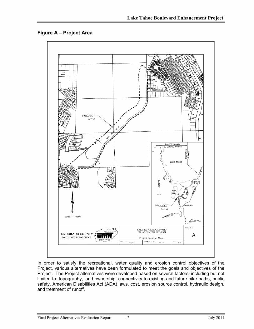


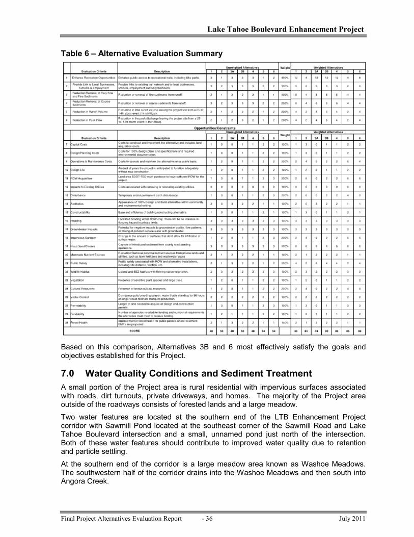


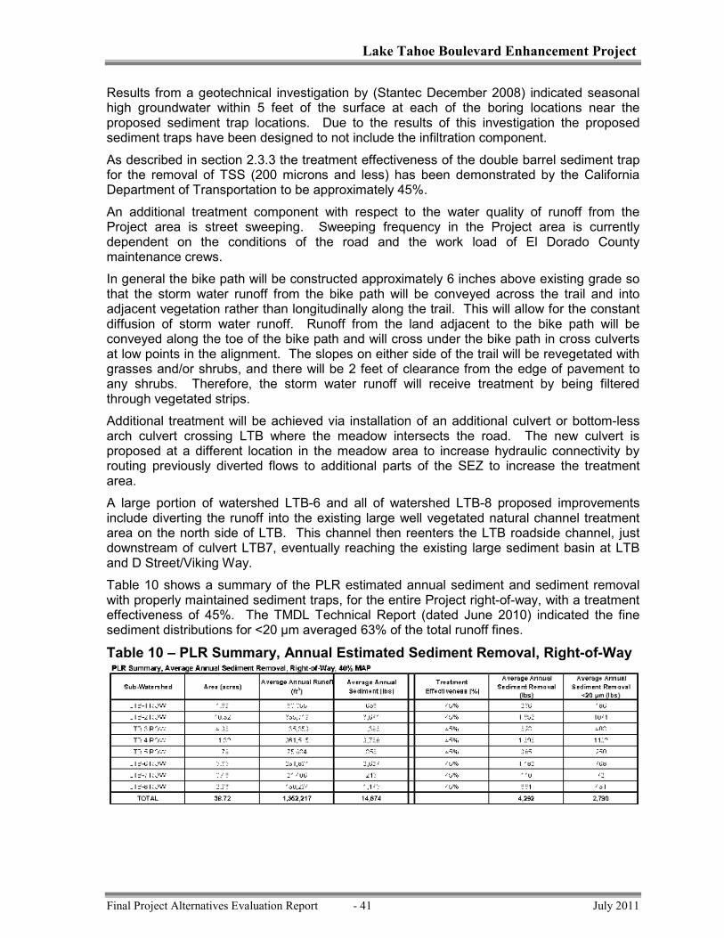


![South Tahoe High School [4 Specialized Projects] South Lake Tahoe, California High School Project of Distinction LPA, Inc. 2012 Exhibition of School Planning.](https://static.documents.pub/doc/80x56/56649dbe5503460f94ab1646/south-tahoe-high-school-4-specialized-projects-south-lake-tahoe-california.jpg)


![Image Enhancement [DVT final project]](https://static.documents.pub/doc/80x56/568163bc550346895dd4d545/image-enhancement-dvt-final-project.jpg)


