LANDFILL FEASIBILITY STUDY (CONCEPTUAL ASSESSMENT) DEVELOPMENT OF A NEW LANDFILL SITE Submitted to: CITY OF TEMISKAMING SHORES 325 Farr Drive P.O. Box 2050 Haileybury, Ontario P0J 1K0 Submitted by: AMEC EARTH & ENVIRONMENTAL 131 Fielding Road Lively, Ontario P3Y 1L7 15 March 2010
Transcript
LANDFILL FEASIBILITY STUDY (CONCEPTUAL ASSESSMENT)
DEVELOPMENT OF A NEW LANDFILL SITE
Submitted to:
CITY OF TEMISKAMING SHORES 325 Farr Drive P.O. Box 2050
Haileybury, Ontario P0J 1K0
Submitted by:
AMEC EARTH & ENVIRONMENTAL 131 Fielding Road
Lively, Ontario P3Y 1L7
15 March 2010
LANDFILL FEASIBILITY STUDY (CONCEPTUAL ASSESSMENT) DEVELOPMENT OF A NEW LANDFILL SITE CITY OF TEMISKAMING SHORES MARCH 2010
2.0 HISTORY OF SOLID WASTE MANAGEMENT IN THE CITY OF TEMISKAMING SHORES.........................................................................................................................5
3.1 Criteria for Site Constraint/Opportunities Mapping .............................................15
3.2 Conceptual Landfill Development Alternative Feasibility Assessment Criteria....17 3.2.1 Public Health & Safety and Socioeconomic Factors ..........................17 3.2.2 Natural Environment ..........................................................................21 3.2.3 Conceptual Technical Considerations................................................22 3.2.4 Preliminary Cost Estimates................................................................24
3.3 Summary of Feasibility Assessment Criteria ......................................................26
4.0 CONCEPTUAL LANDFILL DEVELOPMENT ALTERNATIVES....................................28
4.1 Conceptual Landfill Development Capacity........................................................28
4.2 Conceptual Landfill Development Alternatives Inside the City Limits..................29 4.2.1 Alternative No. 1 ................................................................................30 4.2.2 Alternative No. 2 ................................................................................30
4.3 Conceptual Landfill Development Alternatives Within the 10 km Buffer Surrounding the City Limits ................................................................................31 4.3.1 Alternative No. 3 ................................................................................32
LANDFILL FEASIBILITY STUDY (CONCEPTUAL ASSESSMENT) DEVELOPMENT OF A NEW LANDFILL SITE CITY OF TEMISKAMING SHORES MARCH 2010
AMEC EARTH & ENVIRONMENTAL Page ii TY91049/3000
4.3.2 Alternative No. 4 ................................................................................32
5.0 EVALUATION OF LANDFILL EXPANSION ALTERNATIVES......................................34
5.1 Assignment of Ranking Scores..........................................................................34
5.2 Public Health and Safety/Socio-cultural Environment ........................................35 5.2.1 Residential Areas...............................................................................35 5.2.2 Sensitive Land Uses ..........................................................................36 5.2.3 Drinking Water...................................................................................36 5.2.4 Accessibility and Driving Distance .....................................................36
5.3 Natural Environment ..........................................................................................37 5.3.1 Terrestrial Habitat ..............................................................................37 5.3.2 Aquatic Habitat ..................................................................................38 5.3.3 Species at Risk..................................................................................38 5.3.4 Hydrogeological Conditions ...............................................................38
5.4 Technical Considerations...................................................................................39 5.4.1 Site Size ............................................................................................39 5.4.2 Leachate Management ......................................................................39 5.4.3 Surface Water Management..............................................................40 5.4.4 Landfill Gas Management ..................................................................40
LANDFILL FEASIBILITY STUDY (CONCEPTUAL ASSESSMENT) DEVELOPMENT OF A NEW LANDFILL SITE CITY OF TEMISKAMING SHORES MARCH 2010
AMEC EARTH & ENVIRONMENTAL Page iii TY91049/3000
LIST OF EMBEDDED TABLES
PAGE
Table 2.1 Waste Quantities Disposed of at City Landfills.....................................................9 Table 2.2 Project Needs ....................................................................................................11 Table 2.3 Haileybury Landfill Remaining Site (Waste & Daily Cover Soil) Capacity ...........13 Table 2.4 Haileybury Landfill Remaining Landfill Waste Capacity......................................13 Table 2.5 Haileybury Landfill Remaining Site Life ..............................................................14 Table 3.1 Site Constraint/Opportunity Mapping Criteria .....................................................16 Table 4.2 Feasibility Assessment Criteria for the Conceptual Expansion of Existing
Landfills .............................................................................................................26 Table 4.1 Key Parameters Conceptual Landfill Development Alternative No. 1 –
Ramsey Road (W1) ...........................................................................................30 Table 4.2 Key Parameters Conceptual Landfill Development Alternative No. 2 –
Highway 11 (W3) ...............................................................................................31 Table 4.3 Key Parameters Conceptual Landfill Development Alternative No. 3 –
Moose Lake Road (G5)......................................................................................32 Table 4.4 Key Parameters Conceptual Landfill Development Alternative No. 4 –
Harley Township Landfill (G6)............................................................................32 Table 5.1 Feasibility Assessment Ranking System............................................................35 Table 5.2 Summary of Feasibility Assessment Evaluation Ranking Scores for the
Conceptual Landfill Development Alternatives ...................................................44
SCHEDULE 1 LIST OF FIGURES (FOLLOWING TEXT)
Figure 1 Study Area Location Map Figure 2 Study Area Boundaries Figure 3 Constraint/Opportunity Mapping for Study Area Figure 4 Generic Contaminant Attenuation Zone (CAZ) Configuration Figure 5 Alternative No. 1-Ramsey Road (W1) Existing Conditions Figure 6 Alternative No. 2-Highway 11 (W3) Existing Conditions Figure 7 Alternative No. 3-Moose Lake Road (G5) Existing Conditions Figure 8 Alternative No. 4-Harley Township (G6) Existing Conditions Figure 9 Conceptual Landfill Development Alternative No. 1-Ramsey Road (W1) Figure 10 Conceptual Landfill Development Alternative No. 2-Highway 11 (W3) Figure 11 Conceptual Landfill Development Alternative No. 3-Moose Lake Road (G5) Figure 12 Conceptual Landfill Development Alternative No. 4-Harley Township (G6)
LANDFILL FEASIBILITY STUDY (CONCEPTUAL ASSESSMENT) DEVELOPMENT OF A NEW LANDFILL SITE CITY OF TEMISKAMING SHORES MARCH 2010
AMEC EARTH & ENVIRONMENTAL Page iv TY91049/3000
SCHEDULE 2 LIST OF TABLES (FOLLOWING TEXT)
Table 1 Waste Quantities Deposited at Haileybury Landfill from 1997 to 2008 Table 2 City of Temiskaming Shores 30-Year Projected Compacted Waste Generation Table 3 Preliminary Cost Estimate for Conceptual Landfill Development Alternative No.
1-Ramsey Road (W1) Table 4 Preliminary Cost Estimate for Conceptual Landfill Development Alternative No.
2-Highway 11 (W3) Table 5 Preliminary Cost Estimate for Conceptual Landfill Development Alternative No.
3-Moose Lake Road (G5) Table 6 Preliminary Cost Estimate for Conceptual Landfill Development Alternative No.
4-Harley Township (G6) Table 7 Feasibility Assessment Evaluation of Conceptual Landfill Development
Alternatives
LIST OF APPENDICES Appendix A Certificate of Approval No. A570402, Haileybury Landfill, dated November 10,
1998, amended April 27, 2005 Appendix B Certificate of Approval No. A571505, New Liskeard Landfill, dated May 9, 2000,
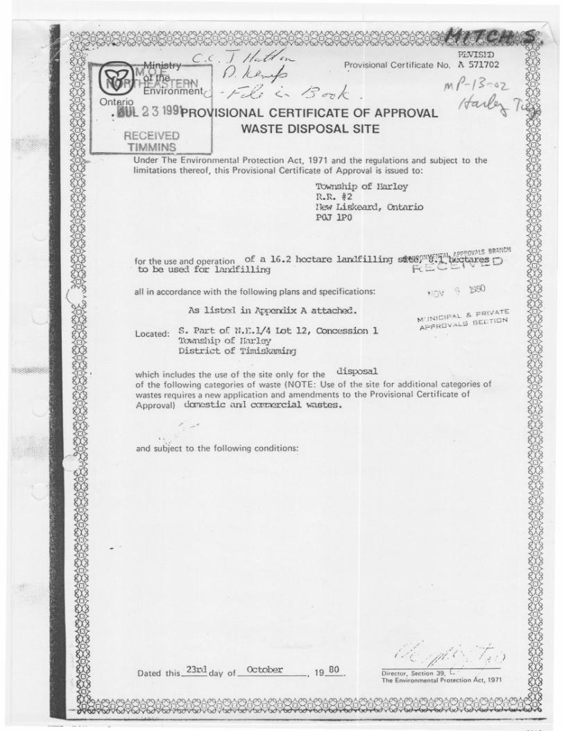
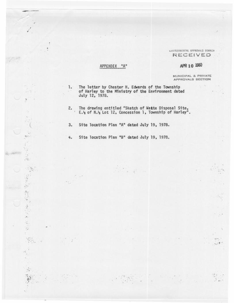
amended April 27, 2005 and April 17, 2007 Appendix C Certificate of Approval for the Harley Township Landfill Site, dated October 23,
1980, amended May 6, 2005 Appendix D Project Limitations
LANDFILL FEASIBILITY STUDY (CONCEPTUAL ASSESSMENT) DEVELOPMENT OF A NEW LANDFILL SITE CITY OF TEMISKAMING SHORES MARCH 2010
AMEC EARTH & ENVIRONMENTAL Page 1 TY91049/3000
1.0 INTRODUCTION
1.1 Project Description
AMEC Earth and Environmental, a division of AMEC Americas Ltd. (AMEC), was retained by the City of Temiskaming Shores (the City) to complete a Feasibility Study to assess alternatives for long-term solid waste management (i.e., landfill disposal). The City has two existing landfill sites, the New Liskeard Landfill and the Haileybury Landfill. The New Liskeard Landfill is currently at capacity and landfill activities have ceased as of June 2009. The Haileybury Landfill is currently in operation, but is anticipated to reach capacity in 2016; under the current waste generation rates (see Section 3.3.2). The City initiated the process to identify the most feasible option for establishing new capacity for long-term solid waste disposal. AMEC was retained to assess the feasibility of providing new solid waste disposal capacity by means of a) expansion of one or both of the existing municipal landfill sites; b) the development of a new site; or c) a combination of both strategies. Once a preferred waste management strategy (i.e., expansion of an existing landfill and/or establishment of a new landfill) is determined to be feasible, the development of this amount of landfill capacity will require a full environmental assessment (EA) under Part II of the Ontario Environmental Assessment Act. The Feasibility Study does not replace such an EA. Instead, it aims at identifying potentially feasible alternatives on the basis of existing information, visual site inspections, and preliminary engineering concepts. It also intends to involve stakeholders and the general public early on in the City’s planning process for new solid waste disposal capacity. It is envisaged that a future EA on this subject would build on the results of the Feasibility Study, consider stakeholder and public input obtained during the process and supplement the information base with field surveys, refined engineering concepts and further consultation.
1.2 Project Tasks and Approach
The scope of work for the preparation of the Feasibility Study is arranged into the following key tasks: Task 1: Project Initiation and Information Gathering (Completed)
• Attend kick-off meeting with the City’s Technical Advisory Committee (TAC) to identify waste management/landfill requirements, and possible new landfill sites;
• Secure and review background documentation including landfill operating manuals and annual reports; and,
• Prepare meeting minutes for the project kick-off meeting.
LANDFILL FEASIBILITY STUDY (CONCEPTUAL ASSESSMENT) DEVELOPMENT OF A NEW LANDFILL SITE CITY OF TEMISKAMING SHORES MARCH 2010
AMEC EARTH & ENVIRONMENTAL Page 2 TY91049/3000
Task 2: Preliminary Assessment of the Feasibility of Expansion of an Existing Landfill (Completed)
• Conduct inspections of existing landfill sites by AMEC’s project team and meet with City representatives and landfill operators;
• Prepare a draft Landfill Feasibility Study (Conceptual Assessment) report discussing the feasibility of expansion for the New Liskeard and Haileybury Landfills;
• Submit draft report to the City for review and conduct a conference call with the City to discuss comments; and,
• Finalize the report and submit to the City for reference/use. Task 3: Preliminary Assessment of the Feasibility of Establishing a New Landfill
• Perform desktop review of three (3) sites outside the City (within 10 kilometers (km) of City boundaries) in areas chosen by City and TAC;
• Perform desktop review of three (3) sites inside the City in areas chosen by City and TAC;
• Prepare a draft Landfill Feasibility (Conceptual Assessment) report discussing the feasibility of establishing four new landfill sites, two (2) sites within, and two (2) sites outside the City Limits and outlining the following:
o determine remaining site life of existing landfills, projected waste generation quantities during proposed 30-year planning period, and projected disposal capacity for future landfill operations;
o development of conceptual design alternatives for establishing new landfills; o evaluation of conceptual design alternatives and ranking to identify a preferred
alternative;• Submit draft report to the City for review and conduct a conference call with the City to
discuss comments; and, • Finalize the report and submit to the City for their reference/use.
Task 4: Consultation Meeting with the Technical Advisory Committee (TAC) (Completed)
• Prepare TAC presentation outlining findings of Tasks 2 and 3;• Conduct consultation meeting with TAC and prepare meeting minutes; and • TAC to select either preferred alternative for landfill expansion or outline new landfill
site(s) for detailed assessment. Task 5: Technical Assessment of Preferred Waste Management Alternative
• Perform technical assessment of preferred alternative site;• Consultation with relevant stakeholders (land owner, public, City, regulatory agency, etc.); • Public consultation meeting (i.e., one open house session) introducing preferred landfill
alternative;
LANDFILL FEASIBILITY STUDY (CONCEPTUAL ASSESSMENT) DEVELOPMENT OF A NEW LANDFILL SITE CITY OF TEMISKAMING SHORES MARCH 2010
AMEC EARTH & ENVIRONMENTAL Page 3 TY91049/3000
• Prepare draft Feasibility Study (Preliminary Assessment) report providing technical information as well as a business case for each site;
• Prepare an executive summary of the technical report for Council and the general public; and,
• Submit draft report to City and TAC for review and comment. Task 6: Consultation Meeting with TAC
• Prepare TAC presentation outlining the results of Task 5• Conduct consultation meeting with TAC and prepare meeting minutes; and, • Record TAC comments for incorporation in the final Feasibility Study Report.
Task 7: Draft Feasibility Study (Final Assessment) Report
• Prepare three (3) copies of draft Feasibility Study (Final Assessment) incorporating the findings and comments from the Task 2, Task 3 and Task 5 reports;
• Submit draft Feasibility Study to the TAC review and comment; and, • Conduct a conference call with the TAC to discuss comments for incorporation in the final
report. Task 8: Final Feasibility Study Submission
• Prepare and conduct final Feasibility Study presentation to Council; and, • Prepare and submit final Feasibility Study (including executive summary) to the City for
reference and use. The scope of work is structured to allow the review of background information and initial visits at the existing landfill sites (i.e., Task 1) as well as independent preliminary assessments of the feasibility of expanding existing sites and the development a new landfill site, as represented by Tasks 2 and 3. Task 4 represents the TAC’s review of the Feasibility Study (Conceptual Assessment) reports, to be submitted as part of, Tasks 2 and 3. The TAC preferred alternative for expansion of an existing Site and/or the development of a new site are compared and evaluated as part of Task 5, in order to establish an overall preferred feasible long-term solid waste management strategy (i.e., landfill disposal). Task 5 also includes the incorporation of a public consultation meeting to introduce the TAC preferred alternatives to relevant internal and external stakeholders and agencies. Further refinement of the preferred strategy will take place as part of Tasks 6 and 7, with the preparation and submission of the final Feasibility Study to the City occurring at the end of Task 8. This report represents the fulfillment of Task 3 – Conceptual Assessment of the Feasibility of Developing a New Landfill Site.
LANDFILL FEASIBILITY STUDY (CONCEPTUAL ASSESSMENT) DEVELOPMENT OF A NEW LANDFILL SITE CITY OF TEMISKAMING SHORES MARCH 2010
AMEC EARTH & ENVIRONMENTAL Page 4 TY91049/3000
1.3 Report Objectives
The objectives of this report are as follows:
a) to identify the long-term solid waste management needs of the City of Temiskaming Shores;
b) to provide conceptual alternatives for development of new landfill sites; c) to assess the feasibility of the development of a new landfill to facilitate long-term waste
management (i.e., landfill disposal) needs; and d) recommend revisions to the scope of work based on the City’s TAC review of the
Feasibility Study (Conceptual Assessment) reports. In order to achieve the report objectives, AMEC has outlined the report as follows:
• Section 1 - Outline project and report specific goals; • Section 2 - Review and evaluate historic/projected waste generation and determine the
City’s needs for future disposal capacity during the projected 30-year planning period; • Section 3 – Establish and discuss landfill siting criteria and preliminary feasibility
assessment criteria for the proposed development of a new landfill site, including completion a desktop level screening assessment to identify a total of six potential landfill development sites (3 within the municipal boundaries and 3 beyond the municipal boundaries within a 10 km study zone);
• Section 4 – Present four (4) conceptual design alternatives for the development of a new landfill site (2 within the municipality and 2 beyond the municipal boundaries);
• Section 5 – Ranking and evaluation of each landfill development alternative against the preliminary feasibility assessment criteria;
• Section 6 – Selection and presentation of a preferred landfill development alternative; and, • Section 7 – Outline the report conclusions as well as recommendations for the revisions to
the original scope of work.
LANDFILL FEASIBILITY STUDY (CONCEPTUAL ASSESSMENT) DEVELOPMENT OF A NEW LANDFILL SITE CITY OF TEMISKAMING SHORES MARCH 2010
AMEC EARTH & ENVIRONMENTAL Page 5 TY91049/3000
2.0 HISTORY OF SOLID WASTE MANAGEMENT IN THE CITY OF TEMISKAMING SHORES
AMEC’s understanding of the history of solid waste management in the City of Temiskaming Shores is based on the 2 September 2009 project kick-off meeting between AMEC and City representatives, as well as a review of the following background documents, provided to AMEC by the City:
• Provisional Certificate of Approval No. A570402 (Haileybury Landfill Site), dated 10 November 1998, amended 27 April 2005;
• Provisional Certificate of Approval No. A571505 (New Liskeard Landfill Site), dated 9 May 2000, amended 27 April 2005 and 17 April 2007;
• Corporation of the Town of Haileybury, Landfill Site Approval Report, Project No. E91008, revised July 1997, prepared by Sutcliffe Engineers & Surveyors (Sutcliffe, July 1997);
• Municipal Groundwater Study, Central Temiskaming Area, dated June 2003, prepared by Knight Piesold Consulting (KPC, June 2003);
• City of Temiskaming Shores, New Liskeard Landfill, Operation and Maintenance Manual, dated May 2004, prepared by Sutcliffe Rody Quesnel Inc. (SRQ, May 2004);
• New Liskeard Landfill Site, Annual Monitoring Report 2004, dated February 2005, prepared by Sutcliffe Rody Quesnel Inc. (SRQ, February 2005);
• New Liskeard Landfill Site, 2007 Annual Groundwater Monitoring Report, dated May 2008, prepared by Jagger Hims Limited (JHL, May 2008);
• Corporation of the City of Temiskaming Shores, Leachate Plume Delineation and Contaminant Attenuation Zone Calculations, Haileybury Landfill Site, dated May 2008, prepared by Story Environmental Services (SES, May 2008);
• City of Temiskaming Shores, Application to Amend Provisional Certificate of Approval Waste Disposal Site No. A570402, dated June 2008, prepared by Story Environmental Services (SES, June 2008);
• City of Temiskaming Shores, 2008 Annual Monitoring Report, Haileybury Landfill Site, dated April 2009, prepared by Story Environmental Services (SES, April 2009); and,
• Draft Solid Waste Management Master Plan, dated August 2009, prepared by Earth Tech Canada Inc. (Earth Tech, August 2009).
Certificate Approvals No. A570404 and A571505 are provided in Appendices A and B, respectively.
2.1 Solid Waste Management Facilities
The City of Temiskaming Shores is located in north-eastern Ontario, near the Quebec border, at the head of Lake Temiskaming (Earth Tech, August 2009). The City has a current population of approximately 10,600, and was formed in January 2004 through the amalgamation of the former Town of Haileybury, former Town of New Liskeard and the former Township of Dymond into a single tier municipality (Earth Tech, August 2009). The City has two existing landfill sites: the New Liskeard Landfill (formally the Town of New Liskeard Landfill)
LANDFILL FEASIBILITY STUDY (CONCEPTUAL ASSESSMENT) DEVELOPMENT OF A NEW LANDFILL SITE CITY OF TEMISKAMING SHORES MARCH 2010
AMEC EARTH & ENVIRONMENTAL Page 6 TY91049/3000
and the Haileybury Landfill (formally the Town of Haileybury Landfill). These sites will be henceforth referred to as the New Liskeard Landfill and the Haileybury Landfill, respectively. Figure 1 (see Schedule 1) presents the locations of the communities that form the City of Temiskaming Shores. The study area established for the purposes of this report (i.e., the municipal boundary plus a 10 km buffer) is presented on Figure 2 (see Schedule 1). The Haileybury Landfill, located approximately 9 km southwest of the former Town of Haileybury off of Highway 11 along Dump Road, has been in operation since 1975 (Earth Tech, August 2009). The Haileybury Landfill currently operates under Certificate of Approval (C of A) No. A570420, dated 10 November 1998, as amended, which approves of the use and operation of a 5.8 ha landfilling area within a total property area of 32.4 ha. C of A No. A570402 is provided in Appendix A. The New Liskeard Landfill, located approximately 3 km west of the former Town of New Liskeard off of Rockley Road, has been used for a landfill site since 1916 (Earth Tech, August 2009). The New Liskeard Landfill currently operates under C of A No. A571505, dated 9 May 2000, as amended, which approves of the use and operation of a 2.02 hectare (ha) landfilling area (i.e., waste footprint) within a total property area of 32 ha. C of A No. A571505 is provided in Appendix B. The City also administers a recycling program through the operation of a material resource facility (MRF) through the Cochrane Temiskaming Waste Management Board (Earth Tech August 2009). The recycling program includes the collection of paper fibres, aluminium and steel cans, container glass, and No. 1 polyethylene terephthalate (PET) plastic which are deposited at eight drop-off depots located throughout the City (Earth Tech, August 2009).
2.2 Solid Waste Management Practices
For the purposes of this report, the discussion of City’s waste management practices will focus on the provision of three main services: 1) solid waste collection; 2) solid waste disposal; and 3) recycling/waste diversion.
2.2.1 Solid Waste Collection
The collection of solid waste within the City is governed by the various policies, by-laws and programs established by the former Towns of Haileybury, New Liskeard and Dymond prior to the January 2004 amalgamation. These policies focus on the collection of waste materials from residential, industrial, commercial and institutional sources. In general, residential waste is collected on a weekly basis in the summer months and bi-weekly in the winter months for all towns located within the City. Industrial, commercial and institutional solid waste is collected on a weekly basis in the summer months and on a bi-weekly basis in the winter months in the former Towns of Haileybury and Dymond, while waste collection in the former Town of New Liskeard occurs twice weekly (Earth Tech, August 2009). Earth Tech reports that the City’s
LANDFILL FEASIBILITY STUDY (CONCEPTUAL ASSESSMENT) DEVELOPMENT OF A NEW LANDFILL SITE CITY OF TEMISKAMING SHORES MARCH 2010
AMEC EARTH & ENVIRONMENTAL Page 7 TY91049/3000
various residential collection by-laws allow for the collection of solid waste with the exception of the following “non-collective wastes”:
• Manufacture waste, including wire; • Oil/gasoline soaked absorbent material or any explosive or highly combustible material; • Broken plaster, lumber or other waste or residue resulting from the construction
alteration, repair, demolition or removal of any building or structure; • Sawdust and/or shavings; • Organic matter not properly drained or wrapped; • Liquid waste; • Bandages, poultices, dressings and other such waste; • Hay, straw, manure; • Night soil; • Carcass of any animal; • Live animals or birds; • Furniture; • Stock or any wholesaler which shall be regarded as manufacturing waste; • Discarded truck and automobile tires; • Tree branches or roots exceeding three (3) inches in diameter; • Ashes (except in Haileybury); • Old corrugated cardboard (OCC); and, • Other materials may, from time to time, be designated by the City as non-collectible
waste. The City operates various special waste collection programs, such as the annual Christmas tree, Spring Clean-Up and Bulky programs where residents can deposit “non-collective waste” such as furniture, large diameter branches, white goods (i.e., stoves and furnaces), fencing, mattresses, bed springs and other general household items at the curbside for collection. The City also operates a limited Hazardous Waste Program for the collection of old/used paint, oils, propane tanks and batteries. Additionally, residents and contractors are able to bring solid waste to the City’s landfill sites for disposal (Earth Tech, August 2009). As reported in Draft Solid Waste Management Master Plan, the City’s current reliance on the various solid waste collection policies have resulted in inconsistencies between the collection services offered to the various towns with respect to the schedule/frequency of waste collection, bag limits, bag fees, container sizes, bans on various waste materials, composting, bulk item collection and hazardous waste collection/disposal (Earth Tech, August 2009). As such, the provision of a uniform solid waste collection by-law/policy is identified as the first key objective in developing a more efficient solid waste management program for the City of Temiskaming Shores (Earth Tech, August 2009).
2.2.2 Solid Waste Disposal
Prior to amalgamation, the New Liskeard Landfill received waste only from the former Town of New Liskeard, while the Haileybury Landfill received waste from the former Town of Haileybury, the former Town of Dymond, the Town of Cobalt, and from residents of Firstbrook and Lorrain
LANDFILL FEASIBILITY STUDY (CONCEPTUAL ASSESSMENT) DEVELOPMENT OF A NEW LANDFILL SITE CITY OF TEMISKAMING SHORES MARCH 2010
AMEC EARTH & ENVIRONMENTAL Page 8 TY91049/3000
Townships (Earth Tech, August 2009). Upon amalgamation, all waste from the various towns comprising the City of Temiskaming Shores was diverted to the New Liskeard Landfill. As such, the New Liskeard Landfill reached its approved landfill capacity in June 2009, and is currently no longer accepting waste. Currently, The Haileybury Landfill accepts landfill waste from the entire City, as well as the Town of Cobalt. It should be noted that based on waste generation projections, as discussed in Section 2.5.2, the Haileybury Landfill is expected to reach its approved landfill capacity by mid-2016. As such, the provision of additional landfill capacity to facilitate long-term waste disposal is identified as the second key objective in establishing a sustainable solid waste management program for the City of Temiskaming Shores (Earth Tech, August 2009). As stated in Section 1.3, this conceptual assessment report will focus on evaluating the feasibility of fulfilling the objective of providing additional landfill capacity through the expansion of a new landfill site.
2.2.3 Recycling/Waste Diversion
As stated in Section 2.1, the City operates an MRF facility for the collection of recyclable materials. Earth Tech reports that the current MRF facility does not have the capacity to accommodate the additional volume of recyclable materials resulting from amalgamation and the location of the MRF limits the possibility of expansion (Earth Tech, August 2009). As such, the City’s ability to divert recyclable materials from the waste stream is restricted. Additionally, the City currently is in contract with Phippen Waste Management (Phippen) to manage and operate the Haileybury Landfill (Earth Tech, August 2009). It should be noted that Phippen was also in contract to manage and operate the now closed New Liskeard Landfill. Phippen continues to separate bulk items such as white goods (i.e., disposed appliances), waste tires, glass, inert construction fill and reclaimed asphalt, from the landfilled solid waste at the open Haileybury Landfill. These bulk items are generally stockpiled on-Site for removal on a sporadic, as needed basis. As such, the provision of additional capacity for long-term recycling and waste diversion is identified as the third key objective in establishing a sustainable solid waste management program for the City of Temiskaming Shores (Earth Tech, August 2009).
2.3 Historical Quantity of Disposed Solid Waste
There are currently no weigh scales at either the New Liskeard or Haileybury Landfill sites, therefore amount of waste disposed per year at each site is based on the following:
• visual pre-disposal waste volume estimates recorded by Phippen, as provided to AMEC by the City; and,
• quantities reported in the background documents listed in Section 2.0. The summary quantity of waste disposed of at the New Liskeard Landfill from 2000 through 2006 is reported in the Section 5.1.1. of the Draft Solid Waste Management Master Plan, and is presented on Table 2.1 (embedded below). The quantity of waste disposed in 2007 is currently not known, although the amount of waste disposed in 2008 was provided by the City as approximately 25,447 cubic yards, or 19,456 cubic meters (m3). Table 1 (see Schedule 2) presents a detailed accounting of the quantity of waste disposed of at the Haileybury Landfill
LANDFILL FEASIBILITY STUDY (CONCEPTUAL ASSESSMENT) DEVELOPMENT OF A NEW LANDFILL SITE CITY OF TEMISKAMING SHORES MARCH 2010
AMEC EARTH & ENVIRONMENTAL Page 9 TY91049/3000
from 1997 to 2008, based on pre-disposal waste volume estimates provided to AMEC by the City. Although a similar detailed accounting for the waste disposed at the New Liskeard Landfill was not provided to AMEC, a summary of the annual quantity waste disposed at the both the New Liskeard and Haileybury Landfills from 1997 to 2009 is provided on Table 2.1 (embedded below):
Table 2.1 Waste Quantities Disposed of at City Landfills
Note: NA = data not available It should be noted that these estimates of historical waste volumes were recorded prior to disposal and compaction by the landfill operators.
As stated in Section 1.1., the overall goal of this project is to identify the most feasible option for establishing new landfill capacity for long-term solid waste disposal. Based on AMEC’s discussions with the City, a long-term solid waste disposal planning period of 30-years was chosen. For the purposes of this report, the 30-year planning period begins in January 2009 and extends to December 2038. This planning period provides the basis for the calculation of projected long-term waste disposal quantities. Tables 2a and 2b (see Schedule 2) present estimates of the amount of uncompacted waste projected to be generated by the communities of Haileybury, Dymond, Cobalt and New Liskeard over the 30-year planning period. The projections were based on the following:
• Linear extrapolations of population growth calculated from 1991, 1996, 2001 and 2006 census data, as provided by Statistics Canada for the City of Temiskaming Shores and the Town of Cobalt;
LANDFILL FEASIBILITY STUDY (CONCEPTUAL ASSESSMENT) DEVELOPMENT OF A NEW LANDFILL SITE CITY OF TEMISKAMING SHORES MARCH 2010
AMEC EARTH & ENVIRONMENTAL Page 10 TY91049/3000
• Uncompacted waste quantity estimates for 2008, as presented above in Section 2.3; and • Uncompacted waste generation estimates of 2.6 m3 per capita for the communities of
Haileybury, Cobalt and Dymond (combined) and 3.9 m3 per capita for the former Town of New Liskeard.
Table 2c (see Schedule 2) presents projections for the generation of uncompacted residential solid waste for the City of Temiskaming Shores, representing the sum of the projected waste generation estimates from Tables 2a and 2b (see Schedule 2). McBean, et. al. (1995) indicates that the density of uncompacted residential solid waste generally ranges from 90 kilograms per cubic meter (kg/m3) to 180 kg/m3, with a typical value of 150 kg/m3. For the purposes of this report, it is assumed that the uncompacted residential waste generated by the City will have a density of 150 kg/m3. As such, Table 2c presents the calculation of the tonnage of projected waste generated per year by multiplying the volume of uncompacted solid waste by a density of 150 kg/m3 and dividing the result by a factor of 1 tonne = 1,000 kilograms. As discussed below in Section 3.4.2, AMEC observed that waste disposed at the Haileybury Landfill was subjected to compaction using a HL760 front end loader. Although the actual densities of the compacted waste material at the New Liskeard and Haileybury Landfills are not known, McBean, et. al., (1995) indicates that the density of residential solid waste after landfill compaction generally ranges from 445 kg/m3 to 505 kg/m3. For the purposes of this report, the in-place density of residential solid waste after landfilling and compaction will be conservatively estimated at 300 kg/m3, representing an increase from the uncompacted residential waste density by a factor of two. Thus, on Table 2c the volume of compacted residential waste is calculated by multiplying the tonnage of projected waste generated by a factor of 1,000 kg to 1 tonne and dividing the result by an in-place density of 300 kg/m3. The results presented on Table 2c (see Schedule 2) indicate that the City of Temiskaming Shores (including the Township of Cobalt) is projected to cumulatively generate approximately 699,073 m3 of compacted solid waste during the 30-year planning period. As stated in Section 2.2.3., although the City does administer the operation of an MRF for the management of recyclable waste, the MRF has limited capacity to accommodate the increased volume of recycled material generated by the City due to amalgamation. As such, this report conservatively assumes that, based on the current condition of the MRF, the volume of residential waste diverted by collection of recycle materials will be negligible throughout the planning period. Therefore any long-term solid waste management alternative developed by the City will have to accommodate a long-term solid waste disposal volume of approximately 699,073 m3 of compacted residential waste. It should be noted that typically, landfill operations in Ontario require that daily cover soil be applied on solid waste at a ratio of 4:1 (waste to daily cover soil), representing approximately 20% of typical landfill capacity. Given a projected long-term solid waste disposal volume of approximately 699,073 m3, the total landfill capacity of waste and daily cover soil is calculated as follows: TC = 699,073 m3 x RTOTAL/RWASTE
LANDFILL FEASIBILITY STUDY (CONCEPTUAL ASSESSMENT) DEVELOPMENT OF A NEW LANDFILL SITE CITY OF TEMISKAMING SHORES MARCH 2010
AMEC EARTH & ENVIRONMENTAL Page 11 TY91049/3000
= 699,073 m3 x [(4+1)/4] = 699,073 m3 x 5/4 = 873,841 m3 Where: TC = Total Capacity of projected solid waste generated; RTOTAL = Total Ratio of solid waste and daily cover soil; and RWASTE = Ratio of solid waste. As such, the overall project needs are summarized in Table 2.2 (embedded below):
Therefore any long-term solid waste management alternative developed by the City will be required to accommodate approximately 874,000 m3 (rounded value) of landfill volume, including waste and daily cover soil quantities. Descriptions of the existing Haileybury and New Liskeard Landfills including background information, a history of regulatory approvals, adjacent land use, physical setting and geology, and hydrogeology is provided in AMEC’s Landfill Feasibility Study (Conceptual Assessment) Expansion of Existing Landfill Sites, dated 8 March 2010, prepared on behalf of the City.
2.5 Remaining Site Capacity
2.5.1 New Liskeard Landfill
As stated above in Section 2.1, C of A No. A571501 for the New Liskeard Landfill approves the disposal of waste in a 2.02 ha area (i.e. Fill Area) within a 32 ha Total Site Area. The estimate
LANDFILL FEASIBILITY STUDY (CONCEPTUAL ASSESSMENT) DEVELOPMENT OF A NEW LANDFILL SITE CITY OF TEMISKAMING SHORES MARCH 2010
AMEC EARTH & ENVIRONMENTAL Page 12 TY91049/3000
of the Total Site Capacity for the New Liskeard Landfill was not provided in any of the background documentation provided to AMEC by the City, although SRQ reports that in 2004 the Remaining Site Capacity of the New Liskeard Landfill Site was approximately 49,580 m3, including waste and waste cover soil (SRQ, May 2004). It is presumed that this Remaining Site Capacity value refers to the volume remaining within the approved 2.02 ha Fill Area. The Remaining Site Capacity of waste and cover soil at the New Liskeard Landfill was consumed in 2009, and landfill operations were indefinitely halted in June of that year. The majority of the landfill area outside the approved Fill Area has been graded and capped with cover soils. Observations recorded during the AMEC’s September 2009 site inspection indicate that topsoil and vegetated cover has been established on the northern portion of the landfill. Representatives of the City reported to AMEC that the cap material used included foundry sands and excavated construction fill with unknown clay content. The thickness of the cap is unknown, but generally ranges from 150 mm to over 300 mm in some areas. As of September 2009, the most recently deposited landfill material, located within the approved Fill area, was exposed although the City arranged for the progressive deposition and application of excavated construction fill on the exposed face as cover material.
2.5.2 Haileybury Landfill
As stated above in Section 2.1, C of A No. A570402 for the Haileybury Landfill approved the use and operation of a 5.8 ha landfill site within a 32.4 ha Total Site Area. The supporting documentation for the Emergency C of A application indicated that the original Total Site Capacity of the Haileybury Landfill Site (including waste and daily cover soil) was estimated as 475,644 m3 (Sutcliffe, July 1997). The Total Site Capacity was revised in 1997 Landfill Site Approval Report to 452,221 m3, based on revised per capita waste projection values. Based on landfill quantities provided by the City, presented on Table 1 (see Schedule 2), between 1997 and 2008, approximately 222,617 m3 of waste material was landfilled at the Haileybury Landfill. The 2008 Annual Monitoring Report, prepared in April 2008 by Story Environmental Services (SES), indicates that the volume of compacted solid waste deposited at the Haileybury Landfill through to the 2008 reporting period is approximately 263,530 m3 (SES, 2009). The more conservative estimate was used to calculate the Remaining Landfill Capacity, although it will be assumed that the volume of 263,530 m3 consumed includes daily cover as well as landfill waste. The Remaining Site Capacity of the Haileybury Landfill is presented on Table 2.3 (embedded below):
LANDFILL FEASIBILITY STUDY (CONCEPTUAL ASSESSMENT) DEVELOPMENT OF A NEW LANDFILL SITE CITY OF TEMISKAMING SHORES MARCH 2010
AMEC EARTH & ENVIRONMENTAL Page 13 TY91049/3000
Table 2.3 Haileybury Landfill
Remaining Site (Waste & Daily Cover Soil) Capacity
Item Volume
Total Site Capacity 452,221 m3
Estimated Volume of Landfill Waste Deposited as of 2008
263,530 m3
Estimated Remaining Landfill Capacity 188,691 m3
Therefore the Remaining Landfill Capacity at the Site, including waste and daily cover soil, is approximately 188,691 m3, as of the end of 2008. The estimated Remaining Landfill Capacity of 188,691 m3 includes both waste and waste cover soil. SES reports that due to historical site practices and the limited availability of cover soil, approximately 3% to 5% of the consumed landfill capacity consisted of daily cover soils. Typically, landfill operations in Ontario require that daily cover soil be applied in a ratio of 4:1 (waste to daily cover soil), representing approximately 20% of typical landfill capacity. Therefore the Remaining Site Capacity is itemized on Table 2.4 (embedded below) as follows:
Table 2.4 Haileybury Landfill
Remaining Landfill Waste Capacity
Item Volume
Estimated Remaining Landfill Capacity 188,691 m3
Estimated Cover Soil Capacity (at a 4:1 ratio)
37,738 m3
Estimated Remaining Waste Capacity 150,953 m3
The projections for waste generation by the City of Temiskaming Shores, including the Town of Cobalt, are presented in Table 2c (see Schedule 2). Table 2c (see Schedule 2) also provides a projection of the total volume of compacted waste to be landfilled for each year starting in 2009, based on the assumption that landfill waste generated can be compacted to an in-place density of 300 kg/m3 (as discussed in Section 2.1). Given the estimate of Remaining Waste Capacity and the projections of the quantity of compacted landfill waste, an estimate of the Remaining Site Life for the Haileybury Landfill is provided on Table 2.5 (embedded below):
LANDFILL FEASIBILITY STUDY (CONCEPTUAL ASSESSMENT) DEVELOPMENT OF A NEW LANDFILL SITE CITY OF TEMISKAMING SHORES MARCH 2010
Based on the conservative estimates presented above it is anticipated that the Remaining Waste Capacity for the Haileybury Landfill will be consumed in mid-2016.
LANDFILL FEASIBILITY STUDY (CONCEPTUAL ASSESSMENT) DEVELOPMENT OF A NEW LANDFILL SITE CITY OF TEMISKAMING SHORES MARCH 2010
AMEC EARTH & ENVIRONMENTAL Page 15 TY91049/3000
3.0 PRELIMINARY FEASIBILITY ASSESSMENT CRITERIA
The process of assessing the feasibility of the conceptual landfill development alternatives will be conducted in two steps. Step one is a review of the potential opportunities for and constraints to the siting (i.e., location), to determine if development of a new landfill is principally feasible. Step two will be the evaluation and ranking of each conceptual landfill development alternative against a set list of feasibility criteria to determine a preferred new landfill development scenario (i.e., the most feasible alternative). The criteria used for both steps are derived from the following sources:
• Environmental Protection Act, Regulation 347 General-Waste Management (Reg. 347); • Ontario Regulation 232/98 (O.Reg. 232/98) for new and expanding landfill sites; • Town of Haileybury Zoning By-law No. 85-27, November 1985; • Township of Dymond By-law No. 1041, March 1986; • Official Plan for the Town of Haileybury, March 1989; • Official Plan for the Town of New Liskeard, March 1989; and • Town of New Liskeard Zoning By-law No. 2233, June 1989.
The following discussion outlines the criteria to be used for both steps.
3.1 Criteria for Site Constraint/Opportunities Mapping
Site constraint/opportunity mapping is an exercise that is typically applied to the screening of new landfill sites. The exercise involves incorporating a series of setbacks from sensitive areas or land uses, which are determined by provincial regulation or local bylaws, onto a map of the project property generated by Geographical Information System (GIS) software. The pictorial representation of these setbacks on the project site provides a preliminary guideline to determine if the proposed landfill site, will be constrained by the regulatory setbacks, and/or if the location of the project site will present any potential opportunities for the municipality with respect to locations to nearby highways, roads and sources of waste generation. Table 3.1 (embedded below) presents a summary of the landfill constraints/opportunity mapping criteria used for this report.
LANDFILL FEASIBILITY STUDY (CONCEPTUAL ASSESSMENT) DEVELOPMENT OF A NEW LANDFILL SITE CITY OF TEMISKAMING SHORES MARCH 2010
AMEC EARTH & ENVIRONMENTAL Page 16 TY91049/3000
Table 3.1 Site Constraint/Opportunity Mapping Criteria
Site Constraint/Opportunity Criteria
Distance to Existing Infrastructure Landfill located within 1000 m of an existing roadway.
Distance from Water Supply Wells Landfill located more than 500 m from an existing water well.
Elevation above Flood Zone Landfill located above an elevation of 182 meters above sea level.
Distance from Railway Landfill located more than 50 m from a railway Limit Preferential Contaminant Pathway Landfill located more than 60 m from a fault
zone. Distance from Surface Water Landfill located more than 30 m from a surface
water body. Distance from Existing Roadways Landfill located more than 50 m from the existing
roadway. Conflicting Land Use Landfill located outside of agricultural lands,
Areas of Natural or Scientific Interest (ANSI), Ministry of Natural Resources (MNR) designated wetlands, and Significant Ecological Areas.
Figure 3 (see Schedule 1) presents the results of the constraint/opportunity mapping for the project study area (i.e., the municipal boundaries including a 10 km study zone), including the following 6 identified potential sites:
• W1 – property located north of Highway 558, east of Ramsey Road; • W2 – property along the west side of the Highway 11 corridor, approximately 2 km south
of Highway 558 • W3 – located west of Highway 11, near the south end of the municipality; • G1 – property located south of Sharp Lake; • G5 – property located approximately 2 km northwest of the existing Haileybury Landfill
Site, on the west side of Moose Lake Road; and • G6 – the existing Harley Township Landfill Site.
Although, the development of a new landfill at all 6 locations was considered to be principally feasible following completion of the desktop exercise, further study, such as performing an inventory and monitoring of the water supply wells adjacent to the new proposed sites and/or measuring and assessing the distance of the limits of the landfill waste to the centerline of the adjacent roads, is recommended to determine the overall impact, if any, the location of the proposed landfills may have on the nearby siting features. During a January 2010 reconnaissance of the 6 potential sites, AMEC reviewed each of the
LANDFILL FEASIBILITY STUDY (CONCEPTUAL ASSESSMENT) DEVELOPMENT OF A NEW LANDFILL SITE CITY OF TEMISKAMING SHORES MARCH 2010
AMEC EARTH & ENVIRONMENTAL Page 17 TY91049/3000
sites identified via the mapping exercise. The intention of this effort was to refine the number of principally feasible sites to a total of 4 potential sites (2 sites within the limits of the municipality and 2 sites beyond the municipal boundary), by considering site specific issues that were not apparent through the desktop, mapping exercise. The result of this ground-truthing eliminated one site within the municipality (W2) along the west side of the Highway 11 corridor, approximately 2 km south of Highway 558 and one site outside of the municipality (G1) south of Sharp Lake. Study property W2 was eliminated due to extreme changes in topography across the property as well observed presence of bedrock outcrops, which indicated significant Site preparation required for the proposed establishment of a landfill. Similarly, study property G1 was eliminated based on the extreme changes in topography as well as overall poor accessibility (i.e., no municipal roads leading to property entrance).
3.2 Conceptual Landfill Development Alternative Feasibility Assessment Criteria
AMEC generated a list of key criteria for the assessment of the feasibility of the conceptual landfill expansion alternatives based on a review of the documentation listed in Section 3.0. The purpose of the feasibility criteria is to assess the overall impact of the conceptual landfill expansion alternatives to the members of the community, the surrounding environment and the municipality. The key criteria are:
• Public Health, Safety and Socioeconomic Factors; • Natural Environment; • Conceptual Technical Considerations; and, • Conceptual Cost Estimates.
The following presents a discussion of each of these key criteria as well as the sub-criteria which will be ranked to assess a preferred conceptual landfill development alternative.
3.2.1 Public Health & Safety and Socioeconomic Factors
This key criterion mainly addresses the potential impact the conceptual landfill expansion alternatives will have on the nearby community. The alternatives will be ranked based on the assessment of the following sub-criteria:
• Distance to Residential Areas; • Distance to Sensitive Land Uses; • Distance to Drinking Water Supply Wells; and, • Distance to Waste Generation Source and Road/Transport Access.
Distance to Residential Areas The distance between a landfill footprint and adjacent residential areas are referenced in several regulatory sources. Section 13 of Reg. 347 requires that a landfill fill area be at least 0.25 mile (400 m) from any existing residence. Section 5.3 of the MOE’s Guideline D-4 Land
LANDFILL FEASIBILITY STUDY (CONCEPTUAL ASSESSMENT) DEVELOPMENT OF A NEW LANDFILL SITE CITY OF TEMISKAMING SHORES MARCH 2010
AMEC EARTH & ENVIRONMENTAL Page 18 TY91049/3000
Use On or Near Landfills and Dumps (Guideline D-4), dated April 1994 recommends that a 500 m study area be established around landfill areas to evaluate the presence and impact of any adverse effects or risks to health and safety. However, Sections 5.3 and 4.4 or Guideline D-4 does consider that the actual perimeter distance of the study area may be set at less than or greater than 500 m based on the determination of the limit of the environmental impacts. Section 7, of O. Reg. 232/98 (for new or expanding landfill sites) outlines the requirement of a 100 m buffer area around the waste fill area of the landfill site or a minimum of 30 m at every point of the buffer area if there is adequate space for site access, parking, surface water management facilities structures and that the buffer area is sufficient to ensure that potential impacts of the landfill operation to the outside are minimal. The various municipal by-laws for the various towns that form the City of Temiskaming Shores also reference distances between waste disposal facilities and residential areas. These references are summarized as follows: Town of Haileybury, Zoning By-law No. 85-27, November 1985
• Article 2.23 - Setbacks from Waste Disposal Sites requires that no building or structure shall be constructed or expanded closer than 30 meters to the perimeter of an operational waste disposal site.
Town of Haileybury Zoning By-law No. 85-27 Nov 1985
• Article 2.23 requires that no building or structure shall be constructed or expanded closer than 30 m to the perimeter of the area which is to be landfilled on an operational waste disposal site.
Township of Dymond By-law No. 1041, March 1986
• The by-law requires that landfills cannot be located in Environmental Protection (EP) zones.
As a result, each conceptual landfill development alternative will be evaluated based on the distance between the landfill and the closest residence. Distance to Sensitive Land Uses Section 13 of Reg. 347 references the following restrictions to locating landfill sites near sensitive land uses:
• Section 13(1) - The fill area shall not be subject to flooding and shall be so located that no direct drainage leads to a watercourse;
• Section 13(2) - The landfill shall be at least one-quarter of a mile (400 m) from the nearest dwelling;
• Section 13(3) - The landfill shall be at least two hundred yards (182 m) from the nearest public road;
• Section 13(4) - The site shall be at least 100 feet (30 m) from any watercourse, lake or pond; and,
• Section 13(5) - The site shall not be on land covered by water.
LANDFILL FEASIBILITY STUDY (CONCEPTUAL ASSESSMENT) DEVELOPMENT OF A NEW LANDFILL SITE CITY OF TEMISKAMING SHORES MARCH 2010
AMEC EARTH & ENVIRONMENTAL Page 19 TY91049/3000
The following excerpts from the City’s municipal by-laws and official plans further define limitations to development of sensitive lands: Township of Dymond By-law No. 1041, March 1986
• Section 14(1) outlines that the only allowed non-residential uses for EP (Environmental Protection) zones are for an archaeological site; conservation use; farm, other that a building; flood control and erosion use; forestry use; marine facility; and outdoor recreational use, other than a building; a wildlife and fish management use; and
• Section 16(5)(n) requires that where a non-agricultural land use is establishing or expanding in close proximity to existing livestock buildings; or where livestock facilities are being constructed, enlarged or remodeled near an existing non-agricultural use the separation distance between the existing use and proposed use shall be the distance prescribed by the Minimum distance Separation formula of the Agricultural Code of Practice as revised from time to time.
Township of Dymond Official Plan Amendment No. 2, November 1996, Section 1- General Provisions:
• Agriculture 1.4.1 - Class 2 and 3 soils as defined by the Canada Land Inventory of soil Capability for Agriculture are considered to be of prime importance and will be protected. Non-farm development in areas of good agricultural capability will not be permitted; and,
• 1.10 Hazard Land and Sensitive Areas – It is the intent of this Plan to prevent development from occurring on lands having an inherent environmental hazards such as poor drainage, flood susceptibility, erosion, steep slopes or any other physical condition which could endanger human life and property.
In order to evaluate potential conflicts of the proposed landfill development alternative, the feasibility of each alternative will be assessed by the number of residences within 400 m of the center of the landfill, the distance to the nearest agricultural land, distance to the nearest EP Zone, and the distance to hazard lands and sensitive areas. Distance to Drinking Water Supply There are no restrictions to water supply well establishing landfill sites in Reg. 347 or O. Reg. 232/98, as groundwater impacts are to be managed within the designed buffer area and attenuation zone. In September 1986, the MOE introduced a policy to assist in the evaluation of groundwater impacts, especially for the case of landfill and/or lagoon operations. The policy was entitled “The Incorporation of the Reasonable Use Concept into MOEE Groundwater Management Activities” and is referred to now as Guideline B-7 (formerly Policy 15-08) or the “Reasonable Use” policy. Simply stated, the policy sets groundwater contaminant discharge criteria for landfills and/or lagoons that may impair local water quality; the criteria are based on maintaining the protection of groundwater resources on the adjacent lands or properties.
Guideline B-7 requires that contaminant discharge criteria, representing the maximum acceptable levels of contaminants that should not be exceeded, be established using a simple mathematical relationship that incorporates background (existing) water quality and the highest
LANDFILL FEASIBILITY STUDY (CONCEPTUAL ASSESSMENT) DEVELOPMENT OF A NEW LANDFILL SITE CITY OF TEMISKAMING SHORES MARCH 2010
AMEC EARTH & ENVIRONMENTAL Page 20 TY91049/3000
provincial water quality standards for the adjacent land use. Under Guideline B-7, water quality impacts will not be allowed to exceed the maximum calculated discharge criteria at the landfill (or Site) property boundaries.
In order to apply Guideline B-7, the appropriate resource use of the adjacent properties must be selected. At all of the proposed landfill development sites, the highest end use for groundwater on the adjacent properties is for drinking water purposes, for which the Ontario Drinking Water Standards (ODWS) - Table 1 through Table 4 have been established. The purpose of the ODWS is to protect public health through the provision of safe drinking water. Water intended for human consumption shall not contain unsafe concentrations of toxic chemicals (health related parameters). Health related standards are established for parameters that, when present above a certain concentration, have known or suspected adverse health effects. At the same time, water should also be aesthetically acceptable. Colour, odour and turbidity are parameters that, when controlled, result in water that is clear, colourless and without objectionable or unpleasant taste or odour (non-health related parameters). In addition, operational guidelines have been established for non-health related parameters that need to be controlled to ensure efficient and effective treatment and distribution of the water. As well, Guideline B-7 requires the identification of background water quality conditions in the underlying aquifer.
In order to establish the background geochemical profile, the geometric mean of the valid concentrations of each applicable ODWS parameter would have to be calculated, and the resultant values applied along with the ODWS, to complete a Guideline B-7 analysis for any on-site groundwater monitoring wells for various landfill indicator parameters.
As each conceptual landfill development alternative may potentially be developed as a natural attenuation site, the feasibility of the development alternatives will be compared to the water well related criteria, specifically pertaining to the presence of any designated drinking water supply areas (i.e., Wellhead Protection Areas) and distance to the nearest drinking water supply well. Distance to Waste Generation Source and Road/Transport Access The Official Plans for the City of Temiskaming Shores do not contain any special provisions to protect rural areas. The rural area covers areas within the City where no further urban development is contemplated by the Plan and where further municipal services will be restricted to those needed to deal with emergencies. Land designated as Rural Use is intended primarily for agriculture, forestry, recreational or conservation purposes. The purpose of the Rural Use designations to prevent uncontrolled and scattered development. Further in order to prevent the conflicts that may result when development occurs in areas that are not adequately supplied with services and other public works and to avoid excessive costs for such works in the future, it is the intent of Council to maintain the rural area at a similar level to the now prevailing and to restrict further development to a minimum. As such, the distance to waste centroid/waste generation source and the distance to nearest existing road will be used to evaluate the feasibility of future landfilling at each site.
LANDFILL FEASIBILITY STUDY (CONCEPTUAL ASSESSMENT) DEVELOPMENT OF A NEW LANDFILL SITE CITY OF TEMISKAMING SHORES MARCH 2010
AMEC EARTH & ENVIRONMENTAL Page 21 TY91049/3000
3.2.2 Natural Environment
This key criterion mainly addresses the potential impact the conceptual landfill development alternatives may have on the surrounding natural environment. The alternatives will be ranked based on the assessment of the following sub-criteria:
• Distance to Terrestrial Habitat; • Distance to Aquatic Habitat; • Distance to Species at Risk; and, • Hydrogeological Conditions (i.e. Overall Condition of Site Setting).
Distance to Terrestrial Habitat Development of a new site may be limited or prevented due to its proximity to certain land use designations; however, there are no specific regulatory requirements or municipal by-laws that outline setbacks from natural areas. However, in order to avoid potential interference the distance to the nearest wetland (swamp, bog, marsh, and fen) and the distance to the nearest potentially significant terrestrial habitat (e.g., old growth forest) will be used as ranking criteria to evaluate the feasibility of potential landfill development alternatives. Distance to Aquatic Habitat Aquatic habitat includes lakes, rivers or other water bodies. As discussed in Section 4.1, Section 13 of Reg. 347 requires that landfill sites be at least 100 feet (30 m) from any watercourse, lake or pond. In addition, the Municipal Bylaws place further restrictions on land use in EP zones, including agricultural, rural areas, hazard land and sensitive areas (as described previously in Section 4.2.1. As a result, the distance to the nearest aquatic habitat will be used to evaluate the new landfill development potential of each of the Sites. Distance to Species at Risk Section 14 of the Township of Dymond By-law No. 1041 requires that landfills must not be located in Environmental Protection (EP) zones. There are no regulatory requirements or by-laws for setbacks from Areas of Natural or Scientific Interest (ANSI). The development of new landfills may be limited due to proximity to species at risk or their potential habitat. through the Natural Heritage Information Centre (NHIC). The NHIC compiles, maintains and distributes information on natural species, plant communities and spaces of conservation concern in Ontario. This information is stored in a spatial database used for tracking this information. The Centre also has a library with conservation-related literature, reports, books, and maps, which are accessible for conservation applications, land use planning, and natural resource management. The NHIC web-site can be accesses at http://nhic.mnr.gov.on.ca/MNR/nhic/nhic_.cfm. Natural heritage information can be checked directly on-line using an interactive map or database
LANDFILL FEASIBILITY STUDY (CONCEPTUAL ASSESSMENT) DEVELOPMENT OF A NEW LANDFILL SITE CITY OF TEMISKAMING SHORES MARCH 2010
AMEC EARTH & ENVIRONMENTAL Page 22 TY91049/3000
information can be downloaded in GIS file format. Distance to nearest known or potential species at risk or its critical habitat will be used as criteria to evaluate the feasibility of expansion potential at each site. Hydrogeological Conditions The environmental impact of a newly established landfill is dependent on the hydrogeological condition of the landfill property. As stated in Section 4.1, Reg. 347 requires that a landfill shall be at least 100 feet (30 m) from any watercourse, lake or pond. The conceptual landfill expansion alternatives will be ranked and evaluated based on distance to the nearest surface water feature. Although regulations and by-laws do not specifically address the overall hydrogeological condition of the landfill property, for the purposes of this report the conceptual landfill development alternatives will be ranked based on the hydrogeological condition of each site. The ranking will be based on factors such as the presence of a groundwater recharge area near the Site, the degree of existing groundwater contamination, the presence of a significant confining layer, and the number of and distance to potentially impacted aquifers.
3.2.3 Conceptual Technical Considerations
This key criterion addresses recommended technical features of each conceptual landfill expansion alternative. The alternatives will be ranked based on the assessment of the following sub-criteria:
• Site Size; • Leachate Management Strategy; • Surface Water Management Strategy; and • Landfill Gas Management Strategy.
Site Size The first technical consideration that must be evaluated for each conceptual landfill development alternative is the size of the proposed landfill, and how it relates to the effort required to implement (i.e., construct) the alternative. As discussed in Section 2.4, this study is to evaluate the feasibility of each conceptual landfill development alternative to address the City’s long term waste management requirements. It is anticipated that the City will generate approximately 841,000 m3 of solid waste over a 30-year planning. For the purpose of this study, it is assumed that the Haileybury Landfill Site continue to be used until it reaches capacity (150,953 m3 of waste to be consumed by 2016, while a new site receives regulatory approvals, permits and is constructed) and the balance of the estimated 30-year planning period waste volume will be disposed of in a newly developed landfill site. As a result, each conceptual landfill development alternative will be assessed to ensure that it can satisfy the required landfill capacity requirements while meeting the MOE design criteria for buffer areas, sideslopes, top elevation and regulatory setbacks (as described earlier). Each alternative will also be assessed on the size of the footprint of the potential development, as that is a key indicator of the required construction effort.
LANDFILL FEASIBILITY STUDY (CONCEPTUAL ASSESSMENT) DEVELOPMENT OF A NEW LANDFILL SITE CITY OF TEMISKAMING SHORES MARCH 2010
AMEC EARTH & ENVIRONMENTAL Page 23 TY91049/3000
Leachate Management It is anticipated that the potential new landfill sites will operate as natural attenuation type facilities, where the primary control for minimizing leachate impacts to groundwater is the establishment of a CAZ downgradient of the landfill to protect potential receptors. Although natural attenuation will be considered as the primary leachate management strategy for each conceptual landfill development alternative, the condition of the potential landfill property, as it relates to site setting factors may require alternative methods for leachate management. As a result, the feasibility of each conceptual landfill development alternative will be evaluated and ranked based on the leachate management strategy. The assessment will consider factors such as the size, complexity and effort required to implement the leachate management strategy. Given the lack of hydrogeological data available at any of the potential sites AMEC has assumed a generic CAZ sizing formula based on the waste footprint (8 times the waste deposit length, including 1 length in the upgradient area and 6 lengths in the downgradient area and 3 waste deposit widths). A visual representation of the generic CAZ area is presented on Figure 4 (see Schedule 1). Surface Water Management Typically perimeter drainage systems direct surface water runoff falling on the lands surrounding landfill away from the active tipping face, thus limiting impacts to nearby creeks and surface water bodies. Surface water runoff from within the landfill footprint is managed through the grading of landfill side slopes and top plateaus, and the application of interim cover on inactive landfill areas, and final cover on closed landfill areas. The feasibility of the conceptual landfill development alternatives will be evaluated against the size and complexity of any surface water management features, including length of ditching, number of stormwater ponds, treatment requirements, and water course alteration requirements. Landfill Gas Management Landfill gas (LFG) is generated by methanogenic bacteria during decomposition of organic material under anaerobic conditions. The rate of LFG production in a landfill depends on the interrelationship of many factors. The principal factors include waste composition and age, temperature, moisture content, pH, and quantity and quality of available nutrients and microbial populations. The length of time that a landfill may generate LFG can be in excess of 50 years. Landfill gas is composed of a variety of chemical compounds, which reflects the types of waste that are placed at the landfill site. In general, landfill gas is composed of approximately 50% to 55% methane by volume, 40% to 45% carbon dioxide by volume, and less than 1% other gases such as sulphur species and volatile organic compounds. The concerns with LFG are that the methane gas creates an explosive hazard under certain conditions (between 5% to 15% by volume in air); that LFG will reduce or replace the percentage of the natural atmosphere in enclosed structures, thus creating an oxygen deficient environment; and that there is a potential for health effects depending on the trace gas compounds and levels.
LANDFILL FEASIBILITY STUDY (CONCEPTUAL ASSESSMENT) DEVELOPMENT OF A NEW LANDFILL SITE CITY OF TEMISKAMING SHORES MARCH 2010
AMEC EARTH & ENVIRONMENTAL Page 24 TY91049/3000
The generated LFG can migrate from a landfill site in two ways. These two methods are emission of the LFG to the atmosphere either under controlled released conditions (designed venting and/or collection structures) or uncontrolled conditions (venting through the landfill cover), and/or the migration of the LFG within the surrounding subsurface until a venting location is encountered. Gas migration in the subsurface soil is governed by the same general principles as water flow. The subsurface migration of landfill gas is dependent on soil conditions at the landfill site, the landfill gas generation rate, the landfill site design and weather conditions throughout the year. Potential migration of landfill gas will be greatest in the higher permeable soil stratigraphic units that are present around the landfill site. The landfill gas generation rate will govern the amount of gas available to migrate and impact the extent of landfill gas migration, since landfill gas will usually rise. A perched water table or frost layer will influence the distance of landfill gas migration, since the boundary layer will create a reduced exfiltration area for the gas and create the conditions for potential lateral migration. In June 2008, the Ministry of Environment amended Reg. 347 and O.Reg. 232/98 to present requirements for landfill gas collection and management for new, expanding and operating landfills. The amendments are presented in the MOE’s Landfill Gas Capture: A Guideline on the Regulatory and Approval Requirements for Landfill Gas Capture Facilities, dated September 2008 (Landfill Gas Guideline). The Landfill Gas Guideline states systems to control the atmospheric emission of landfill gas are required for landfills with capacities larger than 1.5 million cubic meters. As each landfill development alternative will be evaluated and ranked based on whether the overall landfill capacity is greater than 1.5 million cubic meters, which will require the establishment of a landfill gas collection and management system.
3.2.4 Conceptual Cost Estimates
This key criterion addresses projected cost of each conceptual landfill development alternative, which will be based on conceptual estimates. The alternatives will be ranked based on the assessment of the following sub-criteria:
• Land Acquisition Cost Estimate; • Capital/Construction Cost Estimate; and, • Cost Estimate for Regulatory Approvals.
It should be noted that the cost estimates provided in this report are conceptual, based on the conceptual design parameters provided for each landfill development alternative. The costs presented herein are intended to provide an order of magnitude estimate for the purposes of a feasibility assessment. They are not intended to be used for budgetary purposes. It is recommended that after the selection of a preferred long-term solid waste management strategy, that the City commissions a detailed design, upon which one can provide cost estimates suitable for capital budget projections.
LANDFILL FEASIBILITY STUDY (CONCEPTUAL ASSESSMENT) DEVELOPMENT OF A NEW LANDFILL SITE CITY OF TEMISKAMING SHORES MARCH 2010
AMEC EARTH & ENVIRONMENTAL Page 25 TY91049/3000
Conceptual Land Acquisition Cost Estimate The acquisition of adjacent land for the development of a new landfill will be required depending on the parameters and scope of each conceptual landfill development alternative. The acquired land may be needed for various reasons, including but not limited to the establishment of proposed contaminant attenuation zones, to facilitate the footprint of the proposed landfill, for the siting of regulatory required buffer zones or to provide sufficient lands for the installation of leachate, surface water and/or landfill gas management facilities. Each conceptual landfill development alternative will be evaluated and ranked based on the project estimated cost of acquiring new lands adjacent to the existing landfill property. The lower cost estimate will be ranked as the most feasible while the higher cost will be ranked as least feasible. Conceptual Capital/Construction Cost Estimate The conceptual capital/construction cost estimates presented herein are based on the key features that are identified for each conceptual landfill development alternative. These key features include projected conceptual cost estimates to perform various construction activities such as:
• Excavation and earthworks; • Installation of a leachate management system; • Installation of a surface water management system; • Application of a final cover system; and, • Installation of a landfill gas management system.
Each conceptual landfill development alternative will be evaluated and ranked based on the projected conceptual estimated capital costs. Lower cost estimates will be ranked as the most feasible while the higher cost will be ranked as least feasible. Conceptual Cost Estimate for Regulatory Approvals As discussed in Section 1.0, once a preferred waste management strategy (i.e., expansion of an existing landfill and/or establishment of a new landfill) is determined to be feasible, the development of the required landfill capacity will require a full environmental assessment (EA) under Part II of the Ontario Environmental Assessment Act. Obtaining an operating license for the preferred waste management strategy will require obtaining approval of the landfill design under the Environmental Protection Act and approval of the required leachate/surface water management system under Ontario Water Resources Act. The conceptual costs estimates for Regulatory Approvals presented herein includes the projected engineering/consulting costs and administrative fees anticipated in order to obtain regulatory approval for each of the for each conceptual landfill development alternative. Each development alternative will be compared against the other and the lowest total cost over the planning period would be considered the most feasible and the highest cost would be considered the least.
LANDFILL FEASIBILITY STUDY (CONCEPTUAL ASSESSMENT) DEVELOPMENT OF A NEW LANDFILL SITE CITY OF TEMISKAMING SHORES MARCH 2010
AMEC EARTH & ENVIRONMENTAL Page 26 TY91049/3000
3.3 Summary of Feasibility Assessment Criteria
Table 3.2 (embedded below) presents a summary of the key criteria and sub-criteria to be employed for the evaluation of each conceptual landfill design alternative, as well as a summary of the indicators which will provide the basis for the ranking.
Table 4.2 Feasibility Assessment Criteria
for the Conceptual Expansion of Existing Landfills
Criteria Indicator
1 Public Health, Safety and Socioeconomic Factors Residential Areas Distance to nearest residence Sensitive Land Uses Number of residences within 400 m and 1000 m of landfill Distance to nearest agricultural lands Distance to nearest Environmental Protection (EP) Zone
Distance to nearest designated Hazard Lands and Sensitive Areas
Drinking Water Supply Distance to nearest designated drinking water supply area Distance to nearest drinking water supply well Road Transport Distance to waste centroid/waste generation source Distance to nearest existing road 2 Natural Environment Terrestrial Habitat Distance to nearest wetland, swamp, bog, marsh or fen
Distance to nearest potentially significant terrestrial habitat (e.g., old growth forest)
Aquatic Habitat Distance to nearest water course, creek, ponds or lake
Species at Risk Distance to nearest known or potential Species At Risk or its critical habitat
Hydrogeological Conditions Presence of on-site groundwater recharge area Existing and degree of groundwater contamination Degree of natural containment at site Number of aquifers Distance to aquifer 3 Technical Considerations Site Size Size of conceptual landfill expansion Leachate Management Size of proposed contaminant attenuation zone Complexity of alternative leachate management system
Surface Water Management Size and complexity of surface water management features
Landfill Gas Management Requirement for landfill gas collection and management 4 Conceptual Cost Estimate Land Acquisition Cost of acquiring new lands adjacent to the existing landfill
LANDFILL FEASIBILITY STUDY (CONCEPTUAL ASSESSMENT) DEVELOPMENT OF A NEW LANDFILL SITE CITY OF TEMISKAMING SHORES MARCH 2010
AMEC EARTH & ENVIRONMENTAL Page 27 TY91049/3000
Criteria Indicator
property Capital/Construction Cost Cost estimate to construct the landfill expansion Cost for Regulatory Approval Cost to obtain regulatory approvals for landfill expansion
LANDFILL FEASIBILITY STUDY (CONCEPTUAL ASSESSMENT) DEVELOPMENT OF A NEW LANDFILL SITE CITY OF TEMISKAMING SHORES MARCH 2010
AMEC EARTH & ENVIRONMENTAL Page 28 TY91049/3000
4.0 CONCEPTUAL LANDFILL DEVELOPMENT ALTERNATIVES
This section includes a description of four (4) conceptual design alternatives for the development of a new landfill (i.e., 2 alternatives located within the municipal boundary and 2 alternatives located outside of the municipal boundary within the 10 km study zone) as well as, a discussion on the basis for the conceptual alternatives. It should be noted that for the purposes of this report, the designs for the development of a new landfill are prepared at a preliminary, conceptual level to facilitate evaluation of overall feasibility of the alternatives. The landfill alternatives presented herein are not intended to provide details on the implementation or construction of the new landfill. The preparation of more detailed designs would be initiated subsequent to the submission of the Final Feasibility Study and the preparation and approval of an Environmental Assessment of a preferred long-term solid waste management strategy (i.e., landfill disposal) for the City.
4.1 Conceptual Landfill Development Capacity
The volumetric capacity for the conceptual landfill development is determined by the following two parameters:
1. the total volume of solid waste projected to be generated during the 30-year planning period; and,
2. the available remaining landfill waste capacity at the existing landfill sites. Section 2.3 presents a discussion of solid waste generation projections for the City during a 30-year planning period (i.e., 2009 to 2038). Based on these projections, it is anticipated that the City will require approximately 874,000 m3 of landfill volume, including waste and daily cover soil quantities. It is understood that any long-term solid waste management strategy would include the use of any remaining landfill capacity at the existing landfills. As discussed in Section 2.5.2, the Haileybury Landfill is the only existing site within the City with a remaining landfill capacity. The Remaining Site Capacity at the Haileybury Landfill is estimated as approximately 188,691 m3, including waste and daily cover soil. As such the estimated capacity of the required landfill alternative would be calculated by the subtraction of the Remaining Site Capacity at Haileybury Landfill from the Long-term Landfill (Waste & Cover Soil) Volume Requirement. Therefore the Conceptual Landfill Expansion Capacity is 685,309 m3 (874,000 m3 - 188,691 m3), which is rounded to approximately 685,000 m3 for the purposes of this report. AMEC has developed four conceptual landfill development alternatives, which are identified as follows:
LANDFILL FEASIBILITY STUDY (CONCEPTUAL ASSESSMENT) DEVELOPMENT OF A NEW LANDFILL SITE CITY OF TEMISKAMING SHORES MARCH 2010
AMEC EARTH & ENVIRONMENTAL Page 29 TY91049/3000
• Alternative No. 1 is the development of a new landfill site within the municipal boundary at property W1, located north of Highway 558, east of Ramsey Road. This alternative is henceforth designated “Ramsey Road (W1)”;
• Alternative No. 2 is the development of a new landfill site within the municipal boundary at
property W3, located west of Highway 11, near the south end of the municipality. This alternative is henceforth designated at “Highway 11 (W3)”;
• Alternative No. 3 is the development of a new landfill site outside of the municipal
boundary at property but within the 10 km study zone at property G5, located approximately 2 km northwest of the existing Haileybury Landfill Site, on the west side of Moose Lake Road. This alternative is henceforth designated “Moose Lake Road (G5)”; and
• Alternative No. 4 is the expansion of the existing Harley Township Landfill Site at property
G6, which is located along Sale Barn Road. Although, the existing Harley Township Landfill Site is currently operating as a small, trench style landfill, the proposed landfill expansion is considered a new development, for the purposes of this report. This alternative is henceforth designated “Harley Township Landfill (G6)”.
Existing site conditions and surrounding property use for each alternative is depicted on Figures 5 through 8 (see Schedule 1). Each conceptual landfill expansion alternative is described by the following key conceptual design parameters:
• footprint area; • base elevation; • top elevation; and • volumetric capacity.
As stated above, the landfill expansion alternatives are prepared on a conceptual basis to facilitate the assessment of socioeconomic, environmental, technical, cost and regulatory feasibility. The preparation of refined conceptual design outlining landfill buffer zones, base contours, side slope grades and landfill plateau grades and other design criteria would proceed upon the identification and selection of a preferred feasible conceptual alternative.
4.2 Conceptual Landfill Development Alternatives Inside the City Limits
Alternative No. 1 – Ramsey Road (W1), has been developed for the property located east of Ramsey Road and north of an existing quarry operation with roads and hydro servicing the area. Based on the results of the desktop review and the site reconnaissance, the site is located in an area of low relief and thin overburden deposits. There currently are no residences within 1 km of the proposed site and no wells, surface water bodies or other sensitive land uses
LANDFILL FEASIBILITY STUDY (CONCEPTUAL ASSESSMENT) DEVELOPMENT OF A NEW LANDFILL SITE CITY OF TEMISKAMING SHORES MARCH 2010
AMEC EARTH & ENVIRONMENTAL Page 30 TY91049/3000
within the setbacks detailed in Section 3.1. The current site conditions for Alternative No. 1 – Ramsey Road (W1) and the surrounding properties are presented on Figure 5 (see Schedule 1). Alternative No. 2 – Highway 11 (W3), was developed for the property located west of Highway 11, near the south end of the municipality, west of an existing quarry operation and within 250 m of existing infrastructure. Based on the results of the desktop review and the site reconnaissance, the site is located in an area of moderate relief and a thin overburden sequence. There currently are no residences within 1 km of the proposed site and no wells, surface water bodies or other sensitive land uses within the setbacks detailed in Section 3.1. The current site conditions for Alternative No. 2 – Highway 11 (W3) and the surrounding properties are presented on Figure 6 (see Schedule 1_. Summary descriptions of each of the conceptual landfill development alternative within the municipality are provided below.
4.2.1 Alternative No. 1 – Ramsey Road (W1)
Conceptual Landfill Development Alternative No. 1 – Ramsey Road (W1) involves the construction of a new landfill east of Ramsey Road. Figure 9 (see Schedule 1) presents a schematic of Alternative No. 1 – Ramsey Road (W1), including the generic CAZ. The key parameters of this alternative are presented on Table 4.1 (embedded below):
Table 4.1 Key Parameters
Conceptual Landfill Development Alternative No. 1 – Ramsey Road (W1)
Parameter Value
Footprint Area 7.07 ha
Base Elevation 259 masl
Top Elevation 285 masl
Landfill Capacity (inc. waste & cover) 685,033 m3
4.2.2 Alternative No. 2 – Highway 11 (W3)
Conceptual Landfill Expansion Alternative No. 2 – Highway 11 (W3) involves the construction of a new landfill to the west of Highway 11. Figure 10 (see Schedule 1) presents a schematic of Alternative No. 2 – Highway 11 (W3). The key parameters of this alternative are presented on Table 4.2 (embedded below):
LANDFILL FEASIBILITY STUDY (CONCEPTUAL ASSESSMENT) DEVELOPMENT OF A NEW LANDFILL SITE CITY OF TEMISKAMING SHORES MARCH 2010
AMEC EARTH & ENVIRONMENTAL Page 31 TY91049/3000
Table 4.2 Key Parameters
Conceptual Landfill Development Alternative No. 2 – Highway 11 (W3)
Parameter Value
Footprint Area 7.59 ha
Base Elevation 305.5 masl
Top Elevation 332 masl
Landfill Capacity (inc. waste & cover) 684,998 m3
4.3 Conceptual Landfill Development Alternatives Within the 10 km Buffer Surrounding the City Limits
Alternative No. 3 – Moose Lake Road (G5) was developed for the property located west of Moose Lake Road, approximately 2 km northwest of the existing Haileybury Landfill Site. The property is located within 250 m of existing infrastructure (roads and hydro), however, it is anticipated that Moose Lake Road North would require considerable improvements to accommodate the volume of traffic associated with landfill construction and operations. Based on the results of the desktop review and the site reconnaissance, the site is located in an area of high relief and significant, coarse grained, overburden deposits. There is currently 1 residence within 1 km of the proposed site (approximately 500 m) and no wells, surface water bodies or other sensitive land uses within the setbacks detailed in Section 3.1. The current site conditions for Alternative No. 3 – Moose Lake Road (G5) and the surrounding properties are presented in Figure 5 (see Schedule 1). Alternative No. 4 – Harley Township Landfill (G6) was developed for the property located in Harley Township, on the west side of Sale Barn Road, approximately 2 km east of Highway 11 and is currently operated as a small scale trench style waste disposal site (i.e. the Harley Township Landfill Site). The site has apparently been in use as a landfill site since 1978. The Harley Township Landfill currently operates under C of A No. A571702, dated 6 May 2005, as amended, which approves of the use and operation of 8.1 ha landfilling area within a total property area of 16.2 ha. This C of A specifies the service area and does not contain any conditions pertaining to the management or monitoring of leachate, landfill gas, groundwater or surface water. C of A No. A571702 is provided in Appendix C. Based on the results of the desktop review and the site reconnaissance, the site is located in an area of moderate relief and a moderate overburden thickness and is located within 250 m of existing infrastructure. There currently are two residences within 1 km of the proposed site (at approximately 600 m) and no wells, surface water bodies or other sensitive land uses within the setbacks detailed in Section 3.1. The current site conditions for Alternative No. 4 – Harley Township Landfill (G6) and the surrounding properties are presented in Figure 6 (see Schedule 1).
LANDFILL FEASIBILITY STUDY (CONCEPTUAL ASSESSMENT) DEVELOPMENT OF A NEW LANDFILL SITE CITY OF TEMISKAMING SHORES MARCH 2010
AMEC EARTH & ENVIRONMENTAL Page 32 TY91049/3000
Summary descriptions of each of the conceptual landfill development alternative within the 10 km buffer area surrounding the municipality are provided below.
4.3.1 Alternative No. 3 – Moose Lake Road (G5)
Conceptual Landfill Expansion Alternative No. 3 – Moose Lake Road (G5) involves the construction of a new landfill to the west of Moose Lake Road. A schematic of Alternative No. 3 – Moose Lake Road (G5) is presented in Figure 11 (see Schedule 1). The key parameters of this alternative are presented on Table 4.3 (embedded below):
Table 4.3 Key Parameters
Conceptual Landfill Development Alternative No. 3 – Moose Lake Road (G5)
Parameter Value
Footprint Area 7.97 ha
Base Elevation 300.0 masl
Top Elevation 332 masl
Landfill Capacity (inc. waste & cover) 688,705 m3
4.3.2 Alternative No. 4 – Harley Township Landfill (G6)
Conceptual Landfill development Alternative No. 4 – Harley Township Landfill (G6) involves the construction of the landfill at the existing Harley Township Landfill Site. A schematic of Alternative No. 4 – Harley Township Landfill (G6) is presented in Figure 12 (see Schedule 1). The key parameters of this alternative are presented on Table 4.4 (embedded below):
Table 4.4 Key Parameters
Conceptual Landfill Development Alternative No. 4 – Harley Township Landfill (G6)
Parameter Value
Footprint Area 6.07 ha
Base Elevation 250.5 masl
Top Elevation 277 masl
Landfill Capacity (inc. waste & cover) 690,000 m3
The discussion of the evaluation and selection of the preferred conceptual landfill development option is presented in Sections 5.0 and 6.0, respectively.
LANDFILL FEASIBILITY STUDY (CONCEPTUAL ASSESSMENT) DEVELOPMENT OF A NEW LANDFILL SITE CITY OF TEMISKAMING SHORES MARCH 2010
AMEC EARTH & ENVIRONMENTAL Page 33 TY91049/3000
Other potential landfill development alternatives may exist but this feasibility assessment focuses on the discussion and evaluation of these four conceptual alternatives. The further refinement of these concepts should be conducted as part of the environmental assessment stage of the solid waste management planning process, which will provide the basis of detailed design alternatives for the implementation of the preferred feasible alternative.
LANDFILL FEASIBILITY STUDY (CONCEPTUAL ASSESSMENT) DEVELOPMENT OF A NEW LANDFILL SITE CITY OF TEMISKAMING SHORES MARCH 2010
AMEC EARTH & ENVIRONMENTAL Page 34 TY91049/3000
5.0 EVALUATION OF LANDFILL EXPANSION ALTERNATIVES
5.1 Assignment of Ranking Scores
The ranking of each feasibility assessment criteria will be based on the level of concern and/or the potential for adverse impact presented by each conceptual landfill alternative. The determination of the level of concern and potential for adverse impact will be based on how each alternative affects the criteria’s indicator. For example, evaluating a conceptual landfill alternative under the criteria for Public Health, Safety and Socioeconomic Factors will include determining the distance of the proposed landfill development to the nearest residence. For the purpose of this feasibility assessment the closer the distance between the proposed development and the nearest residence, the greater the level of concern and/or potential adverse impact to the environment. The rating of the level of concern and/or potential for adverse environmental effects was determined in consultation with City’s Technical Advisory Committee. For those criteria where a concern or potential for environmental effect was identified, one of the following ratings was assigned:
• High – Where the expansion may affect the environmental component so as to seriously disturb the integrity, distribution, operation, or abundance of the component and is expected to raise serious concern with government reviewers and / or the public.
• Medium - Where the expansion may affect the environmental component so as to bring
about a disturbance but does not threaten the integrity, distribution, operation, or abundance of the component as determined by government reviewers and the public. Short-term effects associated with construction and operation of facilities also constitute a potential for moderate effects/concerns.
• Low – Where the expansion may affect the environmental component in such a way that
only a portion of the component is disturbed for a short period of time.
• None – The expansion causes little or no affect to the environmental component and causes no concern among government reviewers and/or the public.
To assist with the identification of the overall most feasible (preferred) alternative the following ranking system was applied:
LANDFILL FEASIBILITY STUDY (CONCEPTUAL ASSESSMENT) DEVELOPMENT OF A NEW LANDFILL SITE CITY OF TEMISKAMING SHORES MARCH 2010
AMEC EARTH & ENVIRONMENTAL Page 35 TY91049/3000
Table 5.1 Feasibility Assessment Ranking System
Level of Concern/Potential Impact
Rating Ranking Value
None 0
Low 1
Low to medium 2
Medium 3
Medium to high 4
High 5
The scores are introduced to summarize the quantitative and qualitative evaluation using the individual feasibility assessment sub-criteria and indicators into a numeric score. To arrive at an overall score for each of the conceptual landfill alternative, the individual scores for each sub-criterion will be tallied in order to asses the overall feasibility.
The following sections will present discussions on how each conceptual landfill alternative is assessed for each individual feasibility assessment sub-criteria, as well as summary rankings for the main key criteria.
5.2 Public Health and Safety and Socioeconomic Factors
5.2.1 Residential Areas
During the January 2010 Site Inspections, AMEC observed that there are no residences located within a 400 m radius of any of the conceptual landfill development alternatives. As stated in Section 3.2.1, Reg. 347, requires that a landfill be placed at least 400 m from an existing residence, therefore no potential conflict with the applicable regulation regarding this criteria. There are no existing residences located within 1 km of Alternative No. 2 – Highway 11 (W3). As such, Conceptual Landfill Development Alternative No. 2 – Highway 11 (W3) will be ranked with a level of concern/potential impact rating of 0-none. Although there are no residences within 400 m of the conceptual landfill development alternatives, there is one residence located between 400 m and 1 km of Alternatives No. 1 – Ramsey Road (W1) and No. 3 – Moose Lake Road (G5). There are two residences located within a 1 km radius of Alternative No. 4 – Harley Township (G6). As a result, for the purposes of this report Conceptual Landfill Development Alternative No. 1 – Ramsey Road (W1) and Alternative No. 3 – Moose Lake Road (G5) will be ranked with a level of concern/potential impact rating of 1-low, and Alternative No. 4 – Harley Township (G6) will be ranked with a level of concern/potential impact rating of 2-low to medium.
LANDFILL FEASIBILITY STUDY (CONCEPTUAL ASSESSMENT) DEVELOPMENT OF A NEW LANDFILL SITE CITY OF TEMISKAMING SHORES MARCH 2010
AMEC EARTH & ENVIRONMENTAL Page 36 TY91049/3000
Table 7 (see Schedule 2) presents a summary of the ranking and scores with respect to the Residential Area sub-criterion.
5.2.2 Sensitive Land Uses
As discussed in Section 5.2.1, there are no residences located within a 400 m radius of the evaluated alternatives for a new landfill site. Only one residence located within a 1 km radius of Alternatives No. 1 – Ramsey Road (W1) and No. 3 – Moose Lake Road (G5) (at 975 m and 500 m, respectively) and two residences located within a 1 km radius of Alternative No. 4 – Harley Township (G6) (both at 600 m). None of the potential landfill properties are located adjacent to agricultural properties, and no Environmental Protection (EP) Zones, Hazard Zones or Sensitive Areas are located within 500 m of the evaluated sites. Alternative No. 1 – Ramsey Road (W1) and No. 2 – Highway 11 (W3) are located adjacent to existing industrial land uses, while Alternative No. 4 – Harley Township (G6) is currently operating as an active landfill. Alternative No. 3 – Moose Lake Road (G5) is located in a relatively undeveloped area, but the existing Haileybury Landfill Site and aggregate extraction operations are located within 2 km of the site. Based on the above noted information Conceptual Landfill Development Alternative No. 2 – Highway 11 (W3) is ranked with a level of concern/potential impact rating of 0-none. Alternative No. 1 – Ramsey Road (W1) and Alternative No. 3 – Moose Lake Road (G5) will be ranked with a rating of 1-low, to address the potential impacts to residences. Alternative No. 4 – Harley Township (G6) will be ranked with a rating of 2-low to medium, to address the potential impacts to the two nearby residences. Table 7 (see Schedule 2) presents a summary of the ranking and scores with respect to the Sensitive Land Use sub-criterion.
5.2.3 Drinking Water
Due to the lack of development in the vicinity of the potential development sites of a new landfill, as shown on Figures 5 to 8 (see Schedule 1), there are no drinking water wells within 500 m of the properties proposed for conceptual landfill development alternatives. As such all for conceptual landfill development alternatives will be ranked with a level of concern/potential impact rating of 0-none. Table 7 (see Schedule 2) presents a summary of the ranking and scores with respect to the Drinking Water sub-criterion.
5.2.4 Accessibility and Driving Distance
Alternative No. 1 – Ramsey Road (W1) is located approximately 10 km from the Town of New Liskeard and 3 km from Town of Haileybury, the two main areas of waste generation within the City. Alternative No. 2 – Highway 11 (W3) is located approximately 12 km from Town of New
LANDFILL FEASIBILITY STUDY (CONCEPTUAL ASSESSMENT) DEVELOPMENT OF A NEW LANDFILL SITE CITY OF TEMISKAMING SHORES MARCH 2010
AMEC EARTH & ENVIRONMENTAL Page 37 TY91049/3000
Liskeard and 12 km from Town of Haileybury. Alternative No. 3 – Moose Lake Road (G5) is located approximately 14 km from Town of New Liskeard and 14 km from Town of Haileybury. Alternative No. 4 – Harley Township (G6) is located approximately 10 km from Town of New Liskeard and 18 km from Town of Haileybury, although the majority of the route is along the Highway 11 corridor. As such it is more advantageous to construct a new landfill at Alternative No. 1 – Ramsey Road (W1), since it is closer to both major waste generation centers. All sites are readily accessed by county roads (at a minimum), although Alternative No. 3 – Moose Lake Road would likely require considerable road improvements to accommodate the volume and types of traffic associated with landfill construction and operation. Based on the above noted information, Conceptual Landfill Development Alternative No. 1 – Ramsey Road will be ranked with a level of concern/potential impact rating of 0-none, while Alternative No. 2 – Highway 11 will be ranked with a level of concern/potential impact rating of 2-low to medium. Alternative No. 3 – Moose Lake Road (G5) will be ranked with a level of concern/potential impact rating of 3-medium to address both the distance from major waste generation centers and the requirement for road improvements, while Alternative No. 4 – Harley Township (G6) will be ranked with a rating of 1-low. Table 7 (see Schedule 2) presents a summary of the ranking and scores with respect to the Accessibility and Driving Distance sub-criterion.
5.3 Natural Environment
5.3.1 Terrestrial Habitat
During the January 2010 Site Inspections, AMEC observed that there were no indicators that a significant terrestrial habitat (i.e., wetlands, old growth forest) in the vicinity of the proposed conceptual landfill development alternative properties. This observation was confirmed during the Site Constraint/Opportunity Mapping exercise, as no significant terrestrial habitats were located within the vicinity of the new landfill development alternatives. In addition to this, the properties for proposed Alternative No. 2 – Highway 11 (W3) and No. 4 – Harley Township (G6) have been cleared of vegetation, an as such are sited in locations in which there are no terrestrial habitats to be impacted. Based on the above noted information, Conceptual Landfill Development Alternatives No. 1 – Ramsey Road (W1) and No. 3 – Moose Lake Road (G5) will be ranked with a level of concern/potential impact rating of 1-low, while Alternatives No. 2 – Highway 11 (W3) and No. 4 – Harley Township (G6) will be ranked with a rating of 0-none. Table 7 (see Schedule 2) presents a summary of the ranking and scores with respect to the Terrestrial Habitat sub-criterion.
LANDFILL FEASIBILITY STUDY (CONCEPTUAL ASSESSMENT) DEVELOPMENT OF A NEW LANDFILL SITE CITY OF TEMISKAMING SHORES MARCH 2010
AMEC EARTH & ENVIRONMENTAL Page 38 TY91049/3000
5.3.2 Aquatic Habitat
Field observations recorded during the January 2010 Site Inspections indicate that there are no indicators that aquatic habitats are located within the vicinity of the conceptual landfill development alternative properties. These observations were confirmed during the performance of Site Constraint/Opportunities GIS Mapping. As such, all four Conceptual Landfill Development Alternatives will be ranked with a level of concern/potential impact rating of 0-none. Table 7 (see Schedule 2) presents a summary of the ranking and scores with respect to the Aquatic Habitat sub-criterion.
5.3.3 Species at Risk
Field observations recorded during the January 2010 Site Inspections indicate that the lands surrounding the potential new landfill site development alternatives are surrounded by natural mixed forests containing flora and fauna species commonly found in Northern Ontario. Site Constraint/Opportunity Mapping indicates that there are not indicators that species at risk (SAR) or Areas on Natural or Scientific Interest (ANSI) located within the vicinity either landfill. As such, Conceptual Landfill Development Alternatives No. 1 through No. 4 will be ranked with a level of concern/potential impact rating of 0-none. Table 7 (see Schedule 2) presents a summary of the ranking and scores with respect to the Species at Risk sub-criterion.
5.3.4 Hydrogeological Conditions
Assessing the hydrogeological impact of Conceptual Landfill Development Alternatives is difficult due to the limited historical data of groundwater conditions in the areas of interest. Field observations indicate that the all alternatives are located on topographic highs or plateaus and each are likely groundwater recharge zones. In addition, Alternative No. 1 – Ramsey Road (W1) and No. 2 – Highway 11 (W3) are inferred to have a very thin overburden sequence overlying the site bedrock, while Alternatives No. 3 – Moose Lake Road (G5) and No. 4 – Harley Township (G6) appear to have significant overburden deposits. Furthermore, Alternative No. 3 – Moose Lake Road (G5) has a coarse grained overburden with a high permeability and provides no natural protection to the aquifer and would allow for rapid migration of contaminants. Alternative No. 4 – Harley Township (G6) appears to have a finer grained overburden, with a lower permeability and may provide some degree of protection to the underlying aquifers. Based on the available information the Conceptual Landfill Development Alternatives are ranked as follows
• Alternative No. 1 – Ramsey Road (W1) = level of concern/potential impact rating of 4-meduim to high;
LANDFILL FEASIBILITY STUDY (CONCEPTUAL ASSESSMENT) DEVELOPMENT OF A NEW LANDFILL SITE CITY OF TEMISKAMING SHORES MARCH 2010
AMEC EARTH & ENVIRONMENTAL Page 39 TY91049/3000
• Alternative No. 2 – Highway 11 (W3) = level of concern/potential impact rating of 4-medium to high;
• Alternative No. 3 – Moose Lake Road (G5) = level of concern/potential impact rating of 3-medium; and
• Alternative No. 4 – Harley Township (G6) will be ranked with a level of concern/potential impact rating of 2-medium to low.
Table 7 (see Schedule 2) presents a summary of the ranking and scores with respect to the Hydrogeological Conditions sub-criterion.
5.4 Technical Considerations
5.4.1 Site Size
The key conceptual technical parameters for each of the Conceptual Landfill Expansion Alternatives are presented in Section 4.0 on Tables 4.1 through 4.4 (embedded above), as well as on Figures 9 though 12 (see Schedule 1). Each Conceptual Landfill Development Alternative is ranked as follows, with respect to the level of concern/potential impact based on the area required to facilitate the required landfill capacity:
• Alternative No. 1 – Ramsey Road (W1) Waste Area plus required buffer areas = 6.9 ha (rank = 2-low to medium);
• Alternative No. 2 – Highway 11 (W3) Waste Area plus required buffer areas = 7.4 ha (rank = 3-medium);
• Alternative No. 3 – Moose Lake Road (G5) Waste Area plus required buffer areas = 7.8 ha (rank = 4-medium to high); and,
• Alternative No. 4 – Harley Township (G6) Waste Area plus required buffer areas = 5.5 ha (rank = 1-low).
It should be noted that the proposed waste footprint for Alternative No. 4 – Harley Township would fit within the existing approved landfill footprint (i.e., 8.1 ha). Table 7 (see Schedule 2) presents a summary of the ranking and scores with respect to the Site Size sub-criterion.
5.4.2 Leachate Management
As discussed in Section 3.2.3, it is anticipated that leachate management at any of the new sites would be completed through natural attenuation processes within an established CAZ. Given the current lack of hydrogeological data to support the calculation of a site specific CAZ, the evaluation of each site was based on a generic CAZ sizing formula, the resultant land area and whether the CAZ would intersect typical groundwater receptors [i.e., other uses or groundwater discharge zones (lakes, streams, rivers, wetlands, etc.)]. The generic CAZ and any such interference for each Alternative are presented on Figures 9 to 12 (see Schedule 1) . Alternatives No. 1 – Ramsey Road (W1) and No. 4 – Harley Township (G6) do not have significant interference potential, however, the generic CAZ for Alternatives No. 2 – Highway 11 (W3) and No. 3 – Moose Lake Road (G5) encroach on the adjacent surface water bodies.
LANDFILL FEASIBILITY STUDY (CONCEPTUAL ASSESSMENT) DEVELOPMENT OF A NEW LANDFILL SITE CITY OF TEMISKAMING SHORES MARCH 2010
AMEC EARTH & ENVIRONMENTAL Page 40 TY91049/3000
Each Conceptual Landfill Development Alternative is ranked as follows, with respect to the level of concern/potential impact based on the generic CAZ and potential interference with downgradient receptors:
• Alternative No. 1 – Ramsey Road (W1) Area of Generic CAZ = 207 ha (rank = 2-low to medium);
• Alternative No. 2 – Highway 11 (W3) Area of Generic CAZ = 218 ha (rank = 3-medium); • Alternative No. 3 – Moose Lake Road (G5) Area of Generic CAZ = 294 ha (rank = 4-
medium to high); and, • Alternative No. 4 – Harley Township (G6) Area of Generic CAZ = 148 ha (rank = 1-low).
Table 7 (see Schedule 2) presents a summary of the ranking and scores with respect to the Leachate Management sub-criterion.
5.4.3 Surface Water Management
The proposed Conceptual Landfill Development Alternatives will include the use of perimeter drainage systems and best management practices as primary components of the surface water management system. Although the extent of the proposed perimeter drainage systems is dependent on the overall configuration of the conceptual landfill development alternative, it is anticipated that the required surface water management for Conceptual Landfill Development Alternatives No. 1 – Ramsey Road (W1) and No. 4 – Harley Township (G6) will be relatively minor due to the limited potential for interference with the CAZ, and thus will have minimal overall impact to the environment. As such, Conceptual Landfill Development Alternatives No. 1 – Ramsey Road (W1) and No. 4 – Harley Township (G6) will be ranked with a level of concern/potential impact rating of 1-low. A stated above in Section 5.4.2 the generic CAZ for Conceptual Landfill Development Alternatives No. 2 – Highway 11 (W3) and No. 3 – Moose Lake Road (G5) encroach on the adjacent surface water bodies, indicating the need for more sophisticated surface water management systems which may include stormwater management retention/detention ponds. As such, Alternatives No. 2 – Highway 11 (W3) and No. 3 – Moose Lake Road (G5) will be ranked with a level of concern/potential impact rating of 2-low to medium. Table 7 (see Schedule 2) presents a summary of the ranking and scores with respect to the Surface Water Management sub-criterion.
5.4.4 Landfill Gas Management
As discussed in Section 3.2.3, MOE amended Reg. 347 and O.Reg. 232/98 to require that landfill gas management systems be installed for landfills with capacities larger than 1.5 million cubic meters. As discussed in Section 4.1, the Total Site Capacity required to serve the 30-year planning period will result in a the development of new landfill with a total volume of 685,000 m3, which is below the 1.5 million cubic meter requirement. Additionally, as stated in
LANDFILL FEASIBILITY STUDY (CONCEPTUAL ASSESSMENT) DEVELOPMENT OF A NEW LANDFILL SITE CITY OF TEMISKAMING SHORES MARCH 2010
AMEC EARTH & ENVIRONMENTAL Page 41 TY91049/3000
Section 5.2.1 there are no existing residences located within 1 km of Alternative No. 2 – Highway 11 (W3), one residence located between 400 m and 1 km of Alternatives No. 1 – Ramsey Road (W1) and No. 3 – Moose Lake Road (G5) and two residences located within a 1 km radius of Alternative No. 4 – Harley Township (G6). In order to address the potential impact that landfill gas may have on adjacent land uses, the Conceptual Landfill Development Alternatives are ranked as follows
• Alternative No. 1 – Ramsey Road (W1) = level of concern/potential impact rating of 1-low; • Alternative No. 2 – Highway 11 (W3) = level of concern/potential impact rating of 0-none; • Alternative No. 3 – Moose Lake Road (G5) = level of concern/potential impact rating of 1-
low; and • Alternative No. 4 – Harley Township (G6) will be ranked with a level of concern/potential
impact rating of 2-medium to low. Table 7 (see Schedule 2) presents a summary of the ranking and scores with respect to the Landfill Gas Management sub-criterion.
5.5 Conceptual Cost Estimates
The projected conceptual cost estimates for Conceptual Landfill Alternatives No. 1 – Ramsey Road (W1), No. 2 – Highway 11 (W3), No. 3 – Moose Lake Road (G5) and No. 4 – Harley Township (G6) are presented on Tables 3, 4, 5 and 6 (see Schedule 2), respectively. The conceptual cost estimates are itemized by the following sub-criteria: land acquisition costs, capital/construction costs; and costs to obtain regulatory approval. Discussions on the basis of each estimate are provided below.
5.5.1 Land Acquisition Cost Estimates
As previously mentioned in Section 5.4.2, it is anticipated that the natural attenuation will be primary method of leachate management for Conceptual Landfill Development Alternatives. Each alternative will require the acquisition of adjacent land for the establishment of a new CAZ. Tables 3a, 4a, 5a and 6a (see Schedule 2) present the proposed conceptual costs for land acquisition for Alternatives No. 1 – Ramsey Road (W1), No. 2 – Highway 11 (W3), No. 3 – Moose Lake Road (G5) and No. 4 – Harley Township (G6), respectively. A unit cost of $1,000 per ha is assumed based on typical land prices observed in Northern Ontario. As discussed in Section 5.4.2, Conceptual Landfill Development Alternative No. 1 – Ramsey Road (W1) will require the acquisition of approximately 207 ha of adjacent land resulting in an estimated conceptual cost of $207,000, Conceptual Landfill Development Alternative No. 2 – Highway 11 (W3) will require the acquisition of approximately 218 ha of adjacent land resulting in an estimated conceptual cost of $218,000, Alternative No. 3 – Moose Lake Road (G5) will require the acquisition of approximately 294 ha of adjacent land resulting in an estimated conceptual cost of $294,000, and Alternative No. 4 – Harley Township (G6) will require the acquisition of approximately 148 ha of adjacent land resulting in an estimated conceptual cost
LANDFILL FEASIBILITY STUDY (CONCEPTUAL ASSESSMENT) DEVELOPMENT OF A NEW LANDFILL SITE CITY OF TEMISKAMING SHORES MARCH 2010
AMEC EARTH & ENVIRONMENTAL Page 42 TY91049/3000
of $148,000. As such, all Conceptual Landfill Development Alternatives will be ranked with a level of concern/potential impact rating as follows:
• Alternative No. 1 – Ramsey Road (W1) Land Acquisition = $207,000 (rank = 2-low to medium);
• Alternative No. 2 – Highway 11 (W3) Area of Generic CAZ = $218,000 (rank = 3-medium); • Alternative No. 3 – Moose Lake Road (G5) Area of Generic CAZ = $294,000 (rank = 4-
medium to high); and, • Alternative No. 4 – Harley Township (G6) Area of Generic CAZ = $148,000 (rank = 1-low).
It should be note that these conceptual cost estimates are based on a generic CAZ area and would need to be refined by site specific hydrogeological conditions. It is recommended that an evaluation of these conditions be completed prior to moving forward with the development of the preferred alternative or any land acquisitions. Table 7 (see Schedule 2) presents a summary of the ranking and scores with respect to the Land Acquisition Cost Estimate sub-criterion.
5.5.2 Capital/Construction Cost Estimate
Tables 3b, 4b, 5b and 6b (see Schedule 2) present the projected conceptual capital/construction cost estimates for Conceptual Landfill Expansion Alternatives No. 1 – Ramsey Road (W1), No. 2 – Highway 11 (W3), No. 3 – Moose Lake Road (G5) and No. 4 – Harley Township (G6), respectively. As discussed in Section 3.2.4, the conceptual cost estimates on the following key construction activities
• excavation of the proposed base elevation of the landfill; • installation of a leachate management system; • installation of a surface water management system; • application of a final cover system; and, • installation of a landfill gas management system.
The unit costs used for Table 3b through 6b (see Schedule 2) are derived from AMEC experience with the construction of municipal landfills in Ontario. They are based on average unit costs for similar construction activities for municipal landfills in Waterloo, Cambridge and Brighton, Ontario. The quantities used for each table are derived from the key expansion parameters for each alternative listed in Section 4.0 and presented on Figures 9 though 12 (see Schedule 1). Each Conceptual Landfill Development Alternative is ranked with respect to the level of concern/potential impact based on the overall capital/construction cost estimates as follows:
LANDFILL FEASIBILITY STUDY (CONCEPTUAL ASSESSMENT) DEVELOPMENT OF A NEW LANDFILL SITE CITY OF TEMISKAMING SHORES MARCH 2010
AMEC EARTH & ENVIRONMENTAL Page 43 TY91049/3000
• Alternative No. 2 – Highway 11 (W3) Capital/Construction Cost Estimate = $2,734,225 (rank = 4-medium to high);
• Alternative No. 3 – Moose Lake Road (G5) Capital/Construction Cost Estimate = $2,868,425 (rank = 5-high); and,
• Alternative No. 4 – Harley Township (G6) Capital/Construction Cost Estimate = $1,480,225 (rank = 2-low to medium).
Table 7 (see Schedule 2) presents a summary of the ranking and scores with respect to the Capital/Construction Cost Estimate sub-criterion.
5.5.3 Cost Estimates for Regulatory Approvals
Tables 3c, 4c, 5c and 6c (see Schedule 2) present the projected conceptual cost estimates for obtaining regulatory approval of Conceptual Landfill Development Alternatives No. 1 – Ramsey Road (W1), No. 2 – Highway 11 (W3), No. 3 – Moose Lake Road (G5) and No. 4 – Harley Township (G6), respectively. As discussed in Section 3.2.4, the conceptual cost estimates provided included the engineering, consulting and administrative fees required to obtain approval of each alternative under the Environmental Assessment Act and the Ontario Water Resources Act. The cost estimates also include conceptual projections of the tender/contract administration and construction inspection costs for each conceptual alternative. For the purposes of this feasibility assessment, the projected approval cost estimates are derived as a percentage of the conceptual capital/construction estimates. The percentages are developed based on AMEC experience with preparing budgets to obtain approval of various landfills sites across Southern and Northern Ontario. As such, the conceptual cost estimate for regulatory approval of Conceptual Landfill Development Alternatives are based on the following:
• Approval under the Environmental Assessment Act = 15% of Capital/Construction Costs; • Approval under the Environmental Protection Act and Ontario Water Resources Act = 15%
of Capital/Construction Costs; and • Tender/Contract Administration and Construction Inspection = 15% of Capital/Construction
Costs. Each Conceptual Landfill Development Alternative is ranked with respect to the level of concern/potential impact based on the overall cost estimate to obtain regulatory approval as follows:
• Alternative No. 1 – Ramsey Road Cost Estimate for Regulatory Approval = $1,140,000 (rank = 2-low to medium);
• Alternative No. 2 – Highway 11 Cost Estimate for Regulatory Approval = $1, 230,000 (rank = 3-medium);
• Alternative No. 3 – Moose Lake Road Cost Estimate for Regulatory Approval = $1,290,000 (rank = 4-medium to high); and,
LANDFILL FEASIBILITY STUDY (CONCEPTUAL ASSESSMENT) DEVELOPMENT OF A NEW LANDFILL SITE CITY OF TEMISKAMING SHORES MARCH 2010
AMEC EARTH & ENVIRONMENTAL Page 44 TY91049/3000
• Alternative No. 4 – Harley Township Cost Estimate for Regulatory Approval = $660,000 (rank = 1-low).
Table 7 (see Schedule 2) presents a summary of the ranking and scores with respect to the Regulatory Approval Cost Estimate sub-criterion.
5.6 Evaluation & Ranking
Table 7 (see Schedule 2) presents the detailed ranking of each criteria to assess the overall feasibility of the Conceptual Landfill Development Alternatives. The ranking for each sub-criterion was tallied in order to calculate the score for each feasibility assessment criteria. The score for each criterion was then totaled in order to calculate the overall score for each Conceptual Landfill Development Alternative. A summary of the feasibility assessment scores are presented on Table 5.2 (embedded below):
Table 5.2 Summary of Feasibility Assessment Evaluation
Ranking Scores for the Conceptual Landfill Development Alternatives
Inside the Municipality Outside the Municipality
Feasibility Assessment
Criteria
Alternative No. 1-
Ramsey Road (W1)
Alternative No. 2-
Higway 11 (W3)
Alternative No. 3-Moose Lake Road
(G5)
Alternative No. 4-Harley
Township Landfill
(G6) Public Health, Safety and Socioeconomic Factors
LANDFILL FEASIBILITY STUDY (CONCEPTUAL ASSESSMENT) DEVELOPMENT OF A NEW LANDFILL SITE CITY OF TEMISKAMING SHORES MARCH 2010
AMEC EARTH & ENVIRONMENTAL Page 45 TY91049/3000
6.0 CONCLUSION
Based on the results of the discussion and ranking provided above in Section 5.0 and on Table 7 (see Schedule 2), the preferred Conceptual Landfill Development Alternative for the development of a new landfill site is Alternative No. 4, the construction of landfill expansion cell at the existing Harley Township Landfill Site (G6). Conceptual Landfill Development Alternative No. 4 – Harley Township (G6) includes the following features:
• Footprint Area =6.07 ha; • Base Elevation = 250.5 masl; • Top Elevation = 277 masl; • Landfill Capacity = 690,000 m3; • Leachate Management Strategy = Natural Attenuation; • Size of Generic CAZ = 148 ha to the northeast; • Surface Water Management Strategy = approximately 845 linear meter of perimeter
ditching; • Landfill Gas Management Strategy = none; and, • Preliminary Total Cost Estimate (including Land Acquisition, Capital/Construction and
Regulator Approvals = $2,288,225. The solid waste management strategy proposed herein includes the continued operation Haileybury Landfill through 2016 until the landfill has reached its proposed final contours and has achieved its approved Total Site Capacity of 452,221 m3. Once the Haileybury Landfill is closed, the City can subsequently implement its long-term waste management strategy, which may include the development of a new site in accordance with Conceptual Landfill Development Alternative No. 4.
LANDFILL FEASIBILITY STUDY (CONCEPTUAL ASSESSMENT) DEVELOPMENT OF A NEW LANDFILL SITE CITY OF TEMISKAMING SHORES MARCH 2010
AMEC EARTH & ENVIRONMENTAL Page 46 TY91049/3000
7.0 RECOMMENDATIONS
On 18 February 2010, a consultation meeting was conducted between AMEC and the City’s TAC to review the draft Landfill Feasibility Study (Conceptual Assessment) Reports for the Expansion of the Existing Landfill Sites and Development of a New Landfill Site. At that meeting, the City informed AMEC of its intention to enter into an Agreement in Principle to acquire the Harley Township Landfill Site for its long-term (30-year) solid waste management (i.e., landfill disposal) needs. AMEC and the City understood that this new solid waste management strategy would require a change in the scope of work in order to assess the feasibility of using the Harley Township Landfill for long-term landfill disposal. As such, it is recommended that the City of Temiskaming Shores undertake the following steps in order to continue and finalize the feasibility assessment process:
1. Secure background documentation from Harley Township regarding landfill operations, including but not limited to the Certificate of Approval, legal property plans, design and operation reports, environmental monitoring reports and landfill waste volume data for the existing Harley Township Landfill;
2. Conduct a preliminary hydrogeological assessment of the Harley Township Landfill. The
assessment would include conducting on-Site baseline environmental studies, hydrogeological investigations (borehole drilling, soil sampling, water quality monitoring), land surveying and engineering assessments, as required, to support the development of a conceptual hydrogeological Site model and to refine the conceptual landfill design of the Harley Township Landfill expansion;
3. Prepare a draft Landfill Feasibility Study (Preliminary Assessment) report of the Harley
Township Landfill expansion, including the preliminary hydrogeological assessment and conceptual design and submit for review by the City’s TAC;
4. Schedule a Consultation Meeting with the City’s TAC to present the findings of the draft
Landfill Feasibility Study (Preliminary Assessment) report and to solicit comments from the TAC;
5. Finalize the Landfill Feasibility Study (Preliminary Assessment) by incorporating the
TAC’s comments and providing recommendations regarding the landfill’s regulatory approvals process; and,
6. Provide technical assistance to the City’s TAC for the development of a Memorandum of
Understanding between the City and Harley Township, as well as to review the regulatory requirements of the expansion, use and closure of the City’s existing landfills (i.e., New Liskeard and Haileybury Landfills).
LANDFILL FEASIBILITY STUDY (CONCEPTUAL ASSESSMENT) DEVELOPMENT OF A NEW LANDFILL SITE CITY OF TEMISKAMING SHORES MARCH 2010
AMEC EARTH & ENVIRONMENTAL Page 47 TY91049/3000
8.0 CLOSURE
This report was prepared exclusively for the City of Temiskaming Shores for specific application to the conceptual assessment of the feasibility of the development of new landfill site. The conceptual feasibility assessment provided herein was completed in accordance with the verbal and written requests from the City of Temiskaming Shores and generally accepted engineering practices. No other warranty, express or implied, is made. The limitations of this report are presented in Appendix D. Respectfully submitted, AMEC Earth & Environmental, A Division of AMEC Americas Limited Prepared By: Ali Williams, B.Sc. (ENG), P.Eng. Tim McBride, B.Sc., P.Geo. Landfill Engineer Project Manager/Staff Hydrogeologist Reviewed By: Wayne Cooley, B.Sc., P.Eng. Senior Landfill Engineer
kimberly.pelland
A Williams
kimberly.pelland
W . Cooley
kimberly.pelland
Tim M
LANDFILL FEASIBILITY STUDY (CONCEPTUAL ASSESSMENT) DEVELOPMENT OF A NEW LANDFILL SITE CITY OF TEMISKAMING SHORES MARCH 2010
LANDFILL FEASIBILITY STUDY (CONCEPTUAL ASSESSMENT) DEVELOPMENT OF A NEW LANDFILL SITE CITY OF TEMISKAMING SHORES MARCH 2010
AMEC EARTH & ENVIRONMENTAL Page 49 TY91049/3000
SCHEDULE 1
FIGURES
LANDFILL FEASIBILITY STUDY (CONCEPTUAL ASSESSMENT) DEVELOPMENT OF A NEW LANDFILL SITE CITY OF TEMISKAMING SHORES MARCH 2010
AMEC EARTH & ENVIRONMENTAL Page 50 TY91049/3000
SCHEDULE 2
TABLES
LANDFILL FEASIBILITY STUDY (CONCEPTUAL ASSESSMENT) DEVELOPMENT OF A NEW LANDFILL SITE CITY OF TEMISKAMING SHORES MARCH 2010
AMEC EARTH & ENVIRONMENTAL Page 51 TY91049/3000
APPENDIX A
CERTIFICATE OF APPROVAL NO. A570402 HAILEYBURY LANDFILL
DATED NOVEMBER 10, 1998 AMENDED APRIL 27, 2005
LANDFILL FEASIBILITY STUDY (CONCEPTUAL ASSESSMENT) DEVELOPMENT OF A NEW LANDFILL SITE CITY OF TEMISKAMING SHORES MARCH 2010
AMEC EARTH & ENVIRONMENTAL Page 52 TY91049/3000
APPENDIX B
CERTIFICATE OF APPROVAL NO. A571505 NEW LISKEARD LANDFILL
DATED NOVEMBER 10, 1998 AMENDED APRIL 27, 2005
LANDFILL FEASIBILITY STUDY (CONCEPTUAL ASSESSMENT) DEVELOPMENT OF A NEW LANDFILL SITE CITY OF TEMISKAMING SHORES MARCH 2010
AMEC EARTH & ENVIRONMENTAL Page 53 TY91049/3000
APPENDIX C
CERTIFICATE OF APPROVAL NO. A571702
HARLEY TOWNSHIP LANDFILL DATED NOVEMBER 23, 1980
AMENDED MAY 6, 2005
LANDFILL FEASIBILITY STUDY (CONCEPTUAL ASSESSMENT) DEVELOPMENT OF A NEW LANDFILL SITE CITY OF TEMISKAMING SHORES MARCH 2010
AMEC EARTH & ENVIRONMENTAL Page 54 TY91049/3000
APPENDIX D
PROJECT LIMITATIONS
LANDFILL FEASIBILITY STUDY (CONCEPTUAL ASSESSMENT) DEVELOPMENT OF A NEW LANDFILL SITE CITY OF TEMISKAMING SHORES MARCH 2010
AMEC EARTH & ENVIRONMENTAL Page 55 TY91049/3000
Limitations 1. The work performed in the preparation of this report and the conclusions presented are subject to
the following:
(a) The Standard Terms and Conditions which form a part of our Contract; (b) The Scope of Services; (c) Time and Budgetary limitations as described in our Contract; and, (d) The Limitations stated herein.
2. No other warranties or representations, either expressed or implied, are made as to the
professional services provided under the terms of our Contract, or the conclusions presented. 3. The conclusions presented in this report were based, in part, on visual observations of the site
and attendant structures. Our conclusions cannot and are not extended to include those portions of the site or structures, which were not reasonably available, in AMEC’s opinion, for direct observation.
4. The environmental conditions at the site were assessed, within the limitations set out above,
having due regard for applicable environmental regulations as of the date of the inspection. A review of compliance by past owners or occupants of the site with any applicable local, provincial or federal by-laws, orders-in-council, legislative enactments and regulations was not performed.
5. The site history research included obtaining information from third parties and employees or
agents of the owner. No attempt has been made to verify the accuracy of any information provided, unless specifically noted in our report.
6. Where testing was performed it was carried out in accordance with the terms of our contract
providing for testing. Other substances, or different quantities of substances testing for, may be present on site and may be revealed by different or other testing not provided for in our contract.
7. Because of the limitations referred to above, different environmental conditions from those stated
in our report may exist. Should such different conditions be encountered, AMEC must be notified in order that it may determine if modifications to the conclusions in the report are necessary.
8. The utilization of AMEC’s services during the implementation of any remedial measures will allow
AMEC to observe compliance with the conclusions and recommendations contained in the report. AMEC’s involvement will also allow for changes to be made as necessary to suit field conditions as they are encountered.
9. This report is for the sole use of the party to whom it is addressed unless expressly stated
otherwise in the report or contract. Any use which any third party makes of the report, in whole or in part, or any reliance thereon or decisions made based on any information or conclusions in the report, is the sole responsibility of such third party. AMEC accepts no responsibility whatsoever for damages or loss of any nature or kind suffered by any such third party as a result of actions taken or not taken or decisions made in reliance on the report or anything set out therein.
10. This report is not to be given over to any third party for any purpose whatsoever without the written