"LANDSCAPES OF POWER" THE POLITICAL ORGANISATION OF SPACE IN THE LOWER HABUR VALLEY IN THE NEO-ASSYRIAN PERIOD ... . Daniele Morandi Bonacossi - Udine Introduction The study of "Landscapes of Power" is one of the most advanced and promising developments within the emerging research area known as "Landscape Archaeology" because of the variety and newness of the perspectives disclosed to future historical- archaeological research l . From the mid-1970s and above all during the 1980s this field of investigation has developed especially in Britain as a research area located at the intersection of social archaeology, anthropology, and political geography, aimed 1) For the definition of "Landscape Archaeology" as an archaeological study of the man-environment relations in ancient times and of the man-man relationships in the context of the environment in which people lived, cf. G. Barker, "L'archeologia del paesaggio italiano: nuovi orientamenti e recenti espe- rienze", «Archeologia Medievale» 13 (1986), p. 12. For an analysis ofthe methods involved, cf. M. Aston - T. Rowley, Landscape Archaeology, London 1974, and the most recent contributions by J.G. Evans, An Introduction to Environmental Archaeology, Ithaca 1978; R. Foley, "Off-Site Archaeology: An Alternative Approach for the Short-Sited", in I. Hodder etal. (eds.), Pattern in the Past: Essay in HonourofR. Clark, London 1981, pp. 157-183; Id., "A Model of Regional Archaeological Structure", «Proceedings of the Prehistoric Society of East Anglia» 47 (1981), pp. 1-17; K.W. Butzer, Archaeology as Human Ecology: Method and Theoryfora Contextual Approach, Cambridge 1982; R.C. Dunnel- W.S. Dancey, "The Site- less Survey: A Regional Scale Data Collection Strategy", in M.B. Schiffer (ed.), Advances in Archae- ological Methods and Theory, New York 1983; 1. Bintliff - A. Snodgrass, "Off-Site Pottery Distributions: A Regional and Interregional Perspective", «Current Anthropology» 29/3 (1988), pp. 506-512; Barker, L'archeologia del paesaggio italiano, cit., pp. 7-29; Id., "Problemi metodologici nelle ricognizioni suI campo nell'area mediterranea", in G. Noye (ed.), Structures de I'habitat et occupation du sol dans les pays mediterraneens, Rome-Madrid 1988, pp. 137-145; Id., "Approaches to Archaeological Survey" in G. Barker - 1. (eds.), Roman Landscapes. Archaeological Survey in the Mediterranean Region (Archaeological Monographs of the British School at Rome 2), London 1991, pp. 1-9; and, lastly, for a full critical summary, cf. F. Cambi - N. Terrenato, Introduzione all'archeologia dei paesaggi, Roma 1994.
Transcript
"LANDSCAPES OF POWER" THE POLITICAL ORGANISATION OF SPACE
IN THE LOWER HABUR VALLEY IN THE NEO-ASSYRIAN PERIOD ... .
Daniele Morandi Bonacossi - Udine
Introduction The study of "Landscapes of Power" is one of the most advanced and promising
developments within the emerging research area known as "Landscape Archaeology" because of the variety and newness of the perspectives disclosed to future historicalarchaeological research l . From the mid-1970s and above all during the 1980s this field of investigation has developed especially in Britain as a research area located at the intersection of social archaeology, anthropology, and political geography, aimed
1) For the definition of "Landscape Archaeology" as an archaeological study of the man-environment relations in ancient times and of the man-man relationships in the context of the environment in which people lived, cf. G. Barker, "L'archeologia del paesaggio italiano: nuovi orientamenti e recenti esperienze", «Archeologia Medievale» 13 (1986), p. 12. For an analysis ofthe methods involved, cf. M. Aston - T. Rowley, Landscape Archaeology, London 1974, and the most recent contributions by J.G. Evans, An Introduction to Environmental Archaeology, Ithaca 1978; R. Foley, "Off-Site Archaeology: An Alternative Approach for the Short-Sited", in I. Hodder etal. (eds.), Pattern in the Past: Essay in HonourofR. Clark, London 1981, pp. 157-183; Id., "A Model of Regional Archaeological Structure", «Proceedings of the Prehistoric Society of East Anglia» 47 (1981), pp. 1-17; K.W. Butzer, Archaeology as Human Ecology: Method and Theoryfora Contextual Approach, Cambridge 1982; R.C. Dunnel- W.S. Dancey, "The Siteless Survey: A Regional Scale Data Collection Strategy", in M.B. Schiffer (ed.), Advances in Archaeological Methods and Theory, New York 1983; 1. Bintliff - A. Snodgrass, "Off-Site Pottery Distributions: A Regional and Interregional Perspective", «Current Anthropology» 29/3 (1988), pp. 506-512; Barker, L'archeologia del paesaggio italiano, cit., pp. 7-29; Id., "Problemi metodologici nelle ricognizioni suI campo nell'area mediterranea", in G. Noye (ed.), Structures de I'habitat et occupation du sol dans les pays mediterraneens, Rome-Madrid 1988, pp. 137-145; Id., "Approaches to Archaeological Survey" in G. Barker - 1. ~loyd (eds.), Roman Landscapes. Archaeological Survey in the Mediterranean Region (Archaeological Monographs of the British School at Rome 2), London 1991, pp. 1-9; and, lastly, for a full critical summary, cf. F. Cambi - N. Terrenato, Introduzione all'archeologia dei paesaggi, Roma 1994.
16 DANIELE MORANDI BONACOSSI [SAABXl2
at elaborating analytical models suitable for simulating and studying the political organisation of ancient space2.
The central idea of studies on "Landscapes of Power" is that the relationships of power, which in a hierarchically structured society are expressed by asymmetry, have a precise spatial correlation and are therefore reflected directly on the configuration that human settlement takes on within a given region. Analysis of scale and spatial distribution of sites, therefore, allows the reconstruction of the organisational structure of ancient political space3• The basic assumption of this approach is that dominance processes of one site over another tend to minimise the energy cost determined by the flow of information and by the management of political, economic and cultural control4. The building blocks of such a theoretical construct can be reduced to a series of axioms that Renfrew and Level summarise as follows5:
2) A. De Guio, "Analisi funzionale dei 'paesaggi di potere''', «Origini» 14 (1988-89), p. 447. Within the domain of "Landscapes of Power" it is possible to mention a by now wide repertory of models implemented for archaeological applications, such as the "Central Place theory", the "Thiessen Polygons", the "X-Tent model" based on the "Gravity theory" and even the "Catchment Area analysis" (cf. e.g. C. Renfrew - E.W. Level, "Exploring Dominance: Predicting Polities from Centres", in C. Renfrew (ed.), Approaches to Social Archaeology, Edinburgh 1984, pp. 54-77; I. Hodder - C. Orton, Spatial Analysis in Archaeology, Cambridge 1976). For a fuller bibliography on these and other related models, cf. fn. 10, below. 3) Renfrew - Level, Exploring Dominance, cit., p. 25. . 4) The application of the principle of least effort and of optimisation of the energy used -originally formalised by G.K. Zipf, Human Behavior and the Principle o/Least Effort, Cambridge 1949 - to ancient societies with non-market economies, in which social, religious and cultural factors instead of strictly economic ones played a prominent role, has created an intense debate among its supporters: cf., among others, in modern locational geography, the, studies by J.H. von Thiinen, Der isolierte Staat in Beziehung aufLandwirtschaJtund Nationalokonomie, Hamburg 1875; A. Weber, Oberden Standortder Industrien, Tiibingen 1909; W. Christaller, Die zentralen Orte in Siiddeutschland, Jena 1933; A. Losch, Die riiumliche Ordnung der WirtschaJt, Jena 1940, and, in spatial archaeology, C. Vita-Finzi - E. Higgs, "Prehistoric Economy in the Mount Carmel Area of Palestine: Site Catchment Analysis", «Proceedings of the Prehistoric Society» 36 (1970), pp. 1-37; N.D.C. Hammond, "Locational Models and the Site of Lubantum: a Classic Maya Centre", in D.L. Clarke (ed.), Models in Archaeology, London 1972, pp. 757 -800; F. Plog, "Measurement of Prehistoric Interaction between Communities", in K.V. Flannery (ed.), The Early Mesoamerican Village, New York 1976, pp. 255-272; M. Chisolm, Rural Settlement and Land Use, London 1979) and critics (cf. above all D.L. Clarke, "Spatial Information in Archaeology", in D.L. Clarke (ed.), SpatialArchaeology, London 1977, pp. 1-32; A.I. Ammerman, "Surveys and Archaeological Research", AnnRevAnthropol. 10 (1981), pp. 63-88. However, the structural weakness of the principle of least effort has been revealed by studies of decision theory. H.A. Simon (Models of Man, New York 1957) has shown that in the case of partial uncertainty or imperfect knowledge, human decision-making tends not to conform to this model. In this case, decisions are taken to satisfy an acceptable but "sub-maximal" level of achievement. It is, however, undeniable that considerations of minimisation of effort and maximisation of yield have played an important role in the social organisation of space, albeit alongside other influential cultural factors. 5) Renfrew - Level, Exploring Dominance, cit. (above, fn. 2), pp. 54-56; cf. also De Guio, Analisifunzionale ... , cit. (fn. 2, above), p. 447.
1996] LANDSCAPES OF POWER 17
a) The tendency towards growing hierarchization and modularity of political space6.
b) The possibility of identifying effective polities on the basis of scale and distribution of the central places 7. Of course, this assumption implies the possibility of reconstructing the sizes of ancient sites and the existence of a positive correlation between the size of a site and its political rank8.
6) With the term "modular", Renfrew (Renfrew - Level, Exploring Dominance, cit. [above, fn. 2], p. 45) indicates the tendency of the different territorial polities within one same climatic and environmental region to show comparable organisation and sizes that are substantially repeated in similar modules. 7) This term indicates a major centre of service activities (political, administrative, economic, religious, cultural, etc.) which is the centre of a hierarchical system including other linked settlements. A central place becomes the pivot of a region since goods, information and people move between it and its hinterland, and vice versa (C.A. Smith, Regional Analysis, I-II, New York 1976, p. 6). A complex regional system usually includes more than one central place. 8) It has often been observed that the reconstruction of ancient sizes of multiphase mounds by means of the analysis of the distribution of the ceramics of the different periods scattered on the surface of the tells have been made difficult by the natural and cultural transformation processes which the surfaces of the ancient sites and the buried archaeological material undergb (cf. among others, P. Tolstoy - S.K. Fish, "Surface and Subsurface Evidence for Community Size at Coapexco, Mexico", JFA2 [1975], pp. 97-104; A. Kirkby - M.J. Kirkby, "Geomorphic Processes and the Surface Survey of Archaeological Sites in Semi-Arid Area~', in D.A. Davidson - M.L. Shackley [eds.], Geoarchaeology: Earth Science and the Past, London 1976, pp. 229-266; M.B. Schiffer, Behavioural Archaeology, New York 1976; J. Oates, "Archaeology and Geography in Mesopotamia", in J. Bintliff (ed.), Mycenean Geography, Cambridge 1977, pp. 101-106; K.G. Hirth, "Problems in Data Recovery and Measurement in Settlement Archaeology", JFA 5 [1978], pp. 125-131; Ammerman, Surveys ... , cit. (fn. 4, above), pp. 63-88; A.M. Rosen, Cities of Clay. The Geoarchaeology of Tells, Chicago 1986). In particular, the quantity and distribution of surface material are influenced by disturbances linked to the agricultural activity and erosive action of the rain and wind (Hirth, cit., p. 126). These factors can impede the reconstruction of clear demarcations of the distribution areas of surface material and site borders. However, it should be remarked that alterations in the archaeological surface record due to agricultural works are virtually inexistent in the case of mound structures like those of the ijabur tells examined here. Furthermore, seasonal precipitation in the region is not plentiful and above all nearly uniform over the entire area. In the process of estimating the sizes of the single sites ofthe Neo-Assyrian period this allows us to keep under control the disturbance factors of the distribution of surface pottery. However, it is still necessary to look at reconstructed mound sizes with caution and not as absolute numerical values, but rather as general orders of size (R.McC. Adams, Heartland of Cities, Chicago 1981, p. 50). The dimensions of the Neo-Assyrian settlements estimated in this way are used to determine the "functional sizes" of the single settlements, i.e. to indicate the number of activities and functions of a different nature taking place in them (Oates, Archaeology and Geography in Mesopotamia ... , cit., p. 106; G.A. Johnson, "Aspects of Regional Analysis in Archaeology", AnnRevAnthropol6 (1977), p. 495; G.A. Johnson, "Spatial Organization ofEarlyUruk Settlement Systems", in M.T. Barrelet [ed.], L'Archeologie de I 'Iraq. Perspectives et Iimites de l'interpretation anthropologique des documents, Paris 1980, p. 239). The obvious basic assumption is that the larger sites are also settlements characterised by a higher level of functional complexity and consequently occupy a higher rank in the regional settlement network. Numerous studies have shown high correlation levels between the surface and functional sizes of the sites (M.J. Webber, Impact of Uncertainty on Location,
18 DANIEL~ MORANDI BONACOSSI [SAAB Xl2
c) The existence of a correlation between the scale of a site and its potential territorial jurisdiction9.
d) The continuity of the territorial jurisdiction of a polity which excludes parcels of land which do not fall under the administration of a precise authority. Therefore, with the exception of"no-man's-land", each portion of the political space belongs to a specific territorial jurisdiction exercised by a centre or its sub-centres.
By means of historical and archaeological data and a series of theoretical assumptions and analytic models, the theory of "Landscapes of Power" makes it possible to tackle the most elusive dimension of geographical space, the political one lO•
This is the object of the present article, in which we aim at examining the politicaladministrative organisation of the Lower ijabur Valley (Eastern Syria) during the Neo-Assyrian period (tenth-seventh centuries BC) in its actual territorial projection.
The analysis of the historical developments recorded by the Middle and NeoAssyrian sources for the Lower ijabur region, which we will briefly summarise here, shows the succession of a series of different political-administrative orders within a limited span of time included between the thirteenth and eighth-seventh centuries BC. From a situation of extensive territorial control over the region in the thirteenth century, during the reigns of Shalmaneser I and Tukulti-Ninurta I (Fig. 1)11, we move
Cambridge 1972, pp. 29f.; V.F. Costello, Kashan: A City and Region of Iran , London 1976, p. 34; Johnson, Spatial Organization ... , cit., p. 239; R. Bernbeck, Steppe als Kulturlandschaft. Das ~Ajij-Gebiet Ostsyriens vom Neolithikum bis zur islamischen Zeit, mit Beitdigen von P. PHilzner [BBVO Ausgrabungen 1], Berlin 1993, p. 138). While there are no doubts about the general reliability of this model, it should be kept in mind that it is not necessarily applicable in a generalised way to every situation, as is clearly shown by the examples of the ancient cities ofDrehem and Tell Harma!. Both sites have a limited "village" size, but, after excavation, were found to be important administrative centres of the late third and early second millennium BC (Oates, Archaeology and Geography in Mesopotamia ... , cit., p. 106). 9) As for this correlation it is necessary to remark that the sphere of influence of a central place tends to decrease as the inter-site distance increases. 10) A. De Guio, "AlIa ricerca del potere: alcune prospettive italiane", in E. Herring et al. (eds.), Papers of the Fourth Conference of Italian Archaeology, London 1991, p. 191. For a more detailed analysis of this topic and the presentation of several models, cf. also 1. Hodder - C. Orton, Spatial Analysis in Archaeology, Cambridge 1976; J .R. Alden, "A Reconstruction ofToltec Period Political Units in the Valley of Mexico", in C. Renfrew - K.L. Cooke [eds.], Transformatio!zs. Mathematical Approaches to Cultural Change, New York 1979, pp. 169-200; I. Hodder, "Simulating the Growth of Hierarchies", in C. Renfrew - K. Cooke (eds.), Transformations: Mathematical Approaches to Cultural Change, New York 1979, pp. 117-144; Renfrew - Level, Exploring Dominance, cit. (above~ fn. 2), pp. 54-77; A. De Guio - G. Secco, "Archaeological Applications of the 'Percolation Method' for Data Analysis and Pattern Recognition", in S.P.Q. Ratz (ed.), Computer and Quantitative Methods in Archaeology (BAR Int. Series 446, In, Oxford 1988, pp. 63-93; De Guio, Analisifunzionqle ... , cit. (fn. 2, above), pp. 447-478. 11) Cf. in greater detail D. Morandi Bonacossi, Tra if flume e la steppa. Insediamento e uso del territorio nella bassa valle del flume Khabur in epoca neo-assira (HANEIM I), Padova 1996, pp. 56-58. The analysis drawn up by M. Liverani, "The Growth of the Assyrian Empire in the HaburlMiddle Euphrates Area: A
1996] LANDSCAPES OF POWER 19
on to the progressive disintegration of the Assyrian political-military hegemony in the valley during the twelfth-tenth centuries through a series of successive evolutionary stages, which witness the gradual formation of areas of Aramaic domination (Figs. 2-3).
During the ninth century a paradigm of Assyrian progress and conquest through the region based on the "oil-stain". model established by the kings of the thirteenth century was progressively replaced by an innovative paradigm of Assyrian penetration in the ijabur area. The new "network" model was based on the Assyrian control of different "knots" of an increasingly thickening "mesh" alternated with Aramaic tributary areas 12. The latter were either friendly or potentially hostile to Assyria. Finally, during the eighth century, the definitive provincialisation of the tributary kingdoms and the transformation of at least one of the old Assyrian centres of the preceding century into a provincial capital led to the renewed assertion of an extensive territorial control over the region. This pattern endured for the whole of the seventh century until the downfall of the Assyrian empire.
The evolutionary process summarily outlined here on the basis of the cuneiform sources can be followed, although less clearly, also through the archaeological study of the configuration of the valley's settlentent pattern. An initial phase, not well defined chronologically, which covers the entire Middle Assyrian period between the thirteenth ~and eleventh centuries (Fig. 4), is characterised by the presence of a very limited number of settlements. These do not spread out in the semi-arid region south of the site of Tell Sheikh Hamad, which can be identified with the Assyrian Dl1rkatlimmu13. Five central places (Hassaka, Tacban, CAjaja, Fadghami and Sheikh Hamad) are set out linearly along the valley at roughly regular intervals of 20-40 km, thus allowing a continuous cover of the valley territory.
The settlement configuration does not seem to undergo any important variations in the successive Early Neo-Assyrian period (Fig. 6), which covers the period included between the end of the ninth and the mid-eighth centuries l4. Indeed, in this
New Paradigm", SAAB 2 (1988), p. 90, is rather different. Liverani holds that it is possible to apply the "network empire" paradigm to the Lower ijabur valley already from this period, therefore assuming a political-military control of the region through a network of Assyrian outposts located within a native territory, which was not extensively controlled by the Assyrians. 12) Cf. Liverani, The Growth ... , cit. (fn. 11, above) pp. 81-98; Studies on the Annals of Ashurnasirpal II 2. Topographical Analysis, Roma 1992. 13) W. Rollig, "Dur-katlimmu", OrNS 47 (1978), p. 420. Cf. instead the greater expansion ofthe settlement network during the preceding Mitannian period (fourteenth century; cf. Fig. 5). In this phase settlements existed also in the region of the ijabur estuary. 14) The examination of the pottery from the surface surveys carried out in the region by the Tiibinger Atlas des Vorderen Orients in the 1970s (cf. H. Kiihne, "Zur historischen Geographie am Unteren Habur. VorHiufiger Bericht fiber eine archaologische Gelandebegehung", AID 25 [1974-77], pp. 249-255; H.
20 DANIELE MORANDI BONACOSSI [SAAB XJ2
phase a slight increase in the number of occupied sites is registered, but the region south of Dfir-katlimmu, with the only possible exception of Tell Fideo, continues to be uninhabited. Furthermore, the site distribution pattern is still characterised by the alignment of mounds along the river valley with a greater density in the northern part of the region, which receives higher rainfall.
The transition from a "communication empire" 15, established on a network of interconnected Assyrian centres alternated by settlements ruled by local dynasties, to a "territorial empire" in which the state authority controls the whole territory under its jurisdiction extensively and without interruption, takes place during the second half of the eighth century. This process is mirrored archaeologically by the dramatic increase in the number of settlements where Late Assyrian pottery was found (Fig. 7). The total number of sites in which occupation can be considered certain increases from 9 Middle Assyrian settlements' (with an aggregate site area estimated at about 75 ha) and from 18 Early Neo-Assyrian sites (95 ha) to 66 Late Assyrian sites, fora total occupied surface area of roughly 270 ha. In parallel, the settlement configuration is reorganised on a new basis: the vertical distribution pattern of sites aligned along the river is now flanked by, and interconnecte4.i with, a new horizontal pattern of settlements located in the steppe adjacent to the ijabur valley. Moreover, the valley south of the site of Tell Sheikh Hamad starts to witness a settlement activity that in the preceding centuries had never been so intense.
The aim of this article is to elaborate a reconstructive model of the region's topology of power during the period included between the end of the ninth and the late seventh century Be. The evidence of the Neo-Assyrian sources and the archaeological record from regional surveys and excavations at the Assyrian sites Tell Sheikh Hamad, Tell CAjaja and Tell Tnenir will be considered. Ina second stage, the application of the "Percolation Method" developed within the broader context of
Kuhne, "Zur historischen Geographie am Unteren Habur. Zweiter VorHiufiger Bericht iiber eine archaologische GeIandebegehung", AfO 26 [1978-79], pp. 181-195; H. Kuhne - W. Rollig, "The Lower Habur.A Preliminary Report on a Survey Conducted by the Tiibinger Atlas des Vorderen Orients in 1975", AAAS 27-28 [1980], pp. 115-140; H. KUhne, - W. Rollig, "The Lower Habur. Second Preliminary Report on a Survey in 1977", AAAS 33 [1983], pp. 187":199) and by the present writer in 1991 did not allow to identify any material (and, consequently, settlements) belonging to the earliest Neo-Assyrian period (tenth -mid-ninth centuries) due to the absolute lack in the Assyrian area of comparable stratified materials from controlled archaeological excavations. Furthermore, the limited availability of pottery found in stratified contexts for the following Early Neo-Assyrian phase makes us refrain from considering as certain and complete the distribution map of the sites of this period (for a general survey of the problems linked to Neo-Assyrian pottery, cf. D. Morandi Bonacossi, "Die eisenzeitliche Keramik der TAVO-GeIandebegehung des Unteren Khabur-Gebietes", in A. Hausleiter - A. Reiche [eds.], Studies on Iron Age Pottery in Northern Mesopotamia, North Syria and Southeastern Anatolia [Altertumskunde des Vorderen Orients], Miinster 1999, pp. 135-171). 15) Liverani, The Growth ... , cit. (fn. 11, above) p. 91.
1996] LANDSCAPES OF POWER 21
investigations on "Landscapes of Power" will allow the integration of formal mathematical models for analysis, pattern recognition and simulation of the ancient political organisation of space, using available archaeological data as a starting point 16. On the other hand, we have decided not to discuss the political setting of the valley during the earliest phase of Neo-Assyrian history (tenth - ninth centuries). As regards this period, we are still forced to base our enquiry exclusively on data from cuneiform sources, while the support from archaeological data is entirely lacking17.
An archaeological picture of Neo-Assyrian settlement activity can only be outlined from the end of the ninth/beginning of the eighth century, even though the catalogue of Neo-Assyrian sites recorded for this phase (Fig. 6) must still be considered fragmentary, uncertain and potentially misrepresented by default (cf. fn. 14, above). Therefore, the investigation of the period included between the end of the ninth and the first half of the eighth century can be better dealt with by using data of cuneiform sources, whereas a full integration of ab~ndant textual data with a reliable archaeological record is only achieved starting from around the mid eighth century Be.
Therefore, the characteristics of the documentary base outlined above lead to divide the discussion of the "Landscape of Power" of the Lower ijabur valley into two sections.
The Political Organisation of Space in the Lower lJabur Valley between the End of the Ninth and the First Half of the Eighth Century
The only sources relating to the region in this period are represented by the stelae recovered at Tell ar-Rimah18 and at Saba'a19. Both monuments were erected by
16) De Guio - Secco, Archaeological Applications ... , cit. (fn. 10, above), pp. 65-66. 17) For a more detailed analysis of the sources relating to this period, cf. the fundamental studies by Liverani, The Growth ... , cit. (fn. 11 , above) pp. 81-98 with Figs. 2-7; Studies ... Ashurnasirpal, cit. (above, fn. 12). 18) S. Page, "A Stela of Adad-nirari III and Nergal-eres from Tell al Rimah", «Iraq» 30 (1978), pp. 139-153; H. Tadmor, "The Historical Inscriptions of Adad-nirari III", «Iraq» 35 (1973), pp. 141-150. 19) E. Unger, Reliefstele Adadniraris III. aus Saba'a und Semiramis (Publikationen der Kaiserlichen Osmanischen Museen II), Konstantinopel 1916; Tadmor, The Historical Inscriptions ... , cit. (fn. 18, above), pp. 141-150. Bembeck, Steppe als Kulturlandschaft, cit. (fn. 8, above), pp. 141 ff., has recently put forward the hypothesis that the place where the stela of Saba;a was recovered, located in the steppe east of the ljabur about seventy kilometres south of the basin of the Wadi CAjij, does not coincide with the place where the monument was erected due to the absence on the surface of materials indicating the presence of an ancient settlement. He therefore assumes that the stela was removed in antiquity from the place in which it was originally set up, to be transported elsewhere (and then abandoned for some reason at Saba'a). Furthermore, Bembeck suggests an identification of the city ofZabanni, where the monument -according to the inscription- was placed, with the mound of Tell Umm CAqrubba, the nearest
22 DANIELE MORANDI BONACOSSI [SAAB Xl2
N ergal (or Palil)-eres, governor of the province .of Ra~appa, situated with every
probability in the steppe region between the Tigris and the ijabur south of the Jebel Sinjar2°.
The inscription of the stela of Saba'a, erected by Nergal-eres in the name of Adad-nirari III (810-783), contains the report on the expedition made in the fifth year of the king' s reign against ijatti, the siege of Damascus and the description of the resulting booty. The narrative secfion of the inscription describes the accomplishments of 806 BC21, but the titulary used by Nergal-eres does not allow a dating of the stela before 797 BC, the year in which he received by royal decree the jurisdiction over the region of ijindanu, mentioned here among his possessions22.
The final part of the text lists a series of toponyms belonging to the province of N ergal-eres23 :
23. IdNergal-eres uisakin uRu.Nemed-Istar uRu.Apqu URu.Mare 24. KUR.Ra~appa II KUR. Qatnu II uRu.Dur-katlimmu ana pan uRu.Kar-Assurna~irpal
uRu.Sirqu 25. KUR.Laqe II KUR.lJindanu IluRu.Anat KUR.Subu IluRU. rAssur'-a~bat
Some of these settlements were found in the ijabur region. They are, in order: the city of Mare (1. 23), belonging to the "Land of Ra~appa" and perhaps located in the northern part of the Lower ijabur valley24, the territory called "Land of Qatni,,25 and the city of Dl1r-katlimmu (1. 24).
Neo-Assyrian site of large size north of Saba'a. An alternative reconstruction, kindly suggested by Prof. EM. Fales (oral communication), is that Saba'a, the place of abandonment of the stela, lay on the route between the place where the stela was inscribed and the place where it should have been set up: thus, Zabanni may be sought in the region close to Saba'a, but not necessarily (and not so plausibly) to the north of it. 20) K.H. Kessler, Untersuchungen zur historischen Topographie Nordmesopotamiens nach kei/schriftlichen Quellen des 1. Jahrtausends v. Chr. (TAVO B 26), Wiesbaden 1980, p. 228, fn. 838; K.H. Kessler, Assyrien bis 800 v. Chr. (Karte TAVO B N 10), Wiesbaden 1987. 21) Tadmor, The Hislorical Inscriptions ... , cit. (fn. 18, above), pp. 147f. 22) J.N. Postgate, Neo-Assyrian Royal Grants and Decrees, Rome 1969, pp. 115 ff.; H.D. GaIter, "Eine Inschrift des Governeurs Nergal-eres in Yale", «Iraq» 52 (1990), pp. 47 ff. 23) For a recent discussion of these toponyms, cf. Liverani, Studies ... Ashurnasirpal, cit. (fn. 12, above). 24) The site of Mare (the reading is unclear: [uRu.ma?]-ri-e; cf. Tadmor, The Historical Inscriptions ... , cit. (fn. 18, above), p. 145) is mentioned after the cities ofNemed-IStar and Apku. M. Liverani, "R~appu and Uatallu", SAAB 6 (1992), pp. 35-40, has already remarked that this reference cannot have been to the city ofMari on the Euphrates (cf., instead, Page, A Stela of Adad-nirari III ... , cit. [fn. 18, above], p. 150; Kessler, Untersuchungen ... , cit. (fn. 20, above), p. 229, fn. 843). He assumes to find himself in front of an otherwise unknown city situated south of the Jebel Sinjar, perhaps to the west ofNemed-IStar and, therefore, in the area ofthe modern Balad Sinjar (cf. also E. Forrer, Die Provinzeinteilung des assyrischen Reiches, Leipzig 1920, p. 14). The toponym MarelMari with generic reference to the area of the Middle Euphrates and the Lower ijabur appears several times after the Old Babylonian period in the cuneiform
1996] LANDSCAPES OF POWER 23
sources of the late second and fIrst millennium. Of particular interest here is the mention of a KUR.Mari referred to in the inscriptions on the clay cylinders of Assur-ketti-Iesir (beginning of the eleventh century), a local ruler tributary of Tiglath-pileser I who defmes himself "king of the Land of Mari", recovered in the site of Tell Bderi (cf. Fig. 2 and S.M. Maul, Die Inschriften von Tall Bderi [Die Ausgrabungen von Tall Bderi 1. BBVO Texte], Berlin 1991; W.G. Lambert, "An Unknown King in an Unknown City", in M. Cogan - I. Eph'al [eds.], Ah, Assyria ... Studies in Assyrian History and Ancient Near Eastern Historio-graphy Presented to H. Tadmor, Jerusalem 1991, pp. 314-319). From these inscriptions we can conclude that the land ofMari was situated in the area of the site of Tell Tacban, the ancient Tabete (Maul, cit., p. 29). At the beginning of the eleventh century, therefore, a land Marl is attested in the northern part ofthe Lower ijabur valley. Furthermore, in a passage of the "ijarran Census" dated to the reign ofSargon (F.M. Fales, Censimenti e catasti di epoca neo-assira, Roma 1973, 2, II 11.13), the following total is reported: PAP uRu.ma-ag-ri-su ina [xx]x-re-e. F.M. Fales, "Marl. An Additional Note on 'Rasappu and Hatallu"', SAAB 6 (1992), p. 107, has recently integrated the second toponym with [uRulKuR.ma]-re-e. The inscription on the stela ofNergal-eres, he suggests, seems to refer to an uRu.Mare situated roughly in the same geographic area indicated for the KURMari and the [KuR].Mare of the cylinder inscriptions of Assur-ketti-Iesir and the "ijarran Census". Thus, the toponym Mari, mentioned during the reign of Tiglath-pileser I in the area of Tell Tacban, seems to have survived in the region in the late ninth/early eighth century as the name of a city and, ifthe above mentioned integration ofthe "ijarran Census" passage is correct, in the late eighth century also as a district. Since in the stela of Saba' a -with a quaint omission for a list oftoponyms- no settlements seem to be mentioneg. in the central-northern stretch of the Lower ijabur valley (the first site quoted is Qatnu; for its location, cf. fn. 25, below), it seems at least possible to suggest that the uRu.Mare ofNergal-eres should be sought right in this region or the adjacent steppe, not in the area south of the Sinjar Hills. A. similar hypothesis would also seem not in contrast with the geographical order from east to west and from north to south in which the toponyms of the stela are listed. The city of Mare could therefore have represented the western limit of the province of ~appa in the ijabur valley, in the same way as Nemed-IStar and Apqu made up the eastern border. 25) W. Rollig, "Dur-katlimmu", OrNS 47 (1978), p. 424; "Ein Itineraraus Dur-katlimmu", DaM 1 (1983), p. 282); Kessler, Untersuchungen ... , cit. (fn. 20, above), p. 233 and P. Pfalzner, Mittanische und mittelassyrische Keramik (BATSH 3), Berlin 1995, have identified Qatni with the site of Tell Asamsani, on the western bank of the ijabur. On the contrary, H. Kiihne, "Zur Rekonstruktion der Feldziige Adad-Nirari II., Tukulti-Ninurtall. undAssurnasirpal II. im Habur-Gebiet", BaM 11 (1980), pp. 51f., and B.J. Beitzel, "Isbme-Dagan's Military Actions in the Jezirah: A Geographical Study", «Iraq» 46 (1984), p. 33, fn. 26, are inclined to identify it with the tell ofFadghami, located on the east bank of the river. A series of philological, archaeological and topographical grounds lead us to identify Qatni with the mound of Fadghami. A text from the archive of Remanni-Adad, mukil appate of Ashurbanipal, shows that the city of Qatni was equipped with a city gate and, therefore, with a city wall (ADD 418; Kessler, Untersuchungen ... , cit. [fn. 20, above], pp. 227 if.). Moreover, from the inscription of the Nimrud Monolith of Ashurnasirpal II (RIMA 2, A.O.l 0 1.1.i 99), we know that the king set up an inscribed statue of himself in the palace of Qatni and erected some stelae with a report of his un4ertakings inside the city gate. Already at the beginning of the ninth century, and, successively, in the seventh century, Qatni is therefore described as a walled city. The topography of the two mounds of Asamsani and Fadghami reveals in both cases the presence of city walls and the division of the urban area in an upper and lower city. A survey carried out by the author in 1991 led to the confirmation of the presence ofNeo-Assyrian pottery on the acropolis and in the lower city of Fadghami, but not in the lower city of Ashamsani, which is a foundation of the Late Antiquity. The Neo-Assyrian village of Asamsani included only an upper city and had a surface area oflittle more than 3.5 ha, whereas the city ofFadghami must have occupied a surface area of9.5 ha with a lower city surrounded by city walls with gates. These remarks lead to believe that
24 DANIELE MORANDI BONACOSSI [SAABXJ2
Therefore, from the inscription on the stela we can infer that the lower course of the ijabur fell within the area under the territorial jurisdiction ofNergal-eres, and was divided up into smaller territorial units ruled by a series of district "capitals". Liverani26 has noticed that the anticlockwise listing of the toponyms of the stela probably followed not only a geographical order, but reflected also the progressive addition of more distant territories to the original nucleus of the province. Following an intuition by Unger27, Liverani concludes that the toponyms bearing the determinative uru precede and belong to the toponyms with the determinative kur. It is therefore possible to obtain a list of five "administrative districts" (Ra~appa, Qatnu, Laqe, ijindanu and Subu) ruled by Nergal-eres, together with a series of sites -perhaps the main centres- belonging to them28.
The inscription on the stela of Tell ar-Rimah, discovered in the temple of the god Adad, shows the same compositional typology of the text of the preceding stela29
and, like it, was written after 797 Be. The campaigns against ijatti and Amurru, the setting up of a stela at Arwad and the felling of logs on Mt. Lebanon are described in the inscription. The tribute paid by the kings of Damascus, Samaria, Tyre, and Sidon and by the kings ofNa:>iri is also mentioned.,,,
Just like the stela of Saba:>a, the stela of Tell ar-Rimah recalls the territories assigned to Nergal-eres: KUR.Ra~appa, KUR.Laqe, KUR.ijindanu30 and KUR.Subu31 . In the last section of the inscription, 331 new settlements founded by the governor by order of Adad-nirari III in the territory of the province of Ra~appa are mentioned. Listed among these are "Dur-Adad-nirari with its 15 villages in the district of Laqe and the city of Adad with its 14 villages in the district of Qatni" (1. 19)32.
an identification of Qatni with the site of Tell Fadghami, situated on the eastern bank of the ijabur, rests on a more solid ground. A recently published letter from the archive ofMari (M. Birot, Correspondance des gouverneurs de Qattumin [ARM XXVII], Paris 1993,43) also seems to point in this direction. In the letter, the governor of Qattunan (as the site was known in the Old Babylonian period) mentions a load of grain to be transported to the opposite bank of the river, in order to proceed along the eastern bank as far as Qattunan. For this reason, the city must have been situated on the eastern ijabur bank. 26) Liverani, Ra$appu and Batallu, cit. (fn. 24, above), p. 40. 27) Unger, Reliefstele Adadniraris Ill. ... , cit. (fn. 19, above), pp. 11-13. 28) The symbol II inserted in the text of the stela after the toponyms preceded by the determinative KUR
is meant to visualise such a subdivision in five districts. 29) Page, A Stela of Adad-nirari III ... , cit. (fn. 18, above), pp. 139-153. 30) For the reading KUR.!Jindanu instead of KUR.Sirqu (Page, A Stela of Adad-nirari III ... , cit. [fn. 18, above], 1. 14), cf. W. Schramm, Einleitung in die assyrischen Konigsinschriften. Zweiter Teil: 934-722 v. Chr., Leiden 1973, II, p. 115. See now RIMA 2, A.0.104.7, 1. 14. 31) Page, A Stela of Adad-nirari III ... , cit. (fn. 18, above), 11. 13f. 32) The latter is only mentioned in the text relating to the report on the activity of Nergal-eres (Page, A Stela of Adad-nirari III ... , cit. [fn. 18, above], 1. 19) and not in the preceding list of territories he administrated.
1996] LANDSCAPES OF POWER 25
A further district -Azalla- is named before Laqe and Qatnu (1. 18). This district is not mentioned in the stela of Saba'a and is difficult to locate33. Here, Nergal-eres founded 8 cities34 and 302 villages divided into eight districts tied to an equal number of major centres (11. 15-18).
Fig. 8 shows the reconstruction hypothesis of the administrative and territorial structure of the valley during the time of Nergal-eres. This proposal is largely based, besides the inscriptions mentioned, on the recent elaboration of a similar map by Liverani35, to which several modifications and additions have been made.
The Ra~appa district, which on Liverani's map comprised only the area of the upper Wadi Tharthar and of the Jebel Sinjar, has been extended as far as the northern reaches of the Lower ijabur valley36.
In our reconstruction the territory of the city of Sadikanni, not mentioned in the inscriptions of the two stelae, borders to the west with the district of Ra~appa. The absence of the city in the list of toponyms of the province governed by Nergal-eres might be due to various reasons. Sadikanni, however, is referred to in the Assyrian sources during the late reign of Shalmaneser III, thus a few decades before the
33) The location pf the land of Azalla, of uncertain reading in the Rimah stela, is still an open problem. The land of Azalla/Izal1alI~alla has been convincingly located in the area of the Kara~a Dagh, north-east of Mardin: Forrer, Provinzeinteilung ... , cit. (fn. 24, above), pp. 22f.; Page,A Stela of Adad-nirari III ... , cit. (fn. 18, above), p. 146; Fales, Censimenti e catasti ... , cit. (fn. 24, above), fig. 4; Kessler, Untersuchungen ... , cit. (fn. 20, above), pp. 26, 128 with fn. 453, and map 3; J.N. Postgate, "Izalla", RIA V, pp. 225f.; S. Dalley, Mari and Karana. Two Old Babylonian Cities, London-New York 1984, p. 192; Kessler, Assyrien bis 800 v. Chr. ... , cit. (fn. 20, above); Liverani, Studies ... Ashurnasirpal, cit. (fn. 12, above), pp. 34f. If this location were correct, we should suppose that Nergal-eres founded settlements also outside his province of Ra~appa, or, alternatively, that this province extended well beyond the Uabur, as far as the region of ijarran. Both hypotheses seem unlikely. Instead, we might have to deal with another land of AzalIa, situated in the Lower ijabur region (M. Liverani, Antico Oriente. Storia, societa, economia, Roma-Bari 1988, fig. 144) or even in the neighbourin~ steppe of the Wadi C:Ajij and the territory immediately north of it. The latter location, which we propose here as a working hypothesis, seems to be suggested by the very order in which the new foundations created by Nergal-eres are listed: the villages of the district of Azalla are followed by those of the Laqe district to the south, in the region where the ijabur flows into the Euphrates, and, finally, by those of the Qatni district to the west, in the Lower Uabur region. If the centre of the Ra~appa province were instead to be sought in the piedmont belt of the Jebel Sinjar, the districts affected by the foundation activity of Nergal-eres would be listed starting from the nearest district to the inner core of the province he governed. 34) The names of these sites are formed on the basis oftoponyms of the type Diir-X ("fortress of X") or Kfir-X ("port of X") which underline the character of new foundation of these sites. Regarding these toponymic formations, cf. H. Limet, "Permanence et changement dans la toponymie de la Mesopotamie antique", in La toponymie antique. Actes du colloque de Strasbourg, 12-14 Juin 1975, Strasbourg s.d., p. 110. 35) Liverani, Ra~appu and lJatallu, cit. (fn. 24, above), pp. 35-40, fig. 1. 36) For the reasons behind this hypothesis linked to the location ofthe city of Mare proposed here, cf. fn. 24.
26 DANIELE MORANDI BONACOSSI [SAABXl2
writing of the inscriptions on the stelae of Saba'a and Tell ar-Rimah. The city is mentioned as the seat of a dynasty of local rulers client of Assyria who were priests (sangUs) of the god Samnuba37. It is therefore not to be ruled out that at the beginning of the eighth century the city might still have been at the head of an autonomous tributary kingdom of Assyria. In this case, we could assume that the eastern bank of the ijabur was under the jurisdiction of the Ra~appa province, while the western one could have been part of the territory of Sadikanni. Such an interpretation, based only on an argumentum e silentio, could explain the unexpected omission of the name of Sadikanni from the list of territories of the Ra~appa province.
To the south, the Ra~appa district bordered on the Qatnu district, which, even with its limited extension, was an independent territorial unit, probably due to the preceding position as a tributary kingdom loyal to Assyria held by this city during the ninth century3 8.
The entire southern section of the valley, together with the Middle Euphrates; to the north-west as far as Kar-Assurna~irpal and to the south as far as the border with ijindanu, was part of the district of Laqe. The three major cities mentioned in the stela of Saba'a were Diir-katlimmu39, Kar-As~uma~irpal and ~irqu, all located near the district borders. Thus the territorial integrity of .the land of Laqe of the preceding century wa~ preserved40, just like that of the land of Qatnu, even under the new administrative order given to the region.
37) Cf. the inscriptions of the sangfi ofSadikanni, Musezib-Ninurta, on two seals recovered respectively at Sharif Han (A.H. Layard, Niniveh und Babylon, Leipzig 1856, p. 603; E. Unger, "Two Seals of the Ninth Century B.C. from Shadikanni on the Habur", BASOR 130 [1953], pp. 15-21) and Babylon (R. Koldewey, Das wiedererstehende Babylon, Berlin 1914, pp. 215 fT.; E. Unger, Two Seals ... , cit., pp. 15-21) and on a lamassu discovered during the excavations ofa palace building at Tell CAjajalSadikanni (A.H. Layard, Discoveries in Nineveh and Babylon, London 1853, p. 276; Rollig in A. Mahmoud et al., "Die Ausgrabungen aufdem Tell CAjajalSadikanni 1982", DaM 3 [1988], pp. 148f.). For the dating of the reign of Musezib-Ninurta to the second part of the reign of Shalmaneser III (858-824), cf. G. Van Driel, "Wine Lists and Beyond?", BiOr 38 (1988), p. 266, and Mahmoud - KUhne in A. Mahmoud et al., "Die Ausgrabungen aufdem Tell CAjaja/Sadikanni 1982", DaM 3 (1988), pp. 146f.). 38) On this matter, cf. the annals of Adad-nirariII(911-891; RIMA 2, A.O.99.2.105-119), Tukulti-Ninurta II (890-884; RIMA2, A.O.I00.5.85b-115a) and Ashurnasirpal II (883-859; RIMA2,A.O.I0l.l.i 69b-99a) with the mention of the tributes promptly paid by the city of Qatni and its king A'il-Adad, who in 883 remained loyal to Assyria by not taking part in the revolt of Bit-ijalupe against Ashurnasirpal II. For the name of this ruler, cf. R. Zadok, "The Ethno-Linguistic Character ofthe lezireh and Adjacent Regions in the 9th-7th Centuries (Assyria Proper vs. Periphery)", in M. Liverani (ed.), Neo-Assyrian Geography, Rome 1995, p. 230. 39) In the inscription, Diir-katlimmu is not presented as an autonomous district, as shown, instead, in Liverani's reconstruction (Ra~appu and IJatallu, cit. [fn. 24, above], pp. 35-40, fig. 1). 40) On the evidence for a dependence of Di'ir-katlimmu and, therefore, of the southern reaches of the valley from Laqe during the ninth century, cf. a slightly fragmentary passage ofTukulti-Ninurta II's annals, which seems to suggest the existence of a sort of "protectorate" of Laqe on Diir-katlimmu (RIMA 2,
1996] LANDSCAPES OF POWER 27
Finally, a hypothesis for the identification of the land of AzalIa with the steppe region east of the Lower ijabur valley has already been brought forth.
The remarks presented here emphasise the great importance of the stelae of Nergal-eres, which shed light on the administrative structure and the territorial projection of a Neo-Assyrian province in the first half of the eighth century. These documents illustrate an intermediate stage in the provincialisation process of the region, which was already under way in this period and will reach a conclusion in the second half of the century. None of the old Assyrian centres (Magarisu, Tabete, Diir-katlimmu) or those loyal to Assyria during the ninth century (Sadikanni, Qatni) had yet been transformed into a governorship at the head of an autonomous province on the ijabur. However, for the first time since the Middle Assyrian period (thirteenth century), the entire valley was unified and attached to the province governed by Nergal-eres, with the only possible exception of the territory of Sadikanni. The latter might have continued to act as a tributary kingdom client of Assyria on the western bank of the river. The picture that in this way emerges for the province of Ra~appa is that of a very large territorial unit, divided from the functional point of view into smaller administrative districts of cantonal significance. These seem to a large extent to take up again and continue historical territorial partitions inherited by the local tributary kingdoms of the preceding century.
The unicity of the two monuments Nergal-eres had erected lies in the fact that they cast single "spotlights" on an intermediate phase of the gradual transition from a "communication empire", based on a network of Assyrian outposts, which were interlinked but not connected by a true continuity in the control of the territory, to a territorial empire, where all the meshes of the network were joined completely and the Assyrian territory was subdivided into provinces ruled by governors. Therefore, the period included between the late ninth and the first half of the eighth century emerges as a crucial stage in the dynamics of formation of the internal territorial order of Assyria which will subsequently characterise the Late Assyrian empire until the end of the seventh century Be. Unfortunately, the scarcity of the annalistic, epistoiary, and legal cuneiform documentation as well as of the archaeological record seriously hampers a more thorough understanding of this period.
A.O.IOO.5.104-107; cf. most recently F.M. Fales, "The DjezirehinNeo-Assyrian Sources", in Proceedings of the International Colloquium on The Syrian Djezireh. Cultural Heritage and Interrelations, April 22nd-25th 1996, in press, fn. 66).
28 DANIELE MORANDI BONACOSSI [SAAB XJ2
The Political Organisation of Space in the Lower {Jabur Valley between the Second Half of the Eighth and the End of the Seventh Century
The integration of the textual evidence with a quantitatively representative archaeological record of reliable dating and attribution takes place from the second half of the eighth century (cf. Fig. 7).
Two groups of texts are of particular relevance in our discussion of the administrative organisation of the valley in this period: a series of five letters sent to Sargon II between 716 and 705 BC by the governor of Sadikanni, Samnuba-bel-u~ur (SAA I, 222-225 and ABL 937), and a second smaller lot of texts consisting of a letter sent by the governor ofNa~ibina, Taklak-ana-Bel, to the sukkallu of Sargon (SAA 1,244) and a text of the "ijarran Census,,41.
Both groups of documents show the existence of several administrative divisions of the territory in the Lower ijabur region during the reign of Sargon. The letters of Samnuba-bel-u~ur display the occurred transformation of the capital of the kingdom of Sadikanni, tributary of Assyria in the period included between the late eleventh and the ninth century (and, possibly, also during the first half of the eighth century), into the capital of a new Assyrian proviQpe, the jurisdiction of which probably reached as far as the northern sector of the Lower ijabur valley.
On the other hand, on the basis of the letter sent by Taklak-ana-Bel, governor of N a~ibina, i.to the sukkallu and the approximately contemporary text of the "ijarran Census", we can infer that the centre of Magarisu belonged to the province ofNa~ibina, the capital of which was situated along the upper course of the Jaghjagh river, in the area of the ijabur Triangle.
In his letter, Taklak-ana-Bel reports to the sukkallu the crimes committed by a certain Bel-Iu-balat. The sukkallu had ordered the governor of Na~ibina to bring before him Babianu, the key witness of Bel-lu-balat's crimes. The governor reports to the sukkallu that Babianu, on his way, has been killed in an ambush on Mount Kaukab. The interesting aspect of this letter is the place of ambush intended for Babianu, the KUR.ku-ki-bi, the name of which is preserved in that of today's extinct volcano Jebel Kaukab, just a few kilometres north-east of Hassaka/Magarisu42. Since Babianu was going to the sukkallu, who was at Dur-:-Sarrukin or in any case in Central Assyria, he must have come from an area west of Mount Kaukab. The fact that the governor of Na~ibina was competent and not that of Guzana in the Upper ijabur leads us to think that the scene of the crime was probably located in the territory under his
41) Fales, Censimenti e catasti ... , cit. (fn. 24, above), p. 2. 42) Parpola, SAA I, fn. on p. 190. For the identification of Magarisu with the tell ofHassaka, cf. Kiihne, Zur Rekonstruktion ... , cit. (fn. 25, above), pp. 44-70, p. 54; RoUig, Dur-katlimmu, cit. (fn. 25, above), p. 422, fn. 14; W. Rollig, "Aspects of Historical Geography of Northeast em Syria from Middle Assyrian to Neo-Assyrian Times", in S. Parpola - R.M. Whiting (eds.), Assyria 1995, Helsinki 1997, p. 282.
1996] LANDSCAPES OF POWER 29
jurisdiction. Babianu could have actually come from Magarisu or some settlement nearby, but not from sites more to the west, which would probably have fallen within the territory of the province of Guzana. The important thing to notice, however, is that in the late eighth century the areas of the Jebel Kaukab and, with every probability, the near city of Magarisu belonged to the province of Na~ibina, the southern border of which would therefore have reached as far as the upper course of the Lower ijabur.
A text of the "ijarran Census,,43 tnay confirm what is indicated by Taklak-ana-Bel's letter. In a list of real estate several possessions of the governor of the province of uru.[x-x-n]a situated in the city of Magarisu are mentioned. The text could be integrated as uru.[na-~ib-n]a, even though the integration uru.[gu-za-n]a is just as possible44.
Therefore, the site of Magarisu, which during the ninth century had a "pre-provincial" function in the upper valley of the Lower ijabur as backing for the Assyrian operations in the region45, seems to have been subsequently attached to the province of Na~ibina, the southern border of which therefore must have reached as far as the northern sector of the valley.
Finally, one last document attests to the existence of official accommodation reserved for Sadikanni military and civil officers at Nineveh during the reign of Esarhaddon (680-669)46. This shows that even after Sargon's reign imperial officers were operating in the city. For this reason, nothing leads to the assumption that Sadikanni had stopped being a provincial governorship during the seventh century.
In summary, the cuneiform sources relating to the administrative order of the region during the Late Assyrian period allow us to:
a) Confirm the existence of a Late Assyrian province with capital at Sadikanni in the late eighth and probably seventh century;
b) State with every probability that the city of Magarisu and, if its identification with the mound of Hassaka is correct, probably also the satellite sites of Abu cAmshah, Rajman, Abu Bakr and Guweran (cf. Fig. 7), belonged to the province ofNa~ibina47.
43) Fales, Censimenti e catasti ... , cit. (fn. 24, above), 2, II 13-14. 44) Cf. Fales, Censimenti e catasti ... , cit. (fn. 24, above), p. 97, and Fales, Mari. An Additional Note ... , cit. (fn. 24, above), p. 107. 45) For the definition of the term "pre-provincial", cf. Liverani, Studies ... Ashurnasirpal, cit. (fn. 12, above), p. 130. 46) For the dating of the text, cf. F.M. Fales - IN. Postgate, Imperial Administrative Records, Part I: Palace Administration (SAA 7), Helsinki 1992, nOs. 9, 20-24 and p. XIX. 47) A brief visit made by the writer in the summer of 1991 to the area bordering the urban belt of the modem centre ofHassaka showed the existence of several small-sized mounds with Neo-Assyrian surface material to the north, north-west and north-east of the city. The Neo-Assyrian site of Hassaka was surrounded by a ring of satellite sites, which can probably be interpreted as rural villages dependent on a
30 DANIELE MORANDI BONACOSSI [SAAB Xl2
In the present review of the cuneiform documentation we recall, lastly, that Forrer48, according to the list of administrative districts K. 4384 (Col. II 20), dated by him to the reign of Ashurbanipal (668-62949), assumed that from the period of Tiglath-pileser III (744-727) the Lower ijabur valley was absorbed by the province of Laqe. However, Kessler has argued· that, even though the city of Laqe appears on the list, the existence of a homonymous province has until now not been attested in the cuneiform sources50. On the contrary, according to considerations of geographic contiguity, he believes that the entire Lower ijabur valley continued to be part of the Ra~appa province even after the mid-eighth century51 . However, a recently published text adds a new piece of evidence in support of Forrer's opinion. The "Annals of Subu" relate of the difficulties faced by Sin-sallimani, bel piibiti of Ra~appa and eponym for 74752, and Adad-da"anu, saknu of Laqe, in facing the menace of the ijatallu tribal confederacy53. Postgate has demonstrated that both titles refer to the same office of governor of a province54. Whatever the relation of Adad-da"anu with Assyria, the existence of a province of Laqe, which from the mid-eighth century broke the previous unity of Nergal-eres's territory, is now confirmed by the "Annals of Suhu,,55.
The letters of the governor of Sadikanni, therefore, show that at least the middle reaches of the Lower ijabur valley formed an au~onomous province. On the other hand, the combined evidence of the "Annals of Subu" and of the earlier annals of Tukulti-Ninurta II suggests that the southern section of the valley might have belonged to the province of Laqe56.
central site of higher rank. F or further N eo-Assyrian sites to the north-west ofHassaka (Tell J asa al Sharki, Tell Abu Hafur East, Tell Hwesh), cf. A. Reiche, "Tell Abu Hafur "East". Neuassyrische Besiedlung in der Umgebung von Hasake (Nord-Ost-Syrient, in H. Waetzoldt-H. Hauptmann (eds.), Assyrien im Wandel der Zeiten, Heidelberg 1997, pp. 355-364 and P. Pfalzner, "Die Keramik von Tell Hwes (Habur-Syrien)", «Berytus» 38 (1990), pp. 137-154. 48) Forrer, Provinzeinteilung ... , cit. (fn. 24, above), p. 105 and enclosed map. 49) Forrer, Provinzeinteilung ... , cit. (fn. 24, above), pp. 53f. 50) Kessler, Untersuchungen ... , cit. (fn. 20, above), p. 228, fn. 838. 51) Kessler, Untersuchungen ... , cit. (fn. 20, above), p. 228; Das neuassyrische Reich derSargoniden und das neubabylonische Reich (Karte TAVO B IV 13), Wiesbaden 1991. 52) A.R. Millard, The Eponyms of the Assyrian Empire (900-612 Be) (SAAS II), Helsinki 1994, p. 115. 53) Cf. RIMB 2, S.0.1002.1.24b-28. 54) IN. Postgate, "Assyria: the Home Provinces", in Liverani, Neo-Assyrian Geography ... , cit. (fn. 38, above), p. 3. Cf. also the discussion of both titles by Millard, Eponyms ... , cit. (fn. 52, above), p. 69. 55) Cf. also Fales, Djezireh ... , cit. (fn. 40, above), fn. 115. 56) The annals ofTukulti-Ninurta II show the existence of a link ofterritorial dependence ofDlir-katlimmu and, therefore, the southern reaches of the ijabur valley, from Laqe during the ninth century (cf. fn. 40, above). The political unity of the territory between Laqe and Dlir-katlimmu was later broken by the progressive formation ofthe domain ofNergal-eres, who controlled the region from the Tigris bend near
1996] LANDSCAPES OF POWER 31
* * * The archaeological data gathered by means of the surface surveys and previously
summarily presented make it possible to continue the analysis of the region's administrative structure and its territorial projection on a different basis57. In particular, the application of the "Percolation Method" will allow to elaborate several hypotheses on the reconstruction of the "Landscape of Power" that developed in the valley during the Late Assyrian period.
The "Percolation Method" is based on an extensive revision of the French economist R. Tremolliers' percolation mode158, elaborated by an archaeologist, A. De Guio and a geographer, G. Secc059. The method is based on an automatic pattern recognition process of "natural" groups within a universe of "points" (in our case sites). Percolation therefore is a new class of cluster analysis, able to detect and partition the multi-modal universe of the Late Assyrian settlements of the Lower ijabur region into uni-modal discrete groups of sites. The aggregation of these sites is assumed to be significant from a political, and possibly administrative, point of view. The aim of the model is to simulate the automatic recognition of the organisational structure of political space in the Lower ijabur of the late eighth and seventh century by isolating a series of clusters of sites assumed to be "natural".
In Tremolliers' elaboration, the Percolation analysis rests on the introduction beside the two co-ordinates x (longitude) andy (latitude) of the bi-dimensional distribution map of Late Assyrian sites of a third dimension (z), corresponding to a density value of the sites measured on a perception threshold. The value of the density function is given by the sum of the sites contained within one perception threshold (1). This represents the radius -of an empirically fixed value- of a circular area centred on the site· under observation60. By reverting the process of aggregation of the sites in groups, it is possible to imagine that our three-dimensional landscape is submerged by water; then, water "percolates" from the highest "peaks" to the bottom (hence the name of the model). The site which emerges first because of its higher density value constitutes the centre of a first group undergoing aggregation. The
Eski Mosul to the Euphrates south of the ijabur confluence. The previous territorial continuity between the Middle Euphrates area and the southern reaches of the Lower ijabur might have been restored from the mid-eighth century, when a governor of Laqe is attested in the "Annals of Subu". 57) For a detailed presentation of the archaeological data relating to the settlement in the Lower ijabur valley in the Late Assyrian period, cf. Morandi Bonacossi, Tra if flume e fa steppa, cit. (fn. 11, above). 58) R. Tremolliers, "The Percolation Method for an Efficient Grouping of Data", «Pattern Recognition» 11 (1979), pp. 225-269; Qualitative Data Clustering by the Percolation Method (Institute d'Administration des Enterprises: Aix en Provence: Etudes et Documents), Aix en Prov~nce 1982, n. 248. 59) Cf. De GUlo - Secco, Archaeological Applications .... cit. (fn. 10, above), pp. 63-93; De Guio, Analisi Junzionale ... , cit. (fn. 2, above); De Guio, Alta ricerca ... , cit. (fn. 10, above), pp. 153-192. 60) De Guio, Alia ricerca ... , cit. (fn. 10, above), p. 163.
32 DANIELE MORANDI BONACOSSI [SAABXJ2
successive site will only be aggregated to the preceding one if its distance from the latter on co-ordinates x and y is inferior or equal to the perception threshold; otherwise it will constitute the nucleus of a new group in formation. Each site can therefore be assigned to an already emerged group if it is linked to the centre of this cluster either directly as the nearest neighbour or through a chain of settlements of decreasing density scores already aggregated to it61 ; otherwise it will form another group.
If we accept the assumption that the density value represents a significant principle at the basis of the birth of the universe of sites in the valley, it becomes possible to carry out an automatic pattern recognition intended to detect "natural" groups on the basis of the distribution of density values. '
An attempt at applying the Percolation approach to the case study of the Uruk region between Early Dynastic II-III and the Middle Babylonian period based on the data of the surveys of the Mesopotamian floodplain carried out by Adams62 did not give realistic results63 . The model was therefore reviewed and in place of the normal density function of Tremolliers a "weighed" density function was introduced. The weighing was carried out according to the size value of the single sites, which were considered before as punctiform spatial entities64. Three other functions based on the weighing factor introduced by the sites' sizes have been set up65. Furthermore, the partitioning process based on an empirical distance (the perception threshold) has been substituted by a new "stepwise" procedure, which constitutes an overcoming of the critical point represented in Tremolliers' Percolation model by the arbitrarily fixed perception threshold66. The process of subdivision into groups is now carried out in successive steps only for those increasing values of inter-site distance that produce different groupings. At the lowest value (minimum inter-site distance between the valley sites), each site will create an autonomous group, and at the highest value all the sites will be united in one cluster. The site with the highest value in the chosen function will represent the general leader. Each grouping produced by an intermediate "step" will have a local leader, which, together with its group, is potentially absorb-
61) De Guio, Analisi/unzionale ... , cit. (fn. 2, above), pp. 451-453. 62) R.McC. Adams, Heartland o/Cities, Chicago 1981. 63) Cf. De Guio, Analisi/unzionale ... , cit. (th. 2, above), p. 455; Alia ricerca ... , cit. (fn. 10), p. 163. 64) The principle at the basis of this weighing is that formulated by Renfrew - Level, Exploring Dominance, cit. (above, fn. 2), pp. 57f., according to whom the influence of one centre on its neighbouring centres is proportional to a function of its size and decreases linearly as the distance increases. 65) For a description of the implemented functions of percolation ("demographic energy", "potential of population", "dominance") and the relating operative algorithms cf. De Guio - Secco, Archaeological Applications ... , cit. (th. 10, above), pp. 67-69; De Guio, Analisi/unzionale ... , cit. (fn. 2, above), pp. 455-459; Alia ricerca ... , cit. (fn. 10, above), pp. 165f. 66) Only the "weighed density" function continues to be measured within an empirically fixed distance threshold. It therefore draws its value from artificial basins oflocal sites and not from the whole universe of the Late Assyrian settlements, as is the case with the other functions. Its utility thus seems rather limited.
1996] LANDSCAPES OF POWER 33
able by other groups at successive steps67. It is finally up to the operator to select the most significant and reliable partitions of the emergent landscape of power through an analysis of the groupings produced by the diverse functions at the various steps and through a check of their internal coherence by comparisons with the archaeological data and textual sources68.
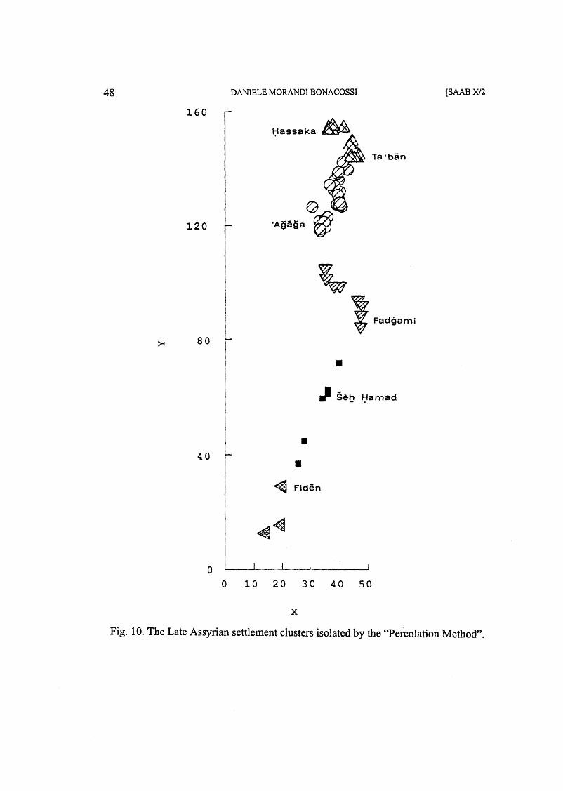
The Percolation model has been used in the present case on a database made up of 54 settlements69. Fig. 9 gives an estimation of the sizes of these sites grouped in a six-rank classification system (from hamlets to large centres).
Among the partitions of the political space of the valley given by the different functions on which the'model relays, the subdivision in five groups operated by the "dominance" function was chosen (Fig. 10). This has given more coherent results even though very similar to those of the two demographic functions ("demographic energy" and "potential of population") 70.
The Percolation model therefore allows us to recognise the presence in the Lower ijabur valley's settlement system of six subsystems or "districts" which to a certain extent are independent of each other 71.
1) District of HassakalMagarisu. Also the fourisatellite districts of Abu C Amshah, Rajman, Abu Bakr and Guweran are part of this district which, if the identification of Hassaka with Magarisu is to be considered correct, in the Sargonic period probably belonged to the N eo-Assyrian province of N a~ibina. This first grouping of sites was
67) De Guio, AnalisiJunzionale ... , cit. (th. 2, above), pp. 458f.; Alia ricerca ... , cit. (fn. 10, above), p. 166. 68) For a detailed and thorough critical discussion of the major problems relating to the application ofthe method and its limits, cf. De Guio - Secco, Archaeological Applications ... , cit. (fn. 1 0, above), pp. 76-91 and De Guio, AnalisiJunzionale ... , cit. (fn. 2, above), pp. 469-473. 69) The analysis was initially conducted on all the sites of the valley which could be assigned with certainty to the Late Assyrian horizon and for which it was possible to reconstruct the sizes with a certain degree of precision (59 sites). Therefore, besides the sites of uncertain dating and size, also the settlements located in the steppe were excluded. Subsequently, the possibility of the area of Magarisu belonging to the province of N~ibina and the probable identification of the site with today's Hassaka have led us to eliminate this site and the neighbouring satellite settlements from the analysis. Once excluded the sites of Abu cAmshah, Rajman, Abu Bakr and Guweran, the percolation analysis was conducted on a base of 54 settlements. 70) The partitions of the landscape of power of the Lower ijabur valley in four clusters given by the three functions have not been accepted insofar as these functions are not able to recognise as autonomous the group that is linked up with the great site of FadghamilQatni, thus broadening exceedingly the area of influence of the settlement of Sheikh Hamad. This area would have reached as far as the site of Bahza North (Fig. 9, no. 47). The division of the valley's territory in 7 groups of sites, subsequent to our selected division in five clusters, has been rejected since it led to a strong and implausible fragmentation of the region's political space. 71) The five districts of the valley and an external sixth (that of Hassaka), which probably politically and administratively did not belong to the Lower ijabur.
34 DANIELE MORANDI BONACOSSI [SAAB XJ2
separated from the subsequent cluster by an inhabited area in the territory included between Rajman (Fig. 9, no. 58) and Rad Shaqrah (no. 72). Such a break in the continuity of the settlement was probably determined by the presence of vast lava flows erupted from the volcano Kaukab which, in many points, reached the course of the river, thus hindering the formation of a floodplain both cultivable and suitable for settlement. In the Late Assyrian period the physiographic barrier formed by the basalts of the Jebel Kaukab could therefore have marked a political-administrative border between the province ofNa~ibina and the area south of it. The size of Hassaka and the presence of a ring of villages around it lead to the assumption that the site was a major centre in the N a~ibina province, perhaps the capital of a local administrative district within the province itself. 2) District of Taf:banlT abete. This group is made up of few settlements. 3) District off:AjajaISadikanni. This cluster represents the largest grouping of settlements, with a higher settlement density. Its southern. border is marked by the low ridge of hills which cuts across the valley near today's site of Saba'a Arbain (Fig. 9). Once more a physiographic barrier seems to have become an administrative border. Sadikanni was the capital of a province known as su~p by the above-mentioned letters sent to Sargon by his governor 72.
4) District of FadghamilQatni. This includes the settlements located between Bahza North (no. 47) and Ashamsani (no" 20). Few kilometres to the south of this site, the width of the river floodplain is greatly reduced on both sides of the ljabur, in particular on the east bank of the river where the alluvial plain is virtually non-existent. Coinciding with this shrinking of the valley the settlement activity ceases and starts again only to the south, at the site of Marqada (no. 19). 5) District of Sheikh Hamad. The cluster of settlements dominated by the great centre of Tell Sheikh Hamad73 reaches south as far as the site ofNamliya (no. 21). 6) District of Fiden. Although made up of only three settlements and dependent on a centre (no. 7) of a limited size (6.5 ha), this group represents one of the apparently more stable clusters 74.
72) The name of Sadikanni appears neither in the list of the Late Assyrian provinces (cf. Forrer, Provinzeinteilung ... , cit. [fn. 24, above], tab. p. 6), nor in the so-called Bezirkslisten, lists of cities published by Forrer, Provinzeinteilung ... , cit. (fn. 24, above), pp. 52-55. 73) Of the 100-110 ha of Tell Sheikh Hamad only 55 ha were located inside the city walls and were densely settled. Approximately 50 ha of surface belonged to an outside city and were only lightly populated (H. Kuhne, "Die rezente Umwelt von Tall Sheikh Hamad und Daten zur Umweltrekonstruktion der assyrischen Stadt Dur-katlimmu. Die Problemstellung", in H. Kuhne [ed.], Die rezente Umwelt von Tall Sheikh Hamad und Daten zur Umweltrekonstruktion der assyrischen Stadt Dur-katlimmu [BATSH 1], Berlin 1991, p. 32). 74) This appears as an autonomous district as from the partition of the sites of the valley into 11 groups and is independent until their subdivision into three groups.
1996] LANDSCAPES OF POWER 35
On the basis of the partitions suggested by the Percolation model and the data from the cuneiform sources it is possible to elaborate the following reconstruction hypothesis of the region's administrative structure in the late eighth and seventh century (Fig. 11):
a) The province of N a~ibina reached as far as the site of Rajman and the border with the territory of the neighbouring province of Sadikanni was made up of the strip without settlements covered by the lava flows of the Jebel Kaukab. The centre of Hassaka/Magarisu with its satellite sites constituted an administrative district of the province ofNa~ibina. .
b) The province of Sadikanni extended as far south as the site of Ashamsani and was subdivided into three administrative districts with centres at TacbanlTabete, CAjaja/Sadikanni, and FadghamilQatni respectively. The region devoid of settlements, and with an extremely narrow floodplain extending from Ashamsani to Marqada, marked the border betWeen the provinces of Sadikanni and Laqe.
c) The districts of Sheikh HamadIDur-katlimmu and FidenlSuru 75 belonged probably to the Middle Euphrates province of Laqe76.
Within the context of this province, the greii growth of the site of Dur-katlimmu stands out. During the second half of the eighth century the city underwent a drastic urbanistic reotganisation through the construction of a vast walled lower city reinforced with buttresses placed at regular intervals 77. As a result the city radically changed its own identity and layout, becoming six times as big (cf. Fig. 9). On the basis of this development, Kuhne 78 suggests that Diir-katlimmu could have regained its old function of provincial capital, a position already held in the Middle Assyrian
75) Forrer, Provinzeinteilung ... , cit. (fn. 24, above), p. 105. For the new identification of Tell Fiden with the ancient Suru, cf. Kuhne, Zur Rekonstruktion ... , cit. (fn. 25, above), pp. 61f. Previously the proposed identification was with the mound of Tell Suwwar (Y. Scheil, Annales de Tukulti Ninip II, Paris 1909, p. 49, fn. 10; S. Hom, "Zur Geographie Mesopotamiens", ZA 34 [1922], p. 152, fn. 2-3; R. Dussaud, Topographie Historique de la Syrie Antique et Medievale, Paris 1927, pp. 487f.; A. Musil, The Middle Euphrates. A Topographical Itinerary, New York 1927, p. 86 fn. 48; S. Parpo1a, Neo-Assyrian Toponyms [AOAT 6], Neukirchen-Vluyn 1970, p. 319). 76) In the itineraries ofTukulti-Ninurta II and Assurna~irpal II Suru is mentioned as "Suru ofBit-ijalupe" or simply as "the city ofBit-ijalupe". Bit-ijalupe was the designation of one of the polities (Sirqu, Supru, etc.) that made up the tribal confederation of Laqe. Already during the ninth century, therefore, the area ofSuru was part of Laqe. Cf. M. Liverani, Studies ... , cit. (fn. 12, above), pp. 32-33 and 69. 77) For an up-to-date summary of the discoveries of the recent campaigns at the site, cf. H. Kiihne, "Tall Sheikh HamadIDur-katlimmu 1985-1987", AID 36/37 (1989-90), pp. 308-327; "Tall Sheik HamadIDurkatlimmu 1988-1990", AID 40/41 (1993-94), pp. 267-272; "Tall Sheikh Hamad. The Assyrian City of Dur-katlimmu; a Historic-geographical Approach", «Bulletin of the Middle Eastern Culture Center in Japan» X (1997), pp. 1-14. 78) Kuhne, Die rezente Umwelt ... , cit. (fn. 73, above), p. 32.
36 DANIELE MORANDI BONACOSSI [SAAB Xl2
period. Such a hypothesis, however, is questionable due to the lack of any type of source supporting it (lists of provinces, cities, occasional mentions in letters or administrative, cadastral or legal documents) and due to the proximity of Diir-katlimmu to the capital of the Sadikanni province, indicated as such by cuneiform sources. It seems instead more in line with the historical information we have through the documentary evidence to interpret the growth of the city of Diir-katlimmu by supposing that in this period the city had acquired new functions within the Assyrian empire with respect to those carried out by the other district centres within the province of Laqc. Although the sources do not help us directly, they do show how the safety of the near steppe region between the Tigris and the ijabur in the period included between 790-770 and 710 Be was threatened by the presence of semi-nomadic Aramaic tribes and, in the steppe of the Assur province, of Arab nomads. The cuneiform sources describe the raiding of settlements, herds and caravans by these nomads 79. Indeed, the nomadic incursions seem to have intensified exactly during the course of the eighth century. ")Vi thin this context of turbulence, and constant threat and pressure from the nomads on the inhabited areas of the neighbouring river valleys80, military actions as a means of repression were carried out by the Assyrian rulers between Tiglath-pileser III and SargortII81.
A military base in the southern segment of the Lower ijabur valley, at the edge of the more -arid steppe, where the presence of the semi-nomadic bands was probably more substantial, would have given the Assyrian army the opportunity to create an important operational and support base for military actions against the Aramaeans.
79) Cf. the inscription ofSamsi-ilu on the lions ofTil-Barsip with the first mention ofthe ijatallu nomads (F. Thureau-Dangin, "L'inscription des lions de Til-Barsip", RA 27 [1930], pp. 16f.; for the reading of the name ijatallu on 1. 11, cf. J.A. Brinkman, A Political History ofPost-Kassite Babylonia, Rome 1968, p. 271, fn. 1740) and the annals of Tiglath-pileserIII (ARAB I, §§ 782,788) and Sargon II (A. Fuchs, Die Inschriften Sargons II. aus Khorsabad, Gottingen 1994, Pronk. 18 and S4, 72), which describe the campaigns fought against the Aramaic tribes of this region united in a single tribal confederation (Utu', Rubu', ijamaranu, Lubuatu, ijatallu). For the incursions of Arab nomads in the province of Assur, cf. F.M. Fales, "Pastorizia e politica: nuovi dati sugli Arabi nelle fonti di eta neo-assira", in A. Avanzini (ed.), Problemi di onomastica semitica orientale, Pisa 1989, pp. 119-134, and the letters SAA I, 82, 84, 173, 175, 177-180. The annals ofSennacherib (704-681; ARAB II, §§ 234 if., 261 f.) instead report a list of rebel Aramaic tribes in which only the tribes of Babylonia are mentioned and no longer the northern Aramaic ones, which were now pacified. For the location of several of the Aramaic tribes in the area of the Wadi Tharthar, i. e. in the steppe east ofthe ijabur, cf. J .A. Brinkman, A Political History ofPost-Kassite Babylonia, Rome 1968, pp. 275-277 and Liverani, RQ.$appu and ffatallu, cit. (fn. 24, above), pp. 35-40. 80) Here we recall, for example, the conquest of 100 villages of the land of Laqe by the Aramaic tribes of the confederation of the ijatallu around 747 and their subsequent defeat by the governor ofSubu and Mari, Ninurta-kudurri-u~ur, described in the so-called "Aramaerbericht" of the "Annals of Subu" (A. Cavigneaux - B.K. Ismail, "Die Statthalter von Subu und Mari im 8. Jh. v. Chr.", BaM 21 [1990], pp. 321-411, transcription on pp. 343 f. col. I, II, 9-35 and translation pp. 347 f.). 81) Cf. fn. 79, above.
1996] LANDSCAPES OF POWER 37
The strong artificial growth of the city of Dur-katlimmu and the possible transformation of its nature through the creation of an extended walled lower city might be part of this new military scenario. Therefore, Dur-katlimmu could have become a great military stronghold in the Laqe province and the seat of a garrison with policing and repression duty towards the semi-nomadic tribes of the neighbouring steppe.
~ The reconstruction of the organisation of political space in the Lower ljabur valley in the Late Assyrian period outlined above shows striking similarities with the subdivision of the region in liwas (administrative districts) and nahiyas (subdistricts) attested in the Tahrir Defterler, an Ottoman register of the fiscal districts dating to the sixteenth century82. As a matter of fact, the liwa of N a~ibina at that time reached as far as the area of the Jebel Kaukab83, while the Lower tJabur valley, as far as the region immediately to the north of the river estuary constituted the liwa of the ljabur, which was void of cities and had no internal division in nahiyas. The area of the mouth of the ljabur and the Middle Euphrates until north of Ana, on the other hand, belonged to the liwa of Deyr. Ibn Hurradadhbah, an Arab geographer of the mid-ninth century, had already written that the city of Qarqisiya -equivalent to the present day Bsera, near the mouth of the ijabur- did ns>t form part of the Kura province (ijabur)84. Yet also in the early Abbasid era, like in the Ottoman and possibly Late Assyrian periods, the Lower tJabur valley was a unitary physiographic and administrative entity only in the region included between the city of Hassaka upstream and the area situated to the north of the mouth of the river downstream. The area of the estuary, on the other hand, was regarded as part of the Euphrates region. Finally, in the Tahrir Defterler, the region of the Jebel Sinjar -the area of our province of Ra~appa- constituted a separate liwa, with its capital at Sinjar and a nahiya with a centre at Tell C Afar85 .
The organisation of political space in the Lower ijabur region therefore seems to have run for centuries along similar guidelines, which in reality probably privileged a more effective structuring of the relations between provinces, districts and single sites in their physical projection on the territory.
82) W. Hiitteroth, "Villages and Tribes ofthe Jezira Under Early Ottoman Administration (16th Century). A Preliminary Report", «Berytus» 38 (1990), pp. 179-184. 83) Cf. Hiitteroth, cit. (preceding fn.), diagram 1. 84) M. De Goeje (ed.), Ibn Hurradadhbah, Abu ~l-Qasim ~Ubaidallah b. ~Abdallah: Kitab al-masalik wa ~-mamalik, (Bibliotheca Geographorum Arabicorum VI), Leiden 1889, p. 96. 85) Kessler, Assyrien bis 800 v. Chr. ... , cit. (fn. 20, above) identifies Ra~appa, capital ofthe homonymous province, with the site of Tell Hadail, located approximately thirty kilometres south-east of the present day city of Sinjar. Furthermore, the mound of Tell C:Afar, which is probably ancient Nemed-IStar (D. Oates, Studies in the Ancient History o/Northern Iraq, London 1968, p. 55, fn. 1; Kessler, Untersuchungen ... , cit. [fn. 20, above], p. 143), is indicated as one of the prominent centres of the Ra~appa province -perhaps the capital of a district- in the inscription on the stela of Saba'a (Unger, Reliefstele Adadniraris III ... , cit. (fn. 19, above), 1. 23).
38 DANIELE MORANDI BONACOSSI [SAAB XJ2
As for the Percolation model, it has been observed how, despite its complex character and the noteworthy mathematical sophistication of its functions, it actually relies on principles of automatic simulation of the origin of the ancient reality. Such a predictive reproduction of the past gives rise to unsolved problems of verifiability and, therefore, of reliability. Nonetheless, the essential coherence of the landscape of power reconstructed by means of the Percolation model with the picture drawn from the Assyrian sources and the archaeological record upholds the heuristic potential of this simulative analysis.
In conclusion, although attention must be drawn once again to the hypothetical nature of the reconstruction proposed above, we should underline the effectiveness of the Percolation model in its contribution to reconstructing the political and administrative layout of the valley in the eighth and seventh centuries Be. This indicates how the study of "Landscapes of Power"S6, if pursued critically and consciously of structurallimitations, can lead to useful and concrete results in the analysis of the structure and organisation of ancient political space.
86) Intended as a field of research aimed at elaborating new analytical models and at improving existing ones in order to tackle the complexity and evasiveness of the political dimension of geographical space.
1996] LANDSCAPES OF POWER
'.it,
f:tamad/Dur- katlimmu A.
LEGEND
~ . Area under direct Assyrian ~ control
Middle Assyrian provincial institutions mentioned in the sources
39
• Main site with Middle Assyrian "official" pottery
Fig. 1. The Assyrians in the Lower ijabur valley in the thirteenth century Be: the evidence of the cuneifonn sources.
40 DANIELE MORANDI BONACOSSI
&.
§ih t;iamad/Our- katllmmu •
[SAABXJ2
LEGEND
% Area under direct Assyrian @ control
•
Seat of a governor mentioned in the sources
Main site with Middle Assyrian "official" pottery
Fig. 2. the Assyrians in the Lower ijabur valley in the twelfth-eleventh centuries Be (until Tiglath-pileser I): the evidence of the cuneiform sources.
1996] LANDSCAPES OF POWER 41
LEGEND
Fig. 3. The Assyrians in the Lower ijabur valley after Tiglath-pileser I (until the end of the eleventh century Be): the evidence of the cuneiform sources.