Leaders in providing decision-quality data September 2013 NAVAIR Public Release #10-1461 Approved for public release; distribution unlimited Electro Optical Tracking Systems TRACKING SYSTEMS The Electro Optical Tracking Systems Section develops, operates, maintains and sustains optical instrumentation at the Atlantic Test Ranges. This instrumentation is used to obtain Time, Space, Position Information (TSPI) data and documentary imaging data on manned and unmanned aircraft, weapon and ship system testing. The section uses fixed and mobile assets in the visible and infrared (IR) spectrums locally, at remote locations and aboard ships. The section also provides precision metrology and geodetic survey services, both locally and at remote locations. LASER TRACKING SYSTEMS An Automatic Laser Tracking System provides precision, single-station solution TSPI data from cooperative (retroreflector-fitted) targets. The eye-safe system is located at the intersection of the two Patuxent River runways to cover takeoffs, landings and infield maneuvers and can also provide data in the restricted airspaces around the Hooper Target Complex. AUTOMATED IR TRACKING SYSTEM The MINILIR is a portable, automatic, IR tracking system that provides automatic tracking of IR sources, such as aircraft landing lights and aircraft/weapon system exhaust. This is a stand-alone, portable, tripod-mounted system configured with an eye-safe semiconductor laser ranger to provide precision single-station, solution TSPI data on cooperative targets. Time-tagged video cameras provide documentation of test events. FOR MORE INFORMATION (301) 342-1197 / 1170 / 3682 / 8640 / 3607 / 1181 23013 Cedar Point Road Patuxent River, MD 20670 [email protected]www.navair.navy.mil/tande/ranges Automatic Laser Tracking System (ALTS) MINILIR portable automatic tracking system MINILIR tracking a V-22 aboard the USS Wasp
Transcript
Leaders in providing decision-quality data
September 2013
NAVAIR Public Release #10-1461Approved for public release; distribution unlimited
Electro Optical Tracking Systems TRACKING SYSTEMS
The Electro Optical Tracking Systems Section develops, operates, maintains and sustains optical
instrumentation at the Atlantic Test Ranges. This instrumentation is used to obtain Time, Space, Position
Information (TSPI) data and documentary imaging data on manned and unmanned aircraft, weapon and ship
system testing. The section uses fixed and mobile assets in the visible and infrared (IR) spectrums locally,
at remote locations and aboard ships. The section also provides precision metrology and geodetic survey
services, both locally and at remote locations.
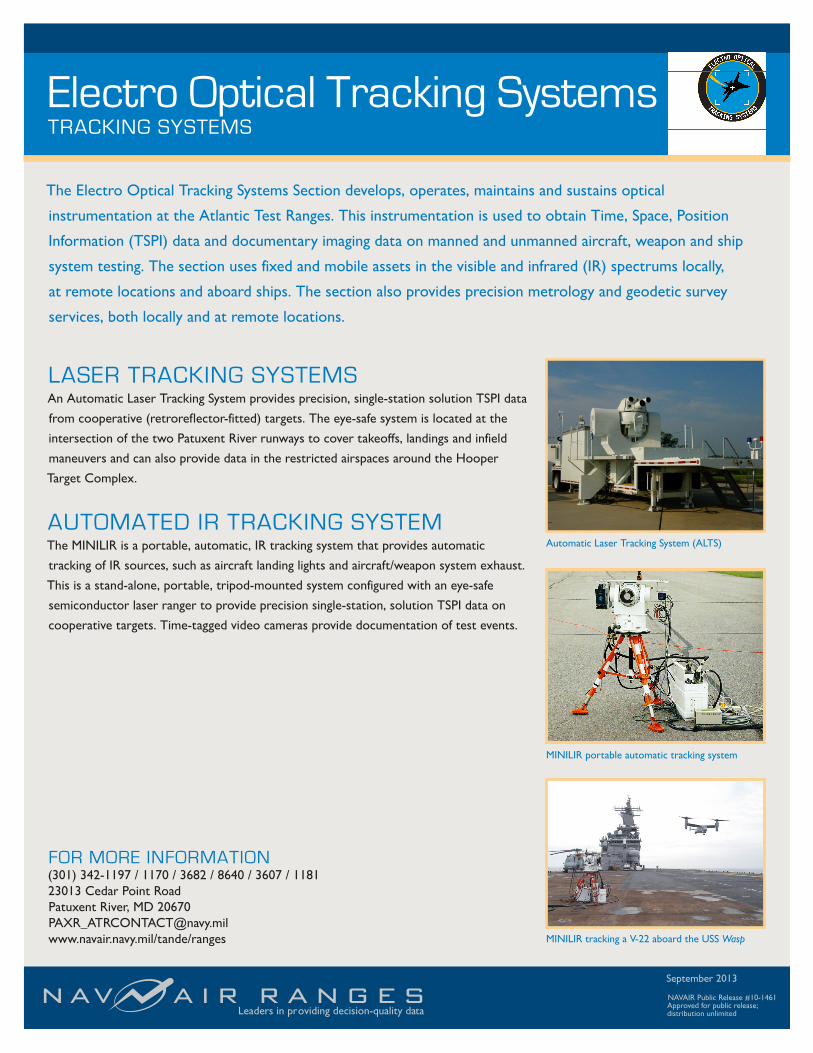
LASER TRACKING SYSTEMSAn Automatic Laser Tracking System provides precision, single-station solution TSPI data
from cooperative (retroreflector-fitted) targets. The eye-safe system is located at the
intersection of the two Patuxent River runways to cover takeoffs, landings and infield
maneuvers and can also provide data in the restricted airspaces around the Hooper
Target Complex.
AUTOMATED IR TRACKING SYSTEMThe MINILIR is a portable, automatic, IR tracking system that provides automatic
tracking of IR sources, such as aircraft landing lights and aircraft/weapon system exhaust.
This is a stand-alone, portable, tripod-mounted system configured with an eye-safe
semiconductor laser ranger to provide precision single-station, solution TSPI data on
cooperative targets. Time-tagged video cameras provide documentation of test events.
FOR MORE INFORMATION(301) 342-1197 / 1170 / 3682 / 8640 / 3607 / 118123013 Cedar Point RoadPatuxent River, MD [email protected]/tande/ranges
Automatic Laser Tracking System (ALTS)
MINILIR portable automatic tracking system
MINILIR tracking a V-22 aboard the USS Wasp
Electro Optical Tracking Systems
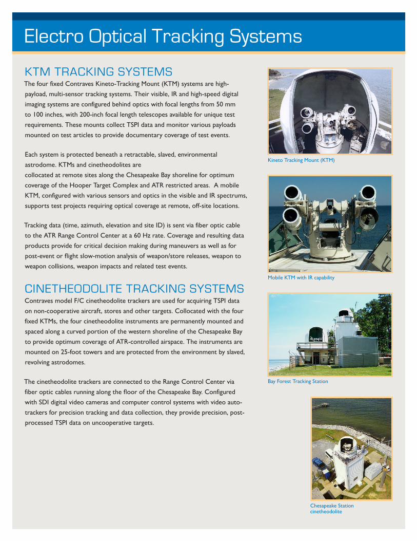
KTM TRACKING SYSTEMSThe four fixed Contraves Kineto-Tracking Mount (KTM) systems are high-
payload, multi-sensor tracking systems. Their visible, IR and high-speed digital
imaging systems are configured behind optics with focal lengths from 50 mm
to 100 inches, with 200-inch focal length telescopes available for unique test
requirements. These mounts collect TSPI data and monitor various payloads
mounted on test articles to provide documentary coverage of test events.
Each system is protected beneath a retractable, slaved, environmental
astrodome. KTMs and cinetheodolites are
collocated at remote sites along the Chesapeake Bay shoreline for optimum
coverage of the Hooper Target Complex and ATR restricted areas. A mobile
KTM, configured with various sensors and optics in the visible and IR spectrums,
supports test projects requiring optical coverage at remote, off-site locations.
Tracking data (time, azimuth, elevation and site ID) is sent via fiber optic cable
to the ATR Range Control Center at a 60 Hz rate. Coverage and resulting data
products provide for critical decision making during maneuvers as well as for
post-event or flight slow-motion analysis of weapon/store releases, weapon to
weapon collisions, weapon impacts and related test events.
CINETHEODOLITE TRACKING SYSTEMSContraves model F/C cinetheodolite trackers are used for acquiring TSPI data
on non-cooperative aircraft, stores and other targets. Collocated with the four
fixed KTMs, the four cinetheodolite instruments are permanently mounted and
spaced along a curved portion of the western shoreline of the Chesapeake Bay
to provide optimum coverage of ATR-controlled airspace. The instruments are
mounted on 25-foot towers and are protected from the environment by slaved,
revolving astrodomes.
The cinetheodolite trackers are connected to the Range Control Center via
fiber optic cables running along the floor of the Chesapeake Bay. Configured
with SDI digital video cameras and computer control systems with video auto-
trackers for precision tracking and data collection, they provide precision, post-