Late Cretaceous emplacement of ophiolitic-radiolaritic thrust sheets over the Arabian passive margin was the fi rst manifestation of the protracted closure of the Neotethys Ocean, which ended with the continental collision between Arabia and central Iran and the formation of the present Zagros fold belt. This tectonic stacking produced a fl ex-ural basin (the Amiran Basin: 400 × 200 km in size) in the northwest Zagros that was filled with a 1225-m-thick shallowing-upward detrital succession made up of the Amiran, Taleh Zang, and Kashkan Forma-tions. This succession sits unconformably above the Late Cretaceous Gurpi Formation and is overlain by the Oligocene-Miocene
Shahbazan-Asmari carbonate succession. Dating of the Amiran-Kashkan succession is based on detailed biostratigraphy using large foraminifera and calcareous nannoplankton.
The Cretaceous-Tertiary (K-T) boundary is located within the uppermost 25–45 m of the Gurpi Formation. The overlying Ami-ran and Taleh Zang Formations have been dated as Paleocene in age. However, the base of the Paleocene within the Gurpi Forma-tion lacks NP1 and NP2 zones, implying a hiatus of ~2 m.y. at ca. 65.5 Ma, which is inferred to correspond to an early fold-ing phase near the Cretaceous-Paleocene boundary. The upper part of the Kashkan Formation is dated to the earliest Eocene by palynostratigraphy. A large hiatus (or very slow deposition) lasting about 15 m.y. oc-curs between the Kashkan and Shahbazan Formations in the studied region. The base
of the prograding Shahbazan platform de-posits is dated by 87Sr/86Sr stratigraphy at ca. 33.9 Ma. The upper part of the Asmari Formation is dated as early-middle Miocene using foraminifera associations.
Reconstruction of the Amiran–Taleh Zang–Kashkan succession of the Amiran Basin indi cates a thickening of the basin fi ll from the southern pinch-out along the SE fl ank of the Kabir Kuh anticline to SW of the Khorramabad anticline, where the fl exure is at least 900 m. In contrast, the NE part of the basin underwent coeval contraction and uplift of ~1300 m. Superimposed smaller un-dulations onto the large-scale fl exure are in-terpreted as Late Cretaceous–Paleocene folds.
Regional comparisons (SE Zagros, Oman, and Turkey) indicate that Late Cretaceous–Early Tertiary deformation affected the entire NE margin of Arabia but that compression
Late Cretaceous–Paleocene formation of the proto–Zagros foreland basin, Lurestan Province, SW Iran
Stéphane Homke†
Group of Dynamics of the Lithosphere (GDL), Institute of Earth Sciences “Jaume Almera,” Consejo Superior de Investigaciones Científi cas, Lluís Solé i Sabarís s/n, Barcelona 08028, Spain and StatoilHydro Research Centre, Sandsliveien 90, Bergen, P.O. Box 7200, N-5020 Bergen, Norway
Jaume VergésGroup of Dynamics of the Lithosphere (GDL), Institute of Earth Sciences “Jaume Almera,” Consejo Superior de Investigaciones Científi cas, Lluís Solé i Sabarís s/n, Barcelona 08028, Spain
Josep Serra-KielDepartment of Stratigraphy, Paleontology and Marine Geosciences, University of Barcelona, 08028 Barcelona, Spain
Gilen BernaolaDepartment of Stratigraphy and Paleontology, Faculty of Science and Technology, University of the Basque Country, P.O. Box 644, 48080 Bilbao, Spain
Ian SharpStatoilHydro Research Centre, Sandsliveien 90, Bergen, P.O. Box 7200, N-5020 Bergen, Norway
Miguel GarcésIsmael Montero-VerdúDepartment of Stratigraphy, Paleontology and Marine Geosciences, University of Barcelona, 08028 Barcelona, Spain
Ridvan KarpuzStatoilHydro Research Centre, Sandsliveien 90, Bergen, P.O. Box 7200, N-5020 Bergen, Norway and OMV Exploration and Production, Gerasdorfer Strasse 151, 1210 Vienna, Austria
Mohammad Hassan GoodarziNational Iranian Oil Company, Exploration Directorate, National Iranian Oil Company Building, Taleghuni Avenue, Hafez Crossing, P.O. Box 1863, Tehran, Iran
Published online April 24, 2009; doi:10.1130/B26035.1
Homke et al.
964 Geological Society of America Bulletin, July/August 2009
was not synchronous, being younger in Lurestan than in the NW Persian Gulf where inversion tectonics occurred from Turonian to mid-Campanian times. The long sedimentary hiatus spanning most of the middle and late Eocene must have been related to deep litho-spheric processes linked to the initial events of the protracted closure of the Neo tethys Ocean between Arabia and central Iran. The tectono-sedimentary history recorded in the Zagros Basin may help to understand early foreland basin growth in other orogens in which subsequent continental collision has obliterated these early events.
The NW-SE–trending Zagros orogenic belt extends over 2000 km from Turkey to south-eastern Iran, and it represents a large segment of the Alpine-Himalayan collisional system (e.g., Berberian and King, 1981; Golonka, 2004) (Fig. 1). The formation of the Zagros belt resulted from the closure of the Neotethys Ocean between Arabia and central Iran. Ear-liest orogenic movements began during Late Cretaceous time (Gidon et al., 1974), when radiolaritic-ophiolitic oceanic slices together with distal parts of the Arabian margin were obducted and emplaced along the entire length of the Arabian passive margin (e.g., Ricou et al., 1977; Ravaut et al., 1997; Braud, 1987; Agard et al., 2005) (Fig. 1). In Lurestan Prov-ince (NW Zagros), thrust sheet emplacement was associated with the formation of a fl ex-ural basin that was initially fi lled by calcare-ous deep-marine sediments (Gurpi Formation) followed by ophiolite- and radiolarite-derived clastic sediments (e.g., the Amiran “fl ysch” Formation and the conglomeratic Kashkan Formation). These detrital units are thicker in the more internal part (NE) of the foreland ba-sin and pinch out toward the SW (James and Wynd, 1965) (Figs. 2 and 3). Continuous con-vergence between Arabia and central Iran pro-duced the fi nal closure of the Neotethys Ocean and Arabia–central Iran continental collision. Although initiation of collision is not clearly dated, it is well accepted that oceanic closure did not directly follow the obduction event. Proposed ages for the collision range from Eocene (Braud, 1987; Sengör et al., 1993) to late Miocene (Stoneley, 1981; McQuarrie et al., 2003). Neogene shortening of the 12–14-km-thick sedimentary Zagros cover succession shaped the actual Zagros fold-and-thrust belt,
in front of which, the Mesopotamian–Persian Gulf foreland basin developed (Fig. 2). The long-lived convergence between Arabia and central Iran led to development of a foreland basin fi lled by a 4–5-km-thick marine to non-marine syntectonic siliciclastic succession.
Magnetostratigraphic analysis of the fore-land Agha Jari Formation in southwest Lurestan shows that folding reached the front of the folded belt in the Pusht-e Kuh arc in Lurestan Prov-ince around 7.6 ± 0.5 Ma (Homke et al., 2004) (Fig. 2). In contrast, the initiation of the fl exural basin during deposition of the Amiran Formation on top of the carbonate-dominated Arabian pas-sive margin is poorly dated. According to James and Wynd (1965), biostratigraphic relations show that the Amiran Formation is Paleocene in central Lurestan and Maastrichtian to Paleocene in the northeastern (internal) part of the basin. As a result, some authors use a Maastrichtian-Paleocene age for the Amiran Formation (Ber-berian and King, 1981; Hooper et al., 1994), while others consider it to be mostly Maastrich-tian (Falcon, 1974; Alavi, 2004). Precise dating of these syntectonic strata is required to accu-rately constrain the timing for development of the Zagros fold-and-thrust belt and associated foreland basin, as well as hydrocarbon history.
The main objectives of this study were to bet-ter constrain the age of the Amiran, Taleh Zang, and Kashkan Formations, which constitute a shallowing-upward foreland-basin fi ll succes-sion sandwiched between the open-marine Late Cretaceous Gurpi Formation and over lying Oligocene-Miocene Shahbazan and Asmari Formations. The Amiran-Kashkan succes-sion was studied on the northeastern fl ank of the Amiran anticline where it crops out continuously, permitting its accurate study and sampling (Fig. 2). The age of deposition was determined using a multidisciplinary ap-proach that combined magnetostratigraphy, biostratigraphy using large foraminifera and cal careous nannoplankton, palynostratig-raphy, and strontium isotope geochemistry. Dating of the Amiran-Kashkan succession, studies of sediment composition, and dating of Shahbazan-Asmari carbonates allowed us to create an accurate reconstruction of the geome-try of the sedimentary fi ll of this early foreland basin at the front of advancing deformation. These results allow interpretation of the evolu-tion of the early Zagros foreland basin during a crucial period of geodynamic change from a passive-margin to compressive setting. The isolation and quantifi cation of the bending and
Ophiolitic complexesand melanges
Anatolian plate
Arabian Plate
Sistan
Makran
Kopeh DagAlborz
Pontides
G. Caucasus
Sanandaj Sirjan block
Eurasia
African plate
Central Iranianblocks
Lutblock
Zagros fold-and-thrust belt
Talesh
Bitlis suture zone
L. Caucasus
Mesopotamian
foreland basin
Red Sea
IranNW
block
EAAC
Naien-Baft
Sabzevar
16 mm/yr
Black Sea
Medit.Sea
Persian Gulf
Caspian Sea
Turan Shield
OmanMts
32°E 36°E 40°E 44°E 48°E 52°E 56°E 60°E
42°N
38°N
34°N
30°N
26°N
22°N
18 mm/yr
22 mm/yr
Figure 1. Plate tectonic context of the Arabian-Eurasian collision zone. Approximate posi-tions of main ophiolitic complexes and ophiolitic mélanges are given. N—Neyriz complex, K—Kermanshah complex, Ky—Koyi ophiolites, A—Ankara-Erzincan ophiolites, B—Berit ophiolite, H—Hatar and Baer-Bassit ophiolites, M—Mersin complex, T—Troodos ophio-lite, EAAC—East Anatolian accretionary complex. Velocities of movement of Arabia with respect to Eurasia (in mm/yr) are from Sella et al. (2002).
Formation of the early Zagros foreland basin
Geological Society of America Bulletin, July/August 2009 965
shortening that occurred in this early foreland basin are important for understanding the over-all evolution of the basin. Implications for the larger regional setting along the Oman-Zagros-Bitlis suture zone are also discussed.
GEOLOGICAL CONTEXT
Structure of the Zagros Belt
The Zagros orogen can be divided from northeast to southwest into four parallel NW-SE–trending structural domains (Fig. 2): the Sanandaj-Sirjan zone, the imbricate zone, the simply folded belt, and the Mesopotamian–Persian Gulf foreland basin.
The Sanandaj-Sirjan zone is a 150–200-km-wide zone composed of deformed and meta-morphosed Paleozoic to Mesozoic rocks intruded by Late Cretaceous to Paleocene plu-tons (Stöcklin, 1968; Alavi, 1994; Mohajjel and Fergusson, 2000). The Sanandaj-Sirjan zone is generally regarded to be of Eurasian affi nity (southern active margin of the Iranian plate) and was accreted to the Arabian margin at the end of Tethys ocean closure (e.g., Ber-berian and King, 1981; Mohajjel et al., 2003).
The Sanandaj-Sirjan zone is thrust southwest-ward over the imbricate zone (or High Zagros). The so-called Main Zagros thrust that sepa-rates the two domains represents the suture between the Arabian and Iranian plates (e.g., Berberian and King, 1981; Agard et al., 2005).
The imbricate zone, or High Zagros, con-sists of imbricated tectonic slices involving radiolarite-ophiolite complexes, Mesozoic and Cenozoic sedimentary and volcanic rocks, and thrust sheets from the Sanandaj-Sirjan zone (e.g., Agard et al., 2005). The imbricate zone is bounded to the southwest by the High Zagros fault (Berberian, 1995).
The simply folded belt is characterized by well-developed folds involving the entire 12–14-km-thick sedimentary cover of the Zagros Basin (e.g., Falcon, 1974; Colman-Sadd, 1978). The Mountain Front fault (or Mountain Front fl exure) bounds the simply folded belt to the southwest (Falcon, 1961; Berberian, 1995). This structural and topographic front has an irregu-lar geometry defi ning salients and reentrants , including the Fars arc (Fars Province), the Dezful embayment (Khuzestan Province), and the Pusht-e Kuh arc (Lurestan Province), from southeast to northwest, respectively (Fig. 2).
The Mesopotamian–Persian Gulf foreland basin extends in front of the simply folded belt. The most proximal part of the foreland basin is characterized by NW-SE–trending buried anti-clines, including the hydrocarbon-prolifi c Dezful embayment (Dunnington, 1968). Miocene to Quaternary detrital deposits (e.g., the fl uvial Agha Jari and conglomeratic Bakhtyari Forma-tions) fi ll the Mesopotamian foreland basin.
Zagros Radiolarite-Ophiolite Complexes
Two radiolarite-ophiolite complexes crop out in the imbricate zone of the Zagros belt: the Neyriz complex in Fars Province, and the Kermanshah complex in Lurestan Province (Fig. 2). They belong to the large-scale Tethyan ophiolite belt that extends from the Balkans to northern India through Greece, Turkey, Iran, and Oman (Ricou et al., 1977; Coleman, 1984) (Fig. 1).
According to Ricou et al. (1977) and Alavi (1994), the Neyriz complex was emplaced onto the northeastern Arabian continental mar-gin between Turonian and Maastrichtian time. Emplacement of the Kermanshah complex in Lurestan Province (Fig. 2) is thought to have taken place later. The onset of compressive movements is recorded by small fragments of radiolarite interbedded in autochthonous Cenomanian deposits (Berthier, 1974), but thrusting was mostly active between Santo-nian and early Eocene time. Indeed, the basal radiolarite unit rests on Santonian-Campanian strata, and early Eocene deposits (the “Eocene red beds,” now included in the Kashkan For-mation) unconformably cover the front of the thrust sheets in several localities of the imbri-cate zone (Berthier, 1974; Gidon et al., 1974; Braud, 1987; Agard et al., 2005). Emplacement of the Kermanshah complex in north Lurestan led to the fi rst volumetrically signifi cant arrival of siliciclastic material in the Zagros Basin with deposition of the Amiran, Taleh Zang, and Kashkan Formations (Figs. 2 and 3).
The tectonic stack of the Kermanshah radiolarite-ophiolite complex is composed of a 500–800-m-thick Triassic to Cretaceous radiolarite series (Braud, 1970), an ~3000-m-thick upper Triassic to Cenomanian limestone unit (Bisotun unit; Agard et al., 2005), origi-nally separated from the Arabian platform by the “radiolarite trough” (Ricou et al., 1977), and dismembered ophiolite remnants gener-ated around 85 Ma (Delaloye and Desmons, 1980). Slices of these different units crop out in the imbricate zone over more than 200 km along strike. Their southeast front marks the trace of the High Zagros thrust in northwest Lurestan (Fig. 2).
Khuzestan
Lurestan
MFF
Deformation
front
HZF
MZT
34°N
33°N
32°N
31°N
46°E 48°E 50°E 52°E 54°E 56°E
Kabir Kuh
Imbricate zone
Sanandaj-Sirjan zone
Central Iran
Dezful Embayment
Persian GulfFars Province
Mesopotamian
foreland basin
Khorramabad
Kuh-e Garri
Kuh-e Surkheh
200 km N
Radiolarite-ophiolite complexes
Amiran Formation
Amiran anticline
Folded belt
arc
Urumieh-Dokhtar
Figure 2. Structural map of the Zagros belt. Ophiolite complexes are mapped in black. The limit of the Amiran Formation is indicated. The rectangle in the Lurestan Province indicates the location of the studied section, in the Amiran anticline. MZT—Main Zagros thrust, HZF—High Zagros fault, MFF—Mountain Front fault.
Homke et al.
966 Geological Society of America Bulletin, July/August 2009
Mesozoic-Cenozoic Stratigraphy of Lurestan Simply Folded Belt
The tectonic phases of the Zagros orogeny controlled deposition of the upper part of the 12–14-km-thick Precambrian to Quaternary sedimentary column of the simply folded belt. In northeast Lurestan, the exposed Mesozoic-Cenozoic stratigraphic column consists of ~4–5 km of pre-orogenic strata and 4–5 km of synorogenic deposits. The Mesozoic pre-orogenic succession is composed mainly of passive-margin carbonate units. The overly-ing synorogenic deposits include, from bottom to top, the Amiran-Kashkan detrital succes-sion, the Shahbazan-Asmari shallow-marine carbonate platform, the evaporitic Gachsaran Formation, and the siliciclastic Agha Jari and Bakhtyari Formations.
Deposition of the Amiran Formation on top of the Gurpi Formation marks the transition from
deep-marine carbonate to foreland siliciclastic sedimentation in the NW Zagros Basin (Fig. 3). To the northeast of the Khorramabad anticline, thick Late Cretaceous radiolaritic conglomer-ates, which pass laterally to the Gurpi Forma-tion along the well-exposed northeastern fl ank of the anticline (Fig. 3A), are generally regarded as the proximal part of the Amiran Formation (e.g., Braud, 1987). To the southeast of the Khorramabad anti cline, the Amiran Formation fl ysch is composed of ophiolitic detritus, and it forms a SW-thinning wedge that pinches out against the NE fl ank of the Kabir Kuh anticline (Fig. 2). According to James and Wynd (1965), the Amiran Formation grades laterally into the Pabdeh Formation (Fig. 3A). The shallow-water carbonate and detrital Taleh Zang Formation and the red conglomeratic Kashkan Formation form the upper part of the early foreland detrital succession (Fig. 3A). James and Wynd (1965) used biostratigraphy to provide a Campanian to
Paleocene age for the Gurpi Formation, Maas-trichtian to Paleocene age for the Amiran For-mation, and Paleocene to middle Eocene age for the Taleh Zang and Kashkan Formations. Alavi (2004) integrated these dates in a modern interpretation for foreland basins (DeCelles and Giles, 1996) in which the Amiran Formation, which grades laterally into the Gurpi Formation, belongs to a prograding sequence that also in-cludes the Surgah, Ilam, and Gurpi Formations. This sequence is separated by a sedimentary unconformity from the overlying sequence that includes the Pabdeh, Taleh Zang, Kashkan, and Shahbazan Formations (Fig. 3B). Differences between the lithostratigraphic description of James and Wynd (1965) and the model from Alavi (2004) illustrate the complexity of the basin deposition history (Fig. 3).
The regional shallow-marine platforms of the Shahbazan and Asmari Formations cover the Amiran–Taleh Zang–Kashkan detrital succes-sion in northeast Lurestan with a proposed age of middle to late Eocene age for the Shahbazan Formation, and Oligocene to early Miocene age for the Asmari Formation (James and Wynd, 1965) (Fig. 3A). The evaporitic Gachsaran For-mation, which overlies the Asmari limestones, records progressive transition from marine to nonmarine conditions in the basin. The overlying fl uvial Agha Jari Formation is in turn overlain by conglomerates of the Bakhtyari Formation, which form the uppermost sedimentary cover (James and Wynd, 1965; Homke et al., 2004).
STRATIGRAPHY OF THE STUDIED SECTION
The studied section is composed of fi ve shorter subsections along the northeastern limb of the Amiran anticline, in the central area of Amiran Basin (Figs. 2 and 4). The composite section encompasses the topmost Gurpi Formation, the Amiran Formation, the Taleh Zang Formation, the Kashkan Formation, and the Shahbazan-Asmari Formations (Figs. 4, 5, and 6A).
Topmost Gurpi Formation
The uppermost part of the Gurpi Formation consists of decimeter-scale beds of gray marl and light-colored fi ne-grained limestone. The con-tact with the overlying dark siliciclastic Amiran Formation is roughly concordant but sharp and is marked by a clear color change (Fig. 6A).
Amiran Formation
The Amiran “fl ysch” Formation, 810 m thick in the Amiran anticline section, is composed of dark mudstone-siltstone layers, medium- to
Cret.
Paleoc.
Eoc.
Oligo.
500
m
50 km
SW NE
Ilam
Kalhur Mb
Kalhur MbAsmari
Shahbazan
Kashkan
Amiran
Taleh Zang
Pabdeh
SurgahSarvak
IlamGurpi
Sachun
Radiolaritic conglo.
Ophiolitic turbidite Platform carbonates
Basinal carbonate
Evaporite
Sedimentary gap
Mioc.
Pl.-Pleist.
Agha Jari
Gachsaran
Backhtyari
Alluvial conglo.
Fluvial deposits
Kabir Kuh Amiran Khorramabad
A. Modified from James and Wynd (1965)
Surgah
Sarvak
B. Modified from Alavi (2004)
Kabir Kuh Amiran
Kuh-e Pasan Kuh-e Sultan Pusht-e Jangal
Pabdeh
AmiranGurpi
Asmari Shahbazan
Kashkan Taleh ZangLate Cret. Conglo.
Sultan Pusht-e Jangal
Figure 3. (A) Stratigraphic NE-SW cross section across Lurestan Province, from James and Wynd (1965). (B) NE-SW chronostratigraphic chart across the Lurestan Province, simpli-fi ed from Alavi (2004). This chart is mostly based on stratigraphic ages from James and Wynd (1965).
Formation of the early Zagros foreland basin
Geological Society of America Bulletin, July/August 2009 967
coarse-grained gray-colored sandstone beds, in-cluding lenticular channel bodies (mainly oriented NE-SW; Fig. 5), and thin limestone beds (wacke-stone to packstone) (Fig. 6B). The lower 180 m of the Amiran Formation consist of centimeter- to decimeter-scale layers of mudstone-siltstone and medium-grained sandstone, with inter-calated thin limestone beds. Sandstone bodies are more common between 200 and 370 m (in the studied section), where they reach 15 m in thick-ness and include lenses of coarse-grained sand-stone and red chert pebble conglomerate. Thin limestone beds are regularly intercalated with the mudstone-siltstone layers, which reach sev-eral meters in thickness. Above 370 m in the section (Fig. 5), sandstone frequency decreases, and sandstones form spaced channel bodies with rare slump features, separated by decameter-scale mudstone-siltstone layers. A slight color change occurs in the middle part of the forma-tion, around 425 m in the section (Figs. 5 and 6A). The lower half of the formation is clearly
darker in color than the upper half, which appears more greenish. This color change follows a bed-parallel trajectory that can be followed across the landscape (Fig. 6A). Above 600 m in the sec-tion, the formation becomes dominated by silty claystone deposits and thin limestone beds with sparse sandstone beds (Fig. 5).
The Amiran Formation is dark due to the ophiolitic component in the sediments (James and Wynd, 1965). Sandstones of the lower part of the formation (samples SH023–2, 146 m, and SH034–1a, 226 m) contain mineral associations characteristic of derivation from ultramafi c rocks, including numerous detrital grains of serpen-tinite, brucite (typical of hydrothermal dikes in serpentine), some serpentinized olivines, altered feldspar, and fractured pyroxene (Fig. 6E). Iron oxides, glauconite, chlorite, clays, and chert fragments (possible radiolarian cherts) are also well represented. Sandstones from the upper part of the Amiran Formation contain less serpentine grains and no brucite. Detrital feldspars are the
main component of sample SH084–1a (631 m), which also contains carbonate rock fragments, iron oxides, glauconite, and chlorite grains (Fig. 6F). Sample SH107–2 (817 m), below the transition with the Taleh Zang Formation, is mainly composed of clasts and bioclasts of lime-stone, with some feldspar and oxide grains.
Taleh Zang Formation
The Taleh Zang Formation (~190 m thick in the Amiran anticline section) is composed of platform carbonates in much of northwest Lurestan (James and Wynd, 1965), showing strongly progradational clinoforms that pass laterally to upper Amiran slope deposits. This platform facies is observable in the southwest-ern part of the Amiran anticline. In the central part of the anticline, however, the studied sec-tion crosses a more detrital facies composed of decimeter- to meter-scale bioclastic limestone, dark mudstone-siltstone, and brown sandstone beds (Figs. 5 and 6C) containing reef-derived bioclasts of limestone with chert rock frag-ments. The Amiran–Taleh Zang transition is gra-dational and is marked only by the appearance of thin bioclastic limestone beds. We defi ne the base of the Taleh Zang Formation in our section as the base of the fi rst bioclastic limestone bed (Fig. 5). Toward the top of the Taleh Zang For-mation, one ~20-m-thick shallow-marine silici-clastic unit occurs, which forms a topographic high in the anticline (Fig. 6C). This unit is com-posed of green to reddish sandstone and reddish conglomerate with radiolarite pebbles.
Kashkan Formation
The red Kashkan Formation (~320 m thick in the Amiran anticline section) is typically inter-preted as nonmarine (James and Wynd, 1965). Transition from the Taleh Zang to Kashkan Formations is clearly gradational and is marked by intercalation of red siltstones and sandstones with yellowish limestones and greenish cross-bedded sandstones of the Taleh Zang Forma-tion. In our section, however, we defi ne the base of the Kashkan Formation at the base of the fi rst red bed (Fig. 5). The lower part of the Kashkan Formation is not well exposed in the Amiran anti cline. It consists of alternating red mudstone and red medium- to coarse-grained sandstone beds (James and Wynd, 1965). Some paleosol root traces are observable. The upper part of the formation, however, is dominated by thick red conglomerate horizons separated by meter-scale beds of red sandstones (Figs. 5 and 6D).
Kashkan sandstones contain subangular to angular poorly sorted clasts of brown radiolarite and smaller clasts of limestone, all surrounded
80°
40°
15°
30°
30
60°
56°
80°
76°
86°
80°
45°
47°55′E 47°57′E 48°00′E47°56′E 47°58′E
33°2
3′N
33°2
2′N
47°59′E
33°2
1′N
33°2
4′N
6A
N
Amirananticline 6B
6C
6D
45°
1 km
Figure 4. Geological map of Amiran anticline, based on the National Iranian Oil Company 1:100,000 geological map 20813W (Khorramabad) and 20812E (Pul-e Dukhtar). The fi ve studied complementary sections are shown. Orientation of aerial picture 6-A is indicated. Ehm.—Emam Hasan Member of the Gurpi Formation, Gu—Gurpi Formation, Am—Amiran Formation, TL—Taleh Zang Formation, Ks—Kashkan Formation, Sb-As—Shahbazan-Asmari Formation, Gs—Gachsaran Formation, Quat.—Quaternary.
Homke et al.
968 Geological Society of America Bulletin, July/August 2009
by red iron-oxide cement (hematite). Conglom-erates are composed mostly of pebbles of red radiolarite cemented in a red sandy matrix.
Shahbazan-Asmari Formations
The shallow-marine Shahbazan-Asmari suc-cession (~280 m thick in the Amiran anticline section) covers the conglomerates of the Kash-kan Formation with a sharp contact and purple
coloration and paleosols that strongly suggest the presence of a sedimentary hiatus. In our sec-tion, the basal 4 m of the Shahbazan-Asmari Formations are covered by Quaternary deposits, but these are possibly similar to the overlying 15 m of the formation composed of alternations of gray marl and white limestone. The upper 260 m consists of massive dolomite and lime-stone, with some bioclastic levels in the upper part of the succession. The contact between the
Shahbazan and Asmari Formations is not al-ways clear and corresponds to a facies change outlined by shift in color from whitish to grayish in outcrop (1414 m) (Fig. 5), which may corre-spond to an erosive unconformity.
Depositional Environments
The studied succession constitutes a shallowing-upward depositional sequence from
Figure 5. Stratigraphic column of the Amiran section. The po-sitions of studied samples are given. White triangles indicate the positions of samples used for calcareous nannoplankton biostratigraphy. Black tri-angles indicate the positions of samples used for larger forami-nifer biostratigraphy. Refer-ence numbers of samples are given. The positions of pictures shown in Figure 6 are indicated in the last column.
Formation of the early Zagros foreland basin
Geological Society of America Bulletin, July/August 2009 969
deep-water siliciclastic to platform and non-marine environments represented by the Amiran , Taleh Zang, and Kashkan Formations, respec-tively. The upper Gurpi Formation is interpreted as a hemipelagic carbonate. The Amiran Forma-tion is interpreted to consist of a threefold facies succession: basin fl oor (including basin-fl oor fan lobes), bypass slope, and upper slope–shelf edge. The bypass slope is characterized by slope instability, slumping, and local slope channels. The upper slope–shelf edge is characterized by the intercalation of well-sorted sands and car-bonate grain fl ows, both with well-developed clinoforms (Mutti et al., 2003). This dual prov-enance, and the local presence of reefal blocks, indicates that the shallow-shelf environment was characterized by point-sourced fl uvial-deltaic input through fringing carbonate platforms. The
shallow-marine, mixed carbonate-clastic envi-ronment passed landward into marginal marine to fl uvial deposits of the Kashkan Formation.
BIOSTRATIGRAPHY
Calcareous Nannoplankton
Material and MethodsTwenty-one samples were examined for their
nannofossil content: two from the uppermost part of the Gurpi Formation, twelve from the Amiran Formation (mostly from dark mudstone-siltstone layers), three from the Taleh Zang For-mation, two from the Kashkan Formation, and two from the Shahbazan and Asmari Formations (Fig. 5). Slides of these samples were prepared using standard methods for calcareous nanno-
fossil biostratigraphic analysis (Bown, 1998). The preservation of the calcareous nanno fossils in these samples was generally poor to very poor, and their abundance was low. Whenever possible, at least 200 nannofossil specimens per sample were counted and analyzed using the standard Paleogene scheme of Martini (1971), with the amendments introduced by Perch-Nielsen (1981, 1985) regarding the NP2/NP3 zone boundary, for zone determination.
ResultsOnly eight of the studied samples yielded cal-
careous nannofossils in suffi cient quantity and degree of preservation to permit accurate dat-ing. Despite their generally poor preservation, diagnostic morphological features could still be recognized and allowed accurate determinations
NENE
NE
Figure 6. (A) Aerial view of the northeastern fl ank of the Ami-ran anticline. The fi ve studied complementary sections are shown in yellow. The dashed white line in the middle Ami-ran Formation follows the color change between the lower and upper part of the formation. Scale: line 5 is 140 m long. The Amiran Formation along the river is ~800 m thick. (B) Rep-resentative outcrop photograph of sandstone–dark silt-mud-stone interbedded in the lower part of the Amiran Formation. Scale: shepherd is ~1.75 m tall. (C) Transition from the Amiran Formation to the Taleh-Zang Formation. Scale: picture width is ~170 m. (D) Typical red con-glomeratic level of the upper part of the Kashkan Formation. Scale: tool in center of picture is 1.5 m long. (E) Microscopic view (polarized light) of sample SH023–2 (dark lower Amiran Formation, 134 m). Ct—calcite, Sp—serpentine, Ol—olivine, Ox—oxide, Frag—rock and chert fragments. (F) Micro-scopic view (polarized-analyzed light) of sample SH084–1a (greenish upper Amiran For-mation, 632 m). Fd—feldspar, Gl—glauconite.
Homke et al.
970 Geological Society of America Bulletin, July/August 2009
to be made at the species level (Fig. DR11). A table presenting details of calcareous nannofos-sil counts is provided in the GSA Data Reposi-tory (Table DR1, see footnote 1). Calcareous nannofossil abundance varies across the studied succession: nannofossils are relatively abundant in the upper part of the Gurpi Formation and lowermost part of the Amiran Formation, very scarce or occasionally absent in the middle and upper part of the Amiran Formation, and prac-tically absent in the Taleh Zang, Kashkan, and Shahbazan and Asmari Formations, where only one specimen was recognized in SH112–04 sample (844 m, Fig. 5).
Samples of the Gurpi Formation (SH142–2, 1 m, and SH139–3, 20 m; Fig. 5) show a 335 typical middle Danian calcareous nannofossil assemblage dominated by Coccolithus pelagi-cus and Ericsonia subpertusa , and with abun-dant Prinsius martinii, Ericsonia robusta, and representatives of the genus Cruciplacolithus as Cr. primus small (<5 μm), Cr. primus large (5–7 μm), Cr. intermedius (>7 μm), and Cr. ed-warsii, the latter of which is the zone NP3 marker (Fig. DR1, see footnote 1). The presence of Ellipsolithus macellus, the zone NP4 marker, in sample SH139–3 suggests that the uppermost part of the Gurpi Formation corresponds to zone NP4 and thus is of late Danian–early Selandian age (Fig. 7; Fig. DR1, see footnote 1). Reworked Cretaceous nannofossils are relatively abundant, reaching 25% and 10% of the assemblage at SH142–2 and SH139–3, respectively. Samples collected for another project ~20 m below sample SH142–2 (Fig. 7) reveal a clear Creta-ceous nannofossil assemblage and thus indicate that the Cretaceous-Tertiary transition is in the upper most part of the Gurpi Formation (Fig. 7).
The calcareous nannofossil assemblages found in the lower two samples of the Amiran Formation (SH011–4, 23 m, and SH013–2, 40 m) (Fig. 5) are similar to those of the upper-most part of Gurpi Formation, except that they also contain relatively abundant Toweius per-tusus (Fig. DR1, see footnote 1). The presence of Neochiastozygus perfectus (Fig. DR1, see foot-note 1) in sample SH013–2, the fi rst occurrence of which is known to take place in the upper part of zone NP4 (Dinarès-Turell et al., 2003), and with the absence of NP5 markers suggest that the lowermost part of the Amiran Formation rep-resents the uppermost part of the zone NP4 and thus is of early Selandian age (Fig. 7). In these samples, reworked Cretaceous nannofossils are still abundant, representing 20% of the total as-semblage. The portion of the section between
samples SH019–2 (94 m) and SH047–3 (338 m) (Fig. 5) is poor in or lacks calcareous nannofos-sils, hampering its dating. However, the presence of Toweius eminens in sample SH-039–2 (264 m) (Fig. DR1, see footnote 1) implies that at least half of the interval represented by those samples can be assigned to zone NP5 (Fig. 7), since the
fi rst occurrence of this taxa usually follows the appearance of Fasciculithus tympaniformis, the zone NP5 marker. The total abundance of calcareous nannofossil increases again in sam-ples SH060–2 and SH070–2, showing a similar calcareous nannofossil assemblage to that found in the lowermost part of this formation, where
1GSA Data Repository Item 2008171, biostratig-raphy data table, and fi gures for magnetostratigraphy, is available at www.geosociety.org/pubs/ft2008.htm. Requests may also be sent to [email protected].
Dar
kG
reen
ish
Stratigraphy Nannoplankton Foraminifer
0
100
200
300
400
500
600
700
800
900
1000
1100
1200
1300
1400
1500(m)
3Se
ctio
n 1
24
+ 5
Sect
ion
5
Time scale (GTS 2004)
K.
EA
RLY
PA
LE
OC
EN
EL
AT
E P
AL
EO
CE
NE
E. E
OC
EN
E
TH
AN
ET
IAN
SE
LA
ND
IAN
DA
NIA
NM
.Y
PRE
SIA
N
NP
3N
P2
NP
4N
P5
NP
6N
P1N
P8
NP
97
NP
10
55
56
57
58
59
60
61
62
63
64
65
E. M
IO.
BU
RD
IG.
16
M. M
IO.
LA
NG
H.
17
NN
4
MID
DL
E P
AL
EO
CE
NE
NP3
NP4NP4
NP5
NP5
NP5
BARR.
NP4
Thanetian
e.-m. Miocene
BARR.BARR.
BARR.
BARR.
BARR.
BARR.
UNKN.
UNKN.
UNKN.
UNKN.
Thanetian
142-2
11-413-419-425-2
139-3
39-2
47-3
32-2
60-2
70-2
81-3
91-2
101-2
110-2
112-4
116-2
122-2
132-1
138-1186-2
BARR.
191-1 / 194-1 / 196-1
114-1
108-1 / 111-1
Maastrichtian
Figure 7. Results of nannoplankton and larger foraminifer biostratigraphy. The Paleogene scheme of Martini (1971), modifi ed by Perch-Nielsen (1981, 1985), was used for nanno-plankton biozone determination. Sample references are indicated. TZ—Taleh Zang Forma-tion; GTS—geomagnetic time scale (Cande and Kent, 1992, 1995). Barr.—barren, without occurrence of nannofossils. Unkn.—unknown, undetermined biozone.
Formation of the early Zagros foreland basin
Geological Society of America Bulletin, July/August 2009 971
it continues to be dominated by Pr. Martini, Tw. Pertusus, Er. subpertusa, Er. robusta, and C. pelagicus (Fig. DR1, see footnote 1). The pres-ence of Tw. eminens is more consistent. The lack of zone NP6 markers suggests that the portion of the section represented by those two samples also belongs to zone NP5 (Fig. 7). From sample SH081–3 (609 m) upward, calcareous nanno-fossils are very rare or absent. Only a single re-worked Cretaceous specimen was found in the seven analyzed samples from the Taleh Zang, Kashkan, and Asmari-Shahbazan Formations, precluding dating of this part of the section.
Larger Foraminifers
MaterialFor larger foraminifera analysis, we sampled
two bioclastic sandstones from the Amiran For-mation, fi ve from the Taleh Zang Formation, two from the Kashkan Formation, and three bioclastic limestones from the upper part of the Asmari Formation (Fig. 4).
Taleh Zang Formation SamplesSample SH108–1 (829 m, Fig. 5) is a wacke-
stone/packstone with abundant dasycladales, articulated coralline algae, udotacean, miliolids, textularids, echinoid and bivalve fragments, bryozoans, and the larger foraminifers Taberina daviesi (Henson, 1950) and Lockhartia diversa (Smout, 1954). Sample SH111–1 (838 m, Fig. 5) is a packstone with fragments of Taberina daviesi (Henson, 1950), dasycladales, miliolids, oyster and echinoid fragments, and abundant Lock-hartia diversa (Smout, 1954). Sample SH114–1 (863 m, Fig. 5) corresponds to sandstone with echinoid and bivalve fragments, dasycladales, corals, bryozoans, and Taberina and Lockhartia fragments (Fig. DR2, see footnote 1).
The Taberina daviesi specimens found in sample SH-108–1 show features similar to those defi ned by Henson (1950): cribate apertures, endo-skeletal characters (interseptal pillars and sub-epidermical partitions), the diameter of the test for 24 annuli is 3.6 mm, the diameter in the equatorial section of the rounded megalo spheric embryo is ~0.500 mm, and height in axial sec-tion is 0.350 mm (Figs. DR2-A to DR2-D, see footnote 1). Lockhartia diversa was described by Smout (1954, p. 52–53, pl. 3, Figures 1–20), Sirel (1998, p. 80–81, pl. 38, Figures 1–24), and Xiaoqiao (1991, p. 13, pl. 1, Figures 30–32). This form is low conical, the height (1 mm) is less than the diameter of the cone base (1.40 mm), and the proloculus is spherical with a diameter between 0.160 and 0.180 mm (Figs. DR2-E and DR2-G, see footnote 1). In the Red Sea, modern soritid Amphisorus hemprichii (similar morphofunctional characteristics as
genus Taberina) individuals live under normal marine conditions at depths up to 35 m (Reiss and Hottinger, 1984).
According to Henson (1950), the distribution of Taberina daviesi is Paleocene–early Eocene in Iran. Pignatti in Carbone et al. (1993, p. 225, Fig. 9b) found Taberina daviesi in Paleocene rocks from Somalia associated with Assilina azilensis (Tambareau 1966) (= “Operculina” Auctt.; Loeblich and Tappan, 1987) and Assilina cf. yvettae (Schaub, 1981), which belong to the biozone Assilina yvettae of Schaub (1981) or SBZ 4 of Serra-Kiel et al. (1998). According to Pignatti et al. (1998), Taberina daviesi is asso-ciated in Yemen with Lockhartia cf. haimei, Daviesina kathiyahi, and “Cincoriola” Arabica , and the age of this association is Thanetian. Lockhartia diversa is located in the Paleocene rocks of Qatar and Iraq according to Smout (1954), in the late Paleocene rocks of Turkey and Iran according to Sirel (1998) and Rahaghi (1983), and in the upper part of the early Paleo-cene according to Xiaoqiao (1991). It thus seems reasonable to consider samples SH108–1, SH111–1, and SH114–1 to be Thanetian in age (Fig. 7).
Shahbazan-Asmari Formations SamplesSample SH192–1 (1505 m, Fig. 5) is a wacke-
stone with echinoid fragments, bryozoans, cornuspiracids, miliolids, textularids, rotalids, and Elphidium sp. Sample SH194–1 (1525 m, Fig. 5) is a mudstone-wackestone with echinoid and bivalve fragments, bryozoans, miliolids, textularids, Dendritina cf. rangii d’Orbigny 1826, Amphistegina sp., Elphidium sp., So-lenomeris sp., and Borelis curdica (Reichel 1937). Sample SH196–1 (1528 m, Fig. 5) is a wackestone with echinoid and bivalve frag-ments, bryozoans, textularids, cornuspiracids (Cornuloculina sp.), miliolids, rotalids, Elphid-ium sp., Dendritina cf. rangii d’Orbigny 1826, and Borelis curdica (Reichel 1937) (Fig. DR2, see footnote 1). Borelis curdica was defi ned by Reichel (1937, p. 108–110, pl. 10) as Neoal-veolina melo curdica, and assigned to Borelis curdica by Bignot and Guernet (1976, p. 19, 21, pl. 2). In our material, this species shows a spher-ical morphology slightly compressed in axial section. The diameter of the shell in equatorial section is 1 mm. The proloculus is small and re-ported to be 0.060–0.080 mm wide. In axial sec-tion, the septula may be Y-shaped (Figs. DR2-H to DR2-M, see footnote 1). In agreement with Henson (1950), Hottinger (1963), and Bignot and Guernet (1976), we consider Dendritina cf. rangii d’Orbigny to be similar but not equiva-lent to the type form, because these specimens show a more compressed shell, a higher number of chambers for each whorl, and a more closed
spiral (Figs. DR2-O to DR2-Q, see footnote 1). Borelis lives at depths of 10–60 m, mostly be-tween 25 and 35 m, in normal-salinity, low-energy, nutrient-poor marine environments with very low terrigenous input, on either soft or hard substrates (Reiss and Hottinger, 1984).
According to Reichel (1936) and Rahaghi (1980), distribution of Borelis curdica (ex Neoalveolina melo curdica) is Burdigalian, but according to Henson (1950), it is early-middle Miocene (Upper Asmari Limestone Formation), and according to Bignot and Guernet (1976), it is middle Miocene. The biostratigraphic dis-tribution of Dendritina cf. rangii is Oligocene to early-middle Miocene according to Henson (1950) and early-middle Miocene accord-ing to Bignot and Guernet (1976). Therefore, we consider samples SH192–1, SH194–1, and SH196–1 to be early-middle Miocene in age (Fig. 7).
Palynology
Two samples from the lower and upper part of the Kashkan Formation were analyzed for palynostratigraphic dating (samples P1 and P2; Fig. 5). Analyses were performed by Millennia Consultants LCC (Rowsham, England).
Sample P1 does not contain age-diagnostic forms. The age of deposition of sample P1 is therefore undetermined. However, sample P2, which contains Apectodinium augustum and Thalassiphora pelagica dinofl agellate cysts, can be dated to the early Eocene (Ypresian) (Fig. 7).
MAGNETOSTRATIGRAPHY
One-hundred and eighty-fi ve samples were collected from 131 sites distributed approxi-mately every 8 m along the section (Fig. 5). For sampling, the most suitable layers were the numerous thin limestone beds, as dark mud-stone and siltstone layers were diffi cult to drill because of very low internal cohesion. Paleo-magnetic samples were analyzed at the Consejo Superior de Investigaciones Científi cas (CSIC) and University of Barcelona Laboratory of Paleo magnetism at the Institute of Earth Sci-ences “Jaume Almera” in Barcelona (Spain) using standard techniques.
Only 56 of 131 analyzed samples carried a characteristic remanent magnetization (ChRM) with clear normal or reverse polarity (Fig. 8; Fig. DR3, see footnote 1). Normal and re-verse mean directions failed the reversal test (McFadden and McElhinny, 1990), indicating that ChRM was not completely isolated from the recent overprint. A signifi cant overlap be-tween the two components was observable in a large proportion of reversely magnetized
Homke et al.
972 Geological Society of America Bulletin, July/August 2009
samples of the lower Amiran Formation (Fig. DR4, see footnote 1). Thus, the easterly di-rected magnetization shown by these samples is likely an artifact resulting from incomplete removal of the recent overprint. Magnetization of the upper Amiran Formation was relatively weak after removal of the recent overprint. A fold test was not feasible in the study area, but
tilt correction of the paleomagnetic directions strongly indicated a prefolding age (Fig. DR5, see footnote 1). The mean direction of the upper Amiran yielded 351°, with an angular error of 5.9°, which represents a small but statistically signifi cant counterclockwise rotation of 9°.
The characteristic directions of the 56 re-tained samples were used to reconstruct the
local magnetic polarity stratigraphy (Fig. 8). Two relatively well-defi ned main polarity do-mains were recovered. They correspond to the lower dark Amiran Formation (reverse) and upper greenish (normal) Amiran Formation, respectively. Thus, a clear correlation appears between lithology (sediment composition and color) and magnetic properties (magnetic po-larities, magnetization intensities, and initial magnetic susceptibilities) (Fig. 8), discrediting the obtained polarity sequence. Taking into ac-count biostratigraphic constraints, correlation with the Geomagnetic Polarity Time Scale (Cande and Kent, 1992, 1995) is not feasible, since the thick normal polarity magnetozone of the upper Amiran Formation is particularly problematic (Fig. 8). Only the more strongly magnetized lower Amiran Formation may have retained the primary reversed magnetiza-tion corresponding to C27r and C26r chrons (Fig. 8). Secondary magnetizations in Amiran Formation strata could be related to the abun-dance of unstable coarse-grained magnetite (Lowrie, 1990) (Fig. DR5, see footnote 1), likely derived from serpentinized ultramafi c source rocks, or diagenetic alterations of the abundant iron-bearing matrix minerals upon burial. Reactivity in the sediments leading to changes in stability of magnetic carriers might also be linked to the migration of fl uids in later stages of basin evolution.
STRONTIUM ISOTOPE STRATIGRAPHIC DATING
Analysis of strontium isotope composition of three samples located between the lower-most 12 and 20 m of the Shahbazan Formation (SH138–2, SH185–1, and SH186–1A) was carried out in order to date its base. Analyses were performed by the Laboratorio de Geo-cronología y Geoquímica Isotópica of the Universidad Complutense de Madrid in Spain. Strontium isotope stratigraphy is based on the 87Sr/86Sr composition of authigenic marine sedi ments, which, with negligible alteration and dissolution effects, is taken as the stron-tium isotopic composition of the ocean at the time of mineral precipitation. The oceanic 87Sr/86Sr ratio varied through geological time as a unique function of time with well-established fl uctuations (e.g., McArthur and Howarth, 2004). From the end of the Eocene to present, 87Sr/86Sr in seawater has increased monotoni-cally, thus permitting dating of well-preserved authigenic marine carbonates throughout much of the Cenozoic with a very good precision of around ±1 m.y. (Hess et al., 1986, 1989; Hodell et al., 1991; Mead and Hodell, 1995; McArthur and Howarth, 2004).
Dar
kG
reen
ish
Stratigraphy Magnetostratigraphy NRM Intensity
Initial susceptibility
0
100
200
300
400
500
600
700
800
900
1000
1100
1200
1300
1400
1500(m)
–90 0 90
VGP latitude
0.01 1 100
(10–2 S.I.)
10010.01
(10–2 A/m)
C28
C29
C27
C26
C25
C24
C5C
C5B
30
Time scale (GTS 2004)
K.
EA
RLY
PA
LE
OC
EN
EL
AT
E P
AL
EO
CE
NE
E. E
OC
EN
E
TH
AN
ET
IAN
SE
LA
ND
IAN
DA
NIA
NM
.Y
PRE
SIA
N
NP
3N
P2
NP
4N
P5
NP
6N
P1N
P8
NP
97
NP
10
55
56
57
58
59
60
61
62
63
64
65
E. M
IO.
BU
RD
IG.
16
M. M
IO.
LA
NG
H.
17
NN
4
MID
DL
E P
AL
EO
CE
NE
Figure 8. Results of paleomagnetism. The magnetostratigraphic column and the variation curves (logarithmic axes) of the initial natural remanent magnetization (NRM) intensity and the initial magnetic susceptibility are shown parallel to the stratigraphic column. Cor-relation to the time scale obtained from biostratigraphy is given, showing that correlation of the upper part of the magnetic polarity sequence to the geomagnetic time scale (GTS) of Cande and Kent (1992, 1995) is impossible. Only the more strongly magnetized lower Amiran Formation may have retained the primary reversed magnetization corresponding to C27r and C26r chrons. TZ—Taleh Zang Formation. VGN—Virtual Geomagnetic Pole.
Formation of the early Zagros foreland basin
Geological Society of America Bulletin, July/August 2009 973
The three analyzed samples provided co-herent 87Sr/86Sr compositions, which corre-spond to stratigraphic ages of 37.72–37.92 Ma (±2.03–2.05 m.y.) according to Mead and Hodell (1995), and 33.80–33.95 Ma (±0.27–0.29 m.y.) according to McArthur and How-arth (2004) (Table 1). The LOWES model from McArthur and Howarth (2004) compiled all published 87Sr/86Sr data, including those from Mead and Hodell (1995). Ages calculated with the LOWES model are thus more accu-rate and reliable than ages calculated using Mead and Hodell’s (1995) equation (Table 1). Moreover, the age of 33.8–33.95 Ma for the base of the Shahbazan Formation fi ts well with the oldest platforms determined by detailed strontium isotope stratigraphy in the central and southeastern parts of the Dezful embay-ment for the Asmari Formation (Ehrenberg et al., 2007) (Fig. 9).
DISCUSSION AND CONCLUSIONS
Dating the Shallowing-Upward Detrital Succession
The analyzed shallowing-upward detrital succession formed by the Amiran, Taleh Zang, and Kashkan Formations is bounded by marine marls and limestones of the Gurpi Formation at its base and by shallow-marine carbon-ates of the Shahbazan-Asmari sequence at its top. At the scale of the Amiran anticline, the Amiran-Kashkan detrital succession shows an apparent concordance with both the Gurpi and Shahbazan boundaries. Remagnetization affecting the upper Amiran Formation and un-stable magnetization of the Kashkan sediments prevent magnetostratigraphic dating of the studied series, and thus the dating of the sec-tion is primarily based on calcareous nanno-fossil biostratigraphy (Fig. 9).
The Cretaceous-Tertiary boundary is located in this area within the upper part of the Gurpi Formation, between 45 m and 25 m below the Gurpi-Amiran contact. Maastrichtian faunas are found at 45 m below the Gurpi-Amiran contact, whereas a clear Paleocene zone NP3 assem-blage is found 25 m below the same contact. Zones NP1 and NP2 are either not present or ex-tremely condensed between these two samples. Although more precise timing is needed for this interval, we document a sedimentary hiatus of ~2 m.y. within the early Paleocene in the upper-most part of the Gurpi Formation (Figs. 9 and 10). A comparable unconformity at the top of the Gurpi Formation is well documented in SW Lurestan (James and Wynd, 1965) and has been observed in the Anaran anticline (I. Sharp, 2008, personal commun.).
The NP3-NP4 transition occurs a few meters below the Gurpi-Amiran contact, which can thus be consistently dated as late Danian (Fig. 9). The base of the Amiran Formation cor-responds clearly to the Paleocene zone NP4. Early to middle Paleocene zones NP4 and NP5 are well represented in the Amiran Formation, in agreement with the Thanetian age determined for the Taleh Zang Formation. The Amiran and Taleh Zang Formations are thus entirely identi-fi ed as Paleocene in age in the northeastern fl ank of the Amiran anticline, which is in agreement with the previous ages of James and Wynd (1965). The top of the shallowing-upward Amiran-Kashkan succession is dated by bio-stratigraphy to the Ypresian (Fig. 9). The early Eocene age for the Kashkan Formation and its lateral gradation to Taleh Zang platforms fi t well with a SW progradational system grading from Kashkan fan deltas to open-marine marls of the Gurpi Formation across the Taleh Zang platforms as showed by Alavi (2004).
Deposition of the base of the Shahbazan Formation is dated by 87Sr/86Sr stratigraphy at ca. 33.9 Ma, around the Eocene-Oligocene transition (Fig. 9; Table 1). This age fi ts well with the age obtained using the same method for the base of the Shahbazan-Asmari succes-sion in the Bibi Hakinem anticline, to the SE of the study area (Ehrenberg et al., 2007). A large hiatus occurs between the Kashkan and Shahbazan Formations in the studied area (Figs. 9 and 10). First-documented fossilifer-ous units in the Asmari Formation, located ~100 m above the Shahbazan-Asmari con-tact, contain an early to middle Miocene fauna (Figs. 7 and 9). New data based on strontium isotope stratigraphy indicate that the contact between the Asmari and Gachsaran Formations is located at 18.6 Ma, in the upper part of the early Miocene (Ehrenberg et al., 2007), thus possibly constraining the maximum age for the top of the Asmari Formation in our study area (Fig. 9). Nevertheless, more accurate dating is needed for the Asmari Formation in Lurestan. The precise age of the unconformity between the Shahbazan and Asmari Formations and the potential duration of the sedimentary hiatus be-fore deposition of the Asmari platform strata are not known, although this unconformity is pervasive and has been described in western Khuzestan (James and Wynd, 1965).
Late Cretaceous Flexural Basin Formation and Folding
The Amiran-Kashkan detrital succession fi lls an aerially restricted fl exural basin developed in Lurestan Province in front of the obducted Kermanshah ophiolitic-radiolaritic complex. Lat-er ally, the Amiran Formation clastic deposits are equivalent to the thick Gurpi-Pabdeh marls in Khuzestan Province, which are also inter-preted as recording foreland fl exure during tectonic emplacement of oceanic slices on top of the Arabian margin (Sherkati and Letouzey, 2004). Accurate constraints on thicknesses and ages of depositional units in the study area allow a reconstruction of the geometry of the Late Cretaceous–Paleocene foredeep basin (Fig. 11).
The geometry of the basin can be recon-structed from the Kabir Kuh anticline to the present outcropping front of the oceanic tec-tonic slices of the imbricate zone. The top of the Ilam Formation is regarded as a pretectonic level, whereas the top of the Asmari Formation is considered to be a subhorizontal level located near sea level, which forms the upper bound-ary of this reconstruction (Fig. 11). The recon-structed foreland basin displays a double-wedge geometry, thickening from foreland to hinter-land, to reach a maximum thickness between the Amiran and Khorramabad anticlines (Fig. 11). To the north of the Pusht-e Jangal anticline, the basin thickness decreases toward the front of the alloch thonous ophiolitic tectonic slices (Fig. 11). Between the pretectonic Ilam For-mation and the top of the Asmari Formation, the Gurpi Formation and Amiran-Kashkan succession show syntectonic depositional pat-terns determined by thickness changes and uncon formi ties (Fakhari and Soleimany, 2003), whereas the upper part of this succession shows post-thrusting overlap patterns on top of radiolarite-ophiolite thrust sheets in the hin-terland (James and Wynd, 1965; Braud, 1987) (Fig. 11). To the NE of Khorramabad anticline, the Cretaceous to early Eocene stratigraphy changes dramatically with the presence of a 500-m-thick Maastrichtian radiolaritic con-glomerate unit that is mostly restricted to the NE fl ank of the Khorramabad anticline. These Late Cretaceous conglomerates show growth strata patterns and pass laterally to marine marls of the Gurpi Formation (Fakhari, 1985; Fakhari
TABLE 1. 87Sr/86Sr STRATIGRAPHIC DATING OF LOWER SHAHBAZAN SAMPLES
Sample Level 87Sr/86Sr Error Mead and Hodell (1995) McArthur and Howarth
974 Geological Society of America Bulletin, July/August 2009
0
100
200
300
400
500
600
700
800
900
1000
1100
1200
1300
1400
1500
(m)
Shahbazan-Asmari GurpiAmiranTZKashkan Greenish Dark
?
??
?
early
-mid
dle
Mio
cene
Maa
NP4
NP4
NP4
NP3
NP5
NP5
NP5
Tha
netia
n
33.7
2 -
33.9
5 M
a Sr/
Sr
Tha
netia
n
Ypr
esia
n
31
65
64
63
62
61
60
59
58
57
56
55
34
33
32
30
17
20
19
18
16
29
54
53
52
51
50
49
NP
11N
P12
NP
13
Pal
ynos
trat
igra
phy
Sr/
Sr
87S
r/86
Sr
Ben
thic
fora
min
ifera
Cal
care
ous
nann
opla
nkto
n
NN4N
P1
NP
2N
P3
NP
4N
P5
NP
67
NP
8N
P9
NP
1021
DA
NIA
NS
ELA
ND
IAN
TH
AN
ET
IAN
YP
RE
SIA
NM
.
EA
RLY
PA
LE
OC
EN
EL
AT
E P
AL
EO
CE
NE
EA
RLY
EO
CE
NE
K.
NP
22-2
3N
N4
RU
PE
LIA
NB
UR
DIG
ALI
AN
L.A
.P.
E. O
LIG
OC
EN
EE
. MIO
CE
NE
(tim
e sc
ale
chan
ge)
M. P
AL
EO
CE
NE
NP
14
Fig
ure
9. C
orre
lati
on o
f th
e st
udie
d st
rati
grap
hic
colu
mn
to t
he g
eolo
gica
l ti
me
scal
e, u
sing
bio
stra
tigr
aphy
and
str
onti
um i
soto
pe
com
posi
tion
. Mos
t re
liabl
e st
ront
ium
str
atig
raph
ic a
ges
calc
ulat
ed a
ccor
ding
to
McA
rthu
r an
d H
owar
th (
2004
) ar
e re
pres
ente
d. T
he
corr
elat
ion
confi
den
ce z
one
is c
olor
ed in
gra
y. T
he d
ashe
d gr
ay li
ne s
how
s a
poss
ible
cor
rela
tion
pat
h. T
Z—
Tale
h Z
ang
For
mat
ion.
Formation of the early Zagros foreland basin
Geological Society of America Bulletin, July/August 2009 975
and Soleimany, 2003). This thick conglomeratic unit is overlain by a 20-m-thick Maastrichtian open-marine carbonate platform, which is cov-ered by the Kashkan red beds (James and Wynd, 1965; Braud, 1987) (Figs. 3A and 11).
The reduction of the foreland succession thickness toward the NE and the unconformity developed at the base of the Kashkan Formation red beds to the NE of Khorramabad anticline document a Late Cretaceous to early Eocene uplift of an ~50-km-wide region in front of the main emergent obducted units (Fig. 12). This deformation reached the southern fl ank of the Khorramabad anticline, which is thus inter-preted as the approximate location of the early foreland uplift tip line (Fig. 12).
This early phase of shortening is also re-corded by evidence of coeval early folding
along the Khorramabad anticline (Fakhari and Soleimany, 2003). Similarly, Sherkati and Letouzey (2004) suggested early deformation during the latest Cretaceous and early Tertiary in the Khuzestan Province simply folded belt. This latest Cretaceous–early Paleocene defor-mation is recorded in the Amiran anticline by the presence of abundant reworked Cretaceous nannofossils included in the Paleocene upper-most Gurpi and lower Amiran Formations (Table DR1, see footnote 1). Early folding along the Amiran anticline is also recorded by a sedimentary hiatus in the uppermost part of the Gurpi Formation, where early Danian NP1 and NP2 are not represented (Fig. 9). A simi-lar sedimentary hiatus spanning the uppermost Maastrichtian to at least lowermost Danian has been observed in the Anaran anticline (I. Sharp,
2008, personal commun.) (Fig. 2) and in west-ern Fars at the base of a glauconitic-rich layer that separates the Gurpi and Pabdeh Formations (Ghasemi-Nejad et al., 2006).
By using these results, it is possible to deter-mine the magnitude of regional fl exure of the Amiran Basin as well as the amount of uplift recorded in the hinterland of the Zagros fold belt (Fig. 12). The regional fl exure accounts for 900 m from the Kabir Kuh anticline to the foreland uplift tip line, located ~90 km to the NE (Fig. 12). However, this amount must be regarded as a minimum, since the northeast region of the fl exural basin was shortened at the same time and uplifted by folding and blind thrusting. According to our reconstruction, the uplifted area, located partly in the imbricate zone and partly in the simply folded belt, was
20 kmRadiolaritic conglomerates
Ophiolitic turbiditesShallow-marine carbonates
Basinal carbonatesEvaporites
Sed. hiatus / erosion
Asmari
Pabdeh
Gurpi
Amiran
Taleh Zang
Ilam
Shahbazan
SW NE
Asmari
Late Cretaceous conglomerates
E. Miocene
Oligocene
L. Eocene
M. Eocene
E. Eocene
L. PaleoceneM. PaleoceneE. Paleocene
Maastrichtian
Campanian
Kalhur
Kabir Kuh Amiran Khorramabad
70
65
60
55
40
45
35
30
25
20
50
0250
100
Sea level (m)
70
65
60
55
40
45
35
30
25
20
Depth(m)
Depth(m)
Depth(m)
50
?
Maastrichtian platform
?
Kashkan
Figure 10. Simplifi ed NE-SW correlation chart across Lurestan Province. The location of the Amiran anticline section is indicated. Eustatic sea-level variation is from Haq et al. (1987).
Radiolaritic conglomerates
Ophiolitic turbiditesShallow-marine carbonates
Basinal carbonates
Evaporites
0
Depth(km)
0.5
1
1.5
2
2.5
Kabir Kuh Amiran KhorramabadSultan Pushti Jangal
Folded belt Imbricate zone
Kuh-e SurkhehKuh-e Garri
NESW
(V=15H)0 10 20 30 40 50 km
SantonianCampanianMaastrichtian
Paleocene
Eocene
MioceneOligocene
Coniacian
Pabdeh
Gurpi
Ilam
Kalhur
Asmari
AmiranTaleh Zang
KashkanShahbazan
Late Cret. conglom.
Ophiolitic thrust sheets
Figure 11. Simplifi ed NE-SW stratigraphic cross section across Lurestan Province, from Kabir Kuh to the imbricate zone. The Amiran stratigraphic column is from this study. The complementary Kuh-e Garri and Kuh-e Surkheh columns are from Gidon et al. (1974) and Braud (1987), respectively. Other sections are from James and Wynd (1965). Used sec-tions are positioned according to their geographical positions.
Homke et al.
976 Geological Society of America Bulletin, July/August 2009
elevated ~1300 m (Fig. 12). The conglomer-ates and sandstones of the Kashkan Formation sealed this early phase of Zagros deformation in late Paleocene–early Eocene time (Fig. 11).
Geodynamic Evolution of the Late Cretaceous–Early Cenozoic Zagros Basin
The fi rst signifi cant clastic infl ux in the Zagros early foreland basin is recorded in the imbricate zone by deposition of large radio laritic blocks in Campanian marls. This olistostrome unit is di-rectly thrust over by radiolaritic tectonic slices, which in turn are sealed by Eocene red beds of the Kashkan Formation (Gidon et al., 1974; Berthier, 1974; Braud, 1987; Agard et al., 2005) (Fig. 11). This sequence of events provides the age of latest emplacement of the lower tectonic unit of the Kermmanshah complex. However, widespread karstifi cation in the upper part of the Sarvak and Mishrif Formations has also been interpreted to result from major doming of the Arabian platform margin near the Cenomanian-Turonian boundary as a consequence of initial intra-oceanic obduction (e.g., James and Wynd, 1965; Burchette, 1993; Alavi, 2004; Farzadi, 2006) (Fig. 3B).
The Amiran foreland basin is restricted to the Lurestan Province, with an areal extent of ~400 × 200 km (Fig. 2). Facies distribution and S to SSW paleocurrent directions suggest that the Amiran Basin was fi lled by fl uvial-deltaic input directly sourced from oceanic thrust sheets of the Kermmanshah complex that emerged above sea level during emplacement. Vertical variation of clast composition through the Amiran-Kashkan sequence shows the unroofi ng history of these stacked thrust sheets. The Amiran Formation, composed mostly of ophiolitic detritus, records erosion of the upper ophiolite tectonic slices of the Kermmanshah complex, whereas the Kash-kan Formation, exclusively made of radio laritic material, records erosion of the lower radiolarite unit. The Triassic to Cenomanian calcareous Bisotun unit of the Kermmanshah complex re-mained covered by ophiolitic rocks and was not exposed until the Eocene (Braud, 1987).
According to these data, initial displacement of the oceanic tectonic slices took place in the NW Zagros Mountains near the Cenomanian-Turonian boundary ca. 93 Ma. Continuous dis-placement of these tectonic slivers led to the latest thrust emplacement on top of early Maas-trichtian sediments after 70 Ma, implying a protracted period of thrust emplacement longer than 20 m.y. The Kashkan red beds fi nally cov-ered the pile of thrust sheets during late Paleo-cene or early Eocene time.
Late Cretaceous timing of deformation of the Arabian plate in the central Zagros can be com-pared to deformation developed along strike (Fig. 1). A similar tectono-sedimentary setting is recorded in the Oman Mountains, where oceanic crust and upper-mantle rocks traveled more than 100 km on top of passive-margin car-bonate deposits. The age of emplacement and foredeep formation is Turonian (e.g., Robert-son, 2006). The foredeep basin in Oman fi lled with radiolaritic and ophiolitic clastic-derived sediments corresponding to the Campanian Muti Formation (Robertson, 1987) and Maas-trichtian Juweiza Formation, which conceals the obduction thrust front (Coleman, 1984). The Late Cretaceous age for fi nal emplacement of allochthonous oceanic slices on top of the Arabian passive margin seems to be consistent with the Turonian to mid-Campanian age of compressive reactivation of N-S–trending base-ment structures along the Persian Gulf (e.g., Stoneley , 1990; Abdollahie Fard et al., 2006). This chronol ogy of deformation also occurred along the northernmost segment of the Oman-Zagros-Bitlis suture in Syria and southern Tur-key (e.g., Robertson, 2006). In our study area, in the NW segment of the Zagros, however, fi nal emplacement of allochthonous thrust sheets is younger, formation of the Amiran foredeep con-tinued until the end of the Paleocene (Amiran Formation), and burial of the thrust front is as young as early Eocene (Kashkan Formation). These younger ages for fi nal emplacement of thrust sheets and basin evolution in NW Zagros are also synchronous with the early folding phase in Lurestan Province, which is younger
than along the Persian Gulf. This early phase of deformation in NW Zagros, although very lim-ited, must be accounted for when addressing the link between hydrocarbon migration history and formation of anticlines (hydrocarbon structural traps), as well as when calculating shortening values during the late Miocene period of the main Zagros folding period.
The most signifi cant result of this study is the long sedimentary hiatus or very slow sedi-mentation in our study area that occurred be-tween deposition of the nonmarine Kashkan and shallow-marine Shahbazan Formations, encompassing the entire middle and late Eocene interval, lasting ~15 m.y. During this period, there was very limited or no tectonic activity in the NW Zagros fold belt, as demonstrated by the lack of observable angular unconformities at the base of the Shahbazan Formation. This qui-escent period of time along the NW Zagros fold belt contrasts, however, with major coeval tec-tonic activity involving folding and thrusting doc-umented along the Greater Caucasus, forming the northern Neotethys realm (e.g., Şengör and Yilmaz, 1981; Rice et al., 2006; Vincent et al., 2007) and along the front of the Sinandaj-Sirjan zone (Braud, 1987; Agard et al., 2005). It is rea-sonable to think that middle to late Eocene con-vergence of Arabia was mostly consumed along the northern Neotethys subsequent to deforma-tion along the southern Neotethys, as discussed in this study. Although migration of stresses to weaker areas after the Late Cretaceous–Paleocene collision along the Zagros region is the most plausible interpretation to account for this long sedimentary hiatus, we cannot disre-gard a concomitant deep-seated event at litho-spheric scale such as the break-off of the oceanic slab attached to the Arabian continental margin, as discussed in Agard et al. (2005).
ACKNOWLEDGMENTS
This study is a contribution of the Group of Dynamics of the Lithosphere (GDL) within the frame-work of a collaborative project with the former Hydro Oil and Energy Research Centre in Bergen (Norway). We thank both Hydro Zagros Oil and Gas Tehran and the National Iranian Oil Company (NIOC) for support
Base Kashkan (thrust sealing)
Top basement
Base Amiran (early folding growth)
Top of forelandprefolding series
Top Asmari
(V=3H)Foreland uplift tip line
~1300 m
~900 m
Foreland flexure
Kabir Kuh Amiran Khorramabad
0
Depth(km)
2
4
6
8
10
Folded belt Imbricated zone NESW
0 10 20 30 40 50 km
Figure 12. Schematic struc-tural setting after deposition on the Asmari Formation (early middle Miocene), illustrating the fl exure, early folding, and uplift of the foreland basin.
Formation of the early Zagros foreland basin
Geological Society of America Bulletin, July/August 2009 977
in the fi eld as well as for permission to publish these results. We thank Eric Blanc for fruitful discussion on early growth folding during a fi eld trip to the study area after the submission of the fi rst paper. We also thank Gary Axen and two anonymous reviewers, as well as Associate Editor Jim Schmitt for their helpful comments that improved the paper. We are also grate-ful to Neil Pickard and Anna Travé for their help and discussion, and to J.M. McArthur for providing the last version of the statistical LOWES fi t for 87Sr/86Sr stratigraphic dating.
REFERENCES CITED
Agard, P., Omrani, J., Jolivet, J., and Mouthereau, F., 2005, Convergence history across Zagros (Iran): Constraints from collisional and earlier deformation: International Journal of Earth Sciences, v. 94, p. 401–419, doi: 10.1007/s00531-005-0481-4.
Alavi, M., 1994, Tectonics of the Zagros orogenic belt of Iran: New data and interpretations: Tectonophysics, v. 229, p. 211–238, doi: 10.1016/0040-1951(94)90030-2.
Alavi, M., 2004, Regional stratigraphy of the Zagros fold-thrust belt of Iran and its proforeland evolution: Ameri-can Journal of Science, v. 304, p. 1–20, doi: 10.2475/ajs.304.1.1.
Berberian, M., 1995, Master “blind” thrust faults hidden under the Zagros folds: Active basement tectonics and surface morphotectonics: Tectonophysics, v. 241, p. 193–224, doi: 10.1016/0040-1951(94)00185-C.
Berberian, M., and King, G.C.P., 1981, Towards a paleo-geography and tectonic evolution of Iran: Canadian Journal of Earth Sciences, v. 18, p. 210–265.
Berthier, F., 1974, Etude Stratigraphique Pétrologique et Structural de la Région de Khorramabad [Ph.D. thesis]: Grenoble, Université Joseph Fourier, 281 p.
Bignot, G., and Guernet, C., 1976, Sur la presence de Borelis curdica (Reichel) dans le Miocène de l’ile de Kos (Grèce): Géologie Méditerranéenne, v. 3, p. 12–26.
Bown, P.R., 1998, Calcareous Nannofossil Biostratigraphy: London, Chapman and Hall, Kluwer Academic Pub-lisher, British Micropalaeontological Society Publica-tion Series, 315 p.
Braud, J., 1970, Les formations du Zagros dans la région de Kermanshah (Iran) et leur rapport structuraux: Comptes Rendus de l’Académie des Sciences, v. 271, p. 1241–1244.
Braud, J., 1987, La Suture du Zagros au Niveau de Ker-manshah (Kurdistan Iranien): Reconstitution Paléo-géographique, Évolution Géodynamique, Magmatique et Structurale [Ph.D. thesis]: Paris, Universtié Paris-Sud, 430 p.
Burchette, T.P., 1993, Mishrif Formation (Cenomanian-Turonian), southern Arabian Gulf: Carbonate platform growth along a cratonic basin margin, in Simó J.A., Scout, R.W., and Masse, J.P., eds., Cretaceous Car-bonate Platforms: American Association of Petroleum Geol ogists Memoir 56, p. 185–199.
Cande, S.C., and Kent, D.V., 1992, A new geomagnetic po-larity time scale for the Late Cretaceous and Cenozoic: Journal of Geophysical Research, v. 97, p. 13,917–13,951, doi: 10.1029/92JB01202.
Cande, S.C., and Kent, D.V., 1995, Revised calibration of the geomagnetic polarity timescale for the Late Creta-ceous and Cenozoic: Journal of Geophysical Research, v. 100, p. 6093–6095, doi: 10.1029/94JB03098.
Carbone, F., Mateucci, R., Pignatti, J.S., and Russo, A., 1993, Facies analysis and biostratigraphy of the Auradu Limestone Formation in the Berbra-Sheikh area: Northwestern Somalia: Geologica Romana, v. 29, p. 213–235.
Coleman, R.G., 1984, Ophiolites and the tectonic evolu-tion of the Arabian Peninsula, in Orcutt, J.A., Burnett, M., and McClain, J.S., Evolution of the ocean crust: Results from recent seismic experiments: Geological Society of London Special Publication 13, p. 359–366.
Colman-Sadd, S.P., 1978, Fold development in Zagros simply folded belt, southwest Iran: The American Association of Petroleum Geologists Bulletin, v. 62, p. 984–1003.
DeCelles, P.G., and Giles, K.A., 1996, Foreland basin systems: Basin Research, v. 8, p. 105–123, doi: 10.1046/j.1365-2117.1996.01491.x.
Delaloye, M., and Desmons, J., 1980, Ophiolites and mélange terranes in Iran: A geochronological study and its paleotectonic implications: Tectonophysics, v. 68, p. 83–111, doi: 10.1016/0040-1951(80)90009-8.
Dinarès-Turell, J., Baceta, J.I., Pujalte, V., Orue-Etxebarria, X., Bernaola, G., and Lorito, S., 2003, Untangling the Paleocene climatic rhythm: An astronomically cali-brated early Paleocene magnetostratigraphy and bio-stratigraphy at Zumaia (Basque basin, northern Spain): Earth and Planetary Science Letters, v. 216, p. 483–500, doi: 10.1016/S0012-821X(03)00557-0.
Dunnington, H.V., 1968, Salt-tectonic features of northern Iraq, in Mattox, R.B., A symposium based on papers from the International Conference on Saline Depos-its: Geological Society of America Special Paper 88, p. 183–227.
Ehrenberg, S.N., Pickard, N.A.H., Laursen, G.V., Monibi, S., Mossadegh, Z.K., Svånå, T.A., Aqrawi, A.A.M., McArthur , J.M., and Thirlwall, M.F., 2007, Stron-tium isotope stratigraphy of the Asmari Formation (Oligocene–lower Miocene), SW Iran: Journal of Petroleum Geology, v. 30, p. 107–128, doi: 10.1111/j.1747-5457.2007.00107.x.
Fakhari, M., 1985, Khurramabad Geological Compilation Map (Sheet 20813W): National Iranian Oil Company, scale 1:100,000.
Fakhari, M., and Soleimany, B., 2003, Early anticlines of the Zagros fold belt, south west Iran: Geological Society of America Abstracts with Programs, v. 35, p. 341.
Falcon, N.L., 1961, Major earth-fl exuring in the Zagros Mountains of south-west Iran: Quarterly Journal of the Geological Society of London, v. 117, p. 367–376.
Falcon, N.L., 1974, Southern Iran: Zagros Mountains, in Spencer, A.M., ed., Mesozoic-Cenozoic Orogenic Belts: Data for Orogenic Studies: Geological Society of London Special Publication 4, p. 9–22.
Fard, I.A., Braathen, A., Mokhtari, M., and Alavi, S.A., 2006, Interaction of the Zagros fold-thrust belt and the Arabian type, deep-seated folds in the Abadan Plain and the Dezful embayment: SW Iran: Petroleum Geo-science, v. 12, p. 347–362.
Farzadi, P., 2006, The development of Middle Cretaceous carbonate platforms, Persian Gulf, Iran: Constraints from seismic stratigraphy, well and biostratigraphy: Petroleum Geoscience, v. 12, p. 59–68.
Ghasemi-Nejad, E., Hobbi, M.H., and Schioler, P., 2006, Dinofl agellate and foraminiferal biostratigraphy of the Gurpi Formation (upper Santonian–upper Maastrich-tian), Zagros Mountains, Iran: Cretaceous Research, v. 27, p. 828–835, doi: 10.1016/j.cretres.2006.03.013.
Gidon, M., Berthier, F., Billiault, J.-P., Halbronn, B., and Maurizot, P., 1974, Sur quelques caractères de la tec tonique néocrétacée dans la région de Borudjerd (Zagros oriental, Iran): Comptes Rendus de l’Academie des Sciences, v. 278, p. 577–580.
Golonka, J., 2004, Plate tectonic evolution of the southern margin of Eurasia in the Mesozoic and Cenozoic: Tectonophysics, v. 381, p. 235–273, doi: 10.1016/j.tecto.2002.06.004.
Haq, B.U., Hardenbol, J., and Vail, P.R., 1987, Chronology of fl uctuating sea levels since the Triassic: Science, v. 235, p. 1156–1167, doi: 10.1126/science.235.4793.1156.
Henson, F.R.S., 1950, Middle Eastern Tertiary Peneroplidae (Foraminifera) with Remarks on the Phylogeny and Taxonomy of the Family [Ph.D. thesis]: Leiden Uni-versity (West Yorkshire Printing Company), 70 p.
Hess, J., Bender, M.L., and Schilling, J.G., 1986, Evolution of the ratio of Sr-87 to Sr-86 in seawater from Cretaceous to present: Science, v. 231, p. 979–984, doi: 10.1126/science.231.4741.979.
Hess, J., Stott, L.D., Bender, M.L., Kennet, J.P., and Schil-ling, J.G., 1989, The Oligocene marine microfossil record: Age assessments using strontium isotopes: Paleoceanography, v. 4, p. 655–679, doi: 10.1029/PA004i006p00655.
Hodell, D.A., Mueller, P.A., and Garrido, J.R., 1991, Variations in the strontium isotopic composition of seawater dur-ing the Neogene: Geology, v. 19, p. 24–27, doi: 10.1130/0091-7613(1991)019<0024:VITSIC>2.3.CO;2.
Homke, S., Vergés, J., Garcés, M., Emami, H., and Karpuz, R., 2004, Magnetostratigraphy of Miocene–Pliocene Zagros foreland deposits in the front of the Pusht-e Kuh arc (Lurestan Province, Iran): Earth and Planetary Science Letters, v. 225, p. 397–410, doi: 10.1016/j.epsl.2004.07.002.
Hooper, R.J., Baron, I.R., Agah, S., and Hatcher, R.D., Jr., 1994, The Cenomanian to Recent development of the Southern Tethyan margin in Iran, in Al-Husseini, M.I., ed., Middle East Petroleum Geosciences GEO’94: Bahrain, Gulf PetroLink, v. 2, p. 505–516.
Hottinger, L., 1963, Quelques foraminifères porcelanés Oligocènes dans la série sédimentaire prébétique de Moratalla (Espagne méridionale): Eclogae Geologicae Helvetiae, v. 56, p. 963–972.
James, G.A., and Wynd, J.G., 1965, Stratigraphic nomencla-ture of Iranian Oil Consortium Agreement Area: The American Association of Petroleum Geologists Bulle-tin, v. 49, p. 2182–2245.
Loeblich, A.R.J., and Tappan, H., 1987, Foraminiferal Genera and Their Classifi cation: New York, Van Nos-trand Reinhold Company, 970 p.
Lowrie, W., 1990, Identifi cation of ferromagnetic miner-als in a rock by coercivity and unblocking tempera-ture properties: Geophysical Research Letters, v. 17, p. 159–162, doi: 10.1029/GL017i002p00159.
Martini, E., 1971, Standard Tertiary and Quaternary calcar-eous nannoplankton zonation, in Second Planktonic Conference, Rome, p. 739–785.
McArthur, J.M., and Howarth, R.J., 2004, Strontium isotope stratigraphy, in Smith, A.G., ed., A Geologic Time Scale 2004: Cambridge, Cambridge University Press, p. 96–105.
McFadden, L.D., and McElhinny, M.W., 1990, Classifi -cation of the reversal test in paleomagnetism: Geo-physical Journal International, v. 103, p. 725–729, doi: 10.1111/j.1365-246X.1990.tb05683.x.
McQuarrie, N., Stock, J.M., Verdel, C., and Wernicke, B.P., 2003, Cenozoic evolution of Neotethys and implications for the causes of plate motions: Geo-physical Research Letters, v. 30, p. 2036, doi: 10.1029/2003GL017992.
Mead, A., and Hodell, D.A., 1995, Controls of the 87Sr/86Sr composition of seawater from the middle Eocene to Oligocene: Hole 689B, Maud Rise: Antarctica: Paleoceanography, v. 10, p. 327–346, doi: 10.1029/94PA03069.
Mohajjel, M., and Fergusson, C.L., 2000, Dextral transpres-sion in Late Cretaceous continental collision, Sanandaj-Sirjan zone, western Iran: Journal of Struc-tural Geology, v. 22, p. 1125–1139, doi: 10.1016/S0191-8141(00)00023-7.
Mohajjel, M., Fergusson, C.L., and Sahandi, M.R., 2003, Cretaceous-Tertiary convergence and continental col-lision, Sanandaj-Sirjan zone, western Iran: Journal of Asian Earth Sciences, v. 21, p. 397–412, doi: 10.1016/S1367-9120(02)00035-4.
Mutti, E., Tinterri, R., Benevelli, G., di Biase, D., and Vacanna , G., 2003, Deltaic, mixed and turbidite sedi-mentation of ancient foreland basins: Marine and Petroleum Geology, v. 20, p. 733–755, doi: 10.1016/j.marpetgeo.2003.09.001.
Perch-Nielsen, K., 1981, Les nannofossiles calcaires à la limite Crétacé-Tertiaire prés de El Kef, Tunisie: Cahiers de Micropaléontologie, v. 3, p. 25–37.
Perch-Nielsen, K., 1985, Cenozoic calcareous nannofossils, in Bolli, H.M., Saunders, J.B., and Perch-Nielsen, K., eds., Plankton Stratigraphy: Cambridge, Cambridge University Press, p. 427–554.
Pignatti, J., Matteucci, R., Parlow, T., and Fantozzi, L., 1998, Larger foraminiferal biostratigraphy of the Maastrichtian-Ypresian Wadi Mashib succession (South Hadramawt Arch, SE Yemen): Zeitschrift für Geologie Wissenschaften, v. 26, p. 609–635.
Rahaghi, A., 1980, Tertiary Faunal Assemblage of Qum-Kashan, Sabzewar and Jahrum Areas: National Iranian Oil Company, Geological Laboratoires Publication 8, 64 p.
Rahaghi, A., 1983, Stratigraphy and Faunal Assemblage of Paleocene–Lower Eocene in Iran: National Iranian Oil Company, Geological Laboratoires Publication 10, 73 p.
Homke et al.
978 Geological Society of America Bulletin, July/August 2009
Ravaut, P., Bayer, R., Hassani, R., Rousset, D., and Al Yahya’ey, A., 1997, Structure and evolution of the northern Oman margin: Gravity and seismic con-straints over the Zagros-Makran-Oman collision zone: Tectonophysics, v. 279, p. 253–280, doi: 10.1016/S0040-1951(97)00125-X.
Reichel, M., 1937, Etudes sur les Alvéolines: Mémoire de la Société Paléontologique Suisse, v. 57/59, 147 p., 11 plates.
Reiss, Z., and Hottinger, H., 1984, The Gulf of Aqaba: Eco-logical Micropaleontology: Berlin, Springer, Ecologi-cal Studies, v. 50, 354 p.
Rice, S.P., Robertson, A.H.F., and Ustaömer, T., 2006, Late Cretaceous–early Cenozoic tectonic evolution of the Eurasian active margin in the central and eastern Pontides, northern Turkey, in Robertson, A.H.F., and Mountrakis , D., eds., Tectonic Development of the Eastern Mediterranean Region: Geological Society of London Special Publication 260, p. 413–445.
Ricou, L.E., Braud, J., and Brunn, J.H., 1977, Le Zagros, in Société Géologique de France, Livre à la mémoire d’ A.F. de Lapparent (1905–1975): Mémoire hors Série de la Société Géologique de France 8, p. 33–52.
Robertson, A.H.F., 1987, Upper Cretaceous Muti Formation: Transition of a Mesozoic carbonate platform to a fore-land basin in the Oman Mountains: Sedimentology, v. 34, p. 1123–1142, doi: 10.1111/j.1365-3091.1987.tb00596.x.
Robertson, A.H.F., 2006, Contrasting modes of ophiolite emplacement in the Eastern Mediterranean region, in Gee, D.G., and Stephenson, R.A., eds., European
Lithosphere Dynamics: Geological Society of London Memoir 32, p. 235–261.
Schaub, H., 1981, Nummulites, et Assilines de la Téthys Paléogène: Taxinomie, Phylogenèse et Biostratigra-phie: Schweizerische Paläontologische Abhandlungen, v. 104, p. 1–236, 18 plates; v. 105 (Atlas I), plates 1–48; v. 106 (Atlas II), plates 49–97.
Şengör, A.M.C., and Yilmaz, Y., 1981, Tethyan evolution of Turkey: A plate tectonic approach: Tectonophysics, v. 75, p. 181–241, doi: 10.1016/0040-1951(81)90275-4.
Sengör, A.C.M., Cin, A., Rowley, D.B., and Nie, S.Y., 1993, Space-time patterns of magmatism along the Tethysides : A preliminary study: The Journal of Geol-ogy, v. 101, p. 51–84.
Serra-Kiel, J., Hottinger, L., Caus, E., Drobne, K., Ferrández , C., Jauhri, A.K., Less, G., Pavlovec, R., Pignatti , J., Samsó, J.M., Schaub, H., Sirel, E., Strougo, A., Tambareau, Y., Tosquella, J., and Zakrevskaya, E., 1998, Larger foraminiferal biostratigraphy of the Tethyan Paleo cene and Eocene: Bulletin de la Société Géologique de France, v. 169, p. 281–299.
Sherkati, S., and Letouzey, J., 2004, Variation of struc-tural style and basin evolution in the central Zagros (Izeh zone and Dezful embayment), Iran: Marine and Petro leum Geology, v. 21, p. 535–554, doi: 10.1016/j.marpetgeo.2004.01.007.
Sirel, E., 1998, Foraminiferal Description and Bio-stratigraphy of the Paleocene–Lower Eocene Shallow-Water Limestones and Discussion on the Cretaceous-Tertiary Boundary in Turkey: Mono-graph Series, v. 2, 117 p.
Smout, A.H., 1954, Lower Tertiary Foraminifera of the Qatar Peninsula: London, British Museum (Natural History), 96 p.
Stöcklin, J., 1968, Structural history and tectonics of Iran: A review: The American Association of Petroleum Geol-ogists Bulletin, v. 52, p. 1229–1258.
Stoneley, R., 1981, The geology of the Kuh-e Dalneshim area of southern Iran, and its bearing on the evolu-tion of southern Tethys: Journal of the Geological Society of London, v. 138, p. 509–526, doi: 10.1144/gsjgs.138.5.0509.
Stoneley, R., 1990, The Arabian continental margin in Iran during the Late Cretaceous, in Robertson, A.H.F., Searle, M.P., and Ries, A.C., eds., The Geology and Tectonics of the Oman Region: Geological Society of London Special Publication 49, p. 787–795.
Vincent, S.J., Morton, A.C., Carter, A., Gibbs, S., and Barabadze, T.G., 2007, Oligocene uplift of the West-ern Greater Caucasus: An effect of initial Arabia-Eurasia collision: Terra Nova, v. 19, p. 160–166, doi: 10.1111/j.1365-3121.2007.00731.x.
Xiaoqiao, W., 1991, Palaeocene larger foraminifera from southern Tibet: Revista Española de Micropaleon-tologia, v. 23, p. 7–28.
MANUSCRIPT RECEIVED 8 MAY 2006REVISED MANUSCRIPT RECEIVED 5 FEBRUARY 2008MANUSCRIPT ACCEPTED 24 APRIL 2008
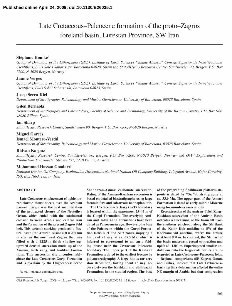
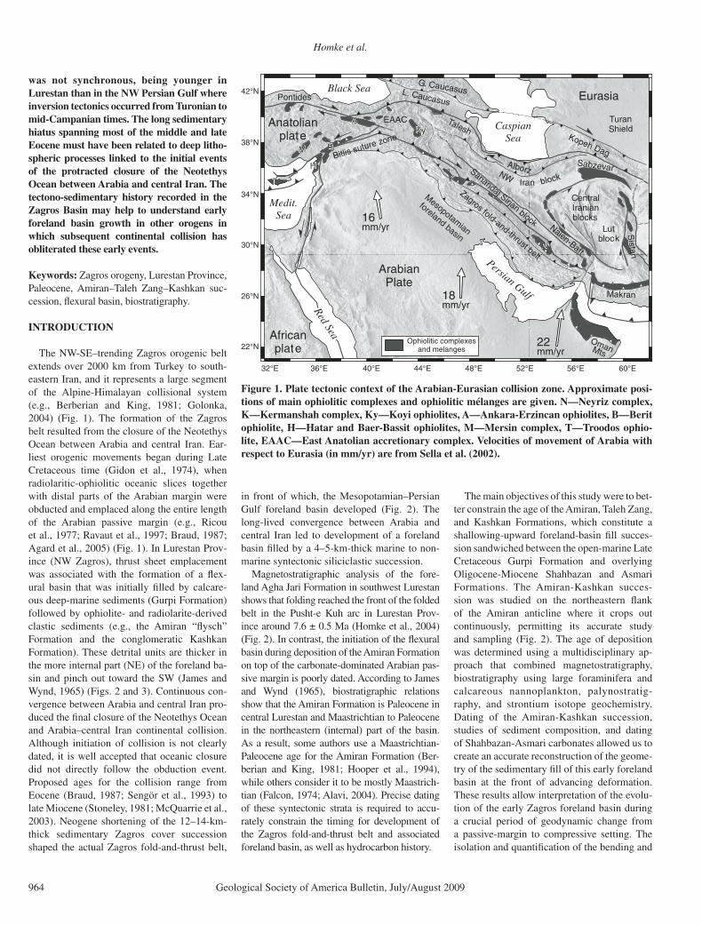
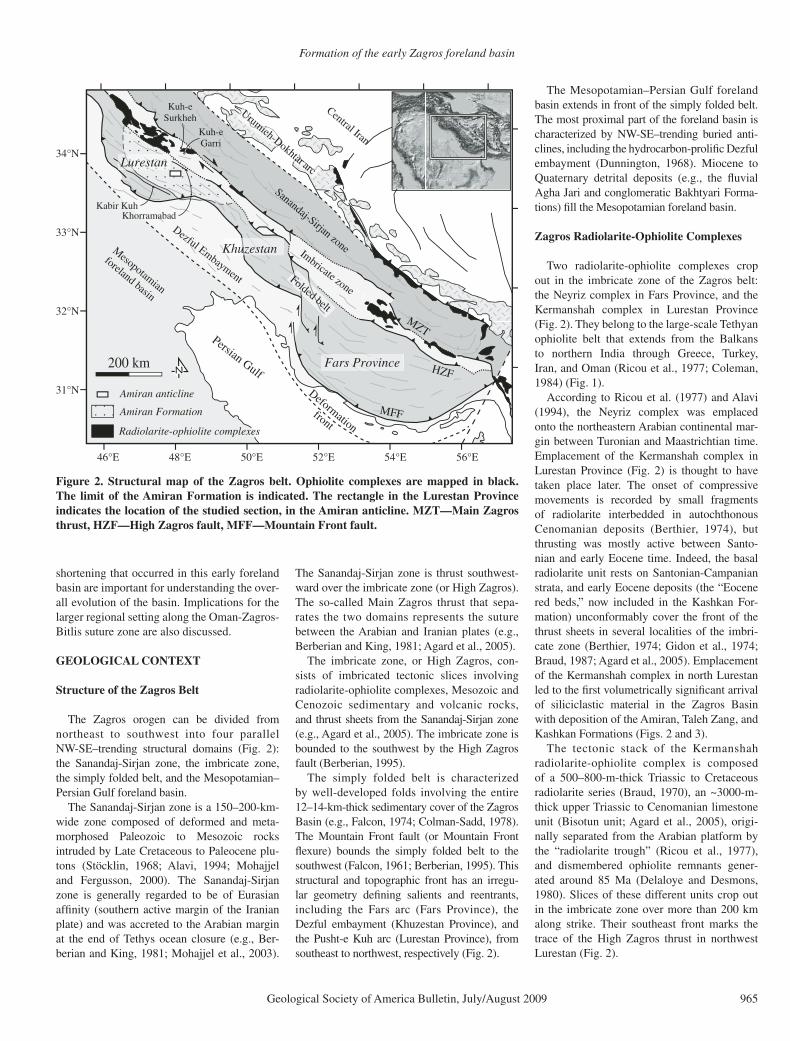
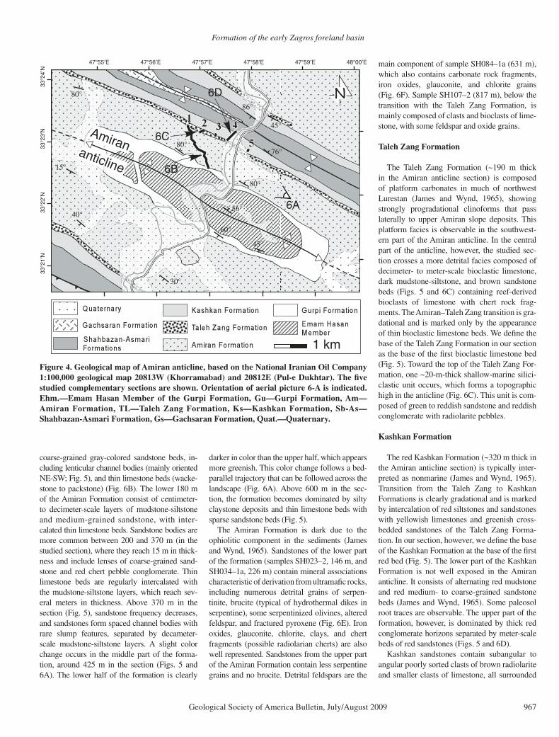
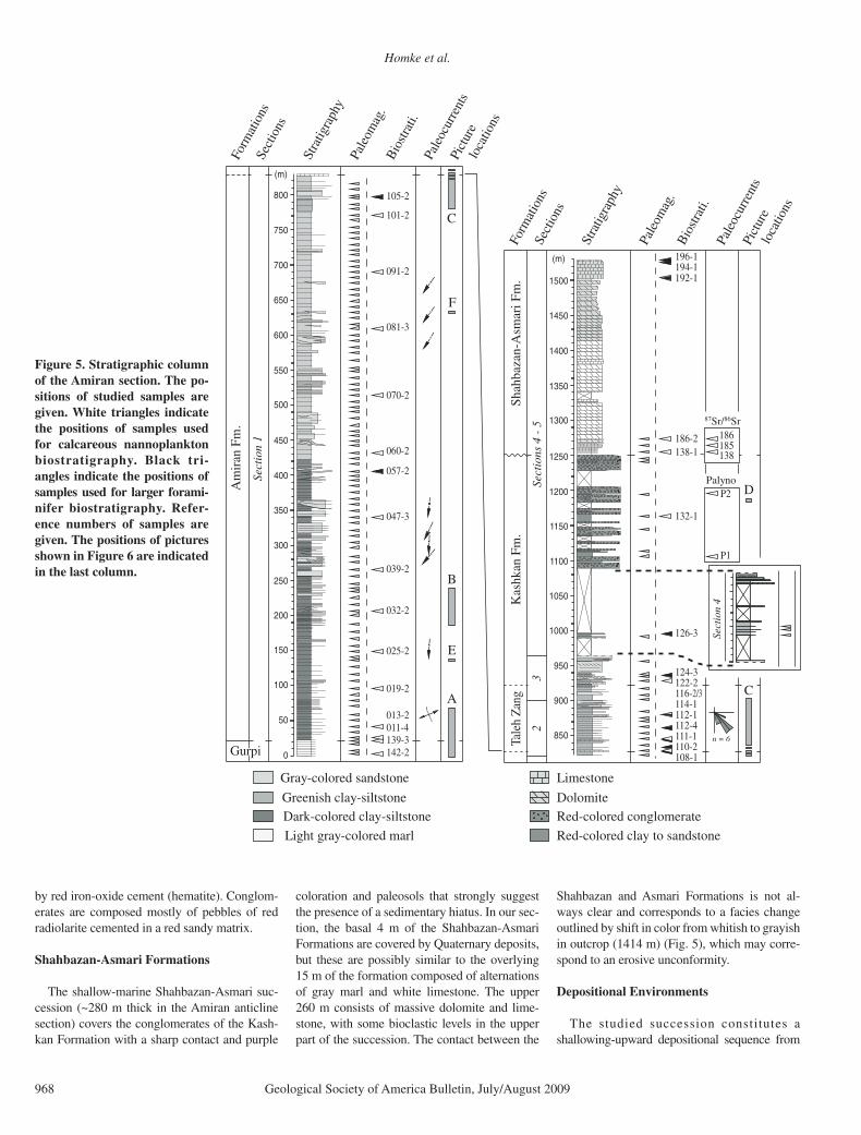


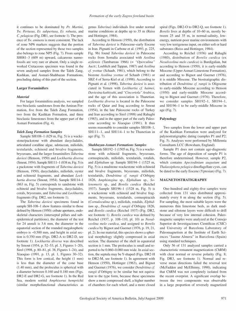


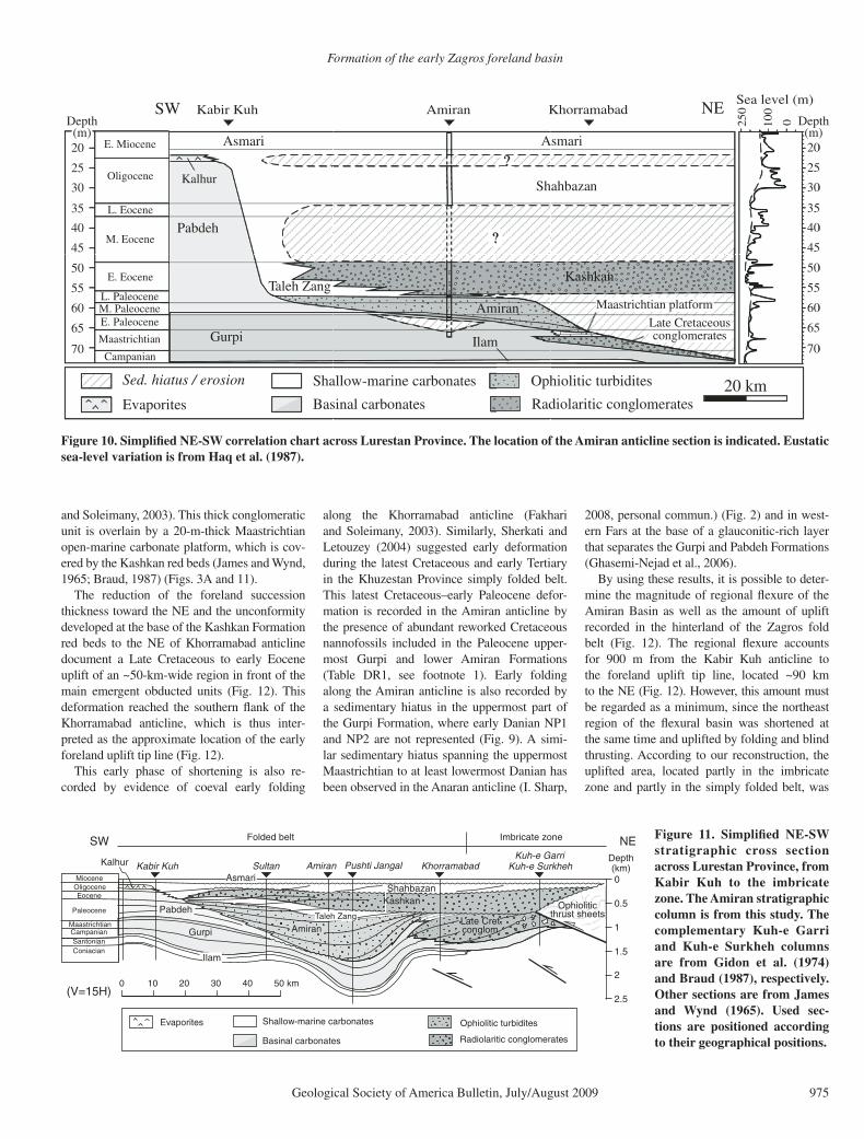


![The Role of the Zagros Suture on Three Dimensional ...journals.ut.ac.ir/article_20881_d08239240afe41517836baec...Zagros Reverse Fault’ by various authors [e.g., 75,33,27,9] in the](https://static.documents.pub/doc/80x56/5f0be6817e708231d432c598/the-role-of-the-zagros-suture-on-three-dimensional-zagros-reverse-faulta.jpg)


