NATURE THE FINNISH ENVIRONMENT 4 | 2010 Late Glacial and Holocene palaeovegetation and palaeogeography of Eastern Fennoscandia Galina A. Elina, Anatoly D. Lukashov and Tatyana K. Yurkovskaya Finnish Environment Institute
Transcript
NATURE
9 789521 137150
LA
TE
GL
AC
IAL
AN
D H
OL
OC
EN
E P
AL
AE
OV
EG
ET
AT
ION
AN
D
PA
LA
EO
GE
OG
RA
PH
Y O
F E
AS
TE
RN
FE
NN
OS
CA
ND
IA
THE FINNISH ENVIRONmENT 4 | 2010
Late Glacial and Holocenepalaeovegetation and palaeogeographyof Eastern Fennoscandia Galina A. Elina, Anatoly D. Lukashov and Tatyana K. Yurkovskaya
This volume contains a comprehensive synthesis of mire research concerning the palaeoecology and palaeogeography of Eastern Fennoscandia, i.e. Karelian republic and Murmansk region (Kola Peninsula), done during the last 60 years in the Karelian Research Centre of the Russian Academy of Sciences in Petrozavodsk.
The main aim of publishing the book in English was to bring the knowledge, previously available mainly in Russian only, to the international specialist and scientific community in Nordic countries, in Central Europe, in North America and also elsewhere.
The writers of the foreword have had over 20 years of Finnish-Russian cooperation in mire research, giving a good basis for the publishing. The information is important for the understanding of the present state of boreal and subarctic mires, as well as the impacts of climatic change on nature. This information is needed also in the guidelines of responsible wise use of peat and peatlands.
The book also gives a sound basis for the estimation of carbon storages deposited in mires. Hopefully the book will stimulate international cooperation in the studies of mires and climatic change in the whole boreal zone.
One important task of this book is increase the understanding that we have to give a chance to mires to continue their role in their palaeoecological task.
Order Service: Edita Publishing Ltd.P.O. Box 780, FI-00043 EDITA Customer Service: phone +358 20 450 05, fax +358 20 450 2380 Mail orders: [email protected] www.edita.fi/netmarket
Late Glacial and Holocene palaeovegetation and palaeogeography of Eastern Fennoscandia
Galina A. Elina, Anatoly D. Lukashov and Tatyana K. Yurkovskaya
Helsinki 2010
FINNISH ENVIRONMENT INSTITUTE
THE FINNISH ENVIRONMENT 4 | 2010 The Finnish Environment InstituteNatural Environment Centre
Layout: Pirjo Appelgren
Cover: An aerial view of a White Sea coast bog. This kind of huge massifs of eccentric bogs covers large areas on the southern coast of White Sea. The bogs lie in the Baltic shield in the west, and in a sedimentary rock area in the east. This view is from the eastern side of Dvina river in Archangel region. (Photo Tapio Lindholm 2002)
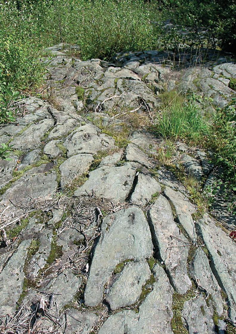
Photo page 10:A pillow lava outcrop, smoothed by glaciations. Pillow lava structure is an evidence of the fact that the lava was erupted in water. The water causes a rapid chilling of the crust of the lava, and it may form separate drops or lumps. This lava outcrop is from the River Kepa rapids in Ypäyssuo mire area, in Kalevala region in the Northern part of Karelia. (Photo Tapio Lindholm 2003)
Photo page 66:Eriophorum latifolium, a rich fen plant. The photo is taken in Olonets Karelia, Kolatselgä region, where calcareous bedrock is the reason for the occurrence of rich fens and rich forests. Mire Suonansuo. (Photo Tapio Lindholm 2008)
Photo page 226:A White Sea coast eccentric bog Matigora close to Belomorsk in North Karelia. The surface pattern consist of hollows and hummocks. Lichens are abundant in high hummocks. (Photo Tapio Lindholm 2006)
Photo page 276:Epipactis palustris, plant which favour calcareous moist habitats. In Fennoscadian Boreal zone it is rich fen plant. The photo from Olonets Karelia, Kolatselgä region. Rich fen close to the village Mandera (Photo Tapio Lindholm 2008)
This publication is also available on the Internet atwww.environment.fi/syke/publications
Vammalan Kirjapaino Oy, Sastamala 2010
Printed on paper certified according to ISO 14001 environmental standards.
ISBN 978-952-11-3715-0 (pbk) ISBN 978-952-11-3716-7 (PDF)ISBN 978-952-11-3677-1 (CD)ISSN 1238-7312 (print)ISSN 1796-1637 (online)
3The Finnish Environment 4 | 2010
FOREWORD
Raimo Heikkilä, Tapio Lindholm & Oleg Kuznetsov
Studies of boreal mires have a long history in Russia. Originally mires have been largely studied as natural resources. Up to 1980s the utilization of mires for forestry, peat mining and agriculture were key issues. To understand the present situation of mires, much attention has been paid from the very beginning to the natural history of mires. The research has resulted in numerous high quality publications. Unfortu-nately, during the Soviet time, most of the works have been published only in Rus-sian, which has reduced the possibilities of scientists from most other countries in the boreal zone to get information on the results from Russia. Also during the Soviet time, international contacts of scientists were limited, and research developed more or less isolated. Rather often the fine results were not distributed internationally.
This book is a synthesis of work done during almost 60 years in eastern Fennoscandia about the Late Glacial and Holocene dynamics of mires and landscapes. The authors have successfully gathered together both geological and botanical data and reached a unique reconstruction of the Holocene vegetation history of Karelian Republic and Murmansk region. This edition is based on a Russian edition which was originally published in 2000 in Petrozavodsk.
In Finnish-Russian mire conservation and research cooperation since 1983 we have learnt about Russian mire science and about the publications. The late Marina Botch from St. Petersburg had an important role in opening the Russian mire science to Finnish researchers. The idea about translating this book into English came up in 2002 when discussing with Galina A. Elina in the Mire Ecosystems Laboratory in the Karelian Research Centre of the Russian Academy of Sciences in Petrozavodsk. The text was translated into English by Ms. Olga Kislova from Karelian Research Centre. The figures have been edited in Friendship Park Research Centre by Ms. Pirjo Ap-pelgrén and Ms. Eveliina Pulkkinen to make printing in colour possible. Finally, Ms. Karen Heikkilä, M.A., from Kuhmo has made linguistic revision. For the English edition, also numerous photos were kindly provided by dr. Galina Elina. She also made some updating in the text.
The way of expression follows the typical Russian style in synthetic monographs. The text is wide and descriptive, and includes a lot of detailed interpretations of the results. The book is a unique synthesis of the Russian school of mire and palaeoecol-ogy studies. An important point is that the book includes a comprehensive list of references, mainly Russian sources.
The main aim of this English edition is to extend knowledge about Russian mire science over the whole circumboreal zone. We also hope to improve possibilities for international cooperation in mire studies.
4 The Finnish Environment 4 | 2010
The authors of the book
Elina, Galina Andreevna (Елина Галина Андреевна) (1929-) Doctor of Science in Biol-ogy, Chief Researcher and former head of Mire Ecosystems Laboratory of the Karelian Research Centre. She is a specialist in geobotany, mire science, palaeogeography and ecology. She has worked for the Institute of Biology, Karelian Research Centre, Russian Academy of Sciences since 1951. Galina Elina is the author of 180 scientific publications, including 5 monographs and 3 popular science books. She has lately been paying much attention to digital mapping of the Holocene palaeovegetation and palaeolandscapes using GIS technologies.
Lukashov, Anatoly Dmitrievich (Лукашов Анатолий Дмитриевич) (1934-2004) PhD in Geology and Mineralogy, Leading Researcher. He worked at the Institute of Geology, Karelian Research Centre, Russian Academy of Sciences for over 45 years. Over these years, he took part in expeditions to many parts of East Fennoscandia, doing research in geomorphology, geoecology, neotectonics and mapping of Quaternary sediments. Anatoli Lukashov published over 100 scientific papers, including 2 monographs writ-ten individually and 5 in co-authorship.
Yurkovskaya, Tatyana Kornelievna (Юрковская Татьяна Корнельевна) (1930-) Doctor of Science in Biology, leading researcher, former head of the Vegetation Geography and Cartography Laboratory (Komarov Botanical Institute, Russian Academy of Sciences, St. Petersburg, Russia). She is a specialist in geobotany, vegetation geog-raphy and cartography, and mire science. Tatiana Yurkovskaya is the editor of the Geobotanical Mapping annual. She has over 200 scientific publications. She is also the author and co-author of numerous vegetation maps, including e.g. the internationally prepared Vegetation Map of Europe.
G.A. Elina, Karelian Research Centre of the Russian Academy of Science, 11 Pushkinskaya str., 185910 Petrozavodsk, Karelia. E-mail [email protected];T.K. Yurkovskaya, Komarov Botanical Institute, Russian Academy of Science, 2 Prof. Popov str., St. Pe-tersburg. E-mail [email protected]
1 Geology and geomorphology..............................................................................11Morphostructure.........................................................................................................12
Establisment of the natural environment in the late glacial and early holo-cene ...............................................................................................................................19
Effect of geological and geomorphological factors on vegetation develop-ment ..............................................................................................................................23
2 Vegetation and phytogeographical zones ....................................................25Climate .........................................................................................................................25
Typological characteristics of vegetation ..............................................................26
Regional differentiation of the plant cover ..........................................................49Kola tundra subprovince ................................................................................50Kola-Karelia taiga subprovince .....................................................................50
Phytogeographical zones and their latitudinal differentiation .......................58
3 Materials and methods .........................................................................................61
4 Palaeovegetation dynamics ................................................................................67Kola peninsula model areas ....................................................................................69
Northern maritime tundra model area ........................................................71Barents Sea Coast (mainland) .................................................................71Rybachii Peninsula (Kalastajasaarento) ..................................................77
Pechenga-Voronja forest-tundra model area ................................................89Lovozero northern taiga model area ...........................................................103
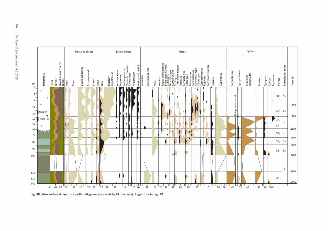
Model areas of Karelia ............................................................................................121North-western montane northermost-taiga ...............................................121The White sea coast: a typical north-taiga model area ............................130Kem: a typical north-taiga model area .......................................................138Vygozero typical north-taiga model area ...................................................139North-Onega mid-taiga model area ............................................................147Syamozero-Shuja mid-taiga model area .....................................................156
5 Palaeovegetation classification scheme ......................................................171Biological diversity of palaeocommunities ........................................................171
Zonal palaeovegetation of the late glacial and holocene .........................172Mire palaeovegetation ...................................................................................176
6 Palaeovegetation mapping ...............................................................................181Model areas ...............................................................................................................181
Forest-tundra MA .....................................................................................................188
6 The Finnish Environment 4 | 2010
Voronja river watershed (MA-1) ...................................................................188Northernmost taiga model areas ..........................................................................192
Lake Lovozero watershed (MA-2) ...............................................................192Maanselkä upland (MA-3) ............................................................................198
Typical north-taiga model areas ...........................................................................203Kem River watershed (MA-4).......................................................................203White Sea lowland (MA-5) ...........................................................................206
Karelia mid-taiga model areas ..............................................................................210Zaonezhje Peninsula, lake Onega (MA-6) ..................................................210Shuja river watershed (MA-7) ......................................................................219
7 The palaeogeography of east Fennoscandia .............................................227Mire formation patterning and peat deposition in the holocene in North-West Russia................................................................................................................227
Lowland plain model areas ..........................................................................228Undulating plain model areas .....................................................................232Elevated plain model areas of the selka type topography ......................235
Mires as indicators of the transgressive-regressive evolution pattern of large bodies of water ...............................................................................................242
The eastern shore of Lake Onega ................................................................244Lake Onega s Zaonezhje Peninsula ............................................................250The Karelia coast of the White Sea lowland ..............................................257
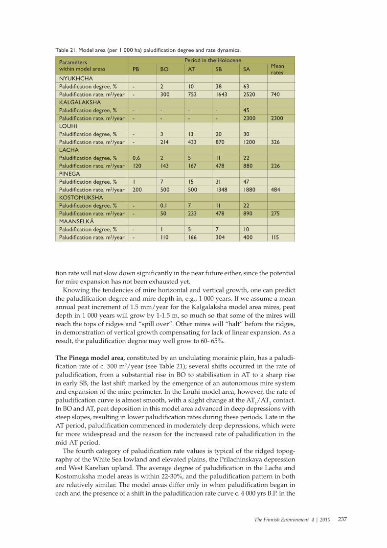
A vast amount of palaeobotanical and palaeogeographical studies was accomplished before the writing of the present volume. Earlier monographs (Елина 1981, 1987; Елина и др. 1984) dealt with the dynamics (including small-scale mapping) of palaeoveg-etation in Karelia. At the time of publication, the monographs featured incontestable advancements, which are still of value (e.g., chrono- and biostratigraphic models of the Holocene in Karelia, and a set of palaeovegetation maps for four time slices).
The profoundly novel factual material accumulated by 1999 (over 20 articles in the Russian and English languages) gave us a chance to present the palaeogeographical situation in the region in more detail. Starting in 1985, we produced 13 pollen dia-grams (PD) for Karelia and 10 for the Kola Peninsula. The latter have never before been published.
The work was done in several stages. The first step was to ensure the quantitative and spatial representativeness of standard and model PD with mandatory radiocar-bon dating of the deposits and calculation of the palaeoclimatic parameters. During the second stage we drew up the climatic-chronological models of the zonal and subzonal levels, and identified trends in the spatial-temporal development of the palaeovegetation.
A further task in the study was to: determine the biodiversity of past floristic com-plexes, and zonal (i.e., tundra, forest-tundra and taiga) and mire palaeocommunities and palaeoecosystems; and find out the general rules of their succession in the most typical landscapes and the effect of the combination of the natural factors on their formation. Following this/Subsequently, a hierarchical classification of palaeocom-munities was developed— the first rank contains groups of types and types of vegeta-tion, and the second classes and groups of associations. The classification comprises 29 syntaxa, which appear to be the key syntaxa in Karelia and the Kola Peninsula.
A remarkable distinction of the present volume from earlier ones lies in the reviews of East Fennoscandian geology, geomorphology and modern vegetation. Relying on the geological-geomorphological maps of model areas, we could more objectively locate the chorological units of palaeovegetation for all time slices.
Vegetation development in any area depends on a multitude of factors determined both by the current climate and physiographical zonality, and by the geological-geo-morphological structure of the region and its geological evolution history. Forming the temperature regime of the area, the climate shapes the plant cover zonality and influences its diversity. On the other hand, the rock composition, tectonic structure and topography, in combination with current climatic conditions, are the cornerstones of the function of modern landscapes at large and their individual components.
As the geochemical background of the landscape, the mineral-chemical composi-tion of crystalline and loose rocks determines the characteristics of the soil formation processes and the surface and ground water chemistry. The fault-block tectonics, activated by Quaternary crustal movements, is responsible for the land surface el-evations, thus influencing the spatial distribution of glacial and marine sediments. Owing to their different filtering properties, the latter induce a varying degree of coverage by open waters and wetlands. Varying displacement of crustal blocks along the fault planes generates a terrain broken to various degrees, both vertically and
8 The Finnish Environment 4 | 2010
horizontally. This, in turn, creates a more complex landscape, where the aspect of the landforms changes frequently over the territory (hence, the differences in local temperatures, drainage network density, etc.), and facilitates a frequent change of the factors influencing the vegetation development. These regularities are common for the present and the past.
Equally important are some events in the Quaternary geological history. This is, first of all, the stadial nature of the last (Late Pleistocene) deglaciation, manifest in the alternating periods of the glacier advance and retreat. Degradation of the Last Glaciation proceeded against the background of the general warming, but periodic expansions, of the continental ice area resulted in the formation of local microclimate superimposed on the overall climatic conditions.
Descriptions of modern vegetation, most importantly accounts of climax and quasi-climax types of communities based on the actualism principle, promote a more objec-tive reconstruction of palaeocommunities and their ecological relations, particularly for the 3 000 and 1 000 yrs. B.P. time slices. The latitudinal and regional differentiation depicted in the maps of modern vegetation enable a comparison of modern zonal and regional boundaries, including their dynamics, during the Holocene. Vice versa, knowledge of past plant cover evolution provides an understanding of modern pat-terns in its geography.
In the past three years, our palaeogeographical studies focused on identification of four new model areas (in addition to the ten studied earlier), where all natural parameters, including sediment stratigraphy were investigated. This involved paly-nological, palaeobotanical and radiocarbon analyses, as well as synthesis of all data on the dynamics of palaeovegetation, palaeohydrology and palaeoclimate.
Thus, the aim of the research was to develop a database of newly and earlier stud-ied standard PD, including: characteristics of their palynological assemblages, floral suites, radiocarbon ages, palaeoclimatic, palaeolimnological and palaeohydrological data; subrecent fossil spectra; stratigraphy; modern geological-geomorphological; and vegetation units. PD covering the Late Glacial and Holocene were analysed to determine the basic features of pollen assemblages in a number of time slices— these were mainly the Younger Dryas (DR3), Preboreal (PB2), Boreal (BO3), Atlantic (AT1-AT3), Subboreal (SB3) and Subatlantic (SA3) periods.
Techniques were developed for palaeovegetation mapping that relied on identified geological-geomorphological units. The main factors influencing the natural environ-ment were mapped for all model areas. In the end, we made a number of theoretical conclusions concerning the palaeogeography of the past 12 000 years.
The main division of responsibility for the manuscript is as follows: A.D. Lukashov: Chapter 1 (‘Geology and geomorphology’ section and chapter
figures), Chapter 6, (‘Geology of Model Areas’ section)T.K. Yurkovskaya: Chapter 2 (‘Vegetation and phytogeographical zones’ section
and chapter figures) G.A. Elina: Introduction and Chapters 3-7 (including figures in Chapters 4-7) Others have also contributed their expertise to this work. E.I. Devyatova is re-
sponsible for the most recent pollen analyses used in the monograph. N.V. Stoikina worked on the botanical analyses of peat and on determining its degradation status. H.A. Arslanov and L.D. Sulerzhitskii were responsible for the absolute datings of sediments. V.A. Klimanov performed palaeoclimate calculations for a number of PD. L.I. Gutaeva completed the graphical design for figures appearing in Chapter 1.
The authors are deeply grateful to their colleagues from the Institute of Biology, Karelian Research Centre, Russian Academy of Sciences, and the Polar-Alpine Bo-tanical Garden who took part in the field research component of this project: O.L. Kuznetsov, V.K. Antipin, A.I. Maksimov, L.V. Filimonova, S.I. Grabovik, A.A. Pohilko and V.A. Kostina. In keeping with the provisions of the grant programme, ‘Integration
9The Finnish Environment 4 | 2010
of the Academy of Science and Higher Educational Institutions’, field surveys were always complemented with the participation of graduate and post-graduate students from Petrozavodsk State University. E.F. Markovskaya, Chair of Botany, a source of excellent ideas, was responsible for the supervision of these students. The students, A. Markovskii, N. Omelchak, N. Babina and S. Kutenkov, are acknowledged for their hard work and dedication to the project.
The research was funded through the following Russian Foundation for Basic Re-search (RFBR) grants: Publishing Project No 00-04-6200д; Start-up Projects No 94-04-11036, 96-04-48004 and 99-04-48736 (Leader: G.A. Elina), No 99-04-49589 (Leader: T.K. Yurkovskaya); three field research project grants within RFBR; and the ‘Integration of the Academy of Science and Higher Educational Institutions’ programme grant No 639 (Leader: E.F. Markovskaya).
The monograph was originally published in Russian by the Karelian Research Centre, Russian Academy of Sciences in 2000. It was translated into English by Ms. Olga Kislova in Petrozavodsk during 2002 - 2004 with support from the Friendship Park Research Centre, Kuhmo, Finland. Ms. Karen Heikkilä, M.A. revised the English language. The final editing of the English version of the manuscript was carried out by Raimo Heikkilä, Oleg Kuznetsov and Tapio Lindholm, in addition to comments provided by G.A. Elina and T.K. Yurkovskaya. Ms. Pirjo Appelgrén and Ms. Eveliina Pulkkinen from the Friendship Park Research Centre prepared the figures in their final form for colour printing.
10 The Finnish Environment 4 | 2010
11The Finnish Environment 4 | 2010
A.D. Lukashov
An essential role in the establishment and evolution of modern landscapes, par-ticularly during the Late Pleistocene and Holocene, is observed in the workings of the geomorphological and geological structure of the area. The Kola Peninsula and Karelia have a number of distinctions in the geological structure from the vast Rus-sian plain bordering the region in the east, southeast, south and southwest. These distinctions are due to the following factors:
• exposed ancient crystalline bedrock;• dominance of absolute uplift over subsidence;• continental mode of regional development over several geological periods;• significant role of faults of various ranks, responsible for the fault-block
structure of ancient, neotectonic structures and terrain;• repeated glaciations in the Quaternary period and development of ancient
glacial deposits in the area;• dominance of glacial exaration over accumulation;• evolution of water bodies in the Late- and Post-Glacial time periods shaped
by transgressions and regressions.
As a result, the modern topography of the Kola Peninsula and Karelia is a combi-nation of the pre-glacial structurally-controlled denudation and tectonic denudation landforms generated by differential denudation of ancient structures and bedrock deformation by Quaternary crustal movements (morphostructures), as well as ero-sional and accretionary landforms created by the geological activity of ancient gla-ciers, glacial meltwater and the abrasion-accretion action of periglacial lacustrine and marine basins (morphosculptures).
The main part in the structure of the loose sediment sheath overlying crystalline bedrock belongs to various genetic types of sediments of the glacial, glacioaqueous and aqueous genesis. As glacial erosion prevailed over accretion, the Quaternary sediment cover is generally quite thin (7-10 m on average) and represented, in most of East Fennoscandia, by young Late Quaternary (Upper Valdai) and Holocene forma-tions. It was only locally, in narrow deeply buried tectonic depressions, that drilling disclosed a thick (to 150 m) composite Quaternary series with pre-glacial Neogene-Lower Quaternary , and Lower-, Middle- and Upper Quaternary deposits. Relatively thick Quaternary deposits (dozens of metres) were discovered in accretionary glacial and glaciofluvial complexes. The Quaternary cover being so thin, the main oro- and hydrographical features of East Fennoscandian topography are determined by the morphostructure.
The glacial and glacioaqueous erosional and accretionary complexes (morpho-sculpture) just modify and add to the complexity of modern topography (with some local exceptions) where the topography is sculpted solely by glacial and glaciofluvial accretion.
1 Geology and geomorphology
12 The Finnish Environment 4 | 2010
Morphostructure
East Fennoscandia is part of a large geological structure, the Baltic (Fennoscandian) Shield, which is the largest exposed section of the crystalline basement of the ancient East-European (Russian) platform. The main distinctive feature of the structure is the exposure of ancient crystalline metamorphic rocks, which in the surrounding areas of the Russian platform are covered by a thick sheath of younger rocks. The Baltic Shield has a composite internal structure. In terms of the tectonic conditions and the deep structure, composition and age of the rocks composing the upper crustal horizons, the eastern part of the shield can be split into four units: Kola, White Sea, Karelian and Ladoga (Кратц, Былинский 1978; Гришин 1990). The units are demarcated by deep long-lived faults (Fig. 1). Each of the megaunits has gone through an inde-pendent geological evolution, as seen both in the differences in the composition and arrangement of ancient Precambrian rocks and their structures, and in the intensity and trends of recent crustal movements, that have emerged in the Cenozoic and have influenced the topography and structure of the loose Quaternary sediment cover. Since recent tectonic structures and landforms are to a certain degree conjugate with ancient structures, each geounit has a corresponding geological-geomorphological region (GGR) of the same name.
An important feature of the Baltic Shield geological history is the dominance of uplift over subsidence, and a long period of geological evolution under continental conditions. The result is the predominance, in the Kola Peninsula and Karelia, of ancient (Mesozoic-Palaeogene and Miocene-Pliocene) denudation plains of vari-ous types, which had developed by means of a prolonged composite denudation of the structurally-heterogeneous-crystalline basement (Герасимов, Мещеряков 1967; Стрелков 1976).
As the upper crustal horizons of the shield are composed of solid crystalline rock, recent crustal movements have occurred chiefly along rejuvenated or reconstructed ancient faults. These crustal movements differ in both intensity and direction, ob-served in the following distinguishing of zones: intensive uplift, moderate uplift, weak uplift and relative subsidence. As a result, individual crustal blocks have formed composite structures with different movement patterns: elevated landforms – horsts –in the intensive and moderate uplift zones, and depressed landforms – grabens – in the relative subsidence zones. Analysis of the relations between the main hypsomet-ric levels of East Fennoscandia, and the region’s geological structure and tectonics, has shown that the location and height of the basic orographic elements reflect the intensity of recent crustal movements. Each zone, with its own corresponding type of exposed basement denudation plains and a certain degree of tectonic faulting, shapes the main oro- and hydrographical features and thereby shows in the pre-glacial topography.
The faulted character of the morphostructures has influenced the morphological appearance of the topography: flat tops(remains of peneplanes) are a typical land-form in drainage divides and interfluves; drainage divide axes appear as broken lines composed of straight segments; and divide slopes are stepped. River valleys are also rectilinear in appearance, bending abruptly, often at the right angle. The basins of medium-sized and large lakes normally lie in faults or over down-dropped blocks. The regional arrangement of the drainage network and the dominant trending of drainage divides and river valleys follow the direction of systems of faults best developed in the area. Owing to the differentiation of recent crustal movements by direction and intensity, smaller fault-block structures varying in their composition of geomorphological features can be delineated within specific megaunits (Лукашов 1976; Кошечкин и др. 1978; Асеев и др. 1986).
13The Finnish Environment 4 | 2010
IV
I II
I
II
ООО
О
О
70
IV
Fig. 1. Schematic map of East Fennoscandian morphostructures (after Асеев и др. 1986). 1–3 tec-tonic denutation terrain: 1, medium and low block mountains and highlands generated by faults in intensive uplift zones; 2, elevated hilly-ridge plains generated by Quaternary crustal movements along faults in moderate uplift zones; 3, hilly-ridge plain generated by low-amplitude faults with par-tial differential erosion of ancient fold structures in weak uplift zones. 4–5 structurally control-led denudation terrain: 4, plain with small hills and ridges, generated by composite denudation and faulted in weak uplift zones; 5, gently undulating plain generated by prolonged denudation in very weak uplift and relative subsidence zones. 6 deep visible faults; 7 geounit boundaries; 8 crustal geounits; 9 model area locations.
14 The Finnish Environment 4 | 2010
Covering the Kola Peninsula, the Kola GGR megaunit is typically defined by:
• the main orographic elements and coastlines of the Barents and White Seas, generally northwest- and southeast-trending;
• prevailing elevations and high relief (as seen in the western part of the regi-on), and depressions and removed relief (as seen in the eastern part of the region).
The western part of the peninsula features low-montane and elevated massifs called tundras; the elevations range from 639 m (Lavnatundra) to 955 m (Volchyi tundras) to 997 m (Salnye tundras), reaching a maximum of 1 120 m (Lovozero tun-dras) and 1 191 m (the Khibines). The elevated massifs form the main drainage divide of the Kola Peninsula, cutting roughly through its middle from the Russian-Finnish border southeasterly towards the Lovozero tundras. Further east, the drainage divide runs along the Keivy ridges where elevations drop to 400-300 m a.s.l. The relief in the western part of the peninsula is the highest, reaching 200-500 m.
Hilly-ridge plains descending step-wise to the Barents Sea coast are situated north-east of the main drainage divide. The elevations in the plains decrease from 600-400 to 200-100 m a.s.l., with a relief not higher than 200 m. Their distinctive feature is that they are finely subdivided into a system of small blocks by a complex and dense net-work of faults of varying rank and direction. The area southwest of the main divide is occupied by gently undulating plains generated by very weak uplift and relative subsidence events. The elevations there are 130-180 m at maximum with a relief of 80-100 m (Стрелков 1976, etc.).
The White Sea GGR megaunit has, given its location in the centre of the White Sea basin, a most characteristic feature by way of a large composite graben (a system of crustal blocks that had subsided along faults). Areas along the White Sea graben flanks, such as the Ter coast of the Kola Peninsula and the Karelian and Pomor coasts of Karelia,,are occupied by a system of gently undulating plains that have experienced very weak uplift and relative subsidence events. These plains are the least elevated parts of the Kola Peninsula and Karelia. Their elevations are 120 to 80 m, with a relief of 20 m (Fig. 1). River valleys and interfluves mostly have a east-northeast trending strike.
The Karelian GGR megaunit covers most of Karelian Republic, with the exception of the White Sea lowland and areas adjacent to the Lake Ladoga catchment. The uplift intensity within the Karelian megaunit is somewhat lower than in the Kola megaunit. It has only two small areas with low-montane massifs. Most of the region is occupied by tectonic denudation and structurally controlled denudation plains that have formed in the moderate and weak uplift zones (Fig. 1). There are certain oro-graphic manifestations of the differences in the intensity and direction of recent crustal movements in Karelian topography (Бискэ 1959; Лукашов 1976). Positive Quaternary structures, appearing as uplands and mountain ranges, have formed in the moderate uplift zones and are found in the west and southeast portions of the republic.
The Northern Upland area is the highest and most rugged part of the republic. Elevations rise to 250-300 m, and relief is recorded at 110-200 m. A distinctive feature of the district is pockets of elevated massifs found in areas with partially differentially-eroded intrusions of acid, basic and ultrabasic rocks and some of the district’s highest elevations: Kivakka (500 m), Päinur (488 m), Nuorunen (576 m), Lunas (497 m), etc. (Бискэ 1959). The district has two common types of terrain: tectonic denudation and structurally-controlled denudation landforms.
15The Finnish Environment 4 | 2010
Tectonic denudation landforms have developed in areas with Archaean gneisses and gneiss-granites, and represent a system of crystalline basement blocks displaced relative to each other along faults. The blocks form interfluves appearing as elevated areas of rectangular or isometric profile, bounded by steep slopes and escarpments trending northwest and northeast, depending on the fault strike. The interfluves are divided by deep linear fault-line depressions with river valleys, lake basins and marshy lowlands cutting through their bases.
The structurally-controlled denudation terrain can be seen around the Lake Paanajärvi basin, which lies in the fault in the axial part of the Kuolajärvi-Paanajärvi structure. The structure is composed of a complex of sedimentary and sedimentary-volcanogenic rocks. Owing to differences in the resistance of rocks to weathering, the fold structures became differentially eroded, subsequently sculpting the present-day terrain. The morphological appearance of the surface is shaped by linear sinuous ridges associated with resistant rock horizons divided by morphologically similar troughs confined to the horizons of non-resistant rocks. The combination of ridges and troughs creates a terrain pattern peculiar to the area.
The West Karelian Upland is the largest elevated orographic formation in Karelia. The nearly 100 km wide upland stretches some 320 km along the border with Finland. It comprises a series of up-thrown massifs in Archaean gneiss-granite areas, and three series of high linear ridges associated with structures composed of Low Proterozoic sedimentary, volcanogenic and igneous rocks. These elevations are recorded at 240-348 m a.s.l., with a relief of 60-80m , (in some cases, up to 100 m). The West-Karelian Upland terrain is noted for a dominance of linearly-shaped elevations, ridges and troughs, and a general northwest strike.
The East Karelian uplift zone occupies southeast Karelia forming the White Sea Lake Onega drainage divide. The divide has an asymmetrical structure, with the northeastern end up-thrown and appearing as a ridge called the Vetreny Belt. In the northeast, the tectonic scarp, 100 to 200 m high, separates the ridge from the adjacent White Sea plain. The divide is inclined towards Lake Onega. Elevations decrease accordingly from 200-240 (300) m in the northeast to 140-160 m in the southwest; similarly, a decrease is noted in relief – from 60-80 to 20-40 m.
A belt of hilly and undulating denudation plains, shaped by weak but differential uplift events, lies between the zones of stable moderate and weak prevailing uplift, appearing in the terrain as uplands and ridges. The belt covers areas in the central part of Karelia. It is noted for its fine-faulted structure and distinct northwest trend of land features as well as a significant spatial variation of elevations and relief. Eleva-tions range from 100 to 180 m, and relief, from 100 to 60-30 m.
Owing to its fine-faulted structure, differential nature of movements, and alterna-tion of up-thrown and down-dropped blocks, the Central Karelian belt harbours a multitude of large and medium-size lakes: Pjaozero, Topozero, Kuito, Elmozero, Seg-ozero, Suojärvi, Jänisjärvi, Tungudskoye, Vygozero, etc. The lake basin morphology depends on the arrangement of the structures it is associated with. Fault-associated basins are linear, while those within down-dropped blocks are isometric or near-isometric.
Only a minor fragment of the Ladoga GGR megaunit falls within Karelia. In this area, the megaunit is located in the southwest, namely in the Lake Ladoga and adja-cent area. The rest of the megaunit belongs within Finland. The East Fennoscandian fragment of the Ladoga geounit is part of the composite Ladoga-Mezen boundary zone of fault structures separating the shield from the platform in the south, south-east and northeast. The zone is made up of a combination of large down-dropped blocks serving as basins for the region’s largest bodies of water: Lakes Ladoga and Onega, and the White Sea (with the up-thrown blocks forming the Onega-Ladoga and
16 The Finnish Environment 4 | 2010
Onega-White Sea drainage divides). The lake basins are connected by narrow, buried tectonic troughs with abnormally thick (120-150 m) Quaternary deposits of the most complete sequence cutting through the divides. This points to how the boundary zone had experienced differential crustal movements which resulted in quite a high relief (uplift rates being slow). The depths of Lakes Ladoga and Onega reach 236 and 120 m, respectively, and the topmost elevations of the Onega-Ladoga and Onega-White Sea drainage divides are 298 and 245 m, respectively, with relief recorded at 100-80 m.
Denudational planation of East Fennoscandia has been conditioned by the forma-tion of the regional peneplain. Quaternary crustal movements broke the peneplain along faults and caused it to deform by either up-throwing or down-dropping frag-ments to a various extent. As a result, the pre-glacial landscape of the Kola Penin-sula and Karelia became arranged in layers. These layers can conventionally be distinguished in terms of three regional landscape layers with their accompanying interfluve surface elevations: a lower layer at 100-120 m, a middle layer at 150-200 m, and an upper layer at 250 m.. Each layer has its own dominant type of denudation plains, in addition to specific types of accretionary terrain and Quaternary deposits.
Our model areas were determined on the basis that they would be geographically positioned within the three largest and most characteristic types of East Fennoscan-dian morphostructures.
Morphosculpture
The morphosculpture of East Fennoscandia reflects the two major stages in its evolu-tion: a long period of continental evolution and repeated continental glaciations in the Quaternary period. The main characteristic feature of the region’s morphosculpture is the erosional and accretionary landforms of the glacial and glacioaqueous genesis which cover most of the region. The relief-forming morphosculptural complexes are glacial and glacioaqueous sediments generated at the final stages of the Last Glacia-tion.
Areas of the Kola Peninsula, where glacial erosion prevailed over accretion are not-ed by a thin and discontinuous loose sediment cover, with frequent gaps occupied by peculiar features — roche-moutonnees and whalebacks, and ice-flattened crystalline rock outcrops — formed by glacial erosion. The inner radial-concentric appearance of the ice sheet showing in the morphosculpture is due to pre-glacial topographic roughness caused by bedrock elevations fixing the spatial position of the ice divides, and by the troughs between them being filled with large ice lobes. The concentric appearance emerged owing to a series of marginal glacial deposit belts, which fixed the glacial margin at every subsequent stage of glaciation and evidenced the gradual shrinking of the ice sheet. Thus, three major glacial morphosculptural complexes are distinguished within East Fennoscandia:
• belts of marginal glacial deposits;• radial ice divides;• massifs and vast morainic plains in glacial depressions (fig. 2).
Karelia has six belts of glacial deposits corresponding to different deglaciation stages: Vepsian, Krestets, Luga, Neva, Rugozero and Kalevala. The marginal depos-its of the Vepsian and Krestets stages are represented in Karelia by a small fragment in the southeast. On the other hand, the Kola Peninsula bears four belts of glacial deposits, lacking in the belts of the two earliest deglaciation stages (Лукашов, Экман 1980; Ekman, Iljin 1991).
17The Finnish Environment 4 | 2010
ОО О
О
О
70
N
L
7
6
L
N
L
4
5
RK
1
2
3
Fig. 2. Schematic map of East Fennoscandian morphosculpture (after Асеев и др. 1986, with addi-tions and corrections). 1 large elevations of preglacial bedrock with a thin discontinuous cover of till and eluvium. 2 Glacioaqueous (marine, lacustrine and glaciolacustrine) accretionary and accretion-abrasion plains. 3 glaciofluvial complexes (eskers and del-tas). 4–6 glacial complexes: 4, (a) hilly-ridge and hilly morainic plains, (b) drumlin fields; 5, end moraine ridges of different Late Pleistocene Glaciation stages (L = Luga, N = Neva, R = Rugozero, K = Kalevala); 6, interlobate glacial accretionary uplands.
18 The Finnish Environment 4 | 2010
The ice-marginal formations of various glaciation stages exhibit both differences and similarities. The similarities lie in their banded arrangement and the form of a morainic ridge series. The belts are 8-12 m wide and the ridges, 15-20 m high. Gla-ciofluvial deltas, alluvial fans, outwash plains and glaciolacustrine plains are situated in front of the morainic ridges.
Certain significant morphological differences can also be observed between the ice-marginal formations of different glaciation stages. The marginal formations of the Vepsian, Krestets, Luga and Neva stages in Karelia are quite sinuous in plan view, reflecting the dissection of the glacier flanks into a number of small tongues. Glaciolacustrine plains typically lie in the pro-glacial zone. The marginal zones of the Rugozero and Kalevala stages in Karelia as well as all marginal zones in the Kola Peninsula appear relatively smooth in plan view, evidencing larger tongues in the glacial flanks. The landforms clearly dominant in the pro-glacial zone are outwash plains, glaciofluvial deltas and alluvial fans (Ильин и др. 1978; Ниэмеля и др. 1993).
The zones of ice divides of different glaciation stages also exhibit certain particulari-ties. The ice divides of the Luga and Neva stages are represented by large, composite interlobate accretionary uplands. They appear as large 1 200-2 300 km2 areas with relative elevations at 80-100 m, rising above the surrounding terrain. The uplands have a hilly-ridge surface and are composed of glacial and glacioaqueous deposits with a thickness of 60-80 m. The ice divides of the Rugozero and Kalevala stages run along the elevations of the pre-glacial bedrock and appear as a series of subparallel elongated eskers and morainic ridges.
Morainic plains, deposited in the glacial lows found in the vast depressions of the pre-glacial terrain, take on a morphological appearance dependent on the rugged-ness of the pre-glacial topography of the depressions and the activity of the ice lobes within the depressions. Glacial depressions of the Luga and Neva stages are covered in nearly continuous till, exhibiting a significant thickness of 10-20 m (in some cases, reaching 60 m). The morainic plains are predominantly undulating and hilly-ridge-like in appearance, with few local drumlin fields. In contrast, glacial depressions of the Rugozero and Kalevala stages overlie a more rugged bedrock, owing to the presence of discontionuous till cover and multiple crystalline rock outcrops taking the form of roche-moutonnees or whalebacks. The till in these depressions reaches a thickness of only 3-10 m. Widely scattered/dispersed drumlin fields form a distinctive feature of these glacial depressions; their long axes are subparallel or radial and they appear as a series of elongated linear morainic ridges with equally narrow linear troughs separating the ridges. Due to the presence of drumlins, the plains appear more rug-ged and fan-like.
The last stages of the Late Pleistocene Glaciation proceeded in the context of in-tense warming, which caused the continental ice to melt rapidly. Glacial meltwater generated another significant morphogenetic type of morphosculpture, glaciofluvial complexes, including eskers, glaciofluvial alluvial fans, deltas and terraces composed of sandy and sand-gravel-pebble deposits. Eskers can be quite large in East Fennos-candia: 10-20 km in length, 8-15 m (in some cases up to 40m) in height, and 500-200 m in width. Within radial systems, eskers may occur either separately or in parallel groups. Occasionally, when they terminate within glaciolacustrine bodies of water, they associate with glaciofluvial deltas. The latter are often of considerable size, with the largest covering an area of 36 km2 at a relief of up to 40 m. Fault depressions in areas with high-relief tectonic denudation terrain are occupied by valley-type out-wash plains and glaciofluvial terraces.
During the Holocene, as the Kola Peninsula and Karelia gradually freed of the continental ice cover, the wave-cut and accretionary action of periglacial, lacustrine and marine basins became the leading terrain- and rock-forming factor. The land-forms of the time were Late-glacial and Holocene glaciolacustrine, lacustrine, marine
19The Finnish Environment 4 | 2010
accretionary and accretion-abrasion plains composed of sand, silt, clay and gyttja. Accretionary and accretion-abrasion plains formed owing to alternating transgres-sions and regressions of large water bodies induced by climate fluctuations, evolu-tion of the regional hydrological regime in connection with the glacial melting, and post-glacial tectonic uplifts. Glaciomarine and marine plains are most widespread along the Barents and White Sea coasts. Glaciolacustrine and lacustrine plains are typically found in large water basins. The evolution of water bodies through alternat-ing transgressions and regressions have resulted in the morphological alikeness of marine and lacustrine plains: both have terrace steps, beach ridges, abrasion scarps and continental coastal dunes.
The morphosculpture of East Fennoscandia is defined by marsh plains, which cover some 30 percent of the region. The Kola Peninsula morphosculpture is repre-sented by the same basic morphogenetic complexes as in Karelia albeit with some distinctions, caused primarily by a higher relief and the action of the Barents and White Seas. These distinctions lies in: far greater areas, especially in the west of the peninsula, being occupied by plains covered in thin, discontinuous till; a general scarcity of eskers and drumlins in the area (although, these features are concentrated, to a certain degree, in the western and central parts of the peninsula); and the pres-ence of marine plains common to coasts (much more common in the Kola Peninsula than in Karelia).
Manifest in a layered topography, morphosculptural features have influenced the spatial distribution and dominance of various types of morphosculpture. A survey, organised in Karelia to investigate these patterns, has shown that each topographic layer has a corresponding morphogenetic type of morphosculpture. Thin, discontinu-ous till and relatively limited distribution of glaciofluvial complexes is typical of the upper layer, which accounts for only 37 percent of the total length of glaciofluvial systems and 35 percent of the area of kames, glaciofluvial deltas and alluvial fans. The area of glaciolacustrine plains is quite insignificant, accounting for17 percent of the total area of the formations. The middle layer exhibits a predominance of glaciofluvial complexes: 42 percent of the total length of ridges and 65 percent of the area of kames, deltas and alluvial fans. The proportion of glacioaqueous plains is also greater (up to 28 percent). Much of the lower layer area is covered with glaciolacustrine, lacustrine and marine plains, accounting for 72 percent of the total area.
Our model areas are located within the main morphogenetic complexes of mor-phosculpture and in areas where the glacial cover was developing during different glaciation stages (Fig. 2).
Establisment of the natural environment in the late glacial and early holoceneThe establishment and development of the modern landscape settings in East Fen-noscandia depended largely on the natural conditions of the Late Glacial and Early Holocene. One of the most important natural events of the time was the repeated formation and melting of large continental ice sheets. East Fennoscandia is a region where the surface morphogenetic complexes are those formed during the last stages of degradation of the Last Upper Quaternary (Late Valdai) Glaciation.
The main events related to glaciation in the Late Glacial period of the regional evolution were a change in the pattern of crustal movements induced by glacial isostasy, and the formation of loose glacial deposits with accretionary topography. The structure of the Quaternary rock sequence in Karelia indicates that the general patterns in geological processes typical of regions with glacial formations took effect here, as well. However, due to a nearly total exaration of Lower, Middle and Upper
20 The Finnish Environment 4 | 2010
Quaternary deposits, the dynamics of ancient ice sheets and deglaciation patterns can only be reconstructed for the Late Pleistocene (Last) Glaciation. Earlier, we men-tioned the four major deglaciation stages distinguished for Karelia: Vepsian-Krestets, Luga-Neva, Younger Dryas and Early Holocene. Each stage had its own individual development features, and the topography and inner structure of the ice-marginal and radial formations help reconstruct the progress of deglaciation at various stages.
The deglaciation was characterised by the alternation of glacial expansion stages and interstadials, when the ice margin retreated. Glacial advance can be reliably determined by the marginal glacial deposits showing the ice sheet size at each stage, although the distance of glacial retreat during interstadials cannot be determined with any certainty. However, glaciological data containing palaeoglaciological reconstruc-tions of the evolution of ancient ice sheets could shed light on the possible shrinkage of the ice cover during interstadials. Through the use of such data, the retreat of the ice margin has been estimated at 70-100 km, although it must be remembered that the calculations remain notional (Ходаков 1973).
Deglaciation began with the formation of two contiguous belts of marginal deposits of the Vepsian (23,000-21,000 yrs B.P.) and Krestets (17,000-15,000 yrs B.P.) stages. A thick, active glacier that deposited a large and composite belt of marginal formations had developed at this phase. Given the thickness of the ice, the inner structure of the glacier was determined by large topographic features. The ice sheet is believed to have been split into two large flows known as the Karelian Flow and Finnish Flow. The floes further split into large lobes: the Karelian Flow into the White Sea and Onega Lobes; and the Finnish Flow into the Ladoga Lobe. The respective ice divide ran along the Vetreny Belt ridge and Olonets ridge in Karelia, the Onega Peninsula in the White Sea and the main drainage divide of the Kola Peninsula. The stagnant Ponoy ice sheet developed in the centre and east of the Kola Peninsula. Throughout this early phase, the whole region was covered in ice. Factual data lacking, the natural conditions of the interstadial cannot be reconstructed with any certainty.
The second phase of deglaciation can also be assessed from the two contiguous belts of marginal deposits belonging to the Luga (14,200-13,200 yrs B.P.) and Neva (12,500-11,800 yrs B.P.) glacial stages (Fig. 3). During this phase, the ice sheet shrank in size and thickness, enhancing the effect of bedrock ruggedness on the inner structure of the ice. It grew more complex owing to newly-formed secondary ice divides and the breakdown of large lobes into ice tongues. The marginal belts became sinuous and scalloped. In this period, the ice lobes and tongues became differentiated by ice movement rates.
The main process in the concluding period of the Luga-Neva stage of deglaciation was dead-ice melting, which created alluvial fans, glaciofluvial deltas in marginal belts, and radial eskers in the ice divide zones. Sandur plains and numerous perigla-cial lakes with rapidly changing contours and levels emerged in the pro-glacial zone. The Luga-Neva stage of deglaciation freed southeast Karelia of the continental ice sheet. According to incomplete palynological data, the area was then occupied by arctic steppe-tundra with periglacial complexes and herb-dwarf shrub communities on gravelly ground or oversaturated soils. The White Sea level was 65 m higher than the present level, but only the southern part of the modern sea basin was filled with water (Девятова 1976а). The southern parts of the Onega and Ladoga Lake beds were then occupied by periglacial bodies of water (Квасов 1975).
Evidence of the Younger Dryas phase of deglaciation is only observable in the north and west of Karelia and in the west of the Kola Peninsula. Warming reduced the size and thickness of the ice sheet, but left it quite active. This phase is displayed by the ice-marginal belts deposited at the Rugozero (11,800-11,300 yrs B.P.) and Kalevala (10,500-10,200 yrs B.P.) stages and composed predominantly of push moraine ridges and scaly massifs.
21The Finnish Environment 4 | 2010
Climatic changes resulted in the restructuring of the ice sheet, showing in a notable reorientation of the ice floe (from SSE to sublatitudinal), displacement of ice divides and straightening of the ice sheet margins along the front. The phase ends with the emergence of glacioaqueous and glaciolacustrine formations (Fig. 3). Marked warm-ing during the Allerød interstadial induced some changes in the natural environment, when herb-dwarf shrub communities lost in significance and the proportion of birch-dominated forest communities increased.
Deglaciation (10,000-9,500 yrs B.P.) in the Early Holocene period took place in furthermost northwest Karelia. During this period, the single ice sheet split into several local glacier reservoirs. Ice floes also became local for a short time, forming disconnected end moraines rather than continuous belts of marginal deposits. The landforms deposited in this period were mostly the result of dead ice melting and glacioaqueous accretion. While East Fennoscandia was freed of ice completely by 9,500 yrs B.P. (Fig. 3), the ice sheet persisted for nearly another thousand years in West
1
2
3
4
5
6
75
5
1
2
3
4
6
7
5
1
2
3
4
6
7
5
1
2
3
4
6
7
5
1
2
3
4
6
7
5
1
2
3
4
6
7
14200 - 13200 BP 12500 - 11300 BP 11800 - 11300 BP
10500 - 10200 BP 10000 - 9300 BP
Fig. 3. Schematic maps representing the stages of the Upper Valdai deglaciation. 14 200–13 200 yrs B.P.: Oldest Dryas (Luga stage); 12 500–11 300 yrs B.P.: Older Dryas (Neva stage); 11 800–11 300 yrs B.P.: Allerød (Rugozero stage); 10 500–10 200 yrs B.P.: Younger Dryas (Kalevala stage); 10 000–9 300 yrs B.P.: Late Preboreal. 1, ice sheet; 2, ice sheet boundaries at different glacia-tion stages; 3, Ponoy stagnant ice sheet; 4, major ice divides between ice lobes and tongues; 5, glaciolacustrine, glaciomarine and marine basins; 6, deglaciated areas; 7, model area locations and numbers.
22 The Finnish Environment 4 | 2010
Fennoscandia and around the Gulf of Bothnia (Хотинский 1973); this is indicative of the natural conditions in the Early Post-glacial period.
The development of the natural environment and vegetation in the early Preboreal period (10,300-10,000 yrs B.P.) was quite similar to that of the previous period; it was only in the second half of the period that the periglacial flora was replaced and conifer-ous species entered forest communities (which had hitherto been populated mainly by birch) , so that the distribution range of light conifers expanded. During this period, the Early Holocene transgression reached a maximum in the White Sea area, cover-ing much of northern Karelia. Large waterbodies of Karelia also transgressed in the period. The features dated to this time on Lake Onega are terraces with elevations at 60-75 m and 80-85 m a.s.l, (i.e., 40-50 m higher than the present-day level). The Early Holocene transgression of Lake Ladoga reached an elevation of 40-41 m a.s.l. (or 35 m higher than the present-day level). The high-stand levels of the lakes pushed the groundwater levels up, causing water-logging of vast coastal areas.
Thus, the development of the natural environment and vegetation in the Late Glacial and Early Post-glacial was totally controlled by the dynamics and evolution of the ice sheets in the Late Pleistocene. The time around 13,000-12,000 yrs B.P. of the Late Glacial period witnessed a turn in climatic conditions, when a profound tem-perature drop was superseded by rapidly progressing warming (Хотинский 1973). While this points to an increased momentum of ice sheet degradation, geomorpho-logical and geochronological data suggest several expansions of the glacier size (yet, with a general downward tendency). The alternation of the ice margin advances and retreats was due to the specific development patterns of continental glaciers, which on the one hand, depended on climate fluctuations, and on the other, influenced the regional climate through self-oscillations of the ice sheet.
Glaciological surveys of modern glaciers as well as palaeoglaciological reconstruc-tions of ancient continental glaciations have shown that a stable anticyclone with low air temperatures forms over the glacier’s centre and promotes snow accumulation. There exists a strong relationship between the thickness of the centres of continental ice sheets and their size in plan view. Furthermore, two zones can be distinguished within glaciers, that of snow accumulation in the centre, and ice ablation (melting) in the flanks. The latter may extend 200-300 km inwards (Ходаков 1973).
When cooling induces accumulation of significant amounts of precipitation in the centre of the ice sheet and its thickness grows, the balance between the ice sheet thick-ness and size is disturbed; this causes a reduction in the ice thickness of the centre and an advance of the ice margin, so that the size of the ice sheet increases. A similar process is observed when the ice melts actively in the ice sheet periphery. Significant ice losses from the marginal zone also disrupt the thickness-size ratio, inducing a reduction in the thickness and ice drift in the marginal zone to balance the losses. The mechanism of glacial self-oscillations is illustrated not only in the influence of external climatic changes on ice sheet dynamics, but also in the role of glaciers in promoting climatic changes.
A two-part reconstruction of each glacial and interglacial stage is provided by palaeobotanical data. The climate in the first part of the glacial stage was cold and humid, followed by a cold and dry climate in the second part of the stage. In contrast, the first half of the interstadial stage was warm and dry, while the second half of the stage was warm and humid (Гричук, Гричук 1961; Хотинский 1973). These climatic patterns may be explained by the self-oscillatory regime of the ice sheet evolution.
Relatively insignificant temperature reductions coupled with fairly high air humid-ity during the second half of the interstadial period provoked substantial snow accu-mulation in the centre of the glacier and expansion of the ice sheet. The ice thickness reached 2-3 km, and the sheet became semi-elliptical in cross-section so that cold air masses – katabatic winds – flowed towards the periphery, carrying great amounts of
23The Finnish Environment 4 | 2010
snow and forming vast snow plains in the periglacial zone, subsequently cooling the climate and making it more continental. Moisture losses from the atmosphere caused a lowering of surface water levels. Having high albedo, desiccated and barren coastal zones also produced a cooling effect.
During the Late Glacial period, the ice sheet was developing in the climate warm-ing context, whereby a wide ablation zone formed in the ice sheet periphery. Ample glacial meltwater triggered rapid melting of the ice, and the ice sheet shrank swiftly. As large ice masses were being lost from the ablation zone and the climate was warm-ing, the ice required for another advance, was slowly accumulating in the centreof the ice sheet bringing about an interstadial period. Glacial meltwater filled topographic depressions and formed large periglacial lakes whose waters produced a warming effect on adjacent areas, making the climate milder. Concomitantly, the ice sheets were becoming increasingly degraded; they were growing markedly smaller at each successive stage and their effect on the climate was, therefore, on the decline.
Early in the post-glacial period, during the first half of the Preboreal, the climate was still influenced by the remains of the ice sheet lying in western Fennoscandia, but the main characteristic features of the period were widely dispersed periglacial lakes and highstand levels of post-glacial lakes owing to significant glacial meltwater influx. Further on in time/into the period, as the ice sheet vanished and volumes of meltwater decreased abruptly (and subsequently, as crustal movements displaced some crustal blocks, runoff thresholds close to modern ones formed), surface water levels fell and some waterbodies disappeared.
Influenced by these processes, a regional climate, controlled both by the planetary climate and glaciers, formed in the ancient ice sheet areas in the Late Glacial and Early Post-glacial periods. This naturally speaks to the trending of physiographic and veg-etation zones (then having a submeridional orientation), which acquired the modern latitudinal strike only when the continental ice sheet had melted down completely.
Effect of geological and geomorphological factors on vegetation developmentGeological and geomorphological agents produce a fairly significant effect on the vegetation development patterns by influencing many features of the natural environ-ment. Geomorphology and neotectonics generate major topographic elevations and depressions. In Karelia and the Kola Peninsula, these processes have created a specific high relief arranged in layers. This arrangement determines the spatial distribution of various Quaternary deposit types. The upper and middle layers are dominated by thin glacial and glaciofluvial deposits composed chiefly of medium- and coarse-grained sands with a high draining capacity, which determine the water content in the layers. Variations in the intensity and direction of Quaternary crustal movements, showing in the topography, have split the region into areas with different vertical and horizontal ruggedness of the terrain. This is seen in the varying steepness and height of slopes, their aspect and, hence, the varying heat supply. Variations in the horizontal ruggedness of the terrain, determining the density of the drainage network, also contributed to the varying degree of channelled (via drainage network) runoff of atmospheric precipitation. Large outcrops of crystalline rock modified the struc-ture and flow direction of continental ice sheets during glaciation, thus influencing changes in the intensity of glacial erosion and accumulation, both in space and time, during deglaciation. This mechanism further determined the spatial distribution and thickness of deposits of varying genesis and particle-size composition, which influ-enced the water content in the area, and served as the substrate for soil formation and development of the plant cover (Демидов, Лукашов 1998).
24 The Finnish Environment 4 | 2010
Another important factor is the pattern of degradation of the last glaciation - alter-nation of glacial advance and retreat periods gave rise to the stage-by-stage freeing of the region of the continental ice sheet. The advances and retreats created specific climatic conditions and determined the spatial orientation of physiographic and veg-etation zones. The leading geological and geomorphological agents changed over the Late Glacial and Early Post-glacial periods. The establishment and development of the natural environment in the Late Glacial period were controlled primarily by the evolution of the ice sheets, whereas during the Post-glacial period the contributory factors were the topography, composition and thickness of Quaternary deposits, and the transgression-regression mode of the development of water bodies.
25The Finnish Environment 4 | 2010
T.K. Yurkovskaya
This chapter is confined to a discussion of vegetation belonging in the Kola-Karelia general area, excluding the southern- and easternmost parts of East Fennoscandia. It should be noted that in modern geological literature, these parts are treated as span-ning the area north-westwards of the Leningrad Oblast (admininstrative region) to the River Neva, and westwards of the Archangelsk Oblast to the River Onega (Kulikov 1995). Geobotanically, the Kola-Karelian region is characteristic of East Fennoscandia, since modern vegetation is unresponsive to the geological structure buried deep be-neath Quaternary deposits. Even in southeast Karelia (Pudozh District), the deposits are so thick that the vegetation in the area can be classified as being of the buffer kind. Like the Russian plain, the area is dominated by spruce forests, and east-European and Euro-Siberian species contribute most significantly to the flora.
Proceeding from the literature and our own field experience/research, we shall dis-cuss the main regularities in the composition, structure and geography of the region’s plant cover. The complex appearance of the plant cover is shaped by a combination of zonal factors consisting of a superimposed relationship between vegetation and geological structures, Quaternary deposits, soils, hydrology and Post-glacial history.
Climate
The zonal factor with the most influence in plant cover differentiation is climate. The vast expanses (over 1 000 km from north to south) covered by the Kola-Karelia general area as well as latitudinal changes of the total radiation make the vegetation zonality quite distinct. For instance, the isolines of total annual radiation for the Murmansk Oblast gradually change from 55 kcal/cm2 in the north of the Rybachii Peninsula to 75 kcal/cm2 in the south of the region (Атлас Мурманской области 1971). In Karelia, the total annual radiation increases from 75 kcal/cm2 in the north to 85-90 kcal/cm2 in the south (Рихтер, Чикишев 1966).
The area, on the whole, belongs to the temperate, maritime and transitional mari-time- continental climate belt (Романов 1956; Яковлев 1961; Климат Карелии 2004). The seasonal pattern of the area can be characterized as having a slow-progressing spring, cool summers, long, warm autumns, and mild winters with frequent thaws. Invasions of Atlantic and Arctic air masses notably influence the climate: the former causing thaws in winter and the latter, cooler periods in summer.
Generally, the area’s east and west are climatically similar; however, eastern Karelia and the central areas of the Kola Peninsula are slightly more continental. Thus, the annual isotherm of 0˚C is confined to the coastal areas, while that of the central part of the Peninsula ranges from -1˚ to -2˚C, and down to -3˚C in the mountains. Janu-ary isotherms in the Kola Peninsula form a sequence from -8˚C in the northwest of the Barents Sea coast to -10˚C further inland and to the northeast, around the neck of the White Sea (the narrow strait opening into the Barents Sea) coinciding nearly everywhere with the boundary between tundra and forest-tundra, through to -13˚C
2 Vegetation and phytogeographical zones
26 The Finnish Environment 4 | 2010
in the heart of the Kola Peninsula. January isotherms in northern Karelia are -10˚C on the White Sea islands, -11˚C along the coast, -12˚C in central northern Karelia (e.g., Sokolozero, Topozero, Kalevala, and Lake Kuito) and -13˚C in the north-westernmost areas of the republic. The reverse is observed in July isotherms, which fluctuate from 9˚C in the northwest and 8˚C in the northeast along the Barents Sea coast, to 14˚C in the southwest of the peninsula. In Karelia, the 14˚C isotherm runs along the coast and the 16˚C isotherm, in the southwest portion. The main agents influencing the temperature and precipitation parameters are: the Gulf Stream; the White, Barents and Baltic Seas; large lakes; and the topography. In the north, the Gulf Stream tempers the arctic severity of the climate, so that the annual isotherm in the extreme north of the Rybachii Peninsula is still 1˚C (comparatively milder compared to the 0.4˚C experienced in Louhi, North Karelia) .
Mean annual precipitation on the Barents Sea coast amounts to 700-800 mm (2-4 times greater than in the East European and Asian Arctic), and 800-2000 mm in the mountain ranges. On account of this, the woody vegetation line/limit, in the Murmansk Oblast, pushes beyond 69˚ N, so much so tundra and alpine tundra com-munities in the area are found to be rich in boreal species. The annual precipitation in Karelia ranges between 500-700 mm with a relatively regular north-south and northeast-southwest distribution; other than precipitation, topography, prevalent winds and air currents also play a part in determining the distribution.
Typological characteristics of vegetation
The Kola-Karelia area comprises five subzones (from southern tundra to southern taiga) of hypoarctic and boreal vegetation (see below). The zonal position of the region determines the characteristics of the flora and vegetation, of which boreal species dominate. Hypoarctic and arctic floral elements also characterize the region; yet, a lesser, but all the same, important role is carried out by nemoral species. The former largely prevail in the north, forming tundra, montane tundra and open woodland communities, and participate in forest formation, where their distribution extends to the south of Karelia along specific habitats such as mires and rock outcrops. The latter, on the other hand, concentrate in the southwest (i.e., the southern taiga) and southeast; as well, nemoral species and their dominated communities are found to be present across the northern boundary of mid-taiga where there exist habitats enriched by deluvial, calcified fissure water and mineral salt leachates arising from degrading, exposed or shallow-bedded bedrock (Fig. 4). Generic and species names are cited according to: Черепанов 1995 (vascular plants but with several exceptions); Игнатов, Афонина 1992 (mosses); Константинов и др. 1992 (liverworts); and Голубкова 1966 (lichens).
Plain tundras, represented by a narrow belt along the Barents Sea coast and the neck of the White Sea/ White Sea Sound, Channel, Strait, are constituted by southern tundra pre-Atlantic shrub and dwarf shrub communities. Empetrum hermaphrodi-tum tundra communities, which are typical of the Kola Peninsula flora/vegetation, concentrate along the coast (Fig. 5 and 6) and are mostly associated with petrophytic soil varieties. Empetrum hermaphroditum dominates, growing with Betula nana, Arctous alpina, and Loiseleuria procumbens. Characteristic also of this subzone are Vaccinium myrtillus – Empetrum nigrum s.l. communities, which are restricted to more fertile soils; included in this community are Phyllodoce coerulea and Chamaepericlymenum suecicum as well as some moist grassland species such as Trollius europaeus, Geum rivale, Veratrum lobelianum and Geranium sylvaticum. Moving further inland where zonal conditions prevail, dwarf shrub tundra formations are found to flourish; Betula
27The Finnish Environment 4 | 2010
Fig. 4 (Plate I). Vegetation map of the Kola-Karelian region (1:5 000 000). 1, southern shrub and dwarf shrub tundras; 2, montane tundras and open birch woodland with pockets of rubble fields; 3, pre-tundra open birch woodland in combination with southern tundras; 4, north-taiga spruce forests; 5, mid-taiga spruce forests; 6, a combination of mid- and south-taiga spruce forests; 7, south-taiga spruce forests; 8, north-taiga pine forests; 9, a combination of north-taiga pine, spruce-pine, spruce forests and aapa mires; 10, mid-taiga pine forests; 11, palsa mires; 12, aapa mires; 13, raised sphagnum bogs; 14, herbaceous fens.
О
О
О
О
О ОО О О
28 The Finnish Environment 4 | 2010
nana (dwarf birch), represented by lichen- and moss-dominated communities, are present in these formations. At mire margins, dwarf birch-sphagnum communities can be found along streams. Streamsides (especially their upper reaches) and gullies shelter willow stands (e.g., Salix hastata, S. phylicifolia, S. glauca, S. lapponum, etc.), where the typical ground cover consists of sedges or herbs. Some peculiar groupings form in nival habitats.
The northern forest limit is defined by pre-tundra open woodland. As with the rest of Fennoscandia, the tree limit in the Kola Peninsula is defined by birch (Betula cz-erepanovii), which thrives as a result of the oceanic climate and full coincidence of the northern limits of birch, spruce and pine distribution ranges. Open birch woodland typically appears as sparse (park-like) stands (Грибова 1980, Раменская 1983, and av-erages in height from 4-8 m (stand height can vary between 10-12 m at the southern boundary and 1.5-2.0 m in the north).
The most common type of formation in this subzone is Betula czerepanovii-Em-petrum nigrum s.l.-moss-lichen open woodland on dry gravelly and sandy soils. Vaccinium myrtillus-Empetrum nigrum s.l. birch stands may grow in richer habitats, and are characterized as having a dense dwarf shrub layer as well as a relatively pronounced Juniperus sibirica undergrowth. More humid habitats shelter herb-dwarf shrub open birch woodland with abundant Lerchenfeldia flexuosa and fairly abundant Chamaepericlymenum suecicum. Open birch woodland, with hydrophilous herbs and Sphagnum, concludes the ecological sequence along the moisture gradient.
Boreal coniferous forests and their derivatives dominate in the overwhelming ma-jority of landscapes. They are represented by north, mid- and south taiga latitudinal groups. The main tree species consist of pine (Pinus sylvestris) and spruce (Picea abies and P. obovata, and hybrids of the two). Larix sibirica are a rare species growing in the southeast (Pudozh District). In southern areas and Zaonezhje, Acer platanoides,
Fig. 5. A tundra site dominated by Empetrum hermaphroditum. Photo: L. Rakcheeva
Fig. 6. Montane tundra plant community (frag-ment). Photo: L. Rakcheeva
29The Finnish Environment 4 | 2010
1 2 3 4 5 6 87 9
N
S
500 0 500 MLake Permejärvi
1
9
2
10
3 4 5 6 87
500 0 500 M
Lake Ala -Vopojärvi
Fig. 7 (Plate II). Vegetation map of the Kepa forestry district key site . North-taiga forests: 1, spruce true moss; 2, spruce sphagnum; 3, pine lichen-true moss; 4, pine sphagnum. Mires: 5, aapa; 6, sedge-sphagnum mesotrophic; 7, pine-dwarf shrub-sphagnum. Water bodies: 8, lake; 9,river.
Fig. 8 (Plate II). Vegetation map of the Yushkozero forestry district key site . North-taiga forests: 1, spruce true moss; 2, spruce herb-sphagnum; 3, pine true moss; 4, pine lichen; 5, pine sphagnum. Mires: 6, aapa; 7, herb-sphagnum mesotrophic; 8, pine-dwarf shrub-sphagnum oligotrophic. Water bodies: 9, lake; 10, brook.
30 The Finnish Environment 4 | 2010
Ulmus glabra and Tilia cordata thrive. Of all broadleaved species, Tilia cordata advances furthest north, almost to the northern limit of the mid-taiga (Яковлев, Воронова 1959). Birch (Betula pendula and B. pubescens) occurs as an admixture in coniferous stands, especially paludified forests, even though it mostly appears in secondary forests. Trembling aspen (Populus tremula), which prefers richer habitats, also appears in secondary forests or participates as an admixture in spruce forests with Vaccinium myrtillus, Oxalis acetosella and nemoral herbs.
The area covered by spruce forests, which are zonal for taiga, is far smaller than that of pine forests. Compact areas of spruce-dominated forest are confined to the southeast and extreme northwest sections of Karelia as well as the Vetreny Poyas in the northeast (Виликайнен 1957; Яковлев, Воронова 1959; Атлас Карельской АССР 1989). Hence, the idea that East Fennoscandia is a region dominated solely by pine forests is an exaggeration, and furthermore, erroneous. Spruce stands can be found nearly throughout the region, interspersed in the plant cover pattern and forming various kinds of combinations with pine stands and mires (Fig. 7). Even areas where pine forests strongly predominate have spruce stands along creek valleys (Fig. 8).
North taiga spruce forests are composed chiefly of Picea obovata and a cycle of Picea abies x P. obovata hybrids (Бакшаева 1962). Spruce forests in the Kola Peninsula are mostly localised in the northwest of Lake Imandra, west of Kandalaksha and in the basins of the Rivers Varzuga and Strelna. In Karelia, large areas of such forest are found in the northwest (Fig. 9) and northeast, on the Vetreny Poyas, and on the el-evated plateau northwest of Lake Sumozero. They are also scattered throughout the north taiga and occur locally in the mid-taiga (close to the northern boundary of the area/belt/region/zone). The general feature of all north taiga spruce forests is low height and density, which result in the participation of birch in the stands.
A zonal type for north taiga is Piceetum empetroso-myrtilloso-hylocomiosum, which is restricted to drained flatlands, often elevated (200-300 m in altitude) with
Fig. 9. Spruce forests on flatlands and mountain slopes in northwestern Karelia. Photo: L. Rakcheeva
31The Finnish Environment 4 | 2010
sandy loams, and to lower parts of ridge slopes. This zonal type is also typical of the lower part of the forest belt in the mountains (to an altitude of 300-350 m). The height of spruce trees in mature stands (120-140 years old) averages at 15-17 m, with birch usually contributing to at least 20-30 percent of the stand composition. The canopy closure is 0.4-0.6, and the shrub layer is either lacking or constituted by sparse Junipe-rus communis and Sorbus aucuparia. The ground cover comprises abundant Empetrum nigrum, E. hermaphroditum and Vaccinium myrtillus; additionally, there is presence of Ledum palustre, Vaccinium uliginosum, Carex globularis, which are species common/belonging to mires and paludified forests further south. The well-developed moss cover is dominated by Hylocomium splendens and Pleurozium schreberi joined by li-chens, although the latter are more common in spruce forests with stony ground. In the southern portion of the north taiga/northern portion of the mid-taiga, Empetrum nigrum s.l is observed to no longer dominate the herb-dwarf shrub layer in communi-ties of the same association; rather, the species here is scarce or represented by single plants (Fig. 10).
Open birch-spruce woodland with Empetrum hermaphroditum and Vaccinium myrtil-lus, which forms the upper part of the forest belt in montane and low-montane habi-tats, is to be viewed as a subassociation of the previous association or an independent association. The stand can be characterized as sparse (canopy closure: 0.0-0.1) and low (spruce height: 10-12 m; birch height: 8-10 m). Birch participation is quite signifi-cant (up to 40%), with Betula czerepanovii dominating. The shrub layer is indistinct, with occasional Juniperus communis and Sorbus aucuparia. The species composition of the herb-dwarf shrub layer is as poor and nearly identical to that of the previous zone. The moss cover is significantly represented by Hylocomium splendens (55% of the cover) and Barbilophozia lycopodioides (15-25% of the cover), against a backdrop of ever-present Nephroma arcticum .
Piceetum empetroso-vaccinioso-hylocomiosum communities are far rarer (Яковлев, Воронова 1959), with Vaccinium vitis-idaea dominating or co-dominating with V. myrtil-
Fig. 10. Piceetum empetroso-myrtilloso-hylocomiosum. Photo: L. Rakcheeva
32 The Finnish Environment 4 | 2010
lus. These communities are dependent on sandy loams, and better-drained habitats than Piceetum empetroso-myrtillosum, to thrive. Tree stands in such communities have a greater proportion of pine (up to 0.2)
Piceetum cladinosum saxatile was earlier described as an association typical of the montane habitat/belt of Northwest Russia/northwest section of the north taiga belt by F. Yakovlev and V. Voronova (Яковлев, Воронова 1959). This type of forest is also characteristic of the Vetreny PoyasPoyas, where it occurs in habitats with large rock blocks (3-7 m high, 5-10 m in diameter), stones (30x50 cm in diameter), and flattened areas in the foothills occupied by typical Piceetum empetroso-myrtilloso-hylocomiosum communities. Birch (Betula pendula) participation in the tree stand is significant (up to 40%), with pine constantly present (10%). Tree stand height is low (10-12 m), although the stands are still comparatively tall. Dead and declin-ing spruce trees are numerous, and the canopy closure is non-uniform (0-0.4). The herb-dwarf shrub and moss-lichen layers are also heterogeneous. Some communities comprise scattered Sorbus aucuparia and Juniperus communis. The overall background is generated by crowberry, while bilberry and cowberry grow in clusters. Vaccinium uliginosum, Melampyrum pratense, Lerchenfeldia flexuosa, and Linnaea borealis are encoun-tered. Lichens and psychrophilic mosses (Cladina arbuscula, C. stellaris, C. rangiferina, Stereocauon paschale, Parmelia centrifuga, Peltigera aphtosa, Andraea rupestris, Polytrichum juniperinum, Ptilidium ciliare, and Paraleucobryum longifolium) concentrate on exposed rocks and rock blocks, whereas litter-covered rocks and sites with a shallow soil layer are occupied by common boreal mosses (Hylocomium splendens, Pleurozium schreberi, Dicranum scoparium, Ptilium crista-castrensis). Bare rocks occupy 20-30% of the area in each community.
Widely distributed in the north taiga, especially in inner, flatter areas but also along creek valleys in ridged terrain, are various types of spruce sphagnum forests dominated either by Equisetum sylvaticum or Carex globularis or by the latter and Vac-cinium myrtillus. With a canopy closure of only 0.1-0.3 and within a 14 m-stand height
Fig. 11. Picea obovata with lichens. Photo: L. Rakcheeva
Fig. 12. Typical mid-taiga spruce forest. Photo: G. Elina
33The Finnish Environment 4 | 2010
(10-12 m on average), the tree stands in these forests are considered low-productivity and consist of spruce (Picea obovata) and birch (Betula pubescens).. Birch participation is high (20-50%). The tree stand is often suppressed with long beards of Usnea and Alectoria lichens (Fig. 11), and the herb-dwarf shrub layer always contains forest spe-cies (Vaccinium myrtillus, Vaccinium vitis-idaea, Trientalis europea), mire dwarf shrubs and paludified forest species (Carex disperma, Equisetum sylvaticum and Carex globu-laris). Species typically occurring in north taiga spruce sphagnum forests are Rubus chamaemorus, which is ever-present and often abundant, and Chamaepericlymenum suecica, which is constantly plenteous. A richer cover with Dactylorhiza traunsteineri, Filipendula ulmaria, Calamagrostis canescens and even the very rare Epipactis palustris sometimes forms in lotic creek valleys. The moss layer dominant in this environment is Sphagnum girgensohnii, co-existing locally with Sphagnum centrale.
Mid-taiga spruce forests are constituted by Picea abies, P. abies x P. obovata and P. obovata. The zonal and dominant spruce forest association is Piceetum myrtilloso-hylocomiosum (Цинзерлинг 1932; Яковлев, Воронова 1959; Василевич 1983). These forests used to cover vast areas in southeast Karelia, and occurred in fragments throughout the mid-taiga subzone, occasionally cutting into north-taiga. Today, the majority of climax mid-taiga spruce forests with Vaccinium myrtillus have been clear-cut and have become replaced by secondary communities. The canopy closure of spruce bilberry forests (120-140 years old) is 0.7-0.8, with a mean height of 20-22 m. The sparse undergrowth consists of Sorbus aucuparia, and occasionally of Juniperus communis and Alnus incana. Vaccinium myrtillus is very abundant. The cover is 40% (occasionally up to 80%); the herb-dwarf shrub layer consistently comprises Vaccinium vitis-idaea, Luzula pilosa, Calamagrostis arundinacea, Melampyrum pratense, Maianthemum bifolium and Trientalis europea, and nearly always Rubus saxatilis, which is often quite abundant. The moss layer is constituted by Pleurozium schreberi and Hylocomium splendens (Fig. 12).
Piceetum vaccinioso-hylocomiosum is confined to drier habitats, on hilltops and slopes with sandy loams. This is an association with limited distribution, resem-bling the previous association, but with a poorer species composition. In addition to the dominance of Vaccinium vitis-idaea, the association has a higher proportion of Lerchenfeldia flexuosa (constantly present like Solidago virgaurea) than in Piceetum myrtilloso-hylocomiosum forests. Where soils are richer than in Piceetum myrtilloso-hylocomiosum forests, spruce forests with Gymnocarpium dryopteris occur on lower slopes
Paludified spruce forests are represented in the mid-taiga by two groups - sphag-num and herbaceous (Fig. 13). Spruce sphagnum forests have a prevailing presence: the largest tracts of such forests are found in the Olonets Plain and Ladva Lowland as well as to the east of Lake Onega; the dominant type of these forests is Piceetum equisetoso-sphagnosum (Яковлев, Воронова 1959). Nonetheless, spruce Sphagnum forests with a dominance of C. globularis are also quite widely distributed; while very similar to the spruce Sphagnum forests of the north taiga, these forests are nearly absent of Chamaepericlymenum suecicum , and are hardly ever encountered in the area east of Lake Onega. Instead, Rubus humulifolius appears in these forests in eastern ar-eas. The tree stand in mid-taiga spruce sphagnum forests has a higher canopy closure than in the north taiga; trees are found to be taller and more vigorous. Descriptions of spruce forests with the dominance of Polytrichum commune are available only in the literature (albeit with no species lists), and were not encountered in the field during numerous research expeditions.
A much wider distribution than in the north is demonstrated by spruce hydrophi-lous-herb forests, pertinent to stream and creek valleys and foothills dominated by Filipendula ulmaria and large ferns (Athyrium filix-femina, Matteuccia struthiopteris).
34 The Finnish Environment 4 | 2010
These forests feature the boreal tall herbs, Aconitum septentrionale, Ligularia sibirica, Crepis paludosa, Cirsium heterophyllum and Delphinium elatum.
In addition to the south taiga region of northwest Lake Ladoga, south taiga spruce forests occur sporadically within the mid-taiga (particularly its southern reaches). These forests are associated with the richest soils and underlying bedrock: sod shun-gite soils on shungite schists and shungite till in Zaonezhje, moderately- and sod-podzolic soils over loams in south Pudozh District and in the Onega-Ladoga drainage divide, and the brown taiga soils over boulder loams in the northwest portion of the Ladoga area.
In Karelia, the most widespread of south taiga types is Piceetum oxalidosum (Fig. 14). Small areas of poorer Piceetum oxalidosum forest are also known to exist in the southern portion of the north taiga. Karelia is the northern limit of the distribution range for the association, and the tree stand productivity is lower here than in most of the range. The canopy closure is 0.7-0.8. Spruce is constantly mixed with Betula pendula and less often with Populus tremula and Pinus sylvestris. Spruce is represented by two species (mostly in hybrid forms); Picea abies predominates in the west. The height of spruce trees (180 years old) averages at 23-24 m. Oxalis acetosella, whose cover reaches 90%, is predominant. The moss layer is sparse, and Rhytidiadelphus triquetrus can be observed growing often abundantly alongside Pleurozium schreberi and Hylocomium splendens. The Oxalis acetosella-dominated species composition typical of south taiga spruce forests largely corresponds with V. Vasilevich’s (Василевич 1983) description. However, we have additionally observed that there is markedly poorer growth to-wards the north, where the species composition lacks its nemoral components, and where it often transforms either into the Piceetum oxalidoso-myrtillosum variant (similar in composition to spruce bilberry forests), or into the low-herb variant (where Oxalis acetosella associates only with Maianthemum bifolium and Trientalis europaea, occasionally Gymnocarpium dryopteris).
Fig. 13. Piceetum thelypterioso-equisetosum. Photo: G. Elina
Fig. 14. Oxalis acetosella in a spruce forest. Photo: G.Elina
35The Finnish Environment 4 | 2010
Also typical of the floristic composition of the south taiga (Lake Ladoga area), southern Pudozh District and Zaonezhje is the occurrence of Piceetum nemoriherbo-sum communities. These communities have a poorer species composition compared with that described by V. Vasilevich (Василевич 1983) as being typical of spruce nemoral-herb forests. In Karelia, one can sometimes also notice Piceetum tiliosum communities (Яковлев, Воронова 1959; Яковлев 1973а; Раменская 1983) (Fig. 15). F. Yakovlev and V. Voronova reported on the presence of spruce forests with Acer platanoides and Ulmus glabra in the first storey of Lake Onega shore vegetation. This description can been expanded, using T.K. Yurkovskaya’s observations in the Shok-shinskaya Ridge area, to include the possibility of spruce forests with Acer platanoides being succeeded by maple-aspen (Acer platanoides-Populus tremula) forests. Paludified spruce forest types also occur in the south taiga; spruce hydrophilous-herb and spruce tall-fern forests are the most characteristic types for the Lake Ladoga area north, whereas Carex globularis-dominated spruce sphagnum forests disappear altogether from the spruce sphagnum forest group.
The prevalence of pine forests over spruce forests notably distinguishes East Fen-noscandia from the taiga regions of the Russian Plain. Pine forests dominate in the north taiga, central mid-taiga, and on the rocky and sandy environments of Lake Ladoga (Fig. 16).
North taiga pine forests are represented by Pinetum empetroso-vaccinioso-hyloco-miosum, Pinetum empetroso-myrtilloso-hylocomiosum, Pinetum empetroso-cladi-nosum and Pinetum empetroso-cladinosum saxatile types (Яковлев, Воронова 1959) as well as by a number of paludified types (Fig. 17).
Pinetum empetroso-cladinosum saxatile is specific to the region and found on rocky outcrops with shallow, skeletal soils. This type is representative of areas with a ridged and hilly-ridge tectonic denudation terrain. The tree stand is very sparse with a canopy closure of no higher than 0.3. Empetrum nigrum and E. hermaphroditum are
dominant, with Calluna vulgaris, Vaccinium vitis-idaea, Ledum palustre and Vaccinium uliginosum constantly present. The lichen cover is dominated by Cladina alpestris, С. Rangiferina, C. arbuscula, Cetraria islandica, Cladonia stellaris, С. deformis, and С. Gracilis. The steepest slopes and isolated large boulders are covered by a Parmelia centrifuga pattern.
Pinetum empetroso-cladinosum typifies the high-quality forests found on the tops of eskers, kames and other sandy hills. It used to occupy vast areas in north-central Karelia, around Lakes Kuito, Rugozero, Tikshezero, but has recently been decimated by logging.
Pinetum empetroso-vaccinioso-hylocomiosum is the most widely distributed type. In addition to the dominant Vaccinium vitis-idaea and less abundant Empetrum nigrum and Е. hermaphroditum, there is presence of Vaccinium myrtillus, Ledum palustre and Vaccinium uliginosum, and occasionally, Lerchenfeldia flexuosa and Solidago virgaurea. Pleurozium schreberi, Hylocomium splendens and Dicranum polysetum prevail in the moss cover, and there is, to a degree, a presence of lichens.
Pinetum empetroso-myrtilloso-hylocomiosum is usually found in combination with the previous type, however, occupying lower positions in the terrain. The com-position of dwarf shrubs is the same as the previous type, except for domination by boreal species such as Maianthemum bifolium, Trientalis europaea, Orthylia secunda, Pyrola rotundifolia and Lerchenfeldia flexuosa.
The prevalent type of paludified pine forests in the north taiga is Pinetum ledoso-sphagnosum. While the type occurs quite regularly, it rarely forms large stands, and usually alternates with forests of the Hylocomiosa and Cladinosa groups and with mires.
Mid-taiga pine forests occupy a smaller area, but are still very typical of the whole of western and central mid-taiga and of Zaonezhje. Pine forest types correspond to northern associations, the only difference being the lack of Empetrum nigrum, E.
Fig. 16. Pine forest near Lake Paanajärvi. Photo: L. Rakcheeva
37The Finnish Environment 4 | 2010
hermaphroditum, Ledum palustre, and Vaccinium uliginosum. Empetrum nigrum does, however, occur near lakes in pine forests on cliffs and sand ridges as far as the Karelian Isthmus (Leningrad Oblast) and the southwestern shore of Lake Onega.
The most specific type is Pinetum cladinosum saxatile, which shelters a peculiar complex of exposed rock species and where Saxifraga cespitosa, S. nivalis and Em-petrum nigrum may flourish alongside Dracocephalum ruyschiana, Thymus serpyllum
Fig. 17. Pine forest near Lake Paanajärvi. Photo: L. Rakcheeva
Fig. 18. Pine forest in the Kivach Strict Nature Reserve (mid-taiga). Photo: G.Elina
Fig. 19. Pleurozium schreberi. Photo: G.Elina
38 The Finnish Environment 4 | 2010
and Polygonatum odoratum. A frequent inhabitant of cliffs, particularly in Zaonezhje, is Cotoneaster melanocarpus.
The occurrence of Pinetum cladinosum on sandy soils is less frequent in the mid-taiga than in the north taiga. Typical species include Calluna vulgaris,Vaccinium myr-tillus and Arctostaphylos uva-ursi as well as Dracocephalum ruyschiana, Thymus serpyl-lum and Festuca ovina. Particularly abundant in the lichen cover are Cladina stellaris, Cetraria islandica and Stereocaulon paschale.
Like in the north taiga, Pinetum vaccinioso-hylocomiosum and P. myrtilloso-hy-locomiosum (Fig. 18 and 19) often alternate, but sometimes form large homogenous stands. The participation of varied herbs is greater than in the north taiga types, and mire dwarf shrubs are found to be lacking. Pine sphagnum forests in mid-taiga are very similar in species composition to that of the north taiga; Pinetum ledoso-sphagnosum and Pinetum chamaedaphno-sphagnosum (Fig. 20) are also found to be prevailing.
There apparently are no specific south taiga pine forests in Karelia, since even in the south taiga these forests are known to thrive in very poor, acidic habitats on whale-backs along Lake Ladoga. Yet, they comprise a greater proportion of grasses and forbs than corresponding mid-taiga types. Polygonatum odoratum and Thymus serpyllum are more frequent in this area than in the mid-taiga. Paludified types also acquire Molinia caerulea, which extending further north is nearly always limited to mires.
A very typical group in Fennoscandia is spruce-pine forests. Many researchers view this group as originally being pine forest seres that ultimately came to be replaced by spruce forests. However, we support F. Yakovlev’s opinion that it is predominantly a climax type (Яковлев, Воронова 1959). Pine and spruce are found in the tree stands in different ratios, but pine usually dominates. The typological composition of spruce-pine forests corresponds to north and mid-taiga pine forest types.
Fig. 20. Pinetum fruticuloso-sphagnosum with Chamaedaphne calyculata. Photo: G.Elina
39The Finnish Environment 4 | 2010
At present, the plant cover of the north taiga is mainly represented by various types of felled sites. In the mid-taiga, where felling mostly took place earlier than in the north taiga, small-leaved birch (Betula pendula, B. pubescens) and aspen (Populus tremula) forests, and occasionally also speckled alder (Alnus incana) forests, prevail. Among the other secondary forest types is that of Alnus incana; this type is especially characteristic of the mid- and south taiga subzones. There probably also exist primary Alnus incana forests, which develop near lakes and along streams where there is an absence of rich or otherwise favourable environments for Alnus glutinosa to thrive.
Forest swamps are a buffer type of vegetation occupying the intermediate position between forest and mire vegetation. Their communities grow on riparian, lake and sea shore terraces, in creek valleys and mire margins, and in the south taiga, subtaiga and broad-leaved forest zone on thick peat layer. The lower layers of the cenoses of this type combine mire, forest, specific nitrophilous and other species. Trees (Alnus glutinosa, Picea abies, P. obovata and their hybrids, and Betula pubescens) are dominant in this type; being undoubtedly forest plants and not specific mire species, these trees are naturally suppressed under mire conditions (Fig. 21). While the particular mosaic structure of forest swamp communities as well as the presence of numerous mire plants in lower layers prevents classification of these communities as forests, there is still no agreement concerning the classification-for instance, Yakovlev (1973) refers to them as ‘forests’, whereas M. Boch (1974) uses the term, ‘mire vegetation’. Alnus glutinosa swamps are most characteristic of the broad-leaved forest zone, and the region is within the northern limit of the distribution range for these alder com-munities. Even so, the northernmost finds of Alnus glutinosa (Раменская 1983) have been attributed to the centre of the north taiga (Rugozero, Louhi) and the White Sea coast (Niukhcha, Kolezhma, Belomorsk).
Alnus glutinosa communities are rare in Karelia, occurring mostly in the south; the northernmost types have been delimited to Zaonezhje (Яковлев 1973б, Кузнецов
Fig. 21. Spruce swamp with Filipendula ulmaria. Photo: G.Elina
40 The Finnish Environment 4 | 2010
1997). Black alder-spruce communities occur in Shuja R. basin, in the vicinities of Petrozavodsk and in some other places. Spruce and birch participate in the tree stand. The spruce-black alder forest was singled out as an association (Яковлев, Воронова 1959). The participation of spruce in taiga Alnus glutinosa forests distinguishes them from the more southern alder forests of the boreo-nemoral broad-leaved forest and forest-steppe zones, where Fraxinus excelsior, Ulmus glabra, Querqus robur participate in the tree stand. Microgroupings of mire, forest-mire, forest and nitrophilous species alternate in the mosaic ground cover of these forests. However, pure Alnus glutinosa stands sometimes occur alongside black alder-spruce forests. Although we identified the limit of the northernmost spruce-black alder swamp community to the Nyukhcha village area (on the banks of a stream flowing to the White Sea), black alder swamps, generally speaking, remain a rare entity/rarity in Karelia.
Mires are as pertinent to the region as forests. The most characteristic type of mires, making the plant cover of East Fennoscandia so specific, is the aapa type (Цинзерлинг 1932; Юрковская 1964, 1971, 1980; Елина 1977; Кузнецов 1980, 1981a, б, 1982; Елина, Кузнецов 1983; Елина и др. 1984, Kuznetsov 1986). Aapa mires have an oligotrophic-margin structure of the plant cover (Галкина 1946), and are concave, elongated and sloping along the traverse (Fig. 22 and 23). Eutrophic-mesotrophic and mesotrophic vegetation, consisting of herb and herb-brown moss flarks alternating with open pools and sphagnum strings (Sphagnum papillosum, S. warnstorfii, S. fuscum), pre-vails in the centre; on the other hand, meso-oligotrophic and oligotrophic sphagnum communities with a prevalence of Sphagnum fuscum occupy the margins. The most typical plant species in aapa mires of the region are Betula nana, Carex lasiocarpa, Mo-linia caerulea, Baeothryon cespitosum, Carex livida, Menyanthes trifoliata, Juncus stygius, Utricularia intermedia, Sphagnum papillosum, S. warnstortii, S. subfulvum and Scorpidium scorpioides. Aapa mires are grouped into four types (variants): Lapland, and north, mid- and south Karelian; such mires also have some specific local features in the flora,
Fig. 22. A bird’s eye view of an aapa mire. Photo: P. Tokarev
41The Finnish Environment 4 | 2010
vegetation composition and structure, related primarily to local hydrogeological and hydrochemical conditions.
Raised sphagnum bogs are far rarer , and are limited to sandy glaciofluvial plains, which are small in size, asymmetrical and slightly convex in shape. Latitudinally, they are represented by three types - northern, middle and southern. The last type is in fact a northern variant of the west Russian type. In southern Karelia, raised bogs are quite significant in the area (e.g., Vazhinskoye has an area of over 9 000 ha), and are defined by ridge-hollow mires differing in combination of communities and plant cover structure. Overall, raised bogs have a very poor floristic composition. Small Pinus-Eriophorum-Ericales-Sphagnum raised bogs can be found scattered throughout the region.
Raised ridge-hollow bogs of the Onega-Pechora type in the east of Karelia (east of the River Vyg and Lake Onega) stand out in the sectoral spectrum. Their plant cover nearly totally lacks western species (Sphagnum cuspidatum, S. tenellum, Calluna vulgaris and Rhynchospora alba) (Антипин 1986).
Fig. 23. Sphagnum warnstorfii - a typical dominant of aapa strings. Photo: G.Elina
42 The Finnish Environment 4 | 2010
An absolute peculiarity of raised bogs is discovered in the southern White Sea type. Bogs of this type occur on the ancient marine terraces of the southern White Sea Lowland (Fig. 24 and 25), and along the south of the River Kalga, which flows into Kalgalaksha Bay. Some complexes of the type occur on the Tersky Coast of the Kola Peninsula, whereby the bog surface is almost completely occupied by ridge-pool and ridge-hollow vegetation complexes. The defining features of raised bogs of the southern White Sea type are: degradation of the sphagnum cover; replacement of the sphagnum cover by lichens (on ridges) and liverworts (in hollows); a wide dis-tribution of denudation phenomena (abundant hollows and patches with no plant cover and exposed peat); an abundance of secondary pools; and the emergence and development of erosion. The dominant species include Calluna vulgaris, Empetrum nigrum, Baeothryon cespitosum, Carex rariflora, Cladina arbuscula, C. rangiferma, C. stel-laris, Cetraria delisei (in hollows), Cladopodiella fluitans, Gymnocolea inflata, Sphagnum balticum, and S. lindbergii.
A topogenous variant of southern White Sea mires is also characteristic of the Ve-treny Poyas, adjoining the White Sea area in the southeast. The ridge is remarkable for its numerous drained areas which emerged as a result of abrupt water removal brought on by neotectonic processes (Елина, Юрковская 1988).
The Vetreny Poyas also features the peculiar meso-oligotrophic herb-sphagnum mire type, which is pertinent to north boreal, low montane areas. Formed under the conditions of a humid suboceanic cold climate, these mires take on a sloping shape (as though the relief of the underlying slope had been smoothed down), and dem-onstrate an affiliation to Atlantic mire types due to the dominance of species like Sphagnum compactum and S. papillosum. Baeothryon cespitosum, Eriophorum vaginatum and Scheuchzeria palustris are dominant in the herb layer of such mires.
Meso-oligotrophic and mesotrophic herb-sphagnum and dwarf shrub-herb-sphag-num mires are very typical of Karelia, particularly in the central and southeastern parts. Slightly less common are sphagnum transitional mires with a canopy of pine and birch. The structure of the plant cover in sphagnum transitional mires is the sim-plest: huge areas of smooth carpets and hummock-hollow complexes prevail, where Carex lasiocarpa, С. rostrata, Scheuchzeria palustris, Sphagnum fallax, S. flexuosum and S. papillosum dominate (Fig. 26).
Fig. 24. A ridge-pool site in a White Sea coastal raised bog. Photo: M. Fyodorov
43The Finnish Environment 4 | 2010
Fig. 26. Sphagnum fallax often dominates the moss layer of transition mires. Photo: G.Elina.
Fig. 25. Sphagnum fuscum. Photo: G.Elina
44 The Finnish Environment 4 | 2010
Fig. 28. Saxifraga hirculus. Photo: G.Elina
Fig. 27. Spring fen with Betula pubescens, Carex appropinquata, Bistorta major, Saxifraga hirculus and Menyanthes trifoliata. Photo: G.Elina
45The Finnish Environment 4 | 2010
Fig. 29. Sedge fen with Carex acuta. Photo: G.Elina
Small spring fens scattered in areas with pressure-driven water, mostly enriched slightly with calcium salts, are places of concentration of peculiar flora (e.g., Carex appropinquata, С. diandra, Saxifraga hirculus, Rumex acetosa, Carex dioica, Stellaria crassi-folia, Epipactis palustris, Paludella squarrosa, Meesia triquetra, Bryum weigelii, etc.) (Fig. 27 and 28).
Quite interesting, but poorly studied, are dwarf shrub-herb-moss mires with a layer of pine and birch also fed by pressure-driven water enriched with mineral salts, and located in groups, like in a landscaped park. Peculiar to such a habitat are many of the spring mire species listed above as well as species of various life forms and ecol-ogy such as Phragmites australis, Potentilla erecta, Pedicularis sceptrum-carolinum, Salix rosmarinifolia, Solidago virgaurea,and Polygonum bistorta.
Small-size sedge-brownmoss eutrophic fens are rare, most frequently occurring in Zaonezhje. A much wider distribution is demonstrated by sedge-brownmoss com-munities within the plant cover of aapa mires. Small sedge fens (Fig. 29) are scattered throughout the region. They adjoin river depths and lake shores, and grow in valleys of small rivers and streams (Юрковская 1959b). These are predominantly large-sedge (Carex rostrata, С. lasiocarpa, С. acuta, and С. aquatilis), and horsetail-sedge (Carex lasio-carpa and Equisetum fluviatile) fens, and less commonly/occasionally tussock-sedge (Carex cespitosa, С. juncella) fens.
Typically occurring in tundra and forest tundra regions (i.e., areas to the north and northeast of the Kola Peninsula) are palsa mires, characterized by high as well as low frozen treeless peat mounds, which often exhibit denudated tops of exposed peat and a dense lower layer of dwarf birch. Palsas alternate with elongated, heav-ily-watered melted flarks with herb-sphagnum and herb-brownmoss communities, where the herb layer is most often dominated by sedges or Eriophorum polystachion (Пьявченко 1955; Елина, Филимонова 2000). Outside of the tundra and forest-tundra regions, palsa mires occur to the north of the north taiga zone in the foothills of the
46 The Finnish Environment 4 | 2010
Khibines, the Lovozero mountain massif, and to the north of the mountain ranges of the Zaimandrovskiye tundras.
Meadows occupy a very small proportion of the region (Раменская 1958, 1983). Up-land meadows are often found in abandoned farmland, the commonest types being dominated by Agrostis tenuis or Nardus stricta. The most widely distributed lowland meadows are those with tufted hairgrass (Deschampsia cespitosa) and hygrophilous-herb meadows with abundant Trollius europaeus and Alchemilla species. Large meadow areas are only found in the south contrastive to the general scarcity of meadows in the north taiga. Floodplain meadows are also rare, except for locations in the flats of large rivers in the south, most distinctly the Vodla River.
Coastal meadows are concentrated along the White Sea. The high salt content of the sea coast determines the presence of many specific halophilous species. Silty soils in the upper strip of the shallow littoral are covered by “marshes”, most commonly populated by Aster tripolium, Triglochin maritima or Bolboschoenus maritimus. Channels possess dense Eleocharis uniglumis coenoses. Pure Carex subspathacea and Puccinellia spp. communities often grow by the high water line. Further, on heavy silted clays, coastal salt meadows with a herb layer constituted mainly by Juncus gerardii grow-ing alongside Festuca rubra, Agrostis gigantea and Calamagrostis neglecta develop in the supralittoral zone. These meadows are interrupted by bright red patches of a continuous Salicornia herbacea cover in salted and periodically inundated depressions (Раменская 1958, 1983).
Lakes, like mires, are an distinctive feature of the East Fennoscandian landscape (Fig. 30 and 31). Yet, aquatic vegetation is found to be fairly poor both in the floristic com-position and diversity of its plant coenoses. The reason for this lies in the oligotrophic status of most lakes. Throughout eastern Fennoscandia, the typical aquatic-littoral vegetation of shallow lake areas and bays of large lakes (e.g., Ladoga and Onega)
Fig. 30. Cliffs of Lake Ladoga’s Valaam Archipelago. Photo: V. Pavlov
47The Finnish Environment 4 | 2010
Fig. 31. Pinetum cladinosum on the Lake Onega shore. Photo: V. Pavlov
consists of reed stands growing on sandy and clayey substrates. Nearly pure aquatic-littoral stands consist also of Equisetum fluviatile. In the mid-taiga, the reed zone is often followed by the rush zone (Scirpus lacustris). In some bays of Lake Onega, such as Cherga-guba Bay, Kizhi archipelago skerries etc., aquatic-littoral reed and rush stands cover vast areas. Shallow areas in the bays usually have stands of the aquatic-littoral plant, Hippuris vulgaris. In the north taiga, Sparganium minimum grows in shallow sites of streams and shallow lakes. Deeper waters have extensive Sparganium gramineum, Potamogeton alpinus and P. perfoliatus stands. Deeper reservoirs also locally host abun-dant water lilies of the species, Nymphaea candida, N. tetragona and Nuphar lutea; these plants are also not uncommon to small, shallow pools in aapa mires, though their occurrence is only occasional in raised bogs. Other locally-occuring species include Polygonum amphibium stands in lakes, and Ranunculus peltatus stands in rivers. Lobelia dortmanna communities quite frequently occur in shallow areas of north taiga lakes with a silty, sandy bottom (Раменская 1983; Распопов 1985).
In the mid-taiga, all species (except for Lobelia) occur much more frequently, and the aquatic vegetation of lakes and rivers, particularly in areas with basic rock out-crops, becomes quite rich and abundant. Vast stands are often formed by Potamogeton gramineus and P. natans. A complete ecological bank-to-bank series (as follows) is sometimes formed in the river depths of slow-flowing rivers: riparian vegetation - helophytes - water lilies - elodeids - water lilies - helophytes - riparian vegetation (Комулайнен 1990) (Fig. 32 and 33).
Rare in Karelia but characteristic of the Kola Peninsula are the communities, montane-tundra open birch woodland and elfin birch (“Krummholz”) woodland (dominated by Betula czerepanovii, of the Empetrum hermaphroditum-lichen and Empetrum her-maphroditum-Vaccinium myrtillus types). These forests measure 6-10 m in height, are interspersed with spruce and the rare Juniperus sibirica, and occupy the upper slopes of mountain massifs and ranges (higher than 350-400 m). Some very rare oc-
48 The Finnish Environment 4 | 2010
currences of open birch woodland (with Chamaepericlymenum suecicum, Empetrum hermaphroditum and Vaccinium myrtillus) can be encountered along lakes in northwest Karelia; at such sites, the forest occurs in narrow strips, and the tree stand measures approximately 10 m in height.
Mountain tops are occupied by montane tundra communities, predominantly of Arctous alpina, Empetrum hermaphroditum and Cetraria nivalis (with the participation of Loiseleuria procumbens, Phyllodoce caerulea as well as Calluna vulgaris and Vaccin-ium myrtillus. The physiography of the Kola Peninsula is revealed not only through its isolated low mountains, but also through its fairly large massifs (e.g., Khibines, Lovozero, Chuna-tundra, Monche-tundra etc.). Detailed syntaxonomic analyses and descriptions of syntaxa are available for the montane-tundra vegetation of Chuna-tundra and the Khibines (Некрасова 1938; Королева 1990a). In particular, a momentous study concerning the differentiation of the syntaxa on the basis of the floristic and dominant classifications was carried out by N. Koroleva (Королева 1990б).
In addition to the above-listed vegetation types typical of the main landscapes, the specific habitats sheltering rare species or peculiar ecological groups of species and plant communities should be detailed here.
The first type of habitat is related to the widely dispersed rock outcrops. Exposed cliffs as habitat were mentioned in the description of mid-taiga rupicolous pine li-chen forests (Pinetum cladinosum saxatile); it also should be mentioned that shaded cliffs, occupied mostly by spruce forests, shelter typical rupicolous ferns such as Woodsia ilvensis, Cystopteris fragilis, and Polypodium vulgare as well as other rare spe-cies, for example those belonging to the genus Asplenium (the most frequent being A. trichomanes).
Special habitats are also observed to be formed by bank slopes, which play the role of corridor in terms of the northwards movement of many forest species requiring rich soils. Open sandy and wet silty shoals, and sandy-fine gravelly beaches are colo-
Fig. 32. Nuphar lutea and Sagittaria sagittifolia on the River Shuja. Photo: M. Fyodorov
49The Finnish Environment 4 | 2010
Fig. 33. Polygonum amphibium and Sparganium sp.on the River Suna. Photo: M. Fyodorov
nised by pioneer species. Willow thickets, especially of Salix aurita and S. phylicifolia, concentrate on islands in rivers and in stream valleys; Salix acutifolia also grows on the sandy shoals of the Lake Ladoga shore and southern Lake Onega.
Regional differentiation of the plant cover
Having completed the brief review of the main vegetation types and description of some of the most typical plant communities, we shall proceed by defining the prin-cipal geographical regularities in the plant cover distribution.
This section will commence with a description of the regional differentiation of the plant cover.
In many regions, the distribution of vegetation is reliant on the redistribution of precipitation and temperatures along the oceanity/continentality gradient; however, for the East Fennoscandian region, far more important factors comprise the effects of topographic altitudinal layers, broken terrain, soil and underlying rock characteristics, and hydrogeological conditions on vegetation distribution. Connections with rela-tively large orographic regions are demonstrated by geobotanical districts (Fig. 34).
50 The Finnish Environment 4 | 2010
Kola tundra subprovince
Kola Peninsula tundras are part of the circumpolar tundra region and form an inde-pendent Kola subprovince of the East European-West Siberian province (Александ-рова, Юрковская 1989).
The subprovince is unique in terms of it containing a wide distribution of Em-petrum hermaphroditum tundras, which dominate over zonal shrub tundras, thereby resulting in a markedly different plant cover from that of EastEuropean tundras.
Noteworthy is the significant participation of Atlantic and amphi-Atlantic species in the Kola tundra communities: Carex bigelowii, Salix herbacea, Calluna vulgaris and Chamaepericlymenum suecicum. The latter two also grow east of the Kola Peninsula, but only in forests, outside the tundra region. Also worth mentioning is the lack of some typical Siberian species in the Kola Peninsula tundras (e.g., the East European-Siberian-Alaskan species Alnus fruticosa, and the crucial cenosis-forming species of East European-Siberian tundras, Carex ensifolia ssp. arctisibirica [Александрова 1977]).
As stated above, the distinguishing feature of these tundras is their richness in boreal species, especially Vaccinium myrtillus and Lerchenfeldia flexuosa, and the almost total lack of Carex globularis, which is undoubtedly characteristic of East European southern tundras.
Two districts are distinguished within the Kola subprovince:1. The Northern maritime tundra district, which is represented by petrophitic,
2. The Yokanga-Ponoj district, situated in the northeast of the peninsula, has a plant cover that features abundant palsa mires. This district is represented by a widespread combination of tall dwarf birch-true moss tundras and mires. The northwest portion of the district is represented by tall willow (Salix glauca, S. phylicifolia, and S. lapponum) tundras, occurring in the midst of mires, which grow along the seashore in the form of a narrow strip dominated by Empetrum hermaphroditum tundras.
Kola-Karelia taiga subprovince
The rest of East Fennoscandia (21 out of 23 geobotanical districts) lies within the North European province of the Eurasian taiga region (Александрова, Юрковская 1989), singled out here as the Kola-Karelian taiga subprovince.
Landscapes of the Baltic crystalline shield are strikingly different from those of the East European plain. Specific communities and their combinations appear. Pineta cladinosa saxatile, occurs by way of a combination of sparse pine forests on crystalline rock outcrops; these communities also occupy dry exposed cliffs, where arctic-alpine and forest-steppe species settle alongside boreal species (Яковлев, Воронова 1959). Typical combinations comprise pine, spruce-pine and spruce forests occurring in the following aggregations: pine sphagnum forests and pine dwarf shrub-sphagnum meso-oligotrophic and aapa mires. This is the only subprovince where aapa mires with Molinia caerulea occur. A significant feature of the province is the prevalence of pine forests over spruce forests, which is in contrast to areas further east. According to V. Chertovskoi (Чертовскoй 1978), spruce forests in Karelia account for 28% of the entire forested area, whereas in the Archangelsk Oblast and the Komi Republic, they account for 63 percent and 54 percent of forested areas, respectively. An important distinctive feature of forests in this subprovince is the lack of Abies sibirica.
51The Finnish Environment 4 | 2010
1
2
3
Lake
Ladoga
Lake
Onega
О О О О О
О
О
О
О
О
68
66
64
62
60
3
1
3
7
8
9
105
2
14
1211
13
14
15
16
17
1819
20
22
21
23
Fig. 34. Map of the Kola-Karelian region geobotanical sectors (1:5 000 000). 1, boundaries of zones; 2, boundaries of subzones; 3, boundaries of sectors; 1–23, sectors (for sector names see text).
52 The Finnish Environment 4 | 2010
Three northernmost districts belong to the forest-tundra:3. The Pechenga-Voronja district is a heavily dissected plateau. The plant cover
(Цинзерлинг 1932; Раменская 1972) is mainly open, consisting of species typical of an elfin birch woodland: Betula czerepanovii (often with low-growing spruce and pine) with clusters of B. nana in the understorey and a mosaic herb-dwarf shrub-lichen cover (Cladina stellaris, С. rangiferina, Empetrum hermaphroditum, Vaccinium vitis-idaea, etc.). Infrequent is the presence of open dwarf shrub-true moss woodland with the same tree stand composition. A typical feature is the participation of Atlantic species (Chamaepericlymenum suecicum and Calluna vulgaris) in the open woodland cover.
Open woodland is combined with smaller fragments of tall dwarf birch- and dwarf shrub-(Empetrum hermaphroditum, etc.) lichen tundras as well as Atlantic floral ele-ments (Calluna vulgaris and Carex bigelowii). Another characteristic assemblage is tall willow (Salix phylicifolia, S. glauca, S. lanata, etc.) herb-dwarf shrub tundras mixed with Betula nana. Tall dwarf birch-lichen tundras with the participation of arctoalpine species and dwarf shrub-lichen tundras (Dryas octopetala, etc.) are found on mountain slopes and the gravelly tops of very high mountains respectively. Planar lowland areas occasionally hold palsa or aapa mires.
4. The Voronja-Ponoi district consists of an undulating raised bedrock plain. Mires (40%) and open woodland (35%) mainly characterize the vegetation of this district (Цинзерлинг 1932, 1935); approximately 25% of the district can be classified as tundra.
Open woodland of Betula czerepanovii, often mixed with spruce and pine, develops on sandy loams and sandy soils; the undergrowth is formed by В. nana. Tundras are mainly represented by tall Betula nana- and dwarf shrub-(Empetrum hermaphroditum and Vaccinium vitis-idaea) lichen types with the participation of Atlantic species (Carex bigelowii and Calluna vulgaris). Tall Betula nana herb-dwarf shrub-moss tundras usu-ally occur in combination with palsa mires. Tall willow tundras (Salix phylicifolia, S. glauca, etc.) are also present. The prevalent mire type is palsa, although aapa mires are also quite numerous.
5. The Ponoi-Tersky district comprises a plateau. Aapa mires characterize and dominate the plant cover. Large areas with sandy loams and sandy soils belong in open woodlands of Betula czerepanovii where there is participation of spruce and pine, B. nana clumps in the understorey and a mosaic herb-dwarf shrub-lichen cover. The district is noted for an insignificant participation of north taiga spruce forests.
Much of East Fennoscandia can be characterized as belonging to the north taiga. This is markedly distinct from the East European plain, where the mid-taiga prevails. The following details the seven districts of the Kola Peninsula that lie within the extreme north-taiga strip.
6.The Lutto-Tuloma district transgresses Russian boundaries, with the Russian part of the district lying mainly in the Lotto-Tuloma lowland. The south of the district is occupied by mountains of the eastern Sariseläntunturi range.
Sparse pine lichen and moss-lichen (Cladina stellaris, С. rangiferina, С. arbuscula, Cetraria islandica and Pleurozium schreberi) dwarf shrub (Empetrum hermaphroditum and Vaccinium vitis-idaea) forests dominate (Цинзерлинг 1932; Чернов 1953), forming various combinations and alternating with sparse spruce-pine moss-lichen, sparse pine sphagnum, sparse spruce lichen-moss forests, pine dwarf shrub-sphagnum mesooligotrophic and aapa mires. Vegetation on Saariseläntunturi range tops and upper slopes is composed of montane dwarf shrub (Dryas octopetala-Empetrum hermaphroditum) and lichen tundras.
7. The Kola-Tuloma district appears as an alternation of flat and montane areas (Zaimandrovskiye tundra ranges such as the Chuna and Monche tundras, etc.). In the plant cover (Цинзерлинг 1932; Некрасова 1935, 1938), north taiga sparse forests and mires on plains and lowlands alternate with montane and upland vegetation, where the altitudinal zonality is quite pronounced, .
53The Finnish Environment 4 | 2010
Sparse pine forests of the lichen and true moss-lichen dwarf shrub (Empetrum her-maphroditum and Vaccinium vitis-idaea) types prevail in flatlands. Forests consisting of Picea obovata, Betula pubescens, B. czerepanovii, spruce, and spruce-birch dwarf shrub ( Vaccinium myrtillus, V. uliginosym, Empetrum hermaphroditum and V. vitis-idaea)- moss (Hylocomium splendens and Pleurozium schreberi) also cover significant areas, ascending the slopes of uplands and mountains to an elevation of 300-400 m a.s.l. Small frag-ments of spruce herb forests occur on these slopes.
Mires do not form large massifs; nevertheless, there is a widespread presence of aapa mires. The mesorelief of flatlands facilitates the formation of the most varied combinations of sparse pine, spruce-pine, spruce dwarf shrub, lichen and moss-lichen forests with sparse pine sphagnum forests as well as with pine dwarf shrub-sphagnum meso-oligotrophic and aapa mires.
Mountain and upland slopes and tops above 300-400 m a.s.l. host montane open birch (Betula czerepanovii) low herb-dwarf shrub woodlands. The open woodland belt is narrow, characterized by montane dwarf shrub (Empetrum hermaphroditum, etc.) and dwarf shrub-lichen tundras or tall Betula nana dwarf shrub (Empetrum hermaphroditum, V. vitis-idaea, Arctous alpina and Dryas octopetala) tundras.
Communities in the district include species that do not thrive further east (except for the Khibiny-Lovozero massifs): Arnica alpina, Alchemilla alpina, Cryptogramma crispa etc.
8. The Khibines-Lovozero district comprises the largest mountain massifs of the Kola region: the Khibines and Lovozero massifs and the Lovozero lowland. Ap-proximately 60 percent of the area of mountain massifs is made up of surfaces rising higher than 500 m a.s.l. A characteristic feature is vast areas covered by coarse rubble and talus.
Vegetation in the district (Цинзерлинг 1932; Чернов 1953; Миняев 1963; Королева 1990a) has distinct altitudinal zonality. The topmost surfaces and slopes (above 750 m a.s.l.) are covered by vegetation of rubble or rock debris with a dominance of crustose lichens and separate specimens or groups of fruticose lichens, mosses and vascular plants.
Further down the slope, between c. 450 and 750 m a.s.l., the dominant vegetation is montane dwarf shrub and dwarf shrub-lichen (Empetrum hermaphroditum, Vac-cinium vitis-idaea, Arctous alpina, Dryas octopetala and Loiseleuria procumbens, Cetraria nivalis, C. islandica, Cladina mitis, C. stellaris) tundras mingled with sparse vegetation of bouldery talus.
Between 300 and 500 m a.s.l., lies a belt of montane open birch woodland (Betula czerepanovii) with participating spruce and pine. Lower slopes are mostly occupied by sparse Piceeta hylocomiosa forests with birch (В. pubescens and В. czerepanovii), Empetrum hermaphroditum, Vaccinium myrtillus, Pleurozium and Hylocomium prevailing. At times, spruce herbaceous (Geranium sylvaticum, Gymnocarpium dryорteris) forests also occur. Among rarer groups of pine forests, the lichen types prevail.
Lowland parts of the district are covered by Pinetum fruticuloso-cladinosum and Piceetum empetroso-myrtilloso-hylocomiosum forests, palsa and other types of mires (Елина и др. 1995a).
The timberline in the mountains is normally formed by spruce, but pine may some-times occur on south-exposed slopes of the Khibines. Species endemism is typical of the district (e.g., Papaver chibinense, P. lujaurense, etc.).
9. The Ponoi district consists of a low plain with one exceptional elevation, the Panskiye Eminences. Sparse, low-productivity forests are characteristic of the district (Цинзерлинг 1932; Чернов 1953; Лесовосстановление… 1975). Open birch lichen wood-land occurs on islets in the midst of mires. Altitudinal zonality is quite pronounced on elevations-peaks are occupied by dwarf shrub (Empetrum hermaphroditum, Arctous alpina)-lichen tundras and subsequently by a belt of open birch-conifer woodland.
54 The Finnish Environment 4 | 2010
Pine and spruce forests equally cover the district. Pine forests are sparse, of the lichen and moss-lichen dwarf shrub (Empetrum hermaphroditum and Vaccinium vitis-idaea) types. Spruce forests (Picea obovata) are also sparse, mixed with pine and birch of the dwarf shrub (Vaccinium myrtillus, V. vitis-idaea, V. uliginosum, Empetrum her-maphroditum and Ledum palustre) types, with a mosaic moss-lichen cover. Forests and mires are often found in combinations, the most common being the combination of pine, spruce-pine lichen and moss-lichen forests with pine sphagnum forests and pine dwarf shrub-sphagnum mesooligotrophic and sphagnum oligotrophic bogs.
The district is heavily paludified. Aapa mires are widespread, with mesoeutrophic sedge and sedge-brownmoss fens also present.
10. The East Tersky district embraces a flatland adjoining the eastern part of the Tersky Coast (White Sea). Separate end moraine ridges (Terskiye Keivy) and other terrain types occur in this district. A distinctive feature of the plant cover (Цинзерлинг 1932; Чернов 1953) is that it is transitional, ranging from forest to tundra. Forests in this district are very sparse, low-producing and unharverstable/non-harvestable.
Areas of pre-tundra open woodland occur among forest and mire communities. Lichen and dwarf shrub-lichen tundras cover Terskiye Keivy crests. Pre-tundra open birch woodland (with spruce, pine, Betula nana and a mosaic herb-dwarf shrub cover) can be found on Terskiye Keivy slopes and dry patches in the midst of mires and on the coast. The last of these areas also hosts Juniperus sibirica thickets, marsh coenoses and sandy beach vegetation.
Also evident in this district is a predominant development of spruce (Picea obovata) and spruce-birch dwarf shrub (Vaccinium uliginosum, V. myrtillus and Empetrum her-maphroditum) moss and moss-lichen forests; pine forests are rare. Large areas are oc-cupied by a combination of spruce forests with aapa and mesooligotrophic sphagnum mires. Over a third of the district area is paludified, mostly as a result of aapa mires.
Siberian species — Picea obovata, Juniperus sibirica, Paeonia anomala — are quite well represented in the district; Aster subintegerrimus and Senecio nemorensis occur sporadically.
11. The Kandalaksha district is situated in southwest Kola Peninsula and northern Karelia, and extends outside Russia to the west. The district comprises both flat and montane areas.
The vegetation (Цинзерлинг 1932; Бреслина 1980) is characterised by the prevalence of sparse pine lichen and moss-lichen (Empetrum hermaphroditum, Vaccinium vitis-idaea) forests in flatlands. These forests are often combined with spruce-pine lichen and moss-lichen forests, pine sphagnum forests, sparse spruce moss and lichen-moss forests, pine dwarf shrub-sphagnum mesooligotrophic and aapa mires. Spruce forests are infrequent, often bound to upland slopes, and the degree of paludification is low.
Altitudinal zonality is pronounced on mountains and uplands. At elevations higher than 300–500 m a.s.l., the sparse forests are superseded by a belt of open birch wood-land (often with spruce and pine), of the dwarf birch herb-dwarf shrub-lichen or low herb-dwarf shrub (Betula czerepanovii, Picea obovata, Pinus sylvestris, Sorbus gorodko-vii, Juniperus communis, B. nana, Vaccinium myrtillus, V. vitis-idaea, Calluna vulgaris, Empetrum hermaphroditum, Gymnocarpium dryopteris, Lerchenfeldia flexuosa, Orthilia secunda, Dryopteris carthusiana and Chamaepericlymenum suecicum) types. Dwarf shrub, dwarf shrub-lichen, and occasionally shrub-lichen tundras lie above this belt.The flora in the district is relatively rich: owing to a montane distribution, a variety of arctic and arctic-alpine species (e.g., Oxytropis sordida, Loiseleuria procumbens, Arctous alpina, Diapensia lapponica etc.) complement the boreal and hypoarctic species common to north taiga forests. Also present are the more southern-type plants (e.g., Pyrola chlo-rantha, Androsace septentrionalis, etc.) that grow in patches, and western species such as Polystichum lonchitis and Asplenium viride.
55The Finnish Environment 4 | 2010
12. The Umba district is defined by a low plain stretching south of the Khibines and Lovozero tundras, occasionally giving rise to outlier ridges and uplands. The most common communities consist of sparse pine and spruce-pine dwarf shrub lichen and true moss-lichen forests as well as spruce dwarf shrub-lichen-moss and pine sphagnum forests (Цинзерлинг 1932; Паянская-Гвоздева 1984).
Small aapa mires, alternating with forests, create characteristic forest-mire combi-nations; however, combinations of raised sphagnum bogs with forests are rare. Woody vegetation along the coast is suppressed, and areas of low-growing pine, spruce, and birch forests with wind- shaped trees can be observed. Additionally, coastal areas typically contain Juniperus sibirica thickets and small areas of crowberry-lichen tundra-like communities on windward capes stretching out into the sea. Large raised bogs of the White Sea type occur along the coast, with the district yielding the westernmost finds of Paeonia anomala.
13. The north-western montane Karelian district lengthens across a part of the Murmansk Oblast, where it is virtually bisected by the polar circle. Mean absolute elevations range from 300 to 400 m, the highest point being Mount Nuorunen (577 m).
This is the only district in northern Karelia where spruce forests are extensively represented. These forests are low-producing (narrow-crowned trees are mature or over-mature) with Picea obovata as the dominant species. Altitudinal zonality is pronounced only in northwest Karelia, on uplands termed “tunturi”. The following sequence of altitudinal belts is typical: spruce Empetrum hermaphroditum-Vaccinium myrtillus-lichen-moss forests, open birch-spruce woodland, elfin birch and open birch woodland, and the top-covered montane dwarf shrub-lichen tundras.
The following descriptions cover the four remaining Kola-Karelian north taiga geobotanical districts:
14. The Topozero district adjoins the previous district in the east, and encloses elevated plains. This is a vast area dominated by sparse pine and spruce-pine lichen and true moss-lichen forests, pine sphagnum and sparse spruce lichen-moss forests, and aapa mires. The listed forest types rarely form large uniform areas; rather, they alternate with each other and with the mires in generating characteristic forest-mire combinations.
The eastern, coastal part of the district, lying on a raised bedrock plain, differs sig-nificantly from the western part in terms of: a prevalence of rocky habitats; different, patchy structure of the plant cover; lower paludification; small-sized mires; relatively wide distribution of eutrophic herb-brownmoss fens; and the presence of tundra or “tundra-like” (cf. Бреслина 1971) groupings with Arctous alpina and Empetrum her-maphroditum on rock outcrops.
15. The West Karelian district is situated in the western portion of the north taiga. Orographically, it is defined/demarcated by the Maanselkä spurs and the northwest-ern part of the West Karelian upland. Commonly-occurring communities include Pinetum cladiosum and Pinetum cladioso-hylicomiosum, and Piceetum cladioso-hylicomiosum and Pinetum saxatile. The highly dissected topography determines frequent shifts of terrain, soils and vegetation (Юрковская 1974; Еруков и др. 1977; Заварзин, Морозова 1977; Щербаков и др. 1977; Kuznetsov et al. 2000). The paludi-fication degree is low (c. 15%), but wide-ranging, between 6 and 53 percent (Елина, Кузнецов 1977). Aapa mires and spring sloping mires fed by pressure water are typi-cal.
16. The Kuito-Vygozero district covers a vast area to the south of the north taiga and borders the White Sea region in the east. Undulating plains alternating with areas of hilly-ridge and hilly terrain prevail. Pine forests dominate, but this is true mostly of forest-mire combinations with frequently alternating, varied types of pine forest and aapa mires rather than large forest areas. Spruce forests rarely occur as
56 The Finnish Environment 4 | 2010
isolated stands – they are occasionally found in forest-mire combinations, but only cover negligibly small areas. The paludification degree is c. 35 percent. As the terrain is not heavily dissected, mires attain a larger size (up to 10,000-20,000 ha) than those found in the north. The prevailing mire type is the aapa of the mid-Karelian variant, dominated by Sphagnum papillosum and S. warnstorfii with herb-brownmoss flarks containing Scorpidium scorpioides. Also present are raised sphagnum ridge-hollow bogs of the mid-Karelian type.
17. The White Sea district is delineated by the easternmost part of the north taiga, and comprises the southern Karelian coast (from Kalgalaksha Bay to the western reaches of the Vetreny PoyasPoyas).
Mires occupy 70 to 80 percent of the district; G. Elina (Елина 1966, 1967, 1968, 1971, 1981) distinguishes three types of mire complexes in the area, which differ in plant cover composition and structure and which are strictly bound to specific altitudinal levels of marine terraces. Liverwort-lichen-sphagnum ridge-hollow-pool raised bogs of the southern White Sea type prevail (Елина, Юрковская 1965).
The uniformity of the plain is broken only by isolated rocky elevations – ancient basement outlier and river valleys. These rocks serve as habitat for pine forests, which were very nearly wiped out by clear-cutting, and whose resurgence can be observed by the prevailing young stands. In the past, valleys near the Pomor villages used to be covered by spruce forests; today, these forests have been mostly clear-cut and in their place have sprung grass-forbs meadows and arable land on narrow strips of the bedrock coast. The Vetreny Poyas, on the other hand, is slightly detached from the rest of the district, due to a prevalence of Piceetum saxatile; yet, mires also cover large areas and are, as mentioned above, similar to the southern White Sea type.
Finally, the descriptions below are of the five districts of the mid-taiga subzone. The portion of this subzone lying within Karelia has a distinctive feature in its hetero-geneous plant cover, fashioned primarily by geomorphological and hydrogeological conditions.
18. The Suojärvi district lies in the north of the mid-taiga, and its vegetation can be characterized as transitional. Patches of north taiga pine forests in the northern portion of the district and aapa mires of the mid-Karelian type continue to exist; however, these same mires in the southern portion of the district thrive at the limit of the continuous distribution range and are of the south Karelian type. Their form chiefly follows the combinations of pine, spruce-pine, spruce dwarf shrub-true moss forests with pine dwarf shrub-sphagnum oligotrophic and sedge-sphagnum mes-otrophic mires. There are a few large areas of pine true-moss forests; even rarer are small patches of spruce moss forests. Pockets of Pinetum cladinosum saxatile are associated with crystalline rock outcrops and are mostly found in the northwest portion of the district.
The paludification degree ranges widely. In addition to pine sphagnum forests and small mire complexes within forest-mire combinations, larger complexes are numerous with aapa mires prevailing. Paludification is greatest in the central part of the district as well as in its northeast (south of Lake Segozero) and southeast (the Shuja plain).
19. It should be understood/remembered that we consider the Northern Onega district to be within the geomorphological district of the same name (see Карта… 1985). Our categorization includes, in addition to the traditionally distinguished Zaonezhje, the western and northeastern coasts of Lake Onega.
Vegetation in the district is very specific, with spruce forests prevailing over pine forests. In order from most to least, Pinetum myrtilloso-hylocomiosum forests occur most frequently, followed by Pinetum vaccinioso-hylocomiosum forests in combina-tion with Pinetum saxatile forests, and lastly by pine and spruce-pine forests with Rubus saxatilis. Secondary types are quite diverse, including: birch (Betula pendula,
57The Finnish Environment 4 | 2010
B. pubescens), aspen (Populus tremula) forests, grass-forbs meadows and Juniperus communis thickets up to 10 m high. Broadleaved species occur in spruce, birch and aspen forests.
South taiga forest types (Piceetum oxalidosum, P. nemoriherbosum and Picee-tum tiliosum) are also found in the district, as many spruce forest communities are transitional from mid- to south taiga groups. Spruce-black alder swamps are more frequent here than in other mid-taiga districts, and rupicolous groupings are typical. The paludification degree is moderate, and eutrophic herb, sedge-brownmoss and spring mires prevail. To the north of the Onega area, Karelian (curly) birch as well as the occasional Ulmus glabra may be encountered.
20. The Vodlozero district includes southeast Karelia and part of the Archangelsk Oblast located adjacent to the River Onega. The plant cover is dominated by spruce true-moss and sphagnum forests, and secondarily by birch forests, and East Euro-pean and East European-Siberian species are fairly abundant in the flora. The district marks the boundary for the distribution of Larix sibirica, which participates in pine forests growing on sand (mostly near Lake Kolodozero). The southern part of the district features some nemoral species and south taiga forest types (Раменская 1983). The dominant mire type is the raised sphagnum bog of the Onega-Pechora type. The paludification degree is particularly high along the eastern border of Karelia.
21. The Olonets district includes the Olonets plain. It is noted as having a domi-nance of pine forests and sphagnum transitional mires, and exists as the most agri-culturally-developed district in Karelia.
22. The Vazha-Svir district is situated in the Ladoga-Onega isthmus. Spruce moss forests and related secondary communities dominate the plant cover. Piceetum cari-coso-sphagnosum with Carex globularis, and Piceetum-equisetoso-sphagnosum with Equisetum sylvaticum forests are numerous. Only small areas are covered by pine for-ests. The meadows of the district yield the greatest amount of hay in Karelia. Mires are generally small in number and size; present are only a few large ridge-hollow sphagnum raised bogs of the west Russian type (at the northern limit of their distri-bution range) and large sphagnum transitional mires.
In Karelia, the south taiga occupies a limited area in the southwest (i.e., south of Janisjärvi, from the north-western shore of Lake Ladoga to the border with Finland), and is represented by one geobotanical district, the Ladoga district.
23. Typical, yet strikingly contrastive is the mix of associations found in the Ladoga district: Piceetum oxalidosum, P. myrtilloso-oxalidosum and even P. nemoriherbo-sum forests (with abundant Hepatica nobilis and participating Acer platanoides) grow alongside , dry pine forests situated on the cliffs along the Ladoga shore. The paludi-fication degree is low, as almost all mires in the district have been drained. Alnus incana forests are a widespread type in secondary communities. Overall, this district has been noted to be the floristically richest in Karelia (Раменская 1983; Кравченко и др. 2000; Uotila & Heikkilä 1999).
58 The Finnish Environment 4 | 2010
Phytogeographical zones and their latitudinal differentiationFor ease of reference, our ideas about the latitudinal differentiation of the plant cover in East Fennoscandia are depicted in a map (Fig. 35). The plant cover differentiation was made possible as a result of analysing literature sources, rich data from transect surveys and floristic reports; and of compiling and analysing geobotanical maps and ad hoc routes designed to identify the patterns in latitudinal boundaries (Юрковская, Паянская-Гвоздева 1993).
Stretching along the Barents Sea coast to the east (Fig. 35, A) is the southern tundra subzone, where dwarf birch (Betula nana), crowberry (Empetrum hermaphroditum) and local willow (Salix spp.) tundras combine with palsa mires. Further inland lies the forest-tundra subzone, represented by a combination of pre-tundra open birch woodland and southern tundras with aapa and palsa mires (Fig. 35, B1).
The north and mid-taiga subzones, which are quite extensive in the Kola-Karelian region and which possess a buffer type plant cover in transitional strips, are divided into second-order latitudinal strips.
The north taiga subzone comprises three distinct second-order latitudinal strips. The first strip, located in the northernmost part of the north taiga and bordering on the forest-tundra subzone (Fig. 35, B21) is known as the extreme north taiga strip. In this strip, mosaic spruce lichen-moss forests are present along with spruce crowberry-bilberry moss forests (Piceetum empetroso-myrtilloso-hylocomiosum). Picea obovata nearly totally replaces Picea abies. M Ramenskaya & V. Shubin (Раменская, Шубин 1975) stressed the sparseness of these forests and their mosaic ground cover as the principal traits of this strip. All forest districts of the Kola region and the thirteenth district of Karelia make up the extreme north taiga strip.
The second, and Karelia’s most distinct, strip is the north taiga strip (Fig. 35, B22). The principal characteristic features of this strip are dependent not alone on the con-stant presence of low-arctic dwarf shrubs (primarily, Empetrum nigrum s.l.), but on their dominance or co-dominance with Vaccinium myrtillus, V. vitis-idaea and Calluna vulgaris.
The third strip is a southern, buffer subdivision (Fig. 35, B23), where there is a prevalence of north taiga spruce and pine forests with a constant participation of hypoarctic dwarf shrubs, especially Empetrum hermaphroditum. These dwarf shrubs do distinguish the north taiga group of forests, but they do not dominate the herb-dwarf shrub layer in the southern, buffer strip of the north taiga. Furthermore, mid-taiga forest communities reach into this strip, and fragments of mid-taiga spruce forests (Piceetum myrtilloso-vaccinioso-hylocomiosum) occur as far as the village of Reboly.
A further two strips, northern and southern, are suggested for the mid-taiga dif-ferentiation. The northern strip (Fig. 35, B3) of the mid-taiga is noted for a dominance of mid-taiga forest types of the true-moss group (Piceetum myrtillosum, Pinetum myrtillosum and P. vacciniosum). Fragments of north taiga forests occur sporadically in this strip. The flora in the northern strip of the mid-taiga is much impoverished as nemoral and most boreonemoral species disappear (Гнатюк, Крышень 1999).
Enriched habitats in the southern strip of the mid-taiga (Fig. 35, B32) host south taiga types of spruce forests (Piceetum oxalidosum, Piceetum tiliosum etc.), and the herb layer of forests occasionally contains some nemoral and boreonemoral species.
In Karelia, the south taiga subzone is only represented in the northwest Ladoga area (Fig. 35, B41), classified as the northern strip of the south taiga. The subzone is typically made up of zonal (south taiga) spruce forest associations, impoverished nemoral elements, significant participation of mid-taiga spruce bilberry forests on sandy loams, and a prevalence of mid-taiga pine forests.
59The Finnish Environment 4 | 2010
1
2
3
Lake
Ladoga
Lake
Onega
White sea
Barents sea
B
B
B
B
B
B
A
1
2
2
3
2
3
1
2
1
3
2
30О
32О
34О
36О
38О
О
О
О
О
О
68
66
64
62
60
Fig. 35. Map of the phytogeographical zones and their latitudinal differentiation (1:5 000 000). 1, boundaries of zones; 2, boundaries of subzones (first-order belts); 3, boundaries of belts (second-order belts). Zones: A, tundra; B, taiga. Subzones: A, southern tundra; B1, forest-tundra; B2, north-taiga; B3, mid-taiga; B4, south-taiga. Second-order belts: B21, northernmost taiga belt (sparse forest belt); B22, typical north-taiga belt (low-density forest belt); B23, southern buffer of the north-taiga belt; B31, northern belt of mid-taiga; B32, southern belt of mid-taiga; B41, northern belt of south-taiga, B42, southern belt of south-taiga.
60 The Finnish Environment 4 | 2010
This is the first time that the Karelian subzone has ever been distinguished. So far, lacking actual field research, this has only been possible through substitution of lati-tudinal differentiation analysis with the analysis of the typological composition and distribution of forests, as undertaken by some researchers working on the Karelian Isthmus (Ниценко 1959; Василевич 1999). By compiling and analysing maps of Kare-lia and the adjacent areas of European Russia and Northern Europe and performing specially designed line transect surveys, we were able to evaluate the latitudinal position of the Ladoga area within the overall system of latitudinal differentiation of north-western and north-eastern Europe.
Detailed analysis of the latitudinal differentiation of East Fennoscandia shall also provide a clearer picture of the dynamics of the subzones during the climatic opti-mum and a number of pessima in palaeogeographical reconstructions as well as the possibility for a more detailed comparison of these dynamics with the present-day latitudinal differentiation of the plant cover.
61The Finnish Environment 4 | 2010
G.A. Elina
Reconstructions of palaeovegetation at various levels — zonal, regional and local — are based on pollen diagrams (PD) and the diagrams of peat botanical composition (Fig. 36). The authors have earlier published over 75 PD, of which 22 were acquired during the 1980s and 1990s. Most new PD are classified as standard diagrams, show-ing a long chronological period and supported by series of radiocarbon datings. We describe 23 radiocarbon-dated PD with 52 datings, using 18 additional PD from earlier publications (Annex I). We also provide 18 peat botanical composition diagrams.
Surveys of East Fennoscandia covered 14 model areas from which geobotani-cal, geological, stratigraphic and palaeogeographical data were obtained. The book contains descriptions of only 7 model areas with the most comprehensive factual basis. Other model areas for which PD assemblages are also available, such as the Kostomuksha reserve (Елина 1981), northern White Sea area (Елина, Лебедева 1992) and the Kivach reserve (Филимонова 1995; Elina & Filimonova 1996; Elina et al. 1995), have not been included in the monograph.
Pollen analysis was performed with respect to modern ideas. At least 500 arboreal pollen grains were counted with simultaneous counts of grains of other types (Гричук 1948): dwarf shrub and herb pollen, and moss spores. The groups distinguished were Ericales, Chenopodiaceae, Artemisia, Cyperaceae, Poaceae, Varia and Hydrophytes. As a result, the total number of grains in one sample often reached 1 000. Calculations (%) were made between three to four major groups as well as within each group (in this case in relation to 100%). A total of 285 taxa were identified in all PD (Annex II).
When constructing PD, we first drew up the “stratigraphy” column with absolute dates (14C) and then created the total pollen/spore composition ratio column. This was followed by the determination of individual curves for spruce, pine, birch, and shrubs [totaled] , and taxon-wise curves for dwarf shrubs. Then the following curves for Chenopodiaceae, Artemisia, Varia (miscellaneous herbs), and other herbal taxa were determined. After the determination of Varia, we illustrated the Hydrophytes, Poaceae and Cyperaceae curves. The sequence in the spore group was: Polypodiaceae, Lycopo-diaceae (totaled and by species), Bryales, Sphagnum and Equisetum. In cases where amounts of pollen and spores were discovered to be deficient , one curve showed both the absolute (%) and the ten-fold value of the taxon. Where the sum of taxa within a group was insufficient for a reliable % ratio to be obtained, recalculations using the correction factor were performed (taken into account only to determine the ratio of taxa within the group).
The next step was to split the PD into periods, subperiods (following, without modifications, Хотинский 1987) and pollen assemblage zones (PAZ), the boundaries of which were dated in absolute or calculated ages. For PAZ identifications, we relied on specific characteristics of tree, shrub and dwarf shrub pollen curves. PAZ were named according to the dominant pollen and spores.
Peat botanical composition diagrams were created in the following manner. Firstly, all plant residues found in one sample were shown successively. Then, the curves were drawn in the order of the residue appearance in the section, from earlier to later residues. The peat decomposition degree (R, %) was constructed on the left-hand side of the diagram, followed by the determination of the palaeocommunity moisture
3 Materials and methods
62 The Finnish Environment 4 | 2010
index curve and absolute ages of the section referenced to the former. On the right-hand side of the diagram, the mire development stages were depicted (in descending order, from latest to earliest) with their calculated ages. The peat influx curve (mm/year) was drawn when necessary.
Peat influx calculations were made for all peat sections. These data have a special status, owing both to a value of their own and the fact that they have been used to determine Holocene organic matter and carbon accumulation and storage, a most topical problem of modern science. Being however outside the scope of our interest, this problem is not dealt with in this volume.
While we have sections with 14C ages of various precision, continuous column dat-ings are only available for four of the sections: Lovozero, Chudesnoye, Sambalskoye and Razlomnoye. The sampling in the first three sections ranged from 5 to 22 cm, and in the last, from 30 to 70 cm. For the Lake Lovozero (lying at the northern boundary of the northernmost belt) set of section samples, a time resolution of only 1 575 (485–2 030) years was determined, indicating very low peat increment (0.06 mm/year). The time resolution for the Chudesnoye (northern taiga) and Sambalskoye (middle taiga) sections was 400 (170–880) and 253 (46–1 090) years, respectively, with a peat incre-ment of 0.25 and 0.4 mm/year. The greater sampling interval of the Razlomnoye mire core yielded age values of 145 (50–270) years, and peat increment values of 0.7 (2–0.4) mm/year. More detailed and specific data is provided in Chapter 4.
Analysis and synthesis of the material in the monograph is based on a number of well-tested methods (pollen, palaeobotanical, stratigraphic, radiocarbon, and pal-aeoclimatic). The principles of using a combination of connected methods have been described earlier (Елина 1981; Елина et al. 1984; Елина & Антипин 1992; Елина et al. 1994б; Юрковская & Елина 1991, Filimonova 1998).
We found that conventional scholarship on geobotany and peat, and palaeo-geographical methods focusing on palynology and palaeoclimates (Гричук 1969;
Fig. 36. Dr. Oleg Kuznetsov and the staff of the Mire Ecosystems Laboratory drilling a peat deposit to obtain samples for pollen and botanical analyses. Shown below are samples with (a) peat of varying botanical composition and (b) clay. Photo: G. Elina
63The Finnish Environment 4 | 2010
Климанов 1976; Букреева 1989) could not sufficiently aid us in a specific task— the reconstruction of paludification processes,.We, therefore, developed new techniques to discover the mechanism behind these dynamic processes, and enable less biased palaeogeographical reconstructions.
The conception of a peat deposit as a container of information storing the “signs” of ecosystem development prompted the creation of original techniques for inter-preting the information. Such techniques allow for data to be obtained on a most problematical consideration in reconstruction, that of mire moisture regimes,(which have a role to play in re-enacting the palaeohydrology of the terrain). Furthermore, the newly-devised techniques make possible the calculation of the vertical and horizontal growth of mires as well as the introduction of corrections to the inferred notion of paludification and its effect on the status of zonal ecosystems.
Fig. 36a.
Fig. 36b.
64 The Finnish Environment 4 | 2010
The new techniques that we developed are as follows:1. A method for calculating mire ages using vertical peat increment, based on val-
ues obtained for various periods in the Holocene and depending on the peat deposit characteristics (Елина et al. 1984).
2. A method for determining the moisture index of palaeocommunities in progress (Елина & Юрковская 1986). The idea of the method follows from common knowledge that any peat deposit is comprised of layers of various peat types differing in the composition and ratio of peat-forming plant residues. Each peat type is a reflection of both the parent communities and combination of environmental factors (nutrient status, drainage status and groundwater level). The latter are directly dependent on overall natural-climatic characteristics, especially the hydrology of the area. Therefore, the ultimate aim of the new method is to not only obtain a quantitative estimate of mire hydrology as it develops, but also to compare it with regional climatic changes, precipitation volumes and local palaeohydrology.
For the data to be comparable, the authors (Елина & Юрковская 1992) suggest that the mire hydrological regime be quantified using the notion of a moisture index. The index is particularly significant when considered as a continuous time sequence, from the commencement of mire formation to present. Knowing the hydrological regime preferences of peat-forming plants, we ranked them on a scale of 1-10: hy-drophilic-psychrophilic plants (trees, shrubs and dwarf shrubs) ranked the lowest at 1–2; hydrophilous-subpsychrophilous (Eriophorum and some Cyperaceae, Sphagnum) ranked average at 3–6; and hyperhydro (some herb, Bryales and Sphagnum moss species) ranked highest at 7–9 (10). When the moisture index is complemented with reconstructed data on groundwater levels for all communities that have ever existed in a specific mire, we get two sets of cross-verifying values, which can be easily com-pared when represented graphically. Their complete time sequence would provide us with an idea of how the hydrological regime of the mire had been developing. In this manner, palaeohydrology can lead to direct quantification of mire ages, and indirectly of that of surrounding dry areas.
Particularly informative are mire sections from the watersheds of large reservoirs, where the effects of lake or sea transgressions and regressions (the base level of ero-sion) are superimposed on the climatic humidity cycles. Here, more than endogenous factors, exogenous factors exert a more powerful influence on ecosystem development and cause a number of discrete shifts.
3. A method including marker horizons (MH) and contact layers (CL) in the peat deposit (Елина & Антипин 1992), based on the assumption that only mire ecosystems can retain a most complete “retrospection” of the dynamics of natural processes. The MH are a peat layer with a distinctly different moisture index within the deposit, and CL, a clear boundary between different peat layers with a moisture index above 10 degrees. Distinct MH and CL in peat deposits indicate that vegetation shifts were discrete. The substitution between the contacts usually proceeds continually and gradually. Attempts to find the causes of discontinuities in the peat deposit stratig-raphy lead to the acquisition of additional material concerning the dynamics of the natural environment. Of particular value is the information about fluctuations of the base level of erosion reflected by the peat deposit (e.g., distinct contacts in peat (CL) may appear due to a change in the base level of erosion induced by the emptying of post-glacial lakes and/or temperature and humidity changes).
65The Finnish Environment 4 | 2010
In addition to the above mentioned methods, techniques for a step-by-step analysis of the factual material were developed:
1) identification, and mapping onto the Holocene timescale, of the most conspicu-ous discrete shifts in mire vegetation;
2) search of regular patterns in the distribution of discrete, continual and interme-diate states in mire stratigraphy and vegetation, accompanied by mapping of these states onto the Holocene chronostratigraphic scale for the specific region;
3) analysis of the causes of the discrete states in the stratigraphy induced by the zonal climate or regional/local factors;
4) dating and correlation of abrupt shifts in the stratigraphy (directly or through calculations) and situating these correlations amongst the characteristics of the natural environment in the Holocene.
Palaeogeographical generalisations on the Holocene in East Fennoscandia made over 10 years ago (Елина 1981; Елина et al. 1984; Лебедева 1984; Девятова 1986) are now somewhat outdated. The accuracy and precision of palynological analyses have since notably improved, as has the precision of radiocarbon dating of deposits. A particular advancement is the now possible quantification of palaeoclimate parameters from individual PD. As a result, reconstructions of palaeovegetation, palaeoclimate and some elements of palaeohydrology have become more objective.
Vast expanses of East Fennoscandia make the spatial and temporal reconstructions of the plant cover extremely difficult. We have therefore reconstructed the palaeo-vegetation dynamic in the Late Glacial and Holocene for some plots within modern latitudinal belts: from the tundra, forest tundra and northernmost taiga of the Kola Peninsula to the northern and middle taiga of Karelia.
Similar pollen diagrams for the same sample plot were treated to compile climate chronology schemes of vegetation dynamics combining data on the dominant and co-dominant PC, the palaeoclimate of critical time slices and, where necessary, the water levels of large reservoirs. The dynamics of their parameters correlated with geological data.
Medium- and large-scale mapping of palaeovegetation was done By G. Elina using a novel approach in which we considered the material through model areas, representative of the complex of the present and past natural conditions within their respective geographical subzones. Uniformity of the cartographic unit contents was ensured by the earlier developed PC classification with detailed descriptions of all PC identified. Factors such as the topography and lithology of Quaternary deposits served as a background for the chorological units. Relying on a geological-geomorphological map and the Last Glacier stadial deglaciation scheme, we compiled small-scale palaeovegetation maps showing the turning points in climate change and natural conditions, as a whole. Maps were drawn for six time slices: 10500±100, 9500±100, 8500±100, 6000±100, 3000±100 and 1200±100 yrs B.P. These maps were decoded using a special legend corresponding to that of the modern vegetation map.
It must be emphasized that these new methods, based on revealing information contained in Quaternary deposits (peat, sapropel and mineral sediments), notably raise the credibility of assessments of the past natural environment.
66 The Finnish Environment 4 | 2010
67The Finnish Environment 4 | 2010
G.A. Elina
Since the last Weichselian deglaciation, there have been several fundamental changes of vegetation. First, open periglacial communities appeared, followed by tundras and forest tundras, which were subsequently, little by little, replaced by true forests. Yet, the forest dominance period cannot be called stable: birch forests were superseded by pine, and then by spruce and even broadleaved forests. It was only by the middle of the Subatlantic period, about 1500 yrs B.P., that vegetation approached its modern appearance.
The age of late- and postglacial plant formations in individual regions of East Fennoscandia are in direct relationship to the time of the glacial retreat (see “Es-tablishment of the natural environment” in Chapter 1). Throughout the evolution period, palaeovegetation was influenced predominantly by the climate, which in the past as well as in the present had its specific parameters and fluctuation ranges in the extreme points of this vast area. Apart from the general climatic factor, geologi-cal and hydrological factors (topography, lithology of the sediments, neotectonics, transgressional-regressional activity of large reservoirs) also influenced the floristic composition of vegetation at the syngenetic and then at the endo-ecodynamic stages.
The vastness of East Fennoscandia, including the Kola Peninsula and Karelia, with its diverse and motley topography and, most importantly, the change in climate and hydrological regime along the north-to-south gradient, make it exceptionally difficult to obtain “the big picture” of the plant cover in the temporal and spatial dimensions. We have, therefore, chosen to reconstruct palaeovegetation dynamics in the Post-glacial and Holocene for individual polygons within geographical zones as they appear now: from the Kola Peninsula’s tundra, forest tundra and northernmost taiga to Karelia’s northern and middle taiga.
Palaeovegetation reconstructions of various levels (zonal, regional and local) are based on pollen diagrams (PD). We added four “old” PD modified in accordance with the principles adopted in the present volume to the 19 PD from the 1980s-1990s. Most “new” PD cover a long historical period and are 14C dated. It is, however, only in the south of the territory that represented the time sequence is complete with the whole range of zonal formations and a distinct climatic optimum. In the north, the range is narrower and the climatic optimum is heavily smoothed down. The patterns of zonal vegetation successions are normally determined by abrupt or gradual climate changes, but changes in mire vegetation are as strongly influenced by the hydrology.
Numerous publications from the 1980s-1990s discuss past vegetation extensively, providing material representing both the spatial and temporal (i.e., dynamic) aspects of the vegetation diversity. This chapter describes the most interesting PD published and interpreted with a new emphasis in the recent decades, as well as previously unpublished, freshly acquired PD. All PD and explanations in the text are unified to meet a common standard, and are often supplemented with details that have not been mentioned elsewhere.
We have gathered a significant amount of new factual material, and it is crucial to select the key PD and polygons for the spatial-temporal account of the natural history in the last 12-11 Ka years. This was necessary in order to obtain a holistic idea of the past natural dynamic in East Fennoscandia, at large. We, therefore, chose an approach
4 Palaeovegetation dynamics
68 The Finnish Environment 4 | 2010
allowing a description of all major geographical zones and subzones (Fig. 37), and the following polygons were singled out: the Kola Peninsula’s tundra, forest tundra and northernmost taiga, and Karelia’s typical northern taiga and northern and typical middle taiga.
The factual material is described with various details and with some differences in interpretation. More details are given on the Kola Peninsula, for which far fewer data can be found in the literature than for Karelia. North Fennoscandia receives more attention because of the more difficult identification of pollen assemblage zones (PAZ) in the diagrams and their periodisation. Although the material is described with various degrees of detail, we have tried to structure the text, figures and legends in a uniform way. The narration is arranged in conformity with the following overall structure:
• brief information about the geology and vegetation of the whole polygon and the specific ecosystems where samples for palaeogeographical analyses were collected;
• main characteristics of the section stratigraphy, including presentation and description of peat botanical composition diagrams and parameters;
• list of radiocarbon dates referenced to the sediment depth and type;• PAZ-wise description of the geographical-zone and individual features of PD;• composition of spore and pollen spectra and PAZ, and criteria for their de-
marcation.• reconstructed palaeovegetation record and, where possible, data on palaeo-
hydrology and palaeoclimate.
30o
35o
40o
65o
70o
Fig. 37. Distribution of pollen diagrams over East Fennoscandian territory.
69The Finnish Environment 4 | 2010
Kola peninsula model areas
Northern Kola Peninsula is of substantial interest for identification of the spatial-temporal relationships between tundra, forest tundra and taiga ecosystems in the post-glacial period. Present-day boundaries between these ecosystems have estab-lished in the course of natural development since deglaciation (12-10 Ka years), and their position has been changing throughout the period: towards the north in the first half, and the south in the second half, of the Holocene. Thus, an important task was to determine the time and place of the “shifts” of the zonal and sub-zonal geo-graphical boundaries: between tundra, forest tundra and northern taiga, as well as within taiga. We also believe to be equally important the comparative analysis of the patterns in the vegetation dynamics in postglacial time in the north, west and centre of the Kola Peninsula.
Palaeogeographical studies of the late- and postglacial periods in the Kola Penin-sula were already underway as early as in the 1950s-1960s. Yet, publications of the period contain only fragmentary data on the Late-glacial and Holocene vegetation (Пьявченко 1955; Малясова 1960). Later publications included several PD for central and southern Kola Peninsula or at least, information on them (Арманд и др. 1969; Пьявченко и др. 1976; Лебедева 1977; 1990; Ващалова, Климанов 1987; Каган и др. 1992; Кременецкий и др. 1997, 1999; Pavlova et al. 1998) as well, as small-scale schematic maps of palaeovegetation summarised for the whole peninsula for four time slices of the Holocene (Елина, Лебедева 1982; Лебедева 1984; Lebedeva 1987). Nonetheless, the listed publications contained few diagrams, and even fewer of them were 14C dated. Only a few recent studies exist on Kola Peninsula palaeogeography (Елина и др. 1995a; Кременецкий и др. 1998; Pavlova et al. 1998; Елина, Филимонова 2000). By contrast, data on the palaeogeography of North Fennoscandia (Norway and Finland), which is an area quite similar in natural characteristics to the Kola Peninsula, are far more plentiful (Vasari 1974; Нуvärinen 1975, 1976, 1985, 1993; Hicks 1977; Rikkinen 1981; Hyvärinen & Alhonen 1994; Mäkelä et al. 1994; Hyvärinen & mäkelä 1996; Moe et al. 1996; Seppä 1996; Vasari et a1. 1996a, b).
In order to raise the reliability of vegetation reconstructions, we undertook a study of sub recent (SR) spectra, of which four PD were acquired from tundra mires on the Kola Peninsula coast, and six from the northwest area of the Kola Peninsula(Елина, Филимонова 2000). Sub recent spectra of the tundra (Table 1) are of the greatest in-terest, since unbiased palaeoevegetation reconstructions could hardly be feasible without them. They are particularly illustrative of the effect of imported tree pollen on the ratio in the pollen and spore total composition.
We see that arboreal (trees+shrubs) and non-arboreal (dwarf shrubs+herbs) pollen contribute nearly equal percentages to the total, the latter slightly prevailing. Among the former, birch prevails against a background of imported pine pollen (the nearest pine stands are 50-90 km away), with Betula czerepanovii partially and B. nana and Salix totally, of local provenance. The numbers of the latter two are significantly lower than corresponding contemporary vegetation, as evidenced by special surveys (see below for Nierisuo PD description). The most significant group is dwarf shrubs (fam. Ericaceae + Empetraceae). Herb pollen (Varia), contributing 11% on average, is very di-verse (41 taxa: see Annex 3). Sub recent tundra spectra normally contain few spores, with Bryales dominating and Polypodiaceae and Lycopodiaceae always fairly numerous. Only the Alexandrovskoye PD was found to contain 8% of Selaginella selaginoides.
The group ratio in the forest tundra belt is as typical: birch and dwarf shrub pol-len is most abundant (Елина, Филимонова 2000). The pollen make up is as follows: arboreal, 77% (47% from trees and 30% from shrubs); dwarf shrubs and herbs, 19%,; spores, 4%. The leading species in the tree group is Betula pubescens, followed by Pinus sylvestris.
70 The Finnish Environment 4 | 2010
Sub recent spectra from Finnish Lapland were closely studied by S. Hicks (1977; 1994). In her reports, open birch woodland contains 60% of birch pollen and 20-30% of non-arboreal pollen (NAP); pine forests, 70% of Pinus sylvestris pollen and 10% NAP; and spruce forests, 12% of Picea abies pollen.
We also relied on higher-level generalisations concerning the composition of domi-nant pollen from zonal vegetation types developed through our participation at the “CAPE” (Circumarctic Palaeo-Enviroments) international symposium in Finland in April 1997. Typical ratios in northern geographical zones are as follows: herb tundras: Ericales >5%, Betula >10%, NAP >30%; shrub-grass tundras: Betula 20%,Poaceae 40-60%; dwarf birch tundras: Betula 20-30%, NAP 30%; the forest tundra: Betula >30% <60%, Pinus <40%, NAP 15%.
Our detailed studies of present and past vegetation in the tundra zone were per-formed in the lower reaches of River Voronja and the Rybachii Peninsula, for which five PD with 14 radiocarbon ages were produced. Four PD with 17 14C ages were considered for the forest-tundra. Northernmost taiga is described in four PD with 13 14C dates. Two Lovozero PD (Елина и др. 1995a) and Nickel and Vlastinsuo PD (Елина, Филимонова 2000) were published.
Table 1.*Composition of sub recent spectra fromStupenchatoye (S), Dalnije Zelentsy (DZ), Verkhnee Eino (VE), Alexandrovskoye (A) PD (%).
* Table compiled in collaboration with L. Filimonova.
71The Finnish Environment 4 | 2010
Northern maritime tundra model area
The description of tundra PD differs somewhat from the conventional pattern: inex-plicit zonal features and delineation of pollen assemblage zones are complicated by the “smeared” curves of tree pollen, which is mostly the result of long-range disper-sal. Therefore, one average description is given for three PD with close resemblance (Verkhnee Eino, Stupenchatoye and Dalnije Zelentsy, named after their source mires or villages adjacent to the mires); the Alexandrovskoye PD, which possesses some markedly distinctive features, is separately described. The basic indicators in the dia-grams are the ratio of pollen and spore groups in the total composition and specific features of dwarf shrub and herb pollen spectra. Of great help in this respect were radiocarbon dates, through which we identified a number of criteria that enabled periodisation of the sections.
Common features in all tundra PD include: dwarf shrub and herb pollen slightly dominated in the total composition, the second position belonging to tree and shrub pollen, and the third, to herb and moss spores (except for the Alexandrovskoye PD, where Selaginella selaginoides spores are numerous). Dwarf shrub pollen prevails in the first group; its amounts indicate a sharp growth either during the mid-AT or mid-SB period. Older pollen assemblage zones typically contain more abundant and diverse Lycopodiaceae, and medium zones (herbs, that had an increasing amount of arcto-alpine species pollen late in the SA period). Arboreal pollen is always dominated by Betula sect. Albae (mostly Betula pubescens), with some amounts of B. czerepanovii and Pinus sylvestris pollen, fairly numerous B. nana and Salix; and minor participation of Alnus and Picea.
Thus, we can list the following criteria for periodisation:
• Total composition is dominated by dwarf shrub and herb pollen, with a slight rise in tree pollen during the climatic optimum only (AT2, or SB2).
• A substantial rise in the pollen of Ericales, Vaccinium: V. myrtillus, V. vitis-idaea, V. uliginosum; Cassiope, Arctous, Andromeda, Ledum and Empetrum, as well as Rubus chamaemorus occurs at the SB/SA or SA1/SA2 contact, simulta-neously with an increase in the significance of hypoarctic species (Dryas oc-topetala, Chamaepericlymenum suecicum, Rumex/Oxyria, Urtica sondenii, species of the family Papaveraceae).
Barents Sea Coast (mainland)New interesting data on palaeobotany and palynology were acquired from the Dalnije Zelentsy village area, not far from the place where River Voronja empties into the sea (Stupenchatoye and Dalnije Zelentsy PD). The dominant terrain is the exposed basement, a heavily broken plain composed of Precambrian crystalline rocks with absolute elevations of 150-300 m (Атлас Мурманской области 1971).
Stratigraphic profiles of the mires surveyed, cutting across palsas and hollows, show that most mires have a shallow deposit (1-1.5 m), and the peat in palsas, which rise 50-70 cm above the hollows, is fundamentally different from the peat in the hol-lows. The former have a basal layer of cotton-grass peat overlain by dwarf-shrub peat; the latter are composed of sphagnum and sedge-sphagnum, usually of the silted, peat types.
The Stupenchatoye PD* was acquired from a mire (69°05’ N & 36°04’ E) with a surface elevation of 20-30 m a.s.l., and an area,of ~ 3 ha. The 30-metre wide mire occupies the runoff valley on a ridge slope. It is made up of 10 “steps” with a gradient of ~ 10 m over a 150 m distance, and an overall slope towards the sea. The lower steps are dominated by Carex aquatilis - Sphagnum riparium + S. lindbergii or Eriophorum polys-
72 The Finnish Environment 4 | 2010
tachion - Calliergon communities; the upper part has small palsas with a diameter of 1-2 m and a height of 40-70 cm against the background of hollows. Three boreholes were drilled in the mire, with one yielding a PD from a 165 cm deep palsa exposure. Five samples were dated from the core at various depths: 55-60 cm = 710±40 yrs B.P.; 75-80 cm = 1200±50 yrs B.P.; 95-100 cm = 2 360±40 yrs B.P.; 115-120 cm = 3140±60 yrs B.P.; 135-140 cm = 4340±40 yrs B.P. (see Annex 1). The calibrated age of the peat basal layer was 5 900 years.
The diagram of peat botanical composition (BC), degree of its decomposition (R, %) and the moisture index (MI) of palaeocommunities of the Stupenchatoye mire (Fig. 38) is indicative of both the stadial pattern in the mire evolution, and of the very low peat increment, particularly between 1200 and 4340 (and 5900) yrs B.P.: 0.25-0.13 mm/year (Table 2). Such minor increment is, no doubt, a consequence of not only periodic permafrost, but also of constant sand influx to peat with groundwater and spring meltwater, and hence frequent hiatuses. Increment in the subsurface layer, at a depth of 60-80 cm, was 0.4, and in the topmost layer (0-60 cm) – 0.8 mm/year. The latter increment rates in dwarf shrub peat point to favourable environmental condi-tions and an optimal hydrological regime for the mire. Peat increment is rather low in other tundra and forest tundra mires; variations of the means are within 0.14-0.44, and the weighted mean is 0.24 mm/year, which is far lower than in the mires of Karelia (Елина и др. 1984).
The Stupenchatoye PD (Fig. 39) belongs to the tundra type, although forest tundra spectra are present in the AT3 and SB1 periods. Arboreal pollen is dominated by birch, with fairly significant participation of pine, and with spruce emerging since the SB/SA contact zone. Ericaceous dwarf shrub (Ericales) and Rubus chamaemorus pollen curves are quite conspicuous. Variable Cyperaceae and Equisetum curves are purely local.
The Dalnije Zelentsy PD was acquired from a mire (69°04’ N & 36°01’ E), with an area of 2 ha, located on a plateau (150 m a.s.l.). Most of the mire is a low palsa-flark site, where palsas with a 1-3 m diameter occupy 80%, and narrow hollows - 20%, of the area. Peat depth was recorded beneath: ridges at 95 cm, hollows at 30-70 cm, and palsas at 70-85 cm. PD was acquired from the deepest part of the mire, in a ridge (Fig.
Table 2.Some parameters of sections with tundra and forest tundra PD.
40). Two samples from the core were dated: at a depth of 25-30 cm = 1 570±60 and 50-55 cm = 1 830±40. The calculated age of the basal layers of silted peat is 4 000 years. This PD, like the Stupenchatoye PD, belongs to the tundra type. In warmer times, however, the amount of tree pollen slightly increased, showing that forest tundra formations were then more widespread.
BC diagrams of the Dalnije Zelentsy mire comprise five stages in palsa sections and six in the hollow section. The abrupt boundary between the cotton-grass and dwarf-shrub peat types dates back to 1570 yrs B.P. (Fig. 41, I). Peat (and hence veg-etation) shifts in all sections occurred rapidly, revealing the number of stages and the distinctness of boundaries between palaeovegetation types. The peat influx rate is estimated to have averaged 0.23 (0.19-0.27) mm/year (see Table 2). Contact layers are clearly visible both in the palsas and hollows.
5
+
+4
?
3
1140±110
+ +
++
+
21
+
+
+
+
+++++++
+
+
+
+
++
+++
+
++++
++++ +
Carex r
otu
ndata
Mois
ture index
C.la
sio
carpa
C.rostr
ata
C.aquatilis +
C.rariflo
ra
Menyanth
es
Drepanocla
dus +
Callie
rgon
Sphagnum
teres +
S.subsecundum
Erio
phorum
S.lindbergii
Salix
Betu
la
Eric
ale
s
Em
petr
um
Vaccin
ium
Sta
ge
Years B
P
Rubus
cham
aem
orus
1200±50
710±40
2360±40
3140±60
4340±40
14
C
R
%
5900
1
4340
2
3
2
4
1250
1000
600
5
3 5 20 10 10 20 10 40 80 40 10 20 20 10 20
cm
0
20
40
60
80
100
120
140
155
165
Fig. 38. Diagram showing the Stupenchatoye mire peat botanical composition, decomposition degree and palaeocommunity moisture index. 1, sand impurities in peat; 2, mineral sediments with plant remains; 3, sampling sites for radiocarbon dating (dates agree with the palynological data); 4, sampling sites for radiocarbon dating (dates contradict the palynological data) 5, plant remains contributing less than 5% to the peat sample.
Fig. 39. Stupenchatoye mire pollen diagram (analysed by E. Devyatova). 1–11 stratigraphy: 1, peat; 2, gyttjous peat; 3, gyttja; 4, gyttja with sand; 5, alm; 6, clay with plant remains; 7, massive clay; 8, clay with sand; 9, varved clay; 10, sand; 11, quicksand.12 sand with plant remains; 13 location of 14c dates in the profile.
75T
he Finnish Environm
ent 4 | 2010
Fig. 40. Dalnije Zelentsy mire pollen diagram (analysed by E. Devyatova). Legend as in Fig. 39.
76 The Finnish Environment 4 | 2010
+
+
+
+
+
+
+
+
+
+
+
+
+
+
+
+
+ +
+
+
+ + +
+
+ ++
++
+
+ + +
++
+
+
++
++
++ + +
++
+
+
++
++
+
R, %
III
1
2
3
4
5
6
3000
2500
1800
1000
1300
700
200 10 2020 20 20 6040 5 %10 10
0
cm
70
85
60
50
25
12
R, %
II
1
2
3
4
5
3000
2000
1300
500
0 20 20 2040 4060 6010 10 10 10 %10 10
0
cm
70
85
60
50
25
12
I
1570±60
1830±40
14R, %C
1
2a
2b
3
1500
2000
3000
4000
3 5 0 20 20 2020 20 10 10 %6040 10 10 10
30
20
10
0
cm
40
50
60
70
80
90
Sphagnum
teres
Eric
ale
s
Betu
la
Erio
phorum
S.rip
ariu
m
S.lindbergii
Drepanocla
dus
Carex rostr
ata
Carex r
otu
ndata
Carex m
agellanic
a
Menyanth
es
Callie
rgon
Lic
henes
Sphagnum
russow
ii
Poly
tric
hum
Ple
uroziu
m
Dic
ranum
Rubus
cham
aem
orus
Vaccin
ium
Em
petr
um
Eric
ale
s
Betu
la
Erio
phorum
Carex r
otu
ndata
Ptilidiu
m c
ilia
re
Lic
henes
Sta
ges
Sta
ges
Sta
ges
Years B
PYears B
P
Years B
P
Poly
tric
hum
Ple
uroziu
m
Dic
ranum
Rubus c
ham
aem
orus
Vaccin
ium
Em
petr
um
Eric
ale
s
Betu
la n
ana+
B.pubescens
Salix
Erio
phorum
Mois
ture index
Carex c
espitosa
Carex rostr
ata
Carex a
quatilis
Carex r
ariflo
ra
Menyanth
es
Equis
etu
m
Fig. 41. Diagram showing the botanical composition and decomposition degree of peat from the Dalnije Zelentsy mire palsas and flark. I and II, palsas; III, flark. Legend as in Fig. 38 for the rest of sections..
77The Finnish Environment 4 | 2010
Rybachii Peninsula (Kalastajasaarento)The four most typical landscapes in the Rybachii Peninsula were studied (Fig. 42). Samples for pollen analysis and radiocarbon dating were taken from different mire deposits in two of the landscapes.
1. The northern part of the peninsula is fairly flat (at 50-100 m a.s.l.), with a rather high paludification degree (~ 20%), and dominated by palsa-carpet and shallow shore bogs. Information about the geology and vegetation of the landscape can be found in Kalela (1940). The Atlas of the Murmansk Region (Атлас Мурманской области 1971) describes this area as an abrasion plain composed of horizontal strata of Precambrian crystalline rocks.
2. The slope of the central plateau, geologically identical to the previous landscape, characterizes the northwestern part of the peninsula. The plateau slope, which is crossed by the River Skorbeevka, steeply descends towards the Barents Sea. Eleva-tions are at 5-100 m a.s.l., with a relatively low paludification degree (10%). Sedge mires, with a thin deposit in runoff valleys trending towards River Skorbeevka and the sea, abound in this area.
3. The southern coast of the peninsula features a low plateau, rising at 100 m a.s.l.. The plateau adjoins the isolated “Motka” mountain range (~ 300 m a.s.l.), which is washed by waters of Motovilovskaya Bay, Barents Sea. A bedded, heavily dissected plain composed of Upper Proterozoic crystalline rocks (Атлас Мурманской области 1971), the plateau is very heavily paludified (~ 40%) and abounds in palsa-carpet and non-patterned palsa-flark mire types with occasional herb-sedge mires.
4. The centre of the peninsula comprises a rocky plateau at 200-300 m a.s.l., with virtually no mires.
5. A narrow shore formed by a gentle slope of the bedded plateau is located in the impact zone of the Barents Sea transgressions; absolute elevations are at 1-15 m.
O
12
Kola
Barents Sea
3
33O
32O
69 40O
69 50
Fig. 42. Distribution of the mires surveyed in the Rybachii Peninsula (black circles, pollen diagrams; light circles, mires with geobotanical and telmatological data).
78 The Finnish Environment 4 | 2010
The Verkhnee Eino PD (69°39’ N & 32°25’ E) was acquired from a mire, occupying an area of 33 ha (Landscape Type 3), which lies in a narrow creek valley at the foot of a high rocky ridge (~ 100 m a.s.l.). The mire generally slopes in the direction of the River Eino, which empties into Bolshaya Motka Bay, Barents Sea. The mire is divided into two parts along the longitudinal axis: a through flow flark stretch along the western shore, and a non-patterned palsa-flark site along the eastern shore. The former is dominated by Eriophorum polystachion + Carex rostrata - Sphagnum lindber-gii. Palsas in the latter part are dominated by : Empetrum hermaphroditum + Rubus chamaemorus - Lichenes; and flarks in the latter part by: Carex rostrata + Eriophorum polystachion - Sphagnum lindbergii. Mapping of the sites has shown that the palsa/flark ratio is 30-35% and 65-70%, respectively, and that the palsa vegetation is represented by several synusia (Fig. 43).
A 295 m long stratigraphic profile of the mire was obtained by drilling eight bore-holes. Peat thickness in the flarks ranges from 75-100 cm, and in palsas, the thickness reaches 150 cm. Frozen peat in one of the palsas was exposed and samples for pol-len analysis and radiocarbon dating were taken. The region between 24 and 82 cm is permafrost overlying a stratum of thawed peat and sand. Radiocarbon ages were determined from layers above and beneath the permafrost: 24-32 cm = 210±70 yrs B.P.; 74-82 cm = 2080±40 yrs B.P.; 135-139 cm = 6700±60 yrs B.P. While the latter two readings were found to correlate quite well with palynological data, the first reading served to simultaneously contradict and rejuvenate the data. The calculated time of formation of the lowermost layer is around 7500 yrs B.P. A similar age of peat – 7438±64 yrs B.P., was recorded in the same area, in the mire basal layer (Кременецкий и др. 1998). Lacustrine sediments from the treeless Arctic zone of Finland yielded older dates: 8570±200 yrs B.P. (Hyvärinen 1976) and 10280±260 yrs B.P. (Hyvärinen 1975).
10
10
10
8
8
8
6
6
6
4
4
4
2
2
2
50
25
0
0
M
MCM
M
A
A
B
B
10-25 30-35 40-50 60-70 80 cm
Fig. 43. Plan view of a palsa-flark site in the Verkhnee Eino mire
79The Finnish Environment 4 | 2010
Four stages are distinguished in the BC diagram of the Verkhnee Eino mire (Fig. 44): Stages 1 and 2 are limited to 7500 - 800 yrs B.P. and correspond to moist conditions; Stages 3 and 4 (800 - 0 yrs B.P.) strongly differ from the earlier stages and correspond to a period when palsas had existed in the area and the ambient conditions were “drier”. Mean increment was 0.18 mm/year with a fairly wide range of values (see Table 2).
Verkhnee Eino PD (Fig. 45) has a tundra type of spectra, with dwarf shrub and herb pollen slightly prevailing (tree pollen in the second and shrub pollen in the third position). Spores are notably present only in the near-surface and near-bottom lay-ers. Spores in most of the PD were so few that their curves could not be drawn (their number was insufficient for a reliable estimate of the percent ratio). The most typical features of the PD are the predominance of birch (Betula pubescens, B. czerepanovii, and B. nana), dwarf shrubs (Empetrum, Vaccinium vitis-idaea, V. myrtillus, V. uliginosum) and Rubus chamaemorus. A question that has emerged as to explaining the dominance of tree-form birch pollen is: was it long-range transport or difficulties with species iden-tification (due to deformation that often happens in severe northern conditions) that gives rise to current interpretations of the dominance? We believe that a combination of both these assumptions/hypotheses is highly likely in answering the question.
The Alexandrovskoye PD (69°52’ N & 32°01’ E) was obtained from a non-patterned palsa-carpet-flark mire with an elevation of 10-15 m a.s.l. and occupying an area of 30 ha. The mire lies on the slope towards Bolshaya Volokovaya Bay of the Barents Sea (Landscape Type 5), terminating ~ 30 m away from the shoreline. The height gradi-ent along the longitudinal axis is ~ 5 m. A 290-metre long stratigraphic profile was
+
+
+
+
+
+
+
+
+
+
+
Sphagnum
fuscum
Poly
tric
hum
Herbs
Dic
ranum
Sta
ges
Years B
P
Rubus
cham
aem
orus
Vaccin
ium
Em
petr
um
Eric
ale
s
Betu
la s
p.
Erio
phorum
Ca
rex
aq
ua
tilis
C.
rostr
ata?
2080 40±
6700 60±
R, %C14
1
2
3
4
200
800
6100
7500
2020 2020 20 106040 4010 10 %
34
24
12
0
cm
44
54
64
74
82
90
100
110
123
131
140
Fig. 44. Diagram showing the Verkhnee Eino mire botanical composition and peat decomposition degree. Legend as in Fig. 38.
80 T
he Finnish Environm
ent 4 | 2010
Fig. 45. Verkhnee Eino mire pollen diagram (analysed by L. Filimonova). Legend as in Fig. 39.
Fig. 46. Fragment of the Alexandrovskoye palsa-flark mire stratigraphic profile. 1, melted peat; 2, frozen peat; 3, sand with plant remains; 4, sand; 5, boreholes (detailed diagrams shown in Fig. 49).
established with the deposit probing done at 12 benchmarks; of these benchmarks, three boreholes were drilled to depths of 140, 122 and 40 cm. Samples for a range of analyses were taken from two artificially exposed frozen palsa mounds (Fig. 46). Dates were acquired for Borehole 11 at various depths: 34-94 cm = 710±50 yrs B.P; 44-49 cm = 1140±110 yrs B.P; and 62-64 cm = 2830±120 yrs B.P.
The plant cover is dominated by palsa-carpet sites, with the palsa mounds often blending into a “plateau”. A through flow flark stretches along the western shore. In the most typical part of the flat palsa-carpet microrelief, palsas occupy ~ 30% of the area and the rest is under carpets; the palsas are 60-70 cm high, ranging from 5 to 10 m2 (max 35 m2) in size. The site comprises three communities: the first occupies higher parts of the palsa mounds (Empetrum hermaphroditum + Rubus chamaemorus); the second, gentle slopes of the palsa (Salix myrsinites + S. phylicifolia); and the third, flat areas or carpets (Betula nana + Empetrum hermaphroditum + Carex rariflora - Sphag-num teres + Paludella squarrosa + Hepaticae).
Two large-scale maps of the sites were made, one of which (Fig. 47) graphically illustrates the spatial distribution of individual microrelief features and the elevation of hummocks and palsas over the carpets.
The Alexandrovskoye PD (Fig. 48) has some significant differences from the three diagrams described above: the topmost part of the PD, to a depth of 44 cm, is rep-resented by distinct tundra-type spectra with very little tree and shrub pollen, pre-dominating dwarf shrub pollen and a negligible number of spores. That is why plant taxa of the latter group are depicted using dots. Spectra of the zone below 44 cm are also predominantly of the tundra type, but always containing Pinus pollen (to 60%) and numerous Selaginella selaginoides spores (to 70%). Herb pollen has two maxima: at depths of 34 and 80 cm. Interestingly, at a depth of 80 cm, S. selaginoides amounts to 88%, but its spores are far smaller than ordinary. Further, two samples from 85 and 90 cm depths contain practically no pollen and spores, but feature numerous Eugleno-phyta cysts. What could this possibly tell us? Possibly indicated here is a set of changes brought about during a cooling period, which occurred 3600 yrs B.P.(evidenced also by the least amount of tree pollen (8%)): the composition and volumes of groundwater discharge changed; this change simultaneously resulted in a reduction of the viability and abundance of Selaginella selaginoides and in the spread of Euglenophyta algae in shallow areas, which in turn nearly totally suppressed pollen and spore production.
Peat BC diagrams from the Alexandrovskoye mire (Fig. 49), where four stages are represented, demonstrate a similar pattern in vegetation evolution. The succession proceeded from inundated sedge and cotton-grass to dwarf shrub (ericaceous and
82 The Finnish Environment 4 | 2010
dwarf birch-ericaceous) palaeocommunities. Like everywhere else in the tundra zone, a typical feature was sand impurities in peat or even hiatuses, as seen in Borehole 11 (Fig. 49, I). The fact that the mire is situated close to the sea may indicate the sea transgression, the calculated duration of which was c. 1 000 years.
Palaeovegetation reconstructions are based on a generalised description of the pol-len assemblage zones of four tundra PD (Tables 3 & 4). They list both the dominant species of the zonal-subzonal level and other taxa found in smaller amounts while determining the palaeocommunity identity.
In identifying PAZ we relied on specific characteristics of arboreal pollen curves (which were usually exaggerated), and on shrub and dwarf shrub curves. Less regard was given to herb and cryptogam curves, which, taken together, do reflect the features of zonal vegetation. The names of PAZ were based on the prevalent pollen and spores, with the dominant (key) taxa emphasized (bold type in Table 3).
Pollen assemblage zones of the three PD (Table 3) correlate quite well with each other, differing in the age of basal layers and individual local features. Yet, the Al-exandrovskoye PD has so many distinctions arising from the sedimentation condi-tions and coastal location within the impact zone of the Barents Sea transgressions that the initial description of PAZ had to be given separately (Table 4). To ensure an easier correlation with PD from Table 3, we unified the numbering of PAZ. As seen
Fig. 47. Plan view of a palsa-flark site in the Alexandrovskoye mire. A-B ecological profile (the vertical section of which is shown below).
Table 3.Principal features of the spore-pollen assemblages in the pollen assemblage zones (PAZ) distinguished in Verkhnee Eino (VE), Stupenchatoye (S) and Dalnije Zelentsy (DZ) PD.
*Here and in Table 4, bold type shows the dominant plants of the zonal and regional levels.** Here and in Table 4, plants present in local communities are shown in brackets. *** SB period in the Verkhnee Eino PD is not divided into 3a and 3b because of the similarity of the spectra.
Fig. 48. Alexandrovskoye mire pollen diagram (analysed by N. Lavrova). Legend as in Fig. 39.
85The Finnish Environment 4 | 2010
+
++
++
+
++
+
+
+
+
++++
+
++
++
++
+
++
+
+
+ + + ++ + +
+ + + + + +
+ + ++ +
+++++++ ++
+
+
+ +
++++
+
+++
+++
++
+ + + +
+
+
+
++
+
+
+++
++
+
+
+
Herbs
Equis
etu
m
Erio
phorum
C.rostr
ata
C.aquatilis
Eric
ale
s
Rubus
cham
aem
orus
Vaccin
ium
Em
petr
um
Betu
la s
p.
B.nana
Dic
ranum
Ple
uroziu
m
C.rotu
ndata
C.rariflo
ra
Salix
Sphagnum
warnsto
rfii
Carex c
espitosa
Herbs
Equis
etu
m
Erio
phorum
Carex r
ostr
ata
C.aquatilis
Eric
ale
s
Rubus
cham
aem
orus
Vaccin
ium
Em
petr
um
Betu
la s
p.
B.nana
Dic
ranum
Ple
uroziu
m
Sta
ges
Sta
ges
Years B
P
Years B
P
4
3
2a
1
750
4000
68007000
R, %
II
2b
2c
?
?
0 401020 20 10 4010 20 201020 20 %20 20 6010
cm
0
10
20
30
40
50
60
70
80
90
100
115
120
4
3
2
1
750
3000
4000
68007000
C14
R, %
I
710±50
1140 110±
2830±120
0 40 10 20 20 10 40 10 20 60 10 20 20 %
cm
0
14
24
34
44
53
62
70
80
90
100
Fig. 49. Diagram showing the peat botanical composition, decomposition degree and palaeocom-munity moisture index in the Alexandrovskoye mire palsa mounds. I, borehole 11; II, borehole 12. Legend as in Fig. 38.
from Tables 3 and 4, the PAZ are not absolutely synchronous, but quite close in age. Naturally, they have some specific features within their respective regions, as shall be emphasized both in PAZ descriptions (Table 5) and in the vegetation reconstruction.
PAZ 1: Ericales - (Lichenes*) (AT1: 7500-6600 yrs B.P.) is present only in two spectra of the Verkhnee Eino PD, so the description is relatively brief. Judging by the pollen/spore ratio in the total composition, this PAZ could be interpreted as belonging to the tundra type, but some doubts still exist (the composition of the spectra is such that it might be the result of the prevalence of rocky, very poor habitats at the time). Open birch woodland has certainly contributed to the situation, as indicated by some of the data from the literature. Thus, as indicated in the PD from the southern Rybachii peninsula (Кременецкий и др. 1998), trees dominated in the general composition of the layers of this age, although Salix was also numerous. Several PD from the utmost north of Finland suggest that the spectra at the beginning of the AT period were of the forest-tundra type (Hyvärinen 1975; Vasari et al. 1996a).
We can therefore assume that tundra, most probably dwarf shrub-lichen communi-ties and open birch woodland with a cover of ferns, alternating with moist stands of grasses and forbs, occurred 7500-6600 yrs B.P. Herbs included species of the families Asteraceae, Apiaceae, Filipendula, Saxifraga, Rumex, Poaceae, and Cyperaceae*. The lower
86 The Finnish Environment 4 | 2010
age boundary of the AT1 is purely conventional (6 600 yrs B.P.) since factual data do not permit a more precise age determination due to the poorly represented PAZ, sediment mixing and gaps in sedimentation.
PAZ 2: Betula pubescens - (Pinus) – Ericales – Lycopodiaceae – Bryales (AT2: 6600-6000 yrs B.P.) is found in the Verkhnee Eino PD only. It is a combination of dominant forest-tundra and subdominant tundra communities. The former occupied runoff valleys and mountain slopes, and the latter covered mountain tops. In the mid-AT2, pine appeared in sparse forest clusters, speckled alder thrived along rivers, and abundant dwarf shrubs and Rubus chamaemorus formed the ground layer. Open true-moss tundra communities were dominated by Lycopodium dubium, L. lagopus, and Diphasiastrum alpinum, D. tristachyum with a minor contribution of herbs (Polypo-diaceae, Asteraceae, Filipendula, Rosaceae, and Ranunculaceae). Considering the composi-tion of the spectra, one may assume that the period was somewhat warmer than the preceding and following ones. In the narrow coastal strip, exposed to the Barents Sea transgressions, there was presence of Chenopodiaceae stands comprising pioneer spe-cies (Chenopodium album, C. polyspermum, C. rubrum) and typical halophytes (Kochia laniflora, Salicornia herbaceae, Atriplex nudicaulis), as well as plants of the Varia group (possibly Aster tripolium, Draba, Plantago maritima). Birch-fern-true moss communities occupied shallow depressions at higher elevations.
PAZ 3: Betula pubescens - Pinus - Ericales - Bryales (AT3, SB: 6000-2500 yrs B.P.) appears in this form only in the Verkhnee Eino PD. There are variations in other PD. From 6000 to 2500 yrs B.P., all dry flat areas on the southern coast of the Rybachii Peninsula were dominated by open birch-dwarf shrub-true moss woodland with pine present in the tree stand. Compared with the previous PAZ, the role of Vaccinium myrtillus, V. vitis-idaea, V. uliginosum in the woodland increased. There emerged also mires, predominantly wet fens (Carex, Eriophorum), which were already featuring some hummocks or small palsa mounds. Tundra communities (dwarf shrub-herb-true moss
Geographic zone
No and name of PAZ Period Age, yrs B.P.(3 PD) (A) 3 PD A 3 PD A
Table 5.Correlation of averaged pollen assemblage zones (PAZ) of the PD Verkhnee Eino, Stupenchatoye, Dalnije Zelentsy (3 PD) and the Alexandrovskoye PD (A).
*For brevity purposes, order Ericales is combined with family Empetraceae.
87The Finnish Environment 4 | 2010
and dwarf birch-true moss) were also present, but most probably only on rocky ridge tops and north-facing slopes. Judging by the pollen and spore sum, this period was slightly colder than AT2.
The only difference in the plant cover on the Barents Sea mainland coast (Stu-penchatoye PD) in the first half of the PAZ (5000-3100 yrs B.P.) was the presence of: Polypodiaceae, Chamaepericlymenum suecicum, Rumex (Oxyria), Primulaceae, Potentilla (and less often Helianthemum, Dryas octopetala, Lycopodium dubium, Ephedra); Urtica sondenii, Geum rivale, Ledum palustre, Selaginella in moist habitats; and an abundance of Rubus chamaemorus in the second half of the PAZ (3100-2500 yrs B.P.). Within the same region, the Dalnije Zelentsy PD indicates that there existed not only forest-tundra (birch-fern), but also peculiar tundra communities: willow herbaceous and willow-club moss-lichen. The latter included arctoalpine and boreal species, psammophytes and mesohydrophytes: Diphasiastrum alpinum, D. tristachium, D. complanatum, Lyco-podium dubium, L. annotinum, L. clavatum, Huperzia selago (H. arcticum) and various herbs (Papaveraceae, Asteraceae, Poaceae, Cyperaceae, Filipendula).
Coastal vegetation at low elevations differed quite notably from that of flatlands with higher elevations. Reconstructions based on the Alexandrovskoye PD show a spread of open birch woodland (with minor participation of pine) with a well-devel-oped herb layer in combination with willow carrs comprising abundant Selaginella selaginoides between 5000 and 3400 yrs B.P. The ground cover also included some herbs (Poaceae, Cyperaceae, Apiaceae, Caryophyllaceae, Saxifraga, Draba, Thalictrum alpinum). Between 3400 and 2500 yrs B.P., the willow carrs described above become more rare, displaced in places by dwarf birch communities with Empetrum hermaphroditum, Vac-cinium myrtillus, V. vitis-idaea, V. uliginosum, Ledum palustre, Andromeda and a minor participation of Armeria and Botrychium boreale.
Mires, mostly wet ones, had also formed, their age ranges being from 7000 (Verkhnee Eino PD) to 3000 yrs B.P. (Alexandrovskoye PD). They typically featured moist sedge-buckbean, cotton-grass and cotton-grass – true moss communities with an established microrelief of hummocks and palsa mounds. Judging by the pollen and spore sum, this period was slightly colder than AT2.
PAZ 4 (Verkhnee Eino, Dalnije Zelentsy, Stupenchatoye PD): Betula nana-Ericales - Bryales (SA1, SA2,: 2500 - 1800 yrs B.P.). A typical PAZ for the Alexandrovskoye PD is Betula (Pinus)-Salix-Selaginella-Bryales. We note that the main distinction is the significant presence of Salix and Selaginella in the latter, whereas arboreal birch and pine pollen was most probably imported. Some substantial changes occurred in the zonal vegetation in SA1 and SA2. Early in the SA, the climate was growing slightly cooler, enhancing the role of dwarf shrubs (mainly Vaccinium) and Rubus chamaemorus, and reducing the abundance and diversity of herbs. Dwarf shrub and dwarf birch tundras dominated, comprising Chamaepericlymenum suecicum, Urtica sondenii, Saxi-fraga foliosa, Pedicularis, Asteraceae, Ranunculaceae, and Scrophulariaceae. Herbs were far more abundant in coastal communities (Alexandrovskoye PD). In addition, Draba, Rumex/Oxyria, Thalictrum alpinum, Cichoriaceae, Sibbaldia, Rosaceae, Polygonum bistorta, Armeria were identified.
Mires spread throughout the tundra, with non-patterned permafrost palsa-flark sites forming in most of them.
PAZ 5: Betula nana-Empetrum-Vaccinium- Lycopodiaceae (SA2, SA3: 1800 - until present). A particularly notable increase in contribution was demonstrated by Betula nana, and often also by dwarf shrubs (Ericaceae and Empetraceae) and Rubus chamaemorus. Dur-ing the lesser climatic optimum (1000 yrs B.P.) when it grew somewhat warmer, the role of Chamaepericlymenum suecicum and shrubs (Alnus, Salix) increased. The end of SA3 was noted for the greatest presence of the tundra species Arctous alpina, Cassiope
Fig. 50. Nickel mire pollen diagram (analysed by E. Devyatova and L. Filimonova). Legend as in Fig. 39.
89The Finnish Environment 4 | 2010
tetragona, Lycopodium dubium. The most common representatives of Varia were species of the families Ranunculaceae and Primulaceae.
There is no doubt about the dominance of tundra coenoses comprised of Eri-cales, Salix and Betula nana mixed with Rubus chamaemorus and various hypoarctic herbs. Betula nana-Bryales and Salix-Lichenes types prevailed. Alder carrs and small cottongrass-sedge and horsetail mires occurred along river valleys. A question that comes to light here is how such a sharp rise in birch pollen could have been possible in the mid-SA3. The answer may be discovered in the Verkhnee Eino PD, with the rise most probably coinciding with the lesser climatic optimum dated to 1000 yrs B.P. in the Lovozero PD.
Pechenga-Voronja forest-tundra model area
Dynamics of the forest-tundra palaeovegetation was reconstructed using four PD: Tumannoye-1 and -2, Pridorozhnoye and Nickel. Two of them were key PD: Nickel (Елина, Филимонова 2000) and Tumannoye-1.
The Nickel PD (69°27’ N & 30°45’ E) was compiled for the Nickel low palsa mire, which adjoins Lake Palojärvi and lies at 185 m a.s.l. Low fell mounts lie to the east and north of it (254 & 371 m a.s.l., respectively). Palsa mounds rise 60-70 cm high and cover ~ 40% of the mire. The dominant species on the palsas are Salix glauca, S. lapponum, Empetrum hermaphroditum; less common are Betula nana, Ledum palustre, Vaccinium vitis-idaea; and a rarely occurring is the stunted Betula czerepanovii. Common species in the wet areas surrounding the palsas are Eriophorum polystachion, Carex pau-percula, Rhynchospora alba, Drepanocladus fluitans, and D. exannulatus. The strip along the lake is abundant with Carex rostrata, Filipendula ulmaria, Potentilla erecta, Parnassia palustris, Galium uliginosum, Comarum palustre; Juniperus and Vaccinium myrtillus are less abundant here.
The Nickel PD (Fig. 50) was acquired from an artificially exposed low palsa, 135 cm deep. The section is composed of peat with an underlying layer of bouldery sand. Age was determined for peat samples from a depth of 65-70 cm = 2060±40, and 110-115 cm = 6890±50 yrs B.P. Age determination was also performed for buried wood: 98 cm = 4840±160, 92 cm = 5000±250, 100 cm = 5310±180, and 95 cm = 5500±250 yrs B.P. The calculated age of the basal layer is 9000 years. The combined analysis of radiocarbon and palynological data has shown that the date 2060±40 yrs B.P. contradicts the char-acteristics of pollen spectra. We believe the date to have been much rejuvenated by the penetration of live roots from the palsa slope or by permafrost action.
The diagram of peat botanical composition (BC), moisture index (MI) and de-composition degree (R) in the Nickel mire (Fig. 51) shows six distinct stages where certain palaeocommunities (PC) prevailed. We will describe them in more detail here so that the data can later be used to substantiate the conclusions about the time of permafrost establishment.
1. PC of Betula, Equisetum, Menyanthes trifoliata, Carex cespitosa. Judging by the composition of plant remains, it would seem that there existed some minor eleva-tions in the microrelief where birch settled, while the depressions were occupied by more hydrophilic plants. Peat R = 40% MI,= 6-7. The groundwater level (GWL) in the hummocks is 15-20 cm below the surface; moist stage. Period: c. 9000-8000 yrs B.P.
2. PC of Betula, Carex cespitosa, C. rostrata. R = 35-40%, MI = 3 (min.), 5 (mean). GWL is 10-15 cm below the surface; moderately moist stage. Period: 8000 - 4900 yrs B.P.
3. PC of Carex rostrata, C. lasiocarpa and Eriophorum sp. with some Betula. R =30%, MI =4.5-5. GWL is 15 cm below the surface; moderately moist stage. Period: 4900-3600 yrs B.P.
90 The Finnish Environment 4 | 2010
4. PC of Betula and Eriophorum (vaginatum) with minor participation of Ericales. R =30-40%, MI = 2.5 (min.), 3-4 (mean); GWL is 25-30 cm below the surface; relatively “dry” stage. Period: 3 600-2 500 yrs B.P.
5. PC of Ericales, Sphagnum fuscum, S. russowii. R = 10-15%, MI = 3.0-3.5; GWL is 30-35 cm below the surface; “dry” stage. Period: 2500-50 yrs B.P.
6. PC of Ericales, with minor participation of Sphagnum fuscum and S. russowii. R = 10%, MI = 2.5; GWL is 35-40 cm; “dry” stage. Period lasted 50 years.
The data indicate that in the period between 9000 and 3600 yrs B.P. the mire was dominated by eutrophic woody-herbaceous and herbaceous communities; palsas began forming 3600 yrs B.P., and permafrost, marked by an abrupt shift in vegetation in the mire, appeared in the palsas about 2500 yrs B.P.
The Nickel PD correlates poorly with the PD described above and diagrams from North Fennoscandia. Only individual pollen layers are synchronous with them. Therefore, we list below some characteristic features displayed predominantly only by this PD, which we believe to be the standard for the forest-tundra:
1. Lower maximum of Salix pollen in BO [after Vasari et al. 1996a); the upper age limit of the peak is about 9000 yrs B.P.
2. Lower max of Betula nana pollen in BO.3. Ascending Pinus pollen curve and decreasing amount of Betula pollen at the
BO/ AT boundary (8000 yrs B.P.). (after Hyvärinen 1985); this was happe-ning between 8780±130 & 7030±130 yrs B.P. (after Vasari et al. 1996a - about 8000 yrs B.P.).
4. Max of arboreal pollen and max of herb pollen 6000-6500 yrs B.P.5. Start of the Picea pollen curve 4800 yrs B.P.6. 1st max of Selaginella selaginoides spores 4700 to 3600 yrs B.P.7. 2nd max of S. selaginoides spores 3400 to 2800 yrs B.P.8. Start of the Rubus chamaemorus & Ericales pollen curve 3700 yrs B.P.
Equis
etu
m
Menyanth
es
Mois
ture
index
Carex c
espitosa
Betu
la
C.chordorrhiz
a
C.rostr
ata
C.la
sio
carpa
Erio
phorum
Eric
ale
s
Bryale
s
Baeoth
ryon
Sphagnum
warnsto
rfii
S.fu
scum
S.russow
ii
Sta
ges
Years B
P
R, %
?
5500 250±
6890 50±
50
2000
3600
4900
8000
90001
2
3
4a
4b
5
6
2 4 6 10 30 20 10 20 20 20 20 10 20 60 %
cm
0
15
25
35
45
55
65
75
85
95
105
115
125
135
Fig. 51. Diagram showing the Nickel mire peat botanical composition, decomposition degree and palaeo-community moisture index. Legend as in Fig. 38.
91The Finnish Environment 4 | 2010
9. Sharp rise in the Ericales pollen curve about 2600 yrs B.P.10. Decline in S. selaginoides spores 2500 yrs B.P.
Pollen layers 1-4 and 9 are of zonal significance, while the rest were fashioned by regional and local environmental conditions.
The Nickel PD, which is unique as regards expressiveness of all pollen and spore curves, reflects the forest-tundra to tundra type of vegetation and contains six dis-tinct PAZ (Table 6). Interestingly, sediments of the Boreal period contain many pollen grains with black spots, sometimes covering their whole surface. The most probable reason for that is unfavourable ambient conditions and permeation of iron-enriched water.
All pollen-assemblage zones have clearly expressed features. Thus, Pinus sylves-tris pollen prevails in the mid-Holocene only, and Betula pubescens (with some B. czerepanovii pollen), in the late-Holocene. Constantly present are Betula nana and Salix with clear maxima in the early Holocene; broad-leaved tree pollen (mainly Ulmus & Corylus) occurs sporadically, never forming a continuous curve; herb pollen is abun-dant and diverse, especially during the climatic optimum. Ericales pollen maximum shows distinctly in the last pollen-assemblage zone (6); the number of Selaginella selaginoides spores in the mid-Holocene is greater than any earlier-known figure.
PAZ 1: Salix - Betula nana - Lycopodiaceae (BO2: 9000-8300 yrs B.P.), formed during the birch-herb peat deposition (135-125 cm), stands out for the tundra type of the spec-tra in the total composition. There was a very high amount of Salix pollen and quite abundant Betula nana pollen; there was presence of B.czerepanovii, and only minimal Betula pubescens & Pinus sylvestris pollen numbers.
Analysis of the pollen and spore assemblages in PAZ 1 suggests that flatlands, ridges and fell were dominated by tundra communities with Salix and Betula nana. Willow tundras occupied ecotopes with moist soils, indicated by the composition of the following spectra: a prevalence of Salix glauca pollen; and a constant, although minor, presence of Polypodiaceaea, Poaceae (Phragmites ?), Apiaceae, Scrophulariaceae. Dwarf birch tundras were found in a wide range of ecotopes and had a mosaic ground
PAZ Zonalvegetation type
Pollen and spore assemblagesPeriod
tree and shrud pollen dwarf shrub and herb pollen herb and moss spores
Table 6.Principal features of spore-pollen assemblages in PAZ of the Nickel PD.
*Bold type marks the dominant plants of zonal and regional significance.
92 The Finnish Environment 4 | 2010
cover: Betula nana dominated, with Empetrum, Vaccinium, Cassiope co-dominating. Hy-poarctic and boreal club moss species were present: Lycopodium dubium, L. annotinum, Diphasiastrum complanatum, D. tristachyum (more frequently), and Lycopodium lagopus & L. alpinum(not so frequently). A common species in both types of communities was Chamaepericlymenum suecicum, but Rosaceae, Rumex, Ranunculaceae, Asteraceae species occurred, as well. Cyperaceae, Scheuchzeria, Triglochin pollen and Equisetum spores are of local, mire and lakeshore provenance.
Judging by the vegetation, the climate was colder and drier than at present. The water level in the basin adjoining the mire with its common moderately moist pal-aeocommunities was ~ 140 cm lower than at present, at an elevation of 183.6 m a.s.l. (see Fig. 51, Stage 1).
PAZ 2: Betula nana - Lycopodiaceae (BO3: 8300-8000 yrs B.P.) was short (125-120 cm layer), but showed clearly specific features: an even lower percent of arboreal pollen (10-15%), distinct Betula nana maximum, a rise in B. pubescens, a constant presence of Salix (up to 20%), Lycopodium and Polypodiaceae. Herb pollen was slightly less abun-dant than in the previous zone and represented mainly by Cyperaceae species (the cryptogam being Equisetum).
The dominant position in the plant cover was taken over by dwarf birch tundras with a poor herb composition, but fairly abundant club-mosses represented by the same species as before.
The zonal type of vegetation was dwarf birch tundras similar to those described for BO2. An essential question is where did Betula pubescens and B. czerepanovii grow? Presumably, small patches of open woodland survived in depressions, along river val-leys and lakeshores; such stands could have grown also on “dry” mires. Thus, during this zone the Nickel mire was dominated by birch communities with fairly abundant low-stemmed birch (the bulk of the peat is birch remnants) and willow (identified by Salix glauca and S. cf. arctica pollen) trees. Small depressions in the microrelief were occupied by carex cespitosa+Equisetum communities with some Menyanthes trifoliata. Judging by the degree of peat decomposition, palaeocommunity moisture index and the groundwater level in the mire, the water level in the basin dropped further and stayed at least 1 m below the mire surface. All the facts listed above suggest that the climate was very cold and quite arid. The palaeoclimate parameters were even somewhat lower than those calculated for the second half of the BO period using the Lovozero PD (Елина и др. 1995a). The Lake Lovozero valley featured lower than present values for: July (by 2°C) and January (by 6°C) temperatures, and yearly pre-cipitation (by 50 mm)*.
PAZ 3: Pinus sylvestris - Varia** - Polypodiaceae (AT: 8000-4800 yrs B.P.) is the central and most distinct PAZ synchronous with woody-sedge peat deposition (100-95 cm). The most pronounced climatic optimum occurred in AT2, wherefore all further recon-structions focus on this period. We shall mention the similarities between past and present vegetation: vegetation in the north-taiga is similar to that in AT1, mid-taiga (its northern variant) to that of AT2, and the north-taiga forest-tundra vegetation to AT3. The zone was distinguished by an increased amount of arboreal pollen (with Pinus sylvestris and Betula pubescens prevailing), and a decline in Betula nana and Salix pollen. An absolute maximum of Varia pollen and a substantial number of Polypo-diaceae, Lycopodiaceae and Selaginella selaginoides spores were recorded. In other words, this was the time of a very distinct climatic optimum in this spatial-temporal slice.
Thus, in the AT period, most of the territory (within the western part of the present-day forest-tundra) was covered with closed-canopy pine-dwarf shrub-true moss and pine-birch herbaceous mid-taiga forests. It was only in the highest points of the relief that open birch woodland in combination with some tundra patches took over. Birch
93The Finnish Environment 4 | 2010
dominated also in many types of mire. One can see that ecotopes with a wide range of natural characteristics were common.
The field layer of pine forests contained Vaccinium, as well as species of Rosaceae, Poaceae, Polypodiaceae, Diphasiastrum complanatum, Lycopodium annotinum. Abundant herbs, such as species of Apiaceae (Angelica), Filipendula ulmaria, Geum rivale, Bistorta major, grew in moister forests and their margins. Birch carrs contained Alnus incana, A. glutinosa, A. kolaënsis, Salix glauca, S. hastata, Parnassia, Galium, Fabaceae species. Se-laginella selaginoides, which settles on minor elevations of the mire microrelief, became a typical species. Open montane woodlands constituted by Betula pubescens and B. czerepanovii contained abundant Betula nana, Empetrum, Cassiope, species of Primu-laceae, Saxifraga, Asteraceae, Chamaepericlymenum suecicum, Dryas, Rumex acetosella, Lycopodium dubium, Diphasiastrum tristachyum. The creek valleys, where mineralised groundwater emerged at the surface, were most probably inhabited also by Selaginella selaginoides.
The above-described palaeocommunities of the mid-AT period persisted for quite a while – a little longer than 1 000 years – and formed a fairly stable climax series. The AT1 and AT3 subperiods were represented by shortened spectra, due to very slow peat influx and a constantly changing climate. Climatically, the AT2 pollen assemblage zone was the most optimal and there is high probability of synchronism with the AT3 period of the Lovozero PD. Palaeoclimatic parameters calculated from the PAZ show that July and January temperatures were 2-3°C higher than at present, and annual precipitation was ~ 50 mm greater than now. The cooling event late in the AT period is reflected in the Nickel PD in an increase in Betula nana and Salix pollen. The water level in the basin adjoining the mire grew slightly by the end of the AT period (to ~ 184 m), but still remained below the surface of the mire, which was notably sloping towards the lake. All these factors favoured the existence of herbaceous birch coenoses (which required good drainage) in the mire (see Fig. 51, Stage 2).
PAZ 4: Pinus sylvestris - Betula pubescens - Selaginella selaginoides (SB1: 4800-3600 yrs B.P.) covers the peat layer between 95 and 68 cm. It features a significant decline in the fol-lowing: amount of arboreal pollen in the total composition, arrival of spruce, reduced role of ericaceous dwarf shrub and herbaceous pollen, and an absolute maximum of Selaginella spores. Analysing the total pollen and spore composition, one can con-clude that the forest-tundra vegetation dominated, with some north-taiga elements present. An analogue is modern vegetation in the belt adjoining the Lovozero plain in the north, where north-taiga pine forests are combined with elfin birch woodland (Betula pubescens+B. czerepanovii) of the forest-tundra type. Mean temperatures there are currently 14°C for July and -12°C for January (the annual mean temperature being -2°C); total precipitation is 400 mm/year (Атлас Мурманской области 1971).
Thus, in the SB1 period, sparse pine (with spruce) and birch-pine forests, with a dwarf-shrub and true-moss (and lichen?) ground cover, were common in flatlands and on low ridges. Elfin birch woodland with a mosaic ground cover of herbs, true mosses and lichens took over on ridges and fell tops. The abundance of pollen of Cyperaceae points to only one possible explanation: not only did they dominate mire communities, but also formed dense stands in shallow parts of the lake.
What is the reason for such a huge amount (to 70%) of Selaginella selaginoides spores? Neither of the known PD, for the territory from northern taiga to tundra, has as great a quantity; in fact, the greatest proportion of Selaginella spores reaching 88% is only found in the Alexandrovskoye PD. The spores are quite numerous in northwest Kare-lia, in the Lake Sokol area (Елина 1981), where S. selaginoides contributes an average of 6% to the peat deposits of the SB and up to 12% of the SA, periods. Sediments in Mäntylampi, a small lake located in Paanajärvi National Park (northwest Karelia), contained up to 25% of S. selaginoides spores in SB1, with its curve starting in the AT2
94 The Finnish Environment 4 | 2010
period (Экман и др. 1995). Numerous PD from northern Finland, mostly built using lake sediments, have only sporadic occurrences of S. selaginoides (Vasari 1962; Sorsa 1965; Hyvärinen 1976). We can therefore conclude that the significant amount of S. selaginoides spores in the Nickel PD comes from mire ecosystems with rich groundwa-ter supply. Other equally probable habitats for the species were runoff valleys among ridges and in low-montane areas with hard groundwater discharge.
Evidently, the natural and climatic conditions became more severe than in the AT period. Reduction in summer and winter temperatures resulted in sparser tree stands and poorer floristic composition of communities. Increased precipitation caused a rise in lake water level (to ~ 184 m), an increased volume of groundwater discharge in the mire, and the spread of sedge and cottongrass communities, with abundant S. selaginoides (see Fig. 51, Stage 3) forming peculiar carpets.
PAZ 5: Betula pubescens - Selaginella selaginoides (SB2 and SB3: 3600-2500 yrs B.P.) encom-passes the birch-cottongrass peat layer (68-38 cm), featuring nearly equal proportions of tree and herb pollen in the pollen sum with prevalence of Betula pollen among the former. The characteristic traits of PAZ 5 are the onset of the continuous Rubus chamaemorus pollen curve and the second absolute maximum of Selaginella selaginoides spores. All parameters of this zone evidence pastdominance of typical forest-tundra, constituted by Betula pubescens, both on mineral soils and on mires. In addition to Betula pubescens, tree stands of zonal communities included B. czerepanovii, Pinus sylvestris and a minor amount of Picea obovata; their mosaic ground cover comprised Betula nana, Vaccinium, Empetrum, and Bryales. The sharp decline of the Pinus pollen curve, slight increase in the proportion of Betula nana and Salix, and presence of Cas-siope, Oxyria/Rumex, Saxifraga, Primulaceae, Polygonaceae, Dryas in the spectra lead us to the conclusion that the significance of tundra communities rose and the timberline in the mountains migrated downslope.
The microrelief with elevations dominated by Betula czerepanovii, B. nana, Ericales species, Rubus chamaemorus, Eriophorum vaginatum (see Fig. 51, Stage 4) began form-ing in the mires, which have become a typical element of present landscapes. Appar-ently, the emergence of permafrost, although showing periodic recessions, occurred in the middle of this PAZ. This is confirmed by a reduction in the arboreal pollen sum resulting from climate cooling and a decrease in precipitation. The evidence is an abrupt change in the peat botanical composition, a very low palaeocommunity moisture index and an extremely high degree of peat decomposition.
Investigations into the dynamics of permafrost in palsa mires in the north of West Siberia (Тыртиков 1979; Новиков и др. 1981; Новиков, Усова 1983; Малясова и др. 1991) have shown that it had emerged on the verge of АТ/SB, finally establishing in the SB pe-riod. In the Kola Peninsula (after Пьявченко 1955), permafrost in palsa mires formed about 2000-2500 yrs B.P. Our data confirm the latter assumption, showing that in the northernmost taiga of central Kola Peninsula (Lovozero Plain) and in the Pechenga area forest-tundra, permafrost first appeared 4 000 yrs B.P. and finally established 2500-2000 yrs B.P.
PAZ 6: Betula pubescens - Ericales - Bryales (SA: 2500 – until present). Peat depth is 38 cm to the surface. The PAZ has a purely conventional division into “a” (SA1) and “b” (SA2). Such a division shows the sharp rise in dwarf shrub pollen and a decline of herbs (at a depth of 25 cm). A decrease in the amount of Rubus chamaemorus pollen was recorded above this boundary. The zone is noted for a nearly total disappear-ance of Pinus pollen and Selaginella selaginoides spores, absolute dominance of Betula pubescens, Ericales pollen and Bryales spores, and a high proportion of B. nana and Varia. Layers near the surface demonstrate a low Picea peak.
95The Finnish Environment 4 | 2010
What were the characteristics of the vegetation? Dwarf shrub-true moss (and li-chen?) tundras dominated drainage divides and fells. Clinging to river valleys and depressions between ridges and mountains was open birch woodland, comprising in addition to the dominant species Betula pubescens and B. czerepanovii, some Picea obovata cf. fennica, Pinus sylvestris cf. lapponica, Juniperus. The mosaic ground cover included Betula nana, Ericales and Bryales species. Both mire and tundra vegetation included Rubus chamaemorus, Vaccinium myrtillus, V. vitis-idaea, Calluna vulgaris, Cas-siope tetragona, Harrimanella hypnoides, and Salix species.
All these characteristics permit a number of conclusions: the climate abruptly grew cooler causing a prevalence of tundra formations over forest-tundra, the timberline in the mountains migrated downslope. Simultaneously, permafrost established in the mires, and the degree of contrast between palaeocommunities on palsa mounds and in flarks, grew. In the last century, signs of degradation of the plant cover on palsa mounds appeared. The climate parameters have been most probably similar to present-day parameters ever since the early SA period (mean temperatures: -12°C (January) and 12°C (July); mean annual precipitation: 600-700 mm (Атлас Мурманской области 1971).
The Tumannoye-1 & Tumannoye-2 PD (69º04´ N & 36º01´ E) were acquired from a mire 2 km south of the village of Tumannyi. The mire, measuring 2 ha, has an eleva-tion of 150 m a.s.l., and is of the ridge-flark type. Hummock strings are usually domi-nated by dwarf shrubs and lichens (Betula nana + Empetrum hermaphroditum - Rubus chamaemorus - Pleurozium schreberi - Cladina rangiferina + C. arbuscula); and flarks by sedges and Sphagnum mosses (Carex rostrata - Sphagnum lindbergii). Four boreholes were drilled in the mire and samples for pollen analysis and radiocarbon dating were collected from two of the cores: from a palsa (135 cm) and from a flark (330 cm). The former yielded four radiocarbon dates: at a depth of 35-40 cm = 690±50 B.P., 75-80 cm = 2230±50 B.P., 105-110 cm = 4260±60 B.P. and 123-125 cm = 6550±40 yrs B.P. The latter, on the other hand, yielded two dates: at a depth of 300-310 cm = 8100±30 B.P., and 290-300 cm = 8120±110 yrs B.P. Two more dates were acquired from the section of a flark for which no pollen analysis was performed: at a depth of 90-100 cm = 3890±110 B.P. and 220-230 cm = 8380±170 yrs B.P. With such frequency of dates, we managed to calculate the increment of various kinds of peat at certain times in the Holocene with quite high confidence (see Table 1). Mean weighted peat influx ranged from 0.37 to 0.22 mm/year, but the range of specific values was greater: 0.8 – 0.09 mm/year.
Tumannoye-1 & Tumannoye-2 PD (Fig. 52 & 53) provide us with an idea of the evolution of zonal and local ecosystems in the north of the forest-tundra, in the Vo-ronja river watershed since 8700 yrs B.P. (the latter date obtained by calculations). Below, we offer a brief scheme of the shifts in zonal palaeovegetation (PAZ-wise) and some characteristics of the palaeoclimate of the past epochs, mostly derived from the Tumannoye-1 PD, with some additions from the Tumannoye-2 PD. Both PD contain six pollen assemblage zones, but the boundaries between them are more distinct in the first PD.
PAZ 1: Betula nana - B. czerepanovii - Salix - (Polypodiaceae) - Bryales (ВО3, AT1: 8700-7000 yrs B.P.). Dwarf birch-willow-true moss tundras dominated in this PAZ, with the ground layer sheltering Empetrum, Ledum palustre, Chamaepericlymenum suecicum, Papaveraceae, Primulaceae, Ranunculaceae, Potentilla, Rosaceae, Rumex/Oxyria, Helianthe-mum, Urtica sondenii, Dryas octopetala, Thalictrum alpinum, Lycopodium dubium, Diphasi-astrum alpinum, Huperzia petrovii. Open birch woodland with abundant ferns occurred in river valleys. Alnus, Filipendula and Parnassia were present in moist habitats. The mires that had formed were dominated by Equisetum and Carex rostrata, or C. rotun-data, or Eriophorum. Grass (reed) and horsetail stands spread around lakes.
Fig. 54. Diagram showing the Tumannoye mire peat botanical composition, decomposition degree and palaeocommunity moisture index. I: palsa mound, borehole 22; II: string, borehole 32; III: flark, borehole 31. Legend as in Fig. 38.
99The Finnish Environment 4 | 2010
The climate was cold, but quite moist. Because of a nearly 1000-year gap in sedi-mentation, the Tumannoye-1 PD lacks spectra of the early Atlantic period. The prob-able reason for this was active melting of residual ice sheets and the carrying away of sediments by the meltwater.
PAZ 2: Betula pubescens - B. czerepanovii - B. nana - Polypodiaceae - Lycopodiaceae (AT2: 7000-6000 yrs B.P.). Two types of vegetation co-dominated in this PAZ: in valleys and depressions, open birch woodland with ferns dominated; on rocky ridges, dwarf shrub-club moss-lichen tundras dominated. The floral composition grew poorer as tundra elements were lost. There appeared clear signs of climate warming and a slight increase in humidity.
PAZ 3: Pinus sylvestris - Betula pubescens - Varia - Bryales (AT3, SB1: 6000 - 3200 yrs B.P.; in the Tumannoye-2 PD the zone covered just 1000 years, until 5000 yrs B.P.). Compar-ing the dates above, one can assume that there was virtually no peat accumulation in the first PD between 5000 and 4260 yrs B.P., which is why the date 4260±60 yrs B.P. corresponds to the AT3/SB1 contact. An explanation can also be found in botanical composition diagrams (Fig. 54), which indicate a “break”, or several breaks, in the hydrological regime in the mire at the time, resulting in wet Eriophorum polystachion palaeocommunities being replaced by drier cottongrass-sedge communities. As a consequence, peat influx dropped notably (0.07 mm/year).
Significant warming and moistening of the climate led to a spread of forest forma-tions with north-taiga features, although probably of the northernmost variant, as is vividly demonstrated by the Tumannoye-1 PD. Birch-herb and pine-dwarf shrub-true moss communities, interspersed with open birch woodland, prevailed; these com-munities contained abundant Rubus chamaemorus, Potentilla, Rosaceae. Nonetheless, tundra elements survived on high rocky ridges, as evidenced by the presence of the hypoarctic species Dryas octopetala, Chamaepericlymenum suecicum, Urtica sondenii, Oxyria/Rumex in the spectra of the period. The spread of mires is witnessed by the presence of Equisetum spores, Cyperaceae (Carex, Eriophorum) pollen and macrofossils in the PD.
PAZ 4: Betula pubescens - B. czerepanovii - B. nana - (Picea) - Ericales - Bryales (SB2-SA1: 3200-1800 yrs B.P.; the age of the zone in the Tumannoye-2 PD is 5000-1800 yrs B.P.). From this PAZ, we can trace the significant changes undergone by the vegetation: the taiga disappeared from the Barents Sea coast for good, and the forest-tundra finally established its dominance. The area of forests with pine decreased, Betula czerepanovii became more frequent, ericaceous dwarf shrubs (Empetrum, Vaccinium, Ledum) grew more abundant and northern species remained as numerous (Papaveraceae, Dryas oc-topetala, Chamaepericlymenum suecicum, Urtica sondenii, Oxyria/Rumex, Helianthemum). These facts point to a tendency towards cooling, which can be clearly distinguished in the SB2 period from the total pollen and spore composition and a rise in ericaceous dwarf shrubs. The dominant role that used to belong to north-taiga forests was taken over by forest-tundra formations in dry flat habitats and by tundras in the mountains.
PAZ 5: Betula pubescens - B. nana - (Picea) - Bryales (SA2: 1800 - 700 yrs B.P.). Frequent and significant climatic changes have revealed the characteristics of the spectra of the time period, which were different in the two PD but all the same, substantially impoverished the floral composition in both. Judging by the total pollen and spore composition, the role of tundra coenoses decreased, or they were so poor floristically that the pollen spectra lacked any individual features. Instead, forest-tundra sparse birch forests became the dominant formation.
Fig. 55. Pridorozhnoye mire pollen diagram (analysed by E. Devyatova). Legend as in Fig. 39.
101The Finnish Environment 4 | 2010
PAZ 6: Betula pubescens - B. czerepanovii - B. nana - Ericales - Varia - Bryales (800-700 yrs B.P. to present). The history of vegetation and climate was especially complex in the last 700-800 years: forest-tundra was very short-lived, soon giving way to tundra with a subsequent return to forest-tundra that exists today. One should note, however, that the zonal vegetation represented by birch forest-tundras is displaced by dwarf shrub tundras at as low an elevation as 100 m a.s.l.
The Pridorozhnoye PD (68º51´ N & 34º09´ E) was acquired from the mire of the same name, located along a highway near the Village Tumannyi (46 km east of Murmansk). The mire occupies an area of 25 ha and has a surface elevation of 205 m a.s.l. It is of the palsa-flark type, wherein palsas are ridge-like and mostly melted, measuring 60-70 cm high,. Empetrum hermaphroditum - Rubus chamaemorus communities dominate on palsas, and low Betula czerepanovii shrubs (up to 1 m high) grow on their slopes. Occasional boulder outcrops can be seen in the flarks dominated by Carex rostrata + C. aquatilis - Drepanocladus intermedius communities. Patches of open birch woodland surround the mire. Samples for pollen analysis and radiocarbon dating were taken from the section of a low palsa mound 140 cm deep at the depths of: 60-65 cm = 2770±70 B.P.,; 105-110 cm = 7260±50 yrs B.P. The calculated age of the basal layers of silted peat is 8500 years.
This PD exemplifies the forest-tundra type of spectra. It comprises five pollen assemblage zones (Fig. 55):
There is a strong enough correlation between the age and depth of tundra and forest-tundra mire ecosystems and their belongingness to a certain present-day geographical zone (Fig. 56). In the tundra, on the Barents Sea mainland coast, mires appeared 5500-4000 yrs B.P., whereas in the Rybachii Peninsula, they emerged 7000-6500 yrs B.P. It is quite possible that the mainland coast also has equally old mires, but we have not discovered them yet. Hence, we believe that coastal mires are younger, especially in areas with rocky and ridged topography. The onset of peat formation in forest-tundra can be confidently dated back to 8000-9000 yrs B.P.
As regards vegetation, mires of the Kola Peninsula fall into several types. Palsa-flark and palsa-pool types prevail, but sedge-sphagnum and cottongrass-sphagnum wet types are also frequent.
An intriguing problem is the status of permafrost in palsa mires, which is very different in inland, relatively continental areas (Lovozero Plain) and on the Bar-ents Sea coast. Thus, in northernmost taiga, in medium and large palsa mounds of the Lovozero mire complex, permafrost starts at a depth of 20 cm below the mire surface, reaches the peat basal layer, and penetrates into the mineral ground (to an undetermined depth). Palsas with permafrost cores are found in the forest-tundra belt (connecting the Pechenga tundras) and in the Nickel palsa mire, however, this is not true of all palsas: some have permafrost cores 20-30 cm below the surface and deeper into the mineral ground, while others have a melted peat layer. In the tundra of the mainland coast, the permafrost cores of nearly all palsas have melted. The most
102 The Finnish Environment 4 | 2010
curious situation concerning permafrost is seen in the palsa mires of the Rybachii Peninsula. As a rule, all palsas there are frozen, but permafrost starts 30 cm below the surface and is only present within the palsa, with a melted layer between peat and mineral ground. This is a kind of “suspended” permafrost that does not spread to the mineral ground.
Can we draw any conclusions, relying on such data, about the influence of the climate on the status of the permafrost? Apparently so, but very cautiously, since no special research has been conducted. The only assumption that we can make is the degradation of permafrost is caused by the impact of the marine climate and warm current. Therefore, permafrost is gradually vanishing from the sea coast, although it still persists further away from coast.
For comparison, a graphic version (Fig. 57) of the tundra and forest-tundra PD sections is provided. One can see that tundra PD are nearly synchronous in their de-velopment, differing only in the time when mire and, hence, pollen spectrum forma-tion started. Forest-tundra PD, covering a 200-km latitudinal belt, demonstrates quite a wide range of both the volume and the time limits of the “blocks” with the same past geographical zonality. Thus, warming showed earlier in the PD of “western” location (Nickel and Pridorozhnoye) than in PD of “eastern” location (Tumannoye-1 and Tumannoye-2). The most probable cause for that is the distance of the PD from the Barents Sea coast.
987654321
Years
BP
mir
e Dalnije
zelentsy
Stupenchatoje
Tundra Forest - tundra
Alexandrovskoe Verhnee
Eino
Tumannoe -1 Tumannoe -2 Prido-
rozhnoje
Nikel Lovozero
Present geographical zones
133331322122131211272829262423N
0
1000
2000
3000
4000
5000
6000
7000
8000
9000
Fig. 56. Correlation of tundra and forest-tundra mire profiles. 1–5 microrelief features: 1, palsa mounds; 2, large hum-mocks; 3, small hummocks; 4, hollows (flarks); 5, pools. 6–8 boreholes: 6, peat botanical composition and decomposition degree; 7, sand bands in peat; 8, pollen diagrams in peat sediments; 9, location of radiocarbon dates.
103The Finnish Environment 4 | 2010
1 2 3 4 5 6
Years B
P
Daln
ije
zele
nts
y
Stu
penchato
je
TundraZone Forest - tundra
Ale
xandrovskoe
V..
Ein
o
Tum
annoe -
1
Tum
annoe -
2
Prid
orozhnoje
Nik
el
0
1000
2000
3000
4000
5000
6000
7000
8000
9000
Fig. 57. Correlation of from tundra and forest-tundra pollen diagrams (PD) . 1–6 spec-tra: 1, tundra, 2, forest-tundra with tundra elements; 3, forest-tundra; 4, north-taiga with forest-tundra elements; 5, north-taiga; 6, mid-taiga.
Lovozero northern taiga model area
Four PD characterize this area: two were obtained from the Lovozero Plain, in central Kola Peninsula, and two from the south of the Pasvik Reserve, on the border with Norway. The key PD are Lovozero-1 (palsa) and Vlastinsuo-1 (Елина и др. 1995a; Елина, Филимонова 2000).
The Lovozero plain is of the glaciolacustrine genesis. It lies close to the northern boundary of the north-taiga subzone (Атлас Мурманской области 1971; Геоботаническое районирование... 1989). Sparse spruce forests, with pine and birch and a mosaic dwarf shrub-true moss-lichen cover, prevail in the area. The study area is located at the con-ventional boundary between the palsa and aapa mire provinces (Кац 1977; Боч 1989). In this location, we had the opportunity of studying the history of the formation and development of vegetation in this contact zone, which has the characteristics of both the forest-tundra and the north-taiga subzones.
The “Pasvik” Reserve, located in the Paz River watershed, has an undulating and ridged topography of glacial and glaciolacustrine genesis. The absolute elevation of the territory is 50-95 m; some mounts (fells) rise to 357 m a.s.l. (Костина 1995). The territory on the border with Norway, where the Pasvik Reserve is located, is covered with Europe’s northernmost pine forests (Природа и население… 1996). These forests cut a narrow “wedge” into the open birch woodland belt for ~ 60 km, to 69°30’ N. In Finland, pine forests form a wide “triangle” that breaks far into the forest-tundra zone, pushing northeasterly to about 69°40’ N (Atlas of Finland 1988). Sparse pine-dwarf shrub-true moss+lichen forests, often with a large-boulder microrelief, are widespread
104 The Finnish Environment 4 | 2010
in the Pasvik Reserve. Pine-dwarf shrub-sphagnum stands on peaty soils are typical. Mires occupy 35% of the area, and are represented by ridge-hollow sphagnum, dwarf shrub-sphagnum and sedge-sphagnum types (Костина 1995). We have recorded sev-eral more mire types: hummocky eutrophic sedge mires with a wide oligotrophic rand growing at a peat depth of 0.5 -1 m in river valleys:; and,meso-oligotrophic pine-dwarf shrub-sphagnum mires growing in a shallow peat deposit (0.3-0.5 m) on flat moraine plains. Small sedge-Sphagnum and Scheuchzeria-Sphagnum mesotrophic shore bogs with an oligotrophic margin and a deeper deposit are not very common.
The Lovozero-1 PD (68° N & 35° E) was acquired from a palsa of the Lovozero mire system. This is a huge mire system that expands over 3,000 ha along the northwest-ern shore of Lake Lovozero. Sloping towards the lake, the system comprises several complexes*, the main ones being high- and flat-palsa (5 and 40%) and string-flark (~ 30%) types. The mire surface elevation is ~ 160 m a.s.l., i.e. 6-7 m above the Lake Lovozero level. The flat palsa-flark site is an alternation of frozen peat mounds and wet melted flarks. Permafrost in the palsa mounds lies at a depth of 20-60 cm. Palsa mounds, which are 0.7-1.2 m (occasionally 2 m) high, cover 60-70% of the site area (Fig. 58). They are elongated-lobed or ridge-shaped in plan view. The palsa surface is flat with only occasional elevated areas caused by frost upheaval. Palsa slopes are steep, often with traces of weathering. The palsa surface microrelief is small-hummocky, with moss tussocks occupying 30-40% of the palsa area. Wet flarks, intricately curved in plan view, are separated by palsas. The palsa and flark vegeta-tion differs both in the composition of the key and dominant taxa, and in the nutri-tion and moistening conditions. Ericales-Bryales+Sphagnum+Lichenes oligotrophic communities dominate on palsas and Carex-Eriophorum-Sphagnum mesotrophic communities in flarks. The closure of the low dwarf shrub layer of the palsas is up to 50%; plants on the slopes are taller and denser, but not rising above the palsa surface. The prevalent dwarf shrubs are Empetrum hermaphroditum, Ledum palustre, Vaccinium vitis-idaea, which are mixed with Betula nana, Andromeda polifolia, Arctous alpina, and Rubus chamaemorus. The moss-lichen layer is represented predominantly by Cetraria nivalis with the participation of C. islandica, Cladina rangiferina, C. mitis, C. alpestris, Icmadophila ericetorum, Dicranum elongatum, Pleurozium schreberi, Polytrichum alpestre. In the flarks, Eriophorum russeolum, E. polystachion are prevalent, and Carex rotundata, C. livida, C. limosa, abundant with Menyanthes trifoliata, Utricularia intermedia present. The moss cover is dominated by Sphagnum lindbergii with some S. majus, S. riparium,
4321
0 2 4 6 8 10 12
20
40
60
80
100
120
cm
m
Fig. 58. Stratigraphic profile of a frozen palsa mound and flark in the Lovozero mire.1–2 peat: 1, typical for palsas; 2, typical for hollows and flarks. 3 mineral sediments (sand?); 4 perma-frost boundary.
105The Finnish Environment 4 | 2010
Drepanocladus fluitans and Calliergon stramineum. The percent cover of the herb layer is 30-50% and that of the moss layer, 100%.
The peat deposit is mostly of the complex type, with vertical bedding of peats that are different in palsas, flarks and hollows. The upper layers of the palsas are composed of Ericales or Sphagnum fuscum peat, and the lower layers of Eriophorum-Carex-Equisetum transition-bog and fen peat. The surficial layer of the flarks is usually composed of Sphagnum lindbergii peat, underlain by Eriophorum and Equisetum peat. The mineral bed in palsa mires is usually higher beneath palsas than beneath flarks (see Fig. 58). Peat depth in the palsa mires is 0.8-2.6 m, and in melted string-flark mires, 0.4-1.0 m.
Samples for botanical, pollen and radiocarbon analyses were collected from the Lovozero mire complex, from a palsa mound (Lovozero-1 PD) and adjacent flark (Lovozero-2 PD) of a typical site. The quantitative characteristics of the palaeoclimate were determined by V.A. Klimanov (Елина и др. 1995a). Seventeen samples (every 5-10 cm) were collected for 14C dating from a pit in a palsa, the sampling depth cor-responding to changes in stratigraphy. The 14C age of the samples from the surface and to a depth of 10 cm could not be determined because of the presence of live roots and rootstocks. Near-bottom samples yielded a rejuvenated age, probably because later humus and plant roots penetrated into the sand. The rest of 14C dating results agree fairly well with palynological data. The dates for specific depths are as follows: 15-20 cm = 1960 ± 60 B.P.; 25-35 cm = 2320 ± 60 B.P.; 35-54 cm = 3380 ± 50 B.P.; 45-50 cm = 5270 ±110 B.P.; 50-57 cm = 5610 ±140 B.P.; 60-65 cm = 6829 ±70 B.P.; 65-68 cm = 7420 ±100 B.P.; 68-70 cm = 7490 ±120 yrs B.P. The calculated age of the near-bottom layer of the Lovozero-1 PD is 8200 years. For the Lovozero-2 PD (sphagnum flark), only one date is available: 120-130 cm = 5930 ±110 yrs B.P.
tVII C t I t year mm/year
PrecipitationO
9000
8000
6000
7000
5000
4000
3000
2000
1000
0
Years
-4 -20
2 4 -6 100-4 -20
2 4 -4 -20
2 4 -1000BP
Fig. 59. Palaeoclimatic curves averaged for pollen diagrams of a frozen palsa mound and melted flark in the Lovozero mire. Left to right: mean July, January, annual temperatures and mean annual precipitation (after Климанов, Елина и др. 1995а). Palaeoclimate parameters are shown in comparison with present-day values (July, 14°C; January, -12°C; annual temperature, -2°C; total precipitation, 400 mm/year).
106 T
he Finnish Environm
ent 4 | 2010
T
14
3
2
1
3
2
1
Fig. 60. Pollen diagram of a palsa mound in the Lovozero mire (analysed by E. Devyatova). Legend as in Fig. 39.
107The Finnish Environment 4 | 2010
String ages in the string-flark site were determined at various depths to be: 6-10 cm =350 ± 50 B.P., 30-40 cm = 860 ±50 B.P., 40-50 cm = 1180 ±90 yrs B.P. String age, at a depth of 25-30 cm, in a flark in the same site is only 170 ±110 yrs B.P. These latter values are very important, as they allow corrections in the calculations of the age of the topmost layers of string and flark peats.
Analysis of the dates in the palsa PD has shown the insufficiency of such 14C sam-pling frequency due to the very low peat increment in the mid-Holocene. The latter date apparently came about as a result of the dominance of lichens (which degraded completely on the surface), and the periodic degradation of peat-forming plants in the period.
The low average peat influx rate mentioned above was combined with occasional gaps in peat deposition, wherefore palaeoclimatic reconstructions are not so reliable, being only a generalised reflection of the dynamics of climatic changes. For instance, curves of the second half of the Holocene are better represented in the palsa section, and curves of the early Holocen, in the flark section. Palaeoclimatic data from the palsa and the flark correlate quite well. Therefore, an average for the palaeoclimatic curves of the two sections were calculated; the calculation still reflects the basic cli-matic rhythms within the Holocene periods (Fig. 59).
The Lovozero-1 PD has the most typical appearance for central Kola Peninsula (Fig. 60), but does not always coincide with PD published earlier (Зворыкин 1954; Малясова 1960; Лебедева 1964б; Арманд и др. 1969). Spectra of the Boreal and early Atlantic periods have tundra and forest-tundra features, and reflect change to the taiga type since AT2. A characteristic feature of the diagram is the significant amount of Betula pubescens, B. nana pollen, a smaller proportion of B. czerepanovii, a subordinate role of pine and very few spruce pollen. In contrast, the diagrams published earlier (see above) show the dominance of pine pollen since the mid-AT period. It follows from our data that Betula pubescens was the dominant or co-dominant species in for-ests and constantly present in mires of the study area throughout the Holocene. The diagram shows that, since the AT3 period till present, there has been very abundant Ericales and Rubus chamaemorus (SB to mid-SA) pollen, which is of both regional and local importance. R.M. Lebedeva (Лебедева 1964б) believed the significant presence of the pollen of these plants to be evidence of the forest-tundra type of the diagrams. However, this is not always true as seen in the following exceptions. The sporadic occurrence of heat-loving woody species pollen can be the result of pollen rain with a relatively short-range transport during the Holocene climatic optimum. The Salix pollen maximum falls on the AT1/AT2 contact, and stratigraphically in the boundary between humus-containing sand and true peat. We can thus assume that the rise of Salix occurred within the time period corresponding to syngenetic succession types immediately after the territory emerged from beneath post-glacial waters.
Local spectra of Equisetum, Cyperaceae, Poaceae and Menyanthes trifoliata from the PD do not always correlate with the composition of their remains in peat (Fig. 61). For example, there was a notable rise in Menyanthes trifoliata pollen during the climatic optimum, but the peat of the period hardly contained any of its remains. The curves of Sphagnum and Bryales spores can be interpreted as follows: there is a definite in-dication of the constant presence of Spagnales in the mires, due to the fact that their spores are buried close to the parent plant (Грабовик 1986). A contradictory fact is the prevalence of Sphagnum fuscum residues in the peat simultaneously with a minimum number of its spores (layer depth: 15-20 cm). The Bryales spore maximum in the SA period may be indicative of its expansive growth in both forests and mires.
The PD is noted for a small number of Lycopodiaceae and Polypodiaceae spores, with some increase in the warm Atlantic period only. The presence of Lycopodiaceae clearly indicates a substantial proportion of open forest communities back in the first half of the AT period, and probably minor transport of these communities from montane
108 The Finnish Environment 4 | 2010
tundras. The presence of Polypodiaceae is evidence of their nearly optimal develop-ment during the climatic optimum. The smaller number of spores in the section of the Lovozero mire complex compared with figures from the literature (Малясова 1960; Лебедева 1990) due probably to the large area of the mire: Polypodiaceae spores from dry habitats did not reach the area, because the range of their transport was quite limited (Заклинская 1950).
The basal layers of humified sand beneath a palsa were dated to the mid-Boreal period by palynology. Peat formation started about 7500 yrs B.P. and continued, with some breaks, until present. The peat accumulation rate was determined palynologi-cally and corrected using 14C dates. It was variable and much lower than in more southern taiga latitudes (Елина и др. 1984). Being 0.1 mm/year on average, peat influx ranged from 0.25 (in SA) to 0.08 mm/year (in SB and AT). The latter value shows that normal (for the north) peat accumulation alternated with its complete cessation.
The Lovozero-2 PD (Елина и др. 1995a) has a beginning (BO, AT1) close to the previ-ous PD, although the total composition spectra bear more similarity to forest-tundra spectra (sensu Зворыкин 1954). Since the SB, however, there have existed significant differences manifest in a sharp decline in arboreal pollen. This phenomenon is purely local, caused by mass spore production of Sphagnales, which changed the ratio of the groups. All other characteristics of the palsa and flark deposit spectra correlate quite well with each other. Another characteristic feature of the diagram common to both the palsa and the flark is the discontinuous nature of the spectra in the SB and AT periods.
The Lovozero-1 PD is subdivided into five pollen assemblage zones, which are further interpreted for the reconstruction of the vegetation, climate and specific events in the Lovozero Plain in the Holocene. Changes in palaeoclimatic parameters are considered in terms of deviations from their modern values: mean temperatures are -12°C (January), 14°C (July), and -2°C (annual); the mean annual precipitation is 400 mm (Климатический атлас... 1960; Хромов 1983). The generalised scheme of vegetation dynamics in the Lovozero Plain is given below:
PAZ 1: Betula nana (B. pubescens) - Salix - Bryales (BO - AT1: 8500-7000 yrs B.P.). The full list of pollen and spores found in both PD in the PAZ appears interesting. A total of 55 taxa were recorded. Total composition spectra were of the tundra type,
Fig. 61. Diagram showing the peat botanical composition, decomposition degree and palaeocom-munity moisture index of a palsa mound in the Lovozero mire. Legend as in Fig. 38.
109The Finnish Environment 4 | 2010
but the vegetation cover was probably a combination of tundra and forest-tundra communities. The woody vegetation of the plains was open birch woodland with characteristics similar to those of modern southern forest-tundras. It was composed of: Betula pubescens and B. czerepanovii with minor participation of Pinus sylvestris, a cover of B. nana and Bryales, and with rare patches of Polypodiaceae. Open woodlands alternated with dwarf birch-dwarf shrub tundras on dry ridges and foothills of the Lovozero mountain range. Judging by the surficial pollen spectra, which are close to the forest-tundra type, forest patches occupied ~30%, tundras 50% and shallow, overgrowing bodies of water 20% of the area.
Alongside the hypoarctic elements preserved since the Preboreal (Betula cz-erepanovii, B. nana, Diphasiastrum alpinum, Lycopodium dubium), the flora of forest communities gained some boreal elements (B. pubescens, Juniperus communis, Frangula sp., Diphasiastrum complanatum, Isoëtes sp.). Herbs grew more diverse, and lakeshores were occupied by suppressed herbaceous communities of Carex cespitosa, Equisetum fluviatile, Menyanthes trifoliata, Scirpus lacustris (their residues found in peat). Although Cyperaceae and Equisetum produced a lot of pollen and spores, their communities lived under extreme conditions and were most probably on the verge of extinction, because they were periodically flooded by Lake Lovozero waters and buried by sands. This conjecture is supported also by data from the literature stating that plants respond to extreme conditions by increasing spore and pollen production (Елина 1969; Грабовик 1986).
After the pre-Lovozero receded late in AT1, Pine+birch-dwarf shrub-true moss forests (probably not yet closed, but of the north-taiga type) spread over most of the plain, although treeless dwarf birch+dwarf shrub communities and open birch woodland preserved their status, too. This is evidenced by the pollen and spores of hypoarctic plants (Lycopodium dubium, Diphasiastrum alpinum, Thalictrum alpinum) discovered in the pollen spectra of the time. Minidepressions (where palsas formed later) became occupied by mire communities of Equisetum fluviatile, Eriophorum rus-seolum, Carex cespitosa, C. rostrata, Menyanthes trifoliata. Yet, periodic transgressions of the lake caused the flooding of young mires and the introduction of sand into peat.
The above data fit quite well into palaeoclimatic reconstructions (see Fig. 59). Ac-cording to Klimanov’s calculations*, the mid-Boreal period (8500 yrs B.P.) had mean July temperatures close to modern temperatures, with lower January (by 2°C) and annual (by 1°C) mean temperatures, and ~ 50 mm more precipitation that now. Dur-ing the following cooling event (before the AT period), temperature and precipitation values were lower than present-day values (by 2-2.5°C (July), 5-6°C (January) and ~4°C (annual); and by 50 mm).
The cooling effect of the pre-Lovozero also sheds light on the zonal vegetation, which still largely resembled the forest-tundra, contrary to earlier ideas of the domi-nance of north-taiga forests in the area (Елина, Лебедева 1987). Other opinions exist as well: some authors (Малясова 1960; Лебедева 1990) tend to believe that central Kola Peninsula in the Boreal period was dominated by forest-tundra, while others (Зворыкин 1954; Лаврова 1960) believe that it was forests of an undetermined zonal appurtenance that dominated in this period. According to R.M. Lebedeva’s unpub-lished data, pollen spectra of the near-bottom layers of the melted peatland dated to 8130±65 B.P., (Tln-333) most resemble birch-pine north-taiga forests.
PAZ 2: Betula pubescens - (Pinus sylvestris) - Ericales - Bryales (AT: 7000—4500 yrs B.P.). The full list of pollen and spores of the period comprises 55 taxa, with boreal plants slightly prevailing and even several nemoral species present.
The plant cover of the plain changed considerably early, in the AT2 period. Pine+birch-dwarf shrub-true moss north-taiga forests became dominant. Lakeshores were occupied by willow and horsetail-sedge communities. Mires expanded rapidly,
110 The Finnish Environment 4 | 2010
although the peat layer was no thicker than 20 cm, and formed only under pre-palsas, where the peat was about 1 000 years older than under flarks. The dominant com-munities were those of Equisetum+Eriophorum russeolum with birch and dwarf shrubs.
In the AT3 period, typical mid-taiga pine and pine-birch-true moss forests became common in the plain. Pollen spectra of the AT3 period demonstrate (see Fig. 60): the lowest proportion of hypoarctic species; near extinction of tundra species; and emer-gence of the taiga club-mosses, Lycopodium annotinum and Diphasiastrum complanatum. The herb layer included species of the family Primulaceae, various Polypodiaceae and herbs (of the families Asteraceae, Rosaceae, Apiaceae, Polygonaceae, Filipendula ulmaria) and even Oxalis acetosella. Spectra of the time contained some Ulmus scabra, U. laevis, and Corylus avellana grains. All these features indicate a relatively close presence of the species in the forests of the mid-taiga further south.
Late in the Atlantic period a microrelief started forming in the mires where small elevations and depressions were occupied respectively by birch-cottongrass, and birch-sedge-sphagnum and buckbean-horsetail-sphagnum (S. lindbergii, S. majus) communities; the latter communities possessed a higher groundwater level.
The Atlantic period has been successfully dated by 14C, so that its climatic extremes are quite reliably referenced to the age. Klimanov believes that the AT period had four warming events separated by cooling events of varying rank. The first warm-ing event occurred at the BO/AT boundary. Compared to present-day temperatures, AT temperature values were: 0.5-1°C higher in summer and 1-1.5°C lower in winter; with the annual mean temperature being ~1°C lower than at present. AT precipitation was 25-50 mm higher than current values. The subsequent warming event in the AT1, dated to 7490 ± 120 yrs B.P., was slightly stronger than the previous event. This was the driest time of all Holocene periods under consideration. Warming and cooling events occurred in the AT2 period as well, but their scope was smaller. The cooling event below the date 5930±110 yrs B.P. apparently took place in the mid-Atlantic period, about 6400 yrs B.P., and affected the whole of Northern Eurasia (Хотинский 1977; Климанов 1994a, б, etc.). In both sections, the dates 5270 ± 40 B.P., 5620 ± 140 B.P. and 5930 ± 110 yrs B.P. fix the optimal phase of the AT period and the Holocene in general. Compared to current values, mean July temperatures were 2-2.5°C higher, and mean January and annual temperatures were 3°C higher; precipitation was 50-75 mm more abundant. If we compare the data with those for Karelia (Климанов, Елина 1984), it transpires that temperatures during cooling events in Karelia were higher, while in the Kola Peninsula they were lower, than at present. This may be connected with the climatic peculiarities of the Kola Peninsula (e.g., elevation, vicinity of the Barents Sea, etc.).
The cold and arid climate of the early Atlantic period provides a reason for the persistence of forest-tundra elements. A minor warming event then followed, trig-gering the formation and spread of closed-canopy forests. Typical mid-taiga pine and pine-birch forests dominated during the climatic optimum, which in a way contradicts earlier theories (Лаврова 1960; Малясова 1960) about the absolute dominance of pine.
The relatively warm and moist climate in AT2 and AT3 promoted the rapid hori-zontal expansion of mires. This is in agreement with the ideas of researchers who investigated palsa mires in West Siberia (Малясова и др. 1991). In our case it might be the consequence of a rapid drop in the Lake Lovozero level.
PAZ 3: Betula nana - B. pubescens - Ericales - Rubus chamaemorus - Bryales (SB: 4800-2500 B.P.). Significant global cooling 4500 yrs B.P. (Хотинский 1977; Климанов 1994б), as will be demonstrated later, caused a substantial transformation of the plant cover and had quite a significant impact in our study area, as well The pollen of thermophilous woody species disappeared, hypoarctic species reappeared (Diphasiastrum alpinum, Lycopodium dubium, Betula czerepanovii, Saxifraga cespitosa), and the proportion of
111The Finnish Environment 4 | 2010
Betula nana increased. All these facts indicate that the boundary between middle and northern taiga shifted considerably to the south (Елина, Лебедева 1982). About 4000 yrs B.P. forests acquired the north-taiga appearance, and pine and pine-birch Bryales and Sphagnum types dominated. Favourable biotopes at the foothills probably shel-tered spruce within pine stands.
Changes were most significant in mires. Their microrelief became heavily rugged. This was promoted by the emergence of permafrost, which must have periodically melted early in the PAZ. From a depth of 100 cm of the flark column, i.e. about 4000 yrs B.P., peat changes abruptly from the pine-sedge to the sedge-true moss-sphagnum type. Simultaneously, birch-cottongrass peat (depth: 40-45 cm), 40-45% degraded, was deposited on elevations of the microrelief. Permafrost formed in the palsas and frost upheaval began with a rise of the mineral bed beneath the palsa. Minimal peat increment indicates periodic degradation of vegetation on the palsa and gaps in peat deposition. Dwarf shrubs (Vaccinium vitis-idaea, Empetrum hermaphroditum) and Rubus chamaemorus, which do not actively form peat, were widespread. On the contrary, flarks now supported more Sphagnum mosses causing an increase in peat increment to 0.25 mm/year.
Palaeoclimate reconstructions (after Klimanov) are in quite solid agreement with vegetation reconstructions. Thus, a notable cooling event, which can be attributed to the early SB period, occurred above the date 5270±40 yrs B.P. Compared to present-day values, mean temperatures then were lower by: 1-2°C (July), 3-4°C (January) and 2-3°C (annual). Precipitation was ~50 mm lower than at present. This cooling event was expressed in Karelia (Климанов, Елина 1984) and other regions of Northern Eura-sia, as well (Климанов 1994a). During the subsequent warming event (in the mid-SB period), the maximum of which occurred in most regions about 3500 yrs B.P., mean temperatures were higher than modern values by: 1.5°C (July), and 2°C (January and annual); precipitation was ~ 50 mm more abundant. Global cooling and reduced pre-cipitation 4500 yrs B.P. resulted in a poorer flora of forests. Even during the following warming event, which peaked at 3500 yrs B.P., forests preserved an appearance close to the north-taiga type. An important fact was the arrival of spruce, whose gradual migration is believed to have proceeded from Karelia. Another remarkable fact is the formation of permafrost beneath palsas (c. 4000 yrs B.P.).
PAZ 4: Betula pubescens - (Pinus, Picea) - B. nana - Ericales - Rubus chamaemorus - Bryales (SA: 2500 yrs B.P. – present). The floristic composition of the vegetation grew nota-bly poorer, demonstated by the PD of the period which comprises only 32 taxa. The dominant communities were: north-taiga pine and birch-pine forests, very early in the period (SA1); pine and birch-pine forests close to the mid-taiga type, in the middle of the period (SA2); spruce, pine and birch-pine dwarf shrub-true moss north-taiga forests combined with open birch woodland of the forest-tundra type, late in the pe-riod (SA3). In the SA3 period, the proportion of Betula czerepanovii, B. nana, and Alnus kolaënsis increased, and Lycopodium dubium, Thalictrum alpinum occurred throughout. It is quite probable that the forest-tundra boundary in the SA3 period ran across the study area or even further south.
An increased role of Ericales in the spectra of the SA period indicated their wide distribution both on palsa mounds in mires, and in unpaludified flatlands. Deg-radation processes and frost upheaval caused the emergence of bare peat patches, and suppressed the viability of Rubus chamaemorus. Some 2000 yrs B.P., the place of birch-dwarf shrub communities on palsa mounds was taken over by dwarf shrub-sphagnum communities of Sphagnum fuscum (see Fig. 60), which dominated for about 1 000 years and were later superseded by dwarf shrub communities of Empetrum hermaphroditum, Vaccinium vitis-idaea, Ledum palustre, Betula nana, with a minor pres-ence of Sphagnum fuscum, Polytrichum sp., Dicranum sp.
112 The Finnish Environment 4 | 2010
The Subatlantic climate, in V. Klimanov’s view, was not homogeneous, as cool-ing and warming events alternated. The cooling event that occurred c. 2500 yrs B.P. (between 3380±50 and 2320±60 yrs B.P.) featured lower-than-comtemporary/current mean temperature and precipitation values (by 1-2°C (July) and 2-3°C (January); and by 25 mm). A minor warming event took place between 2320±60 and 1960±60 yrs B.P., and a cooling event followed. The last warming event can be said to have occurred in the lesser climatic optimum of the Medieval period, with the maximum about 1000 years ago. The temperatures then were 1-2°C higher than at present, and precipitation was ~ 75 mm more abundant. When the small Ice Age started, several warming and cooling events occurred in Karelia, and the Lovozero Plain experienced the maximum of the cooling event (mean temperatures were lower than modern temperatures by: 2°C (July), 4°C (January) and 3-4°C (annual); and precipitation was ~50 mm lower than current values). It should be noted that the small Ice Age in the Kola Peninsula, in contrast to other regions, is regarded to have been uniform; this is due to the poor study of sediments of this age.
Of great interest in our PD is the Subatlantic period with explicit climate fluc-tuations. As a result of cooling and a slight increase in precipitation 1500 yrs B.P., communities with Sphagnum fuscum (which also existed during the lesser climatic optimum) became common on palsas. Further cooling and a decrease in precipita-tion (i.e., small Ice Age with the extreme of about 800 yrs B.P.) caused degradation of Sphagnum on palsas, and the formation of dwarf shrub and lichen communities, which still persist in the area. The formation and rapid horizontal expansion of mires on the higher levels of the plain started 2500 yrs B.P. Birch-herb communities first appeared, in turn, superseded by buckbean-true moss and thereafter, by cottongrass communi-ties. Communities of Sphagnum lindbergii, S. majus corresponded to the lesser climatic optimum (c. 1000 yrs B.P.). About 800-500 yrs B.P. the ridge-flark site, with Ericales-S. fuscum ridges and Carex+Eriophorum-Sphagnum (S. lindbergii, S. balticum) flarks, formed in the matrix of Sphagnum carpet communities.
Relief formation in the Lovozero lacustrine plain was the result of gradual pulsat-ing recession of the late-glacial water body (the predecessor of Lake Lovozero). The formation started in the first half of the Boreal period and became activated by the end of the period. In the place of the modern Lovozero mire complex, regression finished about 6500 yrs B.P. However, already in yrs 7500 B.P., peat formation began in mini depressions, spreading to mini elevations somewhat later. Between 7500 and 6500 yrs B.P., the latter were getting overgrown with wetland plants, periodically getting buried beneath lacustrine sands. After 6500 yrs B.P., the mire expanded to cover the whole lower part of the depression. Peat formation then continued throughout the Holocene, but slowed down significantly in the AT and SB periods.
The dynamics of mire vegetation and mire ecosystems had a complex nature, manifest first of all in the different time of formation of the first mire cores beneath modern palsas and flarks. Palsa mires evolved through a number of stages:
1. Eutrophic communities had existed in the place of pre-palsas for c. 1 000 years, during which a peat layer of about 10 cm formed. Later (c. 6500 yrs B.P.), they spread into mini depressions (pre-flarks).
2. After 6000 yrs B.P., minor differences in the vegetation structure started ap-pearing: Cottongrass carpet communities formed on small elevations of the microrelief, and horsetail+sedge communities, in depressions. A significant role in both communities was played by Betula pubescens, B. czerepanovii, and B. nana. This stage continued until 4500 yrs B.P.
3. After the cooling event 4500 yrs B.P., the microrelief, with complex vegeta-tion, formed: birch-dwarf shrub-cottongrass communities formed on eleva-
113The Finnish Environment 4 | 2010
tions and sedge-true moss-sphagnum communities, in flarks. At this stage, the formation of permafrost began.
4. The cooling event 2500 yrs B.P. completed the formation of the non-pat-terned palsa-flark site, with birch-dwarf shrub communities dominating on palsas and cottongrass-sphagnum communities, in flarks. At this time, paludification of small depressions became more active, and they were now occupied by string-flark mires.
5. Dwarf shrub-Sphagnum fuscum communities on palsa mounds, which had replaced pine-dwarf shrub communities 2000 yrs B.P., existed for about 1 000 years. Their expansion began simultaneously with the cooling event dated 2000 yrs B.P.
6. About 1000 yrs B.P. (during the lesser climatic optimum), Dwarf shrub-lichen communities succeeded dwarf shrub-sphagnum communities. This seemingly paradoxical phenomenon was the consequence of the strengthe-ning of frost weathering on the already considerably elevated palsa mounds, along with the degradation of vegetation and formation of bare peat pat-ches. Non-patterned palsa-flark mire formation proceeded in six stages. During the third stage (c. 4000 yrs B.P.), the differentiation of the microrelief and permafrost formation began completion about 2000 yrs B.P.
Vlastinsuo-1 PD (69°03’ N & 29°21’ E) characterizes the deposits in the deepest part of the Vlastinsuo mire lying to the south of the Pasvik Reserve. The absolute elevation of the mire surface is 95 m, and of the dry shore surrounding the mire, 100 m. The mire occupies a deep depression with a pond ~ 150 m in diameter and preserved in the centre. It is surrounded by the sedge-sphagnum community composed of Carex paupercula, Scheuchzeria palustris, Sphagnum lindbergii, S. balticum. The community of Carex rostrata, C. rotundata and Sphagnum majus adjoins the shore. The whole mire is surrounded by sparse pine-dwarf shrub-sphagnum woodland, with a very distinct boundary between the mire and woodland. Beneath the sparse pine canopy, Betula nana, Empetrum hermaphroditum and Rubus chamaemorus grow abundantly; conversely,
PAZ Zonalvegetation type
Pollen and spore assemblagesPeriod
tree and shrub pollen dwarf shrub and herb pollen herb and moss spores
1 Forest-tundra
Betula pubescens,B. czerepanovii, B. nana,Picea, Alnus, Salix
Fig. 62. Vlastinsuo-1 mire pollen diagram (analysed by E. Devyatova and L. Filimonova). Legend as in Fig. 39.
115The Finnish Environment 4 | 2010
Ledum palustre, Vaccinium vitis-idaea, Oxycoccus palustre are less numerous. The domi-nant mosses are Sphagnum angustifolium, S. fuscum, S. nemoreum, Pleurozium schreberi. The peat deposit near the pond shore reaches 4 m in depth. Two boreholes were drilled in the mire to depths of: 480 cm by the lake and 260 cm in the mire flanks.
Two samples from the Vlastinsuo-1 PD (Fig. 62) were 14C dated: in peat at 260-270 cm = 3540±120 yrs B.P.; and in gyttja at 412-424 cm = 8010±230 yrs B.P. The age of the near-bottom layers, determined using palynological data, is c. 10 200 years. The PD is quite clearly subdivided into six pollen assemblage zones (Table 7). Only the most sig-nificant taxa are shown as the distinctive features of the pollen and spore assemblages of the zones; the dominant, zonal and regional level taxa are in bold type (as in Table 6). All zones differ in the vegetation composition: PAZ 1 refers to forest-tundra, PAZ 2 to tundra, and the remaining PAZ to various forest types. The shortened phase of PAZ 2, which precedes global warming, contains a lot of crumpled, mineralised and corroded Pinus and Picea pollen; however, the reverse it true of PAZ 3, where grains are clean and undamaged. In O.F. Dzjuba’s (Дзюба 1996) opinion, which we share, increased amounts of defective pollen are usually found at the boundary between pollen assemblage zones, normally coinciding with global climate changes.
Woody spectra of the PAZ 2 are mainly dominated by pine and birch pollen; near-bottom layers (PAZ 1) contain more Betula nana and B. czerepanovii. The pollen of broadleaved species and Corylus avellana occurred sporadically during the arboreal phase of the Holocene climatic optimum.
With a ten-fold magnification (‰) the curve of this pollen sum appears continuous. The herb pollen composition is extremely poor, being more or less noticeable only in near-bottom layers, which also contained quite numerous Artemisia pollen and some Isoëtes grains. An interesting feature is the curves of Polypodiaceae and Lycopodiaceae spores, which are largely represented in PAZ 3.
The calculated age of the basal layer in the Vlastinsuo-2 PD is c. 4000 years (Fig. 63). The zonal elements of the PD’s pollen and spore assemblages nearly totally co-incide with the main PD. On the contrary, dwarf shrub and herb pollen has its own local and regional features. Dwarf shrub spectra contain a very significant proportion of Ericales (chiefly Vaccinium) pollen, which was most probably transported from the ground layer of pine forests surrounding the mire; Rubus chamaemorus pollen, on the other hand, is of the “mire” provenance.
The diagram of the peat from the centre of the Vlastinsuo mire (Fig. 64) shows the ratio of plant remains (%), including the curves of the peat decomposition degree (R, %), and moisture index of palaeocommunities. The botanical composition dia-gram has a clear division into nine palaeocommunity stages differing in moisture, groundwater level and nutrient status (the first three stages are eutrophic, while the rest are meso-oligotrophic). Dates for the boundaries of the stages were calculated using two radiocarbon datings and peat increment data. Even though there was an overall predominance of high moisture, there were periods in the mire evolution when moisture decreased to a moderate level: c. 6500 yrs B.P. and between 3800 and 3600 yrs B.P. Moisture decrease in the latter time was probably caused by a change in the overall hydrological situation towards somewhat “drier” conditions. The oli-gotrophic margin with the pine-dwarf shrub-sphagnum community encircling the mire formed about 2500 yrs B.P.
The dynamics of palaeovegetation in the Pasvik Reserve is reconstructed with the help of the two Vlastinsuo PD, which characterize northernmost taiga pine forests and are sufficiently representative of the reserve territory. Vlastinsuo-1 PD is the main and more complete of the two PD.
Fig. 63. Vlastinsuo-2 mire pollen diagram (analysed by E. Devyatova). Legend as in Fig. 39.
117T
he Finnish Environm
ent 4 | 2010
Fig. 64. Diagram showing the Vlastinsuo-1 mire peat botanical composition, decomposition degree and palaeocommunity moisture index. Legend as in Fig. 38.
118 The Finnish Environment 4 | 2010
PAZ 1: Betula pubescens - B. nana -Ericales- Artemisia - Polypodiaceae (PB1: 10200 - 10000 yrs B.P.) Corresponding to the time of formation of fine lacustrine sand (480-448 cm), the zone is quite homogeneous as regards the pollen and spore composition ratio: arboreal pollen (30-40%), herb pollen (~ about 20%), and spores (20-25%). The PAZstands out because of the increased amount of Betula nana, B. czerepanovii and Artemisia. It is safe to conclude from the characteristics of the spectra, that the domi-nant formation in flat areas was forest-tundra open Betula pubescens and B. czerepanovii woodland with a minor participation of Picea (obovata?), Pinus sylvestris, Juniperus and Frangula. Betula nana, Vaccinium, Linnaea borealis, Rubus chamaemorus, Diphasiastrum complanatum, Lycopodium annotinum prevailed in the well-developed dwarf shrub-herb layer. The herb layer of birch stands in shallow depressions and creek valleys was dominated by Polypodiaceae species, and contained Filipendula ulmaria, Angelica, species of Scrophulariaceae, Caryophyllaceae, Polygonaceae, and Asteraceae. Open birch woodland colonized mountain slopes, yielding near mountain tops and the tops of high ridges and fells to dwarf shrub-(dwarf birch)-true moss tundras with Cyperaceae, Poaceae, Rumex, Lycopodium dubium, Diphasiastrum alpinum, Huperzia selago, Selaginella selaginoides in the cover. Botrychium, Ephedra, Dryas, Chamaepericlymenum suecicum were less common. The fairly significant presence of Artemisia and Chenopodiaceae pollen in the spectra suggests that periglacial communities, most probably growing in strips along melting firns on northern faces of the mountains, were then widespread.
The water level in the pre-basin (what is today the Vlastinsuo mire) was quite high, nearly reaching a depth of 10 m. High and steep slopes composed of sandy till hindered overgrowing of the lake. The spectra contained only singular grains of Alisma, Typha angustifolia, Menyanthes trifoliata and Isoëtes. From the abundance of mesophytic and mesohydrophytic herbs (Cyperaceae, Poaceae, Polypodiaceae), it is plausible that moist and wet habitats were typical. All the facts mentioned above, which are in agreement with the ideas of R.M. Lebedeva (Лебедева 1984), point to a fairly mild climate, similar to that of the present Kola forest-tundra.
PAZ 2: Betula nana -Ericales - Bryales (PB2: 10000-9300 yrs B.P.) corresponds to the time of massive clay accumulation (444-428 cm), the main characteristic features of the zone are: minimal arboreal pollen proportion in the total composition, a lower maximum of birch and a minimum of pine, as well as an ericaceous dwarf shrub pol-len maximum. The zonal formations in the time period were tundras, combined with pockets of elfin birch woodland composed of Betula pubescens and B. czerepanovii. Low dwarf birch tundras with a well developed moss layer dominated. Herbs became less diverse, although Oxyria, Rumex, Filipendula, and species of Asteraceae, Ranunculaceae were constantly present. Pine and spruce virtually disappeared, and the amount of Cyperaceae, Polypodiaceae and Lycopodiaceae decreased. An obvious conclusion is that there was significant cooling and the climate of the time became similar to that in the modern dwarf shrub tundra belt of the Kola Peninsula. Precipitation had most probably decreased, as indicated by the spread of shallow-water plant communities (Batrachium, Sagittaria sagittifolia, Nuphar, Typha angustifolia), which formed when the lake level had dropped. The unfavourable climatic conditions influencing the viability and preservation of pollen are evidenced by a significant number of corroded and mineralised pine and spruce grains. Damaged pollen is much more frequent in this zone than in the previous one, which may well be an indication of a cooler and drier climate than earlier, in PB1.
PAZ 3: Betula pubescens - Lycopodiaceae (BO: 9300-7800 yrs B.P.) This PAZ falls into the time of gyttja and fen sphagnum peat deposition (428-400 cm), and is distinguished by arboreal pollen prevailing in the total composition, the prevalent taxa being Betula pubescens, Lycopodiaceae with a significant participation of Polypodiaceae. Birch forests
119The Finnish Environment 4 | 2010
with an appearance close to the north-taiga type became the zonal type in the plant cover, and were most probably of low density, with mainly Betula pubescens dominat-ing, sometimes mixed with pine. By the end of the Boreal period, the latter slightly gained in significance in birch forests, and stands where pine prevailed might have already then have formed on immature sandy and bouldery soils. Boreal birch forests were absolutely unique, with hardly any analogues found in the modern plant cover. The closest possible parallel is birch stands of the modern southern forest-tundra adjoining the northernmost taiga.
In moist habitats, birch was mixed with alder, and the ground layer was constituted by Polypodiaceae, Poaceaea, Cyperaceae species. The species prevailing in drier habitats were Diphasiastrum complanatum and Lycopodium annotinum mixed with D. tristachium, L. dubium and Pyrola. The presence of the floristic group of Equisetum, Menyanthes trifoliata, Poaceae (Phragmites), Cyperaceae in the spectra may indicate intensive over-growing of the lake and the formation of very swampy shore bogs.
Even as the climate grew more similar to the modern climate of the Kola Peninsula northernmost taiga, precipitation was most probably on the decline. This is evidenced by a notable drop in the lake water level, which created favourable conditions for benthos and plankton with gyttja formation as a result. A further, quite rapid drop of the lake level could have been caused by a drop of the base level of erosion. As a consequence, gyttja was exposed and mire communities formed. These conclusions are in conformity with generalised data (Пьявченко и др. 1976; Лебедева 1984; Leb-edeva 1987) stating that mires in the Kola Peninsula started forming early in the BO period, between 8860 and 8130 yrs B.P.
PAZ 4a: Betula pubescens (Pinus sylvestris) - Lycopodiaceae - Polypodiaceae (AT1, AT2: 7800-6000 yrs B.P.) This PAZ corresponds to the time of Scheuchzeria-Sphagnum peat accumulation (400-310 cm), its main distinctive feature being the maximum of arbo-real pollen in the total composition spectra, and scant pollen of broadleaved species such as Betula pendula, Alnus and Varia. It follows that most of the reserve territory was dominated by closed-canopy pine forests resembling the mid-taiga type. The prevalent communities in “dry” habitats were of the dwarf-shrub (Vaccinium vitis-idaea)-Bryales types, with Betula pubescens playing a significant role in the tree stand and Lycopodium clavatum, L. annotinum, Diphasiastrum complanatum occurring in the herb layer. Pine swamp forests were also present. The ground cover in these forests was dominated either by Ledum palustre and Betula nana, or by Polypodiaceae, Cyperaceae and Poaceae species mixed with Filipendula ulmaria. Pine forests rose to the tops of ridges and fells, where they were replaced by elfin Betula pubescens woodland with B. czerepanovii and Picea present in the tree stand, and Empetrum, B. nana, Chamaepericlymenum suecicum present in the herb-dwarf shrub layer. Mires began to fill deep depressions and were represented, as in the Vlastinsuo territory, by Scheuchzeria+Carex-Sphagnum and Carex-Sphagnum communities. By the AT period, mires had become an inseparable component of the landscape.
PAZ 4b: Pinus sylvestris - (Betula pubescens) - Ericales - Bryales (AT3: 6000-5000 yrs B.P.). Vlastinsuo PD spectra of this time period correlate quite clearly with the AT3 period of the Lovozero PD (central Kola Peninsula), which is dated within 5930±110 and 5270±40 yrs B.P. (Елина и др. 1995a). From there, we can extrapolate the palaeocli-mate reconstructions and assume that the optimal phase of the Holocene in the west was characterized by a rise in July and January temperatures by 2-2.5°C and by 3° C, respectively, and more abundant precipitation (50-75 mm/year) than at present.
PAZ 5: Pinus sylvestris - Ericales - Bryales (SB: 5000-2500 yrs B.P.) This PAZ corresponds to the time of herb-Sphagnum transitional peat deposition (310-175 cm). The SB1/SB2
120 The Finnish Environment 4 | 2010
boundary, which runs at a depth of 230 cm, is indicated by a sharp decline in arboreal pollen in the total composition, a spruce pollen minimum and a slight increase in the amount of Betula czerepanovii pollen. The arboreal pollen sum at this boundary drops to 30%, a possible reason being either climate cooling or fires. The fact that the ratio of pollen and spore groups was in favour of the latter is due also to the active spore production of Equisetum, Sphagnum lindbergii and S. balticum.
In this time period, zonal vegetation acquired a definite north-taiga appearance, with the dominance of pine-dwarf shrub-true moss, birch+pine-dwarf shrub-true moss, dwarf shrub-polytrichum (sphagnum) forests; the cover of the former was dominated by Vaccinium and Empetrum, and that of the latter by Ledum. Pine forests along rivers and streams comprised spruce. One may also assume that the timberline in the mountains migrated downslope ; the spread of elfin birch woodland on the tops of mountains increased whereas, judging by the rise in Betula czerepanovii, B. nana and Salix pollen, that of tundra communities decreased.
Vlastinsuo-2 PD indicates that dwarf shrubs, club-mosses and true mosses domi-nated the ground layer of pine stands, while Rubus chamaemorus, Lycopodium dubium, and L. annotinum, Diphasiastrum complanatum (joined by D. tristachium in the SB1
) dominated the mire margin in the SB2 period. A purely local phenomenon was the abundance of Cyperaceae pollen and a distinct Scheuchzeria palustris peak, which dominated in the Vlastinsuo mire. But the Equisetum spore maximum in SB2 was a phenomenon of a higher rank: it was most probably a consequence of the intensified overgrowing of the lake, as it naturally grew shallower owing to the expanding gyttja layer in its centre. This led to a rise in the water level both in the lake and in the mire, where communities typical of a “very humid phase” were common.
The signs evidencing climate cooling are a decrease in the arboreal pollen sum, vanishing of broadleaved species and Betula pendula pollen, and a slight increase in the amount of B. nana and Salix pollen. Yet, there is no distinct AT/SB or SB/SA boundary in these PD. It is therefore difficult to extrapolate palaeoclimate data from the Lovozero PD (which represents central Kola Peninsula) to the Subboreal period in western Kola Peninsula (Елина и др. 1995a).
PAZ 6: Pinus sylvestris - Ericales (SA: 2500 yrs B.P. – present) corresponds to the time of wet sphagnum peat deposition in the centre of the mire (175 - 0 cm) and wood-dwarf shrub-sphagnum peat deposition in the margin. The increment of weakly decom-posed Sphagnum peat in the mire centre amounted to 0.6 mm/year (with the mean increment of deeper layers being much lower at 0.4 mm/year), one of the highest values for northern latitudes. The ratio in the total pollen and spore composition, as well as of individual spectra, points to the dominance of north-taiga pine-cowberry-true moss forests very similar to modern forests. The tree stand included Betula and some Juniperus communis; the ground cover was dominated by Vaccinium, Betula nana, and comprised an abundance of club-mosses (chiefly Lycopodium dubium). Elfin birch woodland and dwarf shrub tundras covered high fell slopes and tops. The climate resembled that of today (Атлас Мурманской области... 1971).
Thus, forests (birch forests in the BO period and pine forests following later and into the, present) were typical of the reserve territory throughout the Holocene. Tundra formations were replaced by taiga formations late in the Preboreal period.
121The Finnish Environment 4 | 2010
Model areas of Karelia
North-western montane northermost-taiga
This model area, located in northwest Karelia and enclosing the Paanajärvi National Park and Lake Sokolozero catchment, is quite specific: the topography is mainly represented by tectonic denudation ridges with single fell mounds, and moraine and glaciolacustrine plains are common in the Levgus River watershed.
The area in question lies within the northernmost taiga subzone, dominated by spruce forests composed mainly of Picea obovata. Mountains in the area, which rise to 500-570 m a.s.l., demonstrate distinct altitudinal zonality. Open birch woodland dominates above 390 m a.s.l., and the dominant vegetation on fell tops is dwarf shrub-lichen tundras (Юрковская 1993; Елина и др. 1994).
The territory is palaeogeographically quite well studied: five PD have been studied by the authors (Елина 1981; Кузнецов, Елина 1982; Елина и др. 1994a, 1999a) and four PD by others (Huttunen, Koutaniemi 1993; Huttunen et al. 1994; Экман и др. 1995). The most detailed data were obtained for the Nierisuo mire (absolute elevation: 306-311 m a.s.l.; absolute elevation of adjoining Lake Nierijärvi: 306 m a.s.l.). In addition to palynological analysis, the section was subjected to algological analysis: Algae, Fungi, Rhizopoda, Rotatoria (Jankovska et al. 1999). Absolute dates of the deposits are available for the Lake Paanajärvi PD: 4 m = 9500±120 yrs B.P.; PD of the Ptichje mires: 6.7-7 m = 8600±100 yrs B.P., and 4.5-4.75 m = 6610±100 yrs B.P.; Neinasuo: 4.75-5 m = 8695±100 yrs B.P., and 3.75-4 m = 7350±90 yrs B.P.; Nierisuo: 5.3-5.5 m = 8430±100 yrs B.P,., and 3.2-3.4 m = 4220+120 yrs B.P.; Mezhgornoye: 5.6-5.9 m = 7920±100 yrs B.P.
Reconstructions of the natural conditions and vegetation are based on the PD of the Nierisuo mire (Elina et al. 1996; Елина и др. 1999a), Lake Mäntylampi (Экман и др. 1995), Lake Paanajärvi (Елина и др. 1994a) and the Levgus River valley (Елина 1981). Data on the palaeoclimate are given in accordance with the literature (Климанов, Елина 1984; Елина и др. 1995a; Климанов, 1996).
Analysis of the data on subrecent (SR) spectra from northwest Karelia have proved sufficient for a clear understanding of how the spectra correlate with modern vegeta-tion. SR spectra were acquired from around lakes Sokol, Kuopsujärvi and from the top of Mount Nuorunen, (570 m a.s.l.) (Huttunen и др. 1994). Within Paanajärvi National Park, samples were collected to determine SR spectra for pine-true moss and spruce-true moss stands located on the Lake Paanajärvi shore, and for the sphagnum mire on the top of a nameless mount (440 m a.s.l.) (Елина и др. 1994a). The data indicate that the SR spectra of flatlands (forests, mires and lake bottom sediments) were mostly of the forest type, while those of mountain tops were of the forest-tundra and tundra types. Local spectra quite reliably reflect the dominant kinds of plant communities. The relationships between SR spectra and modern vegetation provide the grounds for stating that the group of forest types can be easily determined through interpret-ing Holocene spectra of lake-mire and mire sediments. If Picea pollen is found to contribute more than 20% to the sediments, it may be extrapolated that spruce stands dominated in forests of the corresponding period. Other pollen proportion – corre-sponding period associations are: 15-20% – spruce stands prevailed; and ≤ 15% – either spruce stands co-dominated with pine stands or pine stands prevailed with spruce occurring in the stands. Absolute predominance of pine stands is indicated by the presence of over 70% of Pinus pollen.
The Nierisuo PD (66° 30’ N & 30° 11’ E) was acquired from a section of the Nierisuo mire, 5.5 m in depth, with peat to a depth of 4.4 m and gyttja to a depth of 5.5 m (Fig. 65). Mean peat increment, to a depth of 3.4 m and dated to 4220+120 yrs B.P., has
Fig. 65. Nierisuo mire pollen diagram plotted using Tilia software (analysed by V. Jankovska, after Елина и др. 1999а). Legend as in Fig. 39.
123The Finnish Environment 4 | 2010
been 0.8 mm/year. It proved feasible to extrapolate this value to the whole of the peat deposit to a 4.5 m depth, since the peat kinds and decomposition degree were organi-cally quite similar. At a depth of 530-550 cm, the date 8430±100 yrs B.P. was obtained. The dates determined by peat increment in the Nierisuo mire were validated using the following data: arboreal and non-arboreal pollen ratio, and time of the first arrival of Picea pollen and its maxima and of Selaginella selaginoides spore curves.
The pattern of the curves in the Nierisuo PD correlates quite clearly with those of the above-mentioned published sections. Thus, there is a continuous Picea curve in the Finnish sections beginning at 5200-5000 yrs B.P., and in Karelian (earlier published) sections, at 6500-6000 yrs B.P. In the Nierisuo and Mäntylampi PD, the curve is dated to 6000-6200 yrs B.P. These data demonstrate the “movement” of Picea in time and space (Aartolahti 1966; Tallantire 1972; Елина 1981; Кременецкий и др. 1999).
The following time limits and events were identified by the Nierisuo PD: a sig-nificant decrease in tree pollen amount (from 95% to 80%) occurring during a cool-ing event c. 4500 yrs B.P. The age of the SB/SA boundary (at a depth of 2 m) was corroborated by calculations based on peat increment. The presence of Selaginella selaginoides spores (to 20%) is typical of northwestern Karelia only (Елина 1981), as explicitly demonstrated by the Nierisuo PD. The spores first arrived in the mid-SB3 period, c. 3200 yrs B.P.; the first maximum was recorded at 2200 yrs B.P., the second at 1200 yrs B.P., and the third at 700 yrs B.P. (a comparison with the Nickel PD shows that these levels are metasynchronous: the first max of Selaginella selaginoides spores in that PD is dated to a period between 4700 and 3600 yrs B.P., the second between 3400 and 2800 yrs B.P., and the third at 2500 yrs B.P.).
The Mäntylampi PD (66° 18’ N & 30° 04’ E) represents sediments from Lake Mänty-lampi, located at an absolute height of 287 m in the Mäntyjoki River valley in Paana-järvi National Park. The lake stretches in the northeastern direction, occupying an area of ~ 65 ha. Three genetic types of deposits were distinguished in the section: terrigenous clays and aleurites; chemogenous limes (alm); and organogenous gyttja. Fifty samples were collected, at an interval of 5-10 cm from a borehole 4.22 m deep, for pollen, diatom and palaeocarpological analyses (Экман и др. 1995).
Individual traits of this PD (Fig. 66) are practically the same as those of the Nierisuo PD, the only difference being the older age of the former. Some of the general charac-teristics of the Mäntylampi PD are: the arrival of Picea pollen at the AT1/AT2 boundary, a minor proportion of broadleaved species pollen, and a constant presence of Selag-inella selaginoides spores from AT2 to SA. The PD has not been radiocarbon dated, but correlates so closely with the Nierisuo PD and three PD from the Sokolozero Lake watershed that the authors (Экман и др. 1995) had no difficulties with its periodisa-tion. The age of the total deposits is PB1 (10 100- 10 200 yrs), which is ~ 1 000 years more than in other PD for the model area.
The Lake Paanajärvi PD (66° 15’ & 29° 50’- 30° 21’ 34”) is represented by bottom sedi-ments 4 m thick sampled from beneath the water column, from a depth of 45 m. The age of the lower layers, determined by 14C dating at the Helsinki Institute of Geology, is 9500±120 yrs B.P. (the lowermost layers formed around 9700–9800 yrs B.P., in the Preboreal period). Sediments of the BO, AT, SB, SA periods are quite clearly distin-BO, AT, SB, SA periods are quite clearly distin-, AT, SB, SA periods are quite clearly distin-AT, SB, SA periods are quite clearly distin-, SB, SA periods are quite clearly distin-guished in the PD (Елина и др. 1994a). Preboreal and Boreal spectra are compressed and therefore fragmentary, but later spectra are full and continuous. This PD has some specific features arising both from the sediment characteristics, and from lake water depth and specific patterns of pollen and spore accumulation: Pinus pollen prevails in the spectra and Picea pollen is relatively scant. The latter arrives at the AT1/AT2 boundary and reaches 26% by SB. The proportion of herb pollen is very low (1-6%). Yet, one may note that the most frequent find is pollen of the families Rosaceae (Poten-
Fig. 66. Mäntylampi mire pollen diagram (analysed by N. Lavrova, after Экман и др. 1995). Legend as in Fig. 39.
125The Finnish Environment 4 | 2010
tilla, Geum, Rubus chamaemorus, Filipendula ulmaria), Polygonaceae (Rumex, Polygonum), Ranuncelaceae (Ranunculus, Thalictrum), Asteraceae (Tanacetum, Saussurea), Brassicaceae, Fabaceae. All layers constantly contain pollen and spores of such hydrophytic herbs as Myriophyllum, Potamogeton, Typha, and Isoëtes, although their proportion is generally low. This dip in proportion is readily understood given the nearly total lack of shal-low foreshore areas in Lake Paanajärvi, which has a tectonic genesis.
All the three PD (Nierisuo, Mäntylampi, Paanajärvi) on which the reconstructions are based evidence the forest type of the spectra from the early Boreal (or Preboreal) period to the present. Sediment accumulation and vegetation development has been continuous. Mäntylampi and Paanajärvi PD comprise five pollen assemblage zones (since 10 100 yrs B.P.), and the Nierisuo PD, four pollen assemblage zones (since 8500 yrs B.P.) (Table 5).
Natural conditions occurring between 10 000 and 9000 yrs B.P. are described rely-ing upon the Mäntylampi, Paanajärvi and Nierisuo PD.
PAZ 1: Betula pubescens - B. czerepanovii - B. nana - Lycopodiaceae - Artemisia + Chenopo-diaceae (PB: 10100-9300 yrs B.P.). Colonisation by vegetation began soon after the ice sheet had melted 10 100-10 000 yrs B.P., i.e. since the mid-PB1 period (see section “Es-tablishment of the natural environment…” in Chapter 1, as well as Коутаниеми, Экман 1993; Экман и др. 1995).Lake Mäntylampi also formed during the Preboreal period as the last ice sheet was melting (Экман и др. 1988). The newly exposed mountain tops were most probably only covered by open communities resembling modern Arctic deserts. Dwarf shrub-true moss tundras composed of Betula nana, Salix, Lycopodium dubium, L. clavatum, Diphasiastrum and Selaginella selaginoides adjoined these exposed areas lower on the slopes. Creek valleys and slopes were abundantly overgrown with Bistorta major, Urtica, Filipendula, Rumex, Thalictrum, Rosaceae, Fabaceae and Ericales species.
Betula nana and shrub species of Salix dominated. In all probability, low-growing forms of Picea occurred as well. Periglacial open Artemisia and Chenopodiaceae com-munities thrived in the wake of the melting ice sheets, and birch forests, composed of Betula pubescens and B. czerepanovii with Lycopodiaceae, occurred as pockets. Depres-sions between ridges and crystalline shield faults filled with water and became lakes, whose total area was far greater at the time than today. The percent cover of lakes
Table 8. Principal features of spore-pollen assemblages in the PAZ of the Nierisuo (1), Mäntylampi (2), Paanajärvi (3) PD
*Subdominant vegetation in brackets.
PAZ Zonal vegetationtype
Pollen and spore assemblages Period
trees and shrubs dwarf shrubsand herbs
herb and mossspores 1 2 3
1 Tundra (forest-tundra)
Betula pubescens, B. czerepanovii
B. nana, Salix Artemisia, Chenopodiaceae
Lycopodiaceae,Polypodiaceae, Bryales
- PB PB
2 Forest-tundra (tundra)
Pinus sylvestris,Betula pubescens Ericales
Lycopodiaceae Polypodiaceae, Bryales
BO BO BO
3 Mid-taiga Pinus sylvestris(Qm) Varia
Lycopodiaceae Polypodiaceae,Bryales
AT1 AT2
AT1
AT1 AT2
4 Mid-, north-taiga Picea,Pinus sylvestris
Ericales, Varia,(Hydrophytes)
Lycopodiaceae, Polypodiaceae
AT3 SB
AT2 SB1
SB
5 North-taiga Picea,Pinus sylvestris
Ericales, Varia,(Hydrophytes)
Lycopodiaceae, Polypodiaceae, Selaginella
SA SB2 SA SA
126 The Finnish Environment 4 | 2010
in the large-ridge terrain was ~ 10%, increasing in the medium-ridge terrain to 30% (owing to mires of the lacustrine genesis and a higher water level in basins).
Silted clays began to accumulate in Lake Mäntylampi and water mineralisation intensified, to the point at which the number of diatom valves was the lowest through-out the lake history. Warming resulted in the melting of residual ice which dammed up the basin, releasing water and creating the Mäntyjoki River. The climate was dry and cold, with summer and winter temperatures 2-4°C below modern values and precipitation, 100-150 mm/year lower than at present.
PAZ 2: Pinus sylvestris- Ericales- Lycopodiaceae (BO: 9300 - 7900 yrs B.P.) corresponds to the basal layers of the Nierisuo section (depth 5.1-5.5 m), and in Lake Mäntylampi to the aleurite layers (3.38-3.33 m) overlain by organic-mineral deposits and the alm layer (3.38-3.09 m). Varved humified clay began accumulating in Lake Paanajärvi.
Pollen spectra of the time demonstrate a tendency towards an increase in Pinus pol-len. A redistribution of the dominants occurred in the herb group, where the pollen of Poaceae, Cyperaceae, and Ericales became dominant. The prevailing spores were those of Polypodiaceae, Bryales. Arboreal (Lycopodium complanatum, L. annotinum), hypoarctic (Diphasiastrum dubium) and arcto-alpine (L. alpinum) species of Lycopodiaceae were present. The cryptogam peak (82%) in the Mäntylampi PD at a depth of 3.33-3.38 m is the result of the effect of purely local vegetation on the formation of the spectra. This is more an indication of the mass spread of Bryales around the lake, apparently related to a drop in the water level, rather than to a reduction in the canopy coverage.
Large areas of the bottom of the lake, formerly dammed up by ice, were colonised by Bryales, probably joined by some Poaceae (Phragmites) and Cyperaceae species. The large amount of Poaceae, Cyperaceae pollen in the Mäntylampi PD may indicate that paludified areas with Phragmites australis-Carex-Bryales communities had existed around the lake. Pollen spectra lack aquatic plant pollen, and the alm sample col-lected for palaeocarpological analysis was found to contain a large number of oogonia of Chara sp. It should be noted that extensive Charophyta stands usually develop in shallow bodies of water with a stable hydrological regime, relatively high calcium concentration and limited aquatic vegetation.
Diatom analysis shows increased water mineralisation, with the number of north-alpine diatom species decreasing from 36% to 14%, due to a warming climate. The alm layer proved “blank” as regards diatoms; this may be due to a high calcium content in the water preventing diatom development, as well as to a low water level (see Экман и др.1995).
Pinus pollen prevailed in the pollen spectra, while Salix pollen was scant (likely a cause of the entomophily of many of its species or a relatively low pollen production). Yet, it is probable that Salix played an important role in the plant cover. The pollen of Juniperus, Ericales and Betula nana, Hippophaë, and Ephedra was found as well. Janko-vska et al. (1999) have come to the conclusion, from their studies of subrecent spectra from the Kola Peninsula and the polar region of the Urals, that Betula nana was present in the dwarf shrub layer during this time period. They believe the amount of B. nana pollen in the spectra is always lower than the actual participation of the species in the plant cover. Even in pure B. nana stands, Betula sect. Albae pollen always prevails.
Spectra of this zone contain single Picea grains. It is quite possible that dwarf spruce occurred in the mountains, as it does now in the vegetation of the Chuna tundra and Khibines of the Kola Peninsula (Геоботаническое районирование... 1989). In these conditions, spruce normally propagated vegetatively.
Herb pollen in the Nierisuo PD is relatively scant. One Armeria maritima grain, Linnaea borealis and Hippophaë pollen, and a number of assorted spores of Pterido-phyta (including Polypodiaceae and Lycopodiaceae species) and Botrychium were found. Herb spectra contained Filipendula ulmaria pollen, which is an indicator of increased
127The Finnish Environment 4 | 2010
groundwater flowage and an intensified nutrient cycle. A possible analogue for com-munities with Filipendula is modern tall-herb spruce stands occurring in rich ground-water discharge areas (Елина и др. 1994).
Dwarf shrub-true moss and dwarf shrub-lichen tundras were still widespread on mountain tops from 9300 to 7900 yrs B.P. (BO). Open herb-moss communities on the northern slopes of ridges retained Hippophaë and Ephedra since the Late Glacial period, and boreal period sediments from about the same latitude in Finland also contained Hippophaë (Reynaud 1976). The elfin birch woodland belt apparently occupied strips between tundras and pine forests, which gained dominance in flatlands and on ridge slopes. It is quite safe to say that forests were still of low density and had a composi-tion similar to that of the northernmost taiga. This is corroborated by the presence of Juniperus and a significant number of Lycopodiaceae species (Lycopodium annotinum, L. dubium, Diphasiastrum complanatum, D. alpinum, D. tristachyum) in all PD. Birch forests, composed of Betula pubescens mixed with B. czerepanovii, Juniperus, Sorbus, Salix and other shrubs, occurred on ridge slopes and in creek valleys. The herb layers comprised abundant Filipendula ulmaria, Rumex, Urtica, Bistorta major, Thalictrum, spe-cies of Asteraceae, Rosaceae. It appears that periglacial open communities of Artemisia and Chenopodiaceae still existed, but at this stage with the participation of Armeria, Hippophaë and Ephedra. Lakeshores started to become overgrown with Phragmites australis, Glyceria, Typha, and Equisetum (their remains were found in gyttja from the Nierisuo mire). Potamogeton stands were common in shallow areas of lakes, while algae and other planktonic organisms were actively developing in the water. The percent cover of lakes slightly decreased to 5-7% in the large-ridge terrain, and to 15-20% in the medium-ridge terrain. The climate grew warmer (peaking around 8500 yrs B.P.), with July and January temperatures close to modern values (after: Елина и др. 1995a; Климанов 1996); however, by 8000 yrs B.P. temperatures decreased (July: by 1-2°C and January: by 4°C). Precipitation volumes were similar to present-day values.
PAZ 3: Pinus sylvestris- Varia - Bryales (AT1 & AT2: 7900 - 5200 yrs B.P.) in the Nierisuo PD corresponds to a peat depth of 4.9-4.0 m; in the Mäntylampi PD, to the time of gyttja accumulation (3.09-2.30 m); and in the Paanajärvi PD, to the time of aleurite accumulation.
Climate warming in the Atlantic period resulted in a rise in the water level of Mäntylampi Lake. Water mineralisation was high due to an increase in surface runoff together with groundwater supply. Simultaneously, overgrowing of shallow areas intensified: palaeocarpological analysis has revealed the presence of Potamogeton sp., Batrachium sp., Scirpus lacustris (Экман и др. 1995).
The Nierisuo antecedent water body had by then overgrown completely. In the conclusive stage of the zone (7900-7200 yrs B.P.) there occurred a sharp rise in Betula sect. Albae pollen and a decrease in Pinus pollen. This could have been a consequence of a rather abrupt shift in the natural settings, namely the recession of the lake and emergence of open areas colonised by birch. The zone starts with a continuous Picea pollen curve and ends with the curve sharply rising. The presence of singular Ulmus, Tilia cordata, Corylus avellana grains may point to climate warming. Salix, Juniperus grains and Lycopodium spores occurred only sporadically, testifying to a greater clo-sure of the forest canopy. A small Betula nana pollen peak and constant presence of Alnus pollen point to the spread of these plants in the mires and around the lake.
It follows that in this period of time spruce arrived and began expanding, although pine forests still preserved dominance. A relatively high heat supply led to the estab-lishment of mid-taiga pine-true moss forests with club-mosses and pine herbaceous forests with ferns; the increased heat also had the effect of advancing the timberline. Open woodland combined with dwarf shrub-true moss tundras retained their role on mountain tops.
128 The Finnish Environment 4 | 2010
PAZ 4: Picea - Pinus sylvestris - Ericales - Polypodiaceae (AT3, SB: 5200-2500 yrs B.P.) corresponds to a peat depth of 4.0-2.0 m in Nierisuo. In Paanajärvi, this PAZ marks the beginning of gyttja accumulation, and in Lake Mäntylampi, of the accumulation of coarse detrital brown gyttja containing abundant plant residues (2.30-1.55 m). The water level in the lake slightly decreased, as evidenced by the accumulation of gyttja with a large content of larger plant residues and wide distribution of Nuphar lutea in the lake. Palaeocarpological analysis has revealed the following seed flora: Carex sp., Potamogeton sp. and Scirpus lacustris. The diatom composition confirms this conclu-sion: diatom valve content in the sediments is maximal, indicating optimal water mineralisation and temperature regime, and a weak alkaline pH.
The PAZ starts with a sharp rise in the Picea pollen curve against the background of a significant proportion of Pinus pollen. Grains of thermophilous trees (Ulmus, Tilia, Quercus, Corylus) occured frequently, although sporadically, while Salix, Juniperus and Alnus pollen curves decline. The presence of Betula nana pollen can be readily explained by the participation of the species in mire and lakeshore communities. The lower maximum of Selaginella selaginoides spores was recorded at the end of the PAZ phase.
Spruce forests dominated between 5200 and 2500 yrs B.P. The presence of Ulmus, Quercus, Tilia and Corylus avellana pollen in the spectra suggests that this was the warmest time and forests were similar to the mid-taiga type. As to whether these trees were actually part of the forests is open to discussion. It could be inferred that this pollen was transmitted by wind from more southern areas or that some ecotopes with a favourable microclimate and soils might indeed shelter singular Ulmus and Tilia trees and Corylus shrubs. The latter hypothesis is based on the fact that Ulmus patches and even lime stands with Convallaria majalis in the ground cover are known to occur in the modern mid-taiga, in the Zaonezhje Peninsula and Kivach Reserve (Кузнецов 1993), although the southern taiga lies 100-120 km south of these areas. T. Yurkovskaya (see Chapter 2) is of the opinion that mid- and south-taiga forests still co-occur in Zaonezhje. One may therefore assume that the same could be true for the
PAZ PD Pollen & spores constituting the PAZ name
1 MäntylampiPaanajärvi
Betula pubescens10-5520
B. czerepa-novii101-5
B. nana5-105-15
Lycopod.103
Artemisia305-10
2NierisuoMäntylampiPaanajärvi
Pinus703080
Ericales110-301
Lycopod.11-106
- -
3NierisuoMäntylampiPaanajärvi
Pinus40-805080
Varia5405
Bryales102540-70
- -
4NierisuoMäntylampiPaanajärvi
Picea20-404010-30
Pinus604060-70
Ericales1202
Polypod.130-6060
-
5NierisuoMäntylampiPaanajärvi
Picea3040-5030-35
Pinus40-604070
Ericales1201
Lycopod.2202
Selaginella52515
Table 9. Proportion (%) of pollen and spores in the spectra of each pollen assemblage zone in three PD: Nierisuo, Mäntylampi, and Paanajärvi.
129The Finnish Environment 4 | 2010
Maanselkä upland in the AT period. It is quite probable also that AT spectra of the Nierisuo PD contain a mixture of imported and local pollen of these nemoral species.
Spruce stands on flatlands, ridge slopes and fell mounts were mostly of the dwarf shrub-true moss type, dominated by Vaccinium myrtillus with locally occurring Chamaepericlymenum suecicum, Lycopodium annotinum, and Diphasiastrum tristachyum. Herbaceous spruce stands with Filipendula ulmaria and Polypodiaceae species (Phegop-teris connectilis) were confined to creek valleys. Sparse pine stands contained abundant Pteridium aquilinum.
The proportion of pine forests was most likely insignificant: they tended to only grow on dry rocky sites on ridges and fells. Sparse Betula czerepanovii stands, which occupied mount tops and upper slopes, were combined with small areas of dwarf shrub-true moss tundras. Betula pubescens stands occurred also in valleys with moist soils, where they mixed with alder.
PAZ 5: Picea - Pinus sylvestris - Ericales- Lycopodiaceae - Selaginella selaginoides (SA: 2500-100 yrs B.P.) in Nierisuo refers to a peat depth of 2.0-0.1 m; in Mäntylampi, to the layer of brown gyttja with a large amount of plant residues (1.55-1.20 m) and to the layer of brown liquefied gyttja with hair-like plant remains (1.20-1.00 m); and in Paanajärvi, to the subsurface gyttja layer.
The zone also features the dominance of Picea and Pinus pollen. Judging from a lower amount of nemoral species pollen (singular Corylus grains), and an increased number of Selaginella spores (final peak 700 yrs B.P.), it can be surmised that the cli-mate grew cooler. Herb and dwarf shrub spectra are represented by Ericales pollen and Lycopodium spores— this composition is still typical of the vegetation of mires and sparse forests in northern Karelia and the Kola Peninsula.
A trace of the cooling event 2500 yrs B.P. in the Nierisuo PD shows up in the de-cline of tree and nemoral species pollen. Although Picea-Bryales stands remained the dominant forest type, they now resembled the modern northernmost taiga. The dwarf shrub layer included species of Vaccinium, Ledum and other species of the order Ericales.
Thus, changes in the plant cover 5200-2500 yrs B.P. were first directed towards a more complex structure of the communities and the formation of the closed-canopy stand analogous to modern mid-taiga forests. Such climax spruce forests existed for a long period of time, c. 2700 years; only after the cooling event 2500 yrs B.P., the cover started rapidly losing boreo-nemoral species, with tree stand productivity declining and spruce forests growing sparse and acquiring a north-taiga appearance. Such for-ests, which dominated until nearly modern times (100 yrs B.P.), were combined with mires of various types and with swamp forests. The percent cover of lakes steadily decreased, from c. 5% in large-ridge terrain to 10-15% in medium-ridge terrain. The percent cover of mires increased to 10% and 20%, respectively.
PAZ 5a: Pinus sylvestris-Picea (late SA3 period: last 100 years, depth 0.1-0 m) is dis-tinguished in Nierisuo only, and refers to the beginnings of human settlement in the area in 1796 (Паанаярвский национальный парк... 1993). For this period, spectra of PD from the study area (as well as from other parts of Karelia) contain less Picea pollen and more Pinus, Betula sect. Albae and Salix pollen. The Nierisuo PD was even found to contain one Cerealia grain (Triticum type).
Environmental change in the past century can be mostly attributed to human activity, specifically the exploitation of favourable ecotopes around Lake Paanajärvi and other, smaller lakes. Logging and slash-and-burn agriculture reduced the area of spruce forests and led to the expansion of pine and birch stands. Accounts of settler activities can be found in historical sources (Паанаярвский национальный парк... 1993), which also relate the emergence of the first Finnish settlements in 1796.
130 The Finnish Environment 4 | 2010
It would be interesting to compare the proportions of pollen and spores forming pollen assemblage zones, given the different sediment genesis in the three PD: the lake-mire provenance in the Nierisuo PD; from a small lake with a depth of 1 m in the Mäntylampi PD; and from a deep lake with a depth of 45 m in the Paanajärvi PD (Table 9).
It is obvious that the best conditions for pollen and spore accumulation existed in the small lake (Mäntylampi PD), where the number (%) of taxa pertinent to each PAZ was most typical. The conspicuous prevalence of pine pollen and very low amount of Ericaceous dwarf shrub pollen in the deep lake (Paanajärvi PD) were apparently due to a complex of physical factors studied by palaeolimnologists (Малясова 1976; Хомутова 1976). Some differences in the composition of the spectra in peat deposits, namely a lower abundance of some taxa (Ericales, Polypodiaceae, Lycopodiaceae and Selaginella selaginoides), may be a consequence of floral impoverishment both in the mire and in its paludified margin.
Thus, the first half of the dynamic process was represented by the formations in-dicative of a warming tendency (tundra ⇒ north-taiga ⇒ mid-taiga), while the second half of the process implied gradual cooling from the mid-taiga to the north-taiga.
The White sea coast: a typical north-taiga model area
The model area studied lies on the Karelian coast of the White Sea lowland and is bounded in the west by a 100 m a.s.l. contour line. The lowland width is c. 30 km, and is mostly composed of marine and glaciolacustrine sediments. It is locally terraced, slightly slopes towards the sea and is heavily paludified (to 50%). Its flat surface is disrupted by ridges of the tectonic denudation genesis (Бискэ 1959).
North-taiga pine forests prevail throughout the lowland, from the Pomor to the Karelian coast: oligotrophic sphagnum ridge-hollow and dystrophic lichen-liverwort ridge-pool (southern White Sea type) mires are combined with eutrophic-mesotrophic string-flark and string-pool mires (aapa). Quite a number of natural features, pre-determined by the whole formation and evolution history of the White Sea lowland, have prompted researchers to distinguish it as a separate territory (Цинзерлинг 1932; Кац 1948; Казакова 1961; Елина 1971; Геоботаническое районирование... 1989).
The White Sea lowland has always been of genuine interest to botanists, landscape scientists, geologists and palaeogeographers. Where the geological aspects have been relatively thoroughly studied, many problems of palaeobotany and palaeogeography remain debatable. The southeastern part of the lowland was studied in the 1970s (Елина 1981; Девятова 1986), and the northern part in the 1980s and 1990s (Елина, Лак 1989; Елина, Лебедева 1992; Elina & Kuznetsov 1996). The former yielded seven PD and the latter, two (from the Uzkoye and Solnechnoye mires). The Uzkoye PD is especially valuable because it contains deep organic sediments (over 10 m) not found elsewhere in northern Karelia.
These two PD (Fig. 67, 68) serve as the source of unique material on the dynamics of vegetation and the natural environment in the Late Glacial and Holocene over the last 11 000 years in the northern White Sea area of Karelia. It turns out that the zonal vegetation had been continually exposed to the effects of a large body of cold water; therefore, the vegetation has always possessed its own specific features. The action of the sea has also been revealing of mire development and the intensity of paludification (determined by fluctuations in the base level of erosion, which in turn was affected by sea water level dynamics).
The Uzkoye PD (66° 10’ N & 33° E) was acquired from the Uzkoye mire lying to the west of the model area, some 50 km away from the sea shore at an elevation of 80-85 m a.s.l. Ridge terrain ,with a latitudinal trend of individual features, prevails
131The Finnish Environment 4 | 2010
and undulating plains of the glaciolacustrine genesis occur locally. The Quaternary sediment sheath on the ridges is quite thin and the ridge base is composed of crystal-line rocks that often outcrop.
The Uzkoye mire, where palaeobotanical and palaeogeographical samples were obtained, has a fen peat deposit 8-10 m thick (mean peat depth in northern Karelia known so far is 3 m with a maximal depth of 7 m) nearly throughout the main profile. The mire occupies a long creek valley 300-350 m wide and ~ 3 km long. The whole central part of the creek valley, along its traverse, is under non-patterned hummocky and string-flark aapa sites. Both sites are represented by combinations of oligo-me-sotrophic communities on elevations and meso-eutrophic and eutrophic communi-ties in depressions. The most frequent complexes are Sphagneta fusci-warnstorfii + Herbeto-scorpidieta. Sphagnum fuscum is sometimes substituted with S. magellanicum or S. papillosum, and S. warnstorfii with S. subfulvum.
Two marker horizons (boundaries between discrete peat layers) are clearly dis-tinguished in the section by peat stratigraphy. The first one (depth 10.25 m) concurs with the gyttja/true peat boundary. The whole layer underneath is highly saturated with K20, Na2O and Fe2O3. Potassium and sodium concentrations above a depth of 10.25 m drop abruptly (Maksimov 1998). This boundary between gyttja and peat coin-cides with the PB/BO climatic boundary, and reflects the shift from salty to brackish to nearly fresh water in the dynamics of the water level in the White Sea bays. The second contact layer lies at a depth of 5m, at the boundary between the Menyanthes and Scheuchzeria peats.
The peat botanical composition diagram (Fig. 69) both reconstructs the course of changes in the mire, and helps recover some key points in the natural processes, such as the dynamics of the palaeohydrological regime. Shifts in mire vegetation are quite typical of this and most other mires in this part of the lowland. The pioneer communities were those of Phragmites australis, which existed for ~ 300 years (9200 to 9000 yrs B.P.). The next sequence of communities included: Phragmites - Menyan-thes trifoliata - Bryales (until 8500 yrs B.P.) ⇒ Carex - Menyanthes (until 7500 yrs B.P.) ⇒ Menyanthes (until 5600 yrs B.P.) ⇒ Sphagnum - Carex - Scheuchzeria palustris (until 1500 yrs B.P.) ⇒ Carex lasiocarpa - Sphagnum (until 300 yrs B.P.) ⇒ Sphagnum papillosum (until present). Each of these large taxa combined a series of two to four communi-ties. The subsurface peat layer, composed of Sphagnum papillosum, remains formed on microrelief elevations that are ~ 300 years old. Simultaneously, sedge (Carex limosa, C. chordorrhiza) and eutrophic moss (Scorpidium scorpioides, Drepanocladus badius) peat formed in depressions. The peat deposit below 25-50 cm is homogeneous.
The Solnechnoye mire PD (65°55’ N & 34°30’ E) is located in the immediate vicinity of the White Sea, c. 10 km away from the coast, at an elevation of 7-12 m a.s.l. (Елина, Лак, 1989; Елина, Лебедева, 1992). The area of the mire system, comprising the Sol-nechnoye mire, is ~ 10,000 ha.
The coastal part of the White Sea lowland features widespread, flat, tectonic denu-dation landforms overlain by younger sediments, mainly of the glacial and marine genesis. Depressions between ridges are most often occupied by paludified moraine undulating plains. Marine sediments of the post-glacial age lie in a narrow strip all along the coast.
The eastern part of the model area, where the Solnechnoye mire is situated, lies in the zone of contact between aapa mires and White Sea raised bogs. It is noted for over-lapping mire types within one complex or formation of mire systems. Peat deposits (max. depth 3.5 m) are nearly always underlain by 1-2 m of gyttja. The most thorough studies were done in the Solnechnoye mire, which is classified as a topo-edaphic vari-ant of the aapa mire with a wide oligotrophic margin. Its modern vegetation cover has the centre occupied by aapa, and the margin, by oligo-dystrophic complexes
132 T
he Finnish Environm
ent 4 | 2010
Pic
ea
Pin
us
Betu
la n
ana
Q m
Aln
us
Salix
Eric
ale
s
Cyperaceae
Poaceae
Poly
podia
ceae
Lycopodia
ceae
Sphagnum
Bryale
s
Arte
mis
ia
Chenopodia
ceae
Hydrophiy
tes
B.s.A
lbae
Sela
gin
ella -
3%
Botr
ychiu
m -
4%
Ephedra -
1%
??
Str
atigraphy
Trees a
nd s
hrubs
Spores
Dw
arf shrubs +
herbs
Trees and shrubs Dwarf shrubs and herbs Spores
Years B
P
Paly
nolo
gic
al zones
Perio
ds
T
T
T
T
T
5270±80
T
T
T
T
6770±80
8980±120
m
0
1
2
3
4
5
6
7
8
9
10
11
11.5
%5 20 402020 1040602040201054060201080400 40
5000
7000
6000
8000
9000
10000
11000
6
5
4
3
2
1
SA2
SA1
SB3
SB1
AT3
AT2
BO2
PB2
2
7
4000
3000
2000
1000
AT1
3
BO1
DR3
AL
Fig. 67. Uzkoye mire pollen diagram (analysed by R. Lebedeva). Legend as in Fig. 39.
133T
he Finnish Environm
ent 4 | 2010
Ephedra
Pic
ea
Pin
us
Betu
la n
ana
Q m
Aln
us
Salix
Eric
ale
s
Varia
Menyanth
es 2
Cyperaceae
Poaceae
Poly
podia
ceae
Lycopodia
ceae
Sphagnum
Bryale
s
Equis
etu
m
Arte
mis
ia
Chenopodia
ceae
Myrio
phyllum
1
Str
atigraphy
Trees a
nd s
hrubs
Spores
Dw
arf shrubs +
herbs
Trees and shrubs Dwarf shrubs and herbs Spores
Perio
ds
Years B
P
Paly
nolo
gic
al zones
2
1
T
T
T
T
T
1780±60B
.s.A
lbae
T
3730±60
++
m
0
1
2
3
4
5
6
%602040 202020202040 2040 2020 10101080400 40
10000
6b
5
2
1
SA3
SA2
SA1
AT2
5000
7000
11000
SB3
7b
3000
2000
1000
DR3
AL
7a
6a
Fig. 68. Solnechnoye mire pollen diagram (analysed by V. Chachkhiani). Legend as in Fig. 39.
134 T
he Finnish Environm
ent 4 | 2010
Fig. 69. Diagram showing the Uzkoye mire peat botanical composition and decomposition degree. Legend as in Fig. 38.
135The Finnish Environment 4 | 2010
(Sphagnum fuscum - Cladina + S. balticum - Jungermanniaceae). A borehole was drilled in the deepest part of the mire, and samples were taken for pollen, radiocarbon, diatom, peat botanical composition and peat decomposition analyses.
The Uzkoye PD (see Fig. 67) provides insight into regional and local shifts in veg-etation from the Allerød to modern times. The total depth of the section is 11.7 m. The stratigraphy comprises (top to bottom) layers of peat, gyttjous peat, massive clay, clay with sand. Three radiocarbon dates were determined at depths of: 4.25-4.5 m = 5270 ± 80 yrs B.P.; 6.75-7.0 m = 6770 ± 80 yrs B.P.; and 10.20-10.50 m = 8980 ± 120 yrs B.P. The total age of the deposits is c. 11 200 years.
The PD falls into seven pollen assemblage zones:
PAZ 1: Ericales - Betula nana - Artemisia - Chenopodiaceae (AL: - 11000 yrs B.P.) displays the prevalence of dwarf shrubs and herbs in the total composition, with shrubs and trees occupying the second position. Betula pubescens, B. nana, Pinus, Ericales; Artemisia, Polypodiaceae pollen prevails. Vegetation reconstructions for this PAZ are discussed following the PAZ 2 description.
PAZ 2: Ericales - Betula nana - Lycopodiaceae - Bryales (DR3: 11000-10150 yrs B.P.). The breakdown of pollen proportion (%) in the total composition of the PAZ is: arboreal pollen: ~ 40%; dwarf shrub and herb pollen: ~ 40%; and cryptogams: ~ 20%. Betula, Ericales and Lycopodiaeae pollen was abundant and even Ephedra was found.
Stratigraphic data and characteristics of spore/pollen spectra allow detailed recon-structions of palaeovegetation and some elements of the palaeogeographic settings of the Late Glacial period. In AL, DR3, and even in PB, the periglacial water body reached into the lowland presumably to at least 80 m a.s.l. Massive clays of the Uz-koye mire section may have the same genesis as sediments in the Kandalaksha Bay of the White Sea, which are dated to the Allerød and Younger Dryas (Малясова 1976).
The cooling effect of the White Sea ice sheath determined the patterns in pollen and spore accumulation: low arboreal pollen amount in the Allerød, poor composition of periglacial spectra in the Younger Dryas, abundant Ericales pollen and mass numbers of Polypodiaceae spores. Only a few pieces of land (tops of ridges now rising over 80 m a.s.l.), occupied by tundra-like communities composed of dwarf shrubs (Betula nana, Ericales) and Lycopodiaceae with a cover of Bryales and Lichenes alternating with open periglacial aggregations of Artemisia sp., Atriplex praecox, A. nudicaulis, Salicornia herbacea and Chenopodium sp., could be seen above the surface of the periglacial water body in the Allerød and Younger Dryas. Sparse insular forests of Pinus and Betula or open birch woodland occasionally occurred only on peninsulas between bays and outside the water body.
PAZ 3: Betula nana - Salix - B. pubescens - Bryales (PB: 10150-9200 yrs B.P.). Clay deposi-PB: 10150-9200 yrs B.P.). Clay deposi-: 10150-9200 yrs B.P.). Clay deposi-tion continued in deep basins (similar to the one investigated), but most of the land had already emerged from under the water within a short period of time (c. 200-300 years). PAZ 3 shows up in the diagram as having a minimal amount of arboreal pollen predominated by the pioneer species, Betula pubescens. It is obvious that even the “undemanding” Betula flowered poorly and spread slowly under such unfavour-able conditions. Sparse forest-tundra birch stands with Juniperus communis and Salix prevailed.
The final emptying of the periglacial brackish water body occurred in the late Preboreal period. Lower layers of the gyttjous peat were dated to 8990±120 yrs B.P., but most probably belonged to the late Preboreal period. Some rejuvenation of the sediments can be explained by Phragmites australis roots penetrating deep into the loose bottom, as well as by its substantial mixing in the shallow lake. The fact that Preboreal water bodies were brackish is incontestably confirmed by the saturation
136 The Finnish Environment 4 | 2010
of the gyttjous peat with potassium, sodium and iron. Their concentrations there are three to five times greater than in the rest of the peat deposit (Maksimov 1998).
PAZ 4: Pinus sylvestris - Polypodiaceae (BO, AT1: 9260-7000 yrs B.P.). Indicated in this PAZ are open tall-herb Pinus forests, with ferns prevailing, resembling the north-taiga, and the domination of mid-taiga forests in AT1. Shallow water bodies, in this period, became overgrown with littoral-aquatic plants: Scirpus lacustris, Phragmites australis, Menyanthes trifoliata, Calliergon. Also, the first cores of eutrophic herbaceous mires emerged.
PAZ 5: Pinus sylvestris - Betula pubescens - (Qm) - Polypodiaceae (AT2, AT3: 7000-4930 yrs B.P.). Mid-taiga closed-canopy pine forests, often with Betula pubescens and lo-cally with a cover of Polypodiaceae, show up in this PAZ as the most common forests in AT2. Shallow bodies of water and residual lakes within mires were dominated by aquatic vegetation composed of Nymphaea, Potamogeton, Scirpus lacustris and Sparga-nium. Mires were dominated by Carex and herbaceous communities (Carex rostrata, C. lasiocarpa, Menyanthes trifoliata). Mid-taiga forests of pine and birch, mixed with Ulmus and Corylus avellana and resembling south-taiga forests, became widespread in the late Atlantic period. Favourable habitats sheltered Picea. At about the AT2/AT3 boundary, mire drainage dropped drastically, resulting in a shift from Menyanthes trifoliata to Scheuchzeria palustris communities. The paludification of most moderately deep depressions also began at this boundary.
PAZ 6: Pinus sylvestris - Picea - (Qm) - Bryales (SB: 5000-2500 yrs B.P.). Forests composed of Pinus and Picea (and infrequently of Betula pubescens) as leading species, among singular Ulmus trees and Corylus avellana shrubs, show up in this PAZ. Morphologi-cally, forests in SB1 resembled the southern taiga, while in SB2 and SB3 they resembled the middle taiga. In this period, eutrophic-mesotrophic mires had already filled every depression in the area.
PAZ 7: Pinus sylvestris - Picea - Bryales (SA: 2500 till present). In SA1, forests composed of Pinus and Picea (mid-taiga) dominated in this period, and in SA2 the proportion of Picea decreased and forests became more similar to the north-taiga type.
As one can see, vegetation syngenesis and endo-ecogenesis in the Late Glacial and Holocene in higher parts of the lowland had very specific features reflecting signifi-cant pulse-like climate fluctuations with typical recurrences of severe cooling events in the second half of the Preboreal and in the mid-Boreal periods. Quite possibly, the base level of erosion experienced abrupt and frequent fluctuations, which broke the continuity of sedimentation and brought about the compact, somewhat “crabbed” character of the spectra. The Uzkoye mire development (Fig. 69) correlated quite clearly with the sea level dynamics in the Atlantic period as well. Between 8100 and 5600 yrs B.P., peat began forming from Menyanthes trifoliata with a negligible admix-ture of other plants. Their height increment, equalling 2 mm/year, testifies to very good growing conditions for the communities. Calculations show (Елина и др. 1984) that the total plant biomass was c. 40,000 kg/ha. This corresponds to a maximum of aboveground biomass in modern Menyanthes trifoliata communities (Максимова 1982); furthermore, it might be reasoned that the herb spectra of these peat layers show a significant presence of aquatic plant pollen (Nymphaea, Potamogeton, and Sparganium). Hence, open water areas harbouring such plants occurred in the midst of the dense M. trifoliata carpet. Presumably, very wet and well-drained quagmire-like communi-ties prevailed.
The marker horizon dated to c. yrs 5700 B.P. fixes the boundary between Menyanthes and Scheuchzeria peats (see Fig. 69). This boundary corresponds to the sea regression
137The Finnish Environment 4 | 2010
maximum, which pre-determined the nearly “instantaneous” shift in the hydrological regime in the mire from highly lotic to lenthic.
The movement towards the oligotrophic status of the mire vegetation began c. 1000 yrs B.P. It was manifest in the spread of the sphagnum mosses less demanding in terms of nutrition (Sphagnum fuscum, S. magellanicum, S. angustifolium, S. papillosum) in eutrophic and mesotrophic mires. This process, known for the whole of Karelia, is of the wide regional scope and appears as a response to increased moisture and climate cooling (Елина и др. 1984).
The depth of the Solnechnoye PD section is 6.5 m (Fig. 68). The deposit basal layer is of the late-glacial age (Al and DR3) (Елина, Лебедева 1992), with Atlantic clay lay-ers, which followed a break in sedimentation. Sediment (clays, loams, sands, gyttja and peats) accumulation thereafter was continuous. Radiocarbon dates are in good agreement with palynological dates; for instance, the gyttja basal layer at a depth of 5.10-5.25 m = 3730 ± 60 yrs B.P.; and peat at a depth of 3.0-3.2 m = 1780 ± 60 yrs B.P.
Only one marker horizon is distinguished in the stratigraphic section: at a depth of 2.5 m, where birch remains in peat, there is an abrupt stagnation of growth. This is the boundary between Betula pubescens and Eriophorum-Sphagnum peat. Judging by the distinctness of the boundary, there was a rapid shift in the hydrological regime of the mire c. 1500 yrs B.P. from abundant lenthic water storage to variable high-flow water supply; the plant cover, an Eriophorum-Sphagnum community with scant birch, was
PAZ Geographical zone and dominantpalaeovegetation
Period No Uzkoye Solnechnoye
1
Betula pubescens(Pinus) - Ericales - B. nana -Artemisia, Chenopodiaceae
Pinus - Artemisia, Chenopodiacaea
FT+T: open birch woodland with pine; Ericales tundras+ periglacial communities
AL
2Ericales - Betula nana - Lycopodiaceae - Bryales
Betula nana - Lycopodiaceae - Bryales
T: Ericales-Lycopodiaceae and Betula nana-Bryales; periglacial PC DR3
3Betula pubescens -B. nana - Salix - Bryales
PAZ absent because of the break in sedimentation FT: open Betula-Bryales woodland PB
4 Pinus sylvestris -Polypodiaceae - NT: sparse pine stands and
Table 10. Correlation between zonal vegetation PAZ from the Uzkoye and Solnechnoye PD.
* T = tundra; FT = forest-tundra; NT = north-taiga; MT= mid-taiga.
138 The Finnish Environment 4 | 2010
replaced by birch carr. The boundary is displays in the pollen spectra as a maximum of Equisetum spores and a sharp rise in Menyanthes trifoliata and Myriophyllum pollen.
A comparison of synchronous PAZ from the Uzkoye and Solnechnoye PD yields a continuous series of spatial-temporal shifts: from 11 500 yrs B.P. until present (Table 10). Very close similarity is seen in late-glacial PAZ from the Uzkoye and Solnechnoye PD. Where the Uzkoye PD features continuous sedimentation and pollen spectra, the Solnechnoye PD has a break in sedimentation that continued ~ 3000 years: from 10 000 to 7000 yrs B.P., when the influx/outflux of marine minerogenous sediments was nearly zero. In the AT period, the conditions were the same throughout the study area; however, since the Subboreal period slight differences have appeared at the level of forest type groups, such as sparse forests with a significant proportion of birch oc-curring on the coast alongside closed-canopy forests.
Kem: a typical north-taiga model area
The model area lies in the central (inland) part of northern Karelia, where the to-pography is a combination of aqueoglacial and gently undulating drumlin moraine plains. The River Kem and its numerous tributaries, the River Kepa being one of the main streams, flows across the area.
Several PD were studied within the model area: Zapovednoye, Kepasuo, Shom-basuo and Rugozero (Елина 1981); we found it necessary to include the latter two, because of their completeness and their suitability, when modified, to the format of the volume.
The Rugozero PD (Fig. 70) occupies a deep depression in the glaciolacustrine terrain (64˚02’ N & 32˚48’ E) near the village of Rugozero. Two dates were determined for the PD: 9230±90, and 5400±80 yrs B.P., with its clay basal layers dated back to the Younger Dryas.
The Shombasuo PD (Fig. 71) is located within a moraine plain near the village of Shomba (65˚10` N & 33˚ E). No dates had been determined for the PD in 1981, when it was first published; since then, O. Kuznetsov has collected four samples from depths of: 60-70cm = 1000±80 yrs B.P.; 100-125 cm = 3050±60 yrs B.P.; 150-175 cm = 4950±100 yrs B.P.; and 385-395 cm = 7600±120 yrs B.P. (Елина и др. 1984). The 1.5 m layer of solid (compact) clays in the PD represents the Younger Dryas.
We shall only mention the specific features of the Younger Dryas in the PD (Table 11), (for detailed descriptions of the features, see Елина и др. 1981). Contribution of pollen/spore (%) to the total composition is: tree and shrub: 32-31%; dwarf shrubs and herbs: 16-27%; and spores: 50-53%. Betula nana pollen accounts for 27.5%, and Salix pollen, 6%. Herbs are quite scant and their diversity is low. The only distinct periglacial element in the Rugozero PD is Artemisia (28%), whereas Chenopodiaceae contribute only 1-2%. Betula pubescens pollen and Bryales (among cryptogams) indi-cate the trees prevalent in this period. DR3 spectra from the northern taiga of inland Karelia are far poorer than those from more southern regions.
139The Finnish Environment 4 | 2010
Vygozero typical north-taiga model area
The model area is situated in the southwestern part of the Vodlozero National Park. Topographically, the area is a slightly hummocky plain of the glaciolacustrine and glacial genesis composed of sands, sandy loams and loams; absolute elevations range from 150 to 170 m. Such topography is typical of eastern Karelia, occupying alto-gether ~8% of the mid-taiga area (see Chapter 1 and Экосистема... 1990). The River Vyg, emptying into Lake Vygozero, flows across the western part of the park, where north-taiga pine-true moss and pine-sphagnum forests dominate (spruce-lichen-true moss forests are less common). Mires cover over 20% of the area, with oligotrophic sphagnum mires prevailing.
Palynologically, the model area is relatively little studied, with the result of only two PD: Chudesnoye and Dolgoye. The former was thoroughly 14C dated and given the status of a standard PD, while the latter was only dated palynologically. Despite the differences in dating method, there is good correlation between the PD. The age of the Chudesnoye PD is 9800 years and that of the Dolgoye PD, 8800 years. Two other PD, the Osokovoje and Ogorelyshy, were earlier acquired from a moraine plain with similar natural settings at some distance southeast of the study area (Елина 1981).
The Chudesnoye PD (62°56’ N & 36°011 E) characterizes the sediments in the Chudesnoye mire (area: 42 ha), studied in detail by V. Antipin (Антипин и др. 1996). The mire occupies an enclosed basin with heavily dissected bottom topography, un-derlain by boulder sands. The mire surface slightly slopes towards the west, in the direction of the Vyg River. The peat deposit is of the bog cottongrass-Sphagnum type, with a mean depth of 3 m and a max depth 4.65 m. The Chudesnoye mire belongs to the oligotrophic sphagnum ridge-hollow Pechora-Onega type (after: Юрковская 1980), one of the most widespread types in eastern Karelia. The central part of the mire is represented by oligotrophic Sphagnum ridge (hummock)-hollow sites, which occupy up to 30% of the total area. Ridges and hummocks consist of dwarf shrub-cloudberry-
Fig. 73. Dolgoye mire pollen diagram (analysed by E. Devyatova). Legend as in Fig. 39.
144 The Finnish Environment 4 | 2010
sphagnum communities with rare pine trees. Chamaedaphne calyculata, Andromeda polifolia, Rubus chamaemorus, Eriophorum vaginatum are abundant, and Empetrum ni-grum, and Carex pauciflora, frequent. The key species of mosses are Sphagnum fuscum and S. angustifolium. Inundated hollows, occupying up to 30% of the area, contain a combination of the communities: Scheuchzeria palustris - Sphagnum majus and Carex limosa - S. majus. Carpets (40%) are composed of Eriophorum-Sphagnum and Baeothryon-Sphagnum coenoses with a moss cover of Sphagnum balticum and S. angustifolium. The Chudesnoye mire has an oligotrophic, Pinus-Ericales-Sphagnum angustifolium margin.
As peat deposit probing was being conducted (along a 1.5 km long profile), 12 sites (to 5 m deep) were discovered, the average depth of deposits being 3 m. Gyttja was found on the bottom of only one basin, where samples for pollen analysis and radiocarbon dating were collected. In this section, 14C dating was performed for 37 samples, of which 23 were effective (Fig. 72); no dates are available for the Dolgoye PD (Fig. 73).
The moisture index of the mire palaeocommunities and peat increment were calcu-lated for the section (Fig. 74). It turns out that it has taken ~ 220 years for the mire to gain 10 cm of peat (the corresponding period for the Sambalskoye mire is 75 years). Information about changes in the moisture of the mire palaeocommunities allows some conclusions to be made concerning the dynamics of the hydrological regime in the territory. Specific features in the Chudesnoye mire development in terms of the moisture index and peat increment have arisen under the effect of several factors: abrupt changes in moisture, a small basin with sandy flanges, and a fire (or a series of fires), all of which reveal information about peat composition and increment. For ex-ample, in the course of post-fire successions, Polytrichum and Eriophorum-Polytrichum peat formed at a depth of 3.6-2.6 m, with an increment moisture index of 3.5 and a relatively high decomposition degree (30-40%) at 0.95 mm/year.
What made the pyrogenic successions unique was the function of Polytrichum commune as the key species in the moss layer in communities with Pinus, Eriophorum vaginatum, Sphagnum fuscum, S. magellanicum, S. angustifolium. Such combinations of
Fig. 74. Diagram showing the Chudesnoye mire peat botanical composition, decomposition degree and palaeocommunity moisture index. Legend as in Fig. 38.
145The Finnish Environment 4 | 2010
plants are now common only at the “forest – mire” edge, and are exceptionally rare in peat. In the past, communities of the listed plants usually preceded the expansion of mires through paludification of dry habitats. Here, they are found in the middle of the deposit, particularly after the mesotrophic mire has significantly dried out. The succession series (Table 12), from the mire initiation (c. 10,000 yrs B.P.) until present, includes a number of shifts, each one with its specific values of habitat moisture and peat increment.
The whole history of the mire was split into seven phases according to the mois-ture regime. Three of the phases were “dry” and three, “moist”. The dry and moist phases obviously alternated, but their duration was different, so that we observed quasi-periodicity, like with the climatic cycle (Климанов 1989). Owing to frequent dat-ing of the sediments, the age of the major natural boundaries was determined: PB/BO1 = 9770±110 – 9120±70 yrs B.P.; BO1/BO2 = 8739±50 – 8370±80 yrs B.P.; BO3/AT1 = 7820±90 yrs B.P.; AT3 /SB1 = 6660±70 – 4389±80 yrs B.P.; SB1/ SB2 = 4250±60 – 3710±60 yrs B.P.; SB2/ B3 = 3060±60 yrs B.P.; SB3/SA1 = 2590±50 – 2400±60 yrs B.P.
Below are some of the essential specific features of the Chudesnoye PD (see Fig. 72):
• Pollen and spore assemblages correspond to poor conditions of sandy mo-raine, which display a prevalence of Pinus, Ericales, Lycopodiaceae and Bryales pollen.
• Spruce pollen appears and spreads earlier than in southern Karelia (AT2 - SA2), but is twice fewer here.
• The same is true for the broadleaved pollen sum (lower than in southern Karelia), its maximum more or less explicit between AT2 and SB3
• During the climatic optimum, only flood valley habitats (which had a limi-ted distribution) harboured minor proportions of boreonemoral species.
• Floristic suites typical of well-drained areas with rich mineral nutrition were present in the early Boreal period only.
• In SA2 and SA3, spruce showed a significant decline, which can be conside-red an indicator of the active expansion of mires and pine swamp forests with a resulting reduction in the area of spruce and spruce-pine forests.
A particularly interesting feature of the Chudesnoye PD is the conspicuous series of pyrogenic successions initiated by vast forest fires. The heaviest fires were dated to c. 8000 and 6200 yrs B.P. The first led to a decrease in the pollen of Ericales, herbs and Polypodiaceae in the spectra. The second impacted both forests and mires, which
Phase* Moistureregime
Interval Moisture index
from – to, yrs B.P. no. of years max min
I Moist 9500-8000 1500 9 -
II Dry 8000-6250 1750 - 3.2
III Dry 6250-4500 1750 - 1.0
IV Moist 4500-4300 200 7 -
V Variable 4300-2600 1700 6.3 5.0
VI Dry 2600-200 2400 - 4.3
VII Moist 200-0 200 6.3 -
* Phases, classified according to the moisture index of dominant palaeocommunities, can be: moist (moisture index: ≥ 6), dry (moisture index: < 5), and variable/intermediate (values between 5 and 6).
Table 12. “Moist” and “dry” phases (by moisture index) in the Chudesnoye mire evolution (9500 yrs B.P. until present)
146 The Finnish Environment 4 | 2010
were then dominated by “dry” Pinus-Eriophorum vaginatum communities. Fires, dur-ing 6400 yrs B.P., were most probably provoked by the climate (Климанов 1994b): this was a time of some cooling and precipitation decrease, followed by a significant temperature rise (6000 yrs B.P.). As a result, the mire was replaced by forest that existed for ~2000 years – from 6250 to 4500 yrs B.P. The consequence was a break in peat accumulation, revealed in detailed dating and integrated analysis of the factual material. This hiatus occurred in the mid-AT period.
Analysis of palynological, palaeobotanical and radiocarbon data permitted both the: determination of the time of the arrival and spread of pollen and spores of dominant and indicator plants; and dating of the shifts in the moisture regime in the Chudesnoye mire, which reflects the hydrological regime of the landscape (Table 13).
The Chudesnoye PD comprises six fairly distinct pollen assemblage zones:
PAZ 1: Betula pubescens - Ericales - Bryales (PB2 - BO1: 10000-8730 yrs B.P.) features absolute dominance of Betula pubescens pollen mixed with Pinus pollen. All signs point to the dominance of sparse birch forests resembling forest-tundra formations in appearance.
PAZ 3: Pinus sylvestris - Picea - Betula pubescens - Polypodiaceae (AT1-3: 7800 - 6600 yrs B.P.) formed during the dominance of mid-taiga birch-pine with spruce (AT1) and south-taiga spruce-pine herbaceous (AT2 and AT3) forests. The Dolgoye PD has some specific features: early in the zone (AT1), Salix pollen was quite abundant, but Polypo-diaceae were few; and a maximum of broadleaved species and Corylus avellana pollen was very distinct late in the zone (AT3) (see Fig. 73).
2400±80 1.SA1 Qm and Corylus avellana min2. Moisture peak
1760±70 1. SA1 first Picea max,Ericales max
*Qm = sum of broadleaved tree species.
Table 13. Dates of major events in vegetation development (1) and palaeocommunity moisture dynamics (2) reflected in the Chudesnoye PD.
147The Finnish Environment 4 | 2010
PAZ 4: Pinus sylvestris - Picea - (Qm + Corylus) - Bryales (SB1: 4800 - 3710 yrs B.P.) cor-responded to a time when south-taiga spruce-pine-true moss forests dominated. The Dolgoye PD contains far less Qm and Corylus pollen than the Chudesnoye PD.
PAZ 5: Pinus sylvestris - Picea - Ericales - Bryales (SA1, SA2: 3710 - 500 yrs B.P.) marks the advent of north-taiga pine-dwarf shrub-true moss forests with spruce and sphag-num mires.
PAZ 6: Pinus sylvestris - (Picea) - Ericales (last 500 years) marks the advent of north-taiga pine-dwarf shrub-(true moss), pine-sphagnum forests and sphagnum mires.
Integrated analysis of the information from pollen diagrams and the mire stratigra-phy shows that the hydrological regime influenced the vegetation of both mires and forests. When the base level of erosion and the groundwater level rose, tall-herb moist or swamp forests, with a specific composition of floristic complexes, developed along-side with climax Bryales forests. Simultaneously, a steep growth in the paludification degree and linear peat increment occurred. During “dry” periods, the proportion of swamp forests decreased, mires grew drier, and large-scale fires disturbed the course of endogenic successions.
The momentous period in forest development history is the time when spruce participation in the stand increased significantly. Spruce arrived in forests ~ 8000 yrs B.P., with significant participation in the tree stand dated to ~ 7300 yrs B.P., i.e. 1200 years earlier than in southern Karelia. These data prompt some revision of the interpretations suggested earlier for adjacent regions (Серебрянный 1971; Tolonen, Ruuhijärvi 1976; Елина 1981, Кременецкий и др. 1999). Our data prove that this event occurred some 1000 yrs B.P., and spruce remained dominant between 6000 and 1100 yrs B.P. Another weighty issue is the time of elm expansion:, which is calculated to have happened 7300 yrs B.P., with its maximum abundance observed 5800-4500 yrs B.P. Coryllus avellana had been spreading actively since 7800 yrs B.P. Some events of regional significance have also been identified such as: breaks in peat accumulation occurring between 6200-4500 and 4200-3100 yrs B.P.; and the essential role played by cold-climate floristic suites 10000-8500 yrs B.P., and moist-forest floristic suites, between 9500 and 8200 yrs B. P. and between 7900 and 6500 yrs B.P.
North-Onega mid-taiga model area
Our surveys of the vegetation and natural settings were performed in the south of the Zaonezhje Peninsula, in the Kizhi Reserve at the eastern edge of the peninsula and in the north, in the Lizhma Bay area. The Lake Onega basin and the Zaonezhje Peninsula are a unique natural area, in terms of both the topography and vegetation.
The Kizhi Reserve has lately been actively investigated by geologists, botanists, pal-aeogeographers, and archaeologists (Панкрушев 1984; Девятова 1986; Природный парк “Заонежский” 1992; Кижский вестник 1993; 1994; Кузнецов 1993; Лукашов, Ильин 1993; Острова... 1999). The modern plant cover in Zaonezhje is the result of its past evolution and centuries of human agricultural activities in the area (Археология Карелии 1996). It now represents a mosaic of secondary communities: meadows, birch forests, and Alnus incana stands. Ulmus laevis patches occur on the lakeshore, and some islands even harbour lime stands with Convallaria majalis (Кузнецов 1993; Юрковская 1993). Yet, spruce forests of the mid-taiga appearance, in combination with the south-taiga type, prevail in the region (see Morphosculpture section in Chapter 1). Most modern plant complexes, which are secondary to mid-taiga Picea-Bryales forests, comprise a significant proportion of nemoral elements (Aegopodium podagraria, Actaea spicata, Convallaria majalis, and Anemonoides nemorosa). Mires cover a minor part of the area
148 The Finnish Environment 4 | 2010
(10-15%), with herb-moss and herbaceous eutrophic-mesotrophic types prevailing (Кузнецов 1993).
The pollen diagrams that were studied are: the Zamoshje and Boyarshchina PD (Kizhi Reserve) (Елина и др. 1999b); Gotnavolok PD (eastern edge of the Zaonezhje Peninsula) (Елина 1981; Elina, Klimanov 1986; Elina, Filimonova 1996); Razlomnoye-1 and Razlomnoye-2 PD (north of the Zaonezhje Peninsula) (Шевелин и др. 1988); and PD from Lake Putkozero bottom sediments (center of the Zaonezhje Peninsula) (Де-мидов, Лаврова 2000). SR spectra were studied by L. Filimonova (Филимонова 1999).
An area of ~ 10 000 ha on the eastern shore of the Zaonezhje Peninsula (across Kizhi Island) was investigated through botanical and stratigraphic ground surveys, geomorphological study, tacheometric survey of the ancient shore levels. Two pollen diagrams and a series of 14 SR spectra were obtained, and 20 peat cores were collected for the peat botanical composition analysis (Елина и др. 1999b), with palynological and radiocarbon analysis additionally performed for two of the cores.
SR spectra-analysis show the spectra to be of the forest type everywhere except in the edge zones (forest-mire). The arboreal pollen sum in mires and meadows ac-counts for 51%, and in “forest” communities, 81% on average. Herb pollen accounts for 32% in mires, 47% in meadows, and 10% in forests. Woody plants are not always represented by the species typical of the regional subtype of the diagrams (Елина 1981): mires show a prevalence of tree pollen, mostly Pinus and Betula, and forests, a prevalence of Alnus incana and Betula pubescens. A curious fact is that the woody plant pollen sum, in patches with Ulmus and in Tilia stands, reaches 9%, i.e. notably higher than in zonal SR spectra at this geographical latitude; this latitude normally only contains singular Corylus avellana pollen grains and very rarely, Ulmus.
Comparisons of the herb composition in modern communities and SR spectra show that the highest constancy factor among the 31 herb taxa is demonstrated by 13 plants. A significant proportion is contributed by the pollen of plants of the fam-ily Apiaceae — 16-20% (in the modern cover the plants are Aegopodium podagraria, Angelica sylvestris, Anthriscus sylvestris, Thyselium palustre). Other contributors are; Rosaceae pollen (51% of Filipendula ulmaria, 4% of Geum rivale, 1% of Rosa Rubus, 11% of Ranunculaceae, 10% of Scrophulariaceae, and 5% of Lamiaceae). Asteraceae, Po-lygonaceae (Rumex, Bistorta major), Primulaceae (Trientalis, Naumburgia, Lysimachia) are fewer. Spore spectra (Polypodiaceae, Equisetum, and Bryales) are little represented, yet reflect local conditions: Equisetum prevails in mires, Bryales in boundary zones, and Polypodiaceae throughout, but most numerous in Alnus incana thickets.
Thus, the most important conclusion from the analysis of the material on SR spectra from anthropogenic vegetation types is the maintenance of their forest-type character-istics and the significant role of local elements in shaping their existence . A number of floristic complexes used as indicators in further reconstructions are distinguished among them.
Palaeovegetation dynamics in the study area was identified through three PD, Za-moshje, Boyarshchina and Gotnavolok. The first two were acquired from mires with the same names located on the Zaonezhje Peninsula coast and separated from the lake by ridges 2-4 m high. All small shallow bays of the lake have started to become overgrown with wetland vegetation and are gradually transforming into mires. The PD correlate quite well with each other, but have some distinctions arising from the specific patterns of the vegetation formation on different terraces under the impact of the transgressions and regressions of Lake Onega. Finding out how powerful these factors were in the past was one of the aims of the palaeogeographical study of the model area. As demonstrated below, differences in the thickness of coeval sediments indicate the essential role of Lake Onega in the sedimentation process, e.g., the mire on the upper terrace formed c. 7000 yrs B.P., while the one on the lower terrace, only 1630 yrs B.P.
149The Finnish Environment 4 | 2010
Pollen and spores Mini-Tumba* Gotnavolok Zamoshje Boyarshchina MeanTrees and shrubsDwarf shrubs and herbsSpores
Table 14. Younger Dryas spore and pollen assemblages.
* The Mini-Tumba PD is situated NW of the model area, c. 150 km away.
The Zamoshje PD (62°03’ N & 35°12’ E) was acquired from a 7.1 m deep section (el-evation 39 m a.s.l.) where radiocarbon dates were determined in four peat samples: 0.75-1.0 m = 2080±50 yrs B.P.; 1.80-2.0 m = 4010±70 yrs B.P.; 2.35-2.50 m = 5210±100 yrs B.P.; and 2.75-3.00 m = 6580±80 yrs B.P. The age of clay basal layers is DR3a, i.e. c. 11 200 yrs B.P. (Fig. 75; Table 14).
Sedimentation was continuous. Peat increment was 0.46 mm/year, but the range was extensive, at 0.44-0.6 mm/year in peat and 0.4-3.0 mm/year in mineral sediments. The greatest increment of peat corresponds to the period 2000-2900 yrs B.P., and of clays, to the Late Glacial period. It turns out that sediment accumulation was fastest during transgressions and slowest during regressions.
For the Boyarshchina PD (62°03’ N & 35°12’ E), from an elevation of 37 m a.s.l., one radiocarbon date was determined in the peat basal layer: 1.2-1.4 m = 1630±80 yrs B.P. The section depth is 6.0 m, with basal layers in the section dated to DR3b. Underlying this section are varved clays as well, although not cored (Fig. 76), assumed to be equal to those in the Zamoshje section.
The Gotnavolok PD (62º10` N & 33º45` E) was acquired from the section of the Gotna-volok mire, 3 ha in area. It fills a deep basin lying between two high ridges generated by tectonic denudation. The absolute height of the mire surface is 88 m. It is situated ~70 km to the west of the two PD described above.
The section, 13.5 m deep (Fig. 77), comprises (bottom to top): varved clays, massive clays, gyttja and peat. This PD is described in detail in the publications mentioned above; we shall note only that two samples from the section were dated: at 10.5-10.8 m = 8670±80 yrs B.P., and at 4.50-4.75 m = 2740±50 yrs B.P. Basal sediments dated to the Allerød underlie Younger Dryas sediments. After a rather long gap in sediment accumulation (between 10 300 and 9300 yrs B.P.), the development has continued unbroken to present.
Fig. 77. Gotnavolok mire pollen diagram (analysed by V. Chachkhiani and L. Filimonova). Legend as in Fig. 39.
153The Finnish Environment 4 | 2010
An argument in favour of using this PD is the availability of palaeoclimate calcula-tions performed by V. Klimanov (Климанов 1980; Елина и др. 1984; Elina, Filimonova 1996), applied here for building the climate-chronology scheme of palaeovegetation dynamics. The Gotnavolok PD yielded a number of highly informative palaeogeo-graphical parameters (after: Elina, Filimonova 1996) (Fig. 78), namely the first arrival of woody species, and the start of their expansion and distribution maximum. Data on specific floristic complexes were used as well.
A comparison of the three PD revealed differences in the representation of PAZ and specific features of their floristic complexes. The Zamoshje section demonstrates continuous accumulation of sediments throughout, but with a slight deceleration in the BO period. The Boyarshchina section totally lacks SB and early SA sediments, al-though the BO period is very well represented and falls clearly into three subperiods. The Gotnavolok section lacks Preboreal sediments.
Comparing tree pollen curves in the two PD from Zaonezhje, we see some local differences. The prevalence of Pinus pollen and Picea minimum in the Boyarshchina PD were most probably due to the wide distribution of rewashed till, while the greater proportion of Picea and Betula on the second terrace (Zamoshje PD) was presumably related to the presence of loamy till and lacustrine clays in small depressions under-lain by potentially rich shungites and dolomites (Горлов 1993). How can we explain the Pinus pollen peak in the late Boreal period and in AT1 (Zamoshje PD)? No doubt, this was a consequence of the lake regression leaving rewashed sandy-gravelly sedi-ments at the foot of low ridges, where pine settled.
Specific floristic complexes of herbs found in some vegetation zones add more in-formation to the vegetation reconstruction. For example, the significant role of Urtica and Filipendula in the Boreal period suggests they participated in the ground layer of birch-alder forests on moist and rich soils; the presence of Ranunculaceae and Fabaceae species indicate the occurrence of open, treeless areas. An increased amount of pollen of Parnassia palustris and unidentified species of the family Polygonaceae in AT3 hints at the presence of rich meadow-like communities along the shores of bays that were becoming shallower and overgrown. Simultaneously, peaks of Typha latifolia and T. angustifolia pollen and Isoëtes spores were recorded. The proportion of the pollen amounted to 40%, and that of the spores, to 20-30% (see Fig. 76), notably a rare and purely local phenomenon. Typha macrofossils were found also in the near-bottom peat layer. The same period was noted also for the abundant pollen of Humulus lupulus, a plant pertinent to moist small-leaved forests and scrub on rich soils. The presence of the pollen of Filipendula, Parnassia, species of Polygonaceae and Rosaceae in SB3 evi-dences the availability of eutrophic herbaceous mires; the combination of Fabaceae and Ranunculaceae species possibly even suggest dry valley meadows.
Two more points need to be stressed concerning the two PD. Mass presence of Ar-temisia and Chenopodiaceae pollen, which is typical of DR3 in most known sections in Karelia (see Gotnavolok PD, Fig. 77), was here recorded in the Preboreal as well. The latter family usually occurs in areas where vast territories with clay and loam sub-strates are continuously emerging from under glacial meltwater. This phenomenon was noted also for the White Sea lowland, which is exposed to the sea transgressions and regressions, although the periglacial species assemblage there was somewhat different (Елина 1981). The most common species on the Onega Lake shore in the Late Glacial period were Chenopodium album and C. polyspermum which reside on clayey and sandy alluvium. C. glaucum and C. rubrum, species of high salt habitats, were less common, and yet less common were Salsola kali, a species growing in saline habitats, and Eurotia ceratoides, a species pertinent to rocky grounds. The combination of plants with different ecological requirements at the syngenesis stage indicates the diversity of habitats: from moist to dry and from acidic to high salt. N. Lavrova (Де-
154 The Finnish Environment 4 | 2010
Fig. 78. Correlation of palaeoclimate parameters with dominant woody species’ time of arrival, ex-pansion and maximum distribution (after Elina, Filimonova 1996). B = Betula, P = Pinus, A = Alnus, C = Corylus, Pi = Picea, U = Ulmus, Q = Quercus, T = Tilia.
1000
2000
3000
4000
5000
6000
7000
8000
9000
10000
11000
12000
T
U C
Pi Q
P B A ?
Pi
C
U
BP ?
P
P
Pi
Pi
A
T C
Q
U
B
(1)
(2)
(2)
(1)
Artemisia,
Adundant
Chenopodiaceae
Polypodiaceae
Adundant
Sphagnum &
numerous
Adundant
Ericaceae
tO
C
+2 0 -2 +100 0 -100
Oligotrophic
peat
Mesotrophic
Yrs B.P.
Gyttjous
Massive
Varved
PrecipitationMeanOther biotic
Vegetation dynamics
MaximumExpansionFirst arrival
Sand lenses
Stratigraphy
Climate parameters
Gyttja
peat
peat
clay
clay
mm/yearannualevents
155The Finnish Environment 4 | 2010
мидов, Лаврова 2000) also reported the presence of Botrychium boreale, Dryas octopetala, Helianthemum, Hippophaë rhamnoides and Diphasiastrum alpinum.
Quite intriguing are the subsurface spectra, demonstrating since SA2 (1800 yrs B.P.), a decrease in tree and an increase in herb pollen in the total composition, and a decline in Picea pollen among woody species. The fairly abundant herb pollen is that of Apiaceae, as well as Urtica. Although the latter two taxa are also quite common in earlier, warmer time slices as representatives of the herb layer of primary forest types, their abundance here is most probably the consequence of human impact, which showed in Zaonezhje earlier than in other northern regions, where it is often not visible at all.
The reconstruction of the 11 200-year history of vegetation development in the region under consideration is based on the Gotnavolok PD and other PD from adja-cent areas (Елина 1981; Девятова 1986; Филимонова, Еловичева 1988; Шевелин и др. 1988; Филимонова 1995). Radiocarbon dates from the Younger Dryas sediments from a small lake in the Onega Lake watershed were obtained: 11500±220 and 11500±150 yrs B.P. (Ekman, Iljin, 1991). Data on palaeoclimate from the literature (Величко и др. 1994; Климанов 1994a, b) were used to provide a more unbiased perception of the past.
Vegetation successions are represented here in tabular format, as discrete units (Table 15), where each time slice is characterized by one to two pollen spectra with a specific or calculated date. The succession reflects major warming and cooling events with their respective palaeoclimate indices (July, January, mean annual temperature, total precipitation). One may note that climax zonal communities are constantly ac-companied by forest or even meadow communities peculiar to the region. The main factors responsible for the specific nature of the vegetation are continuous emergence of land upon lake recession and the availability of potentially rich soils.
The dynamics of the Lake Onega water level is essential for the palaeogeographical process. Later in the volume (Zaonezhje model area, Chapter 6), the dynamics are explained schematically for four periods based on data from the literature (Девятова 1986) and original research on the altitudinal position and age of ancient shore levels in the Zaonezhje Peninsula, as well as on the sediment lithology and palynology of new PD.
In summary of the above, we shall stress peculiar zonal and local characteristics, as well as the distinctive traits of the two PD from Zaonezhje, which feature:
• a fully represented and explicit spectra of the whole Late Glacial–Holocene, with a fairly distinct division into six PAZ;
• quite a high amount of herb pollen, especially in the Late Glacial and second half of the Holocene. This enables reconstruction of plant formations: tundra – in DR3; forest-tundra – in PB, north- and mid-taiga – in BO, mid-taiga – in AT1, south-taiga with subtaiga elements – in AT2; south-taiga – in AT3, SB1 and SB2; and mid-taiga – in SA;
• overall correlation with the North Onega subtype of diagrams (Елина 1981). A closer correlation is observed with specific diagrams from the Zaonezhje Peninsula, e.g. the Gotnavolok PD. The patterns of the zonal species pol-len curves are similar to the subtype, differing only in a somewhat smaller amount of Picea pollen, longer duration of periglacial complexes, and higher herb pollen sum.
• anthropogenic impact on the vegetation which manifests as early as in SA2, c. 1500 yrs B.P.
156 The Finnish Environment 4 | 2010
Syamozero-Shuja mid-taiga model area
Palaeogeographical research carried out in the area since the 1960s was concentrated within the Kindasovo Forest-Mire Research Station (Елина 1977). Later on, in the 1970s-80s, a large area of the Shuja River catchment was covered, from the place where it empties into Lake Onega and nearly 100 km to the east. Early in the 1990s, a new standard PD was acquired from the eastern part of the model area. It was thoroughly studied and dated (Елина и др. 1996).
The model area comprises glaciolacustrine lowlands fringed by uplands of various genesis reaching elevations of 185-260 m and more. The Shuja Plain is dominated by spruce and pine forests, but now deciduous forests secondary to various spruce stand types prevail (see Chapter 2). Picea-Vaccinium myrtillus forests dominate on eleva-tions within the hilly moraine plain, and Picea-Sphagnum forests prevail between them. The percent cover of mires is 20% to 50%.
The coverage by palynological research is quite high. There are 15 pulished PD in total, including Nenazvannoye, Mustusuo, Riittusuo, Ljezhsuo, Bezdonnoye Hi-
B.P.
Period
ZonalVegeta-tion*
Plant communities: dominant (D),subdominant (S), specific (Sp), local (L)
Climatic parameters (compared with present day)**, temperatures (C0) and precipitation
July January annual mean mm/year
1 2 3 4 5 6 7
10600: DR3
T Betula nana-Salix-Bryales (D), periglacial (D), perigla-cial herbs (S), open birch woodland (S) 11 -21 -6 350
Pinus-Picea-Bryales with Quercus and Corylus (D), Pinus-Betula-herbs-Bryales with Ulmus and Corylus (D), Betula-Alnus glutinosa-herbaceous with Picea (Sp), aquatic and littoral-aquatic (L)
Pinus-Picea-Bryales with Ulmus and Corylus (D), Picea-Bryales with nemoral herbs (D), Alnus glutin-osa-Picea-Polypodiaceae with Ulmus and Corylus (Sp), grasslands (L), mires (L)
Table 15. Vegetation and climate of individual time slices of the Late Glacial and Holocene in the Zaonezhje Penin-sula, Lake Onega.
157The Finnish Environment 4 | 2010
ilisuo, (Елина 1981), and Lake Maloye (Экман и др. 1988). The Sambalskoye mire PD has recently been published. Samples for palynological analysis and radiocarbon dat-ing, performed at Leningrad State University under the supervision of H. Arslanov, were taken from a 7m deep deposit (Елина и др. 1995b, 1996).
The Lake Maloye PD (61°25’ N & 33°30’ E) was acquired from the bottom sediments of a small nameless lake (area 110 x 60 m) located 6 km southeast of Lake Svyatozero (Fig. 79). A 90-cm core was obtained from under 4.9 m of water. The core comprises aleuritic gyttja and humified aleurites, both with plant remains and pure. Gravelly sands underlie lacustrine sediments. Two samples from the section were dated to 10200±150 (TA-1675) and 11500±150 (TA-1674) yrs B.P., which agree with their late-glacial age determined by pollen analysis.
There are some peculiarities in how the diagram was plotted: where the absolute number of pollen and spore taxa was sufficient, their percent ratio was calculated as usual. But as the herb group between 535 and 580 cm yielded only 20-30 grains, the determination of reliable percent ratios was not possible. The same holds for spores in the 505-580-cm layer. For such cases, the curve is drawn with a dashed line or the presence of a taxon marked by “+”; this provides at least some idea of the composi-tion and ratio of taxa in the time slices.
The Lower Preboreal, Younger Dryas and Allerød are clearly distinguished in the PD. The calculated age of the aleurite basal layers is 11800-12000 yrs B.P., as corrobo-rated by reconstructions of the last deglaciation (see Establishment of the natural environment…, Chapter 1 Fig. 3). The Preboreal period is represented by gyttja, where the ratio of tree, shrub and herb pollen and spores was 27:2:10:61%, respec-tively. Woody spectra were dominated by Betula, with a minor participation of Pinus and Salix; herb spectra, by Artemisia and Chenopodiaceae, with Cyperaceae, Poaceae and herbs; and spore spectra, by Polypodiaceae, Lycopodiaceae and Bryales.
The ratio of the groups in the Younger Dryas was 37:12:43:8%. Thus, herbs domi-nated (same taxa as earlier), with the second position belonging to Betula and Alnus; Picea occurred occasionally. Common herb taxa were Apiaceae, Asteraceae, Brassicaceae, Caryophyllaceae, Lamiaceae, Polygonaceae, Ranunculaceae, and Scrophulariaceae. Spores were so few (usually 3-5%) that no calculations of their proportion in the total com-position were made.
Allerød spectra stood out markedly for the total composition, where absolute dominance belonged to trees (Betula) and shrubs (Alnus). The amount of herbs and spores is so negligible that only their presence is indicated.
This PD helps form a generalised notion of the vegetation characteristics in the Late Glacial. Equally significant during the Allerød were open alder and birch woodlands and Artemisia-Chenopodiaceae communities. In the cold times of the Younger Dryas, open woodland was replaced by periglacial, periglacial-herbaceous aggregations and low willow thickets. Ephedra and ericaceous dwarf shrubs grew on rock streams. Hippophaë rhamnoides and Juniperus existed. Abundant grass, sedge and forbs pollen points to the formation of lakeshore wetland communities.
The Sambalskoye PD (61°46’ N & 34°09’ E) was acquired from the Sambalskoye mire, 40 ha in area, situated on a glacial hilly plain in the Shuja River catchment. The mire fills a deep depression between moraine hills composed of aleurites (Карта... 1993). Its surface is at an absolute elevation of 120-125 m and it slopes towards the west, with a deposit depth is 4-7 m. Peat, mostly of the Scheuchzeria-Sphagnum transition type, overlies a thin layer of gyttja and sands of glacial genesis. Samples for various kinds of analysis were collected from the deepest part of the mire. Peat botanical composi-tion and decomposition degree, and pollen spectra were studied in 70 samples (with a 10-cm interval). The radiocarbon age of the sediments was determined every 10-15
158 T
he Finnish Environm
ent 4 | 2010
Fig. 79. Lake Maloye pollen diagram (analysed by A. Kolkonen). Legend as in Fig. 39. Extra notations: 1, clayey gyttja; 2, humified silt (with vivianite inclusions); 3, silt with plant remains; 4, silt.
159T
he Finnish Environm
ent 4 | 2010
Fig. 80. Sambalskoye mire pollen diagram (analysed by E. Devyatova). Legend as in Fig. 39.
160 The Finnish Environment 4 | 2010
cm throughout the core to yield a continuous sequence of 52 dates, of which 34 were “effective” (Fig. 80).
Calculations show that a gain of 10 cm of peat normally required 40 to 320 years, but sometimes the period reached 420 years. Between 6900 and 6000 yrs B.P., a 10-cm increment of peat took 1 150 years to achieve, presumably because of gaps in sedi-ment accumulation. In the section, on average, 10 cm of peat was accumulated in 75 years. Recalculating these figures per unit time and depth (mm/year), we get an illustrative picture of peat increment in the Sambalskoye mire (Fig. 81). For example, in a Eriophorum-Sphagnum peat at a depth of 0.75-1.50 m the values range from 0.4 to 2.0 mm/year; and in the same type of peat at a depth of 1.50-3.40 m, the values vary from 0.3 to 3.0 mm/year. It is quite likely that peat increment fluctuated within the same type of peat, but the range of variation was hardly large enough to level out the effect of different factors on the values of specific dates. Layers comprising several similar types of peat were therefore singled out and average increment values were determined for them. Thus, the evolution of vegetation in the Sambalskoye mire is represented by 12 stages, each with its own values of peat decomposition degree (R, %), peat increment and moisture index. The data help to find out the patterns of peat accumulation, as well as offer information about many aspects of landscape development.
Fig. 81. Diagram showing the Sambalskoye mire peat botanical composition, decomposition degree, influx and palaeocommunity moisture index. Legend as in Fig. 39. Extra notations ?: 1, “dry” period; 2, “moist” period.
161The Finnish Environment 4 | 2010
The focus in considering the dynamics of vegetation in the Sambalskoye mire is to gain understanding of the ecological conditions and peat accumulation rate. The moisture regime dynamics in the mire fall into two distinct stages. The first stage continued for over 4000 years (between 9500 and 4710 yrs B.P.), combining series of communities with sharply varying moisture. This fact evidences a variable hydrologi-cal regime in the area, accentuated by contrasts in the climatic settings. The second stage (since 4710 yrs B.P.) features more stable ecological conditions and constantly high moisture.
The mire history commenced 9500 yrs B.P. with overgrowing of a shallow basin which had existed for about 200 years; its emptying could be the consequence of a significant regression of the Lake Onega precursor (after: Девятова 1986). Gyttja traces have preserved in some deeper points of the depression, but the test hole (9500-9130 yrs B.P). showed evidence of accumulating Bryales peat. The evidence of unfavourable conditions for parent herb-Bryales communities is low increment of the corresponding peat (0.5 mm/year) at high moisture. A rather rapid fall of the groundwater level in dry areas and, as a consequence, in the mire, continued until 8540 yrs B.P. It was so substantial that forest communities formed in place of eu-trophic swamps. Woody peat had a high decomposition degree and low increment (0.4 mm/year). Opposite tendencies showed between 8540 and 8250 yrs B.P., when the peat decomposition degree was high and moisture, moderate (moisture index
100
1 2 3-3 -2 -10
0-100
VII
-5 -4 -3 -2 -10
1 2 3
tO
I
-5 -4 -3 -2 -10
1 2 3
year PrecipitationtO
tO
0
1000
2000
3000
4000
5000
6000
7000
8000
9000
Years
BP
Fig. 82. Palaeoclimatic curves plotted using the Sambalskoye mire pollen diagram. Left to right: mean July, January, annual temperatures and mean annual precipitation (after Климанов, Елина и др. 1996). Palaeoclimate parameters are shown in comparison with present-day values (July, 16°C; January, -1°C; annual temperature, -2°C; total precipitation, 550 mm/year).
162 The Finnish Environment 4 | 2010
= 5-6.5); peat increment was at its greatest (1.7-2.5 mm/year) in these conditions. Heterotrophic herbaceous birch and herbaceous-sphagnum birch communities in the optimal status dominated, forming an explicit hydrogenous succession. A series of post-fire successions, clearly differentiated from the previous successions, took place 8250-5700 yrs B.P. In addition to the regression of Lake Onega, post-fire successions were triggered by a temperature reduction and decrease in precipitation (compared to modern values) (Fig. 82). A notable decline in the groundwater level in the mire led to the expansion of forest, and then heterotrophic forest-mire communities, periodi-cally disturbed by fires. The presence of charcoal particles in peat, a very high peat decomposition degree, a low moisture index and low peat increment values (0.2-0.3 mm/year) support the hypothesis about the pyrogenic nature of the series. It is safe to say that peat accumulation periodically halted, and the topmost layers of dry peat were destroyed by fire. This is corroborated also by the peat botanical composition, a mixture of mesopsychrophilic and hyperhydrophylic plant remains. The latter plant remains were most probably of the secondary genesis (their roots and rootstocks penetrated from later layers).
The new hydrogenous series of successions, which lasted from 5700 to 5320 yrs B.P., was probably initiated by a rise in the base level of erosion in the Shuja River catchment formed as the result of the Lake Onega transgression. Furthermore, the local hydrological regime and climate apparently also played a part in that the series of successions could be called climatogenous. Thus, the boundaries between series of successions were discrete with a continuum within them throughout the first stage of the mire evolution.
The second stage in the mire evolution is quite clearly differentiated from the first, and is generally represented by an endogenic continual series of successions. Smooth succession of communities with a similar species composition but a slightly altered structure (from patches to a loose complex) testifies to the attainment of the quasi-climax status by the vegetation, the ecosystem development being in a relatively independent phase.
Thus, analysing the continuous series of radiocarbon dates, we found that the same kind of peat had different increment. The conclusion from this finding is that uniform characteristics of the peat species composition and decomposition degree do not nec-essarily evidence the stability of the ecological situation, as was previously believed.
The problem of the time of arrival and duration of major stages in the zonal vegeta-tion development has also been elucidated in a new way owing to frequent dating of the sediments (Table 16). It deserves mention that specific dates correlate more accu-rately with principal natural turning points equated with the boundaries of periods, and even less with not so momentous ones.
Comparing our chronological scale with Khotinsky’s model (Хотинский 1987), we see that they are not totally identical. But there is apparently nothing wrong about it, since the above model is based on generalised data on the tundra and forest zones of northern Eurasia, whereas we are suggesting a regional scheme, to understand natural boundaries formed under the effect of geological and hydrological processes.Pollen and spore assemblages in the Sambalskoye PD are divided into seven PAZ:
PAZ 1: Betula pubescens - B. nana - Salix - Bryales (PB2: BO1: 9500-8800 yrs B.P.). Domi-nance throughout the PAZ period belonged to Betula pubescens pollen with a small admixture of Pinus and Salix pollen. The cryptogams identified were Lycopodiaceae and Polypodiaceae. We postulate that the dominance in PB2 and BO1 was of sparse birch stands with a minor proportion of pine (Betula pubescens - B. nana + Salix - Diphasi-astrum complanatum + Lycopodium dubium + L. alpinum - Bryales). On moist soils, the birch stands were accompanied by a specific floristic suite (Angelica sylvestris, Geum rivale, Filipendula ulmaria, Polypodiaceae). All changes in vegetation proceeded against
163The Finnish Environment 4 | 2010
BoundaryAge (yrs B.P.)
14C, from the PD Averaged
PB /BO1 9260±130 9300
BO1 / BO2 8890±80 - 8510±70 8800
BO2 / BO3 8410±70 8400
BO3 / AT1 7550±90 7900
AT1 / AT2 6920±90 7100
AT2 / AT3 5750±80 6000
AT3 / SB1 4860±60 4800
SB1 / SB2 4010±60 4100
SB2 / SB3 3490±60? 3200
SB3 / SA1 2780±70 2500
SA1 / SA2 ? 1800
SA2 / SA3 ? 800
Table 16. Age of the natural boundaries determined by the Sambalskoye PD and integrated palyno-logical, climatic chronology and published data (after: Елина 1981; Хотинский 1987).
the climatic background typical of the forest-tundra subzone (Fig. 82). Two warming (9260±130 and 8970±100 yrs B.P.) and two cooling events (c. 9500 and 9200 yrs B.P.) took place in the period.
PAZ 2: Pinus sylvestris - Betula pubescens - (Salix) - Bryales (BO2, BO3: 8800 - 7900 yrs B.P.) is quite uniform as regards both palynological and climatic characteristics (with a warming tendency), and the vegetation is classified first as north-taiga, and then as mid-taiga. The dominance was maintained by pine-birch forests; less dominant were pine-true moss and dwarf shrub-true moss forests in combination with moist birch forests (Pinus sylvestris – Ericales - Bryales; Pinus sylvestris + Betula pubescens - Phragmites australis + Filipendula ulmaria) with minor participation of Alnus glutinosa and Corylus avellana.
PAZ 3: Pinus sylvestris - Betula pubescens - Ericales - Lycopodiaceae (AT1: 7900-7000 yrs B.P.). The natural-climatic boundary between the Boreal and Atlantic periods (BO/AT) is dated to 7900 yrs B.P., when directional warming, coupled with changes in forest composition and structure, began. South-taiga Pinus sylvestris + Betula pubescens + B. pendula - Ericales - Bryales forests dominated 7900-6000 yrs B.P.
PAZ 4: Picea - Pinus sylvestris - Bryales (Qm and Corylus avellana) (AT2 and AT3: 7000 - 4800 yrs B.P.) is represented by Picea + Pinus sylvestris - Bryales forests with the south-taiga floral elements, Quercus robur and Corylus avellana. Less common were Picea + Alnus glutinosa - Phragmites australis + Polypodiaceae forests mixed with Ulmus laevis, U. scabra, Corylus avellana, Humulus lupulus, Apiaceae, Primula, Filipendula ulmaria. The lack of abrupt boundaries in forest successions is in agreement with gradual changes in climatic parameters: annual temperature rose 1.5°C from values close to present-day by 7100 yrs B.P., but fell to present-day values again 6400 yrs B.P. This fits well with Khotinsky’s model (Хотинский 1987), although pollen spectra in our PD are somewhat “smeared”. A possible explanation for the smearing is that for nearly 2000 years between 7900 and 6000 yrs B.P. (see Fig. 81) wood-herb peat increment was minimal (0.2-0.3 mm/year), and some “thin” time slices simply “dropped out”; when this happened, the spectra merged together or did not form at all. As a result, the stated 2000-year interval in the Sambalskoye mire diagram is represented by
164 The Finnish Environment 4 | 2010
four pollen spectra only, and hence, by protracted palaeoclimate curves (although, as stated above, peat was sampled at equal intervals).
A quite clear turning point is the AT2/AT3 boundary (6000 yrs B.P.), which is demarcated in the Sambalskoye mire PD by the onset of post-fire successions. The most extensive fire, dated to 6000 yrs B.P., destroyed forests, and even impacted mire vegetation. The evidence is the presence of charcoal in peat and an arboreal pollen minimum (AP sum dropped to 20-30%). There probably were several successive fires, the last one being 5750 yrs B.P., whereupon the tree pollen sum decreased to 15%. This explains the long period of time (about 400 years) that it took for closed-canopy forests to re-establish.
An explicit climatic optimum in the Sambalskoye PD is recorded in AT3 between 6000 and 4800 yrs B.P. This time marks the maximum of the presence of all heat-loving floral elements (Ulmus laevis, U. scabra, Quercus robur, Tilia cordata, Alnus glutinosa, Corylus avellana, Humulus lupulus, as well as Viburnum opulus and Sambucus sp.). All pollen spectra were discovered to be close to each other, evidencing optimum conditions for peat accumulation (the rate of which reached maximal values, to 1.5-2.5 mm/year). Climatic parameters point to a temperature maximum: annual temperature was 2.5° C higher than at present, with three warming and two minor cooling extremes noted (Fig. 82). In view of all of the above, and from data from the literature (Хотинский 1987; Елина, Юрковская 1992; Климанов 1994a, b), one can state that the vegetation acquired a south-taiga appearance with sub-taiga elements. The whole of the territory was then dominated by pine-spruce-true moss forests with broadleaved species in the first storey and Corylus, Viburnum, and Sambucus in the undergrowth. The herb layer also comprised elements of nemoral and boreonemoral flora (Humulus lupulus, Urtica).
Post-fire successions in AT3 were represented by sparse birch herbaceous and birch-pine herbaceous forests with abundant Urtica and Apiaceae species (presumably Angelica sylvestris and Anthriscus sylvestris), Filipendula ulmaria, Geum rivale, Primula and Polypodiaceae. Post-fire birch stands in AT3 were reported also from the Kivach Reserve territory (Филимонова 1995). Such a wide distribution of post-fire succession series suggests that the fires were generated by climatic conditions.
We shall further describe the continual forest dynamics, and more generally, the prevalence of endogenic successions.
PAZ 5: Picea - Pinus sylvestris - Bryales with minimal Qm presence (SB1: 4800-4100 yrs B.P.). A cooling event finished in a peak 4500 yrs B.P., but was not as pronounced as in ealier studied regions ( see Климанов, Елина 1984; Елина и др. 1995b). The cooling caused some decrease in the proportion of broadleaved species pollen and a notable increase in the proportion of spruce pollen. Judging by the characteristics and com-position of the spectra, south-taiga spruce herbaceous, spruce-pine-true moss and spruce-pine herbaceous forests still dominated, although the participation of nemoral species was lower.
PAZ 6: Picea - Pinus sylvestris - (Qm, Ericales) - Lycopodiaceae - Bryales (SB2, SB3: 4100-2500 yrs B.P.) is characterized by the prevalence of south-taiga pine-dwarf shrub-true moss forests. Spruce herbaceous moist forests in this period comprised Ulmus, Alnus glutinosa, Humulus lupulus, Viburnum, Sambucus, Polypodiaceae, and Stachys. This was the time of climate warming with two extremes, 4000 and 3500 yrs B.P., with a minor cooling event between. After 3200 yrs B.P., pollen spectra showed a downward ten-dency in the proportion of broadleaved species, which prompted a conclusion that the climate cooled at two extreme points – 3120±50 and 2500 yrs B.P. The latter period was more pronounced in other areas. Yet, the same vegetation remained dominant in the period.
165The Finnish Environment 4 | 2010
PAZ 7a: Picea - Pinus sylvestris - Ericales - Lycopodiaceae - Bryales (SA1, SA2: 2500-1500 yrs B.P.); PAZ 7b: Pinus sylvestris - Ericales - Bryales (SA3: 1500 yrs B.P. – until present). The gradual disappearance of broadleaved species pollen indicates steady cooling, but with a relatively pronounced lesser climatic optimum in SA2 and a Little Ice Age in SA3. The succession of mid-taiga forests in southern Karelia was as follows: spruce (SA1) ⇒ pine-spruce (SA2) ⇒ pine with spruce (SA3).
In conclusion, the climatic-chronological scheme of vegetation dynamics for the whole of southern Karelia is provided, with only primary formations in the status of quasi-climax formations shown (Table 17). Data from the Sambalskoye PD (Fig. 80) and the diagrams acquired from the region earlier (Sauramo 1958; Девятова 1969; Elina, Filimonova 1996) are summarised below.
It follows from the table that:
1. The climatic parameters determined by the Sambalskoye mire PD are well synchronized to the time scale. Warming and cooling extremes agree (within radiocarbon dating error) in age with their reconstructions for adjacent areas (Величко и др. 1994; Климанов 1994a), i.e. temperature fluctuations lasting longer than a century were simultaneous in vast areas. In the first half of the Holocene, warming events corresponded to an increase, and cooling events to a decrease in precipitation. In the second half of the Holocene, the pattern was not so regular. Some warming and cooling extremes were first identified in the territory (e.g., the warming event 5500 yrs B.P.). The range of tempera-ture and precipitation fluctuations determined for the Sambalskoye PD was narrower than, for example, that for the Kivach Reserve, located 40 km to the north (Elina, Filimonova 1996). The reason, as stated above, is the lower proportion of broadleaved species on the poor moraine substrate.
Boundary, yrs B.P. Zone Dominants and co-dominants Subzone
4700 AT3 Pinus + Picea + Betula + Q m ST (SubT) +2.5 0 Medium
4300 SB1 Picea + Pinus + Q m ST 0 +50 Variable
3200 SB2 Picea + Pinus + Q m ST +2 +25(+50) High
2500 SB3 Picea + Pinus (Q m) S(M)T +1 +50 Same
1800 SA1 Picea + (Pinus) MT +0.5 -50 Same
800 SA2 Picea + Pinus MT +1 +25(-25) Medium
0 SA3 Pinus + Picea MT -1.5 -25 Same
Table 17. Climatic-chronological scheme of vegetation dynamics in the Holocene in southern Karelia (subzonal level).
*Bold type = dominants; plain type = co-dominants**FT= forest-tundra; NT = north-taiga; MT = mid-taiga; ST = south-taiga; SubT = sub-taiga.
166 T
he Finnish Environm
ent 4 | 2010
Fig. 83. Correlation of tundra, forest-tundra and taiga pollen diagrams (PD). Spectra: 1,tundra and tundra-steppe; 2, tundra; 3, forest-tundra; 4, north-taiga; 5, mid-taiga; 6, south-taiga.
654321
V.Ein
o
D.Z
ele
nts
y
Stu
penchato
ye
Nic
kel
Prid
orozhnoye
Mänty
lam
pi
Lovozero -
1
Vla
stinsuo -
1
Tum
annoye -
1
Paanajä
rvi
Uzkoye
Shom
bashuo
Chudesnoye
Zam
oshje
Sam
bals
koye
Lovozero -
2
Vla
stinsuo -
2
Tum
annoye -
2
Nie
ris
uo
Soln
echnoye
Rugozero
Dolg
oye
Boyarschin
a
Lake M
alo
ye
Modern zones
Kola Peninsula Karelia
TUNDRA FOREST/TUNDRA NORTH - TAIGA NORTH - TAIGA MID - TAIGA
Yrs
PD
B.P.
1
2
3
4
5
6
7
8
9
10
11
1 2 3 4 5 6 7 8 9 10
167The Finnish Environment 4 | 2010
2. Comparing data on the development of the climate-dependent zonal (forest) vegetation with moisture fluctuations in mires (moisture index of palaeo-communities), we see a certain synchronism of all parameters between 7300 and 2500 yrs B.P. In this time period (c. 5000 years) both forest and mire vegetation successions were determined by climate. Thus, the expansion of wood-herb and wood-moss communities is related to the cooling and preci-pitation reduction extreme dated to 7300 yrs B.P. The moisture index of the communities was extremely low, as was peat increment.
Equally synchronous were changes in the climate and mire vegetation after 6400 yrs B.P.: reduced precipitation led to the dominance of mesopsychrophilic communities with a low moisture index. A rise in precipitation 5500 yrs B.P. resulted in the forma-tion of hydrophilic communities with a high moisture index. Later on, until about 2500 yrs B.P., increased precipitation corresponded to a high groundwater level. Yet, no such synchronism was observed early and late in the Holocene. Vegetation devel-opment between 9500 and 7300 yrs B.P. most probably depended on the hydrological regime in each specific depression, and late in the Holocene (after 2500 yrs B.P.) on the autonomous hydrological regime within a large oligotrophic sphagnum mire system.
Conclusions
To conclude, we offer brief schemes of zonal vegetation development for each model area described above, which are referenced to geographical zones (subzones) as they appear at present. Ten model areas, each characterized by several PD, display a gradual enlargement of the “blocks” (PAZ) and growing complexity of their structure. Where the text describes palaeocommunities at approximately the level of association groups, in this chapter they are represented at the formation rank, where the level in the graphical version is groups of formations (Fig. 83). Thus, the material in this synthesis is related at three levels: from detailed to generalised representation.
Tundra
The scheme for the coastal tundra zone of the Kola Peninsula is based on three PD showing sediments 7500 years of age (see Fig. 83, 1). It demonstrates the sequence: Ericales-Bryales tundra (AT1: 7500-6600 yrs B.P.) ⇒ forest-tundra of open birch wood-land in combination with montane tundras (AT2: 6600-6000 yrs B.P.) ⇒ sparse Betula-Ericales-Bryales forest-tundra and montane tundra (AT3, SB: 6000-2500 yrs B.P.) ⇒ Betula nana-(Ericales) - Bryales and Lichenes tundra (SA: 2500 yrs B.P. - present).
Forest-tundra
The scheme is based on four PD and comprises (see Fig. 83, 2): Betula nana-Lyco-podiaceae, Salix-Lycopodiaceae, Betula-Lichenes and Salix-Lichenes tundra (BO2: 9000-8300 yrs B.P.) ⇒ Betula nana-Bryales tundra with open birch woodland elements (BO3: 8300-8000 yrs B.P.) ⇒ northernmost taiga: sparse pine forests (AT2: 8000-7000 yrs B.P.) ⇒ mid-taiga: Pinus-Ericales-Bryales and Pinus-Betula herbaceous forests with montane birch woodland elements (AT3: 7000-6000 yrs B.P.) ⇒ north-taiga: Pinus-Ericales-Bryales and Betula-Ericales-Bryales forests with elements of elfin woodland forest-tundra on mountain tops (SB1: 6000-5000 yrs B.P.) ⇒forest-tundra with sparse birch stands and montane tundra (SB2, SB3: 5000 yrs B.P. – present).
168 The Finnish Environment 4 | 2010
Kola northernmost taiga
Reconstructed based on four PD, the palaeoclimate parameters for this scheme were calculated for the Lovozero Plain using two Lovozero PD (see Fig. 83, 3). The scheme for this part of the peninsula appears as follows: forest-tundra of open birch wood-land in combination with Betula nana-Ericales tundra (BO, AT1: 8500-7000 yrs B.P.) ⇒ north-taiga: pine-birch forests in combination with dwarf Betula nana-Ericales tundra (AT2: 7000-6000 yrs B.P.) ⇒ mid-taiga: pine and pine-birch forests (AT3: 6000-4800 yrs B.P.) ⇒ north-taiga: pine and pine-birch forests (SB: 4800-2500 yrs B.P.) ⇒ north-taiga: spruce, pine and birch-pine forests in combination with open birch woodland (SA: 2500 yrs B.P. - 0 yrs).
The scheme for northwestern Kola (see Fig. 83, 4), based on two Vlastinsuo PD, appears somewhat different: forest-tundra of open birch woodland with elements of periglacial communities (PB1: 10200-10000 yrs B.P.) ⇒ low Betula nana- Bryales tundra (PB2: 10000-9300 yrs B.P.) ⇒ north-taiga: birch and pine forests with abundant Lycopo-diaceae (BO: 9300-7800 yrs B.P.) ⇒ mid-taiga: Pinus-Ericales (Vaccinium vitis-idaea)-Bryales forests (AT1, AT2: 7800-5000 yrs B.P.) ⇒ north-taiga: Pinus-Ericales-Bryales and Betula-Pinus-Ericales-Bryales forests (SB: 5000-2500 yrs B.P.) ⇒ north-taiga: Pinus-Vaccinium vitis-idaea-Bryales forests in combination with elfin birch woodland in the mountains (SA: 2500 yrs B.P. - 0 yrs).
Northernmost taiga of Karelia
Northwestern Karelia, Maanselkä upland (see Fig. 83, 5). Zonal vegetation dynamics are represented relying on the patterns of “movement” of the dominant communities determined by three PD: tundra: Ericales-Bryales with elements of open birch wood-land and periglacial complexes (PB: 10100-9300 yrs B.P.) ⇒ forest-tundra: pine-birch in combination with Ericales-Bryales tundra (BO: 9300-7900 yrs B.P.) ⇒ north-taiga: Pinus-Bryales and Pinus-herb (AT1 and AT2: 7900-5200 yrs B.P.) ⇒ mid-taiga: Picea-Ericales-Bryales with Picea-herb and Pinus-Bryales-Lichenes stands (AT3 and SB: 5200-2500 yrs B.P.) ⇒ north-taiga: Picea-Bryales and with a mosaic ground cover with the participation of Picea-Pinus-Ericales-Bryales and Pinus-Ericales-Bryales forests (SA: 2500 yrs B.P. – present).
Typical north-taiga
Northeastern Karelia. The White Sea Pomor coast (see Fig. 83, 6) is characterized by two PD only, but a fairly detailed scheme of palaeovegetation dynamics over 11 000 years was still compiled: forest-tundra of open birch woodland with pine and with elements of dwarf shrub tundra and periglacial communities (AL: 11500-11000 yrs B.P.) ⇒ tundra: Ericales-Lycopodiaceae and Betula nana-Bryales in combination with periglacial communities (DR3: 11000-10150 yrs B.P.) ⇒ forest-tundra of open birch woodland (PB: 10150-9200 yrs B.P.) ⇒ north-taiga: sparse Pinus-Bryales and Pinus-Lichenes forests with elements of mid-taiga herbaceous pine forests (BO, AT1: 9200-7000 yrs B.P.) ⇒ mid-taiga: pine (birch) herb forests, often with Lycopodiaceae (AT2, AT3: 7000-4930 yrs B.P.) ⇒ mid-taiga: Picea-Pinus-Bryales forests (SB: 4930-2500 yrs B.P.) ⇒ mid-taiga: Picea-Pinus-Bryales forests with participation of north-taiga sparse pine forests (SA1: 2500-1800 yrs B.P.) ⇒ north-taiga: Picea-Pinus-Bryales and Pinus-Ericales forests (SA2, SA3: 1800 yrs B.P. - 0 yrs).
Central (inland) Karelia is characterized by two PD (see Fig. 83, 7): forest-tun-dra: sparse birch forests (AL: 11200-11000 yrs B.P.) ⇒ tundra: B. nana-Bryales with fragments of periglacial communities (DR3, PB: 11000-9300 yrs B.P.) ⇒ north-taiga: Betula-herb-Bryales and Pinus-Lycopodiaceae-Lichenes forests (BO1, BO2: 9300-8300
Eastern Karelia has only two palynological sections, but in one, the Chudesnoye PD, 37 samples from a continuous core were dated. The sequence in the scheme (see Fig. 83, 8) is: forest-tundra of sparse birch forests (PB2 - BO1: 10000-8730 yrs B.P.) ⇒ north-taiga: Betula-Pinus-Bryales forests (BO2: 8730 - 7800 yrs B.P.) ⇒ mid-taiga: birch-pine forests with spruce (AT1: 7800 - 6600 yrs B.P.) ⇒ south-taiga: spruce-pine herbaceous forests with Qm (AT2 and AT3: 6600-6000 yrs B.P.) ⇒ south-taiga: Picea-Pinus-Bryales forests (SB1: 4800 - 3710 yrs B.P.) ⇒ north-taiga: Pinus-Ericales-Bryales forests with spruce (SA1, SA2: 3710 - 500 yrs B.P.) ⇒ north-taiga: Pinus-Ericales-Bryales, Pinus-Sphagnum forests and sphagnum mires (last 500 mires).
Typical mid-taiga
The Zaonezhje Peninsula was studied with the aid of two PD from the model area conventionally named “Kizhi”, complemented with data from the Gotnavolok PD, on which the scheme of palaeovegetation dynamics was based (see Fig 83, 9): B. nana-Bryales tundra in combination with periglacial communities (DR3: 11000 - 10150 yrs B.P.) ⇒ forest-tundra of sparse birch forests with pine mixed with periglacial-herbaceous communities (PB: 10150 - 9300 yrs B.P.) ⇒ north-taiga: low-density Pinus-Bryales forests (BO1: 9300 - 8900 yrs B.P.) ⇒ mid-taiga: Pinus-Bryales and Pinus-Betu-la-Poaceae-Herb forests (BO2 and BO3: 8900 - 7900 yrs B.P.) ⇒ south-taiga: pine-birch herbaceous forests (AT1: 7900-7000 yrs B.P.) ⇒ south-taiga with sub-taiga elements: Pinus-Picea-herb-Bryales forests with Qm and Corylus avellana, and Pinus-Betula-herb-Bryales forests with (AT2, AT3: 7000-4800 yrs B.P.) ⇒ mid- (south-) taiga: Pinus-Picea-Bryales forests (SB1: 4800-4200 yrs B.P.) ⇒ south-taiga: Pinus-Picea-Bryales forests with Ulmus and Corylus avellana, and composite Picea-Bryales forests (SB2:
The scheme based on two PD, the well-dated Sambalskoye PD and Lake Maloye PD, was composed for the same belt (see Fig. 83, 10): forest-tundra: alder and birch herbaceous open woodland and periglacial palaeocommunities (AL: 11800-11000 yrs B.P.) ⇒ periglacial PC in combination with willow tundras (DR3: 11000-10300 yrs B.P.) ⇒ tundra: Ericales-Bryales (PB1: 10300-9500 yrs B.P.) ⇒ forest-tundra: sparse birch (with a minor proportion of pine) Ericales-Lycopodium-Bryales forests (PB2, BO1: 9500-8800 yrs B.P.) ⇒ north- (mid-) taiga:, Pinus-Bryales and Pinus-Ericales-Bryales forests in combination with moist birch forests (BO2, BO3: 8800-7900 yrs B.P.) ⇒ mid-taiga: Pinus-Betula-Bryales forests (AT1: 7900-7000 yrs B.P.) ⇒ south-taiga: Pinus-Picea forests with Quercus and Corylus avellana, occasionally – Picea-Alnus glutinosa-herb forests (AT2 and AT3: 7000-4800 yrs B.P.) ⇒ south-taiga: Picea-Bryales, Picea-Pinus- Bryales and Picea-Pinus-herb forests (SB1: 4800-4100 yrs B.P.) ⇒ south-taiga: Picea-Ericales-Bryales forests in combination with spruce tall-herbs forests (SB2, SB3: 4100-2500 yrs B.P.) ⇒ mid-taiga: spruce (SA1), pine-spruce (SA2), pine with spruce (SA3) forests (SA: 2500 yrs B.P. – present).
Analysis of all the peat sections proves that peat increment has its specific pa-rameters in each botanical-geographical zone and subzone, and the differences are absolutely reliable. Increment rates are similar under palsa mounds, and in tundra and forest-tundra, the mean rate is 0.22 mm/year (averaging between 0.14-0.28 mm/year). In the northernmost taiga, in the same mire types, peat increment under palsas is only 0.10 mm/year, and under adjacent flarks 0.19 mm/year. On the other hand, herb-sphagnum mires in the same area were gaining in increment at 0.52 mm/ year,
170 The Finnish Environment 4 | 2010
which resembles the increment rate in mires of the typical northern (0.54mm/year) and middle (0.68 mm/year) taiga. Yet, maximal increment rates have also been noted in the following mires: Uzkoye (1.14 mm/year), Gotnavolok (1.6 mm/year), and Razlomnoye (1.7-2.0 mm/year), indicating optimal conditions for mire communities and superoptimal peat accumulation.
Peat increment dynamics also follow a certain pattern: palsa mires of the north demonstrate the lowest values at the initial (AT period), and the greatest, at the final stages of the mire development (SA period) at 0.12-0.17 and 0.2-0.3 mm/year, respec-tively. Earlier studies on peat increment in taiga mires have noted a gradual decrease in increment from the time of initial accumulation to the present time period (from 1.2 to 0.6 mm/year). (Елина и др. 1984).
The data are interesting both in themselves and for the interpretations they provide. They serve as the basis for calculations of organic matter accumulation, and hence carbon accumulation in the Holocene. This ecological problem is currently the focus of attention of many specialists. Although our volume does not address this problem, the data on peat increment reported here can be used for that purpose.
Data on peat increment are also important for palaeogeography. They give an idea of how well represented pollen spectra are: spectra are complete only when peat incre-ment is medium or high. Furthermore, peat deposits are a rich source of information about the palaeohydrological regime of landscapes, which at present can be obtained only by using the moisture index of mire palaeocommunities.
171The Finnish Environment 4 | 2010
G.A. Elina
Biological diversity of palaeocommunities
With state-of-the-art methods in palynology and palaeogeography, diversity studies can be quite successfully performed at three levels: flora, plant cenoses and ecosys-tems. The results of such studies in the regional and particularly the zonal aspects serve as the basis for all kinds of theoretical conclusions, e.g., identification of relics in the present-day plant cover, compilation of legends for palaeovegetation mapping, or for various forecasts.
The literature offers quite rich data on the diversity of palaeovegetation in the last geological period (Late Glacial and Holocene), but the work on its classification has just started. Furthermore, only individual aspects of the problem are getting attention: at the global level for the Late Glacial (Гричук 1982); and the regional level for the Holocene (Елина и др. 1984; Боч, Смагин 1993). Profound analysis of palaeovegetation reconstruction, including the development of principles and methods, was performed by V. Krasilov (Красилов 1972), who termed the sum of buried plant remains the ta-phocoenosis. When dealing with buried pollen and spores, we get the palynocoenosis combined with the taphocoenosis (when data on plant macrofossils are involved). Upon various corrections, both notions transform into the palaeocommunity (PC).
Analysis and synthesis of the PC, reconstructed from the pollen spectra of nu-merous own PD and some PD from the literature (Елина 1981; Девятова 1986 etc.), enabled the arrangement of the PC in a certain logical sequence. All standard PD studied in the past decade and a series of earlier “palynological” publications on Karelia were used as a basis for comparison. The focus was on zonal, geographically determined PC: taiga, forest-tundra and tundra, reconstructed mainly in the climax status. The PC identified cover the main diversity ranges in the chorological and temporal aspects, and reflect the whole complex of the past natural conditions for the present-day tundra, forest-tundra, north- and mid-taiga. PC classification is based on regional climatic-chronological schemes that we have compiled (see Chapter 4), where vegetation evolution stages are referenced to the absolute age of the sediments and correlated with the palaeoclimate.
The scheme was built using all new and earlier published PD. It comprises syntaxa of the PC of two hierarchical ranks. Smaller communities, the rank of association classes or groups (forest type groups), are subordinate to the largest communities, approximately the rank of vegetation types and groups (tundras, sparse pre-tun-dra woodland, taiga forests). The degree of detail in the description of second-rank syntaxa depends on the capacities of palynological analysis. The list starts with the dominant and most significant plants, followed by typical and specific species (genera). Most probable species postulated with the actualism method are given in brackets after the palynologically-identified name of the family or genus. The time limits of occurrence and characteristics of the past habitat, as well as the present-day geographical location follow the description of each syntaxon. All PC are considered zonal except for periglacial PC.
5 Palaeovegetation classification scheme
172 The Finnish Environment 4 | 2010
Zonal palaeovegetation of the late glacial and holocene
I. Periglacial PCI.1. Periglacial Artemisia-Chenopodiaceae with: a) halophytes and b) Chenopodium,
Atriplex praecox, A. nudicaulis, Salicornia herbacea and Salsola kali; on dry gravelly soils – xerophytes (Artemisia and Chenopodium species, Kochia prostrata, K. laniflora, and Eurotia ceratoides). The PC occurred throughout, following the receding glacier, between 11 200 and 10 300 yrs B.P., and until 9 300 yrs B.P. , along sea and lake shores, and on terraces emerging upon water recession. No analogues have been found in the present-day plant cover.
I.2 Periglacial herbaceous (successors to Artemisia-Chenopodiaceae PC) with new plants gradually entering the communities: Hippophaë, Apiaceae (Angelica archangelica), Plantaginaceae - Plantago (maritima), Rosaceae (Potentilla), Asteraceae - Aster (tripolium); occasionally Armeria, Ephedra and Ericaceae species (Arctous alpina, Cassiope tetragona, Phyllodoce coerulea). The time interval parallels that for Syntaxon I.1.
I.3. Periglacial with the halophytes, Atriplex praecox, A. nudicaulis, Salicornia herba-cea, Salsola kali, Kochia prostrata, K. laniflora, Aster tripolium, Plantago (maritima), and Cyperaceae, Poaceae. The PC occurred on Karelian coastal plains between 8 500 and 5 500 yrs B.P. Close analogues are currently found in White Sea area coastal meadows.
II. Tundra PCII.4. Arctic desert with open PC comprised of Bryales and Lichenes, growing on
partially exposed ground (rock debris). Bryales, Cyperaceae, and Poaceae occurred on mountain tops in the Kola Peninsula between 8 500 and 6 000 yrs B.P., through to 2500 yrs B.P.; these species occurred in Karelia, in the Maanselkä Mountains between 10 000 and 9 000 yrs B.P. At present they are found only in the upper belt of the Kola Mountains, above 700 m a.s.l.
II.5. Ericales-herbs-Bryales with Betula nana, Salix, Empetrum (hermaphroditum), Vaccinium (vitis-idaea and myrtillus), Cassiope tetragona, Arctous alpina, and Phyllodoce caerulea. The characteristic species are Dryas (octopetala), Ephedra (distachia) and Heli-anthemum. Common herbs consist of Ranunculaceae - Thalictrum, Polygonaceae - Rumex, Asteraceae, Rosaceae - Filipendula ulmaria, Fabaceae (Oxyria), Apiaceae, Cyperaceae; and Bryales. The PC occurred on the moraine and lacustrine plains of southern and central Karelia between 11 200 (we have not discovered earlier sediments) and 10 300 yrs B.P.; and until 9 300 yrs B.P. in the north. The PC are now characteristic of the Kola Peninsula tundra and the upper belt of the Kola mountainous taiga-zone; addition-ally, they occur on the highest tops of the Maanselkä Mountains.
II.6. Salix-Bryales PC with: a), Betula nana-Bryales PC and b) Salix glauca, S. cf. hastata and S. cf. arctica (pollen-identified), Betula nana, Arctous alpina, Alnus, Em-petrum, Vaccinium, Cassiope, Chamaepericlymenum suecicum, Urtica sondenii, and Cyper-aceae. Constantly present were hypoarctic and boreal Lycopodiaceae, and herbs such as Rosaceae, Rumex, Ranunculaceae, Asteraceae, Papaveraceae, Primulaceae, Potentilla, Helianthemum, Dryas octopetala, and Thalictrum alpinum. Some indirect evidence hints at the dominance of the moss cover by Pleurozium schreberi and Hylocomium splendens, wherefore the taxon is called “true moss”. To distinguish this taxon from types with no clear predominance of specific moss species, it is given the notation “Bryales PC”. II.7. Ericales-herbs-Lycopodiaceae-(Lichenes) with Ericaceae (trailing). The dominant and characteristic species are the same as in the previous PC, but less abundant. Dominant here, too, are Diphasiastrum alpinum, D. tristachyum, Lycopodium dubium, and less often, Botrychium boreale and Huperzia selago. The PC occurred primarily in northern Karelia between 11 200 and 9 300 yrs B.P., in morainic and outwash plains, as well as on tops of ridges of various genesis. In the Kola mountainous area, the PC
173The Finnish Environment 4 | 2010
occurred from 11 000 yrs B.P., and in dry flat areas, between 11 000 and 8 000 yrs B.P. Present-day distribution is similar to that of Syntaxon II.5.
III. Forest-tundra PC (pre-tundra sparse woodland)III.8. Betula-Ericales-Bryales (Lichenes) in dry flat areas with a) a rocky ground
and b) Betula pubescens, B. czerepanovii, Pinus sylvestris, Alnus incana, Juniperus, Salix; B. nana, Ericaceae (Ledum, Arctous alpina, Phyllodoce), Empetrum, Vaccinium myrtillus, V. vitis-idaea, and Rubus chamaemorus; Chamaepericlymenum suecicum, Lycopodium dubium (rarely occuring), L. lagopus, Diphasiastrum alpinum, D. tristachyum, D. complanatum, and Selaginella selaginoides; and Bryales and Sphagnum. The PC occurred in Karelia throughout (but fragmentarily) on ridge slopes, sandy and sandy loam (outwash and moraine) plains between 11 000 and 10 000 (9000) yrs B.P. In the present-day tundra belt of the Kola Peninsula, the PC occurred between 7 000 and 2 500 yrs B.P., and in the forest-tundra belt, between 8 000 (7 000) and 2 500 yrs B.P. At present, the com-munity forms the pre-tundra open woodland zone to the north of the Kola Peninsula and the upper slopes of mountains.
III.9. Betula-Poaceae-Polypodiaceae with: a) Alnus and b) Betula pubescens, and B. czerepanovii; Salix and Alnus; and Ledum palustre, Vaccinium uliginosum, Poaceae, Cy-peraceae, and Polypodiaceae. Characteristic species consist of Angelica sylvestris, Geum rivale, Filipendula ulmaria, and Polypodiaceae. The PC occurred in the northern portion of the Kola Peninsula 7 000-4 000 yrs B.P. Similar communities in the present-day forest-tundra cover are confined to well-drained depressions.
III.10. Pinus-Betula-Ericales-herbs-Bryales with trees and dwarf shrubs similar to the last two syntaxa but, occasionally, slightly mixed with Picea (obovata). The par-ticipation of herbs was significant and comprised of Asteraceae (Solidago, Saussurea), Rosaceae - Rubus chamaemorus, Dryas (octopetala), Chamaepericlymenum suecicum, Linnaea borealis, Ranunculaceae - Thalictrum, Polygonaceae - Rumex, (Oxyria), Saxifraga, Scrophu-lariaceae (Bartsia, Pedicularis), Urtica sondenii, Geum rivale; Polypodiaceae, Botrychium boreale; Poaceae; Bryales. The PC occurred throughout Karelia, usually in shallow de-pressions and on northerly-exposed ridge slopes, between 11 000 and 10 000 yrs B.P.; in northern Karelia occurrence (i.e., on the upper slopes of fells or tunturi) was from 9 000 yrs B.P. until present. In the Kola Peninsula, on rocky ground, the PC occurred between 7 000 and 5 000 yrs B.P. For the latter dating, the PC formed as part of the forest-tundra vegetation in the Kola Peninsula.
III.11. Open Picea woodland with Picea obovata, Picea obovata cf. fennica and Pinus sylvestris cf. lapponica (pollen-identified), Juniperus (sibirica), Vaccinium, Ericaceae; and Empetrum species. Herbs and mosses in this PC are mainly the same as those listed in Syntaxon III.8. Having occurred throughout the region as pockets of sparse forest between 11 200 and 10 300 yrs B.P, the community forms, in the present-day plant cover, an indistinct belt in the Kola and Maanselkä mountains and the Vetreny Belt in Karelia.
IV. North-taiga forest PCIV.12. Low-density Betula-Ericales-Lycopodiaceae-Bryales, sometimes with Betula
pubescens, B. czerepanovii, Pinus sylvestris; Betula nana, Ericaceae, Vacciniaceae, Empetrum; Diphasiastrum alpinum, D. complanatum, Lycopodium dubium; and Bryales, (Lichenes). The PC occurred between 10 000 and 9 000 yrs B.P. throughout the region, forming edaphic variants on sandy plains and tops of low ridges. In the north of the north-taiga forest belt, the PC occurred in the same settings until 8 000 yrs B.P.; on fell tops until 7 000 yrs B.P.; and in the Kola mountainous region between 7 000 and 5 000 yrs B.P. At present, the communities are typical of northernmost taiga and the slopes of mountains in the Kola Peninsula.
174 The Finnish Environment 4 | 2010
IV.13. The syntaxon/PC is comprised of: a) low-density Betula-herbs and b) Betula-Alnus-herbs: Betula pubescens, B. czerepanovii, sometimes Alnus incana and A. glutinosa, A. kolaënsis, Juniperus, Sorbus, Salix, Hippophaë; B. nana, Ericaceae, Vacciniaceae; Rubus chamaemorus, Poaceae, Apiaceae (Angelica), Fabaceae, Ranunculaceae, Scrophulariaceae, Asteraceae, Rosaceae - Geum rivale, Filipendula ulmaria; Urtica, Cyperaceae; Polypodia-ceae; and Bryales. The PC occupied plains of various genesis and small relief lows in central and southern Karelia between 10 300 and 9 300 yrs B.P.; and in the Kola Peninsula, between 7 000 and 5 000 yrs B.P. Present-day distribution emulates that of the previous PC.
IV.14. Low-density Pinus-Betula-Ericales-herbs-Bryales with Pinus sylvestris, Betula pubescens; B. nana, Ericales, Calluna vulgaris, Empetrum, Vaccinium; Ranunculaceae, Ur-tica, Filipendula, Polygonaceae; Bryales, and Sphagnum. The PC were of high significance in southern and central Karelia between 9 300 and 8 000 yrs B.P., in northern Karelia, until 7 000 yrs B.P., and of least significance in the Kola Peninsula. At present, the communities are typical of the north-taiga subzone of Karelia and southern Kola Peninsula.
IV.15. Low-density Pinus-Ericales-Bryales-(Lichenes) with: a) species similar to Lycopodiaceae and b) Pinus sylvestris, Betula pubescens, Juniperus;, Ericaceae - Calluna vulgaris; Empetrum (nigrum, hermaphroditum), Vaccinium; Rosa; Poaceae; Lycopodium clavatum, L. annotinum, Diphasiastrum complanatum; Bryales, (Lichenes). The PC were widespread in southern and central Karelia between 9 300 and 8 000 yrs B.P., occupy-ing morainic ridge highs and outwash plains. They appeared in the north of Karelia 4 500 yrs B.P. and are still present there. The PC also existed in the Kola Peninsula 6 000-5 000 yrs B.P., and are now known to belong in the taiga zone of the Kola Peninsula.
IV.15c. Pinus-herbs similar in plant composition to Syntaxon VI.15, except for the presence of Polypodiaceae, Poaceae, and Cyperaceae.
IV.16. Low-density Picea-Ericales-Bryales PC, and Pinus-Picea-Ericales-Bryales PC with Picea (obovata), Pinus sylvestris; Ericaceae, Vaccinaceae; Empetraceae; Bryales (Pleurozium schreberi and Hylocomium splendens). The PC have been characteristic of north-western Karelia from 3 200 yrs B.P. to present. In the present-day cover, the community can also be found in the taiga zone of the Kola Peninsula (on plains and mountain slopes).
IV.17. Picea-tall herbs, and Picea-Alnus-tall herbs similar to Syntaxon IV.14 in spe-cies, albeit with the addition of Alnus incana, A. kolaёnsis, Filipendula ulmaria, Apiaceae, Scrophulariaceae, Fabaceae, Cyperaceae, Poaceae; Polypodiaceae; Bryales, and Sphagnum. The PC occurred in Karelia 3 000 yrs B.P. and is still occasionally observed in the present-day cover.
V. Mid-taiga forest PCV.18. Betula-herbs, and Pinus-Betula-herbs with Betula pubescens, Pinus sylvestris,
sporadic Betula pendula; Sorbus, Rosa, Alnus incana; and Ericales, Poaceae (Phragmites, Calamagrostis), Filipendula, Apiaceae, Geum rivale, Bistorta major. Slightly abundant were Lycopodium annotinum, and Diphasiastrum complanatum. The PC occurred throughout Karelia between 9 300 and 8 000 yrs B.P. Only anthropogenic variants are known in the present-day cover.
V.18c. Betula-Alnus-herbs with Betula pubescens, Alnus incana, A. glutinosa, Salix, Parnassia, Galium, Fabaceae; Bryales, and Sphagnum.
V.19. Pinus-Ericales-Bryales PC, and Pinus-Ericales-Lichenes with Pinus sylvestris, Betula pubescens, Sorbus, Juniperus; Ericaceae, Vaccinium, Empetrum (nigrum), Pyrola, Poaceae, Asteraceae (Solidago); Diphasiastrum complanatum, Lycopodium annotinum, L. clavatum; and Bryales (Pleurozium schreberi, Hylocomium splendens), (Lichenes). The PC occurred in southern and central Karelia between 9 300 and 8 000 yrs B.P., and in
175The Finnish Environment 4 | 2010
northern Karelia, between 8 000 and 5 000 yrs B.P. The community now cover most of the territory, as far as 63° N.
V.20. Picea-Pinus-Ericales-Bryales, and Picea-Pinus-Betula-Ericales-Bryales with Picea (abies), Pinus sylvestris, Betula pubescens; Ericaceae, Vacciniaceae; Cyperaceae, Eq-uisetum; and Polytrichum, Sphagnum. Occurring in central and southern Karelia, the PC have been typical of moist, poorly drained habitats (lacustrine and marine plains with a loamy ground) since 7 500 yrs B.P.
V.21. Picea-Ericales-Bryales PC, and Pinus-Picea-Ericales-Bryales PC with Picea (abies), Pinus sylvestris, Ericales, Vacciniaceae (Vaccinium myrtillus), Diphasiastrum com-planatum, Lycopodium clavatum, L. annotinum; and Bryales (Pleurozium schreberi, Hylo-comium splendens). The PC occurred in northern Karelia between 4 000 and 3 200 yrs B.P., and in central and southern Karelia from 2 500 yrs B.P. At present, the community forms isolated areas of plant cover in eastern and south-eastern Karelia.
V.22. Picea-herbs, and Picea-Alnus glutinosa-herbs with Picea (abies), Alnus gluti-nosa, Betula pubescens; Sorbus, Salix; Humulus lupulus; and Apiaceae, Filipendula, Poaceae (Phragmites, Calamagrostis), Cyperaceae, Polypodiaceae. The PC occurred in Karelia be-tween 3 000 and 1 000 yrs B.P, and is an edaphic variant of the Syntaxon V.21 PC, typical of moist and rich habitats. The PC occurred in fragments in central Karelia between 7 000 and 4 500 yrs B.P., and in southern Karelia, from 8 500 yrs B.P.
VI. South-taiga forest PCVI.23. Pinus-Betula-herbs, and Betula-Alnus-herbs with: Pinus sylvestris, Betula
pubescens, B. pendula, Alnus glutinosa, Ulmus scabra, U. laevis; Corylus, Humulus lupulus; Poaceae, Apiaceae, Brassicaceae, Rosaceae, Urtica; and Bryales. The PC occurred in central and southern Karelia between 7 000 and 3 200 yrs B.P, and is now distributed in the south-taiga.
VI.24. Pinus-herbs-Bryales, and Pinus-tall herbs with mostly the same plants as previous PC, except for the addition of Poaceae, Cyperaceae, and Polypodiaceae species. The PC’s past and present parameters parallel those of Syntaxon VI.23.
VI.25. Pinus-Betula-Polytrichum and Pinus-Betula-Sphagnum with Pinus sylvestris, Betula pubescens; Juniperus, Sorbus, Salix; Cyperaceae, Poaceae, Equisetum; and Polytri-chum, Sphagnum. These PC are an edaphic variant of the Syntaxon VI.23 PC, notable for inhabiting poorly drained, shallow depressions. The PC’s other past and present ranges are similar to those belonging in the previous PC.
VI.26. Picea-Pinus-herbs and Picea-Pinus-herbs-Bryales with Picea (abies), Pinus sylvestris; and same dwarf shrubs and herbs as VI.23. The ground cover is dominated by herbs and Bryales. The past and present ranges of these PC are similar to those under Syntaxon VI.23.
VI.27. Picea- Ericales-herbs (Oxalis), and Picea-Pinus-Ericales-herbs (Oxalis) with Picea (abies), Betula pubescens, B. pendula, infrequent Ulmus laevis, U. scabra, Quercus robur, Tilia cordata; frequent Corylus avellana, Viburnum opulus, Sambucus; and Vac-cinium, Trientalis, Oxalis, Cyperaceae, Polypodiaceae. Between 6 000 and 4 500 yrs B.P, the PC occurred throughout central Karelia, and between 7 000 and 3 200 yrs B.P. in southern Karelia. The community is typical, in the present-day, of the south-taiga (60° N southwards).
VI.28. Alnus glutinosa-Picea-herbs with Picea (abies), Betula pubescens, B. pendula, Al-nus glutinosa, Ulmus laevis, U.scabra; Corylus avellana, Salix, Viburnum opulus, Frangula alnus; and Humulus lupulus, Apiaceae, Rosaceae (Rubus), Menyanthes trifoliata, Filipendula ulmaria, Cyperaceae, Poaceae (Phragmites, Calamagrostis), Polypodiaceae. Between 6000 and 3200 yrs B.P., these PC were typical of moist, well-drained habitats in central and southern Karelia At present, they are distributed in the south-taiga and subtaiga.
176 The Finnish Environment 4 | 2010
VII. Broadleaved-coniferous forest PC VII.29. Picea-Tilia-herbs and Picea-Ulmus-herbs with Picea (abies), Tilia cordata, Ul-
mus laevis, Betula pubescens, B. pendula, Alnus glutinosa; Rosaceae (Padus), Frangula alnus, Viburnum opulus, Corylus avellana; Fabaceae (Orobus), Urtica, Polypodiaceae. Between 6000 and 5000 yrs B.P., these PC occasionally grew in central and southern Karelia on south-facing ridge slopes and along lake shores. At present, these communities are only known to thrive in the subtaiga.
Mire palaeovegetation
Mire palaeocommunities have been studied in much detail, but the information has not, so far, been analyzed according to the methodological considerations used by the present authors. Yet, when PD were constructed for the deposits of specific mires, reconstructions of their vegetation were nearly always done. Successions in the mire are directly related to its location: either within heavy external impact zones (near large lakes, rivers; in areas of significant neotectonic movements) or outside them. In the former case, endogenetic successions are often replaced by exogenetic ones, and the sections demonstrate a distinctly discrete pattern. In the latter case, endogenetic successions are continual.
Discrete successions were noted, for instance, in the Randozerskoye Mire (Елина, Антипин 1992), situated on the eastern shore of Lake Onega and directly exposed to its transgressions and regressions: when the lake level rose, swamp PC dominated in the mires, and when the level fell, less hydrophilous plants (woody) took over. Below we show only the basic PC, which fixed the turning points in the succession process. Key species are represented in bold type, and dominant species in normal font. The first PC were:
nicum + S. angustifolium (2 500-2 200 yrs B.P.) ⇒ • a mire site of dry and wet PC: Sphagnum fuscum and S. balticum (1 200 - 0
yrs B.P.).
Equally discrete were successions in the Zamoshje Mire (Fig. 84), which developed under the constant “pressure”, particularly at the early stages, of the Lake Onega level dynamics (Елина и др. 1999b). Yet, the majority of mires in Karelia evolved mostly by the laws of endogenesis and their successions were continual. There were only a few moments in the mire evolutionary history when external factors interfered in the smooth succession dynamics and a PC with a contrasting composition formed. This is illustrated, for instance, in the diagram of the Moshnoye Mire (Fig. 85), situated in the Zaonezhje Peninsula of Lake Onega. Carex lasiocarpa and Phragmites australis remain dominant, with Calliergon appearing at the early, and Scorpidium and Scheuchzeria, at the final stages. Only Stages 1-3, when the mire was indirectly influenced by the Lake Onega level fluctuations, were most dynamic.
177The Finnish Environment 4 | 2010
Fig. 84. Diagram showing the Zamoshje mire peat botanical composition, decomposition degree, influx and palaeocommunity moisture index. Legend as in Fig. 38.
Fig. 85. Diagram showing the Moshnoye mire peat botanical composition, decomposition degree, influx and palaeocommunity moisture index. Legend as in Fig. 38.
This succession series contains only swampy stages, owing to constant and abun-dant hard groundwater discharge in the mire. Therefore, eutrophic vegetation has dominated since mire initiation until present. In oligotrophic mires, however, indi-vidual successions were clustered into series: from the eutrophic to the mesotrophic to the oligotrophic.
The analysis of PC successions in mires of northern Kola Peninsula will be some-what more detailed, since such information cannot be found elsewhere in the litera-ture. Palsa-flark mires of the tundra and forest-tundra show a very specific course of successions, where the sections appear as though “cut” into two parts: 1) hydro-phytic in the first half, and 2) xerophytic in the second half of the evolution period. Two examples are the Alexandrovskoye (Rybachii Peninsula) and Pridorozhnoye (forest-tundra) mires. The former (see Fig. 49) comprises five stages with two gaps in deposition:
• pre-mire, when constantly wet sands were colonised by Eriophorum, Carex aquatilis, Herbs (7 000-6 800 yrs B.P.) ⇒
• mire: Equisetum + Eriophorum + Carex aquatilis + Herbs (6 800-4 000 yrs B.P.); the stage was interrupted and the vegetation buried in sand ⇒
• paludified tundra: Ericales, including Empetrum (4 000-3 000 yrs B.P.) ⇒• palsa mire: Ericales, including Empetrum (3 000-750 yrs B.P.) ⇒• palsa mire with declining Ericales (Empetrum) - Dicranum + Pleurozium vege-
tation (until present).
Six stages are distinguished in the Pridorozhnoye Mire (Fig. 86):
Forest-tundra mires (see Fig. 51) typically demonstrate a fairly steady composi-tion of peat-forming species and a wide range of time when plants pertinent to palsa mounds arrived, between 2500 and 500 yrs B.P.
The data are just a preliminary demonstration of the highly complex evolution of mire palaeocommunities, with no claims for any generalisation whatsoever. How-ever, it can be stated with certainty that the mire history corresponds to the set of natural conditions of the geographical zone that have in one way or another existed throughout the Holocene.
179The Finnish Environment 4 | 2010
Yet, a series of such palaeocommunity reconstructions, in combination with local elements of PD, helped create a summary classification of past mire vegetation, where syntaxa had a scope close to that of present-day mire types. These include:
I. Forest swamps: tall-forbs and sedge, eutrophic and mesotrophic: Pinus sylves-tris, Betula pubescens, Alnus glutinosa, Salix; Poaceae (Phragmites australis), Cyperaceae (Carex, Eriophorum), Menyanthes trifoliata, Equisetum; Bryales. This mire type has had a fragmentary distribution since 9 000 yrs B.P., but was most significant between 4 500 and 2 500 yrs B.P. While they now rarely occur as types, isolated palaeocommunities of the kind can often be observed in herb and moss mire margins.
II. Herbaceous eutrophic fens: Poaceae (Phragmites), Cyperaceae (Carex, Eriophorum), Menyanhtes trifoliata, Scheuchzeria, Equisetum. Between 9 000 and 6 000 yrs B.P., this mire type was significant, and while still existent later on in time, it was more frag-mentary. While rare at present as a type, this association is often found within other mire types as specific communities.
III. Herb-moss eutrophic fens: Cyperaceae (Carex, Eriophorum), Menyanthes, Phrag-yperaceae (Carex, Eriophorum), Menyanthes, Phrag-mites, Equisetum, Scheuchzeria; Bryales (Drepanocladus, Calliergon, Scorpidium), Sphag-num ( S.teres, S. subsecundum, S. warnstorfii). This type contributed most significantly between 9 000 and 6 000 yrs B.P. Ever since 6 000 yrs B.P., it has been part of complexes as palaeocommunities on microrelief elevations.
IV. Dwarf shrub-herb-sphagnum mesotrophic mires: Ericaceae, Vacciniaceae; same herbs and mosses, with an addition of Sphagnum (S. angustifolium, S. fallax, S.magellanicum, S. papillosum). Occurring from 8 000 yrs B.P. until present, this mire type was significant after 2 500 yrs B.P. At present, this is one of the most widespread types.
V. Sphagnum ombrotrophic bogs: Ericaceae - Calluna, (Andromeda, Chamaedaphne), Vaccinium (uliginosum); Empetrum; Cyperaceae (Eriophorum, Baeothryon); Sphagnum (S. angustifolium, S. magellanicum, S. fuscum, S. balticum, S. majus). Rare between 6 000 and 3 000 yrs B.P.; this mire type has been very frequent since 3 000 yrs B.P. In the present time, these bogs signify the most widespread mire type.
Fig. 86. Diagram showing the Pridorozhnoye mire peat botanical composition, decomposition degree, influx and palaeocommunity moisture index. Legend as in Fig. 38.
180 The Finnish Environment 4 | 2010
VI. Palsa-flark mires, with palsa mounds dominated by Ericales, Empetrum, Vac-cinium, Ledum; Betula nana, Rubus chamaemorus; mosses and lichens: Pleurozium, Poly-trichum, Dicranum, Lichenes. Flarks are overgrown with Eriophorum polystachion, Carex, Sphagnum lindbergii, Drepanocladus. The distribution covers the northern portion of the Kola Peninsula: forest-tundra, since 2 500 yrs B.P.; and tundra, between 1 500 and 500 yrs B.P. This mire type is now typical of both tundra and forest-tundra, and far less common in the northernmost taiga.
Thus, 29 syntaxa with 11 edaphic variants within them, were distinguished in the classification of zonal vegetation. Specific PC of mires from Karelia and the Kola Peninsula were described in the mire vegetation classification scheme. Six general-ised syntaxa similar in scope to modern mire types are represented. All the data are original, and the generalisation at the zonal level was done for the region for the first time. Undoubtedly, corrections and additions will be made in the future to the classification schemes, both to the number of compositions in the syntaxa, and their timeframes. For the purposes of palaeovegetation mapping, PC syntaxa are equated to the chorological unit. The suggested classification schemes, to some degree, solve the problem of systematisation of individual palaeocommunities and palaeoecosystems. They may be used in forecasts and mapping past vegetation (not only for Karelia, but also of adjacent regions, with certain adjustments to the classification).
Further work on the problem of past vegetation mapping should proceed in the following order: from the best-studied regions, where generalisations are based on specific materials, to geographical zones, where both empirical and literature data could be employed. This would enable the eventual comparison of palaeocommuni-ties and palaeoecosystems within close geographical zones.
181The Finnish Environment 4 | 2010
G.A. Elina & A.D. Lukashov
Model areas
Identification of the chorological patterns in the leading Late Glacial and Holocene ecosystems, in regions where ancient glacial formations developed, is the aim of the chapter. Publications of the last decade mostly reflect the problems of past vegetation dynamics in individual regions. However, since the systematisation of all new materi-als accumulated to date, we now have an idea of the overall diversity of palaeovegeta-tion spatial-temporal patterns, covering the entire, vast East Fennoscandian region. We have chosen to describe the palaeovegetation in seven relatively small model areas (MA) distributed more or less evenly over the whole territory, representing the main terrain types and landscapes (see Fig. 87). Although we have data on other model areas at our disposal; Kostomuksha Zapovednik (strict nature reserve) (Елина 1981), northern White Sea area (Елина, Лебедева 1992), Kivach Zapovednik (Филимонова 1995; Elina, Filimonova 1996), Vodlozero National Park (Антипин и др. 1996) and other areas (see Fig. 9), the selected areas have been most comprehensively described and reflect all the natural features of the territory quite reliably.
Large- and medium-scale palaeovegetation mapping can by no means be called a “beaten track” in palaeogeography, and questions are far more numerous than specific developments (Юрковская, Елина 1991). We believe the solution to the problem, which consists in assessing the patterns in palaeovegetation dynamics in relation to the lead-ing natural factors, lies in a complex of conjugate methods and approaches. Holding to this principle in our work, we gained a tangible outcome by way of developing a series of maps on the critical time slices (10 500 to 1 000 yrs B.P.) for the model areas.
The principal difficulty in large- and medium-scale mapping (Generalised large-scape maps at 1:50 000, and medium-scale, at 1:200 000 to 1:300 000 after Грибова, Исаченко 1972) of the past is the lack of direct evidence of the status and location of plant formations in this or that place and time. These same challenges arise in small-scale mapping as well, but operating within larger categories is always somewhat easier. Furthermore, the experience of such research in palaeogeography is quite extensive (Нейштадт 1957; Елина 1981; Гричук 1982; Нейштадт и др. 1982; Хотинский 1982; Borisova, Zelikson 1995; Zernitskaya 1995).
The initial material for all maps of the selected scale is pollen and spore assem-blages, i.e. collected plant pollen and spores, often with incompatible ecology. We believe that it is only through the actualism method and our knowledge of the de-pendencies and relations between vegetation and the environment that can lead to solving the problem of palaeovegetation mapping. Further assumptions and recon-structions should link palaeocommunities to specific topographic, sediment lithology, hydrogeological and hydrochemical settings of the locality. In view of the knowledge of how present-day plant formations are related to specific natural conditions, we conclude, for instance, that pine forests dominated in the morainic plain composed of sands (although, in addition to Pinus, the spectra included Betula and Picea), and spruce forests, in lacustrine plains composed of loams (even though spruce and pine pollen may have been present in equal shares).
6 Palaeovegetation mapping
182 The Finnish Environment 4 | 2010
The mapping of palaeocommunities typical of a particular time slice brought about yet another task, that of identifying patterns in the plant cover development that would support the hypothesis about continuum discreteness. Analysis of the factual material made this possible as distinct (climax or seral) vegetation categories were singled out in the continuous dynamic series.
Model areas (MA) were delimited in areas (polygons) with a sufficient number of PD forming compact aggregations. Other essential criteria were the “novelty” of the PD and representation of the whole Late Glacial and Holocene history in them.
The MA names were determined by geography: location in river and lake catch-ments, lowlands or uplands. This principle underlies five MA (see Fig. 87). In the Kola Peninsula these are: MA-1, Voronja River watershed (Pechenga-Voronja and Voronja-Ponoi forest-tundra sectors); MA-2, Lake Lovozero watershed (Khibines-Lovozero northernmost taiga sector; MA-3, Maanselkä upland (north-western northernmost taiga sector in Karelia); MA-6, Zonezhje Peninsula, Lake Onega (northern Onega mid-
Fig. 87. Distribution of model areas in East Fennoscandia. Black squares depict the mapped and described model areas, whereas blank/ unfilled squares indicate those not covered in the mono-graph. 1, Voronya river watershed; 2, Lake Lovozero catchment; 3, Lake Paanajärvi catchment; 4, Kem River watershed; 5, White Sea lowland; 6, Lake Onega’s Zaonezhje Peninsula; 7, Shuja River watershed; 8, Rybachii Peninsula; 9, Pechenga River watershed; 10, Paz River watershed; 11, Keret’ River watershed; 12, Lake Segozero catchment; 13, Vyg River watershed; 14, “Kivach” Zapovednik.
183The Finnish Environment 4 | 2010
taiga sector); and MA-7, Shuja River watershed” (Suojärvi mid-taiga sector).
To understand more thoroughly the depend-ence of the plant cover on the geological-geomor-phological settings, PD acquired prior to 1980 had to be employed (Елина 1981). There was demand for an MA in the center of northern Karelia, in the vast morainic plain from the typical north-taiga subzone. The coverage by palynological studies of the Kem River watershed within the Topozero sec-tor was sufficient for delimiting MA-4, Kem River watershed. The same criteria were used to single out MA-5, White Sea lowland, on the south-eastern coast of the White Sea (White Sea sector).
The seven MA selected in this manner differ from polygons in having strict “boundaries” and a certain scale. The latter fact is crucial for further extrapolations and interpolations onto similar landscapes.
Data on palaeoclimate that enabled more accurate interpretation of palaeovegetation at the zonal level were obtained by V. Klimanov (Климанов 1996), in-cluding data on many of our radiocarbon-dated PD (Климанов 1980; Елина и др. 1984, 1996; Климанов, Елина 1984; Elina et al. 1995; Elina, Filimonova 1996; etc.). Figures showing specific climatic pa-rameters can be found earlier on in this volume (e.g., Lovozero PD, Fig. 59;, Gotnavolok PD, Fig. 78; and Sambalskoye PD, Fig. 82). Analogous data were also previously obtained for the Rugozero and Bezdonnoye PD (Елина и др. 1984).
Several of the most distinct palaeoclimate mani-festations are to be stressed. The cold Dryas and Preboreal periods were followed by notable warming in BO1 (with the warm extremum at 9 000 yrs B.P.), when annual temperatures (tº C) first approached modern values. A significant warming event, when annual temperatures rose 1–1.5º C above present-day values, occurred in AT1. The AT3 period in most of Karelia and central Kola Peninsula is regarded as the high-est climatic optimum (annual temperatures were 2–2.5º C higher than at present). The highest warming peaks for this time slice refer to 5 500 and 5 000 yrs B.P. In SB3, after a global cooling event dated to 4 800-4 500 yrs B.P., climatic parameters became similar to those for the present.
Naturally, the palaeoclimate was not the same throughout the territory, but its detailed description is beyond the scope of the present volume. The listed time slices occupy small pieces (Fig. 88) in the Late Glacial and Holocene scheme that we have adopted (after: Хотинский 1987); yet, they do provide a holistic notion of the major stages in the climate and vegetation dynamics over 11 200 years.
Syntaxa of the developed classification (Chapter 5) are used in palaeovegetation mapping of MA. As stated earlier, the background for cartographic units consists of the most constant natural factors (topography and Quaternary deposit lithology) that “work” at present as they did in the past. New original techniques based on the use of information contained in Quaternary deposits (peat, gyttja, mineral sediments) notably reduce the bias in the assessments of the past natural environment.
SA
yrs B.P Periods Time slices
and
Zones
SB
AT
BO
PB
DR
AL
1
1
1
1
2
2
2
2
3
3
3
3
2
3
1
Fig. 88. Distribution of time slices mapped across the time scale. 1, mapped for all model areas; 2, mapped for some model areas.
184 The Finnish Environment 4 | 2010
The material gathered, new PD included, enabled large-scale mapping of the en-vironmental parameters within the MA for which rich factual material was available. Taken as a whole, these MA provide the most complete and graphic idea of the con-stantly changing environmental conditions in the temporal and spatial dimensions.
It would certainly be best to reconstruct palaeovegetation by time slice, supported by the most comprehensive data. Ideally, there needs to exist a sufficiently complete sequence of chorological reconstructions corresponding to the most strongly contrast-ing climatic parameters for the periods: Allerød - Al (11 500-11 200 yrs B.P.), Young Dryas - DR3 (10 700 yrs B.P.), first half of the Preboreal - PB1 (10 100 yrs B.P.), last third of the Boreal - BO3 (8 200 yrs B.P.), middle Atlantic - AT2 (6 500 yrs B.P.), last third of the Atlantic - AT3 (5 500 yrs B.P.), middle Subboreal - SB2 (3 500 yrs B.P.), early Subat-lantic - SA1 (2 000 yrs B.P.) and late Subatlantic - SA3 (700 yrs B.P.). However, we map fewer time slices, each covering roughly a 500-year interval (Fig. 88, Table 18). This is done for a number of reasons, such as: the occasional gaps in the PD time interval between 11 200 yrs B.P. and today, varying frequency of spectra in the deposits, and impossibility of identifying clear distinctions between close-lying spectra.
In map compilation, the criterion for selecting certain time slices is how explicit pollen spectra are in representing the climax vegetation they contain. As shown in Chapter 4, the age of our tundra and forest-tundra PD is no more than 8 500 years; in contrast, Kola Peninsula (northernmost taiga) and Karelian PD date back to 10 000 and 11,200-11,800 years, respectively. This leads us to the number of time “blocks” that can be mapped most effectively. Not all of the time slices shown in the table could be reflected in the maps. Preference was given to four to six of the most strongly
Timeslice
Model areas*no** 1 2 3 4 5 6 7
10500DR3
- - - -T***: Betula nana,Ericales
PG + T:Artemisia,Chenopodiaceae
T + pg: Betula nana ?
9500PB2
- - -T + ft:Betula nana, Ericales
- -FT: Betula, (Pinus)
FT: Betula
8500BO2
T:B. nana,Salix
T:B. nana, Salix
FT: Betula
NT + ft: Pinus
NT:Betula, Pinus
NT: Pinus, Betula
NT:Pinus
NT:Pinus, Betula
7500AT1
FT:Betula
NT: Pinus NT + t: Pinus,Betula
MT: Pinus MT: Pinus, Betula
MT:Pinus, Betula
ST: Pinus, Betula
MT: Pinus, Betula
6500AT2
NT+ft:Betula,Pinus
MT: Pinus,Betula
NT:Pinus, Betula - - - - -
5500AT3
NT:Pinus,Betula
NT: Pinus MT: Pinus, Betula
MT: Pinus,Picea
ST: Betula, Pinus
ST: Betula, Pinus +Picea
ST: Pinus, Picea
ST:Pinus, Picea
3000SB3
FT:Betula
FT: Betula NT:Pinus, Betula
MT: Picea,(Pinus)
NT:Betula, Pinus
MT:Picea,Pinus
ST: Pinus,Picea
ST: Picea
1000SA3
FT:Betula
FT+T:Betula
NT:Picea, Betula, Pinus
NT:Picea, Pinus
NT:Pinus, Picea+Pinus
NT:Pinus, Picea+Pinus
MT:Picea
MT:Pinus +Picea
* See Fig. 59 for MA numbers used in the table.** Characteristics of the series of PD from tundra polygons that are not transformed into MA.*** Capital letters designate the most probable botanical-geographical zones, and lower case letters, the less prob-able botanical-geographical zones. PC represented as PG (periglacial), T (tundra), FT (forest-tundra), NT (north-taiga), MT (mid-taiga), ST (south-taiga).
Table 18. Correlation of MA palaeovegetation with the most distinct time slices (vegetation shown as the dominant plant taxa).
185The Finnish Environment 4 | 2010
contrasting time slices, as dictated by the factual material and figure arrangement considerations.
The contours of palaeovegetation chorological units are linked to the outline of terrain and lithology distinguished in geological-geomorphological maps. These, as well as hypsometric (relief) maps, precede vegetation maps. A corresponding scale and legend were developed for them (Fig. 89). It is obvious that in the scale selected, chorological categories occupy (biologically) relatively equivalent habitats, although of a different type. Within each unit, the topography and soils blend to generate similar environmental conditions where communities of ecologically affiliated as-sociations or their combinations settle.
Compared with modern geobotanical maps of a corresponding scale, the rank of units in palaeovegetation maps is much higher, often with a less clear syntaxonomic status. These restrictions are imposed by the degree of detail in palaeovegetation reconstructions, and the mapped units of the legend are therefore not so strictly de-limited from each other as regards their contents (i.e., more continual than is common for modern maps of the scale).
The suggested legend is common for all maps in the series (Юрковская, Елина 1991). The reasons for constructing such a legend are the gradual course of vegetation change in time, the need to compare the symbols in the legend scale and the somewhat conventional nature of the plots serving as starting points. The notion of the direction, rate and characteristic features of the vegetation dynamics is achieved upon analysis of the whole series of vegetation maps for the selected time slices.
The text of the palaeocommunity (PC) map legend is a brief version of the PC classification. All mapped units of the legend correspond to syntaxa of the presented classification. The numbers in the classification and the legend also fully match.
All maps have been created in colour using CorelDraw software and will appear in published format for the first time in this monograph (see below). Palaeovegeta-. Palaeovegeta-tion units are denoted by the colours commonly used in geobotanical maps: spruce
1 2
A
AA
B
BB
3 4
5 6 7 8
9 10 11 12
Fig. 89. Quaternary sediments and topography legend. 1, tectonic denudation and structural denudation terrain (crystalline rock outcrops with a thin veneer of eluvium); 2, (a) flat, undulating and (b) drumlin morainic plains (boulder sands, sandy loams, loams); 3, end moraine ridges indicating the limits of the ice sheets at different glaciation stages; 4, interlobate accretionary uplands composed of glacial and glaciofluvial sediments; 5, subaerial ice divides over preglacial bedrock elevations generated by tectonic denudation; 6, steep slopes and scarps. Glaciofluvial accretionary complexes (sandy-gravelly sediments with boulders and pebbles): 7, esker ridges; 8, deltas and alluvial fans. Glacioaqueous accretion and abrasion plains: 9, (a) glaciomarine and marine, composed of clays and silts or (b) sands of varying particle-size composition; 10, (a) glaciolacustrine and lacustrine, composed of clays and silts or (b) sands of varying particle-size composition; 11, shore levels: (a) abrasion scarps, (b) offshore bars and boulder beaches; 12, aeolian features: dunes.
186 The Finnish Environment 4 | 2010
forests: lilac and violet tones, pine: orange and red, and birch forests: green and yellowish-green. The scale of formations reflecting the dominance of the leading tree species (spruce, pine, birch) and their significance depending on the tree layer density and canopy cover (in compliance with subzonal categories), is shown in the organigram (Fig. 90).
Thus, the monograph presents and analyses a total of 39 palaeovegetation maps (schematic maps) for seven MA of different time slices: three each for 10 500 B.P and 9 500 yrs B.P.; seven each for 8 500, 5 500 and 3 000 yrs B.P.; and six each for 7 500 and 1 000 yrs B.P. In addition, 14 more maps- seven geological-geomorphological and seven hypsometric- were compiled to show the studied PD.
A point that should be stressed is MA size, which normally falls within the 1 000 - 3 000 km2 range. The Voronja River watershed and the Zaonezhje Peninsula MA are exceptions, the former being 352 km2 and the latter, 12 000 km2. These MA were included in our mapping, all the same for several reasons. The Voronja watershed MA proved to be sufficient, in that it reflects all the major geological-geomorphological and hypsometric varieties and, ultimately, palaeovegetation dynamics, as a whole. The Zaonezhje Peninsula MA was selected based on our experience mapping the Kizhi Skerries and Kizhi Island area natural factors, which is in fact a small portion of the Zaonezhje Peninsula itself (Елина и др. 1999б), although 10 000 ha of the area was found to be unsuitable in representing all past vegetation varieties. We there-fore decided to use the Zaonezhje Peninsula in its entirety for mapping, particularly because it is an integral natural region and the number of PD for the territory was sufficient. Thus, the choice of the two MA was dictated chiefly by the need to show representatively the essential natural attributes, from the geology, topography and major chorological units through to the whole spectrum of palaeovegetation.
Finally, it should be noted that the availability of comprehensive factual material and application of the actualism method made possible the mapping of palaeovegeta-
Fig. 90 Medium-scale palaeovegetation map legend. For the meaning of the colours see text.
187The Finnish Environment 4 | 2010
tion. Nonetheless, since hardly any instances of large- and medium-scale mapping of palaeovegetation can be found in the literature, it should be stressed once more that all the maps presented are essentially experimental and to a certain degree, probabi-listic. In other words, although based on facts, such maps would “speak” only when transformed into logical probabilistic constructions. Still, the degree of probability is quite high, growing yet higher closer to the present day. Maps of the Late Glacial period are, however, rather hypothetical, direct analogues of the natural conditions of the period’s time slices, particularly of vegetation now nonexistent.
I . Periglacial PC
I.1 Periglacial Artemisia-Chenopodiaceae (A) with halophytes (B)
II. Tundra PCII.4. Arctic desert: open PC with Bryales and LichenesII.5. Ericales–herbs-Bryales II.6. Salix-Bryales PC (A), Betula nana-Bryales PC (B)II.7. Ericales-herbs-Lycopodiaceae (Lichenes)
III. Forest-tundra PC
III.8. Betula-Ericales-Bryales (Lichenes) open woodland in flatlands (A),Betula or Picea elfin woodland (B)
III.9. Betula-Poaceae-Polypodiaceae (A), Betula-Poaceae-Polypodiaceae with Alnus or Picea (B)
III.10. Pinus-Betula-Ericales-BryalesIV. North-taiga forest PC
IV.11 Open Picea woodlandIV.12 Betula-Ericales-Lycopodiaceae-Bryales
IV.13. Low-density Betula-herbs (A) and Betula-Alnus-herbs (B)
VI.28. Alnus glutinosa-Picea-herbs VII Deciduous-coniferous forest PC
VII.29 Picea-Tilia-herbs and Picea-Ulmus-herbs
188 The Finnish Environment 4 | 2010
Forest-tundra MA
Description of the model areas begins with the forest-tundra, containing three sub-zonal units. The tundra MA will be omitted from discussion due to their mapping being inconclusive, based on only two units.
Voronja river watershed (MA-1)
All major changes in palaeovegetation in the present-day forest-tundra belt can be located in the Voronja River watershed MA (68°50’ - 68°57’ N & 35°25’ - 35°50’ E). Two PD were acquired for the MA: Tumannoye-1 and Tumannoye-2 (see Fig. 24, 25). Radiocarbon dates are mentioned in the descriptions of the PD (see Chapter 4) and in Annex 1.
The MA is situated in the Kola Peninsula, 30 km away from the Barents Sea coast, north of the Lovozero mountain range, spatially coinciding with the Voronjinskaya morphostructure (Стрелков 1976). This large crustal block is delimited by faults on all sides. Most of the territory is in the Central-Kola horst, an anticlinorium composed of Achaean gneisses and granites. Geomorphologically, the Voronjinskaya morpho-structure is a denudation-generated hilly-ridge plain with a “block-faulted surface” shaped by recent faulting. This is reflected in the surface topography, which represents a series of elevated hills and ridges separated by depressions. The hills and ridges are rounded or elongated in plan view and flat-topped. Absolute elevations of the tops are 160-298 m a.s.l.
The vertical relief is quite high, with relative elevations ranging from 40 to 200 m (Fig. 91). Hills and ridges have different degrees of slope, but they are most often either steep-sloped or scarps. The depressions between ridges are usually linear and bound to faults. These depressions hold river valleys and lake basins trending strictly along faults. The recent uplift rate of the Voronjinskaya morphostructure is moder-ate, wherefore most of the territory is covered in glacial deposits. The till cover being shallow, hill and ridge tops lack a sheath of loose sediments. Several esker ridges with glaciofluvial deltas were found within the MA.
The MA is located in front of the ice-marginal formations, which lie in the immedi-ate vicinity of its western boundary. There are two contiguous belts of ice-marginal morainic ridges correlating with ice-marginal formations of the Kalevala and Rug-ozero marginal zones of Karelia. It can be therefore assumed that the territory became freed of ice in the Younger Dryas, 11 200-10 000 yrs B.P. (see “Establishment of the natural environment…” in Chapter 1).
The plant cover of the MA is a combination of tundra and forest-tundra formations. The former is dominated by rupicolous Empetrum hermaphroditum (see Fig. 5 & 6) and Salix-low Betula nana types, and the latter is comprised of open birch woodland (35%), tundras (25%) and mires (40%). Open woodland consists of Betula czerepanovii with minor participation of Picea obovata and an understorey of B. nana. Tundras are represented by tall Betula nana and less often, of tall Salix types.
Analysis of all the data and a comparison with published data on the Kola Pe-ninsula (Лебедева 1984; Елина и др. 1995а; Елина, Филимонова 2000; Кременецкий и др. 1997, 1999; Pavlova et al. 1998) allowed conclusions concerning the spatial and temporal dynamics of zonal and regional palaeolandscapes.
Forest-tundra MA maps are given for three time slices: 8 500, 5 500 and 3 000 yrs B.P. For the 1 000 yrs B.P. time slice, only a description is provided since it has only a few distinctions compared to the previous two time slices (Fig. 92).
189The Finnish Environment 4 | 2010
8 500±250 yrs B.P.The plant cover was dominated by tundra elements, mostly ericaceous dwarf shrubs (Empetrum and Betula nana), with some contribution of trees and shrubs (B. pubescens, B. Czerepanovii, Alnus, Juniperus).
Two zonal PC dominated: Empetrum hermaphroditum-Lichenes with Lycopo-diaceae (II.7) and tundras composed of Betula nana, Empetrum hermaphroditum, Dryas, Asteraceae, Papaveraceae, Lycopodium dubium, Huperzia selago and Bryales (II.6) (See
1 52 643
200
10
12
14
16
R.Voro
nya
Seitajärvi
Tsigjärvi
.
269
100
140
180
200200 140
161
100
200
100
200
200
200
200
140
160
200
180
200
200
200160
100
200 180
200
240
200
1
100
200
100
100
120
2
100
II
I
0 2 4 8 10 12 14 16 18 206 22
6
0
2
4
8
km
km
200
200
273
290
197
180
298
Fig. 91. Geological-geomorphological scheme for the Voronja River watershed model area (I). Hypsometric map (II): 1-4 topography -1,,tectonic denudation and structural denudation terrain; 2, flat undulating morainic plains; 3, esker ridges; 4, deltas and alluvial fans; 5 elevation contours lines and elevations A.S.L.; 6 pd studied (1 = Tumannoye-1; 2 = Tumannoye-2).
190 The Finnish Environment 4 | 2010
Fig. 90). The former occupied the stony tops and slopes (150 and higher than 200 m a.s.l.) of rock ridges, while the latter tended to grow at the foot of ridges and elevated plateaus, where the moisture supply was somewhat better. Salix-Bryales PC PC with Salix glauca (II.6a) occurred less frequently (not mapped to chosen scale). River and lake valleys quite possibly harboured open birch woodland with abundant herbs (III.8a), where Betula czerepanovii dominated, Pinus sylvestris and Juniperus occurred occasionally, and the herb-dwarf shrub layers comprised B. nana, Salix, Chamaepericli-menum suecicum, species of Fabaceae, Filipendula, Potentilla, Primulaceae, Rumex/Oxyria, Scrophulariaceae, Urtica sondenii, Polypodiaceae. Abundant Cyperaceae pollen and the presence of Menyanthes, Scheuchzeria pollen and Equisetum spores, indicate intensive paludification of very wet depressions.
5 500±250 yrs B.P.The lack of distinct boundaries between AT2 and AT3 makes the time slice somewhat ambiguous: subzones in the PD are either very close to or gradually grow into each other; furthermore, the difference in the nature of pollen and spore assemblages is also rather vague. Nonetheless, one can state quite confidently that the north-taiga is
SB : 3000 BP Forest-tundra
North-taigaTundra : 5500 BP: 8500 BPBO AT2
3
2
FT:
NT:
31 2
4
6
5
:T
Fig. 92. Palaeovegetation maps for the Voronja River watershed model area (time slices, 8 500, 5 500 and 3 000 yrs B.P.). For ease of reference, the map symbols employed in previous maps are used here. 1–3 tundra palaeocommunities: 1, Ericales-herbs-Bryales; 2, Betula nana-Bryales PC; 3, Ericales-herbs-Lyco-podiaceae-Lichenes. 4–5 forest-tundra palaeocommunities: 4, Betula-Ericales-Bryales open woodland; 5, Betula elfin woodland. 6 north-taiga palaeocommunities: low-density Pinus-Betula-Ericales-herbs-Bryales forest.
191The Finnish Environment 4 | 2010
quite distinct in the Voronja River watershed. Factual data point to the prevalence of forest palaeocommunity syntaxa represented by plants of the woody, dwarf shrub, herb and moss layers.
It follows that the north-taiga Pinus-Ericales-Bryales PC communities with Betula (IV.15) were common in dry flat areas lying below 150 m a.s.l. Open birch woodland with Betula nana, Rubus chamaemorus, Chamaepericlymenum suecicum, Urtica sondenii, Polypodiaceae, Huperzia selago, Selaginella selaginoides and Bryales in the herb-moss layer (III.8b) occupied habitats with more severe conditions (ridge tops and north-facing slopes). The cover comprised Asteraceae, Papaveraceae, Parnassia, Potentilla, Primulaceae, Urtica sondenii, and even Dryas octopetala.
The highly broken terrain caused the formation of combinations in the plant cover, making it somewhat motley. The floristic composition of herbs was therefore rich and diverse. It addition to those mentioned above, taxa of various ecology were present: Apiaceae, Fabaceae, Filipendula ulmaria, Geum, Menyanthes, Polygonaceae, Ro-saceae, Rumex/Oxyria, Scrophulariaceae, Saxifraga, Parnassia, and Ranunculaceae.
Thus, during the climatic optimum, most of the territory within 100-150 m a.s.l. was dominated by pine taiga, which was gradually replaced by montane elfin woodland (III.8b) at an elevation of 150-200 m. However, on rocky ridge tops, elfin woodland still combined with patches of Betula nana and Ericales-Lichenes tundras (not mapped).
3 000±250 yrs B.P.Climate cooling and the ensuing change in the palaeogeographical situation caused a shift from taiga to forest-tundra vegetation. Betula pubescens and Pinus sylvestris dominated, with Betula czerepanovii and B. nana occurring quite frequently, Alnus and Salix less significantly, and Juniperus, Picea obovata occurring as singular specimens. The most common ericaceous dwarf shrubs were Empetrum and Vaccinium vitis-idaea, and occasionally, Ledum; the most common herb was Rubus chamaemorus. Chamaeperic-lymenum suecicum, Dryas octopetala, Primulaceae, Potentilla, Rosaceae, Rumex/Oxyria, and Urtica sondenii occurred sporadically. The amount of Polypodiaceae spores decreased, and a significant role among Lycopodiaceae was acquired by Selaginella selaginoides, quite numerous in the Nickel PD.
It follows that simultaneously with the zonal open birch (pine-birch, spruce-birch) woodland (III.8), which occupied areas with medium elevations, tundra Ericales-herbs-Bryales PC (II.5) colonised higher elevations and probably “descended” to 100-120 m a.s.l. (slightly later than 5000 yrs B.P.)
1 000±250 yrs B.P.The vegetation transformed fundamentally during the global cooling event at the SB/SA boundary. However, during 1 000 yrs B.P., vegetation became quite uniform: some prevalence of trees and a rise in shrubs and dwarf shrubs was observed. Betula pubescens dominated, with Pinus sylvestris (Pinus cf. lapponica included), B. nana and B. czerepanovii as common species and Salix, on occasion. Picea obovata (Picea cf. fennica in-cluded) was constantly present, but only as an admixture. The most essential distinc-tions from the vegetation of the previous time slice was the sharp and very significant rise in ericaceous dwarf shrubs. Most notably, Vaccinium (V. vitis-idaea, V. myrtillus, V. uliginosum), and Empetrum prevailed, with the occurrence of Ledum slightly less significant and Cassiope and Arctous alpinea, rare. As a rule, Rubus chamaemorus was quite numerous. The herb layer composition was poor, although “northern” species were always present: Primulaceae, Rumex/Oxyria, Papaveraceae; Lycopodiaceae were sparse, but represented by both tundra and forest species. A common component of the moss layer was Bryales.
Factual data suggest a confident conclusion about yet a further lowering of the forest-tundra boundary and a rise in the proportion of tundra PC. Even Betula-
192 The Finnish Environment 4 | 2010
Ericales-Bryales PC (Lichenes) forests (III.8) in valleys contained Arctous alpina, Arc-tostaphylos uva-ursi, Empetrum hermaphroditum, Vaccinium uliginosum, V. vitis-idaea, which were still more abundant in Ericales, Empetrum hermaphroditum, Betula nana and Salix tundras.
Northernmost taiga model areas
Lake Lovozero watershed (MA-2)
MA-2 (c. 920 km2 , 67º46’ - 68º05’ N & 34º28’ - 35º20’ E) occupies the central inland portion of the Kola Peninsula, including the eastern Lovozero Mountain range. In terms of its geology and geomorphology, the MA can be divided into two markedly different parts (Fig. 93, I). The southern part, characterizing the northern slopes of the Lovozero Tundras, is one of the most elevated mountain ranges of the Kola Peninsula. The top surfaces of the range appear as tableland or convex rolling denudation plain. The absolute elevations of the range tops are 798-614 m a.s.l., and the available relief is 450-600 m. The range is bounded by steep slopes and scarps, which flatten at the foot. River valleys are canyon-shaped, lying in crystalline rock fracturing zones.
The Lovozero Tundras nearly match the nepheline syenite intrusion in outline. The intrusion is bounded by faults along the periphery. The Lovozero Range is a composite block structure generated by the mountain range uplift caused by recent tectonic movements along faults (Стрелков 1976).
The northern part of the MA is an extensive depression around the mountain range. Absolute elevations of the top surfaces are 280-220 m, and the available relief is only 40-20 m (see Fig. 93, II)
Differences in orographic characteristics of different MA parts reveal the distribu-tion of loose Quaternary sediments. The mountain range lacks loose sediments on tops and upper and middle slopes, with morainic ridges only at the foot. The depres-sion in front of the mountains is nearly totally overlain by Quaternary sediments. Most of the territory has a till cover of varying thickness. The western part contains a belt of marginal morainic ridges, indicating the position of the ice margin in the Late Glacial period (11 200 – 10 000 yrs B.P.), the genesis of which correlates in terms of time with the Kalevala and Rugozero (Karelia) and Salpausselkä I, II (Finland) stages of glaciation (see “Establishment of the natural environment…” in Chapter 1).
During the Late Glacial period, the deepest parts of the depression were occupied by a glacier-generated lake, whose two terraces can be seen on the northern and eastern slopes of the Lovozero Mountain range, at absolute elevations of 200-215 and 200-195 m. A vast accretionary plain of the lake, composed of sands, silts and clays, is situated on the western shore of Lake Lovozero (Кошечкин и др. 1976).
The plant cover of the Khibines-Lovozero sector (Chapter 2, and Геоботаническое районирование... 1989), where two PD were studied, is diverse, due to much of the territory alongside the Lake Lovozero plain being occupied by the Lovozero Moun-tain range. The maximum elevation of the range is 1 120 m a.s.l., but more commonly, elevations are ~500 m. Altitudinal zonality is very distinct in the mountains. Rubble fields on tops are superseded by montane tundras and then by montane elfin birch woodland. Low-density spruce forests with Betula grow at the foothills (see Fig. 9). Lake Lovozero is surrounded by spruce, and spruce-birch herbaceous and Bryales forests, interspersed with numerous mires mostly of the Ericales-moss and palsa-hollow types.
The MA is supported by two PD, Lovozero-1 and Lovozero-2, in which five time slices: 8 500, 7 500, 5 500, 1 000 yrs B.P. were described and mapped (Fig. 94).
193The Finnish Environment 4 | 2010
240
600
280 240
240
240
240
220220
220
220
200
200180
180
160
160
190
194
12
180
300 400
400
400400400
400400
500
600
700 798
200
220
220
200
200
300
500600
600 700800
260
500
Lovozero
R.Virma
Fig. 93. Geological-geomorphological scheme for the Lake Lovozero catchment model area (I). Hypsometric map (II): 1-8 topography - 1, tectonic denudation terrain; 2, morainic plains; 3, end moraine ridges; 4, esker ridges; 5, deltas and alluvial fans; 6, glaciolacustrine and lacustrine plains composed of clays and silts; 7, glaciolacustrine and lacustrine plains composed of sands; 8, steep slopes and scarps; 9 hypsometric levels; 10 location of the PD studied (1 =Lovoze-ro-1; 2 = Lovozero-2)
194 The Finnish Environment 4 | 2010
Mid-taiga
North-taiga
Forest-tundraBO-2:8500 BP
AT-1:7500 BP
AT-3:5500 BP
195The Finnish Environment 4 | 2010
T
FT
NT
MT
1 2 3
4 5 76
8 9
14 15
10 12
17
1311
16
A B
North-taiga
North-taiga
SB-3:3000 BP
SA-3:1000 BP
Fig. 94. Palaeovegetation maps for the Lake Lovozero catchment model area (time slices, 8 500, 7 500, 5 500, 3 000 and 1 000 yrs B.P.). See pp. 150-151 for legend numbers. 1–3 tundra pal-aeocommunities: 1, Ericales-herbs-Bryales; 2, Salix-Bryales PC; 3, Betula nana-Bryales PC. 4-7 forest-tundra palaeocommunities: 4, Betula-Ericales-Bryales (Lichenes) open woodland on rocky grounds; 5, Betula-Ericales-Bryales (Lichenes) open woodland in flatland areas; 6, Betula-Poaceae-Polypodiaceae with Alnus; 7, Pinus-Betula-Ericales-herbs-Bryales. 8-13 north-taiga palaeocommunities: 8, Low-density Pinus-Betula-Ericales-herbs-Bryales; 9, Low-density Pinus-Ericales-Bryales-Lichenes; 10, Betula-Pinus-Ericales-Bryales; 11, Picea-Pinus-Ericales-Bryales; 12, Pinus-Picea-Ericales-Bryales PC; 13, Picea-tall herbs. 14-16 mid-taiga palaeocommunities: 14, Betula-herbs and Alnus-Betula-herbs; 15, Pinus-Betula-herbs; 16, Betula-Pinus-Ericales-Bryales PC. 17 present-day lake Lovozero shoreline.
196 The Finnish Environment 4 | 2010
8 500±250 yrs B.P.In the Boreal period, the lake was ~ 30 percent larger than at present, and depressions (mires-to-be) were becoming filled with sands that were later humified. A gradual pulsating retreat of the late-glacial water body shaped the relief.
Tundra and forest-tundra PC co-occurred in the plant cover, with the former occu-pying higher areas of the Lovozero Ridge, and the latter, glacial and glaciolacustrine plains. Open birch woodland growing on morainic plains comprised Betula pubescens and B. czerepanovii, slightly mixed with Pinus sylvestris with a cover of Betula nana and Bryales (III.8a; III.10). The composition included hypoarctic (Betula czerepanovii, B. nana, Thalictrum alpinum, Diphasiastrum alpinum, Lycopodium dubium) and boreal (B. pubescens, Juniperus communis, Frangula sp., Diphasiastrum complanatum) plants. Lake-shore and riparian plains of the glaciomarine and glaciolacustrine genesis, delimited by the 160 m a.s.l. contour line, was dominated by open birch woodland containing al-der and tall herbs of the species, Poaceae, Cyperaceae, Polypodiaceae (III.9). Salix-Bryales PC PC (II, 6a) occupied the Lovozero Ridge piedmont, while Betula nana-Ericales tundras (II, 6b) occupied the flat tops of the ridge. Stunted spruce sometimes occurred in shallow trough valleys. Lakeshore belts were covered by herb communities of Carex cespitosa, Equisetum fluviatile, Menyanthes trifoliata, Scirpus lacustris, and Isoëtes (remains were found in peat; not mapped to chosen scale). Yet, periodic transgressions of the lake flooded young mires and brought sand into the peat layer.
A comparison with corresponding present-day pollen spectra shows that the area was occupied by open woodland (c. 50%), tundras (30%), and shallow overgrow-ing bodies of water (20%). The hypothesis regarding the co-occurrence of tundra and forest-tundra PC is supported by the reconstruction of climatic parameters (see Chapter 4).
7 500±250 yrs B.P.The cold and dry climate of the early Atlantic period appears to have facilitated the prolonged preservation of forest-tundra elements. A subsequent minor warming event caused the formation and expansion of forests and substantial changes in the plant cover of the plain. In flatlands, the forest-tundra was replaced by sparse Pinus-Betula-Ericales-Bryales PC north-taiga PC (IV.14). The tree-shrub layer contained Pinus sylvestris, Betula pubescens, Juniperus, Ericales, Empetrum, Vaccinium, Diphasias-trum complanatum, D. alpinum, Lycopodium annotinum, Bryales, Sphagnum. Lakeshore and riparian plains were occupied by low-density birch forests (IV.13), composed of Alnus incana, A. kolaënsis, Betula czerepanovii, B. subarctica, B. callosa, B. nana, Salix, Rubus chamaemorus, Menyanthes, Scrophulariaceae, Urtica. Elfin birch woodland (III.8b) prevailed on the Lovozero Ridge slopes, while Ericales-herbs-Bryales tundras with Rubus chamaemorus, Papaveraceae, Lycopodiaceae, Bryales (II.5) occupied the tops of slopes. Mires were already then quite widespread in depressions, the dominant types being Equisetum-Eriophorum russeolum and Equisetum-Carex with birch. After 6 500 yrs B.P., mires “spilled over” onto the whole of the lower part of the depression as well (not mapped as neither the mire sizes nor locations could be determined).
5 500±250 yrs B.PIn the AT3 period, flatlands were commonly occupied by mid-taiga Pinus-Ericales-Bryales PC and Betula-Pinus-Ericales-Bryales PC PC (V.19), often with Lycopodium annotinum and Diphasiastrum complanatum. Singular grains of Ulmus scabra, U. laevis, Corylus avellana were found in the spectra of the time, showing that the species were present in the more southern mid-taiga forests nearby. The ground cover contained species of the families Primulaceae, Asteraceae, Rosaceae, Apiaceae, Polygonaceae, Filipen-dula ulmaria and Polypodiaceae. Mires, from this point onwards, are not represented on maps.
197The Finnish Environment 4 | 2010
The taxa identified were Betula czerepanovii, B. subarctica, B callosa. B. nana, Thalic-trum alpinum, Papaveraceae, Saxifraga (S. cespitosa), Primulaceae, Diphasiastrum alpinum and Lycopodium dubium, which points to the occurrence of open birch woodland with tundra PC elements (III.8 б, II.5, II.6б) in the mountains.
The relatively warm and humid climate in AT2 and AT3 promoted a fast horizontal expansion of mires, probably due to a rapid fall in the Lake Lovozero level. Compos-ite PC formed in the mires, with Betula-Eriophorum-Sphagnum on elevations and Menyanthes-Equisetum-Sphagnum in depressions.
3 000±250 yrs B.P.Global cooling at the AT/SB boundary caused notable transformations in the plant cover. After 4 000 yrs B.P., dominance shifted to birch-pine and pine Bryales PC and Sphagnum north-taiga PC (IV.15a). Pine-birch tall-herb PC (IV. 13 & 14) retained the principal role in the most favourable flatland habitats (along rivers, at the foot of mountains, etc.), but their small fragments probably also found shelter in the trough valleys of the Lovozero Mountains. Yet, the prevailing communities there were mon-tane elfin birch woodland (III.8b) alternating with Betula nana-Bryales and Ericales-Bryales PC tundras (II.5, 6).
Pieces of permafrost appeared in palsa mounds in the mires, making the topog-raphy even more dissected. Dwarf shrubs (Vaccinium vitis-idaea, Empetrum hermaph-roditum) and Rubus chamaemorus were widespread on palsas and sphagnum mosses gained in significance in hollows.
1 000±250 yrs B.P.Morainic ridges were dominated by north-taiga pine and birch-spruce (with Pinus lapponica) PC (IV.15), while lacustrine plains were colonised by spruce, which formed Pinus-Picea-Ericales-Bryales PC north-taiga PC interspersed with tall herbs (IV.16 & IV.17). Elfin birch woodland with spruce present (III.8 b & III.11) occupied the foot and slopes of mountains (to an elevation of 400 m a.s.l.). This is evidenced by an increase in the proportion of Betula czerepanovii, B. nana, Alnus kolaënsis, Picea, and constant occurrence of Lycopodium dubium, Thalictrum alpinum in the spectra. Combinations of Ericales-herbs-Bryales and Betula nana-Bryales PC tundras (II.5, II.6) dominated on mountain tops (400 to 800 m a.s.l.).
Palsa erosion and frost upheaval intensified, leading to degradation of the vegeta-tion and the spread of PC composed of Empetrum hermaphroditum, Vaccinium vitis-idaea, Ledum palustre and Betula nana, with a minor presence of Sphagnum fuscum, Polytrichum sp. and Dicranum sp.
Investigations into the dynamics of the Lake Lozovero level have shown that lacus-trine sands were deposited between 8 600 and 7 500 yrs B.P. Recession of the lake and filling in of the territory with wetland plants commenced 7 500 yrs B.P. Until 6500 yrs B.P., however, the lake periodically flooded the stands, preventing peat formation. It was only after the shoreline receded 6 500 yrs B.P. that eutrophic mire communities colonised the territory.
Lower than present-day levels of precipitation can be regarded to have caused the regression of Lake Lovozero, which continued until 6 500 B.P. with periodic minor transgressions. The cooling effect of pre-Lovozero may also provide a rea-son for forest-tundra resemblance of the zonal vegetation; it was once believed that north-taiga forests dominated during this time period around Lake Lovozero (Елина, Лебедева 1982).
The data above can help with understanding the complicated pattern of spatial-temporal changes in the AT period. The cold and dry climate of the Early Atlantic period led to the completion of the Lake Lovozero regression, when water receded
198 The Finnish Environment 4 | 2010
from the part of the valley that is now occupied by mires. Yet, in all probability, the surface area [?] of the lake was greater then than it is now. The specific climate was also responsible for the prolonged preservation of forest-tundra elements. A slight warming that followed led to the formation and expansion of closed-canopy forests, and pine and birch-pine, typical of the mid-taiga forest, dominated during the climatic optimum. This contradicts the earlier held opinion (Лаврова 1960; Малясова 1960) of the absolute predominance of pine. According to the literature, Lake Lovozero achieved its present-day outline as late as in the Subboreal period (Порецкий и др. 1934; Арманд и др. 1969).
Maanselkä upland (MA-3)
The MA is situated in northwest Karelia and comprises the Paanajärvi National Park and Lake Sokolozero watershed, territorially confined to the southeastern spurs of the Maanselkä upland (66°11’ - 66°31’ N & 29°40’ - 30°50’ E). The MA area is c. 1 200 km2 , lying within the Northern upland district (Maanselkä upland spurs). While the area occupies the upper regional level, all its natural and climatic characteristics are quite specific.
The Maanselkä upland rests on the ancient Precambrian basement comprising volcanites, quartzites and gabbro-diabases (Сыстра 1993). Absolute land surface el-evations in the MA are the greatest in Karelia. The area holds the highest mountain massifs and ridges (e.g., Nuorunen, 576 m; Kivakka, 499 m; Mäntytunturi, 550 m; and Päinur, 486 m) and features the highest vertical relief amounting to 110-200 m. Four local altitudinal topographic layers are distinguished within the MA: 1) highest (over 355 m), 2) upper (310-255 m), 3) middle (220-145 m), and 4) lower (125-115 m). The two higher layers are the most extensive, covering the central and western parts of the MA; the middle and lower layers are confined to the eastern part.
The MA is located at the boundary between two neotectonic structures with dif-ferent uplift rates, and this is the reason for the complex layered structure of the topography. Geomorphologically, most of the territory represents tectonic denuda-tion terrain, with only the eastern past containing morainic plains, eskers, deltas and glaciolacustrine plains.
A significant part of the MA lies behind the frontal zone of the last (Kalevala) stage of the Late Pleistocene glaciation, which freed of ice 9 500 yrs B.P. Early in the Holocene, a glaciolacustrine and a glaciomarine basin existed in the MA’s eastern part, with the region’s largest fluvioglacial delta forming in the basins’ coastal zone by Lake Tsipringa. The complex structure of the topography also predetermined the variety of genetic types of Quaternary sediments and their shallowness (Fig. 95).
The study area belongs to the north-western geobotanical sector of the northern taiga (see Chapter 2). In Karelia, this is the only sector where Picea obovata dominates in forests. As regards the forest-type zoning, this is the sector of Empetrum hermaph-roditum-Lichenes coniferous forests of mid-montane northwest Karelia and of open birch woodland (Figs 9-11). The peculiarity of the vegetation was also noted by Vasari (1962, 1965), who closely studied the vegetation’s history in the Finnish part of the Maanselkä Upland (Kuusamo). Altitudinal zonality is quite distinct in the mountains, which rise to 500-570 m a.s.l. Flat areas and lower slopes are dominated by Piceetum empetroso-myrtilloso-hylocomiosum forests with small fragments of pine forest (see Fig. 10, 16). These are mainly Piceetum empetroso-myrtillosum, Betuletum-Piceetum empetroso-myrtillosum, Piceetum empetroso-vaccinioso-hylocomiosum, Piceetum cladinosum saxatile and Piceetum sphagnosum types. Pine forests, most often rep-resented by edaphic variants, have a secondary significance. Forests rise to 390 m a.s.l., gradually transforming into open woodland and superseded on mountain tops
199The Finnish Environment 4 | 2010
2
7
53
8
1
6
4
9
Fig. 95. Geological-geomorphological scheme for the Maanselkä upland model area (I). Hypso-metric map (II): 1-7 topography-1, tectonic denudation and structural denudation terrain (crystalline bedrock outcrops overlain by thin veneer of eluvium); 2, flat undulating morainic plains; 3, steep slopes and scarps; 4, esker ridges; 5, deltas and alluvial fans; 6, glacioaqueous accretion plains composed of clays and silts; 7, glacioaqueous accretion plains composed of sands of varying particle-size composition; 8 elevation contour lines; 9 PD studied (1 = Lake Paanajärvi, 2 = Nierisuo, 3 = Mäntylampi, 4 = Mezhgornoye, 5 = Neinasuo, 6 = Ptichje).
200 The Finnish Environment 4 | 2010
1 2
3 4 65
7
10
15
8
11
16
9 12
171413
PG
FT
T
NT
MT
North-taigaMid-taigaSB-3: 3000 BP SA-3: 1000 BP
-3: 5500 BP Mid-taigaMid-taiga-1: 7500 BP
-2: 8500 BP North-taigaForest-tundra: 9500 BPPB BO
AT AT
Fig. 96. Palaeovegetation maps for the Lake Paanajärvi and Sokol catchment model areas (time slices, 9 500, 8 500, 7 500, 5 500, 3 000 and 1 000 yrs B.P.) See pp. 150-151for legend numbers. 1–2 periglacial palaeocommunities: 1, Periglacial Artemisia-Chenopodiaceae; 2, Periglacial Artemisia-Chenopodiaceae with herbs. 3 arctic tundra palaeocommunities. 4–6 tundra palaeocommunities: 4, Ericales–herbs-Bryales; 5, Betula nana-Bryales PC; 6, Ericales-herbs-Lycopodiaceae-Lichenes. 7–8 forest-tundra palaeocommunities: 7, Betula elfin woodland; 8, Picea elfin woodland. 9–12 north-taiga palaeocommunities: 9, Low-density Pinus-Betula-Ericales-herbs-Bryales; 10, Low-density Pinus-Ericales-Bryales-Lichenes; 11, Picea-Ericales-Bryales PC; 12, Picea-Alnus-tall herbs. 13–17 mid-taiga palaeocommunities: 13, Pinus-Betula-herbs; 14, Pinus-Ericales-Bryales PC; 15, Picea-Pinus-Ericales-Bryales; 16, Picea-Ericales-Bryales; 17, Picea-Alnus glutinosa-herbs.
201The Finnish Environment 4 | 2010
by dwarf shrub-lichen tundras (Юрковская 1993; Елина и др. 1994а) dominated by Arctous alpina, Empetrum hermaphroditum, Loiseleuria procumbens, Phyllodoce coerulea, Arctostaphylos alpina, Betula nana and Salix.
Thus, this is the only district in Karelia with distinct altitudinal zonality. The fact that the northernmost area of spruce forest is situated in this upland district is due both to the orography and to the prevalence of basic bedrock, which also determined both till composition and potential soil richness. As reported by Vasari (1962), the proportion of spruce forests in Kuusamo also tends to increase from acid to basic bedrock areas.
The MA is very little paludified, c. 15%, the most frequent mire types being aapa and eutrophic herb-Sphagnum mires (Цинзерлинг 1938; Кац 1948; Елина и др. 1994а). These mires occupy tectonic lows that often have a steep grade, causing them to be labelled “sloping mires” (Havas, 1961), a topographic variant of the aapa type.
The MA is supported by five authors’ PD (Елина 1981; Елина и др. 1994а, б, 1999а; Экман и др. 1995) and three PD from the literature (Huttunen, Koutaniemi 1993; Hut-tunen et al. 1994), and the Paanajärvi, Nierishuo and Mäntylampi PD are regarded as model PD (see Fig. 65 & 66).
Palaeovegetation dynamics is shown in six schematic maps depicting the time slices, 9 500, 8 500, 7 500, 5 500, 3 000 and 1 000 yrs B.P., each covering an interval of c. 500 years (Fig. 96).
9 500±250 yrs B.P.The natural setting of the time slice was reconstructed using factual data. Slight warm-ing led to certain changes in the vegetation, which had until then demonstrated some continuity with the early Preboreal with its dry and very cold climate. Periglacial formations most probably retained their significance in aqueoglacial plains. These were periglacial Artemisia-Chenopodiaceae and periglacial herbaceous PC (I.1 and I.2). It is quite likely that their small aggregations found shelter under north-facing slopes of mountains and in depressions on upper slopes.
The zonal type of PC was Betula-Ericales-Bryales-Lichenes forest-tundras (III.8a), which occupied low slopes and plateaus (300 to 150 m a.s.l.). There prevailed Betula pubescens, B. czerepanovii mixed with Pinus sylvestris and Salix. The ground cover comprised ericaceous dwarf shrubs, B. nana, some herb species, Bryales and possibly lichens.
Altitudinal zonality was very distinct: mountain tops (over 400 m a.s.l.) held open PC of mosses and lichens definitely combined with extensive unvegetated rubble fields and bedrock outcrops (II.4).
Mountain slopes and tops 350-400 m high were occupied by Ericales-herbs-Bryales tundras with the prevalence of Empetrum hermaphroditum and prostrate Betula nana, with participation of Erigeron, Antennaria, Tanacetum, Draba, Dryas, Lycopodium du-bium, Diphasiastrum alpinum and Huperzia selago, but dominated by Empetrum her-maphroditum, Vaccinium vitis-idaea, V. myrtillus and Cassiope tetragona (II.5). The ground layer contained Lycopodium dubium, Diphasiastrum alpinum, Huperzia and Selaginella selaginoides, with occasional Hippophaë and Ephedra. Lower slopes and tops (200-300 m) were the habitat for Betula nana-Bryales PC tundras: Betula nana, Salix, Bryales (II.6b). Salix-herbs PC with abundant Bartsia, Saussurea, Taraxacum, Cicerbita, Mentha, Bistorta major, Rumex, Filipendula ulmaria, Geum rivale, Caltha, Thalictrum, Scrophularia and Pedicularis spread in trough valleys with a considerable gradient and favourable water regime (not shown on maps in this book due to the small size of the area).
The plant cover was a combination of various PC, and vegetation within the PC was undoubtedly mosaic, as is the case today.
202 The Finnish Environment 4 | 2010
8 500±250 yrs B.P.Several formations existed due to the topography being highly dissected. The zonal formations in this time slice were pine north-taiga PC (VI.15a, b), which occupied dry flat areas and elevated plateaus. Open birch woodland grew on low tops and slopes, and tundra Ericales-Bryales (II.5) and Ericales-herbs-Lycopodiaceae-Lichenes PC (II.7) covered mountain tops. Fragments of periglacial Artemisia and Chenopodiaceae aggregations survived amongst tundra communities.
Pine forests were sparse, as indicated by the presence of Juniperus, Hippophaë and arboreal Lycopodiaceae: Lycopodium annotinum, L. clavatum, Diphasiastrum complanatum and Huperzia selago. River and lake valleys were occupied by birch and alder tall-herb thickets, whose ground cover comprised Filipendula ulmaria, and species of Polypo-diaceae, Poaceae and Cyperaceae.
7 500±250 yrs B.P.Climate warming and natural endogenic successions caused marked changes in the vegetation of this time slice. Mid-taiga forests with a more complex structure and richer floristic composition acquired zonal status. Dominance was assumed by Pinus sylvestris-Ericales-Bryales PC forests (V.19b). Pinus sylvestris prevailed in the tree stand, although Betula pubescens and Picea occurred as well. The ground layer was constituted by Betula nana, Salix, Ericales, Lycopodiaceae, Bryales. Singular finds of Chamaepericlymenum suecicum, Lycopodium dubium, Diphasiastrum alpinum and D. tristachyum suggest that the slopes and tops of higher mountains preserved open birch woodland with fragments of tundra communities. Birch and alder-birch herbaceous forests (Polypodiaceae, Filipendula ulmaria, Bistorta major, Rumex, Urtica, Thalictrum and other herbs) occupied river and lake valleys. Herb and herb-Sphagnum mires, the formation of which began 8 700-8 000 yrs B.P., already had metre-thick peat layers. The proportion of these mires was greatest in the Levgus River and Lake Sokol valley, where paludification was ~ 5%.
5 500±250 yrs B.P.The climatic optimum and resulting intensification of matter and energy metabolism triggered a fundamental change in the plant cover, with its structure growing more complex and floristic composition, richer. This is evidenced by the abundance and diversity of herbs (Asteraceae - Solidago, Rosaceae) and the presence of Ulmus and Co-rylus avellana pollen in the spectra (although not in the tree stand). The AT period in general can be regarded as a time of relative equilibrium in the plant world, when all its meso- and hydrothermophilic niches were thriving. Vegetation had a mid-taiga ap-pearance, and dominance belonged to Picea-Pinus-Ericales-Bryales PC forests (V.20a); Picea might have locally dominated (V.21a) or co-dominated with Pinus sylvestris. The presence of Betula czerepanovii, B. nana and Juniperus in the pollen spectra testifies to distribution of sparse pine and birch PC, possibly of the Bryales and Lichenes types, on ridges and steep slopes. Isolated birch and pine forest stands grew in areas with a more or less pronounced layer of till; only the highest mountain tops preserved open pine-birch woodland with a mosaic cover of Lycopodiaceae and Lichenes (III.8b). In depressions, spruce tall-herb PC with birch and alder grew in combination with herbaceous mires and carrs.
3 000±250 yrs B.P.Picea-Ericales-Bryales PC mid-taiga forests of the northern variant (V.21a) were dis-tributed throughout this time slice. The dominant dwarf shrubs were Vaccinium myr-tillus, Chamaepericlymenum suecicum, present were Lycopodium annotinum, L. clavatum and Diphasiastrum complanatum. Spruce herbaceous (Asteraceae, Lamiaceae, Filipendula ulmaria, Ranunculaceae, Thalictrum and Polypodiaceae) forests with alder (V.22b) oc-
203The Finnish Environment 4 | 2010
cupied some areas on glacioaqueous plains with moist soils. Only high ridges and tunturi hosted sparse spruce and pine forests with a cover of Ericales, Lycopodiaceae (Diphasiastrum alpinum, D. tristachium, Lycopodium dubium and Huperzia selago) and Lichenes (III.8, III.11). On average, paludification extended to 7%,, and to 12%, in the Levgus River valley.
1 000±250 yrs B.P.Spruce forests remained dominant throughout, except for high mountains, where north-taiga sparse forests now thrived (IV.16). In flatlands and river and lake valleys, spruce mixed with alder (IV.17) over loams and clays, and Pinus-Ericales-Bryales PC and Pinus-herb PC (IV.15a & 15b) formed on sands. The upper mountain belt was covered in sparse forest-tundra spruce and birch PC (III.8b & III.11) combined with various tundra PC.
Typical north-taiga model areas
Kem River watershed (MA-4)
The MA (area 2 600 km2) is situated within the inner reaches of northern Karelia (65°00’ – 65°22’ N & 31°46’ – 32°20’ E). The River Kem and its tributaries, the Shomba and Kepa rivers, flow across the MA. Absolute elevations range from 100-150 m (aver-age) to 180-223 m (maximal). The terrain comprises glacioaqueous plains composed of sands and flat, gently undulating drumlin morainic plains underlain by boulder sands, sandy loams and loams (Fig. 97). Clays of glaciomarine and marine genesis are found in the aqueous accretion plain, in the Kem River valley.
Sparse north-taiga Pinetum empetroso-cladinosum forests dominate, and Pinetum sphagnosum forests are frequent. Paludification is relatively high (25-50%), with aapa mires prevailing (see Fig. 22, 23).
Four PD were studied within the MA: Shombasuo, Zapovednoye, Kepskoye and Rugozero (Елина 1981). The first and last PD are the most complete (see Fig. 70 & 71), their advantages lying in the availability of four new datings for the Shombasuo PD and calculations of palaeoclimatic parameters for the Rugozero PD. A total of 10 radiocarbon ages were determined for all the four PD.
Schematic maps show six time slices: 10 500, 8 500, 7 500, 5 500, 3 000 and 1 000 yrs B.P. (Fig. 98):
10 500 yrs B.P.Factual data for this time slice are rather scant. Consequently, vegetation mapping is problematic, despite the conclusion that the spread of tundra Salix-Bryales and Betula nana-Bryales PC PC (II.6), with a minor proportion of periglacial PC, occurred in this time slice. The clayey soils of the Kem River valley were likely overgrown by birch trees (Betula pubescens, B. czerepanovii and B.nana), forming sparse forest-tundra Betula czerepanovii PC (III.8b). Later on, Betula-Ericales-Bryales PC-Lichenes forests of the north-taiga appearance became total dominants. Dwarf shrubs represented by species of Ericales (Calluna), Empetrum; Betula nana, Salix prevailed in the ground layer of these forests. Cyperaceae, Poaceae and Polypodiaceae grew in relief lows. Pine was proportionally low in forests, possibly becoming an admixture to birch on elevations with dry sandy soils. Interestingly, the spectra of all PD, even to 9 500 yrs B.P., were found to contain Artemisia and Chenopodiaceae pollen; this possibly indicates that ele-ments of periglacial vegetation were also present during the period.
204 The Finnish Environment 4 | 2010
8 500±250 yrs B.P.Birch forests were gradually ousted by Pinus-Ericales-Bryales and Lichenes mid-taiga forests (IV.15a). The latter occupied morainic plains composed of sands and sandy loams, but comprised a significant amount of Betula pubescens, and sometimes also Diphasiastrum tristachium, D. complanatum, Lycopodium dubium and L. lagopus, indicat-ing their low density.
Glacioaqueous sandy loam plains were still dominated by sparse Betula and Pinus-Betula-Ericales-herbs-Bryales PC (IV.14), often with substantial participation of Alnus (IV.13). Willow PC with herbs (Ranunculaceae, Fabaceae, Equisetum, Cyperaceae and Poaceae) also occurred.
1 2 5
11
6
12
4
10
3
7 8 9
150
181
135223
152
100100
85
0 10 20 30 40 50 60 Km
150
12
3 4
100
Shomba
R. Kem
Kepa
L. Shombozero
Fig. 97. Geological-geomorphological scheme for the Kem River watershed model area (I). Hypso-metric metric (II): 1–9 topography: 1, tectonic denudation and structural denudation terrain; 2, flat undulating morainic plains; 3, end moraine ridges; 4, deltas and alluvial fans; 5, glacioaqueous accretion plains composed of clays and silts; 6, glacioaqueous accretion plains composed of sands; 7, glaciolacustrine plains composed of sands of varying particle-size composition; 8, drumlins; 9, dunes; 10 elevation contour lines; 11 absolute elevations of some sites; 12 PD studied (1 = Kepasuo, 2 = Zapovednoye, 3 = Shombasuo-1, 4 = Shombasuo-2).
205The Finnish Environment 4 | 2010
1 2
4 85 97 11
3
6 10
12
16
20
13
17
14
18 19
15
T FT
NT
MT
ST
North-taigaTundra -2: 8500 BPBO
South-taigaMid-taiga-1: 7500 BPAT
-3: 10500 BDR
-2: 5500 BPAT
North-taigaNorth-taigaSB-3: 3000 BP SA-3: 1000 BP
Fig. 98. Palaeovegetation maps of the Kem River watershed model area time slices, 10 500, 8 500, 7 500, 5 500, 3 000 and 1 000 yrs B.P.) See pp. 150-151for legend numbers. 1–2 tundra palaeo-communities: 1, Betula nana-Bryales PC; 2, Salix-Bryales PC. 3 forest-tundra palaeocommu-nities: Betula-Ericales-Bryales. 4–11 north-taiga palaeocommunities: 4, low-density Pinus-Betula-Ericales-herbs-Bryales; 5, low-density Pinus-Betula-Ericales-herbs-Bryales with Alnus; 6. low-density Pinus-Ericales-Bryales-Lichenes; 7, low-density Pinus-Ericales-Bryales-Lichenes with Betula; 8, Picea-Pinus-Ericales-Bryales PC; 9, Picea-Ericales-Bryales PC; 10, Pinus-Picea-Ericales-Bryales PC; 11, Picea-tall herbs. 12–15 mid-taiga palaeocommunities: 12, Betula-herbs; 13, Pinus-Betula-herbs; 14, Betula-Pinus-Ericales-Bryales PC; 15, Pinus-Ericales-Bryales PC. 16–19 south-taiga palaeocommunities: 16, Betula-Alnus-herbs; 17, Pinus-Betula-Polytrichum and Pinus-Betula-Sphagnum; 18, Pinus-herbs and Pinus-herbs-Bryales; 19, Picea-Pinus-herbs and Picea-Pinus-herbs-Bryales; 20 mires.
206 The Finnish Environment 4 | 2010
7 500±250 yrs B.P.In this time sluice, the MA was occupied by Pinus-Betula-Bryales PC and Pinus-Bry-ales PC forests of mid-taiga appearance (V.19). The proportion of birch was quite high in some ecotopes with moister soils, where birch tall-herb forests established (V.22). The tree stand comprised Alnus glutinosa, and the ground layer, Salix, Polypodiaceae, Cyperaceae, Poaceaea. Deeper depressions became filled with herbaceous mires and carrs that had emerged as far back as 9 000-8 000 yrs B.P. The paludification degree was c. 15% of the territory.
5 500±250 yrs B.P.South-taiga forests similar to those of the present-day south taiga northern belt be-came typical of the MA. The dominants were Pinus-Bryales and Pinus-herbs, and less often, Picea-Pinus-herbs-Bryales PC forests mixed with a minor proportion of thermophilic tree species such as Ulmus, Corylus, Betula pendula and Alnus glutinosa (VI.24a, VI.25 & VI.26). Birch forests mixed with alder (VI.23b) preserved their sig-nificance in river valleys.
3 000±250 yrs B.P.In contrast to the time slice described above, the natural parameters in this time slice resemble those of the north-taiga. Although the conditions were not favourable for spruce forests, they did occur in flatlands with loamy and clayey soils (IV.16a, IV.17a). Yet, the dominant PC were Pinus-Ericales-Bryales forests with a minor admixture of Picea (IV.15).
1 000±250 yrs B.P.Vegetation of the period can be said to resemble the contemporaneous north-taiga. Combinations of pine, spruce-pine and pine-spruce Ericales-Bryales and Lichenes PC (IV.15; IV.16b) became typical in this time slice.
White Sea lowland (MA-5)
MA-5 occupies the south-eastern part of the White Sea lowland, although data are also available for the northern coast of the White Sea (see section “White Sea typical north-taiga model area” in Chapter 4). The MA is 2 500 km2 in area and lies on the south-eastern coast of the White Sea, in between the villages Virma and Nyukhcha (63°51’-64°22’ N & 35°10´-36°34´ E). This is where a number of streams (e.g., the Ny-ukhcha, Suma, and Virma rivers) empty into the White Sea.
The MA lies within the lower regional topographic layer. Absolute elevations range from 10 to 120 m, and relative elevations in most of the territory are within 20 m. The MA comprises two geomorphological complexes: 1) eastern Sumozero interlobate accretionary upland, which formed during the Neva glaciation stage; and coastal abrasion and accretion plains related to past fluctuations of the White Sea level. The Sumozero upland separates the White Sea and Onega glacial lobes from the glaciola-custrine and glaciomarine abrasion-accretion uplands. It is the largest upland among other similar formations, and appears as an elevated 3 750 km2 area. The top surfaces of the morphogenetic complex have absolute heights of 180-100 m, and relative eleva-tions are 120-20 m. The principal geomorphological traits of the upland were shaped by its layered structure. The relief falls into three layers with varying elevations: 1) upper, 120-80 m; 2) medium, 100-60 m; and 3) lower, 80-40 m. Each layer has its cor-responding set of landforms. The interlobate upland is composed of thick glacial and glaciofluvial sediments (Лукашов, Экман 1980).
Freed of ice completely in the Older Dryas (12 000-11 200 yrs B.P.), the MA became exposed to transgressions and regressions in the Late Glacial and Holocene. Early in
207The Finnish Environment 4 | 2010
the Holocene, a series of terraced accretion-abrasion plains formed in connection with the transgressional-regressional regime of the White Sea evolution. The most distinct features are three terraces and offshore bars with elevations of 46-47m, 33-32m and 26-19 m, respectively. Abrasion and accretion marine plains are composed of sands, silts and clays (Fig. 99, I).
The plant cover is represented chiefly by sparse north-taiga pine lichen, true moss and sphagnum forests. River valleys shelter some spruce forests. Paludification is 50-70% and raised ridge-pool dystrophic bogs dominate (see Fig. 24, 25).
Palaeovegetation reconstructions are based on seven PD (Елина 1981; Елина, Юрковская 1988): Nyukhchinskii Mokh, Zarutskoye, Krugloye, Primorskoye, Nizhnii Mokh, Kamennyi Mokh, Lapino (see Fig. 97, II). Dating yielded eight absolute ages, and palaeoclimatic parameters were calculated for the Zarutskoye PD (Елина и др. 1984; Климанов, Елина 1984).
The MA is characterised by maps for six time slices (Fig. 100). Mapping of the Late Glacial period (DR3), 10 500, 8 500, 7 500, 5 500, 3 000 and 1 000 yrs B.P. is based on data from the literature (Девятова 1976a):
10 500±250 yrs B.P.Although there is no consensus regarding the level of sea rise in this period, there are speculations that the rise was 60-65 m (Девятова 1976). Significant in the MA flora was Artemisia, Chenopodiaceae, with the occurrence of Hippophaë, Betula nana, Ephedra, Dryas octopetala, Selaginella selaginoides, Huperzia selago, and many halophytes (Eurotia ceratoides, Salsola). Abundant plants were the herbs, Polypodiaceae, Bryales, while Betula pubescens, Alnus and Ericales (Calluna vulgaris) were less abundant. These facts suggest the distribution of periglacial PC composed of Artemisia and Chenopodiaceae, mixed with halophytes (I.1). Ericales-Bryales tundras with rare birch trees undoubtedly oc-curred outside the MA, at higher levels.
Fig. 99. Geological-geomorphological scheme for the White Sea lowland model area (I). Hypsometric map (II): 1–6, topography: 1, crystalline bedrock outcrops; 2, glaciomarine and marine plains composed of clays and silts; 3, flat and undulating morainic plains; 4, glacioaqueous accretion plains composed of sands; 5, interlobate glacial accretion uplands composed of glacial and glaciofluvial sediments; 6, steep slopes and scarps. 7 elevation con-tours lines; 8 pd studied (1 = Krugloye, 2 = Zarutskoye, 3 = Nyukhchinskii Mokh, 4 = Primorskoye, 5 = Nizhnii Mokh, 6 = Lapino).
5 6 871 2 43
60
White
Sea
White
Sea
208 The Finnish Environment 4 | 2010
Fig. 100. Palaeovegetation maps for the White Sea lowland model area (time slices, 10 500, 8 500, 7 500, 5 500, 3 000 and 1 000 yrs B.P.). See pp. 150-151for legend numbers. 1–2 periglacial paleocommunities: 1, Periglacial Artemisia-Chenopodiaceae with halophytes; 2, Periglacial halophytes. 3 forest-tundra palaeocommunities: open birch woodland. 4–9 north-taiga palaeocommunities: 4, Alnus-Betula-herbs; 5, Pinus-Ericales-Bryales-Lichenes; 6, Pinus-Eri-cales-Bryales-Lichenes with Lycopodiaceae; 7, Betula-Pinus-Ericales-Bryales PC; 8, Pinus-Picea-Ericales-Bryales PC; 9, Picea-Ericales-Bryales PC. 10–15 mid-taiga palaeocommunities: 10, Pinus-Betula-herbs; 11, Betula-Pinus-Ericales-Bryales PC; 12, Pinus-Ericales-Bryales PC; 13, Picea-Ericales-Bryales PC; 14, Picea-Ericales-Bryales PC with Pinus; 15, Picea-herbs. 16–19 south-taiga palaeocommunities: 16, Betula-Alnus-herbs; 17, Picea-Pinus-herbs and Picea-Pinus-herbs-Bryales; 18, Betula-Pinus-Polytrichum (Sphagnum); 19, Pinus-herbs and Pinus-herbs-Bryales. 20 forest palaeocommunities in combination with mire palaeocommunities; 21 mire complexes.
1 2
4 8
14
20
5 9
15
21
7
3
6
10
16
11
17
12
18 19
13
PG FT
NT
MT
ST# #
North-taiga-2: 8500 BPBO-3: 10500 BPDR
South-taigaMid-taiga-1: 3000 BPAT -3: 5500 BPAT
North-taigaMid-taigaSB-3: 3000 BP SA-3: 1000 BP
Tundra-steppe
#
#
#
#
#
#
#
#
209The Finnish Environment 4 | 2010
Until 9 200-9 000 yrs B.P., most of the MA was submerged in the waters of the White Sea, and it was only in the Sumozero Upland area that open birch and pine-birch woodland grew.
8 500±250 yrs B.P.In this time slice, the White Sea level dropped by ~ 20 m, following the contour line of c. 40 m a.s.l. (after Девятова, 1976a). Vegetation became north-taiga in appearance, although the strip along the shore was still occupied by halophytic communities resembling present-day coastal meadows (Раменская 1958, 1983; Юрковская 1993) (I.3). The aqueous accretion plain belt composed of silts and clays was covered by low-density birch herbaceous forests heavily mixed with alder (IV.13b). To a greater or lesser extent, low-density Pinus-Ericales-Bryales forests mixed with Betula and Lycopodiaceae (IV.12) and colonised areas ≥ 60 m a.s.l. . The presence of Betula nana and B. czerepanovii pollen in the spectra indicates that sparse pine and birch PC of the forest-tundra type occupied rocky islands.
7 500±250 yrs B.P.The MA had specific vegetation in conformity with periodic transgressions and re-gressions of the sea. The first terrace, covered by sea water, neighboured a strip of pioneer halyphytic communities (I.3) alternating with reed beds comprising Artemisia, Chenopodium album, C. polyspermum, C. viride, Aster tripolium, Salicornia herbacea, Atri-plex kuzenovii, A. nudicaulis, Kochia laniflora and K. prostrata. While similar in species composition to contemporary coastal meadows within the tidal zone, the resemblance of the vegetation to periglacial communities was purely outwardly, being an edaphic variant of communities pertinent to open salt grounds emerging from under the sea.
Higher levels of the lowland, composed of Late Glacial marine sediments, were occupied by mid-taiga birch tall-herb (Polypodiaceae) and Sphagnum forests (V.18b). Rocky elevations were occupied by sparse pine-birch forests (III.10). Participation of psychrophilic and taiga-appurtenant Lycopodiaceae points to the cooling effect of the sea; the notable presence of aquatic and wetland plants (Myriophyllum, Hydrocharis, Sparganium, Typha and Scheuchzeria palustris) in turn point to the active terrestrialisa-tion of residual shallow bodies of water. Paludification of low-lying areas was already quite perceptible in this period, reaching ~ 8% with mesotrophic herbaceous mires prevailed.
The typical vegetation in the interlobate accretionary upland, where elevations were higher, was Betula-Pinus-Bryales PC forests of the mid-taiga type (IV.15). Nu-merous small lakes, predecessors of mires, were undergoing terrestrialisation.
5 500±250 yrs B.P.In this period, dominance in the MA was assumed by Pinus and Picea-Pinus herba-ceous and Picea-Pinus-herbs-Bryales south-taiga forests (VI.24; VI.26). These forests may have also represented combinations of pine, birch, alder-birch (VI.23b) and spruce forests. The first combination type tended to grow on bedrock outcrops and sandy soils, whereas the other types grew on the lower terrace or in river valleys. The Ulmus pollen maximum was on the decline in the period (c. 2%), so that hypothetically Ulmus could occur in the most favourable habitats. Fairly large areas of Picea-Pinus-Bryales PC forests were found in the interlobate upland (IV.26).
The whole plain, to an elevation of 60 m (present-day third and fourth terraces), was 10-15% paludified, with oligotrophic mires (not mapped to scale) prevailing. The second terrace was only then emerging and the area was occupied by coastal mead-ows with patches of herbaceous mires, alder carrs (of Alnus incana and A.kolaënsis) and alder-birch herbaceous forests (IV.23b).
210 The Finnish Environment 4 | 2010
3 000±250 yrs B.P.Most of the MA was dominated by pine-spruce mid-taiga forests (V.20); in particu-lar, Picea-Ericales-Bryales PC forests with a negligible proportion of thermophilic floral elements (V.21) dominated the upland. The coastal zone harboured numerous paludified pine forests and mires, which now covered about 40% of the territory. The prevalent mires were oligotrophic Ericales-Sphagnum and ridge-hollow Sphagnum types (delineated on the map with a scaleless contour).
1 000±250 yrs B.P.The cooling event 2 500 yrs B.P. altered the vegetation cover, causing the establish-ment of north-taiga PC. Picea-Ericales-Bryales PC forests (IV.16) prevailed in combi-nation with: bogs on the lower terrace, pine on upper levels (IV.16b), or low-density Pinus-Ericales-(Lichenes) forests harbouring Lycopodiaceae (IV.15b). Paludification approached contemporary values, locally reaching 50-60%.
Karelia mid-taiga model areas
Zaonezhje Peninsula, lake Onega (MA-6)
The MA (c.12,000 km2) occupies the Zaonezhje Peninsula of a Lake Onega (62º11’ - 62º48’ N & 34º20’ - 35º37’ E). The territory is unique in that it contains nearly every type of terrain and unconsolidated sediments known in the vast expanses of northwest Russia (Fig. 101). The relief and sediment cover had formed over a prolonged time period in the Mesozoic and Cainozoic. The last stage in the evolution of Lake Onega and the peninsula is related to the manifestation of recent tectonic movements in the Paleogene-Neogene, the activity of continental ice sheets and the palaeolake in the Pleistocene and Holocene (Бискэ и др. 1971; Лукашов 1976).
An issue crucial for the understanding of the conditions in which the natural environment had formed is the evolution of Lake Onega in the Late Glacial and Holocene. In this period, fluctuations of the lake level, with an overall decrease to the present-day level, generated abrasion and accretionary terraces of various heights on the islands and shore. A step-by-step evolution of the natural environment can be traced through the availability of easily dated complexes of archaeological monu-ments of different age, situated on terraces of different height in a number of sites along the shore, which allow correlation of the ancient shore elevation with the shore age (Девятова 1986; Кижский вестник 1993; Журавлев 1994).
The dynamics of the Lake Onega level is shown schematically (Fig. 102) for four periods in the Late Glacial – Holocene, relying on Devjatova (Девятова 1986) and original data (Лукашов, Ильин 1993; Лукашов 1999, 2000). The latter data give an idea about the altitudinal position and age of ancient shores of Kizhi Island as well as that of the lake shore on the north of Unitskaya Bay. Additionally, the data provide insight into sediment lithology and the palynology of new PD (Елина и др. 1999б).
In the Late Glacial period, the peninsula was almost totally submerged, the water standing 63-67 m a.s.l. at maximum (i.e., 30-34 m higher than today). Lake Onega covered an area ~ 20% greater than at present (Девятова 1986). Only isolated islands rose above the water in place of the Zaonezhje Peninsula. This vast lake, where varved clays were being deposited, comprised several smaller lakes from the northern part of the Lake Onega watershed (Sundozero, Sandal, Paljeozero, etc.).
During the Preboreal period, the level of the palaeolake showed an overall down-ward tendency, fluctuating from 58 (during transgressions) to 55 m a.s.l. (during regressions). A multitude of islands emerged above the water surface. The deposition
211The Finnish Environment 4 | 2010
Fig. 101. Geological-geomorphological scheme of the Zaonezhje Peninsula model area (I). Hypso-metric map (II): 1–8 topography: 1, crystalline bedrock outcrops; 2, flat, undulating morainic plains; 3, drumlin fields; 4, glaciolacustrine and lacustrine plains composed of clays and silts; 5, glaciolacustrine and lacustrine plains composed of sands of varying particle-size composition; 6, esker ridges; 7, deltas and alluvial fans; 8, scarps in crystalline bedrock; 9 end moraine ridges; 10 elevation contour lines; 11 Kizhi model area; 12 Pegrema pd (Журавлев 1991); 13 original pd studied (1 = Zamoshje, 2 = Boyarshchina, 3 = Razlomnoye-1, 4 = Razlomnoye-2).
212 The Finnish Environment 4 | 2010
3357
33
65
52
33
45
33
DR-3 PB
BO AT
1 2 333
52
Fig. 102. Changes in the pre-Onega level in the Late Glacial and Holocene. 1 steep slopes and scarpes; 2–3 shoreline: 2, modern; 3, past.
of massive clays was underway, which comprised bands of fine-grained sand quite confidently correlating with three regression stages: 1) at the DR3/PB contact, 2) in the mid-PB, and 3) late in the PB period.
The Boreal time is noted for significant changes as regards the lake level. It fell to an average of 51-48 m. Massive clays were being deposited in deeper areas, and sandy loams formed in the littoral zone. A profound regression during 8 600-8 300 yrs B.P., proved by a complex of geological and palynological data (Девятова 1986), was reflected in our PD as well (see Fig. 75, 76). For the first time, herb spectra contained a significantly high amount of hydrophyte pollen typical of shallow waters: Typha latifolia, T. angustifolia, Sparganium and Myriophyllum spicatum.
During the Atlantic period, the lake level, while generally decreasing, rose or fell a number of times, ranging between 44 and 45 m (according to Девятова 1986, the minimum was 41 m a.s.l.). This is evidenced also in the PD (Zamoshje and Bo-yarshchina) we studied, pointing in particular to a mid-Atlantic regression with the extremum 6 700 yrs B.P. The regression caused the lake to grow shallower and the
213The Finnish Environment 4 | 2010
sediments, coarser; these processes took place simultaneously with the spread of hydrophytic herb pollen and Isoetës spores, and the initiation of the Zamoshje Mire (6 750 yrs B.P.). Since the mire occupies a gully-shaped depression that used to be a bay of Lake Onega’s, one can state with certainty that its level, during the regression, dropped as low as 36 m.
The Subboreal period was recorded only in the Zamoshje PD (Fig. 75), where the peat layer of the time occupied an elevation of 36 m a.s.l. Tacheometric data also suggest that the lake level fluctuated between 36 and 41 m. Yet, one can see from the PD of the Boyarshchina Mire, which nearly adjoins Lake Onega and lies in a shallow lotic depression connected to the lake by distal ends, that the lake level during the regression did not rise above 35.5 m. Our PD only suggests evidence for the mid-Subboreal transgression, when the water surface rose to 38 m.
In the Subatlantic period, the lake level approached contemporary values, at 37-33 m, for which only indirect evidence is available: the base of true peat in most mires, occupying the palaeobays of Lake Onega, occupied a height of 32.5 m and was under-lain by peats composed of aquatic plant fossils. Furthermore, submerged lacustrine terraces, located below the present-day Lake Onega level, were discovered in some parts of the Onega basin (Молчанов 1946).
Geobotanical zoning categorises Zaonezhje as a separate North-Onega sector, standing out for its very peculiar vegetation. Mid-taiga spruce forests (see Fig. 12, 13) prevail here: Piceetum myrtillosum forests are the most frequent type, followed by widespread Piceetum vaccinioso-hylocomiosum forests in combination with Pinetum saxatile forests and numerous pine and spruce-pine (Rubus saxatilis) forests. Second-ary types are quite diverse: birch, aspen forests, grass-forbs meadows and juniper thickets, with some plants reaching a height of 10 m. Spruce, birch and aspen forests contain broadleaved trees. Areas with south-taiga forest types (Piceetum oxalidosum, Piceetum nemoriherbosum and Piceetum tiliosum forests) and Piceetum alnoso-glutinosum spruce-black alder swamps have been found, and rupicolous groupings are typical. Paludification is low, with eutrophic herbaceous and sedge-hypnum mires fed by springs prevailing (see Fig. 14, 15, 17, 28).
Reconstruction of the 11 000-year history of vegetation in the study area is based on the correlation of four PD. To make the reconstruction more accurate, we employed data from the literature on PD from adjacent regions: Nemino and Mini-Tumba (Елина 1981); Gotnavolok (Елина 1981; Elina et al. 1995; Elina, Filimonova 1996), Razlom-noye-1 and Razlomnoye-2 (Шевелин и др. 1988); a number of PD from the Pegrema village (Девятова 1986); archaeological data on Zaonezhje (Журавлев 1991); bottom sediment cores from Lake Onega (Хомутова 1976), and PD from varved clays of Lake Putkozero situated in the centre of the Zaonezhje Peninsula. The last PD demonstrates undifferentiated Late Glacial sediments where Lavrova (Демидов, Лаврова 2000) identified 87 taxa.
Most PD we have studied are supported by several radiocarbon dates from peat and gyttja. Also employed were data from the literature on radiocarbon dates for Younger Dryas sediments from small lakes in the Lake Onega watershed: 11 500±220 and 11500±150 yrs B.P. (Ekman, Iljin 1991). Additionally, palaeoclimate parameters were calculated for four original PD (Елина и др. 1984, 1996; Климанов, Елина 1984; Elina et al. 1995). The bias in the portrayal of the past is also reduced by considering data from the literature (Величко и др. 1994; Климанов 1994а, б).
The time slices comparable to those from other MA were selected for mapping: 10 500, 9 500, 8 500, 5 500, 2 500, 1 000 yrs B.P. (Fig. 103).
10 500±250 yrs B.P.The floristic composition was quite diverse (84 taxa) in this time slice. In addition to the dominant tundra-steppe and tundra PC, the plant cover also comprised other
214 The Finnish Environment 4 | 2010
1 2
7
5
118
6
12
43
9
13 14 15
10
Fig. 103. Palaeovegetation maps of the Zaonezhje Peninsula model area (time slices, 10 500, 8 500, 7 500, 5 500, 3 000 and 1 000 yrs B.P.). See pp. 150-151 for legend numbers. 1-2 periglacial palaeocommunities: 1, Artemisia-Chenopodiaceae; 2, Artemisia-Chenopodiaceae with herbs. 3 tundra pc: Betula nana-Bryales PC. 4 forest tundra-palaeocommunities: open Betula wood-land. 5-9 mid-taiga palaeocommunities: 5, Betula-herbs; 6, Betula-Alnus-herbs; 7, Pinus-Betu-la with Alnus; 8, Pinus-Ericales-Bryales-Lichenes; 9, Picea-Ericales-Bryales PC. 10-12 south-taiga palaeocommunities: 10, Pinus-herbs and Pinus-herbs-Bryales; 11, Alnus glutinosa-Picea-herbs; 12, Picea-Ulmus-herbs. 13 past shoreline. 14 shoreline at present. 15 shore scarps.
215The Finnish Environment 4 | 2010
formations (sparse Betula-Bryales and Pinus-Bryales PC), which occupied favour-able habitats (south-facing slopes, relief lows). The latter formation was, however, situated outside the MA, which represented a series of islands of varying size. Thus, tundra-steppe periglacial (I.1) and periglacial-herb (I.2) PC prevailed on the islands. Artemisia and Chenopodiaceae prevailed and were slightly mixed with halophytes in the former formation, while in the latter, they were joined by various herbs such as spe-cies of the families Asteraceae, Caryophyllaceae, Fabaceae, Polygonaceae, Primulaceae etc. Also widespread were Ericales-Bryales PC (with Salix and Lycopodiaceae), and Betula nana-Bryales PC (II.4, II.5). Their herb layer comprised Astragalus, Dryas, Ephedra, Taraxacum, Rumex, Polygonaceae, Silenaceae, Caryophyllaceae, Diphasiastrum alpinum, Lycopodium dubium, L. lagopus and Huperzia selago.
Rich and moist habitats (south-facing slopes of relief highs), albeit outside the MA, were becoming colonised by PC with Alnus incana, Betula pubescens, Pinus sylves-tris, Juniperus, Salix, and possibly even with some stunted Picea. Their ground layer comprised Apiaceae, Asteraceae (Solidago, Tanacetum, Saussurea, Cicerbita), Brassicaceae, Lamiaceae (Scutellaria, Mentha), Polygonaceae (Bistorta major, Rumex), Rosaceae (Filipen-dula ulmaria, Geum rivale), Primulaceae, Ranunculaceae (Thalictrum), Scrophulariaceae (Scrophularia, Pedicularis) and Polypodiaceae.
9 500±250 yrs B.P.In this period, the only change to the floristic composition was the decrease in the number of taxa (61 vs. 84); otherwise, the floristic composition remained similar to that of the Younger Dryas. New arrivals among indicator-plants were the species, Salicornia herbaceae and Botrychium lanceolatum. That the periglacial complex retained its role is not simply a consequence of cold and arid climatic conditions (since a warming tendency began between 10 000 and 9 000 yrs B.P). A more probable cause was that the unfavourable climate coupled with continuous emergence of land upon lake recession and the cooling effect of the large body of water. This conclusion fol-lows from analysis of the palaeoclimate parameters of the Gotnavolok PD (see fig. 77), which is the spatially closest PD to Zaonezhje (Климанов, Елина, 1984; Elina, Filimonova, 1996).
Thus, some attenuation of the climate resulted in the spread of forest-tundra PC with quite a significant proportion still contributed by periglacial and periglacial-herbs formations similar to those described for the DR3 period. It was promoted also by an increase in land area, which in the model area is represented by islands. Their tops rose 20-22 m above the water surface, and the shores were most often low, descending into the lake with a flat gradient. This created the conditions for the development of two new formations: sparse birch forests with rare pine and spruce or pine-birch forests with a lush cover of Bryales (III.8b, III.10), and tundra-steppe periglacial-herb PC (I.2). Birch tall-herb PC with notable presence of Alnus incana, and probably also A. glutinosa (III.9) played some part in the MA and most likely outside it, as well. The prevalent species in the herb layer were Filipendula ulmaria, Rumex, Urtica, Bistorta major, Apiaceae, Ranunculaceae, Rosaceae, Scrophulariaceae, Poaceae (Phragmites australis, Calamagrostis), Cyperaceae and Polypodiaceae.
Abundant shallow bays promoted the expansion of aquatic and wetland plant stands, mostly with PC composed of Isoetes, or of Myriophyllum spicatum and Sparga-nium, or of Typha latifolia, Cyperaceae, Poaceae and Equisetum.
8 500±250 yrs B.P.The mid-Boreal period was when the first substantial warming occurred. Resembling contemporary values, the annual temperature, in comparison with that in the early Boreal period, rose by 3.5-4.0 Cº. The Lake Onega level was about 52 m a.s.l., and a third of the MA still remained submerged. The area of islands grew significantly,
216 The Finnish Environment 4 | 2010
and the west of the MA had already become a mainland. Within as well as outside the MA, two climax communities dominated: Pinus-Ericales-Bryales PC (V.19) and Betula-herbs (with Alnus) Poaceae-Polypodiaceae (V.18c) forests of the mid-taiga appearance. The former occupied the central parts of islands, while the latter grew closer to the shore. Vaccinium, B. nana, Asteraceae, Rosaceae, Poaceae, Lycopodium du-bium, Diphasiastrum trystachium, D. complanatum and Bryales prevailed in the ground cover of the pine forests. Birch forests harboured particularly lush herbs (Varia pollen contributed 25-32% to total herbs in the spectra). The most significant herbs were Polypodiaceae, tall Poaceae and Apiaceae, Fabaceae, Liliaceae, Polygonaceae, Poaceae, Ra-nunculaceae, Filipendula ulmaria, Urtica and Polypodiaceae.
Also quite widespread were Betula-Alnus glutinosa tall-herbs forests (VI.23b) growing in shallow depressions. The tree stand comprised occasional Ulmus, Tilia, with Salix and possibly Corylus avellana as shrubs; the rich herb layer included Thalic-trum flavum, Filipendula ulmaria, Urtica, Mentha and Myosotis. These flexible communi-ties were quick to respond to decreased drainage by the emergence and expansion of sphagnum mosses (not mapped according to scale).
Littoral-aquatic vegetation spread throughout shallow areas and had a composi-tion similar to the earlier one.
5 500±250 yrs B.P.The AT3 period marked the time of a climatic optimum. Broadleaved species became widespread, and herbs were lush and diverse, with 88 taxa identified.
The dominants in the plant cover were south-taiga PC with subtaiga elements: Picea-herbs with Quercus, Ulmus and Corylus avellana (VII.29) and Pinus-herbs-Bryales PC (Lichenes) (VI.24a), which grew on ridge tops with bedrock outcrops. The tree lay-er of the former included Ulmus glabra, and less significantly, U. laevis, Quercus robur and Tilia cordata. In the undergrowth, Corylus avellana grew together with Viburnum opulus, Lonicera, Rosa, Sorbus aucuparia and Padus avium. The herb cover comprised many boreonemoral species such as Liliaceae, Lamiaceae, Lathyrus and Humulus lupulus.
Low-lying shorescomposed of lacustrine sands was colonised by spruce tall-herbs forests mixed with Alnus glutinosa (VI.28). Peninsulas with sandy soils were colonised by alder-birch thickets (VI.23b).
Annual mean temperature was 2-3º C higher, and total annual precipitation, 50 mm more than at present. Transgression was nearly completed and the lake was in transition to the regression stage. The shoreline ran at an elevation of c. 45 m, some-times falling somewhat lower. The PC of Potamogeton, Nuphar, Polygonum amphibium spread widely in shallow bays, while the PC of Alisma, Typha angustifolia, T. latifolia, Scirpus, Menyanthes and Equisetum, as well as species of Poaceae and Cyperaceae thrived in areas closer to shore. Yet, the most substantial areas in shallow waters were oc-cupied by Isoëtes stands.
3 000 ±250 yrs B.P.The area of land grew as the lake level fell, and a cooling tendency in the climate caused a shift from south-taiga to mid-taiga forests, with a total loss of broadleaved species and Corylus avellana from the tree stand. Picea-Ericales-Bryales PC forests dominated in dry, flat areas (IV.16a), and Pinus-Ericales-Bryales PC (Lichenes) forests, on rock ridges (IV.15a). Small depressions adjoining the lake shore were colonised by alder-birch and pine-birch PC. Mires had accumulated 1-2 m of peat and many already then began to resemble contemporary mires in outline. It is quite likely that the first true meadows or meadow-like communities appeared, as indicated by the amount and composition of herb pollen.
217The Finnish Environment 4 | 2010
1 000±250 yrs B.P.The last third of the Subatlantic period was the time of a lesser climatic optimum, when the modern outline of the peninsula shoreline formed. The dominant spruce mid-taiga forests (V.21) gradually gave way to pine and spruce-pine forests looking very much like their present-day counterparts. Small depressions by the shore were occupied by Betula (with Sorbus and Padus), tall-herb forests (secondary?) and Betula-Alnus glutinosa-Polypodiaceae PC. A decline in spruce and a rise in pine and speckled alder were most probably due to human impact. The influence of human settlement may also have caused the abundant growth of certain plants of the meadow flora, namely, Ranunculus acer, Rumex, Geum, Caryophyllaceae, Brassicaceae, Asteraceae and Polygonaceae.
In addition, large-scale (detailed) plans of six time slices are provided for a small area: Zaonezhje Peninsula shore (Fig. 104) and Kizhi Island (Елина и др. 1999б). The area is 10 000 ha.
The reconstruction of the 11 200-year history of vegetation in the territory is based on two PD: Zamoshje and Boarshchina (see Fig. 75, 76 and Table 15). In this volume the reconstruction is represented from 8 500 yrs B.P., due to the territory being totally submerged prior to this period. The large mapping scale has enabled a more detailed reconstruction of PC according to their chorological distribution.
8 500 yrs B.P.: mid-Boreal period. Most of the MA territory (97% compared to 35% at present) was submerged. Only ridges in the west of the model area had emerged. Two climax communities dominated: Pinus-Bryales and Betula-Pinus-Poaceae-Poly-podiaceae forests of mid-taiga appearance. Ericales, Lycopodium dubium, Diphasiastrum tristachium, D. complanatum and Bryales prevailed in the ground cover of pine forests, while Polypodiaceae, tall Poaceae and abundant herbs thrived in birch forests. These communities were accompanied by birch and black alder tall-herbs forests growing in relief lows.
6 700 yrs B.P.: mid-Atlantic period. Transgression was nearly complete and the lake was in transition to the regression stage. The shoreline ran at an elevation of ≤. 42 m, and the highest parts of present-day Kizhi Island emerged. The lake occupied about 70% of the model area. Two forest communities of south-taiga appearance dominated the plant cover: Pinus-Picea-herbs-Bryales PC with Quercus, Ulmus and Corylus (climax) and Pinus-Betula-herbs-Bryales with Ulmus and Corylus (pre-climax) forests. The tree stand always contained broadleaved species, and the undergrowth comprised Sambucus, Sorbus and Padus in addition to Corylus avellana. A mire started forming in the middle of the main submeridional depression, with Equisetum-Men-yanthes-Carex communities as pioneers. Most of the creek valley was, however, occupied by a specific Betula-Alnus glutinosa herbaceous community with Ulmus. Stands of aquatic and wetland plants began to spread in shallow bays.
4 800 yrs B.P.: early Subboreal period. Lake Onega was at a stage of profound regression, its level fallingl to 39-36 m. The lake covered 50% of the model area. The depression in the lower terrace turned into a shallow bay, where hydrophytic herbs flourished. Cooling inhibited the growth of thermophilic trees and caused a substantial decrease in their amount (the tree pollen sum, including Corylus avellana, dropped from 7.4 to 2.9%). Forests now resembled the mid-taiga type, but comprised some south-taiga floral elements. Pine-spruce forests grew on fairly low ridges and dry flat areas, but were not so significant within the model area. The dominants here were birch with pine Poaceae-Polypodiaceae forests, with a very rich herb layer (Varia – 59% of 100% herbs). The proportion of black alder forests decreased, as they were forced out of small depressions by mires. Birch-pine tall-herb communities prevailed in the latter.
218 The Finnish Environment 4 | 2010
1 5
11
17
2 6
12
43
7
13
8
14
9
15 16
10
3933
33
3232
1 2
33
50
50
Kizhi
37
3336
33
3348
4233
62 06
35 10 35 13
62 03
4000 BP 2500 yr B.P. 700 BP
Middle taiga Middle taigaSouthern taiga
8500 BP 6700 B. 4800 BP
Middle taiga Middle taigaSouthern taiga+ST
B
A
Fig. 104. Palaeovegetation maps of the Kizhi model area. A = “Kizhi” model area and geographical location; B = palaeovegetation of the time slices, 8 500, 6 700, 4 800, 4 000, 2 500, 700 yrs B.P. The majority of palaeocommu-nities are similar to those shown in Fig. 101. Extra symbols: 12, mires; 13, aquatic-littoral vegetation; 14, modern Lake Onega shoreline (33 m a.s.l.); 15, Lake Onega levels at different times in the Holocene; 16, 50 m a.s.l. eleva-tion contour line (in map A); 17, PD locations (1 = Zamoshje; 2 = Boyarshchina).
219The Finnish Environment 4 | 2010
4 000 yrs B.P.: mid-Subboreal. Lake Onega underwent full regression in this period, so that new islands formed and land expanded (the lake covering c. 45% of the model area). Picea-Bryales and Pinus-Picea-Bryales south-taiga forests became the prevalent types of vegetation. The amount of broadleaved species and Corylus increased again, but did not reach the Atlantic period values. Corylus was common in the undergrowth, and Poaceae, among herbs. Mires were replacing black alder communities and spa-tially expanding. The Zamoshje Mire was still dominated by Betula-Pinus-Phragmites communities. The presence of spruce in black alder forests not only modified the appearance of the forests but positioned spruce as a key species alongside alder.
2 500 yrs B.P.: SB/SA contact. The downward tendency in the lake level resulted in an increase in the land area, and Kizhi Island acquired an outline close to the one it has today. The land-water ratio was 60%:40%. Cooling caused a shift in forest type from south-taiga to mid-taiga, with Picea-Bryales forests gaining dominance. Birch-black alder forests colonised depressions. Woody-herbaceous communities still prevailed in the Zamoshje Mire, the contour of which was close in likeness to the present-day form of the mire.
700 yrs B.P. The last third of the Subatlantic period was the time of substantial cool-ing (Small Ice Age) and establishment of present-day contours of the peninsula and Kizhi island shoreline. The land-water ratio in the model area was 62%:38%. Overall dominance belonged to Pinus and Picea-Pinus forests; Betula (with Sorbus and Padus avium) tall-herb forests (secondary?) and Betula-Alnus glutinosa-Polypodiaceae for-ests dominated on the slopes and bases of ridges. Herbaceous and Carex-Sphagnum subsecundum communities colonised mires.
Having thus traced the dynamics of palaeovegetation with such a small sequence (10 500, 9 500, 8 500, 6 700, 5 500, 4 800, 3 000, 2 500, 1 000 and 700 yrs B.P.), one may note that the warming tendency that continued until 5 500 yrs B.P. was interrupted by the spread of mid-taiga PC, which preceded and then replaced south-taiga PC with subtaiga elements. It was not earlier than 4 000 yrs B.P. that progressive cooling continued and the mid-taiga finally established.
Shuja river watershed (MA-7)
MA-7 (3600 km2) is situated in the middle reaches of the Shuja River (61º40’ - 62º00’ N & 32º49’ - 34º20’ E). At the centre of the MA, is the Kindasovo Forest-Mire Re-search Station, the natural parameters of which have been studied very thoroughly (Стационарное изучение... 1977).
The study area lies in the centre of the Onega-Ladoga drainage divide (Бискэ 1959). The territory is noted for its highly dissected topography. The axial part is occupied by an extensive lowland, where absolute elevations are within 100 m, and relative elevations are just 10-15 m. The lowland contains the Shuja River valley and Sho-tozero and Vagatozero lake basins. Large elevated areas fringe the lowland towards the north and south.
The Olonets Upland is composed of crystalline rocks; the absolute elevations of its top surfaces reach 185-260 m, and relative elevations are 100-160 m. The Olonets raised-bedrock upland formation was initiated during the Luga stage of glaciation. Three accretionary massifs with top surface absolute elevations of 180-160 m and rela-tive elevations of 80-60 m are interlobate ice divides with a composite glacial and gla-cioaqueous hilly-ridge topography that formed during the Neva stage of glaciation.
Three local relief layers are distinguished within the model area. The upper layer is situated in the south-eastern part and confined to the Olonets Upland. The mid-dle layer is situated in the south-western and northern parts of the territory, and is found in large accretionary massifs. The lower layer corresponds to the lowland in the axial part of the territory. Abrasion-accretion plains composed of sands, silts and
220 The Finnish Environment 4 | 2010
clays lie in the central part of the model area. The formation of the plains is related to the Lake Onega evolution in the Late Glacial and Holocene (Fig. 105). It occupies the proglacial zone of the Nega stage glacier and freed of ice in the Oldest Dryas (14 200-13 200 yrs B.P.). In the Late Glacial period, the lowland was totally covered by a glacier-generated lake.
The model area falls within the subzone of mid-taiga pine forests (see Fig. 18) combined with Sphagnum bogs. The distribution range of pine forests cuts into the Shuja Lowland in a wide belt bordering the zone dominated by spruce forests in the north, south and west (see Fig. 12, 19). Elevated areas within the hilly morainic plain are dominated by Piceetum-myrtilloso-hylocomiosum forests with Piceetum-sphagnosum forests between them. The area is highly paludified (20-50%). According to mire zoning, the territory belongs to the district of herb-sphagnum mesotrophic and aapa mires (see Fig. 22, 29).
1
8
2
9
5
12
6 74
11
3
10
Präzha
R. Shuya
Petrozavodsk
L. Syamozero
120
120
120
100
100
100
140
140
140160
6080
140240
200
1
2
3
4
5
6
7
8
0 10 20 30 40 50 60 70 80 Km
Fig. 105. Geological-geomorphological scheme of the Shuja River watershed model area (I). Hyp-sometric map (II): 1-10 topography: 1, tectonic denudation and structural denudation terrain; 2, flat, undulating morainic plains; 3, end moraine ridges; 4, interlobate glacial accretion uplands composed of glacial and glaciofluvial sediments; 5, subaerial ice divides over bedrock elevations generated by tectonic denudation; 6, steep slopes and scarps; 7, esker ridges; 8, deltas and alluvial fans; 9, glacioaqueous accretion and abrasion plains composed of sands of varying particle-size composition; 10, glaciolacustrine and lacustrine plains composed of clays and silts; 11, elevation contour lines; 12 PD studied (1 = Bezdonnoye, 2 = Ljezhesuo, 3 = Koivusuo, 4 = Nenazvan-noye, 5 = Rittusuo, 6 = Mustusuo, 7 Delovoye, 8 = Sambalskoye).
221The Finnish Environment 4 | 2010
Eight PD were studied within the model area. The most interesting ones are Nenaz-vannoye, Mustusuo, Rittusuo, Koivusuo (Елина 1981) and Sambalskoye (Елина и др. 1996). The last PD is supported by 52 radiocarbon dates (see Fig. 80). A bottom sedi-ment core that yielded the Lake Maloye PD (Экман и др. 1988, see fig. 79) was taken some 20 km south of the model area. Palaeovegetation was considered for seven time slices: 10 500, 9 500, 8 500, 7 500, 5 500, 3 000, 1 000 yrs B.P. However, maps were only compiled for six of the time slices, starting from 9 500 yrs B.P. (Fig. 106).
10 500±250 yrs B.P.The whole flat section of the model area to a level of 120 m was covered by waters of a transient periglacial lake. The plant cover was dominated by Salix-Bryales and Betula nana-Bryales PC tundras (II.5) with abundant Lycopodiaceae (II.7) and herbs, and infrequent Ephedra and Juniperus of prostrate growth habit. Equally significant were periglacial and periglacial-herb communities (I.1), which were “following” the retreating glacier. A fairly large proportion was contributed by open woodland of low-stemmed birch and shrubby alder trees, and possibly also spruce (III.8). Carex and Poaceae (Phragmites and Scirpus) stands, occasionally alternating with hydrophyte communities (Typha, Sparganium, Isoetes), colonised the littoral zones of shallow water bodies.
9 500±250 yrs B.P.The riverside was still covered by the postglacial lake, the level of which reached 102.5 m a.s.l. (Елина 1977, 1981). Small and shallow residual bodies of water becoming overgrown with wetland plants still persisted in depressions, in place of present-day large mires. The topography being heterogeneous, vegetation was also quite diverse, its zonal appurtenance defined as forest-tundra. Sparse birch (with Alnus glutinosa) Bryales and tall-herbs forests (III.8a, III.9) grew along the then wider Shuja River channel, on glaciolacustrine and lacustrine plains composed of clays and silts. Slopes of the ice divide were overgrown by open Pinus-Betula-Ericales-Bryales woodland (III.10). Birch stands on moist soils were accompanied by an ecologically correspond-ing floristic suite (Angelica sylvestris, Geum rivale, Filipendula ulmaria, Polypodiaceae). The model area plant cover contained tundra and even periglacial-herbs PC (II.6b, I.2). The former, occupying interlobate glacial accretion uplands, were represented by Betula nana-Bryales PC tundras; the latter, confined to top surfaces of the ice divide generated by tectonic denudation, sheltered degrading periglacial groupings, which contained a significant proportion of herbs.
8 500±250 yrs B.P.By the mid-Boreal period, vegetation changed fundamentally: forest-tundra and tundra were replaced by taiga of the north-taiga appearance. It was only in the Shuja River valley and Lake Sjamozero Plain composed of clays and silts that sparse birch herbaceous forests with a significant proportion of pine in the tree stand (IV.13a, IV.14) grew. All other ecological niches demonstrated the dominance of pine forests (which were still sparse) with a cover of dwarf shrubs and mosses or lichens (IV.15). Locally, on plains with elevations of 100 to 120 m a.s.l., the tree stand included birch in addition to pine.
7 500±250 yrs B.P.In this period, the model area demonstrated the prevalence of Pinus-herbs and Pinus-herbs-Bryales south-taiga forests (VI.24, VI.25) combined with herbaceous birch PC (VI.23). Paludification locally reached 10%. River and lake valleys that used to be covered by the postglacial lake as recently as 9 000 yrs B.P. were now colonised by pine-birch forests with a tree stand that included Alnus incana, A. glutinosa, and pos-
222 T
he Finnish Environm
ent 4 | 2010
DR-3: 10500 BP Periglacial + Tundra PB-2: 9500 BP Forest-tundra North-taigaBO-2: 8500 BP
AT-1: 7500 BP AT-3: 5500 BP SB-3: 3000 BPSouth-taiga South-taiga South +(mid) taiga
SA-3: 1000 BP Mid-taiga
PG
FT
SubT
NT
MT
ST
1 2
3 4 5
6
9
16
13
7
10
17 20
14
8
11
18 21
15
12
19 22
T
Fig. 106. Palaeovegetation maps of the Shuja River watershed model area (time slices, 10 500, 9 500, 8 500, 7 500, 5 500, 3 000 and 1 000 yrs B.P.). See pp. 150-151 for legend numbers. 1-2 periglacial palaeocommunities: 1, periglacial Artemisia-Chenopodiaceae; 2, periglacial herbaceous. 3-5 tundra palaeocommunities: 3, Betula nana-Bryales PC; 4, Ericales-herbs-Bryales; 5, Ericales-herbs-Lycopodiaceae-Lichenes. 6-8 forest-tundra palaocommunities: 6, Betula-Ericales-Bryales (Lichenes); 7, Pinus-Betula-Ericales-herbs-Bryales; 8, Betula-Poaceae-Polypodiaceae. 9-12 north-taiga palaeocommunities: 9, Betula-Ericales-Lycopodiaceae-Bryales with Pinus; 10, low-density Pinus-Betula-Ericales-herbs-Bryales; 11, Pinus-Ericales-Bryales-(Lichenes); 12, Pinus-Ericales-Bryales-(Lichenes) with Lycopodiaceae. 13-15 mid-taiga palaeocommunities: 13, Pinus-Ericales-Bryales PC; 14, Picea-Pinus-Eri-cales-Bryales; 15, Pinus-Picea-Ericales-Bryales. 16–21 south-taiga palaeocommunities: 16, Pinus-Betula-herbs; 17, Pinus-Betula-Polytrichum and Pinus-Betula-Sphagnum; 18, Pinus-herbs and Pinus-herbs-Bryales; 19, Picea-Pinus-herbs and Picea-Pinus-herbs-Bryales; 20, Picea- Ericales-herbs with Pinus; 21, Picea- Ericales-herbs. 22 subtaiga palaeocommunities: Picea-Tilia-herbs and Picea-Ulmun-herbs with Alder.
223The Finnish Environment 4 | 2010
sibly also some broadleaved trees and Corylus (the amounts of Ulmus scabra, U. laevis, Quercus robur and Tilia cordata pollen were constant, reaching 1-1.5%). This as well as the rich and diverse herb layer, and especially the floristic suite of Polypodiaceae, Hu-mulus lupulus, Apiaceae and Filipendula ulmaria indicate substantial warming and the formation of south-taiga vegetation. The tree stand of pine forests in the eastern part of the model area, at higher elevations (to 180 m a.s.l.) comprised some spruce. Some of forests might have already then become spruce-pine PC, although they still covered minor areas. This is indicated by only 2% of spruce pollen in the tree spectrum group.
5 500±-250 yrs B.P.Vegetation is categorised as south-taiga in this time slice, with chorological units having a rather complex outline. Overall dominance belonging to composite Pinus-herb and Pinus-herb-Bryales forests (VI.24, VI.25) grew in the Shuja River valley and around Shotozero and Vagatozero lakes, and Alnus-glutinosa-Picea-herb forests with a fairly significant proportion of broadleaved species established. The most favourable biotopes even featured broadleaved-pine forests, with the most frequently occurring broadleaved species being Ulmus, followed by Quercus and Tilia cordata. Given all the coefficients of correlation between the pollen amount and the composition of the tree stand, it can be surmised that these species accounted for 10-20% of all trees. They probably even participated in the upper layer of the stand, flourished and bore seeds successfully. Corylus avellana also played some part in the undergrowth (its pollen contributed 2-10%); Alnus glutinosa, Viburnum opulus, Sambucus and Humulus lupulus
1
7
2
8
5
11
64
10
3
9
Fig. 107. Palaeovegetation map of the Atlantic period (6 000–5 000 yrs B.P.) for the Kindasovo Re-search Station. 1-8 south-taiga forest: 1, spruce; 2, pine-spruce paludified; 3, black alder-spruce paludified; 4, spruce Polytrichum; 5, pine; 6, birch-pine; 7, pine-birch paludified; 8, black alder-spruce forest swamps. 9 mires. 10 mire contours. 11 palaeolake boundary.
224 The Finnish Environment 4 | 2010
were common. A large and compact area of Picea-Pinus-herbs-Ericales PC (VI.27b) first formed in the lowest part of the model area where elevations were below 100 m a.s.l. Paludification notably expanded, especially in the plain composed of clays (to 15%); mires accumulated up to 2-3 m of peat and herb-Sphagnum mesotrophic mire types prevailed.
That the Kindasovo Research Station landbase has been thoroughly studied geo-botanically, geologically and palaecologically, enables detailed large-scale mapping of the vegetation of the main Holocene time slices (Елина 1981). The most interesting map is that of the second half of the AT period (Fig. 107), which demonstrates the high complexity and variety of vegetation. Mapping was based on a detailed study of the topography and Quaternary deposits, present-day vegetation and the composition of subrecent spectra. Eight units are shown instead of the four described above for the 5 500-year slice. The syntaxa feature a great degree of detail, and are a level close to the group of associations.
Pine-spruce forests with a significant proportion of broadleaved species (Ulmus pollen only contributed 3-5%) and, possibly, fragments of broadleaved-spruce for-est types, colonised areas with dissected topography (on basic bedrock) and well-drained soils. Topographic lows (basins of present-day mires with clayey grounds) and gentle slopes of sandy morainic hills were generally less favourable, and must have therefore been occupied by composite pine herbaceous forests combined with Betula-Pinus-herbs-Bryales PC groups of forest types. Paludified pine forests com-bined with evenly distributed birch herbaceous forests spread in the southern part of the plain, composed of lacustrine clays. Shallow basins with stable and plentiful groundwater supply that were later filled by mires were favourable for Betula-Alnus glutinosa-herb communities.
3 000±250 yrs B.P.As regards its natural characteristics, the model area was most favourable for south-taiga Picea-Bryales and Picea-herbs forests (VI.27, VI.29) with a notable proportion of thermophilic elements (Ulmus, Corylus, Alnus glutinosa, Humulus lupulus, infre-quently, Tilia cordata and Quercus robur). Such communities occupied well-drained sites with abundant mineral water supply. Nonetheless, pine and spruce-pine PC (VI.24, VI.26) were still quite frequent and covered all elevations of various genesis. Paludification, especially in lower parts of the plains, where mires had approached their present-day outline in shape and size, was up to 20%. Ericales-herbs-Sphagnum oligotrophic types prevailed, while herbaceous eutrophic mires and forest swamps were less widespread.
1 000±250 yrs B.P.Vegetation in this time slice, dominated by mid-taiga forests, began to take on the likeness of modern vegetation. Chorological contours of PC mostly remained the same as in the previous period, but the zonal appurtenance of their types changed. Paludification reached a modern level (30%). The above statements are best illustrated by the Kindasovo Station vegetation map (Елина 1977) produced by transformation of the map of present-day settings. All relatively shallow hollows were by now paludi-fied and peat accumulation began in them. As a consequence, all, even negligible, depressions were inundated with the resulting poorer aeration of soils for which lacustrine clays were the parent rock. Forest paludification therefore intensified and spruce began to gradually lose its significance.
225The Finnish Environment 4 | 2010
Conclusions
Investigations into the patterns of vegetation succession in the Late Glacial and Holocene as compared with its present-day status shows that geological history is the factor responsible for vegetation composition and the distribution of vegetation units.. Palaeovegetation successions represented as a continual/discrete series demonstrate incessant spatial and temporal changes in the plant cover. Constant dynamics with the alternation of long-lived climax formations with short-lived seral ones are featured. The former occurred in more or less stable natural-climatic settings, the latter – dur-ing shifts in the settings at the verges of Holocene periods. Thus, the series of maps displays the “principle of continuous change of the community both as a whole” and as part of the ecosystem “imprinted on the community by nature” (Сукачев 1972).
Both the composition of formations and the zonal appurtenance changed with time. Thus, where subzonal differentiation in the Younger Dryas and probably also the Preboreal periods was virtually lacking, it was, since BO2 , already quite distinct in most of the territory, featuring chiefly north-taiga forests, and in the Kola Penin-sula, forest-tundra open birch woodland. A radical transformation occurred in the mid-Atlantic period, particularly pronounced in AT3, when the climatic optimum became noticeable even in the north. North-taiga forests were “ousted” and “driven off” to the Kola Peninsula, where they stretched almost as far as the Barents Sea coast, terminating just 20-30 km away from the shore. Karelia was in turn colonised by mid- and south-taiga forests, and some of its districts, even with subtaiga elements. The south-taiga boundary in the north of Karelia ran approximately 65º30’ N, i.e. 500 km north of the present-day limit. Global cooling at the AT/SB contact shifted the boundary between the middle- and south-taiga c. 1º to the south so that it ran along 65º N. In the Subatlantic period, vegetation approached its present-day status in terms of the subzonal distribution. In the first half of the SA period, dark spruce forests still dominated in the taiga. About 1 500 yrs B.P., however, pine began expand-ing again, and spruce forests became replaced by pine forests for most of the taiga territory. Large areas of spruce forests survived only in the far reaches of northwest and southeast Karelia and in southast Kola Peninsula.
In sum, we shall stress that the direction of the spatial succession in the first half of the Holocene was from tundra to mid-taiga (in the Kola Peninsula) to south-taiga or even subtaiga formations (in Karelia). Simultaneously, these “movements” were generally synchronous throughout the territory. The “turning point” was the peak of global cooling (4 500-4 800 yrs B.P.), whereupon the “movement” reverses. Thus, the first trend – from cold to warm – lasted from 12 000 to 4 500 yrs B.P., i.e. 7 500 years; and the second trend – from warm to cold – lasted 4 500 years. Palaeogeographers assert that the interglacial cycle (the one we are living in) is not yet complete and may continue for another 5 000-7 000 years (Величко 1982) with a tendency towards cooling.
227The Finnish Environment 4 | 2010
G.A. Elina
Mire formation patterning and peat deposition in the Holocene in North-West RussiaPaludification dynamics is a subject of research not only for mire scientists, but also for geologists, silviculturists and ecologists. Visual and partially quantitative data concerning the relationship between mire ecosystem and topographical spatial and temporal parameters have been published for individual areas (see Лепин 1957; Нейштадт 1977; Пьявченко 1979, 1980; Коломыцев 1993), but the descriptions deal only with general data. Our major task is, therefore, to quantitatively assess the mire formation process and determine the evolutionary specific effects of natural factors as well as the endo- and exogenous phenomena within the mire complexes.
The author responsible for the writing of the present chapter, G.A. Elina, has de-terminedly and thoroughly studied the Holocene in north-west Russia (often focuss-ing on peatlands) (Елина 1994); her work has yielded new material not only on the dynamics of zonal vegetation, natural landscapes and climate of the territory, but on paludification process patterns and the relationships of such patterns with various environmental factors. Thus, a holistic perception was achieved of how the natural environment evolved in north-west Russia (Karelia and Arkhangelsk), the most heav-ily paludified region of the taiga zone.
Working with peat deposit data, we developed a number of original interpreta-tion techniques (see Chapter 3), which enabled the retrieval of data on the most difficult-to-reconstruct factor, namely the mire moisture regime (which typifies the palaeohydrology of the terrain), mire vertical and horizontal growth calculations (at times without any palynological or radiocarbon data) and a revised paludification history for the area.
Chapter 7 provides a summary of the published materials on the palaeogeography of East Fennoscandia (Елина 1971; Елина, Кузнецов 1977; Елина, Хомутова 1987, 1988; Шевелин и др. 1988; Юрковская и др. 1989; Елина, Антипин 1992; Елина и др. 1994б, etc.). The model areas considered in this chapter do not always coincide with those described in Chapter 4, as they are situated both in Karelia and the Arkhangelsk re-gion (Fig. 108). The studies to be discussed cover the present-day vegetation of forests and mires, peat and peat deposits, and the palynological characteristics and radio-chronology of standard sections. Comprised of descriptions of the principal (large) topographic types (after Рихтер, Чикишев 1966), the studies focus on lowland marine and undulating morainic plains, as well as the selka topography of elevated flatlands.
7 The palaeogeography of east Fennoscandia
228 The Finnish Environment 4 | 2010
Lowland plain model areas
The most thoroughly studied lowland plain in Karelia is the White Sea lowland. It is bounded in the west by a 100 m a.s.l. contour line, with a width ranging from 30 to 100 km. The main natural parameters of the lowland plain can be categorized according to a north-south split: along 65º45’ N (the length of the White Sea Karelian coast) and bordering the Pomor coast. The lowland lies fully within the north-taiga subzone; in the northern divide, pine forests dominate, accounting for 85-90% of the tree canopy cover while in the southern divide, pine becomes slightly mixed with spruce forests (to 30% of the tree canopy cover). Predominantly composed of marine and glaciola-custrine sediments, the lowland is locally terraced and heavily paludified (to 70%). Particularly in the northern divide, the flatness is interrupted by tectonic denudation ridges (Бискэ 1959) which have the effect of reducing paludification (to 50%).
Three model areas representing the main landscape and geomorphological varie-ties were established and surveyed in the lowland in different time periods: Nyukhcha (in the south, along the Onega Bay); Kalgalaksha (in the northern flanks, by the sea); and Louhi (at the north-western limit, some 80 km from the sea).
The Nyukhcha model area is situated on the Karelian coast, to the south-east of the White Sea lowland (Fig. 109, I). In the past, Pomor coast mires have been quite thor-oughly studied (Елина 1971; 1984). The model area occupies an area of 6 000 ha, where six mire complexes with a total area of 3 780 ha (this includes a small part of MA-5; see Chapter 6) were surveyed. The model area was described to be 63% paludified, the size of mires within it ranging from 75 to 1 250 ha. Dystrophic lichen-liverwort ridge-pool bogs on the third and fourth terraces (20-25 m a.s.l.) and oligotrophic Sphagnum ridge-hollow mires on the second terrace (10-12 m a.s.l.) now prevail in the model area. Mean peat depth on the top terrace is 3.2 m (maximum depth: 8 m) and on the second terrace,1 and 2 m, respectively. Palaeoclimate parameters were calculated using the Zarutskoye PD (Елина и др. 1984). Dystrophic bogs emerged
1
2
3
4
56
7
Fig. 108. Locations of the model areas surveyed. 1-3, lowland plains: 1, Nyukhcha; 2, Kalgalak-sha; 3, Louhi. 4-5 undulating plains: 4, Prilachinskaya depression; 5, Pinega. 6-7 elevated plains: 6, Kostomuksha; 7, Maanselkä.
229The Finnish Environment 4 | 2010
8 500 yrs B.P., while oligotrophic mires emerged 5 000-4 000 yrs B.P. The first terrace is occupied by young eutrophic and mesotrophic herbaceous and herb-Sphagnum mires not older than 1 000 years.
Data on vertical peat increment were acquired from two standard and seven auxil-iary PD with radiocarbon dates (Елина 1981; Elina, Filimonova 1996). Average vertical peat increment by period was: 0.7 mm/year in the Boreal; 1.1 mm/year in the Atlan-tic; 0.65 mm/year in the Subboreal; and 0.85 mm/year in the Subatlantic. It was these data, as well as moisture indices for the complete time sequence, marker horizons and contact levels, that enabled further calculations of the dynamics of the horizontal expansion of mires (Table 19) and accumulation of organic matter and water therein.
Degree of paludification calculations were determined for each mire as it under-went change in the different periods of the Holocene. The time limits and major characteristics of the climate were as follows: PB (10 150-9 300 yrs B.P.), cold and dry; BO (9 300-7 800 yrs B.P.), a tendency towards warming and increase in precipitation;
I
II
1 2 3 40
2
4
5
0
1
3
6
Km
R. Keret
R. N
yukc
ha
Km
C
1 2
Fig. 109. Model area fragments. I = “Nyukhcha”; II = “Louhi”: 1, mire complexes; 2 rivers and lakes.
Table 19. Mire horizontal growth dynamics in the Nyukhcha model area.
230 The Finnish Environment 4 | 2010
AT (7 800-4 900 yrs B.P.), climatic optimum, warmer and moister that at present; SB (4 900-2 500 yrs B.P.), notable cooling at the AT/SB contact followed by a warming event, although not as significant as in AT, and lower precipitation than at present; SA (2 500-0 yrs B.P.), alternating minor warming and cooling events, with devia-tions within 1°C compared to present-day temperatures, and slightly more abundant precipitation than at present (Климанов, Елина, 1984). Time intervals in all further calculations were constant, except for the initial stages of mire formation when only the actual time of mire existence was taken into account.
The age of peat in all boreholes and peat thickness within periods were determined palynologically, by 14C dating or calculations. The resulting points were connected by contour lines and the area within the contour was determined.
In BO and AT, paludification of upper terraces in the Nyukhcha model area pro-ceeded in deep depressions only. Paludification of lower terraces commenced in the Subboreal period and progressed in a geometric series thereafter. For the data to be comparable (for this and other model areas), mire expansion and paludification rates were calculated per 1 000 ha (Table 20).
It is however not only the rate of linear mire growth that matters, but also the in-crease in peat volume and water content. A series of calculations was performed to obtain these data, with the thickness of peat formed within each period determined (using different techniques) for all sections. Mean values of vertical increment (mm/year) and mean depth of peat were used. Subsequently, absolute-dry-weight (ADW) peat and water influxes within periods were calculated. Results indicate that over 8 500 years, the Nyukhcha model area (per 1 000 ha) has accumulated a total of 17 010 000 m3, or 1 701 000 tons of ADW peat and 15 309 m3 of water. The annual increment in the territory was 200 tons of peat, i.e. 317 kg per 1 ha.
The Kalgalaksha model area, forming the White Sea Lowland model area together with Louhi (See Chapter 4), occupying an area of 2 250 ha and an elevation of 7-12 m a.s.l., is situated in the immediate vicinity (some 10 km away) of the White Sea coast. Featuring spread-out flat tectonic denudation landforms alternating with undulating marine and glacial plains, the model area has a mean paludification of 45%.
The model area lies in the zone where the ranges of aapa and White Sea coastal type mires overlap. Peat deposits (mean depth = 2.7 m, maximum depth = 3.75 m) are nearly always underlain by a 1-2 m layer of gyttja. Five mire complexes were thoroughly investigated within the model area. Their mean size is 58 ha, amounting to a total of 1 000 ha. Only one section, the Solnechnoye PD, can be regarded as a standard PD. In addition to the basic peat and pollen analyses, diatom analysis was performed for this section (see Fig. 68).
The section, although relatively young (surface to 3.3 m: peat; to 5.25 m: gyttja; to 6.5 m: clay), is nonetheless highly informative (Елина, Лак 1989; Елина, Лебедева 1992). The basal layer of the section dates back to the Late Glacial period, with Atlantic-peri-od clays deposited later, after a hiatus. Gyttja and peat deposition commenced 3 730 yrs B.P. and 1 780 yrs B.P. (14C age), respectively. The rate of peat influx in this and other
Parameter BO2 AT1 AT2 SB SATotal area of mires, ha 125 250 585 2278 3780Paludification, % 2 4 10 38 63Area of mires per 1 000 ha 21 42 98 378 630Paludification rate,m2/year (per 1 000 ha) 300 300 753 1643 2520
Table 20. Mean parameters of the paludification process in the Nyukhcha model area. Rate of mean paludification over 8 500 years is calculated to be 740 m2/year.
231The Finnish Environment 4 | 2010
sections is 1.7-1.5 mm/year (on average). Peat deposits have fairly distinct marker horizons, synchronous with transgressions and regressions of water bodies, resulting in a rise or fall in the base level of erosion. Hydrophilous and hyperhydrophilous Sphagnum communities colonized the mires during an increase in the base level of erosion, whereas mesohydrophilous and mesopsychrophilic Eriophorum-Sphagnum or Pinus-Sphagnum communities dominated in mires when there was a decrease in the base level of erosion.
Calculations of the mire horizontal expansion rate, performed in the same way as for the Nyukhcha model area, yielded the following characteristics of the mire formation process. When paludification of the lowland began, c. 2 500 yrs B.P., mires occupied approximately 1% of the territory; from then onwards, the area occupied by mires increased: 2 000 yrs B.P., 10%; 1 000 yrs B.P., 30%; at present, 45%. The mean paludification rate is recorded at 2 300 m2/year.
Over 1 950 years (the average age of the mires), the lowland mires have accumu-lated (per 1 000 ha of the model area) 9 000 000 m3 of peat, including 900 000 tons of peat (ADW) and 8 100 000 m3 of water. Annually, the area gained 460 tons of peat (ADW) and 4 154 l of water. Annual increment per hectare was 1 022 kg of peat (ADW) and 9 230 l of water.
The Louhi model area, 2 300 ha in size and 80-85 m a.s.l, extends ~50 km inland from the sea. A ridge terrain with a latitudinal strike of features generated by tectonic denudation prevails and alternates with undulating glaciolacustrine plains. Today, all depressions in this area are filled with peat deposits or occupied by lakes and riv-ers, and only the linear forms of the palaeotopography are retained (see Fig. 109, II).
The total area of mires in the model area is 670 ha, with a paludification degree of 30%. Most of the mires are relatively small, 15-130 ha (averaging 50 ha) in size. Mire depths range from 2.5 to 10.7 m, with a mean depth of 5.6 m. One of the deepest mires in northern Karelia is found in this model area, recoded at 10.7 m. It was in such a mire (the Uzkoye mire) that cores were obtained from a borehole for the purpose of deter-mining peat, chemical, palynological and radiocarbon parameters. This mire, lying in a long and narrow creek valley, belongs to the north Karelian variant of aapa mires.
The peat botanical composition diagram (see Fig. 67) and PD (see Fig. 69) provide an idea of zonal, regional and local vegetation successions from the Allerød (11 000 yrs B.P.) to the modern period.
Fairly precise data on vertical peat increment were acquired for the section: BO = 1.25 mm/year; AT = 1.5 mm/year; SB = 0.85 mm/year; and SA = 0.8 mm/year. Us-ing these data as well as data from other analogous sections (Елина и др. 1984), the age of all mires in the model area was calculated. It was found that peat formation in moderately deep depressions commenced between 6 000 and 4 000 yrs B.P. Thus, the first mires appeared in this part of the lowland soon after water vacated marine lagoons, i.e. c. 9 200 yrs B.P. For 3 000 years, mires only developed in very deep de-pressions, eventually followed by sharply accelerated paludification. By period, the paludification degree and rate values were: BO = 3% and 214 m2/year; AT = 13% and 433 m2/year; SB = 20% and 870 m2/year; and SA = 30% (up to present) and 1 200 m2/year. The mean paludification rate over 9 200 years is 326 m2/year.
Over the mire existence period, the Louhi model area (per 1 000 ha) has accumu-lated 1 864 000 tons of peat (ADW) and 15 085 000 m3 of water. The territory annually gained 202 tons of peat (ADW) and 1 640 m3 of water. Peat and water accumulation was fastest in the AT period at 147%, and slowest in SB and SA at 76% and 66%, re-spectively. These values are relative to the mean matter accumulation index (kg/ha/year), which was 670 kg/year over the 9 200-year period.
232 The Finnish Environment 4 | 2010
Undulating plain model areas
Mires, their age and paludification processes were investigated within the Vozhe-Lachinskaya depression (Arkhangelsk region) and in the upper reaches of River Kama (Perm region). These model areas fall within the mid-taiga subzone (spruce forest distribution range), with the former lying in the centre of the subzone and the latter, at the zone’s southern limit.
The Prilachinskaya depression model area has been studied in much detail. It ad-joins the western and southern shore of Lake Lacha, and is c. 5 000 ha in size, with mires occupying 1 100 ha of its total area. The plain around shallow Lake Lacha is a combination of flat terraces (slightly sloping towards the lake), surrounded by un-dulating terrain of the glaciolacustrine genesis. The flatness is occasionally broken by hills composed of glaciofluvial sediments. Depressions are usually filled with mires, and elevations are occupied by secondary coniferous-deciduous or birch-alder forests (Абрамова 1965).
Three mire complexes (and three PD), representing the major geomorphological varieties of lacustrine plain, abrasion slopes and glaciolacustrine plain, were studied in the model area. Mires, occupying c. 22% of the area (Веселова 1979), are catego-rised as Sphagnum bogs (Юрковская 1980); those surveyed represent the main mire types found in the region, specifically Pinus-Ericales-Sphagnum and ridge-hollow ombrotrophic bogs (Елина, Хомутова 1988).
Stratigraphic columns of the mires vividly demonstrate the landscape dynamics de-termined by Lake Lacha level fluctuations. Of particular interest is the Nikiforovskoye mire section, where one can see a number of marker horizons and contact levels, which evince notable changes in the base level of erosion (Fig. 110, I). One of the con-tact levels appeared in the late AT period, when wet sedge communities were rapidly displaced by pine-herbs-sphagnum forests (depth of 2.3 m). Only a serious external impact could have changed the water regime in the mire so that the groundwater level dropped by at least 30 m (from 10 to 40-50 cm below surface). Among the most probable reasons is a drop in the base level of erosion caused by the lake regression. The only possible explanation for the presence of gyttja separating transitional pine and ombrotrophic Sphagnum peat (2.15-m depth) is the transgression of Lake Lacha, which probably lasted for a long period of time with at least a 3-4 m rise in the water level. After a fairly prolonged hiatus (c. 1 000 years), peat deposition in the mire has been continuous. Our data on mires in the model area complement earlier notions of changes in palaeogeographical settings over 10 150 years. Moist and dry climatic periods alternated, with transgressions and more active mire formation in the former, and regressions and slower mire growth in the latter.
At a mean of 226 m2/year/1 000 ha, model area paludification was accelerating at a gradual and smooth pace in each period. Over 9 700 years the model area has ac-cumulated (per 1 000 ha) 7 040 000 tons of peat, including 985 000 tons of ADW peat and 6 055 000 m3 of water, annually gaining 101 tons of ADW peat and 624 m3 of water. Annual increment per hectare was 462 kg of ADW peat and 2 837 l of water. Organic matter and water accumulation was the most intensive in the BO and SB periods, at 202% and 100%, respectively; a slowdown in accumulation occurred in AT and SA, at 87% and 70%, respectively.
The Pinega model area is situated within an undulating morainic plain, sloping as a whole towards the River Pinega (Arkhangelsk region). The Sebboloto mire complex, occupying an area of 3 900 ha (Юрковская и др. 1989), was studied here. The model area is 8 500 ha in area, with a paludification degree of 46% and a mean absolute mire surface elevation of 65 m a.s.l.
233The Finnish Environment 4 | 2010
The model area lies in the north-taiga subzone, where spruce true moss forests dominate. Aapa-type mire complexes now prevail in Sebboloto, forming the basis of the system. As if “superimposed” on the mire complexes , there are several oligo-trophic complexes at different evolutionary phases, from Pinus-Ericales-Sphagnum to ridge-hollow Sphagnum to ridge-hollow-pool regressive.
The standard PD (Юрковская и др. 1989) originates from the 5 m core taken from the centre of one of the oldest (as regards evolutionary phase) complexes. The peat basal layer is 9 700 years old, but the Preboreal and Boreal layers are fragmentary and
2
3
1
2
1
3
2
1
2
1
3
3
2
Fig. 110. Mire stratigraphic profiles. I = Nikiforovskoye; II = Sebboloto: 1–14 plant remains in peat: 1, pine and birch wood and bark; 2, horsetail; 3, reed; 4, cottongrass; 5, bogbean; 6, sedge; 7, Sphagnum teres; 8, S. warnstorfii; 9, S. fuscum; 10, S. magellanicum; 11, S. angustifolium; 12, S. balticum; 13, dwarf shrubs; 14, hypnoid mosses. 15 gyttja. 16 contact levels.
234 The Finnish Environment 4 | 2010
shortened, indicating instability of the hydrological regime and a gap in sedimenta-tion. The same is observed at the AT/SB and SB2/SB3 contacts. All the listed layers therefore contain distinct contact levels (CL) and marker horizons, also demonstrated by the moisture index values (Fig. 110, II). CL-1 formed as the base level of erosion dropped due to substantial warming, increased continentality of the climate, and the likely emptying of the last periglacial bodies of water. CL-2, which corresponds to an abrupt decrease in mire moisture and precedes a transitory spread of Pinus-Erio-phorum-Sphagnum communities (before and after which hydrophilous Sphagnum communities dominated), formed due to a nearly total cessation of peat influx. The most likely cause of CL-3 was a sharp reduction of summer and winter temperatures and a notable decline in total precipitation. Consequently, there was a drop in the base level of erosion, followed by mire desiccation. The contact level at a depth of 1.55 m (CL-4), which separates Sphagnum hollows and Eriophorum-Sphagnum peat layers, dates back to 3 500 yrs B.P. and coincides with the Subboreal warming event and a rise in precipitation.
It is clear that the most distinct contact levels reflect the discrete pattern in peat shifts, indicating a marked effect of climatic and hydrological factors. Taken together, they were responsible for abrupt exogenous shifts in the mire vegetation succession. Such discrete-continual dynamics of mire vegetation was the reason for slow peat accumulation. Thus, peat influx by period was: BO = 0.35 mm/year; AT = 0.66 mm/year; SB and SA = 0.4 mm/year. These values are far lower than the mean values for similar deposits in Karelia (Елина и др. 1984).
Calculations of the linear expansion of the Sebboloto system show the paludifica-tion rate by period as: PB = 200 m2/year; BO and AT = 500 m2/year; SB = 1 348 m2/year; and SA = 1 880 m2/year. The mean rate for the whole period of mire existence (9 700 years) was 484 m2/year.
Using factual materials, Elina in collaboration with Yurkovskaya mapped (large-scale) the palaeovegetation of the model area in its most stable, climax statuses (Юрковская, Елина 1991). Hence, in the mid-Boreal period (8 300–8 500 yrs B.P.), only very deep depressions filled with eutrophic herbaceous mires and the model area paludification degree was 6%. In the AT period (5 200 to 5 500 yrs B.P.) the area under mires increased to 14%. Pieces of Ericales-Sphagnum and Eriophorum-Sphagnum mesotrophic and oligotrophic communities appeared against the herbaceous mire background. Treed birch swamps gained notably in significance. Late in the SB pe-riod (2 800 to 3 000 yrs B.P.) paludification accelerated (1 240 m2/year vs. 500 m2/year in AT), and the proportion of mires reached 30% of the model area area. This dash from a relatively slow to a high paludification rate was due to the emergence of new paludification sources and growing autonomy of the mire system and its total perimeter, with the mire system area reaching 2 000 ha. This happened despite a lower precipitation compared to that in the AT period. The mire vegetation became highly differentiated: ridge-hollow oligotrophic Sphagnum sites formed against the background of dominating eutrophic-mesotrophic herbaceous flarks. In the SA period (1 200 to 1 000 yrs B.P.), the mire system area and distribution of vegetation complexes with different trophic levels approached their present-day status.
Analysis of peat and water accumulation revealed a curious pattern. A sharp rise occurred in the BO and AT periods, when 14 100 000 m3 of peat, including 1 269 000 tons of ADW peat and 12 730 000 m3 of water accumulated per 1 000 ha of the model area. The territory annually gained 131 tons of ADW peat and 1 312 m3 of water, i.e. 278 kg/ha/year of peat and 2 447 m3/ha of water.
235The Finnish Environment 4 | 2010
Elevated plain model areas of the selka type topography
The Kostomuksha model area (63 000 ha in area) is situated in the West Karelian upland at an elevation of 200-220 m a.s.l., in the north-taiga subzone, where pine for-ests dominate. There prevails the large- and small-ridge terrain generated by tectonic denudation in combination with small lacustrine plains. Model area paludification ranges from 16% to 25%, with a mean value of 22%. Relatively small mires (c. 50 ha) of-ten blend into systems covering 300-400 ha. Typical mires in the Kostomuksha model area are concentric aapa and mesotrophic herb-Sphagnum types (Елина, Кузнецов 1977); 13 PD with twelve 14C dates were acquired from these mires (Елина 1981).
Analysis of the data on the maximum depths of the fifty mires, whose peat was dated using various techniques, provided us with an idea of the paludification stages in the territory (Fig. 111). It turns out that 8 000 yrs B.P., when mires began forming, they covered as little as 1% of the territory. Mire formation was at its most intensive in the second half of the AT period, when about half of all new mires formed, and in the SB period when 37% of mires developed. Hardly any new mires formed afterwards, and paludification proceeded owing to the expansion of older mires. Thus, the for-mation of new mires was virtually continuous between 8 000 and 5 000 yrs B.P., and continued with intermittent short gaps (c. 500 years) until 3 000 yrs B.P.
The paludification rate was 275 m2/year on average, attaining a maximum in SA and a minimum in BO. Over 8 000 years, the model area accumulated 2 420 ton/ha of ADW peat and 19 580 m3/ha of water, i.e. 302 kg/year of ADW peat and 2 447 l/year of water. Mires of the model area annually gained (per 1 000 ha) 66 tons of ADW peat and 538 m3 of water.
....... ... ..
..............
... ...
. ... ..... .
... . ...
BO 2
AT
AT
SB
1
2
8
7
6
3
2
1
0
876
5
5
4
43210
m
Thousand
years
Fig. 111. Relationship between mire age and maximum peat depth in the Kostomuksha model area.
236 The Finnish Environment 4 | 2010
A similar analysis was performed for Maanselkä model area, as well. It occupies the most elevated part of the West Karelian upland, at a mean elevation of 250 m a.s.l. North-taiga sparse spruce forests prevail in the model area, which features large ridges that have a high relative relief of ≥ 100 m. Individual small mires (20-40 ha) often form small-size mire systems (to 140 ha), where the paludification degree is 10%. Aapa mires with rugged ridge-flark and ridge-pool microrelief prevail in the nine mire complexes surveyed (Кузнецов 1982), where maximum and mean peat depths were recorded at 7 m and 2.6 m, respectively. The model area is characterised by three model spore-pollen sections, which range in age from 7 200 to 8 700 years (Елина 1981).
Calculations show that mires occupied just 1% of the territory in BO, 5% in AT, 7% in SB, and 10% in late SA. The average paludification rate (per 1 000 ha of the model area) was only 115 m2/year (ranging across different periods from 110 to 400 m2/year). There accumulated (per 1 000 ha) 312,000 tons of ADW peat and 2 288 000 m3 of water; annually 36 tons of ADW peat and 236 m3 of water (i.e. 338 kg/ha/year of ADW peat and 2 630 l/ha/year of water) accumulated.
Summarising the data on all paludification and peat formation characteristics, we can now compare all the parameters discussed above. It is known that the paludifi-cation rate (Table 21) depends primarily on the relief, bedrock lithology and miscel-laneous hydrological parameters. However, if one looks at the whole set of mean paludification rates (Fig. 112), it becomes obvious that not only the listed factors but the changing climate influences the rates.
As regards the mean paludification rate for the model areas, all indices fall into five categories: 1) 2300 m2 /year (Kalgalaksha); 2) 740 m2 /year (Nyukhcha); 3) 484 m2 /year (Pinega); 4) 326-226 m2 /year (Louhi, Kostomuksha, Lacha); and 5) 115 m2/year (Maanselkä). It is immediately obvious that Kalgalaksha model area is an exception, for which no analogue has yet been found. Paludification, which started in this model area 2 000 yrs B.P., proceeded at such a high rate that the only possible explanation for the Kalgalaksha singularity is its compensatory nature (i.e., the short period of mire existence was balanced by the high paludification rate). As the territory emerged from beneath the waters of the last White Sea transgression, a nearly “instantaneous” paludification of all depressions followed. Judging by the topography, the paludifica-
Fig. 112. Dynamics of the paludification rate (m2/year) per 1 000 ha of a model area in the Holocene.
237The Finnish Environment 4 | 2010
tion rate will not slow down significantly in the near future either, since the potential for mire expansion has not been exhausted yet.
Knowing the tendencies of mire horizontal and vertical growth, one can predict the paludification degree and mire depth in, e.g., 1 000 years. If we assume a mean annual peat increment of 1.5 mm/year for the Kalgalaksha model area mires, peat depth in 1 000 years will grow by 1-1.5 m, so much so that some of the mires will reach the tops of ridges and “spill over”. Other mires will “halt” before the ridges, in demonstration of vertical growth compensating for lack of linear expansion. As a result, the paludification degree may well grow to 60- 65%.
The Pinega model area, constituted by an undulating morainic plain, has a paludi-fication rate of c. 500 m2/year (see Table 21); several shifts occurred in the rate of paludification, from a substantial rise in BO to stabilisation in AT to a sharp rise in early SB, the last shift marked by the emergence of an autonomous mire system and expansion of the mire perimeter. In the Louhi model area, however, the rate of paludification curve is almost smooth, with a slight change at the AT1/AT2 contact. In BO and AT, peat deposition in this model area advanced in deep depressions with steep slopes, resulting in lower paludification rates during these periods. Late in the AT period, paludification commenced in moderately deep depressions, which were far more widespread and the reason for the increased rate of paludification in the mid-AT period.
The fourth category of paludification rate values is typical of the ridged topog-raphy of the White Sea lowland and elevated plains, the Prilachinskaya depression and West Karelian upland. The average degree of paludification in the Lacha and Kostomuksha model areas is within 22-30%, and the paludification pattern in both are relatively similar. The model areas differ only in when paludification began in each and the presence of a shift in the paludification rate curve c. 4 000 yrs B.P. in the
Table 21. Model area (per 1 000 ha) paludification degree and rate dynamics.
Lacha model area when mires were actively developing in the lower terrace, having emerged from beneath the lake.
The final model area, Maanselkä has a paludification rate of 115 m2/year, and displays a very smooth rise in its paludification rate curve, mainly due to a vertical rather than horizontal growth of its mires.
A general look at the paludification rate curves of all model areas reveals a common tendency towards a sluggish rate of paludification in BO and AT, and conversely, an abrupt, accelerated rate in SB and SA. Two factors are responsible for such high rates in the SB period: 1) climate cooling, and 2) geometrically progressing paludification involving both “older” mire cores and new mires that emerged and expanded.
Described below are the main patterns in peat accumulation in various types of terrain. Graphic representation of the relationship between peat volume (m3/ha) and the rate of its influx (kg/ha/year) creates an image (Fig. 113, I) of where most “points of reference” (Nyukhcha, Lacha, Pinega, Kostomuksha, Maanselkä) have a very narrow range of fluctuations. It is quite natural, however, that Kalgalaksh and Louhi fall out of the general pattern, the former owing to faster linear expansion and the latter, to rapid vertical peat increment. Taking other relationships into account, paludification rate (m2/year) and peat accumulation rate (t/year per 1 000 ha of a model area), it appears (Table 22, Fig. 113, II) that one group includes model areas with a paludification degree of 22% [Lacha and Kostomuksha which feature a moder-ate mire formation activity (MFA)], and another group, which features model areas with a range of paludification degrees,from 30% to 63% (Louhi and Nyukhcha which have a high MFA). The MFA is lowest in the Maanselkä model area, with its deep depressions and low paludification degree. Clearly, the leading factor in all model areas is the paludification potential, with the second most important factor being the duration of mire existence. All model areas except for Kalgalaksha are quite similar in these parameters, as well as in the age (8 000 to 9 700 years). Very much “ahead” in MFA, the Kalgalaksha model area is regulated by two crucial factors: a maximal paludification rate and highly rapid peat accumulation. Within a short period of time, the model area mires have caught up, as regards the total peat volume, with those territories that contain older mires.
Table 22. Holocene peat and water accumulation in the model areas.
*Absolute dry weight (ADW) was determined using peat volumetric weight values averaged for each model area separately (0.09 to 0.14) (after: Лопатин, Пятецкий 1977).
239The Finnish Environment 4 | 2010
. ..
.
..
.
.. .
.
...
1
3
4
5
6
7
2
100 200 300 400 500
2200
1800
1400
1000
600
200
Peat t/year per 1000 ha of model area
Palu
dific
ation r
ate
m²/
year
2
3
1
2 3 4 5 6 7 8 9 10
6
5
4
3
2
210
0
kg/ha/year peat
Peat
volu
me t
housa
nd m
³/ha
1
45
6
7
I
II
Fig. 113. Relationship between peat accumulation rate and the natural moisture volume ( I) and mire formation activity expressed as the dependence of peat accumulation (ADW) per 1 000 ha of a model area on the paludification rate (II). For names of the model areas see Fig. 108.
240 The Finnish Environment 4 | 2010
Conclusions
1. Paludification and peat accumulation parameters are best assessed in model areas most comprehensively representing the paludification degree, range of mire and peat deposit types within certain landforms (with regard to the absolute eleva-tion of the model areas).
2. The paludification rate was determined using two parameters: paludification degree and the age of peatlands. Compatibility of the data was achieved by employ-ing a specific unit of the model area area, 1 000 ha.
3. The dynamics was calculated by direct (pollen diagrams and 14C) and indirect methods (relationship between peat vertical increment and peat deposit charac-teristics, and analogue-sections), which were verified using data yielded by new methods (palaeocommunity moisture index, marker horizons and contact levels in stratigraphic profiles).
4. Effectiveness of the methods was tested in seven model areas differing quite distinctly in all natural parameters. The model areas are situated in various types of terrain of varying genesis in the Karelia/Arkhangelsk region.
5. The paludification rate, expressed in m2/year, is directly dependent on two pa-rameters: paludification potential and mire age. The highest rates are demonstrated by weakly undulating lowland plains, having relatively recently emerged from beneath the sea (c. 2 000 yrs B.P.), as well as by heavily paludified plains where the mire age ranges from 8 000 to 3 000 years. The paludification rate in the former case is 2300 m2/year, and in the latter, 740 m2/year. Lower paludification rates are typical of large-ridge topography with a low paludification degree (115 m2/year). Undulating plains and the low-ridge (selka) topography of elevated plains share quite similar paludification rates (486-226 m2/year).
6. The paludification rate has been generally growing over the Holocene, in bounds rather than smoothly, dependent not only on climate shifts but also on the growing size of mires. Furthermore, the latter factor multiplied the paludification rate accel-eration tendency, coinciding with the critical periods of the Holocene. There were several more factors superimposed on this process, the main one being regional and local change in the base level of erosion.
7. The idea of mire formation dynamics was obtained through the “mire formation activity” notion composed of two combined processes: mire linear growth [paludifi-cation rate (m2/year)] and peat influx (ADW, t/year per 1 000 ha of the model area). The marginal (highest and lowest) values of MFA are observed for heavily paludified areas still featuring young mires or vice versa, areas with old mires, but little paludi-fied. The MFA does not vary significantly in other territories, showing average values.
8. Peat accumulation and the increase in the paludification degree combine with growing water accumulation rates. Peat stores per hectare may reach 50 000 m3, and per 1 000 ha per model area, 2 to 15 million m3 Water accumulation calculated per unit time per hectare and per 1 000 ha per model area per year, yielded 0.3-1 m3 and 260-4000 m3, in that order.
9. A comparison of the paludification rate and peat accumulation in the Holocene reveals some contradictions. When expressed as percentages, the values are as fol-lows (cumulative values are shown in brackets): paludification rate: BO = 9%, AT = 13% (∑ = 22), SB =,23% (∑ = 45), SA = 55% (∑ = 100); peat accumulation: BO = 3%, AT = 35% (∑ = 38), SB = 25% (∑ = 63), SA = 37% (∑ = 100). Yet, this fits quite well in the overall pattern. One can see that the paludification rate and peat accumulation values are relatively similar only in the BO period, whereas already in AT and SB, there is a significant lag in the paludification rate compared to peat accumulation. The only relevant factor in this connection is the involvement of moderately deep and shallow depressions in the paludification process, and only from the mid- or
241The Finnish Environment 4 | 2010
even late AT period. Paludification then slows down as the paludification potential is substantially reduced as even second-order basins are filled. An outburst in the paludification rate in the SA period was no doubt due both to climate cooling and the intensified paludification of forest-covered flat areas.
10. Total peat reserves and the amount of the water stored in peat have long been known for north-west Russia (as well as other subarctic regions of Russia). These values are determined by simply multiplying the area covered by mires by their mean depth. What makes the data reported above valuable is that they permit a more concrete, reliable determination of peat and water stores for each specific landscape.
11. Another advantage of the suggested approach to the problem and data assess-ment is the possibility of forecasting paludification and peat accumulation rates. Such forecasts, based on retrospective knowledge and objective tendencies of the process can be quite reliable. A forecast covering 1 000 years was made for two model areas (Елина, Лебедева 1992; Антипин и др. 1996).
The mire formation process is influenced not only by geological-geomorphological factors, but also certainly by climate. Earlier studies have dealt with the problems of the dynamics of both the mire ecosystems of Karelia in the Holocene and their veg-etation at the key species level (Елина и др. 1984). It turns out that the initial stages in mire evolution are related to herb-moss and herbaceous eutrophic and mesoeutrophic mire ecosystems, whereas the later evolutionary stages are related to oligotrophic Sphagnum ecosystems.
An interesting task was to find out how reliant the mire development stages are on climate (Elina 1991). A comparison of averaged palaeoclimate parameters for
Climate Mires
Climatic parameters
July January
Gyttja and mineral sediments
Vegetation (formations)
Forest
EM
Herbaceous E
Herbm
oss E
& M
Sphagnum
O
Perio
dsPaludification
rate
Peat increment
mm/year
Precipitation
mm/year
1000 y
ears B
.P.
1000 y
ears B
.P.
10
9
8
7
6
5
4
3
2
1
SA3
SA2
SA1
SB3
SB2
SB1
AT3
AT2
AT1
BO
PB
DR3
3
2
1
-20
+2 -6 -30
-1000
+100 0 20% 0,5 0,9 10 10 10 30 10%
1
2
3
4
5
6
7
8
9
10
Fig. 114. Correlation between palaeoclimate parameters and principal mire ecosystem characteristics.
242 The Finnish Environment 4 | 2010
Karelia with corresponding averaged values of the paludification rate and peat in-crement and the role of certain vegetation formations in mires yielded unambiguous conclusions (Fig. 114). The principal conclusion was that mire vegetation is changing synchronously (with a slight lag) with changes in climate. Mire vegetation responds most readily and adequately to changes in precipitation amounts. When a decrease in precipitation is coupled with reduced temperatures, mires show a clear rise in forest mesopsychrophilic and a decline in hyperhydrophilous herbaceous formations. This happened at the Atlantic/Subboreal contact, described by palaeoclimatologists as a time of global cooling. When increased humidity is combined with a temperature rise, hyperhydrophilous formations expand at the expense of mesopsychrophilic ones. As the climate changes sharply, peat formation processes change as well: in “dry” periods, the paludification rate and peat increment decrease, and in “wet” periods, the reverse takes place.
Such regularities can hardly be discerned in specific stratigraphic peat profiles, but they become manifest at a high level of generalisation.
Mires as indicators of the transgressive-regressive evolution pattern of large bodies of waterThe Lake Onega catchment has been studied in much detail (Fig. 115). Curious conclu-sions have been obtained concerning the effect of the lake transgressions/regressions on the evolution of landscapes. Mire ecosystems can be said to store the “memory” of the dynamics of natural processes, particularly level fluctuations of large water bodies resulting in changes in the base level of erosion. The latter effect is most often the factor directly responsible for the groundwater level in the mire and vegetation succession.
A number of mire studies have been carried out in the area over time, but the effect of Lake Onega level fluctuations on mire evolution in the Holocene was first investigated in 1992 (Елина и др. 1992). Our other tasks were to clarify the role and influence of endo- and exogenous factors in mire vegetation succession during the Holocene, and to synchronise and find correlations for the most significant shifts in the successions.
The fulfilment of the tasks was made possible solely through integrated application of botanical, geographical and palaeogeographical methods relying on representa-tive factual data on modern mire vegetation and the patterns of mire formation and development in the Holocene (Елина 1981; Антипин 1986; Шевелин и др. 1988).
The Lake Onega catchment covers an area of 66 300 km2, including 9 900 km2 of the lake itself. Several large rivers flow into the lake, the longest being the Suna, Shuja and Vodla rivers. The catchment comprises a total of 7 000 rivers and 9 500 lakes (Экосистема... 1990). The topography, in its present form, formed in postglacial time through a combination of neotectonic processes and the erosional and accretionary action of glaciers (Бискэ 1959; Лукашов 1976; Острова... 1999). Morphostructurally, the catchment falls into six large districts (Лукашов и др. 1989) differing in the ratio of various landforms and their genesis, as well as in the trends and rate of recent tectonic movements. As shall be demonstrated below, the latter proved to be a key influence in the evolution of past and present mire vegetation of the study area.
The mean paludification degree in the catchment is 33.4% (Медведева, 1990). The mires proper occupy 582 300 ha, and range in size from several hectares in the ridged terrain to 400-600 ha in the flatlands. One of the largest mires in Karelia, Muromskoye, lies in a lacustrine plain on the eastern shore of Lake Onega.
A literature survey in geology and geomorphology (Земляков 1936; Бискэ 1959; Лукашов 1976; Лукашов и др. 1989; Кижский вестник.. 1993), hydrology and hydrog-
243The Finnish Environment 4 | 2010
raphy (Молчанов 1946; Экосистема... 1990), palaeogeography (Елина 1981; Панкрушев 1984; Девятова 1986), vegetation (Юрковская 1980), and mire typology and zoning (Елина и др. 1984) has led to the development of the following methodological ap-proach to analysing the factual material:
• identification of the most conspicuous discrete shifts in mire vegetation (by the peat deposit thickness and stratigraphy) and their mapping onto the Holocene time scale;
• location of regular patterns in the distribution of discrete, continual and intermediate states in the stratigraphy and, hence, in the past vegetation of mires, with further mapping of the states onto the chronostratigraphic scale of the Holocene in the region;
• analysis of the causes of discreteness (zonal-climatic and regional-local) in the stratigraphy;
• dating of abrupt changes in the stratigraphy (directly or by calculations), and location of correlations with the parameters of the natural environment in the Holocene.
Applying the above scheme, systematic analysis of the factual data was performed to consider two morphostructural districts (after: Лукашов и др. 1989):
1) Lake Onega’s eastern shore, situated within the moderate Quaternary subsi-dence zone, at an elevation of up to 50 m (cf. Lake Onega’s elevation at 33 m a.s.l.);
2) Zaonezhje Peninsula, an intensive differentiated diastrophism zone, with surface elevations up to 80-90 m.
2
7
1
8,9
56
10
11
Medvezhegorsk (Karhumäki)
Kondopoga
Kizhi
Shuya
River S
huya Lake Onega
Petrozavodsk
Kivach
Povenetsky Bay
1 2
3,4
Fig. 115. Location of the mires studied in the Lake Onega catchment. 1 = mires for which geobo-tanical and peat data are available; 2 = additional palynological and radiocarbon data.
244 The Finnish Environment 4 | 2010
The eastern shore of Lake Onega
Surveys in the area both yielded data on palaeovegetation dynamics and shed light on some aspects of the Late Glacial and Holocene palaeogeography. The strip delimited by the 50 m elevation contour line contains mostly lacustrine and glaciolacustrine plains composed of sands, with offshore bars (dunes) along the shore. The plains adjoin the shore and stretch inland along river valleys. Less common are glacial undulating plains composed of boulder loams and clays (Бискэ 1959). South of the valley of the River Vodla (which empties into Lake Onega in this area), there lies a small lake, Muromskoye, which is connected to Lake Onega by the River Muromka. V. Antipin (after: Елина, Антипин 1992) undertook a thorough study of four mire complexes (Table 23) in the area. Data on two more mire complexes (the Andomskoye mire and the mire located by the village, Zhabinitsy) to the south of the study area are available from the literature (Марков и др. 1934).
The present-day surfaces of all the mires lie above the Lake Onega level, while their bottoms, lying in depressions, are 1.4–4.5 m below the level. This may either indicate that the lake level had dropped by 3–4 m during the initial stages of mire formation, or that land subsidence had occurred during the period of mire existence. In K. Markov’s opinion (Марков и др. 1934), at specific points in time, the Lake Onega level fell 3.5 m and 1.25 m below the present-day level. According to the later views of geologists (Земляков 1936; Лукашов и др. 1989; История.. 1990) and archaeologists who studied ancient sites along the Onega shores (Панкрушев 1984), neotectonic movements also occurred after the retreat of the glacier, with parts of the northern shore rising and those of the south-eastern, subsiding. This is also indicated by the location of ancient human sites, where the absolute elevation gradually increases from south to north, and where sites on the south-eastern shore have been flooded over. In view of all this, we shall further rely on the hypothesis related to uneven isostatic movement (Квасов, Кошечкин 1990), which will enable explanation of the unusual location of living peatlands below the level of the main sink-reservoir.
Analysis of the evolution of mires on the eastern shore of Lake Onega confirms not only the fact that the territory had subsided during the Holocene, but also answers the question about the rate of subsidence and changes in the lake level over the period.
Let us now look at the step-by-step dynamics of vegetation and peat accumulation in the Randozerskoye mire, the bottom of which is now 4.5 m below the lake level. Reconstruction of the processes is based on the stratigraphic profile running from the Lake Onega shoreline in the west-to-east direction across the mire complex. The mire is separated from the lake by a series of dunes up to 3 m high, whose slacks are filled with young peatlands which started forming 3 170±80 and 4120±60 yrs B.P. (Антипин 1986).
№ Mire Plant communities Area, haAbs. elevation, m Age of near-
5 Andomskoye Carex-Sphagnum MO 2400 33.8 29.5 8.0 – 8.2
6 Zhabinitsy Carex-Sphagnum M 200 33.7 30.7 7.5
Table 23. Characteristics of mire complexes on the eastern shore of Lake Onega.
*O = oligotrophic, MO = mesooligotrophic, M = mesotrophic.** Bold type: 14C ages; regular font: calculated ages.
245The Finnish Environment 4 | 2010
Chronostratigraphic reconstructions of the stages in the evolution of the Randoz-erskoye mire vegetation created for the mire’s central, deepest section (6 m) have been correlated with the averaged pollen diagram of the southern Onega palynological district (Елина 1981). Calculated moisture index and reconstructed groundwater level values of the palaeocommunities were added to this standard section (Fig. 116). The age of the near-bottom gyttja layers at a depth of 6 m equals c. 8 500 years, as confirmed by the radiocarbon age of the peat basal layer, from a depth of 5.35–5.5 m (7 815±60 yrs B.P.). Peat influx calculations done using an earlier developed technique (Елина и др. 1984) give a range of 0.36 – 1 mm/year, with a mean of 0.7 mm/year.
The section (see Fig. 116) has several clearly discernible contact levels (Table 24), which could have only been caused by significant changes in the natural environ-ment manifest in the fluctuations of temperature and, especially, humidity. The lat-ter resulted in a change in the mire hydrological regime and, consequently, in rapid vegetation successions. Boundaries between contact levels and adjoining peat layers are always quite explicit (if the difference in the moisture index between layers is over 10 units, the contact is termed “sharp”, and if less than 10 units, “noticeable”).
1
8
15 16
9
2 3
10
4 5 6 7
11 12 13 14
Stratigraphy
Moisture
index
Groundwater
level
Conta
ct
levels
Years B
P
1
2
3
4
8000
7000
6000
5000
5
4000
3000
6
7
8
2000
1000
+100
-10975380 %604020m
1
2
3
4
5
6
Fig. 116. Model section (borehole 18) of the Randozerskoye mire. 1–13 plant remains in peat: 1, tree wood and bark; 2, horsetail; 3, reed; 4, cottongrass; 5, Scheuchzeria; 6, sedge; 7, Sphagnum teres; 8, S. fuscum; 9, S. balticum; 10, S. magellanicum; 11, S. angustifolium; 12, S.lindbergii; 13, hydrophytic herbs. 14 gyttja; 15 contact levels; 16 radiocarbon data (7 815±60 yrs B.P.).
246 The Finnish Environment 4 | 2010
Analysis of the contact levels indicating the moisture level in the mire permitted a relatively precise dating of the whole sequence of plant community successions from 8 500 yrs B.P. until present, and their referencing to certain events in the Holocene such as the Lake Onega transgressions and regressions.
Following the contact levels, we can represent the whole sequence of mire vegeta-tion successions, pointing to only the key communities serving as the turning points in the succession process. The discreteness of the boundaries between contact com-munities, and adjoining and intermediate communities is further evidenced by the shorter life of the former. Contact levels then correspond to short-lived seral commu-nities reflecting turning points in the dynamics of the natural environment, whereas layers between them point to long-term, climax or quasi-climax communities. The palaeocommunity succession scheme below shows a representation of contact levels by key species (in bold type) and dominants, and the periods of species existence. The time gap, stated between arrows, corresponds to the period of climax community existence. Numbering in the scheme is the same as in Table 24.
The scheme was used as the basis for the reconstruction of mire ecosystem evolu-tion, the stages of which are in strict relation to natural climatic events. The emphasis is on correlating these stages with the climate humidity dynamics (Шнитников 1957), one of the factors that has predetermined Lake Onega transgressions. As stated earlier, we support the hypothesis about the subsidence of the south-eastern portion of the
№ Contact levels and adjoining layersMoisture index
Depth, m Composition (peat type)
1 5.75.7 – 5.5
Gyttja-like peat with aquatic plain remains *Phragmites
9069
2 5.5 – 5.355.35 – 5.2
PhragmitesHerbs-Sphagnum
6764
3 5.0 – 4.954.95 – 4.8
Birch-herbsCarex
4960
4 4.5 – 4.44.4 – 4.35
ScheuchzeriaScheuchzeria-Sphagnum
6861
5 3.5 – 3.33.2 – 3.0
Eriophorum with PinusScheuchzeria-Sphagnum
5070
6 2.5 – 2.352.35 – 2.15
ScheuchzeriaScheuchzeria-Sphagnum
7358
7 1.5 – 1.451.45 – 1.3
Pinus-Eriophorum-SphagnumEriophorum-Sphagnum
4048
8 1.01.0 - 0
Eriophorum-SphagnumSphagnum fuscum + hollow-type
5039 (76)
* Bold type: contact levels.
Table 24. Contact levels in the Randozerskoye mire standard section.
247The Finnish Environment 4 | 2010
Lake Onega bottom and surrounding shores. Detailed step-by-step reconstruction of the mire ecosystem requires, however, quantification of the subsidence rate. Although we did determine the values, they were found to be naturally averaged for a period of 8 000 years. Thus, if the 4.65 m thick peat layer beneath the lake level has accumu-lated over a period of 7 000 years, the mean land subsidence rate would be 0.7 mm/year. Corresponding values for other mires on the eastern shore of Lake Onega (see Table 22) being similar (0.75–0.66 mm/year), we decided to proceed from the average figure, 0.7 mm/year. Calculations of the position of the Randozerskoye mire bottom relative to its present-day elevation were made for every 1 000 years, and a scheme with four major stages was created (Fig. 117). The groundwater level in the mire was reconstructed as was each stage relying on the type of vegetation, resulting in the levels of the lake itself being determined (i.e., the principle of communicating vessels).
The Lake Onega level 9 000 yrs B.P. was notably higher than today (Девятова 1986). Within 500 years, however, the lake level dropped so much that a shallow-water bay (likely separated from the pre-Onega by only a low offshore bar and connected to it by a wide passage) formed where the Randozerskoye mire now lies. For 300 years (until 8 200 yrs B.P.), the bay had been growing, gradually becoming filled with aquatic and wetland vegetation. At this stage, plant roots were penetrating earlier deposited gyttja, and gyttja-like peat with sand impurities was forming. The water level in such communities was ~ 1 m above the ground (Table 25).
We can therefore conclude that the Lake Onega surface elevation was c. 34.5 m a.s.l. Devyatova’s calculations (Девятовa 1986) yielded similar figures – 34.5–35.0 m. After the level of the palaeolake had dropped (8 200 yrs B.P.), it rapidly grew shallower; this process continued until 7 800 yrs B.P., a time when Carex-Equisetum-Phragmites communities formed and started depositing true peat.
The parent communities 6 700 yrs B.P. (see Fig. 117) were birch herbaceous com-munities, probably with a hummocky microrelief requiring good drainage. This could only be achieved when the adjoining lake level was at least 1 m lower than the groundwater level in the mire, i.e. equal to c. 32 m.
Sphagnum ridge-hollow site 1.2-0 28.3 33.8 5.5 33.0 modern
status -1.0 +50
Table 25. Correlations between Randozerskoye mire contact levels and natural climatic factors.
* after Девятова 1986** Palaeoclimate, compared with modern, parameters are shown for the section located closest to the Randozerskoye mire (Климанов, Елина 1984).
248 The Finnish Environment 4 | 2010
1 2 3 4 5 6 7 8
34,5
m
a.s.l.
33,0
8200
BP
Lake
Lake
Lake
Lake
BP
BP
BP
6700
3300
2200
33,0
33,0
34,0
32,0
32,0
33,0
0 200 1000400 600 800 1200 m
Fig. 117. Scheme of the spatial-temporal dynamics of the Randozerskoye mire ecosystem in the Holocene (33 m a.s.l., equivalent to the modern water level in Lake Onega).Plants: 1, Pinus; 2, Betula; 3, Phragmites; 4, Equisetum; 5, Menyanthes; 6, Eriophorum; 7, Carex; 8, Ericales.
249The Finnish Environment 4 | 2010
Scheuchzeria-Sphagnum swamps (see Fig. 117), which existed between 3 500 and 3 300 B.P., were spreading in the mire when the water regime was lenthic. At this stage, the peat layer was already 3.5 m and the lake level was hence either close or a little higher than the mire groundwater level (c. 34 m).
Omitting a detailed consideration of the stages in the mire ecosystem evolution, we will move to summarising the correlations between local (mire) and zonal-regional (climate, lake level fluctuations) events. The high degree of correlation between stages with “arid” and “wet” mire vegetation and a lower or higher (compared with modern values) lake level indicates a direct dependence of the mire evolution on lake activity (Fig. 118).
No such direct dependence can be seen when comparing exogenous stages in mire evolution (our contact levels) with palaeoclimate parameters (see Table 25) or climate humidity (after Шнитников 1957). The explanation is quite simple: vegetation always responds to a change in the climate, namely humidity, after a certain time lag. This is particularly well demonstrated by the graphic representation of the material in Table 25 (see Fig. 116) and a comparison of the parameters in the table with the parameters of moister and drier climate half-cycles grouped into 1 850-year cycles.
Other mire ecosystems of the eastern shore of Lake Onega were analysed in the same way. Much information was obtained from the peat deposit stratigraphic profile of the Gryaznukha mire, which occupied a shallow depression between lakes Onega and Muromskoye. Curiously, the mire’s peat thickness is 3.8 m (i.e., 2 m shallower
3
2
1
3
2
1
3
2
1
3
2
1
3
Fig. 118. Correlation of pollen diagram profiles from the Lake Onega catchment with the lake level dynamics.
250 The Finnish Environment 4 | 2010
than that of the Randozerskoye mire), although it was initiated at the same time as the Randozerskoye mire, 7 890±100 yrs B.P. (TA-1903) (Антипин 1986).
Choosing between the two hypotheses: 1) an average peat increment of 0.47 mm/year (0.7 being the Karelian average) and 2) prolonged gaps in peat deposition, we finally decided to give preference to the latter. This assumption fits well in the above scheme of mire vegetation discrete-continual successions. A distinctive feature of the Gryaznukha mire is the lack of some contact levels corresponding to periods with gaps in deposition. The manifestation of exogenous impacts here lies in even sharper shifts of the peat layers composed of plant remains differing in the ecology.
Thus, the chronostratigraphic scheme of mire evolution on the eastern shore of Lake Onega is now based on a solid unbiased argument. Lake action, responsible for changing the base level of erosion at least eight times, has been proved to directly influenced mire evolution. This factor caused the emergence of contact levels that were exogenous (hydrogenous) in essence and short-lived. The contact levels were in turn superseded by peat layers, indicating endogenous successions that were much longer (3-5 times). This leads us to another assumption: land subsidence was most probably not so gradual and smooth, having first experienced short periods of acceleration (100-200 years long) and then, 700-1 100-year-long deceleration periods.
Lake Onega´s Zaonezhje Peninsula
This morphostructural district occupies the area of intensive differentiated move-ments of the crystalline basement delimited by the 50 m elevation contour line. A distinctive feature of the territory is the wide occurrence of seismic dislocations (earth-quakes), which were particularly strong (to 7-9 degrees) 7 200, 4 200 and 2 000-1 000 yrs B.P. (Лукашов и др. 1989). The present-day topography of the Zaonezhje Peninsula features frequent alternation of narrow and long ridges composed of bedrock and equally long gully-shaped depressions filled with lakes and mires (Бискэ и др. 1971). The ridges trend north–west and south–east, reaching 80-90 m a.s.l. in elevation (see section “Zaonezhje Peninsula…” in Chapter 6).
The paludificiation degree here is 10–15%, with herbs-Sphagnum string-flark and herbs-hypnum eutrophic-mesotrophic mires prevailing (Елина и др. 1984). Peat de-posits in most mires are of the fen type, sometimes overlain by layers of transition peat. The state peatland inventory of Karelia (Торфяные месторождения.. 1979) pro-vides data on dozens of mires, of which many were surveyed with the participation of G.A. Elina. Geobotanical and peat science data on the mires of Zaonezhje Penin-sula can be found in a number of publications (Галкина, Козлова 1971; Козлова 1971; Елина и др. 1984; Шевелин и др. 1988). Yet, this data has so far not been analysed in terms of the ratio and roles of exo- and endogenous successions. Having assessed the stratigraphic deposits of the seven most thoroughly surveyed mires (see Fig. 118) from this point of view, we singled out four of them, which showed numerous abrupt shifts of peat types (Елина 1981; Филимонова, Еловичева 1988; Шевелин и др. 1988).
The most detailed assessment was performed for the Razlomnoye mire, whose evolu-tion was previously reconstructed by G. A. Elina (Шевелин и др. 1988). Occupying an area of c. 100 ha on the northern edge of Lizhma Bay/Cherga Inlet (Шевелин, Елина и др. 1988), the mire lies in a narrow, long and deep depression stretching parallel to an unnamed Lake Onega bay. The northern portion of the mire lies at an elevation of 50 m a.s.l., and its southern portion at 48.5 m a.s.l. The depression, filled with lacustrine and peat sediments, is confined to a long-lived fault, where tectonic movements still continue (Лукашов 1976). Studies have shown the mire to be unique in a number of aspects: vegetation and peat deposit stratigraphy, and genesis and dynamics of
251The Finnish Environment 4 | 2010
natural processes, throwing light upon the natural history of the past 11 000 years. Particularly interesting is the palaeolimnological research into the Razlomnoye mire system, since its evolution in the Holocene was related to the Lake Onega transgres-sions/regressions.
A 1 935 m long stratigraphic profile was established along the longitudinal axis of the mire (Fig. 119), which belongs to the eutrophic-mesotrophic herb-moss type. Samples for palaeobotanical, palynological and radiocarbon analyses (Fig. 120) were taken from two (boreholes 3 & 6) out of six boreholes. The peat deposit is of the fen type, and rather heterogeneous, with contacts between parts of the stratigraphic profile sharp and poorly matching. One gets the impression that the deposit stratig-raphy was heavily disturbed by an uplift of the crystalline basement, together with the overlying sediments in the northern part, and a subsidence of the central part of the mire. This explanation is in conformity with geological data on neotectonic movements of the bedrock in the region (Лукашов 1976), and also corroborated by radiocarbon dates of peat and gyttja samples from two boreholes (see Fig. 120) and by the pollen analysis of two sections of the mire.
The profile stratigraphy of the boreholes drilled in the central part of the mire at a distance of 600 m from each other differs sharply in the assortment of peat types, starting from the limnotelmatic contact and nearly to the surface. Borehole 6 has birch peats with heavily humified silted bands directly overlying gyttja. This indicates both a pronounced slope of the surface and continuous influx of mineral material, possibly with lake water. The outwardly impression of the central, most depressed part of the creek valley characterised by borehole 3 is that of continuous deposition of herb-moss peat. Botanical, palynological and radiocarbon analyses of the peats have shown that endogenous vegetation (and hence peat deposition) successions had been interrupted by several cataclysms, notably neotectonic bedrock movements. The isochrone lines
т
т
. . . .тт т + + +
....
. .. .
.. .
.
++
+
+
+
+
+
+
+
+
++
+
+
+
++
++
++
+
+
+
+
+
+
++
+
+
+
+
+ +
+
+
+
+ ++
+
++
+
+
+
+ +
+
+
+
+
+
+
+
+
+
т т т т т т тт т т т т т т
...
3
6
Fig. 119. Stratigraphic profile of the Razlomnoye mire. 1, peat; 2, gyttja; 3, gyttjous peat; 4, clay; 5, crystalline rocks; 6, sand; 7, boreholes in which peat botanical composition and decomposition degree were determined; 8, boreholes in which palynological and radiocarbon analyses were ad-ditionally conducted.
252 The Finnish Environment 4 | 2010
drawn for every 1 000 years are therefore displaced “upward” in borehole 6, and “downward” in borehole 3 (Fig. 121).
The Razlomnoye PD (borehole 3), with a total depth of 10.4 m, discloses blue and dark humified clays, gyttja, gyttja-like peat, and true peat. Palynological and radiocarbon data correlate quite well, indicating that the deposition of clays occurred in DR3-BO, and the occurrence of gyttja and gyttja-like peat, in AT (7 200±100 and 5 500±80 yrs B.P.). The formation of true peat began as recently as 2 000 (1 980±60) yrs B.P. (see Fig. 120). Subboreal sediments are totally lacking, and those of the Boreal period are very fragmentary. On the other hand, deposition in the Subatlantic period proceeded very rapidly, at a rate of 2 mm/year, a phenomenon not observed in such profiles before.
1 2 3 4
450 m
SA
SA
SA
SB
SB
SB
AT
AT
AT
DR
8
7
6
5
4
3
2
1
0
m
1650±60
1800±70
3690±90
3790±70
4390±80
4860±60
5890±50
6170±40
7310±70
8040±80
11
10
9
8
7
6
5
4
3
2
1
0
m
DR
PB
BO
AT
SA
SA
SA
5500±80
7200±100
1980±60
Fig. 120. Correlation of boreholes 6 and 3 in the Razlomnoye mire, where palynological and radio-carbon analyses were conducted. 1, peat; 2, gyttjous peat; 3, gyttja; 4, clay. The PD were published (Елина, Хомутова 1988; analysis by V. Khomutova).
253The Finnish Environment 4 | 2010
The Razlomnoye-6 PD characterises the section of the mire that is 1.5 m higher up the traverse (see Fig. 119). The section, at a depth of 8 m and yielding ten 14C dates, disclosed massive blue-gray clays, gyttja, and gyttja-like peat. The greatest distinction of the PD is the presence of Subboreal sediments, which were 14C dated to 3 690±90, 3 790±70, 4 390±80 and 4 860±60 yrs B.P. Detailed analysis of the composition and amount of plant remains in the gyttja from section 6 showed it to be heterogeneous. The upper gyttja layer (4.2–5.15 m) is rich in aquatic and wetland plant remains (Fig. 95). About 45–50% of the sediment volume is humus and gyttja, while 50% consists of plant remains. The lake level has likely fluctuated a few times, evinced by the ratio of the remains of aquatic (Nuphar), wetland (Typha, Phragmites, Equisetum) and mire plants (Menyanthes, Scheuchzeria, Carex). Aquatic and wetland plant remains prevail in true gyttja sediments, which occupy an intermediate position between silted gyt-tja and gyttja-like peat. This suggests that c. 6 000 yrs B.P. the lake was a shallow body of water. Later on, the amount of aquatic plants decreased owing to the spread of Phragmites and Equisetum. Between 5 600 and 5 200 yrs B.P., the lake level clearly dropped to a minimum, and the shallows got rapidly overgrown with vegetation. In the period preceding the replacement of the lake by the mire (4.8–4.2 m), the water surface level rose again.
Ever since the limnotelmatic contact, the mire evolution has largely depended on natural processes (Fig. 122). An account, however brief, of the stages that preceded the mire formation is therefore necessary. The lacustrine phase of the mire covers the Late Glacial, Early Holocene and part of the Middle Holocene periods. The spatial “mismatch” of coeval peat layers in the two boreholes described (see Fig. 120) was due to a complex of factors, with the leading factor most probably being connected with
654321 8
m18001600140012001000800600400200
38
40
42
44
46
48
50
m
1
2
3
1
2
3
4
5
1
2
3
4
5
6
7
8
9
10
8
7
6
5
4
3
2
1
1
2
3
4
5
67
8
9
10
1
2
3
4
5
678
9
10
1
2
3
4
5678
Fig. 121. Isochrones of the Razlomnoye mire palaeosurfaces plotted at a 1 000-year interval. 1, peat and gyttja; 2, clay; 3, isochrones plotted at a 1 000-year interval; 4, radiocarbon dating loca-tions; 5, line-dividing blocks moving in different directions; 6, blocks with a positive (arrow point-ing upwards) and negative movement direction (arrow pointing downwards).
254 The Finnish Environment 4 | 2010
neotectonic movements. In addition to the three earthquakes mentioned above, there presumably was another either very late in the Glacial or very early in the Holocene period. This would be the only possible explanation for the absence of sediments (hiatus) between 10 000 and 8 500 yrs B.P. (borehole 6). A second seismic dislocation (7 200 yrs B.P.) resulted in a new displacement of basement blocks. This is confirmed by the different age of basal gyttja layers. The lateral blocks were up-thrown, and the layer of clays underlying gyttja in the centre of the complex (borehole 3) was crushed and eroded.
The final evaporation of lake waters in the Razlomnoye mire depression took place about 4 500 yrs B.P., a time that geologists associate with the happening of one of the strongest earthquakes in the Zaonezhje Peninsula. Drainage disturbance in the centre of the mire caused the formation of a secondary lake that persisted for over 2 000 years.
Analysis of spatial-temporal successions (Table 26) from the limnotelmatic contact until present has revealed substantial heterogeneity of natural conditions resulting in the asynchronism of some layers (Fig. 123).
This was particularly conspicuous during the transition from the lacustrine to the lake-mire stage (6 000 to 5 000 yrs B.P.) and in the period when a lake existed within the mire (5 000 to 2 000 yrs B.P.). Seismic dislocations were certainly not the only cause of repeated changes in the trend of the successions. The slow land uplift resulting in change in the base level of erosion in Lake Onega transgressions and regressions, also played a part. Shortened pollen spectra in the AT period (see Fig. 120) demonstrate several short gaps in sedimentation corresponding to multiple rises and falls of the Lake Onega level (Девятова 1986).
Nuphar
Scir
pus
Typha
Equis
etu
m
Menyanth
es
Phragm
ites
Scheuchzeri
a
Care
x14
4390+80
4860+60
5890+50
6170+40
7310+70
8040+80
20 40 60 80 10 %20 10 20 40 10 10
400
420
440
460
480
500
520
540
560
580
600
620
640
cmC
Years
BP
Stratigraphy
1 2 3 4 5 6 7 8++
+++++++
+
+++++
++
+
+++++++++
++
+
++
+
+++
+
+++
+++++
+++++
++
+++++
++++++++ +
Fig. 122. Stratigraphy of lacustrine sediments in borehole 6 of the Razlomnoye mire.1, peat; 2, gyttja featuring plant remains; 3, gyttja featuring organic material; 4, silted gyttja; 5, clay; 6, plant remains contributing over 1%; 7, plant remains contributing 1%; 8, plant remains contribut-ing less than 1%. RIGHT: radiocarbon dates.
255The Finnish Environment 4 | 2010
50
48
46
44
42
40
38
10000
BP
0 180014001000600200
50
48
46
44
42
40
38
8000
BP
0 180014001000600200
Heig
ht
above s
ea level 50
48
46
44
42
40
38
6000
BP
0 180014001000600200
50
48
46
44
42
40
38
2000
BP
0 180014001000600200
50
48
46
44
42
40
38
1000
BP
0 180014001000600200
m
m
m
m
m
m
m
m
m
m
1 2 3 4 5
Fig. 123. Scheme of the spatial-tem-poral dynamics of the Razlomnoye mire ecosystem. 1, palaeolake water; 2, clay; 3, gyttja; 4, peat; 5, contour of the modern peatland complex “body”. Dushed line above the peat shows the present surface of mire.
256 The Finnish Environment 4 | 2010
Following Pankrushev’s calculations (Панкрушев 1984) of the rate of uplift of the Lake Onega northern shore, AT-age layers which now lie at a level of 43–44 m should have then been 3–5 m lower. Hence, the lake bottom, composed of gyttja, could have been periodically exposed during the greatest Atlantic transgression, dated to 5 800 yrs B.P. (after Девятова 1986). This assumption is further supported by the low gyttja increment of 0.41 mm/year, which is also visible in the borehole 6 profile (see Fig. 120).
Lake Onega transgressions and regressions in the SB period (after Девятова 1986) revealed little on mire existence and duration. The hiatus in the Subboreal period between 5 000 and 2 000 yrs B.P., related to the formation of the mire-enclosed lake, was the consequence of the indirect effect of the Lake Onega level fluctuations. Same logical constructions as for the AT period (based on shore uplift values) show that when the Lake Onega level dropped very significantly during Subboreal regressions, the bottom of the secondary lake was lower than its present-day position (c. 38–40 m vs. 45 m). It follows that the mire-enclosed lake could only have formed as a conse-quence of impeded surface runoff from the depression.
Early in the Subboreal, simultaneous with a significant transgression, peat deposi-tion in the mires adjoining the lake was very rapid (1.1 mm/year vs. an average of 0.51 mm/year). Later on, during a regression, the high northern shores of the mire were better drained than its low southern shores. As a consequence, Phragmites-Carex and Phragmites communities, which thrive on good drainage, developed on the mire’s northern shores, and Carex-Sphagnum and Carex-Bryales communities, on its southern shores. In the SB period, peat increment also decreased (to 0.3 mm/year), promoted by a dry and warm climate in the middle of the period. Interestingly, although the mire was no longer under the immediate effect of Lake Onega in the Subboreal, the time with the maximum peat increment correlates quite clearly with a transgression (4 700-4 000 yrs B.P.), and a decrease in peat deposition, with a regres-sion. For 1 000 years in the SA period, after the lake within the mire had emptied, the bottom became overgrown with Equisetum and then with Bryales communities. Exceptionally high peat increment, reaching 1.7–2 mm/year, soon made the mire surface flat.
One can say in conclusion that the analysis of mire vegetation succession patterns in the Holocene, within the direct impact zone of a large water body, indicates its
Ka B.P.Plant communities
Phaseborehole 6 borehole 3 borehole 5
7.0-6.0 Benthic-plankton, water depth >3 m Water depth >5 m
Lacustrine benthic-plankton, with singular aquatic plants, water depth – 2-3 m
Table 26. Spatial-temporal correlation of palaeovegetation in the northern (borehole 6), central (borehole 3) and southern (borehole 5) parts of the Razlomnoye mire.
257The Finnish Environment 4 | 2010
crucial role manifest in frequent interruptions of the continual endodynamic course of successions by discrete short-term exodynamic ones. Direct impact on mire vegeta-tion was normally produced by shifts in the base level of erosion, caused eventually by lake transgressions and regressions. Lake regressions, in response to which plant communities better adapted to low groundwater levels colonised mires, became more explicit in dry climatic half-cycles. Gaps in peat deposition were a consequence of such low groundwater levels in the mire that the topmost peat layer degraded. The arrival of hydrophilous communities, separated from psychrophilic ones by a sharp boundary, could only have been caused by an “abrupt” rise in the base level of erosion and the accompanying rise in mire groundwater level, and vice versa.
The alternation of endo- and exogenous successions is quite distinct. The former correspond to climax communities and dominate in the mires much longer than the latter. After a substantial shift occurs in the natural environment causing exogenous successions (contact levels), the course of the evolution may either return to the in-terrupted phase (meso-, oligotrophic) or move abruptly from one phase to another.
Thus, the geobotanical and palaeogeographic analysis of the spatial-temporal dy-namics of mire ecosystems in the Lake Onega catchment has shown that the process of vegetation successions in mires lying within the zones of Quaternary differentiated land movements is represented by a combination of endogenous long-term continual successions and short-lived exogenous ones. The latter are usually temporally discrete and reflect significant changes in the Holocene natural environment manifest in the lake transgressions and regressions (which are either intensified by wet climate or attenuated by dry climate). The original method of contact levels, developed by the authors, was used as the basis for dating discrete communities in the absolute system of chronology. The method can also be applied for developing chronostratigraphic schemes of mire evolution in the Holocene in other regions.
The Karelia coast of the White Sea lowland
Analysis of all available data on the profiles of mires Uzkoye and Solnechnoye (see section “White Sea typical north-taiga model area” in Chapter 4) has shown that the former started forming late in the Preboreal, and the latter, in the first half of the Subatlantic period; they are generally of the lacustrine-marine genesis directly related to the sea level regime, which changed a number of times.
In the Allerød and Younger Dryas, a brackish glaciolacustrine water body covered the territory to an elevation of 80 m a.s.l. (possibly even higher), shaping a skerried coast. The water level had been gradually and slowly falling in the first half of the Preboreal until 9 500 yrs B.P. Then a very rapid emptying of the basin (within c. 200 years) followed. This generally agrees with Lavrova’s assertion (Лавровa 1968) that a profound regression of the White Sea took place in the Preboreal period. Yet, the sea level was higher then than today (by 35 m, after Авилов 1956). The presence of salt water on lower levels of the lowland attests to the marine genesis of gyttja in the Solnechnoye mire (Елина, Лак 1980). In higher parts of the lowland, salt or brackish water persisted in deep depressions throughout the Preboreal period. These depres-sions were possibly connected to the sea along latitudinal geological faults. The lower marker horizon in the Uzkoye mire (see fig. 67) indicates that the regression of the brackish periglacial water body finished at the PB/BO contact. This contact also marks the time when the first mire centres formed, as a consequence of the drop in the base level of erosion. The PB/BO boundary has also played an essential role in the evolu-tion of the plant cover; forests, first low-density forests of the north-taiga appearance and then closed-canopy forests, have been expanding since the Early Boreal period.
In the Atlantic period, mires in the upper parts of the lowland acted as true water-courses similar to highly lotic rivers. This could have only taken place if the base level
258 The Finnish Environment 4 | 2010
of erosion was unstable, with a clear downward tendency. This means that the sea in the Atlantic period was in regression, peaking at 5 700 yrs B.P. This assumption does not contradict data found in the literature (Авилов 1956; Лаврова 1968), or the fact that mass paludification and peat formation occurred in moderately deep depressions at the upper levels of the lowland at the AT1/AT2 contact.
Late in the Atlantic and early in the Subboreal periods, differentiation of the evolu-tion of the natural environment at the upper and lower levels of the lowland began. The development of forest and mire vegetation at the upper levels was no more influenced by sea dynamics, and successions in mires now adhered to the laws of endogenesis.
The literature offers few specific data on sea level dynamics since the Subboreal period. Our data show that Subboreal sea regression started 4 000 yrs B.P., and within 1 000 years, the absolute sea level height dropped from 15 m to 5 m. Yet, the sea water remained in gulfs cutting 10–15 km into the mainland (comparable with the present-day coastline).
Early in the Subatlantic period (2 000 to 1 800 yrs B.P.), sea level rose again for a short while, at about 10 m higher than today. This is proven both by data from the Solnechnoye mire, where true gyttja was deposited, and the results of a chemical study done for the Uzkoye mire (increased potassium and sodium content) (Maksi-mov 1998). Some 1 800 yrs B.P., the sea receded to its present-day boundaries, and mires formed in low sites throughout the lowland. A minor rise in the sea level was followed by another, final fall. This boundary is fixed by the marker horizon of the Solnechnoye mire aged 1 500 yrs B.P. It was only after 1 000 yrs B.P. that sea action stopped directly influencing the development of mires.
The course of events in the territory had many distinctions in terms of the dynamics of vegetation composition both at the zonal and local levels. Of the most influential factors that determined these distinctions were the cooling effect of the sea and its transgressive-regressive action resulting in fluctuations of the base level of erosion. The Uzkoye mire PD, which is the most complete for the territory (and generally, for the whole of northern Karelia), reflects the evolution of vegetation over 11 000 years. Thus, the warming event in the Allerød was not so noticeable here as in a part of northern Karelia further inland. This shaped the vegetation and appearance of forests, which were sparser and similar to forest-tundra. The floristic composition of the ground cover was depauperate, represented mainly by Betula nana, Ericales and Polypodiaceae. The cooling event in the Younger Dryas impacted coastal areas more severely than those further away from the sea. In the Boreal and early Atlantic periods, closed-canopy forests alternated with low-density forests, whereas in inland Karelia closed-canopy forests dominated solely. The expansion of spruce occurred simultaneously throughout northern Karelia, but the proportion of spruce forests in the White Sea lowland was incomparably lower.
Specific features also appeared in the local vegetation composition. Aquatic and littoral-aquatic vegetation and coastal meadows had a poorer floristic composition in the past. The emergence and expansion of mires are closely related to the gradual pulsating retreat of the sea; this happened in deep depressions at the western limit of the lowland 9 000 yrs B.P; throughout the lowland c. 6 000 yrs B.P.; and by the present-day coastline at the eastern limit of the lowland c. 2000 yrs B.P.
The research has helped to specify some elements of the palaeogeographic settings in the territory, such as the penetration of marine salt water about 50 km inland along latitudinal faults, as well as gain new data on sea transgressions and regressions in the past 4 000 years.
259The Finnish Environment 4 | 2010
Geographical zonation dynamics
The aim of this section is to trace the major, most significant changes in East Fen-noscandian palaeovegetation and graphically, through a series of small-scale maps, demonstrate its changes within the time slices, 10 500, 9 500, 8 500, 6 000, 3 500 and 1 200 yrs B.P., which differ most noticeably from each other, with a focus on geographi-cal zonation dynamics.
Palaeovegetation small-scale maps Such maps, representing a spatial-temporal series against a background of geographi-cal zonation dynamics, can be called a quintessence of the analysis and synthesis of all original and published data. The six maps provided below reflect different, yet relatively stable climatic conditions and the complexes of all natural settings. The maps were compiled for:
Reconstructions of palaeovegetation dynamics in the chorological aspects were based on the geological-geomorphological map (see Fig. 1) and a stage-by-stage scheme of the last deglaciation (see Fig. 3). The latter also shows the state of periglacial water bodies, the precursors of modern seas and lakes. All maps (both geological and palaeovegetation) have a similar scale (~ 1:5 000 000), ensuring comparability of past and present natural factors. Palaeovegetation reconstructions and respective maps were compiled using both the authors’ data and data from the literature. The least reliable map is that depicting the Younger Dryas, since the initial data (published PD or their descriptions) are still very scant, and the radiocarbon dates of the time, undependable. Needless to say, the chorological reconstructions become more reliable the closer the period is to modern times.
Comprehensive analysis of the data has demonstrated that for a large integral region like East Fennoscandia, maps are capable of reflecting both the dynamics of zonal-subzonal boundaries, and the composition of vegetation formations. Delinea-tion is easiest for tundras and forest-tundras occupying mountain ranges. Vegetation often also inherits the contours of lowlands of various genesis, or glaciofluvial sites with sandy and sandy loam soils. It is not, however, always possible to show relation-ships between vegetation and geological-geomorphological factors.
What specifically can a series of small-scale palaeovegetation maps contribute to palaeogeographic science? The greatest reliability for tundra and forest-tundra palaeovegetation reconstructions was achieved at the zonal-subzonal level and less often at a level close to formations. For taiga palaeovegetation reconstructions, the greatest reliability was always achieved at the level of formations (north-taiga birch and pine forests, mid-taiga pine and spruce forests, etc.). It is often surmised that forest formations may exist in combinations (e.g., pine forests with Picea or pine forests with spruce forests where either may prevail), because of the small size of the geological-geomorphological units.
A common legend was created for all maps using the genetic principle, earliest arriving syntaxa introduced first (i.e., birch forests replaced by pine forests and later, by spruce forests). Although different approaches are used in the legends of past and present-day vegetation, they still show much similarity (see Fig. 4).
260 The Finnish Environment 4 | 2010
Palaeovegetation was depicted using several colours and hues: yellow for tundra and light green for forest-tundra. For taiga, birch forests are shown in green, pine forests in red and spruce forests in crimson (Fig. 124). Taiga subzones differ in hue: the lightest hue denotes the north-taiga, the most intensive hue the south-taiga, and an intermediate hue the mid-taiga. Using a set of non-scale symbols, an admixture of another tree species is shown against the dominant species background. For instance, the second position in the spruce-pine forest syntaxon is occupied by the dominant genus. In the case of small-sized geological units, the same sign can be interpreted as a combination of pine and spruce forests in which the former prevail.
TUNDRA-STEPPE PC1. Periglacial Artemisia-Chenopodiaceae and herbs2. Periglacial in combination with tundras
TUNDRA PC3. Dwarf shrub undifferentiated4. Dwarf shrub composed of Ericales5. Dwarf shrub composed of Betula nana6. Dwarf shrub with birch (Betula sect. Albae)7. Dwarf shrub flatland in combination with montane elfin birch woodland8. Montane dwarf shrub
FOREST-TUNDRA PC9. Montane elfin birch woodland (lower belt) and tundras (upper belt)10. Open birch woodland11. Open birch woodland in combination with montane or flatland tundras12. Open birch woodland with pine13. Open birch woodland in combination with mires
NORTH-TAIGA PC14. Low-density birch forest in combination with tundras15. Birch forest16. Birch with pine forest or combinations of birch forests with pine forests 17. Pine forest in combination with tundras or birch woodland18. Pine forest in combination with birch elfin woodland or tundras19. Pine forest
20. Pine with birch forest or combinations of pine forests with birch forests21. Pine with spruce forest or combinations of pine forests with spruce forests22. Pine forest in combination with mires23. Spruce forest in combination with montane elfin birch woodland24. Spruce forest25. Spruce with pine forest or combinations of spruce forests with pine forests26. Spruce forest in combination with mires
MID-TAIGA FOREST PC27. Pine with birch or combinations of pine forests with birch forests28. Pine true moss29. Pine with spruce in combination with birch elfin woodland and tundras30. Pine with spruce or combinations of pine forests with spruce forests31. Spruce32. Spruce with pine or combinations of spruce forests with pine forests33. Spruce in combination with mires
SOUTH-TAIGA FOREST PC34. Pine35. Pine with spruce or combinations of pine forests with spruce forests36. Pine with birch or combinations of pine forests with birch forests37. Pine in combination with mires38. Pine with the participation of broadleaved species39. Pine with spruce with the participation of deciduous species40. Spruce41. Spruce with pine or combinations of spruce forests with pine forests42. Spruce with the participation of deciduous species
EXTRA SYMBOLS43. Glacier44. Unit contours45. Ancient contours of the White Sea and inland lakes46. Modern contours of water bodies47. Boundaries between zones and subzones48. Symbol number in legend
262 The Finnish Environment 4 | 2010
Palaeovegetation map for the time slice, 10 500±100 yrs B.P. (DR3)Factual material on East Fennoscandian palaeovegetation is rather scarce, with the exception of PD that were obtained from five sites in the Kola Peninsula and 16 sites in Karelia, with radiocarbon dates available for one Kola Peninsula PD and seven Karelia PD. Nonetheless, a holistic notion of the evolutionary situation in the Younger Dryas was attained with the help of published data acclaiming a high level of generalisation (Елина 1981; Палеогеография… 1982; Лебедева 1984, Lebedeva 1987; Palaeoecological… 1996).
One can see (Fig. 125) that western Kola Peninsula and the West Karelian upland were still covered by an ice sheet with a gulf separating them from the mainland in the north. An enclosed water body was situated in central Kola Peninsula, and vast late-glacial water bodies occupied the place of the present-day White Sea, as well as lakes Onega and Ladoga. There also existed smaller late-glacial lakes, which are not shown in the maps due to their small scale.
The plant cover was fairly uniform. The Kola Peninsula had flatland tundras (3) alternating with montane PC (8) and periglacial sites (1 & 2), and the Karelian territory south of 65° N featured pockets of birch woodland (6) in the midst of the prevalent tundra PC. Here, periglacial PC, mostly growing around water bodies, played a sig-nificant role, It is quite possible that forest-tundra birch PC (10) combined with dwarf shrub tundras (11) already occurred south of 62° N.
Palaeovegetation map for the time slice, 9 500±100 yrs B.P. (BO2)Palaeovegetation reconstructions were based on nine reliable PD from the Kola Pe-ninsula and 24 PD from Karelia, with absolute age determined for the deposits of seven of the Kola Peninsula and four of the Karelia PD.
Water bodies still occupied far greater areas than they do today (Fig. 126), but there were already signs of zoning. Probably still enveloped in ice, most of the Kola Peninsula was still under dwarf shrub PC, composed of Ericales (4) and Betula nana (5) with some montane tundra communities (8). Considerable areas were still occupied by periglacial PC (1). Birch woodland (10), mixed with pine towards the south (12) stretched to about 66° N. In the Maanselkä upland, forest-tundras were combined with montane tundras (11).
Sparse birch forests (15) resembling north-taiga forests in appearance were typical in the rest of the region. Southern Karelia was now dominated by pine-birch forests, or combinations of birch and pine PC with the former prevailing (16).
Palaeovegetation map for the time slice, 8 500±100 yrs B.P. (BO2)The amount and quality of factual data have grown so as to make reconstructions suf-ficiently unbiased. They include 10 PD for the Kola Peninsula and 47 PD for Karelia, of which radiocarbon dating was done for six Kola Peninsula PD and 19 Karelia PD.
Zonality was absolutely explicit (Fig. 127), nearly as much as today. There also existed tundra, forest-tundra, and northern and middle taiga. Amidst typical dwarf shrub tundras (3), there often occurred forest-tundra PC (7), with the forest-tundra belt being formed by open birch woodland (10 & 11). The southern Kola Peninsula and nearly the whole of Karelia were occupied by low-density pine, birch-pine forests, a combination of pine and birch PC (20) or pine PC with montane elfin woodland and tundras (18).
The boundary between northern and middle taiga ran at about 62°30’ N. Mid-taiga was also dominated by pine forests (28), and the Onega and Ladoga lake catchments, by birch-pine forests (27).
263The Finnish Environment 4 | 2010
Palaeovegetation map for the time slice, 6 000±100 yrs B.P. (AT3)The number of reliable PD used for reconstructions approaches a maximum, that is, 20 for the Kola Peninsula and 55 for Karelia, with 14C dates available for 11 Kola Peninsula PD and 19 Karelia PD.
Zonality during the climatic optimum differed significantly from that of today (Fig. 128). The tundra zone practically disappeared, and forest-tundra (10) immediately adjoined the Barents Sea. A fairly narrow strip of north-taiga pine or birch-pine forests (17), often in combination with mires (22), gradually “passed into” mid-taiga, which was mostly represented by pine forests (27). Spruce arrived in the Maanselkä upland, forming spruce-pine PC (30). Lower slopes of the mountain ranges were occupied by elfin birch woodland, and upper slopes, by tundras (29).
Roughly 66° N was the boundary between middle and southern taiga. Pine forests (34) prevailed in the territory, but spruce-pine forests (35) were gaining in significance. Mires were becoming common in the White Sea lowland against a general back-ground of pine forests (37). Spruce and pine-spruce forests or combinations of spruce and pine forests, with the former prevailing (41), became typical throughout south-eastern Karelia. Tree stands in the Zaonezhje Peninsula and Ladoga area comprised broadleaved species within pine (38) and spruce forests (42), and to the extreme south of Karelia, mixed broadleaved-coniferous subtaiga forests might have even formed.
Palaeovegetation map for the time slice, 3 500±100 yrs B.P. (SB3)The map was compiled using 15 PD from the Kola Peninsula and 55 PD from Karelia, with 14C dates available for 8 Kola Peninsula PD and 12 Karelia PD.
A substantial distinction of the time slice (Fig. 129) from the previous time slice is the return of tundra, spatial expansion of north-taiga forests and shrinkage of south-taiga forests. Tundra (3) and forest-tundra PC, in combination with montane and flatland tundras (11), occupied nearly the same position as they do today. Pine forests (19), often in combination with mires (22), prevailed in the north-taiga. Spruce-pine forests (21) were also quite frequent, and the Maanselkä upland was dominated by spruce forests in combination with montane elfin woodland (23).
The boundary between northern taiga and middle taiga ran at ~ 650 N. The preva-lent communities in the latter were chiefly spruce (31) and pine-spruce (32), followed by spruce-pine forests (30). The Onega and Ladoga lake catchments were occupied by south-taiga spruce (40) and pine-spruce forests (41).
Palaeovegetation map for the time slice, 1 200±100 yrs B.P. (SB2)The factual material for this time slice is nearly equal to that for the previous time slice, albeit with fewer radiocarbon dates, i.e., five for Kola Peninsula PD and 10 for for Karelia PD.
The position of zonal-subzonal boundaries was very close to that of today (Fig. 130). Dwarf-shrub tundras (3 & 4) occupied the northern, coastal part of the Kola Peninsula. The prevalent communities in forest-tundra were open birch woodland (10) and a combination of this forest type with mires (13). With pine (19) and birch-pine (20) forests forming the background in north-taiga, there also occurred spruce forests with montane elfin woodland and tundras (23), and pine-spruce (24) and spruce-pine (21) forests. Large areas in the midst of White Sea lowland pine forests were colonized by mires (22).
In the mid-taiga, there was a prevalence of pine-spruce forests or combinations of spruce and pine forests, where the former prevailed (32); pine PC (28) reoccupied western areas.
264 The Finnish Environment 4 | 2010
Accordingly, the maps in the series can be defined as:
- Periglacial-tundra in DR3, - Birch (forest-tundra – north-taiga) in PB2,- Pine (north-taiga) in BO2,- Spruce-pine (mid- and south-taiga) in AT3,- Spruce and spruce-pine (north-, mid- and south-taiga) in SB3,- Spruce-pine (north- and mid-taiga) in SA2.
Zonal-subzonal boundaries shifted most during the climatic optimum. The mid-taiga then advanced far into the Kola Peninsula reaching ~ 50 or c. 550-600 km further north than today. The south-taiga experienced the same, where the advance reversed after the global cooling event c. 4 800 yrs B.P. Yet, during the Subboreal warming event (3 500 yrs B.P.), both the middle and southern taiga had a more northern location (~ 100-150 km further north than at present). All geographical zones and subzones approached their present-day outlines after a profound cooling event, 2 500 yrs B.P.
It is to be stressed, in conclusion, that in addition to differences in the boundaries, present-day and past zones and subzones were not totally identical in the composi-tion of communities. Although PC reconstructions are based on pollen and spore spectra only (based on natural environment parameters), it would still be relevant to speak of the spiral course of the dynamics, where each convolution had similari-ties and distinctions. In spite of the variety of palaeocommunities, we can still quite confidently (except for periglacial communities) pair them with present-day zones/subzones. The primary similarity is the common nature of vegetation of the zones and subzones, while the major difference lies in the floristic composition of palaeo- and modern communities.
265The Finnish Environment 4 | 2010
Fig. 125. Map of palaeovegetation for the middle of the Late Dryas period (time slice, 10 500±100 yrs B.P.). See fig. 124 for legend. 43, glacier; 44, unit contours; 45, ancient contours of the White Sea and inland lakes; 46, modern contours of water bodies; 47, boundaries between zones and subzones; 48 symbol number in legend.
1
1
3
3
6
11
2
45
43
30ОО О
35 40
О
О
65
70
10500±100 BP
266 The Finnish Environment 4 | 2010
ОО О
О
О
70
9500±100 BP
Fig. 126. Map of palaeovegetation for the mid-Preboreal period (time slice, 9 500±100 yrs B.P.). Consult Fig. 124 for symbols and the main body of the text for the legend.
267The Finnish Environment 4 | 2010
27
28
7
8
11
10
10
20
20
189
19
19
15
30ОО О
35 40
О
О
65
70
8500±100 BP
Fig. 127. Map of palaeovegetation for the mid-Boreal period (time slice, 8 500±100 yrs B.P.). Con-sult Fig. 124 for symbols and the main body of the text for the legend.
268 The Finnish Environment 4 | 2010
30ОО О
35 40
О
О
65
70
6000±100 BP
10
10
17
2227
27
27
30
98
34
34
37
35
39
39
36
38
41
40
42
Fig. 128. Map of palaeovegetation for the mid-Atlantic period (time slice, 6 000±100 yrs B.P.). Consult Fig. 124 for symbols and the main body of the text for the legend.
269The Finnish Environment 4 | 2010
30ОО О
35 40
О
О
65
70
3500±100 BP
3
3
11
11
8
9
19
23
19
19
21
21
21
22
22
3330
30
32
31
28
41
40
Fig. 129. Map of palaeovegetation for the mid-Subboreal period (time slice, 3 500±100 yrs B.P.). Consult Fig. 124 for symbols and the main body of the text for the legend.
270 The Finnish Environment 4 | 2010
30ОО О
35 40
О
О
65
70
1200±100 BP
4
4
3
13
13
12
10
8
9
19
19
19
22
22
25
23
23
23
21
21
21
30
30
31
31
32
28
32
Fig. 130. Map of palaeovegetation for the mid-Subatlantic period (time slice, 1 200±100 B.P.). Con-sult Fig. 124 for symbols and the main body of the text for the legend.
271The Finnish Environment 4 | 2010
Vegetation development models
Materials obtained in the past decade provide more information about the com-position of pollen and spore spectra, permitting a more objective representation of the palaeogeographic situation over the 11 200-year historic period. The problem was approached in several steps and at several levels. The first step was to ensure a representative number and spatial distribution of standard and model PD with mandatory radiocarbon dating of the sediments and calculations of the palaeoclimate parameters. The second step was to compile climatic-chronological schemes of the zonal and subzonal levels, and the third step, to identify the trends and models of the spatial-temporal development of palaeovegetation.
PD, arranged in quite dense “clusters”, are fairly evenly distributed over the East Fennoscandian territory (see Fig. 37). It proved feasible to identify the most repre-sentative ones, pertinent to this or that geographical zone/subzone, or even the most typical landscapes. The tool used to this end, was a step-by-step generalisation of the factual material. At the start, palaeovegetation of individual PD was reconstructed (see Chapter 4) to be then averaged and generalised for close PD within relatively uniform model areas or model areas (see Chapter 6). At the end, the same was done for close model areas and model areas. The level of the reconstructed PC grows within the stated steps: from groups of associations in individual PD to formations at the first generalisation, at the model area or MA level, and to the type of the zonal or subzonal vegetation at the final step. To illustrate, the first level of generalisation (Fig. 131, 132, I) using the central portion of the mid-taiga (Zaonezhje Peninsula) will be considered here. The climatic-chronological scheme of palaeovegetation dynamics was built for the area relying on three PD (see Table 15). In addition to the dominant palaeocommunities, the scheme states subdominant, specific and local communities. The second step involves generalisation at the level of formations, including state-ment of their zonal appurtenance (see Fig. 132, II), whereas the third step involves generalisation at the leves of botanical-geographical zones only (see Fig. 132, III). In this case, PD series are correlated with the time scale.
Several preliminary vegetation development models (VDM) were thus obtained, most often with two variants suggested, for continental and coastal area PD. Eventu-ally, six VDM were obtained (Елина 1999a). They are not, however, finalized, and are likely to undergo further revision with the possibility of a change in the total number of the models.
The VDM are represented both in the tabular (Table 27) and graphical form (Fig. 133). The fact that vegetation development is directly dependent on climate is stressed. Yet, it should be noted that miscellaneous points at the margins of the vast East Fen-noscandian territory displayed their own parameters of the fluctuation range. In compliance with the factors of pioneer community age and climate, the six VDM dem-onstrate general evolutionary patterns and tendencies as well as clear distinctions. The course of the successions reflects sharp or gradual changes in the palaeoclimate. Each of the models combines at least three individual PD, and the well-studied (IV-VI) continental and coastal (lake-side) variants of VDM combine up to 13 PD.
Fig. 131. Correlation between PD series with regard to the palaeovegetation and geographical zone (subzone) formation composition.
273The Finnish Environment 4 | 2010
Mid-taiga MT
MT
ST
ST
STST
ST
T
T
FT
FT
MT
MT
NT
NT
Mid-taiga
South-taiga
South-taiga
Mid-taiga
North-taiga
Forest-tundra + (tundra + periglacial)
Tundra + periglacial
South-taiga + (mid-taiga)
South-taiga + subtaiga
Fig. 132. Scheme of the generalisation process with Zamoshje PD as an example: from individual palaeoveg-etation communities (I) via generalised formations (II) to botanical-geographical zones (III).
274 The Finnish Environment 4 | 2010
Let us once more stress the main differences between PD from the tundra and forest-tundra, which are especially difficult to interpret. The tree/shrub/dwarf shrub pol-len ratio in the tundra model (I), covering the past 5 500-4 000 (up to 7 000) years, is 30%:12%:31%, which is indicative of the prevalence of dwarf shrub syntaxa in the vegetation. As the profiles are very young, the climatic optimum is hardly notice-able, although SB period spectra show some traits of a milder climate. The local, mire vegetation was changing rapidly and abruptly, shaping discrete boundaries of palaeocommunities. The above facts hint at that the idea that the hydrological regime was changing abruptly, possibly in connection with permafrost processes.
In the forest-tundra model (II), which reflects a longer time span (9 000-8 200 years), the tree/shrub/dwarf shrub pollen ratio is somewhat different: 40%:17%:7%, showing an obvious favouring of trees and shrubs. The climatic optimum is not very distinct, yet visible in the second half of the Atlantic and even early in the Subboreal period. Mire vegetation successions appear discrete on palsa mounds but more continual in hollows.
Two variants are distinguished in VDM III (northernmost taiga), from central Kola Peninsula (a) and north-western Karelia (b). Showing much similarity in the overall pattern, they differ in the age and distinctness of the climatic optimum.
The course of successions in VDM IV –VI is continual, only becoming discrete-con-tinual in the catchments of large water bodies. The successions cover one of the long-est periods of time, with mid-Holocene always seen as a distinct climatic optimum.
A number of conclusions can be made as a result:
1. East Fennoscandia comprises six fairly distinct VDM representing territo-ries of different size, their outlines more or less corresponding to modern geographical zones and subzones: tundra, forest-tundra, and northern and middle taiga.
2. All models are represented by two trends: a “cold” trend in the Late Glacial and first half of the Postglacial period, and a “warm” trend in the second half of the Postglacial period.
3. The climatic optimum in all models took place 6 500-5 500 yrs B.P., sometimes shifting to 3 200 yrs B.P. Its manifestation in different VDM ranged from very weak (1 degree) to distinct (4 degrees).
4. The transition between the first and second trends dates back to 5 000-4 500 yrs B.P.
Table 27. Vegetation development models.
№ Modern zone(subzone)
Start of deve-lopment,yrs B.P.
NumberCO* Succession course VDM type
PD 14C
I Tundra (7000)5500-4000 8 22 1 Discrete-continual Tundra - forest-tundra
II Forest-tundra 9000-8200 3 6 3 Discrete Tundra – north-taiga
5. Southern parts of the study area normally feature the whole range of zonal formations with a complete time sequence, from tundra to subtaiga (5–6 units).
6. In the north, the range is narrower (2 units), and the climatic optimum is not always distinct.
7. Periglacial complexes are metachronous, rejuvenating towards the north from 11 200 to 7 000 yrs B.P. It was not only the climate that influenced the floristic composition of vegetation at the syngenetic phase, but also the geological-hydrological factors of topography, sediment lithology, neotectonic move-ments, and transgressions and regressions of large waterbodies.
8. VDM help in understanding the spatial and temporal dynamics of zonal-sub-zonal boundaries. Thus, the whole of the present-day tundra belt to the very coast used to be occupied by forest-tundra in the AT and SB periods, although the taiga never reached the area. The boundary between tundra and forest-tundra was scalloped in outline, rising to the north along river valleys and receding in the low-montane terrain.
DR
Years
BP x
1000
Perio
ds
Fig. 133. Correlation between vegetation development models in East Fennoscandia (at the level of botanical-geographical zones). Solid lines = ascertained position of palaeovegetation in space and time; dashed lines = hypothesized position. Model III is represented by two variants: a = Kola Peninsula (Lovozero plain) and b = Karelia (Maanselkä upland).
276 The Finnish Environment 4 | 2010
277The Finnish Environment 4 | 2010
Conclusion
The dynamics of palaeovegetation in East Fennoscandia was studied using the com-bined expertise of mire ecology, palaeogeography, geology, geomorphology and archaeology. In the past, as well as in the present, the dynamics depended on the climate, geological-geomorphological factors and the regional history of geological evolution. Rock composition, tectonic structure and topography, in combination with palaeoclimatic conditions, shaped palaeo-landscapes and their individual compo-nents. Differentiated movements of crustal blocks along faults created topography with varying vertical and horizontal relief, thus making the landscape settings more complex and creating the conditions for a frequent change of the factors influencing the evolution of the plant world.
Degradation of the Late Pleistocene ice sheet, proceeding in the context of the overall climate warming, governed the process of vegetation emergence and spread. Contrasts in the natural factors in the Late Glacial period influenced the syngenesis of vegetation and provided for its rapid shifts.
Consideration of present-day vegetation (specifically climax and quasi-climax communities) using the actualism principle permits more objective reconstruction of palaeocommunities and their ecological relations, especially in relation to the time slices 3 000 and 1 000 yrs B.P. Maps of modern vegetation, depicting latitudinal and regional differentiation allow a comparison of present-day zonal and regional boundaries with their dynamics in the Holocene.
The rich factual material provided by the authors’ field research was interpreted, both in traditional and novel ways, by employing a complex of techniques used in a number of palaeogeography-related disciplines. Analysis and synthesis of the materials was based on over 75 PD, of which 22, in the past few years, yielded 170 radiocarbon dates. As palynological analysis has become more accurate and detailed, the objectivity of palaeovegetation reconstructions, based on the actualism principle, has also improved.
PD were described for the model areas most comprehensively investigated in terms of modern forest and mire vegetation, geology and geomorphology, and partly hydrology. Palaeovegetation dynamics was described for nine model areas represent-ing the major botanical-geographical zones of today: Barents Sea coast (tundra) and Pechenga, Teriberka and Voronja river watersheds (forest-tundra); Lovozero Plain, Paz River watershed and Maanselkä upland (northernmost taiga); White Sea Karelian coast and Vyg River watershed (typical north-taiga); Zaonezhje Peninsula and Shuja River watershed (mid-taiga with south-taiga elements and typical mid-taiga).
Detailed analysis of standard PD and their pollen assemblage zones, the boundaries of which were either 14C dated or calculated, preceded palaeovegetation reconstruc-tions. Pollen assemblage zones were distinguished relying on a set of indicators (listed in order of significance): total pollen and spore composition, tree and shrub pollen composition and ratio, and data on dwarf shrub and herb pollen, as well as fern and club-moss spores. For tundra and forest-tundra PD, the latter two groups ranked in importance with the former two.
This is the first publication of its kind, providing data on seven PD obtained from the tundra and forest-tundra vegetation zones of the Kola Peninsula. Thus far, the principles for interpreting PD have been insufficiently developed. We singled out several major criteria for zoning tundra PD, most notably that the dominant position in PD total composition more often than not/typically [?] belongs to dwarf shrub and herb pollen, followed by tree and shrub pollen and subsequently by herb and moss spores. Prevailing in the dwarf shrub/herb group is Ericales pollen accompanied by Rubus chamaemorus pollen, their amounts showing a sharp rise since either the mid-AT or mid-SB period. Older pollen assemblage zones feature abundant and diverse
278 The Finnish Environment 4 | 2010
club-mosses, while medium-aged and young pollen assemblage zones feature herbs and a rise in arctoalpine species pollen, correspondingly. The arboreal group is always dominated by Betula sect. Albae, contains greater or smaller amounts of B. czerepanovii and Pinus sylvestris pollen, a relatively large proportion of B. nana and Salix pollen, and a minor proportion of Alnus and Picea pollen. It was only during the climatic optimum (in AT2 or SB2) that tree pollen outnumbered other groups in total composi-tion, although the phenomenon was not simultaneous in all PD.
Brief schemes of zonal vegetation dynamics in each of the listed model areas are referenced to geographical zones (subzones) in their present-day outline. The schemes of nine model areas, each represented by several PD, demonstrate a gradual north-south increase in the size of pollen assemblage zones and complexity of structure, manifest in the number of formations. Each modern botanical-geographical zone features its own specific sequence of successions as shown below:
Tundra: AT1 (7 500-6 600 B.P.): dwarf shrub-true moss tundras => AT2 (6 600-6 000 B.P.): open birch woodland in combination with montane tundras => AT3, SB (6 000-2 500 B.P.): open birch dwarf shrub-true moss woodland and montane tundras => SA (2 500 B.P. – present): dwarf birch (dwarf shrub)-true moss and lichen tundras.
Forest-tundra: BO2 (9 000-8 300 B.P.): dwarf birch and willow clubmoss and lichen tundras => BO3 (8 300-8 000 B.P.): dwarf birch tundras with elements of open birch woodland => AT2 (8 000-7 000 B.P.): sparse north-taiga pine forests => AT3 (7 000-6 000 B.P.): pine dwarf shrub-true moss and pine-birch herbaceous mid-taiga forests in combination with elements of montane elfin birch woodland => SB1 (6 000-5 000 B.P.): pine and birch dwarf shrub-true moss north-taiga forests with elements of forest-tundra elfin woodland on mountain tops => SB2, SB3 (5 000 B.P. - present): open birch woodland and montane tundras.
Northernmost taiga, Kola Peninsula: BO, AT1 (8 500-7 000 B.P.): open birch woodland in combination with dwarf birch-dwarf shrub tundras => AT2 (7 000-6 000 B.P.): pine-birch north-taiga forests in combination with dwarf birch-dwarf shrub tundras => AT3 (6 000-4 800 B.P.): pine and pine-birch mid-taiga forests => SB (4 800-2 500 B.P.): pine and pine-birch north-taiga forests => SA (2 500 B.P. - present): spruce, pine and birch-pine north-taiga forests in combination with open birch woodland.
Northernmost taiga, Karelia: PB (10 100-9 300 B.P.): dwarf shrub-true moss tundras with elements of open birch woodland and periglacial communities => BO (9 300- 7 900 B.P.): pine-birch forest-tundras in combination with dwarf shrub-true moss tundras => AT1 & AT2 (7 900-5 200 B.P.): pine true moss and herbaceous north-taiga forests => AT3 & SB (5 200-2 500 B.P.): spruce dwarf shrub-true moss mid-taiga forests with participation of spruce herbaceous and pine true moss-lichen forests => SA (2 500 B.P. - present): spruce true moss north-taiga forests with a mosaic ground cover with participation of pine-spruce and pine dwarf shrub-true moss forests.
Typical north-taiga: PB2-BO1 (10 000-8 730 B.P.): open birch woodland => BO2 (8 730-7 800 B.P.): birch-pine true moss north-taiga forests => AT1 (7 800-6 600 B.P.): birch-pine with spruce mid-taiga forests => AT2 and AT3 (6 600-6 000 B.P.): spruce-pine herba-ceous south-taiga forests with broadleaved species => SB1 (4 800-3 710 B.P.): spruce-pine true moss south-taiga forests => SA1, SA2 (3 710-500 B.P.): pine with spruce north-taiga dwarf shrub-true moss forests => (last 500 years) pine dwarf shrub-true moss, pine-sphagnum north-taiga forests and sphagnum mires.
279The Finnish Environment 4 | 2010
Typical mid-taiga: DR3 (11 000-10 150 B.P.): dwarf birch-true moss tundra in combi-nation with periglacial communities => PB (10 150-9 300 B.P.): birch with pine open woodland and periglacial-herbs PC => BO1 (9 300-8 900 B.P.): low-density pine true moss north-taiga forests => BO2 & BO3 (8 900-7 900 B.P.): pine true moss and pine-birch grass-forbs mid-taiga forests => AT1 (7 900-7 000 B.P.): pine-birch herbaceous south-taiga forests => AT2, AT3 (7 000-4 800 B.P.): pine-spruce herb-true moss with broadleaved species and hazel, and pine-birch herb-true moss with elm and hazel subtaiga-south-taiga forests => SB1 (4 800-4 200 B.P.): pine-spruce true moss south-, mid-taiga forests => SB2 (4 200-3 200 B.P.): pine-spruce true moss with elm and hazel, and spruce herb-true moss south-taiga forests => SB3 (3 200-2 500 B.P.): pine-spruce true moss mid-taiga forests => SA (2 500 B.P. - present): spruce true moss mid-taiga forests.
The approach chosen to create a holistic idea of palaeovegetation dynamics in East Fennoscandia was to consider its course in individual model areas representing the main terrain types and landscapes, distributed relatively evenly over East Fennos-candian territory. Within each of the seven model areas, first geology and topography and then palaeovegetation were mapped with reference to permanent chorological units. The criteria for delineating the chorological units were differences in geolog-ical-geomorphological factors and elevations. Further reconstructions are linked to such permanent units and based on comparisons with certain types of present-day vegetation, which is in keeping with the actualism principle. In view of this, not only geology and geomorphology, but also present-day vegetation was briefly described for each model area.
Until recently, palaeovegetation mapping has been done to the generalised large- or medium scale, remaining an unceasing problem in palaeogeography. To improve the mapping, we developed a number of approaches using a set of related techniques, which yielded quite substantial results. The main obstacle in the medium-scale map-ping of the past is the lack of direct evidence of the status and location of plant forma-tions in a specific place or time period and the fact that the past cannot be extrapolated from modern data.
Palaeovegetation mapping was done consistently for six time slices, each covering about 500 years and corresponding to the most strongly contrasting climatic param-eters. Overall, the following time slices were mapped: DR3 (10 500 yrs B.P.), PB2 (9 500), BO2 (8 500), AT1 (7 500), AT2 (6 500), AT3 (5 500), SB3 (3 000), and SA3 (1 000 yrs B.P.). It should be noted, however, that in some cases, time slices were omitted. This was due to a number of reasons, including an often incomplete representation of the periods of the Holocene for the northern portion of the study area, a varying frequency of spectra in PD sediments, and a lack of clear distinctions between close-lying spectra.
Palaeovegetation in model areas is mapped using a specially developed PC clas-sification of palaeocommunities. This classification recognises the priority of zonal, geographically predetermined (taiga, forest-tundra and tundra) PC reconstructed in their climax status. The PC distinguished in the study cover the principal spatial and temporal diversity ranges and reflect the sum of past natural conditions for present-day tundra, forest-tundra, north- and mid-taiga outlines. Systematisation of PC is based on regional climatic-chronological schemes, where vegetation evolution phases are referenced to the absolute age of sediments, and correlations with the palaeoclimate are found.
The scheme comprises syntaxa of PC of two hierarchical ranks. Smaller syntaxa in the rank of classes or groups of associations (forest type groups), are subordinated to larger syntaxa , approximately in the rank of vegetation types or type groups (tundra, forest-tundra, taiga). The description of each syntaxon is followed by the time span within which it occurred and past ecotopes; the present-day geographical position of the syntaxon is also mentioned for comparison.
280 The Finnish Environment 4 | 2010
The classification of zonal vegetation comprises 29 syntaxa with 10 subordinated edaphic variants. The mire vegetation classification scheme, generalised to six syn-taxa, describes the volume of present-day mire types for specific PC of Karelian and Kola Peninsula mires.
The classification schemes suggested in this monograph offer a partial solution to the problem of systematising palaeocommunities and individual palaeoecosystems. These schemes can be adjusted/fine-tuned if necessary and be used in reconstructing and mapping past vegetation for other areas of Karelia as well as for adjacent regions.
Mapping was based on geological-geomorphological and hypsometric maps, ac-companied by a legend of Quaternary sediments and topography composed of 11 symbols. Contours enclosing areas with common geological and geomorphological parameters are transformed into units, which are constant for the palaeovegetation of all time slices.
A legend was also created for the classification of zonal palaeovegetation, its sym-bols used to “fill in” the chorological units.
The materials gathered, including new PD, enabled generalised large- and medi-um-scale mapping of the natural environment parameters within the model areas, for which the factual material is most comprehensive. The materials -do not always correspond to the model areas described, and preference is given to the areas with the most complete palaeogeographical information. Palaeovegetation maps were compiled for the following model areas: Kola Peninsula (Voronja River watershed and Lovozero Plain) and Karelia (Maanselkä upland, Kem River watershed, south-east White Sea area, Lake Onega’s Zaonezhje Peninsula and Shuja River watershed). The listed areas, which quite fully represent the eastern Baltic shield with its geographical zones (from tundra to south-taiga), provide a fairly comprehensive and graphic idea of both the spatial and temporal aspects of the constantly changing environmental conditions.
The monograph deals with East Fennoscandian palaeogeography by demonstrat-ing a number of the factors influencing the formation and evolution of palaeoveg-etation. The factors are: geology and geomorphology, neotectonics and hydrology, and transgressions and regressions of large water bodies and their effect on the base level of erosion. The consequence was the role and significance of mire formation and peat accumulation in the characteristics and dynamics of landscapes and zonal vegetation, in general.
The main aim of the study on Holocene paludification and peat accumulation was to quantify mire formation and establish how it related to the natural factors and endo- and exogenic phenomena within the mire complexes in the course of evolu-tion. These processes were considered in the model areas located both in Karelia and the Arkhangelsk region.
In the model areas, modern forest and mire vegetation, peat and the peat deposit, and the palynology of model profiles and their radiochronology were surveyed. These surveyed components cover the main (large) terrain types (after Рихтер, Чи-кишев 1966): low marine and undulating morainic plains, as well as the selka terrain of elevated plains.
Analysis of extensive factual material using a set of related standard and original techniques has led to a number of conclusions. Paludification and peat accumula-tion parameters were assessed in the model areas most representative of the degree of paludification, as well as the range of mire and peat deposit types within certain landforms (with regard to the absolute elevation of the model areas).
The paludification rate (PR) was determined using two parameters: paludification degree and the age of peatlands (comparability of the data obtained was ensured by setting the model area area unit at 1 000 ha). PR dynamics was calculated using direct
281The Finnish Environment 4 | 2010
(pollen diagrams and 14C) and indirect (dependence of vertical peat increment on the peat deposit characteristics and analogue-sections) techniques.
The PR, expressed as m2/year, is shown to directly depend on the paludification potential and mire age. The greatest PR is demonstrated by slightly undulating low plains that had emerged from beneath the sea relatively recently (c. 2000 yrs B.P.), and by heavily paludified plains where mires are 8 000 (PR = 2 300 m2/year) to 3 000 years old (PR = 740 m2/year). The lowest recorded PR, 115 m2/year, is relatable to little paludified large-ridge terrain. Undulating plains and small-ridge (selka) terrain of elevated plains have a similar PR (486–226 m2/year). Generally, the PR increased by fits and starts and depended both on shifts in climate and on growing mire size. Furthermore, the latter factor multiplied the upward tendency in the PR, happening at critical moments in the Holocene. A few other factors were superimposed on the process, the main being regional and local changes in the base level of erosion.
In the study, mire formation dynamics was approached via the notion of “mire formation activity”, combining two associated processes: the linear growth of mires (PR, m2/year) and peat accumulation (air-dry weight, ton per year per 1 000 ha). Marginal (highest and lowest) mire formation activity values are demonstrated by heavily paludified areas with young mires, or by areas with old mires but a low degree of paludification. The range between the two marginal values is relatively narrow.
The mire formation process is influenced not only by geological-geomorphological factors, but also certainly by climate. Problems of the dynamics of both mire ecosys-tems in Karelia in the Holocene and their vegetation at the key-species level were considered elsewhere (Елина и др. 1984). It turns out that initial phases in mire evolu-tion are related to eutrophic and meso-eutrophic herb-moss and herbaceous, whereas the latest phases are related to oligotrophic Sphagnum mire ecosystems.
A comparison of averaged palaeoclimate parameters with averaged values of the paludification rate, peat increment and the role of certain plant formations in mires yielded unambiguous conclusions. The main one was that mire vegetation was chang-ing synchronously with the climate change, albeit with a short lag. Mire vegetation responds most quickly and adequately to precipitation amounts. When low precipi-tation is coupled with low temperatures, the proportion of forest mesopsychrophilic formations in the mires definitely increases and that of herbaceous hyperhydrophil-ous formations decreases. This happened at the Atlantic/Subboreal contact, which palaeoclimatologists describe as a time of global cooling. When increased humidity is combined with elevated temperatures, hyperhydrophilous formations expand at the expense of mesopsychrophilic formations. Peat formation processes change simultaneously with abrupt climate shifts: the paludification rate increases and peat increment decreases in “dry” periods, and vice versa.
The relationship between mire evolution and the transgressive-regressive activity of large water bodies was studied in the catchments of Lake Onega (its eastern shore and the Zaonezhje Peninsula) and the White Sea. The precept is that mire ecosystems retain the “memory” of the dynamics of natural processes, especially fluctuations of the level of large water bodies. The lake level fluctuations result in a change in the base level of erosion and most often act as the crucial factor influencing the groundwater level in mire and vegetation successions.
Analysis of the patterns in plant cover successions in mires within the immediate impact zone of Lake Onega in the Holocene shows that the lake has had an essential role manifest in frequent interruptions of the continual endodynamic course of suc-cessions by discrete short-lived exodynamic successions. As a rule, direct influence on mire vegetation was exerted by abrupt shifts in the base level of erosion, caused in fact by the lake transgressions and regressions. Lake regressions, in response to which plant communities became better adapted to low groundwater levels, colonised mires and became more explicit in dry climatic half-cycles. Gaps in peat deposition were a
282 The Finnish Environment 4 | 2010
consequence of such low groundwater levels in mires, so much so that the topmost peat layer degraded. The arrival of hydrophilous communities caused a sharp sepa-ration from psychrophilic communities due to an “abrupt” rise in the base level of erosion and the following rise in the groundwater level in the mires, and vice versa.
The course of events in the White Sea area was also quite specific, revealing the dynamics and composition of vegetation at both the zonal and local levels. The dis-tinctions arose from the cooling effect of the sea and its transgressions and regressions, which caused fluctuations of the base level of erosion. The research helped specify some elements of the palaeogeographic settings, such as the penetration of marine salt water ~ 50 km inland along latitudinal faults, and provided new data on the sea transgressions and regressions in the past 4 000 years.
To graphically represent the dynamics of the natural environment, six small-scale colour maps of palaeovegetation (mostly at the level of formations) were compiled for the time slices, 10 500, 9 500, 8 500, 6 000, 3 500 and 1 200 yrs B.P. to reflect the turning points in climate change. They show that zonality started forming in PB1 (10 500 yrs B.P.), and that tundra, forest-tundra and north-taiga became distinguishable in PB2 (9 500 yrs B.P.) and BO1 (8 500 yrs B.P.). Zonal-subzonal boundaries shifted most dur-ing the climatic optimum. Mid-taiga then advanced far into the Kola Peninsula push-ing ~ 550-600 km further north than today. The same happened to south-taiga. The movement only reversed after the global cooling event (c. 4 800 yrs B.P.). Yet, during the Subboreal warming event (3 500 yrs B.P.), both middle and southern taiga had a more northern location, ~ 100-150 km further north than at present. All geographical zones and subzones approached their present-day outlines after a profound cooling event 2 500 yrs B.P.
East Fennoscandia comprises six fairly distinct vegetation development models representing territories of various size (more or less corresponding to modern geo-graphical zones and subzones): tundra, forest-tundra, northern and middle taiga. All models are represented by two trends: a “cold” trend in the Dryas 3 and Preboreal pe-riods, and a “warm” trend from the Boreal period until present. The climatic optimum in all models took place 6 500–5 500 yrs B.P., its manifestation in different vegetation development models ranging from very weak (1 degree) to distinct (4 degrees). The whole range of zonal formations with the complete time sequence, from tundra to subtaiga (5-6 units), can normally be found in the south of the territory only. In the north, the range is narrower (2 units), and the climatic optimum is not always distinct.
283The Finnish Environment 4 | 2010
References
Абрамов И. И., Волкова Л. А. Обзор бриофлоры северотаежной Карелии // Новости систематики низш. раст. 1982. Т. 19. С. 170-174.
Абрамов И. И., Волкова Л. А. Обзор бриофлоры среднетаежной Карелии // Новости систематики низш. раст. 1985. Т. 22. С. 197-201.
Абрамова Т.Г. Болота Вологодской области, их районирование и сельскохозяйственное использование // Северо-запад европейской части СССР. Л., 1965. Вып. 4. С. 65-92.
Абрамова А.Л., Савич-Любицкая Л.И., Смирнова З.Н. Определитель листостебельных мхов Арктики СССР. М.-Л. 1961, 715 с.
Авилов И. К. Мощность современных осадков и послеледниковая история Белого моря //Тр. Океанологического ин-та. 1956. Вып. 31(43). С. 5-55
Александрова В.Д. Геоботаническое районирование Арктики и Антарктики //Комаровские чтения, 29. Л., 1977. 188 с.
Александрова В.Д. Арктические тундры //Растительность европейской части СССР. Л. 1980. С. 44-52.Александрова В.Д., Юрковская Т.К. (ред.). Геоботаническое районирование Нечерноземья европейской
части СССР // Л. 1989. 63 с.Антипин В. К.. Структурно-функциональная организация верховых среднекарельских болот//Общие
проблемы биогеоценологии. М.: 1986. Т. 1. С. 110-112. Антипин В.К.. Елина Г.А., Токарев П.Н., Бразовская Т.И. Болотные экосистемы национального парка
«Водлозерский»: прошлое, настоящее, будущее. // Ботан. журн. 1996. T. 81. № 1. С. 21-37.Арманд А.Д., Лебедева Р.М., Черемисова Е.А. О позднеледниковых морских отложениях в районе оз.
Имандра //Четвертичные отложения и грунтовые воды Кольского полуострова. М., 1964. С. 43-55Арманд Н. Н. Евзеров В. Я., Гунова В. С., Лебедева Р. М. Палеогеография центральной части Кольского
полуострова в голоцене // Основные проблемы геоморфологии и стратиграфии антропогена Кольского полуострова. Л., 1969. С. 80-85.
Морфоструктура и морфоскульптура платформенных равнин СССР и дна омывающих морей. М. 1986. 192 с.
Атлас Карельской АССР. М., 1989. 40 с. Атлас Мурманской области. М., 1971. 33 с. Бакшаева В. И. Изменчивость видов ели в Карелии //Вопросы лесоведения и лесной энтомологии в
Карелин. Л., 1962. С. 28-39. Бискэ Г.С. Четвертичные отложения и геоморфология Карелии. Петрозаводск, 1959.305 с.Бискэ Г. С., Лак Г. Ц., Экман И. М. Строение и история котловины Онежского озера. Петрозаводск,1971. 73 с.Боч М. С. О типе болотной растительности. //Ботан. журн. 1974. Т. 59, N 8. С. 1093-1101. Боч М . С. О болотах лесной полосы Кольского полуострова // Ботан. журн. 1989. Т. 74., № 12. С. 1747-
1756.Боч М.С., Смагин В.А. Флора и растительность болот северо-запада России и принципы их охраны. СПб.,
хозяйство Севера. Вып.3. Апатиты, 1971. С. 89-91.Бреслина И.П. Приморские луга Кандалакшского залива Белого моря // Биолого-флористические
исследования в связи с охраной природы в Заполярье. Апатиты, 1980. С. 132-143.Букреева Г.Ф. Математические методы в палинологии. Новосибирск, 1989. Вып. 2. 98 с.Василевич В. И. О растительных ассоциациях ельников северо-запада // Ботан. журн.,1983. Т. 68, № 12. С.
1604-1613. Василевич В.И. Особенности растительного покрова Карельского перешейка. // Биологические основы
изучения, освоения и охраны животного и растительного мира, почвенного покрова восточной Фенноскандии. Тез. докл. Межд. конф. Ч.1. Петрозаводск.,1999. С. 12.
Ващалова Т. В., Климанов В. А. Количественные палеоклиматические реконструкции в Хибинах как аналог климата будущего (методика, результаты) // Вестн. МГУ. Сер.1. Геогр. 1987. № 1. С. 84-88.
Величко А. А. Природный процесс в плейстоцене. М., 1973. 256 с.Величко А.А. Периодизация событий позднего плейстоцена в перигляциальной области. //Палеогеография
Европы за последние сто тысяч лет. М., 1982. С.67-70.Величко А. А., Андреев А. А., Климанов В. А. Динамика растительности и климата Северной Евразии в
позднеледниковье и голоцене // Короткопериодные и резкие ландшафтно-климатические изменения за последние 15 000 лет. М., 1994. С. 4-60.
Веселова М.Ф. Природные условия бассейна озер // Гидрология озер Воже и Лаче. Л„ 1979. С. 3-18.Виликайнен М. И. О флоре еловых лесов Карелии //Тр. Карел. фил. АН СССР. 1957. Вып. 7. С. 5-14. Галкина Е. А. Болотные ландшафты и принципы их классификации // Сб. работ Ботанич. ин-та им. В. Л.
Комарова, выполненных в Ленинграде за 3 года Великой Отечественной войны (1941-1943). Л., 1946. С. 139-156.
Галкина Е. А., Козлова Р. П. Принципы районирования болот // Очерки по растительному покрову Карельской АССР. Петрозаводск, 1971. С. 123-176.
Геоботаническая карта Нечерноземной зоны РСФСР / Под ред. Т. И. Исаченко и др. М. 1:1500000. Л., 1975.
284 The Finnish Environment 4 | 2010
Герасимов И.П., Мещеряков Ю.А. Понятие «морфоструктура» и «морфоскульптура» и использование их в целях геоморфологического анализа. // Рельеф Земли. М., 1967. С. 7-13.
Гнатюк Е.П., Крышень А.М. Уточнение границ флористических районов средней Карелии с применением математических методов // Биологические основы изучения, освоения и охраны животного и растительного мира, почвенного покрова восточной Фенноскандии. Тез. докл. Межд. конф. Ч.1. Петрозаводск.,1999. С. 15.
Голубкова Н.С. Определитель лишайников средней полосы европейской части СССР. М.;Л., 1966. 256 с.Горлов В. И. Геологическое строение Заонежского полуострова // Заонежье. Петрозаводск, 1993. С. 9-13
(Кижский вестник. № 2).Грабовик С. И. Влияние некоторых экологических факторов на споровую про дуктивность сфагновых мхов
// Ботан. журн. 1986. Т. 71, № 12. С. 1652-1657.Грибова С.А. Тундры //Растительность европейской части СССР. Л., 1980. С. 42-70.Грибова С.А., Исаченко Т.И. Картирование растительности в съемочных масштабах //Полевая геоботаника.
Т. IV. Л., 1972. С. 137-330.Гричук В.П. Применение пыльцевого анализа для реконструкции физико-географических условий
геологии прошлого //Проблемы физ.-геогр. 1948. Вып. 13. С. 164-172.Гричук В.П. Опыт реконструкции элементов климата северного полушария и атлантический период
голоцена // Голоцен. М., 1969. С. 41-57.Гричук В.П. Палеоэкологическая реконструкция по палеоботаническим данным // Палеогеография Европы
за последние сто тысяч лет. М., 1982. С. 120-121.Гричук М.П., Гричук В.П. О приледниковой растительности на территории СССР // Перигляциальные
явления на территории СССР. М., 1961. С. 27-35.Гришин А.С. Геоблоки Балтийского щита. Петрозаводск, 1990. 112 с.Девятова Э.И. Развитие поздне- и послеледниковой растительности в районе Иксинской депрессии и
некоторые вопросы палеогеографии голоцена Архангельской области // Голоцен. М. , 1969. С. 152-164.Девятова Э.И. Геология и палинология голоцена и хронология памятников первобытной эпохи в юго-
западном Прибеломорье. Л., 1976 а. 121 с.Девятова Э.И. Палинологическая характеристика верхнечетвертичных отложений Карелии // Четвертичные
отложения и геоморфология восточной части Балтийского щита. Л., 1972. C 59-96.Девятова Э.И. Природная среда позднего плейстоцена и ее влияние на расселение человека в
Северодвинском бассейне и в Карелии. Петрозаводск, 1982. Девятова Э.И. Природная среда и ее изменения в голоцене. Петрозаводск, 1986. 109 с.Демидов И.Н., Лаврова Н.Б. Особенности четвертичных отложений и истории геологического развития
в четвертичном периоде //Инвентаризация и изучение биологического разнообразия территории Заонежского полуострова и северного Приладожья. Петрозаводск, 2000. С. 28-40.
Демидов И.Н., Лукашов А.Д. Геоморофологические особенности территории // Инвентаризация и изучение биологического разнообразия в приграничных с Финляндией районах Республики Карелия. Петрозаводск ,1998. С. 18-27.
Дзюба О.Ф. Количество пыльцевых зерен и реконструкция палеоэкологических обстановок //Палинология в биостратиграфии, палеоэкологии и палеогеографии. М., 1996. С. 40-41.
Елина Г. А. Морфология поверхности прибеломорских болот и приуроченность сообществ и комплексов к определенным уклонам. Тез. докл. // Науч. конф. ИБ КФ АНСССР. Петрозаводск, 1966. С. 71-72.
Елина Г. А. Классификация болотных фаций Прибеломорья. // Науч. конф. ИБ КФ АН СССР. Тез. докл. Петрозаводск, 1967. С. 47-48.
Елина Г.А. Растительность, болотные фации, история развития болот юго-восточного Прибеломорья // Автореф. дисс. … канд. биол. наук. Петрозаводск, 1968. 25 с.
Елина Г. А. К истории развития болот юго-восточной части Прибеломорской низмен ности // Ботан. журн. 1969. Т. 54, № 4. С. 545-553.
Елина Г.А. Типы болот Прибеломорской низменности // Болота Карелии и пути их освоения. Петрозаводск, 1971. С. 51—79.
Елина Г. А. Типы болот Шуйской равнины // Стационарное изучение болот и заболоченных лесов в связи с мелиорацией. Петрозаводск, 1977. С. 5-19.
Елина Г.А. Принципы и методы реконструкции и картирования растительности голоцена. Л., 1981.156 с.Елина Г.А. Многоликие болота. Л., 1994. 191 с.Елина Г.А. Динамика болотообразования на северо-западе России в голоцене // Биогеоценологические
особенности болот и их рациональное использование. Чт. памяти акад. В.Н. Сукачева. XI. М. , 1994. С.61-84.
Елина Г.А. Палеорастительность поздне- и послеледниковья восточной Фенноскандии в эмпирических моделях //Актуальные проблемы палинологии на рубеже третьего тысячелетия. Тез. докл. IX всеросс. палинологической конф. М., 1999а. С.97-98.
Елина Г.А. Растительность Карелии в позднеледниковье и голоцене //Палеонтологический журн. 1999б. № 5. С. 112-118.
Елина Г. А., Антипин В. К. Эндо- и экзогенные сукцессии растительности болот бассейна Онежского озера в голоцене // Ботан. журн. 1992. Т. 77, № 3. С. 16-30
Елина Г.А., Кузнецов О. Л. Типы болот, их использование и охрана //Биологические ресурсы района Костомукши, пути освоения и охраны. Петрозаводск, 1977. С. 5-23.
Елина Г. А., Кузнецов О. Л. Торфяно-болотный фонд Карелии //Биологические ресурсы Карелии. Петрозаводск, 1983. С. 5—29.
285The Finnish Environment 4 | 2010
Елина Г.А., Лак Г.Ц. Развитие болот и лесов Шуйской равнины в голоцене // Болота Европейской части СССР. Петрозаводск, 1980. С. 185-230.
Елина Г.А., Лак Г.Ц. Торфяные болота - индикаторы динамики природно-климатических процессов голоцена // Палеоклиматы позднеледниковья и голоцена. М, 1989. С. 52-57.
Елина Г.А., Лебедева Р.М. Голоценовая динамика ландшафтных зон Северо-Запада европейской части СССР // Развитие природы территории СССР в позднем плейстоцене и голоцене. М., 1982. С. 148-154.
Елина Г. А., Лебедева Р. М. Голоценовая динамика ландшафтных зон Северо-Запада европейской части СССР // Развитие природы территории СССР в позднем плейстоцене озерных отложений в палеоэкологических и палеоклиматических аспектах. Вильнюс, 1987. С. 193-203.
Елина Г.А., Лебедева P.M. Динамика растительности и палеогеография голоцена Карельского берега Прибеломорской низменности // Ботан. журн., 1992. Т. 77, № 5. С. 17-29.
Елина Г.А., Филимонова Л.В. Этапы развития растительности и климата в восточном Заонежье в позднеледниковье-голоцене // «Острова Кижского архипелага. Биогеографическая характеристика. Тр. Кар. НЦ РАН. Петрозаводск, 1999. Вып. 1. С. 21-28.
Елина Г.А., Филимонова Л.В. Динамика растительности и границы «тундра-тайга» в голоцене на северо-западе Кольского полуострова // Ботан. журн. 2000. Т. 85, № 9. С.34-55.
Елина Г.А., Хомутова В.И. Корреляция голоценовых разрезов донных осадков Онежского озера и его празаливов по палинологическим данным // Методы исследования озерных отложений в палеоэкологических и палеоклиматических аспектах. Вильнюс, 1987. С.193-203.
Елина Г.А., Хомутова В.И. Динамика озерной и болотных экосистем Лачинской низины в голоцене // Болотные экосистемы Европейского Севера. Петрозаводск, 1988. С. 24-38.
Елина Г. А., Юрковская Т. К. О прибеломорских болотах Карелии //Ботан. журн. 1965. Т. 50, № 4. С. 486-497.
Елина Г.А., Юрковская Т.К. Методы реконструкции водного режима болот голоцена // Методы исследования озерных отложений в палеоэкологических и палео-лимнологических аспектах. Тез. Докл. Вильнюс, 1986. С. 26-28.
Елина Г. А., Юрковская Т. К. Болотные экосистемы низкогорий северной тайги //Болотные экосистемы Европейского Севера. Петрозаводск, 1988. С. 5-24.
Елина Г. А., Юрковская Т. К, Методы определения палеогидрологического режима как основа объективизации причин сукцессий растительности болот // Ботан. журн. 1992. Т. 77, № 7. С. 120-124.
Елина Г.А., Кузнецов О.Л., Максимов А.И. Структурно-функциональная организация и динамика болотных экосистем Карелии. Л., 1984. 128 с.
Елина Г.А., Кузнецов О.Л., Девятова Э.И и др. Современная и голоценовая растительность национального парка Паанаярви (северо-западная Карелия) // Ботан. ж. 1994а. Т.79, N4. С.13-31.
Елина Г.А., Филимонова Л.В., Кузнецов О.Л., и др. Влияние палеогидрологических факторов на динамику растительности болот и аккумуляцию торфа. // Ботан. журн. 1994 б, Т.79, № 1. С. 53-69.
Елина Г. А., Арсланов X. А., Климанов В. А., Усова Л. И. Растительность и климатохронология голоцена Ловозерской равнины Кольского полуострова (по спорово-пыльцевым диаграммам бугристо-топяного болота) // Ботан. журн. 1995а. Т. 80, № 3. С. 1-16.
Елина Г. А., Арсланов X. А., Кузнецов О.Л. и др. Хронология этапов развития растительности в голоцене на юго-востоке Фенноскандии (по стандартным спорово-пыльцевым диаграммам) // Палинология в России. М., 1995б. Вып. 2. С. 37-55.
Елина Г. А., Арсланов X. А., Климанов В. А. Этапы развития растительности голоцена в южной и восточной Карелии // Ботан. журн. 1996. Т. 81, №3. С. 1-17.
Елина Г. А., Янковска В., Кузнецов О.Л. Реконструкции растительности и природных условий голоцена Паанаярвского национального парка (Карелия) по данным палинологического и планктонного (Algae, Fungi, Rhizopoda, Rotatoria) анализов //Ботан. журн. 1999а. Т. 84, № 7. С. 23-35.
Елина Г. А., Лукашов А.Д., Филимонова Л.В., Кузнецов О.Л. Сукцессии палеорастительности позднеледниковья-голоцена на Заонежском полуострове и зависимости их от уровней Онежского озера // Ботан. журн. 1999б. Т. 84, № 6. С. 32-52.
Еруков Г. В., Морозова Р. М., Лазарева И. П. Лесные почвы и почвенный покров зеленой зоны г. Костомукши //Биологические ресурсы района Костомукши, пути освоения и охраны. Петрозаводск, 1977. С. 59-78.
Журавлев А. П. Пегрема. Петрозаводск, 1991. 205 с.Журавлев А. П. Заонежье в эпоху камня и раннего металла. Петрозаводск, 1994. 88 с.3аварзин В. М., Морозова Р. М. Общая характеристика почвенного покрова // Биологические ресурсы
района Костомукши, пути освоения и охраны. Петрозаводск,1977. С. 54-59. Заклинская Е. Д. Опыт определения дальности воздушной транспортировки спор папоротника // Тр. конф.
по спорово-пыльцевому анализу. М., 1950. С. 221-224.Зворыкин К. В. К истории лесной полосы Кольского полуострова в послеледниковое время // Материалы
по палеогеографии. M., 1954. Вып. 1. С. 27-44.Земляков Б. Ф. Четвертичная геология Карелии // Тр. секции естественных и производительных сил
Карельского науч.-исслед. ита. 1936. С. 1-103.Ильин В.А., Лукашов А.Д., Экман И.М. Краевые ледниковые образования Западной Карелии и их
корреляция с грядами финских Салпаусселькя // Краевые образования материковых оледенений. Материалы Всесоюзн. совещ. Киев, 1978. С.96-108.
История Ладожского, Онежского, Псковско-Чудского озер, Байкала и Ханки. Л., 1990. 280 с.Каган Л.Я., Кошечкин Б.И., Лебедева Р.М. Кольский полуостров // История озер восточно-европейской
равнины. СПб, 1992. С. 20-35.
286 The Finnish Environment 4 | 2010
Казакова О. Н. Ландшафты и урочища Карельской АССР // Уч. зап. Латвийского ун-та. 1961. Т. 37. Вып. 4. С. 399-405.
Карта геоморфологического районирования СССР. М. 1:8000000. М., 1985.Кац Н.Я. Типы болот СССР и Западной Европы и их географическое распространение. М., 1948. 320 с.Кац Н. Я. Болота земного шара. М., 1971. 293 с.Квасов Д. Д. Позднечетвертичная история крупных озер и внутренних морей Восточной Европы. Л., 1975.
278 с. Квасов Д. Д., Кошечкин Б. И. Геоморфология береговой зоны // История Ладожского, Онежского, Псков ско-
Чудского озер, Байкала и Ханки. Л., 1990. С. 83.Кижский вестник. N 2. Заонежье. Петрозаводск, 1993. 230 с.Кижский вестник. N 3. Комплексное изучение и использование памятников археологии и природы
европейского Севера. Петрозаводск, 1994. 100 с.Климанов В. А. К методике восстановления количественных характеристик климата прошлого // Вестн.
МГУ. Сер. геогр. 1976. № 2. С. 92-98.Климанов В. А. Климатические условия территории Карельской АССР в голоцене // Болота Европейского
Севера СССР. Петрозаводск, 1980. С. 177-185.Климанов В. А. Цикличность и квазипериодичность климатических колебаний в голоцене // Палеоклиматы
позднеледниковья и голоцена. М., 1989. С. 29-33.Климанов В. А. Климат Северной Евразии в позднеледниковье (в последний климатический ритм) //
Короткопериодные и резкие ландшафтно-климатические изменения за последние 15 000 лет. М., 1994а. С. 61-93.
Климанов В. А. Особенности изменения климата Северной Европы в позднеледниковье и голоцене // Бюлл. МОИП. Отд. геол. 1994б. Т. 69, вып. 1. С. 58-62.
Климанов В. А. Климат северной Евразии в позднеледниковье и в голоцене (по палинологическим данным): Автореф. дис. ... д-ра геогр. наук. М., 1996. 46 с.
Климанов В. А., Елина Г. А. Изменение климата северной Европы в позднеледниковье и голоцене // ДАН СССР. 1984. Т. 274, вып. 5. С. 1164-1167.
Климат Карелии: изменчивость и влияние на водные объекты и водосборы. (Ред. Н.Н. Филатов), Петрозаводск. 2004. 223 с.
Кошечкин Б.И., Стрелков С.А., Лукашов А.Д. Новейшая тектоника и ее связь с глубинным строением // Земная кора восточной части Балтийского щита. Л., 1978. С. 171-182.
Кошечкин Б.И., Рубинраут Г.С., Лебедева Р.М., Каган Л.Я. Континентальные образования //История формирования рельефа и рыхлых отложений северо - восточной части Балтийского щита. Л., 1976. С. 110-144.
Кравченко А.В., Гнатюк Е.П., Кузнецов О.Л. Распространение и встречаемость сосудистых растений по флористическим районам Карелии. Петрозаводск, 2000. 75 с.
Красилов В.А. Палеоэкология наземных растений. Владивосток, 1972. 212 с.Кратц К.О., Былинский Р.В. Блоковое строение Балтийского щита // Земная кора восточной части
Балтийского щита. Л. ,1978. С. 40-54.Кременецкий К.В., Ващалова Т.В., Сулержицкий Л.Д. История растительности Хибин в голоцене //
Актуальные проблемы палинологии на рубеже третьего тысячелетия. М., 1999. С.160-167.Кременецкий К.В., Патык-Кара Н.Г., Горячкин С.В. Палиностратиграфия и геохронология голоценовых
озерно-болотных отложений Кольского полуострова в голоцене // Стратиграфия. Геологическая корреляция. 1998. Т.6, № 3. С. 87-96.
Кременецкий К.В., Ващалова Т.В., Горячкин С.В. и др. Динамика растительности и торфонакопления на западе Кольского полуострова в голоцене //Бюлл. МОИП. Отд. Биол. 1997. Т. 103 (3). С. 40-46.
Кузнецов О. Л. О развитии аапа болот северной Карелии // Болота Европейского Севера СССР. Петрозаводск, 1980. С. 92-113.
Кузнецов О. Л. Аапа болота северной Карелии, их структура, динамика и охрана //Антропогенные изменения и охрана растительности болот и прилегающих к ним территорий. Минск, 1981а. С. 224-228.
Кузнецов О. Л. Структура и динамика фаций аапа болот северной Карелии: Автореф. дис. …канд. биол. наук. Петрозаводск, 19816. 22 с.
Кузнецов О. Л. Структура и динамика грядово-мочажинных комплексов аапа болот северной Карелии //Ботан. журн. 1982. Т. 67, № 10. С. 1394-1400.
Кузнецов О.Л. Флора и растительность Кижских шхер // Растительный мир Карелии и проблемы его охраны. Петрозаводск, 1993. С. 8-20.
Кузнецов О.Л. Дополнение к флоре зоологического заказника «Кижский» // Флора и фауна охраняемых природных территорий Карелии. Вып. 1. Петрозаводск, 1997. С. 143-150.
Кузнецов О. Л., Елина Г. А. Болота северо-западной Карелии и история их формирования // Комплексные исследования растительности болот Карелии. Петрозаводск, 1982. С. 13-28.
Лавренко Е.М. и Сочава В.Б. (ред.). Растительный покров СССР. Пояснительный текст к «Геоботанической карте СССР» М. 1:4 000 000. М.-Л.,1956. С. 971.
Лаврова М. А. Четвертичная геология Кольского полуострова. М.-Л., 1960. 234 с. Лаврова М., А. Позднеледниковая и послеледниковая история Белого моря // Неогеновые и четвертичные
отложения Западной Сибири. М.,1968. С. 140-163.Лаврова Н.Б. Флора и растительность позднеледниковья Карелии //Актуальные проблемы палинологии на
рубеже третьего тысячелетия: Тез. докл. IX всерос. палинологической конференции. М. 1999. С. 156-157.
287The Finnish Environment 4 | 2010
Лебедева Р.М. История развития растительности в позднеолледниковье и ранне послеледниковое время в бассейне р. Тулома //Четвертичные отложения и грунтовые воды Кольского полуострова. М.;Л., 1964а. С. 61-77.
Лебедева Р. М. К стратиграфии рыхлые отложений среднего течения р. Вороньей по данным спорово-пыльцевого метода // Рельеф и геологическое строение осадочного покрова Кольского полуострова. М.;Л., 1964б. С. 72-76.
Лебедева P. М. Палинологические уровни в голоценовых отложениях Кольского полуострова и их абсолютная хронология // Стратиграфия и палеогеография четвертичного периода севера европейской части СССР. Петрозаводск, 1977. С. 34-39.
Лебедева Р.М. К истории ландшафтов Кольского полуострова в голоцене //Природа и хозяйство Севера. Мурманск, 1983. Вып. 11. С. 8-11.
Лебедева P. М. История развития растительности северо-востока Балтийского щита в антропогене //Природа и хозяйство Севера. Мурманск, 1984. Вып. 12. С.25-29.
Лебедева P. М. Основные этапы развития растительности и климата на Кольском полуострове в голоцене //Четвертичный период: методы исследования, стратиграфия и экология: VII Всесоюз. совещание. Тез. докл. Таллинн, 1990. Т.II. С.124-125.
Лепин Л.Я. Торфяной фонд Карельской АССР // Торфяной кадастр РСФСР: Карельская АССР. М., 1957. С. 5-25.
Лесовосстановление в Карельской АССР и Мурманской области. Петрозаводск.1975. 206 с.Лопатин В.Д., Пятецкий Г.Е. Уравнение зависимости между объемным весом и степенью разложения
торфа и значение пересчета агрохимических данных на единицу объема //Стационарное изучение болот и заболоченных лесов в связи с мелиорацией. Петрозаводск, 1977. С. 148-149.
Лукашов А. Д. Новейшая тектоника Карелии. Л., 1976. 108 с. Лукашов А. Д. Структурная геология моренного покрова Карелии:// Тез. докл. на IX Конгрессе ИНКВА. Т.
III. 1982.Лукашов А. Д. Рельеф и условия образования острова Кижи. // Острова Кижского архипелага.
Биогеографическая характеристика. Тр. КарНЦ РАН. Петрозаводск, 1999. Вып. 1. С. 16-20. Лукашов А.Д. Геоморфологические особенности территории. //Инвентаризация и изучение биологического
разнообразия территории Заонежского полуостров и северного Приладожья. Петрозаводск, 2000. С. 16-27.
Лукашов А. Д., Ильин В. А. Рельеф и четвертичные отложения Заонежского полуострова // Заонежье. Петрозаводск, 1993. С. 23-34. (Кижский вестник. № 2).
Лукашов А.Д., Экман И.М. Деградация последнего оледенения и некоторые особенности маргинальной и островной ледниковой аккумуляции в Карелии // Природа и хозяйство Севера. Вып. 7. Мурманск, 1980. С. 8-20.
Лукашов А. Д., Ильин В. А., Экман И. М. Объяснительная записка к карте четвертичных отложений бассейна Онежского озера. Гос. per. № 0187.0056284. Петрозаводск, 1989. 85 с.
Максимова Т. А. Урожайность вахты трехлистной на болотах Карелии // Комплексные исследования растительности болот Карелии. Петрозаводск, 1982. С. 119-134.
Малясова Е. С. Результаты применения метода спорово-пыльцевого анализа для стратиграфического расчленения четвертичных отложений Кольского полуострова, Ка релии и Карельского перешейка // Сб. по палеогеографии и стратиграфии четвертичных и третичных отложений. Л., 1960. Вып. 2. С. 42-91.
Малясова Е. С. Палинология донных осадков Белого моря. Л., 1976. 119 с.Малясова Е. С. Формирование спорово-пыльцевых спектров в современных осадках // Основные проблемы
палеогеографии позднего кайнозоя Арктики. Л., 1983. С. 143-195. Малясова Е. С., Новиков С. М., Усова Л. И. Динамика торфонакопления и процесс образования бугристых
болот Западной Сибири // Ботан. журн. 1991. Т. 76. № 9. С. 1227- 1238.Марков К. К., Порецкий В. С., Шляпина Е. В. О колебаниях уровня Ладожского и Онежского озер в
послеледниковое время //Тр. Комиссии по изучению четвертичного периода. 1934. Т. 4. С. 71-113. Медведева В. М. Оценка современного состояния лесомелиоративного фонда в бассейне Онежского озера
и влияние гидролесомелиорации на водный режим и качество воды рек и озер. Петрозаводск, 1990. 22 сМиняев Н.А. Структура растительных ассоциаций (по материалам исследования чернично-вороничной
серии ассоциаций в Хибинском горном массиве). М.;Л., 1963. 262 с.Молчанов И. В. Онежское озеро. Л., 1946. 189 с.Невесский Е. Н., Медведев В. С., Калиненко В. В. Белое море. Седиментогенез и история развития в
голоцене. М., 1977. 235 с. Нейштадт М.И. История лесов и палеогеография СССР в голоцене. М., 1957. 403 с.Нейштадт М.И. Возникновение и скорость развития процесса заболачивания // Научные предпосылки
освоения болот Западной Сибири. М., 1977. С. 39-47.Нейштадт М.И., Хотинский Н.А., Крайнов Д.А. Растительность и ареалы ранненеолитических культур
на территории Европейской части СССР в климатическом оптимуме // Палеогеография Европы за последние 100 тысяч лет. М., 1982. С.121-123.
Некрасова Т.П. Очерк растительности Лапландского заповедника // Тр. Ленингр. об-ва естествоиспытателей. 1935. Т. 64, вып.2. С. 239-272.
Некрасова Т.П. Растительность альпийского и субальпийского поясов Чунатундры //Тр. Лапландского заповедника. 1938. Вып.1. С. 7-76.
Никонов А.А. Развитие рельефа и палеогеография антропогена на западе Кольского полуострова. М;Л., 1964. 183 с.
Ниценко А.А. Очерки растительности Ленинградской области. Л., 1959. 142 с.
288 The Finnish Environment 4 | 2010
Ниэмеля Й., Экман И.М., Лукашов А.Д. (ред). Четвертичные отложения Финляндии и Северо-Запада Российской Федерации и их сырьевые ресурсы [карта]. М. 1:1000000. Эспоо. 1993. 2 л.
Новиков С. М., Усова Л. И. Генезис бугристых болот Западной Сибири // Вопр. гидрогеологии болот. Тр. ГГИ. 1983. Вып. 303. С. II-16.
Новиков С. М., Усова Л. И. Арсланов X. А., и др. Генезис и возраст бугристых болот Западно-Сибирской равнины // Изотопные и геохимические методы в биологии, геологии и археологии. Тез. докл. Тарту, 1981. С. 87-91.
Острова Кижского архипелага. Биогеографическая характеристика. Тр. КарНЦ РАН. Сер. «Биогеография Карелии». Вып. 1. Петрозаводск, 1999. 170 с.
Паанаярвский национальный парк. Куусамо, 1993. 159 с.Палеогеография Европы за последние сто тысяч лет. М., 1982. 156 с.Панкрушев Г. А. Формирование берегов Онежского озера в голоцене (по археологическим данным) //
Археологические памятники бассейна Онежского озера. Петрозаводск, 1984. С. 5-24. Паянская-Гвоздева И. И. Изучение неоднородности растительного покрова Кольского полуострова в связи
с крупномасштабным картированием //Геоботаническое картографирование 1984. Л., 1984. 33-45.Паянская-Гвоздева И. И. Структура растительного покрова северной тайги Кольского полуострова. Л.,
1990. 109 с.Перигляциальные явления на территории СССР. M., 1961. С. 27-35.Порецкий В. С., Жузе А, Я., Шешукова В. С. Диатомовые Кольского полуострова в связи с
микроскопическим составом Кольских диатомитов // Тр. Геоморф. и-та. 1934. Вып. 8. С. 95-210.Природа и население пограничной области Инари-Паз. Осло, 1996. 99 с.Природа и экосистемы Паанаярвского национального парка. Петрозаводск, 1995. 172 с.Природный парк Заонежский. // препринт доклада на заседании Президиума Карельского научного центра.
Петрозаводск.,1992. 59 с.Пьявченко Н. И. Бугристые торфяники. М., 1955. 278 с.Пьявченко Н.И. Заболачивание суши на Европейском Севере СССР // Биологические проблемы Севера.
Апатиты, 1979. С. 9-11.Пьявченко Н.И. О современном заболачивании северных лесов // Структурно-функ циональная организация
биогеоценозов. М., 1980. С. 144-163. Пьявченко Н. И., Елина Г. А, Чачхиани В. Н. Основные этапы истории растительности и торфонакопления
на востоке Балтийского щита в голоцене // Бюлл. Комиссии по изучению четвертичного периода. 1976. № 45. С. 3-24.
Раменская М. Л. Луговая растительность Карелии. Петрозаводск, 1958. 400 с.Раменская М.Л. Растительность Печенгских тундр // Флора и растительность Мурманской области. Л.,
1972. С. 32-53.Раменская М.Л. Фитогеографические особенности и лесные ландшафты.// Лесовосстановление в
Карельской АССР и Мурманской области. Петрозаводск, 1975. С. 4-35.Раменская М. Л. Анализ флоры Мурманской области и Карелии. Л., 1983. 215 с.Раменская М. Л., Шубин В. И. Природное районирование в связи с вопросами лесовосстановления //
Лесовосстановление в Карельской АССР и Мурманской области. Петрозаводск, 1975. С. 180-197.Распопов И. М. Высшая водная растительность больших озер Северо-запада СССР. Л., 1985. 197 с. Растительность европейской части СССР. Ред. С.А. Грибова, Т.И Исаченко, Е.М. Лавренко Л., 1980. 345 с.Рихтер Г.Д., Чикишев А.Г. Север европейской части СССР. М., 1966. 237 с.Романов А.А. О климате Карелии. Петрозаводск, 1961. 140 с.Серебряный Л.Р. Динамика распространения некоторых древесных пород на северо-западе СССР в
послеледниковое время // Палинология голоцена. М., 1971. С. 17-32. Стационарное изучение болот и заболоченных лесов в связи с мелиорацией. Петрозаводск. 1977. 151 с.Стрелков С.А. Структурно-геоморфологические особенности и морфоструктуры Кольского полуострова //
История рельефа и рыхлых отложений северо-восточной части Балтийского щита. Л., 1976. С. 17-24.Сукачев В.Н. Руководство по исследованию типов леса //Избр. тр. Л., 1972. Т.1. Сыстра Ю. Древнее скальное основание // Паанаярвский национальный парк. Куусамо, 1993. С. 25-30.Торфяные месторождения Карельской АССР. М., 1979. 464 с.Тыртиков А.П. Динамика растительного покрова и развитие мерзлотных форм рельефа. М., 1979. 116 с.Филимонова Л. В. Стандартные спорово-пыльцевые диаграммы позднеледниковья и голоцена средней
Карелии // Палинология в России (к IX Междунар. палинолог. конгр.). (Хьюстон, Техас, 1995). М., 1995. С. 86-103.
Филимонова Л. В. Поверхностные и приповерхностные спорово-пыльцевые спектры из среднетаежной подзоны Карелии // Актуальные проблемы палинологии на рубеже третьего тысячелетия; Тез. докл. IX всерос. палинологической конф. М., 1999. С. 311-312.
Филимонова Л. В., Еловичева Я. К. Основные этапы развития растительности лесов и болот в голоцене на территории заповедника Кивач //Болотные экосистемы европейского Севера. Петрозаводск, 1988. С. 94-110.
Ходаков В.Г. Построение модели Европейского покровного ледника, основанной на актуалистическом подходе // Палеогеография Европы в позднем плейстоцене. Реконструкции и модели. М., 1973. С.79-113.
Хомутова В.И. Геохронология донных отложений по результатам палинологического анализа // Палеолимнология Онежского озера. Л., 1976. С. 41-67.
Хотинский Н. А. Палеогеографические реконструкции для природной среды голоцена (модель современного межледниковья) // Палеогеография Европы в позднем плейстоцене. М., 1973. С. 232-241.
289The Finnish Environment 4 | 2010
Хотинский Н. А. Голоцен северной Евразии. М., 1977. 199 с.Хотинский Н. А Палеоэкологическая реконструкция природной среды голоцена (модель современного
межледниковья) // Палеогеография Европы за последние 100 тысяч лет. М., 1982. С.123-127.Хотинский Н.А. Радиоуглеродная хронология и корреляция природных и антропогенных рубежей голоцена
//Новые данные по геохронологии четвертичного периода. М., 1987. С. 39-45.Шевелин П. Ф., Елина Г. А., Хомутова В. И., Арсланов X. А. Отражение колебаний уровенного режима
Онежского озера в растительности и стратиграфии болота Разломное в голоцене // Болотные экосистемы европейского Севера. Петрозаводск, 1988. С. 39-59.
Шнитников А. В. Изменчивость общей увлажненности северного полушария // Зап. ВГО. Нов. сер. 1957. Т. 16. С. 1-357.
Щербаков Н.М., Зябченко С.С., Рябинин Н.И. Природные особенности лесов. //Биологические ресурсы района Костомукши, пути освоения и охраны. Петрозаводск, 1977. С. 90-101.
Цинзерлинг Ю. Д. География растительного покрова Северо-запада европейской части СССР // Тр. Геоморфологического и-та АН СССР. Вып. 4. Л., 1932. 376 с.
Цинзерлинг Ю.Д. Материалы по растительности Кольского полуострова // Тр. СОПС. Сер. Кольская. 1935. Вып. 10. С. 13-150.
Цинзерлинг Ю. Д. Растительность болот //Растительность СССР. М;Л., 1938. Т.1. С. 355-428.Хромов С. П. Метеорология и климатология. Л., 1983. 416 с. Черепанов С. К. Сосудистые растения России и сопредельных государств. СПб., 1995. 990 с.Чернов Е.Г. Карта растительности Кольского полуострова в М. 1: 1 000 000 // Фонды Полярно-альпийского
ботанического сада. Кировск, 1953. 274 с.Чертовской В. Г. Еловые леса европейской части СССР. М., 1978. 176 с. Экман И.М. Краевые образования и дегляциация последнего оледенения в Советской Карелии: Тез. докл.
На XI Конгрессе ИНКВА, Т. III. M. 1982. Экман И.М. Лукашов А.Д., Колканен А.М., Лийва А.А.. Динамика развития озер и озерности Карельской
АССР по данным радиохронологии (за последние 13000 - 12000 лет ) // Изотопно-геохимические исследования в Прибалтике и Белоруссии. Таллин, 1988. С. 206 -219.
Экман И. М., Шелехова Т. С., Лаврова Н. Б. История озера Мянтюлампи в голоцене // Природа и экосистемы Паанаярвского национального парка. Петрозаводск, 1995. С. 54-70.
Экосистема Онежского озера и тенденция ее изменения. Л.: 1990. 264 с.Юрковская Т. К. Краткий очерк растительности болот средней Карелии //Тр. Карел. фил. АН СССР.
Петрозаводск, 1959а. Вып. 15. С. 108-124. Юрковская Т. К. Болотные ландшафты речных плесов средней Карелии // Тр. Карел. фил. АН СССР.
Петрозаводск, 1959б. С. 84-93. Юрковская Т. К. Типы болот Лоухского района КАССР //Учен. Зап. Петрозаводского ун-та. 1964. Т. 12, вып.
2. Биол. науки. С. 37-71. Юрковская Т. К. Схема болотного районирования северной Карелии // Очерки по растительному покрову
Карельской АССР. Петрозаводск, 1971. С. 177-193.Юрковская Т. К. Структура растительного покрова северо-запада Карелии на примере окрестностей озера
Контокки //Пути изучения и освоения болот Северо-запада европейской части СССР. Л., 1974. С. 32-36. Юрковская Т.К. Болота. //Растительность европейской части СССР. Л., 1980. С. 300-345.Юрковская Т. К. Растительный покров Карелии // Растительный мир Карелии и проблемы его охраны.
Петрозаводск, 1993. С. 8-36.Юрковская Т. К., Елина Г. А. Крупномасштабное картографирование палеорастительности голоцена //
Геоботаническое картографирование 1991. СПб., 1991. С. 2-12.Юрковская Т.К., Паянская-Гвоздева И.И. Широтная дифференциация растительности вдоль российско-
финляндской границы // Ботан. журн. 1993. Т.78, № 12. С.72-98.Юрковская Т.К., Елина Г.А., Климанов В.А. Растительность и палеогеография лесных и болотных
экосистем правобережья р. Пинеги // Ботан. журн. 1989. Т. 74, № 12. С. 1711-1722.Яковлев Б.А. Климат Мурманской области. Мурманск, 1961. 200 с.Яковлев Ф. С. Сообщества с широколиственно-лесными элементами на северной границе их ареала //Тр.
гос. заповедника «Кивач». 1973а. Вып. 2. С. 32-39. Яковлев Ф. С. Ольха черная в заповеднике «Кивач» и в смежных районах // Тр. гос. заповедника «Кивач».
1973б. С. 23-31.Яковлев Ф. С., Воронова В. С. Типы лесов Карелии и их природное районирование. Петрозаводск, 1959.
190 с.Aartolahti T. Über die Einwanderung und die Verhäufing der Fichte in Finland // Ann. Bot. Fenn. 1966.
Vol. 3. N 3. P. 368—379.Atlas of Finland. Folio 141-143. Biogeography, nature conservation. 1988. Bondestam K. The pollen record of human influence at Paanajärvi. // Fennia. 177:1. 1999. P.93-106.Borisova O.K., Zelikson E.M. Vegetation and Climate of Eastern Europe during the Glacial. //Climate
and environment changes of East Europe during Holocene and Late Pleistocene: Moscow, 1995. P. 14-19.
Ekman 1., lljin V. Deglaciacion, the Younger Dryas end moraines and their correlation in the Karelian A.S.S.R. and adjacent areas // Eastern Fennoscandian Younger Dryas end moraines / Geological Survey of Finland. Espoo, 1991. P. 73—102.
Elina G.A. Methods for reconstruction of regularities of paludification and mire dynamics in the Holo-cene // Studies of mire ecosystems of Fennoscandia. Petrozavodsk, 1991. P. 51-60.
290 The Finnish Environment 4 | 2010
Elina G.A. Vegetation in Karelia during the Late Glacial-Holocene //Paleontological Journal Vol.33, № 5. 1999. P. 585-591.
Elina G. A., Filimonova L. V. Russian Karelia //Palaeoecological Events during the last 15000 Years. Re-gional Syntheses of Palaeoecological Studies of Lakes and Mires in Europe. John Wiley & Sons. 1996. P. 363-366; 755-756.
Elina G.A., Klimanov V. A. The late-glacial vegetation and climate of soviet Karelia. // Proceedings of the Finnish-Soviet symposium on methods in paleoecology and Nordic meeting of diatomologists. Joensuu, 1986. P. 17-26.
Elina G.A., Kuznetsov O.L. Paleovegetation and Paleogeography of Holocene of Pribelomorskaya low-land in Karelia; prognosis for 1000 years. // Aquilo. Ser. Bot. 1996. V. 36. P. 9-20.
Elina G. A., Filimonova L. V., Klimanov V. A. Late Glacial and Holocene Paleogeography of East Fen-noscandia // Climate and environment changes of East Europe during Holocene and Late Pleisto-cene. Moscow, 1995. P. 20—27.
Elina G.A., Shelechova T.S., Tarasov P.E., Harrison S.P. Paanajärvi Lake, Karelia, Russia. // Lake Status Records from the Former Soviet Union and Mongolia: Documentation of the Second Version of the Database. Palaeoclimatology Publication Series Report, № 5. Boulder, Colorado, 1996. P. 57-58.
Filimonova L.V. Combining various methods for Reconstruction of climate, hydrology and vegetation dynamics in Late-Glacial and Holocene // Dynamics of Mire Ecosystems of North in Holocene. Materials of International Symposium. Petrozavodsk, 1998. P. 10-11.
Havas P. Vegetation und Ökologie der ostfinnischen Hangmoore // Ann. Bot. Soc. “Vanamo”. 1961. T. 31. N 2. 188 p.
Hicks S. Modern pollen rain in Finnish Lapland investigated by analysis of surface moss samples // New Phytol. 1977. N 78. P. 715—734.
Hicks S. Present and past pollen records of Lapland forest // Rev. of Palaeobotany and Palynology, 82. 1994. P. 17-35.
Hyvärinen H. Absolute and relative pollen diagrams from northernmost Fennoscandia. // Fennia. 142. Helsinki. 1975. P. 5-23.
Hyvärinen H. Flandrian pollen deposition rates and tree-line history in northern Fennoscandia. //Boreas, . 1976. vol. 5. P. 163-175.
Hyvärinen H. Holocene pollen history of the Alta area, an isolated pine forest north of the general pine forest region in Fennoscandia. // Ecology Mediterranea. T. XI. (Fascicule 1). 1985. P. 69-71.
Hyvärinen H. Holocene pine and birch limits near Kilpisjarvi, Western Finnish Lapland: pollen strati-graphical evidence. Palaeoklimaforschung.1993. V.9. P. 19-27.
Hyvärinen H., Alhonen P. Holocene lake-level changes in the Fennoscandian tree-line region, western Finnish Lapland: diatom and cladoceran evidence. //The Holocene 4.3. 1994. P. 251-258.
Hyvärinen H., Mäkelä E. Parallel trends of Holocene tree-line changes and lake and mire development in northwestern Finnish Lapland. // Palaeoklimaforschung - Palaeoclimate Research. 20. 1996. P. 293-300.
Hyvärinen H ., Martma T., Punning J.-M. Stable isotope and pollen stratigraphy of Holocene lake section from NE Finland // Boreas. 1990. Vol. 19. P. 17-24.
Huttunen A., Huttunen R.-L., Ekman 1. et al. Microfossil sequences in Ilpolampi, a small lake in northern Russian Karelia // Bull. Geol. Soc. 1994. Vol. 6. P. 2. P. 67-80.
Huttunen A., Koutaniemi L. A palynological record of a pond on Mount Nuorunen, East Fennoscandia // Oulanka Reports. 1993. N 12. P. 21-24.
Huttunen A., Huttunen R.-L. and Vasari Y. Holocene palynostratigraphy of a deep lake sediment in Paanajärvi, Russian Karelia. // Fennia. 177:1.Helsinki. 1999. P. 83-92.
Ignatov M.S., Afonina O.M. Check-list of mosses of the former USSR // Arctoa. 1992. Vol.1. P. Jankovska V., Vasari Y., Elina G.A., Kuznetsov O.L. The Holocene paleogeography of Paanajärvi National
Park, northwestern Russia. //Fennia, 177:1. Helsinki. 1999. P. 71-82.Kalela A. Über Wiesen und wiesenartige Pflanzengesellschaften auf der Fischerhalbinsel in Petsamo
Lappland. // Acta forestalia fennica, 48. Helsinki. 1940. P/ 1-523.Kremenetski C.V. and Patyk-Kara N.G. Holocene vegetation dynamics of the South-East Kola Peninsula,
Russia. //The Holocene. 1997. V.9. №4. P. 473-479Kulikov V.S. Where is the southern Boundary of Fennoscandia? // Bull. Geol. Soc. Finland, 67, part II.
1995. P. 73-75.Kuznetsov O. L. The structure and age of ridge-hollow aapa mire complex. // Univ. Joensuu Publication
of Karelian Institute. 79. 1986. P. 73-79.Lebedeva R.M. Stages of Peat Formation in the Woodland zone of the Kola Peninsula during the Ho-
locene. // Palaeohydrology of the Temperate Zone, 3. Mires and Lakes. Tallinn «Valgus». 1987. P. 38-52.
Mäkelä E., Sarmaja-Korionen K., Hyvärinen H. Holocene Forest History of the Pöyrisjärvi Area north of the Coniferous Tree Line in Western Finnish Lapland: a pollen stratigraphical study. // Bull. Geol. Soc. Finland 66. Part 2. 1994. P. 81-94.
Maksimov A. I. Dynamics of microelements accumulation during Holocene in the aapa mire of the Northern Karelia. // Dynamics of Mire Ecosystems of North in Holocene/ Materials of International Symposium. Petrozavodsk. 1998. P. 27-28.
Moe D., Vorren K.-D., Alm T., et al. Norway. // Palaeoecological Events during the last 5000 years. J. Wiley & Sons. 1996. P. 153-214.
291The Finnish Environment 4 | 2010
Pavlova Y.Y., Dorozhkina M.V., Devyatova E.I. Paleoclimate and Environmental Development of Chu-rozero Region (Kola Peninsula) in the Pleistocene and Holocene. // Палеоклиматы и эволюция палеогеографических обстановок в геологической истории Земли. Тез. докл. Петрозаводск., 1998. С. 70.
Reynand Ch. Palaeoecological significance of Hippophaë rhamnoides, with an example of the protoaretic vegetational stage in NE Fennoscandia. // Boreas, 5. 1976. P. 10-24.
Rikkinen K. Man at the timberline: life on the Kola Peninsula in the 1880’s. // Fennia. 159:1. 1981. P. 201-207.
Sarmaja-Korionen K. and Hyvärinen H. Cladoceran and diatom stratigraphy of calcareous lake sediments from Kuusamo, NE Finland. Indications of Holocene lake-level changes. //Fennia. 177:1. Helsinki. 1999. 55-70.
Sauramo M. Die Geschichte der Ostsee. // Ann. Acad. Sci. Fennica, ser. A III, 51. 1958. 522 p.Seppä H. Post-glacial dynamics of vegetation and tree-lines in the north of Fennoscandia. // Geographi-
cal Society of Finland. Helsinki. 1996. 96 p.Sorsa P. Pollenanalytische Untersuchungen zur spätquartären Vegetations und Klimaentwicklung im
östlichen Nordfinnland. // Ann. Bot. Fennici 2. 1965. P. 301-413.Tallantire P. A. The regional speed of spruce (Picea abies L.) within Fennoscandia: reassessment // Now. J.
Bot. 1972. Vol. 19. N 1. P. 1—16.Tarasov P.E., Webb III, T., Andreev, A.A., Afanaseva, N. B., Berezina, N. A., Bezusko, L. G., Blyakharchuk, T. A.,
Bolikhovskaya, N. S., Cheddadi, R., Chernavskaya, M. M., Chernova, G. M., Dorofeyuk, N. I., Dirksen, V. G., Elina, G. A., Filimonova, L. B., Glebov, F. Z., Guiot, J., Gunova, V. S., Harrison, S. P., Jolly, D., Khomutova, V. I., Kvavadze, E. V., Osipova, I. M., Panova, N. K., Prentice, I. C., Saarse,L., Sevastyanov, D. V., Valentina S. Volkova, V. S. and Zernitskaya. Present-day and mid-Holocene biomes reconstructed from pollen and plant macrofossil data from the former Soviet Union and Mongolia. // Journal of Biogeography 1998. № 25. P. 1029-1053.
Tolonen K. & Ruuhijärvi R. Standard pollen diagrams from the Salpausselkä region of Finland. // Ann. Bot. Fenn., 13..1976. P. 155-196.
Uotila P., Heikkilä U. Biodiversity of the northwest shore of Lake Ladoga // Norrlinia. 1999. T. 7. P. 3-10.Vasari Y. A study of the vegetational history of the Kuusamo district (North East Finland) during the
Late-quaternary period. // Ann. Bot. Soc. «Vanamo» Helsinki. 1962. Vol. 33. N 1. P. 1-140.Vasari Y. Studies on the vegetational history of the Kuusamo district (North East Finland). during the
Late-quaternary period. // Ann. Bot. Fennici 2. 1965. P. 249-274.Vasari Y. New additions to the subfossil flora of the Kuusamo district, North East Finland // Aquilo.
1967. Ser. Botanica. T. 6. Oulu. P. 71-83.Vasari Y. The vegetation of Northern Finland - past and present. // Inter-Nord, 13-14. 1974. P. 99-118.Vasari Y., Gluckert G., Hyvärinen H. et al. Finland // Palaeoecological events during the last 15 000 years.
Wiley, 1996a. P. 281-352.Vasari Y., Tonkov S., Vasari A., Nikolova A. The Late-quaternary history of the vegetation and flora of
northeastern Finland in the light of a re-investigation of Aapalampi in Salla // Aquilo. 1996b. Ser. Botanica. T. 36. Oulu. P. 27-41.
Zernitskaja V.P. Stages of the Main Forest Species in Belarus in the Late Glacial Time and Holocene. Climate and environment changes of East Europe during Holocene and Late Pleistocene: Moscow, 1995. P. 28-37
ANNEX 3.List of dwarf shrub and herb pollen in tundra SR-spectra from: I Verkhnee Eino, II Dalnije Ze-lentsy, III Stupenchatoye, IV Alexandrovskoye (%).
301The Finnish Environment 4 | 2010
DOCUMENTATION PAGE
Publisher Finnish Environment Institute (SYKE) DateApril 2010
Author(s) Galina A. Elina, Anatoly D. Lukashov and Tatyana K. Yurkovskaya
Title of publication Late Glacial and Holocene palaeovegetation and palaeogeography of Eastern Fennoscandia
Publication seriesand number
The Finnish Environment 4/2010
Theme of publication Nature
Parts of publication/other projectpublications
The publication is available on the internet: www.environment.fi/syke/publications
Abstract The monograph is a generalization based on the analysis and synthesis of the voluminous scope of data on the dynamics of palaeovegetation and its mapping, along with aspects of palaeogeography of the Kola Peninsula and Karelia. All the elements of past landscapes are considered against the background of the present state of envi-ronments: geology, geomorphology and vegetation. The interval under consideration embraces the Late Glacial Time (12 000-10 300 years BP) and the Holocene (from 10 300 years BP up to the present).
The book discusses the methodical and theoretical treatments of the last decade. As a result, the dynamics of past landscapes are shown in the unity of all their components (i.e., relief, hydrology and vegetation), and in comparison with their present-day parameters.
Cartographic and textual materials on geology and modern vegetation as well as palaeovegetation maps of model territories used in this book are entirely original. The model territories are rather evenly distributed throughout the Kola Peninsula and Karelia. Seven of them are represented in this work; for each of model terri-tory, a series of maps (for 10 500, 9 500, 8 500, 5 500, 3 000, and 1 000 years BP) are provided, correlated with relief and present-day vegetation.
The second stage of data generalization is a comparison of maps related to the same temporal sections. The se-quence of the maps from ‘older’ to ‘younger’ characterizes the dynamics of chorological palaeovegetation units. These dynamics readily illustrate shifts of geographical zones in space and time.
Keywords Pollen analysis, peat stratigraphy, macrosubfossil analysis, mire vegetation, peat increment, Karelia, Kola Peninsula
Finnish Environment Institute (SYKE), P.O. Box 140, FIN-00251 Helsinki, Finland
Printing place and year
Vammalan Kirjapaino Oy, Sastamala 2010
302 The Finnish Environment 4 | 2010
KUVAILULEHTI
Julkaisija Suomen ympäristökeskus (SYKE) JulkaisuaikaHuhtikuu 2010
Tekijä(t) Galina A. Elina, Anatoly D. Lukashov and Tatyana K. Yurkovskaya
Julkaisun nimi Late Glacial and Holocene palaeovegetation and palaeogeography of Eastern Fennoscandia(Itä-Fennoskandian paleokasvillisuus ja paleomaantiede myöhäisjääkaudella ja holoseenin aikana)
Julkaisusarjan nimi ja numero
Suomen ympäristö 4/2010
Julkaisun teema Luonto
Julkaisun osat/muut saman projektin tuottamat julkaisut
Julkaisu on saatavana myös internetistä: www.environment.fi/syke/publications
Tiivistelmä Tämä teos on kooste ja yhteenveto Karjalan tasavallassa ja Kuolan niemimaalla tehdyistä suotutkimuksista, jotka ovat kuvanneet kasvillisuuden kehitystä ja sen kartoitusta myöhäisjääkauden ajalta nykypäivään.
Tutkimuksessa esitellään jääkaudenjälkeisen ajan kuvitellut kasvillisuusmaisemat. Nämä ovat malleja, jotka perus-tuvat nykyiseen tietoon ympäristöstä., sen kallioperään, maanpeitteeseen ja kasvillisuuteen. Menneitten aikojen luonnon kuvaus alkaa myöhäisjääkauden ajasta (12 000 - 10 300 BP) ja jatkuu läpi jääkauden jälkeisen ajan (holo-seeni) 10 300 BP – nykyisyyteen.
Kasvillisuuden maisematilanteiden laadinta on tehty nykytietoon perustuvien menetelmien ja oppirakennelmien mukaisesti. Tulos on siten korkokuvan, vesitalouden ja kasvillisuuden yhdistelmä.
Nykyisen kasvillisuuden karttapohjaiset ja kerronnalliset aineistot, sekä mallialueiden muinaiskasvillisuuden kartat ovat kirjan uutta aineistoa, aiemmin julkaistu vain venäjäksi. Muinaiskasvillisuuden mallialueet on sijoitettu Kuolan niemimaan ja Karjalan tasavallan alueelle jokseenkin tasaisesti. Mallialueista seitsemän esitellään kirjassa. Jokaiselle mallialueelle on laadittu kasvillisuuskarttojen aikasarja: 10 500, 9 500, 8 500, 5 500, 3 000 ja 1 000 vuotta ennen nykyisyyttä. Nämä pohjautuvat maiseman korkokuvaan ja nykyiseen kasvillisuuteen.
Malliaineiston aikasarjoja on käytetty samanaikaisten tilanteiden maantieteellisessä vertailussa. Aikasarjat vanhem-mista nuorempiin luonnehtivat dynaamisia kehityssarjoja. Nämä kehityssarjat osoittavat myös miten kasvimaan-tieteelliset vyöhykkeet ovat liikkuneet tilassa suhteessa aikaan.
Författare Galina A. Elina, Anatoly D. Lukashov and Tatyana K. Yurkovskaya
Publikationens titel Late Glacial and Holocene palaeovegetation and palaeogeography of Eastern Fennoscandia(Senglacial och holocen paleovegetation och paleogeografi av Östra Fennoskandien)
Publikationsserieoch nummer
Miljö i Finland 4/2010
Publikationens tema Natur
Publikationens delar/andra publikationerinom samma projekt
Publikationen finns tillgänglig på internet: www.environment.fi/syke/publications
Sammandrag Detta verk är ett sammandrag av de myrundersökningar som har gjorts i Karelska republiken och Kolahalvön för att beskriva vegetationens utveckling och dess kartläggning från senglacial tid till nutid. I undersökningen presenteras rekonstruerade vegetationslandskap för den postglaciala tiden. Dessa är modeller, som grundar sig på nuvarande kunskap om miljön samt dess berggrund, jordtäcke och vegetation. Framställning-arna av naturen under gångna tider sträcker sig från senglacial tid (12 000–10 300 BP) genom postglacial tid till nutid (holocen10 300 BP–). Utarbetandet av vegetationsrekonstruktioner baserar sig på moderna metoder och lärobyggnader. Resultatet är sålunda en kombination av ett områdes relief, vattenhushållning och vegetation. Nytt material i boken är beskrivningarna av och kartorna över den nuvarande vegetationen samt kar-torna över modellområdenas forntida vegetation. Detta material har tidigare publicerats endast på ryska. Modellom-rådena för forntida vegetation placerades tämligen jämt över Kolahalvön och inom Karelska republiken. Sju av modellområdena presenteras i denna bok. För varje modellområde har det utarbetats en tidsserie av vegeta-tionskartor: 10 500, 9 500, 8 500, 5 500, 3 000 och 1 000 före nutid. Dessa baserar sig på landskapens relief och nuvarande vegetation. Modellmaterialets tidsserier har använts för jämförelser av förhållandena på olika områden under samma tidspe-rioder. Börjande från de äldsta fram till de yngsta beskriver tidsserierna dynamiska utvecklingsserier. Tidsserierna visar också hur de växtgeografiska regionerna har rört på sig i för-hållande till tiden.
Förläggare Finlands miljöcentral (SYKE), PL 140, 00251 Helsinki
Tryckeri/tryckningsortoch -år
Vammalan Kirjapaino Oy, Sastamala 2010
304 The Finnish Environment 4 | 2010
ЛИСТ ОПИСАНИЯ ПУБЛИКАЦИИ
Издатель Центр окружающей среды Финляндии Время публикацииАпрель 2010
Автор(ы) Елина Г.А., Лукашов А.Д., Юрковская Т.К.
Название публикации Late Glacial and Holocene palaeovegetation and palaeogeography of Eastern FennoscandiaПОЗДНЕЛЕДНИКОВЬЕ И ГОЛОЦЕН ВОСТОЧНОЙ ФЕННОСКАНДИИ (палеорастительность и палеогеография)
Название и номер серии публикаций
Suomen ympäristö 4/2010
Тематика публикации Природа
Части публикации/другие публикации, вышедшие в рамках этого же проекта
www.environment.fi/syke/publications
Резюме Монография является обобщением огромного фактического материала по динамике палеораститель-ности и ее картографированию, а также некоторым другим аспектам палеогеографии Кольского полу-острова и Карелии. Все элементы прошлых ландшафтов рассматриваются на фоне современного состо-яния природной среды: геологии, геоморфологии и растительности. Историческое прошлое охватывает позднеледниковье (12000-10300 л.н.) и голоцен (10300 л.н. - настоящее время).
В книге сделан акцент на методических и теоретических разработках последнего десятилетия. Взгляды на природу прошлого, приводимые в публикациях 1983-1998 гг., развиваются в направлении большей их объективизации и детализации. Раскрываются процессы динамики природы прошлого (рельефа, гидрологии, озерности, растительности) в полном единстве всех ее составляющих и всегда в сравнении с их современными параметрами.
Полностью оригинальными являются не только картографический и текстовой материал по геоморфо-логии, геологии и современной растительности, но и карты по палеорастительности модельных терри-торий, достаточно равномерно распределенные по территории Кольского полуострова и Карелии (пред-ставлены 7 модельных территорий). В каждой из них даются серии карт по одним и тем же временным срезам (10500, 9500, 8500, 5500, 3000 и 1000 л.н.). Такой подход к решению проблемы реконструкции природной среды позволил одновременно использовать результаты анализа и синтеза материала, при-чем специалистами нескольких научных направлений.
Второй этап обобщения данных - сопоставление карт по одновременным срезам для всей Фенноскан-дии. Серия карт от наиболее «старых» - к «молодым» характеризует динамику хорологических единиц палеорастительности, которая наглядно демонстрирует «движение» географических зон в пространстве и времени.
Теоретическим завершением монографии являются пространственно-временные тренды (модели), характеризующие динамику природы в пределах современных ботанико-географических зон.
Книга предназначена для ботанико-географов, геоботаников, экологов и палеогеографов. Она может быть использована для преподавания на биологических и географических факультетах университетов.
Ключевые слова пыльцевой анализ, стратиграфия торфа, анализ макросубфоссилиев, болотная растительность, торфонакопление, Карелия, Кольский полуостров
Финансирующая органи-зация/заказчик
ISBN978-952-11-3715-0 (сшитое)
ISBN 978-952-11-3716-7 (PDF)978-952-11-3677-1 (CD)
Finnish Environment Institute (SYKE), P.O. Box 140, FIN-00251 Helsinki, Finland
Место и год издания Vammalan Kirjapaino Oy, Sastamala 2010
NATURE
9 789521 137150
LA
TE
GL
AC
IAL
AN
D H
OL
OC
EN
E P
AL
AE
OV
EG
ET
AT
ION
AN
D
PA
LA
EO
GE
OG
RA
PH
Y O
F E
AS
TE
RN
FE
NN
OS
CA
ND
IA
THE FINNISH ENVIRONmENT 4 | 2010
Late Glacial and Holocenepalaeovegetation and palaeogeographyof Eastern Fennoscandia Galina A. Elina, Anatoly D. Lukashov and Tatyana K. Yurkovskaya
This volume contains a comprehensive synthesis of mire research concerning the palaeoecology and palaeogeography of Eastern Fennoscandia, i.e. Karelian republic and Murmansk region (Kola Peninsula), done during the last 60 years in the Karelian Research Centre of the Russian Academy of Sciences in Petrozavodsk.
The main aim of publishing the book in English was to bring the knowledge, previously available mainly in Russian only, to the international specialist and scientific community in Nordic countries, in Central Europe, in North America and also elsewhere.
The writers of the foreword have had over 20 years of Finnish-Russian cooperation in mire research, giving a good basis for the publishing. The information is important for the understanding of the present state of boreal and subarctic mires, as well as the impacts of climatic change on nature. This information is needed also in the guidelines of responsible wise use of peat and peatlands.
The book also gives a sound basis for the estimation of carbon storages deposited in mires. Hopefully the book will stimulate international cooperation in the studies of mires and climatic change in the whole boreal zone.
One important task of this book is increase the understanding that we have to give a chance to mires to continue their role in their palaeoecological task.
Order Service: Edita Publishing Ltd.P.O. Box 780, FI-00043 EDITA Customer Service: phone +358 20 450 05, fax +358 20 450 2380 Mail orders: [email protected] www.edita.fi/netmarket