IPPA BULLETIN 29, 2009: 33-44 LATE PLEISTOCENE TO MID-HOLOCENE COASTAL AND INLAND INTERACTION IN THE GUNUNG SEWU KARST, YOGYAKARTA J. Susetyo Edy Yuwono Jurusan Arkeologi, Fakultas Ilmu Budaya, Gadjah Mada University, Yogyakarta 55281, Indonesia Email: [email protected]Key words: Java archaeology, karst, Landsat imagery, GIS, cave archaeology. Translated by Anggraeni and Peter Bellwood ABSTRACT The Gunung Sewu karst in the Southern Mountains of Java Island has specific characteristics from a geoar- chaeological viewpoint. Cross disciplinary approaches utilising Geographic Information Systems (GIS), and geographical and geological information, are very useful for examining correlations between site distributions and geophysical processes. The geographical and geological aspects of the region contribute information for under- standing prehistoric interactions between coastal and inland communities. GIS technology was applied in an examination of terrain, the karst landscape, and the distributions of cave sites. INTRODUCTION Gunung Sewu is a karst region which covers three kabu- paten in three provinces; Kabupaten Gunungkidul (Yogyakarta), Kabupaten Wonogiri (Central Java) and Kabupaten Pacitan (East Java). It runs for 80 km along the southern coast of Java from Parangtritis in the west to Pacitan Bay in the east. The karst extends inland for about 30 km to the north between two depressions, the Wono- sari Basin in the west and the Baturetno Basin in the east (Pannekoek 1949; van Bemmelen 1970; Yuwono 2006) (Fig. 1). The southern edge of the karst region is dominated by coastal cliffs and bays. Inland, the karst is characterised by conical hills with polygonal dolines and a labyrinthine network of dry valleys. Some depressions are wet all year, but others contain wet season lakes only. Otherwise, most of the water flow in the region is sub-surface, and apart from the dolines the karst is rather barren and without surface water. On the other hand, the Miocene limestones of the Wonosari Formation (Mark 1961; Bemmelen 1970) contain large numbers of phreatic caves and rock shelters suitable for prehistoric occupation. More than 100 cave sites have been recorded, but few have been excavated (Simanjuntak 2002; Yuwono 2002). Tanudirjo et al. (2003) located more than 40 caves during a survey of Kecamatan Tanjungsari, 22 recognised as archaeological sites. However, interaction patterns among the cave com- munities during the prehistoric period have not as yet been studied. Therefore, this research aims to: 1. expand the survey into the western part of Gunung Sewu (Kabupaten Gunungkidul); 2. study the distribution patterns of caves in the context of the Gunung Sewu landscape; 3. recover archaeological data through excavation for investigating prehistoric interaction between coastal and inland region. RESEARCH STRATEGY The research comprised interpretation of maps and Landsat imagery, surface survey, and excavation. The research area consists of the western part of Gunung Sewu, especially Tanjungsari and the adjacent area of Kabupaten Gunungkidul, Yogyakarta Province (Fig. 2). The surface survey was based on a 1:25.000 Rupa Bumi Indonesia (RBI) digital map, Shuttle Radar Topog- raphic Mission (SRTM) imagery made in 2005, and on data from Landsat ETM band 457 (30 m resolution (Yuwono 2004). The occupational suitability of a cave was determined by factors such as the size and capacity of the chamber (Yuwono 2006). The survey produced 22 caves with archaeological po- tential, 20 without. Most of the caves at Tanjungsari were located in 2003, while those at Semanu and in the eastern part of Tanjungsari were surveyed in this research (Table 1, at end of paper). Excavations were carried out in Song Jrebeng in the coastal area and at Song Tritis further inland (Fig. 2). Song Jrebeng had the richest surface finds amongst the coastal cave sites, while Song Tritis was chosen based on its morphology. Excavations at Song Jrebeng and Song Tritis were undertaken in July and August 2006. Two test pits were excavated in each cave (TP 1 and TP 2). The excavation at Song Jrebeng was about 60 cm deep, at Song Tritis about 1 m. RESULTS OF THE RESEARCH Song Jrebeng (Fig. 3) Song Jrebeng is a rockshelter 85 m above sea level near Pantai Kukup, Kabupaten Gunungkidul. It is about 23 m wide and 5 m high, and faces south to Pantai Kukup,
Transcript
IPPA BULLETIN 29, 2009: 33-44
LATE PLEISTOCENE TO MID-HOLOCENE COASTAL AND INLAND INTERACTION IN THE GUNUNG SEWU KARST, YOGYAKARTA
J. Susetyo Edy Yuwono
Jurusan Arkeologi, Fakultas Ilmu Budaya, Gadjah Mada University, Yogyakarta 55281, Indonesia Email: [email protected]
Key words: Java archaeology, karst, Landsat imagery, GIS, cave archaeology. Translated by Anggraeni and Peter Bellwood
ABSTRACT The Gunung Sewu karst in the Southern Mountains of Java Island has specific characteristics from a geoar-chaeological viewpoint. Cross disciplinary approaches utilising Geographic Information Systems (GIS), and geographical and geological information, are very useful for examining correlations between site distributions and geophysical processes. The geographical and geological aspects of the region contribute information for under-standing prehistoric interactions between coastal and inland communities. GIS technology was applied in an examination of terrain, the karst landscape, and the distributions of cave sites.
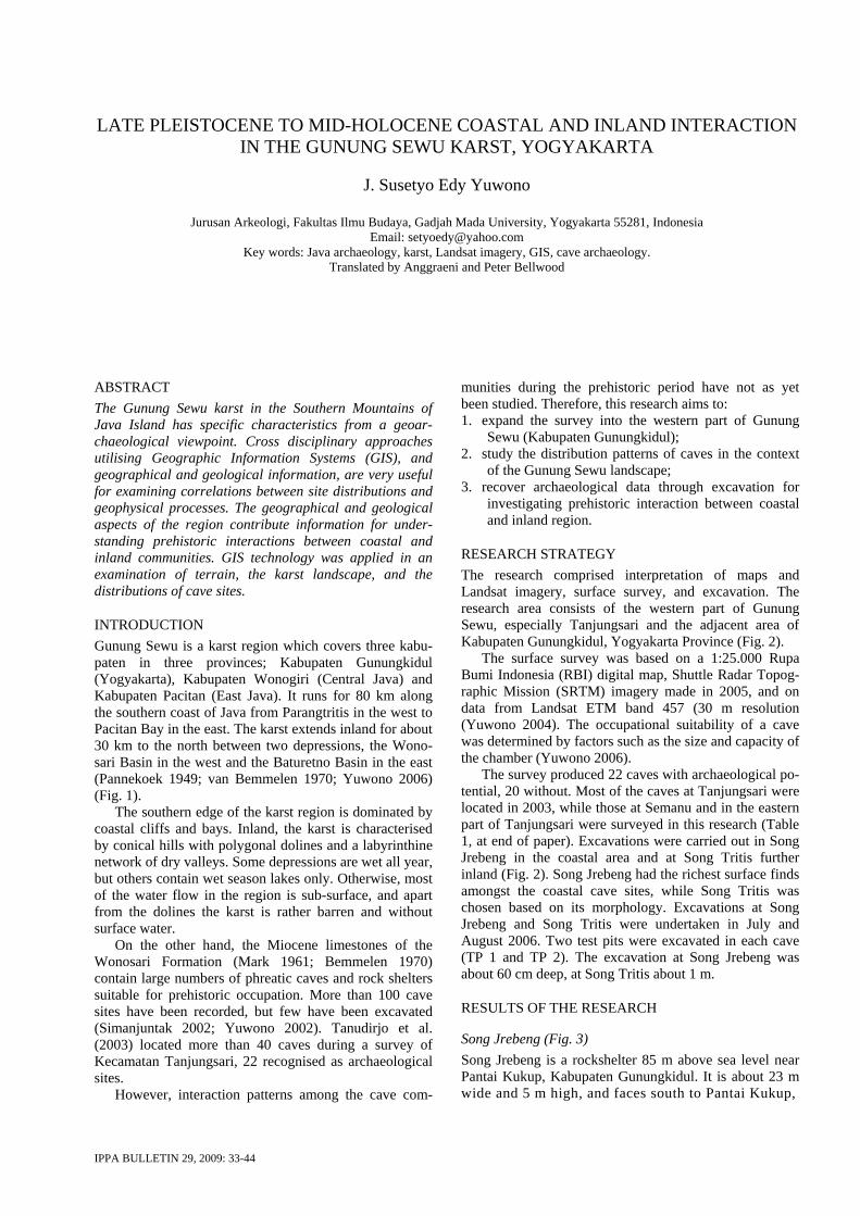
INTRODUCTION Gunung Sewu is a karst region which covers three kabu-paten in three provinces; Kabupaten Gunungkidul (Yogyakarta), Kabupaten Wonogiri (Central Java) and Kabupaten Pacitan (East Java). It runs for 80 km along the southern coast of Java from Parangtritis in the west to Pacitan Bay in the east. The karst extends inland for about 30 km to the north between two depressions, the Wono-sari Basin in the west and the Baturetno Basin in the east (Pannekoek 1949; van Bemmelen 1970; Yuwono 2006) (Fig. 1).
The southern edge of the karst region is dominated by coastal cliffs and bays. Inland, the karst is characterised by conical hills with polygonal dolines and a labyrinthine network of dry valleys. Some depressions are wet all year, but others contain wet season lakes only. Otherwise, most of the water flow in the region is sub-surface, and apart from the dolines the karst is rather barren and without surface water.
On the other hand, the Miocene limestones of the Wonosari Formation (Mark 1961; Bemmelen 1970) contain large numbers of phreatic caves and rock shelters suitable for prehistoric occupation. More than 100 cave sites have been recorded, but few have been excavated (Simanjuntak 2002; Yuwono 2002). Tanudirjo et al. (2003) located more than 40 caves during a survey of Kecamatan Tanjungsari, 22 recognised as archaeological sites.
However, interaction patterns among the cave com-
munities during the prehistoric period have not as yet been studied. Therefore, this research aims to: 1. expand the survey into the western part of Gunung
Sewu (Kabupaten Gunungkidul); 2. study the distribution patterns of caves in the context
of the Gunung Sewu landscape; 3. recover archaeological data through excavation for
investigating prehistoric interaction between coastal and inland region.
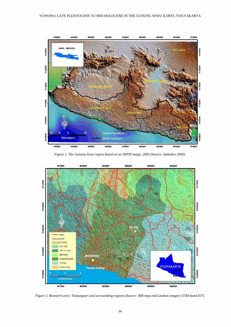
RESEARCH STRATEGY The research comprised interpretation of maps and Landsat imagery, surface survey, and excavation. The research area consists of the western part of Gunung Sewu, especially Tanjungsari and the adjacent area of Kabupaten Gunungkidul, Yogyakarta Province (Fig. 2).
The surface survey was based on a 1:25.000 Rupa Bumi Indonesia (RBI) digital map, Shuttle Radar Topog-raphic Mission (SRTM) imagery made in 2005, and on data from Landsat ETM band 457 (30 m resolution (Yuwono 2004). The occupational suitability of a cave was determined by factors such as the size and capacity of the chamber (Yuwono 2006).
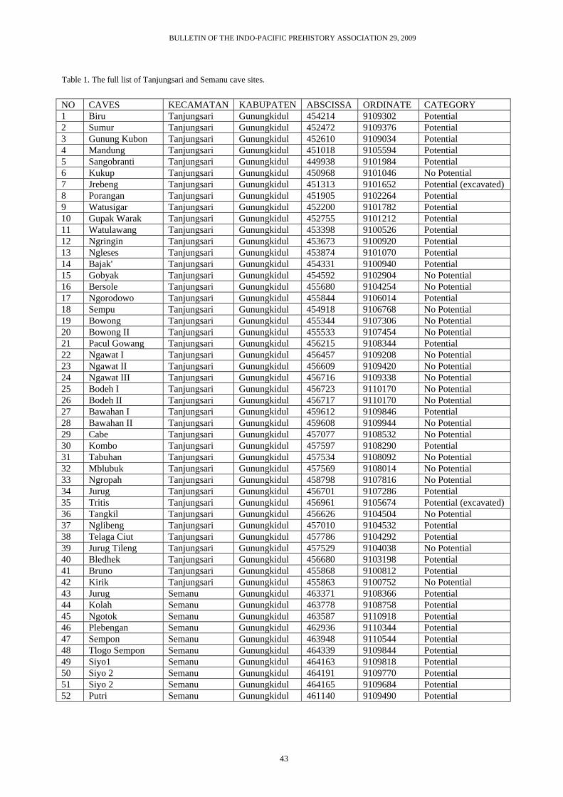
The survey produced 22 caves with archaeological po-tential, 20 without. Most of the caves at Tanjungsari were located in 2003, while those at Semanu and in the eastern part of Tanjungsari were surveyed in this research (Table 1, at end of paper). Excavations were carried out in Song Jrebeng in the coastal area and at Song Tritis further inland (Fig. 2). Song Jrebeng had the richest surface finds amongst the coastal cave sites, while Song Tritis was chosen based on its morphology. Excavations at Song Jrebeng and Song Tritis were undertaken in July and August 2006. Two test pits were excavated in each cave (TP 1 and TP 2). The excavation at Song Jrebeng was about 60 cm deep, at Song Tritis about 1 m.
RESULTS OF THE RESEARCH
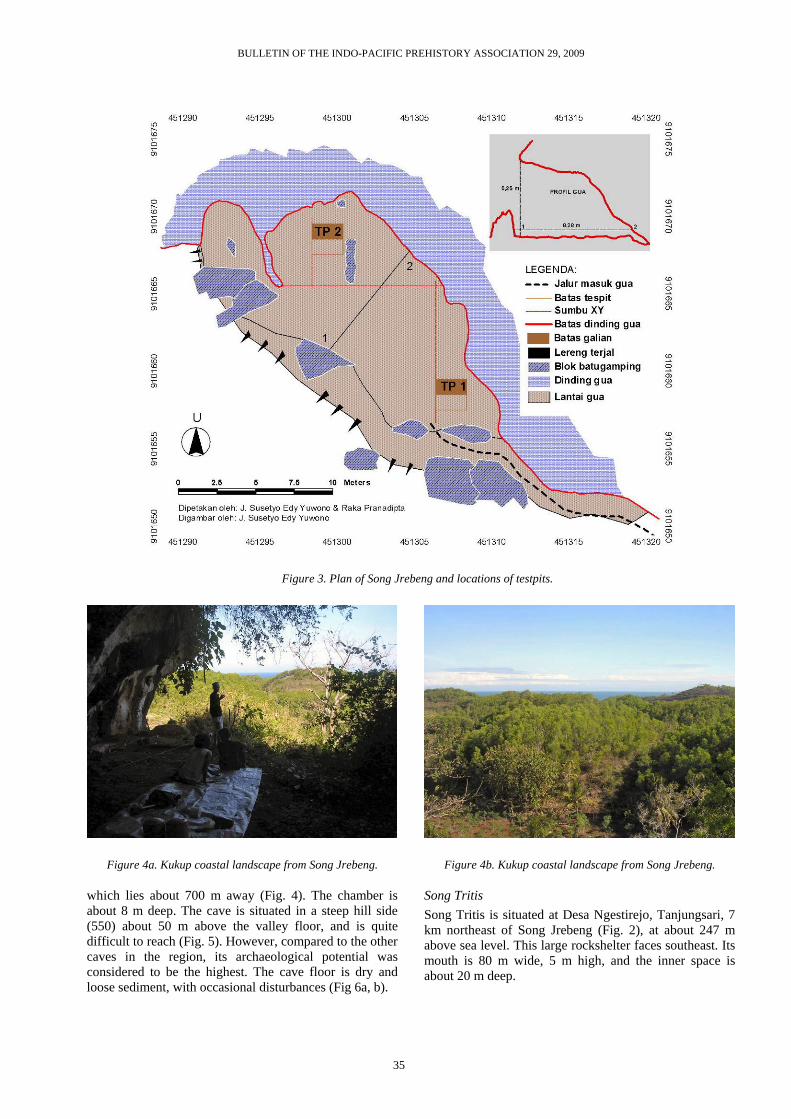
Song Jrebeng (Fig. 3) Song Jrebeng is a rockshelter 85 m above sea level near Pantai Kukup, Kabupaten Gunungkidul. It is about 23 m wide and 5 m high, and faces south to Pantai Kukup,
YUWONO: LATE PLEISTOCENE TO MID-HOLOCENE IN THE GUNUNG SEWU KARST, YOGYAKARTA
34
Figure 1. The Gunung Sewu region based on an SRTM image, 2005 (Source: Samodra 2006).
Figure 2. Research area: Tanjungsari and surrounding regions (Source: RBI map and Landsat imagery ETM band 457).
BULLETIN OF THE INDO-PACIFIC PREHISTORY ASSOCIATION 29, 2009
35
Figure 4a. Kukup coastal landscape from Song Jrebeng.
which lies about 700 m away (Fig. 4). The chamber is about 8 m deep. The cave is situated in a steep hill side (550) about 50 m above the valley floor, and is quite difficult to reach (Fig. 5). However, compared to the other caves in the region, its archaeological potential was considered to be the highest. The cave floor is dry and loose sediment, with occasional disturbances (Fig 6a, b).
Figure 4b. Kukup coastal landscape from Song Jrebeng.
Song Tritis Song Tritis is situated at Desa Ngestirejo, Tanjungsari, 7 km northeast of Song Jrebeng (Fig. 2), at about 247 m above sea level. This large rockshelter faces southeast. Its mouth is 80 m wide, 5 m high, and the inner space is about 20 m deep.
Figure 3. Plan of Song Jrebeng and locations of testpits.
YUWONO: LATE PLEISTOCENE TO MID-HOLOCENE IN THE GUNUNG SEWU KARST, YOGYAKARTA
36
Song Tritis is in one of several hills which encircle a polygonal depression with a permanent lake called Telaga Tritis (Figs 7a, 7b, 8). Compared to Song Jrebeng, this cave is very easy to reach from an access road to the lake. The existence of this access has disturbed the surface finds.
Figure 5. The position of Song Jrebeng on a hill slope.
Figure 6a. TP1 at Jrebeng (Photo: Taufiqurrahman S.)
Figure 6b. TP2 at Jrebeng (Photo: Taufiqurrahman S.
Figure 7a. The location of Song Tritis.
Figure 7b. The lake near Song Tritis.
Figure 8. TP1 at Tritis (Photo: Suhartono).
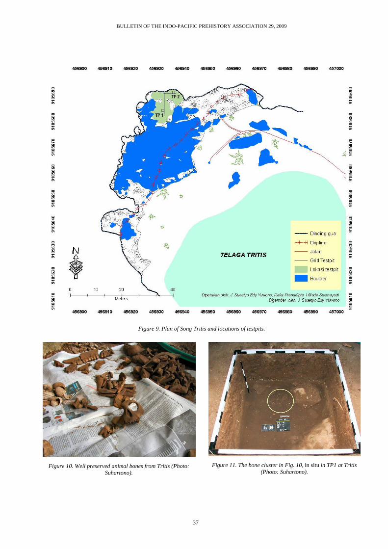
Most of the interior of Song Tritis is covered by lime-stone boulders. Nevertheless, there was space for excava-tion at the back (Fig. 9). The surface here is lower than the cave mouth, so that rain water can enter the cave along the dripline. The surface soil in the excavated area
BULLETIN OF THE INDO-PACIFIC PREHISTORY ASSOCIATION 29, 2009
37
Figure 9. Plan of Song Tritis and locations of testpits.
Figure 10. Well preserved animal bones from Tritis (Photo: Suhartono).
Figure 11. The bone cluster in Fig. 10, in situ in TP1 at Tritis (Photo: Suhartono).
YUWONO: LATE PLEISTOCENE TO MID-HOLOCENE IN THE GUNUNG SEWU KARST, YOGYAKARTA
38
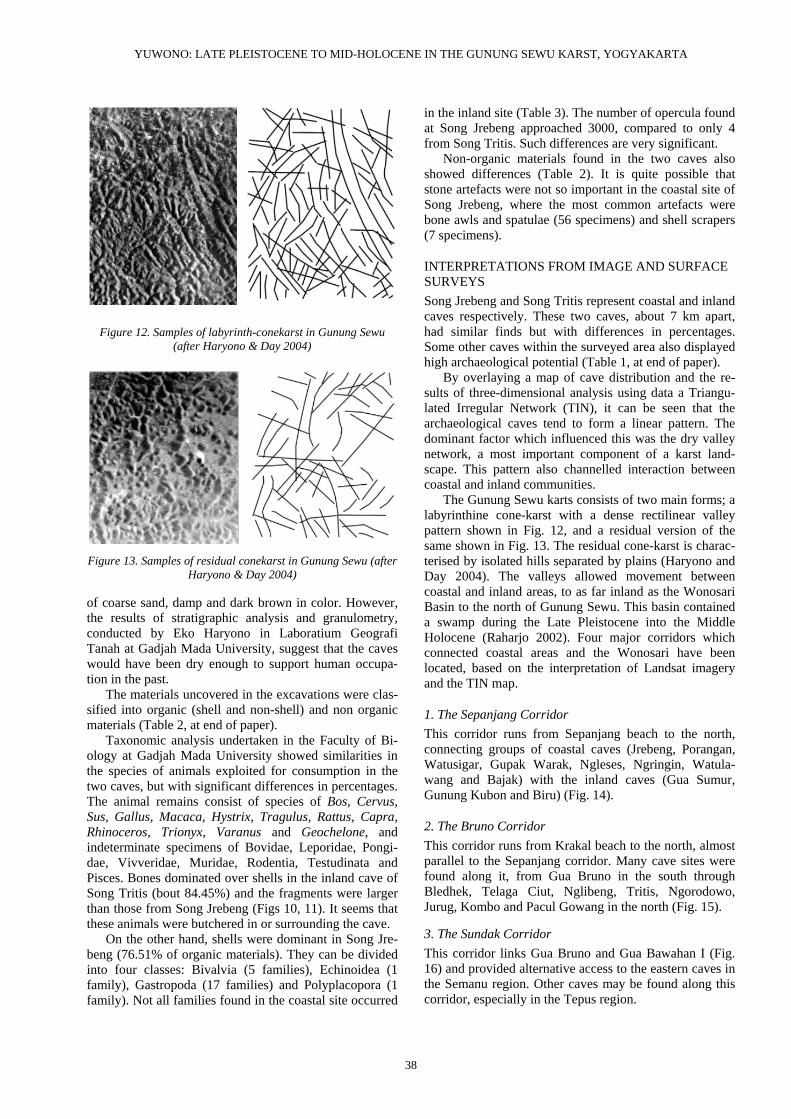
Figure 12. Samples of labyrinth-conekarst in Gunung Sewu (after Haryono & Day 2004)
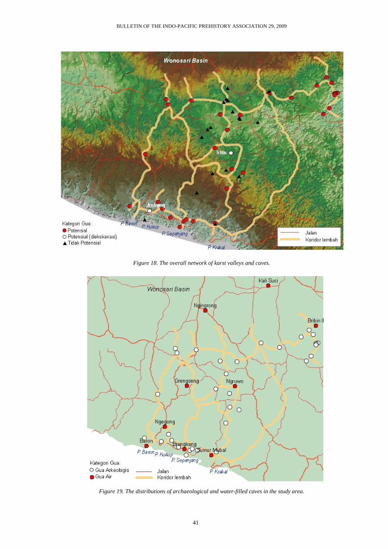
Figure 13. Samples of residual conekarst in Gunung Sewu (after
Haryono & Day 2004)
of coarse sand, damp and dark brown in color. However, the results of stratigraphic analysis and granulometry, conducted by Eko Haryono in Laboratium Geografi Tanah at Gadjah Mada University, suggest that the caves would have been dry enough to support human occupa-tion in the past.
The materials uncovered in the excavations were clas-sified into organic (shell and non-shell) and non organic materials (Table 2, at end of paper).
Taxonomic analysis undertaken in the Faculty of Bi-ology at Gadjah Mada University showed similarities in the species of animals exploited for consumption in the two caves, but with significant differences in percentages. The animal remains consist of species of Bos, Cervus, Sus, Gallus, Macaca, Hystrix, Tragulus, Rattus, Capra, Rhinoceros, Trionyx, Varanus and Geochelone, and indeterminate specimens of Bovidae, Leporidae, Pongi-dae, Vivveridae, Muridae, Rodentia, Testudinata and Pisces. Bones dominated over shells in the inland cave of Song Tritis (bout 84.45%) and the fragments were larger than those from Song Jrebeng (Figs 10, 11). It seems that these animals were butchered in or surrounding the cave.
On the other hand, shells were dominant in Song Jre-beng (76.51% of organic materials). They can be divided into four classes: Bivalvia (5 families), Echinoidea (1 family), Gastropoda (17 families) and Polyplacopora (1 family). Not all families found in the coastal site occurred
in the inland site (Table 3). The number of opercula found at Song Jrebeng approached 3000, compared to only 4 from Song Tritis. Such differences are very significant.
Non-organic materials found in the two caves also showed differences (Table 2). It is quite possible that stone artefacts were not so important in the coastal site of Song Jrebeng, where the most common artefacts were bone awls and spatulae (56 specimens) and shell scrapers (7 specimens).
INTERPRETATIONS FROM IMAGE AND SURFACE SURVEYS Song Jrebeng and Song Tritis represent coastal and inland caves respectively. These two caves, about 7 km apart, had similar finds but with differences in percentages. Some other caves within the surveyed area also displayed high archaeological potential (Table 1, at end of paper).
By overlaying a map of cave distribution and the re-sults of three-dimensional analysis using data a Triangu-lated Irregular Network (TIN), it can be seen that the archaeological caves tend to form a linear pattern. The dominant factor which influenced this was the dry valley network, a most important component of a karst land-scape. This pattern also channelled interaction between coastal and inland communities.
The Gunung Sewu karts consists of two main forms; a labyrinthine cone-karst with a dense rectilinear valley pattern shown in Fig. 12, and a residual version of the same shown in Fig. 13. The residual cone-karst is charac-terised by isolated hills separated by plains (Haryono and Day 2004). The valleys allowed movement between coastal and inland areas, to as far inland as the Wonosari Basin to the north of Gunung Sewu. This basin contained a swamp during the Late Pleistocene into the Middle Holocene (Raharjo 2002). Four major corridors which connected coastal areas and the Wonosari have been located, based on the interpretation of Landsat imagery and the TIN map.
1. The Sepanjang Corridor This corridor runs from Sepanjang beach to the north, connecting groups of coastal caves (Jrebeng, Porangan, Watusigar, Gupak Warak, Ngleses, Ngringin, Watula-wang and Bajak) with the inland caves (Gua Sumur, Gunung Kubon and Biru) (Fig. 14).
2. The Bruno Corridor This corridor runs from Krakal beach to the north, almost parallel to the Sepanjang corridor. Many cave sites were found along it, from Gua Bruno in the south through Bledhek, Telaga Ciut, Nglibeng, Tritis, Ngorodowo, Jurug, Kombo and Pacul Gowang in the north (Fig. 15).
3. The Sundak Corridor This corridor links Gua Bruno and Gua Bawahan I (Fig. 16) and provided alternative access to the eastern caves in the Semanu region. Other caves may be found along this corridor, especially in the Tepus region.
BULLETIN OF THE INDO-PACIFIC PREHISTORY ASSOCIATION 29, 2009
39
Figure 14. The Sepanjang Corridor.
Figure 15. The Bruno Corridor.
YUWONO: LATE PLEISTOCENE TO MID-HOLOCENE IN THE GUNUNG SEWU KARST, YOGYAKARTA
40
Figure 16. The Sundak Corridor.
Figure 17. The Baron Corridor.
BULLETIN OF THE INDO-PACIFIC PREHISTORY ASSOCIATION 29, 2009
41
Figure 18. The overall network of karst valleys and caves.
Figure 19. The distributions of archaeological and water-filled caves in the study area.
YUWONO: LATE PLEISTOCENE TO MID-HOLOCENE IN THE GUNUNG SEWU KARST, YOGYAKARTA
42
4. The Baron Corridor This most westerly corridor starts from Baron beach and joins the Sepanjang corridor at Gunung Kubon. This corridor might have been used by the inhabitants of Sangobranti, Jrebeng, Porangan and Watusigar caves in the coastal area, and Mandung, Gunung Kubon and Sumur caves in the inland region (Fig. 17).
Figure 18 shows all the valley corridors in the re-search area. This figure also indicates cross-links between the Song Jrebeng and Tritis communities. The corridors which may have been used were coastal-coastal, coastal-inland, or on some occasions inland-inland.
The distribution of the Tanjungsari cave sites corre-lates with other components of the Gunung Sewu karst, in particular the large Bribin-Baron underground river system. Many uninhabitable caves (gua air) such as sinkholes and collapsed dolines, together with blind valleys, also follow this underground system (Fig. 19). Hydrological examination of the Bribin–Baron under-ground river system undertaken by Soenarto (2004) justifies these correlations between archaeological phe-nomena and endokarstic structures (Yuwono 2006).
CONCLUSIONS The linear distribution patterns of cave sites in the re-search area suggest that prehistoric settlement in Gunung Sewu was much influenced by terrain and other elements of palaeo-landscape. Karstic valley corridors determined the nature of interaction between communities within different geographical regions. The excavations at Song Jrebeng and Song Tritis showed that both sites shared coastal and inland resources, but in different proportions.
Tanjungsari and adjacent areas form only a small re-gion of the whole Gunung Sewu complex, and reveal interesting geoarchaeological phenomena. Broader research is still needed, and the location chosen for future research is the Sundak Corridor, close to the former valley of the Solo River.
ACKNOWLEDGEMENTS Many thanks due to the Anthony F. Granucci Fund and IPPA for funding and the opportunity to undertake the research; to Daud Aris Tanudirjo for the valuable sugges-tions and support; and to Eko Haryono for analysis of the sediments from Song Tritis.
REFERENCES Bemmelen, R. . van. 1970. The Geology of Indonesia. vol.
IA, The Hague: Martinus Nijhoff. Haryono, E. and M. Day. 2004. Landform differentiation
within the Gunung Kidul kegelkarst, Java, Indo-
nesia. Journal of Cave and Karst Studies: 66, no. 2, pp. 62-69.
Pannekoek, A. . 1949. Outline of the geomorphology of Java. TAG Th 1949, pp. 270-326. Leiden: E.J. Brill.
Mark, P. 1961. Stratigraphic Lxicon of Indonesia. Publikasi Keilmuan no. 31 Seri Geologi. Band-ung, Kementrian Perekonomian Pusat Djawatan Geologi.
Rahardjo, W. 2002. Paleogeografi daerah Pegunungan Selatan Jawa Tengah selama Plestosen hingga awal Holosen: Suatu tinjauan awal. Seminar Gunungkidul dalam Visi Budaya dan Lingkun-gan Purba. Yogyakarta, FIB UGM.
Samodra, H. 2006. Pembentukan lembah kering purba kawasan karst: Contoh kasus Gunung Sewu. In Maryanto I., Noerdjito M. and Ubaidillah R. (eds). Manajemen Bioregional: Karst, Masalah dan Pemecahannya, pp. 87-98 Puslit Biologi LIPI.
Simanjuntak, T. (ed). 2002. Gunung Sewu in Prehistoric Times. Yogyakarta: Gadjah Mada University Press.
Soenarto, B. 2004. Tinjauan dari aspek hidrologi kondisi fisik daerah karst Bribin-Baron, Pendidikan dan Pelatihan Scientific Karst Exploration Tingkat Nasional, Bogor, Rasamala KPA Sylvalestari dan Lawalata IPB.
Tanudirjo D., T. Prasodjo and Anggraeni. 2003. Potensi gua-gua sebagai tempat hunian manusia prase-jarah di Kecamatan Tanjungsari, Kabupaten Gunungkidul, Daerah Istimewa Yogyakarta. La-poran Penelitian. Yogyakarta, Lembaga Peneli-tian UGM.
Yuwono, J.S.E. 2002. Laporan hasil ekskavasi dan analisis pendahuluan situs Song Bentar, Dusun Bentar, Desa Kenteng, Kecamatan Ponjong. Yogyakarta. PTKA Gunungkidul FIB UGM – The Toyota Foundation.
Yuwono, J.S.E. 2004. Arkeologi karstik dan metode penelusuran potensi kawasan: Introduksi tentang model penerapannya di Gunung Sewu. Pendidikan dan Pelatihan Scientific Karst Exploration Tingkat Nasional. Bogor, Rasamala-KPA Sylvalestari dan Lawalata IPB.
Yuwono, J.S.E. 2006. Perspektif geoarkeologi kawasan karst: kasus Gunung Sewu. In Maryanto I., Noerdjito M. and Ubaidillah R. (eds). Manajemen Bioregional: Karst, Masalah dan Pemecahannya, pp. 181-203 Puslit Biologi LIPI.
BULLETIN OF THE INDO-PACIFIC PREHISTORY ASSOCIATION 29, 2009
43
Table 1. The full list of Tanjungsari and Semanu cave sites.
YUWONO: LATE PLEISTOCENE TO MID-HOLOCENE IN THE GUNUNG SEWU KARST, YOGYAKARTA
44
Table 2. Find distributions at Song Jrebeng and Song Tritis.
CATEGORY OF FINDS SONG JREBENG SONG TRITIS Number of specimens % Number of specimens % Organic materials (non shell) 3,408 23.32 9,305 84.45 Organic materials (shell) 11,180 76.51 1,539 13.97 Non organic materials 22 0.15 175 1.59 Unidentified 3 0.02 0 0 Total 14,613 100.00 11,019 100.00 Table 3. Molluscan families recovered from Song Jrebeng and Song Tritis (analysed by Rury Eprilurahman, Faculty of Biology, Gadjah Mada University).