Latin America Background – name reflects culture traits inherited from Spain and Portugal – Spanish and Portuguese in Brazil are the major languages, – dialects of French are spoken in Haiti and the French dependencies Guiana, Guadeloupe, and Martinique. – modification of Latin influence by local culture
Transcript
Latin America Background
– name reflects culture traits inherited from Spain and Portugal
– Spanish and Portuguese in Brazil are the major languages,
– dialects of French are spoken in Haiti and the French dependencies Guiana, Guadeloupe, and Martinique.
– modification of Latin influence by local culture
Physical Dimensions– With a land area of slightly more than 7.9
million square miles (over 20.5 million sq km),
– Latin America not as large in size as Africa, the Post-Soviet Region, Anglo-America or the Orient
– maximum latitudinal extent of 5900 miles; maximum east-west measurement of 82 degrees of longitude also impressive.
Population – Latin American population is 525 million. – population is unevenly distributed with wide
variations in density.
– two major population areas are on the East coast from the Amazon to Buenos Aires and on the West coast from Caracas to Santiago
– southern Andes and the dry lands of Argentina's Patagonia are scarcely populated
– Europeans developed ports as bases for penetration into the interior.
– Many port became major metropolitan centers like Lima, Caracas, and Santiago
– lure of gold and silver stimulated the penetration of the Andes and the Brazilian Highlands. Urban centers inland served the mines
– a few highland cities like Bogota, Colombia have grown into sizable metropolises.
– main seaports and highland cities became important centers of colonial government
– population of central Mexico was already the center of population when the Spanish conquerors came.
– central Mexico was principal domain of the large and technologically advanced Aztec Empire
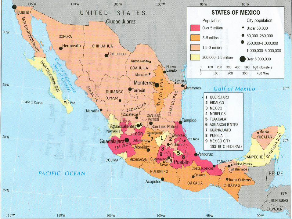
– roughly half of Mexico's 102 million people (2002) now live in, around, or between the region's two principal cities of Mexico City and Guadalajara.
Latin America:Population Distribution
Ethnic Diversity– Although most Latin Americans speak
Spanish or Portuguese and embrace some form of Roman Catholicism, the region's inhabitants have highly varied ancestries—white European, black African, native Indian, Asian, or mixtures.
– Europeans, Africans, and Asians came from various parts of their respective continents, while the native Indians represented a multiplicity of tribes.
– only three nations—Argentina, Uruguay, and Costa Rica—have preserved white European racial strains on a large scale with little admixture by Indians or blacks.
– Black Latin Americans found in greatest numbers in West Indian islands and along the Atlantic coast in Middle and South America where they were a source of plantation labor
– most of Latin American of mixed racial heritage, i.e. mestizo (Spanish and indian); zambos ( indian and black ancestry; or mulattoes (European and black ancestry.
Rapid Population Growth and Urbanization– most of Latin American in Stage II with
high birth rates and falling death rates– major migrations from rural areas to
– population explosion clearly seen in metropolitan Mexico City, Sao Paulo, Rio de Janeiro, and Buenos Aires.
– strain on social services– shantytowns on urban periphery (favalas in
Brazil) Physical features and climate
– differences in elevation and topography striking in Latin America
– low-lying plains drained by Orinoco, Amazon and Parana-Paraguay river systems
– high interior plateaus broken by basins in Mexico
– north/south continuous mountain from Mexico to Tierra del Fuego at tip of South America
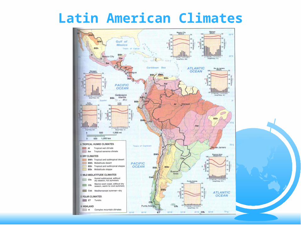
Climates– humid lowland climates
tropical rain forest with heavy year-round precipitation, high heat and humidity, and abundant vegetation.(Af/Am)
tropical savanna climate in vicinity of Tropic of Capricorn with less rain, cooler temperatures, savanna grasslands and deciduous trees (Aw)
humid subtropical climate on eastern side of South America with prairie grasses and cooler winters(Cf)
small strip of Mediterranean climate in central Chile with dry summers(Csb)
marine west coast climate in uninhabited mountain at southern end of the Andes(Cfb)
Latin American Climates
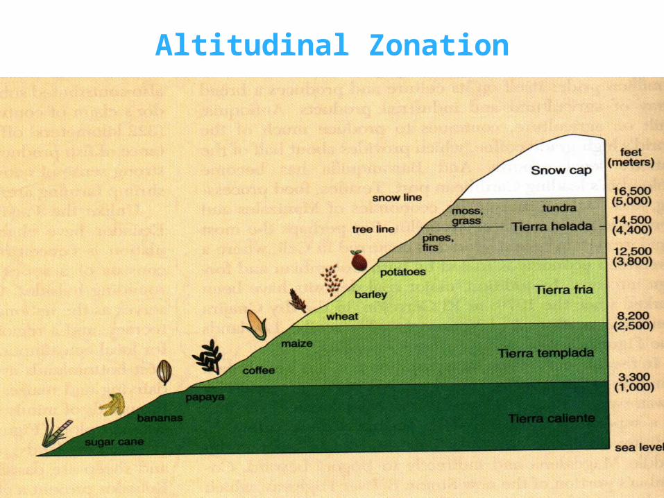
Altitudinal Zonation
Altitudinal Zonation– much of Latin America has highland
climates influenced by zones of altitude– Tierra Caliente
tropical rain forest and savanna climate found at foot of highlands where rice, sugar cane, bananas, and cacao are grown
heavy concentrations of blacks, zambos and mulattos
– Tierra Templada sugar cane, cacao, bananas and oranges
grow here predominately the zone of the coffee tree upper limits of zone at 6,000 feet
– Tierra Fria frost zone from 6,000 to 10,000 feet high plateaus, basins, and valleys of the
Andes and other high mountain ranges native indian economy with subsistence
component
– Tierra Helada (frozen land above 10,000 feet) Systems of Agriculture
– latifundia (large estates) with a strong commercial orientation.
owned by families or corporations employment of landless, illiterate workers profits benefit owners and workers underpaid
and seasonally employed
owners often absentee landlords single crop plantation producing a single
commodity like bananas with significant foreign investment from US
– minifundia (smaller estates) with a subsistence component
people who farm them often lack capital to purchase equipment
marginal plots farmed on sharecropping basis
individuals who own small plots of land often indebted
produce food for family and local market- beans, maize, and squash
productivity low
Minerals and Mining– Latin America produces small amount of key
minerals that are important to external powers
– Mexico, Venezuela, Brazil with large value of mineral output though most profits go to showy buildings, corruption, enrichment of upper classes and foreign investors
– masses derive few benefits from mineral and mining activities
– mineral wealth does provide some infrastructure improvements like roads, power stations, water systems, schools and hospitals
– mineral production includes petroleum from Caribbean Sea, Gulf of
Mexico and northern Venezuela high grade iron ore in eastern highlands of
Brazil and Venezuela unexploited bauxite deposits in Venezuela,
Chile and Peru copper in Atacama Desert in northern Chile silver in Mexico, Peru and Bolivia large tin reserves in Bolivia
– most mining ventures controlled by outside firms
– boom and bust cycles with high revenues followed by high spending, then depression
Manufacturing– many governments attempting to attract
outside foreign investment in manufacturing with tax exemptions, cheap labor and other inducements
– largest output of factory goods in Brazil, Mexico, and Argentine
Drug Trafficing– The Andean countries account for 90% of the
world’s cocaine trade– Coca leave chewed by indians in the highlands
to endure long hours of work in the mines and relieve pangs of hunger
– Coca plant only takes 1 year to produce product vs. fruit trees which take 4-5 years
– Coca profits for cultivators 4-5 times greater than other cash crops
– Environmental impact of US drug enforcement
Latin America: Countries and
Economies Mexico
– most influential country in Middle America– unrecognized giant in the region– eight times larger in size than UK;
elongated territory would stretch from Wash state to Florida
– huge population of 102 million in 2002; expected to reach 120 million by 2010is with the US
– economic relations with US crucial because 2/3’s of its trade is with the US
– Impact of 1994 North American Free Trade Agreement (NAFTA
Designed to promote Mexican economic growth Hope of expanded export markets for US,
Canada Promise of stemming tide of illegal immigration Trade between US Mexico has tripled since ’94 85% of Mexican imports to US US concern about loss of jobs in textiles, shoes,
assembly plants
– sensitivity of US Mexico relations because of disparity in wealth and power, loss of considerable territory to US in 19th C, national pride derived from ancient civilizations Aztec and Mayan
Geographic Influences of the past– advanced civilizations influenced
present settlement pattern around Mexico City and Yucatan
– Spanish conquerors sought out indians as laborers and potential Christian converts
– Aztec empire destroyed by Hernando Cortez in 1521
– establishment of an Hispanic pattern of life- Spanish language, culture, architectural styles
– rectangular grid with plaza and church in town center
– best lands to wealthy Spanish owners who established large haciendas
– turbulence of 19th C with bloody revolution from 1810-21; Mexican empire, loss of Texas, California, New Mexico and Arizona
– despotic rule under Porfirio Diaz as population sank deeper into poverty, foreign investment poured into railroads, oil, mining, manufacturing
– Mexican Revolution in 1910 ushered in era of reform, many huge haciendas broken up, land redistribution
– dominance of the PRI (Independent Revolutionary Party) until election of Vincente Fox
– More market oriented economic policies
Immigration Problems– US Mexican border over 2,000 miles long– Over 1 million immigrants/year make way into
US territory– Illegal immigrants send back $6-8 billion per
year to Mexico– Fox plans for reintroduction of Bracero
Program– Immigration concerns in US- terrorism,
competition for jobs, inundation of US culture
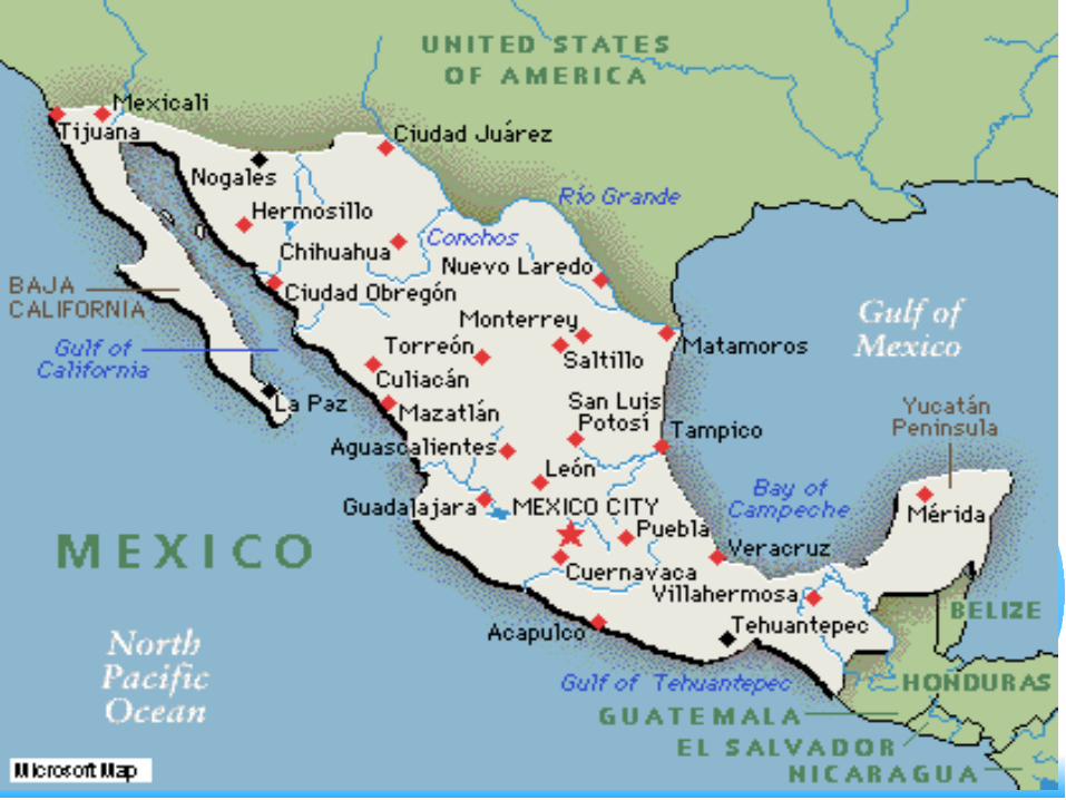
Mexico City
Puebla
Monterrey
Acapulco
Ciudid Juarez
Mexicali
Tijuana
GuadalajaraYucatanPeninsula
Mazatlan
Veracruz
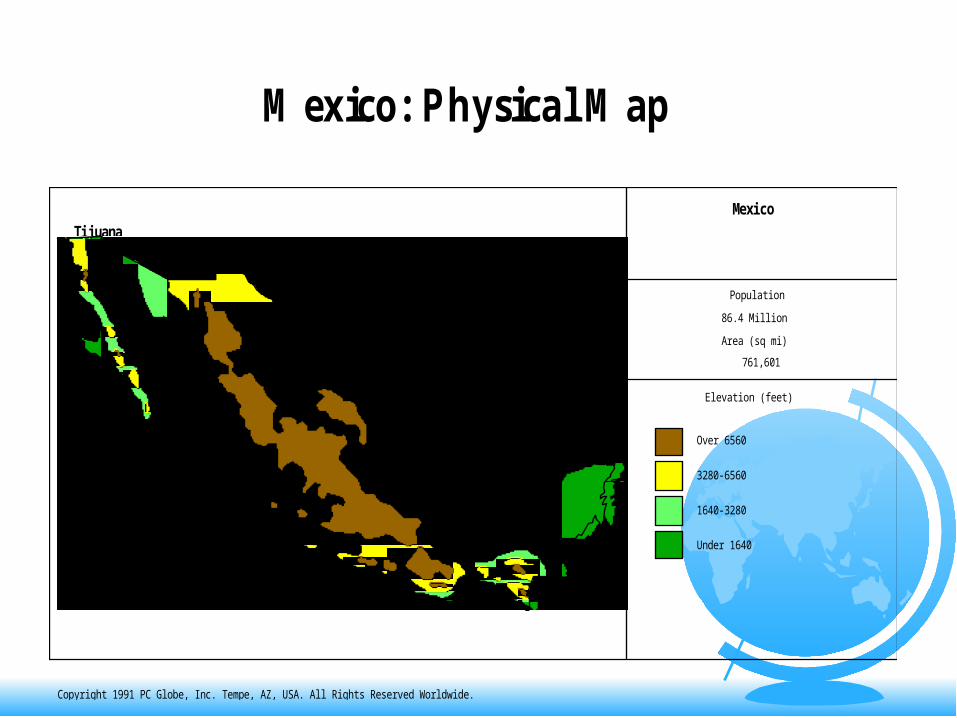
M exico: Physical M ap
Mexico
Population
86.4 Million
Area (sq mi)
761,601
Elevation (feet)
Under 1640
1640-3280
3280-6560
Over 6560
500 mi
Copyright 1991 PC Globe, Inc. Tempe, AZ, USA. All Rights Reserved Worldwide.
Mexico: Physical Map
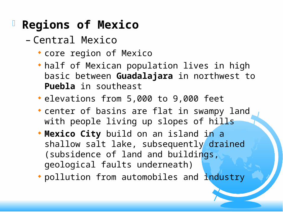
Regions of Mexico– Central Mexico
core region of Mexico half of Mexican population lives in high basic
between Guadalajara in northwest to Puebla in southeast
elevations from 5,000 to 9,000 feet center of basins are flat in swampy land with
people living up slopes of hills Mexico City build on an island in a shallow
salt lake, subsequently drained (subsidence of land and buildings, geological faults underneath)
pollution from automobiles and industry
temperature inversions in Mexico City relentless flow of migrants, unemployment, low
wages modern subway system manufacturing center and business and industrial
center
– Northern Mexico rugged and arid terrain ranching economy with sparse population source of timber larger landholdings in north metals, coal, zinc, copper, silver, gold irrigated agriculture near Rio Grande cotton, fruits and winter vegetables for US
market
maquiladora program to attract foreign investment in border areas like Tijuana, Cuidad Juarez, Nuevo Laredo and Matamoros
import components without customs duties, utilization of cheap labor to assemble component parts, then export back to US
illegal alien problems (1.5 million Mexicans cross US border every year)
valuable oil and gas reserves government monopoly PEMX US largest foreign customer natural gas pipelines to US major foreign borrowings for Mexican
development and declining oil revenues led to major economic problems in 80’s and 90’s
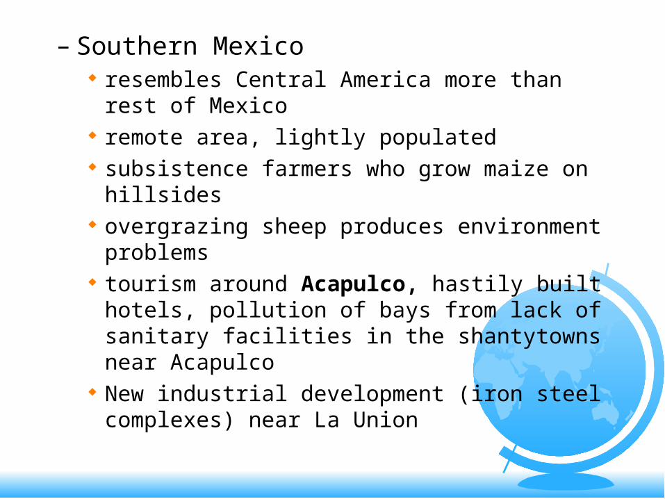
– Southern Mexico resembles Central America more than rest of
Mexico remote area, lightly populated subsistence farmers who grow maize on
hillsides overgrazing sheep produces environment
problems tourism around Acapulco, hastily built
hotels, pollution of bays from lack of sanitary facilities in the shantytowns near Acapulco
New industrial development (iron steel complexes) near La Union
– Chiapas and Yucatan center of native American cultures tourism around Cancun Destruction of Mexico’s natural beauty due
to coastal development in Yucatan Cacao, sugar cane and rubber refugees from Guatemala and El Salvador civil disturbance, guerrilla warfare, human
rights problems, disillusion with central government
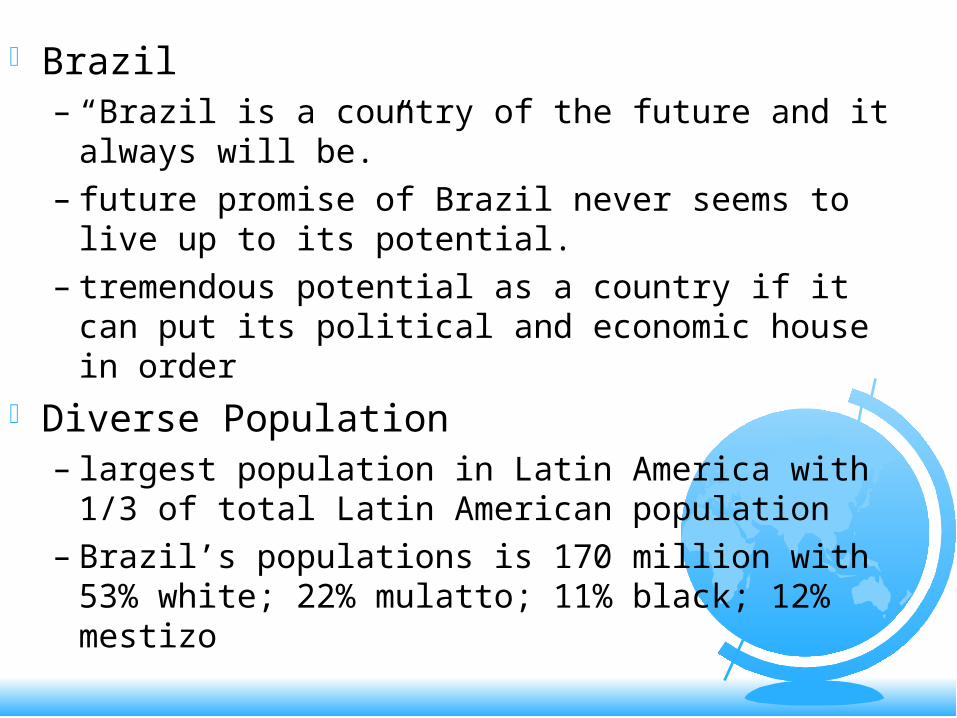
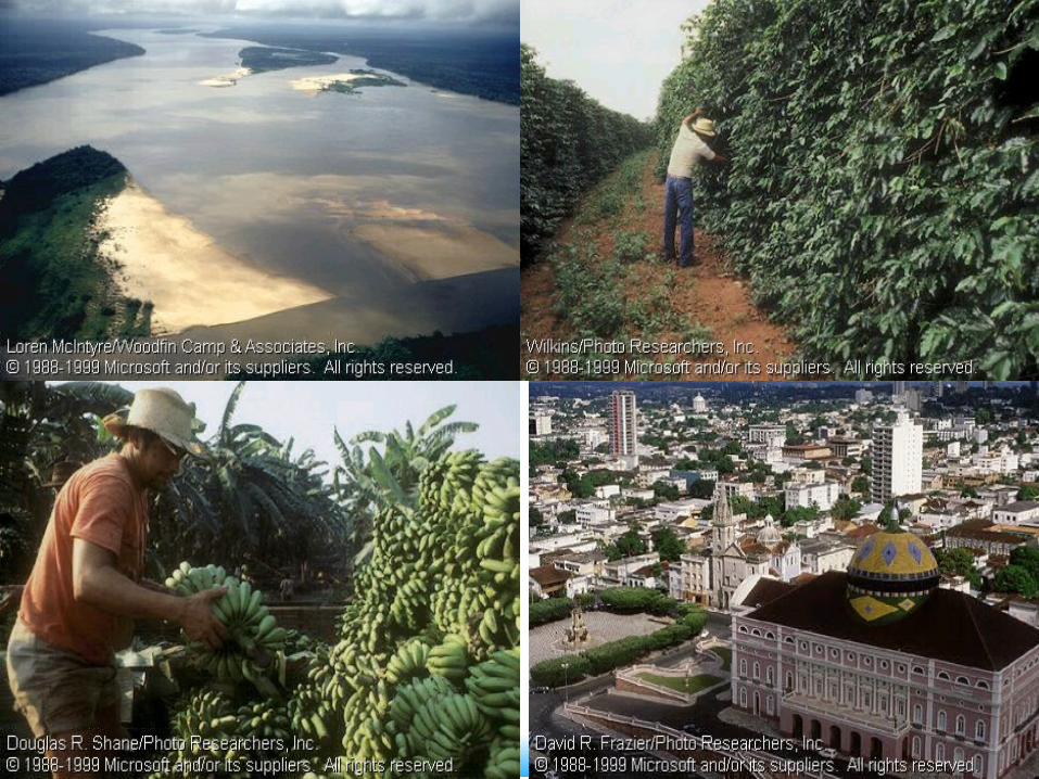
Brazil– “Brazil is a country of the future and it always
will be.”– future promise of Brazil never seems to live
up to its potential.– tremendous potential as a country if it can
put its political and economic house in order Diverse Population
– largest population in Latin America with 1/3 of total Latin American population
– Brazil’s populations is 170 million with 53% white; 22% mulatto; 11% black; 12% mestizo
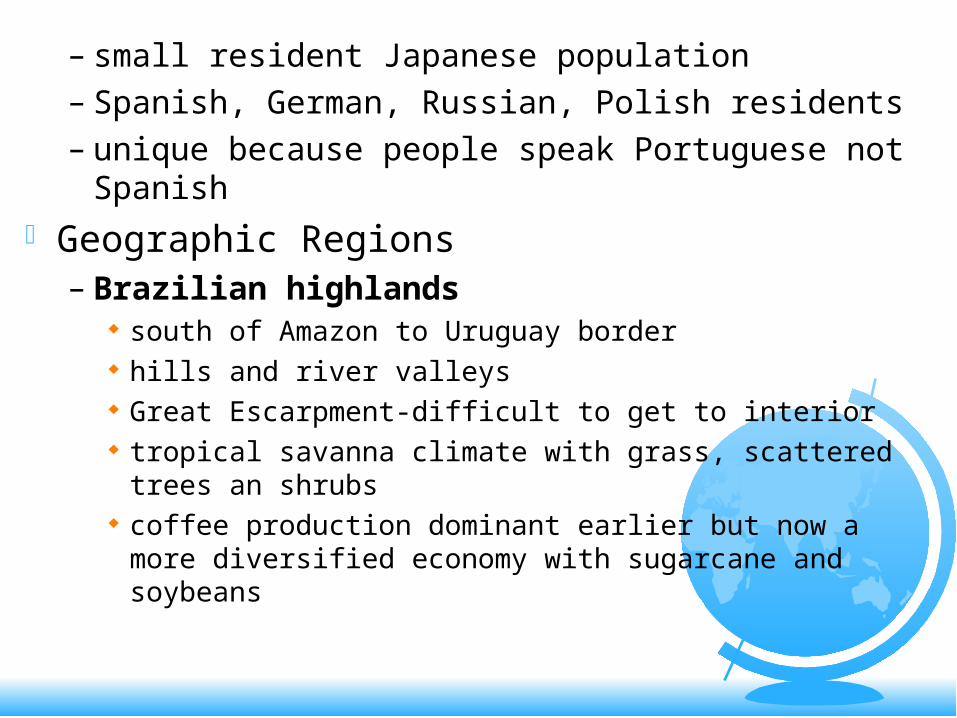
– small resident Japanese population– Spanish, German, Russian, Polish residents – unique because people speak Portuguese
not Spanish Geographic Regions
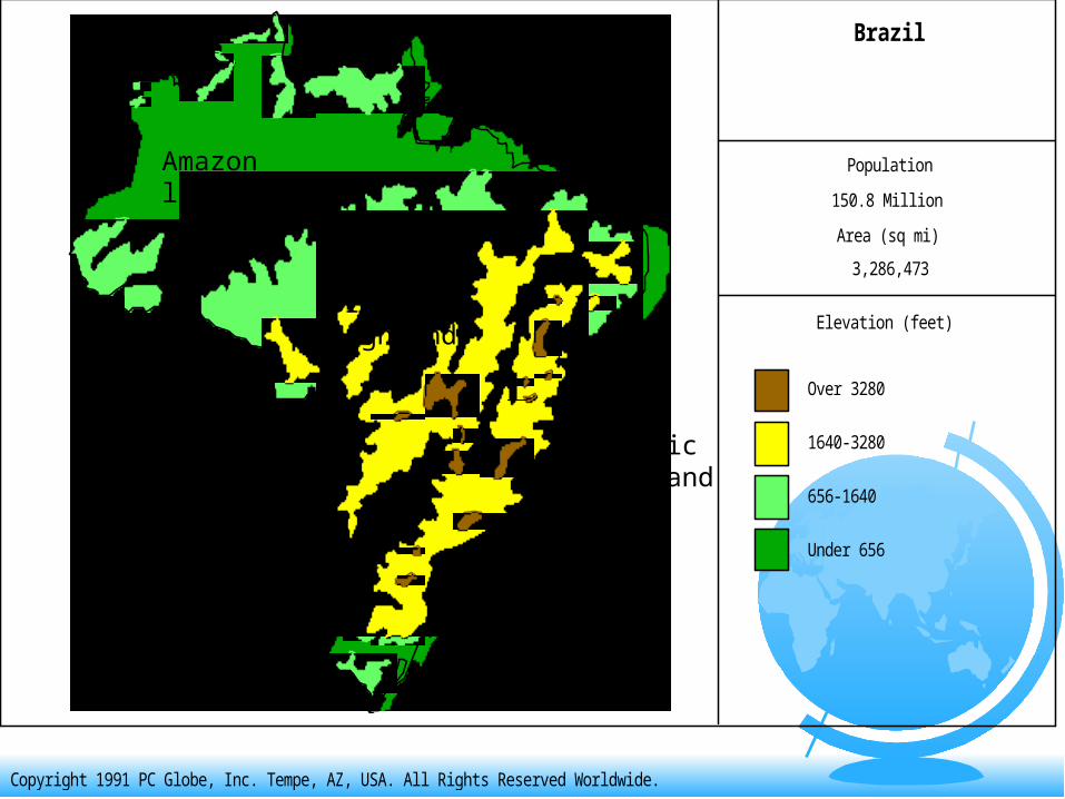
– Brazilian highlands south of Amazon to Uruguay border hills and river valleys Great Escarpment-difficult to get to interior tropical savanna climate with grass, scattered trees an
shrubs coffee production dominant earlier but now a more
diversified economy with sugarcane and soybeans
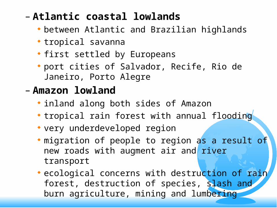
– Atlantic coastal lowlands between Atlantic and Brazilian highlands tropical savanna first settled by Europeans port cities of Salvador, Recife, Rio de Janeiro,
Porto Alegre
– Amazon lowland inland along both sides of Amazon tropical rain forest with annual flooding very underdeveloped region migration of people to region as a result of new
roads with augment air and river transport ecological concerns with destruction of rain
forest, destruction of species, slash and burn agriculture, mining and lumbering
Brazil
Population
150.8 Million
Area (sq mi)
3,286,473
Elevation (feet)
Under 656
656-1640
1640-3280
Over 3280
500 mi
Copyright 1991 PC Globe, Inc. Tempe, AZ, USA. All Rights Reserved Worldwide.
BrazilianHighlands
Atlanticcoastlands
Amazonlowlands
Boom Bust Economy– Sugarcane era in 16th C
large exports to Europe utilizing slave labor from Africa
great profits initially, following by decline due to stiff competition from other parts of Latin America and Caribbean
– Gold and Diamonds 18th C gold and diamonds discovered in highlands
north and northwest of Sao Paulo Brazil produced 1/3 of world’s gold in 18th C
moved by pack animals over poor roads decline in production by 19th C
– Rubber boom in 19th C centered around port city of Manaus vulcanization process by Charles Goodyear in
1839 stimulated demand rubber prices skyrocketed, fortunes made in
Brazil boom ended when British smuggled rubber
seeds out of Brazil to Southeast Asia and West Africa where better conditions existed for plantations
fragile soil could not sustain plantation agriculture
– Coffee boom 19th C growing world market for coffee in West ideal climatic conditions, good soil in Brazilian
highlands railroads linking producing areas to Atlantic
around Sao Paulo and Santos bust in coffee prices by 1910, competition
from Columbia which undercut prices
Economic Development since WWII– rapid development since 1945– military government in 1964 opened
country to foreign investment by multinational corporations
– huge investments in infrastructure programs, road construction, Trans-Amazon Highway
– development of new capital city of Brazilia in 1957 to pull population inland
– expansion of sugar, citrus, soybeans for export
– new industrial age in 80’s producing textiles, steel, machinery, automobiles, trucks, ships, chemicals, plastics and a thriving weapons industry
– General Motors, Ford, Volkswagen, Fiat, Renault and Hyundai all operate automobile factories in Brazil
– commercial aircraft, military aircraft, missiles and tanks sold to Latin American customers
– largest industrial core region around Sao Paulo and Rio de Janeiro
– secondary industrial region developing around Manaus in Amazon basin
– free trade zone around Manaus to attract foreign investment, import materials without tariffs, exports to world markets
– 6,000 new factories established by companies like Honda, Kodak, Olivetti, Toshiba, Sony and 3M Co.
– utilization of gasohol made from sugar cane supplying 25% of Brazil fuel needs
– world’s largest hydroelectricity project at Itaipu on Parana River on border with Paraguay will supply 20% of all electric power for Brazil, 100% for Paraguay
– debt problems in the 80’s (Brazil’s foreign debt amounted to $120 billion US) slowed growth, necessitated rescheduling debt payments, high debt payments, high domestic tariffs to keep out imports.
– political stability remains a key potential problem
– election of Lula da Silva promised "a new style of government" and a crusade against hunger, injustice and corruption
Favela housing in Rio de Janeiro
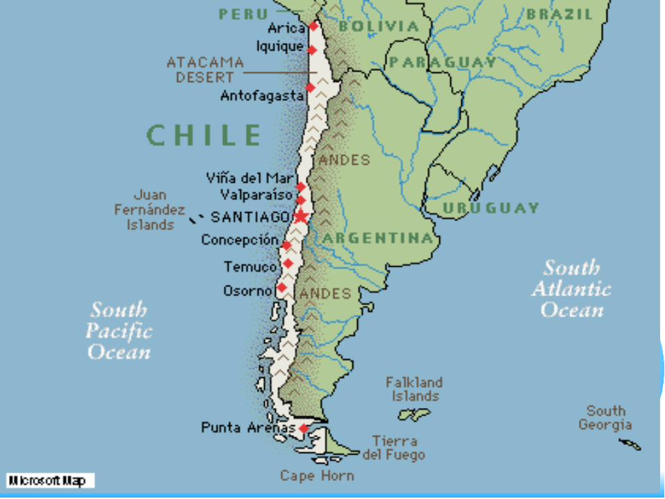
Chile– string bean shape conceals country’s
considerable size (double the size of Germany)
– 2600 miles in length along Pacific Ocean– only 100-130 miles wide– high Andes border on east– struggle with rugged terrain, extreme
aridity in north and wetness in south– Andes not impassable to east but little
traveled
Regions of Chile– Middle Core region
most populous region of country Mediterranean dry summer climate between 31-
37 degrees south latitude lower slopes of Andes, hilly central valley and
coastal mountains site of southern outpost of Inca Empire
occupied by Spanish in mid 1500’s establishment of haciendas by large landowners
with wide differences in income and status ranching economy manned by landless cowboys
and subsistence farmers intermarriage between Europeans and indians
very common producing a large mestizo society
wheat farming and feed crops major supplier of high quality fruits and
vegetables for US markets, i.e. apples, pears, peaches, plums,citrus in off season (Chilean summer is US winter)
Chilean wine industry rapid urbanization around Santiago (4
million) Valparaiso main port city and resort (1 million) and Concepcion (700K)
75% of Chilean population of 15 million live in the central core area
– Northern Chile Atacama Desert one of the driest places on
face of the earth
Chile captured Atacama Desert in the War of the Pacific from 1879-83 by defeating Bolivia and Peru.
war fought over mineral wealth of Atacama, mainly sodium nitrate used as a fertilizer
later discoveries of large copper deposits world’s largest producer of copper today with
sophisticated refining techniques
– South Chile marine west coast climate, heavy rainfall and
cool temperatures, violent storms sparse population in south large German population settled in 19th C abundant forests, fishing, beef cattle, wheat,
hay and root crops
Chile
Population
12.8 Million
Area (sq mi)
292,257
Elevation (feet)
Under 1640
1640-3280
3280-6560
Over 6560
500 mi
Copyright 1991 PC Globe, Inc. Tempe, AZ, USA. All Rights Reserved Worldwide.
Coreregion
Northernregion
Southernregion
– Political problems Marxist government of Salvador Allende
came to power through democratic elections in 1970; reformist agenda, land reform, nationalization of foreign owned mining enterprises
Chilean military overthrew and killed Allende with US help; Augusto Pinochet took power
Allenda murdered; US complicity alleged massive human rights violations, diplomatic
isolation great repression, but also great economic
growth as multinational corporations were welcomed back to Chile
market reforms opened up Chilean economy and the economy boomed
Pinochet surrendered power to a democratically elected government in 1990 as opposition to his rule grew
European human rights case against Pinochet in England.
prosperous economy today
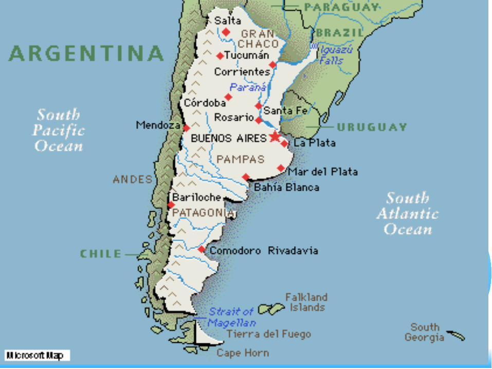
Argentina– second largest country by area in Latin
America– third largest population with 37 million– gained independence in 1816 but
remained sparsely populated until 1870’s when invention of refrigerated railroad cars and ships made it possible to ship beef to Europe
– 6 million workers imported from southern Europe (Spain and Italy mainly) to work on cattle ranches
Argentina
Population
31.9 Million
Area (sq mi)
1,068,297
Elevation (feet)
Under 656
656-1640
1640-3280
Over 3280
300 mi
Copyright 1991 PC Globe, Inc. Tempe, AZ, USA. All Rights Reserved Worldwide.
Pampas
Northwestlowlands
Patagonia
– Argentine Agriculture Argentine is a major exporter of agricultural products
to world markets- wheat, corn, soybeans, and beef core area in pampa (plain) south of Buenos Aires level, gently rolling plains with hot summers, cool to
warm winters and precipitation of 20-50 inches/year gauchos (Argentine cowboys) roamed pampas
tending herds of cattle for market ideal agricultural region, grew alfalfa as feed crop soils more fertile than most because they have a
high humus content from decomposed grasslands and blown loess from west
British financed railroads to ship beef to Europe
northwest lowlands good area for cattle ranching
eastern foot of Andes hotter and dryer than coast
vineyards and sugarcane grown in western part of Argentine
sheep farming also prevalent
– Urban and Industrial Argentine indentured immigrants from 1860-1930
initially worked the land, later moved to the city in search of work
dispossessed farm workers become the descamisados or “shirtless ones”, gravitated to Buenos Aires, Rosario, and other cities where they became an urban proletariat
worldwide depression in 30’s severely damaged Argentina’s economy
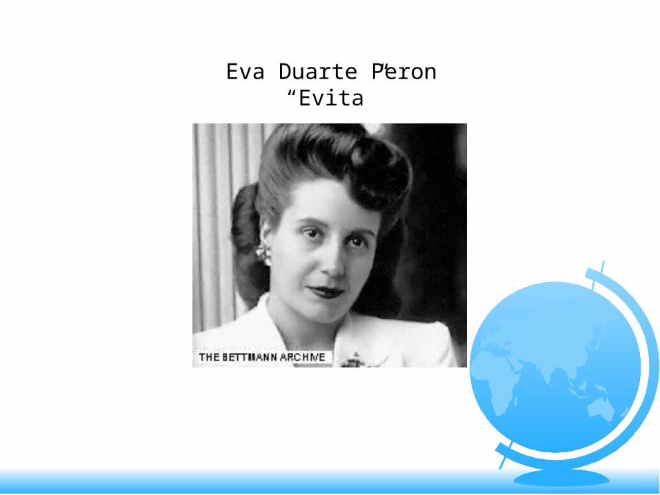
charismatic army leader Juan Peron elected president in 1945; his wife Eva Peron influential
Peron was ultranationalist, semi-fascist, distrustful of democracy, hated communism, and hostile to free-market economic liberalism
established authoritarian, repressive regime with state ownership of large segments of economy
disastrous consequences for Argentine economy huge inflation, capital flight, foreign debt,
unemployment led to Peron’s demise in 1955
repressive military governments until 1973 when Peron returns from exile to take over government again, dies shortly after this, succeeded by his wife Isabel de Peron who is ousted by the military in 76
repressive period in 70’s and 80’s with massive human rights violations, thousands of people disappear (los desaparecidos)
1982 Argentine military moves to take over Falkland Islands (known as the Malvinas in Argentine) and are defeated in a disastrous war
Eva Duarte Peron“Evita”
unsolved political and economic problem lead to establishment of a civilian reform government under Carlos Menam who sold off inefficient state enterprises, encouraged foreign investment, brought down rampant inflation, reestablished confidence in government
Argentine economy was doing reasonable well in the early 90’s, but in 2002 the economy collapsed bring widespread suffering to the people
– industrial economy industrialization began in 20th C with small
scale consumer industries, agricultural processing plants, and meat packing plants
later development of textiles, shoemaking
light industry and manufacturing most plants are small,inefficient operations
that are not competitive in world markets, supply domestic market
Buenos Aires largest city with 12 million; Cordoba a large oasis inland has 1.2 million
Argentina making some progress but still not as prosperous as the poorer European countries