45
Federal Aviation Administration ‹#› Federal Aviation Administration LAX Procedures

Federal Aviation Administration
‹#›
Federal Aviation Administration
LAX Procedures

Federal Aviation Administration
‹#›
LAX West Flow STARs
Federal Aviation Administration
‹#›
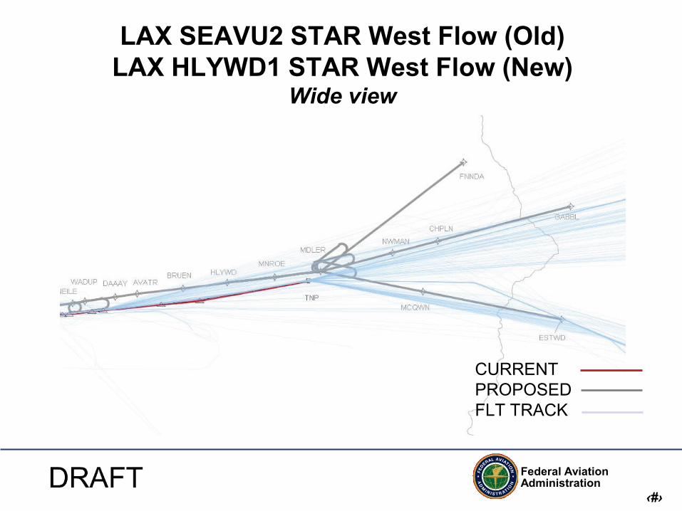
LAX SEAVU2 STAR West Flow (Old) LAX HLYWD1 STAR West Flow (New)
Wide view
CURRENT PROPOSED FLT TRACK
Federal Aviation Administration
‹#›
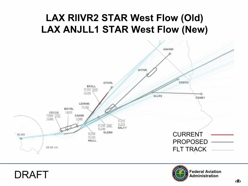
LAX RIIVR2 STAR West Flow (Old) LAX ANJLL1 STAR West Flow (New)
CURRENT PROPOSED FLT TRACK

Federal Aviation Administration
‹#›
LAX SEAVU2 STAR West Flow (Old) LAX HLYWD1 STAR West Flow (New)
Close up view
CURRENT PROPOSED FLT TRACK
• Proposed procedure moved north approximately 5.5 NM north descending to 12000 feet • Below 12000 feet no change from current track patterns
Federal Aviation Administration
‹#›
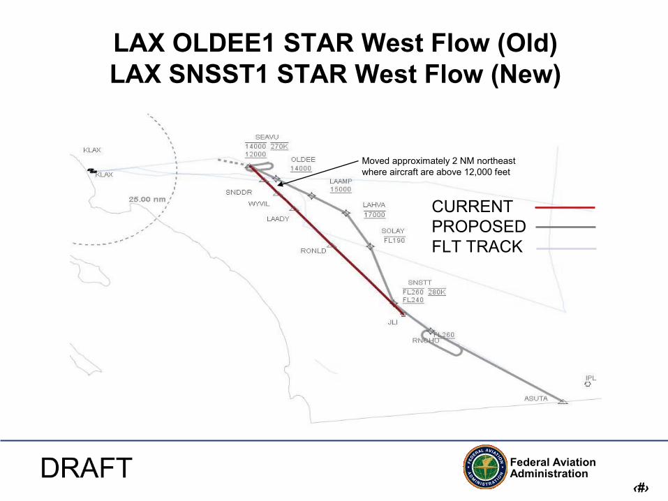
LAX OLDEE1 STAR West Flow (Old) LAX SNSST1 STAR West Flow (New)
CURRENT PROPOSED FLT TRACK
Moved approximately 2 NM northeast where aircraft are above 12,000 feet

Federal Aviation Administration
‹#›
LAX VISTA2 STAR West Flow (Old) LAX OLAAA1 STAR West Flow (New)
CURRENT PROPOSED FLT TRACK

Federal Aviation Administration
‹#›
LAX BUFIE4 STAR West Flow (Old) LAX GOATZ1 STAR West Flow (New)
Wide view
CURRENT PROPOSED FLT TRACK

Federal Aviation Administration
‹#›
LAX BUFIE4 STAR West Flow (Old) LAX GOATZ1 STAR West Flow (New)
Close up view
CURRENT PROPOSED FLT TRACK
All changes in flight tracks are offshore and no impacts anticipated

Federal Aviation Administration
‹#›
LAX KEACH1 STAR West Flow (Old) LAX CRSHR1 STAR West Flow (New)
Wide View
CURRENT PROPOSED FLT TRACK
Moved approximately 4 NM north of VTU same altitude
• New procedures WSHOT transition moved north to mimic actual flight path utilized when W289 active • During times that W289 not active aircraft will generally be cleared direct VTU the currently utilized control instruction

Federal Aviation Administration
‹#›
LAX KEACH1 STAR West Flow (Old) LAX CRSHR1 STAR West Flow (New)
Close View
CURRENT PROPOSED FLT TRACK

Federal Aviation Administration
‹#›
LAX SYMON1 STAR West Flow LAX-HHR IRNMN1 STAR West Flow
Wide view
CURRENT PROPOSED FLT TRACK
Federal Aviation Administration
‹#›
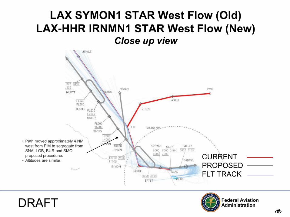
LAX SYMON1 STAR West Flow (Old) LAX-HHR IRNMN1 STAR West Flow (New)
Close up view
CURRENT PROPOSED FLT TRACK
• Path moved approximately 4 NM west from FIM to segregate from SNA, LGB, BUR and SMO proposed procedures
• Altitudes are similar.

Federal Aviation Administration
‹#›
LAX HUULL1 STAR West Flow (New)
• New procedure • No comparison data for LAX traffic • Route predominately utilized for SNA and LGB traffic currently.

Federal Aviation Administration
‹#›
LAX KIMMO3 STAR All Flows (Old) LAX-SMO BOGET1 / WAYVE1 STAR All Flows (New)
CURRENT PROPOSED FLT TRACK
• New procedures for props only • BOGET industry requested procedure that mimics current track data.

Federal Aviation Administration
‹#›
LAX West Flow Approaches

Federal Aviation Administration
‹#›
LAX RNAV/RNP Approaches West Flow
• Offset transitions to LAX Runways 25L/R

Federal Aviation Administration
‹#›
LAX West Flow SIDs

Federal Aviation Administration
‹#›
LAX LOOP8 SID West Flow (Old) LAX ORCKA1 SID West Flow (New)
Close up view
Small Medium Heavy
Federal Aviation Administration
‹#›
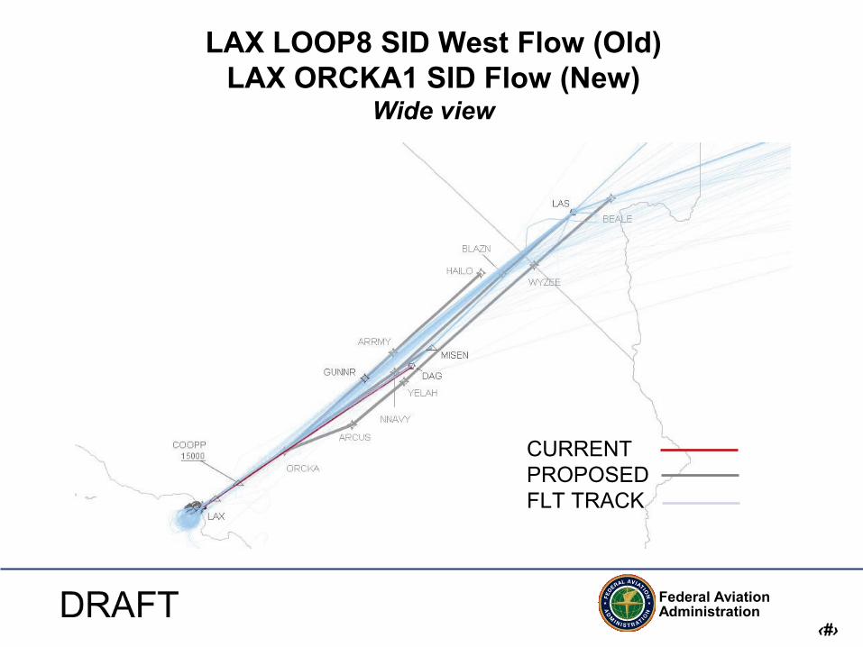
LAX LOOP8 SID West Flow (Old) LAX ORCKA1 SID Flow (New)
Wide view
CURRENT PROPOSED FLT TRACK

Federal Aviation Administration
‹#›
LAX HOLTZ9 SID West Flow (Old) LAX DOTSS1 SID West Flow (New)
Close up view
CURRENT PROPOSED FLT TRACK
There are no significant changes in traffic patterns between DOTSS and current close in flight track data
Crosses the shoreline at South Huntington Beach, above 14,000

Federal Aviation Administration
‹#›
LAX HOLTZ9 SID West Flow (Old) LAX DOTSS1 SID West Flow (New)
Wide view
CURRENT PROPOSED FLT TRACK
At DOTSS tracks deviate from current track data to provided segregation from other departure traffic.
New procedure moves tracks approximately 5.5 NM north of TRM
New procedure moves tracks approximately 8 NM south of TRM

Federal Aviation Administration
‹#›
LAX KARVR4 SID West Flow (Old) LAX PNDAH1 SID West Flow (New)
Close view
CURRENT PROPOSED FLT TRACK

Federal Aviation Administration
‹#›
LAX KARVR4 SID West Flow (Old) LAX PNDAH1 SID West Flow (New)
Wide view
CURRENT PROPOSED FLT TRACK
Moved offshore until aircraft are above FL200
Federal Aviation Administration
‹#›
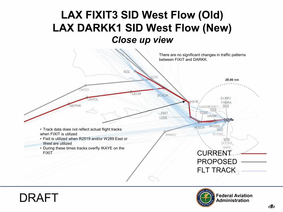
LAX FIXIT3 SID West Flow (Old) LAX DARKK1 SID West Flow (New)
Close up view
CURRENT PROPOSED FLT TRACK
There are no significant changes in traffic patterns between FIXIT and DARKK.
• Track data does not reflect actual flight tracks when FIXIT is utilized • Fixit is utilized when R2519 and/or W289 East or
West are utilized • During these times tracks overfly IKAYE on the
FIXIT

Federal Aviation Administration
‹#›
LAX FIXIT3 SID West Flow (Old) LAX DARKK1 SID West Flow (New)
Wide view
CURRENT PROPOSED FLT TRACK

Federal Aviation Administration
‹#›
LAX MOOOS SID West Flow (New)
• Props only • This procedure was originally designed for SkyWest E-120
aircraft as the main user • SkyWest just announced that E-120’s will no longer fly at LAX • Horizon, Lakes Air and general aviation will utilize the
procedure; approximately 35 operations daily.

Federal Aviation Administration
‹#›
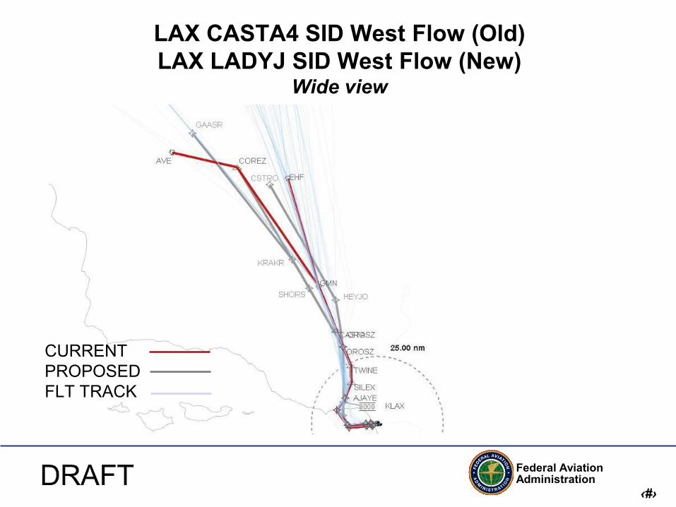
LAX CASTA4 SID West Flow (Old) LAX LADYJ SID West Flow (New)
Close up view
CURRENT PROPOSED FLT TRACK
Moved approximately 2 NM east and no more than 1,000 feet lower
Federal Aviation Administration
‹#›
LAX CASTA4 SID West Flow (Old) LAX LADYJ SID West Flow (New)
Wide view
CURRENT PROPOSED FLT TRACK

Federal Aviation Administration
‹#›
LAX East Flow STARs

Federal Aviation Administration
‹#›
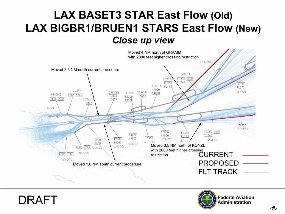
LAX BASET3 STAR East Flow (Old) LAX BIGBR1/BRUEN1 STARS East Flow (New)
Wide view
CURRENT PROPOSED FLT TRACK
Federal Aviation Administration
‹#›
LAX BASET3 STAR East Flow (Old) LAX BIGBR1/BRUEN1 STARS East Flow (New)
Close up view
CURRENT PROPOSED FLT TRACK
Moved 3.5 NM north of KONZL with 2000 feet higher crossing restriction
Moved 4 NM north of GRAMM with 2000 feet higher crossing restriction
Moved 2.3 NM north current procedure
Moved 1.6 NM south current procedure

Federal Aviation Administration
‹#›
LAX MOOR3 STAR East Flow (Old) LAX ZUUMA1 STAR East Flow (New)
Wide view
CURRENT PROPOSED FLT TRACK

Federal Aviation Administration
‹#›
LAX MOOR3 STAR East Flow (Old) LAX ZUUMA1 STAR East Flow (New)
Close up view
CURRENT PROPOSED FLT TRACK
Moved approximately 4 NM west and no more than 2,000 feet lower.
Federal Aviation Administration
‹#›
LAX East Flow Approaches

Federal Aviation Administration
‹#›
LAX RNAV/RNP Approaches East Flow

Federal Aviation Administration
‹#›
LAX East Flow SIDs
Federal Aviation Administration
‹#›
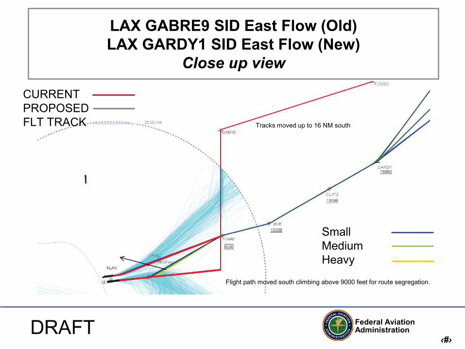
LAX GABRE9 SID East Flow (Old) LAX GARDY1 SID East Flow (New)
Close up view
CURRENT PROPOSED FLT TRACK
Flight path moved south climbing above 9000 feet for route segregation.
Tracks moved up to 16 NM south
Small Medium Heavy

Federal Aviation Administration
‹#›
LAX GABRE9 SID East Flow (Old) LAX GARDY1 SID East Flow (New)
Wide view
CURRENT PROPOSED FLT TRACK

Federal Aviation Administration
‹#›
LAX VTU5 SID East Flow (Old) LAX TRTON1 SID East Flow (New)
Close up view
CURRENT PROPOSED FLT TRACK
• Moved approximately 2.5 NM east. • No altitude change.
Small Medium Heavy

Federal Aviation Administration
‹#›
LAX VTU5 SID East Flow LAX TRTON1 SID East Flow
Wide view
CURRENT PROPOSED FLT TRACK

Federal Aviation Administration
‹#›
LAX LAXX7 SID East Flow LAX TUSTI1 SID East Flow
Close up view
CURRENT PROPOSED FLT TRACK
• Moved approximately 3 NM east to where actual LAXX7 flight tracks are located • No altitude difference.

Federal Aviation Administration
‹#›
LAX LAX7 SID East Flow (Old) LAX TUSTI1 SID East Flow (New)
Wide view
CURRENT PROPOSED FLT TRACK

Federal Aviation Administration
‹#›
LAX GMN4 SID East Flow (Old) LAX WNNDY1 SID East Flow (New)
Close up view
CURRENT PROPOSED FLT TRACK
• Moved approximately 4 NM east to where actual GMN4 flight tracks are located • No altitude difference

Federal Aviation Administration
‹#›
LAX GMN4 SID East Flow (Old) LAX WNNDY1 SID East Flow (New)
Wide view
CURRENT PROPOSED FLT TRACK


