42

August 12, 2014


Laguna Canyon Road Corridor Improvement Assessment – El Toro Road to Canyon Acres Drive
Table of Contents Page i
Table of Contents 1: Background
Purpose ....................................................................................... 1 Assessment Process .................................................................... 1 Historical Context ....................................................................... 3
2: Laguna Canyon Road Opportunities
Overview ..................................................................................... 6 The Significance of Laguna Canyon ........................................... 6 Laguna Canyon Road ................................................................. 7 Key Considerations for Corridor Improvements ........................ 9
3: Improvement Concepts
Alternatives Overview .............................................................. 11 Improvement Components ....................................................... 11 Alternatives ............................................................................... 17 Traffic Analysis .......................................................................... 23 Conceptual Alignments and Cross-Sections ............................ 23
4: Next Steps
Funding Process ........................................................................ 37 Caltrans Project Development Timeframe............................... 37Cost Considerations .................................................................. 37 Community Input Process ......................................................... 38 Formal Stakeholder Engagement ............................................ 38


Laguna Canyon Road Corridor Improvement Assessment – El Toro Road to Canyon Acres Drive
Background Page 1
1: BackgroundThis chapter briefly describes the project and its context. Purpose
In the spring of 2013, the City of Laguna Beach initiated an effort to generate and assess concepts for improving the Laguna Canyon Road corridor between the intersections of El Toro Road and Canyon Acres Drive assuming undergrounding the existing above-ground utilities for safety and aesthetic purposes. This report presents findings from the assessment, which is a preliminary exploration of concepts to improve mobility for emergency responders, drivers, transit riders, bicyclists, and pedestrians along Laguna Canyon Road. The concepts illustrated in this document are intended to be a starting point for a larger community discussion and further dialogue with key stakeholders. The goal of this study is to identify alternative ways to improve the Laguna Canyon Road corridor and create a multi-modal corridor that addresses all modes of transportation, improves safety, retains the semi-rural character of the area, and respects the environmental context within the project study area.
Study Area
Laguna Canyon Road is designated State Route 133 (SR-133) by the State of California and is under the jurisdiction of the California Department of Transportation (Caltrans). The study area along Laguna Canyon Road between El Toro Road and Canyon Acres Drive is an approximately 2 ½ mile-long corridor with a distinct character, between the festivals area and the wide-open spaces of the outer Canyon. Above-ground utilities are generally located along both sides of Laguna Canyon Road. The study area boundary is shown in Figure 1, Study Area. Described in more detail in the next chapter, it is an eclectic area characterized by scenic open space, semi-rural infrastructure, and a mix of business and residential uses along with some important Laguna institutions. Within the study area, Laguna Canyon Road is designed for vehicle travel with extremely limited accommodations for bicyclists and pedestrians. Congestion is common during peak hours,
especially during the summer visitor season, and it is most extreme at the two ends of the study area where traffic must merge from two lanes into one lane in each direction of travel.
Objectives
The corridor improvement concepts for Laguna Canyon Road are intended to address the following objectives:
Improve traffic safety, fire safety and aesthetics by undergrounding utilities. Improve response time of emergency first responders. Improve air quality in the canyon. Improve traffic circulation/mobility. Improve pedestrian and bike access and safety. Improve mobility for trolleys and/or similar high occupancy vehicles. Improve storm drainage on the roadway and adjacent areas. Maintain the semi-rural character of the area. Minimize impacts to open space and Laguna Canyon character.
These objectives have been captured in a set of “Key Considerations” that are used in this report to evaluate each alternative.
Assessment Process
Assessment Scope
The City contracted with RBF Consulting for the assessment, which included the following: Site review; Meetings with applicable governmental agencies; Development of improvement concepts; Preparation of typical cross sections and conceptual alignment plans; Approximate right-of-way impacts; Traffic operations assessment; and Summary report.

Laguna Canyon Road Corridor Improvement Assessment – El Toro Road to Canyon Acres Drive
Page 2 Background
Figure 1 – Study Area
Laguna Canyon Road Corridor Improvement Assessment – El Toro Road to Canyon Acres Drive
Background Page 3
Agency Engagement
Key public agencies and utilities were engaged in preliminary discussions about potential improvement concepts, to discuss potential issues and suggest solutions. These agencies included:
City of Laguna Beach Caltrans OC Parks OC Public Works OCTA Southern California Edison
Residents, businesses, and institutions along the roadway and members of the public at large are important stakeholders to include in any deliberative process about what improvements should be pursued. Future public meetings will solicit input from these key stakeholders regarding future improvements within the corridor. A crucial next step in pursuing improvements will be engaging the owners and operators of the overhead utility lines and utility poles within the existing Caltrans right-of-way. These facilities must be relocated in order to implement any of the alternatives presented in this report.
Next Steps
Chapter 4 presents recommendations for next steps as the City and Caltrans consider options for improving the Laguna Canyon Road corridor. As this report represents only a starting point, there are many more steps that need to be taken before a project can be initiated, including:
Expanded stakeholder engagement & community input to further refine goals & objectives Further evaluation and feasibility & environmental studies Consideration of cost and funding options Planning, design, and engineering
Historical Context
Laguna Canyon Road Over Time
Early Years
Originally a Native American trail through tribal territory and later a stagecoach route, Laguna Canyon Road was paved to provide access to the coast. According to the Laguna Canyon Annexation Area Specific Plan, tribal artifacts have been discovered in Laguna Canyon and there are numerous rock formations and other topographical features that are considered historically significant. Annexation
The portion of Laguna Canyon from Big Bend to El Toro Road was annexed by the City of Laguna Beach in 1989. Partly due to the many variances granted by the County in this area, there is an unusual combination of residential, work/live, commercial, light industrial, and semi-rural uses that do not conform to the City zoning code but have been “grandfathered.” The Laguna Canyon Annexation Area Specific Plan, adopted soon after annexation, serves as the City policy framework for this area. Laguna Canyon Road Re-Alignment
North of the current study area, Laguna Canyon Road recently underwent a major improvement project which expanded roadway capacity from two adjacent lanes to four lanes separated by a variable-width naturally vegetated median area. The project re-routed the roadway from its previous alignment between Laguna’s two natural lake--an area subject to frequent floodin--to a position above the lakes. Impacts to the wilderness area were reduced by including four wildlife under-crossings and designing the alignment to minimize the need for grading. The project also included features to capture and treat stormwater. While the idea of expanding Laguna Canyon Road initially faced considerable community opposition, the project’s collaborative process addressed concerns and found creative solutions through a multi-stakeholder Citizens’ Oversight Committee.

Laguna Canyon Road Corridor Improvement Assessment – El Toro Road to Canyon Acres Drive
Page 4 Background
Figure 2, Historical Context for SR-133 Re-Alignment provides a timeline graphic showing more context for the Laguna Canyon Road (SR-133) realignment improvement project from I-405 to the SR-73 Tollroad.
Current and Future Projects
Improvements to Laguna Canyon Road within the study area should be coordinated with other, related projects. These include:
A planned OC Public Works project to improve the roadway between El Toro Road and the SR-73 Tollroad
A planned project by Caltrans to extend the two southbound/inbound lanes from El Toro Road to just past Anneliese’s School and to eliminate the reduction of one lane on the northbound/outbound side between El Toro Road and the SR-73 Tollroad.
Storm drain improvements Enhanced Mobility and Complete Streets Transition Plan Downtown Specific Plan Update Citywide Transit Analysis Mobility Element update OCTA District 5 Bike Strategy & Feasibility Study

Laguna Canyon Road Corridor Improvement Assessment – El Toro Road to Canyon Acres Drive
Laguna Canyon Road: Opportunities Page 5
Figure 2 - Historical Context for SR-133 Re-Alignment

Laguna Canyon Road Corridor Improvement Assessment – El Toro Road to Canyon Acres Drive
Page 6 Improvement Concepts
2: Laguna Canyon Road Opportunities This chapter describes the importance of Laguna Canyon and how a multi-function Laguna Canyon Road can play its multiple roles better.
Overview
Laguna Canyon is an important and highly visible area for residents and visitors as a primary gateway for Laguna. It has a thriving, eclectic mix of land uses and a rustic, natural character. Laguna Canyon Road provides the only corridor for travel through Laguna Canyon other than the trails along the Canyon’s ridges. In its current form, the road serves its multiple users poorly, with extremely limited facilities for walking, limited accommodation for bicycling, and segments with heavy traffic congestion at peak travel times, resulting in increased air pollution associated with idling vehicles and stop & go vehicular movement. Above-ground utilities are generally located along both sides of Laguna Canyon Road. The community frequently experiences the road’s poor performance, and some may feel that there is no way to improve the situation without compromising the character and integrity of the Canyon. However, the goal of this study is to identify alternative ways to improve the Laguna Canyon Road corridor and create a multi-modal corridor that improves safety, improves emergency vehicle response time, improves air quality, addresses all modes of transportation (motor vehicles, bicyclists, pedestrians, and transit), retains the semi-rural character of the roadway, and respects the environmental context within the project study area.
The Significance of Laguna Canyon
Laguna Canyon is a feature of Laguna Beach that residents cherish and visitors admire—whether they live or work in the Canyon, learn or worship there, use the park trails, or enjoy the scenery as they pass through it.
Any project to improve Laguna Canyon Road must be sensitive to the character of Laguna Canyon and the multiple roles it plays for the Laguna community, wildlife, and visitors. Some key roles that Laguna Canyon plays:
Gateway. The Canyon is a character-defining feature of Laguna that provides one of the three routes in and out of town. It serves as a primary entrance for visitors and many residents pass through it every day to get to work and home again. Nature and Recreation Area. Laguna has worked for decades to preserve the natural lands in Laguna Canyon. Now Laguna Coast Wilderness Park and the James Dilley Greenbelt Preserve are wildlands in Laguna Canyon that offer recreation opportunities for Orange County residents. Another recreation amenity, Laguna Beach Dog Park, provides Laguna’s only fenced dog run. Stormwater drainage is another important natural function of the Canyon; this water flows through downtown to Main Beach. Thriving Mixed Use Area. Although not actually zoned “mixed use,” Laguna Canyon is populated with a diverse mix of businesses, residences, institutions, and public facilities. These uses include light manufacturing companies, service businesses, artist studios, shops, live/work uses, Laguna College of Art and Design, Pacific Marine Mammal Center, Anneliese School, and Kingdom Hall of Jehovah’s Witnesses. Residential Neighborhood. Between El Toro Road and Canyon Acres, there are pockets of residential neighborhoods, work/live units, and homes directly fronting Laguna Canyon Road. The Laguna Canyon Annexation Area Specific Plan describes four distinct neighborhoods within this area as well as the homes fronting the roadway. The Canyon Acres Drive intersection is the front door of the Canyon Acres neighborhood and Arroyo Drive.
Laguna Canyon’s “residents and property owners accept its eclectic land use pattern and somewhat semi-rural lifestyle,” explains the Laguna Canyon Annexation Area Specific Plan. “They appreciate the diversity and uniqueness of where they live and wish to preserve it.”

Laguna Canyon Road Corridor Improvement Assessment – El Toro Road to Canyon Acres Drive
Improvement Concepts Page 7
Laguna Canyon Road Laguna Canyon Road is the corridor that provides access to Laguna Canyon and enables it to play its multiple roles.
Within the study area from Canyon Acres Drive to El Toro Road, Laguna Canyon Road provides one travel lane for vehicles in each direction that bicycles may share, however in many locations there is a striped shoulder of variable width for bicycles to use. There is a two-way left turn lane for most of the study area, providing access to the many uses on the northbound/outbound side of the roadway. The limited shoulders are not wide enough for consistent bicycle lanes, and pedestrians either walk along the shoulder or in driveway--except in limited segments on the northbound/outbound side where there is a curb with a sidewalk or path. Above-ground utilities are generally located along both sides of Laguna Canyon Road.
For a bird’s eye view of Laguna Canyon Road, please see the three-and-a-half-minute video on the CD in the sleeve at the back of this report which provides a Google Earth flythrough along the roadway from the SR-73 Tollroad to Canyon Acres Drive.
Roadway Characteristics and Issues
Corridor Characteristics
Visitors entering Laguna Beach from I-405 and I-5 pass through wide views of preserved open space along Laguna Canyon Road. The speed limit through this northern part of Laguna Canyon is 65 mph and the four-lane separated highway is primarily auto-oriented, with bicyclists using the 8 foot wide striped shoulders that serve as an on-street striped bicycle lane/Class II bicycle route.
The character of Laguna Canyon Road changes noticeably south of the SR-73 Tollroad where the roadway narrows into a flood hazard zone. Between the SR-73 and El Toro Road, the roadway is undivided with one southbound/inbound lane and two northbound/outbound lanes except for a small portion where only one lane is provided which causes northbound/outbound merging into one lane north of El Toro Road. South of the El Toro Road intersection, there is one travel lane in each direction and a two-way left-turn lane in the center for access at the many uses along the roadway. Parking is provided in front of many businesses sometimes on private property and other times within Caltrans State Highway right-of-way; on-street parking spaces are provided along the Laguna Beach Dog Park.
South of the Canyon Acres Drive intersection, the roadway expands again into two lanes in either direction with a raised median in the center through the festivals area. There are pedestrian walkways with curbs and on-street parking on both sides of the road in this section.
Traffic Volumes
Laguna Canyon Road between El Toro Road and Canyon Acres Drive carries approximately 38,000 to 42,000 vehicles on a daily basis depending upon the time of the year, with traffic volumes highest in July and August during the Laguna Beach Summer Festival Season. Laguna Canyon Road traffic volumes are expected to increase in the next several years as a result of approximately 44,000 new and pending housing units recently approved by surrounding cities as shown in Figure 3, Approved Housing Growth in Cities Surrounding Highway 133/Laguna Canyon Road on the next page, as well as potential future land use in the canyon .
Traffic Congestion
Congestion is common during peak hours, especially during the summer visitor season, and it is most extreme at the two ends of the study area where traffic must merge from two lanes into one. This congestion at the “pinch points” impacts the operations of the El Toro Road and Canyon Acres Drive intersections and extends beyond the study boundaries. During the summer peak period, southbound/inbound traffic backs up over several miles from the El Toro Road intersection and at the Canyon Acres intersection into downtown Laguna.
Bus and Trolley Service
There are several OCTA bus stops along Laguna Canyon Road in the study area. In most cases, benches are provided at these stops and the shoulder is wide enough for the buses to pull out of traffic when they stop. However, stops on the southbound/inbound side of the roadway that are adjacent to Laguna Coast Wilderness Park do not have waiting areas or benches, and the shoulder is narrower in these locations.
During the summer visitor season, a free trolley operates between the ACT V parking lot, festivals, and downtown bus depot. The trolley’s return to the ACT V lot is often delayed by having to wait for a gap in southbound/inbound traffic.

Laguna Canyon Road Corridor Improvement Assessment – El Toro Road to Canyon Acres Drive
Page 8 Improvement Concepts
Figure 3 - Approved Housing Growth in Cities Surrounding Highway 133/Laguna Canyon Road

Laguna Canyon Road Corridor Improvement Assessment – El Toro Road to Canyon Acres Drive
Improvement Concepts Page 9
Shoulders
Shoulder widths are variable throughout the study area. On the southbound/inbound side, open space in the Laguna Coast Wilderness Park slopes down to the edge of the shoulder, which is as narrow as 4 feet around Big Bend. On the northbound/outbound side, the shoulder is typically wider than on the southbound/inbound side; however, the roadway edge is indistinct and many businesses have parking areas that directly about the roadway. Bicycle Facilities
People ride road and mountain bikes along Laguna Canyon Road, whether they are bicycling in and out of Laguna to other cities, accessing bike trails in Laguna Canyon, or traveling to/from another Canyon destination. There are no designated bicycle facilities within the study area, although it is legal for bicycles to share the travel lanes with vehicles. More commonly, bicyclists ride in the inconsistent shoulder or along the property frontages. As they travel, they must be alert for cars in the travel lane, parked cars, and vehicles turning in and out of the Canyon’s many driveways. Pedestrian Facilities
Despite the lack of a defined pathway in most areas, people walk along Laguna Canyon Road to access the homes, businesses, bus stops, parks, LCAD, and other uses in the Canyon. There are limited pedestrian facilities within the study area along the northbound/outbound side; these include curb and sidewalk along Laguna Beach Dog Park and short segments in front of businesses. Walking along the northbound/outbound side of Laguna
Canyon Road typically means walking in a busy space along property edges - a space that is shared with cars crossing the pedestrian path of travel and with bicyclists, who also do not have a designated lane. On the southbound/inbound side, pedestrians can choose between the shoulder on the roadway or the parkland edge, which in some areas offers a flat surface for walking. Utility Poles
There are communication poles on the southbound/inbound side of Laguna Canyon Road and Southern California Edison power transmission and distribution poles on the northbound/outbound side. The poles are located within Caltrans right-of-way where they represent a hazard to drivers who veer off of the travelway. The high-voltage power poles also pose a fire hazard and an impediment to emergency resource access for the community and evacuation. Collisions with these poles have led to interruptions of power and communications services, and closure of Laguna Canyon Road.
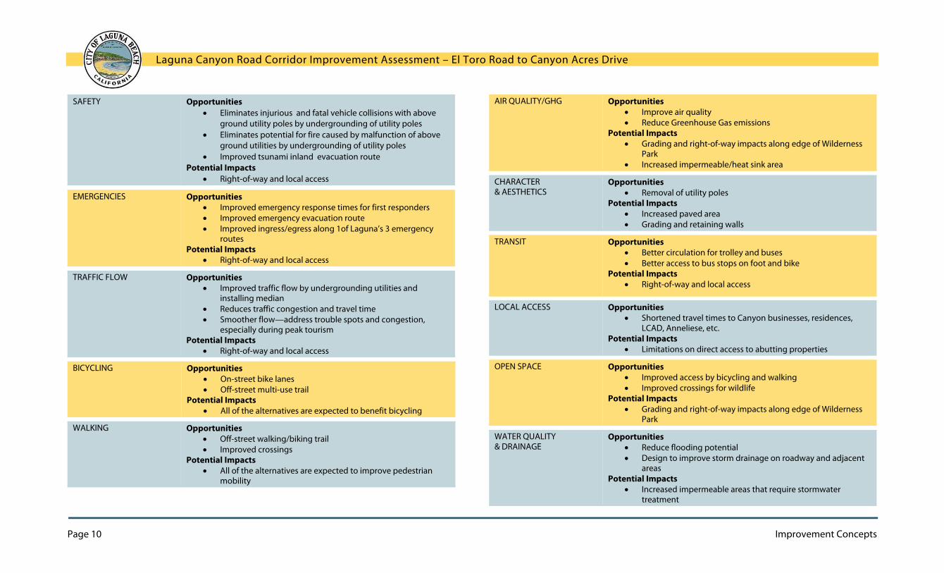
Key Considerations for Corridor Improvements
The following Key Considerations are based on the goals and objectives laid out by the City at the beginning of the project, and will be used in the next chapter to measure the expected performance of each concept.
Pedestrian facilities are lacking, especially on the southbound/inbound side of the roadway.
Shoulder widths vary along Laguna Canyon Road.
Laguna Canyon Road Corridor Improvement Assessment – El Toro Road to Canyon Acres Drive
Page 10 Improvement Concepts
SAFETY Opportunities Eliminates injurious and fatal vehicle collisions with above
ground utility poles by undergrounding of utility poles Eliminates potential for fire caused by malfunction of above
ground utilities by undergrounding of utility poles Improved tsunami inland evacuation route
Potential Impacts Right-of-way and local access
EMERGENCIES Opportunities Improved emergency response times for first responders Improved emergency evacuation route Improved ingress/egress along 1of Laguna’s 3 emergency
routes Potential Impacts
Right-of-way and local access
TRAFFIC FLOW
Opportunities Improved traffic flow by undergrounding utilities and
installing median Reduces traffic congestion and travel time Smoother flow—address trouble spots and congestion,
especially during peak tourism Potential Impacts
Right-of-way and local access
BICYCLING Opportunities On-street bike lanes Off-street multi-use trail
Potential Impacts All of the alternatives are expected to benefit bicycling
WALKING Opportunities Off-street walking/biking trail Improved crossings
Potential Impacts All of the alternatives are expected to improve pedestrian
mobility
AIR QUALITY/GHG Opportunities Improve air quality Reduce Greenhouse Gas emissions
Potential Impacts Grading and right-of-way impacts along edge of Wilderness
Park Increased impermeable/heat sink area
CHARACTER& AESTHETICS
Opportunities Removal of utility poles
Potential Impacts Increased paved area Grading and retaining walls
TRANSIT Opportunities Better circulation for trolley and buses Better access to bus stops on foot and bike
Potential Impacts Right-of-way and local access
LOCAL ACCESS Opportunities Shortened travel times to Canyon businesses, residences,
LCAD, Anneliese, etc. Potential Impacts
Limitations on direct access to abutting properties
OPEN SPACE Opportunities Improved access by bicycling and walking Improved crossings for wildlife
Potential Impacts Grading and right-of-way impacts along edge of Wilderness
Park
WATER QUALITY& DRAINAGE
Opportunities Reduce flooding potential Design to improve storm drainage on roadway and adjacent
areas Potential Impacts
Increased impermeable areas that require stormwater treatment
Laguna Canyon Road Corridor Improvement Assessment – El Toro Road to Canyon Acres Drive
Improvement Concepts Page 11
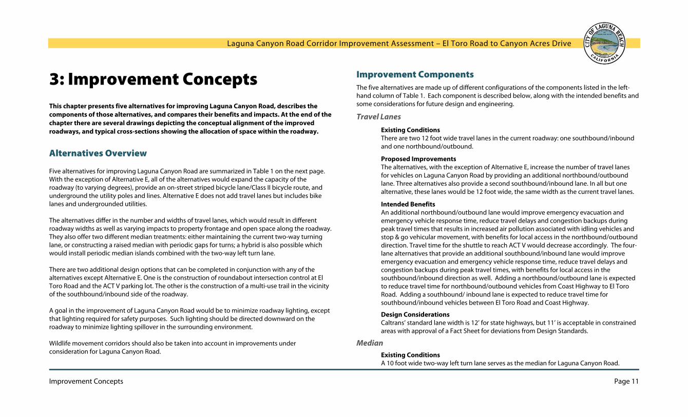
3: Improvement Concepts This chapter presents five alternatives for improving Laguna Canyon Road, describes the components of those alternatives, and compares their benefits and impacts. At the end of the chapter there are several drawings depicting the conceptual alignment of the improved roadways, and typical cross-sections showing the allocation of space within the roadway.
Alternatives Overview
Five alternatives for improving Laguna Canyon Road are summarized in Table 1 on the next page. With the exception of Alternative E, all of the alternatives would expand the capacity of the roadway (to varying degrees), provide an on-street striped bicycle lane/Class II bicycle route, and underground the utility poles and lines. Alternative E does not add travel lanes but includes bike lanes and undergrounded utilities. The alternatives differ in the number and widths of travel lanes, which would result in different roadway widths as well as varying impacts to property frontage and open space along the roadway. They also offer two different median treatments: either maintaining the current two-way turning lane, or constructing a raised median with periodic gaps for turns; a hybrid is also possible which would install periodic median islands combined with the two-way left turn lane. There are two additional design options that can be completed in conjunction with any of the alternatives except Alternative E. One is the construction of roundabout intersection control at El Toro Road and the ACT V parking lot. The other is the construction of a multi-use trail in the vicinity of the southbound/inbound side of the roadway. A goal in the improvement of Laguna Canyon Road would be to minimize roadway lighting, except that lighting required for safety purposes. Such lighting should be directed downward on the roadway to minimize lighting spillover in the surrounding environment. Wildlife movement corridors should also be taken into account in improvements under consideration for Laguna Canyon Road.
Improvement Components The five alternatives are made up of different configurations of the components listed in the left-hand column of Table 1. Each component is described below, along with the intended benefits and some considerations for future design and engineering.
Travel Lanes
Existing Conditions There are two 12 foot wide travel lanes in the current roadway: one southbound/inbound and one northbound/outbound.
Proposed Improvements The alternatives, with the exception of Alternative E, increase the number of travel lanes for vehicles on Laguna Canyon Road by providing an additional northbound/outbound lane. Three alternatives also provide a second southbound/inbound lane. In all but one alternative, these lanes would be 12 foot wide, the same width as the current travel lanes.
Intended Benefits An additional northbound/outbound lane would improve emergency evacuation and emergency vehicle response time, reduce travel delays and congestion backups during peak travel times that results in increased air pollution associated with idling vehicles and stop & go vehicular movement, with benefits for local access in the northbound/outbound direction. Travel time for the shuttle to reach ACT V would decrease accordingly. The four-lane alternatives that provide an additional southbound/inbound lane would improve emergency evacuation and emergency vehicle response time, reduce travel delays and congestion backups during peak travel times, with benefits for local access in the southbound/inbound direction as well. Adding a northbound/outbound lane is expected to reduce travel time for northbound/outbound vehicles from Coast Highway to El Toro Road. Adding a southbound/ inbound lane is expected to reduce travel time for southbound/inbound vehicles between El Toro Road and Coast Highway.
Design Considerations Caltrans’ standard lane width is 12’ for state highways, but 11’ is acceptable in constrained areas with approval of a Fact Sheet for deviations from Design Standards.
Median Existing Conditions A 10 foot wide two-way left turn lane serves as the median for Laguna Canyon Road.

Laguna Canyon Road Corridor Improvement Assessment – El Toro Road to Canyon Acres Drive
Page 12 Improvement Concepts
Improvement Components
Alternatives
A 3 Lane Road with
Turning Lane
B4 Lane Road with
Turning Lane
C4 Lane Road with
Raised Median
D3 Lane Road with
Raised Median
E 2 Lane Road with
Turning Lane
Travel Lanes 1 SB / 2 NB
12’ 2 SB / 2 NB
12’ 2 SB / 2 NB
12’ 1 SB / 2 NB
12’ 1 SB / 1 NB
12’
Median 10’ turning lane 10’ turning lane 10’ raised median 10’ raised median 10’ turning lane
Bike Lanes 1 SB / 1 NB
On-street Striped/Class II 8’
1 SB / 1 NB On-street Striped/Class II
8’
1 SB / 1 NB On-street Striped/Class II
8’
1 SB / 1 NB On-street Striped/Class II
8’
1 SB / 1 NB On-street Striped/Class II
8’
Utility Lines Underground Underground Underground Underground Underground
Multi-Use Trail Design Option Design Option Design Option Design Option None
Roundabout/Traffic Signal
Design Option Design Option Design Option Design Option None
Dedicated Transit Lane None Design Option Design Option None None
Roadway Width 62’ not including trail 74’ not including trail 74’ not including trail 62’ not including trail 62’
Right-of-Way Impact ROW needed for
roundabouts and trail
Add 10’ in narrow areas; more ROW needed for roundabouts and trail
Add 10’ in narrow areas; more ROW needed for roundabouts and trail
ROW needed for roundabouts and trail
None
Table 1 - Summary of Alternatives

Laguna Canyon Road Corridor Improvement Assessment – El Toro Road to Canyon Acres Drive
Improvement Concepts Page 13
Proposed Improvements Three of the alternatives retain the two-way turning lane. The other alternatives would replace the lane with a raised and landscaped median of the same width. The median would be designed to serve as a pedestrian refuge island in some locations, and would have periodic breaks with turn pockets to allow left turns and U-turns for vehicle access for the businesses and other uses in the canyon. A third hybrid option is possible, in which the turning lane would be retained but median islands would be installed within the lane at strategic locations - for instance, to allow pedestrians to cross to a bus stop.
Intended Benefits A raised and landscaped median would provide safety, aesthetic, and water and air quality benefits while continuing to provide access for the uses along the roadway.
As a safety feature, it would serve as a physical barrier between vehicles traveling in opposing directions. Pedestrians would be able to use the median as a safe place to stand while crossing the roadway. The median would also reduce the potential conflicts for bicyclists, pedestrians and vehicles.
As an aesthetic feature, the median would provide a new canvas for landscaping and public art where there is currently only asphalt.
As a water quality feature, the median would replace impervious surface area with landscaping that would absorb rainfall and could include stormwater treatment features.
Access and egress for the uses along Laguna Canyon Road are currently constrained by traffic conditions during peak hours, which should be ameliorated by expanding the capacity of the roadway. Gaps in the median and turn pockets would allow turning movements and U-turns needed for local access/egress.
Design Considerations If a raised median is installed, gaps and turn pockets should be provided at intervals that provide convenient access/egress for the uses along Laguna Canyon Road. The raised median should be designed for safe maintenance and minimal water needs, with sites for the installation of public art. It should have hardscaped areas where pedestrians can stand as they wait to cross the roadway. Drainage and stormwater treatment should be considerations in the design.
Bike Lanes
Existing Conditions There are no dedicated bicycle facilities along Laguna Canyon Road, but it is legal for bicycles to ride in the travel lane. The shoulder width varies and narrows to 4 feet wide around Big Bend on the southbound/inbound side. Proposed Improvements All of the alternatives include a full 8 foot wide paved shoulder on each side of Laguna Canyon Road. Each shoulder would be marked with painted lines, symbols, and signage to create an on-street striped bicycle lane/Class II bicycle route. Intended Benefits Bike lanes would provide bicyclists with a dedicated space on the roadway that provides improved safety and comfort while reminding drivers to watch for bicyclists.
A two-way left turn lane currently provides local access and serves as a median.

Laguna Canyon Road Corridor Improvement Assessment – El Toro Road to Canyon Acres Drive
Page 14 Improvement Concepts
Design Considerations According to Caltrans standards, bicycle lanes along Laguna Canyon Road should be a minimum of 8 foot wide.
Utility Lines
Existing Conditions There are communication wires owned by Verizon and Cox Communications attached to poles on both the southbound/inbound and northbound/outbound sides of Laguna Canyon Road. Southern California Edison transmission wires are on poles located on the outbound side of Laguna Canyon Road, distribution and secondary wires alternate on both sides of the road. A majority of the poles are located within the Caltrans right-of-way where they represent a potential hazard to drivers who veer off of the traveled way. Downed electric lines, arcing and transformer explosions can all pose a fire hazard. Downed wires from both automobile collisions and failed support systems have led to interruptions of power and communications services, and have caused severe traffic congestion and lengthy traffic delays due to road closures. Proposed Improvements Undergrounding the utility lines is a critical component of all the alternatives. The communication poles on the southbound/inbound side of Laguna Canyon Road and power poles on the northbound/outbound side would be relocated underground. Intended Benefits Undergrounding enables the existing Caltrans right-of-way to be used for transportation facilities which is a starting point for all the alternatives. Undergrounding of the poles and lines on both sides of Laguna Canyon Road would provide the opportunity to utilize Caltrans right-of-way for transportation facilities including vehicles, bicycles and pedestrians, create unobstructed views of the Canyon and remove hazards from the roadway. Design Considerations Caltrans does not allow longitudinal utility encroachments within its right-of-way. The feasibility of undergrounding the existing power lines and eliminating the power poles should be explored in the abutting County open space to eliminate this issue.
Multi-Use Trail
Existing Conditions There are limited pedestrian facilities within the study area along the northbound/outbound side and no dedicated facilities on the southbound/inbound side. As described above in the Bike Lanes discussion, there are no dedicated facilities for bicycles. Proposed Improvements As a design option for all of the alternatives except E, a 12 foot wide paved multi-use trail would be constructed adjacent to or near the roadway. Between the Willow Staging Area of Laguna Coast Wilderness Park and Big Bend, where the topography is flat, the trail could be constructed near the edge of the parkland but separated from the roadway. From Big Bend to Canyon Acres, the trail would be constructed adjacent to the southbound/inbound 8 foot wide bicycle lane. Intended Benefits A multi-use trail on the southbound/inbound side of the roadway would provide a safer and more enjoyable walk or ride—separated from the roadway where the topography allows, and almost never interrupted by driveway; on the northbound/outbound side there are over 70 driveways exist. Combined with the existing pathway and sidewalk between Canyon Acres Drive and Forest Avenue, this would create a complete off-street connection from downtown to Laguna Coast Wilderness Park. Besides providing a more comfortable option for people already walking and bicycling in the Canyon, it would encourage new users who are only comfortable using paths that are separated from vehicular traffic. Design Considerations To allow for multiple users moving in two directions, the trail should be 12 feet wide. It should be constructed in conjunction with a raised median (or median islands) to facilitate pedestrian crossings. If constructed with a four-lane alternative, the trail will be difficult to accommodate directly alongside the roadway in constrained areas such as Big Bend. Instead, the trail could be elevated above the roadway along a terraced retaining wall which would need to be designed with aesthetic considerations.

Laguna Canyon Road Corridor Improvement Assessment – El Toro Road to Canyon Acres Drive
Improvement Concepts Page 15
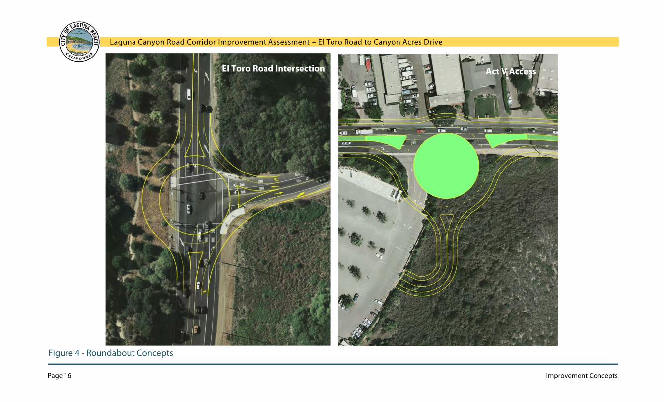
Roundabouts
Roundabouts are an alternative to traffic signals for consideration on Laguna Canyon Road.
Existing Conditions The intersections of Laguna Canyon Road with Canyon Acres Drive and El Toro Road are controlled by traffic signals. There is a reduction in lanes as vehicles enter the study area from either intersection, which requires drivers to merge into one travel lane and also causes traffic to congest and back up during peak times.
Proposed Improvements All alternatives are compatible with, but do not depend upon, the construction of a roundabout at each end of the improvements. This would mean replacement of the El Toro Road traffic signal with a roundabout; however construction of a roundabout north of Canyon Acres Drive which to facilitate ingress/egress for the ACT V parking lot may result in potentially significant right-of-way impacts.
Intended Benefits If the number of lanes in the study area is increased, this will eliminate one or both of the merging areas that results in traffic congestion when traffic volumes exceed the capacity of one lane. Two roundabouts are suggested as design options that would serve as “bookends” for the improvements and calm traffic entering the study area. Both roundabouts are a generous diameter that would provide ample space for public art and landscaping.
A roundabout at El Toro Road would help create a smoother traffic flow through the intersection and reduce the potential for high-speed collisions while serving as an entry statement for the improvement area that reminds drivers to slow down.
A second roundabout north of Canyon Acres Drive would calm free-flowing traffic and provide an entry statement for the festivals area. This roundabout would improve northbound/outbound ingress and egress for the ACT V lot, which can be challenging when attempting to cross free-flowing southbound/inbound traffic. Due to potentially significant right-of-way impacts a traffic signal at this location may provide the appropriate control.
Design Considerations Caltrans follows FHWA guidelines for the design of roundabouts in state highways. The roundabouts shown in Figure 4, Roundabout Concepts on the next page are at the smaller end of the range provided in those guidelines. Accommodating a diameter of this size in the roadway will lead to right-of-way impacts beyond the Caltrans right-of-way, as shown in the figures.
At El Toro Road, this means constructing roadway within the perimeter of Laguna Coast Wilderness Park immediately adjacent to Stagecoach South Trail; also impacts to the park at the northeast corner of the intersection and to the property at the southeast corner would occur. At ACT V, right-of-way impacts affect the frontages of private properties.
Roadway Width and Right-of-Way Impact
Existing Conditions The existing Caltrans right-of-way width varies from 66 feet to 84 feet between El Toro Road and Canyon Acres Drive. Within this right-of-way are the current lanes and utility poles. The exact boundaries of the right-of-way have not been determined as part of this study and there may be some encroachments due to the ill-defined roadway edges.
Proposed Improvements Roadway widths for the alternatives range from 62 feet to 74 feet. Three alternatives are designed to remain within the Caltrans right-of-way. For the other alternatives, an additional 10 feet of right-of-way is required in narrow areas to accommodate all the proposed components. Additional right-of-way would be required for the multi-use trail and roundabouts, as discussed below.
Intended Benefits The alternatives seek to provide additional roadway components that would result in a wider roadway - travel lanes, bike lanes, multi-use trail, and roundabouts - while seeking to avoid impacts to open space and property frontages.
Design Considerations The alignment of the roadway shown for each alternative is conceptual and would be refined in future design work to minimize right-of-way impacts. Steps will also need to be taken to direct and treat stormwater with any increase in roadway surface. If the roadway is widened, installing a raised landscaped median as discussed above is advisable for aesthetic reasons.
Laguna Canyon Road Corridor Improvement Assessment – El Toro Road to Canyon Acres Drive
Page 16 Improvement Concepts
Figure 4 - Roundabout Concepts
El Toro Road Intersection Act V Access
Laguna Canyon Road Corridor Improvement Assessment – El Toro Road to Canyon Acres Drive
Improvement Concepts Page 17
Alternatives
The five alternatives that were explored fully in this assessment are described again below and evaluated according to the Key Considerations presented in Chapter 2. In addition to these five alternatives, other alternatives were explored initially and were not pursued further; these are also described briefly below. As described in Chapter 1, some targeted traffic analysis has been conducted to test the concepts and they have been shaped by input from representatives of key agencies. However, all alternatives should be considered merely starting points for discussion; they can be expected to be refined through the processes of stakeholder and public engagement, evaluation, formal design, and engineering (see Chapter 4 for a discussion of next steps).
Other Alternatives Considered
Other alternatives were considered in the assessment process, but were deemed inadvisable and are not presented as alternatives in this report. These were the following:
Reversible Lanes – To address the congestion that results when there is a reduction of two travel lanes to one travel lane, consideration was given to reversible lanes that would provide two lanes in the direction with the highest percentage of traffic volume. To be effective, there are two key elements that must be present: the roadway should have a directionality peak of 65% and be void of left turn access requirements. As Laguna Canyon Road within the study area generally exhibits a balance in peak hour flows and has multiple left turn access requirements, reversible lanes were not deemed to be a feasible alternative.
High-Occupancy Vehicle (HOV) Lane – Construction of a lane dedicated to HOVs would improve traffic flow. However, given the existing right-of-way constraints and limited benefit of these facilities at this location, it was not deemed to be a feasible alternative.
No Undergrounding of Utilities – The existing poles which abut northbound/outbound and southbound/inbound Laguna Canyon Road present a major constraint to any capacity enhancements, because they encumber the Caltrans right-of-way with non-transportation facilities. Absent their removal, the only significant improvement that could be realized is the construction of an off-street bicycle lane/Class I bicycle route outside Caltrans right-of-way.
Narrow Four-Lane Alternative – An alternative was developed which aimed to provide four travel lanes within the existing Caltrans right-of-way. This alternative included 11 foot wide travel lanes and a median barrier along the centerline rather than a full raised median. In such a configuration, there is no room for turning lanes, and instead multiple roundabouts were proposed to provide access for the uses along Laguna Canyon Road. Given the large diameter required for roundabouts, however, there would be considerable right-of-way impacts which would negate the purpose of this “narrow” alternative.

Laguna Canyon Road Corridor Improvement Assessment – El Toro Road to Canyon Acres Drive
Page 18 Improvement Concepts
Alternative A Three Lane Road with Turning Lane
Improvement Components
A 3 Lane Road with Turning Lane
Travel Lanes 1 SB / 2 NB; 12’ Median 10’ turning lane Bike Lanes 1 SB / 1 NB; Class II; 8’ Utility Lines Underground Multi-Use Trail Design Option Roundabouts Design Option Dedicated Transit Lane None Roadway Width 62’ not including trail Right-of-Way Impact ROW needed for roundabouts and trail
Opportunities:
Emergencies Improved northbound/outbound emergency evacuation and
emergency vehicle response Improved fire safety by undergrounding utilities Improved egress along one of Laguna’s three emergency access
routes Traffic Flow & Safety
Reduced travel times and congestion in northbound/outbound direction
Improved safety by undergrounding utilities
Bicycling On-street bike lanes
Transit Improved times for northbound/outbound transit Reduced northbound/outbound shuttle travel time to reach ACT V Better access to bus stops on bike
Local Access Reduced travel time for northbound/outbound local access
Air Quality Improves air quality Reduces Greenhouse Gas emissions
Open Space Improved bike and pedestrian access to open space
Character & Aesthetics Removal of utility poles
Water Quality & Drainage Could be designed to improve storm drainage on adjacent areas Installation of recycled water lines outside Caltrans right-of-way
Neutral for:
Walking (unless multi-use trail is constructed) Potential Impacts:
Open Space Some right-of-way impacts to open space, but less than impacts from
four-lane alternatives
Character & Aesthetics Wider paved area, but narrower than four-lane alternatives
Water Quality & Drainage Increased impermeable areas that require stormwater treatment

Laguna Canyon Road Corridor Improvement Assessment – El Toro Road to Canyon Acres Drive
Improvement Concepts Page 19
Alternative B Four Lane Road with Turning Lane
Improvement Components
B 4 Lane Road with Turning Lane
Travel Lanes 2 SB / 2 NB; 12’ Median 10’ turning lane Bike Lanes 1 SB / 1 NB; Class II; 8’ Utility Lines Underground Multi-Use Trail Design Option Roundabouts Design Option Dedicated Transit Lane Design Option Roadway Width 74’ not including trail
Right-of-Way Impact Add 10’ in narrow areas; more ROW needed for roundabouts and trail
Opportunities:
Emergencies Improved northbound/outbound and southbound/inbound
emergency evacuation and emergency vehicle response Improved fire safety by undergrounding utilities Improved egress and ingress along one of Laguna’s three
emergency access routes Traffic Flow & Safety
Reduced travel times and congestion in northbound/outbound and southbound/inbound direction
Improved safety by undergrounding utilities
Bicycling On-street bike lanes
Transit Improved times for northbound/outbound and
southbound/inbound transit Reduced northbound/outbound and southbound/inbound shuttle
travel time between ACT V Better access to bus stops on bike
Air Quality Improves air quality Reduces Greenhouse Gas emissions
Local Access Reduced travel time for northbound/outbound and
southbound/inbound local access
Open Space Improved bike and pedestrian access to open space
Character & Aesthetics Removal of utility poles
Water Quality & Drainage Could be designed to improve storm drainage on adjacent areas Installation of recycled water lines outside Caltrans right-of-way
Neutral for:
Walking (unless multi-use trail is constructed) Potential Impacts:
Open Space Right-of-way impacts to open space
Character & Aesthetics Wider paved area
Water Quality & Drainage Increased impermeable areas that require stormwater treatment
Laguna Canyon Road Corridor Improvement Assessment – El Toro Road to Canyon Acres Drive
Page 20 Improvement Concepts
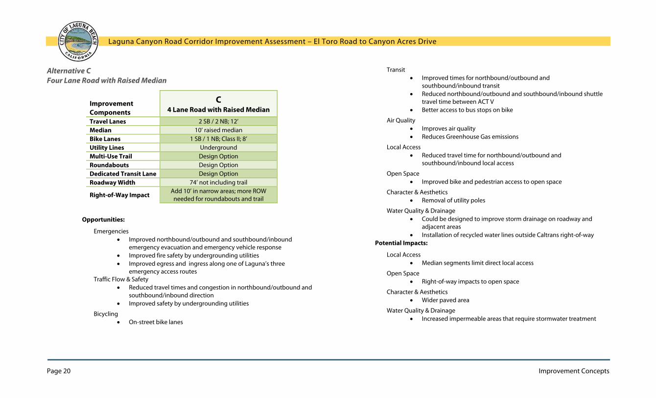
Alternative C Four Lane Road with Raised Median
Improvement Components
C 4 Lane Road with Raised Median
Travel Lanes 2 SB / 2 NB; 12’ Median 10’ raised median Bike Lanes 1 SB / 1 NB; Class II; 8’ Utility Lines Underground Multi-Use Trail Design Option Roundabouts Design Option Dedicated Transit Lane Design Option Roadway Width 74’ not including trail
Right-of-Way Impact Add 10’ in narrow areas; more ROW needed for roundabouts and trail
Opportunities:
Emergencies Improved northbound/outbound and southbound/inbound
emergency evacuation and emergency vehicle response Improved fire safety by undergrounding utilities Improved egress and ingress along one of Laguna’s three
emergency access routes Traffic Flow & Safety
Reduced travel times and congestion in northbound/outbound and southbound/inbound direction
Improved safety by undergrounding utilities
Bicycling On-street bike lanes
Transit Improved times for northbound/outbound and
southbound/inbound transit Reduced northbound/outbound and southbound/inbound shuttle
travel time between ACT V Better access to bus stops on bike
Air Quality Improves air quality Reduces Greenhouse Gas emissions
Local Access Reduced travel time for northbound/outbound and
southbound/inbound local access
Open Space Improved bike and pedestrian access to open space
Character & Aesthetics Removal of utility poles
Water Quality & Drainage Could be designed to improve storm drainage on roadway and
adjacent areas Installation of recycled water lines outside Caltrans right-of-way
Potential Impacts:
Local Access Median segments limit direct local access
Open Space Right-of-way impacts to open space
Character & Aesthetics Wider paved area
Water Quality & Drainage Increased impermeable areas that require stormwater treatment

Laguna Canyon Road Corridor Improvement Assessment – El Toro Road to Canyon Acres Drive
Improvement Concepts Page 21
Alternative D Three Lane Road with Raised Median
Improvement Components
D 3 Lane Road with Raised Median
Travel Lanes 1 SB / 2 NB; 12’ Median 10’ raised median Bike Lanes 1 SB / 1 NB; Class II; 8’ Utility Lines Underground Multi-Use Trail Design Option Roundabouts Design Option Dedicated Transit Lane None Roadway Width 62’ not including trail Right-of-Way Impact ROW needed for roundabouts and trail
Opportunities:
Emergencies Improved northbound/outbound emergency evacuation and
emergency vehicle response Improved fire safety by undergrounding utilities Improved egress along one of Laguna’s three emergency access
routes Traffic Flow & Safety
Reduced travel times and congestion in northbound/outbound direction
Improved safety by undergrounding utilities
Bicycling On-street bike lanes
Transit Improved times for northbound/outbound transit Reduced northbound/outbound shuttle travel time to reach ACT V Better access to bus stops on bike
Local Access Reduced travel time for northbound/outbound local access
Air Quality Improves air quality Reduces Greenhouse Gas emissions
Open Space Improved bike and pedestrian access to open space
Character & Aesthetics Removal of utility poles
Water Quality & Drainage Could be designed to improve storm drainage on roadway and
adjacent areas Installation of recycled water lines outside Caltrans right-of-way
Potential Impacts:
Local Access Median segments limit direct local access
Open Space Some right-of-way impacts to open space, but less than impacts from
four-lane alternatives
Character & Aesthetics Wider paved area, but narrower than four-lane alternatives
Water Quality & Drainage Increased impermeable areas that require stormwater treatment

Laguna Canyon Road Corridor Improvement Assessment – El Toro Road to Canyon Acres Drive
Page 22 Improvement Concepts
Alternative E: Two Lane Road with Turning Lane
Improvement Components
E 2 Lane Road with Turning Lane
Travel Lanes 1 SB / 1 NB; 12’ Median 10’ turning lane Bike Lanes 1 SB / 1 NB; Class II; 8’ Utility Lines Underground Multi-Use Trail None Roundabouts None Dedicated Transit Lane None Roadway Width 62’ not including trail Right-of-Way Impact None
Opportunities:
Traffic Flow & Safety Improved safety by undergrounding utilities
Bicycling On-street bike lanes
Transit Better access to bus stops on bike
Open Space Improved bike and pedestrian access to open space
Character & Aesthetics Removal of utility poles
Emergencies Improved fire safety by undergrounding utilities
Water Quality & Drainage Could be designed to improve storm drainage on adjacent areas Installation of recycled water lines outside Caltrans right-of-way
Neutral for:
Walking Local Access
Potential Impacts:
Character & Aesthetics Slightly wider paved area
Water Quality & Drainage Slight increase in impermeable areas that require stormwater
treatment

Laguna Canyon Road Corridor Improvement Assessment – El Toro Road to Canyon Acres Drive
Improvement Concepts Page 23
Traffic Analysis
Table 2, Traffic Analysis on the next page summarizes the findings of the traffic operations assessment for the three-lane and four-lane alternatives, including roundabouts at El Toro Road and Canyon Acres Drive. Traffic conditions were predicted for peak weekday a.m. and p.m. travel times during the peak summer season. The analysis shows travel times and speeds for northbound/outbound and southbound/inbound lanes within the study boundaries (between El Toro and Canyon Acres) as well as between Canyon Acres Drive and Coast Highway. As noted in the evaluation of the individual alternatives above, there are two principal findings:
Adding a northbound/outbound lane is forecast to reduce travel time for northbound/outbound vehicles between Canyon Acres Drive and El Toro Road, as well as for northbound/outbound vehicles between Coast Highway and Canyon Acres Drive, resulting in an overall decrease in northbound/outbound travel time between Coast Highway and El Toro Road.
Adding a southbound/inbound lane is forecast to reduce travel time for southbound/inbound vehicles between El Toro Road and Canyon Acres Drive, as well as for southbound/inbound vehicles between Canyon Acres Drive and Coast Highway, resulting in an overall decrease in southbound/inbound travel time between El Toro Road and Coast Highway.
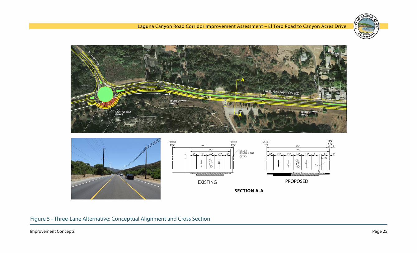
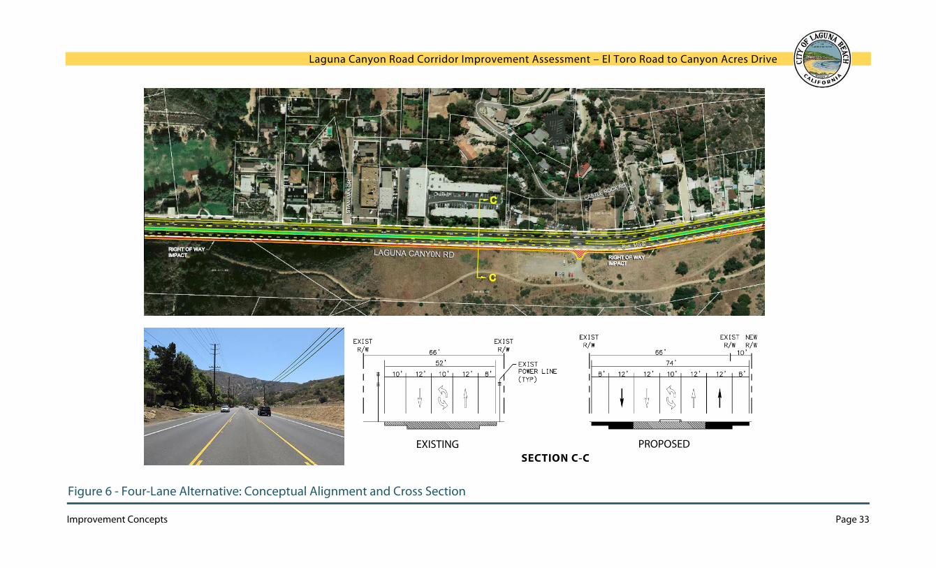
Conceptual Alignments and Cross-Sections
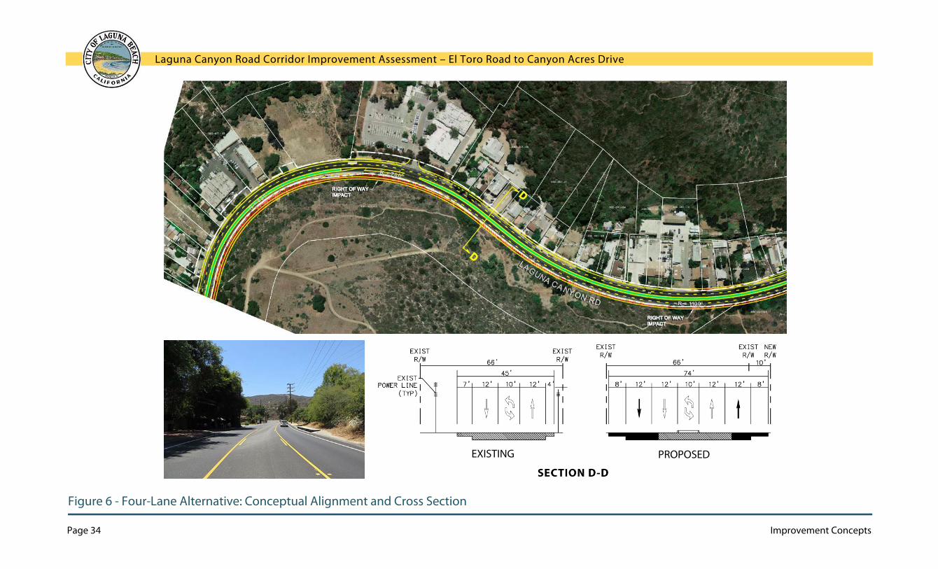
The drawings on the pages following Table 2 show potential alignments and typical cross-sections for the three-lane and four-lane alternatives, in six different locations along Laguna Canyon Road. Alternative D is depicted in Figure 5, Three Lane Alternatives: Conceptual Alignment and Cross-Sections; the alignment for Alternative A would be the same since the only difference between A and D is whether there is a raised median or a two-way left turn lane. These diagrams include the multi-use trail and the roundabout concepts. Similarly, Alternative C is shown in Figure 6, Four Lane Alternatives: Conceptual Alignment and Cross-Sections, but Alternative B would have the same alignment. These diagrams include the roundabout concepts.
Conceptual Alignments
Right-of-way impacts are shown on these drawings in red; these call attention to places where constructing the roadway as depicted would impact adjacent properties or open space. These plans are conceptual and should not be interpreted as recommended alignments. They are intended to help visualize how the increases in roadway width could be accommodated.
Cross-Sections
For each location, the improved cross-section is shown along with the existing cross-section. These cross-sections depict how the width of the roadway would be allocated to various lanes, and show the total width of the roadway with respect to the Caltrans right-of-way. The existing roadway cross-sections also show the typical locations of utility poles. All cross-sections are depicted facing south. Solid black arrows indicate added lanes while outlined white arrows indicate existing lanes.

Laguna Canyon Road Corridor Improvement Assessment – El Toro Road to Canyon Acres Drive
Page 24 Improvement Concepts
TABLE 2 - TRAFFIC ANALYSIS Laguna Canyon Road Arterial Performance by Alternative between El Toro Road and Canyon Acres Drive
Summer Weekday AM Peak Hour Summer Weekday PM Peak Hour
Direction of Travel (# of Lanes)
Travel Time (Min:Secs) Average Speed (MPH) Travel Time (Min:Secs) Average Speed (MPH)
Alternative Travel Time (Min:Secs)
Change from Existing Conditions
Average Travel Speed (MPH)
Change from Existing Conditions
Travel Time (Min:Secs)
Change from Existing Conditions
Average Travel Speed (MPH)
Change from Existing Conditions
Existing NB/Outbound (1 Lane) 05:30 - 27 - 05:19 - 28 - SB/Inbound (1 Lane) 04:52 - 30 - 04:27 - 33 - 3-Lane Alternatives* NB/Outbound (2 Lanes) 03:49 -01:42 39 12 04:35 -00:44 32 4 SB/Inbound (1 Lane) 05:01 00:09 29 -1 04:43 00:15 31 -2 4-Lane Alternatives* NB/Outbound (2 Lanes) 03:49 -01:41 39 12 05:02 -00:17 29 1 SB/Inbound (2 Lanes) 03:55 -00:57 38 8 03:56 -00:31 37 4
between Canyon Acres Drive and Coast Highway Existing NB/Outbound (1 Lane) 03:05 - 19 - 05:11 - 11 - SB/Inbound (1 Lane) 02:48 - 21 - 03:50 - 15 - 3-Lane Alternatives* NB/Outbound (2 Lanes) 02:41 -00:24 21 2 03:11 -02:00 18 7 SB/Inbound (1 Lane) 02:47 Negligible 21 0 03:12 -00:39 18 3 4-Lane Alternatives* NB/Outbound (2 Lanes) 02:45 -00:20 21 2 03:30 -01:41 16 5 SB/Inbound (2 Lanes) 02:51 Negligible 20 -1 03:13 -00:38 18 3
both segments (between El Toro Road and Coast Highway) Existing NB/Outbound (1 Lane) 08:35 - 24 - 10:30 - 19 - SB/Inbound (1 Lane) 07:40 - 27 - 08:17 - 25 - 3-Lane Alternatives* NB/Outbound (2 Lanes) 06:30 -02:05 31 7 07:46 -02:44 26 7 SB/Inbound (1 Lane) 07:48 00:09 26 -1 07:54 -00:23 26 1 Total Travel Time Reduction - -01:56 - - - -03:07 - - 4-Lane Alternatives* NB/Outbound (2 Lanes) 06:34 -02:01 31 7 08:32 -01:58 24 5 SB/Inbound (2 Lanes) 06:45 -00:57 30 3 07:09 -01:09 29 4 Total Travel Time Reduction - -02:58 - - - -03:06 - -
Notes: * Alternatives include roundabouts at El Toro Road and Canyon Acres Drive. Negligible = travel time change from existing conditions is two seconds or less and thus considered negligible. Green Highlighted cells indicate improved condition (Shorter travel times or increased travel speeds)
Purple Highlighted cells indicate deteriorated condition (Longer travel times or reduced travel speeds)
Laguna Canyon Road Corridor Improvement Assessment – El Toro Road to Canyon Acres Drive
Improvement Concepts Page 25
Figure 5 - Three-Lane Alternative: Conceptual Alignment and Cross Section
INSERT FIGURE: Section A-A
EXISTING PROPOSED

Laguna Canyon Road Corridor Improvement Assessment – El Toro Road to Canyon Acres Drive
Page 26 Improvement Concepts
Figure 5 - Three-Lane Alternative: Conceptual Alignment and Cross Section
EXISTING PROPOSED

Laguna Canyon Road Corridor Improvement Assessment – El Toro Road to Canyon Acres Drive
Improvement Concepts Page 27
Figure 5 - Three-Lane Alternative: Conceptual Alignment and Cross Section
INSERT FIGURE: Section C-C
EXISTING PROPOSED

Laguna Canyon Road Corridor Improvement Assessment – El Toro Road to Canyon Acres Drive
Page 28 Improvement Concepts
Figure 5 - Three-Lane Alternative: Conceptual Alignment and Cross Section
EXISTING PROPOSED

Laguna Canyon Road Corridor Improvement Assessment – El Toro Road to Canyon Acres Drive
Improvement Concepts Page 29
Figure 5 - Three-Lane Alternative: Conceptual Alignment and Cross Section
PROPOSED EXISTING

Laguna Canyon Road Corridor Improvement Assessment – El Toro Road to Canyon Acres Drive
Page 30 Improvement Concepts
Figure 5 - Three-Lane Alternative: Conceptual Alignment and Cross Section
PROPOSED EXISTING

Laguna Canyon Road Corridor Improvement Assessment – El Toro Road to Canyon Acres Drive
Improvement Concepts Page 31
Figure 6 - Four-Lane Alternative: Conceptual Alignment and Cross Section
EXISTING PROPOSED

Laguna Canyon Road Corridor Improvement Assessment – El Toro Road to Canyon Acres Drive
Page 32 Improvement Concepts
Figure 6 - Four-Lane Alternative: Conceptual Alignment and Cross Section
EXISTING PROPOSED
Laguna Canyon Road Corridor Improvement Assessment – El Toro Road to Canyon Acres Drive
Improvement Concepts Page 33
Figure 6 - Four-Lane Alternative: Conceptual Alignment and Cross Section
EXISTING PROPOSED
Laguna Canyon Road Corridor Improvement Assessment – El Toro Road to Canyon Acres Drive
Page 34 Improvement Concepts
Figure 6 - Four-Lane Alternative: Conceptual Alignment and Cross Section
EXISTING PROPOSED

Laguna Canyon Road Corridor Improvement Assessment – El Toro Road to Canyon Acres Drive
Improvement Concepts Page 35
Figure 6 - Four-Lane Alternative: Conceptual Alignment and Cross Section
EXISTING PROPOSED

Laguna Canyon Road Corridor Improvement Assessment – El Toro Road to Canyon Acres Drive
Page 36 Improvement Concepts
Figure 6 - Four-Lane Alternative: Conceptual Alignment and Cross Section
EXISTING PROPOSED

Laguna Canyon Road Corridor Improvement Assessment – El Toro Road to Canyon Acres Drive
Next Steps Page 37
4: Next Steps This chapter suggests elements that should be included in a process to move forward with evaluating, discussing, and pursuing improvements for Laguna Canyon Road.
Funding Process
Funding
The Orange County Transportation Authority (OCTA) is responsible for the planning and coordination of County regional transportation components. Local agencies generally oversee construction and maintenance of roadway improvements using a combination of regional and local funding sources derived from grants and formula distributions.
The Comprehensive Transportation Funding Program (CTFP) represents a collection of competitive grant programs offered to local agencies to assist in funding street improvements, transit expansion, and even environmental mitigation projects. The CTFP is comprised primarily of Orange County Measure M2 funds, but can also include state/federal funding sources such as the Regional Surface Transportation Program (RSTP) and supplemental State-Local Partnership Program (SLPP) funds.
The CTFP was created to provide a common set of guidelines and project selection criteria for a variety of funding programs, establishing a simplified and consistent process. Each program has a specific objective, funding source, and set of selection criteria detailed in separate chapters contained within these guidelines.
In April 2014 when OCTA updated its Long Range Transportation Plan (updates occur approximately every 4 years), the SR-133 Multimodal Corridor Improvement Project Between El Toro Road and Canyon Acres Drive was added to its 2035 Conceptual Scenario Roadway and Regional Highway Improvement Plan.
It is recommended that the City of Laguna Beach submit the Laguna Canyon Road Corridor Assessment project to OCTA to fund the Project Initiation Document (PID) in the next call for projects. The PID would be a Project Study Report – Project Development Support which upon approval would serve as a programming document for securing future funding for planning, design, right-of-way, and construction.
Caltrans Project Development Timeframe
The Caltrans project development process is comprised of four stages:
Stage General Timeframe
1. Project Initiation Document (PID) 18 - 24 months
2. Project Approval/Environmental Document (PA/ED) 30 - 36 months
3. Plans, Specs, & Estimates (PS&E) & Right-of-Way Acquisition 24 - 30 months
4. Construction 30 - 36 months
The timeframe for planning and design would generally take between 9 and 11 years. This assumes sequential phases of project development. The general overall timeframe for the project could be reduced to 8 years with overlap of stages or it would increase if there were gaps in the timeframes between stages.
Cost Considerations
Cost Estimate
Following is a rough order-of-magnitude development project cost estimate for improving Laguna Canyon Road from the El Toro Road intersection to the Canyon Acres intersection, a distance of approximately 13,000 lineal feet. It is important to note the project cost estimate does not include costs associated with the undergrounding of utilities since the utilities need to be relocated outside of Caltrans State Highway right-of-way at the expense of the utility companies to accommodate transportation improvements within the State Highway right-of-way. It is estimated in 2014 dollars that a 3-lane improvement concept would cost approximately $25 million and a 4-lane improvement concept would cost approximately $30 million budgeted as follows.

Laguna Canyon Road Corridor Improvement Assessment – El Toro Road to Canyon Acres Drive
Page 38 Improvement Concepts
Item Description 3-Lane
Concept ($ million)
4 -Lane Concept($ million)
1. Roundabouts (2) 1.0 1.02. Removals 0.5 0.53. Roadway Improvements 7.3 10.34. Median Improvements 1.3 1.35. Drainage Improvements 1.0 1.06. Class 1 Off-street Trail 2.0 2.0
Subtotal 13.1 16.150% Contingency 6.5 8.0
Subtotal Construction 19.6 24.1
Project Study Report 1.0 1.0Project Report/Environmental Document 2.0 2.0Plans, Specifications, & Estimate 3.0 3.0
Total (2014 dollars)
$25.6
$30.1
Community Input Process
The release or presentation of this report will mark the beginning of a public process to consider options for improving the Laguna Canyon Road corridor. Public involvement will be initiated to evaluating potential corridor improvement projects.
Residents, businesses, and institutions along the roadway are crucial stakeholders to include in any deliberative process about what improvements should be pursued. The public at large is also expected to have a high level of interest in the future of Laguna Canyon Road; future public involvement meetings will solicit their input in order to develop a preferred set of improvements.
This report suggests the types of considerations that should be weighed in evaluating the alternative concepts and any other concepts that may be developed in the future. Future planning efforts should include these considerations, which capture the multiple roles of Laguna Canyon Road and the importance of the Canyon to the community. Through the public process, the community should provide feedback into which considerations are most important, what tradeoffs can be accepted, and how certain impacts can be avoided through design.
Formal Stakeholder Engagement
As stated previously, the City engaged certain key governmental agencies in discussing concepts for the Laguna Canyon Road corridor--those with particular influence over the right-of-way, roadway operations, and the adjoining open space. However, these discussions were preliminary and no formal agreements have been made. In order to proceed with undergrounding the utilities and improving the roadway, the City will need to formally engage: Caltrans, OCTA, OC Parks, OC Public Works, Southern California Edison, and communication companies.


![Common Harmonic Improvement Concepts...1979/10/14 · Common Harmonic Improvement Concepts Ted Greene — 1979, October 14 [Ted’s note to himself about teaching this page:] Show](https://static.documents.pub/doc/80x56/5e87784b4d71975aa254fba3/common-harmonic-improvement-concepts-19791014-common-harmonic-improvement.jpg)


