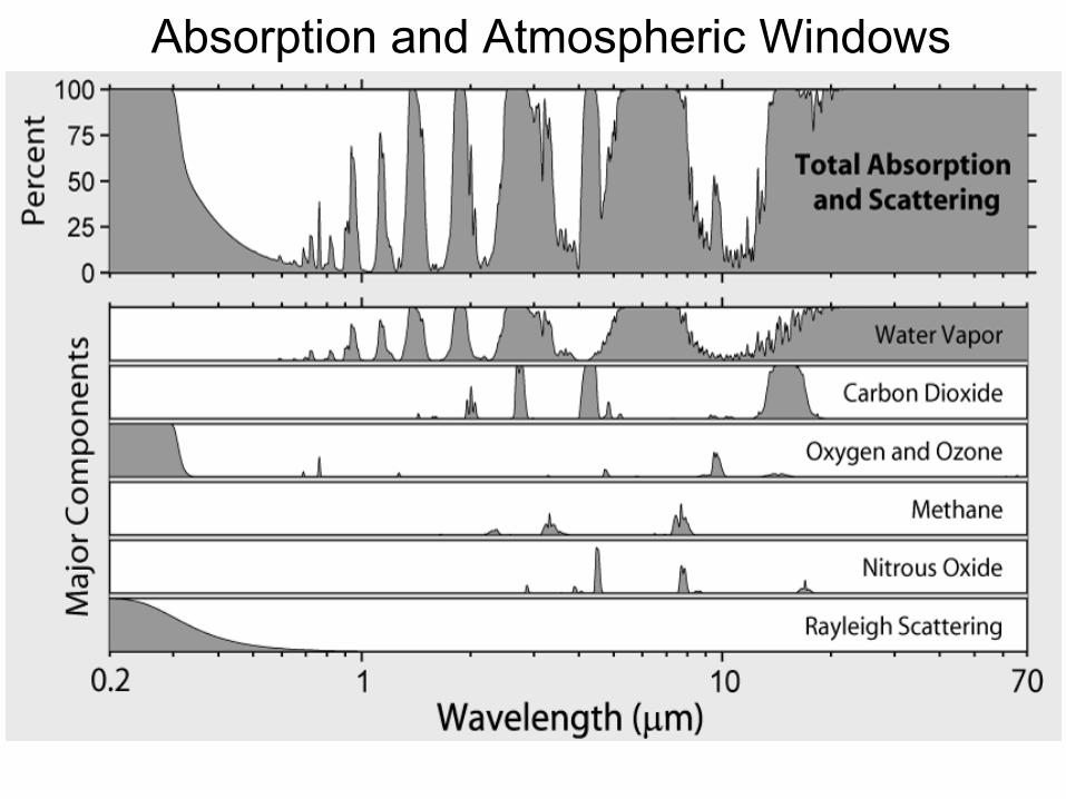
• EMR is attenuated by its passage through the atmosphere
Attenuation = scattering + absorption–Scattering is the redirection of
radiation by reflection and refraction–Attenuation is wavelength dependent
Atmospheric Absorption
In the atmosphere EMR is primarily absorbed by
• H2O water vapor, water droplets• CO2 carbon dioxide• O2 oxygen• O3 ozone• dust
Absorption and Atmospheric Windows
Optical Depth• The optical depth (t) expresses the quantity of light removed
from a beam by scattering or absorption during its path through a medium.
I/Io = e-t (Eq. 1)Where: – Io = intensity of a source– I = Intensity observed after a given path
• When a surface is viewed at an angle, Eq 1 becomes:I/Io = e-t/cos(θ) (Eq. 2)
Where θ = the viewing angle
• Optical depth also determines how visible a surface is
*
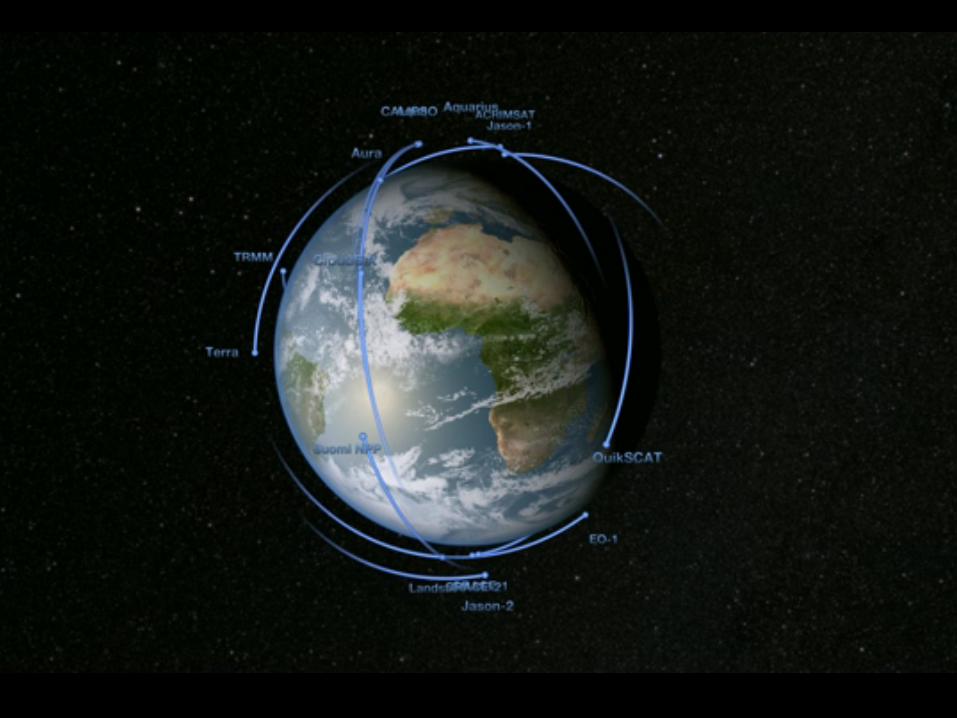
3.3 Orbit types
Orbital parameters can be tuned to produce particular, useful orbits
• Geostationary• Geosynchronous• Sun synchronous
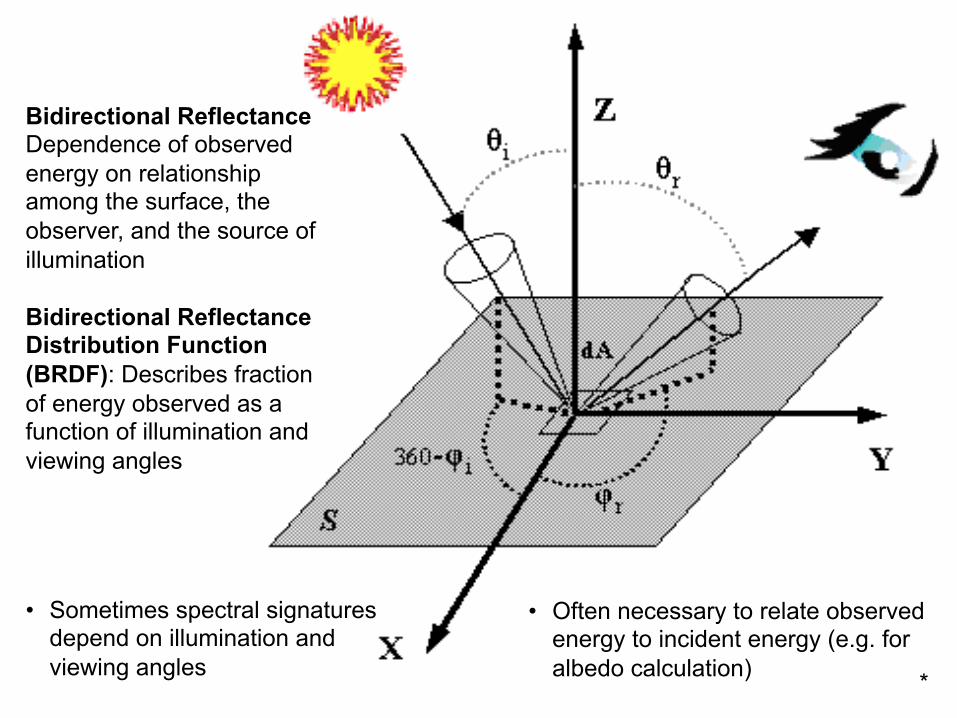
Bidirectional ReflectanceDependence of observed energy on relationship among the surface, the observer, and the source of illumination
Bidirectional Reflectance Distribution Function (BRDF): Describes fraction of energy observed as a function of illumination and viewing angles
• Often necessary to relate observed energy to incident energy (e.g. for albedo calculation)
• Sometimes spectral signatures depend on illumination and viewing angles *
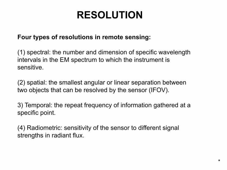
Four types of resolutions in remote sensing:
(1) spectral: the number and dimension of specific wavelengthintervals in the EM spectrum to which the instrument issensitive.
(2) spatial: the smallest angular or linear separation betweentwo objects that can be resolved by the sensor (IFOV).
3) Temporal: the repeat frequency of information gathered at aspecific point.
(4) Radiometric: sensitivity of the sensor to different signalstrengths in radiant flux.
RESOLUTION
*
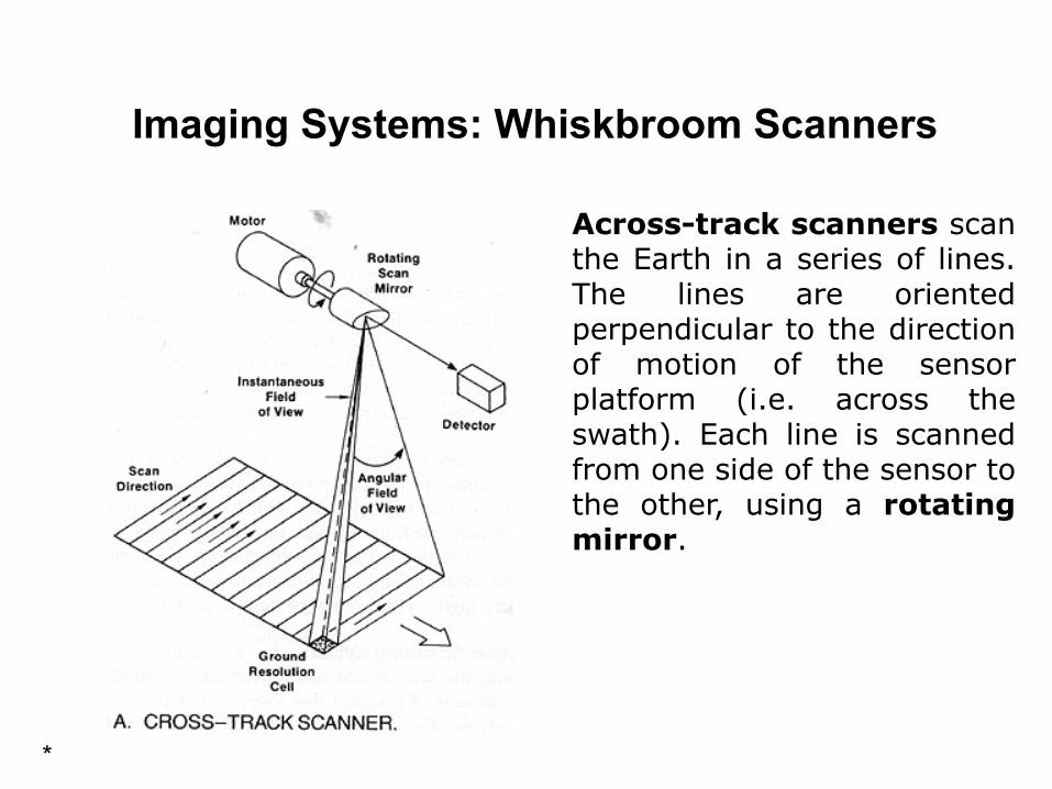
Imaging Systems: Whiskbroom Scanners
Artists impression of Spot 5 Across-track scanners scanthe Earth in a series of lines.The lines are orientedperpendicular to the directionof motion of the sensorplatform (i.e. across theswath). Each line is scannedfrom one side of the sensor tothe other, using a rotatingmirror.
*
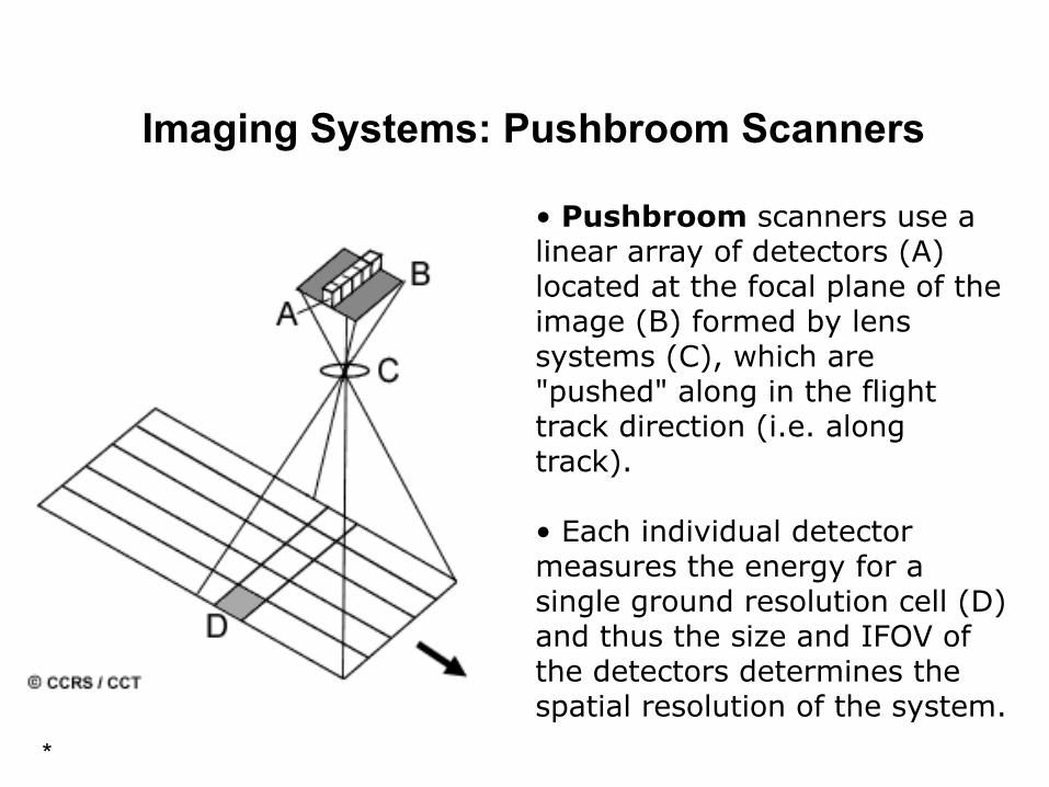
Imaging Systems: Pushbroom Scanners
• Pushbroom scanners use a linear array of detectors (A) located at the focal plane of the image (B) formed by lens systems (C), which are "pushed" along in the flight track direction (i.e. along track).
• Each individual detector measures the energy for a single ground resolution cell (D) and thus the size and IFOV of the detectors determines the spatial resolution of the system.
*
Landsat TM image of Mississippi River, before and after 1993 flood
Monthly snow cover with fractional snow cover from the Terra MODIS, February 2004.
Cryosphere Remote Sensing ApplicationsSnow
Landsat TM Band-5
Landsat TM Band-2
*
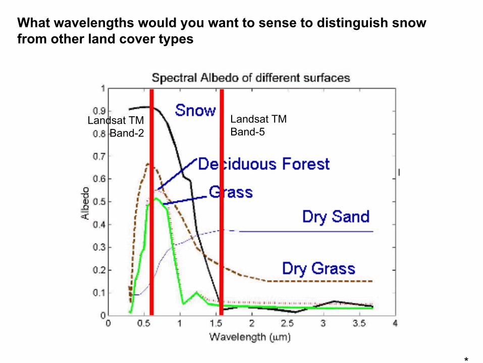
What wavelengths would you want to sense to distinguish snow from other land cover types
Soils: Organic Matter
Organic matter is a strong absorber of EMR, so more organic matter leads to darker soils (lower reflectance curves)
Land Surfaces are often a mixture of soils that may have similar spectral signatures
*
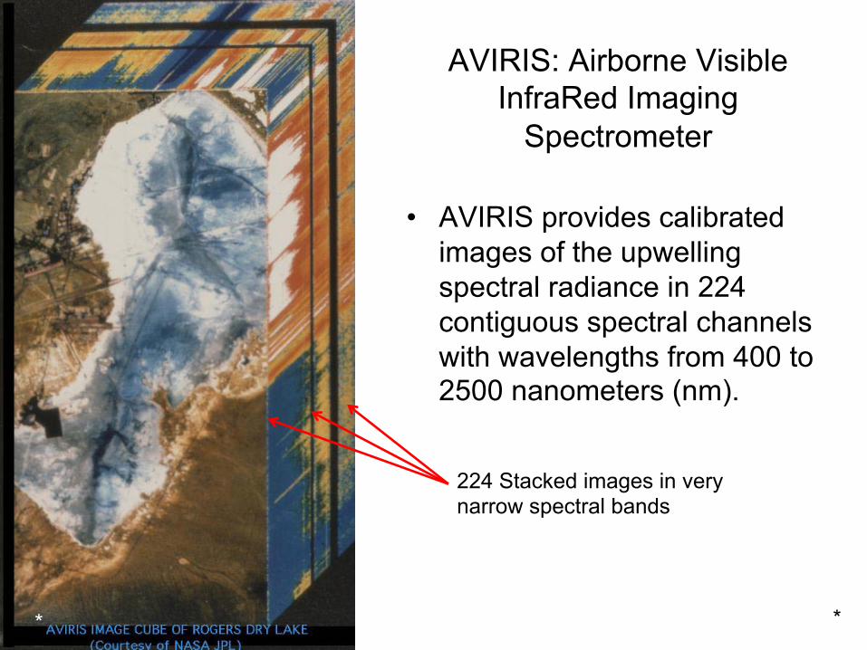
AVIRIS: Airborne Visible InfraRed Imaging
Spectrometer
• AVIRIS provides calibrated images of the upwelling spectral radiance in 224 contiguous spectral channels with wavelengths from 400 to 2500 nanometers (nm).
224 Stacked images in very narrow spectral bands
**
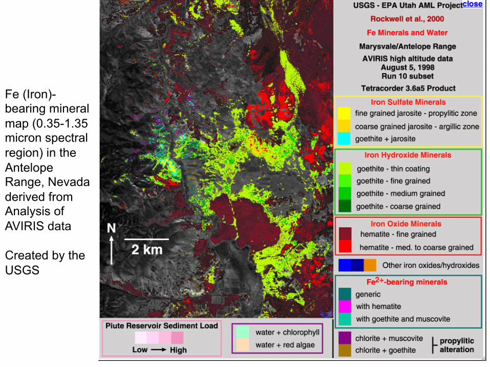
Fe (Iron)-bearing mineral map (0.35-1.35 micron spectral region) in the Antelope Range, Nevada derived from Analysis of AVIRIS data
Created by the USGS
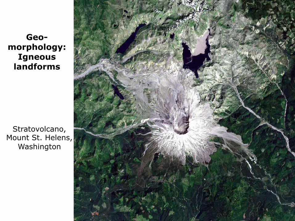
Geo-morphology:
Igneous landforms
Stratovolcano, Mount St. Helens,
Washington
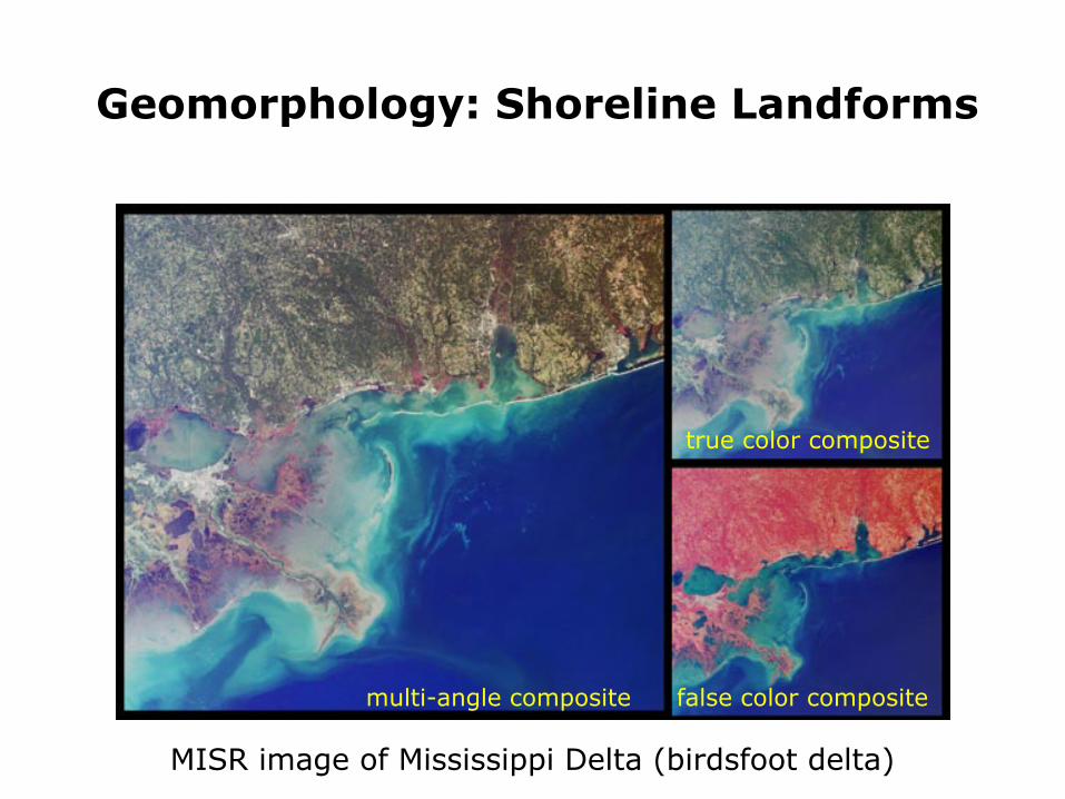
Geomorphology: Shoreline Landforms
MISR image of Mississippi Delta (birdsfoot delta)
multi-angle composite false color composite
true color composite
Tectonic LandformsColorado Rocky Mountains from
Landsat TM (band 4)
Canadian Rocky Mountains from
Radarsat
Shaded Relief from Shuttle Radar Topography Mission