Leger NASP Office Consolidation March 2006 Leger Neighbourhood Area Structure Plan Office Consolidation March 2006 Prepared by: Planning and Policy Services Branch Planning and Development Department City of Edmonton Bylaw 11011 (as amended) was adopted by Council in June 1995. In March 2006, this document was consolidated by virtue of the incorporation of the following bylaws: Bylaw 11011 Approved June 23, 1995 (to adopt the Leger Neighbourhood Area Structure Plan) Bylaw 13799 Approved August 26, 2004 (to realign the north-south collector roadway; reconfigure the district campus/park sites; include an area for future recreation facilities and/or institutional/urban services or medium density residential uses) Editor’s Note: This is an office consolidation edition of the Leger Neighbourhood Structure Plan, Bylaw 11011, as approved by City Council on June 23, 1995. This edition contains all amendments and additions to Bylaw 11011. For the sake of clarity, new maps and a standardized format were utilized in this Plan. All names of City departments have been standardized to reflect their present titles. Private owners’ names have been removed in accordance with the Freedom of Information and Protection of Privacy Act. Furthermore, all reasonable attempts were made to accurately reflect the original Bylaws. All text changes are noted in the right margin and are italicized where applicable. This office consolidation is intended for convenience only. In case of uncertainty, the reader is advised to consult the original Bylaws, available at the office of the City Clerk. City of Edmonton Planning and Development Department
Transcript
Leger NASP Office Consolidation March 2006
Leger Neighbourhood Area Structure Plan
Office Consolidation March 2006
Prepared by:
Planning and Policy Services Branch Planning and Development Department
City of Edmonton Bylaw 11011 (as amended) was adopted by Council in June 1995. In March 2006, this document was consolidated by virtue of the incorporation of the following bylaws: Bylaw 11011 Approved June 23, 1995 (to adopt the Leger Neighbourhood Area Structure Plan) Bylaw 13799 Approved August 26, 2004 (to realign the north-south collector roadway; reconfigure the
district campus/park sites; include an area for future recreation facilities and/or institutional/urban services or medium density residential uses)
Editor’s Note: This is an office consolidation edition of the Leger Neighbourhood Structure Plan, Bylaw 11011, as approved by City Council on June 23, 1995. This edition contains all amendments and additions to Bylaw 11011. For the sake of clarity, new maps and a standardized format were utilized in this Plan. All names of City departments have been standardized to reflect their present titles. Private owners’ names have been removed in accordance with the Freedom of Information and Protection of Privacy Act. Furthermore, all reasonable attempts were made to accurately reflect the original Bylaws. All text changes are noted in the right margin and are italicized where applicable. This office consolidation is intended for convenience only. In case of uncertainty, the reader is advised to consult the original Bylaws, available at the office of the City Clerk. City of Edmonton Planning and Development Department
Leger NASP Office Consolidation March 2006
Terwillegar Owners Group
Leger Neighbourhood
Neighbourhood Area Structure Plan
Revised March 1995
Leger NASP Office Consolidation March 2006
Table of Contents (Amended by Editor)
(Amended by Bylaw 13799)
1.0 Introduction.......................................................................................................................... 1 2.0 Development Context........................................................................................................... 2
2.1 Local Setting and Access .................................................................................................... 2 2.2 Plan Area............................................................................................................................. 2 2.3 Existing Land Uses ............................................................................................................. 2 2.4 Utility Corridors.................................................................................................................. 2 2.5 Land Ownership.................................................................................................................. 4 2.6 Soils, Vegetation and Topography...................................................................................... 4 2.7 Geotechnical Assessment.................................................................................................... 9 2.8 Environmental Site Assessment......................................................................................... 11
3.1 Edmonton Regional Plan .................................................................................................. 12 3.2 Edmonton General Municipal Plan................................................................................... 12
4.0 Development Principles ..................................................................................................... 18
4.1 Development Objectives................................................................................................... 18 4.2 Development Concept....................................................................................................... 18 4.3 Residential Development .................................................................................................. 21 4.4 Commercial/Employment Centre ..................................................................................... 24 4.5 District Campus/School Sites ........................................................................................... 24 4.6 Pedestrian and Bicycle Circulation................................................................................... 25 4.7 Transportation ................................................................................................................... 26 4.8 Municipal Engineering Services ....................................................................................... 29
5.0 Development Implementation............................................................................................ 35
5.1 Development Staging........................................................................................................ 35 5.2 Additional Requirements/Studies ..................................................................................... 36
Appendix “A” – Land Use Statistics
Leger NASP Office Consolidation March 2006 1
Leger Neighbourhood – Neighbourhood Area Structure Plan
1.0 Introduction
This document describes the proposed Neighbourhood Area Structure Plan for Leger Neighbourhood (Phase 2A) of Terwillegar Heights as defined by the Terwillegar Heights Servicing Concept Design Brief (As Amended), approved by City Council on January 12, 1993.
The purpose of this document is to describe in detail and implement the policies and guidelines as set out in the Terwillegar Heights Servicing Concept Design Brief (SCDB), so as to provide the framework for the development of this area of this comprehensively planned residential community.
The plan has been prepared by IBI Group on behalf of the landowners of the area.
Leger NASP Office Consolidation March 2006 2
2.0 Development Context
2.1 Local Setting and Access
As shown in Exhibit 1, Leger Neighbourhood is located in the southwest area of the City of Edmonton.
The plan area is currently accessible via 142 Street and 23 Avenue. A road crossing of the Private Utilities Corporation Right-of-Way would permit access from the Carter Crest Neighbourhood in Riverbend.
2.2 Plan Area
The area of the Leger Neighbourhood (2A) is defined by the Terwillegar Heights SCDB and is located within S.E.1/4 Section 2-52-25-W4M and SW Section 2-52-25-W4M. Leger Neighbourhood is bounded on the east by Rabbit Hill Road, on the north by the south boundary of the Private Utilities Corporation right-of-way, and to the south by 23 Avenue and to the west by Terwillegar Drive.
The proposed plan area comprises approximately 98.98 hectares of land.
2.3 Existing Land Uses
The east half of the plan area is presently being used for agricultural purposes. The west portion of the plan area includes disturbed lands relating to sand and gravel excavation activities. This portion of the plan area is presently being reclaimed from gravel pit operations.
A residence with associated buildings is located in the southeast area of the neighbourhood on the private landowner’s property, with access from 23 Avenue.
2.4 Utility Corridors
The Private Utilities Corporation right-of way is aligned in west/east direction, forming the northern boundary of the neighbourhood. This transmission corridor is included in the Carter Crest Neighbourhood Structure Plan. A second private utilities corporation gas pipeline right-of-way is located in the southeast area of
Amended by Editor
Amended by Editor
Amended by Editor
Leger NASP Office Consolidation March 2006 3
*Amended by Editor
Exhibit 1 – Local Context* (Bylaw 11011, June 23, 1995)
Private Utilities Corporation Right of Way
Leger NASP Office Consolidation March 2006 4
the neighbourhood, adjacent to the existing farmstead. This right-of-way will be relocated or abandoned as development of the neighbourhood progresses.
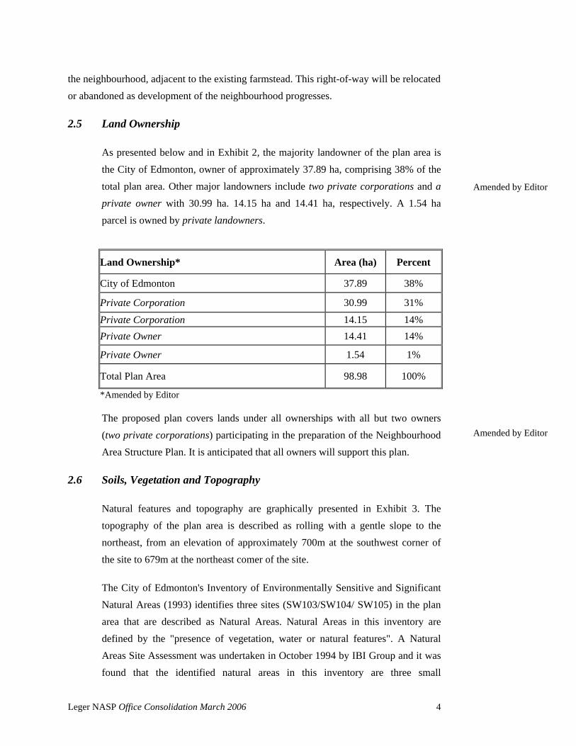
2.5 Land Ownership
As presented below and in Exhibit 2, the majority landowner of the plan area is the City of Edmonton, owner of approximately 37.89 ha, comprising 38% of the total plan area. Other major landowners include two private corporations and a private owner with 30.99 ha. 14.15 ha and 14.41 ha, respectively. A 1.54 ha parcel is owned by private landowners.
The proposed plan covers lands under all ownerships with all but two owners (two private corporations) participating in the preparation of the Neighbourhood Area Structure Plan. It is anticipated that all owners will support this plan.
2.6 Soils, Vegetation and Topography
Natural features and topography are graphically presented in Exhibit 3. The topography of the plan area is described as rolling with a gentle slope to the northeast, from an elevation of approximately 700m at the southwest corner of the site to 679m at the northeast comer of the site.
The City of Edmonton's Inventory of Environmentally Sensitive and Significant Natural Areas (1993) identifies three sites (SW103/SW104/ SW105) in the plan area that are described as Natural Areas. Natural Areas in this inventory are defined by the "presence of vegetation, water or natural features". A Natural Areas Site Assessment was undertaken in October 1994 by IBI Group and it was found that the identified natural areas in this inventory are three small
Exhibit 1 – Land Ownership* (Bylaw 11011, June 23, 1995)
*Amended by Editor
Private Corporation
Private Corporation
Private Owner
Private Owners
Private Utilities Corporation Right of Way
Leger NASP Office Consolidation March 2006 6
depressions which contain water intermittently and range from 0.2 to 0.4 hectares in size. These areas contain vegetation such as poplar, aspen, willow and spruce trees and an understorey of species such as willow and sedge. These depressions may contain standing water during the early to late spring season and wet periods in the summer. These sites are not viable in the context of a suburban residential development due to their small size and sensitivity to changes to drainage patterns as a result of urban development.
As shown in Exhibits 3 and 4, as a result of agricultural practices, most of the mature vegetation within the eastern portion of the plan area has been eliminated. Two small stands of trees are located in the vicinity of the farmstead located in the southeast area of the site and a stand of trees is located directly west of 142 Street. These stands of trees are comprised mainly of aging poplar and aspen trees with a variable deciduous understorey of species such as dogwood, raspberry, rose, saskatoon and honeysuckle. The free-growing shrub hedgerow and other plantings adjacent to the farmstead site also contain some cultivated deciduous and coniferous species. Due to the composition, size, age and location of these tree stands, they have limited viability in the context of a suburban residential development due to changes in drainage patterns and the impacts of road construction. These tree stands have limited value to the urban landscape.
The lands in the west portion (SW l/4 SEC.2) of the plan area are flat and stripped as a result of previous quarry and reclamation activities. A stand of trees approximately 1 hectare in size is located adjacent to the easterly 1/4 section line. A wind row of poplar trees follows the north/south 1/4 section line and the north edge of the plan area. The largest stand of trees is comprised of aging poplar-aspen trees with a dense understorey of shrubs, species such as saskatoon, raspberry, honeysuckle, etc.
As a result of the reduced land requirements for the District Campus Site, the current configuration of the school sites does not allow for the retention of this stand of trees.
Exhibit 5 shows the proposed land use concept superimposed on the natural features and topography of the Leger Neighbourhood lands.
Leger NASP Office Consolidation March 2006 7
Exhibit 3 – Site Features* (Bylaw 11011, June 23, 1995)
Priv
ate
Util
ities
Cor
pora
tion
Righ
t of W
ay
*Amended by Editor
Leger NASP Office Consolidation March 2006 8
Exhibit 4 – Aerial Photograph* (Bylaw 11011, June 23, 1995)
Priv
ate
Util
ities
Cor
pora
tion
R.O
.W
*Amended by Editor
Leger NASP Office Consolidation March 2006 9
2.7 Geotechnical Assessment
A geotechnical assessment was prepared for the Rabbit Hill Pit in August 1993 by HBT Agra Limited. The purpose of this assessment was to provide geotechnical recommendations regarding the infilling of the Rabbit Hill Pit. These recommendations were prepared to assist in the planning and design activities of the Transportation, Planning & Development and Community Services Departments of the City of Edmonton.
The report indicated that the surface mining of the area started before 1950. The City of Edmonton purchased the pit in 1962 and used it as a source of sand and clay backfill. A portion of the pit was also used for infill for various excavations throughout the City. In about 1986, the sand and clay borrow source within the pit was nearly depleted and backfill operations from the excavation operations for Whitemud Drive construction were available for infilling. The City then commenced infilling of the pit with materials excavated from the Whitemud Drive construction.
The pit has now been filled to the elevation of the design contours, except for a portion of the northeast and southeast areas of the property, which require additional fill.
The report stated that the main issue surrounding the Rabbit Hill Pit was the vertical movement behaviour of the pit infill materials. Depending on the foundation conditions, special footing and foundation designs may be required to ensure serviceability of structures. Pre-loading of surcharge fill along with a settlement monitoring program was recommended to minimize both immediate and long term settling. The City of Edmonton has arranged for a settlement monitoring program for the site.
The School Boards have indicated that they are satisfied with the location of the school sites relative to the reclaimed areas, and that detailed site planning and monitoring will be undertaken in the future.
The more easterly of the two 1/4 sections in Leger Neighbourhood was examined in a Geotechnical Report prepared by 7.R. Paine & Associates in September of 1994. The report indicates that the soils in the area are suitable for the type of development proposed. The report also indicates that the soils encountered in the
Amended by Editor
Leger NASP Office Consolidation March 2006 10
Exhibit 5 – Site Features / Development Concept (Bylaw 11011, June 23, 1995)
Priv
ate
Util
ities
Cor
pora
tion
Righ
t of W
ay
*Amended by Editor
Leger NASP Office Consolidation March 2006 11
test holes are considered suitable for the construction of stormwater retention facilities.
2.8 Environmental Site Assessment
A Phase I Environment Site Assessment for the east portion of the plan area was prepared by IBI Group in October 1994. This assessment concluded that since the East Lands have been in continuous agricultural use, there is little potential for environmental contamination. As a result of this conclusion, it was recommended that no further study of the East Lands is required.
A Phase I Environmental Site Assessment was prepared for the west portion of the plan area by the City of Edmonton Planning & Development Department in September 1994. This assessment concluded that excavation and stockpiling activities are not a contamination concern and that whatever contaminants there might be on the site would be minimal. As a result of these conclusions, it was recommended that no further study of the west lands is required prior to NASP approval. However, prior to any redistricting applications being accepted for the former pit site, soil and groundwater analyses will be required for those areas on which residential and recreational buildings will be constructed.
Leger NASP Office Consolidation March 2006 12
3.0 Policy Context
The Leger Neighbourhood Area Structure Plan has been prepared in the context of the applicable development policies and objectives governing this area. These policies are identified below.
3.1 Edmonton Regional Plan
The Leger Neighbourhood is contained within and conforms with the Edmonton Metropolitan Regional Plan (the Edmonton Metropolitan Regional Plan was repealed on March 31, 1995). The Regional Plan contained broad policy directives which are met by specific land allocations and servicing proposals outlined in this Neighbourhood Area Structure Plan. The Neighbourhood was designated in the Edmonton Regional Plan as "Potential Urban Expansion Area", indicating its suitability for the development of residential, institutional and commercial development.
3.2 Edmonton General Municipal Plan
The Edmonton General Municipal Plan sets out a growth strategy to accommodate the development of the City. The following are strategic objectives and policies specific to development in the Leger Neighbourhood:
• Managing suburban growth:
Objective 2.A - To accommodate growth, serviced in an orderly fashion, in all suburban areas of the City.
Policy 2.A.1 - Encourage new development to be contiguous with existing development.
• Ensuring adequate neighbourhood services
Objective 2.B - Encourage flexibility in creating attractive and functional neighbourhoods.
Policy 2.B.3 - Allow flexibility in the type of central focus for each neighbourhood, using a range of community and private facilities to serve the residents' needs.
Amended by Editor
Leger NASP Office Consolidation March 2006 13
Policy 2.B.4 - Promote linkages between communities through the design and location of open spaces, community facilities and activity centres.
• Maintaining a balanced mix and density of dwellings
Objective 2.C - To provide a range of housing types and density opportunities in each residential neighbourhood.
The proposed Leger Neighbourhood Area Structure Plan meets the above noted strategic objectives and policies.
The Terwillegar Heights Servicing Concept Design Brief provides the policy basis for City Council to establish a generalized framework for municipal infrastructure, servicing, planning and development guidelines and basic environmental requirements for the Terwillegar Heights area, and to facilitate the staged submission of specific neighbourhood area structure plans (NASP) by developers and landowners.
The policies which apply specifically to the plan area are as follows:
School and Parks/Open Space Natural Environment
• School locations are to be determined in cooperation with the Public and Catholic School Boards, taking into account physical site requirements and future student attendance areas.
• Open space in the form of active, passive and natural park areas is required to provide a variety of recreational opportunities throughout the study area.
• Efficient and enjoyable pedestrian movement is required to areas and facilities within neighbourhoods and between neighbourhoods and to the river valley and ravine system.
• Utility rights-of-way, pipeline rights-of-way, public utility lots and RDA lands present opportunities for recreation/pedestrian
Leger NASP Office Consolidation March 2006 14
development and should be integrated into a comprehensive open space system.
• Stormwater management facilities will be located and designed in order to maximize their potential for use as recreational areas within the community.
For Leger Neighbourhood, the SCDB specifies a need for a Public K-8 and Separate Elementary as well as 2 High Schools, a Recreation Centre and a District Park. The school/park sites will be linked to the neighbourhoods with a walkway/bikeway system which complements the pedestrian and bicycle routes on the collector and local roadway-system.
According to the SCDB, the reserve dedication for this neighbourhood is to total some 36.7 ha. Through consultation with the Community Services Department and both School Boards, the land allocation for the District Campus site is being reduced to 30.7 ha (75.9 ac). Parks and open space provisions are consistent with City policy and guidelines.
Housing Types and Density Opportunities
• Provide a balanced blend of housing types in each neighbourhood according to recently approved Council density distribution guidelines.
• A1low for innovative design to accommodate all types of housing, especially "affordable" housing.
• Encourage integration of housing types along local streets.
• Promote some housing at increased densities to maximize utilization of municipal infrastructure investments.
The proposed residential areas within the Leger Neighbourhood Area Structure Plan accommodate a wide variety of housing opportunities appropriate to the neighbourhood. The single family/multi-family ratio is proposed at 65%/35% and is within City Council's guidelines for suburban neighbourhoods.
Amended by Editor
Bylaw 13799 August 26, 2004 Amended by Editor
Leger NASP Office Consolidation March 2006 15
Transportation System and Utility Corridors
Provide a transportation system that reflects the character of the intended development, meets the unique demands of each neighbourhood or NASP, as well as the City's wider transportation objectives.
Encourage efficient and economic phased development
Design integrated transportation and movement systems at the outset (bicycle/pedestrian/transit and private vehicles).
The proposed transportation system in the Leger Neighbourhood Area Structure Plan has changed from the conceptual alignment of the SCDB to better accommodate the reduced size of the District Campus site and to keep District Campus destined vehicles out of the residential portion of the neighbourhood. The proposed transportation system is consistent with City policy and guidelines.
Neighbourhood Focus
Ensure that each neighbourhood has a central focus that provides an activity centre rather than a static, geographic feature.
Allow flexibility and composition of central focus ensuring a range of services, amenities, and employment opportunities.
Design intra- and inter-community linkages (pedestrian, bicycle, vehicular).
Placement of the community focus need not always be in the geographic centre of the neighbourhood. Flexibility, particularly with park and/or school sites, is required, if their focus is to serve a larger area.
Plan for the rehabilitation of sand and gravel pits in an environmentally sensitive manner and integrate them into the NASP design.
The focus of the neighbourhood is the proposed District Campus site, providing an activity centre offering a range of services and amenities. An additional focus is also the Commercial/Employment Centre located in the southeast corner of the neighbourhood.
Leger NASP Office Consolidation March 2006 16
3.4 City of Edmonton Suburban Investment Strategy
The Suburban Investment Strategy identified the proposed capital projects to resolve existing infrastructure deficiencies and ensure forecasted residential servicing to continue.
A key principle of the strategy deals with neighbourhood approvals and states that new neighbourhood approvals should be considered if:
• new neighbourhoods are contiguous with adjacent, completed
development;
• new neighbourhoods are necessary in order to meet servicing forecasts within the appropriate sector,
• funding is in place to provide required infrastructure or that the developers are responsible for all costs associated with the required infrastructure.
City of Edmonton forecasts suggest the existing residential land in Riverbend will be depleted within the next two to three years. In single family residential servicing forecasts for the southwest sector, the City of Edmonton predicts that 400 and 450 1ots will be serviced in 1996 and 1997, respectively. For the Terwillegar lands, in particular, the City of Edmonton forecasts 200 and 250 lots will be serviced in 1996 and 1997, respectively. The popularity of this section of the City to developers and purchasers is reflected in the historic lot production and absorption activity. Since 1981 over 3,500 single family lots have been developed and sold in Riverbend, one of the most active development areas in the City. This trend is expected to continue for the next number of years.
The City's preparation of the SCDB for Terwillegar enables plan preparation for neighbourhoods to proceed to facilitate housing opportunities in this sector of the City. The Haddow Neighbourhood was the first neighbourhood located in the Terwillegar SCDB to be approved. Approval was given in July 1993. It is anticipated that lot production in the Haddow Neighbourhood will not be able to meet market demand of 250 lots per year in Riverbend/Terwillegar Heights.
For the Leger Neighbourhood, the following infrastructure requirements will be provided by the developers:
Leger NASP Office Consolidation March 2006 17
• Rabbit Hill Road development (to be shared by developers of Leger and Hodgsan Neighbourhoods);
• storm sewer, sanitary sewer and water extensions;
• local and collector roadways;
• servicing to property lines of school sites.
The lands in the Leger Neighbourhood meet the principles of the Suburban Investment Strategy as follows:
• the lands are contiguous with the development of Carter Crest to the north, which is fully subdivided;
• the lands are required to meet servicing forecasts of 400 lots per year in the southwest sector of the City and in particular, the market demands through 1999 and beyond;
• the infrastructure required for this neighbourhood is included in the City's CPP or will be funded by the Developers.
Leger NASP Office Consolidation March 2006 18
4.0 Development Principles
4.1 Development Objectives
This Neighbourhood Area Structure Plan has been prepared to attain the following development objectives:
• to provide a land use homework for development of a complete neighbourhood through which the demands of the marketplace can be fulfilled;
• to define in detail a functional and comprehensive development program such that the orderly approval and development of these lands may proceed.
Land Use Framework to Meet Market Demand
This NASP application offers residential land uses as the predominant development form. A broader variety of low density residential opportunities are proposed than historically experienced in Riverbend to the north. This will allow the lands in this NASP to be more market responsive than Riverbend communities have been in the past.
Orderly Development
The lands are adjacent to existing development to the north (Carter Crest) and they are the logical southward extension of this development. As the development of the Riverbend area is nearing completion, these lands are physically and logistically, readily and easily serviced without "leap-frogging" other potential development areas. Servicing can be readily extended from the north through Rabbit Hill Road and Carter Crest Way.
4.2 Development Concept
The development concept for the Leger Neighbourhood Area Structure Plan is presented in Exhibit 6. Land Use Statistics for the plan are presented in Appendix "A". The primary land use will be residential, comprising low density and medium density housing. This residential component of the plan comprises approximately 48.0 hectares. A District Campus is the other major component of
Leger NASP Office Consolidation March 2006 19
Exhibit 6 – Land Use Concept* (Bylaw 13799, June 23, 1995)
*Amended by Editor
Private Utilities Corporation Right of Way
Leger NASP Office Consolidation March 2006 20
the neighbourhood, comprising some 30.7 hectares (75.9 acres). A commercial site is also identified, as part of the Regional Employment Centre shown in the SCDB, focusing on the intersection of 23 Avenue and Rabbit Hill Road.
The mass of the District Campus within the neighbourhood is significant, comprising almost 32% of the lands (including the Recreation Facility / Playing Fields). Due to favourable ownership (City of Edmonton), its location is almost entirely in the west portion of the neighbourhood. As a result, two residential precincts are formed, east of the District Campus, some 42.2 ha (104.3 ac) and within the District Campus site, some 5.69 ha (14.0 ac) with the exact area being
determined upon completion of the facility study for the recreation facility.
A second possible use for the 5.69 ha (14.0 ac) site is Institutional/Health uses. The intent of this use is to facilitate the development of health services primarily of a diagnostic and rehabilitation nature with related commercial health components. These uses will take advantage of the open space system, parks and recreational amenities and proximity to the adjacent transit facility and transportation network. It is proposed that building height be restricted to 10 meters and that commercial parking and landscaping be of a level and design to complement the open space and park uses that will characterize the majority of the west Leger area. It is anticipated that these uses will be implemented through a Direct Control Provision.
Should market conditions change and preclude the development of institutional/health uses with a related commercial component, this area may be converted to a variety of residential uses designed to take advantage of its location to the transit centre and recreational facility/sportsfield.
Because of geotechnical conditions and concerns of the Public School Board, the District Campus cannot be moved westward to allow the integration of the 5.69 ha (14.0 ac) residential site on City-owned lands with the residential lands to the east.
The stormwater management facilities, the school/park sites and residential areas in the neighbourhood are linked by walkways comprising open space paths and sidewalks. The schools, campus and associated parks are destination points. The existing private utility corporation right-of-way also functions as an east/west
Bylaw 13799 August 26, 2004 Amended by Editor
Bylaw 13799 August 26, 2004 Amended by Editor
Amended by Editor
Leger NASP Office Consolidation March 2006 21
open space link, providing pedestrian access to open space, public transit, and the future District Campus.
4.3 Residential Development
The concept for residential development in the neighbourhood is to encourage single family and medium density sites to take advantage of the open space system, parks and recreation amenities, schools and the natural features of the site.
Lower density housing forms will be developed to reflect the range of densities permitted in the City of Edmonton Land Use Bylaw including a range of single family residential on a variety of lot sizes and semi-detached residential opportunities.
The medium density housing forms including row housing and walk-up apartments, are proposed in locations where good transportation access and transit routes are available, as well as proximity to pedestrian and bicycle access to the area's amenities. The proposed medium density housing will be developed to a density no greater than 50 units per hectare. The Planning & Development Department will monitor densities through the rezoning and development permit processes.
In the western portion of the plan area along 23 Avenue, a medium density residential site is located within the Recreation Facility/Playing Field area. The exceptional conditions which support this level of development are:
• proximity to an abundance of green space in the adjacent District Campus;
• the desire to have a reasonable population to allow the creation of a "neighbourhood" identity and local scale recreation facilities in a relatively isolated part of the neighbourhood;
• the geotechnical conditions which make single family development less economical.
All residential areas will be within walking distance to transit as defined in the current City practices. Pedestrian and bicycle networks are proposed within the
Bylaw 13799 August 26, 2004 Amended by Editor
Bylaw 13799 August 26, 2004
Leger NASP Office Consolidation March 2006 22
neighbourhood to link residential areas to each other and to manmade and other open space features.
Density Ratio
Lands associated with District Campuses and/or employment centres have been traditionally planned to permit higher densities to:
• maximize the exposure of the open space amenity;
• enhance the viability of the transit centre located on 23 Avenue;
• create market opportunities to respond to demand.
Overall, the mix proposed for this neighbourhood is 65% single family and 35% multi-family. Low Density Residential Development
The emphasis of housing for the eastern half of this neighbourhood is on low density residential. To the extent possible, low density residential development will be located with access to local roads to provide more quiet and private residential environments.
Single detached residential on a variety of lot widths and semi-detached residential development are proposed for the majority of the eastern half of the neighbourhood. Densities of approximately 22.5 units/ha are proposed.
No low density residential development is proposed for the western half of the neighbourhood.
Medium Density Residential Development
Medium density residential development in the eastern half of the plan area is proposed on three 1-acre sites:
• one site in the northeast portion of the neighbourhood south of the storm management facility, on the west side of Rabbit Hill Road;
• one site north of 23 Avenue adjacent to the collector read;
• one site in the southeast portion of the neighbourhood north of the commercial site and west of Rabbit Hill Road.
Bylaw 13799 August 26, 2004 Amended by Editor
Leger NASP Office Consolidation March 2006 23
These sites comprise approximately 3.00 ha and potentially total 126 units if developed to row housing densities. This will permit future consumers a reasonable choice of housing types and locations.
The potential density of the Medium Density Residential site located in the south central portion of the plan area site, located along Leger Way/Leger Road is intended to be developed as an apartment condominium site. The maximum
number of units permitted on this site will be 60 units and is required to be developed with underground parking at a minimum ratio of 1.50 parking spaces per unit or in accordance with the zoning bylaw whichever is greater. These requirements will be dealt with via a DC2 Provision.
The medium density residential areas are oriented to the pedestrian/bikeway system and open space system. These medium density residential areas have access to the pedestrian/open space system which connects the various elements of the plan area.
For the west portion of the plan area, medium density housing is proposed and
will comprise of approximately 5.69 ha (14.0 ac).
The proposed medium density residential development is separated from the east portion of the plan area by the proposed District Campus site and the roadway network. Due to the relative separation of this medium density residential area in relation to the single family residential areas, the integration of these medium density residential area must be achieved by pedestrian and bicycle linkages. This medium density residential area is buffered from the Carter Crest Neighbourhood by the Private Power Corporation right-of-way and to some extent the District Campus site.
This medium density residential development area is oriented to the recreation, open space and education facilities that are proposed on the District Campus site. As a result of the separation and size of the medium density residential development, there is an opportunity to create a “community within a community" in this location.
Bylaw 13799 August 26, 2004 Amended by Editor
Bylaw 13799 August 26, 2004
Amended by Editor
Leger NASP Office Consolidation March 2006 24
4.4 Commercial/Employment Centre
A 2.79 ha. (6.9 ac.) commercial/employment centre site to serve the needs of the neighbourhood and district residents is proposed. The site is located in the southeast comer of the neighbourhood and is oriented to 23 Avenue and Rabbit Hill Road and comprises 2.79 hectares (6.9 acres).
4.5 District Campus/School Sites
A very important and significant feature in the Leger Neighbourhood will be the large amount of land allocated for school, park and recreational purposes. The requirement for these land uses is identified in the Terwillegar Heights Servicing Concept Design Brief which was approved by City Council in January, 1993. The SCDB identifies that 36.7 ha of land is required to accommodate a District Campus site. Through consultation with the Community Services Department and both School Boards, this requirement is reduced through this NASP to 30.7 ha (75.9 acres).
Public land uses will occupy an area of approximately 30.7 hectares (75.9 acres) in the central west part of the plan area, extending from the Private Utilities Corporation right-of-way in the north to 23 Avenue in the south. In general,
buildings and major facilities are grouped around the collector or access roads with playing fields and other activities being in the north and northwestern potion of the plan area. The northern part of this area will accommodate a Catholic Elementary/Junior High school and a Public K-8 school, with a neighbourhood park situated between the two sites. The larger part of the public lands will be allocated for an educational campus site and district level parks and recreation facilities. These facilities include a Catholic Senior High School, a Public 9-12 School, school sports fields, a district recreation complex and district athletic fields. Also, it is proposed that community league facilities be located adjacent to and in conjunction with the recreation complex so that there are additional efficiencies with respect to building and land use.
The school/park/campus site is primarily located on the area formerly occupied by the Rabbit Hill Gravel Pit. Although this borrow area has been rehabilitated, there is a great deal of concern regarding its potential capital costs of
Bylaw 13799 August 26, 2004
Bylaw 13799 August 26, 2004 Amended by Editor
Amended by Editor
Leger NASP Office Consolidation March 2006 25
accommodating large structures such as those required for school buildings. In order to alleviate these cost concerns, all school building envelopes have been located to the east of the borrow area, on undisturbed land. With respect to the recreation complex, it is proposed that it be located in a rehabilitated area previously occupied by a large stockpile. Playfield have been located in areas that are potentially unsuitable for building foundations. It is expected that the weight of this stockpile and the passage of time will make the site suitable for its intended use.
In order to ensure that the various facility sites are geotechnically adequate for their intended uses, the Public School Board and/or developers will provide information with respect to soil conditions and construction requirements. Final building locations will be determined after these geotechnical investigations.
4.6 Pedestrian and Bicycle Circulation
Linkages will provide pedestrian access to the District Campus site and will connect all portions of the neighbourhood to the parks and commercial area. Linkages will be made through use of walkways, open spaces and public roadways to be determined at the time of subdivision. A Class 1 bicycle route will be incorporated into Rabbit Hill Road and 23 Avenue. Construction of this bicycle route will be included in the staged construction of Rabbit Hill Road. Bicycle and pedestrian paths. sidewalks and walkways adjacent to storm management areas will be developed consistent with City policy and guidelines.
Linkages will be provided to the existing east/west pedestrian walkway in the Private Utility Corporation R.O.W. from the neighbourhood. The developers of the Leger Neighbourhood will undertake improvements to the Private Utility Corporation R.O.W. walkway system to the satisfaction of the Transportation and Community Services Departments.
Exhibit 7 highlights the proposed parks, open space and conceptual pedestrian/bicycle circulation system.
Amended by Editor
Bylaw 13799 August 26, 2004 Amended by Editor
Leger NASP Office Consolidation March 2006 26
4.7 Transportation
The Terwillegar Heights SCDB proposed a roadway network comprised of a single loop collector road. As a result of consultation with the Transportation Department, two collector roads are proposed. The first collector and westerly connector roadways will accommodate traffic from the District Campus site and the westerly medium density residential area. The second is an eastern collector loop road and will accommodate traffic to the easterly residential area, extending west from Rabbit Hill Road and connecting to the north via Carter Crest Way.
Traffic access and circulation are important in the location, configuration and design of the school/park sites. The Catholic Elementary/Jr. High and Public K-8 schools will have frontage on the collector roadway which will connect with Carter Crest Way and loop easterly through the neighbourhood to Rabbit Hill Road. Each of these schools will be provided with a drop-off zone within the roadway right-of-way and in accordance with City requirements and standards.
The campus collector accesses 23 Avenue at a single location across from the existing access serving Terwillegar Towne to the south. It also forms a T-intersection with the residential collectors located to the east of the campus sites. Two other roadways are located within the Campus lands that provide a link between the western areas of the campus site and the collector roadway.
Depending upon the final configuration of the proposed recreational complex a roadway connection may be required between these roadways for connectivity and emergency response requirements.
In response to resident concerns, traffic volumes on Leger Way will be monitored once the High School and Recreation Facilities are constructed. Depending on volumes, traffic management/calming measures may be required along the collector roadways in the eastern portion of Leger. The configuration of the collector roadways are intended to maximize efficiencies in the layout of the Low Density Residential areas while maintaining an appropriate level of circulation and collector access within the plan area as well as reducing the amount of collector roadway within the Campus area.
Amended by Editor
Bylaw 13799 August 26, 2004 Amended by Editor
Bylaw 13799 August 26, 2004 Amended by Editor
Leger NASP Office Consolidation March 2006 27
Exhibit 7 – Pedestrian and Bicycle Circulation* (Bylaw 11011, June 23, 1995)
Priv
ate
Util
ities
Cor
pora
tion
Righ
tofW
ay
*Amended by Editor
Leger NASP Office Consolidation March 2006 28
Any requirement for noise attenuation that may be required for Terwillegar Drive and 23 Avenue will be addressed at the subdivision stage to the satisfaction of the General Manager of the Transportation Department.
Public Transportation
The Leger Neighbourhood will be served with public transportation on the arterial and collector roadways. It is anticipated that transit will not be required for this neighbourhood until such time as population levels are sufficiently adequate to support transit service, at which time they can be incorporated into the existing service from the Riverbend Neighbourhoods. A transit link from the Carter Crest Neighbourhood will be provided via Carter Crest Way to the Leger Neighbourhood. Actual routing will be determined as development progresses. A transit centre is proposed in the west part of the neighbourhood adjacent to 23 Avenue, in the vicinity of the public facilities to further enhance public access to the area.
Roadway Requirements/Staging
Any arterial roadway improvements required to meet access and transportation requirements for Leger will be the responsibility of the developer. Therefore, with development of this neighbourhood Rabbit Hill Road will be constructed by the developers of the Leger and Hodgson Neighbourhood in a staged manner from Ogilvie Boulevard to 23 Avenue as development proceeds.
Two lanes of the arterial roadway improvements and construction will be borne by and shared on an equitable basis by the owners of the Hodgson and Leger Neighbourhoods and the details of the cost sharing arrangement will be determined between the owners at the appropriate time.
Amended by Editor
Leger NASP Office Consolidation March 2006 29
4.8 Municipal Engineering Services
Water Supply & Distribution
The water network analysis for the Terwillegar Heights SCDB was prepared in May, 1992 by ID Engineering Co. Ltd. The report concluded that two separate pressure zones are required within the Terwillegar Heights area. The ultimate secondary pressure zone is proposed to service land with elevations greater than 692m. The zone of lower elevation is serviced off of the 1050mm transmission main at Rabbit Hill Road and the Private Utility Corporation right-of-way and the zone of higher elevation is serviced from the proposed 1350mm south ring watermain. In the ultimate condition, the proposed 1350mm south ring watermain will be the primary feed to the Terwillegar Heights area and the 1050mm feeder main will supplement the flows.
Construction of the 1350mm south ring watermain is not scheduled for the immediate future. Therefore, servicing the proposed NASP is restricted to one tie-in at the 1050mm watermain at Rabbit Hill Road and the Private Utility Corporation right-of-way. As per ID Engineering's water network analysis, a 600mm watermain will connect to the 1050mm watermain and will extend south along Rabbit Hill Road to 23 Avenue. A temporary boaster station will be required to service the secondary pressure zone (including subdivisions above the 684m ground contour in this Neighbourhood) until the connection can be made to the future 1350mm south ring watermain, as outlined in the City of Edmonton Water Branch's recent study on the ring main (1994). As shown on Exhibit 8, a 300mm watermain will loop through the neighbourhood to complete servicing.
If the South Ring main is constructed prior to completion of this Neighbourhood, the water network shown will need to be modified to reflect the change. Any such revision will be defined in discussions with the Water Branch.
Sanitary Services
The Area Master Plan prepared for the Terwillegar Heights SCDB shows the neighbourhood split into three catchment areas. The western part is serviced to an existing stub at Carter Crest Way and the Private Utility Corporation right-of-way. The middle catchment including a small area south of 23 Avenue is
Amended by Editor
Amended by Editor
Amended by Editor
Leger NASP Office Consolidation March 2006 30
serviced by an existing 375mm sanitary at Rabbit Hill Road and the Private Utility Corporation right-of-way. The eastern part, including an area east of Rabbit Hill Road, is serviced approximately 700m east of Rabbit Hill Road to an existing 450mm sanitary stub at the Private Utility Corporation right-of-way. All three catchments eventually tie together into the 675mm sanitary trunk at Rabbit Hill Road and Bulyea Road.
According to the Area Master Plan, servicing the eastern part of the neighbourhood will be very costly. IBI Group has developed a scheme whereby the middle catchment and the eastern catchment are combined. Exhibit 9 illustrates the servicing proposal. As will be outlined in the storm section, we are proposing to lay in common trench the storm and the sanitary to the existing storm and sanitary trunks on Ogilvie Boulevard. This would involve running the sanitary on the east side of the existing power substation site w the existing 600mm diameter sanitary trunk on Ogilvie Boulevard. The Drainage Branch has approved this concept in principle and the necessary approvals and easements will be pursued with the City of Edmonton. The western portion is virtually unchanged from the Area Master Plan.
Storm Water Drainage
The SCDB Area Master Plan shows an area south of 23 Avenue to drain north along Rabbit Hill Road to the Private Utility Corporation right-of-way and then east approximately 700m to a proposed stormwater management lake. This scheme is very costly in that the storm trunk sizes are extremely large and the trenching depth for the line running east/west is very deep. This scheme also ignores the natural low area at the northeast corner of S.E.1/4 SEC.2-52-25-4. The western portion of the NASP is shown to be serviced by a stormwater management lake near the northeast corner of the S.W.1/4 SEC.1-32-25-4. It then outfalls to an existing 600mm diameter pipe at Carter Crest Way and the Private Utility Corporation right-of-way.
Exhibit 10 shows a more cost affective servicing scheme for Leger and the Hodgson Neighbourhood to the east. A dry pond is proposed at the northeast corner of S.E.1/4 SEC.35-51-25-4 to regulate flows from this area consistent with the permitted flow suggested by the SCDB. By regulating flows from the dry pond, the need for storm trunks along Rabbit Hill Road is eliminated. A dry pond
Amended by Editor
Amended by Editor
Amended by Editor
Leger NASP Office Consolidation March 2006 31
Exhibit 8 – Water Network* (Bylaw 11011, June 23, 1995)
Priv
ate
Util
ities
Cor
pora
tion
Righ
t of W
ay
*Amended by Editor
Leger NASP Office Consolidation March 2006 32
is also proposed in the low area by the northeast corner of S.E.1/4SEC.2-52-25-4. This facility will store the major system flows from the lands west of Rabbit Hill Road and will discharge at a controlled rate to the proposed dry pond east of Rabbit Hill Road. As mentioned previously in the sanitary section, we propose to run an outfall pipe from this lake in common trench with the sanitary sewer to Ogilvie Boulevard where it will tie to an existing drop structure and the existing 5100mm diameter tunnel. Arrangements will be made with the City of Edmonton to obtain the necessary easement.
This scheme is cost effective and beneficial in another way. Existing predevelopment flows from the captioned NASP and approximately half of S.W.1/4SEC.1-52-25-4 drain to the low area as mentioned previously. An existing culvert then drains the water through the substation and into an existing ravine at Ogilvie Boulevard and Osland Drive. Erosion within the ravine has been a continual problem due to this runoff. Our proposed scheme will intercept these existing flows and redirect them through the proposed outfall to the 5100mm tunnel, thereby alleviating the current erosion problem in the ravine.
The storm servicing for the western portion of the NASP is similar to the Area Master Plan except for a small modification in catchment area size. The proposed dry pond is to be designed to fit between proposed ball diamonds. This pond will store stormwater up to the 25-year event at which point the adjacent park: space will be used for storage. This concept has been approved in principle by both the Asset Management and Public Works and Community Services Departments. Details of this stormwater management facility and necessary park improvements will be resolved with City Departments prior to any subdivision application being approved.
5.0 Development Implementation 5.1 Development Staging
Based on the location of municipal services, development will commence adjacent to Rabbit Hill Road, shown as Stage 1 on Exhibit 11. The subsequent stages, labelled as 2 through 9, suggest a logical servicing sequence, however, the stages need not follow in order. Timing and development sequence will depend on ownership needs and market conditions. Servicing in the northeast of the neighbourhood will likely be completed before development is advanced in the rest of the neighbourhood.
Rabbit Hill Road will be dedicated as a four-lane arterial road at time of subdivision. It will be constructed by the developers as a two-lane roadway and staged to correspond with access requirements.
The following staging of Rabbit Hill Road has been agreed upon by the owners of the Hodgsan and Leger Neighbourhoods and the City of Edmonton. This staging may be examined in greater detail during the subdivision approval process:
Stage 1 • two lanes (west half) of Rabbit Hill Road from Ogilvie
Boulevard to 28 Avenue (required for Stage 1);
• Channelization of the Rabbit Hill Road at 28 Avenue.
Stage 3
• two lanes of Rabbit Hill Road from 28 Avenue to 25 Avenue (entrance to Leger);
• Channelization of Rabbit Hill Road at 25 Avenue.
Stage 6
• two lanes of Rabbit Hill Road from 25 Avenue to 23 Avenue.
In addition, the owners of lands in the Leger Neighbourhood will be responsible for the cost of channelization of access connections to 23 Avenue.
The timing of subsequent stages of development will depend on market conditions in the City of Edmonton and will be developed as demand dictates.
Leger NASP Office Consolidation March 2006 36
5.2 Additional Requirements/Studies
Studies that require completion are summarized below:
Study Timing
Neighbourhood Design Report Completion prior to acceptance of first redistricting application for Leger Neighbourhood
Monitoring studies (Settlement rates and soil/groundwater contamination)
Completion prior to acceptance of first redistricting application on former gravel pit lands
School/Building Site Geotechnical Study (by Public School Board)
Prior to construction of any building on the District Campus Site
Dual use of park space for storm water management
Prior to subdivision approval for west lands within the drainage basin
Leger NASP Office Consolidation March 2006 37
Exhibit 11 – Development Staging* (Bylaw 11011, June 23, 1995)
*Amended by Editor
Priv
ate
Util
ities
Cor
pora
tion
Righ
t of W
ay
Leger NASP Office Consolidation March 2006 38
Appendix A
Land Use Statistics
Leger NASP Office Consolidation March 2006 39
Leger Neighbourhood Area Structure Plan
Land Use Statistics (Bylaw 13799, August 26, 2004)
Area (ha) %
Gross Area 98.98
Arterial Roadway (142 Street) 1.5 ha
Gross Developable Area (GDA) 97.48 100.00
Stormwater Management Facilities 3.40 3.5
District Campus/School Sites 14.9 15.3
Recreation Facility / Playing Fields 15.8 16.2
Transit Centre 0.69 0.7
Circulation 12.01 12.32
Net Developable Area 50.68 51.9
Commercial 2.79 2.9
Net Residential Area 47.89 49.1
Area (ha) Dwelling Units/ha Units Persons /
Unit Population
Low Density Residential 38.55 22 848 3.46 2,934 Medium Density Residential 9.34 50 467 2.9 1,392
Totals 47.89 1,315 4,326 Density: 27 units / net residential ha Housing Mix: 65% Low Density Residential / 35% Medium Density Residential
Student Generation
Public School Separate School
Housing Type K-8 9-12 SE SJH SHS
Low Density Residential Medium Density Residential