19
March 2016 | Issue O | City of Sydney: Legible Sydney Design Manual | PLACEMENT & MESSAGING GUIDELINES

March 2016 | Issue O | City of Sydney: Legible Sydney Design Manual |
PLACEMENT & MESSAGING GUIDELINES
PLACEMENT AND MESSAGING GUIDELINES 43
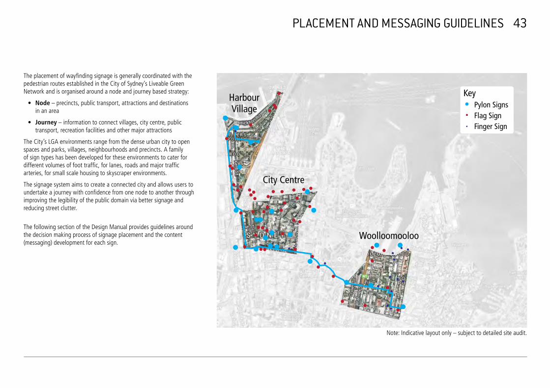
The placement of wayfinding signage is generally coordinated with the pedestrian routes established in the City of Sydney’s Liveable Green Network and is organised around a node and journey based strategy:
• Node – precincts, public transport, attractions and destinationsin an area
• Journey – information to connect villages, city centre, public transport, recreation facilities and other major attractions
The City’s LGA environments range from the dense urban city to open spaces and parks, villages, neighbourhoods and precincts. A family of sign types has been developed for these environments to cater for different volumes of foot traffic, for lanes, roads and major traffic arteries, for small scale housing to skyscraper environments.
The signage system aims to create a connected city and allows users to undertake a journey with confidence from one node to another through improving the legibility of the public domain via better signage and reducing street clutter.
The following section of the Design Manual provides guidelines around the decision making process of signage placement and the content (messaging) development for each sign.
Harbour Village
City Centre
Woolloomooloo
Key Pylon Signs Flag Sign Finger Sign
Note: Indicative layout only – subject to detailed site audit.

Step 1On Site Audit &Detail Placement
Step 2DocumentationSets
High LevelDesktop Review
1
Detail LevelReview andDocumentation
2
OUTCOME 1 DRAFT PLACEMENT SCHEME
OUTCOME 2 FINAL PLACEMENT SCHEME AND DOCUMENTATION SET
The signage placement process is structured in two parts:
• A high level desktop review of the relevant area
• and an in-depth on site audit for each sign location.
The following describes this process step by step as shown on the placement process graphic. (Refer to Figure A)
Desktop Review
A number of considerations need to inform the placement of signage and signage type selection. This includes destinations, pedestrian routes, transport hubs and transport routes, decision points, arrival points, thresholds, topographical changes and more.
The high level review for signage placement aims to consolidate readily available data and local knowledge to create a first draft placement scheme.
The following steps are to be applied:
Step 1 – Data Collection and Layering
Step 2 – Filtering
Step 3 – Draft Placement Scheme
PLACEMENT GUIDELINES - DESKTOP REVIEW 44
Step 1 Data Collection & Layering
Step 2 Filtering
Step 3 Draft Placement Scheme
Destinations
Pedestrian Routes
Transport Hubs & Routes
Decision Points
Figure A - Desktop Review

45
PLACEMENT GUIDELINES - DATA COLLECTION AND LAYERING
Step 1 - Data Collection and Layering
Through the identification of what people are looking for and how people are getting to their destinations, three data layer maps can be created: Destinations, pedestrian routes, transport hubs and transport routes.
Destinations
This data layer identifies the places in an area that people are looking for.
It is to show all relevant destinations in an area while a differentiation between main destinations and local destinations is maintained. Destinations can be buildings, institutions, parks or waterfront locations as well as major streets or hubs with a high level of activity. The Wayfinding Destination Schedule (Appendix 1) provides a complete list of all destinations for each village in the local government area.
Pedestrian Routes
This data layer identifies how people are getting to their destinations on foot.
The City’s Liveable Green Network (LGN) pedestrian routes form the basis for this layer and help to establish a route hierarchy.
Primary routes are the main activity routes and connect the citywide pedestrian network. Primary routes offer good accessibility (gentle topography), visual legibility, natural surveillance, good lighting and access to public transport. Primary routes are predominantly well understood access routes for walking and public transport between areas.
Secondary routes connect local destinations, such as parks, schools and community centres. They can link single attractions or destinations to the primary route network and should only be encouraged as a route if they are safe, well-lit and accessible. They may provide a short cut between two locations or destinations via stairs, laneways or small streets. Secondary routes have also been identified as those that offer less direct but quieter or scenic connections between areas or attractions e.g. foreshore route between The Rocks and Walsh Bay.
A number of well used recreational, foreshore and parkland routes that have a high scenic value and can be used as alternative routes for some journeys, avoiding steep rises, stairs or restricted access areas are also included in the secondary route selection.
The City Centre area has a more complex and networked arrangement of streets, pathways and preferred pedestrian routes. These routes include malls, underground train station concourses, footbridges, shopping arcades, street closures, parks, squares and laneways. Routes in the City Centre are more diverse and driven by a high number of arrival points, transport modes and a density of destinations, and often carry peak loads of pedestrians during morning and evening periods.
Transport Hubs & Routes
This data layer identifies how people are getting to their destinations by public transport.
It shows all major on-road public transport routes (bus and light rail) and the most frequently used stops. Train stations and ferry wharfs are the busiest nodes, followed by bus interchange locations like Wynyard, Circular Quay and Railway Square. Buses and light rail provide a less concentrated distribution of arrivals with more stops located closer together.
After the preparation of the three data layer maps the gathered information is to be overlayed to create one map showing all information and highlighting the opportunities for decision points and possible signage locations in the following steps.
46
PLACEMENT GUIDELINES - FILTERING
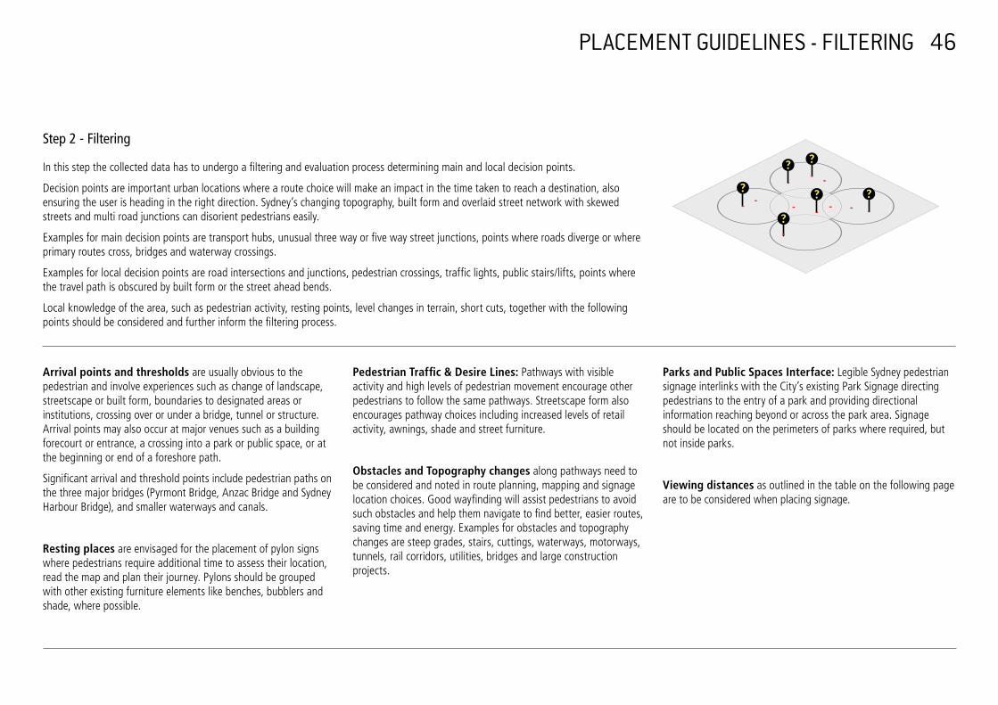
Step 2 - Filtering
In this step the collected data has to undergo a filtering and evaluation process determining main and local decision points.
Decision points are important urban locations where a route choice will make an impact in the time taken to reach a destination, also ensuring the user is heading in the right direction. Sydney’s changing topography, built form and overlaid street network with skewed streets and multi road junctions can disorient pedestrians easily.
Examples for main decision points are transport hubs, unusual three way or five way street junctions, points where roads diverge or where primary routes cross, bridges and waterway crossings.
Examples for local decision points are road intersections and junctions, pedestrian crossings, traffic lights, public stairs/lifts, points where the travel path is obscured by built form or the street ahead bends.
Local knowledge of the area, such as pedestrian activity, resting points, level changes in terrain, short cuts, together with the following points should be considered and further inform the filtering process.
Arrival points and thresholds are usually obvious to the pedestrian and involve experiences such as change of landscape, streetscape or built form, boundaries to designated areas or institutions, crossing over or under a bridge, tunnel or structure. Arrival points may also occur at major venues such as a building forecourt or entrance, a crossing into a park or public space, or at the beginning or end of a foreshore path.
Significant arrival and threshold points include pedestrian paths on the three major bridges (Pyrmont Bridge, Anzac Bridge and Sydney Harbour Bridge), and smaller waterways and canals.
Resting places are envisaged for the placement of pylon signs where pedestrians require additional time to assess their location, read the map and plan their journey. Pylons should be grouped with other existing furniture elements like benches, bubblers and shade, where possible.
Pedestrian Traffic & Desire Lines: Pathways with visible activity and high levels of pedestrian movement encourage other pedestrians to follow the same pathways. Streetscape form also encourages pathway choices including increased levels of retail activity, awnings, shade and street furniture.
Obstacles and Topography changes along pathways need to be considered and noted in route planning, mapping and signage location choices. Good wayfinding will assist pedestrians to avoid such obstacles and help them navigate to find better, easier routes, saving time and energy. Examples for obstacles and topography changes are steep grades, stairs, cuttings, waterways, motorways, tunnels, rail corridors, utilities, bridges and large construction projects.
Parks and Public Spaces Interface: Legible Sydney pedestrian signage interlinks with the City’s existing Park Signage directing pedestrians to the entry of a park and providing directional information reaching beyond or across the park area. Signage should be located on the perimeters of parks where required, but not inside parks.
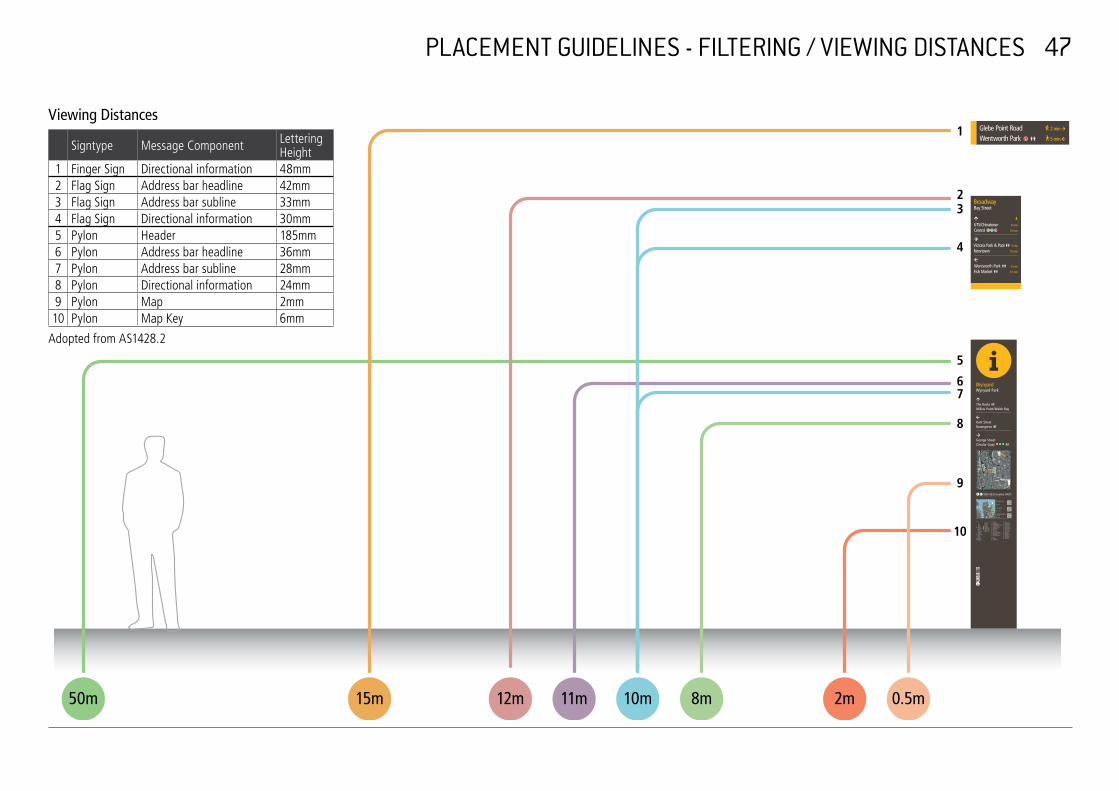
Viewing distances as outlined in the table on the following page are to be considered when placing signage.
PLACEMENT GUIDELINES - FILTERING / VIEWING DISTANCES 47
Viewing Distances
Signtype Message Component
1 Finger Sign Directional information 2 Flag Sign Address bar headline 3 Flag Sign Address bar subline 4 Flag Sign Directional information 5 Pylon Header 6 Pylon Address bar headline 7 Pylon Address bar subline 8 Pylon Directional information 9 Pylon Map 10 Pylon Map Key
Adopted from AS1428.2
Lettering Height 48mm 42mm 33mm 30mm 185mm 36mm 28mm 24mm 2mm 6mm
1
2 3
4
5
6 7
8
9
10
50m 15m 12m 11m 10m 8m 2m 0.5m

48 PLACEMENT GUIDELINES - DRAFT PLACEMENT SCHEME
Step 3 - Draft Placement Scheme
As the last step of the desktop review is the preparation of a Draft Placement Scheme, which determines potential sign locations and sign types forming the basis for the on-site audits.
In general, Pylon Signs should be only used in strategic nodal locations, such as main decision points along the primary routes where links to neighbouring areas and a larger context of the area is required by users.
Pylon Signs will be used at train stations, ferry wharfs and light rail stops. They should be located near entrances and exits, in particular areas of high egress that have clear lines of sight and access around them. Flag signs can be considered if the arrival point is at a bus stop along a primary route or directing to secondary routes. These are important locations as they are often a user’s first introduction to the transport system and wayfinding system that provides the foundation for an integrated multi modal transport experience.
Only car parking stations noted in the Destination Schedule (Appendix 1) are to be included for assessment of signage requirements.
Flag Signs should be used for mid-journey assurance along primary and secondary routes or in locations where pylon placement is restricted.
Finger Signs will be used in specific locations for directing pedestrians to a nearby attraction, local destination or where a change of direction from the route is required.
A desktop analysis of proposed pylon sign locations utilising online resources (NearMap, Google Earth, StreetView etc.) is recommended at this stage.
Once the high level desktop review is completed, the prepared Draft Placement Scheme needs to be verified on site.

PLACEMENT GUIDELINES - ON SITE AUDIT 49
On Site Audit and Detail Placement
A thorough site audit needs to be undertaken to verify the placement scheme and signage numbers while aiming to reduce and consolidate any existing signage. Signage and street clutter reduction are also part of this process.
The audit is to include a full photographic documentation for each proposed sign location, whilst taking into account flow of traffic, built environment, sightlines and visibility, distance between signs to create assurance of the route, space available for new signs and existing signs.
The following key principles for placement and orientation of Pylon, Flag and Finger signs have to be considered during the on-site audits:
• Signage addresses primary pedestrian traffic routes
• Signage addresses secondary pedestrian traffic routes where appropriate
• Signs (Pylons, Flag & Finger Signs) are typically located diagonally across the intersection from each other
ROAD FOOTPATH
BUIL
DIN
G L
INE
BUIL
DIN
G L
INE
FOOTPATH
Street Furniture
Alignment
Narrower Wider Path Path
Primary Traffic Primary Signage
Secondary Traffic Secondary SignagePylon Locations
Minimum 1200 mmclear width
Minimum1500 mm
clear width
Pole MountedBike Rack
BenchSeat
Minimum1500 mm
clear width
BUIL
DIN
G L
INE
BUIL
DIN
G L
INE
ROAD
BUIL
DIN
G L
INE
ROAD
ROAD
Building and roadoffsets
Wall mounted optionwhere space is limited
600 mm fromkerb edge
Kerbedge
Restrictedclear width
600 mm fromkerb edge
Minimum 1200 mmclear width
Minimum1500 mm
clear width
Minimum1500 mm
clear width
BUIL
DIN
G L
INE
BUIL
DIN
G L
INE
ROAD
BUIL
DIN
G L
INE
ROAD
ROAD
Building and roadoffsets
Wall mounted optionwhere space is limited
Wheelchaircirculation and streetfurniture offsets
600 mm fromkerb edge
Kerbedge
Restrictedclear width
600 mm fromkerb edge
Minimum 1200 mmclear width
Minimum1500 mm
clear width
Pole MountedBike Rack
BenchSeat
Minimum1500 mm
clear width
Minimum1500 mm
clear width
Minimum1500 mm
clear width
BUIL
DIN
G L
INE
BUIL
DIN
G L
INE
ROAD
BUIL
DIN
G L
INE
ROAD
ROAD
Wall mounted optionwhere space is limited
Wheelchaircirculation and streetfurniture offsets
Kerbedge
Restrictedclear width
600 mm fromkerb edge
600 mm fromkerb edge
Minimum 1200 mmclear width
PLACEMENT GUIDELINES - ON SITE AUDIT 50
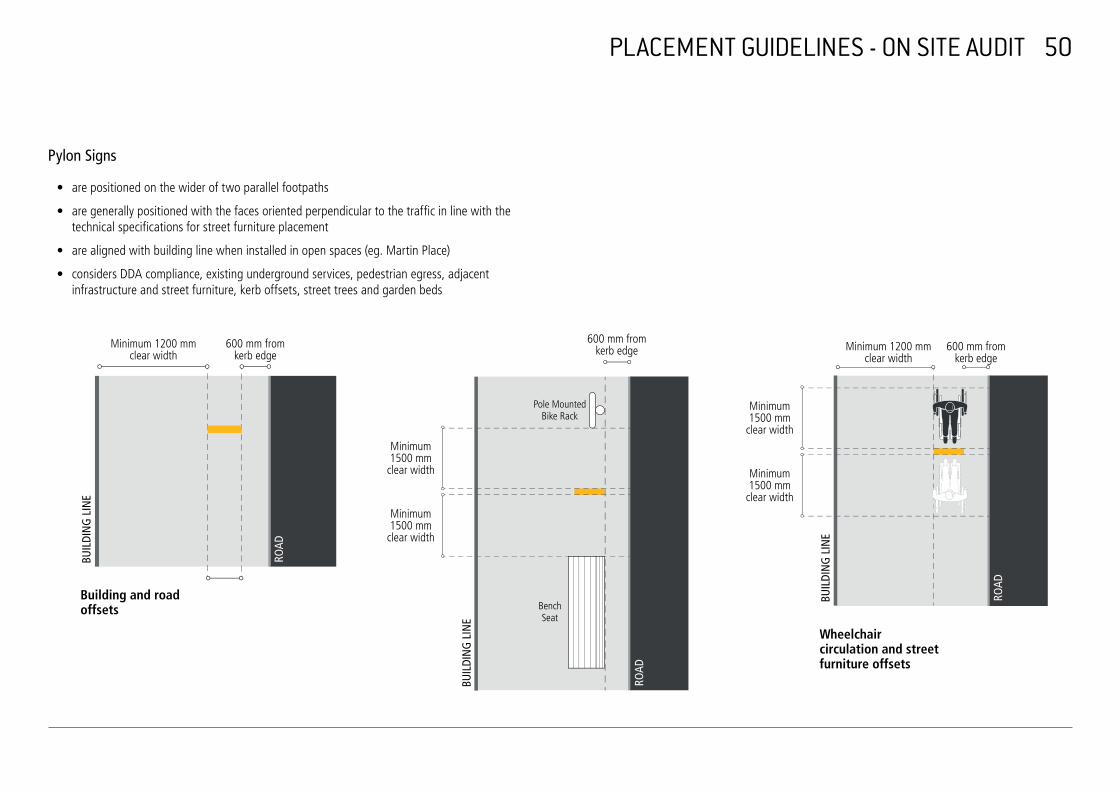
Pylon Signs
• are positioned on the wider of two parallel footpaths
• are generally positioned with the faces oriented perpendicular to the traffic in line with the technical specifications for street furniture placement
• are aligned with building line when installed in open spaces (eg. Martin Place)
• considers DDA compliance, existing underground services, pedestrian egress, adjacent infrastructure and street furniture, kerb offsets, street trees and garden beds
Minimum 1200 mm clear width
600 mm from kerb edge
600 mm from kerb edge Minimum 1200 mm
clear width 600 mm from
kerb edge
Minimum 1500 mm
clear width
Pole Mounted Bike Rack
Minimum 1500 mm
clear width
Minimum 1500 mm
BUIL
DIN
G L
INE
ROAD
clear width Minimum 1500 mm
clear width
BUIL
DIN
G L
INE
ROAD
Building and road Benchoffsets Seat
Wheelchair circulation and street
BUIL
DIN
G L
INE
ROAD
furniture offsets
PLACEMENT GUIDELINES - ON SITE AUDIT 51
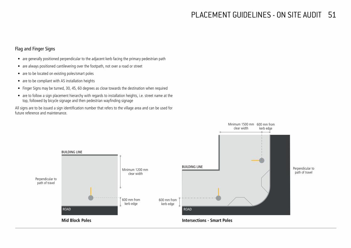
Flag and Finger Signs
• are generally positioned perpendicular to the adjacent kerb facing the primary pedestrian path
• are always positioned cantilevering over the footpath, not over a road or street
• are to be located on existing poles/smart poles
• are to be compliant with AS installation heights
• Finger Signs may be turned, 30, 45, 60 degrees as close towards the destination when required
• are to follow a sign placement hierarchy with regards to installation heights, i.e. street name at the top, followed by bicycle signage and then pedestrian wayfinding signage
All signs are to be issued a sign identification number that refers to the village area and can be used for future reference and maintenance.
Minimum 1500 mm 600 mm from clear width kerb edge
BUILDING LINE
ROAD
Perpendicular to Minimum 1200 mm path of travel clear width
Perpendicular to path of travel
600 mm from 600 mm from kerb edge kerb edge
Mid Block Poles
BUILDING LINE
ROAD
Intersections Smart Poles
52
PLACEMENT GUIDELINES - CLUTTER REDUCTION
Signage and Street Clutter Reduction
While assessing and evaluating placement for new signage, it is crucial to reduce and consolidate any existing signage. All signage proposed for removal or consolidation is to be documented and subject to approval by the City.
The following environments and signage types are to be considered:
Redundant Signs
Any signage with redundant or outdated content is to be documented for removal. This includes the following examples:
Signage installed by former councils (Leichardt, South Sydney), outdated signage (i.e. Sydney Olympics, temporary signage), unauthorized commercial signage, signage that does not comply with the City’s signage code
Consolidation of Signs
Some older signage may be incorporated and consolidated into new Legible Sydney signage. Doubling up of signage is unnecessary and reduces clarity of the wayfinding system.
Signage to be consolidated into new Legible Sydney signage includes local destinations, transport information, community facilities
Temporary Signs
Temporary signage is used for large events such as New Year’s Eve, large sporting or community events. This signage should not replace wayfinding signage and should be managed and removed after the event as soon as possible.
Street Furniture
Wayfinding signage should consider nearby street furniture locations, such as bus stops, telephone booths and kiosks. It should not obstruct sightlines to advertising panels or transport information such as bus stop signs both to the motorist or pedestrian. In general signage locations should be in alignment with street furniture set out lines as specified in the City’s technical specifications (ref) wherever possible.
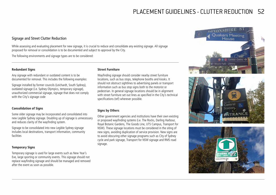
Signs by Others
Other government agencies and institutions have their own existing or proposed wayfinding systems (i.e. The Rocks, Darling Harbour, Royal Botanic Gardens, The Goods Line, UTS Campus, Transport for NSW). These signage locations must be considered in the siting of new signs, avoiding duplication of service provision. New signs are to avoid obscuring other signage programs such as City of Sydney cycle and park signage, Transport for NSW signage and RMS road signage.
53 MESSAGING GUIDELINES - PLACE NAMING
The following principles set out a methodology to rationalise and prioritise signage content. This process should also be informed by the placement guidelines and the pedestrian routes developed therein.
1. Place Naming and Destination Schedule
Place naming is critical for the wayfinding system, which shares an environment with other signage tools, such as websites, downloadable applications, printed maps and guides. The convention for place naming is based on a coordinated effort between the City of Sydney and stakeholders.
To simplify the signage content selection a Wayfinding Destination Schedule has been developed as part of this Design Manual (refer to Appendix 3). It comprises a complete list of suburbs, areas, precincts and main and local destinations for the local government area, which were selected in accordance with the messaging guidelines of the City’s Signage Code.
When a location for a sign is proposed the Wayfinding Destination Schedule together with the mapped out destination data layer will refer the author to a selection of possible destinations and facilities for the sign content. Using this system will embody the larger system with a consistent and cohesive information nomenclature.
The following destination types are listed in the Destination Schedule: Areas, Suburbs and Precincts; Main Destinations and Local Destinations.
Areas, Suburbs and Precincts
Areas and suburbs are defined by postcode areas.
Next to the postcode areas precinct names are often also used to give more precise locational information. These precincts are a combination of historical place names, geographic place names and/or transport related names such as nearby train stations.
The Destination Schedule lists all postcode areas and commonly known precincts for each village, such as the Rocks, Chinatown, Barangaroo, Circular Quay, Surry Hills, Newtown, etc.
In some instances precinct names are identified through streets, buildings, transport hubs, water or parks. These are listed in the main destination section of the schedule under their relevant classification. Examples are Walsh Bay, Botanic Gardens, Hyde Park, QVB, Town Hall, George Street, Wynyard etc.
The term City Centre is to be used for directional messaging only and is not considered an address (refer to B2). Terms like City South, City North Sydney CBD etc are not to be used.
54
MESSAGING GUIDELINES - PLACE NAMING
Main Destinations
Main destinations are the key destinations in any given area. These may be tourist and visitor attractions, public transport nodes, public open spaces, retail and hospitality areas as well as major public service and cultural institutions.
The Destination Schedule divides these ‘main destinations’ in the following sections:
Streets, Squares and Plazas - Includes all high streets, village main streets and activity hubs, main plazas, public open spaces and squares in an area.
‘Sustainable Sydney 2030’ is focussed around ten villages and main streets that form the nucleus of community, commercial and pedestrian activity outside the city centre. These hubs form the primary wayfinding patterns for the LGA outside the city centre. In general these activity hubs are located on high streets and form linear spines that link to transport, shops and local destinations.
Examples for high streets and activity hubs are Crown Street, Glebe Point Road, Green Square, Harris Street, King Street and Oxford Street.
Public Transport - Includes all key arrival hubs for train, bus, ferry and light rail.
Parks and Waters - Includes all parks and waters such as bays, coves etc. Examples for parks and water are Hyde Park, Botanical Gardens, Cockle Bay etc.
Landmarks, Buildings and Institutions - Includes all main landmark buildings as well as all institutions and buildings that represent major tourist and visitor destinations. Examples for this classification are Sydney Opera House, Sydney Harbour Bridge, Sydney Tower, Queen Victoria Building (QVB), Australian Museum, Art Gallery of NSW, Prince Alfred Park Pool, etc.
Local Destinations
Local destinations include any landmarks, buildings and institutions that do not fall into the main destination classification, but are important on a local level. This includes local community and service venues such as community and neighbourhood centres, libraries, schools and education facilities, places of worship, hospitals, parking, police, fire stations, parking, post offices.
Most of these local destinations are shown on the wayfinding map only. In some situations it may be required to direct people to unique local destinations. In general these destinations should be restricted to Finger Signs only, and to destinations that are obscured or located in harder to find places (laneways, access via a set of stairs or lift etc).
Destinations outside the local government area are also included in the Destination Schedule if they are useful to the broader wayfinding and orientation of the user.
Place names/destinations can be shortened if required. The Destination Schedule provides acceptable abbreviations of names.
LEGIBLE SYDNEY WAYFINDING SIGNAGE - DESTINATION SCHEDULE
Revision A - 29/05/2015 Dual Naming application added LEGEND Revision B - 05/06/2015 Added local destination column for secondary public spaces, removed Powerhouse Museum from HRS-04, delete Lance Kindergarten and Rosebury Child Care, remove outside village area
Object gallery and other changes as shown red Revision C - 18/06/2015 Rosebury Comm. Centre removed, replaced Devonshire St (L) with Surry Hills (L) TBC
Revision D - 30/06/2015 Removed AWA Tower, Transport House, the Gaelic Club, removed/added some dual naming, ermoved Sydney Secondary College Dual naming application
Revision F - 10/08/2015 Main 'spine' streets turned bold for adressing, abbreviations added, Public toilets (WC) added Revision G - 21/09/2015 Main 'spine' streets turned bold for adressing, abbreviations added, miscellaneous corrections, taxi pictos added Revision H - 19/11/2015 Royal Botanic Gardens' (plural) changed to 'Royal Botanic Garden' (singular) plus changes as highlighted in red
VILLAGE AREA/SUBURB/ PRECINCT
01 - HARBOUR VILLAGE HBR-01 The Rocks (WC)
HBR-01 Millers Point
HBR-01
HBR-01 Barangaroo
HBR-01 City Centre
HBR-01 Walsh Bay
HBR-01 Dawes Point / Tar-Ra
HBR-01 Milsons Point HBR-01 North Sydney
HBR-02 City Centre
HBR-02 Circular Quay (WC)
HBR-02
HBR-02 HBR-02 HBR-02 HBR-02 HBR-03 City Centre
HBR-03 HBR-03
HBR-03 HBR-03 HBR-03 HBR-03 HBR-03 HBR-03 HBR-04 City Centre
HBR-04
HBR-04 HBR-04 HBR-04 HBR-05 Barangaroo
HBR-05 Darling Harbour / Tumbalong (WC)
HBR-05 HBR-05 HBR-05 HBR-05 HBR-05 HBR-05 HBR-06 Royal Botanic Garden (WC)
HBR-06 The Domain (WC)
HBR-06
HBR-06 HBR-06
STREETS, SQUARES, PLAZAS PUBLIC TRANSPORT
George Street
Argyle Street
Hickson Road
Windmill Street
Lower Fort Street
Hungry Mile
Hungry Mile Circular Quay (T, B, F, L) (WC)
Chifley Square (Taxi), corner Hunter and Phillip) George Street
Macquarie Street (Taxi)
Bridge Street Bent Street Pitt Street (Taxi, Martin Pl) George Street Martin Place (T, B) (WC)
Macquarie Street (Taxi) Grosvenor St (L) Market Street
Martin Place (WC) Castlereagh Street
Pitt Street (Taxi, Martin Pl) Elizabeth Street Phillip Street Angel Place
George Street Wynyard (T, B) (WC)
Clarence Street Elizabeth St (B)
York Street Philip St (B) Sussex Street Kent Street
Hickson Road Barangaroo (F)
Mercantile Walk King Street Wharf (F)
Shipwright Walk Barangaroo Avenue Sussex Street Exchange Place Lime Street King Street
Macquarie Street (Taxi)
Art Gallery Road
Mrs Macquaries Road
Shakespeare Place
MAIN DESTINATIONS PARKS + WATERS LANDMARKS, BUILDINGS,
INSTITUTIONS OTHER PUBLIC SPACES, SQUARES AND PARKS
COMMUNITY CENTRES, LIBRARIES
Observatory Hill (WC) Roslyn Packer Theatre Hickson Road Reserve Abraham Mott Hall
Dawes Point Park Harbour Bridge The Paddock Harry Jensen Centre
Campbell’s Cove / Meeliyahwool
Sydney Observatory Argyle Place Park
Museum of Contemporary Art Munn St Reserve
Overseas Passenger Terminal Clyne Reserve
Pier 2/3 Bennelong Point / Dubbagallee
Wharf 4/5 Wharf Theatre
Mrs Macquarie's Chair / Yurong
Cahill Walk Lang Park (WC) Harbour Bridge Walk Barney and Bligh Reserve
Sydney Cove / Warrane Sydney Opera House Jesse Street Gardens
First Fleet Park Museum of Sydney Macquarie Place Park
Customs House (Library) (WC)
Hyde Park (WC) Sydney Tower
Pitt St Mall (WC) City Recital Hall
Wynyard Park (WC)
Barangaroo Reserve (WC) Sealife Sydney Aquarium
Nawi Cove Barangaroo Cultural Centre (name TBC)
Royal Botanic Garden (WC) Art Gallery of NSW
The Domain State Library
Farm Cove / Wahganmuggalee (Andrew ) Boy Charlton Pool
Government House Sydney Hyde Park Barracks
LOCAL DESTINATIONS CHILDCARE CENTRES, PRIMARY, SECONDARY SCHOOLS + TERTIARY EDUCATION
PLACES OF WORSHIP
Fort Street Public School St Brigid’s Church
Julian Ashton Art School Holy Trinity Church
St Patrick’s Church
St Philip’s Church
Macquarie School of Management UNSW CBD Campus
Southern Cross University
St Stephen’s Church
Macquarie University Scots Church
Melbourne Institute of Technology
LANDMARKS MUSEUMS, THEATRES, CINEMAS, CULTURAL
OTHER LANDMARKS, BUILDINGS, INSTITUTIONS, HOSPITALS
PARKING, POLICE, FIRE STATIONS, POST OFFICES, INFORMATION CENTRES
3D LANDMARKS
National Trust Centre King George V Recreation Centre
Police Station -132 George Fingerwharfs Walsh Bay -3D
Susannah Place Museum Cadman’s Cottage Sydney Visitor Centre (Info Centre)
Harbour Bridge -3D
The Rocks Discovery Museum
Bridgeclimb Fire Station - Kent St Holy Trinity Church -3D
S.H.Ervin Gallery Harbour Bridge Museum and Pylon Lookout
Museum of Contemporary Art -3D
Walsh Bay (Cultural Precinct)
Foreshore Walk' Grosvenor Place -3D
Campbells Stores
Dawes Point Battery Archeological site
Justice and Police Museum Cahill Walk (Harbour Bridge Walk)
Opera House Parking Sydney Opera House -3D
Dendy Opera Quays Cinema
Circular Quay Info Centre Sydney Cove Building -3D
Post Office - Australia Square Wintergarden Plaza -3D
Post Office - Pitt St Chifley Tower -3D MLC Centre -3D Sydney Tower -3D
Museum of Australian Currency Notes
Supreme Court of NSW Post Office - Martin Place
Reserve Bank of Australia Mid City Theatre Royal Westfield Sydney Central
Plaza David Jones
Service Centre NSW, 19 York St
Wildlife Sydney Zoo
Madame Tussauds
Lucy Osborn-Nightingale Museum
Sydney Conservatorium of Music
The Domain Carpark Art Gallery of NSW -3D
Sydney Hospital and Sydney Eye Hospital (WC)
Post Office - Sydney Parliament House
NSW Parliament House
Mrs Macquaries Chair Fleet Steps
Dual Naming
The Destination Schedule shows all applicable aboriginal name conventions as recognised by the Geographical Names Board.
Page 1 of 6

MESSAGING GUIDELINES - PLACE NAMING 55
Hierarchy of messages
The Destination Schedule provides all relevant destinations to be used for the wayfinding map as well as for all messaging. The following diagram together with the destination schedule assists with the level of hierarchy to be applied when choosing directional messages for a sign.
Area / Suburb / Precinct Main Destinations Local Destinations Streets, Public Parks & Landmarks,
Maps Squares, Plazas Transport Waters Buildings & Institutions
Overview Map
Detail Map
Pylon and Flag Signs
Address Bar Headline
Address Bar Subline
Directional Information
Finger Signs

MESSAGING GUIDELINES - ADDRESSING 56
The overarching approach in messaging is simplicity and clarity. Reduced text volumes minimise time spent reading and analysing the information on offer.
Different signs types have different messaging requirements:
• Pylon and Flag Signs provide information on the viewer’s location (Address Bar) as well as directional information while Finger Signs generally only carry one or two destinations.
• Flag and Finger Signs include the walking time to shown destinations in minutes while the Pylon Signs provide walking distances via provided maps and walking distance circles.
Address Bar — Pylon and Flag Signs
The address bar on top of the Pylon and Flag signs provides the user with information on their current location. It consists of a combination of two lines:
The Address Bar Headline is to nominate the area, suburb or precinct name of the sign location as listed in the Destination Schedule (Appendix 1). This could also be a main activity/high street or transport node as per the precinct definitions. Examples are George Street, Harris Street, Oxford Street, Wynyard, Museum, etc.
The Address Bar Subline provides information on the local place name. This could be again an area, suburb or precinct name, but also a street, building or main destination. Along main activity streets this will be the cross street of the intersection or any main destination that the sign is located at.
The content combination of the address bar can vary depending on the sign location. The following examples show a number of possible addressing options.
Note: The generic ‘City Centre’ area is never to be used in the address bar of a sign.
York Street Wynyard
Sussex Street Chinatown
Bourke Street Waterloo
Town Hall George Street
Transport node Precinct High Street Suburb
57
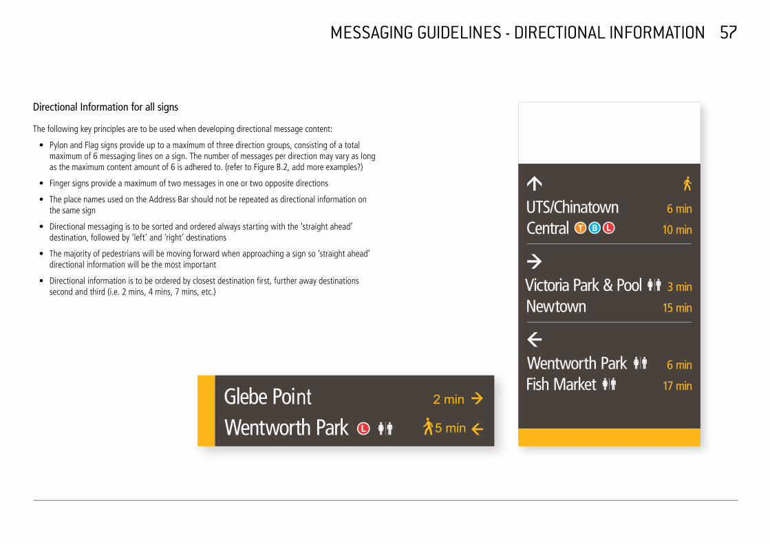
MESSAGING GUIDELINES - DIRECTIONAL INFORMATION
Directional Information for all signs
The following key principles are to be used when developing directional message content:
• Pylon and Flag signs provide up to a maximum of three direction groups, consisting of a totalmaximum of 6 messaging lines on a sign. The number of messages per direction may vary as longas the maximum content amount of 6 is adhered to. (refer to Figure B.2, add more examples?)
• Finger signs provide a maximum of two messages in one or two opposite directions
• The place names used on the Address Bar should not be repeated as directional information onthe same sign
• Directional messaging is to be sorted and ordered always starting with the ‘straight ahead’ destination, followed by ‘left’ and ‘right’ destinations
• The majority of pedestrians will be moving forward when approaching a sign so ‘straight ahead’directional information will be the most important
• Directional information is to be ordered by closest destination first, further away destinations second and third (i.e. 2 mins, 4 mins, 7 mins, etc.)
nt 2 min
5 min

PADDY'SMARKETS
LIBRARY(THE TOTE)
FERNSIDESKATE PARK
YOUTH CENTRE
JOYNTONPARK
LIBRARY(FUTURE)
SCHOOL/
ES MARKS FIELD
CHINESEOF
KOREANCULTURALCENTRE
SCEGGSDARLINGHURST
CHURCH
ST JOHN'S CHURCH
C3 CHURCH
CENTRALCOURTHOUSE WHITLAM
SQUARE
FIVE WAYS
REDFERN
SERVICE
ABORIGINALMEDICAL
CORONATIONCENTRE
COURTS
TENNIS
ULTIMO
SUSSEX STR
EET
CAS
TLER
EAG
H S
TREE
T BAYSWATER ROADSTANLEY STREET
REDFERN
MCEVOY STREET
Main Destinations
Local Destinations
Main Activity Spine
Commercial/ Civic Precincts
07 CROWN STREET VILLAGESTEP 1 – DATA COLLECTIONDESTINATIONS
T
OF SONRY
FAMILY COURT
STR
EET
RIL
EY
STR
EET
CR
OW
N
BOU
RKE
STR
EET
STREET
FOVEAUX
BOU
RKE
STR
EET
STR
EET
ELIZ
ABET
H
PARAD
E
ANZAC STREET
BELVOIR
STREET
CLEVELAND
STR
EET
RIL
EY
STR
EET
ELIZ
ABET
H
AVENUE
STR
EET
STREET CLEVELAND
STREET
CAMPBELL
STR
EET
CR
OW
N
EDDY
STR
EET
PITT
ROAD
GEO
RG
E ST
REE
T
GEO
RG
E ST
REE
T
DIXO
N STR
EET
GOULBURN STREE
DARL
ING
HURS
T RO
AD
VIC
TOR
IA S
TREE
T
LIVERPOOL STREET
LIVERPOOL STREET
BOUNDARY STREET
GLENMORE R
OAD
OXFORD STREET
MOORE PARK ROAD
OXFORD STREET
DANKS STREET
BAPT
IST
SOU
TH D
OW
LIN
G S
TREE
T
ANZAC
PARAD
E
STREET
11,,000000mm
880000mm
660000mm
440000mm
200m200m
MESSAGING GUIDELINES - MESSAGING HIERARCHY 58
Catchment Areas and Messaging Hierarchy GARDEN FRIENDSHIP
LOCAL COURT DOWNING CENTRE/ CIVIL CHURCH OFWORLD
CHRIST SCIENTISTCLAIMS COURT SALVATION
MUSEUM
SQUARE
ARMY ALBERT SLOSS DARLINGHURSTFREEMA
PUBLIC SCHOOLRESERVEThe selection of sign addresses and directional information is also based on the catchment area of the sign.
CENTRAL MARTIN EAST SYDNEYBAPTIST CHURCH
CHINATOWN
LUTHER COMMUNITYKIRCHE ETERNITY AND ARTS CENTREOXFORD JEWISHPLAYHOUSESQUARE MUSEUM GARVANGOLDEN AGEST PETER INSTITUTECINEMA GREENNATIONAL ARTJULIAN'S
PARKSCHOOLCHURCH HARMONYCAPITOL HAYMARKET PARKTHEATRE LIBRARYCatchment areas between 100m to 1000m can be applied depending on the sign location.
ST VINCENT'S HOSPITALDARLINGHURST
COURT UNI. TASMANIASACRED4A CENTRE HEART HOSPICE
TAYLOR UNI. OF LACROZIA PARK
The combination of messages in each direction group can vary with regards to distance and destination SQUARE NOTRE DAME BARCOM AVENUE SERVICE PARKSACRED HEART
CHURCHCENTRE NSWTRINITY
type depending on the sign location and destination hierarchy, however a combination of a nearby BELMORELUTHERAN CROWN STPARKCHURCH SURRY HILLS MOSQUE
PUBLIC SCHOOL CHRIST CHURCH ST LAURENCEdestination (1-5min) and a further away destination (6-10/15min) providing a broader orientation is VERONA
CINEMAFROG HOLLOW RESERVE preferred. KUDOS
GALLERY RAILWAY SQUARE
CENTRAL STATION CHINESE ST MICHAEL'SUSQ SYDNEY
PRESBYTERIAN CHURCHEDUCATION
SYDNEY DENTALIn dense city centre locations where there is a greater coverage of signage the directional information CHURCHCENTRE UNSW ART & DESIGN
HOSPITAL GALLERIES UNSW
should be weighted towards nearby streets and transport nodes up to 200m distance from the sign location.
PADDINGTON DEPT. TOWN HALL IMMIGRATION VICTORIA LIBRARY
SURRY HILLS SHANNON BARRACKS CHAUVEL CINEMACOMMUNITY RESERVE RESERVOIRCENTRE & LIBRARY GARDENS CENTRE FORTHE GAELIC CLUB
PHOTOGRAPHY
PADDINGTON UNITING
TOM MANN THEATRE THE GIRLS &
COURTS BOYS BRIGADE PADDINGTON PUBLIC MARKETSBASKETBALL
PRINCE ALFRED PARK & POOL
BRETT WHITELEYBELVOIR ST
MOORE PARK SYDNEY FOOTBALL STADIUM
WARD STUDIOBAPTIST CHURCH PARK
CLEVELAND ST INTENSIVE ST PETER'SBELVOIR ENGLISH HIGH SCHOOL THEATRE CHURCH
ALBERT TIBBY COTTER BRIDGE
SYDNEY CRICKET GROUND
MOORE PARK FOX STUDIOS
BOURKE STREET PUBLIC SCHOOL
REDFERN CHILDCARE
NEIGHBOURHOOD CENTRE SYDNEY CENTRE BOYS HIGH
SCHOOLREDFERN ST MAROUN'S
LEGAL CENTRE CATHEDRAL TOWN HALL &
107REDFERN STREET (COS COMMUNITYVENUE)
SERVICE CO-OPERATIVE
SYDNEY GIRLS HIGH SCHOOL HORDERN
PAVILION
ENTERTAINMENT QUARTERYOUNG ST
TOWERSREDFERN PARK
ST SAVIOUR'S CHURCH RON WILLIAMS
CENTRE CENTENNIAL PARKLANDS EQUESTRIAN CENTRE
HILLSONG MOORE PARK GOLFCHURCH
OUR LADYOF ARTBANK MTCARMEL SYDNEY PRIMARY SCHOOL
WATERLOO WATERLOO LIBRARYPARK
CENTENNIAL PARK

59
MESSAGING GUIDELINES - ADDITIONAL INFORMATION
Walking speed and walking distance
The noted walking distance on each sign is based on a 5km/hour walking speed in correspondence with the walking circle on the pylon maps.
Specific guidelines are applied to walking times on finger signs:
• Where a finger sign is placed at the last turn-off to adestination and the distance is 1 minute or less, no timedistance is to be shown, but only the arrow and the walkingman
• Where two destinations in the same direction are signed onlyone arrow is to be shown, but two time distances and twopedestrian symbols
Pictograms and Symbols
The use of a unique pedestrian symbol for the wayfinding system will reinforce and encourage walking as a viable transport option.
This symbol will be used to represent the purpose and audience of the wayfinding system and to identify the average time taken to walk to the messaged direction.
The use of international pictograms and symbols improves message and map legibility, increasing the speed of comprehension of information, services and transport locations.
Pictograms are generally shown in white with two exceptions that are shown in the legible Sydney yellow: Secure super Taxi Ranks and gallery pictograms.
Transport for NSW’s new colour coded wayfinding icon system is to be used on mapping and wayfinding messaging. The following order of transport icons is to be applied where several transport modes are shown:
For destinations that exist as a destination in itself as well as a transport stop location (e.g. Wentworth Park (L), Fish Market (L)) a decision needs to be made on a case by case basis whether the transport pictogram should be added to a place name or not. This depends on walking distance and relevance for the sign location.
Where a number of pictograms are used after a destination the transport icon takes priority, i.e. the transport icon is to be shown before any other pictograms or icons.
In situations where all destinations in one direction are reached via stairs or lift, the stair/lift pictogram is to be shown next to the directional arrow.
Dual Naming
Aboriginal place naming is to be used for all destinations marked as dual naming in the Destination Schedule. Where dual naming is to be used the english and aboriginal names are to be shown in the same font, same font size and next to each other, separated by a slash, e.g. Potts Point / Derrawun, Elizabeth Bay / Gurrajin.
Dual naming is to be shown in the addressing and directional information.
nt Rackson Steps
Barangaroo Reserve

60
DOCUMENTATION
Documentation
After completion of placement and messaging for a sign or an area documentation sets are to be prepared.
These documentation sets are to include final signage location plans for pylon, flag and finger signs, 1:100 site plans for all pylon sites showing the pylon set out, photomontages of all signs including orientation and installation heights for flag and finger signs, signage artworks (incorporating the messaging schedules for all signs) and Braille certification.
This step also includes the selection of the map crops for pylon signage and review and editing of information on the maps.
The developed messaging schedules are to be included in the artwork production and documentation sets.
An excel data spreadsheet including all sign identification numbers, sign types, all addressing and messaging as well as any additional notes and comments is another element of this documentation set. This spreadsheet will be used for inclusion of wayfinding signage in the CAMS system and is required for all future maintenance requirements.


