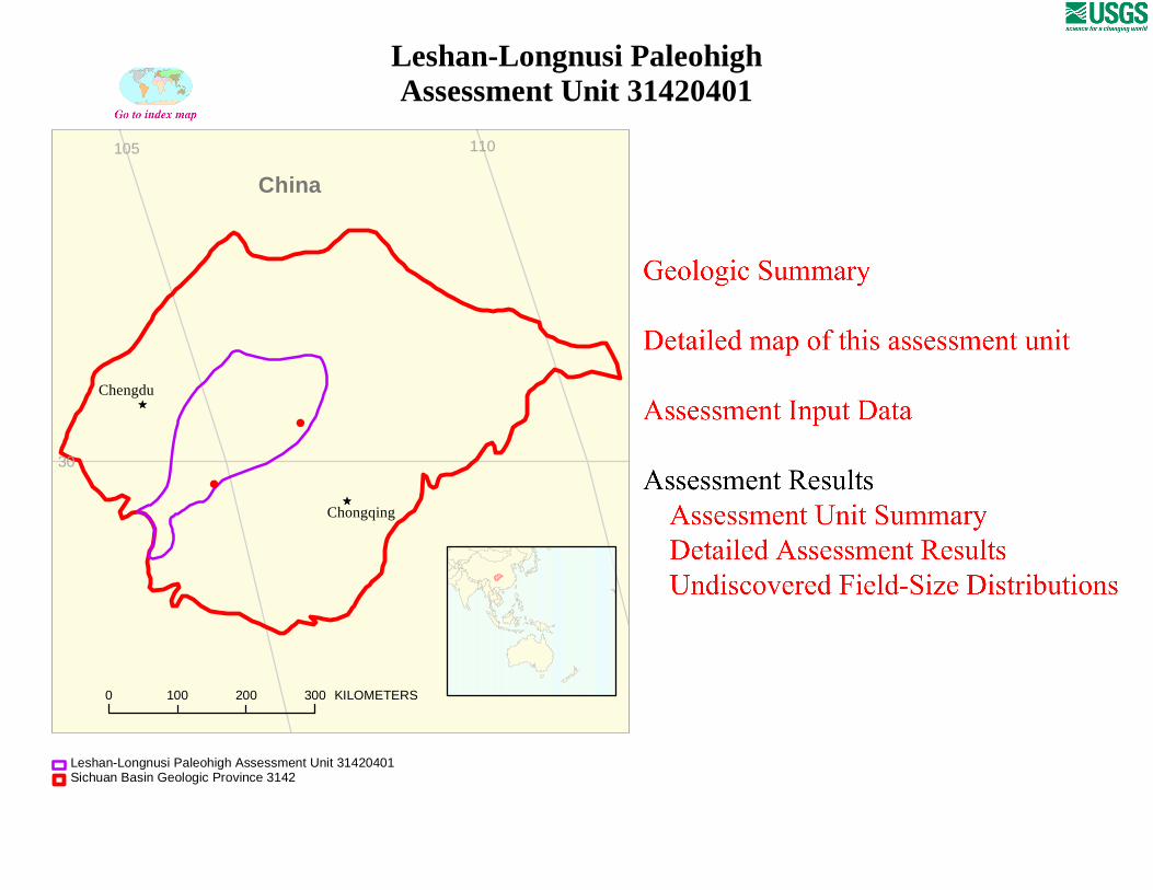
# # Ê Ú Ê Ú Chongqing Chengdu 0 100 200 300 KILOMETERS China 30 110 105 Leshan-Longnusi Paleohigh Assessment Unit 31420401 Sichuan Basin Geologic Province 3142 Leshan-Longnusi Paleohigh Assessment Unit 31420401
Transcript
#
#
ÊÚ
ÊÚChongqing
Chengdu
0 100 200 300 KILOMETERS
China
30
110105
Leshan-Longnusi PaleohighAssessment Unit 31420401
Sichuan Basin Geologic Province 3142Leshan-Longnusi Paleohigh Assessment Unit 31420401
Page 1
USGS PROVINCE: Sichuan Basin (3142) GEOLOGIST: R.T. Ryder TOTAL PETROLEUM SYSTEM: Cambrian/Silurian Marine Shale-Dengying/Lower Paleozoic (314204) ASSESSMENT UNIT: Leshan-Longnusi Paleohigh (31420401) DESCRIPTION: The assessment unit is characterized by structurally controlled gas fields in Sinian, Cambrian, and Ordovician carbonate reservoirs situated on the Leshan-Longnusi paleohigh (LLPH), a Late Silurian to Early Devonian regional uplift that occupies much of the central uplift. In the vicinity of the LLPH, Lower Permian rocks rest unconformably on lower Paleozoic rocks as old as Late Cambrian and as young as Middle Silurian. The gas was derived from a deeply buried pod of mature Cambrian and Silurian source rocks. The gas accumulations are normally pressured and most of them reside at drilling depths of 4 to 7 km. SOURCE ROCKS: The dominant source rocks are marine shelf black shale of Early Cambrian and Early Silurian age. The 100-to 400-m-thick Lower Cambrian source rock sequence rests disconformably on Upper Sinian dolomite reservoirs and extends across most of the LLPH. Total organic carbon (TOC) values range from 0.1 to 2.0 percent and average about 0.7 percent. Lower Silurian graptolitic black shale source rocks thicken from an erosional zero edge around the center of the LLPH to as much as 650 m on the flanks of the LLPH. The TOC values for the Silurian black shale range from 0.5 to 2.0 percent and average about 0.8 percent. Type I and II varieties of kerogen characterize both source rocks. Many Chinese investigators suggest that dolomite in the Upper Sinian Dengying Formation is a major source rock but this seems unlikely judging from the very low TOC values (average~0.1) of the strata. MATURATION: The Cambrian and Silurian source rocks have been mature with respect to gas generation since about the Middle Jurassic. Based on bitumen-filled vugs in reservoirs and reflectance (% Ro max) values of 2.5 to 5 for dispersed organic matter, oil generated from the source rocks has been converted to bitumen and gas. A geothermal gradient of about 20 to 25°C/km probably accompanied oil and gas generation. MIGRATION: Because of an absence of carrier beds, most gas that was generated in the Middle Jurassic to Early Cretaceous remained in or near the source rock until widespread folding and tectonic fracturing occurred during Late Cretaceous (Yenshanian) to early Cenozoic (Himalayan) compression. After this fracturing event, gas either remained in place and filled existing fractures or was involved in limited lateral migration toward the LLPH. Oil had converted to gas before significant migration occurred. RESERVOIR ROCK: The dominant reservoir rock is tidal-flat algal dolomite in the Upper Sinian Dengying Formation. The upper 400 to 500 m of the Dongying Formation has reservoir potential. Reservoir quality of the algal dolomite is generally poor (average porosity of 3.2 percent and average permeability <1 mD). Secondary porosity controlled by intracrystalline pores, dissolution pores and vugs, and open tectonic fractures along crestal zones of anticlines provide the better reservoirs. Dissolution pores and vugs, as well as other reservoir enhancing features such as local karst-related fractures and caverns, are most commonly found where tidal-
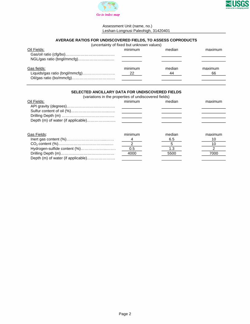
Assessment Unit (name, no.)Leshan-Longnusi Paleohigh, 31420401
AVERAGE RATIOS FOR UNDISCOVERED FIELDS, TO ASSESS COPRODUCTS
Oil Fields: minimum median maximum Gas/oil ratio (cfg/bo)………………………...……… NGL/gas ratio (bngl/mmcfg)…………………....….
Gas fields: minimum median maximum Liquids/gas ratio (bngl/mmcfg)….…………..…….. 22 44 66 Oil/gas ratio (bo/mmcfg)………………………….…
SELECTED ANCILLARY DATA FOR UNDISCOVERED FIELDS(variations in the properties of undiscovered fields)
Oil Fields: minimum median maximum API gravity (degrees)…………………….…………. Sulfur content of oil (%)………………………...….. Drilling Depth (m) ……………...…………….…….. Depth (m) of water (if applicable)……………...…..
Gas Fields: minimum median maximum Inert gas content (%)……………………….....…… 4 6.5 10 CO2 content (%)……………………………….....… 2 5 10 Hydrogen-sulfide content (%)………………...……. 0.5 1.3 2 Drilling Depth (m)…………………………………… 4000 5500 7000 Depth (m) of water (if applicable)………………….
(uncertainty of fixed but unknown values)
Page 2
31420401
31420401Assessment unitcode and boundary
3142
3142
Assessment Unit - 31420401Leshan-Longnusi Paleohigh
EXPLANATION
HydrographyShorelineGeologic province code and boundaryCountry boundaryGas field centerpointOil field centerpoint
Projection: Robinson. Central meridian: 0
50 KILOMETERS
105 106 107
29
30
31
China
Chengdu
SEVENTH APPROXIMATIONNEW MILLENNIUM WORLD PETROLEUM ASSESSMENTDATA FORM FOR CONVENTIONAL ASSESSMENT UNITS
Date:………………………….. 12/16/99Assessment Geologist:…….. R.T. RyderRegion:……………………….. Asia Pacific Number: 3Province:……………………… Sichuan Basin Number: 3142Priority or Boutique.………… BoutiqueTotal Petroleum System:…… Cambrian/Silurian Marine Shale-Dengying/Lower Paleozoic Number: 314204Assessment Unit:…………… Leshan-Longnusi Paleohigh Number: 31420401* Notes from Assessor Commercial concentration of helium (0.28%).
CHARACTERISTICS OF ASSESSMENT UNIT
Oil (<20,000 cfg/bo overall) or Gas (>20,000 cfg/bo overall):… Gas
What is the minimum field size?………. 3 mmboe grown (>1mmboe)(the smallest field that has potential to be added to reserves in the next 30 years)
Number of discovered fields exceeding minimum size:………… Oil: 0 Gas: 2 Established (>13 fields) Frontier (1-13 fields) X Hypothetical (no fields)
Median size (grown) of discovered oil fields (mmboe):1st 3rd 2nd 3rd 3rd 3rd
Median size (grown) of discovered gas fields (bcfg):1st 3rd 2nd 3rd 3rd 3rd
Assessment-Unit Probabilities: Attribute Probability of occurrence (0-1.0)1. CHARGE: Adequate petroleum charge for an undiscovered field > minimum size……………… 1.02. ROCKS: Adequate reservoirs, traps, and seals for an undiscovered field > minimum size…… 1.03. TIMING OF GEOLOGIC EVENTS: Favorable timing for an undiscovered field > minimum size 1.0
Assessment-Unit GEOLOGIC Probability (Product of 1, 2, and 3):……...…….....…. 1.0
4. ACCESSIBILITY: Adequate location to allow exploration for an undiscovered field > minimum size……………………………………………………..………………..……..………… 1.0
UNDISCOVERED FIELDS
Oil fields:…………………………………min. no. (>0) median no. max no.Gas fields:……………………………….min. no. (>0) 1 median no. 20 max no. 50
Size of Undiscovered Fields: What are the anticipated sizes (grown) of the above fields?:
Oil in oil fields (mmbo)………………..……min. size median size max. sizeGas in gas fields (bcfg):……………………min. size 18 median size 60 max. size 3500
(variations in the sizes of undiscovered fields)
(uncertainty of fixed but unknown values)Number of Undiscovered Fields: How many undiscovered fields exist that are > minimum size?:
Page 1
Assessment Unit (name, no.)Leshan-Longnusi Paleohigh, 31420401
AVERAGE RATIOS FOR UNDISCOVERED FIELDS, TO ASSESS COPRODUCTS
Oil Fields: minimum median maximum Gas/oil ratio (cfg/bo)………………………...……… NGL/gas ratio (bngl/mmcfg)…………………....….
Gas fields: minimum median maximum Liquids/gas ratio (bngl/mmcfg)….…………..…….. 22 44 66 Oil/gas ratio (bo/mmcfg)………………………….…
SELECTED ANCILLARY DATA FOR UNDISCOVERED FIELDS(variations in the properties of undiscovered fields)
Oil Fields: minimum median maximum API gravity (degrees)…………………….…………. Sulfur content of oil (%)………………………...….. Drilling Depth (m) ……………...…………….…….. Depth (m) of water (if applicable)……………...…..
Gas Fields: minimum median maximum Inert gas content (%)……………………….....…… 4 6.5 10 CO2 content (%)……………………………….....… 2 5 10 Hydrogen-sulfide content (%)………………...……. 0.5 1.3 2 Drilling Depth (m)…………………………………… 4000 5500 7000 Depth (m) of water (if applicable)………………….
(uncertainty of fixed but unknown values)
Page 2
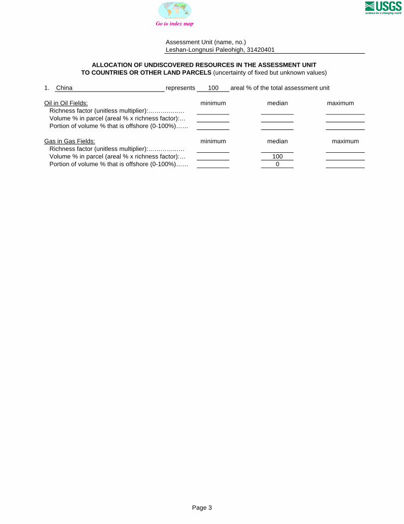
Assessment Unit (name, no.)Leshan-Longnusi Paleohigh, 31420401
ALLOCATION OF UNDISCOVERED RESOURCES IN THE ASSESSMENT UNITTO COUNTRIES OR OTHER LAND PARCELS (uncertainty of fixed but unknown values)
1. China represents 100 areal % of the total assessment unit
Oil in Oil Fields: minimum median maximum Richness factor (unitless multiplier):……….…..… Volume % in parcel (areal % x richness factor):… Portion of volume % that is offshore (0-100%)……
Gas in Gas Fields: minimum median maximum Richness factor (unitless multiplier):…………..…. Volume % in parcel (areal % x richness factor):… 100 Portion of volume % that is offshore (0-100%)…… 0