1 LESSON 4: DROUGHTS AND DESERTIFICATION Key Concepts You must know, or be able to do the following: Assess which areas would be prone to droughts and desertification on both a global, regional and local scale. Clearly understand the causes of droughts and link back to the El Nino effect on a South African regional scale Clearly understand the causes of desertification and the large role that that humans on the planet have contributed to this problem Be able to use examples of the effects of droughts and desertification on people and the environment Be able to compare differences of vulnerability of different groups of people Research management strategies using case studies X-Planation Areas at Risk for Droughts and Desertification on a Global, Regional and Local Scale In this unit we will look at the concepts of droughts and desertification, the causes of droughts and desertification and vulnerable areas on both a regional and a local scale. We need to connect these ideas with the effects and possible management strategies that arise from droughts and desertification. Africa is a good example of great vulnerability to drought and desertification and a seemingly inability to manage these climate based issues. A drought means a long period of dry weather during which the lack of rain results in a severe shortage of water. The South African weather service defines a drought as a period of 12 moths when total rain received is below 75% of the average. Desertification is the process whereby land in semi-arid regions become desert, the grasslands becomes semi-desert and so on. This is a chain reaction of sub-species of fauna invading previously productive land and, in the process, more unproductive land is created. Desertification goes hand in hand with accelerated soil erosion. Figure 1 shows global extent of droughts and desertification. Notice the large area of blue over South Africa. Figure 2 shows a regional (African) extent of the problem.
Transcript
1
LESSON 4: DROUGHTS AND DESERTIFICATION
Key Concepts You must know, or be able to do the following:
Assess which areas would be prone to droughts and desertification on both a global, regional
and local scale.
Clearly understand the causes of droughts and link back to the El Nino effect on a South
African regional scale
Clearly understand the causes of desertification and the large role that that humans on the
planet have contributed to this problem
Be able to use examples of the effects of droughts and desertification on people and the
environment
Be able to compare differences of vulnerability of different groups of people
Research management strategies using case studies
X-Planation
Areas at Risk for Droughts and Desertification on a Global, Regional and Local Scale
In this unit we will look at the concepts of droughts and desertification, the causes of droughts and
desertification and vulnerable areas on both a regional and a local scale.
We need to connect these ideas with the effects and possible management strategies that arise from
droughts and desertification. Africa is a good example of great vulnerability to drought and
desertification and a seemingly inability to manage these climate based issues.
A drought means a long period of dry weather during which the lack of rain results in a severe
shortage of water. The South African weather service defines a drought as a period of 12 moths when
total rain received is below 75% of the average.
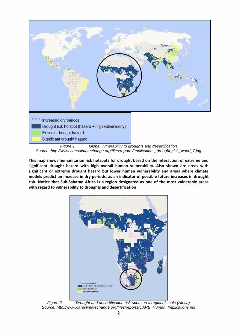
Desertification is the process whereby land in semi-arid regions become desert, the grasslands becomes semi-desert and so on. This is a chain reaction of sub-species of fauna invading previously productive land and, in the process, more unproductive land is created. Desertification goes hand in hand with accelerated soil erosion. Figure 1 shows global extent of droughts and desertification. Notice the large area of blue over South Africa. Figure 2 shows a regional (African) extent of the problem.
2
Figure 1 Global vulnerability to droughts and desertification
This map shows humanitarian risk hotspots for drought based on the interaction of extreme and significant drought hazard with high overall human vulnerability. Also shown are areas with significant or extreme drought hazard but lower human vulnerability and areas where climate models predict an increase in dry periods, as an indicator of possible future increases in drought risk. Notice that Sub-Saharan Africa is a region designated as one of the most vulnerable areas with regard to vulnerability to droughts and desertification
Figure 2 Drought and desertification risk spots on a regional scale (Africa)
This map shows ‘drought risk hotspots’ based on the interaction of extreme and significant drought hazards with high overall human vulnerability. Also shown are areas with significant or extreme drought hazard but lower human vulnerability and areas where climate models predict an increase in dry periods, as an indicator of possible future increases in drought risk. We will look at a local scale problem of the eastward migration of the Kalahari Desert in Southern Africa (Figure 3)
Figure 3 Eastward migration of the Kalahari Desert http://www.kgalagadiphotography.com/resources/SA%20Map%20River%20_HEAT%20%20desertific
ation.jpg.opt422x297o0,0s422x297.jpg The geographical position of the Southern Kalahari on the Sub-tropical high pressure belt (latitude 25°-35°S) causes its aridity. High pressure zones like these commonly receive little rain. Air advected onshore from the west is dry due to a cold ocean current and cold ocean waters. The semi-desert conditions have almost reached the Witwatersrand. This means that if the area was left to regenerate natural vegetation with normal rainfall, much of the grassland would have been replaced by desert scrub.
Causes and Types of Drought
Causes of Droughts This can be triggered by:
A high level of reflected sunlight, [high albedo]
An unusual above average and strength of high pressure systems
Winds carrying continental, rather than oceanic air masses (i.e. reduced water vapour)
Ridges of high pressure areas which prevent or restrict the developing of thunderstorm activity or rainfall over a region.
Oceanic and atmospheric weather cycles such as the El Niño-Southern Oscillation (ENSO) make drought a regular recurring feature of areas situated in the sub-tropical high pressure belts of South Africa
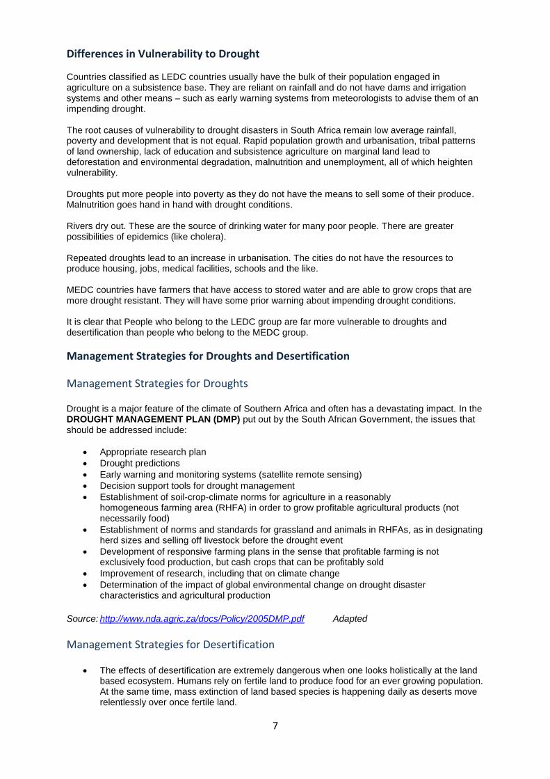
Types of Droughts While droughts can be defined in many ways, three main drought types are commonly identified. See Figure 4 – a summarised table of the different types of drought.
4
Figure 4 Types of droughts http://0.tqn.com/d/weather/1/0/S/9/-/-/climvar.gif
Hydrological Drought Many watersheds experience depleted amounts of available water. Lack of water in river systems and reservoirs can impact hydroelectric power companies, farmers, wildlife, and communities.
Meteorological Drought A lack of precipitation is the most common definition of drought and is usually the type of drought referred to in news reports and the media. Most locations around the world have their own meteorological definition of drought based on the climate expectations in the area. A normally rainy area that gets 25% less rain than usual can be considered in a drought.
Agricultural Drought When soil moisture becomes a problem, the agricultural industry is in trouble with drought. Shortages in precipitation, changes in evapo-transpiration, and reduced ground water levels can create stress and problems for crops.
Causes of Desertification
Malagasy used to be a rain forest. 10% of the forest remains
The light grey ellipses are those that involve vegetation cover reduction, while the dark grey ones involve soil erosion. Human activity can directly trigger desertification such as over farming, excessive irrigation, deforestation, and erosion. These adversely impact the ability of the land to capture and hold water. Activities resulting in global climate change are expected to trigger droughts with a substantial impact on agriculture throughout the world, and especially in developing nations Figure 5 is a detailed mind map as to how desertification occurs.
Figure 5 The causes and development of desertification (modified from Kemp 1994).
6
The Effects of Droughts and Desertification on People and the Environment There are three main ways droughts impact lives and communities: Economic impacts of droughts and desertification:
Losses in the timber industry
Losses in the agricultural industry
Losses in the fisheries industry
Job losses (Figure 6)
Decrease in the economic growth of a country
Many of these losses are then passed on to consumers in the form of higher commodity pricing
Figure 6 http://2.bp.blogspot.com.jpg
Social impacts of droughts and desertification:
Increased chance of conflict over commodities, fertile land, and water resources.
Abandonment of cultural traditions
Loss of homelands
Changes in lifestyle
Increased chance of health risks due to poverty and hygiene issues. Environmental impacts of droughts and desertification:
Loss in species biodiversity
Migration changes of roaming animals
Reduced air quality
Increased soil erosion.
During the monsoon season, areas that depend on the seasonal rains will often experience drought if the monsoon rains fail
Once crops fail, famine can become a major problem
In some African countries, rain rituals are often used to try and thwart the dry seasons and bring on the rain
While it is no cure, modern technology has developed ways to help see potential famine situations as satellites see famine conditions from space.
Figure 7 Dust storms produce air pollution
http://www.ktar.com/emedia/az/31/3188/318842.jpg
7
Differences in Vulnerability to Drought Countries classified as LEDC countries usually have the bulk of their population engaged in agriculture on a subsistence base. They are reliant on rainfall and do not have dams and irrigation systems and other means – such as early warning systems from meteorologists to advise them of an impending drought. The root causes of vulnerability to drought disasters in South Africa remain low average rainfall, poverty and development that is not equal. Rapid population growth and urbanisation, tribal patterns of land ownership, lack of education and subsistence agriculture on marginal land lead to deforestation and environmental degradation, malnutrition and unemployment, all of which heighten vulnerability. Droughts put more people into poverty as they do not have the means to sell some of their produce. Malnutrition goes hand in hand with drought conditions. Rivers dry out. These are the source of drinking water for many poor people. There are greater possibilities of epidemics (like cholera). Repeated droughts lead to an increase in urbanisation. The cities do not have the resources to produce housing, jobs, medical facilities, schools and the like. MEDC countries have farmers that have access to stored water and are able to grow crops that are more drought resistant. They will have some prior warning about impending drought conditions. It is clear that People who belong to the LEDC group are far more vulnerable to droughts and desertification than people who belong to the MEDC group.
Management Strategies for Droughts and Desertification
Management Strategies for Droughts Drought is a major feature of the climate of Southern Africa and often has a devastating impact. In the DROUGHT MANAGEMENT PLAN (DMP) put out by the South African Government, the issues that should be addressed include:
Appropriate research plan
Drought predictions
Early warning and monitoring systems (satellite remote sensing)
Decision support tools for drought management
Establishment of soil-crop-climate norms for agriculture in a reasonably homogeneous farming area (RHFA) in order to grow profitable agricultural products (not necessarily food)
Establishment of norms and standards for grassland and animals in RHFAs, as in designating herd sizes and selling off livestock before the drought event
Development of responsive farming plans in the sense that profitable farming is not exclusively food production, but cash crops that can be profitably sold
Improvement of research, including that on climate change
Determination of the impact of global environmental change on drought disaster characteristics and agricultural production
The effects of desertification are extremely dangerous when one looks holistically at the land based ecosystem. Humans rely on fertile land to produce food for an ever growing population. At the same time, mass extinction of land based species is happening daily as deserts move relentlessly over once fertile land.
The United Nations Convention to Combat Desertification (UNCCD) came into force in 1996. The picture (Figure 8) is a chilling illustration of the dangers of desertification.
Figure 8 Severe soil erosion leads to desertification
As we have seen throughout this topic, soil erosion often goes hand in hand with desertification. By tackling one, you can affect the other.
Some strategies within the UNCCD are to solve the problems caused by desertification. There has to an increase in the amount of food that can be grown in areas where people live and farm the land. The following problems of desertification can be tackled by:
Deforestation - Afforestation, that is re-planting trees, especially in shelter belts. Planting grasses can help stabilise the soil and cut down on erosion by wind and rain.
Over cultivation - Using good farming practices such as proper crop rotation and the use of manure as a fertiliser
Overgrazing – Control of herd sizes to ensure that the grass is not eaten before it can be replaced
Poor irrigation - Make sure the water is not evaporated on a surface which wastes water and increases its salinity
Runoff - Terracing the land to slow run off will allow for infiltration and moist soil
Over population - Control growing populations in marginal agricultural areas by creating alternatives for employment
9
X-ample Questions
Question 1 Look at the map showing drought risk over Africa and answer the questions that follow:
http://ourworld.unu.edu/en/wp-content/uploads/2008/07/drought_risk_africa.gif 1.1 Name the THREE deserts labelled E, F and G.
(3) 1.2 Account for the areas H and J as having no droughts.
5 x 2 (10) 1.3 Name the countries south of area H that have the highest risk of droughts.
(8) 1.4 How would you rate the comparative risk for drought in South Africa? Give a reason for your
answer. 2 x 2 (4)
1.5 Write a paragraph explaining why Africa as a continent is the most drought prone in the World. Remember to have an introduction, a body and a conclusion.
5 x 2 (10) [35]
Question 2 Write down the relationship between: 2.1 Amount of rainfall and droughts
(2 x 2) (4) 2.2 Droughts and desertification
(2 x 2) (4) 2.3 Desertification and soil erosion
(2 x 2) (4) 2.4 Desertification and temperature
(2 x 2) (4) 2.5 Desertification and poverty
(2 x 2) (4) [20]
10
Question 3 Case Study: Desertification of the Southward moving Gobi Desert
Desertification exacerbates poverty, sparks conflict' United Nations Secretary General Kofi Annan says that desertification is worsening extreme poverty and sparking conflict over dwindling resources, particularly in sub-Saharan Africa (Sahara) and southern Asia (Gobi). "Across the planet, poverty, unsustainable land management and climate change are turning dry lands into deserts," Annan said in a message for World Environment Day. “There is also mounting evidence that dry land degradation and competition over increasingly scarce resources can bring communities into conflict,” he said. Dry lands are found in all regions, cover more than 40% of the Earth and are home to nearly two billion people—one-third of the world population. About 10% to 20% of dry lands are already degraded, which is a “serious obstacle to eradicating extreme poverty and hunger, and is jeopardising efforts to ensure environmental sustainability”, Annan said. Algerian President Abdelaziz Bouteflika said that with deserts growing “at an alarming rate”, desertification will be “one of the global problems of the 21st century”. “Deserts are threatening the food security of poor countries, particularly in Africa and southern Asia, where the number of malnourished people doubled to 200-million in 1995 from 100-million at the end of the 1960s,” Bouteflika said at an international conference here marking World Environment Day.
Figure 3a Chain reaction of desertification
http://local.mg.co.za/article/2006-06-05-desertification-exacerbates-poverty-sparks-conflict By examining satellite data, it is determined that the Gobi is expanding approximately 15.3 km/year. At this rate, China’s capital city (Beijing) will be on the edge of the Gobi within 6-8 years, and many populated cities in between will be consumed by the desert’s sands. (See Figure 3) Many Chinese officials believe that the idea of Beijing being swallowed by the Gobi in a few years is “Silly”, but according to the satellite data, if China does not taken drastic action, mass amounts of people will be displaced, and thirst and famine will be widespread. The Gobi desert is expanding more than 10,000 square kilometres a year due to over cultivation and overgrazing. This expansion has already forced migration and threatens thousands more villages in the Chinese province of Gansu of Inner Mongolia and Ningxia Huizu. China’s sheep, goat, and cattle populations tripled from 1950-2002, taking a heavy toll on soil quality. Overgrazing by these animals and an increase in ploughed land has allowed the desert to expand. In Gansu Province alone, an estimated 4,000 villages are at risk of being buried with sand.
11
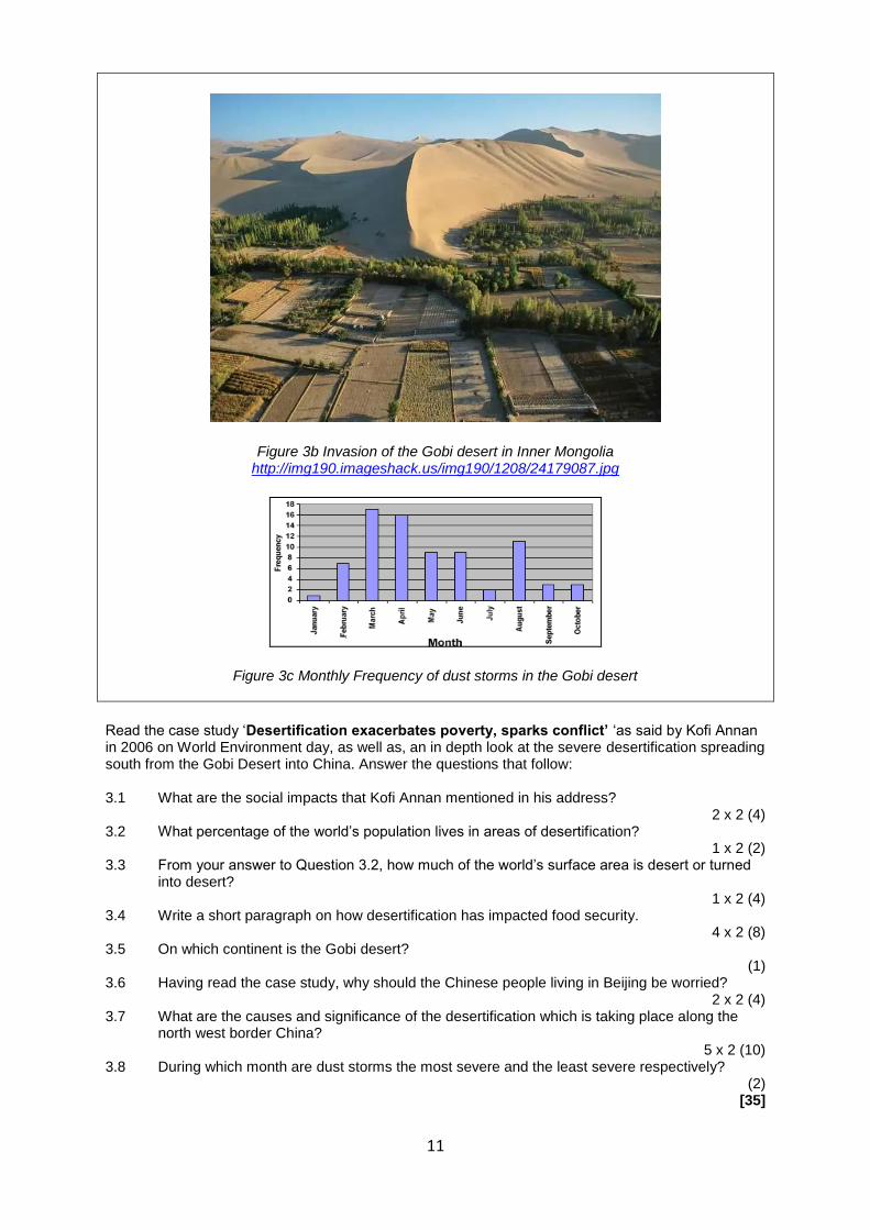
Figure 3b Invasion of the Gobi desert in Inner Mongolia http://img190.imageshack.us/img190/1208/24179087.jpg
Figure 3c Monthly Frequency of dust storms in the Gobi desert
Read the case study ‘Desertification exacerbates poverty, sparks conflict’ ‘as said by Kofi Annan in 2006 on World Environment day, as well as, an in depth look at the severe desertification spreading south from the Gobi Desert into China. Answer the questions that follow: 3.1 What are the social impacts that Kofi Annan mentioned in his address?
2 x 2 (4) 3.2 What percentage of the world’s population lives in areas of desertification?
1 x 2 (2) 3.3 From your answer to Question 3.2, how much of the world’s surface area is desert or turned
into desert? 1 x 2 (4)
3.4 Write a short paragraph on how desertification has impacted food security. 4 x 2 (8)
3.5 On which continent is the Gobi desert? (1)
3.6 Having read the case study, why should the Chinese people living in Beijing be worried? 2 x 2 (4)
3.7 What are the causes and significance of the desertification which is taking place along the north west border China?
5 x 2 (10) 3.8 During which month are dust storms the most severe and the least severe respectively?
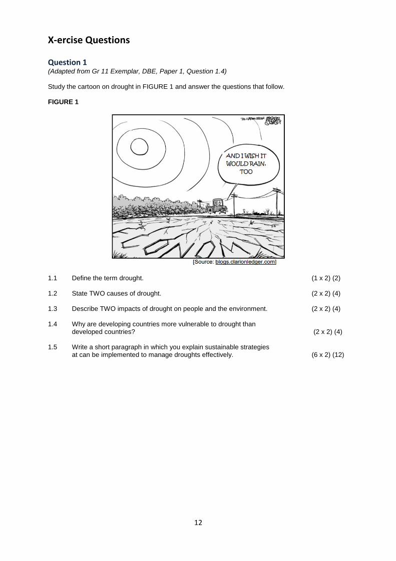
X-ercise Questions Question 1 (Adapted from Gr 11 Exemplar, DBE, Paper 1, Question 1.4) Study the cartoon on drought in FIGURE 1 and answer the questions that follow. FIGURE 1
1.1 Define the term drought. (1 x 2) (2) 1.2 State TWO causes of drought. (2 x 2) (4) 1.3 Describe TWO impacts of drought on people and the environment. (2 x 2) (4) 1.4 Why are developing countries more vulnerable to drought than
developed countries? (2 x 2) (4) 1.5 Write a short paragraph in which you explain sustainable strategies
at can be implemented to manage droughts effectively. (6 x 2) (12)
13
Question 2 (Adapted from Gr 11 Exemplar, DBE, Paper 1, Question 2.4) Refer to FIGURE 2 showing desertification in Africa. FIGURE 2: DESERTIFICATION IN AFRICA
2.1 What is desertification? (1 x 2) (2) 2.2 State ONE way in which humans contribute to desertification. (1 x 2) (2) 2.3 Describe the extent to which South Africa is threatened by desertification. (2 x 2) (4) 2.4 Discuss TWO effects of desertification on the economy of Africa. (2 x 2) (4) 2.5 Write a short paragraph in which you suggest sustainable ways to
prevent and reverse desertification in Africa. (6 x 2) (12)
14
Solutions to X-ercise Questions Question 1 (Adapted from Gr 11 Exemplar, DBE, Paper 1, Question 1.4) 1.1 A period of below-average rainfall
1.2 When the amount of moisture in the air drops Changes in the ocean-atmosphere cycle/El Niño event Shifts in wind patterns Locations in high pressure belts Poor land use practices that affect the ability of the land to catch and store water Wasteful water usage 1.3 Crops fail Livestock die Food shortages/Famine Malnutrition Mass migration Increased urbanisation leading to increased social stress Shortage of water in industries
Loss of jobs resulting in poverty Reduced hydro-electricity generation
Wars and conflict over resources Drought fuel wildfires Reduce biodiversity 1.4 Developing countries have many people living in rural areas who depend on the land for their
livelihood/subsistence farming Not variety of crops to fall back on No food in storage No capital to import Little insurance against droughts 1.5 Building dams to store water Could seeding to artificially increase rainfall Desalination of sea water Crop rotation to protect soil to store water Water restrictions Recycling Redirecting water to provide for irrigation in areas prone to drought Harvesting rain water from rooftops Development of sustainable agricultural practices Education to change attitude towards water usage Increase price of water to reduce usage
Question 2 (Adapted from Gr 11 Exemplar, DBE, Paper 1, Question 2.4) 2.1 The process which turns productive land into non-productive desert as a result of poor land-
management 2.2 Overgrazing Constructing boreholes, windmills and water points Farming marginal land Poor grazing management Incorrect irrigation practices Population increase Poverty Collecting fuel wood
15
2.3 Greatly threatened/50% threatened Moderate risk in Karoo area High risk in grassland area Desert expanding eastwards 2.4 Desertification reduces the ability of land to support life Affect domestic animals and agricultural crops Reduction food Poverty sets in 2.5 The number of animals on the land must be reduced Reseeding may be necessary in badly degraded areas Farmers should change farming methods to suit the land and soil Good land management in semi-arid areas Take part in the activities of conservation groups Bring overgrazing and land mismanagement to the attention of authorities Set up schemes to save water in your community