+ All Categories
Home > Documents > Let it snow -operational snow cover product from …€¦ · Let it snow -operational snow cover...

Let it snow -operational snow cover product from …€¦ · Let it snow -operational snow cover...

Date post: 19-Aug-2018
Category:
Upload: votram
View: 224 times
Download: 0 times
Share this document with a friend
26
Let it snow - operational snow cover product from Sentinel-2 and Landsat-8 data and Landsat-8 data Manuel Grizonnet CNES – Toulouse, France Co-authors: S. GASCOIN (CNRS), O. HAGOLLE, C. L’HELGUEN, T. KLEMPKA
Transcript

Let it snow - operational snow

cover product from Sentinel-2

and Landsat-8 dataand Landsat-8 dataManuel Grizonnet

CNES – Toulouse, FranceCo-authors: S. GASCOIN (CNRS), O. HAGOLLE, C. L’HELGUEN, T. KLEMPKA

Let It Snow in a nutshell

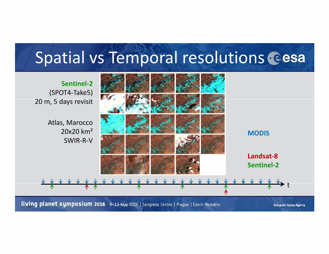
• CNES and CESBIO are developing a snow cover product from Landsat-8 and

Sentinel-2 data to provide the snow presence or absence at 20 m

resolution every 5 days

• Algorithm is simple because the snow surface is quite straightforward to

detect from high resolution optical imagery

2

detect from high resolution optical imagery

• Challenge is typically to avoid the confusion between the snow cover and

the clouds

• Take advantages of the availability of level 2A Product by CNES in the

frame of the THEIA initiative

• Leverage research and development efforts

SPOT1

1990 2000 2010 2020

SPOT2 SPOT3 SPOT4 SPOT5

SPOT 1

LANDSAT 5 LANDSAT 7 LANDSAT 8

SENTINEL-2A

SENTINEL-2B

More than 30 years of data39 years of data

1984 2023

SPOT 1

SPOT 2

SPOT 3

SPOT 4

SPOT 5

LANDSAT 5

LANDSAT 7

LANDSAT 8

SENTINEL 2A

SENTINEL 2B

THEIA initiativeTHEIA: French national multi-agency organisation for continental

surface studies

THEIA promotes the use of satellite data by scientific community

and public policy actors.

4

THEIA Scientific Expertise Centres

The Scientific Expertise Centres (CES as for Centres d'Expertise Scientifique in French)

are laboratories or groups of national laboratories leading research and developing

innovative processes to use space data for “land surfaces” issues

CES's objectives

5

CES's objectives• Validate products provided by the Space Data Infrastructure

• Develop processes to use the data and demonstrate applications.

• Contribute to network and federate the scientific community at regional, national and

even international levels

• Contribute to promoting the use of satellite data and associated analysis methods.

CES Theia• Surface reflectance CES : Olivier Hagolle (Cesbio) (link sends e-mail)

• Albedo CES : Jean-Louis Roujean (Météo France) (link sends e-mail)

• Land cover CES : Jordi Inglada (Cesbio) (link sends e-mail)

• Vegetation biophysics variables CES : Frédéric Baret (Inra) (link sends e-mail)

• Evapotranspiration CES : Vincent Simonneaux (IRD) (link sends e-mail) et Albert Olioso (Inra) (link sends e-mail)

• Irrigated surfaces CES : Valérie Demarez (Cesbio) (link sends e-mail)

• Digital soil mapping CES : Philippe Lagacherie (Inra) (link sends e-mail)

• Ground humidity CES : Yann Kerr (Cesbio) (link sends e-mail)

6

• Ground humidity CES : Yann Kerr (Cesbio) (link sends e-mail)

• Forest biomass and changes in forest cover CES : Thuy Le Toan (Cesbio) (link sends e-mail)

• Water levels of lakes and rivers CES : Jean-Francois Cretaux (Observatoire Midi Pyrénées) (link sends e-mail)

• Colours of the continental waters CES: Jean-Michel Martinez (IRD) (link sends e-mail)

• Snow-covered extent CES: Simon Gascoin (Cesbio) (link sends e-mail)

• Urbanisation / Artificialisation CES: Anne Puissant (Université de Strasbourg) (link sends e-mail) et Eric Barbe (Irstea) (link sends e-

mail)

• Risks associated with infectious diseases CES : Annelise Tran (Cirad) (link sends e-mail) et Emmanuel Roux (IRD) (link sends e-mail)

• High frequency change detection CES: Pierre Gancarski (Université de Strasbourg) (link sends e-mail)

• Mapping and monitoring of water bodies CES : Hervé Yesou (Université de Strasbourg) (link sends e-mail)

CNES Processing capacity• CNES – MUSCATE Infrastructure

• To process automatically up to 3600 products a day (including reprocessing)

• Based on the mutualised CNES HPC center

• Use of CNES software: PHOEBUS (orchestration), SIGMA (orthorectification), and MACCS

(conversion in surface reflectance)

Cumulative Volume of MUSCATE data:

0

500

1000

1500

2015 2016 2017 2018 2019 2020 2021 2022 2023 2024

Vo

lum

e i

n T

o

Input

Output

Total

7

Cumulative Volume of MUSCATE data:

SE

NT

INE

L-2

A

SE

NT

INE

L-2

B

1 Peta in 2023

Snow cover detection from optical satellite images

Pros• Products: snow cover, albedo…

• Variety of sensors and resolutions (spatial, spectral and temporal)

• Weekly monitoring since 1966 and global monitoring since 1981

Cons• Clouds, clouds, and again clouds…

• Snow-Vegetation interactions

• Incomplete (hydrology): , only the snow cover AREA is retrieved

• Trade-off between spatial and temporal resolution (Landsat vs. MODIS)

8

Spatial vs Temporal resolutionsMODIS 500-m, 1 day (watershed in grey) Landsat-8 30-m, 16 days

t

MODIS

Landsat-8

Spatial vs Temporal resolutions

Sentinel-2

(SPOT4-Take5)

20 m, 5 days revisit

Atlas, Marocco

20x20 km²

10

t

MODIS

Landsat-8

Sentinel-2

20x20 km²

SWIR-R-V

Let it Snow in Theia operational ground segment

Sentinel-2 TOA

Atmosphericcorrection (MACCS)

Cloud detection

11

Synthetic product (10 days)

(MACCS)

Snow detection Gapfilling

LIS algorithm

Step 1

Step 2

• Estimate the lowest elevation of the

snow cover in the image ( ZS ) using the

SRTM digital elevation model.

• We perform another pass for the pixels

located above the snowline elevation located above the snowline elevation

ZS, with different threshold values :

snow2=Z>ZS and cloud1 is false

and NDSI>N2 and ρRed>R2

14

Bar plot of the snow cover area, cloud

area and total area per elevation band

after pass 1. The image is a SPOT-4 Take5

image in the High-Atlas of Morocco

acquired on 27-03-2013

Final result

• pass1 U pass2

• Background image is a RGB

color composite (bands 421)

• Cloud mask is in black

Snow mask after pass 1 is

15

• Snow mask after pass 1 is

delineated in yellow

• Final snow mask in magenta

Snow and cloud mask in a SPOT-4 Take5 image in the High-

Atlas of Morocco (27-03-2013)

From R&D to operational product

• Matlab prototype developed by S. Gascoin (CNRS/CESBIO)

• Ported in Python and C++ based on open source software:

• OTB (open-source C++ library for remote sensing images processing)

• GDAL

Python• Python

• Compatible with SPOT4/SPOT5, Landsat-8 and Sentinel-2 products

• Iterative process

• Formats (metadata): followed guidelines from ESA SnowPEX initiative

16

Going Big: Landsat-8 time series

17

Quicklooks of a Landsat-8 time series over the Pyrenees (the snow mask is drawn

in magenta and cloud mask in green if you have good eyes)

Revisiting the L2A cloud mask

Snow and cloud mask after processing by LIS (left) vs. L2A original cloud and snow

mask (right). Clouds are marked in green, cloud shadows in black, snow in magenta

18

Toward S2 snow product

Alpes SPOT4-Take5

series

Snow line rising

Snow fraction in

elevation cells

First Sentinel-2 snow map!

20

The Sentinel-2A image of 06-July-2015 (level 2A, tile 30TYN) and its snow mask. The snow mask is in

magenta and the background image is a color composite RGB NIR/Red/Green

First Sentinel-2 snow map

• Snow mask computed from

the Sentinel-2A image of 06-

July-2015 is superposed to

an aerial image of 2013

(IGN)

• In the Vignemale and

21

• In the Vignemale and

Gavarnie area

• Persistence of snow patterns

from one year to another

• It seems to work rather well!

And now?

• CNES is implementing the

operational version on the

MUSCATE ground segment

• Hope to start distributing snow

maps with Sentinel-2 in 2016

• Next step :develop an

interpolation method to provide

a 5-day gap-filled snow product

22

And now?

• The accumulation of Sentinel-2 and

Landsat data will enable to generate

snow cover climatology at high

resolution

• It will allow to better characterize the

fluctuations of the snow cover in the fluctuations of the snow cover in the

mountains

• Develop services like web applications

for winter tourism, support water

managers decision-making in mountain

regions

• Ski slopes in Alpe d’Huez and les 2 Alpes

(From April to September)

23

Perspectives

• Process Sentinel-2 sites from:

– Pyrénées (France, Spain, Andorra)

– French Alps– French Alps

– Morocco Atlas mountain

and then the Alpine region up to Austria?

Support/Help/Contribute

• Source code : http://tully.ups-tlse.fr/grizonnet/let-it-snow.git

• CESBIO blog: http://www.cesbio.ups-tlse.fr/multitemp/

25

• Theia : https://www.theia-land.fr/

Thank you! Any questions?

26

Bassiès, Ariège (French Pyrénées)


Recommended