28
STARTER WALKS to improve your health... FIND YOUR NEWPORT WALK
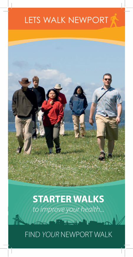
STARTER WALKSto improve your health...
FIND YOUR NEWPORT WALK

Lets Walk N ewport - Healthy Start Walks
10Reasons to walk...
1. Makes you feel good
2. Reduces stress
3. Helps you sleep better
4.• Heart disease• Stroke• High blood pressure• Diabetes• Arthritis• Osteoporosis• Certain cancers
and can help with their managementand recovery
5. Meet others and feel part of your community
6. See your local area and discover new places
7. Kind to the environment
8. Can be done by almost anyone
9. N o special equipment required
10. Its FREE, saving money on bus fares and petrol
© Steve Pope
© Steve Pope
2
Reduces risk of:-

3
How often should I walk?
As often as you can
Aim for at least:-
This can be in one go or 3 walks of 10 minutes or2 walks of 15 minutes per day
305
minutes
or more daysof the week
How fast should I walk?Start slowly to warm upgradually increase to a brisk pace:-
• heart beating a little faster• breathing a little faster• feel a little warmer• leg muscles may ache a little• you should still be able to hold a conversation
Slow down gradually to cool down
Tips• Walk to the local shops• Get off the bus a stop earlier• Park a little further from your destination• Walk the children to and from school• Go for a lunchtime walk• Walk to post a letter• Use the stairs• Walk with friends/family• Explore new areas• Walk the dog• Note your progress
Lets Walk N ewport - Healthy Start Walks
4
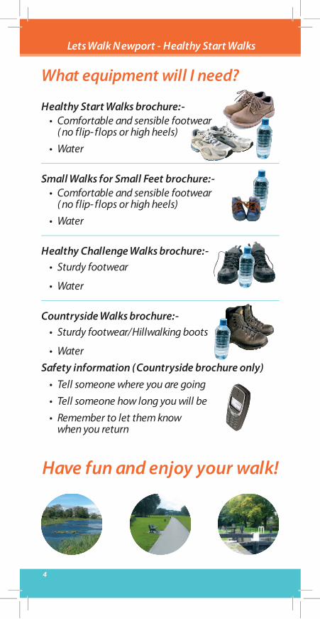
What equipment will I need?
Healthy Start Walks brochure:-• Comfortable and sensible footwear
( no flip- flops or high heels)• Water
Small Walks for Small Feet brochure:-• Comfortable and sensible footwear
( no flip- flops or high heels)• Water
Healthy Challenge Walks brochure:-• Sturdy footwear
• Water
Countryside Walks brochure:-• Sturdy footwear/Hillwalking boots
• WaterSafety information (Countryside brochure only)
• Tell someone where you are going• Tell someone how long you will be• Remember to let them know
when you return
Have fun and enjoy your walk!
Lets Walk N ewport - Healthy Start Walks

5
Walks
Distance Page
1. Lliswerry Pond 6- 7
2. Morgans & 1
1.6 km 1 mile
3.7 km 2.3 miles
.5 Km 8- 9Woodstock Pools 1 Miles
3. St. Woolos Cemetery 2 Km 10- 111.2 Miles
4. Caerleon Circular 2.2 Km 12- 131.3 Miles
5. Fourteen Locks 2.3 Km 14- 151.4 Miles
6. Bettws Brook 2.9 Km 16- 171.8 Miles
7. Malpas Meander 2.9 Km 18- 191.8 Miles
8. Tredegar Park 20- 21
9. Ringland Wood 2.7 Km 22- 231.7 Miles
10. Rogerstone 3.2 Km 24- 25Welfare Ground 2 Miles
Please refer to map on back cover
Lets Walk N ewport - Healthy Start Walks

6
ABCDEF
Lliswerry PondStart at bottom
of Lliswerry Road...
Go through gate, continue along alleyw
ay between houses and go through another gate entering
Lliswerry Pond.
Turn left and continue walking on gravel path in a clockw
ise direction around Lliswerry Pond.
At far end of Llisw
erry Pond keep on lower path on your right running alongside the Pond.
Go through gate and enter recreation ground.
Turn left and continue in a clockwise direction around Llisw
erry Pond back to the start.
GO
PTION
: To shorten walk - G
o from E directly to G
, through a gate and back to the start.
Walk around the recreation ground in a clockw
ise direction and re-enter Lliswerry Pond through the
same gate.
WALK1
WALK 1
Lliswerry Pond
Note: There is no car
parking available.
A short andenjoyable w
alkaround Llisw
erry pondw
ith plenty of wildlife
to spot.
A level hard surfacepath around the pondw
ith a level grassyroute around therecreation area.

Aberthaw
Road
Liswerry Road
Arthur R
oad
School
7
KEY
Walk Route
Bus Stop
Gate
Bench
Picnic Table
A
B
C
D
E
F
G
Lliswerry Pond Distance 1.6 Km, 1 Mile
Lliswerry from
theW
elsh “Llyswyry”
means M
aidens Court,possibly relating to them
anor house ofKing of Brycheiniog’sdaughter.

8
ABCDEF
Morgans & Woodstock PoolsStart in the car park o� Bettw
s Lane...
Cross metal stile in bottom
right hand corner of car park, take path on your left and walk around W
oodstockPond in a clockw
ise direction.
Turn left when you reach the green m
etal buildings on your left, follow path over bridge.
Take care: No sides to the bridge.
At fork take path to your left up a short incline, bear right at top of incline and follow
path, cross over thebridge on your left leading back to W
oodstock Pond.
Follow path past G
reen Buildings on your left and carry on walking around W
oodstock Pond in a clockwise
direction back to the start.
Take path on your left and walk around M
organs Pond in a clockwise direction.
At fork keep on m
ain path running level alongside the Pond.
WALK2
WALK 2
Morgans &
Woodstock Pools
A short and peacefulw
alk around the�shing pools nearBettw
s.
There is anabundance of w
ildlifeto spot.
A level walk on hard
surface paths.

Blaen-Y-Pant Crescent
Blaen-Y-Pant
Residential HomeMalpas Road
Bettw
s lane
9
KEY
Walk Route
Car Park
Bus Stop
Bench
Foot Bridge
P
PA
B
FC
E
D
Morgans & Woodstock Pools Distance 1.5 Km, 1 Miles
Morgans &
Woodstock
Pools, also comm
onlyknow
n as Morgans &
Woodstock Ponds or
the Bob Smalls Fishery.

10
ABCDEFGH
St. Woolos CemeteryStart at m
ain entrance to St Woolos Cem
etery on Bassaleg Road...
Turn left before cemetery o�
ce and follow tarm
ac footpath around outer edge of cemetery dow
n a slightslope (�ne view
s of hills ahead)
Keep straight ahead on footpath passing a gate entrance on your left and follow footpath around outer edge
of cemetery.
Bear left and carry on along main road around cem
etery in a clockwise direction.
Turn right and keep following m
ain road around cemetery leading uphill.
At path junction turn left and follow
road around cemetery in a clockw
ise direction.
At m
ini roundabout keep following outer path around edge of cem
etery back to start.
Bear right following m
ain road around cemetery dow
n a slope then uphill. There are many options to take
the footpaths on your left around the outer edge of cemetery w
hich loop back to the main road around
the cemetery.
When you reach a building ahead of you take the sm
all footpath on your right, between bollards then turn
left and follow footpath around outer edge of cem
etery.O
ption to carry on past the building ahead of you, through kissing gate into small w
ood ‘Coed Melyn’
outside cemetery boundary leading to Risca Road, turn right on pavem
ent along Risca Road and backinto cem
etery entrance at point F.
WALK3
WALK 3
St. Woolos
Cemetery
A lovely walk w
ith�ne view
s of thehillsides surroundingN
ewport. Som
e tarmac
footpaths are uneven,otherw
ise use main
road around cemetery.
There are many
benches to rest at.
ALSO - SU
RVIVORS O
F THE
BATTLE OF RO
RKE'S DRIFT
1 Alfred Saxty
2 John Murphy
3 John Jeremiah Lyons
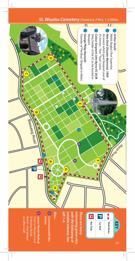
KEY
Walk Route
Car Park
Bus Stop
P
P
11
A
B
C
D
E
F
G
H2
St. Woolos Cemetery Distance 2 Km, 1.2 MilesArthur G
ouldW
elsh Rugby's �rst SuperstarN
ew D
ock Disaster M
emorial, 1909
An event w
hich gave New
port one ofit's heroes - Tom
"Toya" Lewis
Colour Sergeant John Byrne VC DCM
Only holder of the VC to be buried in
New
portG
eorge Philip ReynoldsFounder of The Boys' Brigade in W
ales
Comm
onwealth W
ar G
raves
James Flew
itt Mullock
Clerk to New
port and St W
oolos Burial Board - blue plaque on o�
ce wall
1
1
1
2
3
23
3
CS
S
C
4
4
There are many
interesting grave sitesw
ith the following of
notable interest. Seeleft 1-4.
Also...
12
ABCDE
FGHIJ
Caerleon CircularStart in car park on Broadw
ay Road...
Go through the gate leading to the am
phitheatre, walk
around amphitheatre in a clockw
ise direction keepingon the level grass and exit using the sam
e gate.
At end of Fosse Lane turn right onto Cold Bath Road,
take the gate on your left and walk around the grassy
perimeter of Caerleon A
FC Football Ground.
Cross over the roundabout using the tra�c
island and continue straight ahead down
Usk Road.
Cross over Usk Road into A
fon Lwyd Close,
bear right between houses onto Tram
Road.
At fork bear left and continue straight ahead
onto Museum
Street.
At junction w
ith the High Street, cross over
the road towards Broadw
ay Road using roadcrossing back to the car park. Take care as theH
ight Street is a busy road to cross.
Turn left at junction with M
ill Street then crossroad using road crossing and head up BackhallStreet. Take care as M
ill Street is a busy roadto cross.
Exit gate and turn right along road towards junction
with Cold Bath Road, turn left and continue along Cold
Bath Road. (Take care: no pavements.)
Turn right along Broadway Road then take the tarm
acpath know
n as Fosse Lane on your left leading towards
the Barracks. Option to take short path leading to
Barracks and return by same route to tarm
ac path.
Turn right at junction with Lodge Road then turn left.
Cross road and follow road next to G
oldcroft Comm
on
WALK4
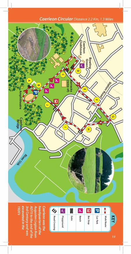
WALK 4
Caerleon Circular
A wonderful historical
walk around Caerleon
and the remains
of the Roman
Amphitheatre and
Barracks.
A level walk, m
ostlyon pavem
ents or hardsurface w
ith grassaround theAm
phitheatre.
(Open 09.30 - 17.00
Last admission 16.30)
13
KEY
Walk Route
Car Park
Bus Stop
Bench
GPlayground
Road Crossing
ate
P
A
B
C
D
E
F
G
HI
J
P
CaerleonBridge
River Usk
Caerleon Circular Distance 2.2 Km, 1.3 Miles
Caerleon was the
headquarters of theAugusten Legion fromAD
75 to the end of the3rd Century and w
asexcavated in the1920’s
Station Road

14
ABCDEFGHIJ
Fourteen Locks Canal WalkStart at the Fourteen Locks Visitor centre car park o� Cw
m Lane in Rogerstone...
From car park cross over Cw
m Lane and w
alk along Brunel Avenue.(Take care - busy lane and on a bend.)
Turn right at tarmac footpath on your right (opposite Jessop Close) and follow
footpath straight aheadbetw
een the houses.
At end of footpath, cross over Ruskin Avenue, turn right along Ruskin Avenue for about 10 m
etres then takethe tarm
ac footpath on your left, signposted ‘Scott Walk’.
At path junction turn right and follow
path straight ahead passing ‘Barry Walk’ and then ‘Paxton W
alk’ bothsignposted on your left.
At end of path, turn left.
Cross Ruskin Avenue and keep straight ahead down �ve steps. (Take care - busy road.)
Walk over a hum
pbacked bridge, there is a handrail on your right on the steeper downhill slope.
Turn left after bridge and follow the tarm
ac footpath along the canal.(Take care - cyclists on cycle route 47.)
Cross Ruskin Avenue and keep straight ahead along canal footpath. (Take care - busy road and on a bend.)
Cross Cwm
Lane and walk straight ahead dow
n a slope, bear left across footbridge back to theFourteen Locks Visitor Centre. (Take care - busy lane and on a bend.)
WALK5
WALK 5
Fourteen LocksCanal W
alk
A rewarding w
alkthrough quietresidential paths andalong the banks ofthe M
onmouthshire
& Brecon Canal.
A level walk, m
ostlyon pavem
ents or hardsurface, w
ith onesm
all steep sectionover a hum
p backedbridge.

Forteen Locks
Cefn
Greendale
Cw
m Farm
15
KEY
Walk Route
Car Park
Bus Stop
Bench
Cafe
P
A
B
C D
E
F
G
H
I
P
Hum
pBackedBridge
Steps
Ty-Du/
Rogerstone
HighcrossRoad
Fourteen Locks Canal Walk Distance 2.3 Km, 1.4 Miles
The �ight of locks was
completed in 1799
and raises the water
level 160ft in just halfa m
ile. Currently thereare also various guidedw
alks on the �rstSaturday of everym
onth from the
Fourteen Locks VisitorCentre – telephone01633 892167
J

ABCDEFGHIJK
16
Bettws BrookStart at car park behind police station...
Walk past Bettw
s Sensory Garden and cross over Lam
bourne Way using zebra crossing outside police station.
Turn right and follow pavem
ent over Bettws Brook.
Turn left and follow tarm
ac footpath running along Bettws Brook.
Carry on past bridge, then past weir.
Follow tarm
ac path uphill onto Tamar Close, w
alk past garages on you left.
Turn left onto Monnow
Way and follow
road downhill past roundabout, using tra�
c island.(Take care, busy road to cross.)
Turn left through gate, opposite Foxglove Meadow
s Estate, keep straight ahead across grass & cross bridge
over Malpas Brook.
Turn right and walk around outer edge of playing �elds in an anticlockw
ise direction.
Turn right and follow gravel path along M
alpas Brook.
Go through “Bike Slow
” gate and cross over Monnow
Way. (Take care, busy road.)
Go through “Bike Slow
gate” opposite and follow tarm
ac path alongside Bettws Brook
WALK6
WALK 6
Bettws Brook
A pleasant mostly
level walk on
pavements or hard
surface along bothsides of Bettw
s Brook.

Bettw
s
School
17
KEY
Walk Route
Car Park
Bus Stop
Bench
Foot Bridge
RoadCrossing
Gate
P
PA
BC
D
EF
G
H
I
J
B
K
Bettws Brook Distance 2.9 Km, 1.8 Miles
Bettws m
eans oratoryor chapel.
John Frost, ChartistLeader, m
arried in StD
avid’s Church,Bettw
s.

18
ABCDEF
GHIJKL
Malpas MeanderStart at the car park in G
rove Park o� Pillmaw
r Road...WALK
7W
ALK 7
Malpas M
eander
This satisfying walk
follows som
epleasant residentialpaths and along anenjoyable section ofthe cycle route. Thereare som
e delightfulw
ooden sculpturesand m
any benches torest at.
A level walk, m
ostlyon pavem
ents or hardsurface, w
ith a shortincline and declinenear the cycle route.
From car park w
alk up tarmac footpath past children’s
playground on your left and the Usk Vale Bar &
Restaurant on right.
Follow path through underpass, continue
straight ahead.W
hen you reach trees and grass in front, turn right,then im
mediate left and follow
path over footbridge.
Keep straight ahead and at end of grassy ground onyour right, turn right.
Follow path straight ahead, then bear right follow
ingpaved footpath around bend and continue straightahead.
At end of path, turn right, then �rst left going dow
nhill,using handrail if necessary.
At bottom
of slope turn right following path
past wood carving and benches.
Walk around short loop at end of path, then
head back towards benches and w
oodcarvings.Keep on path, past tw
o footbridges andboardw
alks on your right.
Head up slope on your left w
ith handrailjust before w
oodcarving. At top of slope,
keep straight ahead towards “Clarem
ont” signopposite and follow
path between houses.
At bollard bear left, then turn left at path
crossroads, heading up slope towards
footbridge.
Walk over footbridge keeping straight ahead
and then turn right at white bungalow
s(signed for houses “235-387”) and continuestraight ahead back to start, rem
embering to
bear left at both forks with bollards.
School
19
KEY
Walk Route
Car Park
Bus Stop
Bench
Foot Bridge
CSlopes
hildren’sPlayground
P
A
B
C
D
I
J
K
LF
G
HP
Malpas Meander Distance 2.9 Km, 1.8 Miles
Malpas is derived from
the French for “badpassage”, the roadw
est from Caerleon
ran through a wet and
di�cult area.
E
Malpas Relief Road
Malpas Road

20
ABCDEFG
Tredegar ParkStart in car park at Tredegar Park...
WALK8
WALK 8
Tredegar Park
A �ne walk across the
open spaces of thepark and beyond intothe attractive oldgol�ng range, skirtingthe river Ebbw
.
A level walk, m
ostlyon tarm
ac or hardsurface, w
ith some
short steep unevensections near theriver.
Walk along the tarm
ac track passing the LifeTrail exercise equipment,
have a go if you are feeling energetic!
CHA
LLENG
E: Try out the marked 1 m
ile route. Can you beat the 4 minute m
ile?!
At the end of the tarm
ac path walk through the M
4 underpass.
Take the �rst left hand path and walk in a clockw
ise direction on the grassy path.
Follow path over a sm
all bridge over a brook and turn right. Follow low
path in a clockwise direction.
At gravel path turn right w
here it forks, following narrow
path towards Ebbw
River Bridge
At bridge over Ebbw
River do not cross. Turn right down short steep path and keep straight ahead on path
back to the underpass
Go through underpass, then turn left and up slope along path tow
ards picnic benches. Keep straight aheadon path back to the start.

21
KEY
Walk Route
Car Park
Bus Stop
Bench
Foot Bridge
CPicnic Tables
1 mile Start
and Finish
hildren’sPlayground
P
PA
BC
D
E
F
Tredegar Park Distance 3.7km, 2.3 Miles
There are 9 Life trailexercise stations t try out as you w
alkaround the route.
G

22
ABCDEFG
HIJKLMN
Ringland WoodStart in car park on Cot Farm
Circle...WALK
9W
ALK 9
Ringland Wood
An enjoyable walk
through RinglandW
ood, with som
esteep hills but �neview
s over the BristolChannel.
Hard surface paths in
the wood w
ith therem
ainder onpavem
ents alongsidethe quiet roads.
Turn right out of car park onto Cot Farm Circle
and follow road tow
ards & then alongside the
recreation ground.A
t end of recreation ground turn right beforehouses and take the footpath bearing to the left,through a gate leading into Ringland W
ood.
Go through gate and turn right. A
t end of pathtake steps leading dow
n to Ringland Circle, with
views tow
ards Celtic Manor Resort &
Christchurch.
Turn left and follow Ringland Circle.
Turn left onto Dunstable Road and follow
the road uphill.
Turn left onto Sterndale Bennett Roadand follow
the road uphill.
Turn left onto Edward G
erman Crescent
and follow the road uphill.
Just after the children’s playground take the tarmac
path on your left leading to a gate into RinglandW
ood.
Go through gate and continue along the top path
of Ringland Wood.
At path crossroads, turn right and go up 3 steps and
through the gate exiting Ringland Wood onto
New
man Close.
At Junction w
ith Edward G
erman Crescent,
turn left and follow the road dow
nhill.
At junction w
ith Sterndale Bennett Road,turn left and follow
the road downhill.
Near the bottom
of the hill, take the second gateentering Ringland W
ood and continue along path.
Exit Ringland Wood through the gate on your right
and return to the start.

23
KEY
Walk Route
Car Park
Bus Stop
Gate
CRecreationalG
round
hildren’sPlayground
P
PA
BD
E
F
G
I
J
K
L
M
N
H
Steps
Ringland was nam
edafter a local farm
.
Ringland Wood Distance 2.7 Km, 1.7 Miles
C

ABCDEFGHIJK
24
Rogerstone Welfare GroundStart in car park at Rogerstone W
elfare Ground...
WALK10
WALK 10
RogerstoneW
elfare Ground
A scenic walk along
the banks of the riverEbbw
and along aquiet country lane.
Some uneven and
sometim
es muddy
tracks alongside theriver.
Mostly level route but
with one short steep
section leading up tothe country lane.
Take footpath with tennis courts on your left, and playing �elds on your right over grass �elds tow
ardspicnic benches.
Keep straight ahead past small pond on your right and w
alk through a gap in the trees, keep to the left-handboundary of the recreation ground, then m
idway along recreational ground take the path on left through a
gap in the trees to meet the path running alongside the river.
Turn left and follow the river path past tw
o pipes running across the river.
Cross over footbridge on your right. (Note: there is a sm
all metal stile.)
Turn left after crossing bridge and head up uneven tarmac path.
Go through kissing gate &
turn right following ‘Sirhow
y' Valley Walk’ arrow
signs, along hardcore gravel path.
Go through opening in fence and at Pentre Tai Road, turn right and follow
country road downhill.
(Take care: there are no pavements along this quiet country road.)
Bear right and walk through underpass.
Bear right and cross over footbridge and turn right following river path.
Keep following river path past tw
o pipes running across the river.
Take footpath on your left back to the start.

25
KEY
Walk Route
Car Park
Bus Stop
Picnic Bench
Foot Bridge
Refreshments
Gate
P
P
AC
J
K
DE
FG
H
I
B
Rogerstone Welfare Ground Distance 3.2 Km, 2 Miles
Rogerstone originatedas a N
orman Castle
built by Roger de Haia
in the 12th Century.

26
LETS WALK NEWPORT
Countryside Walks
Lets Walk N ewport - Healthy Start Walks
SMALL WALKSfor small feet...FIND YOUR NEWPORT WALK
CHALLENGE WALKS
challenge yourself...
FIND YOUR NEWPORT WALK
Small Walksfor small Feet
This brochure forms part of a series of fourbrochures on walk in the Newport area.Please see below for the other three brochures in this series.
HealthyChallenge
Walks
CountrysideWalks
27
Useful Information
Bus & Rail InformationTraveline Cymru - 0871 200 22 33
www.traveline-cymru.org.uk
Other InformationNHS Direct Online - 0845 46 47
www.nhsdirect.nhs.uk
Newport City Council - 01633 656 656www.newport.gov.uk
Ramblers Association - 01633 894 172www.ramblers.org.uk
Gwent Police -01633 838 111www.gwent.police.uk
Walking Informationwww.newport.gov.uk/countryside
Lets Walk N ewport - Healthy Start Walks

LETS WALK NEWPORT
1
2
3
4
5
67
8
9
10
Liswerry Pond
Morgans & Woodstock Pools
St. Woolos Cemetery
Caerleon Circular
Fourteen LocksCanal Walk
5
4
3
2
1 Bettws Brook
Malpas Meander
Tredegar Park
Ringland Wood
RogerstoneWelfare Grounds
10
9
8
7
6
Healthy Start Walks in N ewport...
© Crown CopyrightAll rights reserved100024210.2008
Version 1. October 2008


