1 Lewisham Gypsy & Traveller Site Selection Background Paper August 2016 (Updated October 2016) Introduction In January 2016, the Mayor and Cabinet noted the following seven stepped 1 approach to identifying a gypsy and traveller site: Step 1 – Consult on proposed scope of plan, search parameters and site selection criteria; Step 2 – Establish a list of appropriate Council assets; Step 3 – Identify a long-list of potential sites; Step 4 – Identify a short-list of potential sites; Step 5 – Identify a preferred site or sites; Step 6 – Consult on a preferred site or sites; and Step 7 – Select a site. Given the relatively small number of potential sites that emerged from Step 3, the ‘long-list’ and ‘short-list’ steps were combined in to one. This note identifies and reviews a long-list of possible sites identified by LBL Property and applies Criteria 2 to 10. It is based on Site Selection Criteria that were approved following consultation by the Mayor & Cabinet on 13 July 2016. The Long List of Sites This comprises the following 5 sites identified by LBL Property: A Land on Westbourne Drive (adjacent to St George’s Primary School) SE23; B Land off Turnham Road (to north of Honor Oak Adventure Playground) SE4; C New Cross Social Club & adjoining land, Horshay Street, SE15; D Land at R/O 46-116 Baizdon Road SE3; and E Land at Pool Court, SE6. In addition to the above sites, the Regulation 18 consultation process resulted in a landowner identifying the following site: F Land at St Mildred’s Road, Hither Green, SE12. Selection Criteria The list of remaining criteria is as follows: 2. Reasonable access to local shops, services and community facilities in particular schools and health services. 3. Safe and reasonably convenient access to the road network. 4. Capable of satisfactory provision for parking, turning, service and emergency vehicles. 5. Mixed residential and business use opportunities 6. They have a supply of essential services such as water, sewerage and drainage and waste disposal. 7. Scope for healthy lifestyles and integration. 8. Local environmental quality. 9. Spatial planning and development management considerations. 10. Deliverability 1 They were actually called ‘stages’ in the Mayor and Cabinet report, but the terms ‘steps’ is being used in the draft GTSLP so as to differentiate from the overall ‘stages’ of preparing the GTSLP.
Transcript
1
Lewisham Gypsy & Traveller Site Selection Background Paper August 2016 (Updated October 2016)
Introduction In January 2016, the Mayor and Cabinet noted the following seven stepped1 approach to identifying a gypsy and traveller site:
Step 1 – Consult on proposed scope of plan, search parameters and site selection criteria;
Step 2 – Establish a list of appropriate Council assets;
Step 3 – Identify a long-list of potential sites;
Step 4 – Identify a short-list of potential sites;
Step 5 – Identify a preferred site or sites;
Step 6 – Consult on a preferred site or sites; and
Step 7 – Select a site. Given the relatively small number of potential sites that emerged from Step 3, the ‘long-list’ and ‘short-list’ steps were combined in to one. This note identifies and reviews a long-list of possible sites identified by LBL Property and applies Criteria 2 to 10. It is based on Site Selection Criteria that were approved following consultation by the Mayor & Cabinet on 13 July 2016.
The Long List of Sites This comprises the following 5 sites identified by LBL Property: A Land on Westbourne Drive (adjacent to St George’s Primary School) SE23; B Land off Turnham Road (to north of Honor Oak Adventure Playground) SE4; C New Cross Social Club & adjoining land, Horshay Street, SE15; D Land at R/O 46-116 Baizdon Road SE3; and E Land at Pool Court, SE6. In addition to the above sites, the Regulation 18 consultation process resulted in a landowner identifying the following site: F Land at St Mildred’s Road, Hither Green, SE12.
Selection Criteria The list of remaining criteria is as follows: 2. Reasonable access to local shops, services and community facilities in particular schools and
health services. 3. Safe and reasonably convenient access to the road network. 4. Capable of satisfactory provision for parking, turning, service and emergency vehicles. 5. Mixed residential and business use opportunities 6. They have a supply of essential services such as water, sewerage and drainage and waste
disposal. 7. Scope for healthy lifestyles and integration. 8. Local environmental quality. 9. Spatial planning and development management considerations. 10. Deliverability
1 They were actually called ‘stages’ in the Mayor and Cabinet report, but the terms ‘steps’ is being used in the draft GTSLP so as to differentiate from the overall ‘stages’ of preparing the GTSLP.
2
Scoring Each criterion will be given a qualitative score as follows: 1 – Excellent 2- Good 3 – Average 4 – Poor 5 - Very poor
Studies Highways The Project Centre was commissioned to assess the suitability of highway access for each of the sites on the long-list. Flooding GeoSmart was commissioned to advise on flooding issues and the likelihood of passing the Sequential and Exceptions Tests for the two long-listed sites that are in Flood Zone 2 or 3.
Stakeholder Engagement The following Council and external stakeholders were consulted on the long-list and all comments that were received have been taken in to account and reflected in the matrix.
LBL Environmental protection Team (comments received)
LBL School Places Manager (no comments received)
LBL Public Health Director (comments received)
Lewisham Clinical Commissioning Group (comments received)
Metropolitan Police (no comments received)
3
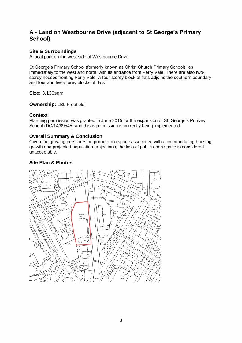
A - Land on Westbourne Drive (adjacent to St George’s Primary School) Site & Surroundings A local park on the west side of Westbourne Drive. St George’s Primary School (formerly known as Christ Church Primary School) lies immediately to the west and north, with its entrance from Perry Vale. There are also two-storey houses fronting Perry Vale. A four-storey block of flats adjoins the southern boundary and four and five-storey blocks of flats
Size: 3,130sqm Ownership: LBL Freehold.
Context Planning permission was granted in June 2015 for the expansion of St. George’s Primary School (DC/14/89545) and this is permission is currently being implemented.
Overall Summary & Conclusion Given the growing pressures on public open space associated with accommodating housing growth and projected population projections, the loss of public open space is considered unacceptable.
Site Plan & Photos
4
Application of Criteria
Land on Westbourne Drive
Commentary Score
2. Reasonable access to local shops, services and community facilities in particular schools and health services.
(a) Bus stop/station – Perry Vale Approx. 300m (b) The following services within 1,500m
Local shop – Forest Hill Town Centre Approx. 300m
Primary School – St. George’s Primary School – Adjacent.
Health facility – The Vale Medical Centre (195-197 Perry Vale Approx. 650m
1- Excellent
3. Safe and reasonably convenient access to the road network.
(a) Safe vehicular access or capable of creating safe vehicular access for 15m long caravan to/off a public highway.
(b) Access for emergency services. (c) Clearance height of 3.7m. Yes.
1- Excellent
4. Capable of satisfactory provision for parking, turning, service and emergency vehicles
(a) Judgement (size and shape of site). (b) Infrequent access needed for 25m long caravan. Yes.
1- Excellent
5. Mixed residential and business use opportunities.
(a) Mixed-use residential and business use acceptable in principle. No (given proximity to school and other homes). (b) Any likely adverse impacts are acceptable (assuming environmental permitting regulations, licensing and planning conditions manage activities that could be carried out). Not applicable (not acceptable in principle).
5- Very poor
6. Supply of essential services such as water,
Assume all sites have access to all essential services or are capable of being connected (NB cost of doing so may vary and
3- Average
5
Land on Westbourne Drive
Commentary Score
sewerage and drainage and waste disposal.
affect deliverability). N.B. All sites to be given a score of ‘Average’ for this criterion.
7. Scope for healthy lifestyles and integration.
(a) Opportunities for healthy lifestyles such as adequate landscaping & play areas – Judgement (size and shape of site). Yes
1- Excellent
(b) High standard design and landscape which facilitates the integration of the site with the surrounding environment and amenity of the occupiers adjoining the site – Judgement (size and shape of site). Yes
1- Excellent
8. Local environmental quality.
(a) Contamination – Free from significant contamination or able to be cleaned up (consult LBL Environmental Health) ((NB cost of doing so may vary and affect deliverability). No specific data available (assume OK).
1- Excellent
(b) Noise – Acceptable internal noise environment (consult LBL Environmental Health) Within Perry Vale Noise Action Area – noise mitigation needed for the site against road traffic noise.
(c) Air quality – Acceptable air quality (consult LBL Environmental Health) Yes (not within an AQMA – to south of AQMA 6)
(d) Flooding – Reasonable prospect of sequential test and exceptions tests being met. Flood Zone 1 – Use acceptable in principle (no need to apply sequential or exceptions test).
9. Spatial planning & development management considerations.
(a) Key relevant site specific development plan policies – both for the site itself and adjoining land
Within:
Flood Zone 1
Area of Stability and Managed Change (Spatial Policy 5) Adjacent
Forest Hill District Hub (Spatial Policy 3)
5 – Very poor
(b) Key relevant general policies
CS Policy 2 (Gypsy and Travellers)
CS Policy 10 (Managing & reducing the risk of flooding)
CS Policy 12 (Open space and environmental assets)
CS Policy 14 (Sustainable movement & transport)
CS Policy 19 – Loss of recreational facility
DM Policy 25 (Landscaping & trees)
LP Policy 3.16 - Protection and enhancement of social infrastructure.
LP Policy 5.12 (Flooding risk management)
LP Policy 7.21 – Trees & woodlands
6
Land on Westbourne Drive
Commentary Score
(c) Key relevant policies in emerging Local Plan and any emerging Neighbourhood Plan
None at present.
(d) Key relevant planning guidance
None
(e) Planning history – identification of any key relevant planning history.
Planning permission granted in June 2015 for the expansion of St. George’s Primary School (DC/14/89545).
(f) Summary – overall conclusion, taking account of the above.
Whilst not explicitly identified in Table 1 Annex 1 in the Development Management Local Plan (List of Open Spaces designated by Core Strategy Policy 12 Open space and environmental assets) or shown on the Policies Map, the park is identified in the Lewisham Leisure and Open Space Study 2009. Policy CS 12 2c makes clear that the Council will “maintain and improve the publicly accessible open space network, such as the Waterlink Way, the Thames Path, the South East London Green Chain, the East London Green Grid, parks and gardens.”
The creation of a site is also likely to result in the loss of some mature trees.
Given the above and growing pressures on public open space associated with accommodating housing growth and projected population projections, the loss of public open space is considered unacceptable.
10. Deliverability Taking account of all of the previous criteria, sites should be: (a) Available now; (b) Offer a suitable location for development; and (c) Be achievable with a realistic prospect that development
will be delivered on the site within five years. The site is deliverable, but loss of public open space would be a major concern.
4. Poor
7
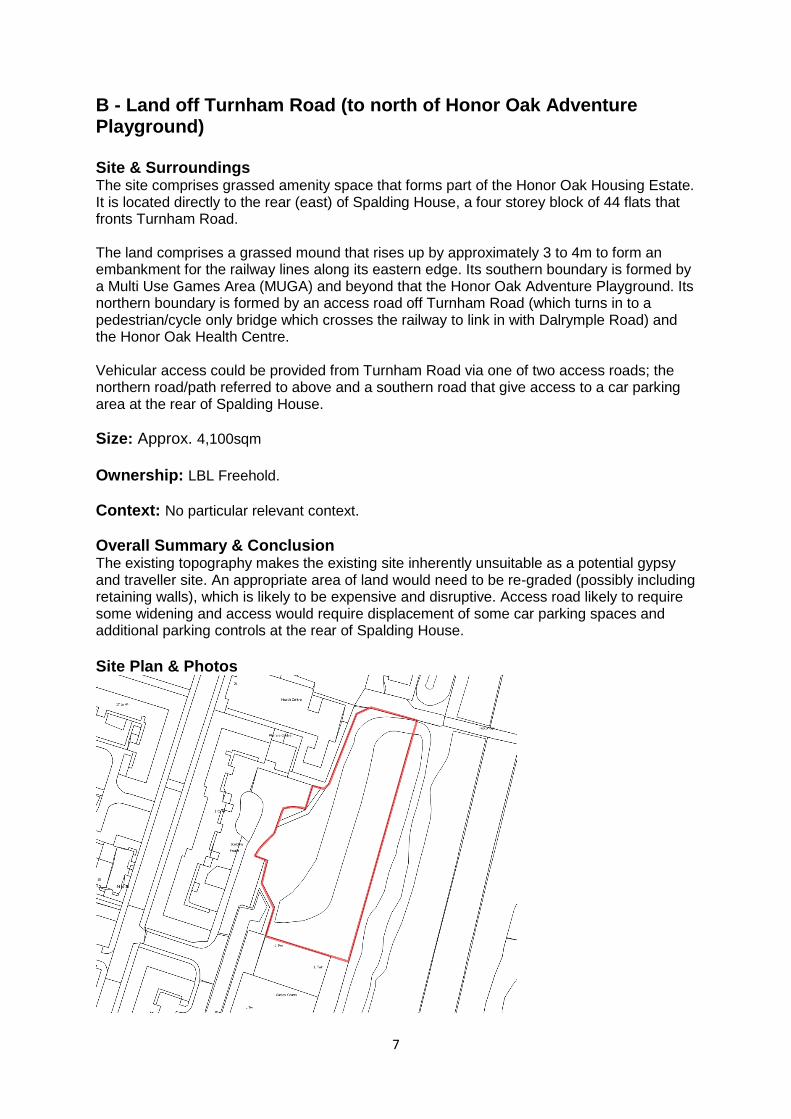
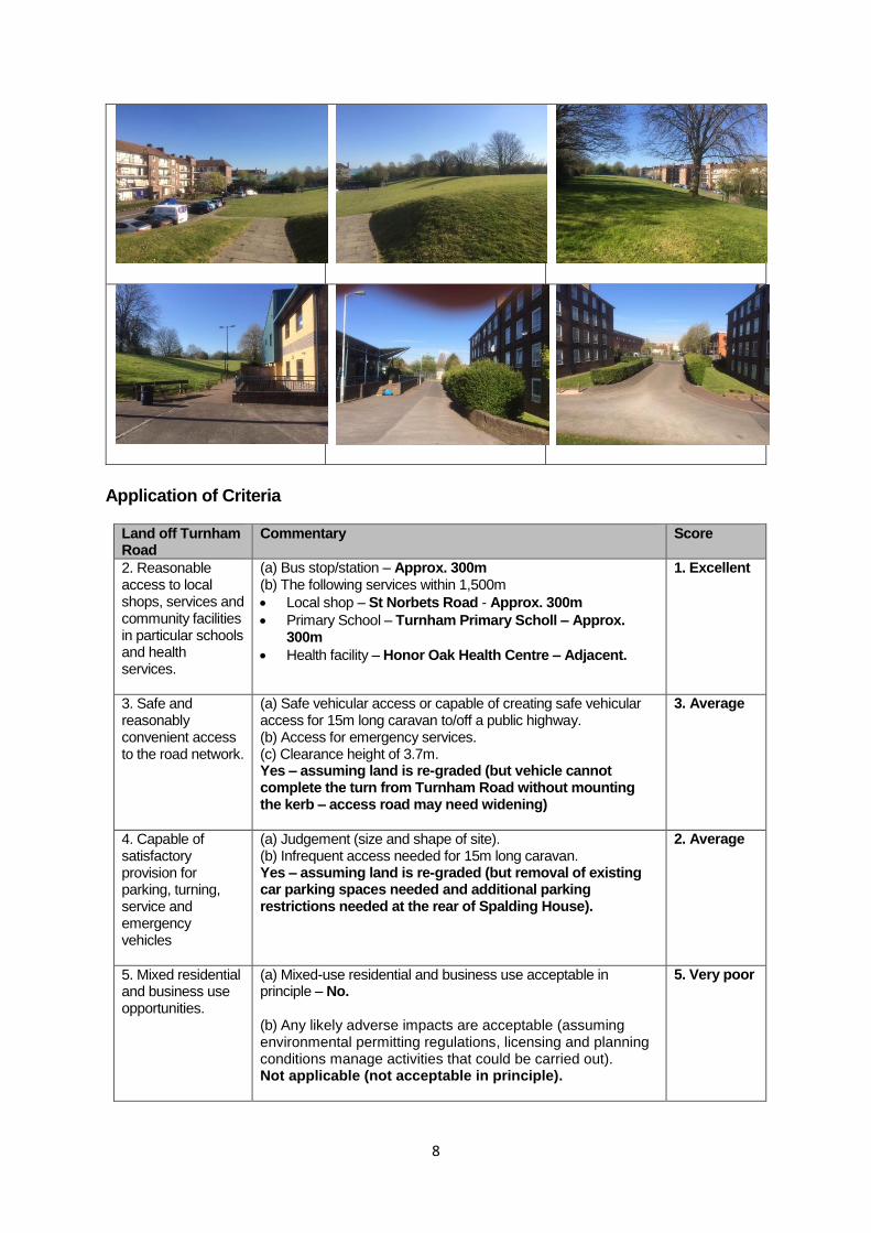
B - Land off Turnham Road (to north of Honor Oak Adventure Playground) Site & Surroundings The site comprises grassed amenity space that forms part of the Honor Oak Housing Estate. It is located directly to the rear (east) of Spalding House, a four storey block of 44 flats that fronts Turnham Road. The land comprises a grassed mound that rises up by approximately 3 to 4m to form an embankment for the railway lines along its eastern edge. Its southern boundary is formed by a Multi Use Games Area (MUGA) and beyond that the Honor Oak Adventure Playground. Its northern boundary is formed by an access road off Turnham Road (which turns in to a pedestrian/cycle only bridge which crosses the railway to link in with Dalrymple Road) and the Honor Oak Health Centre. Vehicular access could be provided from Turnham Road via one of two access roads; the northern road/path referred to above and a southern road that give access to a car parking area at the rear of Spalding House.
Size: Approx. 4,100sqm
Ownership: LBL Freehold.
Context: No particular relevant context.
Overall Summary & Conclusion The existing topography makes the existing site inherently unsuitable as a potential gypsy and traveller site. An appropriate area of land would need to be re-graded (possibly including retaining walls), which is likely to be expensive and disruptive. Access road likely to require some widening and access would require displacement of some car parking spaces and additional parking controls at the rear of Spalding House.
Site Plan & Photos
8
Application of Criteria
Land off Turnham Road
Commentary Score
2. Reasonable access to local shops, services and community facilities in particular schools and health services.
(a) Bus stop/station – Approx. 300m (b) The following services within 1,500m
Local shop – St Norbets Road - Approx. 300m
Primary School – Turnham Primary Scholl – Approx. 300m
Health facility – Honor Oak Health Centre – Adjacent.
1. Excellent
3. Safe and reasonably convenient access to the road network.
(a) Safe vehicular access or capable of creating safe vehicular access for 15m long caravan to/off a public highway. (b) Access for emergency services. (c) Clearance height of 3.7m. Yes – assuming land is re-graded (but vehicle cannot complete the turn from Turnham Road without mounting the kerb – access road may need widening)
3. Average
4. Capable of satisfactory provision for parking, turning, service and emergency vehicles
(a) Judgement (size and shape of site). (b) Infrequent access needed for 15m long caravan. Yes – assuming land is re-graded (but removal of existing car parking spaces needed and additional parking restrictions needed at the rear of Spalding House).
2. Average
5. Mixed residential and business use opportunities.
(a) Mixed-use residential and business use acceptable in principle – No. (b) Any likely adverse impacts are acceptable (assuming environmental permitting regulations, licensing and planning conditions manage activities that could be carried out). Not applicable (not acceptable in principle).
5. Very poor
9
Land off Turnham Road
Commentary Score
6. Supply of essential services such as water, sewerage and drainage and waste disposal.
Assume all sites have access to all essential services or are capable of being connected (NB cost of doing so may vary and affect deliverability). N.B. All sites to be given a score of ‘Average’ for this criterion.
3. Average
7. Scope for healthy lifestyles and integration.
(a) Opportunities for healthy lifestyles such as adequate landscaping & play areas – Judgement (size and shape of site). Yes – facilities nearby and potential for landscaping on site (level areas difficult and costly to create).
2. Good
(b) High standard design and landscape which facilitates the integration of the site with the surrounding environment and amenity of the occupiers adjoining the site – Judgement (size and shape of site). Yes – subject to re-grading and detailed design.
2. Good
8. Local environmental quality.
(a) Contamination – Free from significant contamination or able to be cleaned up (consult LBL Environmental Health) ((NB cost of doing so may vary and affect deliverability). No specific data available (assume OK).
(c) Air quality – Acceptable air quality (consult LBL Environmental Health)
Within AQMA 6, but away from main road, so OK.
(d) Flooding – Reasonable prospect of sequential test and exceptions tests being met. Flood Zone 1 – Use acceptable in principle (no need to apply sequential or exceptions test).
9. Spatial planning & development management considerations.
(a) Key relevant site specific development plan policies – both for the site itself and adjoining land
Within:
Flood Zone 1
AQMA 6
Area of Stability and Managed Change (Spatial Policy 5)
SINC (CS Policy 12) Adjacent to:
Urban Green Space (Adventure Playground) (CS Policy 12)
SINC (CS Policy 12)
3. Average.
(b) Key relevant general policies
CS Policy 2 (Gypsy and Travellers)
CS Policy 10 (Managing & reducing the risk of flooding)
CS Policy 12 (Open space and environmental assets)
CS Policy 14 (Sustainable movement & transport)
DM Policy 25 (Landscaping & trees)
LP Policy 5.12 (Flooding risk management)
LP Policy 7.21 – Trees & woodlands
10
Land off Turnham Road
Commentary Score
(c) Key relevant policies in emerging Local Plan and any emerging Neighbourhood Plan
None.
(d) Key relevant planning guidance
None.
(e) Planning history – identification of any key relevant planning history.
None.
(f) Summary – overall conclusion, taking account of the above.
Whilst identified as forming part of SINC, the land is mown amenity grassland and would appear to be of little biodiversity interest.
The re-grading that would be necessary to create an acceptable site may result in the total loss of existing trees and any biodiversity value that the land does have. It may also have adverse impacts on the wooded railway embankment part of the SINC immediately to the east.
Loss of amenity space for the Honor Oak Estate.
10. Deliverability Taking account of all of the previous criteria, sites should be: (a) Available now; (b) Offer a suitable location for development; and (c) Be achievable with a realistic prospect that development
will be delivered on the site within five years. Deliverable, but subject to major re-grading and access works.
4. Poor
11
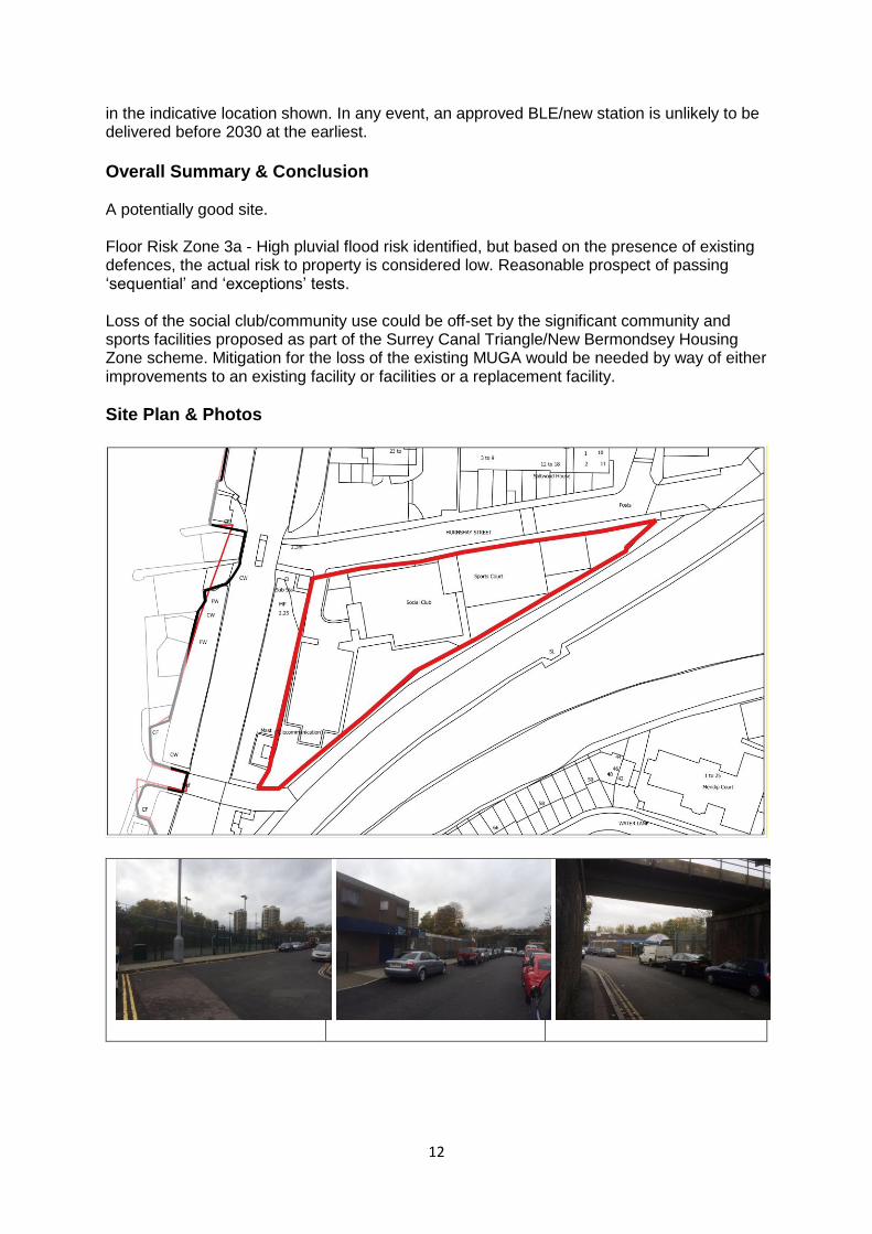
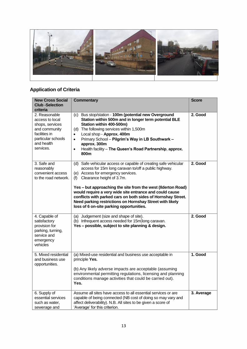
C - New Cross Social Club & adjoining land
Site & Surroundings A part one and part two-storey licensed social club and hall. The hall is used for community events, including church services on Sundays. To the west of the building is a car park for approximately 25 cars. To the east of the building sits a flood-lit Multi Games Area (MUGA) – this effectively forms part of the Winslade Estate. To the north lies the main part of the Winslade Estate; mainly four-storey blocks of flats and parking courts and open space courtyards that stretches northwards to Rollins Street. A pedestrian underpass built as part of these works provides a link between Hornshay Street and John Willis Close to the east. The East London Line Extension (ELLE) between Surrey Quays and Clapham Junction opened in December 2012 and adjoins the site to the south and now forms part of the London Overground. The South London railway line crosses Hornshay Street on a bridge immediately to the west and this comprises the borough boundary with the LB Southwark. There is an existing telecommunications mast located in the railway embankment immediately to the west of the site. To the west of this bridge (fronting Ilderton Road) are a number of open yard motor-trade and builder related businesses. Car parking in Hornshay Street is generally uncontrolled, although there is a short length of yellow-line control on the south side of the street, under the railway bridge. On-street car parking takes place on both sides of the street.
Size: 3,100sqm Ownership: LBL Freehold. Lease that expired in February 2011.
Context The existing MUGA was funded by the former New Cross Gate NDC and Marathon Trust about 10 years ago. The site is very close to the boundary with the LB Southwark. There are four gypsy and traveller sites within 1500m in Southwark, providing a total of 42 pitches, as follows:
Brideale Close SE15 (Off Glengall Road) 16 pitches;
Burnhill Close SE15 (Off Leo Street, Behind Toys 'R' Us in Old Kent Road) - 5 pitches;
Ilderton Road SE16 (Next to South Bermondsey Railway Station) - 15 pitches;
Springtide Close SE15 – 5 pitches. Passive provision has been made for a new train station at Surrey Canal Road on the London Overground network; linked with the approved Surrey Canal Triangle development/ New Bermondsey Housing Zone. The area to the west of Ilderton Road is within the London Plan Old Kent Road Opportunity Area and LB Southwark and the GLA are preparing and Opportunity Area Planning Framework (OAPF). Related to this, in December 2015, TfL confirmed that the proposed Bakerloo Line Extension would follow the Old Kent Road route to Lewisham (initially). Two indicative locations for stations along the Old Kent Road have been identified; one is to the west of Ilderton Road (approx. 400-500m from the potential site). The BLE is at a relatively early stage and is by no means certain. It is also not certain whether there would be a station
12
in the indicative location shown. In any event, an approved BLE/new station is unlikely to be delivered before 2030 at the earliest.
Overall Summary & Conclusion A potentially good site. Floor Risk Zone 3a - High pluvial flood risk identified, but based on the presence of existing defences, the actual risk to property is considered low. Reasonable prospect of passing ‘sequential’ and ‘exceptions’ tests. Loss of the social club/community use could be off-set by the significant community and sports facilities proposed as part of the Surrey Canal Triangle/New Bermondsey Housing Zone scheme. Mitigation for the loss of the existing MUGA would be needed by way of either improvements to an existing facility or facilities or a replacement facility.
Site Plan & Photos
13
Application of Criteria
New Cross Social Club -Selection criteria
Commentary Score
2. Reasonable access to local shops, services and community facilities in particular schools and health services.
(c) Bus stop/station - 100m (potential new Overground Station within 500m and in longer term potential BLE Station within 400-500m)
(d) The following services within 1,500m
Local shop - Approx. 400m
Primary School – Pilgrim’s Way in LB Southwark – approx. 300m
Health facility – The Queen’s Road Partnership, approx. 800m
2. Good
3. Safe and reasonably convenient access to the road network.
(d) Safe vehicular access or capable of creating safe vehicular access for 15m long caravan to/off a public highway.
(e) Access for emergency services. (f) Clearance height of 3.7m. Yes – but approaching the site from the west (Ilderton Road) would require a very wide site entrance and could cause conflicts with parked cars on both sides of Hornshay Street. Need parking restrictions on Hornshay Street with likely loss of 6 on-site parking opportunities.
2. Good
4. Capable of satisfactory provision for parking, turning, service and emergency vehicles
(a) Judgement (size and shape of site). (b) Infrequent access needed for 15m long caravan. Yes – possible, subject to site planning & design.
2. Good
5. Mixed residential and business use opportunities.
(a) Mixed-use residential and business use acceptable in principle Yes. (b) Any likely adverse impacts are acceptable (assuming environmental permitting regulations, licensing and planning conditions manage activities that could be carried out). Yes.
1. Good
6. Supply of essential services such as water, sewerage and
Assume all sites have access to all essential services or are capable of being connected (NB cost of doing so may vary and affect deliverability). N.B. All sites to be given a score of ‘Average’ for this criterion.
3. Average
14
New Cross Social Club -Selection criteria
Commentary Score
drainage and waste disposal.
7. Scope for healthy lifestyles and integration.
(a) Opportunities for healthy lifestyles such as adequate landscaping & play areas – Judgement (size and shape of site). Yes – possible, subject to site planning & design. Bridge House Meadows open space within 800m.
2. Good
(b) High standard design and landscape which facilitates the integration of the site with the surrounding environment and amenity of the occupiers adjoining the site – Judgement (size and shape of site). Yes – possible, subject to site planning & design. No immediate residential neighbours to east, south or west. Housing to the north - on opposite side of Hornshay Street.
2. Average
8. Local environmental quality.
(a) Contamination – Free from significant contamination or able to be cleaned up (consult LBL Environmental Health) ((NB cost of doing so may vary and affect deliverability).
No specific data available – proximity to railway means that there could be issues.
Railway noise would be an issue that would need to be addressed.
(c) Air quality – Acceptable air quality (consult LBL Environmental Health)
Within AQMA3 – but away from main road, so OK.
(d) Flooding – Reasonable prospect of sequential test and exceptions tests being met
Yes - Floor Risk Zone 3a - High pluvial flood risk identified, but based on the presence of existing defences, the actual risk to property is considered low.
9. Spatial planning & development management considerations.
(a) Key relevant site specific development plan policies – both for the site itself and adjoining land
Within:
Flood Zone 3A
AQMA1
New Cross/New Cross Gate Regeneration & Growth Area (Spatial Policy 1)
Lewisham, Catford & New Cross Opportunity Area (London Plan Policy 2.13)
Area of Regeneration (London Plan Policy 2.14)
Area of Archaeological Priority (Policy CS16) Adjacent to:
London Plan Old Kent Road Opportunity Area (west side of Ilderton Road)
Green Chain/Corridor (Policy CS12)
SINC 13 (Policy CS12)
3. Average
15
New Cross Social Club -Selection criteria
Commentary Score
(b) Key relevant general policies
CS Policy 2 (Gypsy and Travellers)
CS Policy 10 (Managing & reducing the risk of flooding)
CS Policy 14 (Sustainable movement & transport)
LP Policy 5.12 (Flooding risk management)
CS Policy 19 – Loss of recreational facility
LP Policy 3.19 (Sports facilities) seeks to resist the loss of sports facilities.
CS Policy 19 – Loss of community premises.
LP Policy 3.16 - Protection and enhancement of social infrastructure.
(c) Key relevant policies in emerging Local Plan and any emerging Neighbourhood Plan
No Neighbourhood Plan under preparation.
(d) Key relevant planning guidance
None relevant (Old Kent Road Opportunity Area Planning Framework under preparation).
(e) Planning history – identification of any key relevant planning history.
Permission granted 20/12/2005 (DC/05/60748/X) for the provision of a multi-use games area next to New Cross Social Club, together with the formation of a replacement car park for 25 cars.
Observations of proposed telecommunications mask on railway embankment to west of site 15-05-09 (DC/09/71216).
(f) Summary – overall conclusion, taking account of the above.
A Social Club is a ‘sui generis’ use for planning purposes
Policy presumption against the loss of a community facility and sports facility. These could be mitigated by the proposed provision of community and sport facilities in the approved Surrey Canal Triangle (New Bermondsey Housing Zone) development approximately 500m to the north.
Flood risk - OK
The PTAL of the area is currently already good given
bus routes along Ilderton Road and Old Kent Road/New
Cross Road. This would be improved by the opening of
a Surrey Canal Road Station on the Overground and (in
the longer term) an Old Kent Road Station on an
extended Bakerloo Line.
10. Deliverability Taking account of all of the previous criteria, sites should be: (d) Available now; (e) Offer a suitable location for development; and (f) Be achievable with a realistic prospect that development
will be delivered on the site within five years. Deliverable.
4. Good
16
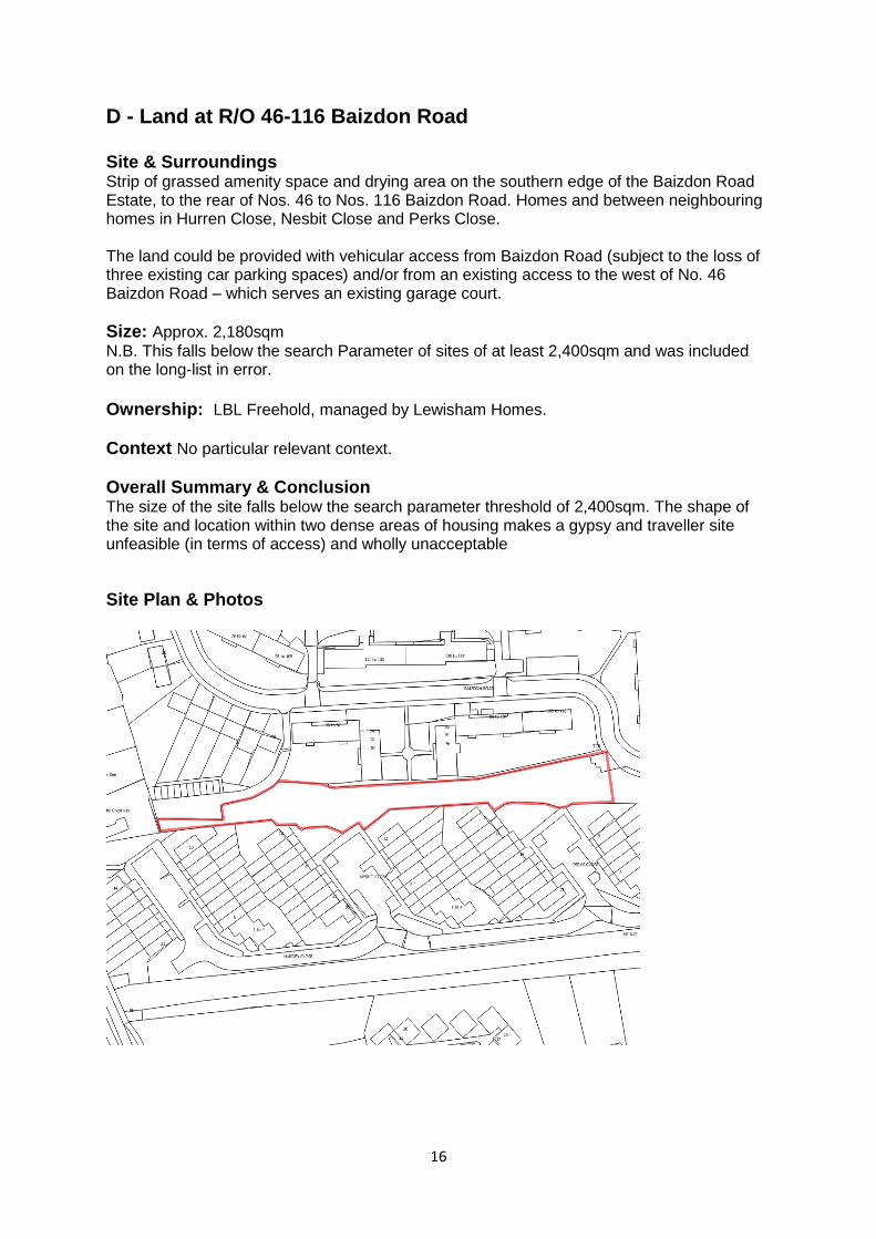
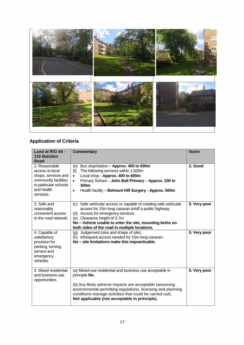
D - Land at R/O 46-116 Baizdon Road Site & Surroundings Strip of grassed amenity space and drying area on the southern edge of the Baizdon Road Estate, to the rear of Nos. 46 to Nos. 116 Baizdon Road. Homes and between neighbouring homes in Hurren Close, Nesbit Close and Perks Close. The land could be provided with vehicular access from Baizdon Road (subject to the loss of three existing car parking spaces) and/or from an existing access to the west of No. 46 Baizdon Road – which serves an existing garage court.
Size: Approx. 2,180sqm
N.B. This falls below the search Parameter of sites of at least 2,400sqm and was included on the long-list in error.
Ownership: LBL Freehold, managed by Lewisham Homes.
Context No particular relevant context.
Overall Summary & Conclusion The size of the site falls below the search parameter threshold of 2,400sqm. The shape of the site and location within two dense areas of housing makes a gypsy and traveller site unfeasible (in terms of access) and wholly unacceptable
Site Plan & Photos
17
Application of Criteria
Land at R/O 44 -116 Baizdon Road
Commentary Score
2. Reasonable access to local shops, services and community facilities in particular schools and health services.
(e) Bus stop/station – Approx. 400 to 600m (f) The following services within 1,500m
Local shop - Approx. 400 to 600m
Primary School – John Ball Primary – Approx. 100 to 300m
Health facility – Belmont Hill Surgery - Approx. 500m
2. Good
3. Safe and reasonably convenient access to the road network.
(c) Safe vehicular access or capable of creating safe vehicular access for 15m long caravan to/off a public highway.
(d) Access for emergency services. (e) Clearance height of 3.7m. No – Vehicle unable to enter the site, mounting kerbs on both sides of the road in multiple locations.
5. Very poor
4. Capable of satisfactory provision for parking, turning, service and emergency vehicles
(g) Judgement (size and shape of site). (h) Infrequent access needed for 15m long caravan. No – site limitations make this impracticable.
5. Very poor
5. Mixed residential and business use opportunities.
(a) Mixed-use residential and business use acceptable in principle No. (b) Any likely adverse impacts are acceptable (assuming environmental permitting regulations, licensing and planning conditions manage activities that could be carried out). Not applicable (not acceptable in principle).
5. Very poor
18
Land at R/O 44 -116 Baizdon Road
Commentary Score
6. Supply of essential services such as water, sewerage and drainage and waste disposal.
Assume all sites have access to all essential services or are capable of being connected (NB cost of doing so may vary and affect deliverability). N.B. All sites to be given a score of ‘Average’ for this criterion.
3. Average
7. Scope for healthy lifestyles and integration.
(a) Opportunities for healthy lifestyles such as adequate landscaping & play areas – Judgement (size and shape of site). No – site limitations make this impracticable.
5. Very poor
(b) High standard design and landscaped which facilitates the integration of the site with the surrounding environment and amenity of the occupiers adjoining the site – Judgement (size and shape of site). No – site limitations make this impracticable.
8. Local environmental quality.
(a) Contamination – Free from significant contamination or able to be cleaned up (consult LBL Environmental Health) ((NB cost of doing so may vary and affect deliverability).
(c) Air quality – Acceptable air quality (consult LBL Environmental Health)
Within AQMA – but away from main roads, so OK..
(d) Flooding – Reasonable prospect of sequential test and exceptions tests being met. Flood Zone 1 – Use acceptable in principle (no need to apply sequential or exceptions test).
9. Spatial planning & development management considerations.
(e) Key relevant site specific development plan policies – both for the site itself and adjoining land
Within:
Flood Zone 1
Area of Stability and Managed Change (Spatial Policy 5)
5. Very Poor
(f) Key relevant general policies
CS Policy 2 (Gypsy and Travellers)
CS Policy 10 (Managing & reducing the risk of flooding)
CS Policy 12 (Open space and environmental assets)
CS Policy 14 (Sustainable movement & transport)
DM Policy 25 (Landscaping & trees)
LP Policy 5.12 (Flooding risk management)
LP Policy 7.21 – Trees & woodlands
(g) Key relevant policies in emerging Local Plan and any emerging Neighbourhood Plan
No Neighbourhood Plan being prepared.
(h) Key relevant planning guidance
19
Land at R/O 44 -116 Baizdon Road
Commentary Score
None.
(i) Planning history – identification of any key relevant planning history.
None relevant.
(j) Summary – overall conclusion, taking account of the above.
Unacceptable loss of residential amenity space for the Baizdon Road Estate.
Unacceptable adverse impact on residential amenity.
10. Deliverability Taking account of all of the previous criteria, sites should be: (g) Available now; (h) Offer a suitable location for development; and (i) Be achievable with a realistic prospect that development
will be delivered on the site within five years. The site is inherently unsuitable.
5. Very Poor
20
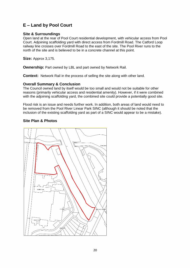
E – Land by Pool Court
Site & Surroundings Open land at the rear of Pool Court residential development, with vehicular access from Pool Court. Adjoining scaffolding yard with direct access from Fordmill Road. The Catford Loop railway line crosses over Fordmill Road to the east of the site. The Pool River runs to the north of the site and is believed to be in a concrete channel at this point.
Size: Approx 3,175.
Ownership: Part owned by LBL and part owned by Network Rail.
Context: Network Rail in the process of selling the site along with other land.
Overall Summary & Conclusion The Council owned land by itself would be too small and would not be suitable for other reasons (primarily vehicular access and residential amenity). However, if it were combined with the adjoining scaffolding yard, the combined site could provide a potentially good site. Flood risk is an issue and needs further work. In addition, both areas of land would need to be removed from the Pool River Linear Park SINC (although it should be noted that the inclusion of the existing scaffolding yard as part of a SINC would appear to be a mistake).
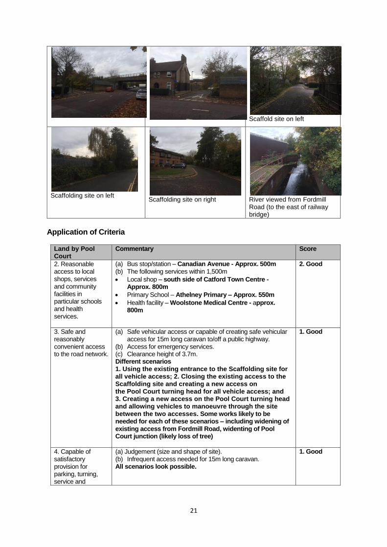
Site Plan & Photos
21
Scaffold site on left
Scaffolding site on left
Scaffolding site on right
River viewed from Fordmill Road (to the east of railway bridge)
Application of Criteria
Land by Pool Court
Commentary Score
2. Reasonable access to local shops, services and community facilities in particular schools and health services.
(a) Bus stop/station – Canadian Avenue - Approx. 500m (b) The following services within 1,500m
Local shop – south side of Catford Town Centre - Approx. 800m
Primary School – Athelney Primary – Approx. 550m
Health facility – Woolstone Medical Centre - approx. 800m
2. Good
3. Safe and reasonably convenient access to the road network.
(a) Safe vehicular access or capable of creating safe vehicular access for 15m long caravan to/off a public highway.
(b) Access for emergency services. (c) Clearance height of 3.7m. Different scenarios 1. Using the existing entrance to the Scaffolding site for all vehicle access; 2. Closing the existing access to the Scaffolding site and creating a new access on the Pool Court turning head for all vehicle access; and 3. Creating a new access on the Pool Court turning head and allowing vehicles to manoeuvre through the site between the two accesses. Some works likely to be needed for each of these scenarios – including widening of existing access from Fordmill Road, widenting of Pool Court junction (likely loss of tree)
1. Good
4. Capable of satisfactory provision for parking, turning, service and
(a) Judgement (size and shape of site). (b) Infrequent access needed for 15m long caravan. All scenarios look possible.
1. Good
22
Land by Pool Court
Commentary Score
emergency vehicles
5. Mixed residential and business use opportunities.
(a) Mixed-use residential and business use acceptable in principle Yes (if access restricted to Fordmill Road) (Scenario 1). (b) Any likely adverse impacts are acceptable (assuming environmental permitting regulations, licensing and planning conditions manage activities that could be carried out). Yes (if access restricted to Fordmill Road) (Scenario 1).
1. Excellent
6. Supply of essential services such as water, sewerage and drainage and waste disposal.
Assume all sites have access to all essential services or are capable of being connected (NB cost of doing so may vary and affect deliverability). N.B. All sites to be given a score of ‘Average’ for this criterion.
3. Average
7. Scope for healthy lifestyles and integration.
(a) Opportunities for healthy lifestyles such as adequate landscaping & play areas – Judgement (size, shape and topography of site). Yes, subject to detailed design.
2. Good
(b) High standard design and landscape which facilitates the integration of the site with the surrounding environment and amenity of the occupiers adjoining the site – Judgement (size and shape of site). Yes, subject to detailed design.
8. Local environmental quality.
(a) Contamination – Free from significant contamination or able to be cleaned up (consult LBL Environmental Health) ((NB cost of doing so may vary and affect deliverability). No specific data available – proximity to railway and existing use of part of the site as a scaffolding yard means that there could be issues.
3. Average
(b) Noise – Acceptable internal noise environment (consult LBL Environmental Health). Railway noise would be an issue that would need to be addressed.
(c) Air quality – Acceptable air quality (consult LBL Environmental Health) Not in AQMA. OK.
(d) Flooding – Reasonable prospect of sequential test and exceptions tests being met. Following mitigation - Moderate risk of surface pluvial flooding and low risk level river and groundwater.
9. Spatial planning & development management considerations.
(a) Key relevant site specific development plan policies – both for the site itself and adjoining land
Within:
3. Average
23
Land by Pool Court
Commentary Score
Part in Flood Zone 2/Part in Flood Zone 3A
Pool River Linear Park SINC (Policy CS 12 & SALP)
Area of Archaeological Priority (Policy CS16) Adjacent to:
Pool River Linear Park SINC (Policy CS 12 & SALP)
(b) Key relevant general policies
CS Policy 2 (Gypsy and Travellers)
CS Policy 10 (Managing & reducing the risk of flooding)
CS Policy 14 (Sustainable movement & transport)
LP Policy 5.12 (Flooding risk management)
Core Strategy Policy 5 (Other employment locations) states, amongst other things, that
o The Council will protect the scattering of employment locations throughout the borough outside SIL, LEL & MUELs.
o Other uses including retail, community and residential will be supported if it can be demonstrated that site specific conditions including site accessibility, restrictions from adjacent land uses, building age, business viability, and viability of redevelopment show that the site should no longer be retained in employment use
DM Policy 11 (Other employment locations) sets out specific criteria for considering applications for redevelopment for change to other business uses suitable for a residential area
(c) Key relevant policies in emerging Local Plan and any emerging Neighbourhood Plan
No Neighbourhood Plan under preparation.
(d) Key relevant planning guidance
River Corridor Improvement Plan SPD (September 2015)
(e) Planning history – identification of any key relevant planning history.
Planning application (DC/07/66731) submitted for the continued use of land adjacent to 16 Fordmill Road as a scaffolding/builders yard.
(f) Summary – overall conclusion, taking account of the above.
Benefits of a good quality site could outweigh the loss of land of ecological significance.
10. Deliverability Taking account of all of the previous criteria, sites should be: (c) Available now; (d) Offer a suitable location for development; and (e) Be achievable with a realistic prospect that development
will be delivered on the site within five years. Deliverable, but only in conjunction with other land that would need to be acquired.
4. Average (Potentially good)
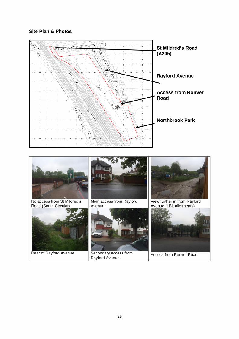
24
F - Land at St Mildred’s Road, Hither Green Site & Surroundings Former Hither Green railway sidings. The northern boundary is formed mainly by the Council owned St. Mildred’s Allotments which are at the rear of houses fronting St Mildred’s Road and accessed via the northern most vehicular access from Rayford Avenue. There are 17 allotments that cover approx. 1.73ha. There is a 6 year waiting list for an allotment, with about 40 people on the list. There is also an area of disused allotments to the south of the active allotment site. The eastern boundary is formed by two-storey houses fronting Rayford and Ronver Road and Northbrook Park. Further former railway sidings open land is to the south and active railway sidings are to the west. Vehicular access is via two accesses from Rayford Avenue, with an unmade lane running between these two accesses immediately to the rear of houses and providing access to a number of individual garages. There is no direct access from St Mildred’s Road (A205, South Circular). The central part of the site (approx. 2hectares) accommodates a horse riding stables (the Willowtree Riding Establishment), accessed from Ronver Road to the south.
Size: Total site is approx. 6.2 hectares.
Ownership: Oceanwave Estates Limited.
Context In March 2014 the Council declined an application for inclusion of the site in the Council’s Assets of Community Value. In May 2013, Oceanwave Estates Limited applied for planning permission to erect private stables, the removal of trees and the laying out of three paddocks (DC/13/83518). In February 2015, following a Local Hearing, the appeal was dismissed.
Overall Summary & Conclusion Vehicular access from Ronver Road would be excellent, if this could be shared with existing tables use. The potential site is ill-defined and there are various options as to where it could be located within the identified site. However, Metropolitan Open Land designation makes such development unacceptable.
25
Site Plan & Photos
St Mildred’s Road (A205) Rayford Avenue Access from Ronver Road Northbrook Park
No access from St Mildred’s Road (South Circular)
Main access from Rayford Avenue
View further in from Rayford Avenue (LBL allotments)
Rear of Rayford Avenue
Secondary access from Rayford Avenue
Access from Ronver Road
26
Application of Criteria
Land at St. Mildred’s Road
Commentary Score
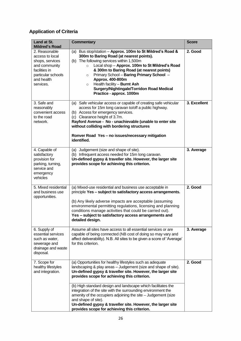
2. Reasonable access to local shops, services and community facilities in particular schools and health services.
(a) Bus stop/station – Approx. 100m to St Mildred’s Road & 300m to Baring Road (at nearest points).
(b) The following services within 1,500m o Local shop – Approx. 100m to St Mildred’s Road
& 300m to Baring Road (at nearest points) o Primary School – Baring Primary School –
Approx. 400-800m o Health facility – Burnt Ash
Surgery/Nightingale/Torridon Road Medical Practice - approx. 1000m
2. Good
3. Safe and reasonably convenient access to the road network.
(a) Safe vehicular access or capable of creating safe vehicular access for 15m long caravan to/off a public highway.
(b) Access for emergency services. (c) Clearance height of 3.7m. Rayford Avenue - No - unachievable (unable to enter site without colliding with bordering structures Ronver Road Yes – no issues/necessary mitigation identified.
3. Excellent
4. Capable of satisfactory provision for parking, turning, service and emergency vehicles
(a) Judgement (size and shape of site). (b) Infrequent access needed for 15m long caravan. Un-defined gypsy & traveller site. However, the larger site provides scope for achieving this criterion.
3. Average
5. Mixed residential and business use opportunities.
(a) Mixed-use residential and business use acceptable in principle Yes – subject to satisfactory access arrangements. (b) Any likely adverse impacts are acceptable (assuming environmental permitting regulations, licensing and planning conditions manage activities that could be carried out). Yes – subject to satisfactory access arrangements and detailed design.
2. Good
6. Supply of essential services such as water, sewerage and drainage and waste disposal.
Assume all sites have access to all essential services or are capable of being connected (NB cost of doing so may vary and affect deliverability). N.B. All sites to be given a score of ‘Average’ for this criterion.
3. Average
7. Scope for healthy lifestyles and integration.
(a) Opportunities for healthy lifestyles such as adequate landscaping & play areas – Judgement (size and shape of site). Un-defined gypsy & traveller site. However, the larger site provides scope for achieving this criterion.
2. Good
(b) High standard design and landscape which facilitates the integration of the site with the surrounding environment the amenity of the occupiers adjoining the site – Judgement (size and shape of site). Un-defined gypsy & traveller site. However, the larger site provides scope for achieving this criterion.
27
Land at St. Mildred’s Road
Commentary Score
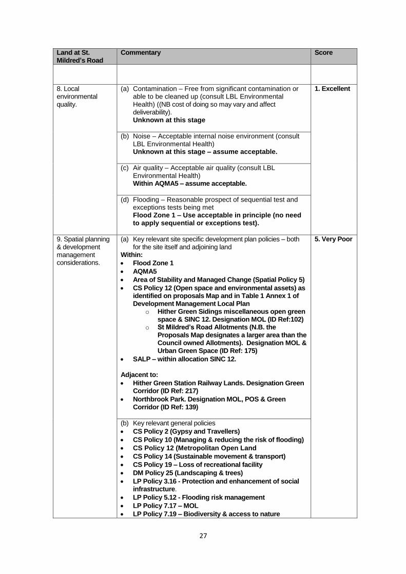
8. Local environmental quality.
(a) Contamination – Free from significant contamination or able to be cleaned up (consult LBL Environmental Health) ((NB cost of doing so may vary and affect deliverability). Unknown at this stage
1. Excellent
(b) Noise – Acceptable internal noise environment (consult LBL Environmental Health) Unknown at this stage – assume acceptable.
(c) Air quality – Acceptable air quality (consult LBL Environmental Health) Within AQMA5 – assume acceptable.
(d) Flooding – Reasonable prospect of sequential test and exceptions tests being met Flood Zone 1 – Use acceptable in principle (no need to apply sequential or exceptions test).
9. Spatial planning & development management considerations.
(a) Key relevant site specific development plan policies – both for the site itself and adjoining land
Within:
Flood Zone 1
AQMA5
Area of Stability and Managed Change (Spatial Policy 5)
CS Policy 12 (Open space and environmental assets) as identified on proposals Map and in Table 1 Annex 1 of Development Management Local Plan
o Hither Green Sidings miscellaneous open green space & SINC 12. Designation MOL (ID Ref:102)
o St Mildred’s Road Allotments (N.B. the Proposals Map designates a larger area than the Council owned Allotments). Designation MOL & Urban Green Space (ID Ref: 175)
SALP – within allocation SINC 12. Adjacent to:
Hither Green Station Railway Lands. Designation Green Corridor (ID Ref: 217)
Northbrook Park. Designation MOL, POS & Green Corridor (ID Ref: 139)
5. Very Poor
(b) Key relevant general policies
CS Policy 2 (Gypsy and Travellers)
CS Policy 10 (Managing & reducing the risk of flooding)
CS Policy 12 (Metropolitan Open Land
CS Policy 14 (Sustainable movement & transport)
CS Policy 19 – Loss of recreational facility
DM Policy 25 (Landscaping & trees)
LP Policy 3.16 - Protection and enhancement of social infrastructure.
LP Policy 5.12 - Flooding risk management
LP Policy 7.17 – MOL
LP Policy 7.19 – Biodiversity & access to nature
28
Land at St. Mildred’s Road
Commentary Score
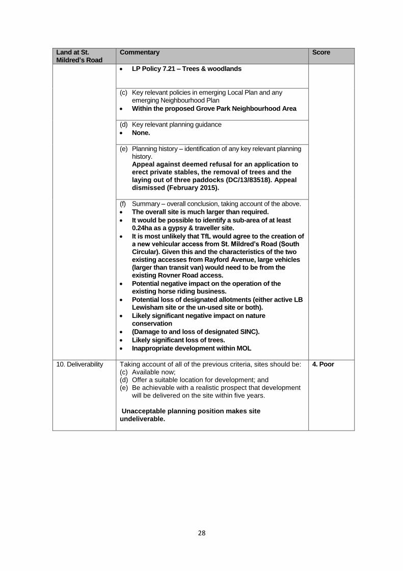
LP Policy 7.21 – Trees & woodlands
(c) Key relevant policies in emerging Local Plan and any emerging Neighbourhood Plan
Within the proposed Grove Park Neighbourhood Area
(d) Key relevant planning guidance
None.
(e) Planning history – identification of any key relevant planning history. Appeal against deemed refusal for an application to erect private stables, the removal of trees and the laying out of three paddocks (DC/13/83518). Appeal dismissed (February 2015).
(f) Summary – overall conclusion, taking account of the above.
The overall site is much larger than required.
It would be possible to identify a sub-area of at least 0.24ha as a gypsy & traveller site.
It is most unlikely that TfL would agree to the creation of a new vehicular access from St. Mildred’s Road (South Circular). Given this and the characteristics of the two existing accesses from Rayford Avenue, large vehicles (larger than transit van) would need to be from the existing Rovner Road access.
Potential negative impact on the operation of the existing horse riding business.
Potential loss of designated allotments (either active LB Lewisham site or the un-used site or both).
Likely significant negative impact on nature conservation
(Damage to and loss of designated SINC).
Likely significant loss of trees.
Inappropriate development within MOL
10. Deliverability Taking account of all of the previous criteria, sites should be: (c) Available now; (d) Offer a suitable location for development; and (e) Be achievable with a realistic prospect that development
will be delivered on the site within five years. Unacceptable planning position makes site undeliverable.
4. Poor
29
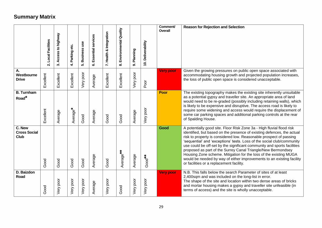
Summary Matrix
2. L
ocal F
acilitie
s
3. A
ccess t
o h
igh
way
4. P
ark
ing
etc
.
5. B
usin
ess u
se
6. E
ssen
tial serv
ices
7. H
ealt
h &
In
teg
ratio
n
8. E
nvir
on
men
tal Q
uality
9. P
lan
nin
g
10. D
elivera
bilit
y
Comment/ Overall
Reason for Rejection and Selection
A. Westbourne Drive
Excelle
nt
Excelle
nt
Excelle
nt
Very
poor
Avera
ge
Excelle
nt
Excelle
nt
Very
poor
Poor
Very poor
Given the growing pressures on public open space associated with accommodating housing growth and projected population increases, the loss of public open space is considered unacceptable.
B. Turnham
Road*
Excelle
nt
Avera
ge
Avera
ge*
Good
Avera
ge
Good
Good
Avera
ge
Very
poor
Poor The existing topography makes the existing site inherently unsuitable as a potential gypsy and traveller site. An appropriate area of land would need to be re-graded (possibly including retaining walls), which is likely to be expensive and disruptive. The access road is likely to require some widening and access would require the displacement of some car parking spaces and additional parking controls at the rear of Spalding House.
C. New Cross Social Club
Good
Good
Good
Good
Avera
ge
Good
Avera
ge**
Avera
ge
Good**
Good
A potentially good site. Floor Risk Zone 3a - High fluvial flood risk identified, but based on the presence of existing defences, the actual risk to property is considered low. Reasonable prospect of passing ‘sequential’ and ‘exceptions’ tests. Loss of the social club/community use could be off-set by the significant community and sports facilities proposed as part of the Surrey Canal Triangle/New Bermondsey Housing Zone scheme. Mitigation for the loss of the existing MUGA would be needed by way of either improvements to an existing facility or facilities or a replacement facility.
D. Baizdon Road
Good
Very
poor
Very
poor
Very
poor
Avera
ge
Very
poor
Good
Very
poor
Very
poor
Very poor
N.B. This falls below the search Parameter of sites of at least 2,400sqm and was included on the long-list in error. The shape of the site and location within two dense areas of bricks and mortar housing makes a gypsy and traveller site unfeasible (in terms of access) and the site is wholly unacceptable.
30
2. L
ocal F
acilitie
s
3. A
ccess t
o h
igh
way
4. P
ark
ing
etc
.
5. B
usin
ess u
se
6. E
ssen
tial serv
ices
7. H
ealt
h &
In
teg
ratio
n
8. E
nvir
on
men
tal Q
uality
9. P
lan
nin
g
10. D
elivera
bilit
y
Comment/ Overall
Reason for Rejection and Selection
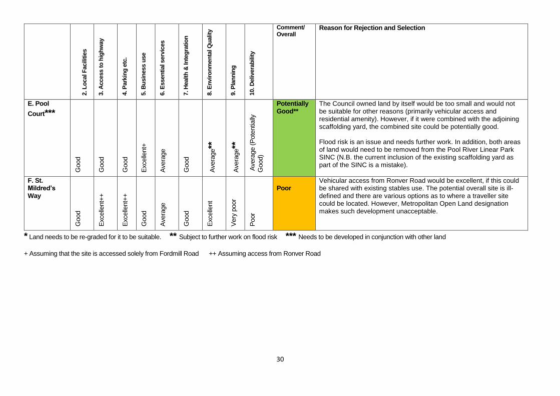
E. Pool
Court***
Good
Good
Good
Excelle
nt+
Avera
ge
Good
Avera
ge**
Avera
ge**
Avera
ge (
Pote
ntia
lly
Good)
Potentially Good**
The Council owned land by itself would be too small and would not be suitable for other reasons (primarily vehicular access and residential amenity). However, if it were combined with the adjoining scaffolding yard, the combined site could be potentially good. Flood risk is an issue and needs further work. In addition, both areas of land would need to be removed from the Pool River Linear Park SINC (N.B. the current inclusion of the existing scaffolding yard as part of the SINC is a mistake).
F. St. Mildred’s Way
Good
Excelle
nt+
+
Excelle
nt+
+
Good
Avera
ge
Good
Excelle
nt
Very
poor
Poor
Poor
Vehicular access from Ronver Road would be excellent, if this could be shared with existing stables use. The potential overall site is ill-defined and there are various options as to where a traveller site could be located. However, Metropolitan Open Land designation makes such development unacceptable.
* Land needs to be re-graded for it to be suitable. ** Subject to further work on flood risk *** Needs to be developed in conjunction with other land
+ Assuming that the site is accessed solely from Fordmill Road ++ Assuming access from Ronver Road