17
LANDFIRE 2015 Program Report March 2016 LANDFIRE 2015 Program Report
LANDFIRE 2015 Program Report March 2016
LANDFIRE 2015 Program Report

LANDFIRE 2015 Program Report March 2016
Executive Summary
The LANDFIRE 2015 Program Report summarizes the accomplishments, successes, and organization of the LANDFIRE program in FY 2015 as well as its anticipated activities in FY 2016. In 2015, the program supported staff members with career development opportunities. LANDFIRE prepared a number of presentations and publications helping inform and educate users. The program experienced great benefits from the partnerships that have been developed over the years. New agreements with Natural Resources Conservation Service (NRCS) and the Bureau of Land Management (BLM) have provided great potential to improve the suite of LANDFIRE data products due to the available ground plot data. The partnership with the National Gap Analysis Program (GAP) is resulting in solid remap planning outcomes as well as future update improvements. The major program accomplishment in 2015 was the delivery of the LANDFIRE 2012 update. This update provides the most recent version in a series of update projects with delivery on reference, disturbance, vegetation, and fuels data. Another noteworthy item included the development and release of the first in a series of seasonally adjusted fuels data sets under the Modeling Dynamic-Fuels with an Index System (MoD-FIS) effort, which systematically transitions surface fuel models based on seasonal conditions. The Southeastern U.S. was the first area to experience this new capability leveraging the Keetch-Byram Drought Index (KBDI). Future efforts in the MoD-FIS arena are anticipated in upcoming years. The program also kicked off the LANDFIRE 2014 update project to continue improving the representation of current conditions on the landscape due to disturbances and successional change. Administratively, the program completed a hardware replacement effort to modernize aging systems to set the stage for future years of support of the comprehensive remap project and the next generation of data updates. The help desk was relocated to USGS-EROS from the University of Idaho which was under the old National Interagency Fuels, Fire, and Vegetation Technology Transfer Team (NIFTT) effort. The program increased the number of product offerings with mosaic downloads. The LANDFIRE technical Leads held workshops and set technical direction on data products. The continued integration of Forest Inventory and Analysis (FIA) data and new geospatial datasets greatly supported mapping vegetation changes in LANDFIRE. Working with The Nature Conservancy (TNC), the program supported users and communication through improved LANDFIRE Bulletins and Post Cards. TNC also helped with development of a new methodology for computing Vegetation Departure and Vegetation Condition Class, plus initiated the Biophysical Settings review process which is planned for completion in 2016. TNC continued to be an important partner in assisting in project administration, planning, and communication.

LANDFIRE 2015 Program Report March 2016
The LANDFIRE Program
LANDFIRE (Landscape Fire and Resource Management Planning Tools) is a joint program between the U.S. Department of Agriculture (USDA) Forest Service (USFS) and the Department of the Interior (DOI), with The Nature Conservancy (TNC). LANDFIRE applies consistent methodologies and processes to develop comprehensive maps and data describing vegetation, disturbances, fire regimes, and wildland fuels across the United States and insular areas.
LANDFIRE Vision LANDFIRE is a cornerstone of a fully integrated national data information framework developing and improving vegetation and fuels data products based on the best available authoritative data and science in an all-lands landscape conservation approach based on inter-agency/inter-organizational collaboration and cooperation. LANDFIRE is acknowledged for management excellence and effective mission delivery.
LANDFIRE Mission LANDFIRE's mission is to provide agency leaders and managers with a common "all-lands" data set of vegetation and wildland fire/fuels information for strategic fire and resource management planning and analysis.
LANDFIRE's mission is to LANDFIRE's mission is to:
Provide national-level comprehensive and consistent strategic geospatial data products and databases to support wildland fire and natural resource management, planning, research, analysis, and assessment;
Produce repeatable, identifiable, mappable, and scalable data products;
Supplement and assist modelling of fire behavior and effects; and,
Improve collaboration between programs, data, and agencies for holistic wildland fire and natural resource management.
LANDFIRE Organization
The LANDFIRE Program is comprised of four organizational components in a blended-matrix structure involving Business Leadership from the DOI and the USDA Forest Service; Agency Technical Center Operations, and Operational Partners.
Governance: Common oversight of program activities, management of component functions, coordination with sponsors and stakeholders, program budgeting and program business case.
Operations: Program functions that do not include direct data production. These functions include website support, hardware and software systems, technical support, and management and administrative activities.
Maintenance: Direct production of data products including version updating of existing products and new editions applying comprehensive product-wide mapping.
Improvement and Innovation: Enhancement to current data production methods and advancement of new scientific methods and information sources.

LANDFIRE 2015 Program Report March 2016
LANDFIRE FY 2015 Results
Major Results / Accomplishments
Completion of all delivery obligations of the LANDFIRE 2012 update. This update provides the most recent version in a series of update projects with delivery on reference, disturbance, vegetation, and fuels data.
Initiated development on LANDFIRE (LF) 2014 update. LF 2014 builds off of previous updates to account for landscape changes, growth, and disturbance information and will focus on the years 2013 and 2014 to support wildland fire and natural resource management, planning, research, analysis, and assessments. LF 2014 is the first LANDFIRE project to adopt formal project management tools to track scope, schedule, and budget.
Initiated the Biophysical Settings review process, including identifying duplicate models, thereby reducing the LANDFIRE Biophysical Settings (BpS) model and description product suite by almost 50% without loss of information, and designing and creating a BpS Review website.
Released the first of a series of seasonally adjusted fuels products created under the Modeling Dynamic-Fuels with an Index System (MoD-FIS) project. MoD-FIS provides a new approach to enhance the accuracy of U.S. fuel products by systematically transitioning surface fuel models based on seasonal conditions. This first product suite uses the Keetch-Byram Drought Index (KBDI) to automatically generate an adjusted LANDFIRE surface fuel model layer in the southeast United States.
LANDFIRE completed an 18-month effort to modernize its process and data delivery systems. Many of these systems were well beyond their useful life and most had no redundant failover capacity requiring significant downtime to recover from failures. We upgraded our data processing systems to allow for more users and integrated into a High Performance Computing (HPC) environment.
A Memorandum of Understanding (MOU) with the Natural Resource Conservation Service (NRCS) for access and use of the National Resource Inventory (NRI) data set was signed in January 2015.
Lessons Learned
LANDFIRE conducted an extensive customer questionnaire in 2015. Over 260 customers completed and returned the survey. Although LANDFIRE’s customer base continues to be fire users, the non-fire community is a rapidly growing segment. Fire Behavior Fuel Model (FBFM) 40 was rated the most “useful” product. Some customers are concerned about site-specific accuracy and regional differences in data set product quality.
Due to informal and evolving planning techniques, LF 2012 required considerable management involvement to keep scope and schedule on track. We sense that this also required the use of more staff than should be necessary. In an effort to more directly involve staff in the planning and execution of products, LF 2014 implemented more formal project management techniques including staff driven
LANDFIRE 2015 Program Report March 2016
planning. We hope these techniques will result in fewer resource assigned to the project freeing them up for the challenge of planning and executing a remap effort.
LANDFIRE is recognizing the impact and value of partnerships. The breadth of efforts in LANDFIRE (NRCS NRI data and USGS GAP integration work on vegetation legend and remap planning) has allowed us to foster and prepare for broader data improvements. The work has created shared benefits by working together and learning from each other. Coordination and collaboration indeed takes time, effort and patience, but partnerships are a key element to a successful path forward with expanded capability and data functionality.
The impact and tangible reach of the LANDFIRE Program is far greater than we understood. The need for timely, consistent, and comprehensive data is vast in both the fire and non-fire user communities, and the LANDFIRE Program is one of the places users can turn to fill some of those needs.
Awards and Staff Recognition
In 2015, Technical Lead Don Long was able to do a detail with the Joint Fire Science Program (JFSP) as the Communications Director in the Program Office in Boise, ID. This job entailed creation and distribution of fire science briefings and news “flashes” of ongoing fire science research funded by JFSP. In addition, in the month of October, Don met and coordinated with members of the Fire Science Exchange Network at a meeting in Ft. Collins, CO, and members of the Joint Fire Science Governing Board at a meeting in Madison, WI.
MoD-FIS: Seasonally Adjusted Fuel Products for SE United States, at the U.S. Geological Survey Earth Resources Observation and Science Center (EROS) 2015 Top 10 Technical Accomplishments.
Presentations and Workshops
68th SRM Annual Meeting & Trade Show Managing Diversity January 30-February 7, 2015, Sacramento, CA: Topic > Integrating Bureau of Land Management’s AIM (Assessment, Inventory, and Monitoring) strategy data in LANDFIRE.
Restoring America’s Forest National Landscape meeting
TNC Wisconsin Chapter staff
Region 9 staff, USFS
Midwest Bird Monitoring Conference
Soil Science Society of America Meeting
Hiawatha LANDFIRE data review workshop
LANDFIRE Program and Data Review, Southern Blue Ridge Fire Learning Network
Nine (9) LANDFIRE webinars presented in collaboration with JFSP Exchanges.
Pecora 19, November 2014, Denver, CO, a presentation titled Disturbance mapping by the LANDFIRE program.
Black Hills Digital Mapping Association Annual Conference, November 2014, Rapid City, SD, a presentation titled LANDFIRE: a source for nationally consistent data.
LANDFIRE 2015 Program Report March 2016
Publications and Reports
Blankenship, Kori, Leonardo Frid, and James L. Smith. A state-and-transition
simulation modeling approach for estimating the historical range of
variability. 2015. AIMS Environmental Science 2(2): 253-268. doi:
10.3934/environsci.2015.2.253
Haugo, Ryan, Chris Zanger, Tom DeMeo, Chris Ringo, Ayn Shlisky, Kori
Blankenship, Mike Simpson, Kim Mellen-McLean, Jane Kertis and Mark Stern.
2015. A new approach to evaluate forest structure restoration needs across Oregon
and Washington, USA. Forest Ecology and Management 335: 37-50.
McKerrow, Alexa, Jim Smith, and Frank Fay. Coming Together for an All-Lands
Dataset to Support Wildfire and Wildlife Conservation Planning. 2015. North
American Bird Conservation Initiative E-Newsletter All-Bird Bulletin. Spring 2015: 9-
13.
Nelson, Kurtis J. and Daniel Steinwand. 2015. A Landsat Data Tiling and
Compositing Approach Optimized for Change Detection in the Conterminous United
States.Photogrammetric Engineering & Remote Sensing 81(7): 573-586.
Peterson, B. and Nelson, K.J., 2014, Mapping Forest Height in Alaska Using GLAS,
Landsat Composites, and Airborne LiDAR: Remote Sensing, v. 6, no. 12, p. 12409-
12426.
Zahn, S.G., 2015, LANDFIRE: U.S. Geological Survey Fact Sheet 2015-3047, 2 p.,
http://dx.doi.org/10.3133/fs20153047.
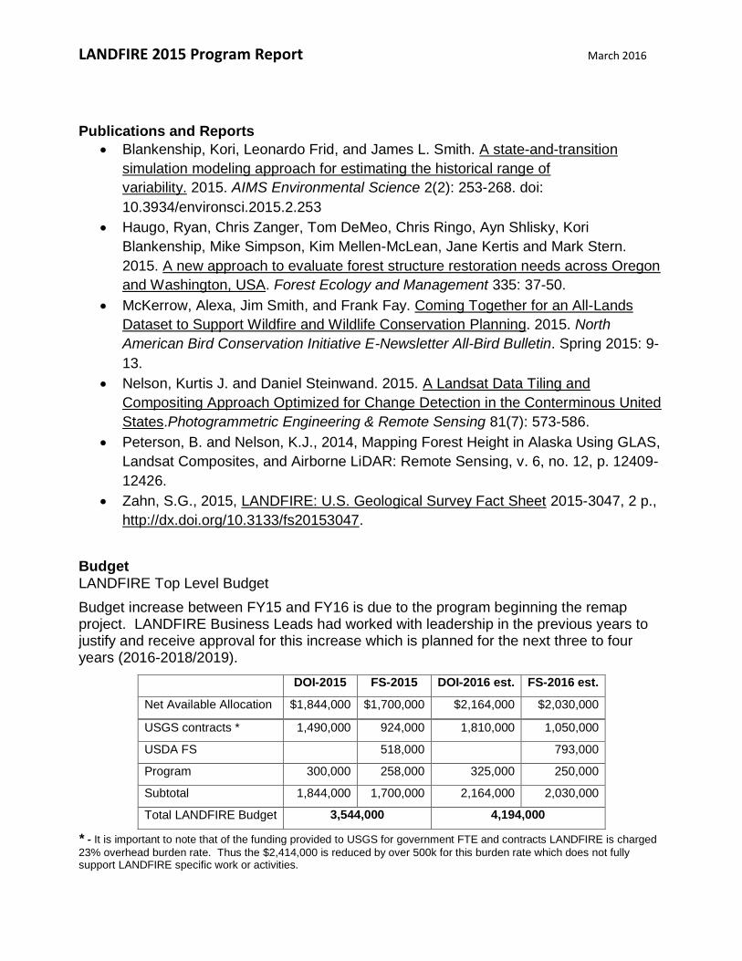
Budget LANDFIRE Top Level Budget
Budget increase between FY15 and FY16 is due to the program beginning the remap project. LANDFIRE Business Leads had worked with leadership in the previous years to justify and receive approval for this increase which is planned for the next three to four years (2016-2018/2019).
* - It is important to note that of the funding provided to USGS for government FTE and contracts LANDFIRE is charged
23% overhead burden rate. Thus the $2,414,000 is reduced by over 500k for this burden rate which does not fully support LANDFIRE specific work or activities.
DOI-2015 FS-2015 DOI-2016 est. FS-2016 est.
Net Available Allocation $1,844,000 $1,700,000 $2,164,000 $2,030,000
USGS contracts * 1,490,000 924,000 1,810,000 1,050,000
USDA FS 518,000 793,000
Program 300,000 258,000 325,000 250,000
Subtotal 1,844,000 1,700,000 2,164,000 2,030,000
Total LANDFIRE Budget 3,544,000 4,194,000
LANDFIRE 2015 Program Report March 2016
Partnerships
LANDFIRE enjoys and promotes many partner relationships with numerous benefits to and
from each other. We recognize our partners within three categories:
Principal Partner: A LANDFIRE Principal Partner is an organization and/or
individual with a strong, vested interest in LANDFIRE and shares many common
goals. Principal Partners serve as sponsors and provide financial support and
programmatic direction. There are two principal partners: The U.S. Department of
the Interior and The U.S. Department of Agriculture (USDA) Forest Service
Major Partner: A LANDFIRE Major Partner is an organization and/or individual with
unique expertise and interest in LANDFIRE and demonstrates a willingness to apply
their expertise to LANDFIRE initiatives and efforts. Our major partners are The
Nature Conservancy, U.S. Geological Survey (USGS) Earth Resources Observation
and Science (EROS) Center, USDA Forest Service (FS) Rocky Mountain Research
Station Fire Modeling Institute (FMI), USGS National Gap Analysis Program (GAP),
USDA Forest Service Forest Inventory and Analysis (FIA), and USDA Natural
Resource Conservation Service (NRCS).
Supporting Partner: A LANDFIRE Supporting Partner is an organization and/or
individual targeted to receive LANDFIRE products and services. Supporting
Partners often provide data or services to LANDFIRE as well, but usually as part of
their general operation without specific, value-added processing. A complete list of
supporting partners can be found at www.landfire.gov.
Partnership highlights in 2015 include the following:
A memorandum of understanding (MOU) was signed in January 2015 with NRCS
for access and use of the National Resource Inventory (NRI) data set in LANDFIRE.
This was a significant milestone after years of work and coordination from the
LANDFIRE Business Leads. The program is excited to begin using these data in
2016 as part of the remap.
A data agreement was signed with the Bureau of Land Management (BLM) to
provide Assessment Inventory & Monitoring data. This agreement leverages the
BLM data and newly implemented NRCS/NRI protocol across BLM managed lands.
Building from the GAP/LANDFIRE MOU signed in 2014, GAP and LANDFIRE staff
has worked to integrate GAP staff as part of the LANDFIRE team. The integration
of staff has strengthened the relationship and the ability of both programs to
collectively work on issues of common concern and begin a joint effort on the
LANDFIRE 2015 remap project.
These partnerships have great potential to improve the suite of LANDFIRE data products
not only in the planned remap but in future updates as well.

LANDFIRE 2015 Program Report March 2016
LANDFIRE Fiscal Year 2016 Plans
Continue LANDFIRE 2014 update towards a delivery in early FY 17
Continue LANDFIRE remap prototypes towards a project kickoff in 2016 o Scoping for a possible LANDFIRE 2016 update (providing for an update
while working on remap) o Preliminary data processing for LANDFIRE 2015 remap
Plot data processing and collection Investigate use of Landscape Change Monitoring and Assessment
Project (LCMAP) data in LF15 remap o Begin to more fully highlight and promote use of data from partnerships
Potentially with NRCS NRI o Engagement Opportunities Completed
Fire Behavior Fuel Model Guidebook-Database LANDFIRE Biophysical Settings (BpS) Models and Descriptions
review Fire Regime Group (FRG) Review
Technical leadership on improving LANDFIRE data products o Smoke and Air Quality o Agricultural lands and as associated fuels
LANDFIRE 2015 Program Report March 2016
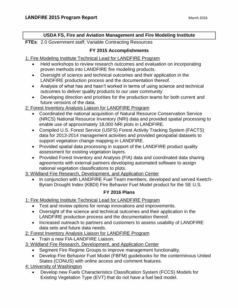
USDA FS, Fire and Aviation Management and Fire Modeling Institute
FTEs: 2.0 Government staff; Variable Contracting Resources
FY 2015 Accomplishments
1: Fire Modeling Institute Technical Lead for LANDFIRE Program
Held workshops to review research outcomes and evaluation on incorporating proven methods into LANDFIRE fire modeling products.
Oversight of science and technical outcomes and their application in the LANDFIRE production process and the documentation thereof.
Analysis of what has and hasn’t worked in terms of using science and technical outcomes to deliver quality products to our user community
Developing direction and priorities for the production teams for both current and future versions of the data.
2: Forest Inventory Analysis Liaison for LANDFIRE Program
Coordinated the national acquisition of Natural Resource Conservation Service (NRCS) National Resource Inventory (NRI) data and provided spatial processing to enable use of approximately 18,000 NRI plots in LANDFIRE.
Compiled U.S. Forest Service (USFS) Forest Activity Tracking System (FACTS) data for 2013-2014 management activities and provided geospatial datasets to support vegetation change mapping in LANDFIRE.
Provided spatial data processing in support of the LANDFIRE product quality assessment for existing vegetation layers.
Provided Forest Inventory and Analysis (FIA) data and coordinated data sharing agreements with external partners developing automated software to assign national vegetation classifications to plots.
3: Wildland Fire Research, Development, and Application Center
In conjunction with LANDFIRE Fuel Team members, developed and served Keetch-Byram Drought Index (KBDI) Fire Behavior Fuel Model product for the SE U.S.
FY 2016 Plans
1: Fire Modeling Institute Technical Lead for LANDFIRE Program
Test and review options for remap innovations and improvements.
Oversight of the science and technical outcomes and their application in the LANDFIRE production process and the documentation thereof.
Increased outreach to partners and customers to assess usability of LANDFIRE data sets and future data needs.
2: Forest Inventory Analysis Liaison for LANDFIRE Program
Train a new FIA-LANDFIRE Liaison. 3: Wildland Fire Research, Development, and Application Center
Segment Fire Regime Groups to improve management functionality.
Develop Fire Behavior Fuel Model (FBFM) guidebooks for the conterminous United States (CONUS) with online access and comment features.
4: University of Washington
Develop new Fuels Characteristics Classification System (FCCS) Models for Existing Vegetation Type (EVT) that do not have a fuel bed model.

LANDFIRE 2015 Program Report March 2016
U.S. Geological Survey Earth Resources Observation and Science Center
FTEs: 1.5 Government staff and variable contracting resources (approximately 19 FTE)
Contractors: Stinger Ghaffarian Technologies; ASRC InuTeq
FY 2015 Accomplishments
1: LANDFIRE 2012 Update
LANDFIRE (LF) 2012 is the latest release in a series of update projects designed to deliver a suite of updated LANDFIRE data products for the conterminous United States (CONUS), Alaska, and Hawai’i using the most recent available data. LF 2012 delivered, on time and on budget, a variety of core products within the Reference, Disturbance, Vegetation, and Fuels categories. Additional achievements under LF 2012 included: Using Remote Sensing of Landscape Change (RSLC) methods to map disturbance in Hawai’i, Provide Gap Fill to correct scan line issues in select Monitoring Trends in Burn Severity (MTBS) fire perimeters, and Adding Canopy Base Height (CBH) Regression Tree Analysis (RTA) capability to the LF Total Fuel Change (LFTFC) tool to streamline CBH calculations, reduce processing time, and simplify future updates.
2: Seasonally Adjusted Fuel Products for SE United States
LANDFIRE released the first of a series of seasonally adjusted fuels products created under its Modeling Dynamic-Fuels with an Index System (MoD-FIS) project. MoD-FIS provides a new approach to enhance the accuracy of U.S. fuel products by systematically transitioning surface fuel models based on seasonal conditions. This first product suite uses the Keetch-Byram Drought Index (KBDI) to automatically generate an adjusted LANDFIRE surface fuel model layer in the SE United States. This capability was released within the Wildland Fire Decision Support System (WFDSS).
3: LF 2014 Project Kickoff
LANDFIRE 2014 (LF 2014) is the next in a series of update releases to the original LF National product suite, aimed at improving LANDFIRE’s representation of current conditions due to landscape disturbances and successional change and continues the goal to account for landscape changes, growth, and disturbance information. The LF 2014 project is for the years 2013 and 2014 to support wildland fire and natural resource management, planning, research, analysis, and assessments. LF 2014 is a collaborative effort between several partners.
4: Hardware Replacement Project
The LANDFIRE program completed an 18-month hardware replacement project to modernize aging critical systems reducing risk to both LANDFIRE Production and Operations. In 2014, LF processing and operations servers, and associated disk arrays, consisted of stand-alone systems, many well past their end of life. Most of the systems had no redundant failover capacity requiring significant downtime to recover from failures. In a worst case scenario, some failures would be catastrophic as spare parts were no longer available. LF retired those systems and moved both production and operations into independently managed enterprise architectures with modern, redundant systems and 24x7 local maintenance and upgrade
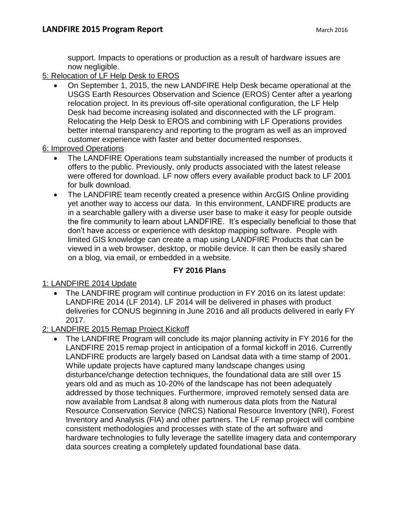
LANDFIRE 2015 Program Report March 2016
support. Impacts to operations or production as a result of hardware issues are now negligible.
5: Relocation of LF Help Desk to EROS
On September 1, 2015, the new LANDFIRE Help Desk became operational at the USGS Earth Resources Observation and Science (EROS) Center after a yearlong relocation project. In its previous off-site operational configuration, the LF Help Desk had become increasing isolated and disconnected with the LF program. Relocating the Help Desk to EROS and combining with LF Operations provides better internal transparency and reporting to the program as well as an improved customer experience with faster and better documented responses.
6: Improved Operations
The LANDFIRE Operations team substantially increased the number of products it offers to the public. Previously, only products associated with the latest release were offered for download. LF now offers every available product back to LF 2001 for bulk download.
The LANDFIRE team recently created a presence within ArcGIS Online providing yet another way to access our data. In this environment, LANDFIRE products are in a searchable gallery with a diverse user base to make it easy for people outside the fire community to learn about LANDFIRE. It’s especially beneficial to those that don’t have access or experience with desktop mapping software. People with limited GIS knowledge can create a map using LANDFIRE Products that can be viewed in a web browser, desktop, or mobile device. It can then be easily shared on a blog, via email, or embedded in a website.
FY 2016 Plans
1: LANDFIRE 2014 Update
The LANDFIRE program will continue production in FY 2016 on its latest update: LANDFIRE 2014 (LF 2014). LF 2014 will be delivered in phases with product deliveries for CONUS beginning in June 2016 and all products delivered in early FY 2017.
2: LANDFIRE 2015 Remap Project Kickoff
The LANDFIRE Program will conclude its major planning activity in FY 2016 for the LANDFIRE 2015 remap project in anticipation of a formal kickoff in 2016. Currently LANDFIRE products are largely based on Landsat data with a time stamp of 2001. While update projects have captured many landscape changes using disturbance/change detection techniques, the foundational data are still over 15 years old and as much as 10-20% of the landscape has not been adequately addressed by those techniques. Furthermore, improved remotely sensed data are now available from Landsat 8 along with numerous data plots from the Natural Resource Conservation Service (NRCS) National Resource Inventory (NRI), Forest Inventory and Analysis (FIA) and other partners. The LF remap project will combine consistent methodologies and processes with state of the art software and hardware technologies to fully leverage the satellite imagery data and contemporary data sources creating a completely updated foundational base data.
LANDFIRE 2015 Program Report March 2016
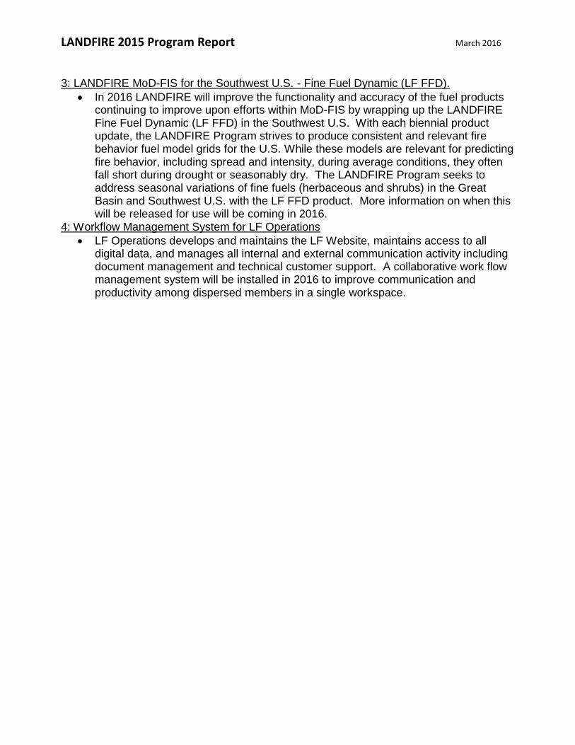
3: LANDFIRE MoD-FIS for the Southwest U.S. - Fine Fuel Dynamic (LF FFD).
In 2016 LANDFIRE will improve the functionality and accuracy of the fuel products continuing to improve upon efforts within MoD-FIS by wrapping up the LANDFIRE Fine Fuel Dynamic (LF FFD) in the Southwest U.S. With each biennial product update, the LANDFIRE Program strives to produce consistent and relevant fire behavior fuel model grids for the U.S. While these models are relevant for predicting fire behavior, including spread and intensity, during average conditions, they often fall short during drought or seasonably dry. The LANDFIRE Program seeks to address seasonal variations of fine fuels (herbaceous and shrubs) in the Great Basin and Southwest U.S. with the LF FFD product. More information on when this will be released for use will be coming in 2016.
4: Workflow Management System for LF Operations
LF Operations develops and maintains the LF Website, maintains access to all digital data, and manages all internal and external communication activity including document management and technical customer support. A collaborative work flow management system will be installed in 2016 to improve communication and productivity among dispersed members in a single workspace.

LANDFIRE 2015 Program Report March 2016
The Nature Conservancy
FTEs: 4.1 FTEs Contractors: Axiom IT Solutions; Apex RMS, Ltd.
FY 2015 Accomplishments
Task 1 (T1): User Support and Program Communication
Led the redesign, development and distribution of LANDFIRE Bulletins and Post Cards.
Collaborated with the Natural Resource Conservation Service (NRCS) Ecological Site Description (ESD) Program and provided recommendations on future opportunities, including a joint presentation at the National ESD meeting in Duluth, MN.
Conducted a widely attended set of seminars with the Joint Fire Science Program (JFSP) Exchange consortia.
Participated in and presented a poster during the LANDFIRE workshop at the Association for Fire Ecology (AFE) Meeting in San Antonio, TX.
Managed the LANDFIRE Twitter site (more than 1,300 followers) and the YouTube Channel (videos viewed more than 1,500 times).
Task 2 (T2): Tool and Process Development
Wrote and facilitate a contract to develop the gNEXUS interface for the LANDFIRE Fuels Team.
Developed new methodology for computing Vegetation Departure and Vegetation Condition Class.
Completed the automation of the LANDFIRE Agreement Assessment processes in partnership with USGS Earth Resources Observation and Science (EROS) Center staff.
Task 3 (T3): LANDFIRE Production Support
Initiated the Biophysical Settings Review (BpS) process, including identifying duplicate models thereby reducing the model set by almost 50%, and designing, creating, and maintaining a BpS Review website.
Worked with EROS staff to compute LF 2010 Vegetation Departure and Condition Class.
Investigated the time and cost requirements for creating a LANDFIRE 2012 Vegetation Departure (VDEP) and Vegetation Condition Class (VCC).
Completed Phase 1 of the LANDFIRE Auto-Key Improvement Project. Task 4 (T4): Data Analysis
Supported the Illinois Fire Needs Assessment. Task 5 (T5): Project Administration, Planning and Communication
Participated in LANDFIRE remap and biennial update planning conference calls/meetings.
Participated in “Special Issue” calls as requested by the Business Lead Team.
Participated in regular Business Lead Team (BLT) and Business Lead Group (BLG) calls (facilitating such calls in rotation).
Administered relevant contracts and agreements.

LANDFIRE 2015 Program Report March 2016
Provided Bi-Monthly Activity Reports (change from Monthly Activity Reports).
Provided a 12 month progress Report each funding year (change from Annual Progress Report).
Led The Nature Conservancy (TNC) LANDFIRE budget control and team management
FY 2016 Plans
Task 1 (T1): User Support and Program Communication
Participate in the design and management of TNC LANDFIRE’s website presences, www.conservationgateway.org, the LANDFIRE Program website, www.landfire.gov, and the LANDFIRE Web-Hosted Application Map (WHAM!).
Actively manage LANDFIRE social media activities.
Coordinate LANDFIRE direct communications with relevant USGS EROS staff (Bulletins, Postcards, etc.).
Support planning for LANDFIRE remap through communications, announcements, and intelligence gathering.
Assist (or lead if designated) the LANDFIRE Program in partnership or collaboration opportunities, such as TNC, JFSP, NRCS (NRI), Bureau of Land Management (BLM) (AIM, Open Standards), National Land Cover Database (NLCD), Landscape Conservation Collaborative (LCC), and the National Gap Analysis Program (GAP).
Direct support to landscapes utilizing or considering utilizing LANDFIRE Program products.
Plan, initiate, and progress on a pilot project with the Eastern NRCS Ecological Site Description Program.
Participate (and lead on specific tasks where appropriate and designated) in the LANDFIRE Website Group and LANDFIRE Communications Strategy Group.
Task 2 (T2): Tool and Process Development
Complete the automation of the LANDFIRE Agreement Assessment processes in partnership with EROS staff.
Initiate planning for quality assessments of appropriate LANDFIRE remap spatial products.
Administer and complete the gNEXUS contract. Task 3 (T3): LANDFIRE Production Support
Complete the review of the BpS Models and Descriptions product suite and complete relevant analyses and communications as requested/designated.
Assist in the development, review, and improvement of LANDFIRE spatial products as requested by the BLG, such as:
o Fire Regime attributes o Succession Classes o VDEP/VCC
Complete the LANDFIRE Auto-Key Improvement Project and assist with analyses and communications as requested/designated.
Task 4 (T4): Data Analysis
Complete and post and/or publish the LF 2012 Agreement Assessment process and associated communications.

LANDFIRE 2015 Program Report March 2016
Task 5 (T5): Project Administration, Planning and Communication
Participate in LANDFIRE remap and biennial update planning conference calls/meetings.
Participate in regular Business Lead Team and Business Lead Group calls (facilitating such calls in rotation).
Participate in other relevant BLG, BLT and Technical Leadership Group (TLG) calls as appropriate and requested and other administrative tasks/requirements.
LANDFIRE 2015 Program Report March 2016
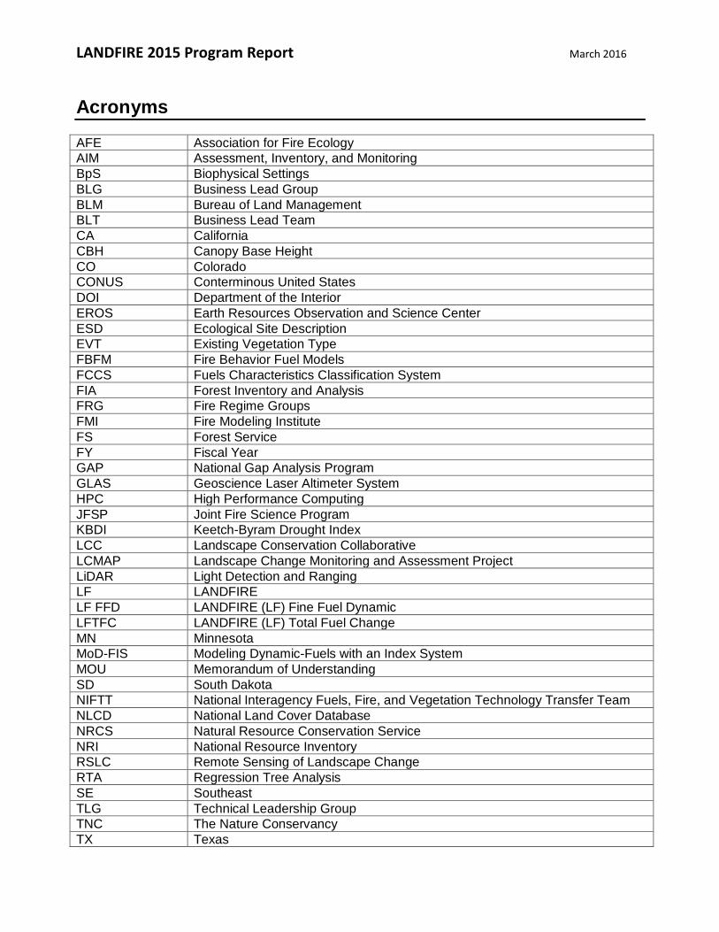
Acronyms
AFE Association for Fire Ecology
AIM Assessment, Inventory, and Monitoring
BpS Biophysical Settings
BLG Business Lead Group
BLM Bureau of Land Management
BLT Business Lead Team
CA California
CBH Canopy Base Height
CO Colorado
CONUS Conterminous United States
DOI Department of the Interior
EROS Earth Resources Observation and Science Center
ESD Ecological Site Description
EVT Existing Vegetation Type
FBFM Fire Behavior Fuel Models
FCCS Fuels Characteristics Classification System
FIA Forest Inventory and Analysis
FRG Fire Regime Groups
FMI Fire Modeling Institute
FS Forest Service
FY Fiscal Year
GAP National Gap Analysis Program
GLAS Geoscience Laser Altimeter System
HPC High Performance Computing
JFSP Joint Fire Science Program
KBDI Keetch-Byram Drought Index
LCC Landscape Conservation Collaborative
LCMAP Landscape Change Monitoring and Assessment Project
LiDAR Light Detection and Ranging
LF LANDFIRE
LF FFD LANDFIRE (LF) Fine Fuel Dynamic
LFTFC LANDFIRE (LF) Total Fuel Change
MN Minnesota
MoD-FIS Modeling Dynamic-Fuels with an Index System
MOU Memorandum of Understanding
SD South Dakota
NIFTT National Interagency Fuels, Fire, and Vegetation Technology Transfer Team
NLCD National Land Cover Database
NRCS Natural Resource Conservation Service
NRI National Resource Inventory
RSLC Remote Sensing of Landscape Change
RTA Regression Tree Analysis
SE Southeast
TLG Technical Leadership Group
TNC The Nature Conservancy
TX Texas
LANDFIRE 2015 Program Report March 2016
US United States
USDA U.S. Department of Agriculture
USFS US Forest Service
USGS US Geological Survey
VCC Vegetation Condition Class
VDEP Vegetation Departure Index
WFDSS Wildland Fire Decision Support System
WI Wisconsin


![Example of Change in a LANDFIRE Refresh 2008 · Example of Change in a LANDFIRE Refresh 2008 [1.1.0] Product Reflecting an Incorporated Disturbance LF 2001 Existing Vegetation Cover](https://static.documents.pub/doc/80x56/5d38958a88c99366578c81d7/example-of-change-in-a-landfire-refresh-2008-example-of-change-in-a-landfire.jpg)


