33
Licensing of Photogrammetrists and Other Geospatial Practitioners MAPPS Summer Meeting Sunriver , Oregon July 15, 2015 John M. Palatiello Executive Director – MAPPS

Licensing of Photogrammetrists and
Other Geospatial Practitioners
MAPPS Summer Meeting
Sunriver, Oregon
July 15, 2015
John M. PalatielloExecutive Director – MAPPS

State Licensing of Photogrammetrists
• Licensure vs. Certification
• Model Law
• Report of Joint Task Force on NCEE Model Law for Surveying
• Status of Licensing Laws in the Various States - Photogrammetry
• What’s Working
• What’s Not
• Discussion

Certification
VS.
Licensure
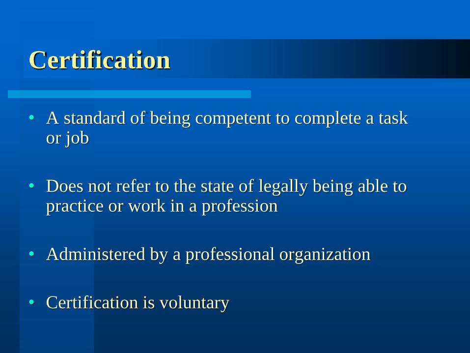
Certification
• A standard of being competent to complete a task or job
• Does not refer to the state of legally being able to practice or work in a profession
• Administered by a professional organization
• Certification is voluntary

Licensure
• Is administered by a governing entity for
public protection
• Grants permission to practice
• It’s the law

Certification/Licensure Requirements
• Both require the demonstration of a certain level of
knowledge and ability
• Education
• Experience
• Exam
• Continuing Competency
• Compliance with Regulations (laws)

Model Law
Reference Guide
Standard Language
to be used by State Legislatures and
Licensing Boards

NCEES
National Council of Examiners
for
Engineers and Surveyors
NCEES.ORG

The Model Law Process
The Model Compiled Law• Delegates for 50 states and territories
• Delegates are PE, LS members of state licensing
boards

• We were drafted into the surveying community
with the 1995 model law revision (included
photogrammetry).
• We have to be accepted into the new
“blended family” of surveyors.
• Attitudes have to change on all sides for
success.
Photogrammetrists/GIS Professionals

• We have to accept becoming a ‘highly regulated
profession’ dedicated to protecting the health, safety,
and welfare of the public.
• The current survey profession has to accept
‘broadening’ of their profession.
Photogrammetrists/GIS Professionals

Licensure Requirements – Paradigm Changes
• Labeling of ‘Professional Surveyor’(not just Professional Land Surveyors)
• Continuing Education Broadened(not just boundary courses)
• Minimum Technical Standards – revised(not just plat requirements)
• Seats on Board of Licensure – modified(to include Photogrammetrists)

Report of the Joint Task Force
on NCEES Model Law
for Surveying

Task Force Organizations
• American Congress on Surveying and Mapping (ACSM)
• American Society of Civil Engineers - Geomatics Division
(ASCE)
• American Society for Photogrammetry and Remote
Sensing (ASPRS)
• Management Association for Private Photogrammetric
Surveyors (MAPPS)
• National Society of Professional Surveyors (NSPS)
• National States Geographic Information Council (NSGIC)
• Urban and Regional Information Systems Association
(URISA)

Task Force History
• 1995 - NCEES Modifies Model Surveying Law to Include
Photogrammetry and GIS/LIS
• 1996 - Concerns Raised/Letters Written by ASPRS,
MAPPS, ASCE. Discussion at Winter NCEES/POLC
Meeting
• 1997 - Five Organization Summit Meeting (ACSM, NSPS,
MAPPS, ASPRS, ASCE). Agree to Work Together.
• 1997 - Task Force Addresses Photogrammetric Issues
• 1997/1998 - Task Force Report Delivered to NCEES
(Covering Photogrammetry Issues Only – No GIS)

Task Force History
• 1998 - NCEES Modifies Model Law to Include Savings
Clause (Grandfather Language) per Task Force
Recommendation
• 1999 - NCEES Modifies Model Law to Address Issues
Related to Reciprocity/Comity and Ease of Mobility
• 1999 - Three GIS Organizations Invited to Participate in
Extension of Task Force to Address GIS/LIS Issues
(URISA, NSGIC, UCGIS)
• 2000 - NCEES Modifies Policies Related to Broadening
Examination Coverage

Task Force History
• 2000 – Task Force Addendum to 1997 Report (covering
GIS/LIS Issues) Delivered to NCEES
• 2001 – NCEES Task Force on Model Law Appointed
• 2001 – Registration Boards Forum, Las Vegas
• 2001 – Workshop at NCEES Annual Meeting, Little Rock
• 2002 – Accepted Report of NCEES Internal Task Force
• 2003 – Adopted at NCEES Summer Meeting

Report of the Task Force on
NCEES Model Law for Surveying
Report and Slides: www.asprs.org
(Follow News and Advocacy link
Click on NCEES)

What’s Working
1. Savings Clause – due to MAPPS / ASPRS
2. Education Broadened
3. Exam – NCEE Fundamentals, same for everyone
4. Experience Broadened – PLS or Photogrammetrists
5. Practice Exam – NCEES 6 hours or Colonial States
6 hours and State 2 hours
6. Continuing Education – some broadening

What’s Not
1. Not a uniform application method by the States
2. Little, no reciprocity/comity
3. NCEES only gave general guidance to States
4. Onerous continuing education requirements for
individuals licensed in multiple states

National Licensure for Photogrammetrists
and GIS Practitioners
Should there be a single, national license rather than 50 State licenses?
Are photogrammetrists & GIS practitioners engaged in 'interstate commerce', or is their practice typically confined to one State?
Constitution of the United States provides that Congress “shall regulate Commerce … among the several States” [Article I, Section 8]

Is Photogrammetry/Geospatial (Broadly
Defined) Really Part
of the Practice of Surveying?
• There are Significant Differences Between
Surveying and Photogrammetry Firms
• Training & Education
• Equipment & Capital
• Size in Revenues & Employees

Is Photogrammetry/Geospatial (Broadly
Defined) Really Part
of the Practice of Surveying?
• Geospatial is more inter-state commerce than
traditional surveying
• Land law varies from state to state
• Laws of science (photogrammetry/GIS/geospatial)
do not vary from state to state

How Would a National License Work?
• Establishment of a Board
(Federal legislation is needed; cannot be done
administratively)
• Appointment of Board Members
• Board Hires Staff
• Board Sets Rules, Fines, Fees and Penalties
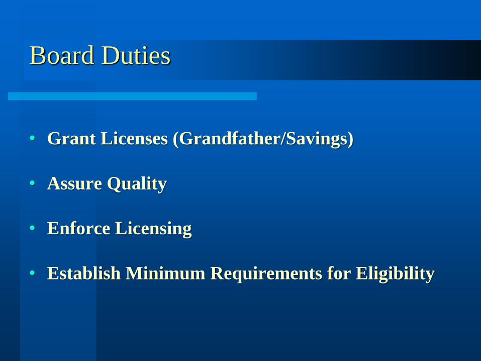
Board Duties
• Grant Licenses (Grandfather/Savings)
• Assure Quality
• Enforce Licensing
• Establish Minimum Requirements for Eligibility

• Administer Examinations
• Establish Standards of Practice
• Award News Licenses
• Enforce Compliance & Conduct Investigations
Board Duties

Legislation/Regulation to
Create a Board Would:
• Define Photogrammetry/GIS/Geospatial*
• Establish Requirements for Licensure
• Set Penalties & Fines
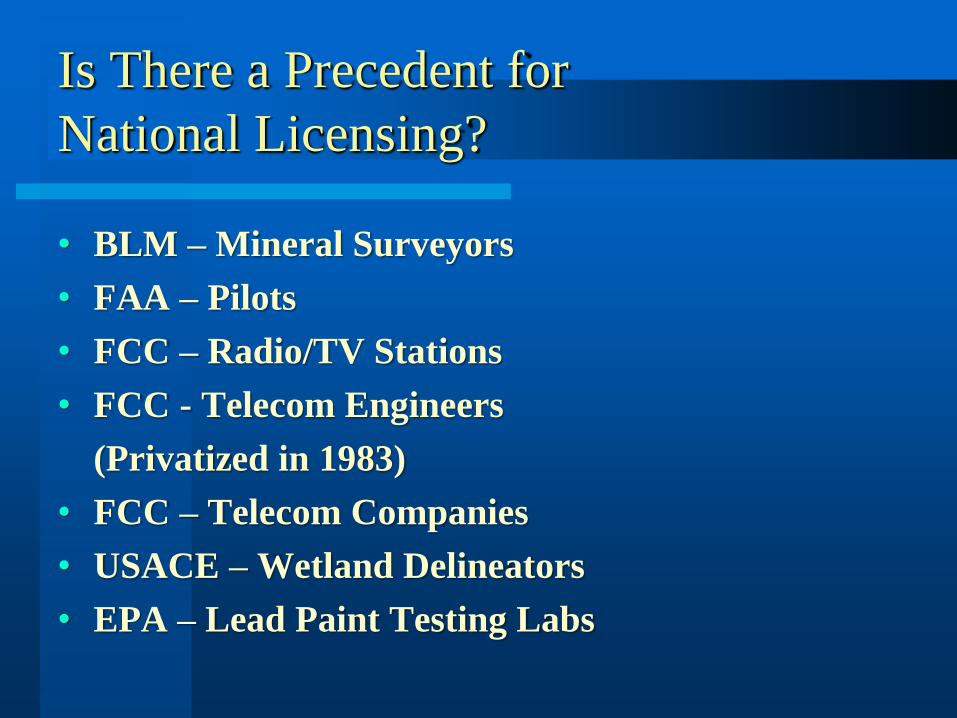
Is There a Precedent for
National Licensing?
• BLM – Mineral Surveyors
• FAA – Pilots
• FCC – Radio/TV Stations
• FCC - Telecom Engineers
(Privatized in 1983)
• FCC – Telecom Companies
• USACE – Wetland Delineators
• EPA – Lead Paint Testing Labs
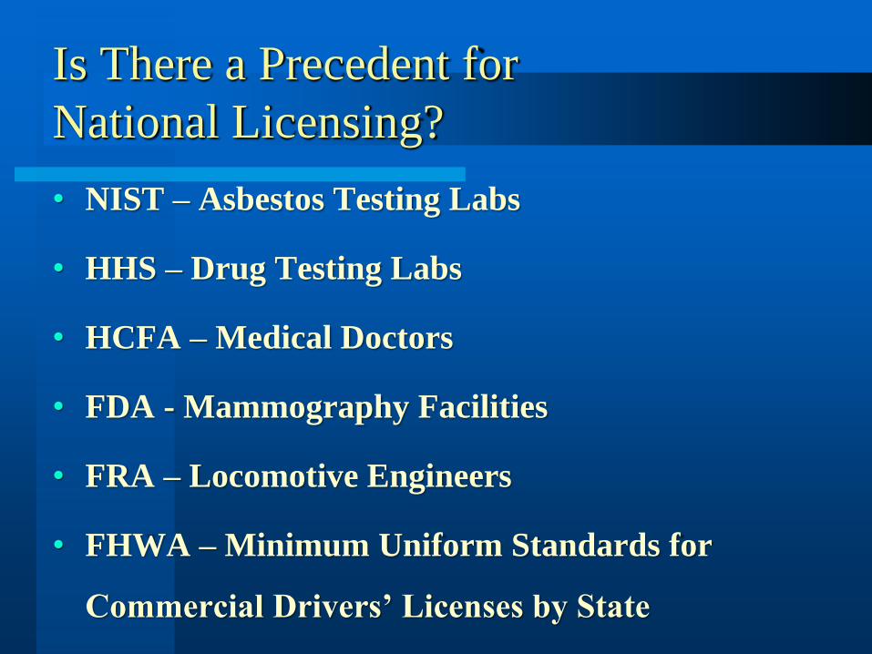
Is There a Precedent for
National Licensing?
• NIST – Asbestos Testing Labs
• HHS – Drug Testing Labs
• HCFA – Medical Doctors
• FDA - Mammography Facilities
• FRA – Locomotive Engineers
• FHWA – Minimum Uniform Standards for
Commercial Drivers’ Licenses by State

Can a National License
be Implemented?
• Interior Department Solicitor has told USGS it
can implement a national license for USGS
contracts under current law and statutory
authority
• New legislation would be needed to expand or
require other Federal agencies or non-Federal
entities to honor the USGS national license

Can a National License
be Implemented?
• Legislation could define what is subject to a
national license, and exempt, leave to the states,
conventional surveying, particularly boundary
Can a National License
be Implemented?
• Draft bill in your email

QUESTIONS
Thank you for your attention.


