29
LiDAR My favourite tool in the bag 2011 St Kitts & Nevis Lt Cdr Rupert Forester-Bennett RN (ret’d) December 5 th to 11 th 2011

LiDARMy favourite tool in the bag
2011
St Kitts & Nevis
Lt Cdr Rupert Forester-Bennett RN (ret’d)
December 5th to 11th 2011

Collection of geospatial data – reasons
Overcoming the ‘White Ribbon’
Not just about heights
Cost comparison against traditional methods
Many and varied uses
Sharing the investment
Content

International Trade and Economy
Ecological Protection
Disaster mitigation & management
International Boundaries (UNCLOS)
Collection of Geospatial data

International Trade and Economy Sea-Land Links
Leisure and tourism
Port and marina development
Fishing industries
Hydrographic data, information, charts, advice
Collection of Geospatial data

Marine Mapping & Ecological Protection
Flood defences, inundation mapping
Protection of environment and aquaculture
Climate change
Hydrographic data, information, charts, advice
Collection of Geospatial data

Disaster Mitigation & Management
Modelling
Response planning
Early warning systems
Hydrographic data, information, charts, advice
Collection of Geospatial data

United Nations Conventions
SOLAS Navigation aids
Pilotage
Hydrographic data, information, charts, advice
UNCLOS Sub-Sea Territorial Rights
Continental Shelf
Collection of Geospatial data

8
Data Collection Techniques
Chains, Distance Measuring Equipment (DME)
Lead Line
Triangulation, Theodolite,PHOTOGRAMMETRY
Single Beam Echo Sounder (SBES)SIDE SCAN SONAR PICTURE
GPSPHOTOGRAMMETRY
Multi Beam Echo Sounder (MBES)SIDE SCAN SONAR PICTURE
Topographic LiDAR 532nmPHOTOGRAMMETRY
Bathymetric LiDAR 1064nmSIDE SCAN SONAR
Topographic/Bathymetric LiDARPHOTOGRAMMETRY/REFLECTANCE

C Copyright 2011 Pelydryn Limited; All rights
reserved 10
What does this mean in Practice?

11
Overcoming The White RibbonTopo LiDAR
Deep MBES
Shallow MBESBathy/Topo
LiDAR
Bathy/Topo LiDAR overlaps both ways

Small
Local
13
Aircraft

• The depth of water and height of land is measured by laser pulses of two wavelengths; Green (532nm) and Infra-Red (IR) (1064nm)
• The green beam penetrates the water, whereas the IR laser is reflected at the surface. The time difference between the green (bottom) and the IR (water surface) laser reflections is used to calculate the depth.
14

• Both lasers are scanned in a pattern on the water surface.
• The scanning mirror of the LiDAR allows the effects of motion in the platform to be compensated for directly.
• The scanning mirror compensates for pitch and roll by adjusting the direction in which the laser beams are transmitted, ensuring that they are transmitted ahead of the aircraft at an off-nadir angle of 20˚ and scan left and right either side of the line of advance of the aircraft.
• The result is a generally evenly spaced pattern of transmissions and returns covering the seabed. 15
Scan Pattern

*
16
Advantages/Disadvantages
White Ribbon(Unsurveyed)
Boat operations suffer
from: reduced swathe width
slow progress
dangerous waters
dependence on Mother
ship
high cost/km2

17
Advantages/Disadvantages
Bathy LiDAR suffers from:
Water Clarity – Secchi Disc
Scale of Operation

The HawkEye II B is fitted with a uEye IU-2250-C / M camera
Imagery is used to assist in data cleaning
Orthophotos are available at a resolution of 25cm when flown at 400m altitude
Imagery will also observe
ambient sea conditions and phenomena (eddies and over falls)
Areas of vegetation and vegetation type
Extent of Rocks and Reefs
Brittany: IFREMER
22
Not Just about heights - Photography

Bathymetric data can be processed to produce images of reflectance to aid bottom type classification
23
Not Just about heights - Reflectance
C Copyright 2011 Pelydryn Limited; All rights
reserved 24
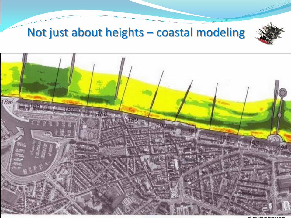
Not just about heights – coastal modeling

2m Cube at 18m depth
HEIIb meets the object detection requirement of >2m in up to 40m depths
27
Not just about heights - Object detection

28
Figures are for guidance, and vary according to local factors
MBES ALB
Average cost per 1 km2 of survey 3 1
Average cost of a 350 km2 survey 3 1
Average time for a 350 km2 (days) 35 2
Speed and Cost

31
Current uses of combined Topo/bathy dataMaldives: Ministry of Transport, Housing and the
EnvironmentClimate Change / Sea Level Rise / Tsunami / Storm Surge Mitigation

32

33
Ideal foundation dataset on which to base:
Storm Surge/Climate Change modeling
Infrastructure design
Current uses of combined Topo/bathy dataStorm Surge Modeling - NOAA

34
Current uses of combined Topo/bathy dataFrench Hydrographic Office (charting)

Maine to New England
Survey Area 1500 SqKm
US ACE National
Coastal Mapping Programme
35
Current uses of combined Topo/bathy data

Data shown courtesy of the USACE
National Coastal Mapping Program.
36
Current uses of combined Topo/bathy dataNew England, USA

37
Current uses of combined Topo/bathy dataIrish Government – EEZ Delineation

48
Wyn Williams
CEO
Pelydryn LtdMerlin House1, Langstone Business ParkNewportWalesNP18 2HJTel: +44 (0) 1633 415 370 Email: [email protected]: +44 (0) 1633 415371
Rupert Forester-Bennett
Pelydryn LLC (USA)4116 Whiting StreetMount PleasantSouth CarolinaUSA29466Tel: +1 (843) 793 9193Email: [email protected]


