81
Environmental Assessment Washington, DC 20426 January 2019 Texas Eastern Transmission, LP Office of Energy Projects Docket No. CP18-533-000 Line 1-N Abandonment Project

Environmental Assessment
Washington, DC 20426
January 2019
Texas Eastern Transmission, LP
Office of
Energy Projects
Docket No. CP18-533-000
Line 1-N Abandonment Project

FEDERAL ENERGY REGULATORY COMMISSION WASHINGTON, D.C. 20426 OFFICE OF ENERGY PROJECTS In Reply Refer To:
OEP/DG2E/Gas 1 Texas Eastern Transmission, LP Line 1-N Abandonment Project] Docket No. CP18-533-000
TO THE INTERESTED PARTY: The staff of the Federal Energy Regulatory Commission (FERC or Commission)
has prepared an environmental assessment (EA) for the Line 1-N Abandonment Project, proposed by Texas Eastern Transmission, LP (Texas Eastern) in the above-referenced docket. Texas Eastern requests authorization to abandon about 30 miles of its lateral Line 1-N and related facilities, in Harrison and Marion Counties, Texas.
The EA assesses the potential environmental effects of the construction and
operation of the Line 1-N Abandonment Project in accordance with the requirements of the National Environmental Policy Act (NEPA). The FERC staff concludes that approval of the proposed project, with appropriate mitigating measures, would not constitute a major federal action significantly affecting the quality of the human environment.
Texas Eastern proposes to abandon in place and by removal a total of about 30
miles of 8-inch, 10-inch, and 12-inch-diameter lateral pipeline; abandon by removal all facilities at Metering and Regulating (M&R) Station 70191; and abandon by removal all aboveground appurtenances on each of the 8-inch, 10-inch and 12-inch-diameter pipeline segments. The aboveground appurtenances to be removed include:
• a remote terminal unit and the 4-foot by 6-foot remote terminal unit building, transmitters, and a gas chromatograph and associated building at M&R 70191;
• two storage tanks, two pressure vessels, a small 6-foot by 6-foot storage building, and associated equipment/piping on the 12-inch-diameter Segment of Line 1-N in the pig launcher/receiver area at Milepost 27.06; and
• aboveground facilities associated with the lateral pipeline segments, including pig launcher/receiver barrels, valves, pipeline markers, and other appurtenant facilities.
The Commission mailed a copy of the Notice of Availability to federal, state, and
local government representatives and agencies; elected officials; Native American tribes; potentially affected landowners; and newspapers and libraries in the project area. The

- 2 - EA is only available in electronic format. It may be viewed and downloaded from the FERC’s website (www.ferc.gov), on the Environmental Documents page (https://www.ferc.gov/industries/gas/enviro/eis.asp). In addition, the EA may be accessed by using the eLibrary link on the FERC’s website. Click on the eLibrary link (https://www.ferc.gov/docs-filing/elibrary.asp), click on General Search, and enter the docket number in the “Docket Number” field, excluding the last three digits (i.e. CP18-533). Be sure you have selected an appropriate date range. For assistance, please contact FERC Online Support at [email protected] or toll free at (866) 208-3676, or for TTY, contact (202) 502-8659.
Any person wishing to comment on the EA may do so. Your comments should
focus on EA’s disclosure and discussion of potential environmental effects, reasonable alternatives, and measures to avoid or lessen environmental impacts. The more specific your comments, the more useful they will be. To ensure that the Commission has the opportunity to consider your comments prior to making its decision on this project, it is important that we receive your comments in Washington, DC on or before 5:00pm Eastern Time on February 25, 2019.
For your convenience, there are three methods you can use to file your comments
to the Commission. The Commission encourages electronic filing of comments and has staff available to assist you at (866) 208-3676 or [email protected]. Please carefully follow these instructions so that your comments are properly recorded.
(1) You can file your comments electronically using the eComment feature on the Commission’s website (www.ferc.gov) under the link to Documents and Filings. This is an easy method for submitting brief, text-only comments on a project;
(2) You can also file your comments electronically using the eFiling feature on
the Commission’s website (www.ferc.gov) under the link to Documents and Filings. With eFiling, you can provide comments in a variety of formats by attaching them as a file with your submission. New eFiling users must first create an account by clicking on “eRegister.” You must select the type of filing you are making. If you are filing a comment on a particular project, please select “Comment on a Filing”; or

- 3 -
(3) You can file a paper copy of your comments by mailing them to the following address. Be sure to reference the project docket number (CP18-533-000) with your submission: Kimberly D. Bose, Secretary, Federal Energy Regulatory Commission, 888 First Street NE, Room 1A, Washington, DC 20426
Any person seeking to become a party to the proceeding must file a motion to
intervene pursuant to Rule 214 of the Commission’s Rules of Practice and Procedures (18 CFR 385.214). Motions to intervene are more fully described at http://www.ferc.gov/resources/guides/how-to/intervene.asp. Only intervenors have the right to seek rehearing or judicial review of the Commission’s decision. The Commission may grant affected landowners and others with environmental concerns intervenor status upon showing good cause by stating that they have a clear and direct interest in this proceeding which no other party can adequately represent. Simply filing environmental comments will not give you intervenor status, but you do not need intervenor status to have your comments considered.
Additional information about the project is available from the Commission’s
Office of External Affairs, at (866) 208-FERC, or on the FERC website (www.ferc.gov) using the eLibrary link. The eLibrary link also provides access to the texts of all formal documents issued by the Commission, such as orders, notices, and rulemakings.
In addition, the Commission offers a free service called eSubscription which allows you to keep track of all formal issuances and submittals in specific dockets. This can reduce the amount of time you spend researching proceedings by automatically providing you with notification of these filings, document summaries, and direct links to the documents. Go to www.ferc.gov/docs-filing/esubscription.asp.

i
ENVIRONMENTAL ASSESSMENT LINE 1-N ABANDONMENT PROJECT
TABLE OF CONTENTS
A. PROPOSED ACTION ................................................................................ 1
1. Introduction ................................................................................................... 1 2. Purpose and Need .......................................................................................... 4 3. Public Review ................................................................................................ 4 4. Land Requirements ........................................................................................ 4 5. Abandonment Procedures.............................................................................. 5 6. Nonjurisdictional Facilities ........................................................................... 7 7. Permits and Consultations ............................................................................. 7
B. ENVIRONMENTAL ANALYSIS ............................................................. 9
1. Geology ......................................................................................................... 9 2. Soils ............................................................................................................. 11 3. Water Use and Quality ................................................................................ 14 4. Vegetation, Wildlife, and Fisheries ............................................................. 19 5. Special Status Species ................................................................................. 22 6. Land Use, Recreation, and Visual Resources ............................................. 25 7. Cultural Resources ...................................................................................... 28 8. Air Quality and Noise.................................................................................. 29 9. Reliability and Safety .................................................................................. 33 10. Cumulative Impacts ..................................................................................... 34
C. ALTERNATIVES ..................................................................................... 37
1. No-Action Alternative ................................................................................. 37 2. Abandonment Alternatives .......................................................................... 37
D. STAFF’S CONCLUSION AND RECOMMENDATIONS ................... 39
E. REFERENCES .......................................................................................... 44
F. LIST OF PREPARERS ............................................................................ 46

ii
LIST OF TABLES
Table 1 Project Areas and Land Requirements Line 1-N Abandonment Project ............... 5 Table 2 Required Permits and Approvals Line 1-N Abandonment Project ........................ 8 Table 3 Waterbodies Potentially Affected ........................................................................ 16 Table 4 Wetlands Identified in Project Footprint .............................................................. 18 Table 5 Vegetative Communities Potentially Affected by the Project ............................. 19 Table 6 Federally Listed Species in Harrison and Marion Counties, Texas ..................... 23 Table 7 Acreage Affected by Construction/Operation ...................................................... 26 Table 8 Project Construction Emissions (tons per construction duration) ........................ 31 Table 9 Geographic Scope of Potential Impact of the Project .......................................... 34 Table 10 Project Summary for Cumulative Impacts Analysis .......................................... 35
LIST OF FIGURES
Figure 1 General Project Overview Map ............................................................................. 3
LIST OF FIGURES
Appendix A USGS Topographic Map ............................................................................ A-1 Appendix B Project Areas and Land Requirements ........................................................ B-1 Appendix C Residential Site Specific Construction Plans .............................................. C-1
iii
ABBREVIATIONS AND ACRONYMS
CAA Clean Air Act CFR Code of Federal Regulations CO2 carbon dioxide CO2e carbon dioxide equivalents Commission Federal Energy Regulatory Commission E&SCP Erosion and Sedimentation Control Plan EA environmental assessment EI environmental inspector EPA U.S. Environmental Protection Agency ESA Endangered Species Act FERC Federal Energy Regulatory Commission g gravity GHG Greenhouse Gas GWP global warming potential M&R Metering and Regulating MBTA Migratory Bird Treaty Act MOU Memorandum of Understanding NAAQS National Ambient Air Quality Standards NEPA National Environmental Policy Act NOI Notice of Intent NRCS Natural Resources Conservation Service NRHP National Register of Historic Places NSA Noise Sensitive Area OEP Office of Energy Projects PCB polychlorinated biphenyls PGA peak ground acceleration Project Texas Eastern’s Line 1-N Abandonment Project RRC Railroad Commission of Texas SHPO Texas State Historic Preservation Office
Spill Plan Spill Prevention Control and Countermeasure Plan & Preparedness, Prevention, and Contingency Plan for Construction Projects
Texas Eastern Texas Eastern Transmission, LP TPWD Texas Parks and Wildlife Department TWDB Texas Water Development Board TXDOT Texas Department of Transportation USFWS U.S. Fish and Wildlife Service USGS U.S. Geological Survey
1
ENVIRONMENTAL ASSESSMENT
Texas Eastern Transmission, LP (Docket No. CP18-533-000)
A. PROPOSED ACTION
1. Introduction
On July 24, 2018, Texas Eastern Transmission, LP (Texas Eastern) filed an
application with the Federal Energy Regulatory Commission (FERC or Commission) in Docket No. CP18-533-000 for authorization under Section 7(b) of the Natural Gas Act and Part 157 of the Commission’s regulations to discontinue natural gas service and abandon natural gas pipelines and aboveground facilities in Harrison and Marion Counties, Texas. Texas Eastern’s proposed abandonment is referred to as the Line 1-N Abandonment Project (Project).
We1 prepared this environmental assessment (EA) in compliance with the
requirements of the National Environmental Policy Act of 1969 (NEPA), the Council on Environmental Quality’s regulations for implementing NEPA (Title 40 Code of Federal Regulations [CFR], Parts 1500-1508 [40 CFR 1500-1508]), and the Commission’s regulations for implementing NEPA (18 CFR 380). The assessment of environmental impacts is an important and integral part of the Commission’s decision-making process. As such, we prepared this EA to assess the environmental impacts that would likely occur as a result of the proposed abandonment of the identified facilities. We have developed and incorporated measures into this EA that we believe would appropriately and reasonably avoid, minimize, or mitigate environmental impacts associated with the abandonment activities.
Texas Eastern proposes to abandon in place and by removal a total of about 30 miles of 8-inch, 10-inch, and 12-inch-diameter lateral pipeline; abandon by removal all facilities at Metering and Regulating (M&R) Station 70191; and abandon by removal all aboveground appurtenances on each of the 8-inch, 10-inch, and 12-inch-diameter pipeline segments. The aboveground appurtenances Texas Eastern would remove include:
• a remote terminal unit and the 4-foot by 6-foot remote terminal unit building, transmitters, a gas chromatograph, and the associated 4-foot by 6-foot gas chromatograph building at M&R 70191;
1 “We,” “us,” and “our” refer to the environmental staff of the Office of Energy Projects.

2
• two storage tanks, two pressure vessels, a 6-foot by 6-foot storage building, and associated equipment/piping on the 12-inch-diameter segment of Line 1-N in the pig launcher/receiver area at Milepost (MP) 27.06;2 and
• aboveground facilities associated with the lateral pipeline segments, including pig launcher/receiver barrels, valves, pipeline markers, and other appurtenant facilities.
Exposed pipe would be removed at nine locations. In addition, to the nine
locations, Texas Eastern would cut, remove carrier pipe, and grout in place sections of the pipeline lateral under state roads, highways, and interstates per Texas Department of Transportation (TXDOT) requirements. Texas Eastern would employ the same practice at railroad crossings.
The general Project location is shown in figure 1.
2. Purpose and Need Texas Eastern states that the abandonment of the 30 miles of 12-inch, 10-inch, and
8-inch-diameter lateral pipelines would eliminate the need for operating and maintenance expenditures on facilities that have not been used to provide service for over a year and are not necessary to meet Texas Eastern’s firm service obligations. Texas Eastern states the Project would not impact the daily design capacity of, or the operating conditions on, its system. In addition, Texas Eastern claims there would be no impacts on service for its existing shippers.
Section 7(b) of the Natural Gas Act specifies that no natural gas company shall
abandon any portion of its facilities subject to the Commission’s jurisdiction without the Commission first finding that the abandonment will not negatively affect the present or future public convenience and necessity.
The Commission bases its decisions whether to approve a project on technical
competence, financing, rates, market demand, gas supply, environmental impact (as described here), long-term feasibility, and other issues concerning a proposed project.
2 A “pig” is a tool that the pipeline company inserts into and pushes through the pipeline for cleaning the pipeline, conducting internal inspections, or other purposes.

3
Figure 1 General Project Overview Map
4
3. Public Review
On September 6, 2018, the Commission issued a Notice of Intent to Prepare an Environmental Assessment for the Proposed Line 1-N Abandonment Project and Request for Comments on Environmental Issues (NOI). The NOI was published in the Federal Register3 and was mailed to approximately 190 interested parties, including federal, state, and local officials; agency representatives; Native American Tribes; local libraries and newspapers; and property owners potentially affected by the abandonment activities. Written comments were requested from the public on specific concerns about the Project or environmental issues that should be considered during the preparation of the EA.
In response to the NOI, the Commission received comments from two landowners,
including a landowner’s legal representative. Comments are summarized below and addressed in the applicable sections of this EA.
The landowners who commented had concerns regarding: • general erosion (see section B.2); • exposed and potentially damaged pipeline (see section A.1, A.5, B.6, and
B.8); • potential pipeline contamination, such as asbestos or other hazardous
material, and the potential impacts on the environment and people (see section B.8);
• impacts on the pipeline from ongoing farming and utilization of the property due to continued disturbance and natural erosion (see section B.6); and
• impacts of abandonment in place of the portions of the pipeline that are exposed in stream areas and other waterway areas (see section B.3).
4. Land Requirements
The Project would affect about 6.0 acres during abandonment activities.4 No new
permanent right-of-way is required for the Project. The existing permanent right-of-way is 50 feet wide. Following abandonment, temporary work areas would be revegetated in accordance with Texas Eastern’s Erosion and Sedimentation Control Plan (E&SCP) and restored to a maintained right-of-way. Texas Eastern would retain and continue to maintain the pipeline right-of-way following abandonment.
Texas Eastern would abandon by removal the following aboveground facilities:
buildings and equipment at M&R 70191; two storage tanks, two pressure vessels, a small storage building, and associated equipment/piping in the pig launcher/receiver area at MP 3 The NOI was published in the Federal Register on September 12, 2018 (83 FR 46155). 4 The sum of acres may not equal the addends in tables 1 or 7 because of rounding errors.

5
27.06; and aboveground facilities associated with the lateral pipeline segments (pig launcher/receiver barrels, valves, pipeline markers, and other appurtenant facilities). The areas disturbed during construction would be restored as close to pre-Project conditions as practicable upon completion of abandonment activities.
A summary of the land requirements for the proposed Project is provided in table
1 and a detailed table of land requirements is provided in appendix B. Table 1 Project Areas and Land Requirements Line 1-N Abandonment Project
Project Area Mile Post (MP)
Land Affected During Abandonment Activities
(acres) 8-inch Segments Segments between MP 0.00-4.44 2.0 10-inch Segments Segments between MP 5.49- 27.06 2.8 12-inch Segments Segments between MP 27.06-29.60 1.0
Project Totals 6.0
5. Abandonment Procedures The Project will comply with U.S. Department of Transportation regulations
codified at 49 CFR 191-192, Transportation of Natural and Other Gas by Pipeline: Minimum Federal Safety Standards; with FERC regulations codified at 18 CFR 380.15, Siting and Maintenance Requirements; and with other federal and state regulations/applicable permits, except as otherwise specified in the FERC application or approved by the appropriate regulatory agency.
Texas Eastern would implement its E&SCP, which is consistent with FERC’s
Upland Erosion Control, Revegetation, and Maintenance Plan and Wetland and Waterbody Construction and Mitigation Procedures (Procedures).5 Additionally, Texas Eastern would implement its Spill Prevention Control and Countermeasure Plan & Preparedness, Prevention, and Contingency Plan for Construction Projects (Spill Plan) for the Project.
Texas Eastern would complete the Project in compliance with applicable federal
regulations and guidelines and would implement its E&SCP and Spill Plan, where applicable to prevent erosion and sedimentation from the work area and minimize any impacts associated with spills of hazardous materials. Texas Eastern would use existing
5 The FERC Plan and Procedures are a set of construction and mitigation measures that were developed in collaboration with other federal and state agencies and the natural gas pipeline industry to minimize the potential environmental impacts of the construction of pipeline projects in general. The FERC Plan can be viewed on the FERC internet website at http//www.ferc.gov/industries/gas/enviro/plan.pdf. The FERC Procedures can be viewed on the FERC internet website at http//www.ferc.gov/industries/gas/enviro/procedures.pdf.
6
access roads and right-of-way to access the work areas during the Project. No improvements to these roadways would be required.
Texas Eastern would abandon in-place about 29 miles of lateral pipeline, and
would abandon 0.58 mile of pipe by removal. Completion of the abandonment activities is anticipated to require a temporary workforce of 12 workers, consisting of two crews of six workers each.
First, Texas Eastern would identify and survey the pipeline alignment and
temporary workspaces prior to beginning abandonment activities. Alignment identification includes staking the centerline of the pipeline, foreign line crossings, the limits of the construction work areas, and wetland boundaries.
Next, the area of ground disturbance within the existing right-of-way would be
cleared of vegetation and graded as necessary to create a level surface for the movement of construction vehicles. No clearing outside of the existing right-of-way is proposed. Because abandonment activities would be within the existing right-of-way, there would be minimal clearing of small trees and shrubs. No mature trees would be cleared as part of the Project.
After clearing is completed but prior to grading, Texas Eastern would install silt
fence, straw bales, and/or other suitable erosion and sediment control devices in accordance with its E&SCP to minimize soil erosion and sedimentation from stormwater runoff outside the disturbed areas of the sites. In wetland areas where soils cannot support construction equipment, a temporary work surface would be constructed with timber construction mats or as otherwise required pursuant to permit requirements.
Texas Eastern would then blow down the pipeline and run cleaning pigs through
Line 1-N to remove residual fluids. After cleaning, the pipe would be purged with air or nitrogen to create an inert atmosphere. The pipeline would be excavated to a depth of about 1.5 feet deeper than the bottom of the pipe at certain locations. The trench would be approximately 10 feet wide at the top. The pipeline would be capped on the exposed ends, then filled with nitrogen or other suitable material. Texas Eastern would also remove pipeline markers and casing vents along the abandoned pipeline.
The pipeline would be grouted under seven state roads and federal highways, as
well as two railroad crossings. Traffic on roadways and railroads would remain open during construction as there would be no surface impact. Texas Eastern would take appropriate measures, such as posting warning signs, to maintain safe conditions at these work areas. Construction crews would excavate Line 1-N at each edge of the easement at these crossings; cut the pipe, remove the carrier pipe, and fill the casing pipe with either foam or cement slurry; and cap the cut pipeline. While Texas Eastern does not plan to remove casing pipe, it would remove casing vents to below grade. Texas Eastern would

7
backfill the excavated areas once grouting is complete and restore preconstruction contours.
Excavations for abandonment of the pipelines would occur within the existing
right-of-way and would not impact active cropland or residential areas. The right-of-way at MP 1.84 is being utilized as a hayfield. Texas Eastern would segregate the upper 12 inches of topsoil (or to the depth of the existing layer) at this location and any other areas deemed necessary in accordance with its E&SCP or at the landowner’s request. The topsoil layer would be restored after the right-of-way has been rough graded.
Restoration and cleanup would begin after abandonment activities are complete
and as soon as weather and site conditions permit. Texas Eastern would grade the disturbed areas as near as practicable to pre-construction contours. During cleanup, construction crews would remove trash that remains on the right-of-way and dispose it in accordance with applicable regulations. Organic refuse unsuitable for spreading over the right-of-way would be disposed at an authorized facility. Texas Eastern would restore disturbed areas, fences, and roads as nearly as practicable to their original condition; install permanent erosion control measures as appropriate; and implement revegetation measures in accordance with its E&SCP.
Information identifying the type of pipeline coating for the pipeline segments is
not currently available. Any pipe that is removed as part of abandonment would be salvaged by the general contractor. Texas Eastern would collect and analyze pipe coating samples for asbestos-containing materials, coal tar, and asphalt. If the pipeline coating is found to contain asbestos and/or the pipeline coating is found to be composed of coal tar and asphalt, Texas Eastern would remove the pipeline coating in accordance with its Standard Operating Procedures to ensure worker health and safety, which includes, but is not limited to, work assigned to an employee or contractor who is specially trained and certified to handle asbestos, who would remain at location throughout the abatement process, and use of proper protective clothing and equipment. Texas Eastern would handle and dispose of any asbestos-containing materials in accordance with its Standard Operating Procedures, which includes disposal at a state-approved facility to handle this type of material. Further information on asbestos is within section B.8 of this EA.
6. Nonjurisdictional Facilities
There are no nonjurisdictional facilities associated with the Project.
7. Permits and Consultations Texas Eastern would obtain all necessary permits, authorizations, or clearances
and approvals for abandonment of Project facilities. Texas Eastern is responsible for
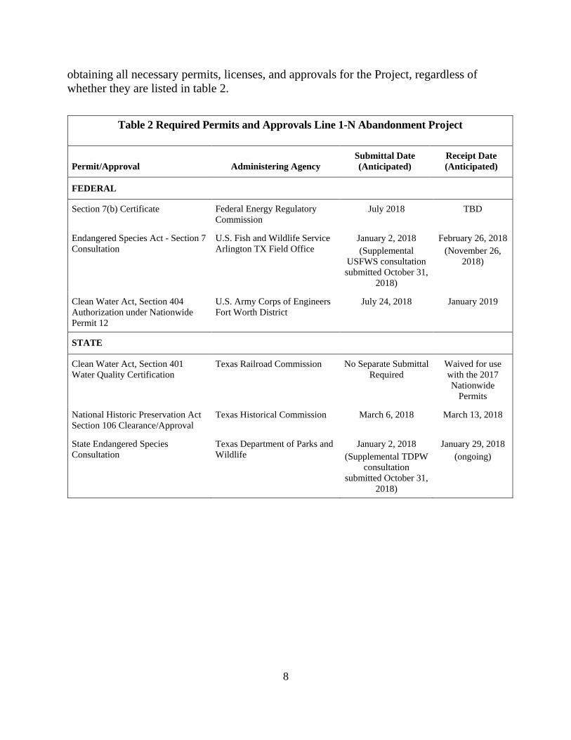
8
obtaining all necessary permits, licenses, and approvals for the Project, regardless of whether they are listed in table 2.
Table 2 Required Permits and Approvals Line 1-N Abandonment Project
Permit/Approval Administering Agency Submittal Date (Anticipated)
Receipt Date (Anticipated)
FEDERAL
Section 7(b) Certificate Federal Energy Regulatory Commission
July 2018 TBD
Endangered Species Act - Section 7 Consultation
U.S. Fish and Wildlife Service Arlington TX Field Office
January 2, 2018 (Supplemental
USFWS consultation submitted October 31,
2018)
February 26, 2018 (November 26,
2018)
Clean Water Act, Section 404 Authorization under Nationwide Permit 12
U.S. Army Corps of Engineers Fort Worth District
July 24, 2018 January 2019
STATE
Clean Water Act, Section 401 Water Quality Certification
Texas Railroad Commission No Separate Submittal Required
Waived for use with the 2017 Nationwide
Permits
National Historic Preservation Act Section 106 Clearance/Approval
Texas Historical Commission March 6, 2018 March 13, 2018
State Endangered Species Consultation
Texas Department of Parks and Wildlife
January 2, 2018 (Supplemental TDPW
consultation submitted October 31,
2018)
January 29, 2018 (ongoing)

9
B. ENVIRONMENTAL ANALYSIS
1. Geology The Project is in northeastern Texas within the Interior Coastal Plains section of
the Gulf Coastal Plains physiographic province (Bureau of Economic Geology, 1996). The Interior Coastal Plains section is characterized by parallel ridges and valleys with elevations ranging from 300 to 800 feet above mean sea level. The Project area is underlain by unconsolidated sands and muds with beds tilted toward the Gulf of Mexico (Bureau of Economic Geology, 1996).
Mineral Resources The major mineral resource production activities identified by the United States
Geological Survey (USGS) in Harrison and Marion Counties include construction and industrial sand, gravel, and common clay (USGS, 2017). No active or historic mining activities were identified within the Project area (USGS, 2011).
Based on a review of information obtained from the Railroad Commission of Texas (RRC), 82 oil and gas wells were identified within 0.25 mile of the Project area, of which 2 were depicted less than 100 feet from Project workspaces (RRC, 2017). Specifically, one oil well is within the pipeline right-of-way, approximately 59 feet from the 8” Dig 6 workspace, and a permitted location is outside of the right-of-way, and approximately 81 feet from the 8” Dig 1 workspace.
Prior to mobilizing to the 8” Dig 1 and 8” Dig 6 locations, Texas Eastern would verify the well locations and restrict access to those portions of the right-of-way with orange safety fencing that would be erected along the edge of the workspace closest to the two wells. Texas Eastern would also inform contractor personnel of the well locations to ensure protection of the wells from Project activity.
Given the scope and nature of Project activities, which would involve shallow and temporary disturbance within an existing permanent right-of-way, and given Texas Eastern’s proposed measures to protect existing oil and gas wells within 100 feet of construction workspaces, we conclude that the Project would not significantly impact mineral resources or mineral resource extraction.
Geologic Hazards Geologic hazards are natural, physical conditions that can result in damage to land
and structures or injury to people. Such hazards typically are seismic-related, including earthquakes, surface faulting, and soil liquefaction; landslides and karst terrain; or ground subsidence hazards.

10
Seismicity
The shaking during an earthquake can be expressed in terms of the acceleration as a percent of gravity (g), and seismic risk can be quantified by the motions experienced at the ground surface or by structures during a given earthquake expressed in terms of g. USGS National Seismic Hazard Probability Mapping shows that for the Project area, within a 50-year period, there is a 2 percent probability of an earthquake with an effective peak ground acceleration (PGA) of 4 to 6 percent g; and a 10 percent probability of an earthquake with an effective PGA of 2 to 3 percent g being exceeded (USGS, 2014). For reference, a PGA of 10 percent g (0.1g) is generally considered the minimum threshold for damage to older structures or structures not constructed to resist earthquakes. The USGS maintains a database of geologic faults and folds in the United States. The Project would be within the region of “Gulf-margin normal faults,” which generally spans the Gulf Coastal Plain physiographic provinces in Texas, Louisiana, and southern Alabama and Mississippi. Individual faults in this region are poorly mapped and have a slip rate of less than 0.2 millimeters per year (USGS, 2018). The movement of these faults along the Gulf Coast is described as a gradual form of fault creep rather than the sudden breaking of rock that occurs in conjunction with detectable earthquakes (Louisiana Geological Survey, 2001).
The Project would be in an area with low seismicity and, as such, the potential for soil liquefaction to occur is negligible. Given these conditions, we conclude that there is a low potential for impact on the Project due to prolonged ground shaking, ground rupture, or soil liquefaction and no significant Project impacts would occur as a result of seismic activity.
Landslides and Slope Stability
Based on review of topographic maps and Texas Eastern’s field reconnaissance, localized steep slopes would not be encountered within the boundaries of the planned dig locations; therefore, we conclude any hazards posed to the Project by landslides or unstable slopes are negligible.
Ground Subsidence
Ground subsidence, involving the localized or regional lowering of the ground surface, may be caused by karst dissolution, sediment compaction due to oil and gas and/or groundwater extraction, and the occurrence of underground mines. No karst terrain is present and the lithology that could lead to bedrock dissolution and karst development do not generally occur within the Project area. Oil and gas extraction does occur within the Project vicinity; however, there have been no reported subsidence hazards as a result of these activities, given the depth (greater than 5,000 feet below ground surface) to these resources. There are no underground mines in the Project vicinity.

11
The Project overlies unconsolidated aquifers of the Coastal Uplands aquifer system. The unconsolidated nature of this aquifer system makes overlying land susceptible to subsidence from over-pumping of groundwater (USGS, 2000); however, regional or local lowering of the water table from excessive groundwater withdrawals has not occurred in the Project area and given the nature of Project activities (involving the abandonment of existing facilities), ground subsidence from the over pumping of groundwater would be a negligible hazard. Therefore, we conclude no significant Project impacts would occur as a result of ground subsidence.
2. Soils Descriptions of the soil series crossed by the Project were obtained from the
Natural Resources Conservation Service (NRCS) Web Soil Survey (NRCS, 2018). All soil types are characterized as having a depth to bedrock of greater than 80 inches. The majority of Project area soils are moderately well drained to somewhat excessively drained, non-hydric, and have a low compaction potential. The majority of Project area soils also have a high to very high susceptibility to wind erosion and low to very low susceptibility to water erosion.
Construction activities, such as clearing, grading, trench excavation, backfilling, heavy equipment traffic, and restoration along the construction right-of-way, have the potential to adversely affect natural soil characteristics, such as water infiltration, storage and routing, and soil nutrient levels, thus reducing soil productivity. Clearing would remove protective vegetative cover and exposes soil to the effects of wind and water which increases the potential for soil erosion and the transport of sediment to sensitive resource areas. Soil characteristics could affect construction performance or increase the potential for adverse construction-related soil impacts.
Prime Farmland The U.S. Department of Agriculture defines prime farmland as land that has the
best combination of physical and chemical characteristics for growing food, feed, forage, fiber, and oilseed crops. Unique farmland is land that is used for production of specific high-value food and fiber crops. In addition, soils may be considered of statewide or local importance if those soils are capable of producing a high yield of crops when managed according to accepted farming methods. While about 3.1 acres of prime farmland and farmland of statewide importance would be disturbed by Project activities, none of these areas are currently used for agriculture. Additionally, all construction activities would occur within the previously disturbed Texas Eastern right-of-way, and disturbed areas would be returned to pre-existing conditions following construction. Therefore, we conclude the Project would not result in new or permanent impacts on prime farmland.

12
Hydric and Compaction-Prone Soils
Hydric soils are soils formed under conditions of saturation, flooding, or ponding long enough during the growing season to develop anaerobic conditions in the upper part of the soils. Of the soils that Project activities would disturb, approximately 0.2 acre is classified as hydric, and approximately 2.5 acres are considered to be moderately or highly compaction prone.
Texas Eastern has committed to segregate topsoil, where practicable, in areas of severe compaction potential when dry soil conditions exist, in order to reduce localized impacts on soil productivity. Given the limited area of hydric and compaction-prone soils that would be affected by the Project and proposed mitigation measures, we conclude significant compaction impacts would not occur.
Erosion and Revegetation Soil erosion is the wearing away of physical soil properties by wind and water,
and could result in a loss of soil structure, organic matter, and nutrients, all of which, when present, contribute to healthy plant growth and ecosystem stability. Clearing, grading, and equipment movement can accelerate the erosion process and, without adequate protection, result in discharge of sediment to waterbodies and wetlands. Of the soils that would be disturbed by Project activities, approximately 0.5 acre would be moderately to highly susceptible to water erosion and approximately 4.3 acres would be highly or very highly susceptible to wind erosion.
We received one comment from Mr. Robert K. Manning, regarding potential erosion on his property. To minimize or avoid potential impacts due to soil erosion, Texas Eastern would implement erosion controls in accordance with its E&SCP (which are inclusive of the Commission’s Upland Erosion Control, Revegetation, and Maintenance Plan and Procedures). Temporary erosion controls would be installed immediately following land disturbing activities. Texas Eastern would inspect these devices on a regular basis and after each rainfall event of 0.5 inch or greater to ensure proper function. Additionally, Texas Eastern would use dust-control measures, including routine wetting of the construction workspace and spoil storage piles as necessary. Temporary erosion control devices would be maintained until the Project area is successfully stabilized/revegetated. In addition, Texas Eastern has committed to continue working with Mr. Manning to resolve erosion issues on his property.
Texas Eastern initiated consultations with local soil conservation authorities for recommendations for seed mixes, seeding dates, application rates for fertilizer and lime, erosion controls, and noxious weed control. Texas Eastern has committed to filing with the Commission responses received from conservation authorities, including any recommendations, as they are received.

13
Given Texas Eastern’s proposed mitigation measures and that disturbed areas would be returned to pre-construction conditions, we conclude impacts on soils would be temporary and permanent impacts due to soil erosion or poor revegetation are not anticipated.
Soil Contamination Texas Eastern searched the U.S. Environmental Protection Agency’s (EPA)
Facility Registry Service to identify the potential for hazardous waste sites and/or landfills within 0.25 mile of construction work areas. No hazardous waste sites or landfills were identified within 0.25 mile of any construction work area (EPA, 2018). If Texas Eastern encounters a hazardous waste during construction, it has committed to stopping work in the vicinity of the hazardous waste and notifying the landowner and appropriate authorities.
As previously stated in section B.1 of this EA, there are several oil and gas wells in proximity to the Project. Given the density of oil and gas exploration activities in proximity to Project workspaces, there is potential to encounter contaminated soils and groundwater. However, Texas Eastern has not conducted any investigations of state-regulated remediation programs to identify contaminated sites within or in the vicinity of the Project area and has not proposed an unanticipated discovery plan should contaminated soils or groundwater be encountered during construction. Therefore, we recommend that:
• Prior to abandonment activities, Texas Eastern should file with the Secretary of the Commission (Secretary), for review and written approval by the Director of the Office of Energy Projects (OEP), procedures that it will follow to identify, handle, temporarily store, and properly dispose of potentially contaminated soils or groundwater, if discovered during construction, and precautions for minimizing the exposure of the public.
Contamination from spills or leaks of fuels, lubricants, and coolant from construction equipment could adversely affect soils. Texas Eastern would implement the measures outlined in its Spill Plan to reduce potential impacts on soils from spills of the hazardous materials used during construction. These measures include regularly inspecting equipment to ensure it is in good working order, properly training employees regarding the handling of fuels and other hazardous materials, implementing appropriate clean-up protocols, and promptly reporting any spills to the appropriate agencies.
Given the minimization and mitigation measures described above, and our recommendation, we conclude that soils would not be significantly affected by the Project.

14
3. Water Use and Quality
Groundwater
The U.S. Geological Survey (USGS, 1996) identifies the Coastal Uplands aquifer system as the predominant groundwater resource in Harrison and Marion Counties. The aquifer system consists of regional aquifers, primarily sand beds, which contain some gravel and yield large volumes of water in updip areas (up the slope of a dipping plane or surface). The Coastal Uplands aquifer system serves as a source of water for public supply, commerce, industry, irrigation, livestock, aquaculture, and mining (USGS, 1996).
In Harrison and Marion Counties, regional aquifers include one major aquifer and one minor unit: i) the Carrizo-Wilcox aquifer; and ii) the Queen City aquifer, respectively. The Carrizo-Wilcox aquifer is composed of sand, which is locally interbedded with gravel, silt, clay, and lignite. The unit is generally between 500 to 3,000 feet thick; however, the freshwater saturated thickness averages 670 feet (Texas Water Development Board [TWDB], 2017a). Generally, groundwater from the Carrizo-Wilcox and Queen City aquifers is unconfined in the Project area, hard, and has increasing total dissolved solids with depth. The chemical quality of groundwater varies considerably with locale and depth (TWDB, 2011). The Queen City aquifer is composed of sand and loosely cemented sandstone with interbedded clay layers. The unit varies in thickness up to 2,000 feet thick; however, the freshwater saturated thickness averages 140 feet (TWDB, 2017a).
The EPA oversees the Sole Source Aquifer Protection Program to protect high production aquifers that supply 50 percent or more of the region’s water supply and for which there are no reasonably available alternative drinking water sources should the aquifer become contaminated. Based on a review of EPA’s Interactive Sole Source Aquifer map, there are no designated Sole Source Aquifers in the Project area (EPA, 2018).
Texas Eastern reviewed the TWDB well database for Texas (TWDB, 2017b) to identify public and private water supply wells in the vicinity of the Project area. No wells were identified within 150 feet of the Project area, with the closest well approximately 250 feet southwest of the 10-inch-diameter MP 18.85 exposure location.
The Springs of Texas map (USGS, 2003) does not identify springs within 150 feet of the Project. Furthermore, during the field surveys conducted in the areas affected by land disturbing activities for the Project, Texas Eastern did not identify any water wells or springs within 150 feet of the Project area. Texas Eastern would also verify with affected landowners prior to the commencement of Project construction activities the locations of any water wells or springs potentially within 150 feet of the Project area.

15
Abandonment activities have the potential to impact groundwater. Short-term effects include alteration of overland flow and groundwater recharge resulting from clearing of vegetation, grading, trenching activities, and potential spills and leaks of fuels into shallow groundwater aquifers. Shallow groundwater resources immediately adjacent to Project work areas, where trench dewatering is necessary, could be affected during Project construction; however, this effect would be temporary and flow patterns would return to pre-construction conditions once dewatering activities cease.
Texas Eastern searched EPA databases to identify the potential for hazardous waste sites and/or landfills within 0.25 mile of construction work areas. No hazardous waste sites or landfills were identified within 0.25 mile of any construction work area. Groundwater contamination could occur from accidental spills of fuels, solvents, and lubricants used during construction. Texas Eastern would minimize spill-related impacts through implementation of the measures included in its Spill Plan. Texas Eastern would additionally prohibit refueling activities and storage of hazardous liquids within at least a 200-foot radius of all private wells and at least a 400-foot radius of all municipal or community water supply wells.
We conclude that based on proposed mitigation measures, implementation of Texas Eastern’s Spill Plan, and our recommendation to identify and mitigate contaminated soils/groundwater above, that groundwater resources in the Project vicinity would be adequately protected, and impacts from Project construction and operation on groundwater resources would be negligible.
Surface Water The proposed Project spans three watersheds, the Black Cypress Creek-Black
Cypress Bayou and Big Cypress Bayou-Frontal Caddo Lake in Cypress Creek Basin, and the Eightmile Creek-Sabine River watersheds in the Sabine River Basin. Texas Eastern conducted field surveys of the Project area December 11 through 14, 2017 and January 4, 2018 to identify waterbodies and wetlands crossed by the proposed Project.6 We received a comment from Avinger Timber and legal counsel for Avinger Timber regarding impacts of abandonment in place of the portions of the pipeline that are exposed in stream areas and other waterway areas. Texas Eastern has proposed to abandon by removal where pipe is exposed at the crossing of four waterbodies. Of these waterbodies, three are perennial streams and one is intermittent. None of the waterbodies identified in the Project area are listed as impaired waterbodies. No municipal water supplies or watershed projection areas would be disturbed by the proposed Project. There are no potable surface water intake sources within 3 miles downstream of any waterbodies in the Project area. 6FERC defines a waterbody as any natural or artificial stream, river, or drainage with perceptible flow at the time of crossing, and other permanent waterbodies such as ponds and lakes. A minor waterbody is less than or equal to 10 feet wide, an intermediate waterbody is greater than 10 feet wide but less than or equal to 100 feet wide, and a major waterbody is greater than 100 feet wide at the water’s edge at the time of crossing.
16
Table 3 provides a list of waterbodies crossed by the proposed Project. Construction impacts would be limited to disturbance by trenching and removal of
pipe segments at these waterbody crossings. These impacts could include an increase in local sediment loading and turbidity from in-waterbody construction activities, or construction adjacent to waterbody channels, and fuel and oil spills during refueling operations. Upland portions of the trench would be isolated through the installation of upland soil trench plugs outside of the waterbody corridor. The use of trench plugs would prevent drainage of water and sediment from upland areas into waterbodies. Texas Eastern would limit trenching within Streams 1 through 4 to the extent necessary for removal of the pipeline sections and would backfill the streams with native material. No permanent impacts on surface water resources are anticipated as a result of the proposed Project.
Table 3 Waterbodies Crossed by Proposed Project
Feature ID Waterbody Name
Mile Post Flow Regime Approximate Crossing
Width
Proposed Crossing Method
Temporary Impact (acres)
Stream 1 Bullard Creek 4.44 Perennial 12 Open Cut <0.01 Stream 2 Unnamed 13.88 Intermittent 9 Open Cut <0.01 Stream 3 Unnamed 15.03 Perennial 32 Open Cut <0.01 Stream 4 Unnamed 29.28 Perennial 2 Open Cut <0.01
Project Total <0.04 Note: Proposed activities are limited to removal of exposed pipeline segments from waterbodies. A trench approximately 10 feet wide would be excavated to a depth of 1.5 feet below the bottom of the pipe.
Temporary bridges would allow access of equipment across waterbodies.
Potential impacts from heavy machinery during construction could result in increased sedimentation and accidental release of hazardous substances such as fuels, lubricants, or coolants. In an event of a spill, Texas Eastern would implement its Spill Plan. Texas Eastern would use temporary and permeant erosion control structures to minimize and prevent sedimentation, erosion, and hazardous substances from entering waterbodies. Additionally, Texas Eastern’s implementation of its E&SCP includes the measures from the FERC Procedures. This includes restoring waterbodies to pre-construction contours upon removal of the pipeline sections.
Texas Eastern would install erosion and sediment control devices around
workspaces to minimize sediment and turbidity at waterbody crossings. Texas Eastern would use turbidity curtains within stream crossing locations to minimize the movement of sediment out of the work area and downstream water quality impacts from turbidity. Additionally, Texas Eastern would stockpile spoil material at least 10 feet from the stream bank and would surround the stockpiles by sediment control devices to prevent

17
sediment from entering the waterbody. No hydrostatic testing is proposed as part of this Project.
On November 15, 2018, Texas Eastern received e-mail correspondence from the
U.S. Fish and Wildlife Service (USFWS) recommending measures for avoiding and minimizing environmental impacts from utility pipeline construction on the proposed streams. These measures include, but are not limited to, trenching of creeks, streams, and other wetland areas during a dry period; and revegetating immediately following construction with native vegetation appropriate to habitat type. Texas Eastern has committed to implementing the applicable measures suggested by the USFWS.
Because of the limited area of surface water disturbance and implementation of the E&SCP, Spill Plan, and Texas Eastern’s commitment to following USFWS recommendations, we conclude that impacts on surface water resources would be temporary and not significant.
Wetlands Wetlands are areas that are inundated or saturated by surface or groundwater at a
frequency and duration sufficient to support a prevalence of wetland vegetation adapted for life in saturated soil conditions. Wetlands can be a source of substantial biodiversity and serve a variety of functions that include providing wildlife habitat, recreational opportunities, flood control, and naturally improving water quality.
Texas Eastern conducted field surveys to delineate wetlands in the Project
footprint on December 11 through 14, 2017 and on January 4, 2018. During the surveys, five wetlands were identified within the Project footprint. The identified wetlands were further classified according to the USFWS classification system (Cowardin et al., 1979), through which Texas Eastern determined that palustrine forested, palustrine scrub-shrub, and palustrine emergent wetlands, are crossed by the existing pipeline. Table 4 provides a list of wetlands within the Project area.
Abandonment activities would temporarily impact less than 0.5 acre of wetlands.
Wetland impacts would occur from workspaces necessary to grout and remove pipe under road crossings and removal of exposed pipe. The proposed Project would result in the temporary loss of wetland vegetation, aesthetics, and wildlife habitat associated with clearing and other construction activities, such as soil disturbance associated with trenching, equipment traffic, and stump removal within the trench. Additionally, temporary increases in turbidity and fluctuations in wetland hydrology associated with trenching and spoil storage could impact wetlands. During clearing, Texas Eastern would implement temporary erosion control measures in accordance with its E&SCP to minimize potential for sedimentation in wetlands.

18
Table 4 Wetlands Identified in Project Footprint Wetland Name Milepost Type Temporary impacts
(acres)
Wetland 1 1.04 PEM <0.1 Wetland 2 1.84 PEM <0.1 Wetland 3 13.87/13.88 PSS/PFO 0.3 Wetland 4 22.35 PEM/PSS <0.1 Wetland 5 27.06 PEM <0.1
Project Total: na na <0.5
Notes: na-not applicable; PFO-palustrine forested; PSS-palustrine scrub-shrub; PEM-palustrine emergent. The numbers in this table have been rounded for presentation purposes. As a result, the totals may not reflect the sum of the addends.
To avoid excessive disruption of wetland soils and the native seed and rootstock,
stump removal, grading, and excavation within wetland areas would be limited to the Project area immediately over the trench line unless additional grading or stump removal is required to provide a safe work area. To facilitate revegetation in unsaturated wetlands, up to 12 inches of topsoil would be removed from the trench line and stored separately from subsoil. Topsoil would not be segregated in saturated areas, in areas where no topsoil layer is evident, or in areas where the topsoil layer exceeds the depth of the trench. Where wetland soils are dry and stable, equipment would operate as in upland areas. If wetland soils cannot support construction equipment or where the equipment would cause rutting, a temporary work surface would be constructed with prefabricated construction mats or layers of timber. Low ground pressure equipment may be used in saturated wetlands or where standing water is present to prevent topsoil mixing. Following construction, Texas Eastern would restore contours to pre-existing conditions, remove temporary construction mats or timber riprap, and allow wetlands to revegetate naturally unless otherwise required by applicable permits.
While abandonment activities are anticipated to temporarily disrupt less than 0.5
acre of wetlands, no permanent impacts are anticipated. Given the limited disturbance of wetlands by construction, and Texas Eastern’s mitigation measures associated with its ES&CP Plan, Spill Plan, and USFWS recommendations discussed under surface water, we conclude wetland impacts would be short-term and not significant.
Texas Eastern is seeking coverage under the U.S. Army Corps of Engineers
Nationwide 12 for wetlands temporarily impacted by abandonment activities, as wetland impacts are anticipated to be less than 0.5 acre. Texas Eastern submitted a pre-construction notification to the U.S. Army Corps of Engineers on July 24, 2018 for coverage under NWP 12.
19
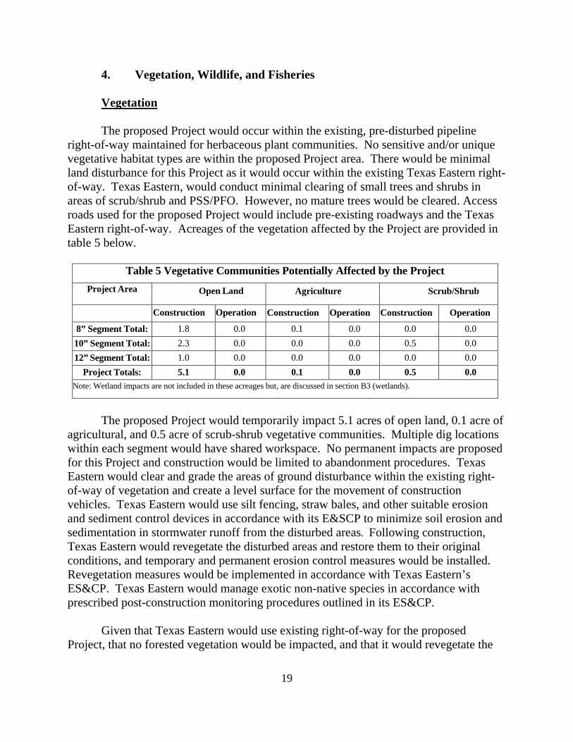
4. Vegetation, Wildlife, and Fisheries
Vegetation The proposed Project would occur within the existing, pre-disturbed pipeline
right-of-way maintained for herbaceous plant communities. No sensitive and/or unique vegetative habitat types are within the proposed Project area. There would be minimal land disturbance for this Project as it would occur within the existing Texas Eastern right-of-way. Texas Eastern, would conduct minimal clearing of small trees and shrubs in areas of scrub/shrub and PSS/PFO. However, no mature trees would be cleared. Access roads used for the proposed Project would include pre-existing roadways and the Texas Eastern right-of-way. Acreages of the vegetation affected by the Project are provided in table 5 below.
Table 5 Vegetative Communities Potentially Affected by the Project
Project Area Open Land
Agriculture Scrub/Shrub
Construction Operation Construction Operation Construction Operation
8” Segment Total: 1.8 0.0 0.1 0.0 0.0 0.0 10” Segment Total: 2.3 0.0 0.0 0.0 0.5 0.0 12” Segment Total: 1.0 0.0 0.0 0.0 0.0 0.0
Project Totals: 5.1 0.0 0.1 0.0 0.5 0.0 Note: Wetland impacts are not included in these acreages but, are discussed in section B3 (wetlands).
The proposed Project would temporarily impact 5.1 acres of open land, 0.1 acre of
agricultural, and 0.5 acre of scrub-shrub vegetative communities. Multiple dig locations within each segment would have shared workspace. No permanent impacts are proposed for this Project and construction would be limited to abandonment procedures. Texas Eastern would clear and grade the areas of ground disturbance within the existing right-of-way of vegetation and create a level surface for the movement of construction vehicles. Texas Eastern would use silt fencing, straw bales, and other suitable erosion and sediment control devices in accordance with its E&SCP to minimize soil erosion and sedimentation in stormwater runoff from the disturbed areas. Following construction, Texas Eastern would revegetate the disturbed areas and restore them to their original conditions, and temporary and permanent erosion control measures would be installed. Revegetation measures would be implemented in accordance with Texas Eastern’s ES&CP. Texas Eastern would manage exotic non-native species in accordance with prescribed post-construction monitoring procedures outlined in its ES&CP.
Given that Texas Eastern would use existing right-of-way for the proposed
Project, that no forested vegetation would be impacted, and that it would revegetate the

20
Project area, we conclude that the proposed Project would have only short-term, not significant, impacts on vegetation.
Wildlife
The Project area consists predominately of herbaceous vegetation cover. Common
wildlife in the area include a wide variety of mammal, amphibian, birds, and reptile species. Common wildlife found within these lands and the proposed Project area include whitetail deer, Eastern wild turkey, Eastern grey squirrel, coyote, bobcat, Eastern bobwhite, and other game species. Direct and indirect impacts on wildlife may occur primarily due to construction-related ground disturbance, such as removal of vegetation, and grading for abandonment activities. These impacts could include the mortality of less mobile species. However, more mobile species such as birds and larger mammals would likely relocate to other nearby suitable habitat and avoid the Project area once construction activities commence. Noise and increased activity in Project work areas would result in temporary indirect wildlife impacts, such as displacement and disruption of daily routines. Texas Eastern would restore the Project area once abandonment activities are complete. After construction and abandonment procedures occur, wildlife would be expected to return. No long-term impacts are anticipated by the proposed Project.
Caddo Lake National Wildlife Refuge and Caddo Lake Wildlife Management area
are approximately 3 miles east of the proposed Project area. These lands are managed for high-quality wildlife habitat. Similar impacts on wildlife within these areas could occur as those described above. However, given the distance to these federally managed lands, we conclude impacts, if any, would be minimal.
Given Texas Eastern’s commitment to revegetate the right-of-way and the
abundance of similar habitat adjacent to the proposed Project area, we conclude that the proposed Project would not have a significant impact on wildlife or wildlife habitat in the Project area.
Migratory Birds Migratory birds are species that nest in the United States and Canada during the
summer and then migrate to and from the tropical regions of Mexico, Central and South America, and the Caribbean for the non-breeding season. Migratory birds are protected under the Migratory Bird Treaty Act ([MBTA] – 16 U.S. Code 703-711), and bald and golden eagles are additionally protected under the Bald and Golden Eagle Protection Act (16 U.S Code 668-668d). The MBTA, as amended, prohibits the taking, killing, possession, transportation, and importation of migratory birds, their eggs, parts, and nests. Executive Order 13186 requires that all federal agencies undertaking activities that

21
may negatively affect migratory birds take a prescribed set of actions to further implement the MBTA, and directs federal agencies to develop a memorandum of understanding (MOU) with the USFWS that promotes the conservation of migratory birds through enhanced collaboration between the two agencies. In March 2011, FERC entered into a MOU with the USFWS, which focuses on avoiding or minimizing adverse impacts on migratory birds and strengthening migratory bird conservation through enhanced collaboration between the two agencies.
Though all migratory birds are afforded protection under the MBTA, both
Executive Order 13186 and the MOU require that Birds of Conservation Concern and federally listed species be given priority when considering effects on migratory birds. Birds of Conservation Concern are a subset of MBTA-protected species identified by the USFWS as those in the greatest need of additional conservation action to avoid future listing under the Endangered Species Act (ESA). Executive Order 13186 states that emphasis should be placed on species of concern, priority habitats, key risk factors, and that particular focus should be given to addressing population-level impacts.
The Project falls within Bird Conservation Region 25: West Gulf Coastal Plain/Ouachitas (North American Bird Conservation Initiative, 2018). The West Gulf Coastal Plain Region is characterized as the westernmost part of the eastern United States forest and includes hardwood-dominated bottomlands along the Arkansas River and other drainages.
Vegetation removal and increased presence of humans and noise during
construction would likely cause displacement and avoidance of the area by any birds in the Project area. Birds fleeing an area of disturbance could be injured or suffer mortality, or abandon nests, affecting egg-laying and potentially causing the mortality of young. However, we expect this impact to be intermittent and short term, occurring during work hours and ceasing after construction activities have moved from a given area. Further, migratory birds not already nesting would be able to avoid these activities and move to abundant habitat adjacent to the existing right-of-way.
Impacts would be localized to Texas Eastern’s existing right-of-way, as such,
routine vegetation maintenance has precluded the growth of trees. Therefore, no tree clearing is proposed for this proposed Project. Although the proposed Project activities may cause some migratory birds to avoid the area during construction and abandonment procedures, impacts would be short-term as abandonment activities would occur during an approximately two-month period. Implementation of the construction and restoration measures in Texas Eastern’s ES&CP plan would reduce the extent and duration of impacts on migratory bird habitat by restoring the construction right-of-way to pre-construction conditions, including revegetation. In addition, there is ample adjacent habitats suitable for any birds that may be displaced during Project activities. For these

22
reasons, we conclude that the proposed Project would not adversely impact migratory bird populations.
Fisheries
As discussed under section B.3 (Water Use and Quality), Texas Eastern would
abandon by removal Line 1-N where pipe is exposed at the crossing of four waterbodies. One named waterbody, Bullard Creek, and two unnamed waterbodies were classified as supporting perennial flow, and another unnamed waterbody was classified as having intermittent flow. It is anticipated that streams with perennial flow could contain habitat that would support fisheries resources. There is no federally designated essential fish habitat present in these waterbodies that would be crossed by the proposed Project. Potential impacts on state-listed fish species are discussed further under section D.5.
Impacts on fisheries resources would be short-term and localized to the immediate
workspace. Construction activities would involve minor trenching to remove the pipe sections that are exposed at the crossing locations. Construction techniques would be implemented to limit sediment and turbidity during construction activities, including the use of erosion and sediment control devices. Further, Texas Eastern would use turbidity curtains to limit sediment and turbidity downstream of the proposed Project. Texas Eastern would return the streambeds and banks impacted by the proposed Project to existing grade and re-stabilize them immediately following completion of the removal. Texas Eastern would adhere to the instream work timing restrictions (June 1 through November 30) for warm water fisheries, in accordance with the FERC Procedures, unless expressly permitted or further restricted by the appropriate federal or state agency in writing on a site-specific basis.
Given the limited habitat that would be affected and construction and mitigation
measures that Texas Eastern would implement, we conclude that impacts on fisheries would be short-term and would not be significant.
5. Special Status Species
Special status species are those species for which state or federal agencies provide
an additional level of protection by law, regulation, or policy. Included in this category are federally listed and federally proposed species that are protected under the ESA, or are considered as candidates for such listing by the USFWS, and those species that are state-listed as threatened or endangered.

23
Federally Listed Species
Texas Eastern, acting as a non-federal representative for FERC, in accordance with Section 7(a)(2) of the ESA initiated consultation with the USFWS on January 2, 2018, to identify federally listed threatened and endangered species that may occur in the Project area. Three federally listed bird species were identified, the least tern, piping plover, and red knot. The USFWS has conditional ranges for when consultation is required for certain federally listed species (USFWS 2018). In the State of Texas, these three federally listed birds are to be considered only when wind related projects are within migratory routes. Wind turbines can have a direct (e.g., collision mortality) and indirect (e.g. migration disruption, displacement from habitat) impact on migratory birds. Because the proposed Project does not attribute to wind energy projects, no further consultation with USFWS is necessary. Table 6 represents the two federally listed species that were identified to occur in Harrison and Marion Counties, Texas.
Table 6 Federally Listed Species in Harrison and Marion Counties, Texas Species Federal
Status Habitat Requirements Site Supports Requirements Effect
Determination
Plants
earth fruit Geocarpon
minium
Threatened
Found in vegetated edges of slick spots in saline barren
complex just above floodplain of Neches River, soils are claypan,
hold late winter rains, with a spongy feel to the soil.
No - sites consist of maintained right-of-way. The sites contain no potential habitat and this species
does not appear to be present.
No Effect
neches river rose- mallow
Hibiscusdasycalyx
Threatened
Prefers wetland areas in open sunlight. Usually found where
plant bases are normally in standing water late-winter and
spring.
No - sites consist of a maintained right-of-way. The sites contain no potential habitat and this species
does not appear to be present.
No Effect
Given that there is no suitable habitat for the earth fruit and neches river rose-
mallow, we conclude that the Project would have no effect on federally listed species. In email correspondence dated February 26, 2018, the USFWS confirmed that no further consultation under Section 7 of the ESA was required.
In email correspondence dated October 31, 2018, Texas Eastern re-consulted with the USFWS, for the temporary in-stream activities to the four stream crossings which were not included in the original USFWS consultation. Based on field surveys of the habitat along the existing right-of-way, these four stream crossings do not contain suitable habitat for these two species; therefore, our determination of no effect would still be applicable and no further consultation with USFWS is necessary. In response, on November 15, 2018, the USFWS stated that no further consultation would be required and provided general recommendations for avoiding and minimizing environmental
24
impacts from pipeline construction. Texas Eastern has committed to following USFWS recommendations as discussed further under section B.3 (surface water).
State Listed Species
Texas Eastern consulted with the Texas Parks and Wildlife Department (TPWD) on January 2, 2018 to determine the presence of state listed species in the Project area. Twenty-three species (six bird, four fish, four mammal, five mollusk, three reptile, and one plant species), were identified as potentially present within the Project area. TPWD responded in a letter dated January 29, 2018, that “significant adverse impacts to rare, threatened or endangered species, or other fish and wildlife species was not anticipated based on its review of the Project.” We agree with this determination.
In email correspondence dated October 31, 2018, Texas Eastern re-consulted with the TPWD for the temporary in-stream activities to the four stream crossings which were not included in previous consultation. Given the proposed Project would cross perennial waterbodies there is potential that state-listed fish and mollusks could be present within these waterbodies. The state-listed fish species that may potentially be present in the three identified perennial waterbodies impacted by the proposed Project include, the blackside darter, bluehead shiner, creek chubsucker, and the paddlefish. State-listed mollusk species include the Louisiana pigtoe, sandbank pocketbook, southern hickorynut, Texas heelsplitter, and/or the Texas pigtoe mollusks.
In a response dated October 31, 2018, TPWD indicated that the proposed Project
may require a state permit for disturbance of state streambed(s) as well as coordination with the TPWD Kills and Spills Team (KAST) to determine an appropriate protection plan and/or permitting for aquatic resources, including potentially occurring state-listed fish and freshwater mussels. Additionally, TPWD indicated in its response to Texas Eastern, that four fish species of greatest conservation need may be present in the Project vicinity; these species include the ironcolor shiner, orangebelly darter, taillight shiner, and the western sand darter. Texas Natural Diversity Database has records of occurrences of the bluehead shiner, creek chubsucker, blackside darter, ironcolor shiner, and Texas pigtoe in downstream waters from the 10-inch (dig 16-21) and 12-inch (dig 10 and 11), thus the Project area streams may support these species and/or their life cycle requirements. TPWD indicated its Project recommendations, which include, but are not limited to:
• coordination with TPWD KAST for appropriate authorization and to ensure
protection of state-listed aquatic wildlife; and • if construction occurs in other streams and wetlands during times when
water is present, then TPWD recommends relocating native aquatic resources in conjunction with a Permit to Introduce Fish, Shellfish, or Aquatic Plants into Public Waters and an Aquatic Resource Relocation

25
Plan. The Aquatic Resource Relocation Plan should be completed and approved by the department 30 days prior to activity within project waters and/or resource relocation and submitted to TPWD Region 2 KAST.
Additional recommendations are included in TPWD correspondence dated
October 31, 2018. Texas Eastern commits to following appropriate required protocols. Additionally, Texas Eastern confirms that, provided a mussel survey is required by TPWD, it will commit to conducting a survey for mollusks before abandonment activities commence on these four stream crossings. Texas Eastern continues to consult with the TPWD on state permits and TPWD Freshwater Mussel Survey and Relocation Protocols.
Texas Eastern would install erosion control devices and may employ turbidity
curtains within the stream to minimize sedimentation and maintain downstream flow conditions. Texas Eastern would remove the pipe and grout the casing at waterbodies in precaution of disturbing aquatic species habitat. Trenching within the waterbody would be limited to the extent necessary to remove pipeline sections and backfill with native materials. Additionally, Texas Eastern has committed to applicable USFWS general recommendations for avoiding and minimizing environmental impacts to proposed streams which are also protective to aquatic resources (discussed further under section B.3).
Given Texas Eastern’s commitment to following appropriate TPWD protocols for
state-listed fish and mussels, its proposed mitigation measures, the limited in-stream work, and limited disturbance proposed along the existing cleared and maintained right-of-way; we conclude that the Project is not likely to adversely affect state listed species or critical habitat.
6. Land Use, Recreation, and Visual Resources Land use categories identified in the Project area consist of open land, agriculture, and forest/woodland. Table 7 summarizes the land use impacts associated with the Project. The following is a description of land use types within the Project area:
• Agricultural land –hayfields; • Forest/Woodland –overgrown, non-maintained right-of-way; and • Open land –existing utility rights-of-way, non-forested lands, and fallow
fields.
Abandonment activities would be confined to the temporary workspaces within the existing 50-foot-wide pipeline right-of-way. Abandonment activities would temporarily impact 0.1 acre of agricultural land that would revert back to hayfield, and would result in the clearing of 0.7 acre of overgrown right-of-way to restore to a maintained right-of-way. Texas Eastern would restore and revegetate temporary

26
construction workspace associated with the Project in accordance with its E&SCP. Texas Eastern would retain and maintain the pipeline right-of-way following completion of abandonment activities. We received a comment from Avinger Timber and legal counsel for Avinger Timber regarding impacts on the pipeline from ongoing farming and utilization of the property due to continued disturbance and natural erosion and impacts of abandonment in place of portions of the pipeline that are exposed in stream and other waterway areas. The portions of Texas Eastern’s Line 1-N that would be abandoned in place are buried at a depth of three feet or more, thereby making it unlikely that natural erosion, ongoing farming, or utilization of the property would disturb the pipeline. Texas Eastern has agreed to remove the pipeline in areas that are currently exposed including stream areas and other waterway areas. In addition, in the event that erosion occurs in the future, Texas Eastern has stated they plan to retain and maintain the pipeline right-of-way following completion of abandonment activities.
Upon completion of construction, Texas Eastern would restore disturbed areas of
the right-of-way as close as practicable to pre-existing grade and allow them to revegetate naturally by segregating topsoil at the 8-inch Dig 11 location (hayfield location) and any other areas deemed necessary in accordance with its E&SCP, which would and conserve the native seed bank.
Table 7 Acreage Affected by Construction/Operation
Open Land Agriculture Forest/Woodland
Construction Operationa Construction Operationa Construction Operationa
Project Area (acres) (acres) (acres) (acres) (acres) (acres)
8-inch Segment Total: 1.8 0.0 0.1 0.0 0.0 0.0
10-inch Segment Total: 2.3 0.0 0.0 0.0 0.5 0.0
12-inch Segment Total: 1.00 0.0 0.0 0.0 0.0 0.0
Project Totals: 5.1 0.0 0.1 0.0 0.5 0.0
a The Project involves abandonment in place and by removal of an existing pipeline within an existing right-of-way; therefore, there would be no operational impacts.
Texas Eastern would use existing public and private roads without modification
for the Project to move equipment and materials to the construction work areas. Texas Eastern would maintain and repair roads as needed, including, but not limited to, the addition of gravel/limestone, grading dirt roads, or patching paved roads. Maintenance and repairs to access roads would not impact areas outside the existing footprint. No new

27
access roads would be constructed nor would any existing access roads used for the Project be removed from service as a result of abandonment activities.
The abandonment activities would not impact or permanently change the current
land use. Therefore, we conclude that no significant impacts on land use would occur. Existing Residences The proposed Project is in a sparsely populated rural area. Based on a review of
aerial photography and field reconnaissance, there are two residences within 50 feet of construction areas (18 feet and 30 feet). Site-specific construction plans are included in appendix C.
Texas Eastern would mitigate impacts on these residences and landowners by
ensuring that abandonment activities proceed quickly (approximately 2 months) and that landowners are informed prior to the commencement of construction. In addition, abandonment activities would be limited to daylight hours in residential areas. Property access and traffic flow would be maintained during abandonment activities, particularly for emergency vehicles. Texas Eastern would minimize dust and remove onsite litter and debris daily from the construction work areas. During abandonment, Texas Eastern would fence the edge of the construction work area within 50 feet of a residential structure for a distance of 100 feet on either side of the residence to ensure that construction equipment and materials, including the spoil pile, remain within the construction work area. At a minimum, Texas Eastern would maintain temporary construction fencing throughout the abandonment activities. Based on the implementation of these mitigation measures, we conclude significant impacts on existing residences are not anticipated.
Planned Development Texas Eastern reviewed the Harrison County and Marion County Appraisal
Districts and clerk of Court offices for new subdivision plats of developments, as well as the county economic development websites, the Texas Commission on Environmental Quality databases, and recent aerial photography for information on planned developments, and did not identify any in proximity to the Project. As this Project is for abandonment of existing facilities, no impacts on planned developments are anticipated. The Project would not result in construction of new facilities; therefore, no permanent impacts on planned commercial/business development would occur.
Public Land, Recreation, and Other Designated Areas No areas were identified where the Project would be within 0.25 mile of federal,
state or local parks, forests, trails, scenic highways, nature preserves, wildlife refuges,

28
wilderness areas, game management areas, or other designated natural, recreational, or scenic areas or registered natural landmarks, Coastal Zone Management Areas, private preservation group lands, hazardous waste sites, mines, or any other specific lands itemized in 18 CFR 380.12(j)(4). In addition, no recreational facilities or public interest areas are within 0.25 mile of the proposed Project. No existing or proposed National Wildlife Refuges, wildlife management areas, or state or federal parks would be affected by construction or operation of the Project. No impacts on wild, natural or scenic rivers are anticipated during the construction or operation of this Project. Additionally, no impacts on special use areas that may be associated with schools, parks, places of worship, cemeteries, sports facilities, campgrounds, golf courses, ball fields, and other recreational areas are anticipated during the construction or operation of the Project. No Native American religious sites or reservations have been identified in proximity to the proposed Project. Therefore, we conclude that the Project would have no effect on any of these resources.
Visual Resources The Project does not involve installation of aboveground facilities or clearing of
mature trees. Removal of aboveground appurtenances at each of the 8-inch, 10-inch, and 12-inch-diameter pipelines, including M&R 70191, would result in permanent changes to the visual landscape in that industrial facilities would be removed.
The Project would have temporary impacts on visual resources during construction
and permanent changes in the visual landscape due to the removal of infrastructure. However, these impacts would be minor and changes would not result in significant impacts on visual resources.
7. Cultural Resources Section 106 of the National Historic Preservation Act, as amended, requires the
FERC to take into account the effect of its undertakings on properties listed, or eligible for listing, on the National Register of Historic Places (NRHP), and to afford the Advisory Council on Historic Preservation an opportunity to comment. Texas Eastern, as a non-federal party, is assisting the FERC in meeting our obligations under Section 106 and its implementing regulations at 36 CFR 800.
Texas Eastern completed a cultural resources survey for the Project, and provided
the resulting survey report to the FERC and Texas State Historic Preservation Office (SHPO). The survey employed surface inspection augmented by excavation of 41 shovel test units, and included both archaeological and architectural resources. Approximately 7 acres were surveyed.

29
As a result of the survey, no archaeological sites were identified. Two historic standing structures, both circa 1910 one-story wood-framed houses (HSS-TJL-0117A and HSS-TJL-0117B), were recorded outside of two adjacent workspaces. Because temporary use of the workspaces would not affect these two properties, Texas Eastern recommended no further work. On March 13, 2018, the Texas SHPO indicated that, regarding archaeological resources, no historic properties were present or affected. Regarding architectural resources, the SHPO indicated that structures HSS-TJL-0117A and HSS-TJL-0117B were not eligible for the NRHP. We agree with the SHPO.
Texas Eastern contacted the following Native American tribes, providing a Project
description and mapping: Alabama-Coushatta Tribe of Texas; Kickapoo Traditional Tribe of Texas; Ysleta Del Sur Pueblo; Muscogee (Creek) Nation; Osage Nation; and Tonkawa Tribe of Oklahoma. In a letter dated April 2, 2018, the Ysleta Del Sur Pueblo indicated it had no comments due to the Project’s location outside its area of interest. On August 10, 2018, the Muscogee (Creek) Nation indicated it was unaware of any religious or culturally significant sites in the Project area. On April 27 and 30, 2018, the Osage Nation requested a copy of the survey report, which Texas Eastern provided. No other comments have been received. We sent our NOI to these same tribes. No responses to our NOI have been received.
Texas Eastern provided a plan to address the unanticipated discovery of cultural
resources and human remains during construction. We requested revisions to the plan. Texas Eastern provided a revised plan which we find acceptable.
8. Air Quality and Noise
Air Quality
The term air quality refers to relative concentrations of pollutants in the ambient
air. Project construction would impact air quality in the Project area during the duration of abandonment activities. However, the Project would not result in any new sources of operational air emissions.
Existing Environment Ambient air quality is protected by the Clean Air Act (CAA) of 1970, as amended
in 1977 and 1990. The EPA oversees the implementation of the CAA and establishes National Ambient Air Quality Standards (NAAQS) to protect human health and welfare.7 NAAQS have been developed for seven “criteria air pollutants”, including nitrogen dioxide, carbon monoxide, ozone, sulfur dioxide, particulate matter less than or equal to 2.5 microns in aerodynamic diameter, particulate matter less than or equal to 10 microns
7 The current NAAQS are listed on EPA’s website at https://www.epa.gov/criteria-air-pollutants/naaqs-table.

30
in aerodynamic diameter, and lead, and include levels for short-term (acute) and long-term (chronic) exposures. The NAAQS include two standards, primary and secondary. Primary standards establish limits that are considered to be protective of human health and welfare, including sensitive populations such as children, the elderly, and asthmatics. Secondary standards set limits to protect public welfare, including protection against reduced visibility and damage to crops, vegetation, animals, and buildings (EPA 2017). Additional pollutants, such as volatile organic compounds and hazardous air pollutants, are emitted during fossil fuel combustion and are regulated through various components of the CAA. At the state level, the Texas Department of Environmental Quality has adopted the NAAQs, as promulgated by the EPA, and does not have any additional standards.
The EPA, state, and local agencies have established a network of ambient air quality monitoring stations to measure concentrations of criteria pollutants across the United States. The data are then averaged over a specific time period and used by regulatory agencies to determine compliance with the NAAQS and to determine if an area is in attainment (criteria pollutant concentrations are below the NAAQS), nonattainment (criteria pollutant concentrations exceed the NAAQS) or maintenance (area was formerly nonattainment and is currently in attainment). The Project area is in Harrison and Marion Counties, Texas, which are designated as attainment for all criteria pollutants.
Greenhouse gases (GHG) occur in the atmosphere both naturally and as a result of human activities, such as the burning of fossil fuels. Carbon dioxide, methane, and nitrous oxide are GHGs that are emitted during fossil-fuel combustion. GHGs are non-toxic and non-hazardous at normal ambient concentrations, and there are no applicable ambient standards or emission limits for GHGs under the CAA. GHG emissions due to human activity are the primary cause of increased atmospheric concentration of GHGs since the industrial age and are the primary contributor to climate change. The primary GHG that the Project would emit during construction is carbon dioxide (CO2), which would be emitted from construction equipment and vehicle exhaust due to personnel commutes and equipment deliveries.
Emissions of GHGs are typically quantified and regulated in units of carbon dioxide equivalents (CO2e). The CO2e takes into account the global warming potential (GWP) of each GHG. The GWP is the measure of a particular GHG’s ability to absorb solar radiation as well as its residence time within the atmosphere. The GWP allows comparison of global warming impacts between different gases; the higher the GWP, the more that gas contributes to climate change in comparison to CO2. Thus, CO2 has a GWP of 1, methane has a GWP of 25, and nitrous oxide has a GWP of 298.8
8 These GWPs are based on a 100-year time period. We have selected their use over other published GWPs for other timeframes because these are the GWPs the EPA has established for reporting of GHG emissions and air permitting requirements. This allows for a consistent comparison with these regulatory requirements.

31
Regulatory Requirements Due to the temporary nature of Project activities in an area classified as
attainment, there are no applicable federal or state air quality permits that are necessary for the Project.
Construction Emissions Impacts and Mitigation Project construction would result in temporary, localized emissions that would last
the duration of construction activities (i.e., about 2 months). Texas Eastern would use heavy equipment and trucks for construction and abandonment activities. Heavy equipment, trucks, and commuting vehicles would generate exhaust emissions through the use of diesel or gasoline engines in order to complete the abandonment activities.
Construction activities would also result in the temporary generation of fugitive dust due to clearing and grading, ground excavation, and driving on unpaved roads. The amount of dust generated would be a function of construction activity, soil type, soil moisture content, wind speed, precipitation, vehicle traffic and types, and roadway characteristics. Emissions would be greater during dry periods and in areas of fine-textured soils subject to surface activity.
Texas Eastern estimated construction emissions based on the fuel type and anticipated frequency, duration, capacity, and levels of use of various types of construction equipment and vessel engines. Construction emissions were estimated using emission factors in the EPA’s MOVES model and the 2015 Climate Registry Default Emission Factors. Table 8 below provides the total Project construction emissions, including exhaust emissions from all construction equipment and marine vessels.
Construction emissions shown in table 8 are not expected to result in a violation or degradation of ambient air quality standards. Texas Eastern would minimize fugitive dust emissions through the application of water to disturbed areas as necessary.
Table 8 Project Construction Emissions (tons per construction duration)
NOx CO SO2 PM10 PM2.5 VOC HAPs CO2e
Total Construction
Emissions 0.06 0.03 0 5.01 3.53 3.02 0.02 5,893.48
PM2.5= particulate matter less than or equal to 2.5 microns in aerodynamic diameter; PM10= particulate matter less than or equal to 10 microns in aerodynamic diameter; SO2= sulfur dioxide; NOx=nitrogen oxides; VOC-Volatile Organic Compounds; HAPs=Hazardous Air Pollutants

32
Construction emissions would occur over the duration of construction activity and would be emitted at different times throughout the Project area. Construction emissions would be relatively minor and would result in short-term, localized impacts in the immediate vicinity of construction work areas. Given the temporary nature of the Project, we conclude air quality impacts from the Project would not result in significant impacts on local or regional air quality.
Noise Noise is generally defined as sound with intensity greater than the ambient or
background sound pressure level. Project construction would affect overall noise levels in the Project area over the duration of construction activities (i.e., 2 months). There are numerous noise sensitive areas (NSAs) within 500 feet of Project workspaces, the closest NSA being 18 feet from the Project workspace at the 8-inch Dig 7 location. NSAs are defined as homes, schools, churches, or any location where people reside or gather. For the residents of the nearest NSA, Texas Eastern would offer relocation assistance during the duration of abandonment activities at this location. Additionally, Texas Eastern would mitigate noise impacts by limiting construction activities and heavy equipment operation to daytime hours only and by installing mufflers on equipment. No nighttime construction activities are proposed. Texas Eastern would also operate equipment in accordance with manufacturer’s recommendations. Given Texas Eastern’s proposed mitigation measures, and the temporary and short-term nature of construction activities, we conclude noise impacts from construction would not result in significant impacts on nearby NSAs. No Project noise would occur after completion of the abandonment.
Polychlorinated Biphenyls and Asbestos
Texas Eastern states that polychlorinated biphenyls (PCB) contamination greater than 50 parts per million is not present at existing Project facilities. However, if piping with PCB concentrations greater than 50 parts per million is encountered during the abandonment work, Texas Eastern would dispose of piping and all related contaminated media in accordance with the EPA Toxic Substance Control Act and all other applicable regulations. Therefore, the Project would not cause any PCB contamination.
We received a comment from Avinger Timber and legal counsel for Avinger Timber regarding concerns that the pipeline contained asbestos and that removal or abandonment of the pipeline in wetlands or where it is exposed at the ground surface would result in impacts, especially where the pipeline crossed Avinger Timber lands. Texas Eastern stated that 0.58 mile of pipeline, including all exposed portions of the pipeline, would be abandoned by removal. Texas Eastern would treat all pipe to be removed as if it contained asbestos and would require the contractor to implement control measures, in accordance with its Presumed Asbestos Containing Material Pipe Handling (PACM) Plan, that ensures the pipeline is cut and removed in a manner that prevents
33
waste material from entering the environment. The PACM Plan would require the following measures:
• use of a plastic drop cloth to line the trench extending to the edge of the trench under the pipe to be removed;
• cover the pipe with plastic prior to removing the coating in area where the pipe would be cut;
• spray the pipeline with water after the coating is removed;
• remove plastic liners carefully and seal to ensure no loss of removed material; and
• wrap all removed pipe and transport from the Project site to a storage yard for further handling and disposal.
Disposal or recycling of the removed pipe would be managed by a specialized waste team, and all asbestos-containing materials would be handled and disposed of in accordance with the EPA Toxic Substance Control Act and all other applicable regulations. In addition, the asbestos in the coal tar coating is not friable asbestos, so in the unlikely event that the pipeline is disturbed, the coating would not be harmful to people or the environment.
9. Reliability and Safety
The transportation of natural gas by pipeline involves some risk to the public in the event of an accident and subsequent release of gas. The greatest hazard is a fire or explosion following a major pipeline rupture. Methane, the primary component of natural gas, is colorless, odorless, and tasteless. It is not toxic, but is classified as a simple asphyxiate, possessing a slight inhalation hazard. If breathed in high concentration, oxygen deficiency can result in serious injury or death.
The Department of Transportation pipeline standards are published in 49 CFR 190-199. Part 192 of 49 CFR specifically addresses natural gas pipeline safety issues and prescribes the minimum standards for operating and maintaining pipeline facilities. Part 192 also requires a pipeline operator to establish a written emergency plan that includes procedures to minimize the hazards in a natural gas pipeline emergency.
Project activities would represent a minimum increase in risk to the public during abandonment activities; following Project completion, there would be a decrease is risk to the public due to the abandonment of Project facilities.

34
10. Cumulative Impacts
In accordance with NEPA and FERC policy, we considered the cumulative impacts of the Project and other projects in the general area, defined in table 9 by resource type. Cumulative impacts represent the incremental effects of the proposed action when added to other past, present, or reasonably foreseeable future actions, regardless of the agency or party undertaking such other actions within a defined geographic scope. Cumulative impacts can result from individually minor, but collectively significant actions taking place over a period of time. We address the direct and indirect impacts of the Project in the previous sections of this EA.
This cumulative effects analysis generally follows a method set forth in relevant
CEQ and EPA guidance and focuses on potential impacts from the proposed Project on resource areas or issues where the incremental contribution would be potentially significant when added to the potential impacts of other actions. To avoid unnecessary discussions of insignificant impacts and projects and to adequately address and accomplish the purposes of this analysis, an action must first meet the following three criteria to be included in the cumulative analysis:
• affect a resource potentially affected by the Project; • cause this impact within all, or part of, the Project area; and • cause this impact within all, or part of, the time span for the potential
impact from the Project. Our cumulative impacts analysis considers actions that impact environmental
resources affected by the proposed action, within all or part of the Project area affected by the proposed action (i.e., geographic scope), and within all or part of the time span of the impacts. The geographic scope used to assess cumulative impacts for each resource are discussed below in table 9. The projects considered in the cumulative impacts analysis are provided in table 10.
Table 9 Geographic Scope of Potential Impact of the Project Resource Geographic Scope
Geological Resources and Soils Limits of Project disturbance Water Resources Watershed boundary HUC-12
Vegetation, Wildlife, and Special Status Species HUC-12 Land Use, Recreation, and Visual Resources 1 mile
Cultural Resources Area of potential effect
Air Quality Construction: 0.25 mile; Operation: 50
kilometers
Noise Construction: 0.25 mile; Operation: 1 mile

35
Table 10 Project Summary for Cumulative Impacts Analysis
Company Name Description Timeline Distance to Project TXDOT Edgeline markings along
FM 134 Portions completed in
2018 Within ¼ mile of 8-inch Digs 6 &
7 HUC12-111403040402 Upper
Paw Paw Bayou TXDOT Resurfacing of TX 43 Under development Within ¼ mile of 10-inch Digs 4
& 5 HUC12-111403060402 Karnack
Creek-Haggerty Creek TXDOT Edgeline and center
markings along FM 248 Finalizing plans for
construction Within ¼ mile of 12-inch Digs 4
& 5 HUC12-111403060208 Scotts Creek-Black Cypress Bayou
Texas Easterna Remove certain previously abandoned facilities
Fall 2018 Within ¼ mile of 8-inch Digs 10 & 11
HUC12-111403040402 Upper Paw Paw Bayou
a Texas Eastern plans to remove certain previously abandoned aboveground facilities plus cut and grout certain segments of lateral Lines 1-N-1, 1-N-1-B, 1-N-2, and 1-N-4 (abandoned in place as per Docket No. CP15-103-000).
Potential Cumulative Impacts of the Proposed Action As described in section B of this EA, abandonment activities associated with the
Project would be temporary and the Project would have a negligible contribution to overall cumulative impacts on groundwater, vegetation and wildlife, threatened and endangered species, cultural resources, land use and visual resources, and operational impacts on air quality and noise. In addition, the relatively minor extent of abandonment activities that would require ground disturbance would occur almost entirely within the Line 1-N previously disturbed right-of-way. Therefore, we conclude that the impacts from this Project when considered cumulatively with past, present, and reasonably foreseeable projects would not contribute to significant cumulative impacts on these resources. Therefore, these resources will not be discussed further in this section. Based on our review, resources with potential to contribute to overall cumulative impacts at some level are geology and soils, surface water, wetlands, fisheries, and construction impacts on air quality and noise, as discussed below.
Soils and Geology Three identified TXDOT resurfacing and restriping projects would be completed
adjacent to dig sites (8-inch Digs 6 & 7; 10-inch Digs 4 & 5; and 12-inch Digs 4 & 5); however, all TXDOT projects would be completed on established, improved roadways, and would not disturb dig site soils. Further, all projects would be expected to adhere to

36
similar erosion and sedimentation control plans and procedures to minimize erosion impacts. Therefore, cumulative impacts on soils are anticipated to be short-term and not significant.
Surface Water, Wetlands, and Fisheries As discussed in section B.3 and B.4 the Project impacts on surface water,
wetlands, and fisheries would be temporary and minor. Texas Eastern would temporarily impact four streams and 0.5 acre of wetlands by removal of the pipeline segments. Three of the four waterbodies could support fisheries resources.
Four projects were identified within the geographic scope for water resources as identified in table 10. The three TXDOT projects and the Texas Eastern’s project under docket CP15-103-000 consist of work on existing roads and pipeline abandonment and would not result in direct impacts on surface water, wetlands, and fisheries; however, indirect impacts may occur from increased turbidity from stormwater run-off or pollutants from construction equipment. Given the nature and location of the three TXDOT activities and Texas Eastern’s project under docket CP15-103-000 in relation to the Line 1-N abandonment Project, the Project would not result in significant cumulative impacts on surface water, wetlands, and fisheries.
Air Quality Construction of the proposed Project would result in short-term construction
impacts on air quality in the vicinity of the Project, as discussed in section B.8. Construction of the three Texas DOT projects and the Texas Eastern project may occur concurrently and may contribute cumulatively to impacts on air quality. Construction of these projects would involve the use of heavy equipment that would generate emissions of air pollutants and would result in short-term emissions that would be highly localized, temporary, and intermittent. Based on the mitigation measures proposed by Texas Eastern, and the temporary and localized impacts of Project construction, the proposed Project would not result in significant cumulative impacts on air quality during construction.
Noise Construction of the Project would result in short-term and temporary impacts on
existing noise levels in the Project area. Construction of the three Texas DOT projects and the Texas Eastern project may occur concurrently and may contribute cumulatively to impacts on noise levels. However, based on the short-term and temporary nature of construction-related activities, impacts from the Project are not expected to significantly contribute to cumulative impacts on noise levels during construction.

37
C. ALTERNATIVES
In accordance with NEPA and Commission policy, we considered alternatives to the proposed action, including the no-action alternative and pipeline abandonment by removal alternative. These alternatives were evaluated to determine whether they would be reasonable and environmentally preferable to the proposed action.
The following evaluation criteria were used to determine whether an alternative
would be environmentally preferable: • technical feasibility and practicality; • significant environmental advantage over the proposed action; and • ability to meet the project’s stated objective. As discussed in section A.2, the Project purpose is to abandon about 30 miles of
12-inch, 10-inch, and 8-inch-diameter lateral pipeline (Line 1-N) eliminating the need for operating and maintenance expenditures on facilities that have not been used to provide service for over a year and are not necessary to meet Texas Eastern’s firm service obligations.
1. No-Action Alternative Under the no-action alternative, Texas Eastern would not implement the proposed
action, thus avoiding the potential environmental impacts associated with the Project as described in this EA; however, the Project objectives would not be met. The pipeline lateral is no longer needed to provide transportation service and has not been used for over a year. According to Texas Eastern, the costs to monitor and maintain the pipeline lateral outweigh any potential benefit to Texas Eastern and its customers. Abandoning the pipeline lateral would eliminate the potential to incur future capital expenditures with minimal impact on the environment. We have dismissed this as a reasonable alternative as it could not meet the Project’s objectives.
2. Abandonment Alternatives We evaluated three alternatives to the abandonment activities proposed by Texas
Eastern: 1) removal of all abandoned facilities; 2) abandonment in-place of all facilities with no construction or ground disturbance; and 3) partial abandonment by removal and partial abandonment in-place.
Abandonment by removal of the entire 30 miles of Line 1-N and associated and
appurtenant facilities would have extensive impacts on environmental resources and

38
landowners crossed by the route. Therefore, we dismissed this as a reasonable alternative.
Abandonment in-place of all facilities was rejected due to TXDOT requirements
that inactive and abandoned lines be cut, the carrier pipe removed, and the casing grouted in-place under state roads, highways, and interstates. In addition, sections of pipeline that are exposed at nine locations require removal for safety reasons.
Based on the limited environmental impact associated with this Project, we did not
identify any unresolved resource conflicts which would present a need to examine further alternatives. Because the impacts associated with the proposed Project are not significant, we did not evaluate additional alternatives. We conclude that the proposed action is the preferred alternative to meet the Project objectives.

39
D. STAFF’S CONCLUSION AND RECOMMENDATIONS
Based on the above environmental analysis, the staff has determined that approval of the Project would not constitute a major federal action significantly affecting the quality of the human environment. The staff recommends that the Commission Order contain a finding of no significant impact and include the mitigation measures listed below as conditions to the authorization the Commission may issue to Texas Eastern. 1. Texas Eastern shall follow the construction procedures and mitigation measures
described in its application and supplements (including responses to staff data requests) and as identified in the EA, unless modified by the Order. Texas Eastern must: a. request any modification to these procedures, measures, or conditions in a
filing with the Secretary; b. justify each modification relative to site-specific conditions; c. explain how that modification provides an equal or greater level of
environmental protection than the original measure; and d. receive approval in writing from the Director of OEP before using that
modification. 2. The Director of OEP, or the Director’s designee, has delegated authority to
address any requests for approvals or authorizations necessary to carry out the conditions of the Order, and take whatever steps are necessary to ensure the protection of environmental resources during activities associated with abandonment of the Project. This authority shall allow:
a. the modification of conditions of the Order; b. stop-work authority; and c. the imposition of any additional measures deemed necessary to ensure
continued compliance with the intent of the conditions of the Order as well as the avoidance or mitigation of unforeseen adverse environmental impact resulting from Project abandonment activities.
3. Prior to any construction, Texas Eastern shall file an affirmative statement with the Secretary, certified by a senior company official, that all company personnel, environmental inspectors (EIs), and contractor personnel will be informed of the EI’s authority and have been or will be trained on the implementation of the environmental mitigation measures appropriate to their jobs before becoming involved with construction and restoration activities.
4. The authorized facility abandonment work shall be as shown in the EA, as supplemented by filed alignment sheets. As soon as they are available, and
40
before the start of construction, Texas Eastern shall file with the Secretary any revised detailed survey alignment maps/sheets at a scale not smaller than 1:6,000 with station positions for all work approved by the Order. All requests for modifications of environmental conditions of the Order or site-specific clearances must be written and must reference locations designated on these alignment maps/sheets.
5. Texas Eastern shall file with the Secretary detailed alignment maps/sheets and
aerial photographs at a scale not smaller than 1:6,000 identifying all staging areas, pipe storage yards, new access roads, and other areas that would be used or disturbed and have not been previously identified in filings with the Secretary. Approval for each of these areas must be explicitly requested in writing. For each area, the request must include a description of the existing land use/cover type, documentation of landowner approval, whether any cultural resources or federally listed threatened or endangered species would be affected, and whether any other environmentally sensitive areas are within or abutting the area. All areas shall be clearly identified on the maps/sheets/aerial photographs. Each area must be approved in writing by the Director of OEP before abandonment work in or near that area. This requirement does not apply to extra workspace allowed by the FERC’s Upland Erosion Control, Revegetation, and Maintenance Plan and/or minor field realignments per landowner needs and requirements which do not affect other landowners or sensitive environmental areas such as wetlands. Examples of alterations requiring approval include all workspace realignments and facility location changes resulting from: a. implementation of cultural resources mitigation measures; b. implementation of endangered, threatened, or special concern species
mitigation measures; c. recommendations by state regulatory authorities; and d. agreements with individual landowners that affect other landowners or
could affect sensitive environmental areas. 6. Within 60 days of the acceptance of the authorization and before construction
begins, Texas Eastern shall file an Implementation Plan with the Secretary for review and written approval by the Director of OEP. Texas Eastern must file revisions to the plan as schedules change. The plan shall identify: a. how Texas Eastern will implement the Project abandonment procedures
and mitigation measures described in its application and supplements

41
(including responses to staff data requests), identified in the EA, and required by the Order;
b. how Texas Eastern will incorporate these requirements into the contract bid documents, construction contracts (especially penalty clauses and specifications), and construction drawings so that the mitigation required at each site is clear to onsite construction and inspection personnel;
c. the number of EIs assigned, and how the company will ensure that sufficient personnel are available to implement the environmental mitigation;
d. company personnel, including EIs and contractors, who will receive copies of the appropriate material;
e. the location and dates of the environmental compliance training and instructions Texas Eastern will give to all personnel involved with construction and restoration (initial and refresher training as the Project progresses and personnel change);
f. the company personnel (if known) and specific portion of Texas Eastern’s organization having responsibility for compliance;
g. the procedures (including use of contract penalties) Texas Eastern will follow if noncompliance occurs; and
h. for each discrete facility, a Gantt or PERT chart (or similar Project scheduling diagram), and dates for:
(1) the completion of all required surveys and reports; (2) the environmental compliance training of onsite personnel; (3) the start of construction; and (4) the start and completion of restoration.
7. Texas Eastern shall employ at least one EI. The EI shall be:
a. responsible for monitoring and ensuring compliance with all mitigation measures required by the Order and other grants, permits, certificates, or other authorizing documents;
b. responsible for evaluating the construction contractor's implementation of the environmental mitigation measures required in the contract (see condition 6 above) and any other authorizing document;
c. empowered to order correction of acts that violate the environmental conditions of the Order, and any other authorizing document;
d. a full-time position, separate from all other activity inspectors; e. responsible for documenting compliance with the environmental conditions
of the Order, as well as any environmental conditions/permit requirements imposed by other federal, state, or local agencies; and
f. responsible for maintaining status reports.

42
8. Beginning with the filing of its Implementation Plan, Texas Eastern shall file updated status reports with the Secretary on a biweekly basis until all abandonment and restoration activities are complete. On request, these status reports will also be provided to other federal and state agencies with permitting responsibilities. Status reports shall include: a. an update on Texas Eastern’s efforts to obtain the necessary federal
authorizations; b. the construction status of the Project, work planned for the following
reporting period, and any schedule changes for work in environmentally-sensitive areas;
c. a listing of all problems encountered and each instance of noncompliance observed by the EI(s) during the reporting period (both for the conditions imposed by the Commission and any environmental conditions/permit requirements imposed by other federal, state, or local agencies);
d. a description of the corrective actions implemented in response to all instances of noncompliance;
e. the effectiveness of all corrective actions implemented; f. a description of any landowner/resident complaints which may relate to
compliance with the requirements of the Order, and the measures taken to satisfy their concerns; and
g. copies of any correspondence received by Texas Eastern from other federal, state, or local permitting agencies concerning instances of noncompliance, and Texas Eastern’s response.
9. Texas Eastern must receive written authorization from the Director of OEP
to commence abandonment. To obtain such authorization, Texas Eastern must file with the Secretary documentation that it has received all applicable authorizations required under federal law (or evidence of waiver thereof).
10. Within 30 days of abandoning and removing the facilities, Texas Eastern shall file an affirmative statement with the Secretary, certified by a senior company official: a. that the facilities have been abandoned in compliance with all applicable
conditions, and that continuing activities will be consistent with all applicable conditions; or
b. identifying which of the conditions in the Order Texas Eastern has complied with or will comply with. This statement shall also identify any areas affected by the Project where compliance measures were not properly implemented, if not previously identified in filed status reports, and the reason for noncompliance.

43
11. Prior to abandonment activities, Texas Eastern shall file with the Secretary, for
review and written approval by the Director of OEP, procedures that it will follow to identify, handle, temporarily store, and properly dispose of potentially contaminated soils or groundwater, if discovered during construction, and precautions for minimizing the exposure of workers and the public.
44
E. REFERENCES Bureau of Economic Geology. 1996. Physiographic Map of Texas.
http://legacy.lib.utexas.edu/geo/pics/txphysio.jpg. Accessed October 2018.
Cowardin, L.M., V. Carter V., F.C. Golet, E.T. LaRoe. 1979. Classification of Wetlands and Deepwater Habitats of the United States. U.S. Fish and Wildlife Service Report No. FWS/OBS/-79/31.
EPA. 2017. NAAQS Table. https://www.epa.gov/criteriaair-pollutants/naaqs-table. Accessed September 2017.
Louisiana Geological Survey. 2001. Earthquakes in Louisiana. http://www.lsu.edu/lgs/publications/products/Free_publications/La-earthquakes.pdf. Accessed November 2017.
Natural Resources Conservation Service (NRCS). 2018. Web Soil Survey. http://websoilsurvey.sc.egov.usda.gov/App/WebSoilSurvey.aspx. Accessed September 2018.
North American Bird Conservation Initiative. 2018. Bird Conservation Regions Map. http://nabci-us.org/resources/bird-conservation-regions-map/. Accessed October 2018.
Texas Railroad Commission (RRC). 2017. Public GIS Viewer. http://wwwgisp.rrc.texas.gov/GISViewer2/. Accessed October 2018.
Texas Water Development Board (TWDB). 2011. Aquifers of Texas, Report 380. https://www.twdb.texas.gov/publications/reports/numbered_reports/doc/R380_AquifersofTexas.pdf?d=47414.49999999895. Accessed October 2018.
TWDB. 2017a. Texas Aquifers. https://www.twdb.texas.gov/groundwater/aquifer/. Accessed October 2018.
TWDB. 2017b. Groundwater Database (GWDB) Reports. https://www.twdb.texas.gov/groundwater/data/gwdbrpt.asp. March 2018.
United States Environmental Protection Agency (EPA). 2018. Sole Source Aquifers. https://epa.maps.arcgis.com/apps/webappviewer/index.html?id=9ebb047ba3ec41ada1877155fe31356b. Accessed October 2018.
United States Fish and Wildlife Service (USFWS). 2018. IPaC Information for Planning and Consultation—Least Tern Conditional Ranges. On USFWS website: https://ecos.fws.gov/ipac/legacy/conditionalRangeInformation?populationId=134&tabularRangeIds=168323. Accessed October 2018.

45
United States Geological Survey (USGS). 1996. Groundwater Atlas of the United States – Oklahoma, Texas. USGS Document # HA730-E. On USGS website: https://pubs.usgs.gov/ha/730e/report.pdf. Accessed October 2018.
USGS. 2000. Land Subsidence in the United States. http://water.usgs.gov/ogw/pubs/fs00165/. Accessed October 2018.
USGS. 2003. Database of Historically Documented Springs and Spring Flow Measurements in Texas. https://pubs.usgs.gov/of/2003/ofr03-315/. Accessed October 2018.
USGS. 2011. Mineral Resource Program. https://mrdata.usgs.gov/general/map.html. Accessed October 2018.
USGS. 2014. Seismic-Hazards Maps for the Conterminous United States. https://pubs.er.usgs.gov/publication/sim3325. Accessed October 2018.
USGS. 2017. 2012-2013 Minerals Yearbook - Texas. https://minerals.usgs.gov/minerals/pubs/state/2012_13/myb2-2012_13-tx.pdf. Accessed October 2018.
USGS. 2018. Quaternary fault and fold database for the United States. http//earthquake.usgs.gov/hazards/qfaults/. Accessed October 2018.

46
F. LIST OF PREPARERS Griffin, Robin – Project Manager, Project Description, Land Use, Cumulative Impacts, Alternatives
M.S. Environmental Management, 1999. Illinois Institute of Technology B.A. English Composition, 1992. DePauw University
Augustino, Kylee – Air and Noise
M.S., Environmental Engineering, 2016, The Johns Hopkins University B.A & Sc., Biology and Geography, 2005, McGill University
Boros, Laurie - Cultural Resources
B.A., Anthropology/Archaeology, 1980. Queens College, City University of New York
Jensen, Andrea – Geology, Soils, Groundwater Resources B.S., Environmental Geology, 2012, College of William and Mary
Melendez-Rivera, Kimberly – Water Use and Quality, Vegetation, Wildlife, and Fisheries
B.S., BioResource Research, 2013, Oregon State University B.A., International Studies, 2013, Oregon State University

A-1
APPENDIX A USGS TOPOGRAPHIC MAP

_̂̂_̂_̂_̂_̂_̂_̂
_̂_̂_̂_
_̂̂__̂̂_
_̂̂_
_̂
_̂̂_
_̂̂__̂̂_
_̂̂_̂_̂_̂_̂__̂̂_
_̂̂_
_̂
_̂
_̂̂_
_̂
_̂
_̂
_̂
PanolaPanola
8" Dig 1
8" Dig 2
8" Dig 3
8" Dig 48" Dig 5
8" Dig 68" Dig 7
8" Dig 98" Dig 8
8" Dig 108" Dig 11
8" Dig 12
10" Dig 1
10" Dig 2
10" Dig 3
10" Dig 4
10" Dig 5
10" Dig 610" Dig 7
10" Dig 8
10" Dig 9
10" Dig 10
10" Dig 11
10" Dig 12
10" Dig 13
10" Dig 14
10" Dig 15
12" Dig 1
12" Dig 2
12" Dig 3
12" Dig 412" Dig 5
12" Dig 6 & 7
8" Dig 13 & 148" Dig 15 & 16
10" Dig 20 & 21
10" Dig 16 & 17
10" Dig 18 & 19
10" Dig 22 & 23
12" Dig 8 & 9
12" Dig 10 & 11
Copyright:© 2013 National Geographic Society, i-cubed
Date:7/19/2018
Scale:
Reference:USGS TOPOGRAPHIC MAP PROVIDED BY ESRIMAP DRAWN BY JSG.
Legend_̂ Project Work Areas
Line 1-N 8" Segment
Line 1-N 10" Segment
Line 1-N 12" Segment
County Boundary0 20,000 40,000
Feet
!EE
1 in:21,105 ftLine 1-N Abandonment ProjectTexas Eastern Transmission, LP
Harrison & Marion Counties, Texas
TOPOGRAPHIC MAP
P:\Projects\Enbridge\ENB -Line 1N Env Desktop\GIS\ENB_1_N_LineDigs_Figure_1_2_a.mxd 7/19/2018 9:42:20 AM
1 of 21
Figure No.
Sheet
CP18- -000FERC Docket:
1-2
_̂̂_̂_̂_̂_̂_̂_̂_̂_̂_̂_̂_̂_̂_̂_̂_̂_̂_̂_̂_̂_̂_̂_̂_̂_̂_̂_̂_̂_̂_̂_̂_̂_̂__̂̂_̂_̂_̂_̂_̂_̂_
Arkansas
LouisianaTexas
Oklahoma
20180724-5177 FERC PDF (Unofficial) 7/24/2018 4:09:47 PM

8" Dig 1
8" Dig 2
USGS The National Map: National Boundaries Dataset, National ElevationDataset, Geographic Names Information System, National HydrographyDataset, National Land Cover Database, National Structures Dataset, andNational Transportation Dataset; U.S. Census Bureau - TIGER/Line; HERERoad Data. Data Refreshed July, 2017.
Date:7/17/2018
Scale:
Reference:USGS TOPOGRAPHIC MAP PROVIDED BY ESRIMAP DRAWN BY JSG.
Legend
Temporary Construction Workspace
Line 1-N 8" Segment
Line 1-N 10" Segment
Line 1-N 12" Segment0 220 440
Feet
!EE
1 in:357 ftLine 1-N Abandonment ProjectTexas Eastern Transmission, LP
Harrison & Marion Counties, Texas
TOPOGRAPHIC MAP
P:\Projects\Enbridge\ENB -Line 1N Env Desktop\GIS\ENB_1_N_LineDigs_Figure_1_2.mxd 7/17/2018 4:09:45 PM
2 of 21
Figure No.
Sheet
CP18- -000
FERC Docket:
1-2
20180724-5177 FERC PDF (Unofficial) 7/24/2018 4:09:47 PM
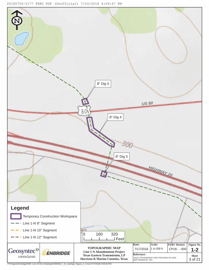
US 80
HIGHWAY 20
8" Dig 3
8" Dig 4
8" Dig 5
USGS The National Map: National Boundaries Dataset, National ElevationDataset, Geographic Names Information System, National HydrographyDataset, National Land Cover Database, National Structures Dataset, andNational Transportation Dataset; U.S. Census Bureau - TIGER/Line; HERERoad Data. Data Refreshed July, 2017.
Date:7/17/2018
Scale:
Reference:USGS TOPOGRAPHIC MAP PROVIDED BY ESRIMAP DRAWN BY JSG.
Legend
Temporary Construction Workspace
Line 1-N 8" Segment
Line 1-N 10" Segment
Line 1-N 12" Segment0 160 320
Feet
!EE
1 in:258 ftLine 1-N Abandonment ProjectTexas Eastern Transmission, LP
Harrison & Marion Counties, Texas
TOPOGRAPHIC MAP
P:\Projects\Enbridge\ENB -Line 1N Env Desktop\GIS\ENB_1_N_LineDigs_Figure_1_2.mxd 7/17/2018 4:09:45 PM
3 of 21
Figure No.
Sheet
CP18- -000
FERC Docket:
1-2
20180724-5177 FERC PDF (Unofficial) 7/24/2018 4:09:47 PM

8" Dig 6
8" Dig 7
8" Dig 9
8" Dig 8
8" Dig13 & 14
UNION PACIFIC
USGS The National Map: National Boundaries Dataset, National ElevationDataset, Geographic Names Information System, National HydrographyDataset, National Land Cover Database, National Structures Dataset, andNational Transportation Dataset; U.S. Census Bureau - TIGER/Line; HERERoad Data. Data Refreshed July, 2017.
Date:7/17/2018
Scale:
Reference:USGS TOPOGRAPHIC MAP PROVIDED BY ESRIMAP DRAWN BY JSG.
Legend
Temporary Construction Workspace
Line 1-N 8" Segment
Line 1-N 10" Segment
Line 1-N 12" Segment0 180 360
Feet
!EE
1 in:300 ftLine 1-N Abandonment ProjectTexas Eastern Transmission, LP
Harrison & Marion Counties, Texas
TOPOGRAPHIC MAP
P:\Projects\Enbridge\ENB -Line 1N Env Desktop\GIS\ENB_1_N_LineDigs_Figure_1_2.mxd 7/17/2018 4:09:45 PM
4 of 21
Figure No.
Sheet
CP18- -000
FERC Docket:
1-2
20180724-5177 FERC PDF (Unofficial) 7/24/2018 4:09:47 PM

FM 134
8" Dig 10
8" Dig 11
UNION PACIFIC
USGS The National Map: National Boundaries Dataset, National ElevationDataset, Geographic Names Information System, National HydrographyDataset, National Land Cover Database, National Structures Dataset, andNational Transportation Dataset; U.S. Census Bureau - TIGER/Line; HERERoad Data. Data Refreshed July, 2017.
Date:7/17/2018
Scale:
Reference:USGS TOPOGRAPHIC MAP PROVIDED BY ESRIMAP DRAWN BY JSG.
Legend
Temporary Construction Workspace
Line 1-N 8" Segment
Line 1-N 10" Segment
Line 1-N 12" Segment0 190 380
Feet
!EE
1 in:312 ftLine 1-N Abandonment ProjectTexas Eastern Transmission, LP
Harrison & Marion Counties, Texas
TOPOGRAPHIC MAP
P:\Projects\Enbridge\ENB -Line 1N Env Desktop\GIS\ENB_1_N_LineDigs_Figure_1_2.mxd 7/17/2018 4:09:45 PM
5 of 21
Figure No.
Sheet
CP18- -000
FERC Docket:
1-2
20180724-5177 FERC PDF (Unofficial) 7/24/2018 4:09:47 PM

FM134
8" Dig15 & 16
USGS The National Map: National Boundaries Dataset, National ElevationDataset, Geographic Names Information System, National HydrographyDataset, National Land Cover Database, National Structures Dataset, andNational Transportation Dataset; U.S. Census Bureau - TIGER/Line; HERERoad Data. Data Refreshed July, 2017.
Date:7/17/2018
Scale:
Reference:USGS TOPOGRAPHIC MAP PROVIDED BY ESRIMAP DRAWN BY JSG.
Legend
Temporary Construction Workspace
Line 1-N 8" Segment
Line 1-N 10" Segment
Line 1-N 12" Segment0 200 400
Feet
!EE
1 in:322 ftLine 1-N Abandonment ProjectTexas Eastern Transmission, LP
Harrison & Marion Counties, Texas
TOPOGRAPHIC MAP
P:\Projects\Enbridge\ENB -Line 1N Env Desktop\GIS\ENB_1_N_LineDigs_Figure_1_2.mxd 7/17/2018 4:09:45 PM
6 of 21
Figure No.
Sheet
CP18- -000
FERC Docket:
1-2
20180724-5177 FERC PDF (Unofficial) 7/24/2018 4:09:47 PM
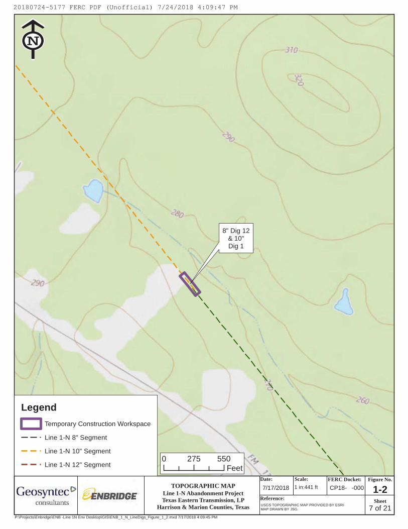
8" Dig 12& 10"Dig 1
USGS The National Map: National Boundaries Dataset, National ElevationDataset, Geographic Names Information System, National HydrographyDataset, National Land Cover Database, National Structures Dataset, andNational Transportation Dataset; U.S. Census Bureau - TIGER/Line; HERERoad Data. Data Refreshed July, 2017.
Date:7/17/2018
Scale:
Reference:USGS TOPOGRAPHIC MAP PROVIDED BY ESRIMAP DRAWN BY JSG.
Legend
Temporary Construction Workspace
Line 1-N 8" Segment
Line 1-N 10" Segment
Line 1-N 12" Segment0 275 550
Feet
!EE
1 in:441 ftLine 1-N Abandonment ProjectTexas Eastern Transmission, LP
Harrison & Marion Counties, Texas
TOPOGRAPHIC MAP
P:\Projects\Enbridge\ENB -Line 1N Env Desktop\GIS\ENB_1_N_LineDigs_Figure_1_2.mxd 7/17/2018 4:09:45 PM
7 of 21
Figure No.
Sheet
CP18- -000
FERC Docket:
1-2
20180724-5177 FERC PDF (Unofficial) 7/24/2018 4:09:47 PM

FM 134
10" Dig 2
10" Dig 3
USGS The National Map: National Boundaries Dataset, National ElevationDataset, Geographic Names Information System, National HydrographyDataset, National Land Cover Database, National Structures Dataset, andNational Transportation Dataset; U.S. Census Bureau - TIGER/Line; HERERoad Data. Data Refreshed July, 2017.
Date:7/17/2018
Scale:
Reference:USGS TOPOGRAPHIC MAP PROVIDED BY ESRIMAP DRAWN BY JSG.
Legend
Temporary Construction Workspace
Line 1-N 8" Segment
Line 1-N 10" Segment
Line 1-N 12" Segment0 210 420
Feet
!EE
1 in:340 ftLine 1-N Abandonment ProjectTexas Eastern Transmission, LP
Harrison & Marion Counties, Texas
TOPOGRAPHIC MAP
P:\Projects\Enbridge\ENB -Line 1N Env Desktop\GIS\ENB_1_N_LineDigs_Figure_1_2.mxd 7/17/2018 4:09:45 PM
8 of 21
Figure No.
Sheet
CP18- -000
FERC Docket:
1-2
20180724-5177 FERC PDF (Unofficial) 7/24/2018 4:09:47 PM

RAYBURN RD
10" Dig 4
10" Dig 5
USGS The National Map: National Boundaries Dataset, National ElevationDataset, Geographic Names Information System, National HydrographyDataset, National Land Cover Database, National Structures Dataset, andNational Transportation Dataset; U.S. Census Bureau - TIGER/Line; HERERoad Data. Data Refreshed July, 2017.
Date:7/17/2018
Scale:
Reference:USGS TOPOGRAPHIC MAP PROVIDED BY ESRIMAP DRAWN BY JSG.
Legend
Temporary Construction Workspace
Line 1-N 8" Segment
Line 1-N 10" Segment
Line 1-N 12" Segment0 210 420
Feet
!EE
1 in:348 ftLine 1-N Abandonment ProjectTexas Eastern Transmission, LP
Harrison & Marion Counties, Texas
TOPOGRAPHIC MAP
P:\Projects\Enbridge\ENB -Line 1N Env Desktop\GIS\ENB_1_N_LineDigs_Figure_1_2.mxd 7/17/2018 4:09:45 PM
9 of 21
Figure No.
Sheet
CP18- -000
FERC Docket:
1-2
20180724-5177 FERC PDF (Unofficial) 7/24/2018 4:09:47 PM

10" Dig16 - 19
USGS The National Map: National Boundaries Dataset, National ElevationDataset, Geographic Names Information System, National HydrographyDataset, National Land Cover Database, National Structures Dataset, andNational Transportation Dataset; U.S. Census Bureau - TIGER/Line; HERERoad Data. Data Refreshed July, 2017.
Date:7/17/2018
Scale:
Reference:USGS TOPOGRAPHIC MAP PROVIDED BY ESRIMAP DRAWN BY JSG.
Legend
Temporary Construction Workspace
Line 1-N 8" Segment
Line 1-N 10" Segment
Line 1-N 12" Segment0 200 400
Feet
!EE
1 in:333 ftLine 1-N Abandonment ProjectTexas Eastern Transmission, LP
Harrison & Marion Counties, Texas
TOPOGRAPHIC MAP
P:\Projects\Enbridge\ENB -Line 1N Env Desktop\GIS\ENB_1_N_LineDigs_Figure_1_2.mxd 7/17/2018 4:09:45 PM
10 of 21
Figure No.
Sheet
CP18- -000
FERC Docket:
1-2
20180724-5177 FERC PDF (Unofficial) 7/24/2018 4:09:47 PM

UNNAMED STREAM
10" Dig20 & 21
USGS The National Map: National Boundaries Dataset, National ElevationDataset, Geographic Names Information System, National HydrographyDataset, National Land Cover Database, National Structures Dataset, andNational Transportation Dataset; U.S. Census Bureau - TIGER/Line; HERERoad Data. Data Refreshed July, 2017.
Date:
7/19/2018 Scale:
Reference:USGS TOPOGRAPHIC MAP PROVIDED BY ESRIMAP DRAWN BY JSG.
LegendTemporary Construction Workspace
Line 1-N 8" Segment
Line 1-N 10" Segment
Line 1-N 12" Segment0 200 400
Feet
!EE
1 in:325 ftLine 1-N Abandonment ProjectTexas Eastern Transmission, LP
Harrison & Marion Counties, Texas
TOPOGRAPHIC MAP
P:\Projects\Enbridge\ENB -Line 1N Env Desktop\GIS\ENB_1_N_LineDigs_Figure_1_2.mxd 7/19/2018 9:45:45 AM
11 of 21
Figure No.
Sheet
CP18- -000FERC Docket:
1-2
20180724-5177 FERC PDF (Unofficial) 7/24/2018 4:09:47 PM

BALDWIN RD
10" Dig 6
USGS The National Map: National Boundaries Dataset, National ElevationDataset, Geographic Names Information System, National HydrographyDataset, National Land Cover Database, National Structures Dataset, andNational Transportation Dataset; U.S. Census Bureau - TIGER/Line; HERERoad Data. Data Refreshed July, 2017.
Date:7/17/2018
Scale:
Reference:USGS TOPOGRAPHIC MAP PROVIDED BY ESRIMAP DRAWN BY JSG.
Legend
Temporary Construction Workspace
Line 1-N 8" Segment
Line 1-N 10" Segment
Line 1-N 12" Segment0 210 420
Feet
!EE
1 in:337 ftLine 1-N Abandonment ProjectTexas Eastern Transmission, LP
Harrison & Marion Counties, Texas
TOPOGRAPHIC MAP
P:\Projects\Enbridge\ENB -Line 1N Env Desktop\GIS\ENB_1_N_LineDigs_Figure_1_2.mxd 7/17/2018 4:09:45 PM
12 of 21
Figure No.
Sheet
CP18- -000
FERC Docket:
1-2
20180724-5177 FERC PDF (Unofficial) 7/24/2018 4:09:47 PM

10" Dig 7
10" Dig 8
10" Dig22 & 23
USGS The National Map: National Boundaries Dataset, National ElevationDataset, Geographic Names Information System, National HydrographyDataset, National Land Cover Database, National Structures Dataset, andNational Transportation Dataset; U.S. Census Bureau - TIGER/Line; HERERoad Data. Data Refreshed July, 2017.
Date:7/17/2018
Scale:
Reference:USGS TOPOGRAPHIC MAP PROVIDED BY ESRIMAP DRAWN BY JSG.
Legend
Temporary Construction Workspace
Line 1-N 8" Segment
Line 1-N 10" Segment
Line 1-N 12" Segment0 200 400
Feet
!EE
1 in:329 ftLine 1-N Abandonment ProjectTexas Eastern Transmission, LP
Harrison & Marion Counties, Texas
TOPOGRAPHIC MAP
P:\Projects\Enbridge\ENB -Line 1N Env Desktop\GIS\ENB_1_N_LineDigs_Figure_1_2.mxd 7/17/2018 4:09:45 PM
13 of 21
Figure No.
Sheet
CP18- -000
FERC Docket:
1-2
20180724-5177 FERC PDF (Unofficial) 7/24/2018 4:09:47 PM
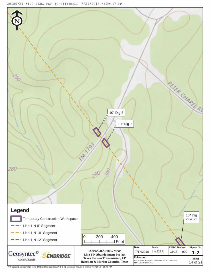
10" Dig 7
10" Dig 8
10" Dig22 & 23
USGS The National Map: National Boundaries Dataset, National ElevationDataset, Geographic Names Information System, National HydrographyDataset, National Land Cover Database, National Structures Dataset, andNational Transportation Dataset; U.S. Census Bureau - TIGER/Line; HERERoad Data. Data Refreshed July, 2017.
Date:7/17/2018
Scale:
Reference:USGS TOPOGRAPHIC MAP PROVIDED BY ESRIMAP DRAWN BY JSG.
Legend
Temporary Construction Workspace
Line 1-N 8" Segment
Line 1-N 10" Segment
Line 1-N 12" Segment0 200 400
Feet
!EE
1 in:329 ftLine 1-N Abandonment ProjectTexas Eastern Transmission, LP
Harrison & Marion Counties, Texas
TOPOGRAPHIC MAP
P:\Projects\Enbridge\ENB -Line 1N Env Desktop\GIS\ENB_1_N_LineDigs_Figure_1_2.mxd 7/17/2018 4:09:45 PM
14 of 21
Figure No.
Sheet
CP18- -000
FERC Docket:
1-2
20180724-5177 FERC PDF (Unofficial) 7/24/2018 4:09:47 PM
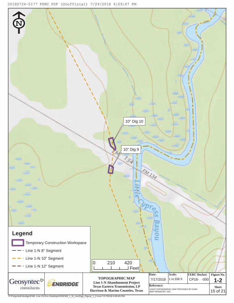
FM 134
10" Dig 9
10" Dig 10
USGS The National Map: National Boundaries Dataset, National ElevationDataset, Geographic Names Information System, National HydrographyDataset, National Land Cover Database, National Structures Dataset, andNational Transportation Dataset; U.S. Census Bureau - TIGER/Line; HERERoad Data. Data Refreshed July, 2017.
Date:7/17/2018
Scale:
Reference:USGS TOPOGRAPHIC MAP PROVIDED BY ESRIMAP DRAWN BY JSG.
Legend
Temporary Construction Workspace
Line 1-N 8" Segment
Line 1-N 10" Segment
Line 1-N 12" Segment0 210 420
Feet
!EE
1 in:338 ftLine 1-N Abandonment ProjectTexas Eastern Transmission, LP
Harrison & Marion Counties, Texas
TOPOGRAPHIC MAP
P:\Projects\Enbridge\ENB -Line 1N Env Desktop\GIS\ENB_1_N_LineDigs_Figure_1_2.mxd 7/17/2018 4:09:45 PM
15 of 21
Figure No.
Sheet
CP18- -000
FERC Docket:
1-2
20180724-5177 FERC PDF (Unofficial) 7/24/2018 4:09:47 PM

10" Dig 11
10" Dig 12
KANSAS CITY SOUTHERN
USGS The National Map: National Boundaries Dataset, National ElevationDataset, Geographic Names Information System, National HydrographyDataset, National Land Cover Database, National Structures Dataset, andNational Transportation Dataset; U.S. Census Bureau - TIGER/Line; HERERoad Data. Data Refreshed July, 2017.
Date:7/17/2018
Scale:
Reference:USGS TOPOGRAPHIC MAP PROVIDED BY ESRIMAP DRAWN BY JSG.
Legend
Temporary Construction Workspace
Line 1-N 8" Segment
Line 1-N 10" Segment
Line 1-N 12" Segment0 210 420
Feet
!EE
1 in:345 ftLine 1-N Abandonment ProjectTexas Eastern Transmission, LP
Harrison & Marion Counties, Texas
TOPOGRAPHIC MAP
P:\Projects\Enbridge\ENB -Line 1N Env Desktop\GIS\ENB_1_N_LineDigs_Figure_1_2.mxd 7/17/2018 4:09:45 PM
16 of 21
Figure No.
Sheet
CP18- -000
FERC Docket:
1-2
20180724-5177 FERC PDF (Unofficial) 7/24/2018 4:09:47 PM

STATE ROUTE 4910" Dig 13
10" Digs14 & 15 &12" Dig 1
12" Dig 2
12" Dig 3
UNION PA
CIFIC
USGS The National Map: National Boundaries Dataset, National ElevationDataset, Geographic Names Information System, National HydrographyDataset, National Land Cover Database, National Structures Dataset, andNational Transportation Dataset; U.S. Census Bureau - TIGER/Line; HERERoad Data. Data Refreshed July, 2017.
Date:7/17/2018
Scale:
Reference:USGS TOPOGRAPHIC MAP PROVIDED BY ESRIMAP DRAWN BY JSG.
Legend
Temporary Construction Workspace
Line 1-N 8" Segment
Line 1-N 10" Segment
Line 1-N 12" Segment0 220 440
Feet
!EE
1 in:354 ftLine 1-N Abandonment ProjectTexas Eastern Transmission, LP
Harrison & Marion Counties, Texas
TOPOGRAPHIC MAP
P:\Projects\Enbridge\ENB -Line 1N Env Desktop\GIS\ENB_1_N_LineDigs_Figure_1_2.mxd 7/17/2018 4:09:45 PM
17 of 21
Figure No.
Sheet
CP18- -000
FERC Docket:
1-2
20180724-5177 FERC PDF (Unofficial) 7/24/2018 4:09:47 PM

12" Dig 8 & 9
USGS The National Map: National Boundaries Dataset, National ElevationDataset, Geographic Names Information System, National HydrographyDataset, National Land Cover Database, National Structures Dataset, andNational Transportation Dataset; U.S. Census Bureau - TIGER/Line; HERERoad Data. Data Refreshed July, 2017.
Date:7/17/2018
Scale:
Reference:USGS TOPOGRAPHIC MAP PROVIDED BY ESRIMAP DRAWN BY JSG.
Legend
Temporary Construction Workspace
Line 1-N 8" Segment
Line 1-N 10" Segment
Line 1-N 12" Segment0 150 300
Feet
!EE
1 in:247 ftLine 1-N Abandonment ProjectTexas Eastern Transmission, LP
Harrison & Marion Counties, Texas
TOPOGRAPHIC MAP
P:\Projects\Enbridge\ENB -Line 1N Env Desktop\GIS\ENB_1_N_LineDigs_Figure_1_2.mxd 7/17/2018 4:09:45 PM
18 of 21
Figure No.
Sheet
CP18- -000
FERC Docket:
1-2
20180724-5177 FERC PDF (Unofficial) 7/24/2018 4:09:47 PM

FM24
8
12" Dig 4
12" Dig 5
USGS The National Map: National Boundaries Dataset, National ElevationDataset, Geographic Names Information System, National HydrographyDataset, National Land Cover Database, National Structures Dataset, andNational Transportation Dataset; U.S. Census Bureau - TIGER/Line; HERERoad Data. Data Refreshed July, 2017.
Date:7/17/2018
Scale:
Reference:USGS TOPOGRAPHIC MAP PROVIDED BY ESRIMAP DRAWN BY JSG.
Legend
Temporary Construction Workspace
Line 1-N 8" Segment
Line 1-N 10" Segment
Line 1-N 12" Segment0 225 450
Feet
!EE
1 in:365 ftLine 1-N Abandonment ProjectTexas Eastern Transmission, LP
Harrison & Marion Counties, Texas
TOPOGRAPHIC MAP
P:\Projects\Enbridge\ENB -Line 1N Env Desktop\GIS\ENB_1_N_LineDigs_Figure_1_2.mxd 7/17/2018 4:09:45 PM
19 of 21
Figure No.
Sheet
CP18- -000
FERC Docket:
1-2
20180724-5177 FERC PDF (Unofficial) 7/24/2018 4:09:47 PM

UNNAMED STREAM
12" Dig10 & 11
USGS The National Map: National Boundaries Dataset, National ElevationDataset, Geographic Names Information System, National HydrographyDataset, National Land Cover Database, National Structures Dataset, andNational Transportation Dataset; U.S. Census Bureau - TIGER/Line; HERERoad Data. Data Refreshed July, 2017.
Date:7/17/2018
Scale:
Reference:USGS TOPOGRAPHIC MAP PROVIDED BY ESRIMAP DRAWN BY JSG.
Legend
Temporary Construction Workspace
Line 1-N 8" Segment
Line 1-N 10" Segment
Line 1-N 12" Segment0 100 200
Feet
!EE
1 in:164 ftLine 1-N Abandonment ProjectTexas Eastern Transmission, LP
Harrison & Marion Counties, Texas
TOPOGRAPHIC MAP
P:\Projects\Enbridge\ENB -Line 1N Env Desktop\GIS\ENB_1_N_LineDigs_Figure_1_2.mxd 7/17/2018 4:09:45 PM
20 of 21
Figure No.
Sheet
CP18- -000
FERC Docket:
1-2
20180724-5177 FERC PDF (Unofficial) 7/24/2018 4:09:47 PM

12" Dig 6 & 7
USGS The National Map: National Boundaries Dataset, National ElevationDataset, Geographic Names Information System, National HydrographyDataset, National Land Cover Database, National Structures Dataset, andNational Transportation Dataset; U.S. Census Bureau - TIGER/Line; HERERoad Data. Data Refreshed July, 2017.
Date:7/17/2018
Scale:
Reference:USGS TOPOGRAPHIC MAP PROVIDED BY ESRIMAP DRAWN BY JSG.
Legend
Temporary Construction Workspace
Line 1-N 8" Segment
Line 1-N 10" Segment
Line 1-N 12" Segment0 120 240
Feet
!EE
1 in:192 ftLine 1-N Abandonment ProjectTexas Eastern Transmission, LP
Harrison & Marion Counties, Texas
TOPOGRAPHIC MAP
P:\Projects\Enbridge\ENB -Line 1N Env Desktop\GIS\ENB_1_N_LineDigs_Figure_1_2.mxd 7/17/2018 4:09:45 PM
21 of 21
Figure No.
Sheet
CP18- -000
FERC Docket:
1-2
20180724-5177 FERC PDF (Unofficial) 7/24/2018 4:09:47 PM

B-1
APPENDIX B PROJECT AREAS AND LAND REQUIREMENTS

B-2
Table 11 Project Areas and Land Requirements Line 1-N Abandonment Project
Project Area Mile Post Land Affected During
Abandonment Activities (acres) 8 inch Segment
8 inch Dig 1 0.00 0.1 8 inch Dig 2 0.13 0.1 8 inch Dig 3 0.63 0.1 8 inch Dig 4 0.63 0.5 8 inch Dig 5 0.70 0.1 8 inch Dig 6 1.12 0.1 8 inch Dig 7 1.12 0.1 8 inch Dig 8 1.43 0.1 8 inch Dig 9 1.13 0.1 8 inch Dig 10 1.84 0.1 8 inch Dig 11 1.84 0.1 8 inch Dig 12 5.50 0.0b
8 inch Digs 13 & 14a 1.04 0.2 8 inch Digs 15 & 16a 4.44 0.2
8 inch Segment Total: 2.0 10 inch Segment
10 inch Dig 1 5.49 0.3 10 inch Dig 2 6.63 0.1 10 inch Dig 3 6.63 0.1 10 inch Dig 4 13.15 0.1 10 inch Dig 5 13.15 0.1 10 inch Dig 16 – 19c 13.87/13.88 0.3 10 inch Dig 20 & 21c 15.13 0.2 10 inch Dig 6 16.32 0.1 10 inch Dig 22 & 23c 18.85 0.2 10 inch Dig 7 19.18 0.1 10 inch Dig 8 19.18 0.1 10 inch Dig 9 22.35 0.1 10 inch Dig 10 22.35 0.1 10 inch Dig 11 23.02 0.1 10 inch Dig 12 23.02 0.1 10 inch Dig 13 27.02 0.1 10 inch Dig 14 & 15, 12 inch Dig 1d 27.06 0.5
10 inch Segment Total: 2.8 12 inch Segment
12 inch Dig 1 27.06 See Noted 12 inch Dig 2 27.27 0.1

B-3
Table 11 Project Areas and Land Requirements Line 1-N Abandonment Project
Project Area Mile Post Land Affected During
Abandonment Activities (acres) 12 inch Dig 3 27.27 0.1 12 inch Dig 8 & 9e 27.62 0.2 12 inch Dig 4 28.09 0.1 12 inch Dig 5 28.09 0.1 12 inch Dig 10 & 11e 29.28 0.2 12 inch Dig 6 & 7e 29.60 0.2
12 inch Segment Total: 1.00 Project Totals 6.0
Notes: a Temporary workspace is shared at two locations on the 8” segment: Digs 13 & 14; Digs 15 &
16 b Dig locations 8 inch Dig 12 and 10 inch Dig 1 are within a shared temporary workspace and
the acreages are reflected in 10-inch Dig 1. c Temporary workspace is shared at four locations on the 10 inch segment: Digs 16-19; Digs 20
& 21; and Digs 22 & 23. d Dig locations 10 inch Dig 14, 10 inch Dig 15, and 12 inch Dig 1 are within a shared temporary
workspace. e Temporary workspace is shared at three locations on the 12 inch segment: Digs 6 & 7; Digs 8
& 9; and Digs 10 & 11.
C-1
APPENDIX C RESIDENTIAL SITE-SPECIFIC CONSTRUCTION PLANS

FM134
18'
90'
8" Dig 6(0.12 acre)
8" Dig 7(0.12 acre)
Date:2/21/2018
Scale:
Reference:MAP DRAWN BY JSG.
LegendLine 1-N 8" Segment
Permanent ROW
Road Edge
Approximate Location of Residence
Temporary Construction Workspace
Access Route
!EE
1 in:58 ftLine 1-N Abandonment ProjectTexas Eastern Transmission, LP
Harrison & Marion Counties, Texas
RESIDENTIAL IMPLEMENTATION PLAN
P:\Projects\Enbridge\ENB -Line 1N Env Desktop\GIS\TETLP_1N_Figure8_1.mxd 2/21/2018 4:48:14 PM
1 of 2
Figure No.
Sheet
CP18- -000FERC Docket:
8-1
Construction Notes:1. Contractor will install safety fence before equipment is used in any part ofthe right-of-way (ROW) and will be removed when restoration is complete.Fence the construction workspace adjacent to the residence for a distanceof 100 feet to ensure that construction equipment and materials, includespoil pile, remain within the construction workspace.2. Abandonment activities will be contained entirely within the existing,maintained ROW.3. Noise from abandonment activities and equipment will be minimized bylimiting active abandonment activity in the residential areas to daylight hours.4. Landowners shall be notified (1) week prior to construction by TexasEastern’s land agent who has been in contact with landowners before andthroughout the construction period to receive, address, and resolve anycomplaints that may arise from abandonment activities. Land agent will serveas a point of contact between the landowner and the construction contractor.
*Not to Scale
20180724-5177 FERC PDF (Unofficial) 7/24/2018 4:09:47 PM

Date:2/21/2018
Scale:
Reference:MAP DRAWN BY JSG.
!EE
1 in:100 ftLine 1-N Abandonment ProjectTexas Eastern Transmission, LP
Harrison & Marion Counties, Texas
RESIDENTIAL IMPLEMENTATION PLAN
P:\Projects\Enbridge\ENB -Line 1N Env Desktop\GIS\TETLP_1N_Figure8_2.mxd 2/21/2018 4:45:35 PM
2 of 2
Figure No.
Sheet
CP18- -000FERC Docket:
8-1
Highway 43
30'
54'
10" Dig 4(0.11 acre)
10" Dig 5(0.11 acre)
Construction Notes:1. Contractor will install safety fence before equipment is used in any part ofthe right-of-way (ROW) and will be removed when restoration is complete.Fence the construction workspace adjacent to the residence for a distanceof 100 feet to ensure that construction equipment and materials, includespoil pile, remain within the construction workspace.2. Abandonment activities will be contained entirely within the existing,maintained ROW.3. Noise from abandonment activities and equipment will be minimized bylimiting active abandonment activity in the residential areas to daylight hours.4. Landowners shall be notified (1) week prior to construction by TexasEastern’s land agent who has been in contact with landowners before andthroughout the construction period to receive, address, and resolve anycomplaints that may arise from abandonment activities. Land agent will serveas a point of contact between the landowner and the construction contractor.
LegendLine 1-N 10" Segment
Permanent ROW
Road Edge
Approximate Location of Residence
Temporary Construction Workspace
Access Route
*Not to Scale
20180724-5177 FERC PDF (Unofficial) 7/24/2018 4:09:47 PM


