NEW MEXICO BUREAU of GEOLOGY & MINERAL R ESOURCES A DIVISION OF NEW MEXICO TECH geoinfo.nmt.edu/publications/periodicals/litegeology Evidence for an ancient meteorite impact structure is preserved in a road cut along New Mexico Highway 475, the road to Hyde Memorial State Park and the Santa Fe Ski Basin in the Sangre de Cristo Mountains. e exposure is located about 12 km northeast of Santa Fe and about 200 m to the east of the Chamisa Trail parking area. e road cut was created decades ago, but the impact features were revealed by a rock slide in 2005 that blocked the highway after a heavy winter storm. An observant retired petroleum geologist living in Santa Fe named Tim McElvain was the first to recognize shatter cones in the rock slide and in the newly-formed exposure along the highway. Shatter cones are nested, roughly conical-shaped fractures up to 1.5 m tall with grooves (striations) that radiate from the tip of the cone. Shatter cones in rocks are produced by shock waves, which form by instantaneous, extreme pressures and temperatures associated with impacts and nuclear explosions. Mr. McElvain had noticed similar, but poorly-preserved, cones along the Chamisa Trail as early as 2003. Leading experts in the field of impact studies Earth Briefs: A Fortuitous Discovery all agree that the features found by Mr. McElvain in that fortuitously-exposed road cut are remarkable examples of shatter cones. e shatter cones are present along the highway for about 2 km and have been mapped up to 1 km north of the highway in the general vicinity of the Chamisa Trail. A total of 110 cones in a 3 km2 area have been identified. Shatter cones generally form near the center of an impact and the tip of the cones point toward the impact origin. Measurements on the cones near Santa Fe imply that ground-zero of the impact is to the northeast of the roadcut. e cones are developed primarily in the pink, equigranular Proterozoic granite, but the conical fractures are also found in black and white foliated Proterozoic metamorphic rocks (schist and quartzite). e cones are not found in the overlying Mississippian carbonate section. us, the impact occurred sometime after 1.4 billion years, the age of the granitic rocks, and before 330 Ma, the age of the Mississippian carbonates. In this issue... Earth Briefs: A Fortuitous Discovery • Dikes and Sills • Igneous Dikes of New Mexico Adjustments on the Margins–Dikes and contact metamorphism • Roadside Dikes of New Mexico: A photo Gallery • Hey! Not all Dikes Are Igneous! • New Mexico’s Most Wanted Mineral New Mexico’s Enchanting Geology • Earth Science Movie Review: Dantes Peak Classroom Activity • Through the Hand Lens Lite F ALL 2016 ISSUE 40 Shari Kelley
Transcript
NEW MEXICO BUREAU of GEOLOGY & MINERAL RESOURCES A DIVISION OF NEW MEXICO TECH
Evidence for an ancient meteorite impact structure is preserved in a road cut along New Mexico Highway 475, the road to Hyde Memorial State Park and the Santa Fe Ski Basin in the Sangre de Cristo Mountains. The exposure is located about 12 km northeast of Santa Fe and about 200 m to the east of the Chamisa Trail parking area. The road cut was created decades ago, but the impact features were revealed by a rock slide in 2005 that blocked the highway after a heavy winter storm. An observant retired petroleum geologist living in Santa Fe named Tim McElvain was the first to recognize shatter cones in the rock slide and in the newly-formed exposure along the highway. Shatter cones are nested, roughly conical-shaped fractures up to 1.5 m tall with grooves (striations) that radiate from the tip of the cone. Shatter cones in rocks are produced by shock waves, which form by instantaneous, extreme pressures and temperatures associated with impacts and nuclear explosions. Mr. McElvain had noticed similar, but poorly-preserved, cones along the Chamisa Trail as early as 2003. Leading experts in the field of impact studies
Earth Briefs: A Fortuitous Discoveryall agree that the features found by Mr. McElvain in that fortuitously-exposed road cut are remarkable examples of
shatter cones.
The shatter cones are present along the highway for about 2 km and have been mapped up to 1 km north of the highway in the general vicinity of the Chamisa Trail. A total of 110 cones in a 3 km2 area have been identified. Shatter cones generally form near the center of an impact and the tip
of the cones point toward the impact origin. Measurements on the cones near Santa Fe imply that ground-zero of the impact is to the northeast of the roadcut. The cones are developed primarily in the pink, equigranular Proterozoic granite, but the conical fractures are also found in black and white foliated Proterozoic metamorphic rocks (schist and quartzite). The cones are not found in the overlying Mississippian carbonate section. Thus, the impact occurred sometime after 1.4 billion years, the age of the granitic rocks,
and before 330 Ma, the age of the Mississippian carbonates.
In this issue...Earth Briefs: A Fortuitous Discovery • Dikes and Sills • Igneous Dikes of New Mexico
Adjustments on the Margins–Dikes and contact metamorphism • Roadside Dikes of New Mexico: A photo Gallery • Hey! Not all Dikes Are Igneous! • New Mexico’s Most Wanted Mineral
New Mexico’s Enchanting Geology • Earth Science Movie Review: Dantes Peak Classroom Activity • Through the Hand Lens
L i t e Fall 2016 issue 40
Shari Kelley
new mexico bureau of geology & mineral resources lite geology fall 2016 2
Minerals within a shocked rock commonly display linear deformation planes created by the intense pressures generated by the shock waves. The Proterozoic rocks along Highway 475 are weakly shocked, suggesting that the strongly shocked rock within the crater has been removed by erosion and that the cones are preserved near the bottom of a deeply eroded crater. The actual size of the crater is difficult to determine because of the deep erosion prior to the Mississippian and because the Sangre de Cristo Mountain range has been affected by several episodes of mountain building since the Mississippian. A current estimate of the crater’s size is >6 to 13 km in diameter.
Dikes and Sills A dike or sill is a sheet-like rock body that cuts across or along bedding. If the intrusion cuts across rock layers, it’s a dike. If it appears to have been squirted between layers, it’s a sill. These features can be igneous, sedimentary, or structural in origin. But most of the easily recognized dikes consist of igneous rock. Geologists have many terms for the way rocks are oriented, which causes much confusion. The best way to think about a dike is to relate it to a manmade feature, like a dam or levee (think of the little Dutch boy). Since igneous rocks are commonly harder than sedimentary types, dikes often “stick up” in the landscape, like a dam or levee. On the other hand, sills tend to be horizontal, like a window “sill” in the same orientation as the host rocks.
Dikes and sills are very important to geologists because they record an episode of Earth history. A dike or sill cannot intrude something that’s not there, so they represent a time marker. They are always younger than the rock they cut through – an important geologic concept we call “The Law of Cross-cutting Relationships.” Since many dikes are igneous, we can date them using radioactive isotopes to pinpoint the age of the intrusive event and then bracket the age of the other rocks.
Dikes essentially fill cracks in host rocks. In order for a crack to form in the Earth’s crust, which can be filled with magma or sediment, the rock must be pulled apart. This “pulling apart” (geologists call it extension) happens where plates are spreading apart, or above areas where something is pushing up from below
Shatter cones developed in Proterozoic granite in an outcrop on the north side of New Mexico Highway 475 northeast of Santa Fe. A small parking area is available on the south side of the road approximately 0.25 miles east of the Chamisa Trailhead. You can safely view the outcrop by standing behind the jersey barriers provided by the New Mexico Highway Department. Yard stick for scale. Photo by Shari Kelley.
Virgil W. Lueth
Cataclasite dike from the footwall of the West Salton Detachment (low-angle normal) fault in Southern California. The fault was active from about 5-7 million to approximately 1 million years ago. Photo courtesy of Gary Axen.
new mexico bureau of geology & mineral resources lite geology fall 2016 3
Igneous Dikes of New Mexico
Schematic diagram showing the relationships between volcanoes, dikes, and magma chambers.Diagram is not to scale.
New Mexico is often referred to as the “Volcano State” because of the well-preserved, diverse types, and large number of volcanoes found within our land of enchantment. Lurking beneath these volcanoes and exposed in many locations are dikes of various ages, geometries, thickness-es, and compositions. Nearly everywhere you find one of New Mexico’s famous volcanoes, somewhere nearby is a dike.
Magma Chamber
Eruptingvolcano
Dikes
Conduit
Sill
Sill
Dike
Beddedsedimentary rocks
What is a dike? An igneous dike is a type of intrusion formed when magma (molten rock) fills a fracture in older rocks. Dikes are tabular intrusions that crosscut existing rocks such as bedded sedimentary rocks, deformed metamorphic rocks, or older intrusions. Dikes are typically oriented in a vertical or near vertical position. The width of dikes is variable, ranging from a few inches to many tens of feet across. Most dikes are more resistant to erosion than the rocks that they intrude and thus, when eroded, form sheet-like or wall-like topographic features. Some of the most well known landscapes in New Mexico, such as the area surrounding Shiprock (Tsé Bit’ a ’í or “rock with wings”), were formed from dikes and related igneous activity. The wings of Tsé Bit’a ’í are actually eroded dikes.
Volcanoes are the surface expression of a multitude of magmatic processes. All magmas originate in the earth’s mantle, many miles below the earth’s surface. For magma to erupt as lava on the surface, it must first travel through the earth’s crust. Although there are many ways magma is transported through the crust, one common method is via dikes. Magma accumulates at various depths in the crust, continuously building pressure until the surrounding rocks fracture. This fracture is then filled with magma and a dike is
formed. The process continues until magmatism stops or the dike breaches the surface of the earth and an eruption commences. For example, the 2014 Holuhraun eruption in Iceland was
preceded by 13-day-long dike emplacement event. Sometimes the accumulation of magma in the crust creates a radial fracture pattern and thus produces radial dikes. This is common at shallow crustal levels, such as in the neck of a volcano, or near very large volcanoes, such as calderas (also known as supervolcanoes). Some radial dikes are more than several hundred miles long.
How are dikes and volcanoes related?
Annotated field photograph showing one of the 25-26 million-year-old Dulce dikes intruded into Cretaceous sedimentary rocks of the northern San Juan basin. Photo by Matt Zimmerer.
Why are dikes important?Geologists study dikes because we can use them to understand different aspects of Earth’s history. Dikes are crosscutting features and are younger than the rocks that they intrude. Using radioisotop-ic-dating techniques, the age of the dike constrains both the timing of magmatism and the minimum age of the surrounding rocks that the dike intrudes. The ages of a dike are used to understand when sedimentary rocks were deposited, when metamorphic rocks were deformed, or when older intrusions were emplaced. Dikes are also used to understand tectonic activity. Here in the New Mexico, the earth’s crust has been most recently deformed by extension related
(magma intrusion). Since these cracks form perpendicular to the direction of maximum extension, dikes are often aligned in the same orientation, which is called a “dike swarm.” If they form over a pluton, radial dike patterns can develop. Cracks that form by compression (squeezing together) typically do not make space, so dikes are not commonly found. However, compression and faulting can make fine-grained rock flour called a cataclasite dike. This process is an example of a structurally formed dike-like feature (think of it as a petrified fault).
Matt Zimmerer
new mexico bureau of geology & mineral resources lite geology fall 2016 4
Aerial photo showing the Pie Town Dike exposed near Techado Mountain of west-central New Mexico. The dike is more resistant to erosion than the sedimentary rocks it intruded and forms a prominent linear topographic feature. Photo by Matt Zimmerer.
Google Earth image showing the radial dikes at Shiprock, northwest New Mexico.
Adjustments on the Margins – Dikes and contact meta-
morphismVirgil W. Lueth
Igneous dikes can bisect many different types of rocks. Some
of these rocks can be very sensitive to temperature changes
caused by the juxtaposition of hot magma and host rocks.
Others, because of their composition, merely recrystallize.
If the temperature flux is great enough, minerals reform to
adjust to higher temperatures, a process that geologists call
“contact metamorphism.”
Mineral changes during contact metamorphism in shales are
analogous to firing a clay pot. Potting clays are essentially
sheets of silicon dioxide (SiO2) and aluminum oxide (Al2O3)
linked by oxygen atoms. These sheets are held together by
hydrogen. Clays with abundant mineralogical water (as OH
groups) lose water when heated (usually around 500°C).
The loss of water shrinks the clay and the bonding between
clay sheets is accomplished by oxygen. The clay is now more
hard and brittle and will not become soft again with the
addition of water.
If the clay is heated even longer and at higher temperatures,
some of the material melts and begins to bond the clay
particles together, like glue, making it even stronger and less
porous. At these higher temperatures the clays can actually
change into the mineral, mullite (3Al2O3∙2SiO2 - note the
lack of OH in the formula), and the originally soft and plastic
clay has become like porcelain. This often happens at the
margins of dikes hosted by shale. A number of other changes
can occur if water moves back and forth during heating,
creating new minerals from the original components. After
metamorphism, these contact zones can be even harder and
more resistant to erosion than the dike itself!
Metamorphic petrologists, geologists who study these types of
processes, can often determine the temperature and pressure
of the metamorphism based on the types of minerals present.
By doing furnace experiments in the laboratory, they can
produce these reactions at specific temperatures and by
analogy; estimate the conditions of metamorphism in nature.
to the Rio Grande rift. Extension produces a variety of stresses in the earth’s crust. If magma is emplaced during tectonic activity, the orientation of dikes is commonly parallel to the minimum stress. For example, many dikes are emplaced along faults. By measuring the orientation of dikes, geologists determine ancient stress fields and compare them to the present-day. Finally, dikes can develop zones of adjacent hydrothermal circulation where minerals are formed and deposited. Many geologists seek out dikes in hopes of finding precious minerals or the next major economic ore body.
Dikes can be found in all types of geologic settings and emplaced into all types of rocks. But one thing is for sure, dikes are found all throughout New Mexico. If you keep an observant eye as you are out hiking or driving there is a good chance you will find one of New Mexico’s dikes!
new mexico bureau of geology & mineral resources lite geology fall 2016 5
Roadside Dikes of New Mexico: A Photo Gallery Compiled by: Kelsey McNamaraONE OF the radial
dikes from Shiprock, which cuts through Cretaceous Mancos Shale. View to north from Tribal Road 13. Photo by Steve Cather.
BASALT DIKES exposed near Abiquiu, which cut through sedimentary units of the Tertiary Santa Fe Group. View to the east from Highway 84. Photo by Kelsey McNamara.
DIKE CUTTING through the Cretaceous Pierre Shale. View to the east from I–25, near the Tinaja exit. Photo by Nelia Dunbar.
new mexico bureau of geology & mineral resources lite geology fall 2016 6
LATITE DIKE cuts through the limestones of the Pennsylvanian Madera Group, east of Albuquerque. View is looking northeast from Sandia Crest Road.
Photo courtesy of David Decker.
A DIKE cuts through the Cretaceous Mancos Shale south of Mt. Taylor. View is looking southwest from Forest Service Road 400, near the mouth of Rinconada Canyon. Photo courtesy of Fraser and Cathy Goff.
THE PIE TOWN dike, composed of andesite, cuts through the Paleogene Baca Formation. View looking south from Highway 60. Photo by Matt Zimmerer.
new mexico bureau of geology & mineral resources lite geology fall 2016 7
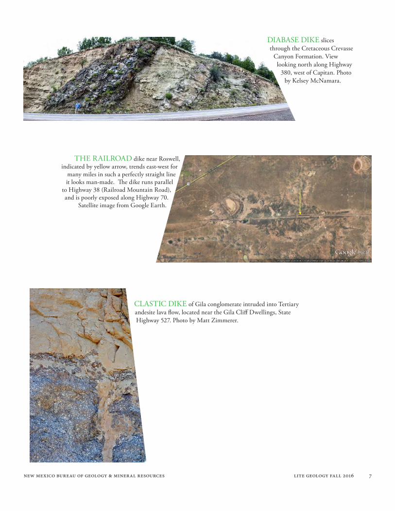
DIABASE DIKE slices through the Cretaceous Crevasse
Canyon Formation. View looking north along Highway
380, west of Capitan. Photo by Kelsey McNamara.
THE RAILROAD dike near Roswell, indicated by yellow arrow, trends east-west for
many miles in such a perfectly straight line it looks man-made. The dike runs parallel
to Highway 38 (Railroad Mountain Road), and is poorly exposed along Highway 70.
Satellite image from Google Earth.
CLASTIC DIKE of Gila conglomerate intruded into Tertiary andesite lava flow, located near the Gila Cliff Dwellings, State Highway 527. Photo by Matt Zimmerer.
new mexico bureau of geology & mineral resources lite geology fall 2016 8
TERTIARY DIORITE dike cutting through the Permian Abo Formation, east of Alamagordo. View is looking north from Highway 82. Photo by Peter Scholle.
dikes
AERIAL VIEW to the southwest of one of the Pratt dikes, just north of the New Mexico-Texas state line along Highway
62–80 (National Parks highway). These northeast- to southwest-trending dikes are poorly exposed as seen from the highway, but are easily seen from above. Photo by
Lewis Land.
MAFIC DIKES cutting through Cretaceous Colorado Formation sandstones and shales. View is looking north from Highway 180, near Silver City. Photo by Kelsey McNamara.
new mexico bureau of geology & mineral resources lite geology fall 2016 9
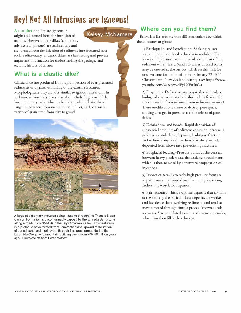
A large sedimentary intrusion (‘plug’) cutting through the Triassic Sloan Canyon Formation is unconformably capped by the Entrada Sandstone along a roadcut on NM 456 in the Dry Cimarron Valley. This feature is interpreted to have formed from liquefaction and upward mobilization of buried sand and mud layers through fractures formed during the Laramide Orogeny (a mountain-building event from ~70-40 million years ago). Photo courtesy of Peter Mozley.
0 4.98 km
West to FolsomNew Mexico
Kenton
Clastic DikeLocation
COLORADO
OK
LAH
OM
A
NEW MEXICO
NEW
MEX
ICO
456
456 325
Hey! Not All Intrusions are Igneous!A number of dikes are igneous in origin and formed from the intrusion of magma. However, many dikes (commonly mistaken as igneous) are sedimentary and are formed from the injection of sediment into fractured host rock. Sedimentary, or clastic dikes, are fascinating and provide important information for understanding the geologic and tectonic history of an area.
Clastic dikes are produced from rapid injection of over-pressured sediments or by passive infilling of pre-existing fractures. Morphologically they are very similar to igneous intrusions. In addition, sedimentary dikes may also include fragments of the host or country rock, which is being intruded. Clastic dikes range in thickness from inches to tens of feet, and contain a variety of grain sizes, from clay to gravel.
1) Earthquakes and liquefaction–Shaking causes water in unconsolidated sediment to mobilize. The increase in pressure causes upward movement of the sediment-water slurry. Sand volcanoes or sand blows may be created at the surface. Click on this link for sand volcano formation after the February 22, 2011 Christchurch, New Zealand earthquake: https://www.youtube.com/watch?v=dFyLXEu4uC0
2) Diagenesis–Defined as any physical, chemical, or biological changes that occur during lithification (or the conversion from sediment into sedimentary rock). These modifications create or destroy pore space, causing changes in pressure and the release of pore fluids.
3) Debris flows and floods–Rapid deposition of substantial amounts of sediment causes an increase in pressure in underlying deposits, leading to fractures and sediment injection. Sediment is also passively deposited from above into pre-existing fractures.
4) Subglacial loading–Pressure builds at the contact between heavy glaciers and the underlying sediment, which is then released by downward propagation of injections.
5) Impact craters–Extremely high pressure from an impact causes injection of material into pre-existing and/or impact-related ruptures.
6) Salt tectonics–Thick evaporite deposits that contain salt eventually are buried. These deposits are weaker and less dense than overlying sediments and tend to move upward through time, a process known as salt tectonics. Stresses related to rising salt generate cracks, which can then fill with sediment.
Below is a list of some (not all!) mechanisms by which these features originate:
Kelsey McNamara
What is a clastic dike?
Where can you find them?
new mexico bureau of geology & mineral resources lite geology fall 2016 10
Students investigate sandstone plugs/pipes cutting through the Dewey Bridge Member of the Entrada Sandstone, near Canyonlands National Park, Utah. One interpretation is that these dikes were formed during ancient earthquakes. Photo courtesy of Peter Mozley.
Sandstone injectites of Upheaval Dome, Utah, which have been interpreted as originating
from an impact structure or by salt tectonics. Photo courtesy of Peter Mozley.
new mexico bureau of geology & mineral resources lite geology fall 2016 11
Description:Cordierite is an orthorhombic mineral with the chemical formula (Mg,Fe)2Al4Si5O18. It is usually granular to massive and easily confused with quartz. Crystals tend to be short striated prisms that are pseudohexagonal. Transparent to translucent crystals can display a variety of colors ranging from violet, blue, and gray to yellow. Oriented and polished clear crystals display distinct pleochroism from blue to yellow. Because of it hardness (7.0-7.5 Mohs scale) it has a white streak. Its luster is vitreous. It usually displays one good cleavage and a two indistinct. Fracture is uneven to subconchoidal.
Iolite is the gem variety with a pleasing violet color. Massive cordierite has no industrial applications. However, metamorphic petrologists like the mineral because it helps define the conditions of metamorphism. Iolite was also known as “the Viking compass” for its light polarizing property that can detect sunlight even when obscured by clouds and fog when used in conjunction with a shadow board and other navigation tools.
The mineral is named after Pierre Louis Antoine Cordier, a French geologist. Dichroite – a name given for the dichroic (yellow to purple) nature of the mineral. Iolite – A combination of Greek words; “ios” and “lithos” which means “violet stone” for gem variety.
It is most commonly found in gneisses and schists. It is also fairly common in contact meta-morphic zones. It has also been reported in intermediate to felsic igneous rocks.
Cordierite has been reported from the Organ Mountains (Doña Ana County) associated with metamorphosed dolomites. It has been described from the skarns at the Fierro-Hanover district in Grant County and Tres Hermanas district in Luna County. It has also been noted at the Good Hope mine in the Rociada district of San Miguel County. The most famous locality in New Mexico is near the Harding Mine and in the Picuris Mountains of Taos County. “Cigars” of cordierite as tapering prisms up to 10 cm have been described.
It is commonly found with garnet, corundum, sillimanite, muscovite, biotite, spinel, andalusite, and potassium feldspar.
Wanted For:
Associations:
Aliases:
Hideout:
Last Seen At Large:
new mexico bureau of geology & mineral resources lite geology fall 2016 12
New Mexico’s Enchanting GeologyIn the Four Corners area—where Utah, Arizona, Colorado and New Mexico meet—travelers can see more than 100 dark, jagged, seemingly out-of-place landforms jutting up from the flats. These volcanic plugs, or necks, are the hardened remains of molten rock that once plugged the throats of ancient volcanoes. The Southwest’s most famous volcanic neck, Shiprock, rises 1,800 feet (549 m) from the plains of northwestern New Mexico like a ship above the ocean. In Navajo legend, Shiprock is Sa-bit-tai-e, the rock with wings, a great bird that brought people to this land from the north.
Travelers can also see three prominent walls or wings of volcanic rocks, called dikes, marching out across the grasslands from Shiprock. The dark-grey to greenish-grey dikes are composed of
Maureen Wilksminette, an alkali-rich, low-silica igneous rock. The longest dike extends for almost 6 miles (10 km). When the volcano was active, the force of the explosive eruptions fractured the surrounding bedrock; and these radiating fractures filled with molten lava. Their exposed remains cut vertically through horizontal layers of rock, like a knife stuck in a layer cake. Because the volcanic rock is harder than the soft shale that once encased it, they have remained standing long after the sediments have been worn away.
Photo courtesy of Steve Cather.
new mexico bureau of geology & mineral resources lite geology fall 2016 13
Earth Science Movie Review: Dantes Peak (1997)
Natural disaster movies took a backseat in the 1990s as filmmakers gravitated towards action and sci-fi flicks like The Fugitive and Men in Black. And what we did get was pretty formulaic (think Twister, among others): (1) scientist detects impending disaster; (2) scientist falls in love while warning everyone of said disaster; (3) said disaster strikes, unleash-ing absolute chaos; (4) scientist saves the day and everyone lives happily ever after. No one will argue that Dante’s Peak broke the mold here. However, they might just notice some enlightened thinking in the science department.
The film follows Dr. Harry Dalton (Pierce Brosnan), a volcanologist with the U.S. Geological Survey. The opening scene shows Dalton and his fiancée in a Colombian town during a colossal eruption. The timeline is shaky, but the scene could be adapted from the Nevado del Ruiz eruption in 1985, where ~23,000 people died. This event is known for destructive volcanic mudflows (lahars), produced from melting of the summit ice cap. In the movie, Dalton’s fiancée is tragically killed by a pyroclastic volcanic bomb (pyroclasts; pyro-meaning fire; clasts-meaning broken), as they attempt to escape.
Four years later, Dalton is called by his boss, Paul Dreyfus (Charles Hallahan), to monitor activity at Dante’s Peak, a fictitious volcano and eponymous town in the Cascades of Washington state. He arrives during a festival celebrating a recent civic award and new economic partnership. Dalton distracts Mayor Rachel Wando (Linda Hamilton) into investigating some unusual phenomena, including a highly acidic lake and dead trees and animals. Dalton suspects carbon dioxide (CO2) gas is the culprit and there may be a real-world basis for this hypothesis: nearly 1,700 people were suffocated by concentrated CO2 emissions from volcanic Lake Nyos in Cameroon in 1986. The movie’s heroes also discover the bodies of a vacationing couple who have met their untimely demise in a boiling hot spring. Such was the unfortunate fate of a visitor to Yellowstone National Park earlier this summer.
Dreyfus brings a USGS team to town, in part to study the volcano and also to rein in Dalton before he scares off
investors. Dalton sticks around anyway, and the team gets to work installing seismometers, measuring sulfur dioxide gas, and repairing a robot to take temperature measurements—all real methods used to assess volcanic activity. The movie also shows gaseous vents (fumaroles) and a steep crater that is in fact Mount St. Helens, which claimed nearly 60 lives during its famous 1980 eruption.
A budding romance between Dalton and Wando doesn’t have much time to develop; an emergency town hall called by Wando is interrupted by, you guessed it, an earthquake and cataclysmic eruption. The ensuing scenes of mayhem (falling powerlines, traffic jams, etc.)
are all too familiar in disaster movies. Wando’s kids complicate things by attempting to retrieve their grandmother from her cabin high on the flanks of the volcano. Wando and Dalton spend the rest of the film trying to return them to safety, all the while dodging lava flows, acidic lake waters, and a gnarly ground-hugging cloud of volcanic gas, pumice, and ash (pyroclastic flow).
PG–13 1 hour, 48 minutesDirector: Roger DonaldsonCast: Pierce Brosnan, Linda Hamilton, Charles Hallahan
Andy Jochems
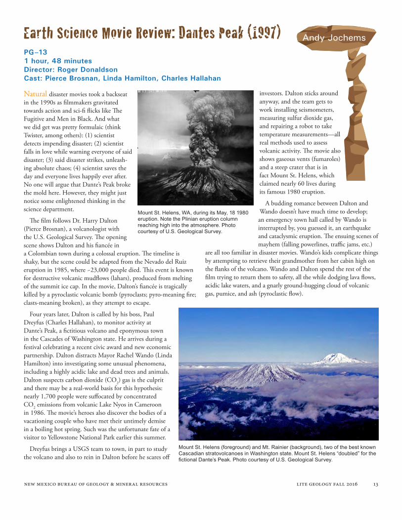
Mount St. Helens, WA, during its May, 18 1980 eruption. Note the Plinian eruption column reaching high into the atmosphere. Photo courtesy of U.S. Geological Survey.
Mount St. Helens (foreground) and Mt. Rainier (background), two of the best known Cascadian stratovolcanoes in Washington state. Mount St. Helens “doubled” for the fictional Dante’s Peak. Photo courtesy of U.S. Geological Survey.
new mexico bureau of geology & mineral resources lite geology fall 2016 14
It wouldn’t be Hollywood without at least a few scientific embellishments. One is the fast-moving lava that chases the protagonists around the mountain. The ropy, basaltic-looking lava flows (pahoehoe) travel much faster than would be expected from Cascadian stratovolcanoes, which commonly erupt andesitic to dacitic lavas and tuffs that are more resistant to flow (i.e. more viscous). Eruptions producing basaltic pahoehoe flows are usually not associated with pyroclastic flows, yet both are shown in the movie. I also questioned the filmmakers’ portrayal of a large flood that was perhaps (but not obviously) intended to be a lahar. These deadly, fast-moving mudflows were responsible for much of the destruction at Mount St. Helens.
Overall, however, I was impressed by the amount of scientific dialogue in the film and discussion of political and economic issues facing communities in geologically hazardous areas. I give credit for the accurate portrayal of a Plinian-type eruption, characterized by explosiveness and high plumes of ash emanating from stratovolca-noes, as well as the immense destruction caused by the pyroclastic flow. The filmmakers were sticklers for detail, even using accurate 90s-era USGS decals on the scientists’ vehicles. And their depiction of one scientist’s unbridled enthusiasm at receiving his morning coffee was no doubt familiar to many geologists.
In a previous movie review that appeared in the Fall 2015 edition
Mount Rainier as viewed from Puyallup, WA. Could this be the next Dante’s Peak? Photo courtesy of U.S. Geological Survey.
of Lite Geology, I offered Dante’s Peak as an example of Hollywood forgoing science for thrills. Granted, the last time I had seen this movie was at a young age. Revisiting the film, I’m happy to recant and give kudos to director Roger Donaldson. Dante’s Peak is a nice reminder that the movie industry occasionally puts decent science on the big screen.
More Information:
http://volcanoes.usgs.gov/index.html
http://www.geology.sdsu.edu/how_volcanoes_work/
4/5 “picks”
new mexico bureau of geology & mineral resources lite geology fall 2016 15
Purpose: This activity is a popular demonstration of the formation of intru-sive igneous dikes using a gelatin model into which viscous fluids are injected. The model will simulate the movement of magma through fractures in sub-surface rocks near the Earth’s crust. The transparent gelatin model represents rock layers; the thick liquid that is injected into the model from below simulates intrusive magma penetrating the rocks. If the liquid magma eventually escapes from the surface of the model and flows out, that extrusive fluid is called lava.
Materials:• Unflavored gelatin, made in the mold according to the package directions, at least one day in advance of the demonstration.
• Bowl to serve as a gelatin mold (2-quart capacity)
• Large plastic syringe
• Aluminum or clear plastic pie plate, big enough to hold the gelatin mold
• Laboratory or home-made stand to support the pie plate so you can work with the syringe from underneath
• Viscous injection fluid, such as colored corn syrup, molasses, or chocolate sauce
•Large tray to catch dripping fluid
Resources:
Procedure:Poke a hole in the center of the pan and a few holes off center with the tip of a sharp knife tip. Be sure the syringe tip will fit into the holes.
To release the gelatin from the mold, place the mold in hot water for a moment. Next, place your hand on top of the gelatin and twist it gently to loosen it before placing the pie pan on top of the mold. Then invert the mold and pie pan together so that the mold releases into the pie pan. Place the pie pan on the stand.
Load the syringe with syrup. Place the syringe tip through the center hole in the pie pan and insert the tip up into the gelatin. Slowly press the plunger of the syringe to inject the syrup into the gelatin model, observing the changes in the model.
Refill the syringe and experiment with more injections in the model at different places where holes are located in the pan. Discuss your observations from this experiment.
Class Room Activity: Exploring Intrusive Dikes Using a Gelatin Model
Kelsey McNamara
Susie Welch
Matt Zimmerer
1) Check out the short video of this model by the authors at: http://geoinfo.nmt.edu/reposi-tory/data/2016/20160003/JelloDike_1.mp4
2) There are many versions of this classroom activity on the internet. Here is a good source for more details on the gelatin model that includes a student worksheet for recording predictions and observations, along with a video demonstrating the model.
Activity-Gelatin Model of Magma Intrusion; Activity adapted from Prentice-Hall—Inside Earth by Roger Groom, Mt. Taylor Middle School, Portland Oregon. http://imssearth.org/documents/volcanoes/activities/GelatinModelOfMagmaIntrusion__LessonPlan_TOTLE.PDF
This video with science teacher Roger Groom demon-strating the gelatin model is titled: Gelatin model of Magma Intrusion; Intrusive vs. extrusive, and is found at: https://youtu.be/EmGl5fakHoY
new mexico bureau of geology & mineral resources lite geology fall 2016 16
Through the Hand Lens: Profile of a New Mexico Science Teacher
The community our school district serves is located in San Juan County, where coal and natural gas resources from the San Juan Basin provide the backbone of the area’s economy. Energy-related jobs support almost half of the families residing in the area, which in turn supports other businesses and services. Our region also boasts beautiful landscapes that attract millions of visitors every year. If students and the public understand the history and geology of the place they call home, that makes living here more interesting and unique.
Geizi Llanes was born and raised in the Philippines, where she earned her Bachelor of Science Degree in Biology, and acquired some credits for a Masters Degree in Environmental Science. She taught high school science for nine years before moving to the United States in 2008 to teach high school science in Newcomb, New Mexico. Geizi’s two daughters are 11 and 14 years old, both of whom love music. The youngest is a percussionist and the oldest plays acoustic and electric guitar. Although Geizi teaches in Farmington, she and the girls live in Durango, CO and are enjoying the perks of outdoor living. They love hiking in the BLM land behind their home with their three dogs, or spending cool afternoons kayaking in the Lemon Reservoir west of Durango.
Geizi Llanes
Susie Welch
One of my hobbies is walking our three dogs with my family up the hill behind our home in Durango, Colorado. We often encounter wildlife here such as bears, deer, elk and many other animals. Photo courtesy of Geizi Llanes.
Geizi taught science in Newcomb for six years and then moved to Farmington to teach at Piedra Vista High School for two years. Her courses ranged from geology, biology, environmental science, and integrated science; some courses were designated as Honors or AP.
This coming school year, Geizi will teach phys-ical science and biology to the freshman cohort of 80 students at the newly opened San Juan College High School (SJCHS). This innovative high school is located on the campus of San Juan College, operating under the Farmington Municipal Schools. Graduates of SJCHS will receive an Associate Degree or certificate, and up to 60 hours of transferable college credit.
Geizi graduated from New Mexico Tech with her Masters of Science for Teachers (MST) in May of 2016. Geizi’s MST project focused on exposing her students to careers in the geoscienc-es. She invited local professionals from the oil and gas and mining industries to visit the classroom and explain not only what they do on the job but how Science, Technology, Engineering and Math (STEM) are required to be successful in their careers. Students were also able to explore some job sites with those professionals on field trips. Geizi’s MST presentation is available at the link in pdf format: http://geoinfo.nmt.edu/repository/index.cfml?rid=20160003
Why is it important for students to learn about Earth Science?
new mexico bureau of geology & mineral resources lite geology fall 2016 17
Why I chose teaching:Teaching is one of the most exciting and challenging professions. We should be knowledgeable about the subject we teach and make it interesting for the students. Gone are the days where teachers pushed worksheets and had students to bury their noses in books. I am fortunate that I am an earth science teacher in this state where very interesting geologic structures are everywhere. I chose to be a teacher in order to learn and explore more about the physical beauty of this planet, along with my curious students.
Collaborating with the local communities brings new information to the classroom and helps students realize how earth science principles connect to the conservation of natural resources. Here my Earth Science - STEM class is working with the Navajo Nation Environmental Protection Agency (NNEPA) officials. Photo courtesy of Geizi Llanes
This pic was taken while I was standing on the plane of a fault during a hike with the Climate Change & Carbon Sequestration Class of Dr. Bruce Harrison under the MST Program at New Mexico Tech. Photo courtesy of Geizi Llanes
Advice or suggestions for other Earth Science teachers:
How did you fall in love with geology?Although my undergraduate degree is in Biology (I initially wanted to pursue a degree in medicine), my interest in earth science began after I experienced a 7.8 M earthquake in high school, followed a year later by an ash fall event during the Mt. Pinatubo eruption. In the graduate environmental science classes that I attended back home, we saw active and extinct volcanoes within the Northern Island (Luzon) of the country and covered a lot of geology. My passion for geology grew stronger when I entered the Masters of
There is no excuse for an earth science teacher not to get out and hike, to feel a rock or grains of soil, or just gaze at the beautiful geologic features of our state. The outdoor classroom, whether it is miles away or as close as the school grounds, is an important exposure for the students. As educators, we can share our passion and knowledge to make earth science not only a required or elective class, but a journey for them to enjoy.
What hobbies do you have that relate to your science teaching?
Science for Teachers program at New Mexico Tech. My focus at New Mexico Tech was on earth science classes, and I use inqui-ry-based learning with my high school students. I often schedule one or two short field trips a week to investigate something the students are learning about in class and give the students ownership in their learning.
I enjoy outdoor activities such as hiking, camping, kayaking as well as fossil and rock identification. I try not to collect the rocks and fossils that I see in trails and leave them where they are to preserve not only their integrity but also to respect their importance of being a part of the Earth. I also love reading books of different genre during my free time.
new mexico bureau of geology & mineral resources lite geology fall 2016 18
Professional Achievements:As a teacher and sponsor for Science Olympiad and Science Fair competitions, most of my students advanced to compete at the state level. In 2012, two of my students competed in the National American Indian Science and Engineering Fair (NAISEF) in Albuquerque. They won numerous awards and advanced to the International Science and Engineering Fair (ISEF) in Pittsburgh, Pennsylvania. Both students were the very first to compete in an international event as representatives from Newcomb High School, which is located on Navajo Tribal lands and has very limited resources. Two years later, another student also went on to Los Angeles, California for the ISEF, after competing and winning the grand award at the Navajo Nation Science Fair. All of these student research projects utilized the resources that are common in the Navajo lands and the application of science to the Dine (Navajo) traditions.
Favorite geologic feature in NM:
Field trips help students realize the importance of earth science to the local and national economy. Pictured here are my Geology students while visiting the Navajo Coal mine in Fruitland, New Mexico. Photo courtesy of Geizi Llanes
1) Shiprock is one of my favorite geologic features in the state. It is sacred to the Navajo people and is associated with wonderful tales and stories about their rich and colorful traditions. Shiprock is located in the northwest tip of the state and is about 25 minutes west of Farmington, New Mexico. It is a volcanic neck remnant of a very explosive volcano and is mainly made of volcanic rocks called breccia. One of the dikes that radiates from it runs parallel along highway 491 towards Gallup and is a very beautiful site to see while driving South from the town of Shiprock.
(2) My second favorite geologic feature is the Hogback Mountain, which is about 15 miles West of Farmington. Known as the Tsé Daa’ Kaan in Navajo, it is a monocline that is a part of the Mesa Verde forma-tion. I took my Geology students to see the beautiful folds visible on both sides of this structure and they were in complete awe. One of my students stated that “I always see this rock whenever we drive to Shiprock to visit family and friends. Now, I will never look at this rock the same way again. It’s so beautiful.”
Geizi is looking at an abandoned mine in Southern Utah during a hike. Photo courtesy of Arnida Acosta.
new mexico bureau of geology & mineral resources lite geology fall 2016 19
Geoheritage is the collection of natural wonders, landforms, and resources that have formed over eons and come to this generation to manage, use, and conserve effectively. Geoheritage locations are valued for many reasons, including scientific, economic, ecological, educational, cultural, aesthetic, artistic, and recreational purposes. -American Geosciences Institute (AGI)
The Valles caldera in New Mexico’s “supervol-cano.” It formed 1.25 million years ago during a catastrophic eruption of 95 cubic miles of gas-rich magma. The iconic landscape of the Valles caldera and it’s fascinating geologic history serve as reminders that New Mexico has a richgeoheritage.
New Mexico Bureau of Geology is celebrating our state’s geoheritage with special items in the Publications Sales Shop. We are featuring merchandise from the Valles calders collectio. To order, call 575-835-5490 or visit our website at : geoinfo.nmt.edu/publications
New Mexico Bureau of Geology
Publications Sales Shop
Valles Caldera Map
Valles Caldera Map Bandana
Valles Caldera Map Bana
Valles Caldera Map Earrings
COMING SOON! Valles Caldera Mug
Valles Caldera Map 750-piece jigsaw Puzzle
The original map Geologic Map 79 – Geologic Map of the Valles Caldera, Jemez Mountains, New Mexico Includes full size waterproof map and booklet.
UV 30+ Bana. More than 12 ways to wear this tubular microfiber bandana.
Produced by David Howell & Co., these earrings depict parts of the valles caldera map are available in teardrop or hoop styles.
$18.95
$14.95
$16.95
$18.95
Expected in late fall 2016
$19.95
new mexico bureau of geology & mineral resources lite geology fall 2016 20
The Mineral Museum is on the campus of New Mexico Tech in Socorro, New Mexico
9 a.m. to 5 p.m., Monday through Friday 10 a.m. to 3 p.m., Saturday and Sunday Closed on New Mexico Tech holidays
The new Bureau of Geology building is located at the corner of Leroy Place and Bullock Blvd. on the campus of New Mexico Tech in Socorro. Visitor parking on the east side of the building provides convenient access to the Mineral Museum and Publications Sales office.
Mineral MuseumThe bureau’s mineralogical collection contains more than 16,000
specimens of minerals from New Mexico, the United States, and around the world, along with mining artifacts and fossils. About 5,000 minerals are on display at a time.
For teachers, students, and other groups, we offer free tours of the museum. We like to show off our home state minerals, as well as give students an idea of how minerals end up in products we use every day. Museum staff can also identify rocks or minerals for visitors. Please call ahead to ensure someone will be available. For more information on the museum, please visit our website at: geoinfo.nmt.edu/museum/
Dr. Virgil W. Lueth: Senior Mineralogist andMuseum Director 575-835-5140; [email protected]
Kelsey McNamara: Museum Curator575-835-5418; [email protected] schedule a museum tour, contact:
A wide selection of resources for teachers is available, including publications on New Mexico’s geology. Many are written for the amateur geologist and general public.
We offer: • Popular and educational geologic publications
• Topographic maps for the entire state of New Mexico
• Geologic maps for selected areas of New Mexico
• U.S. Forest Service maps
• Jewelry and Children’s Science Exploration Kits
20% Teachers Discount on Bureau of Geology and New Mexico Geological Society publications
Call 575-835-5490 for phone orders or information, or visit our website at: geoinfo.nmt.edu/publications