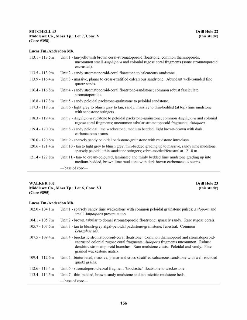
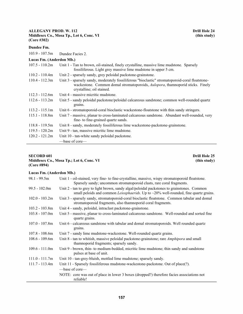
Ontario Geological Survey Open File Report 6137 Lithofacies and Geochemistry of the Lucas Formation in the Subsurface of Southwestern Ontario: A High--Purity Limestone and Potential High--Purity Dolostone Resource 2004
Transcript
Ontario Geological SurveyOpen File Report 6137
Lithofacies andGeochemistry of theLucas Formation in theSubsurface ofSouthwestern Ontario:A High--Purity Limestoneand Potential High--PurityDolostone Resource
2004
ONTARIO GEOLOGICAL SURVEY
Open File Report 6137
Lithofacies and Geochemistry of the Lucas Formation in the Subsurface ofSouthwestern Ontario: A High--Purity Limestone and Potential High--PurityDolostone Resource
by
M.C. Birchard, M.A. Rutka and F.R. Brunton
2004
Parts of this publication may be quoted if credit is given. It is recommended thatreference to this publication be made in the following form:
Birchard,M.C., Rutka,M.A. and Brunton, F.R. 2004. Lithofacies andgeochemistry of theLucasFormation in the subsurface of southwesternOntario: a high--purity limestoneand potential high--purity dolostone resource; Ontario Geological Survey, Open FileReport 6137, 180p.
e Queen’s Printer for Ontario, 2004
iii
e Queen’s Printer for Ontario, 2004.
Open File Reports of the Ontario Geological Survey are available for viewing at the Mines Library in Sudbury, at theMines andMinerals InformationCentre in Toronto, and at the regionalMines andMinerals officewhose district includesthe area covered by the report (see below).
Copies can be purchased at Publication Sales and the office whose district includes the area covered by the report. Al-though a particular report may not be in stock at locations other than the Publication Sales office in Sudbury, they cangenerally be obtainedwithin 3working days.All telephone, fax, mail and e-mail orders should be directed to the Publica-tion Sales office in Sudbury. Use of VISA or MasterCard ensures the fastest possible service. Cheques or money ordersshould be made payable to the Minister of Finance.
Mines and Minerals Information Centre (MMIC) Tel: (416) 314-3800Macdonald Block, Room M2-17900 Bay St.Toronto, Ontario M7A 1C3
Thunder Bay - Suite B002, 435 James St. S., Thunder Bay P7E 6S7
Timmins - Ontario Government Complex, P.O. Bag 3060, Hwy. 101 East, South Porcupine P0N 1H0
Toronto - MMIC, Macdonald Block, Room M2-17, 900 Bay St., Toronto M7A 1C3
This report has not received a technical edit. Discrepanciesmay occur for which the OntarioMinistry ofNorthernDevel-opment andMines does not assume any liability. Source references are included in the report andusers are urged to verifycritical information. Recommendations and statements of opinions expressed are those of the author or authors and arenot to be construed as statements of government policy.
If you wish to reproduce any of the text, tables or illustrations in this report, please write for permission to the TeamLeader, Publication Services, Ministry of Northern Development and Mines, 933 Ramsey Lake Road, Level B4,Sudbury, Ontario P3E 6B5.
Cette publication est disponible en anglais seulement.
Parts of this report may be quoted if credit is given. It is recommended that reference be made in the following form:
Birchard,M.C., Rutka,M.A. andBrunton, F.R. 2004. Lithofacies and geochemistry of the LucasFormation in thesubsurface of southwestern Ontario: a high--purity limestone and potential high--purity dolostone resource;Ontario Geological Survey, Open File Report 6137, 180p.
v
ContentsAbstract ............................................................................................................................................................... xi
Study Objectives and Approach .......................................................................................................................... 1Definitions of Key Terms ........................................................................................................................... 3Limestone and Dolostone Classification..................................................................................................... 5
General Geology of Study Area .......................................................................................................................... 5Regional Setting.......................................................................................................................................... 5Stratigraphy................................................................................................................................................. 7
Distribution, Thickness and Stratigraphic Relationships of the Lucas Formation............................. 10Depositional Facies and Distribution of the Lucas Formation ................................................................... 11
Dolostone and Limestone Distribution............................................................................................... 17Geochemistry of the Lucas Formation ............................................................................................... 21
Rationale .................................................................................................................................... 21Existing Data ............................................................................................................................. 21Methodology.............................................................................................................................. 22
Drill Core and Sample Selection ....................................................................................... 22Geochemical Data Analysis .............................................................................................. 24
Discussion of Results........................................................................................................................................... 32Accuracy of Dolomitization Estimation...................................................................................................... 33Geochemistry of the Lucas Formation ........................................................................................................ 33
Lithofacies Purity and Regional and Vertical Trends in the Lucas Formation ........................................... 39Regional Facies and Limestone and Dolostone Purity............................................................... 39
Vertical Trends in Lucas Formation Geochemistry........................................................... 40Regional Trends in Lucas Formation Geochemistry ......................................................... 40
Controls on Carbonate Purity in the Lucas Formation............................................................... 44Lucas Formation in the Michigan Basin ........................................................................... 45
Resource Potential of Lucas Formation Carbonates ............................................................................................ 47
vii
Summary and Conclusions .................................................................................................................................. 48Limestone and Dolostone Distribution ....................................................................................................... 49Geochemistry of the Lucas Formation ........................................................................................................ 49Vertical and Regional Geochemical Trends................................................................................................ 49Resource Potential ...................................................................................................................................... 50
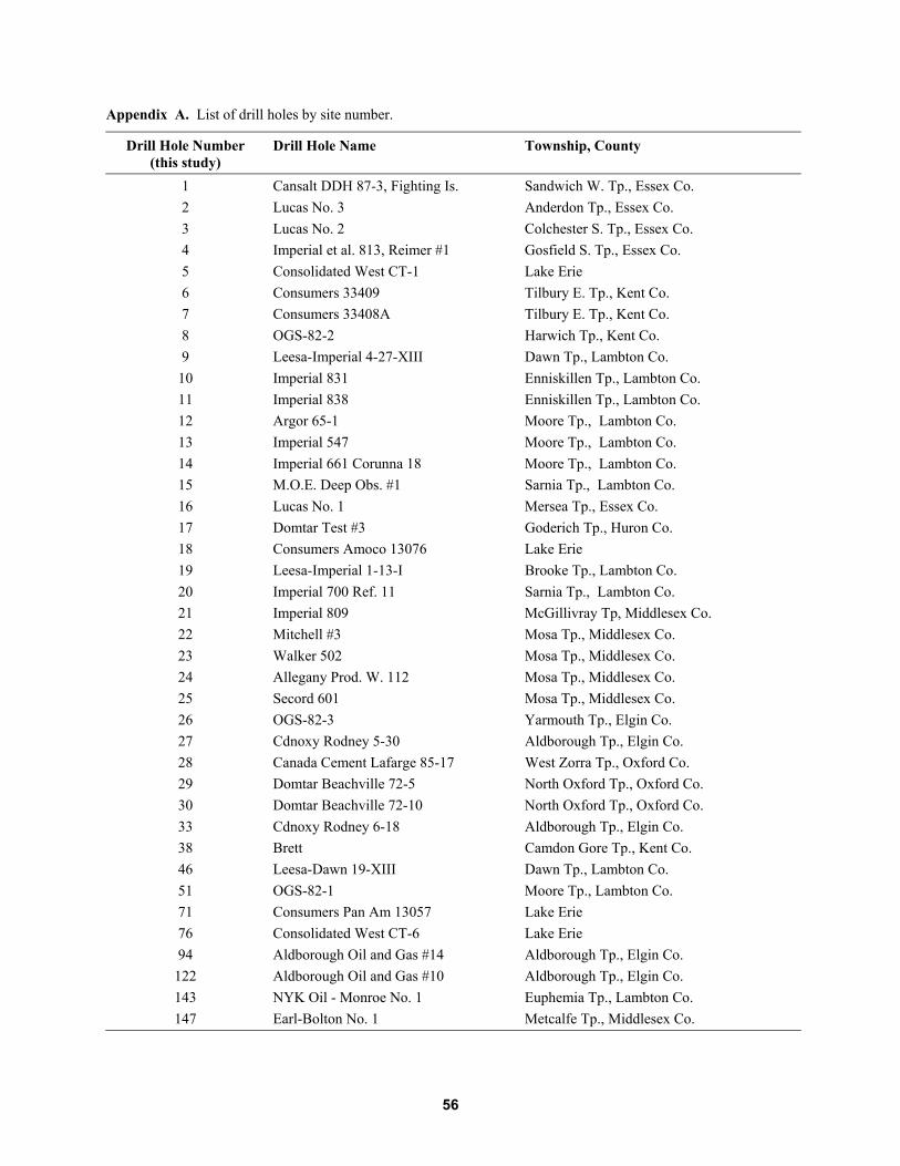
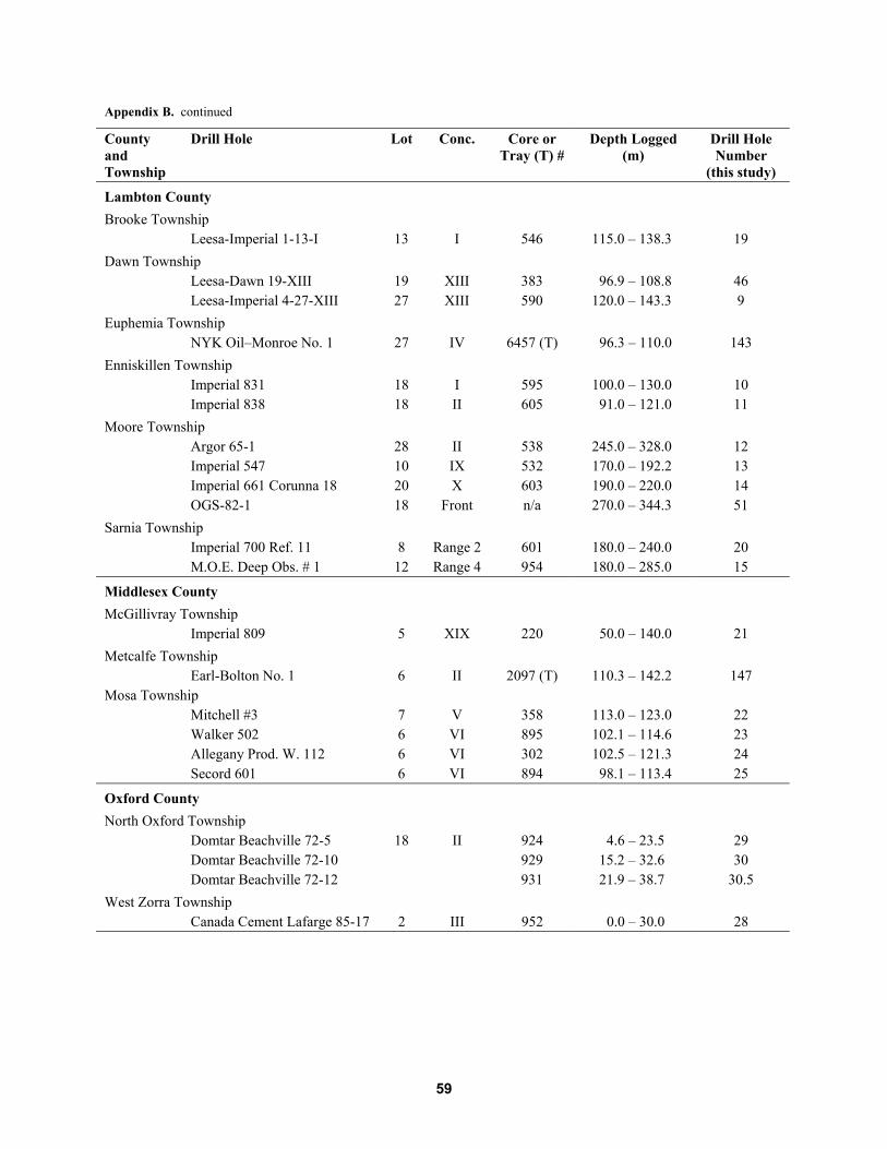
Appendix A. List of Drill Holes by Site Number ............................................................................................... 55
Appendix B. List of Drill Cuttings and/or Core Samples Logged for this Study ............................................... 57
Appendix C. Summary of Depositional Lithofacies........................................................................................... 61
Appendix D. Drill Core Lithologs ...................................................................................................................... 64
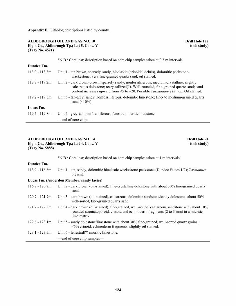
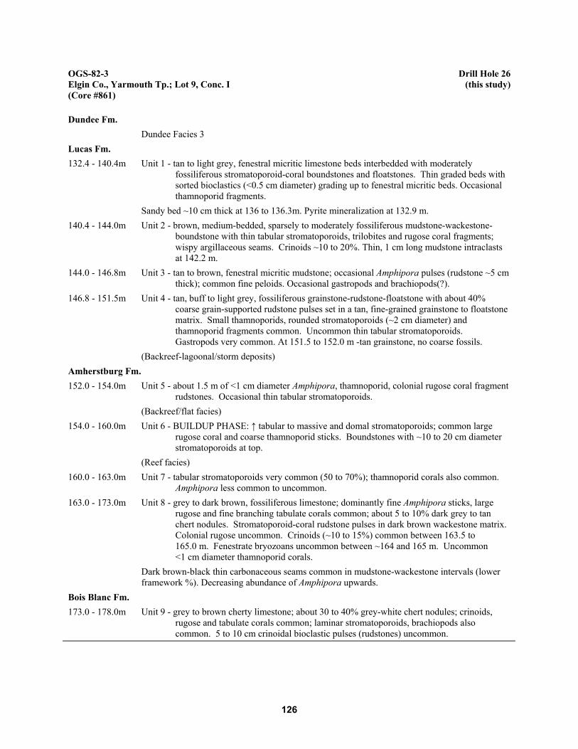
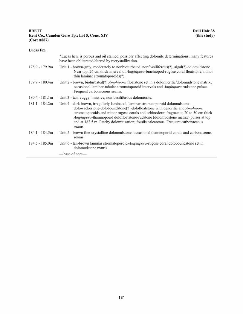
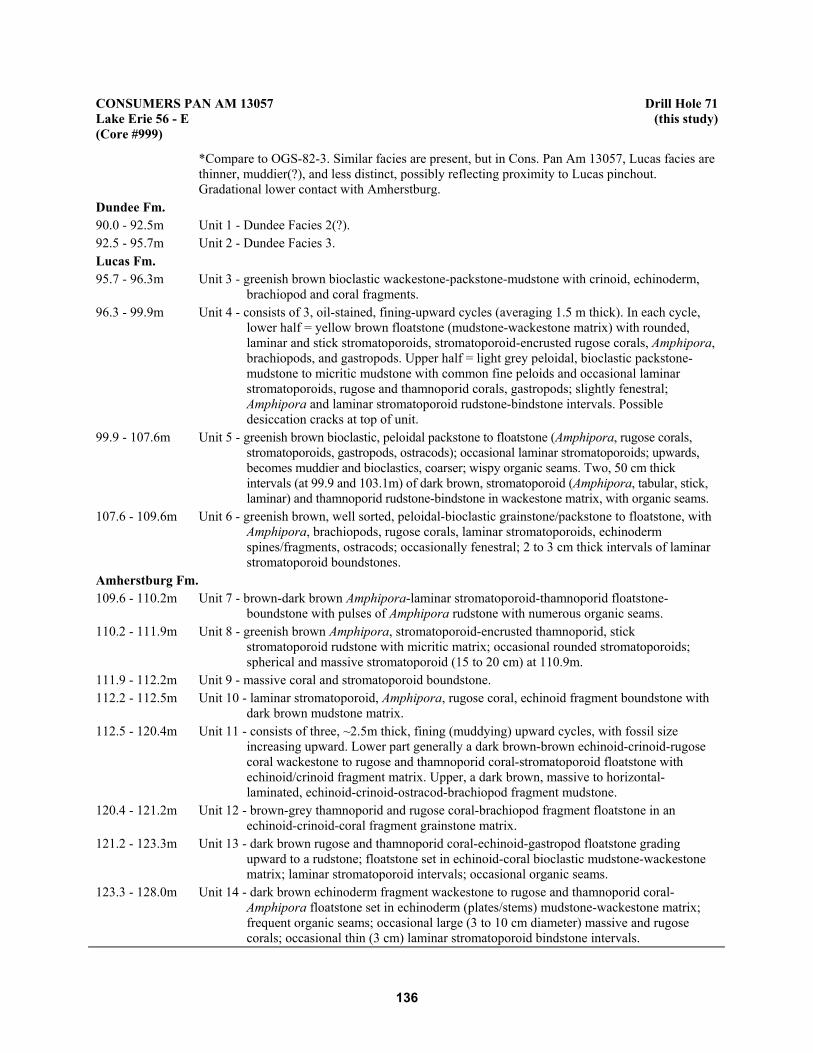
Appendix E. Litholog Descriptions Listed by County........................................................................................ 123
Appendix F. Existing Geochemical Data for Canada Cement Lafarge Core 85-17 (Drill Hole 28).................. 159
Appendix G. Sample Locations.......................................................................................................................... 161
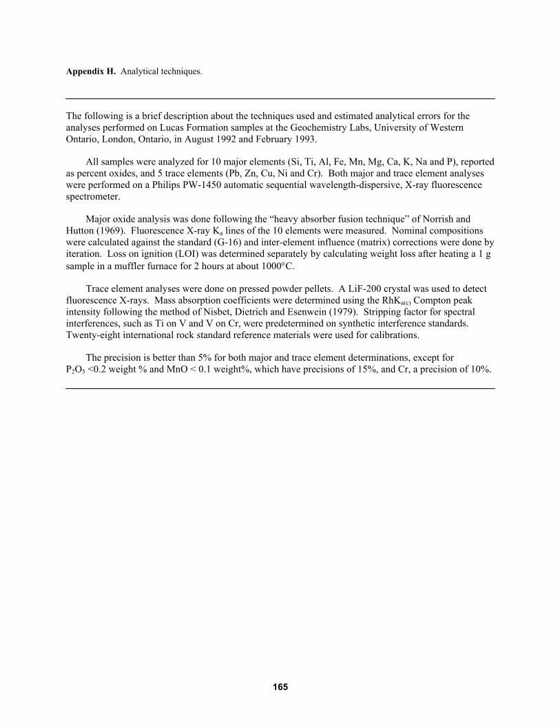
Appendix H. Analytical Techniques................................................................................................................... 164
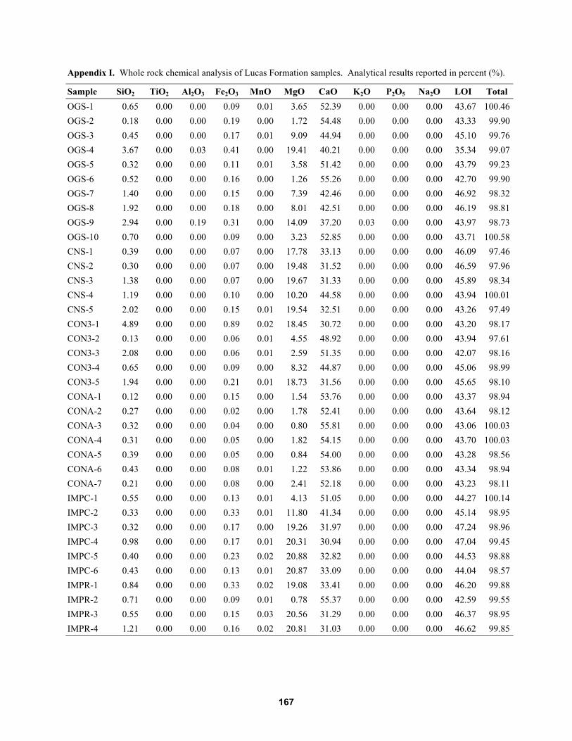
Appendix I. Whole Rock Chemical Analysis of Lucas Formation Samples ...................................................... 166
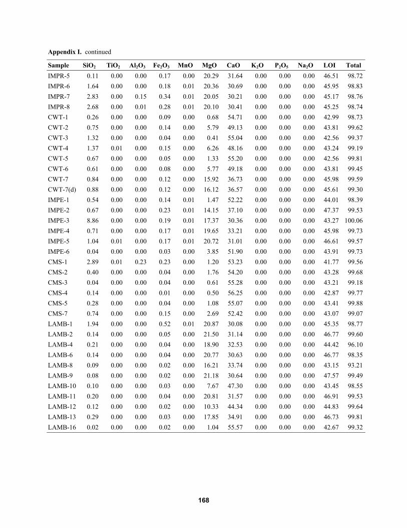
Appendix J. Trace Element Analysis of Lucas Formation Samples ................................................................... 169
Appendix K. Histograms .................................................................................................................................... 171
FIGURES1. Subcrop area of the Detroit River Group (Lucas Formation forms uppermost unit) and
locations of logged and sampled drill cores for this study throughout southwestern Ontario..................... 2
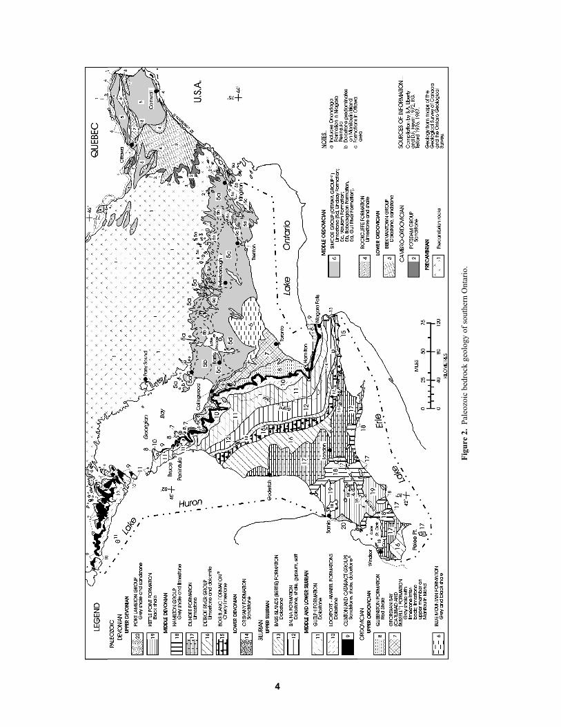
2. Paleozoic bedrock geology of southern Ontario. ........................................................................................ 4
3. Major structural elements and locations of intracratonic basins of Ontario. ............................................... 6
4. Devonian stratigraphy of southwestern Ontario and adjacent areas............................................................ 8
5. Schematic representation of depositional settings showing lateral relationships ofLucas Formation lithofacies in both intracratonic basins............................................................................ 12
6. Paleogeographic map of southwestern Ontario showing depositional environmentsduring the Eifelian (Middle Devonian). ...................................................................................................... 12
7. Location map for cross-sections A�A', B�B' and C�C' .............................................................................. 13
8. Stratigraphic cross-section of Lucas Formation along transect A�A' (Kent to Lambton counties) ............ 14
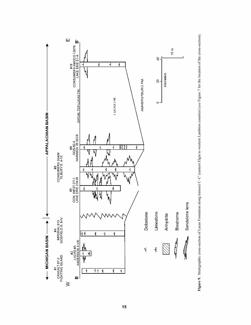
9. Stratigraphic cross-section of Lucas Formation along transect C�C' (eastern Elginto western Lambton counties) ..................................................................................................................... 15
10. Stratigraphic cross-section of Lucas Formation along transect B�B' (Elgin to Essex counties) ................. 16
11. Location map for cross-sections D�D' and E�E'......................................................................................... 18
ix
12. Stratigraphic cross-section D�D' showing limestone and dolostone distributionwithin the Lucas Formation (Lambton to Kent counties). .......................................................................... 19
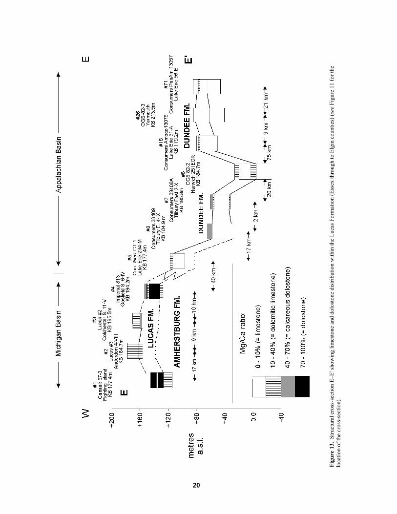
13. Structural cross-section E�E' showing limestone and dolostone distributionwithin the Lucas Formation (Essex through to Elgin counties). ................................................................. 20
14. A) Geochemical vertical profiles of Lucas Formation (Cansalt DDH 87-3); andB) Lucas and Dundee formations (Lucas No. 3 � existing data), Essex County......................................... 25
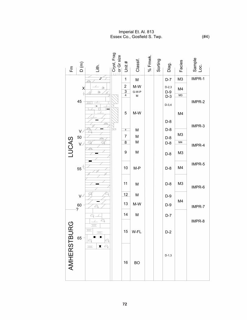
15. A) Geochemical vertical profiles of Lucas and Dundee formations (Lucas No. 2 � existing data);and B) Amherstburg and Lucas formations (Imperial et al. 813), Essex County........................................ 26
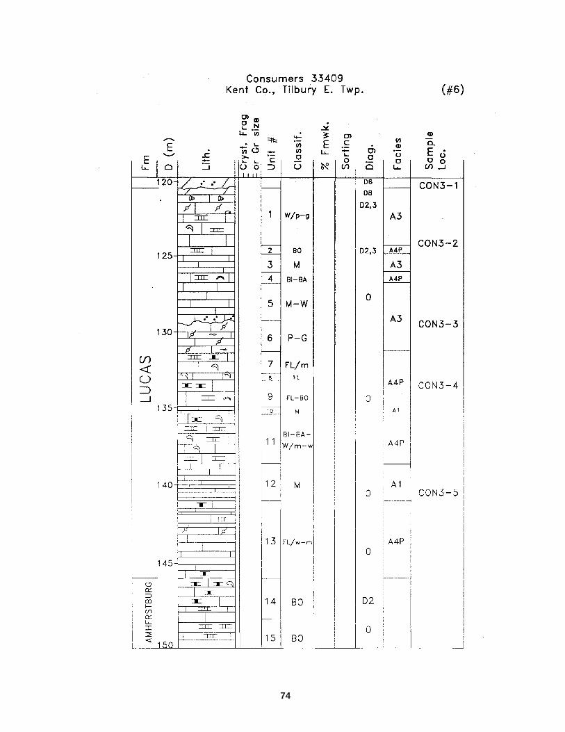
16. A) Geochemical vertical profiles of Lucas Formation (Consolidated West CT-1, Lake Erie);and B) Lucas and Dundee formations (Consumers 33409, Kent County). ................................................. 27
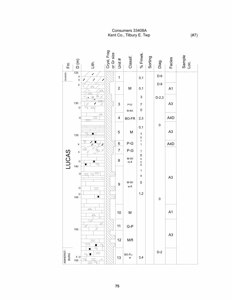
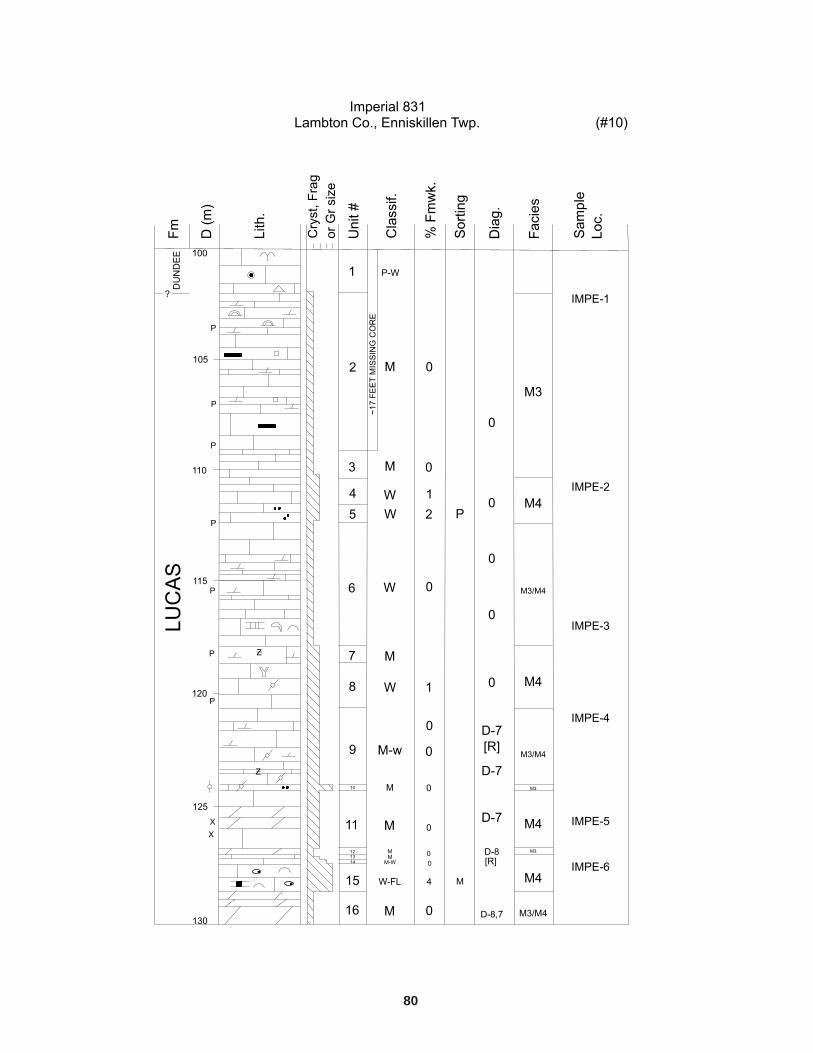
17. A) Geochemical vertical profiles of Lucas Formation (OGS-82-2 Chatham) in Kent County;and B) Lucas Formation (Imperial 831) in Lambton County...................................................................... 28
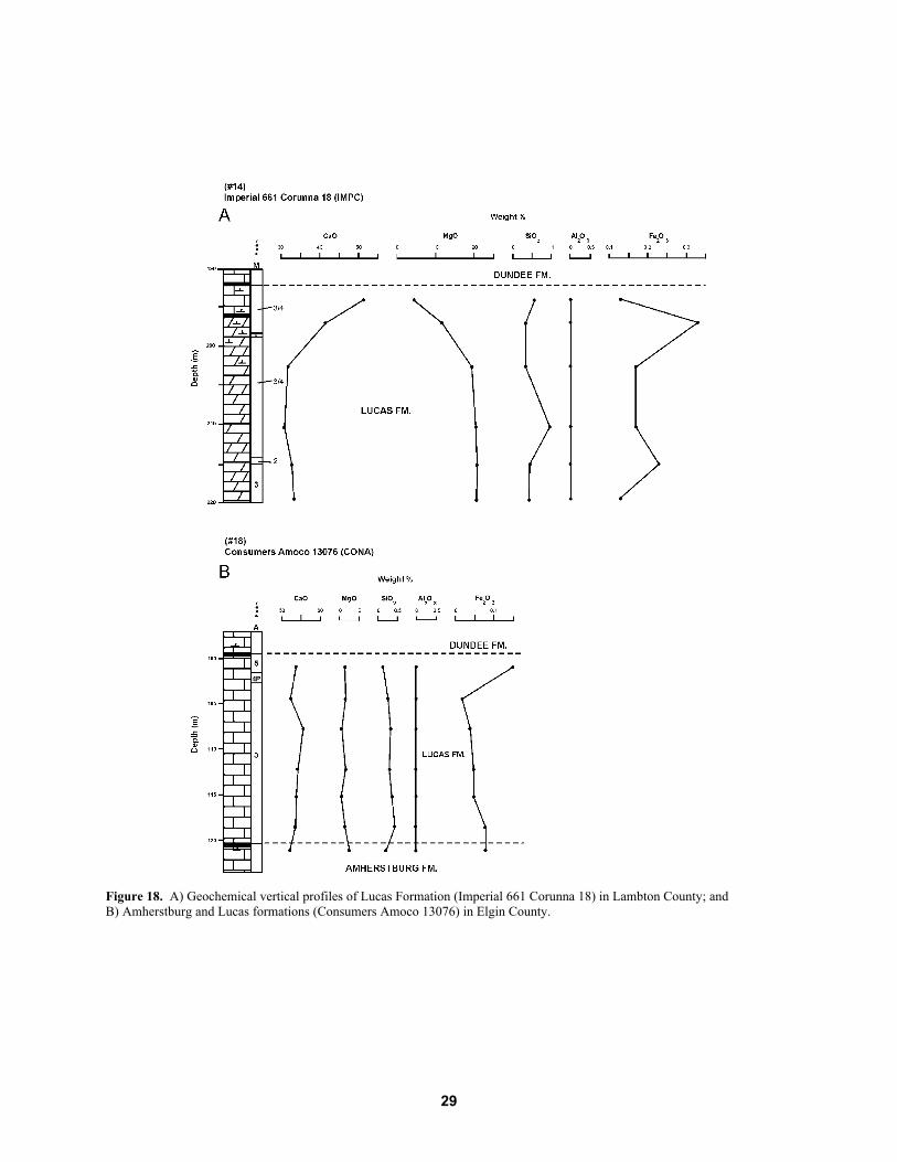
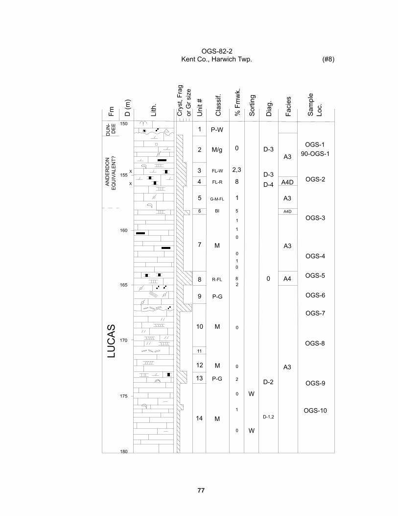
18. A) Geochemical vertical profiles of Lucas Formation (Imperial 661 Corunna 18)in Lambton County; and B) Amherstburg and Lucas formations (Consumers Amoco 13076)in Elgin County. .......................................................................................................................................... 29
19. A) Geochemical vertical profiles of Amherstburg and Lucas formations (OGS-82-3)in Elgin County; and B) Lucas Formation (Canada Cement Lafarge 85-17 � existing data)in Elgin County. .......................................................................................................................................... 30
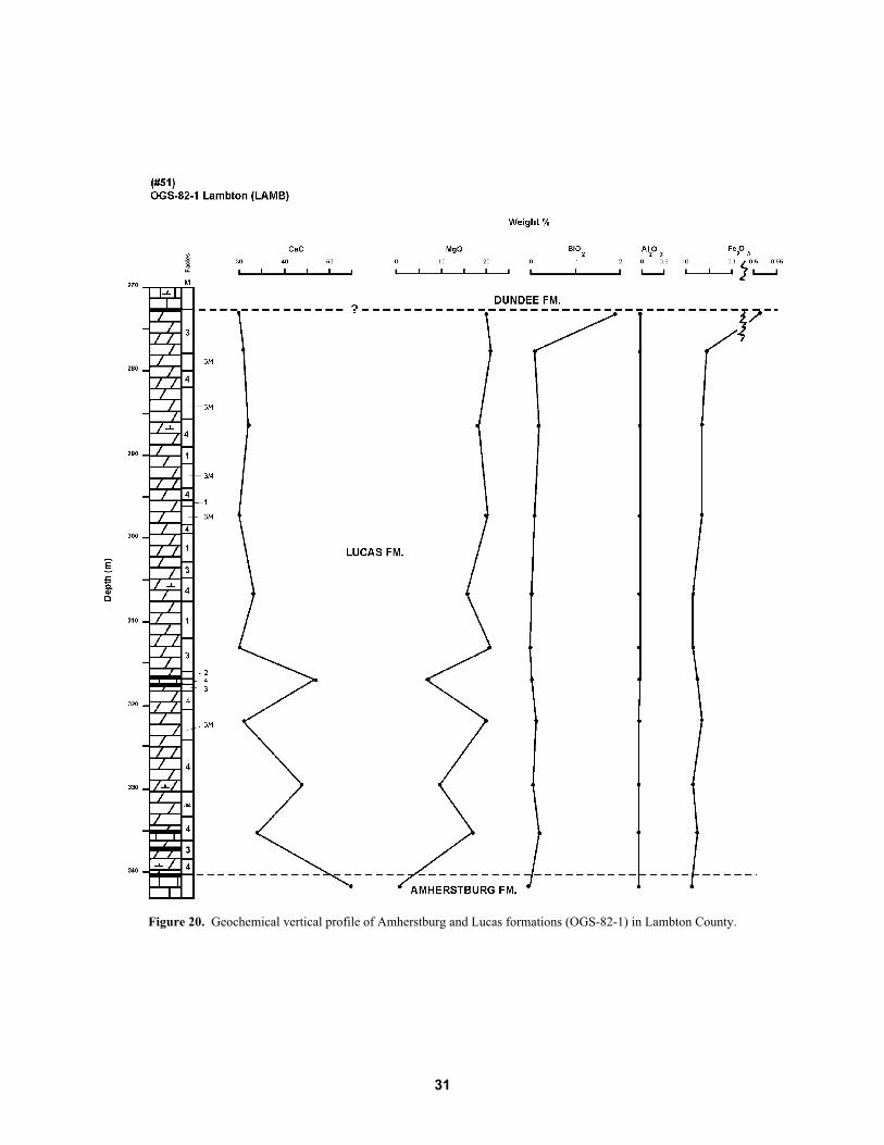
20. Geochemical vertical profile of Amherstburg and Lucas formations (OGS-82-1)in Lambton County. .................................................................................................................................... 31
21. Scatter plot showing relationship between estimated degree of dolomitization of sampled intervals asdetermined from core examination, and actual degree of dolomitization based upon MgO content. ......... 32
22. Scatter plot showing A) distribution of % MgO within lithofacies with respect toAppalachian Basin (A1 to A5) and Michigan Basin (M3, M3/4 and M4) lithofacies;and B) % total impurities within lithofacies with respect to Appalachian Basin (A1 to A5)and Michigan Basin (M3, M3/4 and M4) lithofacies. ................................................................................. 38
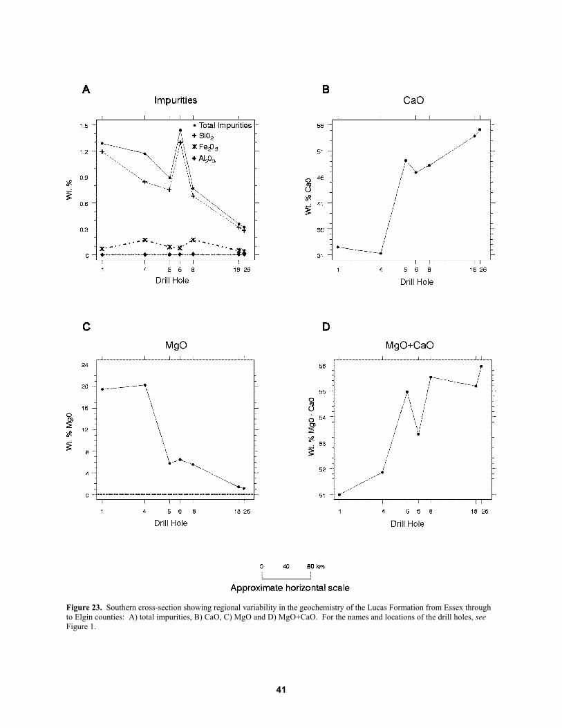
23. Southern cross-section showing regional variability in the geochemistry of the Lucas Formationfrom Essex through to Elgin counties: A) total impurities, B) CaO, C) MgO and D) MgO+CaO. ........... 41
24. Northern cross-section showing regional variability in the geochemistry of the Lucas Formationfrom Lambton to Elgin counties: A) total impurities, B) CaO, C) MgO and D) MgO+CaO...................... 42
25. Regional variability in the geochemistry of lithofacies A3, Kent to Elgin counties: A) total impurities, B) CaO, C) MgO and D) MgO+CaO........................................................................... 43
26. Regional distribution of the 5 diagenetic and/or depositional zones of the Lucas Formation,based upon their carbonate resource potential throughout southwestern Ontario. ...................................... 46
TABLES1. Limestone and dolostone classification based on visual estimations of the degree of dolomitization. ....... 5
2. Limestone and dolostone classification suitable for laboratory results. ...................................................... 5
3. List of sample names and the number of samples obtained for each drill hole........................................... 23
4. Limestone and dolostone classification distribution of all Lucas Formation samples(n = 66) based on MgO content................................................................................................................... 33
5. Percentage of high-purity limestone and dolostone samples that meet various specification limits............... 34
6. Distribution of lithofacies samples according to limestone and dolostone classificationbased on MgO content ............................................................................................................................... 36
xi
Abstract
The Middle Devonian (Eifelian-age) Lucas Formation of the Detroit River Group of southwestern Ontariois a current source of high-purity limestone in the Woodstock and Amherstburg areas. A geochemicaland lithofacies analysis was conducted to delineate possible controls concerning the spatial distributionsof high-purity limestone lithofacies in the subsurface throughout southwestern Ontario. Thirty-seven drillcores and 4 suites of drill cuttings were examined to reconstruct regional paleoenvironments, and 66samples were collected from the cores at regular intervals for geochemical analysis of 10 major and 6trace elements.
Nine depositional lithofacies were identified and subdivided into 2 distinct basinal systems: theMichigan Basin and the Appalachian Basin (also referred to as the Allegheny Basin). The MichiganBasin includes the upper sabkha mud flat (M1); lower sabkha mud flat (M2); supratidal to shallowintertidal (M3); and subtidal (M4) lithofacies. The Appalachian (or Allegheny) Basin includes thesupratidal to intertidal (A1); marginal marine (A2); subtidal (A3); biostromal (A4); and restrictedlagoonal (A5) lithofacies. A maximum of 7 shallowing-upward cycles (brining-upward cycles: subtidalto intertidal lithofacies overlain by evaporites) have been recognized in the Michigan Basin succession.Lithofacies associations indicate that deposition occurred in a shallow marine, low energy, hypersalineenvironment characterized by extensive sabkha-like tidal flats.
Geochemical analysis of cores indicates considerable spatial and temporal variability of MgO andCaO content throughout the formation. Interbasinal comparison of lithofacies failed to detect markeddifferences in the geochemical character of individual lithofacies of the Lucas Formation. Dolomitecontent in Appalachian Basin samples was generally low, with a median of 10% (2.21% MgO), whileMichigan Basin samples had a median dolomite content of 89% (19.48% MgO). The amount of totalimpurities was generally less than 3% for both sedimentary basins. Appalachian Basin supratidal tointertidal (A1) lithofacies have the highest limestone purity (median MgO content of 1.55%, or 7%dolomite), followed by subtidal (A3) lithofacies (MgO median of 2.21%, or 10% dolomite). This findingis potentially significant because much of the high-purity limestone extracted in Oxford County is fromthe subtidal (A3) lithofacies.
The following regional trends in geochemical and lithological character of the Lucas Formation wereobserved across the Algonquin Arch: an eastward increase in limestone purity (with respect to both MgOand total impurities content) and lithologic uniformity with depth; and a westerly basinward increase indolostone purity. In general, high-purity dolostones are likely to be found in the subsurface bordering thesouth shore of Lake Huron, whereas high-purity limestones are present at or near the surface and in thesubsurface in Elgin and parts of Kent, Middlesex and Oxford counties.
Lithofacies and Geochemistry of the Lucas Formation in theSubsurface of Southwestern Ontario � A High-Purity Limestone andPotential High-Purity Dolostone Resource
Limestone and dolostone, used either directly as crushed stone or calcined to produce lime, are among themost widely used raw materials in the chemical, metallurgical and construction industries. Principalmarkets include the steel industry, pulp and paper industry, the mining industry, water and sewagetreatment, glass and chemical production, soil stabilization, construction products and agriculture.
Ontario is fortunate to possess abundant resources of limestone, dolostone and other relatedcarbonates, such as marble and carbonatite. Southwestern Ontario, where much of Ontario�s populationand the limestone and dolostone market reside, has thick and extensive deposits of carbonate rock suitablefor a variety of industrial applications. Despite ample resources, the availability of high-purity limestoneand dolostone, which meets the strict physical and chemical specifications required for varied industrialapplications, is more limited. Extraction of these high-purity deposits depends upon economicconsiderations (e.g., extent and thickness of the deposit and the amount of overburden) and accessibility.In recent years, increasing socio-environmental pressures and urban expansion have severely limitedaccess to potential high-purity carbonate deposits. In light of these restrictions, new near-surfaceresources need to be identified. Alternative extraction practices also need to be considered, such as theestablishment of underground mines, which could supply a variety of industrial mineral materials from anumber of stratigraphic levels within the Paleozoic sedimentary succession to various markets.
In response to the demand for local sources of high-purity and/or dense carbonate rock, the OntarioMinistry of Northern Development and Mines initiated a regional study of the various stratigraphic unitsin southwestern Ontario to delineate potential new limestone and dolostone resources. This studyexamines the Middle Devonian (Eifelian-age) Lucas Formation, which is a historically significantpetroleum-producing succession in the subsurface, and is the key source of high-purity limestone in theWoodstock�Ingersoll and Amherstburg areas of southwestern Ontario. As near-surface high-puritylimestone resources at these localities become more restricted in their lateral extent, other potentiallyeconomic localities need to be identified.
Study Objectives and Approach
This project comprises a lithofacies and geochemical analysis of the Lucas Formation in order to evaluateits potential as a high-purity carbonate rock resource in the subsurface of southwestern Ontario. The mainobjective of the study was to correlate depositional lithofacies and high-purity carbonate zones throughoutthe study area. A geochemical analysis was conducted to provide both a quantitative basis for theregional correlations and augment the existing database of the Lucas Formation. Such a geochemicaldatabase would also provide information that may lead to future prospects within this economicallysignificant limestone�dolostone succession. Results of this study also contribute to our understanding ofthe paleogeography of the Michigan and Appalachian basins during Middle Devonian (Eifelian) time.
Thirty-seven drill cores and 4 suites of drill cuttings were selected for lithological and geochemicalexamination. These cores, most of which are stored at the Petroleum Resources Core Laboratory of theOntario Ministry of Natural Resources in London, Ontario, were chosen from approximately 80 coreslisted by the Petroleum Resources Laboratory (Carter and Trevail 1989) as penetrating part or all of theLucas Formation. All of the cores examined in this study have good penetration into the LucasFormation, while most of the remaining cores only penetrate the upper few metres of the formation. Corecontrol is variable over the study area, reflecting the interest of the petroleum industry. As a result, some
Figu
re 1
. Su
bcro
p ar
ea o
f the
Det
roit
Riv
er G
roup
(Luc
as F
orm
atio
n fo
rms u
pper
mos
t uni
t) an
d lo
catio
ns o
f log
ged
and
sam
pled
dril
l cor
es fo
r thi
s stu
dy th
roug
hout
sout
hwes
tern
Ont
ario
.
2
3
areas, such as parts of Middlesex, Oxford and Elgin counties, where there may be the greatest potentialfor high-purity limestone, have poor core control, demonstrating the strong need for additional drilling inthese areas.
To facilitate referencing of drill holes, all drill cores logged for this study have been assignednumbers ranging from 1 to 76 (Figure 1); the 4 suites of drill cuttings were assigned higher numbers.These numbers, linked to their corresponding well names, as shown in Figure 1 and in Appendix A, arereferred to in the text as �drill hole [number]�.
Lithologic descriptions of carbonates were made using Dunham�s (1962) rock classification asmodified by Embry and Klovan (1971). An approximation of the ratio of MgCO3 to CaCO3 (i.e., degreeof dolomitization) was also made for each unit. This ratio is based upon the following criteria:
1. visual examination of lithology2. degree of reaction with dilute HCl (10%)3. microscopic examination of core after etching with dilute HCl4. degree of staining with an Alizarin Red S solution
Detailed core examination enabled definition of lithofacies that are representative of a variety ofdepositional environments, and also allowed preliminary observations to be made regarding
1. lateral and vertical relationships of depositional lithofacies2. lateral and vertical relationships of diagenetic facies3. possible correlation of depositional lithofacies to diagenetic lithofacies4. basinal controls on high-purity limestone and dolostone distribution
A total of 66 samples, collected from 10 drill cores, representing the various carbonate lithofacies ofthe Lucas Formation, were analyzed for major and trace elements.
DEFINITIONS OF KEY TERMS
High-purity dolostone: Dolostone that contains less than 3% total impurities and at least 97% combinedcalcium and magnesium carbonates. For the purposes of this report, dolostone has 19.5% to 21.6% MgOcontent and less than 3% impurities (after Hewitt and Vos 1972).
High-purity limestone: Limestone that contains less than 3% total impurities and less than 2% MgCO3,or less than 1% MgO content (after Hewitt and Vos 1972).
Impurities: As used in this report, impurities refer to the presence of silica, iron and alumina. If presentin significant amounts these, as well as other substances, such as organic matter and heavy metals, mayrestrict the use of the material in certain industrial applications.
Lime: Lime is the product of heating limestone and dolostone until CO2 is driven out of the rock, aprocess referred to as calcination. The 2 main types of lime, high calcium lime and dolomitic lime, areproduced by calcination of high calcium limestone and dolostone, respectively.
Figu
re 2
. Pa
leoz
oic
bedr
ock
geol
ogy
of so
uthe
rn O
ntar
io.
4
5
LIMESTONE AND DOLOSTONE CLASSIFICATION
Limestone and dolostone classification of units described was initially based on the visual estimation ofthe degree of dolomitization, using Classification #1 (Table 1).
Table 1. Limestone and dolostone classification based on visual estimations of the degree of dolomitization.
This classification scheme takes into consideration the difficulties involved in visually estimating thedegree of dolomitization when dealing with rocks on the borderline between a limestone and dolostone.Geochemical analysis of some units enabled the more rigid classification scheme of Hewitt and Vos(1972), here referred to as Classification #2 (Table 2).
Table 2. Limestone and dolostone classification suitable for laboratory results. MgO limits hold if the amount ofimpurities present is relatively small (from Hewitt and Vos 1972).
Paleozoic sedimentary rocks in southwestern Ontario straddle 2 significant Precambrian basementstructures�the Findlay and Algonquin arches�and, therefore, make up parts of the eastern and westernsedimentary successions of both the Michigan and Appalachian (also referred to as the Allegheny) basins,respectively (Figures 2 and 3). The Algonquin Arch trends northeast through southwestern Ontario,whereas the Findlay Arch trends northward through southeastern Indiana, western Ohio, and the extremewestern regions of southern Ontario. These arches, which are separated by a structural low called theChatham Sag, were affected by intermittent epeirogenic movements throughout the Paleozoic Era inresponse to orogenic overthrust loading along the Appalachian Orogen (Bradley 1983; Quinlan andBeaumont 1984). Deposition of Eifelian-age Detroit River Group strata in southern Ontario coincidedwith Acadian orogenesis within the Appalachians (Johnson 1971; Bradley 1983; Rickard 1984; Quinlanand Beaumont 1984; Ettensohn 1985, 1994). Pysklywec and Mitrovica (1997) have inferred that thedepositional history of the late Paleozoic succession in some intracratonic basins of North America (e.g.,
6
Williston and Michigan basins) may reflect the interplay of distant subduction zones and temporallyassociated mantle avalanches beneath cratons and associated regional tilting of cratons (Mitrovica,Beaumont and Jarvis 1989; Coakley, Nadon and Wang 1994). Regional shifts in lithofacies andassociated basinal and meteoric fluid migration adjacent to reactivated Precambrian basement structuresin overlying Paleozoic strata, in response to multi-million-year duration tectophases and eastward cratonictilting, may have played an important role in the distribution of high-purity limestone and dolostonelithofacies of the Lucas Formation, which is the uppermost unit of the Detroit River Group.
Figure 3. Major structural elements and locations of intracratonic basins of Ontario. The study area spans the eastern MichiganBasin, Algonquin Arch and westernmost Appalachian Basin, which are highlighted in the lower right-hand portion of map area.
7
The Paleozoic rocks of southwestern Ontario are essentially flat lying, having been relativelyunaffected by the multiple episodes of intense folding and thrust-faulting that occurred far to the east inthe Appalachians. These predominantly marine strata have been subjected to shallow and deeper burialbasinal fluid migration associated with episodic regional tilting, subsidence, uplift, marine restriction andkarstification spanning late Cambrian through Carboniferous time. North and west of the AlgonquinArch, strata dip gently at 6 to 9 m per kilometre westward into the Michigan Basin. Equivalent-age stratato the south of the arch dip approximately 6 m per kilometre southward into the Appalachian (Allegheny)Basin (Winder and Sanford 1972). Both major and minor faults are evident in the subsurface ofsouthwestern Ontario (Brigham 1971) and some of these faults, such as the Dawn Fault (LambtonCounty), cut through Detroit River Group strata and show a maximum displacement of 47 m down to thesouth. Sanford, Thompson and McFall (1985) have proposed that the Paleozoic strata of southwesternOntario reveal an extensive fracture network, reflecting vertical rotation of fault-bounded blocks, which isa means of relieving stresses set up by orogenic activity occurring at the craton (Laurussia: Ziegler 1988)margins. According to Ziegler (1988, p.15), �Laurussia was formed during the latest Silurian by thewelding of Laurentia�Greenland and Fennosarmatia [Baltica] along the Arctic�North Atlantic Caledonianmegasuture�. These regional-scale structures have resulted in favourable configurations for the migrationof basinal fluids, including the stratigraphic and structural entrapment of hydrocarbons and thehydrothermal overprint of dolomitizing fluids (Coniglio et al. 1994; Coniglio, Zheng and Carter 2003).This network of faults and fractures is also reflected in Precambrian basement structures, especially alongthe eastern margin of the Michigan Basin (Carter and Easton 1990; Carter, Trevail and Easton 1993,1996; Easton and Carter 1995).
STRATIGRAPHY
In southwestern Ontario, the Lower to Middle Devonian Detroit River Group comprises 3 formations: thebasal Sylvania Formation; the middle Amherstburg Formation; and the upper Lucas Formation (Figure 4).
The Sylvania Formation, up to 30 m in thickness, comprises well-sorted, fine- to medium-gradeorthoquartzitic sandstones. The formational status of this strandline deposit has been a matter of debate.Some authors have included it as a member of the Amherstburg Formation (Landes 1951; Sanford 1967;Derry Michener Booth and Wahl and OGS 1989a, 1989b), whereas others have treated it as a separateformation within the Detroit River Group (Fagerstrom 1966; Johnson et al. 1992; Russell 1993).Fagerstrom (1971) argued that it should not be included in the Detroit River Group because of itslithologic distinctiveness. The Sylvania Formation sandstone does not crop out in Ontario, but, in theextreme southwest part of the province, occurs within 60 m of surface and pinches out rapidly to the northand east (Winder 1961; Sanford and Brady 1955).
The Amherstburg Formation comprises up to 50 m of grey brown or dark brown, slightly cherty,very bituminous, coral-stromatoporoid rudaceous limestone (Uyeno, Telford and Sanford 1982).Localized reefal development, informally known as the �Formosa Reef Limestone�, occurs in the upperpart of the formation. These reefs, which are up to 15 m thick and crop out at Formosa, in central-southwest Ontario, occur in the subsurface as a series of lenticular (biostromes) and hummocky(bioherms) skeletal-rich units. The narrow reefal belt trends parallel to the southeastern rim of theMichigan Basin (Sanford 1967). The Amherstburg reefs at Formosa consist of high-purity limestone.Little is known at present about the paleogeographic influences, thicknesses and lithofacies character oroccurrences of similar reefal units in the subsurface and their potential as a high-purity limestone resource.
The Lucas Formation is primarily a Michigan Basin unit. In the central part of the basin, theformation consists of dolostone and limestone with interbedded anhydritic dolostone, salt and anhydrite(Sanford 1967; Uyeno, Telford and Sanford 1982). Eastward, toward the basin margin and over the
Figu
re 4
. D
evon
ian
stra
tigra
phy
of so
uthw
este
rn O
ntar
io a
nd a
djac
ent a
reas
(mod
ified
afte
r Ric
kard
198
4).
The
stra
tigra
phic
nom
encl
atur
e us
ed in
Ont
ario
is h
ighl
ight
ed in
gre
yco
lum
n un
der s
ubhe
adin
g fo
r Sar
nia�
Woo
dsto
ck a
rea
of so
uthw
este
rn O
ntar
io.
The
Luca
s For
mat
ion
is th
e up
perm
ost r
ock
unit
of th
e D
etro
it R
iver
Gro
up in
sout
hwes
tern
Ont
ario
. Th
e up
perm
ost M
iddl
e D
evon
ian
unna
med
form
atio
n w
ithin
this
col
umn
(Ric
kard
198
4) re
quire
s fur
ther
cor
e lo
ggin
g to
con
firm
its d
istin
ctio
n fr
om Ip
perw
ash
Form
atio
n in
sout
hwes
tern
Ont
ario
. A
bbre
viat
ions
: B
B, B
ois B
lanc
Lim
esto
ne; F
m, F
orm
atio
n; L
S, li
mes
tone
; Mbr
, Mem
ber;
sh, s
hale
; SS,
sand
ston
e.
8
9
Algonquin Arch, the formation comprises carbonate platform dolostones and high-purity limestones(Sanford 1967; Uyeno, Telford and Sanford 1982). Throughout most of southwestern Ontario, the LucasFormation sharply and conformably overlies Amherstburg stromatoporoid-bearing microbial biostromes.Johnson, Russell and Telford (1985) have reported thin anhydrite-gypsum beds, partings and blebs fromdrill cores of the Lucas Formation. Needle-like moldic porosity and breccia textures, suggestive ofevaporite mineral dissolution, are evident in the formation. The variety of depositional and diageneticlithofacies evident within the Lucas Formation has resulted in the development of a range of definitionsand subdivisions for the formation (Lane et al. 1909; Ehlers 1950; Sanford 1967). The Lucas Formationhas been subdivided into 3 distinct, mappable units, including 1) undifferentiated Lucas Formationlithofacies; 2) Anderdon Member lithofacies; and 3) sandy limestone lithofacies of the Anderdon Member(Uyeno, Telford and Sanford 1982).
Briefly, these 3 units comprise
1. Lucas Formation (undifferentiated): tan, light brown to grey, laminated, thin- to medium-bedded, fine crystalline, poorly fossiliferous dolostone with dark, bituminous laminations(stylolitized seams). This lithofacies outcrops at the base of the St. Marys Quarry at St. Marys,Ontario, and along the Maitland River near Goderich, Ontario.
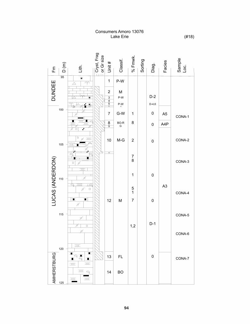
2. Anderdon Member: alternating zones of light-tan to brown, medium- to thick-bedded, sparselyfossiliferous, micritic limestone and thick or massive beds of rudaceous, very fossiliferousskeletal limestone. Megafauna include varied low diversity stromatoporoid sponge assemblageinvolving diagnostic dendroid or digitate amphiporids Amphipora nattressi and low domical tolaminar forms of Anostylostroma and Syringostroma; the rugose corals Eridophyllum andZaphrentis; tabulate coral Hexagonaria; brachiopods Paraspirifer and Brevispirifer; bryozoans;bivalves; trilobites, gastropods and the rare rostroconch Conocardium (Best 1953; Linsley 1968;Fagerstrom 1982; Prosh and Stearn 1993; Klapper and Oliver 1995). This very high-puritylimestone unit occurs in the Beachville�Ingersoll area, where it forms almost the entire LucasFormation. Quarries in this area expose an almost complete section (40 m) of the member(Derry Michener Booth and Wahl and OGS 1989b). The Anderdon Member also occursbeneath central Lake Erie, in the adjacent areas of Elgin, Norfolk and Oxford counties, and inthe Amherstburg area of Essex County (Sanford 1967).
3. Sandy limestone facies of the Anderdon Member: buff-coloured, thick- to massive-bedded,medium- to coarse-crystalline, rudaceous limestone and lenses of orthoquartzitic sandstone.This facies forms the top unit of the Anderdon Member in the Lafarge (former Steel Companyof Canada) and Carmeuse (Beachville Lime) quarries in the Woodstock�Ingersoll area ofsouthern Ontario. It also occurs in the subsurface in parts of Lambton, Kent, Middlesex andEssex counties (Sanford 1967; Summerson and Swann 1970; Uyeno, Telford and Sanford1982). Winder and Sanford (1972) interpreted the faceted and frosted quartz grains of thismember to be derived from an extremely mature source area. Sanford (1967) interpreted thesands as being of eolian origin.
The undifferentiated Lucas Formation and Anderdon Member lithofacies of the Detroit River Grouphave been defined solely on the basis of dolostone and limestone lithologies, respectively. Although theseunits are mappable on a regional scale, a better stratigraphic scheme is necessary in order to carry outfurther detailed subsurface stratigraphic work and to better delineate potential high-purity limestone anddolostone resources in areas where diagenetic lithofacies show interfingering relationships. Rickard(1984) has demonstrated the usefulness of integrating geophysical logs of boreholes to delineate keystratigraphic units and contact relationships on a regional scale.
10
In much of southwestern Ontario, the Detroit River Group is disconformably overlain by the DundeeFormation, a 20 to 40 m thick, fossiliferous, argillaceous, cherty, skeletal-bearing, in places rudaceous,limestone. Biota and depositional textures suggest a variety of depositional regimes, ranging fromnearshore lagoonal to more open-shelf, deeper subtidal environments (Birchard 1990a, 1990b, 1993). Inthe southern part of Essex and Kent counties, however, a shallow water equivalent to the DundeeFormation, found to the north and northeast, intervenes between the Detroit River Group and the DundeeFormation. These tan to grey, very fossiliferous, bioclastic dolomitic lime wackestones-packstones-grainstones have been assigned to the �Columbus Formation� (Birchard 1990a, 1990b), although the termis not formally recognized in Ontario. Fossils representative of the �Columbus Formation�, as used inthis report, commonly include stromatoporoids, solitary and colonial rugose and tabulate corals, largebrachiopods, bryozoans and crinoids.
Distribution, Thickness and Stratigraphic Relationships of theLucas Formation
The distribution and subcrop area of the Detroit River Group (Lucas Formation) is shown in Figure 1.The formation forms the bedrock of a broad belt extending northwestward from west of Simcoe to LakeHuron (Telford and Hamblin 1980). It is also present in Essex County forming small inliers in theGoderich, Grand Bend and Delhi areas (Sanford 1969). Surface exposures are scarce: the most extensivesections occur in quarries located in Amherstburg, Ingersoll and St. Marys (Uyeno, Telford and Sanford1982; Derry Michener Booth and Wahl and the OGS 1989b). Outcrops occur along the Maitland River,near Goderich, the east shore of Lake Huron and also near Inverhuron, Douglas Point and in theFormosa�Teeswater areas (Sanford 1969; Uyeno, Telford and Sanford 1982).
The Lucas Formation has a fairly uniform thickness of between 20 to 40 m along the AlgonquinArch (eastern margin of the Michigan Basin). In the centre of the Michigan Basin, the formation is morethan 365 m thick (Sanford 1967). The formation attains a maximum thickness of approximately 100 m inOntario in the subsurface of Sarnia Township, Lambton County. The high-purity limestone AnderdonMember forms only a thin veneer at the top of the Lucas Formation in southeastern Michigan andadjacent Essex County, Ontario. It thickens eastward to about 40 m in quarries in the Beachville�Ingersoll area, Oxford County, forming the main rock unit (Uyeno, Telford and Sanford 1982; DerryMichener Booth and Wahl and OGS 1989b).
Despite its varied lithofacies, the Lucas Formation is a distinctive stratigraphic unit. Its lowercontact with the Amherstburg Formation is conformable and is marked by a change from dark brown,fine- to coarse-crystalline, bituminous, occasionally cherty, skeletal limestones (Amherstburg Formation)to lighter coloured, micritic limestones and dolostones (Lucas Formation). The upper contact with theoverlying Dundee Formation is unconformable. The contact is characterized by a sharp, undulatory(erosive) surface, in places overlain by dolomitic sandy lime wackestones (Birchard 1990a; Birchard andRisk 1990) or by a thin (5 to 10 cm) intraformational conglomerate with tabular dolostone intraclasts set in amicritic limestone matrix (Uyeno, Telford and Sanford 1982). The contact is believed to be diachronousrepresenting the slow transgressive signature of more open-marine Dundee Formation lithofacies onlappingmore restricted lithofacies of the Lucas Formation (Sparling 1985; Birchard and Risk 1990).
The Lucas Formation in southwestern Ontario is generally believed to be Eifelian in age (Sanford1967; Fagerstrom 1971; Winder and Sanford 1972; Sparling 1985; Rickard 1984; Johnson and Klapper1992; Klapper and Oliver 1995). It is correlated with the Lucas Formation of Michigan, the middle partof the Columbus Limestone of north-central Ohio, and the Moorehouse Member of the OnondagaLimestone of New York (Rickard 1984; Sparling 1985; Oliver 1981). Uyeno, Telford and Sanford (1982)incorrectly placed the lower part of the Lucas Formation within the Emsian (Early Devonian).
11
DEPOSITIONAL FACIES AND DISTRIBUTION OF THELUCAS FORMATION
Although the 3 lithological units of Uyeno, Telford and Sanford (1982) can be mapped regionally,complications arise in the application of these terms in areas where there is an interfingering of limestoneand dolostone lithologies. Therefore, a facies analysis approach was considered necessary for the detailednature of this study.
During logging of the 37 Lucas Formation drill cores for this study (see Figure 1; Appendixes A andB), a total of 9 lithofacies, representative of a variety of depositional environments, were defined. Theselithofacies are listed below as typical of their locations in the Michigan and Appalachian basins. Detailedlithofacies summaries are given in Appendix C and lithologs for each logged well are listed inAppendixes D and E.
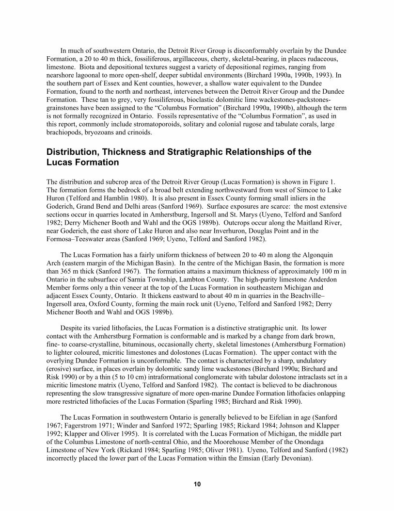
Lithofacies of the Lucas Formation in this study area have been subdivided into 2 distinct basinalsystems, reflecting the fact that the Michigan and Appalachian basins had very different depositionalsystems (Figures 5 and 6). The Michigan Basin system is generally characterized as a low-energy,shallow-water evaporitic environment, while the Appalachian Basin was a slightly deeper water, higherenergy, more open, marine depositional system. The 2 basins were probably largely separated throughoutmost of the Eifelian interval represented by deposition of the Lucas Formation, with waters having highersalinity in the Michigan Basin than in the Appalachian Basin. The difference in salinity is evidenced by amore diverse and abundant faunal assemblage in the Appalachian Basin, while sediments in the MichiganBasin are, in large part, poorly fossiliferous.
These paleoenvironmental reconstructions are based on analysis of lateral and vertical faciesrelationships within the Lucas Formation. There is considerable regional variation in the distribution ofdepositional and diagenetic facies. This is best illustrated by reference to 3 geographic areas: 1) theMichigan Basin (northwest part of the study area); 2) the northwest flank of the Appalachian Basin; and3) the southeast part of the study area. In general, the Lucas Formation is typically a dolostone withinterbedded anhydrite to the north of the Algonquin Arch, in the Michigan Basin. South of the AlgonquinArch, in the Appalachian Basin, the Lucas Formation is a limestone (Sanford 1967). An interfingering ofthese gross lithologies occurs in Essex County and in Enniskillen Township, Lambton County.
In the Michigan Basin, in the northwest part of the study area (Lambton County, northwestMiddlesex County), the Lucas Formation thickens from a minimum of 25 m in the southeastern part ofLambton County to approximately 100 m in Sarnia Township, Lambton County (Figures 7 to 10). In thisarea, Lucas Formation lithofacies of the Michigan Basin are typically microcrystalline to very finecrystalline dolostones. Anhydrite and anhydritic dolostone interbeds are common in deeper parts of the
12
Figure 5. Schematic representation of depositional settings showing lateral relationships of Lucas Formation lithofacies in bothintracratonic basins.
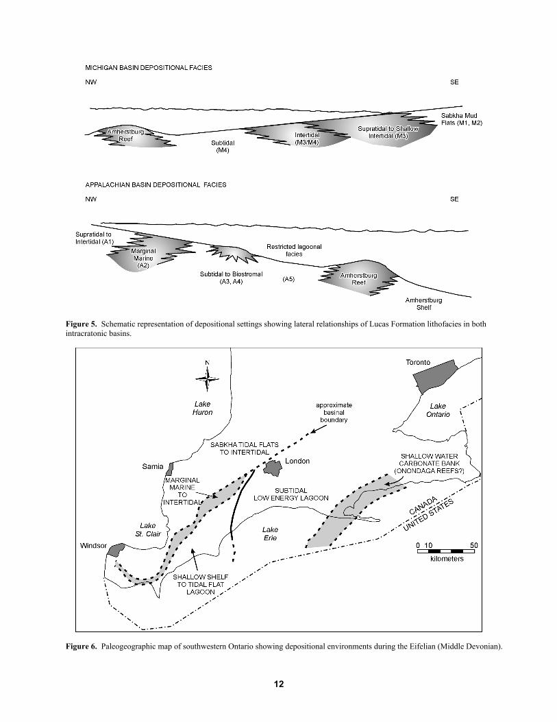
Figure 6. Paleogeographic map of southwestern Ontario showing depositional environments during the Eifelian (Middle Devonian).
13
basin and up to 7 cycles of dolomite capped by anhydrite may be identified from wells (e.g., drill hole 15)located in Sarnia Township, Lambton County. A repetition of shallow subtidal to supratidal lithofacies(M4 to M3) in the Michigan Basin of southwestern Ontario suggests that only minor fluctuations in sealevel occurred throughout the depositional history of the Lucas Formation. Anhydrite and anhydriticdolostone beds pinch out to the southeast toward the margin of the Michigan Basin. The upper fewmetres of the Lucas Formation in the Michigan Basin is more fossiliferous than underlying beds and mayrepresent a freshening of waters at the end of Detroit River time in the Michigan Basin. This upper unit isgenerally limestone with dolomitic limestone interbeds in contrast to underlying higher purity dolostone.Orthoquartzitic sands and sandy limestone beds commonly found in the Lucas Formation of theAppalachian Basin are absent in this area of the Michigan Basin, suggesting that transport of terrigenousclastics, presumably originating from the area of the arch, was predominantly directed toward thesoutheast, into the Appalachian Basin.
On the northwest flank of the Appalachian Basin (Kent, south Lambton, southwestern Middlesex,and western Elgin counties), the Lucas Formation is generally 20 to 30 m thick. Lithofacies here varyconsiderably in gross lithology and fossil content and reflect more normal marine depositional environs.The abundant and diverse marine invertebrate fauna indicates that normal marine salinities prevailed inthis area of the Appalachian Basin throughout the depositional history of the Lucas Formation. Carbonateunits here, in contrast to the Michigan Basin, are more rudaceous (increased skeletal components) andmore representative of higher energy environments. Coarse packstone and rudstone units and thinbiostromal lenses (facies A4: bindstone, floatstone and bafflestone textures) are common.
Figure 7. Location map for cross-sections A�A', B�B' and C�C' (Figures 8, 9 and 10, respectively). These cross-sectionsillustrate the changes in thickness and depositional and diagenetic lithofacies of the Lucas Formation in the Appalachian Basinand Michigan Basin.
Figu
re 8
. St
ratig
raph
ic c
ross
-sec
tion
of L
ucas
For
mat
ion
alon
g tra
nsec
t A�A
' (K
ent t
o La
mbt
on c
ount
ies)
(see
Fig
ure
7 fo
r the
loca
tion
of th
e cr
oss-
sect
ion)
.
14
Figu
re 9
. St
ratig
raph
ic c
ross
-sec
tion
of L
ucas
For
mat
ion
alon
g tra
nsec
t C�C
' (ea
ster
n El
gin
to w
este
rn L
ambt
on c
ount
ies)
(see
Fig
ure
7 fo
r the
loca
tion
of th
e cr
oss-
sect
ion)
.
15
Figu
re 1
0. S
tratig
raph
ic c
ross
-sec
tion
of L
ucas
For
mat
ion
alon
g tra
nsec
t B�B
' (El
gin
to E
ssex
cou
ntie
s) (s
ee F
igur
e 7
for t
he lo
catio
n of
the
cros
s-se
ctio
n).
16
17
The marginal marine lithofacies (facies A2) or quartzitic sandy facies of the Anderdon Member(Uyeno, Telford and Sanford 1982) is found only in the Appalachian Basin. It is well developed, as seenin quarries in the Ingersoll area and in southeast Lambton and southwestern Middlesex counties (drillholes 9, 19 and 22 to 25). This lithofacies is characterized by the presence of thick orthoquartziticsandstone and sandy limestone beds interbedded with coarse, fossiliferous biostromal to rudaceous lenses.The sandstones or sandy limestones are generally massive to planar to cross-stratified. This marginalmarine facies is interpreted here as being characteristic of a broad tidal flat environment (partly eolian inorigin; Sanford 1967) which existed along the northern flank of the basin during this depositional phaseof the Lucas Formation. This tidal flat environment graded northward into shallow intertidal andsupratidal lithofacies, interfingering with Michigan Basin facies (see Figure 6).
In the southeasternmost part of the study area, a potentially and economically significant high-puritylimestone facies occurs: the Anderdon Member of Uyeno, Telford and Sanford (1982). Surface andsubsurface exposures of the Lucas Formation in the Woodstock�Ingersoll and Port Stanley areas,respectively, consist almost exclusively of 20 to 30 m thick sections of dense, micritic limestone (seeFigures 9 and 10; also see lithologs for drill holes 18, 26, 28 in Appendix D). This limestone unit,included in the Appalachian subtidal facies (A3), consists primarily of light tan to brown, medium- tothick-bedded, moderately fossiliferous, dense micritic lime mudstones and wackestones. Quartzsandstone and sandy limestone pulses do not appear to be present in this locality. This facies isinterpreted as representing deposition within a broad, shallow subtidal lagoonal or platform setting thatmay have existed behind a reef complex to the southeast (see Figure 6). This back-reef or lagoonalinterpretation is supported by the occurrence of stromatoporoid-coral biostromes and bioherms that occurat the top of the Lucas Formation in the Port Dover area (Birchard 1990a). The rapid change from coarse-grained, higher energy, shallow subtidal and marginal marine lithofacies in the northwesternmost part ofthe Appalachian Basin to low energy, micritic subtidal lagoonal facies in the southeasternmost portion ofthe study area suggests possibly deeper water conditions in the Appalachian Basin.
Dolostone and Limestone Distribution
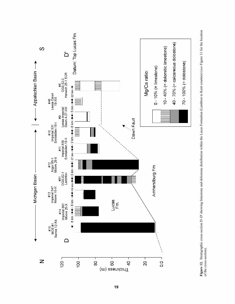
Previous workers have mapped the gross dolostone�limestone lithofacies boundaries of the LucasFormation as being roughly coincidental with the transition from the southeast margin of the MichiganBasin to the northern margin of the Appalachian Basin (Best 1953; Sanford 1967). This interpretation issupported in this study (Figures 11, 12 and 13). Cross-sections D�D′ (see Figure 12) and E�E′ (see Figure13) are stratigraphic and structural cross-sections, respectively, showing the regional variation in thediagenetic facies of the Lucas Formation from the Michigan Basin into the Appalachian Basin. Theproportions of dolomite present for each lithologic unit (as determined from core examination, seeAppendixes D and E), were grouped into one of the gross range of 1) limestone, 2) dolomitic limestone, 3)calcareous dolostone and 4) dolostone of Classification #1 (see Table 1) in order to construct the sections.
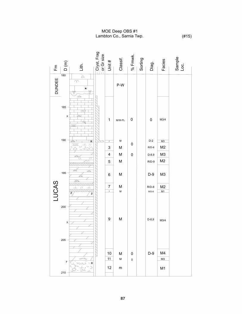
Noncarbonate lithologies are not shown on these sections, but were included in the gross carbonatelithology depending upon their bounding carbonate units. For example, in the MOE #1 well (drill hole15), Sarnia Township (see Figure 12), a number of anhydrite beds that are bounded by high-puritydolostone have been included in the gross dolostone lithology. Stratigraphic cross-section D�D′illustrates both the change in thickness of the Lucas Formation and variations in diagenetic facies fromthe Michigan to Appalachian basins. Note:
• the rapid thickening of the Lucas Formation into the Michigan Basin,• a limestone to dolomitic limestone cap at the top of the Lucas Formation in the Michigan Basin,• the pinch-out of dolostone between the Imperial 831 (drill hole 10, Enniskillen Township) and
Leesa Imperial 4-27-XIII (drill hole 9, Dawn Township) wells.
18
Drill hole OGS-82-1 (drill hole 51) lacks the limestone cap seen in other Michigan Basin drill holesand more than likely reflects misplacement of the upper contact of the Lucas Formation in that core log(see Figure 12).
The change in diagenetic facies from predominantly calcareous dolostone and dolostone lithologiesto limestone lithologies, from Enniskillen to Dawn township, is roughly coincidental with the location ofthe west-trending Dawn Fault (see Figure 12). This fault, located near the northern boundary of DawnTownship, is about 15 km long and has a maximum displacement of 47 m (Brigham 1971). Depositionallithofacies change drastically away from this fault zone. Orthoquartzitic sand and sandy limestone faciesof the Appalachian Basin (facies A2) are found exclusively south of the approximate position of theDawn Fault. This fault position may also delineate the boundary of lateral movement of diagenetic fluidsin the Michigan and Appalachian basins, such that dolomitizing fluids influencing the Detroit RiverGroup have been essentially restricted to the Michigan Basin north of this location. Diagenetic faciespatterns of the Lucas Formation in this area indicate that this diagenetic front may extend along-strike ofthe fault trending toward the axis of the Algonquin Arch. Fossiliferous normal marine facies,characteristic of the Appalachian Basin, are restricted to locations south of the inferred position of theDawn Fault.
Figure 11. Location map for cross-sections D�D' and E�E' (Figures 12 and 13, respectively).
Figu
re 1
2. S
tratig
raph
ic c
ross
-sec
tion
D�D
' sho
win
g lim
esto
ne a
nd d
olos
tone
dis
tribu
tion
with
in th
e Lu
cas F
orm
atio
n (L
ambt
on to
Ken
t cou
ntie
s) (s
ee F
igur
e 11
for t
he lo
catio
nof
the
cros
s-se
ctio
n).
19
Figu
re 1
3. S
truct
ural
cro
ss-s
ectio
n E�
E' sh
owin
g lim
esto
ne a
nd d
olos
tone
dis
tribu
tion
with
in th
e Lu
cas F
orm
atio
n (E
ssex
thro
ugh
to E
lgin
cou
ntie
s) (s
ee F
igur
e 11
for t
helo
catio
n of
the
cros
s-se
ctio
n).
20
21
Cross-section E�E′ (see Figure 13) is a structural cross-section constructed from wells in EssexCounty (on the edge of the Findlay Arch) through Kent County (in the vicinity of the Chatham Sag) toElgin County. The Lucas Formation is approximately 20 to 30 m thick throughout this area and changesfrom a predominantly high-purity limestone lithofacies in Kent and Elgin counties to a dolomitic facies inEssex County. Depositional lithofacies of the Michigan and Appalachian basins interfinger in the EssexCounty area. Orthoquartzitic sands and sandy limestone and dolomite beds commonly occur near the topof the Lucas Formation in this vicinity, as well (see Figure 9; see also lithologs in Appendix D). Sandycarbonate stringers occur proximal to the Findlay Arch in Essex County and are absent in wellsimmediately to the east in Kent County, away from the arch. This is reflected in the lateral change frommarginal marine terrigenous sandy units to fossiliferous subtidal and biostromal facies characteristic ofslightly deeper more open marine waters.
Lucas Formation lithofacies characteristic of Appalachian Basin environs occur only in thesouthernmost part of Essex County, near Amherstburg. The Lucas Formation, in most of the remainderof Essex County, is more comparable to Michigan Basin paleoenvironments, although more detailed workneeds to be done to verify this interpretation. The orthoquartzitic sands and sandy limestone intervalsobserved in Lucas Formation cores from Essex County are also found at the top of the Lucas Formationin the Lafarge (former Stelco Steel) quarry near Ingersoll, Ontario (Uyeno, Telford and Sanford 1982;Derry Michener Booth and Wahl and OGS 1989b). These sandy limestones and sandstone lenses,previously called Columbus Formation (Ehlers and Stumm 1951) and subsequently reclassified as sandyAnderdon Member of the Lucas Formation (Sanford 1967), may have been sourced from the AlgonquinArch or from sources well to the southwest. The absence of thick sandy carbonate units in deeperportions of the Michigan Basin area suggests a short lived and proximal eolian(?) southeasterly source(eolian reworking of the underlying Sylvania Formation sandstone?).
Geochemistry of the Lucas Formation
RATIONALE
A geochemical analysis of the Lucas Formation was conducted primarily to provide a quantitative basisfor determining whether a correlation exists between depositional facies and high-purity carbonate zones.Should geochemical characterization of the various facies indicate a correlation, regional and stratigraphicdelineation of high-purity limestone and dolostone zones in the subsurface and surface would be greatlysimplified. The geochemical information obtained during this study augments the existing database forthe Lucas Formation and will make a substantial contribution to the existing geochemical database forPaleozoic carbonate strata in southwestern Ontario.
EXISTING DATA
Geochemical data on the Lucas Formation has been reported from quarries near St. Marys (St. MarysCement Co. quarry), Ingersoll (Lafarge Canada Inc. Woodstock quarry; Beachville Ltd. quarries; StelcoSteel quarry), and Amherstburg (MacGregor and Amherst quarries) (Derry Michener Booth and Wahl andOGS 1989a, 1989b; Kelly 1996). A few cores penetrating the Lucas Formation have also been sampledfor geochemical analyses by the then staff geologist of the Ontario Ministry of Northern Developmentand Mines (MNDM), Southwestern Ontario District Office in London, Ontario (Kelly 1996), the results
22
of which are included in this report. Cored wells with geochemical data include (see Figure 1 for locationof wells)
1. CdnOxy Rodney 5-30 (drill hole 27), Elgin County, Aldborough Township2. Lucas No. 3 (drill hole 2), Essex County, Anderdon Township3. Lucas No. 2 (drill hole 3), Essex County, Colchester South Township4. S-82-2 (drill hole 8), Kent County, Harwich Township
Sample data from the wells in Elgin and Essex counties are representative of only the uppermost partof the Lucas Formation, as none of these wells penetrates more than 4 to 5 m into the Lucas Formation.Samples from the Lucas No. 3 and Lucas No. 2 wells are representative of an interfingering ofAppalachian Basin shallow water (A1 and A2) facies and Michigan Basin supratidal to intertidal (M3)facies. Samples from OGS-82-2 are representative of the subtidal (A3) facies.
Geochemical data are also included (Appendix F) for a series of samples obtained from a core(Canada Cement Lafarge core 85-17, drill hole 28) drilled adjacent to the Canada Cement Lafarge Quarrynear Ingersoll, Ontario. The data listed from the Lucas Formation at this quarry are representative of theAppalachian subtidal facies (A3). This lithofacies comprises dense, micritic lime mudstones thataccumulated in a shallow lagoon that extended across much of Elgin and part of Middlesex counties.
Other geochemical data are the result of an Ontario Prospector�s Assistance Program (OPAP) Grantproposal (Grant #OP92-337) submitted to the Mineral Development Section of MNDM to sample thehigh-calcium Lucas Formation, as well as the overlying Dundee and underlying Amherstburg formationsfrom the Port Stanley drill core (OGS-82-3). Channel samples were analyzed for whole rock majorelement oxides and selected trace elements. This core was also resampled for this study (drill hole 26).
METHODOLOGY
Drill Core and Sample Selection
Ten drill cores, all having good penetration through the Lucas Formation and intersecting at least oneformational contact, but preferably both contacts (such as drill holes 6, 8, 18, 26 and 51), were selectedfor sampling (Table 3; see Figure 1). Five of the drill holes (1, 4, 10, 14 and 51) occur within theMichigan Basin and 5 (drill holes 5, 6, 8, 18 and 26) within the Appalachian Basin, thus providingadequate regional coverage of the Lucas Formation throughout the study area.
A total of 71 samples were selected for analysis of whole rock major element oxides and selectedtrace elements. Sixty-six of these samples were from the Lucas Formation, the remaining 5 samples fromthe sandy Anderdon Member and the Amherstburg Formation. Sampling of the drill cores was done insuch a way as to ensure both adequate representation of each hole and of the various carbonate lithofacieswithin the Lucas Formation. Samples (approximately 20 g each) were taken at fairly regular intervalsdown each hole. Interval length, however, varied from hole to hole, ranging anywhere from 1.5 to 8.6 m(but generally averaging 3 m), depending on the length of core available. The number of samplesobtained per drill core ranged from 5 to 11. Highly sandy (mostly from facies A2) and argillaceousintervals were generally avoided. Table 3 lists the sample names used for each of the drill cores.
23
Table 3. List of sample names and the number of samples obtained for each drill hole.
Sample Name Drill Hole Name Drill Hole Number(this study)
All predominantly carbonate lithofacies of the Lucas Formation were sampled, the number ofsamples obtained from each lithofacies generally reflecting the relative abundance of the lithofacies.The number of samples obtained from each facies is listed below:
Facies Number of SamplesA1 supratidal to intertidal 4A3 subtidal 20A1/A3 2A4 biostromal (proximal and distal) 4A5 restricted lagoonal 2
Subtotal 32M3 supratidal to shallow intertidal 12M4 subtidal 12M3/M4 10
Subtotal 34Total 66
Sample locations are shown on the lithologs in Appendix D and the depths at which they were takenare tabulated in Appendix G.
Samples were analyzed for 10 major elements (Si, Ti, Al, Fe, Mn, Mg, Ca, K, Na and P) and 6 traceelements (Pb, Zn, Cu, Ni, Cr and V) at the Geochemistry Labs, University of Western Ontario, London,Ontario. The analyses were conducted in 2 separate batches. The first batch of 41 samples (thoseprefixed OGS, CNS, CON3, CONA, IMPC and IMPR) were analyzed during August 1992, and theremaining 30 samples (CWT, IMPE, CMS and LAMB) during February 1993. Both sets of samples wereprepared and analyzed similarly to maximize accuracy and to enable utilization and comparison of bothsets of data. A brief description of the analytical techniques used is presented in Appendix H.
Trace elements likely to pose environmental problems during stone processing were determined.Analyses for zinc were also undertaken because anomalous amounts of this element, along with thepresence of strontium, lead and fluorine, may indicate the presence of Mississippi Valley-type oremineralization (Johnson and Sorensen 1981).
24
Geochemical Data Analysis
Statistical summaries and a series of histograms, line plots and scatter plots were utilized as aids indrawing preliminary conclusions regarding regional and vertical trends and possible correlations that mayexist between lithofacies and high-purity carbonate intervals within the Lucas Formation. Suspectedcorrelations were verified using regression analysis. Unfortunately, the extent to which the LucasFormation geochemical data could be analyzed in this manner was restricted by the relatively small sizeof the data set, especially when the set was further divided into smaller groups. Only the results of the 66Lucas Formation samples obtained during this study were statistically analyzed; the above-mentioned pre-existing geochemical data were not included due to possible discrepancies that may occur in samplepreparation and analytical techniques followed by other laboratories. However, the additionalgeochemical data did contribute to the overall understanding and interpretations of the regionalgeochemical character of the formation.
The Lucas Formation data set was examined as a whole and also with respect to lithofacies,individual drill holes and regional location. Results of samples from units assigned to 2 facies, such asCMS-1, which was taken from a unit measured as facies A1/A3, were generally placed in both facies datasets for analysis. Limestone and dolostone classification of analyzed samples allowed the use of the morerigid scheme of Hewitt and Vos (1972).
RESULTS
Results of the major and trace element analyses are presented in Appendixes I and J. Selected histogramsand statistical summaries of the major element data with respect to the Lucas Formation as a whole, thevarious lithofacies and depositional basin are shown in Appendix K; these are referred to throughout thetext. Trace element data were not examined as thoroughly, but observed trends and abnormally highvalues are discussed.
Some of the geochemical data (CaO, MgO, SiO2, Al2O3 and Fe2O3) of key interest to the limestoneindustry are presented graphically against drill core vertical profiles showing gross lithology andlithofacies subdivisions (Figures 14 to 20). Existing geochemical data from drill holes Lucas No. 2 andNo. 3 (Kelly 1996), Canada Cement Lafarge (see Appendix F), and OGS-82-2 (Kelly 1996) have alsobeen incorporated into these graphs. The gross lithologies portrayed on these profiles are based on bothlithological examination and geochemical data. Because of the use of results from the former, grosslimestone and dolomitization classifications are based on Classification #1 (see Table 1).
25
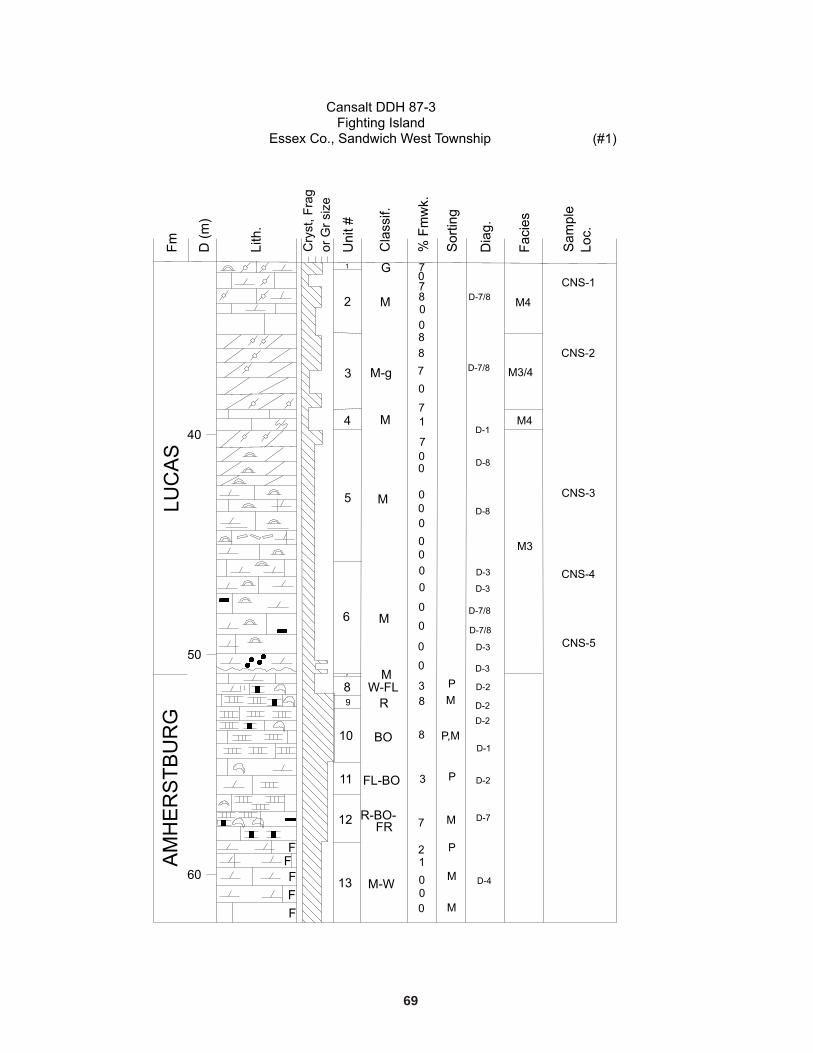
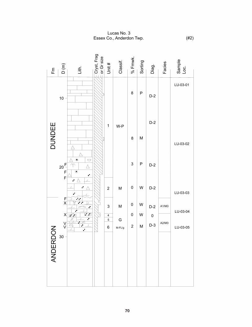
Figure 14. A) Geochemical vertical profiles of Lucas Formation (Cansalt DDH 87-3); and B) Lucas and Dundee formations(Lucas No. 3 � existing data), Essex County; triangles represent data from Kelly (1996).
26
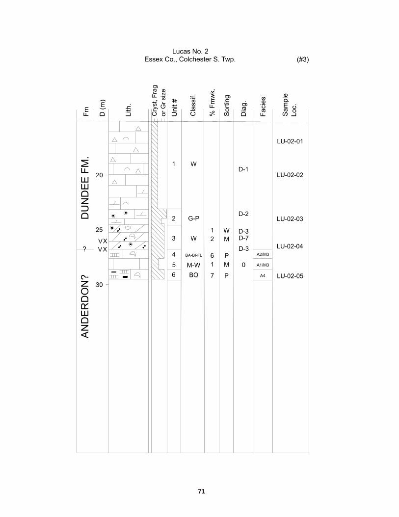
Figure 15. A) Geochemical vertical profiles of Lucas and Dundee formations (Lucas No. 2 � existing data) (triangles representdata from Kelly (1996)); and B) Amherstburg and Lucas formations (Imperial et al. 813), Essex County.
27
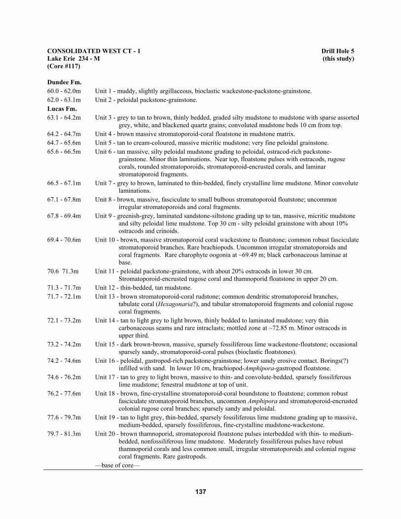
Figure 16. A) Geochemical vertical profiles of Lucas Formation (Consolidated West CT-1, Lake Erie); and B) Lucas andDundee formations (Consumers 33409, Kent County).
28
Figure 17. A) Geochemical vertical profiles of Lucas Formation (OGS-82-2 Chatham) in Kent County (triangles at top andbottom of profiles represent data from Kelly (1996), drill holes 90-OGS-1 and 90-OGS-2, respectively); and B) Lucas Formation(Imperial 831) in Lambton County.
29
Figure 18. A) Geochemical vertical profiles of Lucas Formation (Imperial 661 Corunna 18) in Lambton County; andB) Amherstburg and Lucas formations (Consumers Amoco 13076) in Elgin County.
30
Figure 19. A) Geochemical vertical profiles of Amherstburg and Lucas formations (OGS-82-3) in Elgin County; and B) LucasFormation (Canada Cement Lafarge 85-17 � existing data) in Elgin County.
31
Figure 20. Geochemical vertical profile of Amherstburg and Lucas formations (OGS-82-1) in Lambton County.
32
Discussion of Results
Throughout the text, as a means of summarizing the various sets of data, the median value, as opposed tothe mean or mode, is referred to. The median seems to be the best measure of central tendency of thevarious distributions and is not as easily affected by extreme values, as is the case with the mean, or byclass interval size, as with the mode.
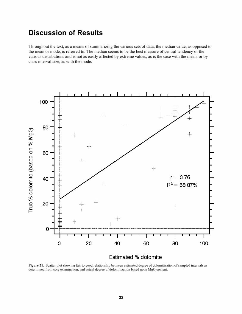
Figure 21. Scatter plot showing fair to good relationship between estimated degree of dolomitization of sampled intervals asdetermined from core examination, and actual degree of dolomitization based upon MgO content.
33
Table 4. Limestone and dolostone classification distribution of all Lucas Formation samples (n = 66) based on MgOcontent. Limestone and dolostone classification after Hewitt and Vos (1972).
Geochemical analysis of the Lucas Formation conveniently allows for a check of the �true� dolomitecontent (based on weight MgO content) of sampled intervals against visual estimates of the same intervalsdone in the core laboratory with the aid of a binocular microscope, hydrochloric acid (HCl) and AlizarinRed S solution. Visual estimates, in general, are fairly accurate and adequate for most descriptivepurposes, but may be thrown off by high porosity and/or permeability and by the presence of significantamounts of oil staining in the rock, as was observed in many of the Lucas Formation cores. One problemin comparing the 2 sets of values is the highly localized nature of dolomitization within the LucasFormation, sometimes exhibiting considerable variation even within a single lithofacies unit. Due to timeconstraints on the logging of core, visual estimates were at times done quickly and the value reported mayrepresent an average for an entire unit interval. On the other hand, the �true� value based on geochemicalresults (MgO content) represents a mere 6 cm interval and may not be truly representative of the intervalfrom which it came.
Although the scatter plot of �true� dolomite content (based on MgO content) versus estimateddolomite content shows considerable scatter (Figure 21), it suggests that the accuracy of the visualestimation of the degree of dolomitization in this study was fair to good. The data suggest that acorrelation between the 2 variables (test statistic, t, is significant at the 95% level), although not strong,with r = 0.76 and R2 = 58.07%, does exist (see Figure 21). Porosity, permeability and oil staining alsoprobably influenced the estimations of the degree of dolomitization.
GEOCHEMISTRY OF THE LUCAS FORMATION
Regional Geochemical Trends
Appendix K contains histograms that graphically show the Lucas Formation to vary widely with respectto CaO and MgO content. The MgO and CaO contents range from 0.41 to 21.50% and 30.08 to 56.25%,respectively. The bimodal nature of the MgO and CaO frequency distributions reflects the 2 predominantrock types: limestone and dolostone. This distribution pattern emphasizes the need to examine the datawith respect to depositional basin (see below). Modes (here referring to the mid-point of the class intervalwith the greatest number of observations) occur at 1.7% and 19.7% for MgO, and 30.8% and 54.8% forCaO. Table 4 summarizes the general distribution of the samples according to limestone and dolostoneclassification.
Total impurities (SiO2+Fe2O3+Al2O3) in the Lucas Formation, of which SiO2 is the primarycomponent, range from 0.07 to 9.05%, with a mode of 0.3%; generally the amount of impurities is low,with 92% of the samples containing less than 3% impurities. The majority of the samples (94%) haveAl2O3 contents of 0%; the remaining 6% have Al2O3 contents of less than 1%.
34
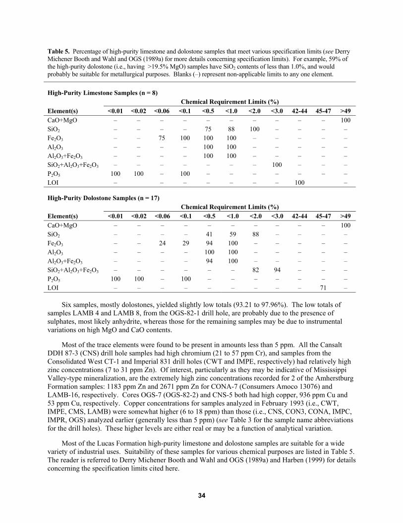
Table 5. Percentage of high-purity limestone and dolostone samples that meet various specification limits (see DerryMichener Booth and Wahl and OGS (1989a) for more details concerning specification limits). For example, 59% ofthe high-purity dolostone (i.e., having >19.5% MgO) samples have SiO2 contents of less than 1.0%, and wouldprobably be suitable for metallurgical purposes. Blanks (�) represent non-applicable limits to any one element.
Six samples, mostly dolostones, yielded slightly low totals (93.21 to 97.96%). The low totals ofsamples LAMB 4 and LAMB 8, from the OGS-82-1 drill hole, are probably due to the presence ofsulphates, most likely anhydrite, whereas those for the remaining samples may be due to instrumentalvariations on high MgO and CaO contents.
Most of the trace elements were found to be present in amounts less than 5 ppm. All the CansaltDDH 87-3 (CNS) drill hole samples had high chromium (21 to 57 ppm Cr), and samples from theConsolidated West CT-1 and Imperial 831 drill holes (CWT and IMPE, respectively) had relatively highzinc concentrations (7 to 31 ppm Zn). Of interest, particularly as they may be indicative of MississippiValley-type mineralization, are the extremely high zinc concentrations recorded for 2 of the AmherstburgFormation samples: 1183 ppm Zn and 2671 ppm Zn for CONA-7 (Consumers Amoco 13076) andLAMB-16, respectively. Cores OGS-7 (OGS-82-2) and CNS-5 both had high copper, 936 ppm Cu and53 ppm Cu, respectively. Copper concentrations for samples analyzed in February 1993 (i.e., CWT,IMPE, CMS, LAMB) were somewhat higher (6 to 18 ppm) than those (i.e., CNS, CON3, CONA, IMPC,IMPR, OGS) analyzed earlier (generally less than 5 ppm) (see Table 3 for the sample name abbreviationsfor the drill holes). These higher levels are either real or may be a function of analytical variation.
Most of the Lucas Formation high-purity limestone and dolostone samples are suitable for a widevariety of industrial uses. Suitability of these samples for various chemical purposes are listed in Table 5.The reader is referred to Derry Michener Booth and Wahl and OGS (1989a) and Harben (1999) for detailsconcerning the specification limits cited here.
35
Interbasinal Geochemical Trends
Of the various elements analyzed, only CaO and MgO contents exhibit marked differences between the2 basins, reflecting the different carbonate regimes. The MgO content of samples obtained from bothbasins showed similar ranges (e.g., 0.41 to 19.41% for the Appalachian Basin, and 0.78 to 21.5% for theMichigan Basin). However, the distribution of values for the Appalachian Basin are positively skewed(median of 2.21%), whereas those for the Michigan Basin are negatively skewed (median of 19.94%).Based on MgO content, 22% of the Appalachian Basin samples classify as high-purity limestone (MgO<1.1%), 28% as magnesian limestone (1.1 to 2.1% MgO), 38% as dolomitic limestone (2.1 to 10.8%),13% as calcitic dolostone (10.8 to 19.5%), and none as high-purity dolostone (MgO >19.5%). Of theMichigan Basin samples, 50% classify as high-purity dolostone; 29% as calcitic dolostone, 15% asdolomitic limestone, 3% as magnesian limestone, and 3% as high-purity limestone. Thus, the majority ofthe samples (79%) are dolostones. The CaO values are similarly, but oppositely, distributed:Appalachian Basin samples had a negatively skewed distribution of values, ranging from 31.56 to 56.25%CaO, with a median of 52.63%, and Michigan Basin samples had a positively skewed distribution ofvalues, ranging from 30.08 to 55.37% CaO, with a median of 32.52%.
Total carbonate (MgO+CaO) content seems to be slightly greater in the Appalachian Basin (slightlynegatively skewed distribution; median = 55.04%) than in the Michigan Basin (slightly positively skeweddistribution; median = 51.89%).
Lucas Formation Facies
Selected histograms and summary statistics for lithofacies geochemical data are presented in Appendix K.Table 6 shows the distribution of lithofacies samples according to limestone and dolostone classifications.
APPALACHIAN BASIN LITHOFACIES
A1 Facies
The 6 samples analyzed from the A1 (supratidal to intertidal) facies had MgO contents ranging from alow of 0.5% to a high of 18.73%; however, the majority of the samples had MgO contents less than 2.1%,the median being 1.55% (~7% dolomite). The CaO content ranged from 31.56 to 56.25% with themedian at 53.72%. Total carbonate (MgO+CaO) of the samples ranged from 50.29 to 56.75% (median55.20%). The amount of total impurities was low, ranging from 0.15 to 3.35% (median of 1.12%). Ofthis total, silica had a median of 1.02%; iron oxide, 0.1%; and alumina, 0%. No anomalously high levelsof the 5 trace elements analyzed for were detected in any of the A1 facies samples. Only zinc and copperoccurred at slightly high levels, ranging from 5 to 16 ppm Zn, and less than 5 to 13 ppm Cu.
Of the 6 samples analyzed, only one (CMS-4) can be classified as a high-purity limestone (see Table6). Impurities in this sample totalled 0.15% (0.14% SiO2, 0.01% Fe2O3, 0% Al2O3).
36
Table 6. Distribution of lithofacies samples according to limestone and dolostone classification based on MgOcontent (Hewitt and Vos 1972; see also Table 2 �Classification #2�). Percentages have been rounded off and maynot total 100%.
Twenty-two samples were analyzed from the Appalachian subtidal facies, which is considered to have thebest potential for producing high-purity limestone in the Lucas Formation. Histograms (see Appendix K)of the A3 facies geochemical data show the MgO and CaO values to be asymmetrically distributed:positively skewed for the former and negatively skewed for the latter. The MgO contents ranged from0.61 to 19.41%, with a median of 2.21% (about 10% dolomite). Based on percent MgO, 86% of thesamples analyzed can be classified as limestones, 26% of which are high purity. The CaO content in thefacies varies similarly, ranging from 36.65 to 55.81%, the median being 52.63% (~93.93% CaCO3).Total carbonate (MgO+CaO) values have a slightly negatively skewed distribution; the median is 55.00%,with values ranging from 49.85 to 59.62%. Of the samples classified as high-purity limestone, all hadtotal impurities of less than 0.5%, with an average of 0.3% and would be considered chemical grade.Trace element values in the samples of this facies are relatively unremarkable. A few exceptions includehigh copper (936 ppm Cu) in one sample (OGS-7); relatively high zinc in CWT samples (12 to 31 ppmZn); high copper in CWT (6 to 17 ppm Cu) and in CMS (11 to 15 ppm Cu) samples.
A4 Facies
Only 4 samples were analyzed from the A4 (biostromal) facies. The limited geochemical data show arelatively narrow range with respect to MgO and CaO contents. Samples from this facies containedbetween 1.72 to 8.32% MgO and 44.87 to 54.48% CaO; averages, which, in this case, were similar to themedians of 4.85% MgO and 49.99% CaO. Total carbonate averaged 54.84% and ranged from 53.19 to56.20%. The amount of total impurities in the samples was low (0.56% average), ranging from 0.37 to0.74%. Of this total, silica averaged 0.44%; iron oxide, 0.12%; and alumina, 0%. Only 2 samples weresent for trace element analysis; CWT-6 had relatively high zinc (16 ppm Zn) and copper (11 ppm Cu)levels. The majority of the A4 facies samples classify as dolomitic limestone (see Table 6). None arehigh purity.
A5 Facies
The 2 samples analyzed from Appalachian Basin restricted lagoonal facies had MgO and CaO contentsless than about 1.5% and greater than 53.5%, respectively. Total impurities were less than 1.5% (<1.4%SiO2, <0.15% Fe2O3 and 0% Al2O3). Only 1 (CWT-3) of the 2 samples underwent trace element analysis;this sample, which is a high-purity limestone with 1.36% total impurities, had relatively high lead(96 ppm Pb), zinc (23 ppm Zn) and copper (14 ppm Cu) levels.
37
MICHIGAN BASIN LITHOFACIES
M3 Facies
From the Michigan Basin supratidal to shallow intertidal facies, 22 samples were submitted for analysis.Ten of these samples came from units assigned to both facies M3 and M4 (i.e., M3/M4). Fifty-ninepercent of the samples can be classified as high-purity dolostones having MgO contents exceeding 19.5%MgO. In general, magnesia values for this facies were widely distributed ranging from a low of 1.47 to ahigh of 21.5%, with a median of 19.66% MgO. The majority of the samples (about 86%) classify asdolostones (68% of these being of high purity); none as high-purity limestones. Total carbonate(MgO+CaO) ranged from 47.73 to 55.18% with a median of 52.15%.
Total impurities in the samples ranged from a low of 0.1% to a rather high 9.05% (sample IMPE-3;with 8.86% silica); however, the majority of the samples (95%) contained less than 3% total impurities(the median value being 0.78%). Silica (generally present in amounts less than 2%), iron oxide, andalumina had medians of 0.61%, 0.16% and 0%, respectively. The high-purity dolostones in this facies allhad total impurities of less than 3%; all had iron oxide contents of less than 1.5%, but only 46% of thesesamples had silica contents of less than 0.5%. Therefore, based on general chemical requirement limitsset out by industry, only half are suitable for most industrial uses of high-purity dolostone.
Among the only trace elements displaying elevated levels were zinc and copper. Trace elementcontents ranged from less than 5 to 16 ppm Zn and less than 5 to 53 ppm Cu; medians were 6 ppm Zn and8 ppm Cu. High levels of chromium (28 and 21 ppm) were found in 2 of the CNS samples.
M4 Facies
The 22 samples analyzed from the Michigan Basin subtidal facies have a similar range in MgO content asthe M3 facies. The MgO values ranged from 0.78 to 21.18%, with a median of 19.08%. Total carbonate(MgO+CaO) content is similar to the M3 facies and had a range of 47.73 to 56.15% and a median of51.84%. Total impurities had a median of 0.42% ranging from a low of 0.07% to a high of 9.05%. Highsilica (8.86%) in one of the samples (IMPE-3) accounts for the large range, however, impuritiesaccounted for less than 1.5%. Of the total impurities, silica had a median of 0.31%; iron oxide, 0.08%;and alumina, 0%.
Forty-one percent of the samples from this facies are high-purity dolostones (see Table 6) withimpurities ranging from 0.1 to 3.32%, but generally less than 1.3%. Seventy-eight percent of these high-purity dolostones have less than 1% each of SiO2, Al2O3 and Fe2O3, and would, therefore, be suitable formost metallurgical purposes. The trace elements zinc and copper were present in relatively high levels:zinc ranged from <5 to 14 ppm Zn and copper ranged from less than 5 to 13 ppm Cu, with medians of6 ppm Zn and 8 ppm Cu. Two CNS samples had high chromium levels of 28 and 57 ppm Cr.
38
Figure 22. Scatter plot showing A) distribution of % MgO within lithofacies with respect to Appalachian Basin (A1 to A5) andMichigan Basin (M3, M3/4 and M4) lithofacies; and B) % total impurities within lithofacies with respect to Appalachian Basin(A1 to A5) and Michigan Basin (M3, M3/4 and M4) lithofacies.
39
LITHOFACIES PURITY AND REGIONAL AND VERTICAL TRENDSIN THE LUCAS FORMATION
The main objective of the geochemical portion of this study was to provide a quantitative basis fordetermining whether there is a correlation between depositional facies and carbonate purity. Results ofthe lithofacies analysis do suggest a correlation. Some of the factors considered included 1) distance fromthe basin margin (Algonquin Arch), which, in turn, controlled the distribution and nature of facies withinthe depositional basins; and 2) the presence of regional-scale faults.
REGIONAL FACIES AND LIMESTONE AND DOLOSTONE PURITY
Results of the geochemical analysis show that the geochemistry of any one lithofacies can varyconsiderably. These variations are evident both regionally, from drill hole to drill hole, and vertically,within even a single lithofacies interval (e.g., drill holes 1, 8 and 10). Figure 22 shows the relativedistribution and central tendencies of the results of the geochemical analyses for MgO and total impuritieswith respect to Lucas Formation lithofacies. Median values for each lithofacies are also plotted on thesegraphs. Comparison of corresponding lithofacies histograms (Appendix K) can be done for the otherelements not shown. Certain lithofacies in the Appalachian Basin, such as facies A1, A4 and A5, havelimited geochemical data making it difficult to compare lithofacies and draw any definite conclusionsregarding their geochemistry.
Most of the Lucas Formation lithofacies show similar ranges in values of the different majorelements, but the median and clustering of the data points are good indicators of where the differencesand similarities lie. With respect to limestone purity in the Appalachian Basin, facies A1, with a medianMgO content of 1.55% (~7% dolomite), has, on average, a slightly lower magnesia content than A3(2.21% MgO, or ~10% dolomite), which, in turn, is lower than A4 (4.68% MgO, or ~21% dolomite).However, this situation is reversed with respect to total impurities and silica content: facies A4, havingmedians of 0.56% for impurities and 0.47% for silica; facies A3, 0.65% impurities and 0.49% silica; andfacies A1, 1.12% impurities and 1.02% silica. Median iron oxide content is the same for all 3 facies,approximately 0.09%.
Facies A3, although quite low in silica and other impurities, actually has lower limestone purity(based on MgO content) than facies A1. If data are included from other drill holes that are not plotted inFigure 22, facies A3 becomes the best potential source of high-purity limestone in the study area. Thereis an indication of a regional control on the purity of the facies: the degree of dolomitization appears todecrease toward the east. In fact, if the geochemical data from the Canada Cement Lafarge drill hole(drill hole 28; see Appendix F; see Figure 20) are considered, the calculated overall purity of the A3facies increases (i.e., median MgO content for facies A3 decreases from 2.21% to 1.28%). The CanadaCement Lafarge quarry in Ingersoll currently extracts high-purity limestone from facies A3 and A4 of theLucas Formation. The median of alumina, silica and total impurities in this facies remains essentiallyunaffected, but the iron oxide content decreases from 0.09% to 0.06%. Facies A4 shows a decrease inMgO to 2.66% and increase in total impurities to 0.62%, whereas silica and iron oxide are unchanged.Therefore, with the incorporation of these additional data from a proven high-purity source, facies A3 isshown to be the purest of the Appalachian Basin facies. Additional sampling is required to increase thesize of the database of facies A1, A2 and A5 to substantiate this ranking with respect to limestone purity.
40
The 2 Michigan Basin dolostone facies, M3 and M4, exhibit similar ranges in MgO content (1.47 to21.5% for facies M3, and 0.78 to 20.7% for facies M4; see Figure 22). Lithofacies M3 is, on average, ahigher purity dolostone (with median MgO content of 20%) than facies M4 (median MgO content of17.8%). Lithofacies M3 also possesses nearly 4 times the amount of total impurities (median of 1.23%)than facies M4 (median of 0.3%). However, these conclusions were made without using data from unitsthat were assigned to lithofacies M3/M4 (see Figure 22).
Appalachian Basin lithofacies tend to have a slightly higher carbonate content than Michigan Basinlithofacies with an average median of 55.06% compared to 51.90% for the Michigan Basin facies(compare basin histograms in Appendix K).
Vertical Trends in Lucas Formation Geochemistry
A number of scatter plots showing element content versus depth, along with vertical profiles (see Figures14 to 20), were used to examine the variability of the geochemical data with depth. A few vertical trendsin the Lucas Formation geochemistry were observed during analysis of the data. Some of these applybasin wide, while others are evident on a local scale at one or a few of the drill cores. These trends arefairly general and based on a limited database. The complex lithofacies relationships of the LucasFormation would require a much smaller sampling interval than that carried out for this study.
Regional Trends in Lucas Formation Geochemistry
Figures 23 to 25 are cross-sections showing the medians of selected major elements at sampled drill coresites. Apart from demonstrating the obvious gross basinal differences in the degree of dolomitization ofthe Lucas Formation, these graphs illustrate the more subtle regional geochemical trends occurring withinboth depositional basins. They complement the lithofacies study by highlighting potential areas of high-purity limestone and dolostone sources.
From Essex County, in the Michigan Basin, eastward to Elgin County, in the Appalachian Basin,(see Figure 23), median values of SiO2 and of total impurities show an overall decrease. Numbers rangefrom approximately 1.3% to approximately 0.3%, with a peak of approximately 1.4% occurring at drillhole 6 in Tilbury East Township. The amount of MgO in the sections shows a similar eastward decrease(from ~19.48% to 1.08%) with a marked jump occurring at the margins of both basins. The increase inlimestone purity, based on MgO content, further into the Appalachian Basin is accompanied bydecreasing variability in lithology, as indicated by the trend in standard deviation values. Both CaO andMgO+CaO contents increase along this cross-section (see Figure 23), again showing a noticeable increaseover the Algonquin Arch.
Although fewer drill sites are represented by the northern cross-section (see Figure 24: LambtonCounty to Elgin County), similar regional geochemical trends, particularly with respect to CaO, MgO andMgO+CaO content, are evident. Both CaO and MgO+CaO contents show an overall increase fromMoore Township, Lambton County, eastward to Yarmouth Township, Elgin County, with the samemarked increase near the vicinity of the Algonquin Arch (between drill holes 10 and 18). The amount ofMgO decreases eastward, from a high of 19.79% at drill hole 14, to 15.76% at the edge of the MichiganBasin (drill hole 10), dropping further to 1.08% at drill hole 26, in the Appalachian Basin. An eastwarddecrease in the amount of impurities is not as pronounced along this cross-section as along the southernone. However, a similar peak in SiO2 and total impurities does occur in the vicinity of the AlgonquinArch, at drill hole 10.
41
Figure 23. Southern cross-section showing regional variability in the geochemistry of the Lucas Formation from Essex throughto Elgin counties: A) total impurities, B) CaO, C) MgO and D) MgO+CaO. For the names and locations of the drill holes, seeFigure 1.
42
Figure 24. Northern cross-section showing regional variability in the geochemistry of the Lucas Formation from Lambton toElgin counties: A) total impurities, B) CaO, C) MgO and D) MgO+CaO. For the names and locations of the drill holes, seeFigure 1.
43
Figure 25. Regional variability in the geochemistry of lithofacies A3, Kent to Elgin counties: A) total impurities, B) CaO,C) MgO and D) MgO+CaO. For the names and locations of the drill holes, see Figure 1.
44
Regional variations in the various elements of facies A3 are depicted as drill hole median values inFigure 25. However, the size of the Appalachian subtidal facies (A3) database is insufficient to make anyconclusive statements regarding regional changes in the geochemical character of this facies. Asmentioned in early sections, this facies is considered to be the best source for high-purity limestone in theLucas Formation and is currently being extracted as a high-purity source in the Woodstock�Ingersollarea. Silica and iron oxide content decrease eastward into the Appalachian Basin. Likewise, the amountof MgO in this facies seems to decrease eastward with distance from the basin margin, from a high of7.7% (dolomitic limestone) at drill hole 8, to a low of 1.14% (essentially high-purity limestone) at drillhole 26. Northeast of drill hole 26, at the Canada Cement Lafarge Quarry, core from drill hole 28 has aneven lower median MgO value content of 0.89%. This decrease in magnesia content from drill hole 8core eastward is accompanied by a decrease in the standard deviation, from a high of 7.81% to a low of0.47% (0.26% at drill hole 28). The amounts of both CaO and MgO+CaO in this facies increase eastwardalong with a corresponding decrease in the standard deviation.
CONTROLS ON CARBONATE PURITY IN THE LUCAS FORMATION
Results of the lithofacies and geochemical analysis of the Lucas Formation demonstrate the existence of aregional control on both the distribution and purity of limestone and dolostone. The regional variabilityof median MgO values is in agreement with the lithofacies analysis: there is an overall shift from high-purity dolostones in the Michigan Basin to increasing limestone purity and decreasing lithologicalvariability within the Appalachian Basin. Although depositional lithofacies likely played a role incontrolling the distribution of high-purity zones within the formation, the lack of strong geochemicalevidence to support this suggests that other factors, such as basement-controlled structures andhydrothermal fluid migration, may be involved. This study is preliminary in nature, focussing on thedepositional lithofacies of the Lucas Formation. Further subsurface work and detailed petrographic andisotopic analyses would be required to examine the extent to which other factors, such as local andregional-scale faults, underlying basement structures, and other structural features and fluid flowpathways, influenced the diagenetic history and nature of dolomitization of the Lucas Formation.
The confinement of Lucas Formation limestone lithologies to the Appalachian Basin, and dolostonelithologies to the Michigan Basin is consistent with the different depositional settings recorded for these 2basins. The basins were likely separated by the Algonquin Arch during much of the Eifelian, except forpossible communication in the area of the Chatham Sag and at an inlet northeast of London (Hamilton1991; Fagerstrom 1983). Seaways most likely connected the Moose River, �Timiskaming�, Michiganand Appalachian basins throughout most of the Ordovician through at least Middle Devonian periods(Prosh and Stearn 1993; McCracken, Armstrong and Bolton 2000). The Appalachian Basin wascharacterized by deeper, higher energy, more normal marine conditions, with an abundant and diversefaunal assemblage in the Lucas Formation.
The presence of silica in both basins suggests a proximal source for quartz sands: siliciclastics mayhave originated from the Algonquin and Findlay arches and were shed by eolian processes into bothbasins. The predominant transport direction appears to have been toward the southeast, into theAppalachian Basin. This direction of wind transport corresponds with prevailing wind and/or currentdirections suggested by paleogeographic reconstructions (this area of Laurussia would have beenapproximately 20 to 22°S of the paleoequator; Ziegler 1988, p.21). This latitudinal belt corresponds topresent-day southern latitude desert belts of Africa and Australia. The quartz sand source may have beenderived from proximal and slightly older Sylvania Formation sandstones or perhaps from siliciclasticunits exposed along the Transcontinental Arch, which formed a north-northeast-trending structurethroughout much of the central North American craton (Laurussia: Ziegler 1988).
45
Lucas Formation in the Michigan Basin
In the Michigan Basin of southwestern Ontario, the Lucas Formation is predominantly a microcrystallineto finely crystalline dolostone. Minor interbeds of dolomitic limestone and calcareous dolostone occur inthe Chatham Sag area and near the basin margin (southeastern Lambton County). These lithologies areless common further into the Michigan Basin. This basinward decrease in calcareous interlayers isaccompanied by an increase in the abundance and thickness of anhydritic dolostone and nodular anhydriteinterbeds. The anhydrite layers are generally associated with subtidal to intertidal and supratidaldolostone facies forming a number of shallowing-upward (brining-upward) cycles (up to 7 cycles havebeen recognized) with the anhydrite layers capping most of the cycles.
The association of dolomites with evaporite deposits is well documented in the literature. Suchvertically repetitive carbonate�evaporite cycles as seen in the Lucas Formation, together with thepresence of a number of supratidal features, such as microbial laminae, rip-up clasts, mudcracks andevaporite pseudomorphs, is consistent with the evaporitic sabkha model for dolomitization (Tucker andWright 1990). Melvin (1989) proposed such an origin for the dolostones and evaporites of the RichfieldMember of the Lucas Formation in Michigan, a possible correlative of the Lucas Formation of Ontario(Gardner 1974). Hamilton (1990, 1991) examined styles of reservoir development in the LucasFormation in Ontario. Dolomite fabrics and lithologic associations indicate that both the micritic to veryfine crystalline dolomites associated with the dolomitic mudstone lithofacies, and the finely crystallinedolomites associated with the peritidal dolostone sequences, represent penecontemporaneousdolomitization (i.e., dolomitization occurring before or shortly after burial at shallow depths). The formerrepresents sabkha dolomitization and the latter represents shallow subtidal seafloor dolomitization. Themedium crystalline dolomites, which are commonly associated with the dolomitic mudstone lithofaciesand are found disseminated throughout some of the Lucas Formation limestones, are of deep burial origin(occurring at maximum burial depths of between 440 m and 1.75 km; Hamilton 1991). Thesevolumetrically insignificant dolomites represent minor late-stage dolomitization associated with fluidmigration through intercrystalline and intergranular porosity.
The distribution of dolomite within the Michigan Basin Lucas Formation, therefore, appears to bemore a function of depositional environment rather than of a burial diagenetic realm. Depositionalenvironment may also explain why the limestone cap found at the top of the Lucas Formation is largelyundolomitized. This unit is more fossiliferous than the underlying dolostones and may represent a returnto more normal marine environs at the end of the time during which the Lucas Formation was deposited.
46
Figure 26. Regional distribution of the 5 diagenetic and/or depositional zones of the Lucas Formation, based upon theircarbonate resource potential throughout southwestern Ontario. Exploitation of these resources in parts of southwestern Ontariowould require the development of underground aggregate or chemical stone mining operations.
47
Resource Potential of Lucas Formation Carbonates
The Lucas Formation carbonates in southwestern Ontario can be mapped into 5 diagenetic or depositionalzones based upon their resource potential (Figure 26).
1. Zone 1 consists of high-purity, dense, micritic lime mudstones, similar to those quarried in theWoodstock�Ingersoll area of southern Ontario, and are characteristic of Lucas lithofacies in thesoutheasternmost portions of the study area. This dense, micritic lime mudstone unit isapproximately 25 to 30 m thick and can likely be found throughout much of Elgin County, thesouthern part of Middlesex County and parts of northern Lake Erie. This zone is shown on Figure 26as the �Dense micritic limestone� zone.
2. Zone 2 comprises approximately 20 to 25 m of fine crystalline, coarse bioclastic limestone, with sparseorthoquartzitic sandstone pulses. Thin biostromal units commonly occur interbedded with thinlybedded dense, microcrystalline and massive, finely crystalline limestones. Dolomite is virtually absentfrom this unit. This zone is shown on Figure 26 as the �Sparsely sandy limestone� zone.
3. Zone 3 consists of thick orthoquartzitic sandstone and sandy limestone beds interbedded with high-purity limestones, which occur in the upper Lucas Formation within a band that parallels the trend ofthe Algonquin Arch in parts of Lambton, Middlesex and Kent counties. The presence of silica-richsands at these localities would tend to limit the high-purity limestone facies in this area to amaximum thickness of 10 to 15 m. This zone is shown on Figure 26 as the �Sandy biostromallimestone� zone.
4. Zone 4 has poor resource potential. The area defined by zone 4 delineates a region of interbeddedlimestone and dolomite on the southern flank of the Michigan Basin. Both limestone and dolomitelithologies are finely crystalline and generally exhibit fair to poor porosity. This zone is shown onFigure 26 as the �Interbedded limestone and dolostone� zone.
5. Zone 5 consists of dense, microcrystalline to finely crystalline dolomudstones that predominate inthe northwesternmost parts of this study area (Lambton County, Sarnia and Plympton townships) andmay prove to be a potential source of aggregate. The Lucas Formation in these localities reaches athickness of approximately 100 m, which includes approximately 75 m of net dolomite, 17 m of netanhydrite and anhydritic dolomite, and approximately 7 to 8 m of a limestone or dolomitic limestonecap at the top of the Lucas Formation. This zone is shown on Figure 26 as the �Densemicrocrystalline dolostone� zone.
48
Summary and ConclusionsThe Lucas Formation is a source of high-purity limestone in the Woodstock�Ingersoll and Amherstburgareas of southwestern Ontario. The need for additional resources of this high-purity limestone and toassess subsurface potential for high-purity dolostone, prompted a largely subsurface lithofacies andgeochemical study of the Lucas Formation to identify and delineate the high-purity carbonate zones forfuture extraction.
The Middle Devonian (Eifelian) Lucas Formation is a complex carbonate unit consisting of a varietyof depositional and diagenetic lithofacies. The formation consists of 3 distinct, mappable units: 1) finelycrystalline, poorly fossiliferous dolostones (undifferentiated Lucas Formation); 2) alternating sparselyfossiliferous, micritic limestones and rudaceous, very fossiliferous skeletal limestone units (AnderdonMember); and 3) thick-bedded, medium-grade, fossiliferous sandy limestones and lenses oforthoquartzitic sandstone (sandy limestone facies of Anderdon Member). The formation is 20 to 40 mthick in the Appalachian Basin and Algonquin Arch areas of southwestern Ontario and thickens westwardinto the Michigan Basin, reaching a maximum thickness in Ontario of 100 m in Sarnia Township.
Detailed lithological examination of Lucas Formation drill core identified a total of 9 depositionalfacies; these have been subdivided into 2 basinal systems, reflecting the fact that the Appalachian andMichigan basins were largely separated during the deposition of Lucas Formation and experienced verydifferent depositional environments.
The Lucas Formation of the Michigan Basin consists of 4 depositional facies: upper sabkha mudflat, lower sabkha mud flat, shallow intertidal to supratidal, and subtidal facies. The formation ispredominantly dolostone in this area and is poorly fossiliferous and interbedded with anhydrite layers,which become thicker and more common deeper into the Michigan Basin. Lateral and vertical lithofaciesrelationships of the Lucas Formation in this basin suggest that deposition occurred in a shallow, lowenergy, hypersaline environment characterized by extensive sabkha-like tidal flats.
The Lucas Formation of the Appalachian Basin is predominantly a fossiliferous limestone consistingof 5 depositional facies: supratidal to intertidal, marginal marine, subtidal, biostromal and restrictedlagoonal facies. Sediment characteristics and lateral and vertical lithofacies relationships suggest thatdeposition occurred in a higher energy, deeper, more normal marine environment than that which theMichigan Basin experienced. Possible communication between the 2 basins may have taken place in theChatham Sag area where an interfingering of Appalachian and Michigan basin facies occurs. Distributionof the orthoquartzitic sandstones and sandy limestones and their proximity to the Findlay�AlgonquinArch suggest that the sands may have been sourced from the arch, or further afield, and that transportationof this siliciclastic material was primarily directed southeastward into the Appalachian Basin.
Based upon the observed lithofacies distribution in the Appalachian Basin, the subtidal facies, fromwhich the high-purity limestone is extracted, is likely to constitute much of the Lucas Formation in partsof Elgin, Kent, Middlesex and Oxford counties.
49
LIMESTONE AND DOLOSTONE DISTRIBUTION
The Lucas Formation limestones are found primarily in the Appalachian Basin and the dolostones, in theMichigan Basin with the area of the Algonquin Arch marking the gross limestone�dolostone faciesboundary. Interbedded limestones and dolostones occur in the area of the arch in Essex and southeasternLambton counties. The change from predominantly dolostone lithologies in Enniskillen Township tolimestone lithologies in Dawn Township may be related to the nearby, easterly trending Dawn Fault. Thefault may delineate the boundary of lateral movement of diagenetic fluids between the 2 basins.
High-purity dolostones are found in deeper parts of the Michigan Basin, but are commonlyinterbedded with evaporite deposits. A thin, 4 m thick, limestone to dolomitic limestone cap occurs at thetop of the Lucas Formation. This unit is more fossiliferous than the underlying high-purity dolostonesand may represent a change to more normal marine conditions at the end of Lucas Formation deposition.
High-purity limestones, up to 20 to 30 m in thickness, are located in deeper part of the AppalachianBasin in parts of Kent, Elgin, Middlesex and Oxford counties.
GEOCHEMISTRY OF THE LUCAS FORMATION
Results of the geochemical analysis show the Lucas Formation to vary widely with respect to CaO andMgO content reflecting the 2 predominant rock types�limestones and dolostones�present in theformation. MgO values in the Appalachian Basin are positively skewed, with a median of 2.21% (10%dolomite), while values in the Michigan Basin are negatively skewed, with a median of 19.48% (89%dolomite). Most of the samples contained less than 3% total impurities (silica being the primarycomponent).
Interbasinal geochemical analysis of facies failed to detect any marked differences in thegeochemistry of the various facies. Comparison of median MgO values does not show conclusively thatthe subtidal facies (A3) is the purest of the Appalachian Basin facies, nor that it is, on average, a high-purity limestone. Facies A1 ranks as the purest of the Appalachian Basin facies with respect to MgOcontent; however, it has nearly twice the total impurities of facies A3, which ranks second. Whenexisting geochemical results from a proven high-purity source are included with this study�s data, faciesA3 becomes the purest of the Appalachian Basin facies. More sampling is needed to clarify therelationship between depositional facies and carbonate purity.
VERTICAL AND REGIONAL GEOCHEMICAL TRENDS
Comparison of median drill core geochemical values indicates the presence of a few regional trends in thegeochemical character of the Lucas Formation. In the Appalachian Basin, there appears to be an eastward(i.e., away from the basin margin) increase in limestone purity (decreasing MgO and total impuritiescontents) of the Lucas Formation overall and of the A3 facies. (The regional variability in thegeochemistry of facies A3 may explain why it did not rank first in facies limestone purity.) In addition,the Lucas Formation becomes more lithologically uniform with depth in this direction. In the MichiganBasin, in Lambton County, a similar basinward increase in dolostone purity (with respect to MgOcontent) was observed.
50
RESOURCE POTENTIAL
Based on the results of this study, Lucas Formation carbonates in southwestern Ontario can be mappedinto 5 zones based upon their resource potential (see Figure 26). In general, high-purity dolostones arelikely to be found in the subsurface (on the land portion of Ontario) bordering the southern shore of LakeHuron. Resources of high-purity limestone can be found near the surface or in the subsurface in Elginand parts of Kent, Middlesex and Oxford counties. The distribution of high-purity limestone in theAppalachian Basin is partly facies controlled, but other factors, such as faults, permeability, subsurfacefluid pathways, need to be examined to determine their role in controlling the dolomitization of the LucasFormation.
Acknowledgments
The material presented in this report is the result of 2 studies pertaining to the facies and carbonateresources (M.C.B.) and the geochemistry (M.A.R.) of the Lucas Formation. The authors would like tothank A. Henry for invaluable assistance in the core lab; P. Smith for word processing support; and D.Schoeffman for unlimited patience in the preparation of the many figures in this report. The authorswould also like to thank R. Corcoran for extensive digital redrafting of figures and the transfer ofAppendix D into printable format. Sincere thanks are also extended to the staff of the MNR PetroleumResources Core Laboratory in London for their assistance, and to B. Feenstra, former OGS ResidentGeologist for southwestern Ontario region, for insightful and stimulating discussions. Kyle Rhoderick,Chief Geologist for Carmeuse Natural Chemicals North America, provided both information and accessto the Anderdon Member lithofacies at their Beachville Lime Quarry near Woodstock, Ontario.
University of Wisconsin, Madison, Wisconsin, 222p.
Birchard, M.C. 1990a. Stratigraphy and facies of the Middle Devonian Dundee Formation, southwestern Ontario;unpublished MSc thesis, McMaster University, Hamilton, Ontario, 136p.
��� 1990b. Stratigraphy and facies of the Middle Devonian Dundee Formation, southwestern Ontario; inSubsurface geology of southwestern Ontario: a core workshop, Ontario Petroleum Institute�AmericaAssociation of Petroleum Geologists, 1990 Eastern Section Meeting, p.131-146.
��� 1993. Stratigraphy and facies of the Middle Devonian Dundee Formation, OGRG 340; Ontario GeologicalSurvey, Open File Report 5848, 156p.
Birchard, M.C. and Risk, M.J. 1990. Stratigraphy of the Middle Devonian Dundee Formation, southwestern Ontario;in Geoscience Research Grant Program, Summary of Research 1989�1990, Ontario Geological Survey,Miscellaneous Paper 150, p.71-86.
Bradley, D.C. 1983. Tectonics of the Acadian Orogeny in New England and adjacent Canada; Journal of Geology,v.91, p.381-400.
Brigham, R.J. 1971. Structural geology of southwestern Ontario and southeastern Michigan; Ontario Department ofMines and Northern Affairs, Paper 71-2, 110p.
51
Carter, T.R. and Easton, R.M. 1990. Extension of Grenville basement beneath southwestern Ontario: lithology andtectonic subdivisions; in Subsurface geology of southwestern Ontario: a core workshop, Ontario PetroleumInstitute�America Association of Petroleum Geologists, 1990 Eastern Section Meeting, p.9-28.
Carter, T.R. and Trevail, R.A. 1989. Oil and gas exploration, drilling and production summary, 1985; Ministry ofNatural Resources, Oil and Gas Paper 8, 212p.
Carter, T.R., Trevail, R.A. and Easton, R.M. 1993. Oil and gas accumulations and basement structures in southernOntario; 32nd Annual Conference of Ontario Petroleum Institute, Technical Paper 9, 27p.
��� 1996. Basement controls on some hydrocarbon traps in southern Ontario, Canada; in Basement and basinsof eastern North America, Geological Society of America, Special Paper 308, p.95-107.
Coakley, B.J., Nadon, G.C. and Wang, H.F. 1994. Spatial variations in tectonic subsidence during Tippecanoe I inthe Michigan Basin; Basin Research, v.6, p.131-140.
Coniglio, M., Sherlock, R., Williams-Jones, A.E., Middleton, K. and Frape, S.K. 1994. Burial and hydrothermaldiagenesis of Ordovician carbonates from the Michigan Basin, Ontario, Canada; in Dolomites � a volume inhonour of Dolomieu, International Association of Sedimentologists, Special Publication 21, p.231-254.
Coniglio, M., Zheng, Q. and Carter, T.R. 2003. Dolomitization and recrystallization of middle Silurian reefs andplatformal carbonates of the Guelph Formation, Michigan Basin, southwestern Ontario; Bulletin of CanadianPetroleum Geology, v.51, p.177-199.
Derry Michener Booth and Wahl and Ontario Geological Survey 1989a. Limestone industries of Ontario, Volume 1.Geology, properties and economics; Ontario Ministry of Natural Resources, Land Management Branch, 158p.
��� 1989b. Limestone industries of Ontario, Volume 3. Limestone industries and resources of central andsouthwestern Ontario; Ontario Ministry of Natural Resources, Land Management Branch, 175p.
Dunham, R.H. 1962. Classification of carbonate rocks according to depositional texture; in Classification ofcarbonate rocks, American Association of Petroleum Geologists, Memoir 1, p.108-121.
Easton, R.M. and Carter, T.R. 1995. Geology of the Precambrian basement beneath the Paleozoic of southwesternOntario; in Basement Tectonics 10, Proceedings of the Tenth International Conference on Basement Tectonics,Duluth, Minnesota, p.221-264.
Ehlers, G.M. 1950. Revised classification of the Middle Devonian Detroit River Group (abstract); GeologicalSociety of America Bulletin, v.61, p.1455-1456.
Ehlers, G.M. and Stumm E.C. 1951. Middle Devonian Columbus Limestone near Ingersoll, Ontario, Canada;American Association of Petroleum Geologists, Bulletin, v.35, p.1879-1893.
Embry, A.F. and Klovan, J.E. 1971. A Late Devonian reef tract on northeastern Banks Island, Northwest Territory;Bulletin of Canadian Petroleum Geology, v.19, p.730-781.
Ettensohn, F.R. 1985. The Catskill Delta complex and the Acadian Orogeny: a model; Geological Society ofAmerica, Special Paper 201, p.39-49.
��� 1994. Tectonic control on formation and cyclicity of major Appalachian unconformities and associatedstratigraphic sequences; in Tectonic and eustatic controls on sedimentary cycles, SEPM (Society ofSedimentary Geology), Concepts in Sedimentology and Paleontology #4, p.217-242.
Fagerstrom, J.A. 1966. Biostratigraphic significance of rhipidomellid brachiopods in the Detroit River Group;Journal of Paleontology, v.40, p.1236-1238.
52
��� 1971. Brachiopods of the Detroit River Group (Devonian) from southwestern Ontario and adjacent areas ofMichigan and Ohio; Geological Survey of Canada, Bulletin 204, 113p.
��� 1982. Stromatoporoids of the Detroit River Group and adjacent rocks (Devonian) in the vicinity of theMichigan Basin; Geological Survey of Canada, Bulletin 339, 81p.
��� 1983. Petrology and regional significance of a Devonian carbonate/evaporite complex, eastern MichiganBasin; Journal of Sedimentary Petrology, v.53, p.295-317.
Gardner, W.C. 1974. Middle Devonian stratigraphy and depositional environments in the Michigan Basin; MichiganBasin Geological Society, Special Papers No. 1, 138p.
Hamilton, G.D. 1990. Styles of reservoir development in the Middle Devonian of southwestern Ontario; inSubsurface geology of southwestern Ontario: a core workshop, Ontario Petroleum Institute�AmericaAssociation of Petroleum Geologists, 1990 Eastern Section Meeting, p.111-130.
��� 1991. Styles of reservoir development in Middle Devonian carbonates of southwestern Ontario; unpublishedMSc thesis, University of Waterloo, Waterloo, Ontario, 191p.
Harben, P.W. 1999. The Industrial Minerals HandyBook, 3rd Edition � a guide to markets, specifications, & prices,Industrial Minerals Information, Ltd. (IMIL), 296p.
Hewitt, D.F. and Vos, M.A. 1972. The limestone industries of Ontario; Ontario Department of Mines, IndustrialMinerals Report 39, 79p.
Johnson, A.M. and Sorensen, H.O. 1981. Evaluation of high purity limestone and dolostone in northern Michigan;Geological Society of America Bulletin, v.92, p.634-640.
Johnson, J.G. 1971. Timing and coordination of orogenic, epeirogenic, and eustatic events; Geological Society ofAmerica Bulletin, v.82, p.3263-3298.
Johnson, J.G. and Klapper, G. 1992. North American Midcontinent Devonian T�R cycles; in Special Papers inPaleontology and Stratigraphy: A tribute to Thomas W. Amsden, Oklahoma Geological Survey, Bulletin 145,p.127-135.
Johnson, M.D., Armstrong, D.K., Sanford, B.V., Telford, P.G. and Rutka, M.A. 1992. Paleozoic and Mesozoicgeology of Ontario; in Geology of Ontario, Ontario Geological Survey, Special Volume 4, Part 2, p.907-1008.
Johnson, M.D., Russell, D.J. and Telford, P.G. 1985. Oil shale assessment project drillholes for regional correlation1983�84; Ontario Geological Survey, Open File Report 5565, 49p.
Kelly, R.I. 1996. High-purity calcite and dolomite resources of Ontario; Ontario Geological Survey, Open FileReport 5954, 38p.
Klapper, G. and Oliver, W.A., Jr. 1995. The Detroit River Group is Middle Devonian: discussion on �EarlyDevonian age of the Detroit River Group, inferred from Arctic stromatoporoids�; Canadian Journal of EarthSciences, v.32, p.1070-1073.
Landes, K.E. 1951. Detroit River Group in the Michigan Basin; United States Geological Survey, Circular 133, 23p.
Lane, A.C., Prosser, C.S., Sherzer, W.H. and Grabau, A.W. 1909. Nomenclature and subdivision of the UpperSiluric strata of Michigan, Ohio, and Western New York; Geological Society of America Bulletin, v.19, p.553-556.
53
Linsley, R.M. 1968. Gastropods of the Middle Devonian Anderdon Limestone; Bulletins of American Paleontology,v.54, no.244, p.333-444.
McCracken, A.D, Armstrong, D.K. and Bolton, T.E. 2000. Conodonts and corals in kimberlite xenoliths confirm aDevonian seaway in central Ontario and Quebec; Canadian Journal of Earth Sciences, v.37, p.1651-1663.
Melvin, J.L. 1989. The Richfield Member of the Lucas Formation of the Detroit River Group (Lower MiddleDevonian), Michigan Basin, Michigan, USA; Carbonate and Evaporites, v.4, p.9-43.
Mitrovica, J.X., Beaumont, C. and Jarvis, G.T. 1989. Tilting of continental interiors by the dynamical effects ofsubduction; Tectonics, v.8, p.1079-1094.
Nisbet, E.G., Dietrich, V.J. and Esenwein, A. 1979. Routine trace element determination in silicate minerals androcks by X-ray fluorescence; Fortschritte der Mineralogie, v.57, p.264-279.
Norrish, K. and Hutton, J.T. 1969. An accurate x-ray spectrographic method for the analysis of a wide range ofgeological samples; Geochimica et Cosmochimica Acta, v.33, p.431-453.
Oliver, W.A., Jr. 1981. The Middle Devonian rugose coral Prismatophyllum conjunctum (Davis) and the age of the�Columbus� Limestone at Ingersoll, Ontario; Geological Society of America Bulletin, v.92, p.873-877.
Prosh, E. and Stearn, C.W. 1993. Early Devonian age of the Detroit River Group, inferred from Arcticstromatoporoids; Canadian Journal of Earth Sciences, v.30, p.2465-2474.
Pysklywec, R.N. and Mitrovica, J.X. 1997. Mantle avalanches and the dynamic topography of continents; Earth andPlanetary Science Letters, v.148, p.447-455.
Quinlan, G.M. and Beaumont, C. 1984. Appalachian thrusting, lithospheric flexure, and the Paleozoic stratigraphyof the eastern interior of North America; Canadian Journal of Earth Sciences, v.21 p.973-996.
Rickard, L.V. 1984. Correlation of the subsurface Lower and Middle Devonian of the Lake Erie region; GeologicalSociety of America, v.95, p.814-828.
��� 1985. Correlation of the subsurface Lower and Middle Devonian of the Lake Erie region: reply; GeologicalSociety of America Bulletin, v.96, p.1218-1220.
Russell, D.J. 1993. Role of the Sylvania Formation in sinkhole development, Essex County; Ontario GeologicalSurvey, Open File Report 5861, 122p.
Sanford, B.V. 1967. Devonian of Ontario and Michigan; in International Symposium on the Devonian System,Alberta Society of Petroleum Geologists, Calgary, Alberta, v.1, p.973-999.
Sanford, B.V. and Brady, W.B. 1955. Paleozoic geology of the Windsor�Sarnia area, Ontario; Geological Survey ofCanada, Memoir 278, 65p.
Sanford, B.V., Thompson, F.J. and McFall, G.H. 1985. Plate tectonics�a possible controlling mechanism in thedevelopment of hydrocarbon traps in southwestern Ontario; Bulletin of Canadian Petroleum Geology, v.33,p.52-71.
Sparling, D.R. 1985. Correlation of the subsurface Lower and Middle Devonian of the Lake Erie region: alternativeinterpretation; Geological Society of America Bulletin, v.96, p.1213-1218.
54
Summerson, C.H. and Swann, D.H. 1970. Patterns of Devonian sand on the North American craton and theirinterpretation; Geological Society of America Bulletin, v.81, p.469-490.
Telford, P.G. and Hamblin, A.P. 1980. Paleozoic geology of the Simcoe area, southern Ontario; Ontario GeologicalSurvey, Preliminary Map P.2234, scale 1:50 000.
Uyeno, T.T., Telford, P.G. and Sanford, B.V. 1982. Devonian conodonts and stratigraphy of southwestern Ontario;Geological Survey of Canada, Bulletin 332, 55p.
Winder, C.G. 1961. Lexicon of Paleozoic names in southwestern Ontario; University of Toronto Press, 161p.
Winder, C.G. and Sanford, B.V. 1972. Stratigraphy and paleontology of the Paleozoic rocks of southern Ontario;XXIV International Geological Congress, Montreal, Quebec, Excursion A45-C45.
Ziegler, P.A. 1988. Laurussia � The Old Red Continent; in Devonian of the World, Canadian Society of PetroleumGeologists, Memoir 14, v.1, p.15-48.
55
Appendix A
List of Drill Holes by Site Number
56
Appendix A. List of drill holes by site number.
Drill Hole Number(this study)
Drill Hole Name Township, County
1 Cansalt DDH 87-3, Fighting Is. Sandwich W. Tp., Essex Co.2 Lucas No. 3 Anderdon Tp., Essex Co.3 Lucas No. 2 Colchester S. Tp., Essex Co.4 Imperial et al. 813, Reimer #1 Gosfield S. Tp., Essex Co.5 Consolidated West CT-1 Lake Erie6 Consumers 33409 Tilbury E. Tp., Kent Co.7 Consumers 33408A Tilbury E. Tp., Kent Co.8 OGS-82-2 Harwich Tp., Kent Co.9 Leesa-Imperial 4-27-XIII Dawn Tp., Lambton Co.
10 Imperial 831 Enniskillen Tp., Lambton Co.11 Imperial 838 Enniskillen Tp., Lambton Co.12 Argor 65-1 Moore Tp., Lambton Co.13 Imperial 547 Moore Tp., Lambton Co.14 Imperial 661 Corunna 18 Moore Tp., Lambton Co.15 M.O.E. Deep Obs. #1 Sarnia Tp., Lambton Co.16 Lucas No. 1 Mersea Tp., Essex Co.17 Domtar Test #3 Goderich Tp., Huron Co.18 Consumers Amoco 13076 Lake Erie19 Leesa-Imperial 1-13-I Brooke Tp., Lambton Co.20 Imperial 700 Ref. 11 Sarnia Tp., Lambton Co.21 Imperial 809 McGillivray Tp, Middlesex Co.22 Mitchell #3 Mosa Tp., Middlesex Co.23 Walker 502 Mosa Tp., Middlesex Co.24 Allegany Prod. W. 112 Mosa Tp., Middlesex Co.25 Secord 601 Mosa Tp., Middlesex Co.26 OGS-82-3 Yarmouth Tp., Elgin Co.27 Cdnoxy Rodney 5-30 Aldborough Tp., Elgin Co.28 Canada Cement Lafarge 85-17 West Zorra Tp., Oxford Co.29 Domtar Beachville 72-5 North Oxford Tp., Oxford Co.30 Domtar Beachville 72-10 North Oxford Tp., Oxford Co.33 Cdnoxy Rodney 6-18 Aldborough Tp., Elgin Co.38 Brett Camdon Gore Tp., Kent Co.46 Leesa-Dawn 19-XIII Dawn Tp., Lambton Co.51 OGS-82-1 Moore Tp., Lambton Co.71 Consumers Pan Am 13057 Lake Erie76 Consolidated West CT-6 Lake Erie94 Aldborough Oil and Gas #14 Aldborough Tp., Elgin Co.
122 Aldborough Oil and Gas #10 Aldborough Tp., Elgin Co.143 NYK Oil - Monroe No. 1 Euphemia Tp., Lambton Co.147 Earl-Bolton No. 1 Metcalfe Tp., Middlesex Co.
57
Appendix B
List of Drill Cuttings and/or Core Samples Logged for this Study
58
Appendix B. List of drill cuttings and/or core samples logged for this study.
CountyandTownship
Drill Hole Lot Conc. Core orTray (T) #
Depth Logged(m)
Drill HoleNumber
(this study)
Elgin CountyAldborough Township
Aldborough Oil & Gas #10 5 V 4521 (T) 113.1 � 119.8 122Aldborough Oil & Gas #14 4 V 5888 (T) 114.0 � 123.1 94Cdnoxy Rodney 5-30 5 V 913 111.0 � 120.2 27Cdnoxy Rodney 6-18 5 V 947 114.6 � 123.8 33Yarmouth TownshipOGS 82-3 9 I 861 130.0 � 160.0 26
Essex CountyAnderdon Township
Lucas No. 3 4 VIII 881 7.6 � 30.6 2Colchester South Township
Lucas No. 2 11 V 882 15.8 � 29.7 3Gosfield South Township
Imperial et al. 813�Reimer # 1 6 IV 197 41.0 � 67.0 4Mersea Township
Lucas No. 1 6 IV 883 20.0 � 32.1 16Sandwich West Township
Cansalt DDH 87-3 Fighting Island 953 32.0 � 62.0 1
Consumers 33408A 2 X 772 125.0 � 163.0 7Consumers 33409 4 IX 751 120.0 � 150.0 6
Lake ErieConsumers Amoco 13076 51 A 957 95.0 � 125.0 18Consumers Pan Am 13057 56 E 999 90.0 � 128.0 71Consolidated West CT-1 234 M 117 60.0 � 81.5 5Consolidated West CT-6 234 L 113 63.0 � 72.6 76
59
Appendix B. continued
CountyandTownship
Drill Hole Lot Conc. Core orTray (T) #
Depth Logged(m)
Drill HoleNumber
(this study)
Lambton CountyBrooke Township
Leesa-Imperial 1-13-I 13 I 546 115.0 � 138.3 19Dawn Township
Leesa-Dawn 19-XIII 19 XIII 383 96.9 � 108.8 46Leesa-Imperial 4-27-XIII 27 XIII 590 120.0 � 143.3 9
West Zorra TownshipCanada Cement Lafarge 85-17 2 III 952 0.0 � 30.0 28
This page left blank intentionally
61
Appendix C
Summary of Depositional Lithofacies
62
Appendix C. Summary of depositional lithofacies.
APPALACHIAN BASIN LITHOFACIES
A1: Supratidal to Intertidal faciesA2: Marginal Marine faciesA3: Subtidal faciesA4: Biostromal facies (proximal and distal)A5: Restricted Lagoonal facies
Facies A1: Supratidal to Intertidal facies� tan, light grey to light brown� laminated, thin to medium bedded mudstone� very finely crystalline to micritic� dark bituminous laminations� occasional angular mudstone intraclasts� common very fine to fine peloids; fenestral� occasional thin organic-rich layers� sparsely sandy with well-rounded, fine quartz grains� sparsely fossiliferous
Facies A2: Marginal Marine facies� tan, grey to light brown� calcareous orthoquartzitic sandstone to fossiliferous sandy limestone in a micritic mudstone
matrix� occasional mudstone intraclasts� stromatoporoid-coral floatstone, boundstone to rudstone interbeds. Common tabular and
dendritic stromatoporoid fragments, thamnoporid corals and stromatoporoid-encrusted colonialrugose coral branches (Synaptophyllum?). Amphipora and Aulopora fragments also occur
� massive, planar to cross-stratified sandstone beds� quartz grains are fine to very fine, subangular to well rounded� commonly peloidal
Facies A3: Shallow Subtidal facies� tan, brown to cream coloured� sparse to moderately fossiliferous; medium bedded� wackestone-packstone-grainstone textures common� commonly peloidal with fenestral micritic mudstone beds� floatstone pulses in a mudstone to wackestone matrix with dendritic to tabular stromatoporoids,
thamnoporid corals, small gastropods, colonial rugose coral fragments and uncommon smalltabulate coral fragments
Facies A4: Biostromal facies[Proximal (A4P) and Distal (A4D)]
� tan to light brown� finely crystalline, medium bedded and moderately to very fossiliferous
63
� boundstone textures dominant in proximal biostrome facies, with common irregular, laminar,tabular and massive stromatoporoids interbedded with finely crystalline subtidal facies
� distal biostrome facies textures are primarily thick, well sorted rudstones and floatstones.These pulses are made up predominantly of lower energy back-reef and reef flank fossils suchas thamnoporid corals, Amphipora and colonial rugose corals
Facies A5: Restricted Lagoonal facies� brown to dark brown, thinly bedded micritic lime mudstones with thin black carbonaceous
Facies M1: Upper Sabkha Mud Flat facies� tan, grey to white or bluish� massive to nodular anhydrite with occasional thin brown dolomudstone beds� common bladed to tabular gypsum? laths bounding dolomudstone beds pseudomorphed by
anhydrite
Facies M2: Lower Sabkha Mud Flat facies� tan, grey to brown� thin bedded to massive, micritic to very finely crystalline dolomudstone with thin anhydrite (or
anhydritic) interbeds� anhydrite commonly brown-tan-whitish colour with a �clotted� texture� thin (<1 cm wide), horizontal to subhorizontal satin spar-filled gypsum veins commonly found
in dolomitic mudstone matrix.
Facies M3: Supratidal to Shallow Intertidal facies� tan to light brown or light grey� typically thinly bedded, laminated to algal-laminated with dark bituminous laminations� microcrystalline to very finely crystalline mudstone� sparsely to non-fossiliferous� may be limestone or dolostone� occasional thin intraformational breccias� celestite / calcite-filled vugs uncommon� common small (1 by 5 mm) anhydrite laths (often leached molds) �floating� in mudstone matrix� may be sparsely sandy� fenestral
Facies M4: Subtidal Facies� tan, light grey, light brown to brown� very fine to fine crystalline, medium bedded to massive� mudstones and wackestone textures dominant with occasional peloidal packstone pulses� commonly dolomitic� sparsely fossiliferous; may have wispy argillaceous seams
64
Appendix D
Drill Core Lithologs
Notes:
1. Drill hole number for this study is shown in upper right corner of each litholog.2. Carbonate classification shown represents entire interval of unit.3. Degree of dolomitization indicated under �Diagenesis� column. If only 1 dolomitization value is shown for a
unit, then it represents the entire unit interval; otherwise values represent the degree of dolomitization at thedepth shown.
X
V
P
O
F
1 2 3 4
De
pth
(m
)
Fo
rma
tion
Lith
olo
gy
Cry
sta
l, G
rain
or
Fra
gm
en
t S
ize
Un
it #
85 6 7 9 10
Dia
ge
ne
sis
Fra
me
wo
rk %
Cla
ssifi
catio
n
So
rtin
g
Fa
cie
s
Sa
mp
le
Lo
catio
n
LEGEND FOR LITHOLOGS
COLUMN 1
COLUMN 2
ROCK TYPE:
POROSITY TYPES:
Intercrystalline, intergranular,
interfragmental
Interoolitic, interpelletoid
Vuggy (voids >0.06mm)
Pinpoint (voids <0.06mm)
Moldic
Organic - bridged, intrafossil
Fracture
Fenestral
Sandstone
Limestone
Dolostone
Anhydrite (massive to clotted)
Anhydrite (massive to nodular)
65
, ,
Z
P
X
F
ACCESSORIES:
SKELETAL AND NON-SKELETAL GRAINS:
PHYSICAL, BIOGENIC AND DIAGENIC FEATURES:
,
,
,
,
,
,
Sandy, sandstone stringers
Silty, siltstone stringers
Argillaceous, shale laminae
Carbonaceous flakes, seams
Anhydritic, anhydrite stringers
Gypsiferous, gypsum stringers
Dolomitic
Dolostone stringers
Calcareous
Limestone stringers
Pyrite
Mineral crystals
Chert
Stromatoporoids
Domal stromatoporoids
Amphipora
Corals
Algal laminae
Crinoids
Gastropods
Ostracods
Brachiopods
Echinoids
Charophyte oogonia
Bryozoans
Fossils <20%
Bioclastic
Pellets, pelloids
Ooids
Intraclasts
Planar lamination
Low-angle cross-lamination
Ripple cross-, small scale
cross-, wave ripple
Convolute/distorted lamination
Intraformation breccia
Disrupted lamination
Desiccation cracks
Erosional contact
Bioturbation: weak, moderate
thorough
Vertical burrows
Hardground
Fenestral texture
Zebra mottled
Bivalves
,,
cross-laminations
66
vfs f cm
COLUMN 3
CRYSTAL, GRAIN OR FRAGMENT SIZE:
SILT
very fine
fine
medium
coarse
0.004-0.0625 mm
0.0625-0.125 mm
0.125-0.250 mm
0.250-0.500 mm
0.500-1.000 mm
COLUMN 5
LIMESTONE/DOLOSTONE CLASSIFICATION(after Dunham 1962; Emby and Klovan 1971):
(DOMINANT, minor)
M,m
W,w
P,p
G,g
FL,fl
R,r
BO,bo
BA,ba
BI,bi
FR,fr
Mudstone
Wackestone
Packstone
Grainstone
Floatstone
Rudstone
Boundstone
Bafflestone
Bindstone
Framestone
COLUMN 6
FRAMEWORK:
0
1
2
3
4
5
6
7
8
9
C
0 TO 5%
10%
20%
30%
40%
50%
60%
70%
80%
90%
100%
SAND
67
COLUMN 7
SORTING:
W
M
P
Well
Medium
Poor
COLUMN 8
DIAGENESIS:
Type D
R
Dolomitization
Recrystallization
Degree 1
2
3
4
5
6
7
8
9
C
10%
20%
30%
40%
50%
60%
70%
80%
90%
100%
COLUMN 9
FACIES:
A1 Supratidal/Intertidal
A2
A3
A4
A5
Marginal marine
Shallow subtidal
Biostromal (Proximal
and Distal)
Restricted Lagoonal
APPALACHIAN
BASIN
FACIES
MICHIGAN
BASIN
FACIES
M1
M2
M3
M4
Massive anhydrite
Anhydritic dolomite
Supratidal/Shallow intertidal
Subtidal
68
Fm
D(m
)
Lith
.
Un
it#
Cla
ssif.
%F
mw
k.
So
rtin
g
Dia
g.
Fa
cie
s
Sa
mp
le
Lo
c.
Cry
st,
Fra
g
or
Gr
siz
e
F
F
FFF
2
3
4
5
6
8
10
11
12
13
9
1
7
40
50
60
AM
HE
RS
TB
UR
GL
UC
AS
M
M-g
M
M
M
M
G
W-FL
R
BO
FL-BO
R-BO-FR
M-W
0
0
0
0
00
00
0
00
0
0
0
0
0
0
00
0
1
12
3
7
7
7
7
7
7
8
8
8
8
8
3
P,M
P
P
P
M
M
M
M
D-7/8
D-7/8
D-7/8
D-7/8
D-1
D-1
D-7
D-8
D-8
D-3
D-3
D-3
D-3
D-2
D-2
D-2
D-2
D-4
M3/4
M4
M4
M3
CNS-1
CNS-2
CNS-3
CNS-4
CNS-5
Cansalt DDH 87-3Fighting Island
Essex Co., Sandwich West Township (#1)
69
Fm
D(m
)
Lith
.
Unit
#
Cla
ssi
f.
%F
mw
k.
Sort
ing
Dia
g.
Fa
cie
s
Sa
mple
Loc.
Cry
st,
Fra
g
or
Gr
siz
e
VV
X
X
F
F
F
F
10
20
30
AN
DE
RD
ON
DU
ND
EE 1
2
3
6
5
4
W-P
M
M
G
M-FL/g
8
8
3
0
0
0
2
P
M
P
W
W
W
M
D-2
D-2
D-2
D-2
D-2
0
D-3
A1/M3
A2/M3
LU-03-01
LU-03-02
LU-03-03
LU-03-04
LU-03-05
Lucas No. 3Essex Co., Anderdon Twp. (#2)
70
Fm
D(m
)
Lith
.
Unit
#
Cla
ssif.
%F
mw
k.
Sort
ing
Dia
g.
Facie
s
Sa
mple
Loc.
Cry
st,
Fra
g
or
Gr
siz
e
X
X
V
V
20
25
30
AN
DE
RD
ON
?D
UN
DE
EF
M.
1
2
3
4
5
6
W
G-P
W
BA-BI-FL
M-W
BO
1
2
6
1
7
W
M
P
M
P
D-1
D-2
D-3D-7
D-3
0
A2/M3
A1/M3
A4
LU-02-01
LU-02-02
LU-02-03
LU-02-04
LU-02-05
Lucas No. 2Essex Co., Colchester S. Twp. (#3)
?
71
Fm
D(m
)
Lith
.
Un
it#
Cla
ssi
f.
%F
mw
k.
So
rtin
g
Dia
g.
Fa
cie
s
Sam
ple
Lo
c.
Cry
st,
Fra
g
or
Gr
siz
e
V
V
V
X
AM
HE
RS
TB
UR
GL
UC
AS
45
55
50
60
65
1
2
34
5
6
7
8
9
10
11
12
13
14
15
16
M
M-W
G-W-P
M
M-W
M
M
M
M
M-P
M
M
M-W
M
W-FL
BO
D-7
D-2,3
D-9D-3
D-3,4
D-8
D-8
D-8
D-8
D-8
D-8
D-8
D-9
D-9
D-7
D-2
D-1,3
M3
M4
M3
M4
M3
M4
M3
M4
M3
M4
IMPR-1
IMPR-2
IMPR-3
IMPR-4
IMPR-5
IMPR-6
IMPR-7
IMPR-8
Imperial Et. Al. 813Essex Co., Gosfield S. Twp. (#4)
Appendix E. Litholog descriptions listed by county.
ALDBOROUGH OIL AND GAS NO. 10 Drill Hole 122Elgin Co., Aldborough Tp.; Lot 5, Conc. V (this study)(Tray No. 4521)
*N.B.: Core lost; description based on core chip samples taken at 0.3 m intervals.Dundee Fm.113.0 - 113.3m Unit 1 - tan brown, sparsely sandy, bioclastic (crinoidal debris), dolomitic packstone-
wackestone; very fine-grained quartz sand; oil stained.113.3 - 119.2m Unit 2 - dark brown-brown, sparsely sandy, nonfossiliferous, medium-crystalline, slightly
calcareous dolostone; recrystallized(?). Well-rounded, fine-grained quartz sand; sandcontent increases upward from <5 to ~20. Possible Tasmanites(?) at top. Oil stained.
119.2 - 119.5m Unit 3 - tan-grey, sandy, nonfossiliferous, dolomitic limestone; fine- to medium-grained quartzsand (~10%).
Lucas Fm.119.5 - 119.8m Unit 4 - grey-tan, nonfossiliferous, fenestral micritic mudstone.
�end of core chips�
ALDBOROUGH OIL AND GAS NO. 14 Drill Hole 94Elgin Co., Aldborough Tp.; Lot 4, Conc. V (this study)(Tray No. 5888)
*N.B.: Core lost; description based on core chip samples taken at 1 m intervals.Dundee Fm.113.9 - 116.8m Unit 1 - tan, sandy, dolomitic bioclastic wackestone-packstone (Dundee Facies 1/2); Tasmanites
present.Lucas Fm. (Anderdon Member, sandy facies)116.8 - 120.7m Unit 2 - dark brown (oil-stained), fine-crystalline dolostone with about 30% fine-grained quartz
sand.120.7 - 121.7m Unit 3 - dark brown (oil-stained), calcareous, dolomitic sandstone/sandy dolostone; about 50%
well-sorted, fine-grained quartz sand.121.7 - 122.8m Unit 4 - dark brown (oil-stained), fine-grained, well-sorted, calcareous sandstone with about 10%
rounded stromatoporoid, crinoid and echinoderm fragments (2 to 3 mm) in a micriticlime matrix.
122.8 - 123.1m Unit 5 - sandy dolostone/limestone with about 30% fine-grained, well-sorted quartz grains;<5% crinoid, echinoderm fragments; slightly oil stained.
123.1 - 123.5m Unit 6 - fenestral(?) micritic limestone.�end of core chip samples�
125
CDNOXY RODNEY 5-30 Drill Hole 27Elgin Co., Aldborough Tp.; Lot 5, Conc. V (this study)(Core # 913)
Dundee Fm.Unit 1 - dolomitic Dundee Facies 1
Lucas Fm.118.2 - 119.2m Unit 2 - tan to light brown, thinly bedded, fenestral, sparsely fossiliferous, algal-laminated(?),
microcrystalline lime mudstone.119.2 - 120.2m Unit 3 - dark grey, moderately fossiliferous dolomitic wackestone to floatstone; tabulate and
rugose corals common in this unit.Approximately 6 cm of bioturbated calcareous sandstone at base of unit.* Core may be out of place and basal dolomitic/sandy limestone and dolomite could actually be
basal Dundee(?).�base of core�
CDNOXY RODNEY 6-18 Drill Hole 33Elgin Co., Aldborough Tp.; Lot 5, Conc. V (this study)(Core #947)
Dundee Fm.114.6 - 118.0m Unit 1 - Dundee Facies 2.118.0 - 121.0m Unit 2 - dolomitic, crinoidal wackestone to mudstone-floatstone--Dundee Facies 1.Lucas Fm.121.0 - 123.8m Unit 3 - dark grey, sparsely to moderately(?) fossiliferous, fine-crystalline, bioturbated,
calcareous dolomudstone-dolowackestone(?); occasionally argillaceous; occasionaloccurrences of laminar stromatoporoids, brachiopods(?), leached Amphipora, and thin(4 to 6 cm), oil-stained intervals of argillaceous dolorudstone-dolofloatstone(?). Veryporous (intercrystalline, vuggy, moldic); dolomitization has obliterated most features;<5% fine quartz sand.
�base of core�
126
OGS-82-3 Drill Hole 26Elgin Co., Yarmouth Tp.; Lot 9, Conc. I (this study)(Core #861)
Dundee Fm.Dundee Facies 3
Lucas Fm.132.4 - 140.4m Unit 1 - tan to light grey, fenestral micritic limestone beds interbedded with moderately
fossiliferous stromatoporoid-coral boundstones and floatstones. Thin graded beds withsorted bioclastics (<0.5 cm diameter) grading up to fenestral micritic beds. Occasionalthamnoporid fragments.
Sandy bed ~10 cm thick at 136 to 136.3m. Pyrite mineralization at 132.9 m.140.4 - 144.0m Unit 2 - brown, medium-bedded, sparsely to moderately fossiliferous mudstone-wackestone-
boundstone with thin tabular stromatoporoids, trilobites and rugose coral fragments;wispy argillaceous seams. Crinoids ~10 to 20%. Thin, 1 cm long mudstone intraclastsat 142.2 m.
144.0 - 146.8m Unit 3 - tan to brown, fenestral micritic mudstone; occasional Amphipora pulses (rudstone ~5 cmthick); common fine peloids. Occasional gastropods and brachiopods(?).
146.8 - 151.5m Unit 4 - tan, buff to light grey, fossiliferous grainstone-rudstone-floatstone with about 40%coarse grain-supported rudstone pulses set in a tan, fine-grained grainstone to floatstonematrix. Small thamnoporids, rounded stromatoporoids (~2 cm diameter) andthamnoporid fragments common. Uncommon thin tabular stromatoporoids.Gastropods very common. At 151.5 to 152.0 m -tan grainstone, no coarse fossils.
(Backreef-lagoonal/storm deposits)Amherstburg Fm.152.0 - 154.0m Unit 5 - about 1.5 m of <1 cm diameter Amphipora, thamnoporid, colonial rugose coral fragment
154.0 - 160.0m Unit 6 - BUILDUP PHASE: ↑ tabular to massive and domal stromatoporoids; common largerugose coral and coarse thamnoporid sticks. Boundstones with ~10 to 20 cm diameterstromatoporoids at top.
(Reef facies)160.0 - 163.0m Unit 7 - tabular stromatoporoids very common (50 to 70%); thamnoporid corals also common.
Amphipora less common to uncommon.163.0 - 173.0m Unit 8 - grey to dark brown, fossiliferous limestone; dominantly fine Amphipora sticks, large
rugose and fine branching tabulate corals common; about 5 to 10% dark grey to tanchert nodules. Stromatoporoid-coral rudstone pulses in dark brown wackestone matrix.Colonial rugose uncommon. Crinoids (~10 to 15%) common between 163.5 to165.0 m. Fenestrate bryozoans uncommon between ~164 and 165 m. Uncommon<1 cm diameter thamnoporid corals.
Dark brown-black thin carbonaceous seams common in mudstone-wackestone intervals (lowerframework %). Decreasing abundance of Amphipora upwards.
Bois Blanc Fm.173.0 - 178.0m Unit 9 - grey to brown cherty limestone; about 30 to 40% grey-white chert nodules; crinoids,
rugose and tabulate corals common; laminar stromatoporoids, brachiopods alsocommon. 5 to 10 cm crinoidal bioclastic pulses (rudstones) uncommon.
127
LUCAS NO. 3 Drill Hole 2Essex Co., Anderdon Tp.; Lot 4 Conc. VIII (this study)(Core #881)
Dundee Fm.7.0 - 21.4m Unit 1 - tan to brown, moderately fossiliferous, slightly dolomitic lime wackestone-packstone
facies. Thin fossiliferous packstone pulses, <30 cm thick, uncommon in lower fewmetres becoming more common upward, making up to about 20% of lithology.Bryozoans, brachiopods, crinoids, rugose corals most common fossils. Chert rare toabsent above ~16 m; common below, comprising about 10 to 15%.
"Bioclastic limestone."Coarse leached fractures between 19 and 21 m.
21.4 - 24.3m Unit 2 - sparsely sandy, wispy dolomudstone with white chalky chert nodules; bioturbated;Tasmanites/Tentaculites common.
Lucas Fm. (Anderdon Mb.)24.3 - 26.6m Unit 3 - light grey to tan, sandy mudstone and sandy dolomitic mudstone beds; thinly bedded to
laminated; occasional mudstone rip-ups and tepee structures (dewatering).26.6 - 27.2m Unit 4 - light tan to cream-coloured, massive to faintly cross-laminated calcareous sand-stone to
sandy limestone.27.2 - 27.8m Unit 5 - tan pelletal grainstone (Leiosphaerids)27.8 - 29.3m Unit 6 - light grey to tan, sandy, grey-mottled, massive- to medium-bedded dolomudstone-
floatstone; rare leached thamnoporid/Amphipora sticks; pulses of pelleted(?)/algalgrainstone (Leiosphaerids).
* Basal massive, mottled, stylolitized finely crystalline dolomitic mudstone is similar to unit inMacGregor quarry, Amherstburg, Ontario.
LUCAS NO. 2 Drill Hole 3Essex Co., Colchester South Tp.; Lot 11, Conc. V (this study)(Core #882)
Dundee Fm.15.0 - 23.2m Unit 1 - pseudonodular bioclastic wackestone. Sparsely fossiliferous; common burrows (mining
structures). Uncommon crinoids, brachiopods, bryozoans, rugose corals. Stylolitic.23.2 - 24.5m Unit 2 - crinoidal grainstone-packstone.24.5 - 26.8m Unit 3 - sandy, crinoidal dolowackestone; very fine- to fine-grained, well rounded quartz sands,
with decreasing sand upward, and increasing fossiliferous materials, especially crinoids,solitary rugose corals and brachiopods.
Lucas Fm. (Anderdon Mb.?)26.8 - 27.7m Unit 4 - Aulopora-tabular stromatoporoid bafflestone-boundstone-floatstone in a brown,
carbonaceous, fine-crystalline mudstone matrix.27.7 - 28.7m Unit 5 - dark to light brown, laminated mudstone-wackestone; occasional thin, laterally
discontinuous laminar stromatoporoids. Stromatoporoid-encrusted corals.28.7 - 29.6m Unit 6 - tan to brown, laminar to tabular stromatoporoid boundstone with dark brown
argillaceous and carbonaceous seams; tubular Aulopora common; uncommon smallthamnoporid branches.
*Lower 3 m of core similar to uppermost stromatoporoid-coral biostrome at the Amherst quarry,Amherstburg, Ontario.
128
IMPERIAL ET AL. 813, REIMER #1 Drill Hole 4Essex Co., Gosfield South Tp.; Lot 6, Conc. IV (this study)(Core #197)
Lucas Fm.41.0 - 42.2m Unit 1 - tan to grey, algal laminated micro-to very fine-crystalline dolomudstone. Sparse
subangular to subrounded, very fine sand grains.42.2 - 43.2m Unit 2 - thin- to medium-bedded, argillaceous, sparsely fossiliferous mudstone-wackestone with
common gastropods.43.2 - 43.8 Unit 3 - coarse pelletal grainstone grading upward to pellet-gastropod wackestone and capped by
grey-brown, dolomitic, gastropod-rich packstone.43.8 - 44.3m Unit 4 - laminated dolomudstone.44.3 - 49.1m Unit 5 - massive, tan, finely crystalline, wispy argillaceous dolomitic mudstone-wackestone with
peloids and thamnoporid fragments grading up to brown to dark brown fenestral, thin-bedded mudstone and tan-brown, argillaceous dolomitic wackestone with argillaceousseams. Rare domal stromatoporoid and colonial rugose corals in upper part of unit;common ostracods.
49.1 - 49.3m Unit 6 - porous, vuggy, massive, homogeneous, tan to light grey dolomudstone; moldic porosity;thamnoporid branches.
49.3 - 50.8m Unit 7 - tan-grey laminated dolomudstone.50.8 - 51.4m Unit 8 - porous, vuggy-moldic porosity, light grey dolomudstone; common leached
thamnoporids.51.4 - 53.8m Unit 9 - tan to light grey to light brown, thinly bedded, laminated to algal-laminated
dolomudstone; very fine crystalline; common dark carbonaceous seams.53.8 - 55.8m Unit 10 - light grey to tan, thinly bedded, peloidal dolomudstone-dolopackstone; moldic pellet
porosity common.55.8 - 58.3m Unit 11 - tan to light brown to grey, thin-bedded to laminated, very fine- to fine-crystalline
dolomudstone with dark carbonaceous laminae.58.3 - 59.1m Unit 12 - porous (vuggy-moldic porosity), massive, light grey dolomudstone; leached
thamnoporids.59.1 - 60.8m Unit 13 - tan-light brown, very porous, massive- to faintly laminated dolomudstone grading up to
wispy, argillaceous dolomudstone-wackestone with occasional thamnoporid fragments.Amherstburg Fm.60.8 - 62.3m Unit 14 - brown to dark brown dolomudstone with uncommon small tabulate corals.62.3 - 65.8m Unit 15 - dark brown, moderately fossiliferous, coralliferous lime wackestone-floatstone;
uncommon crinoids, common domal tabulates, fasciculate stromatoporoids and colonialrugose coral branches. Uncommon thin tabular stromatoporoids. Rare chert.
65.8 - 67.0m Unit 16 - tabular stromatoporoid/Amphipora/coral reef facies.
129
LUCAS NO. 1 Drill Hole 16Essex Co. Mersea Tp.; Lot 6, Conc. IV (this study)(Core #883)
Dundee Fm.20.0 - 22.6m Unit 1 - medium-bedded, brown crinoid-brachiopod wackestone.
22.6 - 24.1m Unit 2 - moderately fossiliferous wackestone interbedded with packstone-rudstone pulses; coarsepulses indurated and slightly pyritized.
24.1 - 25.8m Unit 3 - crinoid-brachiopod wackestone; no charophytes.
25.8 - 29.9m Unit 4 - cherty, dolomitic wackestone with similar fossil constituents as below. Hydrocarbonstaining.
Lucas Fm.32.0 - 32.4m Unit 1 - algal/peloidal grainstone.32.4 - 35.3m Unit 2 - tan, massive, peloidal to algal-laminated dolomudstone (compare below). Vuggy
porosity with calcite infill.35.3 - 38.8m Unit 3 - tan, massive, peloidal, wispy to thin algal-laminated dolomudstone. Good intraparticle
porosity. About 20 to 60 cm thick algal (Leiosphaerids)/peloidal grainstone beds.38.8 - 39.8m Unit 4 - tan to brown, sparsely fossiliferous, burrow-mottled mudstone, uncommon ostracods.39.8 - 45.7m Unit 5 - tan-light brown-grey algal-laminated dolomudstone with common celestite replacement
in lower 30 cm. Uppermost ~50 cm possibly peloidal or algal(?) (Leiosphaerids). Thinblack clay seam/breccia at ~44.6 m.
45.7 - 50.7m Unit 6 - tan to buff, thin-bedded, algal-laminated dolomitic mudstone with carbonaceous seams;small celestite nodules.
Amherstburg Fm.50.7 - 50.8m Unit 7 - grey-light grey-tan, mottled dolomitic mudstone; exposure surface with phosphatics(?);
sandy.50.8 - 51.8m Unit 8 - tan to brown, moderately fossiliferous wackestone-floatstone with occasional crinoids,
colonial rugose branches and uncommon thin tabulate corals. Rare small domaltabulates (Favosites) and common Amphipora. Uncommon Aulopora.
51.8 - 52.3 Unit 9 - brown fossiliferous rudstone, Amphipora, tabular stromatoporoids, thin thamnoporidsand Aulopora common. Intraskeletal porosity.
52.3 - 54.7m Unit 10 - brown-dark brown-black tabular stromatoporoid boundstone with occasional Aulopora,coarse thamnoporid branches and Amphipora. Very fine-grained mudstone-wackestonematrix; slightly dolomitized. Carbonaceous.
54.7 - 56.3m Unit 11 - brown-dark brown thamnoporid floatstone to tabular stromatoporoid boundstone.56.3 - 58.4m Unit 12 - brown stromatoporoid rudstone-bindstone-framestone with basal fine Amphipora
rudstone grading up to tabular stromatoporoid bindstone-floatstone-framestone. Upper1 m has common 3 to 5 cm diameter, well-rounded domal stromatoporoids.Carbonaceous. Oil show. Massive ~10 to 20 cm diameter stromatoporoids in framestone.Dolomitic mudstone-wackestone matrix. Intercrystalline and intraskeletal porosity.
58.4 - 62.0m Unit 13 - brown-dark brown, wispy dolomitic mudstone-wackestone with uncommonthamnoporids, small tabular corals, and tabular stromatoporoids.
**N.B. Incomplete core recovery. A total of 28.7 m of core missing throughout cored interval.Lucas Fm.14.2 - 18.8m Unit 1 - tan, thinly laminated dolomudstone with thin carbonaceous seams.18.8 - 19.5m Unit 2 - tan-buff to cream, very soft caliche(?).19.5 - 21.0m Unit 3 - dark brown calcareous mudstone with angular dolomudstone clasts.21.0 - 24.4m Unit 4 - thin-laminated dolomudstone with moldic lath porosity (calcite replacement);
carbonaceous seams.24.4 - 24.8m Unit 5 - dark brown, vuggy calcareous mudstone.24.8 - 26.3m Unit 6 - tan, thinly laminated to massive dolomudstone with moldic lath porosity.26.3 - 27.1m Unit 7 - Sandy, stromatolitic calcareous boundstone; <1 cm thick laminae of well sorted,
subrounded quartz grains (very fine- to fine-grained); angular stromatoporoid clasts.27.1 - 28.6m Unit 8 - tan, thin-laminated to massive dolomudstone.28.6 - 31.2m Unit 9 - brown to dark grey, thinly laminated, porous dolomudstone. Coarse pebble to cobble-
sized, angular dolomudstone clasts in a dark grey lime mudstone matrix. (Channel?)Tan-brown, massive dolomudstone with stromatolites immediately underlying breccia.
31.2 - 34.5m Unit 10 - tan, massive dolomitic mudstone with common small evaporite laths.34.5 - 36.3m Unit 11 - dark grey calcareous mud/clay (nonmarine?) Vuggy porosity (anhydrite lath dissolution
vugs). Tan to grey mottled dolomudstone. Breccia(?); dark grey calcareous mudstone.36.3 - 44.0m Unit 12 - tan, massive to brown-buff, laminated and grey, massive to laminated dolomudstone.44.0 - 45.9m Unit 13 - massive dolomudstone-floatstone grading to massive, wispy, dark brown
dolomudstone.45.9 - 50.2m Unit 14 - tan to buff, massive, wispy argillaceous dolomudstone grading up into massive, vuggy,
moderately fossiliferous, tan dolowackestone-floatstone with brachiopods andthamnoporid/colonial rugose coral fragments (secondary dolomite)
50.2 - 53.3m Unit 15 - tan to buff, massive to laminated dolomudstone.53.3 - 56.6m Unit 16 - tan-light brown, laminated dolo-mudstone (primary) with intraformational breccia.
Breccia consists of tan, dolomitic clasts leached out of a grey-brown mudstone matrix.Dark grey, thinly laminated dolomudstone (petroliferous) at top.
56.6 - 60.1m Unit 17 - coral-stromatoporoid, dolomitic boundstone-floatstone grading upward to laminateddolomudstone. (All secondary dolomite).
60.1 - 64.8m Unit 18 - laminated dolomudstone grading upward to massive, stromatoporoid-coraldolofloatstone. Small colonial rugose branches common at top.
64.8 - 70.0m Unit 19 - tan to light brown-buff to light grey, thinly laminated dolomudstone with coarseintraformational breccias (channel cuts). Grades upward to medium-bedded, greydolomudstone. Anhydrite laths (<5 mm) common → dissolved molds! Solutioncollapse(?) features at base.
131
BRETT Drill Hole 38Kent Co., Camden Gore Tp.; Lot 5, Conc. XIV (this study)(Core #887)
Lucas Fm.*Lucas here is porous and oil stained, possibly affecting dolomite determinations; many featureshave been obliterated/altered by recrystallization.
178.9 - 179.9m Unit 1 - brown-grey, moderately to nonbioturbated, nonfossiliferous(?), algal(?) dolomudstone.Near top, 26 cm thick interval of Amphipora-brachiopod-rugose coral floatstone; minorthin laminar stromatoporoids(?).
179.9 - 180.4m Unit 2 - brown, bioturbated(?) Amphipora floatstone set in a dolomicritic/dolomudstone matrix;occasional laminar-tabular stromatoporoid intervals and Amphipora rudstone pulses.Frequent carbonaceous seams.
180.4 - 181.1m Unit 3 - tan, vuggy, massive, nonfossiliferous dolomicrite.181.1 - 184.2m Unit 4 - dark brown, irregularly laminated, laminar stromatoporoid dolomudstone-
dolowackestone-doloboundstone(?)-dolofloatstone with dendritic and Amphiporastromatoporoids and minor rugose corals and echinoderm fragments; 20 to 30 cm thickAmphipora-thamnoporid dolofloatstone-rudstone (dolomudstone matrix) pulses at topand at 182.5 m. Patchy dolomitization; fossils calcareous. Frequent carbonaceousseams.
184.1 - 184.5m Unit 5 - brown fine-crystalline dolomudstone; occasional thamnoporid corals and carbonaceousseams.
184.5 - 185.0m Unit 6 - tan-brown laminar stromatoporoid-Amphipora-rugose coral doloboundstone set indolomudstone matrix.
Dundee Fm.150.0 - 151.4m Unit 1 - Dundee Facies 2.Lucas Fm. (Anderdon Mb. equivalent(?) - 151.4 to 158.2 m)151.4 - 153.9m Unit 2 - tan to light brown, carbonaceous, slightly dolomitic, laminated, fenestral mudstone with
common peloidal grainstone pulses. Occasional thin, dark brown-black organic layers(nonmarine exposure?).
153.9 - 155.0m Unit 3 - buff to brown, medium-bedded, moderately fossiliferous stromatoporoid-coralfloatstone-wackestone; occasional colonial rugose coral fragments, thin laminarstromatoporoids, and Amphipora.
155.0 - 155.9m Unit 4 - dolomitic Amphipora floatstone-rudstone; intercrystalline porosity.155.9 - 158.2m Unit 5 - tan-buff-light brown, medium-bedded peloidal grainstone-mudstone to stromatoporoid-
coral floatstone.158.2 - 158.6m Unit 6 - tan-brown, laminar to tabular stromatoporoid bindstone; rare Amphipora.158.6 - 163.8m Unit 7 - tan to light brown to light grey, thinly laminated mudstone with sparse small rugose
coral fragments; microstylolites and thin carbonaceous seams.163.8 - 165.0m Unit 8 - Amphipora rudstone, fasciculate to tabular stromatoporoid floatstone.165.0 - 166.7m Unit 9 - peloidal packstone-grainstone with common subangular to subrounded quartz grains;
low-angle cross-bedding.166.7 - 170.6m Unit 10 - grey to brown, micritic lime mudstone; thin- to medium-bedded with coarse secondary
anhydrite/celestite(?) replacement. Large sulphate nodules (up to about 10 cmdiameter). Sulphate-filled fractures.
170.6 - 171.3m Unit 11 - intraformational breccia with sparse angular quartz grains.171.3 - 172.8m Unit 12 - tan to grey, massive- to thin-bedded, micritic limestone; about 5 to 10% brown
anyhdrite laths/mottles. Fractures filled with anhydrite.172.8 - 173.8m Unit 13 - brown, massive peloidal packstone-grainstone with occasional stromatoporoid
fragments and small domal stromatoporoids; secondary anhydrite replacement (<10%).173.8 - 180.0m Unit 14 - tan to light grey, thinly laminated mudstone facies; occasional microstylolites in more
argillaceous mudstone.180.0 - 181.0m Unit 15 - light grey to brown peloidal mudstone-packstone; uncommon corals.181.0 - 184.1m Unit 16 - irregular stromatoporoid-Amphipora-thamnoporid coral floatstone-wackestone.184.1 - 184.5m Unit 17 - irregular stromatoporoid-Amphipora rudstone to floatstone.Amherstburg Fm.184.5 - 190.3m Unit 18 - tan to brown to light grey stromatoporoid bindstone-framestone. Irregular and tabular
stromatoporoids very common to abundant; thamnoporid corals, small domal tabulatesuncommon. (Reef facies.) Unit becomes increasingly carbonaceous towards top, withthin dark brown to black mudstone seams. Tightly cemented (anhydrite), with someintraskeletal porosity.
190.3 - 191.5m Unit 19 - brown, sparsely fossiliferous mudstone to wackestone; rare chert; crinoids, corals(thamnoporids) and thin tabular stromatoporoids uncommon.
191.5 - 192.1m Unit 20 - brown, moderately fossiliferous stromatoporoid-crinoid-coral bindstone to floatstone.192.1 -195.0m Unit 21 - tan to light brown, massive, cherty mudstone with wispy seams.195.0 - 200.7m Unit 22 - brown, slightly cherty (<10%), fossiliferous mudstone-wackestone-floatstone facies
with common irregular stromatoporoid-colonial rugose coral branch pulses and crinoidfragments. Abundant dark brown mud lenses, about 2 to 5 mm long and 1 to 2 mmwide.
200.7 - 204.0m Unit 23 - coarse crinoid-coral rudstone-floatstone-bafflestone with about 20%+ chert; largetabulate corals common with very coarse crinoidal fragments. Occasional anhydritenodules.
133
CONSUMERS 33408A Drill Hole 7Kent Co., Tilbury East Tp.; Lot 2, Conc. X (this study)(Core #772)
Dundee Fm.125.0 - 126.7m Unit 1 - massive, dark grey, medium-crystalline dolostone; common (~15%) fine-grained quartz
sands.Lucas Fm.126.7 - 128.6m Unit 2 - dark brown-bluish stromatolite mound with dark laminae; bluish anhydrite nodules
common (probably out of place!).128.6 - 131.5m Unit 3 - brown to tan, moderately fossiliferous packstone-grainstone interbedded with thinly
laminated carbonaceous mudstones and thin stromatoporoid-coral bindstone-bafflestonepulses in a wackestone-packstone matrix. Sparse subrounded quartz grains. Commonto abundant small turbinate gastropods at top of unit.
131.5 - 132.8m Unit 4 - stromatoporoid bindstone-framestone(?) with tabular and large domal stromatoporoids(up to ~20 cm diameter) uncommon in a sparsely fossiliferous mudstone-wackestonematrix.
132.8 - 135.9m Unit 5 - laminated mudstone with thin Amphipora-coral pulses rarely occurring.135.9 - 136.8m Unit 6 - sandy Amphipora, tabular stromatoporoid, coral fragment rip-ups/packstone-grainstone.
(Reworked!) About 10 to 15% very fine- to fine-grained, subangular to subroundedquartz sands.
136.8 - 138.1m Unit 7 - light grey to light brown, massive peloidal packstone-grainstone. Planar laminated, low-angle to small-scale cross-bedded; poor intergranular porosity.
138.1 - 140.0m Unit 8 - same as immediately below with abundant Amphipora; Amphipora very coarse at top,with colonial rugose fragments and Aulopora also present. Distorted laminae in upper 1m.
140.0 - 145.9m Unit 9 - tan to light brown, moderately fossiliferous mudstone-floatstone pulses set in amudstone-wackestone matrix interbedded with thinly bedded to thinly laminated algalmudstone. Same fauna as below.
*Deeper water than typical laminated Lucas facies.145.9 - 148.4m Unit 10 - tan to light grey, thinly laminated algal mudstone.148.4 - 150.2m Unit 11 - tan to cream peloidal grainstone to packstone.150.2 - 152.8m Unit 12 - tan to light brown, algal-laminated mudstone with occasional thin. moderately
fossiliferous floatstone pulses; large Amphipora, colonial rugose coral, and brachiopodfragments.
Amherstburg Fm.152.8 - 155.7m Unit 13 - brown, Amphipora-thamnoporid-thin laminar to tabular stromatoporoid boundstone to
floatstone set in a muddy wackestone matrix. Occasional stromatoporoid-encrustedcolonial rugose fragments.
155.7 - 159.3m Unit 14 - tabular stromatoporoid boundstone with ~20 cm interbeds of dark brown-black,carbonaceous stromatoporoid-coral boundstone to floatstone. Irregular and thick tabularstromatoporoids very common.
159.3 - 162.2m Unit 15 - brown, moderately fossiliferous, thin laminar stromatoporoid-coral floatstone tobafflestone with a mudstone-wackestone matrix. Fasciculate tabulates and smallthamnoporids common; crinoid fragments.
162.2 - 163.0m Unit 16 - tan to light brown to light grey, tabular stromatoporoid boundstone with smallfasciculate tabulate coral colonies.
134
CONSUMERS 33409 Drill Hole 6Kent Co., Tilbury E. Tp.; Lot 4, Conc. IX (this study)(Core #751)
* See Consumers 33408A core (#772) Kent Co., Tilbury E. Tp., for detailed lithologicdescriptions.
Dundee Fm.120.0 - 120.6 sandy, medium-crystalline dolostone.Lucas Fm.120.60 - 124.4m Unit 1 - stromatoporoid-coral wackestone with massive peloidal packstone-grainstone pulses;
common small gastropods at top of unit.124.4 - 125.1m Unit 2 - stromatoporoid boundstone.125.1 - 126.1m Unit 3 - massive mudstone.126.1 - 126.8m Unit 4 - tabular to massive stromatoporoid bindstone-bafflestone.126.8 - 129.3m Unit 5 - massive, sandy lime mudstone-wackestone.129.3 - 131.4m Unit 6 - peloidal packstone-grainstone facies.131.4 - 132.8m Unit 7 - stromatoporoid-coral-Amphipora floatstone interbedded with massive and laminated
mudstone.132.8 - 133.2m Unit 8 - robust thamnoporid-colonial rugose coral branch floatstone.133.2 - 134.9m Unit 9 - Amphipora-stromatoporoid floatstones/boundstones with occasional Aulopora.134.9 - 135.3m Unit 10 - laminated mudstone facies.135.3 - 138.6m Unit 11 - tabular stromatoporoid bindstone, stromatoporoid-colonial rugose coral bafflestone,
coral-stromatoporoid wackestones in a mudstone-wackestone matrix.138.6 - 141.0m Unit 12 - laminated mudstone facies.141.0 - 146.0m Unit 13 - tabular stromatoporoid-Amphipora floatstones interbedded with massive wackestones
and thinly bedded to laminated mudstones.Amherstburg Fm.146.0 - 148.2m Unit 14 - Amphipora-irregular stromatoporoid-thamnoporid backreef/reef cap facies.148.2 - 150.0m Unit 15 - tabular stromatoporoid reef facies.
Dundee Fm.96.5 - 97.0m Unit 1 - Dundee Facies 2.97.0 - 97.5m Unit 2 - dark brown, thin-bedded micritic mudstone (Facies 3).97.5 - 98.4m Unit 3 - Dundee Facies 2.98.4 - 98.8m Unit 4 - calcareous sandstone.98.8 - 99.4m Unit 5 - dolomitized, sparsely sandy Facies 2.Lucas Fm. (Anderdon Mb.)99.4 - 99.6m Unit 6 - peloidal, gastropod-rich grainstone; common small Amphipora.99.6 - 101.4m Unit 7 - brown, massive, peloidal grainstone to dark brown micritic mudstone with black
carbonaceous seams. Peloids <177 microns.101.4 - 102.2m Unit 8 - brown, slightly carbonaceous stromatoporoid-coral boundstone to mudstone. Common
irregular stromatoporoids. Amphipora and thamnoporids.102.2 - 102.5m Unit 9 - massive peloidal grainstone.102.5 - 106.1m Unit 10 - massive, grey-brown, sandy, fenestral peloidal grainstone (faecal pellets!). Massive,
brown, micritic to peloidal mudstones; light brown, laminated peloidal mudstones arefenestral. Uncommon thin black carbonaceous seams. Uncommon large (~40 cmdiameter) domal stromatoporoids flanked by thin Amphipora pulses. Sparsely sandy(subrounded, grey, black, and clear quartz grains).
106.1 - 106.2m Unit 11 - sandy limestone on erosive contact.106.2 - 120.4m Unit 12 - massive, light brown to brown micritic mudstone to fine peloidal mudstone. Frequent 5
to 30 cm thick stromatoporoid-coral pulses with Amphipora, irregular stromatoporoidsand stromatoporoid-encrusted colonial rugose corals. Rare thamnoporids. Peloidalmudstones are fenestral. Possibly cyclic: basal stromatoporoid, fossiliferous pulse tomicritic mudstone and capped by peloidal mudstone(?).
Amherstburg Fm.120.4 - 121.8m Unit 13 - Amphipora-rich floatstone.121.8 - 125.0m Unit 14 - irregular, laminar and tabular stromatoporoid reef facies. Dark brown to black; very
carbonaceous.
136
CONSUMERS PAN AM 13057 Drill Hole 71Lake Erie 56 - E (this study)(Core #999)
*Compare to OGS-82-3. Similar facies are present, but in Cons. Pan Am 13057, Lucas facies arethinner, muddier(?), and less distinct, possibly reflecting proximity to Lucas pinchout.Gradational lower contact with Amherstburg.
Dundee Fm.90.0 - 92.5m Unit 1 - Dundee Facies 2(?).92.5 - 95.7m Unit 2 - Dundee Facies 3.Lucas Fm.95.7 - 96.3m Unit 3 - greenish brown bioclastic wackestone-packstone-mudstone with crinoid, echinoderm,
brachiopod and coral fragments.96.3 - 99.9m Unit 4 - consists of 3, oil-stained, fining-upward cycles (averaging 1.5 m thick). In each cycle,
lower half = yellow brown floatstone (mudstone-wackestone matrix) with rounded,laminar and stick stromatoporoids, stromatoporoid-encrusted rugose corals, Amphipora,brachiopods, and gastropods. Upper half = light grey peloidal, bioclastic packstone-mudstone to micritic mudstone with common fine peloids and occasional laminarstromatoporoids, rugose and thamnoporid corals, gastropods; slightly fenestral;Amphipora and laminar stromatoporoid rudstone-bindstone intervals. Possibledesiccation cracks at top of unit.
99.9 - 107.6m Unit 5 - greenish brown bioclastic, peloidal packstone to floatstone (Amphipora, rugose corals,stromatoporoids, gastropods, ostracods); occasional laminar stromatoporoids; upwards,becomes muddier and bioclastics, coarser; wispy organic seams. Two, 50 cm thickintervals (at 99.9 and 103.1m) of dark brown, stromatoporoid (Amphipora, tabular, stick,laminar) and thamnoporid rudstone-bindstone in wackestone matrix, with organic seams.
107.6 - 109.6m Unit 6 - greenish brown, well sorted, peloidal-bioclastic grainstone/packstone to floatstone, withAmphipora, brachiopods, rugose corals, laminar stromatoporoids, echinodermspines/fragments, ostracods; occasionally fenestral; 2 to 3 cm thick intervals of laminarstromatoporoid boundstones.
Amherstburg Fm.109.6 - 110.2m Unit 7 - brown-dark brown Amphipora-laminar stromatoporoid-thamnoporid floatstone-
boundstone with pulses of Amphipora rudstone with numerous organic seams.110.2 - 111.9m Unit 8 - greenish brown Amphipora, stromatoporoid-encrusted thamnoporid, stick
stromatoporoid rudstone with micritic matrix; occasional rounded stromatoporoids;spherical and massive stromatoporoid (15 to 20 cm) at 110.9m.
111.9 - 112.2m Unit 9 - massive coral and stromatoporoid boundstone.112.2 - 112.5m Unit 10 - laminar stromatoporoid, Amphipora, rugose coral, echinoid fragment boundstone with
dark brown mudstone matrix.112.5 - 120.4m Unit 11 - consists of three, ~2.5m thick, fining (muddying) upward cycles, with fossil size
increasing upward. Lower part generally a dark brown-brown echinoid-crinoid-rugosecoral wackestone to rugose and thamnoporid coral-stromatoporoid floatstone withechinoid/crinoid fragment matrix. Upper, a dark brown, massive to horizontal-laminated, echinoid-crinoid-ostracod-brachiopod fragment mudstone.
120.4 - 121.2m Unit 12 - brown-grey thamnoporid and rugose coral-brachiopod fragment floatstone in anechinoid-crinoid-coral fragment grainstone matrix.
121.2 - 123.3m Unit 13 - dark brown rugose and thamnoporid coral-echinoid-gastropod floatstone gradingupward to a rudstone; floatstone set in echinoid-coral bioclastic mudstone-wackestonematrix; laminar stromatoporoid intervals; occasional organic seams.
123.3 - 128.0m Unit 14 - dark brown echinoderm fragment wackestone to rugose and thamnoporid coral-Amphipora floatstone set in echinoderm (plates/stems) mudstone-wackestone matrix;frequent organic seams; occasional large (3 to 10 cm diameter) massive and rugosecorals; occasional thin (3 cm) laminar stromatoporoid bindstone intervals.
137
CONSOLIDATED WEST CT - 1 Drill Hole 5Lake Erie 234 - M (this study)(Core #117)
Dundee Fm.60.0 - 62.0m Unit 1 - muddy, slightly argillaceous, bioclastic wackestone-packstone-grainstone.62.0 - 63.1m Unit 2 - peloidal packstone-grainstone.Lucas Fm.63.1 - 64.2m Unit 3 - grey to tan to brown, thinly bedded, graded silty mudstone to mudstone with sparse assorted
grey, white, and blackened quartz grains; convoluted mudstone beds 10 cm from top.64.2 - 64.7m Unit 4 - brown massive stromatoporoid-coral floatstone in mudstone matrix.64.7 - 65.6m Unit 5 - tan to cream-coloured, massive micritic mudstone; very fine peloidal grainstone.65.6 - 66.5m Unit 6 - tan massive, silty peloidal mudstone grading to peloidal, ostracod-rich packstone-
grainstone. Minor thin laminations. Near top, floatstone pulses with ostracods, rugosecorals, rounded stromatoporoids, stromatoporoid-encrusted corals, and laminarstromatoporoid fragments.
66.5 - 67.1m Unit 7 - grey to brown, laminated to thin-bedded, finely crystalline lime mudstone. Minor convolutelaminations.
67.1 - 67.8m Unit 8 - brown, massive, fasciculate to small bulbous stromatoporoid floatstone; uncommonirregular stromatoporoids and coral fragments.
67.8 - 69.4m Unit 9 - greenish-grey, laminated sandstone-siltstone grading up to tan, massive, micritic mudstoneand silty peloidal lime mudstone. Top 30 cm - silty peloidal grainstone with about 10%ostracods and crinoids.
69.4 - 70.6m Unit 10 - brown, massive stromatoporoid coral wackestone to floatstone; common robust fasciculatestromatoporoid branches. Rare brachiopods. Uncommon irregular stromatoporoids andcoral fragments. Rare charophyte oogonia at ~69.49 m; black carbonaceous laminae atbase.
70.6 71.3m Unit 11 - peloidal packstone-grainstone, with about 20% ostracods in lower 30 cm.Stromatoporoid-encrusted rugose coral and thamnoporid floatstone in upper 20 cm.
71.3 - 71.7m Unit 12 - thin-bedded, tan mudstone.71.7 - 72.1m Unit 13 - brown stromatoporoid-coral rudstone; common dendritic stromatoporoid branches,
tabulate coral (Hexagonaria?), and tabular stromatoporoid fragments and colonial rugosecoral fragments.
72.1 - 73.2m Unit 14 - tan to light grey to light brown, thinly bedded to laminated mudstone; very thincarbonaceous seams and rare intraclasts; mottled zone at ~72.85 m. Minor ostracods inupper third.
73.2 - 74.2m Unit 15 - dark brown-brown, massive, sparsely fossiliferous lime wackestone-floatstone; occasionalsparsely sandy, stromatoporoid-coral pulses (bioclastic floatstones).
74.2 - 74.6m Unit 16 - peloidal, gastropod-rich packstone-grainstone; lower sandy erosive contact. Borings(?)infilled with sand. In lower 10 cm, brachiopod-Amphipora-gastropod floatstone.
74.6 - 76.2m Unit 17 - tan to grey to light brown, massive to thin- and convolute-bedded, sparsely fossiliferouslime mudstone; fenestral mudstone at top of unit.
76.2 - 77.6m Unit 18 - brown, fine-crystalline stromatoporoid-coral boundstone to floatstone; common robustfasciculate stromatoporoid branches, uncommon Amphipora and stromatoporoid-encrustedcolonial rugose coral branches; sparsely sandy and peloidal.
77.6 - 79.7m Unit 19 - tan to light grey, thin-bedded, sparsely fossiliferous lime mudstone grading up to massive,medium-bedded, sparsely fossiliferous, fine-crystalline mudstone-wackestone.
79.7 - 81.3m Unit 20 - brown thamnoporid, stromatoporoid floatstone pulses interbedded with thin- to medium-bedded, nonfossiliferous lime mudstone. Moderately fossiliferous pulses have robustthamnoporid corals and less common small, irregular stromatoporoids and colonial rugosecoral fragments. Rare gastropods.
*oil stained; may affect dolomitization estimatesDundee Fm.63.0 - 64.9m Unit 1 - tan bioclastic packstone-grainstone-floatstone with rounded and laminar
stromatoporoids, and stromatoporoid-encrusted rugose corals.Lucas Fm.64.9 - 65.4m Unit 2 - peloidal, bioclastic packstone grading up to grey, thin-laminated mudstone; top 15 cm is
a grey, disrupted, fenestral, peloidal (15%), algal mudstone.65.4 - 66.2m Unit 3 - tan, porous, very thinly laminated, very fine- to fine peloidal (some fecal pellets)
grainstone; occasional laminar stromatoporoids. Mottled, nodular layer at 65.7 m.66.2 - 66.9m Unit 4 - tan wackestone-packstone with occasional stromatoporoids, ostracods and echinoderms,
grading and fining upward into a grey, bioclastic mudstone-wackestone. Occasionalpulses of rugose corals and Amphipora.
66.9 - 67.5m Unit 5 - grey, slightly fenestral, sandy (fine- to medium-grained quartz), very fine peloidal, algal,micritic mudstone; rare gastropods. Frequency of peloidal layers decreases upwards; top23 cm appears disrupted. Carbonaceous seam at lower contact.
67.5 - 69.2m Unit 6 - predominantly a tan, sandy (5 to 10%) bioclastic wackestone-packstone with crinoid,brachiopod and gastropod fragments; intervals of massive, laminar, tabular and roundedstromatoporoid-Amphipora floatstone. At 67.8 m - porous, very fine to fine peloidal(some fecal pellets) grainstone with brachiopod, trilobite and gastropod fragments.
69.2 - 69.5m Unit 7 - fine peloidal (and fecal), sandy wackestone.69.5 - 70.0m Unit 8 - grey to light brown, sandy (fine-grained) stromatolitic mound; very thinly laminated.70.0 - 70.7 Unit 9 - tan, sandy, peloidal, algal mudstone; ostracods; grades upward into bioclastic, sandy
wackestone with occasional laminar stromatoporoids and stromatoporoid-encrustedAmphipora.
70.7 - 70.9m Unit 10 - very fine peloidal (some fecal pellets) grainstone to gastropod-brachiopod floatstonewith grainstone matrix. <5% well-rounded, medium-grained quartz sand.
70.9 - 72.3m Unit 11 - grey to tan, sandy (<5%), laminar-tabular-dendritic stromatoporoid boundstone inmudstone matrix with occasional brachiopods, rugose, thamnoporids, stromatoporoid-encrusted corals and gastropods; increasing mud upwards; intervals of bioclasticpackstone-rudstone, with rounded stromatoporoids, corals, brachiopods, Amphipora.
72.3 - 72.6m Unit 12 - tan, fine peloidal (60 to 70%), irregular- to algal-laminated packstone-grainstone withabout 10 to 20% subrounded quartz sand; 2 x 20 mm intraclast and ripple cross-laminations; carbonaceous seam at top.
�base of core�
139
LEESA-IMPERIAL 1-13-I Drill Hole 19Lambton Co., Brooke Tp.; Lot 13, Conc. I (this study)(Core #546)
Dundee Fm.115.0 - 118.8m Unit 1 - Dundee Facies 2.Lucas Fm.118.8 - 120.1m Unit 2 - tan to light brown to greyish blue-mottled, massive, micritic lime mudstone.120.1 - 120.6m Unit 3 - sparsely sandy coral-stromatoporoid fragment bioclastic rudstone.120.6 - 121.3m Unit 4 - thin-bedded, brown micritic mudstone interbedded with massive sandy mudstone.121.3 - 124.8m Unit 5 - tan to light brown to greyish blue-mottled, massive, micritic lime mudstone.
Recrystallized to some degree but not dolomitized; irregularly stylolitized and fractured.124.8 - 125.3m Unit 6 - tan, stromatoporoid-coral bioclastic rudstone.125.3 - 126.7m Unit 7 - stromatoporoid-coral rudstone; common massive and dendritic stromatoporoid
fragments, fractured and abraded. Uncommon robust Amphipora; common abradedfragments of thamnoporid, colonial rugose (Synaptophyllum) and solitary rugose coral.(Cystiphyllum).
126.7 - 126.8m Unit 8 - tan, laminated, micritic and massive, tan to cream, fine-crystalline sandy wackestone.126.8 - 127.6m Unit 9 - thamnoporid, stromatoporoid-encrusted Synaptophyllum, and robust Amphipora
rudstone sharply overlain by 20 cm of sandstone.127.6 - 129.3m Unit 10 - medium-bedded, brown lime mudstone with black argillaceous seams; rare in-situ
Aulopora and thamnoporid branches present; sparsely sandy with very fine- to fine-grained, rounded to subrounded quartz grains.
129.3 - 129.9m Unit 11 - thamnoporid-Synaptophyllum, sandy bioclastic (abraded fossils common) rudstone;grades upwards to unit 10.
129.9 - 130.2m Unit 12 - grey, sandy, fenestral peloidal grainstone.130.2 - 133.8m Unit 13 - tan to grey, oil-stained, clean quartz sandstone with thinly bedded to laminated angular
micritic limestone clasts; grades upward to sandstone with limestone stringers thenlaminated lime mudstone with sandstone stringers. Calcite cemented, intergranularporosity.
133.8 - 137.0m Unit 14 - massive, brown, fine-crystalline lime mudstone with thin moderately fossiliferouspulses (stromatoporoid-encrusted Synaptophyllum); grades upward to tan to cream,laminated micritic limestone; sparsely sandy with fine, rounded quartz grains. Upperpart - tan- to grey-mottled, dolomitic peloidal mudstone.
137.0 - 138.2m Unit 15 - tan to light grey, thin- to medium-bedded to laminated, sparsely sandy lime mudstoneand dense micritic limestone. Darker brown, medium-bedded mudstone pulses (about 3to 5 cm thick) with sorted, abraded Amphipora sticks; pulses in channels(?). Tan- togrey-mottled peloidal packstone(?) pulses, slightly dolomitic.
140
LEESA-DAWN 19-XIII Drill Hole 46Lambton Co., Dawn Tp.; Lot 19, Conc. XIII (this study)(Core #383)
*entire core oil saturated and glycerine-treated, making degree of dolomitization difficult todetermine.
Dundee Fm.96.9 - 100.7m Unit 1 - Dundee Facies 2.Lucas Fm. (Anderdon Mb.)100.7 - 102.4m Unit 2 - light brown, fine-grained sandy wackestone-packstone-grainstone; 5 cm thick pulses of
Amphipora rudstone/floatstone set in sandy wackestone matrix; rare massive/domalstromatoporoid; occasion very thin bedded intervals.
102.4 - 103.0m Unit 3 - massive, sandy dolomudstone/dolomitic sandstone. Amphipora floatstone at top.103.0 - 103.7m Unit 4 - buff to brown, silty to sandy, slightly wispy argillaceous wackestone; rounded fossil
fragments; rare Amphipora. Thin carbonaceous seam at base.103.7 - 104.2m Unit 5 - sandy lime mudstone. Top 10 cm - light grey sandy peloidal grainstone with sandy wavy
seams. Gradational contact with unit 6.104.2 - 106.9m Unit 6 - brown, horizontal, cross- to low-angle cross-stratified, fine- to medium-grained,
moderately to weakly bioturbated calcareous/dolomitic quartz sandstone; rarebrachiopods; Skolithos burrows.
106.9 - 108.8m Unit 7 - buff thamnoporid floatstone set in silty to fine sand, dolomitic lime mudstone-wackestone matrix. Gastropods, ostracods, bivalves also present. Upwards, becomessandier, coral abundance increases while those of other fossils decreases. Amphiporaand rounded stromatoporoids at top.
�end of core�
141
LEESA-IMPERIAL 4-27-XIII Drill Hole 9Lambton Co., Dawn Tp.; Lot 27, Conc. XIII (this study)(Core #590)
thamnoporid and stromatoporoid-encrusted colonial rugose fragments common.127.2 - 127.8m Unit 3 - dark brown massive mudstone.127.8 - 130.8m Unit 4 - tan to light grey to bluish, sparsely sandy, mottled, brecciated and irregularly
stylolitized, moderately fossiliferous mudstone-floatstone. Massive to varved(?)/thinlaminated mudstone beds. Dendritic and tabular stromatoporoid clasts; coral fragmentsrounded to subangular in mudstone matrix. Burrow mottled(?).
130.8 - 131.4m Unit 5 - dark brown Amphipora floatstone.131.4 - 132.3m Unit 6 - massive, dark brown, sparsely sandy, sparsely fossiliferous lime mudstone.132.3 - 133.0m Unit 7 - tan to light grey, fenestral peloidal grainstone with common planispiral gastropods;
calcite-filled fenestrae very common; sparsely sandy.133.0 - 134.4m Unit 8 - massive, tan- to cream-coloured, very fine peloidal mudstone with small intraclasts.134.4 - 137.3m Unit 9 - tan to light brown to light grey calcareous sandstone grading to thinly bedded, tan, sandy
lime mudstone and tan to grey, bluish-mottled, massive sandy mudstone; irregularlystylolitized/brecciated(?); rip-up mudstone clasts. Quartz sand very fine- to fine-grained, rounded to subangular.
137.3 - 139.3m Unit 10 - sparsely sandy, stromatoporoid-coral floatstone-boundstone to rudstone. Commontabular and dendritic stromatoporoids, thamnoporid branches and uncommonstromatoporoid-encrusted Synaptophyllum branches. In-situ thamnoporid colonyoverlying stromatoporoid boundstone; Aulopora fragments. Oil stained.
139.3 - 140.2m Unit 11 - tan, thin-bedded mudstone grading upward to laminated sandy mudstone and capped bycross-laminated calcareous sandstone (oil stained).
140.2 - 140.6m Unit 12 - tan-grey, mottled dolomitic lime mudstone; slightly sandy; calcite-filled fenestrae.140.6 - 143.3m Unit 13 - tan to light brown, laminated to thinly bedded, micritic lime mudstone with darker
laminae and stylolitic seams; sandy mudstone lenses to up to ~40 cm thick, decreasingsand content upward; fine-grained, rounded quartz sands; sparsely fossiliferous withuncommon small planispiral gastropods. Well sorted clean sands abut againststromatolite mound.
�base of core�
142
IMPERIAL 831 Drill Hole 10Lambton Co., Enniskillen Tp.; Lot 18, Conc. I (this study)(Core #595)
Dundee Fm.100.0 - 102.0 Unit 1 - Dundee Facies 2.Lucas Fm.102.0 - 109.0m Unit 2 - tan to brown, thinly bedded to laminated, algal-fenestral, slightly dolomitic,
microcrystalline lime mudstone with dark carbonaceous seams. (Typical Lucas -laminated facies.)
109.0 - 110.4m Unit 3 - tan to brown, thinly bedded to laminated, microcrystalline lime mudstone; leachedanhydrite laths.
110.4 - 111.5m Unit 4 - brown, slightly argillaceous, sparsely fossiliferous lime wackestone; rare to uncommoncrinoid, thamnoporid fragments.
lime wackestone interbedded with thinly bedded microcrystalline dolomudstone.Approximately 5 cm thick bioclastic floatstone bed with tabular stromatoporoids,dendritic stromatoporoid fragments, and stromatoporoid-encrusted colonial rugosecorals. Tabular stromatoporoid ripped up and eroded.
117.9 - 118.6m Unit 7 - bluish grey to white, zebra-mottled, dolomitic(?) lime mudstone; recrystallized anddedolomitized(?). Leached skeletal fragments.
118.6 - 120.6m Unit 8 - medium-bedded, sparsely fossiliferous lime wackestone; slightly silty, peloidal with rareintraclasts at top.
120.6 - 124.0m Unit 9 - tan to light brown, thinly bedded and laminated, to massive, tan-coloured, peloidal limemudstone. Massive mudstone in middle and top of unit, dolomitic. Tan-grey-bluishmottled, recrystallized lime mudstone-wackestone with partially dissolved mudstoneclasts. Sparsely to nonfossiliferous.
124.0 - 124.2m Unit 10 - silty, peloidal lime mudstone; common (~60%+) fine peloids.124.2 - 126.9m Unit 11 - tan to light brown, massive, slightly wispy lime mudstone. Nonfossiliferous. Very
fine-crystalline dolomudstone in middle of unit.126.9 - 127.1m Unit 12 - tan to brown laminated dolo-mudstone.127.1 - 127.3m Unit 13 - tan, massive lime mudstone.127.3 - 127.5m Unit 14 - tan to grey to bluish mottled, recrystallized lime mudstone-wackestone.127.5 - 128.8m Unit 15 - ostracod-rich bioclastic wackestone to floatstone. Common ostracod valves, rare
Amphipora.128.8 - 130.0m Unit 16 - tan to light brown, thinly bedded to laminated, microcrystalline dolostone. (Typical
Lucas facies.)
143
IMPERIAL 838 Drill Hole 11Lambton Co., Enniskillen Tp.; Lot 18, Conc. II (this study)(Core #605)
Dundee Fm.91.0 - 92.2m Unit 1 - Dundee Facies 2.Lucas Fm.92.2 - 100.1m Unit 2 - laminated microcrystalline mudstone.100.1 - 100.3m Unit 3 - dendritic to tabular stromatoporoid rudstone-floatstone.100.3 - 100.6m Unit 4 - laminated mudstone.100.6 - 101.3m Unit 5 - peloidal packstone-grainstone with subrounded to subangular sand/silt ~<10%.101.3 - 105.1m Unit 6 - tan to brown, thinly bedded to laminated, slightly dolomitic, microcrystalline lime
mudstone with occasional thin intraformational breccias.105.1 - 106.0m Unit 7 - stromatoporoid-coral bioclastic rudstone-floatstone. Common tabular and dendritic
106.0 - 107.5m Unit 8 - tan to brown, sparsely peloidal, microcrystalline dolomitic mudstone.107.5 - 107.8m Unit 9 - bluish grey to tan mottled dolomudstone; zebra mottled(?).107.8 - 110.3m Unit 10 - tan to brown, thinly bedded to laminated dolomudstone with thin peloidal packstone
pulse.110.3 - 110.5m Unit 11 - tan to bluish grey, mottled, fenestral dolomitic mudstone; zebra dolomitic(?).110.5 - 111.15m Unit 12 - tan to brown, thinly bedded to laminated, algal dolomudstone; thin brecciated interval.111.15 - 118.8m Unit 13 - tan to light brown, heavily oil-stained, massive- to medium-bedded, sparsely peloidal,
microcrystalline dolomitic mudstone.118.8 - 120.1m Unit 14 - tan peloidal mudstone-packstone-grainstone.120.1 - 121.0m Unit 15 - tan-brown, fasciculate to thin tabular stromatoporoid floatstone.
�base of core�
144
NYK OIL MONROE No. 1 Drill Hole 143Lambton Co., Euphemia Tp.; Lot 27, Conc. IV (this study)(Tray No. 6457)
*N.B.: Core not available; description based on core chip samples taken at 1.5 m intervals.Dundee Fm.95.8 - 98.6m Unit 1 - tan, crinoidal, bioclastic grainstone-wackestone-packstone; Dundee Facies 2.Lucas Fm. (Anderdon Mb.)98.6 - 100.1m Unit 2 - grey, nonfossiliferous dolomudstone. About 1% fine organic fragments; trace of pyrite.100.1 - 101.6m Unit 3 - tan, sandy, bioclastic grainstone-packstone with micritic matrix; stringers of rounded,
very fine- to fine-grained quartz sand (70 to 80% of framework), constituting 10 to 20%of unit overall; carbonaceous seams.
101.6 - 103.2m Unit 4 - tan, fine-grained, bioclastic, peloidal(?), algal(?) packstone with micritic matrix; possiblecrinoid fragments; 5 to 10% rounded, frosted, fine-grained quartz sand.
103.2 - 106.2m Unit 5 - tan, sandy calcareous sandstone to sandy micritic limestone; sand consists of medium- tocoarse-grained, rounded to well rounded, poorly to moderately sorted, frosted/pittedquartz grains, constituting 70 to 95% of rock in lower part to ~10 to 20% (occurring instringers) in upper, micritic limestone intervals. Oil stained.
106.2 - 107.7m Unit 6 - light brown, sandy, bioclastic and pelletal (10 to 20%) packstone-grainstone withoccasional rugose coral and echinoderm fragments; 10 to 20% subangular tosubrounded, fine-grained quartz sand. Oil stained.
107.7 - 109.3m Unit 7 - brownish grey, sandy, pelletal, bioclastic, algal(?) grainstone-packstone-wackestone witha dolomudstone matrix; fine laminations; <5% fine-grained, subrounded to subangularquartz sand; some echinoderm fragments; common organic seams.
109.3 - 110.7m Unit 8 - grey, fine peloidal grainstone; common (up to 30%) fine-grained, rounded, frostedquartz sand occurring as stringers; rare micritic intraclasts.
�end of samples�
ARGOR 65-1 Drill Hole 12Lambton Co., Moore Tp.; Lot 28, Conc. II (this study)(Core #538)
Dundee Fm.245.0 - 248.6m Dundee Facies 2Lucas Fm.248.6 - 251.7m Unit 1 - tan to light brown, light grey, massive to medium-bedded, nonfossiliferous lime
mudstone to sparsely fossiliferous wackestone to floatstone and thin stromatoliticmound mudstone. Rare tabular stromatoporoid, thamnoporid and Aulopora fragments;uncommon Tasmanites; ~10 cm thick algal mound at ~240.0 m. Very fine to fineintercrystalline porosity.
251.7 - 251.9m Unit 2 - massive mudstone with tan, laminated mudstone intraclasts.251.9 - 253.0m Unit 3 - tan, laminated, peloidal(?) mudstone-packstone. Anhydrite laths. Interpelletoid
porosity. Thin black clay seam at base.253.0 - 253.6m Unit 4 - grey, massive mudstone; ~4 cm mottled below clay seam. Lower 30 cm tan to grey
brecciated zone with tan clasts in grey, pyritic mudstone matrix.253.6 - 254.2m Unit 5 - brown-dark brown, laminated to thinly bedded mudstone.254.2 - 256.6m Unit 6 - light grey to tan, thinly bedded to massive dolomudstone.
145
ARGOR 65-1, continued
256.6 - 258.6m Unit 7 - light grey to tan, laminated to thinly bedded lime mudstone and peloidal packstone intop 1.5 m. Thinly bedded dolomudstone at base.
258.6 - 260.9m Unit 8 - tan, massively bedded to grey-tan, thinly bedded nonfossiliferous, possibly sparselypeloidal dolomudstone with thin peloidal packstone pulses(?).
260.9 - 262.6m Unit 9 - tan to brown, thinly bedded to massive, nonfossiliferous, finely crystallinedolomudstone. Good intercrystalline porosity. Uncommon small (<2 cm diameter)calcite nodules.
262.6 - 265.5m Unit 10 - brown, massive dolomitic wackestone-floatstone(?) with white, coarse calcite void-filling nodules (~5%); gastropod molds (~1 to 2 cm turbinate gastropods). Goodporosity (vuggy to moldic). Medium to coarse crystalline; possibly peloidal/algalpackstone-grainstone at base.
265.5 - 267.5m Unit 11 - tan to light grey to light brown, thin- to medium-bedded, nonfossiliferous, fine- tovery fine-crystalline dolomitic mudstone with rare mudstone rip-up clasts.
267.5 - 269.7m Unit 12 - tan to light grey, nonfossiliferous, massive, micritic dolomudstone interbedded withtan to grey to light brown, very fine- to fine-crystalline, thinly bedded dolomudstone.Upper 30 cm - grey to bluish mottled mudstone, slightly pyritic.
269.7 - 270.8m Unit 13 - massive, brown, porous, vuggy wackestone(?) with rare anhydrite cement.270.8 - 274.0m Unit 14 - tan, massive, micritic to very fine-crystalline dolomudstone.274.0 - 275.0m Unit 15 - grey-brown dolomudstone with abundant thick coarse secondary anhydrite. Common
fibrous and tabular laths bounding dolostone (gypsiferous).275.0 - 279.8m Unit 16 - tan to grey to light brown, medium-bedded, massive, microcrystalline to very finely
crystalline dolomudstone interbedded with porous, peloidal(?), moldic(?), massivepackstone to mudstone. Some vug-filling secondary anhydrite (<10%). Lower 50 cmhas common anhydrite laths.
279.9 - 282.1m Unit 17 - in upper part of unit, coarse secondary anhydrite with lath pseudomorphs boundingdolostone beds (recrystallized). Tan-grey, massive dolomudstone with anhydrite lathsand uncommon small nodules.
282.1 - 284.4m Unit 18 - brown, finely crystalline, medium-bedded to massive, sparsely fossiliferous, pinpointvuggy dolowackestone-floatstone(?). Fossils replaced by secondary anhydrite;evidence of common small ostracods/bivalves(?); ~15 cm intraformationalconglomerate at base of unit.
284.4 - 288.0m Unit 19 - tan-brown dolomudstone (10 to 20%) with coarse bluish white anhydrite. Part lookslike chicken-wire texture (anhydrite ~80%).
288.0 - 292.8m Unit 20 - tan-brown to dark brown, massive, medium and thinly bedded dolomudstone. Basalmassive dolomudstone with anhydrite laths grade into medium and thinly bedded,possibly peloidal dolomitic packstone-mudstone. Small vuggy and fine intercrystallineporosity.
292.8 - 298.1m Unit 21 - tan to light brown and grey, thinly bedded dolomudstone (~20%) and massive coarsesecondary anhydrite (~80%).
298.1 - 304.6m Unit 22 - tan to brown, thinly bedded and laminated to medium-bedded, homogeneousdolomudstone. Nonfossiliferous. Possibly sparsely peloidal(?). Leached anhydritelaths.
304.6 - 325.4m Unit 23 - tan-light brown to grey laminated, thinly bedded and massive interbeddeddolomudstones. Very fine to fine crystalline. Algal stromatolitic in places. Rareanhydrite nodules.
Amherstburg Fm.325.4 - 327.5m Unit 24 - sharp contact with Amphipora/stromatoporoid/coral rudstone to floatstone.
146
IMPERIAL #547 Drill Hole 13Lambton Co., Moore Tp.; Lot 10, Conc. IX (this study)(Core #532)
Dundee Fm.165.0 - 172.3m Unit 1 - Dundee Facies 2Lucas Fm.172.3 - 174.7m Unit 2 - tan, laminated to wispy, massive and medium-bedded lime mudstones.174.7 - 178.0m Unit 3 - massive, sparsely fossiliferous lime mudstone to wackestone; slightly wispy textures.
Thin ~3 cm mottled mudstone (not vuggy) 20 cm above base of unit. Upper 1 m hasuncommon Amphipora and tabular stromatoporoid bioclasts; rare Synaptophyllumfragments and ostracod valves.
178.0 - 178.6m Unit 4 - tan-grey, vuggy, very porous, calcareous mudstone with mudstone clasts and commoncoarse spar.
178.6 - 178.8m Unit 5 - laminated, algal, dolomitic lime mudstone.178.8 - 181.4m Unit 6 - tan-brown-dark brown, thinly laminated dolomitic mudstone interbedded with medium-
bedded, very fine- to fine-crystalline dolomitic mudstone. Massive beds possiblypeloidal(?).
181.4 - 182.5m Unit 7 - tan, massive, dolomitic mudstone; uncommon wispy seams.182.5 - 184.1m Unit 8 - very fine- to fine-crystalline, laminated dolomudstone facies.184.1 - 185.3m Unit 9 - tan, massive, peloidal(?) packstone-mudstone with intercrystalline and organic (leached
clasts/peloids) porosity.185.3 - 185.5m Unit 10 - tan to whitish, vuggy, porous limestone; caliche(?); coarse sparry calcite.185.5 - 189.8m Unit 11 - tan to brown, massive, sparsely peloidal, very finely crystalline dolomitic mudstone
189.8 - 192.1m Unit 12 - tan to brown, thinly bedded to laminated dolomudstone facies. (Typical laminatedLucas.)
�base of core�
IMPERIAL 661 CORUNNA 18 Drill Hole 14Lambton Co., Moore Tp.; Lot 20, Conc. X (this study)(Core #603)
Dundee Fm.190.0 - 192.1m Unit 1 - Dundee Facies 2Lucas Fm.192.1 - 198.3m Unit 2 - tan to light brown, laminated to thinly bedded, nonfossiliferous to algal-laminated,
microcrystalline lime mudstone with massive, sparsely fossiliferous wackestone bed inmiddle of unit. Wackestone has thin tabular in-situ stromatoporoids, stromatoporoidfragments and ostracod fragments. Very fine intercrystalline porosity.
198.3 - 198.7m Unit 3 - tan, porous, massive lime mudstone with sulphur crystals.198.7 - 214.2m Unit 4 - tan to light brown, thinly bedded, laminated and occasionally algal-laminated,
microcrystalline to very fine-crystalline dolomitic mudstone; dark laminae.Nonfossiliferous. Thin beds of dolomudstone with some anhydrite replacement andsulphur crystals.
214.2 - 214.9m Unit 5 - dolomudstone with ~70% brown coarse anhydrite.214.9 - 220.0m Unit 6 - tan, thinly bedded dolomudstone.
147
OGS-82-1Lambton Generating Station Drill Hole 51Lambton Co., Moore Tp.; Lot 18, Conc. Front (this study)
Dundee Fm.270.0 - 270.5m Unit 1 - tan-brown bioclastic wackestone-packstone-floatstone with tabulate and thamnoporid
corals, Aulopora(?), laminar stromatoporoids, bivalves, ostracods, Amphipora.270.5 - 271.1m Unit 2 - bioclastic, very fine peloidal grainstone with bryozoan fragments and Aulopora(?).271.1 - 272.6m Unit 3 - grey-tan, thick- to algal-laminated, dolomitic lime mudstone; rare tabulate corals;
brecciated and disrupted in upper and lower (subaerial?--Lucas?) intervals. Smallanhydrite nodules at base.
Lucas Fm.272.6 - 274.0m Unit 4 - tan-grey to brown, horizontal- to algal-laminated, dolomudstone to dolomicrite with rare
gastropods, numerous organic seams, minor desiccation and bioturbation in lower half,and normally graded laminae; occasional calcite nodules.
274.0 - 274.9m Unit 5 - tan, porous, soft, thin-bedded to thin-laminated, horizontal- to wavy-laminateddolomicrite-dolomudstone; uncommon Tasmanites; rare sulphur crystals, anhydritelaths; numerous organic seams and disturbed algal laminae near base.
274.9 - 276.9m Unit 6 - grey to tan brown, thin- to thick-laminated dolomicrite/mudstone with numerous organicseams; laminae normally graded: coarse to fine crystalline; occasional carbonaceouslayers, ripple cross-laminae, truncated laminae; algal-laminae, anhydrite laths near top;rare, 2 to 3 cm deep vertical burrows.
276.9 - 277.9m Unit 7 - tan, soft, porous, coarse- to fine-crystalline, horizontally thick-laminated to thin-beddeddolomicrite; occasionally desiccated and severely fractured (with brown dolomudstoneinfills).
277.9 - 279.9m Unit 8 - dark brown, moderately bioturbated(?), algal(?)-laminated dolomudstone with numerousorganic seams; laminae become thicker and less distinct upward; ripple cross-laminae,desiccated/disturbed laminae and thorough bioturbation near top; rare black organicseams; contorted laminae and hardground(?) at base.
279.0 - 280.5m Unit 9 - tan-grey mudstone-wackestone with ostracods, brachiopods, echinoderms, peloidalintraclasts, and minor thamnoporids and stromatoporoid(?) sticks.
280.5 - 281.5m Unit 10 - brown, sparsely fossiliferous, irregularly laminated to massive mudstone-wackestonewith numerous organic seams; rare brachiopods; carbonaceous seam at top.
281.5 - 281.9m Unit 11 - brown wackestone to rugose-thamnoporid floatstone set in ostracod-brachiopodwackestone matrix; some corals stromatoporoid encrusted; occasional laminarstromatoporoids.
281.9 - 283.5m Unit 12 - tan, very thin- to thick-laminated dolomudstone with weakly to thoroughly bioturbated,disrupted (desiccated?) and convoluted intervals; bioclastic (storm) layers at 282.2m.Tan-grey tabular stromatoporoid boundstone in upper 0.5 m.
283.5 - 283.8m Unit 13 - massive anhydrite with interstitial dolomudstone and minor gypsum veins.283.8 - 285.6m Unit 14 - tan-grey, thickly laminated to massive dolomudstone with a few 10 cm intervals of
fenestral dolomicrite; disrupted laminae at base.285.6 - 289.0m Unit 15 - tan to grey-brown, thin-laminated to thin-bedded, fine-crystalline dolomudstone
grading up to very thin-bedded mudstone-wackestone with crinoids(?), Amphipora(?);weakly bioturbated; occasional intervals of fracturing, brecciation.
289.0 - 290.9m Unit 16 - nodular to massive anhydrite (60 to 70%) with interstitial contorted/disrupted,laminated dolomudstone; gypsum laths and numerous gypsum veins.
148
OGS-82-1, continued
290.9 - 294.0m Unit 17 - tan brown, massive, moderately to thoroughly bioturbateddolomudstone/dolowackestone with thin intervals of thin-laminations, occasionallydisrupted; occasional brachiopods, anhydrite laths and gypsum- and calcite nodules. At293.2m, interlaminated, horizontal- to low-angle cross-laminated, sandy, peloidal(?),dolomudstone and fine-grained sandstone; rare escape burrows(?).
294.0 - 295.4m Unit 18 - grey, thin- to thick-laminated, nonfossiliferous, occasionally massive, contorted anddesiccated(?) lime mudstone to dolomudstone; occasional wave(?) ripple cross-laminae(one ripple form-set).
295.4 - 296.2m Unit 19 - blue-grey, nodular, mosaic and chickenwire anhydrite with interstitial massive tothickly laminated dolomudstone; gypsum laths.
296.2 - 298.4m Unit 20 - tan-brown, interbedded algal dolomicrites and thin-bedded dolomudstones, displayingdish structures, disruption (possible desiccation?); occasional overturned laminae;hardground(?) and bioclastic (corals, brachiopods) packstone at 297.5m.
298.4 - 299.4m Unit 21 - brown, massive to faintly laminated, moderately bioturbated, dolomudstone withgypsum nodules; gradational upper contact.
299.4 - 302.9m Unit 22 - blue-grey, nodular/mosaic and chickenwire anhydrite with interstitial laminated tomassive dolomudstone; uncommon anhydrite laths.
302.9 - 304.8m Unit 23 - tan-brown, thickly horizontally laminated dolomudstone/dolomitic lime mudstonegrading up into dolo-algal laminites; gradational upper contact.
304.8 - 306.1m Unit 24 - tan brown, moderately to thoroughly bioturbated, thickly laminated calcareousdolomudstone-dolowackestone with occasional brachiopods and other unidentifiablefossils; wave ripple form-set at base.
306.1 - 307.8m Unit 25 - tan-brown, massive to thickly laminated dolomudstone/micrite; fracturing and possibledesiccation at 307.3m
307.8 - 312.1m Unit 26 - blue-grey nodular to massive (some chickenwire) anhydrite with occasional intervals ofnonfossiliferous, porous, thin-laminated dolomicrite/dolomudstone; gradational lowercontact.
312.1 - 316.3m Unit 27 - tan, porous, nonfossiliferous, thin-laminated to algal(?) laminated dolomudstone-dolomicrite. Algal-laminated intervals are brecciated (desiccated?), contain soft,claystone (some fragmented) interlayers, and variably alternating fine and coarsecrystalline laminae; numerous organic seams. Dark grey mottling throughout.
316.3 - 316.9m Unit 28 - tan, thin- to thick- and horizontal-laminated calcareous dolomudstone withdiscontinuous interlaminations/stringers of anhydrite and calcite; possibly peloidal;intraclasts in lower half.
316.9 - 317.6m Unit 29 - tan, non- to recrystallized, very fine to coarse oolitic(?), peloidal grainstone/packstone-floatstone with horizontally oriented intraclasts, 10 to 20% fragmented brachiopods;variably dolomitized.
317.6 - 318.4m Unit 30 - tan, algal-laminated dolomudstone; uncommon fine peloids; 1 cm thick intraclast layer.318.4 - 320.0m Unit 31 - tan-brown, weakly bioturbated, thin- to thick-laminated dolomudstone; some laminae
truncated and overturned; occasional organic seams.320.0 - 320.6m Unit 32 - tan, medium-grained oolitic grainstone with occasional shell fragments and peloids;
10% scattered anhydrite lath masses. Similar to unit 29.320.6 - 323.3m Unit 33 - greyish tan to tan, weakly to moderately bioturbated, sparsely fossiliferous, thin- to
thick- and horizontal-laminated (continuous to discontinuous)dolomudstone/dolomicrite with variably alternating fine and coarse crystalline layers;occasional anhydrite laths; intervals of frequent organic seams; possible algal laminae;interval of ostracod and shell fragment lime wackestone at top.
149
OGS-82-1, continued
323.3 - 324.4m Unit 34 - tan-grey oolitic grainstone (same as unit 32) grading up into tan, moderatelybioturbated, irregularly laminated dolomudstone and algal-laminated dolomudstone;desiccation cracks at top.
324.4 - 326.1m Unit 35 - tan to tan-brown, massive to thinly bedded, sparsely fossiliferous, moderately tothoroughly bioturbated dolomudstone-wackestone with wispy organic seams, scatteredbrachiopods and 1 to 2 cm diameter anhydrite nodules; flattened anhydrite nodules onsharp, bottom contact.
326.1 - 327.0m Unit 36 - tan-grey, fine to medium peloidal grainstone with occasional scattered shell fragments,lime micrite intraclasts (some imbricated), and 1 cm thick grey lime micrite interlayers;anhydrite laths; gradational lower contact.
327.0 - 330.4m Unit 37 - tan-brown, massive to thin-bedded, moderately to thoroughly bioturbateddolomudstone-dolowackestone with numerous organic seams; anhydrite nodules at329.3 m; 10 cm thick thoroughly disrupted interval at 328 m; similar to unit 35.
330.4 - 333.5m Unit 38 - buff-brown, thickly laminated to thinly bedded to algal-laminateddolomudstone/dolomicrite; several intervals displaying scouring (up to 4 cm) of laminaeoverlain/filled by bioclastic (ostracod, brachiopod, gastropod and thamnoporidfragments) dolowackestones with flat-lying intraclasts; 50% of unit disrupted/brecciated(dewatering); rare thoroughly bioturbated layers; large (up to 5 cm deep) verticalburrows near top.
333.5 - 335.7m Unit 39 - tan-brown to buff, indistinctly thin-bedded dolomudstone to massive, thoroughlybioturbated, bioclastic (10 to 30%) dolowackestone; brachiopod, ostracod andgastropod(?) fragments; scoured and disrupted laminae; frequent organic seams andcelestite(?) nodules near top.
335.7 - 336.3m Unit 40 - tan, peloidal, bioclastic grainstone/floatstone with 10 to 15% larger, dolomitizedfragments of ostracods, brachiopods, Amphipora, thamnoporids; abundant diageneticanhydrite laths; wave(?) ripple cross-laminations at top.
336.3 - 338.7m Unit 41 - tan to tan-grey, irregular, wavy and discontinuous laminated to algal-laminateddolomudstone; non-algal intervals commonly contain crinoid and brachiopod fragments,and display flat pebble conglomerate textures and wave rippling; intervals of bioclastic(crinoids, gastropods, brachiopods) dolowackestone; algal laminae occasionallybioturbated/disturbed; clotted fenestral micrite with crinoids at 338.38; occasionalorganic seams; irregular, massive stromatoporoid at 337.9 m.
338.7 - 340.3m Unit 42 - tan-brown, massive to wispy laminated bioclastic dolomudstone-wackestone-packstonewith ostracod, coral, stromatoporoid, brachiopod, thamnoporid, and echinodermfragments; peloidal in area; large massive-irregular stromatoporoid at 339.5m; organicseams more frequent near base.
Amherstburg Fm.340.3 - 340.6m Unit 43 - light brown, rugose coral-irregular and laminar stromatoporoid-Amphipora-
stromatoporoid encrusted thamnoporid dolofloatstone in dolowackestone matrix.340.6 - 341.5m Unit 44 - brown Amphipora rudstone-boundstone with laminar, irregular, rounded and stick
341.5 - 342.3m Unit 45 - grey to black, rounded, tabular to lamellar stromatoporoid boundstone to Amphipora-rich rudstone with thamnoporids, lamellar, and stick stromatoporoids, and rugose corals;black organic seams constitute interstitial areas.
342.3 - 344.3m Unit 46 - tan-brown, non- to moderately bioturbated tabular-irregular stromatoporoid boundstonewith thamnoporids rounded stromatoporoids and rugose corals; dolomitized interstitialareas; anhydrite nodules and laths; numerous organic seams at base.
150
IMPERIAL 700 - REF. 11 Drill Hole 20Lambton Co., Sarnia Tp.; Lot 8, Range 2 (this study)(Core #601)
*For detailed lithologic description, see M.O.E. Deep Obs. #1 core, Lambton Co., Sarnia Tp.Dundee Fm.180.0 - 182.5m Unit 1 - Dundee Facies 2Lucas Fm.182.5 - 188.4m Unit 2 - massive micritic, to medium-bedded, sparsely fossiliferous, wispy dolomudstone-
dolowackestone to lime mudstone-wackestone.188.4 - 189.0m Unit 3 - sulphur crystals in vuggy, porous, stromatolitic dolomudstone.189.0 - 190.6m Unit 4 - massive anhydrite.190.6 - 192.1m Unit 5 - horizontally veined, gypsiferous and anhydritic dolomudstone.192.1 - 195.3m Unit 6 - tan, laminated to thin-bedded dolomudstone.195.3 - 206.0m Unit 7 - predominately thin-bedded to laminated dolomudstone with some massive, very fine-
crystalline beds. Zebra-mottling at top.206.0 - 209.0m Unit 8 - massive anhydrite.209.0 - 219.5m Unit 9 - medium-bedded to massive, very finely crystalline dolomudstone grading up to massive,
grey-brown, finely crystalline dolomudstones to dolowackestones, then dark grey tobrown to tan, laminated to algal-laminated dolomudstone.
219.5 - 224.3m Unit 10 - massive anhydrite.224.3 - 226.6m Unit 11 - tan to grey, laminated to thin-bedded dolomudstone.226.6 - 229.2m Unit 12 - anhydritic dolomudstone.229.2 - 234.7m Unit 13 - thin- to medium-bedded, tan, fractured, homogeneous dolomudstone grading up to
massive, wispy, very fine- to fine-crystalline dolomudstone.234.7 - 240.0m Unit 14 - massive to nodular anhydrite.
151
M.O.E. DEEP OBS. # 1 Drill Hole 15Lambton Co., Sarnia Tp.; Lot 12, Range 4 (this study)(Core #954)
Dundee Fm.180 - 183.4m Dundee Facies 2.Lucas Fm.183.4 - 190.2m Unit 1 - thinly bedded and laminated, tan to brown, microcrystalline, stromatolitic lime mudstone
interbedded with 10 to 20 cm thick massive, very finely crystalline, sparselyfossiliferous lime wackestone-floatstone beds. Rare brachiopods and coral fragments.Tabular stromatoporoid clast at ~188.0 m. (Oil stained).
190.2 - 190.4m Unit 2 - ~15 cm thick grey-brown stromatolite mound with sulphur crystals.190.4 - 191.6m Unit 3 - massive, grey-brown anhydrite at base grading into a clotted and subhorizontally veined
gypsiferous (satin spar) and anhydritic dolomitic. Upper unit is a laminated grey-brownanhydrite.
191.6 - 192.8m Unit 4 - tan-brown algal-laminated dolomudstone.192.8 - 193.85m Unit 5 - laminated to subhorizontally veined (satin spar) gypsiferous dolomudstone and
anhydrite.193.85 - 196.6m Unit 6 - tan to light brown, thinly bedded to algal-laminated dolomudstone. Minor distorted
laminae.196.6 - 197.3m Unit 7 - tan to light grey, microlaminated and slumped dolomudstone/anhydrite - cottage cheese
texture.197.3 - 197.8m Unit 8 - clotted grey-tan anhydrite.197.8 - 206.3m Unit 9 - tan-light brown, laminated to thinly bedded, very finely crystalline dolomudstone (oil
stained) with dark carbonaceous laminae. Upper part of unit has light grey to tan,massive to very thinly laminated dolomudstone beds. Thin, bluish grey zebra-mottleddolomudstone at top of unit.
206.3 - 207.5m Unit 10 - tan to light grey, thin- to medium-bedded, microfractured dolomudstone.207.5 - 208.2m Unit 11 - tan, laminated to distorted dolomudstone.208.2 - 210.0m Unit 12 - tan-grey, massive anhydritic dolomudstone (~60% anhydrite). Anhydrite and sulphur-
filled fractures at top.210.0 - 211.4m Unit 13 - same as above (anhydritic dolomudstone).211.4 - 215.5m Unit 14 - tan to brown, massive, micro-cross-laminated and slumped/deformed(?) dolomudstone.
Common anhydrite-filled fractures.215.5 - 216.7m Unit 15 - massive, tan, fractured, very porous dolomudstone. Excellent permeability.216.7 - 221.2m Unit 16 - grey-brown to greyish, massive to medium-bedded, sparsely fossiliferous, finely
crystalline dolowackestone to thin-bedded dolomudstone. Uncommon brachiopods,Amphipora and thamnoporid coral fragments. <10% anhydrite-filled <2 cm diametervugs.
221.2 - 222.7m Unit 17 - massive to clotted grey-brown anhydrite with ~30% thin dolomudstone beds.222.7 - 222.9m Unit 18 - nodular anhydrite.222.9 - 223.4m Unit 19 - laminated dolomudstone and anhydrite.223.4 - 224.2m Unit 20 - massive replacive anhydrite.224.2 - 224.7m Unit 21 - white-bluish to brown nodular anhydrite.224.7 - 225.6m Unit 22 - tan to light brown, massive very thinly laminated to slumped dolomudstone; fractured
with anhydrite infilling.
152
M.O.E. DEEP OBS. # 1, continued
225.6 - 226.6m Unit 23 - tan, laminated dolomudstone; oil stained/fractured.226.6 - 229.1m Unit 24 - nodular to massive anhydrite in dolomudstone (~30%) matrix. Large tabular laths
bounding dolomudstone pseudomorphed by anhydrite.229.1 - 237.1m Unit 25 - tan to light brown to greyish brown, thin- to medium-bedded to massive, finely
crystalline dolomudstone. Common "floating" pseudomorphed anhydrite laths. Sparsesmall anhydrite nodules.
237.1 - 241.8m Unit 26 - massive to nodular, white to greyish-blue anhydrite with ~10 to 20% browndolomudstone beds.
241.8 - 249.1m Unit 27 - tan to light brown, thinly bedded (oil-stained) to massive, very fine crystallinedolomudstone. Floating anhydrite laths common.
249.1 - 249.8m Unit 28 - massive anhydrite and laminated dolomudstone.249.8 - 262.3m Unit 29 - tan to light brown, algal-laminated, microcrystalline dolomudstone with occasional
massive dolomudstone beds. Dark carbonaceous laminae common. Uncommon smallanhydrite laths. Some anhydrite replacement in lower few metres of unit. Anhydrite-filled, subvertical fractures common.
262.3 - 263.0m Unit 30 - clotted anhydrite in dolomudstone matrix, possibly with clasts at top.263.0 - 263.4m Unit 31 - laminated dolomudstone; light grey to tan.263.4 - 264.8m Unit 32 - brown, dark brown-black laminated dolomudstone [restricted environment].264.8 - 266.0m Unit 33 - tan to light grey, very porous, thinly bedded dolomudstone; common thin anhydrite-
filled vertical fractures.266.0 - 273.3m Unit 34 - light brown, wispy, massive, bioturbated dolomudstone, interbedded with light grey,
massive to medium-bedded, very porous dolomudstone. Sparse, recrystallized robustthamnoporids at ~270.5 m. Anhydrite-filled fractures common. Hardgrounds at 266.8and 272.7 m. Hardground surface with borings and overlying clasts at 272.7m.
273.3 - 278.3m Unit 35 - tan to light brown, thinly laminated (very flat), microcrystalline dolomudstone.278.3 - 281.6m Unit 36 - brown, dark brown to black, wispy, bioturbated, sparsely fossiliferous dolomudstones
and dolowackestones. Massive, medium bedded with rare anhydrite recrystallizedfossils. Rare thamnoporid coral fragments. (Restricted lagoonal environment);dolomitic above 280 m.
Amherstburg Fm.281.6 - 283.4m Unit 37 - dark brown-black stromatoporoid-coral bioclastic floatstone with thin tabular
*Common to abundant tabulate corals in Amherstburg to ~290 m.
153
IMPERIAL 809 Drill Hole 21Middlesex Co., McGillivray Tp.; Lot 5, Conc. XIX (this study)(Core #220)
Dundee Fm.Dundee Facies 2
Lucas Fm.53.2 - 54.8m Unit 1 - tan to light brown, algal-laminated, microcrystalline lime mudstone; peloidal(?)54.8 - 55.2m Unit 2 - tan to brown, massive, wispy stromatoporoid-coral wackestone to floatstone.55.2 - 58.3m Unit 3 - tan to brown, thinly bedded to algal-laminated, micro- to fine-crystalline lime mudstone.
Leached anhydrite laths.58.3 - 60.5m Unit 4 - tan to brown to light grey, thinly bedded, laminated to algal-laminated, very fine
crystalline dolomudstone; occasionally fine peloidal with peloid intraclasts. Anhydritelaths in massive beds.
60.5 - 61.2m Unit 5 - laminated lime mudstone.61.2 - 62.4m Unit 6 - algal-laminated lime mudstone with clotted anhydrite mottles and thin, horizontal, satin
spar-filled gypsum veins.62.4 - 63.1m Unit 7 - massive slumped dolomudstone with rare anhydrite.63.1 - 66.8m Unit 8 - brown to tan to greyish white dolomudstone and anhydrite. Anhydrite: thin,
subhorizontally veined, massive and clotted textures; 50% anhydrite 50%dolomudstone.
Upper 20 cm - tan to bluish grey, zebra-mottled dolomite.66.8 - 67.8m Unit 9 - tan, thin- to medium-bedded, very fine-crystalline dolomudstone.67.8 - 74.4m Unit 10 - tan to grey, laminated to massive lime mudstone; common anhydrite laths throughout.
Thin, sparsely fossiliferous coral floatstone pulse at top of unit.74.4 - 77.6m Unit 11 - brown to grey, laminated to thin bedded dolomudstone; anhydrite cements.77.6 - 80.0m Unit 12 - brown, massive dolomudstone and grey-brown, veined to massive anhydrite (30 to 40%
anhydrite).80.0 - 82.0m Unit 13 - tan-brown, faintly laminated, thin-bedded to massive, wispy, slightly dolomitic, micro-
to very fine-crystalline lime mudstone. Common anhydrite laths in laminated sediments.82.0 - 83.4m Unit 14 - tan to light brown, massive, very fine-crystalline dolomudstone.83.4 - 83.6m Unit 15 - brown anhydrite.83.6 - 84.7m Unit 16 - grey to tan, thin-bedded dolomitic lime mudstone.84.7 - 85.0m Unit 17 - brown anhydrite.85.0 - 85.7m Unit 18 - tan to brown, laminated microcrystalline dolomudstone.85.7 - 89.8m Unit 19 - massive, grey-brown, finely crystalline, sparsely fossiliferous dolo-wackestone.
Anhydrite replacing fossiliferous material; brachiopods, thamnoporid corals and smallAmphipora uncommon.
89.8 - 91.4m Unit 20 - grey to tan, thin-bedded dolomitic lime mudstone.91.4 - 91.9m Unit 21 - brown anhydrite.91.9 - 95.4m Unit 22 - predominately tan, thin-bedded, microcrystalline dolomudstone with occasional grey-
brown laminated beds at base. *Tan laminites immediately below anhydrite.95.4 - 97.5m Unit 23 - interbedded greyish-brown and tan, thin-bedded to laminated microcrystalline
100.3 - 102.1m Unit 25 - tan, thin- to medium-bedded dolomudstone.102.1 - 106.4m Unit 26 - white to bluish, nodular and massive anhydrite in a laminated brown dolomudstone
matrix. ~80% anhydrite, <20% dolomudstone.106.4 - 118.8m Unit 27 - thin-bedded to massive, light tan dolomudstone with about 4 pulses of massive, tan to
light grey, very fine- to fine-crystalline dolomudstone grading upward to dark brownand tan, thinly bedded to laminated microcrystalline dolomudstone. Uncommon, verysmall anhydrite laths in tan, laminated muds. Massive beds slightly wispy andbioturbated.
118.8 - 131.0m Unit 28 - predominately tan, algal-laminated, microcrystalline dolomudstone with darkcarbonaceous laminae. Thin, massive, finely crystalline dolomudstone-dolowackestonepulses. Rare <3 cm diameter anhydrite nodules in tan, algal dolomudstone in uppermetre of unit. Rare anhydrite-filled fractures at base of unit.
131.0 - 131.5m Unit 29 - laminated lime mudstone.131.5 - 132.6m Unit 30 - massive, finely crystalline, sparsely fossiliferous dolowackestone with small anhydrite-
filled vugs.132.6 - 135.1m Unit 31 - dolomitic, moderately fossiliferous wackestone.Amherstburg Fm.135.1 - 138.0m Unit 32 - irregular stromatoporoid-coral boundstone-floatstone, dolomitic.138.0 - 140.0m Unit 33 - tabular stromatoporoid-reef facies.
155
EARL-BOLTON NO. 1 Drill Hole 147Middlesex Co., Metcalfe Tp.; Lot 6, Conc. II (this study)(Tray No. 2097)
*N.B.: Core not available; description based on core chip samples taken at 3 m intervals.Dundee Fm.110.3 m Dundee Facies 2 - brown, bioclastic packstone-wackestone; primarily crinoidal with minor
brachiopod fragments; argillaceous seams; partially dolomitized matrix.113.4 m Dundee Facies 2/1(?) - bioclastic (crinoids, brachiopods) wackestone with sucrosic
dolomudstone matrix and layers; more argillaceous than unit above.116.4 m Dundee Facies 2(?) - tan, bioclastic packstone-wackestone with predominantly crinoidal-
brachiopod debris; occasional Tasmanites.Lucas Fm.119.5 m Dark brown, thinly laminated, nonfossiliferous micritic mudstone with numerous carbonaceous
seams; no Tasmanites.122.5 m Grey, slightly fenestral, nonfossiliferous, micritic mudstone with thin sucrosic dolostone
interlaminations; sparse rounded and frosted fine quartz grains; speckled fine pyrite, occasionallyconcentrated in thin bands.
125.6 m 50% grey micritic mudstone similar to unit immediately above; 50% brown, thinly laminated,dense micritic mudstone; same as at 119.5 m except with less carbonaceous seams.
128.6 m Brown, fine crystalline dolomudstone-dolowackestone with sparse flattened crinoids(?) andostracod valves; 5% imbricated carbonaceous flakes.
131.7 m Tan brown, sandy (20 to 30%; fine grained), argillaceous, bioclastic packstone-wackestone withfine crystalline dolomudstone matrix, interlaminated with tabular/laminar(?) stromatoporoidswith galleries filled with quartz and peloids; oil stained; unit possibly a floatstone or boundstone.
134.7 m 70% tan, thin-laminated to massive, very fine-crystalline, nonfossiliferous dolomudstone; 30%grey, leached, tabular stromatoporoid fragments associated with stringers of fine peloidalgrainstone; therefore, possibly a boundstone or floatstone; sulphur crystals; same as unit below.
137.8 m Tan-grey, predominantly fine peloidal, minor echinoderm grainstone or a floatstone withgrainstone matrix; 10% larger fossil fragments consisting of tabular and rugose corals,brachiopods, ostracods and trilobites(?); trace sulphur crystals.
140.2 m Grey to tan, massive, porous, fine-crystalline dolomudstone; tan-coloured rock is more porous(vuggy, moldic).
142.2 m Tan brown, nonfossiliferous, sucrosic, thin-laminated to massive dolomudstone with minorcarbonaceous seams.�end of core chip samples�
156
MITCHELL #3 Drill Hole 22Middlesex Co., Mosa Tp.; Lot 7, Conc. V (this study)(Core #358)
Lucas Fm./Anderdon Mb.113.1 - 113.5m Unit 1 - tan-yellowish brown coral-stromatoporoid floatstone; common thamnoporids,
uncommon small Amphipora and colonial rugose coral fragments (some stromatoporoidencrusted).
113.5 - 113.9m Unit 2 - sandy stromatoporoid-coral floatstone to calcareous sandstone.113.9 - 116.4m Unit 3 - massive, planar to cross-stratified calcareous sandstone. Abundant well-rounded fine
quartz sands.116.4 - 116.8m Unit 4 - sandy stromatoporoid-coral floatstone-sandstone; common robust fasciculate
stromatoporoids.116.8 - 117.3m Unit 5 - sandy peloidal packstone-grainstone to peloidal sandstone.117.3 - 118.3m Unit 6 - light grey to bluish grey to tan, sandy, massive to thin-bedded (at top) lime mudstone
with sandstone stringers.118.3 - 119.4m Unit 7 - Amphipora rudstone to peloidal packstone-grainstone; common Amphipora and colonial
rugose coral fragments; uncommon tabular stromatoporoid fragments; Aulopora.119.4 - 120.0m Unit 8 - sandy peloidal lime wackestone; medium bedded, light brown-brown with dark
carbonaceous seams.120.0 - 120.6m Unit 9 - sparsely sandy peloidal packstone-grainstone with mudstone intraclasts.120.6 - 121.4m Unit 10 - tan to light grey to bluish grey, thin-bedded grading up to massive, sandy lime mudstone,
sparsely peloidal; thin sandstone stringers; zebra-mottled/fenestral at 121.0 m.121.4 - 122.8m Unit 11 - tan- to cream-coloured, laminated and thinly bedded lime mudstone grading up into
medium-bedded, brown lime mudstone with dark brown carbonaceous seams.�base of core�
WALKER 502 Drill Hole 23Middlesex Co., Mosa Tp.; Lot 6, Conc. VI (this study)(Core #895)
Lucas Fm./Anderdon Mb.102.0 - 104.1m Unit 1 - sparsely sandy lime wackestone with common peloidal grainstone pulses; Aulopora and
small Amphipora present at top.104.1 - 105.7m Unit 2 - brown, tabular to domal stromatoporoid floatstone; sparsely sandy. Rare rugose corals.105.7 - 107.5m Unit 3 - tan to bluish-grey algal-peloidal packstone-grainstone; fenestral. Common
Leiosphaerids.107.5 - 109.4m Unit 4 - bioclastic stromatoporoid-coral floatstone. Common thamnoporid and stromatoporoid-
109.4 - 112.6m Unit 5 - bioturbated, massive, planar and cross-stratified calcareous sandstone with well-roundedquartz grains.
112.6 - 113.4m Unit 6 - stromatoporoid-coral fragment "bioclastic" floatstone to wackestone.113.4 - 114.5m Unit 7 - thin-bedded, brown sandy mudstone and tan micritic mudstone beds.
�base of core�
157
ALLEGANY PROD. W. 112 Drill Hole 24Middlesex Co., Mosa Tp., Lot 6, Conc. VI (this study)(Core #302)
Dundee Fm.103.9 - 107.5m Dundee Facies 2.Lucas Fm. (Anderdon Mb.)107.5 - 110.2m Unit 1 - Tan to brown, oil-stained, finely crystalline, massive lime mudstone. Sparsely
wackestone. Common domal stromatoporoids, Aulopora, thamnoporid sticks. Finelycrystalline; oil stained.
112.3 - 112.6m Unit 4 - massive micritic mudstone.112.6 - 113.2m Unit 5 - sandy peloidal packstone/peloidal calcareous sandstone; common well-rounded quartz
grains.113.2 - 115.1m Unit 6 - stromatoporoid-coral bioclastic wackestone-floatstone with thin sandy stringers.115.1 - 118.8m Unit 7 - massive, planar to cross-laminated calcareous sandstone. Abundant well-rounded, very
fine- to fine-grained quartz sands.118.8 - 119.5m Unit 8 - sandy, moderately fossiliferous lime wackestone-packstone-grainstone.119.5 - 120.2m Unit 9 - tan, massive micritic lime mudstone.120.2 - 121.2m Unit 10 - tan-white sandy peloidal packstone.
�base of core�
SECORD 601 Drill Hole 25Middlesex Co., Mosa Tp.; Lot 6, Conc. VI (this study)(Core #894)
Lucas Fm. (Anderdon Mb.)98.1 - 99.5m Unit 1 - oil-stained, very fine- to fine-crystalline, massive, wispy stromatoporoid floatstone.
Sparsely sandy; uncommon stromatoporoid clasts, rare coral fragments.99.5 - 102.0m Unit 2 - tan to grey to light brown, sandy algal/peloidal packstones to grainstones. Common
small peloids and common Leiosphaerids. Up to ~20% well-rounded, fine quartz grains.102.0 - 103.2m Unit 3 - sparsely sandy, stromatoporoid-coral bioclastic floatstone. Common tabular and domal
stromatoporoid fragments, also thamnoporid coral fragments.103.2 - 103.8m Unit 4 - sandy, peloidal, intraclast packstone-grainstone.103.8 - 107.0m Unit 5 - massive, planar to cross-laminated calcareous sandstone. Well-rounded and sorted fine
quartz grains.107.0 - 107.8m Unit 6 - calcareous sandstone with tabular and domal stromatoporoids. Well rounded quartz
grains.107.8 - 108.6m Unit 7 - sandy lime mudstone-wackestone. Well-rounded quartz grains.108.6 - 109.6m Unit 8 - tan to whitish, massive peloidal packstone-grainstone; rare Amphipora and small
thamnoporid fragments; sparsely sandy.109.6 - 111.0m Unit 9 - brown, thin- to medium-bedded, micritic lime mudstone; thin sandy and sandstone
pulses at base of unit.111.0 - 111.7m Unit 10 - tan-grey-bluish, mottled lime mudstone; sparsely sandy.111.7 - 113.4m Unit 11 - Sparsely fossiliferous mudstone-wackestone-packstone. Out of place(?).
�base of core�NOTE: core was out of place in lower 3 boxes (dropped?) therefore facies associations not
reliable!
158
CANADA CEMENT LAFARGE 85-17 Drill Hole 28Oxford Co., West Zorra Tp.; Lot 2, Conc. III (this study)(Core #952)
Lucas Fm.0.0 - 2.0m Unit 1 - dark brown, micritic lime mudstone-wackestone; recrystallized coral fragments
floatstone-bindstone-framestone. Thin, irregular and tabular stromatoporoids grade upto domal and massive types at top. Amphipora uncommon. Very fine- to fine-crystalline mudstone-wackestone matrix, wispy microstylolites common.
4.5 - 10.1m Unit 3 - tan to brown, massive, sparsely fossiliferous, dense micritic lime mudstone interbeddedwith very fine-crystalline, sparsely fossiliferous lime wackestones-mudstones. Thin bedwith ~6 cm tabular stromatoporoid overlain by Amphipora floatstone-rudstone, cappedby thin peloidal grainstone pulse, and immediately overlain by massive micriticmudstone. Common Leiosphaerid algae with very fine- to fine-grained peloids. Sparse,subrounded, very fine- to fine-grained quartz sand.
10.1 - 11.0m Unit 4 - dark to light brown Amphipora rudstone with rare thin irregular stromatoporoids andcoral fragments grading up to Amphipora floatstone; very fine-grained peloidalpackstone pulses.
11.0 - 13.4m Unit 5 - brown, massive micritic lime mudstone with uncommon recrystallized Amphipora andrugose coral fragments. Argillaceous, carbonaceous seams more common upward.
13.4 - 15.7m Unit 6 - light grey to cream, massive micritic lime mudstone with rare Amphipora and smallfenestrae. Solitary domal stromatoporoid (recrystallized) above thin Amphipora-coralpulse at ~15.5 m.
15.7 - 18.0m Unit 7 - tan-light brown, moderately fossiliferous Amphipora-thamnoporid-colonial rugose coralfragment floatstone pulses in a wackestone matrix. Fossiliferous pulses slightlycarbonaceous with common microstylolitic seams.
18.0 - 19.0m Unit 8 - massive, grey, sparsely fossiliferous mudstone-wackestone; wispy stylolitic seams.19.9 - 19.9m Unit 9 - massive Amphipora floatstone grading upward to a fenestral, peloidal packstone.19.9 - 23.4m Unit 10 - light grey to tan to brown, massive micritic limestone; mudstone-wackestone beds most
common with thin, carbonaceous Amphipora-colonial rugose coral fragment floatstonepulses uncommonly found.
23.4 - 26.0m Unit 11 - tan to grey, moderately fossiliferous wackestone-packstone-floatstone. Thin laminarstromatoporoids, small Amphipora fragments and uncommon rugose coral fragments.Massive, sparsely fossiliferous wackestone beds. Slightly pyritized zone (~5 cm thick)at ~25.8 m.
26.0 - 28.1m Unit 12 - brown-dark brown-black, Amphipora-irregular stromatoporoid rudstone-floatstone toboundstones. Rudstones constitute ~40% of unit. Amphipora delicate at base, robust attop of unit. Uncommon colonial rugose branches.
28.1 - 29.0m Unit 13 - dark brown-brown, bituminous tabular stromatoporoid-thamnoporid boundstone tofloatstone in a wackestone-floatstone matrix.
Amherstburg Fm.29.0 - 30.0m Unit 14 - bituminous tabular stromatoporoid-rugose coral boundstone to floatstone.
The following is a brief description about the techniques used and estimated analytical errors for theanalyses performed on Lucas Formation samples at the Geochemistry Labs, University of WesternOntario, London, Ontario, in August 1992 and February 1993.
All samples were analyzed for 10 major elements (Si, Ti, Al, Fe, Mn, Mg, Ca, K, Na and P), reportedas percent oxides, and 5 trace elements (Pb, Zn, Cu, Ni and Cr). Both major and trace element analyseswere performed on a Philips PW-1450 automatic sequential wavelength-dispersive, X-ray fluorescencespectrometer.
Major oxide analysis was done following the �heavy absorber fusion technique� of Norrish andHutton (1969). Fluorescence X-ray Ka lines of the 10 elements were measured. Nominal compositionswere calculated against the standard (G-16) and inter-element influence (matrix) corrections were done byiteration. Loss on ignition (LOI) was determined separately by calculating weight loss after heating a 1 gsample in a muffler furnace for 2 hours at about 1000°C.
Trace element analyses were done on pressed powder pellets. A LiF-200 crystal was used to detectfluorescence X-rays. Mass absorption coefficients were determined using the RhKa(c) Compton peakintensity following the method of Nisbet, Dietrich and Esenwein (1979). Stripping factor for spectralinterferences, such as Ti on V and V on Cr, were predetermined on synthetic interference standards.Twenty-eight international rock standard reference materials were used for calibrations.
The precision is better than 5% for both major and trace element determinations, except forP2O5 <0.2 weight % and MnO < 0.1 weight%, which have precisions of 15%, and Cr, a precision of 10%.
166
Appendix I
Whole Rock Chemical Analysis of Lucas Formation Samples
167
Appendix I. Whole rock chemical analysis of Lucas Formation samples. Analytical results reported in percent (%).
ton (short) ton (short)1 g/t 0.583 333 33 pennyweights/ 1 pennyweight/ 1.714 285 7 g/t
ton (short) ton (short)
OTHER USEFUL CONVERSION FACTORS
Multiplied by1 ounce (troy) per ton (short) 31.103 477 grams per ton (short)1 gram per ton (short) 0.032 151 ounces (troy) per ton (short)1 ounce (troy) per ton (short) 20.0 pennyweights per ton (short)1 pennyweight per ton (short) 0.05 ounces (troy) per ton (short)
Note:Conversion factorswhich are in boldtype areexact. Theconversion factorshave been taken fromor havebeenderived from factors given in theMetric PracticeGuide for the CanadianMining andMetallurgical Industries, pub-lished by the Mining Association of Canada in co-operation with the Coal Association of Canada.