[Maskare., 2(1): January, 2015] ISSN: 2349-4506 Global Journal of Engineering Science and Research Management http: // www.gjesrm.com (C) Global Journal of Engineering Science and Research Management 4 LITHOLOGICAL CONTROL ON CHANNEL MORPHOLOGY: A STUDY OF KAS RIVER GORGE IN AHMEDNAGAR DISTRICT, MAHARASHTRA, INDIA Babaji B. Maskare *1 Sudhakar D. Pardeshi 2 Department of Geography, University of Pune. Pune 411007, India. *Correspondence Author: Babaji B. Maskare Keywords: Bedrock Channel, Fluvial Geomorphology, Gorge, Lithology (Basalt), longitudinal profile. Abstract Gorges and bedrock channels are always the sites of interest for studying fluvial processes. The response and adjustment of the flow to lithological and structural control are also the causes of the several focused studies of bedrock channel. The bedrock channel in the present study also reveals the response to bedrock lithology. The bedrock channel incision affects the evolution of the channel forms while the shapes, size, gradient and plan form of the rocky channels are largely determined by the physical characteristics of bedrock (structure, jointing, resistance to erosion, etc.) rather than the hydraulics and sediment transport characteristics. Since the width and depth of the Kas River George are almost constant therefore the velocity of discharge increases. Hence, the energy available for stream work will be greater in the segments of gorge even at normal flow discharge. Increased velocity helps to maintain the material transportation and/or increases the intensity of erosion processes in the gorge. Kas river also shows variation in the channel width from 40 to 150 meters, channel depth varies unusually from knick towards the confluence. On the basis of channel morphometshows lots of variations in the width and depth in the lower reaches of the stream, which may be the effect of the local controls like bedrock lithology and structure. Introduction Bedrock channels are always the sites of interest for the study of fluvial processes. The response and adjustment of the flow to the lithology and structure are also the causes of the several focused studies of bedrock channel. Recent interest in feedback between erosion and rock uplift, such as that between the rate of river incision into bedrock, relief development and hill stability (Montgomery et al., 1995), has focused attention on the processes of bedrock river incision. In bedrock channel the rate of erosion would be very high and in alluvial channel the rate of erosion would be low. In the bedrock channel system some beds of the channel consist of hard rock while others are soft rock such as alluvium. Bedrock channel has a deeper flow than the alluvial channel because bedrock channels are narrower. The bedrock channel incision affects the evolution of the mountain topography and therefore bedrock channel incision has become an important concept in geomorphology (Finnegan et al., 2005).The shape, size, gradient and plan form of the rocky channels are largely determined by the physical characteristics of bedrock (structure, jointing, resistance etc.) rather than the hydraulics and sediment transport characteristics (Kale, 2001). Bedrock channel Broadly two main types of bedrock channels have been identified in the geomorphological literature. Bedrock channel is developed in the mountain region in which an incision is required to maintain gradient of the channel and if the channel has a bed of alluvial then they are exposed and eroded at the time of high discharge event. At some places the channel bed contains alternating bedrock and alluvial beds (Montgomery et al., 2001). The channel could become increasingly wide, keeping its depth and velocity constant or it could increase its velocity, keeping its depth and width constant (Leopold et al, .1964).The bedrock channels in high discharge or flood condition having a high depth and also the width and velocity. During the time of high discharge large boulders, gravel, pebbles suspended load is carried away. The coarser materials settle down on the bed and the finer material like fine sand and silt is deposited on the banks. This fine deposited material marks flood boundary. Study area Bedrock channel studies have been carried out in the Deccan plateau region because most of the rivers flow through the basaltic bedrock of lava flows belonging to the Deccan Traps. The rivers rise in Western Ghat and flow towards the East during which they dissect the plateau extensively. In these bedrock channels, many small and large erosional as well as depositional features are identified. The formation of such features is related to different factors that affect the channel such as base- level change, tectonic activity, variation in lithology, channel width, flow velocity etc. For the present study the area of the lower reaches of Kas River has been selected (Fig:1). The gorge of Kas River is very narrow and long and contains a waterfall (knick) of 15 m height at the headward end of gorge. The objective of this paper is to document the geomorphology of the Kas River gorge, Therefore the study of such streams and the processes that affecting on the formation of the features like gorge, waterfall, preconditions of gorge elongation, widening, material
Transcript
[Maskare., 2(1): January, 2015] ISSN: 2349-4506
Global Journal of Engineering Science and Research Management
http: // www.gjesrm.com (C) Global Journal of Engineering Science and Research Management
4
LITHOLOGICAL CONTROL ON CHANNEL MORPHOLOGY: A STUDY OF KAS RIVER
GORGE IN AHMEDNAGAR DISTRICT, MAHARASHTRA, INDIA Babaji B. Maskare*1 Sudhakar D. Pardeshi2 Department of Geography, University of Pune. Pune 411007, India.
Abstract Gorges and bedrock channels are always the sites of interest for studying fluvial processes. The response and adjustment
of the flow to lithological and structural control are also the causes of the several focused studies of bedrock channel. The bedrock
channel in the present study also reveals the response to bedrock lithology. The bedrock channel incision affects the evolution of
the channel forms while the shapes, size, gradient and plan form of the rocky channels are largely determined by the physical
characteristics of bedrock (structure, jointing, resistance to erosion, etc.) rather than the hydraulics and sediment transport
characteristics. Since the width and depth of the Kas River George are almost constant therefore the velocity of discharge increases.
Hence, the energy available for stream work will be greater in the segments of gorge even at normal flow discharge. Increased
velocity helps to maintain the material transportation and/or increases the intensity of erosion processes in the gorge. Kas river also
shows variation in the channel width from 40 to 150 meters, channel depth varies unusually from knick towards the confluence. On
the basis of channel morphometshows lots of variations in the width and depth in the lower reaches of the stream, which may be the
effect of the local controls like bedrock lithology and structure.
Introduction Bedrock channels are always the sites of interest for the study of fluvial processes. The response and adjustment of the
flow to the lithology and structure are also the causes of the several focused studies of bedrock channel. Recent interest in feedback
between erosion and rock uplift, such as that between the rate of river incision into bedrock, relief development and hill stability
(Montgomery et al., 1995), has focused attention on the processes of bedrock river incision. In bedrock channel the rate of erosion
would be very high and in alluvial channel the rate of erosion would be low. In the bedrock channel system some beds of the channel
consist of hard rock while others are soft rock such as alluvium. Bedrock channel has a deeper flow than the alluvial channel because
bedrock channels are narrower. The bedrock channel incision affects the evolution of the mountain topography and therefore
bedrock channel incision has become an important concept in geomorphology (Finnegan et al., 2005).The shape, size, gradient and
plan form of the rocky channels are largely determined by the physical characteristics of bedrock (structure, jointing, resistance etc.)
rather than the hydraulics and sediment transport characteristics (Kale, 2001).
Bedrock channel Broadly two main types of bedrock channels have been identified in the geomorphological literature. Bedrock channel is
developed in the mountain region in which an incision is required to maintain gradient of the channel and if the channel has a bed
of alluvial then they are exposed and eroded at the time of high discharge event. At some places the channel bed contains alternating
bedrock and alluvial beds (Montgomery et al., 2001).
The channel could become increasingly wide, keeping its depth and velocity constant or it could increase its velocity,
keeping its depth and width constant (Leopold et al, .1964).The bedrock channels in high discharge or flood condition having a high
depth and also the width and velocity. During the time of high discharge large boulders, gravel, pebbles suspended load is carried
away. The coarser materials settle down on the bed and the finer material like fine sand and silt is deposited on the banks. This fine
deposited material marks flood boundary.
Study area Bedrock channel studies have been carried out in the Deccan plateau region because most of the rivers flow through the
basaltic bedrock of lava flows belonging to the Deccan Traps. The rivers rise in Western Ghat and flow towards the East during
which they dissect the plateau extensively. In these bedrock channels, many small and large erosional as well as depositional features are identified. The formation of
such features is related to different factors that affect the channel such as base- level change, tectonic activity, variation in lithology,
channel width, flow velocity etc. For the present study the area of the lower reaches of Kas River has been selected (Fig:1). The
gorge of Kas River is very narrow and long and contains a waterfall (knick) of 15 m height at the headward end of gorge. The
objective of this paper is to document the geomorphology of the Kas River gorge, Therefore the study of such streams and the
processes that affecting on the formation of the features like gorge, waterfall, preconditions of gorge elongation, widening, material
[Maskare., 2(1): January, 2015] ISSN: 2349-4506
Global Journal of Engineering Science and Research Management
http: // www.gjesrm.com (C) Global Journal of Engineering Science and Research Management
5
of gorge and their relationship is undertaken. Besides interesting geomorphic set up, exploration of such site is also important for
better understanding of the fluvial processes and related features.
The lower reaches of the stream before confluence such as occurrence of alluvial deposits on one bank and presence of
rocky bank on the other has attracted the attention towards the geomorphic analysis of bedrock channel of Kas River.
Figure 1. Location map of the study area
Physical set up of study area
The WesternGhat is a major water divide in western Maharashtra and sepeartes the eastward flowing rivers (Plateau rivers)
from the westward flowing rivers (Konkan rivers). The Kas River is a six order tributary of Godavari River. Its source is near the
Karandi village in Ahmednagar district in Western Ghat and crest area. It flows in upper reaches eastward and in lower reaches it
turns to north direction and again it flows in eastward direction. The total length of Kas River is 35.25km (from source to
confluence). The study area lies near to village Bota and on the administrative boundaries of Ahmednagar and Pune district. The
study area falls in rain shadow zone of Western Ghat and it experiences semiarid climate conditions.
Geology
The study area is a part of upland Maharashtra which is part of Deccan Traps. On the basis of their physical characteristics
the lava flows may be classified as massive compact basalt and amygdoloidal vesicular basalt. The massive basalt is black, bluish-
black, brownish black or dark gray in colour. They are characteristically medium to fine grained with porphyritic texture (Uddin,
1984). Amygdoloidal basalt is vesicular in nature with or without minerals and quartz vesicles. In the lower reaches of Kas r iver,
near the knick and in the gorge both compact and amygdoloidal basalt types are observed.
Lithology
[Maskare., 2(1): January, 2015] ISSN: 2349-4506
Global Journal of Engineering Science and Research Management
http: // www.gjesrm.com (C) Global Journal of Engineering Science and Research Management
6
The term lineament was first proposed by Hobb (1904) for the rectilinear features of the earth surface such as crest, ridges
or boundaries of the elevated area, drainage lines and boundary lines of the petrographic rock types. Some of the lineaments in the
western Maharashtra are also found in the Kas river basin.
The Deccan Traps consists predominantly of tholeiite lava flows intruded by dolerite dykes. The ~3.4 km thick volcanic
pile exposed in the Western Ghats consists of lava -flows are of compound pahoehoe (Duraiswami et al. 2001, Bondre et al. 2004),
slabby pahoehoe (Duraiswami et al. 2002), rubbly pahoehoe (Duraiswami et al. 2008) and aa types (Brown et al. 2011). The lava
flows from the Kas River consists of compound pahoehoe flows and are intruded by numerous dykes. The dykes belong to the West
Coast dyke swarms. Most dykes are hypabyssal (Auden 1949) but, recent interpretations consider that many of the dykes fed the
flows (e.g. Bondre et al. 2006, Hooper and Widdowson, 2010, Vanderkluysen et al. 2011).The pahoehoe lava flows consists of lobes
and sheets that consists of a basal pipe amygdale zone, a massive central core and a vesicular upper crust. The various units are
exposed in the bed rock of the Kas River gorge.
Drainage
The Kas River is a 6 th order stream with a catchment area of about 185.28km2 and drainage density is 2.98, bifurcation
ratio is 4.14 (Table 1). All these values suggest that the stream is draining over a uniform rock and there is no strong control of
geology and structure.
Climate
This region falls in the semi-arid region of west central Maharashtra. The annual average rainfall in this area is 530 mm
(Joshi, 1992).The temperature ranges from 10° C to 40°C during winter to summer season, generally the lowest temperature occur
in month of November, December and April to June annual maximum temperatures are recorded (Uddin, 1984).
Table 1. Drainage basin and network morphometry in Kas River Sr.No. Drainage basin parameters Values
obtained
1. Basin area (km) 2 185.28
2. Absolute relief (m) 1060
3. Relative relief (m) 469
4. Channel length (km) 35.25
5. Dissection index (%) 55.75
6. Order 6
7. Drainage density km/km2 2.98
8. Bifurcation ratio 4.14
9. Stream frequency No./km2 5.48
Longitudinal profile The longitudinal profile of a river channel extends from its source to its mouth/confluence. Ideally the longitudinal profile
is smooth concave curve. According to Smith (1984), it is usually broken by knick points (as a result of past base level changes) at
stretches of rapids, lakes, hard rock, bands etc. A smooth profile from source to mouth may indicate that the river has reached a
state of grade, in which there is a balance between erosion and deposition. The river is then said to possess a graded long profile.
In an area of hard bedrock vertical erosion may predominant, producing a steep sided narrow gorge and a lower value of hydraulic
radius. The convexity of long profile can therefore be expected in an area where the river crosses hard bedrock. Convexity usually
marks the site of knick i.e. rapids and waterfalls. The ultimate profile is a function of a number of factors, such as the lithology of
the area through which the stream flows, discharge amount and texture of the channel load, flow resistance, flow velocity, width,
depth of channel and regional slope (Kale, 1997). When in the downstream of the channel abrupt change or break in gradient occurs
the break is associated with the waterfall, rapids, knick point and gorge. The data for the longitudinal profile extracted from the SOI topographical map number 47 I/3 at 1:50000 scale. The distance
from the source of stream up to the confluence is taken against the elevation. The profile has been prepared for main stream up to
the confluence for the distance of 35.25 km. where Kas River meets to Mula River.
The basic data for elevation for the preparation of longitudinal profile is the contours. The contour interval at the scale of
1:50000 is 20 m. After that the channel bed, elevation plotted against the distance from source to confluence on the arithmetic graph
paper. But it dose not indicate the much variation in the channel gradient. The curve indicates the very low gradient. Therefore,
same as to earlier workers who have plotted data on semi- logarithmic scale, with distance on the logarithmic scale and elevation
on arithmetic scale (fig: 2). this profile gives better detailed information about the channel gradient.
[Maskare., 2(1): January, 2015] ISSN: 2349-4506
Global Journal of Engineering Science and Research Management
http: // www.gjesrm.com (C) Global Journal of Engineering Science and Research Management
7
Hack (1957) defined the stream gradient index (SL), which has been widely used for the gradient over a distance. According
to Hack wherever there is break on long profile, the stream gradient index is more that means there is a more commonly lithological
or tectonic controls on the channel slope. For the Kas River the steam gradient index (SL) has been calculate to given by Hack
(1957) following formula.
SL=h1-h2/ (InL2-InL1)
Where,
SL=Stream Gradient Index
h1=Elevation of first point
h2=Elevation of second point
L1=Distance of first point from the source
L2=Distance from the source of second point
The profile on semi-logarithmic graph shows overall convexity; indicating increase in the channel gradient in
downstream and that implying the river is in the above-grade condition. Graded stream as one in which, over a period of years,
slope is delicately adjusted to provide, with available discharge and with prevailing channel characteristics, just the velocity
required for the transportation of the load supplied from the drainage basin.
The SL Index values range between 3 to 1280. The plot in (fig: 2) also shows the variation between the SL values by
number of segments. From source to mouth SL Index values do not decrease downstream but showing variation with distance. In
the source area the SL Index values are lower but in the middle and lower reaches SL Index values suddenly increase from 185 to
1280 (fig: 2).
This means that there is major break in the profile or steepning of the profile further downstream. In the lower reach the SL values
increases 120 to 371. This indicates steepning of channel gradient is close to the confluence, SL value is 371. This profile clearly
shows the disequilibria and erosion is the main process. The changed gradient studied from SL index has been confirmed after
doing actual field survey. Change in level of thalweg before and after knick is 15m. This confirms the major break and it also
indicates the lithological control on the bedrock channel.
[Maskare., 2(1): January, 2015] ISSN: 2349-4506
Global Journal of Engineering Science and Research Management
http: // www.gjesrm.com (C) Global Journal of Engineering Science and Research Management
8
Figure 2. Longitudinal Profile of the Kas River
Channel width Channel width is an important parameter to understand the channel characteristics behavior of flow and the process
operating. To understand the variations in channel width, cross sections were taken with the help of Theodolite survey in the lower
reaches of Kas River gorge. For the detail information about the gorge and channel morphology, relation between litho logy and
characteristics of bedrock channel, a detailed study of cross section was undertaken.
Throughout the study area mostly compact basalt and amygdaloidal vesicular basalt occurs. After the channel cross-section
survey, the analysis of cross section plots were carried out. With the help of analysis it is confirmed that channel bed width is more
in study area just before upstream the knick. After the knick in the downstream reaches channel bed becomes narrow. In this section
channel width is bounded by gorge walls. When the cross-sections of upstream from the knick and lower stream from the knick are
compared, it is found that the channel before knick is wider than the channel bed in the gorge (Table 2). The cross-sections for gorge
reaches are also analyzed and compared to understand variation in channel width. After analysis it is found that the gorge has become
wider in downstream areas. The gorge walls are of alluvium which may be one of the causes of gorge widening.
With the help of cross section that were taken in the gorge it is evident that the shape of the gorge is box type. This means
that there was both vertical and lateral erosion. Vertical erosion is also dominated in the channel, implies that there is some control
on lateral erosion. As we to lower reaches the channel becomes wider and wider. This is confirmed from the cross section. This
means that there is also change in the litho logy that changes from basalt to alluvial material. It is observed that were the channel
bed becomes wider depositional features like boulder bar, points bars occur. It may be due to the fall in the stream power. It means
stream power decreased because of channel widening.
Table 2. Cross- sectional parameters along the Kas River
Cross-section
No.
Distance from
the source (km)
Channel
Floor width (w)(meters.)
Channel depth (d) b
(meters)
Form ratio
(w/d)
C1 25.286 78 6.5 12
C2 25.294 53 5.7 9
C3 25.400 118 11.5 10
C4 25.410 36 15 2
C5 25.494 53 16.5 3
C6 25.566 71 9.5 7
C7 25.740 59 11.9 5
C8 25.899 58 15.3 4
C9 25.931 73 15 5
C10 26.137 97 14 7
C11 26.225 64 17 4
C12 26.560 150 17.2 9
C13 26.947 105 6.8 15
C14 27.577 140 13.5 10
C15 29.150 102 18.2 6
C16 29.900 55 14.3 4 b on the basis of actual survey
Channel parameters and their relationship With the help of channel parameters and their relationship we can understand various aspects such as shape of the channel,
channel depth, width and length. The relationship such as between channel aspects such as width and depth, distance and elevation,
relation between distance and width, relation between distance and depth etc. (Fig. 3). Fig No 4. Shows the relation between the distance and from ratio (width/depth). Form ratio means the ratio between channel
width and channel depth. It shows that at the starting or close to gorge head, channel depth is increased. That means form ratio is
more. As distance from knick has increase form ratio decreased. This indicates that with increasing distances the rate of increases
in depth is more than rate of increase in width. This is due to the fact that there is change in litho logy in the lower reaches. It changes
from basalt to alluvium. A significant variation in elevation is also observed in the field and it is confirmed after getting positive
correlation that is 0.2389 means width increases as distance increases in lower reaches.
[Maskare., 2(1): January, 2015] ISSN: 2349-4506
Global Journal of Engineering Science and Research Management
http: // www.gjesrm.com (C) Global Journal of Engineering Science and Research Management
9
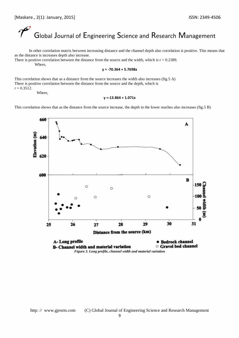
In other correlation matrix between increasing distance and the channel depth also correlation is positive. This means that
as the distance is increases depth also increase.
There is positive correlation between the distance from the source and the width, which is r = 0.2389.
Where,
y = -70.364 + 5.7698x This correlation shows that as a distance from the source increases the width also increases (fig.5 A)
There is positive correlation between the distance from the source and the depth, which is
r = 0.3512.
Where,
y =-13.864 + 1.071x This correlation shows that as the distance from the source increase, the depth in the lower reaches also increases (fig.5 B)
Figure 3. Long profile, channel width and material variation
[Maskare., 2(1): January, 2015] ISSN: 2349-4506
Global Journal of Engineering Science and Research Management
http: // www.gjesrm.com (C) Global Journal of Engineering Science and Research Management
10
Figure 4. Form ratio of the Kas River channel in the study area.
Figure 5. Correlation between the distance from the source and width and depth
Geomorphic mapping “Geomorphic mapping means by which geomorphological characteristics and features of any area are recorded on a map”. For the detail study of bed rock channel it is necessary to study the geomorphic feature present in study area. For the study area of
Kas river gorge and channel in lower reaches by the using standard geomorphic symbol a geomorphic maps were prepared. Number
of cross-sections are taken in the lower reaches these are used to know the shape of the channel and gorge.
From these cross-sections it is clear that the channel in basalt is wider above the knick (fig: 6). beside wider channel,
scabland topography is also observed. The scabland topography shows grooves, potholes, and inner channel. Potholes are merged.
Deep gorge starts after cross section 3 that is cross-section at knick. Gorge walls are vertical and well developed these are carved in
basalt. In the longitudinal profile major break represents the location of water fall (15 m) and below this deep plunge pool occurs.
The shape of the gorge is a box type. In gorge the bed material is of depositional in nature. Fig. 6 shows features like point bar,
bolder berm, pot holes, sand deposit, calcareous rock, pools are present in the gorge bed, and gorge bed is flat and less gradient.
Bedrock is exposed in patches on the channel floor, particularly in the vicinity of large pools, some time deposits of gravel are
observed in the channel (Table: 3).In the study area after the narrow gorge, channel width increases because lithology changes in
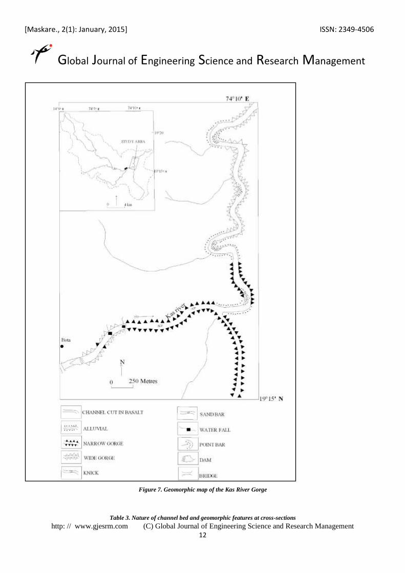
lower reaches. In downward segments on either bank alluvial deposits are observed. Lower reaches channel is meandering (Fig: 7)
and there are two tight meanders before the confluence.
[Maskare., 2(1): January, 2015] ISSN: 2349-4506
Global Journal of Engineering Science and Research Management
http: // www.gjesrm.com (C) Global Journal of Engineering Science and Research Management
11
Figure: 6 geomorphic map of the Kas River channel.
[Maskare., 2(1): January, 2015] ISSN: 2349-4506
Global Journal of Engineering Science and Research Management
http: // www.gjesrm.com (C) Global Journal of Engineering Science and Research Management
12
Figure 7. Geomorphic map of the Kas River Gorge
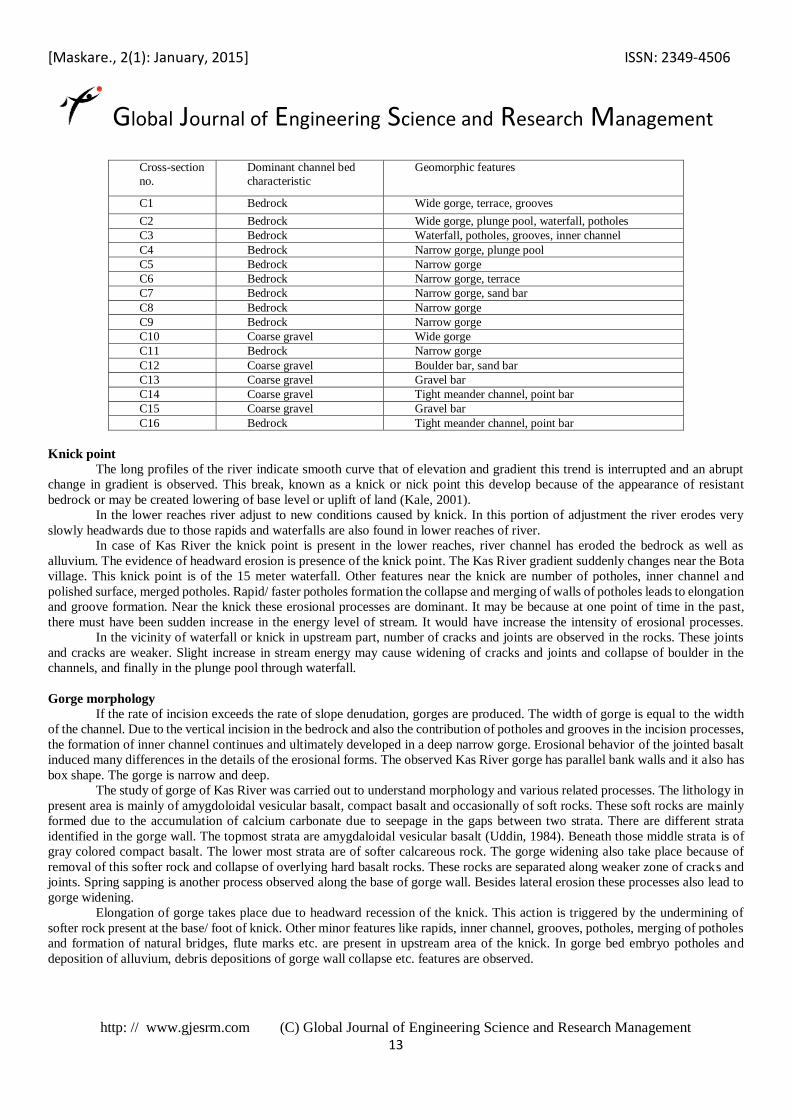
Table 3. Nature of channel bed and geomorphic features at cross-sections
[Maskare., 2(1): January, 2015] ISSN: 2349-4506
Global Journal of Engineering Science and Research Management
http: // www.gjesrm.com (C) Global Journal of Engineering Science and Research Management
13
Cross-section
no.
Dominant channel bed
characteristic
Geomorphic features
C1 Bedrock Wide gorge, terrace, grooves
C2 Bedrock Wide gorge, plunge pool, waterfall, potholes