173
Liverpool Growth Centre Precincts Development Control Plan
Liverpool Growth Centre Precincts Development Control Plan
Liverpool Growth Centre Precincts Development Control Plan
To view an electronic version in PDF format, visit the Planning and Environment website: www.planning.nsw.gov.au
© Crown Copyright 2016
Planning and Environment
17/04/2019
Printed April 2019
Disclaimer
While every reasonable effort has been made to ensure that this document is correct at the time of printing, the State of New South Wales, its agents and employees, disclaim any and all liability to any person in respect of anything or the consequences of anything done or omitted to be done in reliance or upon the whole or any part of this document.
Copyright Notice
In keeping with Planning and Environment’s commitment to encourage the availability of information, you are welcome to reproduce the material that appears in this Development Control Plan for personal, in-house or non-commercial use without formal permission or charge. All other rights are reserved. If you wish to reproduce, alter, store or transmit material appearing in this Development Control Plan for any other purpose, a request for formal permission should be directed to:
Infrastructure, Housing and Employment
Planning and Environment
GPO Box 39
Sydney NSW 2001
You are required to acknowledge that the material is provided by the Agency or the owner of the copyright as indicated in this Development Control Plan and to include this copyright notice and disclaimer in any copy. You are also required to acknowledge the author (the Department of Planning and Environment) of the material as indicated in this Development Control Plan.
Liverpool Growth Centre Precincts Development Control Plan Page i
Contents
1 Introduction 1
1.1 Name and application of this plan 3
1.2 Purpose of this plan 3
1.3 Using this DCP 5
1.3.1 Structure of this DCP 5
1.3.2 How to use this DCP 5
1.4 Relationship to other planning documents 7
1.4.1 The Act and the Growth Centres SEPP 7
1.4.2 Liverpool Council planning documents 7
1.4.3 NSW and Commonwealth Biodiversity Assessments 7
1.4.4 Summary of applicable planning documents 8
1.5 Consent authority 8
1.6 Exempt and Complying Development 9
1.7 Development Application Process 10
1.7.1 Development Application Process 10
1.7.2 Information to be submitted with Development Applications 11
1.7.3 Variations to Development Controls and DCP Amendments 11
1.7.4 Infrastructure 13
2 Precinct Planning Outcomes 15
2.1 Introduction 17
2.2 The Indicative Layout Plan 17
2.3 Site analysis 17
2.3.1 Flooding 17
2.3.2 Water cycle management 19
2.3.3 Salinity and soil management 21
2.3.4 Aboriginal and European heritage 22
2.3.5 Native vegetation and ecology 24
2.3.6 Bushfire hazard management 26
2.3.7 Site contamination 27
2.3.8 Development on and adjacent to electricity and gas easements 28
2.3.9 Noise 28
2.3.10 Odour assessment and control 30
2.3.11 Air quality 30
2.4 Demolition 31
2.5 Crime Prevention through Environmental Design 32
2.6 Earthworks 33
3 Neighbourhood and subdivision design 35
3.1 Residential Density and Subdivision 37
3.1.1 Residential Density 38
3.1.2 Block and Lot Layout 40
3.1.3 Battle-axe Lots 44
3.1.4 Corner Lots 46
3.1.5 Subdivision in the Environmental Living Zone 47
Page ii Liverpool Growth Centre Precincts Development Control Plan
3.2 Subdivision Approval Process 49
3.3 Movement network 52
3.3.1 Street network layout and design 52
3.3.2 Laneways 59
3.3.4 Shared Driveways 63
3.3.5 Pedestrian and Cycle Network 65
3.3.6 Temporary vehicular access 65
3.3.7 Access to arterial roads, sub-arterial roads and transit boulevards 68
3.4 Construction Environmental Management 68
4 Development in the residential zones 70
4.1 Site responsive design 71
4.1.1 Site analysis 71
4.1.2 Cut and fill 71
4.1.3 Sustainable building design 74
4.1.4 Salinity, sodicity and aggressivity 75
4.2 Dwelling design controls 75
4.2.1 Summary of Key Controls 75
4.2.2 Streetscape and architectural design 83
4.2.3 Front setbacks 87
4.2.4 Side and rear setbacks 89
4.2.5 Dwelling Height, Massing and Siting 93
4.2.6 Landscaped Area 94
4.2.7 Private Open Space 95
4.2.8 Garages, Storage, Site Access and Parking 96
4.2.9 Visual and acoustic privacy 98
4.2.10 Fencing 100
4.3 Additional controls for certain dwelling types 102
4.3.1 Residential development adjacent to transmission easements 102
4.3.2 Attached or abutting dwellings 102
4.3.3 Secondary dwellings, studios and dual occupancies 103
4.3.4 Multi dwelling housing 106
4.3.5 Controls for residential flat buildings, manor homes and shop top housing 107
4.4 Other development in residential areas 109
4.4.1 General requirements 110
4.4.2 Exhibition Homes and Exhibition Villages 112
4.4.3 Child Care Centres 114
4.4.4 Educational Establishments and Places of Worship 117
4.4.5 Neighbourhood Shops 119
4.4.6 Seniors Housing 120
5 Centres Development Controls 123
5.1 Introduction 125
5.2 Development principles 125
5.2.1 Function and land use mix 125
5.2.2 Design layout 126
5.2.3 Public domain 126
5.2.4 Built form 126
Liverpool Growth Centre Precincts Development Control Plan Page iii
5.2.5 Transport 127
5.3 Development controls 127
5.3.1 Streetscape and architectural design 127
5.3.2 Solar access, weather protection and energy efficiency 131
5.3.3 Building bulk, scale and design 133
5.3.4 Signs 134
5.3.5 Acoustic and visual privacy 136
5.3.6 Safety, surveillance and maintenance 137
5.3.7 Site servicing 138
5.3.8 Traffic circulation, parking and access 139
5.3.9 Shopping Trolleys 141
6 Employment Lands Subdivision and Development Controls 143
6.1 Land to which this Part applies 143
6.2 Subdivision 143
6.2.1 Lot Subdivision 143
6.2.2 Strata or Community Title Subdivision 144
6.2.3 Battle Axe Lots 144
6.3 Landscape Design 145
6.3.1 Streetscape and Allotment Frontages 145
6.3.2 Allotment Landscape 146
6.3.3 Landscaping of Car Parking Areas 147
6.3.4 Communal Areas 148
6.4 Built Form and Streetscape 148
6.4.1 Setbacks 148
6.4.2 Building Design and Siting 149
6.4.3 External Building Materials and Colours 150
6.4.4 Entrance Treatment 151
6.4.5 Ancillary Buildings, Storage and Service Areas 151
6.4.6 Development adjacent to residential zoned land 152
6.5 Ecologically Sustainable Development 153
6.6 Fencing, Signage and Lighting 156
6.6.1 Fencing 156
6.6.2 Signage and Lighting 157
6.7 Access and Parking 158
6.7.1 Vehicular Access 158
6.7.2 Parking 159
6.8 Waste Management 161
6.9 Safety and Surveillance 162
6.10 Additional Land Use Controls 163
6.10.1 Neighbourhood Shops 163
6.10.2 Industrial Retail Outlets 163
6.10.3 Child Care Centres 165
6.10.4 Sex Services Premises 165

Page iv Liverpool Growth Centre Precincts Development Control Plan
Schedules Schedule One – Austral and Leppington North Precincts Schedule Two – Leppington Major Centre Schedule Three – East Leppington Precinct
Appendices Appendix A – Glossary
Appendix B – Salinity Management Strategy
Appendix C – Prescribed Trees and Preferred Species
Liverpool Growth Centre Precincts Development Control Plan Page v
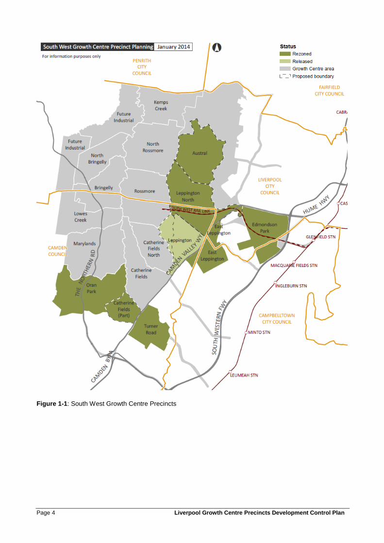
Figures Figure 1-1: South West Growth Centre Precincts ..................................................................................... 4
Figure 1-2: Development Approval process ............................................................................................ 10
Figure 2-1: Measures to attenuate noise ................................................................................................ 29
Figure 3-1: Example for calculating Net Residential Density of a subdivision application ...................... 37
Figure 3-2: Distinct and coherent streetscapes occur in varying proportions in density bands. ............. 39
Figure 3-3: Measurement of minimum lot widths and lot area ................................................................ 42
Figure 3-4: Two examples of lot subdivison for 'sets' of attached or abutting terraces .......................... 44
Figure 3-5: Examples of locations of battle-axe lots ............................................................................... 45
Figure 3-6: Examples of driveways and shared driveways for battle-axe lots ........................................ 46
Figure 3-7: Corner lots ............................................................................................................................ 47
Figure 3-8: Sample of a Building Envelope Plan (BEP) .......................................................................... 51
Figure 3-9: Sample of a Public Domain Plan .......................................................................................... 51
Figure 3-10: Typical Transit Boulevard ................................................................................................... 53
Figure 3-11: Typical sub-arterial road ..................................................................................................... 54
Figure 3-12: Typical collector road .......................................................................................................... 54
Figure 3-13: Typical local street .............................................................................................................. 55
Figure 3-14: Typical access street .......................................................................................................... 58
Figure 3-15: Laneway principles ............................................................................................................. 60
Figure 3-16: Sample lane layouts ........................................................................................................... 61
Figure 3-17: Sample laneways showing maximum number of secondary dwellings or strata studios ... 62
Figure 3-18: Indicative examples of shared driveways ........................................................................... 64
Figure 3-19: Temporary half road width construction ............................................................................. 67
Figure 4-1: Cut and fill requirements ....................................................................................................... 72
Figure 4-2: Maximum cut and fill within residential lots .......................................................................... 73
Figure 4-3: The combination of built form, lot size, garaging and landscaping creates different streetscapes ............................................................................................................................................. 84
Figure 4-4: Streetscape design principles ............................................................................................... 86
Figure 4-5: Minimum front setback distances ......................................................................................... 87
Figure 4-6: Minimum front setbacks for dwellings fronting open space or drainage land....................... 88
Figure 4-7: Minimum setbacks for corner lot dwellings ........................................................................... 88
Figure 4-8: Dwelling and open space siting principles for different lot orientations ................................ 90
Figure 4-9: Battle axe lot (without any street frontage) example of setbacks ......................................... 91
Figure 4-10: Battle axe lot (fronting access denied road) setbacks ........................................................ 92
Figure 4-11: Soft landscaped area and principal private open space..................................................... 94
Figure 4-12: Strategies for minimising noise transmission ..................................................................... 99
Figure 4-13: Fencing design ................................................................................................................. 101
Figure 5-1: Awnings .............................................................................................................................. 130
Figure 5-2: Preferred locations for signs ............................................................................................... 136
Figure 5-3: Design of main streets ............................................................ Error! Bookmark not defined.
Page vi Liverpool Growth Centre Precincts Development Control Plan
Figure 6-1: Battle axe lot dimensions .................................................................................................... 145
Figure 6-2: Typical industrial street ....................................................................................................... 146
Note: Figures referred to in the text of this DCP by name only are located within the relevant Precinct Schedule, if applicable to that Precinct. Not all figures referred to in the controls in this DCP apply to all Precincts.
Tables Table 1-1: Structure of the DCP 5
Table 1-2: Guide to the controls in this DCP 6
Table 2-1: Water quality and environmental flow targets 21
Table 3-1: Typical Characteristics of Residential Net Densities 38
Table 3-2: Minimum lot size by density bands 41
Table 3-3: Minimum lot frontages by density bands 42
Table 3-4: Subdivision Approval Process 49
Table 4-1: Summary of lot and dwelling types 76
Table 4-2: Summary of key controls for lots with frontage width ≥4.5m for rear accessed dwellings 77
Table 4-3: Summary of key controls for lots with frontage width ≥ 7m and < 9m for front accessed dwellings 79
Table 4-4: Summary of key controls for lots with frontage width ≥ 9m and ≤15m for front accessed dwellings 80
Table 4-5: Summary of key controls for lots with frontage width > 15m for front accessed dwellings 81
Table 4-6: Summary of key controls for lots in the Environmental Living Zone 82
Table 4-7: Noise criteria for residential premises impacted by traffic noise 99
Table 4-8: Key controls for secondary dwellings and studio dwellings 104
Table 4-9: Key controls for multi dwelling housing 106
Table 4-10: Key controls for residential flat buildings, manor homes and shop top housing 108
Table 4-11: Car parking requirements for places of public worship and educational establishments 118
Table 5-1: Car parking requirements in centres 139
Table 6-1: Landscape car parking 147
Table 6-2: Specific land use requirements for parking 160

Liverpool Growth Centre Precincts Development Control Plan Page 1
1 Introduction
1.0 Introduction

Liverpool Growth Centre Precincts Development Control Plan Page 3
1.1 Name and application of this plan
This Development Control Plan (DCP) is the Liverpool Growth Centre Precincts Development Control Plan (also referred to as the DCP). It has been prepared pursuant to the provisions of Section 72 of the Environmental Planning and Assessment Act 1979.
This DCP was adopted by the Deputy Director General Planning Strategies, Housing and Infrastructure (under delegation from the Director-General) of Planning & Infrastructure on 21 March 2013 and came into force on 3 April 2013. The South West Growth Centre Precincts are shown in Figure 1-1. This DCP applies to Precincts, or parts of Precincts, within Liverpool Local Government Area where precinct planning has been completed, as shown on Figure 1-1 and listed below:
• The Austral Precinct, as shown in the Land Application Map in Schedule One.
• The Leppington North Precinct, within Liverpool Local Government Area, as shown in the Land Application Map in Schedule One.
• The East Leppington (Liverpool Part) Precinct, as shown in the Land Application Map in Schedule One.
Notes: The Leppington Major Centre is part of the Leppington North Precinct. Specific controls for the Leppington Major Centre are contained in Schedule Two, and should be read in conjunction with Schedule One.
Some Growth Centre Precincts are partly within Liverpool local government area and partly within Camden or Campbelltown local government areas. Applicants should ensure that they refer to the DCP applying to the local government area where their development is situated.
A list of the amendments to the Liverpool Growth Centre DCP is provided below:
Section Date adopted
Housing Diversity Amendment 13/08/2014
Minimum Lot Size Amendment 30/11/2016
Shopping Trolley Controls 17/04/2019
1.2 Purpose of this plan
The purpose of this DCP is to:
1. Communicate the planning, design and environmental objectives and controls against which the
Consent Authority will assess Development Applications (DAs);
2. Consolidate and simplify the planning controls for the Precincts in the South West Growth Centre;
3. Ensure the orderly, efficient and environmentally sensitive development of the Precincts as envisaged
by the South West Growth Centre Structure Plan and State Environmental Planning Policy (Sydney
Region Growth Centres) 2006 (the Growth Centres SEPP);
4. Promote high quality urban design outcomes within the context of environmental, social and economic
sustainability.
Page 4 Liverpool Growth Centre Precincts Development Control Plan
Figure 1-1: South West Growth Centre Precincts
Liverpool Growth Centre Precincts Development Control Plan Page 5
1.3 Using this DCP
1.3.1 Structure of this DCP
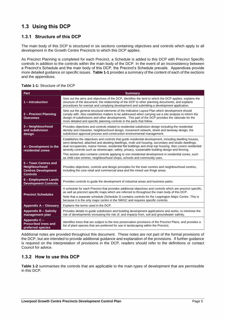
The main body of this DCP is structured in six sections containing objectives and controls which apply to all development in the Growth Centre Precincts to which this DCP applies.
As Precinct Planning is completed for each Precinct, a Schedule is added to this DCP with Precinct Specific controls in addition to the controls within the main body of the DCP. In the event of an inconsistency between a Precinct’s Schedule and the main body of this DCP, the Precinct’s Schedule prevails. Appendices provide more detailed guidance on specific issues. Table 1-1 provides a summary of the content of each of the sections and the appendices.
Table 1-1: Structure of the DCP
Part Summary
1 – Introduction Sets out the aims and objectives of the DCP, identifies the land to which the DCP applies, explains the structure of the document, the relationship of the DCP to other planning documents, and explains procedures for exempt and complying development and submitting a development application.
2 – Precinct Planning Outcomes
Sets out the general structural elements of the Indicative Layout Plan which development should comply with. Also establishes matters to be addressed when carrying out a site analysis to inform the design of subdivisions and other developments. This part of the DCP provides the rationale for the more detailed and specific planning controls in the parts that follow.
3 – Neighbourhood and subdivision design
Provides objectives and controls related to residential subdivision design including the residential density and character, neighbourhood design, movement network, street and laneway design, the subdivision approval process and construction environmental management.
4 – Development in the residential zones
Establishes the objectives and controls that guide residential development, including dwelling houses, semi-detached, attached and abutting dwellings, multi unit housing, secondary and studio dwellings, dual occupancies, manor homes, residential flat buildings and shop top housing. Also covers residential amenity controls such as streetscape, safety, privacy, sustainable building design and fencing.
This section also contains controls applying to non-residential development in residential zones, such as child care centres, neighbourhood shops, schools and community uses.
5 – Town Centres and Neighbourhood Centres Development Controls
Provides objectives, controls and design principles for the town centres and neighbourhood centres, including the core retail and commercial area and the mixed use fringe areas.
6 – Employment Lands Development Controls
Provides controls to guide the development of industrial areas and business parks.
Precinct Schedules
A schedule for each Precinct that provides additional objectives and controls which are precinct specific, as well as precinct specific maps which are referred to throughout the main body of this DCP.
Note that a separate schedule (Schedule 2) contains controls for the Leppington Major Centre. This is because it is the only major centre in the SWGC and requires specific controls.
Appendix A – Glossary Explains the terms used in the DCP.
Appendix B – Salinity management plan
Provides details to guide subdivision and building development applications and works, to minimise the risk of developments increasing the risk of, and impacts from, soil and groundwater salinity.
Appendix C – Prescribed trees and preferred species
Identifies trees that are subject to the tree preservation provisions of the Precinct Plans, and provides a list of plant species that are preferred for use in landscaping within the Precinct.
Additional notes are provided throughout this document. These notes are not part of the formal provisions of the DCP, but are intended to provide additional guidance and explanation of the provisions. If further guidance is required on the interpretation of provisions in the DCP, readers should refer to the definitions or contact Council for advice.
1.3.2 How to use this DCP
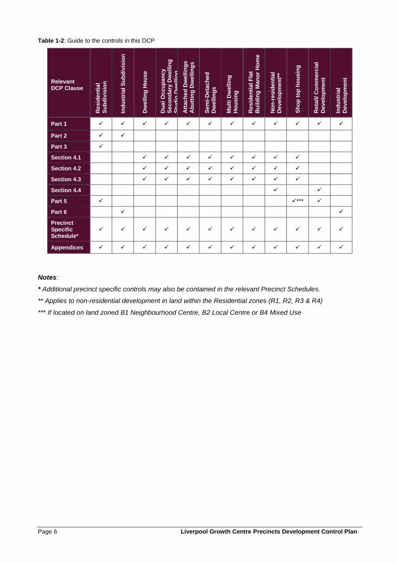
Table 1-2 summarises the controls that are applicable to the main types of development that are permissible in this DCP.
Page 6 Liverpool Growth Centre Precincts Development Control Plan
Table 1-2: Guide to the controls in this DCP
Relevant DCP Clause
Re
sid
en
tia
l
Su
bd
ivis
ion
Ind
us
tria
l S
ub
div
isio
n
Dw
ell
ing
Ho
use
Du
al
Occ
up
an
cy
S
ec
on
da
ry D
well
ing
Stu
dio
Dw
ell
ing
Att
ac
he
d D
we
llin
gs
A
bu
ttin
g D
we
llin
gs
Se
mi-
De
tac
he
d
Dw
ell
ing
s
Mu
lti
Dw
ell
ing
H
ou
sin
g
Re
sid
en
tia
l F
lat
Bu
ild
ing
Ma
no
r H
om
e
No
n-r
esid
en
tia
l D
eve
lop
me
nt*
*
Sh
op
to
p h
ou
sin
g
Re
tail
/ C
om
me
rcia
l
De
ve
lop
me
nt
Ind
us
tria
l
De
ve
lop
me
nt
Part 1 ✓ ✓ ✓ ✓ ✓ ✓ ✓ ✓ ✓ ✓ ✓ ✓
Part 2 ✓ ✓
Part 3 ✓
Section 4.1 ✓ ✓ ✓ ✓ ✓ ✓ ✓ ✓
Section 4.2 ✓ ✓ ✓ ✓ ✓ ✓ ✓ ✓
Section 4.3 ✓ ✓ ✓ ✓ ✓ ✓ ✓ ✓
Section 4.4 ✓ ✓
Part 5 ✓ ✓*** ✓
Part 6 ✓ ✓
Precinct Specific Schedule*
✓ ✓ ✓ ✓ ✓ ✓ ✓ ✓ ✓ ✓ ✓ ✓
Appendices ✓ ✓ ✓ ✓ ✓ ✓ ✓ ✓ ✓ ✓ ✓ ✓
Notes:
* Additional precinct specific controls may also be contained in the relevant Precinct Schedules.
** Applies to non-residential development in land within the Residential zones (R1, R2, R3 & R4)
*** If located on land zoned B1 Neighbourhood Centre, B2 Local Centre or B4 Mixed Use
Liverpool Growth Centre Precincts Development Control Plan Page 7
1.4 Relationship to other planning documents
1.4.1 The Act and the Growth Centres SEPP
This DCP has been prepared under the Environmental Planning and Assessment Act, 1979. It has been prepared to provide additional objectives, controls and guidance to applicants proposing to undertake development in the South West Growth Centre Precincts, and for Council reference in the assessment of development applications. It should be read in conjunction with the Growth Centres SEPP, in particular the specific Precinct Plans which are included as Appendices of the SEPP. The Growth Centres SEPP and the relevant Precinct Plan provide the statutory planning controls for development in the Precinct. This DCP is consistent with and supports those controls by providing more detail in relation to how development is to occur in the Precinct.
1.4.2 Liverpool Council planning documents
Liverpool Local Environmental Plan 2008 and the Liverpool Development Control Plan 2008 do not apply to land that a Precinct Plan applies to, except if specifically referred to in the Growth Centres SEPP or this DCP. Some other design standards and guidelines of Council do continue to apply, such as the Council’s Engineering Specifications. Where other policies, procedures and guidelines apply to the South West Growth Centre Precincts, these are specifically referred to in the relevant clauses of this DCP.
1.4.3 NSW and Commonwealth Biodiversity Assessments
Growth Centres Biodiversity Certification
The Threatened Species Conservation Act 1995 (the TSC Act) provides for the protection of threatened species, populations, endangered ecological communities, and critical habitat in NSW. Typically, threatened species issues are addressed during both the rezoning of land and when development applications are submitted and assessed by Council. However, the TSC Act also provides for planning instruments to be “certified”, meaning that the assessment of threatened species is done at the rezoning stage and does not need to be further considered at the development application stage. This approach provides for more strategic assessment and management of threatened species issues, and streamlines the development application process.
Biodiversity Certification was conferred upon the Growth Centres SEPP on 14 December 2007 via the gazettal of a Biodiversity Certification Order signed by the Minister for Climate Change and the Environment. The Order requires 2,000 ha of “existing native vegetation” (ENV) to be retained across the Growth Centres. Any clearing of ENV within Non-Certified Areas will be required to undertake a TSC assessment and vegetation removal may need to be offset in accordance with the Biodiversity Certification Ministerial Order.
All Indicative Layout Plans, Precinct Plans and this DCP have been prepared in accordance with the Biodiversity Certification Order. The majority of land within the Growth Centre Precincts is certified, meaning that development can occur without the need for further assessment under the TSC Act. The relevant Precinct Plans contain controls to restrict the clearing of “Existing Native Vegetation” and this is the principle mechanism for ensuring consistency with the Biodiversity Certification Order. This DCP contains other objectives and controls in relation to the protection and enhancement of native vegetation, consistent with the Biodiversity Certification Order.
More information on the Growth Centres Biodiversity Certification is available at www.growthcentres.nsw.gov.au.
Growth Centres Strategic Assessment Program
In December 2011 the Federal Government endorsed the Sydney Growth Centres Strategic Assessment Program Report and in February 2012 approved the classes of actions in the Growth Centres that if undertaken in accordance with the approved program do not require separate approval under the Environmental Protection and Biodiversity Conservation Act 1999 (EPBC Act).
The Program includes a range of commitments for matters of national environmental significance protected under the EPBC Act. The commitments are drawn from the analysis in the Supplementary Assessment Report
Page 8 Liverpool Growth Centre Precincts Development Control Plan
and Draft Strategic Assessment Report (Part B), and build upon the Relevant Biodiversity Measures for the Growth Centres Biodiversity Certification.
Generally, if a development proposal complies with the Biodiversity Certification under the TSC Act (refer above), the requirements of the Strategic Assessment Program will have also been met. This means that:
• On land that is certified under the TSC Act, there is no need for further assessment of impacts under the EPBC Act.
• Any proposal to clear vegetation on land that is non-certified must be in accordance with the Relevant Biodiversity Measures (RBMs) of the Growth Centres Biodiversity Certification.
• Any proposed development on non-certified land that is not in accordance with the RBMs would require full assessment and approvals under both the TSC Act and the EPBC Act.
More information on the Growth Centres Strategic Assessment Program is available at www.growthcentres.nsw.gov.au.
1.4.4 Summary of applicable planning documents
Applicants proposing to undertake development in the Precinct, and Council when assessing development applications, should refer to:
• the Growth Centres SEPP, as amended, including the relevant Precinct Plan;
• this DCP;
• the relevant Section 94 Contributions Plan;
• Technical Studies completed as part of the Precinct Planning work (available from Council);
• the Growth Centres Biodiversity Certification Order, December 2007 and related amendments to the Threatened Species Conservation Act 1995; and
• The Sydney Growth Centres Strategic Assessment Program, under the EPBC Act.
1.5 Consent authority
Unless otherwise authorised by the Environmental Planning and Assessment Act 1979 Liverpool Council is the consent authority for all development in the Precincts to which this DCP applies on land that is within Liverpool Local Government Area.
Council will use this DCP when assessing development applications.
Liverpool Growth Centre Precincts Development Control Plan Page 9
1.6 Exempt and Complying Development
The Environmental Planning and Assessment Act 1979 enables certain forms of development to be classified as either exempt development or complying development through Environmental Planning Instruments.
Exempt development is development of a minor nature that can be undertaken without the need for development consent.
Complying development is development that, providing it meets pre-determined development standards, can be assessed through the issuance of a complying development certificate.
The State Environmental Planning Policy (Exempt and Complying Development Codes) 2008, and the associated Housing Code provides controls for the siting and design of detached housing on lots 200m² and larger as well as alterations and additions to existing residential dwellings up to two storeys. Development that meets the criteria in the Housing Code is complying development and this DCP does not apply. Where a development does not meet the requirements of the Housing Code, consent is required and this DCP applies.
The NSW Commercial and Industrial Code outlines how some types of commercial and industrial development in certain zones can meet the complying development criteria. Where a development does not meet the requirements of these Codes, consent is required and this DCP applies.
Other Environmental Planning Instruments that apply to the land that this plan applies to may also specify that certain development is exempt or complying development. Applicants should review relevant instruments to determine the applicable approval process for their development.
Page 10 Liverpool Growth Centre Precincts Development Control Plan
1.7 Development Application Process
1.7.1 Development Application Process
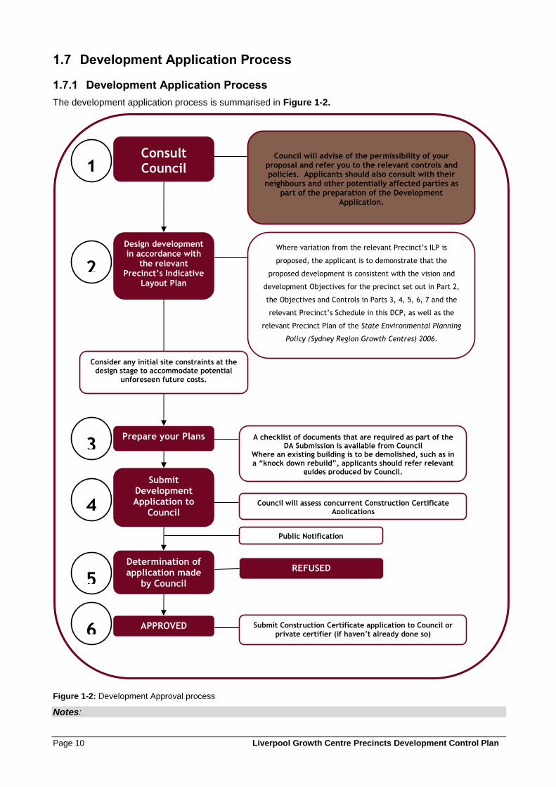
The development application process is summarised in Figure 1-2.
Figure 1-2: Development Approval process
Notes:
Consult Council
Design development in accordance with
the relevant Precinct’s Indicative
Layout Plan
Council will advise of the permissibility of your proposal and refer you to the relevant controls and policies. Applicants should also consult with their
neighbours and other potentially affected parties as part of the preparation of the Development
Application.
Public Notification
Council will assess concurrent Construction Certificate Applications
Determination of application made
by Council
APPROVED
Submit Development Application to
Council
Submit Construction Certificate application to Council or
private certifier (if haven’t already done so)
A checklist of documents that are required as part of the DA Submission is available from Council
Where an existing building is to be demolished, such as in a “knock down rebuild”, applicants should refer relevant
guides produced by Council.
Where variation from the relevant Precinct’s ILP is
proposed, the applicant is to demonstrate that the
proposed development is consistent with the vision and
development Objectives for the precinct set out in Part 2,
the Objectives and Controls in Parts 3, 4, 5, 6, 7 and the
relevant Precinct’s Schedule in this DCP, as well as the
relevant Precinct Plan of the State Environmental Planning
Policy (Sydney Region Growth Centres) 2006.
Prepare your Plans
1
2
3
5
4
6
Consider any initial site constraints at the design stage to accommodate potential
unforeseen future costs.
REFUSED

Liverpool Growth Centre Precincts Development Control Plan Page 11
Notification is where Council writes to those people identified as requiring notification, advising of the submission of a development application. Notification is for a minimum period of 14 days.
Advertising is where Council, in addition to writing to those people required to be notified, places an advertisement in a local newspaper advising of the submission of a development application. Advertising is for a minimum period of 14 days unless otherwise specified by legislation or Environmental Planning Instruments in the case of Integrated, Designated and Advertised Development.
Council has a Policy which establishes the types of Development Applications that will be notified or advertised. Reference should be made to Liverpool DCP 2008 for notification requirements.
1.7.2 Information to be submitted with Development Applications
Applicants are required to submit information with all Development Applications that clearly illustrates and describes the development proposal, and demonstrates consistency with the relevant planning controls (particularly the Precinct Plan and this DCP). The level of detail and the range of issues to be addressed by applicants varies depending on the type and scale of development that is proposed: Some information is required for all Development Applications, while more detailed or specific information is required only for some types of development.
Council can advise applicants on the information required to be submitted with Development Applications.
Considerable background work has been undertaken to inform the preparation of the ILP and planning controls for each Precinct. This information is available either by contacting Council or Planning and Infrastructure.
In some cases, Precinct Planning studies and reports may be sufficient for the purposes of lodging a Development Application, while for some properties or some development types, more detailed information may need to be prepared. Applicants should discuss the suitability of studies prepared as part of Precinct Planning with Council prior to preparing Development Application documentation, to determine if additional studies or documentation will be required.
The ILP and Planning Controls have been prepared based on the Precinct Planning studies. Where applications propose a development type or design that differs from the ILP or doesn’t comply with the planning controls (refer to Part 1.7.3), additional technical studies are likely to be required to justify the non-compliance.
1.7.3 Variations to Development Controls and DCP Amendments
Compliance with the Indicative Layout Plan
The Precinct Indicative Layout Plan (in the relevant Precinct Schedule) is intended to show how the overall Precinct will develop over time. It shows how the numerous developments, undertaken over numerous years, will come together to ensure the overall development of the Precinct is integrated, sustainable and attractive. However, it is recognised that some variation to the layout shown on the ILP may be reasonable to address new or more detailed information about the site, or other factors that might influence individual developments.
Council may grant consent to a proposal that differs from the Indicative Layout Plan (ILP), where the variation is considered to be minor and the proposal is demonstrated to be generally consistent with the ILP. Development Applications will be considered on their merits, and applicants are required to demonstrate that the proposed variation is:
• Consistent with the relevant Precinct Plan under the Growth Centres SEPP;
• Consistent with the Precinct Planning Outcomes in Part 2 of this DCP;
• Consistent with the Precinct Planning Vision in the relevant Precinct Schedule;
• Not likely to significantly impact on the amenity, safety or environmental quality of adjoining lands, or the ability of adjoining development to occur generally in accordance with this DCP.
Where a proposed variation to the DCP does not meet the above requirements, Council may either:
• refuse consent for the application;
Page 12 Liverpool Growth Centre Precincts Development Control Plan
• condition the development consent to ensure the above requirements are achieved subject to compliance with any condition Council imposes; or
• request the applicant to demonstrate that amendment of the DCP is warranted to enable the development to be approved.
Amendment of the DCP will only be considered where the amendment would not significantly alter the planning outcomes for the Precinct. Typically, DCP amendments will not be undertaken to address issues that relate only to a single development: these issues should be dealt with by addressing the criteria for ILP variations above. Amendments will usually only be considered where the change relates to an aspect of the ILP that is demonstrably unreasonable or unnecessary, or where amendments are appropriate to address issues that will affect development generally in the Precinct.
Liverpool Growth Centre Precincts Development Control Plan Page 13
Compliance with Objectives and Controls in this DCP
Each clause in this DCP contains Objectives and Controls relating to various aspects of development (for example, building setbacks, requirements for car parking, or minimum requirements for landscaping).
The Objectives enable Council and Applicants to consider whether a particular proposal will achieve the development outcomes established for the Precinct in the ILP.
The Controls establish standards, which if met, mean that development should be consistent with the Objectives. However, in some circumstances, strict compliance with the controls may not be necessary, or may be difficult to achieve because of the particular characteristics of a development site. In these situations, Council may grant consent to a proposal that does not comply with the Controls in this DCP, providing the intent (i.e. the Objective/s) of the Controls is achieved. Where a variation is sought it must be justified in writing by indicating how the development will meet the Objectives of the relevant Control and/or is generally consistent with the ILP.
1.7.4 Infrastructure
The Growth Centres SEPP requires that, before granting consent to development applications, Council is satisfied that essential infrastructure (water, sewer and electricity) are available or that satisfactory arrangements are in place for the infrastructure to be available, to service the development. As part of Precinct Planning, and Infrastructure Delivery Plan is prepared that documents the planned provision of essential infrastructure for each Precinct. The Infrastructure Delivery Plan identifies where trunk level services will be provided, and gives an indication of likely timing. In most cases, the timing and location of the first stages of infrastructure delivery will be subject to demonstrated demand for development, so while the Infrastructure Delivery Plan may indicate that some parts of the Precinct will be serviced before others, this may change if development demand in another part of the Precinct is sufficient to justify an alternative delivery strategy.
Applicants and land owners should refer to the Infrastructure Delivery Plan (available from Council or Planning and Infrastructure) to understand the current arrangements for infrastructure delivery in the Precinct. Applicants should also discuss their development plans with Council and infrastructure providers (e.g. Sydney Water and Endeavour Energy), in the early stages of preparing a development proposal, to determine the availability of infrastructure. Alternative approaches to infrastructure delivery may be possible particularly in the early phases of development in the Precincts when demand may not be sufficient to justify investment in major trunk infrastructure works. Infrastructure delivery agencies may be able to suggest alternative measures that can satisfy the requirements of the Growth Centres SEPP and enable development consent to be granted.
The Infrastructure Delivery Plan may be updated from time to time as arrangements for infrastructure delivery change or as more detailed information becomes available.

Liverpool Growth Centre Precincts Development Control Plan Page 15
2 Precinct Planning Outcomes
2.0 Precinct Planning Outcomes

Liverpool Growth Centre Precincts Development Control Plan Page 17
2.1 Introduction
This Part of the DCP defines Precinct wide planning outcomes. These outcomes apply broadly to all Precincts that this DCP applies to. The specific way the outcomes are to be achieved for each Precinct is established by the Indicative Layout Plan. This part also outlines the matters to be considered when undertaking site analysis for all development. These controls should be considered to determine the suitability and the development potential, and during the initial stages of planning for the development. Typically, the planning outcomes will be addressed for new development at the subdivision stage. However, some development may occur without prior subdivision, and in these cases the requirements of this Part of the DCP should be addressed in the Development Application. Some controls in this Part apply regardless of whether the proposal is for subdivision or other forms of development. Applicants should review this Part to identify relevant provisions.
2.2 The Indicative Layout Plan
An Indicative Layout Plan, specific to each Precinct, is in the relevant Precinct Schedule. The Indicative Layout Plan forms the basis for urban development in the Precinct by setting out:
• the transport network;
• the open space and drainage networks;
• the locations of land uses including residential development, schools, community facilities, utilities, centres and employment lands;
• areas requiring protection because of environmental or heritage values;
• the density and types of housing that are preferred in various parts of the Precinct.
Objectives
a. To ensure that development in the Precinct occurs in a coordinated manner consistent with the
Precinct’s Indicative Layout Plan.
Controls
1. All development applications are to be generally in accordance with the Indicative Layout Plan.
2. When assessing development applications, Council will consider the extent to which the proposed development is consistent with the Indicative Layout Plan.
3. Any proposed variations to the general arrangement of the Indicative Layout Plan must be demonstrated by the applicant, to Council’s satisfaction, to be consistent with the Precinct Planning vision in the relevant Precinct Schedule.
2.3 Site analysis
The following clauses contain matters to be addressed in relation to existing site characteristics, when planning new developments.
2.3.1 Flooding
Objectives
a. to limit the flow of stormwater from development to replicate pre-development flows;
Page 18 Liverpool Growth Centre Precincts Development Control Plan
b. to define the flood constraints and standards applicable to development in the Precincts;
c. to minimise the potential of flooding impacts on development, essential services, other land uses and
risk to human life.
Controls
1. The pattern of subdivision is to ensure that no new dwelling will be located within the 1% Annual Exceedance Probability (AEP) flood extent shown on the Flood Prone Land figure in the relevant Precinct’s Schedule.
2. Filling and development within the 1% AEP flood extent may be permitted where site specific flood investigations justify the development in conjunction with the considerations in control 11 below.
3. Floor levels must be above the 1% Annual Exceedance Probability (AEP) flood level plus a freeboard of 500mm (the ‘flood planning level). The 1% AEP flood extent may be varied based on more detailed site specific flood studies that are prepared to the satisfaction of Council. Note Council may request such a study be undertaken by the applicant.
4. Where an existing building (including dwellings) is within the 1% AEP flood extent, and is proposed to be replaced by a new dwelling, the floor level of the new structure must satisfy the flood planning level (1% AEP plus 500mm freeboard).
5. For existing buildings (including dwellings) where floor levels are within the 1% AEP flood extent, a proposed addition (including new outbuilding) or alteration to that existing building should not exceed 30sqm or 10% of the existing floor area (whichever is the lesser). This may be varied based on more detailed site specific flood investigations that are prepared to the satisfaction of Council
6. Any change of use of an existing building, (including a dwelling) within the 1% AEP flood must not increase flood risk.
7. Pedestrian and cycle pathways and open space may extend within the 1% AEP flood level, provided the safe access criteria contained in the NSW Floodplain Manual are met. The Flood Prone Land figure in the relevant Precinct’s Schedule shows the approximate extent of the 1% AEP flood level.
8. Roads and basement car parking are to be located above the 1% AEP level. The design of the road network is to ensure that evacuation routes from existing development and adjoining properties are maintained, or suitable alternative evacuation routes are provided for flood events up to and including the 500 year ARI (0.2%AEP) flood event.
9. Existing roads that are below the 1% AEP level may be retained or upgraded on the current vertical alignment, providing safe evacuation routes can be provided, where they provide access to existing development and where elevation of the road to achieve a higher level of flood immunity would:
• Unreasonably restrict, or require significant modifications to access to properties; or
• Restrict overland flow paths or the installation of stormwater pipes; or
• Result in unacceptable flooding impacts on other properties; or
• Upgrading of the road would require removal of Existing Native Vegetation mapped under the Growth Centres SEPP.
10. In general, Council will not support development, including the filling of land, within the floodway (as defined in the Precinct Water Cycle Management Strategy, available from Council) due to its function as the main flow path for flood waters once the main channel has overflowed and the possibility of a significant threat to life and property in a major flood.
11. In determining any application for development on land designated as being within the floodway or flood fringe Council will consider the following:
• Consistency with the NSW Floodplain Manual;
Liverpool Growth Centre Precincts Development Control Plan Page 19
• Whether the proposed building materials are suitable (refer control 14 below);
• Whether the buildings are to be sited in the optimum position to avoid flood waters and allow evacuation;
• Whether the flood impact of proposed structures, including fencing, or the filling of land are likely to affect flood flows, or increase flood affectation elsewhere;
• Whether earthworks required to maintain the capacity of the floodplain and flood flow velocities will impact on soil salinity and soil stability;
• The potential impact of the development, including earthworks, on native vegetation; and
• The views of other relevant authorities, as considered necessary and whether the applicant has consulted with those authorities and the outcomes of that consultation.
12. An application (other than agriculture, cultivation and minor alterations to existing buildings) lodged for development in a floodway (as defined in the Precinct Water Cycle Management Strategy, available from Council) shall be accompanied by a survey plan to satisfactorily demonstrate that:
• The development will not increase flood hazard or damage to other properties or adversely affect them in any way, by the provision of a report from a professional civil engineer experienced in hydraulics.
• The building can withstand the force of flooding, by the provision of a detailed report from a professional structural engineer.
13. Applications may be required to indicate that permanent fail-safe measures are incorporated in the development to ensure the timely, orderly and safe evacuation of people from the area should a flood occur. In addition, it may also be necessary to demonstrate that the displacement of these people during times of flood will not significantly add to the overall community cost and community disruption caused by the flood.
14. Applications may be required to indicate proposed flood compatible building components and flood proofing of the structure to the satisfaction of Council. This may include evidence that the structure can withstand the forces of floodwater, debris and buoyancy up to and including a 1% AEP flood plus 500m freeboard.
2.3.2 Water cycle management
Objectives
a. To ensure that the quality of stormwater discharged from urban areas into the environment complies
with appropriate standards.
b. To minimise potable water consumption and maximise re-use of stormwater within urban areas.
c. To ensure that the water cycle management infrastructure is cost effective and maintainable.
d. To maintain and enhance the quality of natural water bodies.
Controls
1. Management of ‘minor’ flows and ‘major’ flows within subdivisions and development sites is to be in accordance with Council’s Engineering Specification.
2. Stormwater within new subdivisions is to be managed primarily through a gravity network of pipes and overland flows generally following streets where flow volumes exceed the capacity of pipes in accordance with Council’s Engineering Specification.

Page 20 Liverpool Growth Centre Precincts Development Control Plan
3. All new development is to be connected, via the network described in control 1 above, to the Council’s trunk drainage system shown on the Key elements of the water cycle management and ecology strategy figure, in the relevant Precinct Schedule.
4. The acquisition of drainage easements over downstream properties, or inclusion of drainage easements on subdivision plans, will be required where direct access to Council’s drainage system or discharge of stormwater to a creek via the street network is not possible (i.e. street kerb and gutter, piped system or open channels and watercourses). However, the design of subdivisions is to generally comply with controls 1 and 2 above and management of stormwater through easements will only be permitted by Council in exceptional circumstances where no other practical solution is available.
5. Roads on primary drainage lines shown on the Key elements of the water cycle management and ecology strategy figure, in the relevant Precinct Schedule, are to be constructed in the locations shown (subject to detailed survey and subdivision design), and are to be designed in accordance with specifications of Council in relation to management of stormwater flows and quality.
6. The developed 1%, 20% and 50% AEP peak flows are to be maintained at pre-development flows through the incorporation of stormwater detention and management devices. Where subdivision works occur prior to the completion of required trunk drainage works, temporary on site facilities need to be provided in order to limit drainage volume and velocity to that experienced prior to development.
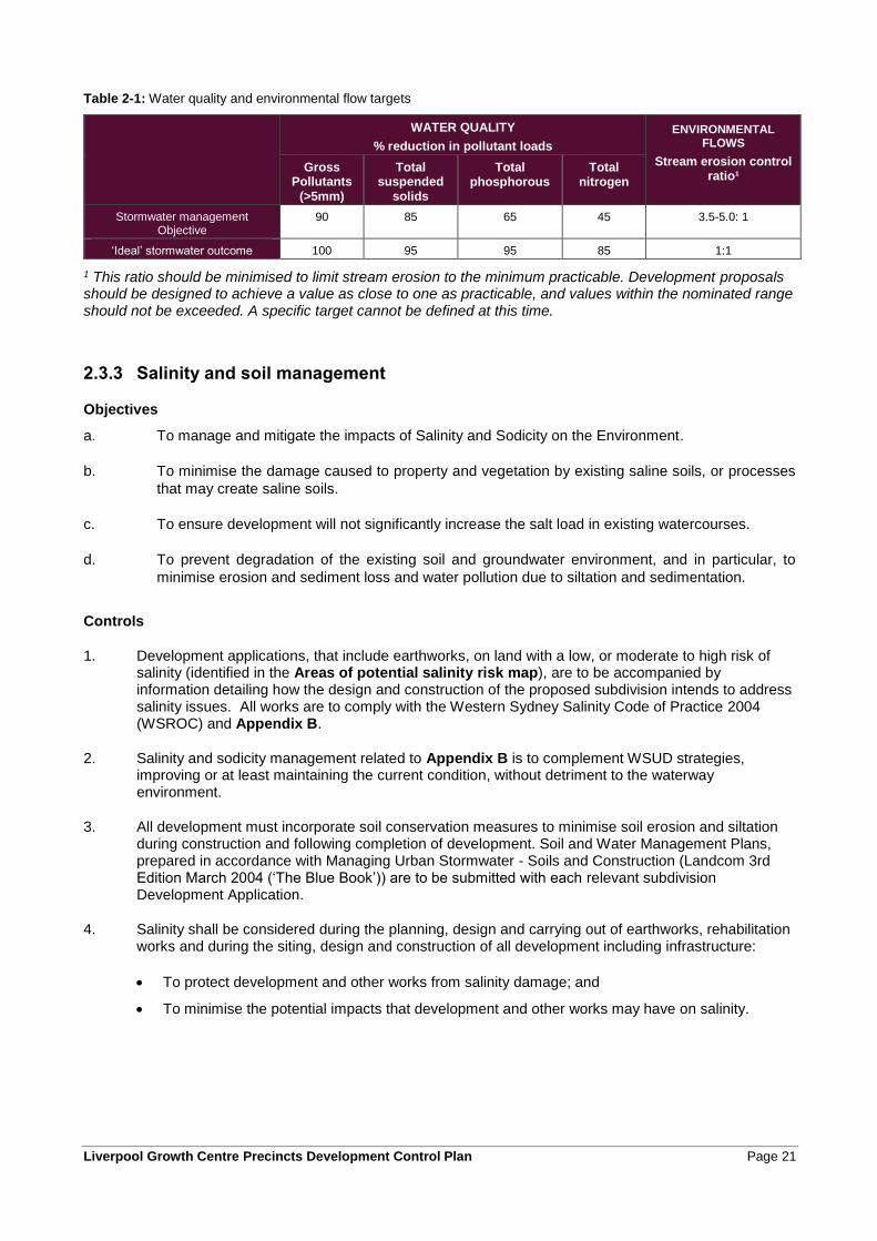
7. Where development includes the construction of water quality treatment infrastructure, the infrastructure is to be constructed in accordance with the Precinct Water Cycle Management Strategy (available from Council) and Council’s Engineering Specification. The applicant must demonstrate that the proposed infrastructure will achieve the water quality targets in Table 2-1.
8. Trunk drainage channels are to be designed and constructed as naturalised channels.
9. Council may consider amendments to the Precinct water cycle management strategy if a revised strategy is submitted that can demonstrate to Council’s satisfaction:
• compliance with the targets in Table 2-1;
• any costs associated with construction (including the cost of land) will be met by the applicant; and
• A maintenance framework addressing maintenance strategies and life-cycle maintenance costs
10. Where development is located on land that drains towards the Sydney Catchment Authority Upper Canal, specific water quality measures may be required to ensure that development does not adversely impact on the quality of water in the Upper Canal. Specific controls are contained in relevant Precinct Schedules.
11. Where development includes land within a Riparian Protection Area (refer to the Riparian Protection Areas Map that is part of the Growth Centres SEPP) applicants are to refer to the Guidelines for riparian corridors on waterfront land prepared by the NSW Office of Water. The guidelines contain the outcomes and requirements for development on land containing a riparian protection area within the Growth Centres. The guidelines are available at www.water.nsw.gov.au.
Liverpool Growth Centre Precincts Development Control Plan Page 21
Table 2-1: Water quality and environmental flow targets
WATER QUALITY
% reduction in pollutant loads
ENVIRONMENTAL FLOWS
Stream erosion control ratio¹
Gross Pollutants
(>5mm)
Total suspended
solids
Total phosphorous
Total nitrogen
Stormwater management Objective
90 85 65 45 3.5-5.0: 1
‘Ideal’ stormwater outcome 100 95 95 85 1:1
1 This ratio should be minimised to limit stream erosion to the minimum practicable. Development proposals should be designed to achieve a value as close to one as practicable, and values within the nominated range should not be exceeded. A specific target cannot be defined at this time.
2.3.3 Salinity and soil management
Objectives
a. To manage and mitigate the impacts of Salinity and Sodicity on the Environment.
b. To minimise the damage caused to property and vegetation by existing saline soils, or processes
that may create saline soils.
c. To ensure development will not significantly increase the salt load in existing watercourses.
d. To prevent degradation of the existing soil and groundwater environment, and in particular, to
minimise erosion and sediment loss and water pollution due to siltation and sedimentation.
Controls
1. Development applications, that include earthworks, on land with a low, or moderate to high risk of salinity (identified in the Areas of potential salinity risk map), are to be accompanied by information detailing how the design and construction of the proposed subdivision intends to address salinity issues. All works are to comply with the Western Sydney Salinity Code of Practice 2004 (WSROC) and Appendix B.
2. Salinity and sodicity management related to Appendix B is to complement WSUD strategies, improving or at least maintaining the current condition, without detriment to the waterway environment.
3. All development must incorporate soil conservation measures to minimise soil erosion and siltation during construction and following completion of development. Soil and Water Management Plans, prepared in accordance with Managing Urban Stormwater - Soils and Construction (Landcom 3rd Edition March 2004 (‘The Blue Book’)) are to be submitted with each relevant subdivision Development Application.
4. Salinity shall be considered during the planning, design and carrying out of earthworks, rehabilitation works and during the siting, design and construction of all development including infrastructure:
• To protect development and other works from salinity damage; and
• To minimise the potential impacts that development and other works may have on salinity.

Page 22 Liverpool Growth Centre Precincts Development Control Plan
2.3.4 Aboriginal and European heritage
Objectives
a. To manage Aboriginal heritage values to ensure enduring conservation outcomes.
b. To ensure areas identified as European cultural heritage sites or archaeological sites are managed
appropriately.
Controls
1. Development applications must identify any areas of Aboriginal heritage value that are within or adjoining the area of the proposed development, including any areas within the development site that are to be retained and protected (and identify the management protocols for these).
2. Developments or other activities that will impact on Aboriginal heritage may require consent from the Office of Environment and Heritage (OEH) under the National Parks and Wildlife Act 1974 and consultation with the relevant Aboriginal communities.
3. Any development application that is within or adjacent to land that contains a known Aboriginal cultural heritage site, as indicated on the Aboriginal cultural heritage sites figure, in the relevant Precinct Schedule, must consider and comply with the requirements of the National Parks and Wildlife Act, 1974.
4. Where the necessary consents under the National Parks and Wildlife Act, 1974 have been obtained, the development application must demonstrate that the development will be undertaken in accordance with any requirements of that consent.
5. Applications for subdivision and building on the properties identified on the European cultural heritage sites figure, in the relevant Precinct’s Schedule, are to be accompanied by:
• A Heritage Management Document that details the heritage significance of the heritage item, the impacts of the proposed development on the heritage item and any management or mitigation measures that are proposed.
• A report from a suitably qualified heritage consultant detailing the results of archaeological investigations undertaken to confirm the presence of archaeological material relating to the heritage site (where heritage studies completed to date indicate the potential presence of as yet unidentified archaeological material). Where archaeological material is identified, the proposal is to address the requirements of the Heritage Act 1977.
6. Features which contribute to the heritage significance of the item or conservation area are to be conserved.
7. Features which contribute to an understanding of the history of the item, or key periods of its development, are to be conserved.
8. Significant landscape elements and/or views associated with the item are to be conserved.
9. Significant historical property boundaries, if identified as part of the significance of the item, are to be conserved.
10. Significant uses, if identified as part of the significance of the item, are to be conserved or a similar/compatible use identified for the heritage item where possible.
11. Unsympathetic elements are to be removed from the item or conservation area, where this will contribute to the heritage significance of the item or conservation area.
12. New work in the vicinity of built heritage items should be readily identifiable as such, and be sympathetic to the form, scale, massing, setback and overall character of the item, and should not detract from its appreciation.
Liverpool Growth Centre Precincts Development Control Plan Page 23
13. Alterations and additions are to be located away from significant and/or primary elevations, and behind and below the main ridge line of built heritage items.
14. Existing fabric, use, associations and meanings are to be adequately recorded before any changes are made.
Notes: Any works, development or other activity that will impact on a known site of Aboriginal cultural heritage significance may require approval under the National Parks and Wildlife Act, 1974, in addition to any approval requirements of Council under the relevant Precinct Plan. Applicants should consult with the Office of Environment and Heritage (OEH) to determine requirements for assessment and approval where developments or other works are to be carried out on or near Aboriginal heritage sites identified on the Aboriginal cultural heritage sites figure, in the relevant Precinct Schedule.
Council or the OEH may require additional investigations to be undertaken as part of a development application to confirm the presence of Aboriginal cultural heritage on the land.
Where works uncover items that may be Aboriginal cultural heritage, the applicant is to consult with the OEH to determine an appropriate course of action.

Page 24 Liverpool Growth Centre Precincts Development Control Plan
2.3.5 Native vegetation and ecology
Objectives
a. To conserve and rehabilitate the remaining native vegetation and trees within the relevant Precinct;
b. To ensure that native vegetation contributes to the character and amenity of the relevant Precinct;
c. To conserve the ecological values of the Precinct, and ecological links to surrounding areas.
Controls
1. Native trees and other vegetation are to be retained where possible by careful planning of development (particularly at the subdivision stage) to incorporate trees into areas such as road reserves and private or communal open space.
2. When assessing an application that proposes removal of a tree or trees, Council will consider whether the tree or trees:
• Form(s) a prominent part of the streetscape or the landscape character of the locality.
• Is of historic or cultural significance or is/are registered on any Council register of significant trees.
• Is prominent due to its height, size, position or age.
• Is a locally indigenous.
• Provides visual screening.
• Is part of an important habitat for wildlife.
• Is part of a larger vegetation remnant or is in a Riparian Protection Area.
• Can be effectively treated by applying appropriate remedial treatment such as pruning of branches, pruning of roots and removal of deadwood or by other appropriate action as recommended by an arborist.
• Is (when located on non-certified land) listed under the provisions of the Threatened Species Conservation Act 1995 (Listed as a threatened species, is habitat of a threatened species or is part of a threatened ecological community).
• Is unsafe.
3. All existing indigenous trees shall be retained or replaced where removal is unavoidable. Where approval is given to remove trees, appropriate replacement planting using similar species will be required.
4. The design of a development should demonstrate that existing street trees will be retained to the greatest practical extent.
5. Buildings are to be set back a minimum of 3 metres from existing trees that are to be retained.
6. The design and location of access driveways should wherever possible be located to avoid or minimise removal of existing street trees.
7. Council may consider alternative street cross section designs where the typical cross section would result in removal of existing street trees that could otherwise be retained.
8. Where practical, prior to development commencing, applicants are to:
• provide for the appropriate re-use of native plants and topsoil that contains known or potential native seed bank; and
• relocate native animals from development sites. Applicants must refer to OEH’s Policy on the Translocation of Threatened Fauna in NSW.
Liverpool Growth Centre Precincts Development Control Plan Page 25
9. Within land that is in the Environmental Protection Overlay, as shown on the Indicative Layout Plan in the relevant Precinct Schedule, all native vegetation is to be retained and rehabilitated, except where clearing is required for essential infrastructure such as roads and drainage and where that clearing is consistent with the Growth Centres Biodiversity Certification and the Growth Centres Strategic Assessment Program1; and
10. Within land that is in a Riparian Protection Area (refer to the Riparian Protection Areas Figure in the relevant Precinct Schedule) native vegetation is to be conserved and managed in accordance with the Guidelines for riparian corridors on waterfront land prepared by the NSW Office of Water (available at www.water.nsw.gov.au).
11. Development on land that adjoins land zoned E2 Environmental Conservation is to ensure that there are no significant detrimental impacts to the native vegetation and ecological values of the E2 zone.
12. All subdivision design and bulk earthworks are to consider the need to minimise weed dispersion and to eradicate weeds on site. If Council believes that a significant weed risk exists, a Weed Eradication and Management Plan outlining weed control measures during and after construction is to be submitted with the subdivision DA.
13. A landscape plan is to be submitted with all subdivision development applications, identifying:
• all existing trees on the development site and those that are proposed to be removed or retained;
• the proposed means of protecting trees to be retained during both construction of subdivision works and construction of buildings;
• proposed landscaping including the locations and species of trees, shrubs and ground cover to be planted as part of subdivision works;
• the relationship of the proposed landscaping to native vegetation that is to be retained within public land, including factors such as the potential for weed or exotic species invasion and the contribution of the proposed landscaping to the creation of habitat values and ecological linkages throughout the Precinct; and
• How bushfire risk has been managed, including requirements for Asset Protection Zones and how these relate to the proposed landscaping.
14. The selection of trees and other landscaping plants is to consider:
• The prescribed trees in Appendix C;
• The use of locally indigenous species where available;
• Bushfire risk;
• Contribution to the management of soil salinity, groundwater levels and soil erosion;
• Items of environmental heritage, heritage conservation areas, historic road alignments and significant view lines.
15. For the purposes of clause 5.9 of the relevant Precinct Plan, prescribed trees include:
• Trees taller than the minimum height and greater than the minimum trunk diameter specified in Appendix C, and
• Tree species listed in Appendix C.
Note: Where applicable, clause 5.9 of the Precinct Plan requires development consent or a permit to ringbark, cut down, top, lop, remove, injure or wilfully destroy any tree or other vegetation that is prescribed by this DCP, except where other requirements of clause 5.9 are met.
1 The relevant Precinct Plan under the Growth Centres SEPP contains provisions that prohibit the clearing of Existing Native Vegetation and limit clearing of vegetation in Native Vegetation Protection Areas.
Page 26 Liverpool Growth Centre Precincts Development Control Plan
2.3.6 Bushfire hazard management
Objectives
a. To prevent loss of life and property due to bushfires by providing for development compatible with
bushfire hazard.
b. To encourage sound management of bushfire-prone areas.
Controls
1. Reference is to be made to Planning for Bushfire Protection 2006 in subdivision planning and design and development is to be consistent with Planning for Bushfire Protection 2006.
2. Subject to detailed design at development application stage, the indicative location and widths of Asset Protection Zones (APZs) are to be provided generally in accordance with the Bushfire risk and Asset Protection Zone Requirements figure in the relevant Precinct Schedule. APZs and construction standards are to be accurately mapped and detailed for each affected lot on plans submitted with the development application.
3. APZs:
• are to be located wholly within the Precinct;
• may incorporate roads and flood prone land,
• are preferred to be located wholly outside of a riparian zone. APZs may only be permitted within a riparian zone where compliant with the NSW Office of Water requirements,
• may be used for open space and recreation subject to appropriate fuel management,
• are to be maintained in accordance with the guidelines in Planning for Bushfire Protection 2006,
• may incorporate private residential land, but only within the building setback (no dwellings are to be located within the APZ),
• are not to increase the maintenance burden on public lands, and
• are to be generally bounded by or incorporate a public road or perimeter fire trail that is linked to the public road system at regular intervals in accordance with Planning for Bushfire Protection 2006.
4. Establishment and maintenance of the APZ must not require clearing of native vegetation within any Native Vegetation Protection Areas or Existing Native Vegetation Areas shown on the Native Vegetation Protection Map.
5. Vegetation outside Riparian Protection Areas, Native Vegetation Protection Areas and Existing Native Vegetation Areas is to be designed and managed as a ‘fuel reduced area’ where it forms part of an APZ.
6. Where an allotment fronts and partially incorporates an APZ it shall have an appropriate depth to accommodate a dwelling with private open space and the minimum required APZ. The APZ will be identified through a Section 88B instrument.
7. Temporary APZs, identified through a Section 88B instrument, will be required where development is proposed on allotments next to undeveloped land that presents a bushfire hazard. Once the adjacent stage of development is undertaken, the temporary APZ will no longer be required and shall cease.
8. Reticulated water is to meet the standards contained within Planning for Bushfire Protection 2006. Water supply is to be via a ring main system, engineered to the requirements of Australian Standard 2419.1-1994 Fire Hydrant Installations.
Liverpool Growth Centre Precincts Development Control Plan Page 27
9. Buildings adjacent to APZs are to be constructed in accordance with the requirements of Appendix 3 of Planning for Bushfire Protection 2006 and Australian Standard 3959-1999 - Construction of Building in Bushfire Prone Areas.
2.3.7 Site contamination
Objectives
a. To minimise the risks to human health and the environment from the development of potentially
contaminated land; and
b. To ensure that potential site contamination issues are adequately addressed at the subdivision stages.
Controls
1. All subdivision Development Applications, and applications proposing a change of use to a more sensitive land use (e.g. Residential, education, public recreation facility etc), shall be accompanied by a Stage 1 Preliminary Site Investigation prepared in accordance with the NSW EPA Contaminated Sites Guidelines, State Environmental Planning Policy 55 – Remediation of Land and the Contaminated Land Management Act, 1995 and relevant Council Policies.
2. Where the Stage 1 Investigation identifies potential or actual site contamination a Stage 2 Detailed Site Investigation must be prepared in accordance with the NSW EPA Contaminated Sites Guidelines, State Environmental Planning Policy 55 – Remediation of Land and the Contaminated Land Management Act, 1995 and any relevant Council Policies. A Remediation Action Plan (RAP) will be required to be submitted and approved by Council prior to development consent being granted for areas identified as contaminated land in the Stage 2 Site Investigation.
3. DAs for development in “high risk” areas of potential contamination risk-ranking figure shall be accompanied by a Stage 2 Detailed Environmental Site Investigation prepared in accordance with the NSW EPA Contaminated Sites Guidelines, State Environmental Planning Policy 55 – Remediation of Land and the Contaminated Land Management Act, 1995 and any relevant Council Policies. If remediation is required, a Remediation Action Plan (RAP) is to be prepared and submitted as part of the DA that seeks consent for remediation. Council may require a Site Audit Statement (SAS) (issued by an NSW Accredited Site Auditor) during any stage of the investigation or remediation process.
4. All investigation, reporting and identified remediation works must be in accordance with the NSW EPA’s (now Office of Environment and Heritage) Guidelines for Consultants Reporting on Contaminated Sites and SEPP 55 – Contaminated Land and relevant Council Policies.
5. Prior to granting development consent, the Consent Authority must be satisfied that the site is suitable, or can be made suitable, for the proposed use. Remediation works identified in any RAP will require development consent prior to the works commencing.
6. Council may require a Site Audit Statement (SAS) (issued by an NSW Accredited Site Auditor) to be provided at any stage of the contamination investigation, remediation or validation stages.
Notes:
All applicants should consider and assess contamination hazards on their land in accordance with the Contaminated Land Management Act, 1995 and State Environmental Planning Policy 55 – Remediation of Land, both of which override any controls in this DCP.
A site audit may be necessary when the Council believes on reasonable grounds that the information provided by the proponent is incorrect or incomplete, wishes to verify that information provided by the proponent adheres to appropriate standards, procedures and guidelines or does not have the internal resources to conduct its own technical review.
Page 28 Liverpool Growth Centre Precincts Development Control Plan
2.3.8 Development on and adjacent to electricity and gas easements
Objectives
a. To ensure that development on or adjacent to land affected by major infrastructure easements does
not impact on the continued operation of the infrastructure.
b. To provide for the safety and amenity of residents living near infrastructure easements.
c. To encourage applicants to find appropriate uses for land burdened by an easement having regard to
the particular circumstances in each case.
Controls
1. Subdivision of land that is affected by easements and land adjacent to easements, as shown on the Location of Easements figure in the relevant Precinct Schedule, is to be consistent with the controls in this part of the DCP, and any specific controls in the Precinct Schedule.
2. Where development is proposed on land containing or adjacent to easements, applicants are to consult with the organisation responsible for management of the easement as part of the process of preparing subdivision or other development plans. Any written requirements of the infrastructure organisation are to be submitted with the Development Application, and the Development Application documentation is to demonstrate how the requirements have been addressed in the design.
3. Road crossings of the easement are to be minimised, to be generally in the locations shown on the relevant Precinct Indicative Layout Plan, and are to be designed in accordance with any requirements issued by the organisation responsible for management of the infrastructure.
4. Earthworks (excavation or filling) and landscaping within easements are subject to conditions and requirements of the infrastructure organisation.
5. Subdivision of easements is to be minimised.
6. Requirements of the infrastructure organisation in relation to access to easements for inspections and maintenance are to be addressed in the design of the development. Access to the easement from public land (eg. roads, open space or drainage land) is preferable.
Note: Under the Infrastructure SEPP, Council must notify the relevant authority if works are being carried out on or adjacent to lands containing a gas or electricity easement.
2.3.9 Noise
Objectives
a. To minimise the impacts of noise from major transport infrastructure, industrial and employment areas
on residential amenity.
b. To achieve an acceptable residential noise environment whilst maintaining well designed and attractive
residential streetscapes.
Controls
1. Figure 2-1 provides guidance to applicants on measures to mitigate the impacts of rail and traffic noise within the Precinct.
2. Development Applications must be accompanied by an acoustic report where the development is in a location, shown on the Potential noise attenuation measures figure in the relevant Precinct Schedule, such as:
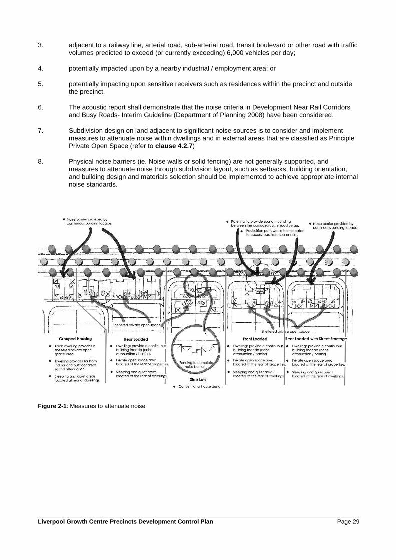
Liverpool Growth Centre Precincts Development Control Plan Page 29
3. adjacent to a railway line, arterial road, sub-arterial road, transit boulevard or other road with traffic volumes predicted to exceed (or currently exceeding) 6,000 vehicles per day;
4. potentially impacted upon by a nearby industrial / employment area; or
5. potentially impacting upon sensitive receivers such as residences within the precinct and outside the precinct.
6. The acoustic report shall demonstrate that the noise criteria in Development Near Rail Corridors and Busy Roads- Interim Guideline (Department of Planning 2008) have been considered.
7. Subdivision design on land adjacent to significant noise sources is to consider and implement measures to attenuate noise within dwellings and in external areas that are classified as Principle Private Open Space (refer to clause 4.2.7)
8. Physical noise barriers (ie. Noise walls or solid fencing) are not generally supported, and measures to attenuate noise through subdivision layout, such as setbacks, building orientation, and building design and materials selection should be implemented to achieve appropriate internal noise standards.
Figure 2-1: Measures to attenuate noise
Page 30 Liverpool Growth Centre Precincts Development Control Plan
2.3.10 Odour assessment and control
Odour management is subject to the Protection of the Environment Operations Act 1997. Currently the only methods of controlling odour impacts are applying buffers around odour generating activities and industry best management practices.
Prior to the commencement of this DCP the Growth Centre precincts were mostly zoned for rural purposes. The Precincts, and nearby rural areas, contain a number of existing rural uses that have the potential to generate odour and other associated impacts that may affect the amenity of nearby urban areas. While these activities may cease operation at some point in the future (such as when the land is rezoned and developed for urban purposes) the timing of cessation of odour generating land uses is not known nor able to be controlled by Council or Planning & Infrastructure. Developers and buyers of property within the Growth Centre precincts should be aware that their property may be subject to odour impacts from these uses for an indeterminate period of time.
Where land is deemed by Council to be affected by an odour source Council will consider whether the type of development in this area is appropriate and will also consider the need for the applicant to provide additional supporting information with the development application. An odour assessment prepared by an appropriate qualified person in accordance with the EPA Draft Policy "Assessment and Management of Odour from Stationary Sources in NSW” and Technical Notes may be required to be submitted.
2.3.11 Air quality
Objectives
a. Preserve air quality, minimise pollution and improve environmental amenity.
b. Ensure appropriate levels of air quality for the health and amenity of residents.
Controls
1. For industrial / employment developments, the emission of all air impurities is to be strictly controlled in accordance with the Protection of the Environment Operations (Clean Air) Regulation 2002 and must not exceed the prescribed standard concentration and emission rates. Where no standard is prescribed by the regulation, the activity or operation of any plant must be carried out by such practicable means as may be necessary to prevent or minimise air pollution. A report prepared by a suitably qualified air quality expert may be requested by Council to be prepared prior to development consent being granted. Such a report is to detail the likely air emissions and impacts, methods for control and maintenance of equipment, to ensure compliance with the Protection of the Environment Operations Act, 1997 and associated Regulations. Refer to Planning and Infrastructure (then Department of Planning) Development Near Rail Corridors and Busy Roads – Interim Guideline.
2. Implement effective site controls during and after demolition and construction to ensure that development does not contribute to increased air pollution.
Note: Emissions from premises of any matter, whether solid, liquid or gaseous must comply with the Protection of the Environment Operations Act and its Regulations, or a pollution control consent provided by the Office of Environment and Heritage for Scheduled Premises.
Liverpool Growth Centre Precincts Development Control Plan Page 31
2.4 Demolition
Objectives
a. To minimise waste generation and disposal to landfill.
b. To ensure efficient storage and collection of wastes and recyclables during demolition and construction
stages.
c. To minimise adverse impacts on adjoining premises; and
d. To avoid the release of contaminated materials.
Controls
1. All demolition work must comply with the Australian Standard AS2601 - 1991, The Demolition of Structures.
2. Security fencing such as hoardings must be provided around the perimeter of the demolition site prior to work commencing to prevent access by unauthorised persons at all times during the demolition period. Approval of the fencing by Council must be received prior to erection.
3. All lead contaminated materials identified in the building must be handled and disposed of in accordance with the NSW Environment Protection Authority's requirements.
4. Dust controls must be implemented on site prior to and during demolition.
5. Hazardous materials audits shall be conducted on any buildings at the site that may require demolition.
6. Asbestos, if identified in the building, must be removed and disposed of in accordance with the requirements of Work Cover.
7. Demolition activities on site must be limited to the following hours:
• Monday to Friday 7:00am to 5:00pm
• Saturday 8:00am to 5:00pm
• No work on Sunday and Public Holidays
8. Sound pressure levels emanating from the site must comply with the Interim Guideline for Construction Noise (Office of Environment and Heritage).
9. A Waste Management Plan (WMP) is to be submitted with the Development Application. The WMP must include volume or area estimates and information about reuse, recycling and disposal options for all types of waste produced on-site, including excavation materials.
10. The WMP together with proof of lawful disposal for all waste that is disposed of, or otherwise recycled from the site must be retained on site.
11. A Dilapidation Report may be required to be submitted with a Development Application for any demolition within the zone of influence of any other building.

Page 32 Liverpool Growth Centre Precincts Development Control Plan
2.5 Crime Prevention through Environmental Design
Principles of crime prevention through environmental design apply to all forms of development including residential, retail, commercial, industrial developments, public buildings and community facilities. The design requirements apply to all residential flat buildings and medium density developments. Many of the principles are also relevant to single dwelling houses and dual occupancies.
Objectives
a. To ensure that the siting and design of buildings and spaces, through casual surveillance, decreases
opportunities for crime.
b. To ensure that development encourages people to use streets, parks and other public places without
fear of personal risk.
c. To ensure the design of publicly accessible areas (eg parks, footpaths, etc) encourages a sense of
community ownership of open and public spaces.
Controls
1. Buildings should be designed to overlook streets, lanes and other public or communal areas to provide casual surveillance. In the case of corner lots habitable windows are also be oriented to overlook the side street.
2. The design of all development is to enhance public surveillance of public streets and open space/conservation areas.
3. For residential development, the use of roller shutters other than garages is not permitted on doors and windows facing the street. Any security railings must be designed to complement the architecture of the building.
4. Developments are to avoid creating areas for concealment and blank walls facing the street.
5. Pedestrian and communal areas are to have sufficient lighting to ensure a high level of safety. These areas must be designed to minimise opportunities for concealment.
6. All developments are to incorporate the principles of Crime Prevention Through Environmental Design (CPTED). Development Applications for subdivision, public open space, community facilities, commercial developments, mixed-use developments, and schools may require a formal crime risk (CPTED) assessment as part of the EP&A Act 1979.
Liverpool Growth Centre Precincts Development Control Plan Page 33
2.6 Earthworks
Objectives
a. To minimise cut and fill through site sensitive subdivision, road layout, infrastructure and building
design.
b. To locate buildings to minimise site works.
c. To ensure that earthworks do not adversely impact local drainage patterns or increase flooding
impacts.
d. To minimise the impacts of earthworks on the natural environment and on the visual character of the
locality.
Controls
1. Subdivision and building work is to be designed to respond to the natural topography of the site wherever possible, minimising the extent of cut and fill both during subdivision and when buildings are constructed.
2. The applicant is to demonstrate how the finished land levels will be integrated with nearby land and facilitate appropriate drainage.
3. Where terraced retaining walls are proposed the minimum horizontal distance between each step is one metre.
4. A variation to the retaining wall heights can be considered with supporting justification.
5. Council will consider permitting greater cut for basements.
6. All retaining walls proposed are to be identified in the development application. Those affecting adjoining properties i.e. adjacent to property boundaries are to be available for inspection prior to the internal linings of the house being installed. All other approved retaining walls are to be in place prior to the issue of an occupation certificate.
7. Where cut or fill is proposed on the boundary of a lot, retaining walls are to be constructed with side fence posts integrated with the retaining wall (relevant construction details are required with retaining wall approval).
8. Retaining walls that front a public place are to be finished with anti-graffiti coating.
9. Retaining walls are to be designed and constructed to allow for installation of boundary fencing without impact on the structural soundness of the retaining wall and its footings.
10. A Validation Report is required to be submitted to Council prior to the placement of imported fill on site. All fill shall comply with the NSW Office of Water – “Site Investigation for Urban Salinity” and the OEH Contaminated Sites Guidelines – “Guidelines for the NSW Site Auditor Scheme (2nd edition) – Soil Investigation Levels for Urban Development Sites in NSW”.
11. Earth moved from areas containing noxious weed material must be disposed of at an approved waste management facility, and transported in compliance with the Noxious Weeds Act 1993.
12. Development on land having a natural gradient of 1:6.7 (15%) or greater shall be accompanied by a geotechnical study, including guidelines for structural and engineering works on the land.
Note: the consent authority may require specific information to be submitted with Development Applications that propose earthworks. Applicants should consult with Council to identify information requirements prior to lodgement of an application.
Page 34 Liverpool Growth Centre Precincts Development Control Plan
13. For sites with existing water storage facilities (dams) the DA must include a dam removal plan which addresses each of the following controls to Council’s satisfaction and must also include details of:
• A water quality and soil test which details any contaminants in both the water and soil at the base of the dam (all testing shall be undertaken by a qualified consultant and National Association of Testing Authorities accredited laboratory).
• A salinity hazard test undertaken in accordance with the Office of Water salinity site assessment guidelines.
14. Sites identified as contaminated must follow the Office of Environment and Heritage contaminated water or soil removal guidelines in the National Environment Protection (Assessment of Site Contamination) Measure 1999. Contaminated water should be disposed of at a liquid waste facility.
15. Water identified as not contaminated may be re-used on site or on other properties. Should there be no possible reuse option for the water; a controlled release into the creek may be possible.
16. Any controlled release of water into the receiving waters (creek) must ensure against any erosion impact.
17. It is recommended that any water release is undertaken during high flow events as creek water quality is reduced at this time.
Liverpool Growth Centre Precincts Development Control Plan Page 35
3 Neighbourhood and subdivision design
3.0 Neighbourhood and
subdivision design

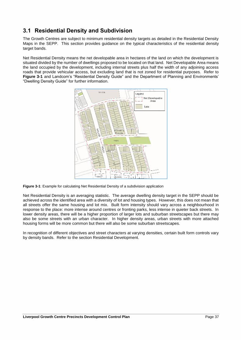
Liverpool Growth Centre Precincts Development Control Plan Page 37
3.1 Residential Density and Subdivision
The Growth Centres are subject to minimum residential density targets as detailed in the Residential Density
Maps in the SEPP. This section provides guidance on the typical characteristics of the residential density
target bands.
Net Residential Density means the net developable area in hectares of the land on which the development is situated divided by the number of dwellings proposed to be located on that land. Net Developable Area means the land occupied by the development, including internal streets plus half the width of any adjoining access roads that provide vehicular access, but excluding land that is not zoned for residential purposes. Refer to Figure 3-1 and Landcom’s “Residential Density Guide” and the Department of Planning and Environments’ “Dwelling Density Guide” for further information.
Figure 3-1: Example for calculating Net Residential Density of a subdivision application
Net Residential Density is an averaging statistic. The average dwelling density target in the SEPP should be achieved across the identified area with a diversity of lot and housing types. However, this does not mean that all streets offer the same housing and lot mix. Built form intensity should vary across a neighbourhood in response to the place: more intense around centres or fronting parks, less intense in quieter back streets. In lower density areas, there will be a higher proportion of larger lots and suburban streetscapes but there may also be some streets with an urban character. In higher density areas, urban streets with more attached housing forms will be more common but there will also be some suburban streetscapes.
In recognition of different objectives and street characters at varying densities, certain built form controls vary by density bands. Refer to the section Residential Development.
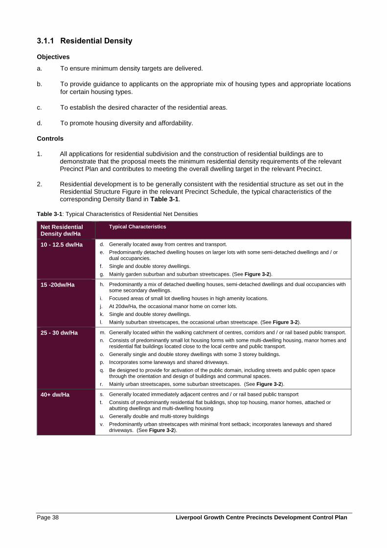
Page 38 Liverpool Growth Centre Precincts Development Control Plan
3.1.1 Residential Density
Objectives
a. To ensure minimum density targets are delivered.
b. To provide guidance to applicants on the appropriate mix of housing types and appropriate locations
for certain housing types.
c. To establish the desired character of the residential areas.
d. To promote housing diversity and affordability.
Controls
1. All applications for residential subdivision and the construction of residential buildings are to demonstrate that the proposal meets the minimum residential density requirements of the relevant Precinct Plan and contributes to meeting the overall dwelling target in the relevant Precinct.
2. Residential development is to be generally consistent with the residential structure as set out in the Residential Structure Figure in the relevant Precinct Schedule, the typical characteristics of the corresponding Density Band in Table 3-1.
Table 3-1: Typical Characteristics of Residential Net Densities
Net Residential Density dw/Ha
Typical Characteristics
10 - 12.5 dw/Ha d. Generally located away from centres and transport.
e. Predominantly detached dwelling houses on larger lots with some semi-detached dwellings and / or dual occupancies.
f. Single and double storey dwellings.
g. Mainly garden suburban and suburban streetscapes. (See Figure 3-2).
15 -20dw/Ha h. Predominantly a mix of detached dwelling houses, semi-detached dwellings and dual occupancies with some secondary dwellings.
i. Focused areas of small lot dwelling houses in high amenity locations.
j. At 20dw/Ha, the occasional manor home on corner lots.
k. Single and double storey dwellings.
l. Mainly suburban streetscapes, the occasional urban streetscape. (See Figure 3-2).
25 - 30 dw/Ha m. Generally located within the walking catchment of centres, corridors and / or rail based public transport.
n. Consists of predominantly small lot housing forms with some multi-dwelling housing, manor homes and residential flat buildings located close to the local centre and public transport.
o. Generally single and double storey dwellings with some 3 storey buildings.
p. Incorporates some laneways and shared driveways.
q. Be designed to provide for activation of the public domain, including streets and public open space through the orientation and design of buildings and communal spaces.
r. Mainly urban streetscapes, some suburban streetscapes. (See Figure 3-2).
40+ dw/Ha s. Generally located immediately adjacent centres and / or rail based public transport
t. Consists of predominantly residential flat buildings, shop top housing, manor homes, attached or abutting dwellings and multi-dwelling housing
u. Generally double and multi-storey buildings
v. Predominantly urban streetscapes with minimal front setback; incorporates laneways and shared driveways. (See Figure 3-2).
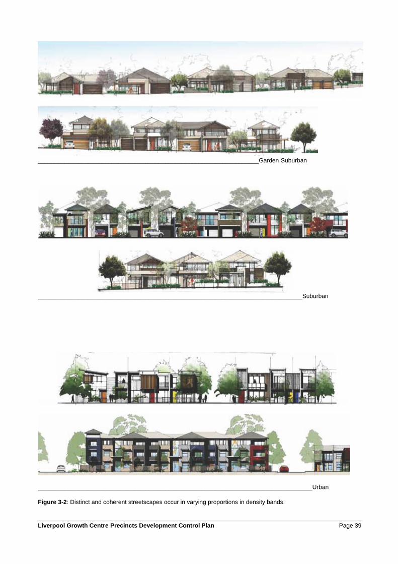
Liverpool Growth Centre Precincts Development Control Plan Page 39
__________________________________________________________________Garden Suburban
_______________________________________________________________________________Suburban
__________________________________________________________________________________Urban
Figure 3-2: Distinct and coherent streetscapes occur in varying proportions in density bands.
Page 40 Liverpool Growth Centre Precincts Development Control Plan
1. Residential development in the Environmental Living area, on the Residential Structure figure, is to:
• Consist primarily of single dwellings on larger lots, reflecting the environmental sensitivity and visual character of these parts of the Precincts.
• Emphasise high quality housing design to make the most of the environmental characteristics of the surrounding area.
• Be designed and located to minimise impacts on flood prone land, and risks to property from flooding.
• Avoid impacts on Existing Native Vegetation and other remnant native vegetation.
• Consider relationships to adjoining land uses including public open space and drainage infrastructure.
• Be designed to respond to constraints from infrastructure corridors such as electricity lines, underground gas pipelines and any Sydney Catchment Authority infrastructure.
• Consider views to and from the land and surrounding parts of the Growth Centre.
2. Non-residential development in the residential areas is encouraged where it:
• Contributes to the amenity and character of the residential area within which it is located.
• Provides services, facilities or other opportunities that meet the needs of the surrounding residential population, and contributes to reduced motor vehicle use.
• Will not result in detrimental impacts on the amenity and safety of surrounding residential areas, including factors such as noise and air quality.
• Is of a design that is visually and functionally integrated with the surrounding residential area.
Note: The relevant Precinct Plan permits certain non-residential development within the residential zones. Other parts of this DCP provides more detailed objectives and controls for these types of development.
3.1.2 Block and Lot Layout
Objectives
a. To establish a clear urban structure that promotes a 'sense of neighbourhood' and encourages
walking and cycling.
b. To efficiently utilise land and achieve the target dwelling yield for the relevant Precinct.
c. To emphasise the natural attributes of the site and reinforce neighbourhood identity through the
placement of visible key landmark features, such as parks, squares and landmark buildings.
d. To optimise outlook and proximity to public and community facilities, parks and public transport with
increased residential density.
e. To encourage variety in dwelling size, type and design to promote housing choice and create
attractive streetscapes with distinctive characters.
f. To accommodate a mix of lot sizes and dwelling types across a precinct.
g. To establish minimum lot dimensions for different residential dwelling types.
Controls
Blocks
1. Residential neighbourhoods are to be focused on elements of the public domain such as a school, park, retail, or community facility that are typically within walking distance.
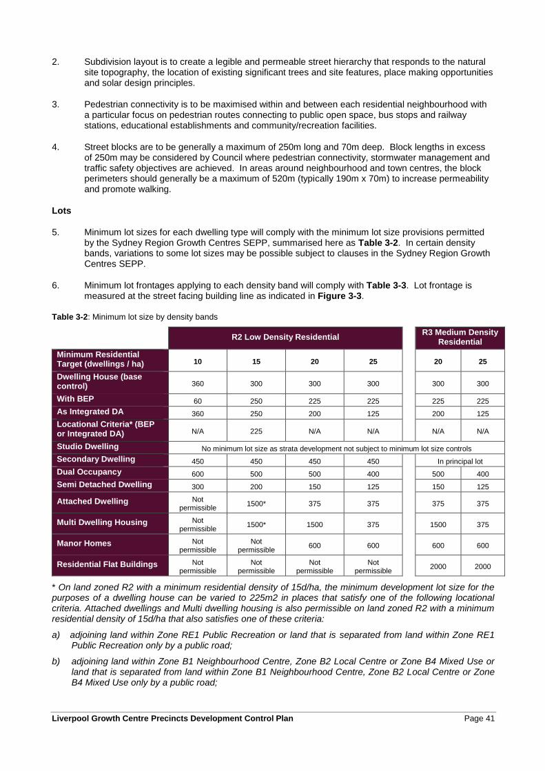
Liverpool Growth Centre Precincts Development Control Plan Page 41
2. Subdivision layout is to create a legible and permeable street hierarchy that responds to the natural site topography, the location of existing significant trees and site features, place making opportunities and solar design principles.
3. Pedestrian connectivity is to be maximised within and between each residential neighbourhood with a particular focus on pedestrian routes connecting to public open space, bus stops and railway stations, educational establishments and community/recreation facilities.
4. Street blocks are to be generally a maximum of 250m long and 70m deep. Block lengths in excess of 250m may be considered by Council where pedestrian connectivity, stormwater management and traffic safety objectives are achieved. In areas around neighbourhood and town centres, the block perimeters should generally be a maximum of 520m (typically 190m x 70m) to increase permeability and promote walking.
Lots
5. Minimum lot sizes for each dwelling type will comply with the minimum lot size provisions permitted by the Sydney Region Growth Centres SEPP, summarised here as Table 3-2. In certain density bands, variations to some lot sizes may be possible subject to clauses in the Sydney Region Growth Centres SEPP.
6. Minimum lot frontages applying to each density band will comply with Table 3-3. Lot frontage is measured at the street facing building line as indicated in Figure 3-3.
Table 3-2: Minimum lot size by density bands
R2 Low Density Residential
R3 Medium Density Residential
Minimum Residential Target (dwellings / ha) 10 15 20 25 20 25
Dwelling House (base control) 360 300 300 300 300 300
With BEP 60 250 225 225 225 225
As Integrated DA 360 250 200 125 200 125
Locational Criteria* (BEP or Integrated DA) N/A 225 N/A N/A N/A N/A
Studio Dwelling No minimum lot size as strata development not subject to minimum lot size controls
Secondary Dwelling 450 450 450 450 In principal lot
Dual Occupancy 600 500 500 400 500 400
Semi Detached Dwelling 300 200 150 125 150 125
Attached Dwelling Not permissible
1500* 375 375 375 375
Multi Dwelling Housing Not permissible
1500* 1500 375 1500 375
Manor Homes Not permissible
Not permissible
600 600 600 600
Residential Flat Buildings Not permissible
Not permissible
Not permissible
Not permissible
2000 2000
* On land zoned R2 with a minimum residential density of 15d/ha, the minimum development lot size for the purposes of a dwelling house can be varied to 225m2 in places that satisfy one of the following locational criteria. Attached dwellings and Multi dwelling housing is also permissible on land zoned R2 with a minimum residential density of 15d/ha that also satisfies one of these criteria:
a) adjoining land within Zone RE1 Public Recreation or land that is separated from land within Zone RE1 Public Recreation only by a public road;
b) adjoining land within Zone B1 Neighbourhood Centre, Zone B2 Local Centre or Zone B4 Mixed Use or land that is separated from land within Zone B1 Neighbourhood Centre, Zone B2 Local Centre or Zone B4 Mixed Use only by a public road;
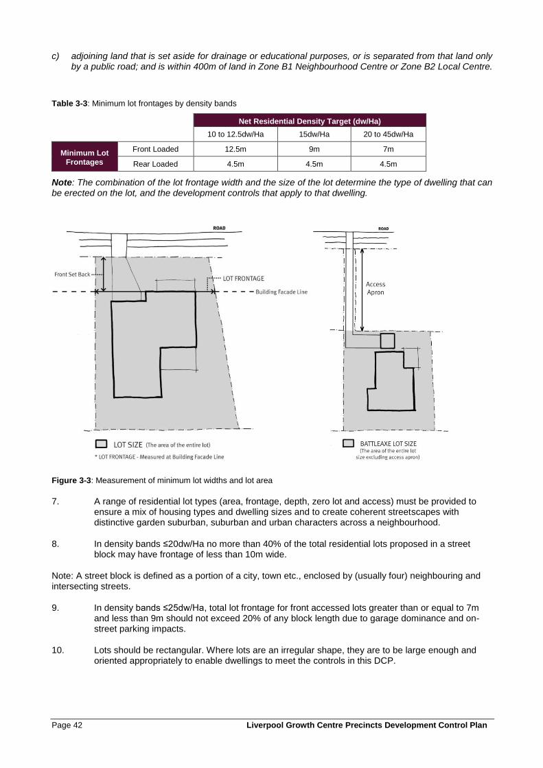
Page 42 Liverpool Growth Centre Precincts Development Control Plan
c) adjoining land that is set aside for drainage or educational purposes, or is separated from that land only by a public road; and is within 400m of land in Zone B1 Neighbourhood Centre or Zone B2 Local Centre.
Table 3-3: Minimum lot frontages by density bands
Net Residential Density Target (dw/Ha)
10 to 12.5dw/Ha 15dw/Ha 20 to 45dw/Ha
Minimum Lot Frontages
Front Loaded 12.5m 9m 7m
Rear Loaded 4.5m 4.5m 4.5m
Note: The combination of the lot frontage width and the size of the lot determine the type of dwelling that can be erected on the lot, and the development controls that apply to that dwelling.
Figure 3-3: Measurement of minimum lot widths and lot area
7. A range of residential lot types (area, frontage, depth, zero lot and access) must be provided to ensure a mix of housing types and dwelling sizes and to create coherent streetscapes with distinctive garden suburban, suburban and urban characters across a neighbourhood.
8. In density bands ≤20dw/Ha no more than 40% of the total residential lots proposed in a street block may have frontage of less than 10m wide.
Note: A street block is defined as a portion of a city, town etc., enclosed by (usually four) neighbouring and intersecting streets.
9. In density bands ≤25dw/Ha, total lot frontage for front accessed lots greater than or equal to 7m and less than 9m should not exceed 20% of any block length due to garage dominance and on-street parking impacts.
10. Lots should be rectangular. Where lots are an irregular shape, they are to be large enough and oriented appropriately to enable dwellings to meet the controls in this DCP.
Liverpool Growth Centre Precincts Development Control Plan Page 43
11. Where residential development adjoins land zoned RE1 Public Recreation or SP2 Drainage, subdivision is to create lots for the dwelling and main residential entry to front the open space or drainage land.
12. The orientation and configuration of lots is to be generally consistent with the following subdivision principles:
• Smallest lots achievable for the given orientations fronting parks and open space with the larger lots in the back streets;
• Larger lots on corners;
• North to the front lots are either the widest or deepest lots, or lots suitable for residential development forms with private open space at the front. Narrowest lots with north to the rear.
13. Preferred block orientation is established by the road layout on the Indicative Layout Plan in the relevant Precinct Schedule. Optimal lot orientation is east-west, or north-south where the road pattern requires. Exceptions to the preferred lot orientation may be considered where factors such as the layout of existing roads and cadastral boundaries, or topography and drainage lines, prevent achievement of the preferred orientation.
14. An alternative lot orientation may be considered where other amenities such as views and outlook over open space are available, and providing appropriate solar access and overshadowing outcomes can be achieved.
Note: The combination of the lot frontage width and the size of the lot determine the type of dwelling that can be erected on the lot, and the development controls that apply to that dwelling.
Zero Lot Lines
15. The location of a zero lot line is to be determined primarily by topography and should be on the low side of the lot to minimise water penetration and termite issues. Other factors to consider include dwelling design, adjoining dwellings, landscape features, street trees, vehicle crossovers and the lot orientation as illustrated at Figure 4-8.
16. On all lots where a zero lot line is permitted, the side of the allotment that may have a zero lot alignment must be shown on the approved subdivision plan.
17. Where a zero lot line is nominated on an allotment on the subdivision plan, the adjoining (burdened) allotment is to include a 900mm easement for single storey zero lot walls and 1200mm for two storey zero lot walls to enable servicing, construction and maintenance of the adjoining dwelling. No overhanging eaves, gutters or services (including rainwater tanks, hot water units, air-conditioning units or the like) of the dwelling on the benefited lot will be permitted within the easement. Any services and projections permitted under Clause 4.2.4 (6) within the easement to the burdened lot dwelling should not impede the ability for maintenance to be undertaken to the benefitted lot.
18. The S88B instrument for the subject (benefited) lot and the adjoining (burdened) lot shall include a note identifying the potential for a building to have a zero lot line. The S88B instrument supporting the easement is to be worded so that Council is removed from any dispute resolution process between adjoining allotments.
For more information, refer to the Department of Planning and Environment Delivery Notes: Zero Lot Boundaries and Building Envelope Plans.
Subdivision of Shallow Lots
19. Shallow lots (typical depth 14-18m, typical area <200sqm) intended for double storey dwellings should be located only in locations where it can be demonstrated that impacts on adjoining lots, such as overshadowing and overlooking of private open space, satisfy the requirements of the
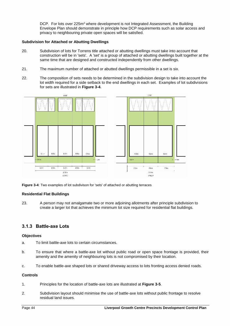
Page 44 Liverpool Growth Centre Precincts Development Control Plan
DCP. For lots over 225m2 where development is not Integrated Assessment, the Building Envelope Plan should demonstrate in principle how DCP requirements such as solar access and privacy to neighbouring private open spaces will be satisfied.
Subdivision for Attached or Abutting Dwellings
20. Subdivision of lots for Torrens title attached or abutting dwellings must take into account that construction will be in 'sets'. A 'set' is a group of attached or abutting dwellings built together at the same time that are designed and constructed independently from other dwellings.
21. The maximum number of attached or abutted dwellings permissible in a set is six.
22. The composition of sets needs to be determined in the subdivision design to take into account the lot width required for a side setback to the end dwellings in each set. Examples of lot subdivisions for sets are illustrated in Figure 3-4.
Figure 3-4: Two examples of lot subdivison for 'sets' of attached or abutting terraces
Residential Flat Buildings
23. A person may not amalgamate two or more adjoining allotments after principle subdivision to create a larger lot that achieves the minimum lot size required for residential flat buildings.
3.1.3 Battle-axe Lots
Objectives
a. To limit battle-axe lots to certain circumstances.
b. To ensure that where a battle-axe lot without public road or open space frontage is provided, their
amenity and the amenity of neighbouring lots is not compromised by their location.
c. To enable battle-axe shaped lots or shared driveway access to lots fronting access denied roads.
Controls
1. Principles for the location of battle-axe lots are illustrated at Figure 3-5.
2. Subdivision layout should minimise the use of battle-axe lots without public frontage to resolve residual land issues.
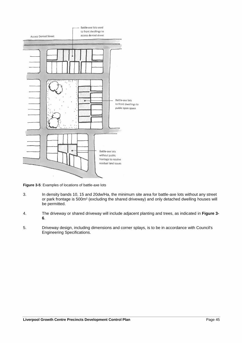
Liverpool Growth Centre Precincts Development Control Plan Page 45
Figure 3-5: Examples of locations of battle-axe lots
3. In density bands 10, 15 and 20dw/Ha, the minimum site area for battle-axe lots without any street or park frontage is 500m² (excluding the shared driveway) and only detached dwelling houses will be permitted.
4. The driveway or shared driveway will include adjacent planting and trees, as indicated in Figure 3-6.
5. Driveway design, including dimensions and corner splays, is to be in accordance with Council's Engineering Specifications.
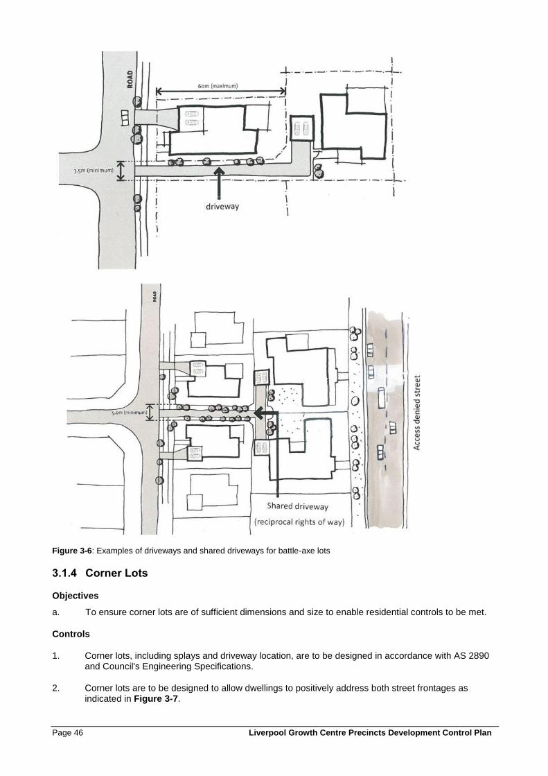
Page 46 Liverpool Growth Centre Precincts Development Control Plan
Figure 3-6: Examples of driveways and shared driveways for battle-axe lots
3.1.4 Corner Lots
Objectives
a. To ensure corner lots are of sufficient dimensions and size to enable residential controls to be met.
Controls
1. Corner lots, including splays and driveway location, are to be designed in accordance with AS 2890 and Council's Engineering Specifications.
2. Corner lots are to be designed to allow dwellings to positively address both street frontages as indicated in Figure 3-7.
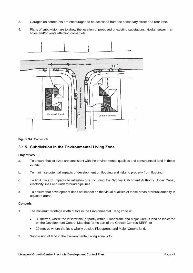
Liverpool Growth Centre Precincts Development Control Plan Page 47
3. Garages on corner lots are encouraged to be accessed from the secondary street or a rear lane.
4. Plans of subdivision are to show the location of proposed or existing substations, kiosks, sewer man holes and/or vents affecting corner lots.
Figure 3-7: Corner lots
3.1.5 Subdivision in the Environmental Living Zone
Objectives
a. To ensure that lot sizes are consistent with the environmental qualities and constraints of land in these
zones.
b. To minimise potential impacts of development on flooding and risks to property from flooding.
c. To limit risks of impacts to infrastructure including the Sydney Catchment Authority Upper Canal,
electricity lines and underground pipelines.
d. To ensure that development does not impact on the visual qualities of these areas or visual amenity in
adjacent areas.
Controls
1. The minimum frontage width of lots in the Environmental Living zone is:
• 30 metres, where the lot is within (or partly within) Floodprone and Major Creeks land as indicated on the Development Control Map that forms part of the Growth Centres SEPP; or
• 20 metres where the lot is wholly outside Floodprone and Major Creeks land.
2. Subdivision of land in the Environmental Living zone is to:
Page 48 Liverpool Growth Centre Precincts Development Control Plan
• Consider the location of flood prone land and ensure that each lot is capable of accommodating a dwelling that complies with the controls for development on flood prone land in clause 2.3.1.
• Protect Existing Native Vegetation and other vegetation within the Environment Protection overlay on the Precinct Indicative Layout Plan.
3. Subdivision of land in the Environmental Living zone is to ensure that:
• The layout of residential lots and the likely positioning and orientation of dwellings does not significantly impact on the visual character of the locality.
• The orientation of lots and dwellings allows for passive surveillance of public land and infrastructure easements where relevant.
• Any areas of remnant native vegetation or significant trees are preserved to the maximum practical extent, including avoiding or minimising subdivision of land that contains Existing Native Vegetation (as shown on the Native Vegetation Protection Areas Map).
• Impacts on utilities easements can be avoided during subdivision works and when buildings are constructed on the land.
• Access to easements for maintenance and inspections is maintained.
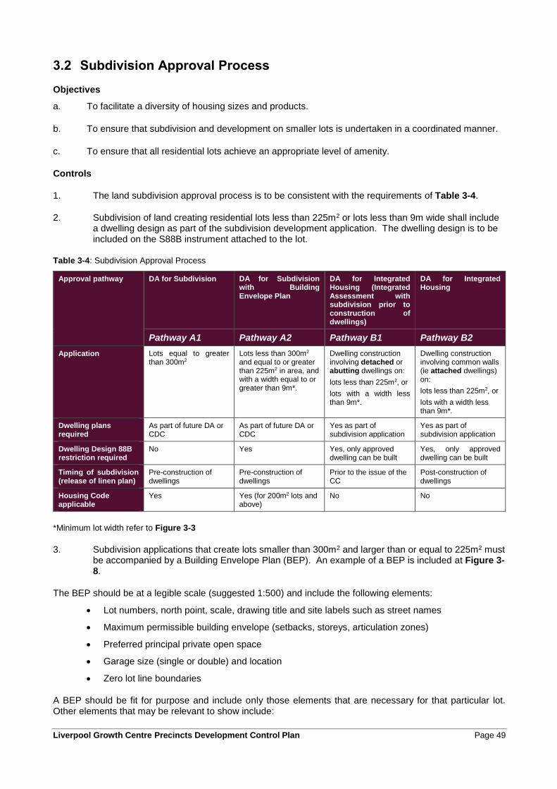
Liverpool Growth Centre Precincts Development Control Plan Page 49
3.2 Subdivision Approval Process
Objectives
a. To facilitate a diversity of housing sizes and products.
b. To ensure that subdivision and development on smaller lots is undertaken in a coordinated manner.
c. To ensure that all residential lots achieve an appropriate level of amenity.
Controls
1. The land subdivision approval process is to be consistent with the requirements of Table 3-4.
2. Subdivision of land creating residential lots less than 225m2 or lots less than 9m wide shall include a dwelling design as part of the subdivision development application. The dwelling design is to be included on the S88B instrument attached to the lot.
Table 3-4: Subdivision Approval Process
Approval pathway DA for Subdivision
DA for Subdivision with Building Envelope Plan
DA for Integrated Housing (Integrated Assessment with subdivision prior to construction of dwellings)
DA for Integrated Housing
Pathway A1 Pathway A2 Pathway B1 Pathway B2
Application Lots equal to greater than 300m2
Lots less than 300m2 and equal to or greater than 225m2 in area, and with a width equal to or greater than 9m*.
Dwelling construction involving detached or abutting dwellings on:
lots less than 225m2, or
lots with a width less than 9m*.
Dwelling construction involving common walls (ie attached dwellings) on:
lots less than 225m2, or
lots with a width less than 9m*.
Dwelling plans required
As part of future DA or CDC
As part of future DA or CDC
Yes as part of subdivision application
Yes as part of subdivision application
Dwelling Design 88B restriction required
No Yes Yes, only approved dwelling can be built
Yes, only approved dwelling can be built
Timing of subdivision (release of linen plan)
Pre-construction of dwellings
Pre-construction of dwellings
Prior to the issue of the CC
Post-construction of dwellings
Housing Code applicable
Yes Yes (for 200m2 lots and above)
No No
*Minimum lot width refer to Figure 3-3
3. Subdivision applications that create lots smaller than 300m2 and larger than or equal to 225m2 must be accompanied by a Building Envelope Plan (BEP). An example of a BEP is included at Figure 3-8.
The BEP should be at a legible scale (suggested 1:500) and include the following elements:
• Lot numbers, north point, scale, drawing title and site labels such as street names
• Maximum permissible building envelope (setbacks, storeys, articulation zones)
• Preferred principal private open space
• Garage size (single or double) and location
• Zero lot line boundaries
A BEP should be fit for purpose and include only those elements that are necessary for that particular lot. Other elements that may be relevant to show include:
Page 50 Liverpool Growth Centre Precincts Development Control Plan
• Special fencing requirements
• Easements and sewer lines
• Retaining walls
• Preferred entry/frontage (e.g. corner lots)
• Access denied frontages
• Electricity kiosks or substations
• Indicative yield on residue or super lots
For further information, refer to the Department of Planning and Environment Delivery Note: Building Envelope Plans.
4. Applications for subdivision using approval pathways A2, B1 and B2 require a Public Domain Plan (PDP) to be submitted as part of the application. The purpose of the PDP is to demonstrate how the public domain will be developed as a result of future development on the proposed lots. An example of a PDP is included at Figure 3-9.
The PDP should be a legible scale (suggested 1:500) and include the following elements:
• Lot numbers, north point, scale, drawing title and site labels such as street names.
• Indicative building footprints on the residential lots.
• Location of driveways and driveway crossovers.
• Verge design (footpath, landscape).
• Surrounding streets and lanes (kerb line, material surface where special treatments proposed).
• In laneways, indicative provision for bin collection.
• Street tree locations. (Sizes and species list can be provided on a separate plan).
• Demonstrated provision and arrangements for on-street car parking particularly in relation to street tree planting, driveways and intersections.*
• Extent of kerb line where parking is not permitted.*
* In principle, not as public domain works
Other elements that may be relevant to show include:
• Location and type of any proposed street furniture
• Location of retaining walls in the public domain
• Electricity substations
• Indicative hydrant locations at lane thresholds
Information on landscape treatment within the private lot is not required.
For further information, refer to the Department of Planning and Environment Delivery Note: Public Domain Plans.
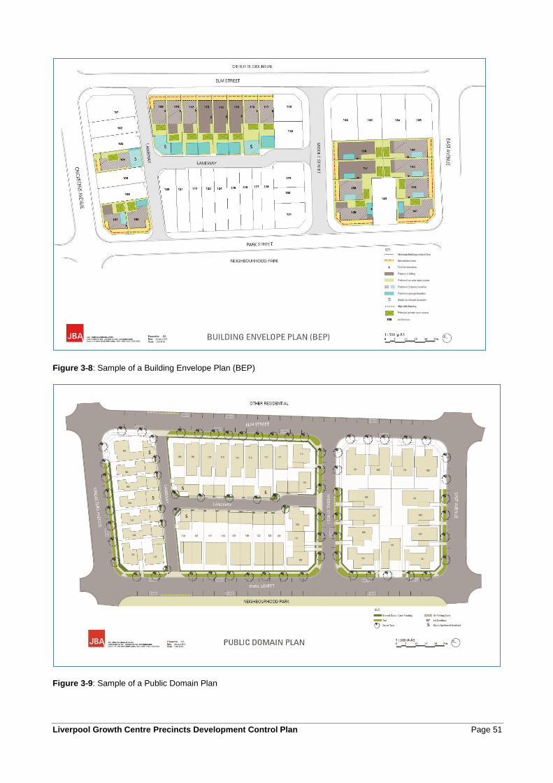
Liverpool Growth Centre Precincts Development Control Plan Page 51
Figure 3-8: Sample of a Building Envelope Plan (BEP)
Figure 3-9: Sample of a Public Domain Plan
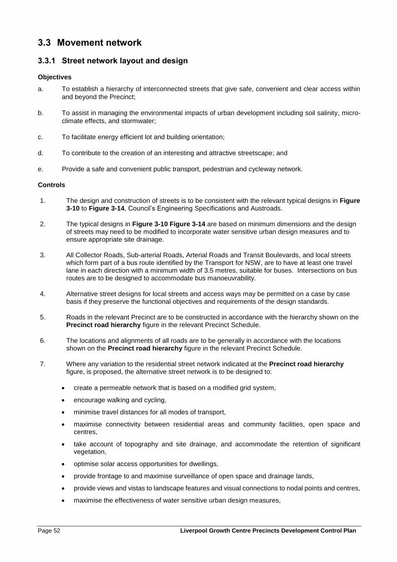
Page 52 Liverpool Growth Centre Precincts Development Control Plan
3.3 Movement network
3.3.1 Street network layout and design
Objectives
a. To establish a hierarchy of interconnected streets that give safe, convenient and clear access within
and beyond the Precinct;
b. To assist in managing the environmental impacts of urban development including soil salinity, micro-
climate effects, and stormwater;
c. To facilitate energy efficient lot and building orientation;
d. To contribute to the creation of an interesting and attractive streetscape; and
e. Provide a safe and convenient public transport, pedestrian and cycleway network.
Controls
1. The design and construction of streets is to be consistent with the relevant typical designs in Figure 3-10 to Figure 3-14, Council’s Engineering Specifications and Austroads.
2. The typical designs in Figure 3-10 Figure 3-14 are based on minimum dimensions and the design of streets may need to be modified to incorporate water sensitive urban design measures and to ensure appropriate site drainage.
3. All Collector Roads, Sub-arterial Roads, Arterial Roads and Transit Boulevards, and local streets which form part of a bus route identified by the Transport for NSW, are to have at least one travel lane in each direction with a minimum width of 3.5 metres, suitable for buses. Intersections on bus routes are to be designed to accommodate bus manoeuvrability.
4. Alternative street designs for local streets and access ways may be permitted on a case by case basis if they preserve the functional objectives and requirements of the design standards.
5. Roads in the relevant Precinct are to be constructed in accordance with the hierarchy shown on the Precinct road hierarchy figure in the relevant Precinct Schedule.
6. The locations and alignments of all roads are to be generally in accordance with the locations shown on the Precinct road hierarchy figure in the relevant Precinct Schedule.
7. Where any variation to the residential street network indicated at the Precinct road hierarchy figure, is proposed, the alternative street network is to be designed to:
• create a permeable network that is based on a modified grid system,
• encourage walking and cycling,
• minimise travel distances for all modes of transport,
• maximise connectivity between residential areas and community facilities, open space and centres,
• take account of topography and site drainage, and accommodate the retention of significant vegetation,
• optimise solar access opportunities for dwellings,
• provide frontage to and maximise surveillance of open space and drainage lands,
• provide views and vistas to landscape features and visual connections to nodal points and centres,
• maximise the effectiveness of water sensitive urban design measures,
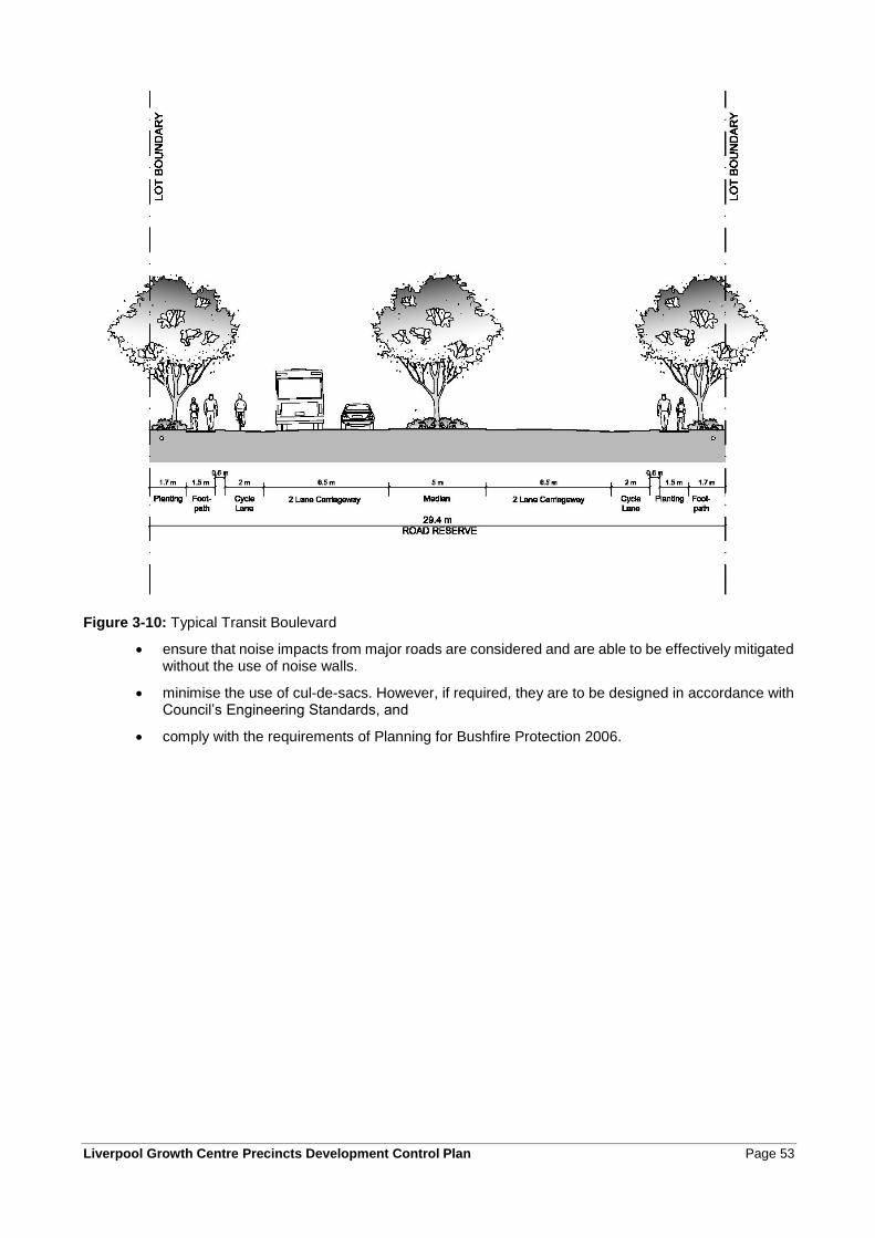
Liverpool Growth Centre Precincts Development Control Plan Page 53
Figure 3-10: Typical Transit Boulevard
• ensure that noise impacts from major roads are considered and are able to be effectively mitigated without the use of noise walls.
• minimise the use of cul-de-sacs. However, if required, they are to be designed in accordance with Council’s Engineering Standards, and
• comply with the requirements of Planning for Bushfire Protection 2006.
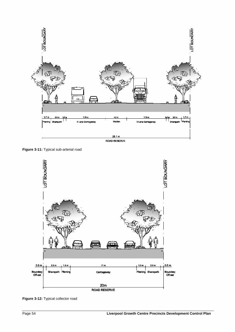
Page 54 Liverpool Growth Centre Precincts Development Control Plan
Figure 3-11: Typical sub-arterial road
Figure 3-12: Typical collector road
Liverpool Growth Centre Precincts Development Control Plan Page 55
Figure 3-13: Typical local street
8. Variations to the residential street network as permitted under control 7 above will only be approved by Council where the applicant can demonstrate to Council’s satisfaction that the proposal:
• will not detrimentally impact on access to adjoining properties,
• provides for the management of stormwater to drain to Council’s trunk drainage network, without negative impacts on other properties,
• will not impede the orderly development of adjoining properties in accordance with the relevant Precinct Plan and this Development Control Plan, and
• does not restrict the ability to provide water, sewer, electricity and other essential services to the development or to development on adjoining properties.
9. For changes to the proposed road system which Council considers minor, Council may write to affected property owners and consider any comments of those persons before determining the application. Applicants wishing to amend the proposed road pattern are advised to liaise with affected adjoining owners prior to the submission of the Development Application. By obtaining the prior agreement of adjoining owners to proposed road pattern changes, the time required by Council to determine the application may be reduced.
Page 56 Liverpool Growth Centre Precincts Development Control Plan
10. For changes to the proposed road system which Council considers major, Council may require a formal application for amendment to the DCP map before determining the application.
11. Where roads are adjacent to public open space or drainage land, or adjacent to arterial, sub-arterial or transit boulevards, the verge width on the side adjacent to the open space, drainage land or major road may, in certain circumstances, be reduced to a minimum of 1m, subject to:
• Appropriate arrangements for the provision of public utilities,
• Provision of appropriate pedestrian access,
• Compliance with road safety, and
• acoustic attenuation, bushfire asset protection zone, and riparian corridor requirements
12. Where local roads are located as per control 11 above or are within or on the boundary of land zoned Environmental Living, the carriageway width may be reduced to 6.5 metres providing the applicant can demonstrate to Council’s satisfaction that the road will operate safely and effectively.
13. Where streets are proposed as part of an application for subdivision that are located adjacent to public recreation land, drainage land, community facilities or schools, the applicant will be responsible for construction of the full width of the street, unless Council specifies otherwise.
14. Except where otherwise provided for in this DCP, all streets and roundabouts are to be designed and constructed in accordance with the minimum requirements set out in Council’s Engineering Specifications.
15. Council may require traffic calming measures to be incorporated into four-way intersections where traffic volumes necessitate controls other than signage, in addition to the intersection treatments specified in the Precinct road hierarchy figure in the relevant Precinct Schedule. Measures may include roundabouts, carriageway narrowing or re-alignment, pedestrian islands or raised platforms, banned turns or differently textured materials.
16. On sloping land, roads that cross the slope may incorporate split carriageways so as to minimise cut and fill, and provide opportunities for landscaping and the preservation of trees. Where split pavements are proposed, they are to comply with the following:
• Split level road pavements will only be considered where other design solutions eg. one way cross falls, road centre line re-grading, retaining walls within lot boundaries and widening of road reserves to accommodate wider medians etc, cannot achieve the desired outcome.
• The proposed split level pavement must be supported by a Road Safety Audit by an RMS accredited Road Safety Auditor.
• Split level road pavements should be limited to a maximum road length of 80m, unless otherwise approved by Council. A minimum road length may be required to achieve the requirements of safety fencing.
• Each "split" road carriageway should be a minimum of 5.5m wide.
• Batter slopes within a central median shall comply with Council's Engineering Specifications. Retaining walls within the central median are not encouraged but may be considered by Council where road design and safety standards are to the satisfaction of Council.
• Safety barriers are to be installed in accordance with the requirements of Section 6 of the RTA Road Design Guide. Sign-posting and line-marking are to be provided in accordance with RTA requirements.
• No split carriageways are allowed at intersections if the split carriageway would restrict pedestrian, cyclist or vehicular access to key destinations such as parks, shopping centres, schools or community facilities.
17. Residential roads, i.e. collector roads, local streets, access road/places, and shareways shall be designed for and sign posted at a maximum of 50kph (i.e. traffic management must be considered
Liverpool Growth Centre Precincts Development Control Plan Page 57
at the subdivision application, with either road layout or speed reducing devices used to produce a traffic environment which reduces traffic speed).
18. Where four way intersections are proposed, traffic is to be controlled, where appropriate and as specified by Council, by traffic lights, roundabouts, median strips or signage, or differently textured materials.
19. Private roads are to be designed and constructed in accordance with Council’s Engineering Specifications. Details must be shown on the engineering design plans and must be submitted prior to the issue of the subdivision certificate.
20. Street trees are required for all streets. Street planting is to:
• use the preferred species listed in Appendix C,
• be consistently used to distinguish between public and private spaces and between different classes of street within the street hierarchy,
• minimise risk to utilities and services,
• be durable and suited to the street environment and, wherever appropriate, include endemic species,
• maintain adequate lines of sight for vehicles and pedestrians, especially around driveways and street corners,
• be located to minimise conflicts between trees and driveways,
• provide appropriate shade in summer and solar access in winter including shading of road carriageways and other hard paved areas to minimise heat retention in summer, and
• provide an attractive and interesting landscape character and clearly define public and private areas, without limiting passive surveillance of the street.
• consider items of environmental heritage, heritage conservation areas, historic road alignments and significant view lines.
21. Street trees are to be provided with a minimum spacing of one tree for each residential lot, or one tree per 10 metres of road, whichever spacing is the greater.
22. Street trees may be permitted within the road carriageway subject to the findings of a Road Safety Audit.
23. While acknowledging the amenity benefit from trees within the carriageway, applications that propose carriageway trees will be assessed by Council with consideration given to:
• access and manoeuvrability of garbage trucks, street sweepers and cars,
• the impact of the root system on the carriageway;
• ongoing maintenance of the tree and carriageway;
• the relationship with future driveway access points; and
• Traffic safety.
24. For medians less than 4m width (e.g. at intersections), no planting is permitted and hard surfaces are to be provided.
25. Signage, street furniture and lighting is to be:
• designed to reinforce the distinct identity of the development;
• coordinated in design and style;
• located so as to minimise visual clutter and obstruction of the public domain; and
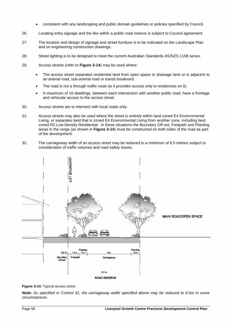
Page 58 Liverpool Growth Centre Precincts Development Control Plan
• consistent with any landscaping and public domain guidelines or policies specified by Council.
26. Locating entry signage and the like within a public road reserve is subject to Council agreement.
27. The location and design of signage and street furniture is to be indicated on the Landscape Plan and on engineering construction drawings.
28. Street lighting is to be designed to meet the current Australian Standards AS/NZS 1158 series.
29. Access streets (refer to Figure 3-14) may be used where:
• The access street separates residential land from open space or drainage land or is adjacent to an arterial road, sub-arterial road or transit boulevard.
• The road is not a through traffic route (ie it provides access only to residences on it).
• A maximum of 10 dwellings, between each intersection with another public road, have a frontage and vehicular access to the access street.
30. Access streets are to intersect with local roads only.
31. Access streets may also be used where the street is entirely within land zoned E4 Environmental Living, or separates land that is zoned E4 Environmental Living from another zone, including land zoned R2 Low Density Residential. In these situations the Boundary Off-set, Footpath and Planting areas in the verge (as shown in Figure 3-14) must be constructed on both sides of the road as part of the development:
32. The carriageway width of an access street may be reduced to a minimum of 6.5 metres subject to consideration of traffic volumes and road safety issues.
Figure 3-14: Typical access street
Note: As specified in Control 32, the carriageway width specified above may be reduced to 6.5m in some circumstances.
Liverpool Growth Centre Precincts Development Control Plan Page 59
3.3.2 Laneways
Laneways are public roads that are shareways, utilitarian throughways of the street network that provide rear vehicular access to compact or restricted access lots. The primary purpose of rear laneways is to create attractive front residential streets by removing garages and driveway cuts from the street frontages, improving the presentation of houses and maximising on street parking spaces and street trees. Laneways are a ‘sacrificial’ network device: while they should be neat and tidy, they should not be confused with streets in width, character or function.
A laneway is a shareway, designed to be shared by all users whether they are pedestrians, cyclists or drivers. Equal priority between all users reinforces the distinctive, slow speed environment for drivers.
In their design and subdivision of lots, laneways should be provided with casual surveillance from some second floor rooms and balconies over garages. Various building forms can provide this casual surveillance along the lane such as studio dwellings, secondary dwellings and rooms of the principal dwelling or lofts over garages. Separate titling of studio dwellings may affect servicing requirements. Generally there will be no underground services in the laneway (except for streetlights) as the studios will be strata titled so power, water, gas, sewer and communications will be located in the front street and reticulated from the front of the allotment through the lot to the rear studio.
Objectives
a. To provide vehicular access to the rear or side of lots where front access is restricted or not possible, particularly narrow lots where front garaging is not permitted.
b. To reduce garage dominance in residential streets.
c. To maximise on-street parking spaces and landscaping in residential streets.
d. To provide opportunities for affordable housing options.
e. To reduce vehicular conflict through reduced driveway cross overs and focusing of traffic to known points.
f. To enable garbage collection.
g. To facilitate the use of attached and narrow lot housing to achieve overall higher neighbourhood densities.
h. To create a slow speed shared zone requiring co-operative driving practices for the very low volume and frequency of vehicle movements that is distinctly different in character and materials to residential streets.
Controls
1. The design and construction of laneways is to be consistent with Figure 3-15 and Department of Planning and Environment Delivery Note: Laneways.
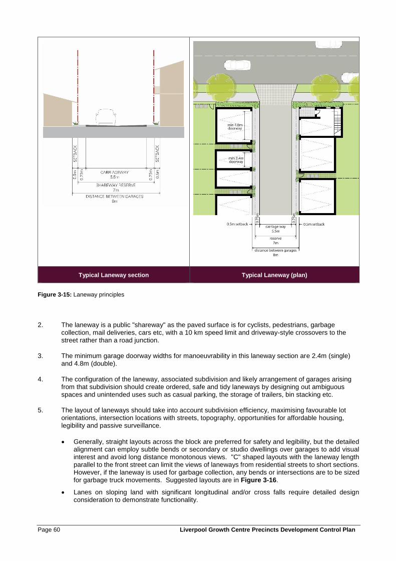
Page 60 Liverpool Growth Centre Precincts Development Control Plan
Typical Laneway section Typical Laneway (plan)
Figure 3-15: Laneway principles
2. The laneway is a public "shareway" as the paved surface is for cyclists, pedestrians, garbage collection, mail deliveries, cars etc, with a 10 km speed limit and driveway-style crossovers to the street rather than a road junction.
3. The minimum garage doorway widths for manoeuvrability in this laneway section are 2.4m (single) and 4.8m (double).
4. The configuration of the laneway, associated subdivision and likely arrangement of garages arising from that subdivision should create ordered, safe and tidy laneways by designing out ambiguous spaces and unintended uses such as casual parking, the storage of trailers, bin stacking etc.
5. The layout of laneways should take into account subdivision efficiency, maximising favourable lot orientations, intersection locations with streets, topography, opportunities for affordable housing, legibility and passive surveillance.
• Generally, straight layouts across the block are preferred for safety and legibility, but the detailed alignment can employ subtle bends or secondary or studio dwellings over garages to add visual interest and avoid long distance monotonous views. "C" shaped layouts with the laneway length parallel to the front street can limit the views of laneways from residential streets to short sections. However, if the laneway is used for garbage collection, any bends or intersections are to be sized for garbage truck movements. Suggested layouts are in Figure 3-16.
• Lanes on sloping land with significant longitudinal and/or cross falls require detailed design consideration to demonstrate functionality.
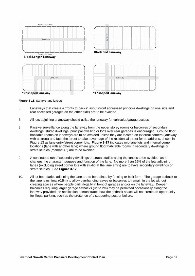
Liverpool Growth Centre Precincts Development Control Plan Page 61
Figure 3-16: Sample lane layouts
6. Laneways that create a ‘fronts to backs’ layout (front addressed principle dwellings on one side and rear accessed garages on the other side) are to be avoided.
7. All lots adjoining a laneway should utilise the laneway for vehicular/garage access.
8. Passive surveillance along the laneway from the upper storey rooms or balconies of secondary dwellings, studio dwellings, principal dwelling or lofts over rear garages is encouraged. Ground floor habitable rooms on laneways are to be avoided unless they are located on external corners (laneway with a street) and face the street to take advantage of the residential street for an address, shown in Figure 13 as lane entry/street corner lots. Figure 3-17 indicates mid-lane lots and internal corner locations (lane with another lane) where ground floor habitable rooms in secondary dwellings or strata studios (marked ‘S’) are to be avoided.
9. A continuous run of secondary dwellings or strata studios along the lane is to be avoided, as it changes the character, purpose and function of the lane. No more than 25% of the lots adjoining lanes (excluding street corner lots with studio at the lane entry) are to have secondary dwellings or strata studios. See Figure 3-17.
10. All lot boundaries adjoining the lane are to be defined by fencing or built form. The garage setback to the lane is minimal (0.5m) to allow overhanging eaves or balconies to remain in the lot without creating spaces where people park illegally in front of garages and/or on the laneway. Deeper balconies requiring larger garage setbacks (up to 2m) may be permitted occasionally along the laneway provided the application demonstrates how the setback space will not create an opportunity for illegal parking, such as the presence of a supporting post or bollard.
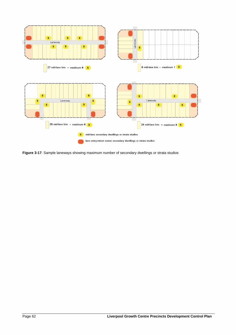
Page 62 Liverpool Growth Centre Precincts Development Control Plan
Figure 3-17: Sample laneways showing maximum number of secondary dwellings or strata studios
Liverpool Growth Centre Precincts Development Control Plan Page 63
3.3.4 Shared Driveways
Shared driveways are privately owned and maintained driveways that serve two or more dwellings through a titling arrangement such as a reciprocal right of way or community title. Shared driveways are usually of minimal dimensions for vehicle access to lots with only a single access to the street network. Garbage collection is usually not a function. Shared driveways are a useful subdivision device for a small number of dwellings with otherwise difficult access or unavoidable block configurations, but are not a substitute in blocks designed with significant numbers of dwellings requiring rear access by laneways.
Objectives
a. To minimise the impact of vehicle access points on the quality of the public domain and pedestrian
safety.
b. To provide safe and convenient access to garages, carports and parking areas.
c. To clearly define public and private spaces, such that driveways are for the sole use of residents.
d. To permit casual surveillance of private driveways from dwellings and from the street.
Controls
1. Shared driveways are to be constructed as one of three general types, depending on block geometry and garages to be accessed. Refer to examples in Figure 3-18.
2. Shared driveways are to have the smallest configuration possible to serve the required parking facilities and vehicle turning movements.
3. The driveway crossing the verge between the property boundary and the kerb is to have a maximum width of 5.4 metres.
4. The location of driveways is to be determined with regard to dwelling design and orientation, street gully pits and tree bays and is to maximise the available on-street parking.
5. The maximum travelling distance from a public road to a garbage collection area within a shared driveway is 70m. Where garbage collection is required to occur within the shared driveway (i.e. when an alternative collection point is not available), the layout is to be designed such that no reversing movements are required to be undertaken to enable a garage truck to enter and leave in a forward direction. A minimum pavement width of 5m and a turning circle with sweep turning paths overlaid into the design plan shall be submitted to demonstrate compliance with this requirement.
6. Access to allotments in the vicinity of roundabouts and associated splinter islands shall not be provided within 10m of the roundabout.
7. Driveways are not to be within 0.5m of any drainage facilities on the kerb and gutter.
8. Shared driveways are to have soft landscaped areas on either side, suitable for infiltration.
9. Shared driveways must be in accordance with the shareway principles and vehicle manoeuvring requirements of the Growth Centres Practice Note: Laneways.
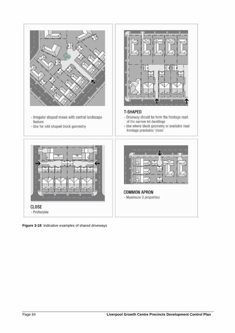
Page 64 Liverpool Growth Centre Precincts Development Control Plan
Figure 3-18: Indicative examples of shared driveways
Liverpool Growth Centre Precincts Development Control Plan Page 65
3.3.5 Pedestrian and Cycle Network
Objectives
a. To provide a convenient, efficient and safe network of pedestrian and cycleway paths for the use of
the community, within and beyond the site.
b. To encourage residents to walk or cycle, in preference to using motor vehicles, as a way of gaining
access to the schools, shops, and local community and recreation facilities.
c. To promote the efficient use of land by allowing pedestrian pathways and cycleways to be located
within parks and corridors wherever practical.
Controls
1. Key pedestrian and cycleway routes are to be provided generally in accordance with the pedestrian and cycleway network figure in the Precinct Schedule.
2. The design of footpaths and cycleways located within the road reserve is to be in accordance with Figure 3-10 toFigure 3-14.
3. The minimum width of off-street shared cycle and pedestrian pathways is to be 2.5m.
4. All pedestrian and cycleway routes and facilities are to be consistent with the Planning Guidelines for Walking and Cycling (DoP & RTA 2004), relevant Council pedestrian and cycling plans and policies, and Council Engineering Design and Construction Specifications.
5. Pedestrian and cycle routes and facilities in public spaces are to be safe, well lit, clearly defined, functional and accessible to all.
6. Pedestrian and cycle pathways and pedestrian refuge islands are to be designed to be fully accessible by all in terms of access points and gradients, generally in accordance with Australian Standard 1428:1-4.
7. Detailed designs for pedestrian and cycle paths are to be submitted with subdivision development applications.
8. Pedestrian and cycle pathways that are within road verges or carriageways are to be constructed as part of the road construction works for each subdivision.
9. Cycle and pedestrian bridges must be located above the 5% AEP flood level.
3.3.6 Temporary vehicular access
Objectives
a. To enable development to progressively occur in Precincts where current land ownership or other
development staging constraints temporarily limit road access to properties in accordance with this
DCP;
b. To ensure that appropriate vehicular access to properties is provided and maintained at all times during
the development of the Precincts;
c. To ensure that temporary vehicular access arrangements do not compromise safety and the efficient
operation of the road network.
Controls
1. Where necessary to ensure that access to residential properties is provided in the early stages of development, Council may consent to the construction and operation of temporary access roads.
Page 66 Liverpool Growth Centre Precincts Development Control Plan
2. Temporary access arrangements must comply with Council’s Engineering Specifications.
3. Temporary access roads are to remain in operation only until such time as the road network has been developed to provide permanent access to all properties. A section 88B instrument is required as part of the subdivision requiring that the temporary access road remains open for as long as necessary to ensure access to all properties.
4. The plan of subdivision is to show the location and design of temporary access roads, and the means of transitioning to permanent access arrangements
Note: Specific controls in clause 3.3.7 apply to temporary access to arterial roads, sub-arterial roads and transit boulevards
5. Temporary turning circles may be required where roads are to continue onto adjoining properties that are not yet developed. Temporary turning circles are to have a minimum radius of 8 metres and are to be sealed using the same materials as the rest of the road. These turning circles must be shown on the plan of subdivision and the application must also demonstrate how the transition to permanent arrangements will be managed.
6. Half-width roads may be constructed to provide temporary access to residential development, in accordance with Figure 3-19. The applicant will cover all costs associated with the design of the full road width and construction of half the full width pavement, including temporary and permanent drainage infrastructure, adequate transitions to full width cross sections, plus a two way traffic configuration ensuring operational effectiveness and safety to relevant standards.
7. Half-width roads are only permitted where the road is located on the side boundary of the land to be developed.
8. The centreline (of the full-width road) is to be located on the boundary.
9. The half-width road design is to ensure that runoff from the road pavement is directed to the kerb.
10. The development application plans are to show the vertical alignment of the half-width road relative to existing ground level on the adjoining property, and the applicant is to demonstrate how the half-width road will be integrated with adjoining land.
11. A minimum carriageway width of 5.5 metres is required for all half-width roads.
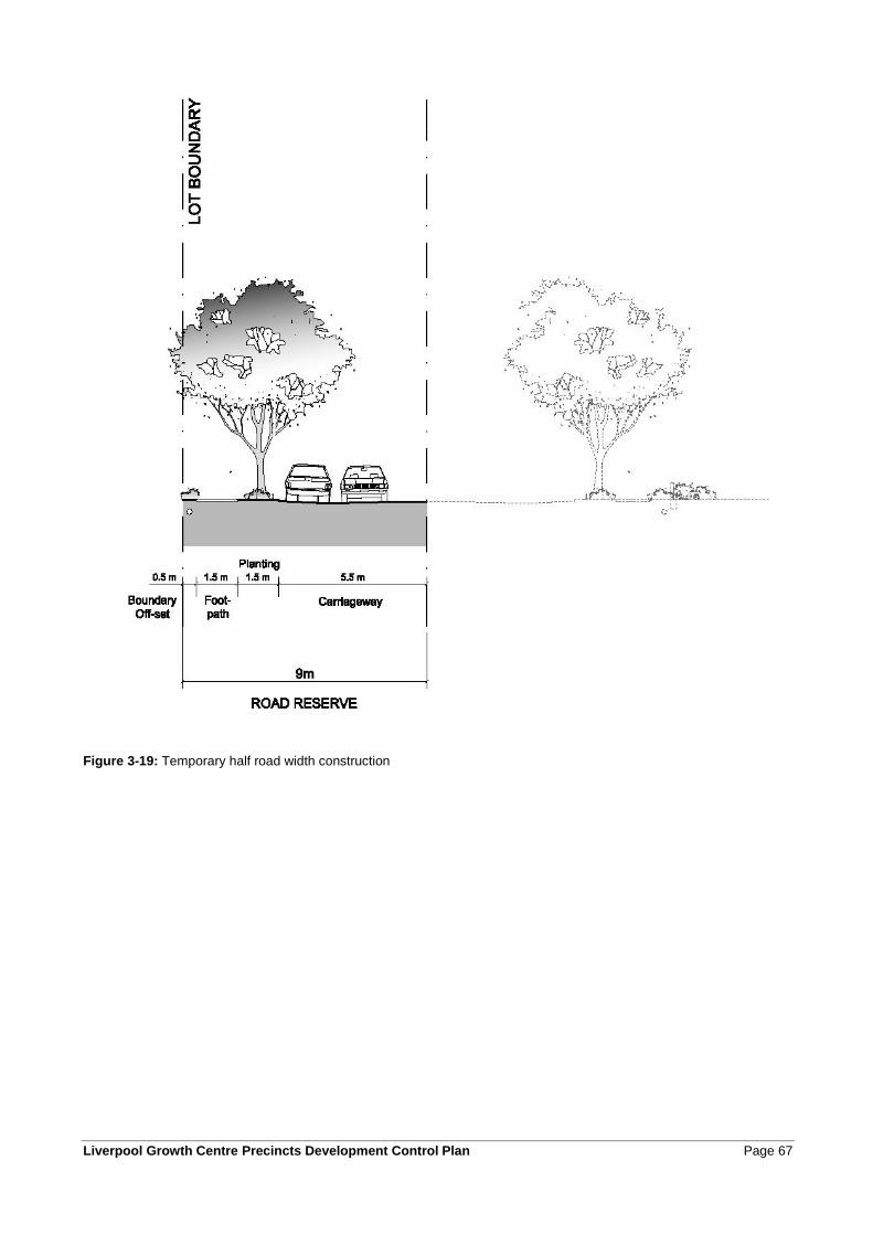
Liverpool Growth Centre Precincts Development Control Plan Page 67
Figure 3-19: Temporary half road width construction
Page 68 Liverpool Growth Centre Precincts Development Control Plan
3.3.7 Access to arterial roads, sub-arterial roads and transit boulevards
Objectives
a. To restrict direct property access to higher order roads to provide for the safe and efficient movement
of vehicles on these roads.
Controls
1. Vehicular access to arterial roads, sub-arterial roads and transit boulevards shown on the Precinct Road Hierarchy figure, in the relevant Precinct’s Schedule, may only be via another public road.
2. To enable the development of land, such as in situations where access across adjoining properties is required but not yet able to be provided, Council may allow temporary access to arterial roads, sub-arterial roads or transit boulevards where:
1. subdivisional roads generally conform with the road pattern shown on the Indicative Layout Plan and the development is capable of being adapted to ensure alternative access when adjacent development occurs;
2. The arterial road, sub-arterial road or transit boulevard is not yet upgraded to its ultimate configuration and/or traffic volumes on the road network are not sufficient to justify restricting direct access;
3. Council is satisfied that the carrying out of the development will not compromise traffic safety.
4. Applicants can demonstrate how the development will enable transition to permanent access arrangements that comply with parking, loading and access and adopted road network requirements of this DCP.
5. Where Council grants such consent, the temporary access must be constructed to Council's standards and conditions will be imposed that access to the designated road by way of the temporary access shall cease when alternative access becomes available.
Note: Approval from the RMS may also be required for any temporary access to a classified road.
3.4 Construction Environmental Management
Objectives
a. To ensure that the construction of subdivisions, new buildings and other structures and works is done
in an environmentally responsible manner.
Controls
1. A Construction Environmental Management Plan (CEMP) is to be submitted to Council or the accredited certifier prior to the issue of a construction certification for subdivision.
2. The CEMP is to detail the methods of ensuring the protection of the environment during construction, monitoring and reporting on construction activities, and procedures to be followed in the event of an incident that is likely to cause harm to the environment.
3. Construction activities are to be undertaken to ensure that water quality, soil stability, trees and vegetation cover, and heritage sites are protected in accordance with the development consent and to maintain the quality of the natural environment.
4. Applicants are to ensure that the management of construction activities is undertaken in accordance with the Erosion and Sedimentation controls in Liverpool DCP 2008.
Liverpool Growth Centre Precincts Development Control Plan Page 69
5. Preservation of trees and native vegetation during construction is to be in accordance with the development consent issued for the development, and with the native vegetation and tree preservation provisions of the relevant Precinct Plan.
6. Trees to be protected must be enclosed within a 1.8m high protection fence installed to conform to a Tree Protection Zone (TPZ) that is consistent with current arboriculture industry standards.
7. A report which outlines the condition, dimensions and species of existing trees contained within a development site is to be included as part of any development application documents and is to be accompanied by a Tree Retention Management Plan which shows the dimension of any proposed TPZs and outlines any other protection/enhancement methods that are appropriate to encourage the viable retention of trees.
8. All reports pertaining to trees on development sites are to be prepared by a suitably qualified person.
Page 70 Liverpool Growth Centre Precincts Development Control Plan
4 Development in the residential zones
4.0 Residential Development
Liverpool Growth Centre Precincts Development Control Plan Page 71
4.1 Site responsive design
4.1.1 Site analysis
Site analysis for each individual lot is an important part of the design process. Development proposals need to illustrate design decisions which are based on careful analysis of the site conditions and their relationship to the surrounding context. By describing the physical elements of the locality and the conditions impacting on the site, opportunities and constraints for development can be understood and addressed in the design.
The Site Analysis Plan should show the existing features of the site and its surrounding area, together with supporting written material. A Site Analysis Plan must show at least the following features:
• the position of the proposed building in relation to site boundaries and any other structures and existing vegetation and trees on the site;
• any easements over the land;
• the location, boundary dimensions, site area and north point of the land;
• location of existing street features adjacent to the property, such as trees, planting, street lights;
• contours and existing levels of the land in relation to buildings and roads and, whether the proposed development will involve any changes to these levels;
• location and uses of buildings on sites adjoining the land; and
• a stormwater concept plan (where required).
4.1.2 Cut and fill
Objectives
a. To minimise the extent of cut and fill within residential allotments.
b. To protect and enhance the aesthetic quality of the area by controlling the form, bulk and scale of land
forming operations.
c. To ensure that fill material is not contaminated and does not adversely affect the fertility or salinity of
soil, or the quality of surface water or groundwater.
d. To ensure that the amenity of adjoining residents is not adversely affected by any land forming
operation.
Controls
1. The maximum cut on a site must not exceed 600mm.
2. All retaining wall structures shall be masonry construction and designed by a suitably qualified person, or constructed as specified by the manufacturer of the product. The retaining wall shall be constructed wholly inside (within) the boundary of the site.
3. All slab constructions for dwellings that are above natural ground level are to be constructed using dropped edge beams to retain fill, as shown in Figure 4-1. The maximum fill within the confines of the slab must not exceed 1m. All fill must be contained within the dwelling footprint. Retaining structures must be constructed prior to the release of the occupation certificate.
4. Contaminated fill, either imported or found on site, is not permitted.
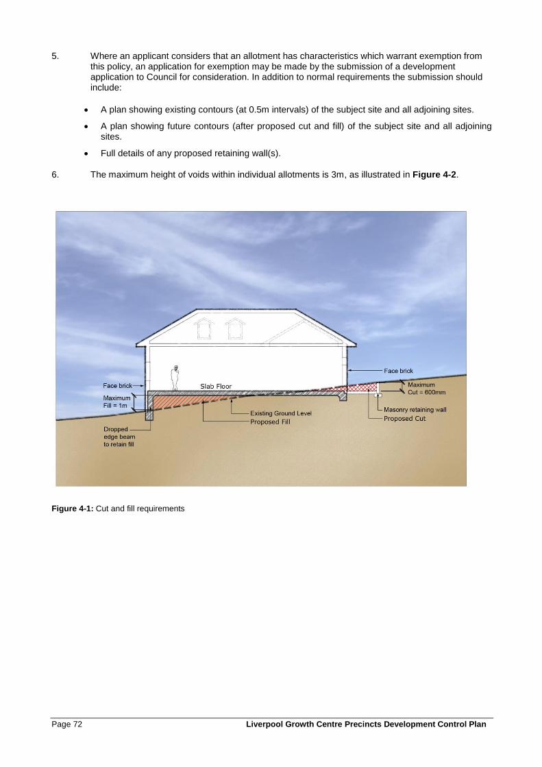
Page 72 Liverpool Growth Centre Precincts Development Control Plan
5. Where an applicant considers that an allotment has characteristics which warrant exemption from this policy, an application for exemption may be made by the submission of a development application to Council for consideration. In addition to normal requirements the submission should include:
• A plan showing existing contours (at 0.5m intervals) of the subject site and all adjoining sites.
• A plan showing future contours (after proposed cut and fill) of the subject site and all adjoining sites.
• Full details of any proposed retaining wall(s).
6. The maximum height of voids within individual allotments is 3m, as illustrated in Figure 4-2.
Figure 4-1: Cut and fill requirements
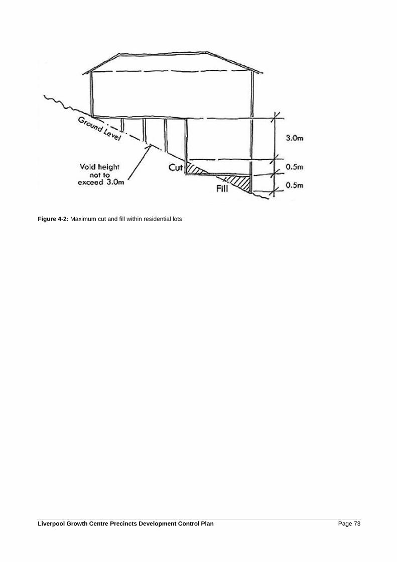
Liverpool Growth Centre Precincts Development Control Plan Page 73
Figure 4-2: Maximum cut and fill within residential lots
Page 74 Liverpool Growth Centre Precincts Development Control Plan
4.1.3 Sustainable building design
Objectives
a. To maximise microclimate benefits to residential lots and to minimise impacts of residential
development on local climatic conditions.
b. To enhance streetscape amenity and ensure an appropriate standard of landscaping.
c. To minimise energy usage and greenhouse emissions and encourage the adoption of renewable
energy initiatives.
d. To minimise consumption of potable water for non-potable uses, minimise site runoff and promote
stormwater re-use.
e. To minimise the use of non-renewable resources and minimise the generation of waste during
construction.
Controls
1. The majority of plant species are to be selected from the preferred species listed at Appendix C and indigenous species are preferred.
2. The provisions of BASIX will apply with regards to water requirements and usage.
3. The design of dwellings is to maximise cross flow ventilation.
4. The orientation of dwellings, location of living rooms and the positioning and size of windows and other openings is to take advantage of solar orientation to maximise natural light penetration to indoor areas and to minimise the need for mechanical heating and cooling.
5. Outdoor clothes lines and drying areas are required for all dwellings and can be incorporated into communal areas for multi-dwelling development and residential flat building developments.
6. Design and construction of dwellings is to make use of locally sourced materials where possible.
7. Residential building design is to use, where possible, recycled and renewable materials.
8. Roof and paving materials and colours are to minimise the retention of heat from the sun.
9. The design of dwellings that are required to attenuate noise shall use, where possible, alternatives to
air-conditioning, such as acoustic wall ventilators, ceiling fans, or bulkhead-mounted ducted fans to
achieve appropriate ventilation.
Liverpool Growth Centre Precincts Development Control Plan Page 75
4.1.4 Salinity, sodicity and aggressivity
Objectives
a. To manage and mitigate the impacts of, and on, salinity.
Controls
1. All development must comply with the Salinity Management Plan developed at the subdivision phase or at Appendix B. The actions/works from the Salinity Management Plan must be certified upon completion of the development.
2. Salinity shall be considered during the siting, design and construction of dwellings including: drainage, vegetation type and location, foundation selection and cut and fill activities, to ensure the protection of the dwelling from salinity damage and to minimise the impacts that the development may have on the salinity process.
4.2 Dwelling design controls
Under the provisions of the Precinct Plan, development consent is generally required for all dwellings in all residential zones, except where applications meet the criteria for complying development. This section establishes objectives and controls for the following types of residential accommodation as defined in the Growth Centres SEPP:
• dwelling houses;
• semi-detached dwellings;
• attached dwellings;
• abutting dwellings;
• multi-dwelling housing;
• dual occupancy dwellings;
• manor homes;
• residential flat buildings;
• secondary dwellings; and
• studio dwellings.
Additional controls for attached or abutting dwellings, secondary dwellings, studio dwellings, dual occupancies, multi-dwelling housing, manor homes, residential flat buildings and shop top housing are contained in Section 4.3.
It is acknowledged that innovative dwelling designs are evolving particularly on lots <300sqm, and design solutions may be developed that meet the objectives but do not comply with the relevant controls. In density bands ≥25dw/Ha, there is the opportunity to vary the dwelling design controls where agreed to as part of an integrated housing development application at subdivision approval. .
Note: Reference should be made to the Glossary for descriptions of the various dwelling types, and to the relevant Precinct Plan for statutory definitions of land uses.
4.2.1 Summary of Key Controls
The following Table 4-1 summarises the types of lots and housing. Table 4-1 is diagrammatic only and directs readers to the relevant Tables 4-2 to 4-6 containing the main development controls.
The key controls should be read in conjunction with the controls in the clauses that follow.
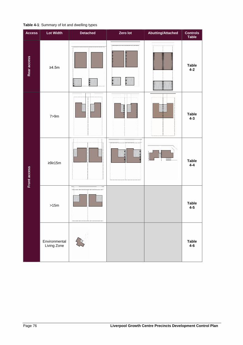
Page 76 Liverpool Growth Centre Precincts Development Control Plan
Table 4-1: Summary of lot and dwelling types
Access Lot Width Detached Zero lot Abutting/Attached Controls Table
Re
ar
acc
es
s
≥4.5m
Table 4-2
Fro
nt
ac
ce
ss
7>9m
Table 4-3
≥9≥15m
Table 4-4
>15m
Table 4-5
Environmental Living Zone
Table 4-6
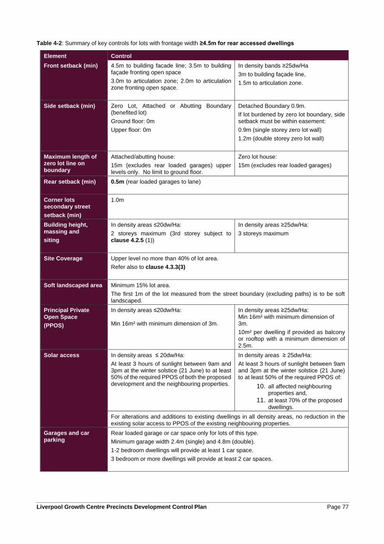
Liverpool Growth Centre Precincts Development Control Plan Page 77
Table 4-2: Summary of key controls for lots with frontage width ≥4.5m for rear accessed dwellings
Element Control
Front setback (min)
4.5m to building facade line; 3.5m to building façade fronting open space
3.0m to articulation zone; 2.0m to articulation zone fronting open space.
In density bands ≥25dw/Ha
3m to building façade line,
1.5m to articulation zone.
Side setback (min)
Zero Lot, Attached or Abutting Boundary (benefited lot)
Ground floor: 0m
Upper floor: 0m
Detached Boundary 0.9m.
If lot burdened by zero lot boundary, side setback must be within easement:
0.9m (single storey zero lot wall)
1.2m (double storey zero lot wall)
Maximum length of zero lot line on boundary
Attached/abutting house:
15m (excludes rear loaded garages) upper levels only. No limit to ground floor.
Zero lot house:
15m (excludes rear loaded garages)
Rear setback (min) 0.5m (rear loaded garages to lane)
Corner lots secondary street
setback (min)
1.0m
Building height,
massing and
siting
In density areas ≤20dw/Ha:
2 storeys maximum (3rd storey subject to clause 4.2.5 (1))
In density areas ≥25dw/Ha:
3 storeys maximum
Site Coverage Upper level no more than 40% of lot area.
Refer also to clause 4.3.3(3)
Soft landscaped area Minimum 15% lot area.
The first 1m of the lot measured from the street boundary (excluding paths) is to be soft landscaped.
Principal Private
Open Space
(PPOS)
In density areas ≤20dw/Ha: Min 16m² with minimum dimension of 3m.
In density areas ≥25dw/Ha: Min 16m² with minimum dimension of 3m.
10m² per dwelling if provided as balcony or rooftop with a minimum dimension of 2.5m.
Solar access In density areas ≤ 20dw/Ha:
At least 3 hours of sunlight between 9am and 3pm at the winter solstice (21 June) to at least 50% of the required PPOS of both the proposed development and the neighbouring properties.
In density areas ≥ 25dw/Ha:
At least 3 hours of sunlight between 9am and 3pm at the winter solstice (21 June) to at least 50% of the required PPOS of:
10. all affected neighbouring properties and,
11. at least 70% of the proposed
dwellings.
For alterations and additions to existing dwellings in all density areas, no reduction in the
existing solar access to PPOS of the existing neighbouring properties.
Garages and car
parking
Rear loaded garage or car space only for lots of this type.
Minimum garage width 2.4m (single) and 4.8m (double).
1-2 bedroom dwellings will provide at least 1 car space.
3 bedroom or more dwellings will provide at least 2 car spaces.

Page 78 Liverpool Growth Centre Precincts Development Control Plan
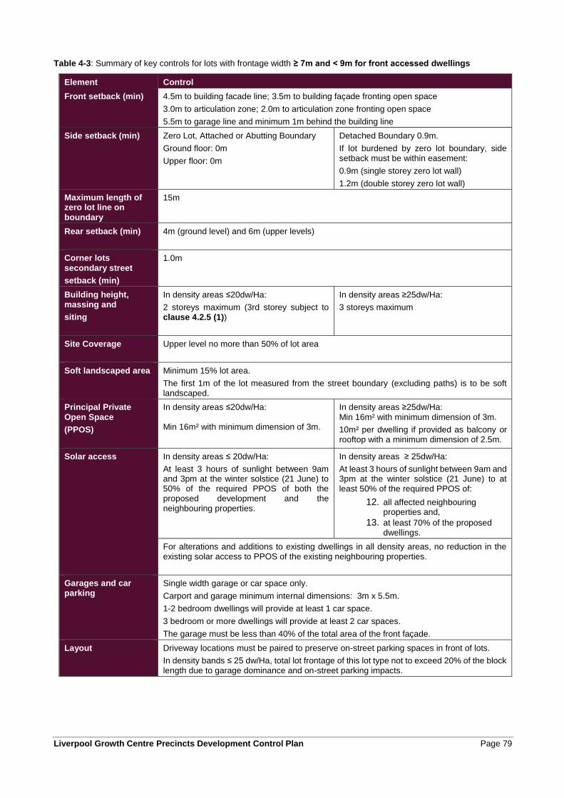
Liverpool Growth Centre Precincts Development Control Plan Page 79
Table 4-3: Summary of key controls for lots with frontage width ≥ 7m and < 9m for front accessed dwellings
Element Control
Front setback (min)
4.5m to building facade line; 3.5m to building façade fronting open space
3.0m to articulation zone; 2.0m to articulation zone fronting open space
5.5m to garage line and minimum 1m behind the building line
Side setback (min)
Zero Lot, Attached or Abutting Boundary
Ground floor: 0m
Upper floor: 0m
Detached Boundary 0.9m.
If lot burdened by zero lot boundary, side setback must be within easement:
0.9m (single storey zero lot wall)
1.2m (double storey zero lot wall)
Maximum length of zero lot line on
boundary
15m
Rear setback (min) 4m (ground level) and 6m (upper levels)
Corner lots
secondary street
setback (min)
1.0m
Building height, massing and
siting
In density areas ≤20dw/Ha:
2 storeys maximum (3rd storey subject to clause 4.2.5 (1))
In density areas ≥25dw/Ha:
3 storeys maximum
Site Coverage Upper level no more than 50% of lot area
Soft landscaped area Minimum 15% lot area.
The first 1m of the lot measured from the street boundary (excluding paths) is to be soft landscaped.
Principal Private
Open Space
(PPOS)
In density areas ≤20dw/Ha: Min 16m² with minimum dimension of 3m.
In density areas ≥25dw/Ha:
Min 16m² with minimum dimension of 3m.
10m² per dwelling if provided as balcony or rooftop with a minimum dimension of 2.5m.
Solar access In density areas ≤ 20dw/Ha:
At least 3 hours of sunlight between 9am and 3pm at the winter solstice (21 June) to 50% of the required PPOS of both the proposed development and the neighbouring properties.
In density areas ≥ 25dw/Ha:
At least 3 hours of sunlight between 9am and 3pm at the winter solstice (21 June) to at least 50% of the required PPOS of:
12. all affected neighbouring properties and,
13. at least 70% of the proposed dwellings.
For alterations and additions to existing dwellings in all density areas, no reduction in the existing solar access to PPOS of the existing neighbouring properties.
Garages and car parking
Single width garage or car space only.
Carport and garage minimum internal dimensions: 3m x 5.5m.
1-2 bedroom dwellings will provide at least 1 car space.
3 bedroom or more dwellings will provide at least 2 car spaces.
The garage must be less than 40% of the total area of the front façade.
Layout Driveway locations must be paired to preserve on-street parking spaces in front of lots.
In density bands ≤ 25 dw/Ha, total lot frontage of this lot type not to exceed 20% of the block length due to garage dominance and on-street parking impacts.
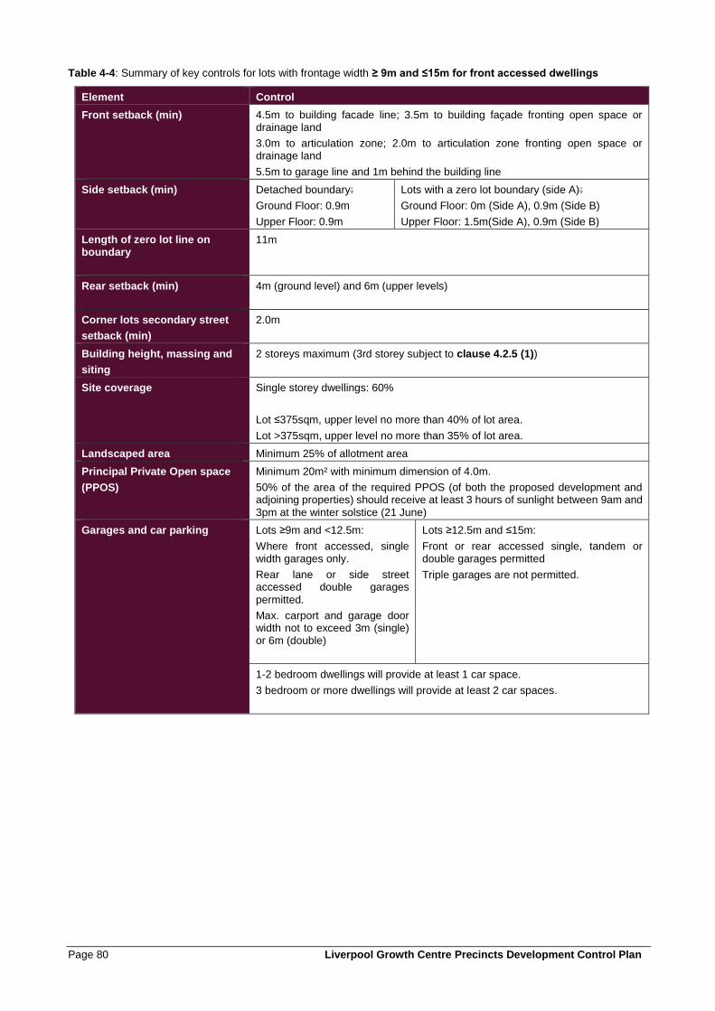
Page 80 Liverpool Growth Centre Precincts Development Control Plan
Table 4-4: Summary of key controls for lots with frontage width ≥ 9m and ≤15m for front accessed dwellings
Element Control
Front setback (min)
4.5m to building facade line; 3.5m to building façade fronting open space or drainage land
3.0m to articulation zone; 2.0m to articulation zone fronting open space or drainage land
5.5m to garage line and 1m behind the building line
Side setback (min)
Detached boundary:
Ground Floor: 0.9m
Upper Floor: 0.9m
Lots with a zero lot boundary (side A):
Ground Floor: 0m (Side A), 0.9m (Side B)
Upper Floor: 1.5m(Side A), 0.9m (Side B)
Length of zero lot line on boundary
11m
Rear setback (min) 4m (ground level) and 6m (upper levels)
Corner lots secondary street
setback (min)
2.0m
Building height, massing and
siting
2 storeys maximum (3rd storey subject to clause 4.2.5 (1))
Site coverage
Single storey dwellings: 60%
Lot ≤375sqm, upper level no more than 40% of lot area.
Lot >375sqm, upper level no more than 35% of lot area.
Landscaped area Minimum 25% of allotment area
Principal Private Open space
(PPOS)
Minimum 20m² with minimum dimension of 4.0m.
50% of the area of the required PPOS (of both the proposed development and adjoining properties) should receive at least 3 hours of sunlight between 9am and
3pm at the winter solstice (21 June)
Garages and car parking
Lots ≥9m and <12.5m:
Where front accessed, single width garages only.
Rear lane or side street accessed double garages
permitted.
Max. carport and garage door width not to exceed 3m (single) or 6m (double)
Lots ≥12.5m and ≤15m:
Front or rear accessed single, tandem or double garages permitted
Triple garages are not permitted.
1-2 bedroom dwellings will provide at least 1 car space.
3 bedroom or more dwellings will provide at least 2 car spaces.
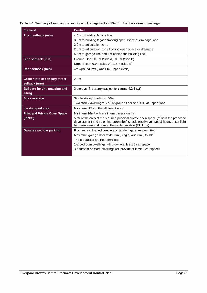
Liverpool Growth Centre Precincts Development Control Plan Page 81
Table 4-5: Summary of key controls for lots with frontage width > 15m for front accessed dwellings
Element Control
Front setback (min)
4.5m to building facade line
3.5m to building façade fronting open space or drainage land
3.0m to articulation zone
2.0m to articulation zone fronting open space or drainage
5.5m to garage line and 1m behind the building line
Side setback (min)
Ground Floor: 0.9m (Side A), 0.9m (Side B)
Upper Floor: 0.9m (Side A), 1.5m (Side B)
Rear setback (min) 4m (ground level) and 6m (upper levels)
Corner lots secondary street
setback (min)
2.0m
Building height, massing and
siting
2 storeys (3rd storey subject to clause 4.2.5 (1))
Site coverage
Single storey dwellings: 50%
Two storey dwellings: 50% at ground floor and 30% at upper floor
Landscaped area Minimum 30% of the allotment area
Principal Private Open Space
(PPOS)
Minimum 24m² with minimum dimension 4m
50% of the area of the required principal private open space (of both the proposed development and adjoining properties) should receive at least 3 hours of sunlight between 9am and 3pm at the winter solstice (21 June).
Garages and car parking
Front or rear loaded double and tandem garages permitted
Maximum garage door width 3m (Single) and 6m (Double)
Triple garages are not permitted.
1-2 bedroom dwellings will provide at least 1 car space.
3 bedroom or more dwellings will provide at least 2 car spaces.
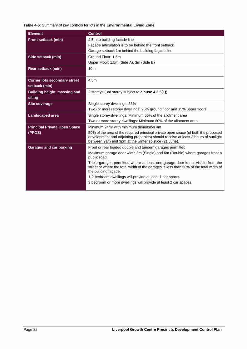
Page 82 Liverpool Growth Centre Precincts Development Control Plan
Table 4-6: Summary of key controls for lots in the Environmental Living Zone
Element Control
Front setback (min)
4.5m to building facade line
Façade articulation is to be behind the front setback
Garage setback 1m behind the building façade line
Side setback (min)
Ground Floor: 1.5m
Upper Floor: 1.5m (Side A), 3m (Side B)
Rear setback (min) 10m
Corner lots secondary street
setback (min)
4.5m
Building height, massing and
siting
2 storeys (3rd storey subject to clause 4.2.5(1))
Site coverage
Single storey dwellings: 35%
Two (or more) storey dwellings: 25% ground floor and 15% upper floors
Landscaped area Single storey dwellings: Minimum 55% of the allotment area
Two or more storey dwellings: Minimum 60% of the allotment area
Principal Private Open Space
(PPOS)
Minimum 24m² with minimum dimension 4m
50% of the area of the required principal private open space (of both the proposed development and adjoining properties) should receive at least 3 hours of sunlight
between 9am and 3pm at the winter solstice (21 June).
Garages and car parking
Front or rear loaded double and tandem garages permitted
Maximum garage door width 3m (Single) and 6m (Double) where garages front a public road.
Triple garages permitted where at least one garage door is not visible from the street or where the total width of the garages is less than 50% of the total width of the building façade.
1-2 bedroom dwellings will provide at least 1 car space.
3 bedroom or more dwellings will provide at least 2 car spaces.
Liverpool Growth Centre Precincts Development Control Plan Page 83
4.2.2 Streetscape and architectural design
Growth Centres neighbourhoods will be composed of a variety of streets with different but equally appealing characters and built form intensity. In low density precincts, suburban streetscapes will be most common but there will also be some streets with a more urban village character. In higher density precincts, urban village streets will be more common but there will also be some suburban streetscapes. The objective is to avoid a monoculture of the one type of street which is neither a successful suburban or urban street.
Figure 4-3 illustrates how the designed combination of built form, lot size, setbacks, garaging and landscaping can create distinctive streetscape characters ranging from the low intensity ‘garden suburban’ character based on landscaped private space around buildings to the built form intensity and public landscapes of urban streets.
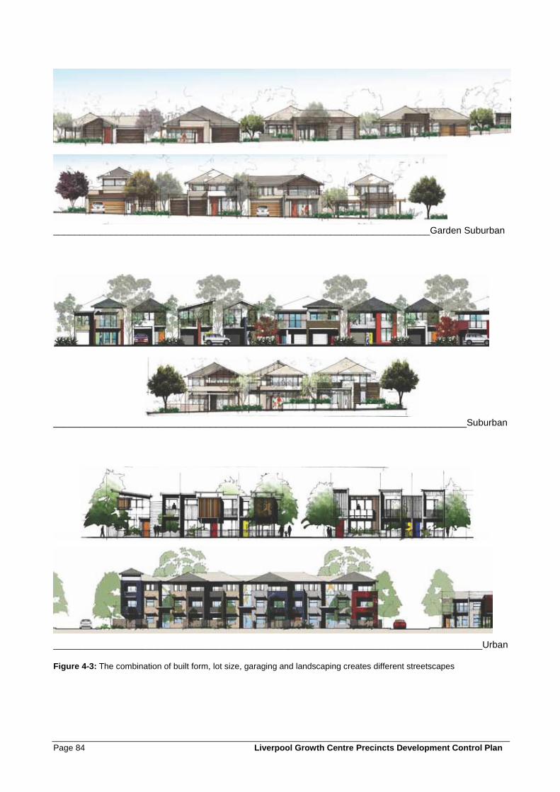
Page 84 Liverpool Growth Centre Precincts Development Control Plan
________________________________________________________________________Garden Suburban
_______________________________________________________________________________Suburban
__________________________________________________________________________________Urban
Figure 4-3: The combination of built form, lot size, garaging and landscaping creates different streetscapes
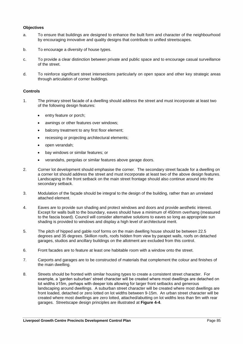
Liverpool Growth Centre Precincts Development Control Plan Page 85
Objectives
a. To ensure that buildings are designed to enhance the built form and character of the neighbourhood
by encouraging innovative and quality designs that contribute to unified streetscapes.
b. To encourage a diversity of house types.
c. To provide a clear distinction between private and public space and to encourage casual surveillance
of the street.
d. To reinforce significant street intersections particularly on open space and other key strategic areas
through articulation of corner buildings.
Controls
1. The primary street facade of a dwelling should address the street and must incorporate at least two of the following design features:
• entry feature or porch;
• awnings or other features over windows;
• balcony treatment to any first floor element;
• recessing or projecting architectural elements;
• open verandah;
• bay windows or similar features; or
• verandahs, pergolas or similar features above garage doors.
2. Corner lot development should emphasise the corner. The secondary street facade for a dwelling on a corner lot should address the street and must incorporate at least two of the above design features. Landscaping in the front setback on the main street frontage should also continue around into the secondary setback.
3. Modulation of the façade should be integral to the design of the building, rather than an unrelated attached element.
4. Eaves are to provide sun shading and protect windows and doors and provide aesthetic interest. Except for walls built to the boundary, eaves should have a minimum of 450mm overhang (measured to the fascia board). Council will consider alternative solutions to eaves so long as appropriate sun shading is provided to windows and display a high level of architectural merit.
5. The pitch of hipped and gable roof forms on the main dwelling house should be between 22.5 degrees and 35 degrees. Skillion roofs, roofs hidden from view by parapet walls, roofs on detached garages, studios and ancillary buildings on the allotment are excluded from this control.
6. Front facades are to feature at least one habitable room with a window onto the street.
7. Carports and garages are to be constructed of materials that complement the colour and finishes of the main dwelling.
8. Streets should be fronted with similar housing types to create a consistent street character. For example, a ‘garden suburban’ street character will be created where most dwellings are detached on lot widths ≥15m, perhaps with deeper lots allowing for larger front setbacks and generous landscaping around dwellings. A suburban street character will be created where most dwellings are front loaded, detached or zero lotted on lot widths between 9-15m. An urban street character will be created where most dwellings are zero lotted, attached/abutting on lot widths less than 9m with rear garages. Streetscape design principles are illustrated at Figure 4-4.
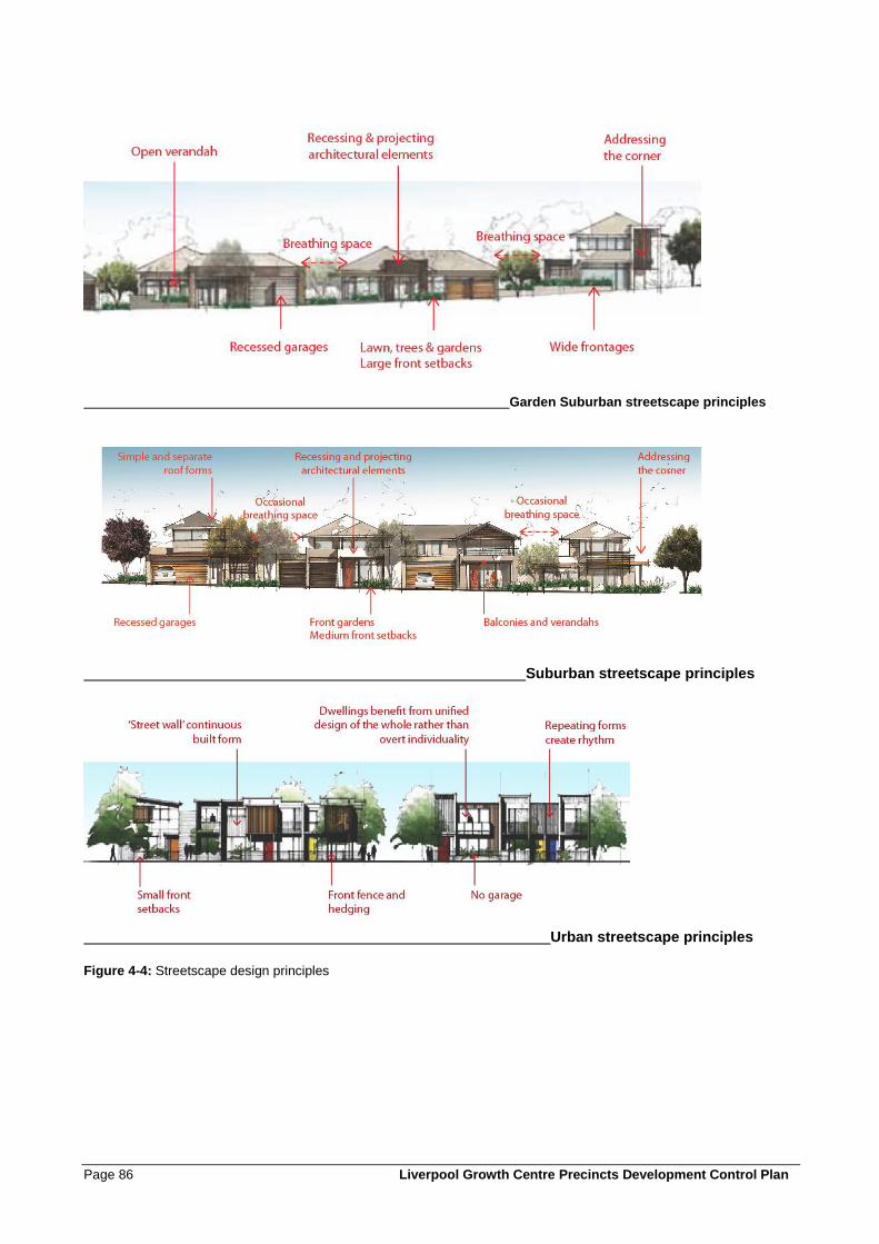
Page 86 Liverpool Growth Centre Precincts Development Control Plan
Garden Suburban streetscape principles
Suburban streetscape principles
Urban streetscape principles
Figure 4-4: Streetscape design principles
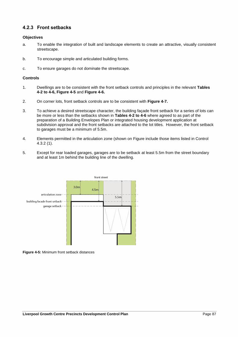
Liverpool Growth Centre Precincts Development Control Plan Page 87
4.2.3 Front setbacks
Objectives
a. To enable the integration of built and landscape elements to create an attractive, visually consistent
streetscape.
b. To encourage simple and articulated building forms.
c. To ensure garages do not dominate the streetscape.
Controls
1. Dwellings are to be consistent with the front setback controls and principles in the relevant Tables 4-2 to 4-6, Figure 4-5 and Figure 4-6.
2. On corner lots, front setback controls are to be consistent with Figure 4-7.
3. To achieve a desired streetscape character, the building façade front setback for a series of lots can be more or less than the setbacks shown in Tables 4-2 to 4-6 where agreed to as part of the preparation of a Building Envelopes Plan or integrated housing development application at subdivision approval and the front setbacks are attached to the lot titles. However, the front setback to garages must be a minimum of 5.5m.
4. Elements permitted in the articulation zone (shown on Figure include those items listed in Control 4.3.2 (1).
5. Except for rear loaded garages, garages are to be setback at least 5.5m from the street boundary and at least 1m behind the building line of the dwelling.
Figure 4-5: Minimum front setback distances
Page 88 Liverpool Growth Centre Precincts Development Control Plan
Figure 4-6: Minimum front setbacks for dwellings fronting open space or drainage land
Figure 4-7: Minimum setbacks for corner lot dwellings
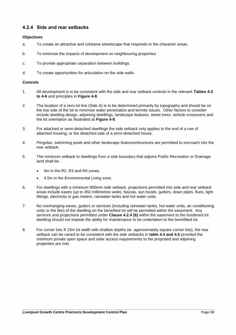
Liverpool Growth Centre Precincts Development Control Plan Page 89
4.2.4 Side and rear setbacks
Objectives
a. To create an attractive and cohesive streetscape that responds to the character areas.
b. To minimise the impacts of development on neighbouring properties.
c. To provide appropriate separation between buildings.
d. To create opportunities for articulation on the side walls.
Controls
1. All development is to be consistent with the side and rear setback controls in the relevant Tables 4-2 to 4-6 and principles in Figure 4-8.
2. The location of a zero lot line (Side A) is to be determined primarily by topography and should be on the low side of the lot to minimise water penetration and termite issues. Other factors to consider include dwelling design, adjoining dwellings, landscape features, street trees, vehicle crossovers and the lot orientation as illustrated at Figure 4-8.
3. For attached or semi-detached dwellings the side setback only applies to the end of a row of attached housing, or the detached side of a semi-detached house.
4. Pergolas, swimming pools and other landscape features/structures are permitted to encroach into the rear setback.
5. The minimum setback to dwellings from a side boundary that adjoins Public Recreation or Drainage land shall be:
• 3m in the R2, R3 and R4 zones.
• 4.5m in the Environmental Living zone.
6. For dwellings with a minimum 900mm side setback, projections permitted into side and rear setback areas include eaves (up to 450 millimetres wide), fascias, sun hoods, gutters, down pipes, flues, light fittings, electricity or gas meters, rainwater tanks and hot water units.
7. No overhanging eaves, gutters or services (including rainwater tanks, hot water units, air-conditioning units or the like) of the dwelling on the benefited lot will be permitted within the easement. Any services and projections permitted under Clause 4.2.4 (6) within the easement to the burdened lot dwelling should not impede the ability for maintenance to be undertaken to the benefitted lot.
8. For corner lots ≥ 15m lot width with shallow depths (ie. approximately square corner lots), the rear
setback can be varied to be consistent with the side setbacks in table 4.4 and 4.5 provided the minimum private open space and solar access requirements to the proposed and adjoining properties are met.
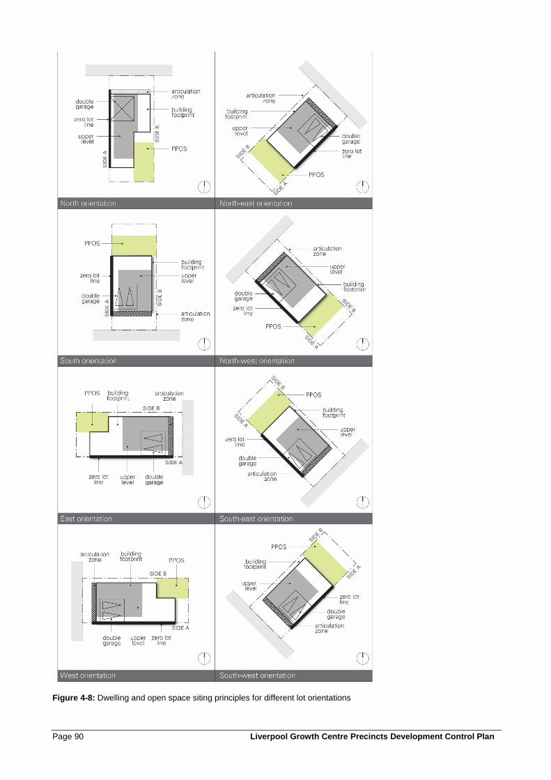
Page 90 Liverpool Growth Centre Precincts Development Control Plan
Figure 4-8: Dwelling and open space siting principles for different lot orientations
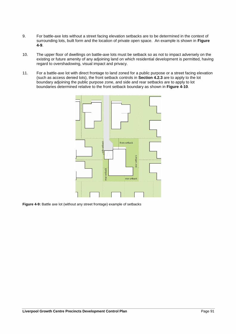
Liverpool Growth Centre Precincts Development Control Plan Page 91
9. For battle-axe lots without a street facing elevation setbacks are to be determined in the context of surrounding lots, built form and the location of private open space. An example is shown in Figure 4-9.
10. The upper floor of dwellings on battle-axe lots must be setback so as not to impact adversely on the existing or future amenity of any adjoining land on which residential development is permitted, having regard to overshadowing, visual impact and privacy.
11. For a battle-axe lot with direct frontage to land zoned for a public purpose or a street facing elevation (such as access denied lots), the front setback controls in Section 4.2.3 are to apply to the lot boundary adjoining the public purpose zone, and side and rear setbacks are to apply to lot boundaries determined relative to the front setback boundary as shown in Figure 4-10.
Figure 4-9: Battle axe lot (without any street frontage) example of setbacks
Page 92 Liverpool Growth Centre Precincts Development Control Plan
Figure 4-10: Battle axe lot (fronting access denied road) setbacks
Liverpool Growth Centre Precincts Development Control Plan Page 93
4.2.5 Dwelling Height, Massing and Siting
Objectives
a. To ensure development is of a scale appropriate to protect residential amenity.
b. To ensure building heights achieve built form outcomes that reinforce quality urban and building
design.
Controls
1. Dwellings are to be generally a maximum of 2 storeys high. Council may permit a 3rd storey if it is satisfied that:
• the dwelling is located on a prominent street corner; or
• the dwelling is located adjacent to a neighbourhood or local centre, public recreation or drainage land, a golf course, or a riparian corridor; or
• the dwelling is located on land with a finished ground level slope equal to or more than 15%, and is not likely to impact adversely on the existing or future amenity of any adjoining land on which residential development is permitted, having regard to overshadowing, visual impact and any impact on privacy; or
• the third storey is within the roof line of the building (i.e. an attic).
Note: Reference should be made to clause 4.2.3 of the relevant Precinct Plan for statutory height limits.
2. All development is to comply with the maximum site coverage as indicated in the relevant Tables 4-2 to 4-6.
3. Site coverage is the proportion of the lot covered by a dwelling house and all ancillary development (e.g. carport, garage, shed) but excluding unenclosed balconies, verandahs, porches, al fresco areas etc.
4. The ground floor level shall be no more than 1m above finished ground level.
5. Dwellings on a battle-axe-lot without public open space or street frontage are to be a maximum of 2 storeys high.
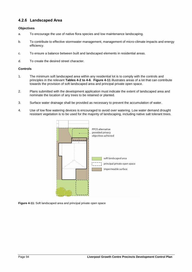
Page 94 Liverpool Growth Centre Precincts Development Control Plan
4.2.6 Landscaped Area
Objectives
a. To encourage the use of native flora species and low maintenance landscaping.
b. To contribute to effective stormwater management, management of micro-climate impacts and energy
efficiency.
c. To ensure a balance between built and landscaped elements in residential areas.
d. To create the desired street character.
Controls
1. The minimum soft landscaped area within any residential lot is to comply with the controls and principles in the relevant Tables 4-2 to 4-6. Figure 4-11 illustrates areas of a lot that can contribute towards the provision of soft landscaped area and principal private open space.
2. Plans submitted with the development application must indicate the extent of landscaped area and nominate the location of any trees to be retained or planted.
3. Surface water drainage shall be provided as necessary to prevent the accumulation of water.
4. Use of low flow watering devices is encouraged to avoid over watering. Low water demand drought resistant vegetation is to be used for the majority of landscaping, including native salt tolerant trees.
Figure 4-11: Soft landscaped area and principal private open space
Liverpool Growth Centre Precincts Development Control Plan Page 95
4.2.7 Private Open Space
Objectives
a. To provide a high level of residential amenity with opportunities for outdoor recreation and relaxation.
b. To enhance the spatial quality, outlook, and usability of private open space.
c. To facilitate solar access to the living areas and private open spaces of the dwelling.
Controls
Each dwelling is to be provided with an area of Principal Private Open Space (PPOS) consistent with
the requirements of the relevant Tables 4-2 to 4-6.
The location of PPOS is to be determined having regard to dwelling design, allotment orientation,
adjoining dwellings, landscape features, topography.
The PPOS is required to be conveniently accessible from the main living area of a dwelling or alfresco
room and have a maximum gradient of 1:10. Where part or all of the PPOS is permitted as a semi-
private patio, balcony or rooftop area, it must be directly accessible from a living area.
Open space at the front of the dwelling can only be defined as PPOS where this is the only means of
achieving the solar access requirements of control 1 above. PPOS at the front of a dwelling must be
designed to maintain appropriate privacy (for example raised level above footpath or fencing or
hedging) and be consistent with the streetscape design controls in Section 4.2.2.
Page 96 Liverpool Growth Centre Precincts Development Control Plan
4.2.8 Garages, Storage, Site Access and Parking
Objectives
a. To control the number, dimensions and location of vehicle access points. To reduce the visual impact
of garages, carports, and parking areas on the streetscape.
b. To provide safe, secure and convenient access to parking within garages, carports and parking areas,
with casual surveillance of private driveways from dwellings and from the street.
c. To minimise conflict between pedestrians and vehicles at the junction of driveways and footpaths.
d. To provide predominantly on-site parking for residents.
Controls
1. 1-2 bedroom dwellings will provide at least 1 car space.
2. 3 bedroom or more dwellings will provide at least 2 car spaces.
3. At least one car parking space must be located behind the building façade line where the car parking space is accessed from the street on the front property boundary.
Note: A car space may include a garage, carport or other hard stand area constructed of materials suitable for car parking and access. The required car parking spaces specified above may be provided using a combination of these facilities, including use of the driveway (within the property boundary only) as a parking space.
4. Vehicular access is to be integrated with site planning from the earliest stages of the project to eliminate/reduce potential conflicts with the streetscape requirements and traffic patterns, and to minimise potential conflicts with pedestrians.
5. Driveways are to have the smallest configuration possible (particularly within the road verge) to serve the required parking facilities and vehicle turning movements and shall comply with AS2890.
6. The location of driveways is to be determined with regard to dwelling design and orientation, street gully pits and trees and is to maximise the availability of on-street parking.
Notes: Section 3.2.5 requires plans of subdivision to nominate driveway locations and preferred building envelopes. The design of dwellings should refer to the approved subdivision plans and be consistent with the nominated driveway locations to the greatest practical extent.
Controls for driveways and access to corner lots are contained in Section 3.2.2 and Figure 3-6.
7. Driveways are not to be within 1m of any drainage facilities on the kerb and gutter.
8. Planting and walls adjacent to driveways must not block lines of sight for pedestrians, cyclists and motorists.
9. Driveways are to have soft landscaped areas on either side, suitable for water infiltration.
10. Garages are to be designed and located in accordance with the controls in relevant Tables 4-2 to 4-6.
11. Garage design and materials are to be consistent with the dwelling design.
Liverpool Growth Centre Precincts Development Control Plan Page 97
For front loaded garages:
12. Single garage doors should be a maximum of 3m wide and double garage doors should be a maximum of 6m wide.
13. Minimum internal dimensions for a single garage are 3m wide by 5.5m deep and for a double garage 5.6m wide by 5.5m deep.
14. Garage doors are to be visually recessive through use of materials, colours, and overhangs such as second storey balconies.
15. Three car garages are only permitted in the Environmental Living and Large Lot Residential zones where:
• At least one of the garage doors is not directly visible from a public road; or
• One of the car spaces is in a stacked configuration; or
• The total width of the garage is not more than 50% of the length of the building facade.
For garages accessed from a laneway or shared driveway:
16. Minimum garage door width of 2.4m (single) and 4.8m (double).
17. All garages, site access and parking will be designed in accordance with the Department of Planning and Environment Delivery Note: Laneways.
Page 98 Liverpool Growth Centre Precincts Development Control Plan
4.2.9 Visual and acoustic privacy
Objectives
a. To site and design dwellings to meet user requirements for visual and acoustic privacy, while
minimising the visual and acoustic impacts of development on adjoining properties.
b. To minimise the impact of noise of other non-residential uses such as parking and sport areas,
restaurants and cafes and waste collection and goods deliveries.
Controls
1. Direct overlooking of main habitable areas and the private open spaces of adjoining dwellings should be minimised through building layout, window and balcony location and design, and the use of screening, including landscaping.
2. Living area windows on upper floors with a direct sightline within 9 metres to the Principal Private Open Space of an existing adjacent dwelling are to:
• be obscured by fencing, screens or landscaping, or
• be offset from the edge of one window to the edge of the other by a distance sufficient to limit views into the adjacent window; or
• have sill height of 1.7 metres above floor level; or
• have fixed obscure glazing in any part of the window below 1.7 metres above floor level.
3. Balconies are not permitted on the first floor of the side and / or rear portion of the dwelling except where the balcony faces a public road, or land zoned for public recreation or drainage.
4. The design of dwellings must minimize the opportunity for sound transmission through the building structure, with particular attention given to protecting bedrooms and living areas.
5. In attached and semi-detached dwellings, bedrooms of one dwelling are not to share walls with living spaces or garages of adjoining dwellings, unless it is demonstrated that the shared walls and floors meet the noise transmission and insulation requirements of the National Construction Code.
6. No electrical, mechanical or hydraulic equipment or plant shall generate a noise level greater than 5dBA above background noise level measured at the property boundary during the hours 7.00am to 10.00pm and noise is not to exceed background levels during the hours 10.00pm to 7.00am.
7. Dwellings along sub-arterial or arterial roads, or transit boulevards, or any other noise source, should be designed to minimize the impact of traffic noise, and where possible comply with the criteria in Table 4.7.
Note: Figure 4-12 provides guidance on measures to mitigate noise in residential buildings.
8. The internal layout of residential buildings, window openings, the location of outdoor living areas
(i.e. courtyards and balconies), and building plant should be designed to minimise noise impact and
transmission.
9. Noise walls are not permitted.
10. Development affected by rail or traffic noise is to comply with Development Near Rail Corridors and
Busy Roads – Interim Guideline (Department of Planning 2008). The design of development is also
to consider ways to mitigate noise in Principal Private Open Space areas.
11. Architectural treatments are to be designed in accordance with AS3671 - Traffic Noise Intrusion
Building Siting and Construction, the indoor sound criteria of AS2107 - Recommended Design
Sound Levels and Reverberation Times for Building Interiors.
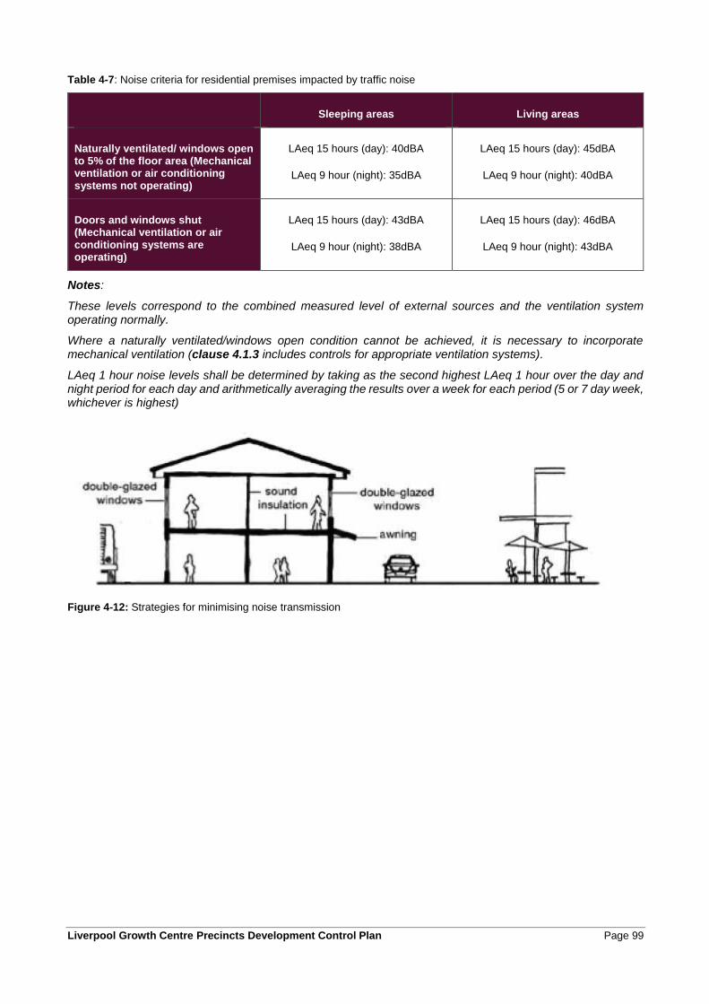
Liverpool Growth Centre Precincts Development Control Plan Page 99
Table 4-7: Noise criteria for residential premises impacted by traffic noise
Sleeping areas Living areas
Naturally ventilated/ windows open to 5% of the floor area (Mechanical ventilation or air conditioning systems not operating)
LAeq 15 hours (day): 40dBA
LAeq 9 hour (night): 35dBA
LAeq 15 hours (day): 45dBA
LAeq 9 hour (night): 40dBA
Doors and windows shut (Mechanical ventilation or air conditioning systems are operating)
LAeq 15 hours (day): 43dBA
LAeq 9 hour (night): 38dBA
LAeq 15 hours (day): 46dBA
LAeq 9 hour (night): 43dBA
Notes:
These levels correspond to the combined measured level of external sources and the ventilation system operating normally.
Where a naturally ventilated/windows open condition cannot be achieved, it is necessary to incorporate mechanical ventilation (clause 4.1.3 includes controls for appropriate ventilation systems).
LAeq 1 hour noise levels shall be determined by taking as the second highest LAeq 1 hour over the day and night period for each day and arithmetically averaging the results over a week for each period (5 or 7 day week, whichever is highest)
Figure 4-12: Strategies for minimising noise transmission
Page 100 Liverpool Growth Centre Precincts Development Control Plan
4.2.10 Fencing
Objectives
a. To ensure boundary fencing is of a high quality and does not detract from the streetscape.
b. To encourage the active use of front gardens through provision of a secure area.
c. To ensure that rear and side fencing will assist in providing privacy to private open space areas.
d. To ensure that fence height, location and design will not affect traffic and pedestrian visibility at
intersections.
Controls
1. Front fencing shall be a maximum of 1.2m high above ground level (existing) and shall be an open style incorporating pickets, slats, palings or the like or lattice style panels with a minimum aperture of 25mm.
2. Front fences and walls are not to impede safe sight lines for traffic.
3. Side and rear fences are to be a maximum of 1.8m high commencing 2m behind the building line (refer to Figure 4-13).
4. Side fences not on a street frontage are to be a maximum of 1.2m high to a point 2m behind the primary building façade.
5. On corner lots or lots that have a side boundary that adjoins open space or drainage, the front fencing style and height is to be continued along the secondary street or open space/drainage land frontage to at least 4m behind the building line of the dwelling. Principles for corner lots are illustrated at Figure 4-13.
6. On side boundaries that adjoin open space or drainage land, fencing is to be of a high quality material and finish. The design of the fencing is to permit casual surveillance of the public space by limiting fence height to 1.2m or by incorporating see through materials or gaps for the portion of the fence above 1.2m high.
7. Pre-painted steel or timber paling or lapped/capped boundary fencing is not permitted adjacent to open space or drainage land or on front boundaries.
8. Fencing that adjoins mews or rear access ways is to permit casual surveillance.
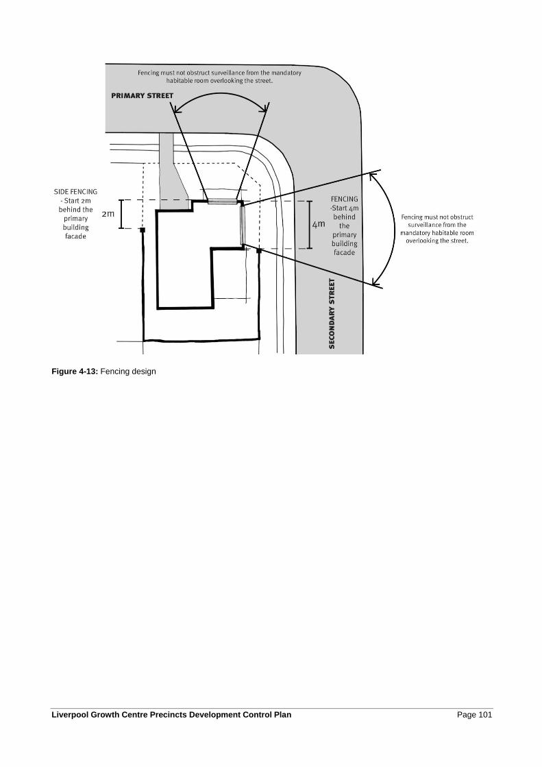
Liverpool Growth Centre Precincts Development Control Plan Page 101
Figure 4-13: Fencing design
Page 102 Liverpool Growth Centre Precincts Development Control Plan
4.3 Additional controls for certain dwelling types
4.3.1 Residential development adjacent to transmission easements
Objectives
a. To minimise the visual and amenity impacts of transmission lines on surrounding residential areas.
b. To provide for passive surveillance of land within and adjacent to transmission easements.
c. To maintain the privacy of dwellings adjacent to the easements.
Controls
1. Dwellings are to be set back as far as possible from the transmission easement.
2. Fencing that complies with the controls for front fences in Section 4.2.10 is to be used on the property boundary facing the easement.
3. Side and rear fencing within easements is to allow for maintenance access to and along the easement.
4. Landscaping is to permit visual surveillance of the easement from dwellings.
5. The orientation of dwellings is to permit casual surveillance of the easement, while maintaining the privacy of occupants.
6. Balconies on upper floors facing the transmission easement are encouraged.
7. The Principal Private Open Space for the dwelling is to be screened from view from the transmission easement, preferably by being located behind the building line.
4.3.2 Attached or abutting dwellings
Additional controls for attached dwellings are outlined below, and should be read in conjunction with those in Section 4.2.
Objectives
a. To ensure that the development of attached or abutting dwellings creates an architecturally consistent
street character.
Controls
1. It is preferred that garages for attached dwellings are located at the rear of the lot. Where attached dwellings have frontage to a collector road, all vehicle access and parking is to be located at the rear of the lot.
2. Attached or abutting dwellings should have a pleasing rhythm and order when seen together as a group, rather than appear as a random arrangement of competing dwellings. Each dwelling should benefit from the unified design of the whole form, a co-ordinated style and base colour palette. Individuality can be added as small details or accent colours, rather than strikingly different forms.
Liverpool Growth Centre Precincts Development Control Plan Page 103
4.3.3 Secondary dwellings, studios and dual occupancies
Controls for secondary dwellings, studio dwellings or dual occupancies are in part determined by whether the secondary, principal or dual occupancy dwelling is proposed at the time of the application or at some point in the future to be strata subdivided. Strata subdivisions create the need for separate or common property dwelling entries, parking and open space to service each dwelling.
The Glossary of this DCP provides further explanation and examples of secondary dwelling, studio dwellings or dual occupancy types. The controls that follow apply to all forms of secondary dwellings, studio dwellings and dual occupancies.
Objectives
a. To enable the development of a diversity of dwelling types.
b. To contribute to the availability of affordable housing.
c. To promote innovative housing solutions that are compatible with the surrounding residential
environment.
d. To provide casual surveillance to rear lanes.
Controls – Secondary dwellings and studio dwellings
1. Secondary dwellings and studio dwellings are to comply with the controls in Section 4.2, except where the controls in this clause differ, in which case the controls in this clause take precedence.
2. Secondary dwellings and studio dwellings are to comply with the key controls in Table 4-8.
3. The maximum site coverage control for upper floors in the relevant Tables 4-2 to 4-6 may be exceeded by the combined upper floor coverage of the secondary or studio dwelling and principal dwelling, providing that:
• The privacy of the principal dwelling and dwellings on adjoining land is not compromised; and
• Solar access to the principal private open space of neighbouring lots is not significantly reduced.
4. The maximum gross floor area of a studio dwelling is 75m2.
5. The finishes, materials and colours of the secondary dwelling or studio dwelling are to complement the principal dwelling in its construction features.
6. For secondary dwellings, windows and private open spaces must not overlook the private open space of any adjacent dwellings. For studio dwellings, windows and private open spaces must not overlook the private open space of any adjacent dwellings including the principal dwelling. Windows that potentially overlook adjacent lots must either have obscured glazing, be screened or have a minimum sill height of 1.5m above floor level.
7. Secondary or studio dwellings and associated garages may have a zero lot setback to one side boundary and may be attached to another garage/secondary dwelling on an adjoining lot, particularly where the secondary or studio dwelling is associated with an attached or semi-detached dwelling.
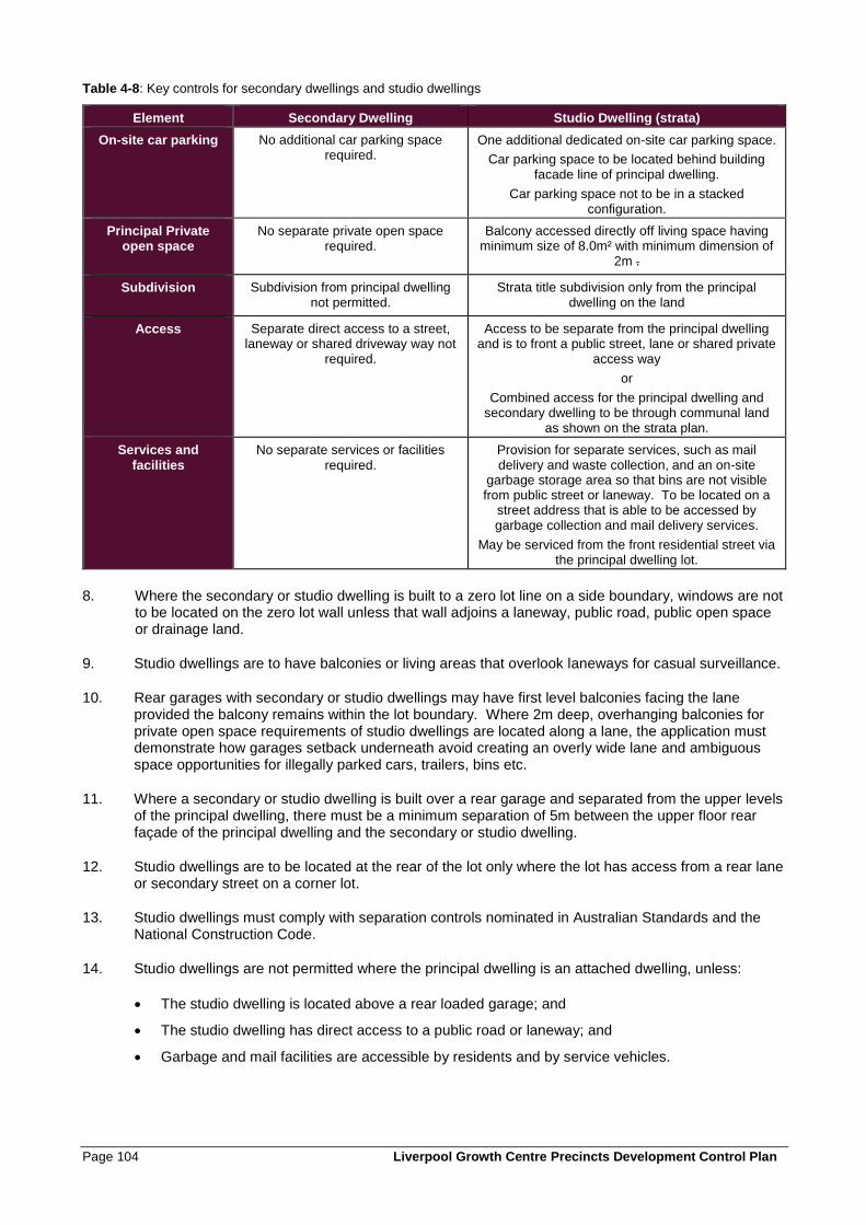
Page 104 Liverpool Growth Centre Precincts Development Control Plan
Table 4-8: Key controls for secondary dwellings and studio dwellings
Element Secondary Dwelling Studio Dwelling (strata)
On-site car parking
No additional car parking space required.
One additional dedicated on-site car parking space.
Car parking space to be located behind building facade line of principal dwelling.
Car parking space not to be in a stacked configuration.
Principal Private open space
No separate private open space required.
Balcony accessed directly off living space having minimum size of 8.0m² with minimum dimension of
2m .
Subdivision
Subdivision from principal dwelling not permitted.
Strata title subdivision only from the principal dwelling on the land
Access
Separate direct access to a street, laneway or shared driveway way not
required.
Access to be separate from the principal dwelling and is to front a public street, lane or shared private
access way
or
Combined access for the principal dwelling and secondary dwelling to be through communal land
as shown on the strata plan.
Services and
facilities
No separate services or facilities
required.
Provision for separate services, such as mail delivery and waste collection, and an on-site
garbage storage area so that bins are not visible from public street or laneway. To be located on a
street address that is able to be accessed by garbage collection and mail delivery services.
May be serviced from the front residential street via the principal dwelling lot.
8. Where the secondary or studio dwelling is built to a zero lot line on a side boundary, windows are not to be located on the zero lot wall unless that wall adjoins a laneway, public road, public open space or drainage land.
9. Studio dwellings are to have balconies or living areas that overlook laneways for casual surveillance.
10. Rear garages with secondary or studio dwellings may have first level balconies facing the lane provided the balcony remains within the lot boundary. Where 2m deep, overhanging balconies for private open space requirements of studio dwellings are located along a lane, the application must demonstrate how garages setback underneath avoid creating an overly wide lane and ambiguous space opportunities for illegally parked cars, trailers, bins etc.
11. Where a secondary or studio dwelling is built over a rear garage and separated from the upper levels of the principal dwelling, there must be a minimum separation of 5m between the upper floor rear façade of the principal dwelling and the secondary or studio dwelling.
12. Studio dwellings are to be located at the rear of the lot only where the lot has access from a rear lane or secondary street on a corner lot.
13. Studio dwellings must comply with separation controls nominated in Australian Standards and the National Construction Code.
14. Studio dwellings are not permitted where the principal dwelling is an attached dwelling, unless:
• The studio dwelling is located above a rear loaded garage; and
• The studio dwelling has direct access to a public road or laneway; and
• Garbage and mail facilities are accessible by residents and by service vehicles.
Liverpool Growth Centre Precincts Development Control Plan Page 105
Controls - Dual occupancies
1. Dual occupancies are to comply with the controls in Section 4.2, except where the controls in this clause differ, in which case the controls in this clause take precedence.
2. The maximum site coverage control for second storeys in the relevant Tables 4-2 to 4-6 may be exceeded by the combined 2nd storey coverage of both dwellings in a dual occupancy, providing that:
• The privacy of the principal dwelling and dwellings on adjoining land is not compromised; and
• Solar access requirements for the principal private open space can be met for the principal dwelling and dwellings on adjoining lots.
3. The design of both dwellings in a dual occupancy development is to be consistent in construction features, finishes, materials and colours.
4. Detached dual occupancy dwellings are not to include zero lot lines for the second dwelling where the second dwelling is located at the rear of the lot.
5. Dual occupancy development is not permitted on a lot that contains an attached dwelling.
6. Dual occupancy dwellings are permitted at the rear of lots (i.e. behind a dwelling that has frontage to a principal street, whether attached or detached to that dwelling) only where:
• Each dwelling has direct pedestrian and vehicle access to a public road; and
• Garbage and mail facilities are accessible by service vehicles and by the occupants of the dwellings.
7. Dual occupancy development referred to in control 6 above is preferred to be located on corner lots.
8. For dual occupancies on corner lots, the real setback can be varied to be consistent with the side setbacks in section 4.2.4 provided the minimum private open space and solar access requirements to the proposed and adjoining properties are met.
9. Where the dual occupancy dwellings are to be strata subdivided:
• private open space is to be provided for each dwelling in accordance with the relevant controls in Tables 4-2 to 4-6, or
• shared private open space is to be provided equivalent to 15% of the site area and shown as communal space on the strata plan, and a minimum area of private open space of 10m² with a minimum dimension of 2.5m is to be provided for each dwelling.
10. The minimum landscaped area on a lot containing a dual occupancy development is to be 20% of the site area.
11. Where practical for front loaded driveway access, shared driveway crossings of the nature strip are to be provided to service both dwellings.
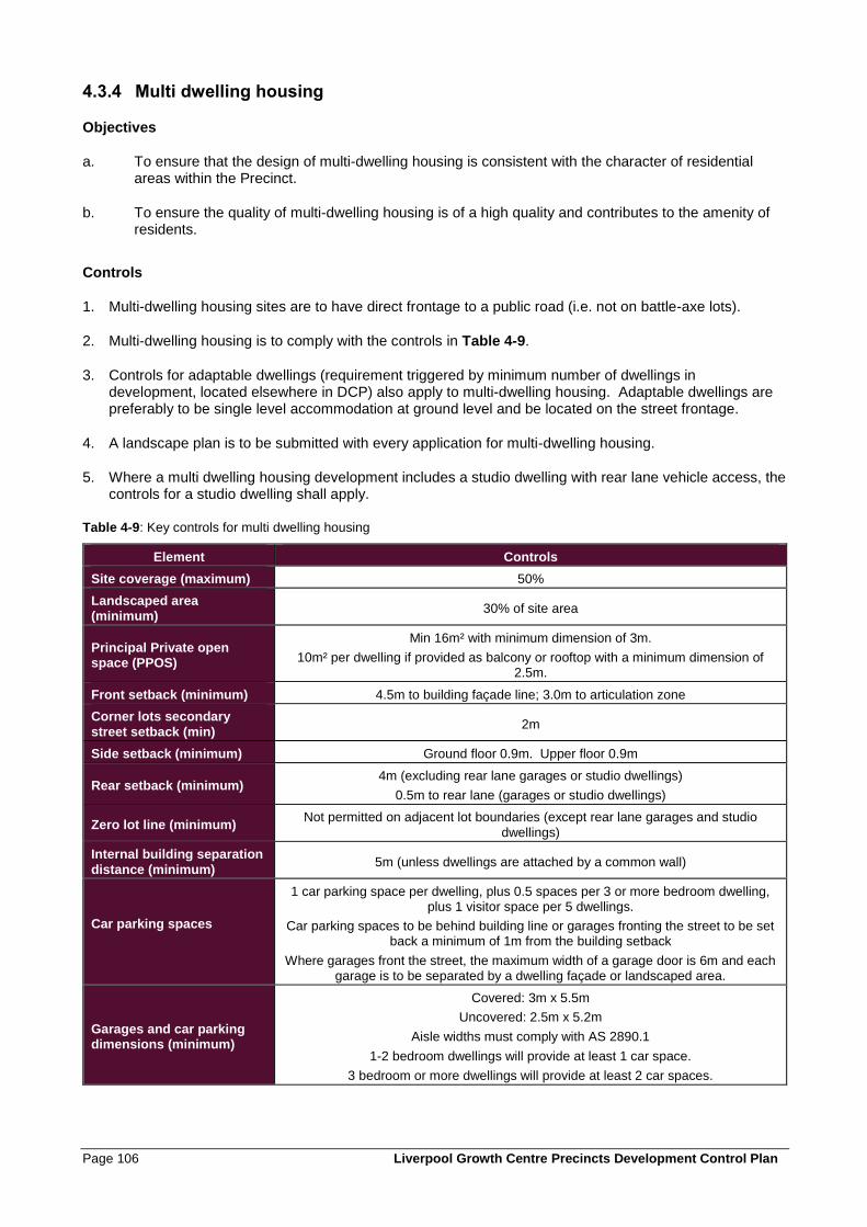
Page 106 Liverpool Growth Centre Precincts Development Control Plan
4.3.4 Multi dwelling housing
Objectives
a. To ensure that the design of multi-dwelling housing is consistent with the character of residential areas within the Precinct.
b. To ensure the quality of multi-dwelling housing is of a high quality and contributes to the amenity of residents.
Controls
1. Multi-dwelling housing sites are to have direct frontage to a public road (i.e. not on battle-axe lots).
2. Multi-dwelling housing is to comply with the controls in Table 4-9.
3. Controls for adaptable dwellings (requirement triggered by minimum number of dwellings in development, located elsewhere in DCP) also apply to multi-dwelling housing. Adaptable dwellings are preferably to be single level accommodation at ground level and be located on the street frontage.
4. A landscape plan is to be submitted with every application for multi-dwelling housing.
5. Where a multi dwelling housing development includes a studio dwelling with rear lane vehicle access, the controls for a studio dwelling shall apply.
Table 4-9: Key controls for multi dwelling housing
Element Controls
Site coverage (maximum) 50%
Landscaped area (minimum)
30% of site area
Principal Private open space (PPOS)
Min 16m² with minimum dimension of 3m.
10m² per dwelling if provided as balcony or rooftop with a minimum dimension of 2.5m.
Front setback (minimum) 4.5m to building façade line; 3.0m to articulation zone
Corner lots secondary
street setback (min) 2m
Side setback (minimum) Ground floor 0.9m. Upper floor 0.9m
Rear setback (minimum) 4m (excluding rear lane garages or studio dwellings)
0.5m to rear lane (garages or studio dwellings)
Zero lot line (minimum) Not permitted on adjacent lot boundaries (except rear lane garages and studio
dwellings)
Internal building separation
distance (minimum) 5m (unless dwellings are attached by a common wall)
Car parking spaces
1 car parking space per dwelling, plus 0.5 spaces per 3 or more bedroom dwelling, plus 1 visitor space per 5 dwellings.
Car parking spaces to be behind building line or garages fronting the street to be set back a minimum of 1m from the building setback
Where garages front the street, the maximum width of a garage door is 6m and each garage is to be separated by a dwelling façade or landscaped area.
Garages and car parking dimensions (minimum)
Covered: 3m x 5.5m
Uncovered: 2.5m x 5.2m
Aisle widths must comply with AS 2890.1
1-2 bedroom dwellings will provide at least 1 car space.
3 bedroom or more dwellings will provide at least 2 car spaces.
Liverpool Growth Centre Precincts Development Control Plan Page 107
4.3.5 Controls for residential flat buildings, manor homes and shop top housing
The controls in Clause 4.3.4 do not apply to residential flat buildings, manor homes and shop top housing, unless specifically referenced in the provisions that follow. The following clauses set out the controls for these types of housing. Additional controls for residential flat buildings and shop top housing may be contained in SEPP 65 – Design Quality of Residential Flat Development.
Objectives
a. To establish a high quality residential environment where all dwellings have a good level of amenity.
b. To encourage a variety of housing forms within residential areas.
c. To ensure the provision of housing that will, in its adaptable features, meet the access and mobility
needs of any occupant.
Controls
1. In density areas of 20dw/Ha and 25dw/Ha, manor homes may only be located on corner lots.
2. Residential flat buildings are to:
• be located on sites with a minimum street frontage of 30m,and
• have direct frontage to an area of the public domain (including streets and public parks), and
• not adversely impact upon the existing or future amenity of any adjoining land upon which residential development is permitted with respect to overshadowing impact, privacy impact or visual impact.
3. All residential flat buildings are to be consistent with:
• the guidelines and principles outlined in SEPP No. 65 – Residential Flat Development; and
• the primary controls set out in Table 4-10, which take precedence over the above where there is any inconsistency.
4. In all residential flat building developments containing 10 dwellings or more, a minimum of 10% of all apartments are to be designed to be capable of adaptation for access by people with all levels of mobility. Dwellings must be designed in accordance with the Australian Adaptable Housing Standard (AS 4299-1995), which includes ‘pre-adaptation’ design details to ensure visitability is achieved.
5. Where possible, adaptable dwellings are to be located on the ground floor. Dwellings located above the ground level of a building may only be provided as adaptable dwellings where lift access is available within the building. The lift access must provide access from the basement to allow access for people with disabilities.
6. The development application must be accompanied by certification from an accredited Access Consultant confirming that the adaptable dwellings are capable of being modified, when required by the occupant, to comply with the Australian Adaptable Housing Standard (AS 4299-1995).
7. Car parking and garages allocated to adaptable dwellings must comply with the requirements of Australian Standards for disabled parking spaces.
8. A landscape plan is to be submitted with every application for residential flat buildings.
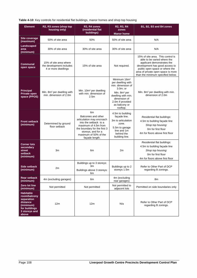
Page 108 Liverpool Growth Centre Precincts Development Control Plan
Table 4-10: Key controls for residential flat buildings, manor homes and shop top housing
Element R2, R3 zones (shop top housing only)
R3, R4 zones (residential flat
buildings)
R2, R3, R4 zones
Manor home
B1, B2, B3 and B4 zones
Site coverage (maximum)
50% of site area 50% 50% of site area N/A
Landscaped area (minimum)
30% of site area 30% of site area 30% of site area N/A
Communal open space
15% of site area where the development includes
4 or more dwellings 15% of site area Not required.
15% of site area. This control is able to be varied where the applicant demonstrates the
development has good access to public open space or where the
area of private open space is more than the minimum specified below.
Principal Private open space (PPOS)
Min. 8m² per dwelling with min. dimension of 2.0m
Min. 10m² per dwelling with min. dimension of
2.5m
Minimum 16m² per dwelling with min. dimension of
3.0m; or
Min. 8m² per dwelling with min.
dimension of 2.0m if provided
as balcony or rooftop.
Min. 8m² per dwelling with min. dimension of 2.0m
Front setback (minimum)
Determined by ground floor setback
6m
Balconies and other articulation may encroach
into the setback to a maximum of 4.5m from
the boundary for the first 3 storeys, and for a
maximum of 50% of the façade length.
4.5m to building façade line.
3m to articulation zone.
5.5m to garage line and 1m behind the
building line.
Residential flat buildings:
4.5m to building façade line
Shop top housing:
0m for first floor
4m for floors above first floor
Corner lots secondary street setback (minimum)
3m 6m 2m
Residential flat buildings:
4.5m to building façade line
Shop top housing:
0m for first floor
4m for floors above first floor
Side setback (minimum)
2m
Buildings up to 3 storeys: 3m
Buildings above 3 storeys: 6m
Buildings up to 2 storeys 1.5m
Refer to Other Part of DCP regarding B zonings.
Rear setback (minimum)
4m (excluding garages) 6m 4m (excluding rear garages)
8m
Zero lot line (minimum)
Not permitted Not permitted Not permitted to
adjacent lots Permitted on side boundaries only
Habitable room/balcony separation distance (minimum) for buildings 3 storeys and above
12m 12m N/a Refer to Other Part of DCP
regarding B zonings.
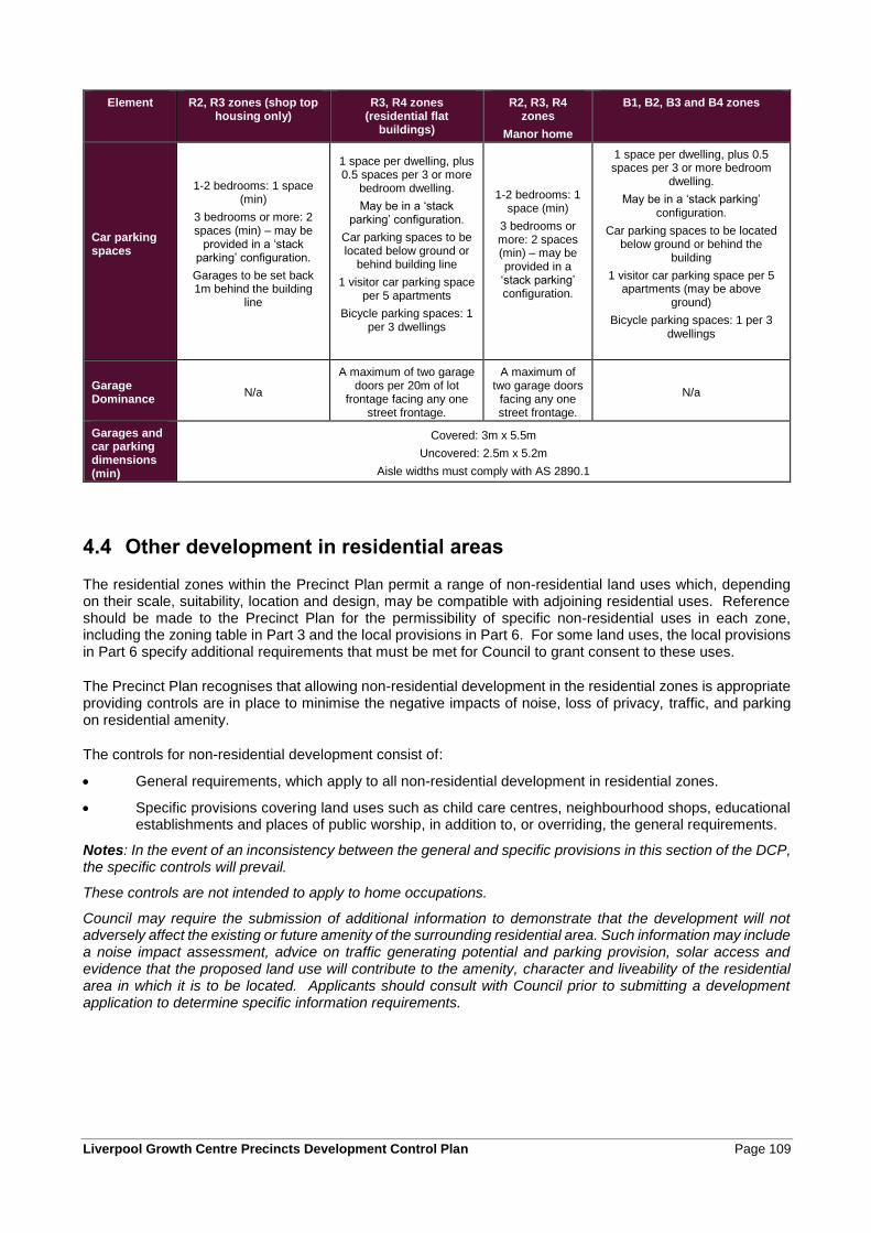
Liverpool Growth Centre Precincts Development Control Plan Page 109
Element R2, R3 zones (shop top housing only)
R3, R4 zones (residential flat
buildings)
R2, R3, R4 zones
Manor home
B1, B2, B3 and B4 zones
Car parking spaces
1-2 bedrooms: 1 space (min)
3 bedrooms or more: 2 spaces (min) – may be
provided in a ‘stack parking’ configuration.
Garages to be set back 1m behind the building
line
1 space per dwelling, plus 0.5 spaces per 3 or more
bedroom dwelling.
May be in a ‘stack parking’ configuration.
Car parking spaces to be located below ground or
behind building line
1 visitor car parking space per 5 apartments
Bicycle parking spaces: 1 per 3 dwellings
1-2 bedrooms: 1 space (min)
3 bedrooms or more: 2 spaces (min) – may be provided in a
‘stack parking’ configuration.
1 space per dwelling, plus 0.5 spaces per 3 or more bedroom
dwelling.
May be in a ‘stack parking’ configuration.
Car parking spaces to be located below ground or behind the
building
1 visitor car parking space per 5 apartments (may be above
ground)
Bicycle parking spaces: 1 per 3 dwellings
Garage Dominance
N/a
A maximum of two garage doors per 20m of lot
frontage facing any one street frontage.
A maximum of two garage doors
facing any one street frontage.
N/a
Garages and car parking dimensions (min)
Covered: 3m x 5.5m
Uncovered: 2.5m x 5.2m
Aisle widths must comply with AS 2890.1
4.4 Other development in residential areas
The residential zones within the Precinct Plan permit a range of non-residential land uses which, depending on their scale, suitability, location and design, may be compatible with adjoining residential uses. Reference should be made to the Precinct Plan for the permissibility of specific non-residential uses in each zone, including the zoning table in Part 3 and the local provisions in Part 6. For some land uses, the local provisions in Part 6 specify additional requirements that must be met for Council to grant consent to these uses.
The Precinct Plan recognises that allowing non-residential development in the residential zones is appropriate providing controls are in place to minimise the negative impacts of noise, loss of privacy, traffic, and parking on residential amenity.
The controls for non-residential development consist of:
• General requirements, which apply to all non-residential development in residential zones.
• Specific provisions covering land uses such as child care centres, neighbourhood shops, educational establishments and places of public worship, in addition to, or overriding, the general requirements.
Notes: In the event of an inconsistency between the general and specific provisions in this section of the DCP, the specific controls will prevail.
These controls are not intended to apply to home occupations.
Council may require the submission of additional information to demonstrate that the development will not adversely affect the existing or future amenity of the surrounding residential area. Such information may include a noise impact assessment, advice on traffic generating potential and parking provision, solar access and evidence that the proposed land use will contribute to the amenity, character and liveability of the residential area in which it is to be located. Applicants should consult with Council prior to submitting a development application to determine specific information requirements.
Page 110 Liverpool Growth Centre Precincts Development Control Plan
4.4.1 General requirements
Objectives
a. To establish appropriate controls to minimise the adverse effects of non-residential development on
surrounding residential development.
b. To maintain consistency in development standards between non-residential and residential land uses
and ensure that buildings are similar in height, bulk and scale to surrounding buildings.
c. To ensure that non-residential development is appropriately located.
d. To avoid concentrations of non-residential uses in any particular area where the cumulative impact on
residential amenity would be unacceptable.
Controls
1. Site analysis information as required by clause 4.1 is to be submitted with all applications for non-residential development in residential zones.
2. Except as provided for in the specific controls below, non-residential development on residential zoned land is to be located on allotments that have a frontage width of greater than 15 metres.
Note: The relevant Precinct Plan specifies minimum site area development standards for some non-residential land uses within residential zones.
3. Non-residential development on residential zoned land is to comply with the requirements of Clauses 4.1.2 to 4.1.4 and Clauses 4.2.9 and 4.2.10 of this DCP in relation to residential amenity and sustainable building design.
4. For all non-residential development, the controls relating to lots with frontages greater than 15 metres in the following clauses of this DCP apply:
• Clause 4.2.1 Front setbacks;
• Clause 4.2.4 Side and rear setbacks;
• Clause 4.2.5 Dwelling height, massing and siting; and
• Clause 4.2.8 Garages, storage, site access and parking.
5. Non-residential development is not permitted on battle-axe allotments.
6. The maximum site coverage of buildings is 60% of the total site area.
7. The minimum landscaped area for non-residential development is 20% of the total site area of the allotment.
8. Provision of car parking for non-residential uses will be assessed by Council on an individual basis, and with reference to standards that apply elsewhere in the Local Government Area, that may establish relevant parking requirements, but must be sufficient to meet demand generated by staff and visitors.
9. Where a non-residential use is proposed as part of, or in association with, a dwelling (eg. a home business):
• Parking and storage areas are to be located behind the building façade or be screened from view from the street by landscaping and set back at least 1 metre from the front property boundary.
• Parking and storage areas are not to encroach on the private open space or landscaped area of the dwelling.

Liverpool Growth Centre Precincts Development Control Plan Page 111
10. Where there is an inconsistency between the general requirements of this clause and the specific controls in clauses 4.4.3 to 4.4.6 the specific controls prevail.
11. Council will have particular regard to the effects of non-residential development in the residential zones. Council will consider whether:
• the proposed development will be out of character with surrounding residential development, particularly in relation to the height and/or scale of any proposed buildings;
• the proposed development will contribute to an undesirable clustering of that type of development, or non-residential uses in general, in the area;
• an undesirable effect on the amenity of the surrounding area will be created;
• the proposed use will draw patronage from areas outside of the surrounding neighbourhood, and the extent to which that patronage might impact on the amenity of residents through factors such as traffic generation, noise or the overall scale of the non-residential use;
• a noise nuisance will be created;
• the development will generate traffic out of keeping with the locality;
• adequate facilities are provided for the purposes of parking, loading and deliveries;
• adequate provision is made for access by disabled persons.
12. Non-residential development in residential zones should be similar in bulk, scale, height and siting to the surrounding buildings.
13. Finishes, materials, paving and landscaping are to be consistent with those of surrounding residential development.
14. Storage of materials and equipment is to be contained within internal storage areas or outdoor storage areas that are suitably screened, fenced and landscaped.

Page 112 Liverpool Growth Centre Precincts Development Control Plan
4.4.2 Exhibition Homes and Exhibition Villages
Objectives
a. To ensure that exhibition homes and exhibition villages operate with minimal impact on surrounding
residential areas.
b. To ensure that exhibition homes and exhibition villages operate for a limited time after which they revert
to a conventional residential environment.
Controls
1. Any subdivision of land shall be in accordance with the requirements for dwellings in this DCP and the relevant Precinct Plan under the Growth Centres SEPP.
2. Any proposed street within an exhibition village may be held as one lot within the development until the cessation of the operation of the exhibition village. Subdivision and dedication of roads to Council must be completed prior to the use of dwellings for residential accommodation.
3. Exhibition villages should be located on Collector Roads or as close to Collector Roads as possible, with vehicle access from a Collector Road.
4. Exhibition homes/ exhibition villages are not permitted:
• where access is from a street with a carriageway width of less than 9.0 metres.
• on streets which are cul-de-sacs.
5. Car parking for exhibition homes shall be provided off street. However, on-street car parking may be considered where there are no privately occupied dwellings opposite or adjoining the individual exhibition homes.
6. Internal streets may be closed out of hours of operation only where the streets are not yet dedicated as public roads.
7. During the operation of an exhibition home/ exhibition village additional measures to maintain the privacy of adjoining residential development may be required.
8. The hours of operation shall be limited to 7am to 7pm each day.
9. Buildings used for such uses as providing home finance, materials display or take-away food and the like shall cease to operate when the exhibition home/ exhibition village ceases unless separate approval is obtained to enable the continued operation of these uses.
10. Temporary buildings used for providing home finance, materials display or take-away food shall be removed and the site made good.
11. When the use of the dwelling ceases to be an exhibition home, any garage that has been used as a sales office is to be reinstated as a functioning garage with an appropriate garage door and associated driveway, prior to the occupation of the dwelling for residential purposes.
12. When the exhibition village/home ceases to operate, all signs and structures etc associated with the exhibition home/village shall be removed to ensure the site has a residential appearance.
13. Security lighting shall be provided in such a way to minimise any adverse impact on adjoining residential areas.
14. The operation of the exhibition village (including the use of designated off-street car parks) shall not cause offensive noise or affect the acoustic amenity of adjoining residents.
15. Waste disposal facilities shall be provided. These shall be located adjacent to the driveway entrance to the site.
Liverpool Growth Centre Precincts Development Control Plan Page 113
16. Any structure involving waste disposal facilities shall be located as follows:
• Set back one metre from the front boundary to the street.
• Landscaped between the structure and the front boundary and adjoining areas to minimise the impact on the streetscape.
• Not be located adjacent to an adjoining residential property.
17. All works affecting public roads, including new driveways, access roads and intersection works are to be in accordance with the requirements of this DCP and the relevant Council’s Engineering Specifications.
18. Landscaping of streets is to be in accordance with the requirements of this DCP, and street landscaping is to be maintained for the duration of operation of the exhibition home/village. Dedication of public roads to Council will be subject to satisfactory provision and maintenance of street landscaping.
19. Dwellings located near future sources of noise are to incorporate appropriate noise attenuation measures when designed and constructed, to ensure that future residents are afforded an appropriate level of amenity.
20. Details of proposed signage are to be submitted with the Development Application. Signage is to be located on public roads at or near the entry to the exhibition home/village. Internal signage within the exhibition village is to be visible only from within the village (not from surrounding residential properties). When considering applications including signage, Council will refer to controls in other Council policies and planning controls that may be applicable.

Page 114 Liverpool Growth Centre Precincts Development Control Plan
4.4.3 Child Care Centres
Objectives
a. To ensure all communities have access to a local child care centre and to minimise travel distances to
and from child care facilities.
b. To provide communities with child care centres that are appropriate in size and scale to the surrounding
neighbourhood and to reduce excessive built form within residential streetscapes.
c. To ensure the appropriate location and operation of child care centres in order to minimise any adverse
impact on the amenity of residential areas.
d. To ensure that child care centres provide a safe, healthy and active environment for children of all
ages.

Liverpool Growth Centre Precincts Development Control Plan Page 115
Controls
1. The following controls apply to child care centres in residential zones:
Control Requirements
Distance Separation Requirement
1km from any existing, approved or proposed child care centre, 100m from high voltage transmission lines, mobile phone towers, radio telecommunication facilities,
restricted premises, sex services premises. 85m (measured at site boundary) of service stations and gas storage tanks
Minimum Allotment size 900m²
Minimum Frontage width 26m
Minimum Lot Depth 30m
Maximum site coverage 50%
Minimum landscape area 30%
Max no. of storeys 1 storey building or ground floor for children’s rooms only
Floor to ceiling height Minimum 2.4 metres
Capacity
Max. 40 children
Min. 5 places for under 2 year olds
Open Space
• Minimum unencumbered indoor play space / licensed child (irrespective of age)
Reference should be made to the Children’s Services Regulation 2004 and other supporting information for these standards.
• Minimum unencumbered outdoor play space / licensed child (irrespective of age)
• Play areas
Setbacks (min/m)
• Primary Front (Building) 6m
• Primary Front (Landscape setback)
2m
• Fronting Open Space 1m
• Side (Building) 2m
• Rear (Building) 4m ground floor
8m upper floors
• Corner Lots (Street Frontage) 3m
• Min. Setback for storage facilities
4m
Car parking spaces
1 car parking space per employee (reduced rates of provision may apply where the child care centre is within walking distance of a bus stop or train station).
1 of the car parking spaces shall be designed for people with a disability.
For the purposes of this calculation the number of employees is based on the following ratios of staff to children:
a. 1:4 in respect of all children who are under the age of 2 years, and,
b. 1:8 in respect of all children who are 2 or more years of age but under 3 years of age, and
c. 1:10 in respect of all children who are 3 or more years of age but under 6 years of age.
Visitor Car Parking 1 space per 6 children
Page 116 Liverpool Growth Centre Precincts Development Control Plan
Site Selection and Location
2. Child care centres are not appropriate on the following land:
• Land that has direct frontage to an arterial road, sub-arterial road or transit boulevard (refer to clause 3.3.1);
• opposite “T” intersections or on bends where sight distances are limited and may create dangerous conditions for vehicle entry to and exit from the site;
• on cul-de-sacs;
• flood liable land or land affected by local overland flooding (refer to clause 2.3.1);
• bushfire prone land (refer to clause 2.3.6); or
• land that requires significant cut or fill, where retaining walls would create a safety hazard for children.
3. In order to limit impact on neighbouring properties child care centres should:
• Be located in close proximity to other non-residential uses such as community facilities, schools, neighbourhood halls, churches and public recreation areas;
• be located in close proximity to transport routes and public transport nodes and corridors (collector roads are the preferred location for child care centres).
• if practical, be located on sites that have minimal common boundaries with residential neighbours;
• locate play areas as far as possible away from neighbours’ living rooms and bedrooms; and
• be sited on allotments that can provide sufficient buffering so as to minimise noise and loss of privacy.
Matters for consideration
4. Council will consider the following matters when assessing development applications for child care centres:
• Whether the development maintains the privacy and amenity of adjoining developments;
• The extent to which the design of the proposed development, including any signage, is consistent with the desired character of the residential area in which it is located;
• The appropriateness of the location of the development, including its location in relation to other existing or proposed child care centres;
• The size of the land where the development is proposed; and
• The provision of and location within the development site of car parking.

Liverpool Growth Centre Precincts Development Control Plan Page 117
Documents to be Submitted with Development Application
5. Development Applications are to be accompanied by the following, which are to be prepared by an appropriately qualified person or organisation:
• Acoustic Report – to address the impact of noise generation from the child care centre on the surrounding area;
• Landscape Plan and associated documentation – to identify existing vegetation and community plant species and the proposed landscaping treatment of the development;
• Traffic Report/Statement - to address the impact of a child care centre on the local road system and address traffic safety issues and address traffic safety issues; and
• Location Analysis – to indicate all existing and proposed child care centres within a 2km radius of the proposed child care facility and to address the locational matters in the controls above.
4.4.4 Educational Establishments and Places of Worship
Objectives
a. To ensure appropriate provision and equitable distribution of educational establishments and places
of public worship within the Precinct.
b. To ensure that buildings are not out of character with the type, height, bulk and scale of surrounding
buildings.
c. To encourage the appropriate location of facilities to create community focal points, centres of
neighbourhood activity and enhance community identity.
d. To mitigate the impacts of noise, privacy, increased traffic and nuisance on surrounding residential
development.
e. To foster iconic and landmark building design within each Precinct.
Controls
1. Places of worship are to be located within centres or co-located with other community facilities in residential areas so as to create a community focal point, to share facilities such as parking, and to minimise impacts on residential areas.
2. Places of public worship and educational establishments are preferably to be located on land with frontage to a collector road. Corner sites are preferred.
3. In assessing applications, Council will consider the following:
• the privacy and amenity of adjoining developments;
• the need and adequacy for provision of buffer zones to surrounding residential development;
• urban design;
• location;
• the size of the land where the development is proposed;
• traffic generation and the impacts of traffic on the road network and the amenity of nearby residents;
• the availability of parking;
• the scale of buildings and their capacity; and
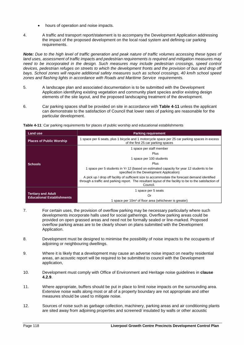
Page 118 Liverpool Growth Centre Precincts Development Control Plan
• hours of operation and noise impacts.
4. A traffic and transport report/statement is to accompany the Development Application addressing the impact of the proposed development on the local road system and defining car parking requirements.
Note: Due to the high level of traffic generation and peak nature of traffic volumes accessing these types of land uses, assessment of traffic impacts and pedestrian requirements is required and mitigation measures may need to be incorporated in the design. Such measures may include pedestrian crossings, speed control devices, pedestrian refuges on streets to which the development fronts and the provision of bus and drop off bays. School zones will require additional safety measures such as school crossings, 40 km/h school speed zones and flashing lights in accordance with Roads and Maritime Service requirements.
5. A landscape plan and associated documentation is to be submitted with the Development Application identifying existing vegetation and community plant species and/or existing design elements of the site layout, and the proposed landscaping treatment of the development.
6. Car parking spaces shall be provided on site in accordance with Table 4-11 unless the applicant can demonstrate to the satisfaction of Council that lower rates of parking are reasonable for the particular development.
Table 4-11: Car parking requirements for places of public worship and educational establishments
Land use Parking requirement
Places of Public Worship 1 space per 6 seats, plus 1 bicycle and 1 motorcycle space per 25 car parking spaces in excess
of the first 25 car parking spaces
Schools
1 space per staff member
Plus
1 space per 100 students
Plus
1 space per 5 students in Yr 12 (based on estimated capacity for year 12 students to be specified in the Development Application)
A pick up / drop off facility of sufficient size to accommodate the forecast demand identified through a traffic and parking report. The resultant layout of the facility to be to the satisfaction of
Council.
Tertiary and Adult Educational Establishments
1 space per 5 seats
Or
1 space per 10m² of floor area (whichever is greater)
7. For certain uses, the provision of overflow parking may be necessary particularly where such developments incorporate halls used for social gatherings. Overflow parking areas could be provided on open grassed areas and need not be formally sealed or line-marked. Proposed overflow parking areas are to be clearly shown on plans submitted with the Development Application.
8. Development must be designed to minimise the possibility of noise impacts to the occupants of adjoining or neighbouring dwellings.
9. Where it is likely that a development may cause an adverse noise impact on nearby residential areas, an acoustic report will be required to be submitted to council with the Development application,
10. Development must comply with Office of Environment and Heritage noise guidelines in clause 4.2.9.
11. Where appropriate, buffers should be put in place to limit noise impacts on the surrounding area. Extensive noise walls along most or all of a property boundary are not appropriate and other measures should be used to mitigate noise.
12. Sources of noise such as garbage collection, machinery, parking areas and air conditioning plants are sited away from adjoining properties and screened/ insulated by walls or other acoustic
Liverpool Growth Centre Precincts Development Control Plan Page 119
treatment. Noise levels are not to exceed specified limits at the most affected point of the property boundary.
13. The general hours of operation for places of public worship and educational establishments are between 7am and 9pm.
14. Variation to the approved hours of operation may be approved by Council subject to other requirements or a merit assessment.
Note: Legislation covering noise impacts and hours of operation is the Protection of the Environment Operations Act 1997 and the Protection of the Environment (Noise Control) Regulation 2000 (Noise Control Regulation. Applicants should also refer to the Office of Environment and Heritage website (http://www.environment.nsw.gov.au) for more information regarding noise control.
4.4.5 Neighbourhood Shops
Objectives
a. To ensure the appropriate provision of retail uses to serve the needs of the local community.
b. To minimise the impacts of retail activities on surrounding residential areas.
c. To ensure that retail activities in residential areas do not detract from the function or viability of nearby
centres.
d. To ensure the appropriate location of neighbourhood shops.
Controls
1. Neighbourhood shops in the R2 zone may only be developed on an allotment of land with a frontage width of 15 metres or more.
2. Neighbourhood shops in the R2 zone are to be located:
• adjoining land zoned RE1 or SP2 or that is separated from land zoned RE1 or SP2 only by a public road, or
• with frontage to a collector road, or
• within 90 metres of public transport stop, or
• adjoining an educational establishment or a community facility or separated from an educational establishment or a community facility only by a public road.
3. The minimum lot size for neighbourhood shops is 500 square metres.
4. For neighbourhood shops, the controls relating to lots with frontages greater than 15 metres in the following clauses of this DCP apply:
• Clause 4.2.2 Streetscape and architectural design,
• Clause 4.2.3 Front setbacks,
• Clause 4.2.4 Side and rear setbacks,
• Clause 4.2.5 Dwelling height, massing and siting, and
• Clause 4.2.8 Garages, storage, site access and parking.
5. Shops fronts are to encourage active and interactive street frontages that are sympathetic to the streetscape with similar materials to adjoining buildings to be used.
Page 120 Liverpool Growth Centre Precincts Development Control Plan
6. Any area of land between the front property boundary and the building alignment, exclusive of approved driveways and parking areas, is to be landscaped to the satisfaction of Council.
7. Address and entry points for any residential use on the same allotment of land are to be separate from the retail use access points and be readily identifiable.
8. Design of the building frontage, front and side setbacks are to include safe and convenient pedestrian facilities such as weather protection, shade, seating and landscaping.
9. On corner sites, shop fronts are to wrap around the corner and zero setbacks are permitted.
10. Entrances are to be visible from the street and well lit.
11. The site should not gain direct access to:
• A road with clearway or other parking restrictions; or
• A restricted access road (sub-arterial, arterial or transit boulevard).
12. Any proposed development should not to create a traffic hazard. However, corner sites are preferred in terms of reducing potential for impacts on neighbouring properties, and for allowing side access for customer parking and deliveries.
13. One car parking space is to be provided for every 30m2 of Gross Floor Area,
14. Parking spaces are to be provided on site or in dedicated on street parking constructed to Council’s standards.
15. The design of the building and parking areas is to provide suitable access for people with disabilities and service deliveries.
16. Bicycle parking must be provided in a location that is secure and accessible with weather protection for employees.
17. Car parking must be clearly signposted to indicate its availability from the street.
18. Plant and equipment (particularly cooling or heating plant), is to be located so as to not cause noise annoyance to neighbours. A noise impact assessment may be required to be prepared and submitted to Council.
19. Waste storage areas must be designed to minimise visual impact and should be screened and properly positioned so as to not to attract pests and cause odour problems for neighbours.
20. All goods storage is to be internal.
4.4.6 Seniors Housing
Objectives
a. To ensure that the design of seniors housing is consistent with the character of surrounding residential
areas.
Controls
1. Applications for seniors housing are to comply with the controls in clause 4.3.4 of this DCP for multi-dwelling housing, or controls for residential flat buildings in clause 4.3.5, as appropriate to the proposed development.

Liverpool Growth Centre Precincts Development Control Plan Page 121
Note: SEPP (Housing for Seniors or People with a Disability) 2004 is the primary environmental planning instrument controlling seniors housing. Applicants considering development of this kind should refer to that SEPP for specific controls and to determine the permissibility of seniors housing.

Liverpool Growth Centre Precincts Development Control Plan Page 123
5 Centres Development Controls
5.0 Centres Development Controls

Liverpool Growth Centre Precincts Development Control Plan Page 125
5.1 Introduction
This Part of the DCP outlines principles, objectives and design controls to achieve quality, consistency and coordination in the development of the Local and Neighbourhood Centres. It applies to land identified in the Location of Centres figure in the relevant Precinct’s Schedule.
Note: Controls specific to certain centres may be contained in the Precinct Schedule and apply in addition to the controls in this part.
The objectives of this Part of the DCP are to:
a. Create vibrant, functional centres that are a focus for community activity and interaction;
b. Establish design principles that achieve high quality coordinated urban design outcomes and high
standards of amenity;
c. Encourage social interaction and the development of places that are safe and desirable for all users;
d. Provide flexible controls to accommodate change within the centres over time;
e. Ensure that development in centres takes advantage of access to public transport.
5.2 Development principles
The following development principles apply to all centres to which this part of the DCP applies. The principles should be considered by applicants for all applications for development in centres. The controls in clause 5.3 are based on these principles, and where an application does not comply with the controls, Council will consider whether the proposed development is consistent with the relevant development principles when determining the application.
5.2.1 Function and land use mix
1. The maximum retail floor area within each centre is to be as specified in the relevant Precinct’s Schedule and to ensure that the centre functions in accordance with its position in the regional centres hierarchy.
2. A range of retail, commercial, entertainment, recreation and community uses is encouraged to serve the needs of the wider community and promote active and vibrant centres.
3. Mixed use developments containing residential uses on upper floors are located in the centre to take advantage of access to transport and services, and to increase levels of activity within the centre.
4. Employment opportunities are maximised within the centre.
5. The ground floor of all buildings is occupied by retail, commercial, community, entertainment or other active uses, particularly fronting the main street and all open space.
6. Fine grained and intensive retail and commercial uses that present an active street frontage are located along the main street.
7. Building design integrates internal spaces (i.e. the interior of shops and other businesses) and the public domain (i.e. the streets, plazas and parks), and facilitates active use of footpaths by cafes and the like.
8. The needs of health and aged care providers, facilities for young people, civic and emergency services are met within the centres.
Page 126 Liverpool Growth Centre Precincts Development Control Plan
5.2.2 Design layout
1. A main street acts as the focal point for the retail and commercial activity in the centre and is of a width and design that encourages pedestrian activity and a low speed traffic environment.
2. Large format retail premises (such as supermarkets and discount department stores) have pedestrian access to the main street, and do not present blank walls or inactive facades to the main street.
3. The importance of car parking to the viability of retailing is recognised, but does not dictate the location and orientation of retail premises at the expense of an active public domain.
4. The core retail areas and fringes are clearly defined by the mix of land uses and intensity of development that integrates with surrounding residential areas.
5. Facilities including loading, waste storage, servicing and other infrastructure are to be co-located as much as possible to maximise the efficient use of space while ensuring these facilities do not adversely impact on the amenity of surrounding sensitive land uses.
6. An interconnected street block network with small block sizes and mid-block connections maximises pedestrian movement and connections to key destinations including parks, plazas and transport nodes.
7. Noise and amenity considerations inform the layout and location of various uses, particularly residential uses.
8. The street network emphasises sight lines to local landscape features, places of key cultural significance, civic buildings and public open space.
9. Opportunities for crime are minimised through appropriate design and maintenance, in accordance with the principles of Crime Prevention Through Environmental Design in clause 2.5.
5.2.3 Public domain
1. The streetscape creates a high amenity pedestrian environment through solar access, shade and shelter, good natural light, landscaping and footpath design, and management of vehicular traffic.
2. Parks and plazas are a focal point for people, businesses and community activities and are designed to ensure adaptability and flexibility in use and function over time.
3. High standards of design and landscaping, based on consistent public domain design standards, promote the character and attractiveness of the centre and create a sense of ownership and pride for businesses and residents.
4. Activities that activate the streets, the park and plaza draw people to the centre not only to shop, but for entertainment and recreation, such as markets, concerts and outdoor community events.
5.2.4 Built form
1. A range of building heights are permitted, up to maximum heights to control amenity and overshadowing, to create a varied skyline.
2. Building heights transition around the fringes of the centre to integrate the built form with adjacent residential areas.
3. Building heights and setbacks are related to street widths and functions to promote a comfortable urban scale of development.
4. Building separation and orientation considers privacy and amenity, particularly for residents.
5. Building heights take into account view lines and solar access to the public domain.
Liverpool Growth Centre Precincts Development Control Plan Page 127
6. Streets and open spaces are defined by buildings that are generally built to the street edge, have a consistent street wall height and provide a continuous street frontage, particularly along the main street and fronting the town square.
7. A high quality built form and energy efficient architectural design promotes a ‘sense of place’ and contemporary character for the centre.
5.2.5 Transport
1. The centre is pedestrian and public transport orientated with walking and cycling taking priority over vehicles, while allowing for vehicle movement and access in a low speed traffic environment.
2. The main street carries sufficient traffic volumes, and has provision for on-street parking, to support retail and commercial uses that front it.
3. Streets are wide enough to ensure pedestrians, cyclists and vehicles can move around the centre, to encourage activity on the street and to enable a clear relationship between development on either side of the road.
4. Traffic signals and pedestrian crossings facilitate easy movement of pedestrians throughout the centre.
5. The street layout allows easy access to and within the centre while allowing for regional traffic to by-pass the centre.
6. Where applicable, rail transport is integrated with other transport modes through an efficient interchange.
7. Vehicle access to parking and loading areas is via secondary streets rather than the main street or other active streets. Separate parking and loading vehicle accesses are preferred.
5.3 Development controls
5.3.1 Streetscape and architectural design
Objectives
a. To achieve high standards of streetscape amenity and building design, and a coordinated streetscape.
b. To encourage pedestrian activity in the streets of the Centre and other public spaces.
c. To clearly define the character of the main street and other elements of the public domain.
Controls - active frontage and street address
1. Active street fronts, built to the street boundary, are required on the ground level of all retail and commercial development fronting the main street and where applicable, public open space, as identified in the Desired future layout of the Centre figure in the relevant Precinct’s Schedule.
2. All applications for development in centres are to include a masterplan showing:
• The location of the proposed development site in the context of the overall centre, and relative to key features of the centre including the main street and other public spaces such as parks, squares and plazas.
• How the proposed development fits into the future layout of the centre as shown on the Desired future layout of the Centre figure in the relevant Precinct’s Schedule. Where the proposal varies from the desired future layout, the applicant is to demonstrate consistency with the development principles in clause 5.2.

Page 128 Liverpool Growth Centre Precincts Development Control Plan
• Proposed vehicle and pedestrian access that is consistent with the Traffic circulation and parking figure in the relevant Precinct’s Schedule. Where consistency with the Traffic circulation and parking figure is not possible (such as in early stages of the development of the centre prior to construction of key roads) the applicant is to demonstrate consistency with the development principles in clause 5.2.
3. Residential, commercial and retail uses on the upper floors are to be designed to overlook streets and other public places to provide passive surveillance.
4. The ground and first floor of all buildings on active street frontages are to be built to the front property boundary (ie. a zero front setback) to define the street edge. If the first floor contains residential uses, internal spaces may be set back where balconies are built to the property boundary.
5. The primary means of pedestrian access to retail, commercial and upper floor residential uses is to be from the street rather than from the rear or internal areas of the building. Building entries should be prominent, clearly identifiable and accessible.
6. Vehicle access to basement level parking or parking located behind buildings must not be from active street frontages.
7. All large format retail premises and decked parking areas are to be sleeved with uses that provide an active frontage to the street.
8. Blank walls visible from the public domain are to be avoided.
9. Retail shops are to have a variety of shop frontage widths and articulation.
10. Restaurants, cafes and the like are encouraged to provide openable shop fronts and to make use of footpath areas on active streets.
11. On corner sites, active shop fronts are to wrap around the corner and address both street frontages.
12. Developments that have multiple street frontages are to provide entrances to internal/upper floor uses on each street frontage.
13. In mixed-use buildings, separate access from the street is required for retail, commercial and residential uses.
14. Entrances are to be visible from the street and well lit.
15. Security shutters and grilles are not encouraged and any proposed security devices are to be transparent or at least 80% open.
16. All buildings on active street frontages are to include awnings above the ground floor for the full length of the street frontage.
17. Parking is to be screened by buildings, from the main street and other streets with active frontages, or be below ground.
Liverpool Growth Centre Precincts Development Control Plan Page 129
Controls – building facades and awnings
18. Building facades at street level on active frontage streets are to have a minimum of 80% glazing and be open to the street.
19. Translucent or obscured glazing is not permitted on active street frontages.
20. Signage and advertising material are not to obscure glazing.
21. At night, internal lighting is to fall onto the footpath, or under-awning lighting is to be provided.
22. Solid elements are preferably to be finished with rendered masonry, tiles or face brick.
23. Coordinated colour schemes are required, and colours and materials are to be consistent with adjoining buildings and the general character of the street.
24. Façade articulation is encouraged above the ground floor through the incorporation of balconies, openings and other design elements that modulate the façade, providing rhythm and interest.
25. Articulated corners are to be provided to building facades on active street frontages, as identified in the Desired future layout of the Centre figure in the relevant Precinct’s Schedule. Articulated elements may include verandahs, awnings, upper level balconies, use of materials or roof designs that accentuate the corner. Articulation elements are to address both street frontages.
26. Design of corner buildings on the ground floor is to facilitate free pedestrian movement. Open corners at ground level are encouraged.
27. Building height, massing, materials and parapet/roof expression should be used to accentuate corner elements. Council may consider proposals on street corners that do not meet relevant height controls where the design of the building accentuates the corner, creates a landmark and is well designed.
28. Any awning over a public footpath will require a Public Road Activity Approval to be issued by the Consent Authority.
29. Awnings should be a minimum height of 2.7m (3.2m desirable) above footpath level and generally consistent in form with adjacent awnings.
30. The front fascia of the awning is to be set back a minimum of 500mm from the kerb of the street carriageway, including at street corners.
31. Awnings are generally to project horizontally from the building façade and be horizontal along the length of the façade. Stepped awnings are appropriate on sloping streets.
32. The design of awnings is to be consistent with adjoining buildings. Awnings that are significantly different in terms of materials, finishes and dimensions will not be permitted.
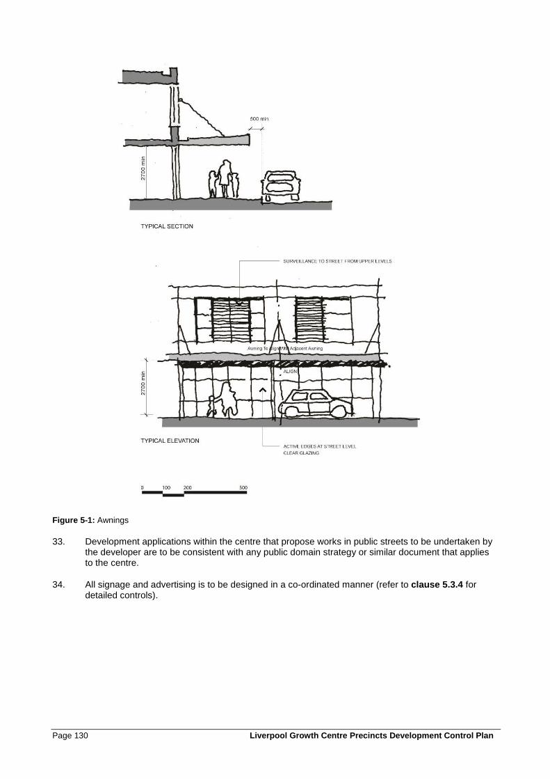
Page 130 Liverpool Growth Centre Precincts Development Control Plan
Figure 5-1: Awnings
33. Development applications within the centre that propose works in public streets to be undertaken by the developer are to be consistent with any public domain strategy or similar document that applies to the centre.
34. All signage and advertising is to be designed in a co-ordinated manner (refer to clause 5.3.4 for detailed controls).
Liverpool Growth Centre Precincts Development Control Plan Page 131
Controls – Landscape design and public spaces
35. Parks and plazas are to act as a focal point for the centre and community activities and are to be designed to ensure adaptability and flexibility in use and function over time.
36. Plant selection should take into account the following:
• species which complement remnant native vegetation,
• level of on-going maintenance,
• potential impacts on road and footpath pavements,
• focus on hardy, drought tolerant, easily maintained species,
• scale in relation to the function of the area,
• solar access and shade, and
• contribution to the character of the local centre.
37. Street tree and open space planting is to provide generous shade for pedestrians in summer and allow for sunlight penetration to street level in winter.
38. All paving materials must conform to relevant standards for durability, non-slip textures, strength and surface treatment to withstand use by light automobiles, service vehicles, pedestrians and bicycles.
39. Paving materials should also be certified colour stable for a period of at least 20 years to ensure a reasonable match to existing paving when damaged sections are replaced.
40. All paved areas should be adequately drained and follow ‘best practises’ in installation, including sub-surface preparation and stormwater management.
41. All paved areas must be properly designed to facilitate use by the elderly and disabled.
5.3.2 Solar access, weather protection and energy efficiency
Objectives
a. To encourage energy efficient building design and operation that complies with statutory benchmarks
in sustainable development.
b. To minimise energy and resource consumption during construction and operation.
c. To consider local climatic conditions and ensure that the design of centres maximises amenity and
activity within the public domain during a wide range of weather conditions.
Page 132 Liverpool Growth Centre Precincts Development Control Plan
Controls
1. Parks and plazas are to receive sunlight on a minimum of 50% of their site area between 11am and 2pm on June 21st.
2. Building envelopes are to allow for north-south streets to receive 2 hours sunlight between 9am-3pm on June 21st on a minimum of 50% of the eastern or western footpaths; and
3. Building envelopes are to allow for east-west streets to receive 2 hours of sunlight between 9am-3pm on June 21st on a minimum of 50% of the southern footpaths.
4. Continuous awnings are required to be provided along the ground floor street frontage on active street frontages in accordance with Figure 5-1 and all buildings fronting public open space or squares.
5. The design of awnings is to comply with the controls in clause 5.3.1, and:
• Ensure that the solar access controls in controls 1, 2 and 3 above are achieved.
• Ensure that protection from rain and summer sun is provided to a minimum of 75% of footpath areas.
6. The design and orientation of buildings is to consider prevailing south-westerly winds in winter, and active frontages are to be located to maximise shielding from strong winds by buildings.
7. Uses that are likely to occupy footpaths should be generally located on the southern or western sides of active streets to take advantage of winter sun and protection from winter winds.
8. Loading, parking and service areas are preferably to be located on the southern or western sides of buildings, except where the western or southern side of a development site adjoins an active street.
9. Residential development within centres is to be generally oriented with living areas and balconies facing north.
10. Residential development within centres is to be designed to maximise natural cross-ventilation.
11. Large expanses of west-facing glazing, or open shop-fronts facing west, are to be avoided unless the glazing or shop-front is shielded from afternoon sun in summer and cold winter winds by other buildings or awnings.
12. Each retail or commercial tenancy is to be separately metered or sub-metered for electricity, gas and water (hot and cold).
13. Hot water is to be supplied from solar or heat pump systems. Where these systems can not deliver sufficient hot water to meet demand (e.g. If the roof area is insufficient), gas water heating is preferred.
14. Rainwater collected from roof areas is to be used for non-potable uses including toilet flushing, laundries and cleaning.
15. All new and refurbished Retail, Commercial and Mixed Use development over the value of $5 million, shall achieve a minimum Greenstar rating of 4 stars as per the applicable Green Building Council of Australia “as built” rating tool.
16. To achieve ESD objectives for new development referred to in control 15:
• An accredited Greenstar Professional from Green Building Council of Australia (GBCA) is to be engaged on the project.
• A schedule of achievable Greenstar credits prepared and certified by the accredited Greenstar Professional is to be provided at the lodgement of the Development Application.
Liverpool Growth Centre Precincts Development Control Plan Page 133
• Proposed Greenstar measures must be shown on the Development Application documents.
• Certificates from suitably qualified structural, hydraulic and mechanical consultants must be provided certifying the ability to incorporate the Green Star commitments at the lodgement of the Development Application.
17. External pedestrian circulation areas are encouraged, rather than internal mall-type buildings. Development that includes internal pedestrian circulation areas should be designed to enable natural ventilation and lighting when weather conditions are appropriate. This may include measures such as openable windows, louvres, skylights and openings on the building perimeter to facilitate natural air circulation. Temporary, moveable or adjustable shade structures are encouraged to provide protection to outdoor or semi-indoor pedestrian circulation areas.
18. Retail and commercial tenancies are to be capable of natural ventilation and have access to natural light.
19. External glazing or shade structures to commercial and retail development shall be capable of controlling solar ingress into internal spaces. Where necessary, solar ingress control systems shall be dynamically operable via climate control systems for individual tenancies.
20. Materials used for construction shall have low Volatile Organic Compounds (VOC) emissions content.
21. Timber building materials should be sourced from sustainable suppliers such as products certified by the Forestry Stewardship Council (FSC).
22. For construction of developments with a value more than $10 million, a Construction Environmental Management Plan is to be submitted prior to the issue of a construction certificate, detailing:
• Measures to reduce the consumption of materials and resources during construction.
• The use of recycled or reclaimed materials in construction.
• Construction waste minimisation measures, including opportunities to re-use materials on site.
• Measures to minimise the use of water and maximise water re-use during construction.
• The embodied energy of the main construction materials, options considered to reduce the embodied energy of materials and (if applicable) the reasons for not choosing materials with the least embodied energy.
• Training, monitoring and reporting on the compliance of construction contractors with the requirements of the CEMP.
5.3.3 Building bulk, scale and design
Objectives
a. To ensure a high standard of building design.
b. To ensure that buildings are appropriate to the scale and character of the centre.
c. To provide for appropriate air circulation and solar access, and to maintain view corridors to and
through the centre.
Controls
1. The maximum allowable depth of residential building envelopes is 22m (max 18m glass line to glass line).
Page 134 Liverpool Growth Centre Precincts Development Control Plan
2. Floors above the second floor are to be set back a minimum of 4 metres from the boundary of the property with any public street.
3. Larger upper floor setbacks from the street may be required to:
• achieve adequate solar access at street level;
• maintain the privacy of dwellings;
• maintain view corridors; or
• minimise the bulk of the building.
4. Zero side setbacks are required on the ground floor and first floor and the side wall shall contain no windows or other openings (except where the side setback is to a public street, where the façade controls in clause 5.3.1 apply).
5. Zero side setbacks are permitted for the upper floors providing the side wall contains no windows or other openings (except where the side setback is to a public street, where the façade controls in clause 5.3.1 apply).
Note: Control 2 above prevails in relation to setbacks to secondary streets in floors above the second floor.
6. Where windows, balconies or other openings are to be provided on upper floors, the minimum side setback for upper floors is 6 metres from the side property boundary and the minimum separation distance between habitable rooms or balconies is 12 metres.
7. For floors above the fourth floor, the minimum separation distance between buildings is to be 18 metres.
8. Roof forms should not result in excessive bulk or overshadowing.
9. All plant and lift over-runs are to be concealed within roof forms to minimise visual impact.
10. The use of roof areas for private / communal open space and gardens is encouraged. Such spaces should be designed to minimise privacy impacts on neighbours.
11. For development in close proximity to a rail corridor, balconies and windows are to be designed so as to prevent objects being thrown onto Railcorp’s facilities (refer to the relevant National Construction Code and the Railcorp Electrical Standards).
12. Floor to ceiling heights are to be a minimum of:
• Ground floor of all buildings (regardless of use): 3.6m
• First floor for retail and/or commercial use: 3.3m
• All other retail and/or commercial floors: 3.3m
• All other residential floors: 2.4m.
5.3.4 Signs
Objectives
a. To ensure that signs and advertising structures are unobtrusive and coordinated in their appearance
and design, and complement buildings and the streetscape.
b. To limit the purposes for which signs may be erected to those that identify businesses and buildings.
Controls
1. Signs are to be designed and located to:
Liverpool Growth Centre Precincts Development Control Plan Page 135
• Be visually interesting and have a high level of design quality,
• Be integrated with the architecture and structure of the building on which they are located;
• Be consistent with the scale of the building or the property on which they are located.
• Consider existing signs on the building, adjoining buildings or elsewhere in the streetscape, and not obscure views of existing signs or the potential for signs to be viewed on adjoining premises;
• Not cover glazed surfaces;
• Project minimally from the building.
2. Signs are not to be supported from, hung from or placed on other signs.
3. The preferred locations for business or building identification signs are shown on Figure 5-2 and include:
• Fascia signs, located on the front or side fascia of an awning;
• Under-awning signs;
• Flush wall mounted signs (e.g. above windows or doors);
• Projecting wall signs, where there is no awning or the fixture of the sign to the awning is not appropriate due to the style of the awning.
4. Awning fascia signs are not to project within 500mm of the kerb.
5. The minimum clearance from the footpath to the bottom of any sign (apart from flush mounted wall signs) is 2.4 metres.
6. Projecting wall signs and under-awning signs are to be perpendicular to the building façade and horizontal.
7. Above awning signs (signs that are attached to the top of an awning) are not permitted.
8. Flush mounted building identification signs are permitted above the first floor on the building parapet only where they are integrated with the design of the building and where they do not project more than 100mm from the building. The maximum area of the sign face is 3m².
9. The maximum number of signs on each façade of any retail or commercial tenancy is three, and only one sign of each type (fascia, under-awning, projecting wall or flush mounted) is permitted on each façade.
10. Under-awning or projecting wall signs are to be a minimum of 3.5 metres apart.
11. Signs are not to project beyond the dimensions of the structure to which they are affixed or obscure windows or other openings.
12. Free standing signs (signs that are not affixed to a building) are not permitted on active street frontages.
13. Flashing, animated or bright neon signage is not permitted.
14. Any illuminated signage must comply with AS 4282 – Control of the obtrusive effects of outdoor lighting.
15. All buildings are to have clearly displayed and legible street numbering.
16. The location of signs is not to obscure views of traffic signs or traffic signals, or have the potential to cause confusion with traffic signs or signals (e.g. signs that look like traffic signals or stop signs located near a public road).
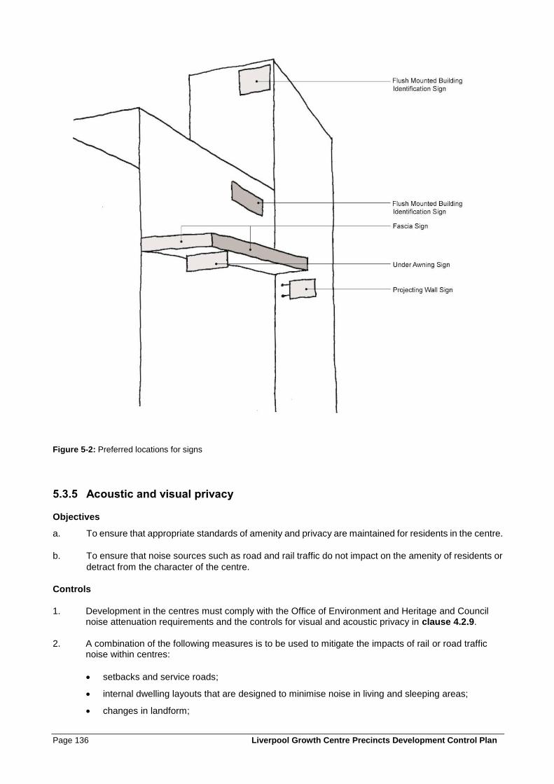
Page 136 Liverpool Growth Centre Precincts Development Control Plan
Figure 5-2: Preferred locations for signs
5.3.5 Acoustic and visual privacy
Objectives
a. To ensure that appropriate standards of amenity and privacy are maintained for residents in the centre.
b. To ensure that noise sources such as road and rail traffic do not impact on the amenity of residents or
detract from the character of the centre.
Controls
1. Development in the centres must comply with the Office of Environment and Heritage and Council noise attenuation requirements and the controls for visual and acoustic privacy in clause 4.2.9.
2. A combination of the following measures is to be used to mitigate the impacts of rail or road traffic noise within centres:
• setbacks and service roads;
• internal dwelling layouts that are designed to minimise noise in living and sleeping areas;
• changes in landform;
Liverpool Growth Centre Precincts Development Control Plan Page 137
• higher than standard fencing constructed with a suitably solid mass; and
• locating courtyards and principal private open space areas that will comply with the criteria in clause 4.2.9 away from the noise source.
5.3.6 Safety, surveillance and maintenance
Objectives
a. To provide for a safe and attractive local centre with high levels of activity and amenity.
b. To ensure that the design quality and amenity of the centre is maintained.
Controls
1. The principles of Crime Prevention through Environmental Design (CPTED) in Clause 2.5 are applicable to all development within centres.
2. Balconies, terraces and other private open spaces are to be oriented to public open spaces to optimise casual surveillance.
3. The design of all buildings, fences and landscape elements shall take sight lines, both horizontal and vertical, into consideration to minimize blind spots and promote a sense of security.
4. All streets, alleys, bike paths and pedestrian walkways must be adequately lit at all times.
5. Lighting is to be installed on all circulation routes and major pedestrian thoroughfares, including under-awning lighting on all awnings.
6. Large open areas such as parking lots and public open spaces are to be floodlit.
7. Lights should be positioned so that they highlight landmarks and other special building features.
8. Lighting fixtures must be sturdy, durable, vandal resistant and easily maintained.
9. Fixtures visible from the public domain should be mounted at a height of at least 2.7 metres, and their appearance should complement the architectural and landscape character of the location.
10. The installation of lighting should take into account and minimise its impacts on surrounding commercial premises and residential properties.
11. Durable and easily cleaned materials should be selected in all areas exposed to the public, and all masonry surfaces to a height of 3 metres should be protected with an approved anti-graffiti treatment.
12. Fencing and street plantings should be designed to achieve a balance between screening and security/surveillance.
13. Traffic facilities are to be installed to enhance pedestrian safety.
14. Safety features such as tactile surfaces and handrails are to be provided in appropriate locations.
Page 138 Liverpool Growth Centre Precincts Development Control Plan
5.3.7 Site servicing
Objectives
a. To ensure that servicing of premises within the centre is efficient.
b. To minimise the amenity impacts of servicing activities including loading/unloading, waste storage and
collection.
Controls
1. Services and structures such as transformers, waste collection, storage and deposit areas, and loading bays are generally to be located to the rear of the property. Where this cannot be achieved services must be integrated into the overall design of buildings and landscaping of the street front through screening measures.
2. Service areas are not permitted on active street frontages or adjacent to public parks, plazas or squares.
3. Service/delivery vehicles should access service and loading areas using secondary streets (refer to the Traffic Circulation and Parking figure in the relevant Precinct’s Schedule for preferred access roads and locations).
4. The following controls relate to the screening of services:
• All services, transformers, storage and deposit areas, and wheeled rubbish bins must be effectively screened from view.
• Screening walls or plant masses shall be at least 1.8 metres high, and Council may require higher screens where required to achieve appropriate standards of amenity.
• All screening shall be designed to allow free and easy access to the facilities, as required to permit maintenance and checking by all relevant parties, including service authorities, Council officials, tenants and property owners.
• Screening wall materials and plants shall be selected which have no adverse impacts on the operation of the facilities.
5. Service access is permitted from rear lanes, side streets and right of ways for the use of parking, loading docks and waste collection areas.
6. Adequate space should be provided for the movement, unloading and loading of service vehicles. All service vehicles should enter and exit any loading area in a forward direction.
7. Structures shall be painted according to the required standards of the relevant service authority, in colours that limit their visual impact.
8. All air conditioners must be located in areas where any noise and dripping condensation will have minimal impact on the public domain. No roof or wall mounted air conditioners shall be visible from public areas.
9. Television antennas and other telecommunication devices are not to be visible from the street.
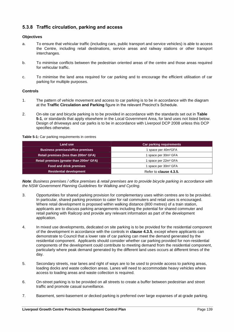
Liverpool Growth Centre Precincts Development Control Plan Page 139
5.3.8 Traffic circulation, parking and access
Objectives
a. To ensure that vehicular traffic (including cars, public transport and service vehicles) is able to access
the Centre, including retail destinations, service areas and railway stations or other transport
interchanges.
b. To minimise conflicts between the pedestrian oriented areas of the centre and those areas required
for vehicular traffic.
c. To minimise the land area required for car parking and to encourage the efficient utilisation of car
parking for multiple purposes.
Controls
1. The pattern of vehicle movement and access to car parking is to be in accordance with the diagram at the Traffic Circulation and Parking figure in the relevant Precinct’s Schedule.
2. On-site car and bicycle parking is to be provided in accordance with the standards set out in Table 5-1, or standards that apply elsewhere in the Local Government Area, for land uses not listed below. Design of driveways and car parks is to be in accordance with Liverpool DCP 2008 unless this DCP specifies otherwise.
Table 5-1: Car parking requirements in centres
Land use Car parking requirements
Business premises/office premises 1 space per 40m²GFA
Retail premises (less than 200m² GFA) 1 space per 30m² GFA
Retail premises (greater than 200m² GFA) 1 space per 22m² GFA
Food and drink premises 1 space per 30m² GFA
Residential development Refer to clause 4.3.5.
Note: Business premises / office premises & retail premises are to provide bicycle parking in accordance with the NSW Government Planning Guidelines for Walking and Cycling.
3. Opportunities for shared parking provision for complementary uses within centres are to be provided. In particular, shared parking provision to cater for rail commuters and retail uses is encouraged. Where retail development is proposed within walking distance (800 metres) of a train station, applicants are to discuss parking arrangements including the potential for shared commuter and retail parking with Railcorp and provide any relevant information as part of the development application.
4. In mixed use developments, dedicated on site parking is to be provided for the residential component of the development in accordance with the controls in clause 4.3.5, except where applicants can demonstrate to Council that a lower rate of car parking can meet the demand generated by the residential component. Applicants should consider whether car parking provided for non-residential components of the development could contribute to meeting demand from the residential component, particularly where peak demand generated by the different land uses occurs at different times of the day.
5. Secondary streets, rear lanes and right of ways are to be used to provide access to parking areas, loading docks and waste collection areas. Lanes will need to accommodate heavy vehicles where access to loading areas and waste collection is required.
6. On-street parking is to be provided on all streets to create a buffer between pedestrian and street traffic and promote casual surveillance.
7. Basement, semi-basement or decked parking is preferred over large expanses of at-grade parking.
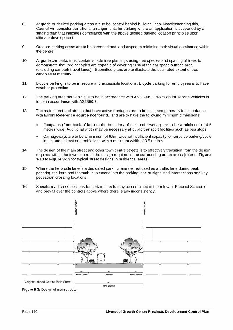
Page 140 Liverpool Growth Centre Precincts Development Control Plan
8. At grade or decked parking areas are to be located behind building lines. Notwithstanding this, Council will consider transitional arrangements for parking where an application is supported by a staging plan that indicates compliance with the above desired parking location principles upon ultimate development.
9. Outdoor parking areas are to be screened and landscaped to minimise their visual dominance within the centre.
10. At grade car parks must contain shade tree plantings using tree species and spacing of trees to demonstrate that tree canopies are capable of covering 50% of the car space surface area (excluding car park travel lanes). Submitted plans are to illustrate the estimated extent of tree canopies at maturity.
11. Bicycle parking is to be in secure and accessible locations. Bicycle parking for employees is to have weather protection.
12. The parking area per vehicle is to be in accordance with AS 2890:1. Provision for service vehicles is to be in accordance with AS2890.2.
13. The main street and streets that have active frontages are to be designed generally in accordance with Error! Reference source not found., and are to have the following minimum dimensions:
• Footpaths (from back of kerb to the boundary of the road reserve) are to be a minimum of 4.5 metres wide. Additional width may be necessary at public transport facilities such as bus stops.
• Carriageways are to be a minimum of 6.5m wide with sufficient capacity for kerbside parking/cycle lanes and at least one traffic lane with a minimum width of 3.5 metres.
14. The design of the main street and other town centre streets is to effectively transition from the design required within the town centre to the design required in the surrounding urban areas (refer to Figure 3-10 to Figure 3-13 for typical street designs in residential areas)
15. Where the kerb side lane is a dedicated parking lane (ie. not used as a traffic lane during peak periods), the kerb and footpath is to extend into the parking lane at signalised intersections and key pedestrian crossing locations.
16. Specific road cross-sections for certain streets may be contained in the relevant Precinct Schedule, and prevail over the controls above where there is any inconsistency.
Figure 5-3: Design of main streets
Liverpool Growth Centre Precincts Development Control Plan Page 141
5.3.9 Shopping Trolleys
Objectives
a. To minimise the abandonment of shopping trolleys.
Controls
1. A management plan is required for all businesses that offer the use of trolleys to their customers. At a minimum the management plan must contain following elements:
- A list of contacts for the store/premises (including phone numbers).
- A statement verifying that trolley management will be undertaken in accordance with the relevant consent (the consent is to be attached as an addendum once issued).
- Methods for identifying shopping trolleys that belong to a specific business (e.g. serial numbers, company logo, tracking device etc.).
- A schedule for the daily collection of abandoned shopping trolleys, including details of trolley collection routes.
- Details of a trolley containment system which restricts the removal of trolleys from the premises.
- Measures to ensure that any trolleys reported as posing a risk or nuisance, are collected immediately upon notification (this may require an “after hours” collection service).
- A register of all trolleys that have been reported or collected (including instances where the trolley was not found at the reported location).
- Methods for warning customers about the consequences of abandoning or removing trolleys from the premises.
- A site plan of the premises showing the location of trolley bays and exit points.
Note: Council must be notified of any updates to the plan of management.
2. A trolley containment system must be provided for businesses with 20 or more trolleys. Such examples include:
- Coin/token operated system with refund.
- Trolleys with wheel locks activated by a radio signal or magnetic strip.
- Radio signal transmitters on trolleys.

Page 142 Liverpool Growth Centre Precincts Development Control Plan
6.0 Employment Lands Subdivision and Development Controls
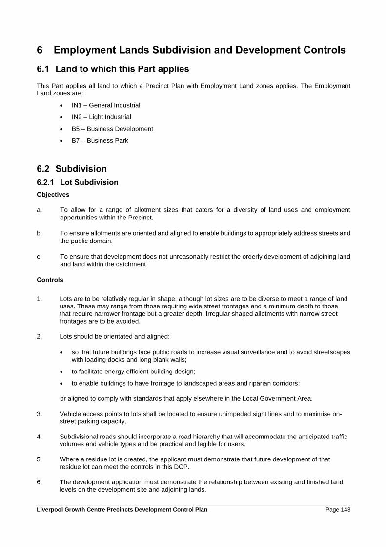
Liverpool Growth Centre Precincts Development Control Plan Page 143
6 Employment Lands Subdivision and Development Controls
6.1 Land to which this Part applies
This Part applies all land to which a Precinct Plan with Employment Land zones applies. The Employment Land zones are:
• IN1 – General Industrial
• IN2 – Light Industrial
• B5 – Business Development
• B7 – Business Park
6.2 Subdivision
6.2.1 Lot Subdivision
Objectives
a. To allow for a range of allotment sizes that caters for a diversity of land uses and employment
opportunities within the Precinct.
b. To ensure allotments are oriented and aligned to enable buildings to appropriately address streets and
the public domain.
c. To ensure that development does not unreasonably restrict the orderly development of adjoining land
and land within the catchment
Controls
1. Lots are to be relatively regular in shape, although lot sizes are to be diverse to meet a range of land uses. These may range from those requiring wide street frontages and a minimum depth to those that require narrower frontage but a greater depth. Irregular shaped allotments with narrow street frontages are to be avoided.
2. Lots should be orientated and aligned:
• so that future buildings face public roads to increase visual surveillance and to avoid streetscapes with loading docks and long blank walls;
• to facilitate energy efficient building design;
• to enable buildings to have frontage to landscaped areas and riparian corridors;
or aligned to comply with standards that apply elsewhere in the Local Government Area.
3. Vehicle access points to lots shall be located to ensure unimpeded sight lines and to maximise on-street parking capacity.
4. Subdivisional roads should incorporate a road hierarchy that will accommodate the anticipated traffic volumes and vehicle types and be practical and legible for users.
5. Where a residue lot is created, the applicant must demonstrate that future development of that residue lot can meet the controls in this DCP.
6. The development application must demonstrate the relationship between existing and finished land levels on the development site and adjoining lands.
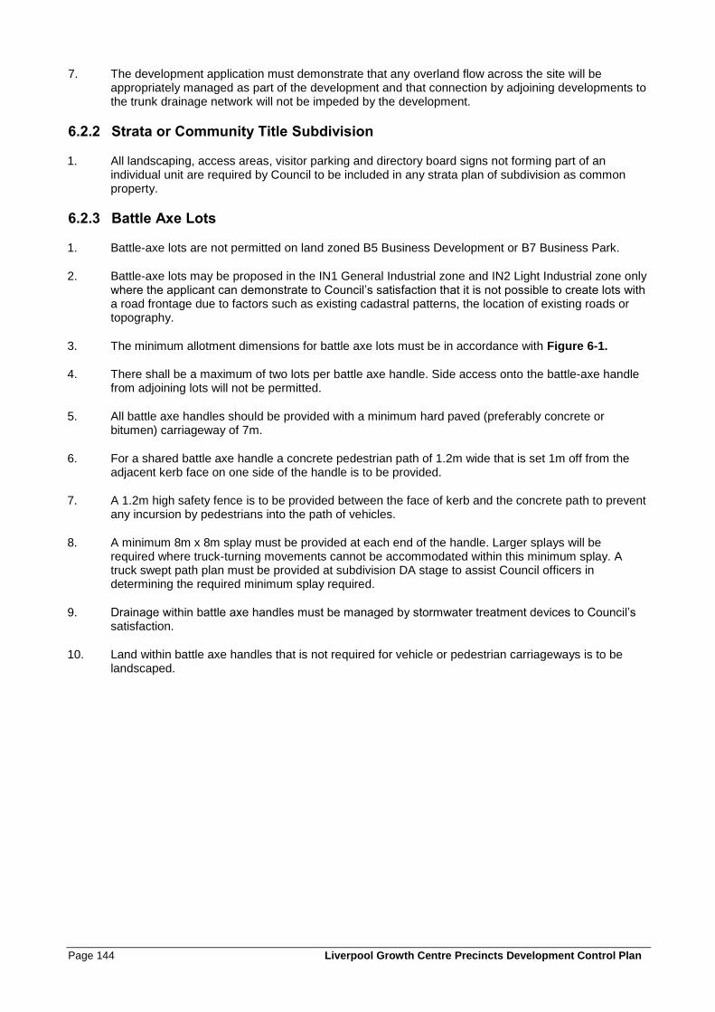
Page 144 Liverpool Growth Centre Precincts Development Control Plan
7. The development application must demonstrate that any overland flow across the site will be appropriately managed as part of the development and that connection by adjoining developments to the trunk drainage network will not be impeded by the development.
6.2.2 Strata or Community Title Subdivision
1. All landscaping, access areas, visitor parking and directory board signs not forming part of an individual unit are required by Council to be included in any strata plan of subdivision as common property.
6.2.3 Battle Axe Lots
1. Battle-axe lots are not permitted on land zoned B5 Business Development or B7 Business Park.
2. Battle-axe lots may be proposed in the IN1 General Industrial zone and IN2 Light Industrial zone only where the applicant can demonstrate to Council’s satisfaction that it is not possible to create lots with a road frontage due to factors such as existing cadastral patterns, the location of existing roads or topography.
3. The minimum allotment dimensions for battle axe lots must be in accordance with Figure 6-1.
4. There shall be a maximum of two lots per battle axe handle. Side access onto the battle-axe handle from adjoining lots will not be permitted.
5. All battle axe handles should be provided with a minimum hard paved (preferably concrete or bitumen) carriageway of 7m.
6. For a shared battle axe handle a concrete pedestrian path of 1.2m wide that is set 1m off from the adjacent kerb face on one side of the handle is to be provided.
7. A 1.2m high safety fence is to be provided between the face of kerb and the concrete path to prevent any incursion by pedestrians into the path of vehicles.
8. A minimum 8m x 8m splay must be provided at each end of the handle. Larger splays will be required where truck-turning movements cannot be accommodated within this minimum splay. A truck swept path plan must be provided at subdivision DA stage to assist Council officers in determining the required minimum splay required.
9. Drainage within battle axe handles must be managed by stormwater treatment devices to Council’s satisfaction.
10. Land within battle axe handles that is not required for vehicle or pedestrian carriageways is to be landscaped.
Liverpool Growth Centre Precincts Development Control Plan Page 145
Figure 6-1: Battle axe lot dimensions
6.3 Landscape Design
Objectives
a. To ensure a balance between built form and landscaped elements
b. To encourage landscaping as a means of screening industrial development.
c. To enable landscaping to contribute to energy efficiency water management and amenity for
employees.
d. To encourage a high standard of landscape design that enhances the streetscape and amenity of the
zone.
6.3.1 Streetscape and Allotment Frontages
1. Streets in industrial zones are to be designed and constructed in accordance with the typical cross section at Figure 6-2.
2. The streetscape design is to integrate vertical elements (trees, light poles and allotment signage) to provide consistency of elements and materials across the zone.
3. Service lids and above ground structures are to be minimised in street frontages.
4. Street tree planting is to be implemented at the subdivision stage in conjunction with the development to ensure plantings are visually consistent in height, spread and form across the zone.
5. The selection of plant species for street tree planting must be in accordance with Appendix C.
Page 146 Liverpool Growth Centre Precincts Development Control Plan
Figure 6-2: Typical industrial street
6.3.2 Allotment Landscape
1. A Landscape Plan must be prepared for all new industrial subdivisions and new buildings.
2. Landscaped areas are required between buildings (ie. within the building separation zone).
3. Allotment landscape design is to be integrated with site planning and building design to:
• reduce the perceived scale of built form from the street;
• reduce visual impact and the extent of continuous building facades.
• highlight architectural features and complement façade articulation;
• identify site and building entries, car park entries and parking areas, in coordination with signage;
• mitigate adverse site conditions through buffering of western sun, provision of shade, wind protection, and screening of poor views;
• maximise northern sun exposure; and
• integrate usable and attractive external seating and amenity areas for staff incorporating paved areas, soft landscape, and shade planting (and canopies where necessary).
4. Landscaping should incorporate hard and soft landscape elements including pavements, retaining walls, low walls and terracing, trees, garden bed planting, and turfed areas.
5. Indigenous species from the area are encouraged for all landscape plantings however, non native species may be considered in limited use to external courtyard areas to achieve seasonal climate
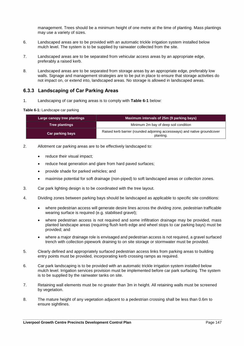
Liverpool Growth Centre Precincts Development Control Plan Page 147
management. Trees should be a minimum height of one metre at the time of planting. Mass plantings may use a variety of sizes.
6. Landscaped areas are to be provided with an automatic trickle irrigation system installed below mulch level. The system is to be supplied by rainwater collected from the site.
7. Landscaped areas are to be separated from vehicular access areas by an appropriate edge, preferably a raised kerb.
8. Landscaped areas are to be separated from storage areas by an appropriate edge, preferably low walls. Signage and management strategies are to be put in place to ensure that storage activities do not impact on, or extend into, landscaped areas. No storage is allowed in landscaped areas.
6.3.3 Landscaping of Car Parking Areas
1. Landscaping of car parking areas is to comply with Table 6-1 below:
Table 6-1: Landscape car parking
Large canopy tree plantings Maximum intervals of 25m (9 parking bays)
Tree plantings Minimum 2m bay of deep soil condition
Car parking bays Raised kerb barrier (rounded adjoining accessways) and native groundcover
planting.
2. Allotment car parking areas are to be effectively landscaped to:
• reduce their visual impact;
• reduce heat generation and glare from hard paved surfaces;
• provide shade for parked vehicles; and
• maximise potential for soft drainage (non-piped) to soft landscaped areas or collection zones.
3. Car park lighting design is to be coordinated with the tree layout.
4. Dividing zones between parking bays should be landscaped as applicable to specific site conditions:
• where pedestrian access will generate desire lines across the dividing zone, pedestrian trafficable wearing surface is required (e.g. stabilised gravel);
• where pedestrian access is not required and some infiltration drainage may be provided, mass planted landscape areas (requiring flush kerb edge and wheel stops to car parking bays) must be provided; and
• where a major drainage role is envisaged and pedestrian access is not required, a gravel surfaced trench with collection pipework draining to on site storage or stormwater must be provided.
5. Clearly defined and appropriately surfaced pedestrian access links from parking areas to building entry points must be provided, incorporating kerb crossing ramps as required.
6. Car park landscaping is to be provided with an automatic trickle irrigation system installed below mulch level. Irrigation services provision must be implemented before car park surfacing. The system is to be supplied by the rainwater tanks on site.
7. Retaining wall elements must be no greater than 3m in height. All retaining walls must be screened by vegetation.
8. The mature height of any vegetation adjacent to a pedestrian crossing shall be less than 0.6m to ensure sightlines.
Page 148 Liverpool Growth Centre Precincts Development Control Plan
6.3.4 Communal Areas
1. Development for the purposes of Industries or Light Industries, with a gross floor area greater than 500 square metres, is to provide a communal area for employees.
2. The area shall be suitably landscaped and accessible from the main office component of the development.
3. The communal area is to have a minimum dimension of 3 metres.
4. Small pockets of open space designed to enhance the appearance of the development will not be counted in the communal area allocation, neither will car parking areas, manoeuvring areas, or landscaped setback areas.
5. In locating communal areas, consideration should be given to the outlook, natural features of the site, and neighbouring buildings.
6. Communal areas shall be embellished with appropriate landscaping, shade, paving, tables, chairs and the like.
7. Communal areas shall be relatively flat and not contain impediments which divide the area or create physical barriers which may impede use.
8. Solar access to communal open spaces is to be provided. Communal areas must receive a minimum of 2 hours direct sunlight between 11am and 3pm on the 21st of June.
9. Appropriate shading is to be provided, preferably using trees, so that communal spaces are useable during summer.
6.4 Built Form and Streetscape
6.4.1 Setbacks
Objectives
a. To achieve attractive streetscapes by ensuring that buildings present an acceptable scale and bulk
when viewed from the public domain.
b. To provide appropriate setbacks to the proposed use and characteristics of the location of the land.
c. To define building envelopes within each allotment by specifying minimum setbacks.
Controls
1. All buildings in zones to which this part applies are to be set back a minimum of 7m from the front property boundary unless otherwise specified in a Precinct’s Schedule.
2. No building or hardstand area (concrete or bitumen pavement) other than a public utility undertaking or a driveway shall be erected within the minimum setback area.
3. All setback areas should be landscaped and maintained in accordance with the landscape provisions in clause 6.3.
4. Pedestrian access should be provided to all landscaped setback areas for maintenance and security purposes.
Liverpool Growth Centre Precincts Development Control Plan Page 149
6.4.2 Building Design and Siting
Objectives
a. To activate streets and the public domain with building frontages.
b. To provide a variety of building orientations and create defined streetscapes that respond to site
conditions.
c. To ensure that building design enhances the existing and future desired built form character by
encouraging innovation and quality architectural design.
Controls
1. Blank building facades facing the primary street frontage are not permitted.
2. The built form and architecture of buildings located at street corners should enhance its location and positively respond to and emphasise the street corner.
3. Building orientation and siting should respond to natural elements such as topography, wind and sunlight.
4. The layout and orientation of buildings should minimise lengthy or deep areas of car parking along the street front.
5. Buildings should provide effective sun shading for windows, wall surfaces and building entries, (other than loading docks) by the use of design elements such as overhanging eaves and awnings, undercrofts, colonnades and external sun shading devices including screens.
6. Building design should be integrated with landscape elements.
7. The bulk and scale of the building should minimise impact on views to features such as local open space and creek lines.
8. Building facades should be articulated by elements such as:
• external structures, finishes, etchings and recessed patterns;
• decorative features, textures and colours;
• locating offices and highlighting entries within front facades;
• emphasised corner elements (particularly on corner sites), customer entries and service access doors;
• protrusions and penetrations in building elements.
9. Buildings with dual street frontage should be designed to ensure:
• the building addresses the primary street and secondary street frontages; and
• distinctive identifying architectural elements are incorporated to provide sufficiently interesting and varied facades;
10. The building design should consider the amenity of any landscaped or communal areas in adjoining properties;
11. The location of roller shutters, loading docks and other building openings should be so that they do not detract from the overall appearance of the building. Where possible, roller shutters and the like should not be located on the primary street frontage;

Page 150 Liverpool Growth Centre Precincts Development Control Plan
12. Roof design should be visually interesting and provide for natural lighting, and compatibility with the overall building design. Where visible from a public area, all rooftop or exposed structures (lift motor rooms, plant rooms etc), must be suitably screened and integrated with the building.
6.4.3 External Building Materials and Colours
Objectives
a. To enhance the visual quality of development through the selection of appropriate materials and
colours.
b. To encourage the use of materials that minimise impact on the environment.
c. To ensure that any reflective materials are used with sensitivity to neighbouring development, vehicular
traffic and public domain areas.
d. To create identifiable, attractive and safe entrances to buildings.
Controls
1. External finishes should be constructed of durable, high-quality and low maintenance materials.
2. External finishes should contain a combination of materials and/or colours.
3. Any wall visible from the public domain must be finished with a suitable material to enhance the appearance of that façade.
4. Building materials should be selected to minimise reflection.
5. External colours shall not detract from the surrounding area. Fluorescent colours are not permitted.
6. The following should be considered in the choice of building materials in all developments:
• energy efficiency;
• use of renewable resources;
• maintenance cost and durability;
• recycled or recyclable materials;
• non-polluting; and
• minimal PVC content.
7. Where concrete roofs are proposed for the purpose of additional parking, parapeted edges are preferred with appropriate screening to conceal roof top car parking.
8. Materials that are likely to contribute to poor internal air quality and those containing Volatile Organic Compounds (VoCs) should be avoided.
9. Proposed external colours and finishes are to be specified in the Development Application. For applications with a value of more than $5 million, or applications for buildings with a floor area of greater than 2,500m2, a colour schedule detailing external colours and finishes may be required by Council.
Liverpool Growth Centre Precincts Development Control Plan Page 151
6.4.4 Entrance Treatment
Objectives
a. To create clear and legible entries that address the street.
Controls
1. Entries to buildings should be clearly visible, well sign posted and lit to pedestrians and motorists.
2. Architectural features are to be provided at ground level giving an entrance element to the building and addressing the primary street frontage.
3. All entrance treatments, such as directory boards, must be located on private property, with appropriate positive covenants and restrictions on title to ensure the ongoing management of such treatments.
4. No third party advertising will be permitted on any entrance treatment facility.
6.4.5 Ancillary Buildings, Storage and Service Areas
Objectives
a. To ensure that ancillary buildings, storage and service areas are considered part of the overall design,
and do not detract from the amenity and appearance of the development.
b. To ensure that site facilities are functional and accessible and are easy to maintain.
c. To ensure that site facilities are thoughtfully integrated into the development and are visually and
physically unobtrusive.
d. To minimise the impact of service access on pedestrians and industrial, commercial and retail frontage.
e. To minimise the visual and acoustic impact of site servicing.
Controls
1. Ancillary buildings and storage sheds are to be located behind the setback lines and be consistent with the design of the main building.
2. Details of any proposed ancillary buildings, open storage and services areas must be submitted with all Development Applications.
3. Storage areas should be located within the confines of the primary building. Appropriate screening must be provided where this can not be achieved.
4. Above ground open storage areas visible from the public domain are not permissible.
5. Above ground open storage areas should not compromise truck or vehicle manoeuvring and car parking areas.
6. Vehicular access to loading facilities is to be provided from secondary and tertiary streets.
7. Waste and recycling areas must be provided in accordance with relevant controls specified by the consent authority. These areas must:
• be integrated with the development;
• minimise the visibility of these facilities from the street; and

Page 152 Liverpool Growth Centre Precincts Development Control Plan
• be located away from openable windows to habitable rooms.
8. Barrier free access is to be provided to all shared facilities.
9. Shower and changing facilities must be provided in accordance with the National Construction Code and be accessible to all building users.
10. The following information must be provided at Development Application stage for outdoor storage areas:
• Size of outdoor storage area
• Maximum storage height
• Types of goods, materials and equipment being stored outdoors; and
• Details on landscaping and screening structures.
11. Sunken loading docks should be avoided.
12. A minimum 225mm clearance is required between finished floor level and finished ground level.
13. Above ground water tanks are preferably to be located behind the front facade of the primary buildings. Where tanks are located in front of the building they must be suitably screened. Materials and finishes of the water tanks must be complementary to the design of the main building. Details (including elevations) of all water tanks must be submitted with the DA.
6.4.6 Development adjacent to residential zoned land
Objectives
a. To ensure that industrial development has a minimal impact on nearby residential areas.
b. To ensure that the site planning for any industrial development responds to the site of any current or future residential development within the locality
Controls
1. Industrial development adjacent to residential zoned land is to:
• Be designed so that heavy vehicle entry and exit points are from side streets or the rear (i.e. streets other than those that separate industrial and residential zoned land).
• Present active uses to the property boundary that faces the residential zoned land (e.g. showrooms, offices or administration areas).
• Locate and screen noisy aspects of the development away from the residential zoned land, preferably behind buildings.
• Have customer and staff vehicle entries to the site on side or rear streets.
• Have a landscaped zone at the front property boundary with a minimum depth from the front boundary of 5 metres, landscaped to reduce the visual impact of buildings and on-site activities when viewed from adjoining residential areas.
• Have any customer and staff parking at the front of the property set back behind the landscaped zone.
• Have a maximum of one free standing business identification sign on the property boundary adjacent to the residential zoned land, with maximum dimensions of 2 metres wide by 3 metres tall, oriented perpendicular to the street.
2. Council will have regard to the following considerations when assessing development applications for industrial uses to which this clause applies:

Liverpool Growth Centre Precincts Development Control Plan Page 153
• the appearance of the development when viewed from the residential area, including the building façade, roof and parapet treatments, outdoor areas including landscaping and parking areas, and signage;
• The bulk and scale of the proposed building when viewed from the residential area;
• Impacts on solar access to residential properties;
• The proposed management of air quality, water quality and noise emanating from the proposed development; and
• Likely impacts on traffic generation, in particular the potential for heavy vehicle movements to increase in residential areas.
3. Where it is considered that a development may have an adverse noise impact on nearby residential areas or adjoining properties, an acoustic assessment undertaken by a qualified acoustic consultant shall be submitted to Council with the development application. The assessment must be in accordance with NSW Industrial Noise Policy.
6.5 Ecologically Sustainable Development
Objectives
a. To improve energy efficiency through the design and siting of buildings;
b. To ensure that developments are environmentally sustainable in terms of energy and water use, and
management of waste and discharge.
c. To encourage the utilisation of materials and construction techniques with low energy inputs in their
production for construction energy systems.
d. To provide a landform that is capable of supporting a range of business and industrial uses that require
large scale, level sites for their operation.
Controls - General
1. Development Applications are required to demonstrate consideration of:
• implementing total water cycle management by including measures that reduce consumption of potable water for non-potable uses, minimise site run-off and promote water harvesting and re-use;
• utilising recycled materials and renewable building resources;
• promoting biological diversity through appropriate retention, planting and maintenance of indigenous flora of the area;
• measures to reduce waste disposal, including contribution of the development to achieving the 60 percent waste reduction target for New South Wales; and
• energy conservation measures that include reducing energy consumption and increasing inherent energy efficiency through design and materials selection, and adopting energy management plans.
2. Development applications involving any landfill/excavation activities must provide an Earthworks Plan that demonstrates how the subject site and land that shares the same drainage catchment may be developed in accordance with this DCP and the Precinct Water Cycle Management Strategy (available from Council).. The plan must provide sufficient detail for Council to determine that the proposal will:
• Function in accordance with the development controls of this DCP and supporting technical studies, relevant sections of Council’s Engineering Specification and good engineering practice.
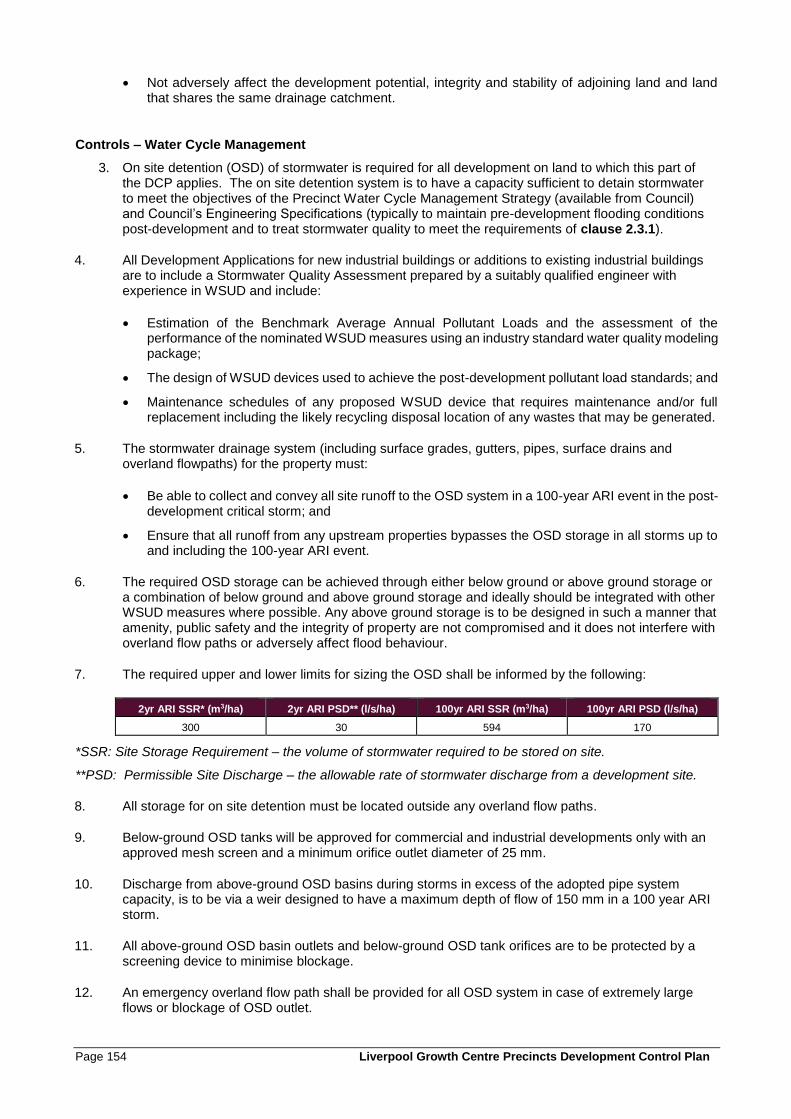
Page 154 Liverpool Growth Centre Precincts Development Control Plan
• Not adversely affect the development potential, integrity and stability of adjoining land and land that shares the same drainage catchment.
Controls – Water Cycle Management
3. On site detention (OSD) of stormwater is required for all development on land to which this part of the DCP applies. The on site detention system is to have a capacity sufficient to detain stormwater to meet the objectives of the Precinct Water Cycle Management Strategy (available from Council) and Council’s Engineering Specifications (typically to maintain pre-development flooding conditions post-development and to treat stormwater quality to meet the requirements of clause 2.3.1).
4. All Development Applications for new industrial buildings or additions to existing industrial buildings are to include a Stormwater Quality Assessment prepared by a suitably qualified engineer with experience in WSUD and include:
• Estimation of the Benchmark Average Annual Pollutant Loads and the assessment of the performance of the nominated WSUD measures using an industry standard water quality modeling package;
• The design of WSUD devices used to achieve the post-development pollutant load standards; and
• Maintenance schedules of any proposed WSUD device that requires maintenance and/or full replacement including the likely recycling disposal location of any wastes that may be generated.
5. The stormwater drainage system (including surface grades, gutters, pipes, surface drains and overland flowpaths) for the property must:
• Be able to collect and convey all site runoff to the OSD system in a 100-year ARI event in the post-development critical storm; and
• Ensure that all runoff from any upstream properties bypasses the OSD storage in all storms up to and including the 100-year ARI event.
6. The required OSD storage can be achieved through either below ground or above ground storage or a combination of below ground and above ground storage and ideally should be integrated with other WSUD measures where possible. Any above ground storage is to be designed in such a manner that amenity, public safety and the integrity of property are not compromised and it does not interfere with overland flow paths or adversely affect flood behaviour.
7. The required upper and lower limits for sizing the OSD shall be informed by the following:
2yr ARI SSR* (m3/ha) 2yr ARI PSD** (l/s/ha) 100yr ARI SSR (m3/ha) 100yr ARI PSD (l/s/ha)
300 30 594 170
*SSR: Site Storage Requirement – the volume of stormwater required to be stored on site.
**PSD: Permissible Site Discharge – the allowable rate of stormwater discharge from a development site.
8. All storage for on site detention must be located outside any overland flow paths.
9. Below-ground OSD tanks will be approved for commercial and industrial developments only with an approved mesh screen and a minimum orifice outlet diameter of 25 mm.
10. Discharge from above-ground OSD basins during storms in excess of the adopted pipe system capacity, is to be via a weir designed to have a maximum depth of flow of 150 mm in a 100 year ARI storm.
11. All above-ground OSD basin outlets and below-ground OSD tank orifices are to be protected by a screening device to minimise blockage.
12. An emergency overland flow path shall be provided for all OSD system in case of extremely large flows or blockage of OSD outlet.
Liverpool Growth Centre Precincts Development Control Plan Page 155
13. All stormwater must drain by gravity to an approved drainage system. Discharge by use of mechanical pump system, or pressurised lines, is not allowed.
14. Development proposals for commercial and industrial zones where HAZCHEM and liquid waste would be stored / produced on-site are to capture all site generated runoff up to the 3 month ARI event within a purpose built device such as a grease trap or retention tank/basin. The device must reduce the risk of runoff polluted by contaminants deposited or spilled on the site from being discharged to the receiving environment. The critical duration storm for the property and the 24 hour duration storm is to be analysed
15. Development shall incorporate water efficient fixtures such as taps, showerheads, and toilets. The fixtures must be rated to at least 3 stars under the National Water Conservation Rating and Labelling Scheme. Where the building or development is water intensive (i.e. high water user), specific water conservation objectives must be resolved with Council.
16. Roof stormwater should be collected in tanks or street level reticulation which would serve as a retention system. The water in the retention system is to be available for use for non-potable uses such as the watering of landscaped areas, cleaning, and use in toilets.
17. Development proposals that propose to capture and to reuse runoff from paved surfaces for irrigation and/or wash down purposes are to incorporate treatment measures into the development to ensure that the harvested water is fit for purpose and that contaminants such as litter, sediment and oil are captured prior to re-use.
18. Where stormwater harvesting is proposed for irrigation of passive and active open spaces, the design and management of such systems is to be undertaken in accordance with the NWQMS Australian Guidelines for Stormwater Harvesting (2009). All harvested stormwater must be treated prior to re-use to be 'fit for purpose'.
19. Any proposed rainwater tank should be:
• Equipped with a 'first flush' diversion system to exclude the initial wash-off (first 5mm of rainfall) from a roof;
• Connected to toilet, laundry and /or garden irrigation fixtures;
• Provided with screens on inlets and overflows to reduce mosquito risk.
20. Tanks are to be designed, installed and operated in accordance with the requirements of the NSW Department of Health, Sydney Water and relevant Australian Standards.
21. Recycled water schemes for development that is not a single residential dwelling are to be designed and operated in accordance with NWQMS Australian Guidelines for Water Recycling: Managing Health and Environmental Risks (2006).
22. New buildings with a footprint of greater than 2,000m2 are encouraged to consider the installation of part or all of the roof as a green roof.
23. Any garden beds in the roof area should predominantly utilise plants from the preferred species list at Appendix C. Plant species endemic to the South West Growth Centre are preferred. Planting beds are to contain a suitable depth of soil to sustain the species selected.
24. A detailed landscape plan of the roof design is to be provided with the development application
Page 156 Liverpool Growth Centre Precincts Development Control Plan
Controls – Energy Efficiency
25. Consideration should be given to the feasibility of any measures to substitute grid-source power with environmentally sustainable alternatives such as tri-generation (green transformers), co-generation (i.e. recovery of waste energy) or photovoltaics.
26. New commercial buildings must achieve a minimum 4 star Green Star rating from the Green Building Council of Australia. An Energy Efficiency Report is to be provided to Council as part of the Development Application for the development proposal.
27. New industrial and light industrial buildings must achieve a minimum 4 star Green Star rating from the Green Building Council of Australia. An Energy Efficiency Report is to be provided to Council as part of the Development Application for the development proposal.
28. Development should incorporate energy efficient hot water systems (solar hot water is preferred).
6.6 Fencing, Signage and Lighting
Objectives
a. To use fencing to define boundaries and provide security, as well as contribute to streetscape and
amenity of the zone.
b. To enhance pedestrian safety, security and amenity within the precinct.
c. To ensure that signage and lighting supports the visual appearance of the building and the visual
appeal of the zone.
6.6.1 Fencing
Controls
1. Low feature walls are encouraged at entry driveways. These walls should be used for retaining purposes, as garden beds or as landscaped features and should be integrated into the overall design of the development.
2. Front and side boundary fences forward of the building line shall consist of open palisade style fencing. Dark or neutral colours are preferred.
3. Side fencing behind the building line may comprise chain wire mesh or similar open style fence, plastic coated in dark green or black.
4. Pre-painted solid metal fencing and other solid fencing is not permissible.
5. Fencing must be set back 1m from the front property boundary.
6. Fencing should be sited so it does not impede sightlines for drivers.
7. Fencing along boundaries should not exceed a height greater than 2.1m, measured from finished ground level.
8. Pedestrian fencing within the road reserve is to be RTA Type 1, without embellishment and black in colour.
9. The use of timber fencing or bollards within public reserves or roads is not permitted.
Liverpool Growth Centre Precincts Development Control Plan Page 157
6.6.2 Signage and Lighting
Controls
1. Signage is to relate to the use occurring on the respective property, and should identify the relevant business name.
2. Business identification signage should be attached to the wall of the main building and be designed to complement the architectural style of the building. Free standing signs will only be permitted where signs are integrated with the landscaping and visual character of the site and surrounding area.
3. Directional signs for car parking areas, loading docks, delivery areas and the like should be located close to the main access of a development site. The design, colouring, type and scale of signage within individual properties should be consistent with signage across the zone as a whole.
4. Signage is only to display corporate logos and company names and is not to occupy more than 10% of any façade or wall of a building, unless it can be demonstrated that characteristics of the site or the building require a larger area of signage.
5. Details of all signage, including free standing, fascia, and wall signs must accompany Development Applications.
6. The design and lux of any internal or spot lighting shall be designed to avoid off-site or traffic safety impacts.
7. No form of moving or flashing signage or lighting is permitted.
8. Signage is not to have a detrimental impact on the visual character of the site or surrounding area.
9. All lighting must comply with AS 1158 – Lighting for Roads and Public Spaces and AS 4282 – Control of the obtrusive effects of outdoor lighting.
Page 158 Liverpool Growth Centre Precincts Development Control Plan
6.7 Access and Parking
6.7.1 Vehicular Access
Objectives
a. To ensure that vehicles can enter and exit premises in a safe and efficient manner in a forward
direction.
b. To minimise the impact of vehicle access points on the quality of the public domain and pedestrian
safety.
c. To provide off-street manoeuvring, loading and docking facilities that are adequate for the operational
needs of the activity and use.
Controls
1. All developments are to be designed, constructed and operated to comply with Liverpool DCP 2008 (unless this DCP specifies otherwise) and relevant Australian Standards.
Industrial Areas
2. Applicants are required to submit plans and details of proposed vehicular access and circulation for Council’s approval with the Development Application. Details must specifically relate to vehicular movement, layout and turning circles.
3. Adequate vehicular entrance to and exit from the development is to be provided and designed in order to provide safety for pedestrians and vehicles using the site and adjacent roadways.
4. Vehicular ingress and egress to the site must be in a forward direction at all times.
5. Driveway crossovers accesses by heavy vehicles should be a minimum of 9m wide, when measured at the kerb alignment.
6. Turning circles will not be permitted to encroach upon any building.
7. Adequate space is to be provided within the site for the loading, unloading and fuelling (if applicable) of vehicles. These areas are to be screened from the road.
8. All parking areas and access roadways must be provided with a drainage system comprising surface inlet pits. Details of pipe sizes (with calculations) and drainage layouts (including discharge points) must be submitted with the Development Application.
B5 Business Development and B7 Business Park Areas
9. Parking areas are to be located underground or screened from view from the street by buildings where at grade or decked.
10. Vehicular access should be designed to avoid conflicts with pedestrians.
11. Adequate space shall be provided within any development site for the loading and unloading of service vehicles. The standard of loading facilities required will depend upon the nature of the development and the uses to be carried out.
12. Council may require the provision of parking for courier vehicles. Loading facilities should be located at the rear of buildings.
13. Vehicular movements associated with loading facilities and customer/employee parking should be separated and all pedestrian movements should be segregated from vehicular movements to avoid possible conflict and congestion.
Liverpool Growth Centre Precincts Development Control Plan Page 159
14. Ingress to and egress from a site should be located where they will cause least interference with vehicular and pedestrian movement on public roads. Direct access is not permitted from sub-arterial roads, arterial roads or transit boulevards (refer to clause 3.3.6 in relation to temporary vehicular access). Access to parking areas will not be permitted in close proximity to traffic signals, intersections or where sight distance is inadequate.
15. The potential for on-street queuing should be eliminated by the provision of sufficient standing areas on-site for vehicles entering the car parking and loading areas.
16. Provision is to be made for all vehicles to enter and leave a site in a forward direction.
6.7.2 Parking
Objectives
a. To provide an appropriate level of on-site car and bicycle parking provision in the Precinct.
b. To minimise the visual impact of on-site parking.
c. To integrate parking facilities with the overall site planning and landscape.
d. To encourage the use of other modes of transport including bicycles and public transport.
Controls
1. The provision of parking must comply with the Table 6-2 unless otherwise specified in the relevant Precinct Schedule.
2. Parking rates for land uses not specified in Table 6-2 are to be as specified for that land use elsewhere in this DCP, or in other Council policies or planning controls
3. The design of car parks is to comply with Council’s Engineering and Design Specifications.
4. Safe and secure 24 hour access to car parking areas is to be provided for building users.
5. Measures are to be implemented to minimise the extent of impervious surfaces within car parks.
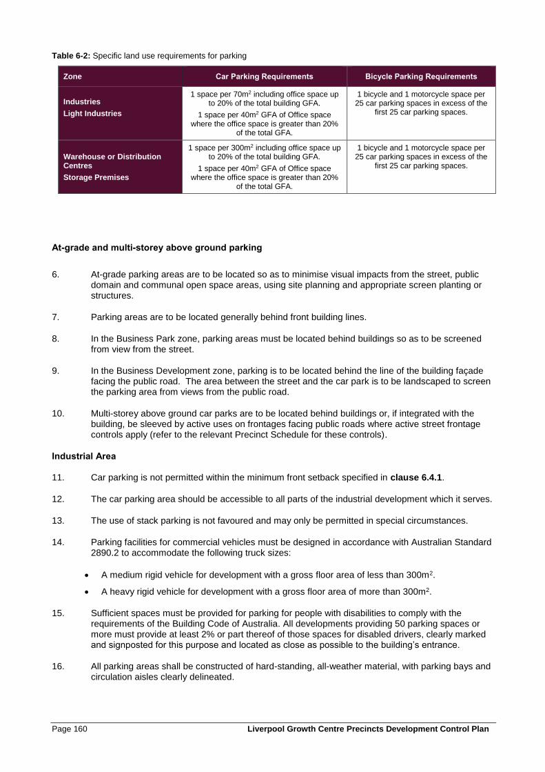
Page 160 Liverpool Growth Centre Precincts Development Control Plan
Table 6-2: Specific land use requirements for parking
Zone Car Parking Requirements Bicycle Parking Requirements
Industries
Light Industries
1 space per 70m2 including office space up to 20% of the total building GFA.
1 space per 40m2 GFA of Office space where the office space is greater than 20%
of the total GFA.
1 bicycle and 1 motorcycle space per 25 car parking spaces in excess of the
first 25 car parking spaces.
Warehouse or Distribution Centres
Storage Premises
1 space per 300m2 including office space up to 20% of the total building GFA.
1 space per 40m2 GFA of Office space where the office space is greater than 20%
of the total GFA.
1 bicycle and 1 motorcycle space per 25 car parking spaces in excess of the
first 25 car parking spaces.
At-grade and multi-storey above ground parking
6. At-grade parking areas are to be located so as to minimise visual impacts from the street, public domain and communal open space areas, using site planning and appropriate screen planting or structures.
7. Parking areas are to be located generally behind front building lines.
8. In the Business Park zone, parking areas must be located behind buildings so as to be screened from view from the street.
9. In the Business Development zone, parking is to be located behind the line of the building façade facing the public road. The area between the street and the car park is to be landscaped to screen the parking area from views from the public road.
10. Multi-storey above ground car parks are to be located behind buildings or, if integrated with the building, be sleeved by active uses on frontages facing public roads where active street frontage controls apply (refer to the relevant Precinct Schedule for these controls).
Industrial Area
11. Car parking is not permitted within the minimum front setback specified in clause 6.4.1.
12. The car parking area should be accessible to all parts of the industrial development which it serves.
13. The use of stack parking is not favoured and may only be permitted in special circumstances.
14. Parking facilities for commercial vehicles must be designed in accordance with Australian Standard 2890.2 to accommodate the following truck sizes:
• A medium rigid vehicle for development with a gross floor area of less than 300m2.
• A heavy rigid vehicle for development with a gross floor area of more than 300m2.
15. Sufficient spaces must be provided for parking for people with disabilities to comply with the requirements of the Building Code of Australia. All developments providing 50 parking spaces or more must provide at least 2% or part thereof of those spaces for disabled drivers, clearly marked and signposted for this purpose and located as close as possible to the building’s entrance.
16. All parking areas shall be constructed of hard-standing, all-weather material, with parking bays and circulation aisles clearly delineated.
Liverpool Growth Centre Precincts Development Control Plan Page 161
6.8 Waste Management
Objectives
a. To maximise opportunities for re-use through source separation and on-site storage.
b. To minimise waste generation and maximise re-use and recycling
c. To minimise waste generation through design, material selection and building practices.
d. To ensure efficient storage and collection of waste and quality design of facilities.
Controls
1. Details of proposed waste management are to be provided as part of all development applications for new buildings and for applications proposing a change of use of a building. For larger developments Council may require a Waste Management Plan to be prepared.
2. Facilities to allow source separation and re-use of materials on-site should be provided.
3. Waste collection should be provided on-site at the street frontage with clear access to facilitate pick up.
4. The siting of any stockpile must take into account environmental factors such as slope, drainage, location of watercourses and native vegetation.
5. Sufficient space must be provided for the storage of garden waste and other waste materials on site.
6. Re-use of stockpile materials on-site should be facilitated.
7. Sufficient space for storage of recyclables and garbage should be provided on-site.
8. Adequate space should be provided for the temporary storage of recyclables, garbage and compostable materials in each unit.
9. Waste cupboards should be designed and located so as to be accessible, useable and cater for change of use.
10. The area or room allocated for garbage and recycling is to be of a sufficient size to store standard bins efficiently.
11. Garbage and recycling areas/rooms must be accessible to all users and have unobstructed and efficient access to bins.
12. Areas for the storage of bulky waste (e.g. clean up materials) should be provided.
13. Volume reduction equipment should be specified in the Development Application for uses that generate significant volumes of waste.
14. Where the development is large or where the site characteristics warrant, multiple garbage and recycling areas should be provided.
15. External space for compostable materials should be provided and located separate to the garbage and recycling room.
16. Composting facilities should be purpose built and be incorporated into the landscape plan for development.
Page 162 Liverpool Growth Centre Precincts Development Control Plan
17. The siting of composting facilities should take into account the potential impact on neighbouring properties.
18. Composting facilities should be adequately signposted to indicate availability of composting facilities on-site.
6.9 Safety and Surveillance
Objectives
a. To ensure personal safety for workers and visitors to the development.
b. To ensure design minimises the opportunity for crime and maximises opportunities for passive
surveillance.
Controls
1. Buildings should be designed to overlook public domain areas and provide casual surveillance.
2. Building entrances should be orientated towards the street to ensure visibility between entrances, foyers, car parking areas and the street.
3. Appropriate lighting should be provided to all cycle and pedestrian paths, bus stops, car parks and buildings.
4. Development should provide clear sight lines and well-lit routes between buildings and the street, and along pedestrian and cycle networks within the public domain.
5. Landscaping design is to consider and implement the principles of Crime Prevention through Environmental Design (refer to clause 2.5).
Liverpool Growth Centre Precincts Development Control Plan Page 163
6.10 Additional Land Use Controls
6.10.1 Neighbourhood Shops
Objectives
a. To enable the provision of neighbourhood shops in business and industrial zones which serve the daily convenience needs of the local workforce, or for the benefit of the local workforce and businesses.
Controls
1. Development Applications must demonstrate that the size, function and proposed use serves the daily convenience needs of the workforce in the zone, or is for the benefit of the local workforce and businesses.
2. Neighbourhood shops must not detrimentally affect the viability of any other centre within a business zone.
6.10.2 Industrial Retail Outlets
Objectives
a. To limit the size of industrial retail outlets to minimise the impacts of large scale retailing on industrial
areas.
b. To ensure that adequate and safe car parking and access is provided for customers.
Controls
1. Industrial retail outlets are to occupy a maximum of 40% of the combined floor area of the industrial retail outlet and the building or place where the relevant industry is carried out, or 400m2, whichever is the lesser
2. Industrial retail outlets are to be located within the part of the building closest to the street frontage and customer access is to be separate from access to parts of the development used for manufacturing, storage or other industrial uses.
3. Car parking for industrial retail outlets is to be clearly marked as customer parking, and is to be provided at the rate of:
• 1 space per 30m2 of floorspace that is occupied by the industrial retail outlet.
• 1 bicycle and 1 motorcycle space per 25 car parking spaces in excess of the first 25 car parking spaces.
4. Customer parking is to be located separate to loading and storage areas.
5. A management plan is required for all businesses that offer the use of trolleys to their customers. At a minimum the management plan must contain the following elements:
• A list of contacts for the store/premises (including phone numbers).
• A statement verifying that trolley management will be undertaken in accordance with the relevant consent (the consent is to be attached as an addendum once issued).
• Methods for identifying shopping trolleys that belong to a specific business (e.g. serial numbers, company logo, tracking device etc.).
Page 164 Liverpool Growth Centre Precincts Development Control Plan
• A schedule for the daily collection of abandoned shopping trolleys, including details of trolley collection routes.
• Details of a trolley containment system which restricts the removal of trolleys from the premises.
• Measures to ensure that any trolleys reported as posing a risk or nuisance, are collected immediately upon notification (this may require an “after hours” collection service).
• A register of all trolleys that have been reported or collected (including instances where the trolley was not found at the reported location).
• Methods for warning customers about the consequences of abandoning or removing trolleys from the premises.
• A site plan of the premises showing the location of trolley bays and exit points.
Note: Council must be notified of any updates to the plan of management
6. A trolley containment system must be provided for businesses with 20 or more trolleys. Such examples include:
• Coin/token operated system with refund.
• Trolleys with wheel locks activated by a radio signal or magnetic strip.
• Radio signal transmitters on trolleys.
Liverpool Growth Centre Precincts Development Control Plan Page 165
6.10.3 Child Care Centres
Objectives
a. To enable the provision of child care centres to address the needs of the local workforce within the
zone.
Controls
1. Due to the nature of the usage, such developments should be sited on allotments which provide buffering from adjoining developments so as to minimise possible conflicts such as noise and invasion of privacy.
2. In order to ensure or protect the privacy of staff and children adequate noise abatement, site landscaping and fencing may be required. Such landscaping is to be in keeping with adjoining developments.
6.10.4 Sex Services Premises
Objectives
a. To ensure that sex services premises are not placed in inappropriate locations so that they do not give
offence to the community or result in a loss of amenity or create adverse social and environmental
impacts.
b. To separate sex services premises and other incompatible land uses.
c. Nominate relevant criteria that Council must have regard for in determining Development Applications
for sex services premises.
d. To impose conditions of consent and operation to prevent adverse impacts on adjacent land such as
noise, safety, offensive visual impact and anti-social activity.
Controls
1. Controls for sex services premises are specified by the Liverpool Development Control Plan 2008. Applicants proposing sex services premises should consult with Council’s DCP to determine controls that are applicable to the development.


