12
LIVING ON THE SLOPE 1
| Date post: | 22-Dec-2015 |
| Category: |
Documents |
| Upload: | kelley-neal |
| View: | 213 times |
| Download: | 0 times |

LIVING ON THE SLOPE
1

HIS STORY (History)• 140 million years ago the Indian Plate formed part of the supercontinent Gondwanaland together with modern Africa, Australia, Antarctica, and South America.
• About 90 million years ago, subsequent to the splitting off from Gondwanaland of conjoined Madagascar and India, the Indian Plate split from Madagascar.
• Begun colliding with Asia between 55 and 50 million years ago
•The collision with the Eurasian Plate along the boundary between India and Nepal formed the orogenic belt that created the Tibetan Plateau and the Himalaya Mountains
(Source: wikipedia)

Westerly Wave(Mid Latitude Weather Systems)
Tracks of Monsoon & Winter Weather Systems (Courtesy PMD)Tracks of Monsoon & Winter Weather Systems (Courtesy PMD)
Monsoon
MonsoonalZone
SUPER FLOOD (2010) in Pakistan: Very Heavy Rainfall Over NW Pakistan

People Centerd Early Warning System-Key Elements
Dissemination and Communication
Communicate risk information and early
warnings
Risk Knowledge
Systematically collect data and undertake risk
assessments
Monitoring and Warning Service
Develop hazard monitoring and early
warning
Response Capability
Build national and community response
capability

Project Outline
Strategic Strengthening of Flood Warning and Management Capacity of Pakistan

Problem revealed by the flood 2010 and counter measures taken in this project
There was limited or no flood forecasting ability for the areas severely damaged by the floods
The flood devastated the areas where had no inundation experience in the past
Flood forecasting including upper-Indus will be introduced by a new system utilizing satellite data ( A1)
Updating flood hazard maps in lower Indus to cover the new inundated areas ( A2)
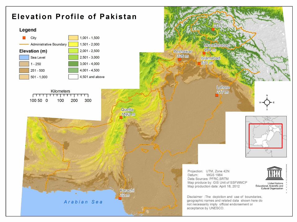
Upper Indus
Lower Indus
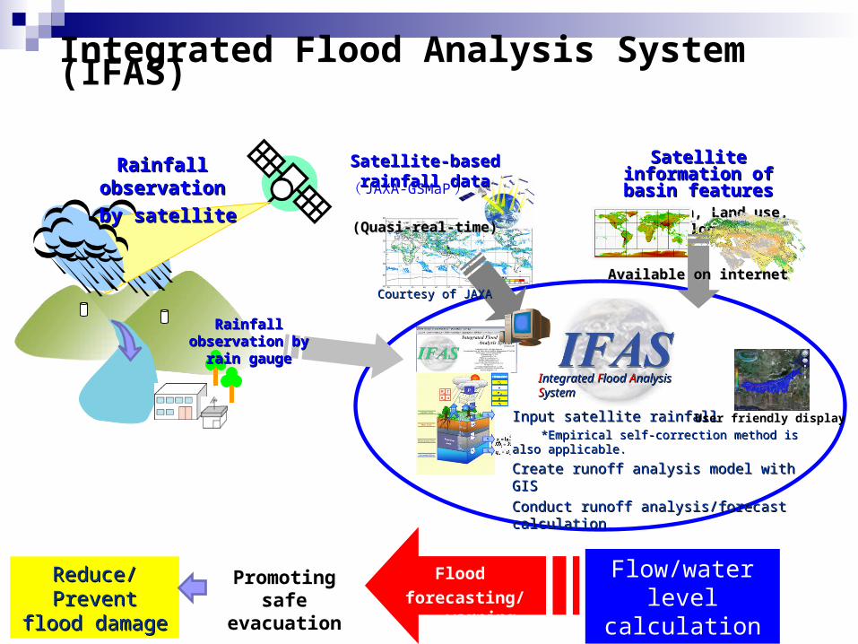
Integrated Flood Analysis System (IFAS)
Satellite information of Satellite information of basin featuresbasin features
(Elevation, Land use, Geology)(Elevation, Land use, Geology)
Input satellite rainfallInput satellite rainfall *Empirical self-correction method is also applicable. *Empirical self-correction method is also applicable.
Create runoff analysis model with GISCreate runoff analysis model with GIS
Conduct runoff analysis/forecast calculationConduct runoff analysis/forecast calculation
Reduce/Prevent Reduce/Prevent flood damageflood damage
Satellite-based rainfall dataSatellite-based rainfall data
(Quasi-real-time)(Quasi-real-time)
User friendly display
Rainfall observationRainfall observation
by satelliteby satellite
Available on internetAvailable on internet
Promoting safe evacuation
Flow/water level calculation
Rainfall observation Rainfall observation by rain gaugeby rain gauge
IIntegrated ntegrated FFlood lood AAnalysis nalysis SSystemystem
( JAXA-GSMaP )
Courtesy of JAXACourtesy of JAXA
Flood
forecasting/warning

TarbellaDam
Realtime flow hydrograph from Existing FEWS
Project Component ( 1/3 )
Geographic area to be covered by Indus-IFAS (enclosed by dotted lines)
Indus-IFAS will be developed in collaboration with the government of Pakistan
Test operation in 2011
Validation and update in 2012
A1
IIntegrated ntegrated FFlood lood AAnalysis nalysis SSystemystem4
IFAS Introduction
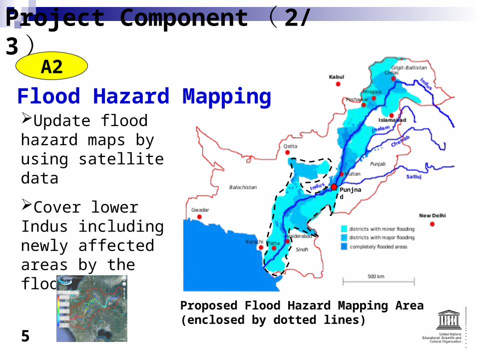
Project Component ( 2/3 )
Proposed Flood Hazard Mapping Area (enclosed by dotted lines)
Update flood hazard maps by using satellite data
Cover lower Indus including newly affected areas by the flood 2010
A2
Punjnad
Flood Hazard Mapping
5

Project Component ( 3/3 )
Parameter improvement and enhanced utilization of IFAS
Capacity development for IFAS introduction and flood hazard mapping, as well as for their sustainable use
B
C
6
Software Platform for Transboundary and domestic data sharing
Human Capacity Development
Supplementation
A1
A2

Implementation FrameworkUNESCO
Project Implementation
ICHARMComponent: A1, C
PMDDevelopment of
Flood Forecasting system
Component: A1
SUPARCOFlood Risk
Hazard MappingComponent: A2
FFCCoordination for
flood management at provincial level
Component: B2
Indus River CommissionTransboundary
Data sharingComponent:B1
NDMA(Including NIDM)
National Policy and Flood Management
at National, Province, District level
Component: B2, C
ICIMODUniv. of Tokyo
UNESCO NetworkComponent: A1, A2
Model Validation
JAXAComponent: A1, A2
PakistanAuthorities
International Partners
Expert InputsGSMAP
Local Calibration
PMD Pakistan Meteological Department
SUPARCO Pakistan and Upper Atmosphere Research Commission
FCC Federal Flood Commission
NDMA National Disaster Management Authority
NIDM National Institute of Disaster Management
ICHARM International Centre for Water Hazard and Risk Management under the auspices of UNESCO
ICIMOD International Centre for Integrated Mountain Development
JAXA Japan Aerospace Exploration Agency
7


