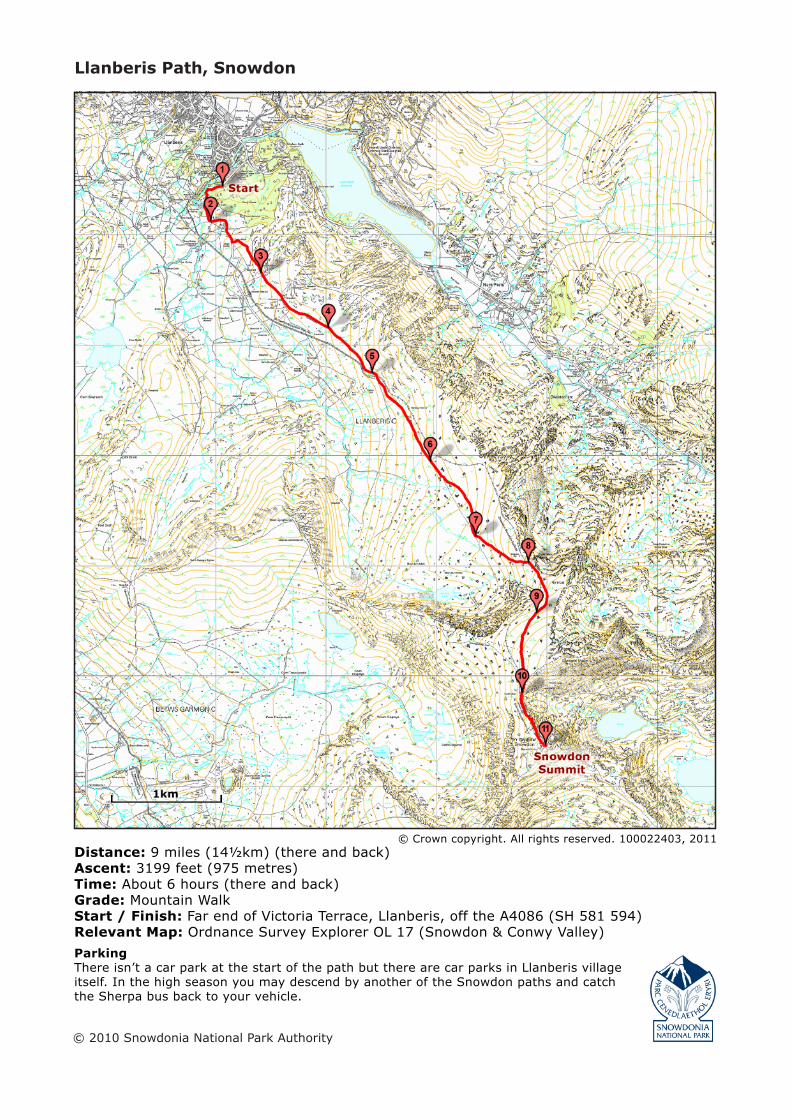
Distance: 9 miles (14½km) (there and back)Ascent: 3199 feet (975 metres)Time: About 6 hours (there and back)Grade: Mountain WalkStart / Finish: Far end of Victoria Terrace, Llanberis, off the A4086 (SH 581 594)Relevant Map: Ordnance Survey Explorer OL 17 (Snowdon & Conwy Valley)Parking There isn’t a car park at the start of the path but there are car parks in Llanberis village itself. In the high season you may descend by another of the Snowdon paths and catch the Sherpa bus back to your vehicle.
1. The Llanberis path starts at far end of Victoria Terrace, which leads down from the mini round-about opposite the Royal Victoria Hotel at the southern end of the village.
2. Go through the gate next to the cattle grid and follow the steep road. The road will pass Pen y Ceunant Isaf, and then through a farmyard. Shortly after going through the farmyard, follow the prominent path on the left signposted ‘Snow-don’.
3. The path climbs gradually, and in a while you will pass the ruins of an old cottage on your left, and Hebron station below on the right. You will shortly reach a mountain gate and a stile.
4. From the mountain gate the path will continue to climb gradually and parallel with the railway.
5. Shortly, you will walk under the railway bridge.
6. After going under the bridge the path will continue to climb gradually with the railway on your left. You will shortly pass the Halfway House, where refreshments are sold in the summer months. From here on the path will begin to climb more steeply.
7. In a while you will reach the bottom of Allt Moses, where the path forks. Keep to the left and follow the path that climbs up the slopes of Llechog.
8. At the top of Allt Moses you will walk under the railway bridge. Once you have walked under the
bridge, Cwm Glas Bach will come into sight on your left. Be careful on this section.
9. After Cwm Glas Bach the path climbs steeply up the slopes of Carnedd Ugain with Clogwyn Coch on your right. Take care on this part of the path. You will shortly reach Bwlch Glas.
10. At Bwlch Glas a standing stone marks the spot where the Pyg Track and Miners’ Track join the Llanberis Path. Over your right shoulder, on the other side of the railway, you will see the Snowdon Ranger path rising up from Bwlch Cwm Brwynog and crossing the railway to join the Llanberis Path.
11. On your way down from the summit, a little further down from the Bwlch Glas standing stone, keep left - the path to the right follows the Snow-don horseshoe which leads over Carnedd Ugain and Crib Goch.
Remember!
Though you are in the Snowdonia National Park, please remember that the path crosses the privately owned farm and grazing lands of Hafodty Newydd, Clogwyn y Gwin and Ffridd Uchaf, where dogs are not welcomed unless under close control or on a lead.
On your way to the summit you will see evidence of essential footpath restoration work carried out by the National Park Authoriy. Please keep to the footpath to prevent further erosion.
Llanberis Path, SnowdonLlanberis Path is the longest and most gradual of the six main paths to the summit of Snowdon, and offers fantastic views of Cwm Brwynog, Llanberis and over the Menai straights towards Anglesey. This is the most popular path amongst leisurely walkers as it is thought to be the easiest to walk in mild weather, but in winter, the highest slopes of the path can become very dangerous.
The path mainly follows the Snowdon Mountain Railway track, and goes by Hebron, Halfway and Clogwyn stations. Before the railway was opened in 1896, visitors employed guides to lead them to the summit along this path on mule-back.
A remarkable geological feature can be seen from the Llanberis path, the Clogwyn Du’r Arddu syncline. The syncline was formed over thousands of years, as the earth moved and transformed horizontal depos-its into vertical layers of rock.
Safety Note
The Llanberis Path and Snowdon Mountain Railway cross above Clogwyn Coch. Walkers who are not wearing, or carrying the appropriate equipment are advised not to walk this path in winter, when ground conditions can lead to serious falls.
Don’t be tempted to walk along the railway! It leads along high, narrow ledges on steep slopes that can be very dangerous on foot.
The Route
Snowdonia National Park Authority, Penrhyndeudraeth, Gwynedd LL486LFTelephone 01766 770274 [email protected] www.eryri-npa.gov.uk