Scoping Report & Methodology Page | 1 Preparing a Local Plan for Pendle Local Plan Part 2 Scoping Report & Methodology For an alternative format of this document phone 01282 661330 October 2016
Transcript
Pendle Local Plan Part 2 Scoping Report & Methodology Page | 1
Preparing a Local Plan for Pendle
Local Plan Part 2 Scoping Report & Methodology
For an alternative format of this document phone 01282 661330
October 2016
Pendle Local Plan Part 2 Scoping Report & Methodology Page | 2
Pendle Local Plan Part 2 Scoping Report & Methodology Page | 3
10. What Happens Next? .............................................................................................. 79
Pendle Local Plan Part 2 Scoping Report & Methodology Page | 5
1. Introduction
The Local Plan 1.1 Pendle Council is preparing a new Local Plan for the borough, to help guide future
decisions on where new homes, jobs and infrastructure will be located and which areas of land will be protected from inappropriate development.
1.2 In Pendle the Local Plan will consist of two documents.
1. Local Plan Part 1: Core Strategy [“LP1”]– adopted in December 2015, this sets-out the strategic policies and established the amount of development required to meet future needs
2. Local Plan Part 2: Site Allocations & Development Policies [“LP2”] – this document follows on from Local Plan Part 1 and has four key objectives:
(i) To set-out policies which provide additional detail for a parent policy in the Core Strategy.
(ii) To set-out additional non-strategic policy requirements (i.e. detailed matters not addressed in the Core Strategy).
(iii) Allocate sites for a wide range of uses (e.g. housing, employment, retail etc.) and where necessary, any specific infrastructure requirements (e.g. new roads, schools etc.)
(iv) Establish boundaries to identify areas where development may be encouraged, resisted or required to meet higher standards of design (e.g. the open countryside, Green Belt, town centres, employment areas etc.)
1.3 This paper is concerned with the scope of the Development Management policies to
be included in LP2 and the methodology that will be used to help identify potential sites for future development, with particular reference to housing.
1.4 This document has been prepared to facilitate consultation with key stakeholders
and the local community. In particular it continues the Council’s dialogue with those organisations and individuals that have previously expressed an interest in the plan making process by responding to earlier public consultations associated with the preparation of LP1.
1.5 Pendle Council will approach the Strategic Environmental Assessment (SEA)
consultation bodies separately for their views on the information and level of detail to be included in the Sustainability Appraisal report for LP2.1
1 In England the SEA Consultation Bodies are Natural England, Historic England and the Environment Agency.
Pendle Local Plan Part 2 Scoping Report & Methodology Page | 6
1.6
1.7
1.8
Public Consultation The Council is seeking feedback on this scoping report and draft methodology prior to starting detailed work on LP2.
Written comments can be submitted in the form of a letter or email and should reach Pendle Council, at the address shown below, by no later than 5.00pm on Friday 7th April 2017.
Pendle Council Planning Policy & Conservation Planning, Building Control & Licensing Town Hall Market Street Nelson BB9 7LG
Pendle Local Plan Part 2 Scoping Report & Methodology Page | 7
2. Scoping of Development Management Policies
2.1 As new buildings are built, we need to make sure that Pendle maintains the right mix of homes, workspaces, shops and green spaces to meet the needs of residents and businesses. We also need to manage the impact new development will have on essential infrastructure (e.g. transport networks, sewage system etc.) and the historic and natural environment.
Why do we need Development Management policies?
2.2 LP1 establishes the strategic objectives and policies that will guide development in the borough up to 2030. The main purpose of the policies in LP2 is set out local standards and criteria against which planning applications for the development and use of land and buildings can be assessed by officers responsible for determining applications for planning permission. They also provide a policy base for the allocation of sites. LP2 also updates those policies from the Replacement Pendle Local Plan 2001-2016, which are still required, but not addressed in LP1.
2.3 It is important to remember that LP2 and its policies cannot be read in isolation. In accordance with the guidance on plan making, the policies in LP2 do not repeat higher level planning policy set out in LP1 or the National Planning Policy Framework [“NPPF”]. Instead they explain how the strategic policies in these documents will be applied at a more local level and define the circumstances in which planning permission will or will not be granted.
2.4 Table 2.1 sets out the policies we propose to include in LP2.2 It briefly sets-out what
the policy is intended to address and references policies in LP1, which may also need to be considered when determining a planning application.
What will the policies address?
2.5 It is proposed to include 44 policies in LP2. These have been arranged in accordance with the themes established in LP1 and their numbering follows on sequentially from the relevant section of that document.
2 Further scoping work and public consultation may see policies added to, or removed from, this initial list.
Pendle Local Plan Part 2 Scoping Report & Methodology Page | 8
Table 2.1: Development Management policies to be included in LP2
Policy Title Description Link to Policies in Local Plan Part 1
Spatial Development Principles
Policy SPD7 Settlement Boundary The Settlement Boundary is used to delineate between the urban area and the open countryside. The policy will explain the purpose of the settlement boundary, indicating the preferred areas for development.
SDP2 ENV1
Policy SDP8 Developer Contributions This policy will provide additional details of how the Council will seek contributions for infrastructure.
SDP6
Our Foundations for a Sustainable Future: Improving the Environment We Live In
Policy ENV8 Open Countryside This policy will provide details of the types of development considered acceptable in the designated Open Countryside. It will set out the criteria for assessing applications on sites located in the Open Countryside.
SDP2 ENV1
Policy ENV9 Areas of Outstanding Natural Beauty (AONB)
This policy will set out the detailed criteria for assessing applications for development within the Forest of Bowland Area of Outstanding Natural Beauty (AONB). It will look at different types of development, alterations and extensions to existing buildings, replacement buildings, scale, materials etc.
ENV1
Policy ENV10 Green Belt This policy will set out the detailed criteria for assessing applications for development within the Green Belt. It will look at different types of development, alterations and extensions to existing buildings, replacement buildings, scale, materials etc. It will also establish safeguarded sites for potential longer term future development beyond the plan period.
ENV1
Policy ENV11 Landscape This policy will set out the importance of Pendle’s Landscapes, provide details of the different landscape character types and how new development should respond to the landscape in which they are located.
ENV1
Pendle Local Plan Part 2 Scoping Report & Methodology Page | 9
Policy Title Description Link to Policies in Local Plan Part 1
Policy ENV12 Natural Environment and Ecological Networks
This policy will define the different nature conservation sites designated in the borough. It will also define the key ecological networks, many of which incorporate the aforementioned sites. It will provide details of how developments should protect and enhance the networks and resist the formation of any potential barriers. It will look at habitat restoration and how links can be improved.
ENV1
Policy ENV13 Local Green Spaces This policy will designate sites as Local Green Spaces and set out the criteria for their protection.
ENV1
Policy ENV14 Open Space This policy will designate sites as Open Space. It will provide criteria for the loss of open space. It will support improvements to existing open spaces.
ENV1 LIV5 SUP2 SUP4
Policy ENV15 Green Infrastructure This policy will identify Green Infrastructure routes, provide details of how they should be protected and improved. It will include details of countryside access and the public rights of way network.
ENV1 SUP2
Policy ENV16 Trees and Hedgerows This policy will set out how trees and hedgerows should be protected, when new planting should be considered and how woodlands will be managed.
ENV1
Policy ENV17 Design and Landscaping This policy will set the design requirements relating to the use of materials and colours in new developments; and set out the requirements in respect of landscaping. It will also address issues of residential amenity and incompatible uses.
ENV2 LIV5 WRK6 SUP4
Policy ENV18 Historic Environment This policy will provide more detailed requirements for development affecting the historic environment. It will set out details relating to the use, alteration of, and extensions to, Listed Buildings. Provide details relating to developments within a Conservation Area. Look at how archaeology should be protected and recorded. Identify those elements of the historic environment which provide local distinctiveness.
ENV1 ENV2
Pendle Local Plan Part 2 Scoping Report & Methodology Page | 10
Policy Title Description Link to Policies in Local Plan Part 1
Policy ENV19 Leeds and Liverpool Canal Corridor This policy will consider the Leeds and Liverpool Canal Corridor, looking specifically at the opportunities for tourism, housing regeneration and sustainable transport. It will set out how the corridor can be improved.
ENV1 WRK5
Policy ENV20 Renewable and Low Carbon Energy This policy will set out the detailed criteria for assessing applications for new development associated with the generation of energy from renewable and low carbon sources.
ENV3
Policy ENV21 Pollution This policy will provide additional details on the control of pollution for different types of development. It will consider issues relating to noise, odour, vibration and lighting.
ENV5
Policy ENV22 Contaminated and Unstable Land This policy will set out details for the remediation of contaminated and unstable land where it affects new development.
ENV5
Policy ENV23 Equestrian Development This policy will set out the criteria that should be followed for equestrian developments (e.g. stables, manages etc.).
ENV1
Policy ENV24 Telecommunications This policy will provide criteria for the siting of telecommunications equipment, looking at the ways to minimise impact.
SDP6
Policy ENV25 Parking This policy will set the parking standards (car and cycling) for different types of development. It will also identify protected car parks in the borough.
ENV4
Policy ENV26 Taxis This policy will consider the criteria for new taxi offices and taxi ranks. It will include details of suitable locations for such uses and any restrictions which may apply.
ENV4
Living: Creating a Vibrant Housing Market
Policy LIV6 Housing Site Allocations This policy will provide details of the sites to be allocated for new housing development and stipulate the criteria for how they should be developed.
LIV1
Pendle Local Plan Part 2 Scoping Report & Methodology Page | 11
Policy Title Description Link to Policies in Local Plan Part 1
Policy LIV7 Reserved Sites for Housing This policy will provide details of those sites that should be allocated as reserve housing sites. These will provide choice and flexibility should the allocated sites fail to come forward. They will also provide potential sites for longer term development at the end of the plan period. The policy will provide details of the circumstances in which these sites will be permitted to be developed.
LIV1
Policy LIV8 Affordable Housing This policy will provide a review of Policy LIV4 of the Core Strategy (a requirement of the Inspector at the Core Strategy Examination). It will reconsider the thresholds and targets for affordable housing. It will take account of the new definition of affordable housing and the different affordable products now available.
LIV4
Policy LIV9 Quality Housing This policy will identify those design standards which the developers of new housing will be encouraged to meet, or be required to adhere to. This may include elements such as accessibility, adaptability, water efficiency and internal space standards. It will also address the layout of estates, development on garden land and infill sites.
LIV5
Policy LIV10 Householder Development This policy will set out the criteria for a range of householder developments including extensions, dormer windows, residential curtilages and garden extensions in the countryside.
ENV2 LIV5
Policy LIV11 Self and Custom Build Housing This policy will set criteria for self and custom-build developments. LIV1 LIV3
Policy LIV12 Housing in the Countryside This policy will establish the types of residential development, which will be considered to be acceptable in the open countryside. It will set out the criteria used to determine applications for agricultural and forestry workers dwellings, barn conversions, redundant buildings and replacement dwellings not within a defined settlement boundary.
SDP2 LIV1
Policy LIV13 Communal Living This policy will set out criteria for the development of premises associated with communal living such as Houses in Multiple Occupation (HMOs), Care Homes and Student Accommodation.
LIV3
Pendle Local Plan Part 2 Scoping Report & Methodology Page | 12
Policy Title Description Link to Policies in Local Plan Part 1
Working: Creating a Dynamic and Competitive Economy
Policy WRK7 Employment Site Allocations This policy will provide details of the sites to be allocated for employment uses and stipulate the criteria for how they should be developed.
WRK2
Policy WRK8 Protected Employment Areas This policy will provide details of those areas protected for employment use and will set the thresholds for the amount of B1, B2 and B8 uses that are acceptable. It will also provide criteria for the redevelopment of areas for alternative uses should they no longer be needed for employment use.
WRK2
Policy WRK9 Mixed Use This policy will set out criteria for assessing applications for mixed-use developments.
WRK1 WRK2
Policy WRK10 Retail Site Allocations This policy will provide details of the sites to be allocated for retail uses and stipulate the criteria for how they should be developed.
WRK4
Policy WRK11 Town Centres This policy will provide details of those uses which are suitable to be developed within the defined town centres and primary shopping areas. The policy will provide details of the primary and secondary retail frontages and the proportion of non-retail uses that can occupy units in those frontages.
SDP5 WRK4
Policy WRK12 Local Shopping Centres This policy will provide details of those uses which are suitable to be developed within the defined Local Shopping Centres. It will provide details of the primary and secondary retail frontages and the proportion of non-retail uses that can occupy units in those frontages.
SDP5 WRK4
Policy WRK13 Edge and Out-of-Centre Retail This policy will provide details of those areas/sites that are designated as edge-of-centre or out-of-centre. It will provide criteria for assessing the suitability of proposed developments in these areas.
WRK4
Pendle Local Plan Part 2 Scoping Report & Methodology Page | 13
Policy Title Description Link to Policies in Local Plan Part 1
Policy WRK14 Local and Convenience Shops This policy will set out the criteria for assessing retail applications outside the six town centres and local shopping centres. Local Shopping Frontages will be defined, where a group of (primarily) convenience shops help to meet the needs of a local neighbourhood. It will also provide details of those circumstances where retail uses may be permitted outside of a designated shopping area or frontage, in order to serve an identified need in a sustainable way (e.g. on a large industrial estate).
WRK4
Policy WRK15 Retail in Rural Areas This policy will provide details of the circumstances for allowing retail uses in rural areas. It will support the provision of new services and facilities to ensure the continued sustainability of the rural settlements.
WRK4
Policy WRK16 Tourist Facilities and Accommodation This policy will provide additional details and criteria for determining applications for tourist accommodation (e.g. hotels, B&Bs, Camping, Caravans, Marinas) and facilities (visitor centres etc.).
WRK5
Supporting: Creating Healthy and Confident Communities
Policy SUP5 Community Site Allocations If required, this policy will provide details of those sites to be allocated for community purposes such as health centres, schools etc.
SUP1 SUP2 SUP3
Policy SUP6 Supporting Healthy Lifestyles This policy will set out a wide range of measures that will help to improve the health of people in the borough; by improving access to open space; addressing the location of hot food takeaways etc.
SUP2
Policy SUP7 Advertisements This policy will provide details for the determination of applications for advertisements. It will look at the siting and placement of advertisements, design, illumination etc.
ENV2 SUP4
Pendle Local Plan Part 2 Scoping Report & Methodology Page | 14
Designations and Allocations to be shown on the policies map
Pendle Local Plan Part 2 Scoping Report & Methodology Page | 15
3. Proposed Distribution of Development by Settlement
3.1 A number of policies in LP1 have a direct influence on the amount and location of new development for housing and employment (Table 3.1). Table 3.1: Policies influencing spatial distribution of new development
Policies Relevance to site selection and assessment
Housing SDP3 Indicates where new housing should be delivered across Pendle, to help support sustainable patterns of new development.
LIV1 Establishes the total amount of new housing required in Pendle over the plan period.
LIV2 A strategic site allocation of 17 hectares (gross) for new housing development in the M65 Corridor.
Employment SDP4 Indicates where new employment growth should be located to meet identified needs.
WRK2 Establishes the amount of new employment land required in Pendle over the plan period.
WRK3 A strategic site allocation of 30 hectares (gross) for new employment development in the M65 Corridor.
Source: Pendle Local Plan Part 1: Core Strategy
3.2 A key role for LP2 is to allocate sufficient land to meet the identified requirements for housing (Policy LIV1) and employment (Policy WRK2) and to ensure that the spatial distribution of sites is broadly in line with that highlighted in policies SDP3 and SDP4 (Table 3.2).
Table 3.2: Spatial distribution of overall development requirements (2011-2030)
Spatial Area Housing Employment
M65 Corridor 3,963 70.0% 53.38 ha 78.5% West Craven Towns 1,019 18.0% 12.58 ha 18.5% Rural Pendle 680 12.0% 2.04 ha 3.0%
PENDLE 5,662 100% 68.00ha 100%
Source: Pendle Local Plan Part 1: Core Strategy
Pendle Local Plan Part 2 Scoping Report & Methodology Page | 16
Housing Requirement 3.3 As the plan period started in 2011, a significant proportion of the overall housing
requirement has already been met through the reoccupation of long-term empty homes and new housing completions. A further element has been committed through the allocation of a strategic housing site in LP1 (Policy LIV2) and part-implemented and unimplemented planning permissions.
Calculating the residual requirement
3.4 This section considers the calculation of the residual housing requirement and its proposed distribution by settlement.
Empty Homes
3.5 The Inspector at the Examination of the Core Strategy accepted that counting the reoccupation of empty homes could be used as a source of supply.
3.6 Statistical returns to the government show that there has been a declining trend in the number of long-term empty properties across the borough. This indicates that such properties are now being used as an active part of the housing stock helping to meet the needs of the population.
3.7 Data relating to the reoccupation of long-term empty homes is only available on a borough-wide basis. It is therefore necessary to subtract the total for empty homes that have been reoccupied since the 2011/12 monitoring period (i.e. the start of the plan period) from the overall housing requirement before considering other factors that will influence the proposed distribution of new housing.
3.8 Once the (net) reduction in long-term empty homes since the start of the plan period (854) has been taken into account, the housing requirement for Pendle is reduced to 4,808 (Table 3.11, Column A).
Considering the evidence
3.9 Before the residual housing requirement can be apportioned by settlement, a number of other factors must also be taken into consideration, as these will have a significant influence on the proposed distribution. In particular it is important to consider:
• land availability (using evidence from the SHLAA)
• housing needs (using evidence from the SHMA)
• the size of each settlement (in terms of its physical area, current population and number of households)
• accessibility, infrastructure capacity and availability of services
• past trends on housing completions
• viability and market demand
Pendle Local Plan Part 2 Scoping Report & Methodology Page | 17
Land Availability
3.10 The availability of land will not be the deciding factor in establishing the proposed distribution of housing in Pendle. Alongside economic viability and on-site constraints, it is an important consideration in the deliverability of new housing. Table 3.4: Potential capacity of SHLAA Sites
1 Only sites without planning permission are included. These sites are regarded as suitable for housing, but may not be deliverable once detailed site constraints have been taken into consideration. To give an indication of deliverability the SHLAA groups sites into 0-5, 6-10, 11-15 and longer-term timeframes.
2 Percentage figures are expressed as a proportion of the spatial area, except those in bold (grey cells) which are expresses as a proportion of the borough as a whole.
Pendle Local Plan Part 2 Scoping Report & Methodology Page | 18
3.11 The Strategic Housing Land Availability Assessment (SHLAA) is an evidence base document that identifies and assesses the availability, suitability and deliverability of land, which has been suggested as having the potential to provide new housing. The potential capacity of those sites that are currently known to be available is summarised in Table 3.4 by settlement.
3.12 The figures reveal that sites in Colne have the greatest capacity to provide new
housing within the M65 Corridor. However, local site-specific constraints will need to be resolved before new housing can come forward on many of these sites. Existing opportunities in Brierfield suggest that it is capable of delivering a significant amount of new housing whereas Nelson, which is bordered on three sides by Brierfield, Colne and the M65 motorway, has much more limited opportunity for future expansion.
3.13 Whilst there is the potential to identify and allocate new sites in LP2, the existing
site portfolio in the West Craven Towns reveals that there is currently greater capacity to deliver new housing in Earby than its larger neighbour Barnoldswick. However, similar to the position in the M65 Corridor, localised constraints are likely to restrict the number of sites that can come forward, which may make it necessary to consider other sites that have not previously been suggested for consideration.
3.14 There is significant variation in the potential capacity of sites associated with the
settlements in Rural Pendle. Four of these – Fence, Kelbrook, Laneshaw Bridge and Salterforth – could potentially accommodate a large amount of housing, but sustainability considerations will restrict the amount of land to be brought forward in these locations and present a series of choices in terms of which of the potential sites are best placed to meet the housing needs of the borough.
Housing Needs
3.15 The Strategic Housing Market Assessment (SHMA) considers the different types of housing need in each of the borough’s spatial areas. The evidence in the SHMA clearly indicates that the vast majority of the identified need for affordable housing in Pendle is situated within the M65 Corridor (Table 3.5).
Pendle Local Plan Part 2 Scoping Report & Methodology Page | 19
3.16 Unfortunately, issues associated with statistical accuracy at small geographies mean that these figures cannot be broken down by individual settlement. However, detailed discussions with registered providers of social housing, during the preparation of the SHMA, indicated that there was demand for affordable housing in both Nelson and Brierfield, albeit a fragile one, whereas in Colne the level of demand was much stronger.3 They also noted that there was a very strong level of demand for affordable housing in both Barnoldswick and Earby (West Craven Towns), with much lower numbers of vacant affordable properties in these areas.
3.17 In Rural Pendle the stock of affordable housing is limited. With higher house prices, the provision of some affordable dwellings would help to meet housing needs within this spatial area. Unfortunately, as noted above, there is no data available to help show which of the rural settlements are most in need.
3.18 Occupancy rating data, based on the number of rooms in a household, is used to
show whether the accommodation is considered to be over-crowded or under-occupied (Table 3.6). The rating is calculated by subtracting the notional number of rooms required from the actual number of rooms. The ages of the household members and their relationships to each other are used to derive the notional number of rooms they require, based on a standard formula. The results can be used to help identify those areas where additional and more suitably sized accommodation should be provided.
3.19 The data indicates that the majority of households in Pendle have more rooms than
the notional standard. 3.20 Evidence of over-crowding is most evident in Nelson and Colne. Other towns with a
high concentration of two-bed terraced properties (e.g. Brierfield, Barrowford, Barnoldswick and Earby) also feature high in the rankings. The rural villages of Blacko and Newchurch-in-Pendle also record relatively high scores for having one less room than the notional standard. This is likely to be due to a high concentration of small former weavers’ cottages.
3.21 The high scores for properties with two or more rooms less than the notional
standard in Nelson and Brierfield reflect the high levels of over-crowding recorded in some inner urban neighbourhoods in these towns.
3.22 In contrast the majority of rural settlements demonstrate a high proportion of
households living in properties with one or more rooms than the notional standard. This indicates high levels of under occupation. Whilst this can be linked to the affluence of the rural population, it is also influenced by parents not down-sizing when their children leave the family home, due to the desirability of the location.
3.23 New housing provision should look to address the issues of over-crowding
wherever practicable.
3 This information cannot be quantified at a settlement level and can only be employed as supplementary evidence when considering where new housing should be located.
Pendle Local Plan Part 2 Scoping Report & Methodology Page | 20
1 Percentage of average totals for each settlement.
Settlement Size
3.24 Considering the physical and demographic characteristics of each settlement helps to provide the context for deciding where new housing should be located (Table 3.7).
3.25 The physical size of each settlement uses the settlement boundaries defined on the current Proposals Map as the basis for its calculations. The figures for population and households are based on Output Area data from the 2011 Census. This is the smallest geography at which data is made available and is mapped against the various settlement areas using a ‘best fit’ approach.
Pendle Local Plan Part 2 Scoping Report & Methodology Page | 21
Table 3.7: Summary of physical and demographic attributes
Settlement / Spatial Area Status Physical Area Population Household Spaces
Tier Role Hectares Percentage Persons Percentage Homes Percentage Nelson 1 Key Service Centre 676 45 28,612 46 10,994 43 Brierfield 2 Key Service Centre 239 16 10,002 16 3,794 15 Colne 1 Key Service Centre 424 29 17,420 28 7,875 31 Barrowford 2 Local Service Centre 152 10 5,933 10 2,658 11 M65 Corridor 1,491 74 61,967 69 25,321 68 Barnoldswick 1 Key Service Centre 228 70 10,168 69 4,528 70 Earby 2 Local Service Centre 97 30 4,538 31 1,952 30 West Craven Towns 325 16 14,706 17 6,480 17 Fence 3 Rural Service Centre 32 16 1,459 11 663 12 Foulridge 3 Rural Service Centre 27 14 1,159 9 526 9 Kelbrook 3 Rural Service Centre 27 14 678 5 309 6 Trawden 3 Rural Service Centre 37 19 2,244 18 950 17 Barley 4 Rural Village 4 2 298 2 119 2 Blacko 4 Rural Village 10 5 534 4 243 4 Higham 4 Rural Village 19 10 778 6 346 6 Laneshaw Bridge 4 Rural Village 15 8 1,195 9 529 10 Newchurch and Spen Brook 4 Rural Village 5 2 248 2 108 2 Roughlee and Crow Trees 4 Rural Village 5 2 318 3 150 3 Salterforth 4 Rural Village 10 5 637 5 272 5 Sough 4 Rural Village 7 3 330 3 145 3 Rural Pendle 198 10 12,779 14 5,547 15 Pendle 2,014 100 89,452 100 37,348 100
Notes: Percentage figures are expressed as a proportion of the spatial area, except those in bold (grey cells), which are a proportion of the borough as a whole.
Pendle Local Plan Part 2 Scoping Report & Methodology Page | 22
3.26 The data reveals that Nelson (including Brierfield), Colne and Barnoldswick are the largest settlements in the Borough, reinforcing their designation as Key Service Centres in LP1. A significant proportion of the housing requirement will therefore need to be allocated to these settlements.
3.27 Barrowford and Earby have been designated as Local Service Centres in LP1 and
this is reflected in their physical size, population and household numbers. The amount of new housing to be distributed to these settlements will need to be of a magnitude that is relative to their status.
3.28 There is a considerable variation in size, population and number of households amongst the rural settlements. The proposed distribution of new housing will need to carefully consider the existing demographics, the level of service provision and the availability of land. It may transpire that there is no direct correlation between the amount of new housing proposed for a settlement and its current size.
Accessibility, Infrastructure and Services
3.29 To be considered sustainable new housing should be supported by adequate infrastructure and services and ideally have good access to higher tier settlements with a wider range of facilities and services.
3.30 It is important to look at the provision of key services on a settlement-by-settlement basis to help determine the amount of new housing that they are capable of accommodating.
3.31 Whilst it is important to consider the current availability of services and the
capacity of essential infrastructure within each settlement (Table 3.8), it must also be recognised that new development may lead to new or improved provision through the imposition of planning obligations – i.e. Section 106 Agreements4 or the Community Infrastructure Levy5.
3.32 LP1 used evidence from the Sustainable Settlements Study (2008) to establish a
settlement hierarchy for the borough (Policy SDP2). This considered a wide range of sustainability factors to determine which settlements were the most sustainable based on the availability of key services and facilities. Although there have been a number of changes since the study was published, the settlement hierarchy provides a useful starting point when considering the sustainability of each settlement and its ability to accommodate new housing development.
4 A condition attached to a planning permission to make acceptable development which would otherwise be unacceptable in planning terms.
5 Due to concerns about the potential adverse impact on development viability, Pendle Council has not adopted a Community Infrastructure Levy Charging Schedule at the time of writing.
Pendle Local Plan Part 2 Scoping Report & Methodology Page | 23
3.33 Table 3.8 provides an update of the information in the Sustainable Settlements Study (2008) and reveals that the Key Service Centres and Local Service Centres in the M65 Corridor and the West Craven Towns are clearly the most sustainable locations in Pendle. They offer a wider range of key services and facilities and offer good access to public transport. They are therefore best placed to accommodate a larger proportion of the borough’s housing requirement.
3.34 In contrast, settlements in the rural areas offer a more limited range of services and
facilities. The amount of new housing to be directed to these settlements must take account of this, whilst recognising that in certain circumstances the provision of additional housing may help to sustain existing facilities or support the provision of new services. Table 3.8: Sustainability factors
Settlement
Key Services Infrastructure
Trai
n
Bus
GP
Dent
ist
Prim
ary
Scho
ol
Gene
ral S
tore
Was
te W
ater
Broa
dban
d1
High
way
s
Nelson Brierfield Colne X X Barrowford X Barnoldswick X Earby X X Fence X X X Foulridge X X X X X Kelbrook X X X Trawden X X X Barley X X X X X X Blacko X X X X Higham X X X X Laneshaw Bridge X X X X Newchurch and Spen Brook X X X X X X Roughlee and Crow Trees X X X X X Salterforth X X X X Sough X X X X X
Source: Pendle Sustainable Settlements Study (2008, Updated 2016)
Notes:
1 Superfast Lancashire is a partnership between Lancashire County Council and BT, rolling out high-speed fibre broadband across the county. In combination with the commercial fibre broadband rollout by BT, high-speed broadband will be available to 97% of the county by the end of 2016.
Pendle Local Plan Part 2 Scoping Report & Methodology Page | 24
3.35 In Rural Pendle the villages of Fence, Kelbrook and Trawden, and to a lesser extent Foulridge, demonstrate slightly better levels of service provision. They have been designated as Rural Service Centres to recognise that they provide a focal point for the rural community and often provide employment opportunities not associated with farming or tourism. These settlements have the potential to accommodate more housing than the smaller rural villages with little or no service provision.
3.36 Consideration must also be given to the capacity of the local infrastructure. Whilst
the Waste Water Treatment Works in Colne, Foulridge and Earby have been highlighted as being close to capacity by United Utilities and Yorkshire Water, given the level of development set out in LP1 and its broad distribution, no insurmountable problems have been identified at this time.
3.37 Similarly, whilst broadband is not yet universally available across the borough, the
Superfast Lancashire initiative will bring high-speed broadband to all but the remotest of locations in Pendle within the next few years.
3.38 Most critical is the potential for new development to have an adverse impact on
the highway network. Part of the North Valley in Colne is currently designated as an Air Quality Management Area, largely on account of high NO2 emissions arising from standing traffic. Whilst congestion may not be an issue in the rural areas, narrow roads mean that only development which helps to meet local needs is likely to be appropriate in the Pendleside villages.
Past trends
3.39 Data on housing completions has been recorded by Pendle Council for a number of years and is reported annually in the Authority’s Monitoring Report (AMR). This can help to show where the demand for new housing is highest. Looking at the 11 year period since 2005/06 provides a good representation of housebuilding in Pendle in both the pre-recession and post-recession periods (Table 3.9), and reduces the chance of the figures being unduly influenced by the availability of land. The data reveals that the highest figures have been recorded in Nelson, Colne and Barnoldswick, which is in-line with their role and function as Key Service Centres.6
3.40 The second-tier Local Service Centres unsurprisingly record the next highest numbers. Of note is the number of completions in Earby (173 new dwellings), which is significantly higher than Barrowford (84). This is likely to reflect the availability of land, its attractive location (close to the Yorkshire Dales National Park) and better viability.
3.41 Trawden (96 dwellings) has provided over one-third of the new homes built in Rural
Pendle during this period. Opportunities provided by the redevelopment of former textile mills within the village envelope have been the main impetus, although some Greenfield development has also occurred. Elsewhere provision has, in most cases, been relative to the size of the settlement.
6 These are gross rather than net figures (i.e. they do not take account of demolitions).
Pendle Local Plan Part 2 Scoping Report & Methodology Page | 25
Table 3.9: Past trends in housing completions (gross)
Settlement / Spatial Area 05/06 06/07 07/08 08/09 09/10 10/11 11/12 12/13 13/14 14/15 15/16 Total
Note: Percentages are expressed as a proportion of the spatial area, except those in the grey cells which are a proportion of the borough as a whole.
Pendle Local Plan Part 2 Scoping Report & Methodology Page | 26
3.42 The future distribution of housing will take account of these past trends and consider if they should continue, or whether certain settlements should deliver more or less housing going forward.
Market Demand and Viability
3.43 Paragraph 47 of the NPPF makes clear that “a supply of specific deliverable sites sufficient to provide five years-worth of housing” should be identified by the local planning authority. Footnote 11 clarifies that to be considered deliverable, sites must be viable. Viability will, therefore, be a key factor to consider in the allocation of sites for new housing development.
3.44 The proposed distribution of new housing will need to take account of development viability within each settlement. If Pendle Council is to demonstrate that it is able to deliver sufficient new housing to meet the borough’s housing requirement in a timely manner, sites will need to be allocated in those locations that are viable, or where there is a reasonable prospect that they will become viable over the lifetime of the plan. This may require the Council to direct more housing to those settlements that demonstrate the greatest levels of viability.
3.45 The market demand for housing tends to be higher in desirable locations and this has implications for the viability of sites and in turn influences the deliverability of new housing across the borough. Careful consideration needs to be given to how the distribution of the housing requirement, to settlements with low market demand, can be achieved in the short term.
3.46 Figure 3.1 shows average house prices and the total number of sales recorded in the
six main settlements in Pendle in the 12 month period from June 2015 to June 2016.
Figure 3.1: House Sales in Pendle, 2015-16
Pendle Local Plan Part 2 Scoping Report & Methodology Page | 27
3.47 It is evident that average house prices in Nelson and Brierfield are much lower than the other settlements in the borough. However, the number of sales varies significantly between settlements and this may have an impact on the average prices.
3.48 Average prices and the levels of sales are similar in Colne and Barnoldswick. Both settlements have similar levels of demand for new housing as they are attractive places to live, with key local amenities and easy access to the surrounding countryside.
Figure 3.2: House Sales in Pendle since 2011/12
Figure 3.3: House Sales in Pendle, since 2005/06
Source: Zoopla
Pendle Local Plan Part 2 Scoping Report & Methodology Page | 28
3.49 Barrowford has the highest average house price, although the number of sales is fairly low, which may unduly influence the average price. That said Barrowford is an attractive location for house buyers.
3.50 These findings are also reflected in the longer term trends for 5 and 10 years (Figures 3.2 and 3.3).
3.51 Taking account of the evidence outlined above, Table 3.10 identifies a proposed distribution of the residual housing requirement by settlement. The final column in the table provides a brief justification for the proportion of housing that has been identified.
Pendle Local Plan Part 2 Scoping Report & Methodology Page | 29
Table 3.10: Proposed Spatial Distribution of New Housing in Pendle, 2011-2030
Spatial Area / Settlement
Influencing Factors Proposed / Balanced Distribution
Area
Popu
latio
n
Hous
ehol
ds
Past
Tre
nds
Avai
labl
e La
nd
Aver
age
Scor
e % Justification
M65 Corridor
Nelson 45% 46% 43% 36% 20% 38% 35% • Nelson is the largest settlement in terms of area, population and households. It offers a wide range of services and facilities and has sufficient infrastructure capacity to accommodate further development. Ongoing upgrades to key junctions on the main highway network will help to support planned growth.
• Nelson has seen the second highest number of new dwellings completed over the last 11 years. The number of residential property sales over the last year, show a reasonable level of demand for housing. There is also some demand for affordable housing, being situated in the M65 Corridor where levels of housing need are highest. Average house prices are low, which has impacted on the viability of sites in the short term. The amount of available land is also lower than in adjacent settlements, with limited opportunity for the settlement to expand.
• As a consequence the amount of new housing it is proposed to distribute to Nelson is 35% of the total requirement for the M65 Corridor. This is considered to be a realistic amount of housing provision when taking account of the land potentially available for new housing development and the poor level of viability.
Brierfield 16% 16% 15% 14% 26% 17% 20% • Brierfield is the third largest settlement in the M65 Corridor and intrinsically linked to Nelson, immediately to the east.
• The number of housing completions over the last 11 years is comparable to the size of the settlement. The level of service provision is less than in the larger towns of Nelson and Colne, but all key services and facilities are present. The town has good transport links by both road and rail, providing good access to additional services in nearby Nelson and Burnley. The current viability of sites is poor, market demand is weak and house prices are low. However, recent and ongoing regeneration projects are helping to improve the housing
Pendle Local Plan Part 2 Scoping Report & Methodology Page | 30
Spatial Area / Settlement
Influencing Factors Proposed / Balanced Distribution
Area
Popu
latio
n
Hous
ehol
ds
Past
Tre
nds
Avai
labl
e La
nd
Aver
age
Scor
e % Justification
market in the area. There is a considerable amount of land potentially available both within and immediately adjacent to the settlement boundary. Sites close to the shared settlement boundary with Nelson could help meet the housing needs in both settlements. Peripheral sites are likely to be more viable than those in the inner urban area. No insurmountable constraints have been identified in terms of infrastructure capacity, restricting the development of these sites.
• The amount of housing it is proposed to distribute to Brierfield is 20% of the total requirement for the M65 Corridor. This will provide for the housing needs of Brierfield taking account of the current poor viability of sites. It may also address some of the housing need in neighbouring Nelson on sites that are close to the boundary between the two settlements.
Colne 29% 28% 31% 39% 41% 34% 35% • Colne is the second largest settlement in Pendle in terms of area, population and households. It is an attractive market town just to the east of Nelson, with arguably the widest range of services and facilities of any town in the borough. These would both attract and support additional development.
• Colne has seen the highest number of new dwellings completed over the last 11 years. Although the viability of sites in the inner urban area is poor, sites to the north are more viable. There is demand for new housing and average house prices are significantly higher than those in Nelson. There is also more land potentially available in and around Colne, although some sites are constrained by a combination of topography, flood risk, access and current policy designations. Infrastructure capacity will also need to be addressed in order to accommodate new development. Colne experiences significant congestion at peak times on roads in the North Valley. Lancashire County Council is looking to develop a route management strategy to help ease traffic flows from the M65 (Junction 14), east along the A6068. United Utilities has highlighted that investment will be needed at the Waste Water Treatment Works to ensure there is sufficient capacity to deal with any additional housing. It will be important to ensure that any sites it is proposed to allocate for new housing do not
Pendle Local Plan Part 2 Scoping Report & Methodology Page | 31
Spatial Area / Settlement
Influencing Factors Proposed / Balanced Distribution
Area
Popu
latio
n
Hous
ehol
ds
Past
Tre
nds
Avai
labl
e La
nd
Aver
age
Scor
e % Justification
exacerbate existing capacity issues. • The amount of housing it is proposed to distribute to Colne is 35% of the total requirement
for the M65 Corridor. This takes account of the amount of land potentially available, possible infrastructure constraints and the market demand for properties in and around the town. This amount of new housing will provide for the needs of Colne and may also address some of the housing need in neighbouring Nelson, on sites that are close to the boundary between the two settlements.
Barrowford 10% 10% 11% 11% 13% 11% 10% • Barrowford is the smallest settlement in the M65 Corridor and the only one to the north of the M65 motorway. It has a linear form, with the majority of development lying to the west of the A682.
• The number of completions in Barrowford over the last 11 years is the lowest for any settlement in the M65 Corridor, but is comparable with the size of the settlement. The village is known for its high quality shopping experience, but also offers a range of other services and facilities, which additional development would help to support. Sites in Barrowford are more viable than anywhere else in the M65 Corridor. Average house prices are also higher and there is good demand for properties in this area. There are a number of potential sites, which could support additional housing provision. No insurmountable constraints restricting development have been identified, although several minor roads leading off the A682 are narrow in places.
• The amount of housing it is proposed to distribute to Barrowford is 10% of the total requirement for the M65 Corridor. This takes account of the land that is potentially available, the current viability of sites, the good level of service provision and facilities in the village. This amount will help to meet the housing needs of Barrowford.
Pendle Local Plan Part 2 Scoping Report & Methodology Page | 32
Spatial Area / Settlement
Influencing Factors Proposed / Balanced Distribution
Area
Popu
latio
n
Hous
ehol
ds
Past
Tre
nds
Avai
labl
e La
nd
Aver
age
Scor
e % Justification
West Craven Towns
Barnoldswick 70% 69% 70% 56% 39% 61% 60% • Barnoldswick is the larger of the two West Craven Towns. Its role as a market town sees it offer a wide range of services and facilities. It has sufficient infrastructure capacity to accommodate further development.
• Over the last 11 years the number of completions in Barnoldswick has varied, with particularly low levels recorded during the years immediately following the 2007/08 economic recession. Sites in Barnoldswick are generally viable. Average house prices and the level of housing demand are both similar to those in Colne. Barnoldswick has less available land than Earby, but there is sufficient to meet the proposed distribution. No insurmountable constraints restricting future growth have been identified.
• The amount of housing it is proposed to distribute to Barnoldswick is 60% of the total requirement for the West Craven Towns. This reflects the town’s status as a Key Service Centre and takes account of the level of service provision, the range of facilities, the availability of land considered to be suitable for housing and the viability of sites.
Earby 30% 31% 30% 44% 61% 39% 40% • Earby is the smaller of the two West Craven Towns, accounting for just 30% of the population and households within the spatial area. The town offers a good level of services and facilities in comparison to its size. This is due to its relative isolation from nearby Barnoldswick and its location on the A56 between Colne and Skipton.
• The number of completions has varied markedly over the last 11 years. The high numbers achieved pre-recession have not re-emerged in the post-recession period. Earby has a significant amount of land potentially available for new housing development. Some of these sites are constrained by flood risk, access and heritage impact. Sites in the West
Pendle Local Plan Part 2 Scoping Report & Methodology Page | 33
Spatial Area / Settlement
Influencing Factors Proposed / Balanced Distribution
Area
Popu
latio
n
Hous
ehol
ds
Past
Tre
nds
Avai
labl
e La
nd
Aver
age
Scor
e % Justification
Craven Towns are generally viable and average house prices in Earby are similar to those in Barnoldswick. Yorkshire Water has programmed improvements to the Waste Water Treatment Works to ensure that there is sufficient capacity in the future. A flood alleviation scheme has been considered, but is not currently included in the capital programme.
• The amount of housing it is proposed to distribute to Earby is 40% of the total requirement for the West Craven Towns. This reflects its status as a Local Service Centre and the availability of land.
Pendle Local Plan Part 2 Scoping Report & Methodology Page | 34
Spatial Area / Settlement
Influencing Factors Proposed / Balanced Distribution
Area
Popu
latio
n
Hous
ehol
ds
Past
Tre
nds
Avai
labl
e La
nd
Aver
age
Scor
e % Justification
Rural Pendle
Fence 16% 11% 12% 8% 10% 11% 15% • Fence is situated alongside the A6068 to the west of Nelson. It is designated as a Rural Service Centre (RSC), in recognition of the level of services and the range of facilities on offer. It is of a similar size to the other RSCs in the borough.
• The amount of development in Fence over the last 11 years has been lower than that experienced in the other RSCs. One reason is that Fence is severely constrained by Green Belt. As a consequence there is little room for expansion. In addition, there have been few opportunities for development on Brownfield sites within the settlement boundary. The rural areas are generally more viable and Fence has a number of potential development sites, although most are within the Green Belt.
• The amount of housing it is proposed to distribute to Fence is 15% of the total requirement for Rural Pendle. This reflects its status as an RSC, the level of service provision and range of facilities available within the village, site viability and the availability of land. This amount of housing will help to meet local needs.
Foulridge 14% 9% 9% 13% 6% 10% 15% • Foulridge, immediately north of Colne on the A56, offers a level of services and facilities relative to its role as an RSC.
• The number of housing completions has varied over the last 11 years with higher levels of completions in the pre-recession period. The village has seen a modest amount of housing development since the recession, but has less land potentially available for new housing than the other RSCs. The village is constrained by Green Belt to the south.
• The amount of housing it is proposed to distribute to Foulridge is 15% of the total requirement for Rural Pendle. This reflects its status as an RSC and site viability.
Pendle Local Plan Part 2 Scoping Report & Methodology Page | 35
Spatial Area / Settlement
Influencing Factors Proposed / Balanced Distribution
Area
Popu
latio
n
Hous
ehol
ds
Past
Tre
nds
Avai
labl
e La
nd
Aver
age
Scor
e % Justification
Kelbrook 14% 5% 6% 8% 16% 10% 15% • Kelbrook, situated on the A56 between Barnoldswick and Earby, offers a range of services and facilities relative to its role as an RSC.
• The village has seen a lower number of housing completions in the last 11 years when compared with the other RSCs. However, a significant amount of land with the potential to provide new housing has been identified. Sites within the rural areas are generally viable and there are no insurmountable constraints or issues with infrastructure capacity. The cumulative impact new development may have on the Waste Water Treatment Works at Earby, in conjunction with any development in that town, will need to be addressed.
• The amount of housing it is proposed to distribute to Kelbrook is 15% of the total requirement for Rural Pendle. This reflects its status as an RSC and the availability of land.
Trawden 19% 18% 17% 34% 7% 19% 15% • Trawden, to the south of Colne, is slightly larger than the other RSCs in terms of physical size and population. With the exception of a village shop (currently vacant) it offers a range of services and facilities relative to its size.
• The village has seen a relatively high number of housing completions over the last 11 years. It has a number of potential sites available for new housing and sites in the rural areas are generally viable.
• The amount of housing it is proposed to distribute to Trawden is 15% of the total requirement for Rural Pendle. This reflects its status as an RSC, site viability and the availability of land.
Barley 2% 2% 2% 2% 0% 2% 3% • Barley is a small village within the Forest of Bowland Area of Outstanding Natural Beauty (AONB), which is much visited by tourists, but offers a very limited range of services.
• Housing completions have been low over the last 11 years. No land has been identified as potentially being available for future housing development.
Pendle Local Plan Part 2 Scoping Report & Methodology Page | 36
Spatial Area / Settlement
Influencing Factors Proposed / Balanced Distribution
Area
Popu
latio
n
Hous
ehol
ds
Past
Tre
nds
Avai
labl
e La
nd
Aver
age
Scor
e % Justification
• The amount of housing it is proposed to distribute to Barley is 3% of the total amount for Rural Pendle. This will allow for the development of a limited amount of housing to meet local needs.
Blacko 5% 4% 4% 4% 3% 4% 6% • Blacko is a small linear village on the A682, offering a very limited range of services and facilities.
• The number of housing completions has been consistent with the size of the settlement and there is land potentially available to allow for a modest amount of new housing to meet local needs. Sites in the rural areas are generally viable.
• The amount of housing it is proposed to distribute to Blacko is 6% of the total requirement for Rural Pendle.
Higham 10% 6% 6% 14% 0% 7% 6% • Higham is a small village just off the A6068 and offering a limited range of services and facilities.
• The village has seen a relatively high number of completions relative to the size of the settlement. No land has been identified as being available for new housing. It will be necessary to find a site to help provide for local housing needs. Sites in the rural areas are generally viable.
• The amount of housing it is proposed to distribute to Higham is 6% of the total requirement for Rural Pendle.
Laneshaw Bridge
8% 9% 10% 14% 24% 13% 8% • Laneshaw Bridge is one of the borough’s larger rural villages, but the level of service provision and the number of facilities are low in comparison to its size. In part, this is due to its proximity and good access to the Key Service Centre of Colne, just a mile or so to the west.
• The number of completions in Laneshaw Bridge has varied over the last 11 years with a higher number in the pre-recession years. In the last seven years just one new property has been completed. When compared to the other villages in Rural Pendle, a considerable amount of land in Laneshaw Bridge has been identified as potentially being available for
Pendle Local Plan Part 2 Scoping Report & Methodology Page | 37
Spatial Area / Settlement
Influencing Factors Proposed / Balanced Distribution
Area
Popu
latio
n
Hous
ehol
ds
Past
Tre
nds
Avai
labl
e La
nd
Aver
age
Scor
e % Justification
new housing development. There are no insurmountable infrastructure constraints restricting development and sites within the rural areas are generally viable.
• The amount of housing it is proposed to distribute to Laneshaw Bridge is 8% of the total requirement for Rural Pendle.
Newchurch and Spen Brook
2% 2% 2% 1% 5% 2% 3% • The neighbouring villages of Newchurch-in-Pendle and Spen Brook lie within the Forest of Bowland Area of Outstanding Natural Beauty (AONB). They are two of the smallest settlements in Rural Pendle and offer a very limited range of services and facilities between them.
• Only two new dwellings have been constructed in Newchurch-in-Pendle and Spen Brook in the last 11 years. In 2015 planning permission was granted for 28 dwellings on a brownfield site in Spen Brook. A reasonable amount land is potentially available for new housing, given the relatively small size of these settlements, the majority of this being in Spen Brook.
• The amount of housing it is proposed to distribute to Newchurch-in-Pendle and Spen Brook is 3% of the total amount for Rural Pendle. This will allow for the development of a limited amount of housing to meet local needs.
Roughlee and Crow Trees
2% 3% 3% 1% 3% 2% 3% • Roughlee and Crow Trees is situated within the Forest of Bowland Area of Outstanding Natural Beauty (AONB). It is one of the smallest settlements in Rural Pendle and offers a very limited range of services and facilities.
• There have been only three housing completions in the last 11 years, but a reasonable amount of land is potentially available given the size of the settlement.
• The amount of housing it is proposed to distribute to Roughlee and Crow Trees is 3% of the total amount for Rural Pendle. This will allow for the development of a limited amount of housing to meet local needs.
Pendle Local Plan Part 2 Scoping Report & Methodology Page | 38
Spatial Area / Settlement
Influencing Factors Proposed / Balanced Distribution
Area
Popu
latio
n
Hous
ehol
ds
Past
Tre
nds
Avai
labl
e La
nd
Aver
age
Scor
e % Justification
Salterforth 5% 5% 5% 1% 27% 9% 8% • Salterforth, immediately south of Barnoldswick on the B6383, is a mid-size rural settlement, but the level of service provision in the village is low. In part, this is due to its proximity and good access to the Key Service Centre of Barnoldswick, just a mile or so to the north.
• The number of completions in Salterforth has been particularly low over the last 11 years, although a 49 home scheme on a brownfield site close to the centre of the village is currently under construction. A considerable amount of land is potentially available for new housing development. No insurmountable infrastructure constraints restricting development have been identified. Sites in the rural areas are generally viable.
• The amount of housing it is proposed to distribute to Salterforth is 8% of the total requirement for Rural Pendle.
Sough 3% 3% 3% 0% 0% 2% 3% • Sough is one of the smallest rural settlements in Pendle. Situated on the A56 in close proximity to Earby (Local Service Centre) and Kelbrook (Rural Service Centre), it has very few services of its own.
• No land has been identified as potentially being available for new housing in Sough. It will be necessary to find a site to help provide for local housing needs. Sites in the rural areas are generally viable.
• The amount of housing it is proposed to distribute to Sough is 3% of the total requirement for Rural Pendle. This will allow for the development of a limited amount of housing to meet local needs.
No Defined Settlement Boundary
N/A - 23% 21% - - 9% 0% It is not proposed to distribute any of the housing requirement to areas outside of the defined settlements – i.e. within the open countryside. This does not necessarily restrict housing coming forward in these areas, as some developments (e.g. barn conversions) will be acceptable in planning terms, where they constitute sustainable development.
Pendle Local Plan Part 2 Scoping Report & Methodology Page | 39
Identifying the housing requirement by settlement
3.52 Having established a ‘balanced housing distribution’ the final step is to take account of the spatial implications of any new housing completions or commitments since the start of the plan period. Strategic Housing Site Allocation
3.53 LP1 (Policy LIV2) allocates a Strategic Housing Site at Trough Laithe on the edge of Barrowford. This Greenfield site, close to Junction 13 on the M65 motorway, has the potential to provide up to 500 new dwellings, making a significant contribution to the supply of housing land in the M65 Corridor. Outline planning permission for the site was granted in 2016.
3.54 When calculating the distribution of new housing on a settlement-by-settlement basis the number of homes to be built on this site is subtracted from the total requirement for the M65 Corridor (not the borough as a whole) as it is a strategic allocation seeking to contribute towards meeting housing need across the whole of this spatial area (Table 3.11, Column B).
3.55 Taking account of the 500 homes that the developers propose to construct on the
strategic housing site the total number of new homes to be delivered over the plan period in Pendle is further reduced to 4,308 (Table 3.11, Column C).
Housing Completions
3.56 Since the start of the plan period a total of 491 new homes have been built in Pendle (Table 3.3). These need to be removed from the overall housing requirement figure, but an allowance must also be made for any losses over the same period (i.e. demolitions and changes of use). Table 3.3: Housing Completions 2011/12 to date (gross)
3.57 Unlike empty homes, the data for housing completions and losses is available by settlement and reported annually in the Authority’s Monitoring Report (AMR). Using the net figure for housing completions (i.e. accounting for any losses) means that the total number of new homes still to be delivered over the plan period is further reduced by 364 (Table 3.11, Column E).
Pendle Local Plan Part 2 Scoping Report & Methodology Page | 40
Existing Commitments
3.58 Since the start of the plan period Pendle Council has granted planning permission for 1,403 new homes, which have yet to be built.7 The number of projected completions on partially implemented sites (i.e. sites under construction) after 1st April 2011, and on sites with planning permission where work has yet to commence, also needs to be taken off the overall housing requirement.
3.59 These commitments are also recorded by settlement and reported annually in the AMR. It is therefore appropriate to deduct these commitments from the individual settlements, to ensure that the site allocations in LP2 do not lead to over-development in a particular town or village (Table 3.11, Column F).
3.60 Once the stock of existing planning permissions has been taken into account, the
residual housing requirement for Pendle, to be met through site allocations in LP2, is equivalent to 2,568 new homes (Table 3.11, Column H).
3.61 As noted above, some settlements will have experienced a higher level of housing
completions than others early in the plan period (i.e. 2011/12 to date) and the same is true for the stock of existing planning permissions. The strategic housing site makes a significant contribution to the housing requirement for the M65 Corridor, but not West Craven or Rural Pendle.
3.62 The four step process for calculating the residual housing requirement by
settlement, to be met through site allocations in LP2 and subsequent Neighbourhood Plans, is set-out in Table 3.11 and summarised below:
Step 1 The starting point for the calculation is the residual requirement after the adjustment for the borough-wide (net) reduction in long-term empty homes has been taken into account (4,808).
Step 2 The allocation of a strategic housing site in LP1 is then accounted for in the figure for the M65 Corridor spatial area.
Step 3 The revised figures for the three spatial areas are then apportioned between the various settlements, by using the percentages identified in the balanced distribution set-out in Table 3.10.
Step 4 Net housing completions and the number of dwellings granted planning permission since the start of the plan period – which have not yet expired, but have not been built-out – are then deducted from the respective figures for each settlement.
7 This figure includes a large site with planning permission for 148 dwellings granted in the 2016/17 monitoring period, as this has a significant bearing on the calculations.
Pendle Local Plan Part 2 Scoping Report & Methodology Page | 41
Table 3.11: Proposed distribution of new housing in Pendle, 2011-2030
Key: Column Comment Column Comment A – Housing Requirement (1) After adjustment for the reoccupation
of empty homes. E – Net Completions Homes built since the start of the plan period
B – Strategic Housing Site Allocation in LP1 F – Existing Commitments Dwellings on sites with extant planning permission, but not built out
C – Housing Requirement (2) A – B G – Balanced Distribution (Revised) D – E – F D – Balanced Distribution Based on percentages in Table 3.10 H – Housing Requirement (3) Final totals
Spatial Area Settlement A B C D E F G H M65 Corridor
Pendle Local Plan Part 2 Scoping Report & Methodology Page | 42
3.63 The final housing requirement figure for each settlement (Table 3.11, Column G) should only be regarded as a minimum. For example, if sufficient developable land cannot be found within, or in a sustainable location close to, a particular settlement, it may be necessary to address this housing need in a nearby settlement. So, whilst the figures for Barley, Newchurch and Spen Brook and Salterforth may suggest that no more housing is needed in these settlements they, and other settlements in the hierarchy, may be required to accommodate additional housing development, where they can meet this ‘displaced need’ in a sustainable manner. In addition, some of the existing commitments may not come forward and alternative land will need to be allocated as a contingency. Flexibility factor and future supply
3.64 In LP1, Policy LIV1 clearly indicates that in addition to allocating the remainder of the housing requirement, additional reserved sites must be allocated to provide increased flexibility and potential options for future development beyond the current plan period.
3.65 It is therefore necessary to outline the amount of additional land that should be allocated on reserved sites. This figure in most Local Plans is somewhere 5% and 10% of the final adjusted housing requirement (2,568)
Employment Land Requirement 3.66 Based on analysis in the Employment Land Review (2014), Policy WRK2 in LP1
identifies an employment land requirement of 68.00 hectares (gross) over the plan period.
3.67 Taking account of existing sites within the employment land portfolio; the potential contribution from vacant premises; and new delivery in the period 2011/12 to 2012/13 the residual (net) requirement to be met through allocations was shown to be equal to 25.02 hectares. An update of this calculation is shown in Table 3.9 (below).
Table 3.9: Updated employment land requirement (gross)
Description Calculation Amount (ha)
A Overall Employment Land Requirement 68.00 B Employment Site Portfolio 29.15 C Contribution from vacant premises 8.94 D Strategic Employment Site (Lomeshaye) 16.00 E Take-up 2011/12-2015/16 9.52 F Shortfall in supply (Allocations) A-B-C-D-E 4.39
Pendle Local Plan Part 2 Scoping Report & Methodology Page | 43
3.68 A significant element of this requirement is met by the Strategic Employment Site allocation at Lomeshaye (Policy WRK3), which it is anticipated will deliver approximately 16.00 hectares (net) of employment land in the M65 Corridor.
3.69 One of the options is to allocate an extension to the West Craven Business Park north of Earby. If this is taken forward, no further allocations of employment land will need to be made in Pendle. Any additional provision would arise from windfall developments.8
Gypsies, Travellers and Travelling Showpeople 3.70 Policy LIV3 and the Burnley & Pendle Gypsy & Traveller Accommodation
Assessment (GTAA) indicate that there is no specific need to provide a site for the Gypsy and Traveller community in Pendle.
3.71 Where a need arises during the plan period sites will be provided to meet the accommodation requirements of gypsies and travellers and travelling show people.
Renewable and Low Carbon Energy 3.72 Pendle should seek to contribute its ‘fair share’ towards helping the Government
meet its obligations for generating heat and electricity from renewable and low carbon (RLC) sources.
3.73 The NPPF calls for local authorities to “consider” identifying suitable areas for renewable and low carbon energy. Where plans identify suitable areas, they should make clear what criteria have determined their selection, including what size of development is suitable. The NPPF explains that the criteria used in identifying those sites are also to be applied to developments proposed outside of those areas.
3.74 Planning guidance for developing different forms of large scale renewable energy
projects varies. For onshore wind developments, recent Written Ministerial Statements make clear the Government’s intention to push decision-making back to the local level, emphasising the requirement for Local or Neighbourhood Plans to identify ‘suitable areas’ for wind energy development and requiring that such developments should only get the go-ahead if the planning impacts identified by the affected community are fully addressed.
3.75 For ground mounted solar arrays, changes to the Planning Practice Guidance
emphasises the requirement to utilise previously developed land and lower value agricultural land.
8 Development granted planning permission on land or buildings not specifically allocated in the Local Plan, which come forward on an ad hoc basis due to unforeseen circumstances.
Pendle Local Plan Part 2 Scoping Report & Methodology Page | 44
3.76 The selection of an appropriate site is the foundation for the success of any renewable energy project, both financially and technically. Suitable sites for wind energy should have:
1. A high average wind speed.
2. Sufficient separation from noise-sensitive neighbours.
3. Potential for good grid connections.
4. Suitable terrain and geology for onsite access.
5. No environmental or landscape designations.
3.77 Evidence in the South Pennines Renewable and Low Carbon Energy Study (2011)
provides a starting point for developers looking to identify suitable areas within Pendle. Information from other evidence base studies (e.g. the Lancashire Landscape Strategy and the Pendle Infrastructure Strategy) should then be considered, in order to provide an overall picture for any sites which may be under consideration.
Pendle Local Plan Part 2 Scoping Report & Methodology Page | 45
4. Draft Methodology for Site Assessment and Boundary Review
4.1 This part of the report considers the methodologies to be employed for:
• individual site assessment
• review of established boundaries 4.2 The cumulative assessment of any impacts arising from the proposed site
allocations and the policies in the plan as a whole is conducted through the Sustainability Appraisal process.
Why is a methodology needed? 4.3 Not all of the sites suggested to the Council will represent sustainable locations for
new development; adequately address the spatial strategy outlined in LP1; or meet identified local needs.
4.4 A clear and transparent methodology helps to show how the Council will:
• narrow down the various options before identifying what it considers to be the most appropriate choice of sites; and
• adopt a consistent and objective approach when considering the relative suitability, availability and deliverability of sites.
4.5 This process allows the Council to demonstrate that the final portfolio of sites
offers the greatest all-round benefit to the local community and minimises any adverse impacts on the environment – i.e. the Preferred Options report helps to promote the most sustainable pattern of growth and development when compared against other reasonable alternatives.
4.6 Government guidance on the selection of sites for development can vary according to the proposed end-use. To aid consistency and transparency, the stages and assessment criteria set-out in this paper have been designed, to apply in all situations, with some additional factors and criteria applied to employment site selection; the identification of suitable areas for renewable energy; and to meet the cultural needs of Gypsies, Travellers and Travelling Showpeople (Chapter 5).
4.7 The Council is seeking to select the most sustainable portfolio of sites for allocation in the Plan. However, identified needs in specific areas of the borough and/or adverse cumulative impacts may mean that it is not appropriate to select the ‘best scoring sites’ in certain circumstances.
Pendle Local Plan Part 2 Scoping Report & Methodology Page | 46
Policy Context 4.8 In preparing this draft methodology and establishing the criteria for the assessment
of individual sites, Pendle Council has had full regard to Government policy, as outlined in the NPPF, and the local strategic policy context, as set out in LP1 (adopted 17th December 2015).
4.9 The Local Plan will not exist in isolation and there are basic legal conditions that it must satisfy. It must be consistent with national policy and it must enable the delivery of sustainable development. The plan should also have regard to other relevant plans and strategies.
National Policy
4.10 The NPPF does not set out a specific approach to site assessment, but does establish policy requirements concerning matters such as the green belt, flood risk and protection of the natural and built environment. In accordance with these policy requirements local planning authorities are required to plan positively to meet the development needs of their area.
4.11 The Local Plan itself should be based on adequate, up-to-date and relevant
evidence about the economic, social and environmental characteristics and prospects of the area. It must also represent the most appropriate strategy when considered against the reasonable alternatives.
4.12 The approach outlined in this draft methodology seeks to reflect the objectives of
paragraphs 110 and 111 of the NPPF, which state that in preparing plans to meet their development needs, Local Plans should “allocate land with the least environmental or amenity value” and “encourage the effective use of land by re-using land that has been previously developed (brownfield land), provided that it is not of high environmental value. It also recognises that a positive approach to plan making involves seeking opportunities to enhance environmental assets and going beyond an initial assessment of potential impacts by identifying how and to what extent those impacts can be mitigated.
4.13 The more detailed advice set out in Planning Practice Guidance (PPG) has helped to
shape both the methodology and the evidence underpinning it.
4.14 The Council is confident that the proposed approach, together with the need to integrate Sustainability Appraisal into the plan making process, fully meets the requirements of paragraph 152 of the NPPF – that local planning authorities “should seek opportunities to achieve each of the economic, social and environmental dimensions of sustainable development” and that “significant adverse impacts on any of these dimensions should be avoided”.
Pendle Local Plan Part 2 Scoping Report & Methodology Page | 47
Local Policy
4.15 Site allocations and policies in LP2 are also required to conform to the strategic priorities and policy objectives set out in the Core Strategy.
4.16 The policy implications for site selection and assessment and the spatial distribution of new development (see Chapter 6) are outlined in Tables 4.1 and 4.2.
Table 4.1: Local Plan policies influencing site selection
Policy Relevance to site selection and assessment
SDP1 The Government’s model policy, which establishes the presumption in favour of sustainable development.
SDP2 Establishes the settlement hierarchy and encourages the re-use of previously developed land.
SDP3 Indicates where new housing should be delivered across Pendle, to help support sustainable patterns of new development.
SDP4 Indicates where new employment growth should be located to meet identified needs.
SDP5 Establishes that new retail development should be in scale with the position a settlement holds within the retail hierarchy.
SDP6 New development should be supported by the necessary infrastructure and contribute towards the mitigation of any adverse impacts.
ENV1 Sets out the approach to ensuring that the integrity of both the natural and the historic environment is not adversely affected by new development. Indicates the need for new development to avoid the sterilisation of mineral resources.
ENV2 None; the policy focusses on elements of design.
ENV3 Indicates the amount of electricity and heat to be generated from renewable and low carbon sources.
ENV4 Indicates that new development should be located so that the use of sustainable modes of travel are maximised and that the impact on existing transport networks is minimised.
ENV5 Establishes that new development should seek to minimise air, water, noise, odour and light pollution and address the risks arising from contaminated land, unstable land and hazardous substances.
ENV6 Supports the provision of well-located waste management facilities.
ENV7 Seeks to manage water quality and reduce flood risk arising from new development and, through sequential testing, ensure that, where possible, site selection avoids areas of higher flood risk.
Pendle Local Plan Part 2 Scoping Report & Methodology Page | 48
Policy Relevance to site selection and assessment
LIV1 Establishes the amount of new housing required over the plan period
LIV2 A strategic site allocation of 17 hectares (gross) for new housing development in the M65 Corridor.
LIV3 Establishes the need for specialist residential accommodation; and sets out selection criteria for sites to accommodate gypsies and travellers and travelling show people.
LIV4 Establishes the amount of affordable housing required over the plan period.
LIV5 Seeks to achieve a more balanced mix of dwellings across the borough. Requires the provision of open space and green infrastructure.
WRK1 Establishes the spatial and sectoral priorities for new employment growth.
WRK2 Establishes the amount of new employment land required over the plan period.
WRK3 A strategic site allocation of 30 hectares (gross) for new employment development in the M65 Corridor.
WRK4 Establishes that Town and Local Shopping Centres (Policy SDP5) should be the primary focus for retail development.
WRK5 Sets out a sequential test to support sustainable development for tourism, leisure and culture.
WRK6 None; the policy focusses on elements of design.
SUP1 Directs new community facilities to highly accessible locations or areas with an identified local need or deficiency in provision.
SUP2 Directs new health facilities to areas with an identified need or deficiency in provision, or high levels of deprivation.
SUP3 Directs new education and training facilities to areas with an identified need or deficiency in provision.
SUP4 Promotes a pattern of land use that encourages active and healthy lifestyles.
Source: Pendle Local Plan Part 1: Core Strategy (December, 2015)
Pendle Local Plan Part 2 Scoping Report & Methodology Page | 49
Table 4.2: Bradley Area Action Plan policies influencing site selection
Policy Relevance to site selection and assessment
1 Allocation of three sites (3.7 hectares in total) for new housing development.
2 Seeks to reduce flood risk arising from development on the sites identified in Policy 1 ensuring that, where possible, it avoids areas of higher flood risk.
3 None; the policy focusses on elements of design.
4 Allocation of a site (1.4 hectares) for a new urban park.
5 Allocation of a site (0.38 hectares) for employment use and protection of an existing site (0.43 hectares) for long-term employment use.
6 None; the policy focusses on elements of design.
7 None; promotes sustainable modes of travel.
Source: Bradley Area Action Plan DPD (June, 2011)
KEY
Policy establishes the amount of new development required during the plan period.
Evidence Base 4.17 A significant body of evidence helped to inform the strategic policy choices in LP1.
Many of these studies also provide a valuable starting point for the evidence required to underpin the allocation of sites for future development.
4.18 The two studies most relevant to the identification of potential development sites are the:
• Strategic Housing Land Availability Assessment (SHLAA)
• Employment Land Review (ELR).
4.19 These documents were themselves the product of earlier Call for Sites exercises held in 2008 and 2010. Together they provide the basis for the initial list of potential development sites in Pendle. Both documents include an assessment of the deliverability of the sites they identify, whilst the SHLAA also uses the parameters set-out in the National Planning Policy Framework (NPPF) to assess their suitability for future housing development.
4.20 Several other evidence base documents will be produced or updated to help inform the preparation of LP2. Foremost amongst these will be a Green Belt Assessment. The Inspector’s Report on the Examination of the Core Strategy (2015) states that the general extent of the Green Belt should be maintained, but that a detailed review of the Green Belt boundary around settlements will be required to ensure that enough land is identified to meet the spatial strategy of the plan (paragraph 41).
Pendle Local Plan Part 2 Scoping Report & Methodology Page | 50
4.21 The Strategic Flood Risk Assessment (2006) and the Open Space Audit (2008) will both be updated prior to the publication of LP2. The latter will form part of a new Green Infrastructure Strategy, which will consider the existing availability and usage of green spaces for sport, recreation, amenity and ecology across the borough. The Infrastructure Delivery Schedule (IDS) will also be updated annually in the Authority’s Monitoring Report (AMR).
4.22 All proposals in the emerging plan will be subject to a variety of impact assessments:
• Sustainability Appraisal (SA) is integral to the preparation and development of a Local Plan and identifies how sustainable development is being addressed. It meets the EU requirement for Strategic Environmental Assessment (SEA) by considering the environmental effects of the plan alongside potential economic and social impacts.
• Habitat Regulations Assessment (HRA) ensures compliance with the EU Habitats Directive by considering the potential effects of the plan, either individually or in combination with other plans or projects, on the nearby South Pennine Moors Site of Special Scientific Interest (SSSI) and other European Sites.
• Equalities Impact Assessment (EqIA) considers the potential effects of the Plan on the local community, in order to prevent discrimination against people who are categorised as being disadvantaged or vulnerable within society.
• Health Impact Assessment (HIA) considers the potential effects the plan may have on the health of local people and the distribution of those effects within the population. This is typically addressed through the SA process, but a separate more detailed assessment may be undertaken, where appropriate.
4.23 This comprehensive evidence base provides the basis for the Council to assess the
potential impact of planned new development and growth over the plan period, helping to ensure the promotion of sustainable development through the plan making process.
New Site Allocations 4.24 The allocation of sites for future development is an essential part of plan making.
New sites are required to accommodate an ever expanding population and to address the economic needs and the aspirations of our community to improve their quality of life; ensuring that the three mutually dependent pillars of sustainable development are met:
• Economic: contributing to building a strong, responsive and competitive economy, by ensuring sufficient land of the right type is available in the right places and at the right time to support growth and innovation; and by identifying and coordinating development requirements, including the provision of infrastructure.
Pendle Local Plan Part 2 Scoping Report & Methodology Page | 51
• Social: supports strong, vibrant and healthy communities by providing the supply of housing required to meet the needs of present and future generations; and by creating a high quality environment, with accessible local services which reflect the community’s needs and support its health, social and cultural well-being.
• Environmental: contributing to protecting and enhancing our natural, built and historic environment and as part of this helping to enhance biodiversity, use natural resources prudently, minimise waste and pollution and mitigate and adapt to climate change including moving to a low carbon economy.
4.25 The Council’s goal is to identify the most appropriate portfolio of sites to deliver
new housing, employment and other uses. The allocations set-out in the Local Plan will be informed by an extensive evidence base (Chapter 3), whilst the continuous process of Sustainability Appraisal will help to ensure that the sites which are selected help to make a positive contribution to sustainable development (Chapter 8).
Existing Boundaries 4.26 The golden thread of the National Planning Policy Framework (NPPF) is a
presumption in favour of sustainable development, with one of the twelve core planning principles stating that planning should “actively manage patterns of growth to make the fullest possible use of public transport, walking and cycling, and focus significant development in locations which are or can be made sustainable (Para 17)”.
4.27 The NPPF makes it clear that “Local Planning Authorities should consider the case for setting out policies to resist inappropriate development … where development would cause harm to the local area (Para 53)”.
4.28 For such policies to be effective a boundary must be designated to clearly illustrate where they are in effect. The Policies Map (formerly known as the Proposals Map) defines the boundaries for policies contained in the Local Plan.
4.29 The boundaries for a number of existing policies have previously been established
in the Pendle Local Plan (January 1999) and the Replacement Pendle Local Plan 2001-2016 (May 2006). The preparation of a new Local Plan provides an opportunity to reassess these boundaries and ensure that they are still fit for purpose.
4.30 The Inspector conducting the examination of LP1 in 2015 requested that the
preparation of LP2 include a review of the defined Green Belt and Settlement Boundaries to determine whether these need to be altered to include additional land for development. This requirement is set-out in Policy SDP2 Spatial Development Principles.
Pendle Local Plan Part 2 Scoping Report & Methodology Page | 52
4.31 LP1 also includes a commitment (page 13) to review the continued validity of a wide range of other policy designations in the Replacement Pendle Local Plan (2001-2016). Those relevant here are the boundaries for the Protected Employment Areas (Policy 22) and Town Centres (Policy 25).
4.32 Local Plan policies also support the objectives of many other designated areas
identified on the Policies Map (e.g. Areas of Outstanding Natural Beauty, Sites of Special Scientific Interest and Biological Heritage Sites, Conservation Areas etc.), but their boundaries are not established in Local Plans.
Pendle Local Plan Part 2 Scoping Report & Methodology Page | 53
5. Site Allocations
5.1 The allocation of sites for future development is an essential part of plan making. New sites are required to accommodate an ever growing population, to address economic needs and improve the quality of life for our community.
5.2 The Council’s objective is to identify a range of sites that will make a positive contribution to sustainable development in the borough.
Site Size Thresholds 5.3 The minimum threshold for the allocation of a site within the Local Plan will be
0.25 hectares. In the case of potential housing sites Pendle Council will also consider sites below this threshold where there is a prospect of securing at least five (5) dwellings.
5.4 This represents a significant change from the 0.4 hectare site threshold typically
adopted in earlier Local Plans. The Council has taken this decision due to the increased scale of housing need and the amount of land required to accommodate this. A smaller site size threshold will help to maximise development opportunities within the built up areas and minimise the release of Greenfield and Green Belt land along the edge of towns and villages. It also helps to provide a wider range and variety of sites.
5.5 Any sites submitted to the Council, which are below the 0.25 hectares threshold,
are unlikely to be considered for allocation in LP2. However, they may still be considered for development (or change of use) through the submission of a planning application. Any that are approved and implemented would be classed as ‘windfall development’.
5.6 The NPPF defines windfall development as occurring on "sites which have not been
specifically identified as available in the Local Plan process. They normally comprise previously-developed sites that have unexpectedly become available." Paragraph 48 provides for local authorities to make an allowance for windfall sites in the five-year housing supply if they have "compelling evidence that such sites have consistently become available in the local area and will continue to provide a reliable source of supply."
5.7 With no site allocations in the previous Local Plan (2006), in recent years all new
housing developments in Pendle have been regarded as windfall development.
5.8 By the time LP2 is published the Council will have held three Call for Sites; sought site nominations in the preparation of the SHLAA (housing) and ELR (employment) and potentially identified further sites through work on the emerging Green Infrastructure Strategy and the Green Belt Assessment. Together with the reduced site size threshold, this will have provided the Council with a comprehensive list of
Pendle Local Plan Part 2 Scoping Report & Methodology Page | 54
almost 250 potential development sites across the borough. As a result the Council does not consider it appropriate to identify an allowance for windfall development, as it is able to demonstrate that the remaining housing requirement can be met on those sites that have been identified. That said it is acknowledged that a relatively small amount of new housing will continue to be delivered on windfall sites.
5.9 Whilst the number of completions on small sites has been lower in recent years,
this has been during a period of recession. Prior to this annual completions on small sites were generally consistent year-on-year and there is little evidence to suggest any long term decline in their supply.
5.10 This consistency suggests that smaller sites are likely to have less exposure to nation-wide fluctuations in demand. For example, with viability and deliverability an issue with national house builders since 2007/08, small site completions have only been marginally affected, with completions taking place even within deprived inner urban neighbourhoods. It is therefore anticipated that windfall development will continue to occur and contribute towards achievement of the housing requirement.
Identification of Sites 5.11 The initial long-list of sites will be compiled from a number of sources. The majority
will be taken from the Council’s SHLAA and ELR, but other sources include:
• Former development plan allocations.
• Sites with planning permission.
• Site nominations submitted in response to the Call for Sites from land owners, developers and members of the public held in 2008 and 2010.
• Site survey work.
• Master plans and neighbourhood plans.
• Council asset review – land or buildings which the Council considers are surplus to requirements.
5.12 As part of the preparation of the LP2, and ahead of the public consultation on the
Preferred Options Report, the Council will conduct a third and final Call for Sites. In addition, the Pendle Green Belt Assessment may also help to identify safeguarded land adjacent to settlements in the borough, which may be required for development beyond the plan period.9
9 In April 2016, Pendle Council appointed DLP (Planning) Limited and Liz Lake Associates to undertake an independent assessment of the Green Belt within the borough.
Pendle Local Plan Part 2 Scoping Report & Methodology Page | 55
General Principles 5.13 Pendle Council has carefully considered published guidance and the approach to
site assessment employed by other local authorities that have already gone through this process.
5.14 Whilst there is generally a broad consensus in terms of the criteria and information used to assess individual sites, there is considerable variation in three areas:
1. The scoring of individual criteria.
2. The order in which different types of assessment are carried out.
3. How and when sites are screened out prior to detailed assessment.
5.15 Having considered the alternative options, the Council has derived an approach based on a number of general principles, which are considered below. Comparison of Sites
5.16 A quantitative assessment of sites using detailed scoring criteria is considered to be inappropriate for a complex process involving professional judgements on potential impacts and benefits. The use of an enhanced ‘traffic-lighting’ or ‘RAG rating’ (red, amber, green) to assess the likely impacts of development is considered to be the most appropriate mechanism and one that can be clearly understood by people unfamiliar with the process.
Mitigation
5.17 Considerable emphasis will be placed on the potential for mitigation to help overcome any potential negative impacts that may be identified.
5.18 Mitigation can either reduce to acceptable levels any adverse impacts or remove them entirely. It can be achieved in a number of ways depending on the type of impact that is identified. Examples of mitigation include:
• Providing new or enhanced open space and wildlife habitats where existing examples will be impacted by new development;
• Using landscape design and planting to address visual impact or manage/reduce flood risk.
5.19 To recognise the role of mitigation and good scheme design, the amber RAG rating
will be separated-out to identify sites where any potential negative impacts can be significantly or completely mitigated; or where mitigation will only partly address expected impacts.
Pendle Local Plan Part 2 Scoping Report & Methodology Page | 56
Screening
5.20 To ensure the efficient use of staff and financial resources, sites in locations where there is little prospect of, or need for, development have been screened out at an early stage, in order to avoid unnecessary assessment work.
Impact Assessment
5.21 Initial assessment work will focus on the potential impact of development on a particular site. In the later stages of the assessment process, impacts will also be considered in terms of the cumulative effects associated with development on other proposed development sites. Where mitigation cannot adequately address any cumulative impacts that are identified, adjustments to the portfolio of sites may be required.
Duty to Cooperate
5.22 The Duty to Cooperate was introduced by the Localism Act in November 2011. The Act inserted a new Section 33A into the Planning and Compulsory Purchase Act 2004. This placed a legal duty on all local authorities and public bodies (defined in regulations) to ‘engage constructively, actively and on an ongoing basis’ to maximise the effectiveness of local plan preparation relating to strategic cross boundary matters.
5.23 The NPPF expands on how strategic planning matters should be addressed in local plans (paragraphs 178-181). In early 2016, Pendle Council refreshed its Statement of Community Involvement in Planning (SCI) to help reinforce the Council’s commitment to meet its obligations under the Duty to Cooperate. Wherever possible the Council will engage with neighbouring authorities and the prescribed (public) bodies to produce shared evidence wherever this is feasible; agree methodologies and maintain an open dialogue on strategic cross-boundary issues.
Summary
5.24 In applying these general principles, Pendle Council believes that the approach to site assessment set-out in this document is considered to reflect current best practice.
Key Stages in Site Assessment 5.25 The Council will adopt an eight stage process for the assessment of sites (Figure
5.1), in order to identify those that are considered to be the most suitable and sustainable. The portfolio of sites selected will be included in the Preferred Options Report for LP2.
Stage 1: Establish a long-list of candidate sites
5.26 The starting point for the site selection process is a comprehensive list of sites with the potential for development during the plan period (2011-2030).
Pendle Local Plan Part 2 Scoping Report & Methodology Page | 57
Figure 5.1: Summary of key stages in site assessment
STAGE 1 ESTABLISH A LONG-LIST OF CANDIDATE SITES
STAGE 2 INITIAL SCREENING-OUT OF SITES (CONSTRAINTS CHECK)
STAGE 3 GROUP AND PRIORITISE THE SHORT-LIST OF SITES
STAGE 4 TECHNICAL APPRAISAL OF SHORT-LISTED SITES
STAGE 5 CONSULT ON INITIAL LIST OF OPTIONS (BY SETTLEMENT)
5.27 The first Call for Sites conducted by Pendle Council was held as far back as 2008,
with a second taking place in 2010. These helped to establish the portfolio of sites included in the Strategic Housing Land Availability Assessment (SHLAA) and the Employment Land Review (ELR).
Pendle Local Plan Part 2 Scoping Report & Methodology Page | 58
5.28 The sites in these two key evidence base documents form the basis for the ‘candidate list’ of sites to be considered in the preparation of LP2. They will be supplemented by sites identified through an internal review of Council-owned land and property, ad-hoc site nominations submitted to the Council since 2010 and a further Call for Sites will help to ensure that all reasonable site options are identified and assessed.
5.29 The achievability assessment carried out in the SHLAA has already ruled some sites
out of consideration, for one or more of the following reasons:
• the site falls within one or more designations where national policy would normally rule out development such as:
- Special Protection Area (SPA) and Special Areas of Conservation (SAC), within the South Pennine Moors Site of Special Scientific Interest (SSSI);
- Flood Zone 3(b).
• the site is unavailable due to land ownership constraints; and/or
• there are very substantial physical or viability issues which make development highly unlikely.
5.30 Although regarded as ‘unachievable’ in the SHLAA, these sites are included in the
‘candidate list’ to acknowledge that individual site circumstances can change over time, particularly with regard to the intentions of landowners. Their inclusion also helps to aid transparency and confirm that the reasons for the conclusions reached in the SHLAA are tested and consulted upon.
Stage 2: Initial screening out of sites
5.31 The Government’s Planning Practice Guidance (PPG) makes clear that the Council is required to assess and compare “all reasonable alternatives”. Stage 2 therefore seeks to screen out those sites which do not represent a realistic option for development, either because it conflicts with national policy (where that policy would automatically and unequivocally rule out development) or where the available evidence suggests that land availability and/or physical constraints cannot be overcome.
5.32 Existing site assessments in the SHLAA and ELR will be re-considered, taking account of any new information that is available. New sites will be subject to the normal SHLAA tests of suitability, availability and achievability and, where necessary, for another proposed use – where this is not for housing.
5.33 Sites below the agreed size thresholds (Chapter 4) and those with planning
permission will also be excluded at this stage.
Pendle Local Plan Part 2 Scoping Report & Methodology Page | 59
5.34 Any sites that are screened-out (i.e. removed from the candidate list) will be added to a list of rejected sites. This list, together with the reasons for their inclusion on it, will be made available for comment when the Preferred Options Report is published for public consultation (Stage 8).
Stage 3: Group and prioritise the short-list of sites
5.35 In accordance with the spatial development principles set out in Policy SDP2 (see Chapter 6), a list of sites for each settlement will be drawn up based on how each site performs in relation to:
• Location – is the site within or outside a defined settlement boundary?
• Status – is the site previously developed (Brownfield) land or Greenfield?
• Priority – is the site within a Regeneration Priority Area?
• Accessibility – is the site well connected to main employment centres (including town centres), health, education, sport, leisure and retail facilities?
• Flood risk – is the site within an area at risk of flooding?
5.36 In accordance with paragraph 17 of the NPPF requirement that “allocations of land for development should prefer land of lesser environmental value” the Council will seek to reuse vacant buildings and previously developed land, provided that they are not of high environmental value. Where Greenfield land is required, such sites must be in a sustainable location and well-related to an existing settlement.
5.37 Where appropriate consideration will be given to the opportunities for mitigation and new investment, which will secure improvements to accessibility or help to reduce flood risk.
Stage 4: Technical appraisal of short-listed sites
5.38 The appraisal of individual sites will require data to be gathered from a wide variety of sources. This data will be supplemented with qualitative information obtained from people, both inside and outside the Council, with specialist knowledge.
5.39 To allow for the consistent and objective assessment of sites an agreed set of criteria will be drawn-up to help reveal the potential impacts should development take place on the site. These criteria will also help to identify potential mitigation measures that may be necessary.10 These measures may themselves lead to additional policy requirements or additional land use allocations (e.g. new open space, highway improvements, new school provision etc.).
5.40 The assessment work carried out at this stage will focus on nine criteria (Table 5.1):
10 Mitigation refers to the action of reducing the severity, seriousness, or painfulness of something.
Pendle Local Plan Part 2 Scoping Report & Methodology Page | 60
Table 5.1: Criteria for initial site assessment
Criteria Key issues External contacts
Highways • Can the site be accessed safely from the main highway network?
• Would development of the site cause any unacceptable impacts on the local highway network?
• What, if any, highways improvements can be introduced to help overcome any negative impacts?
• Highways England (On matters that affect the strategic road network)
• Lancashire County Council (Highways Authority)
Drainage & Flood Risk
• What Flood Zone is the site predominantly within?
• Would development on the site contribute to increased levels of flood risk?
• What, if any, flood alleviation measures can be introduced to help overcome any negative impacts?
• Environment Agency • Lancashire County Council
(Lead Local Flood Authority) • United Utilities • Yorkshire Water • Canal & River Trust • Earby & Salterforth Internal
Drainage Board
Heritage • Would development on the site adversely affect the historic environment?11
• What, if any, mitigation measures can be carried out to help overcome any negative impacts?
• Historic England • Lancashire County Council
Wildlife & Ecology
• Would development on the site adversely affect any nationally or locally designated sites or habitats? Note: Impacts on the South Pennine Moors SSSI (including the Special Protection Areas
• Natural England • Lancashire County Council
(LERN – Local Environment Record Network)
• Lancashire Wildlife Trust (Lancashire Local Nature
11 Includes conservation areas, listed buildings and their settings; areas of archaeological interest etc.
Pendle Local Plan Part 2 Scoping Report & Methodology Page | 61
Criteria Key issues External contacts (birds) and Special Areas of Conservation (habitats) will be assessed through the Habitat Regulations Assessment (Stage 8).
• What, if any, mitigation measures can be carried out to help overcome any negative impacts?
Partnership (LNP)) • Pennine Prospects
(South Pennines Local Nature Partnership (LNP))
Trees & Woodland
• Would development on the site adversely affect an area of Ancient Woodland, or a tree(s) protected by a Tree Preservation Order?
• What, if any, mitigation measures can be carried out to help overcome any negative impacts?
• Forestry Commission • Woodland Trust
Landscape • Could development on the site adversely affect the capacity and sensitivity of the landscape?
• What, if any, mitigation measures can be carried out to help overcome any negative impacts?
• Historic England • Natural England • Lancashire County Council
(Forest of Bowland AONB) • Pennine Prospects
Open Space & Green Infrastructure
• Would development on the site result in the loss of green infrastructure?
• What, if any, mitigation measures can be carried out to help overcome any negative impacts?
• Natural England • Sport England • Lancashire County Council • Lancashire Wildlife Trust
Utilities • Would development exceed existing infrastructure capacity?
• What, if any, mitigation measures can be carried out to help overcome any negative impacts?
• National Grid • Met Office • NATS (Air Traffic Control) • Mobile Phone Operators • United Utilities • Yorkshire Water
Pendle Local Plan Part 2 Scoping Report & Methodology Page | 62
5.41 Sites will be assessed against each of the criteria using an adaptation of the ‘traffic lighting’ or RAG (red, amber and green) rating system commonly used in studies of this type (Figure 5.2).
Figure 5.2: Summary of Assessment
Category Comments
GREEN No adverse impacts are anticipated
BLUE Any adverse impacts can be completely, or substantially, reduced through mitigation
AMBER Any adverse impacts can only be partially mitigated
RED Significant and unacceptable adverse impacts render development of the site inappropriate
5.42 A preliminary assessment of the most appropriate use of the site will also be made
at this stage, by also applying any specific criteria for other end uses (Chapter 9).
Stage 5: Consult on initial list of options by settlement
5.43 This stage brings together the information gathered at earlier stages with the results of any preliminary assessment work that has been carried out. It also considers what use, or mix of uses, is the most appropriate for each site.
5.44 For each settlement a list of preferred site options will be identified, sufficient to deliver the required quantum of development necessary for housing, employment or other uses.
5.45 The number of housing sites required will inevitably depend on assumptions that
are made about the capacity of each site. The SHLAA provides a starting point for assessing the anticipated yield of each site, but these figures may have been adjusted either upwards or downwards in the light of more detailed impact testing and assessment carried out in previous stages.
5.46 Account will also need to be taken of Policy LIV5, which states that “new housing
developments should make the most efficient use of land and be built at a density appropriate to their location”. Although no locally specific targets have been defined, densities will normally be between 30 and 50 dwellings per hectare, depending on the accessibility of the site.
Pendle Local Plan Part 2 Scoping Report & Methodology Page | 63
Stage 6: Assess cumulative impact
5.47 Stages 1-5 will have identified a preliminary list of potential site allocations. At Stage 6 the assessment considers the wider implications of development taking place on more than one site. Specifically it looks at:
• Whether the impact of development on a particular site, in combination with development on other sites in the preliminary list, is likely to result in any unacceptable cumulative impacts.
• What the nature of these additional cumulative impacts may be.
• Whether an alternative package of sites would be capable of reducing or removing these cumulative impacts.
• What mitigation measures, improved management or additional infrastructure provision may be required?
5.48 Assessment work at this stage will focus on the following:
• Highways – as informed by up-to-date traffic impact assessments and transport corridor studies (including any new modelling);
• Flood Risk – as informed by an up-to-date Level 2 Strategic Flood Risk Assessment (SFRA);
• Infrastructure – as informed by an up-to-date Infrastructure Strategy; in particular the Infrastructure Delivery Schedule, which is based on detailed discussions with key providers in education, health, emergency services, utilities etc.; and
• Biodiversity – the potential impacts on protected habitats, species and designated sites; in particular the Special Protection Area (birds) and Special Areas of Conservation (habitats) within the South Pennine Moors SSSI; as informed by Sustainability Appraisal, Habitat Regulations Assessment and the Green Infrastructure Strategy.
5.49 The assessment of the cumulative impacts associated with new growth and
development may reveal that additional land needs to be allocated (or reserved) for the introduction of mitigation measures or new infrastructure provision. Such requirements will also need to be reflected in planning policy. The process may also require the provisional list of site allocations by settlement to be amended in order to better reflect the principles of sustainable development.
5.50 In accordance with Section 19 of the Planning & Compulsory Act 2004, the site selection process and the site allocations identified in LP2 will be informed by the results of a Sustainability Appraisal (SA).
Pendle Local Plan Part 2 Scoping Report & Methodology Page | 64
5.51 The Government’s Planning Practice Guidance (PPG) describes Sustainability Appraisal as integral to the preparation and development of a Local Plan. Its role is to promote sustainable development by assessing the extent to which the emerging plan, when judged against the reasonable alternatives, will help to achieve relevant environmental, economic and social objectives.
5.52 SA considers the wider economic and social effects of a plan, as well as its potential
environmental impacts, thereby meeting the requirements of the Environmental Assessment of Plans and Programmes Regulations 2004. This means that a separate Strategic Environmental Assessment (SEA), which considers only the environmental effects of a plan, is not necessary.
5.53 SA is an iterative process which influences all stages in the site selection process. In the early stages SA work will focus on scoping work to ensure that the criteria and impact tests for the Technical Appraisal (Stage 4) are appropriate. To ensure the efficient use of officer time and financial resources only those sites that are proposed for allocation in the Preferred Options Report (Stage 7) and any reasonable alternatives that have been set-aside will undergo full SA.
5.54 SA also provides a means of identifying and mitigating any potential adverse effects
that the plan might otherwise have. The key stages of the SA process are set out in the PPG and this is reproduced as Figure 5.3.
5.55 To ensure that the proposals set-out in the Local Plan will not result in any adverse
effects on the ecological integrity of internationally important habitats or species, either within or close to the district, the Conservation of Habitats and Species Regulations 2010 (as amended) require a Habitat Regulations Assessment (HRA) Scoping Report to be prepared.
5.56 HRA assesses the potential of the plan to adversely affect the ecological integrity of
any sites designated for their nature conservation importance as part of a system known collectively as the Natura 2000 network of European sites. In Pendle, the Special Protection Areas (SPA) and Special Areas of Conservation (SAC) within the South Pennine Moors Site of Special Scientific Interest (SSSI) fall within this category.
5.57 To help manage time as efficiently as possible, some other key tasks (e.g. Green Belt Assessment) will also be carried out in parallel with the site assessment process.
Pendle Local Plan Part 2 Scoping Report & Methodology Page | 65
Figure 5.3: The Sustainability Appraisal Process
Source: National Planning Practice Guidance (DCLG, March 2014)
Pendle Local Plan Part 2 Scoping Report & Methodology Page | 66
Stage 8: Consult on preferred options
5.58 At this stage the Council will publish its draft plan; the so called Preferred Options Report. This document will include:
• the portfolio of sites the Council proposes to allocate for development;
• a range of policies and other designations designed to protect key components of the natural and historic and environment; and
• detailed planning policies to help manage development in the borough.
5.59 Any evidence base documents which underpin these policies and designations, including the full SA Report, will be published alongside the draft Plan.
Specific Criteria 5.60 Details of those sites not included in the draft plan will also be published, together
with the reasons why they have not been taken forward as allocations within the draft plan.
5.61 Where the proposed allocation is for an end-use other than housing additional site specific criteria will also be taken into consideration.
Employment
5.62 Sites for employment use require specific attributes. In particular they need to be situated in locations that are easily accessible from the strategic highway network; capable of linking in to the superfast broadband network and be attractive to modern end-users. Larger site may also be required to play a sub-regional role.
Gypsies, travellers & Travelling Showpeople
5.63 The Council will consult with relevant interest groups to identify areas of search and specific criteria to ensure that any sites that may be required are located where they will meet the needs, lifestyles and wellbeing of this community.
Renewable & Low Carbon Energy
5.64 Identifying areas suitable for renewable energy gives greater certainty as to where such development will be permitted. Where the Local Plan identifies suitable areas for onshore wind or large scale solar farms, they should not have to give permission outside those areas for speculative applications involving the same type of development if the impact is judged to be unacceptable.
5.65 Planning Practice Guidance (PPG) states that there are no hard and fast rules about how suitable areas for renewable energy should be identified. When considering locations account will need to be taken of the requirements of the technology and the potential impacts on the local environment (including any cumulative impacts). The views of any local communities that are likely to be affected must also be listened to.
Pendle Local Plan Part 2 Scoping Report & Methodology Page | 67
5.66 Considerations for particular renewable energy technologies that can affect their
siting include proximity of grid connection infrastructure and site size. For wind turbines, predicted wind resource, considerations relating to air safeguarding, electromagnetic interference and access for large vehicles must also be taken into account.
5.67 Cumulative landscape and visual impacts should be considered separately.
• Cumulative landscape impacts affect the fabric, character and quality of the landscape; being concerned with the degree to which a proposed development will become a significant or defining characteristic of the landscape.
• Cumulative visual impacts concern the degree to which proposed renewable energy development will become a feature in a particular view, or sequence of views, and the impact this has upon the people experiencing those views. Such impacts may arise at a particular point, or may be visible shortly after each other along the same journey – i.e. it cannot be assumed that, just because no other sites are visible from the proposed development site, that the proposal will not create any cumulative impacts.
Pendle Local Plan Part 2 Scoping Report & Methodology Page | 68
6. Settlement Boundaries
6.1 Settlement boundaries separate built-up areas from the open countryside. Their use is widely recognised and generally accepted as an essential tool for the management of development. Their main purpose is to prevent new development encroaching into the open countryside. In locations where the pressure for new development is anticipated to be particularly high the open countryside may be designated as Green Belt (Chapter 6).
6.2 In principle development within a settlement boundary is considered to be acceptable, whereas in the open countryside, with limited exceptions, it is not. There is clearly a judgement to be made as to whether areas adjacent to, but outside a settlement boundary, relate more to the built environment than the surrounding countryside.
6.3 The Inspector conducting the examination of LP1 requested that the preparation of
LP2 include a review of the defined settlement boundaries to determine whether these need to be altered to include additional land for development (Policy SDP2).
Methodology
6.4 The starting point for this review are the settlement boundaries identified on the Proposals Map for the Replacement Pendle Local Plan 2001-2016. These will then be assessed against the strategic policies in LP1.
6.5 Policy SDP2 establishes a four-tier settlement hierarchy, with the classification of settlements within the hierarchy being based on their existing characteristics; taking account of a number of factors including the availability of services and facilities, levels of accessibility and public transport, settlement size and character, identified infrastructure, environmental constraints and potential land availability.
6.6 The review process will seek to:
• respect the setting, form and character of the settlement;
• avoid actual or perceived coalescence of settlements; and
• ensure good accessibility to local services and facilities.
6.7 Development outside a defined settlement boundary will only be permitted for those exceptions identified in the NPPF or a local development plan document – essentially those uses which require a countryside location; meet an essential local rural need; or support rural diversification. This will help to support the continuation of a sustainable network of services.
Pendle Local Plan Part 2 Scoping Report & Methodology Page | 69
Assessment
6.8 A desktop study will collect data on current built form, land-use, landscape character, woodland cover, field and settlement patterns using GIS mapping and aerial photographs. Where necessary this will be followed up with site visits, in order to gain a clearer understanding of the potential settlement boundary and to collect visual information to illustrate perceptual aspects such as scale, enclosure and visual unity. This information will be collated to help identify where a new settlement boundary may be required or an amendment to an existing settlement boundary is justified.
6.9 Whilst the transition between urban garden and open countryside may be hard to
define, the processes identified above should help in judging the point where the characteristics of one are more dominant than another. Agricultural buildings may be included in settlement boundaries if they are well related in terms of scale and positioning to the rest of the settlement. Account will also be taken of the availability of defensible boundaries and the age of the building (i.e. how established the building is in the settlement).
6.10 The maps and written analysis, supported by photographs where necessary, will provide the evidence for the decision made.
6.11 Where necessary existing settlement boundaries will be amended to:
• follow a strongly defined man made or topographical feature e.g. road, railway line, field boundary, river etc.
• include any new development adjacent to the settlement boundary and any sites that have been granted planning permission;
• include any allocations for new development;
• exclude any isolated or sporadic development, which is clearly detached from a settlement; and
• overcome an acknowledged anomaly in the mapping of boundaries.
Pendle Local Plan Part 2 Scoping Report & Methodology Page | 70
7. Green Belt Boundaries
7.1 The establishment and maintenance of Green Belt around many of the largest cities and towns in England has been part of national policy since the 1950s. The aim is to protect those areas of the open countryside that are under the most pressure and are at greatest risk from development by restricting the expansion of urban areas.
7.2 The general extent of the Green Belt in Lancashire was first established in the Lancashire Structure Plan (January 1990). But it was not until the adoption of the first Pendle Local Plan (January 1999) that the detailed boundaries for the Green Belt within Pendle were formally designated. There have been no formal reviews of the general extent of the Green Belt in Pendle since this date.
7.3 The Inspector conducting the examination of LP1 requested that the preparation of
LP2 include a review of the defined Green Belt boundaries to determine whether these need to be altered to include additional land for development (Policies SDP2 and ENV1).
Methodology
7.4 In May 2016 Pendle Council commissioned DLP (Planning) Limited and Liz Lake Associates to carry out an independent and comprehensive assessment of the Green Belt in Pendle.
7.5 The brief for the study focuses on the extent to which the land currently within the Green Belt performs against the five purposes of Green Belt, as set-out in paragraph 80 of the National Planning Policy Framework (NPPF), namely:
1. To check the unrestricted sprawl of large built-up areas;
2. To prevent neighbouring towns merging into one another;
3. To assist in safeguarding the countryside from encroachment;
4. To preserve the setting and special character of historic towns; and
5. To assist in urban regeneration, by encouraging the recycling of derelict and other urban land.
7.6 The assessment was also required to examine the case for including within the
Green Belt any additional areas of land that currently lie outside the designated Green Belt boundaries.
7.7 The purpose of the work is to provide clear and robust conclusions on the relative value of each identified parcel of land to the Green Belt.
Pendle Local Plan Part 2 Scoping Report & Methodology Page | 71
Assessment
7.8 Whilst there is no standard methodology for carrying out a Green Belt Assessment the approach to be followed is well established (Figure 7.1). Figure 7.1: Summary of Green Belt assessment process
Stage Summary of Activity
1 Prepare a strategic overview of the Lancashire Green Belt Establish a methodology for the assessment Consult key stakeholders Identify land parcels (including site visits)
2 Detailed appraisal of land parcels Prepare draft report
3 Public consultation on draft report Amendment of draft report (if necessary) Adoption of assessment
7.9 As such wide-scale public engagement was not considered to be necessary in the
early stages of the assessment. However, to address any potential strategic cross boundary issues and to inform those with a vested interest in the Pendle Green Belt or with a detailed knowledge of local circumstances a wide-range of organisations were invited to comment on a draft methodology and to attend a stakeholder workshop. Minor changes were made to the draft methodology to reflect the comments that were received. A copy of the final methodology for the assessment can be found on the Pendle Council website at – www.pendle.gov.uk/greenbelt
7.10 Once the consultants have concluded their assessment work the Council will make
the draft report available for wider public comment. The report will then be amended, if necessary, prior to adoption by the Council.
Pendle Local Plan Part 2 Scoping Report & Methodology Page | 72
8. Protected Employment Areas
8.1 Section 1 of the National Planning Policy Framework (NPPF) provides a commitment to support sustainable economic growth in order to build a strong and competitive economy.
8.2 The NPPF makes clear that in order to meet business needs planning should be proactive and operate to encourage rather than act as an impediment to sustainable economic growth. To this effect, planning policies should avoid the long term protection of sites allocated for employment use where there is no reasonable prospect of a site being used for that purpose.
8.3 Where there is no reasonable prospect of a site being used for the allocated
employment use, applications for alternative uses of land or buildings should be treated on their merits having regard to market signals and the relative need for different land uses to support sustainable local communities.
8.4 The Replacement Pendle Local Plan 2001-2016 did not allocate any sites for employment use, but did identify nine Protected Employment Areas (PEAs) where proposals for development other than for general industry (B1, B2 or B8) would be resisted. The Bradley Area Action Plan (2011) subsequently re-allocated the Riverside Mills PEA for housing, but designated Throstle Nest Mill as an additional PEA (Policy 5).
8.5 The continued validity of the PEA designations was subsequently assessed in the
Employment Land Review (First Revision) (ELR) adopted by Pendle Council on 18th September 2014. The findings in this document will help to inform the identification of PEAs in LP2.
Methodology
8.6 The starting point for the review carried out in the ELR was the PEA boundaries identified on the Proposals Map for the Replacement Pendle Local Plan 2001-2016.
8.7 The review process in the ELR assessed the PEAs against a wide range of criteria summarised in Table 5.2. These addressed such matters as:
• access to the strategic highway network
• market conditions
• user constraints
• development constraints
• prevailing social and regeneration policy
Pendle Local Plan Part 2 Scoping Report & Methodology Page | 73
8.8 As the ELR was adopted in 2014, its findings are still considered to be robust. However, they will be re-assessed against the strategic policies in LP1 to ensure that they are still appropriate. The appropriate polices are Policy WRK2 which establishes the employment land requirement and the need to protect the best employment sites from development for alternative use, and Policy SDP4 which indicates the proposed spatial distribution to help promote sustainable employment growth.
Assessment
8.9 Stage 1 of the site appraisal process in the ELR considered the continued suitability of the PEAs. This confirmed whether a PEA should continue to be safeguarded for employment use or whether policy restrictions should could be removed and the land released for other uses.
8.10 The assessment process revealed that the continued suitability of the PEAs at
Throstle Nest Mill in Nelson and Greenfield in Colne required further consideration at Stage 3. Full details of the criteria and scoring are set out in Appendix 6 of the ELR.
8.11 This review noted that Throstle Nest Mill had only been designated in 2011 and was
considered to have an important role to play in the regeneration of an inner urban ward. As this had been the subject of an independent examination confirming this role the PEA designation was confirmed.
8.12 In contrast Greenfield PEA was recommended for de-designation to help promote
mixed use development which may help to attract new investment to the Primet Bridge Conservation Area and help secure the long-term future of the former textile mills and foundries within it.
8.13 Detailed consideration of any changes that may be required to the boundaries of
the eight remaining PEAs will take into account the following:
• the need to avoid the long term protection of sites allocated for employment use where there is no reasonable prospect of a site being used for that purpose;
• the potential loss of valuable employment land to non B uses, particularly on the periphery of a new or well-established PEA; and
• the need to relax restrictions across all, or part of, an established PEA to promote change of use applications and mixed-use development, which will help to maintain the vitality and viability of the PEA.
Pendle Local Plan Part 2 Scoping Report & Methodology Page | 74
9. Town Centre Boundaries
9.1 Section 2 of the National Planning Policy Framework (NPPF) establishes that planning policy should support the role and function of town centres as the heart of the local community, and promote their continued vitality and viability.
9.2 Paragraph 23 of the NPPF states that ‘planning policies should be positive, promote
competitive town centre environments and set out policies for the management and growth of centres over the plan period’. In drawing up Local Plans, Local Planning Authorities (LPAs) should ‘define the extent of town centres and primary shopping areas, based on a clear definition of primary and secondary frontages in designated centres, and set policies that make clear which uses will be permitted in such locations’.
9.3 Annex 2 of the NPPF sets out the following definitions:
Town centre: Area defined on the local authority’s proposal map, including the primary shopping area and areas predominantly occupied by main town centre uses within or adjacent to the primary shopping area. References to town centres or centres apply to city centres, town centres, district centres and local centres but exclude small parades of shops of purely neighbourhood significance. Unless they are identified as centres in Local Plans, existing out-of-centre developments, comprising or including main town centre uses, do not constitute town centres.
Primary shopping area: Defined area where retail development is concentrated (generally comprising the primary and those secondary frontages which are adjoining and closely related to the primary shopping frontage).
Primary and secondary frontages: Primary frontages are likely to include a high proportion of retail uses which may include food, drinks, clothing and household goods. Secondary frontages provide greater opportunities for a diversity of uses such as restaurants, cinemas and businesses.
9.4 The starting point for this review is the existing boundaries carried forward from the Replacement Pendle Local Plan 2001-2016, adopted by Pendle Council in May 2006. In this document only Nelson has a defined Primary Shopping Area. It will be appropriate to designate Primary Shopping Areas in Colne and Barnoldswick.
9.5 The boundaries were defined within the context of, and for the purposes of, implementing shopping policies within the Local Plan. In LP1, Policy SDP5 defines a two tier hierarchy of shopping centres to be maintained and enhanced within the borough. The distinction between Town and Local Shopping Centres is based on the scale of the centre and the types of uses present. Policy WRK4 addresses retail activity throughout the borough in greater detail.
Pendle Local Plan Part 2 Scoping Report & Methodology Page | 75
9.6 The preparation of LP2 will review activity in the defined town and local shopping centres to inform policy development in relation to:
• the definition of town and local shopping centre boundaries;
• the identification of primary shopping areas;
• the requirement for, and definition of, primary and secondary frontages;
• the requirement for, and definition of, local shopping frontages outside the defined town and local shopping areas; and
• the requirement for, and definition of, locally distinctive thresholds for impact assessments.
Methodology
9.7 The key questions to be addressed when reviewing the boundaries for the town centre, primary shopping area and determining the extent of any primary and secondary shopping frontages are set out in Figure 8.1.
Figure 8.1: Establishing Town Centre boundaries
Key Questions Sources of information Does the TOWN CENTRE boundary include the main concentration of town centre uses? – i.e. retail, leisure, entertainment, offices, arts, culture and tourism
Land use mapping Existing Local Plan boundaries Core Strategy Site visit
Is it appropriate to include the curtilage rather than just the existing building within the TOWN CENTRE, to allow flexibility for future redevelopment?
Land use mapping Site visit
Is the TOWN CENTRE a compact, sustainable area, or does it extend into poorly accessible areas?
Land use mapping Public transport accessibility levels (PTAL Mapping) Site visit
Are development sites within, or on the edge of, the TOWN CENTRE needed to attract and accommodate new town centre uses?
Land use mapping Town Centre Masterplan Retail Capacity Study (including leisure and entertainment facilities)
Pendle Local Plan Part 2 Scoping Report & Methodology Page | 76
Does the TOWN CENTRE boundary appear to continue to fulfil its role? Consider concentrations of vacant units, planned growth and regeneration schemes.
Land use mapping Town Centre Masterplan Retail Capacity Study (including leisure and entertainment facilities) Core Strategy
Do the PRIMARY SHOPPING FRONTAGES correspond with the main concentrations of A1 uses? – any anchor stores should be located within the Primary Shopping Area.
Land use mapping Existing Local Plan boundaries Town Centre Masterplan Retail Capacity Study (including leisure and entertainment facilities) Core Strategy Site visit
Do the SECONDARY SHOPPING FRONTAGES include a wider range of town centre uses? – these include A2 (financial); A3, A4 and A5 (restaurants, cafes and bars) and D2 (entertainment and leisure).
Land use mapping Existing Local Plan boundaries Town Centre Masterplan Retail Capacity Study (including leisure and entertainment facilities) Core Strategy Site visit
Does the PRIMARY SHOPPING AREA include the primary shopping frontages; contiguous secondary shopping frontages and the main pedestrian flows?
Land use mapping Existing Local Plan boundaries Town Centre Masterplan Retail Capacity Study (including leisure and entertainment facilities) Core Strategy Site visit
9.8 The annual Retail Survey identifies the current range of uses within each of the six
town and local shopping centres. Over time this information is used to inform actions that help to manage the balance of uses within each centre. The balance of uses can be measured in three ways:
1. Amount of floorspace
2. Number of units
3. Frontage length
Pendle Local Plan Part 2 Scoping Report & Methodology Page | 77
9.9 Whilst the number of units is the easiest method for monitoring, the loss of one large unit, or the break in active retail frontage caused by a large non-shopping use, cannot be managed using this method. Similarly floorspace may have no relationship with the street-scene – for example certain operators have a relatively small entrance offering access to relatively cheap first floor floorspace (this is a format commonly adopted by furniture retailers, sports equipment suppliers and gymnasiums).
9.10 To help maintain ‘active retail frontages’ within the Primary Shopping Area the length of the frontage has traditionally been the preferred method of ensuring that shopping units with active window displays are the predominant feature. This will need to be re-assessed in the light of the changing role of town centres, which now see increased leisure use as shopping increasingly moves to the internet.
9.11 A further consideration will be to determine whether any proposed policy thresholds (e.g. the percentage of non-shopping uses in primary and secondary frontages) can be applied consistently across the borough, or within a particular tier of the retail hierarchy. If not, thresholds that reflect the intended role and function of a particular centre will need to be identified.
9.12 Whilst it may be desirable to monitor and restrict the percentage of A5 uses (hot-
food takeaways) within designated shopping areas or frontages, or in close proximity to establishments frequented by young people (e.g. schools, colleges, youth clubs etc.), to promote the ‘healthy lifestyles’ agenda, the evidence must be available to support this.
Assessment
9.13 The principal source of evidence will be the Council’s Retail Occupancy Survey. This primary research is carried out annually, and involves a combination of GIS mapping and on-site survey work. The results of this report will be used to reveal:
• the current balance of uses within town centres
• the existing proportion of A1 uses within designated shopping areas and frontages; and
• locations where there is an extensive run of consecutive non-A1 uses within a particular frontage.
9.14 The current balance of uses will be considered alongside other supporting evidence
to help determine if the current balance of town centre uses is appropriate to the role of each centre and any wider spatial objectives. In turn this will provide evidence to support policy formation for LP2.
Pendle Local Plan Part 2 Scoping Report & Methodology Page | 78
9.15 To help maintain the vitality and viability of town and local shopping centres, where appropriate, existing boundaries and frontages will be amended to:
• avoid the long term protection of areas or frontages where there is no reasonable prospect of those areas being used by recognised town centre uses;
• avoid the potential loss of floorspace, particularly on the periphery of a new or well-established town or local shopping centre;
• remove or relax restrictions across all, or part of, an established shopping area or frontage to promote change of use applications and mixed-use development; and
• allocate appropriate edge of centre sites for main town centre uses that are well connected to the town centre where suitable and viable town centre sites are not available.
Pendle Local Plan Part 2 Scoping Report & Methodology Page | 79
10. What Happens Next?
10.1 The scoping report and methodology represent the start of the plan-making process.
10.2 Plan-making is an iterative process. This means that draft documents are published and consulted upon at specific points in the process. The comments received in response to these consultations are used to help to improve the next draft of the plan.
10.3 Anticipated progress towards the adoption of LP2 will be set-out in a revision of the Local Development Scheme [“LDS”]. This will be re-published in late 2017, once the timescales have been agreed and formally approved by the Council’s Executive.
10.4 At this moment in time the draft timetable for the preparation of LP2 is
summarised in Figure 10.1.
Figure 10.1: Summary of Plan Preparation for LP2
Stage Summary of Activity
Summer 2016 to Spring 2017
1. Consult on the scope of the plan and site assessment methodology (4 weeks)
2. Review the Sustainability Assessment toolkit and baseline information
3. Update existing and prepare new evidence, as necessary
4. Conduct a final “call for sites” exercise (6 weeks) 5. Scope and draft development management policies 6. Conduct site appraisal and assessment of ‘plan-wide’
(cumulative) impact
Summer 2017 7. Consult on Preferred Options Report (6 weeks)
Autumn 2017 8. Revise Preferred Options, as necessary
Winter 2017 9. Consult on Publication Report (6 weeks) 10. Submit the Plan to the Secretary of State
Spring 2018 11. Independent Examination of the Plan
Autumn 2018 12. Adoption
Pendle Local Plan Part 2 Scoping Report & Methodology Page | 80
This page has been left blank intentionally
Pendle Local Plan Part 2 Scoping Report & Methodology Page | 81
Appendix 1
Draft Site Assessment Criteria
Pendle Local Plan Part 2 Site Allocations & Development PolicesSite Assessment Criteria
Ref Issue 5 pts 4 pts 3 pts 2 pts 1pt How will it be measured? Additional Comments Linkages to legislation, guidance and Policy
0
0.1 What is the overall area of the site?(hectares)
Over 0.25ha Under 0.25ha PBC: GIS MappingLandowners / Developers ‐ Site Nomination Forms
Planning practice Guidance: para ID: 3‐010‐20140306
0.2 What is the indicative capacity of the site?(e.g. number of dwellings, employment floorspace etc.)
PBC: GIS MappingLandowners / Developers: Site Nomination Forms
0.3 Describe the location of the site in relation to nearest settlement.
Within Key Service Centre Edge of Key of Service Centre or within a Local
Service Centre
Edge of Local Service Centre or within aRural Service Centre
Edge of Rural Service Centre or within or edge
of a Rural Village
Other(e.g. isolated sites in the
open countryside)
PBC: GIS Mapping Urban edge sites must have at least part of their boundary co‐existant with a defined settlement boundary.Sites within existing settlements are considered to be more sustainable than edge of settlement and remote rural locations.
NPPF ‐ para 17 (BP5 and BP11) and para 55Planning Practice Guidance ‐ para ID: 3‐016‐130729SHLAA Practice Guidance ‐ para 38Core Strategy ‐ Policy SDP2
0.4 How much of the site can be regarded as previously developed land?(e.g. Brownfield / Greenfield split)
Brownfield Predominantly Brownfield
Greenfield / Brownfield Predominantly Greenfield Greenfield or
Brownfield of high environmental value
PBC: GIS Mapping & Site Visit Determined in accordance with the NPPF definition for Previously Developed Land (PDL).Encourage the effective use of land by re‐using PDL (brownfield land), provided it is not of high environmental value.
NPPF ‐ paras 17 (BP8) & 111Planning Practice Guidance ‐ para ID: 8‐024‐20140306Core Strategy ‐ Policy SDP2
1 AVAILABILITY
A OWNERSHIP CONSTRAINTS
1.1 Is the site currently in an alternative use? NoThe site is vacant and
available for development
Yes All or part of the site is in use, but the occupier(s) are on a short‐term lease,
which will not be renewed. The site can be made available within six
months.
Yes The site is still in use and it is unclear when it will become available for
development.
PBC: Site VisitsLandowners / Developers: Site Nomination Forms
Sites that are currently in another use are not considered to be available; except where a landowner or developer has provided evidence that the occupier of the site is on a short‐term lease and operations will cease within a six month period.
NPPF: para 47 (Footnotes 11 & 12)Planning Practice Guidance ‐ para ID: 3‐020‐130729SHLAA Practice Guidance ‐ para 39
1.2 Is the number and identity of freehold or leasehold owners known?
Yes1 owner
Yes2 owners
Yes3 or more owners
Don''t know PBC: Business Rates / Property ServicesLandowners / Developers: Site Nomination FormsEstate AgentsLand Registry
Sites in multiple ownership are often more difficult to assemble and make available for development.
Planning Practice Guidance ‐ para ID: 3‐020‐130729SHLAA Practice Guidance ‐ para 39ELR Guidance Note ‐ Box 4.4
1.3 Is the site already owned by a developer or agency known to undertake development?
Yes Don't know No PBC: Property RegisterLandowners / Developers: Site Nomination FormsEstate Agents
ELR Guidance Note ‐ Box 4.4
1.4 Are the owner(s) of the site likely to sell or bring it forward for future development?
Development agreementalready in place
Single owner willing to sell for future
development
Single ownerIntentions unknown
orMultiple owners
No issues identified
Multiple ownersIssues identified but appear capable of
resolution
Single ormultiple owners
Unwilling to develop and/or complex issues to
resolve
PBC: Business RatesLandowners / Developers: Site Nomination FormEstate AgentsLand Registry
1.9 When is the site likely to be available for development?
Immediate or within one year
2‐5 years 6‐10 years 11‐15 years Over 15 years Landowners / Developers: Site Nomination FormsEstate Agents
The Local Plan is required to allocate sites that will be available early in the plan period to address any backlog on delivery.
NPPF: para 47 (Footnotes 11 & 12)Planning Practic Guidance ‐ para ID: 3‐020‐20140306ELR Guidance Note ‐ Box 4.5
1.10 PDL‐ If unoccupied, how long has the site been vacant?
Under 12 months 1‐5 years > 5 years PBC: Property Register & Business Rates NPPF ‐ para 22
2 ACHIEVABILITY
A VIABILITY
2.1 Does the residual valuation calculation show a good (positive) value for the site, without the need for public funding to resolve infrastructure or other on‐site constraints?
The economic viability of developing a site will often be the main factor in determining whether a site is likely to come forward for development.Sites are compared with the appropriate model benchmark in the Development Viability Study, which allows a broad‐brush assessment of viability to be made. Site specific viability information may be provided by the landowner or developer.
NPPF ‐ paras 173‐177
2.2 Is there sufficient public funding committed, to overcome any infrastructure or on‐site constraints, to make the proposed use viable?
Yes Don't know No PBC: Housing & Economic Regeneration
B MARKET CONDITIONS / PERCEPTION AND DEMAND
2.3 What is the strength of market demand in the area for the proposed development?(Assess the principal market segment in mixed‐use developments)
Very strong Strong Moderate Weak Very weak PBC: Internal data setsEstate Agents: House prices and demand dataLand Registry: House pricesZoopla: House pricesONS: Various data sets
NPF: para 159Planning Practice Guidance: paras ID: 2a‐019‐20140306 and ID: 2a‐030‐20140306SHLAA Practice Guidance: Appendix 2ELR Practice Guidance: Box E.1
2.4 What is the level of supply of comparable sites in the local area?(Including neighbouring authorities, where appropriate)
ShortageHigh demand
Sufficient Enough sites
to meet current demand
AbundantLittle or no demand
evident
PBC: Property RegisterEstate Agents: Listings
NPPF: paras 22 and 23 (BP6)ELR Practice Guidance: paras 4.4, 4.28 and 6.32
2.5 Is there any potential to extend the proposed development onto adjacent land in the future?
YesSubstantial areas of adjacent land have no obvious restrictions for
the proposed use
LimitedSome adjacent land is potentially suitable, but there may be some
restrictions to development for the
proposed use
NoNo the adjacent land is protected or there are likely to be severe restrictions to
development for the proposed use
PBC: GIS Mapping & Site VisitsLandowners
2.6 Is the site being actively marketed for the proposed use?
Yes No PBC: Property RegisterEstate Agents
Identify if the property is being marketed for the proposed use. [N.B. scoring the length of time would adversely impact on property new to the market]
Ref Issue 5 pts 4 pts 3 pts 2 pts 1pt How will it be measured? Additional Comments Linkages to legislation, guidance and Policy
3.1 Is access to the site constrained? (e.g. presence of ransom strips or other known ownership constraints on development)
No Don't know Yes PBC: Property ServicesLandowners / Developers: Site Nomination FormEstate AgentsLand Registry
Planning Practice Guidance ‐ paras ID: 3‐020‐20140306SHLAA Practice Guidance ‐ paras 39ELR Guidance Note ‐ Box E.1
3.2 Is there an existing vehicular access into the site?
YesThere is an existing
vehicular entrance with adequate visibilty splays.
YesThere is a potential
access point (e.g. farm gate/track) but it will
require improvement to ensure that adequate visibility splays can be
provided.
NoThere is currently no
vehicular access into the site. A new access point will be required, but
adequate visibility splays can be provided.
YesThere is a potential
access point (e.g. farm gate/track) but it is
unlikely that adequate visibility splays can be
provided.
NoThere is currently no
vehicular access into the site. It is unlikely that a
new access with adequate visibility splays
can be provided.
PBC: GIS Mapping, Aerial Photography & Site VisitsLandowners / Developers: Site Nomination FormLCC: Highways
If vehicular access already exists then the site is considered to be ready and available.
Planning Practice Guidance ‐ paras ID: 3‐016‐20140306 & ID: 3‐020‐20140306SHLAA Practice Guidance ‐ paras 38 & 39
3.3 Is the capacity of road network constrained in the immediate vicinty of site, or close by?
No YesBut only minor
congestion at peak times
Moderate Minor improvements in
vicinity of site achieveable through
S106/CIL
Significant Major improvements to
highway network required through
S106/CIL
Significant Major improvements to highway network unlikely
to occur
PBC: Engineering & Special Projects, Environmental HealthLCC: Highways
NPPF ‐ para 30Planning Practice Guidance ‐ para ID: 54‐005‐20141010Core Strategy ‐ Policy ENV4
3.4 Are any infrastructure works required to provide adequate connections to essential utilities?(including water supply, sewage, drainage, electricity, gas and telecoms)
NoAll connections available
within the site
YesSome connections
available within the site.Minor works required to make off‐site connections
YesNo connections available
within the site.Minor/moderate works required to make off‐site
connections.
YesDiversion of power lines, sewers etc. likely to be
required.
YesMajor constraints for one or more connections
PBC: Engineering & Special ProjectsLandowners / Developers: Site Nomination FormUtility CompaniesEA
Planning Practice Guidance ‐ para ID: 3‐016‐20140306
3.5 Is any part of the site within the buffer zone of high pressure gas pipeline (150m) or overhead electricity cables (100m)?
No YesElectricity cablesBuffer Zone (Gas)
YesOuter Zone (Gas)
YesMiidle Zone (Gas)
YesInner Zone (Gas)
PBC: GIS MappingUtility CompaniesHSE
Planning Practice Guidance ‐ para ID: 3‐016‐20140306
3.6 Will the topography of the site lead to a reduction to the net developable area, or require engineering solutions that will constrain the size and shape of the plots / plateau available for development.
NoneMinimal loss of developable land
MinorUp to 25% of the site may
be undevelopable
Moderate25‐50% of the site may
be undevelopable
SignificantLess than half the site may be developable
Citical The site is undevelopable
PBC: GIS Mapping, Aerial Photography & Site VisitsLandowners / Developers: Site Nomination Form
Planning Practice Guidance ‐ para ID: 3‐016‐20140306
B NATURAL ENVIRONMENT
3.7 Would development of the site be likely to result in any adverse impacts for a site designated as being of importance for its ecological or biodiversity value?
NoNot in close proximity to a designated site, and/or
no adverse impacts identified.
No But the site is within an Ecology Standing Advice
3.14 Would development of the site be likely to result in any adverse impacts on the Forest of Bowland AONB?
NoNot within the vicinity of
the AONB
YesLocated outside the
AONB, but potential for impact on views out of
the AONB
YesWithin the AONB, but minor and/or localised impact anticipated
YesWithin or adjacent to the AONB, but is likely to
have a significant impact
PBC: GIS MappingLCC: Forest of Bowland AONB Management Plan
Great weight should be given to conserving landscape and scenic beauty in AONB. NPPF ‐ paras 14 (Footnote 9) , 115 and 165Planning Practice Guidance ‐ para ID: 8‐004‐20140306 and ID: 8‐005‐20140306Core Strategy ‐ Policies ENV1 & ENV2
3.15 Identify the principal landscape character type for the area in which the site is located.
Natural England: National Character AreasLCC: Landscape Character Assessment
Where possible, proposed developments should be of a size, type and density that is in sympathy with the prevailing landscape character
3.16 In the context of the landscape character type in which the site is situated, describe how development of the site for the proposed use would be likely to impact on the wider landscape.
Little or none(e.g. self contained site within a settlement
boundary)
Minor(e.g. urban edge site
enclosed on 2‐3 sides by development)
Moderate(e.g.urban edge site
with development along one boundary)
Substantial(e.g. sustainable
development on a site within 400m of the
settlement boundary of a key, local or rural service
centre)
Significant & adverse(e.g. incongruous development on an
isolated site within the open countryside)
PBC: GIS MappingNatural England: National Character AreasLCC: Landscape Character Assessment
NPPF: para 109 (BP1)Planning Practice Guidance: para ID: 8‐001‐20140306Core Strategy: Policy ENV1
3.17 How visible is the site in the landscape from public vantage points?(e.g. roads, railway lines, public rights of way, viewpoints etc.)
Not visible VisibleMinor impact, site well
screened
VisibleModerate impact (visible
in distant views)
VisibleLocal detrimental impact minimal / no screening
Highly visibleSignificant adverse
impact
PBC: GIS & Lidar Mapping, Aerial Photography, Site Visits NPPF ‐ para 109Planning Practice Guidance ‐ para ID: 8‐001‐20140306Core Strategy ‐ Policies SDP2, ENV1 and ENV2
D HISTORIC & BUILT ENVIRONMENT
3.18 Would development of the site be likely to result in any harm to the significance of a heritage asset, its setting or the wider historic environment? (e.g. listed buildings, scheduled monuments, conservation areas, townscape features, archaeological remains etc.)
NoNo adverse impacts
identified.No data relating to
archaeological remains available for this site.
YesConservation Area adjacent to the site;
setting may be affected.Potential harm to an
asset identified on a Local List.
YesAll or part of the site lies within a Conservation
Area.Potential harm to a
Grade II Listed Building or its setting
No data relating to archaeological remains available for this site.
Further investigation may be required.
YesPotential harm to a
Grade II* Listed Building or its setting.
YesPotential harm to a
Grade I Listed Building, a Scheduled Ancient Monument or their
setting.Site contains known
archaeological remains. Further investigation must be carried out.
PBC: GIS Mapping and Site VisitsLCC: Environment Directorate & MapZoneHistoric England: Advice Note 3
What if any protected species or habitats are likely to be present?Record the presence of natural and heritage assets in the immediate vicinity of the site.
NPPF ‐ paras 126‐141Planning Practice Guidance ‐ para Core Strategy ‐ Policy ENV1
3.19 Would development of the site be likely to contribute towards the coalescence of settlements?
No YesWill marinally reduce the size of the gap between
two settlements
YesWill significantly reduce
the size of the gap between two settlements
YesCould potentially close the gap between two
settlements
PBC: GIS Mapping NPPF‐ paras 80
No score, contextual information only
Ref Issue 5 pts 4 pts 3 pts 2 pts 1pt How will it be measured? Additional Comments Linkages to legislation, guidance and Policy
NPPF ‐ paras 109, 120 & 121Planning Practice Guidance ‐ para ID: 33‐001‐20140306 Core Strategy ‐ Policy ENV5
3.21 Are there any potential adverse impacts arising from on‐site structures, unstable land, culverted watercourse etc.?
NoNo issues identified.
YesMinor engineering works required, with little or no loss of developable land.
YesSignificant engineering works required, and
some loss of developable land
PBC: GIS Mapping & Site VisitLancashire County Council: Asset registerEA: Asset register
NPPF ‐ para 109, 102 & 121Planning Practice Guidance: para ID: 45‐001‐20140306Core Stategy: Policy ENV5
3.22 Is the site potentially affected by former coal mining activities, or are there any potentially workable mineral deposits on or under the site?
Off Coal Area /Not within a Mineral Safeguarding Area
Standing Advice Area for Coal
Development Referral Area (Coal) or Mineral Safeguarding Area
PBC: GIS MappingLCC: Minerals & WasteCoal Authority: Planning Team
GIS layers are available for coal referral and standing advice areas and for mineral safeguarding areas.
NPPF ‐ para 143Planning Practice Guidance ‐ para ID: 27‐147‐20140306 Core Strategy ‐ Policies ENV1 & ENV6
3.23 What is the likely risk and extent of flooding on the site?(N.B. undeveloped sites only)
Zone 1 <25% in Flood Zone 2 or 3
25‐50% inFlood Zone 2 or 3
50‐75% inFlood Zone 2 or 3
>75% inFlood Zone 2 or 3
PBC: GIS MappingEA: GIS mapping ‐ Flood risk from rivers or the sea and flood risk from reservoirs
The extent of Flood Zones 2&3 are available to view on the EA and LCC (MapZone) websites and PBC has access to these GIS layers. Mapping to show the extent of Flood Zones 3a and 3b is not readily available, but will be assessed for any sites considered for allocation.
NPPF ‐ paras 99‐104Planning Practice Guidance ‐ para ID: 7‐001‐20140306 and ID: 7‐003‐20140306Core Strategy ‐ Policy ENV7
3.24 What is the likely risk and extent of surface water flooding on the site?(undeveloped sites only)
Very Low Low Medium High PBC: GIS MappingEA: GIS Mapping and Flood risk from surface water
The extent of surface water flooding is available to view on the EA website and PBC has access to the GIS layers.
NPPF ‐ paras 99‐104Planning Practice Guidance: para ID: 7‐013‐20140306Core Strategy: Policy ENV7
3.25 Is there any evidence of groundwater or aquifers on the site, or is the site within a drinking water safeguarded zone?
No YesMinor constraints
YesSignificant constraints
PBC: GIS MappingEA: Aquifer superficial drift and bedrock mapping
The extent of Flood Zones 2&3 are available to view on the EA and LCC (MapZone) websites and PBC has access to the GIS layers.
NPPF ‐ paras 109 (BP4)Planning Practice Guidance: para ID: 34‐010‐20161116Core Strategy: Policy ENV7
F QUALITY OF THE WIDER ENVIRONMENT
3.26 Is the proposed development likely to have an adverse impact on surrounding uses? If yes, could these be overcome through mitigation measures?
No YesMitigation measures should overcome any
issues
Yes Mitigation either not possible or will have
limited impact
PBC: GIS Mapping (consideration and recording of surrounding uses), Environmental Health records and site visits.
Consider both from the site and adjacent uses. Planning Practice Guidance ‐ para ID3‐016‐130729SHLAA Practice Guidance ‐ para 38
3.27 What is the potential for adjacent land uses to constrain the type and quality of uses that could potentially occupy the site?(i.e in terms of noise and light pollution, traffic generation etc.)
Minimal or no impact
Moderate negative impact.
Mitigation measures should overcome any
issues
Significant negative impact.
Major mitigation work required or not possible.
Air Quality Management Area (AQMA) in
immediate vicinity.Major mitigation work required or not possible.
PBC: Site Visit & Environmental Health Assess the compatability of adjacent occupiers/uses. Consider the extent to which development of the site may be constrained by amenity considerations arising from these occupiers/uses (i.e. in terms of pollution, noise, light or traffic generation)
Planning Practice Guidance ‐ para ID3‐016‐130729SHLAA Practice Guidance ‐ para 38 ELR Practice Guidance ‐ Box E.1
3.28 What is the overall perception of the area in the immediate vicinity of the site?
Positive Neutral / Mixed Negative PBC: Indices of Multiple Deprivation (IDB) & Site VisitEstate Agents: House prices and demand dataLand Registry: House prices
Consider the general condition of the site/estate/premises (i.e. the provision of soft landscaping elements etc.), the appearance of the streetscape and the quality of adjacent occupiers.
ELR Practice Guidance ‐ Box E.1
E ACCESSIBILITY
3.29 Access to the motorway network. <1km 1‐2km 2‐3km 3‐5km >5km PBC: GIS Mapping Distance travelled to access the nerest motorway junction. Core Strategy ‐ Policy ENV4
3.30 Access to the nearest main road. Direct accessonto motorway network
Direct access onto A or B road,
no issues
Direct access onto A or B road,
some issues to resolve
Indirect accessonto A or B road
<2km journey along distributor road / residential street
Indirect accessonto A or B road>2km journey with critical restrictions to
HGV access requiring off‐site works
PBC: GIS Mapping, Engineering & Special ProjectsLCC: Highways
Restrictions may include narrow roads, restrictive height and weight restrictions on bridges.Distance travelled to access the nearest junction with an A Road (or the B6383 in West Craven)
NPPF ‐ paras 17 (BP11) , 30 and 35Core Strategy ‐ Policy ENV4
3.31 Access by public transport, from the nearest key service centre.
Bus stop with <20 min service interval,
or railway stationwithin a 5 min walk
Bus stop with 20‐40 min service
interval,or railway station
within a 5‐10 min walk
Bus stop with 40‐60 min service
interval,or railway station
within a 5‐10 min walk
Bus stop with 1 route and >60 min
service interval,or railway station
within a 5‐10 min walk
No bus stopsor railway station
within a 5‐10 min walk
PBC: GIS MappingTransdev/Northern Rail: Service timetables
Based on distance from the centre of a site, using a safe and direct route:WALKING5 minutes upto 400m (flat)10 minutes upto 800m (flat), or 400m (with a long or steep slope)15 minutes upto 1200m (flat) or 800m (with a long or steep slope)20 minutes upto 1600m (flat) or 1200m (with a long or steep slope)DRIVING5 minutes upto 1km (high density urban) or 2‐3km (low density/rural)10 minutes upto 4km (high density urban) or 4‐8km (low density/rural)15 minutes upto 12km
3.32 Ease of access to nearest source of significant employment.(e.g. business park, town centre, retail park etc.)
Within a 10 min walk Within a 15 min walkor a 5 min drive
Within a 20 min walkor a 5‐10 min drive
Within a 30 min walkor a 10‐15 min drive
Over 30 min walk or 15 min drive
PBC: Local Plan / GIS MappingRegeneratePL: Spatial Plan
As above NPPF ‐ paras 17 (bullet point 11) 30, 34, 35, 37 and 38Core Strategy ‐ Policy ENV4
3.33 Ease of access to nearest Town or Local Shopping Centre (excludes out of town retail)
Within a 10 min walk Within a 15 min walkor a 5 min drive
Within a 20 min walkor a 5‐10 min drive
Within a 30 min walkor a 10‐15 min drive
Over 30 min walk or 15 min drive
PBC: Local Plan / GIS Mapping As above NPPF ‐ paras 17 (bullet point 11) 30, 34, 35, 37 and 38Core Strategy ‐ Policy ENV4
3.34 Ease of access to nearest superstore Within a 10 min walk Within a 15 min walkor a 5 min drive
Within a 20 min walkor a 5‐10 min drive
Within a 30 min walkor a 10‐15 min drive
Over 30 min walk or 15 min drive
PBC: Local Plan & GIS Mapping As above NPPF ‐ paras 17 (bullet point 11) 30, 34, 35, 37 and 38Core Strategy ‐ Policy ENV4
3.35 Ease of access to nearest convenience store(e.g. Spar, Nisa, Premier, Co‐op etc.)
Within a 5 min walk Within a 10 min walk Within a 15 min walkor a 5 min drive
Within a 20 min walkor a 5‐10 min drive
Over 20 min walk or 10 min drive
PBC: Local Plan / GIS Mapping As above NPPF ‐ paras 17 (bullet point 11) 30, 34, 35, 37 and 38Core Strategy ‐ Policy ENV4
3.36 Ease of access to nearest primary school or nursery
Within a 5 min walk Within a 10 min walk Within a 15 min walkor a 5 min drive
Within a 20 min walkor a 5‐10 min drive
Over 20 min walk or 10 min drive
PBC: Local Plan & GIS Mapping As above NPPF ‐ paras 17 (bullet point 11) 30, 34, 35, 37 and 38Core Strategy ‐ Policy ENV4
3.37 Ease of access to nearest secondary school Within a 10 min walk Within a 15 min walkor a 5 min drive
Within a 20 min walkor a 5‐10 min drive
Within a 30 min walkor a 10‐15 min drive
Over 30 min walk or 15 min drive
PBC: Local Plan & GIS Mapping As above NPPF ‐ paras 17 (bullet point 11) 30, 34, 35, 37 and 38Core Strategy ‐ Policy ENV4
3.38 Ease of access to nearest doctors surgery or health centre
Within a 10 min walk Within a 15 min walkor a 5 min drive
Within a 20 min walkor a 5‐10 min drive
Within a 30 min walkor a 10‐15 min drive
Over 30 min walk or 15 min drive
PBC: Local Plan & GIS Mapping As above NPPF ‐ paras 17 (bullet point 11) 30, 34, 35, 37 and 38Core Strategy ‐ Policy ENV4
3.39 Ease of access to nearest dentist Within a 10 min walk Within a 15 min walkor a 5 min drive
Within a 20 min walkor a 5‐10 min drive
Within a 30 min walkor a 10‐15 min drive
Over 30 min walk or 15 min drive
PBC: Local Plan & GIS Mapping As above NPPF ‐ paras 17 (bullet point 11) 30, 34, 35, 37 and 38Core Strategy ‐ Policy ENV4
3.40 Ease of access to nearest hospital Within a 25 min walkor a 5‐10 min drive
Within a 25‐50 min walkor a 10‐15 min drive
Over 50 min walk or 15 min drive
PBC: Local Plan & GIS Mapping As above NPPF ‐ paras 17 (bullet point 11) 30, 34, 35, 37 and 38Core Strategy ‐ Policy ENV4
3.41 Ease of access to nearest sports or leisure centre Within a 10 min walk Within a 15 min walkor a 5 min drive
Within a 20 min walkor a 5‐10 min drive
Within a 30 min walkor a 10‐15 min drive
Over 30 min walk or 15 min drive
PBC: Local Plan & GIS Mapping As above NPPF ‐ paras 17 (bullet point 11) 30, 34, 35, 37 and 38Core Strategy ‐ Policy ENV4
3.42 Ease of access to neearest cultural facility(e.g. theatre, cinema, art gallery, museum etc.)
Within a 10 min walk Within a 15 min walkor a 5 min drive
Within a 20 min walkor a 5‐10 min drive
Within a 30 min walkor a 10‐15 min drive
Over 30 min walk or 15 min drive
PBC: Local Plan & GIS Mapping As above NPPF ‐ paras 17 (bullet point 11) 30, 34, 35, 37 and 38Core Strategy ‐ Policy ENV4
3.43 Ease of access to nearest amenity open space (including parks, equipped play areas etc.)
Within a 5 min walk Within a 10 min walk Within a 15 min walkor a 5 min drive
Within a 20 min walkor a 5‐10 min drive
Over 20 min walk or 10 min drive
PBC: Local Plan & GIS Mapping As above NPPF ‐ paras 17 (bullet point 11) 30, 34, 35, 37 and 38Core Strategy ‐ Policy ENV4
3.44 Ease of access to nearest public right of way(e.g. footpath, bridleway or cycleway)
Within a 5 min walk Within a 10 min walk Within a 15 min walkor a 5 min drive
Within a 20 min walkor a 5‐10 min drive
Over 20 min walk or 10 min drive
PBC: Local Plan & GIS Mapping As above NPPF ‐ paras 17 (bullet point 11) 30, 34, 35, 37 and 38Core Strategy ‐ Policy ENV4
F SOCIAL AND REGENERATION POLICY
3.45 Is the site within a designated Neighbourhood Area?
3.46 Has the site been identified (in an existing or proposed strategy/masterplan) as a key opportunity to deliver economic development, or other spatial policy objectives ?
Yes(Adpoted document)
Yes(Draft document)
No PBC: Local Plan, Housing & Economic RegenerationPLA: Spatial Guide, ED StrategyLEP: Lancashire Growth Plan
ELR Practice Guidance ‐ para 2.11
Stage 1: High Level Assessment Stage 2: Detailed Assessment
Traffic Lighting (RAG) Scoring Abbreviations
Positive 5 pts Positive PBC = Pendle Borough Council
Neutral / Mixed 4 pts LCC = Lancashitre County Council
Negative ‐ Critical Impact 1pt Negative EA = Environment Agency
No score, contextual information only
Pendle Local Plan Part 2 Scoping Report & Methodology Page | 82
This page has been left blank intentionally.
Pendle Local Plan Part 2 Scoping Report & Methodology
Pendle Council Strategic Services Planning, Building Control & Licensing Town Hall Market Street Nelson Lancashire BB9 7LG Tel: 01282 661330 Email [email protected] Website: www.pendle.gov.uk/planning
If you would like this information in a way which is better for you, please telephone us.


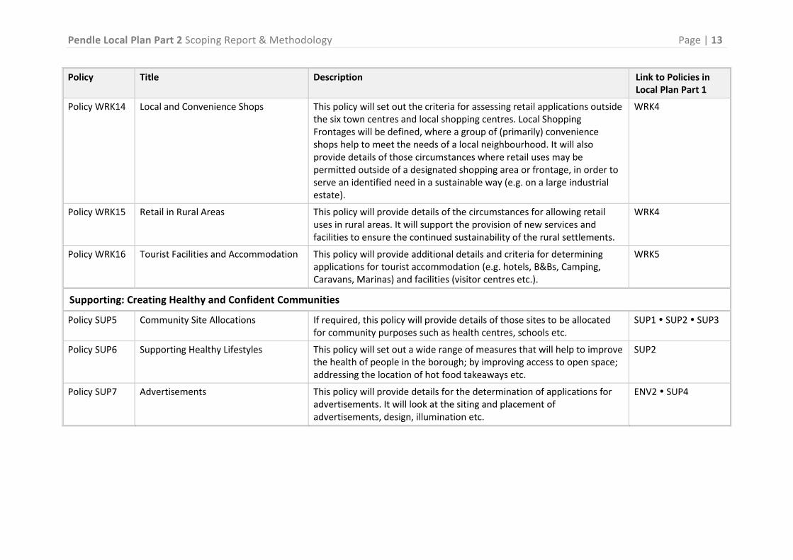


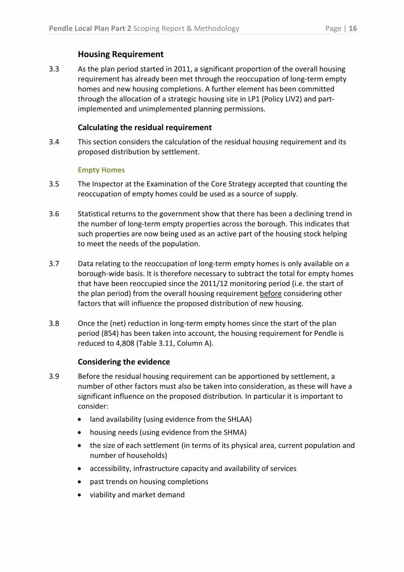
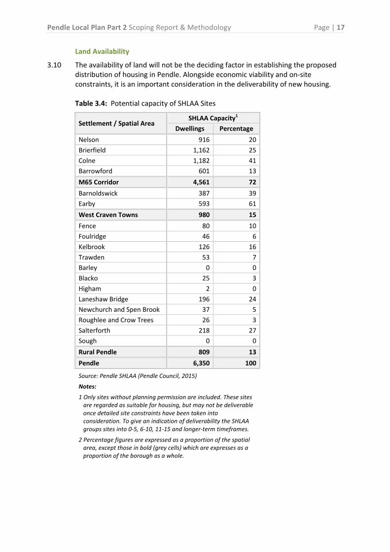


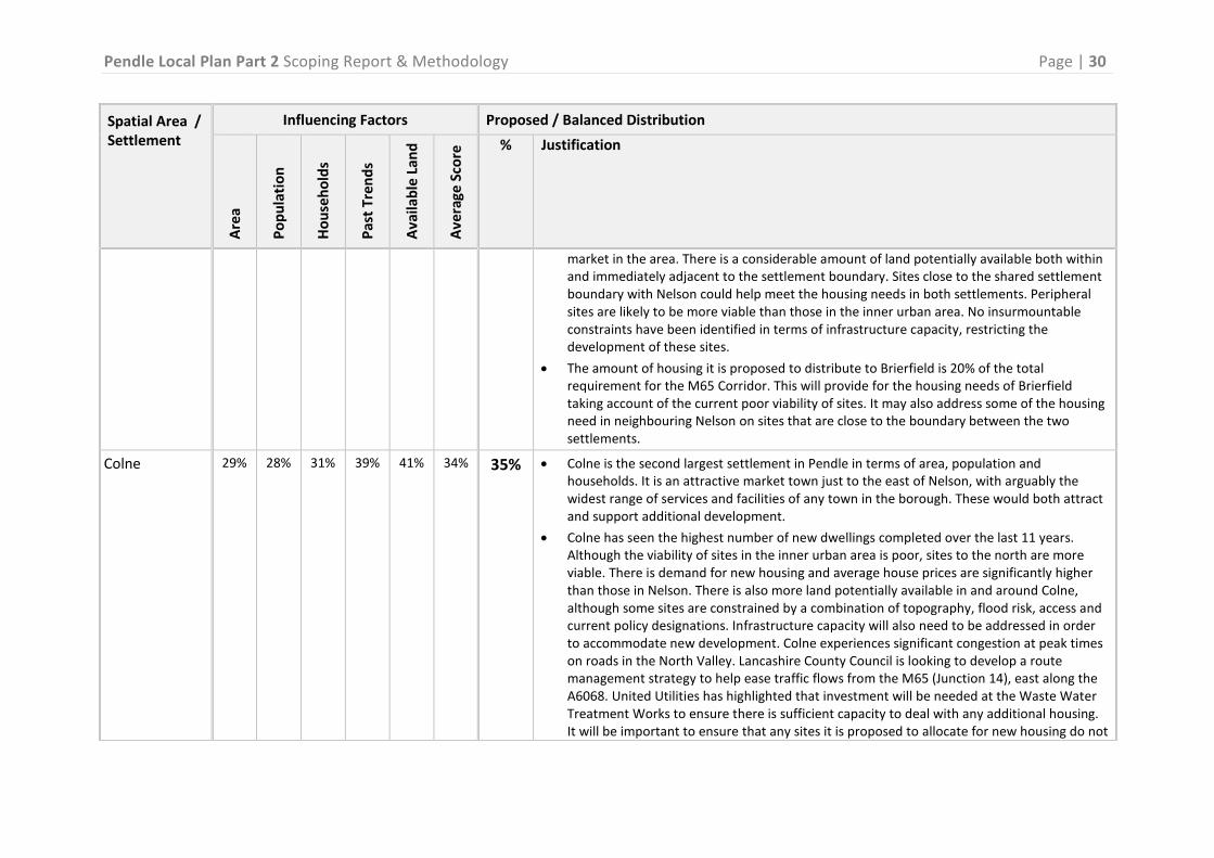

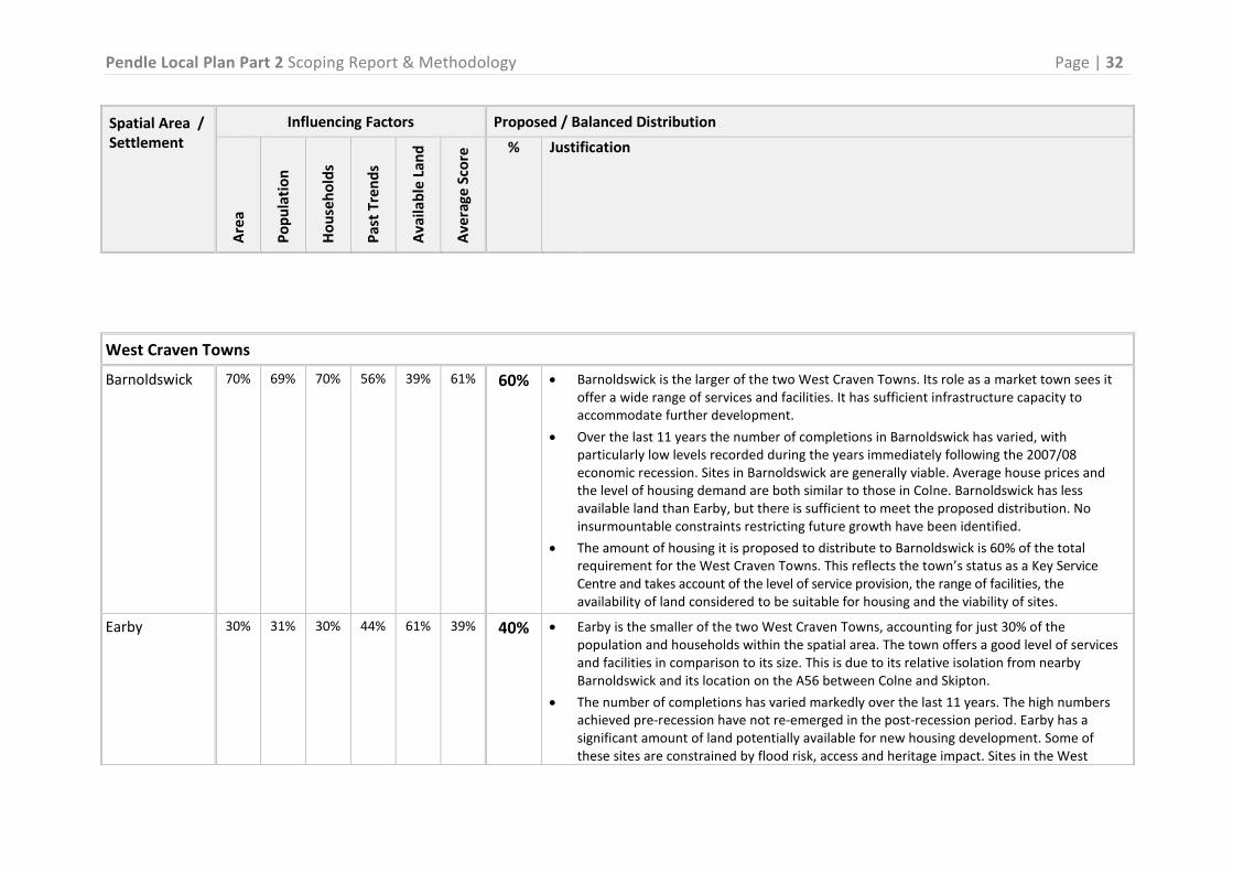


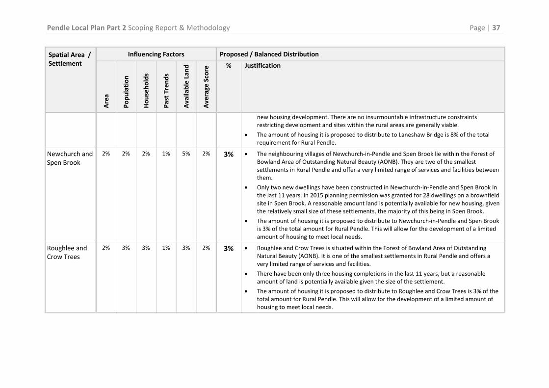


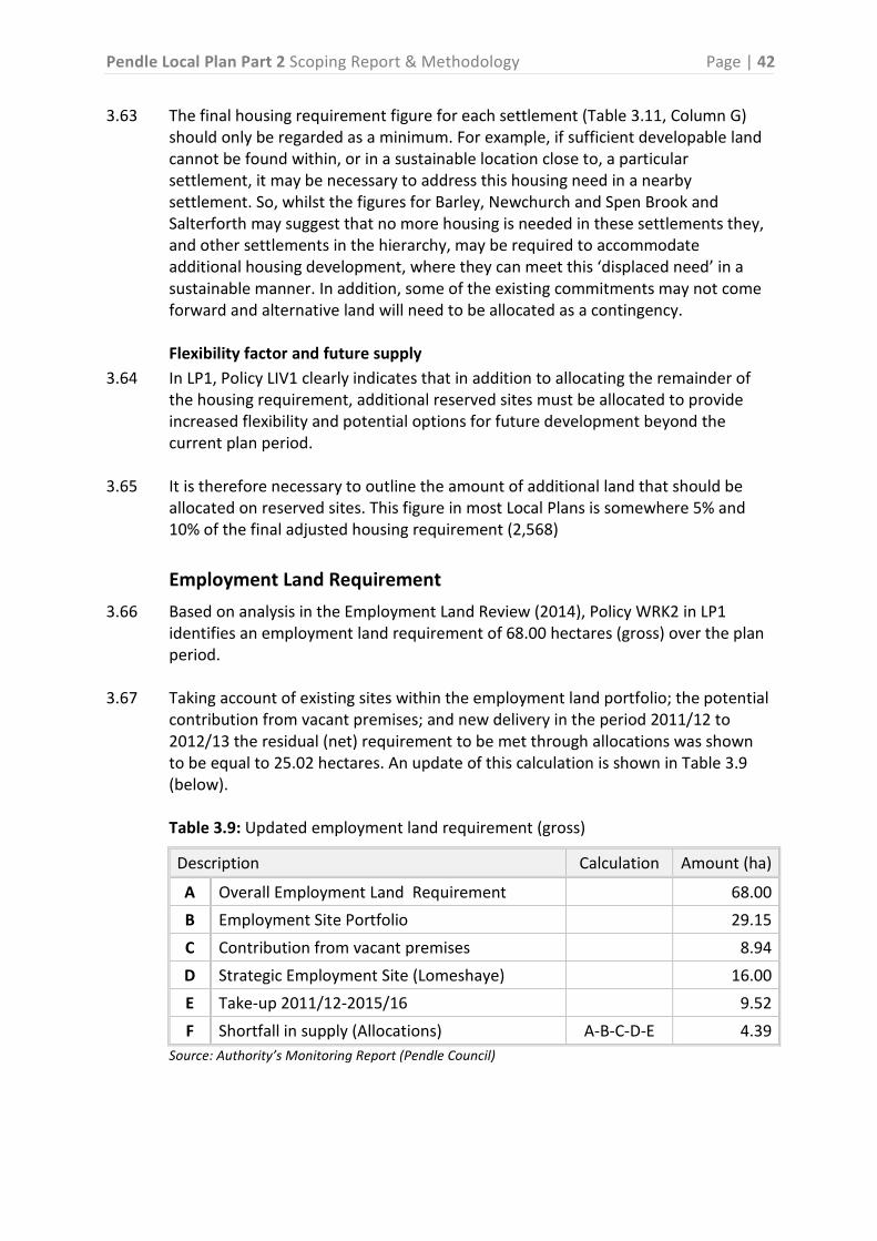


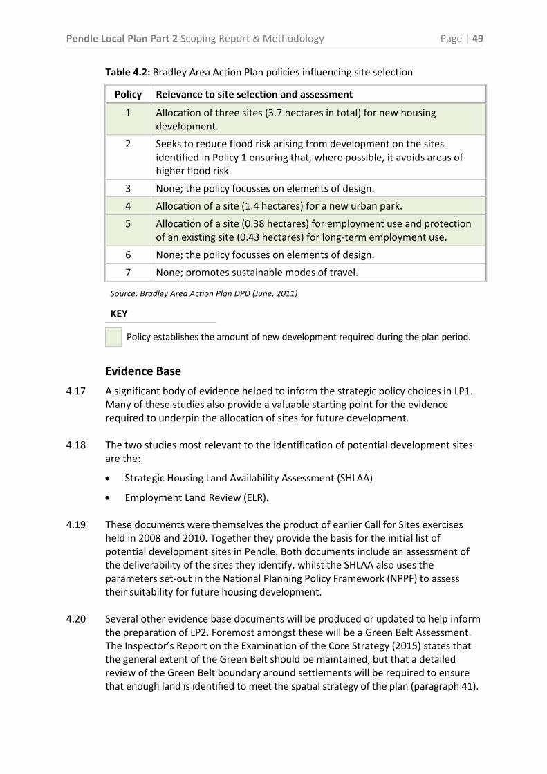


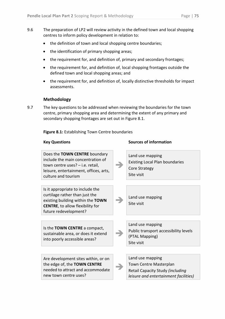


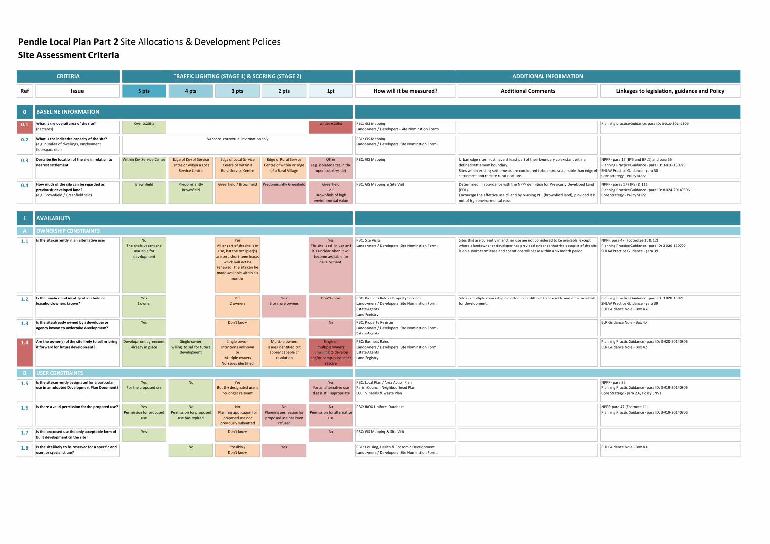


![Opdc Draft Local Plan Iia Scoping Report - Finalised Version1[1]](https://static.documents.pub/doc/80x56/5695d0371a28ab9b02917abc/opdc-draft-local-plan-iia-scoping-report-finalised-version11.jpg)
