Android Location Based Services Lesson 24 Victor Matos Cleveland State University Notes are based on: Android Developers http://developer.android.com/index.html Portions of this page are reproduced from work created and shared by Google and used according to terms described in the Creative Commons 3.0 Attribution License .
Transcript
Android Location Based Services
Lesson 24
Victor Matos Cleveland State University
Notes are based on:
Android Developers
http://developer.android.com/index.html
Portions of this page are reproduced from work created and shared by Google and used according to terms described in the Creative Commons 3.0 Attribution License.
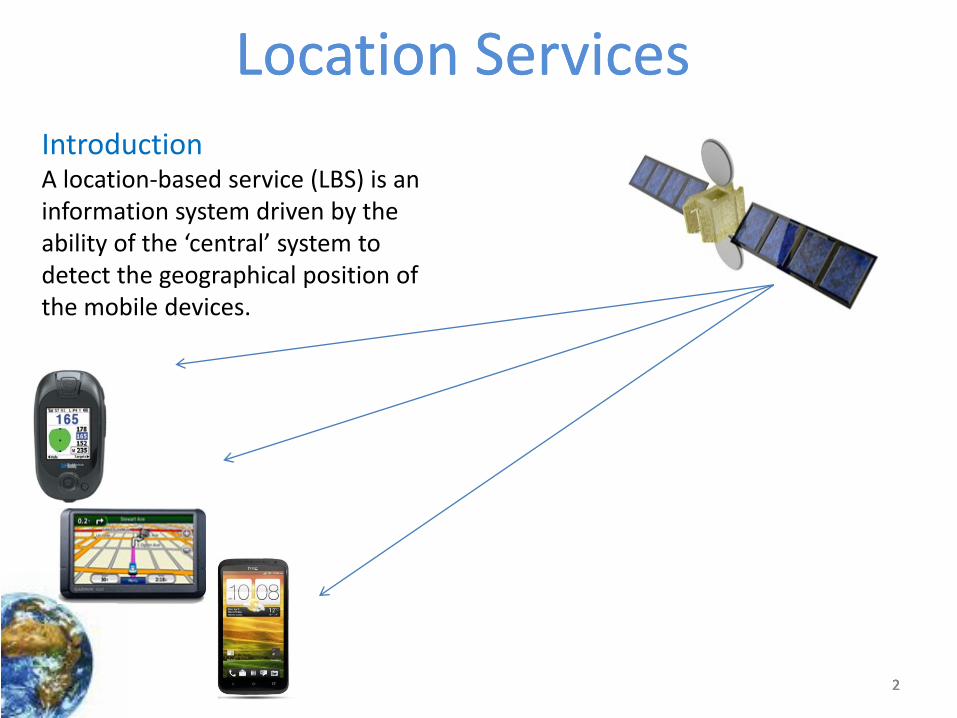
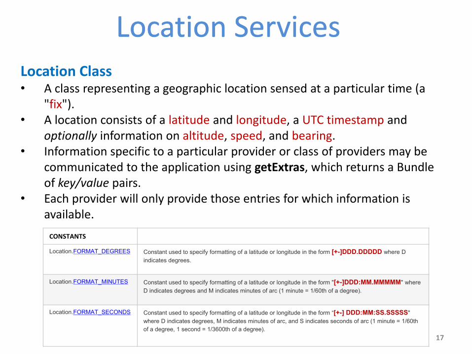
Introduction A location-based service (LBS) is an information system driven by the ability of the ‘central’ system to detect the geographical position of the mobile devices.
3 3 3
Location ServicesLocation Services
3
Introduction Location Based Services are used in a variety of situations, such as commercial, entertainment, emergency, health, work, personal life, etc. Examples: • Locate the nearest bank, restaurant, gas station, hotel, golf course,
hospital, police station, etc.
• Provide transportation information on how to go from ‘here’ to ‘there’.
• Social networking is used to locate and reach events, friends and family members.
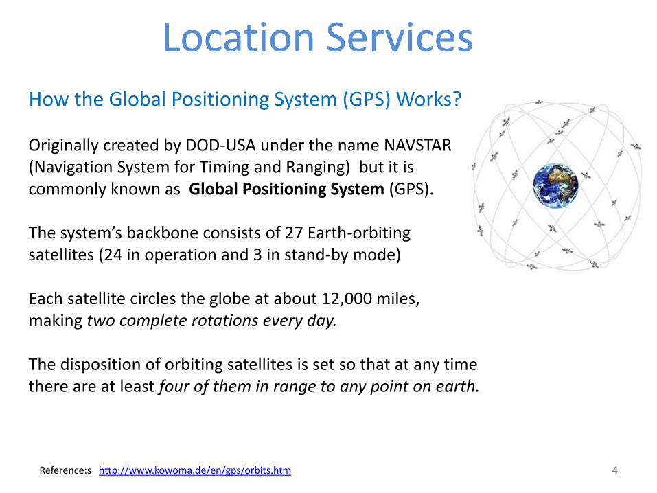
How the Global Positioning System (GPS) Works? Originally created by DOD-USA under the name NAVSTAR (Navigation System for Timing and Ranging) but it is commonly known as Global Positioning System (GPS). The system’s backbone consists of 27 Earth-orbiting satellites (24 in operation and 3 in stand-by mode) Each satellite circles the globe at about 12,000 miles, making two complete rotations every day. The disposition of orbiting satellites is set so that at any time there are at least four of them in range to any point on earth.
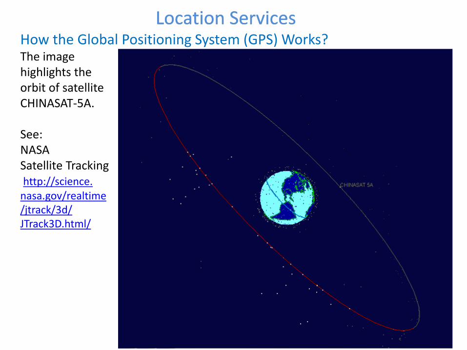
How the Global Positioning System (GPS) Works? The image highlights the orbit of satellite CHINASAT-5A. See: NASA Satellite Tracking http://science. nasa.gov/realtime /jtrack/3d/ JTrack3D.html/
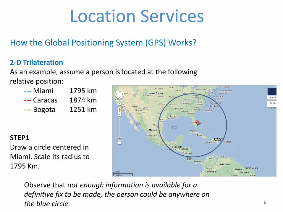
How the Global Positioning System (GPS) Works? 2-D Trilateration As an example, assume a person is located at the following relative position:
--- Miami 1795 km --- Caracas 1874 km --- Bogota 1251 km
STEP1 Draw a circle centered in Miami. Scale its radius to 1795 Km. Observe that not enough information is available for a
definitive fix to be made, the person could be anywhere on the blue circle.
7 7 7
Location ServicesLocation Services
7
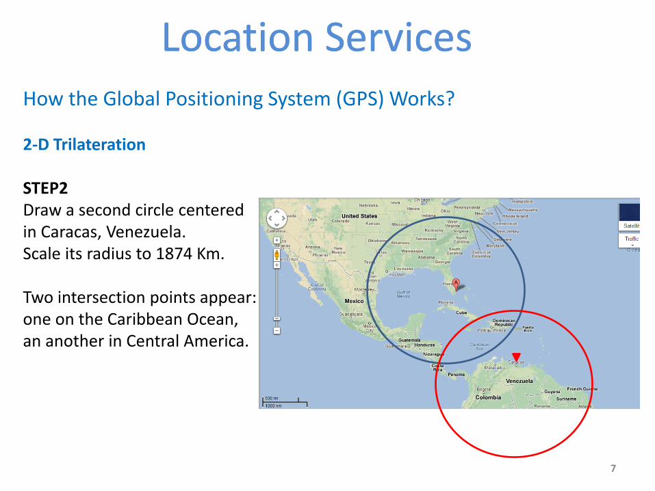
How the Global Positioning System (GPS) Works? 2-D Trilateration STEP2 Draw a second circle centered in Caracas, Venezuela. Scale its radius to 1874 Km. Two intersection points appear: one on the Caribbean Ocean, an another in Central America.
8 8 8
Location ServicesLocation Services
8
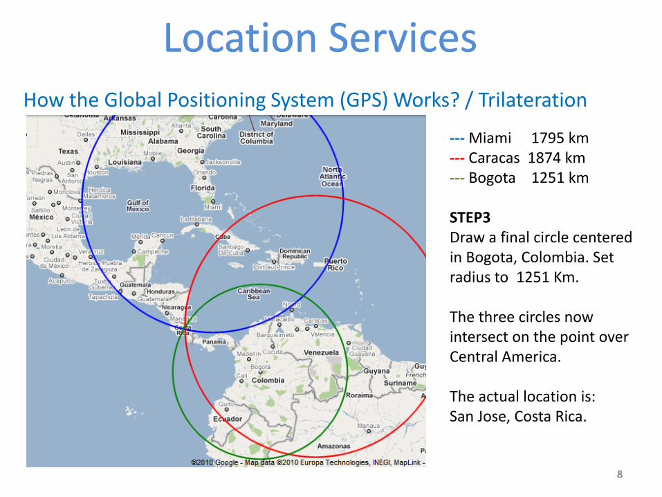
How the Global Positioning System (GPS) Works? / Trilateration
--- Miami 1795 km --- Caracas 1874 km --- Bogota 1251 km STEP3 Draw a final circle centered in Bogota, Colombia. Set radius to 1251 Km. The three circles now intersect on the point over Central America. The actual location is: San Jose, Costa Rica.
9 9 9
Location ServicesLocation Services
9
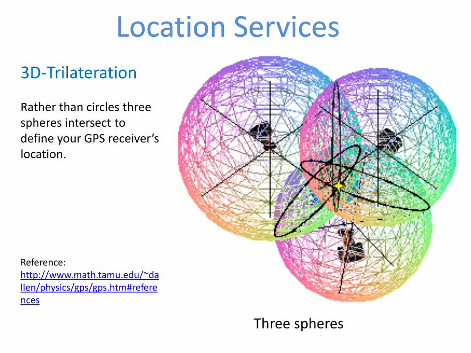
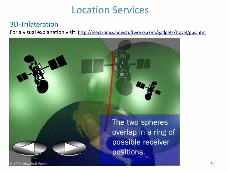
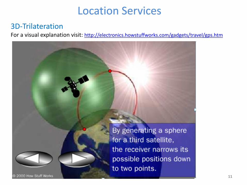
3D-Trilateration Rather than circles three spheres intersect to define your GPS receiver’s location. Reference: http://www.math.tamu.edu/~dallen/physics/gps/gps.htm#references
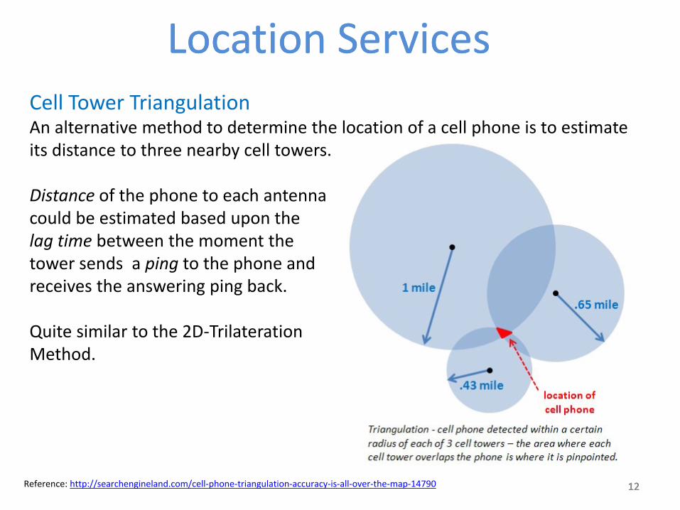
Cell Tower Triangulation An alternative method to determine the location of a cell phone is to estimate its distance to three nearby cell towers. Distance of the phone to each antenna could be estimated based upon the lag time between the moment the tower sends a ping to the phone and receives the answering ping back. Quite similar to the 2D-Trilateration Method.
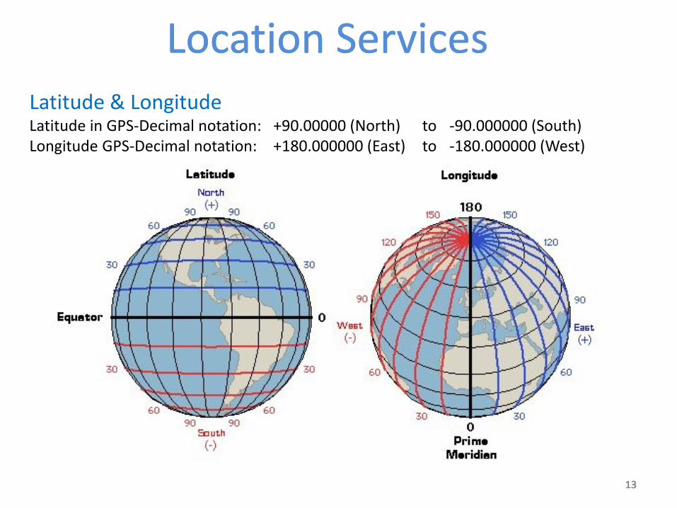
Latitude & Longitude Latitude in GPS-Decimal notation: +90.00000 (North) to -90.000000 (South) Longitude GPS-Decimal notation: +180.000000 (East) to -180.000000 (West)
14 14 14
Location ServicesLocation Services
14
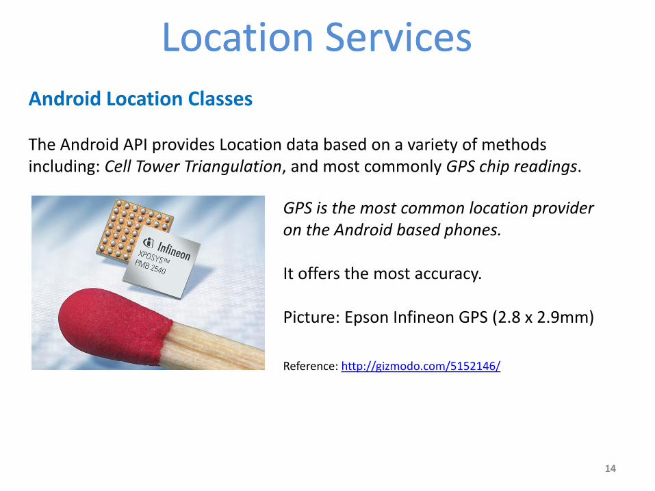
Android Location Classes The Android API provides Location data based on a variety of methods including: Cell Tower Triangulation, and most commonly GPS chip readings.
GPS is the most common location provider on the Android based phones. It offers the most accuracy. Picture: Epson Infineon GPS (2.8 x 2.9mm) Reference: http://gizmodo.com/5152146/
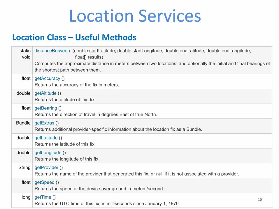
Computes the approximate distance in meters between two locations, and optionally the initial and final bearings of
the shortest path between them.
float getAccuracy ()
Returns the accuracy of the fix in meters.
double getAltitude ()
Returns the altitude of this fix.
float getBearing ()
Returns the direction of travel in degrees East of true North.
Bundle getExtras ()
Returns additional provider-specific information about the location fix as a Bundle.
double getLatitude ()
Returns the latitude of this fix.
double getLongitude ()
Returns the longitude of this fix.
String getProvider ()
Returns the name of the provider that generated this fix, or null if it is not associated with a provider.
float getSpeed ()
Returns the speed of the device over ground in meters/second.
long getTime ()
Returns the UTC time of this fix, in milliseconds since January 1, 1970.
19 19 19
Location ServicesLocation Services
19
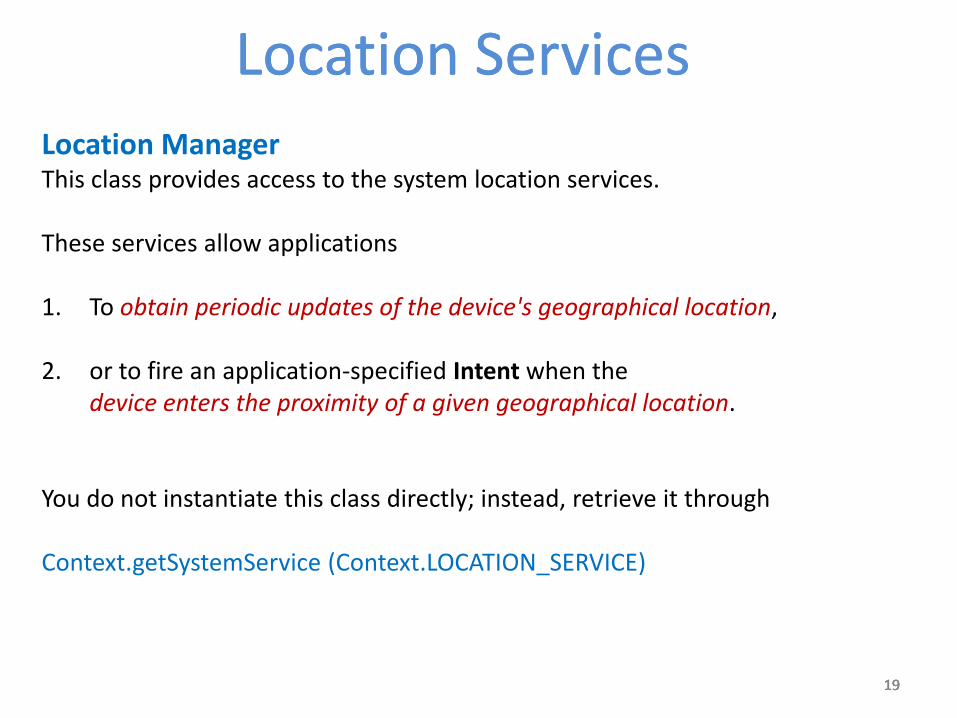
Location Manager This class provides access to the system location services. These services allow applications 1. To obtain periodic updates of the device's geographical location,
2. or to fire an application-specified Intent when the device enters the proximity of a given geographical location. You do not instantiate this class directly; instead, retrieve it through Context.getSystemService (Context.LOCATION_SERVICE)
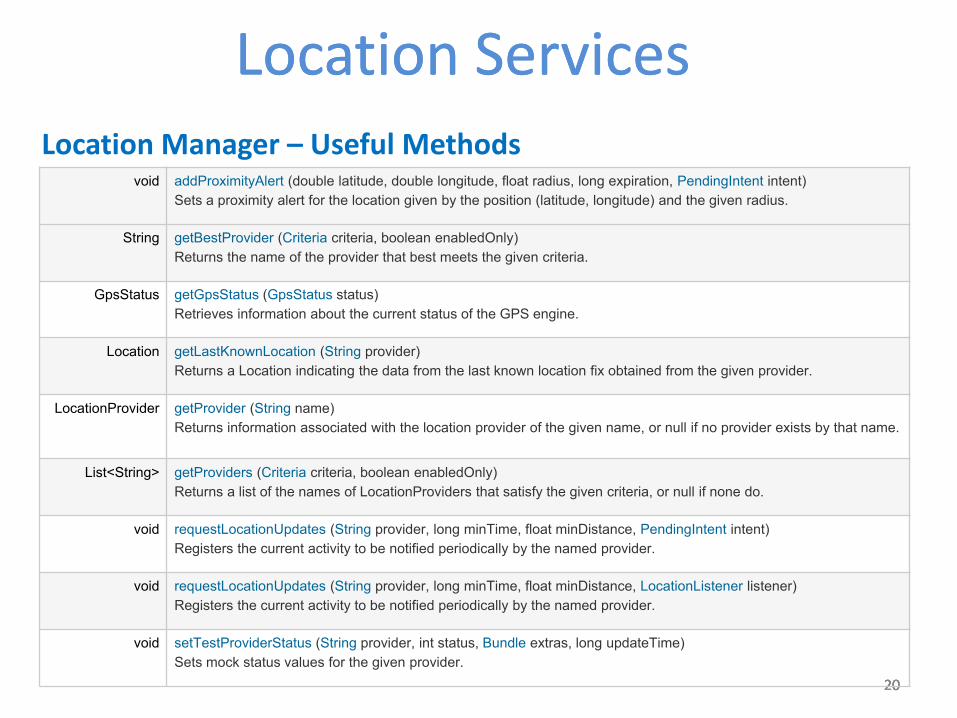
Returns a list of the names of LocationProviders that satisfy the given criteria, or null if none do.
void requestLocationUpdates (String provider, long minTime, float minDistance, PendingIntent intent)
Registers the current activity to be notified periodically by the named provider.
void requestLocationUpdates (String provider, long minTime, float minDistance, LocationListener listener)
Registers the current activity to be notified periodically by the named provider.
void setTestProviderStatus (String provider, int status, Bundle extras, long updateTime)
Sets mock status values for the given provider.
21 21 21
Location ServicesLocation Services
21
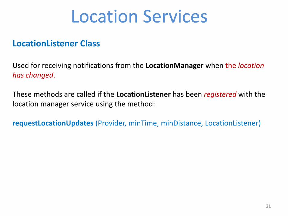
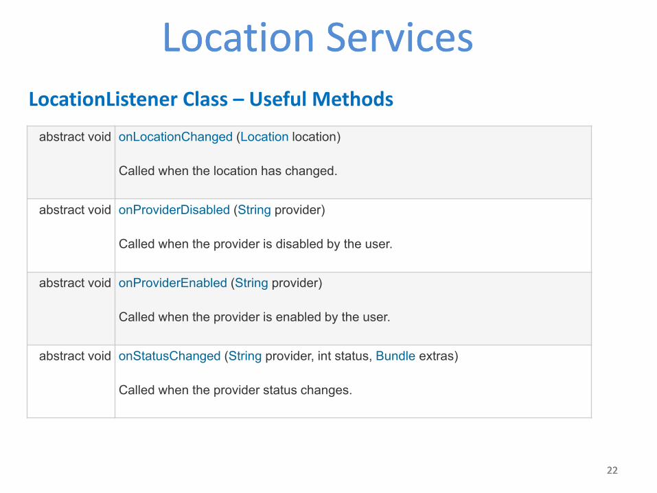
LocationListener Class Used for receiving notifications from the LocationManager when the location has changed. These methods are called if the LocationListener has been registered with the location manager service using the method: requestLocationUpdates (Provider, minTime, minDistance, LocationListener)
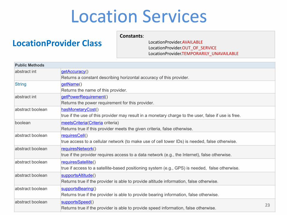
LocationProvider Class An abstract superclass for location providers. A location provider supplies periodic reports on the geographical location of the device. Each provider has a set of criteria under which it may be used; for example, some providers require GPS hardware and visibility to a number of satellites; others require the use of the cellular radio, or access to a specific carrier's network, or access to the internet. They may also have different battery consumption characteristics or monetary costs to the user. The Criteria class allows providers to be selected based on user-specified criteria.
25 25 25
Location ServicesLocation Services
25
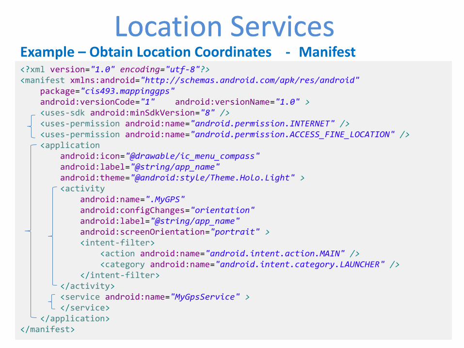
Example – Obtain Location Coordinates In this example we request GPS services and display latitude and longitude values on the UI. Additionally we deliver an SMS with this information. Notes 1. Observe the GPS chip is not a synchronous device that will immediately respond to a “give me a GPS reading” call.
1. In order to engineer a good solution that takes into account the potential delays in obtaining
location data we place the UI in the main activity and the request for location call in a background service.
2. Remember the service runs in the same process space as the main activity, therefore for the sake of responsiveness we must place the logic for location data request in a separate parallel thread.
3. A thread (unlike an Activity) needs the presence of a Looper control to manage IPC message sending. This implies and additional Looper.prepare and Looper.loop methods surrounding the locationUpdate method.
26 26 26
Location ServicesLocation Services
26
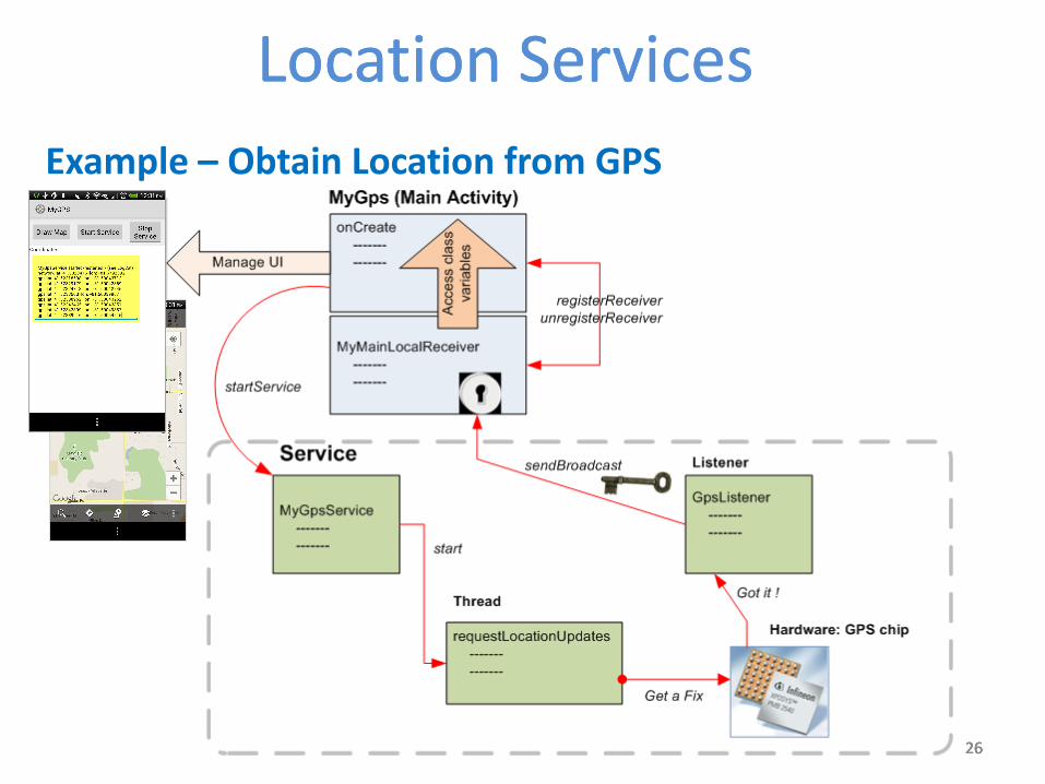
Example – Obtain Location from GPS
27 27 27
Location ServicesLocation Services
27
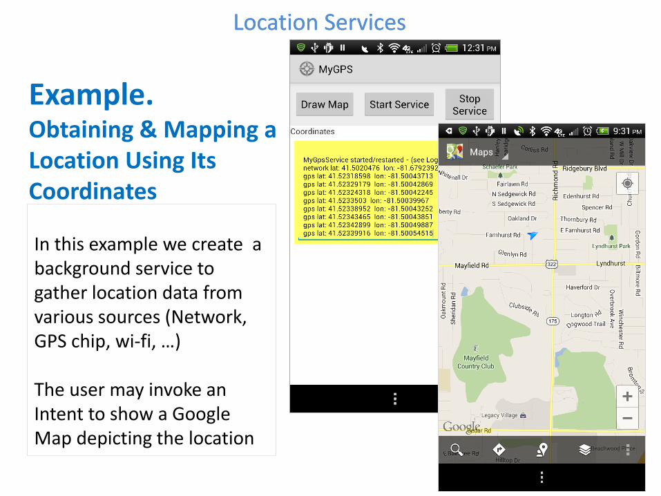
Example. Obtaining & Mapping a Location Using Its Coordinates
In this example we create a background service to gather location data from various sources (Network, GPS chip, wi-fi, …) The user may invoke an Intent to show a Google Map depicting the location
28 28 28 28
Location Services
28
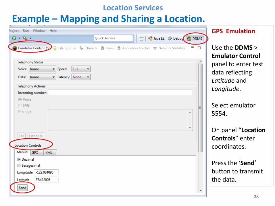
Example – Mapping and Sharing a Location.
GPS Emulation Use the DDMS > Emulator Control panel to enter test data reflecting Latitude and Longitude. Select emulator 5554. On panel “Location Controls” enter coordinates. Press the ‘Send’ button to transmit the data.
29 29 29
Location ServicesLocation Services
29
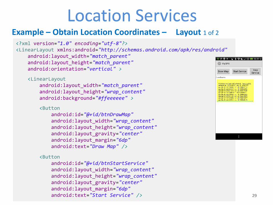
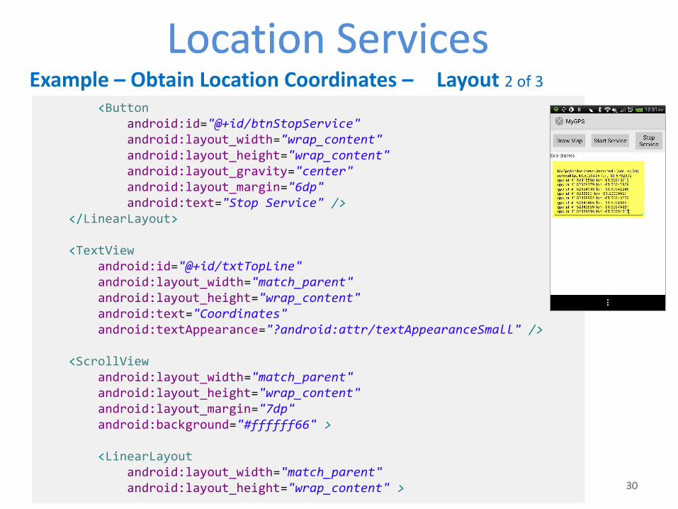
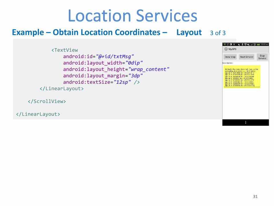
Example – Obtain Location Coordinates – Layout 1 of 2
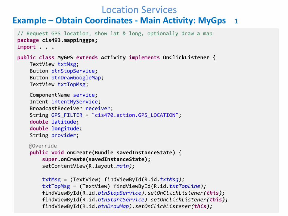
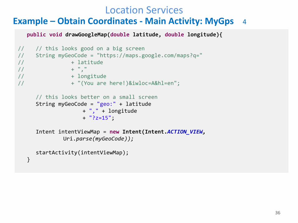
Example – Obtain Coordinates - Main Activity: MyGps 4
public void drawGoogleMap(double latitude, double longitude){ // // this looks good on a big screen // String myGeoCode = "https://maps.google.com/maps?q=" // + latitude // + "," // + longitude // + "(You are here!)&iwloc=A&hl=en"; // this looks better on a small screen String myGeoCode = "geo:" + latitude + "," + longitude + "?z=15"; Intent intentViewMap = new Intent(Intent.ACTION_VIEW, Uri.parse(myGeoCode)); startActivity(intentViewMap); }
37 37 37
Location Services
37
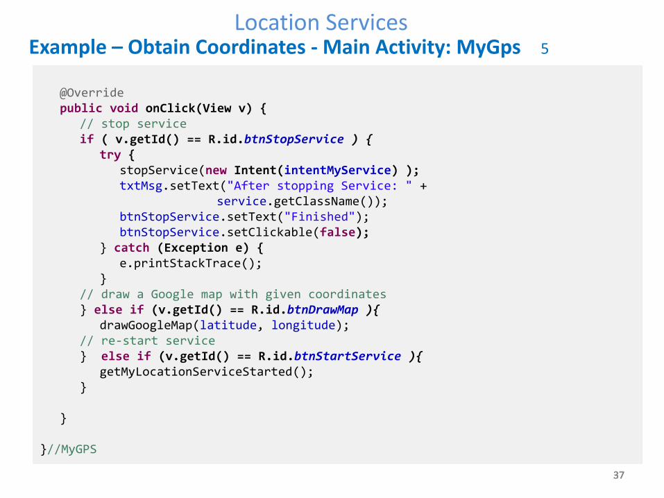
Example – Obtain Coordinates - Main Activity: MyGps 5
@Override public void onClick(View v) { // stop service if ( v.getId() == R.id.btnStopService ) { try { stopService(new Intent(intentMyService) ); txtMsg.setText("After stopping Service: " + service.getClassName()); btnStopService.setText("Finished"); btnStopService.setClickable(false); } catch (Exception e) { e.printStackTrace(); } // draw a Google map with given coordinates } else if (v.getId() == R.id.btnDrawMap ){ drawGoogleMap(latitude, longitude); // re-start service } else if (v.getId() == R.id.btnStartService ){ getMyLocationServiceStarted(); } } }//MyGPS
38 38 38
Location Services
38
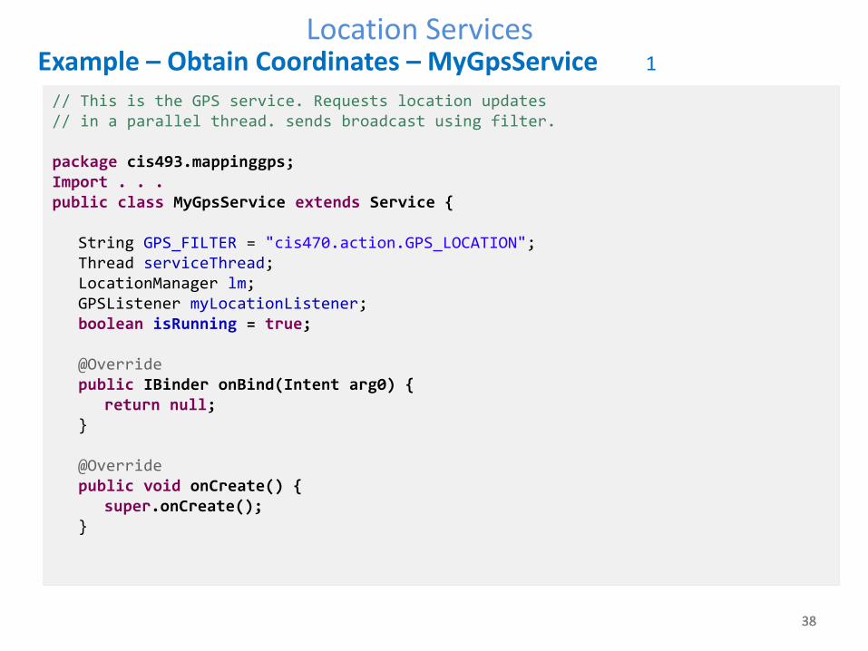
Example – Obtain Coordinates – MyGpsService 1
// This is the GPS service. Requests location updates // in a parallel thread. sends broadcast using filter. package cis493.mappinggps; Import . . . public class MyGpsService extends Service { String GPS_FILTER = "cis470.action.GPS_LOCATION"; Thread serviceThread; LocationManager lm; GPSListener myLocationListener; boolean isRunning = true; @Override public IBinder onBind(Intent arg0) { return null; } @Override public void onCreate() { super.onCreate(); }
39 39 39
Location Services
39
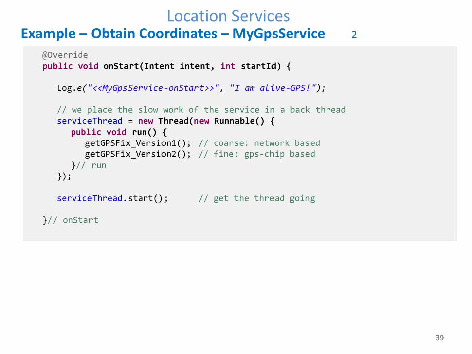
Example – Obtain Coordinates – MyGpsService 2
@Override public void onStart(Intent intent, int startId) { Log.e("<<MyGpsService-onStart>>", "I am alive-GPS!"); // we place the slow work of the service in a back thread serviceThread = new Thread(new Runnable() { public void run() { getGPSFix_Version1(); // coarse: network based getGPSFix_Version2(); // fine: gps-chip based }// run }); serviceThread.start(); // get the thread going }// onStart
40 40 40
Location Services
40
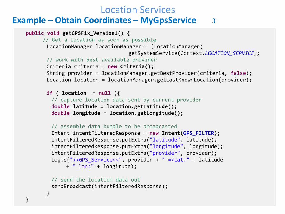
Example – Obtain Coordinates – MyGpsService 3
public void getGPSFix_Version1() { // Get a location as soon as possible LocationManager locationManager = (LocationManager) getSystemService(Context.LOCATION_SERVICE); // work with best available provider Criteria criteria = new Criteria(); String provider = locationManager.getBestProvider(criteria, false); Location location = locationManager.getLastKnownLocation(provider); if ( location != null ){ // capture location data sent by current provider double latitude = location.getLatitude(); double longitude = location.getLongitude(); // assemble data bundle to be broadcasted Intent intentFilteredResponse = new Intent(GPS_FILTER); intentFilteredResponse.putExtra("latitude", latitude); intentFilteredResponse.putExtra("longitude", longitude); intentFilteredResponse.putExtra("provider", provider); Log.e(">>GPS_Service<<", provider + " =>Lat:" + latitude + " lon:" + longitude); // send the location data out sendBroadcast(intentFilteredResponse); } }
41 41 41
Location Services
41
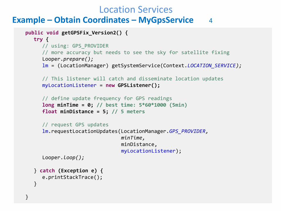
Example – Obtain Coordinates – MyGpsService 4
public void getGPSFix_Version2() { try { // using: GPS_PROVIDER // more accuracy but needs to see the sky for satellite fixing Looper.prepare(); lm = (LocationManager) getSystemService(Context.LOCATION_SERVICE); // This listener will catch and disseminate location updates myLocationListener = new GPSListener(); // define update frequency for GPS readings long minTime = 0; // best time: 5*60*1000 (5min) float minDistance = 5; // 5 meters // request GPS updates lm.requestLocationUpdates(LocationManager.GPS_PROVIDER, minTime, minDistance, myLocationListener); Looper.loop(); } catch (Exception e) { e.printStackTrace(); } }
42 42 42
Location Services
42
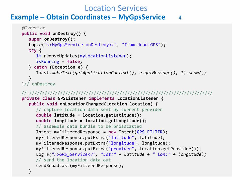
Example – Obtain Coordinates – MyGpsService 4
@Override public void onDestroy() { super.onDestroy(); Log.e("<<MyGpsService-onDestroy>>", "I am dead-GPS"); try { lm.removeUpdates(myLocationListener); isRunning = false; } catch (Exception e) { Toast.makeText(getApplicationContext(), e.getMessage(), 1).show(); } }// onDestroy
// /////////////////////////////////////////////////////////////////////// private class GPSListener implements LocationListener { public void onLocationChanged(Location location) { // capture location data sent by current provider double latitude = location.getLatitude(); double longitude = location.getLongitude(); // assemble data bundle to be broadcasted Intent myFilteredResponse = new Intent(GPS_FILTER); myFilteredResponse.putExtra("latitude", latitude); myFilteredResponse.putExtra("longitude", longitude); myFilteredResponse.putExtra("provider", location.getProvider()); Log.e(">>GPS_Service<<", "Lat:" + latitude + " lon:" + longitude); // send the location data out sendBroadcast(myFilteredResponse); }
43 43 43
Location Services
43
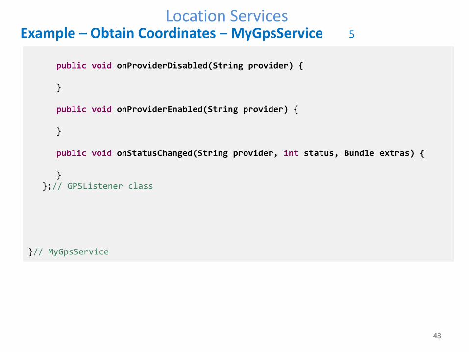
Example – Obtain Coordinates – MyGpsService 5
public void onProviderDisabled(String provider) { } public void onProviderEnabled(String provider) { } public void onStatusChanged(String provider, int status, Bundle extras) { } };// GPSListener class }// MyGpsService
44 44
Location ServicesLocation Services
44
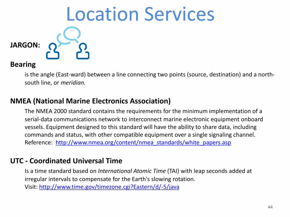
JARGON: Bearing is the angle (East-ward) between a line connecting two points (source, destination) and a north-
south line, or meridian.
NMEA (National Marine Electronics Association) The NMEA 2000 standard contains the requirements for the minimum implementation of a
serial-data communications network to interconnect marine electronic equipment onboard vessels. Equipment designed to this standard will have the ability to share data, including commands and status, with other compatible equipment over a single signaling channel. Reference: http://www.nmea.org/content/nmea_standards/white_papers.asp
UTC - Coordinated Universal Time Is a time standard based on International Atomic Time (TAI) with leap seconds added at
irregular intervals to compensate for the Earth's slowing rotation. Visit: http://www.time.gov/timezone.cgi?Eastern/d/-5/java
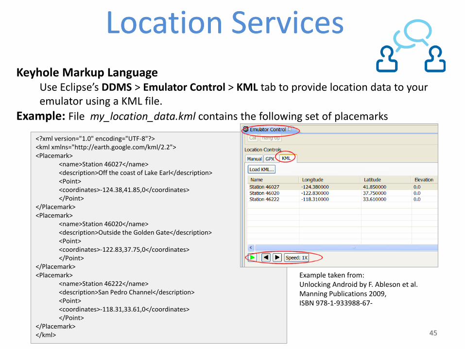
<name>Station 46027</name> <description>Off the coast of Lake Earl</description> <Point> <coordinates>-124.38,41.85,0</coordinates> </Point>
</Placemark> <Placemark>
<name>Station 46020</name> <description>Outside the Golden Gate</description> <Point> <coordinates>-122.83,37.75,0</coordinates> </Point>
</Placemark> <Placemark>
<name>Station 46222</name> <description>San Pedro Channel</description> <Point> <coordinates>-118.31,33.61,0</coordinates> </Point>
</Placemark> </kml>
Example taken from: Unlocking Android by F. Ableson et al. Manning Publications 2009, ISBN 978-1-933988-67-
46 46
Location ServicesLocation Services
46
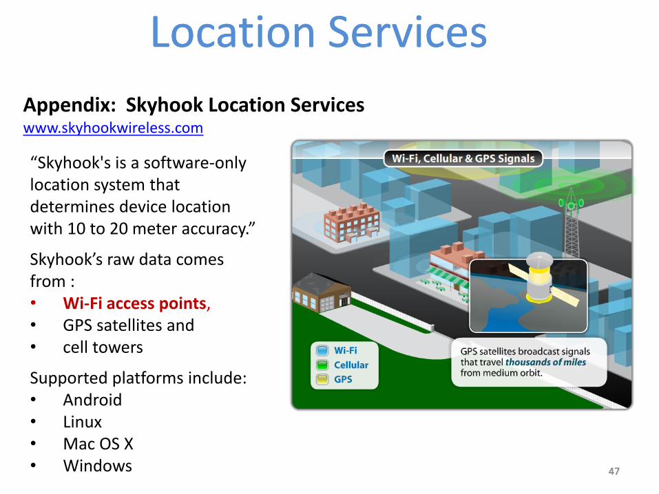
Appendix: Skyhook Location Services (Excerpts taken from www.skyhookwireless.com) Skyhook's Core Engine is a software-only location system that quickly determines
device location with 10 to 20 meter accuracy. A mobile device with Skyhook's Core Engine collects raw data from each of the
location sources (GPS, towers, wi-fi). The Skyhook client then sends this data to the Location Server and a single location
estimate is returned. The client is optimized so that it communicates with the Location Server only when
the location cannot be determined locally. This behavior minimizes the user's data cost while maximizing battery life
PROS: • Promises to work well in confined physical spaces (such as very developed
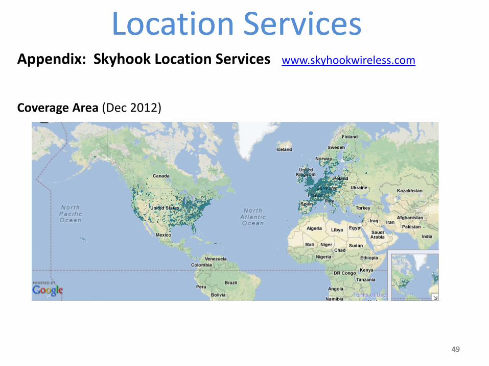
urban areas) • Better battery life (no need for constant GPS-chip readings) CONS: • Poor documentation available (Dec 2012) • Unreliable at times (you may get very inaccurate fixes, or none at all) • Not appropriate for rural areas, current coverage focuses mostly on USA and
European cities. • Vulnerable to spoofing location attacks (the attacker could convince the
device to be in a false location. See http://www.syssec.ch/press/location-spoofing-attacks-on-the-iphone-and-ipod )