16
Logan Village Stormwater Infrastructure Plan Review Logan City Council
| Date post: | 29-May-2018 |
| Category: |
Documents |
| Upload: | hoangthuan |
| View: | 214 times |
| Download: | 0 times |
!
!!!!!!!!!!!!!
Logan&Village&Stormwater&Infrastructure+Plan+Review!
Logan&City&Council&!!!!!!!!!!!!!!!!!
!!!!!! !

!
!!!!!!!!!!!!!!!!!!!!!
Document!Information!
Report!Title! Logan!Village!Stormwater!Infrastructure!Plan!Review!
Version! Rev!A!!
Author(s)! Kelly!McKendry!!
Approved!by! KMcK!(RPEQ!09298)!
Signed! !
Date! 13!May!2015!
Distribution! Monishaa!Prasad!–!LCC;!Damian!McGarry!N!Hydralogic!
! !
Document!Path:! AquaIntel! Projects:2015005_LOGAN! PIP! REVIEWS:Logan! Village:05_WP:2015005_Logan! Village!
Stormwater!Infrastructure!Plan!Review_RevA.docx!
!!!

!
!
Contents!
1! INTRODUCTION! 4!1.1! SCOPE! 4!
2! INFORMATION!SUPPLIED! 5!
3! BASE!DATA!AND!ASSUMPTIONS! 5!3.1! LOGAN!DEVELOPMENT!PROJECTION!MODEL!(LDPM)! 5!3.2! WATER!QUALITY!DESIGN!OBJECTIVES! 7!3.3! WATER!QUANTITY!DESIGN!OBJECTIVES! 7!
4! STORMWATER!QUALITY!MODELLING! 7!4.1! SOFTWARE!AND!REFERENCE!BASIS! 7!4.2! METHODOLOGY!AND!MODEL!SCHEMATIZATION! 8!4.3! INPUT!PARAMETERS! 9!4.4! REVISED!MODEL!AND!OUTCOMES! 10!4.5! ASSESSMENT!SUMMARY! 11!
5! STORMWATER!QUANTITY!MODELLING! 11!5.1! SOFTWARE!AND!REFERENCE!BASIS! 11!5.2! METHODOLOGY!AND!MODEL!SCHEMATIZATION! 12!5.3! INPUT!PARAMETERS! 12!5.4! HYDRAULIC!MODELLING! 13!5.5! ASSESSMENT!SUMMARY! 13!
6! PROPOSED!INFRASTRUCTURE! 13!6.1! LOCATION! 13!6.2! CONCEPTUAL!LAYOUT! 14!6.3! LAND!REQUIREMENTS! 14!
7! COSTING! 14!
8! CONCLUSION! 16!!!Figure!1:!Comparison!of!catchment!boundary!and!planning!scheme!classifications! 6!!!Table!1:!Review!Summary!]!Methodology!and!Model!Schematization! 9!Table!2:!Review!Summary!–!Input!Parameters! 10!Table!3:!Modification!to!Infrastructure!Resulting!from!Model!Revision! 11!Table!4:!Cost!estimates! 15!!!!

!!!
Page!4!
1 Introduction!!AquaIntel!were!commissioned!in!partnership!with!HydraLogic,!to!undertake!a!review!and!update!of! the!stormwater! infrastructure!sizing!which! forms!the!basis!of!Logan!Council’s!Local!Government! Infrastructure!Plan! (LGIP)! for! the!Logan!Village!Priority!Infrastructure!Plan!Area!(PIA).!!A! comprehensive! investigation! of! the! future! trunk! stormwater! infrastructure!requirements!for!the!area!was!undertaken!in!August!2011!by!DesignFlow!and!SKM!in!the!Logan&Village&Stormwater&Plan&for&Trunk&Infrastructure,&Water&Quality&and&Flood&Management&Conceptual&Design.!!The!report!and!the!associated!modeling!files!were!provided!and!are!the!basis!of!the!review!and!update!of!the!stormwater!infrastructure!provided!within!this!document.!!
1.1 Scope!!This!project!is!aimed!at!reviewing!and!refining!the!previously!sized!infrastructure!to!ensure! the!planned!elements!are! in! line!with!and!meet! current!best!practices!and!legislative!requirements.!!Elements!(including!(detention!basins,!bioretention!basins,!constructed! channels,! and! wetlands)! are! to! be! reviewed! to! ensure! they! mitigate!ultimate!peak!catchment!flows,!meet!water!quality!objectives,!and!make!optimal!use!of!land!requirements.!!The!review!process!was!structured!to!assess!three!elements:!
• A! review! of! the! report! methodology! and! tools! used! to! plan! and! size! the!proposed!infrastructure;!
• A!technical!review!of!the!models!developed!to!size!infrastructure;!and!!• A!review!and,!where!required,!an!update!of!the!data!and/or!parameters!used!
within!the!development!of!the!infrastructure!requirements.!!!The!2011!DesignFlow!report!was!reviewed!with!the!intent!of!confirming:!
• the!appropriateness!of!the!methodology,!• the! basis! of! sizing! and! design! being! in! accordance!with! contemporary! best!
practice!and!legislative!requirements,!and!!• the!appropriate!use!of!industry!standard!software.!
!The! model! files,! provided! by! Logan! City! Council,! on! which! the! proposed!infrastructure!sizing!was!based,!were!reviewed!for:!
• appropriateness!and!currency!of!base!model!data;!• model!construction!and!input!parameters;!• model!output!and!sizing!of!elements!with!respect!to!design!standards;!and!!

!!!
Page!5!
• identification!of!any!shortfalls! in!performance!or!potential! for! reductions! in!requirements.!
!A! review! of! the! base! data! and! parameters! used! to! construct! the! models! was!undertaken! to! ensure! currency! and! a! sound! basis! on! which! to! size! the! proposed!infrastructure! to! inform! a! financial! model! of! proposed! stormwater! quantity! and!quality! infrastructure.!This!review!focused!primarily!on!aligning!the!financial!model!for!stormwater!infrastructure!with!the!latest!population!projections!presented!in!the!Logan! Development! Projection! Model! (LDPM).! To! achieve! this! a! procedure! for!deriving! the! impervious! fractions! of! the! catchments! over! each! of! the! planning!horizons!was!developed.!The!planning!horizons!being:! the!existing!case;!2031;!and!the!ultimate!development!time!horizons.!!
2 Information!Supplied!!Information!supplied!by!Logan!City!Council!for!use!in!the!review!included:!!
1. A!copy!of!the!Logan!Village!Stormwater!Plan!for!Trunk!Infrastructure,!Water!Quality!and!Flood!Management!Conceptual!Design!(DesignFlow,!2011)!(“the!report”)!
2. MUSIC!model!files!from!DesignFlow!3. XPNRafts!files!from!SKM!4. HECRAS!files!from!SKM!5. GIS!base!data! including!topography,! landuse,!stormwater! infrastructure!and!
planning!scheme!layers.!6. Logan! Development! Projection!Model! (2010! and! 2010_amended_Feb2015)!
in!GIS!format!!
3 Base!Data!and!Assumptions!
3.1 Logan!Development!Projection!Model!(LDPM)!!The! key! element! of! stormwater! infrastructure! planning! is! the! fraction! of! the!catchment!that!is!impervious!at!each!planning!horizon.!!The!2011!DesignFlow!report!utilised!the!Logan!Development!Projection!Model!(LDPM)!2010!as!the!basis!for!the!derivation!of!impervious!catchment!areas!for!use!in!both!water!quality!and!quantity!modelling!and!thus!infrastructure!sizing.!!!The! report,! in! Appendix! B,! outlines! a! sound! methodology! for! the! derivation! of!impervious!catchment!area!through!the!use!of!the!LDPM.!!Logan! City! Council! advised! that! in! February! 2015! the! LDPM!was! revised.! ! Advice!received!from!Council!and!review!of!the!LDPM!data!and!summary!tables!contained!

!!!
Page!6!
within!the!planning!scheme!confirmed!that!within!the!Logan!Village!Projection!Area!the! number! of! dwellings! had! been! revised! however! the! projected! nonNresidential!floor!area!had!not!been!revised.!!Review!of!the!LDPM!data!revealed!that!within!the!Logan!Village!Projection!Area!the!predicted!total!number!of!dwellings!(consisting!of!only! detached!dwellings! in! this! case)! had!been! revised!down!by! some!20%!at! the!ultimate!development!horizon!and!by!up! to!26%! in! the! intervening! time!horizons.!!Review!of!the!data!also!confirmed!that!the!nonNresidential!GFA!remained!consistent!between!the!two!LDPM!revisions.!!It!is!noted!that!the!catchment!areas!defined!within!the!study!being!reviewed!do!not!align!with!or! contain!only! lots! that! are! classified!as!being!within! the! Logan!Village!Projection!Area!of!the!LDPM.!!Figure!1!provides!comparison!of!the!catchment!areas!defined! in! the! 2011! DesignFlow! study! and! the! Logan! Village! Planning! Area! as!classified! in! the! LDPM.! ! This! is! raised! as! direct! comparison! of! dwellings! and! nonNresidential! floor!area!between!the!planning!scheme!summary!tables! (based!on!the!LDPM! projection! areas)! and! the! areas! contained!within! the! study! being! reviewed!cannot!be!made.!!!
!Figure!1:!Comparison!of!catchment!boundary!and!planning!scheme!classifications!
As!part!of! this! review!a!consistent!procedure! to!derive! the! impervious! fraction! for!the!study!catchment!areas!from!the!revised!LDPM!(Feb!2015)!data!was!developed.!!This! procedure! reflected! a! similar! methodology! to! the! original! 2011! DesignFlow!report!with! the!addition!of!an! impervious! fraction! for!newly!developed! residential!lots! determined! by! utilising! the! Stormwater!Demand!Areas! and! associated! factors!contained!within!Map!3.00!of!the!PIP2.!!This!procedure!was!developed!to!encourage!

!!!
Page!7!
consistency! in!the!derivation!of! impervious!fractions!from!the!LDPM!data!between!different!Planning!Areas!within!Logan!City!Council.!!!Comparison! of! the! impervious! fraction! for! each! subcatchment! area! with! that!reported!and!modelled!within!the!2011!DesignFlow!report!concluded!that!there!was!some!change!in!the!impervious!fractions!of!the!catchment!as!a!result!of!the!revised!LDPM! and! modified! methodology! however,! the! changes! were! not! of! sufficient!magnitude! to! warrant! modification! of! the! models! and! were! unlike! to! result! in!significant!change!in!the!size!of!infrastructure!presented!in!the!reviewed!report.!!
3.2 Water!Quality!Design!Objectives!!Review!of!the!report!concludes!that!the!water!quality!objectives!derived!and!which!form!the!basis!of!infrastructure!sizing!are!based!on!sound!and!acceptable!guidelines.!!The!selected!water!quality!objectives!remain!consistent!with!the!current! legislative!requirements!of!the!SPP!July!2014.!!
3.3 Water!Quantity!Design!Objectives!!Review!of!the!report!concludes!that!the!flood!management!objectives!derived!and!which! form! the! basis! of! infrastructure! sizing! are! based! on! sound! and! acceptable!principles.!!The!water!quantity!design!objective,!was!to:!!!
Limit!the!postNdevelopment!event!discharge!peaks!for!the!2!year!to!100!year!average!recurrence!interval!(ARI)!at!the!boundary!of!the!site!to!the!preNdevelopment!peak!discharges.!
!This!objective!is!considered!consistent!with!current!best!practice!and!the!relevant!planning!policies.!!
4 Stormwater!Quality!Modelling!!A!technical!review!and!revision!of!the!provided!water!quality!model!files!and!sizing!of! trunk! stormwater! treatment! infrastructure! was! undertaken.! The! following!summarises! the! findings! and! provides! recommendations! and! revisions! to! the!infrastructure!sizes!to!inform!a!financial!model!for!stormwater!quality!infrastructure!planning.!
4.1 Software!and!Reference!Basis!!Water! quality! modelling! was! undertaken! using! the! industry! standard! software!package! MUSIC.! ! This! package! is! accepted! as! an! appropriate! tool! for! conceptual!sizing!of!stormwater!quality!treatment!devices!and!appropriate!for!use!in!this! level!of!investigation.!

!!!
Page!8!
!The! 2011! DesignFlow! report! notes! that! “MUSIC& version& 4.0& was& used& for& the&assessment&and&the¶meters&have&been&established&in&accordance&with&the&MUSIC&Modelling&Guidelines&(Water&by&Design,&2010).”!!This!version!of!MUSIC!has!been!superseded,!with!the!current!version!being!MUSIC!v6.! !Revisions!of!MUSIC! since!v3!have! included!alterations! to!algorithms,! including!those!which!calculate!pollutant! removal!efficiencies!within!bioretention!basins.!On!this!basis,!rerunning!the!original!model!files!in!MUSIC!v6!were!expected!to!alter!the!results!and!required!infrastructure!sizes!presented!in!the!2011!DesignFlow!report.!!The!2011!DesignFlow!report!also!states!that!“The&interim&bioretention&node&(Version&3)& has& been& used& in& the&model& as& advised& by&Water& by& Design& due& to& the& current&revisions&occurring&to&the&V4&bioretention&node.&This&node&does¬&specifically&model&the& saturated& zone& in& bioretention& systems& and& therefore& provides& a& conservative&result& if& a& saturated& zone& is& present.”! ! This! was! considered! to! be! an! acceptable!approach!at!the!time!of!the!study.!!!!This!review!has!adopted!the!current!version!of!MUSIC!(v6)! for!reviewing!the!sizing!and! conceptual! performance! of! stormwater! treatment! infrastructure! identified! by!the!2011!DesignFlow!report.!!The!MUSIC&Modelling&Guidelines& (Water& by&Design,& 2010)! are! accepted! as! current!best!practice!for!model!construction!and!the!selection!of!MUSIC! input!parameters.!!It! is! noted! that! since! the! above! guidelines! were! published!Water! by! Design! have!issued!advice! regarding! the! setup!of!bioretention!nodes! for!models! constructed! in!versions!later!than!v5.!
4.2 Methodology!and!Model!Schematization!!Review!of!the!2011!DesignFlow!study!report,!with!particular!reference!to!Appendix!C!–! Water! Quality! Assessment! finds! that! the! methodology! for! the! derivation! of! a!stormwater!quality!strategy!at!a!catchment!scale!planning!level!is!sound.!!!!The! methodology! adopts! an! endNofNline! catchment! scale! treatment! train! for! the!management!of!stormwater!runoff!from!newly!developed!areas!within!the!planning!horizon.!This!is!considered!a!reasonable!approach!for!the!purpose!of!development!of!a! financial! model! for! stormwater! quality! infrastructure! planning.! ! However,! the!future! sizing! and! design! of! infrastructure! for! capital! works! should! consider!hydrologic!aspects!and!inflow!from!both!existing!and!future!development!areas.!!Six!catchment!based!MUSIC!models!were!developed!and!provided!for!review.! !The!presented! delineation! of! catchments! was! based! primarily! on! topography! and!drainage!and!is!considered!acceptable.!!Catchments! were! represented! as! ‘split! catchment’! source! nodes! for! a! range! of!landuse! types! present! or! proposed! within! the! catchments.! ! The! use! of! the! ‘spilt!

!!!
Page!9!
catchment’! approach! is! a! reflection! of! both! the! method! for! the! derivation! of!impervious!fractions!within!the!catchments!(being!undertaken!using!the!LDPM!data!as! discussed! above! in! Section! 4)! and! the! inclusion! of! rainwater! tanks! within! the!treatment! train! requiring! the! separation! of! roof! areas! and! direction! of! part! roof!areas!to!tanks.!!This!approach!to!the!representation!of!the!catchments!is!considered!acceptable.!!Treatment! trains! and! the! associated! treatment! nodes! were! accepted! as! being!reasonable!and!within!industry!best!practice.!!The!selection!of!treatment!node!types!within! the! catchments,! for! example! selection! of! wetlands! over! bioretention,! is!considered! appropriate! and! consideration! of! practicality! and! function! within!constraints!such!as!topology!and!landuse!is!apparent.!!At!the!time!of!the!2011!DesignFlow!study!State!government!legislation!required!the!installation! of! rainwater! tanks! on! private! dwellings! and! thus! this! element! was!included! in! the! stormwater! treatment! train! for! the! PIA! area.! ! Since! this! time! this!requirement!has!been!removed!and!thus!it! is!recommended!that!a!treatment!train!and! the! associated! sizing! of! endNofNline! treatment! devices! does! not! include! the!assumed!installation!of!rainwater!tanks!within!residential!areas.!!Table! 1! provides! a! summary! of! the! review! of! methodology! and! model!schematization.!!!Table!1:!Review!Summary!]!Methodology!and!Model!Schematization!
Element! Input! Assessment! Recommendation! Comment!Water!Management!Strategy!
Catchment!level;!endNofNline!
Accepted! N! N!
Catchment!Delineation! Newly!developed!areas!only!
Accepted! ! The!future!sizing!and!design!of!infrastructure!should!consider!hydrologic!aspects!of!the!whole!of!catchment.!
! Based!on!topography! Accepted! ! !Source!Node!Approach! ‘Split’!catchment! Accepted! ! !Treatment!Train! Includes!rainwater!
tanks,!wetlands!and!bioretention!
Reasonable!at!time!of!study!
Removal!of!rainwater!tanks!
No!longer!legislative!backing!to!ensure!use!of!tanks!in!residential!areas.!
!
4.3 Input!Parameters!!The! following! table! summaries! the! review! of! the! model! files! and! the! input!parameters.!!The!table!includes!recommendations!for!revision!based!on!current!best!practice!where!applicable.!!
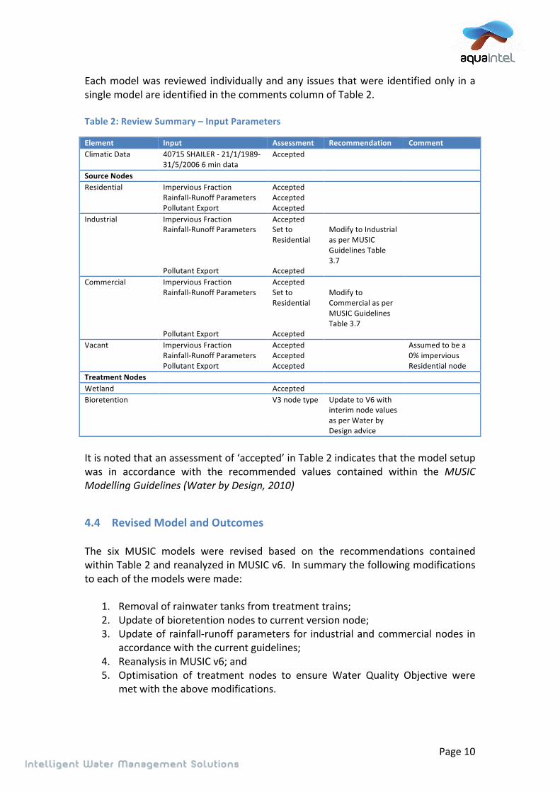
!!!
Page!10!
Each!model!was!reviewed!individually!and!any! issues!that!were! identified!only! in!a!single!model!are!identified!in!the!comments!column!of!Table!2.!!!Table!2:!Review!Summary!–!Input!Parameters!
Element! Input! Assessment! Recommendation! Comment!Climatic!Data! 40715!SHAILER!N!21/1/1989N
31/5/2006!6!min!data!Accepted! ! !
Source!Nodes! ! ! ! !Residential!!
Impervious!Fraction!RainfallNRunoff!Parameters!Pollutant!Export!
Accepted!Accepted!Accepted!
!!
!
Industrial! Impervious!Fraction!RainfallNRunoff!Parameters!!!!Pollutant!Export!
Accepted!Set!to!Residential!!!Accepted!
!Modify!to!Industrial!as!per!MUSIC!Guidelines!Table!3.7!!
!
Commercial! Impervious!Fraction!RainfallNRunoff!Parameters!!!!Pollutant!Export!
Accepted!Set!to!Residential!!!Accepted!
!Modify!to!Commercial!as!per!MUSIC!Guidelines!Table!3.7!!
!
Vacant! Impervious!Fraction!RainfallNRunoff!Parameters!Pollutant!Export!
Accepted!Accepted!Accepted!
! Assumed!to!be!a!0%!impervious!Residential!node!
Treatment!Nodes! ! ! ! !Wetland! ! Accepted! ! !Bioretention! ! V3!node!type! Update!to!V6!with!
interim!node!values!as!per!Water!by!Design!advice!
!
!It!is!noted!that!an!assessment!of!‘accepted’!in!Table!2!indicates!that!the!model!setup!was! in! accordance! with! the! recommended! values! contained! within! the! MUSIC&Modelling&Guidelines&(Water&by&Design,&2010)!!
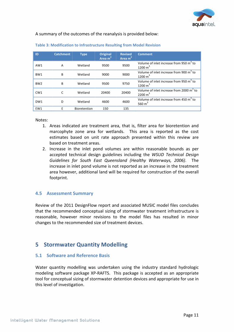
4.4 Revised!Model!and!Outcomes!!The! six! MUSIC! models! were! revised! based! on! the! recommendations! contained!within!Table!2!and!reanalyzed!in!MUSIC!v6.!!In!summary!the!following!modifications!to!each!of!the!models!were!made:!!
1. Removal!of!rainwater!tanks!from!treatment!trains;!2. Update!of!bioretention!nodes!to!current!version!node;!3. Update!of!rainfallNrunoff!parameters! for! industrial!and!commercial!nodes! in!
accordance!with!the!current!guidelines;!4. Reanalysis!in!MUSIC!v6;!and!5. Optimisation! of! treatment! nodes! to! ensure! Water! Quality! Objective! were!
met!with!the!above!modifications.!!!
!!!
Page!11!
A!summary!of!the!outcomes!of!the!reanalysis!is!provided!below:!!Table!3:!Modification!to!Infrastructure!Resulting!from!Model!Revision!
ID! Catchment! Type! Original!Area!m2!
Revised!Area!m2!
Comment!
AW1! A! Wetland! 9500! 9500! Volume!of!inlet!increase!from!950!m3!to!1200!m3!
BW1! B! Wetland! 9000! 9000! Volume!of!inlet!increase!from!900!m3!to!1200!m3!
BW2! B! Wetland! 9500! 9750! Volume!of!inlet!increase!from!950!m3!to!1200!m3!
CW1! C! Wetland! 20400! 20400! Volume!of!inlet!increase!from!2000!m3!to!2200!m3!
DW1! D! Wetland! 4600! 4600! Volume!of!inlet!increase!from!450!m3!to!560!m3!
EW1! E! Bioretention! 150! 135! !
!Notes:!!
1. Areas! indicated! are! treatment! area,! that! is,! filter! area! for! bioretention! and!marcophyte! zone! area! for! wetlands.! ! This! area! is! reported! as! the! cost!estimates! based! on! unit! rate! approach! presented! within! this! review! are!based!on!treatment!areas.!
2. Increase! in! the! inlet! pond! volumes! are! within! reasonable! bounds! as! per!accepted! technical! design! guidelines! including! the!WSUD& Technical& Design&Guidelines& for& South& East& Queensland& (Healthy& Waterways,& 2006).! ! The!increase!in!inlet!pond!volume!is!not!reported!as!an!increase!in!the!treatment!area!however,!additional!land!will!be!required!for!construction!of!the!overall!footprint.!
!
4.5 Assessment!Summary!!Review!of!the!2011!DesignFlow!report!and!associated!MUSIC!model!files!concludes!that!the!recommended!conceptual!sizing!of!stormwater!treatment! infrastructure! is!reasonable,! however! minor! revisions! to! the! model! files! has! resulted! in! minor!changes!to!the!recommended!size!of!treatment!devices.!!
5 Stormwater!Quantity!Modelling!
5.1 Software!and!Reference!Basis!!Water! quantity! modelling! was! undertaken! using! the! industry! standard! hydrologic!modeling! software!package!XPNRAFTS.! ! This!package! is! accepted!as!an!appropriate!tool!for!conceptual!sizing!of!stormwater!detention!devices!and!appropriate!for!use!in!this!level!of!investigation.!!

!!!
Page!12!
Additional!hydraulic!modeling!was!undertaken!in!HECNRAS,!a!1!dimensional!hydraulic!software! package,! which! is! again! considered! appropriate! for! use! in! this! level! of!investigation.!!
5.2 Methodology!and!Model!Schematization!!Review!of!the!2011!DesignFlow!study!report,!with!particular!reference!to!Appendix!D!–!Water!Quantity!Assessment!(SKM),!finds!that!the!methodology!for!the!derivation!of!a!stormwater!quantity!management!strategy!at!a!catchment!scale!planning!level!is!sound.!!!!The! reviewed! investigation!seeks! to!quantify! the!peak! runoff! for!a! range!of!design!events!(including!both!minor!and!major!events)!from!the!delineated!subNcatchments!in!an!existing!landuse!case!and!under!the!projected!development!conditions!at!the!2031! and! ultimate! (2051)! planning! horizons.! ! Conceptual! sizing! of! detention!infrastructure!is!then!undertaken!to!mitigate!peak!flows!from!the!catchment!to!the!existing!case!condition.!!Some! level! of! calibration,! or! verification,! of! estimated! peak! flows! is! undertaken!within!the!investigation!in!line!with!general!industry!practice.!!The!subNcatchment!delineation! is!based!upon!topography!and,!while!at!a!relatively!course! level! of! definition,! is! considered! appropriate! for! this! investigation! and! the!nature!of!the!planning!area!being!primarily!greenfields!development.!
5.3 Input!Parameters!!The! construction! of! the! XPNRAFTS! models! for! each! of! the! subNcatchments! were!found!to!be!generally!in!accordance!with!technical!guidelines!including!the!software!supplier! reference!manuals! and! industry! best! practice.! No! notable! variances! from!industry!best!practice!were!identified.!!Input! parameters! for! subNcatchments! including! catchment! areas! and! slope! were!considered!to!be!reasonable!on!comparison!with!base!topographical!data!and!aerial!photography.!!As! discussed! in! Section! 4,! impervious! fractions! adopted! within! the! hydrological!models! were! reviewed! against! the! impervious! fractions! derived! from! the! revised!LDPM!data!and! found! to!have! some!deviation!but! the!magnitude!of! the!deviation!was!not!considered!likely!to!result!in!a!significant!change!in!the!estimated!detention!volumes!and!did!not!warrant!amendment!of!the!models.!!!!
!!!
Page!13!
5.4 Hydraulic!Modelling!!A! limited! level!of!hydraulic!modeling! is!reported!within!the!2011!DesignFlow!study!with! the! objective! of! identifying! drainage! easements! and! required! trunk!infrastructure!in!addition!to!the!detention!basins!within!Catchments!B!and!C.!!As!noted!above!hydraulic!modeling!was!undertaken!in!HECRAS,!an!industry!standard!1! dimensional! hydraulic! modeling! software! package! which! is! considered! to! be!acceptable.!!Review! of! the! provided! model! files! and! associated! reporting! concludes! that! the!construction!of!the!hydraulic!models!is!acceptable!for!the!intended!purpose.!!Input!parameters!and!model!construction!is!sound!however!it!is!noted!that!the!results!of!this! modeling! should! only! be! used! for! the! intended! purpose! being! to! identify!drainage! easements! and! conceptual! sizing! of! culverts.! ! This! hydraulic! modelling!should! not! be! relied! upon! for! the! prediction! of! flood! levels! within! the! area! or!detailed!costing!or!design!of!infrastructure.!!
5.5 Assessment!Summary!!Review! of! the! 2011! DesignFlow! report! and! associated! hydrologic! and! hydraulic!model! files! concludes! that! the! recommended! conceptual! sizing! of! detention! and!flood!management!infrastructure!is!reasonable!and!does!not!require!any!revision!of!model!files!at!this!time!for!the!purpose!of!estimation!of!future!trunk!infrastructure!requirements!for!stormwater!quantity!management.!!
6 Proposed!Infrastructure!!The! 2011! DesignFlow! report! provides! conceptual! infrastructure! summaries! within!Appendix!A.!!An!assessment!of!key!elements!of!the!summaries!is!provided!below.!
6.1 Location!!Generally!the!selected!location!for!proposed!infrastructure!is!considered!reasonable!and! practical.! ! It! appears,! where! possible,! water! quality! and! flood! detention!infrastructure!has!been!coNlocated!to!minimize!footprint.!!No! revision! or! modification! to! location! of! infrastructure! is! recommended! on! the!basis!of!informing!a!financial!model!for!stormwater!infrastructure!planning.!!!!

!!!
Page!14!
6.2 Conceptual!Layout!!The! conceptual! layout! of! both! water! quality! treatment! devices! (wetlands! and!bioretention)!and!detention!infrastructure!presented!in!the!2011!DesignFlow!report!appears!to!be!reasonable!and!in!line!with!current!industry!practice.!!!It!is!noted!that!the!layouts!presented!should!only!be!used!for!the!purpose!intended,!this! being! the! quantification! and! preliminary! costing! of! trunk! infrastructure! to!service! projected! development! with! the! catchments.! ! The! presented! conceptual!designs! are! suitable! for! informing! financial!modelling!of! stormwater! infrastructure!however,!should!not!relied!upon!for!capital!works!estimates.!!!
6.3 Land!requirements!!Review! of! the! land! acquisition! GIS! layer! associated! with! the! PIP2A!(PIP2_Proposed_Land_Acquisition_polygon_LV)! concludes! that! the!areas! align!with!the! proposed! conceptual! layouts! for! infrastructure! proposed! within! the! 2011!DesignFlow!report.!!It!is!noted!that!no!information!was!provided!as!to!proposed!drainage!easements!and!thus! review! of! drainage! easement! requirements! within! the! catchments! was! not!undertaken.!
7 Costing!!The! 2011! DesignFlow! report! presents! cost! estimates! for! each! of! the! proposed!elements!of!trunk! infrastructure.!Cost!estimates!have!been!reviewed!based!on!any!revision! of! the! infrastructure! requirements! as! a! result! of! this! review! process! and!based!on!standardized!unit!cost!rates!for!stormwater!infrastructure!as!presented!in!a!supplied!reference!document!titled!Stormwater&Management&Unit&Cost&Rates&for&Logan&–&Park&Ridge&Priority&Infrastructure&Plan!(DesignFlow,!2014).!!Revised!cost!estimates!are!provided!in!Table!4.!!!!

!
Page!15!
Table&4:&Cost&estimates&
Item&ID& Item& Original&size&m2&
1.&Original&Size&m3&
1.& Original&Cost&1.& 2014&Unit&Cost/m2&2.&
2014&Unit&Cost/&m3&2.&
2014&cost&based&on&
original&size&Revised&Size&m2& Revised&Cost&
2031! ! ! ! ! ! ! ! ! !AW1! Wetland! 9500! ! $1,489,000! 150! ! $1,425,000! 9500! $1,425,000!AD1! Detention! 14500! 5800! $589,000! ! 34! $197,200! ! $197,200!BW1! Wetland! 9000! ! $1,318,000! 150! ! $1,350,000! 9000! $1,350,000!BD1! Detention! 13000! 7400! $1,175,000! ! 34! $251,600! ! $251,600!EB1! Bioretention! 150! ! $46,000! 480! ! $72,000! 135! $64,800!ED1! Detention! 680! 500! $72,000! ! 34! $17,000! ! $17,000!2051! ! ! ! ! ! ! ! ! !BW2! Wetland! 9500! ! $1,557,000! 150! ! $1,425,000! 9750! $1,462,500!BD2! Detention! 13200! 5800! $360,000! ! 34! $197,200! ! $197,200!CW1! Wetland! 20400! ! $2,969,000! 150! ! $3,060,000! 20400! $3,060,000!CD1! Detention! 15000! 11500! $818,000! ! 34! $391,000! ! $391,000!DW1! Wetland! 4600! ! $665,000! 150! ! $690,000! 4600! $690,000!DD1! Detention! 3900! 2100! $270,000! ! 34! $71,400! ! $71,400!TOTAL& & & & $11,328,000& & & $9,147,400& & $9,177,700&!Notes:!
1. From!DesignFlow,!2011.!Size!of!water!quality!treatment!infrastructure!is!treatment!area!(i.e!filter!area!of!bioretention!and!macrophyte!area!of!wetlands)!
2. From!Stormwater!Management!Unit!Cost!Rates!for!Logan!(DesignFlow,!2014)!!
!!!
Page!16!
8 Conclusion*!The! review! of! the! Logan& Village& Stormwater& Plan& for& Trunk& Infrastructure,& Water&Quality& and& Flood&Management& Conceptual& Design& completed! by&DesignFlow! and!SKM!in!August!2011!and!the!associated!modelling!files!concludes!that:!!
• The!base!data!and!assumptions!on!which!the!study!was!based!are!sound!and!that!revisions!to!the!LDPM!(February!2015)!are!unlikely!to!result!in!significant!alteration!to!the!infrastructure!proposed.!
• In! general! water! quality! modeling! was! found! to! be! sound.! Recommended!revisions!to!and!update!of!the!water!quality!modelling!files!resulted!in!minor!changes! to! the! treatment! areas! proposed! in! the!DesignFlow! 2011! study! in!order!to!meet!defined!Water!Quality!Objectives!(WQO’s).!
• Proposed! detention! infrastructure! sizing! and! the! construction! of! the!water!quantity!(XPTRAFTS)!model!files!was!found!to!be!sound!and!no!model!revision!or! change! in! the! proposed! detention! infrastructure! size! was! found! to! be!warranted.!
• Update! of! cost! estimates! based! on! revision! of! the! infrastructure!requirements! as! a! result! of! this! review!process! and! based! on! standardized!unit! cost! rates! for! stormwater! infrastructure! resulted! in! the! total! cost! of!proposed!infrastructure!in!the!PIA!falling!from!the!original!DesignFlow!2011!estimate!of!$11.3!million!to!$9.2!million.!
!!


