integration application network LOICZ: Land LOICZ: Land - - Ocean Ocean Interactions in the Coastal Zone Interactions in the Coastal Zone International International Geosphere Geosphere Biosphere Biosphere Programme Programme http:// http:// ian.umces.edu ian.umces.edu William C. Dennison William C. Dennison
Transcript
integration application network
LOICZ: LandLOICZ: Land--Ocean Ocean Interactions in the Coastal ZoneInteractions in the Coastal Zone
International International GeosphereGeosphereBiosphere Biosphere ProgrammeProgramme
http://http://ian.umces.eduian.umces.edu
William C. DennisonWilliam C. Dennison
integration application network
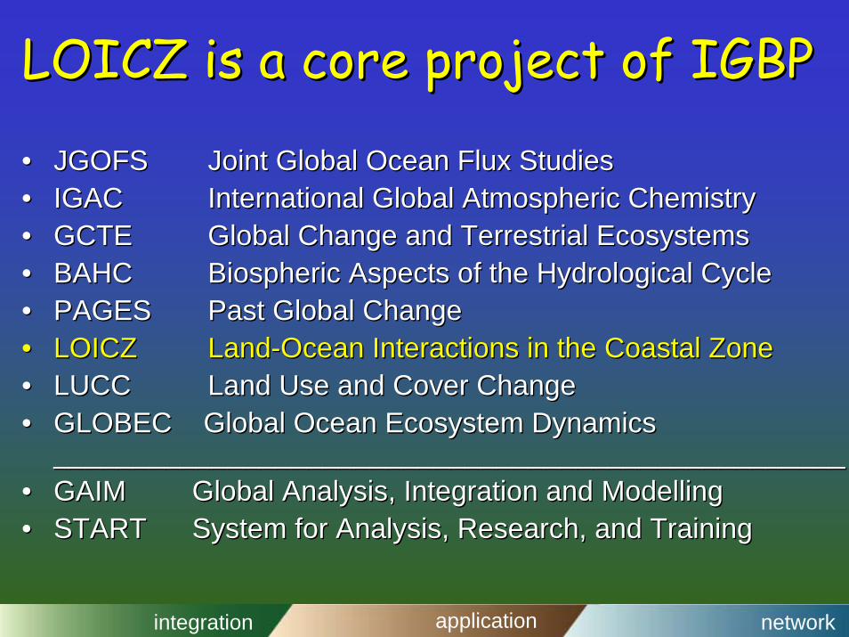
LOICZ is a core project of IGBPLOICZ is a core project of IGBP
•• JGOFSJGOFS Joint Global Ocean Flux StudiesJoint Global Ocean Flux Studies•• IGACIGAC International Global Atmospheric ChemistryInternational Global Atmospheric Chemistry•• GCTEGCTE Global Change and Terrestrial EcosystemsGlobal Change and Terrestrial Ecosystems•• BAHCBAHC BiosphericBiospheric Aspects of the Hydrological CycleAspects of the Hydrological Cycle•• PAGESPAGES Past Global ChangePast Global Change•• LOICZLOICZ LandLand--Ocean Interactions in the Coastal ZoneOcean Interactions in the Coastal Zone•• LUCCLUCC Land Use and Cover ChangeLand Use and Cover Change•• GLOBEC Global Ocean Ecosystem DynamicsGLOBEC Global Ocean Ecosystem Dynamics
____________________________________________________________________________________________________•• GAIMGAIM Global Analysis, Integration and Global Analysis, Integration and ModellingModelling•• STARTSTART System for Analysis, Research, and TrainingSystem for Analysis, Research, and Training
integration application network
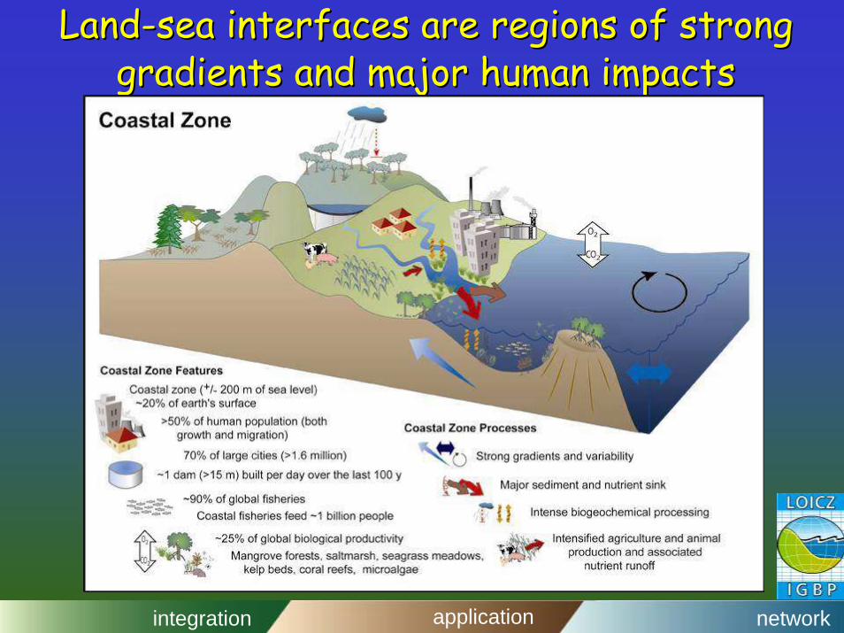
LandLand--sea interfaces are regions of strong sea interfaces are regions of strong gradients and major human impactsgradients and major human impacts
www.nioz.nl/loiczwww.nioz.nl/loicz//
integration application network
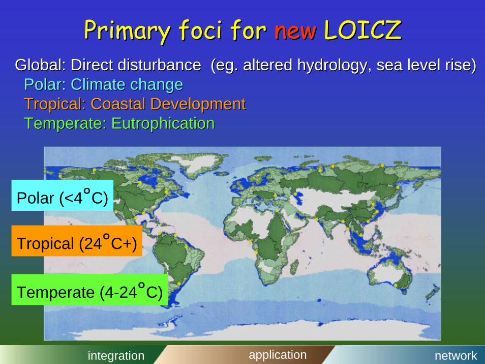
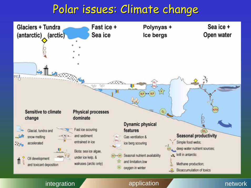
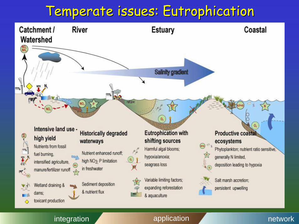
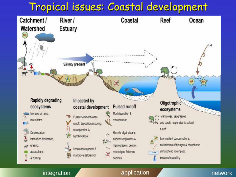
Primary foci for Primary foci for new new LOICZLOICZGlobal: Direct disturbance (Global: Direct disturbance (egeg. altered hydrology, sea level rise). altered hydrology, sea level rise)Polar: Climate changePolar: Climate changeTropical: Coastal DevelopmentTropical: Coastal DevelopmentTemperate: Temperate: EutrophicationEutrophication
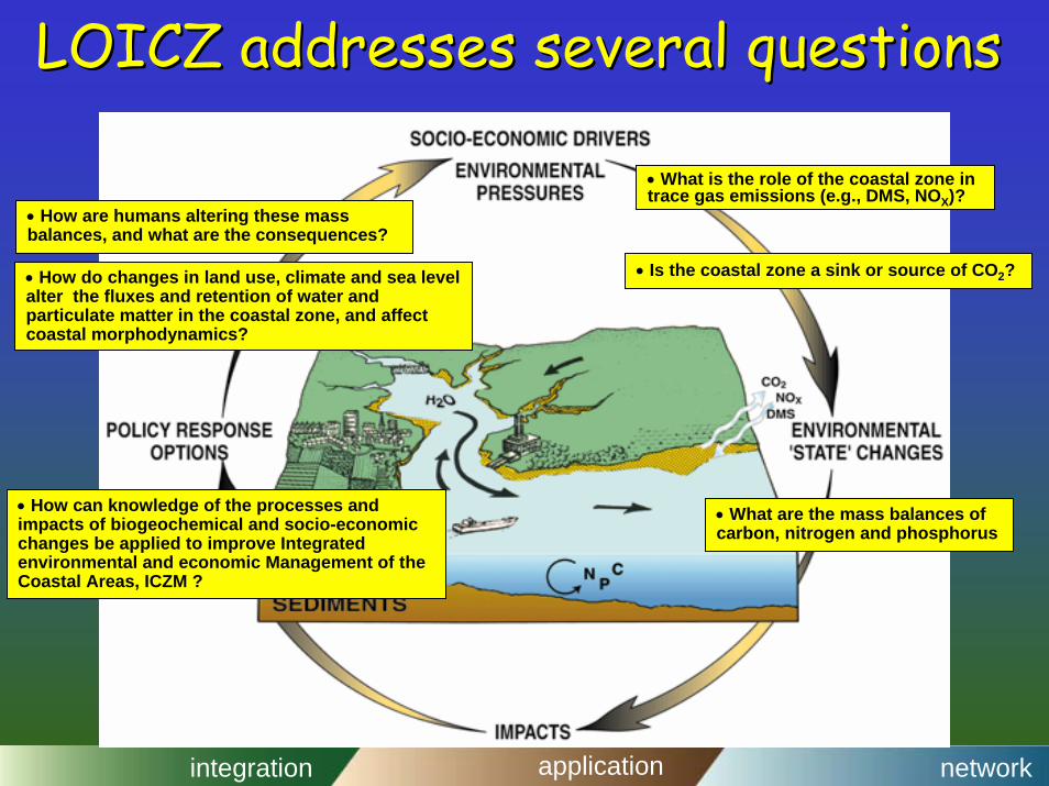
LOICZ addresses several questionsLOICZ addresses several questions
• What are the mass balances of carbon, nitrogen and phosphorus
• How can knowledge of the processes and impacts of biogeochemical and socio-economic changes be applied to improve Integrated environmental and economic Management of the Coastal Areas, ICZM ?
• How do changes in land use, climate and sea level alter the fluxes and retention of water and particulate matter in the coastal zone, and affect coastal morphodynamics?
• How are humans altering these mass balances, and what are the consequences?
• What is the role of the coastal zone in trace gas emissions (e.g., DMS, NOX)?
• Is the coastal zone a sink or source of CO2?
integration application network
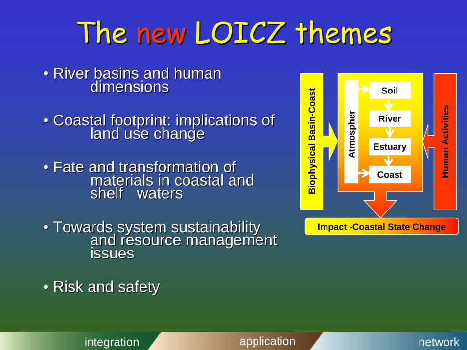
The The newnew LOICZ themesLOICZ themes•• River basins and human River basins and human
dimensionsdimensions
•• Coastal footprint: implications of Coastal footprint: implications of land use changeland use change
•• Fate and transformation of Fate and transformation of materials in coastal and materials in coastal and shelf shelf waterswaters
•• Towards system sustainability Towards system sustainability and resource management and resource management issuesissues
•• Risk and safetyRisk and safety
Soil
River
Estuary
Coast
Atm
osph
ere
Bio
phys
ical
Bas
in-C
oast
Hum
an A
ctiv
ities
Impact -Coastal State Change
integration application network
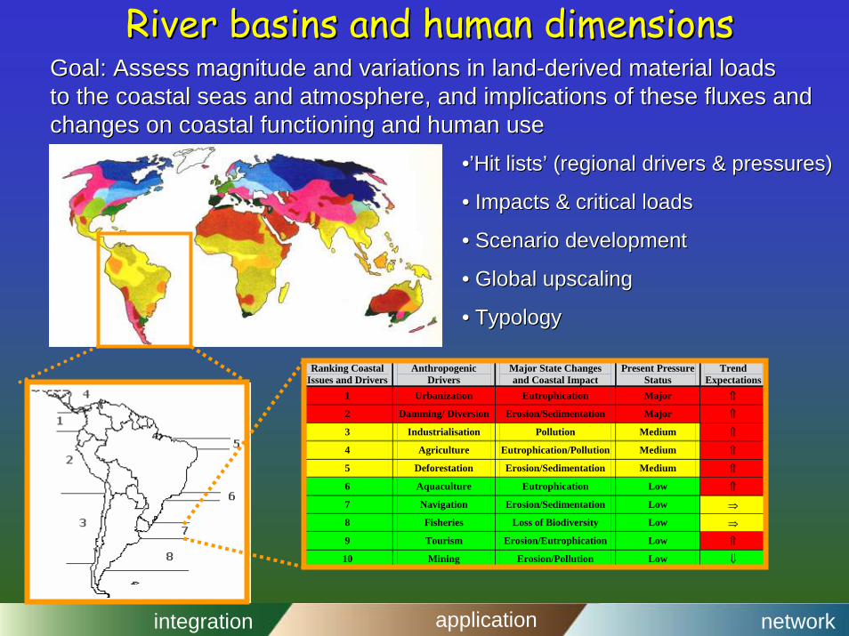
River basins and human dimensionsRiver basins and human dimensions
Ranking Coastal Issues and Drivers
Anthropogenic Drivers
Major State Changes and Coastal Impact
Present Pressure Status
Trend Expectations
1 Urbanization Eutrophication Major ⇑
2 Damming/ Diversion Erosion/Sedimentation Major ⇑
Goal: Assess mGoal: Assess magnitude and variations in landagnitude and variations in land--derived material loadsderived material loadsto the coastal seas and atmosphere, and implications of these flto the coastal seas and atmosphere, and implications of these fluxes and uxes and changes on coastal functioning and human usechanges on coastal functioning and human use
integration application network
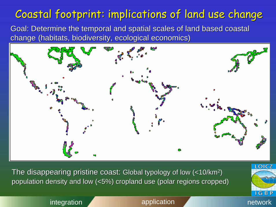
Coastal footprint: implications of land use changeCoastal footprint: implications of land use changeGoal: Determine the temporal and spatial scales of land based coGoal: Determine the temporal and spatial scales of land based coastal astal change change (habitats, biodiversity, ecological economics)(habitats, biodiversity, ecological economics)
The disappearing pristine coast: The disappearing pristine coast: Global typology of low (<10/kmGlobal typology of low (<10/km22) ) population density and low (<5%) cropland use (polar regions cropopulation density and low (<5%) cropland use (polar regions cropped)pped)
integration application network
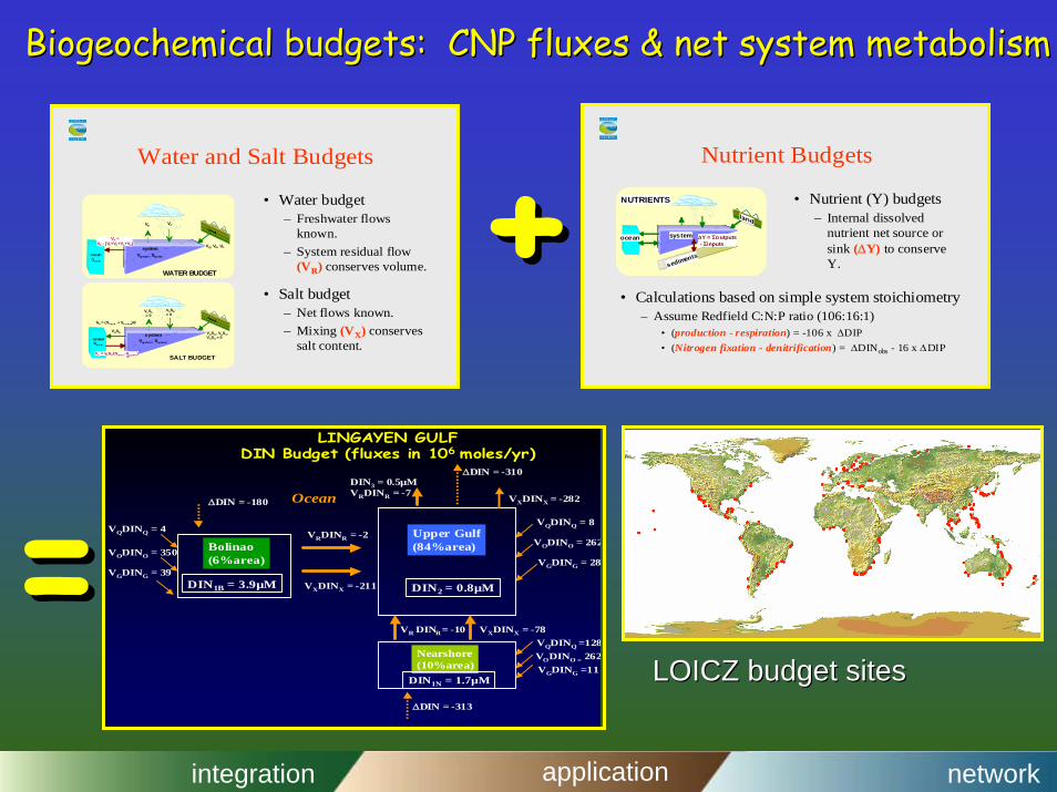
Biogeochemical budgets: CNP fluxes & net system metabolismBiogeochemical budgets: CNP fluxes & net system metabolism
Nutrient Budgets
• Calculations based on simple system stoichiometry– Assume Redfield C:N:P ratio (106:16:1)
• (production - respiration) = -106 x ∆DIP• (Nitrogen fixation - denitrification) = ∆DINobs - 16 x ∆DIP
• Nutrient (Y) budgets– Internal dissolved
nutrient net source orsink (∆Y) to conserveY.
ocean system
NUTRIENTS
∆Y = Σoutputs - Σinputs
sediments
Water and Salt Budgets
• Salt budget– Net flows known.– Mixing (VX) conserves
salt content.
• Water budget– Freshwater flows
known.– System residual flow
(VR) conserves volume.oceanSocean
systemVsystem, Ssystem
VR =VE - (VP+VQ+VG+VO)
VPVE
VQ, VG, VO
WATER BUDGET
VPSE= 0
VESE= 0
VQSQ, VGSG, VOSO = 0ocean
Soce an
systemVsystem, Ssystem
SR = (Soce an + Ss y ste m)/2
VRSR
VX = VRSR/(Soc ea n-Ss y ste m) SALT BUDGET
∆DIN = -180
∆DIN = -313
∆DIN = -310
VODINO = 262
VODINO = 262
VODINO = 350
VQDINQ = 4VQDINQ = 8
VQDINQ =128
Ocean
LINGAYEN GULFDIN Budget (fluxes in 106 moles/yr)
Upper Gulf(84%area)
Nearshore(10%area)
Bolinao(6%area)
DIN1B = 3.9µM DIN2 = 0.8µM
DIN1N = 1.7µM
VXDINX = -211
VR DINR= -10
VRDINR = -2
VXDINX = -78
DIN3 = 0.5µMVRDINR = -7 VXDINX = -282
VGDING = 28
VGDING =11
VGDING = 39
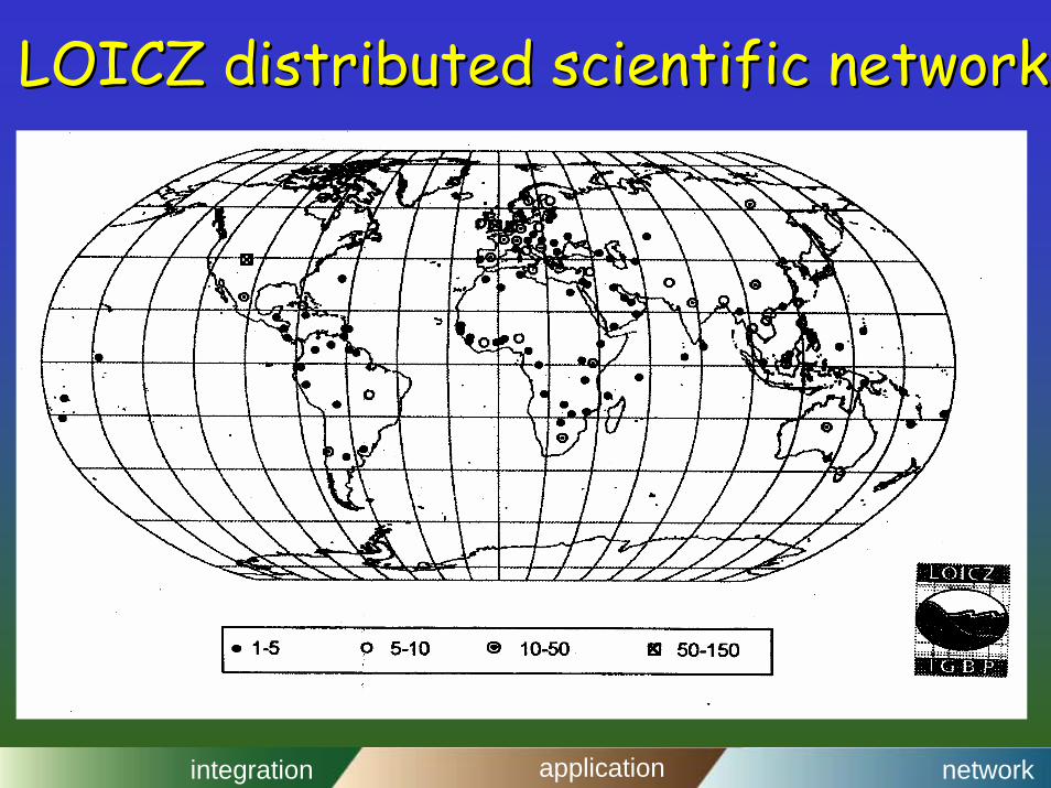
LOICZ budget sitesLOICZ budget sites
integration application network
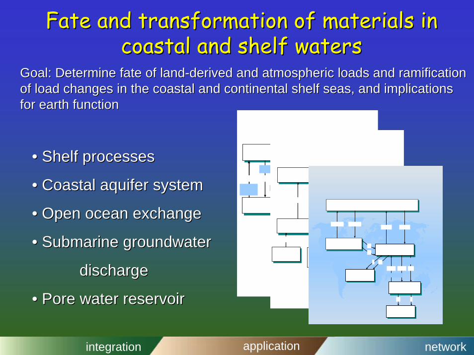
Fate and transformation of materials in Fate and transformation of materials in coastal and shelf waterscoastal and shelf waters
Goal: Determine fate of landGoal: Determine fate of land--derived and atmospheric loads and ramification derived and atmospheric loads and ramification of load changes in the coastal and continental shelf seas, and iof load changes in the coastal and continental shelf seas, and implications mplications for earth functionfor earth function
•• Shelf processesShelf processes
•• Coastal aquifer systemCoastal aquifer system
•• Open ocean exchangeOpen ocean exchange
•• Submarine groundwater Submarine groundwater
dischargedischarge
•• Pore water reservoirPore water reservoir
integration application network
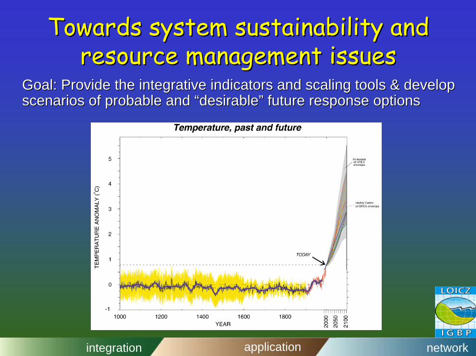
Towards system sustainability and Towards system sustainability and resource management issuesresource management issues
Goal: Provide the integrative indicators and scaling tools & devGoal: Provide the integrative indicators and scaling tools & develop elop scenarios of probable and scenarios of probable and ““desirabledesirable”” future response optionsfuture response options
integration application network
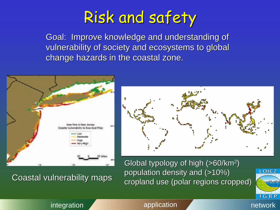
Risk and safetyRisk and safetyGoal: Improve knowledge and understanding ofGoal: Improve knowledge and understanding ofvulnerability of society and ecosystems to globalvulnerability of society and ecosystems to globalchange hazards in the coastal zone.change hazards in the coastal zone.
Global typology of high (>60/kmGlobal typology of high (>60/km22) ) population density and (>10%)population density and (>10%)cropland use (polar regions cropped)cropland use (polar regions cropped)Coastal vulnerability mapsCoastal vulnerability maps
integration application network
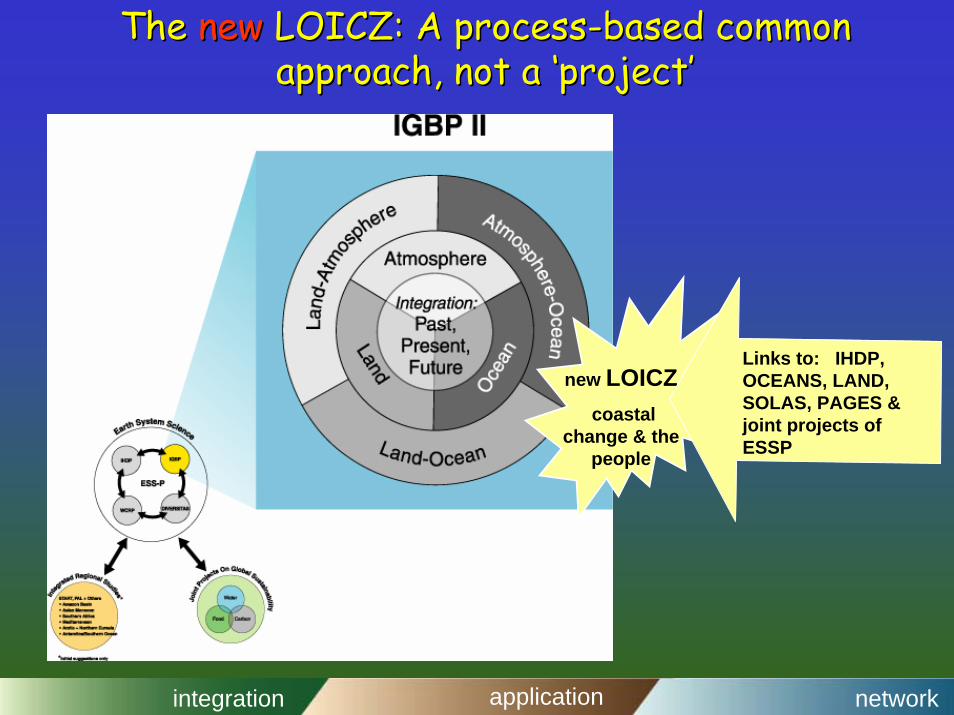
The The newnew LOICZ: A processLOICZ: A process--based common based common approach, not a ‘project’approach, not a ‘project’
new LOICZcoastal
change & the people
Links to: IHDP, OCEANS, LAND, SOLAS, PAGES & joint projects of ESSP
integration application network
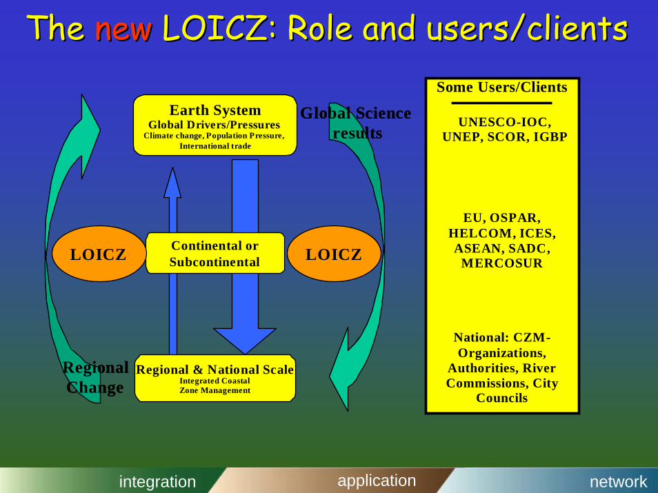
The The newnew LOICZ: Role and users/clientsLOICZ: Role and users/clients
Earth SystemGlobal Drivers/Pressures
Climate change, Population Pressure,International trade
Continental orSubcontinental
Regional & National ScaleIntegrated CoastalZone Management
Global Scienceresults
LOICZLOICZ
RegionalChange
Earth SystemGlobal Drivers/Pressures
Climate change, Population Pressure,International trade
Continental orSubcontinental
Regional & National ScaleIntegrated CoastalZone Management
Global Scienceresults
LOICZLOICZ
RegionalChange
Some Users/Clients
UNESCO-IOC,UNEP, SCOR, IGBP
EU, OSPAR,HELCOM, ICES,ASEAN, SADC,
MERCOSUR
National: CZM-Organizations,
Authorities, RiverCommissions, City
Councils
integration application network
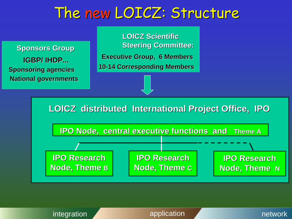
The The newnew LOICZ: StructureLOICZ: StructureLOICZ Scientific LOICZ Scientific Steering Committee:Steering Committee:
LOICZ distributed International Project Office, IPOLOICZ distributed International Project Office, IPO
IPO Node, central executive functions and IPO Node, central executive functions and Theme ATheme A
IPO Research IPO Research Node, Theme Node, Theme BB
IPO Research IPO Research Node, Theme Node, Theme CC
IPO Research IPO Research Node, Theme Node, Theme NN
integration application network
LOICZLOICZ
Robert Robert BuddemeierBuddemeierRobert Robert CostanzaCostanzaChris Chris CrosslandCrosslandHartwigHartwig KremerKremerStephen SmithStephen SmithJames James SyvitskiSyvitski
www.nioz.nl/loiczwww.nioz.nl/loicz
integration application network
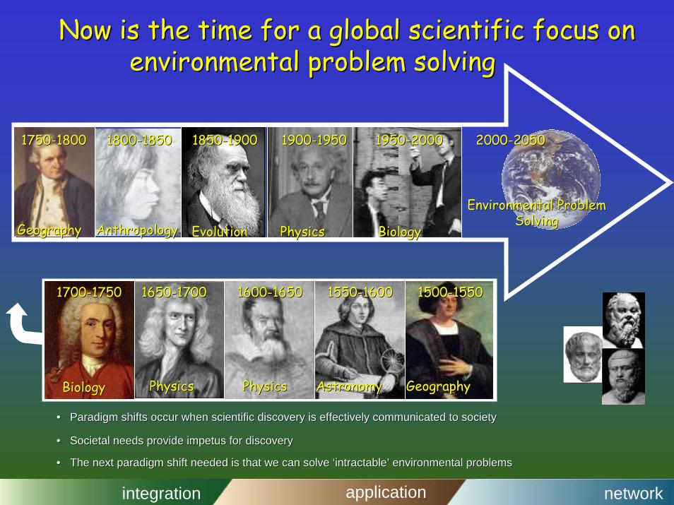
Now is the time for a global scientific focus onNow is the time for a global scientific focus onenvironmental problem solvingenvironmental problem solving
GeographyGeography
17501750--18001800
AnthropologyAnthropology
18001800--18501850
EvolutionEvolution
18501850--19001900
PhysicsPhysics
19501950--2000200019001900--19501950
BiologyBiology
20002000--20502050
Environmental Problem Environmental Problem SolvingSolving
•• Paradigm shifts occur when scientific discovery is effectivelParadigm shifts occur when scientific discovery is effectively communicated to society y communicated to society
•• Societal needs provide impetus for discoverySocietal needs provide impetus for discovery
•• The next paradigm shift needed is that we can solve ‘intractaThe next paradigm shift needed is that we can solve ‘intractable’ environmental problems ble’ environmental problems
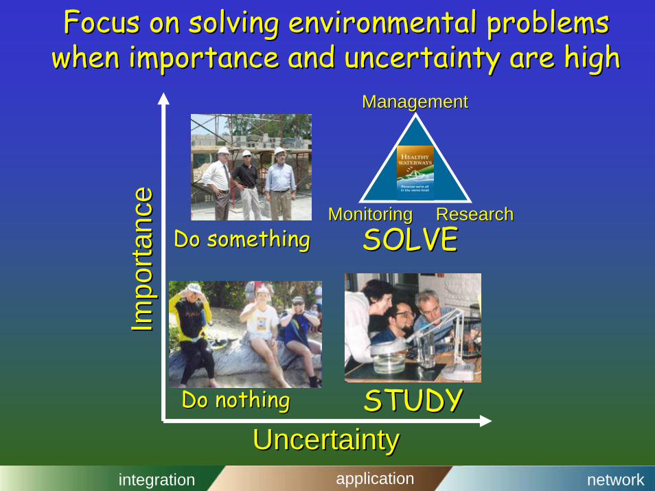
Focus on solving environmental problems Focus on solving environmental problems when importance and uncertainty are highwhen importance and uncertainty are high
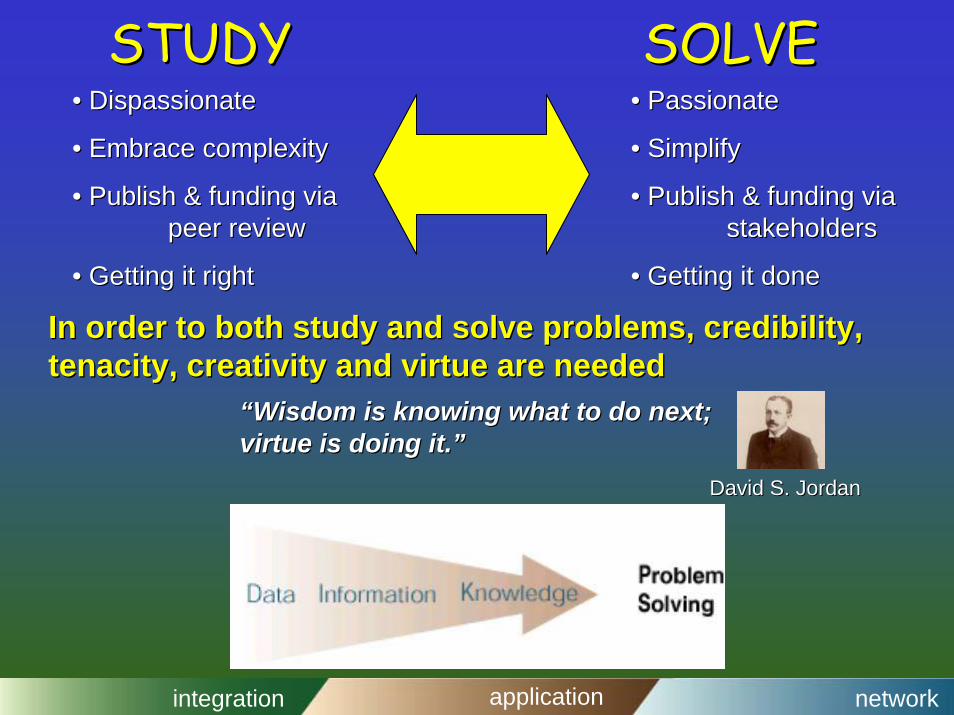
In order to both study and solve problems, credibility, In order to both study and solve problems, credibility, tenacity, creativity and virtue are neededtenacity, creativity and virtue are needed
““Wisdom is knowing what to do next; Wisdom is knowing what to do next; virtue is doing it.”virtue is doing it.”
David S. JordanDavid S. Jordan
integration application network
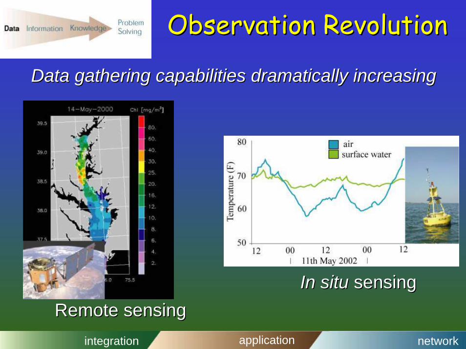
Observation RevolutionObservation Revolution
Data gathering capabilities dramatically increasingData gathering capabilities dramatically increasing
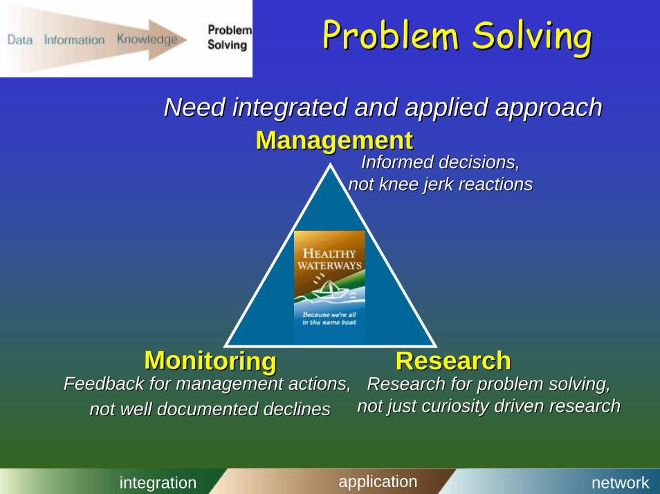
Feedback for management actions,Feedback for management actions,not well documented declinesnot well documented declines
Research for problem solving, Research for problem solving, not just curiosity driven researchnot just curiosity driven research
integration application network
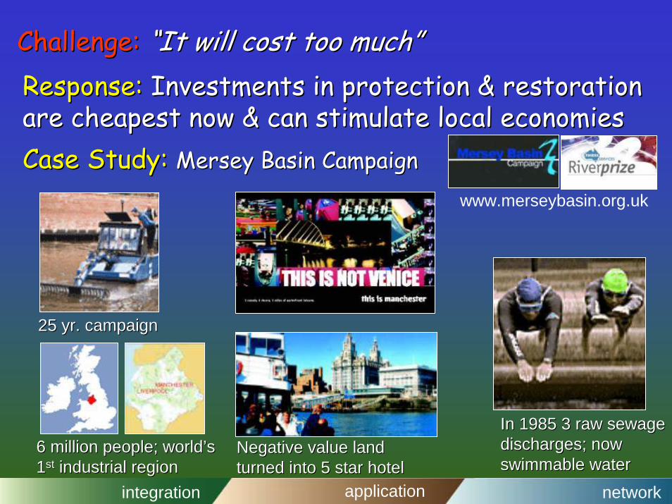
Challenge:Challenge: “It will cost too much”“It will cost too much”Response: Response: Investments in protection & restoration Investments in protection & restoration are cheapest now & can stimulate local economiesare cheapest now & can stimulate local economiesCase Study: Case Study: Mersey Basin CampaignMersey Basin Campaign
6 million people; world’s 6 million people; world’s 11stst industrial regionindustrial region
Negative value landNegative value landturned into 5 star hotelturned into 5 star hotel
25 yr. campaign25 yr. campaign
In 1985 3 raw sewage In 1985 3 raw sewage discharges; now discharges; now swimmableswimmable waterwater
www.merseybasin.org.uk
integration application network
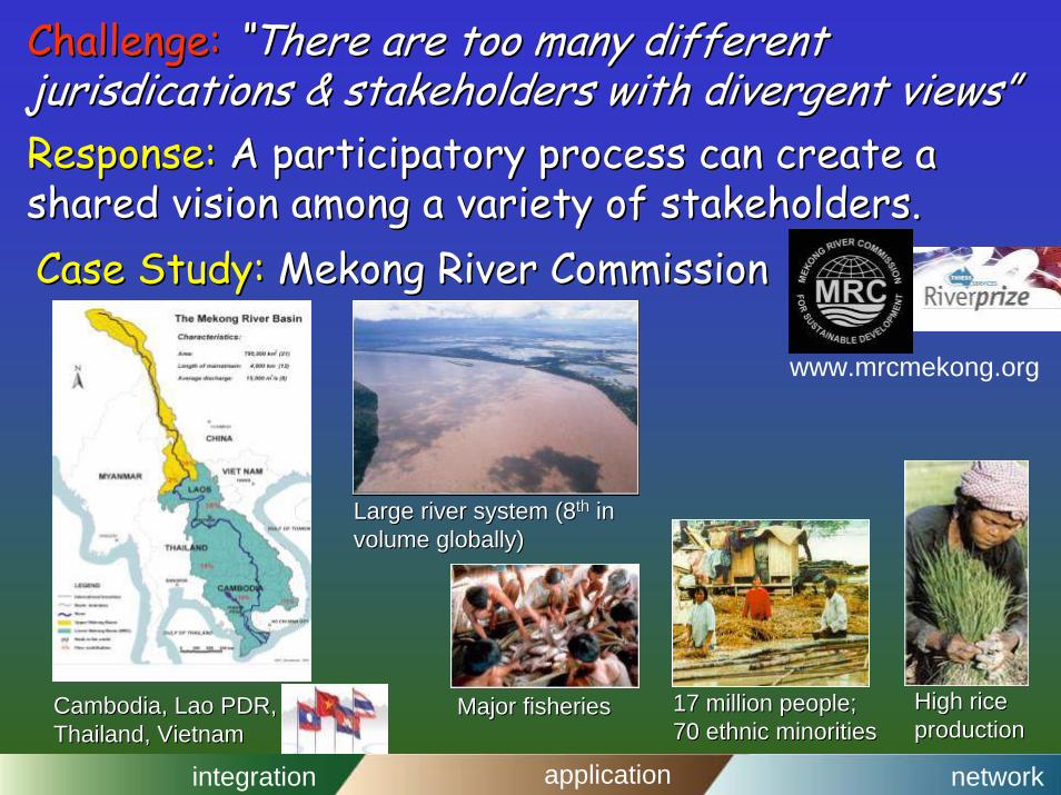
Challenge:Challenge: “There are too many different “There are too many different jurisdicationsjurisdications & stakeholders with divergent views”& stakeholders with divergent views”Response: Response: A participatory process can create a A participatory process can create a shared vision among a variety of stakeholders.shared vision among a variety of stakeholders.Case Study: Case Study: Mekong River CommissionMekong River Commission
Large river system (8Large river system (8thth in in volume globally)volume globally)
Major fisheriesMajor fisheries High rice High rice productionproduction
17 million people;17 million people;70 ethnic minorities 70 ethnic minorities
www.mrcmekong.org
integration application network
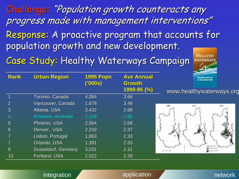
Challenge:Challenge: “Population growth counteracts any “Population growth counteracts any progress made with management interventions”progress made with management interventions”Response: Response: A proactive program that accounts for A proactive program that accounts for population growth and new development.population growth and new development.Case Study: Case Study: Healthy Waterways CampaignHealthy Waterways Campaign
www.healthywaterways.orgwww.healthywaterways.org
RankRank Urban RegionUrban Region 1995 1995 PopnPopn((‘‘000s)000s)
11 Toronto, CanadaToronto, Canada 4,0844,084 3.663.6622 Vancouver, CanadaVancouver, Canada 1,6781,678 3.463.4633 Atlanta, USAAtlanta, USA 3,4323,432 2.882.8844 Brisbane, AustraliaBrisbane, Australia 2,1092,109 2.862.8655 Phoenix, USAPhoenix, USA 2,5642,564 2.682.6866 Denver, USADenver, USA 2,2332,233 2.372.3777 Lisbon, PortugalLisbon, Portugal 1,8631,863 2.332.3377 Orlando, USAOrlando, USA 1,3911,391 2.332.3399 DusseldorfDusseldorf, Germany, Germany 3,0313,031 2.312.311010 Portland, USAPortland, USA 2,0222,022 2.282.28
integration application network
Human health is linked to ecosystem healthHuman health is linked to ecosystem health
•• Medical geology: humanMedical geology: humandisturbances can acceleratedisturbances can acceleratenatural geological processesnatural geological processes
•• Biodiversity affects ecosystem Biodiversity affects ecosystem function & healthfunction & health
•• EndrocrineEndrocrine disrupters leading to disrupters leading to increased human diseasesincreased human diseases
•• Disease emergence as a function of Disease emergence as a function of ecosystem alterationecosystem alteration
e.g., AIDS, SARSe.g., AIDS, SARS
integration application network
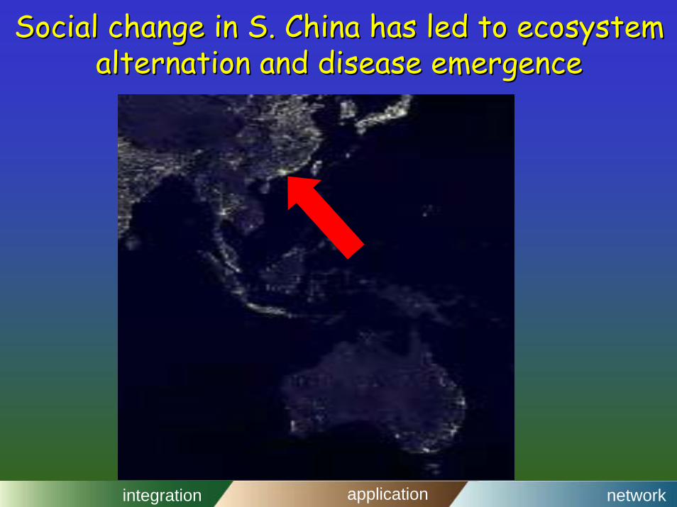
Social change in S. China has led to ecosystem Social change in S. China has led to ecosystem alternation and disease emergencealternation and disease emergence
integration application network
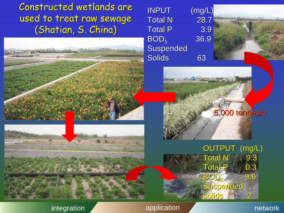
Constructed wetlands are Constructed wetlands are used to treat raw sewage used to treat raw sewage
((ShatianShatian,, S. China)S. China)
INPUT (mg/L)INPUT (mg/L)Total N 28.7Total N 28.7Total P 3.9Total P 3.9BODBOD55 36.936.9SuspendedSuspendedSolids 63Solids 63
OUTPUT (mg/L)OUTPUT (mg/L)Total N 9.3Total N 9.3Total P 0.3Total P 0.3BODBOD55 9.69.6SuspendedSuspendedsolids 2solids 2
5,000 5,000 tonnes/dtonnes/d
integration application network
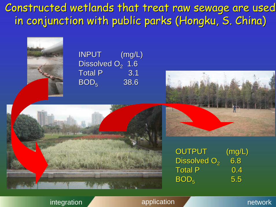
Constructed wetlands that treat raw sewage are used Constructed wetlands that treat raw sewage are used in conjunction with public parks (in conjunction with public parks (HongkuHongku, , S. China)S. China)
INPUT (mg/L)INPUT (mg/L)Dissolved ODissolved O22 1.61.6Total P 3.1Total P 3.1BODBOD55 38.638.6
OUTPUT (mg/L)OUTPUT (mg/L)Dissolved ODissolved O22 6.86.8Total P 0.4Total P 0.4BODBOD55 5.55.5
integration application network
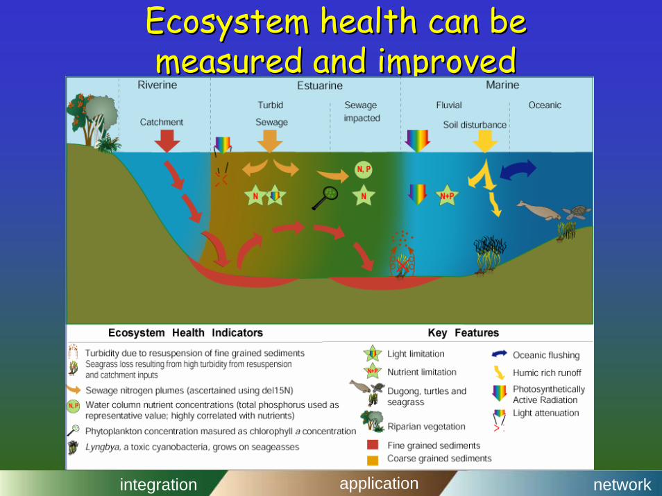
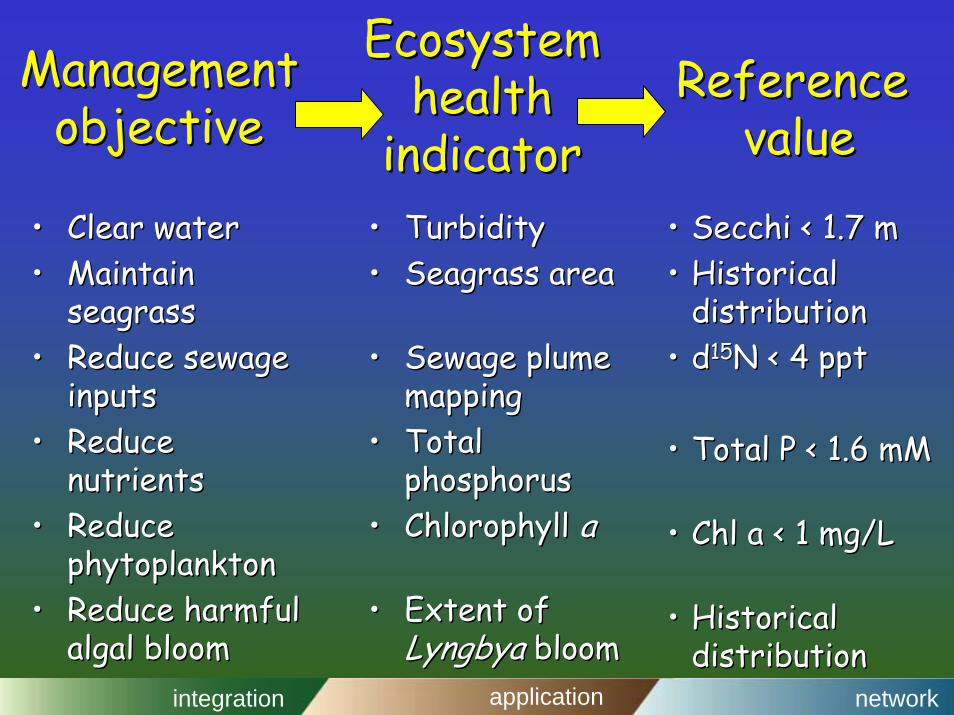
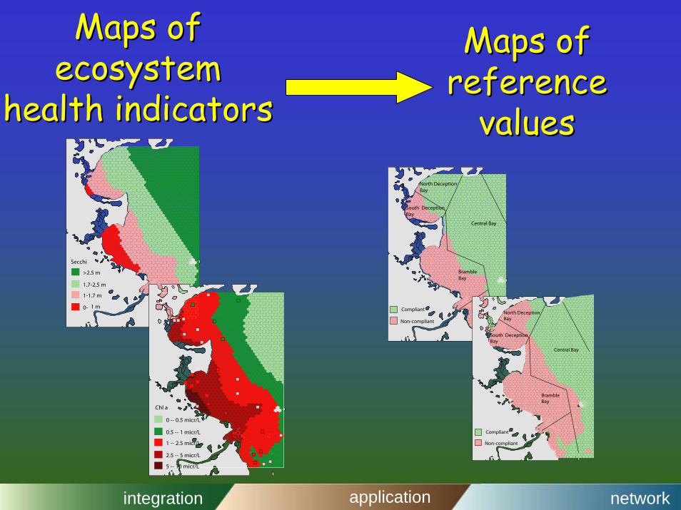
Ecosystem health can beEcosystem health can bemeasured and improved measured and improved
integration application network
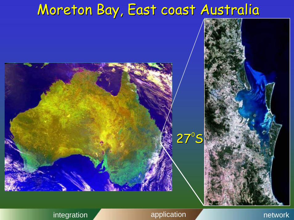
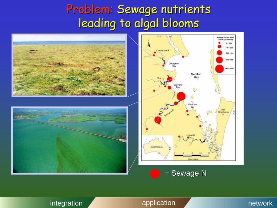
Moreton Bay, East coast AustraliaMoreton Bay, East coast Australia
27 S27 S00
integration application network
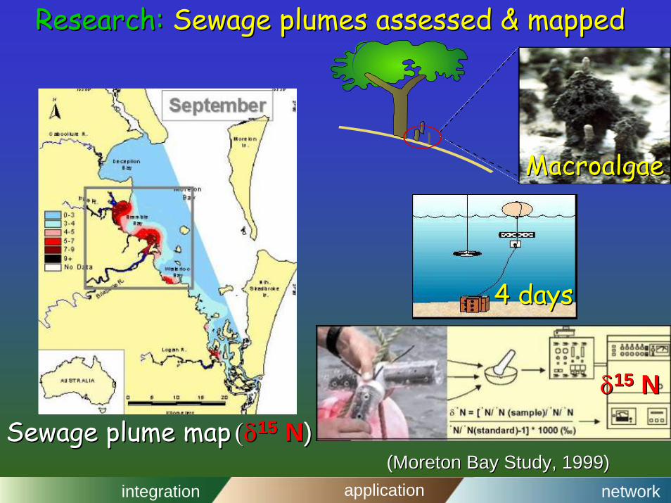
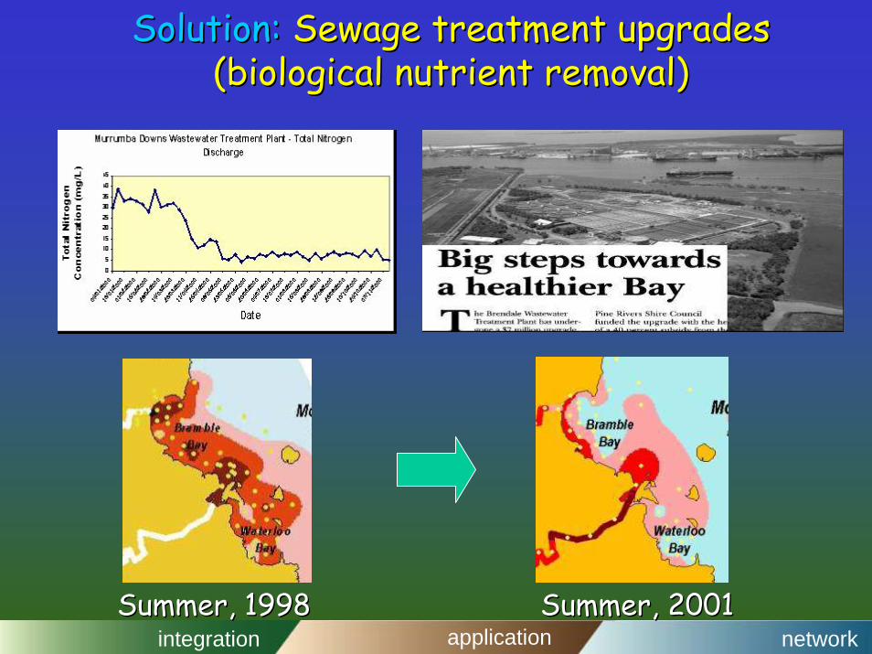
Problem:Problem: Sewage nutrientsSewage nutrientsleading to algal bloomsleading to algal blooms
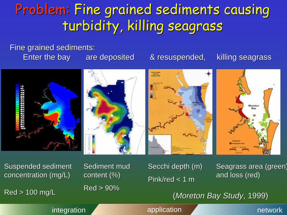
Problem:Problem: Fine grained sediments causing Fine grained sediments causing turbidity, killing seagrassturbidity, killing seagrass
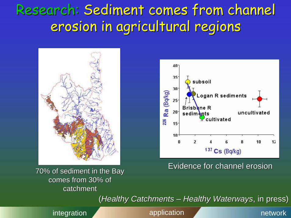
Fine grained sediments:Fine grained sediments:Enter the bay are deposited & resuspended, Enter the bay are deposited & resuspended, killing seagrasskilling seagrass
((Moreton Bay StudyMoreton Bay Study, 1999) , 1999)
Sediment mud Sediment mud content (%) content (%)
Red > 90%Red > 90%
Secchi depth (m)Secchi depth (m)
Pink/red < 1 m Pink/red < 1 m
Seagrass area (green)Seagrass area (green)and loss (red)and loss (red)
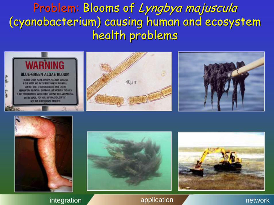
Problem:Problem: Blooms of Blooms of Lyngbya majusculaLyngbya majuscula(cyanobacterium) causing human and ecosystem (cyanobacterium) causing human and ecosystem
health problemshealth problems
40µm
integration application network
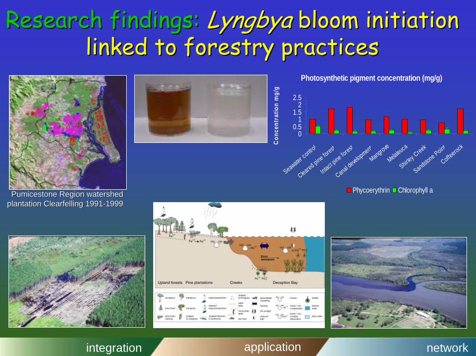
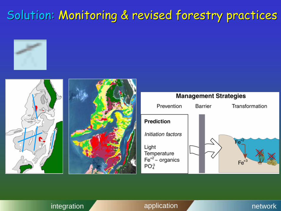
Research findings:Research findings: LyngbyaLyngbya bloom initiation bloom initiation linked to forestry practiceslinked to forestry practices
Photosynthetic pigment concentration (mg/g)
00.5
11.5
22.5
Seawater control
Cleared pine forest
Intact pine forest
Canal development
Mangrove
Melaleuca
Shirley Creek
Sandstone Point
CoffeerockConc
entr
atio
n m
g/g
Phycoerythrin Chlorophyll aPumicestonePumicestone Region watershedRegion watershedplantation plantation ClearfellingClearfelling 19911991--19991999
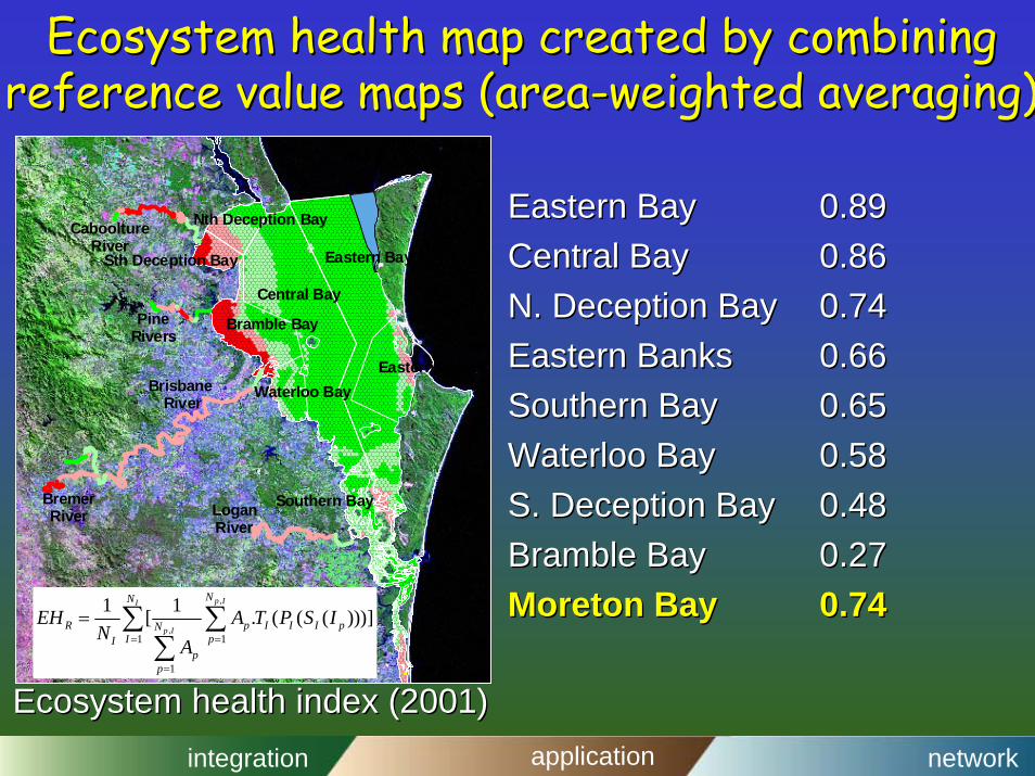
Ecosystem health map created by combining Ecosystem health map created by combining reference value maps (areareference value maps (area--weighted averaging)weighted averaging)
Eastern BayEastern Bay 0.890.89Central BayCentral Bay 0.860.86N. Deception BayN. Deception Bay 0.740.74Eastern BanksEastern Banks 0.660.66Southern BaySouthern Bay 0.650.65Waterloo BayWaterloo Bay 0.580.58S. Deception BayS. Deception Bay 0.480.48Bramble BayBramble Bay 0.270.27Moreton BayMoreton Bay 0.740.74
Southern Bay
Sth Deception Bay
Central Bay
Waterloo Bay
Bramble Bay
Nth Deception Bay
Eastern Bay
Eastern Banks
LoganRiver
CabooltureRiver
PineRivers
Brisbane River
BremerRiver
,
,1 1
1
1 1[ . ( ( ( )))]p II
p I
NN
R p I I I pNI pI
pp
EH A T P S IN
A= =
=
= ∑ ∑∑
Ecosystem health index (2001)Ecosystem health index (2001)
integration application network
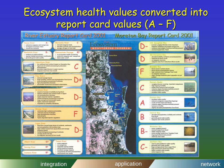
Ecosystem health values converted into Ecosystem health values converted into report card values (A report card values (A –– F)F)
integration application network
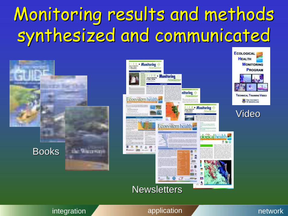
Monitoring results and methods Monitoring results and methods synthesized and communicatedsynthesized and communicated
NewslettersNewsletters
VideoVideo
BooksBooks
integration application network
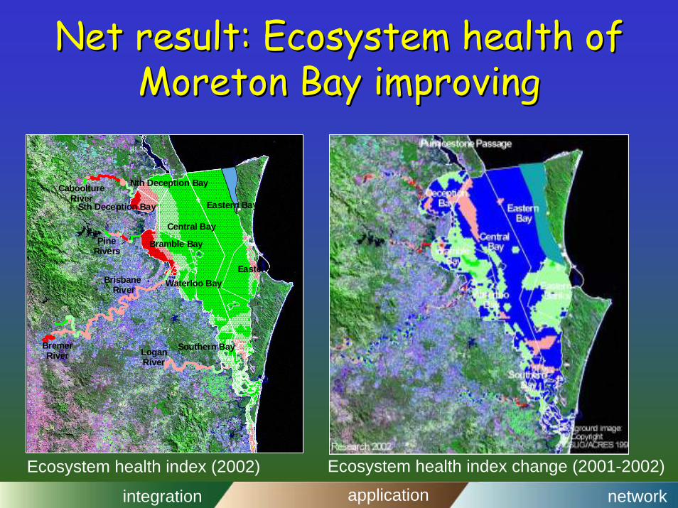
Net result: Ecosystem health of Net result: Ecosystem health of Moreton Bay improvingMoreton Bay improving
Southern Bay
Sth Deception Bay
Central Bay
Waterloo Bay
Bramble Bay
Nth Deception Bay
Eastern Bay
Eastern Banks
LoganRiver
CabooltureRiver
PineRivers
Brisbane River
BremerRiver
Ecosystem health index change (2001-2002)Ecosystem health index (2002)
integration application network
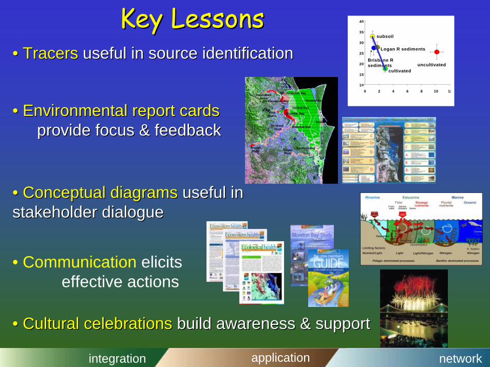
Key LessonsKey Lessons
0 2 4 6 8 10 1210
15
20
25
30
35
40
uncultivated
subsoil
cultivated
Brisbane Rsediments
Logan R sediments
Southern Bay
Sth Deception Bay
Central Bay
Waterloo Bay
Bramble Bay
Nth Deception Bay
Eastern Bay
Eastern Banks
LoganRiver
CabooltureRiver
PineRivers
Brisbane River
BremerRiver
•• Tracers Tracers useful in source identificationuseful in source identification
•• Cultural celebrations Cultural celebrations buildbuild awareness & supportawareness & support
RecommendationsRecommendations•• Ecological economics can provide Ecological economics can provide key indicatorskey indicators for for
assessment and monitoringassessment and monitoring
•• The next major global scientific effort, environmental The next major global scientific effort, environmental problem solving, will require the type of problem solving, will require the type of transdisciplinarytransdisciplinarysciencescience that ecological economics practicesthat ecological economics practices
•• Both human and ecosystem health are rapidly changing Both human and ecosystem health are rapidly changing and and creative solutions are possiblecreative solutions are possible
•• The well resourced countries need to become The well resourced countries need to become world world leadersleaders in environmental problem solvingin environmental problem solving
integration application network
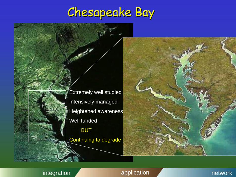
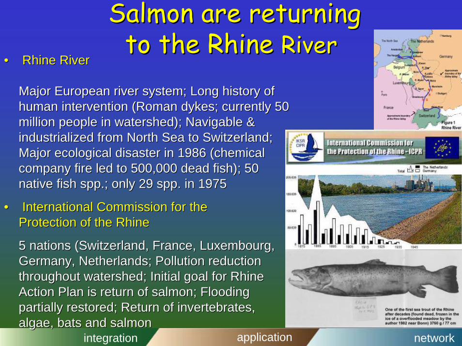
Salmon are returningSalmon are returningto the Rhine to the Rhine RiverRiver
•• Rhine RiverRhine River
Major European river system; Long history of Major European river system; Long history of human intervention (Roman dykes; currently 50 human intervention (Roman dykes; currently 50 million people in watershed); Navigable & million people in watershed); Navigable & industrialized from North Sea to Switzerland; industrialized from North Sea to Switzerland; Major ecological disaster in 1986 (chemical Major ecological disaster in 1986 (chemical company fire led to 500,000 dead fish); 50 company fire led to 500,000 dead fish); 50 native fish spp.; only 29 spp. in 1975native fish spp.; only 29 spp. in 1975
•• International Commission for theInternational Commission for theProtection of the RhineProtection of the Rhine
5 nations (Switzerland, France, Luxembourg, 5 nations (Switzerland, France, Luxembourg, Germany, Netherlands; Pollution reduction Germany, Netherlands; Pollution reduction throughout watershed; Initial goal for Rhine throughout watershed; Initial goal for Rhine Action Plan is return of salmon; Flooding Action Plan is return of salmon; Flooding partially restored; Return of invertebrates,partially restored; Return of invertebrates,algae, bats and salmonalgae, bats and salmon
integration application network
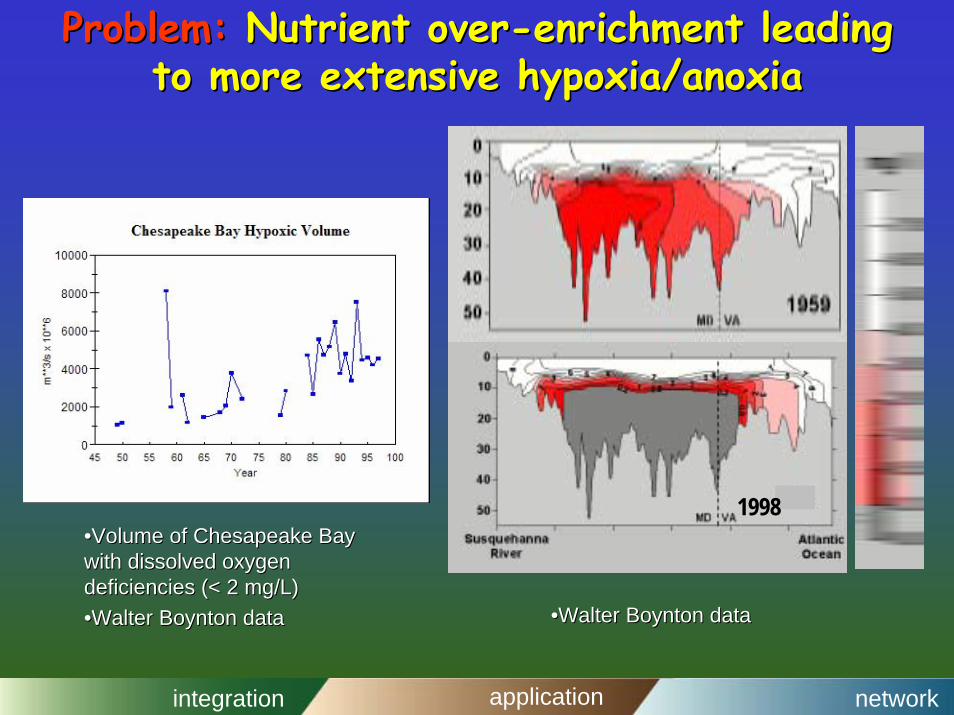
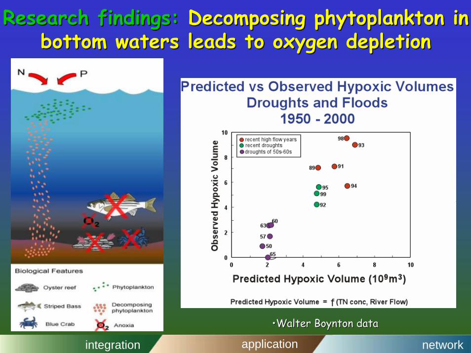
Problem:Problem: Nutrient overNutrient over--enrichment leading enrichment leading to more extensive hypoxia/anoxiato more extensive hypoxia/anoxia
1998••Volume of Chesapeake Bay Volume of Chesapeake Bay with dissolved oxygen with dissolved oxygen deficiencies (< 2 mg/L)deficiencies (< 2 mg/L)••Walter Boynton dataWalter Boynton data ••Walter Boynton dataWalter Boynton data
integration application network
Research findings:Research findings: Decomposing phytoplankton in Decomposing phytoplankton in bottom waters leads to oxygen depletionbottom waters leads to oxygen depletion
••Walter Boynton dataWalter Boynton data
integration application network
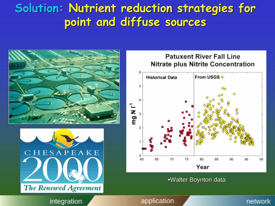
Solution:Solution: Nutrient reduction strategies for Nutrient reduction strategies for point and diffuse sourcespoint and diffuse sources
••Walter Boynton dataWalter Boynton data
integration application network
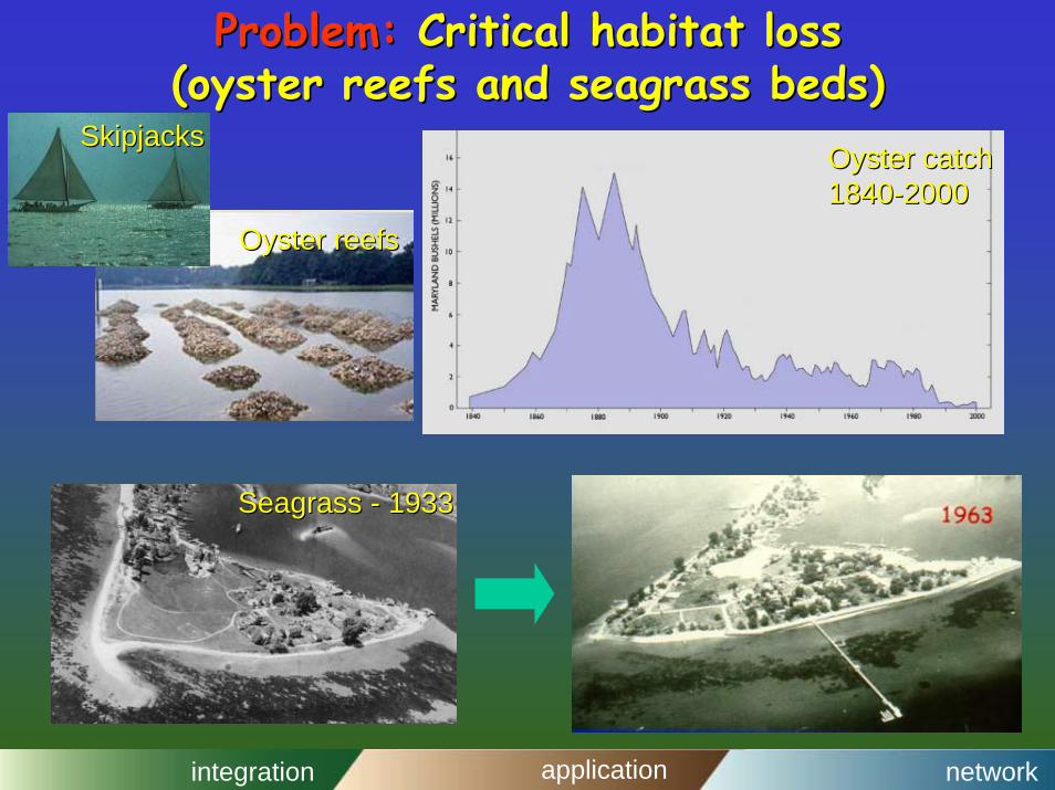
Problem:Problem: Critical habitat loss Critical habitat loss (oyster reefs and seagrass beds)(oyster reefs and seagrass beds)
Oyster reefsOyster reefs
Oyster catchOyster catch18401840--20002000
SkipjacksSkipjacks
Seagrass Seagrass -- 19331933
integration application network
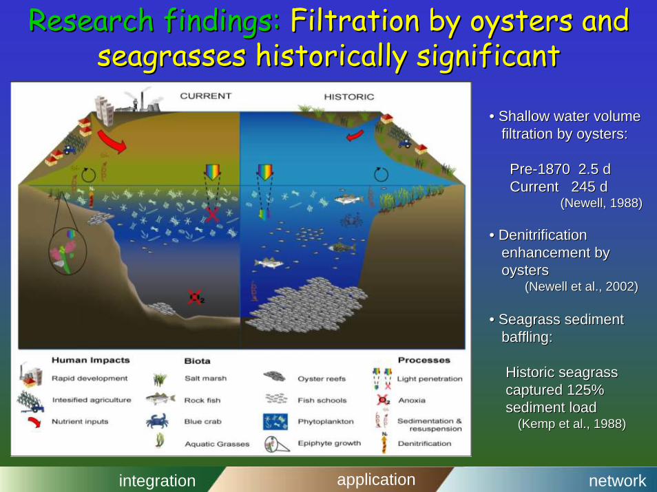
Research findings:Research findings: Filtration by oysters and Filtration by oysters and seagrasses historically significant seagrasses historically significant
•• Shallow water volumeShallow water volumefiltration by oysters:filtration by oysters:
PrePre--1870 2.5 d1870 2.5 dCurrent 245 d Current 245 d
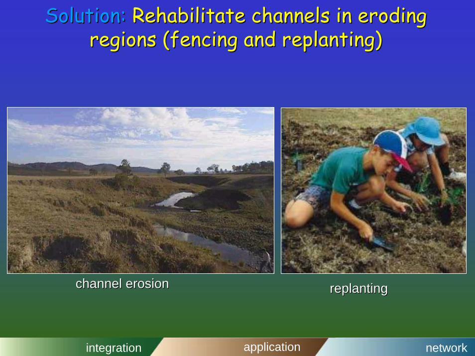
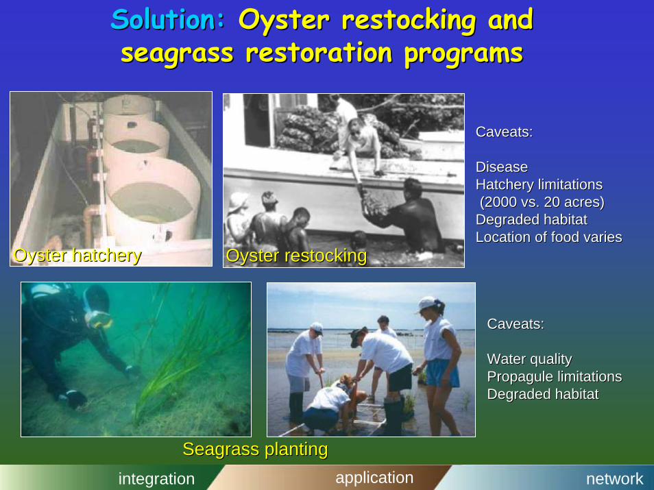
Solution:Solution: Oyster restocking and Oyster restocking and seagrass restoration programsseagrass restoration programs
Oyster restockingOyster restocking
Caveats:Caveats:
DiseaseDiseaseHatchery limitationsHatchery limitations(2000 vs. 20 acres)(2000 vs. 20 acres)
Degraded habitatDegraded habitatLocation of food variesLocation of food varies
Oyster hatcheryOyster hatchery
Caveats:Caveats:
Water qualityWater qualityPropagulePropagule limitationslimitationsDegraded habitatDegraded habitat
Seagrass plantingSeagrass planting
integration application network
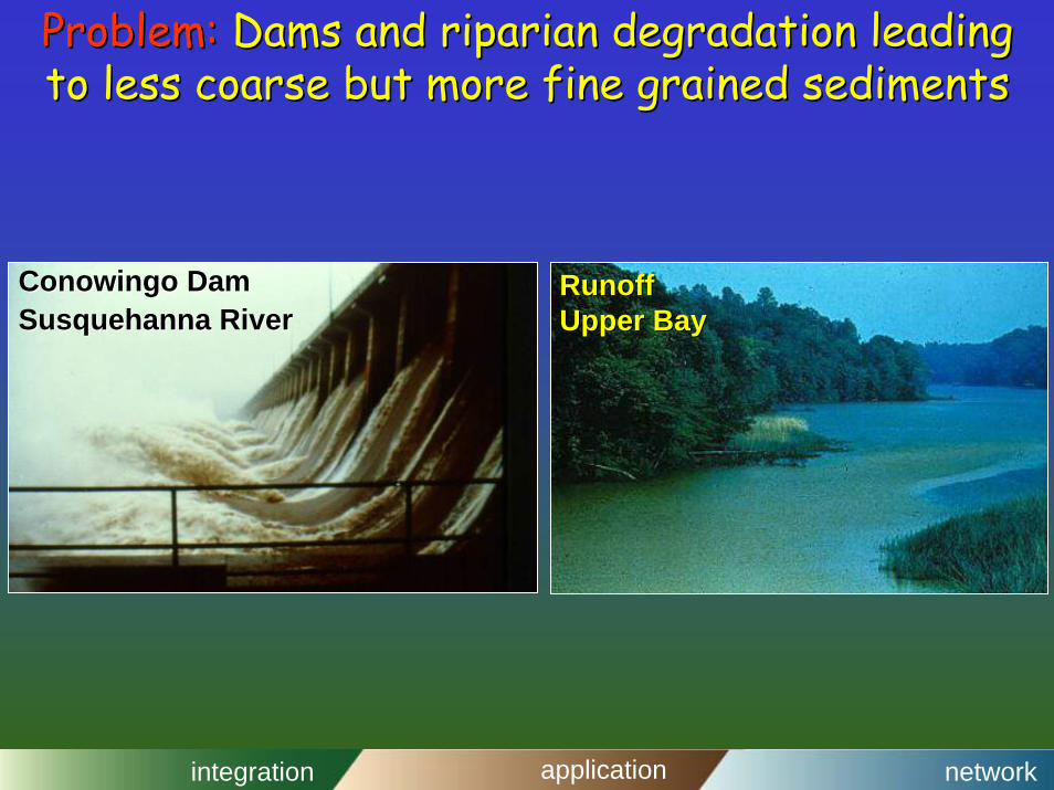
Problem:Problem: Dams and riparian degradation leading Dams and riparian degradation leading to less coarse but more fine grained sedimentsto less coarse but more fine grained sediments
ConowingoConowingo DamDamSusquehanna RiverSusquehanna River
RunoffRunoffUpper BayUpper Bay
integration application network
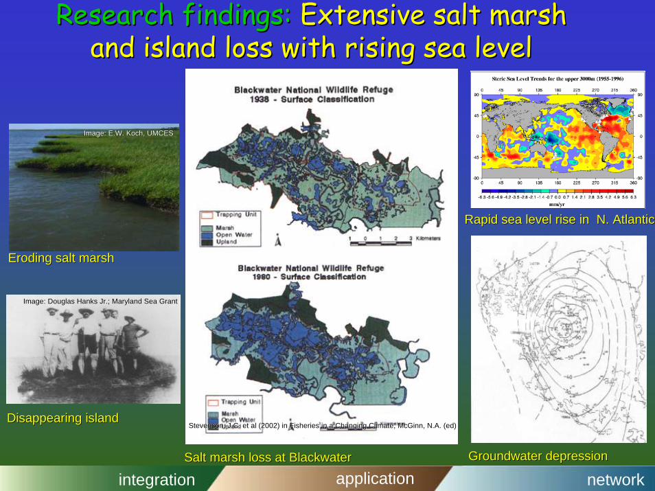
Research findings:Research findings: Extensive salt marsh Extensive salt marsh and island loss with rising sea leveland island loss with rising sea level
Eroding salt marshEroding salt marsh
Disappearing islandDisappearing island
Groundwater depressionGroundwater depression
Rapid sea level rise in N. AtlanticRapid sea level rise in N. Atlantic
Salt marsh loss at Salt marsh loss at BlackwaterBlackwater
Image: E.W. Koch, UMCESImage: E.W. Koch, UMCES
Image: Douglas Hanks Jr.; Maryland Sea GrantImage: Douglas Hanks Jr.; Maryland Sea Grant
Stevenson, J.C. et al (2002) in Fisheries in a Changing Climate,Stevenson, J.C. et al (2002) in Fisheries in a Changing Climate, McGinnMcGinn, N.A. (ed), N.A. (ed)
integration application network
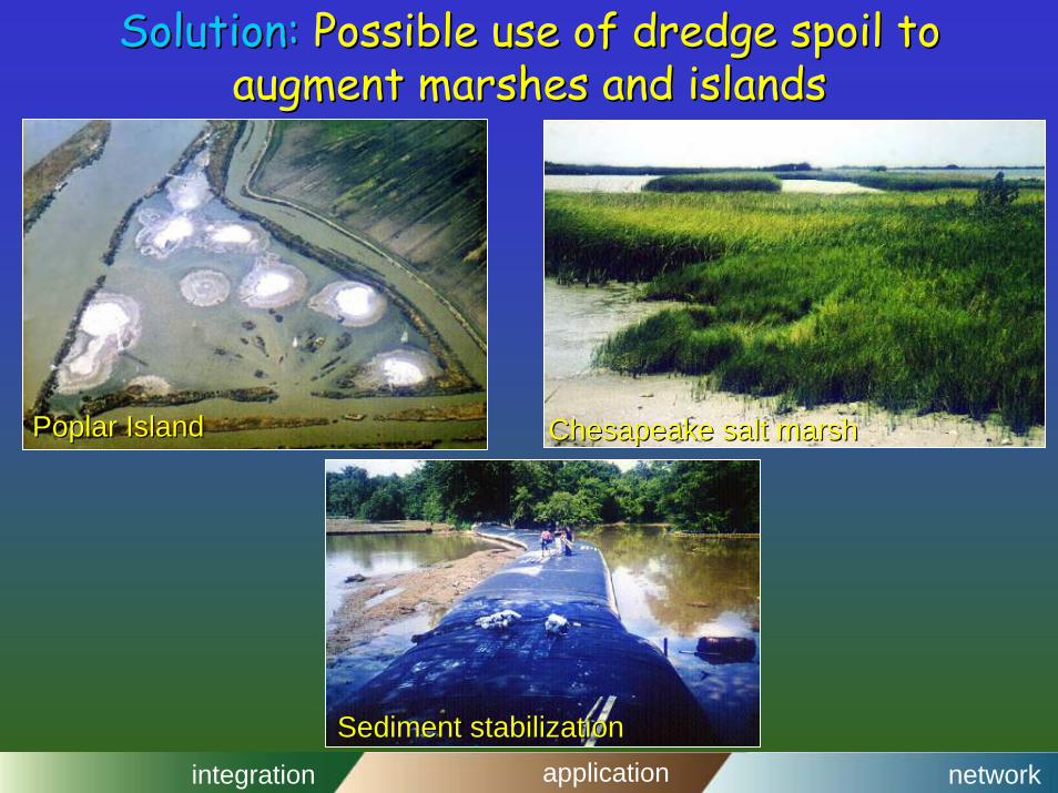
Solution:Solution: Possible use of dredge spoil to Possible use of dredge spoil to augment marshes and islandsaugment marshes and islands
Poplar IslandPoplar Island Chesapeake salt marshChesapeake salt marsh
Sediment stabilizationSediment stabilization
integration application network
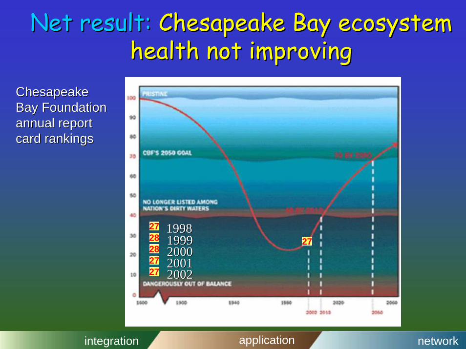
Net result:Net result: Chesapeake Bay ecosystem Chesapeake Bay ecosystem health not improvinghealth not improving
272828
2727
271998199819991999200020002001200120022002
Chesapeake Chesapeake Bay Foundation Bay Foundation annual report annual report card rankingscard rankings
integration application network
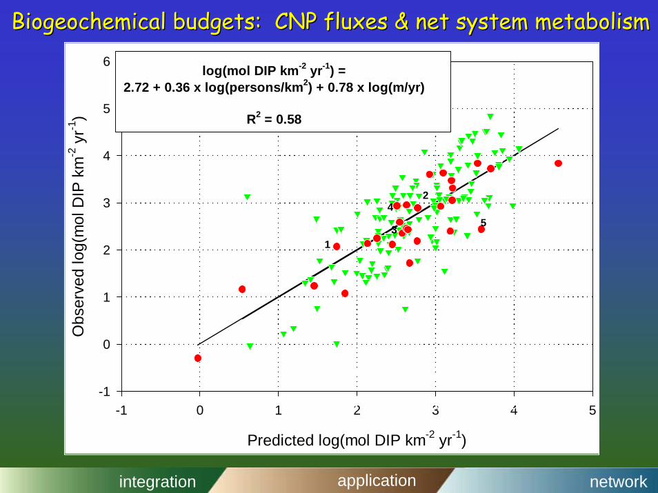
Biogeochemical budgets: CNP fluxes & net system metabolismBiogeochemical budgets: CNP fluxes & net system metabolism
Predicted log(mol DIP km-2 yr-1)
-1 0 1 2 3 4 5
Obs
erve
d lo
g(m
ol D
IP k
m-2
yr-1
)
-1
0
1
2
3
4
5
6 log(mol DIP km-2 yr-1) =2.72 + 0.36 x log(persons/km2) + 0.78 x log(m/yr)