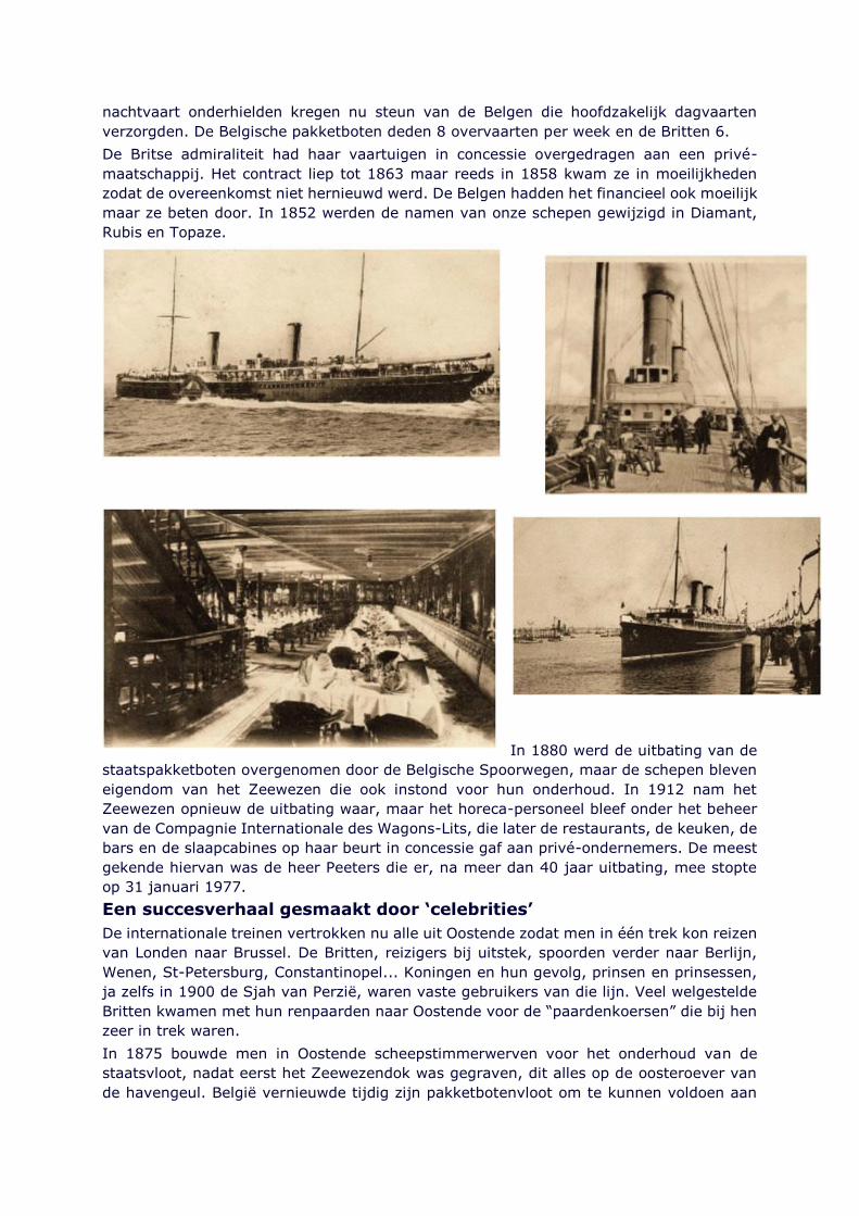
Page 1
INSERE 12/02/16 NIEUWS NOUVELLES NEWS ENLEVE 12/03/16
Low sulphur problems are emerging
More problems are coming to light with low sulphur fuel oil, which if not addressed could
lead to costly vessel breakdowns and even severe damage to the engine.
BIMCO, courtesy of the Britannia P&I Club, has warned of paraffin being formed when using
low sulphur gasoil (MGO) in northern European waters during the winter.
The reports state that MGO blend DMA 0.1%, which was analysed to be within the
specifications for ISO 8217, has been forming large amounts of paraffin in the MGO tanks,
which has caused problems.
The cloud point for this MGO was 32 deg C, which is the temperature where paraffin starts
to form, but the cloud point is not part of the ISO 8217 specification.
Operators are advised to find out the cloud point, as well as the pour point prior to the
bunkering operation. They should also think about whether it is necessary to stem DMX
grade MGO, if they are trading in the Baltic or other areas where traditionally there are low
sea temperatures.
This would enable any operator to obtain the cloud point beforehand, since it is part of the
DMX specification, the report explained.
Paraffin problems
Skuld, in association with Chris Fisher of Brookes Bell, has also warned of bunkering ultra-
low sulphur gas oils for use in ECAs, particularly noting the presence of a considerable
quantity of paraffin in the product offered for supply and forming in the product post supply,
following criticisms from its members.
This may be partly due to the demand for MGO since 1st January, 2015. This has been
such that it is now being sourced from a wider field and that quality standards are under
pressure. The blending of biodiesel with conventional diesel fuel could also in part explain
this problem.
Agreeing with BIMCO, Skuld said that it could also be a seasonal factor, due to low
temperature conditions accelerating the formation of paraffin wax. This particular issue
may cause excessive build-up of sludge in the engine system and even a possible loss of
power.
Gas oils, as well as alternative 0.1% sulphur content fuels, available in the market are
‘paraffinic’ and if mixed with regular heavy fuels, an unstable mixture may follow.
Sludge build up
As there will be a certain amount of mixing, following a switch over between fuel types, in
the lines to the engines (unless completely separate lines are available), it is important for
the engineers to carefully check against the build-up of sludge. An excessive amount could
block fuel lines leading to a power loss.
It may be necessary to ensure that gas oil is placed into a tank with heating coils. However,
some vessels with designated MDO/MGO tanks do not have heating coils installed, the
report noted.
IBIA’s Peter Hall said at the Navigate/IPTA Product and Chemical Tanker Conference last
month that that marine fuel supply was a changing scene. He explained that the HFO to
Page 2
MGO split has narrowed to about 60:40 and there were more distillates being presented fo
testing- around 15%.
He said that the challenges were the new fuels with wider formula variations and the fuel
switching problems. Since the new regulations came into force, sampling has become a
“whole new ball game” to get the correct fuel.
Suppliers tend to blend to the upper limit o the specification due to financial reasons.
Another problem is what is described in the contract and what Port State Control says upon
an inspection may be totally different interpretations of the same fuel.
Testing in a credited laboratory could give one answer, but the same test in another
laboratory could give a different result, due to the chemistry involved giving a range of
results in different circumstances.
He said that often it was a case of the ISO Standard versus MARPOL, which can lead to
ambiguity due to conflicting parameters. “This breeds uncertainty and it hasn’t been
addressed properly,” Hall said. He pointed to the high costs associated with de-bunkering
and the commercial issues that could arise from such an operation.
Partnerships
IBIA has what it calls a ‘twin track approach’ to work in partnership with stakeholders. One
example is a ports charter. Thus far Singapore, Rotterdam, Antwerp and Gibraltar have
joined, but Hall called for more ports to sign up.
The association has written a questionnaire for the IMO correspondence group on fuel
quality. Proposals were put to both MEPC 66 and 67 to the effect that the fuel should
contain nothing that wasn’t fit for purpose and a paper will be submitted to MEPC 68.
He argued that the Note of Protest should be used to look at why a stem went wrong and
to get to the root cause of any problems that had occurred. Hall thought that Port State
Control could undertake this task as a rogue delivery will cause a supplier and the port a
bad reputation.
Hall also warned that refineries would need five years to reach the specification for the
2020/2025 cap. He said that the fuel characteristics were “all over the place- a warning for
2020/2025.”
He argued by saying that the industry was on a learning curve, which will take time.
TankerOperator
INSERE 14/02/16 HISTORIEK HISTORIQUE ENLEVE 144/03/16
La côte belge convoitée par la Kaiserliche Marine
Luc Vandeweyer
Dans les années qui ont précédé 1914, le commandement de l’armée allemande élabora
minutieusement un grand plan d’attaque. L’idée maîtresse était qu’une progression
allemande massive à travers la Belgique constituait le meilleur moyen de battre l’armée
Page 3
de terre française dès la phase initiale de la guerre. Ensuite, l’armée pourrait se concentrer
sur l’armée russe à l’est.
Il s’agissait donc essentiellement d’une stratégie continentale visant à éliminer les
principales armées ennemies. Pourtant, l’empire disposait aussi d’une flotte de guerre dont
la puissance n’était surpassée que par celle de la Royal Navy britannique, mais elle ne se
vit confier aucun rôle d’importance dans le plan d’attaque. L’amirauté allemande n’avait
pas l’intention d’en rester là. Elle chercha des opportunités et était donc très intéressée
par la marche à travers la Belgique car cela pouvait lui permettre d’obtenir le contrôle de
la bande côtière de la Belgique et du Nord de la France. Le contrôle des ports dans cette
zone améliorerait considérablement sa position stratégique par rapport à la marine
britannique.
L’amirauté avait donc une toute autre vision de la guerre à venir que les généraux de
l’armée de terre.
La stratégie de l’amirauté allemande
La marine ne reçut du commandement suprême de l’armée qu’une mission purement
défensive. Elle devait protéger la côte allemande, rien de plus. L’amirauté pensait toutefois
en termes d’empire colonial, d’approvisionnement en nourriture et en matières premières,
et visait donc à maintenir l’ouverture des voies maritimes. C’est la raison pour laquelle, à
ses yeux, l’ennemi le plus à craindre n’était pas la France mais le Royaume-Uni. La flotte
britannique pouvait en effet fermer la Mer du Nord. Pour parer à ce danger, l’amirauté
allemande devait être en mesure de nuire à la force britannique en mer. À cela, il faut
ajouter le fait que sa figure centrale, le Grossadmiral Alfred von Tirpitz, avait des
dispositions très pangermaniques. Pour lui, cette guerre n’était pas une fin, mais une
première étape vers la « quête du pouvoir mondial » (Griff nach der Weltmacht).
L’offensive fut lancée le 4 août 1914. Le gros de l’armée allemande envahit la Belgique
neutre dans sa route vers la France. Le gouvernement britannique réagit immédiatement
par une déclaration de guerre et un envoi de troupes sur le sol français. Il avait bien
compris que l’armée de terre allemande pouvait s’emparer de la côte continentale face à
l’Angleterre, ce qui entraînerait un glissement de l’équilibre stratégique des forces au profit
de la marine allemande. Les Britanniques étaient donc prêts à tout pour préserver l’armée
de terre française d’une défaite. Mais les généraux allemands voulaient-ils vraiment
prendre la côte? Il semblait que non, du moins d’après le plan d’attaque. Les circonstances
allaient toutefois rapidement changer.
En route vers les ports de Flandre
Page 4
Le premier conflit avec les troupes britanniques
eut lieu près de Mons, dans le Hainaut,
quelques semaines après l’invasion. Les
Britanniques avaient en effet renforcé le flanc
gauche français. C’est justement ce flanc qui
devait être écrasé le plus rapidement possible
par les assaillants allemands.
Pendant ce temps, la marine protégeait la côte
allemande. L’amirauté pensait toutefois qu’elle
devait jouer un rôle beaucoup plus actif. Fin
août, elle regroupa ses régiments de fusiliers
marins en une division qu’elle envoya vers le
territoire belge. Ces hommes en uniforme bleu
arrivaient à point nommé pour les Allemands,
car la force d’invasion était alors mise en
difficulté sur son flanc nord par l’agressivité de
l’armée belge, qui menait des attaques à
grande échelle depuis la place forte d’Anvers.
Les fusiliers marins allemands devaient aider à
protéger le flanc nord de la zone de
progression.
Le 23 août, l’amiral Ludwig von Schróder fut
nommé commandant de cette division. Depuis
des années, sur l’ordre de von Tirpitz, il avait
élaboré un plan pour prendre le port d’Anvers
par une attaque surprise. Il faisait partie des
officiers de marine qui étaient parfaitement conscients de l’importance des ports belges.
Ce n’est donc pas un hasard si ses hommes étaient positionnés juste au sud de la ceinture
de forts anversoise. Le fait que l’un des plus grands ports européens se trouvait ainsi à
portée n’était évidemment pas sans importance pour la stratégie maritime de l’amirauté
allemande.
Les Britanniques l’avaient eux aussi compris, cela devint une évidence lorsque la présence
de Royal Marines fut décelée. Le ministre britannique Winston Churchill avait fait
transporter ces troupes dans des bus depuis le port de Zeebruges en direction d’Anvers
afin d’offrir un appui visible à l’armée belge.
Pour les soldats de la marine allemande, cela constitua un changement radical. Au lieu de
se préparer à assurer des tâches militaires dans les colonies, ou à défendre leurs ports, ils
étaient à présent mobilisés en tant qu’unité « de terrain », tout comme des troupes
ordinaires de l’armée de terre.
Ostende aux mains des Allemands
Le plan d’attaque de l’armée de terre échoua autour du 8-9 septembre durant la bataille
de la Marne. Ce n’est qu’alors que les regards se tournèrent une nouvelle fois vers le nord.
L’armée française ayant échappé à l’anéantissement, il devint important pour les
Allemands d’occuper un espace stratégique au nord. Il fallait conquérir la place forte
d’Anvers, et avec elle le port.
Page 5
Les fusiliers marins allemands
furent affectés à un corps
d’armée nouvellement
constitué dirigé par le général
Hans von Beseler. Il devait
percer la place forte d’Anvers
et si possible neutraliser
l’armée belge. Il s’était vu
confier l’artillerie de siège
lourde et avait donc de
grandes chances d’y parvenir.
Toutefois, lorsque la place
forte d’Anvers dut se rendre le
10 octobre, l’armée de
campagne belge était déjà en
route vers la côte. Entre-
temps, le quartier-général
français avait lui aussi compris qu’il devait envoyer davantage de troupes vers le nord.
C’était en effet la seule région où les Allemands tentaient encore de gagner du terrain.
C’est ainsi qu’arriva en Belgique, entre autres, une brigade de fusiliers marins français, les
« pompons rouges ». Leur première confrontation avec la force d’invasion allemande eut
lieu près de Melle, au sud-est de Gand.
Cela ne stoppa toutefois pas la progression allemande. Le centre de gravité de la bataille
se déplaça vers la Flandre occidentale. Dès lors, les alliés ne parvinrent pas à faire
aménager par l’armée belge une nouvelle base dans la région d’Ostende. Les troupes
devaient continuer en direction de la frontière française. Au dernier moment, il fut décidé
de maintenir la position près de l’Yser. La progression allemande put y être contenue fin
Page 6
octobre, au terme de furieux combats. Les forces navales françaises et britanniques
jouèrent toutes deux un rôle important à cet égard. Les fusiliers marins français défendirent
Dixmude avec acharnement. Des bateaux britanniques appelés « monitors » pénétrèrent
les eaux côtières et bombardèrent les régiments allemands à l’aide de canons lourds. Il
devint évident pour la marine allemande que les amirautés britannique et française étaient
prêtes à tout pour éloigner les Allemands du littoral français.
Parmi les troupes allemandes en marche, on trouvait aussi des soldats de la marine. Les
troupes de von Schróder ne prirent pas uniquement possession du port d’Anvers. Une
partie d’entre elles furent envoyées à Bruges en train, via Bruxelles. De là, elles marchèrent
en direction de la ligne de combat dans la plaine de l’Yser. Mais la majorité occupa Bruges
et les communes côtières.
Un des médecins de bataillon se retrouva à Ostende, une station balnéaire mondaine qu’il
connaissait d’avant la guerre.
Au lieu de riches touristes, la ville était pleine de militaires allemands, de soldats sur leurs
gardes. Pas sans raison s’avéra-til, car le 23 octobre, la ville fut lourdement bombardée
par des navires de guerre britanniques. À partir de ce moment, plus personne ne put
accéder à la plage, afin d’éviter les pertes inutiles en cas de nouveau bombardement. La
plage et la digue avaient donc un tout autre aspect que durant la période de paix qui avait
précédé. Il s’avéra, au cours des semaines et mois qui suivirent, que le danger n’était pas
écarté. Les navires de guerre britanniques continuaient de s’aventurer devant la côte et
les occupants allemands durent faire face à plusieurs pluies de grenades.
Pendant ce temps, les alliés parvinrent à empêcher que les ports du Nord de la France ne
soient occupés. Ostende et Zeebruges tombèrent toutefois inéluctablement aux mains des
Allemands. De plus, les installations portuaires étaient pratiquement intactes. C’était
également le cas à Anvers. Néanmoins, les Néerlandais ayant conservé leur neutralité et
fermé l’Escaut aux navires de guerre, Anvers n’avait qu’une importance limitée pour la
poursuite des combats en mer.
Il s’agissait à présent d’élaborer une stratégie pour une guerre de longue haleine. La
marine allemande avait la ferme intention d’exploiter au maximum l’étroite bande côtière
de la Flandre occidentale. C’est là qu’elle était la plus proche de la côte britannique et des
ports de débarquement, depuis lesquels les troupes britanniques partaient pour le front de
l’Ouest. La côte belge devait lui permettre d’infliger de lourdes pertes à l’ennemi.
Les ports maritimes comme bases d’opérations
Page 7
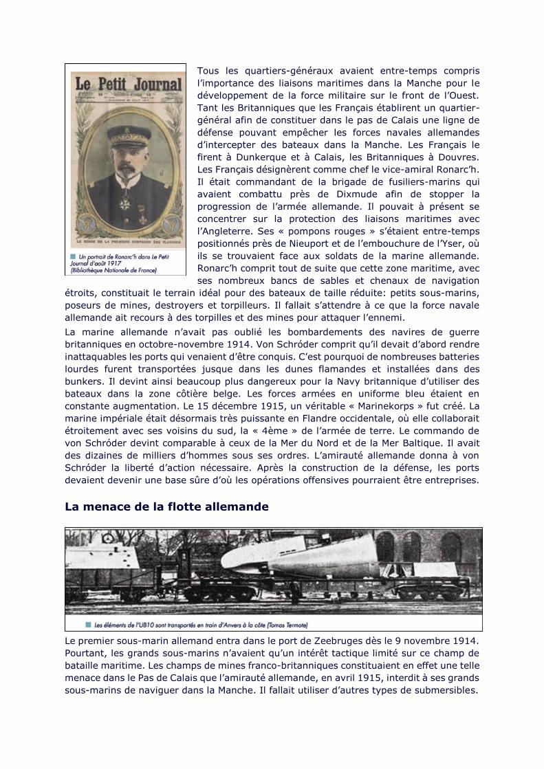
Tous les quartiers-généraux avaient entre-temps compris
l’importance des liaisons maritimes dans la Manche pour le
développement de la force militaire sur le front de l’Ouest.
Tant les Britanniques que les Français établirent un quartier-
général afin de constituer dans le pas de Calais une ligne de
défense pouvant empêcher les forces navales allemandes
d’intercepter des bateaux dans la Manche. Les Français le
firent à Dunkerque et à Calais, les Britanniques à Douvres.
Les Français désignèrent comme chef le vice-amiral Ronarc’h.
Il était commandant de la brigade de fusiliers-marins qui
avaient combattu près de Dixmude afin de stopper la
progression de l’armée allemande. Il pouvait à présent se
concentrer sur la protection des liaisons maritimes avec
l’Angleterre. Ses « pompons rouges » s’étaient entre-temps
positionnés près de Nieuport et de l’embouchure de l’Yser, où
ils se trouvaient face aux soldats de la marine allemande.
Ronarc’h comprit tout de suite que cette zone maritime, avec
ses nombreux bancs de sables et chenaux de navigation
étroits, constituait le terrain idéal pour des bateaux de taille réduite: petits sous-marins,
poseurs de mines, destroyers et torpilleurs. Il fallait s’attendre à ce que la force navale
allemande ait recours à des torpilles et des mines pour attaquer l’ennemi.
La marine allemande n’avait pas oublié les bombardements des navires de guerre
britanniques en octobre-novembre 1914. Von Schróder comprit qu’il devait d’abord rendre
inattaquables les ports qui venaient d’être conquis. C’est pourquoi de nombreuses batteries
lourdes furent transportées jusque dans les dunes flamandes et installées dans des
bunkers. Il devint ainsi beaucoup plus dangereux pour la Navy britannique d’utiliser des
bateaux dans la zone côtière belge. Les forces armées en uniforme bleu étaient en
constante augmentation. Le 15 décembre 1915, un véritable « Marinekorps » fut créé. La
marine impériale était désormais très puissante en Flandre occidentale, où elle collaborait
étroitement avec ses voisins du sud, la « 4ème » de l’armée de terre. Le commando de
von Schróder devint comparable à ceux de la Mer du Nord et de la Mer Baltique. Il avait
des dizaines de milliers d’hommes sous ses ordres. L’amirauté allemande donna à von
Schróder la liberté d’action nécessaire. Après la construction de la défense, les ports
devaient devenir une base sûre d’où les opérations offensives pourraient être entreprises.
La menace de la flotte allemande
Le premier sous-marin allemand entra dans le port de Zeebruges dès le 9 novembre 1914.
Pourtant, les grands sous-marins n’avaient qu’un intérêt tactique limité sur ce champ de
bataille maritime. Les champs de mines franco-britanniques constituaient en effet une telle
menace dans le Pas de Calais que l’amirauté allemande, en avril 1915, interdit à ses grands
sous-marins de naviguer dans la Manche. Il fallait utiliser d’autres types de submersibles.
Page 8
En attendant, la division construction de ports et canaux, qui avait été attribuée à von
Schröder, faisait de son mieux pour améliorer le plus vite possible les infrastructures
portuaires et les liaisons par navigation intérieure. C’est en effet la navigation intérieure
qui devait permettre d’assurer en grande partie l’approvisionnement. De petits sous-
marins de classe UB et UC furent conçus pour ce champ de bataille. Les « B » étaient
équipés de torpilles, tandis que les « C » étaient spécialisés dans le mouillage de mines
sur les voies de navigation ennemies. L’ U-Bootsflotille Flandern devint une unité autonome
en avril 1915.
Afin de pouvoir
construire ces petits
sous-marins en
nombre suffisant,
l’Allemagne se tourna
vers les chantiers de
construction navale
près d’Anvers. Le 27
juin 1915, les
quartiers-généraux
des divisions belges
sur le front de l’Yser
reçurent un rapport
du service de
renseignements où
figurait une lettre
venant d’Hoboken.
Dans cette lettre, on
pouvait lire que
l’ennemi assemblait
des sous-marins sur le site de Cockerill Yards, à l’aide de pièces ayant été transportées en
train depuis l’Allemagne. Une fois assemblés, les submersibles étaient amenés via les
canaux dans les ports maritimes, où un équipage leur était affecté.
Les UB n’avaient pas de canon de bord. Il pouvaient donc uniquement attaquer à l’aide de
torpilles. Cette technique était détestée et ces sous-marins furent accueillis négativement
par l’opinion publique, y compris dans les pays neutres. C’est pourquoi les Allemands firent
preuve de retenue. Mais cela ne dura pas. Le 1er février 1917, les restrictions quant à
l’utilisation de torpilles furent levées, et la « guerre sous-marine totale » fut annoncée. À
ce moment, 37 sous-marins étaient stationnés dans les bases le long de la côte flamande.
En 1917, un grand nombre de poseurs de mines de classe UC furent mis en service. Ceux-
ci mouillèrent des mines devant de nombreux ports britanniques et français, depuis la
frontière espagnole jusque loin dans la Mer d’Irlande.
Mais il y avait aussi des « Torpedobootstreitkriifte ». Les premiers étaient de petits
torpilleurs de classe A1, eux aussi spécialement conçus pour ces eaux côtières peu
profondes. Ces bateaux avaient aussi été transportés en pièces détachées et assemblés à
Hoboken avant de poursuivre leur chemin par les canaux. Seize exemplaires furent amenés
rien qu’en 1915. En 1916, ils furent suivis par la classe A2, un peu plus grande, puis par
la classe A3, encore plus grande, avec quatre exemplaires en 1917.
Cela représentait à chaque fois un gain de puissance sensible pour la force allemande en
mer.
Page 9
En mars 1916,
des bateaux
encore plus
grands
arrivèrent et
formèrent la Z-
Flotille Flandern,
« Z » pour
Zerstörer
(destroyer). On
en comptait déjà
dix au printemps
1917. Étant
équipés
d’artillerie, ces
bateaux étaient
en mesure de
tirer sur les
troupes belges
dans la région côtière. La Panne, qui était restée jusqu’alors un havre de repos idyllique,
se transforma rapidement en ligne de front où la sécurité était tout sauf garantie. Très tôt
déjà, le commandement de l’armée britannique promit de placer un ballon d’observation
près de la côte pour avertir en cas de bombardement potentiel de la flotte allemande sur
les havres de repos belges.
Ces navires de guerre allemands devaient assurer la sécurité des eaux côtières afin que
les sous-marins puissent entrer et sortir indemnes de Zeebruges et d’Ostende. Autrement
dit, ils constituaient un prolongement des batteries côtières. Ils devaient également enlever
les mines et barrages de filets britanniques. Les Zerstörer furent mobilisés quatre fois pour
bombarder Calais. De plus, les Allemands installèrent de l’artillerie longue portée afin de
bombarder les ports français et la place forte de Dunkerque. Les Allemands étaient
conscients du fait que la présence de leur marine à Ostende et Zeebruges était difficile à
accepter pour les Britanniques. Même si la Flandernflotille ne parvint jamais à vraiment
interrompre le ravitaillement et le renfort des troupes britanniques sur le continent, la
menace de cette perspective continua de peser lourdement sur le moral des Britanniques.
Ce risque ne pouvait toutefois être écarté que par une opération terrestre de grande
envergure.
Passendale et Nieuport durant l’été 1917
Entre-temps, la force militaire britannique sur le front de l’Ouest s’était drastiquement
renforcée. Le commandant en chef Douglas Haig voulait améliorer la position stratégique
britannique en s’emparant de la bande côtière belge. Il procéda par étapes. Grâce à une
série de puissantes attaques successives, il obtint la crête au sud d’Ypres, qui constituait
une meilleure position de départ. Pendant ce temps, il continuait de faire amener des
troupes et du ravitaillement.
Les commandants allemands pressentaient que la Flandre occidentale allait à nouveau
devenir un champ de bataille important. Le 1er juin 1917, une « 3ème Marinedivision » fut
constituée par l’amirauté allemande. Von Schröder eut ainsi davantage de moyens pour le
combat terrestre.
Pendant ce temps, les Britanniques s’étaient octroyé Nieuport et y avaient remplacé les
soldats français. Au cours des semaines suivantes, les Britanniques constituèrent une
Page 10
impressionnante capacité d’artillerie. Mais les batteries côtières lourdes de la marine
impériale avaient la possibilité de bombarder Nieuport à tout moment grâce à leurs
coupoles rotatives.
La météo du 10 juillet 1917 s’annonçait exécrable. Les Britanniques ne pouvaient dès lors
pas compter sur les canons lourds de leur flotte. Le soir, le Marinekorps allemand en profita
pour assaillir des heures durant les positions britanniques entre Nieuport et la mer par des
tirs d’artillerie. Ces tirs furent suivis par une attaque au gaz. Ensuite, les fusiliers marins
allemands foncèrent à travers l’obscurité, armés de lance-flammes, et conquirent les
tranchées britanniques.
Les soldats allemands parvinrent à traverser les dunes jusqu’à l’eau de l’embouchure de
l’Yser. Près de la ville, les Britanniques purent de justesse conserver un petit morceau de
terrain. Le complexe d’écluses où se trouvait le génie belge devint fortement menacé. C’est
à ce moment que s’arrêta la progression allemande. Nieuport ne fut pas conquise, mais les
Britanniques perdirent leurs positions de départ pour une offensive à travers la bande
côtière. Le gain de territoire allemand était donc significatif d’un point de vue stratégique.
Ensuite, les Britanniques menèrent une offensive qui allait être connue sous le nom de «
bataille de Passendale » ou « Troisième bataille d’Ypres ». Ce fut un fiasco total. Le plan
de Haig d’éliminer la marine allemande sur la côte flamande fut un échec complet.
1918, l’année des « offensives finales »
Au cours de l’année 1917, l’empire tsariste russe s’était effondré et après le coup d’État
bolchévique à l’automne, un accord de cessez-le-feu avait été signé. Cela avait permis aux
Allemands de transférer un grand nombre de troupes vers le front de l’Ouest. Celles-ci
allaient leur offrir la puissance de feu nécessaire pour passer à l’offensive au printemps.
L’une de ces offensives tenta une percée au sud
d’Ypres en direction de la côte de la Manche. Cette
attaque se conclut par un bain de sang lors de
combats acharnés près du mont Kemmel. Les
Britanniques avaient déjà prévu qu’ils devraient
défendre leur base près du port de Calais. Les
Français avaient préparé un plan semblable près de
Dunkerque.
Avec deux bastions lourdement défendus faisant dos
à la mer, ils espéraient priver les Allemands de la
victoire pour longtemps.
À ce moment, le gouvernement belge au Havre
pensait vraiment qu’il devrait effectuer la traversée
vers l’Angleterre. Cela ne fut toutefois pas
nécessaire. Les offensives allemandes du printemps
s’essoufflèrent lentement et en août 1918, l’équilibre
des forces penchait à nouveau en faveur des alliés.
Le moment était venu pour ceux-ci de planifier à leur
tour leurs « offensives finales ».
Au nord, un « groupe d’armées des Flandres »
international fut formé, placé officiellement sous le
commandement du roi Albert ter. Les divisions belges
constituaient la force militaire la plus septentrionale.
La zone côtière et les polders furent toutefois laissés de côté dans le plan d’attaque. La
progression belge partit de la région au sud de Dixmude. Le but était d’avancer
systématiquement sur un front large. La côte tomberait ainsi sous contrôle belge.
Page 11
Toutefois, la marche fut relativement lente, ce qui permit à la marine allemande d’éviter
que le Marinekorps Flandern ne soit encerclé, de sorte que l’amiral von Schröder put
rejoindre l’Allemagne après quatre années passées au front. Pendant ce temps, dans le
port d’attache de la flotte impériale à Kiel, la mutinerie avait commencé à gronder. La fin
de la guerre était en vue. Celle-ci signerait également la fin de la marine impériale.
INSERE 16/02/16 DOSSIER ENLEVE 16/03/16
Putting the human at the centre of e-navigation
The IMO’s long and winding road towards an e-navigation future has recently passed an
important point, with the Organisation laying down guidelines for technology companies
developing future systems on how to put the operator at the centre of their technology.
Digital Ship looks at the potential of Human-Centred Design he IMO’s e-navigation
programme has been something of a slow burn-er, with years of discussion and debate
having led to very little concrete movement towards the introduction of new technologies
or methods of ship operation.
However, there is some hope that the cogs in the machine may be beginning to turn.
Following the approval of an e-navigation Strategy Implementation Plan (SIP) by MSC 94
late last year, a list of tasks has been defined which are expected to be completed during
the period 2015–2019 and which will hopefully provide a framework for technology
providers to begin designing products and services to drive the e-navigation era.
This is expected to include the use of existing equipment in different ways, making
modifications to interfaces and controls on some existing onboard equipment, as well as
the addition of completely new technologies and applications.
The SIP prioritises five specific areas – they are:
improved, harmonised and userfriendly bridge design;
means for standardised and automated reporting;
improved reliability, resilience and integrity of bridge equipment and navigation
information;
integration and presentation of available information in graphical displays received
via communication equipment;
improved communication of VTS Service Portfolio (not limited to VTS stations).
For the first of these, the IMO’s sub-committee on Navigation, Communications and Search
and Rescue (NCSR), taking the place of the previous COMSAR and NAV sub-committees,
has now issued a set of guidelines for software quality assurance and human-centred
design following its most recent meeting.
The prior NCSR meeting had established a Correspondence Group on harmonisation of
guidelines related to e-navigation, under the coordination of Australia, creating the draft
text for the documents.
These were considered at the most recent meeting and, following referral to the Navigation
Working Group for finalisation based on those discussions and with the addition of further
technical information submitted by the Republic of Korea, the sub-committee endorsed a
Page 12
draft MSC (Maritime Safety Committee) circular titled Guideline on Software Quality
Assurance and Human-Centred Design for e-navigation, and invited the Committee to
approve it.
That approval was granted at MSC’s 95th session in June, and now IMO mem ber
governments are being invited to bring the guidelines to the attention of all parties
concerned.
New guidelines
The document created by IMO aims to concentrate technology system developers’ focus
on Software Quality Assurance (SQA) and Human-Centred Design (HCD) in the creation of
systems for use within the developing e-navigation framework.
The guidelines note that “Systems so designed, developed and managed throughout their
life cycle deliver improved user performance, being stable and resilient, and, most
importantly, support users in low and high workload environments, such as during
challenging navigation and environmental conditions when users are most vulnerable to
making mistakes and when error management and recovery is essential.”
“Other important benefits include limiting the amount of operator familiarisation training
that is needed and the time and resources required for system maintenance and support.”
Perhaps the most interesting element of this is the Human-Centred Design part of the
guidance. It could be argued that maritime technology has traditionally been extremely
function-focused in its design, with user experience featuring quite low on a list that is
more likely to prioritise meeting type-approval and keeping costs down.
IMO’s guidance on the matter may struggle to have much immediate impact in that regard,
but declaring the issue as important to future development in the sector is a positive step
at least.
As IMO describes it, what ideally would be achieved would be the development of systems
that are specifically designed to suit the characteristics of intended users and the tasks
they perform, rather than requiring users to adapt to a system.
A key component of this is Usability Testing (UT), which tests the ability of systems to
support user needs and helps to identify potential problems and solutions during design
and development stages. The iterative approach used in effective UT will test the design
again and again, as it evolves through rounds of prototyping, testing, analysing and
refining.
In theory this is clearly a worthwhile pursuit and would undoubtedly improve the practical
usability of new technologies that are introduced to the maritime market. However, the
downside is likely to be one of cost, with the repeated additional ‘human’ testing adding
further time and complexity to the equipment or software developer’s purely technical
testing – and perhaps pushing up prices considerably for the end user.
Putting the cost element to one side for the time being, it is worth examining exactly what
IMO is recommending in these guidelines when it comes to system development.
Guidelines
As IMO describes it, its guidelines are intended to be used by all stakeholders involved in
the design and development of e-navigation systems, but are primarily aimed at those who
develop and test e-navigation systems.
The broader stakeholder group includes equipment designers and manufacturers, system
integrators, maritime authorities and regulators, shipbuilders, shipowners, ship operators,
Vessel Traffic Service authorities and Rescue Coordination Centres, while international
organisations such as the International Association of Marine Aids to Navigation and
Page 13
Lighthouse Authorities (IALA) and the International Hydrographic Organization (IHO) are
also expected to take note.
The overarching goal for IMO in this regard is to ensure that all of these players are
maintaining a sufficiently high level of quality when it comes to e-navigation system design
attributes.
Where that becomes a little more complicated is in the fact that the guidance is goal-based
and “not intended to specify or discourage the use of any particular quality assurance,
management process, or testing method,” according to IMO.
This means that detailed specific design requirements have not been created – and as such
there is no exact ‘quality standard’ to test technologies against. Instead, it is suggested
that system developers “be generally familiar with contemporary quality management
processes, software quality assurance and human factors” – which many maritime
technology companies likely already are.
It is also suggested that quality assurance checks be embedded into the development life
cycle process, with the guidelines applying both to the development of new systems and
the modification of existing technologies.
For Human Centred Design specifically, the IMO’s advice is to incorporate a check-list of
six activities into the full development lifecycle for maritime technologies linked to e-
navigation, which we will look at in more detail below.
EHEA and specified context At number one in the six-point checklist is a suggested ‘pre-
activity’ to be carried out at the very beginning of the project to establish an understanding
of usability issues, which IMO refers to as Early Human Element Analysis (EHEA).
Before work begins on the technology being developed it is recommended that the
operation of other similar systems be reviewed first for lessons they can teach in terms of
usability, and that these be documented for consideration in a new project.
This can be helpful in identifying how changes in technology may have an impact on the
human element, in terms of usability.
Following this we move to the second point in the checklist, which is understanding and
specifying the context of use of the system being developed.
As IMO describes it, “Context of use consists of the users' characteristics (and their
associated individual cognitive and physical factors), their goals and interactions with
tasks, stakeholders, physical operating environments (i.e. the work environment where
the e-navigation system is being used), and social and management environments (i.e.
training, the company and its management policies and procedures).”
This is a pretty comprehensive list, and creates quite a significant burden for the system
developer if they need to create extremely detailed plans of the various circumstances the
technology could be expected to be used in, and map out all of the various stakeholders
both on and off a ship that might be impacted by its use.
As IMO notes, this also needs to extend to the area of overlap between the system being
developed and other technology in use within the same environment, so that the context
of use of the combined systems together is understood during the development process.
User requirements
Following the preparatory work of the first two activities (or activity and ‘pre-activity’
perhaps), the third and fourth items listed in the guidelines focus on the specific user
requirements of the system being created.
Specifically, this will include user needs and task-related needs already identified in the
preparatory work with regard to the context of use of the system and its taskrelated
activity.
Page 14
To do this the developer needs to progress those user and contextual needs that have been
identified into an explicit statement of user requirements, as they relate to the intended
context of use and the business objectives of the system.
IMO’s guidelines suggest that attempts to define user requirements (the third activity in
the checklist) should include some or all of the following steps:
1. clarification of system goals;
2. analysis of stakeholders' needs and expectations;
3. analysis of user needs and expectations;
4. resolution of conflicts between different user and task requirements;
5. identification of safety issues (risks and hazards);
6. analysis of training needs;
7. analysis of system/equipment familiarisation requirements;
8. generation of operational concept and top-level system requirements;
9. ensuring the quality of user requirement specifications; and
10. further development and refinement of task-based scenarios and test cases. The
fourth activity of producing and developing design solutions to meet user
requirements should follow, applying the knowledge gained earlier about the
intended context of use, including user roles, responsibilities, tasks and their
outputs to design solutions.
This could involve development of prototypes or specific test beds, as well as design
solutions that can be tweaked and altered based on UT feedback. User-system interaction
and user interface designs could be approached at this point to meet context of use and
usability requirements, while the development of a maintenance/support regime is also
recommended at this stage.
The final two activities in IMO’s check-list call for the evaluation of the design created
against usability criteria, and ongoing maintenance of the system’ s usability in the longer
term after the design is finalised.
As IMO describes it, the evaluation of the design against usability criteria should be
conducted before a system is deployed operationally and should, as a minimum, employ
test participants who are representative of user groups.
The usability testing requires the selection of relevant scenarios and test cases, identifying
and recruiting testing participants, choosing methods, techniques and documentation for
collecting and analysing data, and then determining the acceptance criteria that will deem
the system ‘usablé .
Determining whether the system has a sufficient degree of usability means analysing the
effectiveness in performing the required task, efficiency in effort and time of getting to that
goal, and satisfaction in the experience for the user themselves.
IMO suggests a number of what it calls “appropriate methods” to uncover this information,
including expert evaluation (such as observation of scenario/task performance),
questionnaires, interviews, walk-throughs, task-based user testing and observations.
A similar usability method, referred to as the “usability rating method” has already been
applied to ECDIS testing, so similar procedures can be brought through into other e-
navigation technologies.
Once the system is designed, developed and out in regular use in the market, IMO’s final
human centred design guideline activity involves assessing the technology in operation
when trained users are including it in their normal work patterns.
This will be the greatest single source of potential feedback on the success or otherwise of
the human centred design, may lead to refinements to the system and subsequently
Page 15
improved performance in newer versions – creating a loop and bringing us back to the
beginning of the checklist for the next version of the system.
Future development
It is hard to say whether IMO’s guidance on human centred design for e-navigation will
have a major impact on the development of future maritime technology systems.
In a commercial market, usability already plays a role in the decisions made when
purchasing equipment like ECDIS, for example, and it is clearly an issue that the big
manufacturers at least take seriously in the design of their products.
However, the more effort involved in testing and re-testing systems with groups of
stakeholders to assess their feedback on the usability of various design features, the more
cost will be incurred in the development process – and cost already plays a large role as it
is in maritime technology purchasing.
The hope is that a more deliberate focus on the issue of human centred design will help to
raise industry standards in the design of the next generation of ship and shore
technologies. There is no doubt that the benefits will be felt by everyone – but harnessing
the will to make that happen may be the more difficult process.
ns
INSERE 18/02/16 BOEKEN LIVRES BOOKS ENLEVE 18/03/16
Ostend Ferry: From Start to Finish
This title traces the history of Ostend links with the UK. The publication
covers the history of RMT and later the Dover Ostende Line. It also
covers the history of the Ostend Folkestone, Ostend Harwich, Ostend
Ramsgate/ Margate and also the services to Tilsbury, Dartford/
Purfleet, London, Southend, Gravesend, Sheerness, Ipswich,
Killingholme, Goole and Brighton. Also included are the local
excursions from the port.
Author Steven Pattheeuws
Format PB
Publisher Ferry Publications (2015)
Price £22.00
LIMITED PRINT RUN
ISBN9781906608804
INSERE 18/02/16 NIEUWS NOUVELLES NEWS ENLEVE 18/03/16
AIS, radio VHF/ASN et feux à LEDs
par Francis.
Page 16
Le Ministère de l’écologie, du développement durable et de l’énergie, a
publié en date du 4 août une alerte de sécurité plaisance concernant
les ampoules à LEDs (¹). Le texte met en garde les plaisanciers sur les
risques de brouillage radio constatés lorsque les antennes VHF sont à
proximité de feux de navigation ou de lampes de pont équipés d’ampoules
à LEDs.
En effet, certaines LEDs (Light-Emitting Diode) peuvent provoquer des
interférences électromagnétiques perturbant les émissions radio hautes-
fréquences comme la VHF, engendrant des pertes dans la transmission
des données AIS, et également celle des données GPS par les émetteurs VHF avec Appel
Sélectif Numérique en cas de déclenchement d’un signal de détresse. Ces interférences
sont généralement dues à une mauvaise conception de l’alimentation de ces ampoules et
de leur isolation
Olivier Bouyssou, ingénieur de son état, explique :
« L’interférence électromagnétique, ou EMI (Electro Magnetic Interference), est en grande
partie due au fait que l’alimentation des LED régule la tension de la batterie (10v à 14v)
via un convertisseur continu/continu. Cette conversion d’énergie s’effectue grâce à un
«découpage» haute fréquence caractérisé par un rendement élevé mais qui peut générer
des perturbations électromagnétiques sur la bande de fréquence utilisée par nos VHF et
l’AIS »
Il en résulte un circuit avec une forte inductance qui produit un champ électrique à travers
le circuit. Dans de nombreux cas, le corps de la lampe est en plastique, ce qui ne bloque
pas l’émission du champ. En conséquence, le champ peut interférer avec les appareils
électriques qui l’entourent. Dans une bonne conception de l’alimentation, les inducteurs de
courant sont isolés individuellement pour contraindre le champ, et l’alimentation elle-
même doit être isolée électriquement par un blindage métallique.
En principe, Le marquage CE est obligatoire sur les LEDs. Il présume de la sécurité
électrique et photobiologique des lampes, ainsi que de leur compatibilité électromagnétique
(CEM ²). Les ampoules marquées CE 2014/30/UE ne devraient pas présenter de risque
d’interférence électromagnétique. Mais la norme CE n’oblige qu’à une déclaration de
conformité sur l’honneur de la part du fabricant ou de l’importateur qui restent seuls
responsables des procédures de contrôle et de la rédaction des documentations techniques
(³).
Il appartient donc aux plaisanciers de vérifier le respect de la directive CE 2014/30/UE sur
les lampes achetées, et de retourner aux distributeurs celles qui ne seraient pas conformes.
–––
(¹) http://www.developpement-durable.gouv.fr/Information-prevention-Brouillage.html
(²) Directive 2014/30/UE du 26 février 2014 (abrogeant la directive 2004/108/CE)
(³) Aux États-Unis, toute pièce d’équipement électrique qui y est vendue doit être soumise
à la Federal Communications Commission (FCC) CFR47 qui la teste et en vérifie la
conformité.
–––
Page 17
INSERE 20/02/16 DOSSIER ENLEVE 20/03/16
AWT launches dual speed optimisation for ECAs
A new approach is required to find the most cost effective route, given the new Emission
Control Area (ECA) requirements recently implemented.
In an effort to provide a safe, efficient and cost-effective optimal route for a voyage,
Applied Weather Technology (AWT), part of the StormGeo Group, has launched BVS Dual
Speed Optimisation tool, which takes ECA zones into account.
AWT’s vice president products and systems, Richard Brown, explained that the Sulphur
Emission Control Area (SECA) of the Baltic and North Seas, as well as the North American
ECA Zones were defined in Annex VI of MARPOL 1997. The regulations specified a gradual
decrease in the amount of sulphur present in the fuel being consumed.
Prior to 1st July, 2010, heavy fuel oil (HFO) contained up to 4.5% sulphur. The initial Annex
VI of MARPOL 1997 mandated sulphur content reductions to 1% in the SECA and ECA
areas. The second phase of the Annex VI of MARPOL 1997 came into force on 1st January,
2015 to further reduce the sulphur limit to 0.1% in the SECA and ECA areas.
With the second phase of the new ECA regulations now in place, it is no longer enough to
only find the best route and speed to sail to minimise voyage costs. With the cost
differential between IFO and ultra low sulphur fuels (ULSFO) on the order of $300 per
tonne, it complicates the picture and raises several questions. For example -
Where should you enter the ECA areas and is sailing the least distance in the ECA
areas always best?
What speed should you be using in the ECA areas and is the minimum speed always
best?
There is no one right answer to these questions and to find the least cost route you need
to take many variables into account, such as those listed below.
Distances steamed, both inside and outside the ECA areas.
Weather and currents.
Fuel prices for each fuel type.
Dynamic vessel specific fuel consumption curves.
Daily hire costs.
Speed setting, both inside and out of ECA areas.
In addition, any wind, wave, navigational, safety, environmental or other constraints
should also be taken into account.
AWT’s new BVS 7 Dual Speed
Page 18
Optimisation
software
addresses
these variables.
They help the
Master find the
safest and best
combination of
sailing track
and speeds to
be most
efficient.
When the
arrival time has
been fixed in
BVS and the
high and low
fuel prices per
tonne have been entered into the system, BVS automatically calculates a least-cost dual
speed optimisation if the vessel encounters an ECA area during the voyage.
If the fuel prices are missing or if the vessel doesn’t enter an ECA area, BVS will provide
the best route and optimum single speed to make the arrival time.
For those voyages where the vessel does not have a specified time of arrival and the high
and low fuel prices per tonne, plus the daily hire rate have been entered into the system,
BVS will automatically do a least-cost dual speed optimisation if the vessel encounters an
ECA area during the voyage. If the fuel prices or the daily hire rate are missing, or the
route doesn’t encounter an ECA area, BVS will calculate the best ‘least time’ optimisation.
AWT has a large database containing several million observations of speed, weather
conditions, consumption rates, and more from ships of all types and sizes. An experienced
team of analysts, whose backgrounds are in oceanography and maritime engineering, have
developed a model that is able to predict speed loss due to weather and the associated
consumption rates.
Using the reported information from the vessel along with AWT’s analysis of the current,
wind, sea heights, swell height and period and relative directions, AWT can accurately
calculate the calm sea speed for each noon report.
As this data accumulates, regression analysis yields a specific consumption (vs calm sea
speed) curve for each vessel from which the data is collected. These curves are
continuously updated, with the latest reports weighted more heavily, so the curves can
keep up with any variations in the vessels performance over time.
To ensure that the Master has the best consumption estimates, these curves are
automatically uploaded to the vessel during the BVS data download process.
For those vessels where no data has been collected, AWT maintains consumption curves
based on sister ships and when this data is not available the system will use AWT ship type
curves.
Conclusion
Page 19
The introduction of ECA zones has presented new
challenges for optimising a voyage, yet AWT has
overcome these challenges. The recently launched
BVS 7 software provides an excellent solution by
recommending both a route and speeds in and out of
the ECA zones to safely minimise fuel costs.
By putting this tool into the Master's hands, quick and
informed decisions can be made with voyage safety
and total voyage costs in mind, Brown claimed.
In another move, AWT is to collaborate with Veson
Nautical to simplify a Master’s reporting with
communications to shore-based managers.
This new offering delivers notable timesavings to vessel Masters, the company claimed
enabling them to send a single at-sea report to both the onshore operator and AWT, via
Veslink, rather than sending multiple duplicate reports comprised of the same data.
In one click, operators using both AWT and Veslink
can deliver critical data to both the AWT weather
routing service and voyage management through
Veslink and IMOS.
This leads to timely data with increased accuracy,
and streamlines the work flow on board the vessel,
the companies said.
“I can truly say that our collaboration with Veson is
based on the demands of many of our important
clients who would like to see closer integration of
AWT and Veson services,” said Haydn Jones, AWT
CEO. “The immediate goal is for AWT’s use of
Veslink formatted ship reports that will help to
reduce the load on ship’s Masters for preparing multiple similar daily reports.”
INSERE 22/02/16 NOUVELLES NIEuWS NEWS ENLEVE 22/03/16
SS United States to Sail Again
Crystal Cruises reaches deal to restore the record-breaking and storied SS UNITED
STATES to a fully operational modern luxury cruise ship Crystal Cruises has come to the
rescue of historic luxury liner SS UNITED STATES, today announcing an exclusive
purchase option agreement to begin work on returning America’s flagship to service as the
world’s fastest cruise ship.Once the world’s fastest, safest and largest passenger liner, the
historic ship still holds the transatlantic speed record, yet it has spent years mothballed at
dock holding off a looming trip to the scrapyard, having last sailed under her own power
more than 40 years ago. Following a number of attempts by developers to save the SS
Page 20
United States through the years, Crystal, together with the SS United States
Conservancy, the group that owns the vessel and has led the efforts for its preservation,
will now work toward bringing the ship into compliance with the latest standards in order
to return the Big U to oceangoing service. The plans were announced at a press conference
at the Manhattan Cruise Terminal in New York City, where Crystal also committed to
covering the $60,000 per month in costs associated with preserving the ship while
undertaking a nine-month technical feasibility study, expected to wrap up by the end of
2016. The Conservancy will continue to own the vessel throughout the study.To facilitate
the technical feasibility study, Crystal has appointed retired U.S. Coast Guard Rear Admiral
Tim Sullivan to build and lead a team with a wide range of cruise line technical, legal and
regulatory expertise. In order to become able to return to sea, the SS United States will
require an extensive rebuild to meet modern demands and be in full regulatory compliance
with more than 60 years of new maritime rules and shipbuilding practices. The total price
tag for the restoration is estimated at $700 million, according to Crystal President and CEO
Edie Rodriguez, who said she believes the SS UNITED STATES could be ready to sail
again as soon as 2018. “[Revitalizing the SS United States] will be a very challenging
undertaking, but we are determined to apply the dedication and innovation that has always
been the ship’s hallmark,” Rodriguez said. A shipyard eligible to perform the work has yet
to be identified as plans are in their early stages. Crystal said it intends to transform the
Big U into a modern 800-guest-capacity vessel, featuring 400 suites measuring about 350
square feet with dining, entertainment, spa and other luxury guest amenities that are true
to the ship’s history. Many features of the original design such as the Promenade and
Navajo Lounge will be retained, while new engines and other marine technology will be
retrofitted to uphold her title as the world’s fastest cruise vessel. “Crystal’s ambitious vision
for the SS UNITED STATES will ensure our nation’s flagship is once again a global
ambassador for the highest standards of American innovation, quality and design,” said
Susan Gibbs, executive director of the SS United States Conservancy and granddaughter
of the ship’s designer, William Francis Gibbs. “We are thrilled that the SS UNITED STATES
is now poised to make a triumphant return to sea and that the ship’s historical legacy will
continue to intrigue and inspire a new generation.” “We are ready to save history,” Gibbs
said, “full speed ahead.”The SS United States was launched in 1952, capturing the
transatlantic speed record on her maiden voyage. Still the largest passenger ship ever
designed and built in America, the Big U was designed as part of a secret Pentagon program
during the Cold War, which stipulated it could be quickly converted from a luxury liner into
a naval troopship in the event of a war, carrying 15,000 troops with a 240,000 shaft
horsepower propulsion plant capable of traveling 10,000 nautical miles – almost half way
around the globe – without refueling. Before her retirement in 1969, the SS UNITED
STATES was regarded as not only a technological marvel, but also as the world’s most
glamorous and elegant ship, having transported more than one million passengers,
including four U.S. presidents, international royalty and many of Hollywood’s “golden era”
celebrities.
Source : Marinelink
SS United States Deal: Publicity Stunt or Bad Idea?
Crystal Cruises has signed an option purchase agreement for a ship that last sailed in 1969,
the SS United States, pending a technical feasibility study. The agreement is between
Page 21
Crystal and the SS United States Conservancy, which currently owns the ship.The liner ran
regular service form 1952-1969, and has had various plans and owners since then.
Crystal CEO and President Edie Rodriguez said it was her intention to return the ship to the
sea as America’s flagship, rebuilding it as modern luxury vessel. She added Crystal has
gone out and hired experts to manage the project, which will be led by retired U.S. Coast
Guard Rear Admiral Tim Sullivan. While also managing newbuildings in Europe for ocean
and river ships, Crystal intends to refit the SS United States for cruise service, pending a
feasibility study.Crystal will also pick up the tab for the next nine months as the ship
continues to sit in Philadelphia, costing some $60,000 a month in dock fees and
insurance.The 64-year-old ship has been docked relatively untouched in Philadelphia for
the last 18 years, and is in need of a complete, major rebuild and overhaul Rodriguez said
the cost for the project would be in excess of $750 million. She said the ship could return
to service as soon as 2018.By comparison, Regent’s Explorer, a new luxury vessel being
built at Fincantieri, will carry about 750 passengers at an estimated cost of $450 million to
build. Crystal also announced in 2015 it would take delivery of its first new ocean going
ship in 2018, with two more ships set to follow. A decade ago, under ownership from
Genting Hong Kong (Crystal’s parent company), Norwegian Cruise Line also intended to
rebuild the SS United States and conducted similar studies, only to abandonthe project.
Genting, meanwhile, has moved into an ownership position with the Lloyd Werft shipyard
in Germany, which was involved in Norwegian’s American-flag projects in the 2000s.
Rodriguez said at the press conference the shipyard would be determined after the
technical feasibility study. Genting bought Crystal in 2015, putting down money not only
for the brand and two existing ships, but a major expansion program including three
newbuild ocean ships, four newbuild river boats, an existing river ship, a small 62-
passenger yacht and three planes, plus a new office in Miami and expanded staff.The SS
United States does present an American-built hull, which could be attractive for a cruise
line looking to operate U.S.-flag service.The announcement was widely welcomed by
mainstream media on Thursday in New York, with no shortage of press at an event hosted
at the Manhattan Cruise Terminal, TV time for executives and no doubt, a major media hit
for the Crystal Cruises brand in the middle of wave season.
Source : cruiseindustrynews
INSERE 24/02/16 HISTORIEK HISTORIQUE ENLEVE 24/03/16
Lloyds of London - Practice and Procedure
by Lionel Warson
Lloyd's is not a company and has no shareholders. It is an international market and a
society of underwriters accepting risks and every member is liable to the full extent of his
or her fortune to meet underwriting losses. Ships, aircraft, oil rigs, cargo of all descriptions,
cars, civil engineering projects, fire, personal accident and third party liability are a few
examples of the everyday risks placed at Lloyd's which brings some £3 million of premiums
to underwriters each working day. Two thirds of this business comes from outside Britain
and makes a valuable contribution to the country's balance of payments. Today there are
approximately 7,000 underwriters grouped in about 270 syndicates of varying sizes, some
Page 22
with several hundred names and each managed by a full-time underwriting agent. The
fortunes of each name depends on the skill of the syndicate underwriter, the man who
accepts the risks on the syndicate's behalf, and whose judgment is final and binding.
The
syndicate
underwriters
sit with their
staff at
boxes, pew-
like desks in
the under-
writing
room, and
details of the
proposed
insurances
are shown to
them by a
substitute, a
representative of one of the 250 accredited Lloyd's brokers. The Committee of Lloyd's
insists on the highest professional standards from these brokerage firms who are permitted
to place business in the room. The broker is a key figure in the Lloyd's market and in effect
the premium income of underwriters is solely dependent on the brokers obtaining business
at home and abroad. His paramount duty however, is to his clients and to obtain the best
possible terms for them and is completely free to place risks with Lloyd's, with the
insurance companies or both.
On receiving a request for insurance cover, the broker makes out the slip, a sheet of paper
with details of the risk, and proceeds to the room where, he negotiates a rate of premium
with underwriters who specialise in that particular type of business. A broker may obtain
several quotations before deciding the best one — bearing in mind what his customer will
pay and the desire for adequate cover. The leading underwriter having set the rate, takes
a proportion of the risk and writes a line on behalf of his syndicate.
Having obtained this lead the broker approaches as many other syndicates as are needed
to get the slip fully subscribed and with 100% insurance cover. Large risks are usually
spread over the whole of the London market, cover being shared by both Lloyd's
underwriters and the insurance companies. The policy is prepared by the brokerage firm
from details of the completed slip, is checked, and sealed on behalf of each subscribing
syndicate by a Lloyd's committee department and returned to the broker for despatch to
the assured. Years ago all insurance policies were signed by the individual underwriters
who accepted a share of the risk but this is impossible nowadays and the work is performed
by Lloyd's policy signing office, a central department where policies are checked with the
slips and signed on behalf of syndicate, and sealed with the seal of Lloyd's policy signing
office. Details are also sent to the syndicates concerned.
Settlements of account for premiums and claims between brokers and underwriting
syndicates are arranged centrally each month on figures issued by Lloyd's policy signing
Page 23
office covering more than 16 million entries a year. Three computers are used in connection
with central accounting and policy signing services.
Brokers in the room could number 2,000 and the problem of contacting colleagues is
achieved by calling from the rostrum the name of the person wanted. This system dates
back to the days at the Royal Exchange, and in an embryo form even earlier to those of
the coffee house when a boy called the kidney, read notices from a pulpit. A modern
refinement is the present location system whereby a personal code number is given to
each broker and on hearing his name called, he can signal his whereabouts by dialling this
code together with the number of the nearest underwriting box. By a special adaptation of
telephone circuitry, the broker's name and the box number appear on two indicator boards,
one in the gallery and the other over the rostrum on the ground floor.
Along one wall of the room are special reports and telegrams from all over the world. They
record maritime and aviation casualties, strikes, floods, earthquakes and fire, all of which
affect the working of the market. They are the work of the Lloyd's intelligence department
supplied by Lloyd's agents and sub-agents who number more than 1,500 in ports
throughout the world. It was, after all, Marine intelligence for which Edward Lloyd was
famous.
The Lutine Bell, to many the symbol of Lloyd's, hangs above the rostrum. It was salvaged
from the HMS Lutine, a frigate which sank off the coast of Holland in 1799 while carrying
a cargo of gold and silver insured at Lloyd's and valued at over a million pounds. The Bell
is rung when important announcements are to be made to the market; one stroke for bad
and two for good news. Contrary to popular belief it is not rung for every loss at sea. Today
it is used mostly for ceremonial occasions.
The members of Lloyd's enjoy the facilities of an excellent restaurant known as the
Captain's room, which derives its name from the earlier coffee house days of ships' captains
and the sale of ships by inch of candle.
Lloyd's building in Lime Street was designed with an eye to the functional and the modern,
but it is easy to escape the urgency of the international insurance market in the quiet of
the Nelson room situated in the gallery floor. There, set out in illuminated cases lined with
crimson velvet, are relies of the Nelson and Lloyd's patriotic fund. Founded in 1803, the
fund was subscribed by the Lloyd's community for the relief of families of sailors killed or
wounded while on active service. This fund is still carrying out the work for which it was
originally founded.
Lloyd's of London Press Ltd, wholly owned by the committee of Lloyd's, edits and publishes
the information gathered by its intelligence department. These publications include Lloyd's
List, London's oldest daily newspaper, which carries news of interest to shipowners,
charterers and other sections of the maritime community. It also features Lloyd's unique
worldwide coverage of marine and aircraft casualties, together with reports of arrivals and
sailings of merchant vessels throughout the world. Other publications include Lloyd's Ship
Index, Lloyd's Voyage Record, Lloyd's Loading List and Lloyd's Law Reports.
A number of documents originating at Lloyd's have become standard, and are universally
used by shipping and insurance circles everywhere. Lloyd's Marine Insurance Policy was
adopted at Lloyd's in 1799 and the wording, only slightly amended, is still used in all marine
policies, although extra clauses have been added to meet modern requirements. Lloyd's
Average Bond, Lloyd's Bottomry Bond, Lloyd's General Average Receipt, Lloyd's Standard
Form of Salvage Agreement are accepted throughout the mercantile world.
Page 24
Confusion often arises
over Lloyd's Register of
Shipping and Lloyd's;
they are in fact two
independent
organisations, though
sharing the same name
and origin. Underwriters
collected and
catalogued information
concerning individual
vessels and this
Register of Ships,
known as the
Underwriters' Register
or Green Book was first
published in 1760. A
dispute over clas-
sification prompted
shipowners to publish
their own book in 1799
and it remained a rival
register until 1834 when
a reconciliation resulted in the formation of Lloyd's Register of Shipping. Since then this
body has remained independent of Lloyd's though a close liaison is maintained by members
serving on the committee of both organisations.
What of the future? The greater part of Lloyd's business will continue to come from the
United States and the Dominions but it faces new challenges and new approaches in view
of Britain's entry into the European Economic Community. Lloyd's existing links with
European insurers are being strengthened and the market will be able to contribute
capacity and expertise towards building up an expanding and outwardlooking European
insurance market.
INSERE 26/02/16 BOEKEN BOOKS LIVRES ENLEVE 26/03/16
Practical Guide to the Rules of the Road: For
OOW, Chief Mate and Master Students (3rd edn)
Page 25
A self-teaching aid that covers International regulations for
preventing collision at sea 1972 (Colregs) or Rules of the
Road, including navigation lights and related situations that
could be asked within the Maritime and Coastguard Agency
oral examinations for the deck certificate of competency.
This book is divided into two sections. The first section
contains simple explanations of the Rules of the Road, while
the second section covers more than sixty situations, exam
questions and model answers.
Interactive navigation light identification software is also
available on a companion website to offer further testing
before examination. All questions are asked randomly, and
will help prepare you for the oral exam.
Self-teaching guide to the International regulations for
preventing collision at sea 1972 (Colregs) / Maritime
Coastguard Agency (MCA) Rules of the Road oral
examinations
Scenarios, questions and model answers help you prepare for the examination
Interactive navigation light identification software on a companion website allows students
to test themselves before entering exams
ISBN9781138843899
Author Saeed, Farhan
Format PB
Publisher Routledge (2015)
Price £19.99
Availability In stock
INSERE 26/02/16 DOSSIER ENLEVE 26/03/16
A Smart way to tanker efficiency
In this article, Peter Mantel, managing director of BMT SMART, a subsidiary of BMT Group,
discusses the drivers that are pushing fuel efficiency to the top of the agenda in the tanker
market and explains how fleet and vessel performance management systems can deliver
on their promises.
Tanker owners, operators and charterers are currently facing unprecedented legislative
and commercial pressures. In recent years, oil demand growth has been more than offset
by high levels of fleet growth, with the global tanker fleet growing by a net 70.8 mill dwt,
or 16.3%, from the start of 2010 until January 2014.
Moderate oil demand growth, combined with high tanker fleet growth resulted in a
significant decline in crude tanker spot rates and secondhand tanker values from 2010 to
the fourth quarter of 2013.
This price-softening and lack of demand in the market, mainly as a result of the economic
recession, led to large numbers of vessels being laid-up in hot, or cold mode. Working
Page 26
tankers need to be operating as efficiently as possible, to ensure they deliver the optimum
level of profitability. In reality, this equates to reducing operational costs wherever
practicable.
The three major costs in tanker operation are crew, bunker fuel and drydocking for
maintenance1. As crew numbers are governed by best practice and legislation, key savings
must be made by ensuring that fuel usage is as economical as possible and timing
drydocking for maintenance when most beneficial, in terms of performance and reliability.
Bunker fuel costs often account for up to 60% of total operating costs, so the assessment
of fuel consumption is quickly becoming an integral part of tanker owners, operators and
charterers operational strategies - having an understanding of overall fuel efficiency should
be high on the agenda.
The introduction of the IMO Energy Efficiency Design Index (EEDI) and Ship Energy
Efficiency Management Plan (SEEMP) guidelines were driven by a desire to reduce CO2
emissions, but greater efficiency should also lead to cost savings. But how is vessel
efficiency to be calculated with the degree of accuracy required to make it more than just
a best guess?
Smart data
The key to understanding vessel efficiency is the ability to collect smart data by accurately
measuring all the different parameters relating to energy efficiency. Parameters that
influence a tanker’s energy consumption include; technical efficiency, state of
maintenance, prevailing weather and sea conditions and operational factors, such as load
and trim conditions.
Using SMARTSERVICES, data from existing vessel systems is collected on board and
combined with external environmental data including wind, waves and current, and further
processed using the system’s unique coefficients and derived values to analyse many
different performance parameters. SMARTSERVICES automatically monitors vessel
performance and visualises key indicators and trends using intuitive, interlinked on board
and onshore applications. All parameters are measured through sensors installed during
the initial fit-out or retro-fitted during routine maintenance.
Vessel performance monitoring equipment can also assist in compliance with emissions
regulations. In the mid-1990’s, estimates indicated that the shipping industry’s share of
global CO2 emissions could increase 20-30% by 2050. In response, the IMO introduced a
raft of new regulations including the ship pollution rules contained in MARPOL 73/78. Since
October 2013, every ship visiting French shores must report its CO2 emissions for their
particular voyage.
Stringent requirements
Emission Control Areas (ECA) for the US Caribbean, including Puerto Rico and the US Virgin
Islands come into force this year. Worldwide, it is likely that increased regulatory
requirements to reduce CO2, NOx, SOx and other effluents, as well as the general
environmental impact of ships, will lead to even more stringent recording and reporting
requirements.
Measuring and recording tools, such as SMARTSERVICES not only help address compliance
issues, but also help tanker owners, operators and charterers to manage the restrictions
on CO2, NOx and SOx production, within the context of the bigger commercial picture.
The importance of deploying an independently validated system cannot be overstated.
When measuring, validating and benchmarking vessel performance, there are a wide range
Page 27
of stakeholders within the supply chain, each with their own vested interests. It’s far too
easy for a vested interest to become a conflict of interest.
The most effective way of dealing with this eventuality is to ring-fence the measurement
and validation process, keeping it completely separate from any other consultancy, or
equipment supply arrangement.
Demand for
fleet and vessel
performance
management
(FVPM) is
increasing, as
growing
numbers of
tanker owners
and contractors
realise the benefits. The multitude of pressures on the global maritime industry means that
tanker owners and contractors can no longer afford to ignore the performance of their fleet.
However, there is still scepticism within certain elements of the shipping community and
some tanker owners, operators and charterers are still wary of the value a monitoring
system can deliver.
Perhaps this is
understandable
having been
used to an
environment
where Chief
Engineers
produced
miracles on a
regular basis,
armed only
with the data
from dials in
their engine
rooms.
However, the
industry is
changing and
there is a growing need to deliver stakeholder transparency on top of commercial and
regulatory considerations. Cargo owners, charter companies, banks, investors and
insurance companies are all increasingly demanding evidence of environmental and
operational efficiency commitments when making contract decisions. Tanker owners,
operators and charterers must be able to provide independently validated performance
results to satisfy their stakeholders.
Arguably, the greatest value that performance monitoring tools such as SMARTSERVICES
can deliver becomes clear when one looks beyond the benefit to a single tanker on a single
voyage. Once multiple data-sets become available from multiple vessels over a period of
time, the information can be used to benchmark performance and drive improvements
across a fleet. Key indicators and trends that could lead to a positive change for future
voyages can be leveraged, while single parameters causing a drop in efficiency can be
identified and addressed. Drydocking for maintenance and renewal of antifouling can be
Page 28
timed to take place just before any rapid drop-off in vessel performance, highlighted by
historical efficiency data.
Looking to the future, it is not unrealistic to envisage
a time when all merchant vessels are equipped with a
fully integrated bridge where performance parameters
and emissions data is displayed alongside navigation
systems and thruster controls.
Voyage planning can already be checked against
efficiency and emissions requirements to identify the
most appropriate routing, while performance
management reports can be produced automatically.
Such reports cover everything from environmental
impact, hull and propeller efficiency and bunkering
factors through to crew data, scheduled maintenance
results, economic modelling and SEEMP/legislation.
The combination of more rigorous legislation and harder economic conditions has led to
tanker owners and operators needing to have easy access to the emissions and
performance data for their vessels. Yes there is still scepticism, but the tide is turning. The
overall decline in tanker freight rates, both in the crude and product tanker markets,
coupled with high bunker prices, should encourage shipowners to reduce their operating
costs considerably and in particular, bunker consumption.
This is expected to continue into the future, on the one hand due to new energy efficiency
regulations and on the other hand due to the fact that tanker companies traditionally
maintain very high technical and operational standards for their vessels.
It is therefore expected that the tanker market will drive the shipping industry’s move
towards increased energy efficiency. The benefits of being able to use real-time data to
dynamically manage the performance of a fleet of vessels, or choose to analyse and review
data over a period of time thus making informed operational and maintenance decisions,
are hard to ignore.
INSERE 28/02/16 NIEUWS NOUVELLES NEWS ENLEVE 28/03/16
Concerns Remain Over Container Weights
From 1st July next year, SOLAS amendment Chapter VI Regulation 2 will require every
freight container loaded aboard a ship to have verification of its gross mass. But just ten
months away from this very significant (and necessary) change, it seems clear that the
preparations for its implementation are far from complete. The concept seems simple
enough, but the fact that nearly half a century after containers started to be carried by sea
we are only now on the threshold of this change ought to alert people that implementation
internationally (and even nationally) may prove more complex than meets the eye. Last
week a technical seminar organised in London by ICHCA International addressed many of
these residual and very practical problems. On the face of it, the new requirements seem
clear about the fact that it is the shipper’s responsibility to present a container to carriers
accompanied by the certificate of Verified Gross Mass. But there still needs to be clarity as
Page 29
to who exactly the “shipper” is. Will the identity of this responsible entity vary dependent
upon the terms of shipment? Will the outsourcing of the weighing to a third party confuse
the issue? And what might happen if boxes arrive at terminal gates without the necessary
VGM? Might issues of demurrage issues arise if boxes are held to await proper
documentation? And how far has the international logistics industry advanced as to the
certifying and calibration of weighing equipment?
There may be a reasonable expectation that such questions are answerable, but it is clear
that many of these matters may give rise to problems around the world as the new system
beds in. There are, it seems, plenty of more practical matters to be addressed in the coming
months. It is worth remembering, the seminar was told, that it is by no means unusual
that an 8000 teu containership can find that there are 2500 tons of unexplained additional
weight aboard, with obvious implications for fuel consumption, let alone anything else.
There are still plenty of instances of disgraceful overloading – a truck driver in the UK
worried about his load found when he took it to a weighbridge, that the 40ft box he was
hauling (declared at 30 tons) contained 96 tons! This perhaps illustrates the importance of
these matters. How accurate must the weighing be? It is noted that international accuracy
standards of weighing are yet to be determined. It is suggested that an accuracy of 1-2%
might be appropriate, but will be left to the national administration to determine this. There
is still debate about the best means of establishing the weight under the two permitted
SOLAS methods and exactly where this ought to be undertaken. Ideally, wherever a
container is packed ought to be the proper place, as just as many problems arise on the
way to the terminal on road and rail as are found in the terminal itself, or on the sea
voyage. But the terminal gate might be a suitable alternative, with terminals earning a
useful fee for this service.More questions surround the location and the accuracy of
weighbridges and other means of establishing the tare weight. The weight of the vehicle,
which varies depending on the amount of fuel aboard is a problem, as is the establishment
of an accurate weight if two 20 ft boxes are aboard. Might load cells, which can be
incorporated into all forms of lifting device provide a safer and surer method? All of this,
bearing in mind the proximity of the implementation date is of growing importance for
everyone right across the logistics chain. Systems, accuracy, calibration arrangements,
methods and “policing” will have to be established. Something workable has to be devised.
The hope was expressed that after the implementation date “common sense” among the
various authorities, will prevail.
Source: BIMCO
INSERE 01/03/16 DOSSIER ENLEVE 01/04/16
The ISM Code from a tanker perspective
Page 30
The ISM Code has been in force since 1st July, 1998*.
It was adopted under SOLAS following several high profile accidents, including the 1987
foundering of the Herald of Free Enterprise and the 1994 sinking of the Estonia, both with
a heavy loss of life.
Under the Code, most vessels of 500 gt and above, including tankers, need to have Safety
Management Systems (SMS) installed, developed, implemented and maintained by
shipowners and managers. The SMS must be implemented both ashore and afloat.
While the Code required companies to develop SMS for their vessels, it was left broadly
open as to as to the terms applied and was deliberately intended to be sufficiently flexible
to allow adoption by varying sized companies and spanning all industry sectors.
However, at times, the Code has been treated as a form filling and check list exercise. It
is seen by many as an administrative burden on vessels without the desired positive effect
on safety, which is the wrong impression.
The Code not only provides the basis on which companies can develop essential safety
systems, along with the procedures to allow these to be checked and followed up, but
compliance is also often required under charterparties, as well as for insurance coverage.
Tanker owners/operators/managers is one industry sector that has had particular reason
to be keenly aware of the necessity for compliance, as well as the consequences of a failure
to comply.
Today, tankers operate in a stringent environment where their employment is directly, or
otherwise, down to ‘oil major approval’. Since a raft of highly publicised incidents down the
years, culminating with the Prestige and Erika sinkings, the oil majors know of the financial
and reputational impact of a major incident.
As a result, the Oil Companies International Marine Forum (OCIMF)- the voice of the oil
majors- developed the Ship Inspection Report Programme (SIRE), which was introduced
in 1994 to create a database about the condition of tankers with the aim of improving
quality and safety standards.
It should come as no surprise to learn that ISM compliance is one of the things that a SIRE
inspector will look for when boarding a vessel.
One of the key issues that has often arisen is the shipping company management’s concern
over addressing:
Achieving ISM compliance.
Concern about creating documents that result in SIRE VIQ ‘observations’.
Legal advice that suggests limiting the creation of a paper trail, which may
subsequently become subject to legal discovery, or disclosure obligations.
The concerns and misunderstandings of how to address these appropriately, can lead to
under performance in critical ISM areas, only increasing the physical and legal risks. It is
not easy to gain a complete overview of tanker ISM issues, as well as casualty data, as
there is no central repository for collecting and analysing Section 9 non-conformity (NC)
reports, or a central or autonomous agency that collects, evaluates and disseminates
tanker incident information.
Lagging behind
In this regard, shipping lags behind the airline industry when it comes to accident
investigation and the lessons learned. Part of the reasons are set out by Jack Devanney in
his paper ‘Uses and Abuses of Ship Casualty Data’. Often the underlying reason will be a
Page 31
fear of embarrassment coupled with concerns over legal prejudice.
This can lead to the following suppression of information:
Ratings not reporting problems to the officers.
Crews not reporting problems to their owners/managers.
Some owners/managers may prefer not to learn in writing about perceived minor
shipboard issues and are concerned about a paper trail being created that could be
discovered during a SIRE inspection or incident investigation.
Regrettably this form of approach still exists today.
An example of such an issue being tested in a New York arbitration case, led to a finding
of neglect by the management and an award in favour of the claimant cargo owners. The
vessel apparently had an SMS certificate for several years, but there was no single fully
completed NC report or any evidence of a management review of a report in the owner’s
records. That issue, combined with a seeming lack of proper planning and management
oversight of voyages and repairs, led to the arbitrators reaching their conclusion.
In 2014, a formal survey of ISM compliance was conducted by David Corkish and presented
in a dissertation - The Effectiveness of ISM Implementation’ - to Liverpool’s John Moores
University.
The findings of this survey were:
Some vessels and organisations had a ‘culture of (avoiding) embarrassment among
their managers and crew.
Official statements about embracing ISM were not followed through in practice,
including a verified check on a particular company stating it was compliant but
having been found to routinely violate STCW work and rest hours with no NC ever
being filed.
Using the ‘5 whys’ technique of incident review often leads to issues of management
practices being the root cause.
Section 12 of the ISM Code requires audits and annual reviews, but these may be
neglected in practice.
Less than half of respondents were able to state that they had a ‘buy in’ to ISM’s
philosophy and practice.
Over two thirds of respondents felt that the paperwork generated by ISM
compliance requirements was excessive, distracting from other duties and
contributed to fatigue on board.
Some respondents felt that IT support was insufficient to assists with this
administrative burden.
Less than one third felt that an adequate and confidential NC system was in place
and a similar low number did not express confidence in their employers to respond
to issues in a timely fashion.
Less than half of the respondents felt that accident and near miss reports were
being taken seriously by their organisations and even more of a concern was that
30% thought the reports were not taken seriously.
Overall, there was a perception that paperwork was being over relied upon to
achieve ISM compliance, which led to frustration on the part of those who had to
complete these tasks - with potential ship to shore attitudes being the root cause.
From 1998-2008, John Dudley- the co-author of Skuld’s loss prevention bulletin, from
which this article is taken - was the primary vetting reviewer for a large international oil
trader. He examined between 400-500 OCIMF SIRE VIQ reports annually and in around
5,000 reports, he saw:
Page 32
■ Only an occasional statement that a VIQ observation ‘would be raised as a nonconformity
and reviewed according to the owner’s ISM process.
■ Only one company who repsonded to SIRE VIQ observations by raising a NC for every
observation. The company submitted a copy of their management NC review status report
as its response to the vessel’s SIRE VIQ observations.
■ Only one example of a fully completed NC report form, with management- of- change
follow through and sign off, as a VIQ observation response.
In one case, an owner’s refusal to submit any kind of written report regarding an incident
that occurred while the vessel was in operation resulted in the tanker not completing a
vetting successfully for two years until finally the situation was properly addressed.
One thing that Dudley was particularly looking out for as a vetting manager was to read a
SIRE inspector’s VIQ observation that ‘during the previous six months, 12 nonconformities
were raised by the crew or during management visits and all were shown to be suitably
closed out by management review and SMS changes.
“Such statements were considered to be evidence of a well working SMS process on board
and ashore with due reporting and follow up. So the quandary for owners and managers is
- How can I create NC records of deficiencies in the operation of my vessels without the
NC records becoming uncorrected observations recorded by SIRE inspectors in their VIQ
report, leading to possible vetting rejections and loss of income, or creating a documented
history of apparent errors and omissions that will be used against me in an arbitration or
court proceedings?” he said.
Strong defence
The answer is that a diligent programme of continuous improvement, including a rigorous
non-conformity process, will significantly reduce the opportunity for an event that will
produce a legal or arbitral consequence and the ability to demonstrate thorough
implementation of ISM is a strong defence against claims of negligence.
Of the greatest
importance, the
most important
step is for
management to
realise the
importance of
ISM compliance
and then ensure
this is translated
into proper
adoption, as well
as continued
review and
appraisal. This
will mean a lot of
work, but the
consequence of failing to comply could lead to a loss of oil major approval, insurance
coverage prejudice, as well as legal consequences- both civil litigation and authority led
action.
One key area to check is compliance with ISM Section 9, as this can be an easy target
when passed into the hands of the lawyers. This section covers reports and analysis of
non-conformities, accidents and hazardous occurrences.
Page 33
The question of what constitutes an adequate number of NCs, as outlined in this section,
to demonstrate compliance, is a contentious one. Owners’ responses differ greatly when
asked this question. It has been suggested that there should be a basic expectation of at
least some issues being reported periodically.
This would allow an easy follow up on vessels that report nothing to see whether all is well
or whether there may be an issue with under reporting which needs addressing.
There are some owners/managers that continue to resist full implementation of the
continuous improvement mandate and ISM NC mechanism out of a possible concern over
the creation of documentary evidence that could adversely affect vetting, arbitration or
court outcomes.
However, this concern should be replaced by an even greater concern of being found to
have not initiated ad maintained a vigorous flow of ISM issue reports from a fleet and a
return flow of change management actions for continuous improvement.
On the legal and insurance side,
if deficiencies are detected,
serious consequences can
follow. For example, the
Australian Maritime Safety
Agency (AMSA) has a strong
track record of highlighting
deficiencies and a demonstrated
willingness to take robust action,
including the banning of vessels
found to be in non-compliance
with codes and regulations.
Should a significant accident
occur and subsequent
investigations reveal that there
was a systematic ISM
compliance failure on board, ashore or both, it may lead to potential legal action by
authorities, including criminal prosecutions. In civil liability, this could lead to a loss of
limitations and defences that could be otherwise available under contract or law.
It must be remembered that vessel insurance coverage is dependent upon the vessel being
fully ISM compliant. For example, Skuld changed its rules in 1998, expressly to make ISM
Code compliance a condition for cover from the P&I club.
TankerOperator
*This article was taken from a dissertation presented by David Corkish in his final year of
an honours degree undertaken at Liverpool John Moore's University, UK. John Dudley of
Tankerisk assisted by providing advice and information during the data collection phase,
as a primary source.
INSERE 03/03/16 NIEUWS NEWS NOUVELLEs ENLEVE 03/04/16
Page 34
European Commission opens in-depth
investigation into alleged aid to two container terminal operators in Port of
Antwerp, Belgium
The European has opened an in-depth inquiry into whether reductions in compensation
payments granted by the Port of Antwerp to two container terminal operators gave them
an undue advantage over competitors, in breach of EU state aid rules. The Port of Antwerp
is managed by the Antwerp Port Authority, a public authority, and fully-owned by the city
of Antwerp. The Authority makes land available to companies to operate in the port area
on the basis of concession agreements. The concession agreements for PSA Antwerp NV
and Antwerp Gateway NV, two container terminal operators in the Port of Antwerp,
contained a requirement that a minimum amount of containers must be handled in the
port every year (minimum tonnage requirements). Between 2009 and 2012 PSA Antwerp
NV and Antwerp Gateway NV did not reach these minimum tonnage requirements. Under
the agreements, they were obliged to pay compensation to the Authority. However, instead
of collecting the compensation due from the two companies, in March 2013 the Antwerp
Port Authority retroactively revised the minimum tonnage requirements downwards. This
significantly reduced the amount of compensation to be paid by PSA Antwerp and Antwerp
Gateway (by around 80%).
Following a complaint from a competitor, the Commission has opened an in-depth
investigation to examine whether a private investor would have accepted to reduce its
compensation in a similar manner. If the operation was not carried out on market terms it
could constitute state aid as defined by EU rules. The Commission would then verify
whether such aid could be authorised under state aid rules that allow Member States to
grant state aid for certain public interest goals.The opening of an in-depth investigation
gives interested third parties the opportunity to submit comments on the measures under
assessment. It does not prejudge the outcome of the investigation.In 2004, the Antwerp
Port Authority concluded with PSA Antwerp NV and Antwerp Gateway NV concession
contracts for the provision of services related to the transhipment of containers in the
Deurganck dock of the Port of Antwerp. The concession contracts were concluded for a
period of 42 years, i.e. until 2046.The Antwerp Port Authority is a public authority and
therefore the reduction in compensation that it granted to PSA Antwerp NV and Antwerp
Gateway NV is a public intervention. Under EU state aid rules, public interventions in favour
of companies can be considered free of state aid when they are made on terms that a
private operator would have accepted under market conditions (the market economy
investor principle – MEIP). If this principle is not respected, the public interventions involve
state aid within the meaning of Article 107 of the Treaty on the Functioning of the European
Union, because they confer an economic advantage on the beneficiary that its competitors
do not have.A non-confidential version of this decision will be made available under case
number SA.35905 in the State Aid register on the competition website once any
confidentiality issues have been resolved. New publications of state aid decisions on the
internet and in the Official Journal are listed in the State Aid Weekly e-news.
Source: European Commission
Page 35
INSERE 05/03/16 BOEKEN LIVRES BOOKS ENLEVE 05/04/16
Ostend Ferry: From Start to Finish
This title traces the history of Ostend links with the UK. The publication
covers the history of RMT and later the Dover Ostende Line. It also
covers the history of the Ostend Folkestone, Ostend Harwich, Ostend
Ramsgate/ Margate and also the services to Tilsbury, Dartford/
Purfleet, London, Southend, Gravesend, Sheerness, Ipswich,
Killingholme, Goole and Brighton. Also included are the local
excursions from the port.
Author Steven Pattheeuws
Format PB
Publisher Ferry Publications (2015)
Price £22.00
LIMITED PRINT RUN
ISBN9781906608804
INSERE 05/02/16 HISTORIEK HISTORIQUE ENLEVE 05/03/16
Omtrent de Oostende-Doverlijn (deel 1)
Robert F. Coulier - De Grote Rede n° 20
Toen op 1 maart 1997 het doek viel over de staatsrederij Regie voor Maritiem Transport
(RMT) kwam een einde aan anderhalve eeuw ‘pakketbootdienst’tussen Oostende en Dover.
Dit gebeuren liet in Oostende diepe sporen na door het plotse wegvallen van de grootste
lokale werkgever. Ook elders zorgde deze onvermijdelijk geworden amputatie voor heel
wat fantoompijnen. In onderstaande bijdrage blikken we terug op glorie en glitter, en
kommer en kwel van 150 jaar Oostende-Doverlijn. En wie wil weten wat het lot geworden
is van elk van de meer dan 60 overzetboten die de lijn hebben verzorgd kan terecht bij de
samenvattende tabel verder in deze bijdrage.
Het prille begin: van postverkeer naar passagiersdienst
Page 36
Een historisch overzicht
van de dienst der
pakketboten van de
Belgische Staat is niet
moeilijk te maken, wel hoe
het postverkeer met
passagiersdienst is
ontstaan want daarover is
weinig bekend. Wat zeker
is, is dat er reeds lang een
overzetdienst met
zeilvaartuigen bestond
tussen Dover en
Nieuwpoort. Het eerste
met zekerheid gekende
postverkeer tussen
Vlaanderen en Engeland
dagtekent van 8 april
1815. Op 6 oktober 1818
sloten het Koninkrijk der
Nederlanden en Engeland
een overeenkomst voor
het inleggen van twee
wekelijkse verbindingen
tussen beide landen, nl.
tussen Harwich en
Hellevoetsluis enerzijds en
Dover en Oostende
anderzijds. Met de
onafhankelijkheid van
België in 1830 bleef de situatie ongewijzigd tot aan de overeenkomst van 17 oktober 1834
tussen België en Engeland. Volgens die overeenkomst gebeurden de overvaarten tussen
Dover en Oostende - vier per week in beide richtingen - met stoomraderschepen van de
Britse posterijen. België verbond er zich toe jaarlijks 1000 pond bij te dragen in de kosten.
Van de vier raderboten was de Ondine de meest moderne mailboot op het Kanaal en, met
een dienstsnelheid van 12 knopen (ca. 22 km/u), ook de snelste.
In het verlengde van de spoorlijn
De verbinding per spoorweg tussen Oostende en Brussel in 1838 maakte een einde aan
het gebruik van postkoetsen, met de regelmatige wisseling van paarden en het gehots en
gebots langs hobbelige wegen. Na het voltooien van de spoorlijn Londen-Dover steeg het
passagiersvervoer aanzienlijk. In uitvoering van de wet van 9 juli 1845 besloot de Belgische
regering drie stoomschepen aan te kopen of te bouwen die een dagelijkse dienst op
Engeland zouden verzekeren en zo de verlenging van de spoorlijn zouden vormen. Met de
Engelse regering werd overeengekomen dat bij inzet van Belgische vaartuigen de jaarlijkse
subsidie zou stopgezet worden. Dat gebeurde in maart 1846. Onze eerste pakketboot had
de wel heel toepasselijke naam Chemin de Fer en stond onder bevel van luitenant-ter-zee
P. Clays van de Koninklijke Marine. Alle pakketboten van de Oostende-Dover lijn voeren
toen met een bemanning van de Koninklijke Marine tot deze afgeschaft werd in 1862.
Zij behielden hun functie bij de pas opgerichte Staatsmarine. Weldra, in 1847, kwamen de
Ville d’Ostende en de Ville de Bruges de Chemin de Fer vervoegen. De Britten die de
Page 37
nachtvaart onderhielden kregen nu steun van de Belgen die hoofdzakelijk dagvaarten
verzorgden. De Belgische pakketboten deden 8 overvaarten per week en de Britten 6.
De Britse admiraliteit had haar vaartuigen in concessie overgedragen aan een privé-
maatschappij. Het contract liep tot 1863 maar reeds in 1858 kwam ze in moeilijkheden
zodat de overeenkomst niet hernieuwd werd. De Belgen hadden het financieel ook moeilijk
maar ze beten door. In 1852 werden de namen van onze schepen gewijzigd in Diamant,
Rubis en Topaze.
In 1880 werd de uitbating van de
staatspakketboten overgenomen door de Belgische Spoorwegen, maar de schepen bleven
eigendom van het Zeewezen die ook instond voor hun onderhoud. In 1912 nam het
Zeewezen opnieuw de uitbating waar, maar het horeca-personeel bleef onder het beheer
van de Compagnie Internationale des Wagons-Lits, die later de restaurants, de keuken, de
bars en de slaapcabines op haar beurt in concessie gaf aan privé-ondernemers. De meest
gekende hiervan was de heer Peeters die er, na meer dan 40 jaar uitbating, mee stopte
op 31 januari 1977.
Een succesverhaal gesmaakt door ‘celebrities’
De internationale treinen vertrokken nu alle uit Oostende zodat men in één trek kon reizen
van Londen naar Brussel. De Britten, reizigers bij uitstek, spoorden verder naar Berlijn,
Wenen, St-Petersburg, Constantinopel... Koningen en hun gevolg, prinsen en prinsessen,
ja zelfs in 1900 de Sjah van Perzië, waren vaste gebruikers van die lijn. Veel welgestelde
Britten kwamen met hun renpaarden naar Oostende voor de “paardenkoersen” die bij hen
zeer in trek waren.
In 1875 bouwde men in Oostende scheepstimmerwerven voor het onderhoud van de
staatsvloot, nadat eerst het Zeewezendok was gegraven, dit alles op de oosteroever van
de havengeul. België vernieuwde tijdig zijn pakketbotenvloot om te kunnen voldoen aan
Page 38
de toenemende eisen qua snelheid en luxe aan boord. Ook werden er opnieuw
nachtvaarten ingelegd.
De laatstgebouwde raderpakketboot, de Princesse Clémentine uit 1897, die als eerste in
1903 van een zendstation was voorzien, bleef in dienst tot 1928. De eerste stoomtur-
binepakketboot, de Princesse Elisabeth, werd in 1904 gebouwd bij Cockerill.
Onze raderpakketboten hoorden tot de snelste in het Kanaalverkeer. Dit gold ook voor de
turbineschepen want in 1905 haalde de Princesse Elisabeth de ‘blauwe wimpel’ als snelste
pakketboot ter wereld! Het liep toen om en bij de 25 knopen (of 46 km/u), een record dat
standhield tot in 1907 met de opkomst van de transatlantiekers Lusitania en Mauretania,
van de Cunard Line.
Wereldoorlog I en zijn naweeën
Na het uitbreken van de WO I werd Dover een oorlogshaven en moest op Folkestone
gevaren worden. Ook schortte men wegens het gevaar de nachtvaarten op. Op 16 oktober
1914 weken vijf raderboten en vijf turbinestoomboten uit naar Frankrijk en Engeland, alle
afgeladen vol met vluchtelingen. Twee raderboten die pas buiten dienst gesteld waren, nl.
de Flandre en de Princesse Joséphine (beide uit 1888), waren echter in Oostende blijven
liggen en werden door de Keizerlijke Marine in beslag genomen. De Britse admiraliteit zette
enkele van onze schepen in als troepentransport-schepen en enkele andere, de snelste,
als hospitaalschepen. Geweten is dat onze pakketboten tijdens de oorlog ca. 4000 reizen
hebben ondernomen voor de geallieerden en meer dan 2,5 miljoen manschappen hebben
vervoerd.
Na de oorlog kwamen twee van de tien uitgeweken boten niet naar België terug. Inderdaad,
reeds op 24 oktober 1914 strandde de Marie-Henriëtte (1893) op de rotsen nabij de punt
van Barfleur in Normandië, waarvan de lichten gedoofd waren. Anderzijds gebruikten de
Britten de Leopold II voor de terugkeer van de gedemobiliseerde troepen. De Admiraliteit
verwierf het schip in ruil voor twee, in 1917 in Selby gebouwde Navy-treilers. Op de
werkplaatsen van het Zeewezen werden die treilers omgebouwd tot stoomloodsboten voor
Oostende.
Ze kregen respectievelijk het nummer 4 en 5. De twee raderpakketboten die de bezetter
had buitgemaakt vond men na de oorlog afgezonken terug. Bij hun aftocht in 1918 hadden
de Duitsers nl. de Flandre aan de kop van de Oostendse havengeul laten zinken, naast het
wrak van de Engelse kruiser Vindictive die de Britten daar einde 1914 ter blokkering van
de haven in de grond gestoken hadden. De Princesse Joséphine van haar kant was
gezonken te Brugge. Beide vaartuigen werden in 1920 ter plaatse gesloopt. Tijdens de
opruimingswerken van de Flandre in de tweede helft van augustus moesten de pakketboten
tijdelijk Zeebrugge aandoen i.p.v. Oostende.
Het interbellum: over ongeluk, koninklijk gezelschap, blauwe wimpels en het eerste Belgische autovrachtschip
Page 39
De volgende jaren waren
gouden tijden voor de
Oostende-Dover lijn.
Meermaals werden tijdens
de zomermaanden tot
12.000 passagiers per
etmaal overgevaren. In
deze periode en tot aan de
tweede wereldoorlog,
kwamen regelmatig twee
Britse pakketboten naar
Oostende: de Royal
Sovereign en de Queen of
the Channel. Beide schepen
waren volledig in de witte
verf gezet en hadden
lichtgroene schoorstenen. De Queen of the Channel zou naar de kelder gaan ter hoogte
van Middelkerke bij de ontruiming van Duinkerke (operatie Dynamo) in 1940.
Naast dit en andere
ongelukkige voorvallen (zie
kader) kenden de
staatspakketboten ook
heuglijke tijden. Zo bracht op
26 oktober 1926 de Princesse
Marie-José (1923), onder
bevel van Cdt. A Timmermans,
de koninklijke familie naar
Zweden, naar aanleiding van
het huwelijk van kroonprins
Leopold met prinses Astrid. In
1935 werd onze eerste
motorpakketboot, de Prince
Baudouin (1934), uitgenodigd
naar Le Havre. Daar meerde deze houder van de ‘blauwe wimpel’ onder de
Kanaalveerboten op 17 juli aan naast de Normandie, eveneens houder van diezelfde
wimpel onder de oceaanreuzen!
Page 40
In 1934 werd de Ville de Liège (1914), samen met zijn zusterschip Stad Antwerpen (1913)
buiten dienst gesteld. Omdat dit schip een heel nieuwe bodem had en meer en meer
gegoede reizigers de overtocht met hun wagen wensten te maken, besloot men in 1935
om dit schip te verbouwen tot België’s eerste ‘auto carrier’. Het vaartuig kreeg een ander
uitzicht en had maar één schoorsteen meer. Ook werd de stookruimte omgebouwd van
kolen- naar oliebrander. In augustus 1936 kwam het opnieuw in dienst onder de naam
London-Istanbul. Het kon 250 passagiers en 100 personenwagens vervoeren.
Pakketboten krijgen offensieve taken tijdens Wereldoorlog II
Na de Duitse inval voltrok zich hetzelfde scenario als in 1914. Op 16, 17 en 18 mei verlieten
onze acht pakketboten en de autocarrier Oostende. Ze zaten afgeladen vol met
vluchtelingen, geld en goud van de Nationale Bank, evenals werktuigen en machines van
de werkplaatsen van het Zeewezen. De allerlaatste nieuwe pakketboot, de Prince Philippe
(1940 – zusterschip van de Prins Albert uit 1937), was nog niet opgeleverd en werd op 15
mei opgehaald op de werf te Hoboken vanwaar hij ’s anderendaags draaiend op één motor
vertrok. Bestemming van de schepen was Dieppe en Le Havre, maar omwille van het zeer
grote mijnengevaar werden ze allemaal door de Britse controlediensten afgeleid naar
Engeland. Aangezien Dover net als tijdens WO I een oorlogshaven was, werden ze afgeleid
naar Folkestone, vanwaar ze later naar Southampton vertrokken.
Page 41
In tegenstelling met WO I zette de Britse admiraliteit ze niet louter in voor troepen- en
gekwetsentransport, maar namen zeven van de negen schepen op vele zeefronten
offensief deel aan het oorlogsgebeuren: raids en landingen van infanterie te Dieppe, op de
Lofoten, in Sicilië, Normandië, Zuid-Frankrijk, Indië, Birma en Singapore. Twee onder hen
hadden een defensieve taak en dienden als stationair opleidingsvaartuig voor de
antiduikbootdienst in IJsland, als depotschip voor het personeel van de mijnenvegers in
Scapa Flow en in IJsland, later te Lerwick als recreatieschip, en tenslotte als depotschip
voor de mijnenvegers van de invasievloot. Op het einde van de oorlog kregen ze die functie
vanuit Terneuzen voor de mijnenvegers op de Schelde.
Twee pakketboten kwamen niet uit de oorlog terug: de gloednieuwe Prince Philippe zonk
op 14 juni 1941 na aangevaren te zijn door de Empire Wave, een stoomschip uit een
konvooi dat hij begeleidde in de Ierse zee. Na een poging tot opsleping zonk hij in de Firth
of Clyde. De Prince Léopold (1930) werd getorpedeerd door de U621 op 29 juli 1944, op 6
mijl van Nab Tower ter hoogte van Portsmouth, de haven van waaruit hij bestendig heen
en weer voer naar de Normandische kust. Daarbij vielen 54 doden.
Het “bibberschip” en co
Page 42
De pakketboten die na
de oorlog fel
gehavend
terugkwamen werden
omgebouwd voor hun
oorspronkelijke taak.
Vanaf 1946 startte
men met nieuwbouw
om de verloren
gegane schepen te
vervangen en de vloot
te verjongen. In 1954
liet de regering een
klein vrachtschip
bouwen dat de naam
IJzer kreeg en
zogezegd moest
dienen om de pakketboten gedeeltelijk te ontlasten van vrachtverkeer. Maar dit schip
verliet zelden de kaaimuren en de Oostendenaars wisten het zeer snel het bibberschip te
noemen. Het gerucht deed immers de ronde dat het eigenlijk gebouwd was om in geval
van nood te vluchten met het geld en goud van de banken, de archieven van de ministeries,
ja zelfs met de ministers zelf! De Koreaanse oorlog had inderdaad een klimaat van
onveiligheid geschapen en velen dachten dat de derde wereldoorlog nabij was. Deze
geruchten werden overigens nooit ontkend door de bevoegde minister. In 1959 kwam er
een vlottend droogdok in het Zeewezendok. Het was 114 m lang, 19m breed en kon
schepen ontvangen tot 5000 ton. Later, met de komst van de polyvalente schepen, werd
het vergroot met als gevolg dat het technisch personeel op bijna 400 man werd gebracht.
De Prince Charles - het oudste schip - kreeg de eerste dokbeurt. In 1968 startte een
dagelijkse carferrydienst met bestemming Harwich. Wegens gebrek aan succes werd die
dienst na korte tijd opgeheven.
Page 43
Wordt vervolgd
INSERE 07/03/16 DOSSIER ENLEVE 07/04/16
Human Factor Competencies for the Future Mariner
Maritime industry has also made great strides in the use of technology and the daily life
on board ship has changed significantly from what it was in the 80’s and 90’s.Here is a
quick review of some of the changes that have taken place already or are coming in the
next decade or two and my opinion on the challenges associated with them.
Page 44
1. ECDIS is a revolutionary change and there is no doubt that it has improved safety of
navigation. The full benefits of ECDIS will be realized as e-navigation strategies evolve.
The discussions of type specific familiarization for ECDIS, have made it obvious that
nonstandardized interfaces present a challenge in the processing of information by the
navigator and this is an aspect that needs to be carefully analyzed and addressed as we
move forward with e-navigation.
2. Electronic engines controlled through advanced computer systems bring about similar
issues for the engineers. However, presently with the market domination of only two
brands, this has not led to the issue being experienced in a similar manner as ECDIS. The
issue of processing, analyzing and controlling data from a single screen is a dramatic
change from ‘touching’, “feeling” and ‘hearing’ sounds from the machinery.
3. Position fixing with GPS, combined with ECDIS with radar overlays, has revolutionized
the bridge watch-keeping practices. Over-reliability on GPS is a constant discussion
amongst older navigators and the younger ones who have never witnessed a GPS failure.
The younger navigators question the practices of manual / radar fixes when they seem to
be obtaining continuous accurate positions from 3 or 4 GPS sets on board. The debate on
the concept of “cross-checking” of vessel’s position is taking a whole new meaning with
the advent of combined GPS/ GLONASS receivers coupled with other satellite positioning
systems on the horizon.
4. Environmental regulations are evolving and developing rapidly. Regulations for
measurement of harmful gases are inked. Ballast water treatment plants are being fitted.
Emission regulations are being rapidly tightened. Belief among the world citizens on taking
the steps to protect the world for the future generations is often found wanting. The
shipping industry is under pressure and efforts to educate the seafarers in their role in this
important field are urgent and important.
5. E-Navigation, as presently envisaged by IMO is a dynamic target and the evolution
brings about various challenges of collection, integration and analysis of data. The way
mariners will interact with e-navigation presents a number of challenges that need to be
carefully studied and risk assessed as new equipment and systems are designed and
developed. Alarm management will be a critical feature here.
6. Besides the social media byproducts of the internet that have become an integral part
of our lives, the introduction of cheaper communication, has resulted in increased volume
of data exchange being handled by vessels.
There are additional tasks to manage the various software issues. The increased use of
electronics has come with the problem of frequent hardware related breakdowns. There
are several cases of Radar, ECDIS and other electronic equipment breaking down, thereby
putting extra stress and workload on the mariners who have to wait till a suitable port for
repairs. There is a need for standardization and having strict equipment quality monitoring
standards at manufacturing and installation stages so that they are better able to withstand
marine conditions and have better “mean time between failures”. The time spent on
handling the increased enquiries and requests from people ashore is a significant factor
that brings about challenges in designing onboard tasks and responsibilities to prevent any
neglect of the core tasks of navigation and care of the cargo.
Page 45
7. Maritime Labour Convention, which was a much needed legislation for rights of
seafarers, has focused the attention of companies and port states on the issue of rest
hours; however it has not yet focused the attention of the port-states and regulations on
the cascading effects on safety of navigation; especially in areas of long pilotages. The
effects on traditional expectation of Master’s presence on the bridge and the laws about
the responsibilities of the pilots have not been sufficiently deliberated over prior to entering
into force of the MLC. This brings about testing times for the mariners, who often are the
‘scapegoats’ of regulatory decisions when things go wrong. The fundamental issue is the
manning scales on board that regulators find impossible to get consensus between various
countries.
8. The traditional hierarchy on board and the management styles of ‘My ship, My law’ have
become obsolete in modern days. Whistle blowing, MLC complaint procedures and
transparent systems have brought about a change in the way Masters and companies
manage the workforce.
9. The amalgamation of ship and shore systems is inevitable and an inherent part of
enavigation. However it opens up fresher challenges of cyber-security. Possibility of
terrorists taking over a ship remotely are being speculated. The mariners will soon need to
understand and appreciate the dangers associated with cyber hacking.
10. Making sense out of the ‘big data’ is becoming the buzz word in all industries. Maritime
industry is a traditional industry and usually not the first to adopt the latest technologies.
The advantages of business intelligence through the use of big data is enormous and it
would be good if the industry does not delay investing in this new field. Besides the areas
discussed above, the mariners are also faced with changes being bought about by
increasing number of regulations.
- Solas 74 was 158 pages. Solas today is 294 pages
- Marpol 78 was 265 pages. Marpol today is 447 pages - STCW 78 was 243 pages. STCW
2010 is 356 pages
- And we of course have the Maritime Labour Convention (110 pages)
- Ballast Water Convention (38 pages), Anti Fouling Convention (45 pages)
This is without counting regional regulations like OP90, Vessel Response Plans, SOPEP etc
etc. A rough estimate is that a Master needs to be familiar with at least 4500 pages
including company’s SMS and owner’s and charterer’s instructions. So what competencies
should our future super-mariners need?
In my opinion the most critical human factor competencies that are needed in the
future are:
1. Ability to process large amounts of data from various man-machine interfaces:
Standardized and well thought of user interfaces will be a critical part in the design of
future shipboard equipment.
Insufficient research or attention to this could endanger the progress of adoption of new
equipment and systems. Accident case studies show that the majority of ‘situational
awareness’ errors were due to a failure to monitor or observe data from the various
equipment due to either overload of information or distractions
2. Ability to focus on critical issues Overload of information can cause the danger of missing
Page 46
out on the critical issues. This issue is already being experienced on the modern day bridge.
The plethora of alarms, and displays sometimes distracts the navigator from keeping a
proper lookout by sight and other available means.
3. Ability to work with remote teams Teamwork on board is well understood at sea.
However with the closer integration of ship and shore systems, a large number of tasks
will be done by people ashore. Vessel traffic services will have a larger role to play. Teams
ashore will analyze engine data and advise the shipboard teams. The large mix of shipboard
crew nationalities and multi-national shore teams will bring about new challenges in
communications and teamwork.
4. Ability to be assertive The interaction with a larger number of shore based teams will
require a clear emphasis on Masters over-riding authority enshrined in the ISM code. With
the lower costs of communications and e-mail systems, Masters are already reporting a
feeling of being ‘controlled’ too closely by shore staff. While the laws make the Master
responsible for all accidents, the reality is that Masters feel that their authority (w.r.t. day
to day running of the vessel) is being ‘taken away’.
5. Ability to understand the limitations and recognize changes of automation
Significant improvements are expected in automation of shipboard systems. Other
industries have recognized that automation leads to complacency, thereby resulting in
slower response in case of emergencies related to failure of automation. Other industries
already talk of ‘Automation Complacency’ and ‘Automation Traps’.
6. Ability to manage change The pace of change of technology and regulations in all
industries has never been faster. We see the challenges in adopting change in our daily
lives. ‘Instagram’ and ‘Snapchat’ are not needed by the people in their 50’s, however for
a teenager they are basic necessities of daily life. A significant number of seafarers and
managers ashore are experiencing challenges with adapting to ECDIS or accepting the
inevitable irrelevance of celestial navigation to a young officer.
7. Ability to learn continuously The human race is discovering new knowledge faster than
ever before. It is no longer possible for any professional to be considered ‘competent’
without constantly keeping abreast and subsequently adapting to these changes.
8. Ability to cope with increased stress The shorter turnaround in ports, faster speeds of
transit, larger sizes of vessels, stricter financial constraints, extremely low manning levels,
criminalization of seafarers and various other factors have changed life on board to a high-
stress job. Social media is a wonderful way of keeping touch with the family but it also has
an effect on rest hours and it brings the problems of the family closer on board. The high
stress levels amongst seafarers and the effects on their health is not being fully recognized
and appreciated by regulators and industry leaders. A lot more research is needed on the
topic of stress affecting seafarers.
9. Ability to communicate effectively The ship-shore and ship-port interface is becoming
more complex due to various factors like port security (without the port taking any moral
or financial responsibility for a stowaway boarding a vessel), terminal regulations and
increased pressure on profits in all parts of the industry. The role of the Master to effectively
deal with charterers, terminals, port state officials, oil major inspectors and the multitude
of agencies that now come on board the ship has become more critical than ever before.
Page 47
10. Ability to be a leader In addition to the Master and Chief Engineer of the future retaining
their traditional skills of managing their shipboard teams, He / she will also need to learn
and adapt to various new skills of organizing, motivating, negotiating, running meetings,
public relations and time management. The seafarer of the future will need to be tech-
savvy, adaptable, analytical and rational manager, who will be able to do a lot more with
better technology and shore based support;
Or perhaps, he will be sitting ashore monitoring drone ships!
Various companies are already tackling these issues through their recruitment and training
programs. Psychometric testing in some form has been adopted by many companies to try
and identify the behavioral competencies needed for the future mariner. Training
requirements can only keep on increasing with the increased regulations. Blended learning,
Outcome Based Education and ‘On the job training’ will take on a greater significance in
the future.Our industry, like others, is going through a transition and debate between the
believers of the traditional ‘good old ways’ and the futurists who are looking at technology
and modern human performance management theories to get ready for the future. But,
there is no doubt that focusing on the human factor competencies is critical for progress
in our industry.The maritime industry has only recently started looking at the human factor
competencies. One of the most significant amendments of the Manila Convention (STCW
2010) was to incorporate competencies for leadership, teamwork and managerial skills.
Even the name of the IMO’s sub-committee on “Standards of Training and Watchkeeeping
(STW) has changed to “Human Element, Training and Watchkeping (HTW)” in 2014.
Source: Capt. Pradeep Chawla, Managing Director, QHSE & Training, Anglo-Eastern Ship
Management Ltd.
INSERE 09/03/16 NIEUWS NOUVELLES NEWS ENLEVE 09/04/16
Alphatron Marine sluit onderhoudscontract met EXMAR
Alphatron Marine heeft een full-
service onderhoudscontract
gesloten met EXMAR
Shipmanagement. Het contract
omvat zes Gas Carriers en zal de
komende vijf jaar de organisatie
van EXMAR Shipmanagement
ontzorgen, een optimale
bedrijfsvoering garanderen en de
dagelijkse bedrijfskosten verlagen.
Elektronica kent over het algemeen
geen standaardonderhoudsinterval
en het jaarlijkse budget hiervoor is
Page 48
voor scheepseigenaren dan ook lastig vast te stellen. Voor deze ongewenste onzekerheid
biedt Alphatron Marine een oplossing. Alphatron Marine heeft meer dan vijfentwintig jaar
praktijkervaring als fabrikant, systeemintegrator en distributeur en weet als geen ander
alles over het onderhoud van navigatie- en communicatieapparatuur aan boord van
zeeschepen. EXMAR Shipmanagement is gevestigd in Antwerpen, de op één na grootste
zeehaven in Europa. Het bedrijf is toonaangevend in het transport van vloeibare
gasproducten wereldwijd en heeft meer dan twintig jaar ervaring als eigenaar en operator
van Gas Carriers. Voor dit contract is de keuze gevallen op Alphatron Marine omdat het
bedrijf wordt beschouwd als een zeer betrouwbare en innovatieve partner die snel en
adequaat reageert bij onverwachte interventies en storingen.De Gas Carriers zijn
voornamelijk uitgerust met JRC-apparatuur en Alphatron Marine heeft jarenlange ervaring
in het installeren en ondersteunen van hoogwaardige apparatuur voor boordnavigatie en
communicatie van JRC en andere fabrikanten. Het contract omvat tevens apparatuur die
jaarlijks verplicht moet worden geïnspecteerd en gecertificeerd. Jeroen Kortsmit, Global
Business Development Manager bij Alphatron Marine:‘Steeds meer
scheepseigenarenzoeken zekerheid en willen niet voor verrassingen komen te staan. Bij
ons contract weet de eigenaar voor een periode van jaren wat de onderhoudskosten voor
de brugapparatuur zijn. Deze service is inclusief de verplichte jaarlijkse keuringen en
vervanging van defecte onderdelen.’ Alphatron Marine is eeninternationaal
gerenommeerde leverancier van geïntegreerde brugoplossingen en fabrikant van unieke
aanvullende producten voor de JRC-portfolio. Samenwerking met JRC en ondersteuning
van eigen Centers of Excellence in Tokio, Rotterdam, Singapore en Houston, brengen
synergiën voort die kwaliteit en innovatie opleveren voor eigenaren, operators en
scheepswerven.
INSERE 11/03/16 DOSSIER ENLEVE 11/04/16
Asian entrepreneur aims to make Ocean network a reality
Colourful Taiwanese tanker operator Nobu Su says he is close to bringing a decade-long
communications project to life, with the launch of his ‘Ocean net’ service planned for 2015.
Digital Ship spoke to Mr Su about his plans for this integrated network system – and how
he believes it will change the maritime industry.
One of the most exciting aspects of advancements in technology is how ideas and
inventions that were once beyond our capabilities gradually enter the realm of the possible.
Video calls, for example, were once the preserve of science fiction, but millions of us now
use Skype and FaceTime each day. Waiting for technology to catch up with an idea can be
frustrating however.
Nobu Su, CEO and owner of the Taipeibased Today Makes Tomorrow (TMT) shipping
company, has waited over a decade for technology to reach a point where it can make his
Ocean net mobile communications network a reality.
Page 49
“The Ocean net
system was a
vision in the
early 2000s, in
the dotcom
boom,” says Mr
Su.
“We were in the
shipping
business and we
wanted to have
internet in the
ocean. If you can
have e-mail for
the crew, it
would be a great
idea. So we saw
this problem,
and wanted to
connect land,
ships and aeroplanes. A hopping system - one by one, by ship or stations.”
The system, designed primarily for maritime use, relays signals across a mesh network of
base stations, vessels, buoys and even aircraft, sending data in a chain or web across the
oceans. An interrogation signal is sent out from one mobile station (vessel, aircraft, buoy
etc) to ascertain whether there is another mobile station within range to receive a data
packet.
If a mobile station responds positively to the interrogation signal, the first station then
sends the data packet, and the second station sends a confirmation signal upon receiving
it. There can be multiple links in the chain, with data travelling securely via several ships
or stations before the final destination for the data is reached.
When Mr Su first conceived of the idea, the technology to make the system a reality on a
commercial scale was not in place. Nonetheless, he filed patents in the UK, the US and
Korea between 2002 and 2009, believing that advancements in computing and
communications would one day see his idea come to fruition.
“The technology at that time was premature but we believed, and I believed, that
technology would improve. We did our own testing in 2007/2008 - among our ships, my
fleet - and we succeeded and slowly improved. Crews were happy as they could download
computer software, use Skype, and we used it internally in my company,” Mr Su explains.
“We’ ve done a lot of things and we’ ve found out it works. You need to have the ships, or
sailboat or aeroplane nearby you, and it’s moving, hopping, and this is the hopping
technology switches that we have.”
Mr Su likens the Ocean net system to “football players on a football field,” in that boats
will tend to be spread out, facilitating the exchange of data across distances. But just as
footballers tend to cluster around the ball, boats tend to cluster around areas of high
activity such as ports and major shipping lanes.
Aeroplane integration Ocean net appears well suited to these hubs, but questions arise as
to its suitability for communication in more remote areas. However, Mr Su says that
research shows the system should work up to 600km from the coast, and wider ocean
coverage could be possible if uptake is strong in the airline industry.
Page 50
Mr Su is hopeful that such widespread adoption can be achieved, and with it improvements
in safety in the industry, with planes in regular contact with ships travelling in the oceans
beneath them.
“When Malaysia Airlines (MH370) went down in 2014, if aeroplanes were connected with
ships ... when aeroplanes disappeared, we would immediately know where (they)
disappeared, because they are connecting with neighbouring ships,” he says.
“So the chance to find the black box, or even rescue the people, if nearby ships are there
they can go and help. So this is very useful because aeroplanes should be talking to each
other and talking with ships also. I’m happy to ask the airline industry whether they will
consider this, because it’s good for the safety of people.”
Enabling a network of vessels and aircraft to stay in contact while traversing the oceans is
not without its complications, but the evolution of cloud computing and communications
technology means that it is now within reach, says Mr Su.
“Another big challenge is that the ships are constantly moving around, whereas on land
(communications systems) are fixed. So the challenge is how to connect with a moving
target,” he told us.
“That was the challenge. Now, with cloud computing coming, and more 4G and in future
5G, technology has improved. I think now is the time, it’s practical and could be
implemented.”
“Before, everyone had closed systems. So when you do the hopping, and if the ship is out
of range - in other words you can’ t find any other parties to connect with - the data would
have to stay there for a while. So the system would have to be very big for storing that
data. But with cloud computing that data can be stored anywhere, once it’s connected, and
the system can become very light. So I think it is good timing now.”
Service introduction
Plans are in place to launch Ocean net in 2015. Mr Su believes the system could be
implemented with a relatively low cost, with the price of data significantly lower than
satellite communications networks. He also claims to be exploring the possibility of
providing free e-mail and messaging capabilities to crews, with heavier data packets
presumably incurring a cost.
“The problem is, how do you reach 200km, or 600km? That is the most challenging and
interesting things, and we plan to launch the project this year,” says Mr Su.
“We plan to offer the bare minimum of fees, and we’re even considering free fees for crews
to use e-mail and short messages.”
Though the promise of a free basic service sounds enticing, data needs at sea today are
continuously growing and a reliable 24/7 service is required by most ocean-going vessels,
both for operational purposes and crew welfare. Due to the nature of its design and
limitations in range, Ocean net seems unlikely to fulfil this requirement in the short term,
with satellite technology still the best option for deep sea communications.
But Mr Su thinks the system is a viable competitor to technologies that are relied upon
where shipping traffic is heavy, such as AIS. He says Ocean net could be used to exchange
the identification, position, course and speed data that AIS uses, but with the ability to
also send e-mails, text messages and other data.
“We believe the system could replace AIS, because AIS is just the anti-collision system.
People use AIS, but it’ s better if we can communicate with each other, and you can send
e-mails and SMS, or use the system for the internet of things,” says Mr Su.
Page 51
He also expressed some doubts as to the accuracy of satellite AIS information, claiming
the Ocean net system would be more accurate, and could potentially even provide better
weather forecasting than some of the systems currently in place.
“I believe some of the (satellite) AIS information today is not correct. Even for satellites to
see the ocean, the question is how they can see the ocean through the clouds. I’m talking
about a cloud or a typhoon, because you can’ t see underneath. So the best weather
forecast is coming from (ships on) the ocean. This way weather forecast can be more
accurate,” he told us.
“So this will help with a lot of things, for us to analyse, for example, global warming data.
Basically the crews become the weather forecasters and tell us the truth. If we have this
on an instant basis, we would have more understanding of the globe.”
According to Mr Su, TMT is already working with partners on providing more accurate
weather forecasting, to exploit what he sees as a competitive advantage that Ocean net
will have. Working with third parties is something he is open to in the future, but all funding
for development of the system has so far been provided by TMT.
“TMT Group has been working on this for more than 10 years. We’ ve funded development
ourselves in the past, with TMT Group, but we are open to discussions (with potential
partners).”
Regardless of whether or not new partners come on board, it will be interesting to see how
the system works in practice, and if adoption is wide enough to make it a success. With
rollout expected later this year, it is set to be a busy 2015 for Nobu Su and TMT Group.
DigitalShip
INSERE 13/03/16 NIEUWS NOUVELLES NEWS ENLEVE 13/04/16
International Trasportation Forum says IMO should impose a carbon tax for shipping
The greenhouse gas emissions of shipping are considerable. They would need to halve by
2050 for attaining the goal of keeping global warming within a 2°C pathway. Instead, they
are set to rise substantially. The industry needs to act.
-Current measures will mitigate ship emissions to some extent, mainly through better
energy efficiency of ships.
-Lower speeds, higher utilisation, better ship designs and alternative energy sources can
further reduce ship emissions.
–Sectoral and institutional complexities must be overcome to create impact.
-A target for shipping emissions, an action plan for implementation and a carbon tax for
shipping, the receipts of which could feed into the Green Climate Fund are needed.
The facts
International shipping contributed to around 0.8 billion tonnes of CO2 emissions globally
in 2012. This represented 2.2% of worldwide carbon emissions. Of these, 62% came from
three sorts of ships: container ships, bulk carriers and tankers (2012 figures). Since 1990,
shipping emissions have doubled, despite a 10% decrease during the economic downturn
Page 52
between 2007 and 2012. The CO2 emissions from maritime transport in 2050 are projected
to be between 50% and 250% higher than current levels, depending on how global trade
increases in different scenarios. This would mean that shipping emissions in 2050 could
represent up to 14% of the total global emissions. The main explanation for the increase
of shipping emissions since 1990 is the increase in maritime trade. The main explanation
for the decrease since 2007 is slow steaming.
The 2009 Copenhagen Agreement set out pathways for CO2 emission reductions needed
to limit global warming to 1.5°C or 2°C by 2100. These references are used in the national
submissions to the UN Framework Convention of Climate Change (UNFCCC) 21st
Conference of Parties (COP 21) to be held in Paris (France) in December 2015. If the
shipping sector would apply a 2°C pathway, it would have to cut CO2 emissions from its
ships to 0.4 billion tonnes by 2050 and achieve zero carbon emissions by 2080. Shipping
emissions are regulated by the International Maritime Organisation (IMO), a special agency
of the United Nations. The 1997 Kyoto agreement gave responsibility to take measures in
this area to IMO. The main measures taken by the IMO include regulations on ship design
which will increase the energy efficiency of ships. These regulations are known under the
acronyms EEDI (Energy Efficiency Design Index) and SEEMP (Ship Energy Efficiency
Management Plan). Although these measures certainly will have an effect in moderating
the growth of shipping emissions, their full implementation will not be enough to halt the
growth of, let alone reduce, shipping emissions in the future.
The mitigation solutions
The main potential measures to mitigate shipping emissions are lower speeds, higher ship
utilisation rates, energy-efficient ship designs and use of alternative fuels Lower speeds:
The combination of ship overcapacity and high fuel prices around 2008 led to widespread
implementation of “slow steaming”, i.e. deliberate reduction of ship speeds to save fuel.
Slow streaming has been an important factor for reducing ship emissions since 2007. Fuel
prices have since come down, but as excess ship capacity has increased consensus in the
sector is that slow steaming is here to stay. The emissions reduction achieved could thus
be considered as structural. If speed would go up emissions would also exponentially rise.
The potential of further emissions reductions through more slow steaming is limited.
Higher ship utilisation: Higher cargo loads per ship reduce emissions, as fewer ships are
needed to carry the same amount of goods. Huge overcapacities in container shipping have
led to corresponding low utilisation rates of ships that are projected to last until at least
2019. The reduction of overcapacity in shipping would be helped by the scrapping of
subsidies for ship yards and shipping companies.
Energy-efficient ship designs: EEDI and SEEMP apply to new-built ships. Considering the
long life cycle of ships, the impact of improved designs will only be felt gradually. Even
after complete implementation of the IMO regulations, results would fall short of needed
emissions reductions. However, the possibility exists to make the design indices for energy
efficiency more stringent and align them with leading industry practices. Alternative energy
sources: The large majority of ships run on heavy fuel oils, which cause the greenhouse
gas emissions. Annex VI of the International Convention for the Prevention of Pollution
from Ships (Marpol) foresees the introduction of a global cap of 0.5% on sulphur content
of ship fuel in 2020, which will force most ships to use cleaner fuels or add scrubber
systems that remove pollutants from exhaust fumes. However, this will not have any
impact on overall CO2 emissions. To reduce these, ships would have to increasingly run on
Liquid Natural Gas (LNG), methanol or use other energy sources for their propulsion, such
as wind or solar energy.For the mitigation of greenhouse gas emissions in ports, shore
power facilities provide an additional solution. Another development that could reduce
Page 53
emissions from shipping is a long-term decline of maritime trade. Although trade growth
has slowed down recently, long-term projections still foresee large increases in maritime
trade: the ITF Transport Outlook 2015 foresees maritime trade volumes almost
quadrupling by 2050.
The challenges
Fuel accounts for up to half of total ship costs. One would thus expect this to be an incentive
for shipping companies to reduce fuel costs. However, this is a split incentive: Many of
ships are chartered and their owners in many instances would not see the benefits of their
investments, which would flow to the shipping companies. Moreover, the information on
the effectiveness of technologies and designs is not easily quantifiable for ship owners,
making it difficult for them to gauge the benefits of certain measures they could take.
Reduction of shipping emissions is partly driven by demands of importers, exporters, ports
and financiers. Some importers and exporters take green supply chains, including low
shipping emissions, into account in their tenders for shipping goods. Some ports have
introduced incentives for reducing ship emissions in ports. Some banks take green criteria,
including emissions, into account in their ship financing decisions These initiatives deserve
support and wide roll-out. But they will hardly be sufficient to direct maritime transport
towards a carbon-neutral pathway. One of the challenges to advancing global debates on
shipping and climate change is the fundamentally different principles of the UNFCCC and
the IMO. While the UNFCCC advocates “common but differentiated responsibilities”, the
basic principle of the IMO is “no more favourable treatment”. The latter principle (which
holds that ships flying the flags of countries that have not yet ratified IMO conventions will
still be required to meet the convention’s stipulations) is applied because shipping is a
global business with a lot of possibilities of avoiding national regulations by de-flagging
ships to flag states with less stringent regulation.This has happened to a massive extent
over the past decades, with the result that the majority of ships are now registered in
developing countries.
The challenge is thus to find measures that will be applied universally, with some sort of
compensation for developing countries, for instance improving local capacity to implement
IMO regulations, without subsidising shipping sectors in developing countries.
The main proposals so far
An emission target for the shipping sector was proposed in April 2015 by the Marshall
Islands, but not acted upon within the IMO. The proposal aimed at establishing a
greenhouse gas emission reduction target for international shipping consistent with global
warming below 1.5°C and at agreeing measures necessary to reach that target.
A variety of Market-based Mechanisms (MBM) to reduce shipping emissions was discussed
within the IMO in 2010/11, but equally without result. These discussions included a fuel
tax, emission trading schemes and a range of further measures. Following the deadlock,
discussion within IMO turned to ship design measures, such as EEDI and SEEMP, on which
agreement was reached. The International Chamber of Shipping (ICS) has recently
expressed its preference for a bunker levy, which the ICS argues would limit administrative
burdens for the shipping sector. The UNFCCC’s 2009 Copenhagen Agreement also proposed
a Green Climate Fund. This was supposed to attain a volume of USD 100 billion by 2020,
and to be used for financing climate mitigation projects in developing countries. In 2014,
shipping was identified at the COP 20 round of climate negotiations in Lima (Peru) as one
of the sectors that could contribute to this fund. A USD 25 charge per tonne CO2 to be
applied in the shipping sector would raise approximately USD 26 billion, while only very
Page 54
marginally raising maritime transport costs. Only recently, the International Monetary Fund
(IMF) on 7 October called for the introduction of carbon taxes.
The European Commission has agreed to introduce obligations for the shipping sector to
conduct monitoring, reporting and verification (MRV) per ship on emissions. This scheme
was decided in anticipation of a global MRV system, still under discussion at IMO level.
MRV could potentially be used as a basis for developing Market-based Mechanisms.
Recommendations: The way forward
The reduction of shipping emissions would gain huge impetus if COP 21 would agree to an
ambitious package for the shipping sector. This package could include the following
elements:
► An absolute emissions target for shipping, related to reaching a 1.5° C or 2° C pathway.
Considering the size of its current and projected emissions, it would be odd if countries are
expected to adhere to emission targets but not the shipping sector, especially since it would
be impossible to apportion shipping emissions to countries.
► A mandate for the IMO to develop an action plan with concrete measures to reach the
emission target. These measures would leverage the approaches outlined above (speed,
utilisation, energy efficiency, alternative energy sources). In order to increase the link
between the IMO and UNFCCC frameworks, the IMO could be requested to submit this
action plan and annual progress reports for scrutiny to the UNFCCC Conference of Parties.
Roll-out of MRV requirements might help to increase the transparency of measures and
instruments and their impacts on emission reductions.
► A carbon tax for the shipping sector. This approach has the advantage of administrative
simplicity. It would be easier to implement than any other Market-based Mechanism. The
impact on maritime trade would be marginal if the tax were set at around USD 25 per
tonne of CO2. The receipts of such a carbon tax could provide a substantial source of
finance for the Green Climate Fund. As such, part of the revenues could be used for
compensation of developing nations affected by the carbon tax on shipping.
Source: International Transport Forum
INSERE 13/03/16 BOEKEN LIVRES BOOKS ENLEVE 13/04/16
Unseen Mauretania (1907)
Page 55
Showcasing photographs and illustrations from a
variety of collectors archives, The Unseen
Mauretania 1907 reveals the Cunard company’s
most luxurious ocean liner of the early twentieth
century as you have never known her before.
When the Mauretania took to the North Atlantic
for the first time in November 1907, she was the
largest and fastest ship in the world, serving with
her sister ship, the Lusitania, for nearly eight
years. Although the Lusitania’s life was cut short
during the First World War, the Mauretania
continued to have an impressive presence at sea,
holding the Blue Riband for the fastest
transatlantic crossing until 1929. This evocative
visual history by maritime expert J. Kent Layton
follows her glorious career, which spanned four decades of the twentieth century.
ISBN9780750959575 Image © History Press (2015)
Author Layton, J Kent
Format HB
Publisher History Press (2015)
Price £25.00
Availability In stock
INSERE 15/03/16 DOSSIER ENLEVE 15/04/16
Omtrent de Oostende-Doverlijn (deel 2)
Robert F. Coulier - De Grote Rede n° 20
Spoed en tegenspoed na WO II
In datzelfde jaar sloeg, na een groot onderhoud van de hoofdmotoren, een motor van de
Koningin Elisabeth (1957) op hol. Blijkbaar was men de motor vergeten te koppelen aan
zijn belasting. Omdat de motor moeilijk kon stilgelegd worden was de krukas 175°
verdraaid. Na zes dagen hard werken slaagde men er - met een thermisch procédé dmv.
vloeibare stikstof - in om de krukas op haar plaats te krijgen. Dit procédé werd beschouwd
als een unicum in de wereld.
Begin 1978 werd de Prince Philippe (1948) voor de duur van drie jaar verhuurd aan de
Zweedse rederij Stroemme Line voor het organiseren van kruisvaarten in de
Scandinavische wateren. Het schip werd Stroemme Rex herdoopt. Begin april van dat jaar
veroorzaakte een defecte uitlaatcollector een ontploffing in de machinekamer.
De pakketboot werd te Oskarham hersteld. Twee maanden later brak brand uit voor de
kust van Jutland. Het schip brandde volledig uit en zonk. Op datzelfde schip was ook al op
30 mei 1966 brand ontstaan terwijl het gemeerd lag aan de kaai in Oostende.
Men kon de brand gemakkelijk bedwingen en er vielen toen geen slachtoffers aangezien
er slechts enkele bemanningsleden en geen passagiers aan boord waren.
Page 56
De start van de ‘RMT’ in 1971
De Staatslijn Oostende-Dover werd op 1 november 1971 overgedragen aan de nieuw
opgerichte Regie voor Maritiem Transport /Régie de Transports Maritimes (RMT/RTM).
Bedoeling was een meer efficiënte uitbating mogelijk te maken door verzelfstandiging van
de lijn. De Staat bleef eigenaar van het materieel maar de uitbating werd aan de Regie
toevertrouwd met de opdracht zichzelf te bedruipen (dat was tenminste de bedoeling!). Op
het einde van dat jaar trad de Regie toe tot Sealink, het samenwerkingsverband tussen
British Rail, de Franse spoorwegen en de Stoomvaartmaatschappij Zeeland.
Vanaf 1 juli 1972
kwamen, voor de
nieuwe car-
ferrydienst
Oostende-
Folkestone,
geregeld schepen
van de Britse
spoorwegen naar
Oostende. Dat
waren o.m. de
Hengist, de Horsa
en later de
Vortigern. Velen
zullen zich nog
herinneren hoe
deze laatste op 4
maart 1982 bij redelijk hoog water vastliep op een strandhoofd in Oostende. Vermoedelijk
zag de kapitein dat hij wegens de sterke stroming de havengeul niet zou halen en liet hij
vlug het schip over stuurboord wegdraaien. Het voorschip liep echter vast op de golfbreker
ter hoogte van het Kursaal. Onder grote volkstoeloop werden bij de volgende
hoogwaterstanden pogingen ondernomen om het schip vlot te krijgen. Het was een enig
zicht en op de derde dag slaagde men erin met behulp van vijf krachtige sleepboten het
schip Oostende binnen te slepen. Voorlopige herstellingen werden uitgevoerd op het
vlottend dok van het Zeewezen.
De RMT en de ‘roro’
De nieuw opgerichte RMT vergde een heel nieuwe structuur. De algemene leiding werd,
onder het gezag van de minister van Verkeerswezen, toevertrouwd aan de directeur-
generaal. Deze laatste werd bijgestaan door vijf directeurs die elk de verantwoordelijkheid
droegen voor één van de volgende directies: handelsdirectie, personeelsdirectie, financiële
directie, directie materieel en last but not least de directie productie, die instond voor de
planning van de overvaarten. Bij de start beschikte de RMT over tien operationele schepen
nl. vier car-ferry’s en zes pakketboten, plus nog enkele in reserve.
Na korte tijd werden echter alle ‘zuivere’ pakketboten (uitsluitend passagiersvervoer)
verkocht. Enkel de jongste, de Prinses Paola, bleef tijdens het zomerseizoen actief en werd
voor de rest in reserve gehouden van 1984 tot 1989. Op korte termijn werden vijf zoge-
naamde ‘multi purpose’schepen gebouwd:polyvalente vaartuigen, zowel voor passagiers
als voor voertuigen. Zo origineel is die benaming niet aangezien sedert 1936 alle car-ferry’s
zowel passagiers als wagens vervoerden. Wel is het zo dat het aan- en afrijden van de
wagens op de nieuwe ferry’s heel wat sneller en vlotter gebeurde, vermits ze zowel een
hek- als een boegdeur hadden. m.a.w. het waren roro (”roll on, roll off”) schepen, waarvan
we intussen weten hoe gevaarlijk ze kunnen zijn met hun diverse doorlopende dekken
Page 57
zonder waterdichte compartimenten. Dergelijke schepen worden voortgestuwd door
sneldraaiende dieselmotoren, klein van omvang en geplaatst diep in de buik van het schip.
Ze maken een hels lawaai en veroorzaken hevige trillingen waardoor geregeld
brandstofleidingen losraken, met brandgevaar als gevolg. Met het oog op het onderhoud
van die schepen werd de capaciteit van het vlottend droogdok vergroot.
Hovercrafts en jetfoils
Op 27 mei 1978 ‘landde’ de Britse hovercraft
Princess Anne op het strand van Oostende
nabij de Thermen. Deze hydrofoil of
luchtkussenboot van het type ‘Super-4’ kon
450 passagiers en 65 personenwagens
vervoeren en deed over de afstand Dover-
Oostende slechts 90 minuten. De directie van de RMT maakte er een proefvaart mee. Het
opzet ging echter niet door omdat er zogezegd geen belangstelling was van het Oostendse
stadsbestuur. Twee jaar later, in 1980, zette de RMT twee jetfoils (draagvleugelboten) in
tussen Oostende en Londen. Het waren de gecharterde P&O jetfoils Jetferry One en Flying
Princess, die tot 250 passagiers konden vervoeren. Dagelijks waren er drie overvaarten in
beide richtingen.
In Oostende meerden ze aan in het Vuurtorendok. De passagiers werden per autobus van
en naar het station gebracht. In 1981 schafte de RMT twee nieuwe jetfoils aan, een
verbeterde versie van de door P&O ingezette jetfoils. Ze kregen de namen Prinses
Stephanie en Princesse Clementine. Ze boden plaats aan 316 passagiers en met 8
bemanningsleden voeren ze, of beter gezegd, vlogen ze naar Dover. Begin 1983 werd er
te Dover een nieuwe jetfoilterminal gebouwd. Het betrof in feite de te Vlissingen
omgebouwde Reine Astrid (1952): voor- en achtersteven waren weggenomen, evenals de
brug, de masten en de schoorsteen; de totale lengte bedroeg nog 85 meter.
Over witte olifanten en jumbo’s
In 1982 werd de Stena Nautica van de Zweedse rederij Stena door de RMT gecharterd:
1200 passagiers en 450 personenwagens konden worden meegenomen. Binnenscheeps
waren er beweegbare dekken en met één dek opwaarts bedroeg de laadcapaciteit 650
passagiers en 70 zware vrachtwagens. In 1983 kocht de RMT dit schip en doopte het om
tot Reine Astrid. In de loop van datzelfde jaar charterde de RMT een ander schip van
dezelfde rederij, nl. de Stena Nordica. Dat schip was merkelijk groter dan het andere en
het kon 1500 passagiers en 425 auto’s vervoeren. Het stond volledig in de witte verf en
werd door het personeel“De Witte Olifant” genoemd! In mei 1986 kwam een einde aan de
charterovereenkomst. In 1985 startte men bij Cockerill in Hoboken met
Page 58
ombouwingswerken aan de drie laatst gebouwde ferry’s nl. de Prinses Maria-Esmeralda,
de Princesse Marie-Christine en de Prins Albert. De schepen werden horizontaal
middendoor gesneden en tussen beide delen werd een vijf meter hoog dek bijgeplaatst,
zodat meer en grotere vrachtwagens en autobussen vervoerd konden worden. Deze
zogenaamde ‘jumbo ferry’s’ werden er zeker niet mooier op maar hun vervoercapaciteit
verhoogde aanzienlijk.
Net geen 150 jaar ‘Oostende-Dover’
De poolovereenkomst tussen RMT en Sealink verliep op 31 december 1985. Ze werd door
de RMT niet vernieuwd omdat zij oordeelde dat de door Sealink gestelde voorwaarden niet
aanvaardbaar waren.
Een samenwerkingsakkoord werd getekend met Townsend Thoresen. Vanaf 1 januari 1986
werden onze vaartuigen in de kleuren van deze laatste rederij geschilderd en haar naam
verving Sealink op de rood-oranje romp. Maar niet voor lang want in 1989 werd Townsend
Thoresen overgenomen door P&O European Ferries, die de poolovereenkomst met RMT
overnam. Opnieuw veranderden onze schepen van kleur: de romp kreeg de prachtige
blauwe kleur van P&O met een lichtblauwe bies ter hoogte van het vrijboord. Maar de
overeenkomst, die verviel op 31 december 1993, werd niet vernieuwd.
Na lange onderhandelingen gaf men de voorkeur aan een samenwerking met de Finse
rederij Sally Line en werd een poolovereenkomst voor de duur van vijf jaar getekend.
Ingevolge deze overeenkomst kon de RMT vanaf 1994 niet langer op Dover varen en werd
gekozen voor Ramsgate als aanleghaven in Engeland. Hiermee was de 147-jarige
Oostende-Dover lijn geschiedenis geworden!
Page 59
De nieuwe bestemming was geen
financieel
succes, o.m.
wegens de
slechte
verbinding met
Londen. Op de
koop toe stortte
de gloednieuwe
speciaal voor de
Prins Filip
gebouwde in- en ontschepingsbrug in, waar bij enkele passagiers het leven lieten en andere
gewond geraakten. Overigens waren de vooruitzichten niet rooskleurig. Omdat per einde
1996 enkel de Prins Filip zeewaardig zou zijn conform de nieuwe veiligheidsnormen, stelde
zich de vraag of zware investeringen in de andere ferry’s nog verantwoord waren. Einde
1996 besloot de regering dan ook onze nationale lijn op te doeken met ingang van 1 maart
1997. Op 28 februari had een laatste overtocht plaats met de Prins Filip en de Prins Albert.
Afgeladen vol met Oostendenaars gold deze reis als een afscheid gepaard aan een zekere
trots, want onze overzetdienst had 150 jaar bestaan. Bij het binnenlopen van Oostende
bliezen de schepen onophoudelijk, als laatste groet aan een mooi en rijk verleden, waarbij
iedereen de tranen in de ogen kreeg...
Page 63
Naschrift Er zal altijd wel een overzet naar Engeland onder een of andere vorm opduiken. Zo was er
de pool Holyman-Sally die de Ramsgate lijn verder zette met de Holyman Rapide en de
Holyman Diamant, maar die dienst kwam reeds in 1998 in moeilijkheden en werd
stopgezet. Hoverspeed nam dan de toeristische trafiek over en charterde beide vaartuigen,
die respectievelijk de naam Rapide en Diamant kregen, en liet ze opnieuw naar Dover
varen. De overtocht nam 1u40 in beslag. Op 8 februari werden beide vaartuigen vervangen
door twee superseacats, die op twee dekken 750 passagiers en 150 personenauto’s konden
vervoeren in één uur tijd. Na een zeer goede start daalde echter het passagiersaantal
tijdens de wintermaanden en begin 2003 hield Hoverspeed het voor bekeken. Af en toe
duiken berichten op als zouden oudgedienden van Hoverspeed overwegen opnieuw
superseacats in te zetten tussen Oostende en Dover...
De ro/ro trafiek op Ramsgate werd overgenomen door de Sloveense rederij TransEuropa
Ferries. Met succes, want de vloot breidde aanvankelijk bestendig uit en tot tien
overvaarten per etmaal vinden plaats in beide richtingen. Sedert 20 juli 2004 zijn
passagiers die met hun auto oversteken aan boord toegelaten. Hopelijk zullen weldra ook
niet-gemotoriseerde passagiers mee kunnen varen. Momenteel varen in hun vloot twee
roro ferryboten van de vroegere RMT nl. de ex Princesse Marie-Christine, onder de naam
Primrose, en de ex-Prins Albert, onder de naam Eurovoyager. De schepen van de Trans
Europa Shipping Ferries varen onder de Cypriotische vlag en zijn ingeschreven in Limassol.
In februari 2007 steeg het aantal passagiers tot meer dan 200.000 op bovenvermelde
schepen en op de Oleander en de Larkspur (deze laatste ingeschreven te Nassau). Volgens
een persmededeling van 18 januari 2007 onderhandelen zowel een Franse als een Britse
Page 64
rederij om ook vanuit Oostende een zeer snelle passagiersdienst op te richten naar
Engeland...
Met dank aan
We houden eraan de heren August Goethaels en Eddy Lannoo in het bijzonder te danken
voor het ter beschikking stellen van prachtig illustratiemateriaal en voor het enthousiasme
waarmee geassisteerd werd bij het tot stand komen van deze bijdrage.
Referenties
Naast aantekeningen uit persberichten door Edouard Vanalderweireldt vanaf 1918 tot
1939, werden ook heel wat persoonlijke aantekeningen verwerkt uit pers- en
radioberichten (periode 1945-2006). Andere bronnen waren:
BELGISCHE VISSCHERIJ-ALMANAK. P. Vandenberghe & A. Callant: Oostende,
Belgium.
BORREY, R. (1982). Oostende-Dover-Folkestone 1846-1982. Eigen beheer:
Oostende, Belgium. 117 pp.
GEVAERT, F. (1970). Vijfkwart Eeuw Male 1846-1971. Een bijdrage tot de
geschiedenis van het gewest Oostende. Heemkring Ter Cuere: Bredene, Belgium.
80 pp.
SCH UTTEVAER: Vakblad voor Rijn- en binnenvaart, kusten zeevaart, visserij,
scheepsbouw, offshore, recreatie- en chartervaart. MYBussinessmedia: Deventer,
The Netherlands. ISSN 0165-490X. Vol. 95(6) 1983.
VAN ALDERWEIRELDT, M.R.H. (1997). Het gulden boek van de maildienst: korte
historiek van de lijn Oostende-Dover in 250 unieke foto’s. Devriendt: Koekelare,
Belgium. 175 pp.
WANDELAER ETSUR L’ EAU: Revue maritime belge. Maurice Pauwaert: Gent,
Belgium. Vols. 1931 & 1945.
INSERE 17/03/16 DOSSIER ENLEVE 17/04/16
AWT launches dual speed optimisationfor ECAs
A new approach is required to find the most cost effective route, given the new Emission
Control Area (ECA) requirements recently implemented.
In an effort to provide a safe, efficient and cost-effective optimal route for a voyage,
Applied Weather Technology (AWT), part of the StormGeo Group, has launched BVS Dual
Speed Optimisation tool, which takes ECA zones into account.
AWT’s vice president products and systems, Richard Brown, explained that the Sulphur
Emission Control Area (SECA) of the Baltic and North Seas, as well as the North American
ECA Zones were defined in Annex VI of MARPOL 1997. The regulations specified a gradual
decrease in the amount of sulphur present in the fuel being consumed.
Prior to 1st July, 2010, heavy fuel oil (HFO) contained up to 4.5% sulphur. The initial Annex
VI of MARPOL 1997 mandated sulphur content reductions to 1% in the SECA and ECA
Page 65
areas. The second phase of the Annex VI of MARPOL 1997 came into force on 1st January,
2015 to further reduce the sulphur limit to 0.1% in the SECA and ECA areas.
With the second phase of the new ECA regulations now in place, it is no longer enough to
only find the best route and speed to sail to minimise voyage costs. With the cost
differential between IFO and ultra low sulphur fuels (ULSFO) on the order of $300 per
tonne, it complicates the picture and raises several questions. For example -
Where should you enter the ECA areas and is sailing the least distance in the ECA
areas always best?
What speed should you be using in the ECA areas and is the minimum speed always
best?
There is no one right answer to these questions and to find the least cost route you need
to take many variables into account, such as those listed below.
Distances steamed, both inside and outside the ECA areas.
Weather and currents.
Fuel prices for each fuel type.
Dynamic vessel specific fuel consumption curves.
Daily hire costs.
Speed setting, both inside and out of ECA areas.
In addition, any wind, wave, navigational, safety, environmental or other constraints
should also be taken into account.
AWT’s new BVS 7 Dual Speed
Optimisation software addresses these variables. They help the Master find the safest and
best combination of sailing track and speeds to be most efficient.
When the arrival time has been fixed in BVS and the high and low fuel prices per tonne
have been entered into the system, BVS automatically calculates a least-cost dual speed
optimisation if the vessel encounters an ECA area during the voyage.
If the fuel prices
are missing or if
the vessel doesn’t
enter an ECA area,
BVS will provide
the best route and
optimum single
speed to make the
arrival time.
For those voyages
where the vessel
does not have a
specified time of
arrival and the
high and low fuel
prices per tonne,
plus the daily hire
rate have been entered into the system, BVS will automatically do a least-cost dual speed
optimisation if the vessel encounters an ECA area during the voyage. If the fuel prices or
the daily hire rate are missing, or the route doesn’t encounter an ECA area, BVS will
calculate the best ‘least time’ optimisation.
Page 66
AWT has a large database containing several million observations of speed, weather
conditions, consumption rates, and more from ships of all types and sizes. An experienced
team of analysts, whose backgrounds are in oceanography and maritime engineering, have
developed a model that is able to predict speed loss due to weather and the associated
consumption rates.
Using the
reported
information from
the vessel along
with AWT’s
analysis of the
current, wind, sea
heights, swell
height and period
and relative
directions, AWT
can accurately
calculate the calm
sea speed for each noon report.As this data accumulates, regression analysis yields a
specific consumption (vs calm sea speed) curve for each vessel from which the data is
collected. These curves are continuously updated, with the latest reports weighted more
heavily, so the curves can keep up with any variations in the vessels performance over
time.
To ensure that the Master has the best consumption estimates, these curves are
automatically uploaded to the vessel during the BVS data download process.
For those vessels where no data has been collected, AWT maintains consumption curves
based on sister ships and when this data is not available the system will use AWT ship type
curves.
Conclusion
The introduction of ECA zones has presented new challenges for optimising a voyage, yet
AWT has overcome these challenges. The recently launched BVS 7 software provides an
excellent solution by recommending both a route and speeds in and out of the ECA zones
to safely minimise fuel costs.
By putting this tool into the Master's hands, quick and informed decisions can be made
with voyage safety and total voyage costs in mind, Brown claimed.
In another move, AWT is to collaborate with Veson Nautical to simplify a Master’s reporting
with communications to shore-based managers.
This new offering delivers notable time-savings to vessel Masters, the company claimed
enabling them to send a single at-sea report to both the onshore operator and AWT, via
Veslink, rather than sending multiple duplicate reports comprised of the same data.
In one click, operators using both AWT and Veslink can deliver critical data to both the
AWT weather routing service and voyage management through Veslink and IMOS.
This leads to timely data with increased accuracy, and streamlines the work flow on board
the vessel, the companies said.
“I can truly say that our collaboration with Veson is based on the demands of many of our
important clients who would like to see closer integration of AWT and Veson services,” said
Haydn Jones, AWT CEO. “The immediate goal is for AWT’s use of Veslink formatted ship
reports that will help to reduce the load on ship’s Masters for preparing multiple similar
daily reports.”
Page 67
INSERE 19/03/16 NIEUWS NOUVELLES NEWS ENLEVE 19/04/16
EXMAR TERMINATES LIQUEFACTION AND STORAGE AGREEMENT
EXMAR NV hereby announces that EXMAR NV and Pacific Exploration and Production
have agreed to terminate a Liquefaction and Storage Agreement, originally executed in
March 2012 for a term of 15 years from delivery of a floating liquefaction unit ("CFLNG")
with a liquefaction capacity of approximately 0.5 million tons per annum of Liquefied
Natural Gas ("LNG") and a storage volume of 16,100 m³ (the "Tolling Agreement"). Since
the execution of the Tolling Agreement the domestic natural gas market in Colombia and
international LNG market have changed substantially making the liquefaction of LNG in
Colombia no longer economic for PEP. The Settlement Agreement stipulates a termination
fee payable by PEP to EXMAR in monthly installments from March 2016 until June 2017.
By virtue of the Settlement Agreement as of 3rd March 2016, any and all obligations in
connection with the Tolling Agreement have been terminated, except for customary
survival clauses (e.g. confidentiality and dispute resolution) and makes theCFLNG available
for other projects around the world. EXMAR is actively negotiating new employment of the
CFLNG with several counterparts and the CFLNG will be delivered in the second Quarter
2016 from the Wison shipyard in Nantong (China).
INSERE 21/03/16 DOSSIER ENLEVE 21/04/16
Gearing up for the Polar Code
The International Code of Safety for Ships Operating in Polar Waters (Polar Code) should
enter into force with the SOLAS amendments on 1st January 2017, under the tacit
acceptance procedure, the IMO has decreed.
It will apply to new ships constructed after that date. Those constructed before 1st January,
2017 will be required to meet the relevant requirements by the first intermediate or
renewal survey, whichever occurs first, after 1st January, 2018.
The Polar Code and SOLAS amendments were adopted during the 94th session of IMO’s
Maritime Safety Committee (MSC), in November 2014.
As the Code contains both safety and environment related provisions, it will be mandatory
under both SOLAS and MARPOL. In October of last year, IMO’s Marine Environment
Protection Committee (MEPC) approved the necessary draft amendments to make the
environmental provisions in the Code mandatory under MARPOL.
MEPC is expected to adopt the Code and associated MARPOL amendments at its next
session in May, 2015, with an entry-into-force date to be aligned with the SOLAS
amendments.
Page 68
As has already been well documented but worth repeating, the Code is intended to cover
ship design, construction and equipment; operational and training concerns; search and
rescue; and, equally important, the protection of the unique environment and eco-systems
of the polar regions.
The draft Polar Code includes mandatory measures covering safety part (part I-A) and
pollution prevention (part II-A) and recommendatory provisions for both (parts I-B and II-
B).
Once it has entered into force, it will require ships intending to operating in Antarctic and
Arctic waters to apply for a Polar Ship Certificate, which would classify the vessel as
Category A ship, ie a ship designed for operation in polar waters at least in medium first-
year ice, which may include old ice inclusions; a Category B ship - one that is not included
in Category A, but designed for operation in at least thin first-year ice, which may include
old ice inclusions; or a Category C ship - one designed to operate in open water or in ice
conditions less severe than those included in Categories A and B.
To qualify for a certificate, a vessel will require an assessment, taking into account the
anticipated range of operating conditions and hazards the ship may encounter in the polar
waters. This assessment would include information on identified operational limitations,
and plans or procedures or additional safety equipment necessary, to mitigate incidents
with potential safety or environmental consequences.
Ships would also need to carry a Polar Water Operational Manual, to provide the owner,
operator, Master and crew with sufficient information regarding the ship's operational
capabilities and limitations in order to support their decision-making process.
Each chapter in the Code sets out goals and functional requirements and will include those
covering ship structure; stability and subdivision; watertight and weathertight integrity;
machinery installations; operational safety; fire safety/protection; life-saving appliances
and arrangements; safety of navigation; communications; voyage planning; manning and
Page 69
training; prevention of oil pollution; prevention of pollution from noxious liquid substances
from ships; prevention of pollution by sewage and prevention of pollution by discharge of
garbage.
Ships operating
in the Polar
regions are
exposed to a
number of
unique risks.
These include
poor weather
conditions and
the relative lack
of good charts,
communication
systems and
other
navigational aids.
The remoteness
of the areas
makes rescue or
clean up
operations
difficult and
costly.
Cold
temperatures
may reduce the effectiveness of vessels equipment, ranging from deck machinery and
emergency equipment to sea suctions. When ice is present, it can impose additional loads
on the hull, propulsion system and appendages.
In November 2012, the MSC adopted a new mandatory ship reporting system in the
Barents Area, proposed by Norway and then Russia, which entered into force on 1st June,
2013. This involves tankers, which have to report either to Vardø or Murmansk VTS
centres.
Trends and forecasts indicate that the numbers of vessels entering the Polar areas,
primarily the Arctic in the case of tankers, will grow, despite the apparent stand-off
between the West and Russia.
Page 70
For example, gas and condensate cargoes should start to be loaded at the Sabetta terminal
on the Yamal Peninsular the same year that the Code enters into force. In addition, shuttle
tanker activity from the Arctic offshore terminals to Murmansk for onward shipment will no
doubt increase in the next five to 10 years, while it will be interesting to see whether the
Northern Sea route (NSR) becomes competitive during that period.
In March, the Oslo Arctic Summit, organised by The Economist Events, brought together
over 150 government and industry leaders, indigenous groups and intergovernmental
organisations to discuss the key issues, challenges and opportunities concerning
commercial interests and operations in the Arctic.
"Conflict with Russia, the slumping oil price and more dramatic evidence of human-induced
warming in the Arctic makes this an exceptionally important moment to discuss the Arctic,"
said James Astill, Political Editor, The Economist and Arctic Summit chairman.
As accessibility to the Arctic region increases due to climate change, the volume of shipping
in the region is also gradually increasing. Currently this is primarily in support of energy
exploration, but also involves increased destination transport between Arctic ports and the
rest of the world.
"The Arctic is the last realm where the West and Russia can co-operate together in a
healthy, diplomatic way," said Astill
We are seeing the beginnings of the commercially viable use of the Northern Sea Route
(NSR); a route that Russia expects to increase five-fold in the next decade.
“Transit shipping can save up to 30% by passing through the Arctic and the security
challenges of the Suez Canal makes the northern route even more attractive,”said Peter
Hinchliffe, Secretary-General, International Chamber of Shipping (ICS).
If they cannot solve their differences, tension and mistrust between Russia and the West
could rapidly turn into an obstacle for development in the Arctic.
“The foundation of the Putin business model is that world politics is a chess game, and
hence Russia is mistrustful of win-win solutions,” said Edward Lucas, Energy, Commodities
and Natural Resources editor, The Economist.
At the summit, the ICS highlighted important issues associated with the growth of Arctic
shipping and expressed confidence in the industry’s environmental performance.
The chamber stressed the critical importance of a mandatory and uniform regulatory
framework to ensure maritime safety and environmental protection, as the volume of Arctic
shipping gradually increases in response to new interest in developing the region’s natural
resources.
Hinchliffe, explained: “The IMO is the appropriate forum for developing standards for ships
operating in the Arctic, as it has the necessary legal and technical expertise to take full
account of the interests of all maritime nations including those with an Arctic coastline.”
Polar Code backing
He added that the shipping industry is fully committed to the implementation of the
mandatory IMO Polar Code, following its recent adoption by the member states. “The Polar
Code will deliver an even greater level of confidence in the environmental performance of
shipping using a risk-based approach, which addresses the hazards relevant to the type of
ship operation, the ship’s location and the season of operation,” Hinchliffe said.
ICS stressed that the shipping industry’s environmental performance is very impressive.
But the industry fully recognises the concern about the potential sensitivity of Arctic
ecosystems and the need for a high degree of care when ships navigate Arctic waters,
which is fully reflected in the new IMO Polar Code.
With respect to society’s concern about the negative impact of CO2 emissions on climate
and the delicate environmental balance that exists within the Arctic region, ICS emphasised
Page 71
that shipping is the only industrial sector already covered by a binding global agreement,
at the IMO, to reduce CO2 through technical and operational measures.
According to the latest IMO Green House Gas Study published in 2014, the global shipping
industry had reduced its total emissions by more than 10% between 2007 and 2012.
With regard to the future governance of Arctic waters, ICS believed that Arctic coastal
states should avoid imposing discriminatory treatment that might prejudice the rights of
ships registered with non-Arctic nations, and highlights the importance of appropriate fees
for services.
The chamber suggested that there was a need for greater clarity regarding the legal status
of Arctic waters as determined by the UN Law of the Sea (UNCLOS). “As remote Arctic sea
routes become accessible these once academic issues are becoming increasingly
important,” Hinchliffe explained, arguing that the UNCLOS regime of ‘transit passage’ for
straits used in international navigation takes precedence over the rights of coastal states
to enact unilateral measures against international shipping.
The classification society DNV GL also used the Arctic Summit to discuss safety issues
within the offshore industry in the Barents Sea.
In its report, ‘Emergency response for offshore operations in the Barents Sea,’ DNV GL
examined the feasibility of emergency preparedness solutions and called for the offshore
industry to collaborate on new response concepts.
This also applies to the commercial shipping either arriving or departing Arctic ports, which
is set to grow considerably, or transiting through the NSR.
INSERE 09/03/16 DOSSIER ENLEVE 09/04/16
Page 72
Liners 03 Achille Lauro
This Italian cruise ship was built between 1939 and
1947 as MS Willem Ruys, a passenger liner for the
Rotterdamsche Lloyd. In 1965, she was sold to the
Flotta Lauro Line, or Star Lauro, (now MSC Cruises)
and renamed the Achille Lauro (after the company
owner).
The ship became world news when it was hijacked
by members of the Palestine Liberation Front in
1985. In 1994, the ship caught fire and sank in the
Indian Ocean off Somalia.
ISBN9789086162536 Image © Lanasta (2015)
Author Zuidhoek, Arne
Format PB
Publisher Lanasta (2015)
Price £16.50
INSERE 23/03/16 NIEUWS NOUVELLES NEWS ENLEVE 23/04/16
Euronav Post Near Half-Billion Profit
Euronav NV has reported its audited financial results for Q4 and the entirety of 2015,
with the company recording a net profit of US$350 million for the year. Paddy Rodgers,
CEO of Euronav, said: “2015 was a landmark year for Euronav with the Company achieving
a number of key objectives such as delivery of the most profitable year since 2008, full
listing on the NYSE and the appointment of Carl Steen as an independent Chairman. “I
would like to take this opportunity to thank the Board of Directors, management and staff
for all their hard work and dedication in helping the group to accomplish so much during
2015.“Euronav continues to experience robust and fundamental strength in the VLCC and
Suezmax sectors. Q1, 2016 is not only substantially better than Q1, 2015 but it should
also beat Q4, 2015 which was the best of the four quarters for that year. We believe the
current market fundamentals are not reflected in our share price. “Vessel supply always
needs to be considered in the context of the anticipated demand for oil. In the context of
robust oil demand and with potential for further demand stimulation from a low oil price,
we believe that the supply of VLCCs and Suezmaxes is a manageable prospect for the
tanker sector. “At the same time, capital markets de-levering and a structural restriction
of availability of financing for tankers have substantially reduced the rate of large tanker
ordering in the past six months.“This critical factor, along with a sustained positive ton-
mile expansion and the likelihood of persistently high global oil production, provide support
for a positive outlook for large tanker markets through 2016 and beyond.”So far in Q1,
2016 Euronav’s VLCC fleet operated in the Tankers International Pool has earned more
than $62,000 per day and 92% of the available days have been fixed.
Page 73
Source: porttechnology
INSERE 25/03/16 HISTORIEK HISTORIQUE ENLEVE 25/04/16
Évolution des U-boots allemands pendant la Première Guerre mondiale
Tomas Termote
Lorsque nous
examinons la
carte marine
actuelle des
bancs de
Flandre, nous
voyons bon
nombre
d’indications,
telles que des
profondeurs,
des noms de
bancs de sable,
des voies de navigation et des balises. L’aspect le plus frappant et peut-être aussi le plus
intriguant est la présence d’obstructions, d’écueils et d’épaves, indiqués en guise
d’avertissement pour la navigation. Dans les eaux territoriales belges se trouvent les restes
de 277 épaves, dont la plupart ont été identifiées. Près d’un tiers (32%) de ces restes
concernent des épaves militaires des deux guerres mondiales. Il s’agit notamment de
petites unités telles que des Vorpostenboots, Sperrbrechers, Kriegsfischkutters,
Motorlaunches, remorqueurs portuaires, contre-torpilleurs, mais aussi des sous-marins.
Près de 3% des épaves, soit un total de 8 épaves, sont des U-boots perdus. Dans ce qui
suit, nous allons dresser une étude typologique des sous-marins allemands employés
durant la 1ère GM à l’aide des épaves d’U-boots trouvées dans les eaux territoriales belges
Page 74
La durée de vie d’une épave
L’influence de l’homme et de la nature Les matériaux non-naturels qui reposent au fond
de la mer, comme les bateaux qui ont coulé, finissent par se décomposer avec le temps.
Cela est dû à l’influence de la vie sous-marine (faune et flore), de forces mécaniques
comme les courants et les tempêtes et de processus chimiques tels que la corrosion («
rouille »). L’influence des activités humaines telles que le dragage, le renflouement, la
pêche et l’extraction de sable met les épaves à nu, accélérant leur décomposition. Chaque
type d’épave a une durée de vie donnée. Une fois cette durée écoulée, l’épave s’effondrera
et les restes seront enterrés. Les vestiges de bateaux et avions en bois ont le plus souffert,
surtout durant la période qui a suivi la 2ème Guerre mondiale. Cette époque a vu l’essor
de la pêche au chalut de fond, qui fut fatale à bon nombre d’épaves. La durée de vie d’un
Page 75
bateau en métal, comme un navire marchand, est estimée à un demi-siècle. Elle varie
selon que l’épave est protégée ou non par une couverture de sable et en fonction de la
profondeur à laquelle repose le bateau. En effet, plus la profondeur est grande, plus il est
protégé contre l’action de la houle et des tempêtes. Le père de l’auteur, Dirk Termote, a
été témoin de ce processus de décomposition grâce à son activité de plongeur qu’il a
poursuivie pendant plusieurs décennies sur différentes épaves au niveau des bancs de
Flandre. L’épave du paquebot MV Queen of the Channel, qui a coulé en 1940 près du
Middelkerkebank, était relativement intacte lorsqu’elle a été découverte en 1987. La proue
était debout, et on pouvait clairement reconnaître les ancres relevées, le treuil et le pied
de mât. L’auteur peut confirmer qu’à peine 20 ans plus tard, les parois de la proue du MV
Queen of the Channel avaient éclaté, et que le treuil, les ancres et la superstructure étaient
éparpillés et enterrés.
Épaves de sous-marins: solides, mais pas invulnérables
Avec leur structure robuste, généralement composée d’une double coque, les U-boots font
partie des épaves les
plus résistantes à
l’action de l’homme
et de la nature. On
peut attribuer à ces
épaves une durée de
vie de 100 ans, voire
plus. Elles sont aussi
aisément
reconnaissables.
Avec leur « forme en
cigare » proéminente
et leur tourelle
centrale, il est
possible de les
identifier même sans
faire de plongée, en
utilisant des images
acoustiques basées
sur le sonar à balayage latéral et le sondeur multifaisceaux
La vulnérabilité des épaves de sous-marins a été constatée au cours de l’été 2005.
Page 76
En effet, cette année-là, un
eurocotre d’IJmuiden a accroché
ses filets sur les restes de l’épave
d’un U-boot de classe UC-II à
hauteur du Fairy Bank. L’un des
filets était manifestement
profondément enchevêtré dans
l’épave, si bien qu’il a fallu huit
heures pour le dégager avec
difficulté. Pour l’auteur, cela
constituait une occasion unique
d’étudier en détails l’influence d’une
traction de 3000 CV sur une épave.
Le filet était manifestement resté
suspendu sur la poupe, à hauteur
de la salle des machines du sous-
marin. Étant donné qu’il restait peu
d’éléments saillants sur la coque, le
filet et les chaînes de touage se sont
accrochées autour de l’écoutille
arrière de chargement de torpilles.
Cette écoutille pesait 300 kg, faisait
2m sur 1m, et était munie de deux
lourdes charnières et de huit
doubles boulons de fixation (de 4cm
de diamètre) afin d’assurer une
fermeture étanche. Malgré cela,
cette écoutille métallique ovale a
été entièrement arrachée et a été
retrouvée dans la fosse d’érosion
derrière l’épave, à hauteur des
hélices. À l’intérieur, tout semblait
intact, on pouvait voir deux
moteurs diesel, une torpille arrimée
dans la partie centrale et un établi
avec toutes sortes d’outils. La
nature a rapidement fait son œuvre
et à peine trois mois plus tard, la
salle des machines était remplie de sable jusqu’au bord supérieur de l’ancienne écoutille.
Types d’U-boot pendant la 1ère Guerre mondiale
En août 1914, à la veille de l’éclatement de la Grande Guerre, la marine allemande ne
disposait que d’une petite flotte de 28 U-boots. Il s’agissait de grands submersibles à
double coque qui naviguaient la plupart du temps en surface et ne s’immergeaient que
lorsqu’un danger se présentait ou lorsqu’ils devaient mener une attaque. Techniquement,
il s’agissait de torpilleurs pouvant s’immerger.
Lorsque la côte flamande tomba aux mains des Allemands en octobre 1914, cela mena au
développement d’un nouveau type de sous-marin. Il fallait un sous-marin qui soit facile à
manœuvrer dans les eaux traîtresses de la Mer du Nord, entre les bas-fonds et les bancs
de sables, et qui puisse se rapprocher d’un port ennemi sans être vu. Ce sous-marin devait
Page 77
aussi sortir de cale plus rapidement que l’U-boot d’avant-guerre, dont la construction durait
une année entière. C’est ainsi que fut développé l’U-boot de type UB-I ou Küstenpatrouille,
qui allait ensuite laisser la place au type UB-II de taille moyenne, et aux UB-III de grande
taille.
Le type UB
UB-I
Le premier UB-I sortit
de cale en février 1915
à Kiel, le premier d’une
série de 17 sous-
marins similaires. Il
avait une longueur de
28,10 m, une largeur
de 3,15 m et un
déplacement de 127
tjb. En raison de sa
taille, ce sous-marin
était muni d’une seule
coque épaisse et d’une
seule hélice. Il pouvait
atteindre une vitesse
de 6,5 nœuds en
surface et de 5,5
nœuds sous l’eau.
Même avec une simple
propulsion, il possédait
une vitesse de plongée
remarquable : 22
secondes pour
atteindre une
profondeur test de 50
m. L’armement était
limité à deux tubes
lance-torpilles 45 cm à
l’avant et à une
mitrailleuse 8 mm. Les
conditions de vie et de
travail à bord de l’U B-
I étaient très limitées,
l’équipage constitué
d’un officier et de 13
soldats devant se
contenter d’une cabine pour deux. Ces petits U-boots firent parler d’eux non seulement
parce qu’ils étaient les plus petits U-boots jamais produits durant la 1ère Guerre mondiale,
mais aussi parce qu’ils furent transportés vers le front par le rail. Une fois terminés sur un
chantier allemand, les UB-I étaient démontés et chargés en quinze parties dans différents
wagons. Les quatre plus grandes parties étaient la proue, la partie centrale, la tourelle et
la poupe. Après un voyage de cinq jours, ils arrivaient sur le chantier maritime de Hoboken,
où ils étaient réassemblés.
Page 78
Ces sous-marins avaient une puissance et un rayon d’action limités et un stock de
seulement deux torpilles. De ce fait, leur capacité opérationnelle était également restreinte.
Les UB-I attaquaient les bateaux dans une zone qui s’étendait du banc de sable
Noordhinder à la côte est britannique, de l’embouchure de la Tamise à la région de Calais.
Malgré une durée de patrouille maximale de trois jours, l’équipage se voyait imposer des
exigences strictes. Un UB-I passait en moyenne 150 jours en mer pendant une durée de
service de 7 mois. Sur la flotte des U-boots UB-I, six ont été perdus, dont deux en territoire
belge. Le plus connu et celui qui a remporté le plus de succès était l’UB-10, commandé par
le Kapitiinleutnant Otto Steinbrinck, qui coula un total de 37 bateaux. L’UB-10 fut aussi le
seul de la flotte UB-I à survivre à quatre années de guerre et à être sabordé en octobre
1918 devant Heist lors de la retraite allemande. L’UB-10 a été redécouvert devant Heist
lors des travaux de dragage et d’extension du port de Zeebruges en 1980. La Tijdelijke
Vereniging voor Bergingswerken (association temporaire pour travaux de renflouement)
est parvenue, à l’aide du navire de sauvetage Norma, à sortir l’épave de l’eau quasi intacte.
Hormis la tourelle et la coque extérieure qui manquaient, elle était remarquablement bien
conservée. En raison d’un manque de temps et d’intérêt, il a fallu faire disparaître l’épave
le plus rapidement possible. Elle a été enterrée sous 15 m de sable, du côté extérieur du
Môle de Zeebruges. Il existe aujourd’hui un projet visant à relocaliser l’UB-10 et si possible
à renflouer et conserver l’épave.
L’UB-I était un bâtiment assez fragile et subissait souvent des pannes de moteur, des
dérèglements du compas une perturbation de l’assiette lorsqu’une torpille était tirée. Il
était normalement équipé d’un système qui devait compenser la perte soudaine d’une
torpille de 770 kg une fois tirée. Mais ce système ne fonctionnait pas toujours comme
prévu, si bien que la proue pouvait remonter vers la surface en cas de remplissage tardif
du tube, ou plonger vers le bas en cas d’excès d’eau dans le tube. L’un de ses commandants
comparait le comportement irrégulier de l’UB-I à une « machine à coudre » lorsqu’un «
têtard en fer » (= torpille) était tiré.
La vie à bord devait être un véritable enfer, surtout vu le temps imprévisible et orageux
de la Mer du Nord. L’Oberleutnant z. See Werner Furbringer, commandant de l’UB-2, a
décrit ce qui s’est passé lorsque son bateau s’est retrouvé dans une tempête de nord-ouest
de force 10 à hauteur de Den Helder. Le sous-marin tanguait et était secoué violemment
et par moments, le haut de la tourelle battait de biais la surface de l’eau. Les deux compas
étaient hors service et Furbringer n’eut pas d’autre choix que de faire descendre l’U B-2
Page 79
jusqu’au fond pour attendre que la tempête se calme avant de reprendre son voyage.
Même à 28 m de profondeur, le sous-marin était balloté par l’effet des lames de fond.
UB-II
L’amirauté allemande reconnut l’utilité de développer un bateau UB plus grand, avec plus
d’armement, d’espace, et un plus grand rayon d’action. Un an après la mise en service du
premier UB-I (le 16 février 1916), l’UB-18 fut le premier sous-marin de type UB-II à entrer
au port de Zeebruges. L’arrivée de ce nouveau type influa fortement sur les résultats de la
Flandern Flottille. Il avait une longueur de 36 m, une largeur de 4,36 m et un déplacement
de 263 tjb. Sa double propulsion lui permettait d’atteindre une vitesse de 9 nœuds en
surface et de presque 6 nœuds sous l’eau. L’armement principal se composait toujours de
deux tubes lance-torpilles et d’une pièce d’artillerie de 8,8 cm sur le pont, placée juste
devant la tourelle. Bien que ce sous-marin fût presque deux fois plus grand que l’UB-I, il
pouvait atteindre une vitesse de plongée de 30 secondes. À bord, les 23 membres de
l’équipage avaient davantage de place et disposaient de leur propre cabine. Près de 30
exemplaires de ce type d’U-boot allaient être en service au milieu de la guerre. Depuis les
bases flamandes, ces U-boots avaient désormais un rayon d’action qui s’étendait jusqu’à
la côte écossaise et l’extrémité occidentale de la Manche.
Le type UB-II remporta de grands succès, principalement contre les navires marchands et
les transports de troupes entre la Grande-Bretagne et la France. Mais ces U-boots avaient
également leurs limites en termes de distance et subirent de plein fouet les contre-mesures
alliées. Sur la dizaine d’UB-II partant des ports flamands, huit ne revinrent jamais de leurs
patrouilles. L’un de ces U-boots était l’UB-20, qui sombra avec tout son équipage le 28
juillet 1917 lors d’un voyage d’essai depuis Ostende. L’UB-20 était sous les ordres de
l’Oberleutnant z. See Glimpf et devait effectuer un voyage d’essai de 4 heures, avec du
personnel de chantier et quelques officiers de l’armée de terre, à hauteur du Westhinder.
Initialement, il
fut supposé
que l’UB-20
avait été
bombardé par
un avion
britannique,
mais il s’avéra
Page 80
ultérieurement qu’il s’était retrouvé dans un champ de mines ennemi. Le corps de Glimpf
fut rejeté trois mois plus tard sur la côte du Jutland et fut enterré près de l’église de
Loddenbjerg (Danemark).
L’épave de l’UB-20 fut retrouvée en 1989 au nord du Kwintebank, près de la balise A-zuid,
et identifiée grâce à la numérotation sur l’hélice tribord. L’épave est en assez bon état de
conservation, si l’on exclut le fait que la partie arrière au niveau de la salle des machines
a été entièrement déchirée par une explosion de mine.
UB-III
Au printemps
1916, l’inspection
des U-boots
commanda le type
U B-III. Il
s’agissait d’une
version améliorée
et plus
manœuvrable du
type U d’avant-
guerre avec un
déplacement
d’eau de 300 tjb.
Par rapport au
type U, ce sous-
marin était de
construction plus
légère, sortait de cale en six mois et avait la même durée de plongée que le type UB-II. Il
avait une longueur de 55 m, une largeur de 5,8 m et un équipage de 34 hommes. L’UB-III
avait aussi une double propulsion et pouvait atteindre des vitesses légèrement supérieures
à celle du type de taille moyenne UB-II.
Son rayon d’action était également plus important: il pouvait facilement atteindre la Mer
d’Irlande, le nord des îles britanniques et le Golfe de Gascogne. Son armement était
remarquable: cinq tubes lance-torpilles et une pièce d’artillerie sur le pont. L’UB-54 fut le
premier U-boot de type UB-III à entrer à Zeebruges. Il fut suivi par 30 autres sous-marins
de ce type. L’UB-57, sous les ordres de l’Oberleutnant z. See Johannes Lohs, est celui qui
a remporté le plus de succès: il est parvenu à détruire 17 bateaux lors de cinq patrouilles.
Cette flotte finira également par subir de lourdes pertes: 16 bâtiments au total ne revinrent
jamais, dont l’UB-57 et l’UB-54.
L’une des
épaves les
plus curieuses
se trouve au
sommet du
Fairy Bank. Le
site
proprement
dit se limite à
une grande tourelle s’élevant au-dessus du fond marin, une partie du haut de la coque,
ainsi que quelques bombonnes d’air comprimé empilées. Au-dessus le la tourelle se
Page 81
trouvent les supports de périscope avec périscopes rétractés, et une écoutille d’accès
ouverte. Le site est remarquable parce qu’il s’agit d’un grand bâtiment de type UB-III qui
est ensablé à 90%. Cet U-boot n’a pas encore été identifié avec certitude, mais il pourrait
s’agir de l’UB-54, de l’UB-56 ou de l’UB-58.
Les UC-type
Les U-boots
n’ont pas été
développés pour
porter
uniquement les
tubes lance-
torpilles
classiques. Étant
donné que le
théâtre des
opérations allait
se jouer dans
des eaux peu
profondes, le
long de voies de
navigation et d’accès portuaires, l’amirauté allemande estima que les mines auraient plus
d’effet. Le gros problème était que les poseurs de mines de surface ne pouvaient pas
atteindre leurs cibles en zone ennemie sans être vus. La seule manière était de concevoir
un sous-marin poseur de mines, l’UC.
Le type UC-I avait une longueur de 34 m, une largeur de 3,15 m et un déplacement d’eau
de 168 tjb. Il comptait un
équipage de 14 hommes, et
les conditions de vie à bord
étaient comparables à celles
du type UB-I. 15 unités furent
achevées au total. Leur proue
était équipée de six puits
ayant chacun une capacité de
deux mines. Le 26 mai 1915,
l’UC-11 fut le premier poseur
de mines à entrer au port de
Zeebruges. Plus tard, onze
autres bâtiments de ce type
allaient opérer depuis des
bases flamandes, après avoir
été transportés en train depuis l’Allemagne. Cette petite arme eut un grand impact: les
alliés perdirent pas moins de 284 bateaux à cause de ces mines. Les douze U-boots de
type UC-I furent finalement tous perdus: cinq en territoire néerlandais, six dans les eaux
britanniques et un sabordé devant Zeebrugge, l’UC-4.
Le type UC-I prouva son efficacité en 1915, mais ne possédait pas d’arsenal d’armes
offensives, à la grande frustration de ses commandants. C’est pourquoi fut développé le
type d’U-boot le plus efficace, combinant tous les éléments des modèles précédents : le
type UC-II. Cet U-boot avait une longueur de 53 m, une largeur de 5,2 m et un
déplacement d’eau de 417 tjb. Il pouvait toujours atteindre une profondeur de 50 m en 40
Page 82
secondes. Sa proue était en outre équipée d’une partie rehaussée abritant six puits
verticaux, pour une capacité totale de 18 mines. L’avantage était que les mines étaient
stockées à sec, contrairement au type UC-I où les mines se trouvaient à l’extérieur de la
coque épaisse. Le type UC-I présentait également un autre problème : le réglage de la
profondeur devait être effectué avant le départ et ne pouvait plus être adapté. Avec le type
UC-II, celle-ci pouvait être ajustée pendant le voyage, permettant de décider sur place où
et à quelle profondeur poser un champ de mines. Le type UC-II était également équipé de
trois tubes lance-torpilles et d’un canon de pont 8,8 cm. Les premiers U-boots UC-II furent
déployés en Flandre en 1916, et à la fin de la guerre, une vingtaine opéraient depuis les
bases flamandes. Les pertes furent importantes puisque 17 bâtiments UC-II furent perdus
au cours des deux dernières années de la guerre. La plupart furent minés ou coulés par
des navires de guerre britanniques, comme l’UC-62 qui repose sur le Thorntonbank.
Pour conclure
L’U-boot a connu une énorme évolution pendant la 1ère Guerre mondiale : ce submersible
d’abord insignifiant a fini par devenir une arme redoutée qui mit presque la Grande-
Bretagne à genoux. Cette évolution a été ultra-rapide, transformant un bateau
expérimental en une arme efficace pouvant porter aussi bien des tubes lance-torpilles que
des mines ou de l’armement de pont de différents calibres. L’occupation de la côte
flamande et le développement d’une grande base a joué un rôle crucial à cet égard. Les
opérations de guerre ont laissé de nombreuses épaves d’U-boots dans nos eaux
territoriales. Celles-ci nous offrent aujourd’hui encore une opportunité unique d’étudier la
typologie des sous-marins. Les recherches en mer combinées à l’étude de nombreux
ouvrages de référence ont permis de confirmer, de réfuter ou de corriger des théories.
L’archéologie maritime va nous permettre d’éclaircir à l’avenir de nouveaux mystères sur
les U-boots disparus. Cela sera rendu possible grâce aux efforts conjoints de personnes
privées, comme des plongeurs, et de certains services publics (Agentschap Onroerend
Erfgoed, Vlaamse Hydrografie).
Bibliographie
Bendert H. (2000). Die UB-Boote der Kaiserlichen Marine 1914-1918. Einsátze –
Erfolge – Schicksal, Mittler.
Bendert H. (2001). Die UC-Boote der Kaiserlichen Marine 1914-1918. Minenkrieg
mit U-Booten, Mittler.
Brooks G. (ed.). Fips. Legendary U-Boat Commander 1915-1918, Barnsley, 1999.
Bundesarchiv/Militárarchiv: RM 104/236: Kaiserliche
Werft Allgemeine Geheime Angelegenheiten bd.
Page 83
Friedman N. (1992). German Warships of World War I, Londres.
Gibson R. &M. Prendergast (1931). The German Submarine war 1914-1918,
Londres.
Groner E. (1985). Die deutschen Kriegsschiffe 1815-1945, Band 3, U-Boote,
Hilfskreuzer, Minenschiffe, Netzleger und Sperrbrecher, Coblence.
Public Records Office: PRO ADM 53/46075 (1917): Diary of H.M. Submarine E-45,
October 1917.
Termote T. (1999). Verdwenen in de Noordzee. De geschiedenis van de Duitse U-
boten aan de Belgische kust in de Eerste Wereldoorlog, Erpe-Mere.
Termote T. (2009). Schatten & Scheepswrakken. Boeiende archeologie in de
Noordzee, DavidsfondsLouvain.
20 VLIZ • DE GROTE REDE • 2013 • 36
INSERE 27/03/16 DOSSIER ENLEVE 27/04/16
Ballast water - an ambiguous issue
Confusing US legislation is leaving
shipowners and operators all at
sea when it comes to
environmental compliance, said
Matt Granitto, Evoqua Water
Technologies’ business manager.
While the industry waits for the
IMO’s convention to be ratified,
which will see the installation of
ballast water treatment systems
on board ships become
mandatory, in the meantime,
other bodies – most notably the
US Coast Guard (USCG) – have
introduced their own regulations
concerning ballast water.
The USCG’s Homeport 2015 regulation links back to two legislative acts, 1990 -
Nonindigenous Aquatic Nuisance Prevention and Control Act and 1996 - National Invasive
Species Act. Under US federal rules, ships must have a USCG type approved system
installed by the ships’ compliance date, starting as early as 2013, if they wish to sail US
waters.
However, the USCG type approval process requires stricter testing than the IMO
equivalent. Whilst the expected standards from each regulation are the same, the testing
conditions for USCG approval are more tightly controlled.
As a result of waiting for ratification and the absence of USCG type approved systems on
the market, the majority of operators are reluctant to install equipment.
Page 84
Ballast water treatment also falls under the remit of the US Environmental Protection
Agency (EPA) as part of the Clean Water Act (1972). The EPA’s requirement to regulate
ballast water discharges is different to the USCG rules (USCG, 2008). This is where the
confusion begins.
New rules required
EPA has recently been ordered to write new rules for the treatment of ballast water in
ships, following a lawsuit initiated by environmental groups in the US Court of Appeals
(Natural Resources Defense Council et al v EPA et al, 2nd US Circuit Court of Appeals, Nos
13-1745, 13-2392, 13-2757).
The New York Court held that EPA had failed to explain why stricter technology-based
effluent standards should not be applied and that it had not given thorough consideration
to onshore treatment options (Findlaw, 2015).
In addition, EPA was held to have acted in an arbitrary manner by issuing the Vessel
General Permit (VGP) to international standards and that it had not justified why some
ships were exempt from compliance (The Waterways Journal, 2015). It must now include
these previously exempted vessels in a new set of rules, investigate onshore treatment
facilities and explore imposing stricter discharge limits before the next VGP is issued in
2018.
This isn’t the first lawsuit that has been initiated against the EPA on this issue and it is
unlikely to be the last. In 2009, the Stanford Environmental Law Clinic filed the suit in the
9th US Circuit Court of Appeals in San Francisco on behalf of the Center for Biological
Diversity, Northwest Environmental Advocates and People for Puget Sound. The groups
claimed that the EPA’s new permitting rules, issued in December, 2009, were not stringent
enough to meet the requirements of the Clean Water Act (Greenwire, 2015).
As far as shipowners are concerned, the process through which they must meet USCG and
EPA regulations, can be construed as ambiguous and confusing (The Naval Architect,
2012). Shipowners have filed extensions to receive more guidance in how best to conform
to these regulations.
Nevertheless, this does not protect them from being held accountable for a violation of
their VGP under the Clean Water Act. If such a case were to be pursued in the courts, this
could leave shipowners who haven’t installed an on board BWTS at risk.
Evoqua’s patented SeaCURE system is now approaching the later stages of USCG approval
testing. This means that there will soon be at least one system on the market that fully
meets the needs of all regulations.
Non-compliance with USCG regulation means that a vessel will be liable for civil fines for
each violation and not allowed to enter or conduct ballasting in ports.
Furthermore, each day of a continuing violation constitutes a separate violation.
By implementing a solution that is undergoing testing sooner rather than later, owners will
be helping to reduce the risk and costs associated with the invasive species incidents, such
as that caused by the zebra mussels back in the 1980s.
In commissioning an already proven solution, such as Evoqua’s SeaCURE system, owners
will be purchasing a solution that will comply with regulations for the lifetime of their vessel.
INSERE 29/03/16 NEWS NOUVELLES ENLEVE 29/04/16
Page 85
In defeat for Beijing, Hague court to hear South China Sea dispute
By Anthony Deutsch
In a legal setback for Beijing, an arbitration court in the Netherlands ruled on Thursday
that it has jurisdiction to hear some territorial claims the Philippines has filed against China
over disputed areas in the South China Sea. Manila filed the case in 2013 to seek a ruling
on its right to exploit the South China Sea waters in its 200-nautical mile exclusive
economic zone (EEZ) as allowed under the United Nations Convention on the Law of the
Sea (UNCLOS). The Hague-based Permanent Court of Arbitration rejected Beijing's claim
that the disputes were about territorial sovereignty and said additional hearings would be
held to decide the merits of the Philippines' arguments.China has boycotted the
proceedings and rejects the court's authority in the case. Beijing claims sovereignty over
almost the entire South China Sea, dismissing claims to parts of it from Vietnam, the
Philippines, Taiwan, Malaysia and Brunei. The tribunal found it had authority to hear seven
of Manila's submissions under UNCLOS and China's decision not to participate did "not
deprive the tribunal of jurisdiction". China, facing international legal scrutiny for the first
time over its assertiveness in the South China Sea, had no immediate comment. The
Philippine government welcomed the decision. Solicitor General Florin Hilbay, Manila chief's
lawyer in the case, said the ruling represented a "significant step forward in the Philippines'
quest for a peaceful, impartial resolution of the disputes between the parties and the
clarification of their rights under UNCLOS". Bonnie Glaser, a South China Sea expert at the
Center for Strategic and International Studies in Washington, called the outcome "a major
blow for China given that the opinion explicitly rejects China's arguments that ... the
Philippines has not done enough to negotiate the issues with China. The United States, a
treaty ally of the Philippines that this week challenged Beijing's pursuit of territorial claims
by sailing close to artificial islands China has constructed in the South China Sea, welcomed
the decision, according to a senior U.S. defence official.
"It shows that judging issues like this on the basis of international law and international
practice are a viable way of, at a minimum, managing territorial conflicts if not resolving
them," the official said, speaking on condition of anonymity.
Another U.S. official said the tribunal's decision undercut China's claims under the so-called
nine-dashed line that takes in about 90 percent of the 3.5 million sq km (1.35 million sq
mile) South China Sea on Chinese maps. This vague boundary was officially published on
a map by China's Nationalist government in 1947 and has been included in subsequent
maps under Communist rule. "You can't say that the nine-dashed line is indisputable
anymore because by acknowledging jurisdiction here the court has made clear that there
is indeed a dispute," said the official, who asked not to be named. "To my mind, this
announcement drives a stake through the heart of the nine-dash line."The court's rulings
are binding, although it has no power to enforce them and countries have ignored them in
the past.
Nevertheless, the decision keeps the spotlight on China."Today's ruling is an important
step forward in upholding international law against China's attempts to assert vast and, in
my view, questionable claims in the South China Sea," said John McCain, chairman of the
U.S. Senate's armed services committee. On Thursday during a visit to Beijing, German
Chancellor Angela Merkel suggested China go to international courts to resolve its rows
over the South China Sea. In a position paper in December, China argued the dispute was
Page 86
not covered by UNCLOS because it was ultimately a matter of sovereignty, not exploitation
rights. UNCLOS does not rule on sovereignty but it does outline a system of territory and
economic zones that can be claimed from features such as islands, rocks and reefs. The
court said it could hear arguments including one contending that several South China Sea
reefs and shoals were not important enough to base territorial claims on On seven other
submissions, including that China had violated the Philippines' sovereign right to exploit its
own territorial waters, the court said it would reserve judgment about jurisdiction until it
had decided the merits of the case No date has been set for the next hearings. The
Permanent Court of Arbitration was established in the Netherlands in 1899 to encourage
peaceful resolution of disputes between states, organisations and private parties. China
and the Philippines are among its 117 member countries.
Source : Reuters (Reporting by Anthony Deutsch and Toby Sterling; Additional reporting
by David Brunnstrom, Yeganeh Torbati and Arshad Mohammedin Washington and Manuel
Mogato in Manila; Editing by Dean Yates and Alex Richardson
INSERE 29/03/16 BOEKEN BOOKS LIVRES ENLEVE 29/04/16
Ciel ! Mon mari veut naviguer !
Christine de Bonviller
Éditeur : Ancre de marine
Publié le : 12 mai 2015
ISBN : 978-2-84141-309-6
Thème : Récits de voyage
Reliure : Broché
Description : 240 pages; (22 x 15 cm)
Coup de coeur
Dans sa rubrique " Empêchements divers:
enfants, animaux, emmerdeuses ", Antoine écrit:
" Honnêtement, je ne vois aucune raison d'hésiter
à emmener femme, enfants ou animaux dans
votre voyage autour du monde " ....
Résumé
Lyonnaise d'ascendance ardéchoise, l'auteure se
retrouve sur l'Echappée belle avec son mari breton
et leurs enfants pour une croisière
transatlantique. Son récit plein d'humour
commence par la construction du voilier.
©Electre 2015
Page 87
Librairie Maritime Outremer 26, rue Jacob
F-75006 PARIS
Tél : +33 1 42 34 96 60 Email : [email protected]
INSERE 31/03/16 DOSSIER ENLEVE 30/04/16
ECDIS standards and training requirements part of 2015 shake-up
The summer of 2015 has seen some interesting changes in the ECDIS sector, with updates
to IHO standards, a review of the type-specific training requirements published by the UK
authorities, and new equipment entering the market
The International Hydrographic Organization (IHO) has published new versions of some of
its ECDIS Standards, reviewed and updated to reflect lessons learned from earlier reports
of unexpected chart behaviour in some ECDIS.
The updated versions of the Standards aim to ensure that all identified ambiguities and
inconsistencies relating to the display of Electronic Navigational Charts (ENCs) in ECDIS
have been resolved.
Specifically, the IHO has published new editions for: IHO Specifications for Chart Content
and Display Aspects of ECDIS (S52 Edition 6.1); IHO Presentation Library (S-52 Annex A
Edition 4.0); IHO Test Data Sets for ECDIS (S-64 Edition 3.0); and IHO Data Protection
Scheme (S-63 Edition 1.2).
“One of the biggest benefits of upgrading ECDIS systems to the latest S-52 Presentation
Library will be a reduction in the number of audible alarms triggered by ECDIS, helping
ease the issue of alarm fatigue on the bridge, whilst still maintaining safety at sea,” said
Thomas Mellor, chairman of the IHO ENC Standard Maintenance Working Group responsible
for S-52, the IHO Standard for the display of ENCs in ECDIS.
“The introduction of an alert model, based on the requirements in the IMO ECDIS
Performance Standard, will also harmonise ECDIS behaviour across different
manufacturers’ systems.”
A number of changes to the Presentation Library have been made to reflect mariner
feedback. For example, the names of Fairways and Anchorage Areas will now appear on
the ENC display, while a ‘hover-over’ function for certain charted features has also been
introduced.
A number of new symbols have additionally been added to the Presentation Library, to help
draw attention to features that need to be highlighted, including the location of automatic
ENC updates and ENC features that have a temporal (timebased) attribute.
To support the process of ECDIS typeapproval, the IHO says it has worked closely with a
number of Notified Bodies and improved the ENC tests and test data sets. It is hoped that
the restructuring of the data sets and the inclusion of more specific tests will ensure that
the proper dis-play of ENCs is more thoroughly checked during the type-testing process in
future.
Page 88
Updates to S-63, the ENC data protection scheme, include specifications for an ENC update
status report, which is a provision that had not been available previously. The update status
report will allow mariners and Port State Control inspectors to confirm that the ENCs
installed in an ECDIS are up-to-date.
The new editions of S-52 and S-64 entered into force on 1 August 2015, aligning with the
publication of the new edition of the International Electrotechnical Commission (IEC) ECDIS
testing specification IEC 61174.
From this date, the new editions of the IHO Standards will be the normative references for
the type approval of new ECDIS.
There will be a 12-month transitional period when the current editions of S-52 and S-64
will remain valid, ending on 31 July 2016, which is intended to provide time for ECDIS
manufacturers and national authorities to move towards type approval of new ECDIS based
on the revised Standards and to enable shipowners and operators to update existing
systems.
A more detailed list of the IHO S-52 changes is available at http://tiny.cc/ ECDIS-
standards.
Type specific
Moving away from general standards to the more regional requirements of the UK, this
summer has also seen the Maritime and Coastguard agency (MCA) remove its requirement
for ECDIS Ship Specific Equipment Training in its latest Marine Information Note (MIN 503).
The new MIN 503 replaces MIN 442, which had detailed the type of training that is
acceptable for Masters and Deck Officers of UK registered vessels which have ECDIS as
their primary means of navigation.
Up to now, it was deemed necessary to attend a training course for each different system
that the Master or Navigation Officer was expected to operate, which had to be delivered
by the manufacturer, the manufacturer’s approved agent or a trainer who has attended
such a programme.
Trickle down training (i.e. one officer training another) was expressly noted as not being
acceptable for this training “as, inevitably, it leads to incomplete knowledge of the
equipment’s capabilities, and especially the lesser used functions, being passed on,”
according to MIN 442.
However, this requirement has now been replaced in MIN 503, with MCA stating that, while
ECDIS ship specific equipment training for Deck Officers must relate to the make and model
of the equipment fitted onboard the ship on which they are currently serving, the decision
on how to deliver that training is now the responsibility of the ship owner or operator.
In essence, this has shifted the requirement away from attendance at a manufacturer-
approved course and passed the burden on to the vessel operator, who must be satisfied
that navigators are adequately trained on the ECDIS they will operate but no longer need
to have them attend a specific course.
This follows the wording of the ISM code and the STCW convention, which both place the
onus on the shipping company to make sure that their navigating officers are properly
familiarised with the ECDIS equipment they will operate at sea.
David Patraiko, director of projects at The Nautical Institute, has welcomed the news, and
believes that it is likely to actually increase the level of competence among ECDIS users.
“Although this decision will save a lot of effort by shipowners not needing to send their
crews all over the world to train on all different makes and models of ECDIS, it is not an
easy option at all,” he told us.
Page 89
“Shipowners will need to ensure that their crews are able to demonstrate all the
competencies outlined in the Industry Guidelines, all the time – that may be to PSC
inspectors, Class surveyors, P&I and to internal auditors.”
“This will be a considerable task but should lead to the safer use of ECDIS in the long run.”
New equipment
Among the companies looking to supply the ECDIS equipment for training in the future are
Navico and Danelec Marine, both of whom have introduced new systems to the market.
Following its acquisition of MARIS late last year Navico has introduced new updates to its
subsidiary’s product line, with the addition of the MARIS ECDIS900 MK5 and MK15, while
Danelec Marine, better known for its voyage data recorders (VDR), has also released newly
developed equipment of its own.
The new MARIS equipment released by Navico is built on Windows-based PC systems with
the option of 19-, 24-, or 26-inch screens.
The MK5 includes a standard Windows PC and a separate 24- or 26-inch flat panel monitor,
supporting horizontal or vertical mounting with an included bracket, or mounting within
the optional ECDIS900 pedestal for a freestanding installation.
The MK15 alternative includes a 19 inch or 24-inch ‘all-in-one’ flat panel display with
integrated Windows PC. The single unit design includes four integrated NMEA0183 ports,
dual Ethernet ports, and an AC/DC power supply.
Both the MK5 and MK15 are based on a standard Windows interface using common controls
including toolbars, tabbed panels, hotkeys, and right-click context or ‘pop-up’ menus. All
ECDIS900 models include a standard keyboard and trackball.
Route planning tools and search and rescue (SAR) functionality is available, as well as a
digital ship’s logbook, an optional Universal RADAR Overlay, and integration of MARIS’
Bridge Assistant software for management of onboard chart folios.
Danelec Marine meanwhile has introduced a new ECDIS platform which features the
company's SoftWare Advanced Protection (SWAP) technology for shipboard service.
The SWAP technology, initially applied in Danelec’s Voyage Data Recorders (VDRs), allows
all programs, application software, configuration files, cartography, routes and other data
to be stored directly onto a 16 GB memory card, which can be removed from the ECDIS
unit and inserted into a replacement unit onboard the ship.
This allows the new ECDIS to be up and running within minutes with the user’s existing
information, and the old unit can be taken off the ship for repair.
The new ECDIS also incorporates Linux-based application software and ruggedised low-
power LED display monitors. The system is designed around a custom-built computer which
has been built for the marine environment.
The user interface has been designed to have a maximum menu depth of three levels,
including the main and sub-menus, which should effectively mean that all important
functions, such as routning or modification, can be accessed with three clicks.
Danelec says it will also offer a range of online, classroom and on board training options
to meet the requirements for typespecific familiarisation.
“We have designed and built the new ECDIS platform to meet the same quality,
dependability, robustness and serviceability we pioneered with our VDRs, which have set
a new standard for the maritime industry,” said Hans Ottosen, CEO of Danelec Marine.
“Together, the new ECDIS platform and our DM100 VDR systems provide an unbeatable
combination of integrated e-navigation and ship-to-shore data connectivity for enhanced
safety and efficiency in ship operations.”
Page 90
Outside of this new ECDIS, Danelec Marine has also teamed up with Radio Holland, part of
Imtech Marine, to create worldwide standardised pricing for the installation of Danelec
Voyage Data Recorders (VDRs) and Simplified VDRs (S-VDRs).
Under the agreement, Radio Holland’s global network of service stations will perform VDR
installations under a fixed-price arrangement, including labour and expenses. The
installation pricing covers Danelec VDRs and S-VDRs for retrofits and newbuilds.
Danelec says it has developed a series of conversion kits with pre-drilled adaptor plates,
and serial, digital and analogue interfaces, to facilitate swift replacement of existing VDR
installations, regardless of make or model.
Danelec Marine and Imtech also have a strategic cooperation initiative for remote access
to shipborne VDR data. Under this programme, Danelec VDRConnect data can be directly
incorporated into Radio Holland’s Global Technical Assistance
INSERE 02/04/16 NIEUWS NOUVELLES NEWS ENLEVE 02/05/16
EXMAR seeking takers for LNG, OPTI floaters
EXMAR anticipates delivery during 2Q, following performance testing at the Wison
shipyard. The contractor is working with Pacific Exploration and Production to find
alternative employment for the vessel.In addition, the DC LNG consortium is waiting for
news from the Canadian authorities on the import duty for the FLNG barge. EXMAR
prolonged the option period for a second FLNG at Wison Offshore and Marine until the end
of 2016.A floating storage and regasification unit, also under construction at Wison, should
be delivered by year-end 2016. EXMAR is in negotiations with various parties for long-term
employ ent of the unit. In addition, the contractor is pursuing various projects around the
world that could deploy its OPTI production semisubmersible design, selected by LLOG for
two projects in the Gulf of Mexico. EXMAR’s accommodation barges Wariboko and Nunce
are operating offshore West Africa and will be fully employed during 2016. However,
Kissama might be redelivered from its current contract in May, and this vessel is currently
being offered for employment in the region. EXMAR adds that oil companies are
increasingly pressing for revisions to existing contracts in order to lower day rates.
INSERE 04/04/16 DOSSIER ENLEVE 04/05/16
De la coopération inter-étatique en cas
d'accident et d'incident de mer : les enquêtes techniques.
Page 91
par Cédric Leboeuf
Docteur en droit. ATER
Centre de Droit Maritime et Océanique - Faculté de Droit et des Sciences Politiques
Université de Nantes
Les enquêtes intervenant suite à un incident ou accident en mer se trouvent encadrées par
divers instruments juridiques internationaux, communautaires et nationaux. Ceux-ci
instaurent, selon les cas, une coopération accrue entre les autorités nationales
compétentes. La volonté normative se fonde sur l'intérêt sécuritaire que présente la bonne
diligence de ces enquêtes en matière de prévention des risques en mer.
Selon le Code OMI pour la conduite des enquêtes sur les accidents et les incidents de mer
adopté le 27 novembre 1997 , l'accident s'entend comme tout 1 événement survenu en
mer ayant entraîné la mort ou de graves blessures à un individu, un cas d'homme à la
mer, une perte avérée ou présumée ou un abandon du navire, des dommages matériels
causés au navire, son échouage, des dommages causés à une infrastructure maritime
pouvant mettre en danger une personne et dommages causés ou potentiels inhérents à
une pollution. L'incident résulte quant à lui d'un événement ayant entraîné des dommages
d'une importance moindre.
Qu'il s'agisse d'un accident ou d'un incident, l'enquête de sécurité ou enquête technique
ne vise pas à déterminer les responsabilités en présence. En effet, l'enquête n'a pas
vocation à établir les faits à l'origine même de l'accident ou incident, mais doit permettre
de relever les différents domaines ou mesures devant faire l'objet d'améliorations. Les
enquêtes ne concernent donc que l'analyse des accidents et incidents aux fins d'améliorer
la sécurité maritime. La sûreté, telle qu'envisagée par exemple dans le Code de l'OMI pour
la conduite des enquêtes sur les actes de piraterie 2, n'est pas concernée par les présents
propos. Par ailleurs, ne sont visés ici que les casd'accidents et incidents entre deux navires
civils.
L'harmonisation européenne des procédures d'enquête technique doit permettre de
surmonter un certain nombre de difficultés inhérentes au caractère international de ces
accidents et incidents. Le manque de moyens, les différents intérêts étatiques en présence,
les conflits deresponsabilité dans la conduite de l'enquête, les agissements préjudiciables
à l'égard de la voie judiciaire et de la préservation des preuves ou encore le ralentissement
de la procédure par la tenue d'enquêtes simultanées sont autant de raisons qui motivent
l'établissement d'un cadre de coopération civile en la matière.
Les enquêtes techniques et leur conduite suite à un accident ou incident en mer peuvent
être appréciées au regard de leur régime juridique (A) qui révèle l'impérieuse nécessité
d'encadrer la coopération et de manière plus générale les liens entretenus par les enquêtes
techniques et judiciaires. Cette coopération est envisagée tant par le Code OMI que par la
directive n° 2009/18/ CE de l'Union européenne (UE) . Elle peut être appréciée au regard
3 des droits et obligations d'enquête à la charge des Etats (B), qu'ils soient ou non
membres d'une même organisation internationale telle que l'UE.
A. Régime juridique de l'enquête technique sur les accidents et incidents en mer
L'enquête technique bénéficie d'un statut particulier (1). La conduite d'une enquête
technique démontre qu'une coopération accrue entre les équipes technique et judiciaire
est nécessaire (2) afin d'obtenir des informations nécessaires à l'une comme à l'autre
procédure d'investigation.
Page 92
1. Statut juridique et conduite de l'enquête technique maritime
Au plan international, l'enquête technique se trouve régie par le Code pour la conduite des
enquêtes sur les accidents et les incidents de mer adopté le 27 novembre 1997 au sein de
l'Organisation maritime internationale (OMI). Le Comité de la Sécurité Maritime (CSM) a
adopté, lors de sa 84ème session (7-16 mai 2008), un nouveau Code 4 (ci-après Code
OMI) ayant été rendu obligatoire par l'adoption d'amendements à la Convention SOLAS
(Chapitre XI-1) et entré en vigueur le 1er juillet 2009. Ce Code exige l'établissement d'une
enquête technique dite « de sécurité » lors de chaque événement de mer de grande
ampleur. Ces évènements consistent en la perte totale du navire civil ou la mort d'une
personne ou dommage grave à l'environnement. La conduite d'une enquête par l'Etat du
pavillon est recommandée dans le cas d'un accident ou incident lorsque celle-ci est
susceptible d'apporter des informations pouvant contribuer à prévenir ce type
d'évènement. Notons que les articles 8 et 12 de la Convention MARPOL disposent
également une obligation d'enquête à la charge des autorités compétentes de chaque Etat
membre suite à un accident survenu en mer.
Au plan européen, définitivement adopté le 11 mars 2009, le troisième paquet sécurité
maritime confirme l'importance accordée aux enquêtes techniques en ce qu'elles
contribuent à la prévention des risques en mer. Ainsi, la directive 2009/18/CE du 23 avril
2009 établit les principes fondamentaux régissant les enquêtes sur les accidents dans le
secteur des transports maritimes et modifie les directives 1999/35/CE et 2002/59/CE
portant sur les mises en place d'un système communautaire de suivi du trafic des navires
et d'information et d'un système de visites obligatoires pour l'exploitation en toute sécurité
de services réguliers de transbordeurs rouliers et d'engins à passagers à grande vitesse.
La transposition de cette directive au plan national est effective depuis le
17 juin 2011. Le statut de l'enquête de sécurité se trouve défini par son article 4 qui renvoie
directement au droit national. Elle dispose cependant que l'enquête technique doit être
effectuée sans que soient déterminées les responsabilités ou attribuées les fautes à
l'origine de l'évènement.
Celles-ci sont appréciées distinctement dans le cadre de l'enquête judiciaire, conduite en
parallèle. D'autre part, la directive pose les principes devant régir la conduite d'une enquête
dirigée par plusieurs Etats, notamment concernant la coopération, l'assistance ou la
coordination entre les différentes autorités nationales compétentes.
Au plan français, la loi n° 2002-3 du 3 janvier 2002 et le décret n°2004-85 du 26 janvier
2004 tous deux relatifs aux enquêtes techniques après événement de mer, accident ou
incident de transport terrestre constituent les cadres juridiques nationaux de référence.
Conformément à l'article 14 de la loi précitée, l'article premier du décret n°2004-85 dispose
que le Bureau Enquête Accident mer (BEA mer) est l'autorité compétente spécialisée pour
conduire ces enquêtes. Celles-ci sont ordonnées par le Ministre chargé de la mer ou sur
proposition du Directeur de cette autorité.
Aux termes de l'article 14 de la loi n°2002-3, une « enquête technique sur les événements
de mer peut porter sur les navires civils battant pavillon français où qu'ils se trouvent, ainsi
que sur les navires civils battant un autre pavillon lorsque l'événement de mer s'est produit
dans les eaux intérieures ou dans la mer territoriale française. Une enquête peut également
être menée lorsque l'événement de mer, où qu'il se soit produit, a coûté la vie ou infligé
des blessures graves à des ressortissants français, ou causé ou menacé de causer un grave
préjudice au territoire français, à l'environnement, aux installations ou ouvrages sur
lesquels la France exerce sa juridiction. Ces enquêtes sont effectuées dans le respect des
règles du droit maritime international ». L'enquête étant ordonnée par Ministre de la mer,
la formule « menacé de causer un grave préjudice » implique dans les faits une politisation
de la procédure . Le champ d'application 5 de cette loi correspond à celui de la directive
Page 93
2009/18/CE dès lors que l'on admet que les « autres intérêts importants des Etats
membres » de la directive correspondent au préjudice ou la menace de préjudice « au
territoire français, à l'environnement, aux installations ou ouvrages » français.
L'enquête technique doit dès lors se comprendre comme la partie apparente d'un ensemble
d'influences et d'intérêts privés et étatiques. Soulignons néanmoins que l'article 8 de la
directive européenne précitée «impose aux Etats membres de garantir l'indépendance des
organismes en charge des enquêtes par rapport à toutes les parties éventuellement
impliquées dans un accident » 6.
En outre, il importe de souligner une prise en compte accrue des éléments d'origines
techniques permettant la détermination des facteurs à l'origine d'un évènement 7. Les
éléments de preuves, « en particulier les informations provenant des enregistrements
électroniques et magnétiques et bandes vidéo, tels que ceux provenant de l'enregistreur
de données de voyage, sont recueillis le plus rapidement possible. Ils sont conservés de
manière à éviter leur altération ou écrasement et leur interférence avec tout autre matériel
susceptible d'être utile à l'enquête technique » 8. Soulignons à cet égard la création d'une
base de données EMCIP (European Marine Casualty Information Platform) qui,
conformément aux objectifs du Règlement (CE) 1406/2002 9, doit permettre, au plan
européen, de fournir aux Etats membres des données de sécurité maritime fiables aux fins
de coopération. Au plan national, cette base doit faciliter la réalisation de statistiques et
d'analyses d'intérêt maritime pour tout évènement de mer requérant une investigation.
2. La coopération entre enquêtes technique et judiciaire
En France, différentes enquêtes sont initiées suite à un accident ou incident de mer 10. La
coopération entre enquêtes technique et judiciaire est d'une importance cruciale car elles
traitent des mêmes faits mais poursuivent des objectifs différents. La différence des délais
entre les deux types d'enquêtes justifie que les enquêteurs techniques aient accès à toutes
les informations collectées par les services judiciaires. L'enquête technique telle
qu'effectuée par le BEA mer est en effet rendue dans des délais relativement courts.
Les enquêteurs techniques doivent bénéficier de l'ensemble des informations nécessaires
à l'établissement des circonstances de l'accident/incident, même couvertes par le secret
de l'instruction ou le secret professionnel. Ils jouissent ainsi de prérogatives régies par la
loi n° 2002-3 (art. 16s.) : « Les enquêteurs techniques ont accès sans retard au contenu
des dispositifs techniques enregistrant les paramètres utiles à la compréhension des causes
et circonstances de l'événement de mer, de l'accident ou de l'incident et peuvent procéder
à leur exploitation. [...] Lorsqu'il y a ouverture d'une enquête ou d'une information
judiciaire, les appareils enregistreurs, préalablement saisis par l'autorité judiciaire selon
les modalités prévues aux articles 97 et 163 du code de procédure pénale, sont mis, à leur
demande, à la disposition des enquêteurs techniques qui prennent copie, sous le contrôle
d'un officier de police judiciaire, des éléments qu'ils renferment.
[...] les enquêteurs techniques peuvent procéder, avec l'accord, selon le cas, du procureur
de la République ou du juge d'instruction, au prélèvement, aux fins d'examen ou d'analyse,
de débris, fluides, pièces, organes, ensembles ou mécanismes qu'ils estiment propres à
contribuer à la détermination des circonstances et des causes de l'événement de mer, de
l'accident ou de l'incident.
Les enquêteurs techniques ne peuvent soumettre les débris, fluides, pièces, organes,
ensembles et mécanismes qui ont fait l'objet d'une saisie à des examens ou analyses
susceptibles de les modifier, altérer ou détruire qu'avec l'accord de l'autorité judiciaire. Ils
sont informés des opérations d'expertise diligentées par l'autorité judiciaire compétente.
Ils ont droit d'y assister et d'exploiter les constatations faites dans le cadre de ces
opérations pour les besoins de l'enquête technique ».
Page 94
La coopération entre enquêteurs techniques et judiciaires revêt donc simultanément un
caractère informatif et opérationnel.
Cette coopération ne doit cependant être analysée qu'au regard des finalités respectives
des enquêtes. Il semble opportun de rappeler les délais et le mode de fonctionnement de
chacune d'elles. Alors que de l'enquête technique doit être rendue dans les plus brefs délais
en réponse à une nécessité de prévention, l'enquête judiciaire doit permettre la
détermination des responsabilités. Ces deux types d'enquêtes sont ainsi dotés de valeurs
probantes distinctes. L'illustration peut en être donnée par l'affaire du Tanio dont les faits
de pollution remontent à Mars et Avril 1980. Lors de cette affaire, les conclusions des
enquêtes technique et judiciaire différaient concernant les causes probables de
l'évènement.
Faute de temps, les enquêteurs techniques ont rendu un rapport « sans avoir pu examiner
les échantillons de la partie avant, prélevée par la COMEX, parallèlement aux opérations
de pompage qui leur avaient été commandées par le gouvernement français, ni visionner
le film de la partie avant du navire qui avait été pris pendant ces opérations » . L'enquête
11 technique n'a cependant pas la même valeur probante que l'expertise judiciaire mais
détient bien souvent la même force probante en raison de la publicité et de la médiatisation
des conclusions techniques.
En outre, relevons que les liens entre les enquêtes techniques et les enquêtes judiciaires
sont expressément prévus, au plan juridique français, par les articles L. 1631 et suivants
du code des transports. Cet encadrement est d'autant plus nécessaire que les enquêteurs
techniques disposent d'un droit de rencontre avec toute personne directement ou
indirectement liée à l'accident ou incident. Ce pouvoir de rencontre suscite néanmoins
quelques réserves notamment au regard des modalités de son exercice , alors même que
les enquêteurs techniques 12 peuvent voir engagée leur responsabilité pénale, notamment
en cas de violation du secret professionnel 13.
B. Des droits et obligations d'enquête technique à la charge de(s)
Etat(s)
Suite à un évènement de mer, différents Etats sont en droit de procéder à une enquête
technique, conformément aux réglementations internationales et nationales en vigueur.
Les règles attributives de compétence en la matière appelle à une appréciation des
avancées en matière de coopérations technique et opérationnelle. L'obligation d'enquête
technique (1) s'inscrit en effet dans un régime de coopération inter-étatique (2)
intimement lié aux différents intérêts en présence.
1. De l'obligation d'enquête technique pour les accidents graves
La détermination de l'Etat responsable de la conduite de l'enquête technique, au sens du
Code OMI et de la directive de 2009 précités, ressort de l'obligation d'enquête technique
suite à un événement de mer. Bien que celle-ci concerne au plan international les cas les
plus graves, elle fait l'objet d'une interprétation extensive par la directive européenne.
L'enquête technique sur un accident ou un incident en mer apporte un regard objectif sur
les circonstances de l'évènement. Elle doit permettre d'expliquer concrètement les
éléments déclencheurs tout en se gardant de déterminer les responsabilités et fautes
éventuelles d'un des membres d'un ou des équipages. Il s'agit d'une analyse factuelle qui
a pour objectif de définir un certain nombre de mises en garde et de conseils. Elle répond
ainsi à une nécessité de prévention en toute indépendance et autonomie vis-à-vis du
système contentieux.
Suite à un événement de mer, il incombe aux Etats ayant un lien direct avec celui-ci
d'enquêter sur les circonstances de cet accident ou incident. La convention SOLAS, la
Page 95
directive 2009/18/CE et la loi n°2002-3, pour ce qui concerne l'Etat français, établissent
une obligation d'enquête conditionnée, à la charge d'un Etat membre, sur l'accident ou
incident impliquant un navire civil. Il est à souligner la différenciation existant entre les
accidents très graves et les accidents et incidents présentant un degré moindre de gravité.
Cette distinction se retrouve dans les trois textes suscités où seuls les accidents très graves
emportent obligation d'enquête. La loi précitée en son article 14 dispose ainsi qu' « à la
suite d'un événement de mer, [...] il peut être décidé une enquête technique dont le seul
objet est de prévenir de futurs événements, accidents ou incidents ».
Le chapitre 7 du Code OMI pour sa part pose cette obligation d'enquête technique pour les
accidents très graves en les termes suivants : « [a] marine safety investigation shall be
conducted into every very serious marine casualty. [...] the flag State of a ship involved in
a very serious marine casualty is responsible for ensuring that a marine safety investigation
is conducted and completed in accordance with this Code ». Au plan national, cette
obligation d'enquête technique pour les accidents les plus graves se traduit par une
décision du Ministre chargé de la Mer missionnant le BEA mer. La directive 2009/18/CE
dispose une obligation similaire. Elle précise que « dans le cas d'accidents graves,
l'organisme d'enquête effectue une évaluation préalable afin de décider de la nécessité de
procéder ou non à une enquête de sécurité » 14. La décision de procéder ou non à une
enquête de sécurité est notifiée à la Commission européenne 15.
La détermination de l'Etat responsable est essentielle dans le cadre d'un accident ou
incident mettant en jeu les intérêts de plusieurs Etats. Le Code OMI, la directive
2009/18/CE ainsi que la loi française n°2002-3 attribuent la responsabilité de la conduite
de l'enquête à l'Etat :
_ du pavillon ;
_ si l'accident ou incident survient dans sa mer territoriale ou ses eaux intérieures ;
_ si l'accident ou incident met en péril d'autres intérêts importants de cet Etat 16.
Dans le cas d'un accident grave survenant en haute mer, la règle définissant l'Etat
responsable de l'enquête technique ou de sécurité est celle du pavillon. Il n'est cependant
pas rare qu'un accident mette en jeu les intérêts d'un Etat autre que celui du pavillon. Dans
ce cas, la coopération inter-étatique devient essentielle. Un régime commun d'enquête
technique voire d'une reconnaissance de l'enquête technique étrangère s'impose ainsi
comme l'instrument nécessaire à une prévention améliorée des risques en mer.
2. Régime de la coopération inter-étatique en matière de conduite d'enquêtes
techniques
En règle générale, il ne devrait y avoir qu'une seule enquête dirigée par un seul Etat. La
directive 2009/18/CE dispose à ce sujet que peuvent exister, de manière exceptionnelle,
des enquêtes multi-étatiques parallèles. La directive envisage le cas d'un accident en haute
mer entre un navire battant pavillon d'un Etat membre de l'UE et un second navire de
pavillon tiers. Les deux Etats peuvent donc diligenter simultanément deux enquêtes
techniques. Aux termes du chapitre 9 du Code OMI, ceux-ci doivent alors coopérer en vue
de ne pas porter atteinte au bon déroulement des deux enquêtes. Il convient donc de
discerner deux cas : la coopération entre deux Etats membres de l'UE sous l'empire de la
directive 2009/18/CE et la coopération d'un Etat membre de l'UE et un Etat tiers.
Coopération entre les Etats membres de l'UE
La coopération entre deux Etats membres de l'UE lors de la conduite d'une enquête de
sécurité est régie par la directive 2009/18/CE. Celle-ci dispose en son article 7 que «
chaque accident ou incident de mer fait l'objet d'une seule enquête, menée par un État
membre, ou par un État membre principalement responsable de l'enquête avec la
Page 96
participation de tout autre État ayant d'importants intérêts en jeu ». Les Etats membres
sont ainsi enjoints de s'accorder sur le déroulement de l'enquête technique : « dans les
cas d'enquêtes de sécurité faisant intervenir au moins deux États membres, les États
membres concernés coopèrent par conséquent afin de décider rapidement lequel d'entre
eux sera l'État membre qui conduit l'enquête. Ils mettent tout en oeuvre pour tomber
d'accord sur la procédure d'enquête ».
Il est toutefois envisageable, exceptionnellement, que des enquêtes simultanées soient
conduites par plusieurs Etats membres de l'UE. Ceux-ci doivent coopérer en s'échangeant
les informations essentielles et en tentant de parvenir à des conclusions communes. La
conduite de l'enquête de sécurité ou de seulement certains aspects de celle-ci peut être
déléguée à un autre Etat membre notamment pour des raisons techniques ou d'expertise.
La directive 2009/18/CE dépasse les exigences du Code OMI en organisant un cadre de
coopération permanente entre les différentes autorités des Etats membres. Celui-ci permet
une mutualisation des moyens, une simplification des modes de partage du matériel, une
assistance technique ou encore une procédure commune d'investigation. Sans pour autant
créer une agence européenne compétente en matière d'enquête de sécurité, ladite
directive pose les bases d'une coopération avancée essentielle à une meilleure prévention
européenne des risques en mer. Reprenant les dispositions du Code OMI, cette directive
définit également le cadre de coopération avec un Etat tiers à l'Union européenne.
Coopération avec un Etat non-membre de l'Union européenne
Le chapitre 7 du Code OMI définit les cas dans lesquels, sans préjudice du droit de mener
de manière autonome sa propre enquête, l'Etat du pavillon doit parvenir à un accord avec
un Etat tiers substantiellement intéressé : entre l'Etat côtier et l'Etat du pavillon ; entre les
différents Etats du pavillon en haute mer ou dans la ZEE d'un Etat tiers. Ressortant du
droit international, le Code dispose un droit pour tout Etat effectivement intéressé, à
participer à l'enquête technique conduite par l'Etat du pavillon.
La directive européenne reprend ces dispositions de la manière suivante : « d'autres États
ayant d'importants intérêts en jeu bénéficient des mêmes droits et du même accès aux
témoins et aux éléments de preuve que l'État membre principalement responsable de
l'enquête de sécurité. Ils ont également droit à ce que l'État membre principalement
responsable de l'enquête prenne en considération leur point de vue ».
Dans le cas où un Etat tiers ayant d'importants intérêts en jeu est responsable de la
conduite d'une enquête de sécurité relative à un accident impliquant un navire battant
pavillon d'un Etat de l'UE, ce dernier peut mener une enquête parallèle, à condition
toutefois que l'enquête conduite par l'Etat tiers le soit dans le respect des règles du Code
OMI 17.
Remarques conclusives
La mise en oeuvre de la directive 2009/18/CE suscite certaines interrogations quant à
l'effectivité de la coopération des autorités de chaque Etat membre compétentes en
matière d'enquête technique. L'instauration d'un cadre de coopération permanente sans
lui donner une forme institutionnelle constitue néanmoins une avancée au regard de l'état
de la coopération mondiale. Au plan européen, il participe de la réalisation d'un véritable
espace de liberté, de sécurité et de justice initié par le Traité d'Amsterdam de 1997, même
si elle est par nature étrangère à la coopération policière et judiciaire. Cependant, les liens
entretenus entre les autorités en charge de l'enquête de sécurité et les instances
judiciaires, notamment en matière d'échange et de partage des informations d'intérêt
maritime, suffisent à démontrer les aspects judiciaires de l'enquête technique dite de
sécurité et l'intérêt qu'ils présentent au regard de cet espace particulier européen.
Page 97
Le droit de déléguer par l'Etat du pavillon à un Etat membre de l'UE doit ainsi être souligné.
Ceci contribue à la mise en place d'un système dans lequel certains Etats européens de
tradition maritime, dotés de moyens techniques plus avancés et d'un niveau d'expertise
plus pertinent, vont détenir un certain monopole en matière d'investigation maritime.
Soulignons en outre l'augmentation de la charge de travail imputable au BEA mer en raison
de l'entrée en vigueur de cette directive. Il n'y est nullement question d'une automatisation
des enquêtes pour tout accident et incident maritimes. Cette obligation d'enquête concerne
en réalité les accidents les plus graves qui auparavant faisaient déjà l'objet d'enquêtes sur
décision du Ministre chargé de la Mer. La réelle innovation réside d'ailleurs peut-être ici :
non plus fondée sur une décision ministérielle, l'enquête technique est désormais la
résultante d'un processus décisionnel propre à l'autorité chargée des enquêtes.
Concrètement en France, le BEA mer est chargé de mener des enquêtes de sécurité sans
que soit requise une décision ministérielle. Toutefois, dans le cadre d'une coopération
judiciaire ou technique internationale, le BEA mer ne saurait passer outre une intervention
ministérielle pour parvenir à un accord avec un Etat tiers à l'UE. La directive pose les
prémices d'une autonomie des procédures d'investigation fondées sur l'intérêt commun
européen.
La directive impose un rendu de rapport, suivant les faits, de deux ou douze mois1 8.
Combiné à l'obligation de notification à la Commission européenne de l'ouverture ou du
refus d'ouverture d'une enquête de sécurité, ces délais s'associent à un plus grand nombre
de cas traités, sans que ne soit envisagée une augmentation des moyens humains destinés
à répondre à cette obligation
1 Code pour la conduite des enquêtes sur les accidents et les incidents de mer annexé à
la résolution A.849(20) de l'Assemblée de l'OMI du 27 novembre 1997
2 Code pour la conduite des enquêtes sur les actes de piraterie annexé à la résolution
A.1025(26) de l'Assemblée de l'OMI du 2 déc. 2009
3 Directive 2009/18/CE du Parlement européen et du Conseil en date du 23 avril 2009,
établissant les principes fondamentaux régissant les enquêtes sur les accidents dans le
secteur des transports maritimes et modifiant la directive 1999/35/CE du Conseil et la
directive 2002/59/CE du Parlement européen et du Conseil
4 Résolution MSC.255 (84) de l'Organisation Maritime Internationale (OMI) adoptée le 16
mai 2008 et portant Code de normes internationales et pratiques recommandées
applicables à une enquête de sécurité sur un accident de mer ou un incident de mer
(Code pour les enquêtes sur les accidents).
5 V. Boraz O., Les politiques du risque, Paris, Presses de Sciences Po, 2008, « Chapitre
3. La politisation des risques », pp. 101-152
6 Boisson Ph., « L'adoption du 3ème Paquet ne vient pas modifier les équilibres
fondamentaux du système de sécurité maritime », Droit Maritime Français, n° 705, juil.
2009
7 En ce sens, Leboeuf C., « Satellite surveillance of the sea : the technical evidence »,
Revue Neptunus, vol. 18, 2012/3
8 Décret n° 2012-668 du 4 mai 2012 relatif aux enquêtes techniques après évènement
de mer, accident ou incident de transport terrestre, JORF n° 107, 6 mai 2012
9 Règlement (CE) 1406/2002 instituant une Agence européenne pour la sécurité
maritime, 27 juin 2002, JO L 208, 5 août 2002, p. 1
10 Grellet, L., « Faut-il réformer les systèmes d'investigations ? », Droit Maritime
Français, avr. 2001 : « les enquêtes préliminaires et enquêtes nautiques et
contradictoires des Affaires Maritimes, […] les information judiciaires et/ou instruction
Page 98
pénale pouvant donner lieu à une expertise ou plusieurs expertises prescrites par le juge
d'instruction, les expertises judiciaires ordonnées en référé à l'initiative d'une des parties
intéressées ou par le juge du fond et les enquêtes parlementaires qui sont cependant
exceptionnelles ».
1 1 Grellet, L., « Faut-il réformer les systèmes d'investigations ? », op. cit.
12 De Graëve L., Fascicule 20 : transports. - Dispositions générales, Lexisnexis, 15 janv.
2013, 65
13 Ibid., 69s.
14 Directive 2009/18/CE, op. cit., art. 5
15 Directive 2009/18/CE, op. cit., art.17 § 3 relatif à la base de données européenne sur
les accidents de mer
16 La notion d'intérêts importants n'étant pas définis dans les différents textes, il est
laissé un large pouvoir
discrétionnaire dans la qualification des faits aux Etats.
17 Directive 2009/18/CE du Parlement européen et du Conseil en date du 23 avril 2009,
établissant les principes fondamentaux régissant les enquêtes sur les accidents dans le
secteur des transports maritimes et modifiant la directive 1999/35/CE du Conseil et la
directive 2002/59/CE du Parlement européen et du Conseil, article 12
18 Directive 2009/18/CE, op. cit., art. 14 § 2 : « Les organismes d'enquête mettent tout
en oeuvre pour présenter au public, et plus particulièrement au secteur maritime, le
rapport visé au paragraphe 1, y compris ses conclusions et toute recommandation
éventuelle, dans les douze mois suivant le jour de l'accident. S'il est impossible de
présenter le rapport final dans ce délai, un rapport intermédiaire est publié dans les
douze mois qui suivent la date de l'accident. »
INSERE 04/04/16 BOEKEN BOOKS LIVRES ENLEVE 04/05/16
Dictionnaire illustré des termes marins
Vanessa Bird
Ce dictionnaire donne chaque terme en neuf langues
européennes! Un dessin légendé en anglais renvoie
sur la page d’en face aux mêmes termes traduits dans
les autres langues. L’index en français facilite l’accès
à chaque mot.
Un livre illustré de 160 pages au format 19 x 26 cm.
Anglais, français, allemand, néerlandais, danois,
espagnol, italien, portugais, grec.
Réf. 105001
Prix 21,00 €
Page 99
INSERE 06/04/16 HISTORIEK HISTORIC ENLEVE 06/05/16
A Printer comes to Port
Wharves, Markets, Pilotage, Publishing Commence in Thriving Old New York
By almost all criteria of the times, The Port of New York was a boom town in the 1690's.
The port's four monopoly and its still flourishing beaver trade assured it of commodities for
export.
Trade with the West Indies thrived. The Crown's encouragement of privateering and
Governor Benjamin Fletcher's hospitality toward well-behaved pirates assured the port a
constant flow of high-value imports, both for home consumption and resale in other
colonies.
Heavy imports from the home country kept the British content with their subjects in
America, while Britain's minimal policing of its restrictive trade regulations kept New
Yorkers contented and loyal subjects. The New York ladies rustled in silks and taffetas. The
rich merchants and lawyers wore brocaded vests and sported silver buckles on their shoes.
The money flowed in.
The port still had only one official public dock — the Great Dock built with public funds on
the East River at the foot of Broad Street. But already waterfront landowners north of the
dock on the East River were building small wharfs to accommodate their own vessels and
those of their friends. So many merchants took to evading public dockage charges by
running into these privately owned wharfs that the Common Council in 1694 passed an
ordinance requiring that ail "must pay the Same Rates as if They Came into the Citty Dock
and to be for ye benefitt of the farmer [lessee] of the Said Dock." Needless to say, this
ordinance was hard to enforce, as many a dock farmer was to complain.
Private development of the waterfront was inadvertently encouraged both by the Dongan
Charter of 1686 and a subsequent charter authorized by Governor John Montgomerie in
1731. The first gave the small "Citty" title to ail public lands within city boundaries down
to low water mark on either side of the island. This land the Mayor and Common Council
were free "to Demise, Grant, Lease, Sett over, Assign and Dispose of" as they jointly saw
Page 100
fit. The second charter extended the city's title and its rights of disposal 400 feet further
into the East and North (Hudson) Rivers.
Almost immediately the small city began to sell off public lands whenever it needed money
for public purposes. East River frontage was prime land. Before too long, almost ail of it
up to Beekman's Slip and beyond was in private hands. Waterfront prises ranged from one
pound per running foot for land nearest the Great Dock to about 15 shillings a frontage
foot for lots further up river near Beekman's Swamp. Buyers also were required to make
certain specified improvements. In addition to "filling up and Levying ail vacant holes. and
Spaces" on their new property, for example, the purchasers of one extended stretch along
Dock and Queen Streets (now Pearl Street) were required in 1692 to build their own wharfs
according to strict specifications — 30 feet broad, laid to low water mark.
Only the East River slips at the
foot of major crosstown streets
remained in city hands. During
the prosperous 1690's sizeable
public markets were beginning
to grow up around these slips —
a meat market at the foot of
Wall Street; a fish market at the
foot of Smith (now William)
Street; and a fish, fruit and
vegetable market at Coentie's
Slip. Farmers from Long Island
or further upriver brought their
produce to market by boat.
"Carmen," the truckers of the
day, helped deliver produce to
those who had corne to buy.
The carmen had a second duty
— keeping the dirty streets clean and removing the garbage. By custom and convenience,
they dumped the town's refuse into the most accessible spot — down toward the slips and
into the East River. In a remarkably short turne, the combination of dock trash, street dirt,
silted river mud and dumped garbage resulted in the creation of new land. Dock Street and
its extension, Queen Street, no longer fronted on the river but onto new waterfront blocks
(see 1730 map at right). The land-sale process continued, with Dock and Queen Street
property owners now given first option to buy, upgrade and build on the plots in front of
them.
Shifting river silt and sands presented a different challenge at the mouth of New York
Harbor by Sandy Hook. In 1694, following severe easterly storms which made passage into
the harbor treacherous, the Provincial Council passed "An Act for settling Pylotage for all
Vessels that shall come within sandy Hook." This required that a pilot "shall constantly
attend at some convenient place near the Hook with a boat to give aid and assistance to
all Vessels bound for this Port which they are obliged to pilot up as far as the narrows."
This service was to be neglected and revived several times in the decades to follow, but
unquestionably the origin of the Sandy Hook pilots dates from this ruling. How those early
pilots handled Governor Fletcher's pirate friends and the rampant smuggling of the day is
not recorded.
A few years after the Sandy Hook pilotage legislation, another precedent-setting act was
passed. "The great Inconveniency that Attends this Citty being A trading place for want of
Page 101
having lights" in 1697 prompted the Common Council and Mayor to order that lanterns be
placed in front of every seventh house and lighted every night that there was no moon.
Perhaps Governor Fletcher's most significant legitimate act in the long run was his
introduction of publishing to the small-but-thriving Port of New York. One of the new
governor's first moves in 1692 was to visit Philadelphia in an effort to extend his Crown
authorized authority to the colony of Pennsylvania. He didn't succeed. The Crown ultimately
sent another governor to rule the Pennsylvanians. But while he was there, he presided
over the trial of one William Bradford, a young Englishman who had been serving as official
printer to the Quaker-dominated colony.
Bradford had been jailed for printing a pamphlet which charged that Philadelphia's Quakers
had compromised their principles by helping capture a privateer. With Fletcher's help, the
young printer was acquitted. Shortly thereafter, when he learned that continuing Quaker
displeasure was prompting Bradford to return to England, Fletcher invited the printer to
move his shop to New York instead.
Bradford accepted the invitation with alacrity, setting up his print shop in 1693 "at the sign
of the Bible," now 81 Pearl Street. Unquestionably his move was a wise one. As Royal
Printer he published the minutes and reports of both the Provincial and the Common
Council, as well as official acts, proclamations, survey reports and the like for a salary of
40 pounds a year.
In addition, his shop turned out a wide variety of flyers, broadsides and almanacs, as well
as a popular and often-revised book on manners for young gentlemen. The map of New
York in 1730, now one of the most cherished items in the vast collections of the New-York
Historical Society, is one of his latter-day efforts.
An early effort was his publication, on the order of Governor Fletcher, of a 1696 issue of
the London Gazette containing news of the current war with France. Not until 1725,
however—long after the days of Fletcher —was New York to get its own newspaper. Then,
Governor William Burnet, seeking colonial support for that decade's war against the French,
ordered Bradford to bring out the weekly New-York Gazette as the official organ of the
government. Bradford's first issue, meager two-page publication that it was, nevertheless
paved the way for later editors one day to build New York's unparalleled publishing and
communications industries.
Bradford himself apparently remained content to let his paper reflect the policies of the
government. No doubt the aging printer's early experiences in Philadelphia had taught him
a bitter lesson. Proclamations, broadsides, official records, almanacs and the weekly
Gazette, now a four-page publication, continued to roll off his presses until 1737. In that
year, when Bradford was 72 years old, the appointment of Royal Printer was passed on to
a former apprentice of his, a German immigrant called John Peter Zenger, whose name
was to become synonymous with freedom of the press.
Bradford himself continued to run his shop for several more years, then went into
retirement. He died at 89 and was buried in Trinity Church Yard, where his remains lie
today. An industrious man of his age, the old man had served little old New York well when
the foundations of its future commercial endeavors were laid.
INSERE 08/04/16 NIEUWS NEWS NOUVELLES ENLEVE 08/05/16
Page 102
Belgium ratifies ballast and recycling conventions
Belgium today (7 March) became the latest country to ratify a key international measure
for environmental protection, the Ballast Water Management (BWM) Convention, bringing
the treaty within sight of meeting entry into force criteria. Aimed at preventing the spread
of harmful and invasive aquatic species in ships' ballast water, the BWM Convention
requires ships to have procedures in place for ballast water management.
The BWM Convention will enter into force 12 months after ratification by 30 States,
representing 35% of world merchant shipping tonnage. With the accession by Belgium, the
number of States stands at 49, with an aggregate of 34.82% of the world’s merchant fleet
tonnage (based on global tonnage data as at end-February 2016). Belgium also deposited
its instrument of accession to the Hong Kong Ship Recycling Convention, bringing the
number of contracting States to four. The Hong Kong Convention will enter into force 24
months after the date on which 15 States, representing not less than 40 per cent of world
merchant shipping by gross tonnage, become Party to the treaty. The combined maximum
annual ship recycling volume of those States must, during the preceding 10 years,
constitute not less than 3 per cent of their combined merchant shipping tonnage. IMO
Secretary-General Kitack Lim encouraged other States that had not already done so, to
ratify both the BWM and Hong Kong treaties, in order to bring them into force.H.E. Mr.
Guy Trouveroy, Ambassador of Belgium to the United Kingdom, handed over the
instruments of accession during a meeting with Secretary-General Lim at the Ambassador’s
residence in London
INSERE 10/04/16 DOSSIER ENLEVE 10/05/16
West African responses needed
Pirate advances in the Gulf of Guinea have sparked a growing debate on both the
weaknesses of many (but surely not all) government responses in West Africa.*
There is also an overwhelming need to quickly reinvent policy and operational prescriptions
different in many key respects from those solutions that have worked so well in the fight
against Somali pirates.
The Somalia situation and problems faced by West Africa are totally different.
The threat came to the fore recently when Nigeria claimed that six pirates died in a gun
duel with its navy, a dramatic event that came little more than a week after Nigerian sailors
killed 12 armed pirates.
This aggressive stance took place as African littoral states sought to ‘fine-tune’ efforts
against pirates, while the Nigerian Air Force promised to deploy its aircraft against them.
These latest battles and other factors helped to underline the critical importance of West
African states signing, in June, a Code of Conduct concerning the prevention of piracy,
armed robbery against ships, and illicit maritime activity.
Page 103
More recently, UN secretary general Ban Ki-moon reiterated the call on Central African
leaders to combat threats, by taking advantage of the “unique opportunity to find concerted
and innovative solutions to [these and other] problems that threaten peace and security
in the Central African sub-region.”
Yet the recent good news about pirate suppression out of Nigeria, in particular, was not
welcomed by all watching events unfold in the fight against the burgeoning threat to
merchant trade and economic progress.
Some critics have said privately that the stories were likely part of a co-ordinated effort by
Nigeria to help in its fight with the US Coast Guard concerning the level of the former’s
compliance (or lack thereof) with the International Ship and Port Facility Security (ISPS)
Code.
In a recent Piracy Daily column, Fending Off Pirates: Depending on West African States to
Help Won’t Count For Much, Dr John AC Cartner said that most of the countries on the
West African coast lack naval, coast guard and/or custom institutions and practices to deal
with the threats ahead, as well as the financial resources to effectively do so.
Territorial waters
Although West African piracy occurs in a region in which vessels carry almost 30% of US
oil imports and where recent discoveries of offshore oil promise even greater international
commercial presence, the great majority of piracy takes place in territorial waters, largely
off-limits to foreign naval vessels.
The problem is not only peculiar to the African continent, now under often-deadly siege by
oil marketeers; the sovereignty of nations weighs heavily around the world in official
diplomatic and thereby also practical/operational, considerations.
As an InsideCostaRica.com article noted, even though officials on the USS Rentz merely
sought to hand over three prisoners — two Costa Ricans and one Nicaraguan — to Costa
Rican authorities, together with nearly a tonne of cocaine worth $78 mill seized from their
ship, a Costa Rican legislature vote was needed to allow the guided-missile frigate to dock
in national waters.
At the same time, while the possible presence of international navies — so key to calming
the seas around East Africa—offers only circumspect opportunities in West Africa,
international organised crime elements of the piracy trade in and around Nigeria are
significantly greater.
In this sense, failed states like Somalia arguably provide less institutional protection to law
breakers through corruption and social conflict than do West Africa’s better-organised and
often barely-disguised official partnerships with seaborne criminals.
State-owned offshore patrol vessels, where they exist in waters that nearly rival the
expanse of the Gulf of Mexico, are only as useful as those who guide their use, an ‘iffy’
proposition, due to widespread corruption and other official failures of accountability.
At the same time, private maritime security companies (PMSCs) that engage contracted
armed security personnel (PCASP) face problems both similar and quite distinct of those
found in the Gulf of Aden and the Indian Ocean, where as senior US officials have noted,
they have played an exceedingly positive role.
The lessons learned off the coast of Somalia include, to some extent at least, how sovereign
nations can avoid clashes over thorny issues such as Rules for the Use of Force, the extent
to which operational best practices can result in real savings for owners and which are the
essential seafarer and security operator training programmes necessary to assure that
PCASP teams are truly part of the solution.
Page 104
Cultural education and critical understanding about the customs and courtesies for those
on board vessels remains key and relations with local port authorities are arguably even
more important—if that was somehow possible—than it is to the east.
PMSCs’ supporting role in West Africa will surely highlight skills that in some regards were
lesser considerations when facing Somali pirates: the protection of waterways and port
facilities; the specific needs of ships, oil rigs and other maritime facilities and spot-on
contingency plans for improving readiness and responses.
Risk analysis remains key, but port and pipeline security appear noticeably in greater need,
particularly as in many countries in the region, arson, sabotage and vandalism are already
severe problems, particularly within the context of simmering ethnic and religious tensions.
Unlike Somalia, shoreside access by criminal elements figures among the top threats faced
by local and international maritime authorities alike, while corruption among those local
officials working hand-inglove with transnational organised crime appears many
magnitudes greater than that across the continent in the east.
However, the good news is that those close to the evolving story say that some West
African leaders are quietly—and to the extent that they can, effectively —putting their
houses in order to better face the coming storms.
Tanker Operator
*This article was taken from Martin Edwin Andersen’s report - “New and old challenges posed by the
pirates of the Gulf of Guinea”, which first appeared in Piracy Daily
INSERE 12/04/16 BOEKEN BOOKS LIVRES ENLEVE 12/05/16
“The Nautical Institute on Command”
B O E K B E S P R E K I N G by : Frank NEYTS
The Nautical Institute recently published a third edition of the book entitled “The Nautical
Institute on Command”.“The Nautical Institute on Command” is the Institute’s
flagship publication and distils the best advice available for aspiring officers, new Masters
and experienced Masters. It aims to promote reflection on aspects of the job that they may
not have yet experienced – not to solve every possible problem or provide a checklist for
every situation. Commanding a ship requires all the skills and knowledge, professional and
technical, gained up to the point of taking up command, plus soft skills. The book’s expert
authors cover these in short practical articles that will guide the transition from chief officer
to Master and also serve as reference for years to come. The book has its own voyage plan
that leads the readers through the basics of command, looking at legislation and how it
impacts the day job and relationships with the various stakeholders. The focus on day tot
day management includes operations and personnel management.
“The Nautical Institute on Command” (ISBN 978-1-906915-21-6) is issued as a
softback and counts 144 pages. The book costs £45. The book can be bought from the
better bookshop, or one can contact The Nautical Institute, 202 Lambeth Road, London,
SE1 7LQ, UK. Tel. +44.(0)20.7928.1351, Fax +44.(0)20.7401.2817,
[email protected] , Web: www.nautinst.org
Page 105
INSERE 14/04/16 DOSSIER ENLEVE 14/05/16
The future of AIS
The Automatic Identification System (AIS) has now been a mandatory fit for oceangoing
vessels for about a decade, but continued developments in the way the technology is used
could see the system have an increasing impact on vessel operations in the coming years
The Automatic Identification System (AIS) for ships, which started off as a safety tool, is
beginning to find a wider and wider range of applications, as various groups of maritime
stakeholders begin to look ‘outside the box’ and consider the opportunities presented by
this rich source of vessel data.
Shore-based authorities are already using AIS information for planning purposes, ship
managers are using it to monitor the efficiency of their fleet, and all this before the system
potentially has its messaging capabilities increased – if the ITU World Radio Conference
next year finds the necessary frequencies.
AIS is now very well established, but the introduction of the system did not happen
overnight, notes Kim Fisher, secretary of TC 80, the Technical Committee on Maritime
navigation and radiocommunication equipment and systems, at the International
Electrotechnical Commission (IEC).
For AIS to finally become accepted was the result of a combination of maritime accidents,
manufacturers’ interest, and a window of opportunity at the IMO (International Maritime
Organization).
“It was part of the package which was introduced into the revision of chapter V of SOLAS
(Safety of Life at Sea) by the IMO. That work started in 1992 and that was for a complete
revision of chapter V of SOLAS. And the interest in the AIS was coming along just at the
right time to feed into that exercise,” Mr Fisher explains.
“There was support from manufacturers for producing the equipment, so that all helped.
And there were a number of quite serious shipping accidents around that time which
showed up a potential value for AIS. So that all came together at just the right time, which
is why it was successfully implemented.”
Mr Fisher notes that, despite these circumstances, it did take almost 10 years to get AIS
through the IMO. A series of oil spills in Europe may be said to have hastened the process,
which was further accelerated by the 2001 terror attacks in the US.
An accident involving the Liberian-flagged oil tanker Braer, for example, had an influence,
after the ship ran aground off the Shetland Islands in January 1993.
In his ‘Safer Ships, Cleaner Seas’ report for the UK government, Lord Donaldson concluded
that the anonymity of ships at sea helped to conceal wilful wrongdoing and negligent
operation and called for transponders to be developed and introduced. He urged the IMO
to agree on carriage requirements by the end of 1996.
Other incidents, such as the December 1999 sinking of the Maltese-flagged tanker Erika
off western France and subsequent 400km coastal oil spill, and the November 2002 sinking
of the Prestige off Galicia, releasing tonnes of fuel into the sea, also highlighted the need
for an improved system.
Page 106
“There was the accident with tanker Braer in British waters which showed up a need to be
able to identify vessels, and then also in Europe there was the tanker Erika which broke
up in the Bay of Biscay, very closely followed by the tanker Prestige,” recalls Mr Fisher.
“And in the United States, there was 9/11. Although it had nothing to do with maritime, it
showed a possible scenario of similar sorts of problems that could arise with shipping. That
led to a demand for ships to be fitted with AIS so they could be tracked and identified.”
After hijacked planes killed almost 3,000 people in New York and Washington in September
2001, the United States recommended that SOLAS be amended to require the installation
of AIS on ships no later than July 1st 2004.
System development
As the necessity to be able to identify ships became more and more pressing, the
manufacturers became more and more interested in developing transponders.
GP&C (Global Positioning and Communication) in Sweden, Marine Data Systems in South
Africa, and Ross Engineering in the United States were all working on Automatic
Identification Systems.
The manufacturers’ interest, maritime accidents and terrorist threats “combined with a
time when the IMO was already looking into revising the carriage requirements for the
navigation equipment on the ship,” Mr Fisher says.
“It started off from a need to identify ships. And that goes right back into the radar days
when it was possible to detect a ship on radar and it was possible to plot the track of a
ship on the radar but you had no idea what actual ship it was that you were tracking.”
“So that started a perceived need to be able to identify a ship. And then problems like the
Braer tanker in Britain and 9/11 in the United States showed the need for shore authorities
to be able to identify and track ships off their coasts.”
In 2000, the IMO had adopted a requirement for all ships to carry automatic identification
systems capable of providing information about the ship to other ships and to coastal
authorities automatically.
The regulation required AIS to be fitted aboard all ships of 300 gross tonnage and upwards
engaged on international voyages, cargo ships of 500 gross tonnage and upwards not
engaged on international voyages and all passenger ships irrespective of size.
The clamour for change following the events of the years following that 2000 adoption saw
the requirement set to be applied to all ships by 31 December 2004.
Performance standards for AIS had already been adopted, in 1998, with IMO regulations
requiring that AIS provide the ship's identity, type, position, course, speed, navigational
status and other safety-related information. It also requires the system to receive such
information from other ships, and exchange data with shorebased facilities.
“The ship-to-ship component of it came early in the development of AIS in the IMO,” says
Mr Fisher.
“That was something which wasn’t thought to be part of the original application of it, which
was just identifying and tracking ships mainly from the shore. So we’ve got that in there.
We’ve got the ability for ships to know the identity and the details of the other ships around
them.”
Other applications are being found for AIS, but their implementation is not that simple –
precisely because of the large footprint of the system.
“Since around about 2007, all ships are equipped with AIS. That is the difficulty now,” says
the IEC secretary.
Page 107
“Of course, the good news is that all the ships are fitted. But it is now difficult to introduce
technical changes in the AIS because of this big installed base of the equipment. Anything
new has to be backward compatible, has to be able to work with what is already out there.”
“So before any major technical change phased in completely overtakes what is out there,
we are talking in terms of 25-year time scale for that to happen.”
Still, the current system is being used for other things than mere identification.
“It has been widely used for planning purposes by shore-based authorities. For the first
time, it has really allowed them to see what ships were traveling, which routes ships were
taking across the waters.
It is very widely used,” notes Mr Fisher.
“Another application that has come along has been the somewhat simplified system of it
for use by the non-commercial vessels, the so-called non-conventional vessels, the small
craft, so class-B AIS.”
“And the AIS SART, which is a device for locating life raft or even a ship over a short range,
which is another SOLAS requirement. That is phasing in now.”
Space-based AIS detection
One significant development that has taken place in the last few years has been the
emergence of systems that can detect AIS signals from space, using receivers mounted on
satellites orbiting the planet.
While the development of the technology involved has been ongoing for almost a decade,
it is only in the last six years that working systems have actually been in place, with
companies like exactEarth (initiated by COM DEV International) and ORBCOMM sending
AIS receivers into space.
With the satellite detection of AIS, ship managers have also been able to monitor their
fleet, following the voyage of their ships, and keeping an eye on their energy efficiency,
for instance.
“The satellite detection of AIS has come along in recent years. That allows global tracking
of where ships are. That will undoubtedly grow further in its application,” says Mr Fisher.
“It can be used by anybody who is prepared to buy the data from the companies like
exactEarth that have these satellite receiving systems.”
Canadian-based exactEarth notes that the satellite detection of AIS has opened up a whole
range of possible applications. Before that, AIS reception range was generally limited to
around 50 nautical miles because of the curvature of the Earth.
“The biggest single change that satellite AIS has caused is that it is now possible to get a
complete, and continuous, global view of shipping even in the most remote regions of the
world’s oceans,” says Peggy Browning, senior director of Maritime Products, exactEarth.
“With this unique view, satellite AIS enables comprehensive planning and operational
management at any scale - everything from more efficient route planning considering
variables such as weather, enabling the advanced situational awareness necessary to
execute preventative action, maximising efficiency for search and rescue patrols, and
revolutionising logistics for ports, canals, and locks providing a comprehensive
understanding of shipping traffic.”
Andrew Loretta, director of Maritime Business Development at ORBCOMM, also sees this
wider overview as the key
benefit of this new technology.
Page 108
“Before space-based AIS, maritime authorities and commercial users of AIS data only had
visibility of vessels within ports and coastal areas where there was shore-based AIS
coverage, usually no more than 20 to 30 nautical miles out,” he says.
“The ability to see ships ‘over the horizon’, or mid-ocean, now enables these organisations
to know a ship’s current and previous positions, as well as better anticipate where and
when a ship will arrive.”
Ms Browning says that her company has a variety of customers utilising its data “as part
of their operational paradigm on a daily basis. Fundamentally, satellite AIS extends
situational awareness from just inside an EEZ to complete global coverage.”
“Satellite AIS has established itself as a must-have technology for situational awareness
but this is just the tip of the iceberg,” she adds.
“The richness of the AIS data is beginning to be exploited for applications such as predicted
behavioural algorithms, behavioural pattern recognition, seasonal variations in traffic
patterns, just to name a few.”
“In addition, the commercial world from commodity traders to aqua-culturalists to logistic
companies are all now beginning to understand the value of a global, uninterrupted view
of the world’s shipping.”
US-based ORBCOMM has witnessed the same trends.
“Government and maritime authorities have used the data for such applications as
maritime security and surveillance, search and rescue as well as fisheries and
environmental compliance,” says Mr Loretta.
“We have also seen the data used in the commercial side, mainly by vessel operators for
ship chartering and broking, banks and insurance organisations for underwriting, ports and
terminals for vessel traffic management and logistics, and financial organisations for
commodity trading.”
“We have seen a broad range of software platforms emerge in the last few years that fuse
AIS data with other applicable intelligence to provide end-users with advanced analytics
and situational awareness on global vessel movements and trends.”
As this technology continues to develop, both satellite-AIS providers believe that the
technology will be utilised to a greater and greater extent.
“As the availability of satellite AIS increases due to mature constellations we expect the
use of satellite AIS to become an essential tool for every decision-maker,” says Ms
Browning.
“When latency is reduced to five minutes or less, it would not be hard to justify satellite
AIS over traditional land-based infrastructure everywhere except in busy ports. With the
work IMO has done, and IALA on behalf of the ITU to define e-Navigation, we see whole
new markets opening up as the spectrum and its usage matures.”
“Currently both an uplink and downlink are being discussed to support e-Navigation
applications, especially in polar regions where terrestrial infrastructure will never be
realised.”
ORBCOMM for its part is currently in the process of launching 17 next generation OG2
satellites that will have AIS payloads on board, and hopes to see the data generated
become even better integrated with terrestrial information systems.
“Availability and performance will continue to improve,” says Mr Loretta.
“We see the convergence of other wireless remote communications solutions, such as
container tracking, benefitting from the use of AIS data to track cargo as it is on board a
vessel and going across the ocean.”
Data delivery
Page 109
While satellite-based systems have allowed for the receipt of transmissions from ships over
a wider area than ever before, AIS technology also allows for those ships to receive data
themselves using their equipment, and the area of messaging is where IEC’s Kim Fisher
sees the biggest potential development.
“In the AIS, there is the capability to send messages. That was built into the standards in
the early days and that is thought to be an area where more use could be made of the
messaging facilities,” he says, though he warns that technical obstacles will first need to
be overcome.
“It does look as though the radio channels that are used for the AIS won’t be capable of
carrying very much more traffic in the way of extra messages. So the proposals at the
moment are to see if it is possible to identify two extra radio channels to use alongside the
AIS for messaging.”
This additional capacity could be used for messaging between ships, though the biggest
application is likely to be from the shore to the ship, Mr Fisher says.
“There is a defined class of messages called application specific messages, which are well
defined, pre-laid-out messages, and they have the ability to send meteorological and
hydrological data, tidal data and area notices of things that are happening around port,”
he adds.
At the moment, Maritime Safety Information (MSI) is delivered through NAVTEX and/or
SafetyNET as part of the GMDSS (Global Maritime Distress and Safety System).
NAVTEX uses radio frequencies to transmit messages, while SafetyNET is a satellite-based
service within the InmarsatC Enhanced Group Call (EGC). They both broadcast navigational
and meteorological warnings, meteorological forecasts, Search and Rescue (SAR)
information and other urgent safety-related messages.
“Those systems have limited capability in transmitting data,” says Mr Fisher, who believes
AIS evolution could help in expanding capabilities in this area.
“These new messaging systems would have the capability of transmitting more data.”
An ITU World Radiocommunication Conference in Geneva, Switzerland, in November 2015
(WRC-15) will see the possibility of this kind of enhancement of AIS be debated.
“That will be the one that will try to deal with the frequency issues, the new channels. And
then there will be an exercise to see whether it will be possible to phase that new system
in. It will involve new equipment on the ship if it takes this route of using new channels,”
says Mr Fisher.
Current equipment wouldn’t support the new channels so every ship would need to change
its equipment or have a new box which would accept these messages, he adds.
“It wouldn’t be enormously expensive, just a box. But of course there are all the other
problems about installing it and maintaining it and so on,” says Mr Fisher, adding that he
is confident that such a system is possible and the cost is not prohibitive.
AIS flaws
Collision avoidance may seem like a suitable potential application for AIS technology,
however this is unlikely to happen any time soon because of the limitations of the AIS
system as it is at the moment.
“There is no integrity in the system, so the data you receive is what the other ship chooses
to transmit,” says Mr Fisher.
“Of course, if that’s incorrect, there is nothing you can do about that. So that gives the AIS
certain basic limitations such as it wouldn’t be very suitable for collision avoidance. That is
because you couldn’t rely enough on the accuracy of the data you’re being given on the
position and so on.”
Page 110
For this type of usage to be developed, the integrity of the system would need to be
guaranteed, but this would require new equipment which would take a very long time to
implement, notes Mr Fisher.
“There is a possible evolution there into a much more secure type of system. But that again
would be a totally different system and we would be equipping the ships with a new system.
Unless something comes along that causes a step change, it would be very slow to phase
in,” he says.
exactEarth has confirmed that it is seeing growing interest in verification of the AIS data,
and says that it is currently testing a Positional Variance service designed to identify ships
whose reported position is not correct.
Recent research projects have helped to highlight the inherent flaws in the system and
pinpoint some of the ways in which AIS might be compromised, such as in exploiting flaws
in the specification of the AIS protocol used by hardware transceivers.
Kyle Wilhoit and Marco Balduzzi of IT security company Trend Micro have published the
results of their own experiments demonstrating how hackers could impersonate marine
authorities to disable the AIS system on a vessel; the ship would then stop communicating
its position and stop getting AIS notifications from nearby vessels.
They could also fake a ‘man-in-thewater’ distress beacon, triggering alarms on
neighbouring vessels.
According to Mr Wilhoit and Mr Balduzzi, hackers could additionally fake a CPA alert (Closest
Point of Approach) and trigger a collision warning alert and cause software on the vessel
to recalculate a course to avoid collision, allowing an attacker to physically nudge a boat
in a certain direction. They could also send false weather information to a vessel, e.g.
approaching storms to route around.
Hackers could alternatively cause ships to send AIS traffic much more frequently than
normal, resulting in a flooding attack on all vessels and marine authorities in range.
The Trend Micro researchers highlighted four specific security issues in the course of their
experiments.
The first was that no geographical validity checks are carried out by the system. They note
that it is possible to send an AIS message from any location for a vessel at another location
– for example, someone near New York can send a message for a vessel that claims to be
in the Gulf of Mexico, and the system will accept it without question.
The second major issue was that there are no timing checks. The researchers note that it
is possible to replay existing (valid) AIS information, because no timestamp information is
included in the message, making it easier to ‘spoof’.
The third major issue identified was that there is no authentication built into the AIS
protocol. Someone who can craft an AIS packet can impersonate any vessel on the planet,
and all receiving ships will treat the message as fact.
Finally, the fourth issue identified in the research was the fact that there is no integrity
check in the system. All AIS messages are sent in an unencrypted and unsigned form,
making them trivial to intercept and modify.
Worryingly, Mr Wilhoit and Mr Balduzzi also note that while all the attacks they carried out
during their experiments (with responsible disclosure to all of the major standards bodies
involved in AIS, as well as major online providers of AIS tracking information) were carried
out in a dedicated test lab setup using specific software defined radio equipment, it would
also be possible for an attacker to do something similar using a modified standard, easy to
obtain VHF radio which costs approximately €150, or approximately US$200.
Page 111
The researchers note that providers of AIS live tracking data on the internet could also be
susceptible to vulnerabilities that allow an attacker to tamper with valid AIS data and inject
invalid AIS data. A simple Google search turns up dozens, perhaps hundreds, of such sites.
Hackers could modify ship details such as position, course, cargo, flag, speed, name, and
MMSI (Mobile Maritime Service Identity), or create fake vessels – for instance having an
Iranian vessel with nuclear cargo show up off the coasts of the US. They could also create
and modify Aid to Navigations (AToN) entries, such as buoys and lighthouses, leading to
scenarios such as blocking the entrance to a harbour, causing a ship to wreck.
These concerns need to be addressed in some fashion, and as Trend Micro notes, “Fixing
the flaws in AIS is not trivial, as they exist right down to the core of the protocol. Even if
the AIS internet providers altered their sites, the underlying protocol is still open to lots of
abuse.”
“At a minimum, a new version of AIS would need to incorporate defences for the three
core issues outlined: validity, authentication and encryption. We are fully aware that the
costs to update AIS on all vessels is high – but in light of threats such as piracy and
terrorism, there really are no alternatives.”
DS
INSERE 16/04/16 HISTORIEK HISTORIQUE ENLEVE 16/05/16
Nos armements de navires de mer au
XlXème et au XXème siècle à Ostende et à Nieuport
Armements ostendais et à Nieuport au XXème siècle
Les premiers bassins du Commerce
Pour ce qui concerne le manque de quais, de nombreux projets virent le jour de 1771 à
1774, tendant à doter le port d'un nouveau bassin. Bien que des travaux de creusement
d'un nouveau bassin furent entrepris dès le 18 juillet 1774, les plans changèrent encore
souvent après cette date pour finalement aboutir à la solution d'un bassin à marée plus
petit qui serait réservé aux barques de pêche et aux petits bateaux, et un grand bassin
avec écluse, réservé au commerce. Les travaux du bassin à flot furent achevés le 25
novembre 1776 et le premier navire y entra déjà le lendemain; de fait, on trouve dans les
archives les noms des trois navires de la Compagnie des Zaegmolens qui participèrent à
cette inauguration Maria-Theresia, capitaine De La Haye, suivi du Keyzer Josephus,
capitaine Le Grande, puis par le Prins Carel, capitaine Devos (le Littoral du 6/2/1932). Le
bassin du Commerce ou Handelsdok, qui fut doté de deux nouvelles grues, avait une
superficie de presque deux hectares et son écluse faisait 42 pieds de largeur soit deux de
plus que celle de Sas-Slykens. Quarante navires marchands avaient place à quai. À l'ouest
s'installèrent des chantiers de calfatage et au coin nord-ouest furent érigées trois cales de
lancement. Quant au bassin à marée, sa superficie fut quelque peu réduite, mais il fut
approfondi en 1774.
Page 112
Un personnage est à mettre en valeur dans l'élaboration de ce projet, gigantesque pour
l'époque: l'expert Thomas De Grysperre à qui on devait finalement plus qu'au bourgmestre.
Un auteur le qualifia même
dans son ambition de faire
d'Ostende un vrai port, un
"voorloper" de Léopold II !
Cet expert avait tout pris
sur lui : non seulement il fit
les analyses et préparations
nécessaires au projet mais
il rencontra
personnellement les
militaires et autorités puis
développa le volet financier
du projet qu'il alla défendre
à tous les niveaux
d'autorité L'année 1776
marqua donc un tournant décisif pour l'avenir du port d'Ostende. Le nouveau bassin
entraîna une augmentation de l'activité portuaire et, par effet boule-de-neige, la création
d'entrepôts, d'une bourse de commerce et d'une chambre des assureurs. L'ancienne crique
Ste.-Catherine était donc devenue notre premier bassin de commerce. Entre 1777 et 1779,
le trafic du port doubla et De Grysperre souleva à nouveau le problème du manque
d'infrastructures. À peine construit, le bassin se révélait trop petit et des projets et
nouveaux travaux de creusement furent entrepris dès 1781, un an après la construction
du grand entrepôt. Un autre problème concernait les limites mêmes de la ville, toujours
encerclée par ses fortifications, et la décision fut prise de raser les fortifications au sud de
la ville. Dès juin 1781, les autorités arrivèrent au consensus qu'il fallait creuser un
deuxième bassin, et les travaux furent entrepris dès le mois d'août. On ne traînait plus et
la décision de creuser un troisième bassin en enfilade aux deux premiers ne tarda pas.
Tout au long de la partie nord des bassins fut entreprise alors la construction du Quai de
l'Empereur (actuellement la Vindictivelaan). En 1781, le chenal du port reçut ses deux
estacades, qui comportaient toujours les ouvertures pour le "ponton" ou bac qui existait
déjà depuis plus de 100 ans. L'estacade Est fut allongée en septembre 1784 et une grue
fut installée en 1785 à la digue des bassins.
Le deuxième bassin fut construit avec des murs de quai en pierre, ce qui ne fut pas le cas
pour le troisième, réservé aux chantiers de réparation; ce dernier fut inauguré le 13 août
1783, en même temps que le deuxième. Et il était temps car à la fin du mois de février
1782, on comptait non moins de 400 navires au port et d'autres en attente au large parfois
pendant deux semaines ! Du fait de l'attribution de ces nouveaux quais au commerce,
l'ancienne "open kom" redevint un bassin exclusivement réservé à la pêche; en 1775,
Ostende avait une flottille de pêche de 70 bateaux. Au sud des bassins de commerce, se
trouvait une petite crique dite "crique américaine", qui menait à l'arsenal et plus à l'ouest
aux chantiers de construction. Notons que ces chantiers furent donc installés dans un
premier temps au sud du troisième bassin et qu'ils ne se déplaceront à l'ouest que plus
tard; ces 6 chantiers bénéficièrent de murs de quai en pierre, par suite du danger
d'incendie. Tout le coin sud-est entre cette crique et le chenal était réservé aux huîtrières,
avant d'arriver au fameux Zoutkaai en amont du chenal. Enfin, entre les huîtrières et les
chantiers se trouvaient regroupées plusieurs installations de corderies. Un plan de 1791
nous représente très précisément tous ces emplacements. En dépit des quelques plans
consultés qui datent de cette époque, il est fort malaisé de pouvoir situer une habitation
en fonction de son numéro. Par exemple, il semble que le n° 35 du Keizerskaai se trouvait
Page 113
au nord du bassin tandis que le n° 36 serait au Nieuwkaai, de l'autre côté. Nous avons
écrit que le troisième bassin était réservé aux chantiers; c'est pourquoi il fut baptisé
Werfkaai. Au sud de ce bassin, on trouve par exemple mention des chantiers de Pr. Denis
et Jac. Laneres, constructeurs de chaloupes de pêche; à la Gilde St- Niklaas, relevons Jean
Baptiste Laneries en 1783. Au début de 1786 fut encore établi un chantier de réparation
près de l'entrée du premier bassin. En 1789, un second chantier s'établit encore à l'est du
premier bassin, donnant sur le chenal. À Thomas Ray junior succéda le 24 mai 1788,
comme bourgmestre d'Ostende, André Jean Van Iseghem. À ce sujet, après avoir établi la
chronologie de la mise en oeuvre des premiers bassins, il est fort étonnant de constater
qu'un auteur écrivit au sujet d'André Jean Van Iseghem (en fonction du 24/5/1788 au
20/6/1794), qu'il fut "la personne grâce à laquelle le port dut son premier développement
réel il y fit construire des entrepôts, aménager les quais et les dota des premières grues"
D'autant plus en lisant la suite immédiate de notre récit. Mais toutes ces constructions
avaient sans doute été réalisées trop à la hâte et sans études assez sérieuses au préalable.
En effet, dès 1888, le Werfdok était déjà pratiquement inutilisable, ensablé. L'ensablement
du port était tel qu'un banc de sable se forma même devant l'écluse d'entrée au premier
bassin qui n'avait plus que 14 pieds de profondeur par rapport à 25 à l'origine. Les pilotis
de bois étaient mangés par la vermine et les murs de quai commençaient à s'effondrer,
tant étaient graves les vices de construction. Des dragages furent enfin entrepris en 1788
et nous relevons pour 1789 un nombre de 682 navires entrés à Ostende mais dont la
grande majorité, 480, étaient des pêcheurs. Nous avons encore noté une phrase venant
d'un rapport français en 1793 décrivant une Ostende "presque neuve", où le "port se
prolonge par des canaux jusqu'au centre de la ville" Mais dès l'année suivante, un rapport
assez alarmiste annonçait que le port commençait à se combler.
Période française
Nous n'insisterons pas assez dans le cadre de ce chapitre sur le caractère catastrophique
de l'occupation française de nos villes et de nos ports. Retenons cependant qu'après la
terreur de la période pré-napoléonienne suivit celle des réquisitions, contributions de
guerre, enrôlements de force dans la marine et les arsenaux, et confiscations de navires.
Napoléon n'avait en effet peu d'autres ambitions pour Ostende que de la mettre à son
service contre l'Angleterre, et il ne fit jamais que trois visites à notre port. En juillet 1794,
Bruges fut prise par les Français, suivie par Ostende et Gand. Le 9 août suivant fut décrété
que la Belgique devait payer une "contribution" de 60 millions de francs dans le délai d'une
semaine, ce qui était évidemment impossible. Il s'en suivit des prises d'otages, des
réquisitions et des levées de troupes parmi les habitants. Mais parmi les plus nantis, on
avait anticipé ce qui allait se passer et beaucoup prirent la fuite. Ce fut le cas du
bourgmestre Van Iseghem qui s'enfuit le 21 juin pour aller se réfugier à Flessingue. Il ne
rentra à Ostende qu'en janvier de l'année suivante, après la chute de Robespierre. Une
autre "bonne raison" de son retour fut l'annexion des Pays-Bas par la France en 1795. Nos
villes furent alors ruinées par de nouvelles réquisitions, contributions de guerre et autres
impositions forcées. Le 4 octobre de cette année fut décrétée notre ̀ anschluss' à la France.
Dès lors, il n'y a pratiquement plus rien à signaler dans le domaine maritime, et pour cause.
Le 1 er juillet 1797, Auguste Wieland succéda comme bourgmestre à Van Iseghem; mais
en ces temps de malheurs, il ne resta en poste que jusqu'au 29 juillet de l'année suivante.
En 1798, on pouvait lire dans les journaux gantois que les commissaires du gouvernement
français saisirent tous les gros bateaux amarrés aux quais; ils étaient destinés à servir de
transports pour la guerre contre l'Angleterre. À Ostende, il n: y aura plus de bourgmestre
à proprement parler avant le 20 janvier 1801, et ce fut alors un Anglais naturalisé belge,
Thomas Blake "junior", qui siégea. Van Iseghem ne reprendra ses fonctions que le 25 avril
1805. Une autre "phobie" française date de 1801: celle de la recherche de marchandises
Page 114
anglaises, interdites depuis le 1 er novembre 1800. En parallèle aux perquisitions, on eut
recours à la "presse" ou le recrutement de force d'équipages pour les navires de guerre;
ce phénomène exista principalement à Ostende et à Anvers, mais aussi à Gand. En 1802,
Laurent Solvyns alarma les autorités par écrit de la situation peu brillante des affaires,
demanda la réouverture du port et réclama des primes à la construction navale. Peine
perdue... En novembre 1803 furent encore organisées à Gand de grandes rafles de
bateliers et anciens bateliers qui furent ensuite transportés à Ostende pour être incorporés
à la marine. Au chantier De Coster à Gand furent construites trois canonnières, les Ville De
Gand, Clermont-Ferrand et Ville de Montpellier; elles furent mises à l'eau au début de
l'année 1804 et furent envoyées quelques jours plus tard à Ostende pour y recevoir
chacune 10 canons. Nous pouvons consulter un plan de 1803, qui nous montre que le port
n'a pratiquement pas changé par rapport à l'époque autrichienne. On y voit clairement le
chenal d'accès dont seule la partie Est pouvait convenir à l'amarrage des navires, le petit
bassin à flot ensablé au nord, et les trois bassins du commerce. Au sud de l'enfilade de ces
bassins, la crique américaine avec des entrepôts au nord et les huîtrières au sud; elle mène
toujours à un petit bassin en forme de boomerang, où sont installés les chantiers de
construction de navires. Le plan comporte quelques indications de noms de rues; nous y
reviendrons plus loin.
Nous avons relevé qu'en 1804, les deux bassins de commerce avaient des superficies de
55.000 et 9.000
mètres carrés,
que l'écluse
permettait le
passage aux
navires de 12
mètres de large
et que notre
chenal d'entrée
de 150 mètres
de long devait
permettre
l'accès aux
navires jusqu'à
600 tonnes.
Mais la réalité
était tout autre
il n'y avait que 3
à 4 pieds de
profondeur dans
le chenal à
marée basse à l'entrée de l'estacade Est pour 1 à 2 pieds seulement dans le chenal. On ne
s'étonnera pas dès lors que la flotte ostendaise était alors réduite à 35 chaloupes de pêche
et 23 petits navires : une décadence totale après la période autrichienne ! Les travaux
d'installation d'une forte artillerie sur les musoirs des estacades, ordonnés le 10 juillet 1803
par Napoléon lors de sa visite au port, furent terminés en 1805 mais c'est cette année que
l'armée française se retira, tout espoir d'envahir l'Angleterre étant perdu.
Malheureusement, le port resta pratiquement en inactivité jusqu'en 1808. Notre côte
souffrit par ailleurs de graves inondations en 1807 et 1808; en février 1808, on pouvait
lire dans les journaux que "tout est sous eau entre Ostende et la Zélande" Notons
cependant quelques réalisations entre 1797 et 1810. C'est en effet le 2 août 1797 que fut
achevé le pont tournant entre les deux premiers docks et c'est de 1798, après sa première
Page 115
visite d'inspection, que date l'ordonnance de Napoléon du creusement d'un bassin de
chasse, le premier "Spuikom", d'un nouveau bassin et d'une liste assez longue de
réparations à entreprendre aux équipements du port. Mais ce n'est qu'en 1810 que fut
construite la grande écluse ordonnée par Napoléon en 1803 et que le Spuikom put enfin
être mis en service. À ce moment, le chenal était ensablé depuis quelques années déjà,
tout comme le port.
Relevons de cette époque quelques noms de familles qui deviendront des armateurs par la
suite. Comme par exemple Casimir Valcke, oncle de Jean-Baptiste Constantin, futur
armateur qui épousa en 1818 Rosalie Thérèse de Knuyt, qui mit en vente en 1806 la saline
qu'il avait acquise au Sas-Slykens. Ou encore E. Lanczweert, installé en 1810 au n° 12 de
la rue du Quai. Le 13 avril 1814, au moment où le dernier soldat français quittait Ostende,
tout était à refaire et notre port n'avait plus un seul armateur de navires important; les
petits navires ne s'aventuraient même plus au "petit cabotage" Mais il y eut cependant
quelques exceptions que l'on peut retrouver en parcourant les anciens journaux; nous y
reviendrons un peu plus loin.
Période hollandaise
Du 9 août 1814 au 22 mai 1821, le bourgmestre fut Charles J. Delmotte, un armateur fort
important dont la petite-fille épousera Auguste Valcke. Il fut remplacé par Jean-Baptiste
Hubert Serruys qui fut bourgmestre de 1821 au 13 novembre 1830. La période hollandaise
qui fut relativement propice à Anvers et Gand ne le fut pas particulièrement pour Ostende.
Bien entendu, la pêche y resta libre, mais les priorités commerciales allèrent tout
simplement aux ports hollandais. Nous disposons à nouveau d'un plan intéressant, datant
de 1816. On y remarque, au bout du bassin à marée, presque perpendiculairement au
milieu du premier bassin de commerce, un nouveau petit bassin prolongeant le premier et
qui rejoignait à la Porte de Bruges les fossés d'enceinte. Ostende est par ailleurs fortifiée
jusque bien au sud des bassins du commerce et le fossé d'enceinte de ces fortifications
remonte à l'est en empiétant sur les huîtrières, jusqu'à l'entrée de la crique américaine. À
cet endroit se situe l'écluse de chasse, donnant dans le "grand bassin de retenue" qui
s'étend presque jusqu'à Sas-Slykens. Entre 1817 et 1820, la "simple" écluse d'entrée au
bassin de commerce fut remplacée par une "schutsluis" et en 1820 fut ouverte une école
de navigation, un an après qu'Anvers eut rétabli la sienne. En 1821 fut mise en service la
première écluse, longue de 58,5 mètres pour 12 de large, et la jonction des bassins au
canal de Slykens à Bruges constitua une fort importante amélioration pour notre navigation
intérieure. Voici les navires qui participèrent le 29 juin 1820 aux inaugurations de ces
nouveaux travaux le sloop Willem de la maison Van Imschoot, capitaine De La Haye âgé
alors de 83 ans et dont le stuurman était son fils; le brick Aventure de Serruys, capitaine
Meynne; Jeune Edouard, capitaine Beens mais dont nous ne connaissons pas encore la
maison d'armement; le brick Vigilance, capitaine Royon, de la maison De Vette; le brick
Deux Amis, capitaine Van Gilwe de la maison Massart; et la bélandre Émelie des Bauwens,
conduite par le capitaine Van de Kerchoven; cette énumération nous indique quelles
étaient, parmi d'autres, les maisons importantes à Ostende à ce moment.
En dépit de ce qui est relaté ici, d'audacieux armements se développèrent cependant au
cours de la période hollandaise, grâce à des contrats décrochés pour livrer le fruit de notre
industrie aux colonies. Ceci est particulièrement vrai pour l'industrie textile. C'est à cette
époque qu'émergèrent les de Cock à Gand et Sinave à Bruges. On trouve ainsi, rapportés
dans les journaux, beaucoup de départs de leurs navires d'Ostende, à destination des
"Indes Néerlandaises" Nous avions évoqué le fait qu'à Ostende même, on arma quelques
grands navires. Voici des exemples de quelques noms de navires ostendais trouvés au
hasard de nos lectures dans les journaux, à la recherche de sinistres maritimes le Deux
Frères qui existait déjà en 1810 et qui disparut après le 6 novembre 1825 lors d'une
Page 116
tempête, dont nous ne connaissons pas avec certitude le type ni l'armateur; la Colette &
Charlotte, navire ostendais pendant la période 1817-25, un brick appartenant à Serruys-
Van der Heyde; la Jeune Colette, un hoecker qui fut abandonné le 6 juillet 1823 au large
d'Ostende mais ramené au port; la Jonge Isabelle dont l'épave fut abandonnée le 9
décembre 1823; une Dame Colette, brick de Serruys jaugeant 130 tonnes qui chavira le 7
décembre 1824, commandé par le capitaine Hoed; l'Augustus, barque de 250 tonnes
appartenant en 1824 à la maison Serruys; le Twee Gebroeders, un "pink" ou trois-mâts de
432 tonnes, qui fut revendu le 20 octobre 1824 à Dordrecht. Malheureusement, nous ne
connaissons que fort partiellement l'histoire de ces navires et bien souvent même pas leur
type ni leur armateur Par contre, nous connaissons pour Ostende la situation maritime
précise le 8 juillet 1820, grâce au relevé établi par Charles Delmotte, que j'ai heureusement
retrouvé aux Archives. Nous y remarquons non seulement des bateaux "polyvalents"
pouvant servir tant à la navigation intérieure qu'au petit cabotage, mais également nos
nouveaux "grands voiliers" Et les noms qui prédominent ne nous sont pas inconnus :
Serruys, Thuys-Verbeke, de Vette... Ce dernier nom mérite une mention spéciale;
réservons-lui donc quelques lignes. Nous n'avons malheureusement pu reconstituer que
des bribes de généalogie de cette famille intéressante pour ses activités d'armement
maritime mais aussi de par ses liens avec d'autres "grands négociants" Joannes De Vette
naquit à Ostende en 1707 où il épousa Judoca Van der Heyde en 1729. Son épouse lui
donna au moins un fils, Joannes junior et une fille, Maria Francisca, qui décéda en 1736;
Joannes épousa en secondes noces M. Th. Garremyn, en 1737 Il était commissionnaire et
fit du commerce avec l'Extrême-Orient. Connu comme négociant-armateur, il fut
bourgmestre d'Ostende du 6 mars 1752 au 17 mars 1755, comme nous l'avons vu. Joannes
junior travailla avec son père dès février 1753 et continua la firme paternelle sous la raison
"Veuve Joannes De Vette & Fils" de 1757 à 1764. Il est connu ensuite comme le plus grand
commissionnaire à Ostende pour ses importations à partir de ports français et espagnols
bien qu'il fit du commerce avec pratiquement tous les pays d'Europe. Il fut armateur et
assureur et est connu pour avoir travaillé avec Romberg. Comme ce dernier, il fit du
commerce d'armes avec les États-Unis. En 1794, il se réfugia à Flessingue comme
beaucoup d'autres de nos grands négociants. Une certaine Thérèse Françoise De Vette
dont nous n'avons pu retrouver les parents, naquit à Ostende en 1778 mais fut à Bruxelles
dès 1800. Elle épousa Guillaume François J. Mosselman, fils de Guillaume, marchand de
grains allié aux Français, négociant, installé en 1812 rue de l'Étuve, au n° 1389. Or, dans
les négociants anversois récemment installés à Ostende en 1778, on trouve des Solvyns
comme Joseph Solvyns-Cambier, fournisseur de cordages de la flotte française et dont le
fils Albin épousa Adèle Mosselman, la fille aînée de Thérèse Françoise et Guillaume
François, veuve depuis 1828 de son cousin Laurent Solvyns-Pieters. À Ostende, notons
encore Maria Francisca De Vette qui épousa en 1764 Pieter B. Thuys (1725-95), d'une
autre grande famille d'armateurs, alliée aux Verbeke. Notre manque de matière
généalogique ne nous permet pas de préciser qui fut "J. J. de Vette" qui armait à Ostende
huit navires en 1820 4 trois-mâts, 2 bricks, 1 goélette et 1 koff; il était donc le plus grand
armateur du port à cette date. Mais tout au plus pouvons-nous dire que cette dernière
maison disparut vers 1823. De cette époque hollandaise datent encore, tant à Anvers qu'en
Flandre, les premières tentatives de navigation à vapeur, mais elles sont timides et
réservées à la navigation intérieure. Ainsi, nous trouvons dans la Gazette de Gand en date
du 30 octobre 1825, qu'un certain F de Moerloose obtient l'autorisation d'établir des
"barques à vapeur" pour voyageurs et marchandises entre Gand, Bruges et Ostende. Le 1
er septembre de l'année suivante, c'est un autre "entrepreneur" du nom Torreborre, qui
est autorisé à offrir un service de nuit pour sa barge tirée; elle sera ainsi équipée de 7
chambres comprenant au total 22 lits.
Page 117
De l'Indépendance à 1870
À l'aube de notre indépendance, la description du port d'Ostende correspondait donc
encore toujours à peu près à celle de 1804, avec cependant quelques améliorations au
cours des périodes française et hollandaise, telles que nous venons de les décrire. Les
estacades, comme en témoignent plusieurs peintures datant du début des années trente,
étaient toujours de simples jetées de pilotis de bois ne s'avançant que très peu dans la
mer, en particulier à l'ouest, où elle contournait simplement la digue où était installé le
phare. Cette dernière fut reconstruite de 1833 à 1837 Le premier bourgmestre après notre
indépendance fut Jean-Baptiste Lanczweert (du 13/11/1830 au 12/10/1836), d'une future
grande famille d'armateurs. En date du 6 mai 1834, notre gazette gantoise nous fait part
à nouveau d'un essai de navigation à vapeur; elle relate l'arrivée à Gand d'un "premier
navire à vapeur en fer ", la Reine, qui fera un service de "beurt" entre Ostende et Gand.
Mais cet essai ne fut pas concluant, la machine donnant encore trop de problèmes. Le
vapeur fut sans doute mis hors service encore dans le courant de l'année, car on apprend
plus tard que l'ancienne barge avait continué son service, en gagnant même un peu de
temps sur son horaire. L'estacade Est fut prolongée vers la mer une première fois entre
1835 et 1837, en parallèle à la reconstruction de celle de l'Ouest; celle de l'Est fut encore
prolongée en 1839.
La première loi belge favorisant la construction de navires de mer date du 7 janvier 1837
Peu de temps après, on trouve dans les premiers témoignages écrits, mention d'un chantier
appartenant aux Royon, au sud du troisième bassin, tandis que le chantier De Zutter (sans
doute appartenant à L. B. De Zutter) était dit "à côté du troisième bassin de commerce",
donc lui aussi au Werfdok. A Jean-Baptiste Lanczweert succéda comme bourgmestre Henri
François Serruys qui restera plus de trente ans en fonction. Fait non négligeable par la
suite pour notre navigation intérieure, le chemin de fer entre Bruxelles et Ostende fut
inauguré le 28 août 1838. C'est lui qui supplantera le service des "barges" vers Bruges et
Gand. En juillet 1845, on pouvait lire dans les journaux que la barge de Bruges, Drie
Gezusters, était offerte en vente publique à Ostende; on apprenait ainsi qu'elle jaugeait
50 tonnes et que son propriétaire avait été Frans De Potter. Notons que la première gare
ne fut construite que de façon temporaire et sur le territoire de Stene, tout juste au sud
des fortifications d'Ostende. La voie fut prolongée en 1839 jusqu'au sud du troisième
bassin, là où se trouvaient précédemment les chantiers, et devait donc traverser les
fortifications. Ce n'est qu'en 1844 que fut construite la première vraie gare ferroviaire, au
sud du deuxième bassin. Un plan plus complet de 1839 nous montre clairement le canal
de contournement qui partait droit au sud du coin sud-est du premier bassin, coupait la
crique américaine et longeait le Spuikom, pour aboutir au canal de Bruges en amont de
l'écluse de Sas-Slykens. Nous évoquerons encore plus loin cet "afleidingsvaart" Vers 1840-
41, on dispose de plus d'informations et on peut situer sur une carte quelques-uns de nos
armateurs. À cette époque venait d'être achevée la ligne de chemin de fer entre Douvres
et Londres, ce qui allait justifier bientôt la création de notre service de malles entre Ostende
et Douvres. Mais à ce moment, le "débarcadère des paquebots", déjà des navires à aubes,
se situait au coin du Visserskaai, donc en aval du petit bassin à flot. Il sera bientôt déplacé.
Voici les adresses de certains armements retrouvés dans les almanachs. Rue Longue, on
trouvait au n° 38 l'armement Van Imschoot-Thuys; l'armement Thuys- Verbeke racheta
en 1782 une maison au coin de la rue St.-Thomas (actuellement la Kappellestraat) et de
la rue Joseph II. En 1820, il possédait un brick. En avril 1833, Van Imschoot-Thuys fit
publier une "réclame" comme telle dans le journal des Flandres tandis qu'à l'almanach de
1841, on trouve séparément Van Imschoot-Thuys à l'adresse indiquée mais aussi une
fabrique de sel appartenant à la veuve Thuys au n° 4 de la rue de l'Ouest. Plus loin dans
la rue Longue, au n° 48, était installé Van Imschoot-De Brouwer. Au n° 2 du Nouveau
Marché, on trouvait encore Van Imschoot-De Broeck. Rue de l'Église, on trouvait au n° 7
Page 118
la maison DuclosAssandri. Rue du Lait Battu, c'est la maison A. & J. Van Iseghem qui avait
installé ses bureaux au n° 34. Au coin du Quai de l'Empereur, au n° 1, s'était installé le
négociant F Cousin. Un autre armateur important de la première heure fut Hooker & C°,
installé au n° 12 de la rue de la Comédie. Enfin, à la rue du Quai, on trouvait l'armateur à
la pêche L. Lanczweert au n° 8 et au n° 2 l'importante maison Serruys. À noter cependant
que Henri François Serruys, le bourgmestre et par ailleurs juge au tribunal de commerce,
habitait au Marché aux Herbes.
Dans son rapport annuel pour 1842, la Ville mentionne les travaux de restauration du quai
sud du
premier
bassin et
têtes du
pont à la
traversée
des bassins
achevés.
L'année
suivante, le
rapport dit
que la Ville
devra
restaurer le
quai sud du
deuxième
bassin et
que l'on y
placera des
rails pour le
transport de marchandises. C'est Henri François Serruys qui inaugura la première gare
maritime de la ligne belge de malles entre Ostende et Douvres le 3 mars 1846; le premier
départ eut lieu le lendemain à 7 heures du matin. C'est donc non sans raison que le nom
Chemin de Fer fut donné initialement à notre première malle, représentée plus tard sur
des timbres-poste. On remarquera que les estacades avaient été reconstruites. À l'époque,
nos premières malles s'amarraient toujours au "Kaai der Stoomboten" ou "Vuurschipkaai"
à l'ouest du chenal, au-dessus du Visserskaai. Toujours en 1846, relevons que le chantier
Maertens livra un premier navire imposant, le trois-mâts barque Progrès de 236 tonnes à
l'armement L.A. Denduyts qui était installé au n° 28 du Quai de l'Empereur; le chantier
même communiquait avec le chenal. Les journaux de 1849 et le rapport de la Ville
mentionnent que l'on "se fait du souci" pour le chenal mais que les "chasses" sont encore
le meilleur remède trouvé à la situation, en dépit de l'obstacle du banc de sable à
l'embouchure qui reste un problème majeur; on lit encore que "il faudrait prolonger les
estacades au-delà des 330 mètres" pour garantir l'entrée aux navires de 20 pieds de tirant
d'eau. Dans les journaux, le peur de la concurrence gantoise se fait sentir et on se montre
contre tout développement de Terneuzen. Enfin, c'est de 1850-51 que date l'idée de
construire une nouvelle écluse de chasse dans la partie est du port. Les bassins du
commerce étaient donc encore limités en 1850 à ceux qui sont encore toujours situés en
face de la gare. Le problème principal, ennemi du développement du port, était toujours
l'envasement ou l'ensablement. On réalisait qu'il aurait fallu à Ostende de plus grands
navires, mais ceux-ci n'auraient pu rejoindre le port du fait de leur trop fort tirant d'eau un
cercle vicieux. Nous disposons dans le Stedenatlas d'un plan de 1856 dressé par le Dr.
Farazijn, ainsi que d'une vue des bassins vers 1858, un dessin de Canelle. Analysons ce
Page 119
que l'on peut en déduire comme renseignements. Avant tout, un nouveau bassin de chasse
(Spuikom) apparaît à l'est du chenal, à l'avant du nouveau phare. Il est doté d'une écluse,
la Léopoldsluis, qui donne dans le chenal à l'endroit où l'estacade quitte la plage. Les
anciens bassins n'ont pas encore été modifiés et les chantiers se trouvaient encore au sud
du troisième bassin. Le premier communiquait avec la crique américaine puis avec le
Verbindingskanaal qui contournait l'ancien bassin de retenue français. La station de chemin
de fer était toujours engorgée entre les chantiers et l'arsenal. Le Quai de l'Empereur de
1781 était encore magnifique, bordé d'arbres. A l'est du chenal se développa un nouveau
quartier; à noter que l'on ne peut pas voir sur ces dessins le deuxième phare, qui fut
construit de 1858 à 1860. Au bourgmestre Henri François Serruys succéda le ler janvier
1861 Jean Ignace Antoine Van Iseghem. Pour rappel, c'est en 1865 que l'ancien chantier
Denduyts fut racheté par la Ville pour construire le nouveau quai du futur "Ostende-
Maritiem".
Voyons quels autres armateurs et chantiers nous pouvons encore situer à l'aide des
almanachs jusqu'en 1870. Les almanachs de 1851, 61 et 68 indiquent que L. De Zutter
était toujours constructeur; ses installations étant sises alors au n° 41 du Quai de
l'Empereur. Nous y trouvons toujours le chantier P. Denys, au n° 53 du Quai de l'Empereur,
encore repris en 1861. En 1854, on trouve l'armateur Edmond Van Cuyl, habitant rue de
la Chapelle mais dont les bureaux étaient en 1868-70 rue du Quai. Également à la rue du
Quai en 1868-70, on trouvait la maison J. de Boninge. Quant à l'armement Vroome, il avait
deux localisations en 1868-70 Quai de l'Empereur et Marché aux Herbes. Nous savons
encore que le chantier d'origine de Panesi au Quai de l'Empereur fut déplacé vers 1857 au
lieu dit "crique américaine" Les anciens almanachs font alors état de "Panesi A. père" et
"Panesi J. fils", dont les bureaux étaient situés rue des Fèves.
Du point de vue des infrastructures portuaires, relevons que c'est le dernier jour de 1860,
comme suite à un incendie, que fut mis hors service le premier phare de 1771, où on
brûlait toujours de la paille; il subsistera cependant "hors du port" jusqu'en 1944. Le 31
juillet 1863 eurent lieu les essais de la nouvelle écluse, qui furent jugés "satisfaisants"
Deux ans plus tard commença le démantèlement des fortifications, mais il faudra 10 ans
pour abattre enfin tous les vieux bastions et murs d'enceinte et en 1875 purent alors
commencer les travaux de construction des nouveaux bassins. En avril 1867, la Ville reçut
la demande de creuser un bassin à flot pour les navires de pêche, à terminer pour le 7
octobre 1868; le 15 avril précédent, le conseil communal décida qu'une largeur de 30
mètres serait suffisante pour ce bassin alors que les armateurs demandaient 47 mètres.
En 1868 fut creusé le nouveau bassin d'échouage; cette année, 80% de nos importations
provenaient d'Angleterre.
A. Delporte
Neptunus aout 2010
INSERE 18/04/16 NIEUWS NOUVELLES NEWS ENLEVE 18/05/16
Euronav attacks share price
Jan 15 2016
Page 120
Notwithstanding the current capital markets sentiment, which is predominantly negative,
Euronav said that it continued to experience robust and fundamental strength in the VLCC
and Suezmax sectors.
For example, the average daily TCE obtained by the company's fleet in the Tankers
International (TI) pool in the fourth quarter of last year was about $62,000 per day (4Q14
= $31,650 per day).
The TCE earnings of Euronav’s Suezmax spot fleet was above $40,000 per day for 4Q15
(4Q14= $24,250 per day).
Up to 8th January, Euronav’s TI operated VLCC fleet had earned about $77,000 per day
and over 25% of the available days had been fixed.
Euronav also said that it is in the final stage of selling the VLCC ‘Famenne’ (2001 - 298,412
dwt), one of the company’s two oldest VLCCs, for $38.4 mill. The vessel was wholly owned
by Euronav and will be delivered to her new owner in the first quarter 2016.
Demand has been and continued to be solid influenced by a range of supportive factors
starting with the price of crude oil. The crude oil price has fallen by a third since the start
of December and continued to benefit tanker companies, such as Euronav, as one of the
key expenses (bunker costs) is a direct derivative of the crude oil price.
In addition, the demand for oil should be stimulated as a direct result of the lower oil price
and finally, the recent repeal of the US ban on crude oil exports should add additional
demand for crude oil transportation.
Vessel supply remains moderate with only a handful of confirmed additional newbuilding
orders placed since the end of 3Q15 and for delivery scheduled in 2018.
Euronav said it strongly feels that the recent fall in its share price, even taken in perspective
to a wider peer group, does not reflect the current value of the share. As set out above,
the company believed that there is no objective justification for the downward movement
of the share price.
The company also said that it will release its 4Q15 unaudited results as planned on the
28th January, 2016.
EURONAV TRADING UPDATE
Euronav NV takes the opportunity to update investors on current market conditions in the
large tanker market.Notwithstanding the current capital markets sentiment which seems
to be predominantly negative, Euronav wishes to emphasize that it continues to experience
robust and fundamental strength in the VLCC and Suezmax sectors. The average daily time
charter equivalent rates (TCE) obtained by the Company’s fleet in the Tankers International
pool in the fourth quarter 2015 was approximately USD 62,000 per day (4Q14: USD
31,650/day). The time charter equivalent earnings of the Euronav Suezmax spot fleet was
above USD 40,000 per day for the fourth quarter 2015 (4Q14: USD 24,250 per day). So
far, until the 8th of January, the Euronav VLCC fleet operated in the Tankers International
pool has earned about USD 77,000 per day and over 25% of the available days have been
fixed.Euronav also take this opportunity to announce that the Company is in the final stage
of selling the VLCC FAMENNE (2001 – 298,412 dwt), one of its two oldest VLCC vessels,
for USD 38.4 million. The vessel was wholly owned by Euronav and would be delivered to
its new owner in the course of the first quarter 2016.Demand has been and continues to
be solid with a range of supportive factors starting with the price of crude oil. The price for
Page 121
crude oil has indeed fallen by a third since the start of December and continues to benefit
tanker companies such as Euronav, as one of the key expenses (bunker costs) is a direct
derivative of the price of crude oil. In addition, the demand for oil should be stimulated as
a direct result of the lower oil price as we have monitored throughout 2015. Finally, the
recent repeal of the USA ban on crude oil exports should add additional demand for crude
oil transportation. Vessel supply remains moderate with only a handful of confirmed
additional newbuilding orders placed since the end of the third quarter 2015 and for
delivery scheduled in 2018. Euronav therefore strongly feels that the recent fall in its share
price, even taken in perspective to a wider peer group, does not correctly reflect the current
value of the share. As set out above, Euronav believes that there is no objective
justification for the downward movement of the share price. Management reaffirms its
intention to return to its shareholders at least 80% net earnings for each fiscal year
excluding exceptional items such as gains or losses on the disposal of vessels by way of
dividends but does not exclude, given where the share price is currently trading to
opportunistically buy back shares in the open market. The extent to which Euronav
repurchases its shares if at all, and the timing of such repurchases, will depend upon a
variety of factors, including market conditions, regulatory requirements and other
corporate considerations, as determined at the sole discretion of Euronav’s management.
Euronav will release its fourth quarter 2015 unaudited results as planned on the 28th of
January 2016. Further details in this respect can be found on the investor section of the
website
INSERE 20/04/16 BOEKEN LIVRES BOOKS ENLEVE 20/05/16
“The Admiralty Manual od Seamanship”
B O E K B E S P R E K I N G by : Frank NEYTS
The Nautical Institute recently published a twelfth edition of the book entitled “The
Admiralty Manual od Seamanship – Authored by The Royal Navy”. The latest edition of
“The Admiralty Manual of Seamanship” covers the seamanship requirements of today’s
modern navy, retaining the principles and underlying knowledge gained through years of
experience; Published jointly by The Royal Navy and The Nautical Institute, the book has
become a leading publication on the subject; It will be of benefit to all mariners, whether
on naval ships, commercial vessels or leisure craft; All share the same need to carry out
seamanship tasks safely at all times; A CD contains chapters including replenishment at
sea; The book includes general sea terms, anchors, cables and buoy work, rigging and
deck gear, towing, boats, water safety,…
The Nautical Institute is the international professional body of qualified seafarers and others
with an interest in nautical matters. The Institute provides a wide range of services to enhance
the professional standing and knowledge of members who are drawn from all sectors of the
maritime world. “The Admiralty Manual od Seamanship” (ISBN 978-1-906915-49-0) is issued
as an A4-hardback. The book costs £110. The book can be bought from the better bookshop,
Page 122
or one can contact The Nautical Institute, 202 Lambeth Road, London, SE1 7LQ, UK. Tel.
+44.(0)20.7928.1351, Fax +44.(0)20.7401.2817, [email protected] , Web:
www.nautinst.org.
INSERE 20/04/16 DOSSIER ENLEVE 20/05/16
GMDSS: the next generation
As IMO’s review of the GMDSS continues, Iridium is pushing for a place at the table while
Inmarsat is looking to evolve its offering to include ‘safety as a service’
The IMO’s review of the Global Maritime Distress and Safety System (GMDSS) has been
the subject of much debate at the Organization’ s most recent Navigation, Communication,
and Search and Rescue (NCSR) sub-committee meetings, in particular the proposal to open
up the provision of GMDSS services to other satellite companies beyond the current single
authorised provider, Inmarsat.
GMDSS is the international framework that relies on terrestrial and satellite technology and
ship-board radio systems for search and rescue. Under the GMDSS, all cargo ships of 300
GT and upwards, as well as all passenger ships engaged on international voyages, must
be equipped with radio equipment that conforms to international standards as set out in
the system.
For many years, Inmarsat has been the sole provider of the space segment necessary for
GMDSS to operate. In April 2014 however, Iridium submitted a formal application to the
IMO to be considered as a provider.
In November of last year, the IMO’s Marine Safety Committee (MSC) agreed that a panel
of experts should produce a technical and operational assessment of Iridium, and that
assessment is now well under way.
IMSO (International Mobile Satellite Organization) initiated its formal assessment and
evaluation in April, and that is ongoing. A formal report will be submitted to the IMO this
November, which will be reviewed at NCSR-3 in the first quarter of 2016.
The United States has backed the bid by Iridium to allow its satellite network to be used
for GMDSS services, and current discussions are examining both the purely technical side,
with a review of the company’s network, and the practical issues of how the change might
potentially affect the global maritime industry.
France and Spain have previously expressed concerns on the proposal to widen the net of
GMDSS providers, based on the view that “the use of additional mobile satellite
communication systems posed several operational problems” and could potentially cause
difficulties in ensuring equipment interoperability, while also creating new costs for
maritime stakeholders.
However, the United States has responded to these concerns with its own presentation to
NCSR, refuting these concerns.
The US noted that IMO has already endorsed the idea of adding another GMDSS service
provider to add redundancy and expand coverage to Polar areas, as well as introducing
healthy competition, and also dismissed issues of interoperability by making an analogy to
the international operation of mobile phones.
“We all make calls to mobile phones served by any number of different carriers from our
various devices and the calls are completed seamlessly. All one needs is the phone number
of another subscriber and the call is completed through interconnec tion with the Public
Switched Telephone Network (PSTN),” the US delegation said.
Page 123
“This same scenario applies to GMDSS services whether provided by Iridium or Inmarsat
– or any other carrier as long as the interconnection requirements of Resolution 1001(25)
are complied with.”
Resolution 1001(25) concerns the interoperability of systems in GMDSS, and says that an
approved network “should be connectable to the public switched telephone network” and
that “satellite systems using the public switched network for routing maritime distress calls
and distress traffic to and from MRCCs should, ... immediately attempt to establish the
connection necessary for the transfer of the distress alert or message.”
It also requires that “The satellite system should have a reliable communication link to one
or more associated MRCCs. The arrangements between the system and the MRCC are
subject to approval by the national administration.”
Turning to the issue of SAR authorities and RCCs having to adapt to additional requirements
and acquire new equipment, the US countered that an RCC would not need an Iridium
terminal to receive or respond to distress alerts, or to transmit distress alert relays.
“The means used by a particular RCC or SAR authority to access the Iridium system will
vary according to the particular needs and capabilities of the RCC or SAR authority,” the
delegation said.
“The ability to receive and to send alerts from the RCC will generally be the same methods
used today for the existing GMDSS satellite provider, Inmarsat. Iridium is discussing
requirements with the RCCs and SAR authorities to determine what arrangements are
necessary.”
This back and forth on these GMDSS issues suggests that the debate will rumble on for
some time to come, as Iridium’ s application is evaluated further and the details of any
changes in the safety infrastructure are ironed out.
For the moment, that will next take place at the eleventh meeting of the Joint IMO/ITU
Experts Group on Maritime Radiocommunication Matters, from 5 to 9 October 2015, at IMO
Headquarters in London.
Iridium
Iridium’s move to try and gain approval as a GMDSS provider does contain a few key
elements which would seem, outside of IMO’s complicated discussions at least, to be of
benefit to the industry as a whole, as well as commercially beneficial to the company itself.
Probably foremost among these, and mentioned by the US in its presentation to NCSR, is
the possibility to add Polar coverage to the distress system, including Antarctica,
particularly at a time when traffic through the NW passage is increasing.
The other key benefit Iridium believes it can offer is redundancy through diversity, creating
options in GMDSS service provision for the maritime industry, rather than the “monopoly”
Iridium points to with Inmarsat as the sole current provider.
GMDSS is a free service of course, so the price related concerns of monopoly markets are
not an issue, but Iridium believes that the maritime industry would be better served by
having additional options for both equipment and service providers. By diversifying
network providers it would also allow for the use of a backup means of communication in
an emergency.
There are commercial considerations too, of course. If Iridium does manage to get its
terminals installed on ships to be used for free in times of distress, it is also likely to see
some paid traffic over the systems if they are installed and operational on a wider number
of ships.
For now there is still a lot of hard work to be done in moving towards that final goal of
GMDSS approval, but the company is excited at the prospect.
Page 124
“I was actually in London recently meeting with the IMO and IMSO (International Mobile
Satellite Organisation) on moving our evaluation forward,” explains Brian Pemberton, vice
president and general manager of aviation and maritime businesses at Iridium.
“That process is going very well. We had the kick-off meeting with the panel of experts,
and they’re now getting under way to complete their operational evaluation and submit
their final report in November of this year, to be reviewed in what looks like the first quarter
of next year at the IMO.”
“So right now things couldn’ t be going better. Wé re very excited to have the panel of
experts assembled, and to have the relationship we do with IMSO and the IMO to undertake
this evaluation. Wé are on a timeline for the IMO to make a decision regarding authorisation
of the Iridium network for GMDSS services probably in 2016.”
Even if that application is successful, a number of other steps must be completed before
Iridium can be up and running as a GMDSS provider.
Integration with search and rescue operators around the world is required, and Iridium has
begun this effort already in anticipation of a positive decision from the panel of experts.
Similarly, Iridium’ s new Certus broadband service, which will operate over the company’s
upcoming NEXT infrastructure, has been configured to be GMDSS compatible, and Iridium
is hoping the broadband terminals being developed by its partners will be the first to also
be approved for GMDSS use.
“At the moment wé re planning for success,” says Mr. Pemberton, “that they would
undertake that decision and that we would have a favourable outcome in late 2016, and
that the integration effort with some of the different rescue coordination centres and
operators would take place late in 2016 through 2017.”
“One of the key elements that wé ve targeted with the development of Iridium Certus
Broadband services is that this platform would be capable of supporting GMDSS. So it’s
very likely that the Iridium Certus broadband terminals will be the first broadband terminals
approved for supporting GMDSS services, which only helps to support the complimentary
nature with VSAT, as well as the standalone terminals. We are very excited about the
developments in our GMDSS efforts.”
Presuming approval is forthcoming, the integration of broadband communications with
GMDSS capabilities could be an appealing prospect to ship owners, and will potentially be
a differentiator for Iridium. An alternative to Inmarsat in the GMDSS space may also be
welcomed by ship owners if competition leads to lower equipment pricing.
“Obviously GMDSS is important for a whole bunch of reasons,” says Brian Hartin, vice
president of sales and marketing at Iridium.
“Maritime customers tell us that they’re eager to have an alternative to Inmarsat’s GMDSS
monopoly. With an addressable market of 60,000 SOLAS vessels, theré s clearly a strong
desire for alternative solutions as one size does not fit all.”
To focus purely on whether having another GMDSS provider will make ships safer, Iridium
believes that the distinct differences in the technology used to provide its low Earth orbit
(LEO) connectivity, via 66 satellites positioned 780 km above the planet, compared with
Inmarsat’s geostationary Earth orbit (GEO) coverage via its four I-3 satellites at an altitude
of approximately 36,000 km, should improve the likelihood of maintaining a good
connection if both were installed.
“We believe there is great value in both network diversity and in architectural diversity.
Our omni-directional antennas, combined with the unique architecture of the Iridium
network, provide reliable communications even when a vessel's antenna changes
direction," said Mr Pemberton.
Page 125
"When vessels are in emergency situations and the ship becomes partially flooded or heeled
over, it can cause an antenna to face a new direction, away from the satellite it was
originally connected to.”
“With our mobile, low-Earth orbit satellite constellation, even if an antenna changes
direction, it may still be able to connect to a new satellite and provide reliable
communications during an emergency.”
Inmarsat As the discussions and evaluation by IMO of Iridium’s application go on, Inmarsat is
continuing to fulfil its commitment to offer global distress communications via the GMDSS,
but is currently also looking to supplement those services through the integration of a new
range of safety services for the shipping industry.
“To look at what IMO is doing, they’re rewriting parts of SOLAS, in particular the GMDSS
requirements, and taking out any explicit reference to a particular network or a particular
service. As a company we wholeheartedly agree with that, because by having those explicit
references in there it limits the ability for anybody – us and other people – to be able to
innovate or do something different,” explains Peter Broadhurst, vice president service
development, Inmarsat Maritime.
“What we want to be able to offer in the future is ‘safety as a service’ – a GMDSS voice
service, a GMDSS data service – and that will be offered by Inmarsat built to the standards
that Inmarsat has always built our safety services to, but almost, in a way, agnostic to
whatever transport layer sits behind it.”
“So it’s not on a FleetBroadband, it’s not on a Ka-band service, it’s not on an Inmarsat-C,
the Inmarsat connectivity that you have on board will work with your safety service. You
don’ t have to worry about over which network it’s going. Inmarsat will offer a GMDSS
voice safety and a GMDSS data safety service, as a service rather than through a specific
network.”
As things stand at the moment this would also require further approval from IMO, perhaps
as part of the overall GMDSS review, as Inmarsat’s I-4 network, used to provide
FleetBroadband services, is not per mitted to run GMDSS services at present.
“If you look at it from a holistic level, we are building so many different technology satellites
today, why would we have our maritime customers relying on only one set of our
satellites?” says Ronald Spithout, president of Inmarsat Maritime.
“We’ ll have global Ka-band satellites, we’ re building an S-band satellite, so I’m sure that
in the future we’ ll have different technologies in our constellations. And because of the
different constellations you could even benefit from double routing on the satellite level,
better than ‘only on L-band’ like in the past.”
“What we’ re trying to do is take safety to the next standard, where the customers will
benefit from all the constellations we have and all the double-routed infrastructure that we
have, and come with a ‘safety as a service’ device on board which is combining all of those
capabilities.”
The ‘device’ envisioned by Inmarsat would include a range of integrated safety services,
including free GMDSS connectivity alongside other paid services that could be used for
tracking and monitoring purposes.
“If you look at the SSAS requirement and the GMDSS requirements, it’s a lot more than
just an Inmarsat-C terminal. There’ s a breakout box for SSAS, there’ s a bridge installed
for GMDSS that takes in the VHF, the HF and other capabilities that you need to have.
What we’ re offering is something that will go in as part of that and be a part of the GMDSS
installation that goes on board,” says Mr Broadhurst.
Page 126
“For retrofit, yes, it may be a separate box that goes in, and in future it may well be built
into the bridges when they’re built through the bridge manufacturers. Because by
maximising all of the different networks that are available it means you are maximising
the reliability, the redundancy, the flexibility.”
“The services that you can offer goes to a whole new level when you take into account
everything that’s available rather than trying to keep it to one individual type of terminal.”
Inmarsat believes that this approach will complement IMO’s own review of the future of
safety services, looking towards a potentially expanded version of the GMDSS, both in
terms of the number of providers and the number of approved satellite networks.
“It’s entirely what they’re doing, they’re moving away from functional based requirements
to goal based requirements, not just for GMDSS but across the whole remit of SOLAS,”
says Mr Broadhurst.
“It’s certainly the way in which they’re moving, to offer that flexibility for operators and
the flexibility to service providers to innovate within that. That way no one is ever tied to
the lack of choice of having just one individual terminal on board.”
Inmarsat is aiming to have something available and in the market from this integrated
safety as a service concept “by the end of this year” covering items such as SSAS, LRIT,
and noon day reporting on top of GMSS.
“All of those things are actually regulatory communications requirements. So it’ll be a
platform that offers all of these communications requirements, not just GMDSS. We’ ll be
rolling out more and more functionality with the first set of it coming later this year. We
hope to have something out there on board ships by the end of 2015, at least,” says Mr
Broadhurst.
“We are (dependent on other people on the regulatory side), but if you look at the broader
range of services like those SSAS, LRIT and noon day reports, which are mandatory in
SOLAS, all of these are already written as goal-based rather than being tied to specific
technologies. So we want to embrace that and be able to offer those services, and then
roll out the others as they bring the rewrite of GMDSS through as well.”
“We’ ll be working with the class societies, flag states, IMO – it’s not something we’ ll do
in isolation, we’ ll be working with all of those stakeholders so that they know all the plans
as we’ re going through.”
With all the excitement and hype around the launch of next generation HTS satellite
networks, and endless debate about the next application to drive data traffic in maritime,
it is reassuring at least to see that innovation is continuing in the development of safety
services.
After all, distress calling provided the initial impetus for the introduction of satellite services
at sea. It’s worth remembering that sometimes, as the ultimate ‘killer app’ should always
be the life-saving one.
DigitalShip DS
INSERE 22/04/16 NIEWS NOUVELLES NEWS ENLEVE 22/05/16
Artifical "Nose Sniffer" Monitoring Ships' Emissions Compliance
Page 127
Since the turn of the year, ships have had to comply with new and stricter environmental
requirements. As a result, the amount of harmful sulphur in the air over Denmark has
more than halved. An ‘artificial nose’ fitted on the Great Belt Bridge is checking whether
ships are complying with the rules. New international regulations require ships in the North
Sea and Baltic Sea to run on clean fuels with a low content of sulphur.To stop ships from
ignoring the rules and continuing to pollute using illicit fuels, the Ministry of the
Environment and Food has intensified its ship pollution control.
An ‘artificial nose’ – called a sniffer – has been fitted on the Great Belt Bridge. The nose
can detect when ships passing under the bridge are using the wrong type of fuel.The first
air measurements from the sniffer reveal that 98% of ships are complying with the sulphur
requirements. Furthermore, according to a new report from the Danish Centre for
Environment and Energy (DCE) at Aarhus University, the content of sulphur in the air over
Denmark has been reduced by up to 60% overall since the turn of the year.“Sulphur and
particles are harmful to humans, so it is good news that the new environmental
requirements are having an effect. Denmark is the first country in the world to apply new
technology in efforts to monitor pollution from ships and to make sure that everyone is
meeting the requirements. The financial benefits of non-compliance with the rules are
huge, and control and enforcement are therefore vital elements in preventing harmful
pollution from ships and unfair competition for law-abiding ship owners,” said Minister for
the Environment and Food, Eva Kjer Hansen.The extra costs of fuel depend on the size and
speed of the ship and can amount to as much as DKK one million for a trip from the English
Channel to the Baltic Sea and back.Monitoring is not only from the Great Belt Bridge. A
small aircraft has also been fitted with a sniffer to monitor ships sailing through the major
shipping lanes in Danish waters. If sniffer measurements show that a ship is using illicit
fuels, the authorities in the nearest port will be notified so that they can put a stop to the
breach.The sniffer technology has been developed by the Swedish Chalmers University of
Technology. The Ministry of the Environment and Food is funding the DKK 6.3-million
monitoring effort.''Danish ship owners are fully behind the new requirements, and I am
very pleased to see that the Minister for the Environment and Food and the Danish
Shipowners’ Association are working closely together on control and enforcement in the
Green Shipping Partnership. It is vital for the industry that we have efficient and effective
enforcement internationally, so that we can secure fair competition for all. Remote
monitoring from bridges and aircraft could become an important element in ensuring that
regulations are complied with – not the least from 2025 at the latest, when tightened
requirements will take affect for the rest of the world and international enforcement
activities will become even more important,” said Anne H. Steffensen, Director General of
the Danish Shipowners’ Association.Most of the air pollution in Denmark comes from
abroad, and international collaboration therefore has great significance. Common
international efforts to ensure that ships comply with the environmental requirements are
very important. This is why Denmark is currently working in the EU and in the UN
International Maritime Organisation to ensure efficient and uniform control and
enforcement.The sniffer is a device which measures the content of sulphur dioxide (SO2)
in ships’ exhausts. The measurement result is paired with data about the position and
identity of the ship, so that it is possible to identify what ships are emitting what. Green
Shipping Partnership The Ministry of the Environment and Food and the Danish Shipowners’
Association have been working together for a green shipping industry since 2007.
Source: Danish Environmental Protection Agency
Page 128
INSERE 24/04/16 DOSSIER ENLEVE 24/05/16
Air lubrication system tested on a products tanker
Silverstream Technologies and Shell recently conducted successful sea trials of an
air lubrication technology for ships, the patented Silverstream System.
The sea trials, independently verified by Lloyd's Register Ship Performance Team, show
net energy efficiency savings in all analysed cases, the company claimed.
Shell funded the exercise and together with Silverstream, oversaw the installation of the
system on the 40,000 dwt products tanker Amalienborg, owned by Dannebrog Rederi and
operated by Stena Weco.
“This is a landmark moment for Silverstream Technologies and the development of our air
lubrication technology, confirming it as a current and commercially viable solution for
reducing fuel costs and emissions within the shipping industry,” said Noah Silberschmidt,
the company’s CEO.
The trials verified
by LR showed net
average energy
efficiency savings
of 4.3% and 3.8%
for the vessel in
ballast and laden
conditions,
respectively. The
figures represent
an average from all raw data captured during each trial, which included optimal and non-
optimal air flows.
Based on the trials, both Silverstream and Shell believe that a fully optimised system has
the potential to deliver more than 5% efficiency savings on an ongoing basis when
deployed on a full-bodied vessel with a large flat bottom.
The Silverstream system produces a thin layer of micro-bubbles that creates a single ‘air
carpet’ for the full flat of bottom of the ship. This reduces the frictional resistance between
the water and hull and improves the vessel’s operational efficiency, reducing fuel
consumption and associated emissions.
The technology can be added to a newbuild design, or quickly retrofitted to an existing ship
within just 14 days, as was the case with the Amalienborg.
“This is a landmark moment for Silverstream Technologies and the development of our air
lubrication technology, confirming it as a current and commercially viable solution for
reducing fuel costs and emissions within the shipping industry,” said Silberschmidt.
“Following this successful trial, we are confident that we can enhance the already significant
savings that we have seen. We believe these results show that the Silverstream system
can play a crucial role in supporting the shipping industry to increase operational and
environmental efficiencies and reduce fuel costs,” he continued.
Page 129
Dr Adri Postema, general manager Shell Shipping & Maritime Technology, said: “We
constantly look for ways to improve our shipping efficiency, both operationally and with
innovative technology. Our maritime technical experts worked closely with Silverstream
Technologies, Lloyd’s Register and a number o other parties to achieve a successful trial
of this promising technology.”
Nick Brown, LR’s COO, Marine, in commenting on
the project, said: “Shipowners and operators need
to trust the savings and return on investment
calculations that manufacturers claim. This trust
can only be built by ensuring rigour and
transparency within the trial process, to ensure the
highest level of accuracy in the projected figures
that are communicated to the market. The sea
trials for the Silverstream system have been
conducted in such a way, with independence
ensured throughout.”
Johnny Schmoelker, CEO, Dannebrog Rederi,
commented: “Given impending stringent
environmental regulations that will further increase
operational costs, energy efficiency technologies
that can reduce fuel consumption and associated
emissions are critical in limiting the bottom line impact for shipowners and operators. We
are proud to be the first owner to install the Silverstream system and demonstrate the
efficiency gains.”
A BMT SMARTACCESS and SMARTVESSEL performance monitoring system was fitted to
the vessel to record data from the trials. These will continue to monitor the system’s
performance over the next 12 months during normal shipping operations.
Prior to the sea trial, Hamburg-based hydrodynamic research company HSVA had worked
closely with Silverstream Technologie to test the technology.
The Amalienborg was retrofitted with the Silverstream system in just 14 days and following
harbour acceptance tests and under the direct supervision of LR’s Ship Performance Group
(SPG), a series of 52 sing runs under ballast load conditions at 6.9 m draught was
conducted in the Kattegat under ideal environmental conditions during March, 2014.
A subsequent laden condition trial conducte on a constant heading, due to operational
restrictions (10.6 m draught), was completed six months later.
The procedures for both trials was specified by LR and conducted in line with LR, STA and
ITTC recommendations and in accordance with acceptable trial control criteria pertaining
to weather, water depth, rudder control, system steady state criteria and hydrostatics.
A full analysis of the trials data was conducted by SPG with the following conclusions drawn:
Ballast trials
■ The performance of the system varied with speed and air settings applied. Comparing
measurements of either the shaft power with the Silverstream system power, or fuel flow
for the main engine, including the diesel generators, a modal average saving of 5% was
demonstrated for all data captured during the trial (difference between the baseline and
Silverstream system being switched on).
■ A mean average power saving of 4.3% was found for the vessel over the sea trial, which
including the Silverstream system power and increase in drag caused by the cavities.
■ The air -in the form of a rigid ‘carpet’ of micro-bubbles - was found to pass down the
whole length of the ship’s hull.
Page 130
■ The Acoustic Emissions signals showed no increase in excitation levels when the the
system was switched on. This indicated that cavitation excitation was not increased by air
ingestion into the propeller. No shiphandling issues were reported by the crew with the
system in operation.
Laden Trials
■ At all speeds tested, the system demonstrated performance improvements in both power
and fuel consumption, against the baseline (no air) curves. The mean average net power
saving of the trial was calculated as 3.8%, against specific CFD baseline calculations of the
vessel in the trial deep loaded condition. This compared measurements of the total of shaft
power and Silverstream’s power against the vessel without cavities fitted.
Based on the experience and results of the trials, Silverstream has further optimised the
system’s design and engineering, which is now ready for commercial launch.
The laden and ballast trial figures represent a mean average result of all raw data captured
during each trial, in conditions where speed, system air content and draft were effectively
balanced, thus providing an optimal performance response, as well as in instances where
they were not, the company confirmed.
INSERE 26/04/16 HISTORIEK HISTORIQUE ENLEVE 20/05/16
Vlucht naar de vrijheid
Een aanzienlijk deel van het effectief van de Belgische strijdkrachten in Engeland bestond
uit ‘évadés’: militairen en burgers die na een vaak risicovolle tocht uit bezet Europa waren
kunnen ontsnappen. Sommige évadés vertelden zulke kleurrijke verhalen dat de
ondervragers van de Royal Victoria Patriotic School, het verhoorcentrum van de Britse
geheime diensten in Londen, aanvankelijk bijzonder argwanend waren. En het was helaas
ook zo dat onder de mensen die het Kanaal overstaken, er enkelen waren die inderdaad
voor de Duitsers werkten. Zij kregen op basis van de Treachery Act (1940) de doodstraf.
Onder hen waren ook vier Belgen. De eerste terechtgestelde Belg was de 37-jarige
Oostendenaar Alfons Timmerman. Hij werd op 7 juli 1942 in de Londense
Wandsworthgevangenis opgehangen. Timmerman was in Groot-Brittannië aangekomen op
1 september 1941, bijna twee maanden nadat een van de meest spectaculaire
ontsnappingen uit België had plaatsgevonden.
In de nacht van 4 op 5 juli namelijk landden twee Belgische piloten, Mike Donnet en Léon
Divoy, met een kleine tweedekker nabij Thorpe-le-Soken, een kustdorpje in het oosten van
Engeland. De twee hadden het toestel, dat eigendom was van baron Thierry d’Huart,
vliegklaar gemaakt en dat nog wel op het kasteeldomein van de baron in Hoeilaart, waar
Duitse militairen verbleven. De Britten hadden natuurlijk vele vragen, maar dankzij de
Belgische RAF-piloot Jean Offenberg, die zijn oude makker Donnet onmiddellijk herkende,
kwamen de twee ontsnapten nog dezelfde maand in een squadron terecht. Wat ook hielp,
was het feit dat de Patriotic School onder het bevel stond van een meertalige Nederlander.
Die had in Parijs gestudeerd en tijdens de Eerste Wereldoorlog voor het Franse Deuxième
Bureau gespioneerd. Aan hem konden de twee Belgen in alle vertrouwen hun verhaal kwijt.
Toch zonden de Britten een verkenningsvliegtuig naar Hoeilaart om te checken of het
kasteel met de aanpalende landingsstrip wel echt bestond.
De courantste manier om Groot-Brittannië te bereiken was via een ontsnappingslijn. Zo
smokkelde de lijn-Hanson vanaf januari 1942 heel wat toekomstig Belgisch RAF-personeel
Page 131
langs het Iberische schiereiland België uit. Vele kandidaat-vluchtelingen werden echter
ontdekt nog voor ze de Pyreneeën over waren en zij belandden voor maanden in een
Franse cel of in een werkkamp. Maar ook Spanje was niet meteen een veilige thuishaven.
Hoewel het land officieel neutraal was, koesterde het sympathie voor nazi-Duitsland –
Hitler had dictator Franco tijdens de Spaanse Burgeroorlog troepen gestuurd – en het zat
dan ook bijzonder verveeld met de vluchtelingen. Die werden teruggezonden of opgesloten
in een kamp ten noorden van Burgos: Miranda de Ebro, dat overigens meer op een
concentratiekamp leek dan op een interneringscentrum. Toch wisten vele Belgen hun
Franse en Spaanse bewakers te verschalken en zij kwamen uiteindelijk toch in Groot-
Brittannië aan. Vanaf april 1943 matigde de Spaanse regering haar houding. De
krijgskansen hadden zich immers in het nadeel van de asmogendheden gekeerd, en
vluchtelingen mochten vanaf toen onder begeleiding van geallieerde functionarissen het
land verlaten.
Een aparte groep évadés waren de Belgische krijgsgevangenen. Zij zaten geïsoleerd in het
hart van het nazirijk en kwamen dus, als ze er al in slaagden te ontsnappen, sowieso
terecht in vijandelijk gebied. De enige hulp waarop zij konden rekenen, kwam uit de
krijgsgevangenkampen zelf. Omdat ontsnappen uit de zwaarbewaakte kampen heel wat
voorbereiding en ondersteuning vergde, begonnen de militairen zich clandestien te
organiseren. De bekendste ‘lifeline’ was die van luitenant-kolonel Bolle in het kamp van
Prenzlau, waar de meeste Belgische officieren zaten opgesloten.
De organisatie-Bolle bezorgde de militairen die wilden ontsnappen, behalve geld,
burgerkleren, kniptangen en ander materiaal, ook een boel nuttige informatie. De
medewerkers van Bolle beschikten immers over nagemaakte sleutels waarmee ze toegang
hadden tot lokalen waar zich belangrijke documenten bevonden. Dankzij Bolle en zijn team
konden zowat zeventig militairen ontsnappen, en twintig van hen wisten daadwerkelijk uit
Duitsland weg te komen en België, Frankrijk of Groot-Brittannië te bereiken. Tussen 1940
en 1944 lukte het bijna 800 Belgische soldaten, onderofficieren en officieren om door het
prikkeldraad te breken. Een aantal van hen belandde uiteindelijk bij het verzet of bij de
strijdkrachten in Groot-Brittannië.
Wie opgepakt werd na een ontsnappingspoging riskeerde eenzame opsluiting of een andere
zware sanctie. Voor de echte diehards was er de burcht Colditz in de buurt van Leipzig.
Ontsnappen uit dit ‘Alcatraz’ voor geallieerde krijgsgevangenen werd als onmogelijk
beschouwd. Toch zouden enkele officieren, onder wie de Belgen Louis Remy en Victor Van
Laethem, daarin slagen. Beiden bereikten na lange omzwervingen Groot-Brittannië en
zetten van daaruit de strijd voort, Remy als piloot bij Bomber Command en zijn compagnon
bij de 1ste Gemotoriseerde Eenheid van de Brigade Piron.
Piloten en matrozen
In Tenby en andere Britse legerkampen werd er tijdens het hele jaar 1941 ‘gewerkt’ aan
de wederopstanding van de landmacht. Al die tijd echter voerden honderden Belgische
zeelui en vliegtuigbemanningen effectief strijd en werkten ze zich geregeld in de kijker.
Page 132
31 oktober 1940 wordt beschouwd als het einde van
de slag om Engeland. Die dag borg Hitler zijn
plannen voor de invasie van Engeland op en
wonnen de Britten de strijd om het behoud van hun
eilanden. Toch zette de Luftwaffe nog meer dan een
half jaar haar nachtelijke aanvallen tegen Londen
en andere steden voort, met de bedoeling de Britse
industriële capaciteit te verzwakken en het moreel
van de burgerbevolking te breken. Tijdens de ‘Blitz’,
zoals de Britten deze zenuwslopende periode
noemden, riposteerde de RAF met nachtelijke
bombardementen op Duitse steden. Ook begonnen
de Britten vanaf januari 1941 met de zogenaamde
circus operations, dagaanvallen door
bommenwerpers en jachtvliegtuigen op
dichtbijgelegen militaire doelwitten. Deze en
andere aanvallen, waaronder de nachtelijke
intruder-missies, hadden eigenlijk maar één doel:
de Duitsers te verplichten een deel van hun
jachtvliegtuigen in Noord-Frankrijk te houden en
het aandeel van de Luftwaffe aan andere fronten af te zwakken.
Ook voor de Belgen bij de RAF ging de oorlog dus verder. Zij zaten verspreid over
verschillende eenheden van Fighter Command en Coastal Command, maar één smaldeel
vertoonde een opmerkelijke ‘concentratie’ van Belgen: squadron 609.
Het 609de ‘West Riding’ was in 1936 opgericht als bommenwerpereenheid, maar drie jaar
later werd het omgevormd tot hulpeskader van Fighter Command. Na het uitbreken van
de oorlog werd het 609de de thuishaven van heel wat buitenlandse vrijwilligers. Alleen al
tussen april en september 1941 kwamen 17 Belgische piloten in het 609de terecht, onder
wie verschillende veteranen van de slag om Engeland. Eén van hen was de ‘aas’ Rodolphe
de Hemricourt de Grunne, die trouwens maar een drietal weken in het 609de zou dienen.
Op 21 mei 1941 werd zijn Spitfire neergehaald door een Messerschmitt 109. De Hemricourt
probeerde zich nog te redden met zijn parachute, maar kwam bij Goodwin Sands in zee
terecht en verdronk wellicht – zijn lichaam werd nooit teruggevonden. Diezelfde dag ook
haalde Victor Ortmans, met de hulp van een strijdmakker, als eerste Belg bij squadron 609
een vijandelijk toestel neer. In de daaropvolgende maanden vernietigden Ortmans en
andere landgenoten nog meer Duitse vliegtuigen. Ook namen de Belgen deel aan de
grootschalige circusoperatie 68, op 9 augustus 1941. Eén Belgische Spitfire werd die dag
getroffen, maar de piloot, Alex Nitelet, wist zijn zwaar beschadigde toestel in de buurt van
Boulogne aan de grond te zetten en kon met de hulp van het Franse verzet ontsnappen.
Wing commander Douglas Bader, de invalide Britse ‘ace’ die ook in Circus 68 vloog, had
niet zo veel geluk: hij wist zich te redden met de parachute, maar werd gevangengenomen
en later naar kamp Colditz overgebracht.
Page 133
De prestaties van de Belgen bij het 609de
trokken de aandacht van zowel de RAF-leiding
als de Belgische regering. In mei 1941 kreeg
Jean Offenberg het bevel over een van de twee
flights van het smaldeel. De maand daarop
ontving hij als eerste Belg het Distinguished
Flying Cross (DFC), een bijzonder gegeerde
onderscheiding. En op 21 juli, de Belgische
Nationale Feestdag, speldde minister Gutt hem
het Croix de Guerre op. Al dan niet op advies van
zijn kabinetschef Legrand had de minister de
Britten trouwens al in januari 1941 een cheque
van 100.000 pond gegeven voor het
zogenaamde Spitfire Fund. Dat was opgericht om
de productie van Spitfirejachtvliegtuigen te
maximaliseren en zo de squadrons van Fighter
Command op peil te houden.
De inzet van de Belgische vliegtuigbemanningen
in het algemeen en het bestaan van een aparte
flight in het bijzonder deden bij de regering-
Pierlot geleidelijk het idee rijpen om een eigen sectie bij de RAF te creëren. Eind augustus
1941 ontstond in de schoot van squadron 131 trouwens nog een tweede Belgische flight.
Omdat er rond die tijd alsmaar meer kandidaten voor de RAF uit bezet Europa
overkwamen, zowel gebrevetteerde piloten als anderen, stond niets de oprichting van een
volledig Belgisch squadron in de weg. Dat werd het 350ste. Het squadron zag officieel het
levenslicht op 12 november 1941en koos als motto ‘Belgae Gallorum fortissimi’ (van de
Galliërs zijn de Belgen de dappersten), een verwijzing naar de beschrijving van de ‘Belgen’
door de Romeinse veldheer Julius Caesar. Het squadron zou die krijgsleus weldra alle eer
aandoen. Vanaf begin 1942 nam het volop en onverschrokken deel aan allerlei operaties
boven Noord-Frankrijk. Over die periode hebben we het uitgebreid in het volgende deel.
Ook de zeelieden hielden de eer van België hoog. De gesprekken tussen Britten en Belgen
over de inzet van de koopvaardijvloot sleepten lang aan. Maar hoewel mensen als
luitenant-ter-zee Billet het behoorlijk op hun zenuwen begonnen te krijgen en op eigen
houtje stappen zetten, kwam er eind juli 1940 toch schot in de zaak. Ofschoon de Belgische
regering nog altijd in Frankrijk zat, werd er op 20 juli een akkoord gesloten tussen het
Belgian Shipping Advisory Committee van baron Boël en het Britse Ministry of Shipping.
Het akkoord bepaalde dat de schepen mét hun bemanning door de rederij verhuurd werden
aan de Britten. Die zouden maandelijks een vergoeding betalen, berekend volgens de
tonnenmaat, en ze zouden ook de verzekering voor hun rekening nemen, iets wat lange
tijd een discussiepunt met de reders was geweest. Brandstof en havenkosten ten slotte
moest de bevrachter betalen.
Alles bij elkaar ging het om een honderdtal schepen, waarvan ongeveer de helft
vrachtschepen, een vijftal passagiersschepen en negen tankers. Bovendien stelde de dienst
van baron Boël de Britten nog enkele Kanaalferry’s ter beschikking, zij het wel op basis
van een zogenaamd bareboat charter (zonder bemanning). Het was beduidend minder dan
wat de Nederlanders en de Noren hadden aangeboden, maar aangezien de trans-
Atlantische tochten medio 1940 elke week toenamen – evenals de verliezen! – was voor
de Belgische koopvaardij een toch niet onbelangrijke rol weggelegd.
Hoewel de koopvaarders stricto sensu geen oorlogsschepen waren, zaten ze wél
voortdurend in het heetst van de strijd. Al in 1939 was, door het drieste optreden van de
Kriegsmarine, het tekort aan scheepsruimte zo nijpend dat de Britten genoodzaakt waren
Page 134
te zoeken naar snelle en bruikbare oplossingen. Dat resulteerde in
scheepsbouwprogramma’s waarbij in relatief korte tijd grote aantallen kant-en-klare
vrachtschepen werden gefabriceerd op Britse én Amerikaanse werven. Tegelijk kocht het
Ministry of Shipping een groot aantal oude Amerikaanse cargo’s op. Al die schepen kregen
de naam Empireschepen. Zeven van die vaartuigen deden tijdens de oorlog dienst bij de
Belgische koopvaardij. Vanaf 1941 ontwikkelden de Amerikanen bovendien een type
vrachtschip dat al na acht maanden inzetbaar was, een tot dan toe ongekende recordtijd.
Ook van deze Libertyschepen voeren er een aantal onder Belgische vlag: de Belgian
Dynasty, de Belgian Tenacity, de Belgian Equality en de Belgian Amity.
Samen met de vele andere soorten vrachtschepen speelden de Empire- en Libertyschepen
een cruciale rol in de bevoorrading van de geallieerde legers, die vooral over het water
verliep. De Duitsers beseften duidelijk het immense belang van de geallieerde konvooien,
want ze zetten het grootste deel van hun oppervlaktevloot en U-boten in op de Atlantische
Oceaan en de Noordzee. De Kriegsmarine werd geassisteerd door
langeafstandsvliegtuigen, zoals de viermotorige Focke Wulf 200, die de schepen honderden
kilometers buiten de kust opspoorden en met bommen en boordgeschut bestookten.
Gezien hun belang voor de bevoorrading van strijdkrachten én burgers in Groot-Brittannië,
mag het enige verbazing wekken dat de konvooien tot eind 1940 vrijwel zonder escorte en
met een povere bewapening uitvoeren. De marinetop in Londen was lange tijd van mening
dat het grootste gevaar van vrij makkelijk te detecteren Duitse oppervlakteschepen kwam,
en hij onderschatte de capaciteiten van het U-bootwapen. Ook het opperbevel van de
Kriegsmarine zelf gaf lange tijd prioriteit aan zijn slagschepen, waaronder giganten als de
Bismarck en de Tirpitz. Om het gevaar van de U-boten te limiteren en het gerichte afvuren
van torpedo’s te bemoeilijken, kregen de geallieerde konvooien het consigne om zigzag te
varen. Daar bestonden een twaalftal varianten van. Daarnaast waren er nog een hele reeks
andere veiligheidsvoorschriften. Om de kans op detectie te beperken mocht er geen vuilnis
gedumpt en zéker geen olie geloosd worden. Ook moest de uitstoot van rook zo gering
mogelijk zijn. Milieubeschermende maatregelen dus om het vege lijf te redden.
De realiteit was dat de konvooien, zodra ze zich in volle zee bevonden, een makkelijke
prooi werden. Maandenlang richtten Duitse bommenwerpers, U-boten en slagschepen
haast ongestraft ravages aan. Vooral de U-boten, die ongemerkt en overal op de oceaan
konden opereren, beleefden de laatste vijf maanden van 1940 hoogtijdagen of, in het
jargon van de Kriegsmarine, een ‘Glückliche Zeit’. Hoewel er toen nog niet zo veel
operationeel waren, kelderden de U-boten in die tijd meer dan zestig geallieerde
vrachtschepen, waarvan zes Belgische.
Een van die schepen was de Ville d’Arlon, die op 21 november 1940 vertrokken was uit
Halifax, Canada. Tien dagen later werd konvooi HX-90, waarvan de Ville d’Arlon deel
uitmaakte, ontdekt en achternagezeten door een groep van een achttal U-boten. Deze
joegen eerst op de achterblijvers en ze ondervonden daarbij niet de minste tegenstand.
Het enige escorteschip, de hulpkruiser Laconia, had immers kort voor de aanval begon,
rechtsomkeert gemaakt zonder op aflossing te wachten. In de vroege ochtend van 2
december werd de Ville d’Arlon, die het vluchtende konvooi niet kon bijhouden, zwaar
getroffen, waarschijnlijk door de U-47 van kapitein Prien, de meest gevierde
duikbootcommandant van de Kriegs-marine. Hij had in 1939 het Britse vlaggenschip Royal
Oak getorpedeerd, in de haven van Scapa Flow nog wel. Net zoals bij al zijn vorige
aanvallen leverde Prien geen half werk: de Ville d’Arlon zonk snel en alle 56 opvarenden
kwamen om. Het was het tweede hoogste dodental op een Belgisch koopvaardijschip
tijdens de Tweede Wereldoorlog en samen met de Portugal was de Ville d’Arlon het enige
schip onder Belgische vlag waarvan alle bemanningsleden omkwamen. De Portugal werd
echter niet gekelderd door een U-boot, maar door een summergibile, een Italiaanse
onderzeeër, op 20 januari 1941.
Page 135
Een ander Belgisch schip dat ten prooi viel aan een summergibile was de Kabalo, die vanuit
Groot-Brittannië op weg was naar Ghana en Sierra Leone in West-Afrika. Op 15 oktober
1940 werd het vaartuig in de buurt van de Azoren opgemerkt door de Commandante
Alfredo Cappellini, de onderzeeër van kapitein Salvatore Todaro. Hoewel België nog niet
officieel in oorlog was met Italië, gaf Todaro toch het bevel tot de aanval. De Kabalo was
immers verduisterd, had boordgeschut en voer dus in dienst van de Britten, zo redeneerde
Todaro. Al bij al was het een faire strijd, voor zover dat natuurlijk kan in
oorlogsomstandigheden. Naar gewoonte gebruikte Todaro geen torpedo’s, maar opende
hij het vuur met zijn boordkanon – hij werd trouwens vanwege zijn ‘softe’ aanpak door de
Duitse admiraal Dönitz spottend de ‘don Quichote van de zee’ genoemd. De Kabalo werd
meermaals getroffen, maar het schip deed er haast een uur over voor het in de golven
verdween. Tijd genoeg dus voor kapitein Georges Vogels en zijn 42-koppige bemanning
om de twee reddingssloepen uit te zetten en zich in veiligheid te brengen. Op één man na,
een Kongolese stoker die getroffen werd door een rondvliegende metaalscherf, overleefden
alle opvarenden van de Kabalo hun ontmoeting met de Italiaanse onderzeeër. Een aantal
zeelieden werd de dag na het gevecht opgepikt door een Panamese tanker en de overige
bemanningsleden waren overgeleverd aan de genade van de Italianen. Todaro gaf het
bevel enkele zeelui aan boord te nemen, waar ze overigens behoorlijk goed verzorgd
werden. De anderen werden in hun sloep op sleeptouw genomen. In de vroege ochtend
van 19 oktober werden de bemanningsleden van de Kabalo allen netjes gedropt op Santa
Maria, het oostelijkst gelegen eiland van de Azoren… waar ze enkele weken vakantie
namen. Nadien scheidden hun wegen. Sommigen trokken opnieuw richting Groot-
Brittannië, anderen, onder wie de kapitein, verkozen naar België terug te keren.
De meeste bemanningen echter hadden niet het geluk te worden aangevallen door een
duikboot die onder het bevel stond van een man met humane principes. Vanaf begin 1940
vielen de onderzeeërs van de Kriegsmarine de koopvaarders aan zonder waarschuwing en
bijgevolg zonder dat de bemanning de kans kreeg het schip te verlaten. Dat was nochtans
wél gebeurd op 1 oktober 1939 met de Belgische koopvaarder Suzon. Omdat de Suzon
mijnhout vervoerde – door de Duitsers als contrabande (verboden goederen) beschouwd
– besloot de commandant van de U-35het schip te vernietigen, maar niet voor hij de
opvarenden in de sloepen had laten stappen.
Een half jaar na het begin van de
Tweede Wereldoorlog maakten de
matrozen en officieren van de
koopvaarders alsmaar minder kans
de confrontatie met een U-boot nog
te kunnen navertellen. Dat de
Duitse onderzeeërs ongrijpbaar en
onaantastbaar leken en snel en
zonder mededogen aanvielen,
veroorzaakte bij de geallieerde
scheepsbemanningen een
bijzonder grote angst. Roger
Machielsen, auteur en zelf veteraan
van de Belgische koopvaardij
tijdens de Tweede Wereldoorlog, schreef hierover:
‘Over het gevaar, over de steeds aanwezige doch onzichtbare dreiging van mijnen en U-
boten, werd nooit gesproken – dit onderwerp was taboe! In feite had iedereen, op een of
ander ogenblik, de bibber maar men liet dit niet merken. Iedereen hield zijn vrees voor
zich. Men wilde zeker niet de indruk opwekken bij de collega’s dat men een bange haas
was en dus hield iedereen zich stoer.
Page 136
Indien er dan toch iemand zich niet kon beheersen of zelfs opbiechtte dat hij schrik had,
dan was zijn reputatie naar de bliksem en hij verloor alle vertrouwen bij zijn kameraden.
De vrees werd er niet minder om, zo men die schaamteloos ten toon spreidde of aan het
klokzeel hing.
Het was een ongeschreven wet dat, op zee, een deur altijd moest openblijven. Er was geen
beter middel om de mannen te ergeren dan een deur achter zich dichtklappen! Teveel
treurige verhalen deden de ronde over schepen die getorpedeerd waren en waarbij de
mannen de deur niet meer openkregen omdat deze door de spanning in de romp
dichtgeperst zat.
Allerlei snufjes werden aangewend om een deur open te houden: houten wiggen tussen de
scharnieren, deurkruk vastgesjord met een stuk touw aan de wand, houten plankjes
vastgenageld op de trede – een deur moest openblijven!’
Het alsmaar driester wordende optreden van de U-boten dwong de Britten om de
konvooien beter te beschermen. Kort voor het uitbreken van de Tweede Wereldoorlog was
de D.E.M.S.-sectie (Defensively Equipped Merchant Ships) opgericht, die de bewapening
van de koopvaardijschepen moest organiseren en coördineren. Maar de sectie kreeg al
vlug te maken met een probleem waar ook de landstrijdkrachten midden 1940 mee
kampten: een acuut gebrek aan materieel. Dat de Britten de koopvaarders lange tijd
vrijwel zonder bescherming lieten uitvaren was dus niet het resultaat van cynisme of
onverschilligheid, maar bittere noodzaak.
Tot eind 1940 moesten de meeste koopvaardijschepen het stellen met enkele mitrailleurs,
waarvan vele van het type Lewis, een degelijk wapen dat echter al dateerde van de Eerste
Wereldoorlog. Zelfs als ze aan elkaar gekoppeld werden, boden deze mitrailleurs alleen
een zekere bescherming tegen vliegtuigen. Pas vanaf begin 1941 werden de eerste
Oerlikons, makkelijk te bedienen lichte kanonnen, op de koopvaardijschepen gemonteerd.
Daarmee konden ook duikboten die aan de oppervlakte kwamen, worden beschoten. De
bediening van al dat geschut gebeurde door de D.E.M.S.-gunners, een bont allegaartje van
inderhaast opgeleide matrozen tot goed getraind Royal Navypersoneel.
Begin augustus 1940 besloten de Britten ook de Belgische koopvaarders te bewapenen, op
voorwaarde dat er genoeg geoefende schutters waren. Daarom richtten baron Boël en
militair attaché Wouters zich tot Tenby, maar ze kwamen van een koude kermis thuis. De
enigen die onmiddellijk inzetbaar waren, namelijk de kanonniers van het vooroorlogse
Corps de Marine, waren maar met enkelen naar Groot-Brittannië kunnen ontsnappen.
Bovendien had hun bevelhebber, majoor de Carpentrie, het niet nodig geacht de oversteek
te maken. Behalve dit handjevol artilleristen, bood zich een groepje vrijwilligers aan. Het
waren weliswaar militairen, maar ze hadden niet de minste ervaring met luchtdoel- en
ander geschut. Dankzij de goodwill van de Royal Navy kregen deze ‘amateurs’ een
degelijke opleiding en waren de eerste Belgische D.E.M.S.-gunners eind 1940 klaar voor
de actie.
Omdat de Britten zelf met een ernstig tekort aan getrainde scheepskanonniers kampten,
vroegen ze minister Gutt om 150 man uit Tenby te detacheren. Het verzoek werd echter
afgewimpeld, ook al omdat de regering en de legerleiding vreesden dat het afstaan van
personeel aan de Britten ertoe zou leidden dat ze de greep op hun kleine operetteleger,
geschikter voor parades dan voor de strijd, nog meer zouden verliezen. Door die weinig
solidaire houding hadden de Belgische koopvaarders heel het jaar 1941 te weinig schutters
en bewapening. Pas in de loop van 1942 kwam daar verandering in. Toen ging de Belgische
koopvaardij de opleiding van haar kanonniers meer ter harte nemen en ze stelde onder
meer instructeurs ter beschikking van het Royal Navy-opleidingscentrum in Liverpool. Het
jaar daarop kregen de Belgische D.E.M.S.-gunners bovendien versterking uit onverwachte
hoek, namelijk van een groep landgenoten die in het Franse Vreemdelingenlegioen hadden
gediend. Deze uitstekend getrainde en ervaren militairen hadden na de bevrijding van
Page 137
Noord-Afrika door de geallieerden niets meer omhanden en waren maar wat blij dat ze
opnieuw in actie konden komen.
De toestroom van al dat nieuwe volk maakte het leven aan boord van de Belgische
koopvaarders nog kleurrijker en gevarieerder dan het al was, en niet alleen de leeftijden
lagen vaak erg ver uit elkaar – van de vijftienjarige bootsjongen tot de zestigjarige kok. Al
van voor de oorlog was de Belgische koopvaardijvloot een smeltkroes van volkeren en
talen. Machielsen vertelt daarover:
‘Zo waren er – sinds voor de oorlog – een zeker aantal Wit-Russen op Belgische schepen.
Het waren vroegere zeelui van de Keizerlijke vloot die uit Rusland waren gevlucht voor de
bolsjevieken en die een bloedige burgeroorlog achter de rug hadden. Ze dreven onbewogen
mee door de oorlog alsof het hen niet aanging.
Voor de Engelsen waren ze in 1940 niet erg betrouwbaar maar in juni 1941 werden ze
plots gepromoveerd tot dappere bondgenoten. Onze Nicolaï’s en Alexeï’s haalden de
schouders op en glimlachten eens geringschattend – niets kon hen nog verbazen…
Daarnaast had men de Spaanse republikeinen, die eveneens een gruwelijke burgeroorlog
hadden meegemaakt en in 1939 aan de klauwen van Franco waren ontsnapt door over de
Pyreneeën te vluchten. Dit waren de mannen van “abajo Franco” en “arriba Espana” en die
onvoorwaardelijk trouw bleven aan hun republikeinse principes.
Ze behoorden natuurlijk niet tot het geallieerde kamp, maar gezien zij de allereersten
waren die tegen de “fascisten” hadden gestreden, werden ze door de Engelsen welwillend
beschouwd als “friendly Aliens” en met rust gelaten.De Britten waren wegwijs in alle
havenbuurten van Albion en wisten steeds waar de goeie pubs waren. Ze kenden ook de
winkels waar je kleding kon aanschaffen zonder “clothing-coupons”.
Als men een amalgaam van Engelsen, Schotten, Ieren en Welshmannen aan boord had,
ging alles best want dan speelde de nationale trots een neutraliserende rol. Het nadeel was
dat ze soms uren konden redetwisten over de meest frivole onderwerpen of anders bleven
ze dan maar de ganse avond kaartspelen. Het waren gebrevetteerde kroeglopers met het
logisch gevolg dat ze chronisch in geldnood verkeerden… In het logies waren ze niet erg
zindelijk en lieten alles rondslingeren. Het waren anders bovenste beste kerels en flinke
zeelui. De Kongolezen vormden een gesloten clan en hadden, buiten het dienstverband,
weinig contact met de rest van de bemanning, temeer daar ze weinig of geen Frans spraken
en, a fortiori, geen woord Engels. In de haven gingen ze steeds in groepjes aan wal en
kwamen dan terug aan boord met allerlei gekke dingen, gaande van potten en
braadpannen tot fietsen, grammofoons en naaimachines.
Page 138
Behalve de vermelde nationaliteiten waren er bij
de Belgische koopvaardij ook nog mensen uit tal
van andere landen: Jemen, Marokko, Algerije,
Martinique, Frans-Guyana, Senegal, Djibouti,
Turkije, Zuid-Afrika, Australië, Brazilië, Cuba…
Op de tanker Lubrafol golden het Nederlands en
het Frans zelfs als minderheidstalen, aangezien
de helft van de 44-koppige bemanning
Amerikanen waren, die met hun medematrozen
uit Ierland, Canada, Zweden en Noorwegen
wellicht Engels spraken.
Het hoge dodencijfer bij de koopvaardij bevatte
dan ook vele mensen die niet de Belgische
nationaliteit hadden. In totaal overleefden 885
zeelui van de Belgische koopvaardij de oorlog
niet: 90% overleed als gevolg van een
vijandelijke aanval of een nautisch ongeval. Dat
de zeelieden zelfs aan wal gevaar liepen, bleek
begin mei 1941, toen de Luftwaffe verschillende
keren de havenstad Liverpool bestookte. Bij die
aanvallen werd ook het Belgisch Zeemanshuis getroffen, dat op 2 september 1940 was
ingehuldigd door ambassadeur Cartier de Marchienne en minister De Vleeschauwer. Er
vielen tientallen slachtoffers. Machielsen geeft daarvan de volgende akelige beschrijving:
‘Op 4 mei rond 23 uur werd Great George Square grotendeels in puin gelegd waarbij het
Belgisch zeemanshuis volledig werd vernield door een luchtmijn. De A.R.P. had twee dagen
nodig om al de doden uit het puin te graven. Sommige lijken zagen eruit als vuile,
bloederige poppen, maar de meeste lichamen waren verminkt of uiteengerukt. Armen,
benen, rompen met opengebarsten buiken, werden eerst opzij gelegd en vervolgens werd
de macabere puzzel gesorteerd tot men tot iets kwam dat ongeveer tot dezelfde persoon
behoorde. De grijs-gele en kwalijk riekende lichaamsresten werden dan in een lijkzak
geduwd waaraan een etiket werd geknoopt met de melding: “Remains of one body – Great
George Square 5” – soms stond er op het etiket: “Remains of two bodies”; steeds werd de
straat en het nummer genoteerd, dit voor verdere identificatie.’(5)
De Belgische koopvaardij betaalde dus vanaf het begin van de oorlog een hoog gelag voor
de vrijheid. Terwijl de nagenoeg weerloze vrachtschepen probeerden om in de ‘Atlantische
jungle’ te overleven, liep een aantal Belgische zeelieden met plannen rond om de vijand
effectief te bestrijden. En zo belanden we weer bij Victor Billet, die, na zijn mislukte
onderhoud met admiraal Dickens in augustus 1940, was blíjven zoeken naar mogelijkheden
om een aparte Belgische marine-eenheid op te richten in de schoot van de Royal Navy.
Toen de deelname van de koopvaardij aan de geallieerde oorlogvoering op de sporen was
gezet, ontstond er ook bij de Belgische regering enige interesse op dat vlak. Op 27
september 1940 kreeg Billet van André Van Campenhout, kabinetschef van minister van
Economische Zaken Gutt, de toestemming om een dertigtal vissers te rekruteren en samen
met hen een opleiding te volgen bij de Britse marine. Het was een hele heksentoer om dat
kleine contingent samen te stellen, ook al omdat de Britten buitenlandse zeelui ronselden
op individuele basis, voor dienst bij de Royal Navy en de Balloon Barrage, de afdeling
sperballons. Hoe dan ook, op 22 oktober 1940 bevonden Billet en zijn manschappen zich
in het kuststadje Skegness, 60 km ten oosten van Lincoln, om er een basisopleiding te
volgen in het kamp HMS Royal Arthur, bijgenaamd Skeggy. Zes weken later mochten ze
naar Lochinver in het noordwesten van Schotland, waar ze de knepen van het mijnenvegen
leerden. En op 31 januari 1941 konden de ‘stagiairs’ eindelijk de zee op. Aan boord van de
Page 139
Quentin Roosevelt, een vijfentwintig jaar oude ‘aviso’ (verbindingsschip), bewapend met
twee kanonnen, voerden ze maandenlang escorte- en patrouilleopdrachten uit tussen
Schotland en de Faroereilanden. Tijdens deze vrij ongevaarlijke missies raakten de Belgen
beetje bij beetje gewoon aan het leven op een Brits oorlogsschip.
Na dat eerste contingent kwamen andere groepen vrijwilligers via Skeggy aan op de
Quentin Roosevelt. Onder hen bevonden zich trouwens opnieuw heel wat West-Vlaamse
vissers. Met deze eerste contingenten zouden in 1942 de bemanningen van de twee
Belgische korvetten worden samengesteld – daarover hebben we het meer uitgebreid in
het volgende deel. Behalve de Quentin Roosevelt waren er nog enkele kleine
patrouilleschepen waarop Belgen het zeemansbedrijf leerden, zoals de HMS Phrontis, die
vanuit Scapa Flow diverse opdrachten uitvoerde: mijnenvegen, bevoorrading, oppikken
van piloten…
Terwijl de gewone zeelui op de zeeën rond Schotland ronddobberden, liepen de officieren
elders stage. Billet monsterde midden april 1941 aan op de HMS Brilliant, een destroyer
die samen met onder meer de kruiser HMS London op Duitse kaperschepen joeg. Zo
maakte de voormalige officier van de ferrydienst Oostende-Dover begin juni 1941 de
interceptie mee van twee bevoorradingsschepen van de groep Scharnhorst-Gneisenau: de
Esso Hamburg en de Egerland, beide door de eigen bemanning tot zinken gebracht. Andere
Belgische officieren bevonden zich in 1941 als ‘trainees’ aan boord van Britse
oorlogsbodems, zoals onder meer R. Jonckheere op de HMS Broke en M. Larose op de HMS
Verity, een escorteschip van de machtige HMS Rodney. Larose had trouwens al in 1939
stage gelopen bij de Royal Navy. Een groepje officieren volgde tijdens de zomer van 1941
ook cursussen aan het prestigieuze Naval College in Greenwich en aan de Chatham
Gunnery School. Onder hen bevond zich de 42-jarige Oostendenaar Georges Timmermans,
een veteraan van Duinkerke en voormalig medewerker van Boël. Zijn contacten met
hooggeplaatste Belgische regeringsambtenaren in Londen zouden Timmermans geen
windeieren leggen.
Hoewel de opleiding van de eerste contingenten vrijwilligers nog niet voltooid was, achtten
de Belgische autoriteiten begin 1941 de tijd rijp voor de oprichting van de Belgische Sectie
bij de Royal Navy. Die kreeg officieel bestaansrecht door de Admirality Fleet Order van 3
april 1941. Wellicht tegen de verwachting van vele gewone zeelui in, kreeg niet ‘pionier’
Billet het commando, maar wel Timmermans. Hij werd begin juni aan de Britten
voorgedragen door de invloedrijke Van Campenhout en enkele weken later bevorderd tot
lieutenant commander, het equivalent van majoor bij de landstrijdkrachten. Met die graad
maakte Timmermans aan boord van een Brits korvet tweemaal de overtocht tussen Groot-
Brittannië en de VS, voor hij in april 1942 zelf op de commandobrug mocht staan van de
Belgische HMS Buttercup.
Billet zou van Timmermans’ benoeming pas officieel op de hoogte worden gebracht op 8
augustus 1941, en nog wel door de Britse admiraal Dickens. Voor de diep teleurgestelde
Billet was het overduidelijk waarom hij naast de hoofdprijs had gegrepen. De regering
mocht hem niet en nam hem zijn uitgesproken sympathie voor de koning kwalijk. Ook
Billets brief aan premier Churchill, waarin hij impliciet de lethargie van de Belgische
regering op de korrel nam, zou wel niet in goede aarde zijn gevallen. Die beweringen
werden door de Belgische ministers in alle toonaarden ontkend, ook nog lang na de dood
van Billet en na de oorlog, zoals onder meer in een brief van Pierlot van 27 juni 1960. Had
de regering zich bewust van deze nogal eigenzinnige officier ontdaan, zoals ze dat wellicht
ook bij Legrand had gedaan? We weten het niet met zekerheid. Maar Billets ‘Belgische’
carrière was in elk geval afgelopen. Hij vervolledigde zijn stage bij de Royal Navy en zou
weldra aan de zijde van de Britten ten strijde trekken.
Eind 1941 was de Belgische Sectie klaar voor de strijd: 200 matrozen, officieren en
Page 140
onderofficieren zouden begin 1942 twee korvetten bemannen. Voor honderden Belgische
zeelui en piloten was het inderdaad volop oorlog. Maar hoe zat het met de ‘landmachters’?
INSERE 28/04/16 BOEKEN LIVRES ENLEVE 28/05/16
INSERE 28/04/16 NIEUWS NIEUWS ENLEVE 28/05/16