Research Library Research Library Land resources series Natural resources research 2003 Lower Gascoyne land resources survey Lower Gascoyne land resources survey Peter J. Tille DAFWA Henry J. Smolinski M R. Wells J A. Bessell-Browne C D M Keating See next page for additional authors Follow this and additional works at: https://researchlibrary.agric.wa.gov.au/land_res Part of the Agriculture Commons, Natural Resources Management and Policy Commons, and the Soil Science Commons Recommended Citation Recommended Citation Tille, P J, Smolinski, H J, Wells, M R, Bessell-Browne, J A, Keating, C D, Oma, V P, and Holm, A M. (2003), Lower Gascoyne land resources survey. Department of Primary Industries and Regional Development, Western Australia, Perth. Report 17. This report is brought to you for free and open access by the Natural resources research at Research Library. It has been accepted for inclusion in Land resources series by an authorized administrator of Research Library. For more information, please contact [email protected].
Transcript
Research Library Research Library
Land resources series Natural resources research
2003
Lower Gascoyne land resources survey Lower Gascoyne land resources survey
Peter J. Tille DAFWA
Henry J. Smolinski
M R. Wells
J A. Bessell-Browne
C D M Keating
See next page for additional authors
Follow this and additional works at: https://researchlibrary.agric.wa.gov.au/land_res
Part of the Agriculture Commons, Natural Resources Management and Policy Commons, and the Soil
Science Commons
Recommended Citation Recommended Citation Tille, P J, Smolinski, H J, Wells, M R, Bessell-Browne, J A, Keating, C D, Oma, V P, and Holm, A M. (2003), Lower
Gascoyne land resources survey. Department of Primary Industries and Regional Development, Western Australia, Perth. Report 17.
This report is brought to you for free and open access by the Natural resources research at Research Library. It has been accepted for inclusion in Land resources series by an authorized administrator of Research Library. For more information, please contact [email protected].
Peter TilleSoils Resources OfficerDepartment of AgricultureBunbury, Western Australia
Henry SmolinskiResearch OfficerDepartment of AgricultureSouth Perth, Western Australia
National Library of AustraliaCataloguing-in-Publication entry
Tille, Peter; Smolinski, Henry
Bibliography.ISBN 0-7307-5811-7
1. Land use surveys - Western Australia - Carnarvon Region. 2. Soil surveys – WesternAustralia – Carnarvon Region. 3. Land capability for agriculture. 4. Lower GascoyneManagement Strategy
Disclaimer:
The Chief Executive Officer of the Department of Agriculture and the State of WesternAustralia accept no liability whatsoever by reason of negligence or otherwise arising from useor release of this information of any part of it.
Chief Executive Officer, Department of Agriculture, Western Australia 2003
LOWER GASCOYNE LAND RESOURCES SURVEY
3
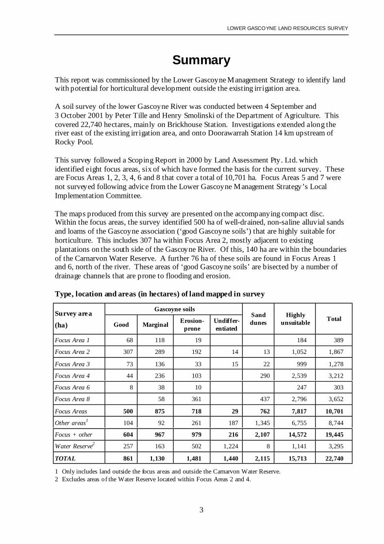
SummaryThis report was commissioned by the Lower Gascoyne Management Strategy to identify landwith potential for horticultural development outside the existing irrigation area.
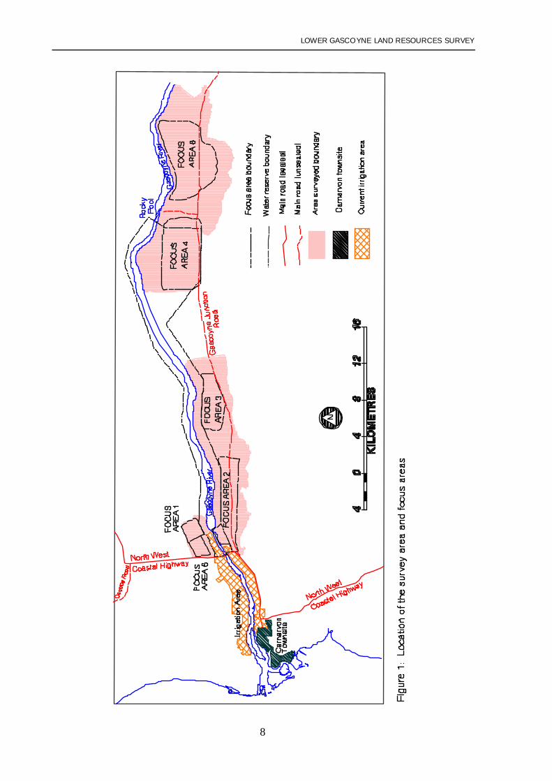
A soil survey of the lower Gascoyne River was conducted between 4 September and3 October 2001 by Peter Tille and Henry Smolinski of the Department of Agriculture. Thiscovered 22,740 hectares, mainly on Brickhouse Station. Investigations extended along theriver east of the existing irrigation area, and onto Doorawarrah Station 14 km upstream ofRocky Pool.
This survey followed a Scoping Report in 2000 by Land Assessment Pty. Ltd. whichidentified eight focus areas, six of which have formed the basis for the current survey . Theseare Focus Areas 1, 2, 3, 4, 6 and 8 that cover a total of 10,701 ha. Focus Areas 5 and 7 werenot surveyed following advice from the Lower Gascoyne Management Strategy’s LocalImplementation Committee.
The maps produced from this survey are presented on the accompanying compact disc.Within the focus areas, the survey identified 500 ha of well-drained, non-saline alluvial sandsand loams of the Gascoyne association (‘good Gascoyne soils’) that are highly suitable forhorticulture. This includes 307 ha within Focus Area 2, mostly adjacent to existingplantations on the south side of the Gascoyne River. Of this, 140 ha are within the boundariesof the Carnarvon Water Reserve. A further 76 ha of these soils are found in Focus Areas 1and 6, north of the river. These areas of ‘good Gascoyne soils’ are bisected by a number ofdrainage channels that are prone to flooding and erosion.
Type, location and areas (in hectares) of land mapped in survey
Gascoyne soilsSurvey area(ha) Good Marginal Erosion-
proneUndiffer-entiated
Sanddunes
Highlyunsuitable Total
Focus Area 1 68 118 19 184 389
Focus Area 2 307 289 192 14 13 1,052 1,867
Focus Area 3 73 136 33 15 22 999 1,278
Focus Area 4 44 236 103 290 2,539 3,212
Focus Area 6 8 38 10 247 303
Focus Area 8 58 361 437 2,796 3,652
Focus Areas 500 875 718 29 762 7,817 10,701
Other areas1 104 92 261 187 1,345 6,755 8,744
Focus + other 604 967 979 216 2,107 14,572 19,445
Water Reserve2 257 163 502 1,224 8 1,141 3,295
TOTAL 861 1,130 1,481 1,440 2,115 15,713 22,740
1 Only includes land outside the focus areas and outside the Carnarvon Water Reserve.2 Excludes areas of the Water Reserve located within Focus Areas 2 and 4.
LOWER GASCOYNE LAND RESOURCES SURVEY
4
A further 875 ha within the focus areas were classed as ‘marginal Gascoyne soils’ due tosalinity or coarse texture. These mostly lie adjacent to ‘good Gascoyne soils’. While topsoilsalinity levels are not usually excessive, values above 20 mS/m are common and some yielddecline could be expected in many horticultural crops. Salinity values up to 500 mS/m wererecorded in the deeper subsoil of many of these profiles. Their suitability for horticulture willdepend on how they respond to irrigation. In deep sandy soils it may be possible to leach thesalt out of the root zone resulting in higher productivity. In heavier soils or where a drainageimpediment occurs at depth, salinity could build up under irrigation decreasing productivity.
Away from the river, 762 ha of sand dunes with potential for horticultural development wereidentified in the focus areas. However, the individual dunes mostly occur as narrow linearfeatures that are too small for large-scale horticultural developments.
More than three-quarters of the focus areas (8,535 ha) contained soils which are not suitablefor development. This includes land with high risk of flooding and soil erosion (718 ha) andsoils with salinity, sodicity and poor structure (7,817 ha).
While the on-ground survey was concentrated within the focus areas identified in the ScopingReport, mapping of an additional 12,039 ha of surrounding land was undertaken where aerialphotograph coverage was available. Because few sites were examined in these surroundingareas, the mapping is of lesser quality . Although this mapping identified 361 ha of ‘goodGascoyne soils’, only 104 ha were situated outside the Water Reserve. There are also 255 haof ‘marginal Gascoyne soils’ (only 92 ha outside the Water Reserve) and 1,411 ha of‘undifferentiated Gascoyne soils’, comprising a combination of the ‘good’ and ‘marginalGascoyne soils’. Only 187 ha of these were located outside the Water Reserve.
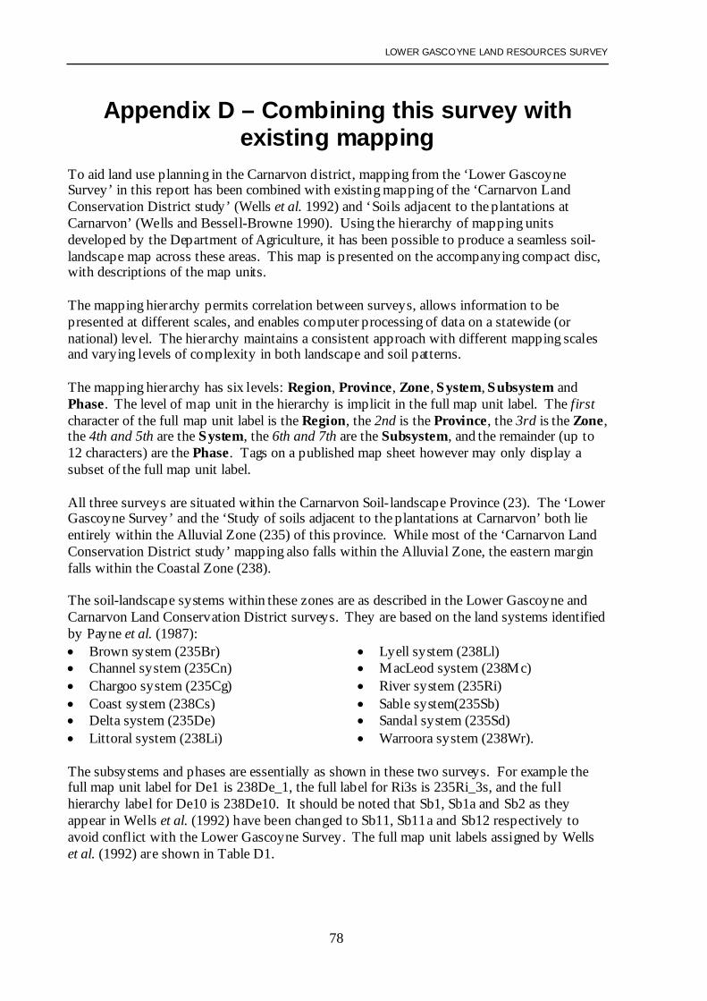
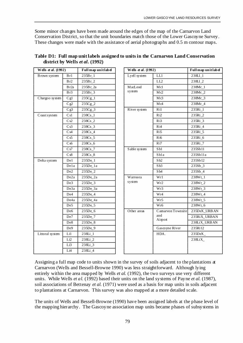
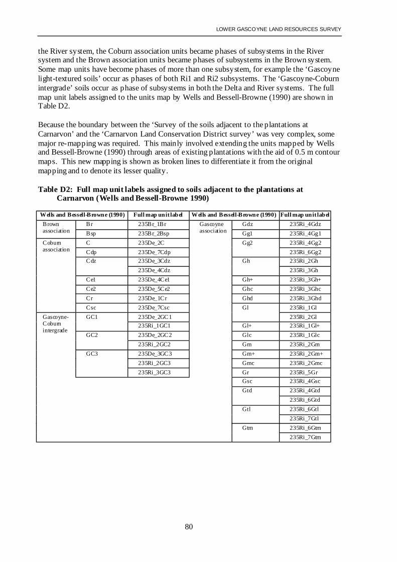
To aid land use planning in the Carnarvon district, the maps from this survey have beenmatched with the existing mapping of the Carnarvon Land Conservation District (Wells et al.1992) and the surrounds of the irrigation district (Wells and Bessell-Browne 1990). Using themap unit hierarchy developed by the Department of Agriculture, it has been possible toproduce a seamless soil-landscape map across these areas (see Appendix D for details).
LOWER GASCOYNE LAND RESOURCES SURVEY
5
Recommendations
1. This survey was undertaken to identify land with potential for horticultural development.The scale of the mapping (1:50,000) is not suitable for planning the details of land releaseor property layout. More detailed mapping, at a scale of 1:15,000, within any areas thathave been earmarked for development, is recommended. This would present moreaccurate patterns of existing soil salinity, as well as the nature of the subsoil that willindicate areas prone to waterlogging and potential future salinity.
2. The risk of soil erosion during Gascoyne flood events is inherently very high for mostarable areas under consideration. As demonstrated following the floods in March 2000,the risk is greatest where the land is regularly cultivated and water flows are concentrated.Any future horticultural development that was to rely on the importation of topsoil toreplace that lost during floods could not be considered as a sustainable land use. For thisreason it is essential that protected buffer strips are retained along the river banks and thatdevelopment not occur on the lower river terraces, drainage depressions and flow zoneson the upper terraces. Details of flooding patterns need to be considered prior to landselection. The likely effects on flood flows of any new levee banks or control structuresalso need to be considered.
3. There is limited information concerning the effects of soil salinity on crops in theCarnarvon district. The predicted yield reductions are based largely on overseas data.Investigations of crop performance at varying levels of soil salinity within the existingirrigation area would benefit the industry and provide better indication of land suitabilitywithin the survey area.
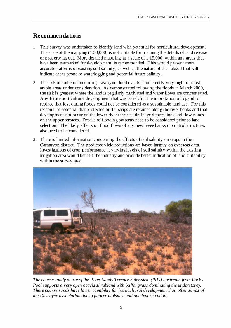
The coarse sandy phase of the River Sandy Terrace Subsystem (Ri1s) upstream from RockyPool supports a very open acacia shrubland with buffel grass dominating the understorey.These coarse sands have lower capability for horticultural development than other sands ofthe Gascoyne association due to poorer moisture and nutrient retention.
LOWER GASCOYNE LAND RESOURCES SURVEY
6
ContentsSummary and recommendations .................................................................................................3Introduction.................................................................................................................................7
2. Land systems.................................................................................................................10
The survey area.........................................................................................................................11Survey method ..........................................................................................................................12
Map units ..................................................................................................................................15
Gascoyne association soils.................................................................................................17
Coburn association soils.....................................................................................................18Doorawarrah and Moyamber association soils ..................................................................20
Brown association soils......................................................................................................20
Soil analysis and soil capability................................................................................................21
Gascoyne association soils.................................................................................................21
Coburn, Moyamber and Doorawarrah association soils ....................................................23Brown association soils......................................................................................................24
Focus areas ................................................................................................................................25
Additional survey area ..............................................................................................................28
Individual focus area descriptions ............................................................................................29Acknowledgments.....................................................................................................................32
A - Representative soil types .............................................................................................34
B - Laboratory methods and analysis ................................................................................44C - Detailed map unit descriptions ....................................................................................47
D - Combining this survey with existing mapping of the Carnarvon District ...................78
LOWER GASCOYNE LAND RESOURCES SURVEY
7
IntroductionThis report was commissioned to provide information on land resources suitable for intensiveagriculture in the Lower Gascoyne, east of the existing irrigation area and extending to 14 kmupstream of Rocky Pool.
The existing irrigation industry near Carnarvon is based on 2,186 hectares bordering theGascoyne River (see Figure 1). It is estimated that just over 1,000 hectares is currentlycropped using an average of 7.5 gigalitres (gL) of irrigation water per annum. Studies on theCarnarvon horticulture industry indicate that inadequate property size, low unit returns andinefficiencies of production are major impediments to future development.
The Lower Gascoyne Management Strategy identifies three main goals. One of these is toexplore opportunities for new developments.
Previous hydrological studies of the Rocky Pool aquifer provide a conservative estimate ofsustainable supplies of 8 gL per annum, with 4 gL nominated for irrigation purposes.However, the quality and quantity of the potential supplies need to be proven through anextensive drilling program.
It is anticipated that any new horticultural precinct development would be based on propertiesof a larger scale with a focus on production for export markets. The study also investigatedareas adjacent to the existing irrigation area that may be developed with existing or additionalwater supplies. In addition to providing an assessment of suitable soils for horticulturaldevelopment, this report also identifies soils that would be suitable for topsoil replacement inthe event of flood erosion.
LOWER GASCOYNE LAND RESOURCES SURVEY
8
LOWER GASCOYNE LAND RESOURCES SURVEY
9
Previous surveysPrevious land resource surveys of the Lower Gascoyne fall into two categories: mapping andcharacterisation of soil associations; and mapping of land systems.
Soil associations
Soil research within the Carnarvon area was carried out by the CSIRO (Bettenay 1964,Chapman and Keay 1965a, Bettenay 1966, Bettenay et al. 1971). Their work identified fourmajor soil associations within the existing irrigation area and its surrounds. A broadreconnaissance survey mapped these associations along the Gascoyne River upstream toRocky Pool. These four associations represent the most common soil types, related landformsand parent materials.
• Gascoyne association: Close to the Gascoyne River and occupying levees slightlyelevated above the adjacent floodplain. Soils are brown deep sands and loams.
• Coburn association: On gently sloping backplains of low relief, situated further from theriver. Vegetation is sparse and eroded claypans occupy a large proportion of the area.Soils include loamy earths, duplex soils and clays.
• Doorawarrah association: On floodplains, levees and channels of prior streams, withsome dunes. Vegetation cover is sufficiently widespread to prevent extensive winderosion. Soils are red-brown and mostly duplex.
• Moyamber association: On floodplains on which vegetation has been largely denudedand eroded claypans occupy a large proportion of the area. Red-brown duplex soils undervegetated areas with clays in the eroded areas.
Bettenay et al. (1971) identified the Gascoyne association as being the most suitable forirrigated crops, while recognising that the variations within this association can influence theircapability. They identified the Doorawarrah as having some potential for irrigation, thoughcareful management would be required because of poor subsoil drainage and the presence ofsaline layers. They considered the Coburn and Moyamber associations unsuited to irrigationdue to subsoil salinity and sodicity.
Wells and Bessell-Browne (1990) provided more detailed mapping around the edges of theexisting irrigation area. They identified: 18 soil/landform units which were subdivisions ofthe Gascoyne association; seven subdivisions of the Coburn association; two intergrades ofthese associations; and two belonging to the Brown association (reddish-brown siliceoussands and earthy sands on dunes and sandplain). They also presented capability ratings forvarious horticultural crops on each of the units.
LOWER GASCOYNE LAND RESOURCES SURVEY
10
Land systems
Mapping of land systems covering the entire survey at a scale of 1:250,000 was completed byPayne et al. (1980) as part of the Carnarvon Basin survey. Land system mapping is based onprinciples outlined by Christian and Stewart (1953), with land systems representing distinctrecurring patterns of topography, soils and vegetation. Systems occurring within the surveyarea are:
Delta land system: Floodplains supporting low shrublands of bluebush and saltbush, widelydegraded and eroded. This system contains mostly the Coburn and Moyamber associations,with minor areas of Gascoyne and Doorawarrah associations on the edges.
River land system: Seasonally active alluvial plains supporting tall shrublands of acacias ondeep sandy and loamy soils. This system is equivalent to the Gascoyne association mappedby Bettenay et al. (1971), but overlaps the edge of the Coburn association in places.
Sable land system: Nearly flat alluvial plain with occasional sandy rises. Soils arepredominantly sandy red duplex soils. This system contains mostly the Doorawarrahassociation, with some Moyamber association.
Sandal land system: Numerous low sandy rises and banks. Soils include deep red sands andsandy or Loamy duplex soils. This system contains mostly the Doorawarrah and Moyamberassociations, but overlies a large area of Gascoyne to the north of Rocky Pool.Target land system: Gently sloping plains with sandy banks, narrow interbanks andnumerous circular lakes carrying tall acacia shrubland. Red sands and red duplex soils arecommon. This system occurs outside the mapping of Bettenay et al. (1971).
Wells et al. (1992) provided more detailed mapping of these land systems in the CarnarvonLand Conservation District (lying to the west of the area surveyed for this report), dividingthem into component sub-systems.
LOWER GASCOYNE LAND RESOURCES SURVEY
11
The survey areaThe soil-landscape survey was conducted along the lower Gascoyne River, with the focusareas outlined in the Scoping Report produced by Land Assessment Pty. Ltd. (2000) formingthe basis for determining the area surveyed (see Figure 1). The Lower Gascoyne Committeerequested that the survey cover Focus Areas 1, 2, 3, 4, 6 and 8 - a total of 10,701 ha. Whilethe field survey was conducted primarily within these areas, some of the surrounding land wasalso mapped (mainly through the interpretation of aerial photographs). This covered anadditional 12,039 ha, raising the total mapped to 22,740 ha.
Focus Areas 1 and 6 are north of the river on Brickhouse Station adjacent to the existingirrigation area and extending east of the North West Coastal Highway. Focus Areas 2, 3, 4,and 8 are on the south side of the river on Brickhouse Station, extending along the GascoyneJunction Road east of the existing irrigation area. Part of Focus Area 8 extends onto thewestern edge of Doorawarrah Station, 14 km upstream of Rocky Pool. Focus Areas 5 and 7were not surveyed following advice from the Committee that being situated away from theriver or roads, they were unlikely to be developed.
The Carnarvon Water Reserve is situated along the Gascoyne River throughout most of thesurvey area. It extends from the North West Coastal Highway some 36 km upstream, and isapproximately 2 km wide for most of this distance. Under current policy, this reserve is aPriority 1 Water Source Protection Area within which irrigated agriculture will not bepermitted. A small portion of Focus Area 2 (around Brickhouse homestead) and most ofFocus Area 4 lie within the Water Reserve.
LOWER GASCOYNE LAND RESOURCES SURVEY
12
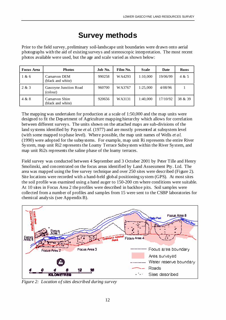
Survey methodsPrior to the field survey, preliminary soil-landscape unit boundaries were drawn onto aerialphotographs with the aid of existing surveys and stereoscopic interpretation. The most recentphotos available were used, but the age and scale varied as shown below:
Focus Area Photos Job No. Film No. Scale Date Runs
1 & 6 Carnarvon DEM(black and white)
990258 WA4293 1:10,000 19/06/99 4 & 5
2 & 3 Gascoyne Junction Road(colour)
960700 WA3767 1:25,000 4/08/96 1
4 & 8 Carnarvon Shire(black and white)
920656 WA3131 1:40,000 17/10/92 38 & 39
The mapping was undertaken for production at a scale of 1:50,000 and the map units weredesigned to fit the Department of Agriculture mapping hierarchy which allows for correlationbetween different surveys. The units shown on the attached maps are sub-divisions of theland systems identified by Payne et al. (1977) and are mostly presented at subsystem level(with some mapped to phase level). Where possible, the map unit names of Wells et al.(1990) were adopted for the subsystems. For example, map unit Ri represents the entire RiverSystem, map unit Ri2 represents the Loamy Terrace Subsystem within the River System, andmap unit Ri2s represents the saline phase of the loamy terraces.
Field survey was conducted between 4 September and 3 October 2001 by Peter Tille and HenrySmolinski, and concentrated on the focus areas identified by Land Assessment Pty. Ltd. Thearea was mapped using the free survey technique and over 250 sites were described (Figure 2).Site locations were recorded with a hand-held global positioning system (GPS). At most sitesthe soil profile was examined using a hand auger to 150-200 cm where conditions were suitable.At 10 sites in Focus Area 2 the profiles were described in backhoe pits. Soil samples werecollected from a number of profiles and samples from 15 were sent to the CSBP laboratories forchemical analysis (see Appendix B).
Figure 2: Location of sites described during survey
LOWER GASCOYNE LAND RESOURCES SURVEY
13
In describing the sites, the terminology of McDonald et al. (1990) was adopted. Dataroutinely recorded included:• vegetation structure and dominant species• landform features• soil colour - using the Munsell Color Chart (Munsell Colour Company 1975)• soil texture - described by hand texturing• soil structure• the presence of gravel and segregations• soil pH using a pocket pH meter or with field pH kit (Raupach and Tucker 1959)• soil salinity using a pocket electrical conductivity (EC) meter.
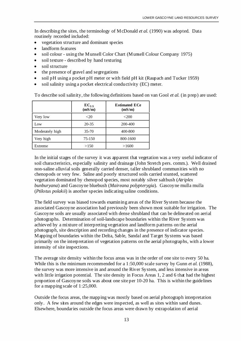
To describe soil salinity, the following definitions based on van Gool et al. (in prep) are used:
EC1:5(mS/m)
Estimated ECe(mS/m)
Very low <20 <200
Low 20-35 200-400
Moderately high 35-70 400-800
Very high 75-150 800-1600
Extreme >150 >1600
In the initial stages of the survey it was apparent that vegetation was a very useful indicator ofsoil characteristics, especially salinity and drainage (John Stretch pers. comm.). Well drainednon-saline alluvial soils generally carried denser, taller shrubland communities with nochenopods or very few. Saline and poorly structured soils carried stunted, scatteredvegetation dominated by chenopod species, most notably silver saltbush (Atriplexbunburyana) and Gascoyne bluebush (Maireana polypterygia). Gascoyne mulla mulla(Ptilotus polakii) is another species indicating saline conditions.
The field survey was biased towards examining areas of the River System because theassociated Gascoyne association had previously been shown most suitable for irrigation. TheGascoyne soils are usually associated with dense shrubland that can be delineated on aerialphotographs. Determination of soil-landscape boundaries within the River System wasachieved by a mixture of interpreting vegetation and landform patterns on the aerialphotograph, site description and recording changes in the presence of indicator species.Mapping of boundaries within the Delta, Sable, Sandal and Target Systems was basedprimarily on the interpretation of vegetation patterns on the aerial photographs, with a lowerintensity of site inspections.
The average site density within the focus areas was in the order of one site to every 50 ha.While this is the minimum recommended for a 1:50,000 scale survey by Gunn et al. (1988),the survey was more intensive in and around the River System, and less intensive in areaswith little irrigation potential. The site density in Focus Areas 1, 2 and 6 that had the highestproportion of Gascoyne soils was about one site per 10-20 ha. This is within the guidelinesfor a mapping scale of 1:25,000.
Outside the focus areas, the mapping was mostly based on aerial photograph interpretationonly. A few sites around the edges were inspected, as well as sites within sand dunes.Elsewhere, boundaries outside the focus areas were drawn by extrapolation of aerial
LOWER GASCOYNE LAND RESOURCES SURVEY
14
photograph patterns identified from within the focus areas. For this reason it was not possibleto differentiate the terrace subsystems and phases of the River System within the WaterReserve.
The map unit boundaries and labels were captured from the photographs using a computer-aided mapping system operated on MicroStation software. Site locations were added from theGPS readings. The linework, labels and site locations were captured using the AGD84 Datumand then transferred into the GDA94 Datum.
LOWER GASCOYNE LAND RESOURCES SURVEY
15
Mapping unitsForty-one map units (systems, subsystems and phases) are shown on the accompanying maps.A summary of these units with their dominant soils is provided below. The units aredescribed in more detail in Appendix C.
The systems correlate to the land systems identified by Payne et al. (1980). In naming thesubsystems, the conventions of Wells et al. (1992) were adopted where relevant, with theexception of the Sable System where the same subsystem codes used for the Delta, Sandaland Target Systems were adopted. The correlation between the subsystems as mapped in thissurvey and by Wells et al. may not always be exact. As indicated, the vegetation compositionand density are major factors in defining subsystems. It was common to identify equivalentsubsystems (soil-vegetation associations) in several systems e.g. areas of bluebush flatoccurred in three different systems (see Sd2, Tg2 and Sb2 below).
Cn - Channel System: Incised rocky streams and creek lines with truncated marginal slopesand stony narrow fringing plains supporting scattered to very scattered shrublands.
De - Delta System: Floodplains of the Gascoyne River supporting open to very open acaciashrublands with bluebush and saltbush understorey, widely degraded and eroded.
De1 - Delta Sand Dune Subsystem: Brown association soilsDe2 - Delta Bluebush Flat Subsystem: Coburn and Moyamber associationsDe3 - Delta Bluebush-Acacia Scrub Subsystem: Coburn and Moyamber associationsDe4 - Delta Acacia Scrub Subsystem: Coburn and Moyamber associationsDe5 - Delta Scald Subsystem: Coburn and Moyamber associationsDe6 - Delta Claypan Subsystem: Coburn and Moyamber associationsDe7 - Delta Drainage Depression Subsystem: Coburn and Moyamber associationsDe10 - Delta Swamp Subsystem.
Ri - River System: Seasonally active floodplains of the Gascoyne River supportingmoderately close tall acacia shrublands with an understorey including buffel grass
Ri1 - River Sandy Terrace Subsystem: Gascoyne ‘light-textured’ soilsRi1c - River Sandy Terrace Subsystem (coarse sand phase): Gascoyne ‘light-textured’ soilsRi1s - River Sandy Terrace Subsystem (saline phase): Gascoyne ‘light-textured’ soilsRi2 - River Loamy Terrace Subsystem: Gascoyne ‘medium-textured’ soilsRi2s - River Loamy Terrace Subsystem (saline phase): Gascoyne ‘medium-textured’ soilsRi3 - River Clayey Terrace Subsystem: Gascoyne ‘heavy-textured’ soilsRi3s - River Clayey Terrace Subsystem (saline phase): Gascoyne ‘heavy-textured’ soilsRi4 - River Drainage Depression Subsystem: Gascoyne associationRi4fz - River Drainage Depression Subsystem (flow zone phase): Gascoyne associationRi5 - River Sand Ridge Levee Subsystem: River sandsRi6 - River Lower Terrace Subsystem: Gascoyne associationRi7 - River Low Lying Sandy Terrace Subsystem: River sandsRi8 - River Saline Duplex Terrace Subsystem: Coburn red-brown duplexesRi9 - River Rocky Margin Subsystem:Ri10 - River Relict Channel Subsystem: Gascoyne association and Coburn red-brown duplexesRi11 - River Relict Terrace Subsystem: Gascoyne association and Coburn red-brown duplexesRiU - Ri ver Undifferentiated Terraces Subsystem: Gascoyne association.
LOWER GASCOYNE LAND RESOURCES SURVEY
16
Sb – Sable System: Nearly flat alluvial plain with occasional sandy rises supporting lowshrublands of saltbush and bluebush and some tall acacia shrublands.
Sb1 - Sable Sand Dune Subsystem: Brown association soilsSb2 - Sable Bluebush Flat Subsystem: Doorawarrah and Moyamber associationsSb5 - Sable Scald Subsystem: Moyamber association.
Sd – Sandal System: Alluvial plain with numerous low sandy rises and banks open to veryopen low acacia shrublands with bluebush and saltbush understorey.
Tg – Target System: Gently sloping plains, carrying tall acacia shrubland, with sandy banks,narrow interbanks and numerous circular lakes.
Tg1 - Target Sand Dune Subsystem: Brown association soilsTg4 - Target Acacia Scrub Subsystem: Doorawarrah and Moyamber associationsTg4c - Target Acacia Scrub Subsystem (claypan phase): Doorawarrah and MoyamberTg5 - Target Scald Subsystem: Doorawarrah and Moyamber associationsTg6 - Target Claypan Subsystem: Moyamber association.
Of the 41 map units identified from field survey, only six have a high to fair capability forirrigated horticulture - those which contain the ‘good Gascoyne soils’ (Ri1 and Ri2) and thesand dunes (De1, Sb1. Sd1 and Tg1).
Within the River System six units contain ‘marginal Gascoyne soils’ with a fair to lowcapability for irrigated horticulture. In most cases restricted subsoil drainage and the risk ofsalinity are the limiting factors (Ri1s, Ri2s, Ri3, Ri11), but coarser textured sands are alimitation on others (Ri1c and Ri5).
Other units within the River System may contain suitable soils, but the risk of flooding andassociated soil erosion make them unsuited to horticultural development (Ri4, Ri4fz, Ri6,Ri7, Ri9, Ri10). The remaining units in the River System (Ri3s and Ri8) and most of theDelta, Sable, Sandal and Target Systems are unsuitable for horticulture due to restrictedsubsoil drainage and high salinity levels.
The Scoping Report prepared by Land Resource Assessment (2000) suggested that 40% ofthe Sandal System might be suitable for irrigated horticulture, with a further 40% beingpossibly suitable. For the Target System these proportions were 30% and 10% respectively.This assessment was based on the component land units presented by Payne et al. (1987),with the sandy banks and plains being considered suitable, and the interbanks beingconsidered possibly suitable. These sandy banks and sandplain were found to comprise about20% of the Sandal System (Sd1), and about 12% of the Target System (Tg1), within thesurvey area. The soils of the interbanks were found to be unsuitable for horticulture,containing mostly shallow duplex soils of the Moyamber and Doorawarrah associations.
LOWER GASCOYNE LAND RESOURCES SURVEY
17
Soil associationsThe soils encountered during field survey generally conformed to the descriptions andproperties described by Bettenay et al. (1971) and Wells and Bessell-Browne (1990).Although five soil associations have been defined, it is common to find various intergradesbetween them. This is to be expected as the soil parent material was developed fromreworked stratified alluvium that is spatially complex.
Bettenay et al. (1971) caused a certain degree of confusion by applying the names Gascoyneand Doorawarrah to layers of alluvial deposits as well as their soil associations. TheGascoyne association is derived mostly from the Gascoyne alluvial layer and theDoorawarrah association is derived mostly from the Doorawarrah alluvial layer, as is theMoyamber association. The Coburn association has formed where the Gascoyne alluviallayer overlies the Doorawarrah alluvial layer.
Gascoyne association soils
Gascoyne soils are developed from relatively recent alluvial deposits that border theGascoyne River and consist of sand, silt and clay. These are reddish-brown sands to clayloams. Soils are generally friable and well-drained, and most commonly have very low to lowsalinity levels. Vegetation is dominated by acacia shrubland.
The general soil distribution pattern finds the coarser textured sands closest to the river, whilethe finer sediments (loams and clay loams) occur in back plains further from the fasterflowing channels. Gascoyne soils generally have a high fine sand content, low coarse sandand moderate silt and clay. Flecks of mica are often present throughout the profile. Althoughgenerally considered to be deep uniform or gradational soils, they often consist of severalstratified soil horizons within the top 200 cm.
Gascoyne soils are typically reddish-brown to yellowish red (5YR4/4-4/6). The occurrence ofclay loam or clay layers within the soil profile is usually associated with increasedaccumulation of carbonates (high alkalinity), salts and boron. Soil sodicity and reducedpermeability are also characteristics of finer textured layers. Three main types of Gascoyneassociation soils have been identified:
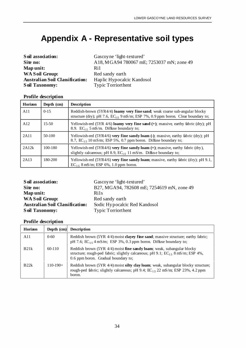
Gascoyne ‘light-textured’ soils
These are the soils in which a sand or sandy loam texture predominates. They fall mainly intothe Red sandy earth and Red loamy earth groups, with occasional Red deep sands(Schoknecht 2002). Topsoil textures range from loamy fine sands to fine sandy loams.Topsoils are loose to firm and generally structureless with a sandy fabric. In the profiles witha loamy or clayey fine sand surface horizon, the texture typically increases to a fine sandyloam (or occasionally silty loam) by 50 cm. Sandy clay loam horizons may be encounteredby 100 cm, and the texture may increase below this depth. Lime segregations are absent orrare.Reference Soil Profiles: A18, B27, C45
LOWER GASCOYNE LAND RESOURCES SURVEY
18
Gascoyne ‘medium-textured’ soils
These are the soils in which fine sandy clay loam or silt loam textures predominate. They fallinto the Red loamy earths group (Schoknecht 2002). Topsoil textures range from fine sandyloams to fine sandy clay loams. In profiles with a sandy loam surface horizon, there istypically a gradual increase to a silty loam or light sandy clay loam texture by 50 cm, andoften to a silty clay loam or clay loam (fine sandy) by 100 cm. Profiles with a silt loamsurface may be uniform throughout the top metre, or gradually increase to a silty clay loam orclay loam (fine sandy). Weak to moderate development of sub-angular blocky structure isusually evident. Lime segregations are absent or rare within the profile. Clays or light-textured horizons may also be encountered within the subsoil below 100 cm.Reference Soil Profiles: B26, B31, C46, C47, C81, C83, C84
Gascoyne ‘heavy-textured’ soils
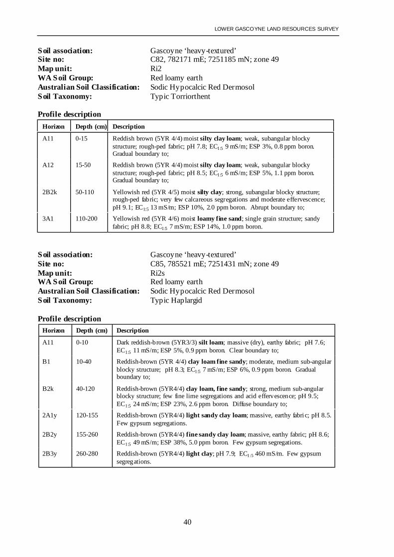
These are the soils in which clay loam or clay textures predominate. They fall mainly into theRed loamy earth and Red/brown non-cracking clay groups, with some Calcareous loamyearths and Red shallow loamy duplexes (Schoknecht 2002). Topsoil textures are typicallysilty clay loams, but may range from fine sandy clay loams to silty clays. Sometimes a thin(<10 cm) surface layer of sandy or silty loam is present, overlying a silty clay loam or siltyclay. These soils exhibit moderate to strong sub-angular blocky structure. Few to commonlime segregations may be encountered within lower topsoil and subsoil. Few gypsumsegregations may also occur below 100 cm. The soil reaction trend is alkaline. Topsoils areslightly acid to alkaline (pH 6.5-8.0) while subsoils are neutral to strongly alkaline (pH7.5-9.0).Reference Soil Profiles: A14, C44, C82, C85
Coburn association soils
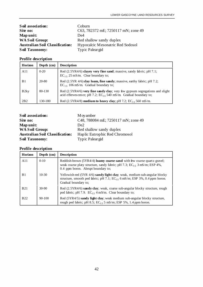
These soils occur on back plains and floodplains inland from the Gascoyne association. Theyare similar to the medium and heavy-textured Gascoyne soils but generally have a finer sandfraction and more silt and clay. Coburn soils support sparser vegetation than Gascoyne andchenopod shrubs are common. Many of these soils have been subject to erosion, part or all ofthe topsoil stripped. Red shallow sandy duplex soils (largely absent from the Gascoyneassociation) are common. Alkaline red shallow loamy duplexes, Red shallow loamyduplexes, Red deep sandy duplexes, Red loamy earths and Red/brown non-cracking clays(Schoknecht 2002) also occur. Clay loam or clay layers typically encountered within 100 cmand these subsoils tend to be massive and dense, resulting in restricted drainage. Moderatelyhigh to extreme levels of salt are often encountered within the subsoils.
The Coburn soils are usually developed from recent layer of Gascoyne alluvial layer which atvariable depth overlies much older layer of truncated Doorawarrah alluvial layer. The upperGascoyne alluvial layer is typically a reddish-brown to yellowish red (5YR4/4-4/6) colour andoften consists of shallow clayey sand to sandy loam topsoil overlying clay loam or light clay.Boundaries between these materials are clear to gradual and usually associated with slightdarkening and illuviation of clay within the upper 5 cm of the clayey horizon. These clayeysubsoils usually display weak to moderately developed sub-angular blocky structure.
LOWER GASCOYNE LAND RESOURCES SURVEY
19
The Doorawarrah alluvial layer is often encountered within 200 cm. It is a red (2.5YR4/6)sand to medium clay with a fine to coarse grain size. Several stratified layers may occur.Alluvial gravel derived from mixed igneous and sedimentary origin may be contained withinthe Doorawarrah alluvial layer. The medium to fine-textured horizons of the Doorawarrahalluvial layer are commonly massive and dense. Such poor physical properties are commonlyassociated with high sodicity .
Salinity levels can be highly variable within the Doorawarrah alluvial layer, but are often veryhigh to extreme. Areas that are scalded or dominated by silver saltbush (Atriplexbunburyana) are not always highly saline within the upper 150 cm although, in the limiteddeep profiles that were sampled, very highly to extremely saline layers were usuallyencountered by 250 cm. It is expected the frequency of flooding, drainage and micro-reliefwould influence the accumulation of salts in the profile.Reference Soil Profiles: B7, C63, F32
The Coburn soil most common within the River System is:
Coburn red-brown duplex
These soils have a reddish-brown to yellowish red (5YR4/4-4/6) sandy or loamy topsoil(similar to the Gascoyne soils) which sits on top of a heavy-textured subsoil. They fallmainly into the Red shallow and Deep sandy duplex soil groups, with some Red shallowloamy duplexes (Schoknecht 2002). Topsoil textures range from fine loamy sands to finesandy loams, occasionally silty loams. The subsoil commences abruptly at 10-50 cm and istypically a silty clay loam to silty clay (sometimes a fine sandy clay loam). The subsoil isusually highly to extremely saline and often sodic.Reference Soil Profile: F32
LOWER GASCOYNE LAND RESOURCES SURVEY
20
Doorawarrah and Moyamber association soils
Doorawarrah soils are predominantly duplex soils developed entirely from the Doorawarrahalluvial layer. Vegetation is a scattered acacia shrubland with a Gascoyne bluebush(Maireana polypterygia) understorey. Red shallow sandy duplex soils (Schoknecht 2002)were most commonly encountered in this survey, though Red deep sandy and loamyduplexes, and Red loamy and sandy earths were also present. Topsoil is usually a loose, red(2.5YR4/4-4/6) sand (occasionally a sandy loam). The bottom of the sandy topsoil is oftenbleached. Clayey subsoils are also red-coloured, and usually massive. They often containlime and may contain gypsum. Sodicity, poor soil structure and restricted drainage arecommon in the subsoil. Salinity levels can be highly variable, but are usually very high toextreme below 100 cm.
The Moyamber soils are differentiated from the Doorawarrah association mainly in that thesandy topsoils are badly eroded by water and wind. They are predominantly Red shallowsandy or Loamy duplex soils and Red/brown non-cracking clays (Schoknecht 2002).
Moyamber soils are associated with poorly drained back plains situated between the river andprior river levees. The vegetation communities are dominated by degraded low Gascoynebluebush (Maireana polypterygia) shrublands. The have also developed entirely from theDoorawarrah alluvial layer. As a result of erosion, they tend to have shallower topsoil andhigher clay content than the Doorawarrah association. The clayey subsoils that occur close tothe surface are commonly highly to extremely saline and sodic.Reference Soil Profile: C48
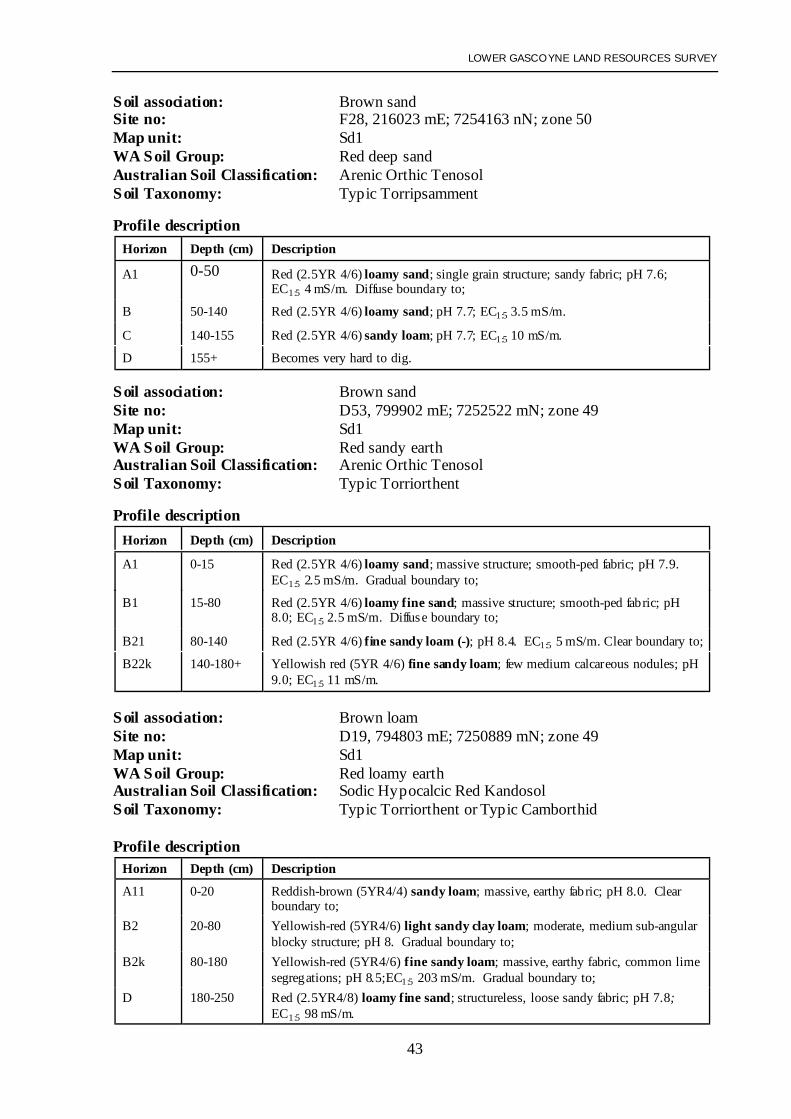
Brown association soils
Soils have developed on sand dunes or alluvial benches. They are commonly Red deep sandsand Red sandy earths with some Red loamy earths and Red deep sandy duplex soils(Schoknecht 2002) along the periphery of the dunes. Sandy topsoils are structureless andloose or massive with earthy fabric. Colour suggests that they are derived predominantlyfrom the Doorawarrah alluvial layer, particularly further from the river. Soil texture oftenincreases to sandy loam at 50-150 cm, and lime may be present in this subsoil. Salinity levelsare generally very low and soil profiles are well drained to rapidly drained.Reference Soil Profiles: D19, D53, F28
LOWER GASCOYNE LAND RESOURCES SURVEY
21
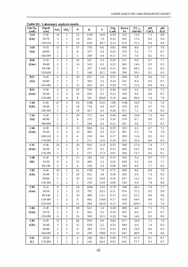
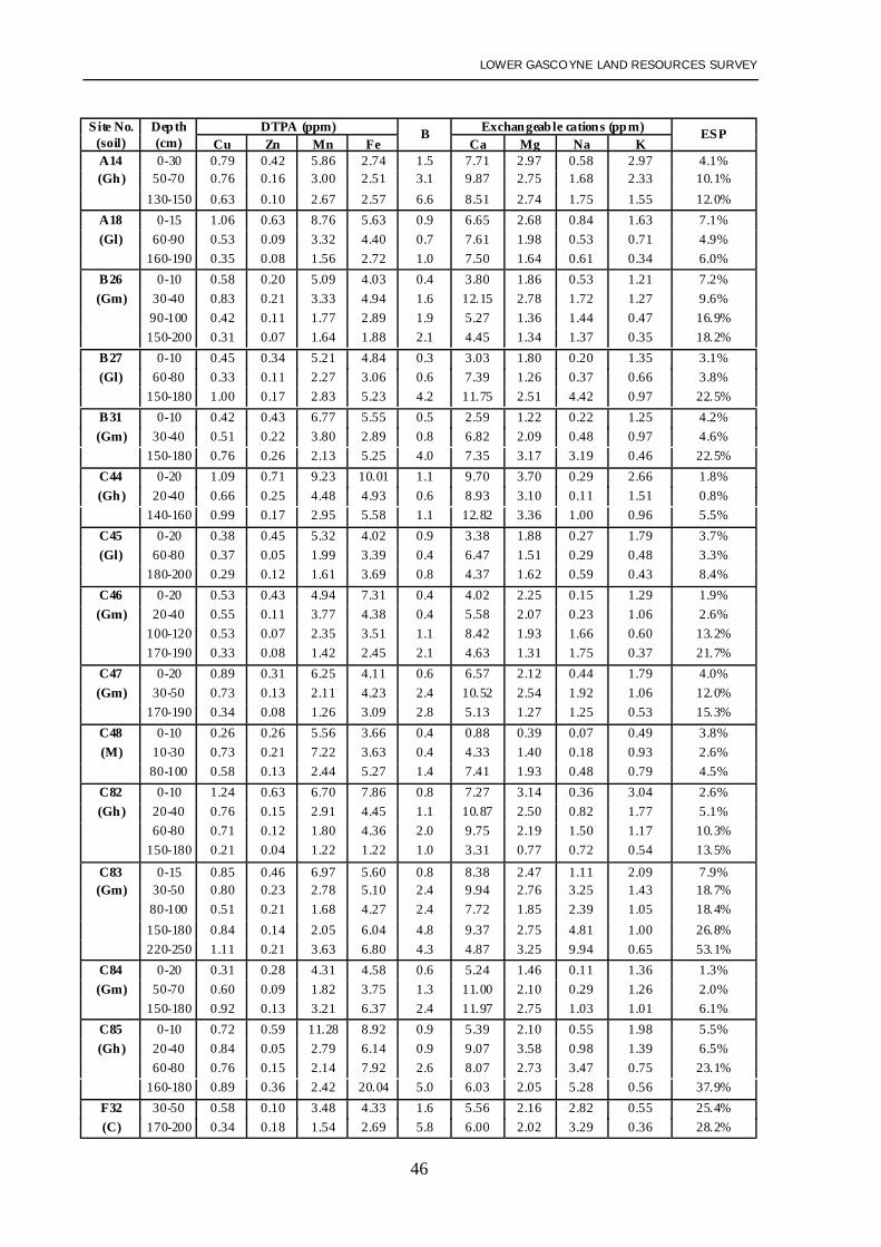
Soil analysis and soil capabilitySoil samples were collected from 15 profiles. Most belonged to the Gascoyne association thatis used for horticulture within the current irrigation area. Analytical results are presented inAppendix B.
Soil analysis results conform to data published by Bettenay et al. in 1971. The soil reactiontrend is alkaline to strongly alkaline. Topsoil horizons are generally neutral to alkaline(pH 7.0-8.0), while subsoils are alkaline to strongly alkaline (pH 8.0-9.4). Soil alkalinity isassociated with fine segregations of lime and carbonate salts (sodium carbonate andbicarbonate). Lime is rarely visible within coarse-textured sands or sandy loams. The clayloams may exhibit sporadic fine segregations below 60 cm.
Analysis indicates that zinc levels are low in all profiles.
Gascoyne association
The Gascoyne association soils are seen as having the greatest potential for irrigatedhorticulture, with virtually all existing plantations and irrigated crops on these soils. This isbecause Gascoyne association soils are deep, typically well-drained (with good subsoilstructure or fabric) and have good moisture and nutrient-holding capacities. The soils possesshigh levels of potassium in particularly the medium to fine textured soils. As indicated byBettenay et al. (1971), potassium is associated with illitic clays that are derived from micathat is clearly evident throughout the Gascoyne alluvial layer. Levels of bicarbonate-extractable phosphorus are moderate to high within all topsoil horizons and low to moderatewithin the subsoil layers.
The accumulation of salts (particularly sodium chloride) is generally not considered to be aproblem. However, there appears to be a trend for salinity levels to increase in proportion tothe distance from the coast. Silver saltbush (Atriplex bunburyana), an indicator of soilsalinity, was found growing over a significant proportion of Gascoyne soils in the survey area.Moderately high to extreme levels of salt (to 500 mS/m at 100-200 cm) were found in thesubsoils of a number of profiles. Even at depths of 50-100 cm soil salinity levels to200 mS/m were encountered.
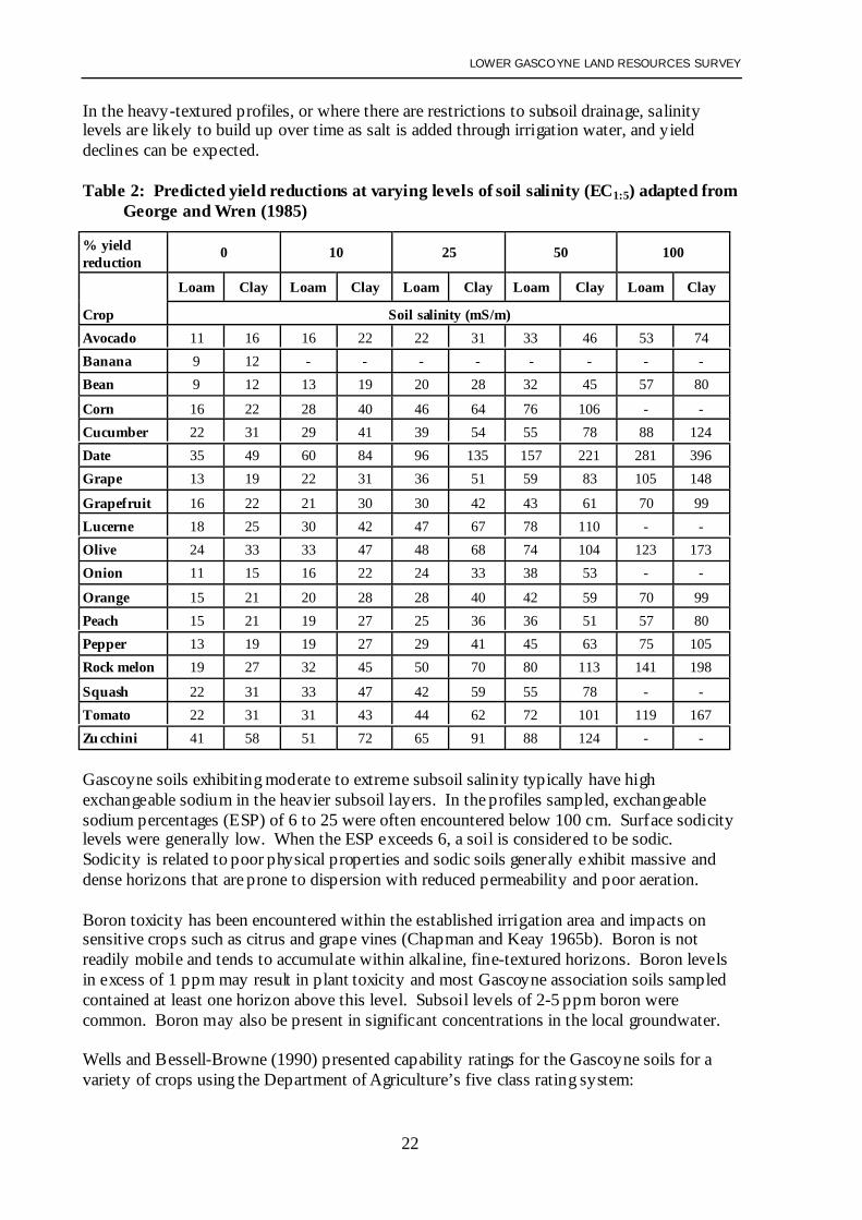
Table 2 gives some indication of the yield reductions which can be expected in some of thecrops grown in the Carnarvon district at different levels of soil salinity. As can be seen, evenlow levels of salinity (20-35 mS/m) can lead to significant yield reductions in manyhorticultural crops. Soils with very high and very low salinity levels can be found close toeach other, and salinity levels within a profile can change dramatically following heavy rainor a flood. The distribution of salts stored in the soil can vary greatly, both spatially and overtime. It is therefore difficult in a survey such as this to map the extent of the saline soilsprecisely, even if many samples are analysed. Vegetation is probably the best indicator.
How salinity levels in these soils will change when they are irrigated is also difficult topredict. The quality of the water supplies and irrigation management will be very important.On light-textured soils where the subsoil is highly permeable, there is potential to leach saltsfrom the profile under irrigation. In such cases crop yields should not be adversely affected.
LOWER GASCOYNE LAND RESOURCES SURVEY
22
In the heavy-textured profiles, or where there are restrictions to subsoil drainage, salinitylevels are likely to build up over time as salt is added through irrigation water, and yielddeclines can be expected.
Table 2: Predicted yield reductions at varying levels of soil salinity (EC1:5) adapted fromGeorge and Wren (1985)
Gascoyne soils exhibiting moderate to extreme subsoil salinity typically have highexchangeable sodium in the heavier subsoil layers. In the profiles sampled, exchangeablesodium percentages (ESP) of 6 to 25 were often encountered below 100 cm. Surface sodicitylevels were generally low. When the ESP exceeds 6, a soil is considered to be sodic.Sodicity is related to poor physical properties and sodic soils generally exhibit massive anddense horizons that are prone to dispersion with reduced permeability and poor aeration.
Boron toxicity has been encountered within the established irrigation area and impacts onsensitive crops such as citrus and grape vines (Chapman and Keay 1965b). Boron is notreadily mobile and tends to accumulate within alkaline, fine-textured horizons. Boron levelsin excess of 1 ppm may result in plant toxicity and most Gascoyne association soils sampledcontained at least one horizon above this level. Subsoil levels of 2-5 ppm boron werecommon. Boron may also be present in significant concentrations in the local groundwater.
Wells and Bessell-Browne (1990) presented capability ratings for the Gascoyne soils for avariety of crops using the Department of Agriculture’s five class rating system:
LOWER GASCOYNE LAND RESOURCES SURVEY
23
• Gascoyne ‘light-textured’ soils were assessed as having a high rating (class 2) for all cropsassessed (i.e. tomatoes, beans, capsicums, cucumbers, bananas and mangoes).
• Gascoyne ‘medium-textured’ soils had a high rating (class 2) for bananas and mangoesand a high rating for the vegetable crops, except where there was a clayey subsoil at30-100 cm. Here the rating was fair (class 3) with waterlogging risk being the mainlimitation.
• Gascoyne ‘heavy-textured’ soils had a fair rating (class 3) for all crops except cucumbers,for which the rating was low (class 4) due to waterlogging risk. Soil workability andwaterlogging risk were the limitations for other crops, while rooting conditions were thelimitation for bananas and mangoes. Where these soils occurred in closed depressions thewaterlogging risk resulted in a low rating for all vegetable crops.
• Ratings for the saline Gascoyne association soils (Gascoyne-Coburn intergrades) rangedfrom fair to low (classes 3-4) depending on the crop and soil texture, with the lower ratingon heavier textures.
The non-saline Gascoyne ‘light and medium-textured’ soils can be considered ‘goodGascoyne soils’. The non-saline Gascoyne ‘heavy-textured’ soils and the saline Gascoyne‘light and medium-textured’ soils can be considered ‘marginal Gascoyne soils’.
Coburn, Moyamber and Doorawarrah association
Only small areas of Coburn soils fall within the current irrigation area. Most no longersupport crops or plantations, or have never been developed. Wells and Bessell-Browne(1990) rated the Coburn soils as having low to very low capability (classes 4-5) for all thecrops assessed, with salinity and waterlogging risk being the main limitations.
Bettenay et al. (1971) stated that the adverse physical properties associated with high levels ofexchangeable sodium and high content of soluble salt render the Coburn and Moyamberassociation soils unsuitable for irrigation. These sodic soils generally exhibit massive anddense horizons that are prone to dispersion with reduced permeability and poor aeration.Reduced infiltration, poor aeration and cloddy, hardsetting topsoils are characteristics thatcommonly develop when they are cultivated. Data presented by Bettenay (1966) showsodium chloride comprising between 40 and 90% of the total soluble salts in the subsoils ofthe Coburn and Moyamber associations.
While salinity and sodicity levels in the only Moyamber profile sampled for laboratoryanalysis (Profile C48) were low, it was only possible to sample this profile to a depth of100 cm as the clay below this was too hard for the backhoe to excavate.
Bettenay et al. (1971) likened the Doorawarrah soils to the red-brown earths that areextensively irrigated in eastern Australia. They suggested that these soils had some potentialfor horticultural development, but that careful irrigation management would be requiredbecause of low permeability and salinity in the clayey subsoils. In this survey it was foundthat the free draining sandy topsoils were usually shallow (typically less than 30 cm), and thatmoderately high to extreme salinity levels (up to 400 mS/m) were often encountered withinthe top 100 cm of the profile. As with the Coburn and Moyamber associations, these soilsappear highly unsuitable for irrigated horticulture.
LOWER GASCOYNE LAND RESOURCES SURVEY
24
High levels of boron have been encountered on all alluvial soils within the irrigation area.Bettenay et al. (1971) showed the duplex soils of the Coburn and Moyamber associations ashaving higher boron levels than the Doorawarrah association.
Brown association
With the exception of a couple of small plantations, these soils are not currently used forhorticulture. However they have a fair to high capability (classes 2-3). They are deep, well-drained and easy to work. Being elevated above the surrounding plains, they have the addedadvantage of not usually being subject to flooding.
Many local growers would consider the Brown association soils as too sandy and rapidlydrained for irrigation. However, the coarser grained Spearwood sands of the Swan CoastalPlain north and south of Perth have high capability for horticulture with careful irrigationscheduling. In comparison, the Brown association sands would be expected to have bettermoisture and nutrient retention characteristics than the Spearwood sands. Because they havelower clay content than most Gascoyne soils, more intense management of irrigationscheduling than currently practised in the plantation areas would be required. Smaller, morefrequent applications are likely to be necessary and soil moisture levels would need to becarefully monitored.
Salinity levels are low. As most profiles are deep and highly permeable, there is goodpotential for leaching salt that accumulates in the root zone under irrigation. There is amoderate to high risk of wind erosion on these dunes and windbreaks would need to beestablished if they were developed for horticulture. Some land reshaping may also berequired on the higher dunes.
LOWER GASCOYNE LAND RESOURCES SURVEY
25
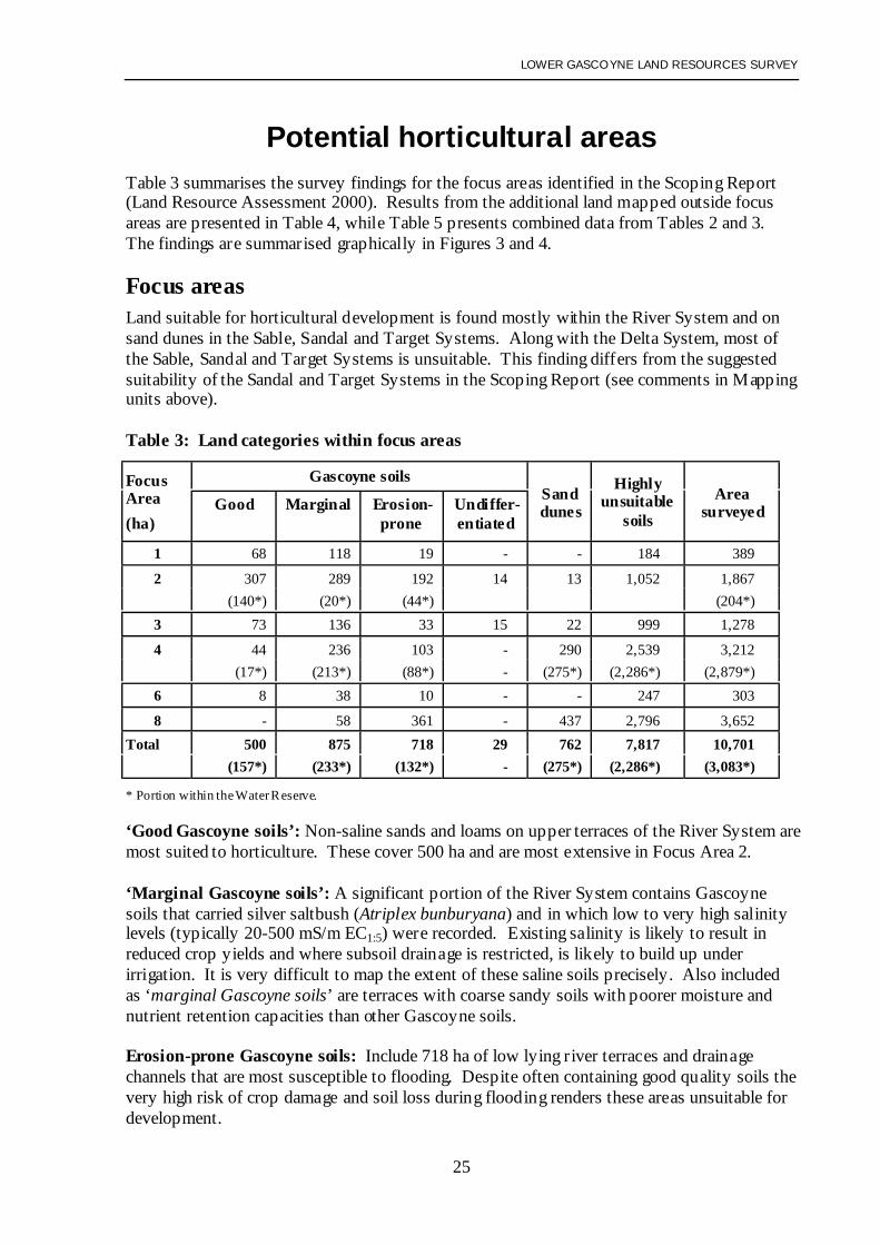
Potential horticultural areasTable 3 summarises the survey findings for the focus areas identified in the Scoping Report(Land Resource Assessment 2000). Results from the additional land mapped outside focusareas are presented in Table 4, while Table 5 presents combined data from Tables 2 and 3.The findings are summarised graphically in Figures 3 and 4.
Focus areasLand suitable for horticultural development is found mostly within the River System and onsand dunes in the Sable, Sandal and Target Systems. Along with the Delta System, most ofthe Sable, Sandal and Target Systems is unsuitable. This finding differs from the suggestedsuitability of the Sandal and Target Systems in the Scoping Report (see comments in Mappingunits above).
‘Good Gascoyne soils’: Non-saline sands and loams on upper terraces of the River System aremost suited to horticulture. These cover 500 ha and are most extensive in Focus Area 2.
‘Marginal Gascoyne soils’: A significant portion of the River System contains Gascoynesoils that carried silver saltbush (Atriplex bunburyana) and in which low to very high salinitylevels (typically 20-500 mS/m EC1:5) were recorded. Existing salinity is likely to result inreduced crop yields and where subsoil drainage is restricted, is likely to build up underirrigation. It is very difficult to map the extent of these saline soils precisely. Also includedas ‘marginal Gascoyne soils’ are terraces with coarse sandy soils with poorer moisture andnutrient retention capacities than other Gascoyne soils.
Erosion-prone Gascoyne soils: Include 718 ha of low lying river terraces and drainagechannels that are most susceptible to flooding. Despite often containing good quality soils thevery high risk of crop damage and soil loss during flooding renders these areas unsuitable fordevelopment.
LOWER GASCOYNE LAND RESOURCES SURVEY
26
LOWER GASCOYNE LAND RESOURCES SURVEY
27
LOWER GASCOYNE LAND RESOURCES SURVEY
28
Undifferentiated Gascoyne soils: Terraces of the River System were not examined in thefield as most lie outside the focus areas (only 29 ha were mapped within focus areas). Theseareas contain a mixture of ‘good’ and ‘marginal Gascoyne soils’. Given the proportions ofthese soils in the focus areas, somewhere between a third and a half is likely to be suitable forhorticulture.
Sand dunes: Contain deep, well-drained fine-grained sands with a high to fair capability forhorticulture. Although the dunes cover 762 ha within the focus areas, they mostly occur asnarrow, linear features, too small for large scale horticultural development.
Additional survey areaAssessment of additional land mapped outside focus areas identified in the Scoping Report ispresented in Table 4. A summary of the total area mapped is presented in Table 5.
Table 4: Additional land mapped outside focus areas identified in Scoping Report
GRAND TOTAL 861 1,130 1,481 1,440 2,115 15,713 22,740* Excludes areas within the Water Reserve.** Excludes areas of the Water Reserve located within Focus Areas 2 and 4.
Water Reserve. The 3,083 ha of Water Reserve within Focus Areas 2 and 4 are discussedabove. A further 3,295 ha were mapped by air photo interpretation with limited fieldinspection. This identified about 2,160 ha of the River System, including 257 ha of ‘goodGascoyne soils’ and 163 ha of ‘marginal Gascoyne soils’. Most of the remaining RiverSystem (1,224 ha) was mapped as Undifferentiated Terraces Subsystem, of which a third to ahalf is likely to be suitable for irrigation. These terraces are approximately 500 m wide andlie directly adjacent to the river bank between Focus Areas 2 and 3, and 3 and 4. Once abuffer strip was excised to protect the river bank from erosion, only a narrow strip of land
LOWER GASCOYNE LAND RESOURCES SURVEY
29
would remain available for development. There were also 502 ha of drainage channels andlow level river terraces identified that are prone to flooding and erosion.
The remainder of the mapping comprises 8,744 ha outside the Water Reserve and focusareas. While it consists largely of unsuitable highly saline duplex soils (6,755 ha), twosizeable areas of sand dunes that have potential for development were identified. These werebetween Focus Areas 2 and 3, with 167 ha on the Gascoyne Junction Road and 106 ha to itssouth. Some limited field investigations were undertaken in these dunes, but furtherinvestigation would be required to ensure the consistency of the soil types within them. Otherlarge areas of dunes are located south and south-east of Focus Area 8. For most, the distancefrom water supplies, and other infrastructure such as power and communications may makethem of lower value for development than other locations where the provision of servicescould be less expensive.
A brief reconnaissance of the Ella Land System, approximately 40 km upstream from RockyPool, was also undertaken on Doorawarrah Station. It was considered that this system mighthave potential for horticulture because it was described by Payne et al. (1987) as containing55% dunes and sandy banks. This system appeared to contain large areas of unsuitableshallow duplex soils, and the dunes were often narrow and steep.
Focus Area descriptions
Focus Areas 1 and 6 form a continuous area covering 692 ha to the north and east of theMcGlade Road plantations on the north side of the river. It excludes areas adjacent toMcGlade Road previously surveyed by Wells (1990).
Focus Areas 1 and 6 contain the second largest area for potential horticultural development.About 274 ha of River System were identified, mostly within Focus Area 1. The soils werepredominantly ‘light’ and ‘medium-textured’ Gascoyne soils, with ‘heavy-textured’ Gascoynesoils towards the northern margins. In general, salinity levels were higher in the medium toheavier Gascoyne soils and increased with distance from the river. Non-saline Gascoyne soilscover 76 ha of this system, while existing salinity could be expected to lead to reduced cropyields over 156 ha. About 29 ha of drainage channels in this system have been identified asunsuited to development due to the flooding and erosion risk. A further 120 ha of RiverSystem lies between Focus Area 6 and the existing McGlade Road plantations. Some ischannel, prone to flooding and erosion.
The rest of Focus Areas 1 and 6 consists of the Delta System (431 ha) which is not suited tohorticultural development. It is dominated by Coburn soils, saline shallow sandy duplexes,typically with 5-20 cm of sandy topsoil overlying highly saline and sodic clayey subsoil.
Focus Area 2 covers 1,867 ha on the south of the river and extending about 10 km east ofexisting plantations along the Gascoyne Junction Road. It includes 204 ha around BrickhouseHomestead within the Water Reserve. About 854 ha of the River System was identified inFocus Area 2. The soil types ranged from light to heavy-textured Gascoyne soils, with thetexture trending heavier with increasing distance from the river. Salinity levels in these soilsalso tend to increase away from the river.
The western portion of Focus Area 2 contains 307 ha of non-saline ‘light and medium-textured’ Gascoyne soils. This is the largest area identified as having high capability for
LOWER GASCOYNE LAND RESOURCES SURVEY
30
horticultural development, though it is bisected by several drainage channels that reduce thepotential block sizes. About 289 ha of saline or clayey ‘marginal Gascoyne soils’ are alsopresent, some lying within areas of non-saline soils. A further 192 ha of drainage channelsand low lying river terraces are classified as unsuitable for development due to the high riskof flooding and water erosion.
The remaining 1,052 ha of Focus Area 2 are dominated by saline, shallow duplex soilsunsuited to horticulture. The sandy topsoil is typically 5-20 cm deep and salinity and sodicitylevels in the clayey subsoil are typically very high to extreme. Most of the unsuitable areasoccur on the Delta System (Coburn and Moyamber association soils), with an area of SandalSystem in the south-east corner (Doorawarrah soils).
Focus Area 3 covers 1,278 ha located between the river and the Gascoyne Junction Roadabout 15 km east of the North West Coastal Highway . It has limited areas of soil withpotential for horticultural development.
The area contains about 258 ha of the River System, with ‘light and medium-textured’Gascoyne soils situated along its northern boundary . More than half of these soils (about136 ha) have subsoils with low to extreme salinity (EC1:5 20-400 mS/m). A further 33 ha ofthe River System consists of drainage channels prone to flooding and erosion.
The remainder occurs on the Delta and Sandal Systems, which are dominated by saline,shallow sandy duplex soils of the Coburn, Doorawarrah and Moyamber associations. Thesandy topsoil is typically 5-20 cm deep and salinity levels in the clayey subsoil are very highto extreme. Areas with potential for horticultural development are restricted to the 22 ha oflow sand dunes which rise above the duplex soil flats of the Sandal System. These duneshave fine to medium-grained red sands which are more than 100 cm deep but are narrow(100-250 m wide) and linear, making them unsuited to large scale developments.
Focus Area 4 covers 3,212 ha, of which almost 90% (2,879 ha) is situated within the WaterReserve. It is between the river and the Gascoyne Junction Road to the west of the RockyPool Access Road. Focus Area 4 contains only minor areas with potential for horticulturaldevelopment.
Focus Area 4 contains 444 ha of River System containing Gascoyne association soils andCoburn red-brown duplex soils. In the north-east corner about 44 ha of ‘light-textured’Gascoyne soils are suitable for horticulture and 61 ha of highly saline Coburn red-brownduplex soils. The remaining 339 ha of the River System consist of relict alluvial depositswhich cut across Focus Area 4. These deposits are 300-600 m wide and bisected by adrainage channel. The soils are highly variable (coarse sands, loamy earths and saline duplexsoils with massive subsoil horizons) and this relict channel has marginal value forhorticulture. There is also risk of erosive flood water moving down this channel.
The remainder occurs on the Sandal and Sable Systems, which are dominated by salineshallow sandy duplex soils of the Doorawarrah and Moyamber associations (2,539 ha). Onthese systems, areas of horticultural potential are restricted to sand dunes (290 ha). Thoughthese dunes are unsuited to large scale development due to their narrow, linear nature, they arenot prone to flooding and could be used for smaller developments. They would be susceptibleto wind erosion if not managed carefully.
LOWER GASCOYNE LAND RESOURCES SURVEY
31
Focus Area 8 covers 3,652 ha east of the Rocky Pool Access Road, extending south from theriver across the Gascoyne Junction Road. It contains only small isolated patches of soil withpotential for horticultural development.
Although Focus Area 8 contains about 654 ha of the River System, more than half (361 ha)consists of low level river terraces that are prone to flooding and erosion. Most less flood-prone areas of the River System (236 ha) consist of Coburn red-brown duplex soils (sand overclay), that are unsuitable for horticultural development due to salinity. Only about 58 ha ofwell-drained sandy Gascoyne Soils are on the upper river terraces. These soils are coarsegrained and have only fair capability for horticulture.
The remainder of Focus Area 8 occurs on the Sandal and Target Systems that are dominatedby highly saline shallow sandy duplex soils. The sandy topsoil is typically 5-20 cm deep andsalinity levels in the clayey subsoil are very high to extreme. Areas with potential forhorticultural development within the Sandal and Target Systems are restricted to the low sanddunes that rise above the duplex soil flats. Dune soils consist of fine-grained red sands morethan 100 cm deep . These dunes are not prone to flooding, but would be susceptible to winderosion. Although Focus Area 8 contains 437 ha of sand dunes, the individual dunes aremostly isolated, occurring as long, narrow (100-250 m wide) areas that would be unsuited tolarge developments.
LOWER GASCOYNE LAND RESOURCES SURVEY
32
AcknowledgementsThis survey was initiated by the Lower Gascoyne Management Strategy Committee. Thechairman Alan Bradley (Water and Rivers Commission) provided assistance in setting theparameters of the survey and reviewed the draft report. Alan also provided detailed contourmapping for much of the survey area. Committee member Karen White (Department ofAgriculture) maintained liaison with the Committee throughout the survey and also reviewedthe draft report, providing numerous comments and suggestions.
Paul and Rachel Burt from Brickhouse Station were generous in allowing access to theirproperty.
Department of Agriculture staff assisted in a variety of ways. Noel Schoknecht (South Perth)undertook the initial budgeting for the survey. John Stretch (Carnarvon) generously sharedhis knowledge of the soils and vegetation of the district. Other personnel from the GascoyneResearch Station who provided logistical, administrative and technical support includedMichelle Boothey, Denise Erlandsen, Linda Hine, Kesi Kesevan, George Morris, KevinShackleton, David Stewart, Crispen Underwood, Karen White and Rod Williams. Mapdigitising and preparation was undertaken Kus Kuswardiyanto (Bunbury) with technicalguidance and backup from Phil Goulding (South Perth). Ned Stephenson (Bunbury)calculated the areas for the initial mapping.
Air photo coverage was supplied by the Department of Land Administration. Analysis of soilsamples was undertaken by CSBP laboratories.
LOWER GASCOYNE LAND RESOURCES SURVEY
33
ReferencesBettenay, E. (1964). Reconnaissance survey of soils of the Gascoyne River, near Carnarvon Western Australia.
CSIRO Australian Division of Soils Technical Memo No. 1/64.
Bettenay, E. (1966). Laboratory examination of standard soil profiles from possible extension of GascoyneIrrigation Area, Western Australia. CSIRO Australian Division of Soils Technical Memo No. 7/66.
Bettenay, E., Keay, J. and Churchward, H.M. (1971). Soils adjoining the Gascoyne River near Carnarvon,Western Australia. Soils and land Use Series No. 51. CSIRO Division of Soils.
Chapman, M. and Keay, J. (1965a). Chemical analysis of soils from possible extension of Gascoyne IrrigationArea, W.A. CSIRO Australian Division of Soil Technical Memo No. 13/65.
Chapman, M. and Keay, J. (1965b). Chemical analysis of soil samples and a citrus leaf sample from the GascoyneResearch Station, Carnarvon, WA CSIRO Australian Division of Soil Technical Memo 14/65.
George, P.R. and Wren, B.A. (1985). Crop tolerance to soil salinity. Western Australian Department ofAgriculture Technote No. 6/85.
Gunn, R.H., Beattie, J.A., Reid, R.E. and van de Graaff, R.H.M. (1988). Australian soil and land surveyhandbook: Guidelines for conducting surveys. Inkata Press Melbourne/Sydney.
Land Resource Assessment (2001). Lower Gascoyne Soil Survey/Land Capability Scoping Report. LandAssessment Pty. Ltd. Report No. 0027, November 2000. 5/27 York Street, Subiaco.
McDonald, R.C., Isbell, R.F., Speight, J.G., Walker, J. and Hopkins, M.S. (1990). Australian soil and landsurvey fi eld handbook (2nd edition). Inkata Press Melbourne/Sydney.
Munsell Colour Company (1975). Munsell Soil Colour Chart. Munsell Colour Company Inc. Baltimore,Maryland 21218, USA.
Payne, A.L, Curry, P.J. and Spencer, G.F. (1987). An inventory and condition survey of rangelands in theCarnarvon Basin, Western Australia. Department of Agriculture Technical Bulletin No. 73.
Raupach, M. and Tucker, B.M. (1959). The field determination of soil reaction. Journal of Australian InstituteAgricultural Science 25: 129-33.
Schoknecht, N.R. (2002). Soil groups of Western Australia - A simple guide to the main soils of WesternAustralia. Department of Agriculture, Western Australia. Resource Management Technical Report 246.
Soil Survey Staff. (1975). Soil Taxonomy - A basic system of soil classification for making and interpreting soilsurveys. USDA Agricultural Handbook No. 436. Washington, DC: US Government Printing Offi ce.
Soil Survey Staff. (1994). Keys to Soil Taxonomy. United States Department of Agriculture, Soil ConservationService 6th ed.
van Gool, D., Moore, G. and Tille, P.J. (in prep). Land evaluation standards for land resource mapping –Guidelines for assessing and determining land capability in south-west Western Australia (secondedition). Department of Agriculture Resource Management Technical Report.
Wells, M.R. and Bessell-Browne, J.A. (1990). Horticultural capability study of soils adjacent to plantations atCarnarvon, Western Australia. Department of Agriculture Resource Management Technical Report 115.
Wells, M.R., Keating, C.D.M. and Bessell-Browne, J.A. (1992). Land resources of the Carnarvon LandConservation District and part of Boolathana station, Western Australia. Department of Agri culture LandResources Series No. 9.
B2 50-100 Yellowish-red (5YR4/6) very fine sandy clay loam; massive, earthy fabric(dry); pH 8.0. EC1:5 129 mS/m. Diffuse boundary to;
2B2ky 100-150 Yellowish-red (5YR4/6) very fine sandy clay loam; pH 8.1. EC1:5 140 mS/m.Few gypsum and fine lime segregations and slight acid effervescence.
Soil association: CoburnSite no: B7, 781952 mE; 7254721 mN; zone 49Map unit: De3WA Soil Group: Red shallow sandy duplexAustralian Soil Classification: Calcic Mesonatric Red SodosolSoil Taxonomy: Typic Paleargid
Profile descriptionHorizon Depth (cm) Description
A11 0-20 Dark reddish-brown (5YR4/4) clayey fine sand; structureless, loose, sandyfabric; pH 7.0. Clear boundary to;
B2k 20-80 Reddish-brown (5YR4/4) silty loam (+); strong, medium to coarse blockystructure; pH 8.5. Few fine lime segregations and very strong acideffervescence. Clear boundary to;
D 80-90 Yellowish-red to red (2.5-5YR4/6) silty clay loam; few lime segregations;pH 8.8; EC1:5 306 mS/m.
LOWER GASCOYNE LAND RESOURCES SURVEY
42
Soil association: CoburnSite no: C63, 782372 mE; 7250117 mN; zone 49Map unit: De4WA Soil Group: Red shallow sandy duplexAustralian Soil Classification: Hypocalcic Mesonatric Red SodosolSoil Taxonomy: Typic Paleargid
Profile descriptionHorizon Depth (cm) Description
A11 0-20 Red (2.5YR4/6) clayey very fine sand; massive, sandy fabric; pH 7.1;EC1:5 25 mS/m. Clear boundary to;
B1 20-80 Red (2.5YR 4/6) clay loam, fine sandy; massive, earthy fabric; pH 7.2;EC1:5 106 mS/m. Gradual boundary to;
B2ky 80-130 Red (2.5YR4/6) very fine sandy clay; very few gypsum segregations and slightacid effervescence; pH 7.2; EC1:5 540 mS/m. Gradual boundary to;
2B2 130-180 Red (2.5YR4/8) medium to heavy clay; pH 7.2; EC1:5 560 mS/m.
Soil association: MoyamberSite no: C48, 788084 mE; 7250117 mN; zone 49Map unit: De2WA Soil Group: Red shallow sandy duplexAustralian Soil Classification: Haplic Eutrophic Red ChromosolSoil Taxonomy: Typic Paleargid
Profile descriptionHorizon Depth (cm) Description
A11 0-10 Reddish-brown (5YR4/4) loamy coarse sand with few coarse quart z gravel;weak coarse platy structure, sandy fabric; pH 7.3; EC1:5 3 mS/m; ESP 4%,0.4 ppm boron. Abrupt boundary to;
B2k 80-180 Yellowish-red (5YR4/6) fine sandy loam; massive, earthy fabric, common limesegregations; pH 8.5;EC1:5 203 mS/m. Gradual boundary to;
D 180-250 Red (2.5YR4/8) loamy fine sand; structureless, loose sandy fabric; pH 7.8;EC1:5 98 mS/m.
LOWER GASCOYNE LAND RESOURCES SURVEY
44
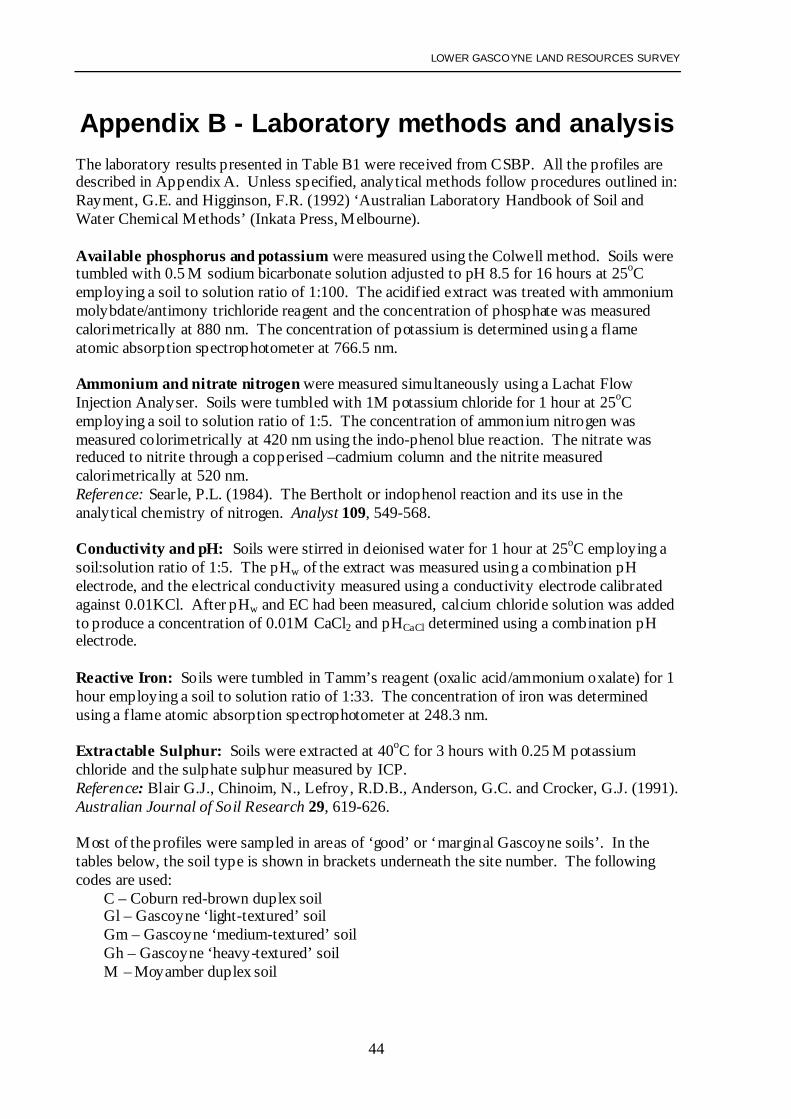
Appendix B - Laboratory methods and analysisThe laboratory results presented in Table B1 were received from CSBP. All the profiles aredescribed in Appendix A. Unless specified, analytical methods follow procedures outlined in:Rayment, G.E. and Higginson, F.R. (1992) ‘Australian Laboratory Handbook of Soil andWater Chemical Methods’ (Inkata Press, Melbourne).
Available phosphorus and potassium were measured using the Colwell method. Soils weretumbled with 0.5 M sodium bicarbonate solution adjusted to pH 8.5 for 16 hours at 25oCemploying a soil to solution ratio of 1:100. The acidified extract was treated with ammoniummolybdate/antimony trichloride reagent and the concentration of phosphate was measuredcalorimetrically at 880 nm. The concentration of potassium is determined using a flameatomic absorption spectrophotometer at 766.5 nm.
Ammonium and nitrate nitrogen were measured simultaneously using a Lachat FlowInjection Analyser. Soils were tumbled with 1M potassium chloride for 1 hour at 25oCemploying a soil to solution ratio of 1:5. The concentration of ammonium nitrogen wasmeasured colorimetrically at 420 nm using the indo-phenol blue reaction. The nitrate wasreduced to nitrite through a copperised –cadmium column and the nitrite measuredcalorimetrically at 520 nm.Reference: Searle, P.L. (1984). The Bertholt or indophenol reaction and its use in theanalytical chemistry of nitrogen. Analyst 109, 549-568.
Conductivity and pH: Soils were stirred in deionised water for 1 hour at 25oC employing asoil:solution ratio of 1:5. The pHw of the extract was measured using a combination pHelectrode, and the electrical conductivity measured using a conductivity electrode calibratedagainst 0.01KCl. After pHw and EC had been measured, calcium chloride solution was addedto produce a concentration of 0.01M CaCl2 and pHCaCl determined using a combination pHelectrode.
Reactive Iron: Soils were tumbled in Tamm’s reagent (oxalic acid/ammonium oxalate) for 1hour employing a soil to solution ratio of 1:33. The concentration of iron was determinedusing a flame atomic absorption spectrophotometer at 248.3 nm.
Extractable Sulphur: Soils were extracted at 40oC for 3 hours with 0.25 M potassiumchloride and the sulphate sulphur measured by ICP.Reference: Blair G.J., Chinoim, N., Lefroy, R.D.B., Anderson, G.C. and Crocker, G.J. (1991).Australian Journal of Soil Research 29, 619-626.
Most of the profiles were sampled in areas of ‘good’ or ‘marginal Gascoyne soils’. In thetables below, the soil type is shown in brackets underneath the site number. The followingcodes are used:
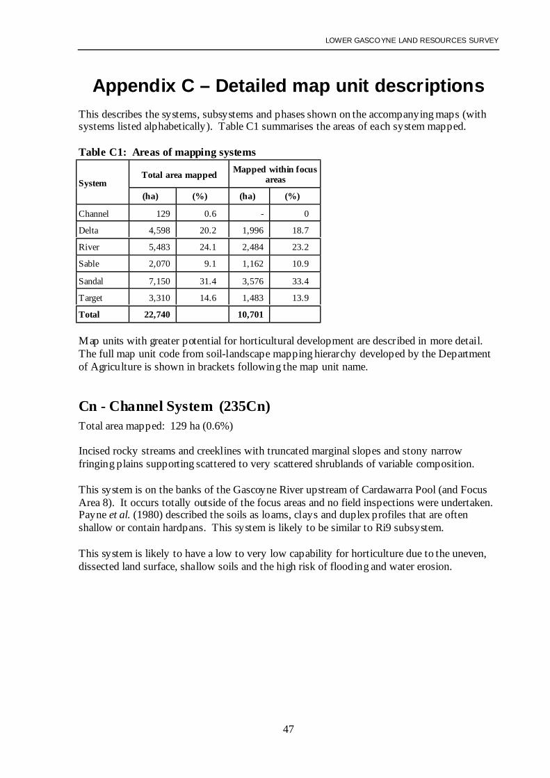
Appendix C – Detailed map unit descriptionsThis describes the systems, subsystems and phases shown on the accompanying maps (withsystems listed alphabetically). Table C1 summarises the areas of each system mapped.
Table C1: Areas of mapping systems
Total area mapped Mapped within focusareasSystem
(ha) (%) (ha) (%)
Channel 129 0.6 - 0
Delta 4,598 20.2 1,996 18.7
River 5,483 24.1 2,484 23.2
Sable 2,070 9.1 1,162 10.9
Sandal 7,150 31.4 3,576 33.4
Target 3,310 14.6 1,483 13.9
Total 22,740 10,701
Map units with greater potential for horticultural development are described in more detail.The full map unit code from soil-landscape mapping hierarchy developed by the Departmentof Agriculture is shown in brackets following the map unit name.
Cn - Channel System (235Cn)Total area mapped: 129 ha (0.6%)
Incised rocky streams and creeklines with truncated marginal slopes and stony narrowfringing plains supporting scattered to very scattered shrublands of variable composition.
This system is on the banks of the Gascoyne River upstream of Cardawarra Pool (and FocusArea 8). It occurs totally outside of the focus areas and no field inspections were undertaken.Payne et al. (1980) described the soils as loams, clays and duplex profiles that are oftenshallow or contain hardpans. This system is likely to be similar to Ri9 subsystem.
This system is likely to have a low to very low capability for horticulture due to the uneven,dissected land surface, shallow soils and the high risk of flooding and water erosion.
LOWER GASCOYNE LAND RESOURCES SURVEY
48
De - Delta System (235De)Total area mapped: 4,598 ha (20.2%) Within focus areas: 1,996 ha (18.7%)
Floodplains of the Gascoyne River supporting open to very open acacia shrublands withbluebush and saltbush understorey, widely degraded and eroded.
Topography: Delta System comprises a level alluvial plain that forms a backplain of theGascoyne River. It lies adjacent to the River System, downstream from Rocky Pool on FocusAreas 1, 2, 3, 4 and 6. This backplain has few to common flow lines and a smooth to verygently undulating or hummocky microrelief. Erosional and depositional surfaces resultingfrom overland flow are often evident while bare and scalded surfaces are present.
Geology: Reworked Quaternary alluvial clay, silt sand and gravel.
Vegetation: Acacia open shrubland to very scattered bluebush low shrubland.Canopy cover: 1-10%; Height: 0.8-4 m.Emergent species: Prickly acacia (Acacia victoriae), curara (Acacia tetragonophylla), silverbarked wattle (Acacia sclerosperma) and needle bush (Hakea preissii). Scattered coolibah(Eucalyptus coolabah) may also be present.Mid-storey species: Climbing saltbush (Rhagodia eremaea) and minga (Heterodendrumoleaefolium) are most common, with occasional cotton bush (Ptilotus obovatus) and currantbush (Scaevola spinescens).Understorey species: Gascoyne bluebush (Maireana polypterygia) is common with silversaltbush (Atriplex bunburyana) often present. Spiny bluebush (Maireana aphylla) andSclerolaena spp. may also be present. Although buffel grass (Cenchrus ciliaris) iswidespread, it is usually a minor component.
Soils: Delta System contains a mixture of Coburn and Moyamber association soils. Theseare mostly Red shallow sandy and Loamy duplex soils (often alkaline) and Red loamy earths.Red, non-cracking clays are also present. Subsoils are typically heavy-textured with restricteddrainage, and salinity levels are often extreme (EC1:5 200-2000 mS/m). Salinity is spatiallyhighly variable, and low to extreme values can occur over short distances.
Soil limitations and land management:• Clay loam subsoils contain moderately high to extreme levels of salt• Inherently poor structure with massive and dense subsoils being common• High risk of soil structure decline• Moderate to high risk of inundation or prolonged waterlogging• Reduced trafficability• Calcareous subsoils• Moderate to high risk of boron toxicity on clay loams• Risk of flooding and water erosion.
Land capability: Largely unsuited to horticultural development (low to very low capability,classes 4-5), due to poor profile drainage, moderately high to extreme salinity levels and therisk of increasing salinity under irrigation. The main exception is the well-drained soilsbelonging to the Brown association in the Delta Sand Dune Subsystem (De1). Only 11 ha ofthis subsystem were mapped.
LOWER GASCOYNE LAND RESOURCES SURVEY
49
Delta System does seem to have a greater area of flats containing pockets of soil with lowsalinity levels than the Sandal, Sable and Target Systems. These pockets are most likely tooccur on the Delta Acacia Scrub Subsystem (De4) but would be difficult to identifyaccurately without the aid of intensive soil sampling. These areas would still be prone todeveloping salinity under irrigation due to poor profile drainage.
Delta System was divided into subsystems, mainly through the interpretation of landscapefeatures and vegetation patterns seen on the aerial photographs:
De1 - Delta Sand Dune Subsystem (235De_1)Total area mapped: 11 ha (<0.1%) Within focus areas: 11 ha (0.1%)
Small, scattered low (1.5-2.5 m) sandy rises, banks and sand dunes occurring on the alluvialplain. Vegetation consists of scattered acacia shrubland with Rhagodia and Eremophila spp.in the second stratum. Major soils are Brown association sands: deep (typically >200 cm),fine to medium-grained, reddish sands (less commonly sandy loams). Red deep sandy duplexsoils are found on the periphery of this subsystem.
The soils have fair to high capability for horticulture. They are deep and well-drained, easy towork and the fine-grained sands have reasonable moisture and nutrient retention. However,the small area of the individual dunes (1-4 ha) severely limits their potential for development.There is a moderate to high risk of wind erosion, especially under vegetable cropping.
This subsystem is very similar to the smaller dunes mapped as Sb1, Sd2 and Tg1. Theequivalent unit mapped by Wells and Bessell-Browne (1990) is Cr.
De2 - Delta Bluebush Flat Subsystem (235De_2)Total area mapped: 654 ha (2.9%) Within focus areas: 378 ha (3.5%)
Plains carrying scattered to very scattered low (0.8-1.2 m high) shrubland dominated byGascoyne bluebush (Maireana polypterygia). Taller acacia shrubs are uncommon. Dominantsoils belong to the Coburn and Moyamber associations, with Red shallow sandy or Loamyduplex soils (often alkaline) being most common. Duplex soils have loose to hardsettingsandy topsoils while polygonal cracking is characteristic of medium to fine textured topsoils.Most clayey subsoil horizons are poorly structured, being massive and extremely dense. Soilsalinity is spatially highly variable, low to extreme salinity values can occur over shortdistances.
This subsystem is very similar to both Sb2 and Sd2, but has more loamy earths and lowersalinity levels. De2 can be differentiated from De3 by the dominance of bluebush andreduced vegetation height. Soil salinity levels are generally higher. It has more bare orscalded areas than De3, but considerably less than found in De5. The equivalent unit mappedby Wells and Bessell-Browne (1990) is C, though GC2 and GC2 partially correspond.
LOWER GASCOYNE LAND RESOURCES SURVEY
50
De3 - Delta Bluebush-Acacia Scrub Subsystem (235De_3)Total area mapped: 344 ha (1.5%) Within focus areas: 184 ha (1.7%)
Plains carrying very open acacia shrubland (2-4 m high) with an understorey dominated byGascoyne bluebush (Maireana polypterygia). Dominant soils belong to the Coburn andMoyamber associations, with Red shallow sandy or Loamy duplex soils (often alkaline) beingmost common.
This subsystem is very similar to Sd3, but has slightly more loamy earths and salinity levelsare generally a bit lower.
This is an intergrade between De2 and De4. It can be differentiated from De4 by the moreopen structure of the shrubland and predominance of bluebush in the understorey. Soilsalinity levels are generally a little higher and it tends to have more bare or scalded areas.De3 has more acacia shrubs than De2, and tends to be less saline and scalded. This unitpartially corresponds to GC3 mapped by Wells and Bessell-Browne (1990).
De4 - Delta Acacia Scrub Subsystem (235De_4)Total area mapped: 1,518 ha (6.7%) Within focus areas: 680 ha (6.4%)
Plains carrying open acacia shrubland (2-4 m high) with an understorey containing Gascoynebluebush (Maireana polypterygia) and silver saltbush (Atriplex bunburyana). Dominant soilsbelong to the Coburn and Moyamber associations, with Red shallow sandy or Loamy duplexsoils (often alkaline) being most common.
This subsystem is very similar to Sd4 and T g4, but has a slightly higher proportion of loamyearths, and salinity levels are generally a bit lower.
De4 can be differentiated from De3 by the less open structure of the shrubland and fewerbluebush in the understorey. Soil salinity levels are generally a little lower and it also tends tohave fewer bare or scalded areas.
Ri3 and Ri3s are similar but carry denser acacia scrub with Gascoyne bluebush generallyabsent. Gascoyne, rather than Coburn soils, dominate Ri3 and Ri3s. Salinity levels and theoccurrence of scalds are also lower, especially in Ri3. The equivalent unit mapped by Wellsand Bessell-Browne (1990) is Ce1.
De5 - Delta Scald Subsystem (235De_5)Total area mapped: 1,119 ha (5.3%) Within focus areas: 439 ha (4.1%)
Plains with prominent scalding. Bare scalds cover more than 50% of this subsystem.Vegetation on non-scalded area is an open to very sparse acacia shrubland (2-4 m high) withan understorey dominated by Gascoyne bluebush (Maireana polypterygia).
Dominant soils belong to the Coburn and Moyamber associations, and include Red shallowsandy and Loamy duplex soils, Red loamy earths (clay loam texture) and Red/brown non-cracking clays. The soils are characterised by surface crusting and polygonal cracking. Mostsubsoil horizons are highly to extremely saline, while topsoil salinity varies. Salt
LOWER GASCOYNE LAND RESOURCES SURVEY
51
inflorescence can be evident on the soil surface. Although soil structure is occasionally welldeveloped angular blocky, most soils are massive and dense.
This subsystem is similar to Sb5, Sd5 and Tg5, but has a higher proportion of scalds. It canbe differentiated from De2 by the predominance of scalding. Soil salinity levels are generallya little higher. It may be similar to De7, but does not occur as distinct linear depressions thatcarry water flows. The equivalent unit mapped by Wells and Bessell-Browne (1990) is Ce2.
De6 - Delta Claypan Subsystem (235De_6)Total area mapped: 24 ha (0.1%) Within focus areas: 0 ha
Slight depressions on the floodplain consisting of circular salt lakes and drainage foci that arepredominantly bare of vegetation. Some claypans may carry a few annual grasses, annualsaltbush or Gascoyne bluebush (Maireana polypterygia). These claypans are prone toinundation following heavy rainfall.
Soils have developed from stratified silty and clayey sediments derived from the Doorawarrahalluvial layer. The claypan surface usually exhibits a polygonal or reticulated pattern whichmay be shiny and laminated by the precipitation of silicates and salts. Surfaces may also havea thin cover of siliceous sand or silt brought on by aeolian reworking. Subsoils are reddish-brown clay loam to clay which may exhibit black manganese-iron segregations and finegypsum crystals. Topsoils are slightly acid to neutral while subsoils are alkaline.
Claypans are generally saline; salinity of the upper 60 cm may be low to high while subsoilsare highly to extremely saline.
This subsystem is very similar to Sb6, Sd6 and Tg6, though it is not usually surrounded bysand dunes. De6 can be differentiated from De5 in that it occurs as discrete claypans ratherthan a mosaic of scalds and vegetated areas. Unlike De7 it occurs as circular closeddepressions.
De7 - Delta Drainage Depression Subsystem (235De_7)Total area mapped: 828 ha (3.6%) Within focus areas: 297 ha (2.8%)
Shallow, open drainage depressions that are broad and poorly vegetated. These depressionsgenerally contain a narrow sinuous drainage channel that shows evidence of erosional anddepositional surfaces. Associated drainage banks are often broad and inconspicuouscontaining very low levees consisting of alluvial sand and silt. Bare and scalded areas arecommon, associated with minor oxbows and depressions.
Vegetation is highly variable consisting of open acacia shrubland (canopy cover <5-20% and<1.0-4.0 m high) with Gascoyne bluebush (Maireana polypterygia) and spiny bluebush(Maireana aphylla) being conspicuous. Silver saltbush (Atriplex bunburyana) and coolibah(Eucalyptus coolabah) are often present.
Sediments in the depressions are reworked recent alluvium consisting of sand, silt and clayoverlying older red Quaternary alluvium, which may contain alluvial gravel. Dominant soilsbelong to the Coburn and Moyamber associations, and include Red shallow sandy and Redshallow loamy duplex soils, Red loamy earths (clay loam texture) and Red/brown non-cracking clays. Loamy Gascoyne topsoils overlying red horizons of the Doorawarrah layer
LOWER GASCOYNE LAND RESOURCES SURVEY
52
may be present. Soils are generally poorly structured with massive and extremely densesubsoils developed from the Doorawarrah layer. Subsoil salinity is extremely variable withnon-saline and extremely saline soils being encountered.
This is similar to Ri4, but has less vegetation cover and more scalds. Gascoyne bluebush isalso common, unlike in Ri4. De7 is dominated by Coburn and Moyamber association ratherthan Gascoyne soils, and is more likely to be saline than Ri4.
It may be similar De5, but occurs as distinct linear depressions that carry water flows. heequivalent units mapped by Wells and Bessell-Browne (1990) are Csc and Cdp.
De10 - Delta Swamp Subsystem (235De10)Total area mapped: 20 ha (0.1%) Within focus areas: 6 ha (0.1%)
Slight depressions on the floodplain forming circular swamps. Although the centre of theswamp is often bare the margins carry native tussock grasses, including swamp grass(Eragrostis australasica), reeds and thickets of coolibah (Eucalyptus coolabah), sometimeswith silver-barked wattle (Acacia sclerosperma) and curara (Acacia tetragonophylla). Theseswamps are usually dry but fill with water following heavy rain or flooding. Depending onthe internal drainage and frequency of inundation, the centre of the swamp may also carryEucalyptus coolabah or tussock grasses.
The soils have developed from stratified, reddish-brown, silty and clayey alluvial sedimentsand include Red cracking clays, Red/brown non-cracking clays or Red shallow loamy duplexsoils. The surface usually exhibits a polygonal or reticulated pattern when dry and the upperhorizons may have a strong sub-angular blocky structure. Topsoils are dark reddish-browndue to increased accumulation of organic matter under moist soil conditions. Salinity levelsare usually very low to low.
This subsystem is very similar to Sd10. It is differentiated from De6 in being more vegetatedand less saline.
LOWER GASCOYNE LAND RESOURCES SURVEY
53
Ri - River System (235Ri)Total area mapped: 5,483 ha (24.1%) Within focus areas: 2,484 ha (23.2%)
Seasonally active floodplains of the Gascoyne River supporting moderately close tall acaciashrublands with an understorey including buffel grass (Cenchrus ciliaris) and fringingcommunities of river red gum (Eucalyptus camaldulensis) and coolibah (Eucalyptuscoolabah). This system consists of depositional surface formed of Quaternary alluvium.Upper and lower terraces are usually present. Dominant soils are deep sands and loams of theGascoyne association.
River System contains most land suitable for horticultural development. For this reason itwas the main focus of field investigations. It was divided into 11 subsystems with 5 additionalphases described in detail below:
Ri1 - River Sandy Terrace Subsystem (235Ri_1)Total area mapped: 518 ha (2.3%) Within focus areas: 244 ha (2.3%)
Level alluvial plain developed on the upper terraces of the Gascoyne River and carryingacacia shrubland with an understorey including buffel grass (Cenchrus ciliaris). Saltbushspecies are usually absent. Gascoyne ‘light-textured’ soils are dominant with smaller areas ofthe Gascoyne ‘medium-textured’ soils. Profiles are well-drained and generally non-saline.
Topography: Level alluvial plain, dissected by a few flow lines, on the broad upper terracesof the Gascoyne River. Level to very gently undulating microrelief of <30 cm. This unitusually occupies the portion of the upper terrace closest to the Gascoyne River channel, andgenerally encountered within 1 km of the Gascoyne River.
Geology: Quaternary alluvium, consisting of uniform or stratified sand to clay loamcontaining mica.
Vegetation: Acacia shrubland or open shrubland. Canopy cover: 5-20%; Height: 2-4 m.Emergent species: Silver barked wattle (Acacia sclerosperma) and prickly acacia (Acaciavictoriae) with curara (Acacia tetragonophylla) less common. Scattered coolibah (Eucalyptuscoolabah) is often present, and needle bush (Hakea preissii).Mid-storey species: Climbing saltbush (Rhagodia eremaea) and minga (Heterodendrumoleaefolium) are reasonably common.Understorey species: Buffel grass (Cenchrus ciliaris) is the dominant understorey.Sclerolaena spp. are often present.
Soils: Predominantly Gascoyne ‘light-textured’ and some ‘medium-textured’ soils with deepand well-drained profiles. Small areas of Gascoyne ‘heavy-textured’ soils may be present.These profiles are well-drained and predominantly non-saline, with very low levels of saltwithin the subsoil (EC 1:5 is typically less than 15 mS/m). Occasional highly saline profiles.
Related map units: Similar to Ri2, but contains more Gascoyne ‘light-textured’ soils. Itdiffers from Ri6 in being situated on the upper terraces of the Gascoyne River (Ri6 is on thelower terraces and more susceptible to flooding). In the coarse phase (Ri1c), medium tocoarse-grained sands dominate. The saline phase (Ri1s) is prone to salinity and typically
LOWER GASCOYNE LAND RESOURCES SURVEY
54
identified by the presence of silver saltbush. The equivalent units mapped by Wells andBessell-Browne (1990) are Gl, Glc and Gl+.
Soil limitations and land management:• Gascoyne ‘light-textured’ soils can be prone to wind erosion• Low to moderate risk of boron toxicity in all soil types• Risk of soil loss during major flooding events, especially if surface is left disturbed or
unprotected.
Land capability: High capability (class 2) for annual and perennial horticultural cropsprovided soil structure is maintained.
Ri1c - River Sandy Terrace Subsystem, coarse sand phase (235Ri_1c)Total area mapped: 56 ha (0.2%) Within focus areas: 54 ha (0.5%)
Level alluvial plain developed on the upper terraces of the Gascoyne River and carrying veryopen acacia shrubland with a buffel grass (Cenchrus ciliaris) understorey . Medium to coarse-grained Gascoyne ‘light-textured’ soils are dominant. Soils are well-drained and relativelynon-saline.
Topography: Level alluvial plain, dissected by a few flow lines, on the broad upper terracesof the Gascoyne River. Level to very gently undulating micro-relief of <30 cm. This unitwas only identified upstream from Rocky Pool.
Geology: Quaternary alluvium, consisting of uniform or stratified sand to clay loamcontaining mica.
Vegetation: Very open acacia shrubland and tussock grassland.Canopy cover: 1-5%; Height: 2-4 m.Emergent species: Silver barked wattle (Acacia sclerosperma) is dominant; also wanyu(Acacia ramulosa), needle bush (Hakea preissii) and curara (Acacia tetragonophylla).Mid-storey species: Emu bush (Eremophila spp.), minga (Heterodendrum oleaefolium).Understorey species: Buffel grass (Cenchrus ciliaris) is dominant.
Soils: Mostly Gascoyne ‘light-textured’ soils dominated by loamy sands to weak sandyloams which are medium to coarse-grained. Profiles are well-drained and predominantly non-saline, with very low levels of salt occurring within the subsoil (EC 1:5 is typically less than10 mS/m). Some areas with higher salinity levels may occur.
Related map units: Similar to Ri1, but has fewer Gascoyne ‘medium-textured’ soils. TheGascoyne ‘light-textured’ soils are medium to coarse-grained with low clay content.Vegetation cover is generally more open on the coarse-textured soils.
LOWER GASCOYNE LAND RESOURCES SURVEY
55
Soil limitations and land management:• Gascoyne ‘light-textured’ soils can be prone to wind erosion• Low to moderate risk of boron toxicity in all soil types• Risk of soil loss during major flooding events, especially if surface is left disturbed or
unprotected• Low moisture retention in coarse sandy soils.
Land capability: Fair to low (classes 3-4) for annual and perennial horticulture. Irrigationwould need to be more frequent due to low clay content and coarser sand grain size.
Ri1s - River Sandy Terrace Subsystem, saline phase (235Ri_1s)Total area mapped: 240 ha (1.1%) Within focus areas: 163 ha (1.5%)
Level alluvial plain developed on the upper terraces of the Gascoyne River and carryingacacia shrubland or very open acacia shrubland (sometimes degraded) with an understoreyincluding silver saltbush (Atriplex bunburyana). Dominant soils are Gascoyne ‘light-textured’ soils with smaller areas of the Gascoyne ‘medium-textured’ soils. Soil profiles arewell-drained and often saline.
Topography: Level alluvial plain, dissected by a few flow lines, on the broad upper terracesof the Gascoyne River. Level to very gently undulating micro-relief of <30 cm. Smallscattered scalds are sometimes present. Usually occupies part of the upper terrace closest tothe Gascoyne River channel, and generally encountered within 1 km of the river.
Geology: Quaternary alluvium, consisting of uniform or stratified sand to clay loamcontaining mica.
Vegetation: Acacia shrubland or open shrubland. Canopy cover: 1-20%; Height: 2-4 m.Emergent species: Silver barked wattle (Acacia sclerosperma) and prickly acacia (Acaciavictoriae) are dominant while needle bush (Hakea preissii) is often present. Scatteredcoolibah (Eucalyptus coolabah) may be found.Mid-storey species: Climbing saltbush (Rhagodia eremaea) is common while minga(Heterodendrum oleaefolium) may be present.Understorey species: Silver saltbush (Atriplex bunburyana) and buffel grass (Cenchrusciliaris) are common with some Sclerolaena spp.
Soils: Predominantly Gascoyne ‘light-textured’ soils with some ‘medium-textured’ soils.The profile is deep and well-drained. Small areas of Gascoyne ‘heavy-textured’ soils orCoburn red-brown duplexes may also be present. Moderately high to extreme levels of saltcommonly occur within the subsoil (EC1:5 at 50-100 cm is often in the 15-200 mS/m range,EC1:5 at 100-200 cm is often in the 50-400 mS/m range).
Related map units: Very similar to Ri1, but subsoil salinity is typically higher. Silversaltbush is usually present, and vegetation cover is often less dense. Scalds are sometimespresent. Unit differs from Ri2s which has a higher proportion of Gascoyne ‘medium-textured’ soils. It partially corresponds to GC1 (and possibly GC2) mapped by Wells andBessell-Browne (1990).
LOWER GASCOYNE LAND RESOURCES SURVEY
56
Soil limitations and land management:• Subsoil salinity levels likely to reduce crop yields• Gascoyne ‘light-textured’ soils can be prone to wind erosion• Low to moderate risk of boron toxicity in all soil types• Risk of soil loss during major flooding events, especially if soil surface is left disturbed or
unprotected.
Land capability: This unit has a low to fair capability (classes 3-4) for annual and perennialhorticulture. It is more suited to shallow-rooted crops such as vegetables and bananas.Subsoil salinity may limit mango and citrus production. Because many of the soils are light-textured, there is potential to leach salt from the root zone through careful irrigationscheduling and mulching provided impeding layers are not present within the subsoil.However, excessive irrigation is likely to result in increasing salinity.
Ri2 - River Loamy Terrace Subsystem (235Ri_2)Total area mapped: 343 ha (1.5%) Within focus areas: 256 ha (2.4%)
Level alluvial plain developed on the upper terraces of the Gascoyne River and carryingacacia shrubland with an understorey including buffel grass (Cenchrus ciliaris). Saltbushspecies are usually absent or a minor component of the understorey . Dominant soils areGascoyne ‘medium-textured’ soils with smaller areas of the Gascoyne ‘light-textured’ and‘heavy-textured’ soils. Soil profiles are well-drained and relatively non-saline.
Topography: Level alluvial plain, dissected by a few flow lines, on the broad upper terracesof the Gascoyne River. Level to very gently undulating microrelief of <30 cm. This unitusually lies on the middle portion of the upper terrace, further from the Gascoyne Riverchannel than Ri1 subsystem, but closer than Ri3.
Geology: Quaternary alluvium, consisting of uniform or stratified sand to clay containingmica.
Vegetation: Acacia shrubland or open shrubland. Canopy cover: 5-20%; Height: 2-4 m.Emergent species: Silver barked wattle (Acacia sclerosperma), prickly wattle (Acaciavictoriae), curara (Acacia tetragonophylla) and coolibah (Eucalyptus coolabah) are common.Mid-storey species: Climbing saltbush (Rhagodia eremaea) is common. Minga(Heterodendrum oleaefolium) and cotton bush (Ptilotus obovatus) are sometimes present.Understorey species: Buffel grass (Cenchrus ciliaris) is the dominant understorey, withSclerolaena spp. sometimes present. Occasional silver saltbush (Atriplex bunburyana) whichnever dominates the understorey.Note: Capparis lasiantha and needle bush (Hakea preissii) may be found on ‘medium andheavy-textured’ soils.
Soils: Predominantly Gascoyne ‘medium-textured’, with some ‘light-textured’ and ‘heavy-textured’ soils. The profile is deep and well-drained and predominantly non-saline, with verylow levels of salt in the subsoil (EC1:5 is typically less than 15 mS/m within the top 100 cm).Occasional saline soil profiles were encountered.
Related map units: Forms an intergrade between Ri1 and Ri3, but has a higher proportion ofGascoyne ‘medium-textured’ soils than either (Ri1 having a greater proportion of ‘light-textured’ soils and Ri3 having a greater proportion of ‘heavy-textured’ soils.
LOWER GASCOYNE LAND RESOURCES SURVEY
57
The saline phase (Ri2s) is prone to salinity and typically identified by the presence of silversaltbush. The equivalent units mapped by Wells and Bessell-Browne (1990) are Gm, Gmcand Gm+. Small pockets of Gh and Gl may also occur.
Soil limitations and land management:• Loamy topsoils are prone to soil structure decline• Gascoyne ‘light-textured’ soils can be prone to wind erosion• Low to moderate risk of boron toxicity in all soil types• Risk of soil loss during major flooding events, especially if soil surface is left disturbed or
unprotected• Risk of inundation or prolonged waterlogging on heavier soils• Reduced trafficability on heavier soils• Some calcareous subsoils.
Land capability: High to fair (classes 2-3) for annual and perennial horticulture providedsoil structure is maintained. Fair capability is associated with heavier soils.
Ri2s - River Loamy Terrace Subsystem, saline phase (235Ri_2s)Total area mapped: 438 ha (1.9%) Within focus areas: 372 ha (3.5%)
Level alluvial plain developed on the upper terraces of the Gascoyne River and carryingacacia shrubland or very open acacia shrubland (sometimes degraded) with an understoreyincluding silver saltbush (Atriplex bunburyana). Gascoyne ‘medium-textured’ soils aredominant with smaller areas of ‘heavy-textured’ soils. Soil profiles are often saline.
Topography: Level alluvial plain, dissected by a few flow lines, on the broad upper terracesof the Gascoyne River. Level to very gently undulating microrelief of <30 cm. Smallscattered scalds are sometimes present.
Geology: Quaternary alluvium, of uniform or stratified sand to clay containing mica.
Vegetation: Acacia shrubland or open shrubland. Canopy cover: 1-20%; Height: 2-4 m.Emergent species: Silver barked wattle (Acacia sclerosperma), prickly acacia (Acaciavictoriae) are dominant, with curara (Acacia tetragonophylla) often present. Needle bush(Hakea preissii) and coolibah (Eucalyptus coolabah) are less common.Mid-storey species: Climbing saltbush (Rhagodia eremaea) is common and minga(Heterodendrum oleaefolium), broom bush (Exocarpus aphyllus) and cotton bush (Ptilotusobovatus) are sometimes present.Understorey species: Silver saltbush (Atriplex bunburyana) and buffel grass (Cenchrusciliaris) are common, with occasional spiny bluebush (Maireana aphylla) and Gascoynebluebush (Maireana polypterygia). Sclerolaena spp. may also be present.
Soils: Predominantly Gascoyne ‘medium-textured’. Some ‘heavy-textured’ soils or Coburnred-brown duplexes may also be present. Moderately high to extreme levels of saltcommonly occur within the subsoil (EC1:5 at 50-100 cm is often in the 15-100 mS/m range,and at 100-200 cm is often 20-300 mS/m).
Related map units: Very similar to Ri1, but subsoil salinity is typically higher. Silversaltbush is usually present, and vegetation cover less dense. Scalds are sometimes present.
LOWER GASCOYNE LAND RESOURCES SURVEY
58
This unit differs from Ri1s (which has a higher proportion of Gascoyne ‘light-textured’ soils)and Ri3s (which has more Gascoyne ‘heavy-textured’ soils). The equivalent unit mapped byWells and Bessell-Browne (1990) is GC2, though GC1 and GC3 partially correspond.
Soil limitations and land management:• Subsoil salinity levels likely to reduce crop yields• Low to moderate risk of boron toxicity in all soil types• Risk of soil loss during major flooding events, especially if surface is disturbed or
unprotected• Susceptible to soil structure decline• Risk of inundation or prolonged waterlogging on heavier soils• Reduced trafficability on heavier soils• Some calcareous subsoils.
Land capability: Fair to low (classes 3-4) capability for annual and perennial horticulture. Itis more suited to shallow-rooted crops such as vegetables and bananas. Subsoil salinity maylimit mango and citrus production. Careful irrigation management is critical to reduce salt inthe root zone. Poor management is likely to result in increasing salinity. Gypsumapplications would be required to maintain soil structure.
Ri3 - River Clayey Terrace Subsystem (235Ri_3)Total area mapped: 49 ha (0.2%) Within focus areas: 41 ha (0.4%)
Level alluvial plain developed on the upper terraces of the Gascoyne River and carryingacacia shrubland with an understorey including buffel grass (Cenchrus ciliaris). Saltbushspecies are usually absent. Dominant soils are Gascoyne ‘heavy-textured’ soils with smallerareas of ‘medium-textured’ soils. Soil profiles are usually non-saline.
Topography: Level alluvial plain, dissected by a few flow lines, on the broad upper terracesof the Gascoyne River. Level to very gently undulating micro-relief of <30 cm. Usually lieson the middle portion of the upper terrace furthest from the Gascoyne River channel.
Geology: Quaternary alluvium, uniform or stratified loam to clay containing mica.
Vegetation: Acacia shrubland or open shrubland. Canopy cover: 5-20%; Height: 2-4 m.Emergent species: Silver barked wattle (Acacia sclerosperma), prickly wattle (Acaciavictoriae) and curara (Acacia tetragonophylla) with scattered coolibah (Eucalyptus coolabah).Mid-storey species: Climbing saltbush (Rhagodia eremaea) and cotton bush (Ptilotusobovatus).Understorey species: Buffel grass (Cenchrus ciliaris) is dominant. Also Sclerolaena spp. anda few silver saltbush (Atriplex bunburyana).
Soils: Predominantly Gascoyne ‘heavy-textured’ soils, with some ‘medium-textured’ andoccasional Coburn red-brown duplexes. Profiles are predominantly non-saline, with very lowlevels of salt within the subsoil (EC 1:5 is typically less than 15 mS/m within the top 100 cm).Occasional saline profiles.
Related map units: Forms an intergrade between Ri2 subsystem and Delta System. Has ahigher proportion of Gascoyne ‘heavy-textured’ soils than Ri2. Fewer Coburn and duplexprofiles than adjoining Delta subsystems, and lower salinity levels. The saline phase (Ri3s) is
LOWER GASCOYNE LAND RESOURCES SURVEY
59
prone to salinity and typically identified by presence of silver saltbush. The equivalent unitsmapped by Wells and Bessell-Browne (1990) are: Gh, Ghc and Gh+. Small pockets of Ghd,Gm, Gmc and Gm+ may also be present.
Soil limitations and land management:• Topsoils are prone to structural decline• Moderate risk of boron toxicity• Risk of soil loss during major flooding events, especially if surface is left disturbed or
unprotected• Risk of inundation or prolonged waterlogging• Salts may accumulate in the profile under irrigation• Reduced trafficability on heavier soils• Some calcareous subsoils.
Land capability: Fair (class 3) for annual and perennial horticulture crops. It is more suitedto shallow-rooted crops such as vegetables and bananas. Because of restricted drainage, saltmay accumulate in the root zone under irrigation. Gypsum applications would be required tomaintain soil structure.
Ri3s - River Clayey Terrace Subsystem, saline phase (235Ri_3s)Total area mapped: 92 ha (0.4%) Within focus areas: 66 ha (0.6%)
Level alluvial plain developed on the upper terraces of the Gascoyne River and carryingacacia shrubland or very open acacia shrubland (sometimes degraded) with an understoreyincluding silver saltbush (Atriplex bunburyana). Gascoyne ‘heavy-textured’ soils aredominant with smaller areas of ‘medium-textured’ soils. Soil profiles are often saline.
Topography: Level alluvial plain, dissected by a few flow lines, on the broad upper terracesof the Gascoyne River. Level to very gently undulating micro-relief of <30 cm. Smallscattered scalds are sometimes present.
Geology: Quaternary alluvium, uniform or stratified loam to clay containing mica.
Vegetation: Acacia shrubland or open shrubland. Canopy cover: 1-20%; Height: 2-4 m.Emergent species: Silver barked wattle (Acacia sclerosperma), prickly acacia (Acaciavictoriae) with some curara (Acacia tetragonophylla) and coolibah (Eucalyptus coolabah).Mid storey species: Climbing saltbush (Rhagodia eremaea), minga (Heterodendrumoleaefolium).Understorey species: Common silver saltbush (Atriplex bunburyana), buffel grass (Cenchrusciliaris), with occasional spiny bluebush (Maireana aphylla). Sclerolaena spp.
Soils: Predominantly Gascoyne ‘heavy-textured’ soils, with some Gascoyne ‘medium-textured’ and occasional Coburn red-brown duplexes. Moderately high to extreme levels ofsalt commonly occur in the subsoil. The EC1:5 at 100-200 cm is typically in the 35-500 mS/mrange, while within the top 100 cm values of 20-100 mS/m were often encountered.
Related map units: Very similar to Ri3, but subsoil salinity is typically higher. Silversaltbush is usually present, and vegetation cover is often less dense. Scalds sometimespresent. It has a higher proportion of Gascoyne ‘heavy-textured’ soils than Ri2s. Duplexprofiles and Coburn soils are less common than on the Delta subsystems, where the
LOWER GASCOYNE LAND RESOURCES SURVEY
60
vegetation is generally less dense and Gascoyne bluebush is more likely to be encountered.The equivalent units mapped by Wells and Bessell-Browne (1990) is probably GC3. This unitis very similar to De3 as mapped by Wells et al. (1990).
Soil limitations and land management:• Salinity levels likely to reduce crop yields• Salinity is likely to increase under irrigation• Risk of inundation or prolonged waterlogging• Moderate risk of boron toxicity• Risk of soil loss during major flooding events, especially if surface is left disturbed or
unprotected• Susceptible to soil structure decline• Reduced trafficability on heavier soils• Some calcareous subsoils.
Land capability: Low capability (class 4) for most annual and perennial horticulture cropsdue to existing salinity and risk of increase under irrigation. Some of the more salt-tolerantcrops could be considered, but very careful application of water would be required.
Ri4 - River Drainage Depression Subsystem (235Ri_4)Total area mapped: 827 ha (3.6%) Within focus areas: 360 ha (3.4%)
Concave drainage depressions cutting across the upper terraces of the Gascoyne River andcarrying acacia shrubland with emergent coolibah (Eucalyptus coolabah). Undulatingmicrorelief with common abraided channels. Dominant soils are the Gascoyne association‘light’ and ‘medium-textured’ soils.
Topography: Channelled and scoured drainage zones, consisting of narrow (typically50-130 m wide) concave drainage depressions (0.5-2.0 m deep). Channels usually havedefined banks and occasional deep incised oxbows. This unit is typically found cutting acrossRiU, Ri1, Ri2 and Ri3 (and their saline phases) on the upper terraces of the Gascoyne River,though it has also been mapped where there are defined channels on the lower terrace. Thesedepressions usually only carry water during major flooding events.
Geology: Recent and Quaternary alluvium, consisting of uniform or stratified sand to clayloam containing mica.
Vegetation: Acacia close shrubland. Canopy cover: 10-60%; Height: 2-4 m.Emergent species: Coolibah (Eucalyptus coolabah), silver barked wattle (Acaciasclerosperma, prickly wattle (Acacia victoriae), needle bush (Hakea preissii) and some curara(Acacia tetragonophylla).Mid storey species: Climbing saltbush (Rhagodia eremaea).Understorey species: Buffel grass (Cenchrus ciliaris) is the dominant species. Spinybluebush (Maireana aphylla) and silver saltbush (Atriplex bunburyana) may be encountered.
Soils: Gascoyne ‘light-textured’ and ‘medium-textured’ soils are dominant. Stratifiedhorizons are evident along stream banks and many soils contain thin layers of recent sand orloam alluvium. Most soils are deep and well-drained. Salinity levels are variable.
LOWER GASCOYNE LAND RESOURCES SURVEY
61
Related map units: Can be differentiated from the Delta Drainage Depression Subsystem(De7) by the predominance of Gascoyne ‘light-textured’ and ‘medium-textured’ soils whileCoburn duplex soils are generally absent. De7 has sparser vegetation with Gascoynebluebush largely absent. Differs from Ri6 being mostly incised into the upper terraces of theGascoyne River (Ri6 being the surface of the lower terrace which is subject to non-channelledflooding). The channel of the drainage depression is more clearly defined here than for theflow zone phase (Ri4fz). The equivalent units mapped by Wells and Bessell-Browne (1990)are Gsc, Gg1, Gg2 and possibly Gtd.
Soil limitations and land management:• High risk of water erosion.
Land capability: Very low capability (class 5) for horticulture due to the high risk offlooding and associated water erosion. Salinity will also be a limitation in some areas.
Ri4fz - River Drainage Depression Subsystem, flow zone phase (235Ri_4fz)Total area mapped: 39 ha (0.2%) Within focus areas: 33 ha (0.3%)
Broad, very gently inclined, flood-scoured drainage zones on the upper terraces of theGascoyne River.
Topography: These depressions are typically less than 1 m deep and up to 150 m wide. Theylack defined banks and only carry water during major flooding events.
Geology: Recent and Quaternary alluvium, consisting of uniform or stratified sand to clayloam containing mica.
Vegetation: No sites were examined, but the vegetation appears to be an acacia shrublandwith emergent coolibah (Eucalyptus coolabah), similar to Ri4.
Soils: No sites were examined in this unit, but the soils are likely to be Gascoyne ‘light-textured’ and ‘medium-textured’ soils similar to those in Ri4.
Related map units: The channel of the drainage depression is less clearly defined than Ri4,being shallower and lacking distinct banks. The equivalent unit mapped by Wells andBessell-Browne (1990) is Gdz.
Soil limitations and land management:• High risk of water erosion.
Land capability: Very low (class 5) for horticulture due to the high risk of flooding andassociated water erosion. Salinity may also be a limitation in some areas.
LOWER GASCOYNE LAND RESOURCES SURVEY
62
Ri5 - River Sand Ridge Levee Subsystem (235Ri_5)Total area mapped: 60 ha (0.3%) Within focus areas: 3 ha (<0.1%)
Sand ridges rising above the lower terrace of the Gascoyne River carrying acacia shrublandwith emergent river red gum (Eucalyptus camaldulensis) and an understorey including buffelgrass (Cenchrus ciliaris). Dominant soils are coarse river sands. Soil profiles are well-drained and non-saline.
Topography: Sand hummocks (dune ridges) rising up to 1-2 m above the lower terrace ofthe Gascoyne River and forming narrow sandy levees bordering the river channel.
Geology: Quaternary alluvium, consisting of sand.
Vegetation: Acacia shrubland or closed shrubland. Canopy cover: 10-60%; Height: 2-4 m.Emergent species: Silver barked wattle (Acacia sclerosperma) with emergent river red gum(Eucalyptus camaldulensis).Understorey species: Buffel grass (Cenchrus ciliaris) is dominant.
Soils: Dominant soils are coarse river sands, which are often paler than the Gascoyne soils.Profiles are well-drained and non-saline.
Related map units: Differs from Ri6 in rising above the lower terraces of the GascoyneRiver, though still susceptible to flooding. It has coarser grained sands than Ri1 and Ri6. Itsits higher than Ri7. The equivalent unit mapped by Wells and Bessell-Browne (1990) is Gr.
Soil limitations and land management:• High risk of soil erosion during flooding• Soils can be prone to wind erosion• Coarse sandy soils have poor moisture and nutrient retention.
Land capability: Fair to low (classes 3-4) for horticulture due to high risk of wind erosion,water erosion and flooding. The coarser sands also reduce capability. The small areascovered by these dunes and high flood risk of surrounding units are major limitations.
Ri6 - River Lower Terrace Subsystem (235Ri_6)Total area mapped: 359 ha (1.6%) Within focus areas: 206 ha (1.9%)
Lower, flood-scoured terraces of the Gascoyne River carrying acacia shrubland with emergentriver red gum (Eucalyptus camaldulensis), coolibah (Eucalyptus coolabah) and anunderstorey including buffel grass (Cenchrus ciliaris). Gascoyne ‘light-textured’ soils aredominant, often with medium to coarse-grained sands. Profiles are well-drained andrelatively non-saline.
Topography: Hummocky low level river terraces subject to flood scouring. This unitusually sits adjacent to the Gascoyne River channel, commonly 2 m below Ri1.
Geology: Quaternary alluvium, consisting of uniform or stratified sand and loam.
LOWER GASCOYNE LAND RESOURCES SURVEY
63
Vegetation: Acacia shrubland or closed shrubland. Canopy cover: 10-60%; Height: 2-4 m.Emergent species: Silver barked wattle (Acacia sclerosperma) with emergent river red gum(Eucalyptus camaldulensis) and coolibah (Eucalyptus coolabah).Understorey species: Buffel grass (Cenchrus ciliaris) is dominant.
Soils: Predominantly Gascoyne ‘light-textured’ soils, typically consisting of uniform profilesof sand to sandy loam, often medium to coarse-grained. Profiles are well-drained andtypically non-saline, though some subsoils with low salinity (30 mS/m) were identifiedupstream of Rocky Pool.
Related map units: Has finer grained, browner sandy soils and more vegetation cover thanRi7. Differs from Ri1 and Ri1c in being on the lower terraces of the Gascoyne River, andmore susceptible to flooding. It has more light-textured (and coarser) soil than Ri1.This unit partially corresponds to Gtl and Gtm (and possibly some Gtd and Gg2) mapped byWells and Bessell-Browne (1990).
Soil limitations and land management:• High risk of soil erosion during flooding• Gascoyne ‘light-textured’ soils can be prone to wind erosion.
Land capability: Very low (class 5) for horticulture due to high risk of water erosion andflooding.
Ri7 - River Low Lying Sandy Terrace Subsystem (235Ri_7)Total area mapped: 45 ha (0.2%) Within focus areas: 10 ha (0.1%)
Lower, flood-scoured, sandy terraces of the Gascoyne River carrying sparse cover of river redgum (Eucalyptus camaldulensis) and little understorey . Soil profiles are well-drained andnon-saline.
Topography: Hummocky low level river terraces subject to flood scouring. Usuallyadjacent to the Gascoyne River channel. Ri6 usually rises above this unit.
Geology: Quaternary alluvium, consisting of uniform or stratified sand to loam.
Vegetation: Very open eucalypt woodland. Canopy cover: 10-20%; Height: 2-4 mEmergent species: River red gum (Eucalyptus camaldulensis)Understorey species: Typically absent.
Soils: Coarse river sands are dominant, often paler than the Gascoyne soils. Profiles arewell-drained and non-saline.
Related map units: Differs slightly from the description provided by Wells et al. (1992) inthat it occurs on the same level, or below Ri6, not above it. It has coarser grained, paler sandysoils and less vegetation cover than Ri6. It differs from Ri1 and Ri1c in occurrring on thelower terraces of the Gascoyne River, thus being more susceptible to flooding. It has morelight-textured (and coarser grained) soils than Ri1. This unit partially corresponds to Gtl andGtm mapped by Wells and Bessell-Browne (1990).
LOWER GASCOYNE LAND RESOURCES SURVEY
64
Soil limitations and land management:• High risk of soil erosion during flooding• Soils can be prone to wind erosion• Coarse sandy soils have poor moisture and nutrient retention.
Land capability: Very low (class 5) for horticulture due to high risk of water erosion andflooding.
Ri8 - River Saline Duplex Terrace Subsystem (235Ri_8)Total area mapped: 479 ha (2.1%) Within focus areas: 297 ha (2.8%)
Level alluvial plain developed on the upper terraces of the Gascoyne River and carrying openacacia shrubland with an understorey including Gascoyne mulla mulla (Ptilotus polakii).Dominant soils are Coburn red-brown duplexes with smaller areas of the Gascoyne ‘medium-textured’ soils. Soil profiles are typically highly to extremely saline.
Topography: Level alluvial plain, dissected by a few flow lines, on the broad upper terracesof the Gascoyne River in the vicinity of Rocky Pool. Level to very gently undulatingmicrorelief of <30 cm. Small scattered scalds are sometimes present.
Geology: Quaternary alluvium, of uniform or stratified loam to clay containing mica.
Vegetation: Open acacia shrubland. Canopy cover: 1-10%; Height: 2-4 m.Emergent species: Prickly acacia (Acacia victoriae), needle bush (Hakea preissii), silverbarked wattle (Acacia sclerosperma)Mid-storey species: Climbing saltbush (Rhagodia eremaea), minga (Heterodendrumoleaefolium) and poverty bush (Eremophila spp.).Understorey species: Gascoyne mulla mulla (Ptilotus polakii) and buffel grass (Cenchrusciliaris) are dominant.
Soils: Predominantly Coburn red-brown duplexes. High to extreme levels of salt commonwithin subsoil (EC 1:5 at 50-100 cm is often in the 50-250 mS/m range).
Related map units: Very similar to Ri3s, but subsoil salinity is typically higher and Coburnred-brown duplexes dominate rather than Gascoyne ‘heavy-textured’ soils. These Coburnduplexes are similar to duplex soils on the adjoining Sandal System, but are less red. Thevegetation is not as sparse as on Sandal System and Gascoyne bluebush is usually absent.
Soil limitations and land management:• Salinity levels would to severely restrict crop yields• Salinity is likely to increase under irrigation• Heavy-textured, sodic subsoils restrict drainage• Moderate to high risk of boron toxicity• Risk of soil loss during major flood events, especially if surface is disturbed or unprotected• Susceptible to soil structure decline• Reduced trafficability on heavier soils• Some calcareous subsoils.
Land capability: Very low (class 5) for annual and perennial horticulture due to salinitywhich would be exacerbated under irrigation.
LOWER GASCOYNE LAND RESOURCES SURVEY
65
Ri9 - River Rocky Margin Subsystem (235Ri_9)Total area mapped: 81 ha (0.4%) Within focus areas: 2 ha (<0.1%)
This is a minor unit bordering the Gascoyne River near Rocky Pool. Areas of outcroppingred sandstone occur along river banks and terrace slopes. Water erosion is evident in someplaces. The soils are probably Gascoyne ‘light’ and ‘medium-textured’, often shallow androcky. Vegetation is acacia shrubland or closed shrubland with few emergent coolibah(Eucalyptus coolabah).
Land capability: Very low (class 5) for horticulture due to shallow soils, rock outcrop andrisk of water erosion.
Ri10 - River Relict Channel SubsystemTotal area mapped: 130 ha (0.6%) Within focus areas: 107 ha (1.0%)
Shallow narrow drainage depression being a prior flood channel of the Gascoyne River. Soiltypes include coarse-grained Gascoyne ‘light-textured’ and ‘medium-textured’ soils andCoburn red-brown duplexes. Vegetation is acacia open shrubland.
Topography: Shallow (<1 m deep), narrow (25-100 m wide) drainage depression formingthe braided channel of a prior offshoot of the Gascoyne River. This relict river channel,which lacks defined stream banks, only carries water from localised run-off or via over-bankriver flow during major flood events.. This unit is found cutting across Ri11.
Soils: Include Gascoyne ‘light’ and ‘medium-textured’ soils and Coburn red-brown duplexes,with the sand fraction often medium to coarse-grained. Some profiles may be saline.
Related map units: Lies slightly below the surrounding Ri11 unit. It differs from Ri4 inhaving coarser grained sands and more duplex profiles.
Soil limitations and land management:• High risk of water erosion• Poor moisture and nutrient retention in coarser grained sands• Some saline subsoils.
Land capability: Very low (class 5) for horticulture due to the high risk of flooding andassociated water erosion. Salinity will also be a limitation in some areas.
LOWER GASCOYNE LAND RESOURCES SURVEY
66
Ri11 - River Relict Terrace Subsystem (235Ri11)Total area mapped: 285 ha (1.3%) Within focus areas: 240 ha (2.2%)
Relict terraces of a prior offshoot of the Gascoyne River. Soils include coarse-grainedGascoyne ‘light-textured’ and ‘medium-textured’ and Coburn red-brown duplexes.Vegetation is acacia open shrubland.
Topography: This offshoot is approximately 300-600 m wide and leaves the Gascoyne Riverupstream of Rocky Pool, flowing in a general south-westerly direction. It lies 2-3 m belowthe level of the surrounding plain, confined by gently sloping banks. The terraces arerelatively narrow (150-500 m wide) and very gently inclined.
Vegetation: Acacia open shrubland. Canopy cover: 10-20%; Height: 2-4 m.Emergent species: Silver barked wattle (Acacia sclerosperma), prickly wattle (Acaciavictoriae), curara (Acacia tetragonophylla).Mid-storey species: Climbing saltbush (Rhagodia eremaea), needle bush (Hakea preissii),minga (Heterodendrum oleaefolium) and poverty bush (Eremophila spp.).Understorey species: Buffel grass (Cenchrus ciliaris) and Solanum spp.
Soils: Include Gascoyne ‘light-textured’ and ‘medium-textured’ soils and Coburn red-brownduplexes, with the sand fraction often medium to coarse-grained. Some profiles may besaline.
Related map units: Situated slightly above Ri10.
Soil limitations and land management:• Risk of flooding water erosion• Poor moisture and nutrient retention in coarser grained sands• Poor subsoil drainage in duplex profiles• Some saline subsoils.
Land capability: Fair to low (classes 3-4) for horticulture due to the risk of flooding andassociated water erosion. Poor moisture retention and subsoil drainage should also beconsidered. Salinity will be a limitation in some areas.
RiU - River Undifferentiated Terraces Subsystem (235Ri_U)Total area mapped: 1,439 ha (6.3%) Within focus areas: 28 ha (0.3%)
The River Undifferentiated Terraces Subsystem was only mapped by air photo interpretation.It mostly lies outside the focus areas identified in the Scoping Report.
The area consists of level alluvial plain, dissected by a few flow lines, on the broad upperterraces of the Gascoyne River. It is likely to consist of a combination of the Ri1, Ri2 andRi3 subsystems, probably with some significant areas of their saline phases. Dominant soilsare likely to be Gascoyne ‘light-textured’ and ‘medium-textured’ soils. Gascoyne ‘heavy-textured’ soils may also be present. Capability for horticulture is likely to range from high tolow (classes 2-4), but it is difficult to assess in which proportions.
LOWER GASCOYNE LAND RESOURCES SURVEY
67
Sb - Sable System (235Sb)Total area mapped: 2,070 ha (9.1%) Within focus areas: 1,162 ha (10.8%)
Nearly flat alluvial plain with occasional sandy rises supporting low shrublands of silversaltbush (Atriplex bunburyana) and Gascoyne bluebush (Maireana polypterygia) and sometall acacia shrublands. Predominantly Shallow red sandy duplex soils.
Topography: Depositional surface consisting of extensive, saline alluvial plain. Minorsandy banks and sand sheets up to 3 m above the surrounding plain are present. Externaldrainage is not clearly defined while only minor internal drainage foci (ephemeral swampsand saline claypans) are present. Sable System lies between the Delta System and relict riverchannel in Focus Area 4, and to the south of the Gascoyne Junction Road in Focus Area 8.
Geology: Quaternary deposits, mostly alluvial or colluvial clay, silt sand and gravel which issemi-consolidated near river deltas. Small areas of aeolian sand.
Vegetation: Acacia open shrubland to very scattered bluebush low shrubland.Canopy cover: 1-10%; Height: 0.8-4 m.Emergent species: Prickly acacia (Acacia victoriae), silver barked wattle (Acaciasclerosperma), needle bush (Hakea preissii) and some curara (Acacia tetragonophylla).Mid-storey: Climbing saltbush (Rhagodia eremaea) is common. Eremophila spp. and minga(Heterodendrum oleaefolium) may be present.Understorey: Gascoyne bluebush (Maireana polypterygia), Gascoyne mulla mulla (Ptilotuspolakii) and annual saltbush (Atriplex spp.) are common. Some spiny bluebush (Maireanaaphylla), buffel grass (Cenchrus ciliaris) and occasional silver saltbush (Atriplex bunburyana).
Soils: Mostly a mixture of Doorawarrah and Moyamber associations. Red shallow sandy andloamy duplex soils (often alkaline) and Red loamy earths are common. Red/brown non-cracking clays are also present. Subsoils are typically heavy-textured with restricted drainage,and salinity levels are often extreme in the subsoil (200-2000 mS/m). Salinity is spatiallyhighly variable, low to extreme salinity values can occur over short distances. Red deep sandsof the Brown association are found on the sand dunes.
Soil limitations and land management:• Clay loam subsoils contain moderately high to extreme levels of salt• Inherently poor structure with massive and dense subsoils common• High risk of soil structure decline• Moderate to high risk of inundation or prolonged waterlogging• Reduced trafficability• Calcareous subsoils• Moderate to high risk of boron toxicity on clay loams.
Land capability: Largely unsuited to horticultural development (low to very low capability,classes 4-5), due to poor profile drainage, moderately high to extreme salinity levels and therisk of increasing salinity under irrigation. The main exception is the well-drained Brownassociation profiles in the Sable Sand Dune Subsystem (Sb1) which cover just under 10% ofthe system (168 ha) in this survey.
LOWER GASCOYNE LAND RESOURCES SURVEY
68
The Sable System was divided into three subsystems, mainly through the interpretation oflandscape features and vegetation patterns seen on the aerial photographs:
Sb1 - Sable Sand Dune Subsystem (235Sb_1)Total area mapped: 168 ha (0.7%) Within focus areas: 93 ha (0.9%)
Small, scattered low (1-3 m high) sandy rises, banks and sand dunes occurring on the alluvialplain. Vegetation consists of scattered acacia shrubland with Rhagodia and Eremophila spp.in the second stratum. Major soils are Brown association sands; deep (typically >200 cm),fine to medium-grained, reddish sands (and occasional sandy loams). Red deep sandy duplexsoils are found on the periphery of this subsystem.
The soils have a high to fair capability for horticulture (classes 2-3). They are deep and well-drained, easy to work and the fine-grained sands have reasonable moisture and nutrientretention. There is a moderate to high risk of wind erosion, especially under vegetablecropping. However, the small area of individual dunes (the largest is 44 ha, and the remainderrange from 2 to 22 ha) and their narrow (75-300 m), sinuous nature severely limits potentialfor development.
Sb1 is very similar to De1, Sd2 and Tg1.
Sb2 - Sable Bluebush Flat Subsystem (235Sb_2)Total area mapped: 1,588 ha (7.0%) Within focus areas: 886 ha (8.3%)
Plains carrying scattered to very scattered low (0.8-1.2 m high) shrubland dominated byGascoyne bluebush (Maireana polypterygia). Taller acacia shrubs are uncommon. Dominantsoils belong to the Doorawarrah and Moyamber associations, with Red shallow sandy orLoamy duplex soils (often alkaline) being most common. Duplex soils have loose tohardsetting sandy topsoils while polygonal cracking is characteristic of medium to finetextured topsoils. Most clayey subsoil horizons are poorly structured, massive and extremelydense. Soil salinity is spatially highly variable; low to extreme salinity values can occur overshort distances.
This subsystem is very similar to Sd2 and De2. It tends to have a lower proportion of loamyearths than De2 and salinity levels are generally a bit higher. Sb2 can be differentiated fromSb5 in that it has considerably fewer bare or scalded areas. Sb2 is similar to the areas mappedby Wells et al. (1992) as Sb3.
Sb5 - Sable Scald Subsystem (235Sb_5)Total area mapped: 313 ha (1.4%) Within focus areas: 182 ha (1.7%)
Plains and depressions with major areas of scalding. The landscape pattern consists ofcircular to linear bare and scalded surfaces (covering 30-50% of the subsystem) surroundedby non-scalded areas, very low hummocks and occasional sinuous sand sheets. Also includedare circular drainage depressions and minor sinuous drainage depressions partially in-filledwith hummocky sand deposits. Vegetation on non-scalded area is an open to very sparseacacia shrubland (2-4 m high) with an understorey dominated by Gascoyne bluebush(Maireana polypterygia). Gascoyne mulla mulla (Ptilotus polakii) may be present.
LOWER GASCOYNE LAND RESOURCES SURVEY
69
Dominant soils belong to the Doorawarrah and Moyamber associations, and include Redshallow sandy and Loamy duplex soils, Red loamy earths (clay loam texture) and Red/brownnon-cracking clays. Most subsoil horizons are highly to extremely sodic and saline, whiletopsoil salinity varies. Salt inflorescence can be evident on the soil surface. The shallowduplex soils in bare areas are characterised by surface crusting and polygonal cracking.Topsoils are firm to hardsetting and may display sporadic A2 horizon development overlyingreddish-brown sandy clay loam or clay . The upper 10-20 cm of the subsoil may display weaksub-angular blocky structure however the lower subsoil is commonly massive and dense. Thevegetated areas are usually associated with loamy earths or duplex soils having relativelydeeper, loose topsoil horizons.
This subsystem is similar to De5, Tg5 and Sd5. It tends to have a lower proportion of scaldsurfaces than De5 and Sd5. It can be differentiated from Sb2 by the predominance ofscalding. Soil salinity levels are generally little higher. Sb5 is similar to areas mapped byWells et al. (1992) as Sb4.
Sd - Sandal System (235Sd)Total area mapped: 7,150 ha (31.4%) Within focus areas: 3,576 ha (33.4%)
Alluvial plain with numerous low sandy rises and banks. Open to very open low acaciashrublands with bluebush and saltbush understorey . Soils include Red shallow sandy orLoamy duplex soils and Red deep sands.
Topography: Depositional surface consisting of nearly flat alluvial plains with a mosaic ofsandy banks and rises up to 5 m above the interbank plains. Drainage is internal into discretefoci (claypans) or along narrow sluggish tracts. Sandal System lies to the south of DeltaSystem on Focus Areas 2 and 3 and south of River System in the east of Focus Area 4 andwest of Focus Area 8.
Geology: Quaternary alluvium, deposits of clay, silt, sand and gravel with areas of aeoliansand.
Vegetation: Acacia open shrubland to very scattered bluebush low shrubland.Canopy cover: 1-10%; Height: 0.8-4 m.Emergent species: Prickly acacia (Acacia victoriae), needle bush (Hakea preissii), curara(Acacia tetragonophylla) and silver barked wattle (Acacia sclerosperma).Mid-storey: Climbing saltbush (Rhagodia eremaea), minga (Heterodendrum oleaefolium)and Eremophila spp. are common, with some cotton bush (Ptilotus obovatus) and currantbush (Scaevola spinescens).Understorey: Gascoyne bluebush (Maireana polypterygia) and Gascoyne mulla mulla (Ptilotuspolakii) are common with some silver saltbush (Atriplex bunburyana), buffel grass (Cenchrusciliaris), ruby saltbush (Enchylaena tomentosa), Sclerolaena, Sida and Solanum spp.
Soils: Mostly a mixture of Doorawarrah and Moyamber associations. These are mostly Redshallow sandy duplexes (often alkaline) with some Red shallow loamy duplexes and Redloamy earths. Red, non-cracking clays are also present. Subsoils are typically heavy-texturedwith restricted drainage, and salinity levels are often very high to extreme in the subsoil (100-600 mS/m). Soil salinity is spatially highly variable, and low to extreme salinity values canoccur over short distances. Red deep sands and Red sandy earths of the Brown associationare found on sand dunes.
LOWER GASCOYNE LAND RESOURCES SURVEY
70
Soil limitations and land management:• Clay loam subsoils contain moderately high to extreme levels of salt• Inherently poor soil structure with massive and dense subsoils being common• High risk of soil structure decline• Moderate to high risk of inundation or prolonged waterlogging• Reduced trafficability• Calcareous subsoils• Moderate to high risk of boron toxicity on clay loams• Risk of flooding and associated water erosion in some areas.
Land capability: Largely unsuited to horticulture (low to very low capability, classes 4-5),due to poor profile drainage, moderately high to extreme salinity levels and risk of increasingsalinity under irrigation. The main exception is the well-drained Brown association profilesfound in the Sandal Sand Dune Subsystem (Sd1) which cover about a fifth of the unit in thissurvey (1528 ha).
The Sandal System was divided into six subsystems, mainly through interpretation oflandscape features and vegetation patterns seen on aerial photographs:
Sd1 - Sandal Sand Dune Subsystem (235Sd_1)Total area mapped: 1,528 ha (6.7%) Within focus areas: 549 ha (5.1%)
Sandy rises, banks and sand dunes on the alluvial plain. Vegetation consists of scatteredacacia shrubland with Rhagodia and Eremophila spp. in the second stratum. Major soils areBrown association sands; deep (typically >200 cm), fine to medium-grained, reddish sands(and occasional to sandy loams). Red deep sandy duplex soils are found on the periphery .
Topography: Sandy rises, banks and sand dunes rising 2-5 m above the surrounding alluvialplain. Most dunes are narrow (100-250 m) and sinuous. Some dunes form lunettessurrounding claypans. There are some large areas of sand sheets or dunefields (up to 800 mwide) which may contain swales and closed depressions.
Geology: Recent aeolian sands overlying older Quaternary alluvium. Some sandy risesrepresent relict alluvial banks, which have been reworked by aeolian activity .
Vegetation: Scattered acacia shrubland that may exhibit bare areas degraded by stock andaccentuated by wind erosion. Canopy cover: 1-10%; Height: <1-4 m.Emergent species: Silver barked wattle (Acacia sclerosperma), wanyu (Acacia ramulosa),prickly acacia (Acacia victoriae), curara (Acacia tetragonophylla) and needle bush (Hakeapreissii)Mid-storey: Currant bush (Scaevola spinescens), minga (Heterodendrum oleaefolium),climbing saltbush (Rhagodia eremaea), cotton bush (Ptilotus obovatus), quondong (Santalumacuminatum) and sandplain poverty bush (Eremophila maitlandii).Understorey: Buck wanderrie grass (Eriachne helmsii), Sida spp. and buffel grass (Cenchrusciliaris). Silver saltbush (Atriplex bunburyana) and Gascoyne mulla mulla (Ptilotus polakii)grow on the periphery.
LOWER GASCOYNE LAND RESOURCES SURVEY
71
Soils: Major soils are Brown association sands: deep (typically >200 cm), fine to medium-grained, reddish sands (and occasionally to sandy loams). Soils are structureless and loose ormassive with an earthy fabric. Colour suggests they are derived predominantly from theDoorawarrah alluvial layer. Loamy earths and Red deep or shallow sandy duplex soils arefound in depressions and dune swales as well as around the periphery.
Related map units: Contains the most extensive areas of sand dunes encountered in thesurvey . Similar units are De1, Sb1 and T g1.
Soil limitations and land management:• Moderate to high risk of wind erosion• Lower moisture and nutrient retention compared with most Gascoyne soils.
Land capability: High to fair for horticulture (classes 2-3). Soils are deep and well-drained,easy to work and being elevated above the surrounding plain are not usually subject toflooding. The fine-grained sands have reasonable moisture and nutrient retention, but lowerclay content than most Gascoyne soils, which indicates more intense management ofirrigation scheduling would be required than in existing plantation areas. Lower rates andfrequency of irrigation are likely to be necessary and soil moisture levels would need to becarefully monitored. As most profiles are deep, there is good potential for leaching salt,which accumulates in the root zone under irrigation. Moderate to high risk of wind erosionon these dunes, and windbreaks would need to be established if they were developed forhorticulture. Some land reshaping may also be required on the higher dunes.
While soils are suitable for horticulture, the narrow and sinuous pattern of sand dunes limitspotential development. Most of the dunes mapped cover less than 30 ha and many are lessthan 200 m wide. Only very small plantings could be established there. Three areas of dunescovering over 100 ha were identified. Two of these (167 and 106 ha) lie south of theGascoyne Junction Road between Focus Areas 2 and 3 and cover relatively discrete areas.The largest is in the south of Focus Area 8. Although it covers over 700 ha, much consists ofnarrow offshoots about 200 m wide. These units contain some swales and depressions withunsuitable duplex soils.
Sd2 - Sandal Bluebush Flat Subsystem (235Sd_2)Total area mapped: 943 ha (4.1%) Within focus areas: 676 ha (6.3%)
Plains carrying scattered to very scattered low (0.8-1.2 m high) shrubland dominated byGascoyne bluebush (Maireana polypterygia). Taller acacia shrubs are uncommon. Dominantsoils belong to the Doorawarrah and Moyamber associations, with Red shallow sandy orLoamy duplex soils (often alkaline) being most common. Duplex soils have loose tohardsetting sandy topsoils while polygonal cracking is characteristic of medium to fine-textured topsoils. Most clayey subsoil horizons are poorly structured being massive andextremely dense. Soil salinity is spatially highly variable; low to extreme salinity values canoccur over short distances.
Sd2 is very similar to De2 and Sb2. It tends to have a lower proportion of loamy earths thanDe2 and salinity levels are generally a bit higher. Sd2 can be differentiated from Sd3 by thedominance of bluebush and reduced vegetation height. Salinity levels are generally higher. Ithas more bare or scalded areas than Sd3, but considerably less than Sd5.
LOWER GASCOYNE LAND RESOURCES SURVEY
72
Sd3 - Sandal Bluebush-Acacia Scrub Subsystem (235Sd_3)Total area mapped: 2,225 ha (9.8%) Within focus areas: 978 ha (9.1.%)
Plains carrying very open acacia shrubland (2-4 m high) with an understorey dominated byGascoyne bluebush (Maireana polypterygia). Dominant soils belong to the Doorawarrah andMoyamber associations, with Red shallow sandy or Loamy duplex soils (often alkaline) mostcommon.
This subsystem is very similar to De3, but has a slightly lower proportion of loamy earths.Salinity levels are generally a bit higher.
It is an intergrade between Sd2 and Sd4. Sd3 can be differentiated from Sd4 by the moreopen structure of the shrubland and predominance of bluebush in the understorey. Soilsalinity levels are generally a little higher and it tends to have more bare or scalded areas. Sd3has more acacia shrubs than Sd2, and tends to be less saline and scalded.
Sd4 - Sandal Acacia Scrub Subsystem (235Sd_4)Total area mapped: 868 ha (3.8%) Within focus areas: 486 ha (4.5%)
Plains carrying open acacia shrubland (2-4 m high) with an understorey containing Gascoynebluebush (Maireana polypterygia). Dominant soils belong to the Doorawarrah andMoyamber associations, with Red shallow sandy or Loamy duplex soils (often alkaline) mostcommon.
This subsystem is very similar to De4 and Tg4. It has a slightly lower proportion of loamyearths than De4, and salinity levels are generally a bit higher. Sd4 can be differentiated fromSd3 by the less open structure of the shrubland and fewer bluebushes in the understorey. Soilsalinity is generally little lower and it tends to have fewer bare or scalded areas.
Sd5 - Sandal Scald Subsystem (235Sd_5)Total area mapped: 1,450 ha (6.4%) Within focus areas: 794 ha (7.4%)
Plains and depressions with prominent scalding. The landscape pattern consists of circular tolinear bare and scalded surfaces (covering about 50% of the subsystem) surrounded by non-scalded areas, very low hummocks and occasional sinuous sand sheets. Circular drainagedepressions and minor sinuous drainage depressions partially infilled with hummocky sanddeposits are included. Vegetation on non-scalded areas is an open to very sparse acaciashrubland (2-4 m high) with understorey dominated by Gascoyne bluebush (Maireanapolypterygia). Gascoyne mulla mulla (Ptilotus polakii) may be present.
Dominant soils belong to the Doorawarrah and Moyamber associations, and include Redshallow sandy and Loamy duplex soils, Red loamy earths (clay loam texture) and Red/brownnon-cracking clays. Most subsoil horizons are highly to extremely sodic and saline, whiletopsoil salinity varies. Salt inflorescence can be evident on the surface. The shallow duplexsoils in bare areas are characterised by surface crusting and polygonal cracking. Topsoils arefirm to hardsetting and may display sporadic A2 horizon development overlying reddish-brown sandy clay loam or clay . The upper 10-20 cm of the subsoil may display weak sub-angular blocky structure however the lower subsoil is commonly massive and dense.
LOWER GASCOYNE LAND RESOURCES SURVEY
73
Vegetated areas are usually associated with loamy earths or duplex soils with deeper, loosetopsoil horizons.
This subsystem is similar to De5, Tg5 and Sb5. It tends to have a higher proportion of scaldsurfaces than Sb5 and Tg5, but lower than De5. It can be differentiated from Sd2 by thepredominance of scalding. Soil salinity is generally a little higher. It differs from Sd6 in thatvegetation is prominent and the entire area is not a bare scald surface.
Sd6 - Sandal Claypan Subsystem (235Sd_6)Total area mapped: 110 ha (0.5%) Within focus areas: 92 ha (0.9%)
Slight depressions on the floodplain consisting of circular salt lakes and drainage foci that arepredominantly bare of vegetation. Some claypans may carry a few annual grasses, annualsaltbush or Gascoyne bluebush (Maireana polypterygia). These claypans are prone toinundation following heavy rainfall. They are often surrounded by sand dunes (lunettesmapped as Sd1).
Soils have developed from stratified silty and clayey sediments derived from the Doorawarrahalluvial layer. The claypan surface usually exhibits a polygonal or reticulated pattern thatmay be shiny and laminated by the precipitation of silicates and salts. Surfaces may also havea thin cover of siliceous sand or silt brought on by aeolian reworking. Subsoils are reddish-brown clay loam to clay which may exhibit black manganese-iron segregations and finegypsum crystals. Topsoils are slightly acid to neutral while subsoils are alkaline. Claypansare generally saline, the upper 60 cm may have low to moderately high salinity while subsoilsare highly to extremely saline.
Sd6 is very similar to Sb6, De6 and Tg6. It can be differentiated from Sd5 in that it occurs asdiscrete claypans rather than a mosaic of scalds and vegetated areas.
Sd10 - Sandal Swamp Subsystem (235Sd10)Total area mapped: 23 ha (0.1%) Within focus areas: 0 ha
Slight depressions on the floodplain forming circular swamps. Although the centre of theswamp is often bare, the margins carry native tussock grasses, including swamp grass(Eragrostis australasica), reeds and thickets of coolibah (Eucalyptus coolabah), sometimeswith silver barked wattle (Acacia sclerosperma) and curara (Acacia tetragonophylla). Theseswamps are usually dry but fill with water following heavy rain or flooding. Depending oninternal drainage and frequency of inundation the centre of the swamp may also carryEucalyptus coolabah or tussock grasses.
The soils have developed from stratified, reddish-brown, silty and clayey alluvial sedimentsand include Red cracking clays, Red/brown non-cracking clays and Red shallow loamyduplex soils. The soil surface usually exhibits a polygonal or reticulated pattern when dry andthe upper soil horizons may have a strong sub-angular blocky structure. Topsoils are darkreddish-brown due to increased accumulation of organic matter under moist soil conditions.Salinity levels are relatively low.
This subsystem is very similar to De10. It can be differentiated from Sd6 as it is morevegetated and less saline.
LOWER GASCOYNE LAND RESOURCES SURVEY
74
Tg - Target System (235Tg)Total area mapped: 3,310 ha (14.6%) Within focus areas: 1,483 ha (13.9%)
Gently sloping plains, carrying tall acacia shrubland, with sandy banks, narrow interbanks andnumerous circular lakes. Shallow red sandy duplex soils are common, with red sands on dunes.
Topography: Depositional surfaces of low plains composed of a mosaic of sandy banks,interbank plains and numerous discrete drainage foci. Relief across the system is up to 10 m.Target System lies south of the River System in Focus Area 8 to the east of Rocky Pool.
Geology: Quaternary deposits of alluvial and aeolian clay, silt, sand and gravel.
Vegetation: Acacia open shrubland to very scattered bluebush low shrubland.Canopy cover: 1-10%; Height: 0.8-4 m.Emergent species: Silver barked wattle (Acacia sclerosperma), curara (Acaciatetragonophylla), prickly acacia (Acacia victoriae) and needle bush (Hakea preissii).Mid-storey: Climbing saltbush (Rhagodia eremaea), Eremophila and Cassia spp. and cottonbush (Ptilotus obovatus).Understorey: Gascoyne mulla mulla (Ptilotus polakii), Gascoyne bluebush (Maireanapolypterygia), buffel grass (Cenchrus ciliaris) and Sclerolaena spp.
Soils: Mostly Doorawarrah and Moyamber association soils. These are mostly Red shallowsandy duplex soils (often alkaline) with some Red deep sandy duplexes. Subsoils aretypically heavy-textured with restricted drainage, and subsoil salinity levels are often veryhigh to extreme (>100 mS/m). Soil salinity is spatially highly variable; low to extreme valuescan occur over short distances. Red deep sands of the Brown association are found on dunes.
Soil limitations and land management:• Clay loam subsoils contain moderately high to extreme levels of salt• Inherently poor soil structure with massive and dense subsoils being common• High risk of soil structure decline• Moderate to high risk of inundation or prolonged waterlogging• Reduced trafficability• Calcareous subsoils• Moderate to high risk of boron toxicity on clay loams.
Land capability: Largely unsuited to horticultural development (low to very low capability,classes 4-5), due to poor drainage, high to extreme salinity and the risk of increasing salinityunder irrigation. The main exception is the well-drained Brown association profiles found inthe Target Sand Dune Subsystem (Tg1) which covers just of 10% (407 ha) of the system inthis survey.
The Target System was divided into four subsystems (and one subsystem phase), mainlythrough the interpretation of landscape features and vegetation patterns seen on the aerialphotographs:
LOWER GASCOYNE LAND RESOURCES SURVEY
75
Tg1 - Target Sand Dune Subsystem (235Tg_1)Total area mapped: 407 ha (1.8%) Within focus areas: 107 ha (1.0%)
Sandy rises, banks and sand dunes. Vegetation consists of scattered acacia shrubland withRhagodia and Eremophila spp. in the second stratum. The major soils are Brown associationsands: deep (typically >200 cm), fine to medium-grained, reddish sands (with occasionalsandy loams). Red deep sandy duplex soils are found on the periphery .
Topography: Sandy rises, banks and dunes rising 2-5 m above the surrounding plain. Mostdunes are narrow (50-250 m) and sinuous which indicates a long history of alluvial andaeolian reworking. Some dunes form lunettes surrounding claypans. Some large areas ofsand sheets or dunefields (up to 400 m wide) may contain swales and closed depressions.
Geology: Recent aeolian sands overlying older Quaternary alluvium. Some sandy risesrepresent relict alluvial banks, which have been reworked by aeolian activity .
Vegetation: Scattered acacia shrubland which may exhibit bare areas degraded by stock andaccentuated by wind erosion. Canopy cover: 1-10%; Height: <1.0-4 m.Emergent species: Silver barked wattle (Acacia sclerosperma), wanyu (Acacia ramulosa),prickly acacia (Acacia victoriae), needle bush (Hakea preissii)Mid-storey species: Currant bush (Scaevola spinescens), climbing saltbush (Rhagodiaeremaea), quondong (Santalum acuminatum) and sandplain poverty bush (Eremophilamaitlandii)Understorey species: Buck wanderrie grass (Eriachne helmsii), Sida spp. and buffel grass(Cenchrus ciliaris). Silver saltbush (Atriplex bunburyana) on the periphery.
Soils: Major soils are Brown association sands: deep (typically >200 cm), fine to medium-grained, reddish sands (with occasional sandy loams). They are structureless and loose ormassive with earthy fabric. Colour suggests the soils are derived predominantly from theDoorawarrah alluvial layer. Loamy earths and red deep or shallow sandy duplex soils arefound in depressions and dune swales as well as around the periphery of this subsystem.
Related map units: Contains the most extensive areas of sand dunes encountered in thesurvey . Similar units in other systems are De1, Sd1 and Sb1.
Soil limitations and land management:• Moderate to high risk of wind erosion• Lower moisture and nutrient retention than most Gascoyne soils.
Land capability: High to fair capability for horticulture (classes 2-3). Soils are deep andwell-drained, easy to work and being elevated above the surrounding plain, they are notusually subject to flooding. The fine-grained sands have reasonable moisture and nutrientretention, but their lower clay content than most Gascoyne soils, would require more intensemanagement of irrigation scheduling than in the existing plantation areas. Smaller, morefrequent applications are likely to be necessary and soil moisture levels would need to becarefully monitored. As most profiles are deep, there is good potential for leaching the saltwhich accumulates in the root zone under irrigation. There is a moderate to high risk of winderosion on these dunes, and windbreaks would need to be established if they were developedfor horticulture. Some land reshaping may also be required on the higher dunes.
LOWER GASCOYNE LAND RESOURCES SURVEY
76
While the soils are suitable for horticulture, the narrow and sinuous pattern of the sand duneslimits potential developments. Most of the dunes mapped cover less than 30 ha and many areless than 200 m wide. Only very small plantings could be established on such dunes. Twolarger dunes (145 and 96 ha respectively) were identified to the south-east of Focus Area 8.Both contain some swales, depressions and claypans with unsuitable duplex soils.
Tg4 - Target Acacia Scrub Subsystem (235Tg_4)
Total area mapped: 718 ha (3.2%) Within focus areas: 353 ha (3.3%)
Plains carrying open acacia shrubland (2-4 m high) with an understorey containing Gascoynebluebush (Maireana polypterygia) and silver saltbush (Atriplex bunburyana). Dominant soilsbelong to the Doorawarrah associations, with Red shallow sandy or Loamy duplex soils (oftenalkaline) being most common.
This subsystem is very similar to De4 and Sd4. It has a slightly lower proportion of loamyearths than De4, and salinity levels are generally a bit higher. Tg4 differs from Tg4c in thatclaypans that are a major feature of Tg4c are largely absent. Ri8 has similarities, butGascoyne bluebush is generally absent from Ri8 which is characterised by the Gascoyne soils(which tend to be closer to brown), rather than the distinctly red-coloured Doorawarrah soils.
Tg4c - Target Acacia Scrub Subsystem, claypans phase (235Tg_4c)Total area mapped: 1,675 ha (7.4%) Within focus areas: 672 ha (6.3%)
As for Tg4, but with discrete depressions containing small (up to 50 m wide) claypanscomprising 10-20% of the mapping unit.
Tg5 - Target Scald Subsystem (235Tg_5)Total area mapped: 410 ha (1.8%) Within focus areas: 324 ha (3.0%)
Plains and depressions with prominent scalding. The landscape pattern consists of circular tolinear bare and scalded surfaces (covering 30-50% of the subsystem) surrounded by non-scalded areas, very low hummocks and occasional sinuous sand sheets. Also included arecircular drainage depressions and minor sinuous drainage depressions partially infilled withhummocky sand deposits. Vegetation on non-scalded area is an open to very sparse acaciashrubland (2-4 m high) with an understorey dominated by Gascoyne bluebush (Maireanapolypterygia). Gascoyne mulla mulla (Ptilotus polakii) may be present.
Dominant soils belong to the Doorawarrah and Moyamber associations, and include Redshallow sandy and Loamy duplex soils, Red loamy earths (clay loam texture) and Red/brownnon-cracking clays. Most subsoil horizons are highly to extremely sodic and saline, whiletopsoil salinity varies. Salt inflorescence can be evident on the surface. Shallow duplex soilsin bare areas are characterised by surface crusting and polygonal cracking. Topsoils are firmto hardsetting and may display sporadic A2 horizon development overlying reddish-brownsandy clay loam or clay . The upper 10-20 cm of the subsoil may display weak sub-angularblocky structure however the lower subsoil is commonly massive and dense. The vegetatedareas are usually associated with loamy earths or duplex soils with deeper, loose topsoilhorizons.
LOWER GASCOYNE LAND RESOURCES SURVEY
77
This subsystem is similar to De5, Sb5 and Sd5. It tends to have a lower proportion of scaldsurfaces than De5 and Sd5. It can be differentiated from T g4c in that the scalds form anirregular uneven pattern rather than occurring as discrete rounded claypans.
Tg6 - Target Claypan Subsystem (235Tg_6)Total area mapped: 99 ha (0.4%) Within focus areas: 27 ha (0.3%)
Slight depressions on the floodplain consisting of circular salt lakes and drainage foci that arepredominantly bare of vegetation. Some claypans may carry few annual grasses, annualsaltbush or Gascoyne bluebush (Maireana polypterygia). These claypans are prone toinundation following heavy rainfall. They are sometimes surrounded by sand dunes (Sd1).
Soils have developed from stratified silty and clayey sediments derived from the Doorawarrahalluvial layer. The claypan surface usually exhibits a polygonal or reticulated pattern whichmay be shiny and laminated by the precipitation of silicates and salts. Surfaces may also havea thin cover of siliceous sand or silt brought on by aeolian reworking. Subsoils are reddish-brown clay loam to clay which may exhibit black manganese-iron segregations and finegypsum crystals. Topsoils are slightly acid to neutral while subsoils are alkaline.Claypans are generally saline, the upper 60 cm may have low to moderately high salinity,while subsoils are highly to extremely saline.
This subsystem is very similar to Sb6, De6 and Sd6. It can be differentiated from T g5 in thatit occurs as discrete claypans rather than a mosaic of scalds and vegetated areas. It is theequivalent of the unmapped claypans in Tg4c.
LOWER GASCOYNE LAND RESOURCES SURVEY
78
Appendix D – Combining this survey withexisting mapping
To aid land use planning in the Carnarvon district, mapping from the ‘Lower GascoyneSurvey’ in this report has been combined with existing mapping of the ‘Carnarvon LandConservation District study’ (Wells et al. 1992) and ‘Soils adjacent to the plantations atCarnarvon’ (Wells and Bessell-Browne 1990). Using the hierarchy of mapping unitsdeveloped by the Department of Agriculture, it has been possible to produce a seamless soil-landscape map across these areas. This map is presented on the accompanying compact disc,with descriptions of the map units.
The mapping hierarchy permits correlation between surveys, allows information to bepresented at different scales, and enables computer processing of data on a statewide (ornational) level. The hierarchy maintains a consistent approach with different mapping scalesand varying levels of complexity in both landscape and soil patterns.
The mapping hierarchy has six levels: Region, Province, Zone, System, Subsystem andPhase. The level of map unit in the hierarchy is implicit in the full map unit label. The firstcharacter of the full map unit label is the Region, the 2nd is the Province, the 3rd is the Zone,the 4th and 5th are the System, the 6th and 7th are the Subsystem, and the remainder (up to12 characters) are the Phase. Tags on a published map sheet however may only display asubset of the full map unit label.
All three surveys are situated within the Carnarvon Soil-landscape Province (23). The ‘LowerGascoyne Survey’ and the ‘Study of soils adjacent to the plantations at Carnarvon’ both lieentirely within the Alluvial Zone (235) of this province. While most of the ‘Carnarvon LandConservation District study’ mapping also falls within the Alluvial Zone, the eastern marginfalls within the Coastal Zone (238).
The soil-landscape systems within these zones are as described in the Lower Gascoyne andCarnarvon Land Conservation District surveys. They are based on the land systems identifiedby Payne et al. (1987):• Brown system (235Br)• Channel system (235Cn)• Chargoo system (235Cg)• Coast system (238Cs)• Delta system (235De)• Littoral system (238Li)
• Lyell system (238Ll)• MacLeod system (238Mc)• River system (235Ri)• Sable system(235Sb)• Sandal system (235Sd)• Warroora system (238Wr).
The subsystems and phases are essentially as shown in these two surveys. For example thefull map unit label for De1 is 238De_1, the full label for Ri3s is 235Ri_3s, and the fullhierarchy label for De10 is 238De10. It should be noted that Sb1, Sb1a and Sb2 as theyappear in Wells et al. (1992) have been changed to Sb11, Sb11a and Sb12 respectively toavoid conflict with the Lower Gascoyne Survey. The full map unit labels assigned by Wellset al. (1992) are shown in Table D1.
LOWER GASCOYNE LAND RESOURCES SURVEY
79
Some minor changes have been made around the edges of the map of the Carnarvon LandConservation District, so that the unit boundaries match those of the Lower Gascoyne Survey.These changes were made with the assistance of aerial photographs and 0.5 m contour maps.
Table D1: Full map unit labels assigned to units in the Carnarvon Land Conservationdistrict by Wells et al. (1992)
Wells et al. (1992) Full map unit label Wells et al. (1992) Full map unit labelBr1 235Br_1 LL1 238Ll_1Br2 235Br_2
De9 235De_9 Gascoyne River 235Ri12Li1 238Li_1 235DeX_Li2 238Li_2Li3 238Li_3
Littoral system
Li4 238Li_4
Other areas
HDA.238LiX_
Assigning a full map code to units shown in the survey of soils adjacent to the plantations atCarnarvon (Wells and Bessell-Browne 1990) was less straightforward. Although lyingentirely within the area mapped by Wells et al. (1992), the two surveys use very differentunits. While Wells et al. (1992) based their units on the land systems of Payne et al. (1987),soil associations of Bettenay et al. (1971) were used as a basis for map units in soils adjacentto plantations at Carnarvon. This survey was also mapped at a more detailed scale.
The units of Wells and Bessell-Browne (1990) have been assigned labels at the phase level ofthe mapping hierarchy. The Gascoyne association map units became phases of subsystems in
LOWER GASCOYNE LAND RESOURCES SURVEY
80
the River system, the Coburn association units became phases of subsystems in the Riversystem and the Brown association units became phases of subsystems in the Brown system.Some map units have become phases of more than one subsystem, for example the ‘Gascoynelight-textured soils’ occur as phases of both Ri1 and Ri2 subsystems. The ‘Gascoyne-Coburnintergrade’ soils occur as phase of subsystems in both the Delta and River systems. The fullmap unit labels assigned to the units map by Wells and Bessell-Browne (1990) are shown inTable D2.
Because the boundary between the ‘Survey of the soils adjacent to the plantations atCarnarvon’ and the ‘Carnarvon Land Conservation District survey’ was very complex, somemajor re-mapping was required. This mainly involved extending the units mapped by Wellsand Bessell-Browne (1990) through areas of existing plantations with the aid of 0.5 m contourmaps. This new mapping is shown as broken lines to differentiate it from the originalmapping and to denote its lesser quality.
Table D2: Full map unit labels assigned to soils adjacent to the plantations atCarnarvon (Wells and Bessell-Browne 1990)
Wells and Bessell-Browne (1990) Full map unit label Wells and Bessell-Browne (1990) Full map unit labelBr 235Br_1Br Gdz 235Ri_4GdzBrown
association Bsp 235Br_2Bsp Gg1 235Ri_4Gg1C 235De_2C 235Ri_4Gg2Cdp 235De_7Cdp