38
Lower King Street Multimodal Feasibility Study Public Meeting May 29, 2014 1
Lower King Street Multimodal Feasibility Study Public Meeting
May 29, 2014
1
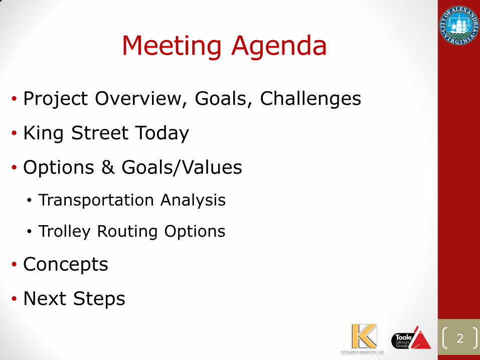
Meeting Agenda
• Project Overview, Goals, Challenges
• King Street Today
• Options & Goals/Values
• Transportation Analysis
• Trolley Routing Options
• Concepts
• Next Steps
2
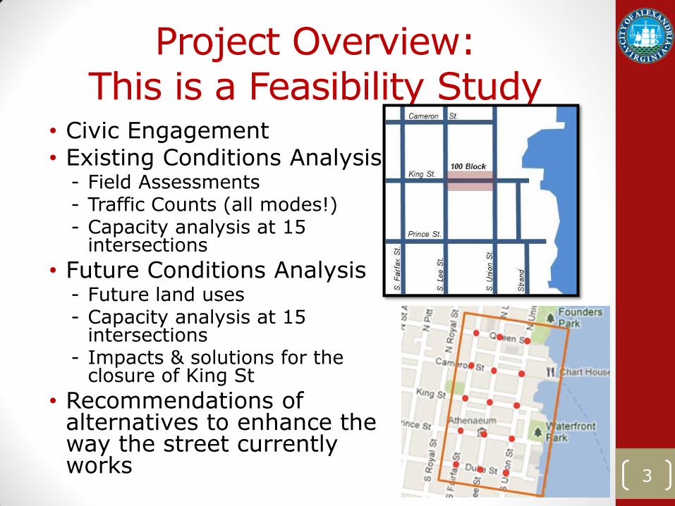
Project Overview: This is a Feasibility Study
• Civic Engagement • Existing Conditions Analysis
- Field Assessments - Traffic Counts (all modes!) - Capacity analysis at 15
intersections
• Future Conditions Analysis - Future land uses - Capacity analysis at 15
intersections - Impacts & solutions for the
closure of King St
• Recommendations of alternatives to enhance the way the street currently works
3
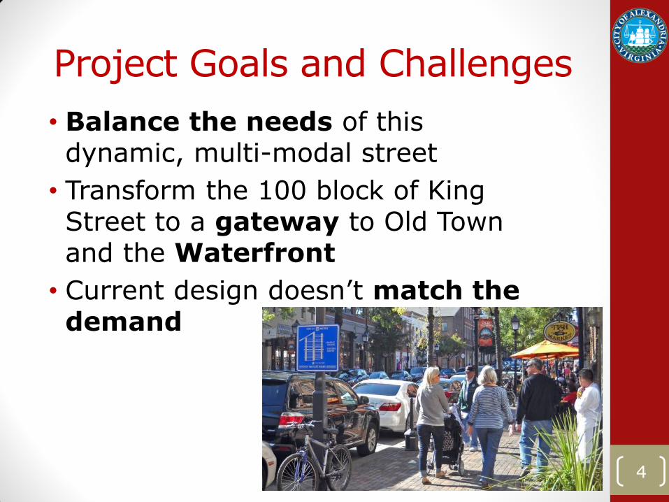
Project Goals and Challenges
• Balance the needs of this dynamic, multi-modal street
• Transform the 100 block of King Street to a gateway to Old Town and the Waterfront
• Current design doesn’t match the demand
4
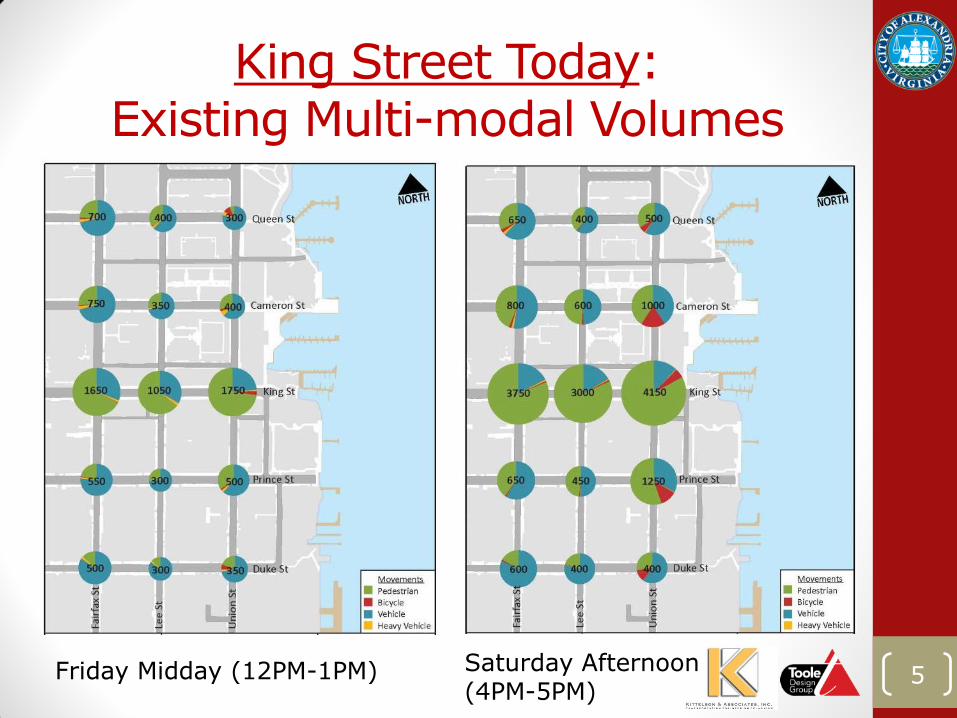
King Street Today: Existing Multi-modal Volumes
5 Friday Midday (12PM-1PM) Saturday Afternoon (4PM-5PM)
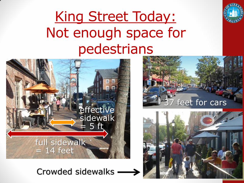
King Street Today: Not enough space for
pedestrians
6
full sidewalk = 14 feet
effective sidewalk = 5 ft
37 feet for cars
Crowded sidewalks
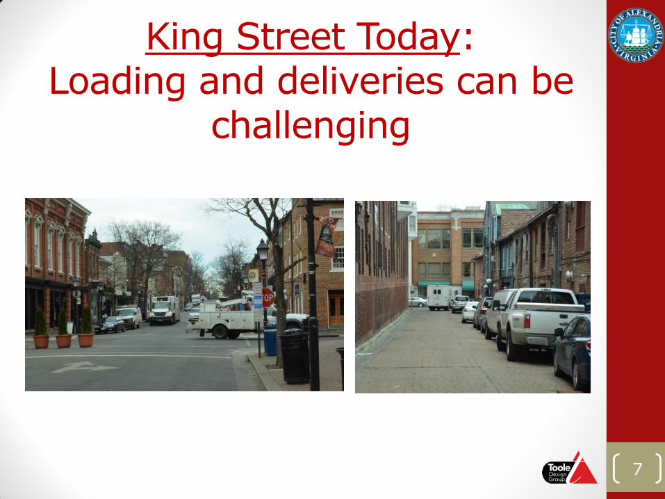
King Street Today: Loading and deliveries can be
challenging
7
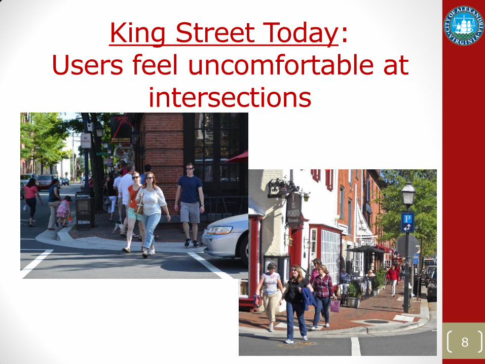
King Street Today: Users feel uncomfortable at
intersections
8
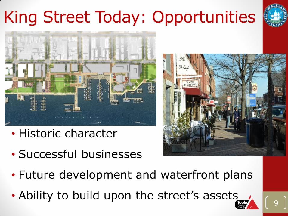
King Street Today: Opportunities
• Historic character
• Successful businesses
• Future development and waterfront plans
• Ability to build upon the street’s assets 9
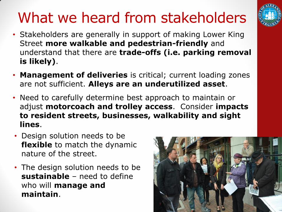
What we heard from stakeholders • Stakeholders are generally in support of making Lower King
Street more walkable and pedestrian-friendly and understand that there are trade-offs (i.e. parking removal is likely).
• Management of deliveries is critical; current loading zones are not sufficient. Alleys are an underutilized asset.
• Need to carefully determine best approach to maintain or adjust motorcoach and trolley access. Consider impacts to resident streets, businesses, walkability and sight lines.
10
• Design solution needs to be flexible to match the dynamic nature of the street.
• The design solution needs to be sustainable – need to define who will manage and maintain.
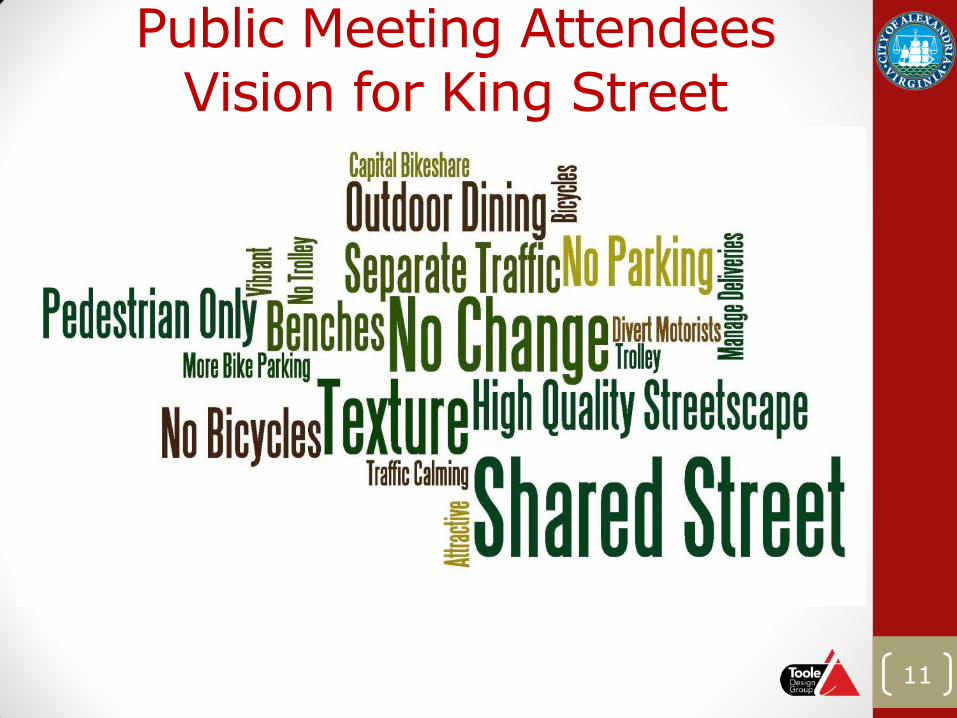
Public Meeting Attendees Vision for King Street
11
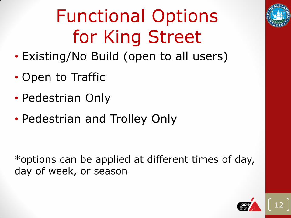
Functional Options for King Street
• Existing/No Build (open to all users)
• Open to Traffic
• Pedestrian Only
• Pedestrian and Trolley Only
*options can be applied at different times of day, day of week, or season
12
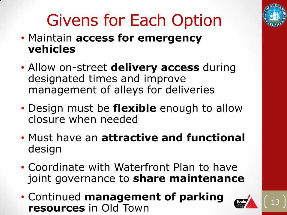
Givens for Each Option • Maintain access for emergency
vehicles
• Allow on-street delivery access during designated times and improve management of alleys for deliveries
• Design must be flexible enough to allow closure when needed
• Must have an attractive and functional design
• Coordinate with Waterfront Plan to have joint governance to share maintenance
• Continued management of parking resources in Old Town
13
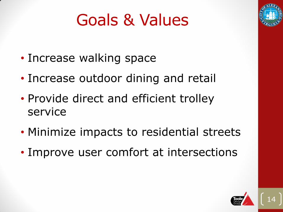
Goals & Values
• Increase walking space
• Increase outdoor dining and retail
• Provide direct and efficient trolley service
• Minimize impacts to residential streets
• Improve user comfort at intersections
14
15
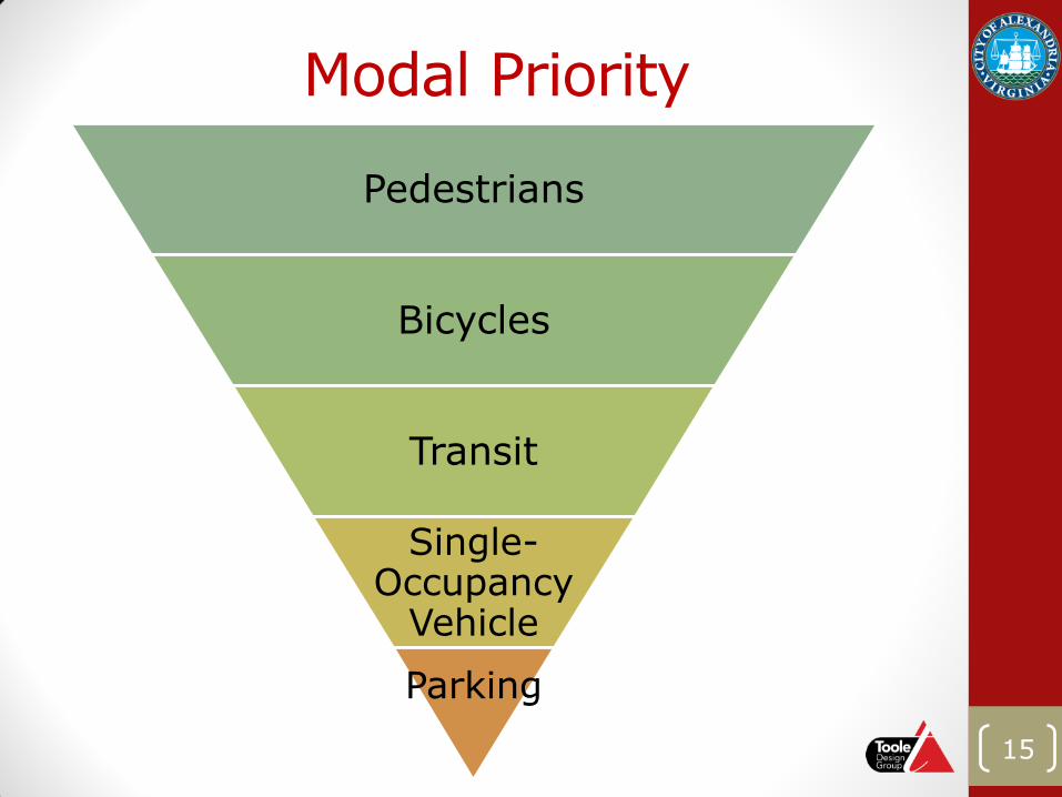
Modal Priority
Pedestrians
Bicycles
Transit
Single-Occupancy
Vehicle
Parking
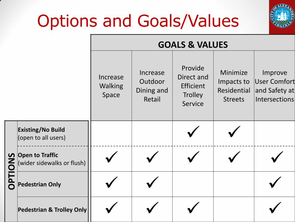
GOALS & VALUES
Increase Walking Space
Increase Outdoor
Dining and Retail
Provide Direct and
Efficient Trolley Service
Minimize Impacts to Residential
Streets
Improve User Comfort and Safety at Intersections
OP
TIO
NS
Existing/No Build (open to all users) Open to Traffic (wider sidewalks or flush) Pedestrian Only
Pedestrian & Trolley Only
Options and Goals/Values
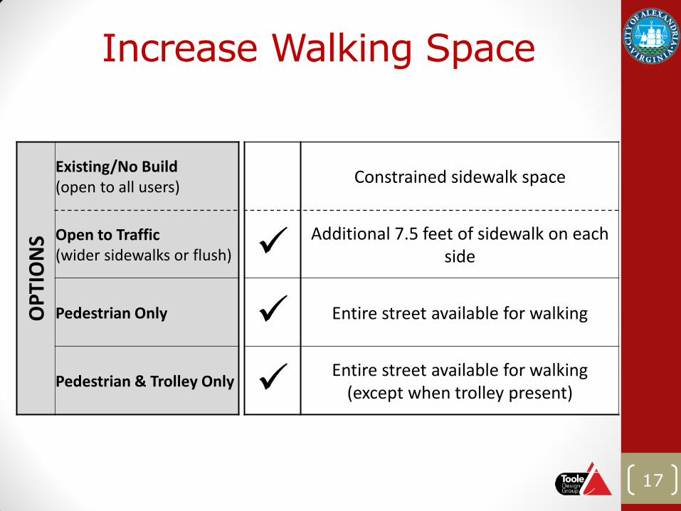
Increase Walking Space O
PTI
ON
S
Existing/No Build (open to all users) Constrained sidewalk space
Open to Traffic (wider sidewalks or flush)
Additional 7.5 feet of sidewalk on each side
Pedestrian Only Entire street available for walking
Pedestrian & Trolley Only Entire street available for walking
(except when trolley present)
17
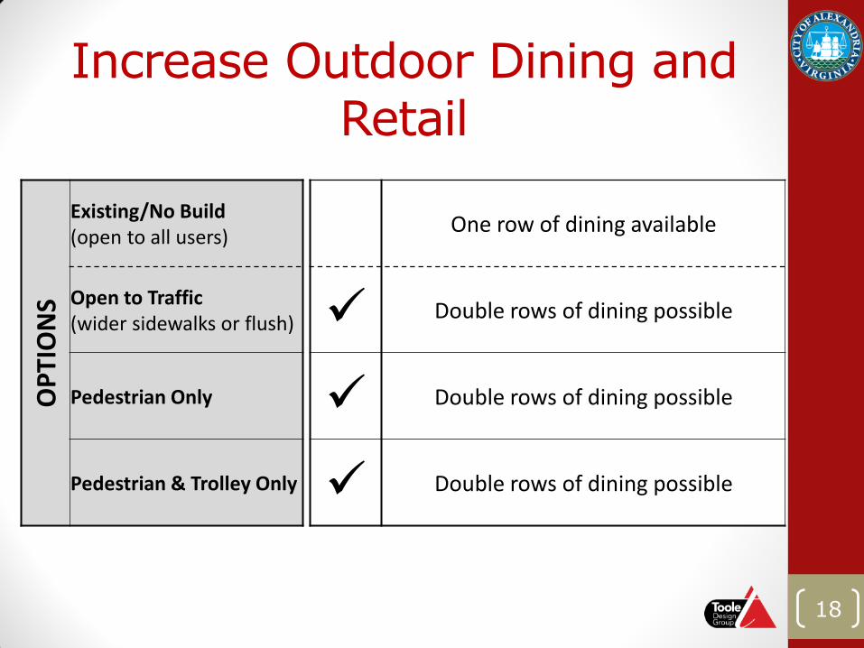
Increase Outdoor Dining and Retail
OP
TIO
NS
Existing/No Build (open to all users) One row of dining available
Open to Traffic (wider sidewalks or flush) Double rows of dining possible
Pedestrian Only Double rows of dining possible
Pedestrian & Trolley Only Double rows of dining possible
18
OP
TIO
NS
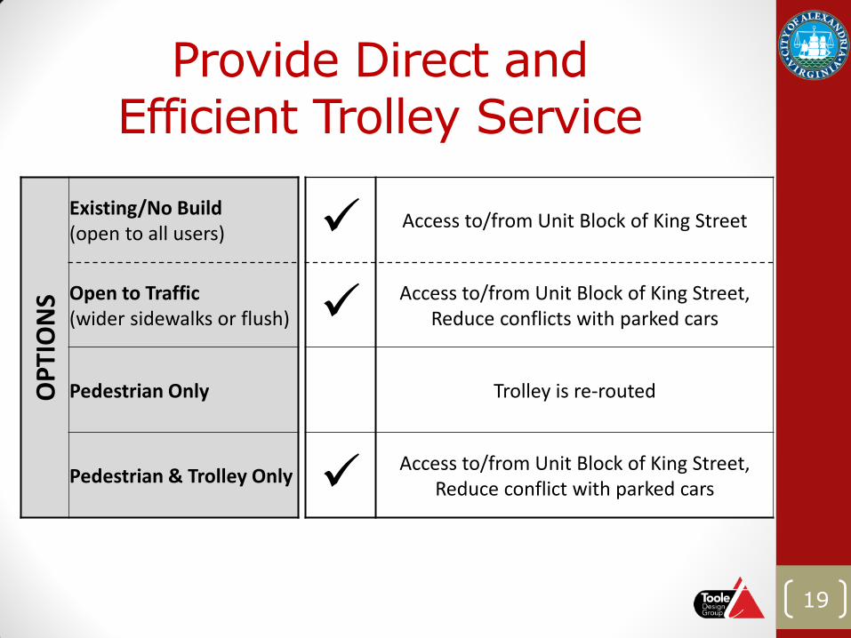
Existing/No Build (open to all users) Access to/from Unit Block of King Street
Open to Traffic (wider sidewalks or flush)
Access to/from Unit Block of King Street, Reduce conflicts with parked cars
Pedestrian Only Trolley is re-routed
Pedestrian & Trolley Only Access to/from Unit Block of King Street,
Reduce conflict with parked cars
Provide Direct and Efficient Trolley Service
19
OP
TIO
NS
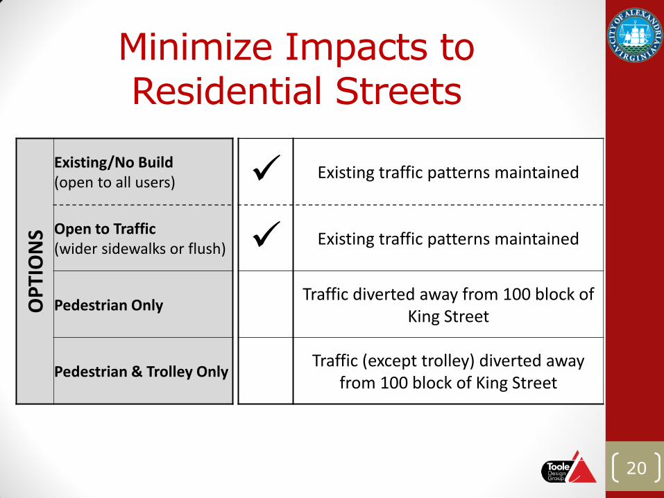
Existing/No Build (open to all users) Existing traffic patterns maintained
Open to Traffic (wider sidewalks or flush) Existing traffic patterns maintained
Pedestrian Only Traffic diverted away from 100 block of King Street
Pedestrian & Trolley Only Traffic (except trolley) diverted away from 100 block of King Street
Minimize Impacts to Residential Streets
20
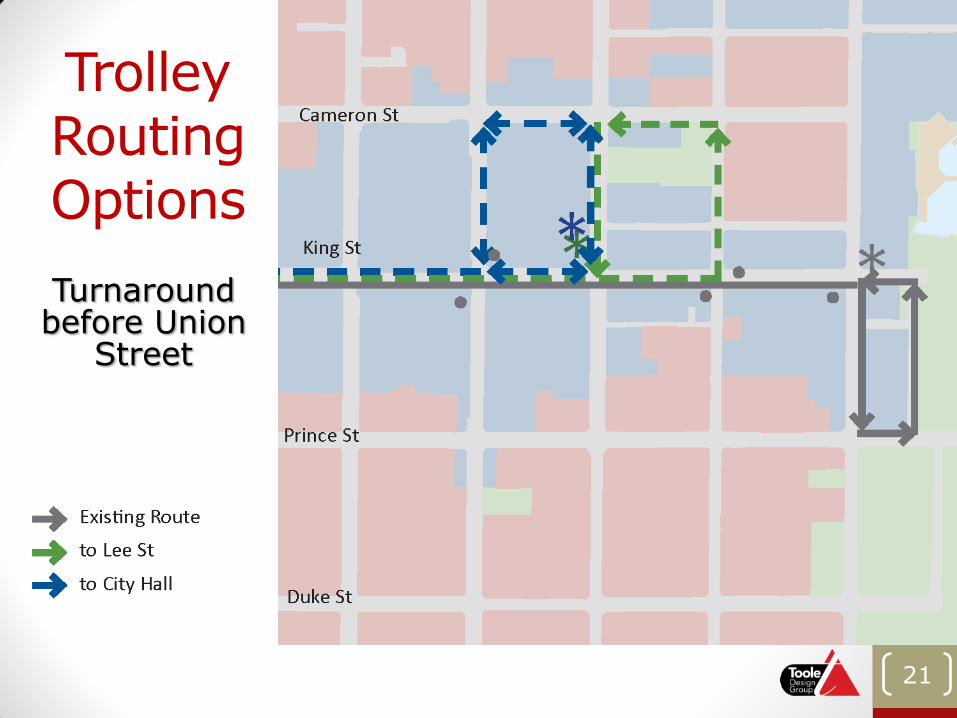
Trolley Routing Options
21
Turnaround before Union
Street
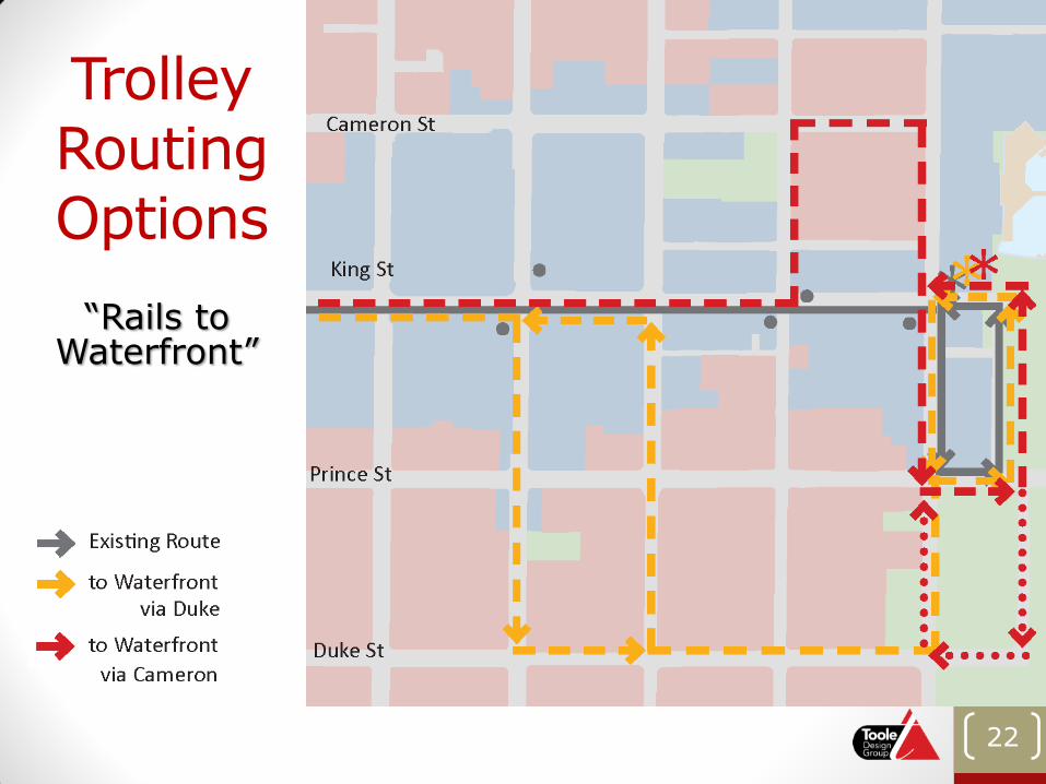
Trolley Routing Options
22
“Rails to Waterfront”
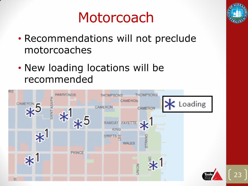
Motorcoach
• Recommendations will not preclude motorcoaches
• New loading locations will be recommended
23
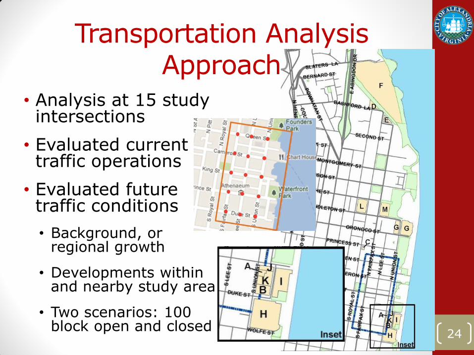
Transportation Analysis Approach
• Analysis at 15 study intersections
• Evaluated current traffic operations
• Evaluated future traffic conditions
• Background, or regional growth
• Developments within and nearby study area
• Two scenarios: 100 block open and closed
24
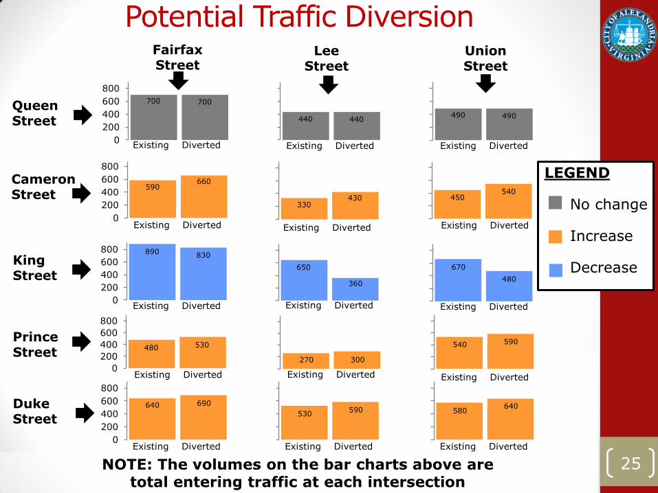
25
0
200
400
600
800
0
200
400
600
800
+ 30% + 15%
-5%
+ 20%
0
200
400
600
800
+ 10% + 10% + 10%
0
200
400
600
800
+ 10% + 10% + 10%
0
200
400
600
8000%
Potential Traffic Diversion
25
Existing Diverted
Queen Street
King Street
Prince Street
Duke Street
Cameron Street
Existing Diverted Existing Diverted
Existing Diverted Existing Diverted
Existing Diverted Existing Diverted
Existing Diverted
Existing Diverted
Existing Diverted
Existing Diverted
Existing Diverted Existing Diverted Existing Diverted
Existing Diverted
Fairfax Street
Lee Street
Union Street
0% 0%
-45% -30%
LEGEND No change Increase Decrease
700 700
440 440 490 490
590 660
NOTE: The volumes on the bar charts above are total entering traffic at each intersection
330 430 450
540
670
480
650
360
890 830
540 590 480 530
580 640
530 590
640 690
270 300
Future Transportation Analysis Results
• With the closure of the 100 block of King Street:
• Vehicles would be less likely to use King Street
• Cameron and Duke Street would carry more east-west traffic
• Union, Lee and Fairfax Street would carry more north-south traffic
• Reduced conflicts at King/Lee Street and King/Union Street
• Roadway network can accommodate additional and diverted traffic
26
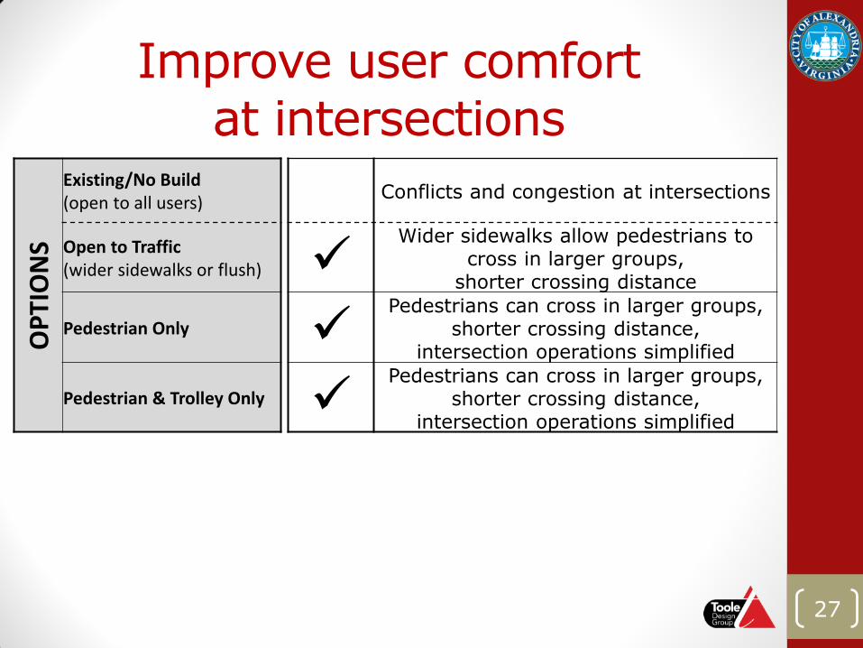
Improve user comfort at intersections
OP
TIO
NS
Existing/No Build (open to all users) Conflicts and congestion at intersections
Open to Traffic (wider sidewalks or flush)
Wider sidewalks allow pedestrians to cross in larger groups,
shorter crossing distance
Pedestrian Only Pedestrians can cross in larger groups,
shorter crossing distance, intersection operations simplified
Pedestrian & Trolley Only Pedestrians can cross in larger groups,
shorter crossing distance, intersection operations simplified
27
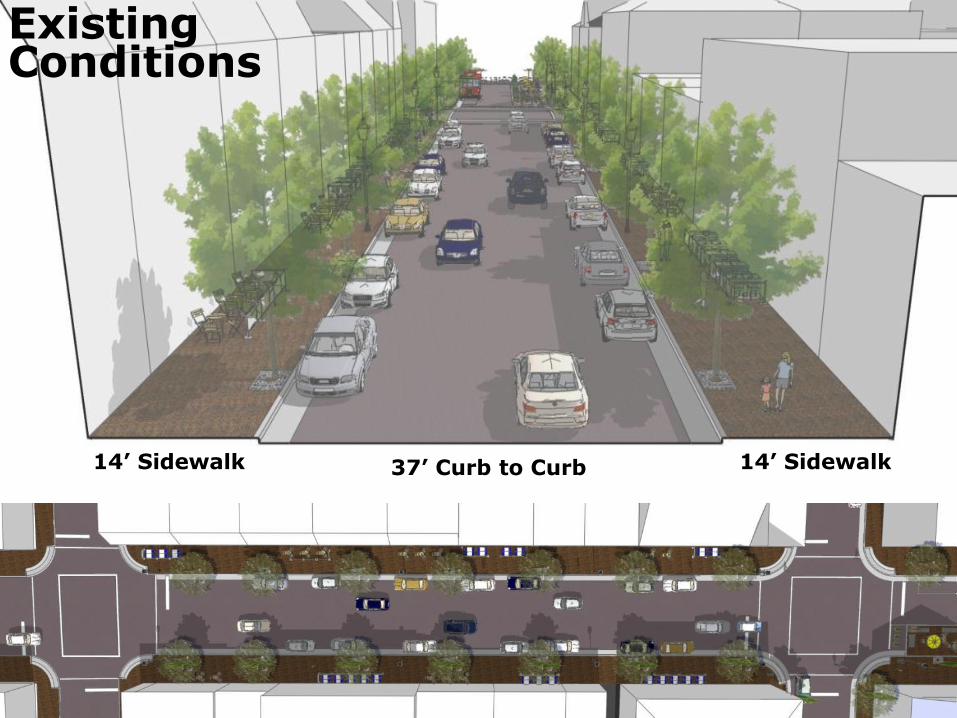
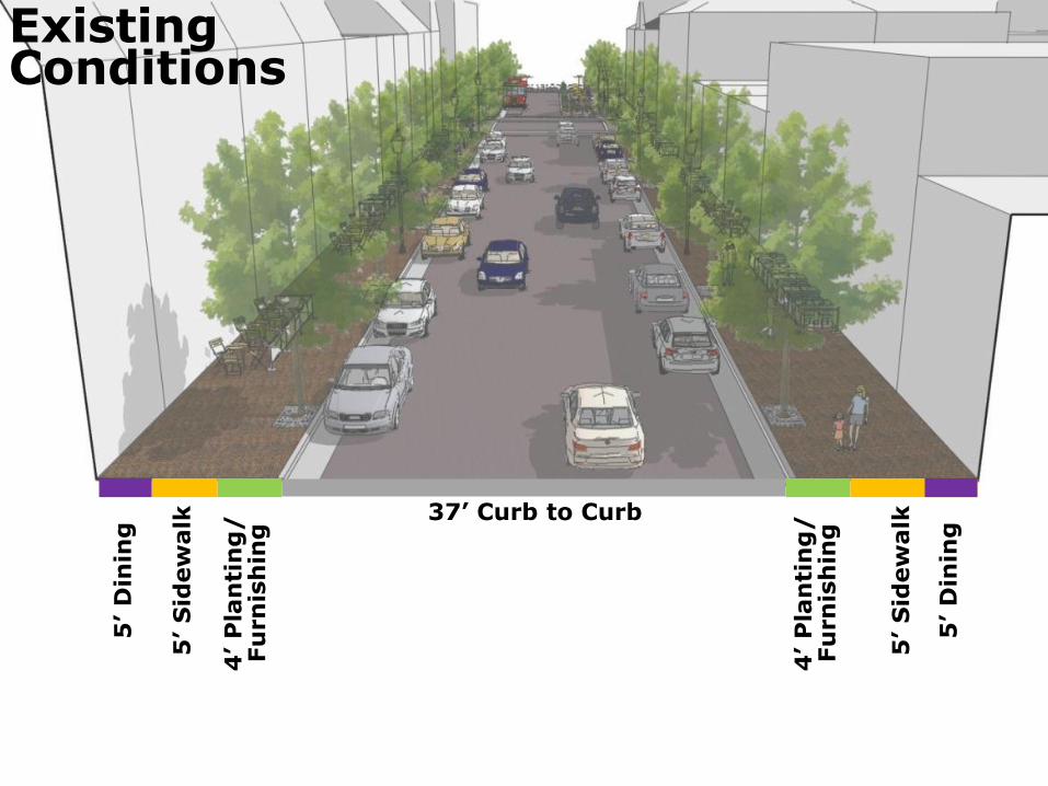
14’ Sidewalk 14’ Sidewalk
Existing Conditions
37’ Curb to Curb
Existing Conditions
37’ Curb to Curb
5’ D
inin
g
5’ S
idew
alk
4’ P
lan
tin
g/
Fu
rn
ish
ing
5’ S
idew
alk
4’ P
lan
tin
g/
Fu
rn
ish
ing
5’ D
inin
g
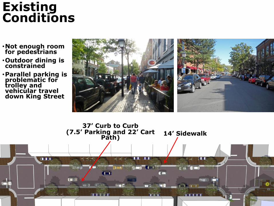
•Not enough room for pedestrians
•Outdoor dining is constrained
•Parallel parking is problematic for trolley and vehicular travel down King Street
Existing Conditions
14’ Sidewalk
37’ Curb to Curb (7.5’ Parking and 22’ Cart
Path)
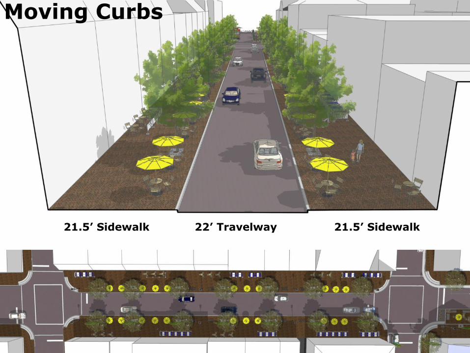
22’ Travelway 21.5’ Sidewalk 21.5’ Sidewalk
Moving Curbs
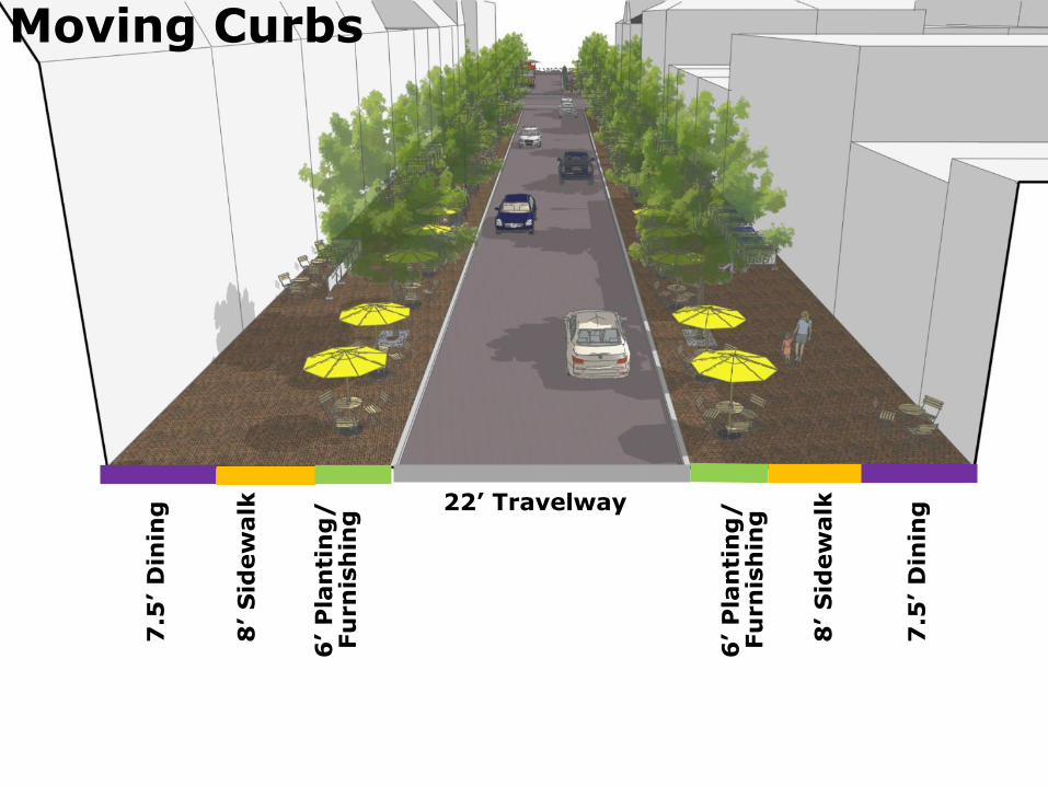
Moving Curbs
22’ Travelway
7.5
’ D
inin
g
8’ S
idew
alk
6’ P
lan
tin
g/
Fu
rn
ish
ing
7.5
’ D
inin
g
8’ S
idew
alk
6’ P
lan
tin
g/
Fu
rn
ish
ing
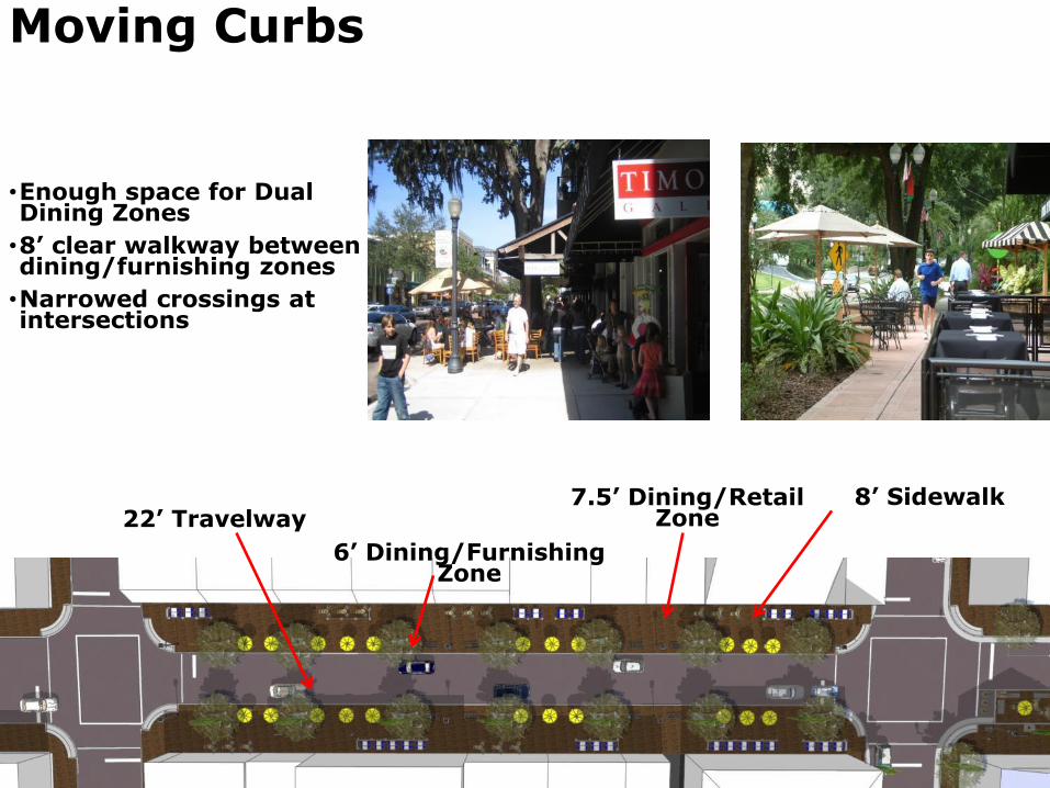
•Enough space for Dual Dining Zones
•8’ clear walkway between dining/furnishing zones
•Narrowed crossings at intersections
Moving Curbs
7.5’ Dining/Retail Zone 22’ Travelway
8’ Sidewalk
6’ Dining/Furnishing Zone
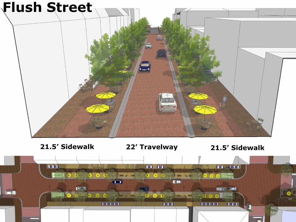
21.5’ Sidewalk 21.5’ Sidewalk
Flush Street
22’ Travelway
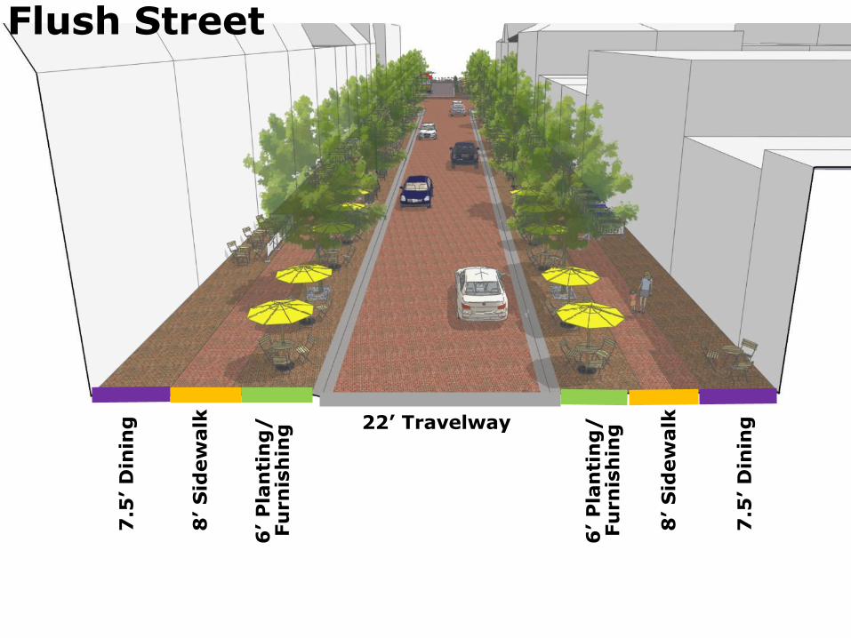
Flush Street
22’ Travelway
7.5
’ D
inin
g
8’ S
idew
alk
6’ P
lan
tin
g/
Fu
rn
ish
ing
7.5
’ D
inin
g
8’ S
idew
alk
6’ P
lan
tin
g/
Fu
rn
ish
ing
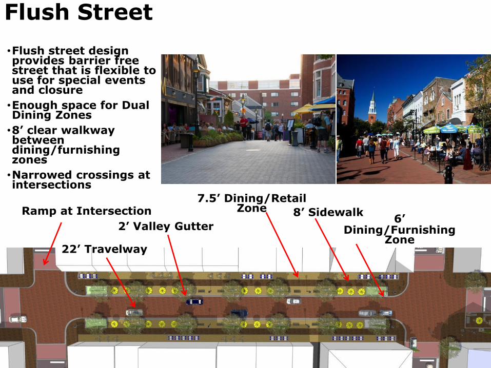
•Flush street design provides barrier free street that is flexible to use for special events and closure
•Enough space for Dual Dining Zones
•8’ clear walkway between dining/furnishing zones
•Narrowed crossings at intersections
Flush Street
8’ Sidewalk Ramp at Intersection 7.5’ Dining/Retail
Zone
22’ Travelway
2’ Valley Gutter 6’
Dining/Furnishing Zone
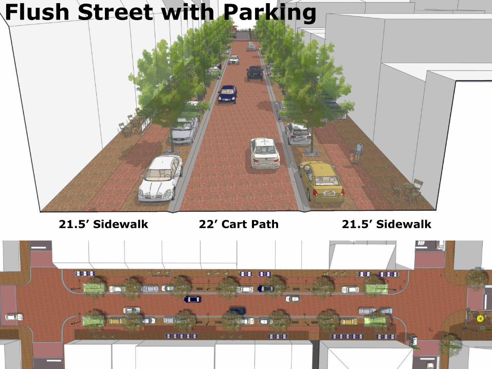
Flush Street with Parking
22’ Cart Path 21.5’ Sidewalk 21.5’ Sidewalk

Questions?
38


