14
TECHNICAL SERVICES DIVISION LYME REGIS ENVIRONMENTAL IMPROVEMENTS PHASE IV WEST DORSET DISTRICT COUNCIL PROJECT APPRAISAL REPORT PRELIMINARY DESIGN STAGE MAY 2005

TECHNICAL SERVICES DIVISION
LYME REGIS ENVIRONMENTAL IMPROVEMENTSPHASE IV
WEST DORSET DISTRICT COUNCIL
PROJECT APPRAISAL REPORT
PRELIMINARY DESIGN STAGE
MAY 2005
TECHNICAL SERVICES DIVISION CONTENTSLYME REGIS ENVIRONMENTAL IMPROVEMENTS - PHASE IV
PROJECT APPRAISAL REPORT - PRELIMINARY DESIGN STAGE
1.0 Introduction
2.0 Definition of the Problems
3.0 Objectives
4.0 Coast Protection Options
5.0 Cost Benefit Analysis and Programme
6.0 Preliminary Design Elements and Cost Estimate
7.0 Summary
References
TECHNICAL SERVICES DIVISION 1.0 INTRODUCTIONLYME REGIS ENVIRONMENTAL IMPROVEMENTS - PHASE IV
PROJECT APPRAISAL REPORT - PRELIMINARY DESIGN STAGE
Lyme Regis is an ancient coastal town situated in Lyme Bay on the south coast of Britain. The town hasrecently become a 'gateway town' as part of the world heritage coast of West Dorset and East Devon. It isboth a popular residential area and a major holiday resort, with a summer population of approximately 14,000.Lyme Regis is famous for its unique harbour structure, the Cobb, which is the oldest working breakwater of itstype in the country. The town's economy relies heavily upon tourists who are attracted by the harbour, thebeaches and the spectacular coastal scenery.
The historical development of the town has been strongly influenced by coastal erosion and landslipping.Over the centuries the coastline has been protected against marine erosion by the construction of a series ofsea walls, jetties and other defences of various forms. These defences have been repaired and replaced in apiecemeal fashion in response to storm damage and general decay so that today the town is protected by avariable complex of ageing structures.
Although the town has been partly protected from the direct erosive action of the sea, large areas of it havebeen constructed on ancient coastal landslides which periodically become reactivated resulting in disruptionand damage to property.
1.3 Strategy PlanA Coast Protection Strategy Plan has been developed for Lyme Regis, which was agreedby DEFRA in November 2003. The plan brings together the findings of the PreliminaryStudies, including early work on the conceptual design of engineering schemes, andestablishes an action plan for improving the coast protection situation at Lyme Regis in thelong term. The main findings of the strategy plan for Phase IV of the Lyme RegisEnvironmental Improvements are:
1) The area of Phase IV is at risk from coastal erosion and landslipping, including 172 properties, associated services, infrastructure and amenity.
2) In order to fulfil the recommendation of the Shoreline Management Plan of 'hold the line' for urban areas of the town, there are no realistic alternatives in the long term other than to implement a new coast protection scheme.
3) The most appropiate coast protection management option for Phase IV is to implement an new coast protection scheme comprising seawall and foreshore rock platform strengthening and repair, and slope strengthening and drainage.
4) There would also be considerable benefits to the environment and society of implementing a scheme.
1.4 Previous StudiesThe data used to develop the Strategy Plan and the proposed engineering schemes havecome from the Preliminary Studies carried out by West Dorset District Council and itsconsultants in the period 1996 - 2000. A summary of the methodology and findings of thestudies is given in the Preliminary Studies Summary Report prepared by WDDC (August2000). The relevant Shoreline Management Plan for Lyme Regis is the Lyme Bay andSouth Devon Shoreline Management Plan, prepared by Posford Duvivier in 1998.Additional reports include the Preliminary Environmental Appraisal prepared by High-PointRendel (April 2003) and the Preliminary Ecological Assessment by EPR (February 2003).
In the early 1990's West Dorset District Council (WDDC) initiated the Lyme Regis EnvironmentalImprovements with the aim of safeguarding the integrity of the coastal areas of Lyme Regis in the long term.The initial emphasis was upon the implementation of a new coast protection scheme for the central part ofthe town adjacent to the River Lim, the existing 250-year old sea walls at which were approaching the pointof failure.
The construction work for this first phase, which comprises a new sea wall and rock armour revetment, wascompleted in 1995. Since then, West Dorset District Council has carried out an extensive series ofPreliminary Studies in order to gain an understanding of the coast protection problems affecting theremaining areas of Lyme Regis. The Preliminary Studies have been deliberately holistic in approach,considering all of the Lyme Regis coastline (not just a series of isolated problem areas) and the whole of thephysical coastal system from the offshore submarine environment to the top of the coastal slope. Thus theinformation obtained has been used at a strategic level in determining an integrated management policy andpreparing coordinated design concepts and programming for coast protection schemes.
Since conducting the Preliminary Studies WDDC has concentrated on the main town frontage (Phase II), feltto be the area at most risk, and in 2005 started construction of a major coast protection scheme to
This report refers to the Phase IV area of Lyme Regis at East Cliff (Figures 1.1 and 2.1), and is submitted in support of an application to DEFRA for coast protection grant to fund the preliminary design and appraisal of scheme options in this area.
secure the town's future. During the development of the Phase II scheme, Lyme Regisexperienced many consecutive years of above average rainfall. This resulted in large ratesof cliff top recession on the east side of Lyme Regis. In 2004, as a result of the increasedthreat to property and infrastructure, WDDC constructed stabilisation works to hold the lineof the cliff top at East Cliff in the short term, pending the implimentation of a full coastprotection scheme.
1.0 General
1.1 Background
1.2 The Lyme Regis Environmental Improvements

TECHNICAL SERVICES DIVISION FIGURE 1.1LYME REGIS ENVIRONMENTAL IMPROVEMENTS - PHASE IV AERIAL PHOTOGRAPHS OF EAST CLIFFPROJECT APPRAISAL REPORT - PRELIMINARY DESIGN STAGE
Church Cliff East Cliff

TECHNICAL SERVICES DIVISION 2.0 DEFINITION OF THE PROBLEMSLYME REGIS ENVIRONMENTAL IMPROVEMENTS - PHASE IV
PROJECT APPRAISAL REPORT - PRELIMINARY DESIGN STAGE
Problem Consequences
1 Large areas of the coastal slopes are inherently unstable and there is a high probability that 1 Destruction of property over a wide area; loss of roads and utilities. there will be a major reactivation of the landslide systems within the next 1 to 5 years.
2 The sea wall is under threat from large-scale slope failure. 2 Loss of the sea wall, leading to further landsliding.
3 The eastern part of Lyme Regis is under threat from the continuing long-term westwards 3 Loss of meadows and allotments.expansion of the Spittles/Black Ven landslide system.
4 The drainage system has defects and its outfall is under threat from continuing 4 Raised groundwater levels triggering destructive landslipping. ground movements.
5 The sea wall is being outflanked at its eastern end. 5 Local loss of sea wall, local erosion of cliff, triggering of existing landsides.
6 The shore platform is lowering and breaking up, the sea wall is in a poor condition and is 6 The sea wall will be subject to an increasing severity of wave attack, will continue to deteriorate starting to be undermined. There is very little protection from beach material. and will eventually fail.
7 The groynes are dilapidated and may become a danger to the public. 7 Unacceptable danger to members of the public.
Table 2.1: Summary of problems and consequences that would arise from them in the 'do nothing' scenario
2.1 Boundaries
As described in the Strategy Plan, the area under consideration for the Lyme RegisEnvironmental Improvements extends from Devonshire Head in the west to the Spittles in theeast, covering the whole of the urban coastal area of Lyme Regis (Figure 2.1). Phase IVcovers the Church Cliff and East Cliff coastal slopes and extends inland into the Timber Hillarea and is bounded by the Spittles to the East. Figure 1.1 shows aerial photographs of theEast Cliff and Church Cliff areas.
Phase IV is separated physically from Phase II by the new coast protection scheme for PhaseI. As a result, it is considered that there is no interconnection between Phase IV, and PhaseII either in terms of overlapping benefit areas or physical coastal process such as sedimenttransfer.
2.2 Summary of the ProblemsThe coast protection challenges facing Lyme Regis have been established from the findingsof the Preliminary Studies. The main problems are essentially as follows:
1) the foreshore rock platforms are starved of beach material and are being lowered by theerosive action of the sea;
2.3 2004 Urgent WorksDuring the winter of 2003/2004 WDDC constructed local urgent stabilisation works in thePhase IV area of Lyme Regis to provide short term protection to properties and infrastructure.The urgent works have a design life of only six years and were constructed purely to securethe area temporarily in the lead in to a full coast protection scheme. Therefore the urgentworks do not provide a permanent solution to any of the problems outlined in Table 2.1.
2) previous coast protection works, such as sea walls and slope drainage systems, are in apoor condition and some elements are approaching the end of their practical life;
3) the coastal slopes are inherently unstable and prone to rapid and large scale landslideactivity;
As a result, a large part of the town is at risk from coastal erosion and landsliding.
Table 2.1 gives a more detailed summary of the problems and the consequences that wouldarise from them in the 'do nothing ' scenario.
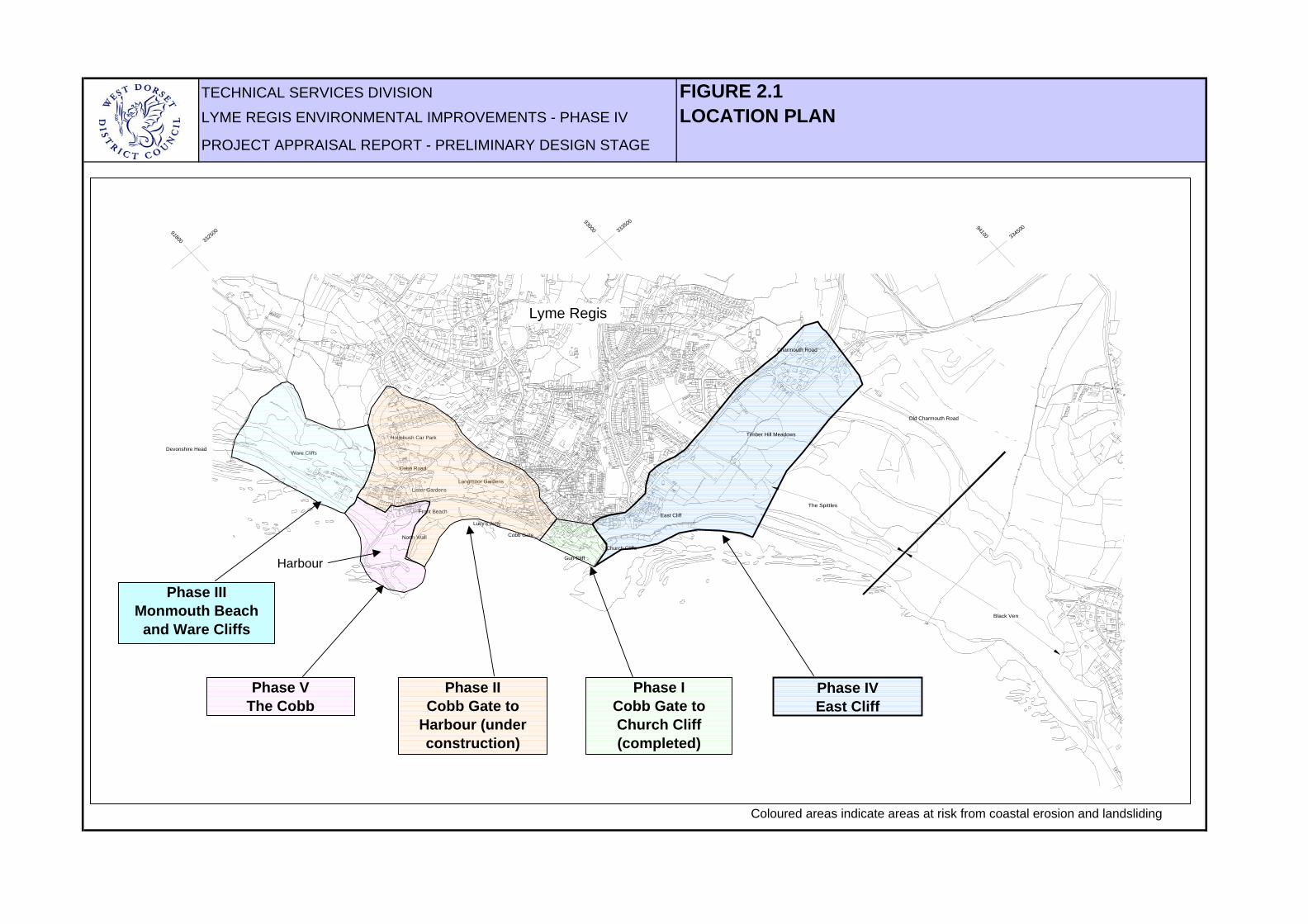
TECHNICAL SERVICES DIVISION FIGURE 2.1LYME REGIS ENVIRONMENTAL IMPROVEMENTS - PHASE IV LOCATION PLANPROJECT APPRAISAL REPORT - PRELIMINARY DESIGN STAGE
33250091800
33350093000
33450094100
The Spittles
Black Ven
Phase VThe Cobb
Phase II Cobb Gate to
Harbour (under construction)
Phase IVEast Cliff
Phase ICobb Gate to Church Cliff(completed)
Lyme Regis
Timber Hill Meadows
Old Charmouth Road
Charmouth Road
East Cliff
Church Cliffs
Gun Cliff
Langmoor GardensLister Gardens
Holmbush Car Park
Ware CliffsDevonshire Head
Cobb Road
Phase IIIMonmouth Beach
and Ware Cliffs
Cobb Gate
Lucy's Jetty
Front Beach
North Wall
Coloured areas indicate areas at risk from coastal erosion and landsliding
Harbour

TECHNICAL SERVICES DIVISION 3.0 OBJECTIVESLYME REGIS ENVIRONMENTAL IMPROVEMENTS - PHASE IV
PROJECT APPRAISAL REPORT - PRELIMINARY DESIGN STAGE
Repair and strengthen the sea wall and the Implement slope stabilisation schemes, foreshore rock platform. including drainage improvements, on the
lower slopes.
Provide further protection at the eastern end Carry out strengthening works to the of the sea wall to prevent outflanking. foreshore and sea wall to improve overall
cliff stability.
Foreshore Slopes
Figure 3.1 Summary of Recommended Generic Actions for Phase IV
3.3 Alternative Philosophies
The following alternatives have been considered :
Do nothing: would lead to severe consequences for the long term future of the town.Discordant with Preferred Strategic Options of the Shoreline Management Plan. Do minimum: i.e. ongoing maintenance of structures, 'patch and mend'. This isessentially the philosophy which is currently in force. It does nothing to address theinherent instability of the foreshore and coastal slopes, nor the fundamental defects of the coast protection structures. Hence it would lead to much the same consequences as inthe 'do nothing' case, and is discordant with the recommendations of the ShorelineManagement Plan.
React to failures once they have occurred: this is often what happened historically andis the equivalent of shutting the stable door after the horse has bolted. Although failureswould not be allowed to develop and extend inland as they would in the 'do nothing' case,there would still be the potential for severe damage and disruption. The remedial works totreat a failure once it had caused the damage would be significantly greater in cost thanthose required to prevent the failure in the first place, and would take place after theassets had been lost. Discordant with the Preferred Strategic Options of the ShorelineManagement Plan.
Early warning systems: in theory, these would give prior warning of landslide events toallow occupiers to leave premises and areas to be evacuated to help ensure publicsafety. They would do nothing to protect assets, hence if used in isolation would bediscordant with the guidelines in the Shoreline Management Plan. However, it may beappropriate to install them in any areas in which there is a high risk to life, but where it isnot feasible to carry out stabilisation works, for example because of access restrictions.WDDC currently operates an early warning system in the Phase IV area pending theimplementation of the proposed coast protection works.
Coast protection works: major strengthening works comprising improvements to thecoast protection walls, repairs to the shore rock platform, slope stabilisation and drainageworks, is considered to be the only realistic philosophy which will meet the objectives ofthe Shoreline Management Plan.
3.1 Shoreline Management Plan
The Lyme Bay and South Devon Shoreline Management Plan (prepared by Posford Duvivier,1998) gives 'hold the line' as the Preferred Strategic Option for the Phase IV area of theLyme Regis Environmental Improvements.
3.2 Recommended Generic Objectives for Phase IV
Lyme Regis is faced with a formidable array of coast protection challenges. In order to fulfilthe recommendation of 'hold the line' in the Shoreline Management Plan, it is considered thatthere is no other realistic alternative in the long term other than to implement a new coastprotection scheme.
On this basis, general objectives or actions have been determined that could be used toimprove the coast protection situation as part of new schemes (Figure 3.1). Section 9 of thePreliminary Studies Summary Report spells out how these have been developed from thedata obtained in the Preliminary Studies.
As the probability of damage due to marine erosion and landsliding are both relatively high,there would be little benefit in implementing foreshore protection works without also carryingout slope stabilisation works, and vice versa.
3.4 Environmental Issues
Much of the Phase IV area has the SSSI and cSAC environmental designations. One ofthe objectives of a scheme in this area will be to protect the valuable habitats and toprovide environmental enhancement of the area.
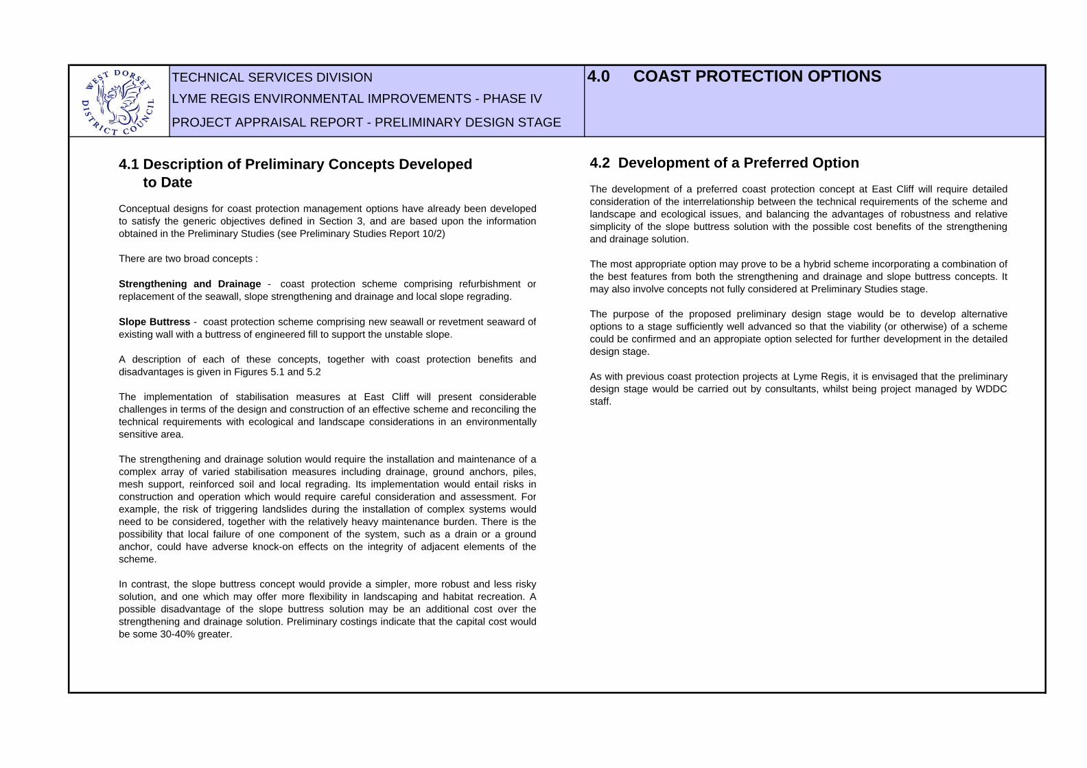
TECHNICAL SERVICES DIVISION 4.0 COAST PROTECTION OPTIONSLYME REGIS ENVIRONMENTAL IMPROVEMENTS - PHASE IV
PROJECT APPRAISAL REPORT - PRELIMINARY DESIGN STAGE
4.1 Description of Preliminary Concepts Developed to DateConceptual designs for coast protection management options have already been developedto satisfy the generic objectives defined in Section 3, and are based upon the informationobtained in the Preliminary Studies (see Preliminary Studies Report 10/2)
There are two broad concepts :
Strengthening and Drainage - coast protection scheme comprising refurbishment orreplacement of the seawall, slope strengthening and drainage and local slope regrading.
Slope Buttress - coast protection scheme comprising new seawall or revetment seaward ofexisting wall with a buttress of engineered fill to support the unstable slope.
A description of each of these concepts, together with coast protection benefits anddisadvantages is given in Figures 5.1 and 5.2
The implementation of stabilisation measures at East Cliff will present considerablechallenges in terms of the design and construction of an effective scheme and reconciling thetechnical requirements with ecological and landscape considerations in an environmentallysensitive area.
The strengthening and drainage solution would require the installation and maintenance of acomplex array of varied stabilisation measures including drainage, ground anchors, piles,mesh support, reinforced soil and local regrading. Its implementation would entail risks inconstruction and operation which would require careful consideration and assessment. Forexample, the risk of triggering landslides during the installation of complex systems wouldneed to be considered, together with the relatively heavy maintenance burden. There is thepossibility that local failure of one component of the system, such as a drain or a groundanchor, could have adverse knock-on effects on the integrity of adjacent elements of thescheme.
In contrast, the slope buttress concept would provide a simpler, more robust and less riskysolution, and one which may offer more flexibility in landscaping and habitat recreation. Apossible disadvantage of the slope buttress solution may be an additional cost over thestrengthening and drainage solution. Preliminary costings indicate that the capital cost wouldbe some 30-40% greater.
4.2 Development of a Preferred OptionThe development of a preferred coast protection concept at East Cliff will require detailedconsideration of the interrelationship between the technical requirements of the scheme andlandscape and ecological issues, and balancing the advantages of robustness and relativesimplicity of the slope buttress solution with the possible cost benefits of the strengtheningand drainage solution.
The most appropriate option may prove to be a hybrid scheme incorporating a combination ofthe best features from both the strengthening and drainage and slope buttress concepts. Itmay also involve concepts not fully considered at Preliminary Studies stage.
The purpose of the proposed preliminary design stage would be to develop alternativeoptions to a stage sufficiently well advanced so that the viability (or otherwise) of a schemecould be confirmed and an appropiate option selected for further development in the detaileddesign stage.
As with previous coast protection projects at Lyme Regis, it is envisaged that the preliminarydesign stage would be carried out by consultants, whilst being project managed by WDDCstaff.

TECHNICAL SERVICES DIVISION FIGURE 4.1LYME REGIS ENVIRONMENTAL IMPROVEMENTS - PHASE IV CONCEPTUAL DESIGN ELEMENTS PROJECT APPRAISAL REPORT - PRELIMINARY DESIGN STAGE
Location of 2003-04 urgent works
New carrier drainage
Trench drains.
Counterfort drains.
Eastern limits of works to be determined.
New toe drain for upper cliff bench.
New toe drain for lower cliff bench.
Front face stabilised by using mesh, dowels and vegetation.
Piled grid arrays or piled retaining structures, to strengthen unstable slope.
Buttress of granular fill or reinforced earth on pile foundation supporting lateral scarp of main landslide. Alternatively, ground anchors on scarp slope instead
of buttress could be considered.
Existing seawall.
New seawall / revetment, replacing existing dilapidated structure
Sub-horizontal drilled drainage arrays.
Local mesh and dowels to support steep cliff.
Do-nothing.
Ground anchors.
Bored piles.
Improve existing surface
water drains.
STRENGTHENING AND DRAINAGE SOLUTION
New carrier drainage system.
Area of fill buttress seaward of existing
seawall.
Eastern limits of works to be determined.
Possible extent of rock armour.
Counterfort drains.
New cut-off drain.
New walkway.
Buttress of engineered fill to support unstable slope, landscaped to create environmentally beneficial habitats.
Area of fill buttress inland of existing seawall.
Trench drains.
Improve existing surface water drains.
SLOPE BUTTRESS SOLUTION
0m 100m
N
Works prevent expansion of
active landslide system into
built-up areas.
Works to north and east of active landslide will provide buffer against
outflanking from east.
Works prevent expansion of active
landslide system into built-up areas.
Works to north and east of active landslide
will provide buffer against outflanking
from east.
Location of 2003-04 urgent works
Location of 2003-04 urgent works
Location of 2003-04 urgent works

TECHNICAL SERVICES DIVISION FIGURE 4.2LYME REGIS ENVIRONMENTAL IMPROVEMENTS - PHASE IV COAST PROTECTION BENEFITSPROJECT APPRAISAL REPORT - PRELIMINARY DESIGN STAGE
Principal Benefits
Secondary benefits
Broad environmental and social benefits
Intensive works to toe of slope alleviates risk of landslide
recession inland, hence reduce need for disruptive works in
sensitive environmental areas higher on hillside.
STRENGTHENING AND DRAINAGE SOLUTION DISADVANTAGES :
Intensive and complex scheme involving significant risks during construction and
operation in terms of both landslide reactivation and cost escalations.
Heavy maintenance burden.
Substantial disruption to environmentally sensitive area.
Construction of drainage, pile grids and other strengthening measures provide stabilisation whilst maintain
existing landform and broad character of the area.
Improved and safer access to internationally important
geological exposures, and to beach at the Spittles and Black
Ven to the east.
Improvements in amenity, access, safety, visual
appearance and general quality of the environment benefit local
economy.
Opportunities to enhance Charmouth Road Car Park and improve amenity, with footpath links to beaches and Gun Cliff
Walk.
Opportunity to reinstate public footpath from East
Cliff Lane, lost to landslipping in the 1970's.
Opportunity to create new footpath along
top of seawall, improving safety for
coastal walkers.
Educational opportunities related to geology, ecology and
geomorphology.Habitat creation benefits nature
conservation interests.Improvements to
visual appearance of area.
SLOPE BUTTRESS SOLUTION DISADVANTAGES:
Substantial disruption to environmentally sensitive area.
Relatively high cost.
Aesthetics: Uniform engineered appearance abutting natural slope
Substantial scope for improvements to visual appearance and amenity use of area.
Slope buttress provides relatively simple and robust stabilisation. Low risk of landslide reactivation during
construction. Low maintenance burden.
Area at risk of coastal erosion and landslipping which would be protected by the proposed scheme.The area includes 172 properties with associated infrastructure and amenities.
0m 200m
N

TECHNICAL SERVICES DIVISION 5.0 COST BENEFIT ANALYSIS AND PROGRAMMELYME REGIS ENVIRONMENTAL IMPROVEMENTS - PHASE IV
PROJECT APPRAISAL REPORT - PRELIMINARY DESIGN STAGE
20093 4 1 2 3 4 1 2 3 4 1 2 3 4 1
Engineers appraisal reportContract documentsTender Period and contract awardConstruction
Preliminary designDetailed designPlanning process
YearQuarter
Finincial year 2008-2009
2005 2006 2007 2008
2005-2006 2006-2007 2007-2008
5.3 Additional benefits In addition to the economic benefits described by the cost benefit analysis, there would beconsiderable other benefits to society of implementing coast protection schemes. These wouldinclude, for example, reduction of stress and worry of residents and business people with premisesin vulnerable areas and improvements in amenity, access, landscaping and the quality of theenvironment, making the areas more attractive and vibrant and increasing the confidence of thetown generally.
5.1 ProgrammeThe indicative programme above places the preliminary design in the context of the programme ofthe scheme as a whole.
5.2 Cost Benefit AnalysisA preliminary cost benefit analysis has been carried out for the East Cliff area and can be seen inthe Lyme Regis Strategy Plan.
The cost benefit analysis shows that the scheme will protect 172 properties valued atapproximately £40M, infrastructure and associated services. Amenity value would also beprotected such as Charmouth Road Car Park and the beaches at Church Cliff and East Cliff,popular with fossil hunters and holiday makers.
At this early stage of the project, the analysis shows that a scheme for Phase IV will achieve a costbenefit ratio in excess of five. This is base on conservative estimates of property value,construction costs and amenity benefit and is likely to exceed this value.
Figure 5.1 Indicative Programme
2 years
TECHNICAL SERVICES DIVISION 6.0 PRELIMINARY DESIGN ELEMENTSLYME REGIS ENVIRONMENTAL IMPROVEMENTS - PHASE IV AND COST ESTIMATEPROJECT APPRAISAL REPORT - PRELIMINARY DESIGN STAGE
Description and PurposeElement
Contingency 105
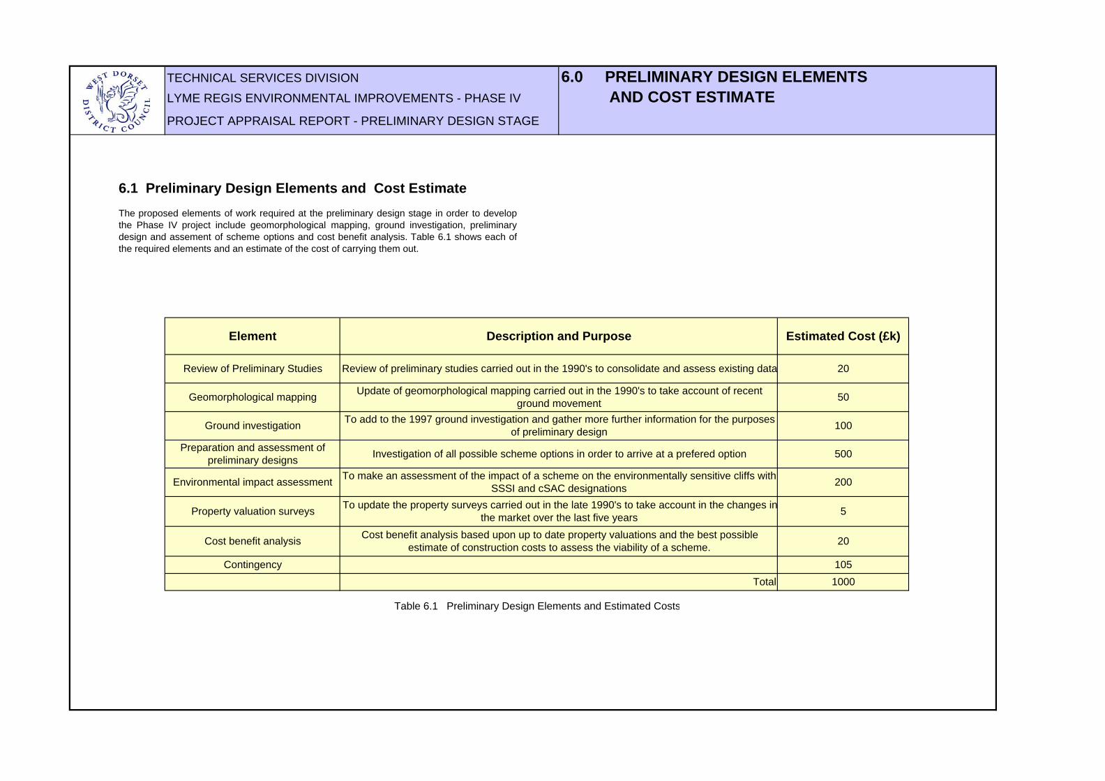
Review of Preliminary Studies
Geomorphological mapping
Ground investigation
Preparation and assessment of preliminary designs
Environmental impact assessment
Property valuation surveys
Cost benefit analysis
Review of preliminary studies carried out in the 1990's to consolidate and assess existing data
Update of geomorphological mapping carried out in the 1990's to take account of recent ground movement
To add to the 1997 ground investigation and gather more further information for the purposes of preliminary design
Investigation of all possible scheme options in order to arrive at a prefered option
To make an assessment of the impact of a scheme on the environmentally sensitive cliffs with SSSI and cSAC designations
To update the property surveys carried out in the late 1990's to take account in the changes inthe market over the last five years
Cost benefit analysis based upon up to date property valuations and the best possible estimate of construction costs to assess the viability of a scheme.
200
5
20
Estimated Cost (£k)
20
50
100
500
Total 1000
Table 6.1 Preliminary Design Elements and Estimated Costs
6.1 Preliminary Design Elements and Cost EstimateThe proposed elements of work required at the preliminary design stage in order to developthe Phase IV project include geomorphological mapping, ground investigation, preliminarydesign and assement of scheme options and cost benefit analysis. Table 6.1 shows each ofthe required elements and an estimate of the cost of carrying them out.

TECHNICAL SERVICES DIVISION 7.0 SUMMARYLYME REGIS ENVIRONMENTAL IMPROVEMENTS - PHASE IV
PROJECT APPRAISAL REPORT - PRELIMINARY DESIGN STAGE
1) The Phase II area of Lyme Regis is at risk from coastal erosion and landsliding and includes:
172 properties valued at least £40M Associated services and infrastructure Amenity value
2) In order to fulfil the recommendation in the Shoreline Management Plan of 'hold the line' for the urban areas of the town, there is no other realistic alternative in the long term other than to implement a new coast protection scheme.
3) As outlined in the Strategy Plan, the most appropriate coast protection management option for Phase IV is a coast protection scheme comprising seawall repair or replacement, strengthening of the forshore rock platform and slope strengthening and drainage.
4) The anticipated start date for the scheme construction is Summer 2008 with a construction period of approximately two years.
5) The overall benefit / cost ratio of implementing the scheme is estimated to approximately 5 : 1
6) There would also be considerable secondary benefits to the environment and society of implementing the scheme.
7) Preliminary designs need to be developed to confirm the viability of a scheme and to allow the selection of a prefered option for detailed design.
8) The cost of carrying out the preliminary studies stage is estimated to be approximately £1.0M.
TECHNICAL SERVICES DIVISION ReferencesLYME REGIS ENVIRONMENTAL IMPROVEMENTS
PROJECT APPRAISAL REPORT - PRELIMINARY DESIGN STAGE
Lyme Regis Environmental Improvements: Preliminary Studies Reports
10/2 Phase IV: Conceptual Management Strategy and Scheme Options for Coastal Slope Stabilisation. Final report. September 2000.14/1 Summary Report. August 2000.
Lyme Regis Environmental Improvements: Strategy Plan
WDDC. Lyme Regis Strategy Plan. August 2002, with May 2003 update.
Lyme Regis Environmental Improvements: Phase IV preliminary design reports
EPR. Preliminary Ecological Assessment. February 2003High-Point Rendel. Preliminary Environmental Appraisal. April 2003
Shoreline Management Plan
Lyme Bay and South Devon Shoreline Management Plan. Posford Duvivier. 1998.


