Lyndon B. Johnson National Historical Park Geologic Resource Evaluation Report Natural Resource Report NPS/NRPC/GRD/NRR—2008/024 National Park Service U.S. Department of the Interior Natural Resource Program Center
Transcript
Lyndon B. Johnson National Historical Park Geologic Resource Evaluation Report
Natural Resource Report NPS/NRPC/GRD/NRR—2008/024
National Park Service U.S. Department of the Interior Natural Resource Program Center
ON THE COVER: The cattle on the LBJ Ranch are descended from the same bloodline as the herd that Lyndon Johnson owned. They look more like 1960s Hereford cattle and so they can be called "history on the hoof." Lyndon B. Johnson National Historical Park Web site (www.nps.gov/lyjo, accessed 1/23/2008).
NPS Photo
Lyndon B. Johnson National Historical Park Geologic Resource Evaluation Report
Natural Resource Report NPS/NRPC/GRD/NRR—2008/024 Geologic Resources Division Natural Resource Program Center P.O. Box 25287 Denver, Colorado 80225
January 2008 U.S. Department of the Interior Washington, D.C.
The Natural Resource Publication series addresses natural resource topics that are of interest and applicability to a broad readership in the National Park Service and to others in the management of natural resources, including the scientific community, the public, and the NPS conservation and environmental constituencies. Manuscripts are peer- reviewed to ensure that the information is scientifically credible, technically accurate, appropriately written for the intended audience, and is designed and published in a professional manner. Natural Resource Reports are the designated medium for disseminating high priority, current natural resource management information with managerial application. The series targets a general, diverse audience, and may contain NPS policy considerations or address sensitive issues of management applicability. Examples of the diverse array of reports published in this series include vital signs monitoring plans; "how to" resource management papers; proceedings of resource management workshops or conferences; annual reports of resource programs or divisions of the Natural Resource Program Center; resource action plans; fact sheets; and regularly- published newsletters. Views and conclusions in this report are those of the authors and do not necessarily reflect policies of the National Park Service. Mention of trade names or commercial products does not constitute endorsement or recommendation for use by the National Park Service. Printed copies of reports in these series may be produced in a limited quantity and they are only available as long as the supply lasts. This report is also available from the Geologic Resource Evaluation Program website (http://www2.nature.nps.gov/geology/inventory/gre_publications) on the internet, or by sending a request to the address on the back cover. Please cite this publication as: Thornberry- Ehrlich, T. 2008. Lyndon B. Johnson National Historical Park Geologic Resource Evaluation Report. Natural Resource Report NPS/NRPC/GRD/NRR—2008/024. National Park Service, Denver, Colorado. NPS D- 83, February 2008
LYJO Geologic Resource Evaluation Report iii
Table of Contents List of Figures .............................................................................................................. iv Executive Summary ...................................................................................................... 1 Introduction ................................................................................................................... 2
Purpose of the Geologic Resource Evaluation Program ............................................................................................2 Geologic Setting .........................................................................................................................................................2
Groundwater Movement .............................................................................................................................................4 Surface Water Movement ...........................................................................................................................................4 Sediment Load and Channel Storage.........................................................................................................................4 General Geology ........................................................................................................................................................5
Geologic Features and Processes............................................................................... 6
Geology and History Connections ..............................................................................................................................6 Llano Uplift..................................................................................................................................................................6 Geology and Biology Connections..............................................................................................................................7
Map Unit Properties .................................................................................................... 11
List of Figures Figure 1. Map of Texas showing physiographic provinces.............................................................................................3 Figure 2. Historic structures at Lyndon B. Johnson National Historical Park..................................................................8 Figure 3. Geologic time scale.......................................................................................................................................17 Figure 4. Map showing Ouachita tectonic front ............................................................................................................18 Figure 5. Diagram showing the evolution of the Ouachita highland during Mesozoic rifting.........................................19 Figure 6. Map showing structural features in the area of Lyndon B. Johnson National Historical Park........................20
LYJO Geologic Resource Evaluation Report 1
Executive Summary This report accompanies the digital geologic map for Lyndon B. Johnson National Historical Park in Texas, which the Geologic Resources Division produced in collaboration with its partners. It contains information relevant to resource management and scientific research. Lyndon B. Johnson National Historical Park commemorates the reconstructed birthplace, boyhood home and ranch of the 36th president, as well as the Texas Hill Country ranch lifestyle while also protecting part of the Pedernales River drainage basin. The park lies in an area of central Texas known as the Llano Uplift, which has the metamorphic core of an ancient mountain range, Paleozoic and Mesozoic sedimentary rocks, and recent alluvial, terrace, and colluvial deposits. Rock structure and geomorphological (surficial) processes have played a prominent role in the history of the entire central Texas Hill Country, impacting early settlement, mining activity, and cattle ranching. Geologic processes gave rise to rock formations, mountains and valleys, dissected plateaus, mineral deposits, and broad river plains. Knowledge of the geologic features and processes directly influences resource management decisions in the park. Natural resource issues identified by the park include: air and water quality, groundwater movement, archaeological excavations, flood risk, wildlife populations, research projects, interpretive needs, and economic resources. The richness of geological, historical, and cultural resources in Lyndon Johnson National Historical Park may be important for land- use planning and in planning for visitors in the park. A detailed geologic map of the park, wayside exhibits, and a road or trail log would provide information helpful to visitor appreciation of the geologic history and dynamic processes that created the natural landscape. These information products would also serve to emphasize the long history showcased at the park. Human activities have played a significant role in determining the surficial features of the park and have also affected ecological responses to changes. Cattle grazing has changed riparian zones, and dams have interrupted water and sediment flow. The dynamic system may show noticeable change within a human life span.
The following geologic features, issues, and processes are significant for management of the park:
• Groundwater movement. Lyndon B. Johnson National Historical Park is located within the Pedernales river Valley. The Pedernales river and its associated hydrogeologic system are primary resources of the park. Understanding how water moves through the subsurface is vital for resource management.
The valley is floored with thick alluvium and terrace deposits containing several shallow aquifers. Wells into these aquifers and other bedrock aquifers provide water to the community. Groundwater inflow is an important contributor to the water budget of the river in the valley. A working model of the hydrogeologic system within the park would be helpful to predict environmental responses to contaminants and to remediate affected areas.
• Surface Water Movement. The Pedernales River is an important tributary of the Colorado River. It cuts through the Llano Uplift, dissecting plateaus and exposing the ancient roots of the Ouachita Mountains. Intense seasonal precipitation and high runoff cause flooding along the river. This flooding threatens many of the historical structures and features of the park. The water quality of the river system is threatened by agricultural waste and sediment loading from erosion and runoff.
• Sediment Load and Channel Storage. Erosion along the riverbanks in the area increases the sediment load carried by streams and exposes aquatic ecosystems to contamination trapped in sediments. Sediment loading can change channel morphology and increase the frequency of overbank flooding. Mostly fine- grained sediments transport contaminants in this water system. Movement of these sediments follows a seasonal cycle with increased flow following storms and spring runoff.
• General Geology. The unique geology of the Llano Uplift has been and continues to be the focus of interest and research. More research in the park area would improve understanding of local geologic features and processes.
NPS Geologic Resources Division 2
Introduction The following section briefly describes the National Park Service Geologic Resource Evaluation Program and the regional geologic setting of Lyndon B. Johnson National Historical Park. Purpose of the Geologic Resource Evaluation Program The Geologic Resource Evaluation (GRE) Program is one of 12 inventories funded under the NPS Natural Resource Challenge designed to enhance baseline information available to park managers. The program carries out the geologic component of the inventory effort from the development of digital geologic maps to providing park staff with a geologic report tailored to a park’s specific geologic resource issues. The Geologic Resources Division of the Natural Resource Program Center administers this program. The GRE team relies heavily on partnerships with the U.S. Geological Survey, Colorado State University, state surveys, and others in developing GRE products. The goal of the GRE Program is to increase understanding of the geologic processes at work in parks and provide sound geologic information for use in park decision making. Sound park stewardship relies on understanding natural resources and their role in the ecosystem. Geology is the foundation of park ecosystems. The compilation and use of natural resource information by park managers is called for in section 204 of the National Parks Omnibus Management Act of 1998 and in NPS- 75, Natural Resources Inventory and Monitoring Guideline. To realize this goal, the GRE team is systematically working towards providing each of the identified 270 natural area parks with a geologic scoping meeting, a digital geologic map, and a geologic report. These products support the stewardship of park resources and are designed for non- geoscientists. During scoping meetings the GRE team brings together park staff and geologic experts to review available geologic maps and discuss specific geologic issues, features, and processes. Scoping meetings are usually held for individual parks and on occasion for an entire Vital Signs Monitoring Network. The GRE mapping team converts the geologic maps identified for park use at the scoping meeting into digital geologic data in accordance with their innovative Geographic Information Systems (GIS) Data Model. These digital data sets bring an exciting interactive dimension to traditional paper maps by providing geologic data for use in park GIS and facilitating the incorporation of geologic considerations into a wide range of resource management applications. The newest maps come complete with interactive help files. As a companion to the digital geologic maps, the GRE team prepares a park- specific geologic report that aids in use of the maps and provides park managers with an overview of park geology and geologic resource management issues.
For additional information regarding the content of this report and up to date GRE contact information please refer to the Geologic Resource Evaluation Web site (http://www2.nature.nps.gov/geology/inventory/).
Geologic Setting Lyndon B. Johnson, the 36th president, grew up in the Texas Hill Country. Lyndon B. Johnson National Historical Park preserves his LBJ Ranch and Johnson City districts, covering 1,570 acres (674 acres federal). The park was designated a national historic site on December 2, 1969, and redesignated a national historical park on December 28, 1980. The Johnson family, which can trace its Texas Hill Country lineage several generations back has been generous in donating land to the park. Today the ranch is preserved as a working ranch in the style of the 1960s, with about 100 to 125 head of white-faced, registered Hereford cattle. In the Johnson Settlement, the park maintains a small herd of Longhorn cattle and horses. Gazing is highly regimented and closely- monitored according to a livestock management and grazing program. There is strict control over livestock numbers at the park. The ranch protects vital habitat and pasture land along the Pedernales River Valley near the community of Stonewall, Texas. Here the Pedernales River flows through Blanco and Gillespie counties as it heads eastward towards its confluence with the Colorado River. The river is part of the larger Colorado River basin (Kier 1988). This area is situated near the boundary between the Edwards Plateau and Central Texas Uplift physiographic provinces (fig. 1). The province contains a collection of tablelands heavily dissected by canyons along entrenched streams. Local tributaries relevant to the two districts of the park include Wittington Creek and Town Creek, as well as a number of seasonal, unnamed washes and streams. The topography of the Pedernales River Valley ranges from rugged, rough terrain to rolling hills of considerable relief with elevations ranging from 305m to 760 m (1,000ft to 2,500 ft) above sea level. The river drains 3,372 km2 (1,302 mi2), of which 1,559 km2 (602 mi2) is upriver from the park. Large, relatively flat floodplains flank the river. The river cuts through the Llano Uplift of central Texas, a geologic feature containing the metamorphic and igneous crystalline core of an ancient collisional orogenic belt that formed during the Precambrian (Mosher and Levine 2005). This structural high
LYJO Geologic Resource Evaluation Report 3
dominates the area. However, erosion since Cretaceous time has resulted in little topographic expression. Sharp bluffs are common where Cretaceous rocks rim the Llano Uplift (Kier 1988). The uplift is bounded on the
south and west by the Edwards Plateau and on the east by an area known as the central Texas Hill Country. These hills are formed by the intense erosion of Cretaceous limestone capping uplands of sandstone and shale.
Figure 1. Map of Texas showing physiographic province sections. Lyndon B. Johnson National Historical Park is near the boundary between the Edwards Plateau and Central Texas Uplift provinces. Modified from map by the Bureau of Economic Geology at the University of Texas at Austin (1996) in the Perry-Castañeda Library Map Collection. Graphic by Trista L. Thornberry-Ehrlich (Colorado State University).
NPS Geologic Resources Division 4
Geologic Issues A Geologic Resource Evaluation scoping session was held for Lyndon B. Johnson National Historical Park on May 15, 2003, to discuss geologic resources, address the status of geologic mapping, and assess resource management issues and needs. The following section synthesizes the scoping results, in particular those issues that may require attention from resource managers. Groundwater Movement The broad Pedernales River valley of the upper Colorado River drainage is floored with thick Quaternary alluvium and colluvium, unconsolidated terrace deposits, and fractured Cretaceous sedimentary rocks. Shallow aquifers are developed in these mixed units in the Lyndon B. Johnson National Historical Park area. Some fractured bedrock supplies water to the system locally as springs and seeps. Groundwater flow responds to variations in seasonal precipitation and is largely from upland areas toward the baseline of the Pedernales River. Groundwater flow generally follows the topographic surface, typically flowing toward the nearest stream or river. Unconsolidated units may be as much as 21 m (69 ft) thick beneath some parts of the valley floor. Coarse-grained beds and lenses of sand and gravel are often permeable and productive aquifers, whereas fine-grained beds of clay and silt are not. If the unconsolidated deposits are part of a stream terrace, water discharge is typically toward adjacent stream valleys into alluvium. For park staff to understand the hydrogeologic system at the park, they need to know how water travels through the subsurface to predict hydrologic responses to contaminants and agricultural wastes. The movement of nutrients and contaminants through the hydrogeologic system can be modeled by monitoring system inputs, such as rainfall, and outputs, such as streamflow. Other input sources include wind, surface runoff, groundwater transport, sewage systems, landfills, and fill dirt. Streams integrate groundwater flow and surface runoff of the watershed. Thus, they provide a cumulative measure of the status of the watershed’s hydrologic system. Consistent measurement of these parameters is crucial to establishing baselines for comparison.
Inventory, Monitoring, and Research Needs for Groundwater Movement • Define the influences of bedrock and topography on
local watersheds at Lyndon B. Johnson National Historical Park.
• Map and quantify subterranean water recharge zones.
• Map and monitor water quality at all known springs and seeps.
• Install monitoring stations to measure atmospheric inputs of important chemical components (such as nitrogen, mercury, and pH) and outputs to groundwater.
• Investigate additional methods to characterize groundwater recharge areas and flow directions
Surface Water Movement The Pedernales River watershed covers approximately 3,372 km2 (1,302 mi2). Understanding the dynamics behind surface water movement in the area is essential for resource management. The transport of sediments and contaminants is controlled by the supply and input rates of the material and by the downstream transport of water and sediment, especially during peak flow. The average annual precipitation in the Pedernales River watershed is greater than 81 cm (32 in.). Most of this precipitation occurs in winter and spring. Intense seasonal precipitation and/or high runoff storms cause flooding along the Pedernales River. The bed of the Pedernales River is bedrock and large cobbles. In the park, the river meanders through unconsolidated valley fill from cut banks to point bars, simultaneously eroding from the former and depositing mixed sediments on the latter.
Inventory, Monitoring, and Research Needs for Surface Water Movement • Determine how surface water movement is affected by
surficial deposits and soils.
• Monitor discharge, pH, specific conductance, temperature, dissolved oxygen, and nitrate concentration in surface water of the park.
• Monitor streamflow, including seasonal mean flows, lowest flow rates, and timing and magnitude of storms.
• Investigate paleoflood hydrology.
Sediment Load and Channel Storage Erosion in the Pedernales River watershed increases the sediment load carried by streams. Sediment loads and distribution affect aquatic and riparian ecosystems, and sediment loading can result in changes to channel morphology and increase the frequency of overbank flooding. Suspended sediment load is a resource management concern because it can contaminate drinking water
LYJO Geologic Resource Evaluation Report 5
sources (both surface and groundwater) and increase concentrations of toxic chemicals, such as fertilizers and other agricultural wastes trapped in river bottom sediments. However, fine- grained sediments are also vital in the overall fluvial transport of contaminants in a water system. Some pesticides and other contaminants bond to soil and fine- grained particles that are then eroded and transported downstream (Anderson et al. 2002). Thus, sediments act as sources and sinks for contaminants (Breuninger 2000). The amount of material being transported by the Pedernales River depends on the flow conditions and overall hydrologic energy. During seasonally high flows, the river probably transports pebbles and gravel as bedload and sand and finer- grained particles in suspension (Smith et al. 1998). These materials are typically deposited as migrating downstream point bars. Channel storage of fine sediment along with the contaminants follows a seasonal cycle. The cycle is subject to hydrologic variability with increased exposure of sediments to movement during spring runoff and decreased sediment movement in autumn. Fine- grained sediments do not travel downstream in a single pulse but are commonly deposited on the bottom and then picked up again (Miller et al. 1984). This intermittent transport of contaminants and fine- grained sediment increases the area affected by contamination. Three dams in the park 0n the Pedernales River impound water for crop irrigation and for scenic purposes. Two of the dams, the Jordan and Johnson dams, are maintained in accordance with NPS management guideline, NPS-40, “Dams and Appurtenant Works: Maintenance, Operations, and Safety.” Resource managers should be aware of the effects of sediment loading and of any stored contaminants that results from hydrologic disturbances of the sediments trapped behind these structures.
Inventory, Monitoring, and Research Needs for Sediment Load and Channel Storage • Assess hydrologic conditions to identify actual and
potential “problem areas” (near roadways, trails, the Visitors’ Center, and administrative facilities) for prioritized monitoring. Monitor problem areas with repeated aerial photography.
• Measure morphologic change in stream channels related to sediment load. Reliable measurements
generally require three to five cross sections over several hundred meters (yards) of channel.
• Promote cattle- free riparian zones along the river corridor to reduce stream bank erosion and loss of pastureland.
• Use shallow (25- cm, or 10- in.) and deeper core data to monitor rates of sediment accumulation and erosion and analyze changes in chemical constituents of sediments.
• Cooperate with local agencies to determine amounts, types, and durations of exposure of the watershed to contaminants.
• Correlate watershed disturbance with sediment load in streams and any reduction in aquatic biological productivity.
General Geology The unique geology of the Llano Uplift has sparked research interest among geologists. More local research would help resource managers at the park understand the relationships among various physical factors in the ecosystem. In addition to general research, the function of the park as a working ranch requires careful management of the pasturelands necessary for cattle grazing. Erosion is removing these pasturelands, and overgrazed areas are especially at risk due to loss of stabilizing vegetation.
Inventory, Monitoring, and Research Needs for General Geology • Determine the depth of alluvial fill to bedrock along
the Pedernales Creek bottom.
• Map the geomorphology of the park.
• Study remediation techniques to restore pastureland along vulnerable reaches of the Pedernales River and along steep slopes.
• Study geologic controls on the restoration of prairie lands and native soils.
• Study historical land use, such as Native American sites and early mining and ranching, to help evaluate the best land use in the future.
• Promote soil studies and surveys, especially concerning how soils relate to the landscape and land use.
NPS Geologic Resources Division 6
Geologic Features and Processes This section describes the most prominent and distinctive geologic features and processes in Lyndon B. Johnson National Historical Park. Geology and History Connections One of the major goals of the park is to preserve the historical context of the area; this includes preserving and restoring old buildings and the landscape around them. Maintaining this landscape often means resisting natural geologic changes, thus presenting several management challenges. Slopes processes, such as landsliding, slumping, chemical weathering, block sliding, and slope creep, are constantly changing the landscape at the park. Runoff removes sediments exposed at the surface and carries them down streams and gullies. Erosion naturally diminishes higher areas and fills in the lower areas, distorting the historical context of the landscape. Issues also arise from opposing values in managing cultural and natural resource. For example, a proposal for restoration of a historic building may consist of removing surrounding natural resources or adding exotic plants. The park highlights the cattle ranching history in central Texas. This history extends beyond European settlement to the early fields, settlements, and 12,000- year- old tool quarries of the Native Americans. They left artifacts and changes in the landscape, such as campsites, tool quarries, and other archaeological sites in Texas Hill Country. The history of the area is heavily influenced by its geology. The gullies and ravines carved into the Edwards Plateau region made travel and farming difficult. Because of the local topography and hydrography of the Pedernales River, large 100- and 500- year floodplains cover much of the park today. The combination of climate and landform rendered this landscape rich in prairies and grasslands for cattle grazing. Several areas in the park, such as the Junction School, LBJ Birthplace, Sam Ealy Johnson Sr. Farmhouse, the Bailey House, and the Cedar Guest House lie within the 100- year floodplain. The Texas White House (Ranch House) lies on the 500- year floodplain. Park historic structures require protection from geologic processes to coexist in harmony with the landscape (fig. 2A−D) and need to be available to visitors without compromising the natural resources or the historical context. E.C. Bearss wrote the Historic Structure Report: Texas White House, Lyndon B. Johnson National Historical Park, Texas, in 1986 (published by Santa Fe, N.M.: Division of Conservation, Southwest Cultural Resources Center, NPS, U.S. DOI). This document could serve as an interpretive tool and guide for preservation of the historic structures.
Llano Uplift The 1.5- billion- acre Llano Uplift—also known as the Central Mineral Region—of central Texas comprises igneous and metamorphic rocks as part of a long- lived collisional orogenic belt that formed during the Precambrian Grenville Orogeny (Kier 1988; Li et al. 2005; Mosher and Levine 2005). This belt formed along the southern margin of the Laurentian (proto- North American) continent. The uplift differs in structure, metamorphic grade, and rock assemblages between the eastern and western parts. The eastern part records the collision between a volcanic arc and the Laurentian continent, and the western part records continent- continent collision with one or more southern continental masses (possibly including the Amazon craton of South America) (Tohver et al. 2002; Rivers 2004; Mosher and Levine 2005). These deformational events took place intermittently over 200 million years (Grimes and Copeland 2004; Rivers 2004). “Llano” translates to “plain” in Spanish, probably a corruption of the French name given to the local Lipan Indians. The term “uplift” is a bit of a misnomer since the area is not a topographic high. Instead, the term refers to the juxtaposition of Precambrian rocks uplifted relative to much younger Cretaceous limestone. The numerous fault blocks comprising the uplift are oriented southwest to northeast (Kier 1988). The relatively low- density granitic rocks of the locally thickened crust “float” on the denser rocks of the Earth’s mantle (Reed 2005). The crust thickened during the orogenic collision and associated plutonism of the Grenville event. According to the City of Llano, the Llano Uplift contains the only known specimens of the granite known as llanite. This brown granite contains visible crystals (phenocrysts) of sky- blue quartz and rusty- pink feldspar in a matrix of microscopic quartz, feldspar, biotite, and minor fluorite, magnetite, apatite, and zircon crystals. This unique rock typically occurs as dikes of ≈1,093- Ma age (Reed 2005). It is treasured as a decorative polished stone. Gem quality topaz and some gold associated with pegmatite dikes are also present in the area. Gold is found either as native gold, or in association with sulfide minerals, such as pyrite, quartz veins, and quartz stringers, as well as residual soils and saprolite (Heylum 1985). Some small- scale mines in the area surrounding the park are the Heath, Central Texas, and Los Almagres mines. Many others small mines explored by early Spanish settlers in the 1700s are known only through local legends of buried treasures (Heylum 1985).
LYJO Geologic Resource Evaluation Report 7
Geology and Biology Connections Geology forms the basis of the entire ecosystem at Lyndon B. Johnson National Historical Park. The relationships between geology and biology at the park are poorly understood, and yet the vast array of species correlates in part with the underlying geology. In recent animal surveys, 18 fish species, 17 amphibian species, 58 reptile species, and 17 mammal species were positively identified in the park. Many species of birds migrate through the area (Patrikeev 2004). A total of 559 species of vascular plants (naturally occurring, hybrids, and cultivated) occur in the park. Park staff have identified nine major plant associations, defined on the basis of physiographic, geologic, and soil types: (1) native grassland on chalky slopes with clay-loam and loam; (2) native grassland and savanna on level,
deep clayey loam and clay- loam; (3) native grassland and savanna on upland sandy loam; (4) pastures and fields on upland, deep redland clay- loam or sandy loam soils; (5) pasture and savanna on alluvial sandy and silty loam soils; (6) upland successional woodland; (7) riparian woodland; (8) ponds, deep swales, and stream margins; and, (9) urbanized habitats (including agricultural plantings) (Sanders 2004). Bank erosion is a major factor leading to the introduction of heavy sediment loads to the riverine environment. Land use affects stream bank erosion rates. Cattle grazing reduces the amount of buffering and stabilizing vegetation in riparian zones along the rivers and streams. Fenced segments of rivers in grazed areas usually have better fish habitat (Nimick 1990).
NPS Geologic Resources Division 8
Figure 2A. Historic homestead structure at Lyndon B. Johnson National Historical Park. Photograph is courtesy of the park (http://www.exploitz.com/national_park/lyndon_b_johnson_national_historical_park/).
Figure 2B. Historic structure of the birthplace (reconstructed) at Lyndon B. Johnson National Historical Park. Photograph is courtesy of the park (http://www.exploitz.com/national_park/lyndon_b_johnson_national_historical_park/).
LYJO Geologic Resource Evaluation Report 9
Figure 2C. Historic barn structure at Lyndon B. Johnson National Historical Park. Photograph is courtesy of the park (http://www.exploitz.com/national_park/lyndon_b_johnson_national_historical_park/).
NPS Geologic Resources Division 10
Figure 2D. Historic structure at Lyndon B. Johnson National Historical Park. Photograph is courtesy of the park (http://www.exploitz.com/national_park/lyndon_b_johnson_national_historical_park/).
LYJO Geologic Resource Evaluation Report 11
Map Unit Properties This section identifies characteristics of map units that appear on the Geologic Resource Evaluation digital geologic map of Lyndon B. Johnson National Historical Park. The accompanying table is highly generalized and is provided for background purposes only. Ground- disturbing activities should not be permitted or denied on the basis of information in this table. More detailed map unit descriptions can be found in the help files that accompany the digital geologic map or by contacting the National Park Service Geologic Resources Division. Locally the Llano Uplift consists of the Valley Spring Gneiss, Oatman Creek Granite, and Town Mountain Granite, all Precambrian. The granite in these units is fine- to medium- grained and porphyritic (Reed et al. 1996). These units are cut by several northeast- to southwest- trending faults. The deformational structures of this uplift record the ancient Grenville orogenic event. Both the LBJ Ranch and Johnson City districts of the park are within the Pedernales River drainage basin. In the central part of this valley, the river flows across jointed Paleozoic dolomite and limestone of the San Saba, Point Peak, Morgan Creek Limestone, and Welge Sandstone members of the Wilberns Formation, and the Riley Formation, including the Lion Mountain Sandstone Member, the Cap Mountain Limestone Member, and the Hickory Sandstone Member. These Cambrian units record the transgressions and regressions of an ancient sea across the buried uplift. Continued marine deposition throughout the Paleozoic resulted in the dolomite, limestone, calcite, and chert-rich units of the Ordovician Tanyard Formation (Staendeback and Threadgill Members), as well as the fossiliferous Gorman and Honeycut formations of the Ellenburger Group. These units support some cave development along joints and show karren and solution pockets (Fieseler 1978). The Devonian dolomite and limestone of the Stribling Formation are separated from underlying Ordovician units, overlying erosional surfaces in Mississippian and Pennsylvanian units. The Mississippian Houy and Barnett Formations, as well as the Chappel Limestone, are rich in fossil records and
contain radioactive phosphatic layers. Pennsylvanian units include the Smithwick Formation, consisting of gray shale, and interbedded layers of shale, and massive limestone of the Marble Falls Limestone. A major unconformity separates Paleozoic limestone from the overlying Cretaceous sandstone, shale, and limestone in the map area. In the area surrounding the Lyndon B. Johnson Historical Park, the Cretaceous Hensell Sand and Glen Rose Limestone Members of the Shingle Hills Formation dominate the upland rock units. Elsewhere within the map area, in the lower parts of the Pedernales River valley, the area is underlain by Cretaceous units, including the Travis Peak Formation, which comprises the Cow Creek Limestone, Hammett Shale and Sycamore Sand Members. Surficial deposits of Quaternary- Pleistocene alluvium, floodplain alluvium, colluvium, and terrace deposits cover most of the bedrock in the area of the park. These deposits include well- sorted to poorly sorted gravel, sand, silt, and clay. Travertine deposits are associated with springs in the area. Travertine typically forms calcium carbonate cement between alluvial grains. The following pages are a table that combines a stratigraphic column (the map units in order of occurrence with depth) and a list of features in each stratigraphic unit: description, resistance to erosion, suitability for development, hazards, potential paleontologic resources, cultural and mineral resources, potential karst issues, recreational use potential, and global significance.
LYJO Geologic Resource Evaluation Report 15
Geologic History This section describes the rocks and unconsolidated deposits that appear on the digital geologic map of Lyndon B. Johnson National Historical Park, the environment in which those units were deposited, and the timing of geologic events that created the present landscape. The geologic story of Lyndon B. Johnson National Historical Park begins in the Proterozoic Eon (fig. 3). Little is known about this period of Earth’s history. Most rocks on Earth of Precambrian age are highly deformed and metamorphosed, losing most, if not all, traces of their original structures. Metamorphic rocks record— with textures and mineral assemblages— the conditions during deformational events. The oldest rocks in central Texas preserve a vast geologic history. The Llano Uplift records the Grenville orogenic event of the Proterozoic Eon (Mosher and Levine 2005). This event involved much of the continental crust in existence at that time. A northern landmass, Laurentia (present-day North America), collided with one or more southern landmasses and island arcs (Mosher et al. 2004). These intermittent collisions caused the uplift of a long, east- trending mountain range and the intrusion of several igneous plutons over a long time period (≈1165−1068 Ma) (Li and Barnes 2005; Reed and Rougvie 2002). Many valuable mineral deposits in central Texas are associated with the high pressure and high temperature that accompanied deformation of these rocks (Hentz 2001). Grenville- age structures are found in northeastern Canada, in patches along the length of the Appalachians, and through central and western Texas. The Carrizo Mountain Group, some 500 km (310 mi) to the west of the Llano Uplift, continues the Grenville trend (Grimes and Copeland, 2004). Corresponding deformational structures and rock assemblages occur in the western Amazon craton, possibly marking the South American continent as the southern landmass involved in the Grenville orogeny (Tohver et al. 2002). Following this uplift, erosion beveled the highlands and vast quantities of sediments were deposited into an emergent sedimentary basin during Cambrian rift events. The so- called Ouachita rift (or trough) extends southward from the Alabama- Oklahoma transform fault to Mexico, defining the Ouachita embayment in the Precambrian crust (fig. 4) (Thomas and Keller 1999). Carbonate beds formed during periods of marine highstands, dominating the rock record in the basin to the southeast, as well as in several small- scale failed rift areas farther inland (Harrison 1997; Hentz 2001). When regional sea level dropped, sediments that became shale and intercalated sandstone were deposited across the basin (Harrison, 1997).
Deposition in shallow seas continued in central Texas throughout the early to middle Paleozoic (Cambrian, Ordovician, Silurian, and Devonian), leaving vast a sediment package grading from coarse sandstone and conglomerate in the near- shore areas to chert, limestone, and dolomite in the deeper areas to the south and east. Abundant fossils in the Paleozoic units reveal the extent of ancient life in this shallow- sea environment (Pierson 2005). Orogenic activity began again during Mississippian-Pennsylvanian time when the supercontinent Pangaea formed through the collision between North America and the other continental landmasses (European and African−South American plates). This resulted in the formation of the Ouachita Mountains in central Texas, northwest Arkansas, and southeast Oklahoma (Hentz 2001; Pierson 2005). Many north- to northeast- trending strike- slip and thrust faults were active, responding to multi- directional tectonic stresses at this time (Amsbury and Haenggi 1993). Regionally, this event is referred to as the Ouachita orogeny. The early Paleozoic sediments deposited in the Ouachita trough were buckled and thrust up into mountainous highlands. Locally, the sedimentary rocks were more mildly deformed (Torrez 1996). As the Ouachita Mountains rose in central Texas, many basins to the north and west formed along a foreland basin, including the Midland and Delaware basins (Hentz 2001). This type of basin forms in response to the force of increasing mass on the crust during mountain building. In effect, the earth’s crust warps beneath the mountain mass, creating a basin that fills with sediments eroded from the nearby highlands. The basin sinks further as more sediments pour in adding a heaver load. Deposition of fine sediments in the brackish foreland basins (West Texas Basin) continued throughout the Permian. Erosion beveled the Ouachita Mountains to the east. Broad carbonate shelves and reefs surrounded the deeper parts of the basins. Rivers flowed from the highlands into the basins, forming deltas. Associated coastlines shifted repeatedly as near- shore sediments were continuously deposited and eroded by shoreline processes (Bureau of Economic Geology 1992). These shallow seas and shorelines supported vast quantities of organic material that interlayered with porous sediments. These deposits are a major contributor to the hydrocarbon resources in Texas
NPS Geologic Resources Division 16
(Pierson 2005). During the late Permian, near the end of the Paleozoic Era, the inland seas retreated southwestward as the climate became hot and dry and broad evaporite basins developed in West Texas. Vast red mud, salt, and gypsum deposits in West Texas record this change (Bureau of Economic Geology 1992). The Cambrian rift feature was reactivated during an early Mesozoic extensional event (≈220−245 Ma) that resulted in the opening of the Gulf of Mexico (Bureau of Economic Geology 1992; Thomas and Keller 1999). The continents pulled apart during the Triassic and Jurassic Periods, creating large basins to hold sediments shed from the rapidly eroding Ouachita highlands. In the early stages, a series of discontinuous rift basins developed parallel to the edge of the opening ocean basin. These basins extended from Mexico to Nova Scotia (Hentz 2001). As rifting continued, thick deposits of Middle Jurassic salt buried the earlier rift basins in Texas. This accompanied the development of the East Texas and Gulf Coast basins (Hentz 2001). As the basins widened, areas in the south and east of Texas warped downwards and continued to subside under the weight of added sediments. Sediments were deposited over the marine salt and limestone shelves from earlier basins (fig. 5). This juxtaposition of rock types led to the formation of many hydrocarbon traps and folds in the East Texas basin (Bureau of Economic Geology 1992). Much of the Coastal Plain of Texas was formed during the heavy sedimentation of this time (Hentz 2001). Continued erosion and burial throughout the Cretaceous beveled the Ouachita Mountains nearly flat (Pierson 2005). As the Rocky Mountains formed, orogenic events in the western United States provided more sediment to a pervasive seaway present intermittently throughout the Cretaceous. Most of Texas was covered by this inland sea. By Late Cretaceous the seaway deepened, resulting in deposition of carbonate sediments mixed with deltaic and strandline sand, forming the reservoir rocks for the productive East Texas oilfields (Hentz 2001). Some widespread Late Cretaceous volcanic activity in southeastern Texas trended parallel to the buried Ouachita Mountains.
The Cretaceous Period ended with the mass extinction of numerous plant and animal species. When the Cenozoic Era began (≈66 Ma), the East Texas basin was filling with fluvial- deltaic sediments, including plant remains that later formed lignite. As mountains were rising to the west during the Laramide Orogeny, the seas retreated off the continent. The early Mississippi River flowed across East Texas, ending at a large delta north of the current shoreline near Houston. The Tertiary Period is marked by deposition of massive fluvial- deltaic sediments eroded from the young Rocky Mountains and transported southeastward into the widening Gulf of Mexico (Bureau of Economic Geology 1992; Hentz 2001). Following orogenic activity in the west, a period of extensional tectonic and igneous activity during the middle Tertiary Period resulted in pervasive faulting and volcanism (fig. 6). In the western part of Texas, volcanic activity (≈47−17 Ma), produced about 14 volcanic centers as well as thick lava- flow and ash- fall deposits. The extensional tectonic regime that typically produces basin- and- range topography began about 30 Ma in Texas (Hentz 2001). In the middle Tertiary Period (Miocene Epoch), regional uplift of the Edwards Plateau resulted in rapid erosion into the stair step topography found today in the area surrounding Lyndon B. Johnson National Historical Park (Pierson 2005). Alluvial and windblown material from the Rocky Mountains were deposited in thick sheets and fans across the central and southern High Plains (Hentz 2001). These units bear major aquifers that have sustained agriculture in a typically dry climate. Pleistocene glaciation never reached central Texas; however, the effects left a record on the landscape. The cooler climate resulted in changes to regional flora and fauna. Wooly mammoth, camel, and bison fossils of central Texas attest to some of these changes. Deciduous forests extended southward (Pierson 2005). Local sea level dropped 90−120 m (300−400 ft) during glacial maxima (Hentz 2001). Windblown dust (loess) evolved into fertile soils for prairies and grasslands. Glacial meltwater scoured and entrenched major watersheds, such as the Colorado, Canadian, Trinity, and Brazos (Pierson 2005).
LYJO Geologic Resource Evaluation Report 17
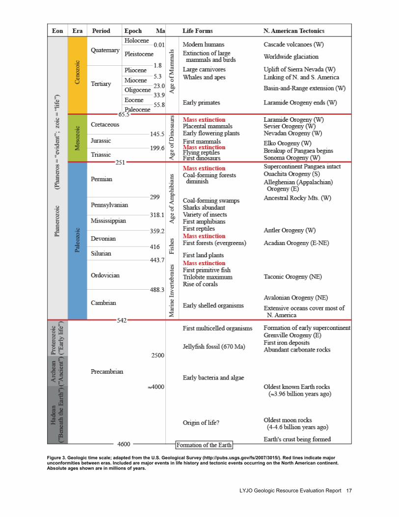
Figure 3. Geologic time scale; adapted from the U.S. Geological Survey (http://pubs.usgs.gov/fs/2007/3015/). Red lines indicate major unconformities between eras. Included are major events in life history and tectonic events occurring on the North American continent. Absolute ages shown are in millions of years.
NPS Geologic Resources Division 18
Figure 4. Map showing Ouachita tectonic front southeast of Lyndon B. Johnson National Historical Park (approximate location noted as green circle) near the Llano Uplift (purple area). Crosscutting faults of the Llano Uplift area are also noted as heavy black lines. Graphic created by Trista L. Thornberry-Ehrlich (Colorado State University) from information from the University of Texas at Austin (http://www.lib.utexas.edu/geo/).
LYJO Geologic Resource Evaluation Report 19
Figure 5. Diagram showing the evolution of the Ouachita highland during Mesozoic rifting resulting in the opening of the Gulf of Mexico. Graphic created by Trista L. Thornberry-Ehrlich (Colorado State University).
NPS Geologic Resources Division 20
Figure 6. Map showing structural features in the area of Lyndon B. Johnson National Historical Park (approximate location noted as green circle) near the Llano Uplift. Graphic created by Trista L. Thornberry-Ehrlich (Colorado State University) from information from the University of Texas at Austin http://www.lib.utexas.edu/geo/
LYJO Geologic Resource Evaluation Report 21
Glossary This glossary contains brief definitions of technical geologic terms used in this report. Not all geologic terms used are referenced. For more detailed definitions or to find terms not listed here please visit: http://wrgis.wr.usgs.gov/docs/parks/misc/glossarya.html. alluvium. Stream- deposited sediment that is generally
rounded, sorted, and stratified. aquifer. Rock or sediment that is sufficiently porous,
permeable, and saturated to be useful as a source of water.
ash (volcanic). Fine pyroclastic material ejected from a volcano (also see “tuff”).
asthenosphere. Weak layer in the upper mantle below the lithosphere where seismic waves are attenuated.
basin (structural). A doubly- plunging syncline in which rocks dip inward from all sides (also see “dome”).
basin (sedimentary). Any depression, from continental to local scales, into which sediments are deposited.
bed. The smallest sedimentary strata unit, commonly ranging in thickness from 1 cm (2.5 in.) to 1−2 m (3−6 ft) and distinguishable from beds above.
chemical weathering. The dissolution or chemical breakdown of minerals at the Earth’s surface via reaction with water, air, or dissolved substances.
clastic. Rock or sediment made of fragments of pre-existing rocks.
clay. Clay minerals or sedimentary fragments the size of clay minerals (>1/256 mm).
continental crust. The type of crustal rocks underlying the continents and continental shelves; having a thickness of 25−60 km (16−37 mi) and a density of approximately 2.7 grams per cubic centimeter.
cross section. A graphical interpretation of geology, structure, and/or stratigraphy in the third (vertical) dimension based on mapped and measured geological extents and attitudes depicted in an oriented vertical plane.
crust. The outermost compositional shell of the Earth, 10−40 km (6−25 mi) thick, consisting predominantly of relatively low density silicate minerals.
crystalline. Describes the structure of a regular, orderly, repeating geometric arrangement of atoms; also often used to mean igneous and metamorphic rock.
deformation. A general term for the process of faulting, folding, shearing, extension, or compression of rocks as a result of various forces in the Earth.
drainage basin. The total area from which a stream system receives or drains runoff.
evaporite. Chemically precipitated mineral(s) formed by the evaporation of solute- rich water under restricted conditions.
fault. A subplanar break in rock along which one side moves relative to the other.
formation. Fundamental rock- stratigraphic unit that is mappable and lithologically distinct from adjoining strata and has definable upper and lower contacts.
glauconitic. Containing the greenish clay mineral glauconite, often associated with marine sediments.
igneous. Refers to a rock or mineral that originated from molten material; one of the three main classes of rocks: igneous, metamorphic, and sedimentary.
intrusion. A body of igneous rock that invades older, solid rock. The invading rock may be a plastic solid or molten matter that pushes its way into the solid rock.
island arc. A line or arc of volcanic islands formed over and parallel to a subduction zone.
landslide. Any process or landform resulting from rapid mass movement under relatively dry conditions (cf.: debris flow).
magma. Molten rock generated within the Earth that is the parent of igneous rocks.
matrix. The fine- grained interstitial material between coarse grains in porphyritic igneous rocks and poorly sorted clastic sediments or rocks.
member. A lithostratigraphic unit with definable contacts that is a subdivision of a formation.
metamorphic. Pertaining to the process of metamorphism or to its results.
metamorphism. Literally, “change in form.” Metamorphism occurs in rocks with mineral alteration, genesis, and/or recrystallization from increased heat and pressure.
orogeny. A mountain- building event, particularly a well- recognized event in the geological past (e.g., the Laramide orogeny).
plateau. A broad, flat- topped topographic high of great extent and elevation above the surrounding plains, canyons, or valleys (both land and marine landforms).
point bar. A sand and gravel ridge deposited in a stream channel on the inside of a meander where flow velocity slows.
recharge. Infiltration processes that replenish groundwater.
regression. A long- term seaward retreat of the shoreline or relative fall of sea level.
sandstone. Clastic sedimentary rock of predominantly sand- size grains.
sediment. An eroded and deposited, unconsolidated accumulation of lithic and mineral fragments.
sedimentary rock. A consolidated and lithified rock consisting of detrital and/or chemical sediment(s).
NPS Geologic Resources Division 22
silt. Clastic sedimentary material intermediate in size between fine- grained sand and coarse clay (1/256−1/16 mm).
strata. Tabular or sheet like masses or distinct layers (e.g., of rock).
strike. The compass direction of the line of intersection that an inclined surface makes with a horizontal plane.
stromatolite. An organic sedimentary structure formed by blue- green algae (cyanophytes).
stylolite. A seam (contact or surface) of insoluble constituents (e.g. clay, carbon, iron oxides) usually found in carbonate rocks.
tectonic. Relating to large- scale movement and deformation of the Earth’s crust.
terraces (stream). Step- like benches surrounding the present floodplain of a stream due to dissection of previous flood plain(s), stream bed(s), and/or valley floor(s).
thrust fault. A contractional, dip- slip fault with a shallow- dipping fault surface (<45o) where the hanging wall moves up and over relative to the footwall.
transgression. Landward migration of the sea due to a relative rise in sea level.
travertine. A limestone deposit or crust, commonly banded, formed from precipitation of calcium carbonate from saturated waters, especially near hot springs and in caves.
trend. The direction or azimuth of elongation or a linear geological feature.
unconformity. A surface within sedimentary strata that marks a prolonged period of nondeposition or erosion.
uplift. A structurally high area in the crust, produced by movement that raises the rocks.
volcanic. Related to volcanoes; describes igneous rock crystallized at or near Earth’s surface (e.g., lava).
LYJO Geologic Resource Evaluation Report 23
References This section lists references cited in this report as well as a general bibliography that may be of use to resource managers. A more complete geologic bibliography is available from the National Park Service Geologic Resources Division. Amsbury, D. L., and W. T. Haenggi. 1993. Middle
Pennsylvanian strike- slip faulting in the Llano Uplift, central Texas. Bulletin of the South Texas Geological Society 34 (1): 9−16.
Phelan, D.J., 2002, Water quality, sediment quality, and stream- channel classification of Rock Creek, Washington, D.C., 1999- 2000, Water- Resources Investigations - U. S. Geological Survey, 91 p.
Barnes, V. E. 1963. Geology of the Johnson City
Quadrangle, Blanco County, Texas. Scale 1:24,000. Geologic Quadrangle Map 25. University of Texas at Austin, Bureau of Economic Geology.
Barnes, V.E. 1965a. Geology of the Hye Quadrangle,
Blanco, Gillespie, and Kendall Counties, Texas. Scale 1:24,000. Geologic Quadrangle Map 27. University of Texas at Austin, Bureau of Economic Geology.
Barnes, V. E. 1965b. Geology of the Rocky Creek
Quadrangle, Blanco and Gillespie Counties, Texas. Scale 1:24,000. Geologic Quadrangle Map 29. University of Texas at Austin, Bureau of Economic Geology.
Barnes, V. E. 1966. Geology of the Stonewall Quadrangle,
Gillespie, and Kendall Counties, Texas. Scale 1:24,000. Geologic Quadrangle Map 31. University of Texas at Austin, Bureau of Economic Geology.
Barnes, V. E. 1967a. Geology of the Cave Creek School
Quadrangle, Gillespie County, Texas. Geologic Quadrangle Map, no. 32 (scale 1:24,000). University of Texas at Austin, Bureau of Economic Geology.
Barnes, V. E. 1967b. Geology of the Monument Hill
Quadrangle, Blanco County, Texas. Scale 1:24,000. Geologic Quadrangle Map 33. University of Texas at Austin, Bureau of Economic Geology.
Barnes, V. E. 1967c. Geology of the Yeager Creek
Quadrangle, Blanco and Hays Counties, Texas. Scale 1:24,000. Geologic Quadrangle Map 34. University of Texas at Austin, Bureau of Economic Geology.
Barnes, V. E. 1982. Geology of the Pedernales Falls
Quadrangle, Blanco County, Texas. Scale 1:24,000. Geologic Quadrangle Map 49. University of Texas at Austin, Bureau of Economic Geology.
Bickford, M. E., K. Soegaard, K. C. Nielsen, and J. M. McLelland. 2000. Geology and geochronology of Grenville- age rocks in the Van Horn and Franklin Mountains area, West Texas: Implications for the tectonic evolution of Laurentia during the Grenville. Geological Society of America Bulletin 112 (7): 1134−1148.
Breuninger, A.B., 2000, Effects of floodplain remediation
on bed sediment contamination in the Upper Clark Fork River basin, western Montana. University of Montana, Master’s thesis, 182 p.
Brown, J. B. 1980. Mesozoic history of the Llano region,
Texas. In Geology of the Llano region, central Texas, ed. D. Windle, 52−58. 80- 73, TX: West Texas Geological Society.
Bureau of Economic Geology. 1992. Geology of Texas.
Four map sheets, scale 1:500,000. University of Texas at Austin, Bureau of Economic Geology.
Button, R. M. 1980. Economic geology of the Llano
region. In Geology of the Llano region, central Texas, ed. D. Windle, 76−82. 80- 73, TX: West Texas Geological Society.
Denney, J. H. Jr. and V. W. Goebel. 1984. Complexity of
regional deformation of Precambrian rocks, northeastern Llano Uplift, central Texas. Abstracts with Programs, 82, vol. 16, no. 2. Boulder, CO: Geological Society of America.
Fieseler, R. G. 1978. Cave and karst distribution of Texas.
In An introduction to the caves of Texas, ed. R. G. Fieseler, J. Jasek, and M. Jasek, 15−53. Annual Convention Guidebook, National Speleological Society: 19.
Grimes, S.W. and P. Copeland. 2004. Thermochronology
of the Grenville Orogeny in West Texas. Precambrian Research 131 (1- 2): 23−54.
Harrison, E. 1997. Sequence stratigraphy of the Concho
Platform, north- central Texas. AAPG Bulletin 81 (5): 867.
Hentz, T.F. 2001. Geology. In The handbook of Texas.
University of Texas at Austin, http://www.tsha.utexas.edu/ handbook/online/articles/GG/swgqz.html.
NPS Geologic Resources Division 24
Heylmun, E. B. 1985. Gold in central Texas. California Mining Journal 54 (12): 12−14.
Johnson, B. 1983. Anatomy of a normal fault in the Llano
Uplift. Abstracts with Programs, 38−39, vol. 15, no. 1. Boulder, CO: Geological Society of America.
Johnson, B. 1990. The Llano Uplift: A plate flexural
model and its associated implications. Abstracts with Programs, 9−10, vol. 22, no. 1. Boulder, CO: Geological Society of America.
Kier, R. S. 1988. Paleozoic strata of the Llano region,
central Texas. In Collection centennial field guide, 351-360. Annual Meeting Guidebook, South- Central Section of the Geological Society of America: 4.
Li, Y., M. A. Barnes, and C. G. Barnes. 2005. Widespread
Grenville- age magmatism in the basement of West Texas and adjacent New Mexico. Abstracts with Programs, 38, vol. 37, no. 3. Boulder, CO: Geological Society of America.
McGookey, D. P. 2004. Geologic wonders of West Texas :
Midland, TX: Donald P. McGookey. Miller, A.J., J.A. Smith, and L.L. Shoemaker, L.L. 1984.
Channel storage of fine- grained sediment in the Monocacy River basin. Eos, Transactions, American Geophysical Union 65 (45): 888
Mosher, S. ed. 1996. Guide to the Precambrian geology of
the eastern Llano Uplift, central Texas. Fieldtrip Guide for the Geological Society of America, 30th Annual Meeting. Austin, TX: South- Central Section of the Geological Society of America.
Mosher, S. 1999. The Texas Grenville Orogen. Abstracts
with Programs, 31, vol. 31, no. 1. Boulder, CO: Geological Society of America.
Mosher, S., J. Connelly, S. Grimes, A. Hoh, and J.
Zumbro. 2001. Mesoproterozoic tectonic evolution of Texas prior to the Grenville Orogeny. Abstracts with Programs, 11, vol. 33, no. 5. Boulder, CO: Geological Society of America.
Mosher, S., A. M. Hoh, J. A. Zumbro, and J. F. Reese.
2004. Tectonic evolution of the eastern Llano Uplift, central Texas: A record of Grenville orogenesis along the southern Laurentian margin. In Proterozoic tectonic evolution of the Grenville Orogen in North America, ed. R. P. Tollo, L. Corriveau, J. McLelland, and M. J. Bartholomew, 783−798. Memoir 197. Boulder, CO: Geological Society of America.
Mosher, S., and B. B. Hunt. 2002. Grenville orogenesis
along the southern Laurentian margin: Contrasts between the eastern and western Llano Uplift, central Texas. Abstracts with Programs, 7, vol. 34, no. 3. Boulder, CO: Geological Society of America.
Mosher, S.; and J. S. Levine. 2005. Collisional model for a Grenville- aged orogenic belt; Llano Uplift, central Texas. Abstracts with Programs, 14, vol. 37, no. 3. Boulder, CO: Geological Society of America.
Nimick, D.A., 1990, Stratigraphy and chemistry of metal-
contaminated floodplain sediments, upper Clark Fork River valley, Montana. University of Montana, Master’s thesis, 118 p.
Nordt, L. 2003. Late Quaternary geology and
geoarchaeology of the LBJ Ranch District and Johnson City District in Gillespie and Blanco Counties, Texas. Report prepared for National Park Service, Order #Q750030001.
Patrikeev, M. 2004. Fish, amphibians, reptiles, and
mammals of Lyndon B. Johnson National Historical Park, Gillespie and Blanco Counties, Texas. Report prepared by the Texas Conservation Data Center—The Nature Conservancy for the National Park Service.
Pierson, D. G. 2005. Geology of North Central Texas. In
A Natural History of North Central Texas, http://www.nhnct.org/geology/.
Reed, R. M. 2005. Rob’s granite page.
http://uts.cc.utexas.edu/ ~rmr/index.html.
Reed, R. M., R.A. Eustice, J. R. Rougvie, and J.F. Reese.
1996. Sedimentary structures, paleo- weathering, and protoliths of metamorphic rocks, Grenvillian Llano Uplift, central Texas. Abstracts with Programs, 59, vol. 28, no. 1. Boulder, CO: Geological Society of America.
Reed, R. M., and J.R. Rougvie. 1998. Late syn- orogenic to
post- orogenic granites in the Grenvillian Llano Uplift, central Texas. Joint Annual Meeting Program with Abstracts, Geological Association of Canada, Mineralogical Association of Canada, and Canadian Geophysical Union: 153−154, vol. 23.
Reed, R. M., and J.R. Rougvie. 2002. Low- pressure
deformation and metamorphism of the Proterozoic Llano Uplift, central Texas. Abstracts with Programs, 7, vol. 34, no. 3. Boulder, CO: Geological Society of America.
Reese, J. F. 1993. The tectonic evolution of the
southeastern Llano Uplift, central Texas: A summary of recent results from structural and U- Pb geochronologic studies. Abstracts with Programs, 297−298, vol. 25, no. 6. Boulder, CO: Geological Society of America.
Reese, J. F. 1995. Structural evolution and geochronology
of the southeastern Llano Uplift, central Texas. PhD diss., University of Texas at Austin.
LYJO Geologic Resource Evaluation Report 25
Rivers, T., 2004, Architecture and tectonic evolution of the Grenville Province: Part of a hot wide orogen that developed over 200 my on the southeastern margin of Laurentia. http://www.lithoprobe.ca/ Contributed%20Abstracts/Oral%20Presentation/Rivers_LithoprobeAbstract_TO_04.pdf.
Sanders, R. W. 2004. Vascular plants of Lyndon B.
Johnson National Historical Park, Blanco and Gillespie Counties, Texas. Report prepared by the Texas Conservation Data Center—The Nature Conservancy for the National Park Service.
Snyder, M. 1980. A brief human history of the Llano
region. In Geology of the Llano region, central Texas, ed. D. Windle, 108−113. 80- 73, TX: West Texas Geological Society.
Thomas, W. A., and G. R. Keller. 1999. Cambrian rifting
and subsequent structures in eastern Texas. Annual Meeting Expanded Abstracts, American Association of Petroleum Geologists A138.
Tohver, E., B. A. van der Pluijm, R. Van der Voo, G. Rizzotto, and J. E. Scandolara. 2002. Paleogeography of the Amazon Craton at 1.2 Ga: Early Grenvillian collision with the Llano segment of Laurentia. Earth and Planetary Science Letters 199 (1- 2): 185−200.
Torrez, B. D. 1996. Intragranular strains in Paleozoic
limestones of the Llano Uplift: Implications for the direction of convergence along the Ouachita-Marathon orogen in east- central Texas. Abstracts with Programs, 66, vol. 28, no. 1. Boulder, CO: Geological Society of America.
Watson, W.G. 1980. Paleozoic stratigraphy of the Llano
Uplift area:A review. In Geology of the Llano region, central Texas, ed. D. Windle, 28- 51. 80- 73, TX: West Texas Geological Society.
Wilson, M. H. 1994. A geologic field guide to the Llano
Uplift and surrounding area. Master’s thesis, Baylor University.
NPS Geologic Resources Division 26
Appendix A: Geologic Map Graphic The following page is a preview or snapshot of the geologic map for Lyndon B. Johnson National Historical Park. For a poster- size PDF of this map or for digital geologic map data, please see the included CD or visit the Geologic Resource Evaluation publications Web page (http://www2.nature.nps.gov/geology/inventory/gre_publications).
LYJO Geologic Resource Evaluation Report 29
Appendix B: Scoping Agenda and Notes The following excerpts are from the GRE scoping summary for Lyndon B. Johnson National Historical Park. The scoping meeting was on May 15, 2003; therefore, the contact information and Web addresses referred to in this appendix may be outdated. Please contact the Geologic Resources Division for current information. Executive Summary A Geologic Resource Evaluation workshop was held for Lyndon B. Johnson National Historical Park (LYJO) on May 15, 2003 to view and discuss the park’s geologic resources, to address the status of geologic mapping for compiling both paper and digital maps, and to assess resource management issues and needs. Cooperators from the NPS Geologic Resources Division (GRD), NPS Lyndon B. Johnson NHP, Baylor University, and the Texas Bureau of Economic Geology were present for the workshop. This meeting was primarily set up to discuss proposed new soil maps through NCRS and a contracted geomorphic map prepared by Dr. Lee Cordt at Baylor University. This involved a field trip to view the geology of the Lyndon B. Johnson NHP area and a scoping session to present overviews of the NPS Inventory and Monitoring (I&M) program, the Geologic Resources Division, and the on- going Geologic Resource Evaluation (GRE). Round table discussions involving geologic issues for Lyndon B. Johnson NHP included interpretation, the status of geologic mapping efforts, sources of available data, and action items generated from this meeting.
Overview of Geologic Resource Evaluation The NPS GRE has the following goals:
• to assemble a bibliography of associated geological resources for NPS units with significant natural resources (“GRBIB”) to compile and evaluate a list of existing geologic maps for each unit,
• to conduct a scoping session for each park,
• to develop digital geologic map products, and
• to complete a geological report that synthesizes much of the existing geologic knowledge about each park.
It is stressed that the emphasis of the inventory is not to routinely initiate new geologic mapping projects, but to aggregate existing "baseline" information and identify where serious geologic data needs and issues exist in the National Park System. In cases where map coverage is nearly complete (ex. 4 of 5 quadrangles for Park “X”) or maps simply do not exist, then funding may be available for geologic mapping. After introductions by the participants, Anne Poole and Bruce Heise (both NPS- GRD) presented overviews of the Geologic Resources Division, the NPS I&M Program, the status of the natural resource inventories, and the GRE in particular.
They also presented a demonstration of some of the main features of the GRE digital geologic database. This has become the prototype for the NPS digital geologic map model as it reproduces all aspects of a paper map (i.e. it incorporates the map notes, cross sections, legend etc.) with the added benefit of being geospatially referenced. It is displayed in ESRI ArcView shape files and features a built- in Microsoft Windows help file system to identify the map units. It can also display scanned JPG or GIF images of the geologic cross sections supplied with the paper "analog" map. Geologic cross section lines (ex. A- A') are subsequently digitized as a line coverage and are hyperlinks to the scanned images. Anne further demonstrated the developing NPS Theme Manager for adding GIS coverage’s into projects "on-the- fly". With this functional browser, numerous NPS themes can be added to an ArcView project with relative ease. Such themes might include geology, paleontology, hypsography (topographic contours), vegetation, soils, etc.
GRBib At the scoping session, individual Microsoft Word Documents of Geologic Bibliographies for LYJO were distributed. The sources for this compiled information are as follows:
• AGI (American Geological Institute) GeoRef
• USGS GeoIndex
• ProCite information taken from specific park libraries
These bibliographic compilations were validated by GRE staff to eliminate duplicate citations and typographical errors, as well as to check for applicability to the specific park. After validation, they become part of a Microsoft Access database parsed into columns based on park, author, year of publication, title, publisher, publication number, and a miscellaneous column for notes. From the Access database, they are exported as Microsoft Word Documents for easier readability, and eventually turned into PDF documents. They are then posted to the GRE website at: for general viewing.
Geologic Mapping
Existing Geologic Maps and Publications After the bibliographies were assembled, a separate search was made for any existing surficial and bedrock geologic maps for LYJO.
NPS Geologic Resources Division 30
The bounding coordinates for each map were noted and entered into a GIS to assemble an index geologic map. Separate coverage’s were developed based on scales (1:24,000, 1:100,000, etc.) available for the specific park. Numerous geologic maps at varying scales and vintages cover the area. Index maps were distributed to each workshop participant during the scoping session. There are nine quadrangles of interest: Fredericksburg West, Fredericksburg East, Cave Creek School, Rocky Creek, Johnson City, Oak Crest Park, Cain City, Stonewall, and Hye. Five of these quads, Cave Creek School, Rocky Creek, Johnson, Stonewall, and Hye exist as 1:24,000 geologic quadrangles mapped by Virgil Barnes. The Texas Bureau of Economic Geology participants indicated that these maps, while old, are scientifically sound and would require only edge matching and an updated stratigraphic name and/or geologic unit names to reconcile with later mapping work done south of the park. All of the maps are bedrock maps produced by TBEG as part of a Texas transportation corridor study. Also available are three quads to the east; Pedernales Falls, Monument, and Yeager Creek. None of these, however, were considered quads of interest by the park. None of these maps exist in digital format, and some are on a planimetric base that will need to be registered or rubber- sheeted. The park decided that the four quads of interest to the west; Fredericksburg West, Fredericksburg East, Oak Crest Park, and Cain City were not needed for their resource management. The final decision on which maps to provide as part of the Inventory: the GRE would digitize the Cave Creek School, Rocky Creek, Johnson, Stonewall, and Hye quadrangles internally. The GRE would provide ½ pay period to TBEG’s Eddie Collins to revamp the stratigraphic nomenclature (language in Task Order: Lyndon B. Johnson National Historic Park: The NPS will develop a digital geologic map of the LBJ National Historic Park based on 4 quadrangle maps published by the Bureau of Economic Geology in 1952 (1:31,680, planimetric base) and 5 quadrangles published between 1963 and 1966 (1:24,000, topographic base) based on field mapping by Dr. Virgil Barnes between 1939 and 1948. Stratigraphic nomenclature and subdivisions of many of the units have changed significantly since the original mapping, and these need to be updated to modern usage. Using the funding ($2,500) provided by this contract, the Bureau will provide an updated composite stratigraphic column
correlated to the map units so that the NPS digital map will include the currently accepted stratigraphic nomenclature and subdivisions. Bureau staff will be available to answer questions or provide guidance to NPS.) TBEG completed their revision and provided it to the GRD in 2004, to date it has not been incorporated into the help files of the completed geologic map.
Other Topics of Discussion Dr. Lee Nordt, from Baylor University, has been contracted by the park to produce a geomorphic map of the park to be used for an archeological study. Nine trenches, produced by using a backhoe (significant excavations) will be dug as part of the geomorphic map. The map would also show the relationship and relative ages of the stream terraces that in turn could be used to predict higher potential for archeological sites. The park is particularly interested in 12,000- year bp lithic fragments that would possibly indicate a quarry site. Near Fredericksburg to the west, there is a nine meter thick alluvial terrace that might be cored as part of this same study. The park also hopes the geomorphology map would give an indication of the alluvial fill to bedrock along the Pedernales Creek bottom. The park was also very interested in a soil survey. Pete Biggam was originally scheduled to participate but was unable to, so the soil map discussion was incidental. Essentially, the park wants to tie the soils map to the geologic map, the geomorphic map, the vegetation map, and the cultural site maps for a comprehensive GIS of the area to investigate how the soils relate to the landscape. Park Physical Resource Concerns: The following were identified as concerns:
• Loss of pastureland along river
• Water supply and hydrology
• Sediment loading in river behind three dams that created ponds
• Nitrates in water
• Spring locations
• Restoration of prairie plants and soils
• Ground Water Data
The meeting then moved into the park itself. There was one bedrock outcrop found in the park in the stream bottom. It was Cretaceous sandstone lying unconformably on Precambrian crystalline rocks.
The Department of the Interior protects and manages the nation’s natural resources and cultural heritage; provides scientific and other information about those resources; and honors its special responsibilities to American Indians, Alaska Natives, and affiliated Island Communities.
Lyndon B. Johnson National Historical Park Geologic Resource Evaluation Report Natural Resource Report NPS/NRPC/GRD/NRR—2008/024 NPS D-83, February 2008
National Park Service Director • Mary A. Bomar
Natural Resource Stewardship and Science Acting Associate Director • Mary Foley, Chief Scientist of the Northeast Region
Natural Resource Program Center The Natural Resource Program Center (NRPC) is the core of the NPS Natural Resource Stewardship and Science Directorate. The Center Director is located in Fort Collins, with staff located principally in Lakewood and Fort Collins, Colorado and in Washington, D.C. The NRPC has five divisions: Air Resources Division, Biological Resource Management Division, Environmental Quality Division, Geologic Resources Division, and Water Resources Division. NRPC also includes three offices: The Office of Education and Outreach, the Office of Inventory, Monitoring and Evaluation, and the Office of Natural Resource Information Systems. In addition, Natural Resource Web Management and Partnership Coordination are cross- cutting disciplines under the Center Director. The multidisciplinary staff of NRPC is dedicated to resolving park resource management challenges originating in and outside units of the national park system.
Geologic Resources Division Acting Chief • John Vimont Planning Evaluation and Permits Branch Chief • Carol McCoy
Credits Author • Trista Thornberry- Ehrlich Review • Bruce Heise Editing • Diane Lane and Sid Covington Digital Map Production • Georgia Hybels and Anne Poole Map Layout Design • Georgia Hybels
Geologic Resources Division Natural Resource Program Center P.O. Box 25287 Denver, CO 80225 http://www.nature.nps.gov/geology/inventory/ (303) 969-2090
EXPERIENCE YOUR AMERICATM
National Park Service U.S. Department of the Interior