•••••••••••••••••••••••••••••••••••••••••• GEOLOGY AND LANDFORMS OF MANITOBA M. Timothy Corkery The geo logical history of Manitoba spa ns more than 3.5 billion years. By st udyi ng the rocks of the prov- ince, geologists can deduce what the lands cape of Man itoba was like mil- lions, or hun dr eds of millions, of ears ago. At ti mes se as covered t he whole province; at ot h er times the province was covered by up to 1.5 km of ice. There were volcanic is - la nd s in th e ar ea t hat is now Flin Flon, and two contine nt s collided in th e Thompson area. Rocks c an re - veal wh et h er it was war m or cold and indicate when our province was close to t he equ ato r. Also, by s tudy- ing fossils we can ev en deduce some thi ng about the anima ls that lived here long before th ere were people. Geolo gists p artitio n th e history of t he earth in the same way tha t historians subdivide and na me dif- fe ren t periods of h um an histo ry, such as the Bronze Age and the Renaissance. In t he earth's history, the t wo maj or time divisions, termed eons, are t he Precam brian (the time when t here wa s little liv- ing) and the Phanerozoic (the time when evidence suggests life was ab und ant). Each of these eons was hWl dr eds of mill io ns of years long, so they are f urt h er di vided into eras: the Precam br ian is divided into t he Ar ch ean and Proterozoic, and th e Phanerozoic is divided into the Paleozoic (the time when early forms of life existed in t he sea s and then spread onto the l and); the Mesozoic (often called "the age of re ptiles" ); an d th e Cenozoic (the time when war m-blooded an imals - mamm als - became domina nt) (Table 2. 1). The P haner ozoi c eras are further subdivided into periods. Man itoba's geological history is so rich th at m uch of th e ge ol ogical time scale is represented in our rocks. The rocks and min erals tha t formed at dif fer en t times in the past occur in different places th roughout the province (Figure 2.1). The olde st rocks in Ma nit oba we re formed dur- ing t he Precambrian eon, a nd are exposed in t he P re cambrian Shield t hat stretche s from sout h ea stern Manit oba n ort h westward to Sas - katc hewan and the Northwes t Ter- rit ories. Younger sediment ary rocks of the Phanerozo ic eon are fo u nd in the southwes t ofthe province and in th e Hudson Bay Lowlands, in the northeast. In sou th-centra l Manitoba , rocks deposited in shallow seas du ring several periods of the Paleozoic are found; these periods are, from old- e st to youngest, the Ordovician, Silu rian, Devonian, and Mississ ip- pian. For t he Mesozoic era, we have rocks depo sited during the .Jurassic and Cretaceous periods, and in some locations these are overlain by Cenozoic rocks from t he Tertiary pe- riod. Of most rece nt origin are gla- cial sediments from the Qu aternary period tha t cover much of the prov-- in ee. HISTORY IN THE ROCK RECORD Precambrian Rocks in the Precambr ian Shield are predo min antl y igneous in origin but include areas of metamor- phosed volcanic and sedimentary rocks called greenstone belts. Broad rea s of igneous rocks were formed by th e cooling and crystallization of extremely hot melted rock material
Transcript
bullbullbullbullbullbullbullbullbullbullbullbullbullbullbullbullbullbullbullbullbullbullbullbullbullbullbullbullbullbullbullbullbullbullbullbullbullbullbullbullbullbull GEOLOGY AND LANDFORMS OF MANITOBA
M Timothy Corkery
The geological history of Manitoba spans more than 35 billion years By studying the rocks of the provshyince geologists can deduce what the landscape of Manitoba was like milshylions or hundreds of millions of ears ago At times seas covered the
whole province at other times the province was covered by up to 15 km of ice There were volcanic isshylands in the area that is now Flin Flon and two continents collided in the Thompson area Rocks can reshyveal whether it was warm or cold and indicate when our province was close to the equator Also by studyshying fossils we can even deduce something about the animals that lived here long before there were people
Geologists partition the history of the earth in the same way that historians subdivide and name difshyferent periods of human history such as the Bronze Age and the Renaissance In the earth s h istory the two major time divisions termed eons are the Precambrian (the time when there was little livshying) and the Phanerozoic (the time when evidence suggests life was
abundant) Each of these eons was hWldreds of millions of years long so they are further divided into eras the Precambrian is divided into the Archean and Proterozoic and the Phanerozoic is divided into the Paleozoic (the time when early forms of life existed in the seas and then spread onto the land) the Mesozoic (often called the age of reptiles) and the Cenozoic (the time when warm-blooded animals - mammals - became dominant) (Table 2 1) The Phanerozoic eras are further subdivided into periods Manitobas geological history is so rich that much of the geological t ime scale is represented in our rocks
The rocks and minerals that formed at different times in the past occur in different places throughout the province (Figure 21) The oldest rocks in Manitoba were formed durshying the Precambrian eon and are exposed in the Precambrian Shield that stretches from southeastern Manitoba northwestward to Sasshykatchewan and the Northwest Tershyritories Younger sedimentary rocks of the Phanerozoic eon are found in
the southwest ofthe province and in the Hudson Bay Lowlands in the northeast
In south-central Manitoba rocks deposited in shallow seas during several periods of the Paleozoic are found these periods are from oldshyest to youngest the Ordovician Silurian Devonian and Mississipshypian For the Mesozoic era we have rocks deposited during the Jurassic and Cretaceous periods and in some locations these are overlain by Cenozoic rocks from the Tertiary peshyriod Of most recent origin are glashycial sediments from the Quaternary period that cover much of the prov-shyinee
HISTORY IN THE ROCK RECORD
Precambrian Rocks in the Precambrian Shield are predominantly igneous in origin but include areas of metamorshyphosed volcanic and sedimentary rocks called greenstone belts Broad
reas of igneous rocks were formed by the cooling and crystallization of extremely hot melted rock material
12 THE GEOGRAPHY OF MANITOBA
called m agma After the old rocks of Table 21 Geological Formations of ManiLoba the Precambrian Shield were formed AGE ERA PERIOD EPOCH FO~MATlON MEMBER nlaquo 8ASIC lrTHOlOGY
they were buried deeply in the earth QUATERmiddot I
C faT Totgt soil dun asandbull and chang d by heat and pressure E NARY
Jrg)t(FIEN GLACLL DRIFT 140 Clay sand gravel 1J1der ~a l
to metamorphic rocks However 0 ~()poundI(
~ lC t1~middotfl
this expla nation is over implified 0 Z
TERl IAAY t cFlrthe rocks are able to tell us more 50 I C TURTlpound MTNplf(Wj[ 120 Shale clav and saM LI(tOile b d - localed onl In TUllia MDunlaabout the distant past They tell of OS
continents olliding volcanoes eruptshying and gre t wandering rivers in mountains that may h ave been as maj sti c as the Rockies today At times the area that is now Manitoba was even in a different global posishytion from that which it occupies to shyday
Archean The rock record of Manitoba tarts in the Precambri n eon about 35 billion years tigO In the eastern part of the Precambrian Shield in the area known as the Superior Geologic Province rocks were formed dur ing th Archean era and
re more than 25 billion years old Early in the Arch an from about 27 to 3 billion years ago there was no large continent as there is today At th t time ocean basins exis ted with black pillowed basalts l being formed along ocean ridges much like mid-ocean spreading ridges found in the Atlantic and Pacifi toshyday Also chains of volcan ic islands kn~wn as is1an 1 a rcs were being formed Remnants of rocks formed during these time are preserverl in th greenstone bel ts Very old areas of continental grani es are preshyserved indicating that some conti shyn ntal land mas es must also hav existed in the early Archean er a Very slowly t he force that move continents today were a t work movshying th var ious segments of the em t together to form th Superior Craton (Contin nt) by about 27 bilshylion years ago
Geololtyical forces are imperceptishybly slow but never idle and 7 bil shylion years ago major geol ogical event called an orogeny began Durshying the next 60 million years h igh moun tains were thrust up and great rivers ra n through de p valshyley Gravel and sand deposited by th se r ivers are preserved in some of the green Lone b It Also during t h is p riod of mountain building alled the Ienoran Orogeny many of the granitic rocks of the Superior
BOISSEVAlN 30 Sanaand saMSIOns glOltllllsli gray - Qcaled only In TuMe Mounlain
C Gray shalo non-calcarS()IJS lOcallronSionaAlm~G 1lN 310 R benlonl Mar tlase gas louodmiddotUfX~
E T lJP1fR VERMLIO~ S~al da yrey e bonaceous nonmiddotealcaJUS lgtemonne bands A OIlgt RIVEfl 000middot- t55 IS~ale oroy sDec1lt1ed calcas OOnlonllic s l~ l ly oelollroo C IS~aEU1lir1lt ~rilL11Qn~us~ =Uo~s~1 samlJ n~ SImiddotllo(llttt
EM FAVEL Gr y s~ lo illn heavy calcoreous Sllcllt~0 40 bandS DlllmaloM and benonllE U
100 5 S ASHVillE 11 5 Shale oark gre~ f1onmiddotca lcar~ous )Ilfy GUatl2 Sflnd or sandstone 0 CrrlO tStr1llEsUJ
tRpound~iCfQUSZ SWAH RIVER 75 SandSll1lI~ and QUartz sand pynllc snale - gray non middotcaI(8rElt1us 0 J
WASgtAOA C R
U BandM green ~ha19 al2 calcareous sand5IQlle R 200
lt SandS llrmes~one yaI1-co[ouIItd shale MEUTA15) A
S RESTON 5 Limestone bull and Mias gray u I uPff-l ~bull r ff ~ WMe aoll)dnla andor g~m snd banoed dolomila aM hale IU~middotC AMA1ANHf
I HI fTalE~ ot() Red sha11 to slClstona dolomrbc 011 prOOuctng200
ST MARTIN 25() Ip~ampn 300 Cabor3l breCCia Ifc~yndB5Jle crypomiddoteltplosion SlruClur~1
OHlEXPEN~SYl Permlan- Tna-59i ()VANIAN
JOO CHARLES 2Q Ms~ anhdnlo and ~Oomita
I g MISSION 120 iJmesIOM lig hl bu~ oollt1c 10 sIIlelOus Ilagmonl1 eIlttybull C~YON bands 01 shale and anhydnlo 011 ploouclngS
2bull LImestone and argllacea-l$ llmeswne Ilgll brown aM edisl1 I ~ l OOGEPOtE
165 moll led Zones 0 shaly oolilic COldal and cherty IIlonsectD 0middot1 proltluengI
BMKEN 20 Two blacllt shalo bullbullbullobaralod by lIslone 01 SIlOw middot D~ OVG~lf lflETON J5 Red siltstone anD sl1ale dolommc A l NISKU ~ Umesl ~ doIom yellowllY I I porOU$ some aMytjnl8
0 ~gE E DlJPpoundROW 170 Limeslone od dOloml eroI reous and nhvdnl ~ rn otec 0 V
iamp SOUAISRV~ 120 eycll1 Shale lmosloM and dotomile anhydnle
Z 0 ~ 65 IOCIII a) led amp green
Hfll
IOAt~HY iJrnoslOO aM dalltmle porous nhydtM shyI ~RttI A ~ ~ 120 Seu poa and anhydrle dolomll nlerbedded
C ~ ~I
fINNIPEGOSIS Dolomlle IIghl jelloh brown 0175~ EiUI(tf Limestolle tossllIerous htghmiddoteaJerum 0100 ~RN 2 001 mil and shale bn~ rod
SILURIAN I fl TEl1IA KE GROUP 135 Dolomu bull yellowish-orange 0 greyistmiddotY9Ow lossIIlerous lIty ZOnEgt
TONEWAU I~ Oolomile greyish-yellow beddeltJ
A WWW DolomI bullbull yllowiSmiddot~ ry lth ly TONY (jr~0 3C
SlLKPtII flEDfllVEfl Fa Dolomltc limestone m lled end dolomlle A T~
N u HEJC
ShaleJln w L anelsIO nlerlleddlaquol ian an saOOamp one Quartzose
WINNPEG eo 500
C~MBRIMoJ DEAOWooD 60 GlaU~t~ ~~on aM IIS10n bullbull and hal green gs)10 blue very bull 01 S W Maniloba only
S5(j
PflECAMBAlAN IroN) Add and bas crylalln fld tamorphc rockS
miAlons 01 years OOlor pS1
Source Geological H igh way Map ofManitoba 1994 2nd ed (Winnipeg Manitoba Minerals Division 1994)
Geolog] Province were fo rm d and Proterozoic tremend us heat a nd pressure Th Proterozoic era sLart d some metamorphosed the rocks beneath 25 billion years ago Th re is evishythe high mountains dence th at a portion of the western
Thus y the end of the Archean margin of th Superi r Geologic 25 billion years ago the Superior Province was rifted away we tward Province of Manitoba had changed about 22 billion years ago creating from oceani c basin and islands in an oceanic basin in the same fashshysome unnam ed sea - similar to the ion th a t th At lantic Ocean has East Indies of today - into a contishy opened and spread to separate the n n t with mountain s a long the Americas from Africa and Europe western edge near where Thorn - With in this new ocean the cycle of son is now 10caLed ocean floor spreading islan arc deshy
___
13
zoic and created a chain of mounshytains Again the rocks were melted and metamorphosed dur ing another mountain-bui lding event called the Trans-Hudson Orogeny which closed the Precambrian eon in Manitoba
Th e geological cycle of continenshyt a l r ifting and ocean floor spreadshying closure of th e ocean basin by subduction of the oceanic plate and continental collision concurrent with a mou ntain-building event has been repeated many times throughout geologi cal history It has now come to be known as the Wilson Cycle after the famous Canadian geologist J Tuzo Wilson whose pioneering work led to the theory of plate tecshytonics
Phanerozoic By th e beginning of the Phanerozoic eon the area th a t is now Manitoba had been eroded down to a relashytively flat to undula ting peneplain (almost a plain) located in the cen shytre of the continent Sediments deshyposited since then have not been dist urbed except by periods of eroshysion when the land was above sea level because Manitoba unlike the mountainous areas of Alberta and British Columbia has not been disshyturbed by a more recent orogeny This h as resulted in the preservashytion of abundant fossils and sedishyment ary features in the rocks of the Paleozoic era
All the younger (Phanerozoic) rocks in Man itoba are sedimentary Th er e are two types of sedimentary rocks clastic rocks and chemical rocks A clast ic rock is formed when an older rock is (1) broken into fragshymen ts (2) transported by water or a ir (3) deposit ed to form a sediment such a s a beach sand and then (4) lithified (made into a solid rock) typically by cementation Clastic rocks are widespread in southwestshyern Manitoba
A chemical rock forms by precipishytation of atoms or molecules from a solution with in a n ocean or lake This can occur wh en organisms such as coral or clams make their shell s alternatively if too m uch of a certain substan ce is dissolved in the solu tion it precipitates to form a rock Chemical rocks a re abunshydant in the Mani toba Lowlands of south -central Manitoba and in the
1 tYNNlAK~
1 Lynnmiddot TV lake
IIISSEYNEW Ta
t bull
f
Geology and L andforms of Manitoba
W01LAl1TOM IIEJAHILIHI il Tb I
SEAL RIVER Tl
CHIPEWYAH
velopment and sedimentation b~shygan agam
Th e famous Thompson Nickel Belt was forming along the west coast of t he Superior Continent The sands of th e day were sitting on~
the granit es and gneisses of the worn-down mountains from the Kenoran t ime about 600 mill ion years before Out in the seas to the west deposits of mu d and sand were building up on the bottom and new chains of volcanic islan ds were
Tb
lEAF RAPIDS TO
-tlIPEIUOR ~ TI (- -_ DillI
0 Thom~SDn Y STUPIKWITONfLbull Sb ~r cf GODS
LAKE Sg
N
MO lSO~ LAkE Sb A
~=~00
IS LAND km
Tertiary
Cretaceous
Jurassic
Devonian
Silurian
Ordovician
Precambrian
TransmiddotHudson Orogen
Supenor Provlnce
Figure 21 Generalized Geology ofMa nitoba (Source Modified from Geological Highway bull Map of Mani toba 1994 2nd ed Winnipeg Manitoba Minerals Division 1994J)
LAKE Sg
BERENS III VEIl
Sb
UCHI Sg
CENOZOIC bull
D MESOZOIC
oWC jbull
PRE CAMBRIAN bullT S
Major subdivIsions of the Preltambrian In Manlloba
Batnolithic granrie
Sedimental) gness Granite greenstone
bein g formed in the basin DUling thj s t ime th e FUn Flon Lynn Lake and Th ompson ore deposit s were formed
As in t he Archean pressures built up and another old Archean continen t to the northwest drifted towards the Supelior Cr at on In the same way that India ran into Asia and pushed up the Himalayas the Hearne-Rae Craton squeezed the sediments volcan ics and ore deshyposit s formed during the P roteroshy
14
c
THE GEOGRAPHY OF MANITOBA
T~I ERA A Mo unlll n
Wlnnlpe~ River AI Red Allier
E
1001)
Honzontal Scale
o 50 km l raadM
1500
A 1shy~----------- + -----
Figure 2 2 Geulogical Cross middotsection of Southern Manitoba (Source Modified from Geological Highway Map of Manitoba 1994 2nd ed (Winn ipeg Manitoba Minerals Diuisin l1 19 47)
Hudson Bay Lowlands Manitoba has rocks from most
periods in the Phanerozoic eon (Figshyure 22) but there are some gaps F r instance there are no rocks from the Penn sylvanian Permian or Triassic periods nor are there any from the Upper Jurassic Durshying these imes all of Manitoba was above sea level as it is today and as now the rocks that were deposited during the previous periods were eroded by river and wind a tivity Thus during these times not only were no new sedimentary rocks deshyposited in our geological record but we were actually losing pieces of the record When a new sh Bow cratonic sea again covered the central part of North America during the J urassic period the sedimentary record reshysumed with he sediments being deposited on the eroded surface of the older Paleozoic strata This type of contact is called an unconformity (Figure 22
Paleozoic Paleozoic sedimentary rocks cover the Precambrian Shield in the Hudshyson Bay Lowlands and in southshywestern Manitoba These rocks acshycumulated in depressed areas in the
earths crust known as sedimentary basins two of which influenced sedimentation in Manitoba the Hudson Bay Basin centred in Hudshyson Bay and the Willi ton Basin centred in northwestern North Dashykota
The Williston Basin developed fyo m the south as the seas advanced over the slowly subsiding Precamshybrian Shield This advance of the sea termed a transgression left deshyposits of sand t ne (dominated by the quartz-rich andstone of the Winnipeg Formation) as it flooded northward (Table 21) As the Preshycambrian Shield continued to subshyside sediments accumulated on the shallow bottom of the ancient sea at a rate that kept pace with the sinkshying of the crust below These sediments formed the dolomites limestones and interbedded shales of the Red River Formation The rocks dip gently t wards the centre of the basin in North Dakota where subsidence was gre test (Figure 22) The Paleozoic rocks of the Williston Basin contribute to Manishytobas mineral ind ustry through produ ts such as silica sand doloshymi tic limestone for building stone dolomite and high-calcium limeshy
stone for cement ubsurface deposits of salt and potash are potential prodshyucls (Chapter 16) In addition some of the rocks serve as reservoirs for petroleum
At this t ime Manitoba was at a tropical latitude c vered by warm shallow seas that teemed wi th newly developing life As a result numershyous fossils such as corals tr ilobites and brachiopods are found in Pashyleozoic rocks It was during this era that an explosion of li fe forms ocshycurred However this does not indishycate that li~ began in the early Paleozoic but rather that a wide arshyray of animals evolved hard parts that could be preserved as fossils It is an unanswered questi n why the sudden explosion of these life forms occuned t this time
P al ozoic rocks in Manitoba conshytain representatives of all the major phyla of the animal kingdom (Table 22) A partial list of fossils from the Stony Mountain Formation (Ordoshyvician) includes several kinds of coral snails brachiopod crinoids sponges trilobites nautiloid cephashylopods and even some of the earlishyest armoured fishes
15 Geology and Landformgt ofManitoba
Table 22 Major Phyl a of the Animal Kingdom
bull
bull
bull
bull
bull
Phylum
Porifera
oelenterata
Mollusca
Annelida
Arthropoda
Echi nodermata
Chordata
Mesozoic At the conclusion of the Paleozoic era t he marine sedimentary rocks were raised above sea level and eroded This erosional surface was characterized by the development of sinkholes and caves in limestone and by the development of hills and valleys Later downward move shyment of the earths crust led to a re shyturn of shallow seas and to the accushymulation of Mesozoic sediments on the erosional surface The contact between the eroded Paleozoic rocks and the base of the Mesozoic rocks is another example of an unconshyformity Mesozoic sediments which formed red siltstones sandstones shales and gypsum were deposited in ancient seas that covered Mani shytoba from about 64 to 225 million years ago Distant volcanic activity probably in western North America spread volcan ic ash which was later altered to beds of bentonite across Manitoba Gypsum bentoshynite brick clay and shale are imshyportant mineral products from the rock fo rmations of the Mesozoic era (Chapter 16)
With the r eturn of the shallow seas most of the species that had previously lived in the region re shyturned with some noteworthy exshyceptions for example trilobites and graptolites which would have done well in a similar environment were extinct by th is time However fosshysils of large marine vertebrates such as mosasaurs and plesiosaurs are foun d in Mesozoic strata This was the age of reptiles and al shythough fossils of dinosaurs have not
Anim als Included
Sponges
Corals sea anemones
Clams snails squid
Wor ms of all shapes and sizes
Trilobites (extinct) crustaceans (crabs crayfish shrim p bamacles) insects chelicerates (spiders scorpions ticks mi tes)
Almost a ll ani ma ls with a backbone (fish amphibians d inosaur s reptiles birds mammals )
been found in the predominantl marine strata in Manitoba the rocks of equivalent age to the west have abundant dinosaur remains There is still a possibili ty of finding fossil dinosaurs in Man itoba in the eastern margins of the deltaic sysshytems of rivers flowing from the mountains to the west
Cenozoic Only a small portion of Manitoba contains rocks of early Cenozoic time which began about 64 million years ago Paleocene strata of the Turtle Mountain Formation are lilnited to a relatively small isolated area capping the topographic high of furtle Mountain in southwestshyern Manitoba These strata conshysist ing primarily of fine sandy and silty shales rest directly on Mes shyozoic rocks
The past 55 million years has been a t ime of relative geological stability in central North America The region was uplifted from the sea and became a fl at plain There was little sedimentation and eroshysional patterns began to develop on the plains Animal life became di shyverse and abundant paleontoshylogical digs in 10-milljon-year-old sediments in the central plains of the United States indicate that doz shyens of hoofed species similar to those found in t he African plains of today were present Gr azing anishymals such as horses pronghorns and camels occupied the grassshylands which they shared with vari shyeties of elephant rhinoceros and tapir The presence of fossil torshy
toises and alligators which could not survive extended periods of cold weather indicates a warm climate Carnivores such as sabre-toothed cats bears dogs and small weasels found no lack of food on these grassy plains Even an unusual sa bre-toothed deer found a niche in the environment
As the climate ch anged with apshyproach of the Ice Age so did the anishymal life Woolly mammoth bison and other cold-tolerant species took the place of the savanna-dwelling populations Possibly the latter were finally driven to extinction as colder winters and dry conditions reduced their range
PREGLACIAL TOPOGRAPHY AND DRAINAGE
The land was uplifted about 50 mil shylion years ago and the Mesozoic seas ret reated from Manitoba even H udson Bay may have been el shyevated above sea level This newly exposed generally fiat former seashyfloor was subjected to erosion by rivshyers Erosional patterns that persist today began to develop on the thick Cretaceous shales th at covered most of southern Manitoba 55 milshylion years ago The la nd then as now sloped away to the east from the Rocky Mountains and rivers flowed eastward across the Praishyries down this gentle slope towards the Canadian Shield (Figure 23) Some were diverted northward into the Mackenzie watershed others south to the Mississippi watershed and possibly some flowed across the
16
Shield to drain to the alea where Hud on Bay is today
H is diffi cult Lo locate these anshycient river and stream valleys beshycause they have been deeply buried beneath glacial deposits but they had 50 million years t erode the Mesozoic sh les that may have xshytended as far east a the On tario border2 Before the onset of glad shybon the shales were eroded back to the Manitoba Escarpment and the eastward-flowing streams carved deep valJ eys producing the emshyb yments in the escarpment tha t are now occupied by the Assinishyboine the Valley River and the Swan River
The Man itoba E scarpment is then a preglacial feature It was not significantly eroded by glaciashytion be ause of the ero ion-resist shyant na ture of the overlying hard gray Odanah shale This shale with its h igh silica cont n t derived from volcanic ash and the remains of silishyceous microorganisms formed a reshysistan t caprock to the Manitoba Esshycarpmen and prevented it from beshying reduced to the level of centr a1 and east rn Manitoba The escarpshyment generally forms the easternshymost edge of Cretaceous rocks in the province
GLACIATION
Glacial P eriods Period of glaciation are not reshystricted to the time we call the lee Age During the 45-biIlion-year history of the earth global climatic conditions h ave changed many tim s indeed major fluctua tions are the norm rather than the excepshytion While Manitoba was basking in the sunny conditions and warm seas of the Paleozoic era other conshytinents such as Africa and South America experi enced repeated glashycial periods This reflects the global position of tl continent as they were moved by pi te tectonics durshying th ese times However proximity to the earths polar regions did no t always mean ice nd cold th re is evidence of grea forests similar to those on the we i coast of Canada near the Nort h Pole dur ing Messhyozoic t imes indicating a global warm spelL
During a glacia ion climatic con-
THE GEOGRAPHY OF MANITOBA
NORr~W[ll m ilT 11[1
Preglacial Channel
6111iff (OWMBlj
MONU~i
FIgure 2 3 Preglacial Drainage of the Prairies (Source Modified from J B Bird The Natural Landscapes of CanHdl (Toronto Wiley Publishers of Canada 1972j 117)
ditions are so cold that continen tal glaciers expan d thousands of kiloshymetres from high latit udes and alshypine glaciers build up and flow down from the mountain This happens when the annual addition of winter snow is greater than the melt ing or sublima tion in the sumshymer Even small amounts of annual addition of now which t urns to ice m build u p over h usands of
years The resulting ice which in our area is estim ted to have been
s much as 3 km thick over Hudson Bay and possibly 2 km thick over Winnipeg will try to fo rm a level surface just as water seeks the lowshyst poin t as gravity pulls it d wnshy
ward Th us as the ice thickens by an nua l addi tion of snow th e marshygins are pu hed from behind and th e ice advances as the glacier flows to reach an equilibrium
As well as spreading out over the land surface the immense weight of ice depresses the earths crust as the ensity of ice i about one-third that of the rocks it is estim ted that 3 m of ice will depress the earth about 1 m So in the regi n f Hudshyson Bay the earths crust may have been depres ed by as much as 1000 m
When he climate changes again and w rms enough so tha t the winshyter addition of ice is less than the summer reduction the glacier slowshyly stops advancing and the edges melt away faster than the i e can flow
At this point the glacier is said to be receding as the weight of the glacier is removed t he lands rise back to their equilibrium position by a process called isostatic reo bound This rebound is fast at fir st and then slows It is not complete even today and in the area of Church ill the r ate of rise is still about 70 em per century
As the ice advances over the ground it picks up loose gravel and soil which are then frozen into its base prodUCing an effective abrashyi e as the moving ice erodes and
reshapes the land below Glacially polished outcrops wi th straight grooves called striations or cresshycent-shaped fr actures cal led chatter marks are one result of th moveshyment of the debris-laden ice over the rocks
Eroded material tha t is picked up by the glacier is t ranspor ted and 1a ter deposited as till an unsorted
17 Geology and Landforms ofManitoba
unlayered mass of debris Water from the melting glacier also deshyposits sediments known as outwash deposits and still other materials are deposited along the shores and on the floors of glacially dammed lakes
During the last several million years of the Pleistocene epoch Eushyrope Asia North America and An tshyardica have been in a relatively cold period - often so cold that vast areas were covered by repeated adshyvances of the continental ice sheets Studies indicate that there have been numerous periods of glaciashytion each lasting thousands of years the most recent of which termed the Wisconsinan began about 75000 years ago and ended about 8000 years ago
Ice sheets did not continuousl cover all of Canada during this time but fluctuated north to the Arctic and south into the United States as the climate varied Ice from the last glaciation receded about 7000shy8000 years ago after a 15000-ycar period of continually moving glacial ice The erosion and deposition from these episodes of glaciation and the significant sedimentary deposits formed by meltwater as the glacier continued their slow 3500-year process of melting and retreat are responsible for most of Manitobas present-day landscape
Results of Glaciation The effects of the glaciation of Manitoba can be grouped under four headings glacial erosion glashycial deposition creation of glacial lakes and the alteration of the drainage system and the results of isostatic depression and rebound
Glacial Erosion The preglacial topography of Manishytoba was devoid of high mountains and deep valleys consequently the potential for alpine glaciation proshyducing spectacular landforms such as in the mountains of Alberta and British Columbia did not exist Nevshyertheless glacial erosion played a role in the evolution of the landshyscape of Manitoba part icularly of the north Here the ice scraped off the surface materials leaving beshyhind extensive exposures of bedrock once the ice melted Glacial scourshy
ing and etching took the fo rm of striations and gouges on a small scale and the larger north-south and northwest-southeast flutings in the Westlake and Interlake regions Over the rest of southern Manitoba evidence of glacial erosion is largely absent or at least hidden by glacial deposition However at one stage ice flowing from the Hudson Bay reshygion may have been blocked by the Mani toba Escarpment 3 As thi s ice was channelled to the southeast it may have scoured the edge of the escarpment
Glacial Deposition Much of Manitoba is covered by glashycial glaciofluvial and glaciolacusshytrine deposits although especially in the southeast east and parts of t he north bedrock is exposed at the surface Till and glaciofluvial deposshyits are widespread as are many of the landforms commonly associated with deposition by a major ice sheet Hummocky stagnation moraine4
(ground moraine) covers large parts of Turtle Mountain Riding Mounshytain Duck Mou ntain and the Porshycupine Hills In the area between Deloraine and Waskada in the southwest this ground moraine has a distinctive circular r idge pattern whereas further east particulary northwest of Killarney low till ridges 15-6 m high trend northeast to south west
Classic inver ted-spoon-shaped drumlins are not common in southshyern Manitoba but rock-cored streamshyline hills have been mapped in the HollandI-ehernelNoire Dame de Lourdes area5 and dr umlins and drumlinlike ridges have been mapshyped in the area between Binscarth and Russel16 Similar features are widespread throughout northern Manitoba
Eskers and kame complexes are also abundant in both the north and the south Numerous small eskers were mapped by Elson 7 in the area south and west of Baldur and in the area between Cartwright and Crystal City and by Klassen8 east of the Assiniboine River southwest of Bir tle The Arrow Hills a promishynent landform rising 50 m above the surrounding landscape northshywest of Oak Lake are probably an esker A prominen t esker also
marks the eastern end of the Brandon HillsG But perhaps the best known esker is that at Bird Hill 16 km northeast of Winnipeg Here a rugh narrow ridge of sand and gravel extends 651m1 east from Birds Hill and then merges into a delta-shaped plateau that extends over a broad area underlying Birds Hill Park The esker is the main source of aggregate material for the city of Winn ipeg
End moraines are thought to have been deposited at the edge of ice sheets when forward motion balmiddot anced wastage No fewer than 17
have been mapped throughout the province al though the best known are in southern Manitoba Io The Darl ingford moraine extends from north of Brandon through the Brandon Hills to the Tiger Hill s and east to Pembina Mountain Further north The Pas moraine exLends south from near The Pas then eastshyward between Cedar Lake and Lake Winnipegosis and on to form Long Point in Lake Winnipeg (Figure 24)
Glaci ofluvial outwash sediments deposited by glacial meltwater are also extensive They give rise to fla t terrain on which former outwash stream courses can often be seen in air photographs such as in the area between Pilot Mou nd and Crystal City
Glacial Lakes Some of the most distinctive scenshyry of Manitoba results from the
fact that glacial lakes existed in the area at the end of the Wisconsinan Evidence for the existence of these lakes takes fOUl forms strandlines which matk former lakeshores spillways which carried water from one glacial lake to another deltas where rivers entered the lakes and deposited sedimen ts and lake botshytom sediments deposited beyond the immediate shores of the lakes
Lake Agassiz the largest of the lakes probably came into existence about 13000 BP as the resu lt of the merging of a number of smaller lakes (Figure 2 5 )11 It owed its exshyistence to ice damming the northshyward-flowing preglacial drainage With various advances and retreats of t he ice the lake rose and fell so that a t different times it emptied south into the Mississippi system
18 THE GEOGRAPHY OF MANITOBA
east in to the Gleat Lakes system and northwest in to t he Mackenzie system 12 Finally the pres nt out t to the north a long the Nelson River became availabl leaving Lake Winnipeg Winnipeg sis and Manishytoba as remnant s of the former glashycial lake (Figure 111 on page 6) Other named glacial lakes wer e Lake Sour is and Lake Hind in southwestern Manitoba
When it was at its highest Lake Agas iz extended far into the Aqsinishyb in embayment and strandlines were formed al ng the Manitoba Es shycarpment Beaches of this stage known as the Herman are found along the east side of Pembina Mountain and Riding Mountain At a lat r date the lake tood at the Upshyper Campbell level during which time a prominent beach was formed that extends from the United St Les border nor1h we t along the Manishytoba Escarpment to the Saskatch shyewan border Known as the Arden Ridge in the Neepawa area it detershymines the southeast-northwe t dishyrection of Highway 352 in thi area and is also followed by High ay 10 further north
The steep-sided flat-floored spill shyways are a second piece of eviden e for the form er existence of glacial lake They are occupied by rivers that are mi fits poundlowing in valleys far loo large for the present dis shycharge The Assiniboine Valley west of Brandon is one example as is the QuAppelle Valley which join s the A s iniboine near St Lazare These valley provide a start ling contrast to the general flatness of the Ulshy
rounding prairies They were cre shyated possibly in a very short period by glacial meltwater flowing from one glacia l lake to another13 In the south t he Souris and Pembin a rivshyers occupy spillways for mllch of heir length
Deltas were deposited into the glacial lakes Elson lists 33 deltas deposited into Lake Agass iz the largest of which is the massive Assiniboine Delt a 14 A broad pre shyglacial embayment in the M nitoba Escarpment was invaded by glacia l LakeAga siz and h ere a delta with its apex near what is now Bran don was deposited The delta extends ea tward almost to Portage la PI i shyrie a distance of a pproximately 120
N
A ~ I
HUDWIN ~~ ~~~~
HummockY Ground]Moraine
_ End Morain e
LL Escarpment
~ ~
bull MILHER RIDGEmiddot Winnipeg BEDFOR D HILLS RED RIVER
VAllpoundY bull ~ ukflt Snbac
It runb
tt
Figure 24 Major Glacial Depositional Features oSo utheTll Mani to ba (Source Modi fi ed (rom Geol ogical Highway Ma p of Ma nitoba 1994 2nd ed (Winnipeg Manitoba Mineral Divi8wn 1994jJ
km and has a maximum width from north to south of 75 km The bulk of the sediments in the delta en tered Lake Agassiz by way of the AssiniboineQuAppelJe system IS
The final piece of evidence for t he glacial lakes is the exis tence oflake shyfloor ediments principally fine a nd silt and clay which cover
parts of Manitoba and give rise to fla t tenmiddotain eposition into Lake Agassiz produced the excessively fla t land around Winnipeg north of POI age la Prairie and around Daushyphin an d Swan River Much of the sedimentation is in the form of varved clays sediments display ng regular alternations of th in lamina shytions nd somewhat thicker layers The alternations may represent sea onal deposiLion with the coarse-grained layers being depos shy
ited in summer when the lake was open and the fi ne-grained layers accumulating in quiet conditions during the win ter when the lake was frozen
Isos tatic Depression and Rebound The weight of the ice caused depresshysion of the earths crust which reshybounded towards its former position once the ice melted Depression and subsequent rebound was greatest where the ice was t hickest In northshyern Manitoba the Hudson Bay Lowshylands were depressed relative to sea level resulting in a t ransgression of th sea (called the Tyrrell Sea as fa r inland as 200 km from the present shore of Hudson Bay
Strandlines forme d along the shore and have ince been elevated to heights a mu ch as 183 m above
I
Geology and Landforms ofManitoba
--- Hudsoll
( r shy
n- -shy 1 - shy
Bay j Lshy
l +r
MANITOBA
~
---- shyLake Agassiz Basin - -
Lake SOUriS Basin DAKOTA __ I
Major Lake Agassiz Sedimentation Basin
MINNESOTA _ Tyrrell Sea Sediment shy- - - - shy -
- - - shy lt Outlet
122 Elevation of the Manne Limit l melTBS)
1 ~
() 100 200
- - -shy
Figure 25 The Extent of Glacial La ke Agassiz (Source E Nielse n et 01 Surfi cial Geological Map of Manitoba [Winnipeg Prouincp of Manitoba Department ofE nergy and Mines 19877J
sea level on the Manitoba- Northshywest Territories border 16 Further south the Agassiz strandlines were tilted up to the north for example Herman beaches are found at eleva shytions of 389 m above sea level west of Morden but rise to 410 m above sea level wes t of NeepawaY Also the upper Assiniboine Delta slopes down to the south as a result of isostatic rebound so that the mod shyern Assiniboine flows along it southern edge
HOLOCENE DEVELOPMENT
With the northwar d retreat of the ice front the drainage pattern of Manitoba gradually evolved to the present situation in which the main flow is to the n orth via the
Nelson River into Hudson Bay Sevshyeral rivers of soulhern Manitoba have changed course during postshyglacial time Perhaps the most reshymarkable is the Souris which once flowed southeast in the direction now followed by the Pembina but which now takes a sharp turn to the northeast to join the Assiniboine (Figure 26) The bend is explained as an elbow of capture the former Souris having been captured by a tributary of the Assiniboine Below the elbow the Souris flows in a seshyries of incised meanders best seen at the village of Wawanesa (Figure 2 7)
In addition the misfit r ivers of southern Manitoba - the Assinishyboine the Souris and the Pembina - have adopted a meandering form on the floor of the spillways that
19
they occupy Meander development and abandonment is rapid the Assiniboine has created 26 cutoffS in the area between the Shellmouth Dam and Portage 1a Prairie in the hundred years since the first maps ofihe area were made
Another Holocene development has been the dissecion of lhe Mani shytoba Escarpment by small creek draining to the Manitoba Lowlands In the Riding Mountain area the escarpment slope region is charshyacterized by deeply incised intershymittent streams Stream incision of between 30 m and 60 mare comshymonlh At the base of the escarp shyment deposition of eroded shale has produced a series of low-angle alluvial fans Fans of similar origin occur where small streams flowing from Pembina Mountain reach the lowlands between Morden and Rathwall
A prominent feature of the land-cape of southern Manitoba are
sand dunes developed on lakeshydeposited sediments and on ouLshywash Most marked are those on the sands of the Assinihoine Delta which north of the Assiniboine River have been blown into dunes ofvarious types Some southwest of Epinette Creek are long seif-like dunes that trend northwest-southeast These are nOw stabilized by a discontinuous cover of vegetation but in the Bald Head Hills is an area of active dunes with arcuate plans steep southeast faces and gentle northshywest slopes19 (Figure 412 on page 57) Although the area of active dunes has decreased during th past 20 years it has been calculated that the dunes are moving southshyeastward at a rate of 20 em a year 20
Other less well-known dune areas are the Laude) Sand Hills on sand deposited into Lake Hind and an area west of St Lazare developed on glaciofluvial sands
PRESENT-DAY TOPOGRAPHY
Manitoba can be divided into four physiographic regions (Figure 28) each of which shows the effects of Pleistocene glaciation
Hudson Bay Lowlands The Hudson Bay Lowlands consist
shy
20 THE GEOGRAPHY OF MANITOBA
N
A G_~
ftlt (
~(I~ c5 ~ Waw~ne$a
bullMilloarei
_ End Mora ine
- - 6811116 01 Gl iFI~IQ J - - Lako Spillway
Figure 26 The Souris Elbow oCapture
of an undulating plain oflow elevashytion South of th Churchill River limestone till covers Paleozoic strata whereas in t he north of the region it overlies t he Precambrian The whole area is overlain by mashyrine clays In this region oflittle reshylief the major elements of relief are strandlines former positions of the Tyrrell Sea shore Additional relief features are the valleys of the Ch urchill and Nelson ri ers both of which have cut through the till and inshyto b drock Erosion by the contin ntal ice sheet deranged the drainage reshysulting in a maze of swamps lakes and streams The region is still rising because of isosta t ic rebound On 1 Jul 1757 Samuel Hearne a Hudshysons Bay Company explorer carved his name and the year into quartzshyites while si t ing by a moor ing ring on the shor of Hudson B y Today thi ring is s veral metres above t he highest t ide levels
Precambrian Shield The Precamb rian Shield is the largshyest phy iographic region an area of uneven or hummocky terrain The central part of the Shield is occushypied by t he Nelson depression or trough which slopes towards Hudshyson B y and is drained by the Churchill Nelson nd Hayes rivshyers Local relief is created by lakes and rivers tha t are generally enshytrenched by 15 to 30 m In northshywestern Manitoba the surface of the
Figure 27 Incied Meander and an Abandoned Meander of the Souris River at Wawanesa (Photograph National Air Photo Library [NAPL] A16404middot15
Precambrian Shield is hilly with rock outcrops and numerous glacial landforms such as eskers and moshyraine ridges The regi on is covered by the great expanse of boreal fo rest and thousands oflakes and rivers
Manitoba Lowlands The Manitoba Lowlands are the flattest part of the province relief being generally less th an 8 m The lowlands are located south west of the Precambrian Shield nd are bounded on the west by th e Manishytoba Escar pment (Figure 29) Th e region is developed primarily on gently dipping Paleozoic limestone and dolomite strata and has been modified by glacial erosion a nd mantled by glacial deposits I e is drained by the Saskatchewan Red and lower Assiniboine rivers which cut across t he structure of the unshyderlying strata_
Of note in this region are Lakes Winnipeg Winni pegosis and Manishytoba all remnants of Lake Agas iz
(Case Study LIon page 6) South of Manitobas Great Lakes bedrock is deeply buried beneath the silty clays of Lake Agassiz tha t form one of the fl a ttest and most prosperous farming areas in Canada In the Interlake region to the north topogshyraphy is more bedrock-controlled with lim stone outcrops forming plateaus rarely more t han 30 m high often covered by a th in layer of glacial deposit Here the lowland is forest d and h as extensive areas of muskeg and str ing bogs
Throughout most of th region th ere are scatered moraine as well as beach ridges of former Lake Agassiz The Assiniboine River has cut a channel through the sands of the Assiniboine Delta and is one of many entrench ed streams that disshysect the region Th e top of the Assiniboine Delta has been windshyblown to form extensive sand dunes that re part ia lly fixed by vegetamiddot tion (Case Study 41 on page 56) In the extreme southeast towards
________
21 Geology and Landforms of Manitoba
r I~
Hudson Say Lowlands
__ Precambllan 1- Shield
Mantoba Ltlwands
Soulhwesl bull Uplands
o_~ oo
Figure 28 Physiographic R egions of Manitoba
Lake of the Woods sandy morainic deposits impart variable relief and drainage and large areas are peat bogs and swamp
Southwest Uplands The Southwest Uplands form the western edge of the Saskatchewan Plains and are underlain by gently westward-dipping Mesozoic strata The region is characterized by the Porcupine Hills Duck Mountain Riding Mountain and Pembina Mountain whose western margin s form the Manitoba E scarpment Beshytween the mountains are broad valleys fo rmed by the work of preglacial r ivers much larger than the present misfi t streams The surshyface of these mountains wh ich at their highest rise 500 m above the Manitoba Lowlands is a relatively flat plateau Bedrock is exposed along the escarpment face but on the plashyteaus it is covered by great thickshynesses of glacial deposits reaching 250 m on Duck Mountain21
In the south Tur tle Mountain (757 m above sea level) is an eroshysional remnant a topogr aphic feashyture that remained after erosion had reduced the su rrounding area It is capped by rocks of Paleocene age that are covered by thick (up to 150 m) glacial drift22
1 A Precambrian Shield
Manitoba Lowlands 2A Interlake-Wesllake Plain 2B Red River Plam 2C Lower Assiniboine Delta 20 Soulheast SeeMn
Southwest Uplands 3A Porcupine Hill s 3B Swan River Plain 3C Duck Mounlain 3D Val ley River Plain 3E Riding Mountain 3F Minnedosa-Reslon Till Plain 3G Upper Asslniboi ne Delta 3H Souris Plain 31 Tiger Hills 3J Pembina Mounio in 3K Boissevain Ti ll Pla in 3L Turlle Mountain
~~ km
lA
Sel kirk ~
28 __
W~ ~
Siernbach
20 jI I
-shy 1 t ( i -__~ 3K
3l shy
Figure 2 9 Physiographic Regions 0 Southern Manitoba (Source After TR Wei r ed Economic Atlas of Manitoba [Winnipeg Province of Manitoba Department of lnrlll~try and Commerce 1960))
CONCLUSION
The present physiography of Manishytoba h as been shaped by 35 billion years of geological history Geologishycal activity continued from the early Precambrian volcanism and mountain-building events for a bilshylion years to gr ind the Precambrian Shield flat so that the shallow seas of the Paleozoic and Mesozoic could lay down the limestones of the Manitoba Lowlands and the shales of the Southwest Uplands More reshycently glacial per iods left a mant]e of deposits over much of the provshyince and depressed the land to allow the rivers to run across the Shield to Hudson Bay
Each event has left its fingershyprint on the land The P recambrian produced early volcanism left as greenstone belts that have provided areas of mineral wealth Then the major Kenoran Orogeny about 2 7 billion years ago produced the exshytensive regions of granite and
gneiss that fo rm the bulk of t he Sushyperior Province The cycle was r eshypeated 17- 18 billion years ago forming the rocks of the TransshyHudson Orogen in northwestern Manitoba There followed a long peshyriod of general quiescence dur ing which the Precambrian Shield was eroded down to a rela tively fl a t plain that extends far to the west deep beneath the Rockies
Throughout the Paleozoic and Mesozoic eras continental drift placed Manitoba near the equ ator At this time the Williston Basin slowly subsided and was fill ed with carbonate rocks and newly evolvshying life forms fill ed the seas DUTing the late Mississippian period the sea receded the waters became brackish and dissolved salts killed off the animal life and evaporites and the last of the Paleozoic dolomites were deposited Then the land emerged again from the washyters to be part ially eroded away Later in the Mesozoic t he seas
22 THE GEOGRAPHY OF MANITOBA
returned bringing more sedim nts and n w life forms in the waters and land animals appeared in areas at the west rn edge of lh ~ province
By the end of the Cretaceous and earl Tertiary the land was once again emerging from the seas The continent of North America slowly drifted northward to its present 10shyation Land animals many of them
NOTES 1 When lava Rows are expell ed (exshy
truded ) under ater the outer surface f lhe lava cools quiltkly forming a
th in crust Liquid parenL lava breaks through the au t to for m a series of pillowli ke masses Contin ua hon of llie process produces a series of in terconshynected pIllows he signHicance of pill ow If at is that they ind icate underwater ormation
2 BB Banna t ne a nd J T Telletmiddot ~ology IJfMa ni toba before the Ice Age in NCtturat Heritagp of Ma nimiddot tuba LegorY () f the Ice Age ed J T Teller (Winni peg Ma nitoba Museum ofMan a nd Nal ur ] 984) 7- 21
3 E Nielsen et aI Surfic iol Gfologicol Map oManiloba Map 1middot1 (Winn ishypeg Provi nce of Mani toba Departshyment of Energy and Mines 1981)
4 When the ice sheets were no longer being replenished by sn wfall the j C
disappeared by stagnation and dow wasting Sedimen ts conta ined with in the ice were deposited on the land belnw re ul ting in an inegu lar lopography of hills nd depressions referred to as hummocky ground moraint 01 hummQlky stagnation moraine
5 J A Elson Surficial geology Brandon west ofprincip I meridian Manitoba Map ] 067 A in E C Ha ist ad
mammal occupied the land and the stage was set for the Ice Age during which the details of Manito shybas landscape were produced Gla shycial elosi n and deposition have produced a varie ty of land~ rms Also damming of the pregiaci I drainage by the ice resulted in a number of glacial lake which in turn have left behind their own dis-
Gl(]ulid Water Re ources of the Brandon Map-Area Mafl itoba Memoir 300 (Ottawa Geological Survey of Canada 1960)
6 R W Klasse n Pleistocene Geology and Geomorphology of the R iding Moun middot lain and Duck Muunlain Areas Man itoba-Sashatchewan Memoir 3913 (Ottawa Geological S urvey of Canada 1979)
7 Ison Sum inl geology 8 Klassen Pleistocene Geology 9 J WelRted a nd H oung Geology
and orib n of t he Bnmdon Hill s sou thwest Manitoba Canadian J ournal ofEarth Sciences 17(1980) 94 - 51
10 These are mapped a nd na med in I ielsen et aI S urficial Geological Map of Manitoba
11 Ibid 12 lG F isher a nd DG Smith North shy
w st outlet of glacia l Lake Agassiz the Clearwater- Lake Athabaska Ipillway valleys Abstract in Proshygramme with Abstracts Third lnlernatiulwl Geomorphology Confershyence (Hamilton ON McMllilter Univers ity 1993) 139
13 AE Kehow a nd L Clay ton Late Wisconsina n fl oods and development of the Souris-Pembina sp illway ystem in Srukatchewan North
Dakota a nd Man itoba in J T Tell er
tinctive assemblage of landforms The period since the Ice Age is
ut an instant in geological t im Neverthel S5 some details have been added to the physiographic map such as altera tions in r iver
OlUses D rm tion of sand dunes and uplift of glacially depressed areas The last a t least continue
and L Clayton eds Glacial Lake Agassiz Special Pa per 26 (St Johns NF Geological ssociation of Canada 1 83) HI7-209
14 JA Elson ~Geology of glacial La ke Agass i z~ in WJ Ma er-Oakes ed Lie Land rind Water (Winnipeg
n ivers ity of Manitoba Press ] 967) 37- 95
15 Klassen Pleistocene Geology 16 Nie lsen et aL Surficial Geological
Map of Manito ba 17 Ibid 18 RA McGinn A genera l de cription
of the eas tern slopes ofR iding Mounta in (unpubli shed ma n cri pt Brandon University 1983)
19 WJ Brown Geomorphology Field Trip to Southw t Manitoba in Department ojGeography University orMan itoba Field Guide for the Canadian Association ofGeo oTaphers Annual Mee tinf Ju ne 1970 (Winnishypeg University of Manitoba Depart shyment of Geography 1970) 43- 71
20 MH War d Veget t ive Colonization and Succes ion and th Impacts of trampling in the Ca rberry Sand Hills Ma nitoba (MSc th s is University of ]I[ n itoba 1980)
21 Nielsen et aI S urficial Geological Map uf Man itoba
22 Ibid
23 Geology and Landforms ofManitoba
Case Study 21 Karst in Manitoba Geraldine Sweet
Karst is a term used to describe landscapes developed both on the surface and underground in regions of soluble rock Typical features Include pavements depressions caves and springs In Manitoba throughout the southern Interlake region (the area between Lake Winnipeg and Lakes Manitoba and Winnipegosis) and along the Hudson Bay coast are extensive areas of limestone dolomitized limestone and dolostone all of which are soluble to some degree in acid-rich terrestrial water These rocks occur at the surface or are covered by a variable layer of glacial debris Anhydrite (gypsum) l one of the most soluble of all rocks is exposed around Gypsumville Although there are probably karst features wherever these rocks occur (Figure 211) they are masked in the south and In the far north by the glacial overburden There is evidence of large sinks in the bedrock below the city of Winnipeg and large infilled cavities have been encountered in cores from the Devonian rocks west of Lake Manishytoba
Surficial karst features are clearly defined and cave passages reach the surface and can be explored in three regions in the province
(1) Near Lake St Martin (Figure 211) exposures of gypsum result in a well-developed landscape of sinkholes trenchesl and shallow caves Because gypsum dissolves easily in water this kind of karst is usually quickly formed and relatively short-lived The present landscape is thought to be postglacial the rock being so fragile that the ice would probably have destroyed any surface features However in some of the caves there is evidence of intense folding of the bedrock that may have been glacially induced
Because the rock is so malleable the caves vary considerably in form but the most common are long narrow phreatiC tubes3 which formed below the piezometric surface (water table)4but which are now dry because of a lowering of the
local water table In fact the longest cave yet found in Manitoba Labyshyrinth Cave near Gypsumville which measures over 180 m is of this type Often the tubes intersect creating small chambers at the intersections The land surface in the Lake St Martin area resembles the classic cockpit karst of tropical regions with many well-developed sinks coalescshying creating a densely pitted surface The reason for the density of sinks shyan indicator of advanced developshyment - is the extremely soluble nature of the rock
(2) There is some surface expresshysion of karst in the southern part of the Interlake where the now-famous snake dens at Narcisse are examples of collapse sinks Water below the surface has dissolved the rock creating cavities whose roofs have subsequently collapsed There are much larger depressions of this nature in places like Broad Valley and farmers throughout the area tell tales of pits and trenches they have filled with rocks
At Inwood Stony Mountain and Garson the limestone has been excavated for building material exposing extensive enlarged joint systems in the walls of the quarries but the main area of cave developshyment is near Dallas where a number of explorable caves have been discovered Some are simply long trenches widened by running water just below ground level probably during the immediate postglacial period when running water was more abundant Some are easily accessible through breaks in the roof Others are more difficult to find entrances are typically a small hole followed by a short drop into the cave proper St Georges Bat Cave is of this type it opens out into a sizable cavity about 5 m high and 165 m long It even has a side passage and some stalactites formed by secondary precipitation5 Altogether eight smaJl caves have been found in this area and exploration by the Speleological Society of Manitoba is continuing
(3) The most extensive area of both surface and underground features is between Grand Rapids and William Lake in the northern
rr
--- ~ ~- SIflQOr ~r RIr
Figure 2 11 [ocation of Kars t Areas in Mo1Itoba
Interlake (Figure 212) Here the bedrock is exposed over hundreds of square kilometres with only a thin till cover in the lower areas The result is a region of well-developed karst pavements so named because the surface resembles paving stones In places blocks have subsided or have been dissolved to produce shallow bedrock sinks In others deep trenches or Lanjones are the result of joint enlargement by both chemishycal and physical processes
An escarpment marking the boundary between the Silurian and Ordovician outcrops has a series of springs along the base indicating the underground drains of many of the lakes on top of the escarpment There are numerous collapse features similar to those at Narcisse and many small bell-shaped cavities Caves were first discovered in the northern Interlake by hunters and trappers but in the last 10 years a plan of exploration by Manitoba cavers has yielded many new cavities and more are being found each year Most are found within the top 20 m of the bedrock and range considershyably in shape and size although they are all small by world standards
There seems to be a pattern to the development of the caves In most cases the main excavation has ocshycurred in the relatively soft and
24
vuggy dolostone of the Atikameg uniV part of the Silurian usually found 1- 3 m below the surface and overlain by thinly layered fine shygrained rock The Atikameg dolostone is easily dissolved and cavities have formed later the roof collapsed and in many cases the cave was enlarged along one or several fractures
In Dales Cave passages are phreatic having formed below the piezometric surface Most of the caves are still actively forming as there is often much water available during spring melt when it is particushylarly aggressive and therefore solution is rapid In early spring Moosearm Pit (Figure 213) has over a metre of meltwater sitting in it until ice in the floor melts and the water disappears rapidly suggesting well -developed drains in the bedrock below Few of the caves have stalacshytites probably because cave formashytion is stJII active but there is some secondary precipitation in the form of the aptly named cave popcorn and dogtooth spar
Almost all the caves show evidence of physical weathering - frost action - and the bedrock is generally shattered to a depth of at least 30 m This is the result of postglacial pressure release and may account for the lack of an integrated cave system as water can move easily almost anywhere in the rock In the 1960s Manitoba Hydro decided to build a dam on the Saskatchewan River at Grand Rapids (Chapter 18) More than a third of the cost was devoted to grouting the rock in the forebay to prevent water from escaping underground Photographs taken at the time show long wide trenches in the bedrock
At Steep Rock on the east side of lake Manitoba there are a whole series of sea caves Also along the shore of Lake Winnipeg lake water has eroded the carbonate cliffs to create deep undercuts cavities arches and stacks a type of develop shyment found to a greater or lesser extent on the shores of a number of lakes In addition there are several locations in Grass River Provincial Park and on Clearwater Lake northshyeast of The Pas where large sections of cliff have collapsed forming cavelike passages The latter are not
THE GEOGRAPHY OF MANITOBA
DALES CAVE
bullbullbull I I
-middotmiddot t
~ ~
l ~ I I I
~ II~ 1 I I bull bull
I J I bull bull bullbullbull I I bull I I I I I A I I I I I I MO OSEARM
bullbull bull bullbull PIT I I I II
LAKE
I-L Escarpment
Cave Small Sink
Spring
Pavement 0 10
km j
Figure 212 Karst Features of the Grand Rapids- William Lake Area
really caves despite the names given than the air in summer colder In them by the Department of Natural many caves the roof is higher than Resources but the collapse has the entrance so warm air Is occurred as a result of solutional trapped The bats take advantage of widening of the natural joints of the this and hibernate rather than rock migrate south Some species of moth
Although the caves in Manitoba do the same Larger mammals such are quite small they are geologically as porcupines and bears sometimes hydrologically and biologically use the caves as dens interesting So far no evidence of Over a hundred individual caves human occupation has been found have been found in the province other than the odd beer bottle or tin Perhaps in the future something can but many of them are occupied larger will be found as the environshyby colonies of Little Brown Bats ment is certainly conducive to karst (Myotis lucifus) Caves have an ambishy development In the meantime ent temperature close to the annual Manitobas caves provide a second mean of the area between -2degC and almost unknown landscape undershy+1 degC so in winter they are warmer ground
25 Geology and Landforms ofMan itoba
4 A glossa ry of technica l terms in included at the end of this case study
~ ~j1gt ~--j _~ sectf~ rmiddotmiddot ~ie _
Estimated spring meltwater level
Observed spring meltwater level
~ tFItrl~
Figure 21 3 Cross-profile of Mooseann Pit in the Grand R apids-William Lake Area (Source From a survey by P Voitovici C S weet et al)
NOTES 1 Gypsum is the hydrous form
(CaSO bull 2HP ) of anhydrite a mineral sometimes found in large enough masses to form a rock It will dissolve in any liquid
2 Some of these may simply be enlargeshyment of joints In tropical environments the term lanjone is common and refers to major enlargement by solution and subsequent collapse Some of the trenches in the northern Interlake exhibit similar characteristics
A ~
Om
- J
Figure 221 Location of the Brandon Hills
3 The terms phreatic and vadose refer to the location of caviti es in re lation to the piezometric surface (water table) and hence their method of formation Vadose cavities are formed when freely flowing wate r comes in contact with soluble rock the emphasis is on downcutting and the upper parl of the cavity is frequently above the water Phreati c cavities form below the water table the entire surface will therefore undergo so lution at the same time creating round tubes that follow the dip of the rock
Case Study 22 The Brandon Hills John Welsted and Harvey R Young
In an area better known for its flatness than for hills the Brandon Hills come as a surprise to the outshysider located approximately 20 km south of Brandon they rise promishynently above the surrounding landshyscape (Figure 221) They must have been a welcome sight for a party of settlers led by the Reverend George Roddick from Pictou County Nova Scotia who in May 1879 crossed the Assiniboine at Grand Valley three miles downstream from the presentshyday Brandon and saw an island of woodland set amidst a sea of waving grasses l Although the surrounding land was soon prepared for agriculshyture the hills offered little agriculshytural potential and have remained an island of natural vegetation surshyrounded by cultivated land
5 Speleothem is the collective name for all fo rms of secondary precipitat ion in caves Speleothems are formed when calCium sulphate-rich waters enter open caves and the pressure release causes deposition that cl ings to the cave wall in much the same way as the fur in a kettle
6 Different modes of formation produce diffe rent fabri cs or textures in the rock M uch of the carbonate found in Manitoba was formed in warm shallow seas where sediment was trapped in alga l mats The resulti ng rock is crumbly and full of spaces or vu gs
GLOSSARY Zanjone - An enlarged fracture generally
associated with solution of carbonate rocks in the tropics
Cockpit karst - An area of closely linked depressions with remnant hill s between them
Piezometric surface - The in terface betw een rock containing freely moving water and the saturated stratum (al so ca lled the water table)
Cave popcorn - Small g rowths of calcium carbonate on cave wa lls and ceilings a form of stalact ite
Dogtooth spar - Seconda ry deposition of pure or nearly pure ca lcium shaped like teeth
Description
The hills run for approximately 12 km in a generally east-west direction and are about 5 km across from north to south In places they rise 90 m above the surrounding landscape and reach altitudes of over 480 m above sea level (Figure 222) Despite their limited area they show considerable variation in topography leading us to divide them into four physiographic regions (1) the main body of the hills an area of irregular topography with some definite ridges (2) the eastern ridge a large sinuous generally north-south-trending ridge (3) the eastern complex an area of mainly north -south-trending ridges and troughs east of and adjacent to the eastern ridge and (4) the southshyern ridge a northwest-southeastshytrending ridge 2
The main body of the hills consists of a series of subparallel ridges that
26
trend northwest-southeast in the west more nearly west-east in the centre and swing around to become almost north-south In the east These are mainly wooded (poplar scrub oak and Manitoba maple) but some of the more prominent ones have only a sparse grass cover A profile drawn across them along the hydro road reveals that the topography is hummocky with the south side of the hills being steeper than the north side (Figure 223) Glacial till is exposed in the road cuts along this minor highway
The eastern ridge is quite differshyent It has been described as looking as if an enormous dump truck has moved along depositing piles of dirt every few hundred metresl Many do not recognize it as a ridge because most people see it while travelling on Highway 344 from which its steep eastern side is clearly visible al shythough there is no indication of an equally steep western side Even the National Topographic Series 1 50000 map does not show it which is surprising because it reaches a maximum elevation of 477 m above sea level and is 90 m above the flat land to the east The view from the top is spectacular stretching to Brandon In the north beyond Shilo to the east and across an old lake floor beyond the small hamlet of Rounthwalte to Wawanesa in the southeast
The ridge is symmetrical in cross shyprofile with slope angles of over 30 (Figure 224) Slow downhill soil creep has produced small terracettes clearly visible only when the light is in the right direction Draws or minor gullies on the ridge sides give a scalloped appearance when seen from above (Figure 225) Gravel pits at each end reveal that it is underlain by well-sorted and layered sands and gravels (glaciofluvial deposits) and borings made into the ridge crest indicate patches of till deposited directly from ice large boulders shyerratlcs - are found along the ridge crest and sides They are composed of rocks foreign to the area and can be grouped into two types granitic boulders generally spherical and usually covered by dark green lichens and dolostone boulshyders typically slablike and usually covered by bright orange lichens
Figure 223 Topographic Profile along the Hydro Road
The ridge provides marginal conditions for plant growth It is exposed to wind from all directions and the permeable nature of the underlying sands and g ravels mili shytates against tree growth Vegetation at the crest is limited to a sparse grass cover that is easily disturbed However small scrubby trees can be found in the draws on the flanks where there is more water and shelter from the wind
The eastern complex is similar to the eastern ridge in consisting of a series of north-south-trending ridges These are more obvious on air photographs than on the ground (Figure 225) They also have grass shycovered crests with trees growing in the intervening troughs Erratics are common including the largest we have found in the Brandon Hills a giant slab of dolostone 3 m long and 15 m wide
The southern ridge is also similar - both on the ground and on air photographs - to the eastern ridge Erratlcs are of the same type and occur in the same ratio as on the eastern ridge However this ridge is lower (approximately 30 m) and less steep (maximum angles about 20deg) It
is also much straighter The south shywest (drier) side is grass-covered whereas the northeast (wetter) side is wooded
Origin
The Brandon Hills were formed during the last ice age probably towards the end of the Wisconsinan glacial period On surficial geology maps of southern and southwestern Manitoba they are shown as end moraine part of a system extending from north of Brandon through the Brandon Hills and the TIger Hills to Pembina Mountain a system usually referred to as the Darlingford Momiddot raine The designation end mo shyraine suggests that they are commiddot posed of sediment deposited at the edge of an ice sheet when it was stationary forward movement of the ice being balanced by melting While this Interpretation may be generally correct the single term end moshyraine does not describe all the features of the Brandon Hills
The main body of the hills is most accurate ly described as end moraine but even here there are uncertainties Beneath the area the layered and
----
27 Geology and Landforms of Manitoba
sorted deposits are clearly of glaciofluvial origin that is they were deposited by water in association with ice These are overlain by till a true glacial deposit Initially we believed that the ridges of the main body of the hills resulted from the irregular deposition of till as the ice front receded but we now believe that they are of glaciofluvial origin and that the overlying till was deposshyited on preexisting ridges
Both the eastern ridge and the southern ridge have many of the characteristics of an esker - a landform thought to originate by deposition in tunnels in a glacier or an ice sheet the deposits being left behind in a ridgelike form when the ice melts Because the sediments were deposited by running water they are layered and sorted The till patches and the scattered erratics on the ridges would have been deposshyited by the overlying ice as it melted Both the eastern ridge and the southern ridge can be categorized as eskers although the eastern ridge in particular is much higher than any other esker mapped in southern Manitobas The eastern complex is sufficiently similar in both composishytion and topography to the eastern and southern ridges to suggest that it has a similar origin
The description of the Brandon Hills as an end moraine can be regarded as the traditional explashynation However an alternative is provided by Aber who claims that the hills are glaciotectonic in origin He explains the ridges of the main body as being due to ice thrusting with great slabs of previously deposshyited glacial sediment or bedrock being pushed forward by the advancshying ice Despite this explanation for the main body he still regards the eastern and southern ridges as eskers6
Whatever the origin of the Brandon Hills they are a largely unspoiled landform that has mainshytained its natural vegetation and that offers a variety of opportunities for the outdoors person
Figure 224 T he S teep East-facing ( Photawaph middotfo hn Wels t~J)
Fig ure 225 The Eastern Part af the Brandan Hills The grass-Io(er(ri eastern ridge l igh tmiddot tunpd) crosses the area frum narth (a t the tap af the photagraph) to sauth thigt flt1s tern complex is located east of the ridge and highway 744 i~ eaf aOhat (j)hotaraph NAPL Al6408middot9)
28 THE GEOGRAPHY OF MANITOBA
NOTES 1 J Welsted and H Young The Blue Hills
of Brandon Manitoba Nature (Autumn 1972)32
2 J W Isted and H Young Geology and ori gin of the Brandon Hill s Southwest Manitoba Canadian journal of Earth Sciences 17(1980)942- 51
Case Study 23 Evolution of the lower Assiniboine River WF Ronnie
The Forks at the confluence of the Assiniboine and Red rivers has become one of Winnipegs bestshyknown features the focus of major redevelopment and a source of international acclaim (Case Study 101 on page 150) less well known is the fact that The Forks has not always been at its present location indeed there has not always even been a Forks About 3000 years ago The Forks was at St Norbert 14 km to the south where the La Salle River joins the Red and for several thousand years before that the Assiniboine did not join the Red at all but flowed north from Portage la Prairie into lake Manitoba These and other routes of the Assinibolne River are shown schematically In Figure 23 1 The cause of these dramatic changes lies with the Portage la Prairie alluvial fan an unusual feature that al shythough barely noticeable on the ground has produced an evolution of the Assiniboine River with few if any counterparts elsewhere in the world
Most alluvial fans are small steep features composed of coarse materishyals deposited by multichannel streams with flashy (frequently ephemeral) flow regimes in dry climates The fan constructed by the Assiniboine has none of these characshyteristics The river Itself is perennial carries a modest sediment load and has a strongly meandering single shychannel pattern The fan it has produced has a very low gradient is composed of relatively fine materials and is an order of magnitude larger than most other contemporary fans Only in two crucial respects does it resemble other fans the radial configuration of channels and its
3 ) Wel sted and H Young The Blue Hi lls of Brandon 35
4 The relevant map is 62Gl 2 Wawanesa A survey point located near the centre of the ridge has the exact height 15663 feet (4774 m)
5 Eske rs in the Baldur Notre Dame de Lourdes and Bruxelles area to the east
(1) WILLOWBENO PHASE Lu 7030 Years Ago
11011(1
~ (3) LONG LAKE middot HIGH BLUFF
PHASE III1I1Ogt Years Ago
It ~
~ ----
(5) LA SALLE PHASE Luke 2980 Years Ago
If 1111 be
- gt ---- shy
~ - -~ I I I
- ~
(7) CURTIS RIDGE PHASE 700 Years Ago
I
I
t _ I
--~
of the Brandon Hi lls are commonly in the order of 10m in height
6 JS Aber Spectrum of Constructional Lan dforms in Genetic Classification of Glaciogenic Deposits ed RP Goldthwait and cL Ma tsch (Rotterdam AA Balkema 1989) 281-92 Figure 4
(2 ) flEE ISLANO PHASE LltlImiddot
Yea rs Ago Iwirf)gt
-) (4) BLI ND PHASE ukmiddot 4520 Years Ago
((1111
l
-- - - --- shy)t -- - shy ---
II -- -
HlIIilflbCl
(6) Mill PHASE 1300 Yea rs Ago
--~
Lukt
MefIIIIP
bull (8) ASSINIBOIN E PHASE Present
Figure 231 E volution of the Lower Asiniboine R iver
location at the point where the Assiniboine emerges from its confin shying valley onto the l ake Agassiz Plain (Chapter 2)
The Portage la Prairie fan was produced by processes normally
associated with floodplain formation by a laterally mobile meandering stream Deposition In and near the river channel repeatedly elevated the river on an alluvial ridge As it gr w higher above the surrounding
29 Geology and L a ndform s of Ma nitoba
c C Location of Fan Profile
Boundary of Allu vial Fan
Escarpment
N
A ~---O
km
Figure 232 Paleochannels of the Lower Assiniboi lle R iver S howing the Locotion of Profiles in Figure 2 33
terrain it became increasingly unstable and was eventually abanshydoned in favour of a new lower course a process called avulsion Each of these episodes left an abandoned ridge-channel system or paleochannel (Figures 232 and 233) with features such as scroll bars that show clearly on aerial photographs (Figure 234)
The Initial courses of the river were northward to Lake Manitoba The oldest paleochannel Willowbend was active before 7000 BP or shortly after the recession of lake Agassiz water from the region Drainage into lake Manitoba shifted to the Flee Island channel and finally by 4500 BP to Blind channel which remained active at least until 3400 BP As the reg ion between presentshyday Portage la Prairie and Lake Manitoba became filled with sediments and paleochannels further avulsion exploited lower terrain and steeper gradients to the east divert shyIng the ancestral Assiniboine away from lake Manitoba and towards the Red River
The firs t eastward route was established by about 3000 BP along the channel now occupied by the La Salle River joining the Red In present-day St Norbert By about 1300 years ago (in the Mill Phase) the lower Assiniboine had shifted northward to join the Red at its
present location at The Forks but differed from its modern course on the fan The upper fan section of the river was altered again by 700 BP in the Curtis Ridge Phase Thus the modern route of the Assiniboine from Portage la Prairie to Winnipeg is somewhat less than 700 years old
Interestingly maps of the soils in the Portage la Prairie area reflect this evolution Soils adjacent to the northward channels being older display mature chernozemic A horizons (Chapter 4) whereas those south of the present Assinlboine have immature thin organic layers as would be expected in much younger sediments The shift in outlet from lake Manitoba to the Red River about 3000 years ago coincided with a sharp reduction in sedimentation in lake Manitoba and increased the sediment and water inflow to the Red Although the sedimentation history of lake Winnipeg Is not known an Increase in the last 3000 years would be expected
Until recently alluvial ridge formation continued to elevate the modern Assiniboine channel on the fan producing a potential for future catastrophic channel abandonment during large flood events This potential was greatly reduced in 1970 however by the opening of the Portage Diversion (Case Study 182 on page 283) located just west of
Portage la Prairie this large artificial channel enables water to be diverted from the Assiniboine to lake Mani shytoba to reduce flow through Winnishypeg during major floods (and incishydentally to reduce flooding on the alluvial fan)
This diversion was possible only because of the elevation of the river provided by the fan near Portage la Prairie Its value was demonstrated during truly exceptional floods in 1974 and 1976 when much of the alluvial fan and lower terrain would otherwise have been inundated More importantly perhaps given the elevated state of the Assiniboine these floods might have triggered avulsive channel abandonment which would have required expensive remedial works Thus human modifi middot cation of the flood regime has probably ended the period of active fan formation
NOTE S 1 For more details see W F Rannie LH
Thorleifson and JT Tell er Holocene Evolution of the Assiniboine River Paleochannels and Portage la Prairie Alluvial Fans Canadian Journal of Earth Sciences 26( 1989) 1834-4 1 and W F Rannie The Portage la Prairie Floodp lain Fan In Alluvial Fans A Field Approach ed A H Rachocki and M Church (Chichester England John Wiley and Sons 1990) 179-93
30 THE GEOGRAPHY OF MANITOBA
A I ASSUUIDIIlE
~I-I~ lLE
I ~A
8 Aamp IN UI OI NF
~ ~ LAA~ - U l -u~
LA UlLE
C
Figure 2 13 Cross-profiles of the A~silL iboine Fall South ofthe Assiniboine RivPr Showing Major Alllw ial Ridges
Figure 234 Paleochannels South of the Assiniboine River The Trans-Canada Highway crosse the area in the north at the top of th e photograph (Photograph Ma nitoba Air Photo Library IMAPLJ MB 89021-J76)
I
Geology and Landforms ofManitoba
--- Hudsoll
( r shy
n- -shy 1 - shy
Bay j Lshy
l +r
MANITOBA
~
---- shyLake Agassiz Basin - -
Lake SOUriS Basin DAKOTA __ I
Major Lake Agassiz Sedimentation Basin
MINNESOTA _ Tyrrell Sea Sediment shy- - - - shy -
- - - shy lt Outlet
122 Elevation of the Manne Limit l melTBS)
1 ~
() 100 200
- - -shy
Figure 25 The Extent of Glacial La ke Agassiz (Source E Nielse n et 01 Surfi cial Geological Map of Manitoba [Winnipeg Prouincp of Manitoba Department ofE nergy and Mines 19877J
sea level on the Manitoba- Northshywest Territories border 16 Further south the Agassiz strandlines were tilted up to the north for example Herman beaches are found at eleva shytions of 389 m above sea level west of Morden but rise to 410 m above sea level wes t of NeepawaY Also the upper Assiniboine Delta slopes down to the south as a result of isostatic rebound so that the mod shyern Assiniboine flows along it southern edge
HOLOCENE DEVELOPMENT
With the northwar d retreat of the ice front the drainage pattern of Manitoba gradually evolved to the present situation in which the main flow is to the n orth via the
Nelson River into Hudson Bay Sevshyeral rivers of soulhern Manitoba have changed course during postshyglacial time Perhaps the most reshymarkable is the Souris which once flowed southeast in the direction now followed by the Pembina but which now takes a sharp turn to the northeast to join the Assiniboine (Figure 26) The bend is explained as an elbow of capture the former Souris having been captured by a tributary of the Assiniboine Below the elbow the Souris flows in a seshyries of incised meanders best seen at the village of Wawanesa (Figure 2 7)
In addition the misfit r ivers of southern Manitoba - the Assinishyboine the Souris and the Pembina - have adopted a meandering form on the floor of the spillways that
19
they occupy Meander development and abandonment is rapid the Assiniboine has created 26 cutoffS in the area between the Shellmouth Dam and Portage 1a Prairie in the hundred years since the first maps ofihe area were made
Another Holocene development has been the dissecion of lhe Mani shytoba Escarpment by small creek draining to the Manitoba Lowlands In the Riding Mountain area the escarpment slope region is charshyacterized by deeply incised intershymittent streams Stream incision of between 30 m and 60 mare comshymonlh At the base of the escarp shyment deposition of eroded shale has produced a series of low-angle alluvial fans Fans of similar origin occur where small streams flowing from Pembina Mountain reach the lowlands between Morden and Rathwall
A prominent feature of the land-cape of southern Manitoba are
sand dunes developed on lakeshydeposited sediments and on ouLshywash Most marked are those on the sands of the Assinihoine Delta which north of the Assiniboine River have been blown into dunes ofvarious types Some southwest of Epinette Creek are long seif-like dunes that trend northwest-southeast These are nOw stabilized by a discontinuous cover of vegetation but in the Bald Head Hills is an area of active dunes with arcuate plans steep southeast faces and gentle northshywest slopes19 (Figure 412 on page 57) Although the area of active dunes has decreased during th past 20 years it has been calculated that the dunes are moving southshyeastward at a rate of 20 em a year 20
Other less well-known dune areas are the Laude) Sand Hills on sand deposited into Lake Hind and an area west of St Lazare developed on glaciofluvial sands
PRESENT-DAY TOPOGRAPHY
Manitoba can be divided into four physiographic regions (Figure 28) each of which shows the effects of Pleistocene glaciation
Hudson Bay Lowlands The Hudson Bay Lowlands consist
shy
20 THE GEOGRAPHY OF MANITOBA
N
A G_~
ftlt (
~(I~ c5 ~ Waw~ne$a
bullMilloarei
_ End Mora ine
- - 6811116 01 Gl iFI~IQ J - - Lako Spillway
Figure 26 The Souris Elbow oCapture
of an undulating plain oflow elevashytion South of th Churchill River limestone till covers Paleozoic strata whereas in t he north of the region it overlies t he Precambrian The whole area is overlain by mashyrine clays In this region oflittle reshylief the major elements of relief are strandlines former positions of the Tyrrell Sea shore Additional relief features are the valleys of the Ch urchill and Nelson ri ers both of which have cut through the till and inshyto b drock Erosion by the contin ntal ice sheet deranged the drainage reshysulting in a maze of swamps lakes and streams The region is still rising because of isosta t ic rebound On 1 Jul 1757 Samuel Hearne a Hudshysons Bay Company explorer carved his name and the year into quartzshyites while si t ing by a moor ing ring on the shor of Hudson B y Today thi ring is s veral metres above t he highest t ide levels
Precambrian Shield The Precamb rian Shield is the largshyest phy iographic region an area of uneven or hummocky terrain The central part of the Shield is occushypied by t he Nelson depression or trough which slopes towards Hudshyson B y and is drained by the Churchill Nelson nd Hayes rivshyers Local relief is created by lakes and rivers tha t are generally enshytrenched by 15 to 30 m In northshywestern Manitoba the surface of the
Figure 27 Incied Meander and an Abandoned Meander of the Souris River at Wawanesa (Photograph National Air Photo Library [NAPL] A16404middot15
Precambrian Shield is hilly with rock outcrops and numerous glacial landforms such as eskers and moshyraine ridges The regi on is covered by the great expanse of boreal fo rest and thousands oflakes and rivers
Manitoba Lowlands The Manitoba Lowlands are the flattest part of the province relief being generally less th an 8 m The lowlands are located south west of the Precambrian Shield nd are bounded on the west by th e Manishytoba Escar pment (Figure 29) Th e region is developed primarily on gently dipping Paleozoic limestone and dolomite strata and has been modified by glacial erosion a nd mantled by glacial deposits I e is drained by the Saskatchewan Red and lower Assiniboine rivers which cut across t he structure of the unshyderlying strata_
Of note in this region are Lakes Winnipeg Winni pegosis and Manishytoba all remnants of Lake Agas iz
(Case Study LIon page 6) South of Manitobas Great Lakes bedrock is deeply buried beneath the silty clays of Lake Agassiz tha t form one of the fl a ttest and most prosperous farming areas in Canada In the Interlake region to the north topogshyraphy is more bedrock-controlled with lim stone outcrops forming plateaus rarely more t han 30 m high often covered by a th in layer of glacial deposit Here the lowland is forest d and h as extensive areas of muskeg and str ing bogs
Throughout most of th region th ere are scatered moraine as well as beach ridges of former Lake Agassiz The Assiniboine River has cut a channel through the sands of the Assiniboine Delta and is one of many entrench ed streams that disshysect the region Th e top of the Assiniboine Delta has been windshyblown to form extensive sand dunes that re part ia lly fixed by vegetamiddot tion (Case Study 41 on page 56) In the extreme southeast towards
________
21 Geology and Landforms of Manitoba
r I~
Hudson Say Lowlands
__ Precambllan 1- Shield
Mantoba Ltlwands
Soulhwesl bull Uplands
o_~ oo
Figure 28 Physiographic R egions of Manitoba
Lake of the Woods sandy morainic deposits impart variable relief and drainage and large areas are peat bogs and swamp
Southwest Uplands The Southwest Uplands form the western edge of the Saskatchewan Plains and are underlain by gently westward-dipping Mesozoic strata The region is characterized by the Porcupine Hills Duck Mountain Riding Mountain and Pembina Mountain whose western margin s form the Manitoba E scarpment Beshytween the mountains are broad valleys fo rmed by the work of preglacial r ivers much larger than the present misfi t streams The surshyface of these mountains wh ich at their highest rise 500 m above the Manitoba Lowlands is a relatively flat plateau Bedrock is exposed along the escarpment face but on the plashyteaus it is covered by great thickshynesses of glacial deposits reaching 250 m on Duck Mountain21
In the south Tur tle Mountain (757 m above sea level) is an eroshysional remnant a topogr aphic feashyture that remained after erosion had reduced the su rrounding area It is capped by rocks of Paleocene age that are covered by thick (up to 150 m) glacial drift22
1 A Precambrian Shield
Manitoba Lowlands 2A Interlake-Wesllake Plain 2B Red River Plam 2C Lower Assiniboine Delta 20 Soulheast SeeMn
Southwest Uplands 3A Porcupine Hill s 3B Swan River Plain 3C Duck Mounlain 3D Val ley River Plain 3E Riding Mountain 3F Minnedosa-Reslon Till Plain 3G Upper Asslniboi ne Delta 3H Souris Plain 31 Tiger Hills 3J Pembina Mounio in 3K Boissevain Ti ll Pla in 3L Turlle Mountain
~~ km
lA
Sel kirk ~
28 __
W~ ~
Siernbach
20 jI I
-shy 1 t ( i -__~ 3K
3l shy
Figure 2 9 Physiographic Regions 0 Southern Manitoba (Source After TR Wei r ed Economic Atlas of Manitoba [Winnipeg Province of Manitoba Department of lnrlll~try and Commerce 1960))
CONCLUSION
The present physiography of Manishytoba h as been shaped by 35 billion years of geological history Geologishycal activity continued from the early Precambrian volcanism and mountain-building events for a bilshylion years to gr ind the Precambrian Shield flat so that the shallow seas of the Paleozoic and Mesozoic could lay down the limestones of the Manitoba Lowlands and the shales of the Southwest Uplands More reshycently glacial per iods left a mant]e of deposits over much of the provshyince and depressed the land to allow the rivers to run across the Shield to Hudson Bay
Each event has left its fingershyprint on the land The P recambrian produced early volcanism left as greenstone belts that have provided areas of mineral wealth Then the major Kenoran Orogeny about 2 7 billion years ago produced the exshytensive regions of granite and
gneiss that fo rm the bulk of t he Sushyperior Province The cycle was r eshypeated 17- 18 billion years ago forming the rocks of the TransshyHudson Orogen in northwestern Manitoba There followed a long peshyriod of general quiescence dur ing which the Precambrian Shield was eroded down to a rela tively fl a t plain that extends far to the west deep beneath the Rockies
Throughout the Paleozoic and Mesozoic eras continental drift placed Manitoba near the equ ator At this time the Williston Basin slowly subsided and was fill ed with carbonate rocks and newly evolvshying life forms fill ed the seas DUTing the late Mississippian period the sea receded the waters became brackish and dissolved salts killed off the animal life and evaporites and the last of the Paleozoic dolomites were deposited Then the land emerged again from the washyters to be part ially eroded away Later in the Mesozoic t he seas
22 THE GEOGRAPHY OF MANITOBA
returned bringing more sedim nts and n w life forms in the waters and land animals appeared in areas at the west rn edge of lh ~ province
By the end of the Cretaceous and earl Tertiary the land was once again emerging from the seas The continent of North America slowly drifted northward to its present 10shyation Land animals many of them
NOTES 1 When lava Rows are expell ed (exshy
truded ) under ater the outer surface f lhe lava cools quiltkly forming a
th in crust Liquid parenL lava breaks through the au t to for m a series of pillowli ke masses Contin ua hon of llie process produces a series of in terconshynected pIllows he signHicance of pill ow If at is that they ind icate underwater ormation
2 BB Banna t ne a nd J T Telletmiddot ~ology IJfMa ni toba before the Ice Age in NCtturat Heritagp of Ma nimiddot tuba LegorY () f the Ice Age ed J T Teller (Winni peg Ma nitoba Museum ofMan a nd Nal ur ] 984) 7- 21
3 E Nielsen et aI Surfic iol Gfologicol Map oManiloba Map 1middot1 (Winn ishypeg Provi nce of Mani toba Departshyment of Energy and Mines 1981)
4 When the ice sheets were no longer being replenished by sn wfall the j C
disappeared by stagnation and dow wasting Sedimen ts conta ined with in the ice were deposited on the land belnw re ul ting in an inegu lar lopography of hills nd depressions referred to as hummocky ground moraint 01 hummQlky stagnation moraine
5 J A Elson Surficial geology Brandon west ofprincip I meridian Manitoba Map ] 067 A in E C Ha ist ad
mammal occupied the land and the stage was set for the Ice Age during which the details of Manito shybas landscape were produced Gla shycial elosi n and deposition have produced a varie ty of land~ rms Also damming of the pregiaci I drainage by the ice resulted in a number of glacial lake which in turn have left behind their own dis-
Gl(]ulid Water Re ources of the Brandon Map-Area Mafl itoba Memoir 300 (Ottawa Geological Survey of Canada 1960)
6 R W Klasse n Pleistocene Geology and Geomorphology of the R iding Moun middot lain and Duck Muunlain Areas Man itoba-Sashatchewan Memoir 3913 (Ottawa Geological S urvey of Canada 1979)
7 Ison Sum inl geology 8 Klassen Pleistocene Geology 9 J WelRted a nd H oung Geology
and orib n of t he Bnmdon Hill s sou thwest Manitoba Canadian J ournal ofEarth Sciences 17(1980) 94 - 51
10 These are mapped a nd na med in I ielsen et aI S urficial Geological Map of Manitoba
11 Ibid 12 lG F isher a nd DG Smith North shy
w st outlet of glacia l Lake Agassiz the Clearwater- Lake Athabaska Ipillway valleys Abstract in Proshygramme with Abstracts Third lnlernatiulwl Geomorphology Confershyence (Hamilton ON McMllilter Univers ity 1993) 139
13 AE Kehow a nd L Clay ton Late Wisconsina n fl oods and development of the Souris-Pembina sp illway ystem in Srukatchewan North
Dakota a nd Man itoba in J T Tell er
tinctive assemblage of landforms The period since the Ice Age is
ut an instant in geological t im Neverthel S5 some details have been added to the physiographic map such as altera tions in r iver
OlUses D rm tion of sand dunes and uplift of glacially depressed areas The last a t least continue
and L Clayton eds Glacial Lake Agassiz Special Pa per 26 (St Johns NF Geological ssociation of Canada 1 83) HI7-209
14 JA Elson ~Geology of glacial La ke Agass i z~ in WJ Ma er-Oakes ed Lie Land rind Water (Winnipeg
n ivers ity of Manitoba Press ] 967) 37- 95
15 Klassen Pleistocene Geology 16 Nie lsen et aL Surficial Geological
Map of Manito ba 17 Ibid 18 RA McGinn A genera l de cription
of the eas tern slopes ofR iding Mounta in (unpubli shed ma n cri pt Brandon University 1983)
19 WJ Brown Geomorphology Field Trip to Southw t Manitoba in Department ojGeography University orMan itoba Field Guide for the Canadian Association ofGeo oTaphers Annual Mee tinf Ju ne 1970 (Winnishypeg University of Manitoba Depart shyment of Geography 1970) 43- 71
20 MH War d Veget t ive Colonization and Succes ion and th Impacts of trampling in the Ca rberry Sand Hills Ma nitoba (MSc th s is University of ]I[ n itoba 1980)
21 Nielsen et aI S urficial Geological Map uf Man itoba
22 Ibid
23 Geology and Landforms ofManitoba
Case Study 21 Karst in Manitoba Geraldine Sweet
Karst is a term used to describe landscapes developed both on the surface and underground in regions of soluble rock Typical features Include pavements depressions caves and springs In Manitoba throughout the southern Interlake region (the area between Lake Winnipeg and Lakes Manitoba and Winnipegosis) and along the Hudson Bay coast are extensive areas of limestone dolomitized limestone and dolostone all of which are soluble to some degree in acid-rich terrestrial water These rocks occur at the surface or are covered by a variable layer of glacial debris Anhydrite (gypsum) l one of the most soluble of all rocks is exposed around Gypsumville Although there are probably karst features wherever these rocks occur (Figure 211) they are masked in the south and In the far north by the glacial overburden There is evidence of large sinks in the bedrock below the city of Winnipeg and large infilled cavities have been encountered in cores from the Devonian rocks west of Lake Manishytoba
Surficial karst features are clearly defined and cave passages reach the surface and can be explored in three regions in the province
(1) Near Lake St Martin (Figure 211) exposures of gypsum result in a well-developed landscape of sinkholes trenchesl and shallow caves Because gypsum dissolves easily in water this kind of karst is usually quickly formed and relatively short-lived The present landscape is thought to be postglacial the rock being so fragile that the ice would probably have destroyed any surface features However in some of the caves there is evidence of intense folding of the bedrock that may have been glacially induced
Because the rock is so malleable the caves vary considerably in form but the most common are long narrow phreatiC tubes3 which formed below the piezometric surface (water table)4but which are now dry because of a lowering of the
local water table In fact the longest cave yet found in Manitoba Labyshyrinth Cave near Gypsumville which measures over 180 m is of this type Often the tubes intersect creating small chambers at the intersections The land surface in the Lake St Martin area resembles the classic cockpit karst of tropical regions with many well-developed sinks coalescshying creating a densely pitted surface The reason for the density of sinks shyan indicator of advanced developshyment - is the extremely soluble nature of the rock
(2) There is some surface expresshysion of karst in the southern part of the Interlake where the now-famous snake dens at Narcisse are examples of collapse sinks Water below the surface has dissolved the rock creating cavities whose roofs have subsequently collapsed There are much larger depressions of this nature in places like Broad Valley and farmers throughout the area tell tales of pits and trenches they have filled with rocks
At Inwood Stony Mountain and Garson the limestone has been excavated for building material exposing extensive enlarged joint systems in the walls of the quarries but the main area of cave developshyment is near Dallas where a number of explorable caves have been discovered Some are simply long trenches widened by running water just below ground level probably during the immediate postglacial period when running water was more abundant Some are easily accessible through breaks in the roof Others are more difficult to find entrances are typically a small hole followed by a short drop into the cave proper St Georges Bat Cave is of this type it opens out into a sizable cavity about 5 m high and 165 m long It even has a side passage and some stalactites formed by secondary precipitation5 Altogether eight smaJl caves have been found in this area and exploration by the Speleological Society of Manitoba is continuing
(3) The most extensive area of both surface and underground features is between Grand Rapids and William Lake in the northern
rr
--- ~ ~- SIflQOr ~r RIr
Figure 2 11 [ocation of Kars t Areas in Mo1Itoba
Interlake (Figure 212) Here the bedrock is exposed over hundreds of square kilometres with only a thin till cover in the lower areas The result is a region of well-developed karst pavements so named because the surface resembles paving stones In places blocks have subsided or have been dissolved to produce shallow bedrock sinks In others deep trenches or Lanjones are the result of joint enlargement by both chemishycal and physical processes
An escarpment marking the boundary between the Silurian and Ordovician outcrops has a series of springs along the base indicating the underground drains of many of the lakes on top of the escarpment There are numerous collapse features similar to those at Narcisse and many small bell-shaped cavities Caves were first discovered in the northern Interlake by hunters and trappers but in the last 10 years a plan of exploration by Manitoba cavers has yielded many new cavities and more are being found each year Most are found within the top 20 m of the bedrock and range considershyably in shape and size although they are all small by world standards
There seems to be a pattern to the development of the caves In most cases the main excavation has ocshycurred in the relatively soft and
24
vuggy dolostone of the Atikameg uniV part of the Silurian usually found 1- 3 m below the surface and overlain by thinly layered fine shygrained rock The Atikameg dolostone is easily dissolved and cavities have formed later the roof collapsed and in many cases the cave was enlarged along one or several fractures
In Dales Cave passages are phreatic having formed below the piezometric surface Most of the caves are still actively forming as there is often much water available during spring melt when it is particushylarly aggressive and therefore solution is rapid In early spring Moosearm Pit (Figure 213) has over a metre of meltwater sitting in it until ice in the floor melts and the water disappears rapidly suggesting well -developed drains in the bedrock below Few of the caves have stalacshytites probably because cave formashytion is stJII active but there is some secondary precipitation in the form of the aptly named cave popcorn and dogtooth spar
Almost all the caves show evidence of physical weathering - frost action - and the bedrock is generally shattered to a depth of at least 30 m This is the result of postglacial pressure release and may account for the lack of an integrated cave system as water can move easily almost anywhere in the rock In the 1960s Manitoba Hydro decided to build a dam on the Saskatchewan River at Grand Rapids (Chapter 18) More than a third of the cost was devoted to grouting the rock in the forebay to prevent water from escaping underground Photographs taken at the time show long wide trenches in the bedrock
At Steep Rock on the east side of lake Manitoba there are a whole series of sea caves Also along the shore of Lake Winnipeg lake water has eroded the carbonate cliffs to create deep undercuts cavities arches and stacks a type of develop shyment found to a greater or lesser extent on the shores of a number of lakes In addition there are several locations in Grass River Provincial Park and on Clearwater Lake northshyeast of The Pas where large sections of cliff have collapsed forming cavelike passages The latter are not
THE GEOGRAPHY OF MANITOBA
DALES CAVE
bullbullbull I I
-middotmiddot t
~ ~
l ~ I I I
~ II~ 1 I I bull bull
I J I bull bull bullbullbull I I bull I I I I I A I I I I I I MO OSEARM
bullbull bull bullbull PIT I I I II
LAKE
I-L Escarpment
Cave Small Sink
Spring
Pavement 0 10
km j
Figure 212 Karst Features of the Grand Rapids- William Lake Area
really caves despite the names given than the air in summer colder In them by the Department of Natural many caves the roof is higher than Resources but the collapse has the entrance so warm air Is occurred as a result of solutional trapped The bats take advantage of widening of the natural joints of the this and hibernate rather than rock migrate south Some species of moth
Although the caves in Manitoba do the same Larger mammals such are quite small they are geologically as porcupines and bears sometimes hydrologically and biologically use the caves as dens interesting So far no evidence of Over a hundred individual caves human occupation has been found have been found in the province other than the odd beer bottle or tin Perhaps in the future something can but many of them are occupied larger will be found as the environshyby colonies of Little Brown Bats ment is certainly conducive to karst (Myotis lucifus) Caves have an ambishy development In the meantime ent temperature close to the annual Manitobas caves provide a second mean of the area between -2degC and almost unknown landscape undershy+1 degC so in winter they are warmer ground
25 Geology and Landforms ofMan itoba
4 A glossa ry of technica l terms in included at the end of this case study
~ ~j1gt ~--j _~ sectf~ rmiddotmiddot ~ie _
Estimated spring meltwater level
Observed spring meltwater level
~ tFItrl~
Figure 21 3 Cross-profile of Mooseann Pit in the Grand R apids-William Lake Area (Source From a survey by P Voitovici C S weet et al)
NOTES 1 Gypsum is the hydrous form
(CaSO bull 2HP ) of anhydrite a mineral sometimes found in large enough masses to form a rock It will dissolve in any liquid
2 Some of these may simply be enlargeshyment of joints In tropical environments the term lanjone is common and refers to major enlargement by solution and subsequent collapse Some of the trenches in the northern Interlake exhibit similar characteristics
A ~
Om
- J
Figure 221 Location of the Brandon Hills
3 The terms phreatic and vadose refer to the location of caviti es in re lation to the piezometric surface (water table) and hence their method of formation Vadose cavities are formed when freely flowing wate r comes in contact with soluble rock the emphasis is on downcutting and the upper parl of the cavity is frequently above the water Phreati c cavities form below the water table the entire surface will therefore undergo so lution at the same time creating round tubes that follow the dip of the rock
Case Study 22 The Brandon Hills John Welsted and Harvey R Young
In an area better known for its flatness than for hills the Brandon Hills come as a surprise to the outshysider located approximately 20 km south of Brandon they rise promishynently above the surrounding landshyscape (Figure 221) They must have been a welcome sight for a party of settlers led by the Reverend George Roddick from Pictou County Nova Scotia who in May 1879 crossed the Assiniboine at Grand Valley three miles downstream from the presentshyday Brandon and saw an island of woodland set amidst a sea of waving grasses l Although the surrounding land was soon prepared for agriculshyture the hills offered little agriculshytural potential and have remained an island of natural vegetation surshyrounded by cultivated land
5 Speleothem is the collective name for all fo rms of secondary precipitat ion in caves Speleothems are formed when calCium sulphate-rich waters enter open caves and the pressure release causes deposition that cl ings to the cave wall in much the same way as the fur in a kettle
6 Different modes of formation produce diffe rent fabri cs or textures in the rock M uch of the carbonate found in Manitoba was formed in warm shallow seas where sediment was trapped in alga l mats The resulti ng rock is crumbly and full of spaces or vu gs
GLOSSARY Zanjone - An enlarged fracture generally
associated with solution of carbonate rocks in the tropics
Cockpit karst - An area of closely linked depressions with remnant hill s between them
Piezometric surface - The in terface betw een rock containing freely moving water and the saturated stratum (al so ca lled the water table)
Cave popcorn - Small g rowths of calcium carbonate on cave wa lls and ceilings a form of stalact ite
Dogtooth spar - Seconda ry deposition of pure or nearly pure ca lcium shaped like teeth
Description
The hills run for approximately 12 km in a generally east-west direction and are about 5 km across from north to south In places they rise 90 m above the surrounding landscape and reach altitudes of over 480 m above sea level (Figure 222) Despite their limited area they show considerable variation in topography leading us to divide them into four physiographic regions (1) the main body of the hills an area of irregular topography with some definite ridges (2) the eastern ridge a large sinuous generally north-south-trending ridge (3) the eastern complex an area of mainly north -south-trending ridges and troughs east of and adjacent to the eastern ridge and (4) the southshyern ridge a northwest-southeastshytrending ridge 2
The main body of the hills consists of a series of subparallel ridges that
26
trend northwest-southeast in the west more nearly west-east in the centre and swing around to become almost north-south In the east These are mainly wooded (poplar scrub oak and Manitoba maple) but some of the more prominent ones have only a sparse grass cover A profile drawn across them along the hydro road reveals that the topography is hummocky with the south side of the hills being steeper than the north side (Figure 223) Glacial till is exposed in the road cuts along this minor highway
The eastern ridge is quite differshyent It has been described as looking as if an enormous dump truck has moved along depositing piles of dirt every few hundred metresl Many do not recognize it as a ridge because most people see it while travelling on Highway 344 from which its steep eastern side is clearly visible al shythough there is no indication of an equally steep western side Even the National Topographic Series 1 50000 map does not show it which is surprising because it reaches a maximum elevation of 477 m above sea level and is 90 m above the flat land to the east The view from the top is spectacular stretching to Brandon In the north beyond Shilo to the east and across an old lake floor beyond the small hamlet of Rounthwalte to Wawanesa in the southeast
The ridge is symmetrical in cross shyprofile with slope angles of over 30 (Figure 224) Slow downhill soil creep has produced small terracettes clearly visible only when the light is in the right direction Draws or minor gullies on the ridge sides give a scalloped appearance when seen from above (Figure 225) Gravel pits at each end reveal that it is underlain by well-sorted and layered sands and gravels (glaciofluvial deposits) and borings made into the ridge crest indicate patches of till deposited directly from ice large boulders shyerratlcs - are found along the ridge crest and sides They are composed of rocks foreign to the area and can be grouped into two types granitic boulders generally spherical and usually covered by dark green lichens and dolostone boulshyders typically slablike and usually covered by bright orange lichens
Figure 223 Topographic Profile along the Hydro Road
The ridge provides marginal conditions for plant growth It is exposed to wind from all directions and the permeable nature of the underlying sands and g ravels mili shytates against tree growth Vegetation at the crest is limited to a sparse grass cover that is easily disturbed However small scrubby trees can be found in the draws on the flanks where there is more water and shelter from the wind
The eastern complex is similar to the eastern ridge in consisting of a series of north-south-trending ridges These are more obvious on air photographs than on the ground (Figure 225) They also have grass shycovered crests with trees growing in the intervening troughs Erratics are common including the largest we have found in the Brandon Hills a giant slab of dolostone 3 m long and 15 m wide
The southern ridge is also similar - both on the ground and on air photographs - to the eastern ridge Erratlcs are of the same type and occur in the same ratio as on the eastern ridge However this ridge is lower (approximately 30 m) and less steep (maximum angles about 20deg) It
is also much straighter The south shywest (drier) side is grass-covered whereas the northeast (wetter) side is wooded
Origin
The Brandon Hills were formed during the last ice age probably towards the end of the Wisconsinan glacial period On surficial geology maps of southern and southwestern Manitoba they are shown as end moraine part of a system extending from north of Brandon through the Brandon Hills and the TIger Hills to Pembina Mountain a system usually referred to as the Darlingford Momiddot raine The designation end mo shyraine suggests that they are commiddot posed of sediment deposited at the edge of an ice sheet when it was stationary forward movement of the ice being balanced by melting While this Interpretation may be generally correct the single term end moshyraine does not describe all the features of the Brandon Hills
The main body of the hills is most accurate ly described as end moraine but even here there are uncertainties Beneath the area the layered and
----
27 Geology and Landforms of Manitoba
sorted deposits are clearly of glaciofluvial origin that is they were deposited by water in association with ice These are overlain by till a true glacial deposit Initially we believed that the ridges of the main body of the hills resulted from the irregular deposition of till as the ice front receded but we now believe that they are of glaciofluvial origin and that the overlying till was deposshyited on preexisting ridges
Both the eastern ridge and the southern ridge have many of the characteristics of an esker - a landform thought to originate by deposition in tunnels in a glacier or an ice sheet the deposits being left behind in a ridgelike form when the ice melts Because the sediments were deposited by running water they are layered and sorted The till patches and the scattered erratics on the ridges would have been deposshyited by the overlying ice as it melted Both the eastern ridge and the southern ridge can be categorized as eskers although the eastern ridge in particular is much higher than any other esker mapped in southern Manitobas The eastern complex is sufficiently similar in both composishytion and topography to the eastern and southern ridges to suggest that it has a similar origin
The description of the Brandon Hills as an end moraine can be regarded as the traditional explashynation However an alternative is provided by Aber who claims that the hills are glaciotectonic in origin He explains the ridges of the main body as being due to ice thrusting with great slabs of previously deposshyited glacial sediment or bedrock being pushed forward by the advancshying ice Despite this explanation for the main body he still regards the eastern and southern ridges as eskers6
Whatever the origin of the Brandon Hills they are a largely unspoiled landform that has mainshytained its natural vegetation and that offers a variety of opportunities for the outdoors person
Figure 224 T he S teep East-facing ( Photawaph middotfo hn Wels t~J)
Fig ure 225 The Eastern Part af the Brandan Hills The grass-Io(er(ri eastern ridge l igh tmiddot tunpd) crosses the area frum narth (a t the tap af the photagraph) to sauth thigt flt1s tern complex is located east of the ridge and highway 744 i~ eaf aOhat (j)hotaraph NAPL Al6408middot9)
28 THE GEOGRAPHY OF MANITOBA
NOTES 1 J Welsted and H Young The Blue Hills
of Brandon Manitoba Nature (Autumn 1972)32
2 J W Isted and H Young Geology and ori gin of the Brandon Hill s Southwest Manitoba Canadian journal of Earth Sciences 17(1980)942- 51
Case Study 23 Evolution of the lower Assiniboine River WF Ronnie
The Forks at the confluence of the Assiniboine and Red rivers has become one of Winnipegs bestshyknown features the focus of major redevelopment and a source of international acclaim (Case Study 101 on page 150) less well known is the fact that The Forks has not always been at its present location indeed there has not always even been a Forks About 3000 years ago The Forks was at St Norbert 14 km to the south where the La Salle River joins the Red and for several thousand years before that the Assiniboine did not join the Red at all but flowed north from Portage la Prairie into lake Manitoba These and other routes of the Assinibolne River are shown schematically In Figure 23 1 The cause of these dramatic changes lies with the Portage la Prairie alluvial fan an unusual feature that al shythough barely noticeable on the ground has produced an evolution of the Assiniboine River with few if any counterparts elsewhere in the world
Most alluvial fans are small steep features composed of coarse materishyals deposited by multichannel streams with flashy (frequently ephemeral) flow regimes in dry climates The fan constructed by the Assiniboine has none of these characshyteristics The river Itself is perennial carries a modest sediment load and has a strongly meandering single shychannel pattern The fan it has produced has a very low gradient is composed of relatively fine materials and is an order of magnitude larger than most other contemporary fans Only in two crucial respects does it resemble other fans the radial configuration of channels and its
3 ) Wel sted and H Young The Blue Hi lls of Brandon 35
4 The relevant map is 62Gl 2 Wawanesa A survey point located near the centre of the ridge has the exact height 15663 feet (4774 m)
5 Eske rs in the Baldur Notre Dame de Lourdes and Bruxelles area to the east
(1) WILLOWBENO PHASE Lu 7030 Years Ago
11011(1
~ (3) LONG LAKE middot HIGH BLUFF
PHASE III1I1Ogt Years Ago
It ~
~ ----
(5) LA SALLE PHASE Luke 2980 Years Ago
If 1111 be
- gt ---- shy
~ - -~ I I I
- ~
(7) CURTIS RIDGE PHASE 700 Years Ago
I
I
t _ I
--~
of the Brandon Hi lls are commonly in the order of 10m in height
6 JS Aber Spectrum of Constructional Lan dforms in Genetic Classification of Glaciogenic Deposits ed RP Goldthwait and cL Ma tsch (Rotterdam AA Balkema 1989) 281-92 Figure 4
(2 ) flEE ISLANO PHASE LltlImiddot
Yea rs Ago Iwirf)gt
-) (4) BLI ND PHASE ukmiddot 4520 Years Ago
((1111
l
-- - - --- shy)t -- - shy ---
II -- -
HlIIilflbCl
(6) Mill PHASE 1300 Yea rs Ago
--~
Lukt
MefIIIIP
bull (8) ASSINIBOIN E PHASE Present
Figure 231 E volution of the Lower Asiniboine R iver
location at the point where the Assiniboine emerges from its confin shying valley onto the l ake Agassiz Plain (Chapter 2)
The Portage la Prairie fan was produced by processes normally
associated with floodplain formation by a laterally mobile meandering stream Deposition In and near the river channel repeatedly elevated the river on an alluvial ridge As it gr w higher above the surrounding
29 Geology and L a ndform s of Ma nitoba
c C Location of Fan Profile
Boundary of Allu vial Fan
Escarpment
N
A ~---O
km
Figure 232 Paleochannels of the Lower Assiniboi lle R iver S howing the Locotion of Profiles in Figure 2 33
terrain it became increasingly unstable and was eventually abanshydoned in favour of a new lower course a process called avulsion Each of these episodes left an abandoned ridge-channel system or paleochannel (Figures 232 and 233) with features such as scroll bars that show clearly on aerial photographs (Figure 234)
The Initial courses of the river were northward to Lake Manitoba The oldest paleochannel Willowbend was active before 7000 BP or shortly after the recession of lake Agassiz water from the region Drainage into lake Manitoba shifted to the Flee Island channel and finally by 4500 BP to Blind channel which remained active at least until 3400 BP As the reg ion between presentshyday Portage la Prairie and Lake Manitoba became filled with sediments and paleochannels further avulsion exploited lower terrain and steeper gradients to the east divert shyIng the ancestral Assiniboine away from lake Manitoba and towards the Red River
The firs t eastward route was established by about 3000 BP along the channel now occupied by the La Salle River joining the Red In present-day St Norbert By about 1300 years ago (in the Mill Phase) the lower Assiniboine had shifted northward to join the Red at its
present location at The Forks but differed from its modern course on the fan The upper fan section of the river was altered again by 700 BP in the Curtis Ridge Phase Thus the modern route of the Assiniboine from Portage la Prairie to Winnipeg is somewhat less than 700 years old
Interestingly maps of the soils in the Portage la Prairie area reflect this evolution Soils adjacent to the northward channels being older display mature chernozemic A horizons (Chapter 4) whereas those south of the present Assinlboine have immature thin organic layers as would be expected in much younger sediments The shift in outlet from lake Manitoba to the Red River about 3000 years ago coincided with a sharp reduction in sedimentation in lake Manitoba and increased the sediment and water inflow to the Red Although the sedimentation history of lake Winnipeg Is not known an Increase in the last 3000 years would be expected
Until recently alluvial ridge formation continued to elevate the modern Assiniboine channel on the fan producing a potential for future catastrophic channel abandonment during large flood events This potential was greatly reduced in 1970 however by the opening of the Portage Diversion (Case Study 182 on page 283) located just west of
Portage la Prairie this large artificial channel enables water to be diverted from the Assiniboine to lake Mani shytoba to reduce flow through Winnishypeg during major floods (and incishydentally to reduce flooding on the alluvial fan)
This diversion was possible only because of the elevation of the river provided by the fan near Portage la Prairie Its value was demonstrated during truly exceptional floods in 1974 and 1976 when much of the alluvial fan and lower terrain would otherwise have been inundated More importantly perhaps given the elevated state of the Assiniboine these floods might have triggered avulsive channel abandonment which would have required expensive remedial works Thus human modifi middot cation of the flood regime has probably ended the period of active fan formation
NOTE S 1 For more details see W F Rannie LH
Thorleifson and JT Tell er Holocene Evolution of the Assiniboine River Paleochannels and Portage la Prairie Alluvial Fans Canadian Journal of Earth Sciences 26( 1989) 1834-4 1 and W F Rannie The Portage la Prairie Floodp lain Fan In Alluvial Fans A Field Approach ed A H Rachocki and M Church (Chichester England John Wiley and Sons 1990) 179-93
30 THE GEOGRAPHY OF MANITOBA
A I ASSUUIDIIlE
~I-I~ lLE
I ~A
8 Aamp IN UI OI NF
~ ~ LAA~ - U l -u~
LA UlLE
C
Figure 2 13 Cross-profiles of the A~silL iboine Fall South ofthe Assiniboine RivPr Showing Major Alllw ial Ridges
Figure 234 Paleochannels South of the Assiniboine River The Trans-Canada Highway crosse the area in the north at the top of th e photograph (Photograph Ma nitoba Air Photo Library IMAPLJ MB 89021-J76)


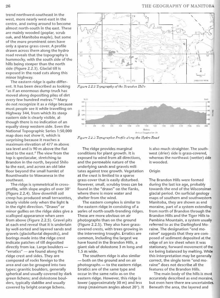


![e]egjaYdk - · PDF fileest (Andreas Huyssen 1995). Bruno Latour s (2005) thinking in relation to dingpolitik and public assembling as well as notions of temporality, ephemeral](https://static.documents.pub/doc/80x56/5a9f14d47f8b9a62178c48c9/eegjaydk-andreas-huyssen-1995-bruno-latour-s-2005-thinking-in-relation-to.jpg)


