277
M2 Upgrade RTA/Pub. 10.259 ISBN 978-1-921766-44-2 SUBMISSIONS AND PREFERRED PROJECT REPORT AUGUST 2010

M2 Upgrade
RTA/Pub. 10.259 ISBN 978-1-921766-44-2
SUBMISSIONS AND PREFERRED PROJECT REPORT
AUGUST 2010
M2 U
pgrad
e SU
BMISSIO
NS A
ND
PREFER
RED
PROJEC
T R
EPORT

(blank page)

Prepared by
AECOM Australia Pty Ltd
Roads and Traffic Authority
M2 Upgrade Project SUBMISSIONS AND PREFERRED PROJECT REPORT 23 August 2010 RTA Publication Number: 10.259 ISBN: 978-1-921766-44-2 © NSW Roads and Traffic Authority

(blank page)

M2 Upgrade SUBMISSIONS AND PREFERRED PROJECT REPORT i NSW Roads and Traffic Authority
Contents 1 Introduction and background .................................................................. 1 1.1 The project ....................................................................................................................... 1 1.2 Statutory context ............................................................................................................ 1 1.3 Environmental assessment exhibition ........................................................................ 1 1.3.1 Notifications ..................................................................................................................... 2 1.3.2 Consultation activities ................................................................................................... 3 1.4 Purpose of the document ............................................................................................. 6
2 Response to issues .................................................................................... 7 2.1 Respondents..................................................................................................................... 7 2.2 Overview of the issues raised...................................................................................... 7 2.2.1 Government agencies .................................................................................................... 7 2.2.2 Local councils ................................................................................................................... 8 2.2.3 Community....................................................................................................................... 9
3 Issues and responses .............................................................................. 11 3.1 Government agency submissions ............................................................................. 11 3.1.1 Department of Environment, Climate Change and Water ............................... 11 3.1.2 NSW Office of Water ................................................................................................ 47 3.1.3 Department of Industry and Investment ................................................................ 58 3.2 Local council submissions .......................................................................................... 59 3.2.1 City of Ryde Council................................................................................................... 59 3.2.2 Hills Shire Council ....................................................................................................... 74 3.2.3 Hornsby Shire Council ............................................................................................... 77 3.2.4 Ku-ring-gai Council .................................................................................................... 101 3.2.5 Parramatta City Council .......................................................................................... 105 3.2.6 Northern Sydney Regional Organisation of Councils ....................................... 111 3.3 Community submissions .......................................................................................... 119 3.3.1 Project development ................................................................................................. 119 3.3.2 Project description and design ............................................................................... 134 3.3.3 Construction ............................................................................................................... 140 3.3.4 Operational traffic and transport ........................................................................... 147 3.3.5 Construction traffic and transport ........................................................................ 159 3.3.6 Operation noise and vibration ............................................................................... 164 3.3.7 Construction noise and vibration .......................................................................... 185 3.3.8 Ecology ......................................................................................................................... 193 3.3.9 Urban design and visual assessment ...................................................................... 202 3.3.10 Aboriginal heritage .................................................................................................... 206 3.3.11 Non-Aboriginal heritage .......................................................................................... 210 3.3.12 Construction surface water management and soils .......................................... 211 3.3.13 Operational surface water management and soils ............................................. 213 3.3.14 Socio-economic .......................................................................................................... 215 3.3.15 Land use and property.............................................................................................. 219

M2 Upgrade SUBMISSIONS AND PREFERRED PROJECT REPORT ii NSW Roads and Traffic Authority
3.3.16 Air quality .................................................................................................................... 221 3.3.17 Lighting impacts .......................................................................................................... 225 3.3.18 Waste minimisation and management .................................................................. 226 3.3.19 Hazards and risks ....................................................................................................... 227 3.3.20 Climate change ........................................................................................................... 228 3.3.21 Cumulative impacts ................................................................................................... 232
4 Preferred project report...................................................................... 233 4.1 Design changes around Kirkham Street/Murray Farm Road overbridge ..... 233 4.1.1 Description .................................................................................................................. 233 4.1.2 Environmental assessment ....................................................................................... 237 4.2 Minor project changes .............................................................................................. 242 4.2.1 Clarification of details of the proposed site compound at Terrys Creek
and Somerset Street, Epping ................................................................................... 242 4.2.2 Correction of table headings in the environmental assessment .................... 242 4.2.3 Increase in height of noise wall NW-W-3001 .................................................... 242
5 Revised Statement of Commitments ................................................. 243
6 References ............................................................................................. 259
7 Glossary of terms and abbreviations .................................................. 261
Appendix A – Assessment of significance ............................................................. 265
Appendix B – Revised table headings .................................................................... 267

M2 Upgrade SUBMISSIONS AND PREFERRED PROJECT REPORT 1 NSW Roads and Traffic Authority
1 Introduction and background
1.1 The project The Roads and Traffic Authority (RTA) of NSW proposes to upgrade 14.5 km of the M2 Motorway from Windsor Road, Baulkham Hills, to Delhi Road, North Ryde. The M2 Upgrade project would generally involve:
• Widening of sections of the eastbound and westbound carriageways.
• Provision of west facing on and off ramps at Windsor Road.
• Provision of an on-ramp at Christie Road and an off-ramp at Herring Road.
• Widening of the Norfolk Tunnel.
• Provision of a permanent cycle facility.
The project includes associated or ancillary works, activities, uses, structures or facilities for the purposes of the project, including (but not limited to) any of the following:
• Construction and associated demolition works.
• Access for construction of the project.
• Environmental management and pollution control for the project.
• Upgrades to the M2 Motorway’s operational management and control systems.
The project does not include preliminary works (such as surveys, test drilling, test excavations, preliminary geotechnical investigations, contamination investigations, utility identification and location and pavement investigations) associated with the design and/or environmental assessment of the M2 Upgrade project occurring prior to the commencement of construction.
1.2 Statutory context The Minister for Planning has declared, by Order published on 27 February 2009 in the NSW Government Gazette (No. 44 of 2009), that the M2 Upgrade project is a project to which Part 3A of the Environmental Planning and Assessment Act 1979 (EP&A Act) applies. The Minister for Planning has also declared that the M2 Upgrade project is a critical infrastructure project under section 75C of the EP&A Act. During the environmental assessment process, some changes were made to the project. Whilst these changes would not substantially alter the project, an amendment to the project description contained in the Minister’s original declarations was sought to reflect the changes. On 6 August 2010, the Minister for Planning amended the original declarations to include the changed project description.
1.3 Environmental assessment exhibition The environmental assessment was exhibited for 34 days from 19 May 2010 to 21 June 2010 and submissions were accepted until 5 July 2010. The exhibition was advertised in local and metropolitan press including:
• Sydney Morning Herald – 19 May.
• Daily Telegraph – 19 May.
• Koori Mail – 19 May.

M2 Upgrade SUBMISSIONS AND PREFERRED PROJECT REPORT 2 NSW Roads and Traffic Authority
• Hills Shire Times – 25 May.
• Rouse Hill Times – 25 May.
• North Shore Times – 26 May.
• Northern District Times – 26 May.
• Parramatta Advertiser – 26 May.
• Hornsby Advertiser – 27 May.
• National Indigenous Times – 27 May.
The environmental assessment was made available for review and electronic download on the RTA website: www.buildingsydneymotorways.com.au and the M2 Upgrade project website: www.hillsm2upgrade.com.au. Hardcopies and electronic (disk) versions of the environmental assessment were made available to community members upon request.
The environmental assessment was exhibited at the display locations listed in Table 1.1. During the exhibition period, the public was able to review the environmental assessment and obtain information from display materials including a 10 page community update brochure. A set of 13 information posters were also available at exhibition events and on the M2 Upgrade project website. Additionally, information could be accessed from the M2 Upgrade project’s enquiries email [email protected] and telephone information line 1800 196 266.
Table 1.1: Environmental assessment display locations
Location Address Department of Planning Information Centre
23-33 Bridge Street, Sydney
Nature Conservation Council of NSW
Level 2, 5 Wilson Street Newtown NSW 2042
NSW Roads and Traffic Authority (Head Office)
Level 9, 101 Miller Street, North Sydney
City of Ryde Council 1 Devlin Street, Ryde
Hornsby Shire Council Pennant Hills Library
Corner Ramsay and Yarrara Roads, Pennant Hills
Hills Shire Council 129 Showground Road, Castle Hill
Parramatta City Council Parramatta Library
1 Civic Place, Parramatta
Blacktown City Council 62 Flushcombe Road, Blacktown
Lane Cove Council 48 Longueville Road, Lane Cove
1.3.1 Notifications
At the start of the environmental assessment exhibition period, the project’s Community Update brochure was distributed via letterbox drop to 10,000 households and businesses in the M2 corridor.
Notifications were also issued via email to City of Ryde Council, Hornsby Shire Council and Hills Shire Council, each listed as relevant stakeholders in the Department of Planning’s (DoP) Director-General’s Requirements (DGRs). Additionally, notifications were issued to

M2 Upgrade SUBMISSIONS AND PREFERRED PROJECT REPORT 3 NSW Roads and Traffic Authority
neighbouring Parramatta City Council, Blacktown City Council and Lane Cove Council, as well as the Northern Sydney and Western Sydney Regional Organisation of Councils.
Relevant public stakeholders, including special interest groups and affected landowners, were also issued with email or posted notifications. Interest groups included transport stakeholders such as M7 West Link and Connector Motorways and the NSW Transport as well as the emergency services, the NRMA, trucking, taxi and bus groups/associations and cyclist groups. Notifications were also issued to social, economic and environmental interest groups. Notifications to interest groups included invitations to briefings on the environmental assessment to be presented by the M2 Upgrade project team during the exhibition period (see Table 1.2 below).
Notifications were also distributed to affected landowners including:
• 411 properties located in the vicinity of proposed construction compound sites.
• 164 properties located in the vicinity of noise wall movements.
• 91 properties listed in the environmental assessment for architectural treatment assessment.
• 29 properties located in the vicinity of potential construction noise related to the Norfolk Tunnel widening works.
• 18 properties subject to subsurface acquisition.
• 5 properties subject to partial property acquisition.
Notifications were also issued to community members who had previously registered to receive project updates. This list included 366 registered subscribers on the date of announcement.
1.3.2 Consultation activities
The public exhibition provided stakeholders and community members with opportunities to speak with members of the M2 Upgrade project team along with RTA and Transurban officers. These events are listed in Table 1.2 below.
Table 1.2: Consultation events
Consultation event Location Date
Council briefings
City of Ryde Council 1 Devlin Street, Ryde 25 May 2010
Parramatta City Council 30 Darcy Street, Parramatta 27 May 2010
Hornsby Shire Council 296 Pacific Highway, Hornsby 28 May 2010
Blacktown City Council 62 Flushcombe Road, Blacktown 28 May 2010
*Note: Hills Shire Council and Lane Cove Council were offered, but declined, briefings. Interest group briefings
Transport groups Attendees: • NSW Police – Castle Hills Police
Station • NSW Ambulance Service –
Castle Hills Ambulance Station
Dunmore Lang College 130 – 134 Herring Road, North Ryde
26 May 2010

M2 Upgrade SUBMISSIONS AND PREFERRED PROJECT REPORT 4 NSW Roads and Traffic Authority
Consultation event Location Date
• NSW Transport and Infrastructure – Transport Planning
• Hillsbus
Cyclist groups
Attendees: • Bike North • Bicycle NSW • Cyclists’ Action Movement
West (CAMWEST)
Dunmore Lang College 130 – 134 Herring Road, North Ryde
26 May 2010
Social-environmental groups
Attendees: • North Rocks M2 Residents
group • Beecroft Cheltenham Civic
Trust • Beecroft Chilworth Bushcare • West Pennant Hills Valley
Progress Association • Ray Park Heritage Group • Pennant Hills Civic Trust • Roselea Bushcare Group
Dunmore Lang College 130 – 134 Herring Road, North Ryde
31 May 2010
Economic/business groups
Attendees: • Arup (Macquarie University) • Ryde Business Forum • Miller Street Partners • Motorcycle Council of NSW • Placemedia • AMP Capital
Macquarie Graduate School of Management 99 Talavera Road, Macquarie Park
8 June 2010
Staffed shopping centre displays
Carlingford Court Corner Pennant Hills and Carlingford Roads, Carlingford
29 May 2010 10am–2pm
Macquarie Centre Corner Herring and Waterloo Roads, North Ryde
1 June 2010 10am–2pm
Winston Hills Mall 180 Caroline Chisholm Drive, Winston Hills
3 June 2010 4pm–8pm
Community information sessions
Epping Boys High School 213 Vimiera Road, Eastwood 2 June 2010 5pm–8pm

M2 Upgrade SUBMISSIONS AND PREFERRED PROJECT REPORT 5 NSW Roads and Traffic Authority
Consultation event Location Date
Stamford Hall, Balcombe Heights Estate
92 Seven Hills Road, Baulkham Hills
5 June 2010 10am–2pm
North Ryde School of Arts Community Centre
201 Coxs Road, North Ryde 10 June 2010 5pm–8pm
Noise/noise wall interviews
36 interviews conducted Dunmore Lang College 130 – 134 Herring Road, North Ryde
Macquarie Graduate School of Management 99 Talavera Road, Macquarie Park
On site at private properties upon request
20 May – 18 June 2010
By community group invitation
North Rocks M2 Resident Group Dunmore Lang College 130 – 134 Herring Road, North Ryde
9 June 2010 7pm–9.30pm
Our Lady of Lourdes Primary School
Oakland Avenue, Baulkham Hills 15 June 2010 4pm-5.30pm
Noise wall movement consultation
Properties located in the vicinity of potential noise wall movements were first contacted in December 2009, with advice that further details would be provided following progress of the concept design development. In mid-May 2010 the M2 Upgrade project team provided correspondence advising these property owners of further details on proposed noise wall changes including:
• Section of noise wall to be moved/installed.
• New location – distance from existing noise wall location.
• New location – distance from M2 lease boundary.
• New location – distance from private property boundary.
• Any changes to new noise wall height.
This correspondence also invited property owners to meet with members of the M2 Upgrade project team and the RTA to discuss the changes and their individual property. Further correspondence issued on 19 May 2010 advised of the environmental assessment public exhibition commencement (see Notifications section above). During the exhibition period, 36 noise/noise wall interviews were conducted.
Property acquisition consultation
Ongoing consultation with residents whose properties would be subject to partial property acquisition (five) and those subject to subsurface acquisition (18) continued through the public exhibition period.

M2 Upgrade SUBMISSIONS AND PREFERRED PROJECT REPORT 6 NSW Roads and Traffic Authority
Transport and Cyclist Interest Groups – Working Groups
Briefings provided to transport and cyclist interest groups during the environmental assessment exhibition concluded a six month program in which working groups were established to consult with these stakeholder groups. Consultation with the Transport Working Group focused on relevant elements of the concept design. Consultation with the M2 Upgrade Cycle Working Group focused on relevant elements of the M2 Upgrade project and the alternative cyclist route proposed to service cyclists during the construction phase when cyclists for safety reasons would not be permitted to use the M2 Motorway. (Note cyclists would be permitted to use the M2 Motorway breakdown lane once the M2 Upgrade project is completed.) Working groups met monthly or bimonthly as appropriate during development of the concept design.
Should the M2 Upgrade project be approved and proceed to construction, consultation with transport and cyclist stakeholders would continue as part of the M2 Upgrade project’s broader ongoing consultation program, as appropriate. The consultation program would be tailored to each phase of the M2 Upgrade project.
Enquiry and correspondence response
Throughout the public exhibition period the M2 Upgrade project’s community relations team provided responses to requests for information from stakeholders and community members. Between 19 May 2010 and 21 June 2010 the M2 Upgrade project received and responded to approximately 100 telephone and 120 email enquiries, providing available information on the environmental assessment, concept design and submissions process.
Correction to advertised Department of Planning facsimile number
At the end of the exhibition period it was identified that the DoP facsimile number for receipt of submissions was incorrect on the Community Update brochure. To address this error, the community was advised of the correct number via a web update, distribution of 11,000 letters along the M2 corridor, and emails to councils, interest groups and registered subscribers. The M2 Upgrade project’s community relations team advised that any previously faxed submissions should be resent and that the DoP would accept submissions for an additional two weeks until 5 July 2010. The DoP’s postal address and email details were correctly listed in the brochure.
1.4 Purpose of the document During the exhibition of the environmental assessment, 910 submissions were received. The Director-General of the DoP provided copies of the submissions to the RTA. In accordance with section 75H(6) of the EP&A Act, the Director-General required the RTA to address the issues raised in the submissions by 30 July 2010 or as otherwise agreed with the DoP. If the response required changes to the M2 Upgrade project to minimise its environmental impact, a preferred project report was to be prepared and the Statement of Commitments to be revised.
This report identifies the issues raised during exhibition of the environmental assessment and provides the RTA’s responses to those (Chapter 3). It includes a preferred project report and a description of changes to the M2 Upgrade project (Chapter 4) and a revised Statement of Commitments (Chapter 5).

M2 Upgrade SUBMISSIONS AND PREFERRED PROJECT REPORT 7 NSW Roads and Traffic Authority
2 Response to issues 2.1 Respondents A total of 910 submissions were received during the exhibition period from 19 May until 21 June 2010 and through to 5 July 2010. Submissions included copies of two form letters and nine petitions.
2.2 Overview of the issues raised Three of the submissions were from government agencies, six from local councils and 901 from the community.
Each submission has been examined individually to understand the issues being raised. The issues raised in each submission have been extracted, collated and summarised. Responses to the summarised issues have been provided. Where similar issues have been raised in different submissions, only one response has been provided. The issues raised and the RTA’s response to these issues forms the basis of Chapter 3 of this report. Of the 910 submissions received, five per cent made a clear statement of objection to the M2 Upgrade project. A further five per cent stated an objection to the M2 Upgrade project with qualifications regarding greater mitigation of noise, environmental and construction impacts. Only two per cent provided conditional support, also based on the M2 Upgrade project effectively addressing these issues. Eighty-eight per cent of submissions did not include a clear statement of objection or support. However, the majority of these submissions addressed concerns regarding the M2 Upgrade project’s expected negative impacts. Overall, submissions addressed issues relating to M2 Upgrade project justification, traffic and transport, noise, construction and the environment.
The main issues from government agencies, local councils and the community are outlined below.
2.2.1 Government agencies
Three government agencies made submissions, raising a range of issues relevant to their areas of responsibility. Some recommendations for Conditions of Approval were also made. A summary of each agency’s issues is provided below. Section 3.1 of this report provides detail on the issues raised by each agency and the corresponding responses.
Department of Environment, Climate Change and Water
The Department of Environment, Climate Change and Water (DECCW) raised issues about the:
• Extent to which the M2 Upgrade project encourages mode shift to public transport, such as improving performance for bus access and travel times at ramps and along the M2 Motorway.
• Rationale for not proceeding with the park and ride facility.
• Provision of safe cycling access to encourage ongoing active transport.
• Management of Norfolk Tunnel works.
• Assessment and management of noise and vibration, erosion and sediment controls, spoil management, blasting and hydro-blasting, flora and fauna, air quality, stormwater and groundwater.

M2 Upgrade SUBMISSIONS AND PREFERRED PROJECT REPORT 8 NSW Roads and Traffic Authority
• Amendments to the draft Statement of Commitments.
NSW Office of Water
The NSW Office of Water raised issues about the:
• Protection and management of watercourses and creek channels, water quality basins, riparian vegetation, subsurface water management and soils.
• Amendments to the Statement of Commitments.
• Conditions of Approval.
Department of Industry and Investment
The Department of Industry and Investment stated that it does not object to the M2 Upgrade project provided that aquatic habitat mitigation measures, listed as reference numbers EM1-4, FF6 and WS1-4 within the draft Statement of Commitments and in Section 9.8.3 of the environmental assessment, are implemented. This agency also commented that weed management during construction should be undertaken in accordance with existing State, regional and local weed management plans or strategies.
2.2.2 Local councils
The City of Ryde Council, Parramatta City Council, Hills Shire Council, Hornsby Shire Council, Ku-ring-gai Council and the Northern Sydney Regional Organisation of Councils (NSROC) made submissions on a range of issues summarised below:
• Strategic issues highlighting traffic and transport needs particularly due to growth in the north west area, necessity for the M2 Upgrade project and support for further transport infrastructure development such as rail links.
• Construction issues including minimisation of impacts to local residents and the environment, and management of construction compounds and access.
• Operation and construction phase traffic and transport issues including impacts to traffic performance, local road networks, local access, public transport, cyclist and pedestrian safety and access. Comments were also made objecting to the removal of the Beecroft Road bus ramps, and requesting consideration of distance based tolling and a park and ride facility.
• Noise and vibration issues including increased noise, noise modelling and assessment, heavy vehicles and compression braking, inadequacy of noise mitigation measures including noise walls, construction noise and vibration, the Norfolk Tunnel widening works, relocation of noise walls, and construction compound site noise impacts.
• Ecology issues including vegetation removal and rehabilitation, landscaping, additional threatened species, biodiversity offset strategies, construction impacts, and construction access impacts on flora and fauna.
• Urban design and visual assessment issues including visual impacts at the Windsor Road intersection.
• Aboriginal heritage issues including Aboriginal site management and ongoing maintenance.
• Non-Aboriginal heritage issues including impacts on a heritage item.

M2 Upgrade SUBMISSIONS AND PREFERRED PROJECT REPORT 9 NSW Roads and Traffic Authority
• Surface water management and soil impacts including water sensitive urban design (WSUD), surface water management and gross pollutant removal and impacts on water quality.
• Land use and property issues including acquisition of land and compensation.
• Air quality impacts including dust impacts from construction work, impacts on local residents and regional air quality.
Section 3.2 of this report provides detail on the issues raised by each local council and the corresponding responses.
2.2.3 Community
Community submissions have predominantly reflected the priorities and concerns of residents living along the M2 corridor, local groups with social, economic and environmental interests and M2 Motorway users including motorists and bus commuters. The main issues raised in community submissions include:
Project justification
• Inadequacy of M2 Upgrade project to address traffic and transport needs of Sydney’s north west region given expected future growth by 140,000 households. Recommendations were made that greater value for money and better outcomes could be gained from alternatives such as a rail link and more investment in public transport.
Traffic and Transport
• Concern regarding the extent to which the M2 Upgrade project would improve the M2 Motorway’s performance and adequately address congestion.
• Concern regarding impacts to the local road network due to increased traffic accessing the M2 Motorway and increased commuter parking in local streets.
• Objection to removal of the Beecroft Road bus ramps due to negative impacts to commuters using bus routes 611 and 740, and future potential of ramps to support social and economic growth in the area.
• Concern regarding impacts of increased heavy vehicle use of the M2 Motorway.
• Concern the M2 Upgrade project should make provision for cyclists’ safe use of the M2 Motorway breakdown lane and, during construction, provide an alternative cyclist route that addresses cyclists needs regarding safety, gradient, distance and ride comfort.
• Concern the M2 Upgrade project has not adequately addressed pedestrian and cyclist safety and access.
Safety
• Concerns that the M2 Upgrade project would exacerbate existing risks at the Windsor Road/Torrs Street/Oakland Avenue intersection used by children from Our Lady of Lourdes School.
Noise and Vibration
• Dissatisfaction with existing noise levels caused by increased traffic and heavy vehicles using the M2 Motorway since the opening of the M7 Motorway and inadequate noise walls.

M2 Upgrade SUBMISSIONS AND PREFERRED PROJECT REPORT 10 NSW Roads and Traffic Authority
• Concern that the environmental assessment’s noise monitoring and assessment methodology and use of the Environmental Criteria for Road Traffic Noise (ECRTN) criteria for existing roads is flawed and does not adequately address existing or future noise impacts.
• Concern that the M2 Upgrade project would further increase noise levels and should include improved noise mitigation, such as more effective noise walls, better road surfacing, greater provision of architectural treatments and technologies such as speed and noise cameras.
Environment
• Concern that the M2 Upgrade project has not adequately sought to minimise community and environmental impact and should shift widening works away from, rather than closer to, sensitive environmental areas and homes to minimise noise and other impacts.
• Concern regarding impacts of vegetation removal and provision for appropriate bush rehabilitation and weed management.
• Concern regarding air quality impacts to health.
Construction
• Expectation of effective noise and impact mitigation at construction sites and construction compound sites.
Socio-economic
• Concern regarding the M2 Motorway tolling system, particularly in relation to tolling costs, social equity and traffic management. The M2 Upgrade project should include introduction of variable tolling.
• Concerns that increased traffic volumes and noise and air quality impacts would affect amenity, quality of life and property values.
Section 3.3 of this report provides detail on the issues raised by the community and the corresponding responses.
Form letters
Two form letters were received. In total, form letter one was lodged 154 times and form letter two was lodged 10 times. These originated from resident groups in the areas of Ku-ring-gai, North Ryde, Beecroft, Cheltenham and Darling Mills Bridge. Issues raised in these form letters presented a range of issues consistent with the issues summarised above.
Petitions
Nine petitions commenting on the M2 Upgrade project were received bearing 347 signatures in total. Additionally, the West Pennant Hills Valley Progress Association submitted a petition of approximately 100 signatures gathered previously regarding existing M2 Motorway noise concerns. Petitions regarding the M2 Upgrade project were received from residents of neighbourhood areas along the M2 corridor. Petition issues related largely to concerns regarding impacts on residential and environmental areas and were consistent with issues raised throughout community submissions, as summarised above.

M2 Upgrade SUBMISSIONS AND PREFERRED PROJECT REPORT 11 NSW Roads and Traffic Authority
3 Issues and responses
3.1 Government agency submissions
3.1.1 Department of Environment, Climate Change and Water
Department of Environment Climate Change and Water Response
Issue
Project development
Planning and statutory requirements
Proposed on-site sandstone crushing, concrete batching and bitumen plants would require an environment protection licence under the Protection of the Environment Operations Act 1997. DECCW recommends that if rock crushing, mobile concrete batching plant or bitumen plant activities are proposed, that an environmental assessment be undertaken for those activities.
No concrete batching or bitumen plants are proposed as part of the M2 Upgrade project. As the M2 Upgrade project would be a scheduled development, construction requires an environment protection licence (EPL) under the Protection of the Environment Operations Act 1997. It is anticipated that the proposed crushing and screening activities would be included in the EPL. Should the M2 Upgrade project be approved, the proposed crushing and screening facility would be discussed with DECCW as part of licence negotiations.
Construction Compound sites
Section 9.4.3 of the environmental assessment broadly outlines but provides no detail of noise impacts predicted in conjunction with the construction and use of various construction compound sites. DECCW considers all construction compound sites, including lay down and stockpiling areas, to be activities ancillary to scheduled
The advice is noted. It is anticipated that various ancillary constructed facilities would be included in the EPL for the construction of the M2 Upgrade project.
M2 Upgrade SUBMISSIONS AND PREFERRED PROJECT REPORT 12 NSW Roads and Traffic Authority
Department of Environment Climate Change and Water Response
Issue
activities and thus subject to licensing under the Protection of the Environment Operations Act 1997.
Amend the draft Statement of Commitments to ensure construction compound sites are not established until erosion and sediment controls have been installed and a site-specific noise impact statement has been prepared and all reasonable and feasible noise impact mitigation measures have been identified in consultation with the community likely to be affected by noise from the use of that construction compound site. Construction compound sites should not be operated until the noise mitigation measures have been implemented. Time hooters, amplified music, public address systems or the like should not be used.
The draft Statement of Commitments includes a requirement to install erosion and sedimentation controls prior to construction and to maintain the controls throughout the construction period. This requirement applies to the entire M2 Upgrade project, including the construction compound sites.
Detailed information regarding the establishment and use of the construction compound sites, and the potential impacts associated with the construction compound sites, would become available as the detailed design and construction methodology for the M2 Upgrade project are finalised. Individual Construction Noise and Vibration Impact Statements (CNIS) for each construction compound site would be prepared and implemented prior to establishment of the site. Time hooters, amplified music or public address systems would not be used at the construction compound sites. Mitigation measures to minimise the potential impacts associated with the establishment and use of the construction compound sites would be developed on a location-by-location basis and implemented as required to manage potential impacts. Mitigation measures would be documented in the Construction Noise and Vibration Management Plan for the construction compound sites. It is anticipated that additional mitigation measures would be implemented to respond to any issues arising from specific construction activities. The draft Statement of Commitments already includes a requirement to implement mitigation and management measures to minimise construction noise and vibration.
Traffic and transport
Public transport
Requested that the preferred project option include measures to encourage mode shift to public transport
The M2 Upgrade project is intended to relieve congestion on the M2 Motorway, and has been designed to facilitate enhancements to public transport through improved travel times

M2 Upgrade SUBMISSIONS AND PREFERRED PROJECT REPORT 13 NSW Roads and Traffic Authority
Department of Environment Climate Change and Water Response
Issue
(buses). and efficiencies. The recently announced Metrobus route M61 will utilise the upgraded M2 Motorway. These buses will run more frequently (every ten minutes in peak periods). This is an example of improvements to public transport services that will contribute to encouraging a mode shift to buses.
Questioned whether the M2 Upgrade project would lead to an increased reliance on public transport given that the majority of east bound AM (morning) peak bus trips are to North Sydney and the Sydney central business district (CBD).
The proposed M2 Upgrade project would not result in increased reliance on public transport but would increase the attractiveness of public transport and encourage greater use of bus services.
The focus of the M2 Upgrade project is to relieve congestion. Reducing congestion on the M2 Motorway would have direct positive impacts on public transport, resulting in improved bus travel times and reliability. The M2 Motorway is an existing major (and heavily used) bus corridor. Bus service levels and reliability of bus operations are dependent on traffic conditions on the M2 Motorway.
As discussed in Section 2.1.6 of the environmental assessment, there has been a significant increase in patronage of bus services using the M2 Motorway in recent years, enabled by the delivery of new buses under the NSW Government’s Growth Buses program. Time savings and improved reliability will enhance the travel experience of bus passengers and encourage use of bus services, but the additional services provided under the Growth Buses program would be the key driver for increases in bus patronage in the future. As outlined above, the new Metrobus services along the M2 Motorway would further contribute to encouraging increased public transport patronage.
Expects the M2 Upgrade project to encourage mode shift to public transport (buses). The environmental assessment appears to acknowledge the likely future need for west facing bus-only ramps at Windsor Road, but the M2 Upgrade project does not facilitate bus access (and
The original design of the Windsor Road interchange made allowance for a west facing median bus ramp so that buses could access the M2 Motorway and Windsor Road, however the bus ramp was not built due to low patronage forecasts. At present there are no west facing ramps for cars, trucks or buses at Windsor Road. Hence the proposed ramps at this location would provide improved access opportunities for all modes and vehicle types.

M2 Upgrade SUBMISSIONS AND PREFERRED PROJECT REPORT 14 NSW Roads and Traffic Authority
Department of Environment Climate Change and Water Response
Issue
thus encourage mode shift to buses) at this location (although it does facilitate general access by means of the proposed west facing ramps). Recommended that the Statement of Commitments be amended to ensure that west facing bus only ramps at Windsor Road interchange are provided to encourage mode shift to buses.
The forecast utilisation levels of these new ramps are not high enough to suggest the volume of traffic and/or traffic congestion would cause significant delays for bus passengers (leading to a loss of patronage) in the foreseeable future. If significant delays are experienced by bus services using the new ramps then consideration would be given to measures to reduce delays. New bus only ramps would be a high cost measure, probably only to be implemented if lower cost measures do not provide acceptable improvements.
Expects the M2 Upgrade project to encourage mode shift to public transport (buses). Commented that the environmental assessment indicates that by 2021 the level of service (LoS) during the AM peak for eastbound bus access to the M2 Motorway via the Windsor Road ramp would deteriorate from LoS B to LoS C. DECCW questioned why the M2 Upgrade project does not include measures to achieve LoS A and thus encourage mode shift to buses.
A LoS C represents reasonable traffic performance. Works required to improve the LoS to “A” are not considered to be reasonable and feasible in the context of the incremental improvement in traffic performance that could be achieved, or in light of the capital investment required to achieve this improvement. Further, it is incorrect to assume that a LoS A would equate to a significant mode shift to buses.
Expects the M2 Upgrade project to encourage mode shift to public transport (buses). The environmental assessment appears to favour a T2 lane commencing at some point east of Terrys Creek bridge to Lane Cove instead of an extension of the eastbound bus only lane from the eastern limit of the existing bus lane (Beecroft Road) through to Lane Cove Road.
A dedicated bus lane between Windsor Road and the Lane Cove Tunnel was considered as a project alternative, and is outlined in Section 3.1.3 of the environmental assessment. A dedicated bus lane was not considered the preferred option at this location for the following reasons:
• A typical AM peak bus trip from Sydney’s north west, such as from Castle Hill, to the Sydney CBD via the M2 Motorway takes over an hour. The travel time improvements expected from a bus lane for the full length of the M2 Motorway is estimated to be around five minutes (less than 10 per cent). Based on observed increases in public transport patronage due to changes in travel time (Wallis, 2003), a bus only lane would be expected to reduce the number of cars on the M2 Motorway by less than 100 vehicles

M2 Upgrade SUBMISSIONS AND PREFERRED PROJECT REPORT 15 NSW Roads and Traffic Authority
Department of Environment Climate Change and Water Response
Issue
per hour in the AM peak. This would have negligible benefits in terms of relieving congestion and improving the LoS for cars and trucks.
• Buses would not generate sufficient patronage to alleviate peak hour congestion on the existing M2 Motorway as there would be little travel time improvement from the ‘do nothing’ case for buses. Consequently, the mode shift from car to bus would not be significant enough to reduce congestion on the M2 Motorway.
• This solution would not generate sufficient benefits to road users to justify the level of expenditure required and environmental impacts generated by widening sections for the bus lane extensions.
Expects the M2 Upgrade project to encourage mode shift to public transport (buses). Recommended that the Beecroft Road bus ramp not be demolished in order to preserve service capacity for future expansion of heavy rail services Epping to Parramatta and Epping to Rouse Hill (North West Rail Link) and that this be included as a Statement of Commitments.
Section 9.1.1 of the environmental assessment provides bus passenger counts at Epping that indicate there are currently approximately 70 passengers per day boarding and departing at Epping Station (Department of Trade and Industry (DTI)). Any future heavy rail expansion with connections to Parramatta or the north-west would most likely result in a reduction in the number of passengers utilising M2 Motorway bus services between these origins and Epping Station, as it would provide an alternative rather than complementary travel option. Hence, the preservation of service capacity on this basis is not considered justified.
Concerned the M2 Upgrade project would delay buses from Macquarie Park through to North Sydney and the Sydney CBD due to induced traffic entering the M2 Motorway eastbound via the proposed Christie Road on-ramp.
The environmental assessment forecast that buses heading east bound on the M2 Motorway would achieve a travel time saving of five minutes during the AM peak and one minute during the PM peak by 2021 across the full length of the M2 Motorway as a result of the M2 Upgrade project. The non-widened eastbound sections between Lane Cove Road and Epping Road would experience slight deterioration in LoS, during the AM peak hour and no change in LoS during PM peak hour in 2021, as detailed in Table 36 of the environmental assessment. However, these sections would still perform at a satisfactory LoS.

M2 Upgrade SUBMISSIONS AND PREFERRED PROJECT REPORT 16 NSW Roads and Traffic Authority
Department of Environment Climate Change and Water Response
Issue
At the Christie Road on-ramp, the existing eastbound bus lane would remain in place and would be unaffected by the M2 Upgrade project. Traffic entering the M2 Motorway via the Christie Road on-ramp is expected to have a negligible impact on the operation of the bus lane and the performance of bus services.
Requested clarification on the rationale for not proceeding with the park and ride facility.
Analysis of the park and ride demand indicated that a substantial proportion of the demand would be generated by commuters travelling to Macquarie Park rather than park and ride users travelling to the CBD. The demand for parking by users with Macquarie Park as a final destination would exceed use by patrons connecting to public transport services to North Sydney and the CBD. The analysis also anticipated very low patronage for park and ride use by rail commuters due to the distance from the site to the Macquarie University rail station and the inconvenience of interchanging to a shuttle bus to travel between the two. The analysis indicated that the park and ride facility would not be adequate to subsidise (reduce) the M2 Motorway toll, which was one of the original objectives that lead to its inclusion in the M2 Upgrade project scope. The analysis did indicate that the facility would be commercially viable in its own right, mainly on the basis of accommodating the demand for commercial parking in the Macquarie Park area.
Clarification sought on whether the Christie Road on-ramp would increase congestion eastbound during the AM peak, negate any congestion reductions gained by the proposed reconfiguration of tolling arrangements, and encourage private car use.
There is a forecast demand of 200 vehicles in the AM peak for the new eastbound Christie Road on-ramp in 2021. This contribution is minimal compared with an expected total AM peak hour traffic volume of 5300 at this location, and is unlikely to significantly affect the operation of the M2 Motorway. In 2021, the M2 Motorway is expected to operate at a LOS of “E” without the M2 Upgrade project, and would improve to a LOS of “D+” with the implementation of the M2 Upgrade project.
The widening of the eastbound carriageway between Lane Cove Road and Delhi Road has not been included in the M2 Upgrade project scope, as this section would require lengthening the Lane Cove Road bridge, and the cost and construction impacts associated with this are

M2 Upgrade SUBMISSIONS AND PREFERRED PROJECT REPORT 17 NSW Roads and Traffic Authority
Department of Environment Climate Change and Water Response
Issue
not considered warranted given the forecast demand and satisfactory LoS.
The new ramps at Christie Road and Herring Road are expected to provide travel time benefits of three minutes in the AM peak and five minutes in the PM peak for cars and buses. These changes in travel times, although a benefit, are not enough to significantly influence mode shift, based on observed increases in public transport patronage due to changes in travel time (Wallis, 2003).
Any mode shift to buses would be most heavily influenced by the LoS provision (frequency and accessibility) of bus services that utilise the new access ramps, as opposed to the forecast changes in private vehicle travel times.
The environmental assessment does not appear to provide detailed analysis to support its suggestions that public transport mode share would not decrease with the addition of the proposed Macquarie Park ramps. Commented that the environmental assessment does not offer a clear explanation of the disparity between the existing travel times identified in Table 27 and Table 45, or the relationship of those forecasts with forecast bus travel times identified in Table 38.
DECCW has misread the information in the tables, and compared tables that present different information. Table 27 summarises the existing travel times as observed from travel time surveys (in 2009). Table 45 summarises the forecast travel time in 2011 and 2021 under the ‘Base’ and ‘Upgrade’ scenarios. Table 38 summarises the forecast travel times in 2011 and 2021 under the ‘Base’ and ‘Upgrade’ scenarios for buses along the M2 Motorway. The travel times for buses do not account for dwell times during passenger pick-up/drop-off at bus stops. Buses have the benefit of travelling in dedicated bus lanes in both the ‘Base’ and ‘Upgrade’ scenarios in both directions between Windsor Road and Beecroft Road. Hence there is a disparity in travel times when being compared to car travel times as the buses are protected from congestion delay in these sections.
Commented that the environmental assessment does not demonstrate that the proposed Christie Road and Herring Road ramps would encourage the degree of mode shift to buses anticipated by the State Plan and Action for Air.
There would be an enhancement to public transport rather than a high degree of mode shift. This enhancement would be the result of more efficient access to Macquarie Park via the proposed Christie Road and Herring Road ramps. On its own, these ramps would not be expected to result in a significant degree of mode shift to buses. The degree of mode shift would depend on the level of bus service provision. However, it does act as an enabling factor for more efficient bus services to be introduced in the future, as a separate but

M2 Upgrade SUBMISSIONS AND PREFERRED PROJECT REPORT 18 NSW Roads and Traffic Authority
Department of Environment Climate Change and Water Response
Issue
complementary initiative to the M2 Upgrade project. The recently announced Metrobus route M61 would provide more buses and passenger capacity. This is an example of a complementary initiative.
Recommended the proposed eastbound Christie Road on-ramp only proceed if it prevents mode shift of ‘journey to work’ trips away from public transport (especially buses) by restricting ramp use to either buses only or buses only during the AM peak traffic flow period. It was recommended that this be included as a Statement of Commitment.
The proposed Christie Road eastbound on-ramp would provide greater accessibility to the M2 Motorway from the Macquarie Park precinct for private vehicles, buses and cyclists. As a result of improved access by this and the westbound ramp, there would be opportunity for the development of new bus services to utilise the M2 Motorway and provide access to/from Macquarie Park.
During the AM peak the eastbound M2 Motorway flows are busiest due to a strong demand for traffic travelling towards the Sydney CBD, Chatswood, St Leonards and North Sydney. During this period, demand for eastbound traffic travelling from Macquarie Park via the new eastbound ramps is expected to be low, as Macquarie Park is a key attraction for journey-to-work trips and education trips. Table 46 of the environmental assessment indicates a forecast demand of only around 200 vehicles in the AM peak hour for the new eastbound Christie Road on-ramp in 2021.
Given the nature of traffic demand for the ramp, it is not expected that banning private vehicles across the day or during the peaks would improve the LoS for bus passengers, and therefore it is not expected that it would encourage a mode shift to buses from private vehicles. Any mode shift to buses would be most heavily influenced by the LoS provision (frequency and accessibility) of bus services that utilise the new access ramps. Monitoring the operation of the ramp would be undertaken as part of the M2 Motorway management.
Recommended the proposed westbound Herring Road off-ramp only proceed if it encourages mode shift to public transport (especially buses) by restricting ramp use to either buses only or buses only during the PM peak
The proposed Herring Road westbound off-ramp would provide greater accessibility to the Macquarie Park precinct for private vehicles, buses and cyclists. As a result of improved access, there would be opportunity for the development of new bus services to utilise the M2 Motorway and to provide access to/from Macquarie Park.

M2 Upgrade SUBMISSIONS AND PREFERRED PROJECT REPORT 19 NSW Roads and Traffic Authority
Department of Environment Climate Change and Water Response
Issue
traffic flow period. It was recommended that this be included as a Statement of Commitment.
During the PM peak the westbound M2 Motorway flows are busiest due to a strong demand for traffic travelling from the Sydney CBD, Chatswood, St Leonards and North Sydney. During this period, demand for westbound traffic travelling to Macquarie Park via the new westbound ramp is expected to be low, as Macquarie Park is a key generator for work trips and education trips. Table 46 of the environmental assessment indicates a forecast demand of 150 vehicles in the PM peak hour for the new westbound Herring Road off-ramp.
Given the nature of traffic demand for the ramp, it is not expected that banning private vehicles across the day or during the peaks would improve the LoS for bus passengers, and therefore it is not expected that it would encourage a mode shift to buses from private vehicles. Any mode shift to buses would be most heavily influenced by the LoS provision (frequency and accessibility) of bus services that utilise the new access ramps. Monitoring the operation of the ramp would be undertaken as part of M2 Motorway management.
Recommended provision of park and ride facilities at Macquarie Park and/or at other locations (not necessarily within the existing M2 Motorway corridor) to encourage a mode shift to buses subject to the outcome of detailed feasibility studies at two years, five years and 10 years after commissioning of additional lanes proposed as part of the project. It was recommended that this be included as a Statement of Commitment.
Analysis suggesting that patronage of the park and ride and bus interchange facility would not be adequate to subsidise (reduce) the M2 Motorway toll as was one of the original objectives. In addition analysis suggested that the proposed site would be too far in distance from the Macquarie University rail station to be attractive for commuters to interchange with rail services. A park and ride facility at another location would also be unlikely to meet this objective of subsidising M2 Motorway tolls and may in fact require an increase in tolls to fund its provision.
Further, there are no individual parcels of land at the western end of the M2 Motorway that would be large enough in size to justify the construction of the requisite access and egress infrastructure from the M2 Motorway. Hence, any park and ride facilities would need to be off-motorway and would best be considered separately to the M2 Upgrade project. On this basis, no other park and ride facilities are being proposed or feasibility studies being prepared as part of the M2 Upgrade project.

M2 Upgrade SUBMISSIONS AND PREFERRED PROJECT REPORT 20 NSW Roads and Traffic Authority
Department of Environment Climate Change and Water Response
Issue
Cyclist considerations
The environmental assessment does not include measures to prevent cycling access being lost to renewed resumption of the breakdown lane for the purpose of managing peak period capacity constraints. It was recommended that dedicated cycling access be provided in both the eastbound and westbound breakdown lanes.
The capacity of the M2 Motorway to meet future demands is met through the provision of additional traffic lanes without the need to use the breakdown lane as a traffic lane and without loss of cyclist access. The M2 Upgrade project would result in the reinstatement of access for cyclists to the breakdown lane in the westbound section of the M2 Motorway from Lane Cove Road to Beecroft Road. Cyclists would have continuous access to the M2 Motorway in both directions between Delhi Road and Abbott Road upon completion of the M2 Upgrade project.
The environmental assessment does not address grade separated cycling access across on and off ramps. It was recommended that grade separated access to cross on and off ramps, or other appropriate measures to facilitate safe crossing of the intersections of ramps, be provided so as to encourage cycling. It was recommended that this be included as a Statement of Commitment.
The design of cyclist crossings at on and off ramps would be in accordance with RTA guidelines to allow cyclists to use the breakdown lane appropriately and safely and to have continuous access to the M2 Motorway between Delhi Road and Abbott Road. Grade separation of the ramps is not part of the M2 Upgrade project scope due to the high cost associated with providing the ramps compared with the relative low volume of cyclists that would use them. In addition, due to the alignment of the existing road infrastructure and site area constraints, it is considered unlikely that grade-separated access would be functionally appropriate at any of the existing or new on/off ramps.
Recommended that alternative dedicated cycling access be provided to maintain both eastbound and westbound cycling access throughout the length of the M2 Motorway should proposed cycle access along breakdown lanes become unavailable due to traffic lanes encroaching into the breakdown lanes or for any other reason. It was recommended that this be included as a Statement of Commitment.
The M2 Upgrade project involves provision of an additional traffic lane without the need to use the breakdown lane as a traffic lane or resulting in loss of cyclist access.

M2 Upgrade SUBMISSIONS AND PREFERRED PROJECT REPORT 21 NSW Roads and Traffic Authority
Department of Environment Climate Change and Water Response
Issue
Encourage ongoing active transport (cycling) options during the construction phase by upgrading those sections of the alternative cycle route that do not meet standards for safety and rideability. It was recommended that this be included as a Statement of Commitment.
The alternative cycle route generally complies with Austroad’s General Guide to Traffic Engineering Part 14 – Bicycles and the RTA’s NSW Bicycle Guidelines. However, in some areas the route is not compliant with the Guidelines as a result of either physical, spatial, heritage, engineering or road safety constraints. The RTA has been advised of these non-compliances and has confirmed its acceptance of the alternative solutions put forward for these areas to ensure the safety of cyclists and other road users, including pedestrians.
Noise and vibration Impacts
DECCW anticipates that the proposed works are likely to generate significant noise and vibration impacts.
If the M2 Upgrade project is approved, a Construction Noise and Vibration sub-plan would be developed as part of the construction environmental management plan (CEMP). The sub-plan would be based on the strategy presented in the construction environmental management framework (CEMF) included in the environmental assessment and would include as a minimum the mitigation measures outlined in the environmental assessment.
Noted that Section 9.4.5 of the environmental assessment provides a construction noise and vibration impact assessment of the proposed tunnelling and tunnel-related construction work at Norfolk Tunnel. However, the environmental assessment:
• Does not include a tunnelling work scenario (Table 73).
• Proposes a minus five dB(A) correction for the effect of existing noise walls (Table 78), omits a plus five dB(A) correction for high noise impact construction work.
Table 73 of the environmental assessment describes general work scenarios that would occur across the entire M2 Upgrade project. These work scenarios, as they relate to the tunnel-related construction work, are considered in Tables 74, 75, 76 and 77 of the environmental assessment (refer to Noise Catchment 17).
Due to the unique nature of the proposed works associated with tunnel widening, the potential noise and vibration impacts for tunnelling are assessed and presented separately in the environmental assessment. As noted in the submission from DECCW, specific noise impacts associated with tunnelling are presented in Table 78.
The Environmental Noise Management Manual produced by the RTA (ENMM) provides guidance that noise walls are not considered reasonable and feasible unless they provide a noise attenuation of at least five dB(A) at the closest residence. The existing noise walls

M2 Upgrade SUBMISSIONS AND PREFERRED PROJECT REPORT 22 NSW Roads and Traffic Authority
Department of Environment Climate Change and Water Response
Issue
• Indicates that “for the early widening works (adjustment to the portal transition area and breaking out of existing concrete barriers) there are limited mitigation measures available”.
around the tunnel portals would be quite high (generally in excess of 4.2 metres). It was assumed therefore that the existing noise wall would provide an attenuation of at least five dB(A). However, the development of construction noise management measures at this location would not assume noise reduction benefits from the existing noise walls.
Correction factors to account for high impact noise activities are discussed in the response below. The ‘worst case’ equipment sound power levels adopted for assessment have been adjusted individually (increased) to account for high impact noise.
The works at the portals and tunnel openings would occur within the deep cuttings and high noise walls are present along the top of the cuttings. Therefore the adjacent residents would be well screened from the noise that would be generated by works at these locations. The noise assessment of the proposed tunnel widening work presented in Technical Paper 2 – Noise and Vibration (Volume 2) of the environmental assessment indicates that relevant noise management levels would not be exceeded for day time works. Noise management levels for the work scenario proposed in the evening would only be exceeded at the façades of five properties and noise management measures would be developed and implemented accordingly. Mitigation measures outlined in the environmental assessment would be implemented where practicable.
The environmental assessment appears to have omitted the recommended five dB(A) noise adjustment (in respect of the quantitative assessment of high noise impact construction work) outlined in Section 4.5 of the Interim Construction Noise Guidelines (ICNG) (DECCW, 2009).
Technical Paper 2 of the environmental assessment clearly identifies the exceedances of noise management levels (NMLs) as being primarily dominated by high noise impact and intermittently used items of plant such as jackhammers and concrete saws. In the assessment for the M2 Upgrade project, higher noise levels than the usual LAeq noise levels quoted for equipment have been used to account for the high impact noise. For example, for a jackhammer, an LAeq sound power level of 108 dB(A) would usually be applied. In this assessment, a level of 115 dB(A) has been used. As such, the cumulative noise levels presented in the environmental assessment are considered to be ‘worst case’ scenarios. The five dB(A) correction factor to account for high noise impact activities and plant referred to

M2 Upgrade SUBMISSIONS AND PREFERRED PROJECT REPORT 23 NSW Roads and Traffic Authority
Department of Environment Climate Change and Water Response
Issue
in the ICNG is considered to be adequately contained within these ‘worst-case’ sound power levels used in the assessment. If any additional corrections were to be added to the levels, then considerable over predictions would most likely result. Therefore, the correction factor for high impact noise has not been added separately to cumulative noise level predictions for the various construction scenarios.
Environmental assessment Section 9.4.3 (Sleep disturbance, p 238) indicates that Table 77 (pp 239 to 240) outlines the predicted sleep disturbance impact of proposed construction scenarios. However Table 77 refers to a daytime NML rather than a night time noise criterion, appears to omit the noise adjustment referred to in the ICNG for noise predictions in respect of high impact construction work, and refers to LA eq (15 minute) predicted noise levels instead of LA1 (60 second) noise levels.
The headings shown in Table 77 of the environmental assessment are incorrect. However, the predicted noise levels and NMLs shown in the Table 77 are the correct values to assess potential sleep disturbance. Table 17 (Construction Noise Predictions – Sleep Disturbance) of Technical Paper 2 presents LAmax noise levels and compares them to night-time NMLs (background level + 15 dB(A)) in accordance with ICNG requirements. Table 77 of the environmental assessment presents the same LAmax noise levels and night-time NMLs outlined in Table 17 of Technical Paper 2 of the environmental assessment, albeit with incorrect column headings. Therefore, the approach for assessing the potential for sleep disturbance outlined in the ICNG has been followed.
Requested confirmation that blasting will not require use of explosives. This should be included in the Statement of Commitments.
The M2 Upgrade project does not include any explosive blasting. If explosive blasting is considered in the future it would be subject to discussion with, and approval from, the DoP and DECCW.
Requested clarification on the nature, scope and predicted environmental impacts of proposed ‘hydro-blasting’ and proposed measures to avoid or mitigate those predicted impacts. The Statement of Commitments should be amended to include these details.
Hydro-blasting is a demolition technique that demolishes and cuts concrete using high pressure water. This method is often adopted so that any steel reinforcing present is not affected as the surrounding concrete is removed. This type of hydroblasting is commonly referred to as ‘hydrodemolition’. Hydrodemolition can result in elevated noise levels due to the operation of compressors and other equipment. Noise levels associated with hydrodemolition are generally less impulsive or intermittent in nature than noise from more traditional demolition techniques and methods, such as jack hammering. Hydrodemolition

M2 Upgrade SUBMISSIONS AND PREFERRED PROJECT REPORT 24 NSW Roads and Traffic Authority
Department of Environment Climate Change and Water Response
Issue
requires the management of the wastewater and cuttings.
In the original concept construction methodology, hydrodemolition was proposed at the existing Windsor Road bridge for construction of the new west facing on/off ramps. However, this proposed construction technique may or may not become part of the final construction methodology. If hydrodemolition is adopted in the final construction methodology, it would be subject to the Conditions of Approval and/or EPL conditions relating to construction noise. Any hydrodemolition proposed would be assessed against those conditions in consultation with the DoP and DECCW, as required.
Noise walls
Noted that the environmental assessment appears to be silent on the specific locations where noise impacts associated with noise wall relocations would arise, the duration of those impacts, and feasible and reasonable mitigation measures, including community negotiations, to offset those temporary impacts.
The situations where the existing noise walls may require removal prior to the construction of new noise walls are generally identified (retaining walls, viaducts and the like). However, all of the specific locations are not known at this stage. As the detailed design, the final construction methodology and project scheduling are developed, specific locations where this issue would occur would be known. At that time, the lengths of noise walls affected and the duration of potential impacts would be able to be determined. A more detailed response to this issue is presented in Section 3.3.7.1 of this report.
One location where design changes are proposed to avoid this situation is around the Kirkham Street/Murray Farm Road overbridge. The proposed design amendments involve shifting the widening of the carriageway works from the south to the north of the M2 Motorway. This would avoid removal of a long section of noise wall in close proximity to residents prior to the construction of a new noise wall and reduce other potential impacts. Further details of this design change are presented in Section 4.1 of this report.
M2 Upgrade SUBMISSIONS AND PREFERRED PROJECT REPORT 25 NSW Roads and Traffic Authority
Department of Environment Climate Change and Water Response
Issue
Recommended the Statement of Commitments require the proponent not to remove existing noise walls unless:
• Permanent or temporary noise barriers or architectural treatments have been installed so as to at least preserve the existing operational acoustic environment; or
• The proponent has –
‐ Clearly identified each location and each noise sensitive receiver that would be adversely affected by operational noise where permanent or temporary noise barriers or architectural treatments would not be able to be installed before existing noise barriers are demolished or removed.
‐ Clearly identified the period during which noise barriers or equivalent alternative noise mitigation measures will not be in place at each of the locations.
‐ Consulted with the affected community of noise sensitive receivers in each location and agreed with each affected noise sensitive receiver alternative arrangements to be adopted where physical barriers or treatments are not practicable.
The removal of noise walls is subject to site-specific issues in respect of the practicality of removal and replacement. In order to provide an appropriate level of flexibility to deal with these circumstances, the following additional Statement of Commitment has been included:
“For all situations where an existing noise wall would need to be removed prior to the construction of a new noise wall, a site specific noise assessment will be prepared. The assessment will identify each potentially affected noise receiver, determine the potential noise impacts and recommend feasible and reasonable mitigation measures at each location. Consultation will occur with all affected residents. The process for undertaking these assessments and the parameters to be taken into account will be detailed in the relevant CEMP sub-plan(s).”

M2 Upgrade SUBMISSIONS AND PREFERRED PROJECT REPORT 26 NSW Roads and Traffic Authority
Department of Environment Climate Change and Water Response
Issue
Mitigation
DECCW concurs with the commitment to operational noise and vibration monitoring set out in the draft Statement of Commitments.
Noted.
DECCW allows three hours of high noise impact activity followed by a minimum of one hour respite. This requirement will be placed as a condition on the licence for the M2 Upgrade project.
Noted.
The environmental assessment appears to be silent on the potential annoyance of alarms fitted to plant to alert workers that plant is moving. Recommended an amendment to the Statement of Commitments to require safety risk assessments to determine the availability of safe alternatives to ‘beeper’ type reversing or movement alarms on vehicles, plant and equipment used during the construction and operational phases of the M2 Upgrade project.
An appropriate safety assessment of any alternatives to traditional ‘beeper’ type reversing or movement alarms would occur prior to use on site. In particular, Review of Alternatives to ‘Beeper’ Alarms for Construction Equipment (UNSW, 2009) would be reviewed. This has been included as an additional Statement of Commitment.
Commented that curfews are likely to be applied to certain high noise impact works and noisy works required to be carried out over extended periods.
Wherever practical, high intensive/impulsive activities would be scheduled to avoid the night time period. However, there would be a need for some works to be undertaken on a 24 hour basis, and for some works to occur at night to avoid congestion in peak periods and to promote safety of road users and construction personnel. In these cases, works outside standard construction hours would be subject to the development of specific noise mitigation and management measures detailed in a construction noise and vibration management sub-plan to the CEMP. These measures would include consideration of scheduling and periods of

M2 Upgrade SUBMISSIONS AND PREFERRED PROJECT REPORT 27 NSW Roads and Traffic Authority
Department of Environment Climate Change and Water Response
Issue
respite.
Where potential night time noise impacts at residential properties is likely to be excessive even after the application of all reasonable and feasible noise mitigation measures, the CEMP would include the option of temporarily relocating affected residents and the process for identifying if this option is appropriate, including consultation with the potentially affected residents. Other mitigation measures would be considered and would need to be found to be inappropriate or not effective before temporary relocation would be considered. The need for temporary relocation would be considered on a case-by-case basis.
As noted in the environmental assessment, considerations associated with structural integrity and safety of the proposed modifications to the Norfolk Tunnel causes the need for 24 hour work at that location. Potential traffic impacts to the M2 Motorway, structural integrity and safety issues would need to be considered in any decision regarding potential licence conditions associated with the proposed work at the Norfolk Tunnel.
The proposed works scheduling strategy for the Norfolk Tunnel considers the potential safety issues and takes into account potential noise impacts associated with the tunnel works in the day, evening and night time periods, relative to the appropriate noise management levels at this location. Mitigation measures proposed to address noise impacts include consultation with the affected residents and the use of an acoustic shed and curtain to reduce construction noise from within the Norfolk Tunnel.
The proposed construction methodology and working hours for the tunnel widening is consistent with the assessment and management approach outlined in the ICNG. It is considered appropriate and justified that these works occur outside the recommended standard construction hours.

M2 Upgrade SUBMISSIONS AND PREFERRED PROJECT REPORT 28 NSW Roads and Traffic Authority
Department of Environment Climate Change and Water Response
Issue
Construction and construction-related work, including tunnel and tunnel-related construction work and activities, should only be undertaken during the proposed standard working hours except as expressly permitted by an EPL. It was recommended that this requirement be included in the Statement of Commitments.
If the construction methodology and working hours for the Norfolk Tunnel widening presented in the environmental assessment is consistent with the assessment and management approach outlined in the ICNG.
As outlined in Section 7.6.2 of the environmental assessment, the construction methodology and working hours for the Norfolk Tunnel widening work would maintain the operational integrity of the M2 Motorway by:
• Minimising the potential for major traffic disruption during the day and evening during peak traffic periods.
• Maintaining the structural integrity and safety of the Norfolk Tunnel.
• Avoiding significant safety risks for road users and construction personnel.
The proposed construction methodology has been developed to minimise construction noise impacts. The proposed work scheduling considers appropriate evening and night-time noise management levels. Controls such as the acoustic shed and curtain are proposed to control noise emissions from the Norfolk Tunnel opening.
A quantitative assessment of the potential impacts is presented in the environmental assessment (refer to Section 7.7 of Technical Paper 2 and Section 9.4.5).
The proposed working hours and the quantitative assessment are outlined in the environmental assessment that was placed on public exhibition. Feedback from affected stakeholders has been received and considered as part of that process, and as required by the ICNG.
The proposed construction methodology and working hours presented in the environmental assessment are consistent with the approach for managing impacts from construction noise outlined in the ICNG. It is considered appropriate and justified that these works occur outside the recommended standard construction hours. Therefore, approval of proposed

M2 Upgrade SUBMISSIONS AND PREFERRED PROJECT REPORT 29 NSW Roads and Traffic Authority
Department of Environment Climate Change and Water Response
Issue
tunnel widening work 24 hours per day and 6 days per week is sought.
The work would be undertaken in accordance with the EPL for the M2 Upgrade project.
Recommended that Norfolk Tunnel spoil is not loaded out other than during the proposed standard working hours except as expressly permitted by an EPL. It was recommended that this requirement be included in the Statement of Commitments.
The approval sought for certain tunnel works to be carried out 24 hours a day, 6 days a week includes the removal of tunnel spoil during those hours, as required. To allow widening within the Norfolk Tunnel to progress during periods of high traffic (ie during the day) a barrier would be installed from the road surface to the tunnel ceiling along the entire length of each tunnel. The barrier would physically separate the work area from the road traffic in the Norfolk Tunnel. The work area would therefore be narrow and constrained. Therefore tunnel construction safety depends in part on being able to remove spoil as needed. Should time restrictions on spoil removal be applied, tunnel construction would also be prevented during the periods spoil removal was prohibited. If tunnel spoil cannot be removed as required, it would not be possible to safely continue the tunnel widening works as required during these hours.
Recommended that tunnel and tunnel-related construction work and activities likely to generate significant airborne noise, groundborne noise or vibration not be conducted until monitoring (attended) trials are undertaken to 'ground truth' predicted noise and vibration impacts and the effectiveness of proposed impact mitigation measures. It was recommended that this requirement be included in the Statement of Commitments. A five dB(A) adjustment factor should be applied to measured airborne noise levels generated by tunnel and tunnel-related construction and construction -related work and activities when reporting and analysing
The trials requested by DECCW to ‘ground truth’ predicted noise and vibration impacts are not considered feasible or appropriate. It would be very difficult to set up trials that are representative of the likely noise impacts associated with actual construction conditions. It is unlikely that a typical scenario with all required equipment that may affect noise levels operating in a representative manner could be set up. As such, it is unlikely that the monitored noise levels associated with such a trial would be representative of actual construction conditions. The noise levels measured during a trial would therefore not form a sound basis for developing appropriate licence conditions.
In place of trials, which may not be able to adequately replicate actual construction conditions, it is proposed to undertake detailed construction noise and vibration assessments prior to each work scenario, commence the proposed work, monitor the resultant noise and compare to the predicted noise levels and relevant noise management levels.

M2 Upgrade SUBMISSIONS AND PREFERRED PROJECT REPORT 30 NSW Roads and Traffic Authority
Department of Environment Climate Change and Water Response
Issue
the results of trials. Vibration monitoring trials should be conducted in accordance with the vibration monitoring guidance provided in Environmental Noise Management Assessing Vibration; a technical guideline (DEC, February 2006) (ENMAV) and the monitoring results assessed reported against the acceptable values of human exposure to vibration set out in Tables 2.2 and 2.4 to the ENMAV technical guideline.
The detailed construction noise and vibration assessment would give an indication of the likely affected receivers and the potential impacts. Relevant correction factors for high impact noise would be applied in accordance with the requirements of the ICNG.
At the commencement of each proposed tunnel widening work scenario noise monitoring would be undertaken to assess compliance with the predicted noise levels and appropriate noise management levels. If exceedances are identified, work practices and mitigation measures would be reviewed and amended appropriately.
A management/monitoring approach through the construction noise and vibration management plan, a sub-plan to the CEMP, would be implemented to address the noise from Norfolk Tunnel work.
Any vibration monitoring required would be conducted in accordance with guidance provided in Assessing Vibration a technical guideline (DEC, 2006). The monitoring results would be reported against the acceptable values of human exposure to vibration set out in Tables 2.2 and 2.4 of that guideline.
Recommended that an effective community information, liaison and consultation process be established and maintained during construction, including a Community Liaison Group Committee, to facilitate ongoing consultation with the community likely to be affected by construction and construction-related work and activities at and in the vicinity of the proposed tunnel and tunnel-related construction work and activities. It was recommended that this requirement be included in the Statement of Commitments.
Targeted community consultation would be undertaken directly with residents affected by the proposed work at the Norfolk Tunnel for the full duration of work in this location. This is considered to be a more effective strategy to identify, understand and address the specific issues and concerns of individual affected residents at this location than a traditional Community Liaison Group Committee, which may not be attended by all affected residents.
During construction there would be a dedicated enquiries and complaints 1800 telephone line as part of the community engagement management system. Additionally, direct communication with residents in this area would include face to face tools such as street or neighbourhood meetings as required. These tools provide a more open forum to share information and feedback than a Community Liaison Group as all residents would have access to the M2 Upgrade project team. The RTA has found this approach to informing and engaging

M2 Upgrade SUBMISSIONS AND PREFERRED PROJECT REPORT 31 NSW Roads and Traffic Authority
Department of Environment Climate Change and Water Response
Issue
directly with the community more effective than the establishment of Community Liaison Groups or Officers.
Ecology
Flora
Commented that the exhibited environmental assessment has not addressed a number of issues raised in DECCW comments about the adequacy of the draft environmental assessment, in particular inadequacy of fauna and flora surveys conducted.
DECCW identifies that the exhibited environmental assessment states that some sites with remnant vegetation do not meet the definition of Sydney Turpentine-Ironbark Forest because the sites are less than one hectare in area or are highly disturbed. However, DECCW confirms its comments that there are no size or condition criteria in the definition of Sydney Turpentine Ironbark Forest by the NSW Scientific Committee. DECCW further confirms its comments that the definition specifies that sites that do not have a native understorey still meet the definition of the endangered ecological community (EEC).
DECCW questioned the classification of vegetation communities impacted by the M2 Upgrade project, particularly Sydney Turpentine Ironbark Forest at:
• Quadrat 5 where it is noted that the environmental
The critically endangered ecological community, Sydney Turpentine-Ironbark Forest, is defined under both the Environment Protection and Biodiversity Conservation Act1999 (EPBC Act) and the Threatened Species Conservation Act 1995 (TSC Act). The definition is different under each Act. Vegetation to be cleared as a result of the M2 Upgrade project does not comply with the definition of Sydney Turpentine-Ironbark Forest provided by the EPBC Act. Potential impacts of the project on Sydney Turpentine-Ironbark Forest, as defined by the TSC Act, are discussed below.
It is the intention to avoid the need to clear the Sydney Turpentine-Ironbark Forest critically endangered ecological community wherever reasonable and where feasible design options exist to do so. Approximately 1.66 hectares of this community have previously been mapped as occurring within the study area (reduced to 1.51 hectares as a result of the Kirkham Road/Murray Farm Road overbridge design amendment (refer to Section 4.1 of this report)), although existing vegetation mapping schemes have labelled the Sydney Turpentine-Ironbark Forest inconsistently across the M2 corridor. In some areas, existing mapping schemes conflict between characterisation of vegetation communities as Sydney Turpentine-Ironbark Forest, Hinterland Sandstone Gully Forest and Blackbutt Gully Forest.
Areas previously mapped as Sydney Turpentine-Ironbark Forest were subject to detailed flora surveys in an endeavour to resolve conflicting characterisations between mapping schemes. Based on those surveys, and for the reasons detailed in Section 9.5 of the environmental assessment, previously-mapped areas of Sydney Turpentine-Ironbark Forest were considered to conform more closely to the description Hinterland Sandstone Gully Forest (which is not

M2 Upgrade SUBMISSIONS AND PREFERRED PROJECT REPORT 32 NSW Roads and Traffic Authority
Department of Environment Climate Change and Water Response
Issue
assessment classes the vegetation as ‘disturbed’, despite 37 native species being recorded from a quadrat at this location.
• South of Westmore Drive, West Pennant Hills, in the vicinity of Dickson Avenue.
• In the vicinity of quadrats 11 and 12 at Beecroft.
DECCW noted that some trees affected by works in the vicinity of Savoy Circuit, West Pennant Hills, may meet the definition of Blue Gum High Forest.
DECCW is concerned that there may be additional sites and expects DoP would organise a site inspection, to be attended by the DoP, DECCW, the proponent and the proponent's consultants, to view areas of remnant vegetation likely to be impacted by the M2 Upgrade project.
an endangered ecological community). While the understorey and ground layer vegetation observed shows a resemblance to that of Sydney Turpentine-Ironbark Forest, its composition and structure are more closely aligned with the Hinterland Sandstone Gully Forest community.
Notwithstanding, the characterisation of vegetation to be cleared as part of the M2 Upgrade project would be reconfirmed by a suitably qualified ecologist during the detailed design phase. Extensive consultation with DoP and DECCW is envisaged to occur. This may include site visits to inspect remnant vegetation. This final vegetation characterisation would inform the development of a Biodiversity Offset Strategy for the M2 Upgrade project, as well as site-specific mitigation measures.
It should be noted that the 1.51 hectares of vegetation mapped as Sydney Turpentine-Ironbark Forest that may be directly affected by the M2 Upgrade project (taking into account reduced vegetation clearing as a result of the Kirkham Road/Murray Farm Road overbridge design amendment) is not present within the M2 corridor as a single contiguous unit. This vegetation is fragmented, generally degraded and in most cases represented in small pockets within mapped Hinterland Sandstone Gully Forest. If ecological surveys undertaken during the detailed design phase confirm the 1.51 hectares of vegetation to be Sydney Turpentine-Ironbark Forest, the M2 Upgrade project is not expected to have a significant impact on the community given the quality of vegetation to be cleared and the commitment to develop and implement an appropriate biodiversity offset package. The offset package offers an opportunity to replace any small areas of Sydney Turpentine-Ironbark Forest that may be lost with higher-quality, connected vegetation in areas that provide a positive ecological outcome.
The trees in the vicinity of Savoy Circuit, West Pennant Hills which DECCW noted may meet the definition of Blue Gum High Forest would also be surveyed by a suitably qualified ecologist during the detailed design phase. If surveys confirm the presence of Blue Gum High Forest in this location, an appropriate Biodiversity Offset Strategy would be developed and

M2 Upgrade SUBMISSIONS AND PREFERRED PROJECT REPORT 33 NSW Roads and Traffic Authority
Department of Environment Climate Change and Water Response
Issue
implemented.
Requested that the Statement of Commitments be amended to ensure that the M2 Upgrade project does not directly or indirectly impact on Sydney Turpentine Ironbark Forest or Blue Gum High Forest unless measures to offset these impacts have been developed with DECCW.
Mitigation measures and commitments outlined in the environmental assessment and other measures to address relevant project approval conditions would be documented in the CEMP, and relevant sub-plans prepared prior to the commencement of construction. Consultation with DECCW regarding these plans would be undertaken as may be required by project approval conditions.
During the detailed design phase, ecological surveys would be conducted within areas of remnant vegetation by a suitably qualified ecologist to confirm the characterisation of affected vegetation, to inform the Biodiversity Offset Strategy and to allow for site-specific mitigation measures to be included within the vegetation sub-component of the CEMP.
The M2 Upgrade project has been designed to avoid impacting on areas of Sydney Turpentine-Ironbark Forest and Blue Gum High Forest where reasonable and feasible, and minimised where direct and indirect impacts cannot be avoided. Vegetation to be cleared during the construction of the M2 Upgrade project would be confirmed prior to clearing and would inform the Biodiversity Offset Strategy to be developed in consultation with relevant government agencies.
A specimen of Syzygium paniculatum is to be removed by road widening works affecting 266 Windsor Road. Although this individual may have been planted, impacts should be assessed. DECCW recommends that the M2 Upgrade project either amend the Statement of Commitments to ensure that the M2 Upgrade project does not have direct or indirect impact on the specimen of Syzygium paniculatum at 266 Windsor Road or to provide an assessment of significance if the plant is to be
Syzygium paniculatum is a small tree that naturally occurs in littoral (coastal) rainforest and river gallery rainforest communities. These rainforest communities do not occur naturally in the subject area. This species is also widely cultivated as an ornamental garden plant (NPWS, 2001). The specimen at 266 Windsor Road is evidently a cultivated garden plant and its genetic provenance is unknown. It is not likely that this isolated individual is contributing to a local viable population of the species.
Assessments of significance for Syzygium paniculatum (see Appendix A) indicate that the removal of a single individual (whether cultivated or not) is unlikely to have an impact such that a local population would be affected by population decline, reduced distribution, habitat

M2 Upgrade SUBMISSIONS AND PREFERRED PROJECT REPORT 34 NSW Roads and Traffic Authority
Department of Environment Climate Change and Water Response
Issue
removed or impacted due to the M2 Upgrade project. loss, habitat fragmentation, interference to the life cycle or introduction of a threatening process.
Fauna
Considers that threatened microchiropteran bat species are one of the fauna groups of most concern in relation to the proposal. DECCW paid particular attention to the adequacy of the surveys for this group given microbats were omitted from previous fauna surveys for the M2 Motorway in 1992 and 2000. DECCW considers that impacts on microbats have not been properly considered as evidenced by the following:
• There is little detail in the environmental assessment on the survey locations, timing or weather conditions, which makes it difficult to determine the adequacy of the survey effort, however the low species richness (just two species recorded) does suggest a lack of survey effort. The report stays there were 'four trap nights in two locations' but it is unclear whether this means eight or four trap nights altogether. In addition, the report only provides data on presence/absence rather than numbers trapped and bat activity levels.
• The environmental assessment refers to the preferred habitat for microbats but fails to clarify that term which is of concern given that different species
Given the linear nature of the area of land affected by the M2 Upgrade project and its proximity to areas of extensive vegetation, the most appropriate approach to identifying fauna species likely to occur in the study area was to utilise a habitat assessment approach rather than rely solely on the outcomes of surveys. The DECCW Threatened Species Database and presence of habitat was relied upon to determine the likelihood for species to occur in an area. This approach is considered consistent with the DECCW Draft Guidelines for Threatened Species Assessment.
Surveys for microchiropteran bats were conducted and included four trap nights total (two nights at two locations), two static recordings using ANABAT devices over four nights (eight in total) and walking transects using handheld ANABAT devices. These were conducted between November 2008 and May 2009. Field survey notes indicate weather conditions were conducive for detecting bat species. The identification of bats by their echolocation is not straightforward and there is considerable subjectivity in the analysis of calls and the subsequent identification of bats (NPWS, 1999). The ease of identification is often related to overlaps with other species in the region and call quality.
Many of these species occupy disturbed, man-made structures up and down the coast. Species not recorded in one area is not indicative of a lack of survey effort as these species may be recorded at the same location at a later date due to seasonal variations. The lack of recorded microbat species is also indicative of the species being absent within the study area. Whilst these species were not detected during recent surveys, microbat species were assumed to be present and were assessed accordingly.
Habitat requirements for these species are addressed in Appendix C of Technical Paper 3 –

M2 Upgrade SUBMISSIONS AND PREFERRED PROJECT REPORT 35 NSW Roads and Traffic Authority
Department of Environment Climate Change and Water Response
Issue
of microbats have different preferred habitats, which range from disturbed open areas to dense riparian gullies.
• Whilst the environmental assessment indicates that trees are proposed to be removed and bridges and drainage culverts disturbed resulting in disturbance of any microbats using those hollows, bridges or culverts, it does not report on effort to search tree hollows, bridges or culverts for the presence of microbats.
Flora and fauna assessment report (Volume 2) of the environmental assessment.
Several microbat species have been identified as occurring within the study area and this is acknowledged in Section 4.5.4 of Technical Paper 3. Also, Table 16 of Technical Paper 3 has ranked the species with moderate to high likelihoods of occurrence within the study area. During the detailed design phase, ecological surveys in the location of these microbat species would be conducted by a suitably qualified ecologist to allow for site specific mitigation measures to be developed.
Mitigation measures currently included in the main volume of the environmental assessment include identifying and marking potential hollow-bearing trees and targeting measures to minimise potential harm to fauna during vegetation clearance.
The Biodiversity Offset Strategy presented in the main volume of the environmental assessment has identified that the installation of nest boxes for bats to enhance structural complexity can be included following consultation with relevant authorities and stakeholders in locations identified as appropriate during the ecological surveys.
Mitigation
Recommended the following mitigation measures be included in the Statement of Commitments to minimise direct and indirect impact on the habitat of microbats:
• Potential hollow-bearing trees (including hollows suitable as microbat habitat) will be identified and marked and targeted measures to minimise potential harm to fauna during clearing.
• Prior to works which involve disturbance to potential microbat roosting habitat (including bridges, culverts
The draft Statement of Commitments in Chapter 11 of the environmental assessment includes the commitment that a suitably qualified and experienced ecologist would conduct further ecological surveys during the detailed design phase. Potential hollow-bearing trees within areas to be cleared would be identified and marked. An ecologist would be present to supervise the removal of hollow bearing trees. A targeted survey for microbat roosts in bridges and culverts would also be conducted by a suitably qualified and experienced ecologist. All threatened microbats would be relocated prior to identified roosts being disturbed.
The Biodiversity Offset Strategy presented in the main volume of the environmental assessment stated that the installation of nest boxes for bats can be included to enhance

M2 Upgrade SUBMISSIONS AND PREFERRED PROJECT REPORT 36 NSW Roads and Traffic Authority
Department of Environment Climate Change and Water Response
Issue
and hollow-bearing trees) a suitable and targeted survey will be undertaken by a suitably qualified and experienced ecologist in order to allow for the detection of any threatened microbat species. If threatened microbats are detected no works are to be undertaken in the area around the roost until the microbats are removed.
• Roost boxes will be installed to mitigate the loss of tree hollows for microbats.
• Nearby temporary or alternative roosting sites are established, including up facing drill holes for subterranean roosting species (eg Miniopterus spp.), under the supervision of a suitably qualified and experienced ecologist.
structural complexity in locations identified as appropriate during pre-clearance surveys. Locations would be identified in consultation with relevant authorities and stakeholders.
The draft Statement of Commitments states that an offset strategy will be developed in consultation with DECCW. While this is supported by DECCW, the Statement of Commitments should have included some commitment to the methodology to be applied to develop the strategy (eg through negotiation or through application of BioBanking Methodology) and the types of outcomes that are envisaged (land purchase, land management, provision of funds).
A Biodiversity Offset Strategy would be developed for the M2 Upgrade project. This would form a framework for a Biodiversity Offset Package that aims to offset the residual biodiversity impacts to approximately seven hectares of habitat as a result of the M2 Upgrade project. As detailed in Section 9.5.4 of the environmental assessment, the offset strategy prepared for the M2 Upgrade project would aim to address the loss of Coastal Sandstone Ridgetop Woodland, Hinterland Sandstone Gully Forest, Sydney Hinterland Transition Woodland, and Sandstone Riparian Scrub. The Biodiversity Offset Strategy would focus on conservation and enhancement of habitat in the M2 corridor and would outline the process for identifying priority areas for habitat enhancement within the M2 corridor and measures that would be undertaken to enhance the value of habitat. The methodology for calculating biodiversity offsets, the areas to be included in the Biodiversity Offset Strategy and the specific measures to be implemented would be determined in consultation with DECCW and
M2 Upgrade SUBMISSIONS AND PREFERRED PROJECT REPORT 37 NSW Roads and Traffic Authority
Department of Environment Climate Change and Water Response
Issue
Principles for the Use of Biodiversity Offsets in NSW (DECCW, 2010).
Whilst the environmental assessment identifies a number of minimisation, mitigation and management measures in Section 6 of Technical Paper 3, those measures have not been adopted in the draft Statement of Commitments and ought to be included.
The draft Statement of Commitments specifies certain environmental outcomes to be achieved and that greater detail as to how those outcomes would be achieved is provided in the mitigation and management measures in Chapters 9 and 10 of the environmental assessment. It is intended that the mitigation and management measures in Chapters 9 and 10 would form part of the M2 Upgrade project Statement of Commitments.
Aboriginal heritage
Stated that should Aboriginal heritage items be identified on site, DoP be contacted, rather than DECCW as is indicated in the environmental assessment.
Noted.
Recommended that any Conditions of Approval reflect the statutory role of agencies. DECCW requested that any conditions of planning approval that ascribe a role to DECCW be provided to DECCW for written endorsement prior to the grant of any approval.
Noted.
Surface water management and soils
Mitigation
Sections 10.1 to 10.2.3 of the environmental assessment discuss water management and water quality issues but omit measures to collect, treat, store and re-use stormwater and groundwater. It is recommended that the Statement of Commitments be amended to identify and implement opportunities for stormwater runoff and
Water quality basins would collect and treat the first flush of stormwater runoff. Given the number of relatively small water quality basins distributed along the length of the M2 corridor, in conjunction with access difficulties presented by undulating topography, the opportunities for practical or efficient re-use of water are limited. Some run-off collected during construction would be used for dust suppression and landscape irrigation wherever possible and practical.

M2 Upgrade SUBMISSIONS AND PREFERRED PROJECT REPORT 38 NSW Roads and Traffic Authority
Department of Environment Climate Change and Water Response
Issue
significant groundwater flow collection, treatment, storage and re-use for landscaping, dust suppression and other non-potable bulk water uses, including potential re-use on local sporting grounds.
Recommended amending the Statement of Commitments to ensure that waters are not polluted by runoff from hydroblasting and concreting (including tunnel shotcreting) activities.
The concept construction methodology includes potential hyrdoblasting or hydrodemolition at the existing Windsor Road bridge for construction of the new west facing on/off ramps. However, this proposed construction technique may or may not become part of the final construction methodology. If this construction method is used, there is a basin downstream of the bridge that could collect runoff so that receiving waters would not be polluted by these activities. Water collected would be tested, including for high pH which may indicate run-off from concreting activities, and would be treated accordingly prior to any release to the road drainage system. Other appropriate mitigation measures would be identified in the CEMP for these construction activities.
Recommended amending the Statement of Commitments to include reference to erosion and sediment control guidance material provided in:
• Managing Urban Stormwater Soils and Construction Volume 1, 4th ed, Landcom (March 2004).
• Managing Urban Stormwater Soils and Construction Volume 2A Installation of Services, DECC (January 2008).
• Managing Urban Stormwater Soils and Construction Volume 2D Main road construction DECC (June 2008).
As detailed in Section 11 of the environmental assessment, the draft Statement of Commitments includes a commitment to implement erosion and sedimentation controls, and cites Managing Urban Stormwater: Soils and Construction (Landcom 2004 and DECC 2008) as providing the ‘guiding principles’ for development of appropriate controls. The requirements to install erosion and sediment controls before commencing vegetation clearing or earthworks, and to inspect erosion and sediment controls, are included in Managing Urban Stormwater: Soils and Construction (Landcom 2004 and DECC 2008).

M2 Upgrade SUBMISSIONS AND PREFERRED PROJECT REPORT 39 NSW Roads and Traffic Authority
Department of Environment Climate Change and Water Response
Issue
Recommended the Statement of Commitments require erosion and sediment controls to be installed before commencing vegetation clearing or earthworks and that erosion and sediment controls to be inspected daily (more frequently during and after wet weather) and maintained as necessary.
Recommended amending the Statement of Commitments to ensure that excavation spoil stockpiles are protected to prevent erosion by wind and water.
The draft Statement of Commitments includes a commitment to implement erosion and sedimentation controls consistent with Managing Urban Stormwater: Soils and Construction (DECC, 2008). This commitment is applicable to excavation spoil stockpiles and would be further documented in the CEMP.
Creek crossings and associated works comprise ‘controlled activities’ within the meaning of the Water Management Act 2000. DECCW understands that its Office of Water will provide separate comments on measures required in respect of those crossings.
Noted.
Air quality
Impacts
Questioned the statements in the environmental assessment that the preferred option is consistent with the NSW State Plan and Action for Air particularly in terms of priorities, targets and objectives for improving air quality and encouraging modal shift to public transport (especially buses and cycling). DECCW questioned the adequacy of the M2 Upgrade project’s assessment of air
The M2 Upgrade project was considered against the priorities in the NSW State Plan 2006 in Section 2.2.1 of the environmental assessment. The NSW State Plan (2010b) has now been released, which identifies the M2 Upgrade project as a key infrastructure initiative contributing to achievement of the priorities and targets in the updated State Plan. The M2 Upgrade project would facilitate improved air quality outcomes by contributing to the following priorities identified within the NSW State Plan 2010:
• Improve the public transport system and provide reliable public transport – by

M2 Upgrade SUBMISSIONS AND PREFERRED PROJECT REPORT 40 NSW Roads and Traffic Authority
Department of Environment Climate Change and Water Response
Issue
quality impacts in terms of the NSW State Plan 2010 and Action for Air. DECCW noted that the environmental assessment references the NSW State Plan 2006 rather than the 2010 Plan.
contributing to improved bus infrastructure along the M2 Motorway, the M2 Upgrade project would contribute to future improvements in air quality realised through improved bus services, facilitating faster, more efficient bus services would be an important factor in encouraging a modal shift to public transport, and improved air quality.
• Improve the road network and maintain road infrastructure – by providing more direct and shorter travel routes the M2 Upgrade project would contribute to a reduction in vehicle hours travelled (VHT) and vehicle kilometres travelled (VKT), which translates to a reduction in total vehicle emissions for trips across the road network.
Similarly, the M2 Upgrade project would contribute to the following objectives in Action for Air:
• Provide more and better transport choices – the M2 Upgrade project would result in a number of benefits to bus services including reduced traffic congestion pinch points on the M2 Motorway resulting from increased capacity and changes to bus access arrangements. Measures include the provision of a T2 lane eastbound between Terrys Creek and Lane Cove Road which would provide additional eastbound road capacity for eastbound bus services that currently face regular congestion during the AM Peak.
• In addition, the widening of the M2 Motorway between Beecroft Road and Lane Cove Road would benefit buses by providing additional capacity and by helping to ease congestion. The introduction of the new eastbound lane at Windsor Road would also help to ease congestion at this point and would help to improve manoeuvrability for buses between the Windsor Road on-ramp and the median bus only lane. Together, these improvements would contribute to improved bus travel times and reliability along the M2 Motorway.
• The M2 Upgrade project would facilitate more and better transport choices, and therefore an opportunity for improved air quality that may be realised through a modal

M2 Upgrade SUBMISSIONS AND PREFERRED PROJECT REPORT 41 NSW Roads and Traffic Authority
Department of Environment Climate Change and Water Response
Issue
shift to public transport.
• Make cars, trucks and buses cleaner – while the M2 Upgrade project would not change the emissions per vehicle kilometre from cars, trucks and buses, it would reduce the total VHT and VKT across the road network, translating to a reduction in the overall emissions of trips across the network.
Requested clarification on whether the M2 Upgrade project will improve air quality given that it will not alleviate east bound AM peak hour traffic congestion at the eastern end of the M2 Motorway between Lane Cove Road and Epping Road.
The air quality assessment in Section 10 of the environmental assessment compared dispersion modelling for operation of the M2 Motorway under the ‘do nothing’ scenario in 2021 with operation of the M2 Motorway in 2021 following the proposed upgrade works. Future traffic predictions were used to evaluate vehicle emissions along all sections of the M2 Motorway, including the new M2 Motorway access ramps proposed at Windsor Road, and at Herring and Christie Roads. The modelling indicated that the M2 Upgrade project would result in slightly higher localised airborne pollutant levels than the ‘do nothing’ scenario. Notwithstanding this, it was found that the concentrations of all modelled pollutants for the proposed M2 Upgrade project would not exceed current DECCW and National Environmental Protection Measure (NEPM) air quality criteria.
The M2 Upgrade project is anticipated to result in increased traffic volumes along the M2 Motorway, resulting in an increase in localised emissions. However, overall road network VKTs are projected to reduce, which would result in lower overall emissions across the road network. Although more congested conditions are expected for the AM peak east of Lane Cove Road, less congested conditions are expected to the west of Lane Cove Road.
When considering air quality impacts associated with the M2 Upgrade project it is also important to note that vehicle emissions per kilometre from free flowing traffic are generally lower than the emissions generated during congested situations. The M2 Upgrade project would alleviate some of the existing congestion experienced on the M2 Motorway at most locations, at least in the short term. When the effect of congestion on air quality is taken into

M2 Upgrade SUBMISSIONS AND PREFERRED PROJECT REPORT 42 NSW Roads and Traffic Authority
Department of Environment Climate Change and Water Response
Issue
account, actual air pollution concentrations could potentially be less than the current predictions identified by the air quality assessment.
In addition, the contribution of vehicle emissions to criteria pollutant and air toxic loads in the urban environment has been decreasing in recent years and is expected to continue to decrease in the future. This is attributed to government regulations (such as the Australian Design Rules) which are making fuel and vehicle emission standards progressively more stringent. Government commitment to the reduction of vehicle and fuel emissions is anticipated to continue in the future.
It is anticipated that any impacts to air quality due to increased vehicle numbers along the M2 Motorway as a consequence of the proposed M2 Upgrade project would potentially be offset, at least in part, by the less congested driving conditions and increasingly more stringent fuel and vehicle emissions controls.
Requested clarification regarding the forecasted 0.1 per cent decrease in VKT across the overall road network as provided in Table 29 of the environmental assessment. DECCW commented that between 2011 and 2021 there would be increases of 14.9 per cent in VKT on the overall road network and 14.1 per cent in VKT on the M2 Motorway. Based on these figures, DECCW anticipated a significant increase in vehicle emissions and associated air quality impacts.
DECCWs calculation of a 14.9 per cent VKT increase is believed to be incorrect as it involves the comparison of the 2011 ‘Base’ VKT with the 2021 ‘Upgrade’ VKT. The air quality impact of the proposed M2 Upgrade project is directly related to the forecast marginal change in VKT and VHT between the ‘Base’ and ‘Upgrade’ cases, as opposed to the forecast change between model years.
Table 29 of the environmental assessment forecasts a decrease of less than 0.1 per cent in VKT as a result of the M2 Upgrade project in both 2011 and 2021. In addition, Table 29 identifies a forecast shift in travel from the local/arterial network to the M2 Motorway network, resulting in an improvement in travel speeds and subsequent reduction in VHT (Table 30) as a direct result of the M2 Upgrade project.
The marginal decrease in VHT and VKT between the ‘Base’ scenario and ‘Upgrade’ scenario in both 2011 and 2021 would result in reduced vehicle emissions and associated air quality benefits across the road network although this would result in greater localised emissions

M2 Upgrade SUBMISSIONS AND PREFERRED PROJECT REPORT 43 NSW Roads and Traffic Authority
Department of Environment Climate Change and Water Response
Issue
near the M2 Motorway.
Commented that the air quality impact assessment did not acknowledge that there would be increases in congestion and vehicle emissions during the two year construction period and the lag period between staged commissioning of the proposed ramps and additional lanes. DECCW also noted that the environmental assessment does not propose any offset measures to address these impacts.
The M2 Motorway is already heavily congested during peak traffic periods when vehicle numbers on the M2 Motorway are highest and emissions are greatest. The capacity of the M2 Motorway during peak traffic periods would be maintained during the construction period. Therefore, congestion levels on the M2 Motorway and associated vehicular emissions are not expected to increase significantly during the construction period.
Construction traffic volumes on the adjacent local road network are generally expected to be quite low and would therefore not significantly affect congestion. As a result, local air quality is not expected to be substantially altered due to the emissions of construction traffic using local roads.
The emissions from construction vehicles, plant and equipment are expected to be insignificant compared to overall vehicular emissions from the M2 Motorway. This is because the volumes of vehicles using the M2 Motorway are so much greater than vehicles, other plant and equipment required for construction. Therefore, construction vehicles, plant and equipment are not anticipated to significantly impact air quality in the vicinity of the M2 Motorway.
The M2 Upgrade project does not specifically include any measures to offset air quality emissions during the construction phase. Increases in GHG emissions due to construction have been considered in the environmental assessment (Section 10.10.3). However, once operational the M2 Upgrade project would contribute to a relative reduction in GHG emissions. When compared to the ‘do nothing’ scenario, it is estimated that the M2 Upgrade project would result in emission savings of approximately 46,000 tonnes carbon dioxide equivalent (CO2-e) per year for the first few years of operation. This reduction in GHG emissions is attributed to a fall in congestion and stop-start driving combined with more direct travel routes and reduced trip distances. It is therefore considered that operational

M2 Upgrade SUBMISSIONS AND PREFERRED PROJECT REPORT 44 NSW Roads and Traffic Authority
Department of Environment Climate Change and Water Response
Issue
emissions savings would balance out emissions generated through the construction phase within the first few years of operation. Over a thirty year period the estimated cumulative operation emission savings would be approximately 1.75 megatonnes CO2-e.
Mitigation
Conduct dust monitoring (including automated Bureau of Meteorology standard weather stations) and dust suppression to prevent dust emissions from the premises during the construction phase. It was recommended that the Statement of Commitments be amended to include this requirement. The EPL will require dust to be monitored and suppressed throughout the construction period.
Noted. Section 10.6.3 of the environmental assessment lists a suite of mitigation measures which can be used for dust suppression and recommends an air quality management strategy be developed and implemented during construction. The strategy would outline air quality targets and monitoring activities that would be conducted during construction.
Waste minimisation and management Impacts
Commented that the environmental assessment does not provide a detailed analysis of how it will apply the waste hierarchy to spoil management. Recommended amending the Statement of Commitments to ensure that excavation spoil is managed in accordance with the waste management hierarchy, with disposal as the last resort option.
Section 10.8.2 of the environmental assessment identifies spoil as a key waste stream during construction. Table 117 and Section 10.8.3 indicates that spoil would be collected in designated collection areas and reused as much as practically possible. Where possible, excess spoil material would be transported to other projects that require suitable fill material. This is consistent with the waste hierarchy established under the Waste Avoidance and Resource Recovery Act 2001 which has resource recovery as a priority.
A Waste Management and Reuse sub plan would be prepared prior to the commencement of the construction period. This plan would form part of the CEMP. These plans would address appropriate waste identification, handling, storage and disposal for spoil.

M2 Upgrade SUBMISSIONS AND PREFERRED PROJECT REPORT 45 NSW Roads and Traffic Authority
Department of Environment Climate Change and Water Response
Issue
The environmental assessment does not provide information on the nature, scope, duration or location of the proposed sandstone crushing operations, its likely impacts, or proposed measures to avoid or mitigate those impacts.
Detailed information regarding the sandstone crushing operations, and the potential impacts associated with the operations, would become available as the detailed design and construction methodology for the M2 Upgrade project are finalised. Mitigation measures to minimise the potential impacts associated with the sandstone crushing operations would be developed and implemented as required to manage potential impacts. Mitigation measures would be documented in the CEMP and appropriate sub-plans.
Mitigation
Commented that Section 10.8 of the environmental assessment outlines proposed waste minimisation and management measures. However, those measures do not appear to be fully adopted in the Statement of Commitments. DECCW recommended amending the Statement of Commitments to ensure that proposals in Section 10.8.3 of the environmental assessment for the proper management of organic waste are implemented.
The guiding principle column in the draft Statement of Commitments includes reference to Waste Classification Guidelines Part 1: Classifying Waste (DECC, April 2008), Environmental Best Management Practice Guideline for Concreting Contractors (EPA, October 2002) or guidance provided at http://www.environment.nsw.gov.au/mao/concretewastes.htm, and the NSW Waste Reduction and Purchasing Policy 1997.
Section 11.1 of the environmental assessment states that the draft Statement of Commitments specify certain environmental outcomes to be achieved and that greater detail as to how those outcomes would be achieved is provided in the mitigation and management measures in Sections 9 and 10 of the environmental assessment. It is intended that the mitigation and management measures in Sections 9 and 10 form part of the M2 Upgrade project Statement of Commitments. Waste minimisation and management measures would be included in a Waste Management and Reuse sub plan which forms part of the CEMP.

M2 Upgrade SUBMISSIONS AND PREFERRED PROJECT REPORT 46 NSW Roads and Traffic Authority
Department of Environment Climate Change and Water Response
Issue
Section 10.10.4 of the environmental assessment refers to mitigation measures including a “sustainable procurement policy...” but fails to adopt sustainable materials purchasing policies as a guiding principle in the Statement of Commitments.
Noted. A sustainable materials purchasing policy would be developed and implemented.

M2 Upgrade SUBMISSIONS AND PREFERRED PROJECT REPORT 47 NSW Roads and Traffic Authority
3.1.2 NSW Office of Water
NSW Office of Water Response
Issue
Project description and design
Section 9.5.4 of the environmental assessment includes as a mitigation measure that, where practicable, the location of bridge piers or foundations within the main waterway channel would be avoided. The NSW Office of Water (NOW) reiterates that the piers should also be located outside the bed and banks of the main waterways as this maximises creek stability and minimises future maintenance costs.
It is unavoidable that new bridge columns would be required in or immediately adjacent to the flow zone of Devlins Creek and Darling Mills Creek.
Existing bridge structures are being modified as part of the M2 Upgrade project. The design of the new bridge sections must be compatible with the existing design. The existing columns already affect the bed and bank of the watercourse at these locations. Therefore, there is limited scope to locate new columns outside the beds and banks of the waterways.
Detailed and site specific erosion and sediment control plans would be required to manage potential environmental impacts associated with these works. Once the detailed design is complete and the construction methodology finalised, site specific management plans would be prepared.
Construction
Compound sites
Compound sites and other works associated with the M2 Upgrade project should preferably be set back at least a minimum of 50 metres away from Terrys Creek, Devlins Creek and Darling Mills Creek in areas that have previously been cleared.
There is limited potential for construction compound site locations, as the majority of the existing M2 corridor is made up of either dense urban development or vegetated areas. The considered approach to identifying potential construction compound sites involved assessing potential locations against the following environmental criteria:
• More than 40 metres from waterways.
• Areas of low ecological and heritage conservation value.
• No significant clearing of native vegetation beyond that already required for the M2 Upgrade project.

M2 Upgrade SUBMISSIONS AND PREFERRED PROJECT REPORT 48 NSW Roads and Traffic Authority
NSW Office of Water Response
Issue
• Minimises impact on amenity of the closest sensitive receiver (unless a negotiated agreement is in place).
• On relatively level ground.
Construction compound sites are required to support proposed construction activities; the siting of these construction compound sites has been developed with reference to the location of work zones. Appropriate measures would be employed to ensure that impacts associated with the proposed development on watercourses are minimised.
Terrys Creek, Devlins Creek and Darling Mills Creek pass directly through locations where construction works associated with the proposed bridge modifications would occur. Existing bridge structural components would be directly inside the riparian zones at these locations. New columns would be required in the riparian zones. As a result of space and access constraints at these locations, construction compound sites would be established around these work sites to support the bridge works. Therefore, due to the location of the bridges and the required works, it would not be physically possible to locate these proposed work sites and construction compound sites more than 50 metres away from the creeks.
If existing riparian vegetation is required to be cleared for the compound sites and other works, the riparian areas need to be rehabilitated post construction to emulate the local endemic vegetation communities. Page 287 of the environmental assessment contains a mitigation measure to this effect and the NOW recommends that this be included as a Condition of Approval.
Clearing of vegetation would be necessary in the areas identified for construction compound sites. Revegetation of disturbed areas as a result of construction activities, adjacent to the construction areas and bordering natural bushland, including fauna habitat removed for construction compound sites, would be conducted by suitably qualified and experienced persons using local provenance plant species representative of the relevant vegetation communities. This strategy would be documented in the CEMP. In addition, the CEMP would include measures to minimise the impacts on riparian vegetation and aquatic environments such as:
• Potential chemical pollutants (eg fuels, oils, lubricants, paints) would be stored in appropriate containers at bunded areas within construction compound sites to minimise the risk of pollution of aquatic environments.

M2 Upgrade SUBMISSIONS AND PREFERRED PROJECT REPORT 49 NSW Roads and Traffic Authority
NSW Office of Water Response
Issue
• Works around waterways would be managed to retain bank stability and prevent erosion. Water quality would be protected through the implementation of suitable sediment control measures in relevant work areas.
• Where practicable and feasible, bridge piers or foundations located within the main waterway channel would be avoided. Where practical, culverts would be aligned with the downstream channel to minimise potential impact to the banks of the watercourse immediately upstream and/or downstream of the culvert.
• Works would be sited and carried out to avoid the clearing of riparian vegetation where practicable.
• Riparian areas disturbed during the works would be reinstated and replanted as quickly as possible with the aim of providing a net long term biodiversity benefit.
• Where practicable and feasible, temporary piers would be used to maintain flow throughout the construction phase.
The draft Statement of Commitments (Chapter 11 of the environmental assessment) captures the mitigation measures proposed. Should approval be granted for the proposed M2 Upgrade project, all future planning approvals, design, construction and/or operation phases of the proposed M2 Upgrade project would be required to undertake all works in accordance with the Statement of Commitments.
Ecology
Any diversion of the tributaries should rehabilitate stable creek channels that emulate natural systems and the rehabilitation of riparian vegetation.
A primary focus of the rehabilitation work would be to restore areas affected by the M2 Upgrade project as close as reasonably practicable to the pre-upgrade conditions. This would include promoting bed and bank stability and replacing any riparian vegetation.

M2 Upgrade SUBMISSIONS AND PREFERRED PROJECT REPORT 50 NSW Roads and Traffic Authority
NSW Office of Water Response
Issue
Water Quality Basins
Where possible any new basins should be located outside the riparian areas. A minimum 50 metre wide riparian zone is recommended along Terrys Creek, Devlins Creek and Darling Mills Creek (measured from top of bank). If it is not possible to locate new basins outside the riparian areas, the design criteria should include the vegetation of these basins with local endemic riparian vegetation.
The environmental assessment outlines that a new water quality basin may be required in the vicinity of Darling Mills Creek. This basin would be required to treat the surface water run-off from the new section of the bridge over Darling Mills Creek. It would not be possible to locate this basin outside the riparian zone of Darling Mills Creek due to:
• The location of the proposed bridge works.
• The steep topography.
• The space restrictions associated with the motorway lease are boundary.
• The close proximity of the waterway to the potential basins locations.
• The proximity to Darling Mills Creek would be considered when choosing appropriate vegetation for this basin.
When the detailed design and drainage system design are finalised, there may be the requirement for an additional basin. Any additional basin proposed for the M2 Upgrade project would be assessed in accordance with relevant Conditions of Approval. The proximity of the proposed basin to watercourses and riparian zones would be considered as required.
Temporary basins may be required at the work locations that are within riparian areas. These would be used to capture and control sediment from the work locations during the construction period. These would not, however, become permanent water quality basins for the M2 Motorway.
Rehabilitation of Riparian Vegetation
Riparian land disturbed by the M2 Upgrade project should be rehabilitated in a two step process. The primary stage should rapidly stabilise disturbed riparian
As outlined in the main volume of the environmental assessment, riparian areas disturbed during the works would be reinstated as quickly as possible with the aim of providing a net long term biodiversity benefit, using local provenance plant species representative of the

M2 Upgrade SUBMISSIONS AND PREFERRED PROJECT REPORT 51 NSW Roads and Traffic Authority
NSW Office of Water Response
Issue
areas and the second phase should establish a permanent cover of vegetation that reflects the local native species that occur in the vicinity of the site areas.
relevant vegetation communities. The strategy for rehabilitation would be developed and implemented by suitably qualified and experienced personnel.
Mitigation measures for the M2 Upgrade project should include the requirement for stream bank rehabilitation types to be selected by a geomorphologist and the works designed by a river engineer.
Advice and input from appropriate and experienced specialists would be sought in developing rehabilitation plans for watercourses affected by the M2 Upgrade project. This may include involvement (as required) from:
• Geomorphologists.
• River engineers.
• Ecologists.
• Soil conservationists.
• Other rehabilitation specialists.
Planting and the introduction of watering and lighting systems under bridges is discussed in Section 12.4.3 of the environmental assessment. This should be included as a Condition of Approval.
It is neither feasible nor appropriate to install a system of gravity-fed perforated pipes under the viaducts to promote vegetation growth in areas that are not currently exposed to rainfall. Run-off from the M2 Motorway is potentially contaminated from debris, fuels, residues, oils and other chemicals that can be deposited on the road pavement. Diverting stormwater from the road pavement underneath the bridges could result in an accumulation of contaminants in the soils and waters underneath.
The M2 Motorway features a ‘first flush’ stormwater collection system that captures potentially contaminated run-off from the road pavement in water quality basins. It also serves to capture potentially contaminated substances in the event of a major spill along the M2 Motorway. Modifications to the collection system to deliver water underneath the viaducts would also render the emergency spill containment system ineffective and are therefore not appropriate.
RTA research has indicated that the moisture rather than the light is the limiting factor for

M2 Upgrade SUBMISSIONS AND PREFERRED PROJECT REPORT 52 NSW Roads and Traffic Authority
NSW Office of Water Response
Issue
vegetation growth under road bridges and therefore the use of lighting is not necessary.
In summary it would not be possible to establish vegetation under bridges where it is not currently growing. However, where existing vegetation beneath bridges would be disturbed by the M2 Upgrade project, this vegetation would be rehabilitated post construction.
The NOW considers it important that the Statement of Commitments and the Conditions of Approval include the following :
Specific Conditions of Approval to address each of these matters are not considered necessary as measures have already been developed and are proposed as part of the M2 Upgrade project. Details of existing commitments are outlined below.
• The removal and loss of riparian vegetation disturbed by the proposal must be offset by rehabilitating/enhancing the riparian corridor linkages elsewhere along the affected creeks.
The existing Statement of Commitments includes a Biodiversity Offset Strategy. The offset strategy would outline the process for identifying priority areas for habitat enhancement within the M2 corridor and management measures that would be undertaken to enhance habitat value. The management measures and areas to be included in the Biodiversity Offset Strategy would be determined in consultation with DECCW. As outlined in the environmental assessment, in terms of identifying priority areas for habitat enhancement, it is anticipated that priority would be given to habitat within the M2 corridor that adjoins major waterway crossings, is along the edges of high quality native vegetation in which weed invasion is apparent, and the edges of waterways. In addition, factors such as the condition of habitat, its connectivity and proximity to remnant native vegetation would also be considered when identifying areas for enhancement.
• Riparian vegetation shall be established and maintained in and adjacent to the watercourses and is to consist of local native plant species that emulate the local community. Rehabilitation of disturbed riparian areas must establish local native plant species that emulate the local endemic vegetation communities. A Vegetation Management Plan needs to be prepared which provides details on the
Environmental Management Plans would be developed and implemented by suitably qualified and experienced personnel and would incorporate as a minimum, all mitigation measures and management measures included in the environmental assessment. This includes the preparation of a Vegetation Management Plan that would require revegetation work using local provenance plant species representative of the relevant vegetation communities. As outlined in the main volume of the environmental assessment, riparian areas disturbed during the works would be reinstated as quickly as possible with the aim of providing a net long term

M2 Upgrade SUBMISSIONS AND PREFERRED PROJECT REPORT 53 NSW Roads and Traffic Authority
NSW Office of Water Response
Issue
rehabilitation of riparian land. biodiversity benefit.
• Riparian vegetation is to be established under the bridges and is to include the installation of a watering system and an artificial light system as described in Section 12.4.3 of the environmental assessment.
It is neither feasible nor appropriate to install a system of gravity-fed perforated pipes under the viaducts to promote vegetation growth in areas that are not currently exposed to rainfall. Run-off from the M2 Motorway is potentially contaminated from debris, fuels residues, oils and other chemicals that can be deposited on the road pavement. Diverting stormwater from the road pavement underneath the bridges could result in an accumulation of contaminants in the soils and waters underneath. The M2 Motorway features a ‘first flush’ stormwater collection system that captures potentially contaminated run-off from the road pavement in water quality basins. It also serves to capture potentially contaminated substances in the event of a major spill along the M2 Motorway. Modifications to the collection system to deliver water underneath the viaducts would also render the emergency spill containment system ineffective and are therefore not appropriate.
RTA research has indicated that the moisture rather than the light is the limiting factor for vegetation growth under road bridges and therefore the use of lighting is not necessary.
In summary it would not be possible to establish vegetation under bridges where it is not currently growing. However, where existing vegetation beneath bridges would be disturbed by the M2 Upgrade project, this vegetation would be rehabilitated post construction.
• The rehabilitation and maintenance phase should continue until all sites (including new additional access areas, compound sites, and other areas of disturbance near waterways) are identified as stable by an independent suitably qualified certifier.
Rehabilitation and maintenance would include provisions for ongoing monitoring of rehabilitated areas in the post-construction period until such time as these areas are identified as stable.
• Areas of disturbance near waterways should be inspected particularly after major rainfall events to ensure the rehabilitation and any stabilisation works
The construction environment management strategy (refer to Appendix F of the environmental assessment) includes an erosion and sediment control strategy. This strategy includes provisions for regular monitoring of sensitive areas (such as riparian zones)

M2 Upgrade SUBMISSIONS AND PREFERRED PROJECT REPORT 54 NSW Roads and Traffic Authority
NSW Office of Water Response
Issue
have been effective. particularly during periods of wet weather.
The strategy also includes provisions for ongoing monitoring of rehabilitated areas during the post-construction period until such time as persistent soil stability is achieved.
This strategy would form the basis of environmental management plans that would be prepared for the M2 Upgrade project.
• Riparian vegetation affected by the proposal must be rehabilitated on−site and/or offset by establishing riparian vegetation elsewhere.
The draft Statement of Commitments includes offsetting residual impacts of the M2 Upgrade project. The Biodiversity Offset Strategy would outline the process for identifying priority areas for habitat enhancement within the M2 corridor and management measures that would be undertaken to enhance habitat value. The management measures and areas to be included in the Biodiversity Offset Strategy would be determined in consultation with DECCW. As outlined in the environmental assessment, in terms of identifying priority areas for habitat enhancement, it is anticipated that priority would be given to habitat within the M2 corridor that adjoins major waterway crossings, is along the edges of high quality native vegetation in which weed invasion is apparent and the edges of waterways. In addition, factors such as the condition of habitat, its connectivity and proximity to remnant native vegetation would also be considered when identifying areas for enhancement.
• Riparian vegetation is to be rehabilitated under the bridges and is to include the installation of a watering system and an artificial lighting system as described in Section 12.4.3 of the environmental assessment.
As noted above, artificial lighting and rainfall under bridges is neither reasonable nor feasible.
• Riparian vegetation shall be established and maintained in and adjacent to the watercourses and is to consist of local native plant species that emulate the local community.
Riparian areas disturbed during the works would be reinstated as quickly as possible with the aim of providing a net long term biodiversity benefit, using local provenance plant species representative of the relevant vegetation communities. The strategy for rehabilitation would be developed and implemented by suitably qualified and experienced personnel.
M2 Upgrade SUBMISSIONS AND PREFERRED PROJECT REPORT 55 NSW Roads and Traffic Authority
NSW Office of Water Response
Issue
• All watercourses affected by the proposal must be rehabilitated to emulate a stable natural stream system that behaves as, and has the appearance of a natural stream system of the area.
All watercourses affected the M2 Upgrade project would be rehabilitated to promote bed and bank stability. It is noted, however, that many of the stream systems in the vicinity of the M2 Upgrade project are generally highly modified from the natural (pre-motorway) state. As such, the rehabilitation would focus on promoting ground stability while returning the waterway as close as practicable to the pre-upgrade state.
Any Condition of Approval should recognise the fact that the existing waterways have been highly affected by the original construction of the M2 Motorway and other events such a public utility undertakings. They are therefore highly modified from a natural (pre-development) state. Any requirement for rehabilitation of these areas outlined in the M2 Upgrade project approval conditions should take this into account.
• A Vegetation Management Plan for site rehabilitation is to be prepared that demonstrates protection of any remnant local native riparian vegetation at the site and the restoration of any riparian zone to a state that is reasonably representative of the natural ecotone of the protected waters system, to achieve sound naturalised watercourse and long term riparian area stabilisation and management by the enhancement/emulation of the native vegetation communities of the subject area.
Environmental management plans would be developed and implemented by suitably qualified and experienced professionals and would incorporate as a minimum, all mitigation measures and management measures adopted in the environmental assessment. This includes the preparation of a vegetation management plan that would take into account revegetation work using local provenance plant species representative of the relevant vegetation communities present within the subject area.
• Seed and propagule sources are to be from local botanical provenance (regarded as from as close as possible and from the same general habitat (same soil type, distance from watercourse, exposure).
The proposed mitigation measures and strategies include collecting seeds from local understorey and ground layer vegetation prior to clearing. Revegetation would be conducted using local provenance plant species representative of the relevant vegetation communities.

M2 Upgrade SUBMISSIONS AND PREFERRED PROJECT REPORT 56 NSW Roads and Traffic Authority
NSW Office of Water Response
Issue
• The riparian vegetation must be maintained and monitored for a minimum period of two years commencing after final planting and will include weed control monitoring and the establishment of locally indigenous riparian vegetation (comprising both natural regeneration and/or planting).
Weed management would occur in a staged manner as required in areas affected by construction throughout the extent and duration of the M2 Upgrade project and for a minimum period of two years following construction works. Section 9.5.4 of the environmental assessment outlines measures proposed to mitigate the potential for the M2 Upgrade project to contribute to the spread of weeds. Earth-working machinery would be received on-site free from excessive soil and vegetative matter to minimise the likelihood of introducing weed seeds and plant pathogens. Weed management would also be undertaken in areas affected by construction (including riparian areas) in a staged manner following completion of construction works. Ongoing monitoring of rehabilitated areas would be conducted in the post-construction period.
• All watercourses affected by the M2 Upgrade project must be maintained and monitored for a minimum period of at least two years or until they are identified as stable by an independent suitably qualified certifier.
The environmental assessment and the CEMF includes outcome focussed provisions and commitments to monitor sensitive areas, including sensitive areas such as watercourses, until persistent soil stability is achieved.
The M2 Motorway operator is responsible for the ongoing monitoring and maintenance of all areas within the M2 Motorway lease boundary.
• Erosion and sediment control measures are to be implemented prior to any works commencing at the site and must be maintained for as long as necessary after the completion of works, to prevent sediment and dirty water entering the waterways. These control measures are to follow relevant management practices as outlined in the Landcom manual "Managing Urban Stormwater: Soils and Construction - Volume 1" (4th Ed, 2004) - the "Blue Book".
Noted. This is standard practice.

M2 Upgrade SUBMISSIONS AND PREFERRED PROJECT REPORT 57 NSW Roads and Traffic Authority
NSW Office of Water Response
Issue
Surface water management and soils
The NOW considers it important that the Statement of Commitments and the Conditions of approval include the following :
• The presence of highly erosive soils in the vicinity of the waterways and the proposed works need to be assessed and adequately addressed in any works plan to ensure long term naturalised stability.
The RTA’s Erosion and Sedimentation Procedure and Managing Urban Stormwater – Soils and Construction (DECC, 2008) would provide specific guidance in these situations.
• Commitment WS3 states new bridge piers will be configured to be consistent with the existing structures to minimise hydraulic impacts and potential scour issues. It is recommended new bridge piers are also located outside the bed and banks of the main waterways.
There is little scope to practically locate new bridge piers outside the bed and banks of watercourses. Consideration would be given to opportunities to minimise impacts on affected watercourses during the development of detailed designs and construction methodologies for the M2 Upgrade project.

M2 Upgrade SUBMISSIONS AND PREFERRED PROJECT REPORT 58 NSW Roads and Traffic Authority
3.1.3 Department of Industry and Investment
Department of Industry and Investment Response
Issue
Ecology
Industry and Investment noted that weed management during construction is to be in accordance with existing State, regional and local weed management plans or strategies. Destruction or removal of noxious weeds may require a permit from Industry and Investment NSW - Primary Industries www.dpi.nsw.gov.au/_data/assests/pdf_file0015/170232/weed-permit.pdf and this should be noted in any final Conditions of Approval.
Noted and agreed. Any approval to destroy or remove noxious weeds would be obtained prior to undertaking the relevant works.
Considering the provisions under the Fisheries Management Act 1994 and the Policy and Guidelines Aquatic Habitat Management and Fish Conservation 1999, Industry and Investment note no objection to the proposed M2 Upgrade project provided that mitigation measures listed as reference numbers EM1-4, FF6 and WS1-4 within the draft Statement of Commitments and in Section 9.8.3 of the environmental assessment are implemented. The implementation of these measures should mitigate potential impacts on aquatic habitats from the M2 Upgrade project and these must be incorporated into any final Conditions of Approval.
Noted and agreed.

M2 Upgrade SUBMISSIONS AND PREFERRED PROJECT REPORT 59 NSW Roads and Traffic Authority
3.2 Local council submissions
3.2.1 City of Ryde Council
City of Ryde Council Response
Issue
Project development
Planning and statutory requirements
The City of Ryde Council stated support for the M2 Upgrade project in principle and is interested in remaining an active stakeholder participant in the M2 Upgrade project and welcomes any consultation regarding the M2 Upgrade project.
The City of Ryde Council requested a detailed response to it’s strong interest in the M2 Upgrade project during the submission period.
The City of Ryde Council and all other local councils in the area of the M2 Motorway have been identified as key stakeholders for the proposed M2 Upgrade project.
As has been the case since inception of the M2 Upgrade project, local councils would continue to be kept fully informed about key developments, general progress and specific activities/issues that may impact their local communities.
Traffic and transport
Local road network - construction
The City of Ryde Council noted that if construction traffic inadvertently uses local roads, it has the potential to affect local access.
Wherever practicable access to and from the proposed work locations and construction compound sites would occur directly to and from the M2 Motorway to minimise potential disruption and disturbance to the community. The proposed access arrangements for each work site are detailed in Tables 47 to 49 of the environmental assessment, and have been carefully selected to ensure that construction traffic utilises appropriate access routes. Any refinements to these proposed routes during detailed design and implementation of the work
M2 Upgrade SUBMISSIONS AND PREFERRED PROJECT REPORT 60 NSW Roads and Traffic Authority
City of Ryde Council Response
Issue
sites would similarly take into account the need for safe and appropriate access, and minimisation of disruption to surrounding receivers and road users.
Construction staff would be directed to use designated construction routes.
The City of Ryde Council expressed concern regarding potential impacts to local infrastructure including:
• Damage to road surfaces from heavy vehicles/plant equipment during construction.
• Pollution to waters and blockage of stormwater drainage systems from site sediment runoff and concrete wash.
Dilapidation surveys would be undertaken for all local roads proposed to be used during construction. Any damage as a result of activities associated with the M2 Upgrade project would be rectified at the completion of construction.
Erosion and sediment control plans would be developed and implemented on a location-by-location basis to minimise the potential for sediment laden run-off from work sites. Specific controls regarding concrete wash out would be developed as part of the CEMPs and implemented on-site to minimise the potential for blockages of the stormwater system.
The City of Ryde Council requested additional consultation on work at the Busaco Road bridge, Marsfield and its projected impacts on vehicular and pedestrian traffic flow during construction and operation.
The M2 Upgrade project includes the construction of a new retaining wall along the top of the existing arch associated with the Busaco Road bridge. No modifications are proposed to the arch itself.
There may be some minor disruption to vehicular and pedestrian traffic flows at times during construction of the new retaining wall at this location. These disruptions would be minimised where possible and would be minor and temporary in nature. Any disruptions would be communicated to stakeholders in advance of works by an appropriate community notification program.
Details of mitigation measures to minimise traffic and other potential impacts would be detailed in the CEMP. Site-specific traffic management/control plans would be prepared for all works with the potential to impact on vehicular and pedestrian movements.
No operational impacts on vehicular and pedestrian flows are expected at the Busaco Road bridge following completion of construction works.

M2 Upgrade SUBMISSIONS AND PREFERRED PROJECT REPORT 61 NSW Roads and Traffic Authority
City of Ryde Council Response
Issue
The City of Ryde Council requested assurance that impacts from construction traffic and potential impacts to local infrastructure/assets have been properly addressed through detailed traffic and construction management plans, particularly where local and regional roads are identified for use by construction traffic.
Details of mitigation measures to minimise traffic and other potential impacts would be detailed in the CEMP for the work site. Site-specific traffic management/control plans would be prepared for all works with the potential to impact on vehicular and pedestrian movements.
The City of Ryde Council requested access to pre and post dilapidation surveys of local and regional roads identified in the Traffic Management Plans (TMPs) within 300 metres of the proposed works.
Council would be provided access to copies of relevant pre- and post-dilapidation surveys.
Local road network - operation
The City of Ryde Council requested that the park and ride facility at Macquarie Park be included in the M2 Upgrade project to:
• Reduce traffic congestion in the Macquarie Park precinct.
• Enable existing employee bus services to be redirected to pick up commuters from this facility.
A major concern for the City of Ryde Council and the region’s stakeholders is the promotion of additional linked transport solutions to other regional transport nodes. There is concern that the current M2 Upgrade project does not support this objective.
The rationale for not proceeding with the park and ride and bus interchange facility as originally proposed is addressed in Section 3.1.3 of the environmental assessment and includes the outcome of detailed analysis on the park and ride and bus interchange facility. The analysis indicated that patronage of the facility would not be adequate to subsidise (reduce) the M2 Motorway toll, one of the original objectives that lead to inclusion of the facility in the original scope of the M2 Upgrade project. In addition analysis suggested the proposed site would be too far in distance from the Macquarie University rail station to be attractive for commuters to interchange with rail services.

M2 Upgrade SUBMISSIONS AND PREFERRED PROJECT REPORT 62 NSW Roads and Traffic Authority
City of Ryde Council Response
Issue
The City of Ryde Council suggested 'traffic calming measures' at Herring Road where Macquarie University is adjacent to the shopping centre to improve traffic through Macquarie Park, reduce risks of traffic incidents and provide a balance in benefits for commuters and local residents/businesses.
Upon completion of the new ramps it is forecast that Herring Road traffic adjacent to Macquarie University would increase by approximately five per cent in both the AM and PM peak hours, representing an absolute increase of approximately 40 vehicles per hour. Given this minor increase in traffic, additional traffic calming measures would not be required at this location as a result of the M2 Upgrade project.
The City of Ryde Council expressed concern about local road traffic impacts at Talavera Road, Herring Road, Culloden Road, Waterloo Road east and west, Epping Road and Vimiera Road.
The City of Ryde Council requested mid-block traffic volume changes and projections in parametric or similar data for the above listed locations.
Section 7.4 of Technical Paper 1 – Transport and traffic (Volume 2) of the environmental assessment discusses the changes in junction performance within the vicinity of Macquarie Park. The proposed new east-facing ramps to Macquarie Park would provide direct M2 Motorway access for trips travelling from the business districts of Chatswood, North Sydney, Sydney CBD and some North Shore suburbs. This would result in less traffic accessing Macquarie Park via the busy Epping Road and Lane Cove Road corridors, eastern sections of Talavera Road and Waterloo Road, and Herring Road. This would result in reduced junction delays and improved intersection performance at the intersections of Lane Cove Road/Waterloo Road, Lane Cove Road/Talavera Road and Lane Cove Road/Epping Road.
The introduction of the new access ramps would result in some increases in traffic in and around the Herring Road/Talavera Road and Christie Road/Talavera Road junctions. The proposed modifications to the intersections of Christie Road/Talavera Road and Herring Road/Talavera Road would provide additional capacity to these junctions and reduce delay, while still catering for the forecast increased traffic accessing Macquarie Park through this area.
Figure 23 of the environmental assessment summarises the forecast daily re-distribution of traffic in 2021 as a result of the M2 Upgrade project, and shows that the majority of the network in the M2 corridor, including routes that compete with M2 Motorway, such as Epping Road, Vimiera Road and Waterloo Road (west) would benefit with significantly reduced traffic volumes as a result of the M2 Upgrade project. Figure 23 indicates that there

M2 Upgrade SUBMISSIONS AND PREFERRED PROJECT REPORT 63 NSW Roads and Traffic Authority
City of Ryde Council Response
Issue
would be some moderate increases in local traffic along Culloden Road at the daily level. During the peaks this figure is forecast to be less than two per cent.
Further discussions would be held with the City of Ryde Council regarding potential impacts on roads under its care and control.
Cyclist and pedestrian considerations – construction
The City of Ryde Council noted that during the construction phase, cyclists will be denied access to the M2 Motorway.
Cyclists would not be permitted to access the M2 Motorway during construction of the M2 Upgrade project because:
• The M2 Motorway is required to remain operational during construction. In some locations there would be spatial constraints as the breakdown lane would be required as a construction zone/work site.
• Maintaining sufficient room on the M2 Motorway is required at all times to ensure safe and immediate access to the existing breakdown lane for emergency and operational motorway maintenance vehicles.
• As part of the proposed construction methodology, work would commence at multiple locations along the M2 Motorway simultaneously. Accordingly, it would not be possible to guarantee safe and uninterrupted access for cyclists along the entire length of the breakdown lane in both directions during the proposed construction phase.
• The type of construction work that is proposed would involve a range of heavy construction vehicles, machinery and construction personnel at multiple work sites along the M2 Motorway. Cyclist access to the breakdown lane during this time would create an unacceptable occupational health and safety risk for all road users, including cyclists, construction workers, emergency services and M2 Motorway maintenance crews.
The City of Ryde Council considers the alternative cycle route less desirable than the current M2 Motorway route
As noted above, there are several operational and safety issues that preclude allowing cyclist access to the M2 Motorway during construction works. The temporary alternative cycle

M2 Upgrade SUBMISSIONS AND PREFERRED PROJECT REPORT 64 NSW Roads and Traffic Authority
City of Ryde Council Response
Issue
and believes it will deter use resulting in a reduction in patronage that will take a long time to recover.
route has been identified having regard to topography, safety and potential interactions with pedestrians and other road users. The alternative cycle route is likely to attract additional cycling, especially from less experienced cyclists who may find the M2 Motorway breakdown lanes undesirable. Once construction works have been completed, the M2 Motorway would be reopened to cyclists and key stakeholders would be notified of its opening. The alternative cycle route could remain to provide a cycling route to the south of the motorway.
The City of Ryde Council expressed concern that blocking the Browns Waterhole underpass will disrupt a regional route and that walkers and cyclists will be required to take long and hazardous deviations.
The potential closure of the Browns Waterhole underpass at the end of Vimiera Road is currently based on a worst case scenario. During the detailed design phase and construction programming of the M2 Upgrade project, other options would be considered to ensure continued access for pedestrians and cyclists. Potential options include:
• Requirement for cyclists to dismount and walk through any detours that may be implemented in the Browns Waterhole underpass.
• Requirement for cyclists and pedestrians to be escorted through any detours that may be implemented in the Browns Waterhole underpass.
The Browns Waterhole underpass would only be closed in the event of spatial constraints and/or potential safety risks for pedestrians/cyclists/construction personnel during major construction works, such as:
• Installation of the new deck structure over the widened portion of the Browns Waterhole underpass.
• Increasing the height of the adjacent embankment earthworks on the northern side of the Browns Waterhole underpass.
Should the Browns Waterhole underpass be closed for short periods of time, the change in access arrangements would be subject to an appropriate community notification program. As a minimum, notification would be provided to the community in advance of any closure, to provide sufficient time to arrange alternative access.

M2 Upgrade SUBMISSIONS AND PREFERRED PROJECT REPORT 65 NSW Roads and Traffic Authority
City of Ryde Council Response
Issue
The City of Ryde’s Bicycle Advisory Committee made the following recommendations:
Maintain the Browns Waterhole underpass access for cyclists and pedestrians except when safety structures are being installed prior to construction.
• Should temporary closure of Browns Waterhole underpass be required, adequate signage, developed in consultation with the City of Ryde Council, Ku-ring-gai Council and Bike North, must be installed to give advanced notice to users and to indicate an alternative route where possible.
• Detailed design of any realignment of the Browns Waterhole underpass/shared user path should be developed in conjunction with the City of Ryde Council and Bike North.
Any potential disruption to north/south bicycle and pedestrian traffic through the Browns Waterhole underpass would be minimised as far as practicable during construction as indicated above. Should the Browns Waterhole underpass be closed for short periods of time, the change in access arrangements would be subject to an appropriate community notification program. As a minimum, notification would be provided to the community in advance of any closure, to provide sufficient time to arrange alternative access. Should any significant realignment of the Browns Waterhole underpass/shared user path be required the City of Ryde Council would be consulted prior to construction of the realignment. Currently, the project design for the alternative cycle route does not include any such realignment.
The City of Ryde Council suggested the alternative cycle route be amended by:
• Incorporating improved signage and bicycle access facilities at the Agincourt Road/Herring Road and Herring Road/Kent Road intersections.
• Developing a signage location plan that includes directional signage and distance measures to encourage patronage.
• Designing the alternative cycle route to meet AustRoads standards with particular regard to the
The design of the proposed alternative cycle route includes the following aspects in line with Council’s suggestions:
• The intersections at Agincourt Road/Herring Road and Herring Road/Kent Road would incorporate bicycle symbols marked on the road and at the intersections, improvements to the existing road markings, new give way lines at the intersections and installation of new signage throughout this section of the cycleway.
• Distance, directional and other statutorily required signs are included in the final design for the entire alternative cycle route.
• The design of the alternative cycle route has been developed with reference to the design specifications of Part 14 of the AustRoad standard and the RTA’s NSW Bicycle Guidelines.

M2 Upgrade SUBMISSIONS AND PREFERRED PROJECT REPORT 66 NSW Roads and Traffic Authority
City of Ryde Council Response
Issue
clear width, curvature, visibility, gradient and obstacles such as bollards.
As the alternative cycle route would be a temporary detour and not a new permanent cycle facility, there are some deviations from the RTA’s NSW Bicycle Guidelines. However, the cycle route would be subject to review by an independent road safety auditor and the RTA prior to finalisation of the detailed design.
The City of Ryde Council raised concerns about impacts on traffic demand and access at Macquarie University and business centre from induced traffic, particularly on local roads and services.
Section 4.3.5 of Technical Paper 1 of the environmental assessment discusses induced traffic and concludes that the M2 Upgrade project would not cause any significant induced trips as:
• Travel time improvements would occur primarily in the morning and evening peak periods and travel times during other hours of the day would change only marginally if at all.
• The proposed toll at the new access ramps and increased toll charge once opened would act as a deterrent to discretionary travel.
Public transport - operation
The City of Ryde Council requested that the Herring Road M2 Motorway off ramp be designed to promote integrated transport modes such as bus, bicycle and pedestrian access along Herring Road to service this region's main destination and employment node.
The proposed westbound off ramp at Herring Road and the widening of Talavera Road would only require modifications to the northern side of the intersection with Talavera Road at Herring Road. Buses and bicycles would be able to use this ramp to access Macquarie Park and the intersection would accommodate pedestrian movements.
The proposed M2 Upgrade project would enhance public transport access to Macquarie Park via the proposed Christie Road and Herring Road ramps, and enable more efficient bus services to be introduced as a separate project in future.
The City of Ryde Council expressed concern that the close proximity of the Herring Road on/off ramps and the bus interchange system (on Herring Road) would create congestion and increase potential for accidents.
Upon completion of the new ramps it is forecast that Herring Road traffic adjacent to the proposed bus interchange would increase by approximately five per cent in both the AM and PM peak hours, representing an increase of approximately 40 vehicles per hour. Table 44 of the environmental assessment details forecast intersection performance and shows increased delays and declining performance at the intersection of Herring Road/Talavera Road during

M2 Upgrade SUBMISSIONS AND PREFERRED PROJECT REPORT 67 NSW Roads and Traffic Authority
City of Ryde Council Response
Issue
the AM peak hour (LoS E in 2011 and LoS F in 2021) and satisfactory performance during the PM peak hour (LoS B in 2011 and LoS C in 2021).
The City of Ryde Council expressed support for the proposed bus interchange system for Herring Road outside the University and the Macquarie Park Shopping Centre.
Noted.
The City of Ryde Council requested more detail on the traffic modelling methodology applied to assess volumes and performance in the vicinity of the proposed new bus interchange outside the Macquarie Park Shopping Centre along Herring Road.
TUSTM, a strategic model developed by Transurban’s Traffic Services Group was the primary tool used for assessment of the M2 Upgrade project’s traffic impacts. Appendix A of Technical Paper 1 includes detailed information on the model development and assumptions used.
More detailed analysis was carried out at key intersections including the Herring Road – Talavera Road intersection, the Herring Road – Waterloo Road intersection and the Christie Road – Talavera Road intersection in the Macquarie Park area. The SCATES intersection analysis program was used as described in Section 3.3.1 of Technical Paper 1 and results included in Appendix D of Technical Paper 1.
A Paramics model for the M2 Upgrade project is also under development and would be used as a verification tool during the detailed design phase.
Access – operation
The City of Ryde Council raised concerns that access to the M2 Motorway is limited from Macquarie Park and that the traffic congestion within the Macquarie Park precinct will be compounded by the M2 Upgrade project resulting in:
• Additional traffic being unnecessarily drawn to the
A key objective of the new Christie Road and Herring Road ramps is to improve access to the Macquarie Park area. The toll price at these new ramps would be consistent (per kilometre rate) with the amount charged for using the on-ramp at Beecroft Road. Hence, there would be little incentive for existing users of the Beecroft Road ramp to shift their usage pattern and enter at the new Christie Road ramp.
The widening of the M2 Motorway and new east facing access ramps at Herring and Christie
M2 Upgrade SUBMISSIONS AND PREFERRED PROJECT REPORT 68 NSW Roads and Traffic Authority
City of Ryde Council Response
Issue
area in order to use the newly constructed Christie Road on ramp to travel east rather than the next closest east bound on ramp at Beecroft Road.
• Conflict with the City of Ryde Council’s precinct transport planning focus on shifting vehicular traffic to more sustainable transport.
Roads are consistent with the requirements identified in the City of Ryde Council’s Macquarie Park Traffic Study prepared by the Bitzios Consulting group in 2009. The modelling results presented in this report confirmed the need for road upgrades (including to the M2 Motorway) to accommodate the area’s future growth and to mitigate an increase in traffic congestion. It is important to note that:
• The proposed tolling regime would act as a deterrent to any shift from public transport to private vehicles.
• The proposed M2 Upgrade project would result in improvements to bus travel times.
• Private vehicle traffic between Macquarie Park and Sydney CBD is most heavily influenced by parking costs and availability and this would not change as a result of the project.
The City of Ryde Council requested that an east bound ramp at Lane Cove Road be included in the M2 Upgrade project to improve traffic flow and avoid traffic congestion through Macquarie Park.
The M2 Upgrade project does not include new east facing ramp connections with Lane Cove Road. While the provision of the east facing exit ramp would facilitate greater accessibility to the M2 Motorway, it would require major reconfiguration of the interchange, with potential traffic impacts and property acquisition. The M2 Motorway operator and the RTA have been in recent discussions about the future provision of this ramp.
Pedestrian considerations - operation
The City of Ryde Council requested that the proposed culvert upgrade to Shrimpton Creek be modified to include enhanced public access to the Lane Cove National Park by including a sign-posted fenced walkway.
The Shrimptons Creek culvert does not currently contain a formalised walkway, nor does the M2 Upgrade project propose a formalised walkway through this area. If a decision is made to provide a walkway at this location in future, it would not be precluded by the current design of the M2 Upgrade project.

M2 Upgrade SUBMISSIONS AND PREFERRED PROJECT REPORT 69 NSW Roads and Traffic Authority
City of Ryde Council Response
Issue
Noise and vibration
Construction/operation
The City of Ryde Council expressed concern regarding noise impacts from construction and operation on sensitive receivers in close proximity to the M2 Motorway. The City of Ryde Council supported in principle requests for noise mitigation measures from residents to be provided by the M2 Upgrade project's proponent.
The City of Ryde Council requested assurance that all noise respite periods, construction hours of operation and guidelines for staging of noisy works are to be adhered to at all times. Further to this point, all incidences of perceived non-compliance will be formally conveyed to the appropriate regulatory authority for enforcement action.
The operational noise assessment has been undertaken in accordance with the ECRTN and in accordance with the DGRs. The proposed noise abatement options have been developed in accordance with the ECRTN and the ENMM. This approach to assessing impacts and mitigation measures is consistent with established assessment policies for noise and vibration impacts.
Construction noise would be managed in accordance with the ICNG. Site specific assessments would be undertaken for noise intensive activities and works required to be undertaken outside of standard construction hours. Specific noise strategies and controls would be identified to minimise potential disturbance to adjacent residents. These would include staging of works and respite periods as appropriate.
Construction noise levels would likely be regulated by planning approval conditions and an EPL. Monitoring of construction noise impacts and reporting of any non-compliances would be in accordance with relevant approval and licence conditions.
The City of Ryde Council stated preference for noise walls that do not obscure visual amenity or sunlight and for individual architectural sound proofing for affected receivers.
The noise walls to be relocated as part of the M2 Upgrade project would generally be replaced with walls of the same height and would be constructed from similar materials. Changes to existing visual amenity and shading effects associated with the relocated noise walls are expected to be minimal and would be considered during detailed design.
The two new noise walls proposed in the North Ryde and Macquarie Park/Marsfield areas would be constructed from similar materials as the existing noise walls along the M2 Motorway. This approach would maintain cohesion in the urban design of the M2 Motorway.
No clear noise walls (such as perspex) are proposed as part of the M2 Upgrade project.

M2 Upgrade SUBMISSIONS AND PREFERRED PROJECT REPORT 70 NSW Roads and Traffic Authority
City of Ryde Council Response
Issue
Properties would be considered for architectural treatments where noise levels are predicted to be acute, in accordance with the ENMM.
The City of Ryde Council recommended that a Community Liaison Officer or group is set up to manage noise impacts and to provide a communication channel.
It is not intended to set up community liaison groups to manage noise impacts associated with the M2 upgrade project. Rather, targeted community consultation would be undertaken directly with residents affected by the M2 upgrade project. This is considered to be a more effective strategy to identify, understand and address the specific issues and concerns of individually affected residents at this location than a traditional Community Liaison Group Committee that may not be attended by all affected residents.
During construction there would be a dedicated enquiries and complaints 1800 telephone line as part of the community engagement management system. Additionally direct communication with residents in this area would include face to face tools such as street or neighbourhood meetings as required. These tools provide a more open forum to share information and feedback than a Community Liaison Group as all residents would have access to the M2 Upgrade project team. The RTA has found this approach of informing and engaging directly with the community to be more effective than the establishment of Community Liaison Groups or Officers.
Ecology Construction
The City of Ryde Council acknowledged that care must be taken to minimise impacts to significant ecosystems and endangered species by adhering to a CEMP and flora and fauna sub-plans and any relevant Conditions of Approval.
Noted.
The City of Ryde Council considered it prudent for the M2 Upgrade project's Environmental Management
The M2 Upgrade project’s EMR would be on-site during vegetation clearing and construction. The EMR would be responsible for ensuring that all relevant requirements of the CEMP, sub-

M2 Upgrade SUBMISSIONS AND PREFERRED PROJECT REPORT 71 NSW Roads and Traffic Authority
City of Ryde Council Response
Issue
Representative (EMR) to be on site during the vegetation removal process to ensure compliance with the project's conditions of approval.
plans and Conditions of Approval are adhered to.
Surface water management and soils
The City of Ryde Council recommended a water sensitive urban design (WSUD) and surface water management approach in line with City of Ryde’s WSUD Development Control Plan to be used to treat roadside runoff and achieve Australian run-off quality (ARQ) targets.
The proposed water management design measures include provision of water quality basins to capture and manage roadside runoff to meet water quality objectives. Initial assessment of these measures suggests that they would improve pollutant reduction efficiencies compared with the existing performance of the M2 Motorway water management systems. Detailed designs for these measures would be developed prior to the commencement of construction.
The City of Ryde Council suggested that improvements to drainage culverts provide an opportunity to incorporate fish friendly design features.
There are four existing culverts that may require physical lengthening due to the M2 Upgrade project, with the additional length would typically be limited to between two and five metres. The nature of culvert works is constrained by the existing structure details and it is therefore not possible or practical to incorporate fish friendly design features into those culverts.
The City of Ryde Council noted that the detailed design for drainage is not yet complete, in particular the design of the storage basins, and as a result Council cannot fully determine the potential environmental impacts of the design without this detail.
Noted. The design of the basins is progressing in conjunction with the development of the overall project design. Details would be available once the design is complete.
The City of Ryde Council recommended that vegetated areas accommodate WSUD techniques.
Given the constraints of the M2 corridor and variation in the surrounding terrain with predominantly sandstone geology, there is little opportunity to accommodate WSUD techniques in vegetated areas in a practical and cost-effective manner.
The City of Ryde Council requested clarification on the performance of the existing basins in meeting gross
Most gross pollutants are washed from the M2 Motorway during the initial first flush stages of a run-off event. The basins are designed to capture this first flush, which would inherently

M2 Upgrade SUBMISSIONS AND PREFERRED PROJECT REPORT 72 NSW Roads and Traffic Authority
City of Ryde Council Response
Issue
pollutant targets. The stated MUSIC model results of 100 per cent gross pollutant removal efficiency in the environmental assessment should be considered incorrect if there is no primary treatment.
include trapping the gross pollutants. Irrespective of the theoretical modelling results it is likely that the actual percentage removal would be in the order of 90 to 100 per cent. This performance is supported by examination of the existing basins which indicate a large retention of litter within the basins and very little evidence of litter along or downstream of the bypass channels.
The City of Ryde Council requested that the detailed design of the M2 Upgrade project at Talavera Road be forwarded to the City of Ryde Council. There should be no increase in flood effects upstream of the M2 Motorway having regard to loss of flood storage and changes in flood levels and velocities.
Noted. Once detailed design has been progressed to a suitable level of development, and as part of on-going consultation with Council, such drainage design would be made available to Council. It is agreed that three should be no increase in flood effects upstream of the M2 Motorway as a result of the M2 Upgrade project.
The City of Ryde Council suggested that the installation of bio-swale design with an appropriate filter media would be a cost effective means to drop the projected elevated total suspended nitrogen levels within a confined area and achieve ARQ guidelines.
Available corridor, terrain and sandstone geological constraints prevent the practical or cost effective implementation of bio-swales.
Air quality
Construction
The City of Ryde Council identified dust impacts from construction work as a major issue for sensitive receivers in close proximity to worksites.
Construction impacts associated with the M2 Upgrade project, including air quality impacts such as the generation of dust, would be carefully managed.
Dust management measures would be developed as part of the CEMP for the construction phase of the M2 Upgrade project. These measures would include strategies and controls to reduce dust emissions and potential impacts on sensitive receivers.

M2 Upgrade SUBMISSIONS AND PREFERRED PROJECT REPORT 73 NSW Roads and Traffic Authority
City of Ryde Council Response
Issue
The City of Ryde Council recommended that dust shielding should be mandatory for tunnel entrance milling work and for locations where continual dust emitting activities are located and that the project's Dust Management CEMP must be followed.
Appropriate dust management controls to cover all aspects of the proposed tunnel widening works would be developed and implemented to effectively manage associated dust emissions. All tunnel works would be undertaken in accordance with the M2 Upgrade project’s dust management controls.

M2 Upgrade SUBMISSIONS AND PREFERRED PROJECT REPORT 74 NSW Roads and Traffic Authority
3.2.2 Hills Shire Council
Hills Shire Council
Response Issue
Traffic and transport
Local road network
Hills Shire Council is concerned about the potential impacts of proposed construction works associated with the M2 Upgrade project on local road congestion in the local government area (LGA).
There is a commitment to reduce potential traffic and transport related impacts during the construction period. Traffic and transport related impacts during the construction phase of the M2 Upgrade project are not expected to cause significant congestion on the local road network.
Hills Shire Council requests that, as a Condition of Approval, a range of commuter parking options along the M2 Motorway be given due consideration for funding as part of the M2 Upgrade project.
Hills Shire Council notes that provision of commuter parking at all three major bus stops along the M2 Motorway (Torrs Street, Barclay Road and Oakes Road) has been a major issue since the original M2 Motorway environmental impact statement (EIS). To date, the RTA has only funded parking for 46 car spaces at Torrs Street and 99 spaces at Barclay Road which are insufficient to meet current commuter demand.
Hills Shire Council notes that it has previously submitted correspondence to the Ministry for Transport about car parking provisions at all three bus stops but has not received a satisfactory reply.
There are no individual parcels of land within the M2 Motorway lease boundary at the western end of the M2 Motorway that would be appropriate for the construction of parking facilities close to bus stops.
Although commuter parking does not form part of this M2 Upgrade project, the RTA will continue to discuss the provision of these facilities with the Hills Shire Council and transport agencies as there may be parcels of RTA land outside the lease area suitable for this purpose.

M2 Upgrade SUBMISSIONS AND PREFERRED PROJECT REPORT 75 NSW Roads and Traffic Authority
Hills Shire Council
Response Issue
Hills Shire Council believes it is the State Government’s responsibility to provide adequate commuter car parking along the M2 Motorway to supplement the limited public transport options available to LGA residents. Hills Shire Council believes it should not be responsible for meeting total demand for commuter parking along the M2 Motorway.
Construction access
Hills Shire Council requested that access to the proposed construction compound site under the Darling Mills Bridge be accessed directly from the M2 Motorway via the entry ramp at Windsor Road rather than using the existing track from Ventura Avenue.
Construction associated with the widening of the bridge over Darling Mills Creek would have to occur in part from the ground below/adjacent to the bridge. The construction compound site proposed at this location supports this work and would only encompass the work area. The compound and proposed works at that location would be unavoidable.
Access options to this area are very limited. The access proposed in the environmental assessment is directly to and from M2 Motorway. However, this may require disturbance of some areas that were relatively unaffected by the original M2 Motorway construction. This is less desirable than access via more highly disturbed areas.
The existing vehicular track from Ventura Road, Northmead northwards along Darling Mills Creek is not identified in the environmental assessment as a proposed access route. The track would be a potential access to the proposed work area and construction compound underneath the M2 Motorway viaduct over Darling Mills Creek. Given its disturbed nature, this access route may be preferable to direct access to and from the M2 Motorway.
For works associated with the widening of Darling Mills Creek Bridge, a preference would be to use existing access tracks (disturbed areas) rather than clearing vegetation to create new access tracks. When existing access tracks are used, they would be adequately maintained to minimise environmental impacts and if not needed after construction could be restored/rehabilitated/landscaped.

M2 Upgrade SUBMISSIONS AND PREFERRED PROJECT REPORT 76 NSW Roads and Traffic Authority
Hills Shire Council
Response Issue
It is intended that the existing vehicular track from Ventura Road would be assessed for use as construction access. If deemed to be the best option then approval would be sought in accordance with any relevant M2 Upgrade project Conditions of Approval. The views of the Hills Shire Council and the local community would be considered in the assessment.
Noise and vibration
Hills Shire Council supports the request by many of its local constituents for an assessment of noise attenuation measures along the full length of the M2 Motorway be undertaken, particularly on the bridge over Darling Mills Creek.
Hills Shire Council notes that the M2 Upgrade project includes no actions to reduce expected increased traffic noise levels to the Environment Protection Authority (EPA) standard of 55 dB(A) at night.
Hills Shire Council notes that the predicted increase in traffic noise is almost entirely related to the significant increase in truck movements over the section of the M2 Motorway in close proximity to the residential areas of West Pennant Hills, Carlingford, North Rocks and out to Bella Vista.
The environmental assessment requirements issued by the Director-General of the DoP for the M2 Upgrade project specify that operational noise impacts associated with the M2 Upgrade project are to be assessed in accordance with the ECRTN. The impacts of the proposed M2 Upgrade project have been assessed in accordance with that guideline/policy. Measures to attenuate noise impacts along the length of the M2 Upgrade project have been developed in accordance with the ECRTN and the ENMM.
Approximately 41 receivers in the vicinity of Darling Mills Creek (between Barclay Road and Windsor Road) would be assessed for architectural treatment to attenuate road traffic noise from the M2 Motorway. These properties are predicted to have reached or would reach acute noise levels.
An extensive, detailed and conservative noise model was developed to assess the impacts of the M2 Upgrade project. The model uses predicted traffic volumes to determine future noise levels. Heavy vehicle usage of the M2 Motorway is specifically taken into account in the model. The accuracy of the model was checked/calibrated using known traffic volumes and measured/surveyed noise levels.
Many residential precincts currently experience noise levels above the ECRTN night time criterion of 55 dB(A) LAeq (nine hour). In these circumstances the guideline states that in all cases, the redevelopment (proposed M2 Upgrade project) should be designed so that noise levels do not increase by more than two dB(A) over the first 10 years from completion of the redevelopment. The current concept design complies with this criterion at all but two properties located on Windsor Road, which would be considered for architectural treatment.
M2 Upgrade SUBMISSIONS AND PREFERRED PROJECT REPORT 77 NSW Roads and Traffic Authority
3.2.3 Hornsby Shire Council
Hornsby Shire Council
Response Issue
Project development
Stakeholder engagement
The M2 project team who recently addressed Council staff have indicated that all residents affected by the M2 Motorway have been notified. However, Hornsby Shire Council have been advised that some residents have not received notification of the proposed works. It is recommended that all property owners impacted by noise level increases/adjustments to noise barriers be notified.
Community and stakeholder engagement for the M2 Upgrade project has been undertaken in accordance with the assessment requirements issued by the Director-General of the DoP, the DoP’s Guidelines for Major Project Community Consultation (2007) and in consultation with the RTA Infrastructure Communications Branch.
An overview of activities used to inform and involve community members and stakeholders during the public exhibition period is provided in Chapter 1 of this document, including a description of the M2 Upgrade project’s delivery of a ten page community update brochure to approximately 10,000 households in the M2 corridor. Chapter 5 of the environmental assessment also provides an overview of community and stakeholder engagement undertaken during the preparation of the environmental assessment.
Consultation with residents along the M2 corridor regarding noise has been a planned component of the M2 Upgrade project’s environmental assessment and public exhibition. Details of the notifications to and interviews with residents in the vicinity of noise wall movements are provided in Chapter 1 of this document. Feedback from residents provided in submissions to the DoP have been analysed and responses provided in Chapter 3 of this document.
Traffic and transport – operation
While the M2 Upgrade project is consistent with the goals and objectives of the NSW State Plan and the Metropolitan Strategy to improve the accessibility of areas
Chapter 2 of the environmental assessment discusses the strategic justification of the M2 Upgrade project. This includes addressing constraints on the Sydney motorway network and supporting economic growth. Facilitating more efficient private vehicle trips is consistent

M2 Upgrade SUBMISSIONS AND PREFERRED PROJECT REPORT 78 NSW Roads and Traffic Authority
Hornsby Shire Council
Response Issue
in the north-west of Sydney, the scheme does not fulfil the long-term mass transit requirements of the region by facilitating private vehicle trips into the CBD and removal of the dedicated bus ramps at Epping which were originally provided to allow buses to exit and enter the motorway without disrupting the main flow of traffic.
Hornsby Shire Council opposed the removal of the bus ramps as it will result in fewer opportunities for bus connections to Epping in the future. This will increase demand for commuter parking near Epping Station, which is not supported by Hornsby Shire Council as the local and main road network around Epping is currently congested.
with this justification. The M2 Motorway has been catering for increasing number of bus trips since its opening and this is expected to continue with the reduction in congestion, and improved and more reliable travel times.
Section 3.1.3 of the environmental assessment discusses the inclusion of the North West Rail Link in the NSW Metropolitan Transport Plan (MTP, 2010a). However, it is not feasible for the rail link to become operational in the short term. The MTP includes a suite of projects and initiatives that together form the Government’s broader strategic transport planning direction for Sydney and the M2 Upgrade project is only one of many transport projects identified in this document. The MTP also demonstrates the need for the M2 Upgrade project to proceed.
As discussed in Section 9.1.2 of the environmental assessment, historic patronage data shows that the number of people transferring between the M2 Motorway buses and the heavy rail network at Epping Railway Station is small in comparison to the demand for direct city bound bus services along the M2 Motorway.
The removal of the bus ramps would require a change in the trip schedule for those commuters using bus routes 611 and 740 to access Epping or to connect with other services at Epping Railway. Section 9.1.2 of the environmental assessment shows that passenger counts at Epping indicate there are approximately 70 passengers per day boarding and departing bus services (DTI) and approximately 40 students from Epping Boys High whose service could be re-routed. There are public transport alternatives for these patrons which provide connections to Epping Station and other stations on the Northern Railway line such as:
• Utilising alternative bus services that travel between the north-west and Epping (refer to Table 23 in the environmental assessment).
• Utilising alternative bus services to Pennant Hills or Beecroft station and catching a train to Epping (refer to Table 23 in the environmental assessment document).

M2 Upgrade SUBMISSIONS AND PREFERRED PROJECT REPORT 79 NSW Roads and Traffic Authority
Hornsby Shire Council
Response Issue
• Utilising potentially re-routed 611 or 740 bus services to Macquarie Centre and catching a train to Epping.
The likelihood of commuters wanting to park at Epping due to the M2 Upgrade project is considered to be negligible in these circumstances. There would also be opportunities for operating new bus services that utilise the M2 Motorway with modified routes to access Epping if demand for these services was warranted.
Table 40 of the environmental assessment indicates a reduction in workday traffic volumes along Epping Road of around 250 vehicles in each direction in 2011 and around 1500-1600 in each direction in 2021. Removal of this through traffic from the Epping area, as a result of the M2 Upgrade project would more than offset any negligible to minor increase in local traffic due to the removal of the ramps and hence the net impact of the widening works would be positive for traffic congestion in the Epping area.
The M2 Upgrade project objective of adding more buses and facilitating their access into the Sydney CBD is not a long-term solution and will not cater for an increasing need and demand for an efficient public transport system. The most efficient alternative which should be considered as part of the proposed M2 Upgrade project is to encourage and facilitate the use of heavy rail or mass transit.
It is important to note that the MTP includes a suite of projects and initiatives that together form the government’s broader strategic transport planning direction for Sydney and the M2 Upgrade project is only one of many transport projects identified in this document.
Section 3.1.3 of the environmental assessment discusses the inclusion of the North West Rail Link in the MTP but it is not feasible for this rail link and road based public transport options to be implemented in the short term as viable alternatives to the M2 Upgrade project. These rail and road based public transport options are important as part of the implementation of the broader strategic transport direction for Sydney and in this respect they would complement the M2 Upgrade project.
The M2 Upgrade project does not preclude future provision of heavy rail but demonstrates the need for the M2 Upgrade project to proceed regardless of any future provision of heavy rail in the north-west Sydney.

M2 Upgrade SUBMISSIONS AND PREFERRED PROJECT REPORT 80 NSW Roads and Traffic Authority
Hornsby Shire Council
Response Issue
With the recent integration of the Epping to Chatswood Rail Line with the Metropolitan rail network, providing direct bus services from the north west sector to Sydney CBD and bypassing major mass transit nodes such as Epping is not an efficient way of utilising available public transport capacity. Long distance commuters using transport modes that have to compete for road space with private vehicles should be encouraged to interchange or switch to mass transit modes that are provided along the M2 corridor.
The M2 Upgrade project would facilitate bus services along the M2 Motorway, but would not be responsible for determining bus routes. Broader integrated land use and transport planning is provided in the MTP and strategic planning for priority bus corridors. The M2 Upgrade project is consistent with both of these strategic plans.
The initial planning of the M2 Motorway acknowledged the status of Epping as a major transport interchange by providing the Beecroft Road dedicated bus on and off ramps.
A Town Centre Study was recently initiated by the NSW Government to develop joint planning controls for Epping Town Centre and maximise opportunities rising from investment in rail infrastructure. Having regard to the envisaged redevelopment of Epping Town Centre and the future needs for public transport accessibility for Epping Hornsby Shire Council recommend that the retention of the Beecroft Road bus ramp be reconsidered.
As discussed in Section 9.1.2 of the environmental assessment, the existing two-way bus ramp near Beecroft Road was installed in anticipation of the potential demand of commuters transferring between the M2 Motorway buses and the heavy rail network at Epping Rail.
However, historic patronage data shows that the number of people transferring from buses at Epping Railway station is small in comparison to the demand for direct city bound bus services along the M2 Motorway.
Any future investment in heavy rail infrastructure leading to new connections between Epping and Parramatta and/or the north-west would most likely result in a reduction in the number of passengers utilising M2 Motorway bus services to Epping.
These new rail services would provide an alternative (competing) mode to M2 Motorway bus services. Hence, the retention of the Beecroft Road bus ramp on the basis of investment in rail infrastructure is not considered to be justified.
As the project proponent and principal authority responsible for planning and managing traffic flow, the RTA is expected to consider long-term traffic demands
The removal of the bus ramps would require a change in the trip schedule for those commuters using bus routes 611 and 740 to access Epping or to connect with other services at Epping Station. Section 9.1.2 of the environmental assessment shows that passenger counts

M2 Upgrade SUBMISSIONS AND PREFERRED PROJECT REPORT 81 NSW Roads and Traffic Authority
Hornsby Shire Council
Response Issue
and requirements of the region strategically rather than as an 'afterthought' by adopting a holistic approach to design and planning for a sustainable transport system, which could be achieved by:
• Encouraging long distance commuters to interchange between modes at Epping to maximise current state government investment in rail infrastructure.
• Planning and advocating for sustainable transport solutions for the larger numbers of people who rely on public transport, such as park and ride, to link with existing strategic bus corridors and train stations remote from Epping.
• Retaining the Beecroft Road bus on and off-ramp to maintain the existing public transport accessibility to Epping Town Centre.
at Epping indicate there are approximately 70 passengers per day boarding and departing bus services at this location (DTI).
Given the relatively low numbers of users boarding and departing at Epping and given that other public transport service options exist for these users, the removal of the bus ramp is considered to be the most appropriate design alternative for widening this section of the M2 Motorway, particularly considering the reduced impacts on the environment and on adjacent property and residents.
A park and ride and bus interchange facility was proposed during early project development stages to link with M2 Motorway bus services and the Macquarie University rail station. Following further analysis it was decided not proceed with this facility. Analysis suggested the proposed site would be too far in distance from the Macquarie University rail station to be attractive for commuters to interchange with rail services. Although there would be some use of these facilities for connection to M2 Motorway bus services, this would be exceeded by use of the facilities for commercial parking by those working in or visiting Macquarie Park. This would not be in keeping with planning strategies for the area.
It is considered that the M2 Upgrade project is consistent with the long term provision of sustainable transport keeping in mind that not all trips can be accommodated by public transport, e.g. freight, business and medical emergencies.
The strategic transport planning direction for Sydney has been established by the MTP and the M2 Upgrade project is considered to be generally consistent with this direction. However, the M2 Upgrade project is only one of many identified transport projects which would contribute toward achieving the broad transport objectives for Sydney that are outlined in this document.
Hornsby Shire Council recommended that cashless and distance tolling be included as part of the M2 Upgrade project. This type of tolling improves accessibility, is
Alternative tolling schemes including Full Electronic Toll Collection (FETC) and distance based tolling have been considered and are discussed in Section 3.1.4 of the environmental assessment.

M2 Upgrade SUBMISSIONS AND PREFERRED PROJECT REPORT 82 NSW Roads and Traffic Authority
Hornsby Shire Council
Response Issue
equitable and would encourage more motorists to use the Beecroft Road ramps. The current tolling arrangement is not equitable for eastbound traffic which enters the M2 Motorway at Beecroft Road ramps. Distance based tolling would encourage some motorists that currently opt to use Epping Road (from Beecroft and Carlingford Roads) to use the M2 Motorway to avoid congestion.
The reason that implementation of FETC at existing toll points has not been included as part of the M2 Upgrade project scope is that infrequent users prefer to pay toll by cash. Hence, there is a preference to retain it as an available payment method until such time as use of cash tolls is low enough to justify removal.
Implementation of distance based tolling may result in some users benefiting from lower tolls (short trips) and others being charged higher tolls (longer trips), depending on the per-kilometre charge rate and whether or not a cap was introduced similar to the M7 Motorway. It is agreed that distance based tolling may encourage more short trips from Beecroft Road but it would also discourage longer trips and result in a net increase of VKT on congested local roads further west.
In view of the envisaged redevelopment of Epping Town Centre, Hornsby Shire Council recommended that a distance based tolling system should be considered as part of the proposed M2 Upgrade project to encourage more traffic to use the Beecroft Road on and off ramps instead of using Epping Road when travelling to destinations beyond Macquarie Centre.
This opportunity is supported by the following statistics: between 7.00-9.00am on weekdays the magnitude of traffic that currently turns left from Beecroft Road to join the M2 Motorway is in the order of 1046 vehicles. Approximately 3375 vehicles approaching from the north on Beecroft Road travel through presumably to turn right at Blaxland Road, or continue eastbound on Epping Road. Only 287 vehicles exit the M2 Motorway at Beecroft Road off ramp with only 115 vehicles turning right to
Alternative tolling schemes including distance based tolling have been considered and are discussed in Section 3.1.4 of the environmental assessment. Implementation of distance based tolling may result in some users benefiting from lower tolls (short trips) and others being charged higher tolls (longer trips), depending on the per-kilometre charge rate and whether or not a cap was introduced similar to the M7 Motorway.
It is agreed that distance based tolling may encourage more short trips from Beecroft Road but it may also discourage longer trips and result in a net increase of VKT on congested local roads further west. Therefore, distance based tolling is not proposed.
It could also have the undesired impact of creating additional congestion at Norfolk Tunnel and the main toll plaza due to an increase in the number of short trips attracted by the lower toll.

M2 Upgrade SUBMISSIONS AND PREFERRED PROJECT REPORT 83 NSW Roads and Traffic Authority
Hornsby Shire Council
Response Issue
travel northbound.
Traffic and transport – construction
Hornsby Shire Council noted that construction traffic and access for the current proposed M2 Upgrade project will primarily take place from the M2 Motorway carriageway thereby reducing the impact on surrounding local roads.
Noted and agreed.
Hornsby Shire Council noted that access to some bush walking tracks would be restricted in areas where the walking tracks pass below the M2 Motorway bridge structure, including under Terrys Creek and Devlins Creek. Provision of alternative paths would not be possible as work sites under these bridges would cover the entire area.
Noted and agreed.
Hornsby Shire Council noted that TMPs for individual work zones should be prepared in consultation with Council and affected communities. The TMP should detail temporary access arrangements for each of the work zones to allow vehicle access to the worksite whilst minimising traffic impact on local roads. Potential measures should include temporary work zone speed limits adjacent to worksites as well as limiting construction activities outside of peak traffic times.
Noted and agreed.
Hornsby Shire Council recommend that to reduce impact on the local road network, the following should be considered in selecting the travel route of construction
Noted and agreed.

M2 Upgrade SUBMISSIONS AND PREFERRED PROJECT REPORT 84 NSW Roads and Traffic Authority
Hornsby Shire Council
Response Issue
vehicles:
• Preference for the motorway network, arterial roads and other higher order roads.
• Restrictions on size and load of vehicles.
• Sensitive communities especially schools, hospitals, places of worship, businesses.
• Hours of operation of the sensitive communities.
• Out of hours impact on residential areas.
• Access needs for residents, pedestrians, emergency services and buses.
• Consultation with Council, residents and sensitive communities.
• Guidance from relevant documents and standards, such as Guide to Traffic Control at Worksites (RTA).
Hornsby Shire Council requested that dilapidation surveys of local roads and properties likely to be affected by the proposed works be undertaken prior to commencement of construction activities and any defects be rectified at no cost to Council.
Dilapidation surveys would be undertaken for all local roads likely to be affected by the proposed M2 Upgrade project. Dilapidation surveys would also be undertaken for properties likely to be exposed to vibration levels at or near the levels at which structural damage might occur, or subject to vibration levels likely to cause regenerated (ground borne) noise at or above appropriate noise management levels. Any damage determined to be as a result of M2 Upgrade project activities would be rectified at no expense to Council or property owners.
Hornsby Shire Council requested information regarding the number of truck movements on local roads, including
The forecast average daily heavy and light vehicle movements generated by each construction compound site is provided in Table 52 of the environmental assessment. Heavy vehicle traffic

M2 Upgrade SUBMISSIONS AND PREFERRED PROJECT REPORT 85 NSW Roads and Traffic Authority
Hornsby Shire Council
Response Issue
the anticipated axle loads. This is to enable the extent of pavement life through local roads to be calculated and for Council to be compensated for such pavement consumption. The methodology for calculating the pavement life consumption of local roads that will be used by construction traffic to be agreed to by the parties concerned and prior to the commencement of the M2 Upgrade project works.
levels on the local road network would be fewer than 40 average daily heavy vehicle movements. Two construction compound sites, at Macquarie Park and the TIDC compound, would generate higher volumes of daily heavy vehicle movements (65 and 190 respectively). However, access to these construction compound sites would be directly via the M2 Motorway for the Macquarie Park compound and via arterial roads in an industrial area for the TIDC compound. Additional information would not be available until the detailed design is completed and the final construction methodology is determined. Detailed traffic management and control plans would be developed at that time.
Council would be consulted regarding truck movements on local roads and dilapidation surveys would be undertaken for all local roads likely to be affected by the proposed M2 Upgrade project. Any damage to local roads determined to be as a result of M2 Upgrade project construction activities would be rectified at no expense to Council.
Hornsby Shire Council requested detail regarding the proposed works that will impact on Somerset Street at the Gloucester Road intersection, particularly in regard to Council’s drainage system at that location and access for residents during construction.
The design is at concept stage. Specific works and potential impacts at this location would not be known until the detailed design and construction methodologies for this location are finalised.
Specific construction details, potential impacts and proposed measures to minimise impact would be discussed with Council prior to construction.
Hornsby Shire Council noted that the road pavement on both approaches to the Kirkham Street M2 Motorway overbridge has failed prematurely after less than 10 years following construction of the M2 Motorway and requested that these failures be rectified as part of the M2 Upgrade project. Council also considers that the RTA and Transurban are responsible for the approaches to the lengthened M2 Motorway overbridge following the upgrade works. This would avoid any possible future
As per recent correspondence (dated 13 November 2009) between the RTA and Hornsby Shire Council, the Kirkham Street overbridge road approaches were constructed by Hills M2 and handed over to Hornsby Shire Council in 1997 in accordance with the requirements of the original Project Deed. Maintenance and repair of the road surface is currently the responsibility of Hornsby Shire Council.
M2 Upgrade project works at this location have the potential to further impact upon the quality of the road surface. Prior to construction, dilapidation surveys would be undertaken for all areas likely to be disturbed as a result of the M2 Upgrade project. Any damage to the road as a result of construction activities associated with the M2 Upgrade project would be

M2 Upgrade SUBMISSIONS AND PREFERRED PROJECT REPORT 86 NSW Roads and Traffic Authority
Hornsby Shire Council
Response Issue
disagreements regarding the performance of the road pavement on the overbridge approaches.
rectified at the completion of construction.
Noise and vibration
The environmental assessment provides no evidence that the current noise levels comply with the original predicted noise levels and subsequent Conditions of Consent for the M2 Motorway project.
The environmental assessment for the M2 Upgrade project was required to assess potential traffic noise impacts associated with the M2 Upgrade project in accordance with the ECRTN to meet the assessment requirements issued by the Director-General of the DoP.
The noise assessment does not specifically have to take into account or revisit the original M2 Motorway EIS, Conditions of Approval or details of the original noise abatement program. However, existing noise levels and the effectiveness of existing noise abatement measures along the M2 Motorway are considered in the current noise assessment.
Results of monitoring undertaken since the opening of the M2 Motorway are consistent with the noise levels predictions outlined in the original M2 Motorway EIS.
Hornsby Shire Council noted that the noise data in environmental assessment is based on noise readings at various locations between March and April 2008 and December 2008. This data identifies that the current operation of the M2 Motorway does not comply with current noise criteria. The environmental assessment presents future noise modelling using this data, to determine the noise levels in 2011 and 2021 and no further noise monitoring readings have been undertaken since to verify if the modelling is 'on-track'.
It is traffic volumes, not measured noise levels, that are used to predict future noise levels. Noise levels obtained from monitoring are only used to check that the noise model is making accurate predictions.
Actual measured traffic data from 2008 was used to predict noise levels for 2008. These results were then compared to the actual physical traffic noise monitoring data for 2008.
This comparison indicated that, on average across all of the monitored locations, the noise model was tending to over predict average day and night time noise levels by around one dB(A). This outcome indicates that the noise model used for the noise assessment was accurate and likely to slightly overestimate predicted noise impacts.
Predicted future traffic volumes for 2011 and 2021 were then used to predict noise levels in accordance with ECRTN requirements.
Additional noise monitoring undertaken now or prior to the completion of the M2 Upgrade

M2 Upgrade SUBMISSIONS AND PREFERRED PROJECT REPORT 87 NSW Roads and Traffic Authority
Hornsby Shire Council
Response Issue
project would not change future traffic predictions. Therefore, additional noise monitoring would not change future noise predictions.
Hornsby Shire Council noted that construction is to take 24 months however if approval is not received until the end of 2010, this would put the completion date around the end of 2012 and as a result 'future noise modelling' would be incorrect as the modelling would need to focus on 2012 and 2022 depending on the start of works. Therefore the modelling would need to be based on data that is more than four years old which has not taken into consideration the increases in traffic noise since 2008.
When the noise assessment was originally undertaken, it was considered that construction of the M2 Upgrade project would commence in 2009 and take approximately 24 months, with completion expected in 2011. Based on the current status of the proposal, it is anticipated that the earliest construction could commence (should the proposal be approved) would be late 2010. This would mean that the M2 Upgrade project would be completed in mid to late 2012 as Council has indicated.
While the future existing and future design years in the noise assessment are 2011 and 2021 respectively, it is considered that the noise predictions in 2011 and 2021 would be generally equivalent to noise predictions if 2012 and 2022 were selected as the future existing and future design years. Growth in traffic volumes during the one year shift in the modelling reference timeframes is not expected to be sufficient to significantly alter the noise modelling predictions.
Evaluation of the traffic figures for the proposed M2 Upgrade project shows that between the 2008 “Base” scenario and the 2011 Future Existing scenarios (ie around three years of traffic growth) an average increase across all sections of the M2 Motorway of about five per cent was apparent. A 25 per cent increase in traffic volume is necessary to produce a one dB(A) increase in traffic noise level.
The maximum traffic increase over the duration of a year (either 2011 to 2012, or 2021 to 2022) would be expected to be in the region of 1-2 per cent. This would equate to a less than 0.1 dB(A) difference in noise levels.
Therefore, noise predictions at 2011 without the M2 Upgrade project and 2021 with the M2 Upgrade project are considered to be representative of the assessment scenarios required by the relevant noise policies. If the years 2012 and 2022 were adopted, the results would be almost identical.

M2 Upgrade SUBMISSIONS AND PREFERRED PROJECT REPORT 88 NSW Roads and Traffic Authority
Hornsby Shire Council
Response Issue
Traffic and noise monitoring data from 2008 was used to calibrate and confirm that the model is producing accurate results. As discussed in the response above more recent monitoring data would not alter the outcomes of the noise modelling.
The receivers of noise along the M2 corridor consist of residents, users of recreational spaces (Pennant Hills Golf Course and Cheltenham Oval) and a public school (Epping Heights). A large proportion of Cheltenham Oval and a portion of the Golf Course will experience noise levels above 60 dB(A) according to Future Design (2021) noise data. Hornsby Shire Council requested more on how this will be addressed. At Epping Heights Public School no modifications will be made to the existing noise walls because the '...future existing noise levels...' do not predict a rise in the noise levels by more than two dB(A) and the future design noise levels are not predicted to be acute.
The potential noise impacts associated with the proposed M2 Upgrade project have been assessed in accordance with established noise assessment guidelines and policies. The potential operational noise impacts at Cheltenham Oval, Pennant Hills Golf Course, and Epping Heights Public School have been assessed. In all cases, the noise assessment indicated that the impacts of the M2 Upgrade project are predicted to comply with the operational noise criteria for the M2 Upgrade project. That is, the noise levels from the M2 Motorway at these locations during the first 10 years from completion of the M2 Upgrade project are not predicted to increase by more than two dB(A). On this basis, further consideration of noise mitigation measures is not required.
Hornsby Shire Council expressed concern regarding the 21 properties in the LGA identified as having an 'acute' exposure to noise levels as a result of the upgrade works. 'Acute' is defined as hearing noise at a level of 60 dB(A). As a result of this high level of noise exposure, it is proposed that these properties receive architectural treatments, such as double glazing, which is based on the property owner/occupier not/rarely opening their windows and relying heavily on air conditioning. This would result in the property owners having to pay for additional energy consumption as a consequence of the
The ENMM discusses the provision of fresh air ventilation systems such as mechanical ventilation to complement architectural treatments such as double glazing. This does not necessarily mean air conditioning.
Mechanical ventilation systems are considered to give residents the option to keep their windows closed while at the same time complying with Building Code of Australia (BCA) requirements for fresh air into residential dwellings.
Such ventilation systems do not draw a lot of power (compared to air conditioning) as they consist of a low speed fan with filters that remove engine emissions and keep noise out.
The provision of financial assistance for energy costs is not included in the architectural treatment process outlined in the ENMM and would therefore not form part of M2 Upgrade

M2 Upgrade SUBMISSIONS AND PREFERRED PROJECT REPORT 89 NSW Roads and Traffic Authority
Hornsby Shire Council
Response Issue
M2 Upgrade project, which would be quite high given the current/potential increases in energy costs.
project.
The M2 Upgrade project also proposes to resurface the M2 Motorway with a product such as Open Graded Asphaltic Concrete (OGAC), which is known to decrease noise level by up to 4 dB(A). In addition, the road would have to be periodically maintained. Hornsby Shire Council recommended that the Conditions of Approval should require the continual maintenance of the road surface to ensure resurfacing is kept in good condition, therefore maximising any noise reduction that this can provide.
The proposal incorporates OGAC which is known to reduce noise levels.
The contractual obligations regarding maintenance of the road surface include meeting specified intervention levels for roughness, rutting, skid resistance, cracking and pot-holing. Appropriate testing of the asphalt surface is required and undertaken on a regular basis to ensure the required intervention levels for these criteria are met.
Therefore, it is safety considerations rather than noise considerations that drive maintenance and replacement of the road wearing course. These considerations, however, generally necessitate the replacement of the road wearing course every eight to 12 years. This roughly coincides with the expected length of time that an OGAC road pavement would provide a noise benefit.
The operation of the M2 Motorway as a result of these works will not meet the criteria set out in the EPA’s ECRTN.
Hornsby Shire Council recommended that the M2 Upgrade project and the ongoing operation is to comply with the EPA’s ECRTN and that all recommended noise mitigation measures are applied as Conditions of Approval. All construction works are to comply with the NSW Industrial Noise Policy (2000) and associated recommendations for noise attenuation.
The noise assessment undertaken for the M2 Upgrade project indicates that the M2 Upgrade project would meet the criteria for the redevelopment of an existing road outlined in the ECRTN at all but two properties in the noise catchment for the M2 Motorway. More detailed discussion regarding the compliance of the M2 Upgrade project with the ECRTN criteria is presented in Section 3.3.6.4 of this report.
The assessment also indicated that it is not feasible to reduce noise levels at all properties along the M2 Motorway below the relevant night time noise criterion of 55 dB(A) (LAeq (9 hour)), nor is it required by the ECRTN.
An assessment of reasonable and feasible noise mitigation measures to reduce the potential impacts of the proposed M2 Upgrade project was undertaken in accordance with the ECRTN and the ENMM. The proposal includes the following noise mitigation measures:
• A new low road noise pavement.

M2 Upgrade SUBMISSIONS AND PREFERRED PROJECT REPORT 90 NSW Roads and Traffic Authority
Hornsby Shire Council
Response Issue
• Two new noise walls at North Ryde and Macquarie Park.
• An increase to the height of one noise wall at North Rocks.
• Considering architectural property treatments for 91 individual properties.
The two properties where the ECRTN criteria would not be met would be considered for architectural property treatment.
Construction work would be undertaken in accordance with the ICNG. The NSW Industrial Noise Policy (EPA, 2000) does not apply to the construction or operation of roadways.
Noise measurements should be undertaken to determine the current noise levels (as data being used is back dated to 2008). It is possible noise levels have increased since 2008. Following the provision of new measurements, mitigation measured must be revised.
Hornsby Shire Council recommended that further noise readings must be taken periodically following completion of the M2 Upgrade project to ensure that the ongoing use of the M2 Motorway complies with noise criteria. A Condition of Approval should state that mitigation measures are to be undertaken to ensure compliance if elevated noise levels are found.
As discussed in the responses above, it is traffic volumes, not measured noise levels, that are used to predict future noise levels. Noise levels obtained from monitoring are only used to check that the noise model is making accurate predictions using collected traffic data.
Additional noise monitoring undertaken now would not change future traffic predictions. Additional noise monitoring, therefore, would not change future noise predictions.
Noise monitoring would be undertaken one year after completion of the M2 Upgrade project. Noise monitoring would be undertaken in multiple locations throughout the noise catchment area. Monitoring locations would be chosen to represent the different noise environments along the M2 Motorway. The measured noise levels would be compared to noise predictions at those locations to determine the accuracy of the traffic noise predictions made in the environmental assessment.
If the noise monitoring indicated that actual traffic noise levels were exceeding the predicted noise levels further consideration would be given to noise mitigation measures consistent with the requirements of the ECRTN, and implemented where they were found to be feasible and reasonable.
Hornsby Shire Council recommended that appropriate signage be installed to remind drivers to limit
The existing signage on the M2 Motorway reminding drivers to limit compression braking would be retained and relocated as appropriate as part of the M2 Upgrade project. New and

M2 Upgrade SUBMISSIONS AND PREFERRED PROJECT REPORT 91 NSW Roads and Traffic Authority
Hornsby Shire Council
Response Issue
compression braking. upgraded variable message signs are being installed which would be used as part of a driver education programme including this issue.
A more detailed discussion of this issue is provided in Section 3.3.6.9 of this report.
Noise generated at construction compound sites is likely to impact surrounding residents and surrounding collector roads and residential streets may experience increased noise from vehicles. In particular, concern was raised over increased noise from construction compound sites at:
• Devlins Creek - off Allerton Road.
• Barombah road, Epping - Barombah.
• Beecroft Road (Old bus ramp).
• Sutherland Road (Tunnel compound) - off Sutherland Road.
• Somerset Street (Terrys Creek western end) - off Crimea Road.
• Terrys Creek - Somerset Street.
The need for site specific procedural and physical controls should be reinforced to ensure noise impacts to residents, particularly those in close proximity to construction compound sites are minimised. To minimise disturbance to residents, the use of collector roads should be discouraged.
Prior to the establishment of each construction compound site a noise assessment would be undertaken, including those construction compound sites identified as being of particular concern to Hornsby Shire Council. The noise assessment would consider the proposed compound, the intended use, proposed hours of use, the equipment that would be located there and potential noise impacts on the surrounding community. Appropriate noise mitigation measures and strategies would be identified and implemented as required to minimise disturbance to adjacent residents.
Wherever practicable access to and from proposed construction compound sites would occur directly from/to the M2 Motorway to minimise the use of local roads and to avoid disturbance to adjacent residents. Where this cannot occur, defined access routes to and from the construction compound sites would be developed with consideration of potential impacts on adjacent residents.

M2 Upgrade SUBMISSIONS AND PREFERRED PROJECT REPORT 92 NSW Roads and Traffic Authority
Hornsby Shire Council
Response Issue
Relocating noise walls will subject residents to more intense road traffic noise. Hornsby Shire Council recommended that all necessary site specific procedural and physical controls should be applied to minimise traffic noise during and after construction. This may include higher quality sound absorbing replacement retaining walls.
In situations where an existing noise wall must be removed prior to the construction of the new noise wall, design and work scheduling options would be reviewed to minimise the length of noise wall requiring removal and the duration of the potential impacts on adjacent residents. Reasonable and feasible additional noise mitigation measures would be evaluated and implemented to address any residual noise impacts.
A more detailed discussion of this issue is provided in Section 3.3.7.1of this report.
Ecology
The level of detail in the environmental assessment particularly regarding construction works and impacts does not enable a complete assessment of the impact of the M2 Upgrade project on the natural environment.
Information on proposed construction compound sites lacks any detail, particularly the sites under Devlins Creek Bridge and Sutherland Road, both of which require creek crossings and which are within flood prone land. These areas and the Beecroft-Cheltenham Link Track have already been degraded from the original construction of the M2 Motorway.
The details of the construction methods and plans for the construction compound sites should be provided to Council and the public to enable consideration of the impacts on the natural environment prior to construction.
Details of the rehabilitation of sites and the proposed
The ecological impact assessment presented in Technical Paper 3 and Section 9.5 of the environmental assessment has been conducted in accordance with the assessment requirements issued by the Director-General of the DoP, and relevant guidelines issued by the DECCW and the Department of the Environment, Water, Heritage and the Arts (DEWHA).
The ecological impact assessment presents a conservative assessment of the potential for threatened species, populations and ecological communities, and their habitats, to be impacted by the M2 Upgrade project. The assessment concludes that the M2 Upgrade project is unlikely to have a significant ecological impact.
The ecological impact assessment is based on the concept design and preliminary construction methodology. The final construction methodology would be established following completion of the detailed design of the M2 Upgrade project. It is recognised that further consideration would need to be given to potential ecological impacts during development of detailed designs and construction methodologies for the M2 Upgrade project, particularly in relation to construction sites and construction compound sites (including Devlins Creek and Sutherland Road construction compound sites). To inform this process, a suitably qualified ecologist would undertake ecological surveys during the detailed design phase to confirm characterisation of vegetation in and around construction areas and would
M2 Upgrade SUBMISSIONS AND PREFERRED PROJECT REPORT 93 NSW Roads and Traffic Authority
Hornsby Shire Council
Response Issue
Biodiversity Offset Strategy are essential to be considered as part of the approval stage of the development to ensure some accountability for these works and to allow public review of the proposed long-term management of sites.
contribute to the development of site-specific mitigation measures to address potential residual ecological impacts. A key focus would be placed on areas of high-quality habitat, including works near the Blue Gum High Forest and Sydney Turpentine-Ironbark Forest communities (the presence of which would be confirmed through ecological surveys during the detailed design phase), watercourses (including the Devlins Creek and Sutherland Road construction compound sites) and riparian areas. Through careful design and implementation of site-specific mitigation measures, including rehabilitation where warranted, the minor ecological impacts identified in the environmental assessment would be further reduced.
Ecological surveys during the detailed design phase would also be used to inform the development of a Biodiversity Offset Strategy for the M2 Upgrade project. As outlined in Section 9.5.4 of the environmental assessment, priority would be given to offsets that protect habitat along the M2 corridor adjoining waterway crossings and other areas of high-quality native vegetation, and enhancement of degraded areas of vegetation, including those areas affected by invasive weeds. A focus would also be placed on enhancing and improving habitat connectivity.
Works associated with the initial construction of the M2 Motorway have resulted in the degradation of bushland under Devlins Creek Bridge and at the end of Allerton Road. Rehabilitation of these areas has not occurred, resulting in increased weed dispersal and the erosion of creek banks. Devlins Creek still lacks a suitable crossing for pedestrians using the Beecroft-Cheltenham Link Track, with the current crossing and pathway being inadequate.
Hornsby Shire Council recommended that M2 Motorway operator fulfil commitments for the rehabilitation of Devlins Creek that are currently outstanding.
Impacts to bushland at Devlins Creek and Allerton Road as a result of construction of the original M2 Motorway, and rehabilitation of these areas, is beyond the scope of the M2 Upgrade project. However, the RTA confirms that it is satisfied that the motorway operator has met its obligations with respect to maintenance and management of creek areas.
Areas which would be disturbed as a result of activities associated with the M2 Upgrade project (other than areas affected by permanent works) would be rehabilitated at the completion of construction in accordance with the CEMP and relevant sub-plans. This includes the area of the Devlins Creek construction compound site.
As detailed in Table 125 of the environmental assessment, the M2 Upgrade project is subject to the provisions of the Noxious Weeds Act 1993 (NW Act). In this regard, noxious weeds on lands under the control of the M2 Upgrade project must be managed in accordance with

M2 Upgrade SUBMISSIONS AND PREFERRED PROJECT REPORT 94 NSW Roads and Traffic Authority
Hornsby Shire Council
Response Issue
Hornsby Shire Council recommended that the M2 Upgrade project needs to provide a pedestrian pathway and creek crossing that meets Australian Standards and can withstand flood events.
relevant control categories of the NW Act. This includes the area of the Devlins Creek construction compound site. Section 9.5.4 of the environmental assessment outlines measures proposed to mitigate the potential for the M2 Upgrade project to contribute to the spread of weeds. Earth-working machinery would be received on-site free from excessive soil and vegetative matter to minimise the likelihood of introducing weed seeds and plant pathogens. Weed management would also be undertaken in areas affected by construction (including riparian areas) in a staged manner following completion of construction works.
It is not proposed to upgrade the Beecroft-Cheltenham Link Track crossing over Devlins Creek as part of the M2 Upgrade project.
The flora and fauna assessment report incorporates a lot of information from previous studies including those of the initial 1992 M2 corridor studies and the 2008 DECC Rapid Fauna Habitat studies, however fails to identify the presence of several threatened species (microchiropteran bats in the culverts under the M2 Motorway).
A large colony of the Eastern Bentwig Bat (a threatened species listed under the Threatened Species Conservation Act 1995 (TSC Act), roosting in culverts under the M2 Motorway was identified as being present in this location in the Rapid Fauna Habitat Assessment of the Sydney Metropolitan Catchment Management Authority Area (DECC, 2008) which is referenced in the environmental assessment.
Council confirmed the presence of microchiropteran bats in a culvert opposite Cheltenham Oval.
The environmental assessment needs to include an
Surveys for microchiropteran bats were conducted and included four trap nights total (two nights at two locations), two static recordings using ANABAT devices over four nights (eight in total) and walking transects using handheld ANABAT devices. These were conducted between November 2008 and May 2009. The identification of bats by their echolocation is not straightforward and there is considerable subjectivity in the analysis of calls and the subsequent identification of bats (NPWS, 1999). The ease of identification is often related to overlaps with other species in the region and call quality.
Many species of bats occupy disturbed, man-made structures up and down the coast. Species not recorded in one area is not indicative of a lack of survey effort as these species may be recorded at the same location at a later date due to seasonal variations. The lack of microbat species recorded during the surveys for the M2 Upgrade project is not indicative of the species being absent within the study area. Whilst these species were not detected during recent surveys, microbat species were assumed to be present and potential impacts of the M2 Upgrade project on these species were assessed accordingly.
Several microbat species have been identified as occurring within the study area and this is acknowledged in Section 4.5.4 of Technical Paper 3. Further, Table 16 of Technical Paper 3 ranked the species with moderate to high likelihoods of occurrence within the study area.

M2 Upgrade SUBMISSIONS AND PREFERRED PROJECT REPORT 95 NSW Roads and Traffic Authority
Hornsby Shire Council
Response Issue
assessment of the impacts on this threatened species and identify mitigation measures to minimise impacts.
Based on the fact that these bat species were not identified as part of the environmental assessment, Hornsby Shire Council challenged the thoroughness of the flora and fauna assessment report and field studies.
During the detailed design phase ecological surveys in the location of these microbat species would be conducted by a suitably qualified ecologist to allow for site-specific mitigation measures to be developed.
Mitigation measures currently included in the environmental assessment include identifying and marking potential hollow-bearing trees and using targeted measures to minimise potential harm to fauna during vegetation clearing.
The Biodiversity Offset Strategy presented in the environmental assessment has identified that the installation of nest boxes for bats to enhance structural complexity could be included following consultation with relevant authorities and stakeholders in locations identified as appropriate during ecological surveys to be conducted during the detailed design phase.
Hornsby Shire Council noted that there is 21 hectares of vegetation being cleared for the proposal, 10 hectares of which is noted as being in good condition. Council recommended that the three hectares being temporarily cleared for construction compound sites and for access are to be rehabilitated and a Biodiversity Offset Strategy of a further seven hectares of vegetation be restored along the M2 corridor. The detail of these works is to be contained in the CEMPs and a Biodiversity Offset Strategy. The DGRs included the need to demonstrate the extent of vegetation clearing is minimised, and include the details of any offset measures proposed.
Hornsby Shire Council recommended that further information be provided, including:
• Detailing the extent of construction to occur in adjoining bushland.
The ecological impact assessment is based on the concept design and preliminary construction methodology. The final construction methodology would be established following completion of the detailed design of the M2 Upgrade project. It is recognised that further consideration would need to be given to potential ecological impacts during development of detailed designs and construction methodologies for the M2 Upgrade project, particularly in relation to works sites and construction compound sites.
To inform this process, a suitably qualified ecologist would undertake ecological surveys during the detailed design phase to confirm characterisation of vegetation in and around construction areas and would contribute to the development of site-specific mitigation measures to address potential residual ecological impacts. A key focus would be placed on areas of high-quality habitat, including works near the Blue Gum High Forest and Sydney Turpentine-Ironbark Forest communities, watercourses and riparian areas. Through careful design and implementation of site-specific mitigation measures and rehabilitation strategies included in a CEMP and associated sub-plans, the minor ecological impacts identified in Section 9.5 of the environmental assessment would be further reduced. The CEMP and sub-plans would include auditing requirements and corrective and preventative actions

M2 Upgrade SUBMISSIONS AND PREFERRED PROJECT REPORT 96 NSW Roads and Traffic Authority
Hornsby Shire Council
Response Issue
• Details for the construction compound sites including the extent of clearing and construction required to gain access to these sites.
• The CEMP and sub-plans, which will contain important information concerning the level of site rehabilitation and management required post-construction.
• Details for the Biodiversity Offset Strategy.
procedures to ensure compliance with the requirements of the plans.
Ecological surveys would also be used to inform the development of a Biodiversity Offset Strategy for the M2 Upgrade project. As outlined in Section 9.5.4 of the environmental assessment, priority would be given to offsets that protect habitat along the M2 corridor adjoining waterway crossings and other areas of high-quality native vegetation, and enhancement of degraded areas of vegetation, including those areas affected by invasive weeds. A focus would also be placed on enhancing and improving habitat connectivity.
Hornsby Shire Council objected to the proposed use of the Midson Road Bushcare site at Devlins Creek, Lot 4 in DP 844151 and Lot 19 in DP 214231, for construction vehicle access.
Objections made to this site being used as an access way include:
• The site includes a Bushland Reserve with locally significant Blackbutt Gully Forest and a major Constructed Wetland.
• The Midson Road Bushcare Site has had over 11 years of Bushcare volunteer regeneration which included rehabilitation of previous degradation from the original M2 Motorway construction and was the subject of an RTA endorsed $16,280 Envirofund Grant from the Australian Government.
• Further use of this as an access way will destroy
The bush regeneration efforts along Devlins Creek in the vicinity of Midson Road are noted. As such, the concept design for the portion of the M2 Upgrade project in the vicinity of this location has been reviewed. An alternative alignment option has been developed whereby the M2 Motorway would be widened on the northern side, rather than on the southern (Midson Road) side. This would avoid the requirements for the access way and would largely avoid impacts to the bush regeneration site referred to by Council. Full details of the project amendment at this location are provided in Section 4.1of this report.
M2 Upgrade SUBMISSIONS AND PREFERRED PROJECT REPORT 97 NSW Roads and Traffic Authority
Hornsby Shire Council
Response Issue
significant remnant canopy trees, significant native orchids and the creek line wildlife corridor.
• The site is a Project Case Study highlighted on Councils web page as part of Sydney Bushcare and has been selected by the Global Restoration Network as one of the 'Top 25' Australasian ecological restoration projects as having outstanding attributes featured at: http://www.hornsby.nsw.gov.au/environment/index.cfm?NavigationID=574.
Hornsby Shire Council recommended that further surveys be undertaken to identify mitigation measures for threatened species in particular for plants including Epacris purpurascens var. purpurascens, Darwinia biflora and Pimelea curviflora ssp. curviflora that have previously been observed within the M2 corridor.
As part of the ecological impact assessment presented in Section 9.5 and Technical Paper 3 of the environmental assessment, a combination of transects, plot-based surveys and targeted threatened species searches were conducted. In addition, the entire length of the M2 Motorway was traversed and included opportunistic observations whilst traversing reserves to gain access to the M2 Motorway. Each survey plot was typically a 20 x 20 metre quadrat, except in largely linear areas where quadrats typically measured 10 x 40 metres. This plot size is used widely and is recommended in Threatened Biodiversity Survey and Assessment Guidelines for Developments and Activities (DEC, 2004). Survey sites were selected based on a preliminary investigation of the study area using aerial photography, topographic maps, vegetation mapping undertaken by Tozer et al (2006) and the existing threatened species database searches. Survey sites were selected in areas of representative vegetation communities and were also conducted in areas with minimal external impacts in order to identify the vegetation communities present.
These assessments indicated that the M2 Upgrade project is unlikely to have a significant impact on local populations of Epacris purpurascens, Pimelea curviflora ssp. curviflora and Darwinia biflora. Nonetheless, mitigation measures have been developed to minimise any potential residual impacts and are outlined in the environmental assessment. During the

M2 Upgrade SUBMISSIONS AND PREFERRED PROJECT REPORT 98 NSW Roads and Traffic Authority
Hornsby Shire Council
Response Issue
detailed design, ecological surveys would be conducted by a suitably qualified ecologist to identify and contribute to measures to minimise impacts on threatened flora species occurring within the M2 corridor. Prior to the commencement of construction, all specimens of Epacris purpurascens var. purpurascens within areas identified for temporary clearing would be marked by an ecologist. Wherever feasible, the areas of temporary clearing would be refined to avoid the need to remove individuals of this species.
Hornsby Shire Council supported the need for appropriate landscaping and revegetation measures in Beecroft/Cheltenham Conservation Area and Chilworth Recreation Reserve, particularly as there is Blackbutt Gully Forest in Chilworth Recreation Reserve. Council’s Bushland and Biodiversity Branch should be consulted in regard to this vegetation.
If the M2 Upgrade project is approved, a detailed CEMP with appropriate sub-plans would be developed. Requirements for site rehabilitation and post-construction management would be included in the CEMP and developed in consultation with relevant government agencies, including DECCW and the Department of Industry and Investment, and other relevant stakeholders. Council would also be consulted.
Aboriginal and non-Aboriginal heritage
Aboriginal heritage sites within the lease boundary have not been suitably maintained since construction of the M2 Motorway. Hornsby Shire Council noted that the current M2 Upgrade project needs to describe and implement Aboriginal site management and to make an ongoing maintenance commitment.
Section 9.0 of Technical Paper 5 – Aboriginal Heritage Assessment (Volume 2) of the environmental assessment states that an Aboriginal heritage management plan (AHMP) would be prepared to provide guidance for the management of all 15 identified sites within the M2 Motorway study area (it should be noted that only six sites are within the M2 Motorway lease boundary (as shown on Figures F7 to F11 of Technical Paper 5)). The AHMP would be prepared in consultation with DECCW and Aboriginal community stakeholders.
The issue of ongoing maintenance would be addressed in the AHMP in consultation with DECCW.
The M2 Upgrade project may impact on Aboriginal and non-Aboriginal heritage items, which include the isolated
An AHMP would be prepared to provide guidance for the management of all 15 identified sites within the M2 Motorway study area. Fencing and sedimentation barriers would be

M2 Upgrade SUBMISSIONS AND PREFERRED PROJECT REPORT 99 NSW Roads and Traffic Authority
Hornsby Shire Council
Response Issue
artefact in close proximity to the Beecroft Road bus ramp and set of grinding grooves directly beneath the Terrys Creek bridges. Hornsby Shire Council recommended that all necessary precautions should be taken during construction to minimise impacts on these Aboriginal heritage items.
erected to avoid impacts on the grinding groove site under Terrys Bridge and impacts would be contained to the northern side of the bridge.
Technical Paper 5 of the environmental assessment states that Aboriginal Heritage Information Management System (AHIMS) AHIMS 45-5-1005 (the isolated artefact in close proximity to the Beecroft Road bus ramp) was not located during the site inspections and the absence of the single artefact suggests that it has been lost from the area. The heritage value of the site has therefore already been effectively lost. Technical Paper 5 recommends that the AHIMS register should be amended to reflect this status.
Hornsby Shire Council expressed concern regarding non-Aboriginal heritage items which may also be affected and subject to vibration issues associated with the Norfolk Tunnel widening works, such as, heritage houses in proximity to the Norfolk Tunnel, including property numbers 57, 61 and 70 Norfolk Road, North Epping.
These three properties are listed on the Hornsby Shire Local Environmental Plan (LEP) and are significant for their contribution to the streetscape and as well preserved examples of Federation-style houses. The following mitigation measures would be applied:
• Obtain specialist advice regarding potential for vibration impacts prior to the commencement of construction activities that may impact these items.
• If advice indicates vibration impacts are possible, carry out a dilapidation (condition) survey as a baseline.
• Investigate and implement means of limiting vibration in the vicinity of the heritage items.
• Provide residents with a copy of the dilapidation survey, intended actions to limit vibration and a contact number to manage and address queries that might arise from the proposed works.
The heritage listed Epping stone causeway over Devlins Creek is located directly under the existing bus ramp between the M2 Motorway and Beecroft Road which is to be removed. Undertaking further studies prior to options for demolition of the Beecroft Road bus ramp is supported to assist in avoiding impacts to the heritage
As the detailed design is completed and construction methodologies are finalised, the works in the vicinity of the causeway would be reviewed. Detailed site plans and work practices would be developed to minimise the potential for impacts to the causeway.
M2 Upgrade SUBMISSIONS AND PREFERRED PROJECT REPORT 100 NSW Roads and Traffic Authority
Hornsby Shire Council
Response Issue
causeway. These studies should investigate the logistics of accessing the site and demolition of the Beecroft Road bus ramp to minimise impacts to the causeway.
Land use and property
Property acquisition
The environmental assessment states that council owned land near Devlins Creek currently utilised as open space would need to be acquired permanently. The majority of the land is zoned Special Uses B (Transport Corridor), however a portion is zoned Open Space A (Public Recreation – Local) under the LEP. Council is uncertain of the exact location of this land and requests further consultation. Councils Bushland and Biodiversity Branch should be consulted as the land to be acquired may be located in the vicinity of Blackbutt Gully Forest.
The majority of the M2 Motorway widening works would occur within the existing M2 lease boundary. South of the M2 Motorway viaduct over Devlins Creek, the lease boundary is only several metres from the westbound bridge deck. The M2 Upgrade project includes widening of the bridge deck, which would extend further south than the existing lease boundary at this location.
Permanent acquisition of two small sections of land (< 150 m2) owned by Hornsby Shire Council is proposed to accommodate the widened bridge deck and M2 Motorway boundary.
All property acquisition would be negotiated in accordance with the RTA’s Land Acquisition Policy. Hornsby Shire Council would be consulted as part of this process, including discussions as required with Council’s Bushland and Biodiversity Branch in relation to potential impacts on the vegetation at this location.

M2 Upgrade SUBMISSIONS AND PREFERRED PROJECT REPORT 101 NSW Roads and Traffic Authority
3.2.4 Ku-ring-gai Council
Ku-ring-gai Council
Response Issue
Project development
Strategic Justification
Ku-ring-gai Council considered that a lack of quality alternative transport options for the north west sector is contributing to the current under-capacity and congestion on the existing M2 Motorway. Council considered that key priority projects for the region should be (but not limited to):
• The North West Rail Link.
• Completion of the Parramatta to Epping Rail link.
• Completion of a second Harbour Bridge rail crossing.
• A fast North Shore railway line.
Provision of public transport including rail and road based options was considered in Section 3.1.3 of the environmental assessment, which indicated that road-based public transport alternatives are not considered adequate to alleviate congestion on the M2 Motorway. Section 3.1.3 also demonstrates the need for the M2 Upgrade project irrespective of the provision of heavy rail infrastructure, due to the following reasons:
• M2 Motorway serving different trip purposes.
• The existing level of congestion on the M2 Motorway.
• The expected longer timeframe for delivery of other transport infrastructure.
It is not considered feasible to introduce the suggested public transport initiatives in the short term. Accordingly, traffic congestion in the M2 corridor would continue through this period which is considered unacceptable.
Ku-ring-gai Council noted that it would represent better long term value for money if the M2 Upgrade project funding was invested in the North West Rail Link.
The MTP (released by the NSW Government in February 2010a) outlines a 25 year vision for land use planning in Sydney together with a ten year fully funded package of transport infrastructure to support it. The MTP commits to the widening of the M2 Motorway (as discussed in Section 2.2.7 of the environmental assessment), getting the most out of buses by implementing bus priority in 43 strategic bus corridors including those through north and north west Sydney, and constructing the North West Rail Link to Rouse Hill. Together, these initiatives represent an integrated response to major transport needs for the north and north west of Sydney.

M2 Upgrade SUBMISSIONS AND PREFERRED PROJECT REPORT 102 NSW Roads and Traffic Authority
Ku-ring-gai Council
Response Issue
The M2 Upgrade project does not preclude any improvement to other regional transport infrastructure nor does it divert funds from other potential projects given the private sector funding arrangement for the M2 Upgrade project (discussed in Section 1.4 of the environmental assessment).
Traffic and transport
Local road network
Ku-ring-gai Council outlined that current demand for travel from the north west affects Ku-ring-gai not only from direct impacts due to the M2 Motorway, but also indirectly on nearby alternative and parallel regional road routes such as The Comenarra Parkway/Yanko Road and Lady Game Drive, which currently experience sustained traffic volumes and delays during peak periods.
A major benefit of the M2 Upgrade project is to improve M2 Motorway network capacity and to encourage road users travelling longer distances to utilise the M2 Motorway, rather than the arterial and local road networks, for the extent of their journey.
Figure 23 of the environmental assessment summarises the forecast daily re-distribution of traffic in 2021 as a result of the M2 Upgrade project, and indicates that traffic would decrease on parallel road routes, such as The Comenarra Parkway.
Traffic volumes on Lady Game Drive are not expected to change significantly as a result of the M2 Upgrade project.
Noise – operation
Ku-ring-gai Council noted that residents of South Turramurra, West Pymble, West Killara and West Lindfield would experience increased noise levels and this has not been adequately addressed in the environmental assessment.
Noise levels along the M2 Motorway are generally not predicted to increase by more than two dB(A) during the first 10 years from completion of the M2 Upgrade project.
Also, the noise assessment for the M2 Upgrade project defined a study area or noise catchment covering all properties likely to experience operational motorway noise levels within 5 dB(A) of the applicable road traffic noise criteria. This approach is consistent with established noise assessment guidelines and policies. The noise catchment generally includes an area within 200 metres and 300 metres of the M2 Motorway.
Ku-ring-gai LGA is outside the identified noise catchment area for the M2 Upgrade project, which indicates that noise generated from the M2 Motorway in Ku-ring-gai LGA would be at

M2 Upgrade SUBMISSIONS AND PREFERRED PROJECT REPORT 103 NSW Roads and Traffic Authority
Ku-ring-gai Council
Response Issue
least five dB(A) below the relevant road traffic noise criteria once the M2 Upgrade project is complete.
Proposed construction activities would result in increased noise levels, which may temporarily impact on the community within the vicinity of the M2 Motorway. Construction noise mitigation measures would be implemented to minimise noise impacts. Construction works associated with the M2 Upgrade project are located at a distance from areas within Ku-ring-gai LGA. Accordingly, any noise impacts associated with construction of the M2 Upgrade project at those locations are anticipated to be negligible.
Air quality – operation
Ku-ring-gai Council has concerns that residents of South Turramurra, West Pymble, West Killara and West Lindfield would experience increased air emissions and this has not been adequately addressed in the environmental assessment.
Chapter 10 of the environmental assessment provides an analysis of the potential air quality impacts of the M2 Upgrade project. This analysis examines the potential impacts of the project on receptors located in proximity to the M2 Motorway. The environmental assessment presents a worst-case scenario of the potential impacts of the project and in this sense the assessment is considered to overestimate pollutant concentrations and air quality impacts associated with the M2 Upgrade project.
The assessment confirms that all modelled pollutant concentrations meet current DECCW and NEPM air quality criteria and standards. Of particular note, the assessment identifies that the M2 Upgrade project would result in only slightly higher pollutant load levels (around 10 per cent more) than the ‘do nothing’ scenario ie the situation if the project does not go ahead. The concentration of additional pollutant loads would decrease with increasing distance from the M2 Motorway. Given the distance of South Turramurra, West Pymble, West Killara and West Lindfield from the M2 Motorway it is considered that any air quality impacts attributable to the M2 Upgrade project at these locations would be negligible.
The air quality assessment was conservative as it did not account for improved fuel technology and the continued implementation of improved vehicle exhaust emissions standards across Australia, which would deliver an overall reduction in vehicle exhaust

M2 Upgrade SUBMISSIONS AND PREFERRED PROJECT REPORT 104 NSW Roads and Traffic Authority
Ku-ring-gai Council
Response Issue
emission intensity.
Furthermore, vehicle emissions per vehicle kilometre generated from free flowing traffic are generally cleaner than the emissions generated during periods of congestion. As the M2 Upgrade project would generally reduce existing traffic congestion, air quality impacts associated with the M2 Upgrade project would be lower than predicted in the environmental assessment and more comparable to the ‘do nothing’ scenario.
The contribution of vehicle emissions to criteria pollutant loads in the urban environment has been decreasing in recent years and is expected to continue to decrease in the future. This is attributed to Government Regulations (such as the Australian Design Rules) which are making fuel and vehicle emission standards progressively more stringent. Government commitment to the reduction of vehicle and fuel emissions is anticipated to continue in the future. As such it is expected that vehicle criteria pollutant emission levels would continue to decrease in the future, resulting in a flow-on effect to overall air quality in urban environments around the M2 Motorway.

M2 Upgrade SUBMISSIONS AND PREFERRED PROJECT REPORT 105 NSW Roads and Traffic Authority
3.2.5 Parramatta City Council
Parramatta City Council
Response Issue
Project description and design
Parramatta City Council requested that alternatives to the proposed westbound on-ramp at Windsor Road, Winston Hills be considered. Council also requested to review more detailed plans of the Windsor Road intersection, including on and off ramps and road widening prior to construction works commencing.
Section 3.2.3 of the environmental assessment outlines the need for the west facing ramps at the existing Windsor Road interchange, and the reasons for the proposed ramp configuration.
The design of the ramps presented in the environmental assessment is at concept level, and sufficient for the assessment of potential environmental impacts. Preparation and finalisation of the detailed design for the Windsor Road intersection would be undertaken prior to commencement of construction.
Construction Compound sites
Parramatta City Council requested that construction activities be carefully considered in any Conditions of Approval, particularly in relation to minimising noise.
Noted.
Traffic and transport Access
Parramatta City Council requested that properties on Windsor Road be provided with adequate and safe vehicular and pedestrian access.
Access arrangements for Windsor Road properties have been developed through consultation with Parramatta City Council and the property owners so as to best meet their requirements and to provide safe access. All properties affected by the widening of Windsor Road would continue to have access to Windsor Road. The width of the western footway/verge area would be increased to 3.5 metres in the section of Windsor Road, being widened to enable pedestrian access.

M2 Upgrade SUBMISSIONS AND PREFERRED PROJECT REPORT 106 NSW Roads and Traffic Authority
Parramatta City Council
Response Issue
Parramatta City Council requested that a Road Occupancy Permit application be submitted to Council's Service Manager - Traffic and Transport, for approval prior to Oakes Road being used as an access road during construction.
Road Occupancy Permits would be obtained, where required, prior to the commencement of relevant works.
Parramatta City Council requested that:
• Access to residential and commercial developments is maintained.
• Sight distance to pedestrians exiting any affected property should be provided in accordance with AS2890.1.
• The required sight lines to pedestrians or other vehicles in or around the construction site shall not be compromised by landscaping, signage fences, walls or display materials.
Access would be maintained to residential and commercial developments in the vicinity of construction activities. Sight distances and sight lines for pedestrians and vehicles in or around construction sites would be considered during the preparation of detailed designs and construction methodologies, and would not be compromised by the landscaping, signage fences, walls or display materials.
Public transport
Parramatta City Council requested that the bus shelter and bus stop located adjacent the proposed westbound on-ramp from Windsor Road (western side) be relocated in consultation with Hillsbus and local residents. Adequate signage should also be installed advising passengers of the location of the relocated bus stop.
The bus stop would be relocated in accordance with engineering standards and road safety considerations and following consultation with the affected bus companies. The final location of the bus stop would be communicated to commuters and relevant stakeholders.
Parramatta City Council requested that bus priority signalling be provided at the Windsor Road/M2
The east facing bus ramps at Windsor Road would retain their exclusive lanterns and phases. Bus priority signalling was not assessed as being required due to the improved LoS for the

M2 Upgrade SUBMISSIONS AND PREFERRED PROJECT REPORT 107 NSW Roads and Traffic Authority
Parramatta City Council
Response Issue
Motorway intersection. intersection. Table 44 of the environmental assessment document shows that in 2021 the performance of the Windsor Road - M2 Ramp intersection would improve in both the AM peak (LoS “E” to LoS “C”) and PM peak (LoS C to LoS B) periods. Table 47 of Technical Paper 1 indicates that the M2 Upgrade project would result in a reduction in average junction delay for all vehicles of 29 seconds. The improvement in intersection performance as a result of the M2 Upgrade project would result in improved conditions and associated time savings for bus users.
Pedestrian and cycling considerations
Parramatta City Council requested that the provision of cycleways along Windsor Road be consistent with existing areas of shared pedestrian/cyclist sections. In this regard, the provision should be based on a pavement of three metre width (shared pedestrian/cyclists) with lanterns provided at crossings. Having regard to the multiple crossings required by cyclists and pedestrians to cross from one side of the M2 Motorway to the other (on Windsor Road), Council also requests that the RTA consider installing a cyclist/pedestrian footbridge in a similar manner to that construction at the Warringah Freeway (Falcon Street).
At the Windsor Road intersection with the motorway at Baulkham Hills, the existing cycle arrangements would be maintained in the south bound direction along Windsor Road. For the north bound direction, the existing arrangements would be maintained on either side of the proposed new ramps. On the ramp diverge/coverage and the bridge, a dedicated on-road cycle lane measuring 1.5–2 metres wide would be created along with a pedestrian crossing. The current design does not include dedicated road crossing lanterns for cyclists at this location as the cyclists would remain on the road.
Where Windsor Road is being widened on the approach to the motorway, the northbound footway/verge would be 3.5 metres wide. The construction of a three metre shared path would therefore be possible although without any proposal to widen Windsor Road further south it is not likely to be warranted at this time. Further, the construction of a three metre shared path at this location is likely to result in additional, undesirable impacts to heritage properties along Windsor Road.
A cyclist/pedestrian footbridge in a similar manner to Warringah Freeway is not considered necessary for access or safety reasons at this time, and as such, has not been included as part of the M2 Upgrade project. The M2 Upgrade project would not, however, preclude construction of a footbridge if required in the future.
Cycleway lanterns would be fitted to all traffic intersections where the path crossed the

M2 Upgrade SUBMISSIONS AND PREFERRED PROJECT REPORT 108 NSW Roads and Traffic Authority
Parramatta City Council
Response Issue
adjoining road. There would also be some adjustments made to existing street furniture and overhead utilities to accommodate this.
Ecology
Parramatta City Council requested that mature trees on Windsor Road cleared by the M2 Upgrade project be replaced with indigenous trees in consultation with relevant landowners.
In areas bordering adjacent urban development, revegetation works would be undertaken in accordance with landscape plans to be developed for the M2 Upgrade project. Site-specific landscaping measures would be provided following consultation with affected landowners and the relevant council.
Urban design and visual assessment
Parramatta City Council requested that more detailed plans be submitted for review prior to construction works commencing, relating to the Windsor Road intersection, including on and off ramps and road widening as well as the visual impacts of acoustic screening adjacent to residential properties in Windsor Road.
Further, Council requested that details be provided in relation to the proposed acoustic screening adjacent to 266-268 Windsor Road, Winston Hills, including proximity, height and materials used.
Preparation and finalisation of the detailed design at the Windsor Road intersection would occur in consultation with Council.
The provision of a noise wall along the Windsor Road frontage at 266-268 Windsor Road has been requested by the owners of that property and this has been assessed in the environmental assessment. Given the predicted elevated road traffic noise levels at this property, further consideration of noise mitigation measures would be required. A final decision regarding architectural treatment of the residence or the erection of a noise wall would be made as part of detailed design and as part of negotiations with the property owners over the acquisition of a strip of land at this location.
Non-Aboriginal heritage
Parramatta City Council considers that the loss of vegetation, loss of curtilage and the installation of a noise wall at 266-268 Windsor Road, Winston Hills would have a significant visual impact on the setting of this heritage-listed building. Council objects to the proposed upgrade
Alternative designs for access on to the westbound on-ramp at Windsor Road have been considered in Chapter 2 of the environmental assessment and were discounted based on the need to demolish the heritage listed buildings associated with the former Baulkham Hills Public School. The school is of local significance as an intact collection of school structures from the mid 1860s.

M2 Upgrade SUBMISSIONS AND PREFERRED PROJECT REPORT 109 NSW Roads and Traffic Authority
Parramatta City Council
Response Issue
and requests alternatives be considered.
Parramatta City Council considers the loss of 370m2 of landscaped area from the front garden of this heritage listed building to be a significant loss and requests that alternatives be considered for the design of access onto the westbound on-ramp at Windsor Road.
Parramatta City Council requests that it be provided with further information about the proximity, height and materials to be used in respect of any acoustic screening adjacent to 266-268 Windsor Road, Winston Hills.
Technical Paper 7 – Windsor Road Heritage Items, Baulkham Hills (Volume 2) of the environmental assessment provided a Statement of Heritage Impact (SOHI) that considered the impacts of the road widening on the farmhouse at 266-268 Windsor Road. The SOHI determined that the road widening would have limited impact on the heritage values of the farmhouse as its significance relates to its fabric. The curtilage of the property has changed over time and reflects recent subdivision. The vegetation has been separately assessed as having no historical significance (see Appendix A of Technical Paper 7).
In relation to noise mitigation options, the SOHI considered three alternatives: (1) do nothing, (2) architectural treatments, and (3) a noise wall. The noise wall was recommended as having the least heritage impact on the farmhouse as the farmhouse would remain a viable dwelling (compared with the ‘do nothing’ option which may result in the structure being undesirable for habitation based on traffic noise issues and may as a consequence fall derelict). Further, the noise wall would not interfere with the heritage significant fabric of the farmhouse as may be the case with architectural treatments. The noise wall is also the preferred option as it is reversible, which may not be the case for architectural treatment.
A final decision regarding architectural treatment of the residence or erection of a noise wall would be made as part of the detailed design process and as part of negotiations with the property owners over the acquisition of a strip of land at this location.
Land use and property
Property acquisition
Parramatta City Council questioned whether it is necessary to resume 370m2 of 266-268 Windsor Road, Winston Hills. Council requested that alternatives are considered in the design of the access to the westbound on-ramp at Windsor Road.
Widening Windsor Road immediately south of the M2 Motorway is necessary for the effective performance of the Windsor Road/M2 Motorway intersection. The proposed upgrade of the intersection (southern side of the M2 Motorway northbound) allows for at least dual right turn lanes, three through lanes, a wide footway (3.5 metres) plus a raised central median. In addition there is a deceleration lane for the northbound slip lane to the proposed west facing M2 Motorway on ramp. The space requirements for this infrastructure

M2 Upgrade SUBMISSIONS AND PREFERRED PROJECT REPORT 110 NSW Roads and Traffic Authority
Parramatta City Council
Response Issue
necessitates property acquisition and widening Windsor Road south of the M2 Motorway.
Opportunities to avoid and minimise impacts on the front yard of the 266-268 Windsor Road property were investigated during the design of the M2 Upgrade project. However, widening on the eastern side of Windsor Road is not possible due to the presence of the heritage listed former Baulkham Hills Primary School buildings, and potential adverse impacts on these structures.
Parramatta City Council requested clarification on the extent of land resumption of other properties to the south of 266-268 Windsor Road.
It is proposed that five properties along Windsor Road comprise land that would be acquired as follows:
• No 256 Windsor Road – 15 m² (approximately 0.35 metres at the southern end and 1.65 metres at the northern end).
• No 258 Windsor Road – 50 m² (approximately 1.65 metres at the southern end and 5.26 metres at the northern end).
• No 260 Windsor Road – 60.1 m² (approximately 5.26 metres at the southern end and 7.93 metres at the northern end).
• No 262 Windsor Road – 305 m² (approximately 7.93 metres at the southern end and 10.07 metres at the northern end).
• No 266 Windsor Road – 370 m² (approximately 10.26 metres at the southern end and 11.93 metres at the northern end).
Compensation
Parramatta City Council requested that property owners affected by land acquisition for the Windsor Road ramps and Windsor Road widening be suitably compensated in accordance with the Land Acquisition (Just Terms Compensation) Act 1991.
Acquisition required to construct the M2 Upgrade project would be undertaken in accordance with the Land Acquisition (Just Terms Compensation) Act 1991.

M2 Upgrade SUBMISSIONS AND PREFERRED PROJECT REPORT 111 NSW Roads and Traffic Authority
3.2.6 Northern Sydney Regional Organisation of Councils
Northern Sydney Regional Organisation of Councils
Response Issue
Project development Strategic justification
NSROC supported the M2 Upgrade project as an improvement to the regional infrastructure serving the north and north-west of Sydney, however NSROC considered that it should be part of a dedicated program of infrastructure and transport works across the whole region (similar to that identified in the MTP) including major rail.
The respondent’s support for the M2 Upgrade project is noted.
The MTP outlines a 25 year vision for land use planning in Sydney together with a ten year fully funded package of transport infrastructure to support it. The MTP commits to widening the M2 Motorway (as discussed in Section 2.2.7 of the environmental assessment), getting the most out of buses by implementing 43 strategic bus corridors including those through north and north west Sydney and constructing the North West Rail Link to Rouse Hill. Together, these initiatives represent an integrated response to major transport needs for the north and north-west of Sydney.
The M2 Upgrade project does not preclude any improvement to other regional transport infrastructure nor does it divert funds from other potential projects given the private sector funding arrangement for the M2 Upgrade project (discussed in Section 1.4 of the environmental assessment).
For many years, NSROC and its members have been advocating long term solutions that connect the city and bring real benefits to its residents, to its economy and to its environment.
Noted.
NSROC noted the Hills District is serviced by the M2 Motorway but has virtually no rail infrastructure and the Northern Beaches has only arterial roads providing
It is noted that the North West Rail Link is one of the major transport infrastructure projects committed to in the MTP. This would provide a major improvement to public transport users in the Hills District alongside improved bus services using the M2 Motorway.

M2 Upgrade SUBMISSIONS AND PREFERRED PROJECT REPORT 112 NSW Roads and Traffic Authority
Northern Sydney Regional Organisation of Councils
Response Issue
access to key employment centres of Chatswood and North Sydney. Additional buses do not solve long term mass transport demands because they rely on existing road networks that are already highly congested and stretched to capacity.
NSROC noted that growth of the north-west sector will cause more congestion on the M2 Motorway and Pennant Hills Road until the proposed rail line to the north-west growth centre is built.
NSROC recommended the following key projects for the region in order of priority:
• North West Rail Link.
• Parramatta to Epping Rail Link.
• Second Harbour Bridge rail crossing and fast North Shore line.
• Transport strategies for the Military Road–Spit Bridge Corridor, Victoria Road, Pennant Hills Road and the Pacific Highway.
• Completion of the M2-F3 link into the Sydney Orbital.
• Improved regional rail services to the Central Coast and Newcastle.
NSROC also recommends that Sydney’s Transport Plan and governance arrangements need to go further than
Part of the reason for upgrading the M2 Motorway is to ensure that buses along that corridor are able to continue to deliver high frequency and high capacity services in the face of growing population and traffic volumes to and from the North West Region.
Provision of public transport including rail and road-based options were considered in Section 3.1.3 of the environmental assessment. Road based public transport alternatives alone are not considered adequate to alleviate traffic congestion on the M2 Motorway. There remains a need for the M2 Upgrade project even with the provision of new heavy rail serving different trip purposes, the existing level of congestion on the M2 Motorway and the expected longer timeframe for delivery of other transport infrastructure.
In relation to the specific projects identified by Council:
• As stated above the North West Rail Link is a commitment stated in the MTP.
• While a commitment to the Parramatta to Epping and Second Harbour Crossing rail links was not possible within the ten year funding envelope associated with the MTP, Council’s, support for these proposals is noted for the longer term.
• A transport strategy is being implemented for the Military Road–Spit Bridge corridor to improve bus services and reliability.
• The Inner West Busway is being constructed along Victoria Road to provide a continuous peak direction bus lane and includes a new bridge over Iron Cove.
• The Pacific Highway is a ‘pinch point’ corridor currently under investigation to improve traffic flows.
• The NSW Government has made a submission to Infrastructure Australia concerning the need for an M2-F3 link into the Sydney Orbital. This initiative would improve the performance of the national network and is seen as a matter for the Federal Government in the first instance. An objective of an M2-F3 link would be to reduce

M2 Upgrade SUBMISSIONS AND PREFERRED PROJECT REPORT 113 NSW Roads and Traffic Authority
Northern Sydney Regional Organisation of Councils
Response Issue
currently proposed by the State Government. traffic volumes on Pennant Hills Road.
• The MTP commits to improving infrastructure on the Northern Sydney Freight Line, which would contribute to improved services for both passengers and freight.
NSROC considered that traffic volumes on the M2 Motorway are considerably less than that on local roads, such as Epping Road, and that future congestion on local roads will worsen.
The M2 Motorway plays a key role in Sydney’s orbital network, linking Sydney’s north-west to the lower north shore and Sydney’s CBD. The M2 Motorway is a key strategic road link and serves traffic including freight and business traffic, moving between regions of Sydney. Local roads will always serve a support function by providing connections from the motorways to local centres, businesses and residential areas. Where there are major centres such as Macquarie Park, there is significant demand for access by public transport, private travel, business travel, commercial vehicles and freight vehicles.
With significant growth in Macquarie Park and the north-west sector, the demand for accessibility between these areas is growing strongly, and is a prime driver for the need for the M2 Upgrade project. Other enhancements would be needed on local roads throughout these areas over time to address local issues.
General improvements are expected in the LoS throughout the local road network based on future traffic modelling as a result the M2 Upgrade project. Improvements in the level of service translate into improvements in factors such as speed and travel time, freedom to manoeuvre, traffic interruptions, comfort and safety.
NSROC identified the productivity, environmental and amenity impacts of the current disconnect between the F3 Freeway at Hornsby and the M2 Motorway which have been previously assessed in feasibility studies. It is not sustainable or efficient for this nationally important north-south road route to be interrupted with over 20
The importance of an improved connection between the F3 Freeway and the M2 Motorway is recognised based on studies led and funded by the Federal Government to improve the national network. A connection between the M2 Motorway and the F3 Freeway was seen as a project of national significance in the NSW Government’s Urban Transport Statement of 2006, with funding responsibility resting either fully or primarily with the Commonwealth. However, from a NSW perspective an upgrade of the M2 Motorway is seen as a first
M2 Upgrade SUBMISSIONS AND PREFERRED PROJECT REPORT 114 NSW Roads and Traffic Authority
Northern Sydney Regional Organisation of Councils
Response Issue
traffic lights along Pennant Hills Road. priority.
The M2 Upgrade project has been developed to address existing constraints and traffic congestion along the M2 Motorway, primarily in an east-west orientation. In these circumstances an upgrade of Pennant Hills Road and/or provision of an alternate road link is a matter for separate consideration.
The number of traffic lights along Pennant Hills Road and the connectivity between the F3 Freeway and M2 Motorway are noted. However, these alternative projects are strategic transport planning matters which are outside the scope of the M2 Upgrade project and require separate consideration by government.
Section 9.1.2 of the environmental assessment outlines the impacts of the M2 Upgrade project in relation to the surrounding road network. The M2 Upgrade project is expected to improve peak period traffic conditions along nearby sections of Pennant Hills Road (between the M2 Motorway and Castle Hill Road) as a result of traffic re-distribution from Pennant Hills Road to Windsor Road via the new west facing Windsor Road ramps.
The M2 Upgrade project would not preclude any future connection with the F3 Freeway either at Pennant Hills Road, as recommended in previous studies, or at other locations.
Project description and design Project Scope
NSROC recommends that the governance arrangements for transport delivery must recognise the role of local government in identifying land use planning and transport needs of the local community and in managing complementary infrastructure and programs to ensure that the transport network is responsive and improving.
Local government is recognised as a key stakeholder in the M2 Upgrade project and has been informed and consulted in the preparation of the environmental assessment and its public exhibition in accordance with the DGRs. Chapter 1 of this report provides an overview of the consultation approach. Local councils would continue to be advised and consulted as part of the project’s consultation program.
Broader governance mechanisms are not within the scope of this M2 Upgrade project.

M2 Upgrade SUBMISSIONS AND PREFERRED PROJECT REPORT 115 NSW Roads and Traffic Authority
Northern Sydney Regional Organisation of Councils
Response Issue
Local government must be included as a partner in any governance mechanism.
Nonetheless it is noted that consultation opportunities for both the MTP and the revision of the Metropolitan Strategy City of Cities A Plan for Sydney’s Future have been provided.
Transport planning
NSROC argues that the best approach to transport planning is the creation of a single independent transport authority across Sydney that:
• Coordinates and integrates all modes of transport.
• Considers both transport and land use planning at a regional level.
Governance arrangements for transport planning are outside the scope of the M2 Upgrade project.
It is noted that the NSW Government has created Transport NSW as an agency to lead and manage the integration of transport planning in NSW. The RTA reports to the Director-General of Transport NSW.
A review of the Metropolitan Strategy City of Cities A Plan for Sydney’s Future is currently underway, led by the DoP, with input from a wide range of agencies including the RTA and Transport NSW. It is understood that Transport NSW and DoP will release a single document later in the year that sets out an integrated land use and transport plan for Sydney.
NSROC considers that transport infrastructure management by local government needs to be integrated into transport planning.
Governance arrangements for transport planning at local government level are outside the scope of the M2 Upgrade project.
NSROC highlighted that both road and rail can operate as shared modes for passenger and freight and this cannot be isolated from public transport planning which is why transport strategies for key arterial roads, the M2 Motorway-F3 Freeway link and regional rail infrastructure must be re-examined.
Within Sydney, freight is moved almost exclusively by road. Delivery to retail centres, business centres and people’s homes is in reality a matter for road-based transport. The freight role of the M2 Motorway is critically important to serve businesses and the community in north and north west Sydney.
Long distance freight transport, with origins or destinations beyond Sydney, may be served by rail in some instances, although rail’s primary function in NSW is to serve bulk commodities markets such as minerals and grain. Initiatives to improve rail infrastructure to serve freight are included in the MTP. These include the Northern Sydney Freight Line and

M2 Upgrade SUBMISSIONS AND PREFERRED PROJECT REPORT 116 NSW Roads and Traffic Authority
Northern Sydney Regional Organisation of Councils
Response Issue
improvements to the Botany and Enfield Rail yards.
Transport strategies for the M2 Motorway-F3 Freeway link are outside the scope of the M2 Upgrade project.
Traffic and transport
Pedestrian and cyclists
NSROC supported expanses of open space that offer the region alternative transport facilities such as bike and pedestrian paths as these encourage individual activity and wellbeing but also improve access and links to mass transport options.
The RTA and the motorway operator support active transport and have considered the needs of pedestrians and cyclists in developing the M2 Upgrade project.
The breakdown lanes along the M2 Motorway are popular amongst cyclists, and would be reinstated at the completion of construction for the entire length of the M2 Motorway.
With the exception of temporary impacts during the construction (refer to Table 54 in the environmental assessment), pedestrian access surrounding the M2 Motorway would remain largely unaffected by the proposed M2 Upgrade project. Access to the current bus facilities located on the M2 Motorway would be maintained during construction and operation of the M2 Upgrade project.
Performance
NSROC asserts that the M7 Motorway has aggravated the existing congestion on Pennant Hills Road and Epping Road/M2 Motorway particularly east of Pennant Hills Road.
The M7 (Orbital) Motorway is now in place, with the M7 Motorway and M2 Motorway forming integral parts of that key strategic peripheral road. This ring allows large volumes of traffic including buses and freight vehicles, to be removed from other roads, many with residential development fronting them. The M2 Upgrade project has been prepared as a response to existing constraints and traffic congestion along the M2 Motorway and to provide for growth in the north-west sector and Macquarie Park. In these circumstances an upgrade of Pennant Hills Road and/or the provision of an alternate road link to bypass traffic lights between the M2 Motorway and F3 Freeway is not a matter within the scope of the M2 Upgrade project. The M2 Upgrade project would not preclude

M2 Upgrade SUBMISSIONS AND PREFERRED PROJECT REPORT 117 NSW Roads and Traffic Authority
Northern Sydney Regional Organisation of Councils
Response Issue
any future connection with the F3 Freeway either at Pennant Hills Road, as recommended in previous studies, or other locations.
The North West Rail Link should be the number one priority in Sydney, closely followed by the completion of Epping to Parramatta Rail Link.
The NSW Government has committed to the provision of the North West Rail Link in the MTP. Provision of public transport including rail options was considered in Section 3.1.3 of the environmental assessment. It concluded a need for the M2 Upgrade project even with the provision of additional heavy rail infrastructure. This was due to the M2 Motorway serving different trip purposes, the existing level of congestion on the M2 Motorway and the expected longer timeframe for delivery of other transport infrastructure.
Surface water management and soils
Construction
NSROC noted the varying terrain of northern Sydney and had major concerns with urban development run-off and its impacts on water quality.
Sedimentation and erosion control measures would be implemented during the construction of the M2 Upgrade project in accordance with a CEMP. During operation of the M2 Motorway, the first flush of runoff from the M2 Motorway road surface would be captured and managed in water quality basins to minimise potential adverse impacts on downstream receiving waters.
Air quality
Operation
NSROC notes that transport modes impact on local and regional air quality and carbon emissions that contribute to climate change.
The air quality impact assessment undertaken for the project modelled pollutant concentrations arising from the M2 Upgrade project and concluded that air quality impacts would comply with DECCW and NEPM air quality criteria and standards.
The modelling also indicated that, in general, the M2 Upgrade project would result in only slightly higher pollutant load levels (by around 10 per cent) compared to the ‘do nothing’ option.
The assessment also noted, however, that driving conditions were expected to improve (this

M2 Upgrade SUBMISSIONS AND PREFERRED PROJECT REPORT 118 NSW Roads and Traffic Authority
Northern Sydney Regional Organisation of Councils
Response Issue
was not accounted for in the modelling). In addition, more stringent standards for fuel and vehicle emissions are resulting in a decline in pollutant levels from individual vehicles. Both of these factors would reduce the actual emission levels from the upgraded M2 Motorway.
The air quality impacts associated with the M2 Upgrade project are therefore expected to be offset, at least in part, by the less congested driving conditions and increasingly more stringent fuel and vehicle emissions control.
With reference to carbon emissions from the upgraded M2 Motorway, the studies undertaken as part of the environmental assessment estimate that the project would result in operational emission savings of approximately 46,000 tonnes CO2-e per year compared to the ‘do nothing’ scenario during the first few years of operation. Over a 30 year period, total operational emission savings of around 1.75 Mt CO2-e are estimated.

M2 Upgrade SUBMISSIONS AND PREFERRED PROJECT REPORT 119 NSW Roads and Traffic Authority
3.3 Community submissions
3.3.1 Project development
3.3.1.1 Community and stakeholder engagement
Stakeholder identification number(s)
8, 9, 31, 33, 34, 90, 97, 108, 113, 128, 149, 161, 172, 178, 190, 191, 206, 207, 221, 228, 229, 394, 404, 419, 447, 453, 464, 469, 494, 495, 497, 554, 555, 557, 567, 569-571, 577, 581, 590, 617, 627, 639, 712, 727, 728
Issue description
In summary, the respondent(s) raised the following issues:
a) Concerns were raised regarding the content of the community information brochure, requesting further detail on the location of widening works and land clearing, and on project-related toll increases. Concerns were also raised regarding the adequacy of the community information brochure distribution zone.
b) Concerns were raised regarding the adequacy of the consultation process and the M2 Upgrade project’s commitment to considering community feedback and submissions. Respondents commented that the process did not provide sufficient:
• Information or consultation events and meetings.
• Individualised notification to landowners adjacent to works or compound sites.
• Consultation on the selection of noise analysis methodology and abatement measures.
• Consultation with cyclists regarding construction issues.
• Opportunities for community input.
• Time for the submission period.
• Additional time for faxed submissions to be re-sent following advice to the community of an incorrect facsimile number in the community information brochure.
c) Requests were made for the M2 Upgrade project to undertake thorough communication and consultation during the detailed design and construction phases and to provide resources such as community liaison officers to respond to community issues. Requests included that the M2 Upgrade project communicates and consults with councils and bush care volunteers on rehabilitation plans, with schools on pedestrian and cyclist access and safety, and with the general community on construction issues such as:
• Work to be conducted outside of standard work hours.
• Pedestrian, cyclist and bushland access changes.
• Traffic changes/delays and alternative routes and transport modes.
• Noise wall relocation.
Response
a) The M2 Upgrade project’s ten page community information brochure provided a summary of the M2 Upgrade project’s scope, key features and benefits. The document

M2 Upgrade SUBMISSIONS AND PREFERRED PROJECT REPORT 120 NSW Roads and Traffic Authority
also provided an overview of the environmental assessment including its key issues and proposed measures to reduce impacts, for both the construction and operation of the M2 Upgrade project. Additionally, the document explained the environmental assessment process and how to make a submission. It also listed opportunities for community members to participate in the public exhibition displays and events. Details were also provided on the availability of further information from websites and via the M2 Upgrade project information phone line and email address.
The brochure provided a diagrammatic representation of the completed M2 Upgrade project showing the widened M2 Motorway, new lanes and ramps. The M2 Upgrade project’s scale over a length of more than 14 km meant that detail regarding the location of widening works and land clearing was better represented to scale in diagrams and graphics provided in the environmental assessment and posters on the M2 Upgrade project’s website, and provided at public exhibition events.
Details about how the proposed M2 Upgrade project would be funded and the NSW Government’s contribution to the M2 Upgrade project was shared with the community in the following ways:
• Media release issued by the then Minister for Transport and Roads on 13 October 2009 advising that an in-principle agreement had been reached between the NSW Government and Transurban, the owner of Hills M2 Motorway. This media release stated that the M2 Upgrade project “would be funded by Transurban, with the NSW Government contributing by extending the toll concession by four years and allowing for a one-off increase in the toll of around eight per cent on completion of works”. This information was also included in the M2 Upgrade project factsheet displayed on the project website from October 2009.
• Section 1.4 of the environmental assessment provided details of costs and funding, including the NSW Government’s agreement to a combination of funding sources, involving a one off toll increase upon opening of the M2 Upgrade project as well as an extension of the toll collection concession period.
• Public exhibition information poster entitled “Meeting Sydney’s Transport Needs” – available at public exhibition events and on the M2 Upgrade project website.
• The community information brochure was distributed to more than 10,000 properties within an area approximately 250 m each side of the M2 Motorway lease boundary. The brochure was also made available at public exhibition displays and events and on the M2 Upgrade project website. It was also provided upon request to community members from outside the brochure distribution zone.
b) Community and stakeholder engagement for the M2 Upgrade project was undertaken in accordance with the assessment requirements issued by the Director-General of the DoP, the DoP’s Guidelines for Major Project Community Consultation (2007) and in consultation with the RTA Infrastructure Communications Branch. The M2 Upgrade project’s Community Involvement Plan aims to inform and engage community and stakeholders in a constructive, transparent and fair process at each phase of the M2 Upgrade project including environmental assessment, construction and commissioning.
An overview of community and stakeholder engagement activities undertaken during the preparation of the environmental assessment is provided in Chapter 5 of the environmental assessment. Additionally, an overview of activities used to inform and involve community members and stakeholders in the public exhibition period is provided in Chapter 1 of this document. These activities included distribution of a ten page Community Update brochure to approximately 10,000 households in the M2 corridor including properties located adjacent to works. Correspondence and the brochure were

M2 Upgrade SUBMISSIONS AND PREFERRED PROJECT REPORT 121 NSW Roads and Traffic Authority
also distributed to properties adjacent to compound sites.
While noise impact assessment analysis methodology and abatement measures are selected according to the ECRTN, the M2 Upgrade project team has sought community input on construction and noise impacts and mitigation measures. These issues, including those associated with noise modelling and monitoring, and the application of guidelines, are addressed in section 3.3.6 and section 3.3.7 of this report.
Since November 2009, four meetings of the M2 Upgrade Cycle Working Group have been held. These meetings have been attended by representatives from the M2 Upgrade project team, Bicycle NSW, CAMWEST, Bike North, Hills M2 and the RTA to discuss cyclist issues, to gain cyclists’ feedback on the M2 Upgrade project, and to contribute to the development of the alternative cycle route that would be utilised during the construction period when cyclists would not be able to use the M2 Motorway due to safety reasons. At this stage of the M2 Upgrade project, ahead of detailed design and construction planning, no communication or consultation has been undertaken with cyclists regarding the timing, duration, nature or possible impacts of construction works. However, the M2 Upgrade team would continue to engage with cyclists and provide relevant information and engagement as the M2 Upgrade project progresses.
Opportunities were made available for community members to provide feedback and comment on the proposed M2 Upgrade project environmental assessment through the submission period set by the DoP. Community interest group meetings, shopping centre displays, community information sessions and noise wall interviews were held as well as briefings to councils. Written submissions were invited throughout the public exhibition period from 19 May to 21 June 2010.
At the end of the exhibition period it was identified that the DoP facsimile number for receipt of submissions was incorrect on the Community Update brochure. To address this error, the community was advised of the correct number via a web update, distribution of 11,000 letters along the M2 corridor, and emails to councils, interest groups and registered subscribers. These communications advised that any previously faxed submissions should be resent and that the DoP would accept submissions until Monday, 5 July 2010. The DoP’s postal address and email details were correctly listed in the brochure.
Written submissions received during the public exhibition period were provided to the RTA by the DoP for its consideration and response. The comments/issues in the submissions and the RTA response will be considered by the DoP in its assessment report and recommendations to the Minister of Planning.
c) Should the M2 Upgrade project be approved, the M2 Upgrade project team would continue to inform and consult with the community during the pre-construction, construction and commissioning phases of the M2 Upgrade project in alignment with the Statement of Commitments and Conditions of Approval.
Principal objectives of the M2 Upgrade project’s construction strategy include carrying out the works in a safe, timely and efficient manner and ensuring impacts are minimised through the provision of appropriate mitigation and management measures. During the construction phase communication and consultation would focus on providing information about the works program, minimising potential impacts and providing timely response to any concerns raised by community and stakeholders. Communication would be integrated with construction schedules and activities to mitigate disruption associated with works by ensuring early notification to the community about potential impacts.
Due to the complex nature of the M2 Upgrade project, multiple construction sites would be in operation concurrently, among which the scheduled works would vary. As a result, potential impacts on stakeholders and the M2 corridor community would differ

M2 Upgrade SUBMISSIONS AND PREFERRED PROJECT REPORT 122 NSW Roads and Traffic Authority
from one area to the next.
To address this and to provide timely and relevant information regarding construction progress in each area, community action plans (CAPs) would be developed for each construction zone.
Each construction zone’s Community Action Plan would document the zone specific construction staging and communication activities planned to manage specific impacts in each local area including: scheduled works, traffic changes, works outside of standard hours, changes to noise walls, and pedestrian, cyclist and bushland access changes. A suite of communication tools and activities would be utilised to provide clear, effective and timely information. Based on this structure a resident would, for example have access to:
• Project wide information – such as the M2 Upgrade project website and community update brochures.
• Zone information – such as zone updates posted on the M2 Upgrade project website and inserted into the M2 Upgrade project community update brochure, letterbox drops regarding specific impacts or changes to planned works.
• Two-way communication access – such as the M2 Upgrade project 1800 information line and email enquiries facility, staffed displays and community information sessions.
3.3.1.2 Environmental assessment information
Stakeholder identification number(s)
7, 33, 62, 96, 107, 114-117, 120, 122-126, 130-132, 146-148, 161, 168, 202, 203, 217, 220, 227, 234, 235, 237, 238, 240, 241, 243-245, 247-251, 253, 254, 256-264, 267, 325-329, 331-390, 397, 398, 466, 469, 471, 483, 499, 504, 505, 535, 542, 567, 570, 571, 601-603, 617, 629, 640, 643, 646, 647, 651, 653, 654, 656, 658, 660-664, 666, 668, 684, 688-690, 692, 693, 704
Issue description
In summary, the respondent(s) raised the following issues:
a) Concern was raised that the environmental assessment contains insufficient information about the proposed design of the M2 Upgrade project, and the location, type and duration of major construction works.
b) The NSW Government has a clear conflict of interest with regard to how the proposed M2 Upgrade project is being assessed and determined. This is because the NSW Government is both the proponent and the project approval authority.
Response
a) Chapter 6 of the environmental assessment provides a comprehensive description of the M2 Upgrade project. The chapter was supported by a suite of figures which provided a clear indication of the location of the proposed works and extent of construction and excavation required. The assessment included an Urban Design and Visual Assessment that included additional information in respect of the proposed design of the scheme and provided an analysis of how the M2 Upgrade project fits within the surrounding context as well as providing a critical assessment of potential visual impacts. The urban design and visual assessment included a series of photomontages showing the appearance of the M2 Upgrade project once completed.
A general description of the proposed construction works is provided in Chapter 7 of the environmental assessment. More detailed information relating to the specific construction techniques to be undertaken would be determined during the detailed

M2 Upgrade SUBMISSIONS AND PREFERRED PROJECT REPORT 123 NSW Roads and Traffic Authority
design phase of the M2 Upgrade project. This information would be presented within the CEMP, which would be available on the M2 Upgrade project website.
b) The planning assessment process applicable to the M2 Upgrade project is defined by NSW State legislation. The project is being assessed under Part 3A of the EP&A Act. Pursuant to the EP&A Act, the Minister for Planning is the approval authority for the M2 Upgrade project and exercises specific statutory powers and functions pursuant to that Act.
The DoP will undertake an independent environmental impact assessment of the M2 Upgrade project on behalf of the Minister for Planning. This assessment is separate to, and not under the direction of, the RTA or the motorway operator.
3.3.1.3 Concession deed
Stakeholder identification number(s)
398, 618, 661, 662, 686
Issue description
In summary, the respondent(s) raised the following issues:
a) Concern was raised that the M2 Upgrade project will result in a toll increase. It should be a Condition of Approval that there be no additional toll increases or changes to the concession duration. The cost of the M2 Motorway should not be passed onto the users of the roadway.
b) The environmental assessment does not justify the M2 Upgrade project on an economic basis. The toll operators receive compensation for any change to road and public transport along this corridor and the surrounds.
Response
a) As indicated in the Media Release dated 13 October 2009 the M2 Upgrade project “would be funded by Transurban, with the NSW Government contributing by extending the toll concession by four years and allowing for a one-off increase in the toll of around eight per cent on completion of works”. This information was also included in the M2 Upgrade project factsheet displayed on the M2 Upgrade project website from October 2009. The funds recouped from tolls applied to the M2 Motorway, including additional toll revenue due to additional traffic at the new ramps and from the increase in M2 Motorway capacity alone was not sufficient to fund the M2 Upgrade project. The NSW Government agreed to a one off toll increase and extension to the concession period to address the shortfall. Details of these funding arrangements are discussed in Section 1.4 of the environmental assessment
b) Based on a Road User Cost Benefit Analysis (RUCBA) undertaken for the M2 Upgrade project (included as Appendix E of the environmental assessment), the M2 Upgrade project benefits have been estimated to exceed the costs by $1.2 billion, with a benefit cost ratio of 3.4. It is noted that a benefit cost ratio of 3.4 is considered to be a very favourable outcome and economically worthwhile.

M2 Upgrade SUBMISSIONS AND PREFERRED PROJECT REPORT 124 NSW Roads and Traffic Authority
3.3.1.4 Planning and statutory requirements
Stakeholder identification number(s)
43, 62, 161, 191, 567, 570, 571, 609, 617, 661, 662, 714
Issue description
In summary, the respondent(s) raised the following issues:
a) The environmental assessment fails to satisfy the Director-General’s Requirements (DGRs), specifically in relation to the following:
• Assessment of the impact of the M2 Upgrade project on the local road network.
• Assessment of the impact of the Oakes Road bus interchange on on-street parking.
• Mitigation of traffic impacts.
• Mitigation of noise impacts.
• Justification of the proposed M2 Upgrade project.
b) Concerns were raised regarding how quickly the M2 Upgrade project has moved through the Part 3A approval process, through which there is the ability to bypass normal approval requirements. As a result, residents feel that they have been excluded from the decision-making process, particularly in relation to works occurring on their properties. More specifically, concern is raised that the relevant Parramatta LEP has not been considered in a fair and appropriate manner.
c) Concerns were raised that the Part 3A approval process for the M2 Upgrade project is flawed and requested that a new environmental assessment be prepared that appropriately addresses community concerns relating to noise, visual impacts, pedestrian and vehicular access, and impacts on property values.
d) Section 75B of the EP&A Act has been incorrectly applied to enable the M2 Upgrade project to be assessed as a Part 3A project. The declaration of the M2 Upgrade project as 'critical infrastructure' misrepresents what the M2 Upgrade project actually comprises and results in wrongful process that does not consider the legal rights of the community and causes risks to their health.
Response
a) With regard to the claim that the environmental assessment fails to satisfy the DGRs in specific areas, the following comments are made:
Impact on the local road network
Section 9.1.2 of the environmental assessment outlines the impacts of the M2 Upgrade project in relation to the surrounding road network. More detailed information is provided within the Sections 7.1 to 7.4 of Technical Paper 1 - Traffic and Transport Impact Assessment (Volume 2). These present the changes in the performance of the local road network and interchanges, changes in travel times along the M2 Motorway, and alternative traffic routes as a result of the M2 Upgrade project.
Section 6.3.6 of the environmental assessment identifies local road upgrades that have been included as part of the M2 Upgrade project scope to accommodate changed traffic movements. These include modifications at the Windsor Road interchange and in the Macquarie Park area (Herring Road, Christie Road and Talavera Road). Beyond these modifications the assessment of traffic impacts did not indicate a need for further local road network enhancements.

M2 Upgrade SUBMISSIONS AND PREFERRED PROJECT REPORT 125 NSW Roads and Traffic Authority
As discussed in Section 2.1.6 of the environmental assessment, there has been a significant increase in patronage of M2 Motorway bus services in recent years, enabled by the delivery of new buses under the NSW Government’s Growth Buses program.
Improved bus travel times presented in Table 38 of the environmental assessment indicate an improvement of travel times for bus commuters as a result of the M2 Upgrade. Whilst these time savings and improved reliability will enhance the travel experience of bus passengers, it is the further increase in the number of services under the Growth Buses program that would drive any future increase in bus patronage. Hence, assessment and mitigation of local traffic and parking issues related to bus passenger are considered to be outside the scope of the M2 Upgrade project.
Assessment of the impact of the Oakes Road bus interchange on on-street parking
The M2 Upgrade project proposes no changes to the Oakes Road bus interchange. The provision of additional parking at such interchanges is not within the scope of the M2 Upgrade project.
Traffic impacts are not adequately mitigated as required by the DGRs
Construction and operational traffic and transport impacts have been comprehensively assessed and documented in Chapters 3, 6, 7 and 9, Appendix F (Attachment D) and in Technical Paper 1 of the environmental assessment. In this regard, the traffic and transport assessments have been undertaken by suitably qualified and experienced professionals using established methodologies. Consequently, all reasonable and feasible mitigation measures, that aim to either avoid or reduce the environmental impacts arising as a result of the M2 Upgrade project have been identified and incorporated into the environmental assessment and draft Statement of Commitments.
Appendix C of the environmental assessment provides a comprehensive checklist in relation to the DGRs and where they have been addressed within the environmental assessment for the purpose of completeness and transparency.
Noise impacts are not adequately mitigated as required by the DGRs
Construction and operational noise and vibration impacts have been comprehensively assessed in accordance with the DGRs and documented in Chapters 9, Appendix F (Attachment C) and in Technical Paper 2 of the environmental assessment. In this regard, the noise and vibration assessments have been undertaken by suitably qualified and experienced professionals using established methodologies. Consequently, all reasonable and feasible mitigation measures, that aim to either avoid or reduce the environmental impacts arising as a result of this M2 Upgrade project have been identified and incorporated into the environmental assessment and draft Statement of Commitments.
Appendix C of the environmental assessment provides a comprehensive checklist in relation to the DGRs and where they have been addressed within the environmental assessment for the purpose of completeness and transparency.
Justification of the proposed M2 Upgrade project
The DGRs required the environmental assessment to provide both a project and a strategic justification for the proposed M2 Upgrade project. In brief, Chapter 2 of the environmental assessment discusses the strategic justification and need for the M2 Upgrade project. Chapter 2 of the environmental assessment needs to be read in conjunction with Chapter 3 of the environmental assessment, which provides an assessment of project alternatives.

M2 Upgrade SUBMISSIONS AND PREFERRED PROJECT REPORT 126 NSW Roads and Traffic Authority
More specifically, the DGRs required the inclusion of an outline of the strategic need and justification for the M2 Upgrade project, taking into account the existing and proposed transport infrastructure and services within the adjoining subregions. This strategic justification is addressed in Sections 2.1.1–2.1.6 of the environmental assessment. In addition, the DGRs required the strategic justification for the M2 Upgrade project to have regard to the outcomes and objectives of the State Plan (NSW Government, 2006) (a more recent version of the State Plan released in 2010 has been considered), City of Cities: A Plan for Sydney’s Future (NSW Government, 2005) (the “Metropolitan Strategy”) and the accompanying draft subregional strategies, and the Urban Transport Statement (NSW Government, 2006). This justification is provided in Sections 2.2.1-2.2.4 of the environmental assessment.
Further, in order to address the M2 Upgrade project justification, the environmental assessment was required to consider the objects of the EP&A Act (refer to Chapter 12 of the environmental assessment), to include an assessment of alternatives considered (refer to Chapter 3 of the environmental assessment) and to demonstrate that the M2 Upgrade project would not unduly induce traffic and exacerbate congestion in the medium to longer term within the adjoining subregions (refer to Sections 3.1 and 9.1 of the environmental assessment). In addition, the environmental assessment needed to specifically address how the proposed park and ride facility would enhance public transport patronage, including a cost benefit analysis (refer to Section 3.1.3 of the environmental assessment).
Finally, Appendix C of the environmental assessment provides a comprehensive checklist in relation to the DGRs and where they have been addressed within the environmental assessment for the purpose of completeness and transparency. Having regard to the above, it is considered that the DGRs, in terms of project justification, have been satisfied.
b) Part 3A of the EP&A Act was passed in to law by the NSW Parliament to provide a single, efficient environmental impact assessment process for major development. Rather than bypassing assessments and approvals, Part 3A combines several environmental approvals into a single assessment process. Part 3A maintains a minimum 30-day public exhibition and submissions process. Community and stakeholder engagement for the M2 Upgrade project was undertaken in accordance with the assessment requirements issued by the Director-General of the DoP. Chapter 5 of the environmental assessment provides an overview of community and stakeholder engagement undertaken during the preparation of the environmental assessment. In addition, an overview of activities used to inform and involve community members and stakeholders during the public exhibition period is provided in Chapter 1 of this report. Feedback from residents provided in submissions to the DoP have been analysed and responses provided in Chapter 3 of this report.
The Parramatta LEP does not impose binding requirements on the M2 Upgrade project, although its relevant provisions may be considered by the Minister for Planning when determining the application for the M2 Upgrade project.
c) All relevant requirements of Part 3A of the EP&A Act have been complied with in regards to the M2 Upgrade project. Community issues relating to noise, visual impacts, pedestrian and vehicular access, and impacts on property values have been addressed through the environmental assessment and the relevant sections of this report.
d) On 24 February 2009, the then Minister for Planning used her discretion to declare the M2 Upgrade project to be a project to which Part 3A of the EP&A Act applies, having formed the opinion that the project is of State or regional environmental planning significance. Similarly, the Minister for Planning declared the project to be a ‘critical

M2 Upgrade SUBMISSIONS AND PREFERRED PROJECT REPORT 127 NSW Roads and Traffic Authority
infrastructure project’ on 24 February 2009, after forming the view that the M2 Upgrade project is essential to the State for economic, social or environmental reasons.
3.3.1.5 Strategic justification
Stakeholder identification number(s)
7, 25, 32, 33, 41, 58, 98, 102, 107, 114-117, 120, 122-126, 128, 130-132, 146, 148, 155, 160, 168, 170, 194, 202, 203, 205, 213, 217, 219, 220, 222, 227, 229, 230, 234, 235, 237-241, 243-245, 247-251, 253, 254, 256-264, 267, 325-329, 331-352, 356-359, 361-375, 378-380, 382-391, 393, 397, 398, 466, 469, 471, 486, 499, 504, 505, 510, 515, 541, 575, 601-603, 606, 608, 611, 613, 618, 629, 637, 640, 643, 646, 647, 651, 653, 654, 656, 658, 661-664, 666, 668, 684, 686, 688-690, 692, 693, 704, 717
Issue description
In summary, the respondent(s) raised the following issues:
a) Concerns expressed that the M2 Upgrade project is not consistent with sustainable and integrated transport plans. The M2 Upgrade project does not address Sydney’s growing public transport needs, especially in the North-West Region, and fails to address future traffic volumes expected from the additional 140,000 homes planned for North West Sydney. The M2 Upgrade project does not consider or support potential for future projects such as the North West Rail Link or the F3 Freeway to M7 Motorway connection.
Response
a) The M2 Upgrade project has been prepared as a response to existing constraints and traffic congestion along the M2 Motorway, and to provide for growth in the North West Region and Macquarie Park.
The MTP outlines a 25 year vision for land use planning in Sydney together with a ten year fully funded package of transport infrastructure to support it. The MTP commits to the widening of the M2 Motorway (as discussed in Section 2.2.7 of the environmental assessment), getting the most out of buses by implementing 43 strategic bus corridors including those through North and North-West Sydney and constructing the North West Rail Link to Rouse Hill. Together these initiatives represent an integrated response to major transport needs for North and North West Sydney.
The NSW Government has made a submission to Infrastructure Australia concerning the need for an M2 Motorway-F3 Freeway connection. This initiative would improve the performance of the national road network and is seen as a matter for the Federal Government in the first instance. An objective of an M2 Motorway-F3 Freeway connection would be to reduce traffic volumes on Pennant Hills Road.
The M2 Upgrade project does not preclude any improvement to other regional infrastructure nor does it divert funds from other potential projects given the private sector funding arrangement for the M2 Upgrade project (discussed in Section 1.4 of the environmental assessment).
Provision of public transport including rail and road based options were considered in Section 3.1.3 of the environmental assessment. Road based public transport alternatives alone are not considered sufficient to alleviate congestion and the introduction of limited light rail to the M2 corridor would not be an effective or feasible solution as it would have no direct links at either end of the M2 corridor. It also demonstrates the need for the M2 Upgrade project alongside the provision of additional heavy rail infrastructure due to the M2 Motorway serving different trip purposes, the existing level of congestion

M2 Upgrade SUBMISSIONS AND PREFERRED PROJECT REPORT 128 NSW Roads and Traffic Authority
on the M2 Motorway and the expected longer timeframe for delivery of other transport infrastructure.
There may be need for further upgrades and enhancements to the M2 Motorway in the future. However, based on current and forecast traffic conditions to 2021, the current scope of the M2 Upgrade project is considered to be optimal with regard to widening the sections of M2 Motorway that provide the greatest value for money. Further discussion on the factors considered in deciding whether particular sections required widening is included in Section 3.2.2 of the environmental assessment.
Based on a RUCBA undertaken for the M2 Upgrade project (included as Appendix E of the environmental assessment), the M2 Upgrade project benefits have been estimated to exceed the costs by $ 1.2 billion with a benefit cost ratio of 3.4. This is considered to be a favourable outcome and economically worthwhile.
3.3.1.6 Project cost and funding
Stakeholder identification number(s)
7, 23, 33, 36, 97, 107, 114-117, 120, 122-126, 130-132, 146-148, 168, 202, 203, 217, 220, 227, 234, 235, 237, 238, 240, 241, 243-245, 247-251, 253, 254, 256-264, 267, 325-329, 331-390, 397, 398, 451, 452, 466, 469, 471, 483, 494, 495, 499, 504, 505, 535, 601-603, 618, 619, 629, 640, 643, 646, 647, 651, 653, 654, 656, 658, 660-664, 666, 668, 684, 688-690, 692, 693, 704
Issue description
In summary, the respondent(s) raised the following issues:
a) Concerns were raised that the M2 Upgrade project cost (approximately $ 550 million) may not be the final cost for the M2 Upgrade project. There have been cost overruns for other road projects, especially those which involve work on tunnels. Further information is requested on what controls or guarantees are in place to ensure any M2 Upgrade project cost overruns would be met by the M2 Motorway operator and not the tax payer, with no change to the agreed toll increases or concession duration.
b) As operator of the M2 Motorway, Transurban should fully fund the M2 Upgrade project.
c) The overall aim of the M2 Upgrade project appears to be to minimise cost and not address the noise impacts to residents through the provision of improved/better noise walls, architectural treatments and other noise abatement measures.
d) Concerns were raised that the noise and vibration assessment does not effectively demonstrate the cost/benefit of modifying existing or providing new noise walls. It was recommended that some of the profits from the existing M2 Motorway, and future additional profits from the M2 Upgrade project, be spent on protecting the amenity of residents adjacent to the M2 Motorway.
e) Concerns were raised regarding how the NSW Government will contribute to funding the M2 Upgrade project. There are concerns that the project will be funded by requiring commuters to pay a higher toll.
Response
a) The $ 550 million M2 Upgrade project cost was estimated based on the agreed scope of the M2 Upgrade project during negotiations between Hills M2 and the NSW Government. Any cost increase for delivery of the agreed scope of the M2 Upgrade project would be borne by Hills M2.

M2 Upgrade SUBMISSIONS AND PREFERRED PROJECT REPORT 129 NSW Roads and Traffic Authority
b) The M2 Upgrade project would be funded by the Hills M2 and the funds would be recouped from tolls applied to the M2 Motorway. The sources of additional toll revenue agreed to fund the M2 Upgrade project cost include additional traffic at the new ramps and from the increase in M2 Motorway capacity. However, the expected increased revenue from these sources alone was insufficient to fund the M2 Upgrade project. Hence, the government agreed with a one-off toll increase and extension to the concession period. Details of these funding arrangements are discussed in Section 1.4 of the environmental assessment.
c) The environmental assessment considered the M2 Upgrade project’s potential environmental issues and identified desired environmental outcomes. This influenced development of the concept design for the M2 Upgrade project and highlighted the mitigation and management measures required to avoid or reduce the environmental impacts of the M2 Upgrade project. The draft Statement of Commitments specifies certain environmental outcomes to be achieved and is included in Section 11.2 of the environmental assessment.
d) The existing noise walls along the M2 Motorway have been considered as part of the overall noise assessment for the proposed M2 Upgrade project. The noise wall optimisation process outlined in Practice Note IV of the Environmental Noise Management Manual (ENMM) (NSW RTA, 2001) has been applied where required. The results of this process are shown graphically in Appendix G of Technical Paper 2 of the environmental assessment and are discussed further in Section 3.3.6.7 of this report.
It is generally recognised that adding additional panels to already high noise wall provides diminishing additional noise attenuation. Also, increasing the height of existing noise walls would generally require complete demolition of the existing wall and construction of a completely new wall. This may be cost prohibitive in the context of the minor additional noise benefit that would be achieved.
The changes proposed to the noise walls as part of the proposed M2 Upgrade project are consistent with the requirements of the ECRTN and the ENMM.
e) Refer to responses in a) and b) above.
3.3.1.7 Project alternatives
Stakeholder identification number(s)
7, 22, 30, 32, 33, 52, 58, 102, 104, 107, 111, 114-117, 120, 122-126, 130-132, 146, 148, 160, 168, 177, 187, 202, 203, 206, 210, 213, 214, 217, 219, 220, 227, 229, 230, 234, 235, 237, 238, 240-245, 247-251, 253, 254, 256-264, 267, 325-329, 331-352, 356-359, 361-375, 378-391, 397, 398, 433, 444, 464, 466, 469, 471, 479, 482, 487, 493, 496, 499, 504, 505, 518, 523, 534, 554, 582, 585, 591, 597, 601-603, 608, 629, 632, 633, 638, 640, 643, 646, 647, 651, 653, 654, 656, 658, 661-664, 666, 668, 669, 671, 672, 682, 684, 688-690, 692, 693, 704
Issue description
In summary, the respondent(s) raised the following issues:
a) It was suggested that the M2 Upgrade project scope and design should be reconsidered to address the following:
• Avoid construction works within Chilworth Reserve.
• From Pennant Hills Road to Beecroft Road, the bus lane could become a T2 lane.
• Reduce the width of the existing lanes and drop speed limits accordingly.
• Provide longer-term public transportation solutions.

M2 Upgrade SUBMISSIONS AND PREFERRED PROJECT REPORT 130 NSW Roads and Traffic Authority
b) Concerns were expressed regarding consideration of alternatives to the M2 Upgrade project. The following M2 Upgrade project alternatives were suggested:
• Adding additional bus lanes, extending existing bus lanes, and improving bus access points.
• Provision for the F3 Freeway-M7 Motorway connection.
• Construction of a new bridge over the Hawkesbury River including a new rail freight line from the Port of Newcastle.
c) Comments were made in relation to the design of the on and off ramps, traffic lanes and intersections.
d) The line marking option should be considered as the preferred option because it would improve travel times more quickly and at less cost compared to the M2 Upgrade project. It was suggested that cost savings could be put towards more sustainable transport options such as the North West Rail Link and a second crossing of the Hawkesbury to link the F3 Freeway and the M7 Motorway.
e) NRMA and Macquarie Shopping Centre stakeholders expressed concern that a park and ride facility, with a bus station, located off Herring Road in Macquarie Park, has not been included in the M2 Upgrade project scope as was included in the preliminary environmental assessment. The park and ride facility would support public transport use and decrease congestion.
Response
a) The M2 Upgrade project has been prepared to address existing constraints and traffic congestion along the M2 Motorway. The design of the M2 Upgrade project has taken into consideration the areas through which it passes and has sought to avoid and minimise impacts with consideration of various factors including:
• Community.
• Natural resources.
• Economic imperatives.
• RTA and AustRoads road design guidelines.
The M2 Motorway passes through bushland in Beecroft associated with Chilworth Reserve. Construction works undertaken in proximity to Chilworth Reserve would be generally limited to within the M2 Motorway lease boundary and areas requiring temporary clearing would be subject to rehabilitation works following construction in accordance with the mitigation measures detailed in Section 9.5.4 of the environmental assessment.
The change from a bus lane to a T2 lane in the section from Pennant Hills Road to Beecroft Road (to overcome the need for widening) is not supported as it would have an adverse impact on bus travel times. Additional traffic capacity is provided in this section of the M2 Motorway by maintaining a dedicated bus lane and three lanes for other traffic for the majority of this section of the M2 corridor.
Creation of additional lanes through line marking is not considered as an appropriate long term solution for congestion relief for the reasons discussed in Section 2.1.2 of the environmental assessment, including that:
• The reduced lane widths and the removal of the shoulder (breakdown/bicycle lane) are inconsistent with design standards along the remainder of the M2 Motorway.

M2 Upgrade SUBMISSIONS AND PREFERRED PROJECT REPORT 131 NSW Roads and Traffic Authority
• The westbound speed limit on the M2 Motorway between Lane Cove Road and Beecroft Road has been reduced by up to 30 km/h, significantly affecting the travel time benefits of the M2 Motorway in off-peak periods.
The widening option being proposed is preferred as it provides adequate space for cars to stop without disrupting traffic flow and becoming a hazard to passing vehicles in the event of an incident. The wider shoulder also allows for shared use by cyclists.
Provision of public transport including rail and road based options was considered in Section 3.1.3 of the environmental assessment. It demonstrates the need for the M2 Upgrade project even after the provision of additional heavy rail infrastructure due to the M2 Motorway serving different trip purposes, the existing level of congestion on the M2 Motorway and the expected longer timeframe for delivery of other transport infrastructure. The analysis presented in this section of the environmental assessment suggests that even if the M2 Upgrade project involved creating a bus lane all the way from Windsor Road to the Lane Cove Tunnel there would not be the level of congestion relief provided by the current M2 Upgrade project scope.
b) The analysis presented in section 3.13 of the environmental assessment suggests that even if the M2 Upgrade project involved creating a bus lane between Windsor Road to the Lane Cove Tunnel, there would not be a sufficient shift from car to bus transport use to alleviate congestion on the M2 Motorway. Accordingly, additional bus lanes are not considered to be an adequate alternative to the current scope of the M2 Upgrade project.
Several public transport initiatives have been committed to by the NSW Government as complementary to the M2 Upgrade project. These include:
• Implementing bus priority focused on the 43 strategic bus corridors including those through North and North-West Sydney.
• North West Rail Link to Rouse Hill.
• Expansion of the Metrobus network, a new network of high frequency, high capacity buses to include the new route that will run between Castle Hill/Baulkham Hills and the CBD.
The ‘F3 to Sydney Orbital Link Study’ prepared by SKM (2004) considered several alignment options, and concluded that the preferred route for an F3 Freeway to M2 Motorway connection was one that follows the alignment of Pennant Hills Road (the “Purple” option) and connects to the M2 Motorway. A review undertaken by the Hon. Mahla Pearlman AO in 2007 supported this conclusion. However, the merits of a second Hawkesbury crossing as a longer term solution were not recognised.
An improved connection between the F3 Freeway and M2 Motorway is recognised as worthwhile, based on studies led and funded by the federal government to improve the National Road Network. The F3 Freeway to M2 Motorway link was seen as a project of national significance in the Urban Transport Statement (NSW Government, 2006), with funding responsibility resting either fully or primarily with the Commonwealth. From a NSW perspective an upgrade of the M2 Motorway is seen as a first priority.
The M2 Upgrade project would not preclude any future connection with the F3 Freeway either at Pennant Hills Road, as recommended in previous studies, or at other locations. The M2 Upgrade project has been developed to address existing constraints and traffic congestion along the M2 Motorway primarily in an east-west orientation. In this regard, upgrading Pennant Hills Road and/or provision of an alternative road link would be a matter for separate consideration.

M2 Upgrade SUBMISSIONS AND PREFERRED PROJECT REPORT 132 NSW Roads and Traffic Authority
c) The scope of the M2 Upgrade project does not include new east facing ramp connections with Lane Cove Road. The M2 Motorway operator and the RTA have recently been discussing possible future provision of this ramp. The RTA is currently assessing the proposal and would negotiate with Transurban if its review indicates the proposal has merit. The toll to be applied to the new ramp would be determined by negotiation, with the aim of covering the expected construction and maintenance costs of the ramp and associated works. Any new ramps would be subject to a separate environmental assessment process from the M2 Upgrade project.
An east facing exit ramp at Lane Cove Road is not being considered as part of the M2 Upgrade project as it would necessitate a major reconfiguration of the interchange and is likely to have significant traffic impacts.
As discussed in Section 3.2.3 of the environmental assessment there is a new off ramp near Herring Road, but rather than a new entry ramp at this location it has been decided to include an on-ramp at Christie Road. The split interchange design utilises existing pavement as far as practical and generates the least increase in construction footprint. It minimises vegetation clearance, avoids the need to construct a new bridge over the M2 Motorway at Herring Road and provides traffic safety and operational benefits.
Although there may be a case for constructing west facing ramps at Beecroft Road at some point in the future, current projections do not indicate these ramps would attract sufficient patronage to make their provision cost effective at this time.
d) Creation of additional lanes through line marking is not considered as an appropriate long term solution for congestion relief for the reasons discussed in Section 2.1.2 of the environmental assessment, including that:
• The reduced lane widths and the removal of the shoulder (breakdown/bicycle lane) are inconsistent with design standards along the remainder of the M2 Motorway.
• The westbound speed limit on the M2 Motorway between Lane Cove Road and Beecroft Road has been reduced by up to 30 km/h, significantly impacting the travel time benefits of the M2 Motorway in off-peak periods.
The widening option being proposed is preferred as it provides adequate space for cars to stop without disrupting traffic flow and becoming a hazard to passing vehicles in the event of an incident. The wider shoulder also allows for shared use by cyclists.
e) Analysis of the demand for a park and ride facility indicated that a substantial proportion of the demand would be generated by commuters travelling to Macquarie Park rather than park and ride users travelling to the CBD. The demand for parking by users with a final destination of Macquarie Park would exceed use by patrons connecting to public transport services to North Sydney and the CBD. The analysis also anticipated very low patronage for park and ride use by rail commuters due to the distance of the site from the Macquarie University train station and the inconvenience of interchanging to a shuttle bus to travel between the two. The analysis indicated that the park and ride facility would not be adequate to subsidise (reduce) the M2 Motorway toll, which was one of the original objectives that lead to its inclusion in the M2 Upgrade project scope. The analysis indicated that the facility would be commercially viable in its own right, mainly to accommodate the demand for commercial parking in the Macquarie Park area.

M2 Upgrade SUBMISSIONS AND PREFERRED PROJECT REPORT 133 NSW Roads and Traffic Authority
3.3.1.8 Other matters (generally outside of the scope of the M2 Upgrade project)
Stakeholder identification number(s)
30, 101, 194, 235, 430, 453, 632, 633
Issue description
In summary, the respondent(s) raised the following issues:
a) The M2 Upgrade project does not extend far enough. Pennant Hills Road requires a major upgrade to cope with additional traffic generated from the M2 Motorway.
b) The design of the road at the eastern end of the M2 Motorway filters traffic into the Lane Cove Tunnel and therefore motorists do not have an alternative route to the city. It was suggested that the M2 Motorway should not be upgraded and that the Lane Cove Tunnel be ungraded instead.
c) It is requested that the NSW Government impose a requirement to provide or improve the continuous cycleway needed to provide safe and environmentally responsible infrastructure. This would encourage reduced dependence on cars.
d) Requests were made to construct formal cul-de-sacs, kerb and guttering, and footpaths on residential streets. Requests were also made for installation of natural gas.
e) NRMA recommends enforcement bays be provided on the M2 Motorway to the satisfaction of the NSW Police to enable police enforcement of the proposed eastbound T2 lane.
f) NRMA recommends the westbound speed camera at the Norfolk Tunnel be removed as part of the proposed M2 Upgrade project in accordance with comments made by the former NSW Minister for Roads.
Response
a) Section 9.1.2 of the environmental assessment outlines the impacts of the M2 Upgrade project in relation to the surrounding road network. The M2 Upgrade project is expected to improve peak period traffic conditions along nearby sections of Pennant Hills Road (between the M2 Motorway and Castle Hill Road) as a result of traffic re-distributing from Pennant Hills Road to Windsor Road via the new west facing Windsor Road Ramps. The M2 Upgrade project has been prepared to address the existing constraints and traffic congestion along the M2 primarily in an east-west orientation. In these circumstances the upgrading Pennant Hills Road is a matter for separate consideration.
b) The Lane Cove Tunnel replaced Epping Road as the primary traffic connection between the M2 Motorway and Gore Hill Freeway in 2007. To avoid weaving traffic movements for vehicles entering and exiting the Lane Cove Tunnel from and to Epping Road it was not possible to retain direct access between the M2 Motorway and Epping Road. It is now necessary for M2 Motorway users to exit at Delhi Road to access Epping Road, which remains available as an alternative route to the city. This arrangement will continue following the M2 Upgrade project. Improvements to the Lane Cove Tunnel are outside the scope of the M2 Upgrade project.
c) On completion of the M2 Upgrade project there would be continuous breakdown lanes on the M2 Motorway that would be of particular benefit to cyclists. The RTA is also investigating a Metro Sydney Bike Route along the M2 Corridor - Action for Bikes Bikeplan (RTA 2010c).

M2 Upgrade SUBMISSIONS AND PREFERRED PROJECT REPORT 134 NSW Roads and Traffic Authority
d) Various requests such as improvements to local roads off the M2 Motorway are beyond the scope of the M2 Upgrade project either because they are not related to impacts from the M2 Upgrade project or are outside the objectives of the M2 Upgrade project.
e) Requirements for enforcement arrangements for the T2 lane would be considered further as part of the detailed design process and in consultation with the police.
f) The speed camera at Norfolk Tunnel was installed to enforce the lower speed limits that were introduced as part of the Westbound Third Lane Conversion Project. Following the M2 Upgrade project, the speed limits would be restored to 100 km/h enabling removal of the speed camera. No decision has been made whether a speed camera would be erected along the M2 Motorway on completion of the M2 Upgrade project.
3.3.2 Project description and design
3.3.2.1 Design
Stakeholder identification number(s)
16, 22, 23, 100, 102, 105, 119, 151, 161, 163, 190, 219, 393, 401, 425-429, 438, 451, 452, 457, 461, 472, 481, 489, 519, 520, 525-527, 529, 540, 543, 544, 547, 551-553, 561, 567, 570, 571, 577, 579, 595, 596, 609, 617, 648, 657, 676, 681, 708, 729
Issue description
In summary, the respondent(s) raised the following issues:
a) Concern that the M2 Upgrade project has not adequately sought to minimise impacts on residential and environmental areas along the M2 Motorway to minimise widening outside the M2 Motorway footprint and the originally designated M2 corridor or to consider alternative lane configurations.
Consideration should include:
• Widening within the existing footprint by retaining 80 km/h speed limits, using existing bus lanes as shared bus/transit lanes and using the existing median strip.
• Shifting extra lane construction away from, rather than closer to, sensitive environmental areas and homes to minimise noise and other impacts.
b) Concern that a long length of sewer main and its inspection hatch located in the Envirofund Grant (Midson Road) area will disappear under the upgrade works. Consideration should be given to maintaining access to the sewer mains for inspection and repair.
c) Concern that the M2 Upgrade project has not adequately investigated ways to minimise land acquisition and impacts to properties affected by the new Windsor Road ramps.
Consideration should be given to:
• Using the existing M2 Motorway median to locate the new ramps.
• Using the vacant site previously associated with Baulkham Hills Public School for all or part of the Windsor Road widening works.
• Designing property adjustment to provide private access, tree replacement and safe usage of the remaining property.

M2 Upgrade SUBMISSIONS AND PREFERRED PROJECT REPORT 135 NSW Roads and Traffic Authority
Response
a) An objective of the M2 Upgrade project is to minimise environmental and social impacts during construction and operation. The design of the M2 Upgrade project has been developed with this objective in mind and has sought to minimise impacts on the community, natural resources and the adjoining transport network. An assessment of design options for the proposed widening of Norfolk Tunnel, lane widening works and new ramps demonstrates that impacts would be avoided and minimised where feasible. This is included in Section 3.2 of the environmental assessment.
Section 6.2 of the environmental assessment describes the route alignment including detailed information regarding where widening works would occur, and where widening is to occur in the median. Figure 5 in the environmental assessment presents this information in graphical format. Widening works on Windsor Road would not extend as far north as Oakland Avenue and would not increase the pedestrian crossing distance at this intersection.
As discussed in Section 3.2.3 of the environmental assessment, provision of median ramps at Windsor Road for general traffic to enter or exit the M2 Motorway is not the preferred solution as the interchange would not perform as efficiently, and would require vehicles to merge into the fast lane, which is not preferred practice. The current design of the Windsor Road intersection allows future provision of bus only ramps, if these are warranted in the future.
In response to concerns relating to the design of the proposed development, specifically concerns regarding the proximity of the proposed extra lane to sensitive environmental areas, changes are proposed to the design of the Motorway upgrade around the Kirkham Street/Murray Farm Road overbridge. Design amendments involve shifting the carriageway widening works from the south to the north of the M2 Motorway thereby reducing the extent of vegetation clearance required. Further details on the proposed design change can be found in Chapter 4 of this report.
b) Any adjustments to utilities required for the M2 Upgrade project would be done in consultation with utility providers to ensure provision of adequate maintenance access, including the sewer main amendment.
c) The alignment of the ramps dictates that construction must occur on the western side of Windsor Road. The potential to acquire additional land at Windsor Road through the incorporation of the vacant site previously associated with Baulkham Hills Public School has been investigated but the site contains heritage listed buildings (identified as Site H-15 within the Non-Aboriginal Heritage chapter of the environmental assessment (Chapter 9). As such, acquisition of the site was considered unsuitable.
Ramps could be constructed in the middle of the M2 Motorway (in the median area), however, it is more appropriate to put the ramps on the sides of the M2 Motorway for the following reasons:
• To allow possible future provision of bus only ramps (as on the eastern side of Windsor Road) if these are warranted in the future.
• To ensure that the M2 Motorway/Windsor Road intersection operates efficiently.
Section 10.5.3 of the environmental assessment discusses mitigation measures proposed for properties impacted by the M2 Upgrade project. This includes maintenance of property access during the construction period, and rehabilitation to similar or better condition after construction is completed.

M2 Upgrade SUBMISSIONS AND PREFERRED PROJECT REPORT 136 NSW Roads and Traffic Authority
3.3.2.2 Safety
Stakeholder identification number(s)
54, 114, 146, 147, 149, 219, 271, 289, 291, 292, 298, 299, 304, 353-355, 360, 376, 377, 381, 383, 384, 397, 421, 453, 466, 471, 483, 485, 499, 510, 515, 520, 535, 633, 640, 643, 651, 660-662, 711
Issue description
In summary, the respondent(s) raised the following issues:
a) Safety concerns were raised in relation to the transportation of hazardous materials through the Norfolk Tunnel.
b) Concern regarding safety of the M2 Motorway design and how it addresses buses joining the T2 lane east of Beecroft Road, vehicle lines of sight at the eastbound Barclay Road bend, sun glare and the impacts of increasing the M2 Motorway speed limit.
c) Concern the M2 Upgrade project’s design has not adequately considered the impact of increased traffic volumes and safety for pedestrians and cyclists in permanent and temporary work along the M2 Motorway and surrounding local road networks. The use of shared breakdown/bicycle lanes does not offer safe options for all road users.
Considerations for construction and operation should include:
• Providing safe cycling facilities to encourage cycling.
• Providing safe pedestrian routes across the M2 Motorway.
• People walking along the earth embankment from Junction Road to Windsor Road in wet weather.
d) NRMA recommends installation of a continuous line of profiled line markings (raised markings) as an edge line to delineate the M2 Motorway from the road shoulder/breakdown lane and provide a visual/audible alert to motorists when they deviate from the main carriageway.
e) Safety concerns were raised about future landslip and the stability of the cutting where the proposed widening impacts on the area near Lamorna Avenue, Beecroft.
Response
a) NSW legislation states that dangerous goods vehicles are banned from entering Sydney’s road tunnels. Appropriate signage is in place along the M2 Motorway and prior to entry to alert M2 Motorway users of this prohibition.
b) The design of the M2 Upgrade project has taken into account the design speed, stopping sight distances and merge and weave lengths in accordance with RTA road design guidelines. The eastbound bend between Kent Street footbridge and Beecroft Road meets these requirements. Operation and final configuration of the T2 lane would be reviewed as part of the detailed design process and would be subject to a road safety audit prior to implementation.
The M2 Upgrade project would result in a significant reduction in traffic densities within and on approach to the tunnel during peak periods. This coincides with the times that sun glare is at its worst and may help to improve safety in this section of the M2 Motorway. Also, lighting in the tunnel would be upgraded as part of the M2 Upgrade project, which would reduce the variation in lighting at the tunnel portals.
Speed limits on NSW roads are set by the RTA and councils in accordance with NSW speed zoning guidelines. The re-instatement of a 100 km/h speed limit on the
M2 Upgrade SUBMISSIONS AND PREFERRED PROJECT REPORT 137 NSW Roads and Traffic Authority
M2 Motorway would be consistent with other motorway environments and the NSW speed zoning guidelines.
c) Measures have been incorporated into the design of the M2 Upgrade project to enable pedestrian and cycle access. These measures include the provision of a footpath to connect Junction Road and Windsor Road, removing the requirement for pedestrians to walk along the earth embankment. In addition, the original cycle facility between Lane Cove Road and Beecroft Road would be restored (involving the reintroduction of the westbound breakdown lanes), thus allowing cyclists to travel westbound on the M2 Motorway. The west facing Windsor Road and east facing Herring/Christie Road ramps would provide additional access points for cyclists.
The safety of pedestrians during the construction phase of the M2 Upgrade project is a high priority and measures would be introduced to help minimise disruption to pedestrians and to help protect their safety. Temporary diversions, for example diversions to the bus stops on the M2 Motorway and temporary road crossings may be required, but safe access for pedestrians would be maintained at all times. Detailed TMPs would also be developed to ensure pedestrian safety during the construction phase.
Some disruption to cyclists is likely to occur during construction of the M2 Upgrade project. A temporary route for cyclists is proposed and would be implemented prior to the commencement of works. The preferred route is located along local streets between Abbott Road, Baulkham Hills and Delhi Road, North Ryde. Further information regarding this route is documented in M2 Upgrade Alternative Cycle Route – Preferred Route Analysis Report (GTA Consultants 2010).
d) The M2 Upgrade project would not result in the permanent removal of any existing pedestrian routes. Necessary modifications to the footpaths, bridges and underpasses would be undertaken to maintain safe access for residents, commercial properties and recreational users. The use of profiled raised line markings is not in line with RTA practice for urban roads mainly due to the noise generated by errant vehicles crossing the markings causing disturbance to nearby residences.
e) The design of embankments and cuttings would take into account geotechnical conditions and constraints, including temporary stability during construction. The Pennant Hills Road westbound off-ramp would not be modified as part of the M2 Upgrade project and widening works would only occur at the eastern end of Lamorna Avenue. At this point it is proposed to widen the southern side of the M2 Motorway to accommodate the additional westbound lane. Earthworks, embankment and battering works would be required at various sections of the carriageway to facilitate these works. The nature of embankments and batters would be determined during the detailed design phase of the M2 Upgrade project.
M2 Upgrade SUBMISSIONS AND PREFERRED PROJECT REPORT 138 NSW Roads and Traffic Authority
3.3.2.3 Project scope
Stakeholder identification number(s)
14
Issue description
In summary, the respondent raised the following issues:
a) Concern that the widening of the Norfolk Tunnel would cause disruption to traffic during construction. Duplication of the tunnel was suggested as an alternative to minimise potential disruptive traffic.
Response
a) Duplication of the Norfolk Tunnel was considered as an option to provide extra capacity but was dismissed due to alignment and land constraints. Excavation of additional tunnels within the M2 corridor would cause disruption at the entry and exit portal areas and would also have operational impacts due to an unfavourable split carriageway configuration.
The continuous safe operation of the M2 Motorway is a priority of the operational and construction teams. Appropriate management plans and construction methodologies would be prepared and implemented to ensure the safety of all road users and workforce involved in, or affected by, construction, excavation and traffic management activities.
TMPs would be prepared for aspects of construction activities and staged opening that require temporary changes to the traffic environment to the M2 Motorway and non-motorway road layout. These plans would include:
• Traffic Control Plans showing the detail of signs and devices required for each configuration.
• Vehicle Management Plans showing access to worksites, direction of travel and the like as well as management of staged opening.
• Pedestrian Control Plans.
• Management strategies for vehicles, including for example, for public transport, temporary bus stop relocations, tidal bus lane operations and staged opening.
3.3.2.4 Drainage
Stakeholder identification number(s)
555
Issue description
In summary, the respondent raised the following issues:
a) Design development should include and budget for opportunities to benefit the community and environment by installing water harvesting systems which would provide water for irrigation of local parks, community landscaping and bush regeneration initiatives.

M2 Upgrade SUBMISSIONS AND PREFERRED PROJECT REPORT 139 NSW Roads and Traffic Authority
Response
a) Water quality basins would collect and treat the first flush of stormwater run-off. Given the number of relatively small water quality basins distributed along the length of the M2 corridor, in conjunction with access difficulties presented by undulating topography, the opportunities for practical or efficient re-use of water are limited. Some runoff collected during construction would be used for dust suppression and landscape irrigation wherever possible and practical.
3.3.2.5 Intelligent transport systems
Stakeholder identification number(s)
36, 219
Issue description
In summary, the respondent(s) raised the following issues:
a) Design development of the Intelligent Transport System (ITS) upgrade should include installation of electronic sensors at all M2 Motorway entrance/exit points.
b) Design development should include ITS techniques to provide tidal flow capability and/or to control different speeds during peak and non-peak periods.
Response
a) All entry and exit points on the M2 Motorway have in-pavement loops which monitor traffic flows, assist in detection of incidents and improve traffic management.
b) ITS is being upgraded as part of the M2 Upgrade project including the introduction of Variable Speed Limit Signs (VSLS) on the M2 Motorway approaches and through the Norfolk Tunnel. These would be deployed to assist the management of incidents on the M2 Motorway.
3.3.2.6 Structures and signage
Stakeholder identification number(s)
28, 41, 487, 633
Issue description
In summary, the respondent(s) raised the following issues:
a) Requests that M2 Motorway signage and approach signage should support motorist access to the Macquarie Park area, address noise impacts from compression braking and not include large billboards or neon advertising.
b) NRMA recommends a range of initiatives to improve motorists’ utilisation of the M2 Motorway. Specifically these include a review of VMS utilisation, development of a road signage strategy, improved provision of incident and travel time information, and improved communication of toll payment options.
Response
a) Detailed designs for appropriate new directional signage would be developed to ensure significant destinations such as Macquarie University are included in accordance with RTA guidelines. Existing directional signage and community information safety signage would be updated and relocated if affected by the M2 Upgrade project. The new VMS

M2 Upgrade SUBMISSIONS AND PREFERRED PROJECT REPORT 140 NSW Roads and Traffic Authority
could be used to provide incident and travel time information and as part of a driver education programmes, including warnings relating to compression braking by trucks.
Heavy vehicles using the M2 Motorway have the potential to cause noise nuisance to residential properties as a result of compression braking. To help limit the use of compression braking by heavy vehicles, consideration would be given to the erection of signage to target the inappropriate use of engine/compression brakes.
Billboard advertising is not proposed as part of the M2 Upgrade project. However, Hills M2 has recently applied for new advertising sites to be approved for sections of the motorway outside of the M2 Upgrade project area. These proposed new advertising sites are subject to a separate environmental assessment and approvals process.
b) The new VMS installed for the M2 Upgrade project would provide a text only facility to communicate with the motorists in relation to incidents on the M2 Motorway or the broader network. No new VMS are being installed on the arterial roads leading to the M2 Motorway as part of M2 Upgrade project.
Due to the reconfiguration of the main toll plaza at North Ryde the signage and line markings at this location would be updated to provide clear direction for motorists. Detailed designs for appropriate new signage relating to tolling would be developed in accordance with RTA guidelines. Existing tolling and directional signage would be updated and relocated if affected by the M2 Upgrade project.
3.3.3 Construction
3.3.3.1 Safety
Stakeholder identification number(s)
7, 67, 146, 178, 330, 467, 640
Issue description
In summary, the respondent(s) raised the following issues:
a) Concerns expressed regarding the extent of construction work in the vicinity of Epping Heights Public School and local access bridge, and the safety of pedestrians and school children attending Cheltenham Girls High School and Epping Heights Public School.
b) Concerns regarding risks to pedestrians near the pedestrian bridge at Castle Howard Road as a result of termite infested trees adjacent to the pedestrian bridge. Concern is raised regarding potential instability of trees during construction due to vibration.
c) Concerns that safety will be compromised during construction as a result of widening Barclay Road Bridge to three lanes, sandstone tunnelling and the removal of breakdown lanes.
Response
a) Prior to any construction work commencing in the vicinity of Epping Heights Public School, detailed TMPs would be prepared. Pedestrian access and safety would be considered when developing these plans and pedestrian control plans developed as required. The M2 Upgrade project does not include plans to modify the Kent Street footbridge over the M2 Motorway. Accordingly, pedestrian access to the Epping Heights Public School and Cheltenham Girls High School using this bridge would remain unaffected during construction.

M2 Upgrade SUBMISSIONS AND PREFERRED PROJECT REPORT 141 NSW Roads and Traffic Authority
b) Prior to construction commencing, a site by site safety assessment would be undertaken to determine potential hazards, including features of the surrounding environment. Mitigation measures would be developed and implemented to address potential risks. This would include removal of hazards or establishment of exclusion zones where required.
Should the termite infested tree at the footbridge over the M2 Motorway at Castle Howard Road/Kent Street, Cheltenham be affected by the M2 Upgrade project, it would be considered in the site safety assessment. Where there are mature trees in close proximity to the M2 Motorway that could potentially be affected by construction works, such as at Ferndale Road, Beecroft, the safety assessment would consider potential safety issues. Appropriate action would be taken to address any potential safety issues in consultation with relevant project stakeholders.
c) General safety impacts would be considered for the widening works at the Barclay Road bridge. Specific work practices would be developed to:
• Ensure safety of road users on Barclay Road and the M2 Motorway.
• Ensure the safety of pedestrian and the general public in the vicinity of the proposed work.
• Maintain structural integrity of the bridge structure at all times.
• Maintain geological stability around the bridge abutments.
Potential safety issues associated with the widening of the Norfolk Tunnel would be assessed prior to construction and specific work practices developed to ensure structural integrity of the Norfolk Tunnel and the safety of road users and construction personnel at all times throughout construction.
Specific measures to maintain safety during Norfolk Tunnel works would include:
• Installation of rock bolts in the tunnel to maintain structural integrity of the Norfolk Tunnel spans prior to any physical widening works.
• Installation of a physical barrier in each tunnel tube to separate the work zone from the traffic in the Norfolk Tunnel.
• Scheduling work during times of low traffic volumes to avoid potential safety issues.
• Continuous tunnelling (24 hours a day, six days a week) to reduce the duration between excavation and stabilisation (rock bolt installation) and ensure tunnel integrity.
It is unlikely that the vibrations from tunnelling would result in structural damage to properties in the vicinity of the Norfolk Tunnel. Measures to reduce potential vibration impacts would be outlined in a construction noise and vibration management plan that would be prepared and implemented during construction.

M2 Upgrade SUBMISSIONS AND PREFERRED PROJECT REPORT 142 NSW Roads and Traffic Authority
3.3.3.2 Management of traffic
Stakeholder identification number(s)
101, 188, 228, 347, 453, 548, 630, 633, 677
Issue description
In summary, the respondent(s) raised the following issues:
a) NRMA expressed concerns regarding the management of traffic during the construction phase of the M2 Upgrade project and suggested that a strategic construction stage TMP, detailed TMPs and associated communications strategies would be required. It was requested that appropriate guidelines and standards be implemented during construction.
b) Concern expressed regarding the proposed access for construction vehicles and post construction maintenance on Somerset Street, Epping, specifically:
• The impact of heavy vehicles on the road surface of Somerset Street.
• Requested the preparation of a maintenance regime for the street to provide ongoing maintenance including rehabilitation and resurfacing.
Response
a) A detailed Traffic Safety Management Plan would be prepared as outlined in the CEMF for the proposed M2 Upgrade project (refer to Appendix F of the environmental assessment). The plan would include traffic staging plans, TMPs and traffic control plans as required. The following guidelines would be considered in development of the overall TMP as well as the site specific plans to manage traffic during construction:
• Australian Road Rules AS1742.3: Traffic control devices for works on roads.
• RTA’s Traffic Control at Worksites Manual.
• Relevant standards and/or guidelines including Austroads Guides.
Specific impacts associated with each access route, work location and the M2 Motorway would be assessed on a case by case basis. Appropriate controls and management measures to address potential safety issues for road users (including motorcyclists), cyclists, pedestrians, construction personnel and the general public would be developed and implemented as required. This would include warning signs, traffic control and barriers among other measures where required.
b) Pre-condition (dilapidation) surveys would be undertaken of all local roads that would be used by construction vehicles, including Somerset Street, Epping, prior to the commencement of construction. Damage to roads used by construction vehicles that does not constitute general wear would be repaired at the completion of construction at no cost to the relevant road authority.

M2 Upgrade SUBMISSIONS AND PREFERRED PROJECT REPORT 143 NSW Roads and Traffic Authority
3.3.3.3 Tunnelling
Stakeholder identification number(s)
5
Issue description
In summary, the respondent raised the following issues:
a) Questions raised regarding the availability of detailed design plans for the eastbound widening of the Norfolk Tunnel.
Response
a) The detailed design of the M2 Upgrade project, including the design of the widened tunnel, would be finalised following approval of the project and prior to the commencement of construction.
Residents potentially affected by proposed tunnel widening works would be advised of the completion of detailed design during pre-construction consultation and would be able to make enquiries regarding the detailed design at that time.
3.3.3.4 Program and staging
Stakeholder identification number(s)
26, 27, 99, 418, 709
Issue description
In summary, the respondent(s) raised the following issues:
a) Request made for eastern end of the M2 Upgrade project to be constructed first to ease congestion, including a west facing entry to the M2 Motorway westbound.
b) Questions raised regarding the timing for operation of the on and off ramps at Windsor Road.
c) Questions raised regarding the construction timeframe for works being undertaken adjacent to Yale Close.
Response
a) An indicative construction program for the M2 Upgrade project shows the construction of the new Windsor Road ramps and work along the section of the M2 Motorway between Lane Cove Road and the Norfolk Tunnel commencing early in the construction period. Detailed construction programming would occur when the detailed design and construction methodology are finalised.
b) The new Windsor Road west facing ramps would commence operation approximately 14-15 months after commencement of the construction.
Detailed construction programming would occur when the detailed design and construction methodology are finalised. The opening date for the proposed west facing ramps at Windsor Road may change as a result. There would be announcements close to the time of opening to advise motorway users of the intended opening date.
c) The detailed design, construction methodology and programming would be finalised following approval of the project and prior to the commencement of construction. Location specific construction details, including the duration of works at certain locations such as Yale Close, North Rocks would become available at that time.

M2 Upgrade SUBMISSIONS AND PREFERRED PROJECT REPORT 144 NSW Roads and Traffic Authority
Potentially affected community members and adjacent landowners at the various work locations would be provided with relevant details of construction including potential impacts in advance of the commencement of construction at that location. This consultation would continue for the duration of the construction phase.
3.3.3.5 Construction methodology
Stakeholder identification number(s)
161, 453, 567, 570, 571, 617
Issue description
In summary, the respondent(s) raised the following issues:
a) Questions raised about the extent of major earthworks required to establish drainage, widen noise walls and construct the Terrys Creek retaining wall. Concerns expressed that this activity will impact on properties in the area.
b) Further information was requested about the proposed major construction works eg location, type, and duration of proposed works.
Response
a) Significant construction works would be required to establish drainage, widen the M2 Motorway, relocate noise walls and construct new retaining walls to the west of Terrys Creek. Detailed information regarding specific works and activity durations are not known at this stage of the planning process, but would be developed during the detailed design phase. Notwithstanding, the work would be limited to the area within the existing lease boundary of the M2 Motorway or within the road reserve of Somerset Street. The lease boundary of the M2 Motorway would be modified at this location to accommodate the widened road. The proposed work and the widened lease boundary would not affect any private property at this location.
The detailed design and construction methodology would be finalised and specific construction details including the physical extent of earthworks would become available at that time. Potential impacts on the community would then be identified and detailed mitigation measures to address site specific impacts developed and implemented.
The local community would be provided with relevant construction details including type, timing and duration of works prior to and during the construction period.
b) Refer to response at a).

M2 Upgrade SUBMISSIONS AND PREFERRED PROJECT REPORT 145 NSW Roads and Traffic Authority
3.3.3.6 Construction compound sites
Stakeholder identification number(s)
19, 34, 51, 54, 83, 101, 110, 128, 187, 194, 221, 228, 237, 271, 272, 330, 400, 404, 405, 409, 411, 432, 453, 456, 460, 474, 480, 488, 490, 496, 506, 509, 518, 530, 537, 548, 559, 576, 581, 628, 631, 634, 665, 667, 694, 703, 706, 707, 719, 722-724, 727
Issue description
In summary, the respondent(s) raised the following issues:
a) Concerns expressed regarding the proposed Vimiera Road construction compound including impacts to local roads, nearby residences (ie. noise, dust and health), commuter pathways, recreational areas, access, public transport, bushland and habitat, pedestrians and cyclists and conflicts with current land uses (horse agistment).
Requests made to consider alternative compound locations.
b) Concerns expressed regarding the lack of communication with the local community regarding the proposed Vimiera Road compound area, including with the current leasee.
Request was made for confirmation of who owns this land and who provides permission for the land, arena, stables and shed to be destroyed.
c) Concerns raised by residents/bushcare groups regarding the impact that construction compound sites (particularly Darling Mills Creek, Barclay Road, Devlins Creek and Terrys Creek compound sites) would have on watercourses, bushland habitat, flora including riparian vegetation and fauna on local residents and recreational users.
Suggestion to implement management plans for Darling Mills and Barclay Road compounds, e.g. bushland remediation, soil erosion and waterway management.
Questions raised regarding the manner in which the degradation of surrounding bushland would be addressed, specifically in the area of Darling Mills Creek Bridge and Barclay Road.
d) Concerns raised regarding construction access resulting in the following impacts: increased safety risks from heavy vehicles, parking availability and conflicts, private property access, the suitability and use of local roads and tracks, bushland habitats, creek banks and flora/fauna, and impacts to the safety of residents, pedestrians and cyclists.
e) Consideration should be given to Somerset Street residents to ensure that they are able to reverse up their driveways during construction.
Response
a) The open space at the end of Vimiera Road has been identified as a potential construction compound site location in the environmental assessment. The potential impacts associated with the use of construction compound sites, including the one proposed at the end of Vimiera Road, have been identified in the environmental assessment.
The construction compound site would not be in constant use, limiting the potential for impacts to the adjacent area. It is proposed to access the construction compound site directly from the M2 Motorway to and only use local roads if required, which would limit the potential for traffic and access impacts. The construction compound site is proposed to be used during standard construction hours only, limiting the potential for noise impacts. Existing land use and areas of biodiversity conservation significance would be considered during site establishment and avoided wherever practicable. A cement batching plant is not proposed at this (or any other) location.

M2 Upgrade SUBMISSIONS AND PREFERRED PROJECT REPORT 146 NSW Roads and Traffic Authority
Prior to establishment of the construction compound site, specific management plans would be developed to address potential:
• Traffic and access impacts for vehicles, cyclists and pedestrians.
• Noise impacts.
• Dust impacts.
• Erosion and sedimentation impacts.
Mitigation measures outlined in the environmental assessment would be included and implemented as appropriate.
b) Prior to the use of any land for the purpose of a construction compound site the ownership and extent of land required would be determined. Consultation would occur with the relevant landowner regarding the use of the land. The land would not be used without express permission of the relevant landowner.
c) The construction compound sites proposed at Darling Mills Creek, Devlins Creek and Terrys Creek are required to support the proposed bridge widening works. At these locations worksites are required to facilitate piling works, pier construction and the widening of the bridge decks. As work to construct the bridge piers must occur from the ground level beneath the bridges. The use of these locations for works areas would be unavoidable.
Compound sites may potentially include lay down and storage areas, site offices and temporary ablution facilities for use by construction personnel involved in the works.
The potential for environmental impacts associated with works proposed at these locations is recognised due to the bushland setting, the surrounding topography, the presence of watercourses and the constrained nature of each construction compound/work site.
Detailed site specific management strategies would be developed and implemented prior to construction at these locations. The works and effectiveness of environmental controls would be monitored daily and any issues rectified accordingly. Detailed rehabilitation and restoration plans would be prepared and implemented at each location in accordance with the mitigation measures outlined in Section 9.5.4 of the environmental assessment.
The proposed Barclay Road construction compound site has previously been utilised for the original M2 Motorway construction. Accordingly, this site has been previously disturbed and therefore provides an ideal site for a construction compound to support the Barclay Road Bridge widening works.
d) Where reasonably possible, access to construction compound site locations would be directly from the M2 Motorway to limit the potential for impacts on the adjacent community and environment as a result of construction vehicles. However, this may not be possible in all cases.
The following issues would be considered when determining designated access routes for the proposed construction compound sites:
• The suitability of the road/access tracks for heavy vehicles.
• Potential access restrictions to private property.
• Potential ecological impacts.
• Proposed hours of use for the construction compound sites.

M2 Upgrade SUBMISSIONS AND PREFERRED PROJECT REPORT 147 NSW Roads and Traffic Authority
• Potential noise impacts.
• Potential dust impacts.
• Road user and pedestrian safety.
• Potential parking impacts.
Appropriate access routes and other controls to minimise potential impacts on the surrounding environment and community would be developed and implemented for each construction compound site location.
Specifically, concern was raised in a number of submissions regarding the suitability of the existing vehicular track from Ventura Road, Northmead northwards along Darling Mills Creek as a potential construction access to the proposed work zone beneath the M2 Motorway viaduct over Darling Mills Creek. This track is not currently identified in the environmental assessment as a proposed access route. However, the track would be considered as a potential access to the construction compound site beneath the M2 Motorway viaduct over Darling Mills Creek during the detailed design phase.
Should the vehicular track be required for construction access it would be assessed appropriately, consistent with the requirements of the relevant project approval conditions. The suitability of the track for use by construction vehicles, potential ecological impacts, potential safety issues for pedestrian and cyclists using the track, as well as the views of the community would be considered in this assessment.
e) If it is determined that a construction compound is required in Somerset Street, Epping potential property access impacts would be considered. Appropriate mitigation measures and a management strategy would be developed to ensure access to private properties would be maintained throughout the construction phase.
Inconsistent information was presented in the environmental assessment regarding access routes to the proposed construction compounds at Somerset Street and Terrys Creek. This inconsistency has been addressed in Section 4.2 of this report.
3.3.4 Operational traffic and transport
3.3.4.1 Public transport
Stakeholder identification number(s)
1, 3, 62, 67, 88, 92, 108, 146, 149, 159, 161, 178, 182, 219, 230, 241, 436, 464, 477, 478, 479, 486, 510, 541, 542, 545, 546, 567, 570, 571, 574, 594, 611, 616, 617, 621, 633, 675, 709, 710, 716
Issue description
In summary, the respondent(s) raised the following issues:
a) Concerns raised regarding pedestrian access to the M2 Motorway bus stations.
b) The need for additional commuter parking and establishment of a park and ride facility near Macquarie Park was suggested to accommodate increased bus patronage.
c) Concern was raised that the lack of commuter parking adjacent to the M2 Motorway and within the project area leads to an increase in congestion on local roads.
d) The removal of the Beecroft Road bus ramp is not consistent with project objectives. It would reduce the available bus services to Epping Station and its future function as a transport interchange. This would have impacts on congestion on the M2 Motorway and local roads leading to increased travel times and cost.

M2 Upgrade SUBMISSIONS AND PREFERRED PROJECT REPORT 148 NSW Roads and Traffic Authority
e) Concern that the removal of the Beecroft Road bus ramp removes the bypass option for bus services in the event of accidents or delays east of Norfolk Tunnel.
f) The environmental assessment does not fully quantify the benefits to bus users and associated economics, and project approval should not be granted until this is quantified.
g) Respondents did not consider the proposed T2 lane and bus lane location would provide adequately for future bus services or encourage car sharing. Further detail on bus lane and T2 arrangements was requested. There were suggestions for additional T2 and bus lane facilities on the M2 Motorway as well as integration with other transit facilities including Epping Road and the north-west T-Way. There was also a suggestion for additional bus priority for buses exiting at Delhi Road.
Response
a) The project does not require any reconfiguration of the bus stations on the M2 Motorway to accommodate widening works and commuter access arrangements to the bus stations would not be modified.
b) The rationale for not proceeding with the park and ride and bus interchange facility as originally proposed is included in Section 3.1.3 of the environmental assessment. This included the outcome of further analysis suggesting that patronage of the facility would not be adequate to subsidise (reduce) the M2 Motorway toll, as was one of its objectives. The analysis did indicate that the facility would be commercially viable in its own right to mainly accommodate commercial parking in the Macquarie Park area. Existing local parking issues in the Macquarie Park area are outside the scope of the M2 Upgrade project.
c) The provision of additional commuter parking at bus stations is outside the scope of the M2 Upgrade project.
There has been significant increase in M2 Motorway bus patronage in recent years as indicated in Figure 27 of Technical Paper 1. This has occurred despite worsening congestion and slower bus travel times on the M2 Motorway. This can be largely attributed to an increase in the number of services provide under the Growth Buses program. Although the public transport impact analysis in Technical Paper 1 indicates the M2 Upgrade project would improve bus travel times and reliability, it is not expected that these factors would contribute to any significant patronage growth. Any existing local parking requirements are not expected to be impacted by the M2 Upgrade project.
d) The need to remove the Beecroft Road bus ramps was determined after consideration of the various project objectives including: reducing congestion to improve car and bus travel times, providing value for money to the community and minimising environmental and social impacts.
The current layout of the M2 Motorway near Beecroft Road is restricted by topography and proximity to Devlins Creek. The removal of the bus ramp allows for an additional eastbound and westbound lane for general traffic, minimises the construction and permanent impact on Devlins Creek and avoids any impact on adjacent property or need to move noise walls. Epping Heights Public School would be directly affected if the ramp was to remain with a reduction in the land able to be used by the school. Hence, retention of Beecroft Road ramps was not deemed consistent with achieving other project objectives.
The impacts of removing the bus ramp in the M2 Motorway near Beecroft Road in relation to the existing bus services being rerouted are discussed in Section 9.1.2 of the environmental assessment. This includes assessment of the impacts of re-routing the effected 611 and 740 services. The removal of the bus ramps would only require a

M2 Upgrade SUBMISSIONS AND PREFERRED PROJECT REPORT 149 NSW Roads and Traffic Authority
change in the trip schedule for those commuters using bus routes 611 and 740 to access Epping or to connect with other services at Epping station. The environmental assessment indicates that passenger counts at Epping are approximately 70 passengers per day (Source: DTI). The majority of passengers on these services continue to Macquarie Park and would benefit from shorter travel times as a result of the using Christie Road exit ramp following removal of the Beecroft Road bus ramps. There are other public transport alternatives available for access to Epping Station albeit some users may require additional transfers and/or travel time. It should be possible to continue to use public transport but, depending on the origin and destination of a trip, it may not involve a bus trip along the M2 Motorway.
Table 39 of the environmental assessment compares travel times for users of these services to alternative existing services between typical origins and destinations and shows that some alternative services would be shorter and some would be longer. There is not expected to be adverse effect on traffic congestion on the M2 Motorway or local roads as a result of removing the Beecroft Road bus ramps. Given the project aims to alleviate congestion in this section of the M2 Motorway by providing additional capacity between Beecroft Road and Christie Road and the widening of Christie Road bridge, it is expected that there would be adequate capacity to accommodate the additional bus services that would be rerouted to the Christie Road exit (only 10 additional services during the morning peak period).
The 611 and 740 services already service the Macquarie Centre, hence there is not expected to be any adverse impact on interchange operations from these buses being rerouted. Given the low passenger numbers of users boarding and departing at Epping, it is not envisaged that the removal of the Beecroft Road bus ramps and resulting changes in travel behaviour would lead to an increase in congestion on local roads. Table 40 of the environmental assessment indicates a reduction in workday traffic volumes along Epping Road in 2011 of around 250 vehicles in each direction and a reduction in 2021 of between 1500-1600 vehicles in each direction. Removal of this through traffic from the Epping area would offset any unexpected increase in local traffic due to the removal of the ramps. Hence, the net impact of the widening works would be positive for traffic congestion in the Epping area.
A Town Centre Study was recently initiated to develop joint planning controls for Epping Town Centre, to maximise opportunities rising from investment in rail infrastructure. Any future investment in heavy rail infrastructure leading to new connections between Epping and Parramatta and/or the north-west would most likely result in a reduction in the number of passengers utilising M2 Motorway bus services as new rail alternatives would be a competing transport mode. Hence, the retention of the Beecroft Road bus ramp on the basis of future investment in rail infrastructure is not considered to be justified.
e) With their removal, the use of the Beecroft Road bus ramps by scheduled services to avoid delays on the motorway would no longer be possible. However, the increased lane capacity through the Norfolk Tunnel and east to Lane Cove Road would reduce the occurrence of congestion. In the event of an accident there would be greater carriageway width to allow traffic and buses to divert around the obstruction and to continue the journey on the M2 Motorway without the need to divert to local roads.
f) The benefits to bus users as a consequence of the M2 Upgrade project are quantified in Section 9.1.2 of the environmental assessment, including forecast improvements in bus travel times which are estimated to be in the order of 250,000 hours in annual savings by the time the project is complete. Based on the same value of time as used in the RUCBA (Appendix E of the environmental assessment), this annual time saving would be equivalent to annual bus user benefits worth around $ 5-6 million.

M2 Upgrade SUBMISSIONS AND PREFERRED PROJECT REPORT 150 NSW Roads and Traffic Authority
g) The criteria for assessment of project options are discussed in Section 3.2.1 of the environmental assessment and target an appropriate balance of community, natural resource, environmental and economic imperatives. Although the suggested additional sections of T2 or bus lane would have benefits to bus users this would require either a wider motorway cross-section than is being proposed or the provision of less capacity for cars and trucks. A wider cross-section would not be justified due to engineering and environmental constraints, and cost-effectiveness, and the reduction in capacity for other M2 Motorway users (cars and trucks) would not alleviate the current congestion during peak hours.
Although there are other sections on the motorway where congestion is currently an issue and no additional bus priority measures are being proposed, there would still be benefit to bus travel times from congestion relief in the general purpose lanes and an increase in speed limits to 100 km/h around the main toll plaza and between the Lane Cove Tunnel and Beecroft Road (westbound). Modifications to transit facilities and bus priority measures on other roads, including Epping Road are outside the scope of the M2 Upgrade project.
The T2 lane configuration and bus lane termination arrangements would be subject to detailed design, and would consider factors including safety and optimisation of traffic conditions. The final configuration would be determined with consideration of these factors and following further consultation with Transport NSW and bus operators. The lane configuration and corresponding lane markings would be developed to allow for safe operation.
Since opening of the Lane Cove Tunnel there has been a significant increase in traffic volumes using the Delhi Road entry and exit ramps. Prior to this, modifications to the Delhi Road intersection were necessary to accommodate this additional demand. The installation of any bus priority measures at this exit would be to the detriment of performance of the intersection, with queues likely to extend back to the M2 Motorway carriageway. In addition, the cost of such priority measures would be significant with structural works required including the widening of the Delhi Road bridge over the M2 Motorway.
3.3.4.2 Cyclist considerations
Stakeholder identification number(s)
55, 68, 90, 121, 146, 206, 210, 419, 484, 510, 611, 625, 633, 696, 701
Issue description
In summary, the respondent(s) raised the following issues:
a) Concerns raised regarding the design and safety of the cycling facility on the M2 Motorway and the need for a risk assessment and comparison with cyclist usage on other Australian motorways. Specific safety hazards identified include:
• Drains and sunken grates within the Norfolk Tunnel.
• Debris within cycle lanes.
b) Compliance with the RTA’s NSW Bicycle Guidelines and Austroads General Guide to Traffic Engineering Practices Part 14 - Bicycles was requested with frequent signage and adequate street lighting.
c) Consideration should be given to reinstating the westbound cycle access from Lane Cove Road to Beecroft Road and reducing the westbound capacity back to two lanes instead of increasing the capacity for cars.

M2 Upgrade SUBMISSIONS AND PREFERRED PROJECT REPORT 151 NSW Roads and Traffic Authority
d) Formal acknowledgement that cyclists would have access to the breakdown lane irrespective of future motorway development.
e) Request that cycle use should be actively promoted, and cycle facilities improved to include a dedicated cycleway with grade separated access to increase the number of cyclists using the M2 Motorway until the usage meets the State government's target.
f) There should be ongoing consultation and sign-off on detailed design for all cycle-related infrastructure on the M2 Motorway in liaison with RTA, NRMA and Bicycle NSW.
Response
a) Regular safety audits of the M2 Motorway are undertaken including all on/off ramp as well as all existing bus, cycle and pedestrian infrastructure. Where issues are identified these are either acted upon and eliminated or referred to the RTA for further discussion and guidance towards potential resolution. Maintenance crews also sweep the breakdown lane along the M2 Motorway for debris on a weekly basis, on Friday nights. Larger items of debris and rubbish are removed immediately if reported by motorists, identified on the motorway’s closed circuit television (CCTV) cameras or discovered by maintenance crews.
Safe and comfortable cycle access through Norfolk Tunnel has been considered as part of the M2 Upgrade project. For example, concept designs for drainage lids within the Norfolk Tunnel indicate these would be installed flush to the road pavement surface. It should be noted, however, that the tolerance for placing and installing these lids would typically be 0-5 mm. This tolerance is needed to allow for the many factors that would influence the exact positioning of the drainage lids.
b) The design of the cycleway facilities follows RTA’s Scope of Work and Technical Criteria and was determined in accordance with NSW Bicycle Guidelines (version 1.2, RTA July 2005) and in conjunction with Austroads General Guide to Traffic Engineering Practice, Part 14 - Bicycles.
The alternative cycle route would generally comply with Austroad’s General Guide to Traffic Engineering Part 14 – Bicycles and the RTA’s NSW Bicycle Guidelines. There are, however, a small number of areas where the route is not compliant due to physical space, heritage, engineering and/or road safety constraints. The RTA has been advised of these non-compliances and has confirmed its acceptance of the alternative solutions put forward for these areas to ensure the safety of cyclists and other roads users, including pedestrians.
c) The M2 Upgrade project reinstates the westbound cycle access from Lane Cove Road to Beecroft Road. A reduction in the number of vehicle lanes from three to two would create congestion and safety issues due to vehicle queues extending back to the Lane Cove Tunnel. The M2 Upgrade project would improve the LoS of this section of the M2 Motorway by providing three standard 3.5 metre lanes and reinstating the speed limit to 100 km/h.
d) Any future M2 Motorway development (including changes to cyclist access) would require further and separate environmental assessment.
e) Provision of a completely grade separated and exclusive cycleway is not a feasible option as part of the M2 Upgrade project, considering M2 corridor constraints and the cost of implementation. Such a measure would require significant land acquisition and further encroachment onto residential land and park/open space areas, undermining both physical and financial feasibility of such a design.
The improvements proposed to cycle facilities on the M2 Motorway are in line with the overall objectives of the NSW Government’s MTP. The NSW Government through its

M2 Upgrade SUBMISSIONS AND PREFERRED PROJECT REPORT 152 NSW Roads and Traffic Authority
New South Wales Bikeplan (May 2010c) has committed to investigate an M2 corridor route as part of its Metro Sydney bike network.
f) To date, a comprehensive consultation process has been undertaken in regard to the alternative cycle route and restoration of shared cycleway/shoulder westbound from Lane Cove Road to Beecroft Road. This has included the establishment of an M2 Upgrade Cycle Working Group comprising representatives from the project team, Hills M2, RTA, Bicycle NSW and local cycle groups. Feedback and comment from the working group. as well as from local councils, has been considered as part of the concept and detailed design processes for the alternative cycle route.
3.3.4.3 Pedestrian considerations
Stakeholder identification number(s)
17, 43, 60, 104, 129, 134, 138-144, 151, 153, 154, 158, 164, 169, 171, 174-176, 178, 179, 181, 183, 184, 186, 189, 191, 196-201, 204, 212, 218, 225, 232, 236, 265, 268, 271, 273-283, 285-292, 295, 297-313, 315, 316, 392, 408, 420, 421, 424, 434, 435, 440, 441, 445, 446, 448, 454, 458, 462, 477, 498, 500, 506, 509, 513, 517, 572, 573, 585, 589, 598, 606, 610, 616, 644, 649, 650, 669, 685, 711, 714, 725
Issue description
In summary, the respondent(s) raised the following issues:
a) Concerns were raised regarding the availability and condition of the existing pedestrian facility between Kerry Avenue locality (Epping) and Cheltenham station.
b) Concerns regarding impact on existing pedestrian facilities from the M2 Upgrade project included:
• Removal of the walkway to Beecroft station.
• Slower access along the footpath on Windsor Road between Woodlands Road and Cook Street.
• Reduced safety (e.g. increased loitering and drug use, poor lighting) within the pedestrian tunnel between Barclay Road and Oakes Road, as a result of the increase in the length of the tunnel and reduced visibility.
c) Concerns raised regarding the safety of pedestrian and cyclist movements at the upgraded Windsor Road intersection and surrounding area near Torrs Street, Oakland Avenue, Canyon Road and Junction Road, Baulkham Hills. The design significantly increases traffic and heavy vehicle volumes and the scale of the Windsor Road intersection. This would exacerbate existing risks at the intersection and at the signalised Oakland Avenue/Windsor Road crossing outside Our Lady of Lourdes Primary School, including motorists speeding and failing to stop at the crossing and congestion of local roads due to commuter car parking. The design should be improved to address the M2 Upgrade project's traffic impacts, safety and needs of the local community and should include:
• Pedestrian and cyclist route efficiency.
• Complexity of multiple crossing.
• Size of traffic islands.
• Installation of pedestrian barriers/traffic guard rails.
• Inclusion of a school speed zone.

M2 Upgrade SUBMISSIONS AND PREFERRED PROJECT REPORT 153 NSW Roads and Traffic Authority
• Light phasing.
• Provision of school drop off and pick up facility.
• Increased commuter car parking.
• Impact of Russell Street development.
• Incorporation of a potential/future pedestrian overbridge.
d) Request that an overhead pedestrian bridge, or underpass, be constructed at the site of the Oakland Avenue/Windsor Road signalised crossing outside Our Lady of Lourdes Primary School as part of, or in conjunction with, the M2 Upgrade project to address existing pedestrian and cyclist safety risks which would be exacerbated by the M2 Upgrade project.
e) Concerns raised regarding safety during construction for pedestrians and cyclists including school children and bus commuters accessing the Windsor Road intersection, surrounding streets and Our Lady of Lourdes Primary School. Construction management should address:
• Congestion caused by bus commuter and school ‘drop off/pick up’ traffic and parking.
• Fencing/pedestrian barriers.
• School safety zone of 40 km/h with speed limits around Windsor Road.
• Access to the Yattenden Oval playing fields for school children.
• Consultation with the school regarding the development of construction phase plans for cyclists and pedestrians.
• Pedestrian route efficiency.
• Sight lines should not be impaired by guard rails/barriers and heavy vehicle traffic.
Response
a) There is no formal pedestrian facility between Kerry Avenue, Epping and the Cheltenham area, although some walkers may utilise existing culverts to cross under the M2 Motorway. It is outside the scope of the M2 Upgrade project to provide new pedestrian facilities at this location. Maintenance of the culverts is an operational obligation of the M2 Motorway Deed and the matter has been referred to Hills M2.
b) Upon completion of the M2 Upgrade project, all formal existing pedestrian routes would be re-opened to maintain access for residents, commercial properties and recreational users. With regard to specific issues raised:
• The comments about the walkway to Beecroft station appear to relate to the path under the M2 Motorway linking Allerton Road to Chilworth Recreation Reserve. Wherever possible the M2 Upgrade project would maintain existing pedestrian access arrangements during construction. However, the path under the motorway viaduct over Devlins Creek near Chilworth Reserve may need to temporarily close during construction for safety reasons. Due to topography, limited space and physical work requirements it may not be possible to maintain safe pedestrian access through this area during construction.
• Signalised crossings at the new Windsor Road ramps at would be provided and it is acknowledged that pedestrian travel times on the western side of Windsor Road may be increased as a result. Provision of a grade separated facility is not considered

M2 Upgrade SUBMISSIONS AND PREFERRED PROJECT REPORT 154 NSW Roads and Traffic Authority
reasonable given the cost of such a facility and negligible improvement in pedestrian access that it could achieve.
• The pedestrian tunnel between Barclay Road and Oakes Road appears to relate to the 35 metre long bridge taking the M2 Motorway over Blue Gum Creek near Yale Close. There is no formal pedestrian facility at this location. The M2 Upgrade project includes no proposal to provide a pedestrian facility at this location.
c) Tables 40-43 of the environmental assessment include forecast changes in traffic volumes on Windsor Road as a result of the M2 Upgrade project. The changes in volume resulting from the M2 Upgrade project are not considered significant enough to warrant changes to pedestrian access arrangements near Torrs Street, Oakland Avenue, Canyon Road or Junction Road.
The RTA has increased the ‘walk’ times at Oakland Avenue/Windsor Road and continues to monitor the site to ensure the required level of pedestrian safety. RTA would also continue to review the M2 Upgrade project design of crossings, traffic islands, barrier protections and the construction plans to ensure pedestrian safety is not compromised by the project. Suggested changes to school parking arrangements and speed zones are outside the scope of the M2 Upgrade project.
Local developments, such as Russell Street, were taken into account as part of the forecast, traffic demand used in the M2 Upgrade project modelling.
d) The changes in volume resulting from the M2 Upgrade project are not considered significant enough to warrant any changes to pedestrian or parking facilities at this location at the Oakland Avenue/Windsor Road signalised crossing based on safety or access issues.
e) The safety of school children, other pedestrians and cyclists around Our Lady of Lourdes Primary School and in the vicinity of the proposed works at Windsor Road would be considered in pre-construction planning and managed during construction.
A Traffic Safety Management Plan would be prepared prior to construction based on the mitigation measures and CEMF outlined in the environmental assessment. The plan would contain relevant mitigations measures and strategies addressing pedestrian and cyclist safety across the entire project area.
Detailed TMPs would consider the specific requirements and constraints of each work location and propose control strategies to ensure pedestrian and cyclist access and safety. These would be detailed in traffic and pedestrian control plans as required.
A Traffic and Transport Liaison Group (TTLG) would be set up prior to the commencement of construction. All plans described above would be developed in consultation with the TTLG.
For the proposed works at Windsor Road, in proximity to Our Lady of Lourdes Primary School, traffic and pedestrian management requirements would be developed to promote the safe movement of school children, other pedestrians and cyclists:
• Across Windsor Road.
• Across the motorway access ramps.
• Around the work locations.
• At bus pick-off and drop-off locations.
• From Our Lady of Lourdes School to Yattenden Oval playing fields.
• Around the access points to Our Lady of Lourdes Primary School.

M2 Upgrade SUBMISSIONS AND PREFERRED PROJECT REPORT 155 NSW Roads and Traffic Authority
A reduced speed limit on Windsor Road in proximity to the M2 Motorway during construction would be considered. Any decision to reduce speed limits during construction would be made during pre-construction planning in consultation with the TTLG.
Where existing pedestrian and cyclist access arrangements would be altered, the proposed changes would be communicated (via signage) well in advance.
3.3.4.4 Heavy vehicles
Stakeholder identification number(s)
7, 16, 31, 39, 42-44, 49, 62, 100, 105, 110, 112, 118, 119, 129, 146, 150, 152, 156, 163, 170, 172, 192, 194, 205, 214, 216, 225, 241, 246, 266, 270, 284, 293, 306, 394, 395, 413, 414, 425-428, 472, 492, 516, 568, 636, 680
Issue description
In summary, the respondent(s) raised the following issues:
a) Respondents suggested the environmental assessment lacks information on the percentage of trucks using the M2 Motorway at night.
b) Suggestions regarding operational improvements to control the movements of heavy vehicles on the M2 Motorway:
• Ban all heavy vehicles during peak hours.
• Discourage heavy vehicle use of the M2 Motorway (eg increase in tolls for heavy vehicles).
• Install speed cameras.
Response
a) The percentage of heavy vehicles using the M2 Motorway at night was not separately included in the environmental assessment. However, the operational noise assessment presented in Section 9.4 of Technical Paper 2 of the environmental assessment used 18 hour (from 6am to midnight) heavy vehicle data, which inherently accommodates night time heavy vehicle volumes. The 18 hour volumes were used to determine a calculation of road traffic noise. LA10 level which was then converted to an LAeq (nine hour) for night-time noise level by applying a 6.4 dB(A) correction. This correction is the average difference between the LA10 and LAeq indices and was derived from measured noise data. In addition, the environmental assessment provided a discussion of the existing heavy vehicle numbers on the M2 Motorway. In 2009, heavy vehicles constituted approximately seven per cent of workday daily traffic at all toll locations.
b) Either imposing a full ban on or discouraging heavy vehicle use by higher tolls on the M2 Motorway would have the undesired impact of diverting heavy vehicles onto local roads. Given motorways are divided and grade separated it is safer and hence preferable to keep heavy vehicles on the M2 Motorway where possible. Diversion to local roads would also increase noise impacts along these local routes where there would be less noise mitigation measures in place than on the M2 Motorway. Enforcement of speed limits is not an issue that has been identified as a problem on the M2 Motorway. If speed limit compliance is ever identified as an issue that compromises road user safety, the RTA and Hills M2 would investigate additional enforcement options available in consultation with other stakeholders including NSW Police. There are no plans to install speed cameras as part of the M2 Upgrade project.

M2 Upgrade SUBMISSIONS AND PREFERRED PROJECT REPORT 156 NSW Roads and Traffic Authority
3.3.4.5 Local road network
Stakeholder identification number(s)
30, 34, 52, 62, 104, 149, 160, 169, 178, 184, 219, 225, 233, 268, 269, 272, 280, 287, 288, 294, 296, 318, 396, 434, 436, 442, 477, 539, 542, 562, 616, 621, 641, 675, 687, 711, 720
Issue description
In summary, the respondent(s) raised the following issues:
a) Concern was raised that the M2 Upgrade project would increase traffic on the local and arterial road network, and the environmental assessment had not adequately addressed these impacts. Specific areas of concern included:
• Windsor Road.
• Windsor Road/M2 Interchange.
• Pennant Hills Road.
• Pennant Hills Road eastbound and westbound exit ramps.
• Pennant Hills Road/M2 Interchange.
• Traffic congestion within the Epping, Beecroft and Cheltenham suburbs, including Epping Road, Carlingford Road, and Lane Cove Road.
• North Rocks Road.
• Copeland Road.
• Aiken Road.
• Beecroft Road.
• Murray Farm Road.
b) Concern was raised in regard to impacts from the Russel Street development and whether it has been included in the environmental assessment. Concern was also raised that there may be changes to local turning movements at:
• Russell Street.
• Torrs Street.
Response
a) A major benefit of the M2 Upgrade project is to improve M2 Motorway and the motorway network capacity and hence to encourage longer distance traffic to use and stay on the motorway network rather than diverting onto arterial and local roads. Figure 23 within the environmental assessment summarises the forecast daily re-distribution of traffic in 2021 as a result of the M2 Upgrade project, and indicates that traffic is forecast to decrease along the majority of surrounding non-motorway roads. This includes reductions in daily traffic volumes along Epping Road, Carlingford Road, Lane Cove Road, North Rocks Road, Copeland Road and Aiken Road. The M2 Upgrade project is not expected to significantly change traffic volumes or the performance of Murray Farm Road.
The impact of new traffic on Windsor Road during peak periods from the new access ramps is discussed in Section 7.4 of Technical Paper 1, with Tables 47 and 48 presenting the forecast change in LoS of the M2 Motorway/Windsor Road Interchange. By 2021, despite increased traffic volume, the performance of this junction is forecast to improve

M2 Upgrade SUBMISSIONS AND PREFERRED PROJECT REPORT 157 NSW Roads and Traffic Authority
during both peak periods as a result of the proposed junction modifications. It is expected that there would be some moderate increases in traffic along Windsor Road, both north and southbound outside of the peak periods. The forecast increased traffic along Windsor Road outside of the peak periods would not cause any significant change to LoS given the level of spare capacity along Windsor Road and the surrounding network during non-peak periods.
The M2 Upgrade project is expected to improve peak period traffic conditions along Pennant Hills Road and at the Pennant Hills Road interchange as a result of traffic re-distributing to Windsor Road via the new west facing Windsor Road ramps.
There are only minor forecast increases in traffic volumes using Beecroft Road as a result of the M2 Upgrade project. The difference in volumes in Table 40 of the environmental assessment indicates an increase in traffic of less than one per cent. The traffic volumes that access the M2 Motorway via the Beecroft Road ramps are considerably lower than traffic volumes on Beecroft Road itself. This suggests that existing congestion issues on Beecroft Road are due to its function as a major arterial route more so than its use for access to the M2 Motorway.
There are no proposed changes to the intersection of Windsor Road with Torrs Street and Oakland Avenue as part of the M2 Upgrade project.
b) There are no proposed changes to the Windsor Road/Russell Street junction as part of the M2 Upgrade project. Local developments such as those at Russell Street were taking into account as part of the forecast traffic demand used in the M2 Upgrade project traffic modelling. Due to the low trip generation forecast from this individual development, any associated impacts are considered to be minor. The potential impacts of the Russell Street development have been addressed in the Baulkham Hills Development Control Plan Part E Section 12, 257 Windsor Road and Russell Street Baulkham Hills (BHDCP) and are separate to the M2 Upgrade project.
3.3.4.6 Performance
Stakeholder identification number(s)
4, 6, 7, 24, 30, 33, 36, 43, 47, 62, 94, 98, 102, 107, 114-117, 120, 122-126, 129-132, 146-148, 151, 155, 160, 163, 164, 168, 177, 191, 202, 203, 212, 214, 217, 219, 220, 227, 234, 235, 237, 238, 240-245, 247-251, 253, 254, 256-264, 267, 325-329, 331-382, 385-390, 398, 413, 414, 430, 458, 464, 466, 469, 479, 482-484, 487, 496, 504, 505, 513, 531, 533, 535, 541, 542, 548, 556, 588, 589, 597, 601-603, 621, 629, 632, 633, 639, 640, 646, 647, 653, 654, 656, 658, 660-664, 666, 668, 675, 677, 684, 687-690, 692, 693, 704, 716
Issue description
In summary, the respondent(s) raised the following issues:
a) Concerns raised regarding the ability of the M2 Upgrade project to improve performance and ease traffic congestion along the M2 Motorway. Specific concerns were also raised in relation to the performance and merging arrangement of the T2 lane and potential for shifting of existing bottlenecks.
b) There were concerns that the M2 Upgrade project would result in an increase in traffic and congestion as a result of the new ramps and induced demand.
c) Suggested additional Intelligent Transport Systems (electronic signage) and tolling solutions to improve motorway performance.
d) Other suggestions to improve performance included:

M2 Upgrade SUBMISSIONS AND PREFERRED PROJECT REPORT 158 NSW Roads and Traffic Authority
• Raise the westbound 70 km/h speed limit to assist traffic flow out of the Norfolk Tunnel.
• Allow motorcyclists to use the bus lane.
• M2 Motorway to be managed as part of the wider Sydney motorway network and not as a discreet link to provide better response to incidents, including development of operational TMPs in consultation with relevant government agencies and other stakeholders.
• Installation and maintenance of “No Stopping” signs on Junction Road, Baulkham Hills.
• Ensure careful planning of Herring Road exit ramp and enable direct exit to Herring Road, as the images provided in the environmental do not clearly demonstrate this configuration.
Response
a) The overall level of peak period congestion would reduce along the corridor as a result of the M2 Upgrade project compared with the current situation. As detailed in Table 45 of the environmental assessment, the M2 Upgrade project would provide an estimated reduction in AM peak (inbound) travel time of 19 minutes and PM peak (outbound) travel time of six minutes for trips travelling the length of the M2 Motorway by 2021.
The performance of traffic in the section of the M2 Motorway between Terry’s Creek and Lane Cove Road would be dependent on the number of vehicles that utilise the T2 transit lane. The assumption adopted in the environmental assessment was that 13 per cent of traffic would be eligible to utilise the T2 transit lane. This was based on M2 Motorway user occupancy surveys undertaken in April 2008. It should be noted that there is currently no incentive for car-pooling. Hence, it is expected that utilisation at this level would be a worst case scenario as the inclusion of a T2 lane in the M2 Upgrade project scope is intended to encourage more car pooling. Utilisation surveys carried out by the RTA during peak periods have indicated utilisation levels of T2 lanes on other Sydney motorways in the 20-30 per cent range.
Based on the conservative assumptions in relation to T2 lane utilisation the performance of the M2 Motorway between Beecroft Road and Christie Road is expected to improve over base conditions in 2011 to LoS D+ in the AM peak and LoS B+ in the PM peak. This is principally as a result of increased capacity and improved merge conditions at Beecroft Road. However, over time the LoS is predicted to deteriorate in 2021 to LoS F+ in the AM peak and LoS D+ in the PM peak. The extent to which this predicted deterioration is experienced in the future would depend on the use of the T2 lane as discussed above.
In the PM peak, the dominant direction of travel is westbound; the westbound carriageway currently experiences congestion on approach to Beecroft Road due to the reduction of main traffic lanes from three to two. This reduction of capacity causes flow-breakdown and queuing. The M2 Upgrade project configuration alleviates this issue by providing three continuing westbound through-lanes beyond Beecroft Road to Pennant Hills Road. The M2 Upgrade project also re-instates three standard full-width lanes between Lane Cove Road and Beecroft Road, which would allow an increase in speed limit from 80 km/h to 100 km/h.

M2 Upgrade SUBMISSIONS AND PREFERRED PROJECT REPORT 159 NSW Roads and Traffic Authority
b) The environmental assessment discusses induced traffic in Section 9.1.2 and concludes that M2 Upgrade project would not cause any significant induced trips as:
• In the case of the M2 Upgrade project, travel time improvements would occur primarily in the morning and evening peak periods with travel times during other hours of the day improving only marginally, if at all.
• The proposed toll at the new access ramps and increased toll upon opening would act as a deterrent to discretionary travel.
c) Intelligent Transport Systems are being upgraded as part of the M2 Upgrade project including VSLS on the approaches and through the Norfolk Road tunnel. These would be deployed to assist the management of incidents on the M2 Motorway.
d) With regard to the suggestions to improve performance:
• The westbound 70 km/h speed limit would be raised once the widening between Lane Cove Road and Beecroft Road is completed.
• There are no plans to permit motorcyclists to use the Bus Only lanes following the M2 Upgrade project as is the current situation due to safety concerns and potential negative impacts on the performance of the bus lane.
• The M2 Motorway already has numerous Intelligent Transport Systems which can assist with incident response. The M2 Upgrade project includes improved communications with RTA Traffic Management Centre (TMC), which would allow for better management of incidents and greater integration of the Sydney motorway network.
• Existing parking constraints and restrictions on local roads such as Junction Road, Baulkham Hills are outside the scope of the M2 Upgrade project.
• The current design of the Herring Road exit ramp does not permit access to Herring Road from the M2 Motorway for private vehicles. Access to Herring Road from Talavera Road is restricted to public transport vehicles.
3.3.5 Construction traffic and transport
3.3.5.1 Cyclist considerations
Stakeholder identification number(s)
24, 54, 55, 68-86, 90-93, 95, 121, 146, 149, 153, 157, 206, 210, 235, 404, 447, 460, 469, 484, 510, 530, 548, 559, 611, 625, 628, 633, 673, 678, 696, 701, 718
Issue description
In summary, the respondent(s) raised the following issues:
a) Concerns raised that the budget for the construction of the proposed alternative cycle route is inadequate to satisfy the RTA’s bicycle guidelines. The alternate cycle route is considered a waste of money as it will not be used by the majority of current M2 Motorway cyclists who normally avoid shared paths due to lower average speeds and increased potential conflict with pedestrians, children, pets and motor vehicles at driveways and side streets. Getting on and off shared paths and mixing with pedestrians and driveways is considered by many cyclists to be more dangerous than staying on the road.

M2 Upgrade SUBMISSIONS AND PREFERRED PROJECT REPORT 160 NSW Roads and Traffic Authority
b) Opposition to banning cyclists from the M2 Motorway during the construction period. It was recommended that cyclists be accommodated on the M2 Motorway in both directions during the construction period.
c) Concerns that the proposed alternative cycle route design is not viable based on safety risks, steep grade, sight lines, conflicts with pedestrian traffic and increased distance.
d) Concerns were raised regarding the closure of Browns Waterhole underpass during the construction period as there is no safe viable alternative route and the closure will discourage use by pedestrians and cyclists, sever suburb connectivity across the Lane Cove River and result in impacts for commuters. It was requested that Browns Waterhole underpass remain fully or partially open during construction or a safe alternate route be provided.
e) Concerns that the alternative cycle route design does not comply with RTA Bicycle Guidelines and Austroads Guide to Traffic Engineering Practice Part 14 - Bicycles.
Response
a) The estimated cost of the alternative cycle route is around $900,000. This amount is sufficient to provide a suitable facility in accordance with RTA guidelines, generally along local roads, that caters for cyclists during the two year construction period of the M2 Upgrade project during which cyclists would not be able to use the breakdown lanes. The facility could remain in place after construction subject to the agreement of local councils.
b) The alternative cycleway would be required to accommodate cyclists that would be excluded from the M2 Motorway for the full duration of construction (see below). The suitability and safety of the alternative cycle route is discussed below.
c) It is not appropriate to accommodate cyclists on the M2 Motorway during the construction period for safety reasons. To allow cyclists access to the breakdown lane at any time during construction of the M2 Upgrade project would create an unsafe, dangerous and illegal construction work zone which would pose unacceptable risks to all road users, including the cyclists, as well as construction personnel, the emergency services and motorway maintenance crews.
Identification of the alternative cycle route design involved comprehensive consultation with relevant stakeholders, including the RTA, local councils and cycle interest groups. Stakeholder input was reviewed in detail and considered as part of the concept and detailed design processes on the grounds of engineering, road safety and cost perspective. Other factors including local topography, the presence of existing road infrastructure or the requirements of the RTA in regard to traffic signalisation and intersection performance levels were also considered in deciding whether stakeholder input could be incorporated into the design of the cycle route.
Due to a combination of factors, including local topography as well as reasonable engineering, cost and road safety constraints, the alternative cycle route is five kilometres longer than the current M2 Motorway route from Hills District to Macquarie Park and may add around 30 minutes to the trip. However, the route does enhance local connectivity to areas such as North Parramatta, North Rocks, the North Ryde shops and Epping CBD as well as the Epping railway station.
The safety of the alternative cycle route has been reviewed by the RTA’s bicycle specialists and an independent road safety auditor. The concept design, which was prepared by specialist transport consultant GTA, was subject to a saddle survey by GTA and was also driven and walked by the independent road safety auditor.
The final detailed design for the alternative cycle route would be subject to the same

M2 Upgrade SUBMISSIONS AND PREFERRED PROJECT REPORT 161 NSW Roads and Traffic Authority
review process by the RTA. It would also be ridden, driven and walked by the road safety auditor prior to construction.
d) The potential closure of the Browns Waterhole underpass at the end of Vimiera Road is currently based on a worst case scenario.
During the detailed design phase and construction programming of the M2 Upgrade project, other options would be considered to provide continued access for pedestrians and cyclists. Potential options include:
• Requirement for cyclists to dismount and walk through any detours that may be present in the underpass.
• Requirement for cyclists and pedestrians to be escorted through any detours that may be implemented in the underpass.
The underpass would only be closed in the event of spatial constraints and/or potential safety risks for pedestrians/cyclists/construction personnel during major construction works, such as:
• Installation of the new deck structure over the widened portion of the underpass.
• Increasing the height of the adjacent embankment earthworks on the northern side of the underpass.
Should the Browns Waterhole underpass be closed for short periods of time, the change in access arrangements would be subject to an appropriate community notification program. As a minimum, notification would be provided to the community at least 28 days in advance of any closure, to provide sufficient time for arranging alternative access.
e) The alternative cycle route would generally comply with Austroad’s General Guide to Traffic Engineering Part 14 – Bicycles and the RTA’s NSW Bicycle Guidelines. There are, however, a small number of areas where the route is not compliant due to physical space, heritage, engineering and/or road safety constraints. The RTA has been advised of these non-compliances and has confirmed its acceptance of the alternative solutions put forward for these areas to ensure the safety of cyclists and other roads users including pedestrians.
3.3.5.2 Pedestrian considerations
Stakeholder identification number(s)
7, 33, 107, 114-117, 120, 122-126, 130-132, 148, 168, 202, 203, 217, 220, 227, 234, 235, 237, 238, 240, 241, 243-245, 247-251, 253, 254, 256-264, 267, 325-329, 331-352, 356-359, 361-375, 378-380, 382, 385-390, 398, 466, 469, 504, 505, 601-603, 629, 646, 647, 653, 654, 656, 658, 663, 664, 666, 668, 684, 688-690, 692, 693, 704
Issue description
In summary, the respondent(s) raised the following issues:
a) Concern raised regarding pedestrian access arrangements for residents and bushwalkers through Beecroft and Chilworth Reserve during construction of the M2 Upgrade project.

M2 Upgrade SUBMISSIONS AND PREFERRED PROJECT REPORT 162 NSW Roads and Traffic Authority
Response
a) Wherever possible the M2 Upgrade project would maintain existing pedestrian access arrangements during construction. In some locations, however, such as underneath the M2 Motorway viaduct over Devlins Creek near Chilworth Reserve, temporary closures or obstructions to existing pedestrian access would potentially be required for safety reasons. Due to topography, limited space and physical work requirements it may not be possible to maintain safe pedestrian access through this area for some periods during construction.
The timing and duration of such closures would not be known until detailed design and construction methodologies are finalised. However, all efforts would be made during detailed construction planning to:
• Maintain pedestrian access.
• Minimise the duration of the closures.
• Provide alternative access arrangements (where feasible).
The local community would be advised in advance of any planned closures of pedestrian access ways and provided with relevant information regarding timing, duration and alternative access arrangements. Advance notifications would be provided by way of signage along access ways either side of construction locations and notifications would be included on the M2 Upgrade project website as appropriate.
Pedestrian access impacts would be temporary in nature. All existing pedestrian access arrangements would be reinstated at the completion of construction and as close as reasonable practicable to the pre-construction condition.
3.3.5.3 Local road network
Stakeholder identification number(s)
101, 104, 169, 174, 176, 178, 183, 184, 191, 225, 226, 268, 280, 287, 288, 309, 398, 410, 412, 418, 441, 447, 453, 462, 463, 573, 641, 674, 676, 687, 694, 698, 699, 714, 720, 725
Issue description
In summary, the respondent(s) raised the following issues:
a) Concern about impacts to local road network during the construction period. In particular, access and egress during an emergency, traffic congestion and delays, increased traffic volumes, intersection performance, public transport interruptions, disruption to local residents, increased heavy vehicle use, safety risks, degradation of road surface conditions and car parking. Suggestions were made to minimise impacts to local roads including road widening, installation of traffic lights, and installation of turning lanes.
Response
a) The majority of construction locations would be accessed by construction vehicles directly from the M2 Motorway, minimising the potential traffic and access impacts in the adjacent local road network.
Local roads would be used to access construction locations that cannot be accessed directly from the M2 Motorway. These locations are listed in Table 53 of the environmental assessment and include the bridges along the M2 Motorway, Christie Road, Talavera Road, Somerset Street and may include other locations depending on the final detailed design and construction methodology.

M2 Upgrade SUBMISSIONS AND PREFERRED PROJECT REPORT 163 NSW Roads and Traffic Authority
Many of the smaller construction compound sites that would be accessed from the local road network would not be used on a constant basis or for the full duration of the construction period. Traffic accessing these work locations via the local road network would be transient in nature and volumes would be generally low. Proposed access arrangements for these sites is provided in Table 49 of the environmental assessment. Potential traffic and access impacts would minor and temporary in nature and would be easily minimised using the management strategy outlined below.
The main construction compound sites, such as the proposed TIDC compound and North Ryde Station compound would be accessed by high volumes of construction vehicles. However, these compounds are located in commercial and industrial areas and would be accessed from regional roads and the M2 Motorway. The use of these compounds would not result in significant traffic and access impacts in the adjacent local road network.
More specific detail regarding construction volumes along local roads and other construction impacts that could cause traffic and access impacts would become known when the detailed design and construction methodology finalised.
The management principles for potential traffic and transport impacts during construction that would be adopted for the M2 Upgrade project, as outlined in the CEMF, are:
• Separate work and active traffic of safety reasons.
• Stage the works to minimise disruption to road users.
• Minimise potential road occupancy requirements.
• Maintain current road conditions as much as practicable.
• Maintain access for residents, commercial development, public transport operators and emergency services.
• Develop appropriate road speed limits maximise safety and minimise delays.
• Communicate proposed changed traffic conditions.
• Provide appropriate signage for changed traffic conditions.
In accordance with the proposed CEMF, detailed TMPs would also be prepared. The plans would consider the specific requirements and constraints of each work site and compound site location and propose specific control strategies to:
• Reduce traffic disruption and congestion from work sites and construction vehicles.
• Limit potential traffic impacts specifically in periods of high traffic volumes.
• Maintain the performance of intersections as much as practicable, particularly in peak traffic periods.
• Maintain access restriction to properties, schools, shops, businesses and public recreation areas.
• Minimise parking impacts due to construction vehicles at compound sites and work sites.
• Promote road user and pedestrian safety.
• Maintain access for council services (such a garbage collection).
• Maintain access of emergency services to emergency facilities (such a fire hydrant locations).

M2 Upgrade SUBMISSIONS AND PREFERRED PROJECT REPORT 164 NSW Roads and Traffic Authority
3.3.6 Operation noise and vibration
3.3.6.1 Existing noise
Stakeholder identification number(s)
2, 7, 9, 15, 18, 20, 23, 25, 31, 33-35, 37-47, 49, 50, 53, 56, 61-63, 65, 96, 98, 100-102, 107-110, 112, 118, 119, 128, 129, 146, 150, 152, 156, 160, 162, 163, 165, 167, 172, 176, 177, 179, 180, 183, 185, 190-192, 195, 205, 208, 214, 216, 223, 230, 236, 241, 246, 266, 394-396, 399-402, 404, 406, 409, 410, 413, 414, 416, 424-428, 431, 432, 438, 439, 441-443, 450-452, 456, 457, 459, 461, 470, 473-476, 480, 485, 486, 492, 494-497, 499, 501-503, 506-509, 514, 516, 519, 521, 523-529, 531, 536, 538, 540, 543, 544, 547, 551-554, 558, 560, 561, 563-565, 577, 579, 581, 586, 587, 595, 596, 600, 604, 606, 608, 615, 622-624, 635, 636, 639, 641, 642, 645, 648, 657, 665, 667, 669-671, 676, 679, 683, 687, 691, 695, 696, 700, 708, 715, 720, 722-725, 727, 728
Issue description
In summary, the respondent(s) raised the following issues:
a) Concerns that existing traffic noise levels along the M2 Motorway have increased to unacceptable levels, particularly since the opening of the M7 Motorway, and are already exceeding ECRTN noise criteria. This is affecting the quality of life of residents along the motorway, particularly at night, yet nothing has been done to date to address this issue.
b) Concerns that the existing noise levels are being exacerbated by the following issues which need to be addressed immediately or as part of the proposed M2 Upgrade project:
• Inadequate noise walls.
• Deteriorated road surface.
• Noisy viaduct expansion joints.
• Vibration and noise from heavy vehicles, particularly at night.
• Lack of noise abatement signs which need to be installed as part of a stringent compression braking enforcement program.
c) Request that the Conditions of Approval for the proposed M2 Upgrade project include the following requirements to mitigate existing traffic noise issues:
• Upgrading of noise walls.
• Higher quality road surface material.
• Reduced speed limits.
• Restrictions on compression braking in residential areas.
• Removal of bridge and viaduct expansion joints.
• Enforcement of traffic noise criteria to the same level as the M7 Motorway (50 dB(A) during the night and 55 dB(A) during the day).
• Enforcement of the NSW Government’s traffic noise criterion of 55 dB(A) at night.
• No increase in noise levels above existing levels as a result of the M2 Upgrade project.
• Implementation of the new ATC Regulations for managing engine brake noise.

M2 Upgrade SUBMISSIONS AND PREFERRED PROJECT REPORT 165 NSW Roads and Traffic Authority
d) Concerns that previous commitments made in regard to noise abatement when the M2 Motorway was originally built have not been fulfilled.
Response
a) The environmental assessment for the M2 Upgrade project was required to assess potential traffic noise impacts associated with the M2 Upgrade project in accordance with the ECRTN to meet the assessment requirements issued by the Director-General of the DoP.
Under the accepted procedure for assessing the noise impacts of road projects, assessing the cause of traffic volumes and mix of vehicles using the road where the project is proposed is not required. Accordingly, assessment to specifically consider changes in noise levels since the M2 Motorway first opened was not undertaken. However, existing noise levels and the effectiveness of existing noise abatement measures along the M2 Motorway were considered in the current noise assessment. Current and future predicted traffic volumes include the changes that have occurred since the opening of the M2 and M7 Motorways.
Monitoring undertaken since the opening of the M7 Motorway indicated that the noise level predictions outlined in the original M2 EIS were consistent with noise predictions within the original EIS.
b) The existing noise levels at properties along the M2 Motorway are influenced by a number of factors including the height of existing noise walls, the condition of the road surface and expansion joints, traffic volumes, traffic composition, and the driving behaviour of motorists. These factors have been taken into account in the noise model and overall noise assessment.
The current low road noise pavement is not operating at its optimum which is contributing to overall traffic noise levels. Upon completion of the proposed M2 Upgrade project, the remaining parts of the M2 Motorway not subject to the current resurfacing work would be resurfaced with a new low road noise pavement. According to the ENMM, such road pavements can provide increased noise attenuation of up to 4.5 dB(A).
Sections of the M2 Motorway not subject to the M2 Upgrade project are currently being replaced with a new low noise open grade asphalt road pavement. This is not only helping to reduce traffic noise levels but, due to is superior drainage characteristics, is also improving the M2 Motorway’s overall wet weather performance.
The M2 Upgrade project would include modifications to several existing bridges. As the impulsive noise from expansion joints in bridges can create localised noise impacts, where these joints would need to be replaced or modified, new joints with improved noise characteristics would be installed to help reduce overall traffic noise levels at properties in proximity to existing bridges.
Given that compression braking is directly controlled by the individual driving the heavy vehicle, the use of signage is not considered to be an effective mitigation measure against compression brake noise. Compression braking by heavy vehicles and potential mitigation measures are discussed in more detail in Section 3.3.6.9 of this report.
c) The noise assessment, including identification of all feasible and reasonable noise mitigation measures that may need to be applied to the M2 Upgrade project, has been undertaken in accordance with accepted procedures for assessing traffic noise from road projects, as contained in the ECRTN and ENMM.
The potential noise impacts of the M2 Upgrade project have been assessed against the relevant ECRTN criteria for a redeveloped road, which are 60 dB(A) during the day and

M2 Upgrade SUBMISSIONS AND PREFERRED PROJECT REPORT 166 NSW Roads and Traffic Authority
55 dB(A) at night. It is not appropriate to adopt the lower criteria that apply to new roads (as was the case with the M7 Motorway). Nor would it be feasible to achieve those levels for all properties along the M2 Motorway.
The noise assessment indicates that the following feasible and reasonable mitigation measures would be required as part of the proposed M2 Upgrade project to ensure compliance with the ECRTN traffic noise criteria for redevelopment of an existing road where the ECRTN noise criteria are already being exceeded:
• Upgrading of noise walls to include two new noise walls and increasing the height of one existing noise wall by 600 mm.
• Installation of new bridge expansion joints with improved noise characteristics where existing bridge expansion joints would need to be expanded or modified.
• Consideration of architectural treatment at a total of 91 properties where traffic noise levels are predicted to be acute (60 dB(A) at night).
With the application of these mitigation measures, the proposed M2 Upgrade project would comply with the relevant ECRTN noise criteria at all but two properties out of a total of 2136 properties in the noise catchment area. These two properties would be considered for architectural treatment to address the predicted acute traffic noise levels.
In addition, improving the road surface by installing a new low road noise pavement along the entire length of the M2 Motorway would provide additional noise mitigation.
The day and night time criteria outlined in the ECTRN are not mandatory levels that must not be exceeded. The ECTRN notes that it is not always feasible and reasonable to achieve the relevant day and night time criteria, particularly for existing roads in urban environments. As such it would not be appropriate to enforce the night time criterion of 55 dB(A), nor is there any requirement in the ECRTN to do so.
As traffic volumes would increase over time it is not feasible or reasonable to design the M2 Upgrade project so that noise levels would not increase above existing levels.
The National Transport Council has developed a standard to manage engine brake noise that was approved by the Australian Transport Council (ATC) in November 2007. Model laws in relation to engine brake noise limits to amend the Australian Vehicle Standards Rules (1999) have been developed. The proposed model laws have not yet been adopted in any Australian State and therefore there is currently no regulation limiting engine brake noise. Should a suitable regulation be made prior to the detailed design stage of the M2 Upgrade project then installing heavy vehicle engine break noise cameras would be considered.
Consideration of reduced speed limits and restrictions on compression braking by heavy vehicles are discussed in Section 3.3.6.9 of this report.
d) The environmental assessment for the M2 Upgrade project was required to assess potential traffic noise impacts of the project in accordance with the ECRTN to meet the assessment requirements issued by the Director-General of the DoP.
The noise assessment does not specifically have to take into account or revisit the original M2 Motorway EIS, Conditions of Approval or details of the original noise abatement program. Existing noise levels and the effectiveness of existing noise abatement measures along the motorway were, however, considered in the current noise assessment.
Monitoring undertaken since the opening of the M2 Motorway indicates that the noise level predictions outlined in the original M2 EIS were accurate and that mitigation measures have been incorporated accordingly.

M2 Upgrade SUBMISSIONS AND PREFERRED PROJECT REPORT 167 NSW Roads and Traffic Authority
3.3.6.2 Monitoring and modelling
Stakeholder identification number(s)
2, 9, 15, 16, 19-21, 23, 26, 27, 29, 31, 32, 35, 39-44, 49, 50, 62, 67, 98, 101, 102, 106-110, 112, 118, 119, 129, 146, 150, 156, 161, 163, 170, 172, 177, 185, 189, 191, 215, 216, 222, 223, 225, 228, 394, 401, 404, 406, 412, 415, 422, 425-428, 431, 438, 442, 451-453, 457, 459, 461, 464, 470, 472, 473, 475, 481, 485, 486, 494-496, 501-503, 506, 519, 521, 525-527, 529, 533, 536, 538, 540, 543, 544, 547, 549, 551-554, 558, 560, 561, 563-565, 567, 570, 571, 577, 579, 587, 590, 595, 596, 604, 617-619, 624, 626, 632, 641, 648, 657, 659, 676, 680, 683, 687, 700, 705, 708, 711, 714, 722, 725, 727
Issue description
In summary, the respondent(s) raised the following issues:
a) Concerns that the noise assessment undertaken as part of the overall environmental assessment is flawed, inadequate and erroneous and should be redone. Specific concerns are raised regarding:
• The overall noise assessment methodology.
• The noise model.
• The noise monitoring that has occurred.
b) Concerns that the noise levels attributed to various properties in the noise assessment are actually much lower than the actual noise levels being experienced by residents. Request that noise assessments and physical noise inspections be undertaken at as many properties as possible along the M2 Motorway prior to construction to ascertain whether the ECRTN noise criteria are currently being met. The new noise assessment should be undertaken:
• By an independent expert commissioned by the community.
• Should include noise monitoring at all of the existing noise walls to check whether they are providing adequate noise attenuation for residents.
• Should include DECCW’s approach to measuring sleep disturbance using the 24 hour average plots of raw data included in Appendix C Technical Paper 2 within the environmental assessment with heavy vehicles being the dominant factor affecting the LA1 figures.
c) Request that noise monitoring be undertaken upon completion of the proposed M2 Upgrade project as well as on an ongoing basis to ensure compliance with the ECRTN noise criteria. This process should be managed by independent agency to ensure the M2 Motorway remains compliant with these levels at all times and that if exceedances occur, appropriate noise mitigation measures are implemented.
Response
a) The environmental assessment for the M2 Upgrade project was required to assess potential traffic noise impacts associated with the M2 Upgrade project in accordance with the ECRTN, to meet the assessment requirements issued by the Director-General of the DoP.
The noise assessment was undertaken by a suitably qualified, highly experienced and industry-recognised specialist noise consultant using a globally-recognised predictive computer model for assessing noise impacts from roads. Conservative assumptions have been adopted to ensure the noise model did not under-predict potential traffic noise impacts.

M2 Upgrade SUBMISSIONS AND PREFERRED PROJECT REPORT 168 NSW Roads and Traffic Authority
The ECRTN noise criteria for redevelopment of an existing road are 55 dB(A) at night and 60 dB(A) during the day. For those roads where the ECRTN noise criteria are already being exceeded, the ECRTN requires that the redevelopment be designed so as not to increase existing noise levels by more than two dB(A). Where feasible and reasonable, noise levels from existing roads should be reduced to meet the relevant ECRTN day and night time noise criteria.
The noise assessment for the M2 Upgrade project was undertaken across a noise catchment area that extends from the intersection between the M2 and M7 Motorways to the intersection of the M2 Motorway with Delhi Road. It also extends approximately 200-300 metres on each side of the motorway and covers a total of 2136 residences. The noise model takes into account the topography, motorway design, location and height of existing noise walls, cuttings and other features that can affect how noise propagates away from the M2 Motorway and impacts on properties in the noise catchment area.
To confirm the noise model was calibrated correctly and producing accurate results, physical noise monitoring was conducted at 37 representative locations along the M2 Motorway in 2008 over each 24 hour period for seven days. The noise monitoring used unattended noise loggers and was conducted at a height of 1.5 metres above ground and at a distance of about one metre from the façade of buildings.
As required by the ECRTN, the results of the physical noise monitoring were averaged over the day time period (7am-10pm) and night time (10pm-7am) so a direct comparison could be made with the ECRTN day and night time criteria of 55 dB(A) LAeq (nine hour) and 60 dB(A) LAeq (15 hour).
Based on actual measured traffic data from 2008, the noise model was used to predict traffic noise levels for 2008. Noise predictions were calculated using the Calculation of Road Traffic Noise prediction model which, according to the ECRTN, has been specifically validated under Australian conditions. These results were then compared to the actual physical traffic noise monitoring data for 2008.
This comparison indicated that, on average across all of the monitored locations, the noise model was tending to over-predict average day and night time noise levels by around one dB(A). This outcome indicates that the noise model used for the noise assessment was accurate and likely to slightly overestimate predicted noise impacts (refer to Table 39 in Technical Paper 2 of the environmental assessment).
Having confirmed the accuracy of the noise model, future predicted noise levels were then calculated for each of the 2136 properties in the noise catchment area. These predictions were based on predicted traffic volumes for 2011 and 2021 in accordance with ECRTN requirements and included total traffic counts, percentage of heavy vehicles within the total traffic flow and vehicle speed for each section of the M2 Motorway
Noise levels were predicted at the ground floor of all properties and, where relevant, the first floor (approximately 737 properties). Noise levels were predicted for all building façades. The predicted noise levels for 2011 and 2021 as well as the change in noise levels over the 10 year period were then assessed against the requirements of the ECRTN.
b) The ECRTN requires assessment of road traffic noise impacts using 15-hour and nine-hour average noise levels for the day time and night time periods, respectively. Significantly higher than average noise levels may, however, be experienced during these times.
The accuracy of model predictions has been checked using actual measured traffic and noise data and is considered to be producing accurate results. There is nothing tangible

M2 Upgrade SUBMISSIONS AND PREFERRED PROJECT REPORT 169 NSW Roads and Traffic Authority
in the noise assessment to suggest that the noise model would be substantially under-predicting noise levels in areas where physical noise monitoring was not undertaken.
The noise monitoring was undertaken at representative locations along the M2 Motorway and included locations in close proximity to noise walls. The effectiveness of existing noise walls along the M2 Motorway and the noise attenuation they provide were considered in the current noise assessment.
Undertaking additional noise monitoring now or prior to commencement of construction of the M2 Upgrade project would not alter future predicted traffic volumes and would therefore not alter future predicted noise levels. This is because the noise model predicts future traffic noise levels using future predicted traffic volume levels. Physical noise monitoring results are not extrapolated out to predict future traffic noise levels. This data is only used to check the accuracy of the noise model as part of the overall calibration process.
A sleep disturbance assessment was undertaken in accordance with the ECRTN and ENMM requirements.
c) As outlined in the draft Statement of Commitments in the environmental assessment, operational noise monitoring would be undertaken within one year of the M2 Upgrade project opening. This noise monitoring would be undertaken at multiple locations along the M2 Motorway within the noise assessment catchment area.
The noise monitoring results would be compared to the noise predictions to determine the accuracy of the model predictions included in the noise assessment and to evaluate actual noise impacts as a result of the M2 Upgrade project.
If the noise monitoring indicated that actual traffic noise levels were exceeding the predicted noise levels further noise mitigation measures would be considered consistent with the requirements of the ECRTN, and implemented where they were found to be feasible and reasonable.
3.3.6.3 Impacts
Stakeholder identification number(s)
27, 31, 101, 118, 228, 230, 437, 442, 470, 583
Issue description
In summary, the respondent(s) raised the following issues:
a) Property owners have stated that property damage resulting from vibration caused by existing traffic volumes will worsen due to increased traffic volumes following the M2 Upgrade project.
Response
a) Vibration generated from additional vehicles (in particular heavy vehicles) travelling along the M2 Motorway as a result of the M2 Upgrade project, including the main carriageway, on/off ramps and the Norfolk Tunnel, would not give rise to levels of vibration that would cause property damage. In addition, re-surfacing and replacement of joints is expected to lead to lower levels of vibration.

M2 Upgrade SUBMISSIONS AND PREFERRED PROJECT REPORT 170 NSW Roads and Traffic Authority
3.3.6.4 Noise policy and guidelines
Stakeholder identification number(s)
9, 15, 16, 18-21, 23, 29, 31, 32, 34, 37, 38, 43-45, 53, 62, 63, 102, 107, 111, 118, 119, 129, 146, 156, 161-163, 177, 185, 190-192, 214, 222, 225, 255, 394, 401, 422, 425-428, 431, 438, 450-452, 457, 459, 461, 464, 472, 481, 485, 486, 494, 495, 507, 508, 519, 523, 525-527, 529, 539, 540, 543, 544, 547, 551-553, 560, 561, 564, 565, 567, 570, 571, 577-579, 587, 593, 595, 596, 598, 604, 617, 618, 648, 657, 659, 676, 683, 687, 700, 708, 714
Issue description
In summary, the respondent(s) raised the following issues:
a) Concerns about the NSW Government’s traffic noise management policies ECRTN and ENMM for the following reasons:
• The ECRTN noise criteria are too low.
• The ECRTN noise criteria are not being enforced currently and would not be enforced in the future as part of the proposed M2 Upgrade project.
• The ECRTN requirements have not been properly applied to the proposed M2 Upgrade project. The ECRTN states that where feasible and reasonable noise levels for existing roads should be reduced to meet the noise criteria yet nothing is being done to achieve this as part of the proposed M2 Upgrade project.
• The ECRTN includes noise criteria for a redeveloped road which are five dB(A) higher than the applicable noise criteria for a new road such as the M7 Motorway.
• Assessment does not apply DECCW's approach to assessing sleep disturbance.
• The assessment of operational noise does not consider the NSW Industrial Noise Policy.
• The ENMM only requires additional noise mitigation measures to be implemented when noise levels reach 60 dB(A), some five dB(A) above the ECRTN noise criteria.
• It is unreasonable and unacceptable that neither the RTA, Hills M2 nor the contractor have to implement any additional noise measures as part of the proposed M2 Upgrade project unless they are statutorily required.
Response
a) Existing, accepted road traffic noise guidelines and policies have been applied to the assessment of the M2 Upgrade project. It is beyond the scope of the current assessment to review these guidelines and policies, the criteria and methodologies endorsed within them or to provide additional noise mitigation not required to meet the relevant criteria.
It should be noted that the M2 Motorway first opened to traffic in 1997 which is approximately two years prior to the publication of the ECRTN. The M2 Motorway was therefore not designed to meet the requirements of the ECRTN.
The ECRTN recognises that it is not always feasible and reasonable for its noise criteria to be met. It also recognises that retrofitting engineering-based noise mitigation measures it is not always feasible and reasonable for road projects affecting existing roads, particularly those roads built before the ECRTN came into existence.
The noise assessment confirms that it is not feasible to achieve the relevant day or night time ECRTN criteria for all properties along the M2 Motorway.

M2 Upgrade SUBMISSIONS AND PREFERRED PROJECT REPORT 171 NSW Roads and Traffic Authority
To allow for situations where the ECRTN criteria are already being exceeded, as is the case along some parts of the M2 Motorway, the ECRTN specifies that the road redevelopment project should be designed so as not to increase existing noise levels by more than two dB(A).
The noise assessment indicates that the M2 Upgrade project would comply with the requirement that existing noise levels do not increase by more than two dB(A). This is the case for all but two of a total of 2,136 properties included in the noise catchment area. These two properties would be considered for architectural treatment to mitigate the predicted acute traffic noise levels.
With the application of all feasible and reasonable noise mitigation measures, as listed below:
• Construction of two new noise walls.
• Raising in height of one existing noise wall.
• Consideration of 91 properties for architectural treatment.
• Installation of a new low road noise pavement along the entire M2 Motorway.
The ECRTN recognises that traffic noise from existing roads may, in some instances only achieve the ERCTN day and night time criteria through long-term strategies such as:
• Improved planning.
• Design and construction of adjoining land use development.
• Reduced vehicle emission levels through new vehicles standards and regulation of in-service vehicles.
• Greater use of public transport.
• Alternative methods of freight haulage.
All of these long-term strategies would require significant input by the State or Australian government and as such are outside the scope of the M2 Upgrade project.
A sleep disturbance assessment was undertaken in accordance with the ECRTN requirements.
The NSW Industrial Noise Policy does not apply to transportation corridors such as roadways, railways and air corridors. However, the provisions of the policy would be considered during the detailed design of construction site compounds to ensure that operation of those sites would not adversely impact on the acoustic amenity of the surrounding properties.

M2 Upgrade SUBMISSIONS AND PREFERRED PROJECT REPORT 172 NSW Roads and Traffic Authority
3.3.6.5 Mitigation measures
Stakeholder identification number(s)
1, 2, 7, 9, 15, 16, 19, 20, 23, 25-29, 31-33, 35, 39, 40, 42-45, 48, 50, 56, 58, 61-64, 98, 100-102, 104-107, 109, 112, 114-120, 122-126, 128-144, 146-148, 150, 152, 153, 156, 160-163, 165-168, 172, 177, 180, 183, 185-187, 189, 191, 193, 195, 202, 203, 205, 209, 213, 214, 216, 217, 219, 220, 222, 223, 225, 227-230, 234-238, 240, 241, 243-245, 247-254, 256-264, 266, 267, 270, 272, 284, 288, 293, 306, 314, 317, 325-391, 394, 396-398, 401, 402, 404, 406, 410, 412-415, 417, 422, 425-428, 431, 437-439, 442, 444, 449-453, 455, 457, 459, 461, 464, 466, 468-472, 474, 476, 480-483, 485, 486, 492, 494, 495, 499, 501-505, 507, 516, 517, 519-521, 523-527, 529, 531, 535, 540, 543, 544, 547, 551-555, 558, 560, 561, 563, 567, 569-571, 573, 577, 579, 583, 585, 587, 588, 591-593, 595, 596, 601-604, 608, 609, 613-615, 617, 618, 621-623, 629, 639, 640, 643, 645-648, 651, 653, 654, 656-668, 670, 676, 680, 683, 684, 687-690, 692, 693, 703, 704, 706-708, 711, 714, 722-725, 727, 728
Issue description
In summary, the respondent(s) raised the following issues:
a) Concerns that the proposed M2 Upgrade project does not include any additional mitigation measures to protect local communities (including schools, hospitals and natural parklands) along the M2 Motorway corridor from increased noise and vibration levels as a result of the M2 Upgrade project.
b) Concerns raised that the measures proposed in the environmental assessment are inadequate to address existing noise issues and the potential increases in noise as a result of the upgrade. Requests that additional noise abatement controls be implemented which take into account the noise mitigation commitments made when the M2 Motorway was first built and to meet in full the DGR’s to mitigate operational noise impacts from the M2 Motorway.
This strategy must include the following additional noise mitigation measures:
• Reduced or variable speed limits on the M2 Motorway, particularly for heavy vehicles and in residential areas.
• Speed cameras and noise cameras.
• Curfews for heavy vehicles on the M2 Motorway.
• Increased regulation on heavy vehicles using the M2 Motorway.
• Low road noise pavement and a better maintenance regime.
• Improved design of bridge expansion joints.
• Architectural treatments for all properties where the ECRTN criteria are predicted to be exceeded.
• New noise walls (including along medians and access ramps), longer noise walls, higher noise walls and noise walls with curved tops along the length of the M2 Motorway.
c) Request that the conditions of approval for the proposed M2 Upgrade project require that the operational noise impacts be re-assessed prior to the start of construction and that the community be provided with information about the specific mitigation measures to be implemented to minimise impacts (particularly at night and during school hours in residential areas) and to ensure that the ECRTN night time noise criterion of 55 dBA is met for all properties.

M2 Upgrade SUBMISSIONS AND PREFERRED PROJECT REPORT 173 NSW Roads and Traffic Authority
d) Request that residents be given the opportunity to have an independent noise assessment undertaken at their properties prior to construction to ascertain whether current noise levels meet the ECRTN criteria. Where this assessment indicates that the levels are being exceeded, the following conditions have been requested:
• Residents be offered financial compensation or noise abatement measures prior to construction. Alternatively they should be reimbursed any monies they may have already spent on noise abatement measures.
• Hills M2 be required to set aside an amount of money as a security deposit for possible future noise mitigation measures, which would be returned if the results of a post-upgrade noise assessment confirm that the ECRTN criteria are being met at all residences within the noise assessment area along the M2 Motorway.
e) Property owners have stated that property damage resulting from vibration caused by existing traffic volumes will worsen due to increased traffic volumes following the M2 Upgrade project.
Response
a) The traffic noise assessment has been undertaken in accordance with the ECRTN to meet the assessment requirements issued by the Director-General of the DoP.
The noise assessment for the M2 Upgrade project evaluated and proposes additional reasonable and feasible mitigation measures to address potential impacts in accordance with the requirements of ECRTN and ENMM.
The potential noise impacts at sensitive receivers including schools, aged care facilities, hospitals and natural parklands have all been assessed as part of the overall noise assessment. In all cases, the future noise levels at these locations were predicted not to increase by more than two dB(A) by 2021, after all reasonable and feasible noise mitigation measures had been implemented.
b) Under the accepted procedure for assessing the noise impact of road projects, assessing the cause of traffic volumes and mix of vehicles using the road where the M2 Upgrade project is proposed is not required. Accordingly, an assessment to specifically consider changes in noise levels since the M2 Motorway first opened was not undertaken. However, existing noise levels and the effectiveness of existing noise abatement measures along the M2 Motorway were considered in the current noise assessment. Current and future predicted traffic volumes include the changes that have occurred since the opening of the M2 and M7 Motorways.
The noise assessment identified that the following additional noise mitigation measures would be required to meet the relevant ECRTN noise criteria applicable to the redevelopment of an existing road where the ECRTN noise criteria are already being exceeded:
• Construction of two new noise walls.
• Raising in height of one existing noise wall.
• Consideration of 91 properties for architectural treatment.
In addition, a new low road noise pavement would be installed along the length of the M2 Motorway.
Further noise mitigation beyond these measures would not be considered feasible or reasonable for the following reasons. They would also be inconsistent with the requirements of the ECRTN:

M2 Upgrade SUBMISSIONS AND PREFERRED PROJECT REPORT 174 NSW Roads and Traffic Authority
• Reduced speed limits along the M2 Motorway would not result in a significant reduction in traffic noise levels. Based on the predicted traffic volumes along the M2 Motorway, a reduction from 100 km/h to 90 km/h would be expected to reduce traffic noise by around 0.8 dB(A). A reduction from 100 km/h to 80 km/h would be expected to reduce road traffic noise by around 1.6 dB(A). The ECRTN notes that for residents to hear a noticeable change in traffic noise levels it would have to be more than two dB(A).
• Reduced or variable speed limits for heavy vehicles in residential areas and increased numbers of speed cameras could increase the risk of sleep disturbance at nearby properties as a result of increased compression braking by heavy vehicles using the M2 Motorway.
• The RTA is currently trialling noise camera technology in the Wollongong area. Model laws have been proposed to address engine braking noise. The proposed laws, however, have not been adopted in any Australian state and therefore there is currently no regulation limiting engine brake noise. Should a suitable regulation be made prior to the detailed design stage of the M2 Upgrade project then installing heavy vehicle engine brake noise cameras would be considered.
• Introduction of curfews or increased regulation of heavy vehicles using the M2 Motorway, would not be considered appropriate as it could result in increased traffic volumes and congestion on neighbouring arterial or local roads.
• Architectural treatments being considered to properties where ECRTN noise criteria are not predicted to be exceeded would be inconsistent with ENMM Practice Note IV and what is applied to other road projects in NSW.
• Two new noise walls and one higher noise wall would be constructed as part of the M2 Upgrade project. The use of noise walls on median strips and access ramps would not be considered reasonable or feasible due to line of sight issues and required stopping distances. Longer noise walls and noise walls with curved tops would not be considered feasible or reasonable due to the overall cost of implementing such measures versus the noise attenuation benefits that would be achieved. Noise walls are discussed in more detail in Section 3.3.6.7 of this report.
• Absorptive treatments on all rock faces and cuttings would not be considered feasible or reasonable due to the overall cost of implementing such a measure versus the noise attenuation benefits that would be achieved.
The M2 Upgrade project would include modifications to several existing bridges. As the impulsive noise from expansion joints in bridges can create localised noise impacts, where bridge joints would need to be replaced or modified, new joints with improved noise generating characteristics would be used to help reduce noise at properties in close proximity to bridge joints.
c) The noise assessment methodology, noise model and noise monitoring undertaken as part of the noise assessment of the M2 Upgrade project are considered to be adequate as discussed in Section 3.3.6.2 of this report. Re-assessing operational noise impacts prior to the start of construction is not appropriate or necessary.
As outlined in the draft Statement of Commitments in the environmental assessment, operational noise monitoring would be undertaken within one year of the M2 Motorway Upgrade project opening to determine the accuracy of model predictions and to evaluate actual noise impacts as a result of the M2 Upgrade project.
If the noise monitoring indicates that the traffic noise levels are exceeding the predicted noise levels included in the noise assessment, further feasible and reasonable noise

M2 Upgrade SUBMISSIONS AND PREFERRED PROJECT REPORT 175 NSW Roads and Traffic Authority
mitigation measures would be considered for implementation, consistent with the requirements of the ECRTN.
d) Individual property owners and residents retain the right to commission and undertake their own independent noise assessment at any time. It should be noted, however, that additional noise monitoring undertaken now or prior to commencement of construction of the M2 Upgrade project would not alter future predicted traffic volumes and therefore would not alter future predicted noise levels.
The noise monitoring undertaken as part of the current noise assessment indicated that the ECRTN day and night time criteria are currently exceeded at locations along the M2 Motorway. The ECTRN notes however that it is not always feasible and reasonable to achieve the relevant day and night time criteria, particularly for existing roads in urban environments.
It would not therefore be appropriate to offer financial compensation where ECRTN day and night time criteria are currently being exceeded or to reimburse money that has already been spent by residents on noise abatement measures. Nor is it a requirement of the ECRTN or ENMM.
Existing noise levels and the effectiveness of existing noise abatement measures along the M2 Motorway have been considered in the current noise assessment. Existing, accepted road traffic noise guidelines and policies have been applied to the assessment of the M2 Upgrade project and appropriate additional mitigations measures have been proposed. It is beyond the scope of the current assessment or the M2 Upgrade project to provide additional noise mitigation not required to meet the relevant criteria.
As outlined in the draft Statement of Commitments in the environmental assessment, operational noise monitoring would be undertaken within one year of the M2 Upgrade project opening. This noise monitoring would be undertaken at multiple locations along the M2 Motorway within the noise assessment catchment area, with monitoring locations chosen to be representative of the different noise environments that exist along the M2 Motorway.
The noise monitoring results would be compared to the noise predictions included in the noise assessment to determine the accuracy of model predictions and to evaluate actual noise impacts as a result of the M2 Upgrade project.
If the noise monitoring indicates that the traffic noise levels are exceeding the predicted noise levels included in the noise assessment, further feasible and reasonable noise mitigation measures would be considered for implementation, consistent with the requirements of the ECRTN.
The draft Statement of Commitments for the M2 Upgrade project presented in the environmental assessment includes the requirement for post-construction monitoring of noise and the implementation of further feasible and reasonable mitigation measures as required. Therefore, it is not necessary for Hills M2 or the RTA to set aside a security deposit for further noise mitigation measures if the post-construction noise assessment confirms that the relevant ECRTN noise criteria are not being met.
e) Vibration generated from additional vehicles (in particular heavy vehicles) travelling along the M2 Motorway as a result of the project, including the main carriageway, on/off ramps and the Norfolk Tunnel, would not give rise to levels of vibration that would cause structural damage.

M2 Upgrade SUBMISSIONS AND PREFERRED PROJECT REPORT 176 NSW Roads and Traffic Authority
3.3.6.6 Road surface treatment
Stakeholder identification number(s)
6, 16, 23, 26, 27, 31, 37-39, 49, 50, 53, 63, 67, 87, 98, 102, 118, 119, 162, 163, 222, 229, 401, 425-428, 438, 451, 452, 457, 459, 461, 465, 472, 481, 482, 486, 502, 503, 506, 519, 523, 525-527, 529, 540, 543, 544, 547, 551-555, 560, 561, 577, 579, 584, 593, 595, 596, 604, 618, 638, 648, 659, 676, 708, 727
Issue description
In summary, the respondent(s) raised the following issues:
a) Concerns about noise from the existing road surface and that it has not been replaced since the M2 Motorway opened issues associated with the deteriorated road surface and bridge expansion joints would reoccur once the M2 Upgrade project has been in place for a few years. Requests for:
• Existing cracked road surface should be replaced a new low road noise pavement.
• New road surface be upgraded to the same standard as the M7 Motorway.
• Regular monitoring of the pavement from a noise perspective.
• Regular replacement of the road surface when it becomes too noisy to ensure traffic noise levels comply with the ECRTN noise criteria.
Response
a) The ECRTN notes that the most effective method for reducing traffic noise is at its source. This is because such mitigation measures have the potential to benefit the greatest number of properties in the vicinity of the motorway or road.
In line with this guidance, the proposed M2 Upgrade project includes replacement of the current deteriorated road surface along the entire M2 Motorway with a new open grade asphalt low road noise pavement. According to the ENMM, low road noise pavements of this type can provide additional noise attenuation benefits of up to 4.5 dB(A). The proposed low road noise pavement included in the M2 Upgrade project is similar to the type that has been used on the M7 Motorway and would provide an equivalent level of tyre/road noise reduction.
It should be noted that traditionally a correction factor of around 2.5 dB(A) would be included in the noise model for redevelopment of an existing road which included use of a low road noise pavement. The noise model for the M2 Upgrade does not include any such correction factor and so any reduction in existing noise from new pavement would reduce the predicted noise level by an equivalent amount below the predictions presented in the environmental assessment.
The Deed of Concession to operate the upgraded M2 Motorway includes specific contractual obligations for the M2 Motorway operator to maintain the quality of the road surface and take appropriate action including replacement of the road pavement when necessary. The need to replace the road surface is determined by safety rather than noise considerations. Typically open graded asphalt low road noise pavements would be replaced every eight to 10 years.
The condition of the road pavement would be inspected regularly as part of routine maintenance of the M2 Motorway. Issues such as cracking would be addressed if and when they occur. However, it is not considered feasible to undertake regular monitoring of the road pavement from a noise perspective. It would not be possible using noise monitoring to accurately distinguish the relative contribution of the noise from the road

M2 Upgrade SUBMISSIONS AND PREFERRED PROJECT REPORT 177 NSW Roads and Traffic Authority
surface to overall road traffic noise. Furthermore, traffic volumes would constantly change, making noise performance comparisons with the new road pavement impractical. Therefore, regular monitoring of the road pavement from a noise perspective is not proposed. The post-construction noise monitoring that is proposed (refer to Section 3.3.6.2 of this report) is considered more appropriate and effective at addressing this issue.
Road pavement replacement works have already commenced in areas along the M2 Motorway that would not be affected by the proposed M2 Upgrade project. The road pavement in areas that would be affected by the M2 Upgrade project would be replaced following completion of construction.
The M2 Upgrade project also includes modifications to several existing bridges. As the impulsive noise from expansion joints in bridges can create localised noise impacts, where these joints would need to be replaced or modified, new joints with improved noise generating characteristics would be used to help reduce noise at properties in close proximity to existing bridges.
3.3.6.7 Noise walls
Stakeholder identification number(s)
2, 6, 7, 9, 15, 16, 18-21, 23, 25-29, 31, 33-35, 37-47, 49-51, 56, 59, 61-65, 67, 98, 100-105, 107-109, 112, 114-120, 122-126, 128-144, 146, 148, 150, 152, 156, 161-163, 166, 168, 170, 172-174, 176, 177, 179, 180, 183, 186-188, 190, 191, 193, 195, 202, 203, 205, 208, 209, 211, 215-217, 219, 220, 222, 223, 225-230, 234-238, 240, 241, 243-264, 266, 267, 272, 325-352, 356-359, 361-375, 378-380, 382, 385-390, 394-396, 398-404, 406, 409, 410, 413, 414, 416, 420, 422, 424-428, 431, 432, 438, 439, 441, 443, 444, 449-453, 455-457, 459, 461, 462, 465, 466, 469, 470, 472, 473, 475, 476, 480-482, 485, 486, 489, 491, 492, 494-496, 498, 499, 502-507, 509, 514, 519-521, 523-529, 531, 536, 539, 540, 543, 544, 547-555, 561, 563-565, 567, 568, 570, 571, 573, 577, 579, 583, 585, 587, 591-593, 595, 596, 601-604, 606, 610, 614, 617-619, 621-624, 626, 629, 635, 636, 638, 640-642, 645-648, 653, 654, 656-659, 661-668, 670, 676, 679, 680, 683, 684, 687-693, 696, 702-708, 714, 715, 719, 720, 722-725, 727, 728
Issue description
In summary, the respondent(s) raised the following issues:
a) Concerns that the existing noise walls along the M2 Motorway are inadequate and do not provide sufficient noise attenuation of existing noise levels because the noise walls:
• Are too low.
• Are of an antiquated design.
• Are not long enough and have gaps in some areas.
• Should be built in some areas along the median strip.
• Are too high on some sides of the M2 Motorway and too low on the other so noise reflects between the two.
• Do not include the latest noise mitigation technology such as curved tops.
• Are unevenly constructed.
• Are poorly configured in some areas given the local topography.
• Are of an inappropriate height in some areas where they are protecting only bushland.

M2 Upgrade SUBMISSIONS AND PREFERRED PROJECT REPORT 178 NSW Roads and Traffic Authority
b) Concerns about the original design and ongoing management of noise walls along the M2 Motorway including specific queries relating to:
• What factors were specifically taken into account when determining their design, height, location and length.
• Who is responsible for ensuring that the existing noise walls are effectively mitigating noise.
c) Concerns that the relocation of existing noise walls in some areas along the M2 Motorway would result in:
• Increased traffic noise levels.
• Negative impacts on visual amenity due to noise walls moving closer to properties.
• Potential loss of views and sunlight resulting in increased shadowing.
• Increased risk of mould on roof tiles and balconies.
• Negative air quality impacts.
d) Concern has been raised regarding the effectiveness of noise walls in mitigating the impacts of existing and increased noise from the operational of the M2 Motorway and that the environmental assessment does not include adequate information justifying the need for, and location of, noise walls. Requests are made to:
• Increase the heights of existing noise walls.
• Extend the length of noise walls.
• Construct noise walls in locations where there are currently no noise walls.
• Placement of noise walls in the motorway median.
Response
a) The potential noise impacts of the original M2 Motorway were assessed in accordance with the relevant noise policy at that time. The current noise mitigations measures along the M2 Motorway were developed to address the predicted noise levels determined in the original assessment.
The height, location, length, design, configuration and number of existing noise walls along the M2 Motorway have been considered as part of the current noise assessment for the M2 Upgrade project. The noise assessment for the M2 Upgrade project, which has been undertaken in accordance with the ECRTN and ENMM, indicates that it is feasible and reasonable for two new noise walls to be constructed and one existing noise wall to be increased in height as part of the M2 Upgrade project.
It is beyond the scope of the current assessment or the M2 Upgrade project to provide additional noise mitigation not required to meet the relevant noise criteria. It should be noted that if the M2 Upgrade project was not to proceed, there would be no requirement under the ECRTN for any changes to be made to the existing noise walls along the M2 Motorway.
For more information about the potential impacts of raising already high noise walls along the M2 Motorway see response d) below.
b) The existing noise walls were developed to attenuate the predicted noise levels determined in the original M2 Motorway EIS. The design would have considered predicted future traffic volumes, traffic composition and vehicle speeds. The design, materials, locations, lengths and heights of the existing noise walls would have been

M2 Upgrade SUBMISSIONS AND PREFERRED PROJECT REPORT 179 NSW Roads and Traffic Authority
determined and assessed in accordance with the relevant noise policies and guidelines at that time. Noise monitoring was undertaken after the completion of the construction in accordance with Conditions of Approval and contractual requirements. Noise levels were compared to noise predictions and appropriate actions implemented (such as architectural property treatments) to address exceedances of the original noise criteria for the M2 Motorway. There is no further requirement under the original Conditions of Approval or the relevant guidelines at the time of construction to review and modify the existing noise walls along the M2 Motorway.
The current noise assessment, however, does not specifically have to take into account or revisit the original M2 Motorway EIS of 1992, Conditions of Approval or details of the original noise abatement program. Existing noise levels and the effectiveness of existing noise abatement measures along the M2 Motorway are, however, considered in the current noise assessment.
c) As confirmed in Section 6.3.9 of Technical Paper 2 of the environmental assessment, a total of 23 noise walls would need to be relocated along the M2 Motorway as part of the M2 Upgrade project due to engineering and construction access requirements.
Those properties affected by the potential relocation of noise walls have already been notified in writing. Each property owner was offered the opportunity to attend a one-on-one interview to discuss the potential impacts of the noise wall relocation on their particular property. During the public exhibition of the environmental assessment, a total of 36 nterviews were held.
Visual amenity, shadowing and other potential impacts would be taken into account during the detailed design phase of the M2 Upgrade project in order to limit impacts from relocated noise walls. For more information about the relocation of noise walls see Section 3.3.3 of this report.
See Section 3.3.7.1 of this report for more information about air quality impacts and the influence of noise walls on air quality dispersion due to the M2 Upgrade project.
d) In response to community concerns about the performance of existing noise walls along the M2 Motorway, additional noise modelling has been undertaken. For this exercise the modelling considered the benefits of increasing the height of the following noise walls by 1.2 metres:
• Mill Drive, North Rocks (eastbound, approx. chainage 5550–5950).
• Hepburn Road and Dale Close, North Rocks (westbound, approx. chainage 5900-6200).
• Westmore Avenue, West Pennant Hills (eastbound, approx. chainage 7300-8400).
• Morton Avenue and Carmen Drive, Carlingford (westbound, approx. chainage 7500-8200).
• Lamorna Avenue, Lynbrae Avenue and Finlay Avenue, Beecroft (westbound, approx. chainage 9000-10150).
• Castle Howard Road, Cheltenham (eastbound, approx. chainage 10700-11900).
• Somerset Street, Epping (westbound, approx. chainage 12300-13650).
• Somerset Street Epping (westbound, approx. chainage 13050-13650).
• Woodvale Avenue, Epping (eastbound, approx chainage 13050-13900).
The predicted additional noise attenuation provided by increasing the height of the noise walls ranged from 0.4 dB(A) (Westmore Avenue) to 2.8 dB(A) at one location in

M2 Upgrade SUBMISSIONS AND PREFERRED PROJECT REPORT 180 NSW Roads and Traffic Authority
Somerset Street (eastern end). The average additional noise attenuation benefit predicted for the heightened noise walls was around 1.8 dB(A). The ECRTN notes that for a change in traffic noise levels to be perceptible to the human ear it has to be more than two dB(A).
The additional modelling also looked at areas where the community has requested new noise walls be constructed, specifically in the following locations:
• Darling Mills Creek bridge, Baulkham Hills (eastbound) (approx. chainage 4500-5000).
• Between Dale Place and Yale Close, North Rocks (westbound) (approx. chainage 6200-6500).
• Virginia Close, West Pennant Hills (eastbound) (approx. chainage 6700-7300).
• Kirkham Street and Castle Howard Road, Beecroft (eastbound) (approx. chainage 10300-10700).
The predicted additional noise attenuation from the construction of a new 3.6 metre noise wall at the properties closest to these locations ranged from 0.4 dB(A) (Castle Howard Road) to 3.4 dB(A) (Darling Mills Creek bridge). The average additional noise attenuation was 1.7 dB(A). The ECRTN notes that for residents to hear a noticeable change in traffic noise levels it would have to be more than two dB(A).
Along the M2 Motorway there are some areas where the M2 Upgrade project would result in a decrease in noise levels due to modifications to the existing noise walls. This is because in the areas immediately north and south of the M2 Motorway (to the west of Windsor Road), the existing 2.4 metre noise walls (which are currently located at ground level) would be relocated to the top of new raised earth embankments as part of the new access ramps at Windsor Road.
The combination of new raised embankments and relocated noise walls (even though they would not have increased in height) would provide additional noise attenuation for properties located in Murrills Crescent and Junction Road on the southern side of the M2 Motorway and Livingstone Avenue, Horwood Avenue and Torrs Street on the northern side of the M2 Motorway.
For example, the noise model indicates that at 3 Horwood Avenue, Baulkham Hills, noise levels at night time would decrease by six dB(A) from 58 dB(A) to 52 dB(A) between 2011 and 2021 and at 10 Livingstone Avenue, Baulkham Hills, noise levels would decrease by four dB(A) from 58 dB(A) to 54 dB(A) over the same period.
On the other side of the M2 Motorway, the noise model indicates that noise levels at 8 Junction Road, Baulkham Hills, would decrease by five dB(A) from 55 dB(A) to 50 dB(A) between 2011 and 2021 while at 18 Junction Road, Baulkham Hills, noise levels would decrease by two dB(A) from 53 dB(A) to 51 dB(A) over the same period.
Noise walls located along the median strip of the M2 Motorway would not be considered reasonable or feasible due to the design of the M2 Motorway, location of existing passenger bus facilities, and RTA requirements regarding line of sight stopping distances for vehicles travelling at 100 km/h along the M2 Motorway.
Existing, accepted road traffic noise guidelines and policies have been applied to the assessment of the M2 Upgrade project. It is beyond the scope of the current assessment and the M2 Upgrade project to provide additional noise mitigation measures, such as noise walls along the median, not required to meet the relevant criteria.
The application of the noise wall optimisation procedure to the noise walls along the M2 Motorway, as outlined in Practice Note IV of the ENMM, has been reviewed.

M2 Upgrade SUBMISSIONS AND PREFERRED PROJECT REPORT 181 NSW Roads and Traffic Authority
The additional analysis indicated that the noise wall heights proposed as part of the M2 Upgrade project have been appropriately optimised and represent reasonable and feasible noise mitigation, using the accepted procedure outlined in the ENMM. The analysis indicated that in most cases, changes to the height of existing noise walls would not be required, as the existing noise walls represent reasonable and feasible noise mitigation in accordance with the requirements of the ENMM. The proposed increase in the height of noise wall NW-E-1002 at North Rocks by 600 mm was similarly confirmed as appropriate.
The need and heights of the two new noise walls proposed as part of the M2 Upgrade project were also re-analysed. On the basis of the additional analysis it was determined that noise wall NW-W-3001, proposed for construction near Vimiera Road, Macquarie Park, should be constructed at 3.6 metres rather than 3.0 metres high as indicated in the environmental assessment. This change has been adopted as is outlined in Section 4.2 of this report.
3.3.6.8 Architectural treatment
Stakeholder identification number(s)
2, 9, 15, 19-21, 23, 26, 27, 29, 31, 41, 43-45, 62, 66, 67, 96, 98, 108, 129, 146, 156, 161-163, 173, 177, 185, 188, 191, 208, 222, 228, 231, 394, 401, 406, 417, 422, 438, 442, 449-452, 457, 459, 461, 464, 465, 475, 481, 482, 485, 486, 489, 502, 503, 506, 519, 525-529, 540, 543, 544, 547, 551-553, 558, 560, 561, 567, 570, 571, 577, 579, 595, 596, 604, 609, 612, 617, 618, 630, 648, 657, 659, 676, 683, 687, 702, 708, 714, 727
Issue description
In summary, the respondent(s) raised the following issues:
a) Concerns that the process used to identify properties that would be further assessed for architectural treatment is flawed, inaccurate and inconsistent. Request that all properties where the ECRTN noise criteria of 55 dB(A) at night and 60 dB(A) during the day are being exceeded now or as a result of the proposed M2 Upgrade project be offered architectural treatment.
b) Request that more information be provided to the community confirming whether those properties that are would be considered for architectural treatment would definitely get the additional noise mitigation measures and when these measures will be implemented.
c) Request that where architectural treatment is offered, additional financial assistance is also offered to compensate residents for increase energy costs resulting from an increased reliance on air conditioning due to their inability to open doors and windows because of the high traffic noise levels.
Response
a) The identification of properties that would be considered for architectural treatments was undertaken in accordance with the accepted procedures outlined in the ECRTN and ENMM.
Offering architectural treatments to all properties where ECRTN noise criteria are predicted to be exceeded would not be considered feasible or reasonable. It would also be inconsistent with the requirements of the ENMM Practice Note IV.
Consistent with the ENMM Practice Note IV, architectural treatments would be considered for properties where noise levels are predicted to exceed 60 dB(A) at night. The noise assessment identified that a total of 91 properties along the M2 Motorway would need to be further assessed to ascertain their suitability for architectural

M2 Upgrade SUBMISSIONS AND PREFERRED PROJECT REPORT 182 NSW Roads and Traffic Authority
treatment.
Key to this assessment would be the suitability of the building façade, type of architectural treatment that would provide the most noise attenuation, and the individual preferences of the property owner. It should be noted that it would only be the individual building façades that are predicted to experience noise levels of 60 dB(A) or more at night that would be architecturally treated.
b) Property owners who would be considered for architectural treatment have already been notified in writing. (refer to Technical Paper 2 of the environmental assessment). These property owners would continue to be consulted until the architectural treatment process had been concluded.
Architectural treatments would generally be installed during the construction of the M2 Upgrade project subject to agreement with the property owner. There is no requirement for the property owner to accept the offer of architectural treatment. If the property owner does not wish to proceed, there is no requirement for alternative additional noise mitigation measures to be provided.
c) The provision of financial assistance for energy costs is not included in the architectural treatment process outlined in the ENMM and would therefore not form part of M2 Upgrade project.
3.3.6.9 Compression braking
Stakeholder identification number(s)
16, 20, 26-28, 31, 35, 41-44, 48-51, 98, 100, 108, 110, 112, 118, 119, 150, 161-163, 172, 177, 193, 208, 211, 241, 246, 330, 400-402, 425-428, 470, 472, 506, 516, 550, 567, 570, 571, 614, 617, 641, 683, 708, 720, 727
Issue description
In summary, the respondent(s) raised the following issues:
a) Concern that the noise mitigation strategy for the proposed M2 Upgrade project does not include any specific measures to deal with the existing levels of compression braking or the potential increases in future levels likely to occur due to increased heavy vehicles volumes along the upgraded M2 Motorway, particularly during the night and early morning.
It is requested that the following mitigation measures be introduced as part of the proposed M2 Upgrade project:
• Reduced or variable speed limits for heavy vehicles on the M2 Motorway.
• Speed cameras along the M2 Motorway that also monitor average speeds.
• Noise cameras, particularly in residential areas.
• Increased signage to discourage compression braking in residential areas.
• A ban on compression braking on the M2 Motorway.
• RTA enforcement of measures to stop compression braking.
Response
a) The M2 Motorway is a major route used by heavy vehicles particularly at night when the M2 Motorway is less congested. As a result of the M2 Upgrade project, the volume of heavy vehicles is predicted to increase. Compression braking by heavy vehicles is a direct result of the individual behaviour of the person driving the vehicle.

M2 Upgrade SUBMISSIONS AND PREFERRED PROJECT REPORT 183 NSW Roads and Traffic Authority
An assessment of sleep disturbance was undertaken as part of the noise assessment (refer to Section 9.3 of Technical Paper 2 of the environmental assessment).
The assessment included physical noise monitoring to determine the number and magnitude of maximum noise level events over a 24 hour period in the vicinity of Windsor Road. Analysis of these maximum noise events suggests that the majority of events could be attributed to compression braking. This observation is well supported by written submissions received from the community and verbal community feedback received during the public exhibition period.
Currently there are no feasible or reasonable noise mitigation measures available that would significantly reduce the noise impacts from compression braking at nearby properties along the M2 Motorway. The use of noise walls and other traditional noise abatement measures are recognised as being relatively ineffective at reducing the noise impacts from compression braking because these maximum noise events cannot be sufficiently attenuated due to the high level of acoustic energy at low frequencies.
Other options available to mitigate compression braking include the use of additional signage such as VMS along the M2 Motorway aimed at encouraging heavy vehicle drivers not to compression brake in urban areas. Given that compression braking is directly controlled by the individual driving the heavy vehicle, the use of such signage is not considered to be an effective mitigation measure.
Introducing reduced or variable speed limits for heavy vehicles along the M2 Motorway in residential areas at night may actually increase compression braking because heavy vehicles would need to slow down to comply with the lowered speed limits. This could increase sleep disturbance for nearby local residents. This already occurs in the vicinity of the M2 Motorway and Windsor Road intersection where the westbound speed limit changes from 100 km/h to 90 km/h. At this location the deceleration by heavy vehicles and resulting compression braking has been identified as a significant problem by local residents particularly at night and during the early hours of the morning.
Another potential option would be to reduce the speed limit along the entire upgraded M2 Motorway but again this would not resolve the problem of compression braking. Heavy vehicles would still need to slow down at the same locations such as in North Rocks on the approach to Darling Mills Creek bridge due to the local topography and alignment of the M2 Motorway.
To enforce lower speed limits, more speed cameras would be required. The combination of a lower speed limit and increased numbers of speed cameras could increase the amount of compression braking as heavy vehicles slow to comply with the lower speed limits. This phenomenon already occurs in and around the Norfolk Tunnel where the current speed limit drops down to 70 km/h. Compression braking at this location is identified as a significant problem by residents in this area.
Currently the RTA is trialling a noise camera in the Wollongong area. Model laws have been proposed to address engine braking noise. The proposed laws, however, have not been adopted in any Australian state and therefore there is currently no regulation limiting engine brake noise. Should a suitable regulation be made prior to the detailed design stage of the M2 Upgrade project then installing heavy vehicle engine brake noise cameras would be considered.
Compared with the existing situation, the M2 Upgrade project is expected to have some positive impacts on the degree of compression braking due to:
• Restoration of a consistent speed limit of 100 km/h along the entire M2 Motorway including in a westbound direction on approach to the Norfolk Tunnel.

M2 Upgrade SUBMISSIONS AND PREFERRED PROJECT REPORT 184 NSW Roads and Traffic Authority
• Removal of the existing speed camera on the approach to the Norfolk Tunnel.
Removal of the merge requirements at the bottom of the on-ramps at Windsor Road, Pennant Hills Road and Beecroft Road.
3.3.6.10 Line of sight
Stakeholder identification number(s)
2, 6, 16, 20, 23, 31, 39, 41, 43, 44, 49, 107, 110, 119, 129, 163, 179, 185, 189, 191, 193, 211, 225, 246, 396, 401-403, 413-415, 424, 438, 457, 461, 472, 480-482, 485, 486, 502, 503, 519, 525-527, 529, 540, 543, 544, 547, 551-553, 561, 563, 568, 573, 577, 579, 584, 595, 596, 604, 618, 623, 636, 641, 645, 648, 657, 676, 680, 708, 725, 727, 728
Issue description
In summary, the respondent(s) raised the following issues:
a) Concerns raised regarding noise impacts on properties that have direct line of sight to vehicles, buses, heavy vehicles and heavy vehicle exhaust stacks on the M2 Motorway. Residents are directly exposed to noise due to gaps in noise walls and insufficient noise wall height. Suggested solutions to address line of sight and improve noise mitigation include filling in noise wall gaps and raising noise wall heights to ensure traffic and exhaust stacks are not visible from residences.
Response
a) There are a number of properties along the M2 Motorway which have a direct line of sight to the road surface and/or traffic using the motorway. Some of these properties are located up to two kilometres away. Others are in quite close proximity to the M2 Motorway but tend to be located in elevated positions.
The noise model has considered line of sight issues because it is a three dimensional model which takes into account topographical data about the elevation of properties and their proximity to the M2 Motorway.
It should be noted that noise generated by the M2 Motorway is the result of a combination of factors including noise from the road surface itself, vehicle tyres, vehicle engines and the exhausts of vehicles.
All of these noise sources are included in the noise model which uses a ‘Three Height Source’ methodology which sets noise from the tyres of cars and heavy vehicles at zero metres above the road surface, the engines of heavy vehicles at one metre above the road surface, and the exhausts of heavy vehicles at three metres above the road surface. This is consistent with the ECRTN requirements.
In situations where the exhausts of heavy vehicles can be seen above the top of existing noise walls, there would be the potential for noise from these exhaust to contribute to overall traffic noise levels.
The existing noise walls in these locations, however, would generally be effective in providing attenuation from noise produced from all other sources including the road surface, vehicle tyres and car engines. Increasing the height of these walls to attenuate noise from the exhausts of heavy vehicles visible over the top of the noise wall would not necessarily result in a noticeable reduction in traffic noise levels at the nearest affected properties due to the high level of acoustic energy at low frequency which reduces the effectiveness of barriers.

M2 Upgrade SUBMISSIONS AND PREFERRED PROJECT REPORT 185 NSW Roads and Traffic Authority
3.3.7 Construction noise and vibration
3.3.7.1 Impacts
Stakeholder identification number(s)
2, 7, 9, 16, 19, 20, 26, 27, 29, 31, 33, 34, 42, 43, 62, 63, 98, 101, 103, 104, 107, 109, 110, 112, 114-120, 122-126, 130-132, 134, 135, 138-142, 144, 146, 148, 150, 152, 168, 173, 184, 185, 187-191, 202, 203, 205, 209, 217, 219-221, 227, 228, 230, 234, 235, 237, 238, 240, 241, 243-245, 247-251, 253, 254, 256-264, 266, 267, 288, 314, 317, 325-352, 356-359, 361-375, 378-380, 382-391, 397, 398, 405, 437, 442, 450, 453, 464, 466, 469-472, 474, 480, 489, 498, 499, 501, 504, 505, 514, 517, 531, 533, 539, 564, 565, 569, 573, 583-585, 601-603, 608-610, 618, 624, 629, 640, 643, 646, 647, 651, 653, 654, 656, 658, 659, 661-664, 666, 668, 676, 684, 687-690, 692-694, 704, 725
Issue description
In summary, the respondent(s) raised the following issues:
a) Construction noise impacts related to hours of work/extent of out-of-hours work, noisy activities such as rock crushing, heavy vehicle movements and the use of reverse beepers and noise from major works such as roadway widening, tunnelling, removal of the Beecroft Road bus ramp, and construction of new on/off ramps.
b) Concern raised that the environmental assessment is inadequate in its assessment of construction noise impacts and identification of mitigation measures.
c) Concerns raised regarding construction compound site noise and vibration impacts over the two year construction period from associated heavy vehicle movements, access to work zones, 24 hour compound site operations, tunnelling works and construction traffic (noise from reverse beepers, horns and engines).
Requests made for the community be informed of construction work plans, expected heavy vehicles volumes and people movements during construction, expected noise levels, and mitigation measures (procedural and physical controls).
d) Concern was raised regarding property impacts associated vibration from tunnelling activities, drilling, earthworks, movement of construction machinery, and construction activities associated with the relocation of noise walls.
e) Concerns regarding impacts associated with the removal of existing noise walls prior to the construction of new walls. In particular, increased noise levels, cumulative impact of day and night time operational and construction noise, interruption to schools and students’ after school home studies, sleep disturbance and the loss of vegetation.
Further clarification was requested regarding:
• The strategy to minimise noise when existing walls are removed prior to the construction of new walls.
• The period of time between removal of existing walls and construction of new walls.
• Temporary relocations for noise affected residents should be offered.
f) Consideration should be given to the implementation of mitigation measures to manage property damage due to vibration from construction including:
• The development of a transparent process for the identification of potentially affected properties and undertaking pre and post-construction property condition surveys.

M2 Upgrade SUBMISSIONS AND PREFERRED PROJECT REPORT 186 NSW Roads and Traffic Authority
• Repair procedures to rectify any damage resulting from construction activities.
Response
a) The environmental assessment included a detailed assessment of potential construction noise and vibration impacts in Section 9.4. The assessment of construction noise impacts presented in the environmental assessment was based on the concept (preliminary) design and concept construction methodology for the M2 Upgrade project. As detailed design and construction methodologies are developed, opportunities for reasonably and feasibly minimising residual construction noise and vibration impacts would be considered.
The potential noise impacts associated with all construction activities, including general road widening, construction of new access ramps and tunnel widening, were considered in the environmental assessment. Potentially noise-intensive activities and the operation of noisy equipment has been considered and assessed for various typical work scenarios. The predicted construction noise levels for the various construction scenarios were evaluated and compared to relevant noise management levels (noise targets) for different locations along the motorway. The assessment is consistent with the approach outlined in the ICNG.
Due to the nature of the proposed works, it is likely that elevated noise levels would be experienced in the vicinity of work zones during the construction period. The elevated noise levels could potentially impact upon residents, schools, businesses, users of recreational areas and other sensitive noise receivers in the vicinity of the works. The potential impacts would, however, be intermittent and temporary in nature as work progresses along the M2 Motorway.
All reasonable and feasible noise control strategies would be implemented to limit potential noise impacts due to construction. In particular, the suite of noise mitigation measures outlined in Section 9.4.6 of the environmental assessment would be implemented as appropriate and wherever practicable. Further details of the strategy to reduce potential noise impacts are outlined in Section 3.3.7.2 of this report.
In most cases, standard construction hours recommended in the ICNG have been adopted for the M2 Upgrade project. The general approach to be applied to scheduling of works is to undertake as much construction as possible during the standard construction hours, particularly in the case of high-intensity, noisy activities.
However, certain construction activities, would not be appropriate during the day or during periods of high traffic flow along the M2 Motorway. Scheduling of specific work activities during evening and night time periods is proposed to:
• Minimise the potential for traffic hazards along the M2 Motorway during peak traffic periods.
• Reduce potential safety issues for road users.
• Reduce potential safety issues for construction personnel.
• Maintain the structural integrity of existing and proposed motorway features.
Typical activities that would be scheduled outside of standard construction hours include:
• Pavement cross stitching.
• Median crossovers.
• Transverse drainage line installation/modification.

M2 Upgrade SUBMISSIONS AND PREFERRED PROJECT REPORT 187 NSW Roads and Traffic Authority
• Asphalting works.
• Motorway connections to local roads.
• Demolition of Beecroft Road bus ramp.
• Intelligent transport system upgrade.
• Bridge works.
• Tunnel widening works.
Wherever practicable, noise-intensive activities would be scheduled during the day or as early as possible in the evening to minimise the potential for sleep disturbance and other noise impacts. Work outside of the recommended standard construction hours would only be undertaken when absolutely necessary, for the reasons outlined above.
Prior to any night works, assessment of the potential noise impacts of the proposed work would be undertaken. Properties that would be affected by construction noise would be identified and the potential noise levels would be predicted. Appropriate mitigation measures to address/reduce any impacts would be identified for different work scenarios on a case by case basis. More detail is provided regarding proposed mitigation strategies to address potential construction noise impacts, particularly at night, in Section 3.3.7.2 of this report. There would be notification to those in properties in proximity to the work advising of potential noise impacts and mitigation measures as well as construction hours and expected duration of works. A community enquiries and complaint management system would also be implemented and maintained for the duration of construction.
Monitoring of actual noise levels would occur for night works to confirm compliance with the noise predictions. Where actual construction noise levels are found to exceed predicted noise levels, work practices and equipment use would be reviewed and revised to address noise levels.
It is noted that sharp intermittent tonal noises, such as those from reversing beepers, have a high potential to cause sleep disturbance and community annoyance, particularly night works. Reversing beepers and other types of vehicular motion indicators are a necessary requirement on construction sites to promote the safety of construction personnel and the general public. To reduce potential night time disruption from reversing beepers, the following measures described in the environmental assessment would be implemented where practicable and safe on a site-specific basis:
• Works site configuration to limit the need for reversing.
• Limit activities that require repeated reversing (such a loading and unloading) during more sensitive times.
• Replace beeper type reversing alarms with non-tonal type alarms.
Where potential night-time noise impacts at residential properties are likely to be excessive even after the application of all reasonable and feasible noise mitigation measures, the CEMP would include the option of temporarily relocating affected residents and the process for identifying if this option is appropriate, including consultation with the affected residents. Other mitigation measures would be considered and would need to be found to be inappropriate or not effective before the temporary relocation option would be considered. The need for temporary relocation would be considered on a case-by-case basis.

M2 Upgrade SUBMISSIONS AND PREFERRED PROJECT REPORT 188 NSW Roads and Traffic Authority
b) The Noise and Vibration Impact Assessment presented in Technical Paper 2 of the environmental assessment is based on the concept design and concept construction methodology for the M2 Upgrade project. The assessment of construction noise impacts in Section 9.4 of the environmental assessment is based on the assessment presented in Technical Paper 2 of the environmental assessment.
The potential noise impacts associated with all construction activities, including general road widening, construction of new access ramps and tunnel widening, are considered in the environmental assessment. Potentially noise-intensive activities and the operation of noisy equipment has been considered and assessed for various typical work scenarios. The predicted construction noise levels for the various construction scenarios are evaluated and compared to relevant noise management levels (noise targets) for different locations along the M2 Motorway. The assessment is consistent with the approach outlined in the ICNG.
Technical Paper 2 of the environmental assessment identified typical mitigation measures that could be implemented as required to address potential noise impacts depending on site specific construction activities and conditions (refer to Section 8 of Technical Paper 2). These typical mitigation measures have formed the basis of the mitigation measures outlined in Section 9.4.6 of the environmental assessment.
During the detailed design phase, site specific construction details would be known and a more detailed assessment of potential nose impacts would follow. Control strategies to address and reduce specific noise impacts would be developed and implemented on a location specific basis. This would occur in accordance with the strategy for the management of construction noise and vibration outlined in the CEMF included in Appendix F of the environmental assessment.
c) Potential construction compound sites are identified in Figure 5 of the environmental assessment. Due to the urban context of the M2 Motorway, the availability of suitable land and the need to be in close proximity of the proposed work locations, there are limited options for construction compound sites to support the proposed construction works. As outlined in Section 7.8.1 of the environmental assessment, the final location of the construction compound sites would be determined during the detailed design phase. In finalising construction compound site locations and configurations, consideration would be given to avoiding or minimising environmental and amenity impacts wherever reasonable and feasible to do so.
Although the total construction period for the M2 Motorway Upgrade project would be up to two years, not all construction compound sites would be used for the full two-year period. The use of certain construction compound sites would be intermittent and temporary in nature. The specific potential noise impacts to surrounding residents at each compound would be evaluated during the detailed design phase and appropriate noise mitigation measures and work procedures would be developed and implemented.
Select construction compound sites would support potential evening and night time works. The general approach to assessing and managing potential noise impacts for night works outlined above would also be adopted for construction compound sites. In particular, the potential for sleep disturbance and general annoyance from the use of horns and reversing beepers on equipment would be considered and managed. Access to construction compound sites would also occur from within the M2 corridor wherever practicable. This would significantly reduce potential noise impacts associated with construction related traffic along local roads.
However, some proposed construction compound sites would need to be accessed via the local road network. Construction related traffic accessing the compounds would potentially include heavy vehicles. This may result in increased noise at properties along

M2 Upgrade SUBMISSIONS AND PREFERRED PROJECT REPORT 189 NSW Roads and Traffic Authority
the local roads and around the proposed construction compound sites. The potential impacts as a result of construction traffic at any location would depend on:
• The existing traffic volumes along the road.
• The amount of construction related traffic along the road.
• The types of construction vehicles using the road.
• The duration the road is required for access.
Only when the detailed design is complete and the proposed construction methodology finalised would these details be available. Potential noise impacts from construction traffic would be assessed at each construction compound, and reasonable and feasible noise mitigation measures identified and applied. Wherever practicable, access to and from proposed construction compounds would occur directly from/to the M2 Motorway to minimise the use of local roads and avoid disturbance to adjacent residents. Where this cannot occur, defined access routes to and from the proposed compounds would be developed with consideration of potential impacts on adjacent residents.
As discussed above, community consultation would continue during construction (refer to Section 11.2 of the environmental assessment). This would include consultation with potentially affected residents regarding the construction compounds. Community members would be provided with relevant details regarding construction compound use (operating hours and expected duration of uses) and likely impacts. Details about potential noise impacts and mitigation measures would also be provided. A community enquiries and complaint management system would also be implemented and maintained for the duration of construction.
d) An assessment of the potential vibration impacts from construction was undertaken as part of the environmental assessment. The potential for structural damage due to the proposed construction activities was assessed for various work scenarios and construction equipment. Typically structural damage could occur for peak component particle velocities of around 15–20 mm/s. Safe working distances were also identified, ranging from around five metres for excavators and rock breakers to around 20 m for very heavy (12 tonnes and over) vibratory rollers.
In general, the environmental assessment concluded that damage to structures and other physical property impacts due to vibration from construction would be unlikely. Further assessment of construction activities, however, is proposed when the final detailed design is complete and the specific details of construction activities are known. Relevant requirements for further assessment of potential vibration impacts would be included in a construction noise and vibration management plan that would be developed prior to and implemented during construction. Specific mitigation measures to reduce potential vibration impacts at properties in the vicinity of work locations are outlined in the environmental assessment and include a considered approach to selecting, using and locating equipment on site to minimise vibration impacts to receivers. These measures would form the basis of the CEMP for the M2 Upgrade project.
Vibrations from tunnel widening and the potential for property damage were subject to a specific assessment. It is anticipated that vibration from the proposed widening works would be perceptible at properties in the vicinity of the tunnel and portals. Vibration levels are, however, anticipated to be below levels that could result in property damage. Notwithstanding this, dilapidation surveys of potentially-affected properties would be undertaken. Any damage to property found to be as a result of the M2 Upgrade project would be rectified at the expense of the project.

M2 Upgrade SUBMISSIONS AND PREFERRED PROJECT REPORT 190 NSW Roads and Traffic Authority
During construction, noise walls would only be moved small distances (generally no more than three metres) to accommodate the additional lane(s) and modified road alignment. In general, these changes would occur within the existing M2 corridor. Where practicable, the need to remove noise walls prior to the installation of a replacement noise wall would be avoided (see response e) below). Additionally, the noise walls would be replaced (in all locations except one) at the same heights as the existing noise walls. The existing noise wall immediately to the west of the Barclay Road overpass on the eastbound side of the M2 Motorway would be increased in height by 0.6 metres. Given the distance between the noise wall and the properties at this location (generally more than 15 metres) the potential for increased overshadowing is not significant.
e) As identified in the Section 9.4.3 of the environmental assessment there are situations where it is not physically possible to construct new noise walls before existing noise walls are removed. This situation would generally occur at locations where:
• Bridges must be widened.
• Road widening requires new retaining walls or other supporting structures.
• The new M2 Motorway access ramps proposed at Windsor Road.
This situation could potentially expose adjacent residents to temporary increases in traffic noise from the Motorway during construction, until replacement noise walls are installed. In some locations, portions of noise walls may require removal to facilitate access to M2 Motorway construction zones from areas outside the M2 Motorway. Locations where this would be required would be selected with consideration of potential noise impacts to residents, safety of construction personnel and the general public, and general environmental impacts. Where such access points are required in close proximity to residents, the design of the access point would be developed to limit line of sight to the M2 Motorway, where practicable, to reduce the potential for noise impacts. Work practices would be developed to limit any potential noise disturbance to adjacent residents from construction vehicles and personnel accessing the construction zone from these access points and detailed in the construction noise and vibration management plan that would be developed as part of the detailed design.
Relocation of noise walls has taken into account the need to avoid vegetation clearing and disturbance wherever possible. Further details of impacts on ecology, including impacts on vegetation associated with noise wall relocations are presented in Section 9.5 of the environmental assessment. A management strategy is proposed to address these situations, which is outlined in Section 9.4.6 of the environmental assessment. Specifically the management approach would include:
• Review and amend the detailed design to avoid the issue wherever possible.
• Review and amend the construction methodology to limit the duration and extent of the potential impact.
• Develop and implement specific noise controls and procedures to minimise noise propagation from the M2 Motorway and to address any residual noise impacts at the adjacent properties.
The exact locations and length of the noise walls where this issue would occur is dependent on the detail design and the final construction methodology.
As outlined in Section 9.4.6 of the environmental assessment and in the CEMF for the M2 Upgrade project, a site specific CNIS would be prepared for all areas where construction of new noise walls prior to the removal of existing noise walls is not possible. These would be prepared prior to construction at these locations.

M2 Upgrade SUBMISSIONS AND PREFERRED PROJECT REPORT 191 NSW Roads and Traffic Authority
The CNISs would include a review of the proposed construction methodology, scheduling, equipment lists, activities and the surrounding environment. Detailed noise and vibration level predictions would be made and a suite of management strategies to deal with specific impacts on a site-specific basis would be developed. The CNISs would also outline appropriate noise monitoring requirements.
CNISs would be included in the construction noise and vibration management plan that would be developed for the M2 Upgrade project. The development of appropriate mitigations measures to address issues associated with removed noise walls would specifically include consideration of the potential for sleep disturbance, interruption to schools and students’ after school home studies and potential impacts to the general amenity of adjacent residents. Where reasonable and feasible noise mitigation measures are unable to reduce noise impacts to acceptable levels, temporary relocations of affected residents would be considered.
When the final details are known, appropriate noise abatement strategies would be developed and implemented on a case by case basis. As identified in the environmental assessment appropriate mitigation strategies could include:
• Erection of temporary noise walls at the edge of the M2 Motorway/construction zone.
• Erection of temporary noise walls adjacent to sensitive receivers.
• Temporary hoarding around noisy plant.
• Limiting noise intensive construction activities during the evening and night time.
• Traffic management strategies, including reduced speed limits.
• Works staging programs and training programs for construction personnel to prevent the simultaneous operation of plant and/or operation of noise-intensive plant for extended periods of time.
The potentially affected residents would be engaged with in advance of the removal of any noise walls and provided with relevant details regarding:
• Construction dates and durations.
• Working hours.
• Likely noise impacts.
• Relevant project contact details.
f) The process for undertaking pre and post-construction condition surveys of properties potentially affected by vibrations is outlined in the draft Statement of Commitments in the environmental assessment. It includes:
• Conducting condition surveys on structures within 50 m of construction activities that generate vibration impacts.
• Providing a copy of the property inspection reports to the owner of each property prior to the commencement of construction.
• Where liable, rectify any property damage (at no cost to the property owner) caused directly or indirectly by construction or operation.
The potential for vibration impacts for construction would be assessed in the development of work method statements and CNISs as required. The safe working distances to avoid structural damage due to vibrations outlined in the environmental assessment would be considered when determining potential impacts. Input from specialist consultants would be sought as appropriate.

M2 Upgrade SUBMISSIONS AND PREFERRED PROJECT REPORT 192 NSW Roads and Traffic Authority
3.3.7.2 Mitigation measures
Stakeholder identification number(s)
1, 15, 16, 20, 23, 26, 27, 39, 44, 45, 48, 50, 62, 63, 98, 100, 101, 118, 119, 161, 163, 167, 172, 177, 187, 189, 191, 205, 209, 216, 219, 225, 228, 229, 241, 252, 266, 391, 394, 401, 404, 412, 417, 422, 425-428, 438, 439, 451-453, 457, 459, 461, 464, 472, 474, 476, 480-482, 486, 494, 495, 502, 503, 519, 523, 525-527, 529, 540, 543, 544, 547, 551-553, 555, 560, 561, 563, 567, 570, 571, 573, 577, 579, 588, 595, 596, 604, 609, 615, 617, 618, 621, 648, 657, 659, 676, 683, 714, 725
Issue description
In summary, the respondent(s) raised the following issues:
a) Concerns that the construction mitigation measures proposed in the environmental assessment (Technical Paper 2) are inadequate. Further mitigation suggestions included testing proposed noise mitigation methods for optimum performance, applying site specific procedural and physical controls, strict noise monitoring and reporting, limiting the use of reversing beepers on construction plant and equipment, reducing speed limits, limiting night works wherever possible, temporarily relocating residents during noisy night works, installing noise attenuation barriers around construction compound sites and offering compensation.
Response
a) Section 9.4.6 of the environmental assessment outlines the suite of mitigation measures and strategies to address potential construction noise impacts. The CEMF provides further details regarding the proposed strategy to manage and reduce potential construction noise impacts. The mitigation measures, strategies and framework outlined in the environmental assessment would form the basis of a construction noise and vibration management plan that would be developed for the M2 Upgrade project.
The following hierarchy of control strategies is outlined in the CEMF for the management of construction noise, including general construction noise, site compound noise, out-of-hours works, vibration impacts and tunnelling noise and vibration issues:
• Reduce noise levels generated as a result of construction (source measures).
• Reduce the propagation noise from the works locations wherever practicable (path measures).
• Treat or otherwise address residual noise impacts at the receiver (receiver measures).
A key element of the construction noise and vibration management plan that would be developed for the proposal would be a detailed site specific CNIS for each relevant area. CNISs would be prepared for major noise intensive construction activities, and in particular:
• Areas where construction of new noise walls prior to the removal of existing noise walls is not possible.
• Noise intensive activities during standard construction hours with the potential to exceed appropriate noise management levels.
• Works proposed outside of standard construction hours.
The CNISs would include a review of the proposed construction methodology, scheduling, equipment lists, activities and the surrounding environment. Detailed noise and vibration level predictions would be made and a suite of management strategies to

M2 Upgrade SUBMISSIONS AND PREFERRED PROJECT REPORT 193 NSW Roads and Traffic Authority
deal with specific impacts on a site-specific basis would be developed. The potential for sleep disturbance, interruption to schools and students’ after school home studies and potential impacts to the general amenity of adjacent residents would be considered.
CNISs would detail requirements for noise and vibration compliance monitoring. Monitoring would generally occur at the start-up of activities to confirm noise and vibration levels against pre-work predictions. Processes would be identified during development of the construction noise and vibration management plan to address and report non-compliances and to amend work practices and noise and vibration management strategies as appropriate.
When the final details are known, appropriate noise abatement strategies would be developed and implemented on a case by case basis. The potentially affected residents would be engaged with in advance of the removal of any noise walls and provided with relevant details regarding:
• Construction dates and durations.
• Working hours.
• Likely noise impacts.
• Relevant project contact details.
3.3.8 Ecology
3.3.8.1 Flora
Stakeholder identification number(s)
7, 9, 18, 19, 26, 27, 33, 34, 51, 62, 63, 66, 102, 105, 107, 108, 111, 114-117, 120, 122-126, 128, 130-132, 146-148, 168, 170, 187, 193, 194, 202, 203, 205, 206, 217, 219, 220, 227, 229, 234, 235, 237-241, 243-245, 247-251, 253, 254, 256-264, 267, 325-329, 331-390, 393, 397, 398, 405, 411, 413, 414, 416, 455, 466, 469, 471, 483, 486, 488, 496, 497, 499, 504-506, 515, 518, 520, 533, 535, 585, 597, 601-603, 606, 607, 613, 618, 620, 629, 632, 640, 643, 646, 647, 651, 653, 654, 656, 658, 660-664, 666, 668, 672, 684, 686, 688-690, 692-694, 700, 704, 722, 727
Issue description
In summary, the respondent(s) raised the following issues:
a) Concerns raised regarding impacts to native vegetation during the construction phase of the M2 Upgrade project including loss of vegetation around watercourses, riparian vegetation, nature reserves, native vegetation communities, especially critically endangered ecological communities, loss of mature trees and encroachment on Lane Cove National Park. Justification for clearing of 21 hectares of vegetation needs to be provided. Suggestions to minimise impacts to native vegetation include:
• Restore, rehabilitate and provide offsets for all lost vegetation.
• Review proposed access routes.
• A survey of the native vegetation to be destroyed by the M2 Upgrade project should be undertaken prior to construction to document what will be lost.
b) Concerns raised regarding native vegetation impacts as a result of construction of the M2 Upgrade project on bushland reserves that have been restored and maintained by bushcare groups and local councils since the construction of the M2 Motorway. This includes the Midson Road Bushcare site which has received an Envirofund Grant and significant funding from Hornsby Shire Council.

M2 Upgrade SUBMISSIONS AND PREFERRED PROJECT REPORT 194 NSW Roads and Traffic Authority
c) Concerns raised regarding impacts to rare flora species as a result of lack of light and water from closing the gap between the carriageways of Devlins Creek Bridge and physical impacts during construction. A request was made to propagate from cuttings and transplant mature specimens of Rhodamnia rubescens to a nearby site.
d) Concerns raised regarding the further spread of weeds as a result of construction of the M2 Upgrade project.
Existing land adjoining the M2 Motorway has been neglected resulting in weed infestation, such as lantana, along creek lines spanning west of Oakes Road, Carlingford to Bidjigal Reserve, Blue Gum Creek and in areas behind homes in Westmore Drive and Virginia Place.
Weed management during construction is to be in accordance with existing State, regional and local weed management plans or strategies. Destruction or removal of noxious weeds may require a permit from Industry and Investment NSW-Primary Industries.
e) Questions and concerns raised regarding the adequacy of the flora and fauna impact assessment as part of the environmental assessment, in particular the methodology and accuracy of the flora identification along the M2 corridor. Information was requested regarding details of the methodology of the flora assessment. Concerns raised included:
• Species and native vegetation communities known to occur have not been recognised.
• Species have been included in the assessment that are not native to the local area.
f) Concern raised that during the construction of the original M2 Motorway, significant areas of Blue Gum High Forest were removed west of Pennant Hills Road through the Darling Mills Forest/Blue Gum Creek area. No compensatory bushland was provided for this vegetation removal.
Response
a) The M2 Upgrade project has been designed to minimise the amount of vegetation removal required. Design options have been considered to reduce the amount of excavation and intensive earthworks that would be required and therefore minimise the potential impacts to the surrounding environment. Wherever practicable the project has been designed within the existing footprint of the M2 Motorway, thereby minimising the extent of intrusions into surrounding land. This includes construction compound site locations and proposed access and egress routes.
The M2 Upgrade project has been designed to avoid direct impacts to important areas such as the Lane Cove National Park, and with the implementation of mitigation measures through CEMPs, the potential for indirect impacts would also be negligible. There may be need for minor linear clearing along the boundaries of local nature reserves adjacent to the M2 Motorway, but the extent of this clearing would be further minimised where possible during development of detailed designs and construction methodologies. Notwithstanding, the linear nature of clearing is unlikely to significantly increase fragmentation of habitat or to impact on larger areas of intact vegetation.
Furthermore, vegetation clearing would be minimised throughout the M2 Upgrade project by delineating the extent of required clearing in order to minimise the risk of over-clearing. Where vegetation clearing could not be avoided, the extent of clearing has been minimised and commitments made to managing residual ecological impacts. Details of proposed mitigation and management measures are provided in Section 9.5.4 of the environmental assessment.

M2 Upgrade SUBMISSIONS AND PREFERRED PROJECT REPORT 195 NSW Roads and Traffic Authority
It is estimated that approximately 21 hectares of vegetation would be directly affected by the M2 Upgrade project, and of this, approximately 10 hectares is characterised as being of high quality. The balance of vegetation to be cleared is either non-native/introduced species or highly degraded. As detailed design and construction methodologies are developed for the M2 Upgrade project, attention would be given to opportunities to further reduce the need for clearing native vegetation where there are reasonable and feasible options to do so. A reduction in clearing has already been achieved through amendments to the project design around the Kirkham Road/Murray Farm Road overbridge. Details of this amendment are provided in Section 4.1of this report.
The M2 Upgrade project has been designed to minimise potential impacts on riparian areas. At the Devlins Creek viaduct, for example, approximately 60 per cent of the additional road width requirements would be achieved by joining the two adjacent bridge decks, rather than expansion into the adjacent riparian area. The location of the construction compound site for this part of the M2 Upgrade project has also been selected to avoid the need to clear vegetation, with a previously-disturbed site chosen instead. Site-specific management measures would be developed for all works in the vicinity of riparian areas, and included in the CEMP and relevant sub-plans. These measures would address issues such as spill management, erosion and sedimentation control, water quality, and vegetation rehabilitation.
Mature trees would be retained where possible, including within construction compound sites. Importantly, the environmental assessment indicated that the critically endangered Blue Gum High Forest community would be completely avoided by the M2 Upgrade project. A suitably qualified ecologist would be employed to demarcate areas of this community and to contribute to the development of site-specific mitigation measures for works that may indirectly impact on the community, prior to the commencement of construction.
It is also the intention to avoid the need to clear the Sydney Turpentine-Ironbark Forest critically endangered ecological community wherever reasonable and feasible design options exist to do so. Approximately 1.66 hectares of this community have previously been mapped as occurring within the M2 corridor study area (reduced to 1.51 hectares as a result of the Kirkham Road/Murray Farm Road overbridge design amendment), although existing vegetation mapping schemes have labelled the Sydney Turpentine-Ironbark Forest inconsistently across the M2 Motorway corridor. In some areas, existing mapping schemes conflict between characterisation of vegetation communities as Sydney Turpentine-Ironbark Forest, Hinterland Sandstone Gully Forest and Blackbutt Gully Forest.
Areas previously mapped as Sydney Turpentine-Ironbark Forest were subject to detailed flora surveys in an endeavour to resolve conflicting characterisations between mapping schemes. Based on those surveys, and for the reasons detailed in Section 9.5 of the environmental assessment, previously-mapped areas of Sydney Turpentine-Ironbark Forest were considered to conform more closely to the description Hinterland Sandstone Gully Forest (which is not an endangered ecological community). While the understorey and ground layer vegetation observed shows a resemblance to that of Sydney Turpentine-Ironbark Forest, its composition and structure are more closely aligned with the Hinterland Sandstone Gully Forest community.
The characterisation of vegetation to be cleared as part of the M2 Upgrade project would be reconfirmed by a suitably qualified ecologist prior to vegetation clearing or other works that may impact on native vegetation. This final characterisation would inform the development of a Biodiversity Offset Strategy for the M2 Upgrade project, as well as site-specific mitigation measures.

M2 Upgrade SUBMISSIONS AND PREFERRED PROJECT REPORT 196 NSW Roads and Traffic Authority
The loss of non-degraded native vegetation would be offset through the development and implementation of a Biodiversity Offset Strategy. Of the approximately 10 hectares of non-degraded native vegetation to be cleared for the M2 Upgrade project, approximately three hectares would be reinstated and rehabilitated in-situ. The balance of the non-degraded native vegetation clearing would be offset through revegetation activities along the M2 corridor, with a particular focus on protecting, enhancing or establishing areas of Coastal Sandstone Ridgetop Woodland, Hinterland Sandstone Gully Forest, Sydney Hinterland Transition Woodland and Sandstone Riparian Scrub.
b) Community consultation and submissions received in response to the public exhibition of the environmental assessment have highlighted concerns over the need for vegetation clearing near the Murray Farm Road overbridge, along the southern side of the M2 Motorway. In response to these concerns, and issues raised in relation to noise wall locations during construction, the design of the M2 Upgrade project at this location was reviewed and amended. The amended design generally shifts upgrade works to the north of the M2 Motorway, and removes the need for vegetation clearing to the south. Details of the amended design are provided in Section 4.1 of this report.
c) As a result of the amended design, areas along the southern side of the M2 Motorway that are subject to community and Council’s Midson Road bushcare and rehabilitation works would not be affected. The net effect of the amended design would be to reduce clearing around the Kirkham Street/Murray Farm Road overbridge from 0.79 hectares to only 0.35 hectares.
The amended design also eliminates the works required within Devlins Creek to the south of the M2 Motorway and the two culvert extensions to the south of the M2 Motorway. The in-waterway works to the north of the M2 Motorway would be changed to works immediately above the M2 Motorway using a cantilever structure. The only remaining works within the waterway would be the extension of the culvert on the northern side required for the current concept design and a new culvert extension, also on the northern side. This would substantially reduce the amount of work that could potentially affect the Devlins Creek watercourse and riparian zone.
The concept design for the M2 Upgrade project sought to close the gap in the carriageways over Devlins Creek Bridge rather than widen on the outside of the carriageways which would require the clearing of additional remnant native vegetation. The vegetation underneath the Devlins Creek Bridge is degraded due to previous earthworks and the impacts of shading and interception of rainfall by the roadway overhead. Vegetation such as Rhodamnia rubescens is locally uncommon in the Sydney area and is typically found in areas north of Batemans Bay. As this species is not a threatened species, removal of individual specimens is not considered to have a significant impact.
Given the nature of vegetation in this area, the site under the Devlins Creek bridge has been identified as a potential construction compound site. In the context of ecological impacts, it is preferable to utilise a degraded site for this purpose, rather than clearing areas of higher conservation value vegetation. Notwithstanding, the development of detailed designs and construction methodologies for activities around the Devlins Creek bridge would aim to minimise vegetation clearing where practical. Following conclusion of construction activities, disturbed areas would be rehabilitated with species best suited to growing in these environments. As outlined in the environmental assessment, a revegetation strategy would be developed that takes into account the availability of light, moisture and the most suitable plant species. This offers an opportunity to enhance ecological values compared with the existing degraded vegetation and to improve habitat connectivity under the bridge. Furthermore, ecological surveys would be conducted within areas of remnant vegetation by a suitably qualified ecologist during the detailed

M2 Upgrade SUBMISSIONS AND PREFERRED PROJECT REPORT 197 NSW Roads and Traffic Authority
design phase to confirm the characterisation of affected vegetation, and to inform the Biodiversity Offset Strategy and site-specific mitigation measures.
d) Ecological survey work undertaken for the M2 Upgrade project has confirmed the presence of several invasive plant species along the M2 Motorway corridor (refer to Section 4.4.4 of Technical Paper 3 of the environmental assessment). If not carefully managed, construction and vegetation rehabilitation works for the M2 Upgrade project have the potential to spread these existing weeds, and to create conditions for further weed invasion. All statutory requirements applicable to the management of noxious weeds would be complied with.
Section 9.5.4 of the environmental assessment outlines measures proposed to mitigate the potential for the M2 Upgrade project to contribute to the spread of weeds. Earth-working machinery would be received on-site free from excessive soil and vegetative matter to minimise the likelihood of introducing weed seeds and plant pathogens. Weed management would also be undertaken in areas affected by construction (including riparian areas) in a staged manner following completion of construction works.
Revegetation of areas that are cleared or disturbed as part of the M2 Upgrade project would be undertaken by suitably qualified and experienced persons using local provenance plant species representative of native vegetation communities. As part of this process, particular care would be taken to ensure that revegetated and rehabilitated areas are free from weeds.
Management measures would be developed and implemented to ensure that rehabilitated and landscaped areas along the M2 Motorway are maintained in an appropriate state. These on-going management measures would include specific provisions to address the potential for the spread of invasive plant species. In addition, weed management would be undertaken in areas affected by construction throughout the extent and duration of the M2 Upgrade project.
e) The ecological impact assessment presented in Section 9.5 and Technical Paper 3 of the environmental assessment has been conducted in accordance with the assessment requirements issued by the Director-General of the DoP and relevant guidelines issued by the DECCW and DEWHA.
As part of the assessment, a combination of transects, plot-based surveys and targeted threatened species searches were conducted. In addition, the entire length of the M2 Motorway was traversed and included opportunistic observations whilst traversing through reserves to gain access to the M2 Motorway. Each survey plot was typically a 20 x 20 metre quadrat, except in largely linear areas where quadrats typically measured 10 x 40 metres. This plot size is used widely and recommended by MacDonald et al (1990) in Threatened Biodiversity Survey and Assessment Guidelines for Developments and Activities (DEC, 2004). Survey sites were selected based on a preliminary investigation of the study area using aerial photography, topographic maps, vegetation mapping undertaken by Tozer et al (2006) and the existing threatened species database searches. Survey sites were selected in areas of representative vegetation communities and were also conducted in areas with minimal external impacts in order to identify the vegetation communities present
A number of threatened flora species have been previously recorded in the area, including Melaleuca deanei and Tetratheca glandulosa (as depicted in Figure 30 of the environmental assessment). Of the threatened flora species previously recorded within 10 km of the M2 Motorway, only Epacris purpurascens var. purpurascens was observed within the M2 Upgrade project footprint during ecological surveys. Despite this, assessments of significance were conducted for all flora species considered to have a moderate to high likelihood of occurrence in the M2 Upgrade project area (including

M2 Upgrade SUBMISSIONS AND PREFERRED PROJECT REPORT 198 NSW Roads and Traffic Authority
Tetratheca glandulosa). The assessments of significance concluded that the M2 Upgrade project is unlikely to significantly impact on threatened species, populations or ecological communities, or their habitats.
The incorrectly referenced flora species in Technical Paper 3 should read Bossiaea obcordata and Acacia linifolia, rather than Bossiaea rhombifolia and Acacia linearifolia. The conclusions of the ecological assessment have been reviewed in light of this change, and it is confirmed that the M2 Upgrade project would not have a significant ecological impact.
Mitigation measures developed to minimise any potential residual impacts from the projects on ecology are presented in Section 9.5.4 of the environmental assessment. Key mitigation measures include:
• Marking specimens of Epacris purpurascens var. purpurascens prior to construction within areas identified for temporary clearing. Wherever feasible, individuals of this species would be avoided through the development of detailed designs and construction methodologies.
• Ecological surveys would be conducted by a suitably qualified ecologist during the detailed design phase to inform the development of detailed designs and construction methodologies, as well as the Biodiversity Offset Strategy for the M2 Upgrade project.
f) The environmental assessment for the M2 Upgrade project is required to consider the impacts of the M2 Upgrade project, and not matters relevant to the previous assessment of the existing M2 Motorway.
The M2 Upgrade project has been designed to avoid direct impacts to the Blue Gum High Forest community. Areas of Blue Gum High Forest would be demarcated by a qualified ecologist prior to the commencement of construction works that may impact on this community, to avoid potential indirect or inadvertent impacts.
Ecological surveys would be conducted within areas of remnant vegetation by a suitably qualified ecologist during the detailed design phase to confirm the characterisation of affected vegetation. This process would inform the Biodiversity Offset Strategy and allow for site specific mitigation measures to be developed.
3.3.8.2 Fauna
Stakeholder identification number(s)
7, 51, 63, 102, 105, 108, 109, 146, 194, 206, 207, 219, 239, 393, 411, 455, 488, 497, 521, 597, 618, 672, 686, 694
Issue description
In summary, the respondent(s) raised the following issues:
a) Questions and concerns raised regarding the credibility of the flora and fauna assessment as part of the environmental assessment, in particular the methodology and accuracy of fauna impact identification along the M2 Motorway corridor. Information was requested regarding details of the methodology of the fauna assessment. Species that are known to occur in the area have not been recognised. Concerns raised regarding impacts to native fauna during construction, particularly to threatened species and migratory birds as a result of habitat destruction and disruption to critical wildlife corridors.

M2 Upgrade SUBMISSIONS AND PREFERRED PROJECT REPORT 199 NSW Roads and Traffic Authority
Response
a) The ecological impact assessment presented in Section 9.5 and Technical Paper 3 of the environmental assessment has been conducted in accordance with the assessment requirements issued by the Director-General of the DoP and relevant guidelines issued by the DECCW and DEWHA.
Extensive fauna surveys were conducted as part of the environmental impact assessment for the original M2 Motorway and supplemented with targeted survey work for the M2 Upgrade project Notwithstanding the results of these surveys, a conservative approach has been applied that assumes the presence of threatened species based on key habitat features and characteristics (including available food plants, vegetation structure, tree hollows, fallen trees and timber, rocky outcrops and water bodies) even if those species were not identified through survey work.
Assessments of significance were completed for those threatened species identified in the M2 Upgrade project area through survey work, and those assumed to be likely to inhabit the area based on habitat feature and characteristics. These included species such as the Grey-headed Flying-fox, the Green and Golden Bell Frog, Powerful Owl and Glossy Black Cockatoo. A full list of species that were assessed is provided in Technical Paper 3 of the environmental assessment. The assessments of significance conclude that the M2 Upgrade project is unlikely to significantly impact on threatened species, populations or ecological communities, or their habitats. Mitigation measures developed to minimise any potential residual impacts from the projects on ecology are presented in Section 9.5.4 of the environmental assessment.
Mobile threatened species such as the Grey-headed Flying-fox forage in larger areas of similar habitat throughout the Sydney Metropolitan area. The extent of potential habitat to be removed or modified by the M2 Upgrade project is therefore not considered significant in relation to areas of higher-quality and less-disturbed habitat across the region.
Modification to vegetated areas as a result of clearing for access would result in a small reduction in available foraging habitat in the short-term. This small temporary reduction in foraging habitat is not considered significant in the context of total potential foraging habitat across the Sydney Metropolitan area, and the short term impact of clearing. In the medium to long term, foraging habitat would be reinstated through natural
regeneration and revegetation works to be undertaken following construction of the project.
Given the proximity of vegetation to the existing M2 Motorway, it is considered unlikely that areas immediately adjacent to the M2 Motorway represent significant sites for breeding by hollow-dependent species. Potential nesting hollows are not known or considered likely to be abundant in the area affected by the M2 Upgrade project, and no hollows of sufficient size to accommodate hollow-dependent fauna were observed in areas of vegetation to be removed for the project.
It is recognised that the existing M2 Motorway currently acts as a barrier to the movement of some fauna species. For highly mobile fauna species such as birds and bats it is considered unlikely that the existing M2 Motorway would present a major barrier to their movement needs and further widening of the M2 Motorway as part of the M2 Upgrade project would not alter this situation. For those less mobile species, such as amphibians, in some locations the existing M2 Motorway would disrupt their ability to move through the landscape, however, the additional widening is unlikely to significantly affect this situation. Where considered necessary, revegetation and biodiversity offsets would be developed to enhance habitat connectivity, including rehabilitation of riparian areas around watercourse crossings.

M2 Upgrade SUBMISSIONS AND PREFERRED PROJECT REPORT 200 NSW Roads and Traffic Authority
3.3.8.3 Aquatic habitat
Stakeholder identification number(s)
7, 102, 146, 194, 618, 672
Issue description
In summary, the respondent(s) raised the following issues:
a) Concerns raised regarding impacts on watercourses, particularly creek banks, riparian areas, aquatic habitats and potential pollution incidents.
Response
a) The M2 Upgrade project presents limited potential for significant direct disturbance to watercourses, creek banks, riparian areas and aquatic habitats. The only works to be undertaken in the vicinity of the creek banks are the additional bridge piers required for the three main creek crossings (Darling Mills, Devlins and Terrys Creeks) and the nominal extension of four transverse culvert crossings for minor tributary waterways. Appropriate energy dissipation and/or scour protection measures would be designed and implemented as required to ensure that potential on-going impacts on watercourses is minimised. Riparian areas disturbed during the works would be re-instated and replanted as quickly as possible with the aim of providing a net long-term biodiversity benefit.
The amended M2 Upgrade project design around the Kirkham Street/Murray Farm Road overbridge detailed in Section 4.1 of this report has further reduced potential impacts to watercourses and riparian areas. The amended design eliminates works required within Devlins Creek on the southern side of the M2 Motorway at the Kirkham Street/Murray Farm Road overbridge. Culvert extensions on the southern side of the M2 Motorway have also been removed from the M2 Upgrade project.
Site-specific construction methodologies and environmental management measures would be development following detailed design of the M2 Upgrade project. Environmental management measures for works in and around watercourses and riparian areas would focus on minimising disturbance to vegetation, and management of erosion and sedimentation to prevent run-off impact on water quality and aquatic ecology. Specific measures to minimise and mitigate the potential for spills and potential off-site impacts during construction would also be developed and implemented. These measures would include safe work method statements prepared for all work activities, highlighting the particular risks and mitigation measures relevant to the works. All construction personnel would be inducted and trained on environmental issues prior to commencing works.
During operation, all surface runoff from the upgraded M2 Motorway would drain to water quality treatment basins which capture and treat the first flush (highest pollutant concentration) and include provision for containment of spills.

M2 Upgrade SUBMISSIONS AND PREFERRED PROJECT REPORT 201 NSW Roads and Traffic Authority
3.3.8.4 Mitigation
Stakeholder identification number(s)
29, 51, 57, 62, 63, 101, 102, 205, 221, 230, 239, 430, 464, 482, 488, 498, 548, 555, 607, 618, 672, 700, 722
Issue description
In summary, the respondent(s) raised the following issues:
a) Concerns raised regarding the adequacy of the ecological mitigation, remediation and revegetation measures outlined in the environmental assessment. The environmental assessment does not identify any improved management practices for either the current or future M2 Motorway operation with respect to flora and fauna. Mitigation measures suggested to minimise impacts on flora and fauna include:
• Replace or rehabilitate lost vegetation.
• Minimise the area of impact especially to high value bushland.
• Minimise weed infestation.
• Provide for the safe passage of fauna.
Concerns raised regarding the rehabilitation of ecological areas after construction including the type and amount of remediation and revegetation that would be implemented. Rehabilitation strategies should be developed with particular emphasis on an effective, planned and long-term approach to native bushland restoration.
Response
a) Extensive measures to mitigate and manage potential ecological are detailed in Section 9.5.4 and Technical Paper 3 of the environmental assessment.
Surveys would be undertaken by a suitably qualified ecologist during the detailed design phase to confirm the scale and characterisation of vegetation to be removed and to inform the development of an appropriate Biodiversity Offset Strategy for the M2 Upgrade project. The surveys would also contribute to the development of site-specific mitigation measures.
The Biodiversity Offset Strategy for the M2 Upgrade project would be developed with the aim of offsetting residual ecological impacts associated with the removal of non-degraded native vegetation. The exact area of native vegetation to be offset and its composition would be finalised following detailed design and development of construction methodologies and would be informed by further ecological survey work. As outlined in Section 9.5.4 of the environmental assessment, priority would be given to offsets that protect habitat along the M2 corridor adjoining waterway crossings and other areas of high-quality native vegetation, and enhancement of degraded areas of vegetation, including those areas affected by invasive weeds. A focus would also be placed on enhancing and improving habitat connectivity.
A key aspect of the M2 Upgrade project would be avoidance of the Blue Gum High Forest community. A suitably qualified ecologist would be employed to demarcate the boundaries of this community prior to works being commenced that may affect it, as a measure to mitigate potential indirect or unintended impacts during construction.
Weed invasion is acknowledged as a potential impact of the proposed works. With the implementation of the proposed weed management and vegetation rehabilitation measures, it is considered that weed proliferation could be adequately managed. Section 9.5.4 of the environmental assessment outlines measures proposed to mitigate the

M2 Upgrade SUBMISSIONS AND PREFERRED PROJECT REPORT 202 NSW Roads and Traffic Authority
potential for the M2 Upgrade project to contribute to the spread of weeds. Earth-working machinery would be received on-site free from excessive soil and vegetative matter to minimise the likelihood of introducing weed seeds and plant pathogens. Weed management would also be undertaken in areas affected by construction (including riparian areas) in a staged manner following completion of construction works.
It is recognised that the existing M2 Motorway currently acts as a barrier to the movement of some fauna species. For highly mobile fauna species such as birds and bats it is considered unlikely that the existing M2 Motorway would present a major barrier to their movement needs and further widening of the M2 Motorway would not alter this situation. For less mobile species, such as amphibians, in some locations the existing motorway would disrupt their ability to move through the landscape, however, the additional widening is unlikely to significantly affect this situation. Where considered necessary, revegetation and biodiversity offsets would be developed to enhance habitat connectivity, including rehabilitation of riparian areas around watercourse crossings.
3.3.9 Urban design and visual assessment
3.3.9.1 Visual amenity
Stakeholder identification number(s)
43, 62, 101, 102, 105, 110, 111, 170, 191, 219, 228, 330, 347, 413, 414, 453, 470, 490, 498, 617, 624, 634, 645, 725, 727
Issue description
In summary, the respondent(s) raised the following issues:
a) Concern was raised that the M2 Upgrade project does not address the existing problem of graffiti on noise walls and does not provide appropriate solutions to manage graffiti following construction. Concerns that the removal of vegetation screening in front of noise walls would encourage graffiti.
b) Concern exists particularly from residents of Somerset Street, Epping, that the removal of vegetation and relocation of noise walls closer to properties would detract from the character of the area and negatively impact visual amenity. It is suggested that bushland screening be maintained wherever possible to reduce impacts on the visual amenity of residents and commuters and that vegetation be re-established if removed.
c) Concern expressed regarding general construction impacts on local visual amenity and landscaped areas along the M2 corridor, and in particular impacts to Beecroft and Chilworth Reserves, Midson Road Bushcare site, and Devlins Creek. Specific concerns include widespread damage from heavy machinery and natural creek embankments being replaced by high concrete retaining walls and piers within floodplains. These piers and concrete walls cannot be colonised by vegetation and would remain an eyesore in the future.
Consideration should be given to minimising impacts on bushland particularly in areas close to residences, re-establishing lost vegetation and the final appearance of landscaped areas following construction.
d) Concern raised regarding existing visual impacts and outstanding commitments from the initial construction of the M2 Motorway to provide noise walls and landscaping capable of mitigating noise, air pollution and visual impacts. Community consultation during the initial construction of the M2 Motorway misled the public and the existing visual impacts would only worsen as a result of the M2 Upgrade project.

M2 Upgrade SUBMISSIONS AND PREFERRED PROJECT REPORT 203 NSW Roads and Traffic Authority
e) Opposition to the construction of the new westbound ramps at Windsor Road due to visual amenity impacts and associated impacts on residents that would have a direct line of site to the vehicle traffic on the new ramps.
Response
a) Urban and landscape designers have been involved from the start in the M2 Upgrade project. A visual assessment was part of the design process to identify areas which require mitigation and this was integrated into the engineering concept. Urban and landscape design objectives and principles for the M2 Upgrade project were set early in the design process to ensure urban and landscape design was an integral part of the design process. (Refer to Section 3 of Technical Paper 4 of the environmental assessment).
As far as practicable, taking into account Safety in Design issues such as maintenance access and the availability of space for landscaping, the landscape design has sought to maximise landscape planting opportunities adjacent to noise and retaining walls to minimise opportunities for graffiti. (Refer to Technical Paper 4 - Section 5.1.3 of the environmental assessment). The removal of graffiti would be part of the normal maintenance regime of the M2 Motorway operator. Where space is available and safety is not compromised planting would be used to screen noise walls and deter graffiti. The noise walls would be painted in a dark colour which would also deter vandalism. Graffiti would be removed by “over painting” of the walls, which is a quicker process than cleaning.
b) There are two sections of Somerset Street which are potentially impacted by the M2 Upgrade project, namely the eastern and western ends. At the eastern end of Somerset Street, the alignment of the noise wall would be relocated. Screening, through landscape would be used to mitigate impacts to the amenity of visual receivers affected by this move. The design intent is that the verge would be replanted to screen the wall in the short to medium term, reducing both visual impact and improving street address. Tree and shrub species and sizes would be selected to achieve a screening effect as rapidly as possible. There is however, a point at the eastern end of the wall where this landscape zone is reduced to a level where screening would not be effective. Treatment to enhance this area would be reviewed as the detailed design of the M2 Upgrade project develops.
The western end of Somerset Street has a well established verge which largely screens the existing noise walls. The intent is that this screening would not be impacted. If impacted, new vegetation would be installed to replace vegetation lost during the construction process.
c) As part of the environmental assessment, a visual assessment, landscape and urban design concept was developed through an iterative process to highlight key issues and constraints. Critical issues were integrated into the concept design to minimise potential visual impacts. The nature of the M2 Upgrade project as an upgrade means that the primary impacts are already experienced and the extent to which these can be changed is limited. However, the environmental assessment identified opportunities to capitalise on the bushland setting through the functional upgrade to the M2 Motorway. Design solutions have been developed to address the character of the existing M2 Motorway’s built environment and to provide a solution that compliments and improves the visual outcome of the built form of the M2 Motorway.
It is not within the scope of the M2 Upgrade project to improve the whole of the M2 Motorway, however, appropriate mitigation measures have been directed towards achieving an integrated and well considered design solution that reflects the desired future character and vision for the M2 Motorway.

M2 Upgrade SUBMISSIONS AND PREFERRED PROJECT REPORT 204 NSW Roads and Traffic Authority
Key considerations in terms of visual and landscape design for mitigation are to:
• Visually screen the built form entirely where possible and practicable from outside the M2 corridor.
• Add landscape elements where possible to assist the process of reducing noise impact and to obscure or reduce views from the surrounding areas towards road traffic.
• Use a landscape palette which is responsive to the differing vegetation communities through which the M2 corridor passes.
• Augment existing planting to strengthen bushland character to reinforce the perception of the M2 Motorway being within a bushland corridor and provide a sense of separation from adjacent properties.
• Screen noise and retaining walls where practicable, particularly where residences are in close proximity.
• New bridges, walls and cuttings would be designed to current RTA urban design standards to improve the appearance of the road corridor. For example, the untreated shotcrete, as seen on the existing road, would not be used as surface finish to new retaining walls and cuttings. Noise walls would be designed in a manner to avoid the ad-hoc stepping in wall height seen on the existing M2 Motorway.
A number of reserves and bush regeneration sites adjoin the M2 corridor boundaries and remnant vegetation occurs within the M2 corridor boundaries. This native vegetation is an asset of the M2 corridor. Generally the proposed design intent is to take advantage of the landscape setting and reinstate areas that are disturbed as part of the construction process. Existing native vegetation would be retained where possible, and only trees impacted directly by the works or assessed to be a risk as a result of construction impacts would be felled. Where an area is disturbed it would be revegetated using a combination of seeding and planting. If the area of revegetation is narrow then planting would be the primary treatment.
The footprint of the construction area is to be minimised to avoid unnecessary disturbance and maximise retention of existing vegetation for screening. However, constraints exist in terms of construction access and so clearance beyond the actual built form would be required in order to construct the M2 Upgrade project. This increased footprint has been considered as part of the visual assessment and urban and landscape design report.
At Beecroft and Chilworth Reserves works are within the existing boundary of the M2 Motorway and so no direct impacts are experienced within the reserve.
Between Kirkham Street Bridge and chainage 11100, the proposed design presented in the environmental assessment had proposed a cantilevered structure which ran along the southern side of the alignment adjacent to the realigned Devlins Creek. This design has been amended in response to public comments suggesting a reduction of the foot print and disturbance in this zone (refer to Section 4.1 of this report). This design amendment has not significantly altered the urban design outcomes of the project.
There would be some vegetation loss around and under Devlins Creek bridge structures at chainage 9900 to 10100. The linking of the bridge structures would provide a roof to the underbridge space restricting light and water. Consequently, the opportunity for revegetation under the bridge would be limited.
Construction access beyond the footprint of bridge structures would involve disturbance to bushland adjoining the M2 corridor at this location. This disturbance

M2 Upgrade SUBMISSIONS AND PREFERRED PROJECT REPORT 205 NSW Roads and Traffic Authority
would be addressed by revegetation works and planting to re-establish the vegetation following construction. The extent of disturbance would be limited to reduce impacts on existing vegetation.
d) The environmental assessment was concerned with new or increased impacts associated with the M2 Upgrade project rather that a review of existing urban design and landscaping issues along the entire M2 Motorway. A comprehensive urban design and visual impact assessment was undertaken for the proposed works, which is detailed in Technical Paper 4. Section 5 of Technical Paper 4 identifies opportunities and constraints to mitigate, manage and reduce visual impacts associated with the M2 Upgrade project.
Further details on the proposed mitigation and management measures pertaining to urban design and visual amenity are included in Chapters 6, 9 and 11 of the environmental assessment as well as Technical Paper 4. Having regard to the key considerations identified in the response to issue c) above, the proposed measures to minimise and manage the visual impact of the M2 Upgrade project are considered adequate.
e) Line of site views to the Windsor Road ramps would only be possible as distant views diagonally across the motorway corridor. Both ramps are lined by noise walls. Views of the west bound on ramp may be possible from the area around Craig Avenue and for the eastbound from the western sections of Junction Road.
Screening of the westbound on-ramp and associated noise and retaining walls has been a key focus of the urban design and landscaping approach, being to maximise the retention of existing vegetation where possible along Junction Road. This would be augmented by new plantings.
3.3.9.2 Landscape design
Stakeholder identification number(s)
102, 439, 584, 634, 645, 659, 725, 727
Issue description
In summary, the respondent(s) raised the following issues:
a) Consideration should be given to the landscaping design along the M2 Motorway to improve visual amenity, reduce impacts from noise/retaining walls, assist with noise attenuation and pollution reduction, prevent graffiti and enhance privacy of homes. Confirmation is requested regarding commitments for site rehabilitation upon completion of construction, especially at the following locations:
• The Windsor Road ramps.
• Oakes Road/Eaton Road.
• Woodvale Avenue.
Confirmation is sought regarding commitments to remove cyclone fencing, plant more trees and rehabilitate land areas along the M2 Motorway after the construction phase.
Response
a) Consideration has been given to the use of landscaping to mitigate the vital impacts of the M2 Upgrade project. The urban design and visual impact assessment (Technical paper 4 of the environmental assessment) identified that the design treatment of noise walls and retaining walls may consider use of texture, materials and colour to reduce

M2 Upgrade SUBMISSIONS AND PREFERRED PROJECT REPORT 206 NSW Roads and Traffic Authority
mass of new walls. It was also identified that potential exists to provide additional vegetation along noise walls for screening.
In relation to the specific areas raised in submissions, the following visual treatments and landscaping are proposed:
• At the embankment area adjacent to the Windsor Road ramps to block the line of sight from Windsor Road into living areas along Junction Road: ramps are to have a noise wall immediately adjacent to them. A landscape buffer currently exists and would be augmented by additional landscape plantings along this edge. Views into properties should not be possible from the M2 Motorway.
• On land near Oakes Road/Eaton Road along the M2 Motorway: no works are proposed on the Eaton Road side of the M2 Motorway west of Oakes Road. East of Oakes Road works associated with the existing water quality basin are required. Landscaping would be reinstated and augmented as part of these works.
• On land between the noise wall and Woodvale Avenue: the environmental assessment identified potential to “Improve treatment of noise walls and provide additional screen planting behind noise wall.” The proposal is discussed in the urban design and visual assessment report which states:
“Planting is to consist of a mix of long lasting shrubs which would provide a dense screen to reduce the visual impact of the walls, and canopy planting (where space permits) to provide a sense of scale and connection with the adjoining bushland.”
Cyclone fencing is a standard fence type required to define the M2 corridor and to restrict access to the M2 Motorway. Where visible, a dark coloured mesh would be utilised to reduce the visual intrusiveness of the fencing. Construction fencing however would be removed. Landscape works would be installed and managed to meet the conditions of approval.
3.3.10 Aboriginal heritage
3.3.10.1 Impacts
Stakeholder identification number(s)
51, 63, 219, 486, 497, 585, 686
Issue description
In summary, the respondent(s) raised the following issues:
a) Concern raised regarding the number of Indigenous heritage sites in the Devlins Creek area that were destroyed or degraded during construction of the original M2 Motorway and that the existing degraded condition of these sites is being used as justification to allow further impact as a result of the M2 Upgrade project.
b) Concern raised regarding the management and protection of the following Aboriginal rock shelters in the Devlins Creek area, particularly during construction:
• The rock shelter under Devlins Creek Bridge and the group of Scrub Turpentine (Rhodamnia rubescens) growing in front of the rock shelter.
• Two Aboriginal rock shelters in Bidjigal Reserve (AHIMS-45-6-2162 and AHIMS-45-6-2097) and proximity of the proposed drainage basin, north-east of Darling Mills Creek Bridge and proximity to AHIMS-45-6-2162.
• The plaque to the Aboriginal ancestors.

M2 Upgrade SUBMISSIONS AND PREFERRED PROJECT REPORT 207 NSW Roads and Traffic Authority
Response
a) While it is acknowledged that Aboriginal cultural heritage sites in the Devlins Creek valley may have been impacted during construction of the original M2 Motorway, the environmental assessment for the current M2 Upgrade project, supported by a technical report (Technical Paper 5 – Aboriginal Heritage (Volume 2), has only identified two Aboriginal sites within the M2 corridor, of which only one is registered on AHIMS. The site (AHIMS 45-5-1005) is an isolated artefact that was identified near the Beecroft Road overpass. An additional site, identified as rock shelter DC1, is located directly beneath the eastern end of the Devlins Creek bridges near the Pennant Hills Golf Course. No other Aboriginal sites are registered in the Devlins Creek valley within the buffer zone and a site inspection did not identify any additional Aboriginal sites.
As part of the management commitments identified in the environmental assessment, a comprehensive AHMP would be developed to manage Aboriginal sites within the M2 Motorway corridor, including the two sites in the Devlins Creek valley, and to outline management actions should previously unidentified Aboriginal cultural heritage be found during the construction works. Specific mitigation and management actions for the two known sites include:
• Site AHIMS 45-5-1005 is a single stone artefact that was considered by the archaeologist who originally reported the site to be in a very disturbed condition and likely to have washed to the site from further upstream. This is not believed to be the result of the original M2 Motorway construction. An inspection of the site with Aboriginal community stakeholders failed to re-identify the site, and it is believe the object is no longer in situ. Therefore impacts to the site are not expected.
• Site DC1 is an Aboriginal rock shelter located directly under the Devlins Creek bridges. An inspection of the site did not identify any impacts resulting from the construction or operation of the original M2 Motorway. In relation to the current M2 Upgrade project. Impacts were considered to be unlikely. However, to mitigate potential impacts from the construction of bridge columns near the site, a vibration specialist would be engaged to assess the potential for vibration damage during construction. The site would also be fenced off during construction to avoid inadvertent damage to the site resulting from access by construction workers. The submission identifies protection of the group of Scrub Turpentine (Rhodamnia rubescens), growing in front of the rock shelter. Management options for this vegetation group would be discussed as part of the AHMP process and, if feasible would be incorporated into the fenced compound around DC1.
The sites were inspected by archaeologists accompanied by members of the local Aboriginal community and no other impacts to Aboriginal cultural heritage were identified within the Devlins Creek valley. The Metropolitan Local Aboriginal Land Council (MLALC) was consulted during the Aboriginal heritage assessment, but declined to take part in the site inspections or to provide feedback on the results of the assessment. Both AHIMS 45-5-1005 and DC1 are located within the M2 Motorway lease boundary (see Figures F10 and F11 in Technical Paper 3), and would be managed by the M2 Motorway operator.
b) The potential impacts to, and the proposed mitigation and management of, these sites were addressed in the environmental assessment (Sections 9.7.3 and 9.7.4) and Technical Paper 3 (Sections 7 and 9), with the exception of the plaque to Aboriginal ancestors. As noted previously, prior to any construction works commencing, an AHMP would be developed in conjunction with the Aboriginal community, DECCW and the various land owners/managers for the 15 Aboriginal cultural heritage sites identified within the 100 m wide buffer zone along the M2 corridor. Specifically mitigation and
M2 Upgrade SUBMISSIONS AND PREFERRED PROJECT REPORT 208 NSW Roads and Traffic Authority
management actions would include:
• Site DC1 under the Devlins Creek bridges. To mitigate potential impacts from the construction of bridge columns near the site, a vibration specialist would be engaged to assess the potential for vibration damage during construction. During construction the site would be fenced off to avoid inadvertent damage to the site resulting from access by construction workers. The site is within the M2 Motorway lease boundary and would be managed by the M2 Motorway operator.
• Site AHIMS 45-6-2162 is an Aboriginal rock shelter located 30 m north of the current M2 corridor between the M2 Motorway and Renown Road within Bidjigal Reserve. Although in close proximity to clearing works along the M2 Motorway, Technical Paper 3 considered that there were unlikely to be any impacts to the site. The site is situated approximately 200 m east of the proposed water quality drainage basin (refer Figure F7 of Technical Paper 3). Therefore, it is considered that construction of the basin would not impact the site. The site would be fenced off during construction works to prevent inadvertent damage by construction worker access. The site is within the M2 Motorway lease boundary and would be managed by the M2 Motorway operator.
• Site AHIMS 45-6-2097 is a large Aboriginal rock shelter located 20-30 m north of the current M2 corridor within Bidjigal Reserve (refer Figure F8 of Technical Paper 3). Although in close proximity to the M2 Motorway, the works associated with the M2 Upgrade project are confined to the southern side of the M2 Motorway and Technical Paper 3 considered that there were unlikely to be any impacts to the site. Notwithstanding, the site would be fenced off during construction works to prevent inadvertent damage by construction worker access. The site is outside the M2 Motorway lease boundary and is therefore managed by the Baulkham Hills Shire Council and the Native Title Claimants under the Bidjigal Reserve Deed of Agreement.
• The plaque to Aboriginal ancestors mentioned in the submission was not identified as a constraint in the environmental assessment or Technical Paper 3 and was not identified as an issue by Aboriginal community stakeholders during the consultation process. However, management of the plaque would be addressed in the AHMP to be prepared prior to the commencement of construction activities.
3.3.10.2 Mitigation
Stakeholder identification number(s)
722
Issue description
In summary, the respondent raised the following issues:
a) It is recommended that an overall plan of management be implemented as part of the M2 Upgrade project to manage impacts on sites of Aboriginal cultural significance during construction.
Response
a) As discussed above, Technical Paper 3 documenting the assessment of Aboriginal cultural heritage values identified a management commitment to prepare an AHMP to manage the 15 Aboriginal sites identified in the study area (ie the 100 m buffer zone either side of the M2 Motorway). In accordance with DECCW consultation guidelines and standard archaeological practice, the AHMP would be prepared in consultation with

M2 Upgrade SUBMISSIONS AND PREFERRED PROJECT REPORT 209 NSW Roads and Traffic Authority
Aboriginal community stakeholders and all comments provided by the Aboriginal community would be evaluated and incorporated into the AHMP where possible.
The following commitments have been made in relation to general management of Aboriginal cultural heritage along the M2 Upgrade project area, and for the preparation of the AHMP:
The following recommendations are made in light of the initial findings of the preliminary Aboriginal heritage assessment:
1. Should Aboriginal objects be identified during the course of construction, work should cease in that part of the study area and DECCW, MLALC and DLALC should be notified immediately.
2. Should Aboriginal skeletal material be identified during construction, work should cease immediately and Police, DECCW and the relevant LALC should be notified immediately.
3. The proponent should prepare an AHMP for the 15 known sites within the study area. The AHMP should provide guidance on the management of the sites both during the construction phase of the M2 Upgrade project, and during the subsequent operational phase of the M2 Motorway. The AHMP will provide more detailed guidance than outlined in this report (e.g. detailed location mapping, fencing specifications, etc). The AHMP should include, but not be limited to, the following protective measures:
a. The proponent should erect temporary protective fencing at Aboriginal rock shelters within 50 m of the M2 construction works to minimise the potential for inadvertent damage by construction workers. The sites include: AHIMS 45-6-2097, 45-6-2160, 45-6-2161, 45-6-2162, 45-6-2163, 45-6-2543, 45-6-2544 and DC1.
b. The proponent should erect temporary sedimentation barriers and fencing along the banks of Terrys Creek, on the southern side of the bridges to minimise potential for indirect impacts to site M2A1through sedimentation and/or personnel access during construction.
c. Aboriginal stakeholders have requested that monitoring take place at sites during construction works. However, this assessment considers that further impacts to, or identification of, Aboriginal objects is unlikely. Therefore further monitoring is not considered necessary.
d. The Aboriginal community have requested that an exclusion zone be placed around site M2A1 on the southern side of the M2 Motorway bridge and the proponent should take steps to avoid any construction activity on that side of the bridge. If possible, access to the areas should be afforded from the northern side of the M2 Motorway. If this is not possible, and access is required on the southern side (passing under the bridge) then access should be made as close as possible to the concrete abutment.
e. The proponent should ensure that regular toolbox talks are conducted with emphasis on Aboriginal cultural heritage and the potential for impacts to the sites.
4. AHIMS 45-5-1005 is not considered to hold cultural heritage significance, and the absence of the single artefact suggests that it has been lost from the area, and therefore the site has already been effectively destroyed. The impact from the M2 is therefore impact on a destroyed site. The AHIMS register should be amended to reflect this status.

M2 Upgrade SUBMISSIONS AND PREFERRED PROJECT REPORT 210 NSW Roads and Traffic Authority
3.3.11 Non-Aboriginal heritage
3.3.11.1 Impacts
Stakeholder identification number(s)
429, 489, 609
Issue description
In summary, the respondent(s) raised the following issues:
a) Concern is raised regarding the impact on the heritage significance of locally listed item, 266 Windsor Road, Model Farms. The existing curtilage of 266 Windsor Road, including the front garden and all vegetation should be retained to ensure the heritage significance of the residence remains intact and protected visually and physically. The curtilage provides essential noise control and additional noise walls and architectural treatment is requested to compensate for the loss of trees in front of the house.
b) Recommended that the M2 Upgrade project be reviewed and amended to preserve items of local heritage significance.
Response
a) A SOHI for 266 Windsor Road, Model Farms (a locally listed heritage item) determined that the road widening would have limited impact on the heritage values of the property as the main significance of the place in the fabric of the farmhouse. The vegetation was separately assessed by a qualified arborist as being almost all younger than 60 years in age with one possible exception, and the garden contained no evidence of landscaping or garden plantings relating to the earlier part of the farmhouse’s occupation.
Alternatives to widening the road in this location were considered to avoid the need for property acquisition at 266 Windsor Road. However, such alternatives would require the demolition of heritage listed buildings associated with Baulkham Hills Public School, which is of local heritage significance and represents an intact collection of school structures from the mid 1860s. The removal of vegetation and reduction in curtilage of 266 Windsor Road was considered preferable to the demolition of the school buildings.
The potential noise mitigation options for 266 Windsor Road were considered with respect to the heritage significance and values of the heritage item. Installation of a noise wall in this location was considered preferable, as it would not impact on the built fabric of the heritage item. A final decision regarding architectural treatment of the residence or erection of a noise wall would be made as part of the detailed design and as part of negotiations with the property owners over the acquisition of a strip of land if the M2 Upgrade project is approved.
It is agreed that the residence should not be put at risk during construction. The following measures are recommended for inclusion in a Heritage Management Plan:
• Obtain specialist advice regarding potential for vibration impacts.
• If advice indicates vibration impacts are possible, carry out a dilapidation (condition) survey as a baseline.
• Investigate and implement means of limiting vibration in the vicinity of the heritage items.
• Provide residents with an emergency contact number to manage and address queries that might arise from the proposed works.

M2 Upgrade SUBMISSIONS AND PREFERRED PROJECT REPORT 211 NSW Roads and Traffic Authority
b) As outlined above, the Baulkham Hills Primary School would not be impacted by the M2 Upgrade project. There would be limited impacts on Model Farms, with the most significant aspect of this item, the built fabric, being unaffected by the M2 Upgrade project.
3.3.11.2 Identification
Stakeholder identification number(s)
429
Issue description
In summary, the respondent raised the following issues:
a) The assessment of 266 Windsor Road as a “cottage" or "farmhouse" is inaccurate. The size of the residence by dimension, construction, character and detailed fittings suggests that the item would be more accurately classified as an "upper class" residence.
Response
a) The description of 266 Windsor Road as a “Cottage” or “Farmhouse” comes from the Parramatta LEP listing. The LEP heritage schedule was informed by the 1993 Parramatta Heritage Study, which was carried out by suitably qualified and experienced heritage specialist (Meredith Walker and Carol Liston). Any reclassification of the dwelling would need to be supported by a heritage study and submitted to the Parramatta City Council for consideration.
3.3.12 Construction surface water management and soils
3.3.12.1 Flooding
Stakeholder identification number(s)
102, 347, 400, 423
Issue description
In summary, the respondent(s) raised the following issues:
a) Concerns raised regarding inaccuracies of the flooding section of the environmental assessment and potential flooding issues at Midson Road, Darling Mills Creek and Devlins Creek construction compound sites. Requests were made for further assessment to be undertaken.
Response
a) The flood investigations undertaken for the environmental assessment were prepared by suitably qualified specialists using the best available information for the specific purpose of evaluating and mitigating potential flood impacts the M2 Upgrade project may cause. The modelling is sufficiently accurate to quantify the relative impacts between the existing and proposed M2 Upgrade project conditions. It has not been developed to provide flood planning levels or information for any other use. Where required, further modelling of construction compound sites would be undertaken during the design phase, prior to construction and once the final construction details and requirements have been further developed. This is likely to involve an iterative process whereby the initial results of the further investigations would be used to help refine the actual location and extent of the construction compound sites and associated access points. The overall objectives would be to minimise the potential for work areas to affect, or be affected by,

M2 Upgrade SUBMISSIONS AND PREFERRED PROJECT REPORT 212 NSW Roads and Traffic Authority
flooding and drainage issues.
Construction compound sites near Darling Mills Creek bridge would be located as far from the main creek as possible and would be located, as a minimum, above the 1 in 20 year average recurrence interval (ARI) flood level. Access tracks, including any creek crossings, would be designed and constructed with the knowledge of the potential for flood inundation to occur.
Flooding risks at construction areas near Midson Road and Devlins Creek would be managed through the implementation of standard flooding management measures to be specified in CEMPs. These would including: appropriate scheduling and location of works to minimise flood risks; using measures to contain and direct flood waters away from construction areas; and minimising waterway obstructions.
3.3.12.2 Mitigation
Stakeholder identification number(s)
51, 497, 719, 722, 727
Issue description
In summary, the respondent(s) raised the following issues:
a) Concerns raised regarding mitigation measures to protect and rehabilitate areas affected by stormwater, erosion, earthworks and construction. Expectations include ongoing monitoring and clearing of water quality basins during both construction and operation and the preparation of management plans for soil erosion and water quality protection.
Response
a) The guiding principles for the design and construction of soil erosion and water quality mitigation and management measures are provided in the Water Policy and Code of Practice for Water Management (RTA, 1999) and Managing Urban Stormwater – Soils and Construction Volume 2 (DECC, 2008). The overall objective for preventing pollution of waters would be achieved through on-site erosion control and sediment retention. Site-specific measures and strategies would be incorporated in an erosion and sedimentation control strategy and related sub-plans as part of the CEMP. These sub-plans would detail management measures to be implemented at all site compound areas including at Darling Mills Creek and Barclay Road.
Water quality modelling has been carried out to assess the risk of downstream receiving waters being affected by runoff from the M2 Motorway roadway. Modelling results have indicated that in the most part, existing water quality basins would be able to treat the additional runoff volumes from the upgraded motorway through the implementation of modifications to either the inlet/outlet arrangements, the basin area and volume, or a combination of both. The standard treatment efficiency objectives required by ARQ (except for total nitrogen) would be achieved and performance levels similar to the existing situation would be targeted.
During construction, regular monitoring of sediment basins would be undertaken to determine the need for maintenance. Cleaning and desilting of the basins would be conducted as necessary to ensure that required storage volumes are available. Operational maintenance of these basins would be carried out by the motorway operator in accordance with maintenance plans.

M2 Upgrade SUBMISSIONS AND PREFERRED PROJECT REPORT 213 NSW Roads and Traffic Authority
3.3.12.3 Erosion
Stakeholder identification number(s)
51, 694, 719, 722, 727
Issue description
In summary, the respondent(s) raised the following issues:
a) Concerns raised regarding further impacts on creek bank erosion as a result of construction access and activities at Ventura Road, Darling Mills Creek and Barclay Road.
Response
a) The M2 Upgrade project would not have any significant impact on creek banks. The only works to be undertaken in the vicinity of the creek banks are associated with the additional bridge piers required at Darling Mills Creek, Devlins Creek and Terrys Creek.
Access to construction compounds and works areas would use arterial roads and sub-arterial roads where possible, and if these are not available, local roads and residential streets would be used. Temporary access tracks would be created where existing roads are not present. These access roads would, where feasible, avoid sensitive areas such as creek banks and erosion and sedimentation control measures would be implemented to minimise impacts.
Access to the proposed Barclay Road compound site would be via Perry Street and would not be in the vicinity of creek banks. Access to the Darling Mills Creek bridge work area from Ventura Road is not currently identified in the environmental assessment. If access from Ventura Road is required, it would be in proximity to Darling Mills Creek and would require subsequent assessment in accordance with the relevant project approval conditions.
A CEMP incorporating an erosion and sedimentation control sub-plan would be prepared before construction commences. All site compounds and access tracks would be constructed in strict accordance with the environmental requirements including provision of appropriate erosion and sedimentation controls. Erosion and scour protection measures such as rock rip rap would be used as appropriate at the location of any creek crossings to minimise impacts on the creek banks. The disturbed site compound areas and access tracks would be rehabilitated and revegetated once construction works are complete.
3.3.13 Operational surface water management and soils
3.3.13.1 Flooding
Stakeholder identification number(s)
63, 192, 205, 330, 347, 423
Issue description
In summary, the respondent(s) raised the following issues:
a) Concern regarding stormwater maintenance and resulting stormwater run-off issues in the following locations:
• Blocked drain near Westmore Drive (houses in this street were recently inundated by water during heavy rain events).

M2 Upgrade SUBMISSIONS AND PREFERRED PROJECT REPORT 214 NSW Roads and Traffic Authority
• The culvert located on Delvins Creek which has not been cleared since the opening of the M2 Motorway. The culvert located at Sutherland Road, Cheltenham is a positive example of maintenance.
b) Concerns raised that the M2 Upgrade project would cause changes to flood patterns which may result in excessive flooding and damage to properties in the vicinity of watercourses.
Particular concerns at the following locations:
• Homes in Castle Howard Road, near Devlins Creek (due to the widening of the motorway and the new support pillars at Devlins Creek).
• Beecroft area.
Response
a) The party responsible for managing existing waterways is the RTA or Council, depending on where the issue is located. The motorway operator has an existing maintenance program for stormwater infrastructure in the M2 corridor and this program would continue after the motorway is upgraded.
b) Flood investigations have been undertaken for the environmental assessment by suitably qualified specialists using the best available information for the specific purpose of evaluating and mitigating potential flood impacts the M2 Upgrade project may cause. The results of these investigations indicated that the M2 Upgrade project would not adversely affect flood patterns such that damage to properties would occur.
The design of the M2 Upgrade project has taken into account potential flooding issues and has endeavoured to avoid work that encroaches into streams wherever possible. The design incorporates measures such as the following to minimise stormwater run-off and flooding risks:
• Alignment of new bridge piers within the hydraulic profile of the existing piers.
• Utilisation of a cantilevered road deck design in areas where potential adverse impacts would otherwise be created by a retaining wall or embankment design.
• Ensuring any inlet and outlet modifications are hydraulically efficient to maintain culvert performance.
In the area of Castle Howard Road (east of Kent Street), no widening works intrude into the Devlins Creek waterway, and accordingly, there would be no impact on flood levels affecting the homes opposite.
Similarly for other areas of Beecroft adjoining the motorway, widening works are not proposed to intrude into floodplain areas where properties may be at risk or sensitive to flooding.
3.3.13.2 Water quality impacts
Stakeholder identification number(s)
423, 497, 613, 661, 662
Issue description
In summary, the respondent(s) raised the following issues:
a) Water quality impacts as a result of stormwater, water pollution, erosion and sedimentation associated with the M2 Upgrade project.
M2 Upgrade SUBMISSIONS AND PREFERRED PROJECT REPORT 215 NSW Roads and Traffic Authority
Particular concerns are as follows:
• Further damage to Devlins Creek which is already degraded due to the initial M2 Motorway construction, resulting in increased flows, erosion, weeds, and water quality impacts.
• Impacts within Bidjigal Reserve.
• Impact to Sydney Water’s current flow-ways resulting in pollution issues.
Response
a) Since the M2 Motorway commenced operation, monitoring indicates that the existing water quality basins are performed their intended function and that the construction of the existing motorway has not had any significant impact on the water quality of downstream receiving waters. Field observations also indicate significant quantities of sediments and pollutants are being trapped and contained within the water quality basins.
Existing water quality basins would continue to be used and maintained during the construction and operation of the M2 Upgrade project. The existing water quality monitoring program would continue to identify and quantify impacts or changes to the downstream receiving waters. Other mitigation measures to address potential water quality impacts are discussed in Section 10.1.3 of the environmental assessment, and include modifying existing basins to account for material changes in the contributing catchment area, and to meet target pollution reduction criteria.
At Devlins Creek and in the Bidjigal Reserve area of Darling Mills Creek, the proposed Upgrade project would not significantly increase water quality impacts. The capacity of the existing water quality basins would be modified, as required, to account for the M2 Upgrade project and to provide the appropriate treatment performance to minimise impacts for the downstream receiving environment.
The environmental assessment provides a comprehensive assessment of operational surface water management, including potential changes to existing hydrology. Consultation is currently underway with utility providers who own services within the M2 corridor, including Sydney Water. The nature and extent of impacts to Sydney Water utilities would be finalised in consultation with Sydney Water through the detailed design and construction of the M2 Upgrade project.
3.3.14 Socio-economic
3.3.14.1 Tolling
Stakeholder identification number(s)
6, 8, 14, 36, 45, 67, 89, 94, 145-147, 229, 235, 353-355, 360, 376, 377, 381, 483, 486, 511, 535, 562, 625, 660
Issue description
In summary, the respondent(s) raised the following issues:
a) Concerns about the tolling system, particularly in relation to tolling costs, social equity and traffic management on the M2 Motorway and the local road network. Residents believe that the M2 Motorway toll is high compared to the tolls on other Sydney motorways.
b) The existing cash system requires merging of light and heavy vehicles, compromising safety of M2 Motorway users.

M2 Upgrade SUBMISSIONS AND PREFERRED PROJECT REPORT 216 NSW Roads and Traffic Authority
c) Review of the tolling system with consideration given to variable tolling, increasing tolling of heavy vehicles and installation of electronic tolling on all toll collection points along the M2 Motorway including Windsor Road east on and off ramps, Pennant Hills Road on and off ramps, Beecroft Road east on and off ramps, Lane Cove Road on and off ramps both eastbound and westbound.
Response
a) Toll rates on Sydney motorways are not set based only on their length, hence comparing toll rates between the roads can be misleading when making a judgement on whether the toll rates are fair. The various motorways in Sydney are operated under different concession deeds that define the duration and terms (including toll pricing) under which the operator can collect tolls. The operator funds the initial construction cost and ongoing maintenance costs and recoups the money on its investment by collecting the toll revenue.
The cost of constructing a road can vary as a result of the topography and geology of the area in which it is located. The M2 Motorway required construction of deep cuttings, tunnels, high embankments, retaining walls and bridges to meet the design requirements in difficult terrain. It also included the construction of bus lanes to cater for the region’s public transport needs. The toll pricing is reflective of the level of funding required to meet these construction challenges.
b) The design of the cash lane configuration at toll plazas is in accordance with the RTA Road Design Guidelines and the speed limits are reduced in these areas for safety reasons.
c) The current configuration of the Pennant Hills Road toll collection facilities is such that there is only one cash booth in each direction. There are no modifications to this tolling point being proposed as part of the M2 Upgrade project. If the M2 Motorway were converted to FETC in the future then some changes would be required to this and the main toll plaza at Macquarie Park.
The reasons that implementation of FETC at existing toll points has not been included as part of the project scope are discussed in Section 3.1.4 of the environmental assessment. These relate to there still being users who prefer to pay the toll by cash and hence there is a preference to retain the cash payment method until such time as its usage is low enough to justify removal.
Heavy vehicles already pay a higher toll than other vehicles on the M2 Motorway. The percentage toll increase being proposed to fund the M2 Upgrade project would be consistent for all vehicle classes.
As discussed in Section 3.1.4 of the environmental assessment, variable time of day tolling was not considered to be a suitable alternative to the M2 Upgrade project given its limited effectiveness in spreading peak demand and reducing congestion. This is due to constraints including availability of other travel options at the user’s origin and destination and inflexibility of work arrangements.

M2 Upgrade SUBMISSIONS AND PREFERRED PROJECT REPORT 217 NSW Roads and Traffic Authority
3.3.14.2 Economic impacts
Stakeholder identification number(s)
32, 160, 167, 177, 209, 394, 499, 622
Issue description
In summary, the respondent(s) raised the following issues:
a) Concerns were raised regarding the economic impact of the M2 Upgrade project on residents living adjacent to the M2 Motorway. Existing noise levels and associated impacts have required residents to install window shutters and increase reliance on air conditioning. Residents are concerned that increased traffic volumes and associated traffic noise as a result of the M2 Upgrade project would further necessitate additional home maintenance and increased use of air conditioning, subsequently increasing energy costs for residents. Request that consideration be given to compensating residents for existing and future economic impacts associated with the M2 Motorway.
Response
a) Consistent with the RTA’s ENMM, Practice Note IV, architectural treatments would be considered for properties where noise levels are predicted to exceed 60 dB(A) at night. The noise assessment identified that a total of 91 properties along the M2 Motorway would need to be further assessed to ascertain their suitability for architectural treatment. Energy costs for private residences are not within the scope of architectural treatments or other mitigation measures proposed for the M2 Upgrade project.
3.3.14.3 Quality of life
Stakeholder identification number(s)
7, 32, 100, 102, 105, 107, 109, 116, 119, 146, 152, 156, 160, 162, 163, 176, 177, 180, 190, 208, 209, 211, 213, 214, 225, 226, 229, 235, 241, 246, 255, 270, 284, 293, 306, 394, 395, 470, 473, 474, 485, 492, 499, 540, 544, 547, 561, 573, 581, 583, 585, 590, 592, 618, 619, 622-624, 639, 642, 648, 659, 679, 687, 691, 696, 715, 722, 727, 728
Issue description
In summary, the respondent(s) raised the following issues:
a) Local residents are concerned that their health and quality of life is currently adversely impacted by the M2 Motorway.
b) Privacy concerns were raised in relation to traffic monitoring cameras. Residents reported that some cameras pan across their properties and into their yards which has a negative impact on their privacy.
Response
a) The M2 Upgrade project has the potential to affect human health and amenity principally through air quality and noise impacts. Impact assessments for air quality and noise were conducted for the construction and operational phases of the project, with the findings presented in the environmental assessment.
The noise and air quality impact assessments have demonstrated that, with the application of appropriate mitigation and management measures, noise and air quality impacts associated with the M2 Upgrade project could be contained within acceptable environmental standards. As these environmental standards have been developed and adopted as policy in NSW based on the protection of the environment, as well as public
M2 Upgrade SUBMISSIONS AND PREFERRED PROJECT REPORT 218 NSW Roads and Traffic Authority
health, safety and amenity, compliance with these standards would ensure that public amenity is not impacted beyond acceptable limits.
b) The position and coverage of relocated traffic monitoring/speed cameras would be determined during the detailed design stage of the M2 Upgrade project and would seek to minimise the potential impact on residents’ privacy. The concerns regarding existing cameras have been made known to Hills M2, the motorway operator.
3.3.14.4 Security
Stakeholder identification number(s)
41, 228
Issue description
In summary, the respondent(s) raised the following issues:
a) Concerns were raised regarding security for residents and properties located near the M2 Motorway and construction compound sites. It is recommended that security cameras be installed to improve monitoring of anti-social behaviour such as graffiti and lighting fires.
Response
a) Anti-social behaviour along the M2 corridor is currently addressed through the ongoing operation and maintenance team on a case by case basis. Hills M2 also works closely with local councils and the police to address any anti-social behaviour issues. The M2 Upgrade project is not expected to result in significantly increased anti-social behaviour.
A recent report from the Australian Institute of Criminology ‘Using CCTV to reduce antisocial behaviour’ (November 2009) notes that the evidence surrounding its effectiveness in preventing and reducing crime is ambiguous, with mixed results from overseas evaluations (Welsh & Farrington, 2008). The use of surveillance cameras as a criminal deterrent is most likely to succeed as part of a broader crime reduction strategy with active monitoring and where the police are able to respond quickly to a developing incident.
Hills M2 would continue to monitor anti-social behaviour and, if anti-social behaviour significantly increases, would work with local councils and police to develop a crime reduction strategy, which may include the use of cameras. Existing traffic cameras monitor general activity within the M2 corridor, which would continue during project operation.
To deter anti-social behaviour at construction compounds, sites would be fenced and monitored by security staff.

M2 Upgrade SUBMISSIONS AND PREFERRED PROJECT REPORT 219 NSW Roads and Traffic Authority
3.3.14.5 Community benefit
Stakeholder identification number(s)
32
Issue description
In summary, the respondent raised the following issues:
a) The environmental assessment failed to include supporting data on the community benefits associated with the M2 Upgrade project, including the benefits to residents in close vicinity of the M2 Motorway.
Response
a) The M2 Upgrade project is expected to provide economic worth of $1.2 billion in net present value terms. Benefits for adjacent communities include reduced congestion on the M2 Motorway and arterial roads, improved access to places of employment and customers, improved public transport and better amenities for cyclists. The most noteworthy benefit associated with the M2 Upgrade project relates to the value of large travel time savings as a result of reduced congestion.
An assessment of the traffic and transport impacts associated with the operation of the M2 Upgrade project estimates that road users would benefit from journey time savings of between three and 15 minutes (depending on the route and direction of travel) in 2011 and between two and 19 minutes in 2021. Reduced travel times, along with greater access through provision of new on and off-ramps at Windsor Road, a new on-ramp at Christie Road and a new off-ramp at Herring Road, would improve access for residents to jobs in other regions. Section 9.1 of the environmental assessment presents further details of expected community benefits.
3.3.15 Land use and property
3.3.15.1 Land use impacts
Stakeholder identification number(s)
225, 269, 272, 294, 296, 318, 347, 434
Issue description
In summary, the respondent(s) raised the following issues:
a) Consideration to be given to future retention of the vacant land at the area south of the entrance to Torrs Street as open space and for development as an open forest.
b) Concern raised regarding a sewer main at the rear of Midson Road which would be buried by the widening of the M2 Motorway.
Response
a) The vacant land at the area south of the entrance to Torrs Street is currently owned by the RTA. During construction of the M2 Upgrade project it is proposed to be used as a construction compound for the new Windsor Road ramps and widening of Windsor Road. At this stage, the proposed future use of this land has not been determined. Notwithstanding, the request is noted. Other potential uses suggested for the land include commuter parking.

M2 Upgrade SUBMISSIONS AND PREFERRED PROJECT REPORT 220 NSW Roads and Traffic Authority
b) ‘Dial before you dig’ searches of all areas potentially affected by proposed construction activities would be undertaken. All relevant existing utility assets, such a sewer mains, would be identified prior to construction at that location.
Potential impacts to utility assets would be identified and assessed when the detailed design and proposed construction methodologies at each location are finalised. Appropriate measures to protect and maintain access to utility assets potentially affected by the proposed works would be developed and implemented in consultation with the relevant utility service provider as required.
3.3.15.2 Property impacts
Stakeholder identification number(s)
7, 9, 29, 33, 34, 43, 50, 101, 107, 108, 111, 114-117, 120, 122-126, 130-132, 146, 148, 160, 162, 168, 185, 202, 203, 214, 217, 220, 227, 228, 234, 235, 237, 238, 240, 241, 243-245, 247-251, 253-264, 267, 325-352, 356-359, 361-375, 378-380, 382-390, 397, 398, 405, 417, 421, 444, 455, 466, 469, 471, 492, 498, 499, 504, 505, 514, 516, 581, 591, 601-603, 618, 629, 632, 640, 643, 646, 647, 651, 653, 654, 656, 658, 661-664, 666, 668, 676, 684, 688-690, 692, 693, 700, 704, 725
Issue description
In summary, the respondent(s) raised the following issues:
a) Concern was raised regarding the impact on property values along the M2 Motorway as a result of construction works and increases in operational noise, air pollution, visual pollution and overshadowing. Requests have been made for compensation for affected owners that have experienced a loss in property values. The proximity of construction compounds to residences during the two year construction period would also impact negatively on property values.
b) Concern is raised regarding the accuracy of the reference to all work being undertaken within the lease boundary when the environmental assessment also refers to the lease boundary being adjusted in Somerset Street, Epping. This lease boundary adjustment would impact on properties in this area as the M2 Motorway would encroach closer to residences.
Response
a) Potential impacts associated with the construction and operation of the M2 Upgrade project are identified in the environmental assessment. Potential construction impacts were identified for air quality, noise and vibration, vehicle traffic, surface water and spoils as well as visual amenity impacts. Measures to mitigate potential construction impacts on properties have been detailed in the environmental assessment and would be included in the CEMP and associated sub plans.
Where land use is proposed to be temporarily modified during the construction period (particularly at construction compound sites), the land would be rehabilitated to a similar or better condition to enable the land use to be reinstated following construction.
b) The environmental assessment provides that the majority of the widening works would occur within the existing M2 lease boundary. A number of properties would be leased during the construction of the M2 Upgrade project where the construction compounds are located outside of the M2 lease boundary. Table 109 of the environmental assessment lists the construction compounds that currently would lie outside the M2

M2 Upgrade SUBMISSIONS AND PREFERRED PROJECT REPORT 221 NSW Roads and Traffic Authority
lease boundary. The final location of these construction compound sites is subject to further assessment, as well as consultation with affected landowners and would be determined during the detailed design phase.
3.3.15.3 Property acquisition
Stakeholder identification number(s)
676, 713
Issue description
In summary, the respondent(s) raised the following issues:
a) Owners in proximity to the M2 Motorway requested that the RTA consider purchasing their properties.
Response
a) The majority of the widening of the M2 Motorway would occur within the existing M2 lease boundary and as such, only a small amount of partial property acquisition would be required. Partial property acquisition would be required to accommodate the new ramps at Windsor Road, Christie Road and Herring Road and the widening of Talavera Road.
Permanent substratum acquisition would be required in the following areas where works below the ground surface would be necessary:
• South of the M2 Motorway just west of the Pennant Hills Road west facing on ramp.
• South of Devlins Creek bridge just west of Kirkham Street.
• At the eastern and western portals to Norfolk Tunnel, north and south of the M2 Motorway.
All property acquisitions would be negotiated in accordance with RTA’s Land Acquisition Policy, and compensation would be assessed under the provisions of the Land Acquisition (Just Terms Compensation) Act 1991.
3.3.16 Air quality
3.3.16.1 Construction impacts
Stakeholder identification number(s)
101, 110, 170, 187, 188, 221, 226, 228, 236, 270, 284, 293, 306, 314, 317, 405, 453, 482, 517, 531, 548, 618, 631, 694
Issue description
In summary, the respondent(s) raised the following issues:
a) Concern about air quality impacts for residents and schools during the two year construction period from heavy vehicle emissions and dust arising from work sites, compounds and noise wall relocations. Mitigation should include decreasing speed limits, providing air conditioning and regularly washing local houses.

M2 Upgrade SUBMISSIONS AND PREFERRED PROJECT REPORT 222 NSW Roads and Traffic Authority
Response
a) Construction activities with the greatest potential to generate dust are demolition works, civil engineering works, road upgrades and construction traffic.
Potential measures to manage dust, fumes and other airborne pollutants from construction sites include amending construction activities to minimise windblown dust and dust suppression methods to manage traffic-generated or equipment-generated dust and emissions on site.
Reduced speed limits would be implemented as appropriate for any unsealed (construction) roads used by construction heavy vehicles to reduce dust generation and the potential for associated impacts at adjacent residences. Reduced speed limits on sealed roads used by construction traffic would be unlikely to significantly affect air quality associated with construction.
The installation of air conditioning systems at residences or washing houses is not proposed.
An enquiries and complaints management system would be implemented and maintained during the construction period. Any complaints, including those related to air quality impacts, would be acknowledged within 24 hours.
3.3.16.2 Operational impacts
Stakeholder identification number(s)
2, 7, 25, 33, 58, 63, 101, 104, 107, 110, 114-117, 120, 122-126, 130-132, 146, 148, 153, 160, 166, 168, 170, 177, 186, 202, 203, 214, 217, 220, 223, 227, 228, 230, 234-238, 240, 241, 243-245, 247-251, 253, 254, 256-264, 267, 288, 314, 317, 325-352, 356-359, 361-375, 378-380, 382-390, 396-398, 422, 434, 442, 444, 453, 455, 466, 468-471, 499, 504, 505, 516, 520, 531, 591, 601-603, 613, 618, 623, 629, 631, 632, 639, 640, 643, 645-647, 651, 653, 654, 656, 658, 661-664, 666, 668, 671, 679, 684, 686, 688-690, 692, 693, 700, 704, 727, 729
Issue description
In summary, the respondent(s) raised the following issues:
a) Concerns that the M2 Motorway upgrade would result in increased air pollution levels particularly during peak hour, due to increased traffic and heavy vehicle volumes, exhaust fumes, braking and tyre wear. Increased pollution levels would affect surrounding areas along the M2 Motorway including residents, schools and playing fields.
b) Locations where there are low noise walls and where vegetation would be removed to make way for the upgrade have no protection from increasing air pollution.
c) Concerns about duration and severity of air quality impacts along the M2 Motorway corridor, particularly during winter, in low lying areas and near the Norfolk Tunnel.
d) Request is made for an independent, comprehensive air quality modelling assessment and monitoring program. If the results/values exceed international standards for domestic environments, the M2 Upgrade project should be modified accordingly or abandoned.
e) Concerns about current and future health effects as a result of air pollution and carcinogenic emissions increasing asthma and other pulmonary problems. The environmental assessment has not adequately addressed health risks or outlined mitigation measures.

M2 Upgrade SUBMISSIONS AND PREFERRED PROJECT REPORT 223 NSW Roads and Traffic Authority
Response
a) The air quality assessment undertaken as part of the environmental assessment compared dispersion modelling for the operation of the M2 Motorway in 2021 without modification with the operation of the motorway in 2021 following the implementation of the M2 Upgrade project.
Future traffic predictions were used to evaluate vehicular emissions along all sections of the motorway, including the new motorway access ramps proposed at Windsor Road, and at Herring and Christie Roads. The traffic predictions included the predicted percentage of heavy vehicles, which have a greater potential to influence air quality than light vehicles.
The Norfolk Tunnel was specifically considered in the air quality assessment. Potential air quality impacts arising from the upgrade were evaluated in the tunnel and at properties around the tunnel entrances.
The modelling indicated that the M2 Upgrade project would result in only slightly higher airborne pollutant levels than the ‘do nothing’ scenario, but that the concentrations of all modelled pollutants for the proposed upgrade would not exceed current DECCW and NEPM air quality criteria.
Only combustion related particulate emissions (PM10) were modelled in the air quality assessment; particulate matter from sources such as brake dust and tyre wear were not modelled. This is because the generation of this type of particulate matter is subject to a greater degree of uncertainty.
The air quality assessment indicates that particulate emissions would be only slightly higher for the upgraded motorway than for the ‘do nothing’ scenario. Contributions from brake dust may result in small increases in predicted particulate concentrations for both scenarios. The potential change in particulate emissions from the ‘do nothing’ and the ‘upgrade’ scenario would however, be minimal.
Therefore, it is considered that the proposed upgrade is not likely to generate significant particulate matter emissions from brake wear, tyre wear and resuspended road dust.
b) The purpose of noise walls is to address potential noise impacts, not to address potential air quality issues. Furthermore, it is anticipated that an increase in the height of noise walls would not have a significant impact on local air quality. Therefore, no changes to noise walls are proposed to address or alleviate potential air quality impacts.
Similarly, vegetation is not effective as a means of reducing the dispersion of airborne pollutants from motorways and therefore the proposed removal of vegetation would not have a significant effect on air quality.
c) Meteorological information such as air temperature, wind direction, wind speed, atmospheric mixing height and atmospheric stability was used in the air quality model. The meteorological information was obtained from weather observations at the DECCW Lindfield air quality monitoring station and is considered representative of regional meteorology. Minor variations in local topography and atmospheric conditions would not significantly affect the outcomes of the air quality modelling presented in the environmental assessment.
d) The assessment of potential air quality impacts associated with the M2 Upgrade project was based on comprehensive air quality dispersion modelling and undertaken by a suitably experienced and industry-recognised consultant. Highly conservative assumptions were adopted to ensure that air quality impacts were not underestimated.
The predicted future impacts on ambient air quality were predicated by air quality testing at 65 representative sensitive receivers in the areas adjacent to the M2 Motorway, including residences, schools and public recreation areas.

M2 Upgrade SUBMISSIONS AND PREFERRED PROJECT REPORT 224 NSW Roads and Traffic Authority
The predicted future concentrations of key pollutants were determined and compared to the relevant air quality criteria outlined in Approved Methods for the Modelling and Assessment of Air Pollutants in NSW (EPA, 2005), which is the applicable guideline for the M2 Upgrade project.
It is therefore considered that the air quality assessment approach was sound and the potential impacts of the proposal were compared to the appropriate air quality criteria.
e) The modelling indicated that the M2 Upgrade project would result in only slightly higher airborne pollutant levels than the ‘do nothing’ scenario. Notwithstanding this, it was found that the concentrations of all modelled pollutants for the proposed upgrade would not exceed current DECCW and NEPM air quality criteria. No further mitigation to address potential air quality and health related issues is warranted or proposed, given that accepted ambient air quality standards would be met.
3.3.16.3 Mitigation
Stakeholder identification number(s)
63, 314, 317
Issue description
In summary, the respondent(s) raised the following issues:
a) A suggestion is made to provide a cycleway alongside the M2 Motorway to offset pollution from vehicle traffic.
b) A question was raised regarding how air pollution will be mitigated during the construction phase.
Response
a) Measures have been incorporated into the proposed design of the M2 Upgrade project to enable cycle access. The original cycle facility between Lane Cove Road and Beecroft Road would be restored (involving the reintroduction of the westbound breakdown lanes), thus allowing cyclists to travel westbound on the M2 Motorway. The west facing Windsor Road and east facing Herring/Christie Road ramps would provide additional access points for cyclists. A separate off-motorway cycleway adjacent to the M2 Motorway is not feasible due to the narrow width of the road corridor.
b) The mitigation of potential air quality impacts during the construction phase would include dust suppression measures at construction sites, changes to construction activities to minimise windblown dust (as required) and dust suppression methods to manage traffic-generated or equipment-generated dust and emissions on site.

M2 Upgrade SUBMISSIONS AND PREFERRED PROJECT REPORT 225 NSW Roads and Traffic Authority
3.3.17 Lighting impacts
3.3.17.1 Impacts
Stakeholder identification number(s)
39, 403, 405, 413, 414, 661, 662
Issue description
In summary, the respondent(s) raised the following issues:
a) Respondents were concerned that increasing the volume of traffic on the M2 Motorway without increasing the height of existing noise walls would result in additional lighting impacts including sleep disturbance.
b) Respondents were concerned that the lighting impacts at the Pennant Hills intersection and the proposed new ramps at Christie Road would worsen.
c) Residents with balconies near the proposed Marsfield construction compound would be affected by compound lighting.
Response
a) The M2 Upgrade project would result in a minimal increase in daily traffic volumes on the M2 Motorway. Between Windsor Road and Pennant Hills Road the predicted change in daily traffic volumes in 2021 is only three per cent and between Pennant Hills Road and Beecroft Road the predicted change in daily traffic volumes is only five per cent in the eastbound direction and nine per cent in the westbound direction. Existing issues associated with nuisance lighting from vehicle headlights on the M2 Motorway are not anticipated to significantly differ as a result of this traffic volume increase associated with the M2 Upgrade project. Noise walls are designed to address noise impacts, not to visually screen the M2 Motorway from adjacent residences.
b) There are no proposed modifications to the Pennant Hills intersection as part of the M2 Upgrade project, therefore existing lighting conditions are expected to remain largely unaffected. Additional lighting would be required at the new interchanges at Christie Road and Herring Road. However, given there is already existing lighting along the M2 Motorway and at the subject interchanges, the increase in lighting would be negligible. There are no residential receivers in the vicinity of the new access ramps proposed at Christie Road and Herring Road that would be impacted by the lights of vehicular traffic utilising the ramps.
c) The potential for lighting impacts (including sleep disturbance) to residents with balconies near the proposed Marsfield construction compound (at the end of Vimiera Road) is likely to be assessed as minimal. General principles that would be applied on a site by site basis when designing outdoor lighting include measures to select appropriate lighting equipment, appropriate location of lighting to minimise impacts and principles to operate lights in an appropriate manner.

M2 Upgrade SUBMISSIONS AND PREFERRED PROJECT REPORT 226 NSW Roads and Traffic Authority
3.3.17.2 Mitigation
Stakeholder identification number(s)
41, 403, 413, 414
Issue description
In summary, the respondent(s) raised the following issues:
a) Suggestions to mitigate existing and future light spill include use of light fittings to direct light onto the roadway and minimise light spill in surrounding areas, installation of higher noise walls and use of non-transparent noise wall material.
Response
a) Potential impacts to adjacent residents from light spill would be considered during the detailed design of the M2 Upgrade project. All attempts would be made to identify locations where new fittings could potentially cause nuisance lighting and to modify the detailed design to avoid or minimise the issue. For example, lights may be fitted with shields or asymmetric beams to minimise light shine on non target areas.
Noise walls are designed to address noise impacts, not to screen light shine from the M2 Motorway. No changes to noise walls are proposed to address current or future lighting impacts. No transparent noise walls are proposed as part of the M2 Upgrade project.
3.3.18 Waste minimisation and management
3.3.18.1 Operational impacts
Stakeholder identification number(s)
62, 101, 618
Issue description
In summary, the respondent(s) raised the following issues:
a) Concerns were raised in relation to waste generation and management associated with ongoing operation of the M2 Motorway. Existing issues relate to the disposal of truck tyres, accumulation of litter along the M2 Motorway and the environmental assessment does not provide assurances that better land management will occur following the M2 Upgrade.
b) Concerns were raised that the M2 Upgrade project will further encourage rubbish dumping. The environmental assessment fails to provide assurance that better management of land adjacent to the M2 Motorway will occur following the M2 Upgrade project.
Response
a) The M2 Motorway operator has an existing program for the collection and appropriate disposal of waste and litter deposited along the M2 Motorway corridor and this program would be continued for the upgraded motorway. In 2008-2009, the M2 Motorway maintenance crew collected an estimated 40 tonnes of waste resulting from motorist litter and lost loads on the motorway. The M2 Motorway is regularly swept for debris and over the last year, maintenance crews were called out on average 16 times per month to remove large hazardous items from lost loads.
While the M2 Motorway operator would continue its maintenance and litter collection

M2 Upgrade SUBMISSIONS AND PREFERRED PROJECT REPORT 227 NSW Roads and Traffic Authority
programs, the key factor affecting litter along the motorway is driver behaviour. The motorway operator is working with local councils and communities in an endeavour to reduce littering through better education and to ensure that the environment along the M2 Motorway is maintained in a clean and tidy state. As part of this work, the local community is encouraged to report littering to the relevant local council or to the DECCW, both of which have the power to enforce littering laws and to issue penalty notices for littering offences.
The issue of weed management along the M2 Motorway is addressed in relation to ecological impacts in Section 3.3.8 of this report.
b) It is not considered likely that the M2 Upgrade project would encourage further rubbish dumping. As discussed above, rubbish removal would continue and proactive measures are being put in place to manage and change driver behaviour.
3.3.19 Hazards and risks
3.3.19.1 Mitigation
Stakeholder identification number(s)
41, 101, 394
Issue description
In summary, the respondent(s) raised the following issues:
a) Concerns were raised that the environmental assessment fails to consider bush fire hazards. The existing practice of clearing vegetation and leaving debris on the ground increases the fire hazard. Suggestions made to mitigate bush fire risks as part of the M2 Upgrade project included undertaking fire reduction burning, making fire fighting equipment available, ensuring clear access and egress for fire fighting and using noise walls as fire protection barriers.
Response
a) Felled native trees would be used within revegetated areas for habitat augmentation and mulched native vegetation would be used for soil stabilisation and vegetation rehabilitation. These activities would only be conducted within areas cleared as part of the project. There is no intention to dispose of cleared vegetation in other areas. Rehabilitation works would be undertaken with the aim of replicating habitat areas prior to clearing. The bushfire risk associated with vegetated areas along the M2 Motorway would not increase as a result of the M2 Upgrade project or associated rehabilitation works.
The M2 Upgrade project has been designed to maintain access for emergency services in the event of an emergency on or around the M2 Motorway.
Responsibility for bushfire risk management measures, including fire reduction burning, rests with the State emergency services. The M2 Motorway operator would continue to cooperate with the emergency services and comply with any directions from them to ensure that the risk of bushfires is managed within the State’s emergency management framework.
Noise walls are not intended to act as fire protection barriers, although in some situations, noise barriers made of non-flammable materials may act to impede fire progression.
M2 Upgrade SUBMISSIONS AND PREFERRED PROJECT REPORT 228 NSW Roads and Traffic Authority
3.3.20 Climate change
3.3.20.1 Impacts
Stakeholder identification number(s)
32, 111, 160, 229, 548, 582, 591
Issue description
In summary, the respondent(s) raised the following issues:
a) The M2 Upgrade project would impact on climate change by encouraging commuters to drive to work, resulting in increased CO2 emissions, temperatures and burning of fossil fuels. The M2 Upgrade project is inconsistent with the principles of sustainability and the objective of reducing our carbon footprint.
The focus should be on creating a long-term sustainable public transport system such as fast tracking the North West Rail Link. However, the M2 Upgrade project demonstrates priority of private motor vehicles over public transport usage and lacks forward planning which betrays future generations through short term vision and lack of foresight.
b) The viability of the M2 Upgrade project is questioned due to potential future fuel shortages and the need to reduce oil consumption and dependency. The environmental assessment does not consider long-term energy requirements to sustain private vehicle use and traffic forecasts with the future availability of energy supplies and risks of shortages.
Recommendations included the preparation of an energy availability assessment to confirm the economic and environmental feasibility of the M2 Upgrade project and the consideration of additional project alternatives such as the Transperth model and the use of electronic buses and vehicles.
c) Climate change impacts associated with M2 Upgrade project may generate more extreme weather events, increasing the risks associated with stability of structures and noise walls during extreme weather events, specifically at Epping Heights Public School. The NSW Government has a duty of care as the M2 Upgrade project would be constructed at the expense of taxpayers.
Response
a) The demand for road transport will continue for both economic and social reasons. Despite efforts to limit demand for road transport, it is expected that the need for transport will continue to grow as the Australian and NSW economies continue to expand.
In North West Sydney, strong commercial and residential growth has led to heavy congestion on the M2 during peak periods. The M2 Upgrade project is therefore necessary to alleviate congestion and to improve travel times for motorists in North West Sydney and the road network as a whole. The M2 Upgrade project would also serve to improve access to major growth areas in north-west Sydney.
In the environmental assessment for the M2 Upgrade project the issue of potential increases in VKT due to the project was considered in Chapter 3 of the environmental assessment (Project Alternatives) generally and as regards CO2 emissions specifically in Section 10.10 of the environmental assessment. The environmental assessment concluded that whilst the overall VKT in Sydney are not expected to change significantly as a result of the project, reduced travel times are expected as peak period congestion eases.

M2 Upgrade SUBMISSIONS AND PREFERRED PROJECT REPORT 229 NSW Roads and Traffic Authority
Overall, the M2 Upgrade project would result in reduced fuel consumption through a fall in congestion and stop-start driving on the M2 Motorway. New ramps on the M2 Motorway would allow for more direct routes to be taken thereby helping to reduce trip distances and associated Greenhouse Gas (GHG) emissions.
Section 10.10 of the environmental assessment includes a GHG Inventory (Construction and Operation) report which indicates that the M2 Upgrade project is expected to generate operational emissions savings of approximately 46,000 tonnes of CO2-e per year when compared to the ‘do nothing’ scenario for the first few years of operation. At this rate, by 2013, the estimated savings in operational emissions would be greater than the estimated emissions generated during the construction of the project.
In Chapter 3 of the environmental assessment, project alternatives are considered, including increased provision of public transport within the M2 Motorway catchment. The environmental assessment includes consideration of both rail (light and heavy rail) and road-based (bus and park and ride) public transport alternatives. The results show that the provision of heavy rail options, for example, would not result in decreased congestion or VKT on the M2 Motorway. The Transperth model (road and rail in the same corridor) is not a feasible alternative to the M2 Upgrade project.
GHG emissions associated with the project are considered in Section 10.10 of the environmental assessment. Over a thirty year period, total operational emission savings of around 1.75 Mt CO2-e are predicted. Longer term climate change impacts are considered in Section 10.10.3 of the environmental assessment which includes climate change projections for the 100+ year design life span, including estimates for 2030 and 2070.
Actions to deal with climate change are being addressed at a national level. With reference to transport, the NSW Government is working collaboratively with the Commonwealth Government to:
• Introduce fuel efficiency standards for cars and assist the car industry to produce more efficient fuel efficient vehicles.
• Address distortions that create incentives for greater private vehicle use.
b) Governments and industry are taking the view that it is prudent to consider that oil production may peak and then decline. This could increase the cost and reduce the availability of transport fuels and construction materials derived from oil.
For transport, the solutions to the problem of “peak oil” are similar to those for climate change. Alternatives to fossil fuels need to be found and transport must become more energy efficient. There are moves to establish alternatives to oil as a fuel for transport and to improve energy efficiency. This would enable the economic benefits provided by road transport to continue to be delivered with a reduced need for fossil fuels. Similar action is being taken, through recycling and investigation of alternative materials, to reduce the need for construction products derived from fossil fuels.
The RTA is also participating with Austroads and industry in research and trials with the goal of developing more sustainable road construction materials and practices and reducing reliance on products derived from oil. As road transport is a significant and necessary element of the NSW economy, that also provides many social benefits, the RTA will continue to ensure that all potential impacts on this system, such as peak oil, are identified and action is taken to manage these risks.
With reference to the M2 Upgrade project, traffic modelling across the Sydney network indicated that the proposed Upgrade would result in a slight net decrease in annual VKT across the Sydney network. This decrease occurs due to the reduced distances travelled

M2 Upgrade SUBMISSIONS AND PREFERRED PROJECT REPORT 230 NSW Roads and Traffic Authority
on arterial and local roads as driving patterns shift to take advantage of reduced congestion and travel times on the M2 Motorway and other freeways.
This net decrease in annual VKT leads to an associated decrease in the quantity of fuel consumed by private vehicles and a subsequent reduction in the quantity of emissions produced. As noted in Section 10.10.3 of the environmental assessment, it is estimated that by 2013, savings in operations emissions would be greater than the estimated emissions generated during construction of the M2 Upgrade project. Furthermore, it is estimated that total operational emission savings of around 1.75 Mt CO2-e would be achieved over a thirty year period when compared against the ‘do nothing’ scenario.
c) All noise walls (including their supporting structures and foundations) would be designed by suitably qualified structural engineers in accordance with the wind loading requirements of Australian Standard AS/NZS 1170.2:2002 Structural design actions - Wind actions and RTA Technical Standard R271 Design and Construction of Noise Walls.
These standards consider likely wind loads that would be imposed on noise walls by extreme weather events and provide design advice on the structural design of noise walls under these conditions. Given the general acceptance of these Standards, there is no reason to expect that relocating noise walls would result in increased safety risks associated with potential wall collapse.
3.3.20.2 Mitigation
Stakeholder identification number(s)
219, 510
Issue description
In summary, the respondent(s) raised the following issues:
a) The M2 Upgrade project has the potential to reduce our carbon footprint by upgrading public transport facilities and enhancing facilities for cyclists on the M2 Motorway.
b) It was requested consideration be given to designing the M2 Motorway for a speed limit of 80 km/h to reduce fuel use and noise.
Response
a) The M2 Motorway is a major bus corridor serving North West Sydney with routes to the CBD, North Sydney, and to a lesser extent Lane Cove, Epping and Macquarie Park. The M2 Upgrade project would benefit bus patrons through reduced travel times and improved service reliability. This is achieved through provision of an eastbound T2 lane between Terrys Creek and Lane Cove Road. The M2 Upgrade project would also improve access to the Macquarie Business Park and Macquarie University precinct by providing new access points at Christie and Herring Roads. These new access points would also provide the opportunity for new bus routes to be developed in the future.
Cycle facilities are also enhanced by the M2 Upgrade project through the reinstatement of cyclist access to the breakdown lane for the entirety of the M2 Motorway post construction.
b) There is evidence to suggest that vehicle speed can have a material impact on fuel efficiency and therefore potential carbon emissions. A Monash University study (2002) and Victoria EPA (2010) support this assertion, with the EPA suggesting that for a similar length trip, a car travelling at 110 km/h uses 30 per cent more fuel than a car travelling at 80 km/h. Another factor which could affect fuel efficiency includes driving behaviour/style (Haworth and Symmons, 2002). However, the EPA also highlights that

M2 Upgrade SUBMISSIONS AND PREFERRED PROJECT REPORT 231 NSW Roads and Traffic Authority
there can be up to a 45 per cent differential in fuel efficiency between different drivers using identical cars. In addition, fuel efficiency and carbon emissions would vary depending on choice of vehicle and fuel type, therefore making any potential reductions resulting from a lower speed limit, difficult to predict with any accuracy. Due to these variables relating to an individual driver’s behaviour, any resulting potential impacts fall outside the scope of the M2 Upgrade project.
3.3.20.3 Ecologically sustainable development
Stakeholder identification number(s)
58, 618
Issue description
In summary, the respondent(s) raised the following issues:
a) Concern raised that upgrading the M2 Motorway is not an environmentally friendly alternative.
b) It was requested that Transurban and RTA demonstrate transparently and accurately where the carbon free primary energy will be sourced to operate cars for the next 30 years and make public its risk assessment findings and recommendations.
Response
a) The M2 Upgrade Project is not intended to solve all of Sydney’s transport planning issues but rather focuses on improving efficiency and reducing congestion in an existing corridor. The environmental assessment is an objective assessment of the potential impact of key environmental issues. The assessment identifies and assesses the environmental issues associated with the M2 Upgrade Project and all feasible and reasonable mitigation measures have been recommended.
As noted in Section 10.10.3 of the environmental assessment, it is estimated that by 2013, savings in operational emissions would be greater than the estimated emissions generated during construction of the M2 Upgrade project. Furthermore, it is estimated that total operational emission savings of around 1.75 Mt CO2-e would be achieved over a 30 year period when compared against the ‘do nothing’ scenario, reducing the carbon footprint of the M2 Motorway.
b) Governments and industry are taking the view that it is prudent to consider that oil production may peak and then decline. This could increase the cost and reduce the availability of transport fuels and construction materials derived from oil in the future.
As a result, alternatives to fossil fuels need to be found and transport must become more energy efficient. There are moves to establish alternatives to oil as a fuel for transport and to improve energy efficiency. This will enable the economic benefits provided by road transport to continue to be delivered with a reduced need for fossil fuels. Similar action is being taken, through recycling and investigation of alternative materials, to reduce the need for construction products derived from fossil fuels.
The RTA is also participating with Austroads and industry in research and trials with the goal of developing more sustainable road construction materials and practices and reducing reliance on products derived from oil. As road transport is a significant and necessary element of the NSW economy that also provides many social benefits, the RTA will continue to ensure that all potential impacts on this system, such as peak oil, are identified and action is taken to manage these risks.

M2 Upgrade SUBMISSIONS AND PREFERRED PROJECT REPORT 232 NSW Roads and Traffic Authority
3.3.21 Cumulative impacts
3.3.21.1 Impacts
a) Stakeholder identification number(s)
149, 393, 714
Issue description
In summary, the respondent(s) raised the following issues:
a) Consideration should be given to projected population growth and its contribution to further destruction and fragmentation of vast areas of bushland and remnant trees that provide essential habitat for wildlife around Terrys Creek.
b) Opposition to the approach taken by the NSW Government in assessing major infrastructure projects in isolation from other road networks (existing and future) that may impact the M2 Motorway. The environmental assessment process inadequately assesses past, present and future cumulative impacts on local communities and residents who live along the corridor.
Response
a) Future projections in population and employment growth within the North West Region and within relevant statistical sub divisions have been taken into consideration as part of the environmental assessment.
Any potential clearing around Terrys Creek would be subject to the Biodiversity Offset Strategy and rehabilitation works as detailed in the environmental assessment.
b) The assessment process for development within NSW is established under the EP&A Act. Once a project is declared to be subject to the provisions of Part 3A, it is subject to the assessment process prescribed under that part of the EP&A Act as a legal requirement.
The environmental assessment has comprehensively assessed the existing environment that may be potentially impacted by the proposed works, identified the potential environmental issues associated with such works and recommended measures to avoid or reduce those impacts.
The environmental assessment has considered proposed urban release areas, major public transport infrastructure, shopping centres, educational facilities and hospitals in the cumulative impact assessment. The environmental assessment also considered the cumulative traffic and transport impacts, construction noise and vibration impacts, socio economic impacts and air quality impacts of these developments in conjunction to the M2 Upgrade project.
Appropriate mitigation and management measures are identified within Chapters 10 and 11 of the environmental assessment, to address identified cumulative impacts and include additional consultation with other proponents to better schedule works and minimise impacts.
In this regard, it is considered that the relevant cumulative impacts have been identified, assessed and where reasonable and feasible, mitigation and management measures have been proposed.

M2 Upgrade SUBMISSIONS AND PREFERRED PROJECT REPORT 233 NSW Roads and Traffic Authority
4 Preferred project report
4.1 Design changes around Kirkham Street/Murray Farm Road overbridge
4.1.1 Description
The M2 Upgrade project, as presented in the environmental assessment, included carriageway widening works around the Kirkham Street/Murray Farm Road overbridge area (CH 10150 to CH 11380) generally to the south of the existing M2 Motorway. These works would require the removal of approximately 0.79 hectares of vegetation, the relocation of approximately 930 metres of existing noise walls and construction works affecting Devlin Creek and surrounding riparian areas.
Community consultation and submissions received in response to the public exhibition of the environmental assessment have highlighted concerns over the need for vegetation clearing along the southern side of the motorway at this location. Hornsby Shire Council and public submissions have stated a preference that motorway upgrade works on the southern side of the motorway be avoided, noting extensive bush regeneration activities undertaken by the community over the last 13 years in the Midson Road Bushcare site (approximately CH 10900 to CH 11100). These regeneration activities have included:
• Hundreds of hours of volunteer work including 18 months of intensive works resulting from a $16,280 Envirofund grant between December 2006 and July 2008.
• Investment by Hornsby Shire Council of $252,000 for major rehabilitation works along Devlins Creek between 2002 and 2003, including widening of the creek, forming wetlands and settling ponds, improving water quality, mitigating flooding and preventing further bank erosion.
Submissions from Hornsby Shire Council and DECCW have also expressed a general concern about the extent of disturbance of existing noise walls required during construction of the M2 Upgrade project. In particular, both agencies stated a preference for noise walls to be replaced prior to the commencement of construction works wherever possible to mitigate potential construction noise impacts on surrounding receivers.
As a consequence of these concerns, the design of the M2 Motorway Upgrade project around the Kirkham Street/Murray Farm Road overbridge has been reviewed, and an alternative design developed to shift carriageway widening works from the south to the north of the M2 Motorway. Compared with the original design presented in the environmental assessment, the alternative design would result in a significant reduction in vegetation clearing, a reduction in the length of noise walls affected during construction works, and would remove the need for works to be undertaken within Devlins Creek and surrounding riparian areas.
The original design and alternative design are shown in Figure 4.1 and Figure 4.2. A comparative summary of key features of the two designs is provided in Table 4.1.

M2 Upgrade SUBMISSIONS AND PREFERRED PROJECT REPORT 234 NSW Roads and Traffic Authority
Table 4.1 – Design change elements around Murray Farm Road overbridge (CH10150 to CH11380)
Original design (Environmental assessment) Amended design
Murray Farm Road overbridge works
New Southern Pier 1 located in Devlins Creek
New Central Pier 2 located in the existing M2 Motorway eastbound carriageway
Deck concrete works at existing northern abutment
Deck concrete works at existing northern abutment
Deck strengthening works at existing Central Pier, existing Pier 1, new Southern Pier 1 and southern abutment
Deck strengthening works around new Central Pier 2 and existing Pier 1
Eastbound (northern side of the M2 Motorway) 300 m long colonnade structure to the west of Murray Farm Road from CH10250 to CH10550
300 m long cantilever structure to the west of Murray Farm Road from CH10250 to CH10550
330 m long cutting west and east of Murray Farm Road from CH10550 to CH10880
550 m long cutting west and east of Murray Farm Road from CH10550 to CH11100
Relocation of approximately 100 metres of noise walls from CH10700 to CH10800
Relocation of approximately 660 metres of noise walls from CH10220 to CH10300 and CH10700 to CH11280
One culvert extension at CH10550 Two culvert extensions at CH10550 and CH11550
Westbound (southern side of the M2 Motorway) 400 m long high cutting to the west of Murray Farm Road from CH10150 to CH10550
430 m long cutting to the west of Murray Farm Road from CH10150 to CH10580
330 m long colonnade structure within Devlins Creek to the west and east of Murray Farm Road from CH10550 to CH10880
No works required from CH10580 to CH11000
300 m long gravity wall from CH10880 to CH11180
200 m long cantilever structure from CH11000 to CH11200
100 m long cutting from CH11180 to CH11280
100 m long cutting from CH11200 to CH11300
100 m long cantilever structure from CH11280 to CH11380
80 m long cantilever structure from CH11300 to CH11380
Relocation of approximately 830 m of noise walls from CH10450 to CH11200 and CH11300 to CH11380
Relocation to approximately 80 m of noise walls from CH11100 to CH11200
Two culvert extensions at CH10550 and CH11550
No culvert extensions

N
HORNSBY
Bingara Road
Murray Farm Road
Beecroft RoadBoronia Avenue
Mid
son
Ro
ad
Orch
ard R
oad
Plympton Road
Mur
ray
Roa
d
Castle Howard Road
Kir
kham
Str
eet
Ken
t Street
Bambara Crescent
Wycombe Street
Austral A
venue
Finlay Avenue
Wingrove Avenue
Che
lten
ham
Roa
d
Karril Avenue
� The Crescent
Daw
son
Street
Lynb
rae A
ven
ue
Alle
rton
Ro
ad��
�
Marwood Drive
Boronia Place
Norwood Avenue
North Rocks Road
The
Pro
men
ade
Magn
olia A
venu
e
Joh
n S
treet
Kerry Avenue
Edwards Avenue
Mas
on A
venu
e
Maw
son
Ave
nu
e
� � �
Kawana Close
Avo
nle
a Drive
Lamorna Avenue
Calo
ol R
oad
Ferndale Road
Oak
land
Ave
nue
Ked
ron
Ave
nu
e
Tarragundi Road
Merinda Avenue
Wel
ham
St
Caraw
atha S
treet
Win
derm
ere Ro
ad
�
Sarace
n R
oad
Bu
rns R
oad
Barombah Road
Marro
n P
lace
Red
gro
ve A
ven
ue
Parker Close
���
Casb
en
Clo
se
Pen
nan
t Parad
e�
��
Nallad
a Place
Overp
ass
Mea
dow
Clo
se
North Rocks Road
Lamorna Avenue
9600
9700
9800
9900
10000
10100
10200
1030
0
1040
0
1050
0
1060
0
1070
0
1080
0
1090
0
1100
0
1110
0
1120
0
11300
11400
11500
11600
Figure 4.1 – Original design (Environmental Assessment)0 100 20050m
Widening northof M2 MotorwayPotential Devlins Creek
compound site under bridge
Wideningthrough median
Widening southof M2 Motorway
PRECINCT 3
Redmil l C
lose
Bu
llaw
ai Place
Japonica Ro
ad
Co
ver dale Street
Existing Motorway Carriageway
Proposed Upgrade
M2 Motorway Corridor (Lease Boundary)
Indicative Cleared Area
Temporary Clearing
Indicative Site Compounds
New / Modified Noise Wall
Existing Noise Wall
LGA Boundary
Chainage8000
Source: RTA, 2010

���
� ��
� ���
���
Figure 4.2 Amended design
Existing M2 Motorway Carriageway
Proposed Upgrade
M2 Motorway Corridor (Lease Boundary)
Temporary Clearing
Indicative Site Compounds
Remove and Rebuild Noise Walls
Existing Noise Wall
LGA Boundary
Chainage8000
Source: RTA, 2010
10800
11500
11400
11300
11200
11100
11000
10900
N
HORNSBY
Bingara Road
Murray Farm Road
Beecroft Road
Boronia Avenue
Plympton Road
Mur
ray
Roa
d
Castle Howard Road
Kir
kham
Str
eet
Kent Street
Bambara Crescent
Wycombe Street
Austra
l Ave
nue
Finlay Avenue
Che
lten
ham
Roa
d
Allerto
n R
oad
Marwood Drive
Boronia Place
The
Pro
men
ade
Kerry Avenue
Mas
on A
venu
e
Maw
son A
venue
Ferndale Road
Oak
land
Ave
nue
Tarragundi Road
Merinda Avenue
Caraw
atha Street
Winderm
ere Road
Saracen R
oad
Red
grove Aven
ue
Parker Close
Overp
ass
Mea
dow
Clo
se
Redmil l Close
Bu
lla
wai Place
Widening northof M2 MotorwayPotential Devlins Creek
compound site under bridge
Widening southof M2 Motorway
Widening throughmedian
0 100 20050m

M2 Upgrade SUBMISSIONS AND PREFERRED PROJECT REPORT 237 NSW Roads and Traffic Authority
4.1.2 Environmental assessment
The amended design would reduce the impacts of the M2 Upgrade project around the Kirkham Street/Murray Farm Road overbridge in the following key areas:
• Ecology.
• Construction noise and vibration.
• Surface water management.
• Construction traffic and site access.
All other potential environmental impacts would remain generally the same as predicted and assessed for the original design. These impacts would be mitigated and managed as presented in the environmental assessment and the revised Statement of Commitments (Section 5 of this report).
Ecology
The amended design would reduce the need to clear vegetation around the Kirkham Street/Murray Farm Road overbridge to less than half the area required for the original design presented in the environmental assessment. The need to clear vegetation mapped as Sydney Turpentine-Ironbark Forest critically endangered ecological community has been reduced from 0.22 hectares to only 0.07 hectares for the amended design. The amended design would not affect the area of mapped Blue Gum High Forest approximately 450 metres to the west. A summary of reductions to vegetation clearing as provided in Table 4.2.
Clearing works would remain within the M2 Motorway boundary. The vegetation to be impacted is highly degraded as a consequence of original construction activities for the motorway and due to edge effects. Given the degraded quality of vegetation to be cleared around the Kirkham Street/Murray Farm Road overbridge, and the reduction in clearing required compared with the original design, the assessment and conclusions presented in the environmental assessment with respect to potential impacts on ecology remain valid. Subject to implementation of the mitigation and management measures outlined in the environmental assessment (Technical Paper 3), the M2 Upgrade project would not significantly impact on threatened species, populations or ecological communities, or their habitats.
The amended design would require a relatively minor extension of the culverts at CH 10550 and CH 11550 in a northerly direction. An extension of the culvert at CH 10550 in a southerly direction would no longer be required, representing an overall reduction in culvert extension works between compared with the original design. It is recognised that some species of microchiropteran bats with moderate to high likelihood of occurrence in the region may utilise the culverts as roosting habitat. To mitigate against potential disturbance of these species, targeted surveys would be undertaken by a qualified ecologist prior to the commencement of construction works, and site-specific mitigation and management measures would be developed, as appropriate. These measures would be developed in consultation with relevant authorities and would be detailed in CEMPs for the project.

M2 Upgrade SUBMISSIONS AND PREFERRED PROJECT REPORT 238 NSW Roads and Traffic Authority
Table 4.2 – Vegetation clearing for original and amended design
Vegetation community Location Vegetation Clearing (hectares)
Original design Amended design
Disturbed vegetation (mapped as Sydney Turpentine-Ironbark Forest)
Northern side of the M2 Motorway
- 0.07
Southern side of the M2 Motorway
0.22 -
Total 0.22 0.07
Hinterland Sandstone Gully Forest
Northern side of the M2 Motorway
0.29 0.28
Southern side of the M2 Motorway
0.08 -
Total 0.37 0.28
Other vegetation (including aquatic and emergent vegetation)
Northern side of the M2 Motorway
- -
Southern side of the M2 Motorway
0.2 -
Total 0.2 -
Total vegetation clearance Northern side of the M2 Motorway
0.29 0.35
Southern side of the M2 Motorway
0.5 -
Total 0.79 0.35
Construction noise and vibration
The amended design would reduce the construction noise and vibration impacts of the M2 Upgrade project compared with the original design presented in the environmental assessment in three key areas:
• A reduction in the length of existing noise walls that would be removed and not replaced prior to the commencement of construction works.
• A shift in construction works away from the closest and potentially most-affected receivers.
• A reduction in the need for construction traffic to use local roads, and a consequent reduction in traffic noise impacts along those roads.
The amended design would reduce the need to remove and replace existing noise walls from 930 m to 720 m around the Kirkham Street/Murray Farm Road overbridge as shown in Table 4.3. As a consequence, construction noise associated with noise wall works would also be reduced. More significantly, however, is the reduction in the length of existing noise walls that must be removed before a new noise wall is installed, as outlined in Table 4.3.
Both Hornsby Shire Council and DECCW raised concern over the removal of noise walls without the prior installation of a replacement acoustic barrier. The amended design means that most of the affected noise walls around the Kirkham Street/Murray Farm Road overbridge would be installed prior to removal of existing walls.

M2 Upgrade SUBMISSIONS AND PREFERRED PROJECT REPORT 239 NSW Roads and Traffic Authority
In addition to the early installation of noise walls, the amended design shifts construction works further away from the potentially most-affected residential receivers on the southern side of the M2 Motorway. Residential receivers are as close as 25 m from the M2 Motorway to the south, and between 115 m and 160 m to the north. By shifting construction works from the south to the north of the M2 Motorway, some benefit has been achieved in further separation of noise generating works from southern receivers. Notwithstanding, given the relative proximity of construction works to receivers to the north and to the south, effective noise management would be required. Mitigation and management measures to be implemented to address these potential impacts are outlined in Section 9.4.6 of the environmental assessment.
Table 4.3 – Noise walls affected by original and amended design
Noise wall works Location Noise walls affected (metres)
Original design Amended design
New noise wall would be installed prior to existing noise wall being removed
Northern side of the M2 Motorway
100 460
Southern side of the M2 Motorway
750 100
Total 850 560 Existing noise wall would be removed before a new noise wall is installed
Northern side of motorway
- 290
Southern side of the M2 Motorway
80 0
Total 80 290 Total noise wall works Northern side of
the M2 Motorway 100 660
Southern side of the M2 Motorway
830 100
Total 930 760
Construction areas for the amended design can, in most cases, be accessed directly from the M2 Motorway. The key exception is widening of Kirkham Street/Murray Farm Road overbridge, which would require access off Murray Farm Road/Kirkham Street. Final access routes would be established based on detailed design and construction methodologies, and while some limited access to local roads may be required, heavy vehicle movements along local roads would be significantly less than envisaged for the original design. As a consequence, the potential for traffic noise impacts associated with construction vehicles using local roads would be significantly reduced.
Surface water management
The amended design would remove the need for works to be undertaken within Devlins Creek and the surrounding riparian areas and would reduce the extent of culvert extensions. A summary of the changes in waterway works is provided in Table 4.4.
The reduction in works within and close to Devlins Creek and surrounding riparian areas would reduce the potential impacts of the M2 Upgrade project on watercourses and surface water quality. Removal of construction activities from these areas would mitigate the potential for construction site run-off to enter Devlins Creek. Notwithstanding, construction areas would still need to be managed to ensure that upgrade works do not adversely impact on the creek. Mitigation and management measures to be implemented to address these potential impacts are outlined in Section 9.8.3 of the environmental assessment.

M2 Upgrade SUBMISSIONS AND PREFERRED PROJECT REPORT 240 NSW Roads and Traffic Authority
Table 4.4 – Changes to waterway works
Original design (Environmental assessment) Amended design
Temporary working platforms required for in-waterway works on the southern and northern sides of the M2 Motorway
No temporary working platforms in the waterway on either the southern or northern sides of the motorway
Temporary working platforms for three culvert extensions (two on the southern side and one on the northern side of the M2 Motorway)
Temporary working platforms for two culvert extensions on the northern side of the motorway.
Construction traffic and site access
As noted in relation to construction noise and vibration, the amended design would allow most traffic to access construction sites directly from the M2 Motorway. As such, potential construction traffic impacts on local roads would be significantly reduced. Unlike the original design, the amended design would not require partial close of Ferndale Road.
There is a possibility that local roads may be required for construction site access, although detailed design and construction methodologies would be developed with the aim of minimising the potential for local roads to be required. As indicated in Section 9.2.3 of the environmental assessment, traffic management plans would be developed and implemented for construction activities to minimise potential impacts and disruptions to the surrounding road network and road users.
A summary of the changes to the construction site access arrangements from the original to the amended design is provided in Table 4.5.
Visual assessment
Under the amended design, there would be no change in the visual appearance of the M2 Motorway, compared with the existing situation, for residents along the southern (westbound) side from CH 10150 to around CH 11200. In contrast, the original design impacted visual amenity at this location through widening works to the south, including a 300 metre long colonnade structure and a 300 metre long gravity wall to support the widened road pavement. As residents are as close as 25 metres from the southern side of the M2 Motorway, the physical changes proposed in the original design would have produced a noticeable visual impact.
From CH 11200, the proposed cuttings and cantilevered sections on the southern (westbound) side of the M2 Motorway would be the same for both the original and amended designs.
Overall the amended design would be expected to result in significantly lower visual impacts than the original design for residents along the southern side of the M2 Motorway at this location.
Along the northern (eastbound) side of the M2 motorway the amended design would result in more physical changes than the original design. A large proportion of the existing noise walls along the northern side of the M2 Motorway would require relocation (closer to the residents) under the amended design. However, the residents on the northern side along this section are generally between 115 metres and 160 metres to the north of the M2 Motorway and separated from the M2 Motorway by mature bushland. Therefore, the changes to the noise walls along the northern side of the M2 Motorway along this section would be unlikely to result in any significant visual impacts for the residents.

M2 Upgrade SUBMISSIONS AND PREFERRED PROJECT REPORT 241 NSW Roads and Traffic Authority
Table 4.5 – Construction site access arrangements
Original design (Environmental assessment) Amended design
Eastbound (northern side of the M2 Motorway) Access to colonnade structure at CH10250 to CH10880 from Kirkham Street/Murray Road
Access to cantilever structure at CH10250 to CH10550 directly from the M2 Motorway. Some minor access from Kirkham Street/Murray Farm Road may be required.
Access to cutting at CH10550 to CH10880 directly from the M2 Motorway.
Access to cutting at CH10550 to CH11100 directly from the M2 Motorway.
- Access to embankment at CH11100 to Ch11280 directly from the M2 Motorway. Some limited access from local roads may be required.
Westbound (southern side of Motorway) Access to cut at CH10150 to CH10550 directly from the motorway and from the local road network. Temporary closure of part of Ferndale Road would be required.
Access to cut at CH10150 to CH10580 directly from the M2 Motorway.
Access into Devlins Creek and riparian areas via Murray Farm Road.
Access to new pier location on the northern side of the M2 Motorway directly from the M2 Motorway
Access into Devlins Creek and riparian areas via Meadow Close
No access to Devlins Creek required on the southern side of the M2 Motorway.
Access to cutting at CH11180 to CH11280 via Kent Street
Access to cutting CH11280 to CH11380 directly from the M2 Motorway.
Access to cantilever structure at CH11280 to CH11380 directly from the M2 Motorway.
Access to cantilever structure at CH11280 to CH11380 directly from the M2 Motorway.
A proposed 300 metre long cantilevered structure would be constructed along the northern side of the M2 Motorway between CH 10250 to CH 10550 in place of the 300 metre long colonnade structure proposed in the original design. The cantilevered structure would be less obtrusive visually than the colonnade structure. This change would be unlikely to be noticed unless the viewer was in immediate proximity of the M2 Motorway at this location.
Therefore, while the amended design would result in more change to the northern side of the M2 Motorway, the changes would not result in significant visual impacts to residential receivers compared to the original design.
The change in physical appearance of the M2 Motorway associated with the amended design compared to the original design would be almost indistinguishable to road users.
Overall Environmental Assessment
The alternative design and subsequent project change of shifting the widening from the south to the north around Kirkham Street and Murray Farm Road Overbridge would minimise the overall environmental impacts of the proposed M2 Upgrade project. As discussed, the project change would result in a significant reduction in clearing of vegetation, reduction in the length of noise walls affected during construction works and would remove the need for works to be undertaken within Devlins Creek and surrounding riparian areas.

M2 Upgrade SUBMISSIONS AND PREFERRED PROJECT REPORT 242 NSW Roads and Traffic Authority
4.2 Minor project changes
4.2.1 Clarification of details of the proposed site compound at Terrys Creek and Somerset Street, Epping
It is noted that there are inconsistencies in the description of the proposed construction compound sites at Terrys Creek and Somerset Street, Epping and the proposed access routes to each of these sites in the environmental assessment. The details are therefore clarified below.
The proposed construction compound site at Somerset Street, Epping would be used to support work modifications to the Terrys Creek bridge and the existing retaining wall at this location. This construction compound site would be accessed from the west via Somerset Street.
The proposed construction compound site and work location underneath the Terrys Creek bridge would be used to support widening of the bridge. This location would potentially be accessed from the east via Crimea Road/Waterloo Road, Marsfield and from the west via Somerset Street, Epping. The exact access details would be finalised when the detailed design is complete and the final construction methodology is known.
4.2.2 Correction of table headings in the environmental assessment
Through the process of preparing this Submissions Report it was identified that certain column labels in Tables 75, 76 and 77 of the environmental assessment were incorrect. These tables relate to construction noise and vibration. The noise management levels and predicted noise levels for the various construction scenarios presented in the tables were incorrect in the environmental assessment, but were correct and as shown in Tables 15, 16 and 17 of Technical Paper 2 of the environmental assessment.
This has been corrected and the revised tables are provided at Appendix B.
4.2.3 Increase in height of noise wall NW-W-3001
As outlined in Section 3.3.6.7 of this report, the noise wall optimisation process undertaken in the environmental assessment for the noise walls along the M2 Motorway was reviewed. It was determined that the new noise wall proposed for construction near Vimiera Road, Macquarie Park (NW-W-3001), should be constructed at 3.6 metres rather than 3.0 metres proposed in the environmental assessment.
NW-W-3001 would be around 140 metres long and would connect two existing noise walls along the M2 Motorway. Impacts associated with the construction of a 3.6 metre high noise wall at this location are consistent with the impacts of constructing a 3.0 metre noise wall, as presented in the environmental assessment. As such, no further consideration of construction-related issues is necessary.
A 3.6 metre high noise wall has been confirmed to be a reasonable and feasible noise mitigation measure in accordance with the ENMM, and would mitigate operational traffic noise impacts for affected local residences in 2021 to below 55 dB(A) at night (the relevant night time LAeq(15 hour) criterion from the ECRTN). This would be a slight improvement from the 3.0 metre high noise wall proposed in the original design.
The new noise wall would be approximately 80 metres from the nearest residential receivers. It is not considered that there would be any significant increase in visual impacts or overshadowing associated with increasing the height of the noise wall by a further 0.6 metres.

M2 Upgrade SUBMISSIONS AND PREFERRED PROJECT REPORT 243 NSW Roads and Traffic Authority
5 Revised Statement of Commitments The environmental assessment for the M2 Upgrade project identified a range of environmental outcomes and management measures that would be required to avoid or reduce the environmental impacts.
After consideration of the issues raised in the public submissions, the draft Statement of Commitments for the M2 Upgrade project (refer to Chapter 11 of the environmental assessment) has been revised. Should the project be approved, the revised commitments would guide the subsequent phases of the M2 Upgrade project development.
The following definitions apply in relation to the revised Statement of Commitments:
Pre-construction Work in respect of the project that includes design, survey,
acquisitions, fencing, investigative drilling or excavation, building/road dilapidation surveys, minor clearing (except where threatened species, populations or ecological communities would be affected), establishing ancillary facilities such as site compounds or other relevant activities determined to have minimal environmental impact (eg minor access tracks and adjustments to services/utilities etc).
Construction All work in respect of the project other than that defined as a pre-construction activity/work.
Operation The operation of the project, but not including commissioning trials of equipment, or temporary use of parts of the project during construction.
The revised Statement of Commitments, including commitments relating to the key issues described in the DGRs is provided in Table 5.1. Additional and/or modified commitments to those presented in the draft Statement of Commitments have been italicised and deleted commitments, or parts of commitments, have been struck out.

M2 Upgrade SUBMISSIONS AND PREFERRED PROJECT REPORT 244 NSW Roads and Traffic Authority
(blank page)

M2 Upgrade SUBMISSIONS AND PREFERRED PROJECT REPORT 245 NSW Roads and Traffic Authority
Table 5.1 Revised Statement of Commitments
Outcome Reference
Commitment Timing Guiding principle
Environmental Management Compliance and continuous improvement in environmental management.
EM1 The head contractor for the project will have an Environmental Management System (EMS).
Pre-construction and construction
ISO 14001:2004 Environmental Management Systems — requirements with guidance for use. ISO 19011:2003 Guidelines for Quality and/or Environmental Management Systems Auditing. RTA QA specification G36 — environmental protection.
EM2 Environmental management plans will be developed and implemented by suitably qualified and experienced personnel and will incorporate as a minimum the mitigation and management measures adopted in the environmental assessment.
Pre-construction and construction
Guideline for the Preparation of Environmental Management Plans (DIPNR 2004) RTA QA specification G36 – environmental protection.
Provide a consistent method for managing environmental issues.
EM3 Environmentally sensitive areas (such as native vegetation, cultural heritage and sensitive land uses) within or immediately adjacent to the construction site boundary will be marked on sensitive area maps as well as being demarcated and signposted where relevant. Maps will be made available during on-site briefings to applicable construction personnel.
Pre-construction and construction
RTA (2008a) Community Involvement Policy and Community Involvement and Communication Resources Manual AS 4269 Complaints Handling Chapter 3 of the environmental assessment
EM4 All construction personnel will receive training regarding environmental management during project induction. Additionally, targeted environmental task specific training will be provided to appropriate personnel.
Pre-construction and construction

M2 Upgrade SUBMISSIONS AND PREFERRED PROJECT REPORT 246 NSW Roads and Traffic Authority
Outcome Reference
Commitment Timing Guiding principle
Community Engagement Informed community.
CE1 The community will be informed with measures such as:
• Letter box drops, media releases and community updates.
• An internet site established and maintained for the duration of the project.
• Road signs (electronic and static).
• Targeted consultation with affected individuals or groups.
• Information to be provided will include: - Changes to access and traffic conditions. - Details of future works programs. - General construction progress.
Pre-construction and construction
Community Involvement and Communications. Draft: A resource manual for staff (RTA 2008).
CE2 An Enquiries and Complaints Management System to be implemented and maintained throughout construction, including:
• A 24 hour, 1800 telephone number.
• A system to receive, record, track and respond to enquiries or complaints within a specified timeframe.
• Acknowledgement of complaints within 24 hours and a process for responding to the complainant within 10 days.
• A mediation system for complaints not able to be resolved.
Pre-construction and construction
Community Involvement and Communications. Draft: A resource manual for staff (RTA 2008). AS 4269 Complaints Handling.
Construction Traffic and Transport Minimised traffic disruption on the M2 Motorway.
T1 Impact on traffic flow during construction will be minimised by restricting lane occupancies to off peak periods.
Construction AS 1742, Part 3 Manual of uniform traffic control devices. Scope of Works and Technical Criteria (SWTC).

M2 Upgrade SUBMISSIONS AND PREFERRED PROJECT REPORT 247 NSW Roads and Traffic Authority
Outcome Reference
Commitment Timing Guiding principle
T2 Maintain a minimum of two traffic lanes available every weekday during peak periods (three lanes westbound from Lane Cove Road to Beecroft Road during PM peak period).
Construction AS 1742, Part 3 Manual of uniform traffic control devices. Scope of Works and Technical Criteria (SWTC).
Minimised traffic disruption on non Motorway roads.
T3 Impact on non motorway roads will be minimised by using the M2 Motorway to access worksites where possible.
Construction AS 1742, Part 3 Manual of uniform traffic control devices. Scope of Works and Technical Criteria (SWTC). Section 9.2 of the environmental assessment
Minimised disruption to bus services on the M2 Motorway.
T4 Disruption of bus services will be minimised by appropriate traffic management arrangements. Access to M2 Motorway bus stops will be maintained during the construction phase.
Construction Scope of Works and Technical Criteria (SWTC). Section 9.2 of the environmental assessment
Minimised impacts on cyclists.
T5 An off-motorway alternative route for cyclists will be available and sign posted prior to commencement of construction. The cycle route will be formulated in consultation with cyclist user groups and councils
Pre-construction and construction
Scope of Works and Technical Criteria (SWTC). Section 9.2 of the environmental assessment
Operational Traffic and Transport Improved reliability and efficiency for M2 Users.
T6 The operation of M2 will be monitored following completion of the project and compared to predicted outcomes. Where feasible and reasonable, operational refinements will be made if required to optimise traffic condition.
Operation Section 9.1 of the environmental assessment
Construction Noise and Vibration Minimised noise and vibration impacts during construction.
CN1 All feasible and reasonable mitigation and management measures to minimise construction noise and vibration at sensitive receivers will be implemented.
Pre-construction and construction
DECCW Interim Construction Noise Guidelines 2009. Section 9.4 of the environmental assessment

M2 Upgrade SUBMISSIONS AND PREFERRED PROJECT REPORT 248 NSW Roads and Traffic Authority
Outcome Reference
Commitment Timing Guiding principle
CN2 Noise and vibration monitoring will be undertaken at key locations along the M2 Motorway to assess noise levels and the effectiveness of adopted noise mitigation measures.
Pre-construction and construction
Technical Basis for Guidelines to Minimise Annoyance Due to Blasting Overpressure and Ground Vibration (ANZECC 1990). German Standard DIN 4150 Part 3 Structural Vibration in Buildings DECCW Interim Construction Noise Guidelines 2009. Section 9.4 of the environmental assessment
CN3 Prior to undertaking out of hours works, noise mitigation and management measures would be implemented where feasible and reasonable to minimise the potential impacts at nearby sensitive receivers. This would involve notification to affected communities.
Pre-construction and construction
DECCW Interim Construction Noise Guidelines 2009
CN4 For all situations where an existing noise wall would need to be removed prior to the construction of a new noise wall, a site specific noise assessment will be prepared. The assessment will identify each potentially affected noise receiver, determine the potential noise impacts and recommend feasible and reasonable mitigation measures at each location. Consultation will occur with all affected residents.
Pre-construction
CN5 Alternatives to traditional ‘beeper’ type reversing or movement alarms will be considered prior to use on site subject to an appropriate safety assessment. In particular, the “Review of Alternatives to ‘Beeper’ Alarms for Construction Equipment” (UNSW, 2009) will be reviewed.
Pre-construction
CN6 Site specific impact assessment of compound sites will identify measures to minimise noise and vibration impacts on the surrounding community
Pre-construction
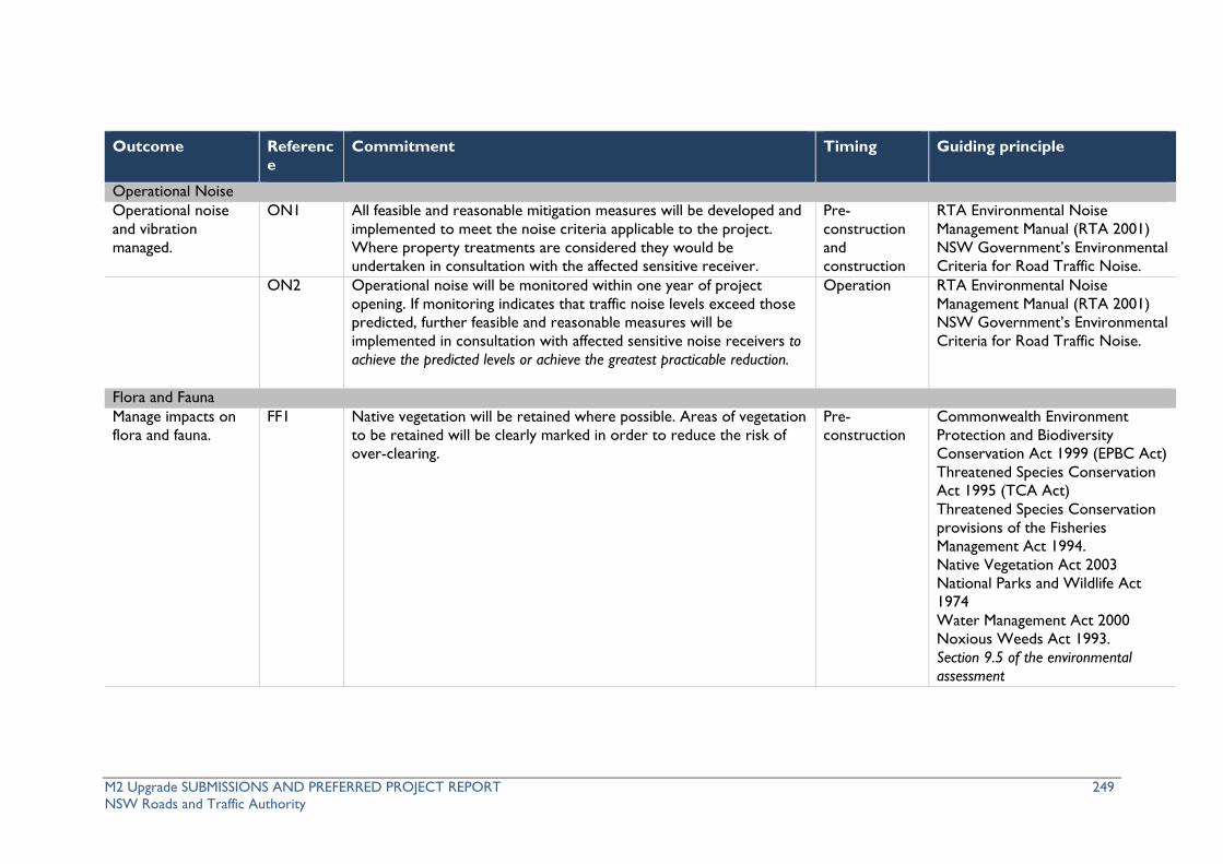
M2 Upgrade SUBMISSIONS AND PREFERRED PROJECT REPORT 249 NSW Roads and Traffic Authority
Outcome Reference
Commitment Timing Guiding principle
Operational Noise Operational noise and vibration managed.
ON1
All feasible and reasonable mitigation measures will be developed and implemented to meet the noise criteria applicable to the project. Where property treatments are considered they would be undertaken in consultation with the affected sensitive receiver.
Pre-construction and construction
RTA Environmental Noise Management Manual (RTA 2001) NSW Government’s Environmental Criteria for Road Traffic Noise.
ON2
Operational noise will be monitored within one year of project opening. If monitoring indicates that traffic noise levels exceed those predicted, further feasible and reasonable measures will be implemented in consultation with affected sensitive noise receivers to achieve the predicted levels or achieve the greatest practicable reduction.
Operation RTA Environmental Noise Management Manual (RTA 2001) NSW Government’s Environmental Criteria for Road Traffic Noise.
Flora and Fauna Manage impacts on flora and fauna.
FF1 Native vegetation will be retained where possible. Areas of vegetation to be retained will be clearly marked in order to reduce the risk of over-clearing.
Pre-construction
Commonwealth Environment Protection and Biodiversity Conservation Act 1999 (EPBC Act) Threatened Species Conservation Act 1995 (TCA Act) Threatened Species Conservation provisions of the Fisheries Management Act 1994. Native Vegetation Act 2003 National Parks and Wildlife Act 1974 Water Management Act 2000 Noxious Weeds Act 1993. Section 9.5 of the environmental assessment

M2 Upgrade SUBMISSIONS AND PREFERRED PROJECT REPORT 250 NSW Roads and Traffic Authority
Outcome Reference
Commitment Timing Guiding principle
FF2 Clearing for construction compounds will be minimised by retaining mature trees where feasible within compound sites.
Pre-construction and construction.
Same as FF1. Section 9.5 of the environmental assessment
FF3 Prior to any clearing of native trees, a suitably qualified and experienced ecologist will conduct a pre-clearing fauna survey. Potentially hollow-bearing trees within the clearing extents will be identified and marked. A two stage clearing and tree felling process will be implemented to reduce the risk of injury to ant nesting fauna from clearing. An ecologist will be present to supervise the removal of hollow bearing trees. A targeted survey for microbat roosts in bridges and culverts will also be conducted by a suitably qualified and experienced ecologist. All threatened microbats will be removed prior to identified roosts being disturbed.
Pre-construction and construction.
Same as FF1. Section 9.5 of the environmental assessment
FF4 Prior to any works in detention basins, a survey will be undertaken by an ecologist to determine if the basins contain potential habitat for frogs. If potential habitat is present a survey will be undertaken for threatened frog species. Any threatened frogs would be appropriately managed prior to basin works commencing.
Pre-construction and construction.
Same as FF1. Section 9.5 of the environmental assessment
FF5 Prior to the commencement of construction in the area containing Epacris purpurascens ssp. Purpurascens would be marked by an ecologist. Clearing would aim to avoid this species.
Pre-construction and construction.
Same as FF1.
Water crossings designed to incorporated best practice principles.
FF6 All works adjacent to waterways will be developed in accordance with the fish habitat classification of each waterway.
Pre-construction and construction.
Same as FF1 Why do Fish Need to Cross the Road? Fish Passage Requirements for Waterway Crossings’ – NSW Fisheries (DPI) Publication.

M2 Upgrade SUBMISSIONS AND PREFERRED PROJECT REPORT 251 NSW Roads and Traffic Authority
Outcome Reference
Commitment Timing Guiding principle
Enhance existing habitat.
FF7 Revegetation of areas disturbed as a result construction activities will be conducted by suitably qualified and experienced persons. Suitable felled native trees will be used for habitat. Seeds will be collected in the corridor prior to and during clearing and used as part of the landscape plan.
Pre-construction and construction.
Same as FF1.
Manage the spread of weeds and plant pathogens.
FF8 Weed management will occur throughout the extent and duration of the project.
Pre-construction and Construction.
Noxious Weeds Act 1993.
Offset residual impacts.
FF9 The Proponent will develop an offset strategy in consultation with DECCW with the overall aim of offsetting residual impacts to seven hectares of native habitat that is proposed to be cleared permanently. The strategy would focus on conservation and enhancement of habitat in the M2 corridor. The offset strategy would outline the process for identifying priority areas for habitat enhancement within the M2 corridor and management measures that would be undertaken to enhance habitat value. The offset strategy would be agreed with the Director-General prior to the commencement of construction.
Pre-construction
Urban Design, Visual and Landscape Minimised the visual impact and enhance the character of the road corridor.
UD1 The detailed design, implementation of built elements will be undertaken with consideration of the visual and urban design objectives and principles for the project.
Pre-construction and construction
RTA Urban and Regional Design Practice Notes, Beyond the Pavement (RTA 1999) Bridge Aesthetics (RTA 2003) Shotcrete Design Guidelines (RTA 2005)

M2 Upgrade SUBMISSIONS AND PREFERRED PROJECT REPORT 252 NSW Roads and Traffic Authority
Outcome Reference
Commitment Timing Guiding principle
Noise Wall Design Guidelines (RTA 2006) Landscape Guidelines (RTA 2008). Section 9.6 of the environmental assessment
Aboriginal Heritage Minimise potential for impacts on Aboriginal heritage in accordance with the strategies described in the environmental assessment.
AH1 Project induction will include responsibilities under the National Parks and Wildlife Act 1974. Site-specific briefings will be given to relevant personnel when working in the vicinity of identified heritage items.
Pre-construction and construction
National Parks and Wildlife Act 1974. Section 9.7 of the environmental assessment
AH2 If any skeletal remains are encountered, all works that would potentially impact the find will stop immediately. Works will not re-commence until appropriate clearance has been received. Work will recommence once consultation with the RTA or project heritage specialists has determined the nature and significance of any finds, and determined an approach for further work, which may include further consultation with heritage agencies.
Pre-construction and construction
Skeletal remains — Guidelines for the management of human skeletal remains under the Heritage Act 1977 (NSW Heritage Office 1998). Section 9.7 of the environmental assessment
AH3 Aboriginal heritage items and sites within 50 metres of work will be managed as environmentally sensitive areas.
Pre-construction and construction
AH4 Should any previously unidentified Aboriginal objects or items be located during the works, all work will cease in the vicinity of the find until specialist Aboriginal heritage advice is received.
Construction National Parks and Wildlife Act 1974.

M2 Upgrade SUBMISSIONS AND PREFERRED PROJECT REPORT 253 NSW Roads and Traffic Authority
Outcome Reference
Commitment Timing Guiding principle
Non-Aboriginal Heritage Minimised impacts on non-Aboriginal heritage.
NH1 If previously unidentified non-Aboriginal heritage items are encountered during construction, all works that would potentially impact the find will stop immediately. Works will not re-commence until appropriate clearance has been received.Work will recommence once consultation with the RTA or project heritage specialists has determined the nature and significance of any finds, and determined an approach for further work, which may include further consultation with heritage agencies.
Construction RTA Heritage Guidelines and Heritage Act 1977.
NH2 Physical and procedural measures to mitigate potential impacts upon the heritage significance of the ‘Farmhouse’ at 266–268 Windsor Road, Model Farms will be developed and implemented prior to and during construction at this location.
Pre-construction
Heritage Act 1977 Australia ICOMOS Burra Charter, 3rd Edition.
NH3 Reasonable physical and procedural construction management measures will be developed and implemented to avoid adverse heritage impacts on the heritage causeway beneath Beecroft Road bus ramp.
Pre-construction and construction
Heritage Act 1977 Australia ICOMOS Burra Charter, 3rd Edition.
Water management and soils Minimised erosion and sedimentation.
WS1 Management measures will be designed and installed in consultation with a soil conservation specialist. A maintenance and inspection program will be developed and implemented to ensure ongoing effectiveness.
Pre-construction and construction
Managing Urban Stormwater: Soils and Construction (Landcom 20052004), (DECC, 2008) RTA Code of Practice for Water Management. Section 9.8 of the environmental assessment
Minimised contamination risk
WS2 Bunded areas will be used for storage of oils, chemicals, toxic substances, flammable and combustible liquids and potentially
Pre-construction
Section 9.8 of the environmental assessment

M2 Upgrade SUBMISSIONS AND PREFERRED PROJECT REPORT 254 NSW Roads and Traffic Authority
Outcome Reference
Commitment Timing Guiding principle
for receiving waters. hazardous or contaminating activities, including, but not limited to refuelling stations and washing construction vehicles.
and construction
Minimised impacts on waterways.
WS3 New bridge piers will be configured to be consistent with the existing structures to minimise hydraulic impacts and potential scour issues.
Construction Managing Urban Stormwater: Soils and Construction (Landcom 20052004) RTA Code of Practice for Water Management. Section 9.8 of the environmental assessment
Minimised scour impacts.
WS4 Permanent stream protection and/or energy dissipation measures as appropriate will be provided at affected culverts downstream of transverse culvert outlets to minimise scour and erosion of the natural waterways, if required and where sufficient space is available.
Construction and operation
RTA QA Specification G38 Soil and Water Management AUSTROADS Waterway Design – A Guide to the hydraulic design of bridges culverts and floodways. Section 9.8 of the environmental assessment
Contamination Protection of the environment, workers and the public.
C1 Risk management measures will be followed to address potential contamination in the site corridor during construction.
Pre-construction and construction
Section 10.9 of the environmental assessment
C2 Collection, testing and classification of sediments in sediment basins will be undertaken. Appropriate management strategies will be implemented prior to works in sediment basins.
Pre-construction and construction
C3 An ‘Unexpected Finds’ Protocol will be developed and implemented. Pre-construction and construction

M2 Upgrade SUBMISSIONS AND PREFERRED PROJECT REPORT 255 NSW Roads and Traffic Authority
Outcome Reference
Commitment Timing Guiding principle
Socio-Economic Avoid, minimise and manage adverse amenity impacts on residents during construction.
S1 Minimise disturbance to adjacent residents by managing:
• Movement of vehicles (especially outside of standard working hours).
• Construction noise attenuation, where feasible and reasonable.
• Visual intrusion, dust and light spill.
Construction
Minimise amenity impacts on residents during operation.
S2 Provide vegetative planting, where appropriate at key locations, to screen the M2 Motorway.
Construction and operation
Air quality Minimise air quality impacts.
AQ1 Feasible and reasonable mitigation and management measures will be adopted to minimise windblown, traffic generated or equipment generated dust and emissions.
Construction
AQ2 Dust generating activities will stop where visible dust is being emitted outside the construction corridor with the potential to affect significant receivers and areas and when dust suppression methods are ineffective.
Construction
AQ3 Dust monitoring will be undertaken at a number of locations along the M2 Motorway. These will be compared to pre-construction levels.
Construction
Waste Management Waste production minimised.
W1 The ‘waste hierarchy’ will be maximised during construction and incorporated into work programs, purchase strategies and site inductions, and will be assessed quarterly to identify opportunities for improvement.
Pre-construction
NSW Waste and Resource Recovery Strategy 2007 (NSW WARR).
Hazards and risks Minimised risk of an H1 All storage areas for hazardous materials will be located an adequate Pre- AS 1940 The Storage and Handling

M2 Upgrade SUBMISSIONS AND PREFERRED PROJECT REPORT 256 NSW Roads and Traffic Authority
Outcome Reference
Commitment Timing Guiding principle
incident during construction.
distance away from watercourses and entry points to the stormwater system. Spillages will be contained and collected for disposal.
construction and construction
of Flammable and Combustible Liquids. Section 10.9 of the environmental assessment
H2 Appropriate controls will be put in place for all hazardous and potentially contaminating activities to prevent contamination of watercourses.
Construction Section 10.9 of the environmental assessment
H3 Site specific safety issues and personnel responsibilities will be included in the project induction. Safety issues and responsibilities shall be included in activity specific briefings as required.
Construction Occupational Health and Safety Act 2000 Occupational Health and Safety Regulation. Section 10.9 of the environmental assessment
Climate change Minimise greenhouse gas (GHG) emissions and energy consumption.
GHG1 Energy efficient equipment and management measures will be used where feasible and reasonable to reduce greenhouse gas emissions.
Pre-construction/ post construction
Section 10.10 of the environmental assessment
Property and land use P1 Conduct property inspections, subject to landowner agreement, on
all structures within 50 m of construction activities that generate vibration impacts or any other locations identified by the proponent in a targeted property risk analysis.
Pre-construction
AS 4349.1 Inspection of Buildings
P2 Give a copy of the property inspection report to the owner of each property inspected at least one week before construction that could affect the property commences.
Pre-construction

M2 Upgrade SUBMISSIONS AND PREFERRED PROJECT REPORT 257 NSW Roads and Traffic Authority
Outcome Reference
Commitment Timing Guiding principle
P3 Maintain a register of all properties inspected, indicating whether the owner accepted or refused the property inspection offer. A copy of the register will be provided to the Director-General upon request.
All stages
P4 Where liable, rectify any property damage (at no cost to the property owner) caused directly or indirectly by construction or operation. Alternatively, the RTA may negotiate compensation for the property damage with the property owner.
Construction and operation
P5 All property acquisitions will be negotiated in accordance with RTA Land Acquisition Policy, and compensation will be assessed under the provisions of the Land Acquisition (Just Terms Compensation) Act 1991.
Pre-construction
RTA Land Acquisition Policy Land Acquisition (Just Terms Compensation) Act 1991
P6 Property access will be maintained for the duration of construction. Temporary access requirements will be assessed, designed, managed and rehabilitation prepared in consultation with affected landholders.
Pre-construction and construction
Ancillary facilities Minimise adverse impacts associated with ancillary facilities.
AF1 Ensure the sites for ancillary facilities satisfy the criteria provided in the environmental assessment unless otherwise approved though the CEMP.
Pre-construction and construction

M2 Upgrade SUBMISSIONS AND PREFERRED PROJECT REPORT 258 NSW Roads and Traffic Authority
(blank page)

M2 Upgrade SUBMISSIONS AND PREFERRED PROJECT REPORT 259 NSW Roads and Traffic Authority
6 References AECOM 2010, M2 Upgrade project Environmental Assessment, May 2010. Australia ICOMOS 1999, The Burra Charter – The Australia ICOMOS Charter for the conservation of place of heritage significance, 3rd edition. Australian Institute of Criminology (AIC) 2009, Using CCTV to reduce antisocial behaviour http://www.aic.gov.au/documents/4/B/5/%7B4B5F84E3-BA48-4132-ABA7-D2FD08E1A0AB%7Dcrm80.pdf. Austroads 1999, Austroads Guide To Traffic Engineering Practice – Part 14 Bicycles. Baulkham Hills Shire Council 2007, Baulkham Hills Development Control Plan (Part E Section 12) – 257 Windsor Road & Russell Street Baulkham Hills, September 2007. Campbell, D (Minister for Roads) 2009, In principle agreement reached for M2 upgrade, media release, 13 October 2009. Department of Environment and Conservation (DEC) 2004, Threatened Species Survey and Assessment: Guidelines for Developments and Activities (Working Draft). Department of Environment and Conservation (DEC) 2006, Environmental Noise Management Assessing Vibration; a technical guideline, February 2006. Department of Environment and Climate Change (DECC) 2008 Managing Urban Stormwater – Soils and Construction Volume 2. Department of Environment, Climate Change and Water (DECCW) 2009, Action for Air. Department of Environment, Climate Change and Water (DECCW) 2009a, Draft Vegetation Community Mapping Scheme for the Sydney Metropolitan Catchment Area. Department of Environment, Climate Change and Water (DECCW) 2009b, Interim Construction Noise Guidelines. Department of Environment and Climate Change and Water (DECCW) 2009, Threatened Species, Communities and Ecological Communities of NSW www.threatenedspecies.environment.nsw.gov.au/tsprofile Department of Environment and Climate Change and Water (DECCW) 2010, Threatened Species, Communities and Ecological Communities of NSW www.threatenedspecies.environment.nsw.gov.au/tsprofile Department of Planning 2007, ‘Guidelines for Major Project Community Consultation’. Environmental Protection Authority (EPA) 1999, Environmental Criteria for Road Traffic Noise. Environmental Protection Authority (EPA) 2000, NSW Industrial Noise Policy. Environmental Protection Authority Victoria (EPA Victoria) 2010, How You Can Save on Fuel Costs.

M2 Upgrade SUBMISSIONS AND PREFERRED PROJECT REPORT 260 NSW Roads and Traffic Authority
GTA Consultants 2010, M2 Upgrade Alternative Cycle Route – Preferred Route Analysis Report. Haworth, N. and Symmons, M. Monash University Accident Research Centre 2002, Relationship Between Fuel Efficiency and Safety Outcomes. Landcom 2004 Managing Urban Stormwater – Soils and Construction Volume 1, 4th edition. National Parks and Wildlife Service (NPWS) 1999, Terms of licence Under the Threatened Species Conservation Act, State Forests, Eden – Appendix B. National Parks and Wildlife Service (NPWS) 2001, Threatened Species Information Syzygium paniculatum. New South Wales Government 2005, Metropolitan Strategy ‘City of Cities: A Plan for Sydney’s Future’. New South Wales Government 2006, Urban Transport Statement, November 2006. New South Wales Government 2010a, Metropolitan Transport Plan, February 2010. New South Wales Government 2010b, NSW State Plan. New South Wales Government 2010c, NSW Bike Plan. Roads and Traffic Authority (RTA) of NSW 1999, Water Policy and Code of Practice for Water Management, April 1999. Roads and Traffic Authority (RTA) of NSW 2001, Environmental Noise Management Manual, Practice Note IV. Roads and Traffic Authority (RTA) of NSW 2005, NSW Bicycle Guidelines, July 2005. Payne, R. 1997, The Distribution and Reproductive Ecology of Syzygium paniculatum and Syzygium australe (Myrtaceae) in the Gosford-Wyong Region, Unpublished Thesis prepared for the award of Masters of Natural Resources, University of New England, Armidale NSW. Sinclair Knight Merz 2004, ‘F3 to Sydney Orbital Link Study’. Tozer, M.G., Turner, K., Simpson, C., Keith, D.A., Beukers, P., MacKenzie, B., Tindall, D. And Pennay, C. 2006 ‘Native vegetation of southeast NSW: a revised classification and map for the coast and eastern tablelands’. Version 1.0 NSW Government Department of Environment and Conservation and Department of Natural Resources. Wallis I 2003, ‘Australasian travel demand elasticities – an update of the evidence ‘. Welsh, B.P. & Farrington, D.C. 2008, Effects of closed circuit television surveillance on crime. Campbell Systematic Reviews 2008:17.

M2 Upgrade SUBMISSIONS AND PREFERRED PROJECT REPORT 261 NSW Roads and Traffic Authority
7 Glossary of terms and abbreviations Terminology Description
alternative cycle route Describes the cycle route provided on local roads because cyclists would be diverted off the M2 Motorway during construction
AHMP Aboriginal Heritage Management Plan
AHIMS Aboriginal Heritage Information Management System
ARI Average recurrence interval is a measure of the rarity of a rainfall event
ARQ Australian run-off quality
ATC Australian Transport Council
Browns Waterhole underpass
Also known as Vimiera Road underpass or Vimiera Road cul-de-sac
CO2 Carbon dioxide
CBD Central business district
CAMWEST Cyclists Action Movement WEST
CCTV Closed Circuit Television
CEMF Construction Environmental Management Framework
CEMP Construction Environmental Management Plan
Chainage An imaginary line used to measure distance
CNIS Construction Noise and Vibration Impact Statement
CO2-e Carbon dioxide equivalent
Contractor Leighton Contractors Pty Ltd
DECCW Department of Environment, Climate Change and Water (previously known as DECC)
DEWHA Department of the Environment, Water, Heritage and the Arts
DGR’s Director-General’s environmental assessment requirements
Director-General’s Requirements
Reference to the Director-General’s environmental assessment requirements under Part 3A of the EP&A Act. Can be shortened to ‘DGRs’
DLALC Deerubbin Local Aboriginal Land Council
DoP Department of Planning
DTI Department of Trade and Industry
ECRTN Environmental Criteria for Road Traffic Noise (EPA 1999)
EEC Endangered Ecological Community
EIS Environmental Impact Statement
EMR Environmental Management Representative
ENMAV Environemntal Noise Management Assessing Vibration: a technical guideline
ENMM Environmental Noise Management Manual (RTA 2001)
environmental assessment The document prepared under Part 3A to assess environmental impacts

M2 Upgrade SUBMISSIONS AND PREFERRED PROJECT REPORT 262 NSW Roads and Traffic Authority
Terminology Description (EA) for seeking Project Approval. Can be shortened to ‘EA’.
environmental assessment Generic term for describing the undertaking of an assessment of impacts
EPA Environmental Protection Authority (part of the Department of Environment, Climate Change and Water)
EP&A Act Environmental Planning and Assessment Act 1979
EPBC Act Environment Protection and Biodiversity Conservation Act 1999
EPL Environment Protection Licence
ESD Ecologically Sustainable Development
ETC Electronic Toll Collection
FETC Full Electronic Tolll Collection
GHG Greenhouse Gas
Hills M2 The Hills Motorway Limited, the company responsible for the operation and maintenance of the M2 Motorway. Hills M2 is a wholly owned subsidiary of Transurban Limited.
ICNG Interim Construction Noise Guidelines
ITS Intelligent Transport System
LAeq A unit used to describe time-varying noise sources
LAmax A unit used to describe time-varying noise sources
LoS Level of Service - as a qualitative measure describing operational conditions within a traffic stream
LCPL Leighton Contractors Pty Ltd
LCT Lane Cove Tunnel
LEP Local Environmental Plan
LGA Local Government Area
the M2 corridor The site, generally bounded by the Hills M2 Motorway lease boundary
M2 Motorway M2 Motorway, which extends from the M7 Motorway/Abbott Road to the Lane Cove Tunnel including carriageways, ramps and associated structures and infrastructure
M2 Motorway operator Hills M2
M2 Upgrade project The proposed works
M2 Upgrade project team The name of the project team delivering the M2 Upgrade project. This includes Leighton Contractors Pty Ltd, Hills M2, AECOM, and KMH Environmental
M7 Motorway M7 Motorway, which extends from end of M2 at Abbott Road interchange
MLALC Metropolitan Local Aboriginal Land Council
MTP Metropolitan Transport Plan
Mt CO2-e Million tonnes of CO2-equivalent
NEPM National Environmental Protection (Air Toxics) Measure
NML Noise Management Levels

M2 Upgrade SUBMISSIONS AND PREFERRED PROJECT REPORT 263 NSW Roads and Traffic Authority
Terminology Description
Norfolk Tunnel Also referred to as Epping Tunnel
NW Act Noxious Weeds Act 1993
OGAC open graded asphaltic concrete
OLOL Our Lady of Lourdes Primary School
park and ride facility Describes the previously proposed park and ride facility at Herring Road
the project M2 Upgrade project works
the proponent Roads and Traffic Authority (RTA)
t CO2-e tonnes of CO2-equivalent
RTA NSW Roads and Traffic Authority
RUCBA Road Users Cost Benefit Analysis
SEPP State Environmental Planning Policy
SOHI Statement of Heritage Impact
Study area Extends from Abbott Road, Baulkham Hills to the western portal of the Lane Cove Tunnel in North Ryde.
Sydney’s north west The area within Sydney that the M2 Motorway serves
Sydney’s North West Growth Centre As defined under Metropolitan Strategy
TMC RTA Transport Management Centre
Sydney Orbital Motorway network or ‘Sydney Orbital’ the M2 Motorway network orbiting Sydney metropolitan area
TMPs Traffic Management Plans
TSC Act Threatened Species Conservation Act 1995
TTLG Traffic and Transport Liaison Group
TUSTM A strategic model developed by Transurban’s Traffic Services Group
VHT Vehicle Hours Travelled
VKT Vehicle Kilometres Travelled
VMS Variable Message Signs
VSLS Variable Speed Limit Signs
WSUD Water Sensitive Urban Design

M2 Upgrade SUBMISSIONS AND PREFERRED PROJECT REPORT 264 NSW Roads and Traffic Authority
(blank page)

M2 Upgrade SUBMISSIONS AND PREFERRED PROJECT REPORT 265 NSW Roads and Traffic Authority
Appendix A – Assessment of significance Syzygium paniculatum
Syzygium paniculatum (Magenta Lilly Pilly) is listed as vulnerable under the EPBC Act.
Syzygium paniculatum is a small to medium sized rainforest tree that grows to eight metres tall. It is found only in NSW in a narrow, linear coastal strip from Bulahdelah to Conjola State Forest. It occurs on grey soils over sandstone, gravels, sands, silts and clays in remnant stands of littoral (coastal) rainforest or in riverside gallery rainforests.
Threats to Syzygium paniculatum identified by DECCW (2010) include:
• Frequent fire.
• Loss of rainforest habitat through clearing for residential development.
• Grazing and trampling of habitat by grazing stock.
• Weeds, particularly Lantana, invading the species’ habitat.
A single specimen of Syzygium paniculatum was recorded in the subject area, growing in a residential garden at 266 Windsor Road. This specimen is to be removed by road widening works.
No natural habitat for Syzygium paniculatum occurs within the subject area. Vegetation mapping for the M2 corridor presented in the environmental assessment records a variety of eucalyptus forests on woodlands on sandstone and shale soils but no littoral or riverside gallery rainforest communities. The individual Syzygium paniculatum at 266 Windsor Rd is evidently a cultivated individual and not a remnant of a former rainforest community.
Will the action lead to a long-term decrease in the size of an important population of a species?
The action would lead to the loss of one individual of Syzygium paniculatum. This individual is likely to have been cultivated and therefore its removal would not reduce the size of any population of the species.
Will the action reduce the area of occupancy of an important population?
The action would lead to the loss of one individual of Syzygium paniculatum. This individual is likely to have been cultivated and therefore its removal would not reduce the area of occupancy of any population of the species.
Will the action fragment an existing important population into two or more populations?
No habitat for Syzygium paniculatum exists in the subject area, so it is unlikely that a population of Syzygium paniculatum exists in the subject area. Therefore, the action is not likely to fragment an existing important population of Syzygium paniculatum.
Will the action adversely affect habitat critical to the survival of a species?
No critical habitat has been declared for Syzygium paniculatum.
Will the action disrupt the breeding cycle of an important population?
The action would lead to the loss of one individual of Syzygium paniculatum. This specimen is evidently cultivated and its genetic provenance is unknown. It is not likely to be contributing to the breeding cycle of the species.
Will the action modify, destroy, remove or isolate or decrease the availability or quality of habitat to the extent that the species is likely to decline?
No habitat for Syzygium paniculatum exists in the subject area, so the proposed action will not remove, destroy or isolate any habitat for the species.
Will the action result in invasive species that are harmful to a vulnerable species

M2 Upgrade SUBMISSIONS AND PREFERRED PROJECT REPORT 266 NSW Roads and Traffic Authority
becoming established in the vulnerable species’ habitat?
There is no habitat for Syzygium paniculatum in the subject area. Nevertheless, mitigation measures are proposed to minimise the likelihood of the introduction, spread and proliferation of weeds and to encourage the regeneration of native vegetation in the M2 corridor. Consequently, the M2 Upgrade project is unlikely to result in invasive species becoming established in the habitat or potential habitat of Syzygium paniculatum.
Will the action introduce disease that may cause the species to decline?
There is no habitat for Syzygium paniculatum in the subject area. Nevertheless, mitigation measures are proposed that would minimise the likelihood of the introduction of plant pathogens (e.g. Phytophthora Root Rot Fungus Phytophthora cinnamoni). Therefore, the M2 Upgrade project is unlikely to introduce disease that may cause Syzygium paniculatum to decline.
Will the action interfere substantially with the recovery of the species?
No recovery plan or threat abatement plan has been prepared for Syzygium paniculatum.
Conclusion
The proposed action is unlikely to have a significant impact on a population of Syzygium paniculatum.

M2 Upgrade SUBMISSIONS AND PREFERRED PROJECT REPORT 267 NSW Roads and Traffic Authority
Appendix B – Revised table headings Table 75 Construction noise predictions – evening
Noi
se c
atch
men
t
area
1
Side
of M
2 M
otor
way
Eve
ning
NM
L (d
B(A
))
(RB
L +
5 dB
(A)
Predicted LAeq(15minute) noise level for each scenario dB(A) (Refer to Table 73 for descriptions)
1a R
oad
wid
enin
g
1b R
oad
wid
enin
g
2 C
ross
sti
tchi
ng
3 IT
S w
orks
4 R
e-su
rfac
ing
5 T
raffi
c m
anag
e
6 H
ydro
-bla
stin
g
7a B
ridg
e-w
orks
1 North 52 - - 59-65 - 49-52 50-55 - - South 52 - - 54 - 45 45 - -
2 North 52 - - 62 - 52-54 49-51 - -
3 North 53 - - 56 - 44-48 43-46 - - South 53 - - 59 - 49 48 - -
4 North 52.5 - - 61 - 53 50-52 - - South 52.5 - - 59 - 49 46-48 - -
52
North 49 - - 53-67 49-68 - 44-53 50-63 38-56
South 48.5 - - 52-67 49-67 - 46-54 51-63 57-66
6 South 61.5 - - 55-57 51-57 - 46 - 44-63
7 North 58 - - 55-57 52-
54 - 45-47 - 44-69
South 58 - - 58 55 - 47 - 45-51
8 North 57.5 - - 52 49-
51 - 43 - -
South 57.5 - - 56 48 - 42 - - 9 South 57.5 - - 55 54 - 43-45 - 44-51
10 North 53 - - 53 51 - 42 - - South 57.5 - - 46 43 - 36 - -
11 North 55 - - 49 47 - 39 - -
South 59.5 - - 62-64 59-63 - 50-52 - -
12 South 52 - - - - - - - -
13 North 57.5 - - 60-62 59-
61 - 49-51 - 52-58
South 52 - - 58 53 - 47 - 40-41
14 South 52 - - 52-56 49-54 - 39-44 - 60-69
15 North 53.5 - - 58-61 56-
59 - 47-50 - -
South 57 - - 52-56 49-54 - 42-44 - -
16 North 53.5 - - 56 55 - 45 - 46-50

M2 Upgrade SUBMISSIONS AND PREFERRED PROJECT REPORT 268 NSW Roads and Traffic Authority
Noi
se c
atch
men
t
area
1
Side
of M
2 M
otor
way
Eve
ning
NM
L (d
B(A
))
(RB
L +
5 dB
(A)
Predicted LAeq(15minute) noise level for each scenario dB(A) (Refer to Table 73 for descriptions)
1a R
oad
wid
enin
g
1b R
oad
wid
enin
g
2 C
ross
sti
tchi
ng
3 IT
S w
orks
4 R
e-su
rfac
ing
5 T
raffi
c m
anag
e
6 H
ydro
-bla
stin
g
7a B
ridg
e-w
orks
17
South 57 - - 58-60 56 - 47-50 - 51-57
North 53 57-62
61-64 59-63 - 52 50 - -
South 53 57 59 57 - 48 45 - - Tunnel 57 54 59 58 - 49 47 - -
18 North 49.5 50-
54 57 53-56 - 44-47 43-46 - 40-45
South 49.5 52-55
54-58 53-57 - 44-49 43-47 - 39-53
19 North 52 - - 50 47 - 40 - - South 49.5 - - 60 57 - 49 - -
20 North 52.5 - - 50-54 45-
50 - 40-44 - -
South 51 - - 50-53 50 - 35-44 - - 21 North 56.5 - - 61 - 52 50 - 41-48
Note 1: Refer to Appendix B of the Technical Paper 2
Note 2: Location 5 presents the worst-case noise levels apparent when the existing noise walls are temporarily removed to construct the new Windsor Road access ramps.

M2 Upgrade SUBMISSIONS AND PREFERRED PROJECT REPORT 269 NSW Roads and Traffic Authority
Table 76 Construction noise predictions – night time
Noi
se c
atch
men
t
area
1
Side
of m
otor
way
Nig
ht N
ML
(dB
(A))
(R
BL
+ 5
dB
(A)
Predicted LAeq(15minute) noise level for each scenario dB(A) (Refer to Table 73 for descriptions)
1a R
oad
wid
enin
g
1b R
oad
wid
enin
g
2 C
ross
sti
tchi
ng
3 IT
S w
orks
4 R
e-su
rfac
ing
5 T
raffi
c m
anag
e
6 H
ydro
-bla
stin
g
7a B
ridg
e-w
orks
1 North 44.5 - - 59-65 - 49-52 50-55 - - South 44.5 - - 54 - 45 45 - -
2 North 44.5 - - 62 - 52-54 49-51 - -
3 North 41 - - 56 - 44-48 43-46 - - South 41 - - 59 - 49 48 - -
4 North 42.5 - - 61 - 53 50-52 - - South 42.5 - - 59 - 49 46-48 - -
52 North 41.5 - - 53-67 49-68 - 44-53 50-63 38-56 South 43.5 - - 52-67 49-67 - 46-54 51-63 57-66
6 South 46.5 - - 55-57 51-57 - 46 - 44-63
7 North 43.5 - - 55-57 52-54 - 45-47 - 44-69 South 43.5 - - 58/ 55 - 47 - 45-51
8 North 46.5 - - 52 49-51 - 43 - - South 46.5 - - 56 48 - 42 - -
9 South 46.5 - - 55 54 - 43-45 - 44-51
10 North 44.5 - - 53 51 - 42 - - South 47 - - 46 43 - 36 - -
11 North 43 - - 49 47 - 39 - - South 42.5 - - 62-64 59-63 - 50-52 - -
12 South 41 - - - - - - - -
13 North 44 - - 60-62 59-61 - 49-51 - 52-58 South 41 - - 58 53 - 47 - 40-41
14 South 41 - - 52-56 49-54 - 39-44 - 60-69
15 North 38 - - 58-61 56-59 - 47-50 - - South 51 - - 52-56 49-54 - 42-44 - -
16 North 39 - - 56 55 - 45 - 46-50 South 51 - - 58-60 56 - 47-50 - 51-57
17
North 40 57-62 61-64 59-63 - 52 50 - - South 40 57 59 57 - 48 45 - - Tunnel 44 54 59 58 - 49 47 - -
18 North 37.5 50-54 57 53-56 - 44-47 43-46 - 40-45 South 37.5 52-55 54-58 53-57 - 44-49 43-47 - 39-53
19 North 43.5 - - 50 47 - 40 - - South 36.5 - - 60 57 - 49 - -
20 North 42 - - 50-54 45-50 - 40-44 - - South 40 - - 50-53 50 - 35-44 - -
21 North 47 - - 61 - 52 50 - 41-48
Note 1: Refer to Appendix B of the Technical Paper 2
Note 2: Location 5 presents the worst-case noise levels apparent when the existing noise walls are temporarily removed to construct the new Windsor Road access ramps.

M2 Upgrade SUBMISSIONS AND PREFERRED PROJECT REPORT 270 NSW Roads and Traffic Authority
Table 77 Construction noise predictions – sleep disturbance
Noi
se c
atch
men
t
area
1
Side
of M
2 M
otor
way
Slee
p di
stur
banc
e sc
reen
ing
crit
erio
n (d
B(A
)) (
RB
L +1
5 dB
(A) Predicted LAmax noise level for each scenario dB(A)
(Refer to Table 73 for descriptions)
1a R
oad
wid
enin
g
1b R
oad
wid
enin
g
2 C
ross
sti
tchi
ng
3 IT
S w
orks
4 R
e-su
rfac
ing
5 T
raffi
c m
anag
e
6 H
ydro
-bla
stin
g
7a B
ridg
e-w
orks
1 North 54.5 - - 60-65 - 54-57 54-62 - - South 54.5 - - 57 - 51 50 - -
2 North 54.5 - - 64 - 56-59 56-58 - -
3 North 51 - - 56-58 - 50-52 48-51 - - South 51 - - 61 - 55 53 - -
4 North 52.5 - - 63-66 - 58 58 - - South 52.5 - - 61 - 55 52-54 - -
52 North 51.5 - - 57-68 56-71 - 50-62 52-59 45-61 South 53.5 - - 63-72 63-75 - 58-61 55-67 64-71
6 South 56.5 - - 58-61 58-62 - 50-52 - 50-67
7 North 53.5 - - 58-60 58-60 - 53 - 51-73 South 53.5 - - 60 61 - 52 - 52-57
8 North 56.5 - - 57 57 - 48 - South 56.5 - - 56 58 - 49 - -
9 South 56.5 - - 56-59 59 - 47-50 - 50-55-
10 North 54.5 - - 57 57 - 48 - - South 57 - - 49 50 - 43 - -
11 North 53 - - 53 53 - 44 - - South 52.5 - - 63-67 69 - 57-59 - -
12 South 51 - - 66 - - - - -
13 North 54 - - 60-63 68 - 52-55 - 58-63 South 51 - - 59-61 65-67 - 55 - 45-47
14 South 51 - - 52-57 58-60 - 45-49 - 65-72
15 North 48 - - 62 54-58 - 52-54 - - South 61 - - 56-61 62-65 - 48-50 - -
16 North 48 - - 58 56-61 - 49 - 50-54 South 61 - - 61-64 59 - 53-55 - 55-61
17 North 50 64-68 69 64-67 - 57 55-58 - - South 50 63 65 63 - 54 53-54 - - Tunnel 54 60 65 60 - 54 52 - -
18 North 47.5 57-60 63 57-59 - 49-52 51 - 47-50 South 47.5 58-61 60-64 56-61 - 49-54 49-52 - 45-57
19 North 53.5 - - 52 54 - 46-49 - - South 46.5 - - 61-63 64 - 54 - -
20 North 52 - - 54-57 52-58 - 48-50 - - South 50 - - 55-57 52-56 - 48 - -
21 North 57 - - 64 - - 55 - 48-52
Note 1: Refer to Appendix B of the Technical Paper 2
Note 2: Location 5 presents the worst-case noise levels apparent when the existing noise walls are temporarily removed to construct the new Windsor Road access ramps.

M2 Upgrade SUBMISSIONS AND PREFERRED PROJECT REPORT 271 NSW Roads and Traffic Authority
(blank page)


