LISTOF TA8LEslAB!€- FA6r1 " Hortzsn Depthr and Unlt Thicknesses at the Proposed MC ?5? #1 Weil Ls{ation -. " -.' .. 142. Int6rpreted $tratlEraphy and Lithologies at th€ Proposed MC 25? #'l Wall Localion .....-.153, $urnmry sf Subsurtate l-lazards at the Proposed MC 252 #l Well Lacation "..'-'"-..".' '. f 5
5. Summaryof $hallawfiazerdsat0ffsatWell$ ".-..-....."..... '.. '"'.1SS. BP Shatlaw Ga6 Intierpretation Guids Psinu .."....-.. ----'..-'.-..' f 7
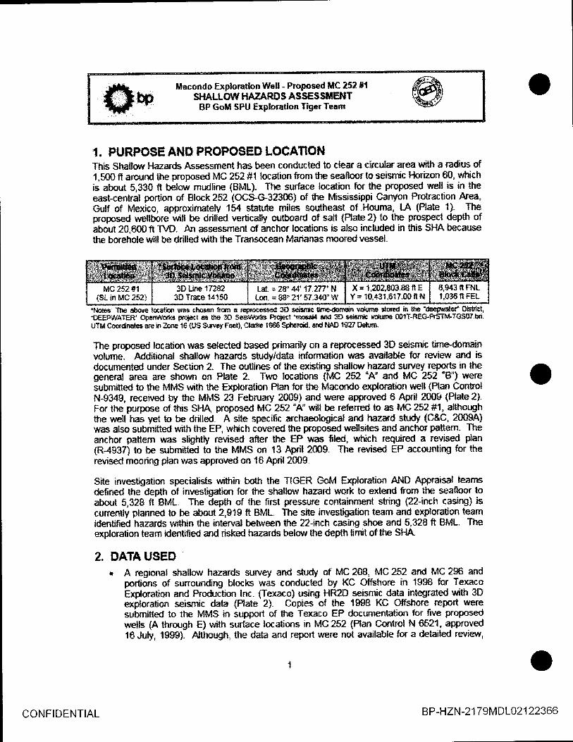
L FUHFO$E Al,t'S pRCpSSEn LOCAfigftlThis $hallow Hazards Assessr*ent has been ccnducted to clear a circular area with a radius of1.5SS fi araund the pnoposd MC ?52 #1 lacatian frorn the *eafloqr to eeism*c hriaon 6S, wlti*his sbsut 5.&1S t befaw rnudline {BML). The surface location for the proposed well is in theeast-central portion *f Elock ?52 (OC9C*323Si af the Mississippi Canyon FrCItracticn Area,Gulf of Mexlco, approximat*ty 154 statute rniles sauthemt sf $-louma. tA {Plate {}- Th€pruposed rrsellbore wfll be drilfed vertic*lly outbard of sa|t {nate 2} to the prospe{t depth ofabout ?0.SO0 ft T\lD, Alr assessrnent sf anchor lscations is also included in fiis SflA becausethe borehole r*ilt be drilled \A,i& the Transocean Marianas rnoored veswl.
'frlcte*: 'fhe absps lscaiioc rras cho*en tam e rrFpcee*ed 30 s€is;ric tt?Kidsfisin wil*]t]s orad h ifie*&a$'tffitef n{*ict,.SEEPU\tATeB* qleFsitort s p{iect ss &e @ s€b-ifibd€ Frciet "nlosdil alrd m $sis,n& tdume SIT-RE&FST[t-TGSfl7,bei.U?M Coerdnsks are io gme 1S {1}S StmEf Feel}, Clsrtp 1ffi6 S$Fierce{ and f{*I} tg27 B*,nt
The praposed location was selected basad prinsrily on a reprotessed3S seisr&ic tirne-donminvoNume" Additional shallotn hazards studyldata infornration wa* availa$e for revievr and isdocumented un&r $ection 2. The autlines of the exisiirg shalfaw hazard st$vey reports in thegeneral area are shotyn *n Plate 2. Two lacations tMG ?5? .A. and ISC 252 "8") weresubrnitted to the MMS with the Fx$omtion Plan for tfre Maeondc exporatipn *ell tPlan Contrslf{-S349, reeeived by the MMS 23 February 20091 and r,vere approved S &it ?009 {Plate ?}.For lfre purpose of this SHA, proposed MC 25? "A"' udl be refened ls as MC 252 #1, ailhoqshthe well has yet to be drilted. A site specific archaeolcgical and hazard stt"tdy {C&C, 20034iwas also submitteO with ttre EF, which caverd lhe proposed wellsites and anehor pattem" Theanchcr pattem was *lightly revised a$cr the EP was tled, which required a r*vised plan(R4W7l t* be subnjltted to tFre MMS on t3 Alril 2mg. The rwised EP accounting f,or therevised mmring plan was approved on 1& April 200$.
Site investigation *pecialists within bsth the TIGER GoM Erylomtion AND Appraisal tsansdefned lhe depth of investig&ion for the shallwv hazard wurk to exlend frorn the seaflosr toabout 5,328 ft BML" The depth of the first pressure containment string {22-inch casing} iscunendy planned to be about 2,919 fi BML. Th€ site investigntian iearn and explaration teamidentified hazards within the interval betw*n the 22-lnch casing shoe and 5,328 ft BML. Theex$oration leam ldeniified and risked hazards belorthe depth llmit of the SlA.
2. DATA USED* A regional shallonr harards survey and str.Idy af MG 208, lvlC 252 and MC 296 and
pcrlioas sf sunoundi*g blocks was condilcted by KC Offshore in tg9$ far TexmoExgaraticn and Froduction Inc. {Texaco) using fR2tr seismic_data_integraied with 3Dexiloration seismic data {Plate 2}. Copies of the 1gS& KC Offshore report v'reresubmitted to tfts MM$ in support of lhe Texaco EP documentatic* fpr five proposedunlis {A thrnugh E} wifh surface locations in MC252 {Plan Control N €5'2'1, approved1S Juty, 19ggl, *lthough, the data and report were net available for a detailed rsriew,
stiAllourt HAzARn s A ssEs sltEf{TBF Goll SPU frplorotlon TigerTeanr
excetpts frorn ihe report submitted witfr tlre Texaco EP were arrailahle frsrn the MMSpians/permit website.
{ shallor hazrd* report for Mc 252 ard Mc 296 ard v{ciniS tms ryod*ced by FugroGeo5ervices, Inc. {Fqqrc} in 2ffi3 for Sominbn Exploratiaur ard Pr+ductisn Inc.{Dorninim} based on exploration 3D sebmic data {Ptate 2} - the seafloor rnapping areafor this report ccvered all of MC 252 and MC ?S6, urhereas fre subsurfrce mapprirq areaonly,qqv_epd the southern hdf af MC ?52 and Sle rcrthern fualf cf MC 2gS, Copies ollhe 2SSg Fugro repcrt were subrniRd in support of lhe Danrinim EP dacumentafron forfiur proposed ttells {Athroryh D} with surface lccations in MC 2S2 and MC ZSG {PlanCcntro! N f43, approved 29 May, 20S31. A digital copy nf lfris report was available forreilew.The exploration 3O seisrnic data, used by Fugrc t?SS3l for ident'foing shallaw hazard$,ulas acgulred blt CGG and GECO in tffi12000 on a N-S grid {alffi cu.in- and 54ff0cu.in airgun ssurces; 7.5 m and s rn source depths; 7,200 m and 8.tffi m slreanrers with288 and 3X) channels Fr sffeamer, a group ir*eryd $f 25 m and a streamer t*n depthof I rn; a recsrd +efigft of 12 sss, witlr a 2 msm. sam$e interval and a 82,5 m shogointlnlerval giving nsminal folds af 57 and $4). The data r,vas originally processed blr GGSusing a ? km x 2 km veloctty grid, pre"stak FKtirne nnigration and past-stack 3D finitedifference migration, re-sampled to 4 msec and output at a bin spacing of i2.5 m x l0 r*.A rnerged data 3D seisrnic tirnedomain vclurne {mosaic}, re-processed by TGS rn 2S4,th4_ccvers f$fgg po4€n-sf Sre Missssippi Canyon Lease Area was mapped internalgin 2S0B and 2009 by BP Amenca lne. for MC ?S2. This seismic data wbl $e primari'dala used lo generate trara site-specific clearance letters in MC 252 {Mc lsz .,{" a*dMC 152 "B*) for SP's ?S$9 Macondc EP subrnittal. The data used in*ernally by BP is are-processed verslon of the tgg$120s0 data used by Fugro, which was prodxed byTGS in 2*&f as part ol their lvli*sissips Canyon Revivaf 3D Propct. The re6rocesseddala uras output on a diagonal grid with a bin spacing cf 12.s m x ?s m havirgundergone fdrchhaff pre-stack curved rry rn$ration and velocily analysis at errery CDFf12-5 rn x 20 rn ewry { msec} tc prsduce a .Higrh-res*l*.rtion interval velogty rlolu$}e-"C&C Technologies completed a site-specific $hallcw Hazards and ArchaeologicalAssessmelt {Plate 2} fs two propased urelfstles and their asssciated mooring paftemwithin a 6,5O0 ft anchor radius {C'&C ?mX}A}- 8P comrnissioned the survey, wfiich wasconducted between .bnuary 2 and 25, 2809 using The C-surveyor lll AutonornousUnderwater Vehicle {ALiV). High resduti*n, muili*am bathyrneby, backscatter sidescan $onar and sub-bottom profiler dala were collecled across * larger area lhan thesite-specifn Shallsvt, Hazards and Archaeological Report. ln addition to the site-specificfqry$ C&C praduced a regbna* repod that covered the entire srrry€y area {C&C?p99ts) This report was submitted to the MMS in June 2il09, afer the original EP wasfiled.
well data {Scq{tt Tirkets} for the nearry Mc 252#1 ard MC 296#1 wells, the MM$shallow water floiv dalabase ard BF intemal nstes uere used to conrpile a dummary ofshallow hazards encountered n*arby offset r,tells"
3. [fiETtfO0$Methad* emgorJ*d frr ttri* site-*pecific sflallow hazard as*ssrnent are generally ?a .sed on theinterpretation prscedur€s conducted for the Regional Geologic Str"tdie* and inchded tbefcllawkq prrcedur*s:
r Dderrnine area of interest fcr analysis: permitted MC ?52'A" ard *8" $urface localionsand tfre irnnrediate vicinity. TtE GoM exploration team selected MC 252 "ff as theprrn€ry tocatian and is refen*d ts as fclC 25?,#1 in {his ass€ssmenl
* Pick seaflsor event frorn 3D seismic volune to create Sathyrnetry futap, Seallacr SlepeMap, Seaffoor Fault MaB, $eafloor Rendering, and Sea6ssr Perspective graphics.Fxtract arndih.ldes frrnr seafloor reflector for nup disptry of tvlaximurn PcsiliveArnplihdes' Compar* this wtth fhe Macando 20W Aw batlbtrnetry, backscattier andside scan ssnar mcsaics-
* Us*d 3D enpl*ratien *eismic data and r*proces*ed 3D seisrnic daia io identi{y andinlerpret prin:ary seafioor and subsurface features withi* area of inlercst and prrticuladyat the propcsed iaell bere.
r ldenfify and interpret kay sequence boundaries in shalls$. section {Horiz*nt 1CI, 20. 3S"rtO, SSar,d SSi.
r Interpre{geologic unildfacies fram s€ismic datc within intervals between hsizons tUrilsl, 2* 3, 4, $ ard 61, Flru int*rvals with patential for shallwr vrater flew {$WF} andshallowgas.
: Selinmte naap extent and dep*r of *egative arnplitude exfactions and evaluate farpctential shalloltt gas hazards.
r Selineate map extentaf seismically rwlvable subsurface faults.
r f;rrduale selgmic data, repcrt evlde*rce for lrydrais, and delineate sub$urface extent.r Conpile and reiview strallwrr tmzard ffcun€rices at nearby well*, and integrate with
propesed well l*cation"r For tk prspsed MC 252#1 well location: Estimate tln depths to the top ol each
stratigraphic interval and risk the pc,tentid of encountering shaltow gas, shallcw t*aterflour ard hydrates within each stratigraphic lnterval. Prduc* Geahazards Ri*Surnn'rary and Top flole Fornation Foretast.
. Integrate informaticn fsr the Macundo ?0*g AUV survey candueted between January 3ts 25, 2fl09.
In erder to addr*ss data quatity and, sperifically, 3D seismic data {requency ccntelrl in theirnrnediatre vicinity of lhe propcsed locaiion, as required b, MMS NTL 2CI0&G04 and MMS NTL2008,G05, po$/er spertfa diagrams $/Ere e)dract* frorn the above re-processed 3D.seismicdata rub*"using the FoststacktPrd* att*bute functicn in Landrnark Graphie's $eisWorkssofiware. The +pecfa $/ere generated fcr a orre-secofld tirrne-r.eindovr be{owthe seafoor and fora radius of 1,500 fr around lhe proposed wellsite, The x-axis repres€nt$ the frequency of thedata b*twee* 0 an 100 ller?, and the y-axis represents Fovrer atlribut€d to €ach co{nponentfrequency either as a percentaEe or as a dts value relative ta the reference valueg of t0096 or -1.0, respectlvely. The reeults dernanstrate that the re-proces*ing has increased the freguencyrangp of lfre data sa that approxinately F0j& af the data exceeds a gual*ty threshold of at leasi
CONFIDENTIAL B P-HZN -2 1 7eM D L02 1 22368
ffim li*condc Expforntion Well - Proposed [l|[ 25? #tS}iALLOII' HAUARS S A $ $ES $SIEHTBF Gotl SFU frploratlon Tig:rTeam
50 l-lslz within the ftrst smond of Tun-Way Travel Time beneath the s€afliloe These plots canbe faund ia the site clearance narrative {SCNI for the lws leatisns tA6rd B) submitted with theEP.
Sewral pr*ject-$anning meetingrs were |eld and included the GoM TIGER team siteinrrestlgation speciafists, Macordo Exploratfurn Wdl Team, and exlemal revievsers-
4. TINI{E-DEPTH COIITI,ERSISNA 3S perspective seaHsor rend*rlng and bathyrnetry rrap were derived from the 3D seisrnicwater bofiem time pick {Plabs 3 and 4} which was ccnverted to feet using an average rr"atercolumn velmlty sf 4-92? ftlw derived frorn sffs€t well-time depth pairs ard then agusted loC&C 2009 AW water dep{h values- Wal,er depths noted in this assessnrent me based on rnuhi-beam echosaunder {MEE} Wrvnpby data {Plate 5} ccllected by ffiC in 40* {C&C 2W$A andZe0gg). Flecorded untcr dep{hs at tfe cloeest RIGEL field offset wells {h,lC 252#t andMC z$$#t) are within { fi of the MBE batrryr*etry depths-
The fdlorc{ng pelynorniaf ftctctisn wm used to convert selsrnic time data to depn *or thesediment colurn*:
Y= 0.{ffil{x}r + 2.6?Sg{X}
lvhere Yis depth EML in fuet and XIs two-way tirne BfutL in msec. This potprcmiattunction isbased cn several tinn &pth pairs deftred fsrn a vertical seismh velacity model-
Accuracy of the water depth rralues b estinilated to b,e 3 0.5or$. Time tc depth conversionaccuracy far hcrizo* depths 8ML are estirnated ta be approximately 3%. The accuracy afzubsea depths are th* surn cf lhese tre ptentiat inaccuracies. These accuracies areeslimates determ*ned usirq the site investlgaticn teanr's expedence in the deep water Gulf ofMexico. The Top Flole Folrnatisn Forecast and Sunrmary of $hallonr'Flazards all use estimatdhorizon t{eptfrs deternin€d frorn the abave clted timeldepth function"
5. WELL OEJECTIVEThe. propased well_ MC 252 #1 is a deepreter expiorati*n well- The pnrnary ogective is taevaluate a patenlial frydroca$on resenrn$r within Miocene sirata-
n. $€AFLSSR OtsSERVATt*t{$The seafloor sbs€rvalions listed bdw,r are bas€d on the results of shallsw hazards studi€sttttlizing 3,8 reprocessed seismic data and the ?SSS AUV high resolutisn data, Re$ilts of thisrwisu have ideatified the {cllonnng featu!'e$ al the proposed r,$ell }ocation.
. The ryopased welt l*cation is sitd within a large basin, open lo the northq.est andsouth, but bordeled t* ihe cwth, norilreffit, scutheast and southwest bry the prarninentrelief fsatures, the t{hiling, Mikhell, Soria and Silaxi salt domes. respe*tively {Pfates 2,3 and 4). The seabed is relatively srnooth and featurdess within thc basin except fs aseries of seafloor furmxs that lrend *nrthrrrest-sorrtheast through MC ?51, tle southwesl
CONFIDENTIAL B P-HZN-2 1 79MD L02 1 22369
jf*- }lacondo Exp*ontion Ylfell - Pmpos*d ifiC 252 #tg t b $HALL*ttr HAUARDS AssEss$iEllrffi Bp Goil $FU Exploretion TigerTaarn
?t !
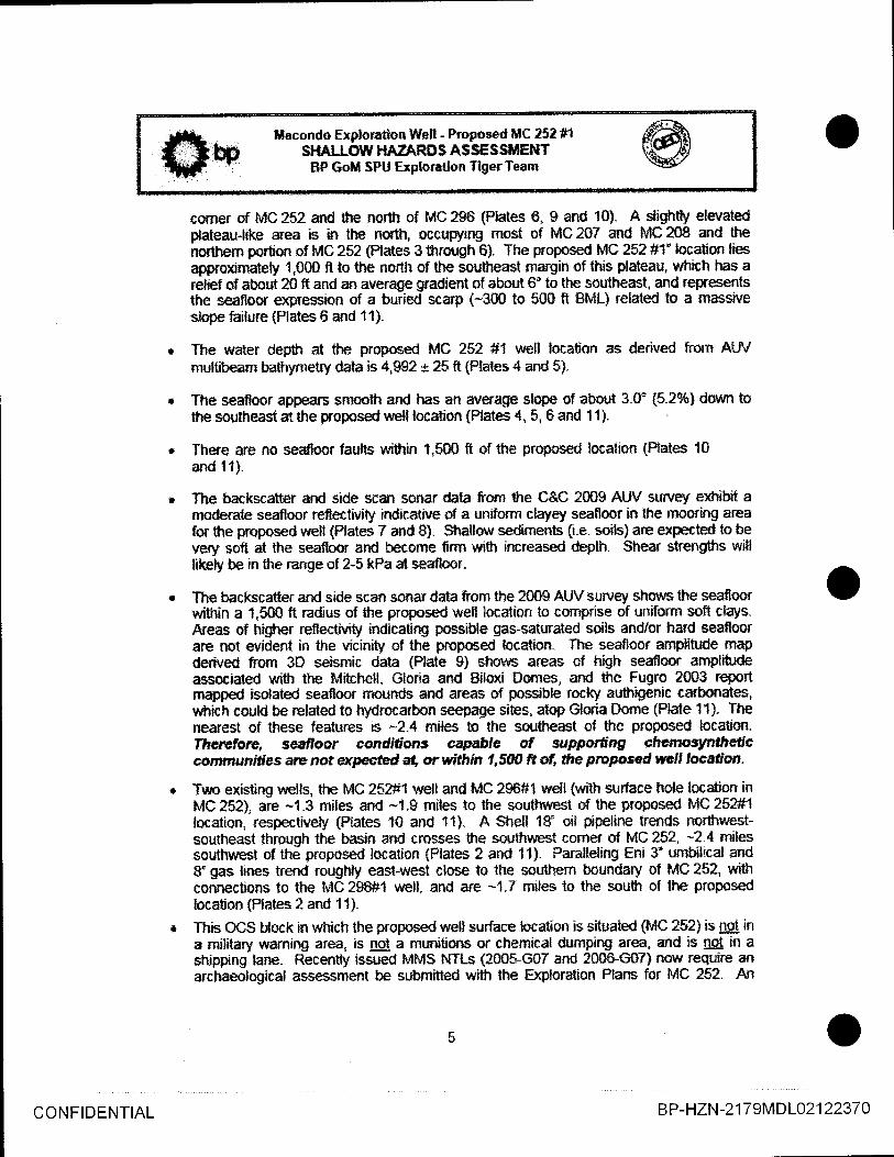
comer of MC 252 aftd the north o{ MC 2$s (Plate* 6, S and 10}. A slight$ elevatedplateau{*ke alea ie in the *orth, trcupying rnost of MC 207 and MC lGg and the*ortrern portion of fdC ?52 {Plates 3 through 6}. The prcpased MG 2SZ #1" localim liesapproxirnateg 1,gm ft to the nsrth of the ssuthea*t margin of this pldeau, wl'dch has aretief of about ?0 fr and an av*rage gradient of about 6' to the ssuthea$t, and reprmentsthe seaftos €xpession al a buried scarp {*3$0 to 50$ ft SML} related ts a massiveslcpe tuilure {Platesfi and t1}"
The water depth at the proposed MS 2$2 #1 r,r*ell lo+alion as derived fom AIJVmultibeam batfumeiry data is 4,S2 '* 15fr iPtates C and 5).
The seafloor appears saroollt and has aft av€rag€ slope af abaut 3.0' ($.2%! darllrn tsthe southeast al the pr*pssed well locatio* {Plates 4, 5. 6 and 11}.
There are rlo seaffsor faults within I,5S0 fi of tfie propased iocation {fiate$ 10and tt).
The backscatter and side scan sanar dala frrnr *te C&C 2009 AUV survey exhibit anpderate seafiosr reffectMty irdicatiue of a unifo*tt ckyey seaBoor in the rnoaring arcafor the proposed well {Plates 7 and 8}. Shallsw sedirnents {i.e. sttils} are expected tc bevery s*fi at the se*floor ard beqome firm witlr increased deph- Shear strengths witllilcly be in the mnge sf ?-5 kPa at seafloor"
The backscater and side scan ss*ar data from lhe 2009 AUV survey shcws the sea$aarwi$rin a 1,500 ft nadius of itre proposed well localion to cornprise of u*ifsrn safl clays.Arem of higher reflectivity indicating possi$e gas-saturaied ssils andlor hard seaflnorare nst evident in the vicinity sf the prcF$ed location- The se*flocr ampliiude mapdertved frorn 3D seisrnic daia {Plate 9} shslvs areas of high seaflocr amptitud*assoeiated w*th the Mitchell. Gloria and Biloxi Fomes, and the Fugra 2S03 reportmapped isclated seafloor mou.nds ard areas *f passible rocky authigenic carbc*rate*,wtrich could be related to hydracarbor! seepa{1e sites, atop Gfwia ilsme {Plate 11}- Th€nearest of these features is -?.4 miles to lhe so*th€ast cf the prapased lccaticn.Ihelef'oro, Eeafocr candifons sapaife af *rypoltngl chenosynfl*trcconrmnndlas arc not rrycted al, or wlthin l,SW fi of, lfie pnaposed *elJ locafon,
Truo existing rrells, tfn MC 252#1 well and fulC 296#1 welf {with surface hole location inh4C252), are -1.3 miles and *t,$ miles lo the soulfwesl sf the prop*sed MC252#1locetion. respectivety {Plates 10 and 11i. A $hell 1S. oil ppeline trends *orthwest-+outheasl thr*ugh the basin and cro*ses the sa*.rthwest comer of MC 252, *2:4 mil€*southwest of the proposed lccation {Ptal* 2 arfr 11}- Paralfeling Eni I umt$lical andS" gae lines trmd roughfy sast,west clo*e to the southern boundary of MC 252, withconnections to lhe MCASS#I nnll, and are -1.7 rniles ts the south of lhe proposedIoratiun {Plates 2 and 11}.
This OCS bteck in vfrich ihe propased well surfaceiccatlon is situaled tldC ?52) is ngt ina mititary uramirg area, is nsJ a munitiene or chernical dumpinE area* afid is g! i|r astripping lane. Recently issued MMS NTI-s {2085-G07 and 200S-€i}7} nour reguire anarchaeological assessrnent be submitted wtth the fxploration Pfans far MC ?$?. Atl
CONFIDENTIAL B P-HZN -2 1 79MD 102 1 2237 0
.1ft, " tl*conda Exploaatlon Welt - Pmpas*d [tC 25? #1
f ilDS SHALLOIt$llAZARg$ASsEs$tElrITtff
' SF Go[l SPU Exptorctton Tig*rTeam
arcilaeological assessrnent for MG252 and vicinity n*a* carid out by C&C using theside scan ssfiar data frorn their 20CI9 AUV sur\/ey. One unidentified sonar target{Contact Ns. 3S, rneaturlng 13.8 ft x ?.2 fi and with a relief of 2-E ft} rms mapped *il,7$0fi to the northvrrest sf lhe propo*ed lo*ation {Plates S M 10}, but the MarineArchaealogist at C&C csnctuded tlrat there is na eyidence fsr strfpnneck delris rysitps of arcfueologfcaf srgnrtrcence af tr $dfriil t,509 tr af {rc propcsed rreltlocatran or prcpcsed ancbor Joardons.
r- $UFSURFACE OBSERINTI*IIIS
SubsurFace Observadons are discussed ln two sectians: !.) $hdlor,rr stratigraphy at theproposed il-lC 252 #1 well location and 2.! strallew hazards at the praposd MS 252 #1 welllscation and offsets wells,
7"{. Shellow $kaffgraphy atthe Frapqs€d $C 25t fi $lall LscatlonThe stratigrapfry of the tophole sectiwr at the propos€d MC 252 #l loeation cansists of 5,S2S fiof deepwater sediments for the depth intenrel nf investigaticn. Based sn ihe FuEo 2S03 report,six seismic-$tratigraphic mits {Units 1 through S} separated by seven harieons ($ealloor andHarizans 10, ?0, g), 4S, S0 and 60) are identified at tle preposed location The Seaflom ardHcrircfis 30, 4S and S0 wnre mapped across fvl0zs? a*d vicinity b'y BP in order tn poducei*tervalamplitude extractisns. The remainirry horizons. l-lsrizons 1G, 20 and 5O are rorelstedte the Fugro mapping area- lntermediate hsrizcns, Horizons !5, 34, 3S, 38 ard 45 areinterpreted across the wellsite b,I 8P ta ald in the description of the strallow geolcEySub-Mtom profrler {SBP) data exampes w?re extracted from the C&C ?ffiA report to shorrthe general character of shallovr sediments to wilhin a ferm 180 ft of nrudline {Pfates 't? and 13}-Plate 14 repretents an isopach nrap of a shallow, parallel bedded clay uait mapped fror* theSBF dala, Plat*s 15 and 1S show example seisrnic sections, Line 17282 and Trace 14150through the poposed lccaticn, r,r*rich illustrate ttre shalla,v geotogy in *le area lo the depth limitaf investigration. The six main units of the tophole section are discussd belovv-
The sflrailow Wdogy between the seabed and f{orizon $0 is relative$ cornplex. comprising well-bedded lurbidib sections wtrich have been eroded by several episodes of debris florrs {Pla}esll,a@ 16). Bepths to the top of the interpretd horizons and unit thicknesses at the proposedMC 2$2#1 u,sll location are povided in Table'i. The interpreted sffatigraphy ard n**ctogiesthat cornpose each Unit are surnmarized in Tabl* 2.
. Unit I is about 25S f thick at the p'roposed locatian and is carnprised cf hemipelagicclays lnterbedded with thin clry-pr*ne debris llows {Plates tS and tS}. Subbottomprofiler records show predominanlly layerd clay beds with occasional thin {less than 1Sft thick) debrris ffoue near lhe proposed rvell location {Plate 12}. Severa} *halluiv burieddebris flsws were mapped east of the prol:osed weil lacalisn {Plate 10}. The debrisflolra are gener*lly hrried by at least 160 fr of parallel hedded drape. P*ate 14represents *n tsupach nnap that vras produced by C&C (?S0gA) fiam the sub-bottomprofler data to show a shaflow interval of parallef bedded clays.
r Unil 2 is about 594 ft thick ard cornprises an upper wrtion t47C ff' of interbedded claysand thin clay-prone debqis ftows, wilh a lower portion t118 fr) of interbedded ctrar;s and
CONFlDENTIAL B P-HZN-2 1 7eMDL02 12237 1
jftar- lilacond{t Explsmtion Well - Frnposed IIC 15? #t
f" E bo sltALLolH HAUARDS AssEssltEHTrffi ' BP Goli sPtl firpl*rg*on Tig*rTearn
marts {Plates 15 and 1$}, Mass wasting of this }ower section of Unit? lns resutted inthe lovr-relief seafloor ssarp ta the south and east sf the proposed locallnn-
Unit 3 is abor* *$* ft thick and cornprises interbedded rnarls and clays. To $e east ofthe propased lccation, Unit 3 ihickens con*iderabty where it infills a prominent channelcornplex {Ptates 1F and t6}. HiEfr ampliludes associated with t}re ueslem rnargin of thechannel complere rndicate possible sand-prorre ever,bank or channd levee depostts{Plate 17}" Theee sands, at the base of t}nit 3, appear to pinch-utt -1,800 fi ta lhesoutheast of the proposed location.Unit 4 has a total thiekness of about Sf2 fi and comprises an uppef pulion $47 ftl andlorrver porlion {212 fi} o{ tine-gnained tu*idites and debnis flsws, whilh are separated bya csniral interval (!31 fl thick) of fioe-grairued overbankand levee deposits wilh pcssibfesands {Ptate= t5 and t8}. This cenkaf litholqic variant 1o Unit 4 thins to the west CIf thepropased'locatisn, but thickens markedly tc the east, n*frere it octupies mtrh of the unitwithin the ctrannel complex. A 11? fi thic* sequence cf continuous $ands and silts f+nrnthe base of Unit 4 and is tru*cated by the cenlral averbanldlevee unii to the east"Unit 5 is about 8$S t thiek and comprises ap upper $equent* (589 fii of predorni*andyfinegrained turbidite$ ard debris flolw with possible discontinuo{s sands overlying a?$9 fr thiek massive clay-prone debris flaarwilh possible silts (Plates t5 and {6}.
The deepest unit d*ilneated, Unit 6, is absut 2,458 fi thick and coatains pedorninantlyfinelgrained tur-bidites and dehis ffon'rs. but with three continuous sequences ofappar€nt sands with thicknms*s of 165 ft, 1$7 fl and ?4S fi within the tentrd part of theunit {Plates
P*tential subsurface hazards at the prcposed MC 252 #1 well lecation are discussed in foursections: Faults, $h*llew Gas, Shatlsw Water Flow, and Hy*ates (Plates t5 thraugh 23). Therisks of encountering the above menlicned shalle$J hazards at the praposed well locatisn aresumnrarized in Table 3 ard in fre Top"llole Fonnation Fcrecast {Pbte 23}. Sffset wells arelisted in Table 4. Shallow hazards enceufered in tfe sfset rarelJs are zumrnarized in Table 5.
7.2.1 Faults
The proposed well bore will not interse(t any *aults betrmeen the seafroor and Hori:sn 6S, Thereare lvro southrrest-northeast trendrng, sculheast dipptnE, buried faults norlhwest of theproposed locatiol tPlales 15 and 16]" These faults reach shallorrlest limits of -l,SC0 ft BML and-2,830 fl BML, approximately 8,500 fr and lCI,SOS ft Fom the proposed well lceatto*,respective{y, ard appear to dip beneath the prapo*ed well, but below the depth limi of th**investigation {Horizan 80 a 5,328 ft flML}. A simifar buried faulf, southeast of the prapcsedlocaticn, dses nct crossthe prcposed wellbore {Flate 15}.
7.?"? Shaflow GasThe patentiat shallsw gra* distribulisr within MC?52 and MG253 is shawn m the amplihrdeextractlons produced internally by gP for the Seafloor io Hcrizon 3O, Harizon 3O lo Horiesn 4CIand Horizsn 40 to Horizon S0 intervals {Pfates 77,18 and 19, respectively}.
CONFIDENTIAL B P-HZN-2 1 79MD 102 1 2237 2
$[fi, . ltlacondo Explcnticn YUelt - Fmposed f,iiC t5l *tI il gn SHALLOII$ lt*ZARil$ ASSESSUES|Tffi
' BP Goli SpU Erploratton TigarTe*:n
qryq t ryfr 2 aFpeat.clay-froile ald da nst exhit$t any anomalous amgitudes in theviciniff cf the proposed locetisn.The, nnst pmmjnent area of potentiaf shallorr* gfts appears asswialed with thesard-prone *verbank and levee depmih of Unit 3 within tre channel complec to ilre€Tl_{ ttle proposed location {Plates 15, 16 and 1z}. These sards appear t* pinchout*1,00$ fi to ttre southeast of tlre prspssed lscation.$everal scattiered anornalous am$itudes appear ts be awociated with the centratoverbank and leve* sequence wtthin Unit ;l and also with tFe cunlinscu* sand md sinsequ€nce at lhe base of tfa unit {Ptates 1$, 16 and 18}, The most prornin*nt anornaS isa$$ociated !#i& the basal coarsegrained sequence *50S fi tCI the norihrcc,st of theproposed lmaticn, wilh mincr anamalies associated with the cenfial sff&ence *3SS ft tothe northeast.Unit Stontains clrygrone turbidites and debis fbws overfyir*g a thick cfry-prone debrisllour- Scaftered, r$inor arn$itude ancmalies withi*the unit suggest polenGl shallow gaspockeb associated wilh dsc*ntirffous sards. The nearest isstded shallow gas pocketsto ihe proposed loedion are -4OS fi ts the nortfreasi and -tr,000 ft tq ffte northrr/est artdsnutheasl {Phtes t5, 't6 and 1€}.Several promirnnt nodfnisest-saJ*reast trending arnplifude arurnalies are ldentifiedwithin unit s to tlte west of the propreed focatian {Flate 1g}. These appear to beass{ciated wilh lhree sand sequerres wi$rin the sverall interMded'dne-grainedlurtidite and deilis flctfl unit, with the mo*t pron*nent anomdies *1.500 ft to the r*estand spulhwest of the proposed well focation"No shalls'v ga$ was reporid ufrrite drilling the tv*a closest sffs€{ v'rells {MC 252 #1 andffiC eg$#l) to the proposed lcatron- Howe\rer, several thin bedded sards with po*siblegas 1#ere interpreted tmr the well lcas for lhe MC 252 #t location r*rithin torer Unit 5and Unit G {Plate 2S} A geologist from ihe nF*i€1" fidd $our Hocks souh-saufteast aFshoum on Plate 2t) noted that shalla,v Eas rrras enccunlered d the ofiset wellil{c 4294-4 vrisin the lawer sectirn sf unit 4 ard upper tJnit 5 at about 8,10CI ft T\o,8,57_2_ft T\lD and 8,860 fi TVD {about ,.914 fr 8ML ?,38S ft BML and Z,ST4 ft BML} aftetthe ?O-inch casing was selShallots gas risks al the p*oposed welfSib are based en BFs Sfrallnll Gas IntergetationGuide Points ard Risk Cribria ffables 6 and 7i.
r 8a:ed prirnarily on the seismic character nbserved h profiles and amgitude extractionsin the irnraediate viciniS of the proposed well, the nsk o{ encountering shaltw gas isranked as f.uqc{iptFtc far units t, 2, 3, 4, and 5- unit s is assessed an sverallgg$gf$ ri$ far shallow gaq wtrich increases tojEg for the upper sand s€quence{?,42 fr to 3,3$7 fi BML} and il{q#,g4 for the midfe and lower sand seqlences{3,781 t to 3,958 ff BML and 4,372 fr to 4,618 fi BML, respectively}, The BOP will be inpface after setting the 22-inch casing sfroe within the upper porlicn sf Unit S, abcue thefirst sand zone interpreted with a lovr pn{entiat for shallavr gas.
7.?.3 Shatlow lffater Flow {$WF}MC 352 i* in the northeast cf ffre Mississippi Canyon Lease Ar*e {Plate ?2}. to the northeast offte highest FleistoceneiPliocene sediment accurnutations in the lease ar;a ffimnson, et d,
{Jthe Yb:*tffiff'lggS). to u"re norft sf the main Lak Pleistocene depocenler, wfrlqh contains the Elue ard Be€nsi6-prone $V{F unit* ffinker, et al, 2ffi}, and in an area sf lsw paienfal for shaltow waterflow{Fe{letier, rl al" 19ffi}.
r NcsWFeventswererecordedirarneiherof tfmofisetwells, hi[C?;EWt orfdC?Sfi#"|.even though the annplitude extractions, Flates t7" 18 and 19. indicate a !tO\r likelihoodof ;ards dithln tfre iquivabnt potential Sl4lF units than at ihe propcsed laca{iry $andswere identifted wrthin Unit S at the MC 252#1 u,relf, however arry risk of SWF wasmitigated b'y tfs tepsetting of Unit 6 v;ith the ?O-ineh casing_followedlfO-lllFg wtft ahiglibr rnuchnreightfiuid. $iuek pipe was reported at a depth of absrt 8,900 ft TVD attheMb 25291 niee$lflate 20). This interval appears tq conelate with a sand unit. Offsetwell data irdicates that *F MC 2S?#"1 wdt may have been drilled wrderbalanced at thissection of the borehsle. whichcotdd have caused lhe stuck pipe-
r The FIIMS $lrVF rivebite t20S5) shoyrs the neare*t SltF blocks to he in MC 4?9 andIr,tG 29? {Ffate ?1}. A taw severity $lAl,F was experienced at a depth of $*t{ ^1,738 ngML at'Bp's MC 42gAi umll tPlates 2S and 21) ard a lcw severily SWF wmexperienced at a depth of 1,7$4 ft BML at Shwron's #1 {Gemini} w*ll-
* The cunent propa$ed casirq program tor the h4C25a #1 bc*lion tsh+wn on Plate 23)has the ?S-inch ca*ing shoe topsettirg fhe potential $tdlF *ands w{lhin Unit 4, and fhe22-inch casing shoe top*ttirq fre potenlial $t4lF snds within Unit 5
r 5WF risks at tk proposed wellsite are based or BP's Sl,'\tr lntelpretatisn Guide Poinkand Risk Griteria ffabl* B and 9i.
, Based on the seisrnic character of tfre shallow sectlon at the prcposed well lacatisn andties to offset wells with krown 5\4lF eve.nts, ihe risk cf encountering SWF is ranked a$
ie&@ for ttrs cordinuc*.rs sandy sequenles at tE B** of Unit 4 {1,832 ft ta 1,944 ftffiIf, affi wi&in Unit 6 {3,202 ft to 3,3SI fr 8ML, 3,7Si {t ta 3,S5S fr B}fiL, and 4.372 fl to4,S18 fi SML; g#g risks fcr $l4lF are assessed for ihe sands within the ov*rbanklla,le*deposit in the cential portian of Unit 4 {1,489fr to 1,620 fi BMt-}, and tie discsntinusussands within the predsminantly frne{rained turbidfie sequence forming the upper pcrtionof Unit 5 {1,944 ft to ?,533 ft BMt}. trpEgi}te 5l4lF risl$ are assessed for all therernaining units sr portions of unib wlriclr are lnterpreted as prtdcminantly *lay-prone.
7.1.4 Hydrate*
The pressure and temperature conditians {avarable for ttre fornralic* of hydrates exist at theproposed locaticn. The base of the frydrate stability zone {BHSZ} is sometimes i*dicated i*biimic data by a bcttorn simulating reltector {BSR}. ln general the preserne or absence of aBSR daes not indicate the amour* of gas hydrate tha{ rnay be present in an area. In hcl thereare areas in the werld where a S$R is present and ns' measureable gas hydrates were detectedduring detailed loggirry and *orirq operations. ln these cases: the SSR rnry just indicate freegas at the base of the trydrate slabihty zone-
No S,SR is sbssved belor lhe proposed well location. l"Norerrer, the $l{SZ is ralcul*ted ts be1,995 ft gML for a l$"llun ge$hermal gnadien{ 1,532 ft BML for a 3O'lltrn gncthennal gradient,and 1,279fi BML for a 35"lkm geoffrermal grdient. The depth esti$lates above use a linear
CONFIDENTIAL BP-HZN-21 79MDL02 12237 4
f---It m u.""r1l;,?ffi1ffi*'$iHffi;g#h? -'!1iF
'' BP €oil SFU fxploratlon TS*rTeam
appraximation of the Mrekawa et af" {t$95} psfyrnmi*t for $H4 trydrate F-T stabilify in vvater ol3-5%NaCl salini$.
The risk of encsuntering Frydrates in the ryaposed rctell b consideled flq&gfbt+tE ttfor Unitsl, 2, 3 and most of Unit {, using $e 1,532 fr depth BML as a conservative ba*e ol lhe gasFydrate stabili$ zone-
S, RIG MOSRII.IGTlte proposed well rxill b drilled with the Marianas moard vessel using a 12-ptnt moortngsystem Although the original praposed anchor radiu* was 4,500 A, C&C ccrpleted a.sitesipcinc archaeological and hazaid asse*sment centered an two ptuposed well leationswith an anchor radius ef S,5SD ft {C& C 20ffi4}. The C&C report was submitted with theoriginal ff. Eecause th* original C&C report also di$u$sed spcific proposed anclprswithin 4,508 t of lhe nrellbore, a revised $Erp was required by the MMS when the proposedanchsr lccallans vr€re e]$end€d tu G,500 fi firyn the propCIsd localion" PJates 5 6, 7, 8, 10,t3 and 14 are used lo sumrnarize the hazard assessment at the propased anchorlpcations.
The mooring syst€m w{|| be comprise$ pf 'N2 SEFLA ancluts that $,til penetrate to a dep.thsf about 75 fi BML" The backscatler and siCe scaft sonar dala from tt* ffiC 200S A{Jllsarrvsf exhibitd a modemte seaflsor refieclivity lndicalive of a unifsm claVey seaflaor(Plates 7 and 8) at the proposed anchor locations- $fraflow sedinents {i"e, sails} areexpected to be very soft at the seafloar and becore firm vuith incrcased deph" Shearskengfihs will likely be in fre rangrc af 2-5 kPa at seaEoor" Sub-bottorn prcfiler records nearthe prop*sed revised anchor lscatisns irdirate at least 75 fi af parallel Ledded claystPlate 13),
No archaedogicalfy sQnifcant artefacts or potentiaf har$ruxtds that could supportchemcsyntheiic cammunities wefe idenlified wiihin the 6,5ffi ft radius of the propmed welllocatians {Plate 10}. Proposed anchor lA is very close ls the scuihem extent of a shallowburied *lump {Flates 6 ard 1S}. However, the sfrallcnpr slump is very thin and should notpose a Froblem ts anchor installation-
The clssest i*fras$ucture to any of the praposed anchsr locations is the exisling MC 252#1wellhead and Sre Firuh diamebr ENI umbilical line. Anchsr 8A is about 3"100fi Forn theclmed trvelltread {MC 252#1} and about 2,509 fi tc the closest umbilical line {Flates 5, S, 7and 8).
At the tine af lhis shallcw hazard a$sessfilenl anchors 1. 2, 3, {, A 6, 7, S, 8A and 14 hadbeea pre-set suceessfu lly-
g. GEilERAL DRILLIIiIG FT*&T{The cunent well $an willjet 3&irnh surface casing to a depth ot ?8fi tt BML, into the upperporiion of Unit 2 {Plates 15. 16 and 23}. The 32.Sin*h tnle ilrill be ddlled with s€aurater toabsr,rt t,{94 ff BML {2&inch rasing shoe at 1,194 t BML}. The 2$inch hole will be drilled withseawaler tc 2,91S fi BML (22inch ca*ing shoe *t 2,919 fi EML). The BOP will be plm*d on lhe?Z-inch casing afler it ltas been cernented ints tle 2&inch trole. The dg will haue materials
rea$ for pumpand-dump drilling in the event that significant SIA/F or shallow gas isencounlerFd-
10. CSI*,fCLU$ISH$
This Shallaw Hazard Assessment for the prcposed Mf, 252#1 well defines lhe surfacelscatian {i* MS 252} and docurnents t}re anticfpated top-hole drilling conditicm {Plat* 23}
Canditisns at the propesed MC 252#t well localisn have been revieurd using ther ults of shallotu hazard studies b6sd en 3S explcration and reprocessed seismic data andAL}V high resolution seismic dat*, Rsults of this review have idenlif,red the following csnditjonsand poter*id hazards at fm propssed well location.
The seaffocn at the proposed lacatian is in a water depth of 4,9S2 it anS dip* tolhe sorltheast al-3.0*- The only sealloor feature ldentified on lhe 3D sisrnicdala within t*te vrcinity is a lorry-relief escarpm€nt approximately 1,9ffi fi tc thesoutfi of th€ proposed lscatio*. uihich is the seafloor expre*sion of a deepFf-buried scafp associated with rnass-wasting.
There is no ev*dence for shipwreck debris ar site* of archaeological significanceat orwilhin 1,50$ fi af the propo*ed welt localion ar prcpsed anchcr lccation*.
There are no seaflsor faulk wilhin 1,500 fr of the prcpesed focatian.
There is ns evidence for th* existence of environmenls capable of supportinghish{ensi$ chemosynthetic communities udthin 1,500 ft of the poposd wel|trcation or a*tociatred anchsr rnooring pattern.
The propased '*vell bore wiH not intersect any faults betiveen the seaflesr andHorizon S$.
Based prirnar*y cn the seismic character observed in prcfiles and amplihrde extractionsin the imncdiate vicinity of the propased ndl, the risk sf encauntering shallsrn gas isranked as ltesftptptt fi:r lJnits 1" 2, 3, 4, ard 5. Unil S is assessed an qverdlifq{tfgfbfe risk f*r shallsw gas, vrhicfr increases ta l.ory for the upper sand $equencet3,202 * io 3,3$7 fi Bt!ilL) and llfqdenale for the n:iddle and lovrer sand sequences{3,7S1 t to 3,95$ ff BML and 4-372 fi to 4.618 fi BML, respectively}" Tnc BOF wi$ be in$ac* after s*ting the Z2Jnth casing shoe qithin the upBer porlion of Unit $, absve thelirst sand aone inlerpreted with a tov+ polential fer shallal, gas {TaSe 3 and Pfatc 23}.
The dsk of encauntefng shallo*u lnlirter flow is ranked as l&&E& for tfeeontinuous sandy sequerc€s at the base of Unit 4 {1,832 fi to 1,944 fi BML}, ardwithin Unit 6 {3"2S2 fi to 3,S7 ft BML, 3,76t ft to 3,955 ft BML, and 4"37? fr t*4,61$ ft BML); Lt+f tor ihe sands within the overbank\levee depcsit in the centralperlion of Unit 4 tt,48gtt tp 1,520 ft B*,lL), and the discontinuous sands wjthinthe predominantly fine"grained tu$idile segueffie fonning the up,per portion cfUnit 5 {1,944 fr tq 2.533 fr BML}; and fl,ryfisiFp for allother un$s or porticns efunits between th9 $reafio*r afid Horiesn 6O {Table 3 and Plate ?3}.
a
t
CONFIDENTIAL
1 t
B P-HZN-2 1 79MD 102 1 2237 6
.*f*, - ttlacondlr Expioration lrUel! - Proposed IttC 25? ftt t m sHALLsw ltAzARSs *ssEss*lENTTtF
- BPGof,l SFll frptorarion TigerTenm
. The fisk of encsunterisg hydrates in the proposed well ts considered llJqrttri4*-t glrfcrUnii* 1, 2, 3 and rnost of Unit 4, u$ing the 1,532 {t depth BML as a effiffi sfthe gas hydrate stabilityzone {TeHe S ard plate Il}.
kTe,adyiqe q4ptio*, HrlFelieye thqt tlle. d*l( pfsangeLlo.rergonnd,egdJta{npge rg tlr*Fotfihpl*" qqqipq€fg end p,Wifgn{{lpr}J is Lp,p. p{aykte{ p€qjtadhFfpncp.ts.prqp#;ggtl,no pndqefllefltqH wry€Sureg,is follos€d. conremirp !he$e h#atdr unt$ lLe !ir-s! ptsssrrre csrllainnqnts,bino is in olace at abo:rt ? glg {t RMI
TT, REFEREHCESC&C?Offia, February ?909, Site Specific Archaeolryical & Hazard Stug, 'Macond+ Prc*pecf,
Blcck ?52 and Block 253, Mississippi Canyon Area, report for BP Exgoration, C&C JobNc. ffi40$&0$474?, *a.ka. C&C Technotcgies.
l''*C Otrshorq,. l=.!-S.. jtggp,l'C'egpfrysicat Survey Report, Btocks 208, ?52, 296 & Parts of 163,lq{JAS,,?qI, 20S, 251- 253, 295. 237 Mississippi Canycn, Offshore Louisiana, OCg&.18293" :lgZS7, g7S, '14G33, 1463S, 1&72 and 15473"" RepCIrt prepared for TexacoSxploratisn afld Frsduction, Inc.* Aplil l$ffi.
Maelawa, T-, ltoh, 5., Sahaia, S., lgari, S-l-, and lma[, N_. !gg5, Pressure ard ternperafurecsndition* for nnthane hydrate dissociation in sadiurn chlorlde solulions: GeochemicalJcumal, v^ l$, p" 32S329.
lVlinerals Managenrent Service, 2CISS, "Notice to Lessees and Operators cf Federal Oil, Gas andSulplur Leases and Fipeline Rightof-Way l-{oiders in th* Outer Continental $tlef, Gu#cfMexice OCS Region, $hallour l-lazards Prcgram"". U. S. Departrnent of the Inteflor,Ylhrydu ManagementService, Gulf of lvfexico, NTL ?m&tr5 {supersedes NTL No.2C07-G0r)_
h'linerals Management $ervice, 2008, .Natice to Lessees and Operators of federal Oil, Gas andSulphur l-eases and Pipeline Rigfrt-of-Way Holders in the Outer Sontinental Shetf, Gulf *f[{exico ffiS ftegion, Information ftequirements for Exploralion Plans and DeveloprnentOperations Coordination Documents,'. U. S" Departnrent of the Interiar, MineralsManagennent Service, Gulf of Mexrco, NTL 20SSG04.
MineralsJvlanagement Service, 200$, .l'lotice l,o Lessees and Operatcrs {NTL) of Federal Oiland Gas Leases and Plpeline Right-of-Way {ROW} Holders on the CIutei GontinentaN She}f(OCS), Gutf of Me"xico OCS Region, Revisicns to tfe Lisi of OCS Lease Blocks RequinrqArchaeclogicat Reso{lrce Surveys and Reportg. United States Department of the Interior.Mrnerals Management Semice, Gulf of Mexico, NTL Zt)O&ffi7"
Minerals l',{anagement Sewice" 20$5, .Notice to Le,ssees and Operators sf Federal Oil, Gas,and Sulphur Leases and Pipeline Right-of-Way Helders in the Outer Gontinental Shetf,
CONFIDENTlAL
12
B P-HZN-2 1 79MD 102 1 22377
ffiwlll*condo Explcration Well - Froposed itC ?51#t
Gulf sf Mexics OCS Region, Archaeological Ressilrce Srweys and Reporls". UnitedSrtates Department sf the Interior, Minerals Managernent Service. Gulf af Mexico,NTL 200$ffi7.
h{inerals Manag*ment Service, 20S5, $tullow water fl*w dala pubJisftgd _on tlle MMS€ulf at Mexiio website htip:l,lgnrry'Lgornt.mfns.gosllloffieoq1of"fshCIHmfetvnmfftos.ltlrfil
Mifierals Management Service, 200S,.Notice ta Lessees and @ratorsof Federal Gil and SasLeases in the Outer Ccniinentaf Shelf, G*tf of futexicc OCS Regiwt, BeepwaterChemosynthetic Csmrilunities: U.$" Departmenl af tlre lr$edor, Minel'als ManagenentService, Gulf of Mexico, NTL ?0m-G20
Pelletier. J.F., Ostenrnifr, R.M., Wir*er" C.D., Nicholson. J.W", and Rambcnr, F.H", lggS,"$ha$orrv Water Flow Sands in the Seeptrater Sulf of Mexica. $*nre *ecent fellexperienceu. Conference Froreedings, lggg Interndional Fcrum on $hallsery Water Flcryrs,Odtober $-8, lgg$. $suth $hnre l{arbour Resort, l-e*gue Ci$, Texas'
Thcrns*n, JA, Dodd, T., and Hill, A., 1$$9, "Formation of Shaltolv Water Fl$,tls'. CofiferenseProceedirrys. lgSg {nf*rnational Forurn an Shalfovr Water Flonrs, October$€, 1999, SsuthShore l-larbour Re*ort, League City, Texas.
Wnker, S" D., and J. R. Saatfi, ?t]fi0, *Sedinrentary dynamirs of tfie sandaminate{t csnttnentalslope, Gulf of Mexic*: intryradon oJ observations fror* the seafloor, near-surfwe, and deepsuburfare, Proeeedings of tfre GCSSFPM Foundation ZSE Arnual Resear*h Cunference-p.10$9-1S86.
TablsS- BP$hallow 6m Guidie Pointst. ls *re rellecticn ftorn the suepectsd rsservoir anoraalcus in am$ihrde, probably brighl?
2. ls tte arnplitude *nonnaly sFucturaily *snsislent?
3. # bdght, ie there ons reffsction Fsm the &op of the ressruoir a*d one fram the b,pse?
4. Os {1e anrpl*r.rdes of tlre top aad base reflEstisns vary in unison. dimming at lhe same poinl at thelimitcf th€ rcsep*ir?Are lhe dalaeers phaee?ls a fl*t spotvisiHe?ls ths fial spor dipping gr consi$lenl wittt gas velaci$ sag?
ls the fiat spot unconfan'nable with the sbucture but eonsistsnt with it?
Soes the ltel sptt h*ve the corrertzero-phase character?
ls the flat spol lccated at lhs ds$tn dip lirnit of bfightness {or dinmess)?ls a phase cfuange visibls?fs lh* phase chang* structura*ly ccnsislent ard at the same ievel a: the llat spot?
So brigbi spol. dim spct. or pha*e ch,ange shcw the apprapriat* zero-phase character?
fs thsre a larr fre4uency shadanrv befow frie suspected reservoir?
ls there an anomaly i* mqveout deriv*d intewal v*locily?
ls there a pull down effecl al und*rlyi.ng re$sctors indiealive cf gas veloci$ sag?
ls a sludy of an*gitude !E$us sssst on the unelacked d*ta likely te yie,ld {urfter validaiisnevidence?Arc a*y shearur*ve data availabie for fu*hervalidatian evidence?
Cone*ld in $999 by Jarncs A Thcgllnn and !fldreur W" Hill d FP
to g*s in an offsetwell, or is lpcated at a knon* regional sh*llsw gas honzcn'
An anoma$ showing msst of tha seisrytir rharacteristics of a shallol# gas anamaly butwhfuh ronld be interpreied nst lo be gas and, as such, reaeonabfe doubt exists fsr theIres€ilce ofgas-
An anomaly showing sarne of tha ssbmic characleristle s uf a shaliew gas anomaiy- butthat i$ i*t*rpr'sted not ic be gae althaugh some interprelive doubt exisl$"
Eilher there is no anorn*ly prss€nt at lhs bratien or ths anomaly i* *leedy d{re to slher,non gasssus, c*uges
An anomaly showing all of the ssisndc characteristics ol a shallo'# gas anomaly that ties
C{{t$ed h tgSS by JaFEs A. Ttv**son s]d Afl{tre$t !1/. !161 8t FP
*lb!b q-_BP Shallovir Water Florr lnterg*talion 6ui& Frintsl- CIces the islerval egnl*in an aquifar {a layer of parcus sediments capable of floning waterp2- ls there a eompetent r€gional or wb-regisnal seal above the potentiel flow zqne?3, ls *rere a rand-prcne layer within a steclural (dip-rev*rsaf] trap?i{. ls there aetra*gmFhie,lrap fornqd by dippl*g sand-prone lays(s} truncst€d by faultir:g, emsional
down rulling or d*pos,itbnel pinch-cut?5" le Sters evtdEnce of hrgh sedimenlabsn rate$ {}1500 fUmy} and rapd buria} leading to pressure
disequffibrium?A k th€rs a lotalbed *mplitude ev*rl c*nsbting cf an anomalous$ bright reffeetion? lf *o" can
lunirq effecls be ruled out as the eause?7 - ls $rere evidente fnr fte pr*s+nce Ef a geopreesured asne. i.s. statigraphic laye{si containing
pcra pressmre greeter lhan hvdrostatic pressure?3" Cen a kntrw* *hslh'w rrra*r flow zcna fr*m a nearby wsil hB corrslated to th€ inter?at? lf so. is
there consisterrcy of seismic character?9- Has a aearby wefl proven that $WF can be n*led o:.ri? lf ss, is th€r€ ccnsistency sf seisilnic
intervel?tl- floas the s*afloar arnplitudt map indicale areas of anomaiously s&ong reffeciion indicating
authige*lc carbonate hardgrounde associated n'J seaftosr ftoer?t?. Are mud wleanoes or olhar expc.:lston fe*lures preaent *n the seaflssr?13. Are buripd expulsion feat$r*s rerogniz*d on subsurfarE data?Itt, Does bathynretdc rn*pping indicale the prcsarce ol seallocr sca F possib*y: as*ci*ted wilh
fault* +r o*mr Sress{rre $nduits?t5. ls there a* isslstsd *nd body capabte af absorbing exeess press{rres caused by
eomp*ction disaquilibdum?15- ls there evidence af diffevential compactbn r+sulling in exfess pressures trsnsfesred frorn
thic k cvarb'urden areas?17. ls the so$e bu*ed deeply *nough {>500 ft} for der.etoprnent of a sufficiently strong seal?18" Are thers fi$h-arrplilude" disrsntinuous rafectors within expanded stratigraphic sequenc*s?.19, ls the water depth grcal enough {*5S0 ft} tp be associated wi*r SWF?At'ry one it@dtgft tan be t$.tric{,g. Shdhrit '.d€rflolv F €diaii$r gr ,r6isil& dstrc irh.dvee ecet$flrdtiroadffi;-re rnc.eencwrlffi ffi h3t#ffi 3lffi ,ilsi'#*T"ffiffi #**
SHALLOI'S HAZARS S A S SE S SIilET{TBP Gotrl SPU Exploraflon TigerTacm
Table $. BP $hallor"r Flou Rsk Criteda
l{fgfr
trfsd"rafe
lEw
f{ryligi}le
An interral po*es*ing att of lhe {,haracleri*lits o{ a shallff}t Ssut inter.'at, *r lfuat tiesdire*tly b a lha$ow ffow ia an affset $*ell, or i* to*ated at a knswn* regional, shallow flst#horizon.
An inlervel meetlnE the criteria listed abeve for "High" rist(, but which t*uld be brs*thed,ar olhenpise sho*l evidencs that pro'ridas reesonable dosbt for the presence of shallcn#floru canditiqns"
An intelalgener:lly lacking lhE ch*racteristics da sballchrffcl.d interval, allhough sorn*inl*rprelive doubt exists-
An interval where data rlearly indicate there is no *sk sf +ith*r sand or adequate seal, orwhErg olfset dritllng has proved the abssnc* of fow risk.
Ccnwed in :999 by .rsmet A Ttplsron and Ard'etr lu1!. xi'l S EP
CONFIDENTIAL
tg
BP-HZN-2 1 7eMDL02 122384
H€UJF,*ffiL,,ugi-.*
*
spilt.}{tr'
x r f(p$* i>{u t*a :f i aL: (f{l} C$-.vf f iu J { }f f f J' 6c! - 5
{. -.)
t s ;
\ , ** : r
s i t:ll &
tt
B P-HZN-2 1 TeMD 102 1 22385CONFIDENTIAL
ouxluItTLoII.J:}(3z,(ulIF-ust
CONFIDENTIAL B P-HZN-2 1 79M D L02 1 22386
w(rl
I!Eg.
EEo t t,l ei
EE, t aE 'l aal It
*FEEC Ix ! tE X
D
rs
aE F
#EE*E$
"il E$l i
e$s$Hgs$$e1 F r .g oa 6b E. , r to oETo tgru
*sg
fo? sE l F J
$ H.$e
fi $fg
B P-HZN-2 1 79MD 102 1 22387CONFIDENTIAL
f,ilg
!!g
bd ff is: *F-c
$HgEx!( r F?rS ET T;E6 =
c f ,rEs3fttoF . -i {& T
E:r L !c ?lt; !g$$tIEFGFE
{tfitn6a{,}i*cod*ttgottotto
g r LQ * eE b gF E i5E EE* i* r - 6; f *{ N t *? l r t c!{ $. ie
ilu ,gq , = u
B P-HZN-2 1 7eM D 102 1 22388CONFIDENTIAL
it
IIo.
-ws3
EE$n#EEEE*6 &
fr8l€A r o
! '
g
$$-g rl
IEg sn *: r &- e
t
a
5 S8f fS n
$E*E! : r .,g :tt o- g
tl
*el$|l €
B P-HZN -2 1 7 9MDLO21 22389CONFIDENTIAL
tt'
s{g.
NIS . h
E8tl t\l
Err€H$a.E I
" & l f Fs*EEE EFE $.il
ryffi $I$ri fs
$*i$$f.Es
I f t *
ilt*
*{sg
*fr
$InT
*
$ * *€ t
d$rJ <"
{$5 ** *35"! b gE X. g &
B P-HZN-2 1 79MD 102 1 22390CONFIDENTIAL
r0oilE.
g
*€3o6s* = t{ } r !t rgo ! l. : B
s3BEsE= F
f ,BO sH PE S& Ef
sES| ' G a
Efe€$-se.e IE * c !s*gEE EF€$
$trt
=*${i Is it$-$iti$*l{i$FfiilFi
-w
{}$ r *i Er i f lgEsfi( . ' EE fEes - 9
E g
E EI
B P-HZN-2 1 79M D 102 1 22391CONFIDENTIAL
l*otf
&
otst! *l
Eds{$gEs 3s*:gE EF€fid
**{
I*IJc
$
t,*Et{'f
-#F
a
t r or : "j ngr;;{/,u EE *9 s: si6 lJF *E. '!E
B P-HZN-2 1 79M D 102 1 22392CONFIDENTIAL
esFo,
*xtt*qtra
€
'w
$3s*$Efl
*ts*!**&g&I*Is
*F*rfx*E
i
i:{ll
ir*if$itT iF{ i }r i t$is*'i.:,' i
ffiffiffi#
o€ os8€ $ l
Eea{$EEd gj*:E3 gFEgsan
i*
' ! l
r ! -Ei
i * l
t
ry#
o
8 n a'1"$.d 't
EEat' ,( r geg3sT*5.8tE
B P-HZN-2 1 79M D 102 1 22393CONFIDENTIAL
-ffi E, oor!
L,
?g
E;e t 'a !Ebo . . t
FS
$F$,ffi5
v
BP-HZN-21 79MD L02 1223s4CONFIDENTIAL
3s$i o .dssi!EL .
€EEI€$
=l*'slxl*t,',1 ,t-i:;rl ;:i
Rltl, l"-1
*l'#t' 1 1 ' , {
i.t i:lt l :1frl+iiil?id ttrft
-ffi
B P-HZN-2 1 79MD 102 1223s5CONFIDENTIAL
rF
o!!g.
r* lr l
i$n€EEEgg$*s$l$a
*r ;rr+*;ii ii'ifr{lf iil$l'ln*
u{i{
i*ft*,
t*il
&:,,e,* # $ o
ffrii
f;
t
-#r
B P-HZN-2 1 79MD 102 I 22396CONFIDENTIAL
t\lF
sils
rFalarnc|(JECttfr{JaIt0l5ge
g | l. 9 F .: i FV E
6 t r5 r r> {r E t* i {E I B{a al5tlfg.
*8dse ' {
Fig' ,F '87 r i -
€*A*;
Il.
,kE}trcH,r{{i$
i*,j,;i i : l
\
:Ilaf, 'H.\YuL,\v,,1&tr.r\1.
S tr- .#{*,w
EF
\
4
t{I oJs .f .#t&a
s ,
;̂* :**
l:
s t .* d i
$rr{r-4.
i
:di
d !a l
a 1
d it i{ i
. 6 lJ ]
* l$ e j
u-iE Ia 1
*t6 j, f l' l
II
si
I
!& it ll [ I
B P - H Z N -2 1 7 gMD LO21 22397CONFIDENTIAL
tro{ry Ta8|,.:Etr F.Ef f?rF
silo,
.€IEoLftE
€tsrslta
o{t
o,s3t$stt
l#*ryl.xuil rF€&f€l
$$a
iiII:q.fl* ,*:loi
lg
t
{i.t}r/$i F*t{Jt i.crI
CONFIDENTIAL B P-HZN-2 1 TeMD 102 1 22398
*!F
sE
*€e{! t . t fr
Efx ::Su* r l t
;E F g$ifiit$F€E
-ffi
' i- "tl;" ".
a * - .. . : , : \bq
. :8:rt
Ft t :
.;#"
B P-HZN-2 1 TeMD 102 1 22399CONFIDENTIAL
Tr$s-fYryJifne ir lN*lli$Gcsffi t3rorsgg-
*w_frl
13{atrat-t
#(D!
It$IILd
l9lu
Ata*i
nt;tE3gt{
drEdt{$
gu
e$;E:sEE*f i1f itu.Ea , F! ! E
{Ee S.€iEs5rE
Egg- i l l- c -"BSFESe6 4 E
E*t*3*$$$
n|roa\l()E
Ita
gJIo
*
* s
te8*s&F $
HI
['t{'IE
${a('NEtT
c
at{g
*
6 9
fiEt5I : E
€Er f€
t b - oft st rt r.
s8 5E{ d €Eo o o o! t t -
**,*eJfsr*!+eedcU f
B P-HZN-21 79MDL02 1 22404CONFIDENTlAL
Two-Wry-Tir$e ln lffi lBsconds€rF
silo.
L
II
lol oIE
lu
fi$H$t; A
4 cr gt =- trEIr1 t 5tel r FE EXT
sEeEIiEsst t | !
ESeEEr- l !
E*$rE*$$$
aaa
5so
{nt
esgF . ' 'pFT EE$
& F
m
!ttca{t{rttt #+ts G t c
EE.$Eg*sslr
cr |a(} II F f R .l
t c c t c
E E E8$*s *Ef
w_gt*ItrglrG€*"FE-aIc,lEiIeEIttrf
BP-HZN-2 1 79MD 102 1 22401CONFIDENTIAL
F.F
gG&w
tloltn$loEcg*s
bEs !
$$$ e E
*EF* J a$ T nFfo
r t t
EgegI
fE!gi
at!sI0a,E0cat
Ea"
B P-HZN-2 1 79MD L02 1 22402CONFIDENTIAL
alF
gIg
-#
3Fa
lsl !I3I t
I . gt €J E
a!.
B P-HZN-2 1 79MD 102 1 22403CONFIDENTIAL
gtiF
trnw
-IF=i
\gI tI gIFl { .t . g.LS, E.B
a.
BP-HZN-2 1 79MD 102 122404CONFIDENTIAL
€tG|
$fr6-
e-IHgI E
pgsF*s* - r
_f i8I 5 sESsig > I'-^ 3 * *E 8 Ea t t oG . t !g ( a d
{frn Ty?*: ExFblrtbrLsrin de tr odroin df Ercdrc tt'srt'riBgr
2g.a4"1r j iT ' r { | 93" : r ' : r l *o ' t ' t r I x ' l .? i l lE03.8snE I Y=10,431.417.80 i i lgsldrlic Dlfrrrr I Pteirotiot; Giodgjt: StEJtt nt*8 tgtl glhs$id: Cir*r i86&: ]( rn* Y eobldinat*r itr [.tTi, Zod. 1A {Ug{c.t}
PrDlrac6ofi ^rar * Eicc* ilo.: f.lirrissbsl€ruiyon X52 | Stocl Callr: | 0.913 'l Fill r,a3G fir'El