MADERA REGIONAL GROUNDWATER MANAGEMENT PLAN A partnership between: City of Chowchilla Chowchilla Water District City of Madera Madera County Madera Irrigation District South-East Madera County United DECEMBER 2014 PREPARED BY: In cooperation with Date Signed: 12-9-2014
Transcript
MADERA REGIONAL
GROUNDWATER
MANAGEMENT PLAN
A partnership between: City of Chowchilla
Chowchilla Water District City of Madera Madera County
Madera Irrigation District South-East Madera County United
DECEMBER 2014
PREPARED BY:
In cooperation with
Date Signed: 12-9-2014
Madera Regional Groundwater Management Plan
NOTICE
Gravelly Ford Water District was initially part of the stakeholder group as a Groundwater Management Plan Participant, but withdrew in March 2014. This Groundwater Management Plan may still contain references to Gravelly Ford Water District.
Madera Regional Groundwater Management Plan
ADOPTED BY: Madera Irrigation District City of Madera
ES-1. Goals of the Groundwater Management Plan The goal of this Plan is to provide the framework and technical data to allow for effective groundwater management which moves to restore, where possible, and maintain a high quality and dependable groundwater resource. This Plan documents the existing groundwater management efforts throughout the Groundwater Management Plan (GMP) area and planned efforts to improve groundwater management. The GMP Participants include Chowchilla Water District, City of Chowchilla, City of Madera, Madera County, Madera Irrigation District, and South-East Madera County United. The goals of the Plan are supported by each of the participants, though not every agency will find it necessary or appropriate to implement every mitigation measure identified in this Plan. The Plan is written to address area-wide issues, but specific measures may only be feasible (technically or economically) in certain subareas. The Plan identifies the measures that may be feasible for each partner agency and leaves the final decisions on implementation to the individual boards of directors and city councils.
ES-2. Basin Management Objectives The GMP Participants have adopted several overarching Basin Management Objectives which have guided preparation of the recommendations in this Plan. These consist of:
o Collaborative Governance
o Stabilization of Groundwater Levels
o Subsidence Mitigation
o Recovery of Groundwater Levels
o Public Awareness
o Economic Viability
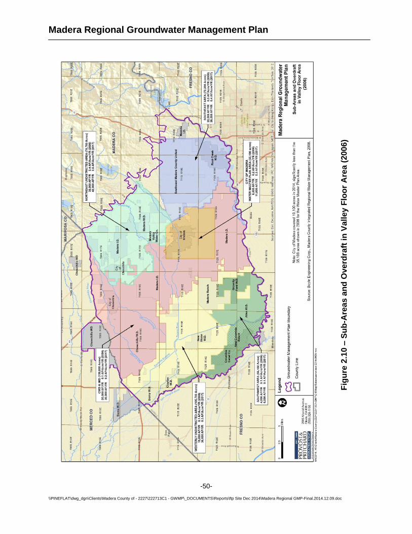
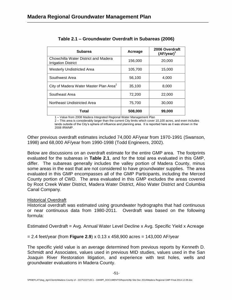
ES-3. Groundwater Overdraft and Sustainability Of the several Basin Management Objectives, the most critical and the one that drives all the others is the objective of achieving groundwater sustainability, which is defined as “development and use of groundwater in a manner that can be maintained for an indefinite time without causing unacceptable environmental, economic, or social consequences.” (Alley et al. 1999) A large list of projects has been identified by the GMP Participants to initiate a program for implementation and work towards maintaining groundwater levels. These are listed in Section 9.3. Determination of an available groundwater supply in a groundwater region (groundwater that can be pumped without causing overdraft) is a complex effort; an estimation was made using data including imported surface water, water used throughout the region by municipal and agricultural uses, water returned to the aquifer via natural and intentional
Madera Regional Groundwater Management Plan
ES-2
recharge, and the calculated change in underground water storage as measured by the changes in groundwater elevation over the region to approximate an area-wide water balance. In Section 2.5, the Plan discusses region-wide overdraft. The 2008 IRWMP calculated the cumulative overdraft in the Valley area to be 99,000 AF/year. The area covered by this Plan does not include the entire Valley area of the County, since it excludes several active districts that did not participate in the Plan. Overdraft was estimated to average 143,000 AF/year over the period from 1980-2011. Future overdraft (2014 and beyond) is estimated to be 259,000 AF/year. The increase in overdraft can be attributed primarily to increased cropping, maturation of existing tree crops, and impacts from the San Joaquin River Restoration.
ES-4. Land Subsidence Within certain portions of the GMP area, land subsidence results from excessive groundwater pumping over time. Unabated, such pumping can cause unwanted land surface disruptions. In reviewing work performed by the Department of Water Resources (DWR) and the United States Bureau of Reclamation (USBR) related to the San Joaquin River Restoration Project, it appears that substantial land subsidence is occurring in the Red Top area of Madera County, and that the rate of subsidence has increased in recent years with increased groundwater pumping in the area. The Red Top area is located in the west-northwest portion of the GMP area near the axis of the valley where the majority of the historic land subsidence has been documented. DWR and USBR are both very interested in the subsidence issues in the Red Top area as it relates to the San Joaquin River Restoration Project and to capacity of the existing flood control channels. Neighboring agencies are concerned as well with what is happening and what can be done to limit land subsidence. Subsidence in this area, and across the valley in general, is a subject at the center of discussions within the state and the State Legislature regarding potential legislation to address groundwater and possible State regulation. Section 2.7 describes the historical background of this subject in more detail. The basin management objectives set forth in Section 3 include a specific objective regarding subsidence limitation and mitigation. In Section 7, the Plan discusses factors that affect groundwater sustainability and provides a list of over twenty strategies for mitigating groundwater overdraft, for consideration by the GMP Participants as may be appropriate for each.
ES-5. Groundwater Monitoring Of all the factors affecting groundwater sustainability mentioned above, overdraft and calculated direction from changes in groundwater storage over time is the most direct method of determining the state of a groundwater basin. No matter the other factors, over a long time period, if the groundwater elevation is declining, the groundwater basin is in a state of overdraft. If the groundwater elevation is increasing, uses and natural groundwater discharge are less than supplies and the basin is recovering. It should be noted that the Madera and Chowchilla sub basins are used conjunctively, meaning that
Madera Regional Groundwater Management Plan
ES-3
groundwater and surface water are used collectively for municipal and agricultural purposes and the groundwater basin is used as a storage reservoir. During wet years, less groundwater pumping is required and recharge is practiced so that excess surface water supplies can be added to water into below-ground storage. In dry years, less surface water is available, more groundwater is pumped to meet demands and groundwater levels decline. Because of this variable use, it is expected that water levels will rise and fall, but in a balanced groundwater basin those levels will be relatively stable over a longer time period. Section 6 of the Plan describes current groundwater monitoring efforts, both as to groundwater surface elevation and groundwater quality, and describes recommended improvements to the program to help the partner agencies have a more thorough understanding of how the state of the aquifer is changing. The Plan finds that groundwater monitoring data is actually less comprehensive now than it was several years ago, since numerous wells that had been previously monitored are no longer being monitored. Intensification of a semi-annual monitoring program will give each of the GMP Participants strong data from which to make informed decisions regarding groundwater management, and will be the foundation of achieving the overall Basin Management Objectives. Section 7 expands that recommendation and describes how the groundwater in the region must be protected from contamination due to transport of contaminants occurring as a result of over-pumping in areas of high-quality water. Several potential mitigation measures are included for consideration by each GMP Participant.
ES-6. On-Going Groundwater Operations and Management An on-going groundwater overdraft as large as the one this region must manage means that significant and broad-based action will be required to bring the region to the point of groundwater sustainability. Review of the water use numbers shows that the issue is too large to be solved by any individual agency or economic sector. It is expected that solving the problem will need to be accomplished in a regional context across all economic sectors and industries in a manner consistent with the boundaries identified in the State’s Bulletin 118 consistent with the Madera and Chowchilla sub basins. Managing the region’s groundwater resource to a sustainable level fairly and equitably will require ongoing cooperation among all the stakeholders in the region, as well as real sacrifices on a number of fronts. These upcoming policy and management decisions have led the GMP Participants to recommend formation of a region-wide groundwater management authority, in the form of a Joint Powers Authority (JPA) amongst the partner agencies. This JPA would be a powerful tool for the accomplishment of the goals set forth in this Plan, vested with the authority to make region-wide policy with respect to groundwater use, short of imposing groundwater use moratoria on properties or land uses within the region. The JPA could also be granted the power to levy and collect groundwater pumping charges and other fees meant to provide incentives to reduce groundwater use and increase overall water conservation.
Madera Regional Groundwater Management Plan
ES-4
Similar JPAs have been created in over a dozen areas of California. The details of the JPA agreements vary widely, and the GMP Participants will have a high degree of latitude in designing a JPA that will be best suited to the Madera region. These JPAs have proven to be effective tools in those regions for creating equitable and effective groundwater management without resorting to adjudication of the basins. In other words, the regions have maintained local control by their willingness to submit to the controls and policies necessary to reach sustainability. Section 5 deals in more detail with how a JPA could be set up and what might be the extents and limitations of its authorities. Readers are cautioned that it was beyond the scope of this project to perform a detailed water budget for each participant. While data exists to make water budget calculations at the sub-regional level, making them at the agency footprint level would require groundwater flow data that are not available without constructing an extensive network of monitor wells throughout the region. Interpolating the sub-regional calculations to the agency footprint level without that supplementary data would be an approximation beyond the prudent use of the available information. It is recommended that as the regional groundwater effort advances, a detailed water budget should be performed to the agency level. This will be helpful in identifying more-detailed information about each agency and the associated impacts that occur from actions by its neighbors. Trends may also become more visible.
1.2. Report Organization ........................................................................................... 3 1.3. Background Information ..................................................................................... 3 1.4. Goals and Objectives of Groundwater Management Plan ............................... 19 1.5. Groundwater Rights and Statutory Authority for Groundwater Management ... 20 1.6. Groundwater Management Plan Components ................................................. 24
1.7. Adoption of Plan .............................................................................................. 25 2. GEOLOGY AND HYDROGEOLOGY .............................................................. 27
2.1. Groundwater Basins and Subbasins Description ............................................. 27
2.2. Geomorphology and Soils ................................................................................ 30 2.3. Geology and Hydrogeology ............................................................................. 32 2.4. Groundwater Elevations and Flow Direction .................................................... 39
2.5. Groundwater Overdraft and Available Groundwater Supplies ......................... 46 2.6. Geologic Potential for Groundwater Recharge ................................................ 54
2.7. Groundwater Quality ........................................................................................ 57 2.8. Land Subsidence ............................................................................................. 64
4.2. Relationships with Other Agencies .................................................................. 80 4.3. Plan to Involve the Public and Other Agencies ................................................ 81
7.2. Overdraft Mitigation........................................................................................ 106 7.3. Groundwater Replenishment ......................................................................... 113 7.4. Conjunctive Use of Water Resources ............................................................ 118
7.5. Land Subsidence Mitigation ........................................................................... 119 7.6. Water Conservation and Education ............................................................... 121 7.7. Water Recycling ............................................................................................. 125
8.1. Well Construction Policies ............................................................................. 128 8.2. Operation of Facilities .................................................................................... 130
9. GROUNDWATER PLANNING AND MANAGEMENT .................................. 136 9.1. Land Use Planning......................................................................................... 136 9.2. Groundwater Reports ..................................................................................... 140
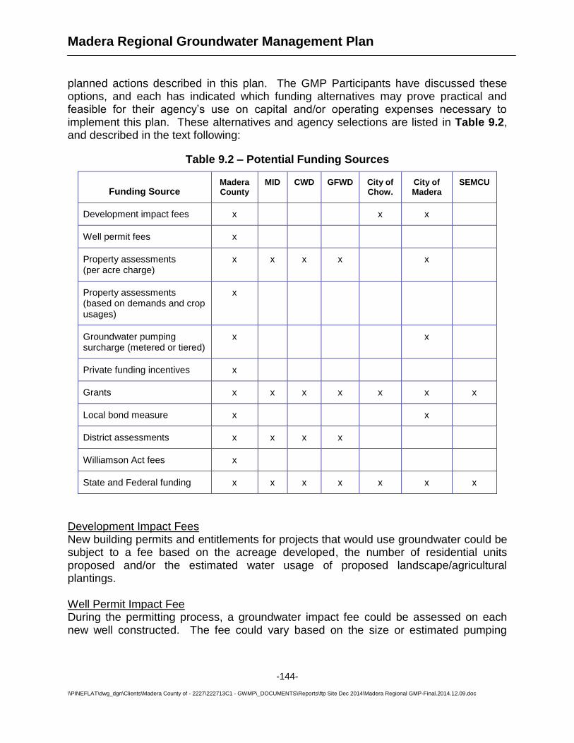
9.3. Plan Implementation ...................................................................................... 141 9.4. Plan Re-evaluation......................................................................................... 142 9.5. Dispute Resolution ......................................................................................... 143 9.6. Program Funding and Fees ........................................................................... 143
Figures Figure 1.1 – Participating Agency Map Figure 1.2 – Major Hydrologic Features and Water Conveyance Facilities Figure 1.3 – Crop / Land Use Data Figure 2.1 – Groundwater Sub-basins Figure 2.2 – Near Surface Hydrologic Soils Groups Figure 2.3 – Simplified Geologic Map – Madera County Figure 2.4 – Simplified Geologic Map – Groundwater Management Plan Area Figure 2.5 – Corcoran Clay Extent Figure 2.6 – Estimated Groundwater Elevation Contours Figure 2.7 – Western Subsidence Area – Upper Aquifer – Groundwater Elevation and Flow Direction (Jan-Feb 2013) Figure 2.8 – Western Madera Subsidence Area – Lower Aquifer - Groundwater Elevation Contour and Flow Direction (Jan-Feb 2013) Figure 2.9 – Average Annual Rates and Total Groundwater Level Declines from 1980-2011 Figure 2.10 – Sub-Areas and Overdraft in Valley Flood Area Figure 2.11 – Natural and Artificial Groundwater Recharge Areas Figure 2.12 – Base of Freshwater Map Figure 2.13 – Historical Land Surface Elevations along Highway 152 Transect Figure 2.14 – Subsidence Area Figure 3.1 – Basin Management Objectives Tables Table 1.1 – Previous Groundwater Management Plans Table 1.2 – Groundwater Management Plan Topics Addressed in Multiple Sections Table 1.3 – Groundwater Management Plan Participant Areas Table 1.4 – Comparison of Unimpaired Runoff in Normal and Dry Years Table 1.5 – Domestic Water Demands Table 1.6 – County-wide Cropping and Agricultural Water Demands Table 1.7 – Agency Cropping and Agricultural Water Demands (2013) Table 1.8 – Average Annual Groundwater Pumpage (2004-2013)
Madera Regional Groundwater Management Plan
-iii-
Table 1.9 – Historical Surface Water Supplies in the Groundwater Management Plan Area Table 1.10 – Location of Groundwater Management Plan Components Table 1.11 – Public Participation in Groundwater Management Plan Update Table 2.1 – Groundwater Overdraft in Subareas (2006) Table 2.2 – Summary of Regional Hydrologic Parameters Table 7.1 – Estimated Losses to Friant Water Contracts from San Joaquin River Settlement (units in AF/year) Table 7.2 – Strategies for Addressing Groundwater Overdraft Table 7.3 – High Priority Strategies for Addressing Groundwater Overdraft Table 7.4 – General Groundwater Recharge Assumptions Table 9.1 – Implementation Plan Table 9.2 - Potential Funding Sources Appendices A - Agricultural Water Demands B - Sustainability from the Ground Up: Groundwater Management in California C – Public Participation in Plan Adoption D – Groundwater Quality Maps E – Proposed Groundwater Monitoring Program for Madera County F – Regional Groundwater Levels (Kenneth D. Schmidt and Associates) G – Groundwater Exporting and Banking Regulations (County of Madera and MID) H – Well Construction Policies (City of Chowchilla and County of Madera)
Madera Regional Groundwater Management Plan
-iv-
List of Abbreviations
AB Assembly Bill AF acre-feet AFY acre-feet/year bgs below ground surface BMO basin management objective BNSF Burlington Northern Santa Fe Railway CASGEM California State Groundwater Elevation Monitoring program CCID Central California Irrigation District CDPH California Department of Public Health CEQA California Environmental Quality Act CFU colony forming unit CGPS continuous global positioning satellite CSD community services district CVP Central Valley Project CWD Chowchilla Water District DBCP dibromochloropropane DOGGER California Division of Oil, Gas and Geothermal Resources DPH Department of Public Health DTSC Department of Toxic Substances Control DWR Department of Water Resources EC electrical conductivity EDB ethylene dibromide EPA Environmental Protection Agency GAC Groundwater Advisory Committee GAMA Groundwater Ambient Monitoring and Assessment Program GFWD Gravelly Ford Water District GMP Groundwater Management Plan GPS global positioning system HPC heterotrophic plate count HSA Hydrologic Study Area ID Irrigation District InSAR Interferometric synthetic aperture radar IRWMP Integrated Regional Water Management Plan JPA Joint Powers Agreement / Joint Powers Authority KDSA Kenneth D. Schmidt and Associates KDWCD Kaweah Delta Water Conservation District LLNL Lawrence Livermore National Laboratory mAF million acre-feet MCL Maximum contaminant level MD Maintenance District MG million gallons MGD million gallons per day MID Madera Irrigation District MOA Memorandum of Agreement
Madera Regional Groundwater Management Plan
-v-
MOU Memorandum of Understanding msl mean sea level mya million years ago NAVSTAR Navigation Satellite Timing and Ranging NGS National Geodetic Survey OBGMA Ojai Basin Groundwater Management Agency P&P Provost & Pritchard Consulting Group PBO plate boundary observatory RCD Resource Conservation District RCWD Root Creek Water District RWQCB Regional Water Quality Control Board SA Service Area SB Senate Bill SCADA Supervisory Control and Data Acquisition SEMCU South-East Madera County United SGA Sacramento Groundwater Authority SJJRP San Joaquin River Restoration Project SLDMWA San Luis & Delta-Mendota Water Authority SMWA Sacramento Metropolitan Water Authority TAC Technical Advisory Committee TDS total dissolved solids TID Tulare Irrigation District UNAVCO University NAVSTAR Consortium USACE United States Army Corps of Engineers USBR United States Bureau of Reclamation USGS United States Geologic Survey WCD Water Conservation District WHPA wellhead protection area WSJV Western San Joaquin Valley WWTP wastewater treatment plant
Madera Regional Groundwater Management Plan
-1-
\\PINEFLAT\dwg_dgn\Clients\Madera County of - 2227\222713C1 - GWMP\_DOCUMENTS\Reports\ftp Site Dec 2014\Madera Regional GMP-Final.2014.12.09.doc
1. INTRODUCTION 1.1. Overview This Groundwater Management Plan (GMP or Plan) is a collaborative effort between the City of Chowchilla, City of Madera, Madera Irrigation District, Chowchilla Water District, Madera County and South-East Madera County United. These agencies will hereafter be called the Plan Participants or GMP participants. Other agencies or entities that may have an interest in the plan will be called Stakeholders. This GMP addresses regional groundwater management issues, as well as local groundwater management by each participating agency. Each participant maintains sovereign groundwater management over their respective service areas. Refer to Section 1.5 for more details on the groundwater management authority of the GMP Participants.
This Groundwater Management Plan satisfies the new requirements for GMPs created by the September 2002 California State Senate Bill No. 1938 and 2011 Senate Bill 359, which amended Sections 10753 and 10795 of the California Water Code. This Plan also addresses recommended components for a Groundwater Management Plan described in Appendix C of Department of Water Resources Bulletin 118 (2003 Update). Section 1.6 shows the required and recommended components for GMPs. In September 2014, the State of California passed Senate Bill 1168, Assembly Bill 1739, and Senate Bill 1319, which are collectively known as the Sustainable Groundwater Management Act. These bills impose mandates for sustainable groundwater management on local agencies in high- and medium-priority groundwater basins, and require development of Groundwater Sustainability Plans, which will supplant Groundwater Management Plans such as this one. The State must develop detailed guidelines for what to include in the Groundwater Sustainability Plans. This GMP will not fully satisfy the requirements of this new legislation, but much of the information herein will be useful in developing a Groundwater Sustainability Plan in coming years. The primary purpose for this plan is to demonstrate that local groundwater management efforts can be meaningful. Adjudication of the groundwater basin by the State may be likely in the near future if a coordinated, regional effort is not implemented to improve groundwater conditions, and to limit subsidence along the San Joaquin River in northwestern Madera County. Additional purposes for preparing this regional GMP include:
1. Satisfy new State requirements for GMPs. 2. Update and document the region’s goals and objectives for groundwater
management. 3. Update information on local groundwater conditions so the GMP is a useful
reference document.
Madera Regional Groundwater Management Plan
-2-
\\PINEFLAT\dwg_dgn\Clients\Madera County of - 2227\222713C1 - GWMP\_DOCUMENTS\Reports\ftp Site Dec 2014\Madera Regional GMP-Final.2014.12.09.doc
4. Maintain the participant’s eligibility for certain State grants, loans and special drought assistance that require an updated GMP.
5. Continue each of the participant’s authority to responsibly manage local groundwater with the intent to sustainably meet local water needs.
6. Improve water management on a regional basis to avoid adjudication of the local groundwater basin by the State.
This plan outlines the framework for regional and local groundwater management efforts in the valley floor portion of Madera County and the portion of Merced County covered by Chowchilla Water District. Several of the GMP participants have previously prepared Groundwater Management Plans, but those plans do not satisfy all the current GMP requirements. The Participants have chosen to prepare a regional GMP so the plan can more effectively address topics that are regional in nature, such as groundwater overdraft and land subsidence, or are better addressed with a regional approach, such as data collection and public education. It is intended that each participant will implement the appropriate regional concepts in their local jurisdictions. Table 1.1 shows the previous GMPs and when each was developed.
Table 1.1 – Previous Groundwater Management Plans
Participant Date of Previous GMP
City of Chowchilla 1997
Chowchilla Water District 1997
Gravelly Ford Water District 1998
City of Madera None
Madera County 2002
Madera Irrigation District 1999
South-East Madera County United None
Hereafter in this report, the terms ‘region’ and ‘regional’ refer to the cumulative jurisdictional areas covered by these agencies. The other public water agencies in the valley portion of Madera County were offered the opportunity to participate in this plan, but chose not to for a variety of reasons. These areas include Madera Water District, Root Creek Water District, Clayton Water District, Progressive Water District, Sierra Water District, New Stone Water District and Columbia Canal Company. Of these, Madera Water District, Columbia Canal Company, Aliso Water District and Root Creek Water District have Groundwater Management Plans that comply with recent State laws. The other districts are inactive or do not have a GMP, and are included in the County’s tabulations.
Madera Regional Groundwater Management Plan
-3-
\\PINEFLAT\dwg_dgn\Clients\Madera County of - 2227\222713C1 - GWMP\_DOCUMENTS\Reports\ftp Site Dec 2014\Madera Regional GMP-Final.2014.12.09.doc
1.2. Report Organization This report is organized according to the required content for GMPs outlined in the California Water Code. General categories that are addressed include descriptions of the regional geology and hydrogeology, basin management objectives, stakeholder involvement, groundwater monitoring, groundwater resources protection, groundwater sustainability, groundwater operations, and groundwater planning and management. Within these categories, specific groundwater management elements are described including existing activities and planned actions to improve groundwater management. Some of these topics are discussed in more than one section, which is a reflection of Water Code requirements. Specifically groundwater quality, land subsidence and groundwater overdraft are discussed in multiple sections, as shown in Table 1.2.
Table 1.2 – Groundwater Management Plan Topics Addressed
in Multiple Sections
Topic Related GMP Sections
Groundwater Quality
2.7 – Groundwater Quality
5.2 – Groundwater Quality Monitoring
6.3 – Saline Water Intrusion
6.4 – Migration of Contaminated Groundwater
6.5 – Groundwater Quality Protection
Land Subsidence
2.7 – Land Subsidence
5.4 – Land Subsidence Monitoring
7.5 – Land Subsidence Mitigation
Groundwater Overdraft
2.5 – Groundwater Overdraft and Available Groundwater Supplies
2.6 – Geologic Potential for Groundwater Recharge
7.2 – Overdraft Mitigation
7.3 – Groundwater Replenishment
7.4 – Conjunctive Use of Water Resources
1.3. Background Information This section provides an overview of each of the GMP Participants as well as the region’s geography, climate, hydrologic features, geology, land use, water demands, groundwater supplies and surface water supplies. Information is provided for each agency, and collectively the data is used in a regional analysis of groundwater conditions. Refer to Section 8.2 - Operation of Facilities for more details on water-related infrastructure in the region. A map showing the locations of each participating agency is shown as Figure 1.1.
Madera Regional Groundwater Management Plan
-4-
\\PINEFLAT\dwg_dgn\Clients\Madera County of - 2227\222713C1 - GWMP\_DOCUMENTS\Reports\ftp Site Dec 2014\Madera Regional GMP-Final.2014.12.09.doc
Fig
ure
1.1
– P
art
icip
ati
ng
Ag
en
cy
Map
Madera Regional Groundwater Management Plan
-5-
\\PINEFLAT\dwg_dgn\Clients\Madera County of - 2227\222713C1 - GWMP\_DOCUMENTS\Reports\ftp Site Dec 2014\Madera Regional GMP-Final.2014.12.09.doc
1.3.1 Participants Overview
City of Chowchilla The City of Chowchilla, incorporated in 1923, covers approximately 11.72 square miles (7,500 acres) and has a population of 19,000 (US Census, 2013), including about 6,600 inmates at two local prisons. The two local prisons are surrounded by County of Madera lands, effectively creating a 1,323-acre city island east of the main city limits. The prisons together farm about 780 acres and provide their own water and sewage services. The City of Chowchilla is governed by a five member City Council which sets policy for city government, city services, and economic development. The City Council has the authority to pass emergency ordinances for the immediate preservation or protection of public health, property or safety. Various commissions and committees, including the Airport Advisory Committee, Heritage Preservation Commission, Parks & Recreation Commission, and the Planning Commission, act in advisory capacities to the City Council. Chowchilla Water District Irrigation in the Chowchilla region began in the late 1800s using artesian wells, but by the 1940s diminished groundwater supplies threatened the area's continued economic viability. The Chowchilla Water District was formed in 1949 for the purpose of furnishing a supplemental water supply for agriculture within its boundaries. Until that time, the lands within the District boundaries had been part of the Madera Irrigation District. In the ensuing years, additional acreage was added to the District. In 1988, the LaBranza Water District and Chowchilla Water District consolidated into the current Chowchilla Water District. In 1950, the District signed its original water service contract with the U.S. Bureau of Reclamation, for water delivery from the Friant Division of the Central Valley Project. In 1968, the District signed a second water service contract with the U.S. Bureau of Reclamation, for water delivery from the Buchanan Unit of the Central Valley Project.
Since its inception, the District has provided consistent and reliable surface water to its constituents, resulting in improvements to local groundwater conditions. The District currently consists of approximately 129.2 square miles (88,700 acres), which includes an overlap of 6,100 acres with the City of Chowchilla. The District includes lands in both Madera and Merced counties.
The mission of the Chowchilla Water District is to protect, enhance, and manage surface and groundwater resources of the District in order to meet present and future water demands within the District. The District is governed by a five-member Board of Directors.
Madera Regional Groundwater Management Plan
-6-
\\PINEFLAT\dwg_dgn\Clients\Madera County of - 2227\222713C1 - GWMP\_DOCUMENTS\Reports\ftp Site Dec 2014\Madera Regional GMP-Final.2014.12.09.doc
City of Madera The City of Madera is the largest city in Madera County and serves as the County seat. The City had an estimated 2013 population of 62,200. Laid out in 1876 at the end of a lumber flume and incorporated in 1907, it now occupies approximately 10,000 acres (15.8 square miles). Utilizing a Council and Manager form of government, six City Council members and a separately-elected Mayor address the legislative needs of the city. The City Manager is appointed by the City Council to administer the overall city organization. Madera is a full-service city, operating its own water and wastewater systems, and hosting a full range of community-based programs and services. Strategic planning in the City is driven by Vision Madera 2025, a community-based visioning program completed in 2006, and by the City’s Comprehensive General Plan. Madera County Madera County was formed in 1893 and encompasses 2,174 square miles (1.4 million acres). The valley portion of the County is covered by this GMP, excluding Cities and Irrigation/Water Districts with adopted GMPs (see Figure 1.1). This area covers 432 square miles (277,000 acres) and has a population of about 27,000 with about 19,700 residing in eight Maintenance Districts and four Service Areas that are provided water by the County. Large areas of unincorporated lands are cropped or grazed and operate on private domestic and irrigation wells. A large portion of the eastern end of Madera County (within the valley) has high bedrock, limited alluvium and little groundwater supply, despite being in a DWR defined groundwater basin. Local wells in this area have limited groundwater yield, and groundwater is typically only pumped from small stockwater wells.
A five member Board of Supervisors (BOS) oversees the duties and functions of Madera County government. Supervisors work with the elected department heads and hire other department heads to run the various departments. The BOS may set County policy, but works within the constraints of State and Federal law. It is the duty of the BOS to submit a balanced budget to the State. The Board meets regularly on the first four Tuesdays of the month and any member of the public may bring matters before the Board if the item is placed on the meeting agenda. The BOS is the governing body for the following: Madera County Flood and Water Conservation Agency, Maintenance Districts and Service Areas, Public Finance Authority, and Redevelopment Agency. Madera Irrigation District Madera Irrigation District (MID) is a public agency, established by the State Legislature as a Special Act District. It is governed by a five-member Board of Directors who are elected at large but who must reside within the division they serve. A large segment of the City of Madera (City) is included within the District as well as portions of Madera Water District. Each registered voter who resides within the City has the opportunity to vote for the Director of his or her choice and may opt to run for the directorship. In addition to the services rendered to the lands within the District, the District also conveys agricultural water to the Gravelly Ford Water District. The District is also a partner in the Madera-Chowchilla Water and Power Authority.
Madera Regional Groundwater Management Plan
-7-
\\PINEFLAT\dwg_dgn\Clients\Madera County of - 2227\222713C1 - GWMP\_DOCUMENTS\Reports\ftp Site Dec 2014\Madera Regional GMP-Final.2014.12.09.doc
The District was formed in 1920 to bring surface water to the Madera area. The District presently encompasses an area of about 129,000 acres, with about 9,400 acres overlapping with the City of Madera. About 10,800 acres within MID are known as “subordinate lands,” which have a lower priority to surface water than other lands in the District. Excluding the City of Madera overlap area, MID has a population of 11,900 according to the 2013 census.
The District has a Central Valley Project (CVP) repayment contract with United States Bureau of Reclamation (USBR) providing up to 85,000 acre-feet (AF) of Class 1 and 186,000 AF of Class 2 water per year from the Friant Division (Millerton Lake). CVP water is released from Millerton Lake through the Friant Dam, and then conveyed through the Madera Canal for delivery into the District’s service area. The District also entered into a CVP repayment contract with the USBR for the yield from the Hidden Unit (Hensley Lake). The average annual supply available to the District under the Hidden Unit contract is approximately 24,000 AF per year.
The District has Pre-1914 rights to divert water from Big Creek, known as the Big Creek Diversion, and the North Fork of Willow Creek, known as the Soquel Diversion. The Big Creek Diversion originates in Big Creek, a tributary of the Merced River. This Diversion is located just upstream of Fish Camp, CA, and redirects water to flow down Lewis Creek, a tributary of the upper Fresno River. The Soquel Diversion originates in North Fork Willow Creek, a tributary of the San Joaquin River. This Diversion is located approximately nine miles upstream of Bass Lake, where the Diversion can redirect water to flow through the Soquel Ditch to Nelder Creek, a tributary of the upper Fresno River. Alternatively, water can be left in North Fork Willow Creek, and allowed to flow to Bass Lake and eventually to the San Joaquin River, where it can be diverted in Friant Dam. MID also has a Pre-1914 water right on the Fresno River. MID expects surface water supplies to increase by 10,000 AF/year in the future as they sell less of their water, and some growers import some surface water.
South-East Madera County United South-East Madera County United (SEMCU) is a non-profit mutual benefit organization dedicated to representing the interests of the residents, property owners, and businesses in the SEMCU Area. It is bounded to the north by Highway 145, on the south by the San Joaquin River, on the east by Highway 41, and on the west by the Burlington Northern Santa Fe Railway (“BNSF”) and by Avenue 32 1/2 north of its intersection with the BNSF Railway. It occupies an area of 97.6 square miles (~62,500 acres). There are two identified communities within the SEMCU area. The larger is the Madera Ranchos with about 12,000 people and around 3,500 homes. Most residential lots are either 2.5 or five acres in size, although there are some one-acre lots and a number of larger parcels. Rural residential development is common in the area. The smaller community is Rolling Hills, located on the west side of SR 41, between Avenue 10 and Avenue 11-1/2. It is comprised of 300 homes; virtually all lots are one acre in size. Both of these areas are unincorporated and represented by Madera County. The population within the SEMCU area was estimated to be 10,500 in 2013.
Madera Regional Groundwater Management Plan
-8-
\\PINEFLAT\dwg_dgn\Clients\Madera County of - 2227\222713C1 - GWMP\_DOCUMENTS\Reports\ftp Site Dec 2014\Madera Regional GMP-Final.2014.12.09.doc
SEMCU is a participant in the GMP but does not own or operate groundwater extraction, recharge or conjunctive use facilities. It is a non-profit educational organization and has no land-use planning authority. However, SEMCU represents numerous public and private interests in its area and provides input and comments on water related land-use policies. In representing local interests, SEMCU studies issues facing its members, such as access to water, transportation, schools, and energy, and works with local governments and private entities to find working solutions to regional problems. Additionally, SEMCU strives to advocate for its members wherever and whenever the opportunity arises and to obtain grant funding to help address area needs. More information on SEMCU can be found on their website: http://semcu.com/about.php).
1.3.2 Geography The Madera Regional GMP area is located in the geographic center of California in the San Joaquin Valley. The GMP area generally includes the valley portion of Madera County and a portion of Chowchilla Water District that is within Merced County. The borders of the GMP area are generally defined by the DWR Groundwater Basin boundaries to the east, the San Joaquin River on the south and west, and the Chowchilla River on the north. The GMP area considered under the jurisdiction of Madera County includes County lands that are not under the jurisdiction of a City, or active water district or irrigation district. Areas excluded from the GMP include Root Creek Water District, Madera Water District, Aliso Water District and Columbia Canal Company. The area of each GMP participant is shown in Figure 1.1 and summarized in Table 1.3.
Table 1.3 – Groundwater Management Plan Participant Areas
Participant Area
Notes Square Miles Acres
Chowchilla Water District 129 82,700 Excludes City areas, includes subordinate lands
City of Chowchilla 12 7,500 Includes prisons
City of Madera 16 10,100
County of Madera 432 277,000 Includes unincorporated areas outside of Cities and districts
Madera Irrigation District 187 119,600 Excludes City areas; includes subordinate lands
South-East Madera County United
98 62,500 Overlaps with Cities, districts and county
Total (excluding SEMCU overlap)
776 496,900
1.3.3 Climate The climate of the GMP area is characterized by cool, mild winters and hot, dry
\\PINEFLAT\dwg_dgn\Clients\Madera County of - 2227\222713C1 - GWMP\_DOCUMENTS\Reports\ftp Site Dec 2014\Madera Regional GMP-Final.2014.12.09.doc
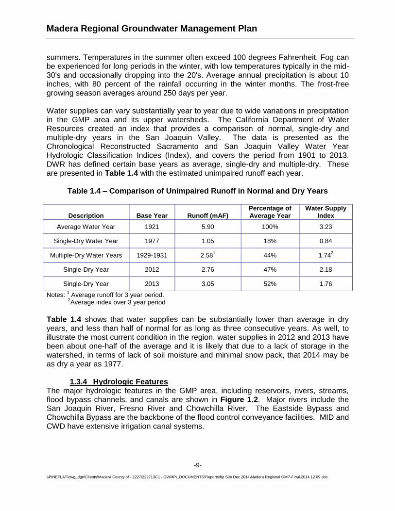
summers. Temperatures in the summer often exceed 100 degrees Fahrenheit. Fog can be experienced for long periods in the winter, with low temperatures typically in the mid-30's and occasionally dropping into the 20's. Average annual precipitation is about 10 inches, with 80 percent of the rainfall occurring in the winter months. The frost-free growing season averages around 250 days per year. Water supplies can vary substantially year to year due to wide variations in precipitation in the GMP area and its upper watersheds. The California Department of Water Resources created an index that provides a comparison of normal, single-dry and multiple-dry years in the San Joaquin Valley. The data is presented as the Chronological Reconstructed Sacramento and San Joaquin Valley Water Year Hydrologic Classification Indices (Index), and covers the period from 1901 to 2013. DWR has defined certain base years as average, single-dry and multiple-dry. These are presented in Table 1.4 with the estimated unimpaired runoff each year.
Table 1.4 – Comparison of Unimpaired Runoff in Normal and Dry Years
Description Base Year Runoff (mAF) Percentage of Average Year
Water Supply Index
Average Water Year 1921 5.90 100% 3.23
Single-Dry Water Year 1977 1.05 18% 0.84
Multiple-Dry Water Years 1929-1931 2.581 44% 1.74
2
Single-Dry Year 2012 2.76 47% 2.18
Single-Dry Year 2013 3.05 52% 1.76
Notes: 1 Average runoff for 3 year period.
2Average index over 3 year period
Table 1.4 shows that water supplies can be substantially lower than average in dry years, and less than half of normal for as long as three consecutive years. As well, to illustrate the most current condition in the region, water supplies in 2012 and 2013 have been about one-half of the average and it is likely that due to a lack of storage in the watershed, in terms of lack of soil moisture and minimal snow pack, that 2014 may be as dry a year as 1977.
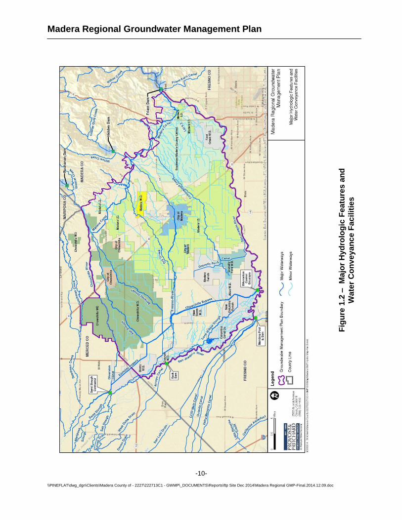
1.3.4 Hydrologic Features The major hydrologic features in the GMP area, including reservoirs, rivers, streams, flood bypass channels, and canals are shown in Figure 1.2. Major rivers include the San Joaquin River, Fresno River and Chowchilla River. The Eastside Bypass and Chowchilla Bypass are the backbone of the flood control conveyance facilities. MID and CWD have extensive irrigation canal systems.
Madera Regional Groundwater Management Plan
-10-
\\PINEFLAT\dwg_dgn\Clients\Madera County of - 2227\222713C1 - GWMP\_DOCUMENTS\Reports\ftp Site Dec 2014\Madera Regional GMP-Final.2014.12.09.doc
Fig
ure
1.2
– M
ajo
r H
yd
rolo
gic
Fea
ture
s a
nd
Wa
ter
Co
nv
ey
an
ce
Fa
cil
itie
s
Madera Regional Groundwater Management Plan
-11-
\\PINEFLAT\dwg_dgn\Clients\Madera County of - 2227\222713C1 - GWMP\_DOCUMENTS\Reports\ftp Site Dec 2014\Madera Regional GMP-Final.2014.12.09.doc
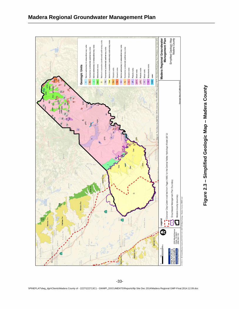
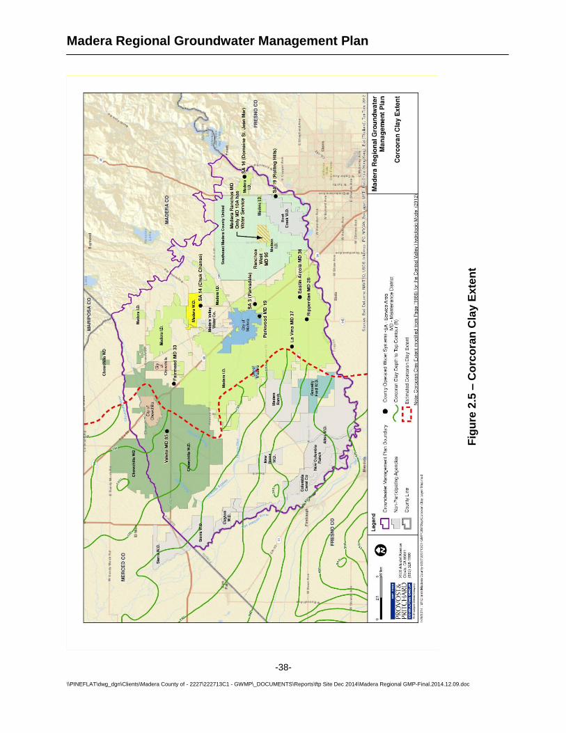
1.3.5 Geology The GMP area encompasses the majority of the Madera Groundwater Sub-basin, and portions of the Chowchilla and Delta Mendota Groundwater Sub-basins (a map and discussion of the extent of these groundwater basins is provided in Section 2.1). These Sub-basins are defined by the California Department of Water Resources Bulletin 118-80. These Sub-basins are within the San Joaquin Valley Groundwater Basin and the San Joaquin Basin Hydrologic Study area. The Madera and Chowchilla Sub-basins are considered to be ‘critically overdrafted’ by the California Department of Water Resources. Groundwater levels in the GMP area have gradually declined over time. The Corcoran Clay, a major confining bed in the San Joaquin Valley, is present in the western portion of the Plan area. See Section 2 for more details on the geology of the GMP area.
1.3.6 Domestic Water Demand Domestic water demands are defined as water used for domestic (indoor and landscape) purposes in urban and rural areas. The Cities directly provide water to their residents, and the County provides water to residents of the 12 Maintenance Districts and Service Areas in the Plan area. Rural residents living in the irrigation districts, water districts and other unincorporated areas also pump domestic water from their private wells. Table 1.5 summarizes domestic water demands in the GMP area based on the most recent statistics
Table 1.5 – Domestic Water Demands
Area Per Capita Usage
(gal/day) Annual Demand
(AF/year)
City of Chowchilla 311 3,500
City of Madera 195 12,700
County Maintenance Districts / Service Areas
168 3,700
Unincorporated County lands 168 1,400
Madera Irrigation District 168 2,200
Chowchilla Water District 168 600
Gravelly Ford Water District 168 20
Total 24,100
The per capita water usage values were obtained from the City’s Urban Water Management Plans, 2008 Madera County IRWMP, and current water use and population statistics.
Madera Regional Groundwater Management Plan
-12-
\\PINEFLAT\dwg_dgn\Clients\Madera County of - 2227\222713C1 - GWMP\_DOCUMENTS\Reports\ftp Site Dec 2014\Madera Regional GMP-Final.2014.12.09.doc
Urban growth was relatively high in the early and mid-2000’s in Madera County but recently has been relatively flat. Evaluating future population growth is beyond the scope of this Plan. However, it is recommended that population growth be evaluated in a separate study to forecast the impacts it may have on future groundwater overdraft. Important factors that may impact population growth include available water supplies, local economic activity, and improvement in local schools.
1.3.7 Agricultural Water Demands
Cropping Data Agricultural cropping data was collected to estimate agricultural water demands in the GMP area. Several sources of cropping data were found including:
1. California Department of Water Resources (DWR) - Land Use Data 2. California Department of Conservation – Farmland Mapping and Monitoring Data 3. Madera County Agricultural Commissioner’s office 4. USDA CropScape 5. Local Irrigation and Water District cropping records
The DWR Land Use Data is generally considered the most accurate and reliable source because it is collected by trained staff who use a combination of aerial photographs and field verification. However, DWR surveys are only performed in each County about once every six years, and the most recent survey was performed in 2011. DWR data was also used in crop demand estimates in the 2008 IRWMP and it can provide a meaningful comparison to changes since 2007. As a result, the 2011 DWR data was projected to 2013 based on historical cropping changes since 2003. The Madera County Agricultural Commissioner’s Office had 2013 cropping data, which is based on pesticide permit applications. This data is not field verified, but is the most recent data available. The data does not include records for organic farms since they do not require pesticide permits, although these cover a relatively small part of the County. Nevertheless, the larger organic farms and dairies were identified, and cropping was assumed to be similar to the year before they converted to organic operations. During the preparation of this report, the Irrigated Lands Regulatory Program was contacted as a potential source of cropping data. However, ILRP members were still in the process of organizing and collecting data and none was available for release. Crop Water Demands in GMP Area General land use in the GMP area is shown in Figure 1.3. The cropping data for Figure 1.3 was acquired from the Madera County Agricultural Commissioner’s Office and can be found in Appendix A. Figure 1.3 shows that almost 54% of the land is planted in permanent crops, and 69% of the total land is cropped. There is potential for further agricultural development since 21% of the land has not been developed.
Madera Regional Groundwater Management Plan
-13-
\\PINEFLAT\dwg_dgn\Clients\Madera County of - 2227\222713C1 - GWMP\_DOCUMENTS\Reports\ftp Site Dec 2014\Madera Regional GMP-Final.2014.12.09.doc
Fig
ure
1.3
– C
rop
/ L
an
d U
se
Data
Madera Regional Groundwater Management Plan
-14-
\\PINEFLAT\dwg_dgn\Clients\Madera County of - 2227\222713C1 - GWMP\_DOCUMENTS\Reports\ftp Site Dec 2014\Madera Regional GMP-Final.2014.12.09.doc
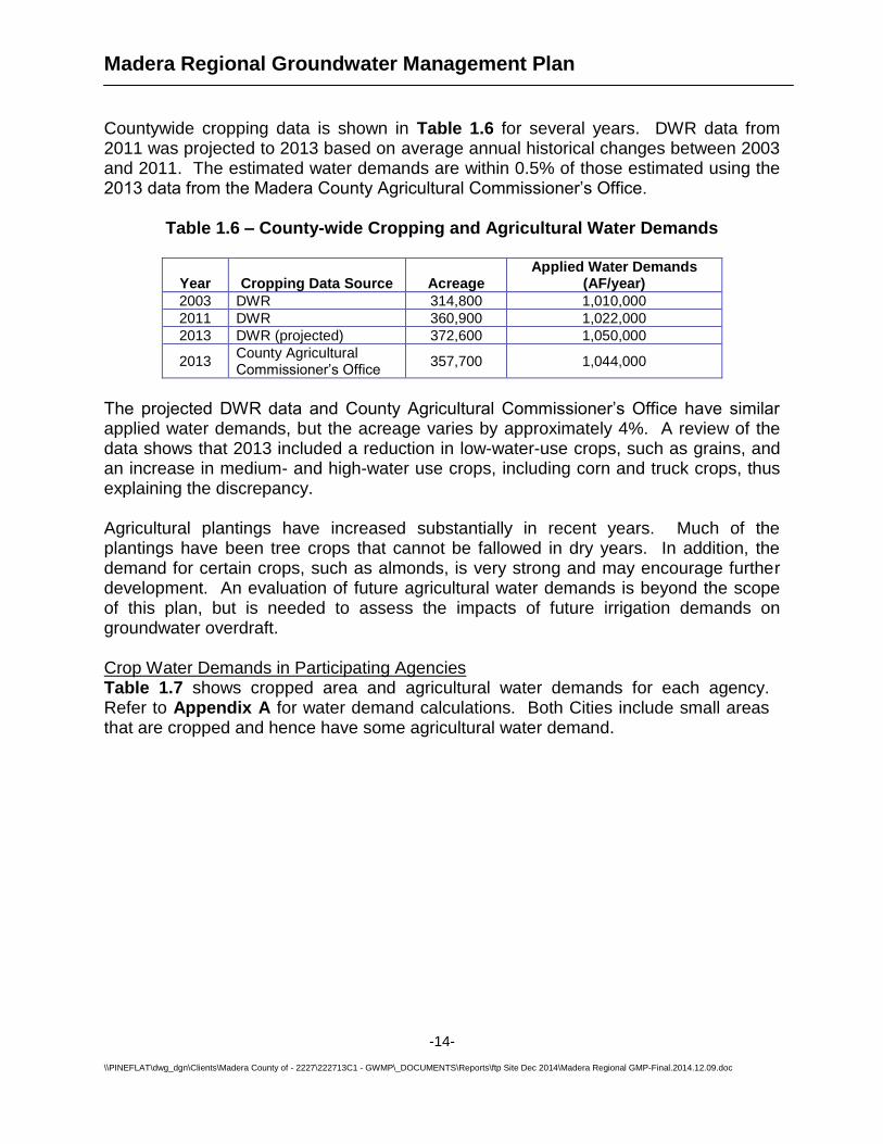
Countywide cropping data is shown in Table 1.6 for several years. DWR data from 2011 was projected to 2013 based on average annual historical changes between 2003 and 2011. The estimated water demands are within 0.5% of those estimated using the 2013 data from the Madera County Agricultural Commissioner’s Office.
Table 1.6 – County-wide Cropping and Agricultural Water Demands
Year Cropping Data Source Acreage Applied Water Demands
(AF/year)
2003 DWR 314,800 1,010,000
2011 DWR 360,900 1,022,000
2013 DWR (projected) 372,600 1,050,000
2013 County Agricultural Commissioner’s Office
357,700 1,044,000
The projected DWR data and County Agricultural Commissioner’s Office have similar applied water demands, but the acreage varies by approximately 4%. A review of the data shows that 2013 included a reduction in low-water-use crops, such as grains, and an increase in medium- and high-water use crops, including corn and truck crops, thus explaining the discrepancy. Agricultural plantings have increased substantially in recent years. Much of the plantings have been tree crops that cannot be fallowed in dry years. In addition, the demand for certain crops, such as almonds, is very strong and may encourage further development. An evaluation of future agricultural water demands is beyond the scope of this plan, but is needed to assess the impacts of future irrigation demands on groundwater overdraft. Crop Water Demands in Participating Agencies Table 1.7 shows cropped area and agricultural water demands for each agency. Refer to Appendix A for water demand calculations. Both Cities include small areas that are cropped and hence have some agricultural water demand.
Madera Regional Groundwater Management Plan
-15-
\\PINEFLAT\dwg_dgn\Clients\Madera County of - 2227\222713C1 - GWMP\_DOCUMENTS\Reports\ftp Site Dec 2014\Madera Regional GMP-Final.2014.12.09.doc
Table 1.7 – Agency Cropping and Agricultural Water Demands (2013)
Area Cropped Acreage Annual Demand
(AF/year)
City of Chowchilla 1,500 4,000
City of Madera 1,100 2,500
Unincorporated County Lands 141,000 418,000
Madera Irrigation District 104,000 286,000
Chowchilla Water District 68,500 215,000
Gravelly Ford Water District 7,600 20,400
Total 323,700 945,900
Note: The values for MID and CWD exclude areas that overlap with the Cities. This was done to avoid double-counting areas and water demands.
The total cropped area in Table 1.7 differs from the acreage presented in Table 1.6 because certain areas which have adopted Groundwater Management Plans (Root Creek Water District, Aliso Water District, Columbia Canal Company and Madera Water District) were excluded from the latter summary.
1.3.8 Groundwater Supplies All of the GMP Participants use groundwater to meet at least a portion of their water demands. Groundwater serves an important reserve supply to supplement surface water deliveries. Below is a summary of groundwater usage in each agency, including groundwater used directly by the agency and groundwater pumped from private wells within the agency boundaries. Groundwater pumpage is directly measured by some municipal agencies, but is not measured on domestic or agricultural wells. Domestic groundwater pumping was based on population and typical per capita use rates (see Table 1.5). Groundwater pumping in agricultural areas was estimated as the difference between water demands and surface water deliveries.
Madera Regional Groundwater Management Plan
-16-
\\PINEFLAT\dwg_dgn\Clients\Madera County of - 2227\222713C1 - GWMP\_DOCUMENTS\Reports\ftp Site Dec 2014\Madera Regional GMP-Final.2014.12.09.doc
Table 1.8 - Average Annual Groundwater Pumpage (2004-2013)
Agency
Agency Groundwater Pumpage (AF)
Private Groundwater Pumpage (AF)
Total Pumpage
(AF)
Chowchilla Water District 0 118,600 118,600
City of Chowchilla 4,100 2,600 6,700
City of Madera 12,700 600 13,300
County of Madera 3,700 398,800 402,500
Gravelly Ford Water District
0 16,300 16,300
Madera Irrigation District 0 185,000 185,000
Total 20,500 721,900 742,400
Notes: 1. Values are total groundwater pumpage. Net pumpage is less due to deep percolation of
irrigation and percolation of wastewaters. 2. These are historical values. Future pumping will likely increase due to reductions in
surface water deliveries as a result of the San Joaquin River Restoration settlement.
1.3.9 Surface Water Supplies
Madera Irrigation District, Chowchilla Water District and Gravelly Ford Water District each meet significant portions of their water demands with surface water. The County of Madera provides a small amount of surface water to one of their Service Areas. In addition, an estimated 10,000 AF/year of riparian water is delivered to other private lands in unincorporated areas of Madera County. The Cities of Madera and Chowchilla do not have surface water rights or contracts. However, within the limits of each City there are cropped lands that receive some surface water from local water or irrigation districts. Owners of those parcels pay assessments to the districts, and as a result partially fund the importation of surface water to the GMP area. The City of Madera also purchased 300 AF of floodwater in 2009 from MID as a pilot study on groundwater recharge. Table 1.9 summarizes the historical surface water deliveries in the GMP area, followed by more detailed descriptions of those supplies. SEMCU does not have the authority to hold water rights or water contracts.
Madera Regional Groundwater Management Plan
-17-
\\PINEFLAT\dwg_dgn\Clients\Madera County of - 2227\222713C1 - GWMP\_DOCUMENTS\Reports\ftp Site Dec 2014\Madera Regional GMP-Final.2014.12.09.doc
Table 1.9 – Historical Surface Water Supplies in the Groundwater Management Plan Area
Agency Average Annual
Supplies (2004-2013) Notes
Chowchilla Water District 135,000 Excludes CWD lands in City of Chowchilla
City of Chowchilla 1,400 CWD water delivered to cropped land in City
City of Madera 1,900 MID water delivered to cropped land in City
County of Madera 20,000 Sumner Hills Service Area, riparian agricultural water, some MID water
Gravelly Ford Water District
10,500
Madera Irrigation District 188,000 Excludes MID lands in City of Madera
Total 356,800
Note: Values include surface water that is delivered directly to growers and recharge basins, and lost as canal seepage.
These surface water supplies have been and will continue to be reduced to provide water for the San Joaquin River Restoration. Those impacts are described in Section 7.1 – Issues Impacting Groundwater Sustainability. Chowchilla Water District Irrigation in the Chowchilla region began in the late 1800s with artesian wells, but by the 1940s diminished groundwater supplies threatened the area's continued economic viability. The Chowchilla Water District was formed in 1949 for the purpose of furnishing a supplemental water supply for agriculture within its boundaries. Until that time, the District had been part of the Madera Irrigation District. In the ensuing years additional acreage was added to the District. In 1988, the LaBranza Water District and Chowchilla Water District were consolidated into the current Chowchilla Water District. In 1950, the District signed its original water service contract with the U.S. Bureau of Reclamation (USBR) for water delivery from the Friant Division of the Central Valley Project (Friant CVP). In 1968, the District signed a second water service contract with USBR for water delivery from the Buchanan Unit of the Central Valley Project. Since its inception, the District has provided consistent and reliable surface water to its constituents, resulting in improvements to groundwater conditions. The District services
Madera Regional Groundwater Management Plan
-18-
\\PINEFLAT\dwg_dgn\Clients\Madera County of - 2227\222713C1 - GWMP\_DOCUMENTS\Reports\ftp Site Dec 2014\Madera Regional GMP-Final.2014.12.09.doc
over 400 landowners on about 88,000 acres of land in southern Merced and northern Madera counties.
Chowchilla Water District (CWD) receives water from three main sources: the San Joaquin River, the Chowchilla River and Merced Irrigation District. Chowchilla Water District’s current Friant CVP contract provides for an annual maximum of 55,000 AF of Class 1 water and an annual maximum of 160,000 AF of Class 2 water, all supplied via the Madera Canal. The District receives an annual average of 48,500 AF from its Buchanan Unit contract, and purchases surplus water from Merced Irrigation District in varying quantities when it is available. Gravelly Ford Water District Gravelly Ford Water District’s contract with the USBR is for 14,000 AF of Class 2 water, delivered through the San Joaquin River. The District has also been able to take some water from Cottonwood Creek, and buy additional water from Madera Irrigation District and the USBR. The average annual surface water supply between 2004 and 2013 was 10,500 AF, and in some years no water has been available. Madera Irrigation District The Madera Irrigation District purchases and wheels or delivers water to growers within its boundaries. Madera Irrigation District has a Central Valley Project (CVP) repayment contract with United States Bureau of Reclamation (USBR) providing up to 85,000 acre feet (AF) of Class 1 and 186,000 AF of Class 2 water per year from the Friant Division (Millerton Lake). The CVP water is released from Millerton Lake through the Friant Dam, and then conveyed through the Madera Canal for delivery into the District’s service area. The District also entered into a CVP repayment contract with the USBR for the yield from the Hidden Unit (Hensley Lake). Under the Hidden Unit contract, the average annual supply available to the District is approximately 24,000 AF per year.
The District has Pre-1914 rights to divert water from Big Creek via the Big Creek Diversion and from the North Fork of Willow Creek via the Soquel Diversion. The Big Creek Diversion originates in Big Creek, a tributary of the Merced River. This Diversion is located just upstream of Fish Camp, CA, and redirects water to flow down Lewis Creek, a tributary of the upper Fresno River. The Soquel Diversion originates in North Fork Willow Creek, a tributary of the San Joaquin River. This Diversion is located approximately nine miles upstream of Bass Lake, and can divert water to flow through the Soquel Ditch to Nelder Creek, a tributary of the upper Fresno River. Alternatively, water can be left in North Fork Willow Creek, allowed to flow to Bass Lake and eventually to the San Joaquin River, and diverted at Friant Dam into the Madera Canal. MID also has a Pre-1914 water right on the Fresno River.
County of Madera The County of Madera manages Sumner Hills Service Area (SA-16) which is supplied with first-priority water released into the San Joaquin River from Millerton Lake by the USBR, under the terms of Holding Contract 7. Sumner Hills’ average annual demands
Madera Regional Groundwater Management Plan
-19-
\\PINEFLAT\dwg_dgn\Clients\Madera County of - 2227\222713C1 - GWMP\_DOCUMENTS\Reports\ftp Site Dec 2014\Madera Regional GMP-Final.2014.12.09.doc
are 120 AF. In addition, an estimated 10,000 AF of other riparian water is delivered to unincorporated lands each year. 1.4. Goals and Objectives of Groundwater Management Plan The purpose of this GMP is to develop a coordinated and comprehensive approach to the evaluation and management of groundwater resources in the area covered by the GMP. The goal of this Plan is to provide the framework and technical data to allow for effective groundwater management which moves to restore, where possible, and maintain a high quality and dependable groundwater resource. The goals and proposed actions in this plan will likely evolve as other concerns and issues arise. This Plan documents the existing groundwater management efforts in the GMP area and planned efforts to improve groundwater management. The objective the GMP is to help the GMP Participants meet the following goals:
1. Develop a collaborative relationship with all the GMP participants to address groundwater management issues on a regional scale.
2. Identify policies, priorities and goals for a collaborative approach to regional management of the groundwater.
3. Develop new surface water sources and the necessary infrastructure to bring the groundwater within the GMP area to a balance.
4. Stabilize groundwater levels in order to minimize pumping costs and energy use, and to provide groundwater reserves for use in droughts.
5. Maximize the use of surface water, including available flood water, for beneficial use, and thus reduce stress on groundwater resources.
6. Prevent groundwater degradation by protecting groundwater quality, importing clean surface water, and preventing intrusion of poor quality groundwater.
7. Preserve, and, where feasible, enhance the existing quality of the area’s groundwater.
8. Address potential impacts to groundwater from changes in surface water supplies resulting from surface water losses in the region (i.e. San Joaquin River Restoration), urban and agricultural development, and drought.
9. Prevent surface water or groundwater exports that would reduce the long-term reliability of groundwater.
10. Coordinate groundwater management efforts between regional water users. 11. Responsibly manage the local groundwater resources so adjudication is
unnecessary. 12. Maintain a groundwater-monitoring program to provide an early warning system
to future problems. 13. Increase knowledge of the local geology and hydrogeology to better understand
threats to groundwater quality and quantity. 14. Minimize land subsidence caused by groundwater pumping through in-lieu
groundwater recharge, direct recharge, and wise and conservative use of pumped groundwater.
Madera Regional Groundwater Management Plan
-20-
\\PINEFLAT\dwg_dgn\Clients\Madera County of - 2227\222713C1 - GWMP\_DOCUMENTS\Reports\ftp Site Dec 2014\Madera Regional GMP-Final.2014.12.09.doc
1.5. Groundwater Rights and Statutory Authority for Groundwater Management Basic Groundwater Rights in California The following discussion of current California Law regarding groundwater is excerpted from Sustainability from the Ground Up, Groundwater Management in California – A Framework, published by Association of California Water Agencies (ACWA) in 2011. In the Foreword of this document, the authors state “the challenge of providing sustainable groundwater management must be met by local and regional agencies and not by centralized state regulation.” The authors continue “..the job is far from done. While there are numerous case studies in successful management, efforts must be expanded in many parts of the state to achieve sustainable outcomes.” This document is included as Appendix B. Under current California law, landowners are entitled to pump and use reasonable amounts of groundwater from a basin underlying their land. Correlative rights and appropriative rights are the two foundational principles of California law germane to groundwater use. Under the doctrine of “correlative rights,” landowners overlying a common source of groundwater are limited to using a reasonable share of the resource. “Reasonable” groundwater use is relative to the amount of overlying land owned by the landowner and the physical condition of the groundwater basin. When there is insufficient water to meet the cumulative demands of the overlying landowners, those users are expected to reduce their demands correlatively to bring groundwater extractions within the safe yield of the basin and prevent overdraft. Entities other than overlying users, such as cities, may be entitled to “appropriative” water from the basin for use as a municipal supply when water surplus to the needs of the overlying users is available. Unless otherwise permitted, appropriators must curtail their use when there is no surplus. Summary of Groundwater and Surface Water Law Under California law, water is characterized as either groundwater or surface water. Groundwater is divided into subterranean stream or percolating groundwater. Surface water and subterranean streams are subject to the permitting authority of the State Water Resources Control Board, while percolating groundwater is not. In areas where there is a hydrologic connection between surface water and groundwater, a number of early cases provide foundational legal doctrine. The following three points are excerpted from ACWA (2011) and the reader is referred to that document or the actual case law for more details.
User of percolating groundwater may diminish flows in a surface stream only if the groundwater is put to reasonable use on lands overlying the groundwater basin.
Overlying owners may extract groundwater for use on overlying lands, despite impacts on downstream riparians and down-gradient overlying pumpers.
Riparian and overlying rights are treated as extracting water from a common source and so have joint rights to reasonable shares of the resource.
Madera Regional Groundwater Management Plan
-21-
\\PINEFLAT\dwg_dgn\Clients\Madera County of - 2227\222713C1 - GWMP\_DOCUMENTS\Reports\ftp Site Dec 2014\Madera Regional GMP-Final.2014.12.09.doc
Key Definitions The brief overview of the basic concepts of groundwater use under current California Law provided must be understood in the context of several terms which are defined below, including “safe yield,” “surplus” and “overdraft.” This GMP will use these terms, with the exception of “safe yield,” as defined by ACWA (2011) throughout the remainder of the Plan. Other terms regarding groundwater are included here and most are from the 2011 ACWA document with the appropriate reference cited. In place of “safe yield,” this GMP uses the term “Available Groundwater.”
Adjudication – product of a judicial process involving parties in a groundwater basin to determine the nature and quantity of each producer’s share of the basin’s safe yield. ACWA 2011.
Applied Water – the amount of water, from any source, needed to meet the demand for beneficial use by the user. (DWR California Water Plan Update, 2005)
Available Groundwater – The volume of groundwater that can be presently pumped without causing groundwater overdraft.
Conjunctive Use – the coordinated and planned use of both surface water and groundwater resources to maximize the availability and reliability of water supplies in a region to meet various management objectives. (ACWA, 2011)
Consumptive Use – quantity of applied water that is not available for immediate or economical reuse. (DWR California Water Plan Update, 2005)
Deep Percolation – water applied to crops and landscaped areas that exceeds evapotranspiration demands and percolates to the groundwater, sometimes referred to as Applied Water Recharge
Groundwater Banking – a water management tool designed to increase water supply reliability. Makes use of dewatered aquifer space to store water during wet years, so that stored water can be pumped and used during dry years. (ACWA, 2011)
Intentional Recharge – surface water purposely recharged into a groundwater aquifer
Natural Groundwater Recharge – water from any natural source such as rainfall or seepage from rivers and streams that recharges groundwater resources
Overdraft – “….overdraft occurs when extractions exceed safe yield Safe Yield – Safe yield refers to “the maximum quantity of water which can be withdrawn annually from a groundwater supply under a given set of conditions without causing an undesirable result”. California Supreme Court, Los Angeles v. San Fernando case, 1975. The phrase “undesirable result” is understood to refer to “a gradual lowering of the groundwater levels resulting in depletion of the supply.”
Madera Regional Groundwater Management Plan
-22-
\\PINEFLAT\dwg_dgn\Clients\Madera County of - 2227\222713C1 - GWMP\_DOCUMENTS\Reports\ftp Site Dec 2014\Madera Regional GMP-Final.2014.12.09.doc
(This term is not used in this GMP because no groundwater supply is considered safe or sustainable in the long-term, and the groundwater yield is dynamic and constantly changing. Instead the term Available Groundwater (see above) is used).
Subsidence – the gradual settling or sudden sinking of the Earth’s surface due to changes that take place underground. (ACWA, 2011)
Surplus – Surplus refers to “the amount of water in a groundwater basin in excess of safe yield.” (San Fernando Court, City of Los Angeles v. City of San Fernando, 1975)
Sustainability – “development and use of groundwater in a manner that can be maintained for an indefinite time without causing unacceptable environmental, economic, or social consequences.” (Alley, W. M., Reilly, T.E., and Franke, O.L, 1999)
Legislation Authorizing Groundwater Management Plans California Assembly Bill No. 3030 (AB 3030), which became law on January 1, 1993, authorized local agencies that are within groundwater basins as defined in California Department of Water Resources (DWR) Bulletin 118-80, and that meet certain other criteria, to prepare and adopt Groundwater Management Plans. Each of the Plan Participants (with the exception of SEMCU, which is a private not-for-profit organization) qualifies under the law. The law created by AB 3030, now codified in California Water Code Section 10753, et. Seq., was amended by 2002 California Senate Bill 1938 (SB 1938), which also identified new requirements for GMPs. In 2011, Senate Bill 359 added additional requirements, mostly related to public outreach. This GMP meets the requirements of AB 3030, SB 1938 and SB 359. Local Sovereignty This GMP serves as both a regional planning document and a local GMP for each of the GMP Participants. Each agency maintains sovereign control over groundwater in its service area, and no agency, including Madera County, is granted rights or permission to manage groundwater in another jurisdiction. This reservation of sovereignty is supported by California Water Code Section 10750.8 (a) which states “A local agency may not manage groundwater pursuant to this part within the service area of another local agency without the agreement of that other entity.” Powers Granted to Adopting Agencies The powers granted to each agency adopting a GMP are codified in the California Water Code and existing state legislation. These powers include:
1. The agency may take any actions needed to replenish the groundwater within the GMP area, including buying and selling water, delivering water in lieu of
Madera Regional Groundwater Management Plan
-23-
\\PINEFLAT\dwg_dgn\Clients\Madera County of - 2227\222713C1 - GWMP\_DOCUMENTS\Reports\ftp Site Dec 2014\Madera Regional GMP-Final.2014.12.09.doc
groundwater pumping, and spreading water for recharge.
2. The agency may take actions needed to protect or prevent interference with water, water quality, or water rights within the agency.
3. Using water quality goals, the agency may take any action needed to preserve the water within the agency for beneficial uses. These actions include preventing contaminants from entering agency groundwater supplies, removing contaminants, locating and characterizing contaminants within the agency’s groundwater supply, identifying parties responsible for contamination of groundwater, and performing studies relative to the listed water quality goals.
4. The agency may enter into agreements with other local agencies or private parties to manage mutual groundwater supplies, including those existing in overlapping areas.
5. The agency may levy and collect general groundwater replenishment assessments, as well as water extraction fees based on the amount of groundwater extracted from the aquifer. However, these fees must be ratified by a majority vote in an election, according to the election rules applicable to the agency.
6. The agency may sue to recover the amount of agency expenditures for protection of groundwater quality from parties responsible for contamination.
7. The agency is granted additional powers of a Replenishment Agency, which allows it to: a) Acquire and operate facilities, waters and rights needed to replenish
the groundwater supplies;
b) Store water in groundwater basins, acquire water rights, import water into the Agency, and conserve water;
c) Participate in legal proceedings as required to defend water rights, and water supplies, and to prevent unlawful exportation of water from the agency;
d) Under certain conditions, to exercise the right of eminent domain;
e) Act jointly with other entities in order to economically perform required activities;
f) Carry out investigations required to implement programs;
g) Fix rates for water for replenishment purposes;
h) Recapture and reclaim water as provided for in Water Code Section 60221; and
i) Fix the terms and conditions of contracts for use of surface water
Madera Regional Groundwater Management Plan
-24-
\\PINEFLAT\dwg_dgn\Clients\Madera County of - 2227\222713C1 - GWMP\_DOCUMENTS\Reports\ftp Site Dec 2014\Madera Regional GMP-Final.2014.12.09.doc
in-lieu of groundwater. 1.6. Groundwater Management Plan Components This GMP includes the required and voluntary components for a GMP as identified in California Water Code Section 10753, et. seq. This Plan is also consistent with the recommended elements for a GMP as identified in DWR Bulletin 118 (2003), Appendix C. Table 1.10 identifies the appropriate section of the GMP where each component is addressed.
Madera Regional Groundwater Management Plan
-25-
\\PINEFLAT\dwg_dgn\Clients\Madera County of - 2227\222713C1 - GWMP\_DOCUMENTS\Reports\ftp Site Dec 2014\Madera Regional GMP-Final.2014.12.09.doc
Table 1.10 – Location of Groundwater Management Plan Components
Description Plan
Section(s) California Water Code Mandatory Requirements (10750 et seq.)
1. Documentation of public involvement 1.5, Appendix C
2. Groundwater basin management objectives 1.2, 3
3. Monitoring and management of groundwater elevations, groundwater quality, land subsidence, and surface water 5.1 – 5.4
4. Plan to involve other agencies located in the groundwater basin 4.3
5. Monitoring protocols 5.3
6. Map of groundwater basin and agencies overlying the basin Figure 2.1
California Water Code Voluntary Components (10750 et seq.)
7. Control of saline water intrusion 6.3
8. Identification and management of wellhead protection areas and recharge areas 6.2, 7.2, 7.3
9. Regulation of the migration of contaminated groundwater 6.3, 6.4
10. Administration of well abandonment and well destruction program 6.1
11. Mitigation of overdraft conditions 7.2, 7.3
12. Replenishment of groundwater extracted by water users 7.3
13. Monitoring of groundwater levels and storage 5.1, 9.2
14. Facilitating conjunctive use operations 7.4
15. Identification of well construction policies 8.1
16. Construction and operation by local agency of groundwater contamination cleanup, recharge, storage, conservation, water recycling, and extraction projects 8.2
17. Development of relationships with state and federal regulatory agencies 4.2, 4.3
18. Review of land use plans and coordination with land use planning agencies 9.1
Additional Components Recommended by DWR (App. C of Bulletin 118)
19. Advisory committee of stakeholders 4.1
20. Description of the area to be managed under the Plan 1.1, 2
21. Descriptions of actions to meet management objectives and how they will improve water reliability 4 – 9
22. Periodic groundwater reports 9.2
23. Periodic re-evaluation of Groundwater Management Plan 9.4
1.7. Adoption of Plan Refer to Appendix C for documentation on the adoption of the GMP and the public process that was followed.
Madera Regional Groundwater Management Plan
-26-
\\PINEFLAT\dwg_dgn\Clients\Madera County of - 2227\222713C1 - GWMP\_DOCUMENTS\Reports\ftp Site Dec 2014\Madera Regional GMP-Final.2014.12.09.doc
Groundwater Advisory Committee The Regional Groundwater Advisory Committee (GAC or Committee) is comprised of representatives from the six entities that sponsored the GMP and who worked collaboratively to prepare this GMP. Each Plan Participant also has its own governing body to address local groundwater issues within their service area. GAC meetings were held regularly during the preparation of the GMP. Plan adoption As required by California Water Code Section 10753.2(a), the Plan Participants published a series of public notices, held public meetings, and adopted resolutions required for preparing and adopting this GMP. Public notices were published in local newspapers. The public was provided a 30-day period to review the draft GMP. No comments were received from the public. These public outreach efforts are summarized in Table 1.11 below.
Table 1.11 – Public Participation in Groundwater Management Plan Update
Phase of
Public Noticing Description Date
Intent to update GMP Notice of hearing published September 2013
Hearing held. Resolution adopted. September 24, 2013
Public Review
Notice of hearing published November 8, 15, 2014
Hearing held. December 9, 2014
GMP Adoption Final GMP adopted by GMP Participants1 Varies
1 – The GMP was adopted by the Plan Participants at six separate Board and council meetings. The respective resolutions can be found in Appendix C.
Madera Regional Groundwater Management Plan
-27-
\\PINEFLAT\dwg_dgn\Clients\Madera County of - 2227\222713C1 - GWMP\_DOCUMENTS\Reports\ftp Site Dec 2014\Madera Regional GMP-Final.2014.12.09.doc
2. GEOLOGY AND HYDROGEOLOGY This section discusses the geology and hydrogeology of GMP area and immediate surrounding areas. The purpose of this section is to provide general background information on the local hydrogeology that will aid in selecting and implementing groundwater management programs.
The following sections include technical discussions on the region’s groundwater. These are intended to provide geologists, engineers, and water managers a greater understanding of the area’s stratigraphy, groundwater conditions, and hydrogeologic parameters. The content of this chapter requires a basic understanding of some geologic principles and terminology. Less technical discussions on groundwater management programs can be found in Sections 3-9.
2.1. Groundwater Basins and Subbasins Description The GMP area is underlain by the San Joaquin Valley Groundwater Basin. The San Joaquin Valley Groundwater Basin covers a vast area and encompasses the alluvial deposits under the valley floor from the Sierra Nevada Mountains to the east, the Coast Range mountains to the west, the Sacramento Valley and Delta to the north, and the San Emigidio and Tehachapi mountains to the south. The San Joaquin Valley Groundwater Basin lies within the San Joaquin River and Tulare Lake Hydrologic Regions and covers approximately 13,900 square miles and has been divided into 16 subbasins. The GMP area is within the San Joaquin River Hydrologic Region and is underlain by three groundwater subbasins (Figure 2.1) as defined by the California Department of Water Resources (DWR) in “California’s Groundwater, Bulletin 118 – Update 2003”. These subbasins are the Chowchilla, Madera, and Delta-Mendota subbasins. A subbasin is defined as follows:
“A groundwater basin is defined as an alluvial aquifer or a stacked series of alluvial aquifers with reasonably well-defined […] features that significantly impede groundwater flow such as rock or sediments with very low permeability or a geologic structure such as a fault. […]
“A subbasin is created by dividing a groundwater basin into smaller units using geologic and hydrologic barriers or, more commonly, institutional boundaries […]. These subbasins are created for the purpose of collecting and analyzing data, managing water resources, and managing adjudicated basins.”
DWR was directed by legislation to define critical overdraft in 1978 and report which subbasins were in critical overdraft. The California Water Plan Update of 2009 restates that the eastern San Joaquin (County), Chowchilla, and Madera subbasins as being in critical condition of overdraft. A comprehensive assessment of overdraft in California’s subbasins has not been completed since 1980.
Madera Regional Groundwater Management Plan
-28-
\\PINEFLAT\dwg_dgn\Clients\Madera County of - 2227\222713C1 - GWMP\_DOCUMENTS\Reports\ftp Site Dec 2014\Madera Regional GMP-Final.2014.12.09.doc
Bulletin 118-80 defined critical overdraft as:
“A basin is subject to critical conditions of overdraft when the present water management practices would probably result in significant adverse overdraft-related environmental, social, or economic impacts.”
Chowchilla Subbasin
The Chowchilla subbasin is shown in Figure 2.1, and is identified as Basin 5-22.05 by DWR. As defined in DWR Bulletin 118, the subbasin covers an area of 248 square miles and is located in Madera County and a small portion of Merced County. The subbasin is bound by the Columbia Canal Company Service Area on the east and the San Joaquin River on the west. To the north, the subbasin is bound by the southern portion of the Merced subbasin. The southern boundary consists of an irregular pattern and borders the northern portion of the Madera subbasin. This basin has been characterized as being critically overdraft since 1980 by DWR. Groundwater recharge is primarily from deep percolation of applied irrigation water (DWR, 1995).
Madera Subbasin
The Madera subbasin is shown in Figure 2.1 and is identified as Basin 5-22.06 by DWR. As defined in DWR Bulletin 118, the subbasin covers an area of 614 square miles and is located entirely within Madera County. It is bound on the south by the San Joaquin River, on the west by the eastern boundary of the Columbia Canal Service Area, on the north by the south boundary of the Chowchilla subbasin, and on the east by the crystalline basement bedrock of the Sierra Nevada foothills. DWR Bulletin 118 characterizes this basin as being in critical overdraft since 1980 by DWR.
Delta-Mendota Subbasin
The Delta-Mendota Subbasin is shown in Figure 2.1 and is identified as Basin 5-22.07 by DWR. As defined in DWR Bulletin 118, the subbasin covers an area of 1,170 square miles and encompasses a small portion of western Madera County and is largely in Fresno County and portions of Stanislaus and Merced counties. It is bound on the west by the Coast Ranges, on the north by the Stanislaus/San Joaquin county line, and on the east generally by the San Joaquin River. The southern boundary is irregular and consists of portions of the western Kings subbasin and the Westside subbasin. DWR Bulletin 118 states that groundwater levels within the Delta-Mendota subbasin have been relatively stable and this subbasin is not considered to be in overdraft.
Madera Regional Groundwater Management Plan
-29-
\\PINEFLAT\dwg_dgn\Clients\Madera County of - 2227\222713C1 - GWMP\_DOCUMENTS\Reports\ftp Site Dec 2014\Madera Regional GMP-Final.2014.12.09.doc
Figure 2.1 – Groundwater Sub-basins
Madera Regional Groundwater Management Plan
-30-
\\PINEFLAT\dwg_dgn\Clients\Madera County of - 2227\222713C1 - GWMP\_DOCUMENTS\Reports\ftp Site Dec 2014\Madera Regional GMP-Final.2014.12.09.doc
2.2. Geomorphology and Soils The GMP area consists of generally flat agricultural land, sloping to the west, with the Sierra Nevada Mountains rising to the east. Fluvial and alluvial processes have formed the landforms within the San Joaquin Valley portion of GMP plan area. Precipitation in the Sierra Nevada Mountains adjacent to the GMP area has drained westward and deposited sediments into the San Joaquin Valley, creating the dominant geomorphic features in the valley. Three major drainages developed east of the Madera area, the Chowchilla, Fresno, and San Joaquin Rivers. Each stream transported sediment out and onto the valley floor developing overlapping alluvial fans. The alluvial fan size appears to increase to the south. In cross section, alluvial fans are wedge-shaped or lens-shaped. Sediments in alluvial fans decrease in grain size with increasing distance from the source. The Chowchilla River flows west along the northern portion of Madera County and spills into the Berenda and Ash Sloughs. The Fresno River flows west through the central portion of the county where it joins the San Joaquin River in the west. The San Joaquin River flows west along the southern portion of Madera County before turning north in the axial portion of the valley, creating the western boundary of Madera County. Each river deposited sediments on the valley floor. There tends to be a larger amount of coarse-grained sediments near the valley margin and more fine-grained sediments downstream. As flood events occurred, the streams would overbank their channels and deposit fine-grained sediments to the north and south of each river channel. Alluvial fans form multiple stream channels over the cycle of formation and often overlap with other alluvial fans. The flood plain deposits of each of the major alluvial fans increase in size from north to south. The flood plain of the Chowchilla River is half a mile wide and less than five (5) miles long (Bertoldi, 1970). The flood plain of the Fresno River is near one-mile wide and 10 miles long (Bertoldi, 1970). The flood plain of the San Joaquin River is the largest and has a maximum width of about two miles and extends 25 miles below Friant Dam (Bertoldi, 1970). Soils that have developed on top of the alluvial fans have varying degrees of infiltration characteristics. The development and extent of soils are dependent on the degree of weathering of the source material. Figure 2.2 depicts the soils in the Madera area based on infiltration rates. A prominent soil designation throughout the eastern valley in the GMP plan area is Hydrologic Group Soil D, indicated by the red color as shown in Figure 2.2. This type of soil is primarily located in-between the major drainages of the county and has the lowest infiltration rate. It is apparent that soil with the greatest infiltration rate, Hydrologic Soil A, are within the main channels of the major stream systems. The soils become less permeable further from the alluvial fan deposits.
Madera Regional Groundwater Management Plan
-31-
\\PINEFLAT\dwg_dgn\Clients\Madera County of - 2227\222713C1 - GWMP\_DOCUMENTS\Reports\ftp Site Dec 2014\Madera Regional GMP-Final.2014.12.09.doc
Fig
ure
2.2
– N
ea
r S
urf
ac
e
Hyd
rolo
gic
So
ils
Gro
up
s
Madera Regional Groundwater Management Plan
-32-
\\PINEFLAT\dwg_dgn\Clients\Madera County of - 2227\222713C1 - GWMP\_DOCUMENTS\Reports\ftp Site Dec 2014\Madera Regional GMP-Final.2014.12.09.doc
2.3. Geology and Hydrogeology The Great Valley of California is an asymmetrical structural trough filled with Mesozoic (deposited 248 million years ago [mya] to 99 mya) and Cenozoic (65 mya to present) sediments that reach a thickness of approximately 30,000 feet. The Great Valley consists of the Sacramento Valley in the north and the larger San Joaquin Valley in the south. The San Joaquin Valley represents the lower two-thirds of the Great Valley of California and is approximately 200 miles long and up to 70 miles wide, bound on the north by the Sacramento-San Joaquin Delta, the Sierra Nevada mountains on the east, the Coast Range Mountains on the west, and the Tehachapi and San Emigdio Mountains to the south. The freshwater aquifer systems underlying the GMP area consist of the younger alluvium and older alluvium and are contained in the Late Tertiary and Quaternary continental deposits (Page, 1986). These deposits increase with thickness from north to south and are up to 3,000 feet thick in the GMP area (USGS, 2012). Sediments generally are coarser at the proximal sides of the fans, closest to the Sierra Nevada Mountains, and become finer towards the center of the valley. Below is a discussion on the regional geologic formations identified in the subsurface in the GMP area as well as their water bearing capacities. Stratigraphy Mitten, LeBlanc, and Bertoldi (1970) characterized the subsurface geology underlying the GMP area. The geologic units, from deep to shallow (oldest to youngest), consist of crystalline basement rock, marine sediments, marine and undifferentiated continental sediments, consolidated continental sediments (including the Ione Formation and Mehrten Formation), and unconsolidated sediments. The stratigraphic succession of deposits in the valley include, from oldest to youngest: crystalline basement rock, marine and continental sedimentary rocks, Ione Formation, Mehrten Formation, continental deposits of tertiary and quaternary age, and continental deposits of quaternary age. The youngest formation is further divided into the Older Alluvium and the Younger Alluvium. Crystalline Basement Rock The basement complex of pre-Tertiary age consists of mostly granitic and metamorphic rocks (Bateman et. al., 1963). As shown on Figure 2.3, the basement complex outcrops east of the older alluvium. The crystalline basement rock underlies the entire GMP plan area at depth. The crystalline basement rock is comprised of the Sierra Nevada batholith (map symbol grMz) and partly the western metamorphic belts, consisting of meta-volcanic and meta-sedimentary (map symbol J) strata (Bateman et. al., 1963). This formation likely contains groundwater in fractures, but does not provide significant groundwater to the GMP area.
Madera Regional Groundwater Management Plan
-33-
\\PINEFLAT\dwg_dgn\Clients\Madera County of - 2227\222713C1 - GWMP\_DOCUMENTS\Reports\ftp Site Dec 2014\Madera Regional GMP-Final.2014.12.09.doc
Fig
ure
2.3
– S
imp
lifi
ed
Ge
olo
gic
Ma
p –
Mad
era
Co
un
ty
Madera Regional Groundwater Management Plan
-34-
\\PINEFLAT\dwg_dgn\Clients\Madera County of - 2227\222713C1 - GWMP\_DOCUMENTS\Reports\ftp Site Dec 2014\Madera Regional GMP-Final.2014.12.09.doc
Marine and Continental Sedimentary Rocks The marine and continental rocks of pre-Tertiary and Tertiary age overlie the basement complex and underlie the western part of the Madera area. The formations do not outcrop in the area, but can be tracked in the subsurface (Mitten et. al. 1970). These rocks consist mostly of sandstone, claystone, siltsone, and shale. The marine sedimentary rocks most likely contain connate saline water and do not provide useable groundwater to the GMP area. Ione Formation The Ione Formation outcrops in the eastern portion of the valley and caps many of the hills northwest of Friant Dam (Mitten et. al. 1970). The Ione Formation is a sedimentary formation and was deposited in both a marine and non-marine environment. The Eocene Ione Formation outcrops discontinuously along the western margin of the Central Valley and consists of sandstone and conglomerates. During the late Cenozoic, a period of erosion eroded the Ione Formation in the Chowchilla River area (Helley, 1978). The Ione Formation does not provide groundwater to the GMP area. This is significant because the absence of the Ione Formation reduces the recharge potential of the groundwater basin in the GMP area. Mehrten Formation The Mehrten Formation is a significant geologic formation within the San Joaquin Valley. The Mehrten Formation is Mio-Pliocene in age and consists of a sequence of volcaniclastic and volcanic rocks. The Mehrten Formation unconformably overlies the Ione Formation. The Mehrten Formation is comprised of two distinct geologic units. The first consists of sediments deposited under alluvial and fluvial conditions and are comprised of gravel, sand, silt, and clay size sediments. The second unit consists of dense volcanic flows of tuff breccia with some interbedded conglomerates and sandstones. As shown in Figure 2.3, the Mehrten Formation outcrops north of the GMP plan area but is not present in Madera County. Sierra Nevada uplift and a period of erosion thought to occur at a higher rate in the south, and glaciation and the associated alluvial fans are thought to have eroded the Mehrten Formation (Helley, 1978). Exposures of the Mehrten Formation have not been identified in the area of the alluvial fan created by the Chowchilla River (Helley, 1978) or in the Madera area. The Mehrten is an important aquifer that stretches from Merced County north to Sutter County. The fact that it is not present in the eastern portion of the GMP area is a significant reason that groundwater recharge does not occur at a rate as it does in the subbasins north of the GMP area. Three miles southeast of Chowchilla, a recent test hole drilled to a depth of 1,000 feet encountered black sand that could be the Mehrten Formation; however, the geophysical surveys indicated that the water in this formation was not fresh as the formation above and could be slightly brackish (personal communication Larry Ernst). The depth to brackish water was reported at approximately 710 feet below ground surface at this location, or an elevation of approximately -510 feet MSL. The base to fresh water map (Page, 1977) predicts the depth between -600 to -800 feet MSL, slightly deeper than was observed in this test hole.
Madera Regional Groundwater Management Plan
-35-
\\PINEFLAT\dwg_dgn\Clients\Madera County of - 2227\222713C1 - GWMP\_DOCUMENTS\Reports\ftp Site Dec 2014\Madera Regional GMP-Final.2014.12.09.doc
Continental Deposits of Tertiary and Quaternary age The continental deposits of Tertiary and Quaternary age underlie most of Madera County, but do not crop out at the surface. The formation dips gently southwest and overlies the marine and continental rocks (Mitten et. al., 1970). The deposit consists of interbedded, poorly sorted sand, silt, clay and conglomerate, with layers of hardpan. The deposits becomes finer grained with depth and distance from the foothills. The lower part of the deposits contains blue and green clays and the upper portion contains red, yellow, and brown clays, which are interpreted to have been deposited under reducing and oxidizing conditions, respectively. In the past, few water wells penetrated the continental deposits. The water bearing capacity of this formation is unclear at this time; however, many new agricultural wells are drilling deeper into this formation to produce additional groundwater. As these wells are put into production over the next several years, additional information with regard to well yields, water quality, and aquifer recharge will become available. Continental Deposits of Quaternary Age (Older Alluvium) The older alluvium of Pleistocene and Holocene age underlies most of the GMP area (Mitten et. al., 1970). As shown in Figure 2.4, the older alluvium (map symbol Qoa) outcrops south of the San Joaquin River and north of the Chowchilla River. Janda (1965) correlated the formation near Little Table Mountain with the Turlock Lake, Riverbank, and Modesto Formations of Davis and Hall (1959). The older alluvium dips gently southwest and ranges in thickness from zero to about 1,000 feet (Mitten et. al. 1970). It overlies the continental deposits of Tertiary and Quaternary age and overlaps the Ione Formation (where present) and the basement complex. The older alluvium consists mostly of interbedded lenses of clay, silt, sand, and some gravel. Cemented hardpan occurs throughout the area near the ground surface. The source of the older alluvium is from the Sierra Nevada (Mitten et. al. 1970). The older alluvium decreases in grain size with depth and grades into the underlying fine-grained continental deposits of Tertiary and Quaternary age (Mitten et. al. 1970). The base of the older alluvium is defined where the resistivity on electric logs reflect a change from relatively coarse to fine grained sediment (Mitten et. al. 1970). Mitten et. al. (1970) summarized aquifer characteristics based on aquifer tests made by the USGS in the late 1960’s and reported aquifer transmissivity values ranging from 18,000 to 99,000 gallons per day per foot (gpd/ft) of drawdown in the Madera area. Based on multiple well tests throughout the Madera area, transmissivities of deposits above a depth of 500 feet (with significant coarse-grained deposits) range in transmissivities from 50,000 to 250,000 gpd/ft of drawdown. The underlying continental deposits normally range in transmissivities from about 10,000 to 30,000 gpd/ft of drawdown (Boyle, 2008). Continental Deposits of Quaternary Age (Younger Alluvium) The younger alluvium is a well-sorted sedimentary formation and overlies the older alluvium. It does not contain cemented hard pan, which differentiates it from the older alluvium. As shown in Figure 2.4, the younger alluvium (map symbol Q) overlies the
Madera Regional Groundwater Management Plan
-36-
\\PINEFLAT\dwg_dgn\Clients\Madera County of - 2227\222713C1 - GWMP\_DOCUMENTS\Reports\ftp Site Dec 2014\Madera Regional GMP-Final.2014.12.09.doc
older alluvium and covers a significant portion of the GMP plan area. The younger alluvium is indistinguishable from the older alluvium in the subsurface. The estimated thickness ranges from zero to 50 feet and is unsaturated, except when saturated near streams and channels (Mitten et.al 1970). Corcoran Clay (E Clay) To better depict the aquitards in the southern San Joaquin Valley, Croft (1972) identified several extensive clay layers in the subsurface that he designated, youngest to oldest, by letters A through F. The A and E clays are the most significant clay layers in the vicinity of the GMP area, but only the E clay is present in the GMP area based on Crofts mapping. The E clay is the thickest and most laterally extensive of the clay layers identified and mapped by Croft. The A clay has been mapped locally at shallow depths southwest of the GMP area at depths of 10 to 60 feet and is generally less than 60 feet thick (Croft, 1972). Elevated groundwater salinity has been identified west of the GMP area, and north of the mapped A clay in the subsurface. This potentially indicates that the A clay extends further north than previously mapped. This correlation will require additional studies. The E Clay, which includes the Corcoran Clay Member of the Tulare Formation, is a regional confining layer and underlies approximately 3,500 square miles in the San Joaquin Valley (Croft, 1972). Within the upper portion of the Older Alluvium, the Corcoran Clay divides the San Joaquin Valley freshwater aquifer system into an unconfined to semi-confined upper system and a largely confined lower system (USGS, 2012). The Corcoran Clay has been identified in the subsurface in the western portion of the GMP area, as shown in Figure 2.5. The Corcoran Clay ranges in depth between 80 and 350 feet, however, it does not outcrop in the GMP area (Croft, 1972). The E clay dips gently from a depth of 80 feet below ground surface near Chowchilla to a depth of 400 feet below ground surface towards the southwestern portion of the GMP area. It consists mostly of clay, silty clay, or silt and divides the Older Alluvium into confined and unconfined aquifers. In contrast to other clays in the subsurface, the Corcoran Clay appears gray, greenish gray, or bluish gray (Mitten et. al. 1970). Water well drillers commonly referred to this clay as the “blue clay”. Portions of the Corcoran Clay consist of a matrix of diatomaceous clays, which are compressible when the pore pressure is reduced by dewatering. The compression of the diatom rich matrix is thought to be the main reason for the extreme inelastic compression and the associated land subsidence overlying the Corcoran Clay.
Madera Regional Groundwater Management Plan
-37-
\\PINEFLAT\dwg_dgn\Clients\Madera County of - 2227\222713C1 - GWMP\_DOCUMENTS\Reports\ftp Site Dec 2014\Madera Regional GMP-Final.2014.12.09.doc
Fig
ure
2.4
– S
imp
lifi
ed
Ge
olo
gic
Ma
p –
Gro
un
dw
ate
r M
an
ag
em
en
t P
lan
Are
a
Madera Regional Groundwater Management Plan
-38-
\\PINEFLAT\dwg_dgn\Clients\Madera County of - 2227\222713C1 - GWMP\_DOCUMENTS\Reports\ftp Site Dec 2014\Madera Regional GMP-Final.2014.12.09.doc
Fig
ure
2.5
– C
orc
ora
n C
lay
Ex
ten
t
Madera Regional Groundwater Management Plan
-39-
\\PINEFLAT\dwg_dgn\Clients\Madera County of - 2227\222713C1 - GWMP\_DOCUMENTS\Reports\ftp Site Dec 2014\Madera Regional GMP-Final.2014.12.09.doc
2.4. Groundwater Elevations and Flow Direction This section discusses the available groundwater level data, recent groundwater elevation contours, groundwater flow direction and existing cones of depression. Existing groundwater level data is limited and recommendations are given for improving monitoring. Groundwater Levels Recent and readily available groundwater level data was obtained from several GMP Participants for the fall 2013 season. Although not a GMP Participant, fall 2013 water level data was also obtained for Root Creek Water District. Fall 2013 data was used because it: 1) provides the most recent data, and; 2) illustrates the condition of the aquifer after a summer of groundwater withdrawals. Groundwater elevation contours were estimated based on the data provided (Figure 2.6). The following should be noted concerning the data sources used for the groundwater level information:
Chowchilla Water District monitors 142 wells, of which 79 have fall 2013 water
level data.
Madera Irrigation District monitors 161 wells, of which 85 have fall 2013 water
level data.
Root Creek Water District – water level data available for 22 wells.
Madera County supplied information from eight wells in valley-floor Maintenance
Districts and Service Areas.
The City of Madera and City of Chowchilla monitor groundwater levels, but the
data was not readily available for the analysis.
No fall 2013 groundwater level data was collected for the Western Madera
County Subsidence Study. The participants in the study only measure
groundwater levels in the spring.
The California Department of Water Resources no longer measures wells in
Madera County (personal communication with DWR staff, March 2014).
The USBR reports their water level data to the DWR, and only eight of those
wells are available on CASGEM.
No readily available data in the un-districted areas of the county, except for data
from Madera County.
Madera Regional Groundwater Management Plan
-40-
\\PINEFLAT\dwg_dgn\Clients\Madera County of - 2227\222713C1 - GWMP\_DOCUMENTS\Reports\ftp Site Dec 2014\Madera Regional GMP-Final.2014.12.09.doc
Fig
ure
2.6
– E
sti
ma
ted
Gro
un
dw
ate
r
Ele
va
tio
n C
on
tou
rs
Madera Regional Groundwater Management Plan
-41-
\\PINEFLAT\dwg_dgn\Clients\Madera County of - 2227\222713C1 - GWMP\_DOCUMENTS\Reports\ftp Site Dec 2014\Madera Regional GMP-Final.2014.12.09.doc
Groundwater Monitoring The majority of the water level data available falls within MID and CWD. Outside of the districted areas readily available water level data is sparse. Water level monitoring programs in the un-districted areas, or areas that receive little or no surface water, are as a whole deficient. Much fewer water level measurements are available in the east part of the valley floor, where the greatest water level declines are occurring. As well, as shown on Figure 2.6 very little water-level data was available in the cities. The City of Madera does monitor groundwater levels annually, but the data was not readily available or organized/formatted in a manner that would allow it to be used in the evaluation. The relative paucity of data outside of the Districted areas, coupled with a general lack of knowledge concerning well construction details, stresses the importance of implementing a robust regional groundwater level monitoring program as described in Section 5.1 – Groundwater Level Monitoring Program. The following items should be considered when reviewing the estimated groundwater contours and will need to be considered when developing a regional groundwater monitoring network:
Well construction details are lacking for most of the wells, and determining the
perforated interval and aquifer being measured will require a separate detailed
study; therefore groundwater contours were developed without knowledge of
specific aquifers monitored by a given well.
The supplied water level data sheets do not indicate the aquifer(s) monitored by
a given well.
Only the eight CASGEM wells, supplied by the County of Madera, and the Root
Creek WD wells have measuring point elevation data, therefore the depth to
water information from the MID and CWD wells were estimated from a GIS
elevation model.
KDSA indicates that confined groundwater, caused by local confining clay layers,
is found east of the Corcoran Clay.
KDSA also indicates that below depths of several hundred feet, usually below
200 feet, groundwater is confined regardless of whether or not the Corcoran Clay
is present.
Derivation of Groundwater Elevation Contours Groundwater elevation contours were estimated from available water level data. As Figure 2.6 shows, wells in relatively close proximity to one another can have significantly different water elevations. This is likely caused by several factors 1) groundwater elevations in wells across the study area appear to be affected to varying degrees by confining conditions, 2) water level measurements are taken with different types of measuring devices 3) water levels taken within a season may be several months apart and 4) groundwater level data taken when a well is running or to soon after the well was shutoff will affect the data. This emphasizes the importance of
Madera Regional Groundwater Management Plan
-42-
\\PINEFLAT\dwg_dgn\Clients\Madera County of - 2227\222713C1 - GWMP\_DOCUMENTS\Reports\ftp Site Dec 2014\Madera Regional GMP-Final.2014.12.09.doc
developing standard protocols to be used throughout the GMP area to measure groundwater levels. Groundwater Flow and Cones of Depression The most consistent and reliable groundwater elevation contours are found along the San Joaquin River from the Root Creek area to about 5 miles west of Highway 145. Through this area groundwater flows northwest into the region due to recharge from the San Joaquin River. Generally flow is west to southwest across the study area with numerous groundwater mounds and depressions indicating that groundwater can locally flow in any direction-either towards a depression or away from a mound. This is readily apparent in areas west of Highway 99, where confining conditions are more prevalent. However, it should be noted that groundwater elevation contours based on fall readings often show more groundwater depressions due to prolonged pumping during the growing season. These seasonal affects to groundwater are partly ameliorated when analyzing spring water level data. Past groundwater contour maps indicate that one of the largest groundwater depressions in the area is south of Highway 145 northeast of the Santa Fe railroad. This depression coincides with a large area with limited surface water. This groundwater depression is not evident on Figure 2.6 due to a lack of recent data in this area. In the area east of Fairmead another groundwater depression is evident which also coincides with an area with limited groundwater supplies (MID annexed lands and Chowchilla Correctional Facilities). This groundwater depression is evident on Figure 2.6. Historically several additional groundwater depressions were present in the un-districted areas west of MID and CWD. These depressions are not evident on Figure 2.6 due to lack of recent data for this area, but are evident on historic DWR groundwater elevation contour maps (not included). Subsidence Area Groundwater-level Monitoring KDSA contoured equal groundwater elevations for the upper and lower aquifers underlying the west side of the County for January-February of 2013. This work was performed as part of an expanded monitoring program in areas experiencing subsidence. This program does not measure water levels in the fall. As shown in Figure 2.7, the direction of groundwater flow in the upper aquifer in this part of the County is towards the northeast, away from the San Joaquin River. Groundwater in the lower aquifer was moving from the south, southwest and southeast toward a pumping depression in the area of Highway 152 and the Merced/Madera County line, as shown in Figure 2.8. Groundwater elevation contour maps for the lower aquifer exist only for the western portion of the Madera area, due to lack of measurements in deep wells on the eastern side. Of note on the groundwater elevation maps, Figures 2.7 and 2.8 is similar groundwater elevations in both the upper and lower aquifers in the area north of the confluence of Ash Slough and the Eastside Bypass. South of this area, near the T10S R14E and T11S R14E line, water elevations in the upper aquifer are much as 50 feet higher than in the lower aquifer. This, coupled with the steep northeasterly groundwater gradient in the upper aquifer, indicates that water elevations in the upper
Madera Regional Groundwater Management Plan
-43-
\\PINEFLAT\dwg_dgn\Clients\Madera County of - 2227\222713C1 - GWMP\_DOCUMENTS\Reports\ftp Site Dec 2014\Madera Regional GMP-Final.2014.12.09.doc
aquifer have declined in the area north of the Ash Slough and the Eastside Bypass confluence. Based on this information, upper aquifer groundwater elevations in this area have been reduced significantly over historic conditions.
Madera Regional Groundwater Management Plan
-44-
\\PINEFLAT\dwg_dgn\Clients\Madera County of - 2227\222713C1 - GWMP\_DOCUMENTS\Reports\ftp Site Dec 2014\Madera Regional GMP-Final.2014.12.09.doc
Figure 2.7 – Western Subsidence Area – Upper Aquifer – Groundwater Elevation and Flow Direction (Jan-Feb 2013)
Madera Regional Groundwater Management Plan
-45-
\\PINEFLAT\dwg_dgn\Clients\Madera County of - 2227\222713C1 - GWMP\_DOCUMENTS\Reports\ftp Site Dec 2014\Madera Regional GMP-Final.2014.12.09.doc
Figure 2.8 – Western Madera Subsidence Area – Lower Aquifer - Groundwater Elevation Contour and Flow Direction (Jan-Feb 2013)
Madera Regional Groundwater Management Plan
-46-
\\PINEFLAT\dwg_dgn\Clients\Madera County of - 2227\222713C1 - GWMP\_DOCUMENTS\Reports\ftp Site Dec 2014\Madera Regional GMP-Final.2014.12.09.doc
2.5. Groundwater Overdraft and Available Groundwater Supplies Overview This section discusses current groundwater level trends, historical and projected future overdraft, and estimates of available groundwater. Groundwater overdraft was estimated for the entire GMP area. Available groundwater, defined as the amount of groundwater that can be withdrawn without causing overdraft, was also estimated for the GMP area. The estimates are preliminary and should be refined with more detailed agency-specific water balance studies including monitoring of groundwater flow between agency service areas. Groundwater overdraft can be estimated based on an evaluation of long-term groundwater levels. Calculation of the available groundwater supply is more complex. In addition to changes in groundwater levels, this calculation must also consider water demands, surface water supplies, natural and artificial recharge, and groundwater flows in and out of the area being considered. The calculation therefore includes some inherent uncertainty. Available groundwater may change over time as natural recharge, groundwater inflows/outflows and practices in neighboring areas change. Overdraft is recommended as a more reliable parameter because it is derived from water level changes that reflect groundwater inflows, outflows and unknown stressors to the resource, and should be the quantitative measurement for making ongoing groundwater management and planning decisions. Readers are cautioned that it was beyond the scope of this GMP to perform a detailed water budget for each participant. While data exists to make water budget calculations at the sub-regional level, making them at the agency footprint level would require groundwater flow data that are not available without constructing an extensive network of monitor wells throughout the region. Interpolating the sub-regional calculations to the agency footprint level without that supplementary data would be an approximation beyond the prudent use of the available information. Average Annual Groundwater Level Decline Over the past 30 years, groundwater levels in the GMP area have experienced significant declines due to overdraft. Figure 2.9 shows the average annual rate of groundwater level decline in feet from 1980 to 2011 in the GMP area. These declines were determined by using trend lines for the decline of the shallowest levels each year and another set of lines for the deepest levels each year. The average of these two lines for each hydrograph was used to represent the average water-level declines.
Madera Regional Groundwater Management Plan
-47-
\\PINEFLAT\dwg_dgn\Clients\Madera County of - 2227\222713C1 - GWMP\_DOCUMENTS\Reports\ftp Site Dec 2014\Madera Regional GMP-Final.2014.12.09.doc
Fig
ure
2.9
– A
ve
rag
e A
nn
ual
Ra
tes
an
d T
ota
l
Gro
un
dw
ate
r L
ev
el
De
cli
nes
(ft
) fr
om
19
80 t
o 2
011
Madera Regional Groundwater Management Plan
-48-
\\PINEFLAT\dwg_dgn\Clients\Madera County of - 2227\222713C1 - GWMP\_DOCUMENTS\Reports\ftp Site Dec 2014\Madera Regional GMP-Final.2014.12.09.doc
Long-term hydrographs with reliable trends were not available in certain areas, and the map represents the best available data in the GMP area. These data were used to establish historical overdraft and available groundwater through 2011. More recent data (up to 2013) were available for only a subset of the important hydrographs that show reliable long-term trends, so a comprehensive map through 2013 cannot be made. However, the estimates were projected to 2013 based on current conditions, which are discussed in the following section. In general, average annual declines are greater on the eastern side of the GMP area, at up to five (5) feet or even more in the southeast and northeast. Increased agricultural demands, particularly the conversion of native grasslands to permanent crops, has increased the rate of decline in the eastern portion of the GMP area. There have been virtually no water-level declines during the past three decades near the San Joaquin River downstream of Mendota Pool. There is insufficient long-term data to make the same conclusion upstream of Mendota Pool along the San Joaquin River. Rates of water-level decline generally increase with distance from the Chowchilla River, Fresno River and San Joaquin River, confirming the importance of recharge from river seepage. For example, near the Fresno River east of the City of Madera, the average water-level decline has been less than one foot per year. It is clear that increased and intensified agricultural development has made a major impact on groundwater levels. Since 2003, about 80,000 acres of new orchards have been developed. A substantial percentage of these new plantings occurred along the western edge of the Valley floor. Some orchards replaced existing annual crops, but many were planted on previously fallow land. While the trees have a lower irrigation demand than annual crops when they are immature, water use from those orchards will continue to increase over the next few years as the trees grow to maturity. That means that even absent additional plantings in coming years, agricultural water demands in those areas of new plantings will increase from the present rate and are estimated to peak around the year 2017. The contours in Figure 2.9 are intended to pertain primarily to the unconfined aquifer, or the upper aquifer. However, many of the wells are composite, and tap the unconfined and confined aquifer. Information on which wells tap which aquifer is not readily available without an extensive investigation. Experience indicates that water levels in composite wells are usually closer to water levels in the lower aquifer than those in the upper aquifer (Kenneth D. Schmidt Associates, Appendix F). As a result, the estimated changes in groundwater levels, and the overdraft values presented below, may be overestimated. Previous Overdraft Estimates In the 2008 Madera County IRWMP (Boyle, 2008), groundwater overdraft was estimated in six specific areas in the Valley portion of Madera County. The six subareas are shown in Figure 2.10. These subareas were identified in the 2008
Madera Regional Groundwater Management Plan
-49-
\\PINEFLAT\dwg_dgn\Clients\Madera County of - 2227\222713C1 - GWMP\_DOCUMENTS\Reports\ftp Site Dec 2014\Madera Regional GMP-Final.2014.12.09.doc
IRWMP for Madera County (Boyle, 2008) and generally cover the valley portion of Madera County. The exact basis for the boundaries was not documented, but they do represent areas with different hydrologic conditions and separate political governance. Some small areas in the eastern portion of the GMP area were not included when the subareas were delineated in 2008 because they generally have little to no groundwater supply from wells completed in valley alluvium; the majority of wells are completed in hardrock and have very little water supply. It should also be noted that some of the lands in the Northeast and Westerly Undistricted areas are within water districts, portions of irrigation districts or water companies (Figure 2.10). The subareas also do not include the Merced County portion of Chowchilla Water District, which was evaluated in this GMP. As part of the 2008 IRWMP, overdraft was estimated for the subareas for 2006. The 2006 overdraft is shown in Figure 2.10 and summarized in Table 2.1.
Madera Regional Groundwater Management Plan
-50-
\\PINEFLAT\dwg_dgn\Clients\Madera County of - 2227\222713C1 - GWMP\_DOCUMENTS\Reports\ftp Site Dec 2014\Madera Regional GMP-Final.2014.12.09.doc
Fig
ure
2.1
0 –
Su
b-A
rea
s a
nd
Ove
rdra
ft i
n V
all
ey
Flo
or
Are
a (
200
6)
Madera Regional Groundwater Management Plan
-51-
\\PINEFLAT\dwg_dgn\Clients\Madera County of - 2227\222713C1 - GWMP\_DOCUMENTS\Reports\ftp Site Dec 2014\Madera Regional GMP-Final.2014.12.09.doc
Table 2.1 – Groundwater Overdraft in Subareas (2006)
Subarea Acreage 2006 Overdraft
(AF/year)1
Chowchilla Water District and Madera Irrigation District
156,000 20,000
Westerly Undistricted Area 105,700 15,000
Southwest Area 56,100 4,000
City of Madera Water Master Plan Area2 35,100 8,000
Southeast Area 72,200 22,000
Northeast Undistricted Area 75,700 30,000
Total 508,000 99,000
1 – Value from 2008 Madera Integrated Regional Water Management Plan 2 – This area is considerably larger than the current City limits which cover 10,100 acres, and even includes lands outside of the City’s sphere of influence and planning area. It is reported here as it was shown in the 2008 IRWMP.
Other previous overdraft estimates included 74,000 AF/year from 1970-1991 (Swanson, 1998) and 68,000 AF/year from 1990-1998 (Todd Engineers, 2002). Below are discussions on an overdraft estimate for the entire GMP area. The footprints evaluated for the subareas in Table 2.1, and for the total area evaluated in this GMP, differ. The subareas generally includes the valley portion of Madera County, minus some areas in the east that are not considered to have groundwater supplies. The area evaluated in this GMP encompasses all of the GMP Participants, including the Merced County portion of CWD. The area evaluated in this GMP excludes the areas covered by Root Creek Water District, Madera Water District, Aliso Water District and Columbia Canal Company. Historical Overdraft Historical overdraft was estimated using groundwater hydrographs that had continuous or near continuous data from 1980-2011. Overdraft was based on the following formula: Estimated Overdraft = Avg. Annual Water Level Decline x Avg. Specific Yield x Acreage = 2.4 feet/year (from Figure 2.9) x 0.13 x 458,900 acres = 143,000 AF/year The specific yield value is an average determined from previous reports by Kenneth D. Schmidt and Associates, values used in previous MID studies, values used in the San Joaquin River Restoration litigation, and experience with test holes, wells and groundwater evaluations in Madera County.
Madera Regional Groundwater Management Plan
-52-
\\PINEFLAT\dwg_dgn\Clients\Madera County of - 2227\222713C1 - GWMP\_DOCUMENTS\Reports\ftp Site Dec 2014\Madera Regional GMP-Final.2014.12.09.doc
The area with a groundwater supply (451,900 acres) is slightly less than the total area of the GMP (496,900 acres). A portion of the eastern end of Madera County lands is considered to have no alluvial groundwater supply despite being within a DWR-defined groundwater basin. This area is estimated at 45,000 acres. This area has shallow soils, high bedrock, no groundwater elevation data, and lack of irrigated agriculture. The area only supports small domestic and livestock wells with limited capacity. In the 2008 IRWMP, a similar area of limited groundwater supply was recognized and considered in overdraft calculations. Projected Overdraft and Available Groundwater Supplies by Agency Future groundwater overdraft and Available Groundwater were estimated for the GMP area. ‘Available Groundwater’ is defined as the amount of groundwater that can be pumped without causing groundwater overdraft. As discussed above, historical overdraft was determined for the period of 1980-2011 based on long-term groundwater level declines. Future overdraft was estimated based on these values and consideration of the following:
1. Recent changes in cropping patterns and acreages
2. Maturation of all existing orchards by 2017
3. Surface water reductions from the San Joaquin River Restoration
4. Additional seepage due to San Joaquin River Restoration flows
5. The difference in hydrology between the historical period 1980-2011 (considered about 10% wetter than normal) and an average hydrologic period.
Available groundwater was determined based on a preliminary water budget analysis, and how much groundwater can be pumped without causing overdraft. Available groundwater cannot be precisely determined for a variety of reasons, including uncertainty in data, and limited groundwater level records, but estimates are provided. Table 2.2 shows the estimated overdraft, available groundwater and several other parameters for the overall GMP area.
Madera Regional Groundwater Management Plan
-53-
\\PINEFLAT\dwg_dgn\Clients\Madera County of - 2227\222713C1 - GWMP\_DOCUMENTS\Reports\ftp Site Dec 2014\Madera Regional GMP-Final.2014.12.09.doc
Table 2.2 – Summary of Regional Hydrologic Parameters
Description Units Value
Total Area acres 496,900
Area with Groundwater Supply acres 451,900
Irrigable Area acres 315,100
Surface Water AF/year 314,300
Water Demands (urban and ag.) AF/year 970,000
Future Overdraft AF/year 259,000
Available Groundwater AF/year 438,400 Note: This table lists some of the primary hydrologic parameters in the region. It does not provide all the components of a water budget.
The future overdraft predictions assume no significant increase in agricultural or urban water demands, and no further reductions in surface water supplies beyond those predicted for the San Joaquin River Restoration Project (see Section 7.1). Further studies are needed to validate these assumptions or estimate future changes in supplies and demands. The analysis also does not consider potential impacts on water supplies from climate change, which should also be addressed in separate studies. Recharged groundwater does not recognize political boundaries and agencies that import surface water often see their groundwater flow to other areas. Thus groundwater supplies can change over time as neighboring areas change their practices, so the available groundwater and overdraft needs to be periodically re-evaluated. Overdraft and available groundwater can both be used to manage groundwater, but overdraft is recommended for several reasons. For example, groundwater management in Arizona has been focused on progressively reducing groundwater overdraft for more than three decades, without specifically evaluating the available groundwater. Groundwater overdraft is much simpler to determine, as it can be calculated by examining water-level trends and specific yields. To the contrary, ‘available groundwater’ by its nature depends on items such as river seepage, groundwater flows, well pumping, and deep percolation of applied waters that cannot be directly measured with any precision from agency to agency, and can only be estimated. Data is even lacking for accurate estimates for some of these variables. Presently, there are not adequate water-level maps or values for aquifer transmissivity at the right locations (i.e. at the boundaries between entities) to do this. Because groundwater overdraft estimates already take these other items into consideration (i.e. as reflected by water-level trends), overdraft estimates are highly useful in groundwater management. There are many inadequacies in the data needed to perform a water budget, which emphasizes the need for improved monitoring to provide better overdraft and available groundwater estimates. This evaluation should be viewed as the first in a series of water resources evaluations needed to manage the region’s groundwater.
Madera Regional Groundwater Management Plan
-54-
\\PINEFLAT\dwg_dgn\Clients\Madera County of - 2227\222713C1 - GWMP\_DOCUMENTS\Reports\ftp Site Dec 2014\Madera Regional GMP-Final.2014.12.09.doc
2.6. Geologic Potential for Groundwater Recharge Groundwater recharge is the process by which groundwater is replenished. The geologic formations that comprise the aquifer system underlying the GMP area extend well beyond the local agencies’ jurisdictional boundaries. Several processes are responsible for natural recharge of the groundwater basin. On a regional scale, surface water flowing over the surface expression of the geologic formations (surface outcrops) allows for direct infiltration into the hydrogeologic system. Locally, groundwater recharge occurs where surface water flows over permeable sediment (gravels and sand) in the river channels, allowing for direct infiltration of surface water (see Figure 2.11). Deep percolation of applied irrigation water also recharges the groundwater basin in areas where impermeable formations do not exist. The amount of groundwater that can be recharged is dependent on the available storage space within the aquifer(s). Depending on the separation of the bottom of the river or stream and that of the groundwater, streams can either “lose” water into the underlying aquifer(s) or “gain” water. Where groundwater levels are at or above the elevation of the surface water, groundwater will flow into the stream (gaining stream). Where there is separation between the groundwater and surface water, water flowing downstream will recharge into the groundwater basin (losing stream). Conversely, if groundwater levels are at the land surface, there will be refusal of any “new” water in the subsurface. Throughout the GMP area, there is significant available storage due to low groundwater levels. DWR groundwater contour maps, as shown in Figure 2.6, above, indicate that the groundwater basins underlying the GMP area received recharge through under seepage from the San Joaquin and Fresno Rivers. As shown in Figure 2.6, above, water recharge occurs beneath the San Joaquin River. Local agricultural interests are increasingly implementing localized groundwater recharge programs using both percolation basins and in-lieu recharge. Due to the hardpan and low infiltration rates in the eastern portion of the County within the GMP area, the majority of surface runoff during storm events flows overland and most water does not percolate into the subsurface. Section 2.2 – Geomorphology and Soils, provides some discussion on the surficial soils and potential for recharge. Those areas conducive to recharge, i.e. underlain by soils with moderate to high infiltration rates, are mainly found west to southwest of the Cities of Madera and Chowchilla. Other areas with soils of high infiltration rates are intermittently found as stream or river deposits radiating from the San Joaquin River and to a lesser extent the Chowchilla River. Along the major rivers and streams areas with the potential for recharge exists as relatively narrow outcrops of soils with moderate infiltration rates that extend easterly to the edge of the groundwater basin. From a regional groundwater recharge perspective these area are very important areas to focus recharge programs. These areas are primarily up gradient from the majority of the valley floor area, thus water recharge in the eastern portions of the major stream and rivers will eventually flow
Madera Regional Groundwater Management Plan
-55-
\\PINEFLAT\dwg_dgn\Clients\Madera County of - 2227\222713C1 - GWMP\_DOCUMENTS\Reports\ftp Site Dec 2014\Madera Regional GMP-Final.2014.12.09.doc
down gradient and recharge the area’s aquifer to the west. Seepage from streams is the primary source of groundwater recharge for the Madera area, but as climatic conditions change, available recharge opportunities are reduced. Several possibilities exist to promote groundwater recharge.
Percolation basins, or storm water retention basins, in conjunction with dry wells, can enable storm water to infiltrate into the subsurface. Dry wells are shallow wells, completed up to 100 feet or more below the land surface, which are constructed in the unsaturated zone and can provide for direct recharge into the underlying hydrogeologic system. Where the impermeable hardpan is located, as along the eastern portion of the GMP area, the base of any retention basins needs to be below the elevation of the hard pan. The location of percolation basins should be considered near dry riverbeds, where the soils and geology will allow higher rates of infiltration.
Direct aquifer storage by constructing wells to inject water into specific aquifers
Uncontrolled flood releases and year-round flows in the San Joaquin, Chowchilla
and Fresno Rivers would enhance recharge of the underlying groundwater basin.
Currently, limited site-specific information on recharge potential is available, or the information has not been gathered and summarized. Some limited recharge studies have been performed, including some for the proposed Madera Water Bank, but overall much of the GMP area has not been studied in detail for recharge potential. Additional investigations are needed to develop large scale recharge projects. These studies would have merit for each GMP Participant. The studies could investigate soils, geology, proximity to conveyance facilities, and include soil testing, exploratory drilling and cone penetration testing. This information would assist in identifying and prioritizing the best locations for recharge. These studies are recommended to identify the most efficient sites and address the critical rate of overdraft in the GMP area.
Madera Regional Groundwater Management Plan
-56-
\\PINEFLAT\dwg_dgn\Clients\Madera County of - 2227\222713C1 - GWMP\_DOCUMENTS\Reports\ftp Site Dec 2014\Madera Regional GMP-Final.2014.12.09.doc
Fig
ure
2.1
1 –
Natu
ral a
nd
Art
ific
ial
Gro
un
dw
ate
r R
ec
harg
e S
ou
rce
s
Madera Regional Groundwater Management Plan
-57-
\\PINEFLAT\dwg_dgn\Clients\Madera County of - 2227\222713C1 - GWMP\_DOCUMENTS\Reports\ftp Site Dec 2014\Madera Regional GMP-Final.2014.12.09.doc
2.7. Groundwater Quality Groundwater quality within the GMP area is generally good for both domestic supply and agricultural use. However, variations in groundwater quality can make it unacceptable without treatment. Groundwater contamination can be a result of naturally occurring, point source contamination, and/or regional contamination. Some common elements of concern include dissolved salts (as measured by the specific conductance or electrical conductance [EC]), boron, manganese, arsenic, iron, hexavalent chromium, bacteria, uranium, and methane. In many cases, these are naturally occurring, but could also be related to regional or point sources of contamination. Typical sources of anthropogenic contamination originate from gas stations, dry cleaners, high-density animal enclosures, applied fertilizers, leaky sewer lines, wastewater treatment plants, and septic systems. Water quality data collected by the California Department of Water Resources (DWR), California Department of Public Health (CDPH) database (up to 2013), and local City and County water agencies for wells located within the County were analyzed to characterize spatial and depth-dependent water quality trends within the GMP sub-areas used in the 2008 IRWMP (see Figure 2.10). The sub-area boundaries are based on a combination of political and hydrologic boundaries, and are considered appropriate for reporting water quality data.
In 2001, the State of California passed the Groundwater Quality Monitoring Act of 2001 to assess and monitor the quality of groundwater in California (State of California, 2001b, Sections 10780– 10782.3 of the California Water Code, Assembly Bill 599). AB 599 required that the California State Water Resources Control Board (SWRCB) work in coordination with various State of California public agencies and a Public Advisory Committee to integrate existing monitoring programs and design and establish a comprehensive statewide groundwater quality monitoring program (USGS, 2013). In order to assess groundwater quality and establish baseline groundwater quality conditions in aquifers within the State, the SWRCB, in collaboration with the U.S. Geological Survey (USGS) and Lawrence Livermore National Laboratory (LLNL), implemented the Groundwater Ambient Monitoring and Assessment (GAMA) Program (California State Water Resources Control Board, 2010, website at http://www.swrcb.ca.gov/gama/). Currently, the GAMA program consists of four projects:
1. GAMA Priority Basin Project, conducted by the USGS (website at http://ca.water.usgs.gov/gama/)
2. GAMA Domestic Well Project, conducted by the SWRCB
3. GAMA Special Studies, conducted by LLNL
4. GeoTracker GAMA online database, conducted by the SWRCB (USGS, 2013).
\\PINEFLAT\dwg_dgn\Clients\Madera County of - 2227\222713C1 - GWMP\_DOCUMENTS\Reports\ftp Site Dec 2014\Madera Regional GMP-Final.2014.12.09.doc
Groundwater quality in the Madera, Chowchilla, and Delta-Mendota Subbasins were investigated as part of the GAMA Priority Basin Project Program. The primary objective of the Priority Basin Project within the Madera-Chowchilla and the Western San Joaquin Valley (WSJV) study units, which included the Delta-Mendota and Westside subbasin, was to provide an assessment of water quality in the primary aquifer system. The assessments conducted in the Madera-Chowchilla and WSJV study relied on water-quality and ancillary data collected by the USGS from 35 wells during April–May 2008 for the Madera-Chowchilla study unit, 58 wells during March to July 2010 for the WSJV study unit, and water-quality data reported in the California Department of Public Health (CDPH) database (USGS, 2013). Analysis of the water quality data from these wells was used to characterize both spatial and depth dependent water quality trends within the GMP sub-areas. Below is a general description of the water quality parameters selected for the characterization of the groundwater basins underlying the GMP area. The data was separated by total well depth into three categories: less than 400 feet deep, 400 to 600 feet deep and greater than 600 feet deep, as delineated on the water quality maps in Appendix D. The selected depth intervals are based on the variations observed in the stratigraphic units within the GMP area.
The selected constituents include arsenic, boron, specific conductance, manganese, and nitrate (as NO3). The spatial and vertical trends in each GMP sub-area are discussed with regard to suitability for agriculture and domestic use.
Arsenic Arsenic is a naturally occurring element commonly found in groundwater. Its presence in groundwater is a result of the dissolution of the element in sediments containing minerals containing arsenic. Exposure to arsenic above the CDPH maximum contaminant level (MCL) can cause both short and long-term health effects. Long-term exposure to arsenic has been linked to cancer, while short-term exposure to high doses of arsenic can cause other adverse health effects. The CDPH has established a primary MCL of 10 micrograms per liter (µg/L) for arsenic, which was reduced from 50 µg/L in 2008.
Boron Boron is a necessary element for agriculture, but may become toxic to very sensitive crops above 500 µg/L. For public drinking water systems, the CDPH has established a notification level of 1,000 µg/L for boron.
Specific Conductance Specific conductance is a property of groundwater that is relatively simple to measure and collect in the field at the wellhead and can help identify and characterize the condition of the freshwater bearing aquifer system. Specific conductance is a measure of how effectively water will conduct electricity in units of both micromhos per centimeter (µmhos/cm) and microsiemens (µS/cm) per centimeter (which are analogous), and
Madera Regional Groundwater Management Plan
-59-
\\PINEFLAT\dwg_dgn\Clients\Madera County of - 2227\222713C1 - GWMP\_DOCUMENTS\Reports\ftp Site Dec 2014\Madera Regional GMP-Final.2014.12.09.doc
provides for the indirect measurement of the amount of dissolved salts in groundwater. Lower specific conductance values indicate less salt, while higher specific conductance values indicate more salt.
Applied irrigation water with fertilizers as well as water softeners can add salts to the hydrogeologic system, which can increase the specific conductance of the groundwater.
Elevated specific conductance values can also be attributed to naturally occurring brackish or saline water, such as geologic formations which are, or have been in the past, directly connected to a salt water body or where geologic formations were deposited under marine (salt water) conditions which have inherently high dissolved salt concentrations. Figure 2.12 shows the elevation of the base of fresh water, which is discussed in more detail in Section 6.3 – Saline Water Intrusion. The data comes from Page (1973) and is the most recent published study to evaluate the base of fresh water in Madera County. Data is only available in some of the GMP area.
Manganese Manganese is a naturally occurring element found in rocks and minerals. Its presence in groundwater is a result of the dissolution of the naturally occurring element. In lower concentrations (below the secondary CDPH MCL of 50 µg/L), manganese may cause aesthetic problems (odor or staining) for domestic and municipal uses, but generally would not pose a health risk.
Nitrate (as NO3) Nitrate (as NO3) is a contaminant which does not naturally occur in the subsurface. Elevated concentrations of nitrate are widespread in the San Joaquin Valley. The CDPH has established a primary MCL of 45 milligrams per liter (mg/L) for nitrate as NO3. Where elevated concentrations of nitrates are present, it is likely a result of overlying land uses, such as applied fertilizer, septic systems, leaky sewer systems (including transmission lines, storage, and wastewater treatment plants), and high-density animal enclosures, such as dairies.
Madera Regional Groundwater Management Plan
-60-
\\PINEFLAT\dwg_dgn\Clients\Madera County of - 2227\222713C1 - GWMP\_DOCUMENTS\Reports\ftp Site Dec 2014\Madera Regional GMP-Final.2014.12.09.doc
Fig
ure
2.1
2 –
Bas
e o
f F
res
hw
ate
r C
on
tou
r M
ap
Madera Regional Groundwater Management Plan
-61-
\\PINEFLAT\dwg_dgn\Clients\Madera County of - 2227\222713C1 - GWMP\_DOCUMENTS\Reports\ftp Site Dec 2014\Madera Regional GMP-Final.2014.12.09.doc
Chowchilla Water District and Madera Irrigation District Sub-Area The Chowchilla Water District (CWD) and Madera Irrigation District (MID) sub-area consists of the central portion of the GMP area (Figure 2.10). As illustrated in Appendix D, available water quality data indicate that:
Arsenic – concentrations do not exceed the MCL of 10 µg/L.
Boron – concentrations are generally acceptable, with the exception for one data point southwest of Road 16 and Avenue 18½, where boron concentrations ranged from 1,000 to 2,000 µg/L (well construction information for this well is unknown).
Specific Conductance – in a few areas located to the west and southwest of Chowchilla, elevated values for specific conductance near to and/or exceeding the recommended MCL1 for domestic use are observed in the shallow and intermediate aquifers. A closer examination into the potential source for the elevated specific conductance concentrations revealed that high-density animal enclosures and/or fertilizer plants were in close proximity. Elevated concentrations of specific conductance could be problematic for agricultural and domestic use.
Manganese – concentrations are generally acceptable in this sub-area, with the exception of the area south of the City of Madera in the aquifers less than 400 feet. Concentrations were reported in the remainder of the area between the secondary MCL of 50 µg/L and 150 µg/L.
Nitrate (as NO3) – wells located west and south of the City of Chowchilla have reported nitrate concentrations that exceed the MCL of 45 mg/L in the shallow aquifer. The occurrence of elevated concentrations observed within these shallow wells can be directly correlated to their close proximity to high-density animal enclosures and fertilizer plants.
Northeast Undistricted Sub-Area The Northeast Undistricted sub-area generally includes the portions of the GMP area east of Highway 99 and north of the City of Madera (Figure 2.10). As illustrated in Appendix D, available water quality data indicates that:
Arsenic – concentrations are elevated and exceed the MCL of 10 µg/L in several wells, completed in both the shallow and deep aquifers.
Boron – concentrations are generally acceptable in this sub-area, with values primarily below 500 µg/L.
Specific conductance – concentrations are generally acceptable in this sub-area, with average values ranging between 600 and 900 µmhos/cm.
Manganese – concentrations are generally below the secondary MCL of 50 µg/L 1 Recommended CDPH MCL for Specific Conductance is 900 µS/cm; upper limit is 1,600 µS/cm; short term is
2,200 µS/cm
Madera Regional Groundwater Management Plan
-62-
\\PINEFLAT\dwg_dgn\Clients\Madera County of - 2227\222713C1 - GWMP\_DOCUMENTS\Reports\ftp Site Dec 2014\Madera Regional GMP-Final.2014.12.09.doc
throughout the sub-area, with the exception of one well exceeding the secondary MCL (well construction information was unavailable for this data point)
Nitrate (as NO3) – concentrations are acceptable in this sub-area, with reported concentrations below the MCL of 45 mg/L.
Southeast Undistricted Sub-Area The Southeast Undistricted sub-area generally includes the portions of the GMP area east of Santa Fe Avenue and south of the Fresno River (Figure 2.10). As illustrated in Appendix D, available water quality data indicate that:
Arsenic – concentrations are generally acceptable with regard to the MCL of 10 µg/L in the shallower aquifers. Elevated concentrations over 10 µg/L appear to be concentrated in the aquifers below 600 feet.
Boron – concentrations are acceptable for the sub-area, with values ranging from less than 500 to 1,000 µg/L.
Specific conductance – concentrations are acceptable (less than 900 µmhos/cm) with the exception of one data point northwest of the Madera Ranchos (unknown well depth).
Manganese – concentrations appear to be acceptable in the underlying aquifers. One data point in the shallow aquifer indicates elevated manganese concentrations, but is most likely a result of a turbid sample (which results in anomalously high results).
Nitrate (as NO3) – Elevated concentrations near to or above the MCL of 45 mg/L is of concern for this sub-area and have been documented in the shallow aquifers. This is of concern primarily for domestic wells, which are usually constructed in the shallow aquifers. The primary reason for the elevated concentrations of nitrates in this sub-area is likely the high density of septic systems in the Madera Ranchos.
City of Madera Water Master Plan Sub-Area The City of Madera Water Master Plan sub-area includes the City of Madera and significant amounts of primarily agricultural lands that surround the City mainly to the south (Figure 2.10). This was the area identified in the 2008 IRWMP. According to the City of Madera, it extends beyond their current sphere of influence and planning area. As illustrated in Appendix D, available water quality data indicate that:
Arsenic – concentrations are acceptable and below the MCL of 10 µg/L in the sub-area.
Boron – concentrations are below 500 µg/L in the entire sub-area.
Specific conductance – concentrations are generally acceptable within the sub-area, with the exception of several wells in the western portion with elevated concentrations over 1,600 µmhos/cm. These wells do not have construction
Madera Regional Groundwater Management Plan
-63-
\\PINEFLAT\dwg_dgn\Clients\Madera County of - 2227\222713C1 - GWMP\_DOCUMENTS\Reports\ftp Site Dec 2014\Madera Regional GMP-Final.2014.12.09.doc
information associated with them, but the wells are located to the southwest of the City and are located in an industrial area. Elevated specific conductance concentrations could be problematic for agricultural and domestic use.
Manganese – concentrations appear to be acceptable and below the secondary MCL of 50 µg/L in the sub-area.
Nitrate (as NO3) – concentrations appears to be under the MCL of 45 mg/L, with the exception of the area southwest of the City where land use potentially affects the shallow aquifer water quality. A closer examination into the potential source for the elevated nitrate concentrations revealed that at these locations, high-density animal enclosures and/or fertilizer plants were in close proximity. Elevated nitrate concentrations can be harmful for domestic use.
Southwest Area Sub-Area
The Southwest Area sub-area encompasses the southwest portion of the GMP area (Figure 2.10). As illustrated in Appendix D, available water quality data indicate that:
Arsenic – water quality data is inconclusive for the underlying aquifers. West of the sub-area in Firebaugh, the data indicate elevated concentrations of arsenic above the MCL of 10 µg/L, but the depth is unknown for the sampled well.
Boron – appears to be acceptable, with concentrations less than 500 µg/L throughout the sub-area; however, well depths are not known.
Specific conductance – is elevated in the northeastern portion of the sub-area in the shallow aquifer and appears to increase towards the west.
Manganese – water quality data is inconclusive for the underlying aquifers.
Nitrate (as NO3) – concentrations appear to be at or near the MCL of 45 mg/L in the eastern portion of the sub-area, and decrease in concentration to the west.
Westerly Undistricted Area Sub-Area The Westerly Undistricted Area sub-area encompasses the portions of the GMP area north of the Southwest Area sub-area and west of the CWD and MID sub-area (Figure 2.10). Water quality data is sparse, with the exception for specific conductance and nitrate (as NO3). As illustrated in Appendix D, available water quality data indicate that:
Arsenic – water quality data is inconclusive for the underlying aquifers; however, from the available data points, arsenic appears to be acceptable.
Boron – water quality data is inconclusive for the underlying aquifers; however, from the available data points, boron appears to be acceptable.
Specific conductance – concentrations have been documented to be above 1,600 µmhos/cm in the central portion of the sub-area in the intermediate aquifer and generally increase in concentration towards the southwest portion of the sub-area.
Madera Regional Groundwater Management Plan
-64-
\\PINEFLAT\dwg_dgn\Clients\Madera County of - 2227\222713C1 - GWMP\_DOCUMENTS\Reports\ftp Site Dec 2014\Madera Regional GMP-Final.2014.12.09.doc
Manganese – water quality data is inconclusive for the underlying aquifers; however, the available data points suggest manganese is acceptable.
Nitrate (as NO3) – concentrations appear to be above the MCL of 45 mg/L near the central portion of the sub-area in the shallow aquifer. The northwestern portion of the sub-area has elevated concentrations of nitrate (as NO3) between 30 and 45 mg/L, near to or at the MCL. For the rest of the sub-area, concentrations are below the MCL.
2.8. Land Subsidence Land subsidence occurs when groundwater levels in confined aquifers decline due to excessive withdrawals of water. This results in compaction of fine-grained sediments (clays) above and within the aquifer system as water is removed from pores between the grains of the sediments. Over time, as more water is removed from the area, the ground level sinks. Land subsidence can lead to reduced conveyance capacity in canals, and damage to structures such as canals, levees, buildings and wells. Subsidence can also cause flooding by creating low spots or reducing gradients in natural channels. This section discusses the causes of land subsidence and impacts from recent land subsidence. Land subsidence monitoring is discussed in Section 5.4, and land subsidence mitigation measures are discussed in Section 7.5. Cause of Local Land Subsidence Land subsidence in the GMP area is caused by pumping groundwater from the deeper confined aquifer that is separated from the shallower unconfined aquifer by the Corcoran Clay. The Corcoran Clay is the regional aquitard throughout the San Joaquin Valley, and is prevalent throughout the western half of the GMP area (see Figure 2.14). The area of greatest land subsidence in the GMP area coincides with the area underlain by the Corcoran Clay. The greatest land subsidence has also occurred in western Madera County, particularly in areas along the Eastside Bypass. History of Land Subsidence in Area Land subsidence in the GMP area is of historic and ongoing significance. Between 1926 and 1972, subsidence resulted in between -1 and -4 feet of ground surface elevation change (drop) within the western half of the GMP area. The area of greatest subsidence occurred roughly along the path of the East Side Bypass flood control structure of the San Joaquin River (Bull, 1975). The majority of the subsidence has occurred since 1940, when large turbine pumps came into widespread use for extracting water from the deeper confined aquifer which underlies the western half of the GMP area (KDSA, 2013). Surface water from the Delta Mendota Canal (early 1950s) and the California Aqueduct (early 1970s) resulted in decreased groundwater demand, stabilization of groundwater levels and a reduced rate of compaction. Drought conditions during 1976-1977 and 1987-1992 resulted in increased demand for groundwater supply and also an increase in subsidence rates. Drought and regulatory reductions in surface water
Madera Regional Groundwater Management Plan
-65-
\\PINEFLAT\dwg_dgn\Clients\Madera County of - 2227\222713C1 - GWMP\_DOCUMENTS\Reports\ftp Site Dec 2014\Madera Regional GMP-Final.2014.12.09.doc
deliveries from 2007 through 2013 have forced unprecedented withdrawals of water from the lower aquifer to meet local water demand. Loss of Storage due to Subsidence The primary cause of land subsidence in the Sacramento and the San Joaquin Valleys has been the compaction of fine-grained sediments (predominantly clay) in the aquifer system following severe, long-term withdrawal of ground water in excess of recharge (USGS, 1995). Subsidence due to compaction of fine-grained sediments began in the San Joaquin Valley in the 1920's. As water levels declined severely during the 1960's, fine-grained sediments lost water from pore spaces and became compacted. When withdrawal rates decreased and water levels were allowed to recover, compaction rates slowed significantly (USGS 1995). Increased withdrawals during the 1976-77 drought caused additional subsidence, some of which was the result of compaction of coarse-grained sediments. When water levels recovered, the fine-grained sediments remained compacted; however, the land surface rebounded in 1978 because the compacted coarse-grained sediments regained some of their original volume when the former or near former pore pressure was attained (USGS, 1995). During the 1976-77 drought, compaction occurred only in the sand and gravel and was relatively insignificant and, to a degree, reversible (USGS, 1995). Overall loss of storage space in the GMP area’s aquifer can be directly correlated to the amount of subsidence seen at the land surface. However, as is indicated above, subsidence due to aquifer compaction is a result of compaction of the fine grained sediments of the aquifer. The fine grained portions of the aquifer are not typically considered water producing portions. As noted above, the coarser grained sediments, i.e., the sands and gravels, may compact but this compaction is elastic, and is largely reversed with increased water levels. This indicates that while overall the aquifer has compacted and lost storage space, the majority of the loss is in the fine grained layers which do not contribute appreciable water to wells nor are the clay layers usable for the storage of recharged water. The minimal amount of storage loss in the coarser grained sediments, the usable part of the aquifer, is for the most part recoverable and is not considered an appreciable loss of storage space in the usable parts of the aquifer. Recent Land Subsidence Impacts Groundwater pumping that results in renewed compaction and land subsidence in the Valley could cause serious operational, maintenance, and construction-design problems for the California Aqueduct, the San Luis & Delta-Mendota canals, and other water-delivery and flood-control canals in the San Joaquin Valley. Subsidence has reduced the flow capacity of several canals that deliver irrigation water to farmers and transport floodwater out of the valley. Several canals managed by the San Luis & Delta-Mendota Water Authority (SLDMWA) and the Central California Irrigation District (CCID) have had reduced freeboard and structural damages that have already required millions of dollars worth of repairs, and more repairs are expected in the future (Sneed, et al. 2013). These instances of land subsidence are not in the GMP area but are adjacent to the westerly portions of the area in the vicinity of the San Joaquin River, and indicate
Madera Regional Groundwater Management Plan
-66-
\\PINEFLAT\dwg_dgn\Clients\Madera County of - 2227\222713C1 - GWMP\_DOCUMENTS\Reports\ftp Site Dec 2014\Madera Regional GMP-Final.2014.12.09.doc
that subsidence is occurring in broad area of the central part of the San Joaquin Valley. Within the GMP area, subsidence in the vicinity of the San Joaquin River and its flood control structures may cause flooding of Hwy. 152, and a local grade school, threaten valuable farmland and dairies, and jeopardize the San Joaquin River Restoration Program (Provost & Pritchard, 2013). Recent work by the USGS, USBR, DWR and Kenneth D. Schmidt and Associates (KDSA) indicates that the greatest amount of subsidence in the GMP area is in the area of the East Side Bypass. This is also referred to as the Red-Top Area, which is located in the west-northwest portion of the GMP area near the axis of the valley where the majority of the historic land subsidence has been documented. The land surface elevation transect along Highway 152, Figure 2.1 shows subsidence along this section since 1972. The maximum subsidence near the Eastside Bypass has amounted to approximately -7 feet. Most of the subsidence west of Highway 33 has occurred since 1988, while subsidence along the eastern portion of the transect occurred before 1988. (KDSA, 2013) Figure 2.14 shows contours of equal subsidence between 2008 and 2010. It should be noted that during this two-year period the ground surface dropped between -0.1 and -1.7 feet, with the greatest declines in elevation occurring along the East Side Bypass.
Madera Regional Groundwater Management Plan
-67-
\\PINEFLAT\dwg_dgn\Clients\Madera County of - 2227\222713C1 - GWMP\_DOCUMENTS\Reports\ftp Site Dec 2014\Madera Regional GMP-Final.2014.12.09.doc
Fig
ure
2.1
3 –
His
tori
ca
l L
an
d S
urf
ac
e E
leva
tio
ns a
lon
g H
igh
way
152
Tra
ns
ec
t
Madera Regional Groundwater Management Plan
-68-
\\PINEFLAT\dwg_dgn\Clients\Madera County of - 2227\222713C1 - GWMP\_DOCUMENTS\Reports\ftp Site Dec 2014\Madera Regional GMP-Final.2014.12.09.doc
Fig
ure
2.1
4 –
Su
bsid
en
ce
Are
a
Madera Regional Groundwater Management Plan
-69-
\\PINEFLAT\dwg_dgn\Clients\Madera County of - 2227\222713C1 - GWMP\_DOCUMENTS\Reports\ftp Site Dec 2014\Madera Regional GMP-Final.2014.12.09.doc
Recent information on continued subsidence in this area, as draft maps produced by the USBR, indicates that subsidence in this area has continued through 2013. These maps are not included here because they are draft and have not been reviewed by the Western Madera County Subsidence Project. Over the period from December 2011 to 2012 as much as 0.6 feet of subsidence occurred in the area and from December 2011 to December 2013, subsidence in the area of the Eastside Bypass has been as much as 0.75 feet. However, a draft map of the same area for the period December 2012 to December 2013 indicates that as much as 1.05 feet of subsidence occurred in this area. It is unclear why there is a discrepancy in the draft maps but it is clear that land subsidence has continued in the area. Department of Water Resources Subsidence Study In November 2013, DWR generated a detailed study entitled “Evaluation of the Effects of Subsidence on Flow Capacity in the Chowchilla and Eastside Bypasses.” The bypasses are major flood control structures that parallel the San Joaquin River along the western edge of the GMP area. The DWR study focuses on changes in levee freeboard (the height of the top of the levee above the water level) and changes in flow capacity in the bypasses that have occurred between 2008 and 2011, and makes projections of potential changes in freeboard and capacity due to continuing subsidence through 2016. The goal of the study was to provide a planning tool for use by the San Joaquin River Restoration Program (SJRRP) in identifying potential impacts on the design and implementation of the projects to achieve the goals of that program. Subsidence issues impacting the SJRRP are addressed by USBR in “Subsidence Design Criteria for the San Joaquin River Restoration Program (DRAFT).” That study used and compared subsidence data from the USGS, US Army Corps of Engineers (USACE), USBR, RBF Consulting and DWR. The agencies used InSAR (USGS), LiDAR (USACE), spirit leveling and GPS instrumentation (DWR/Reclamation/RBF). Topographic data collected by USGS using Interferrogram (InSAR) data between 2008 and 2010 show similar trends as the RBF Consulting data. Bi-annual survey data collected by Reclamation between 2011 and 2012 show similar trends, but subsidence rates vary along the bypass depending on season, year type, and land use. However, general subsidence trends indicated by USBR data are similar to the latest trends indicated by RFB Consulting and USGS data. Differences in subsidence data were attributed to placement of material on top of the levees after the USGS surveys, time frames that the data were taken (RBF 2008-2010, USGS 2008-2010, USBR 2011-2012, and DWR 2008-2012), the accuracy and geographical coverage of the data and the number of control points used in the ground surveys. The study used the USACE Hydraulic Engineering Center’s River Analysis System (HEC-RAS) software to model the bypasses with 2008 topography and 2010 bathymetry where available. Using the annual estimated subsidence rates determined by DWR, two versions of the model were developed, to reflect 2011 and 2016 conditions. The model results indicate the following:
Madera Regional Groundwater Management Plan
-70-
\\PINEFLAT\dwg_dgn\Clients\Madera County of - 2227\222713C1 - GWMP\_DOCUMENTS\Reports\ftp Site Dec 2014\Madera Regional GMP-Final.2014.12.09.doc
“Water surface elevations declined between 2008 and 2011, and are predicted to continue to decline in 2016. Because the changes in topography represent the only variable between the model runs, changes in water surface elevation are caused by the lowering of the ground which, in turn, is the result of subsidence. The results show that freeboard in 2008 and 2011 is generally above 3 to 5 feet along most of the bypass except between Sand Slough and West Washington Road, which is an area of recurring sediment deposition. From 2011 to 2016, it is expected that the continuing subsidence will reduce the freeboard in this area by about 0.5 feet. In the peak subsidence area between Road 4 and Avenue 21, ongoing subsidence is estimated to decrease the freeboard from 2011 to 2016 an additional 1.5 feet. For Highway 152, the projected decrease in freeboard is about 0.7 feet. The opposite is true within the proximity of Avenue 18-1/2, where freeboard is expected to increase from 2011 to 2016 by about 0.7 feet due to the increase of the channel slope, resulting in higher channel capacity, as the result of the subsidence.”
DWR also modeled flow capacity of the bypasses in the study. In that analysis, flow capacity above Ash Slough will still handle published flood design flows. However, in the Eastside Bypass below Ash Slough, flow capacity is less than the assumed flood design flow. Continuing subsidence will further reduce the Eastside Bypass’ ability to convey flood flows. The flow capacity in the Eastside Bypass from Ash Slough to Sand Slough was 5,000 cfs less in 2008 than published design flows and 500 cfs less than design from Sand Slough to the Mariposa Bypass. For 2011 and 2016 conditions, subsidence further reduces the flow capacity in these segments of the Bypass. Due to backwater conditions caused by flood flows from the Kings River, maximum flow capacity in the Ash Slough to Sand Slough section of the Eastside Bypass is reduced to 7,500 cfs and 6,000 cfs in 2011 and 2016, respectively. This is a significant reduction from the flood design flow of 17,500 cfs in this segment of the Bypass. Likely causes include historical subsidence and sediment deposition in this reach, as illustrated from the already-reduced 2008 flood capacity of 9,500 cfs. Along the Eastside Bypass from Sand Slough to the Mariposa Bypass, the 2008 17,000 cfs flow capacity at 4 feet of freeboard was reduced by about 2,500 cfs to 14,500 cfs in 2011, and by another 1,500 cfs to 13,000 cfs in 2016. Subsidence is reducing the amount of available freeboard in the two bypasses, which affects their abilities to convey flows. Flow capacity in the bypasses has been reduced by up to 2,500 cfs as a result of subsidence since 2008. If subsidence continues, it is estimated that there will be an additional loss in flow capacity from 2011 to 2016, up to 1,500 cfs depending on the segment of Bypass. If future subsidence occurs as expected, additional negative impacts on future flood operations would result.
Madera Regional Groundwater Management Plan
-71-
\\PINEFLAT\dwg_dgn\Clients\Madera County of - 2227\222713C1 - GWMP\_DOCUMENTS\Reports\ftp Site Dec 2014\Madera Regional GMP-Final.2014.12.09.doc
Economic Viability
Public
Awareness and Education
Recovery of Groundwater
Levels
Subsidence Mitigation
Stabilization
of Groundwater
Levels by 2024
3. BASIN MANAGEMENT OBJECTIVES Basin Management Objectives (BMOs) are broad goals for improving the management of a local groundwater basin. BMOs were developed through a collaborative process with the GMP Participants. This process included several general meetings on the GMP, and three focused workshops specifically on BMOs, potential projects and future goals. The BMOs fall into the five main categories shown in Figure 3.1 with Stabilization of Groundwater Levels by 2024 as the central or overarching Basin Management Objective.
Figure 3.1 – Basin Management Objectives
Madera Regional Groundwater Management Plan
-72-
\\PINEFLAT\dwg_dgn\Clients\Madera County of - 2227\222713C1 - GWMP\_DOCUMENTS\Reports\ftp Site Dec 2014\Madera Regional GMP-Final.2014.12.09.doc
Following is a description of each BMO.
Stabilization of Groundwater Levels (by 2024) The overarching and highest-priority goal of the Participant Agencies is to stabilize the groundwater levels by 2024, by approximately 250,000 AF/year. This amount of overdraft reduction by 2024 is based on the estimated projected future overdraft of 259,000 AFY as discussed in Section 2.5. This includes 150,000 AFY reduction in overdraft by reducing groundwater demands, and an additional 100,000 AFY reduction in overdraft through recharge and acquisition of new surface water supplies. Short Term Goals (1-5 years)
Implement demand reduction measures to reduce 150,000 AFY of groundwater
overdraft
Identify, develop and construct storm water capture facilities to perform recharge
with a minimum yield of 50,000 AFY
Long Term Goals (5-10 years)
Perform additional recharge, identify and acquire new surface water supplies
(50,000 AFY), such as Temperance Flat, watershed management, and storm
water capture.
Prevent degradation of potable water supplies and improve ground water quality
where feasible.
Subsidence Mitigation Continued unabated subsidence may potentially cause un-recoverable damages to groundwater storage capacity, existing infrastructure such as existing flood conveyance and irrigation conveyance facilities, future infrastructure such as future wells, restoration flows and High Speed Rail. Subsidence mitigation is critical in stemming the continued impacts to the western region of Madera County. Short term Goal (1-5 years):
Implement demand reduction measures in subsidence areas to reduce the rate
of subsidence by half.
Develop well construction and destruction policies in subsidence areas
Develop recharge and flood irrigation projects
Long Term Goals (5-10 years):
Significantly reduce rate of subsidence (near zero)
Recovery of Groundwater Levels after 2024 The goal is the recovery of groundwater levels to sustain a 5 year drought. The recovery of groundwater levels will inherently have multiple benefits such as improved groundwater quality, and reduced pumping cost. The storage needed to accommodate
Madera Regional Groundwater Management Plan
-73-
\\PINEFLAT\dwg_dgn\Clients\Madera County of - 2227\222713C1 - GWMP\_DOCUMENTS\Reports\ftp Site Dec 2014\Madera Regional GMP-Final.2014.12.09.doc
a 5-year drought will vary by area and drought severity, but could be 15 to 20 feet of groundwater. Public Awareness and Education The goal is to provide public education and awareness of groundwater conditions, preparation for the next drought, better understanding of water resources, and causes and impacts of subsidence. A major focus of the educational program will be on K-12 education. Another benefit to this goal is it will enable the timely transfer of accurate and up to date information to public officials so they can make better informed decisions about water and groundwater resources in the Madera region. Economic Viability One of the primary goals is to maintain and improve the economic viability of the Madera region. Continued unabated groundwater extractions and continued overdraft is unsustainable and will ultimately lead to depletion of groundwater and a declining water table. Significant demand reductions will be needed during drought years when surface water supplies are significantly reduced and groundwater supplies are not reliable. Demand reduction may lead to some agricultural properties having to fallow lands, municipalities curtailing outdoor water usage, loss of well production in public and private wells, loss of property values, increased unemployment and poverty, and loss of property tax revenues as a result of lower property values. Properties that have a reliable groundwater supply will generally have increased property values and will be in higher demand. A reliable water supply will allow property owners and investors to make informed investment decisions. Collaborative Governance While not considered a standalone objective, the Partners understand that collaborative and regional solutions and management of the groundwater basin is essential to successfully addressing the groundwater resource issues within the basin. Formation of an agency to manage groundwater and promote collaboration among all the stakeholders within the groundwater basin is a key component to that collaboration. The Partners have determined that formation of a Joint Powers Authority (JPA) may be the most direct and effective way to create such a collaborative governance structure. A JPA is an entity permitted under California Constitution (Section 6502 of the Government Code), whereby two or more entities (local governments, utilities or special districts), may jointly exercise any power common to all of them. JPAs may be used where:
An activity naturally transcends the boundaries of existing public authorities, such
as groundwater management authorities given to local agencies by the state
following the agencies’ adoption of AB 3030- and SB 1938-compliant
groundwater management plans.
Madera Regional Groundwater Management Plan
-74-
\\PINEFLAT\dwg_dgn\Clients\Madera County of - 2227\222713C1 - GWMP\_DOCUMENTS\Reports\ftp Site Dec 2014\Madera Regional GMP-Final.2014.12.09.doc
The authority will receive existing powers from the creating governments.
By combining their efforts, public authorities can achieve economies of scale,
generally achieve consensus, improved effectiveness, and improve efficiencies.
A Joint Powers Authority would be distinct from the member authorities; it would have an independent board of directors and its own staff. The JPA Board can be given any of the powers inherent in all of the participating agencies. The authorizing agreement would state the powers the new authority would be allowed to exercise. The term, membership, and standing orders of the Board of the authority must also be specified. The JPA may employ staff and establish policies independently of the constituent authorities. The JPA could also provide a one-stop repository for data collection and sharing of groundwater and water resources data. Through a collaborative effort in collecting and monitoring groundwater data, the region would benefit from scale of economy and efficiencies. A regional groundwater management authority and definitive mitigation measures would help prevent a state mandated adjudication of the groundwater basin. Short Term Goals (1-5 years)
Formation of a collaborative governance/JPA within one year of adoption of the
GMP.
Identify and secure short term funding for operation of JPA
Long Term Goals
Identify long term funding for operation of JPA
The Basin Management Objectives are reflected in the strategies listed in Section 7.2 – Overdraft Mitigation and a list of projects provided in Section 9.3 – Plan Implementation.
Madera Regional Groundwater Management Plan
-75-
\\PINEFLAT\dwg_dgn\Clients\Madera County of - 2227\222713C1 - GWMP\_DOCUMENTS\Reports\ftp Site Dec 2014\Madera Regional GMP-Final.2014.12.09.doc
4. STAKEHOLDER INVOLVEMENT 4.1. Groundwater Advisory Committee / Groundwater Management Agency This section discusses the existing Groundwater Advisory Committees that oversaw development of this GMP, and potential Groundwater Management Agencies that could be formed to implement the GMP. A Groundwater Advisory Committee is a required component of Groundwater Management Plans and serves to guide and inform decision makers on groundwater related projects and policies.
4.1.1 Regional Groundwater Advisory Committee The GMP Participants serve as the regional Groundwater Advisory Committee (GAC or Committee) for the Madera Regional Groundwater Management Plan. The GAC is composed of members from Madera County, Madera Irrigation District, Chowchilla Water District, City of Chowchilla, City of Madera, and South-East Madera County United. These participants serve as the GAC on regional groundwater issues. The main role of the GAC is to provide regional oversight of groundwater concerns and address these concerns through preparation and implementation of this GMP. GAC meetings were held regularly during the preparation of the GMP and will be held as needed to discuss progress towards meeting the goals contained in this GMP. The GAC will discuss the progress in implementing the Groundwater Management Plan in each regularly scheduled meeting and will have the following responsibilities:
Review trends in groundwater levels and available information on groundwater quality;
Evaluate the effectiveness of current groundwater management policies and facilities;
Discuss the need for new groundwater supply/enhancement facilities;
Educate landowners on groundwater management issues;
Assess the overall progress in implementing the programs outlined in the GMP;
Recommend updates or amendments to the GMP;
Identify regional and multi-party groundwater projects;
Review and comment on the Annual Groundwater Report (see Section 9.2); and
If needed, form special committees or task forces to undertake special groundwater management tasks.
4.1.2 Local Groundwater Advisory Committees Each participating agency also has their own individual GAC, which is comprised of their respective Boards of Directors/Supervisors or City Councils that serve to inform the respective GMP Participants on groundwater issues. Madera County also has a separate Water Advisory Commission that advises the Madera County Board of Supervisors on water and groundwater issues in the County’s service area. Each
Madera Regional Groundwater Management Plan
-76-
\\PINEFLAT\dwg_dgn\Clients\Madera County of - 2227\222713C1 - GWMP\_DOCUMENTS\Reports\ftp Site Dec 2014\Madera Regional GMP-Final.2014.12.09.doc
member agency currently maintains its own sovereignty for groundwater issues within its boundaries.
4.1.3 Development of Regional Groundwater Management Agency The first step in developing a regional program should include educating the general public, growers, politicians and other water agencies in Madera County on the need for a regional management entity. As discussed in Section 3, the GMP Participants are planning to create a Joint Powers Authority to provide regional groundwater management within the Plan area. This JPA would provide greater powers in funding and implementing regional solutions to groundwater problems. Such an agency would also supplant the exiting GAC. If a JPA is formed, each Participating Agency could still maintain local control of their groundwater depending upon the powers and authorities ceded to the JPA. This is a decision the Partner Agencies will need to make during the formation of the JPA. While the Partner Agencies have already expressed interest in forming a JPA, there are other legal organizations available to manage groundwater. They vary from voluntary agreements to improve cooperation to formation of a new special district. Several examples are provided below:
Cooperative Agreements and Memoranda of Agreements. Cooperative Agreements and Memoranda of Agreement (MOA) are documents written between parties to cooperate on an agreed-upon project or meet an agreed objective. The purpose of an MOA is to have a written understanding of the agreement between parties.
Water Conservation Districts. Water Conservation Districts (WCD) are entities formed under the California Water Conservation District Law of 1931 which superseded the Water Conservation District Law of 1927. According to the law the purposes of water conservation districts are to:
“Conserve and store water by dams, reservoirs, ditches, spreading basins, sinking wells, sinking basins, etc.; appropriate, acquire and conserve water and water rights for any useful purpose; obtain water from wells; sell, deliver, distribute or otherwise dispose of water; make surveys; provide recreational facilities; provide flood protection. May reclaim sewage and storm waters. The whole or a part or parts of one or more watersheds of any stream of water or unnavigable river or rivers, or territory adjacent thereto or deriving a water supply therefrom; may be entirely within unincorporated territory or partly within incorporated territory; may be within one or more counties; need not be contiguous.” (DWR, 1977)
Revenues can come from water sales, sales and leases of property, and charges for use of recreational facilities. Additionally, a WCD can issue general obligation bonds and levy an ad valorem tax on lands and/or property within the district.
Madera Regional Groundwater Management Plan
-77-
\\PINEFLAT\dwg_dgn\Clients\Madera County of - 2227\222713C1 - GWMP\_DOCUMENTS\Reports\ftp Site Dec 2014\Madera Regional GMP-Final.2014.12.09.doc
Other Special Districts. The formation of other special districts requires the enactment of a new law by the California Legislature. There is precedent for this in that the Legislature has created a number of groundwater management districts to meet the special needs in particular areas of the state. (Correspondence between Kronick, Moskovitz, Tiedemann & Gerard and Eastern Kern County Resource Conservation District; Indian Wells Valley Cooperative Groundwater Management Group, June 11, 1991)
The following are examples of existing legal entities or agreements used for groundwater management in other areas of California. Indian Wells Valley Cooperative Groundwater Management Group The Indian Wells Valley Cooperative Groundwater Management Group is a public water data-sharing group consisting of most of the major water producers, other government agencies, and concerned citizens in the Indian Wells Valley in Kern County, CA. In the past, efforts by the individuals or agencies involved were often duplicated. This group was formed to coordinate efforts, share data, and avoid the redundancy of effort. Signatories to the agreement include: U.S. Bureau of Land Management, City of Ridgecrest, County of Kern, Eastern Kern County Resources Conservation District, Indian Wells Valley Airport District, Indian Wells Valley Water District, Inyokern Community Services District, Kern County Water Agency, China Lake Naval Air Weapons Station, and Searles Valley Minerals.
A Technical Advisory Committee (TAC) continually reviews and monitors on-going efforts to better understand the local water resources. This group is also responsible for an extensive well monitoring program and a water recharge study. Numerous studies have been conducted to better understand the groundwater resource in the Valley. Rain and stream gages have been placed in strategic locations in the basin, and over 100 wells are monitored. More information can be found at their website: (http://iwvgroundwater.org/). Sacramento Groundwater Authority The Sacramento Groundwater Authority (SGA) is a joint powers authority (JPA) created to manage the Sacramento region’s North Area Groundwater Basin (North Area Basin). The SGA’s formation in 1998 resulted from a coordinated effort by the Sacramento Metropolitan Water Authority (SMWA) and the Sacramento Area Water Forum (Water Forum) to establish an appropriate management entity for the basin. The SGA is recognized as an essential element to implement a comprehensive solution for preserving the lower American River and ensuring a reliable water supply through the year 2030. The SGA draws its authority from a joint powers agreement signed by the cities of Citrus Heights, Folsom, and Sacramento and the County of Sacramento to exercise
\\PINEFLAT\dwg_dgn\Clients\Madera County of - 2227\222713C1 - GWMP\_DOCUMENTS\Reports\ftp Site Dec 2014\Madera Regional GMP-Final.2014.12.09.doc
their common police powers to manage the underlying groundwater basin. In turn, these agencies chose to manage the basin in a cooperative fashion by allowing representatives of the 14 local water purveyors and representatives for agricultural and self-supplied pumpers to serve as the SGA Board of Directors. At the core of the SGA’s management responsibility is a commitment to not exceed the average annual sustainable yield of the basin, which was estimated to be 131,000 acre-feet. To date the SGA has engaged in groundwater studies, monitoring, grant applications, education, and project promotion. They have enacted limited restrictions or controls on groundwater extractions in specific areas where overdraft is occurring. The SGA has also developed policies for groundwater banking, exchanges in the form of credits, a monitoring program and processes to report groundwater extractions on a monthly basis. More information on the SGA can be found on their website: (www.sgah2o.org). Kaweah Delta Water Conservation District The Kaweah Delta Water Conservation District (KDWCD) was formed in 1927, under the provisions of California state law known as the Water Conservation Act of 1927, for the purpose of conserving and storing waters of the Kaweah River and for conserving and protecting the underground waters of the Kaweah Delta. Later the Water Conservation Act, as well as the purpose of the District, was expanded to include power generation and distribution. The District is located in the south central portion of the San Joaquin Valley and lies in portions of both Tulare and Kings Counties. The total area of the District is about 340,000 acres. The District and the Kaweah River groundwater basin have experienced long-term groundwater overdraft estimated in 2007 to be as much as 40,000 AF/year. The District has performed several groundwater overdraft studies. There are currently over 40 recharge basins within the District covering approximately 5,000 acres. KDWCD owns and operates many of these groundwater recharge basins. The District also performs education, water resources studies and facilitates project development in their area. More information can be found on their website at: (http://kdwcd.com/). Ojai Basin Groundwater Management Agency The mission of the Ojai Basin Groundwater Management Agency (OBGMA) is derived from its enabling legislation, the Ojai Basin Groundwater Management Agency Act, which became law in 1991. The act was approved as a response to the needs and concerns of local water agencies, water users, and well owners of the Ojai Basin, located in Ventura County, CA. The Agency was established in the fifth year of a drought, amidst concerns for potential basin overdraft. More information on the agency can be found at their website: http://www.obgma.com/. The OBGMA has enacted ordinances that specify the requirements for new well permitting, notification of intent to construct, registration of extraction facilities, metering,
\\PINEFLAT\dwg_dgn\Clients\Madera County of - 2227\222713C1 - GWMP\_DOCUMENTS\Reports\ftp Site Dec 2014\Madera Regional GMP-Final.2014.12.09.doc
reporting of groundwater extractions, and the recordation of wells within the boundaries of the Agency. To date it has not initiated mandated restrictions on groundwater pumping, but it does charge an extraction fee of $17.75 per AF of water. San Luis Obispo County On August 27, 2013, the San Luis Obispo County Board of Supervisors adopted County Ordinance No. 3246, which is an “Urgency Ordinance establishing a moratorium on new or expanded irrigated crop production, conversion of dry farm or grazing land to new or expanded crop production and new development dependent upon a new well in the Paso Robles Groundwater Basin unless such uses offset their total projected water use, including certain exemptions.” On October 8, 2013, The Board of Supervisors continued the Urgency Ordinance for two years (San Luis Obispo County Ordinance No. 3246; 2013). The Ordinance requires large land uses to offset new water use at a 2:1 ratio, prohibit the creation of new parcels in the basin, and requires changes to the County General Plan to be water-neutral. The Ordinance will not affect the cities of Paso Robles and Atascadero or the towns of Templeton, San Miguel or Shandon, the drilling of wells, or the building of single family homes. Additionally, water from the Nacimiento or State Water Projects shall not be used for development in the rural area of the Paso Robles Groundwater Basin. Net offsets for agricultural uses can be accomplished by showing that existing water use has been upgraded to achieve water savings equal to the future proposed water use. It can also be accomplished by removing irrigated agricultural land from production. For residential or other development, this can be done by showing that enough fixtures in other residences have been replaced to achieve water savings equal to the proposed future water use. This can also include offsetting of proposed outdoor water use. More information can be found at the following website: (http://www.slocounty.ca.gov/planning/commguidelines/PRgroundwater.htm) Existing Activities
Continue groundwater management through local groundwater advisory committees
Planned Actions
Develop a regional groundwater management authority, agency or organization
Develop a framework to equitably manage groundwater resources to achieve the Basin Management Objectives
Develop mechanisms to fund a regional groundwater management authority, staff and program activities to sustainably manage groundwater resources
Avoid state adjudication of the Madera regional groundwater basin by demonstrating the effectiveness of local and regional efforts
\\PINEFLAT\dwg_dgn\Clients\Madera County of - 2227\222713C1 - GWMP\_DOCUMENTS\Reports\ftp Site Dec 2014\Madera Regional GMP-Final.2014.12.09.doc
4.2. Relationships with Other Agencies The development of relationships between water agencies is important as the GMP Participants implement a regional approach to groundwater management with this GMP. The GMP plan area is located in three separate groundwater sub-basins (see Figure 2.1) which extend beyond many political boundaries and includes numerous municipalities, irrigation districts, water districts, private water companies, and private water users (see Figure 1.1). This network of interests emphasizes the importance of inter-agency cooperation, and the GMP Participants have historically made efforts to work conjunctively with many other water management agencies. Below is a list of some groups and organizations that they have worked with in managing the local groundwater:
Madera Regional Water Management Group
Madera-Chowchilla Basin Regional Groundwater Monitoring Group
Chowchilla Red-Top-City Joint Powers Authority
South-East Madera County United A description of each organization and its role in managing groundwater in the GMP area is provided below. Madera Regional Water Management Group The Madera Regional Water Management Group (RWMG) was formally organized under a Memorandum of Understanding (MOU) in 2010. There are currently 15 MOU signatories, and all of the GMP Participants are MOU signatories. The RWMG has developed an Integrated Regional Water Management Plan, successfully secured funding for water resources projects, and meets monthly to discuss water related issues and share ideas. The goals of the RWMG overlap strongly with this plan as they both seek benefits from regional cooperation in addressing groundwater issues. More information on the RWMG can be found on their website (http://madera-id.org/index.php/rwmg). Madera-Chowchilla Basin Regional Groundwater Monitoring Group The Madera-Chowchilla Basin Regional Groundwater Monitoring Group (Monitoring Group) was formed in 2010 to monitor groundwater levels in the Madera Groundwater sub-basin and Chowchilla Groundwater sub-basin in compliance with California Statewide Groundwater Elevation Monitoring (CASGEM) program, which is described in Section 5.1. The group consists of Madera Irrigation District, Chowchilla Water District, Madera County, Madera Water District, Root Creek Water District, and Gravelly Ford Water District. The monitoring area covers 789 square miles. The group has worked cooperatively to establish a regional groundwater-level monitoring network.
Madera Regional Groundwater Management Plan
-81-
\\PINEFLAT\dwg_dgn\Clients\Madera County of - 2227\222713C1 - GWMP\_DOCUMENTS\Reports\ftp Site Dec 2014\Madera Regional GMP-Final.2014.12.09.doc
Chowchilla Red-Top-City Joint Powers Authority The Chowchilla Red-Top-City Joint Powers Authority (JPA) includes the Chowchilla Water District, City of Chowchilla and Chowchilla Red-Topy Resource Conservation District. The JPA was formed in 1997 to develop and implement a groundwater management plan. This is a sub-regional effort to address groundwater issues in the area covered by the three agencies. South-East Madera County United South-East Madera County United (SEMCU) is not a water agency, but educates and advocates for responsible and sustainable water management in southeast Madera County. SEMCU is interested in pursuing groundwater recharge projects, particularly in the southeast area of the county where their groundwater subbasin would directly benefit. SEMCU members have been working on a variety of specific projects in collaboration with Madera County Engineering and with some of the development interests in the area. SEMCU is working to collaborate with all agencies and organizations to enhance that aspect of future grant applications. SEMCU leadership is currently working to get a statement from Madera County that the two agencies are working together on groundwater issues, which could help in their efforts to secure additional planning and construction grants, especially where the collaboration will lead to multi-faceted, multi-disciplinary projects with a range of measurable benefits. Proposed efforts to involve other public agencies and develop new relationships are discussed in Section 4.3. Existing Activities
Continue existing relationships with local, state and federal agencies Planned Actions
Madera County is a participant of the US Bureau of Reclamation’s Sacramento-San Joaquin Basin wide Study and Update
4.3. Plan to Involve the Public and Other Agencies The GMP Participants are already involved with many neighboring and regional agencies on groundwater management projects. Existing relationships that pertain to groundwater management are described in Section 4.2. Nevertheless, they are always interested in building new relationships with other agencies that share the same groundwater basin. They will also strive to involve the public in groundwater management decisions. Additional cooperative relationships can be achieved through data sharing, inter-agency committees, inter-agency meetings, memorandums of understandings, formal agreements, and collaborations on groundwater projects. Several water management agencies in the valley portion of Madera County are not involved with this GMP. The GMP Participants will seek to gain support for regional groundwater management from these agencies.
Madera Regional Groundwater Management Plan
-82-
\\PINEFLAT\dwg_dgn\Clients\Madera County of - 2227\222713C1 - GWMP\_DOCUMENTS\Reports\ftp Site Dec 2014\Madera Regional GMP-Final.2014.12.09.doc
Specific goals for involving the public and other agencies include:
1. Contact neighboring counties to discuss the impacts they are having on the area’s groundwater levels
2. Recruit other water agencies to participate in future regional efforts, such as Joint Powers Authorities, or formation of a county-wide groundwater management district.
3. Engage in dialogue with the public and other agencies within, adjacent to or near Madera County, such as:
a. Madera Water District
b. Sierra Water District
c. Aliso Water District
d. Columbia Canal Company
e. Progressive Water District
f. Clayton Water District
g. New Stone Water District
h. Madera Oversight Coalition
i. Madera County Farm Bureau
j. Lower San Joaquin Levee District
k. Revive the San Joaquin
l. Chowchilla Red-Top Resource Conservation District
m. Madera Valley Water Company
n. Conservation Districts
o. Merced County
p. Fresno County
q. Central California Irrigation District (CCID)
r. San Joaquin River Exchange Contractors
s. City of Fresno
t. Friant Water Authority
u. Mendota Pool Group
Madera Regional Groundwater Management Plan
-83-
\\PINEFLAT\dwg_dgn\Clients\Madera County of - 2227\222713C1 - GWMP\_DOCUMENTS\Reports\ftp Site Dec 2014\Madera Regional GMP-Final.2014.12.09.doc
4. Involve Other State and Federal Agencies. The GMP Participants plan to engage other state and federal agencies, such as:
a. California Department of Water Resources
b. The US Bureau of Reclamation (through their 2013 Basin Wide Update)
c. US Geological Survey (through subsidence elevation monitoring data)
d. California Department of Public Health (through well construction and destruction)
e. US Fish and Wildlife
f. California Fish and Wildlife
g. Regional Water Quality Control Board
h. Natural Resource Conservation Service
Existing Activities None
Planned Actions
Provide copies of an annual groundwater reports (see Section 9.2) to the public and interested public agencies at their request.
Recruit other water agencies to participate on regional groundwater management efforts.
Work with and involve agencies in Madera County on groundwater management such as Root Creek Water District, Madera Water District, Aliso Water District, New Stone Water District, Columbia Canal Company, Clayton Water District, Sierra Water District, Chowchilla Red-Top Resource Conservation District, Madera Valley Water Company, Madera Oversight Coalition, and Lower San Joaquin Levee District.
Work with adjacent counties and agencies (County of Merced, County of Fresno, City of Fresno, and Friant Water Authority) on groundwater management along county borders to reduce impacts from surrounding regions.
Work with adjacent water districts and irrigation districts on groundwater management along county borders to reduce offsite impacts, such as CCID, and the Exchange Contractors.
Continue to work with DWR, Bureau of Reclamation, USGS, California Department of Fish and Wildlife, US Department of Fish and Wildlife, and CDPH.
Madera Regional Groundwater Management Plan
-84-
\\PINEFLAT\dwg_dgn\Clients\Madera County of - 2227\222713C1 - GWMP\_DOCUMENTS\Reports\ftp Site Dec 2014\Madera Regional GMP-Final.2014.12.09.doc
5. MONITORING PROGRAM This section discusses monitoring of groundwater levels, groundwater quality, and land surface subsidence. Monitoring is considered critical to future management decisions, and the region’s monitoring programs are intended to: 1. Provide warning of potential future problems;
2. Use data gathered to generate information for water resources evaluations;
3. Develop meaningful long-term trends in groundwater characteristics; and
4. Provide data comparable from place to place in the GMP area. 5.1. Groundwater Level Monitoring Following is a discussion of groundwater level monitoring efforts in the areas served by the GMP participants, and a discussion of a regional groundwater-level monitoring program. City of Chowchilla The City of Chowchilla does not regularly measure groundwater levels, but does measure them when they perform maintenance on wells, which is frequent. City of Madera The City of Madera measures groundwater levels annually in 19 wells. Chowchilla Water District Chowchilla Water District measures groundwater levels in about 140 wells each spring and fall. Gravelly Ford Water District Gravelly Ford Water District does not perform groundwater level monitoring, but is a member of local CASGEM group and other agencies measures groundwater levels in their service area. Madera Irrigation District The Madera Irrigation District monitors groundwater levels each spring and fall in about 230 wells. Madera County Madera County monitors groundwater levels at 14 special districts operated by the county. Twenty five wells are monitored annually and one well has a data logger to provide continuous measurements. No monitoring is performed in other unincorporated areas of the County. There is especially a dearth of data in undistracted areas.
Madera Regional Groundwater Management Plan
-85-
\\PINEFLAT\dwg_dgn\Clients\Madera County of - 2227\222713C1 - GWMP\_DOCUMENTS\Reports\ftp Site Dec 2014\Madera Regional GMP-Final.2014.12.09.doc
South-East Madera County United SEMCU does not perform groundwater-level monitoring, but some agencies within the SEMCU area do monitor groundwater levels. California State Groundwater Elevation Monitoring Program The California State Groundwater Elevation Monitoring Program (CASGEM) was created by SBx7 6, Groundwater Monitoring, a part of the 2009 Comprehensive Water Package. By passing the bill, the Legislature established for the first time a statewide program to collect groundwater elevations, facilitate collaboration between local monitoring entities and the DWR, and report this information to the public. In 2010, DWR approved the Madera-Chowchilla Basin Groundwater Monitoring Group (CASGEM Group) as the local monitoring entity. The Group includes Madera Irrigation District, Chowchilla Water District, Gravelly Ford Water District, and Madera County. The group also includes Root Creek Water District and Madera Water District, who are not part of this regional GMP. The total monitoring area covers 789 square miles and includes all of the Madera sub-basin and most of the Chowchilla sub-basin. The Group submits groundwater level data each spring and fall to the DWR. In 2011, the CASGEM Group submitted a Groundwater Monitoring Plan to DWR. This plan describes:
Well Network Design
o Shallow versus deep aquifer wells
o Minimum well density
o Spatial distribution of the wells
o Water level history for wells
o Inclusion of wells in DWR Water Data Library
o Use of dedicated monitoring wells
Well selection criteria
Addition of future wells to network
Monitoring frequency
Field methods for data gathering and reporting of data Proposed Groundwater Monitoring Program for Madera County In 2008, Kenneth D. Schmidt and Associates prepared a Proposed Groundwater Monitoring Program for Madera County. It included recommendations for monitoring groundwater levels and groundwater quality. Although it was prepared for the County of Madera, the recommendations envision a county-wide monitoring plan including the
Madera Regional Groundwater Management Plan
-86-
\\PINEFLAT\dwg_dgn\Clients\Madera County of - 2227\222713C1 - GWMP\_DOCUMENTS\Reports\ftp Site Dec 2014\Madera Regional GMP-Final.2014.12.09.doc
GMP Participant service areas, not just the County districts and unincorporated areas outside of special districts. A copy of the plan can be found in Appendix E. The plan states that DWR monitors groundwater levels in about 60 wells in the Valley floor, primarily in undistracted areas. However, these efforts have been scaled back in the anticipation that they will be replaced by CASGEM. DWR staff stated that they no longer measure groundwater levels in Madera County (personal communication with Chris Guevara, DWR, March 2014). Schmidt cited several challenges with monitoring groundwater levels in the area:
1. Depth and/or perforated interval are not available for many wells being monitored, which complicates interpretation of the water-level records
2. Groundwater level data is not extensive enough in the non-Districted areas, especially the southeast part of the valley floor
3. Some wells tap multiple aquifers (i.e. composite wells) and have water levels intermediate between those in the different aquifers
Schmidt recommended the following:
Develop two separate water level monitoring networks; one for relatively shallow wells (i.e., about 250 to 330 feet deep or shallower) and the other for deeper wells (commonly about 500 to 900 feet deep, and including only those wells without shallow perforations).
Install data loggers to provide continuous measurements on at least one dozen wells in the county.
Add new wells to the monitoring network. Sources of information can include private residential, private agricultural, landfills, wastewater treatment facilities, dairies, gasoline leak sites, and newly constructed dedicated monitoring wells.
Prepare spring and fall water-level elevation maps for both the shallow and deep groundwater on an annual basis, with an evaluation of groundwater overdraft at least every three years.
In addition, a large number of deep wells have been drilled in the last decade to tap the confined aquifer. Long-term and even recent water-level changes from most of this deep groundwater are unknown in most of the area. Water levels in the deep aquifer are only well known in the Red-Top area (see Figure 2.7 and 2.8), which has implemented a detailed groundwater monitoring program and identified the perforated interval for the monitored wells.
Madera Regional Groundwater Management Plan
-87-
\\PINEFLAT\dwg_dgn\Clients\Madera County of - 2227\222713C1 - GWMP\_DOCUMENTS\Reports\ftp Site Dec 2014\Madera Regional GMP-Final.2014.12.09.doc
Recommendations The recommendations in Schmidt’s report have not been implemented, but would substantially improve the groundwater monitoring network in the GMP area. It is recommended that the GMP Participants develop a regional groundwater level monitoring program similar to Schmidt’s recommendations. The program would be more comprehensive than the CASGEM group, include a greater density of wells, and include all the GMP Participants. This could be accomplished through an expansion of the CASGEM program or a new separate program. The program would require participation from numerous agencies including the GMP Participants, and possibly other water agencies in the Madera area. The program would include collection of groundwater level data each spring and fall, and development of groundwater contour and groundwater level maps for the GMP area. Figure 2.10 shows the network of wells with long-term hydrographs in the DWR database. There is a dearth of data in several areas, especially those outside of special districts. As a result, additional wells should be added to the network. These could be private wells that grant permission to be monitored, or preferably dedicated monitoring wells with data loggers. Existing Activities
Measure groundwater levels according to existing monitoring plans in each agency. Planned Actions
Require, as a condition of obtaining a well permit, that all new wells will be added to the monitoring grid.
Add private domestic wells to the monitoring network since they are almost always known to be in the unconfined aquifer.
Create County-wide groundwater contour maps (elevation and depth) each spring and fall for both the shallow unconfined aquifer and the deep confined aquifer.
Generate a representative set of long-term hydrographs showing groundwater surface elevation and depth for both the shallow unconfined aquifer and the deep confined aquifer.
Annually estimate the change in groundwater storage from groundwater contour maps, and compare it to reductions in groundwater pumping and the volume of surface water imported.
Periodically review the monitoring network to determine if it provides sufficient areal coverage to evaluate groundwater levels.
Maintain at least the same number of wells in the monitoring network by constructing monitoring wells, or adding new private wells to the network when existing wells are taken out of the monitoring network.
Protect wells in monitoring program from being abandoned or destroyed.
Encourage landowners and developers to convert unused wells to monitoring wells. Inform them through existing educational outreach programs that their abandoned well(s) could be useful to monitoring programs.
Madera Regional Groundwater Management Plan
-88-
\\PINEFLAT\dwg_dgn\Clients\Madera County of - 2227\222713C1 - GWMP\_DOCUMENTS\Reports\ftp Site Dec 2014\Madera Regional GMP-Final.2014.12.09.doc
Seek grant funds to install dedicated monitoring wells with data loggers.
Prepare enhanced groundwater level maps after improved groundwater level data is available for the confined and unconfined aquifers
Conduct aquifer tests along agency boundaries to determine aquifer transmissivity and storativity.
Request as part of the well replacement/abandonment process that existing wells not be abandoned and utilized as monitoring wells.
Madera County to consider development of a groundwater monitoring fee associated with the well permits, to partially subsidize groundwater monitoring program.
Madera County shall develop policy as part of well permits that all new wells have meters installed to allow for possible future data gathering.
5.2. Groundwater Quality Monitoring Groundwater quality monitoring is an important aspect of groundwater management in the GMP area. Monitoring groundwater quality serves the following purposes:
1. Spatially characterize water quality according to soil types, soil salinity, geology, surface water quality, and land use;
2. Establish a baseline for future monitoring;
3. Compare constituent levels at a specific well over time (i.e. years and decades);
4. Determine the extent of groundwater quality problems in specific areas;
5. Identify groundwater quality protection and enhancement needs;
6. Determine water treatment needs;
7. Identify impacts of recharge and surface water use on water quality;
8. Identify suitable crop types that are compatible with the water characteristics; and
9. Monitor the migration of contaminant plumes. Groundwater quality in the GMP area is discussed in Section 2.7 – Groundwater Quality. Following are descriptions of monitoring programs in the GMP area.
Irrigation and Water Districts MID, CWD and GFWD do not perform groundwater quality testing on a regular or periodic basis because they do not provide drinking water. Testing is sometimes performed for project specific purposes, such as when new groundwater banking facilities are being studied. Testing is also performed in the City of Chowchilla, which is within CWD, and the City of Madera, which is partially within the MID service area.
Madera Regional Groundwater Management Plan
-89-
\\PINEFLAT\dwg_dgn\Clients\Madera County of - 2227\222713C1 - GWMP\_DOCUMENTS\Reports\ftp Site Dec 2014\Madera Regional GMP-Final.2014.12.09.doc
Urban Water The City of Madera operates 19 wells, and the City of Chowchilla operates 7 wells. The County of Madera operates 12 small public water systems in the GMP area, each of which operates from one to four wells. These public water systems are all operated as either Maintenance Districts (MD) or Service Areas (SA). Eleven of the districts rely entirely on groundwater with a total of 22 wells. One system, Sumner Hills (SA 16) uses surface water from Friant Dam releases to the San Joaquin River. The County analyzes the water quality from each water supply well in Madera Ranchos (MD 10A), Parkwood (MD 19), Ripperdan (MD 28), Fairmead (MD 33), Eastin Arcola (MD 36), La Vina (MD 37), Valeta (MD 85), Parksdale (SA 3), Chuck Chanse (SA 14), Rolling Hills (SA 19) and Ranchos West (MD 95). The Cities and County test water quality on a routine basis for state- and federally-regulated inorganic and organic constituents, as well as coliform bacteria, as required by the California Department of Public Health (CDPH). The period of sampling varies from quarterly (bacteria) to annually (nitrate), bi-annually (nitrite) to greater than bi-annually for those constituents that meet drinking water standards and do not show changes in concentrations. The two cities and each County district prepare annual Consumer Confidence Reports to inform the public of water quality issues, as required by the State of California. Water Quality Coalition The East San Joaquin Water Quality Coalition (Coalition) is a group of agricultural interests and growers formed to represent all “dischargers” who own or operate irrigated lands east of the San Joaquin River within Madera, Merced, Stanislaus, Tuolumne and Mariposa Counties and portions of Calaveras County. In the past monitoring efforts focused on surface water, but are being expanded to groundwater. The goals of the coalition include:
1. File required reports with the Central Valley Regional Water Quality Control Board (Regional Board) to provide conditional waiver coverage for members of the coalition
2. Develop and implement an economical and scientifically valid water monitoring program for area rivers and agricultural drains (as required by the waiver)
3. Spread costs equitably among farm land owners/operators who are coalition members;
4. Communicate to landowners where water monitoring indicates problems and work to solve those problems.
Mendota Pool Group The Mendota Pool Group is a collection of interests who work together to manage surface water, groundwater, and water quality, and resolve water conflicts in the Mendota Pool area. Mendota Pool is located at the southwestern tip of Madera County,
Madera Regional Groundwater Management Plan
-90-
\\PINEFLAT\dwg_dgn\Clients\Madera County of - 2227\222713C1 - GWMP\_DOCUMENTS\Reports\ftp Site Dec 2014\Madera Regional GMP-Final.2014.12.09.doc
actually in the County of Fresno. As part of their efforts, an extensive groundwater quality monitoring program has been undertaken by the Pool Group, including a number of wells in the southwest part of the valley floor area and in adjoining areas in Fresno County. Annual monitoring reports are available for this program that provide and interpret this information. The Mendota Pool is an important hydrologic feature in central California because it is hydrologically connected to the San Joaquin River, Kings River, and numerous irrigation canal systems. It is feasible that future flood water, above the capacity of the Madera Canal, can be stored in Mendota Pool and later delivered downstream of Mendota Pool via the San Joaquin River to lands in the western part of Madera County near the San Joaquin River. Landowner Monitoring Many landowners test the water quality of their domestic and irrigation wells. Some landowners may provide the test results to the GMP Participants, however, the results are proprietary, and the landowners may ask that the data is used for informational purposes only, and not be released to the general public. Other Agency Monitoring Numerous other agencies play important roles in the monitoring and mitigation of groundwater quality. These agencies include the Regional Water Quality Control Board, Environmental Protection Agency, Department of Toxic Substances Control, USGS, and State Water Resources Control Board. The GMP participants make efforts to collect and review pertinent water quality data published by these agencies. Proposed Improvements Schmidt (2008) evaluated the current groundwater quality monitoring in the GMP area. Monitoring is performed in urban areas, but otherwise there is no routine mapping of groundwater quality issues, nor plotting of time trends for changes in concentrations of specific constituents. Schmidt recommends collecting data from private wells and regularly developing maps of groundwater quality issues, including high TDS, nitrate, DBCP, alpha activity, manganese, arsenic and high heterotrophic plate counts. In addition, information on vertical trends in groundwater quality (i.e. water quality changes with depth) should be gathered from cities, communities and schools. Existing Activities
Perform required groundwater quality testing for potable water systems.
Regularly collect new water quality information from other agencies and review it to identify any impending groundwater quality problems.
Planned Actions
Protect wells in monitoring program from being abandoned.
Develop a central data repository for all available groundwater quality data in the GMP area.
Madera Regional Groundwater Management Plan
-91-
\\PINEFLAT\dwg_dgn\Clients\Madera County of - 2227\222713C1 - GWMP\_DOCUMENTS\Reports\ftp Site Dec 2014\Madera Regional GMP-Final.2014.12.09.doc
5.3. Groundwater Monitoring Protocols Monitoring protocols are necessary to ensure consistency in monitoring efforts and are required for monitoring evaluations to be valid. Consistency should be reflected in factors such as location of sample points, sampling procedures, testing procedures, and the time of year when the samples were taken. Without such common ground, comparisons between reports must be carefully considered. Consequently, uniform data gathering procedures are important. The monitoring protocols used are not attached to this GMP due to their length, but they can be found at the website links provided below. Groundwater Level Monitoring Protocols Members of the CASGEM Group (CWD, MID, GFWD and Madera County) follow DWR protocols for monitoring groundwater levels. The other GMP participants, City of Chowchilla and City of Madera, do not follow specific protocols, but do follow standard procedures similar to those documented by DWR. In 2011, the CASGEM Group submitted a Groundwater Monitoring Plan to the DWR. In that plan, the Group’s monitoring protocols “will follow those described in Groundwater Elevation Monitoring Guidelines” prepared by the DWR in December 2010. Those protocols can be found on the CASEGEM website: (http://www.water.ca.gov/groundwater/casgem/) The CASGEM protocols include requirements for:
Well location data
Establishing wellhead elevation (reference point)
Water level measurement devices
Calibration and maintenance of water level measurement devices
Field data sheets for water level measurements
Groundwater Quality Monitoring Protocols Protocols for obtaining groundwater quality samples can vary depending on the type of monitoring program. Routine sampling of constituents for municipal wells will differ from dedicated monitoring wells, private wells and agricultural wells in the sampling interval and types of constituents analyzed as well as the reporting agency overseeing the program (if any). Operators of municipal wells are required to report to and follow protocols set by the California Department of Public Health (http://www.cdph.ca.gov/Pages/default.aspx). Any set of protocols for sampling should “require that ground-water monitoring programs include measurement, sampling, and analytical methods that accurately assess ground-water quality, and that provide early detection of hazardous constituents released to groundwater. Measurement, sampling and analytical methods that are part
\\PINEFLAT\dwg_dgn\Clients\Madera County of - 2227\222713C1 - GWMP\_DOCUMENTS\Reports\ftp Site Dec 2014\Madera Regional GMP-Final.2014.12.09.doc
of the ground-water quality program should be documented in the operating record and should include quality assurance and quality control procedures.” (U.S. Environmental Protection Agency, 1992) Two other sources for groundwater quality monitoring protocols include:
1. Ground-Water Data-Collection Protocols and Procedures for the National Water-Quality Assessment Program: Collection and Documentation of Water-Quality Samples and Related Data Open-File Report 95-399; United States Geological Survey, 1995, http://pubs.usgs.gov/of/1995/ofr-95-399/
2. RCRA Ground-water Monitoring: Draft Technical Guidance; U.S. Environmental
The following list is compiled from both documents and should be included in the protocols for all groundwater quality monitoring programs:
Equipment setup
Well purging, grab samples and field measurements
Assessment of chemical stability
Sample collection and processing
Sample preservation
Decontamination of field equipment
Preparation of blank samples
Chain-of-Custody and records management
Sample labels
Sample handling and shipping Existing Activities
Continue using standard monitoring protocols developed by DWR, USGS and EPA. Planned Actions
Review the adequacy of the water quality monitoring protocols annually and revise them when necessary.
Develop a standard set of water quality monitoring protocols for all GMP participants.
Protect wells in monitoring program from being abandoned.
Develop a standard set of water level monitoring protocols for all GMP participants to follow, especially a common time of year to measure water levels.
Develop a central data repository for all available groundwater quality and groundwater level data.
Survey all wells used for water level measurements in subsidence areas for change in ground surface elevation every two years.
\\PINEFLAT\dwg_dgn\Clients\Madera County of - 2227\222713C1 - GWMP\_DOCUMENTS\Reports\ftp Site Dec 2014\Madera Regional GMP-Final.2014.12.09.doc
5.4. Land Surface Subsidence Monitoring High groundwater pumping can contribute to land subsidence across a broad area, resulting in aquifer compaction, loss of storage capacity, and adverse effects to surface features such as canals, flood control systems, and water supply pipelines which rely on gravity flow. Land subsidence in the western half of the GMP area is an historic and significant on-going problem. The USGS, California DWR and Kenneth D. Schmidt and Associates have each generated numerous studies documenting the subsidence problems in this area. Land surface elevation surveys which can be used for subsidence studies date back to the 1920s. According to KDSA, studies have centered on the periods 1926 through 1972, and 1992 to the present. Measurement and monitoring for subsidence is performed by a variety of agencies including USGS, DWR, USBR, USACE, San Luis & Delta-Mendota Water Authority (SLDMWA), Central California Irrigation District (CCID), California Department of Transportation (Caltrans), National Geodetic Survey (NGS), University NAVSTAR (Navigation Satellite Timing and Ranging) Consortium (UNAVCO), and various private contractors. Geologic aspects of land subsidence and the results of land subsidence monitoring efforts are presented in Section 2.7 – Land Subsidence. Potential mitigation measures are discussed in Section 7.5 - Land Subsidence Mitigation. Below are discussions on existing and potential land subsidence monitoring techniques. Current Subsidence Monitoring Programs Currently, USBR in conjunction with DWR, USGS and USACE obtain subsidence data twice yearly in December and June, and publish maps of the results in January and July as part of the San Joaquin River Restoration Project (SJRRP). SJRRP is developing a technical memorandum entitled “Subsidence Design Criteria for the San Joaquin River Restoration Program (DRAFT).” To address subsidence issues in the Red-Top area of Madera County, the Western Madera County Subsidence Solution Project was formed. It includes Central California Irrigation District, San Luis Canal Company, Washington Area Growers, Red Top Area Growers, Merced County and Madera County. This group gathers and reviews subsidence data collected by other agencies (see Figure 2.14). They are also performing technical studies and evaluating subsidence mitigation projects. Existing subsidence areas may expand, and areas that currently lack subsidence may soon experience subsidence. It is recommended that all agencies in the GMP area that are not actively monitoring subsidence develop a monitoring plan that includes surveying several local benchmarks annually. Subsidence Monitoring Methods and Technology Surveying. In the past, subsidence measurement relied upon optical (spirit level) surveying devices and later laser and global positioning satellite (GPS) survey
Madera Regional Groundwater Management Plan
-94-
\\PINEFLAT\dwg_dgn\Clients\Madera County of - 2227\222713C1 - GWMP\_DOCUMENTS\Reports\ftp Site Dec 2014\Madera Regional GMP-Final.2014.12.09.doc
equipment. This type of measurement is still done today, usually along established highways and water conveyance facilities such as levees and canals. Extensometers. In the 1950s and 1960s, the USGS, DWR and other agencies installed a number of borehole extensometers which allow for continuous measurement of subsidence. Extensometers are costly to install and require frequent maintenance and calibration. There are presently no extensometers within the GMP area; the closest is a few miles south of the southwest corner of the study area. Continuous Global Positioning Satellites. Subsidence can also be measured using continuous global positioning satellite (CGPS) data. Various USGS studies obtain CGPS data from the UNAVCO Plate Boundary Observatory (PBO) network of continuously-operating GPS stations. The PBO is the geodetic component of UNAVCO, a consortium of research institutions whose focus is measuring vertical and horizontal plate boundary deformation across the western United States using high-precision measurement techniques. InSAR. During the last decade the USGS and other groups have been using data from radar emitting satellites in a technique called InSAR (interferometric synthetic aperture radar). This form of remote sensing compares radar images from each pass of an InSAR satellite over a study area to determine changes in the elevation of the land surface (USGS, 2013). LiDAR. DWR and USBR utilize LiDAR coupled with land elevation surveys to monitor subsidence. LiDAR utilizes a laser device that is flown from an airplane. Existing Activities
The US Bureau of Reclamation in conjunction with DWR, and USGS, beginning in 2010 have been measuring subsidence twice yearly in the western half of the GMP area.
Periodically look for visual signs of land subsidence, such as loss of freeboard in canals and levees, collapsed wellheads, and other damaged infrastructure.
Development of the Western Madera County Subsidence Solution Project, which includes Central California Irrigation District, San Luis Canal Company, Washington Area Growers, Red Top Area Growers, Merced County and Madera County.
Continue to acquire subsidence information from various agencies. Planned Actions
Participate in any regional efforts to monitor and evaluate land subsidence.
Educate local growers on the potential for land subsidence and visual indicators of possible subsidence.
Review newly published land subsidence reports and information prepared by the USGS, DWR, USBR, Caltrans and other organizations.
Madera Regional Groundwater Management Plan
-95-
\\PINEFLAT\dwg_dgn\Clients\Madera County of - 2227\222713C1 - GWMP\_DOCUMENTS\Reports\ftp Site Dec 2014\Madera Regional GMP-Final.2014.12.09.doc
Coordinate with cooperative efforts by government agencies, water districts and water users to establish subsidence mitigation measures.
Develop a cooperative management group to deal with subsidence issues on a regional basis.
Develop a central repository for all available data and documents concerning subsidence in the region.
In areas that are not actively monitoring subsidence, identify and monitor several benchmarks for subsidence annually.
Madera Regional Groundwater Management Plan
-96-
\\PINEFLAT\dwg_dgn\Clients\Madera County of - 2227\222713C1 - GWMP\_DOCUMENTS\Reports\ftp Site Dec 2014\Madera Regional GMP-Final.2014.12.09.doc
6. GROUNDWATER RESOURCES PROTECTION 6.1. Well Abandonment Existing State law and Madera County ordinance require that owners or lessees properly destroy their abandoned wells. Proper destruction of abandoned wells is necessary to protect groundwater resources since abandoned or improperly destroyed wells can result in contaminated surface water entering the well, and water of different chemical qualities from different strata mixing. In both cases, groundwater can be degraded. The administration and enforcement of the well ordinance is the responsibility of Madera County. Madera County currently oversees all aspects of water well abandonment in the GMP area, including private wells in unincorporated areas, cities, irrigation districts and water districts. The County requires that wells be abandoned according to State standards documented in Water Well Standards, State of California (DWR, 1981). Before a property owner can construct a new well, the County requires that abandoned or out of service wells be properly destroyed. Alternatively, they can be converted to dedicated monitoring wells if they are found suitable based on their condition, total depth, perforated interval, location and other criteria. The City of Madera requires that existing wells be destroyed in conformance with the County’s Environmental Health Department standards before a property can connect to the City’s municipal water system. Existing Activities
Encourage landowners to abandon wells according to State and County standards. Planned Actions
Educate landowners through public outreach programs about well abandonment standards, and possible conversion of abandoned wells to monitoring wells.
Perform inventory of retired wells that have not been properly abandoned to help in enforcing proper abandonment, and identifying potential wells to add to a monitoring network.
When possible, convert unusable production wells to monitoring wells.
6.2. Wellhead Protection A Wellhead Protection Area (WHPA) is defined by the Safe Drinking Water Act Amendment of 1986 as "the surface and subsurface area surrounding a water well or wellfield supplying a public water system, through which contaminants are reasonably likely to move toward and reach such water well or wellfield." The WHPA may also be
Madera Regional Groundwater Management Plan
-97-
\\PINEFLAT\dwg_dgn\Clients\Madera County of - 2227\222713C1 - GWMP\_DOCUMENTS\Reports\ftp Site Dec 2014\Madera Regional GMP-Final.2014.12.09.doc
the recharge area that provides the water to a well or wellfield. Unlike surface watersheds that can be easily determined from topography, WHPAs can vary in size and shape depending on subsurface geologic conditions, the direction of groundwater flow, pumping rates and aquifer characteristics. There are several different methods typically used to delineate the lateral boundaries of a WHPA. The Federal Wellhead Protection Program was established by Section 1428 of the Safe Drinking Water Act Amendments of 1986. The purpose of the program is to protect groundwater sources of public drinking water supplies from contamination, thereby eliminating the need for costly treatment to meet drinking water standards. The program is based on the concept that the development and application of land use controls, usually applied at the local level in California, and other preventative measures, can protect groundwater. Under the Act, States are required to develop an EPA-approved Wellhead Protection Program. To date, California has no state-mandated program, but instead relies on local agencies to plan and implement programs. This is one of the factors that prompted the State Legislature to enact AB 3030. Wellhead Protection Programs are not regulatory in nature, nor do they address specific sources. They are designed to focus on the management of the resource rather than control a limited set of activities or contaminant sources. Wellhead protection is performed primarily during design and can include requiring annular seals at the well surface, providing adequate drainage around wells, constructing wells at high locations, and avoiding well locations that may be subject to nearby contaminated flows. Wellhead protection is required for potable water supplies and is not generally required, but is still recommended, for agricultural wells. Neither the County of Madera water well ordinance nor the City of Chowchilla water well ordinances have sections pertaining directly to wellhead protection areas for public drinking water wells. Both ordinances contain sections pertaining to placement of annular seals to prevent groundwater migration between aquifers. The City of Madera relies on the County’s standards.
Existing Activities
Design new wells with appropriate wellhead protection features. Planned Actions
Manage potential sources of contamination to minimize their threat to drinking water sources.
Develop a contingency plan to prepare for an emergency well closing and to plan for future water supply needs.
Encourage the establishment of wellhead protection areas for non-municipal wells.
Madera Regional Groundwater Management Plan
-98-
\\PINEFLAT\dwg_dgn\Clients\Madera County of - 2227\222713C1 - GWMP\_DOCUMENTS\Reports\ftp Site Dec 2014\Madera Regional GMP-Final.2014.12.09.doc
Develop more detailed wellhead protection standards for Madera County, the City of Chowchilla and the City of Madera.
6.3. Saline Water Intrusion Saline (or brackish) water intrusion is the induced migration of poor quality water into a freshwater aquifer system. Saline water intrusion is typically observed in coastal aquifers where over pumping of the freshwater aquifer causes salt water from the ocean to encroach inland, contaminating the fresh water aquifer. The proximity of the GMP area to the Pacific Ocean would negate the possibility of saltwater intrusion from the ocean into the underlying freshwater aquifers. However, groundwater with naturally occurring elevated concentrations of salts exist in the aquifers underlying the GMP area. The base of freshwater, or the depth at which elevated specific conductance is encountered, has been characterized as the boundary where the concentration of specific conductance is over 3,000 µS/cm (Page, 1973). Figure 2.12 depicts the base of freshwater in the subsurface. Figure 2.12 shows data from the most recent published study to evaluate the base of the freshwater. Figure 2.12 indicates that the base of freshwater becomes shallower towards the southwest boundary of the GMP area and deeper beneath the San Joaquin River on the south and the Chowchilla River to the north. In the deeper portions of the groundwater basins within the GMP area, specific conductance concentrations in excess of 3,000 µS/cm are present. The base to freshwater map also indicates areas southwest of the GMP area where brackish shallow water overlies freshwater. As discussed in Section 2.3, a shallow aquitard (the A clay) is likely associated with the perched water table. The depth to saline, or brackish water, varies with depth throughout the GMP area (see Figure 2.12). The base of freshwater is commonly referred to when discussing the depth of brackish water. Brackish water is also present in the western portion of the GMP area as discrete pockets at shallower depths. Groundwater wells constructed in multiple aquifers can provide a conduit for the upward (or downward) migration of brackish water into freshwater aquifers. Oil and gas wells, which are required to have cemented annular seals throughout the freshwater bearing aquifers, but could also provide a conduit for saline water to migrate upward into the freshwater aquifers if improperly constructed or destroyed. Preventing the intrusion of brackish water into the freshwater bearing aquifers is critical to protecting the groundwater resources in the GMP area. It is critical to identify and characterize the aquifers with brackish, or saline, waters when constructing new wells. Utilizing exploratory test holes with geophysical surveys or depth specific water quality sampling (monitoring wells) can identify zones of poor quality water. This information can be used to identify the depths of brackish water and to properly design wells to help ensure that aquifers with brackish water are not connected to freshwater aquifers.
Madera Regional Groundwater Management Plan
-99-
\\PINEFLAT\dwg_dgn\Clients\Madera County of - 2227\222713C1 - GWMP\_DOCUMENTS\Reports\ftp Site Dec 2014\Madera Regional GMP-Final.2014.12.09.doc
Existing Activities None Planned Actions
Update the County’s well standards to add additional levels of protection to ensure that the design of new wells prohibits the migration of saline/brackish water into the freshwater bearing aquifers by requiring approved sealing methods to properly seal test holes, which were drilled below the known base to freshwater.
Amend the County’s well standards to require exploratory test holes, or borings, to be abandoned with approved sealing materials from the total depth to ground surface.
Require, through the well permitting process, the use of geophysical surveys in all new boreholes that have the potential to encounter saline water to enhance groundwater protection by identifying the aquifer zone(s) with elevated concentrations of specific conductance, as well as the depths of confining layers, to design adequate sanitary/annular seals. With this data, future wells can be designed to be isolated from poor water quality and provide aquifer protection.
6.4. Migration of Contaminated Groundwater
Groundwater contamination can be the result of naturally occurring contaminants, point sources contaminants, or regional contaminants. Improperly constructed groundwater wells (domestic, agricultural, or industrial) and oil and gas wells can become conduits resulting in the migration of poor quality groundwater into aquifers containing good quality water. Groundwater wells constructed with insufficient sanitary/annular seals can result in the downward migration of shallow/near surface contamination through the annulus (the area between the borehole wall and the well casing). Proper sealing methods include cement annular seals strategically placed to prevent the vertical migration of poor quality groundwater in the annulus. Additionally, groundwater wells that connect multiple aquifers of differing water quality and static water levels (head) can cause the vertical migration of contamination between aquifers. Migration of contaminated groundwater can also occur in unsecured abandoned wells or improperly destroyed wells. Unsecured wells are also susceptible to the illegal disposal of hazardous materials. Improperly destroyed wells have the potential to allow contaminants to flow between aquifers. Several State of California maintained online databases provide information and data on known groundwater contamination, planned and current corrective actions, investigations into groundwater contamination, and groundwater quality from select water supply wells and environmental monitoring wells. These databases are discussed below:
Madera Regional Groundwater Management Plan
-100-
\\PINEFLAT\dwg_dgn\Clients\Madera County of - 2227\222713C1 - GWMP\_DOCUMENTS\Reports\ftp Site Dec 2014\Madera Regional GMP-Final.2014.12.09.doc
California Water Resources Control Board The State of California Water Resources Control Board (SWRCB) maintains an online database that identifies known contamination cleanup sites, known leaky underground storage tanks, and permitted underground storage tanks. The online database contains records of investigation and action related to site cleanup activities and groundwater contamination and can be accessed at http://geotracker.waterboards.ca.gov. The Department of Toxic Substance Control The State of California Department of Toxic Substance Control (DTSC) provides an online database with access to detailed information on hazardous waste permitted sites, corrective action facilities, as well as existing site cleanup information. Information available through the online database includes investigation, cleanup, permitting, and/or corrective actions that are planned, being conducted or have been completed under DTSCs oversight. The online database can be accessed at http://www.envirostor.dtsc.ca.gov. Groundwater Ambient Monitoring and Assessment Program The State Water Resources Control Board GAMA (Groundwater Ambient Monitoring and Assessment) program, as mentioned in Section 2.7, collects data by testing untreated raw water for naturally occurring and man-made chemicals and compiles all of the data into a publicly accessible online database. The online database can be accessed at http://geotracker.waterboards.ca.gov/gama/. Existing Activities
As Part of the permitting process for new well construction, require sanitary seal and annular seal depths to avoid creating a conduit for downward migration of shallow contaminated groundwater or co-mingling of aquifers of different water quality (current County regulation).
As part of process to connect to a municipal water system, require existing wells to be properly abandoned prior to connection to municipal water system to prevent inter-aquifer contamination (current County regulation).
Planned Actions
Review online databases for existing contaminant plumes, or investigations into groundwater contamination. Ensure that existing well operations and new well operations do not induce downward migration of contaminants.
As part of the permitting process for new well construction, require sanitary seal and annular seal depths to avoid creating a conduit for downward migration of shallow groundwater contamination or the co-mingling of aquifers of different water quality.
Design a well abandonment program to identify abandoned wells and develop a plan to properly destroy wells.
\\PINEFLAT\dwg_dgn\Clients\Madera County of - 2227\222713C1 - GWMP\_DOCUMENTS\Reports\ftp Site Dec 2014\Madera Regional GMP-Final.2014.12.09.doc
6.5. Groundwater Quality Protection The intent of protecting the quality of groundwater is to minimize activities that could potentially reduce the long-term availability of high-quality groundwater in the GMP area. A brief discussion on the potential impacts of oil and gas development on the GMP area’s groundwater resources is also included, as California is in the process of reviewing existing regulations regarding development of these resources. Updating the County’s well standards to add additional levels of protection will help prohibit the downward migration of surface/shallow contaminants or cross connection of aquifers. The County has adopted standards set forth in Chapter II of the State Department of Water Resources Bulletin 74-81, and as supplemented by Bulletin 74-90, entitled “Water Well Standards: State of California”, except as otherwise provided in Chapter 13.52 “Well Standards” of the Madera County Municipal Code. Some amendments that could be made to the existing well standards are: (1) require the use of geophysical surveys for all new well projects, (2) increase the required minimum sanitary seal depths (currently 50 feet for municipal supply and 20 feet for agricultural wells), and (3) update the well destruction requirements. Groundwater Quality Impacts of Oil and Gas Field Development Hydraulic Fracturing. Hydraulic fracturing, also called fracking, includes stimulating a geologic formation to increase oil production. Hydraulic fracturing has been practiced in California for many years, but has become much more common in recent years. Most
oil wells are now fracked. The process of fracking involves pumping water, sand and small concentrations of chemicals (some of which are toxic) underground at high pressure to break up oil-bearing rock formations, allowing the oil to flow more freely. There is some concern that this process can impact the quality of water in usable aquifers above the oil producing formations. Fracking is typically performed at considerable depths, well below usable aquifers. Currently, there are fairly stringent state guidelines that must be met before a well can be stimulated. Among other things, baseline water quality and water quality benchmarks in the usable aquifer must be established before a fracking operation can be permitted. Groundwater quality monitoring wells must be constructed and monitored before, during and after the fracking operation. The oil well must be sealed through and below the bottom of the usable aquifer. In addition to the regulations currently in place, California lawmakers are considering additional regulations and safeguards regarding future fracking in California.
Oil companies are also working towards developing safer, bio-degradable chemicals to use in the process. Disposal of Oilfield Brine and Hydraulic Fracturing Chemicals (wastewater). Oil well development can also impact water quality through disposal of brine wastewater. When oil wells are pumped, large quantities of water are also produced. The water derived from oil field operations can have very high salinity (~50,000 to 100,000 ppm
Madera Regional Groundwater Management Plan
-102-
\\PINEFLAT\dwg_dgn\Clients\Madera County of - 2227\222713C1 - GWMP\_DOCUMENTS\Reports\ftp Site Dec 2014\Madera Regional GMP-Final.2014.12.09.doc
total dissolved solids) and chemicals post hydraulic fracturing, and there is little demand for treating and recycling the water due to the high costs. Most of this water is disposed in deep injection wells built for this purpose. Oil and Gas Fields in the GMP Area. There are currently six gas fields in the western portion of the GMP area: Any Field, Ash Slough Gas Field, Gill Ranch Gas Field, Merril Avenue Gas Field, Merril Avenue Southeast Gas Field; and Moffat Ranch Gas Field. To date, 296 gas wells have been drilled and completed. Of this total, 31 wells are actively producing gas, 6 are new with no production data, 3 are idle with the potential for production and 252 have been plugged and abandoned. All oil, gas and geothermal resource exploration, development, stimulation and production are overseen by the California Division of Oil, Gas and Geothermal Resources (DOGGR). Additionally, all oil/gas field brine disposal is overseen by DOGGR. Information for each well can be obtained through the DOGGR interactive website: http://www.conservation.ca.gov/dog/Pages/Index.aspx.
Existing Activities
Implement DWR Bulletin 74-84 and 74-91 Water well standards for the
construction of new wells.
Planned Actions
Educate growers on the proper use of pesticides, herbicides and fertilizers.
Seek funding to improve security at participant facilities and reduce the potential for contamination from acts of vandalism or terrorism.
Follow State and County well construction standards for wellhead protection to protect groundwater quality.
Construct, abandon and destroy wells according to State and County standards.
Assess and identify the availability of high-quality surface water supplies to
augment groundwater use, to recharge the groundwater basin, and to create a
conjunctive use program.
Update the County’s well standards to reduce the risk of cross contamination or degradation of good quality water, refer to Section 8.1 for more details.
\\PINEFLAT\dwg_dgn\Clients\Madera County of - 2227\222713C1 - GWMP\_DOCUMENTS\Reports\ftp Site Dec 2014\Madera Regional GMP-Final.2014.12.09.doc
7. GROUNDWATER SUSTAINABILITY 7.1. Issues Impacting Groundwater Sustainability A number of activities, both natural and man-made can impact groundwater sustainability. Long-term availability of the GMP area’s groundwater resource will ensure that present and future demands are met. Establishing responsible groundwater use will help protect groundwater rights and maintain local control. Basin adjudication of the groundwater basin is possible if long-term groundwater sustainability cannot be achieved. Several issues that can impact the long-term groundwater sustainability are discussed below. Groundwater Overdraft Groundwater overdraft results in a net loss of the available groundwater resource. The overdraft in the GMP area is projected to be about 259,000 AF per year by 2017 when exiting orchards are mature as discussed in Section 2.5 and calculated in Table 2.3. This estimate assumes that no further increases in demands due to cropping or population growth. (It is beyond the scope of this document to forecast future growth but should be performed in a separate study). As overdraft continues, groundwater users are required to pump water from deeper depths and groundwater quality may decline in some areas as deeper water is extracted. Regional Groundwater Recharge Large portions of the Madera area geology and climatology is not conducive to groundwater recharge in quantities sufficient to offset the current rate of groundwater use. Large portions of the GMP area, especially in the east, have soils with very slow infiltration rates (Figure 2.2). The limited areas with groundwater recharge potential are described in Sections 2.2 and 2.6. Artificial groundwater recharge programs to capture storm water runoff and river flows that would otherwise be lost in flood releases to the sea will be an important tool to help reduce the current rate of depletion of the groundwater basin. Agricultural/Urban Development Agriculture is important to the economic viability of the GMP area. Changes in cropping patterns, such as converting dry pasture to permanent crops, have increased overall water demands in recent years. In addition, permanent crops cannot be fallowed in dry years, leading to a hardening of demand regardless of the type of water year. Where groundwater is the sole source for irrigation needs for water-intensive crops, pumping depressions have formed and will enlarge. Pumping depressions result in a reduction of the available resource as well as increased electrical costs to pump the water to the surface. Every acre of previously-fallow land that is developed, whether for agricultural or urban uses, potentially places a greater demand upon the groundwater aquifer. Currently there are no restrictions on conversion of fallow land to new agricultural uses, and
Madera Regional Groundwater Management Plan
-104-
\\PINEFLAT\dwg_dgn\Clients\Madera County of - 2227\222713C1 - GWMP\_DOCUMENTS\Reports\ftp Site Dec 2014\Madera Regional GMP-Final.2014.12.09.doc
landowners are entitled to drill water supply wells on their own properties to support such plantings. Urban uses, on the other hand, are regulated not only by each local agency’s land use authority but by State Water Code and CEQA. Madera County, for instance, has used these requirements in combination to help assure that proposed new residential developments, particularly in the southeast unincorporated areas of the County, demonstrate groundwater balance plans before project entitlements are granted. Land Subsidence Land subsidence is the gradual decline or sudden lowering of the land surface elevations due to inelastic compaction of the underlying sediments. Although there are several causes of inelastic land subsidence, the compression of clay as a result of groundwater extraction is most likely the cause of subsidence documented in the San Joaquin Valley. Once water is removed (mined) from the compressible clay, the clay compresses, resulting in the lowering of the overlying land surface. The compressed clay can no longer store water, thus there is no opportunity to reverse the subsidence in these areas. Compressible Clays, such as the Corcoran Clay Member of the Tulare Formation, has been mapped over much of the western side of the San Joaquin Valley. The subsidence documented extends over a very large area, with ground surface declines of over 30 feet recorded in some areas. Recent investigations have indicated that subsidence is accelerating in parts of the San Joaquin Valley. Refer to Section 2.7 for more details on land subsidence in the GMP area. Water Quality Degradation Conserving the quality of the groundwater resource is a main goal of the GMP participants to ensure enough water of high quality is available for both urban and agricultural uses. A major concern is that the confined fresh water aquifer overlies a second confined aquifer containing extremely saline water with TDS in some areas measured in excess of 10,000 ppm. Water quality degradation could occur if wells are drilled deeper into these marine sediments, thereby tapping the underlying saline waters beneath the fresh water aquifers. Below the saline water there are deposits of methane gas stored in natural rock formations. Wells completed deep enough could potentially cause upflow of saline water and in some areas methane gas might begin to migrate upward into the fresh water aquifer. Wells that are perforated across multiple aquifer zones can allow water of poor quality to migrate into aquifers with good water quality. As well, direct recharge of surface water in certain areas can cause migration of plumes of contamination. One of the main goals of the GMP Participants is to maintain the high quality groundwater to continue to meet drinking and agricultural standards. Reductions in Surface and Imported Water The San Joaquin River Restoration project will continue to reduce available surface
Madera Regional Groundwater Management Plan
-105-
\\PINEFLAT\dwg_dgn\Clients\Madera County of - 2227\222713C1 - GWMP\_DOCUMENTS\Reports\ftp Site Dec 2014\Madera Regional GMP-Final.2014.12.09.doc
water to the County of Madera, Chowchilla Water District, Gravelly Ford Water District and Madera Irrigation District. Declines in surface water allotments will likely result in additional groundwater extraction to meet water demands. Reduction in imported surface water deliveries can cause a shift to increasing reliance on groundwater supplies to provide for total water demand. Reductions related to year-to-year climatic changes (drought years and wet years) and environmental issues could reduce the amount of water delivered each year. As surface water imports decline, increased groundwater pumping can cause groundwater levels to decline at an increased rate, as well as increase the incidence of land subsidence. The San Joaquin River Settlement will reduce water deliveries to water contract holders and leave more water in the river for environmental flows. This will directly impact Friant Division CVP water supplies available to Madera Irrigation, Chowchilla Water District, and Gravelly Ford Water District. Madera County has a Friant contract for 200 AF/year but the water is used in the foothills outside of the GMP area. Several forms of mitigation were promised to the water contractors, both in terms of water and monies. However, the water contractors have seen limited mitigation so far and the reliability and consistency of future mitigation is questionable. Table 7.1 shows the anticipated impacts to the districts with and without mitigation.
Table 7.1 – Estimated Losses to Friant Water Contracts from San Joaquin River Settlement (units in AF/year)
District Total Losses Losses after all mitigation
waters are received
Gravelly Ford WD 1,700 500
Madera ID 27,500 7,500
Chowchilla WD 22,600 6,200
Total 51,800 14,200 Source: Provost & Pritchard, San Joaquin River Restoration Water Supply Impact Tool, 2007. Losses were estimated using a spreadsheet model based on the anticipated settlement. Impacts to CVP Class I, Class II, and Section 215 water supplies were estimated for each Friant CVP contractor. Mitigation waters were estimated for ‘$10 water’ (additional water provided to contractors for $10/AF), re-circulated San Joaquin River water, and assumed $50 million for recharge projects
The Gravelly Ford Water District has historically been able to purchase about 2,000 AF/year of additional water, beyond their water contract, from USBR. This is water which, in the past, would have flowed past GFWD to a dry portion of the San Joaquin River. The water was sold to GFWD since it did not appear to have habitat benefits to a dry reach of the river. With the advent of the River Restoration program, these water sales have ceased. Since this water was not part of regular CVP supplies, the impact of its loss is not shown in Table 7.1. However, the cessation has had a real impact on the regional groundwater overdraft, and a very significant impact on GFWD.
Madera Regional Groundwater Management Plan
-106-
\\PINEFLAT\dwg_dgn\Clients\Madera County of - 2227\222713C1 - GWMP\_DOCUMENTS\Reports\ftp Site Dec 2014\Madera Regional GMP-Final.2014.12.09.doc
Groundwater Management Funding Any new property tax assessments will be subject to a Proposition 218 election requiring 2/3 voter approval in order to be imposed. Therefore raising revenues to fund groundwater management, replacement, and monitoring activities would require 2/3 voter approval. In addition, an engineering study would need to be provided identifying the benefits received by each parcel, and the amount of the proposed assessments for each parcel. These requirements add additional cost and make it very difficult to levy any assessments. Other funding alternatives are discussed in Section 9.6 – Program Funding and Fees. 7.2. Overdraft Mitigation This section provides a list of strategies to mitigate groundwater overdraft, identifies the high priority strategies for each GMP Participant, and describes several of the strategies. Groundwater overdraft can be mitigated both by reducing demands and increasing surface water supplies. MID, CWD and GFWD all make substantial impacts on groundwater overdraft by importing, on average, a cumulative of about 320,000 AF of surface water each year between 2004 and 2013. Surface water delivered to the City of Madera, City of Chowchilla and Madera County averaged 23,400 AF/year between 2004 and 2013. This water comes from MID, CWD and San Joaquin River riparian rights.
7.2.1 Summary of Overdraft Mitigation Strategies Numerous alternatives are available to mitigate groundwater overdraft. Identifying strategies to address overdraft is one of the main goals of the Madera Regional Groundwater Management Plan. Table 7.2 lists over 20 strategies with some potential to help alleviate overdraft. These strategies fall into seven groups, including conjunctive use, surface water, land management, groundwater use restrictions, water conservation, funding and public education. Table 7.2 also provides the section of the GMP in which the individual strategies are discussed, and the estimated length of time to implement each of the various strategies.
Madera Regional Groundwater Management Plan
-107-
\\PINEFLAT\dwg_dgn\Clients\Madera County of - 2227\222713C1 - GWMP\_DOCUMENTS\Reports\ftp Site Dec 2014\Madera Regional GMP-Final.2014.12.09.doc
Table 7.2 – Strategies for Addressing Groundwater Overdraft
No. Category Description GMP
Section
Estimated Time to Potential
Implementation (years)
1
Conjunctive Use
Groundwater Recharge 7.3, 7.4 1 - 5
2 Groundwater Banking 7.4 1 - 5
3 Intentional Irrigation Field Flooding 7.3 1 - 5
4
Surface Water
Flood and Storm Water Capture (recharge or direct use)
7.3 1 - 5
5 Identify and Import New Surface Water Supplies
7.2 1 - 5
6 Increase Surface Water Storage 7.2 >5
7 Increase Conveyance Capacity 7.2 1-5
8 Surface Water Treatment 7.2 >5
9
Land Management
Agricultural Land Conversion / Reserve Open Space
9.1 1 - 5
10 Expand Districts/Form New Districts 9.1 >5
11 Crop Conversion (salt tolerant or low water use)
7.6 0 - 1
12 Land Use Planning Regulations 9.1 0 - 1
13 Disclaimer for Property Purchases 9.1 0 - 1
14 Work with Adjacent Entities 4.2, 4.3 0 - 1
15
Groundwater Use Restrictions
Prohibit Groundwater Exports 7.2 0 - 1
16 Groundwater Pumping Restrictions 8.1 0 - 1
17 Restrictions on Well Permits 8.1 0 - 1
18
Water Conservation
Water Use Restrictions in Droughts 7.6 0 - 1
19 Agricultural Water Conservation 7.6 0 - 1
20 Urban Water Conservation 7.6 0 - 1
21 Water Recycling 7.7 >5
22 Funding
New Fees to Fund Recharge Projects 9.6 1 - 5
23 Groundwater Pumping Fees 9.6 0 - 1
24 Education Public Education 7.6 0 - 1
These strategies are addressed at a planning level throughout this GMP. They are discussed in various sections because many of them relate to other required sections of GMPs, as dictated by the California Water Code. Those strategies that are not part of a GMP Section are discussed below. When implemented, each of these strategies will
Madera Regional Groundwater Management Plan
-108-
\\PINEFLAT\dwg_dgn\Clients\Madera County of - 2227\222713C1 - GWMP\_DOCUMENTS\Reports\ftp Site Dec 2014\Madera Regional GMP-Final.2014.12.09.doc
provide a certain amount of overdraft mitigation, but it is certain that numerous strategies will be needed to arrest the total current and projected overdraft.
7.2.2 Proposed Overdraft Mitigation Strategies for GMP Participants Each strategy listed in Table 7.2 has geographic and legal limitations. Some are not applicable to certain types of agencies or in certain geographic areas covered in this plan. In addition, some geographic areas have higher rates of overdraft than others and will need to use a larger portfolio of mitigation measures. Table 7.3 lists the ‘high-priority’ strategies that apply to each GMP Participant. Some strategies are not listed under a GMP Participant, but they are still considered viable alternatives and may be considered in the future. The GMP Participants determined the high priority strategies in Table 7.3 through a series of interactive workshops. The Participants considered economic feasibility, practicality of a given strategy, past experience and local knowledge during deliberations.
Madera Regional Groundwater Management Plan
-109-
\\PINEFLAT\dwg_dgn\Clients\Madera County of - 2227\222713C1 - GWMP\_DOCUMENTS\Reports\ftp Site Dec 2014\Madera Regional GMP-Final.2014.12.09.doc
Table 7.3 – High Priority Strategies for Addressing Groundwater Overdraft
Description Madera Co. MID CWD
City of Chowchilla
City of Madera SEMCU
Groundwater Recharge x x x x x
Groundwater Banking x
Intentional Irrigation Field Flooding
x x x
Flood and Storm Water Capture (recharge or direct use)
x x x x x
Identify and Import New Surface Water Supplies
x x x x
Increase Surface Water Storage x x x x x
Increase Conveyance Capacity x x x x
Surface Water Treatment x x x
Agricultural Land Conversion / Reserve Open Space
x x x x
Land Use Planning Regulations x
Disclaimer for Property Purchases
x
Work with Adjacent Entities x x x x
Prohibit Groundwater Exports x x
Water Use Restrictions in Droughts
x x
Agricultural Water Conservation x x x
Urban Water Conservation x x x
Water Recycling x x
New Fees to Fund Recharge Projects
x x x x
Public Education x x
7.2.3 Description of Overdraft Mitigation Strategies Following are discussions on several overdraft mitigation strategies that are not covered in other State mandated Sections of the GMP. However, the GMP Participants recognize that the following overdraft mitigation strategies will be important components of addressing overdraft. Refer to Table 7.2 for the locations within this Plan where the other strategies are addressed. Increase Surface Water Storage Increasing surface water storage can have a large positive impact on total annual water supplies. In the region, the three main reservoirs with Sierra Nevada watersheds are Millerton Lake, Hensley Lake, and Eastman Lake. In addition, Madera Lake is a
Madera Regional Groundwater Management Plan
-110-
\\PINEFLAT\dwg_dgn\Clients\Madera County of - 2227\222713C1 - GWMP\_DOCUMENTS\Reports\ftp Site Dec 2014\Madera Regional GMP-Final.2014.12.09.doc
medium-sized reservoir used for storage and regulation for MID. Building new dams on the local rivers could substantially increase water storage. The proposed Temperance Flat project, which includes a new dam located upstream of Friant Dam on the San Joaquin River, would conserve about 175,000 AF/year. The GMP area would not receive or be entitled to all of this water. Other interests including the Friant Water Users Authority, San Joaquin River Restoration Project and the San Joaquin River Exchange Contractors would be also be recipients of portions of the water. However, new dams are certainly long-term projects and face significant funding and regulatory hurdles. Raising existing dams may be a more realistic option, but would still be a long-term option and require a minimum of five to ten years to implement. Dam raising projects are relatively-large endeavors that entail detailed planning, environmental and engineering studies. However, as evidenced by the recent raising of Terminus Dam on the Kaweah River, these projects can be viable. Raising the Terminus Dam spillway by 21 feet increased the available storage in Lake Kaweah by 42,000 AF, from 143,000 AF to 185,000 AF. No recent dam-raising studies for the local reservoirs are available. MID has considered raising Madera Lake Dam, but has not performed any studies to date. Raising Friant Dam, if technically feasible, would not be practically feasible if the Temperance Flat project is constructed since the two facilities would then overlap. Increase Conveyance Capacity Increasing conveyance capacity can help increase water deliveries for intentional recharge, and allow delivery of water to lands that rely solely on groundwater. If large-scale recharge and banking projects are developed, existing conveyance facilities may be a limiting factor. For example, Kings River and San Joaquin River floodwaters are available approximately once every three years for about 120 days at a time. If the recharge target is an average of 100,000 AF/year, then facilities capable of accepting 300,000 AF within 120 days would be required. This would require a conveyance capacity of 1,250 cfs for the 120 days. This exceeds the capacity of portions of even the Madera Canal, which is the largest canal in the area, and its capacity ranges from 1,275 cfs down to 625 cfs. Three separate siphons on the Canal are limited to 1,500 cfs each. Estimating the cost of expanding the Madera Canal, or providing alternative reliable conveyance to recharge facilities, would require a detailed feasibility study that evaluates existing demands on the canal, anticipated future demands with San Joaquin River Restoration impacts, choke points, hydraulic grades and right of way issues. Expand Area Served by Surface Water Some land areas do not have facilities to receive surface water. Developing infrastructure to allow surface water delivery to these lands would not create new water supplies, but would allow districts to take greater advantage of surplus waters in wet years. The GMP area evaluated for this study includes about 223,000 acres of land that have surface water contracts (CWD, MID and GFWD) and about 295,000 acres of land
Madera Regional Groundwater Management Plan
-111-
\\PINEFLAT\dwg_dgn\Clients\Madera County of - 2227\222713C1 - GWMP\_DOCUMENTS\Reports\ftp Site Dec 2014\Madera Regional GMP-Final.2014.12.09.doc
that have little to no surface water (unincorporated County, City of Madera, City of Chowchilla). Chowchilla Water District In-lieu Recharge Study. Fugro (2006) evaluated the benefits of new infrastructure that could deliver surface water to certain areas in CWD that currently lack the ability to use surface water. The Fugro study demonstrated that supplemental deliveries of surface water in-lieu of groundwater pumping would provide significant benefits to the groundwater resources. The study showed that increases in water levels and groundwater storage achieved during wet years do not completely diminish during dry years. Groundwater level increases of 5 to 10 feet were predicted over large portions of CWD even after four dry years. The Fugro report also included the annual theoretical amount of CVP supplies available to but not purchased by CWD over the base period of 1993 to 2004. This amount ranged from 0 AF in dry years to as much as 40,000 AF in 1995 when Class 1, Class 2, and floodwaters were available. Over the base period, an estimated 127,220 AF, or about 10,600 AF/year, of available surface water went unused. This water was not purchased or used by the District mainly because of insufficient interests by local farmers to purchase the water. District staff noted to Fugro that many farmers believe CVP water was either too expensive or too inconvenient to physically receive into their irrigation systems. Several model scenarios were evaluated, showing water supply benefits ranging from 3,000 AF to 28,000 AF/year. These quantities of unused water supplies, and the benefits of new delivery infrastructure, will likely decrease with the impacts from the San Joaquin River Restoration. Prohibit Groundwater Exports Madera County and Madera Irrigation District (MID) both have regulations governing the exportation of groundwater from their service areas (see Appendix G). The potential impacts from exporting groundwater are summarized in the Madera County ordinance as follows:
“The direct or indirect transfer of groundwater from Madera County may have significant environmental impacts on Madera County including, but not limited to, increased groundwater overdraft; land subsidence; uncontrolled movement of contaminated groundwater, uncontrolled movement of poor quality groundwater; the lowering of groundwater levels; increased groundwater or soil degradation; and loss of aquifer capacity due to land subsidence” (Article V of Title 13, Madera County Code).
These regulations provide Madera County and MID with regulatory controls over the exportation of groundwater, but also address regulation of groundwater banking. Generally groundwater cannot be exported from the County unless an equivalent amount of other water supplies are imported.
Madera Regional Groundwater Management Plan
-112-
\\PINEFLAT\dwg_dgn\Clients\Madera County of - 2227\222713C1 - GWMP\_DOCUMENTS\Reports\ftp Site Dec 2014\Madera Regional GMP-Final.2014.12.09.doc
The regulations do not give the County jurisdiction over lands within the boundary of a local water agency or incorporated city. Rather, within these areas, regulatory powers reside with the local water agencies or incorporated cities which are governed by various statutes and regulations, including CEQA, that ensure that groundwater exports address potential environmental impacts. Therefore, all of the GMP Participants have, under existing Codes and Statutes, the regulatory authority to limit groundwater exports. Nevertheless, it is recommended that the other GMP Participants adopt a specific ordinance or regulation, similar to those adopted by Madera County and MID, to restrict groundwater exports. Identify and Import New Surface Water Supplies Most of the surface water supplies naturally flowing into the GMP area are fully allocated. The only available unallocated supplies are flood flows, which could potentially be used for groundwater recharge or banking. However, new water supplies could be imported to the GMP area from other parts of the Valley and the State. These may require complex exchanges and would likely have high costs compared to current local water prices. One example is the long-term water purchase by Root Creek Water District (RCWD), located in southeastern Madera County. RCWD has agreed to purchase up to 7,000 AF/year from the Westside Mutual Water Company, located in Kern County, with prices starting at $600/AF and escalating over time. The water will be delivered to RCWD through a series of exchanges. This is an example of a recent water purchase in Madera County, and illustrates that large water transfers into the area are feasible. The agreement in RCWD will ultimately be absorbed by urban developments. Such costs are probably not realistic for irrigation water. Potential water purchases are not identified here, but would require personal discussions with other water agencies. There may be some potential in purchasing additional water (above what is currently purchased by CWD) from Merced Irrigation District or the members of the San Joaquin River Exchange Contractors Water Authority. Regional Surface Water Treatment Plant A regional surface water treatment plant could be constructed at the base of Madera Lake and send water to the Cities of Madera and Chowchilla, as well as the Madera Ranchos area. The treatment plant would likely use MID and/or CWD surface water supplies. Such a surface water treatment plant could help reduce groundwater pumping in the two Cities and have some positive impact on groundwater levels in CWD and MID. A regional surface water treatment plant has been discussed but no formal studies have been performed. One obstacle is the lack of year-round surface water; this could be addressed by increasing storage space in a local reservoir. MID and CWD currently have contracts for agricultural water, but do not have authority to deliver municipal and industrial water. Amending the contracts may be difficult and face public opposition from local growers. Estimating the cost of a treatment plant
Madera Regional Groundwater Management Plan
-113-
\\PINEFLAT\dwg_dgn\Clients\Madera County of - 2227\222713C1 - GWMP\_DOCUMENTS\Reports\ftp Site Dec 2014\Madera Regional GMP-Final.2014.12.09.doc
would require a detailed study, but it could be on the order of $50 million to $100 million. Existing Activities
Restrict groundwater exports from the GMP area Planned Actions
CWD, MID and GFWD will pursue the transfer of surface water supplies into the County
CWD, MID, and Madera County will increase the number of surface water users
SEMCU will continue to assist with the demonstration project at Liberty High School
Madera County and SEMCU will continue efforts for a surface water treatment plant for the Madera Ranchos
Madera County will continue to pursue removal of vegetation from conveyance facility channels to reduce evapotranspiration to make that water available for delivery and groundwater recharge
MID to perform analysis of increasing capacity of Madera Canal to convey floodwaters when available
7.3. Groundwater Replenishment Replenishment of groundwater is an important technique in management of a groundwater supply to mitigate a condition of overdraft. Replenishment of groundwater underlying the Madera region occurs both naturally and through intentional means including deep percolation of crop and landscape irrigation, wastewater effluent percolation, intentional recharge and river seepage. The total recharge in the GMP area is estimated to be about 500,000 AF/year based on data from 2003-2014. Much of the recharge comes from imported surface waters (deep percolation of irrigation and intentional recharge). Intentional Irrigation Field Flooding, and Flood and Storm Water Capture are identified in Table 7.2 as strategies to increase groundwater replenishment and are discussed below. Intentional Irrigation Field Flooding Intentional irrigation field flooding (field flooding) for groundwater recharge occurs when agricultural fields are flooded with water in excess of the crop water demand. This is not widely practiced in the GMP area, but has some potential to increase the total area of lands that could be utilized for recharge in wet years. Field flooding is normally done on agricultural lands planted to annual crops, especially when the land is fallow. Field flooding would generally be performed on a voluntary basis by growers who wish to contribute to overdraft reduction; as a result some education and promotion may be
Madera Regional Groundwater Management Plan
-114-
\\PINEFLAT\dwg_dgn\Clients\Madera County of - 2227\222713C1 - GWMP\_DOCUMENTS\Reports\ftp Site Dec 2014\Madera Regional GMP-Final.2014.12.09.doc
necessary. They may also be interested if the flooding can provide pre-irrigation and salt leaching benefits. Generally growers would not flood their fields unless the water is free. It should be noted that intentional field flooding will only benefit groundwater resources if the source of water used to flood fields is not locally pumped groundwater. The viability of field flooding in the GMP area is further limited by the complex soil profile common throughout the Valley area. Numerous subsurface clay lenses are present, and these impermeable layers restrict the effective percolation of applied surface water to the aquifer. Field flooding is less viable on lands planted with permanent crops; mainly orchards. Several concerns that would need to be considered are the propensity for root rot, timing of pruning/shredding, and application of insecticide/herbicides. Another main concern, especially for shallow-rooted trees like almonds, is that when the field is saturated, even moderate winds can cause trees to blow over. As well, on lands that have been converted from annual crops to permanent crops, the infrastructure may no longer be in place to facilitate field flooding. Consequently, field flooding probably has limited potential in the GMP area. Flood and Storm Water Capture The local cities and districts currently have the facilities to capture significant amounts of flood and storm water. These could be expanded with additional recharge facilities. The following strategies could be used to capture more water for recharge:
Construct additional stormwater detention and groundwater recharge basins
Hold stormwater in basins as long as feasible to promote recharge
Districts could provide water to Cities to recharge in their stormwater basins
Expand districts so more land is accessible for the capture, storage and recharge of surplus waters
Develop a maintenance program for existing streams, canals, and recharge basins to maintain and/or improve recharge rates
Implement LID (Low Impact Development) and green infrastructure to maximize opportunities to infiltrate storm water within urbanized areas
Coordinate with municipal agencies to encourage coordination of municipal storm water planning with the goals of this GMP
The three main water sources include San Joaquin River, Fresno River and Chowchilla River flows.
1. San Joaquin River. Historical flood releases from the San Joaquin River, and the adjacent Kings River, have typically flowed about once every third year, for about 120 days at a time. This is a good general estimate of available flood water on the San Joaquin River. A proprietary analysis that considers river
Madera Regional Groundwater Management Plan
-115-
\\PINEFLAT\dwg_dgn\Clients\Madera County of - 2227\222713C1 - GWMP\_DOCUMENTS\Reports\ftp Site Dec 2014\Madera Regional GMP-Final.2014.12.09.doc
restoration impacts estimates that San Joaquin River flood flows will average about 55,000 AF/year in the future.
2. Chowchilla River. Fugro (2006) estimates that flood releases from Buchanan
Dam on the Chowchilla River averaged 23,000 AF/year between 1993 and 2004. According to the San Joaquin Valley Water Year Hydrologic Classification Index (http://cdec.water.ca.gov/cgi-progs/iodir/wsihist), this period is hydrologically similar to the period from 1993 to 2013 (indexes of 3.48 versus 3.55). Therefore, 23,000 AF/year is considered a reasonable long-term estimate of available floodwater.
3. Hidden Dam. No studies are readily available on spills from Hidden Dam. Estimating the available water would require a detailed study including a hydrologic simulation of a minimum of 10 years of data and associated water demands. Lacking such a study, the flood flows from Hidden Dam are preliminarily estimated to average about 15-20,000 AF/year, based on basic information on the river, dam and watershed.
Developing accurate estimates of available flood flows would require a detailed study that investigates dam releases over a minimum 10-year period, contract water demands, demands for the flood waters from other agencies, minimum environmental flows, diversion capacities, and the timing of the releases. Such a study can provide a more accurate assessment of available water and recharge potential in the Madera Area. Estimated Costs to Recharge Water The cost to develop recharge basins varies, but conceptual costs for general discussion can be estimated using the basic assumptions in Table 7.4.
Madera Regional Groundwater Management Plan
-116-
\\PINEFLAT\dwg_dgn\Clients\Madera County of - 2227\222713C1 - GWMP\_DOCUMENTS\Reports\ftp Site Dec 2014\Madera Regional GMP-Final.2014.12.09.doc
Table 7.4 – General Groundwater Recharge Assumptions (2014 dollars)
Description Value Notes
Recharge Basin Cost (Land and facilities)
$25,000/acre
Blend of average cost of several rural recharge projects in Fresno County ($20,000 for land and facilities), and land costs in the City of Madera ($66,000/acre)
Operation and Maintenance Cost
$100/acre/year
Water Purchase Cost $50/AF Typical cost for surplus & flood water in Madera area
Water Availability 120 days
every third year Typical availability of Kings River and San Joaquin River floodwater
Infiltration Rate 0.25 ft/day Assumed average
The infiltration rate of 0.25 ft/day used in this analysis is a conservative estimate of the long-term infiltration rate. This assumed infiltration rate is estimated based on local experience, the general lack of good recharge sites in the county, and the fact that lands with high infiltration rates may not be available for acquisition, and there has been no county-wide study of infiltration rates. The actual costs per AF to recharge water will need to be determined on a site by site basis during the feasibility phase prior to acquiring property for the purpose of groundwater recharge. In addition, several recent local recharge facilities were not sited based on the infiltration rate of site soils, but rather on the availability of that land for purchase. This clarifies the importance of identifying areas with high potential for recharge as these areas will provide more effective and cost efficient recharge. Using the data as presented in Table 7.4, a one acre basin could recharge on average 10 AF per year or 300 AF over a 30-year life expectancy. This calculation is based on the assumption that water would be available for recharge on average for 120 days per year, and flood waters available for recharge occur on average once every 3 years (120 days/365 days per year X 1 year/3 years) X 0.25 ft/day infiltration rate = ~10 AF per year. The operation, maintenance and water purchase costs would be $10,500/acre over a 30-year period. This results in a unit cost of ($25,000 (land and facilities) + $15,000 (water cost) +3,000 (O&M cost)/300 AF = $143/AF or approximately $145/AF. This does not include the cost to convey water. The cost to develop recharge basins varies geographically and by project, so this number should be considered approximate, but can be useful for general planning purposes. The City of Madera has estimated that the cost to purchase land in the City is $66,000 per acre, however the majority of recharge basins developed in the Plan Area will be on lower value agricultural land; therefore the costs per acre provided above is a blended
Madera Regional Groundwater Management Plan
-117-
\\PINEFLAT\dwg_dgn\Clients\Madera County of - 2227\222713C1 - GWMP\_DOCUMENTS\Reports\ftp Site Dec 2014\Madera Regional GMP-Final.2014.12.09.doc
estimate. Approximately 5,000 acres of recharge basins will be needed to mitigate an overdraft of 50,000 AF/year, pursuant to the short term goal of recharging 50,000 AF/year. This short term goal is meant to be achievable in the 1 to 5 year time frame and is a significant step towards the overarching BMO of Stabilization of Groundwater Levels by 2024. The annual cost to mitigate 50,000 AF/year of overdraft would be $7,250,000. Over a 30 year period (the life expectancy of the recharge basins) the total cost would be $218 million. The estimated cost to mitigate the total overdraft of 259,000 AF/year (at $145/AF) through recharge would be $36.5 million/year, if sufficient surplus waters were available. However, as stated above, the anticipated surplus waters from the Fresno, Chowchilla and San Joaquin Rivers will be on the order of only 100,000 AF/year, and there will be other demands for this water and the timing of the flows will restrict how much can be captured. The GMP Participants have therefore set a goal of increasing recharge by 50,000 AF/year. A detailed study is needed to refine this number. Recharging more water may require importing water from other areas or constructing/raising dams. It is clear that recharge can make a significant contribution to mitigating overdraft, but it must be combined with other alternatives if overdraft is to be arrested. Existing Activities
City of Madera will pursue recharge in the Schmidt Creek Flood Control and Groundwater Recharge Project
GFWD will analyze expansion of Franklin Secara Basin
GFWD will expand recharge opportunities in the Gravely Ford Canal-recharge basin
Madera County and MID will pursue the viability of a dam on the Fresno River
Madera County and the City of Madera will pursue recharge at Ellis Basin
Madera County will pursue recharge at the SWC Road 29 and Avenue 29 Basin
Madera County, MID, and City of Madera will continue to pursue recharge opportunities at the Air Port Basin and Avenue 12 Basin
Madera County, MID, CWD, and GFWD will make efforts to implement an Irrigation Field Flooding program
MID, CWD, and City of Madera will pursue recharge opportunities at golf course basins
Perform detailed study to estimate the ability to capture and recharge floodwaters from the Fresno, Chowchilla and San Joaquin Rivers.
Madera Regional Groundwater Management Plan
-118-
\\PINEFLAT\dwg_dgn\Clients\Madera County of - 2227\222713C1 - GWMP\_DOCUMENTS\Reports\ftp Site Dec 2014\Madera Regional GMP-Final.2014.12.09.doc
Perform feasibility studies on existing streams, rivers, and recharge basins to develop strategies to increase recharge rates.
Plan Participants, except the City of Chowchilla, will pursue future storm water collection/recharge projects
7.4. Conjunctive Use of Water Resources Conjunctive use or management refers to the coordinated and planned use of both surface water and groundwater resources to maximize the availability and reliability of water supplies in a region to meet various management objectives (ACWA, 2011). Currently, surface water is limited in Madera County. The County of Madera, Chowchilla Water District, Gravelly Ford Water District, and Madera Irrigation District have and utilize surface water supplies to various extents. As GMP Participants secure additional surface water supplies, conjunctive use can be an effective management practice to ensure a long-term groundwater supply. For example, in years of reduced surface water availability, more groundwater could be used and groundwater levels might decline. Conversely, in years of full surface water availability, groundwater use could be curtailed and groundwater levels allowed to recover. Whenever possible, surface water should be used to the fullest extent practical, with groundwater serving as secondary supply. This practice will help maximize the available water supply because unused surface water generally flows downstream and is lost, but unused groundwater remains in the ground and would be available for later use. Several steps can be taken to help ensure that surface water is fully utilized including: 1) construction of recharge basins; 2) selling or delivering surplus surface water to other agencies in the GMP area; 3) pricing surface water so it is competitive with groundwater pumping costs; and 4) expanding surface water delivery systems so more land can be served. Implementing the use of recycled water to help offset groundwater withdrawals will reduce demand on the groundwater system. Regional wastewater treatment plants can provide recycled water for irrigation needs to agricultural customers or for landscaping. Recycled water can also be utilized to provide a “new” source of water to aid in incidental groundwater recharge. Some existing conjunctive use programs in the GMP area are described below: Madera Irrigation District The MID Water Supply Enhancement Project (Project) as proposed involves water-banking facilities to recharge groundwater for water supply enhancement. The Project is located on Madera Ranch and consists of approximately 13,646 acres, located in southwestern Madera County south of the Fresno River, approximately five miles southwest of the City of Madera (Figure 2.12). The water bank will ultimately have capacity to store up to 250,000 AF/year. The water will recharge the groundwater basin through natural swales (ancient creek beds) and with 323 acres of recharge basins.
Madera Regional Groundwater Management Plan
-119-
\\PINEFLAT\dwg_dgn\Clients\Madera County of - 2227\222713C1 - GWMP\_DOCUMENTS\Reports\ftp Site Dec 2014\Madera Regional GMP-Final.2014.12.09.doc
The Project aims to bank available surplus surface water in wet years for use in dry years. Currently, the Project is in the planning phase. MID also percolates surface water in the unlined portions of their canal systems and in various basins throughout MID and the City of Madera. Chowchilla Water District The CWD percolates water in their unlined canals, local sloughs, recharge basins and City of Chowchilla stormwater basins. City of Madera The City of Madera Waste Water Treatment Facility provides primary and secondary treatment with a capacity of 10.1 million gallons per day. The plant has 320 acres of land for effluent incidental recharge and evaporation. The City of Madera storm water system also drains flows to rivers and creeks and detention and retention basins. City of Chowchilla The City of Chowchilla provides for incidental recharge and evaporation of secondary effluent from its wastewater treatment facility. Existing Activities
Surface water recharged in existing City storm water basins
Surface water recharged in existing MID basins and canals
Surface water recharged in CWD canals and sloughs
Planned Activities
MID’s Water Supply Enhancement Project
CWD will attempt to develop additional surface water storage
MID and Madera County will evaluate feasibility of increasing storage in Lake Madera
Identify and preserve lands with the potential for recharge
Seek funding to develop additional regional recharge capacity
Annex lands near existing water districts to provide surface water deliveries to
meet demands
7.5. Land Subsidence Mitigation Land subsidence in the GMP area is caused by pumping groundwater from the deeper confined aquifer that is separated from the shallower unconfined aquifer by the Corcoran Clay, the regional aquitard throughout the San Joaquin Valley. Subsidence is a process that can be slowed or stopped, but the inelastic subsidence that occurs in fine-grained layers such as those present in the western part of Madera County cannot be reversed. Any effort to mitigate land subsidence must substantially reduce or eliminate reliance on deep aquifers (those beneath the Corcoran clay) as a water
Madera Regional Groundwater Management Plan
-120-
\\PINEFLAT\dwg_dgn\Clients\Madera County of - 2227\222713C1 - GWMP\_DOCUMENTS\Reports\ftp Site Dec 2014\Madera Regional GMP-Final.2014.12.09.doc
source. A coordinated effort in northwestern Madera County, specifically the Red-Top area (see Figure 1.1 for the location of the Red-Top area), has been implementing methods to mitigate land subsidence. This effort is funded by the local growers, Madera County and Central California Irrigation District. As part of these efforts, the following activities were implemented in 2013 to reduce pumping from the deep aquifer:
Convert pumping from primarily deep wells to primarily shallow wells on Triangle
T Ranch.
Substitution of two deep wells on Vlot Property for two shallow wells on Triangle
T Ranch.
Fallow late-year forage crops and purchase feed from an outside source.
Secure and distribute a supplemental water supply from an outside source. These activities resulted in a 6,000 AF/year reduction in deep well pumping (estimated by CCID District Manager pursuant to observations and conversations with local growers, 2013). These efforts represent a good model of regional cooperation among local agencies to address land subsidence. Telescoping compression sections can also be used in new wells to reduce the impacts to well casings and well foundations. These do not mitigate the rate of subsidence but reduce collateral damage and impacts. They are typically only affordable on large capacity wells. Additional long term solutions to achieve a reduction in deep well pumping have been suggested by the Land Subsidence Solution Program, USGS, DWR, Reclamation and other stakeholders. These include:
Existing wells:
Convert to more efficient irrigation practices
Convert to crops with a lower water demand
New Wells
Allow only shallow wells to be drilled in subsidence areas
Development of a groundwater bank in the shallow aquifer (above Corcoran Clay) for overlying farming utilizing all available flood flows from local sources
Secure a supplemental water supply from an outside source
Develop a water distribution system to areas not served by surface water
Madera Regional Groundwater Management Plan
-121-
\\PINEFLAT\dwg_dgn\Clients\Madera County of - 2227\222713C1 - GWMP\_DOCUMENTS\Reports\ftp Site Dec 2014\Madera Regional GMP-Final.2014.12.09.doc
Ultimately, reducing land subsidence comes down to reducing groundwater overdraft. Numerous overdraft mitigation alternatives, including those listed above, are discussed in more detail in Section 7.2 – Overdraft Mitigation. Existing Activities
Interagency monitoring and study of subsidence: USGS, USBR, DWR, USACE, and various stakeholders.
Formation of Western Madera County Subsidence Project, which includes Central California Irrigation District, San Luis Canal Company, Washington Area Growers, Red Top Area Growers, Merced County and Madera County.
Monthly subsidence coordination meetings between agencies and stakeholders. Planned Actions These planned actions primarily apply to CWD and unincorporated areas of Madera County where subsidence is occurring, however, they would apply to other areas if subsidence is observed in the near future:
Develop a shallow groundwater banking program.
Develop recharge basins to make use of available flood waters.
Develop a water well replacement strategy.
Explore potential to inject flood waters into the deeper aquifer.
Construct internal conveyance infrastructure improvements to provide surface water to more areas.
Implement other overdraft mitigation strategies identified in Section 7.2.
Re-activate existing water districts, or annex into existing nearby water districts to import surface water supplies where feasible.
Develop an enhanced conjunctive use program to perform intentional recharge in the lower aquifer.
Madera County plans to develop policies for new well permits in the proximity of the subsidence area, to require wells to be constructed so they extract from the upper aquifer only, and limit the deep well extractions.
7.6. Water Conservation and Education Water conservation can help reduce water demands and stress on groundwater resources. Below are discussions on agricultural and urban water conservation potential in the GMP area. Agricultural Water Conservation Agricultural water conservation through conversion to high efficiency drip and micro-sprinkler systems has limited potential in the GMP area. According to the California Department of Water Resources Land Use Data, Water Conservation and Land and Water Use Section, 66% of the crops in the GMP area already have high efficiency irrigation systems. This reflects the large percentage of the total area planted with
Madera Regional Groundwater Management Plan
-122-
\\PINEFLAT\dwg_dgn\Clients\Madera County of - 2227\222713C1 - GWMP\_DOCUMENTS\Reports\ftp Site Dec 2014\Madera Regional GMP-Final.2014.12.09.doc
permanent crops. Moreover, local irrigators and water managers have found that these systems do not conserve total water consumed over time, because they result in less deep percolation, and their precise water application paradoxically increases yields and thereby increases evapotranspiration demands. These systems have also allowed sloped land that is unsuitable for flood or furrow irrigation to be developed, thus increasing water demands. In summary, these systems have helped to increase agricultural output, but have not likely reduced water consumption. Growers of annual crops may be able to change to crops or varieties that are more salt tolerant, drought tolerant or require less water. This can result in significant water savings if performed over a wide area, but may require conversion to less-valuable crops, which could have negative economic impacts. In California, such changes have typically only been made when there are severe water shortages or the high local cost of water has merited such conversions. The districts already perform a wide variety of other water conservation programs. These include education, volumetric pricing, and numerous other methods. These are already summarized in their Agricultural Water Management Plans submitted to the United States Bureau of Reclamation. Urban Water Conservation Both the cities of Chowchilla and Madera currently have urban water conservation plans, as components of state-mandated Urban Water Management Plans. City of Chowchilla. The City of Chowchilla’s water conservation programs are described in their Urban Water Management Plan (Boyle, 2008). They include year-round water scheduling restrictions, enforcement of plumbing efficiency standards, leak detection, public education, water metering, and a drought preparedness plan. The City will also be installing time-of-use smart meters that can assist in detecting leaks, water waste, and watering violations. Lastly, the City plans to increase efforts to enforce their existing regulations through a Conservation Water Patrol. The City’s per capita demand is estimated to be about 310 gallons/capita/day, which is high for a metered system in the Valley. A reduction of 20% through conservation is considered reasonable, and matches the goal set by the State of California through the 20 x 2020 Water Conservation Plan. This would reduce City water demands (excluding the prison population) by 700 AF/year. City of Madera. The City of Madera’s water conservation program is described in their Urban Water Management Plan (Carollo Engineers, 2011). They use a variety of methods to encourage conservation, including a water shortage contingency plan, residential water surveys, water system audits, metering, large landscape conservation programs, high-efficiency washing machine and low-water-use toilet rebates, public education, and water waste prohibitions. The City also has a 4-stage water conservation program that requires up to 50% reduction in water use during severe droughts. The City installed water meters 10 to 15 years ahead of State requirements. Conservation
Madera Regional Groundwater Management Plan
-123-
\\PINEFLAT\dwg_dgn\Clients\Madera County of - 2227\222713C1 - GWMP\_DOCUMENTS\Reports\ftp Site Dec 2014\Madera Regional GMP-Final.2014.12.09.doc
efforts have helped reduce per capita water demands by over 20% since 1996, and per capita water demands are currently less than 200 gallons/capita/day. The City is also examining a modification to their rate structure to encourage conservation. Additional conservation is possible, but anticipated improvements would be smaller than for the City of Chowchilla. Unincorporated Areas. Unincorporated areas were estimated to have a per capita consumption of 168 gallons/day in the 2008 IRWMP. These estimates are difficult to perform and confirm since most of this water is pumped from private unmetered wells. There are no more recent studies to provide additional data. This is a relatively low per-capita consumption, and conservation potential in these areas is probably still limited. Various urban water conservation measures are available (metering, low-flow appliances, public education, etc.) to help reduce urban water demands. Requiring the use of native California plants that are drought tolerant and use very little water in new developments could help to reduce water demands. In addition, new buildings are required to have higher water efficiency standards and may have less per capita water demand than older buildings. According to Southwest Hydrology (2009), conservation methods range in cost from about $75/AF to $1,200/AF, with several options around $400/AF. Assuming an average cost of $400/AF, the cost to conserve every 1,000 AF would be $400/AF x 1,000 AF = $400,000. Some of the measures, such as plumbing rertrofits, would have life expectancies of 10 to 15 years. Other measures, such as ordinances and education, would be longer term. Water Use Restrictions in Droughts The irrigation and water districts are allocated lower water supplies in dry years and as a result must reduce deliveries to growers. Unit water prices usually increase in dry years since there are some fixed overhead costs that must be paid, regardless of the water allocation. The cities of Madera and Chowchilla both have water shortage contingency plans documented in their Urban Water Management Plans. Madera County is currently developing demand management measures for their water-serving Maintenance Districts and County Service Areas to implement in dry and multiple-dry years. Public Education An effective means to conserve water is through educating the public on water conservation methods, elevating awareness of the critical overdraft and land subsidence issues, and increasing awareness of severe water shortages. Urban Areas. The cities provide information on water conservation programs to their customers though mass mailings (often in the form of utility bill inserts), their websites, and occasionally in the printed media. In addition, the cities also support water conservation programs for public schools. Educating young people has been shown to be an effective means of making the general public aware of certain issues. Students also tend to bring the water conservation message home to their family. The GMP
Madera Regional Groundwater Management Plan
-124-
\\PINEFLAT\dwg_dgn\Clients\Madera County of - 2227\222713C1 - GWMP\_DOCUMENTS\Reports\ftp Site Dec 2014\Madera Regional GMP-Final.2014.12.09.doc
Participants could work with the local school districts to develop an educational program that specifically addresses groundwater overdraft and the importance of water conservation. Agricultural Areas. Public awareness and educational programs should also be offered to the local farming and industrial communities. These should include awareness of overdraft and land subsidence issues and their consequences, as well as focused education on increasing irrigation efficiency, conversion to drought tolerant crops, conservation easements, and other methods to reduce crop water demand. South-East Madera County United. SEMCU has recognized the need for much greater public awareness and knowledge of an entire spectrum of water-related issues, and has begun acting to address that need. SEMCU has published a series of articles in the Ranchos Independent, authored by SEMCU leadership, addressing groundwater decline, overdraft, future water quality issues and more. As well, SEMCU is planning a “demonstration project” in collaboration with the Golden Valley School District, the California Water Institute at California State University Fresno, Provost & Pritchard Consulting Group and Valley Teen Ranch. The project, which is not yet fully defined, will be designed to provide education to students at Liberty High School about the school’s wastewater treatment plant, the benefits of using recycled water, and water-efficient irrigation practices. The project will also be used to educate the general public, although the format for that program has not been determined. An MOU has been signed by the parties and the group is currently working to develop a final scope and curriculum for the project. Existing Activities
Various urban and agricultural water conservation efforts performed by the GMP participants
Planned Actions
City of Chowchilla will implement a conservation voucher/rebate program for low flow plumbing fixtures, smart irrigation controllers, turf removal and replacement with drought tolerant vegetation
City of Madera and Madera County will develop commercial metering and water rates
Develop a demonstration project at Liberty High School on wastewater effluent recycling
Perform studies to evaluate the potential for further water conservation, and estimate the impact of population growth on urban water demands.
Educate general public on groundwater overdraft and land subsidence issues.
Focused education on growers to help increase irrigation efficiency and reduce water demands
Madera Regional Groundwater Management Plan
-125-
\\PINEFLAT\dwg_dgn\Clients\Madera County of - 2227\222713C1 - GWMP\_DOCUMENTS\Reports\ftp Site Dec 2014\Madera Regional GMP-Final.2014.12.09.doc
Madera County and City of Chowchilla will increase water wasting enforcement programs
Madera County and City of Madera will implement a residential metering and water rates program, and water conservation outreach programs
Cities of Chowchilla and Madera will encourage water conservation in landscaping in both existing and new developments
7.7. Water Recycling Urban wastewater effluent can be reused in several ways. The water can be percolated and returned to the aquifer. If the water receives tertiary level treatment, it can be directly recycled for unrestricted landscaping, agriculture or industrial use. Sprayfields, often irrigating grass or natural open spaces that would not otherwise be irrigated, have been preferred in the past by the Regional Water Quality Control Board for effluent disposal at certain locations in Madera County, but due to higher evaporation losses they have fewer incidental recharge benefits than percolation ponds and are much less effective than direct recycling of water in replacement of pumped groundwater irrigation. The Central Valley Regional Water Quality Control Board encourages reclamation wherever feasible, and in some locales, where irrigated agriculture is not in proximity and there is limited land available for percolation ponds, sprayfields are a preferred method of effluent disposal. Water returned to the aquifer through incidental effluent recharge of septic systems, or incidental infiltration of treated effluent, is generally about 35% of the demand. Thus there is large potential for capturing this water and directly using it in areas of need. Following is a discussion of water recycling practices and future goals in the City of Madera, City of Chowchilla, Madera County Special Districts, and other unincorporated communities. City of Madera The City of Madera currently discharges all treated wastewater to percolation ponds. The incidental recharge helps to recharge the local groundwater west of the City. The City has installed a well intended to recover percolated effluent and deliver it to MID Canals for direct irrigation use. Although this water would not be considered “recycled” in accordance with definitions in California Code, it would be a relatively effective method of water reuse by the City. In order to meet water quality standards set by MID, the groundwater pumped from underneath the percolation ponds would need to be blended with MID’s surface-sourced canal water. This project is partially developed, but it has encountered some water quality issues with the Regional Water Quality Control Board, and has not been implemented at this time. The City of Madera also performed a recycled water feasibility study (Montgomery Watson Harza, 2013). Recycling wastewater was found to be technically feasible and the study found there would be demand for the recycled water. However, all alternatives
Madera Regional Groundwater Management Plan
-126-
\\PINEFLAT\dwg_dgn\Clients\Madera County of - 2227\222713C1 - GWMP\_DOCUMENTS\Reports\ftp Site Dec 2014\Madera Regional GMP-Final.2014.12.09.doc
were considered to be cost-prohibitive at this time; the cost to treat and distribute the water would be far more than potential water fees collected at the rates the City believes could be charged. The report instead recommended that City Well 27, which has required treatment before potable use, be used to provide non-potable water to certain customers, thus conserving the City’s supply of potable well water. City of Chowchilla The City of Chowchilla currently discharges its secondary wastewater effluent to percolation ponds that incidentally returns to groundwater. The volume discharged is estimated to be about 365 MG/year (1,120 AF/year) with evaporation losses estimated at 10%. The City owns land southwest of the main City Limits intended for a new WWTP. If and when funding becomes available, the City plans to build a tertiary treatment plant and recycle the effluent to park landscaping or farmland. County Service Areas Madera County Service Areas and Maintenance Districts operate 16 small sewer systems. Seven of these are located in the Valley floor and the remaining nine are in the Foothills and Mountains subarea. Effluent disposal methods for the Valley districts within the Plan area are by either percolation ponds or sprayfields. No effluent from these districts is directly applied to agricultural crops. None of the WWTPs produce the tertiary-level effluent necessary for application to public landscape areas. The communities served by these districts range from 31 to 259 residential lots each. Madera Ranchos SEMCU plans to perform a privately-funded feasibility study to show the severity of the local groundwater quality problems in the Madera Ranchos area, where there is already some community interest in construction of a wastewater treatment system. Should the study demonstrate that a collection and treatment system is technically and financially feasible, the next step would be to apply for funding, either through the Clean Water State Revolving Fund or IRWMP Implementation funds, to design and construct the project. The Regional Water Quality Control Board will likely require recycling of treated waste water to the extent possible for any new waste water treatment facility. Other Unincorporated Areas Other unincorporated areas in the GMP area generally use septic systems. All of the wastewater is returned to the underground, and there is no practical way to recycle the water unless sewer systems are installed. In these areas it is assumed that 35% of water is used indoors and returned to groundwater through septic system percolation, with the remaining 65% used for outdoor irrigation and not effectively reused. Existing Activities
Percolate wastewater effluent to recharge the groundwater supplies.
Madera Regional Groundwater Management Plan
-127-
\\PINEFLAT\dwg_dgn\Clients\Madera County of - 2227\222713C1 - GWMP\_DOCUMENTS\Reports\ftp Site Dec 2014\Madera Regional GMP-Final.2014.12.09.doc
Planned Actions
Develop relationships between urban and agricultural water agencies to use more wastewater effluent for crop irrigation.
Potentially use recycled water for city landscaping, golf courses, and parks
Perform feasibility study to evaluate the severity of local groundwater quality problems in Madera Ranchos.
Madera County and SEMCU will continue efforts to develop a waste water treatment plant for Madera Ranchos
Madera Regional Groundwater Management Plan
-128-
\\PINEFLAT\dwg_dgn\Clients\Madera County of - 2227\222713C1 - GWMP\_DOCUMENTS\Reports\ftp Site Dec 2014\Madera Regional GMP-Final.2014.12.09.doc
8. GROUNDWATER OPERATIONS 8.1. Well Construction Policies The GMP Participants follow State standards for well construction as documented in DWR Bulletins 74-81 and 73-90. Madera County and the City of Chowchilla supplement those standards with additional requirements (see Appendix H). The City of Madera defers to the County’s well standards. Well construction policies fall into three general areas: 1) Policies to protect groundwater quality; 2) Policies to conserve groundwater and prevent land subsidence, and 3) Policies to promote and improve groundwater monitoring and data collection.
8.1.1 Groundwater Quality Protection Improperly constructed wells can result in contaminated groundwater by creating pathways for pollutants to enter a well through drainage and percolation from the surface, by allowing mixing between aquifers of varying water quality, and through the unauthorized disposal of waste into a well. The City of Chowchilla municipal water code section 8.20.050, Special Groundwater Protection, states that the City may designate areas where groundwater quality problems are known to exist, and where wells will likely penetrate more than one aquifer. In those locations, the City may require that wells include seals to prevent mixing of water from different aquifers. See Appendix H for a copy of the relevant sections of the City code. Madera County has enacted and is responsible for enforcing a County Well Ordinance that regulates well construction within the unincorporated areas of the County and the City of Madera. Chapter 13.52, Title 13 of the Madera County Code and Chapter 8.2, Title 8 regulate the location, construction, maintenance, abandonment, and destruction of wells that may affect the quality of water within each jurisdiction. The well standards include regulations regarding: 1) drilling test holes; 2) restrictions on well construction in service areas as designated by the Public Utilities Commission; 3) restrictions on wells within 500 feet of existing public water systems; 4) requirement that private parcels have adequate area to site wells and on-site sewage disposal systems; and 5) safeguards against impacts of new wells on neighboring wells. The Madera County well standards are also found in Appendix H. It is recommended that all new domestic and municipal wells require an annular seal of at least 100 feet, in accordance with current CDPH requirements, to avoid near-surface contamination from runoff, surface spills, agricultural amendments, septic systems, and wastewater effluent percolation. In some areas deeper seals may be appropriate due to local conditions. For example, a municipal well being constructed in 2014 by Madera County MD10A in Madera Ranchos will have an annular seal of 350 feet to protect the new well from known nitrate contamination in the area.
Madera Regional Groundwater Management Plan
-129-
\\PINEFLAT\dwg_dgn\Clients\Madera County of - 2227\222713C1 - GWMP\_DOCUMENTS\Reports\ftp Site Dec 2014\Madera Regional GMP-Final.2014.12.09.doc
Urban and agricultural interests often compete for groundwater near city boundaries, but they have different water quality requirements. It is recommended that the geologic layers with good water quality near urban boundaries be characterized. It is also recommended that the GMP participants consider a policy that requires new agricultural wells on urban boundaries to seal layers with the best water quality for urban uses, so the water is reserved for the urban community.
8.1.2 Groundwater Conservation/Land Subsidence Groundwater extraction is currently unrestricted in the GMP area and this has exacerbated overdraft and land subsidence. Locally-implemented (as opposed to State-mandated) well construction policies could be adopted to help conserve groundwater. They could range from voluntary programs to restrictions on pumping and well construction. Restrictions could be applied to certain high-priority areas or throughout the entire GMP area. For instance, in areas experiencing land subsidence, a possible permit requirement could be to perforate the casing only in the aquifer above the Corcoran Clay. Other well construction policies could be implemented in these areas as outlined below. Mandatory restrictions on groundwater consumption are considered measures of last resort, but could be one of the most effective mitigation methods considering the gravity and magnitude of the overdraft situation in the GMP area. Following are possible alternatives for conserving groundwater through well construction policies; these could help to prevent or delay a court-ordered adjudication of the groundwater basin.
Voluntary agreements to reduce pumping in severely impacted areas (e.g., agreements among an organized group to limit deep wells in the Red-Top area, which is experiencing high levels of subsidence)
Mandatory restrictions on well drilling or pumping in severely overdrafted areas
Mandatory restrictions on well drilling or pumping in areas experiencing land subsidence
Levy additional fees on all new wells to fund overdraft mitigation projects
Require that retired deep wells in subsidence areas be replaced with shallow wells
Require parties applying for a new well to read and sign an educational document on aquifer overdraft and land subsidence
8.1.3 Groundwater Monitoring/Data Collection
Groundwater wells that are being abandoned could instead be converted to monitoring wells. During the well abandonment permitting process, wells that are properly constructed to allow for on-going monitoring and data collection could be identified and
Madera Regional Groundwater Management Plan
-130-
\\PINEFLAT\dwg_dgn\Clients\Madera County of - 2227\222713C1 - GWMP\_DOCUMENTS\Reports\ftp Site Dec 2014\Madera Regional GMP-Final.2014.12.09.doc
possibly included in a monitoring network. In addition, the County could adopt a policy requiring that new wells be added to a monitoring network and require regular water level monitoring as a condition of issuing a well permit. This policy could be constrained geographically to areas where there is currently a lack of monitored wells, or to areas with substantial groundwater level declines.
8.1.4 Private Well Construction
The cities of Madera and Chowchilla do not allow construction of new wells within their City limits, except under very limited circumstances. Typically new private wells are only allowed when an existing private well serving a particular property is failing and an extension of the municipal water systems to the site is not feasible. New private wells are not allowed in support of new development. The purpose of these regulations is to keep the water system under central control by the Cities’ water departments. The County has similar restrictions on construction of new private wells in areas proximate to County water systems, limiting new well construction to replacement of existing private wells where extension of the public system is cost-prohibitive. In undistricted areas, private wells are allowed as a matter of course. New private wells require a County well permit, which are commonly approved as long as well standards are followed. The County requires construction of a public water system to serve new developments in the Valley area with lots smaller than three acres.
Existing Activities
Continue to enforce existing State, County and City well standards Planned Actions
Educate landowners on the existing City, County and State Well Standards
Increase the minimum depth requirement of sanitary seals to at least 100 feet for all wells
8.2. Operation of Facilities Following is a description of the water resources facilities in the GMP area and how they are operated. City of Chowchilla Drinking Water System The City of Chowchilla’s 2013 population was approximately 19,000, including the inmates of the Central California Women’s Facility and Valley State Prison for Women, and is the second largest city in the County. The City relies solely on groundwater to supply its domestic water, but some cropped lands within the City limits do receive surface water from Chowchilla Water District.
Madera Regional Groundwater Management Plan
-131-
\\PINEFLAT\dwg_dgn\Clients\Madera County of - 2227\222713C1 - GWMP\_DOCUMENTS\Reports\ftp Site Dec 2014\Madera Regional GMP-Final.2014.12.09.doc
The City’s water system is comprised of 37 miles of main distribution pipelines, and about 3,770 connections. There are currently seven active groundwater wells (Wells 1, 3, 4, 6, 8, 10 and 11) in service, in addition to two off-line wells and one abandoned well. The total pumping capacity of the wells is 6,000 gpm. Each well site is equipped with a chlorine pump, metering chlorine dosage to the distribution system. The two prisons each have their own separate water systems. (Data primarily from Integrated Regional Water Management Plan, Madera County; Boyle, 2008) Wastewater Treatment Facility The City of Chowchilla collects wastewater from its customers via approximately 26 miles of sanitary sewers. There are seven sewage pump stations in Chowchilla. The collected wastewater is treated at a 1.8-MGD wastewater plant. Currently, the treated effluent is discharged to percolation ponds at the wastewater treatment plant. Discharges currently average about 1.0 MGD. (Data primarily from Integrated Regional Water Management Plan, Madera County; Boyle, 2008) City of Madera Drinking Water System The City of Madera’s 2013 population was approximately 62,200, and it is the largest urban area in the County. The City covers approximately 15.8 square miles of incorporated area. The City relies solely on groundwater to serve its domestic customers, but some cropped land within the City limits does receive surface water from Madera Irrigation District. The City’s existing water system facilities include 19 groundwater wells, 150 miles of water distribution system pipelines ranging in size from 4 to 14 inches in diameter, about 13,500 connections, and a 1.0-MG elevated water storage tank. The wells are located throughout the City and have completion depths ranging from approximately 300 to 700 feet. The total pumping capacity of the current water system is about 27,000 gpm. The City also has numerous stormwater basins; some are connected to MID facilities and can receive surface water for recharge. The basins are being operated to maximize the volume of stormwater that is captured and recharged locally. (Data primarily from Integrated Regional Water Management Plan, Madera County; Boyle, 2008)
Wastewater Treatment Facility Wastewater is collected throughout the City of Madera via a network of sanitary sewer collection pipelines ranging from 8 to 48 inches in diameter. With the aid of five sewer lift stations, the influent is gravity-fed to the WWTP, located approximately seven miles west of the City limits. There are approximately 12,500 residential connections, each typically with a 4-inch sewer service connecting to the main. Commercial and industrial customers number just over 1,000 and are connected with service lines appropriate to
Madera Regional Groundwater Management Plan
-132-
\\PINEFLAT\dwg_dgn\Clients\Madera County of - 2227\222713C1 - GWMP\_DOCUMENTS\Reports\ftp Site Dec 2014\Madera Regional GMP-Final.2014.12.09.doc
handle their particular wastewater load. The average daily wastewater volume for 2013 was estimated to be approximately 5.19 MGD. The City of Madera has no facilities for extensive storage of the wastewater before treatment. Septic haulers from outside the City service area bring in an additional volume of wastewater. The most recent data show that outside septic waste collection contributes about 7,500 gallons (less than 1 percent of total) per day to the treatment totals, though the biological loading is disproportionately higher due to the higher strength of the septage versus domestic wastewater. The effluent from the City of Madera’s WWTP is disposed to fourteen 20-acre percolation/evaporation ponds. The WWTP Expansion Predesign Report by Boyle (July 2004) proposed a system of recovery wells that would pump groundwater from under the percolation ponds to an MID canal for agricultural irrigation. This pumping of percolated effluent is intended to reduce groundwater mounding under the WWTP and to control elevated concentrations of nitrate or other contaminants in the underlying groundwater. A recovery well has been installed, but the implementation of the project has encountered regulatory hurdles. Chowchilla Water District Surface Water Facilities The Chowchilla Water District receives water from three sources; San Joaquin River (Madera Canal), Chowchilla River (Buchanan Dam) and Merced Irrigation District. The District utilizes portions of the Chowchilla River, Ash Slough and Berenda Slough to convey irrigation water to the District's irrigation water distribution system, which consists of 150 miles of unlined canals and 49 miles of pipeline. There are over 950 turnouts in the system where irrigation water is delivered to water users. The District utilizes various water management techniques and facilities to deliver water efficiently and accurately to its water users. These facilities include: measurement weirs, water meters, rated canal gates, regulating reservoirs and ponds, long-crested weirs, flap gates and the District’s SCADA system. All water released to the District, delivered to water users and leaving the District is measured and recorded in the District’s database. (Data primarily from Chowchilla Water District Website; http://cwdwater.com/index.php/about-cwd-2/district-system) Groundwater Facilities The District does not own or operate groundwater extraction facilities. Conjunctive/Recharge Use Facilities The District purchases water for recharge when available, but is not able to secure an additional water supply solely for recharge. Of all the water that flows through the District’s conveyance system, it is estimated that as much as 30 percent of it is lost to seepage. An average of 38,000 AF of water was recharged through the District’s conveyance system between 2004 and 2013. Irrigation seepage is estimated to be
\\PINEFLAT\dwg_dgn\Clients\Madera County of - 2227\222713C1 - GWMP\_DOCUMENTS\Reports\ftp Site Dec 2014\Madera Regional GMP-Final.2014.12.09.doc
approximately 84,000 AF annually. In addition, natural and intentional recharge is accomplished in nearby stream channels (Chowchilla River, Dutchman Creek, Ash Slough), two surface water retention reservoirs (Berenda Reservoir and Minturn Dam), and eight recharge basins located throughout the district (Dairyland Pond, Haynes Pond, Townsend Pond, Rutherford Pond, Askew Pond, Vera Pond, Gregory Pond, and Berenda Pond). (Data primarily from Groundwater Management Plan; Chowchilla Red-Top-City Joint Powers Authority, 1997) Madera County Surface Water Facilities Madera County has a 200 AF/year Class 1 CVP Friant Division contract supply from the San Joaquin River, delivered behind Friant Dam. The County also manages the Sumner Hills Service Area (SA-16), which diverts water released into the San Joaquin River by the USBR for their diversion pursuant to Holding Contract No. 7. (Integrated Regional Water Management Plan, Madera County; Boyle, 2008) Groundwater Facilities The County of Madera oversees the water services in eight Maintenance Districts and four Service Areas in the GMP area. These districts/areas are solely dependent on groundwater except for Service Area 16. County water service facilities include 22 water wells and service mains, and the surface water treatment facility for CSA 16. The larger systems, with a combined capacity of about 2,000 gpm, serve Parkwood, Parksdale, and Madera Ranchos. The remaining systems have capacities ranging from 15 to 900 gpm. (Data primarily from Integrated Regional Water Management Plan, Madera County; Boyle, 2008) Wastewater Treatment Facilities Madera County Service Areas and Maintenance Districts operate seven small sewer systems within the GMP area. The smaller wastewater systems most commonly have sanitary sewer systems with asbestos cement, clay, or plastic pipe collection systems; one raw sewage pumping station; an extended aeration treatment process; chlorine disinfection; and treated water pumping. Effluent disposal is handled by percolation ponds and/or sprayfields. Many of these wastewater systems are in poor condition and need repair. The largest County-operated wastewater system within the GMP area, with more than 500 connections, serves the community of Parksdale. (Data primarily from Integrated Regional Water Management Plan, Madera County; Boyle, 2008) Unincorporated Areas Large areas in the County are not served by a County District and rely on private wells for domestic and irrigation water. These areas dispose of wastewater through septic systems.
Madera Regional Groundwater Management Plan
-134-
\\PINEFLAT\dwg_dgn\Clients\Madera County of - 2227\222713C1 - GWMP\_DOCUMENTS\Reports\ftp Site Dec 2014\Madera Regional GMP-Final.2014.12.09.doc
Madera Irrigation District Surface Water Facilities The District’s water and distribution system is a combination of open flow primary and secondary laterals, enclosed conduit and natural streams. There are approximately 315 miles of open flow canals and laterals, 115 miles of pipeline and 102 miles of natural streams used for District conveyance and distribution. The open flow canals are comprised of approximately 90 miles of unlined canals and 225 miles of USBR built lined canals. The District receives water via the Madera Canal from Friant Dam through natural streams and open flow primary laterals. Fresno River water is available from both controlled release and uncontrolled flows from Hidden Dam. Water from the Madera Canal may also be released into the Fresno River. Water is diverted from the Fresno River at the District’s Franchi Diversion Weir on the east side of the District. Groundwater Facilities The District does not own or operate groundwater extraction facilities, but there are privately owned wells in the District. Conjunctive/Recharge Use Facilities The District maintains a number of stormwater and flood retention basins that are used for groundwater recharge. These basins range in retention capacity between 2 and 160 AF each. There are 45 recharge basins within MID, and the City of Madera has facilities which are capable of taking irrigation and floodwater for recharge purposes. Several City stormwater basins are connected to MID irrigation distribution facilities, allowing collected storm water to be beneficially reused. Portions of the City of Madera are within MID and are assessed a monthly charge that is related to the recharge stormwater conveyance benefits created by the District. South-East Madera County United South-East Madera County United (SEMCU) is a participant in the GMP but does not own or operate groundwater extraction, recharge or conjunctive use facilities. It is a non-profit education and advocacy organization and has no land-use planning authority. However, SEMCU represents numerous public and private interests in its area and provides input and comments on water related projects. Existing Activities None Planned Actions
Develop strategic operation of facilities to increase groundwater recharge in canals, recharge basins and storm water basins.
MID and CWD will automate facility operation
Madera Regional Groundwater Management Plan
-135-
\\PINEFLAT\dwg_dgn\Clients\Madera County of - 2227\222713C1 - GWMP\_DOCUMENTS\Reports\ftp Site Dec 2014\Madera Regional GMP-Final.2014.12.09.doc
Madera County, MID, and CWD will implement vegetation removal on creeks and rivers, and increase the capacity of road crossings
Madera Regional Groundwater Management Plan
-136-
\\PINEFLAT\dwg_dgn\Clients\Madera County of - 2227\222713C1 - GWMP\_DOCUMENTS\Reports\ftp Site Dec 2014\Madera Regional GMP-Final.2014.12.09.doc
9. GROUNDWATER PLANNING AND MANAGEMENT 9.1. Land Use Planning This section describes the land-use planning authority for each GMP Participant and presents alternative land use planning policies that could improve groundwater management. Madera County Land use planning activities in unincorporated areas of Madera County are performed by the County of Madera's Planning Department, and are overseen by the Madera County Planning Commission. City of Madera The City of Madera Community Development Department was established in 2006 to facilitate a coordinated approach to planning and development within the City. All phases of the planning and development process are administered through the Community Development Department. Operations managers in the Planning, Building, Engineering, and Public Works Departments all report to the Director of Community Development. The Planning Department is responsible for long range planning within the City and for processing and approving site-specific development proposals. Planning staff members also serve as staff to the Madera Planning Commission. The City of Madera requires a conditional use permit for new agricultural land uses on land that is designated for urban development. This requirement does not apply to the limited amount of land within the City limits already planned for agriculture uses (such as around the airport). City of Chowchilla The Community and Economic Development Department guides and facilitates projects and development activities within the City of Chowchilla. The department is responsible for planning and building activity within the City and for implementation of economic development plans and programs which strengthen and diversify the economic base of Chowchilla. South-East Madera County United SEMCU is a non-profit education and advocacy organization and has no land-use planning authority. However, SEMCU represents numerous public and private interests in its area and provides input and comments on water related land-use policies. SEMCU advocates for requiring sustainable water supplies for new urban developments, and supports development of a regional group, JPA or special district to manage the groundwater.
Madera Regional Groundwater Management Plan
-137-
\\PINEFLAT\dwg_dgn\Clients\Madera County of - 2227\222713C1 - GWMP\_DOCUMENTS\Reports\ftp Site Dec 2014\Madera Regional GMP-Final.2014.12.09.doc
Irrigation and Water Districts Madera Irrigation District and Chowchilla Water District have no land-use planning authority, therefore regional and local land use planning activities will remain with the appropriate agencies. However, when appropriate, they comment on proposed land use plans that may impact the local groundwater quantity or quality. The Plan Participants all share some common land-use planning goals including:
1. Preserving areas with high groundwater recharge potential for recharge activities;
2. Protecting areas sensitive to groundwater contamination;
3. Requiring appropriate mitigation for any adverse impacts that land use changes may have on groundwater resources.
4. Requiring hydrogeologic investigations, water supply master plans, and sustainable water supplies for new developments. Current State Water Code requires that urban developments of 500 units or more must demonstrate a sustainable water supply in normal, dry and multiple dry years over a planning horizon of 20 years. The GMP Participants support requirements for a longer-term or permanent water source.
Disclaimer for Property Purchases Land management agencies are authorized to require that buyers read and sign a disclaimer regarding groundwater supplies. Such a disclaimer could provide educational material on groundwater overdraft and subsidence. In addition, it could state that groundwater supplies are finite, and limit the liability of public agencies if groundwater levels decline or private wells run dry. Agricultural Land Conversion Agricultural land could be converted to other uses to reduce water demands. Land conversion falls into three main areas:
1. Agricultural Land Retirement. The County or other special districts could buy and retire agricultural land to reduce water demand. This would be performed on a voluntary basis with landowners willing to sell their property. This method has been highly effective at reducing water demands in Westlands Water District in Fresno and Kings Counties, but it could significantly impact economic output, employment, and tax revenue. Other similar programs have allowed small water usage on the retired land so other uses, such as grazing, are still feasible. As well, agricultural land retirement could preferentially focus on lands that currently have drainage problems, shallow saline groundwater, are no longer suitable for agriculture or have no surface water supply.
2. Conservation Easements. Some state and federal agencies will pay landowners
to convert land to conservation easements, which are reserved for habitat
Madera Regional Groundwater Management Plan
-138-
\\PINEFLAT\dwg_dgn\Clients\Madera County of - 2227\222713C1 - GWMP\_DOCUMENTS\Reports\ftp Site Dec 2014\Madera Regional GMP-Final.2014.12.09.doc
protection or soil conservation. These programs also help to reduce water demands. Some examples include the California Department of Fish and Wildlife Permanent Wetland Easement Program, and the United Stated Department of Agriculture Conservation Reserve Program. Westlands Water District (Fresno and Kings Counties) and Buena Vista Water Storage District (Kern County) have had significant success reducing water demands with conservation easements. In some cases the land is purchased from the landowner, in others the landowner still maintains title to the land but is restricted in the land uses and must still pay property taxes. Some other programs are similar to a lease and the land can be returned to farming after a certain period, such as five or ten years. Education and promotion of existing programs may be needed to get significant participation from local farmers.
3. Conversion to Low-Water-Demand Uses. Irrigated farming land could be
converted to other uses that have low water demands, such as grazing, dry land agriculture reliant solely on precipitation, or solar energy development. These lands uses can still contribute to economic output.
Expand Districts/Form New Districts New or expanded districts can help increase surface water supplies and increase the authority of certain areas to engage in surface water and groundwater management. There are several types of special districts that can be formed under California law, including water districts, irrigation districts, groundwater replenishment districts, community service districts, improvement districts, and maintenance districts. These types of entities are typically local in nature. Regional districts and legal organizations such as conservation districts and Joint Power Authorities are discussed in Section 4.1. MID, CWD and GFWD have contracts with the USBR for surface water. This reduces the demand on the underlying groundwater resources. A strategy identified in Table 7.2 to reduce groundwater overdraft is to expand the boundaries of existing districts or form new districts. New districts or annexed lands might have lower priority for water supplies than existing district landowners. The annexed lands or new district areas would primarily be eligible to receive flood water or surplus waters in certain years, similar to the rights associated with subordinate lands in Madera Irrigation District and Chowchilla Water District. The new districts might be able to apply to make floodwater diversions, but would still be junior to the existing districts. Within Madera County, about 277,000 acres is located outside of the two cities and the active districts. Several benefits can be achieved from expanding districts or creating new districts:
The legal right to deliver surface water to these areas, if the correct water conveyance facilities are in place.
Facilities on the new lands could benefit from grants or low interest loans from the state or federal government. These funds could be used for large capital
Madera Regional Groundwater Management Plan
-139-
\\PINEFLAT\dwg_dgn\Clients\Madera County of - 2227\222713C1 - GWMP\_DOCUMENTS\Reports\ftp Site Dec 2014\Madera Regional GMP-Final.2014.12.09.doc
improvement projects that could convey, store or recharge water supplies.
More lands that could be potentially developed for intentional recharge.
Improved ability of the districts to utilize flood waters that currently leave the region when the existing flood storage capacity is exceeded.
The ability of existing districts to expand groundwater monitoring networks.
More land becomes eligible for assessments. The Chowchilla Water District has recently added 10,000 acres of subordinate lands. MID also has about 11,000 acres of subordinate lands. These lands have lower priority to water supplies, and generally can only take surface water after demands are met on other lands. These subordinate lands increase the potential area that surface water can be delivered to. SEMCU is advocating for creating a self-governed utility provider in their area. MD10A, with about 1,000 connections, is by law governed by the Madera County Board of Supervisors and is staffed by the Madera County Engineering Department. Costs for these services are charged back to the District by the County. As is typical of the Madera County special districts, the County maintains an Advisory Committee within MD10A. This committee, formed of area residents, provides advisory input to County Staff and the District Supervisor with respect to District operational issues. Communication from the County to the Committee is an important means of communicating to the local residents. However, as an advisory committee, there are real limits to the ability of the committee to effect policy or operational changes. Objective citizen input is limited to voting in Proposition 218 elections which result from proposed County changes in capital improvement strategy. SEMCU has suggested, and has discussed with other area groups, the possibility of forming a Community Services District (CSD) in the area. Such a new district could take over MD10A’s responsibilities for water in the Madera Ranchos, but could also be responsible to pursue development and operation of a wastewater collection, treatment and reuse/disposal system to serve the Madera Ranchos, and develop lands surrounding that community. Since a CSD would be directed by a board of directors elected by voters living within the district, local control would be increased along with the range of services. Taking such an action would require work to establish the feasibility of the CSD, technically and financially, and adequate management expertise would be needed. Existing Activities
When appropriate, comment on environmental documents and land-use plans that have the potential to impact groundwater.
Madera Regional Groundwater Management Plan
-140-
\\PINEFLAT\dwg_dgn\Clients\Madera County of - 2227\222713C1 - GWMP\_DOCUMENTS\Reports\ftp Site Dec 2014\Madera Regional GMP-Final.2014.12.09.doc
Planned Actions
Promote conservation easements and other land uses that have economic output but lower water demands.
Where practical expand existing water districts and form new water districts so surface water can be delivered to additional lands.
MID, Madera County and CWD will pursue increasing the number of surface water users
At a planning and land-use level, MID, Madera County, CWD, GFWD and the City of Madera will continue to pursue future recharge basin sites
Explore the establishment of a water agency in the SEMCU area to manage water and wastewater and perform groundwater recharge
9.2. Groundwater Reports The California DWR included “Periodic Groundwater Reports’ in their list of additional components recommended for GMPs (Appendix C of Bulletin 118 – California’s Groundwater). The GMP Participants have therefore set a goal to prepare periodic regional groundwater reports to document groundwater conditions. Currently, none of the GMP participants prepare formal groundwater reports, but many collect and evaluate groundwater data on an annual basis, and therefore it is feasible that an annual report may be prepared. The information in the groundwater report would primarily be used to evaluate the impact from overdraft mitigation measures, forecast future problems, plan future groundwater projects, and develop new groundwater policies. An important step in preparing the report is to develop a regional, coordinated groundwater monitoring program (see recommendations in Section 5.1 – Groundwater Level Monitoring). The content of the groundwater report may vary based on the needs, available data, and recent accomplishments of the local agencies. Existing Activities None Planned Actions
Prepare a periodic regional groundwater report, as described above.
Madera Regional Groundwater Management Plan
-141-
\\PINEFLAT\dwg_dgn\Clients\Madera County of - 2227\222713C1 - GWMP\_DOCUMENTS\Reports\ftp Site Dec 2014\Madera Regional GMP-Final.2014.12.09.doc
9.3. Plan Implementation Table 9.1 includes an implementation plan for the GMP Participants. The Table lists the major projects they have identified for possible implementation. A legend at the bottom of the table describes the general strategies that the projects belong to. Implementation of each project will be contingent on local approval, favorable economics, and the availability of funding and staff to oversee implementation. Implementation of these projects is expected to result in significant amounts of new knowledge and a substantial reduction in groundwater overdraft in the GMP area.
Table 9.1 – Implementation Plan
Project Madera
Co. MID CWD GFWD City of
Chowchilla City of
Madera SEMCU
Airport Basin 10 10 10
Assist with surface water transfers into Madera County 4, 6 4, 6 4,6
Liberty High School Demonstration Project 2,4,5 2,4,5
Madera Regional Groundwater Management Plan
-142-
\\PINEFLAT\dwg_dgn\Clients\Madera County of - 2227\222713C1 - GWMP\_DOCUMENTS\Reports\ftp Site Dec 2014\Madera Regional GMP-Final.2014.12.09.doc
Project Madera
Co. MID CWD GFWD City of
Chowchilla City of
Madera SEMCU
Madera Ranch Water Bank 9
Madera Ranchos Surface Water Treatment Plant 5 5
Madera Ranchos Wastewater Treatment Plant 3 2
Residential Metering/Rates 2 2
Schmidt Creek Flood Control and Groundwater Recharge Project 8,10
SWC Road 29 and Ave 29 Basin 10
Vegetation Removal in Creeks/Rivers 7,6 7,6 7, 6 7,6
Water conservation outreach programs 2 2
Legend: 1 - Increase surface water storage 2 – Urban or agricultural water conservation 3 – Surface water treatment 4 – Work with adjacent entities (Merced County, Mendota Pool, Exchange Contractors, etc.) 5 – Water recycling 6 – Additional surface water supplies 7 – Increase conveyance capacity 8 – Flood and storm water capture 9 – Groundwater banking 10 – Groundwater recharge (existing and new)
9.4. Plan Re-evaluation The Regional Groundwater Advisory Committee (GAC), which is comprised of representatives from each participant in this GMP, will be responsible for monitoring the progress in implementing the GMP objectives. Refer to Section 4.1 for more information on the membership, policies, and procedures of the GAC. In the future the GAC may be supplanted with a Joint Powers Authority. The GAC will discuss progress in implementing this plan, and the effectiveness of the plan, at each regularly scheduled meeting. As new policies, practices, and ordinances become necessary or desirable, this GMP will be amended as necessary. Each agency will also reevaluate sections pertaining to their jurisdiction annually and may choose to modify specific sections of the GMP. This GMP will be updated as necessary. An important component of the update will be a reevaluation of overdraft and the effectiveness of overdraft mitigation measures. Existing Activities None.
Madera Regional Groundwater Management Plan
-143-
\\PINEFLAT\dwg_dgn\Clients\Madera County of - 2227\222713C1 - GWMP\_DOCUMENTS\Reports\ftp Site Dec 2014\Madera Regional GMP-Final.2014.12.09.doc
Planned Actions
Update the GMP at least every five years through a formal public process, or more frequently if a sufficient quantity of revisions, updates and additions have been identified.
Evaluate the effectiveness of the GMP and need for an update at least once a year.
Document recommendations for improving or updating the GMP in each Annual Groundwater Report.
9.5. Dispute Resolution Madera County has a special Water Appeals Board (County Code Chapter 13.06.010) to resolve issues concerning water. The water appeals board may affirm, reverse or modify determinations of administrative staff. The other GMP participants do not have specific procedures for addressing groundwater disputes. Well disputes related to pumping interference have occurred in the GMP area. Some private landowners have believed that agency wells are impacting their private wells. Sometimes agency-owned and private wells are sited close together, and one or both of the wells should be moved to prevent interference. In addition, there have also been several complaints from residences indicating that they believe their wells have been impacted by nearby agricultural wells. Groundwater disputes between landowners are not the responsibility of the local water management agencies; however, when asked to, they may choose to help resolve disputes as an impartial mediator. Such efforts are intended to maintain amicable relationships among landowners, educate landowners on groundwater management goals and policies, and avoid an adjudication of the local groundwater basin. Developing a county-wide groundwater management organization is being considered to help implement the goals and objectives of this GMP. Staff could also assist with groundwater related disputes, especially if they involve regional water management issues or disputes between two separate agencies. Several alternatives for a regional groundwater management organization are discussed in Section 4.1 – Groundwater Advisory Committee. Existing Activities
Resolve disputes through existing formal dispute resolution policies. Planned Actions
Evaluate the merits and feasibility of developing a county-wide groundwater management program.
9.6. Program Funding and Fees Numerous alternatives are available to the GMP Participants for funding existing and
Madera Regional Groundwater Management Plan
-144-
\\PINEFLAT\dwg_dgn\Clients\Madera County of - 2227\222713C1 - GWMP\_DOCUMENTS\Reports\ftp Site Dec 2014\Madera Regional GMP-Final.2014.12.09.doc
planned actions described in this plan. The GMP Participants have discussed these options, and each has indicated which funding alternatives may prove practical and feasible for their agency’s use on capital and/or operating expenses necessary to implement this plan. These alternatives and agency selections are listed in Table 9.2, and described in the text following:
Table 9.2 – Potential Funding Sources
Funding Source Madera County
MID CWD GFWD City of Chow.
City of Madera
SEMCU
Development impact fees x x x
Well permit fees x
Property assessments (per acre charge)
x x x x x
Property assessments (based on demands and crop usages)
x
Groundwater pumping surcharge (metered or tiered)
x x
Private funding incentives x
Grants x x x x x x x
Local bond measure x x
District assessments x x x x
Williamson Act fees x
State and Federal funding x x x x x x x
Development Impact Fees New building permits and entitlements for projects that would use groundwater could be subject to a fee based on the acreage developed, the number of residential units proposed and/or the estimated water usage of proposed landscape/agricultural plantings. Well Permit Impact Fee During the permitting process, a groundwater impact fee could be assessed on each new well constructed. The fee could vary based on the size or estimated pumping
Madera Regional Groundwater Management Plan
-145-
\\PINEFLAT\dwg_dgn\Clients\Madera County of - 2227\222713C1 - GWMP\_DOCUMENTS\Reports\ftp Site Dec 2014\Madera Regional GMP-Final.2014.12.09.doc
capacity of the well. This fee could be extended to well rehabilitations which result in increased well capacity.
Property Assessments (Per-Acre Fee) A per-acre fee (or a per-parcel fee) could be harder to implement than some of the other alternatives, since both could be construed as property taxes and could therefore require a super-majority vote of the affected property owners to put into effect. There would, however, be advantages to this funding method. It could apply county-wide (or within a defined benefitted subarea) and would have the potential to raise relatively large sums of money annually without placing excessive burden on any single owner or group of owners. Property Assessments (Per Demand and Crop Water Usage) Under AB 3030, local agencies which have prepared and adopted Groundwater Management Plans have the authority to limit groundwater extractions and implement water replenishment fees based upon the amount of groundwater extracted. Extraction-based fees must first be approved by majority vote of impacted landowners. These could be considered realistic alternatives if the State begins to regulate groundwater extractions, or if a groundwater basin adjudication appears imminent. Groundwater Surcharge (Based on Calculated Water Demand) A groundwater extraction surcharge could be assessed on agricultural lands within the GMP area based on anticipated water demand, which could be determined from the cropping data that is already submitted to the Madera County Agricultural Commissioner’s Office. Anticipated water demand would be based on standard evapotranspiration rates for each crop and land use in the GMP area. This fee would be equitable both to landowners that use little groundwater, such as ranchers, and to heavier users such as tree orchards. Credit could also be allowed for parcels that receive surface water deliveries which offset groundwater pumping.
Groundwater Surcharge (Based on Actual Volume Pumped) A groundwater surcharge could be assessed based on the actual volume of groundwater pumped, which would require metering of all wells within the GMP area. Groundwater extractions could be reported in several fashions.
1. Self Reporting. Each property owner would report their groundwater extractions
to the County or an established Groundwater Management Authority. The form for the reporting, as well as frequency of reporting and billing, would be up for later determination.
2. Manual Reading and Reporting. The County or an established Groundwater Management Authority could manually read and record the meter readings for
Madera Regional Groundwater Management Plan
-146-
\\PINEFLAT\dwg_dgn\Clients\Madera County of - 2227\222713C1 - GWMP\_DOCUMENTS\Reports\ftp Site Dec 2014\Madera Regional GMP-Final.2014.12.09.doc
billing purposes. This would incur significant ongoing costs both for labor to carry out the readings as well as costs for vehicles, fuel, and other necessary items.
3. Automated Reading and Reporting. New meters could be installed (and older meters retrofitted) with automatic reading and reporting capabilities incorporating radios and repeaters. The County or an established Groundwater Management Authority could receive this data electronically, reducing processing and administrative costs. Such automated reading and reporting is the current standard of the industry for municipal water metering, based upon the rapid payback of the capital investment in self-reading meters by the reduction in direct and indirect expenses.
Private Funding Incentives Private organizations and foundations are often-overlooked sources for grants. They will often fund grant application preparation, organizational capacity building, feasibility studies and public education. Operations funding is difficult to get through grants, which are most often limited to one-time expenditures. Private foundation funding may not be available for construction projects, but often is available for “capacity building,” increasing the skills and abilities of an agency to actually pursue major funding through training in grant writing and project administration skills. Understanding how to create and structure grant applications is critically important to winning grant funds, and each funding agency or foundation is different in how it perceives needs, benefits and the overall mission of the applying agency. An established Groundwater Management Authority will strongly benefit from mastery of these skills. Private Property Owners Private property owners could also fund/purchase land conservation easements from other land owners, essentially “Buying" groundwater rights, or paying water users to forgo pumping or reduce their ground water extractions. This approach can be very effective in reducing groundwater overdraft, while avoiding the potential equity concerns associated with mandatory reductions in ground water extractions. However, monitoring and enforcement are critical for ensuring the success of the purchase of conservation easements/ground water rights. This is clearly required to ensure that water right or license holders do not continue to pump contrary to the program or agreement. Grants and Loans (Public and Private Sources) Grants designed to fund projects addressing several of the Basin Management Objectives may be available both through public grant programs and from private foundations. The GMP Participants will pursue available grants and low-interest loans from the DWR as well as other State and Federal agencies. The GMP participants realize that funding from State and Federal agencies for groundwater projects will be partially based on the group’s progress in implementing this GMP.
Madera Regional Groundwater Management Plan
-147-
\\PINEFLAT\dwg_dgn\Clients\Madera County of - 2227\222713C1 - GWMP\_DOCUMENTS\Reports\ftp Site Dec 2014\Madera Regional GMP-Final.2014.12.09.doc
Water quality projects can potentially be funded through State programs addressing water and wastewater projects. Funding from the Federal government is available for water and wastewater projects benefitting small and disadvantaged communities. Potential public funding programs include:
IRWMP Implementation Grants (Department of Water Resources)
Local Groundwater Assistance Grants (Department of Water Resources)
Water Use and Energy Efficiency Grants (United States Bureau of Reclamation)
State Revolving Fund (Municipal Water Projects – CDPH)
Clean Water State Revolving Fund (Wastewater Projects – RWQCB)
Rural Utilities Service (USDA – Water and Wastewater Projects) Local Bond Measures Local agencies can propose funding of specific capital improvements via sale of local general obligation bonds, to be paid back by adding incrementally to the property tax collected from each parcel within a benefitted area. The range of projects so financed can be very broad, though generally a project list must be included in the measure that proposes sale of the bonds. The measure is subject to a vote in the benefitted area, and must pass by a two-thirds majority vote. (Only school facilities were affected by the new 55% approval rule passed in Proposition 39 in 2000.) Under another process involving local bonds, the County and participating Cities and Districts each have the authority to finance capital improvement projects and collect repayment charges from the benefited parties. The authorizing legislation used most often is the Assessment Act of 1913. That Act allows local agencies broad authority to plan and propose capital projects benefitting a group of property owners, and provides a legal framework for spreading the costs of the project (construction, design, legal, finance) back to the benefitted parties. Frequently, funding comes from the sale of tax-exempt bonds by the local agency, secured by the value of the benefitted properties, and paid back over 20 years by the property owners. The assessment district process can be initiated and driven forward by the local agency. Property owners are kept informed of the project and are given an opportunity to protest the assessments before they are finalized. An assessment district can proceed so long as less than half of the benefitted property owners protest the assessments. Assessments on District Lands If irrigation and water districts choose to annex lands and expand into un-districted areas, they would have the authority to collect assessments from the landowners in the newly-annexed areas. These assessments could be parcel-based or area-based. The revenues collected could be used to acquire additional water supplies for delivery or groundwater recharge, or to develop irrigation efficiency or groundwater recharge projects.
Madera Regional Groundwater Management Plan
-148-
\\PINEFLAT\dwg_dgn\Clients\Madera County of - 2227\222713C1 - GWMP\_DOCUMENTS\Reports\ftp Site Dec 2014\Madera Regional GMP-Final.2014.12.09.doc
Annexation of lands outside a district requires petition of the landowners within the area to be annexed, or is sometimes initiated by a vote of the district’s board of directors. The annexation action requires approval by the Local Agency Formation Commission (LAFCo) which will, among other responsibilities, check to make sure that no other districts are already providing the same or similar services to the area in question, and will verify that the proposing district has the managerial and financial resources to manage the annexed lands. Requirement for an election prior to annexation depends upon the number of people living within the proposed annexed area. If there are up to eight people in the area, the annexation can proceed as an “uninhabited annexation” without a vote. Greater populations within the area require a majority vote of the residents in order to proceed.
Williamson Act Fees The Williamson Act of the State of California (officially, the California Land Conservation Act of 1965) is a California law that provides a reduction of property tax to owners of farmland and open-space land in exchange for a ten-year agreement that the land will not be developed or otherwise converted to another use. The motivation for the Williamson Act is to promote voluntary land conservation, particularly farmland conservation. Subsequently, the Open Space Subvention Act of 1971 provided local governments an annual subvention payment of lost property tax revenues from the state. In 2010, legislation was passed by the California State Senate and State Assembly and sent to the Governor for signing in the form of Senate Bill 1142. This bill was created in response to the economic downturn and the State’s revenue shortfalls, and suspended the State’s subvention payments to local agencies and Counties for the Williamson Act contracts. The County has approximately 600,000 acres in Williamson Act Contracts. The County has continued to honor the Contracts and provide a tax reduction to landowners without the States subvention payments. The estimated loss of tax revenue to Madera County was approximately $780,000 during the 2012-2013 tax year. The County could consider not renewing the contracts, or impose an additional fee on contracts which are not funded by State subventions. The revenues collected could be set aside for groundwater management, construction of infrastructure-related projects to perform groundwater recharge, or acquisition of additional surface water supplies to improve groundwater conditions in Madera County. State and Federal Funds Because of the magnitude of the groundwater overdraft in the GMP area and the importance of Madera County’s agribusiness to the overall economy of the state and nation, it is reasonable to think that the State and Federal governments could choose to
Madera Regional Groundwater Management Plan
-149-
\\PINEFLAT\dwg_dgn\Clients\Madera County of - 2227\222713C1 - GWMP\_DOCUMENTS\Reports\ftp Site Dec 2014\Madera Regional GMP-Final.2014.12.09.doc
help finance projects to mitigate overdraft. This assistance could take the form of direct project funding contained in legislation approved in Sacramento or Washington, D.C. Accomplishing this goal would require concerted efforts among the GMP participants to select and develop a project or projects that could be particularly beneficial yet don’t have alternative financing sources. Once that is done, the participants would need to work closely with legislators and congressional representatives to convince those people of the merits of the project, and then see if funding approval can be obtained. This funding strategy is one of the most complex and hard to achieve of any of those listed, but carries one of the largest potential rewards in that the funding capacity of the State and Federal governments is much larger than anything the GMP participants and the people of Madera County can accomplish on their own. Existing Activities
Regularly research grant and loan opportunities from the State and Federal governments and apply for these opportunities when they appear advantageous to the GMP participants.
Planned Actions
Identify which funding mechanisms described above will be adopted by each GMP participant to fund local and regional groundwater management efforts.
Move toward creation of a Joint Powers Authority for groundwater management, which would be the most logical agency to implement many of these proposed funding strategies.
Share information on funding opportunities with other agencies that may be potential partners in multi-agency groundwater projects.
Perform a financial study to estimate the long-term cost of mitigating groundwater overdraft.
Develop projects to the point of funding viability, so that they can be moved quickly to completion when funding is secured. Potential projects must be more than a listing, but must include background information, technical and financial justification, schematic (or greater) design documents and an attainable schedule.
Madera Regional Groundwater Management Plan
-150-
\\PINEFLAT\dwg_dgn\Clients\Madera County of - 2227\222713C1 - GWMP\_DOCUMENTS\Reports\ftp Site Dec 2014\Madera Regional GMP-Final.2014.12.09.doc
10. REFERENCES
1. Association of California Water Agencies, Sustainability from the Ground Up, Groundwater Management In California – A Frame Work, 2011.
2. Alley, W.M., Reilly, T.E., and Franke, O.L., Sustainability of Ground-Water Resources, U.S. Geological Survey Circular 1186, 1999.
3. Basteman, P.C., Clark, L.D., Huber, N.K., Moore, J.G., and Rinehard, C.D., 1963, The Sierra Nevada Batholith – A synthesis of recent work across the central part: U.S. Geological Survey Professional Paper 414-D, 46p.
4. Boyle Engineering Corporation, City of Chowchilla 2008 Urban Water
Management Plan, Administrative Draft, September 2008.
5. Boyle Engineering Corporation, Madera County Integrated Regional Water Management Plan, 2008.
6. Boyle Engineering Corporation, Madera Irrigation District AB3030 Groundwater
Management Plan, 1999. 7. Bull, W. B., Land subsidence due to ground-water withdrawal in the Los
Banos- Kettleman City area, California; Part 2, Subsidence and compaction of deposits, USGS Professional Paper 437-F, 1975.
8. California Department of Oil, Gas and Geothermal Resources Website,
http://www.conservation.ca.gov/dog/Pages/Index.aspx 9. California Department of Public Health Website,
http://www.cdph.ca.gov/Pages/default.aspx 10. California Department of Water Resources, Bulletin No. 74-81 – Water Well
Standards: State of California, 1981. 11. California Department of Water Resources, Bulletin No. 74-90 – Water Well
Standards: State of California, Supplement to Bulletin 74-81, 1990. 12. California Department of Water Resources South Central Region Office,
Evaluation of the Effects of Subsidence on Flow Capacity in the Chowchilla and Eastside Bypasses, November 2013.
13. California Department of Water Resources, California’s Groundwater, Bulletin
\\PINEFLAT\dwg_dgn\Clients\Madera County of - 2227\222713C1 - GWMP\_DOCUMENTS\Reports\ftp Site Dec 2014\Madera Regional GMP-Final.2014.12.09.doc
14. California Department of Water Resources, California’s Groundwater, Bulletin 118 (Update 2003), 2003.
15. California Department of Water Resources Website;
http://www.water.ca.gov/groundwater/casgem/) 16. California Department of Water Resources South Central Region Office,
Evaluation of the Effects of Subsidence on Flow Capacity in the Chowchilla and Eastside Bypasses, November 2013.
17. California Department of Water Resources, General Comparison of Water
District Acts Bulletin 155-77, 1977.
18. California Department of Water Resources, Groundwater Basins in California, Bulletin 118-80, January 1980.
19. Carollo Engineers, City of Madera 2010 Urban Water Management Plan, 2011. 20. Croft, M.G., Subsurface Geology of the Late Tertiary and Quaternary Water-
bearing Deposits of the Southern Part of the San Joaquin Valley, California, USGS Water Supply Paper: 1999-H, 1972.
21. Davis, G.H., Lofgren, B.E. and Mack, S., Use of Ground-water Reservoirs for
Storage of Surface Water in the San Joaquin Valley, California, US Geological Survey Water-Supply Paper 1618, 1964.
22. Driscoll, F.G., Groundwater and Wells, 2nd Edition, 1986. 23. Gravelly Ford Water District, 2009 Water Management Plan, 2012.
24. Helley, E.J., 1978, Geologic Map of the alluvial fan of the Chowchilla River and
25. Howell, Terry A., Irrigation Efficiency, Encyclopedia of Water Science, 2003. 26. Indian Wells Valley Cooperative Groundwater Management Group Website;
http://iwvgroundwater.org/ 27. Ireland R.L., Land Subsidence in the San Joaquin Valley as of 1983, USGS
Water Resources Investigation 85-4196, 1986.
28. Janda, R.J., 1965, Quaternary Alluvium near Friant, California, in 7th Inqua Congress Guidebook for field conferences; Nebraska Acad. Sci., p. 128-133
\\PINEFLAT\dwg_dgn\Clients\Madera County of - 2227\222713C1 - GWMP\_DOCUMENTS\Reports\ftp Site Dec 2014\Madera Regional GMP-Final.2014.12.09.doc
29. Kaweah Delta Water Conservation District Website; http://kdwcd.com/ 30. Kenneth D. Schmidt & Associates and Provost & Pritchard Engineering Group,
Hydrogeologic Investigation – Southeastern Madera County, October 2001. 31. Kenneth D. Schmidt and Associates, Proposed Groundwater Monitoring
Program for Madera County, 2008.
32. Kenneth D. Schmidt and Associates, Update On Groundwater Conditions In the San Joaquin River Exchange Contractors Service Area (Draft), 2013.
33. Kern County Water Agency, Improvement District No. 4 Financial Plan, 2010. 34. Kern County Water Agency, Water Supply Report, 2008. 35. Koterba, M. T., Wilde, F. D. and Lapham, W. W., Ground-Water Data-Collection
Protocols and Procedures for the National Water-Quality Assessment Program: Collection and Documentation of Water-Quality Samples and Related Data, U.S. Geological Society Open File Report 95-399, 1995.
36. Mitten, H.T., Bertoldi, G.L., and LeBlanc. R.A., Geology, Hydrology and Quality
of Water in the Madera Area, San Joaquin Valley, California, USGS Open File Report 70-228, 1970.
37. Montgomery Watson Harza, City of Madera Recycled Water Feasibility Study,
Final Draft, November 2013.
38. Ojai Basin Groundwater Management Website; http://www.obgma.com/ 39. Page, R.W., Base of Fresh Groundwater (approximately 3,000 micromhos) in
the San Joaquin Valley, California, USGS, Hydrologic Investigations Atlas HA-489, 1973.
\\PINEFLAT\dwg_dgn\Clients\Madera County of - 2227\222713C1 - GWMP\_DOCUMENTS\Reports\ftp Site Dec 2014\Madera Regional GMP-Final.2014.12.09.doc
43. Provost & Pritchard Consulting Group, Western Madera and Merced Counties Subsidence Solution Presentation for the San Joaquin River Exchange Contractors Authority, 2013.
44. San Luis Obispo County, County Ordinance No. 3246, 2013 45. San Luis Obispo County Groundwater Website;
47. Shelton, J.L., Fram, M.S., Belitz, Kenneth, and Jurgens, B.C., 2013, Status and
understanding of groundwater quality in the Madera-Chowchilla Study Unit, 2008—California GAMA Priority Basin Project: U.S. Geological Survey Scientific Investigations Report 2012–5094, 86 p.
48. Sneed, M., Brandt, J., and Solt, M., Land Subsidence along the Delta-Mendota
Canal in the Northern Part of the San Joaquin Valley, California, 2003-10, USGS Scientific Investigations Report 2013-5142, 2013.
49. Southwest Hydrology, Residential Conservation: How Much and at What Cost?,
November/December 2009. 50. Swanson, Arvey, A., Land Subsidence in the San Joaquin Valley Updated to
1995, California Department of Water Resources, 1998. 51. Todd Engineers, CWD-Red Top RCD Joint Powers Authority Groundwater
54. U.S. Environmental Protection Agency, RCRA Ground-Water Monitoring: Draft
Technical Guidance, 1992.
55. Weissmann, G.S., Bennett, G.L., and Lansdale, A.L., 2005, Factors controlling sequence development on Quaternary fluvial fans, San Joaquin Basin, California, USA, in Harvey, A.M., Mather, A.E., and Stokes, M., eds., Alluvial fans—Geomorphology, sedimentology, dynamics: Geological Society of London Special Publication 251, p. 169–186.