40
WITH PROJECT: EXPEDITION 2008

WITH PROJE
CT:
EXPED
ITION 2008
Madre de Dios: a unique heritage revealed at last
2 Ultima Patagonia 2006
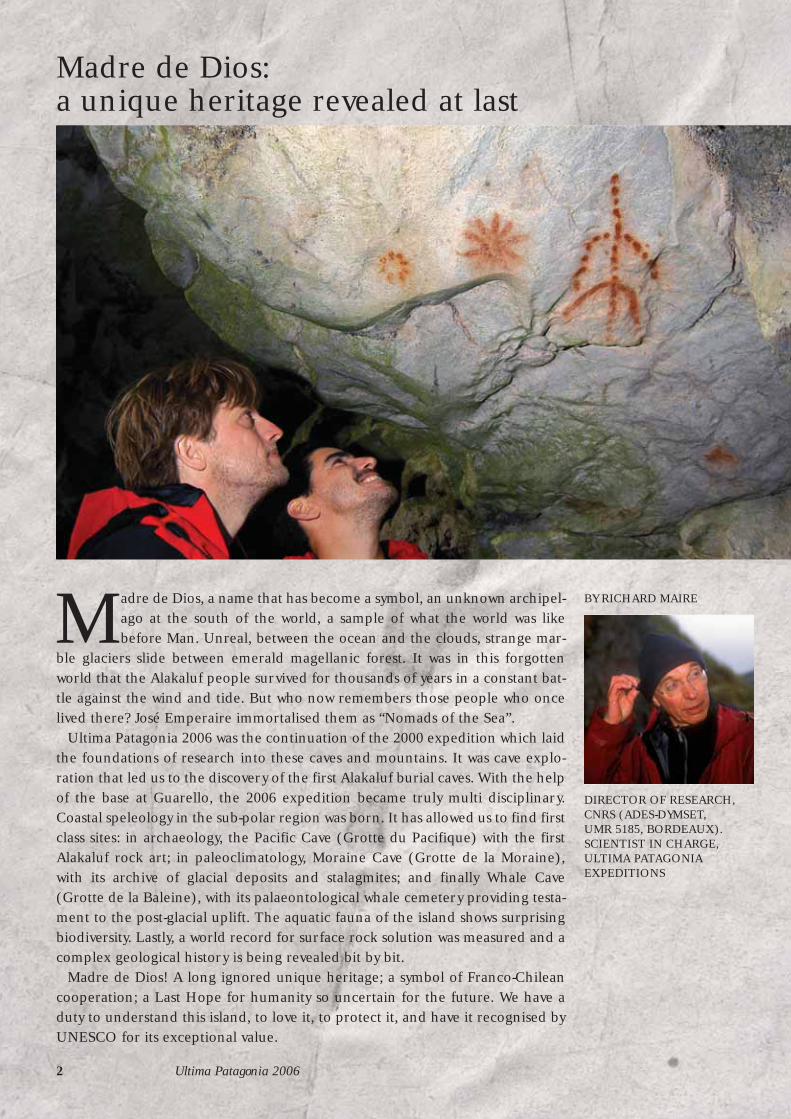
Madre de Dios, a name that has become a symbol, an unknown archipel-ago at the south of the world, a sample of what the world was likebefore Man. Unreal, between the ocean and the clouds, strange mar-
ble glaciers slide between emerald magellanic forest. It was in this forgottenworld that the Alakaluf people survived for thousands of years in a constant bat-tle against the wind and tide. But who now remembers those people who oncelived there? José Emperaire immortalised them as “Nomads of the Sea”.
Ultima Patagonia 2006 was the continuation of the 2000 expedition which laidthe foundations of research into these caves and mountains. It was cave explo-ration that led us to the discovery of the first Alakaluf burial caves. With the helpof the base at Guarello, the 2006 expedition became truly multi disciplinary.Coastal speleology in the sub-polar region was born. It has allowed us to find firstclass sites: in archaeology, the Pacific Cave (Grotte du Pacifique) with the firstAlakaluf rock art; in paleoclimatology, Moraine Cave (Grotte de la Moraine),with its archive of glacial deposits and stalagmites; and finally Whale Cave(Grotte de la Baleine), with its palaeontological whale cemetery providing testa-ment to the post-glacial uplift. The aquatic fauna of the island shows surprisingbiodiversity. Lastly, a world record for surface rock solution was measured and acomplex geological history is being revealed bit by bit.
Madre de Dios! A long ignored unique heritage; a symbol of Franco-Chileancooperation; a Last Hope for humanity so uncertain for the future. We have aduty to understand this island, to love it, to protect it, and have it recognised byUNESCO for its exceptional value.
BY RICHARD MAIRE
DIRECTOR OF RESEARCH,CNRS (ADES-DYMSET,UMR 5185, BORDEAUX).SCIENTIST IN CHARGE,ULTIMA PATAGONIAEXPEDITIONS
ASSOCIATION CENTRE TERRE 3
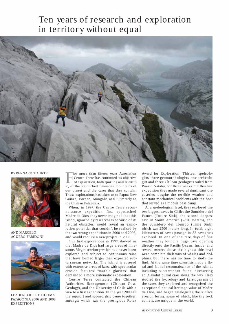
For more than fifteen years AssociationCentre Terre has continued its objectiveof exploration, both sporting and scientif-
ic, of the untouched limestone mountains ofour planet and the caves that they contain.These explorations has taken us to Papua NewGuinea, Borneo, Mongolia and ultimately tothe Chilean Patagonia.
When, in 1997, the Centre Terre recon-naissance expedition first approachedMadre de Dios, they never imagined that thisisland, ignored by researchers because of itsnatural obstacles, would reveal an explo-ration potential that couldn’t be realised bythe two strong expeditions in 2000 and 2006,and would require a new project in 2008...
Our first explorations in 1997 showed usthat Madre de Dios had large areas of lime-stone. Virgin territory which had never beenexplored and subject to continuous rainsthat have formed larger than expected sub-terranean networks. The island is coveredwith extensive areas of karst with spectacularerosion features: “marble glaciers” thatdemanded a more systematic exploration.
Centre Terre contacted the ChileanAuthorities, Sernageomin (Chilean Govt.Geology), and the University of Chile with aview to a first expedition. In the year 2000 allthe support and sponsorship came together,amongst which was the prestigious Rolex
Award for Exploration. Thirteen speleolo-gists, three geomorphologists, one archeolo-gist and three Chilean geologists sailed fromPuerto Natales, for three weeks. On this firstexpedition they made several significant dis-coveries, despite the terrible weather andconstant mechanical problems with the boatthat served as a mobile base camp.
At a speleological level, they explored thetwo biggest caves in Chile: the Sumidero delFuturo (Future Sink), the second deepestcave in South America (–376 meters), andthe Sumidero del Tiempo (Time Sink)which was 2500 meters long. In total, eightkilometres of caves passage in 32 caves wasexplored. In one of the rare days of fineweather they found a huge cave openingdirectly onto the Pacific Ocean. Inside, andseveral meters above the highest tide levelwere complete skeletons of whales and dol-phins, but there was no time to study thefind. At the same time scientists made a flo-ral and faunal reconnaissance of the island,including subterranean fauna, discoveringan Alakaluf burial cave along the way. Theystudied the hydrology and karstogenesis ofthe caves they explored and recognised theexceptional natural heritage value of Madrede Dios, and began cataloguing the surfaceerosion forms, some of which, like the rockcomets, are unique in the world.
Ten years of research and exploration in territory without equal
BY BERNARD TOURTE
AND MARCELO AGUERO FARIDONI
LEADERS OF THE ULTIMAPATAGONIA 2006 AND 2008EXPEDITIONS

A documentary ‘Deepest Patagonia’ (“L’ex-pédition Ultima Patagonia”) and an articlein National Geographic Magazine as well as var-ious articles in scientific journals reinforcedour efforts to make this exceptional placeknown to the wider public.
But all this only went to show that we hadbarely touched the tip of the iceberg, espe-cially in the field of exploration. We had noteven begun to explore the northern andmost extensive part of the island. The sheervolume of scientific research left to do wasenormous.
It took six years to organise a group of spe-cialists and the required funds to run a sec-ond expedition that by necessity was bigger
than any previous expedition. Thanks tothe support of the French Embassy weforged many good contacts with various gov-ernment ministries, three universities,Bienes Nacionals and the Bicentenary Com-mission. The Aceros del Pacifico corporationoffered the expedition a solid base camp attheir mine on the nearby island of Guarellofrom where we could reach our objectives ininflatable boats.
In January and February 2006, 31 speleolo-gists and scientists (20 French, 5 Chilean, 3Spanish, 2 Quebec and 1 Australian) went
to work on increasing our understanding ofMadre de Dios. The findings detailed in thereport of this expedition, like the others arecharacterised by the abundance of rain and vio-lent wind. One unexpected discovery on the21st of January was to have important conse-quences: the Pacific Cave had been inhabitedby humans. It had the remains of fireplaces,shell middens, and above all impressive indige-nous rock art, the first ever found on theislands of Patagonia.
They were attributed to the Alakaluf, seanomads, who in their bark canoes, were theonly people able to reach the shores of theseislands. This discovery justified a visit byChilean experts who were able to visit for afew days when part of our team changed.They could only make a preliminary assess-ment of the discoveries and see the necessityof further studies.
During the expedition other burial siteswere found on the shores of Seno BarrosLuco, an arm of the sea oriented east-westthat almost cuts the island in two. But thefragility of our transport made it impossibleto front the Pacific. We had only one smallinflatable boat that we had to carry acrossthe island on our backs.
The north of the island remains almostcompletely untouched. Exploration of thesouth of the island continued: new areasexplored, research started or continued andmore than a hundred new caves explored.Some of them such as Moraine and Finis-terre Caves started to produce important cli-matic data. The Mt. Roberto zone was reaf-
firmed as the most productive in the southpart of the island. The most promising cave,“Restful Cave”, which carried an under-ground stream was left at a depth of –305 mdue to lack of time and equipment.
Also for the first time we released “realtime” reports on the progress of the expedi-tion to the scientific, and world in general,by means of our web page (www.centre-terre.fr), which was supplied day by day withreports and photographs from base camp.
The base camp at Guarello mine was vital,but some travel distances were still long andthe north of the island remained inaccessi-ble despite our belief that it must be as pro-lific as the south. At the same time the dis-covery of the Pacific Cave and the burial sitesin Barros Luco opened a new chapter in thehistory of Madre de Dios research. Studyingthem will require a prolonged campaign ofexcavations which can only be carried outwith vessels considerably more suitable toocean travel than our modestinflatable boats.
Once the 2008 expedition isunderway, we will have bothconcrete objectives and obliga-tions.We can count both on theexperience gained on previousexpeditions, and that we havebeen recognised as a group thatis very willing to work alongsidethe Chilean Authorities, a part-nership that is ever expanding.Our shared long-term desire isto have Madre de Dios listed as aUNESCO World Heritage areaand our future studies will con-tribute to this objective.
Lost in the islands of Patagonian Chile,Madre de Dios is an extraordinary natu-ral conservatorium. It is a unique natural
laboratory that has been preserved fromhuman influence by its inaccessibility. Wellbeyond cataloguing its riches, our speleologicaland scientific focus has made it clear that wecan use it to study the evolution of our climateover the past tens of thousands of years whileobserving their subtle variations as they hap-pen, a subject that is causing much scientificand public concern today.
4 Ultima Patagonia 2006
Ten years of research and exploration

The Expedition:day by day

When the Mama Dina rounded the northeast point of the island of Guarelloon the 14th of January 2006, all 22 members of the expedition were on thebridge: Madre de Dios appeared in the distance, under a heavy sky, under theroaring fifties...The veterans of previous expeditions remember the unique land-scape engraved on their memories, the uninitiated see the marble “glaciers” thathave attracted them here first appear then grow larger.
6 Ultima Patagonia 2006
FROM THE EXPEDITIONLOGBOOK, A SYNTHESIS BY GEORGES MARBACHOur Chilean hosts at the mine on the
island of Guarello greet us warmly.They will look after us for two months
lodge us, feed us, without once losing theirpatience or good humour despite the complica-tions and risks that inevitably come with a bandof cavers on expedition: indecent hours, lastminute changes to plans, unavoidable noisethat’s hardly compatible with workers on nightshift. The magnificent conditions in the mine’sbase camp and the wonderful treatment by thepersonnel of the Aceros del Pacifico Companycontributed enormously to the success of ourexpedition.
The first few days of the expedition are del-icate: make contact with our hosts, moveeverybody in, assemble and fit-out our fleetof Zodiacs and Bombards, prepare ourequipment...
Maritime speleology
From the 16th, groups spread out acrossthe countryside, through the heavy rain thatfell every day. The unusual thing aboutPatagonia caving is that you leave base campeach morning and return each evening, usu-ally after a long voyage to Madre de Dios inZodiac. Whipped up by the violent winds,mists of salt and fresh water combine to soakus well before we can set foot on land. Every-
one tries their own technique to keep thewater out, but in the end, there’s nothing forit. We just resign ourselves to return tomor-row to the storms and curtains of rain. Sud-denly everything calms and like a blessing,the sea becomes like a lake.
A strong attack
One group makes a reconnaissance trip toIsla Tarlton, another limestone island to thesouth of Madre de Dios. At the very end ofSeno Conteras we need to find a land routeto Seno Barros Luco. It is only accessible bythe open sea and our fragile inflatables arenot up to the task. A land passage is the keyto accessing the north of the island.
Another three groups check objectives thatwe couldn’t visit in 2000. The first of these isthe Sumidero de los Condors sink, accessiblefrom Seno Conteras after six hours of walk-ing through a wild traverse of lakes and rockoutcrops. The cave is actually a sort of activesubterranean canyon 150 meters long, andin exceptionally violent state after the rains.It runs below the hill that blocks the cirqueand exits down a 50 m cascade into a lakewhose waters rapidly mingle with those at thevery north of Seno Eleuterio.
Seno Azul (Blue Bay) and its entrance to the Pacific seen from the heights of the Tarlton Island lapiaz on a day
of unusually fine weather.

COUPEALZADO
??
0 50 m
Grotte des CondorsCueva de los Cóndores
Perte des CondorsSumidero de los Cóndores
Grotte du ColibriCueva del Colibrí
NordNorte
SudSur
3
12
S : 50° 17,677’W : 75° 17,370’alt : 141 m
Dév : 140 mProf : - 40 m
PLANPLANTA
0 50 m
Grotte des CondorsCueva de los Cóndores
Pertes des CondorsSumidero de los Cóndores
Grotte du ColibriCueva del Colibrí
N
Nord m
agnétique 2006
22
1
1
3
3
CascadeCascada 50 m
ASSOCIATION CENTRE TERRE 7
Condor SinkThe Condor Sink system is a typical steep
underground canyon. Discovered in 2000 on theaerial photo and only briefly visited at the time, itwas explored and mapped in 2006. The sink swal-lows the water from a basin various kilometres inarea and includes two lakes.
The outflow from these lakes disappears intoan impressive canyon-sink. The undergroundstretches of cave are short as the roof has col-lapsed into the canyon in several places. Some 20m further on, Condor Sink passes through a flood-ed section before dropping into a collapse zone.
Some caves (such as Hummingbird Cave) on theleft bank have also been partially breached byreceding stream erosion. At the downstream endof the system, the water emerges from a cliff as aspectacular 50-100 m high waterfall.
The Condor Sink system in reality constitutes acanyon that was formed by glacio-karstic
processes and later altered by post-glacial ero-sion. Upstream, an extensive glacial cirque fed bywaters from the Patagonian icecap, must have fedthis glacio-karst system. When the glacier reced-ed (or perhaps beneath the glacier), the waterflow excavated Condor cave that grew and wasbreached by later erosion. The area is geomor-phologically very interesting. The influences ofice are associated with karst solution in a com-pact area where there has virtually always been asurface canyon and a cave sinkhole. Due to manysimilarities, it is reminiscent of Future Sink,explored in 1997 on Diego Almagro island. Thestudy of this type of system will help us betterunderstand karst processes during and afterglaciation on Madre de Dios and the entire archi-pelago.
Stéphane JailletThe waterfall at the downstream end of the system.

8 Ultima Patagonia 2006
List of caves explored in 2006N° Name Long. West Lat. South Alt Length Length Depth Comments
MappedA CAMP 6001 Contact Pit 75° 21,015’ 50° 18,900’ 629 87 m 87 m -47 m
Cave beneath the Glacier 75° 20,760’ 50° 18,828’ 745 55 m 55 m -15 m Highest altitude entrance foundGSLS 04 75° 20,893’ 50° 18,953’ 635 52 m 52 m -38 mAJPP02A 75° 20,980’ 50° 19,075’ 579 50 m -32 mAJPP02B 75° 20,980’ 50° 19,075’ 50 m -32 mAJPP02C 75° 20,980’ 50° 19,075’ 50 m -32 mUL03 75° 21,014’ 50° 19,029’ 48 m -33 mAJPP01A 75° 20,998’ 50° 19,055’ 46 m -32 mAJPP01B 75° 20,998’ 50° 19,055’ 46 m -32 mGLA 760 75° 20,753’ 50° 18,822’ 45 m 45 m -12 m contains ice
C CAMP 400 North2 Comet 75° 21,049’ 50° 18,200’ 380 111 m 111 m -85 m3 Moral sink 75° 20,598’ 50° 17,985’ 360 128 m 128 m -68 m4 As you like it Cave 75° 21,072’ 50° 18,510’ 350 93 m 93 m -85 m P85 of camp 400
Cueva A 75° 21,093’ 50° 18,292’ 398 55 m -45 mB CAMP 400 South5 Rock Killer Sink 75° 21,534’ 50° 20,524’ 100 401 m 401 m -98 m Also known as River Sink6 Little Flood Cave 75° 21,081’ 50° 19,460’ 437 337 m 337 m -200 m7 Colander Cave 75° 21,120’ 50° 19,741’ 362 262 m 262 m -180 m
JJP1 75° 20,983’ 50° 19,534’ 429 70 m -30 mUL05 75° 21,097’ 50° 19,295’ 455 60 m -45 mJJP8 75° 20,956’ 50° 19,670’ 358 60 m -35 mJJP2 75° 20,925’ 50° 19,491’ 444 50 m -20 mJJP3 75° 21,014’ 50° 19,462’ 452 50 m -35 m
I MONTE ROBERTO West8 Sorry Map Cave 75° 24,445’ 50° 19,739’ 351 200 m -90 m8 Later On Pit or Al Rato 75° 24,449’ 50° 19,739’ 380 128 128 m -120 m9 Fifty Year Olds’ Pit 75° 24,177’ 50° 19,233’ 386 113 m 113 m -76 m P100.10 Ophiolite Cave 75° 24,780’ 50° 18,820’ 550 100 m 100 m -50 m CaveAncient glacial sink, cave continues...8 Only One Spit(!) Cave 75° 24,452’ 50° 19,720’ 388 95 m -70 m
Hole beside camp 75° 24,224’ 50° 19,538’ 405 65 m -32 mFinal Cave 75° 24,458’ 50° 19,701’ 393 50 m -30 mCoipo Sink 75° 24,200’ 50° 19,380’ 320 50 m -25 m A Coipo is a large rodent that lives on Madre de DiosPO3 Cave 75° 24,246’ 50° 19,767’ 368 50 m -26 m
D MONTE ROBERTO East11 Hourglass Cave 75° 22,675’ 50° 18,880’ 452 667 m 667 m -271 m Sink 512 Restful Cave 75° 22,710’ 50° 19,104’ 449 640 m 640 m -276 m Sink 7. Cave continues beyond –305 m. Deepest cave of 2006.
The Green Chair 75° 22,981’ 50° 19,171’ 599 80 m -35 mLe Tube 75° 22,997’ 50° 19,026’ 673 70 m -60 mCave of the Three 75° 22,817’ 50° 18,987’ 548 70 m 70 m -35 m Cave continuesLost Body Cave 75° 22,656’ 50° 19,045’ 444 55 m 55 m -65 mGGZ-03 75° 22,583’ 50° 18,916’ 520 50 m -25 mPACIFIC COAST CAVES
13 Floating Kebab Cave 320 m 10 m Cave continues (Franck and Guillaume)14 Whale Cave 75° 27,347’ 50° 17,267’ 8 270 m 18 m
GUARELLO COAST CAVES15 Finisterre Cave 75° 23,015’ 50° 24,058’ 37 1 085 m 1 085 m 131 m 4 entrances. Stopped by a climb in the stream.16 Moraine Cave 75° 22,800’ 50° 23,500’ 60 219 m 219 m 35 m
ISLA TARLTON CAVESResurgence 75° 24,277’ 50° 23,279’ 0 0 m 0 m Estimated at 80 L/s (27 February 2006). Blocked by rocks.SENO SOPLADOR
17 Kawtcho Sink 75° 21,703’ 50° 18,849’ 44 212 m 212 m -54 m Cave continues below sea level.SENO ELEUTERIO NORTH
18 Siphon des Lobos 75 ° 17,063’ 50° 18,163’ 0 290 m -49 m Resurgence for the Condor Sink System. Cave continues.19 Système des Condors 75° 17,370’ 50° 17,677’ 141 140 m 140 m -40 mF END OF THE SENO NORTH20 Siphon at the end of the Seno 75° 14,765’ 50° 18,374’ 0 186 m 186 m -16 m Siphon21 Sherpa Cave 75° 12,965’ 50° 18,566’ 50 110 m 110 m -40 m Old resurgence that takes waterG SENO BARROS LUCO22 Résurgence 1 75° 15,831’ 50° 11,508’ 6 198 m 198 m 35 m Stopped by a climb with air flow.23 Cairn Cave 75° 21,624’ 50° 12,421’ 3 100 m 35 m Cemented cairn. Stopped by climb. Strong air flow.24 Dolphin Hole 75° 15,383’ 50° 11,354’ 5 100 m 10 m25 Résurgence 2 75° 18,272’ 50° 12,077’ 0 Estimated at 500 L/s. Fed by a lake?
ARCHEOLOGICAL CAVES26 Pacific Cave 327 Burial Cave 1 9 8 m -3 m 3 skeletons (1 under shelter). Climb at end.28 Burial Cave 2 3 2 m 0 m Burial cave29 Burial Cave 3 5 8 m 0 m Burial cave
Length explored: 7,919 mLength mapped: 5, 494 m
ADVANCED CAMPS 2006
A Camp 600
B Camp 400 South
C Camp 400 North

10 km0
O
D Roberto East
E Time Sink
F End of the seno North
G Seno Barros Luco
H Pacific
I Robeto West


Below: during the incursion of the fiftyyear olds’, Richard Maire, Serge Caillaultand Pierre Bergeron navigated using airphotos in an attempt to reach Whale Caveon the Pacific coast of the island. Alongthe way they made several very importantdiscoveries and observations.(above)
Left: the first pitch of Restful Cave, the deepest cave explored in 2006 (-271 m mapped, –305 m explored) on Madre de Dios.
The Expedition: day by day
ASSOCIATION CENTRE TERRE 11
The cave divers continue exploration ofthe siphon “At the end of the Seno” that re-emerges after 140 m of underwater passagesand on their way out set traps for aquaticfauna.
The final group is composed of veterans ofMadre de Dios, They begin the “incursion ofthe fifty year olds” in an attempt to forge anoverland route to Whale cave on the Pacificcoast that was only reached on one excep-tionally calm day by Zodiac in 2000.
Inside this huge cave whose mouth openssome six meters above the high tide mark,the 2000 team discovered whale bones... Thisintriguing mystery, probably related to theuplift of the island after it was liberated fromthe weight of the ice sheet as it melted at theend of the last ice age, demanded moredetailed study. But after walking for two daysin rain and wind that at times made it diffi-cult to them to stay on their feet, theyretreated without reaching their objective.
In base camp, a magnificent day was dawn-ing, the first of three in a row and somethingunknown in these islands. Global warminghad reached Madre de Dios... Some groupstook advantage of the calm to begin explo-ration of the southern part of the islandbetween Senos Soplador and Eleuterio. Theyinstalled two “high altitude” camps in prom-ising zones, one at 400 m and the other at600 m. The first caves were found and explo-ration began.
Change of scene21 January. While trying to reach Whale
cave by following ledges on the limestonecliffs Thibault and Laurent made an unex-pected find. Right where Seno Azul emptiesinto the Pacific they found a small cave only200m2 with two entrances and plenty oflight. Covering the floor were thousands ofshells and the remains of fireplaces, clear evi-dence of human habitation.
Suddenly ochre paintings and traces ofcharcoal came into view on the back wall!More than 40 paintings of a form previouslyunknown amongst the Alakaluf indians(only they could have reached these islandsin their canoes).
The anthropomorphic figures and geo-metric designs, some covered with a thinlayer of calcite, took advantage of a naturalprominence in the rock wall to represent amarine creature.
In Santiago, where the news of the findhad been beamed immediately, the effectwas like a bomb going off. On the island, theexpedition had no alternative but to switchpriorities to the Pacific Cave where it wasnecessary to first protect the site, then effectsome initial studies.
Eleven people and 600 kg of equipmentwas immediately unloaded in the most terri-ble swell, all the time attempting to avoid thenumerous sharp rocks that continuouslythreatened to shred the Bombard. They theninstalled a camp in “normal”, that is terrible,

conditions. That first night the group tentwas flattened by the violent squalls. They hadto quickly move it and lash it down behind arock with caving ropes to avoid its total disin-tegration. They mapped in a quadrangle,made a careful inventory of the paintingsand documented everything with movie andstill cameras. The Chilean prehistory worldwas very excited and the authorities followedour findings closely. In base camp, the tele-phones rang continuously as it wasannounced that an official mission wouldarrive to take advantage of the mid-expedi-tion team rotation between January and Feb-ruary and make a preliminary study of thesite. We posted several photographs on theinternet and the press.
Hard yards to explore
Despite the archeological reorientationimposed by events we also continued withthe work we had come to do: our cave explo-rations continued. We resumed scientificstudies in Moraine Cave, discovered on theNW coast of Guarello Island in 2000. Most ofthe caves in the island of Patagonia areyoung, formed after the last glaciation.Moraine cave is older. It has impressive 20 mthick moraine deposits and finely layered“varve” deposits (formed from glacial rockdust), in a side passage. It is a veritable cli-matic archive that demands to be studied.
We took advantage of the Pacific Cavecamp to make a further attempt to reachWhale cave by land, but on the 26th we faileddefinitively: an impassable cliff rose before
12 Ultima Patagonia 2006
The Expedition: day by day
Pacific Cave, an exceptional prehistoric site found by the2006 expedition. Above: a simple touch-up to a natural rockform evokes a marine animal. Below: 100 m2 of the floor iscovered with sea shells, a rich supply of nutrition, and asignature of the presence of the Alakaluf.
Below: the emblematic figure of PacificCave. This large anthropomorph evokes thegeometric body-painted figures thatwestern sailors reported as they firstpassed through the Patagonian canals inthe 16th century.

ASSOCIATION CENTRE TERRE 13
The Expedition: day by day
Madre de Dios and its myriad of fjords.Don’t be fooled by appearances (below):the sun and summer flowers in front of thePacific Cave (note the “African mask”appearance of the entrance). The next daya wild storm raged in this same place...
us.On the 27th we moved the camp back to
base and celebrated our discoveries.On the 28th, another team returned to
600 camp to continue prospecting. Thenumerous caves we descended all had mod-est dimensions: barely 40 m! At least thespectacular scenery and magnificent lapiazwas some compensation for our lack ofresults.
On the 29th we installed a more remotebase camp at the very end of Seno Conteraswith the aim of reaching Seno Barros Luco.
On the 30th we established a route and thenext day we portaged the tiny Bombard andits motor. It was necessary to pass an unex-plored col at 350m altitude carrying morethan 30 kg loads, including enough equip-ment for a further advanced camp. This“camp at the end of the earth” would beoccupied almost continuously until the endof February by small reconnaissance teamson rotation. The first voyage took place onthe 1st of February with an escort of dol-phins beneath an immaculate sky. This firstday turned up various discoveries. We firstfound and mapped a resurgence 100 m longbefore we were stopped at a 6 m waterfall.Four Alakaluf burial caves, three on the lime-stone and in the shales of Isla RamÛn in thewaters of Barros Luco proved that theAlakalufs didn’t hesitate to sail the Pacificbeyond the safety of the island – the onlyroute to get there by water. The relievingteam found another resurgence with abreeze that they we able to penetrate forsome 50 m.
Monte Roberto, six years on
On the 30th of January we installed anoth-er five day camp on the southern slope ofMt. Roberto at an altitude of 400 m to con-tinue exploring the limestone-sandstonecontact. Here, during the 2000 expedition,we found several important caves, amongthose, the Future Sink, the deepest cave inChile at –376 m.
We found several new caves, four of which
14 Ultima Patagonia 2006
ARCHEOLOGY
The Mystery of the Alakaluf IndiansBY LUC--HENRI FAGE
To discover a cave adorned with paintings is
nothing extraordinary. To discover one on the
coast of the restless Pacific even less so. But to
find one in the heart of the Patagonian archipela-
go in the most isolated place imaginable, is some-
thing extraordinary. Then to find four more burial
caves just a few days later on the shores of Barros
Luco is also in the realm of exceptional... All of this
was just part of the discoveries that follow on from
those of the 2000 expedition and have allowed us
to date a skull at 4,500 years old.
Eternal busybodies into the most hidden corners
of our planet, cavers have been the first to discov-
er, here and there, vestiges of the past. These dis-
coveries from Chilean Patagonia are proof of the
existence of a group of humans lost to the past.
The “Nomads of the Sea” were studied by José
Emperaire in the 1940s, displayed through fiery
tales by Jean Raspail, and above all scientifically
studied by Dominique Legoupil and her Franco-
Chilean group of archaeologists for the past 25
years.
The Alakaluf indians, also known as the
Kaweskar, lived in the Patagonian “canales”, they
hunted and collected shellfish, almost naked, they
travelled around in bark canoes and maintained a
fire burning in a clay basin. Such a rough life, on
the edge of survival, that even the great Charles
Darwin while passing through the Beagle Canal on
his voyage around the world wrote, before later
retracting the statement, that they couldn’t quite
be called human.
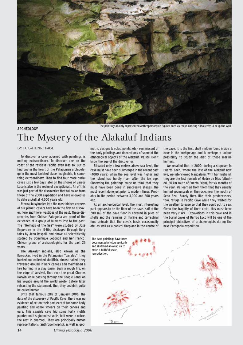
Until that famous 21th of January 2006, the
date of the discovery of Pacific Cave, there was no
evidence of art on their part except for some body
painting and ochre smears on their canoes and
oars. This seaside cave hid some forty motifs
painted on it’s gloomiest walls, half were in ochre,
the rest in charcoal. They are principally human
representations (anthropomorphs), as well as geo-
metric designs (circles, points, etc), reminiscent of
the body paintings and decorations of some of the
ethnological objects of the Alakaluf. We still Don’t
know the age of the discoveries.
Situated only a few meters above sea level, the
cave must have been submerged in the recent past
(4000 years) when the sea level was higher and
the island had hardly risen after the ice age.
Observing the paintings made us think that they
must have been done in successive stages, the
most recent done just prior to modern times. Prob-
ably in the period between 3,000 and 200 years
ago.
At an archeological level, the most interesting
part appears to be the floor of the cave. Half of the
200 m2 of the cave floor is covered in piles of
shells and the remains of marine and terrestrial
food animals that the cave’s hosts occasionally
ate, as well as a conical fireplace in the centre of
the cave. It is the first shell midden found inside a
cave in the archipelago and is perhaps a unique
possibility to study the diet of these marine
hunters.
We recalled that in 2000, during a stopover in
Puerto Eden, where the last of the Alakaluf now
live, we interviewed Magdalena. With her husband,
they are the last nomads of Madre de Dios (situat-
ed 160 km south of Puerto Eden), for six months of
the year. We learned from them that they usually
hunted young seals on the rocks near the mouth of
Seno Azul. Surely they, like their predecessors,
took refuge in Pacific Cave while they waited for
the weather to ease so that they could put to sea.
Given the fragility of their craft, this must have
been very risky... Excavations in this cave and in
the burial caves of Barros Luco will be one of the
principal objectives of archaeologists during the
next Patagonia expedition.
The cave paintings have beendocumented photographicallyand sketched allowing us tomake a faithful scalereproduction.
The paintings mainly represented anthropomorphic figures such as these dancing silhouettes 4 m up the wall.

Point 26 on the location map on page 9
Pacific cave
Limestone
limestone wall
limestone outcrop
clay/loam soil
damp clay/loam soil
limestone blocks
Hole
Entrance dripline
Topographic step
Alluvial fill
Floor slope
Water
Water flow direction
Peak
Charcoal
Parietal paintings (sections)
Undifferentiated bones
Shells
Hydrophyllic vegetation
Protective track marking
Legend

exceeded –70 m deep and one –120 m deep.On the 5th of February, on a day trip to
this sector we found “Hourglass sink” on thecontact between the limestone and the sand-stone. Its moss-filled entrance was hiddenbeneath the Nothofagus where an activestream littered with sandstone blocks contin-ued into the limestone. We explored 150 mand mapped to –45 m.
At last the caves we were finding werereaching a reasonable depth. Our persever-ance began to pay off as Mt. Roberto recon-firmed itself to be the area with the bestpotential.
Making the most of a period of fine weath-er, two of the team made a lighteningattempt toward the Pacific. Although theygot in sight of Whale Cave, they didn’t haveto 80 m rope that they needed to descendthe vertical cliff down to its entrance...
On the 4th of February, on the island ofGuarello we found Finisterre Cave. A strong,cold breeze was rushing out and we exploredover 200 m, and it continued...
In camp 400 south, we began to see results.We descended Colander Cave to –135 m andit continued... Unfortunately, HourglassCave reminded us that time was running out.
Fresh troops
The day arrived for the January team, TheMama Dina approached. On the morning ofthe 7th of February, after a difficult voyage,nine “Februarians” were unloaded to relievenine “Januarians” that were to embark the
following day, along with various officialsfrom Santiago and Punta Arenas who hadcome to inspect the archeological site: anarcheologist, an anthropologist and govern-ment representatives. During these two daysthe expedition team was dedicated to publicrelations, taking some to the Pacific Caveand other to the advanced base at the end ofSeno Conteras to allow them to make con-tact with the reality of the terrain.
The weather was on our side. On the 8thof February, after a ceremony to unveil aplaque to commemorate the expedition, the
16 Ultima Patagonia 2006
The Expedition: day by day
A memorable portage allowed us to carrya Zodiac, its motor and camping equipmentacross the strip of land that separatesSeno Barros Luco from Seno Conteras. Ourexploration of Barros Luco could begin andwe discovered four Alakaluf burial caves(below).

“Januarians” re-embarked for PuertoNatales.
On the 9th, the new team started workdespite the weather having returned to nor-mal: the wind forced back a Zodiac that washeading for Finisterre Cave resulting in aduel with the elements in Seno Eleuterio.
One team returned to Colander Cave,while another returned to Hourglass Cave tocontinue exploration of the limestone-sand-stone contact on Mt. Roberto towards thesouth where they found a superb 33m deepbell-shaped shaft that swallowed a waterfall:“Restful Cave”. It rapidly reached –100 m,then –150 m.
On the 10th, Hourglass Cave reached–150m in an active meander.
On the 15th, the divers went to KawtchoSink in Seno Soplador and reached –30m.
We installed another Roberto camp as theday trips were becoming too long andrelieved the teams every three days.
On the 16th we finalised the explorationof Colander Cave. It ended in a squeeze at–180 m so we derigged the cave and movedthe camp to a nearby area to explored Hue-quito Cave that had reached –200 m.
The camp at Barros Luco saw successiveteams continue exploration of the shorestowards the huge lapiaz to the north. In totalwe explored over 150 km of shoreline inthese unknown waters.
The Country of ExtremesWhile the climate punished those in the
precarious camps lashed by winds; the hor-ror of putting on cold wet clothing from theday before and any intent to light a fire was anear impossible task....others rechargedtheir batteries in the comfortable refuge ofGuarello base, designed so that all the activi-ties of normal life could be carried out with-out ever poking your nose out into the out-side world. We walked in covered passage-ways in t-shirts while on the other side of thewindows, the rain fell by the bucket-load.
We listen to the howling wind as themachines clean and dry our clothing thatwe’ll soak once again on Madre deDios...And so pass the days, oscillatingbetween the discomforts on land and thecomforts in base. Little by little, our note-books fill up and the caves we are exploringbecome deeper.
By definition cave divers aren’t afraid ofwater: at the most, they put on their dry suitsin the comfort of the base in the morningand stay that way until they return in theevening. Day after day they lay line and setfauna traps. The best siphon that has beenexplored so far is the Wolf Siphon (“Lobos”,named after the sea lions-sea wolves in span-ish-that live in the entrance). They contin-ued exploring this undersea resurgence thatwas discovered in 2000 and explored to –49m. The part explored six years ago turnedout to be nothing more than just one branchof a complex underwater network centred
ASSOCIATION CENTRE TERRE 17
The Expedition: day by day
The whole time we were there theBombard Commando C5s allowed us totravel in the canales and resupply theadvanced camps.

P15
COUPEALZADO
P33
Siphon
P19
P36
P13
P15
P17
P7
P8
contact contacto
P10
Espera2008
R3,5
S : 50° 19,104’W : 75° 22,710’alt : 449 m
Dév : 640 mProf : -276m topo (-305 m ?)
- 276 m
Meandro Tiburon
entréeentrada
PLANPLANTA
N
Nord m
agnétique 2006
0 50 m
Espera2008
- 276 m
entréeentrada
18 Ultima Patagonia 2006
Restful CaveSituated 400 m south of Hourglass Sink, Restful
Cave begins with a 33 m pitch very close to the lime-stone-sandstone contact. The cave is mainly verticaland is characterised by a flat roof and a cascadingprofile that is oriented to the west and later to thesouth until it reaches a 17 m pitch at –160 m. From thispitch, the morphology changes to become a meander.The narrow “Shark Meander” is occasionally inter-rupted by vertical drops and numerous downclimbs,and takes the cave towards the north. With a length ofover 200 m, the Shark Meander continued beyond themapped limit (-276 m) to a level of –305 m. A “sport-ing” climb out for its entire length, Shark Meanderwill be equipped with rope next time as it would beproblematic with high water levels. It is without doubtone of the principal objectives of the next expedition.
Point 12 on the location map on page 9.
Maps: Centre TerreDrawn by Stephane JailletText and descriptions by Judicael Arnaud

ASSOCIATION CENTRE TERRE 19
COUPEALZADO
- 271 m
EntréeEntrada
P9
P8
P8
P8
P30
P15
P27
P10
P8
P7
R3
P5
P15
P10
P34
moussede crue
PLANPLANTAN
Nord m
agnétique 2006
0 50 m
S : 50° 18,880’W : 75° 22,675’alt : 452 mDév : 667 mProf : -271m
- 271 m
EntréeEntrada
P9
P8
P8P8
P30
P8
P27
P10
P8
P15
P10
P34
The Expedition: day by day
Hourglass SinkAt the bottom of a depression,
beneath the exuberant vegetation thatcovers the rocks, a permanent streamcontinues its journey to the ocean as itenters the limestone mass. The entrancezone is a tangle of blocks and sand fill.Various diffuse sinks supply the under-ground stream of some 10 l/s. Afterabout 100 m along a meander, a 30 mpitch indicates a change in the cave’sprofile. With short meanders, the cavesheads north until it reaches –121 m afterwhich it becomes very vertical, charac-terised by a flat roof and cascading pro-file that moves to the southwest. Theway on continues down parallel shafts onoccasions to avoid the risk of floods that
we can’t ignore, proof of which is thecomplete absence of sand anywhere. Atthe base of the pitches (-220 m), thecaves once again becomes an occasion-ally tight meander heading northwestand occasionally cut by climb downs.After fifty meters, the last pitch givesaccess to a large room where flood foamis visible 5 m up the walls. Once again wehit a chaos of blocks and sand fill that weexplored to –271 m. At this point we mustbe very close to the “Forgotten Sink”explored on the 2000 expedition.
Point 11 on the location map on page 9

on an extensive smooth-walled passagewhere the current varied from violent totranquil. The halocline between the freshand salt water is visible from time to time.You can go 90 m in this passage to reach adepth of –49 m. The system merits a moresystematic exploration.
The Whale at last!
We still continued to make attempts toreach Whale Cave every time that even thesmallest window of fine weather opened. Youneed two days of calm weather so that youcan take a chance the sea will be calmenough on the third. On the 9th, a cruisingyacht anchored in Guarello, its crew attract-ed by newspaper articles about our discover-ies. “No, you can’t visit Pacific Cave, but ifyou’d like to visit Whale Cave perhaps we cancome to some arrangement...!” This wouldbe our fourth failure. Despite the size of theboat we turned back due to the Pacific swelland strong wind...
18th of February, another incursion byZodiac... and another failure.
On the 19th, with only one metre waves ateam of eight took to the Pacific. In twohours they reached the cave and made acommando-style landing thanks to thedivers. The enormous cave held even moreremains than expected. There are five whaleskulls and numerous bones, as well as theremains of dolphins and seals. Some tooksamples for dating and DNA analysis, whileothers made a photographic record of thecave. On the way home they found anothercave which they explored 300 m beyond acascade.
Beyond –300 m
This week our efforts were concentratedon Mt. Roberto where rotating teams avoid-ed the constant floods thanks to “high flyingrigging”.
On the 21st, Hourglass Sink reached alevel of –271 m. At this point, the water dis-appeared into a narrow sump at the contactbetween the limestone and the sandstonethat left no hope: the final chamber carriedflood marks five meters up the walls... Thecountdown had begun: only a few daysremained to recover the equipment from theoutlying camps, including our boat fromBarros Luco, clean and dry everything, tidyup the paperwork. Our stay was nearing isend.
We made our last attack on Restful Caveand continued exploration and mappinguntil the 23rd without reaching the end.Thanks to some calm weather and low water,the deepest point we reached was estimatedto be –305 m. It will continue as one of ourmajor objectives for the next expedition,along with exploration of the extensive lapi-az of the northern part of the island.
The return
On the 28th of February we made one lastvisit to Finisterre Cave and a last dive. Wewanted to enjoy Patagonia right up to theend. On the 2nd of March, Mama Dina leftGuarello then entered Seno Conteras head-ing toward West Canal. The fog horn salutedthe miners of Guarello who had become ourfriends. By the time that the huge lapiaz thatdescends to the sea beneath a leaden sky haddisappeared we were already making plans.In 2008 Centre Terre will be back!
20 Ultima Patagonia 2006
The Expedition: day by day
Three photos of Finisterre Cave:Below: moving along an inclined meanderin the lower river. Opposite, above: thecave is well decorated and occasionallyhas helictites.Below: immediately before the firstpassage through the small lake nearentrance 1.

The Expedition: day by day
COUPEALZADO
0 50 m
NordNorte
SudSurS : 50° 24,058’
W : 75° 23015’
alt : 37 m Dév : 1085 m Prof : - 41 m / + 90 m (131 m)
Entrée 4 (imp.)entrada
Entrée 2
Entrée 3Entrada
R5
- 41
+ 90
Salle des BaugesSala de las Bauges
+ 11
Dépôts morainiquesDepósitos morrénicos
Puits remontantPozo remontante
Puits remontantPozo remontante
Ossements d’oiseauxHuesos de aves
Galerie du MondmilchGalería del Mondmilch
c.a.
siphon
N
6 0
0 2
e u
q i t
é n
g a
m
d
r o
N
PLANPLANTA
Entrée 1Entrada
Entrée 3Entrada
Entrée 1Entrada
Entrée 2Entrada
étroitureestrechez
étroitureestrechez
+ 11
siphon terminalsifón
siphon terminalsifón
siphonsifón
siphonsifón
siphonsifón
Finisterre CaveThe entrance of Finisterre Caves is located
on the extreme south west of Guarello Islandat the foot of a tall cliff that dominates the lowmarshy country between the cliff and the sea.The entrance itself is a 1.5 m diameter pressuretube close to a waterfall. A low wet passagegives way to a heavily decorated passage thathas areas of aragonite and helictites. After-wards, a meander leads to a steeply slopingpassage.
Uphill, the cave is developed parallel to thecliff and has moraine deposits. The cave con-tinues to three entrances, the first one ofwhich is impenetrable and 90 m above the firstentrance, making it the highest point in thecave. A small stream in a side passage ends ina climb waiting to be explored. Downward, ashort dig through sand gives access to a nar-row, sloping passage to a climbdown and themain stream (10L/s). Upstream, the stream isin a narrow meander while a high, dry fossilpassage above it has considerable claydeposits. The river is fed by two streams; onecomes from an impenetrable siphon, while the
other was followed to a chimney that wasn’tclimbed. Downstream, the river runs into asiphon at the lowest point in the cave (-41
m). This siphon isn’t far from an impenetrablearea visible at the foot of the cliff.
Judicael Arnaud
ASSOCIATION CENTRE TERRE 21
Chiffre 15 sur le plande situation p. 9.

Giant solution runnels
With its outstandingly huge solution run-nels, the lapiaz of Madre de Dios constitutesa new geomorphological heritage. Thanks tothese drainage forms that imitate hydrologicnetworks in miniature, it is possible toobserve the action of water on rock as it hap-pens. All the major forces of terrestrial karsterosion are there: fluvial incision, meanderformation, regressive step erosion, etc. Andthe other factor without which we wouldnever have this beautiful landscape: wind,that give rise to “hydro-eolean” lapiaz. Otherforms of differential dissolution are the“rock comets” that are caused by a laminarflow of wind-driven rainwater. With an annu-al rainfall of 6 to 10 m, the rate of surface dis-solution is a record. At 400 m altitude, thereare erratic block stranded on limestonepedestals 1.6 m high showing the amount ofdissolved limestone that has “melted away”since the retreat of the glaciers 10, 000 yearsago a world record for surface dissolution of16 mm/century.
To measure the flow, the dissolution, andthe evolution of these landforms, weinstalled a hydrological and hydrochemicalmeasuring station on Guarello, in a smallbasin at the junction of several runnels. Theparameters measured were rainfall, windspeed, temperature, flow volume and disso-lution rate.
Karst drainholes:young models of subterranean systems
The rainwater flows across the lapiaz andgoes underground taking advantage of theintensely fractured rock. On the marbledomes, the thousands of pits and cracks nar-row down or end in loose blocks between 30and 80 m deep. For cavers, the most interest-ing caves are those on the contact betweenimpermeable and permeable rock. Forexample, the rainwater flowing across thesandstone of Monte Roberto concentratesinto a stream underground right on the con-tact with the limestone. Various pits reach
22 Ultima Patagonia 2006
KARSTOLOGY
A Unique Geomorphological Heritage
BY RICHARD MAIRE, STÉPHANE JAILLET, BENJAMIN LANS ANDLAURENT MOREL
Above: the vertical runnels of GuarelloIsland were studied to measure their rateof dissolution mode of formation.Below: unusual karst erosion “teeth”beneath a calcareous block on TarltonIsland.

The comparisonbetween the growthrings of the nothofagusand those of the calciteformation may clarifysome doubts about theevolution of Madre deDios.Below: an erratic blocksitting atop its 1.6 m limestonepedestal, shows how muchlimestone has been dissolved sincethe end of the last glaciation 10,000years ago.
between 200 and almost400m deep on this part of the
island. Devoid of formations andother deposits these cave/sinks are
made up of a series of meanders andpits. Like the surface lapiaz, these active
caves, especially dangerous duringfloods, are models of accelerat-
ed erosion. They must beless than 15,000 to 10,000
years old. There are alsoolder caves, which isthe case with WhaleCave on the Pacificshore, Moraine Caveon Guarello and
Ophiolite Cave on thelower flanks of Monte
Roberto. These havepreserved traces of anoth-
er environment that would beuseful to decipher.
The paleoclimatic archives of Moraine Cave
On the NE coast of Guarello, MoraineCave is a large cave filled with glacial sedi-ments 20 m thick. The wall inside has twohorizontal glacial notches, the first time sucha feature have been seen below ground. Thecave has served as a receptacle for rocky left-overs carried by the glacier in the last coldperiod. You can see blocks embedded ingravel (typical moraine), gullied surfaces(erosion episodes), and finely laminatedclays and sand: these are glacial “varves”formed by sedimentation in a glacial meltwa-ter lake.
We made measurements and took samplesto help decipher the evolution of the climateand environment. These varves could corre-spond to sudden warm phases that havebeen noted in the polar icecaps.
We intend to see if they are caused by sud-den changes or a succession of variousglaciations. Finally, we have dated a stalag-mite that has formed after the morainedeposit using thorium/ uranium dating inthe Lab. Sc. Climat et de l’Environnement,UMR 1572, CEA-CNRS, Saclay. The five datesso far obtained show that it has an age of lessthan 10,000 years. These dates will be corre-lated with paleotemperature dates obtainedby oxygen and carbon stable isotope dating.
We know that stalagmites form duringwarm periods owing to carbonic acid formedin soils by vegetation. It is very important tolearn more about this post-glacial warm peri-od that allowed the formation of this stalag-mite, as there are no other records of thistype so far south in the world.
There is a comparative study being under-taken between the most modern stalagmiteand the growth rings of the Nothofagus(beech) trees with the aim of getting preciseinformation on the warming climate of thepast 150 years.
ASSOCIATION CENTRE TERRE 23
Moraine Cave: the caver moves over the remains of glacial moraine. On the right wall a glacial notch is visible, the only one ever found underground so far.
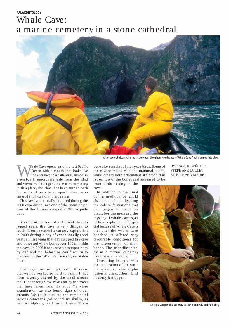
Whale Cave opens onto the vast PacificOcean with a mouth that looks likethe entrance to a cathedral. Inside, in
a semi-dark atmosphere, safe from the windand waves, we find a genuine marine cemetery.In this place, the clock has been turned backthousands of years to an epoch when wavesentered the heart of the mountain.
This cave was partially explored during the2000 expedition, was one of the main objec-tives of the Ultima Patagonia 2006 expedi-tion.
Situated at the foot of a cliff and close tojagged reefs, the cave is very difficult toreach. It only received a cursory explorationin 2000 during a day of exceptionally goodweather. The team that day mapped the caveand observed whale bones over 100 m insidethe cave. In 2006 it took seven attempts, bothby land and sea, before we could return tothe cave on the 19th of February by inflatableboat.
Once again we could set foot in this cavethat we had worked so hard to reach. It hasbeen severely altered by the small streamthat runs through the cave and by the rocksthat have fallen from the roof. On closeexamination we also found signs of olderstreams. We could also see the remains ofvarious cetaceans (we found six skulls), aswell as dolphins, sea lions and seals. There
were also remains of many sea birds. Some ofthese were mixed with the mammal bones,while others were articulated skeletons thatlay on top of the bones and appeared to befrom birds nesting in thecave.
In addition to the usualdating methods we couldalso date the bones by usingthe calcite formations thathad begun to form onthem. For the moment, themystery of Whale Cave is yetto be deciphered. The spe-cial feature of Whale Cave isthat after the whales werebeached, it offered veryfavourable conditions forthe preservation of theirbones. The scientific inter-est in a marine cemeterylike this is enormous.
One thing for sure: withthe exploration of this sanc-tuary-cave, sea cave explo-ration in this southern landhas only just begun.
24 Ultima Patagonia 2006
PALAEONTOLOGY
Whale Cave:a marine cemetery in a stone cathedral
BY FRANCK BRÉHIER,STÉPHANE JAILLET ET RICHARD MAIRE
Taking a sample of a vertebra for DNA analysis and 14C dating.
After several attempt to reach the cave, the gigantic entrance of Whale Cave finally comes into view...

Topographie FH / SJ - Centre Terre - 2000Décamètre, compas clinomètre Morin
0 50m
COUPEALZADO
ASSOCIATION CENTRE TERRE 25
Nm2000
PLANPLANTA
Whale CaveWhale Cave is 270 m long and 6 m above current sea
level. The entrance chamber is the largest yet discov-ered on the Madre de Dios archipelago, with dimen-sions of 150 m long, 40 m wide and a height of between20 m and 70 m, it has an approximate volume of270,000 m3.
The cave continues as an inclined tube that we mustexplore on a future trip. The floor of the cave is flat,clayey and damp. Water drops Water drops from theceiling to join occasional streamlets that eventuallyflow into the sea. that eventually flow into the sea. Atthe end of the cave is a squeeze that gives access to asmall dead-end chamber.
Also at the back of the cave and 100 m from the sea,several skeletons of cetaceans cover the floor, mixedwith the remains of dolphins, sea lions and seals. Thebones are spread everywhere, some stuck in the clay,others covered in foam. It’s an ancient deposit thatintrigues us. Leftovers of Alakaluf meals?, not likely.The remains are a long way from the entrance, to getthem there would be difficult, and the only access is bysea. We found no indications to support this hypothe-
sis. Deposited by storm perhaps?, it’s possible, but thecave mouth isn’t oriented directly towards the openocean, but instead, well protected. These remainscould really be even older, dating from a time when thesea-level was higher, or the continent lower.
20,000 years ago during the last glaciation, theweight of the ice caused the continent to sink. Whenthe ice retreated, the sea rapidly rose over 100 m,while the continent still continues to rise more slowly.
Whale Cave was once an enormous sea cave, regu-larly lashed by ocean waves for thousands of years. Itis possible that during that time, cetaceans and othermarine animals were washed in, marooned and died.Their remains were finally uplifted along with the caveover the thousands of years that followed.
Without doubt, Whale Cave has not yet revealed allits secrets. Carbon 14 and DNA analysis is ongoing andwe wait impatiently for the results that may allow usto better understand the origin of this intriguing ceme-tery.
PALAEONTOLOGY
Remains of five whales, twodolphins (above), reinforce thehypothesis of a marine cemetery...
Left: a whale vertebrae coveredwith calcite testifies to theantiquity of the site.

Madre de Dios: a Patagonian archipela-go lost “at the end of the earth”; dom-inated by a karst that extends to the
horizon; exceptionally severe climatic condi-tions, the worst on the planet: record rainfall,violent winds, cold...; recent past glaciation,with extensive Patagonian glaciers only 10,000years ago that descended from the AndeanCordillera and covered the entire island.
It seemed that Madre de Dios had all therequirements to be a biological “desert”.Despite these expectations, our biologicalexplorations revealed an unexpected floraland faunal diversity and surely previouslyunknown species.
Many different environments wereexplored during the 2006 expeditions:rivers, caves, peat bogs, forests, transitionzones... Two environments were especiallystudied owing to the specialisation of thebiologists present: rivers and their under-ground circulation and caves. We also tookadvantage of the presence of Chilean biolo-gists to begin the first inventory of verte-brates of the archipelago. From the vegeta-tion point of view, a lot of work was done col-lecting and defining species in the Nothofa-gus rainforests, the peat bogs and on the“high” altitude steppes.
Principal results
The biological sampling done in the riversduring this expedition were the first done inthis part of the world. They revealed a sur-prising diversity of benthic (those that liveon the bottom of the river), and hyporheic(those that live in sediments) invertebrates.At least 15,000 aquatic vertebrates were col-lected. So far we have identified more than40 different taxa from at least 20 differentinsect families. To get a more precise esti-mate of the biodiversity of the rivers ofMadre de Dios we’ll have to work a littlelonger...
Actually, there was no previous data point-ing to such a number of invertebrates in thispart of the world. Specimens have been sent
26 Ultima Patagonia 2006
BIOLOGY
An incredible biodiversity
BY THIBAULT DATRY, WITH TRISTAN LEFEBUREAND FRANCK BREHIER
Above: sampling a river that runs intoBarros Luco.Left: a biologist in the typical hyper-wettemperate forest of the archipelago.

to experts all over the world. It’s highly prob-able that they will identify new species.
Underground collecting has also revealedan unexpected faunal biodiversity. Theunderground aquatic fauna is especially richand some species are stygobites (only foundin underground waters), which is surprisinggiven the magnitude of the last glacialepisodes. The most notable discovery comesfrom underwater sampling in two marineresurgences. These caves, classified asanachaline, hide a fauna that is totally differ-ent from the other underground habitatsthat we found and where various species arenew to science. Anachaline caves are notedfor their great biodiversity, but it is the firsttime that they have been described fromthese latitudes.
Numerous mammals and at least 30species of birds were observed during theexpedition. Our Chilean colleagues alsoobserved indications of the presence ofmany others.
In conclusion, even though Madre de Diosis a very hostile environment to Man, it con-stitutes a true biodiversity reserve and refer-ence ecosystem largely unaffected by man inChile. From now on it is vital that we pre-serve and protect this environment and wewill work in this direction.
ASSOCIATION CENTRE TERRE 27
BIOLOGY
Classification under microscope in thecomfort of base camp. Collecting insurface and underground rivers hasrevealed a surprising biodiversity.
This hummingbird on a Nothofagus hasnever seen man and was not disturbed inthe slightest by our presence...
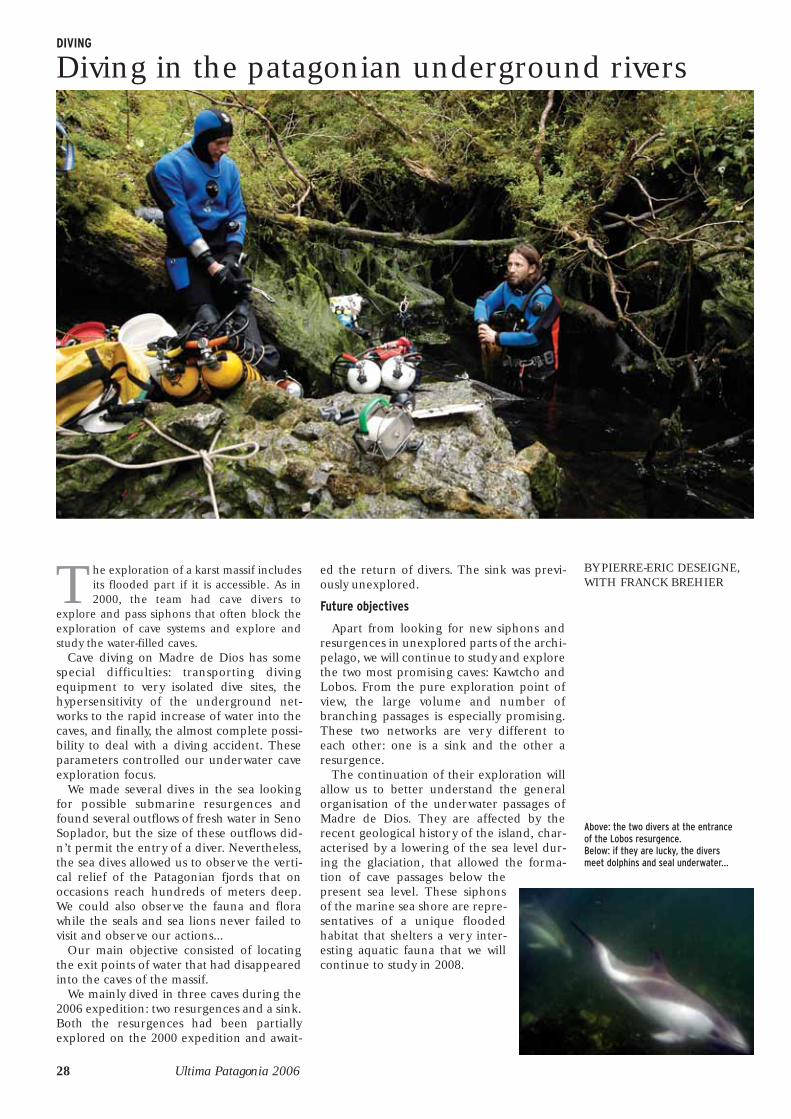
The exploration of a karst massif includesits flooded part if it is accessible. As in2000, the team had cave divers to
explore and pass siphons that often block theexploration of cave systems and explore andstudy the water-filled caves.
Cave diving on Madre de Dios has somespecial difficulties: transporting divingequipment to very isolated dive sites, thehypersensitivity of the underground net-works to the rapid increase of water into thecaves, and finally, the almost complete possi-bility to deal with a diving accident. Theseparameters controlled our underwater caveexploration focus.
We made several dives in the sea lookingfor possible submarine resurgences andfound several outflows of fresh water in SenoSoplador, but the size of these outflows did-n’t permit the entry of a diver. Nevertheless,the sea dives allowed us to observe the verti-cal relief of the Patagonian fjords that onoccasions reach hundreds of meters deep.We could also observe the fauna and florawhile the seals and sea lions never failed tovisit and observe our actions...
Our main objective consisted of locatingthe exit points of water that had disappearedinto the caves of the massif.
We mainly dived in three caves during the2006 expedition: two resurgences and a sink.Both the resurgences had been partiallyexplored on the 2000 expedition and await-
ed the return of divers. The sink was previ-ously unexplored.
Future objectives
Apart from looking for new siphons andresurgences in unexplored parts of the archi-pelago, we will continue to study and explorethe two most promising caves: Kawtcho andLobos. From the pure exploration point ofview, the large volume and number ofbranching passages is especially promising.These two networks are very different toeach other: one is a sink and the other aresurgence.
The continuation of their exploration willallow us to better understand the generalorganisation of the underwater passages ofMadre de Dios. They are affected by therecent geological history of the island, char-acterised by a lowering of the sea level dur-ing the glaciation, that allowed the forma-tion of cave passages below thepresent sea level. These siphonsof the marine sea shore are repre-sentatives of a unique floodedhabitat that shelters a very inter-esting aquatic fauna that we willcontinue to study in 2008.
28 Ultima Patagonia 2006
DIVING
Diving in the patagonian underground rivers
BY PIERRE-ERIC DESEIGNE,WITH FRANCK BREHIER
Above: the two divers at the entrance of the Lobos resurgence.Below: if they are lucky, the divers meet dolphins and seal underwater...
ASSOCIATION CENTRE TERRE 29
DIVING
COUPEALZADO
m 050
Dév : 212 mProf : -54m (-48/+6)
EntréeEntrada
S2 (35m, -30m)
- 48 m (siphon -30)sifón
S1 (8m, -1m)
P6
+/- 0
?
?
?
?
?
PLANPLANTA
m 050
Dév : 186 m
Prof : -16m
Entrée 1Entrada
Entrée 2Entrada
Entrée 3Entrada
Entrée 4Entrada
Entrée 5Entrada
N
Nord m
agnétique 2006
-16 m
S1 (78 m, -13)
S2 (57, -9)
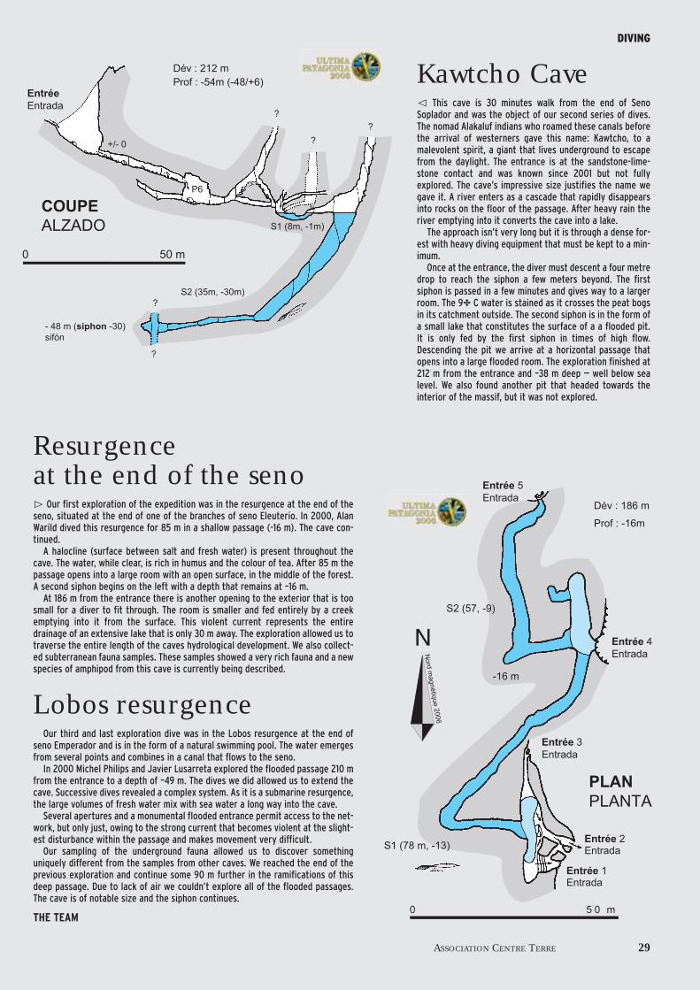
Kawtcho CaveThis cave is 30 minutes walk from the end of Seno
Soplador and was the object of our second series of dives.The nomad Alakaluf indians who roamed these canals beforethe arrival of westerners gave this name: Kawtcho, to amalevolent spirit, a giant that lives underground to escapefrom the daylight. The entrance is at the sandstone-lime-stone contact and was known since 2001 but not fullyexplored. The cave’s impressive size justifies the name wegave it. A river enters as a cascade that rapidly disappearsinto rocks on the floor of the passage. After heavy rain theriver emptying into it converts the cave into a lake.
The approach isn’t very long but it is through a dense for-est with heavy diving equipment that must be kept to a min-imum.
Once at the entrance, the diver must descent a four metredrop to reach the siphon a few meters beyond. The firstsiphon is passed in a few minutes and gives way to a largerroom. The 9∞ C water is stained as it crosses the peat bogsin its catchment outside. The second siphon is in the form ofa small lake that constitutes the surface of a a flooded pit.It is only fed by the first siphon in times of high flow.Descending the pit we arrive at a horizontal passage thatopens into a large flooded room. The exploration finished at212 m from the entrance and –38 m deep — well below sealevel. We also found another pit that headed towards theinterior of the massif, but it was not explored.
Resurgence at the end of the seno
Our first exploration of the expedition was in the resurgence at the end of theseno, situated at the end of one of the branches of seno Eleuterio. In 2000, AlanWarild dived this resurgence for 85 m in a shallow passage (-16 m). The cave con-tinued.
A halocline (surface between salt and fresh water) is present throughout thecave. The water, while clear, is rich in humus and the colour of tea. After 85 m thepassage opens into a large room with an open surface, in the middle of the forest.A second siphon begins on the left with a depth that remains at –16 m.
At 186 m from the entrance there is another opening to the exterior that is toosmall for a diver to fit through. The room is smaller and fed entirely by a creekemptying into it from the surface. This violent current represents the entiredrainage of an extensive lake that is only 30 m away. The exploration allowed us totraverse the entire length of the caves hydrological development. We also collect-ed subterranean fauna samples. These samples showed a very rich fauna and a newspecies of amphipod from this cave is currently being described.
Lobos resurgenceOur third and last exploration dive was in the Lobos resurgence at the end of
seno Emperador and is in the form of a natural swimming pool. The water emergesfrom several points and combines in a canal that flows to the seno.
In 2000 Michel Philips and Javier Lusarreta explored the flooded passage 210 mfrom the entrance to a depth of –49 m. The dives we did allowed us to extend thecave. Successive dives revealed a complex system. As it is a submarine resurgence,the large volumes of fresh water mix with sea water a long way into the cave.
Several apertures and a monumental flooded entrance permit access to the net-work, but only just, owing to the strong current that becomes violent at the slight-est disturbance within the passage and makes movement very difficult.
Our sampling of the underground fauna allowed us to discover somethinguniquely different from the samples from other caves. We reached the end of theprevious exploration and continue some 90 m further in the ramifications of thisdeep passage. Due to lack of air we couldn’t explore all of the flooded passages.The cave is of notable size and the siphon continues.
THE TEAM

30 Ultima Patagonia 2006
A multi disciplinary international teamCOMMUNICATIONS
France 1 Bernard Tourte . . . . . . . . . . . . . . . . . . . . . . . . . . . . . . . .caver, expedition leader, president of Centre Terre2 Richard Maire . . . . . . . . . . . . . . . . . . . . . . . . . . . . . . . . . . . .caver, karstologist, expedition scientist in charge, director of research CNRS, Bordeaux,3 Judicaël Arnaud... . . . . . . . . . . . . . . . . . . . . . . .caver4 Frank Bréhier... . . . . . . . . . . . . . . . . . . . . . . . . . . . . .cave diver, biologist, Muséum Histoire naturelle, Paris5 Sylvain Boutonnet... . . . . . . . . . . . . . . . . .caver6 Serge Caillault .. . . . . . . . . . . . . . . . . . . . . . . . . . . . .caver, photographer7 Georges Castello ... . . . . . . . . . . . . . . . . . . . . .caver8 Thibault Datry... . . . . . . . . . . . . . . . . . . . . . . . . . . .caver, biologist, Cemagref Lyon9 Pierre-Eric Deseigne ... . . . . . . . . . .cave diver, photographer10 Luc--Henri Fage... . . . . . . . . . . . . . . . . . . . . . . .caver, film maker, photographer11 Grégory Guillaume... . . . . . . . . . . . . . .caver12 Stéphane Jaillet .. . . . . . . . . . . . . . . . . . . . . . . . . .caver, karstologist, CNRS/Univ. de Savoie13 Benjamin Lans ... . . . . . . . . . . . . . . . . . . . . . . . . . .karstologist, doctoral student CNRS/Bordeaux14 Tristan Lefébure ... . . . . . . . . . . . . . . . . . . . . .caver, biologist LEFH Lyon15 Stéphane Maiffret .. . . . . . . . . . . . . . . . . . .caver16 Georges Marbach... . . . . . . . . . . . . . . . . . . .caver, treasurer of Centre Terre
Patrick Mauroy... . . . . . . . . . . . . . . . . . . . . . . . . . .sound engineer17 Laurent Morel .. . . . . . . . . . . . . . . . . . . . . . . . . . . . .caver, hydrologist, CEGELY
18 Nathalie Rizzo... . . . . . . . . . . . . . . . . . . . . . . . . . . . .caver, company director19 Jean-Philippe Toustou... . . . . . .caver
Chile 20 Marcelo Agüero Faridoni . . . . . . . .Chilean expedition coordinator, naturalistAndrès Charrier ... . . . . . . . . . . . . . . . . . . . . . .biologist specializing in vertebrates
21 David Quiroz Pincheira... . .geologist, Sernageomin22 Nicolas Lira... . . . . . . . . . . . . . . . . . . . . . . . . . . . . . . . . . . .film assistant, interpreter
Fernando Sepúlveda ... . . . . . . . . . .geologist, University of ChileSebastian Martini .. . . . . . . . . . . . . . . . . . . . .geologist, University of Chile
Spain 23 Marta Candel... . . . . . . . . . . . . . . . . . . . . . . . . . . . . . .caver, geographer, industrial rescue specialist24 Alfredo Moreno... . . . . . . . . . . . . . . . . . . . . . . .caver, company director25 Enrique Ogando... . . . . . . . . . . . . . . . . . . . . .caver, photographer, rescue specialist
Canada 26 Pierre Bergeron... . . . . . . . . . . . . . . . . . . . . . . .caver, mountaineer27 Guillaume Pelletier ... . . . . . . . . . . . . .caver
Australia 28 Alan Warild ... . . . . . . . . . . . . . . . . . . . . . . . . . . . . . . . . . . .caver, cave diver
1 23
4
5
6
7
8
1011
9
12
13
14
15
16
17
18
19
20
21 22
23
24
25 2627
28
The Aceros del Pacifico (Pacific Steel) and CentreTerre commemorate the second speleologicalexpedition to Madre de Dios with a plaque in frontof the offices of the mining base at Guarello.

Since its creation, Centre Terre haspaid special attention to publicisingits expeditions around the globe.
This has allowed the local inhabitants tolearn about speleology on their doorstep,and for the greater public to be informed
about the discoveries made during eachproject. To this end, the Ultima Patagonia 2000expedition supported the production of a 52minutes documentary, that has received severalprizes in film festivals, and made for France 2by Luc- Henri Fage.
The 2000 team also publicised its findingswidely via the print media, in particularthrough the international edition of NationalGeographic Magazine, but also in the Chileannewspapers and monthly magazines such asGrands Reportages, Terre Sauvage, etc Theawarding of the Rolex Award for Explorationfurther increased the prestige and public vis-
ibility of the expedition.
The 2006 expedition in real time
In 2006, publicity was in-creased in print and radio mediain both Chile and France. Thisadded up to more than 150 arti-cles and interviews over thecourse of the expedition. Mostnotable was the eight page arti-cle in the french edition ofNational Geographic Magazine,and how listeners of bothFrance-Inter and Radio Bio-bio
(Chile) could follow the course of the expe-dition through weekly updates via satellitetelephone. A thick press-book of some 100pages and two more press-books assembledby the Burson-Master agency were also pro-duced.
www.centre-terre.fr
At the same time, the Centre-Terre websiteregularly updated and published photo-graphs thanks to the internet connection atGuarello base. This was very well receivedwith more than 10,000 visitors following theteam’s progress.
The page supplied up to date information,press releases and France-Inter interviews.
A movie for the wider public
Finally, a movie for the general public is inproduction. It especially concentrates on anew type of speleology: maritime speleology,with the discovery of Alakaluf artifacts.
It is due for release in 2007.
A book
A book is also being written that describesthe various Centre Terre expeditions to thePatagonian archipelago.
It will be distributed in France and Spanishspeaking countries. Personalised versionsfeaturing the company logo on the cover willbe produced for sponsors.
ASSOCIATION CENTRE TERRE 31
Spreading the Centre Terreexpeditions story

The Ultima Patagonia Expedition was under the patronage of Mr Jacques Chirac, President of the Republic of France and the Chilean Bicentenary Commission 1810/2010 – President of Chile
IN COLLABORATION WITH:
IN FRANCEFédération Française de SpéléologieCNRS-Université Bordeaux 3 : UMR 5185 ADES-Dymset, Prof. Guy Di Méo et François Bart.CNRS-Université de Savoie : UMR 5204 EDYTEM, Prof. Jean-Jacques Delannoy.Université Lyon 1 :• Laboratoire Ecologie Hydrosystèmes Fluviaux (UMR CNRS 5023)• CEGELY-CNRS (UMR CNRS 5005)• CEMAGREF (Lyon)Muséum National d’Histoire Naturelle (Paris)CSR, Comité de Spéléologie Régional de Midi-Pyrénées.Société Québécoise de SpéléologieSAMU 31, assistance médicale à distance par téléphone satellite Inmarsat
IN CHILEAmbassade de France au ChiliIRD Institut de Recherche et de Développement.Ministerio de Bienes Nacionales, Sr. Sebastian Infante de Tezanos PintoSernatur, Servicio National de TurismoCONADI Corporacion Nacional De Desarrollo Indigena (Sr. Nelson Aguilera Iguila).Universidad de Chile (Santiago) : Prof. Francisco Hervé y Reynaldo Charrier.Universitad de la Catolica, Santiago de ChiliNaturaleza sin limitesSERNAGEOMIN : Servicio Nacional de Geologia y Mineria (Sr. Luis Sougarret Seitz).Instituto Chileno de Campos de Hielo (Sr. Horacio Toro Iturra).Universidad de Magallanes (Punta Arenas) (Dr Victor Fajardo Morales).Museum de Historia Natural de ChileArmada de ChiliSOCHEX Sociedad Chilena de Exploracion (Sr. German Henriquez Véliz)
TECHNICAL COLLABORATION IN FRANCEMTDEBéalPetzlICOMBombardExpéMidi Service SanimatBioetik (Québec, Canada)Teknika-HBA (Québec, Canada)
TECHNICAL COLLABORATION IN CHILEThe North FaceCAP Compagnie des Aciers du Pacifique.IMOPAC – Sociedad de Ingenieria y Movimientos de Tierra del Pacifico.TESACOM Telefonica Satelital (Sr. Javier Bustamente Schatzke).Lider – Supermarché de Punta ArenasEnergizer
COLLABORATION IN COMMUNICATIONSNational Geographic FranceFrance InterSpéléo MagazineSpelunca – le magazine de la Fédération Française de Spéléologie
Radio Bio-Bio – Radio du Chili partenaire de RFI (France)El MercurioLa Prensa AustralDiario de la NacionEl Diario del SurTélé Megavision
The photographs illustrating this document were takeby photographers of the Centre Terre team andespecially Serge Caillault, Alan Warild, Luc--HenriFage, Richard Maire, Enrique Ogando Lastra, FranckBréhier, Andrès Charrier, Guillaume Pelletier, NicolasLira, Stéphane Jaillet… © Centre Terre 2006. Design by Luc-Henri Fage. Translation: Alan Warild.Printed by Delta Color, Nîmes, France. CENTRE TERRE association loi 1901, siège social :Pasquet 33760 Escoussans, France.


ULTIMA PATAGONIA 2008
34 Ultima Patagonia 2008
The explorations in Madre de Dios will take place during the months of Janu-ary and February of 2008. Planning has already begun. We have collected alltypes of scientific information about the archipelago and will use it to try tounderstand and preserve this exceptional heritage by continuing the researchbegun by the Centre Terre team in 2000 and 2006 and compiled in the reportof the expedition. This operation brings together a number of public and pri-vate organisations who will work within the framework of a Franco-Chilean sci-entific cooperative effort.
Our objectives for the 2008 expeditionare based on those of the previous twoexpeditions.
1 – Monte Roberto Sector
Restful Cave, discovered in 2006 andexplored to a depth of –305 m, continues. Itis one of our primary objectives. It will beexplored from a high altitude camp set up inthe area. This camp will also be used for sci-entific research. We have yet to carry out anyfaunal sampling in this area.
2 – Sandstone-limestone contact zone abovePacific Cave
This sector was seen in 2006 from theMonte Roberto camp and appears to haverelatively easy access from base camp atGuarello. It has a geological facies similar tothat at Monte Roberto where we have foundour most important caves such as “FutureSink”. At –376 m deep, it is the deepest cave
in Chile. Exploration in this zone will be dif-ficult: its situation facing the Pacific meansthat it is subject to especially severe climaticconditions. Its exploration will demand all ofour technical skill and experience.
3 – Pacific Cave
Houses over fifty indigenous ochre andcharcoal paintings and was our most beauti-ful discovery of 2006. It is an exceptionalplus for Chile that has very few caves withthis type of artifact. With the aim of makinga detailed study, our team will be comple-mented with Chilean archaeologists who arespecialists in “Nomads of the Sea”(Alakaluf).
4 – Prospecting in the north and western zones
One of our main objectives in 2008 will beto finalise the exploration of the perimeterof the island, an operation begun in 2000.The West (Pacific) an North (canalTrinidad) coasts await our exploration. Weexpect to find fresh water resurgences and
BY BERNARD TOURTE AND RICHARD MAIRE
A new frontier

more archeological remains. A camp on theshores of Canal Trinidad will be one elementin ascertaining routes once used by theAlakalufs to reach Seno Barros Luco.
These western and northern zones howev-er, will be extremely difficult to reach by sea.Their exploration will not be possible with-out the support of the Chilean Navy.
5 – Seno Barros Luco
There remains a lot of work to be done inand from this navigable harbour:
- from a speleological point of view, in 2006we saw two possible ridges that may provideaccess to higher areas. They will allow us toput in advanced camps that will be indispen-sable for reconnaissance, systematicprospecting and scientific research in theseas-yet unexplored areas of limestone.
- from an archeological point of view, wehave already discovered three caves facingthe sea that house bones in their interiors,an unmistakable sign of human use. In 2008,studies will attempt to acertain whetherthese caves were used to live in or solely forceremonial purposes, and to determinetheir age.
Comprehensive studies in this zone willnot be possible without a lot of logistic sup-port that only the Chilean Navy is in a posi-tion to give.
6 – Central Zone
So far it has only been possible to make alight reconnaissance of the interior of the
island towards Seno Barros Luco. Weatherand thick vegetation were the most notablefeatures of exploration in this region. Weneed to try once again to forge a centralroute to the groups that will work in BarrosLuco and at the same time be sure to make asystematic exploration of the large areas oflimestone visible on the air photos.
7 – Whale Cave
It was discovered in 2000 and revisited in2006, but only after seven attempts. Situatedon the Pacific coast and more than 15 nauti-cal miles from the mouth of Seno Azul, itrequires a difficult and dangerous voyagethrough the open ocean: rocky reefs, the vio-lence of the wind, large waves...
This cave houses a great mystery that hasonly become greater the farther into it thatwe have delved. But we are trying to solve it.We know that the bones of at least six whalesare dispersed over 100 m from the entrance,which is surprising, as today this part of thecave is some six meters above sea level.
How did the whales get here? During anexceptional storm? A tsunami? Or due to theisland rising after the melting of the ice thatonce covered it? There are still a lot of unan-swered questions...
The bones are being dated, but it is stillnecessary to take further samples.
We are also planning to prospect for cavesin this area that is so difficult to access.
ASSOCIATION CENTRE TERRE 35
2008 project

For over two million years, after eachglaciation, life has returned to theseislands: the forests, animal species, and
finally man. This competition for life hasfavoured specialisation and adaptation. The“refuge” habitat has survived, even during thecoldest periods. To study the last post-glacialreconquest constitutes a particularly interest-ing line of investigation. One passes from oneworld dominated by a single parameter: cold,to a new, more complex world with variousinfluences.
1 – A limestone world frozen 20,000 years agois now liberated after the thaw
20,000 years ago, a mantle of glaciersextended from the Andes to the Pacificshore. The entire Patagonian archipelagoappears to have been covered by ice; it’smovement favoured the excavation of valleysby glacial erosion. Today, these valleys havebeen invaded by the sea, canals or “senos”,owing to a higher sea level.
The directions of our 2008 research willbe:
- Geological mapping and geomorphologyto closely define the contacts between lime-stone, sandstone and granites.
- The geological and geomorphologicalhistory of the archipelago from the end ofthe primary period.
- Recording the climatic changes from thecave deposits, in particular the dating of sta-lagmites by U/Th (TIMS) and paleotemper-ature analysis using stable oxygen and car-bon isotopes.
- Recording the sea-level rise as well as theuplift of the island (isostatic rebound), bystudying the marine notches. These can bedated thanks to studies in Whale Cave.
- The morphological indices that allow usto study surface dissolution.
- Hydrological measuring stations in exper-imental basins connected to meteorologicalstations.
- Measurement of cave flood events withthe help of “luirographes” (specialised waterdepth recorders).
2 – Measuring climatic change
During the retreat of the glaciers, newcaves began to be formed. The caves werefed by the abundant run off and locally filledwith large amounts of sediments. In the caseof Moraine Cave, an accumulation of 20 m ofsediment provides proof of sedimentation
36 Ultima Patagonia 2008
2008 PROJECT
BY RICHARD MAIRE,STEPHANE JAILLET AND THIBAULT DATRY
2008 Scientific projectThe Madre de Dios archipelago offers an exceptional terrain for scientific
research owing to its virgin landscape and its geographical position at the con-fluence of polar and maritime influences. This hostile, cold, hyper-humid con-text has allowed the evolution of an aesthetically beautiful karst environmentwithout equal on earth and the development of a biodiversity that only makes usask ourselves more questions.

that is contemporaneous with the last glacia-tion, or perhaps the last two. We began acareful study of this deposit in 2006 that willcontinue with the aim of learning the age ofthe sediments using U/Th dating of stalag-mites on it.
Cave formations grow in the warmer inter-glacial periods. Their detailed study tells usabout climatic variations. Growth rings, thenature of the crystalization and contamina-tions within the deposits give us informationabout the nature of this warming. Cross-cor-relation of these data with those obtainedfrom Nothofagus growth rings will give useven more precise data on climatic variationfrom more recent times.
3 – The surprising biodiversity of the archipelago
The surprising biodiversity observed in2006 presents us with two main scientificproblems:
- Admit that there was no life in the archi-pelago during the last glaciation? How couldthe rivers have been colonized to such adegree, in so little time, and where did thecolonizing species come from?
- Was the last glaciation as severe as theglaciologists believe? Could Madre de Dioshave been a biological refuge during the lastglaciation owing to its extreme western loca-tion?
On the next expedition we will study thebiodiversity of all the habitats on Madre deDios, looking closely at the rivers and cavesso that we can answer the questions posed.These studies will be focused on two objec-tives:
the first objective will be to complete ourstudy by exploring the sectors that we didn’tvisit in 2006 and intensifying our sampling inthe richest habitats.
A second objective will be to establish asampling protocol that will allow us to makeDNA analyses and establish whether or notMadre de Dios was a biological refuge dur-ing the last glaciation.
Apart from the animal biodiversity, we willstudy the soils and forests of the magellanicforests, their physiology and associated effectof their physical position (protected,exposed, rock type...). We also hope to studythe wet grasslands and peat bogs, both thoseon hillsides as well as those on the flat sand-stone areas.
4 – The time of man: the Alakaluf
Late, only during the last few thousandyears has man colonised these wild andinhospitable lands.
Living by hunting and collecting shell fish,travelling in bark canoes, the Alakaluf peo-ple have left very few traces: huts, middens,burial sites and paintings on cave walls. Caveshave provided a refuge the world over, andMadre de Dios has been no exception, bothfor man and animals.
These days, in caves by the sea shore, spele-ologists and archaeologists are finding tracesof a people that have disappeared less than50 years ago. The discovery of Pacific Cave,with its paintings, its fireplaces and its shellmiddens has resulted in a mapping cam-paign, a photographic report of the studysite, excavations, and dating. Our geomor-phologists will help the Franco-Chileanarcheological and ethnological team tounderstand the physical environment.
Prospecting the shore line for furthertraces will continue so we can better under-stand the lives of the Alakaluf on Madre deDios.
ASSOCIATION CENTRE TERRE 37
2008 PROJECT

Provisional logistics
January 3 – Departure of the pre-expedition team. The eight memberswill have eight days to receive the con-tainer of equipment, buy and arrangethe food and technical equipment tolast the two month duration of theexpedition. This team will also arrangethe official meetings and press confer-ences before travelling to PuertoNatales, the embarkation point forGuarello base.
January 8 – The boat transportingthe team to Guarello will set sail withover 25 participants who arrive theday before in Punta Arenas. Some willstay two months, others will berelieved at the beginning of February.
February 3 – Another boat fromPuerto Natales will bring the reliefteam. A group of officials (institutionaland private collaborators), will takeadvantage of this trip to make a sitevisit during the expedition.
February 4 – The January groupreturns to Puerto Natales.
March 1 – End of the expedition. Thecontainer that is to return the equip-ment to France will be sealed at theend of the day.
March 2 – Goodbye to Guarello base.The boat that has arrived the eveningbefore from Puerto Natales returns allthe participants and a huge quantity ofcollected data to the continent.
March 6 – Team presentation in apress conference in Santiago de Chilewith our preliminary results...with theexpectation of more detailed findingsfrom the laboratory.
March 8 – The last of the teamdeparts Santiago de Chile for Europe.
www.centre-terre.fr
Solid logisticsBase camp
Thanks to the help of the Aceros del Paci-fico Company we will once again establishour base camp in the mining base at Guarel-lo. The living and logistic conditions of thebase make for an optimum environment forour research: rooms where expedition mem-bers can rest, spacious store rooms, medicalpost, mechanical workshop, etc...
Container and equipment
The personnel on this next expedition willincrease by 25% with respect to last year’sexpedition. For this reason, the amount ofgroup and personal equipment that must betransported will increase significantly to anestimated total of some 16 tones of cargo.Apart from the necessary scientific equip-ment, close to three kilometres of rope, acomplete kit of exploration equipment, fif-teen tents and three fully equipped Zodiacswill be packed in a shipping container andsent by sea from France.
Getting around
It is essential to have a suitable, efficientmeans of getting to our proposed objectives.In good weather it will be easy to return tosome parts of Madre de Dios from our basecamp using Zodiacs. On the other hand, itwill be impossible to adequately explore sec-tors such as Whale Cave, Seno Barros Lucoor Canal Trinidad with only this type of boat.
The 2008 team will have 8 Zodiacs with arange of capacities and motors at our dispos-al. Depending on the objective, we will alsohave a boat supplied by the Guarello minefor the duration of the expedition. We are
also negotiating the support of Chilean Navyto enable us to reach the most exposedareas.
External communications
For the 2006 expedition, Centre-Terredeveloped a web-based information distribu-tion system:
http://www.centre-terre.fr- an initiative that met with resounding suc-
cess as we registered over 10,000 visits duringthe two months of the expedition.
The 2008 project will take this initiativeand improve it with a larger part dedicatedto our partners. The expedition will havemore satellite telephones that will cover theadvanced camps with a broadband connec-tion.
This will also guarantee high quality inter-ruption-free transmission of information tosend photographs and even movies and alsoto have direct contact with schools and uni-versities associated with our project.
The logistics require advanced coastal camps for recovery and altitude camps that arealways much less comfortable.
2008 PROJECT


Scientist in chargeRichard MaireDirector of Research, CNRSUniversity of Bordeaux33607 Pessac CEDEX – FranceTél. +335 56 84 68 34e-mail : [email protected]
Expedition leader, president of Centre TerreBernard Tourte25, rue Louis de Broglie31100 Toulouse – FranceTel : +335 34 60 95 63Fax : +335 34 60 95 64Portable/movil : +336 08 75 95 29e-mail : [email protected]
Chilean expedition coordinatorMarcelo Agüero FaridoniAv. Blanco Encalada 1823, depto. 405Santiago de Chile – ChileFono: (56 + 2) + 6717 935Movil : 09 88 555 21e-mail : [email protected]


![Rio Alto Madre de Dios Amphibians of the Manu Learning …...Rio Alto Madre de Dios – 450-750m asl, Madre de Dios, SE Perú ... [andy@crees-manu.org] o Jaime Villacampa Ortega [jaime.villacampa@hotmail.com];](https://static.documents.pub/doc/80x56/5f0b0eb77e708231d42ea3d5/rio-alto-madre-de-dios-amphibians-of-the-manu-learning-rio-alto-madre-de-dios.jpg)