MARINE ACCIDENT INVESTIGATION BRANCH ACCIDENT REPORT LESS SERIOUS MARINE CASUALTY REPORT NO 24/2014 SEPTEMBER 2014 Report on the investigation of the grounding of Ovit in the Dover Strait on 18 September 2013
Transcript
MA
RIN
E A
CCID
ENT
INV
ESTI
GAT
ION
BRA
NCH
AC
CID
ENT
REP
OR
T
LESS SERIOUS MARINE CASUALTY REPORT NO 24/2014 SEPTEMBER 2014
Report on the investigation of
the grounding of
Ovit
in the Dover Strait
on 18 September 2013
Extract from
The United Kingdom Merchant Shipping
(Accident Reporting and Investigation)
Regulations 2012 – Regulation 5:
“The sole objective of the investigation of an accident under the Merchant Shipping (Accident
Reporting and Investigation) Regulations 2012 shall be the prevention of future accidents
through the ascertainment of its causes and circumstances. It shall not be the purpose of an
investigation to determine liability nor, except so far as is necessary to achieve its objective,
to apportion blame.”
NOTE
This report is not written with litigation in mind and, pursuant to Regulation 14(14) of the
Merchant Shipping (Accident Reporting and Investigation) Regulations 2012, shall be
inadmissible in any judicial proceedings whose purpose, or one of whose purposes is to
1.15 Operator training requirements 321.15.1 International Safety Management Code 321.15.2 Generic training 331.15.3 Familiarisation 33
1.16 Voyage planning 331.17 Watchkeeping standards 341.18 Channel Navigation Information Service 34
1.18.1 Purpose 341.18.2 Vesseltrafficservices 361.18.3 Equipment and manning 361.18.4 Varne Bank alerting system 361.18.5 CNIS operator training 371.18.6 Watch system 371.18.7 CNIS manpower 38
Figure 13 - ECDIS display comparison of 30m and 20m safety contours
Figure 14 - CNIS – coverage
Figure 15 - Area coverage of ENC cell 202675
Figure 16 - Area coverage of ENC cell 401892
TABLES
Table 1 - Transcript of VHF radio exchanges between 0449 and 0452
Table 2 - Transcript of VHF radio exchanges between 0506 and 0509
Table 3 - ENC cell range scales
ANNEXES
Annex A - Voyage planning checklist
Annex B - ECDIS – voyage plan - checklist
Annex C - Maris900classificationsocietyapproval
Annex d - Ovit’s Maris900installationcertificate
Annex E - SMS depth and cross track distance setting formulae
Annex F - SMS watch conditions
Annex G - Ovit deck risk assessment
Annex H - DoverCoastguardWatchStaffingPlanningandRiskEvaluation
GLOSSARY OF ABBREVIATIONS ANd ACRONYMS
ABS American Bureau of Shipping
AIS AutomaticIdentificationSystem
ARPA Automatic Radar Plotting Aid
BNWAS Bridge Navigation Watch Alarm System
BRM Bridge resource management
BV Bureau Veritas
CNIS Channel Navigation Information Service
CoC CertificateofCompetency
COG Course over the ground
DNV Det Norske Veritas
DP Designated Person
DSC Digital Selective Calling
ECDIS Electronic Chart Display and Information System
ENC Electronic navigational chart
GPS Global Positioning System
ICS International Chamber of Shipping
IEC International Electrotechnical Commission
IHO International Hydrographic Organization
IMO International Maritime Organization
ISM Code International Safety Management Code
kts measurement of speed: 1 knot = 1 nautical mile per hour
m metre
Maris Marine Information Systems AS
MCA Maritime and Coastguard Agency
MGN Marine Guidance Note
MSN Merchant Shipping Notice
nm nautical miles
OCIMF Oil Companies’ International Marine Forum
OOW Officerofthewatch
PSC Port State Control
SAR Search and Rescue
SENC System electronic navigational chart
SIRE Ship Inspection Report Programme
SMC SafetyManagementCertificate
SMS Safety Management System
SOLAS International Convention for the Safety of Life at Sea 1974, as amended
STCW InternationalConventiononStandardsofTraining,Certificationand Watchkeeping for Seafarers 1978, as amended (STCW Convention)
TSS TrafficSeparationScheme
UMS Unmanned Machinery Space
UTC Universal Co-ordinated Time
VDR Voyage data recorder
VHF Very High Frequency (radio)
VTS VesselTrafficService
XTD Cross Track Distance
Times: All times used in this report are UTC
1
CHIEF INSPECTOR'S FOREWORd
This is the third grounding investigated by the MAIB where watchkeepers’ failure to use an electronic chart display and information system (ECDIS) properly has beenidentifiedasoneofthecausalfactors.Asthisreportispublished,thereareover 30 manufacturers of ECDIS equipment, each with their own designs of user interface, and little evidence that a common approach is developing. Generic ECDIS training is mandated by the International Maritime Organization (IMO), but itislefttoFlagStatesandownerstodecidewhetherornottype-specifictrainingisnecessary and, if so, how it should be delivered. As experience of ECDIS systems improves,evidenceindicatesthatmanyownersareconcludingthattype-specifictraining is essential, though some are resorting to computer-based training once the watchkeeper is on board. In this accident, however, despite dedicated training ashore on the system they were to use, the operators’ knowledge of the ECDIS and ability to navigate their vessel safely using the system were wholly inadequate.
Unfortunately,thecurrentgenerationofECDISsystems,thoughcertifiedascomplying with regulatory requirements, can be operated at a very low level of functionality and with key safety features disabled or circumvented. Training and company culture may mitigate these shortcomings to some extent, but can only go so far. While systems allow individuals to operate them in a sub-standard manner, there are those who will do so: such is human nature. For all shipping companies navigation is a safety-critical function and failure to navigate effectively can and does result every year in pollution, loss of vessels, and loss of life. It is to be hoped, therefore, that the next generation of ECDIS will embody features making them less vulnerable to the vagaries of human performance to achieve a better level of assurance that safe navigation is being consistently achieved.
Steve ClinchChief Inspector of Marine Accidents
2
SYNOPSIS
At 0434 on 18 September 2013, the Malta registered chemical tanker, Ovit, ran aground on the Varne Bank in the Dover Strait while on passage from Rotterdam, Netherlands, to Brindisi, Italy. The vessel, which was carrying a cargo of vegetable oil, remained aground for just under 3 hours; there were no injuries and damage to thevesselwassuperficial.Therewasnopollution.Ovit refloatedontherisingtideand subsequently berthed in Dover.
Ovit’s primary means of navigation was an electronic chart display and information system(ECDIS).TheofficerofthewatchwasfollowingarouteshownontheECDISdisplay; the route passed directly over the Varne Bank.
The investigation established that:
• Thepassagewasplannedbyaninexperiencedandunsupervisedjuniorofficer.Theplanwasnotcheckedbythemasterbeforedepartureorbytheofficerofthewatch at the start of his watch.
• The ship’s position was monitored solely against the intended track shown on the ECDIS. Navigational marks on the Varne bank were seen but not acted upon.
• The scale of the chart shown on the ECDIS was inappropriate. The operator-definedsettingsappliedtothesystemwereunsuitableandthesystem’saudiblealarm did not work.
• Theofficerofthewatch’ssituationalawarenesswassopoorthatittookhim19minutes to realise that Ovit had grounded.
• A Channel Navigation Information Service (CNIS) procedure, which should have alerted Ovit’sofficerofthewatchasthetankerapproachedtheVarneBank,wasnotfollowedbecausetheprocedurehadnotbeenformalisedandanunqualifiedand unsupervised CNIS operator was distracted.
Recommendations have been made to the Maritime and Coastguard Agency, Transport Malta, The International Chamber of Shipping, the Oil Companies International Marine Forum and Ayder Tankers Ltd aimed at improving the standard of navigational inspections of vessels using ECDIS as the primary means of navigation. A further recommendation to the Maritime and Coastguard Agency is intended to ensure that the Channel Navigation Information Service is manned appropriately. A recommendation has also been made to Marine Information Systems AS intended to improve the functionality of its ECDIS 900.
3
SECTION 1 - FACTUAL INFORMATION
1.1 PARTICULARS OF Ovit ANd ACCIdENT
SHIP PARTICULARS
Vessel’s name Ovit
Flag MaltaClassificationsociety American Bureau of ShippingIMO number 9466611Type Oil/chemical tankerYear of build 2011Registered owner Ovit Shipping LimitedManager(s) Ayder Tankers LimitedConstruction Steel Length overall 117mGross tonnage 6,444Minimum safe manning 14Authorised cargo Oil/chemicals
VOYAGE PARTICULARS
Port of departure Rotterdam, NetherlandsPort of arrival Brindisi, Italy Cargo information 9,500 tonnes of vegetable oil
MARINE CASUALTY INFORMATION
Date and time 0434 UTC on 18 September 2013Type of marine casualty or incident Less Serious Marine CasualtyLocation of incident Varne Bank, Dover StraitInjuries/fatalities NoneDamage/environmental impact Hull coating loss. No pollutionShip operation In passageVoyage segment Mid-waterExternal environment Wind: South-west force 3-4.
Sea state: moderate. Visibility: goodPersons on board 14
4
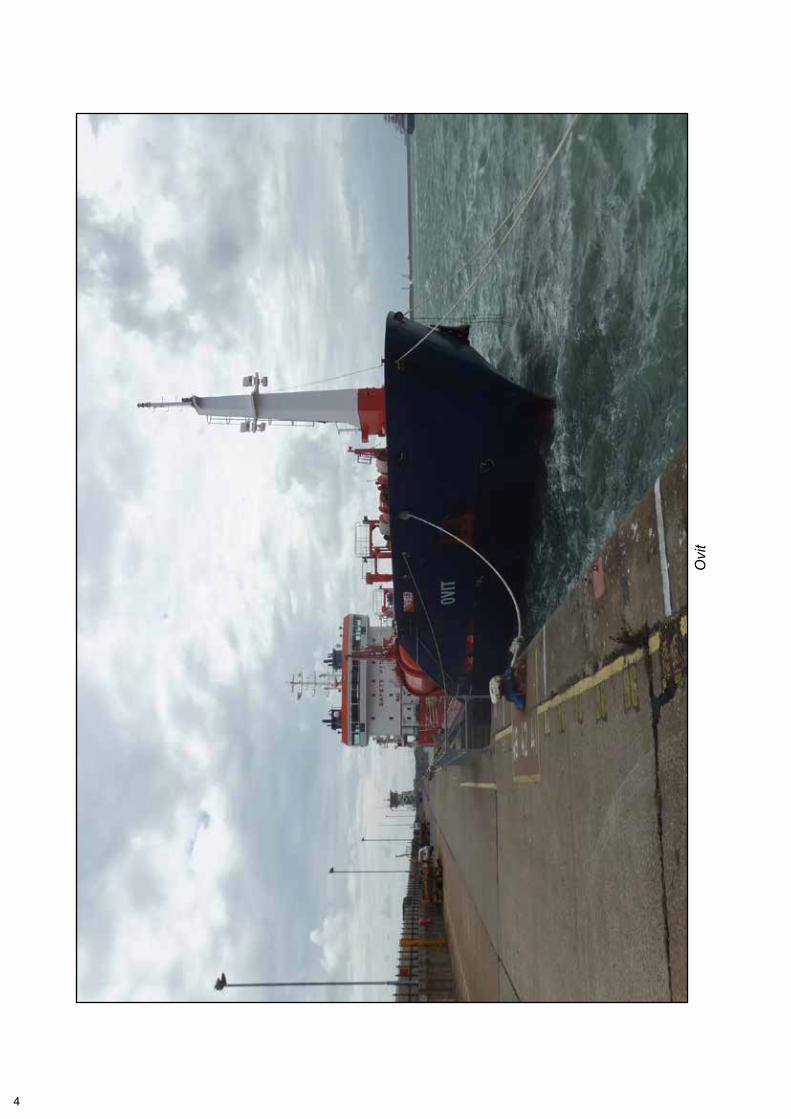
Ovi
t
5
1.2 NARRATIVE
1.2.1 The grounding
During the early morning of 18 September 2013, the Malta registered tanker Ovit was transiting the Dover Strait. The vessel was on passage from Rotterdam, Netherlands, to Brindisi, Italy carrying a cargo of vegetable oil. The intended route through the Dover Strait (Figures 1 and 2) was prepared using the ship’s electronic chart display and information system (ECDIS).
At 02301,thechiefofficerarrivedonthebridgeandtookoverfromthesecondofficerastheofficerofthewatch(OOW).Hewasjoinedbythedeckcadetwhowasthe assigned lookout. Ovit was following an autopilot controlled heading of 206° at a speed of between 12 and 13 knots (kts). The OOW selected the scale on the ECDIS display that closely aligned with the 12 nautical miles (nm) range scale set on the adjacent radar display. He then sat in the port bridge chair where he had a direct view of both displays (Figure 3). At about 0300, the heading on the autopilot was adjusted to 225°.
As Ovit approached the Varne Bank, the deck cadet, who was standing on the starboardsideofthebridgeandusingbinoculars,becameawareofflashingwhitelights ahead. He did not identify the lights or report the sighting to the OOW.
At approximately 0417, Ovit passed close by the Varne Light Float. From 0432 the ship’s speed slowly reduced until the vessel stopped when it grounded on the Varne Bank at 0434 (Figure 4).
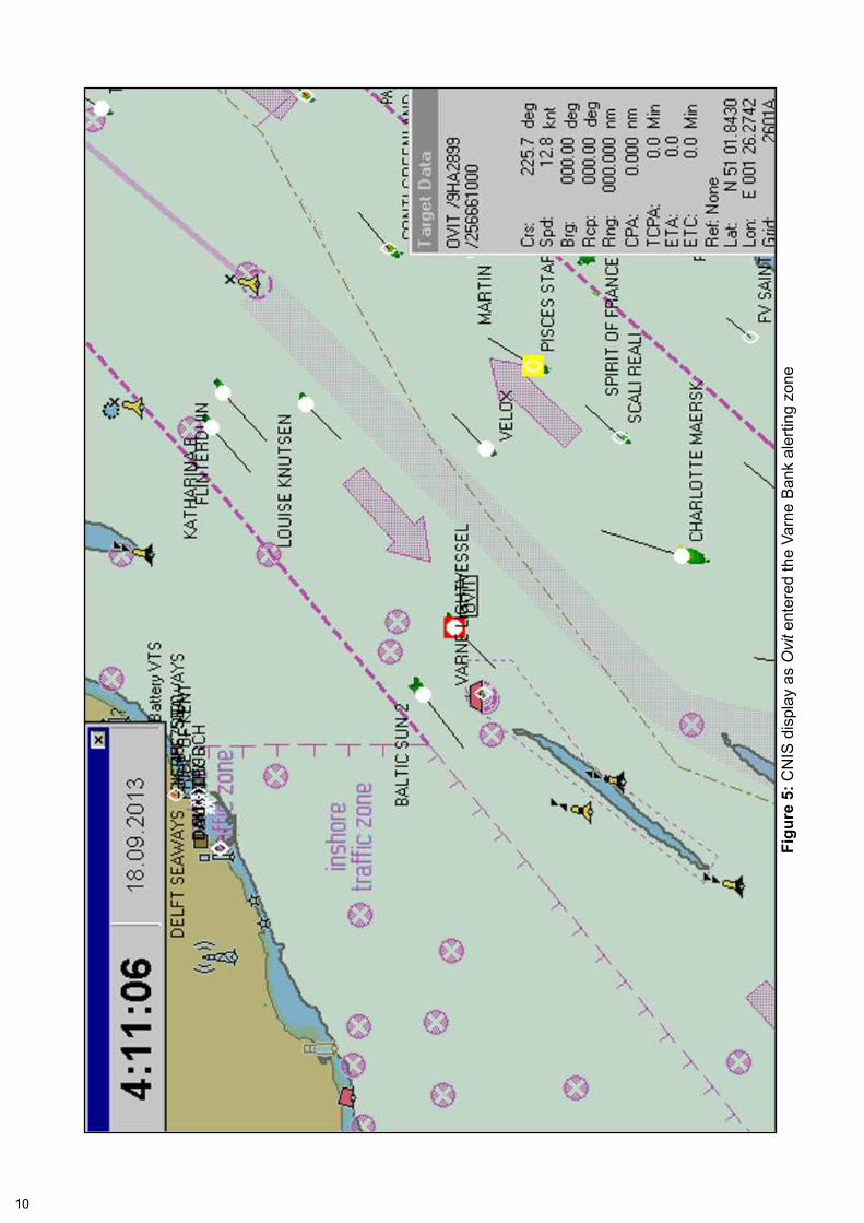
1.2.2 Shore monitoring
At 0411, Ovit’s radar vector2 crossed into the Channel Navigation Information Service’s (CNIS) Varne Bank alerting zone. This activated an audible alarm in the operations room at Dover Coastguard. The ship’s symbol on the CNIS display alsochangedfromblacktoredandstartedtoflash(Figure 5). The CNIS operator ‘authorised’ Ovit’s approach to the Varne Bank using a drop down menu on the CNIS display. This action silenced the audible alarm, and the ship’s symbol stopped flashinganditscolourchangedtoblack.Theoperatorthenreturnedtoaveryhighfrequency (VHF) radio exchange with another vessel inside the CNIS area.
1.2.3 Post grounding
The OOW did not appreciate that Ovit had grounded. At 0437, an engineering alarm sounded and the OOW placed both azipod control levers to zero. He then telephoned the master in his cabin to inform him of the alarm. He also telephoned the second engineer and instructed him to check the engines.
At 0443, the second engineer telephoned the bridge and informed the OOW that 45° of ahead pitch was available on the starboard azipod. Accordingly, the OOW moved the starboard azipod control lever to 45° pitch ahead. The ship remained stationary, which led the OOW to assume that there was still a problem with the ship’s engines.
1 This was 0430 ship’s time (UTC+2 hours).2 A computer projection ahead of the ship, the length of which is a function of the ship’s speed.
6
Figu
re 1
: Ovi
t’s p
assa
ge p
lan
thro
ugh
the
Dov
er S
trait
Rep
rodu
ced
from
Adm
iralty
Cha
rt B
A 00
02-0
and
218
2A-0
by
perm
issi
on o
f the
Con
trolle
r of H
MS
O
7
Figu
re 2
: Det
ail o
f Dov
er S
trait
pass
age
plan
Rep
rodu
ced
from
Adm
iralty
Cha
rt B
A 26
75-0
by
perm
issi
on o
f the
Con
trolle
r of H
MS
O
8
Figu
re 3
: OO
W v
iew
of b
ridge
dis
play
s fro
m th
e po
rt br
idge
cha
ir
EC
DIS
Rad
ar
9
Figu
re 4
: Ovi
t's g
roun
ding
pos
ition
Rep
rodu
ced
from
Adm
iralty
Cha
rt B
A 18
92-0
by
perm
issi
on o
f the
Con
trolle
r of H
MS
O
10
Figu
re 5
: CN
IS d
ispl
ay a
s O
vit e
nter
ed th
e Va
rne
Ban
k al
ertin
g zo
ne
11
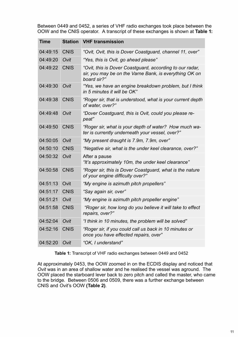
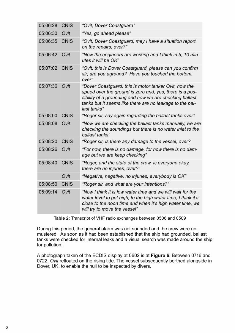
Between 0449 and 0452, a series of VHF radio exchanges took place between the OOW and the CNIS operator. A transcript of these exchanges is shown at Table 1:
Time Station VHF transmission
04:49:15 CNIS “Ovit, Ovit, this is Dover Coastguard, channel 11, over”
04:49:20 Ovit “Yes, this is Ovit, go ahead please”
04:49:22 CNIS “Ovit, this is Dover Coastguard, according to our radar, sir, you may be on the Varne Bank, is everything OK on board sir?”
04:49:30 Ovit “Yes, we have an engine breakdown problem, but I think in 5 minutes it will be OK”
04:49:38 CNIS “Roger sir, that is understood, what is your current depth of water, over?”
04:49:48 Ovit “Dover Coastguard, this is Ovit, could you please re-peat”
04:49:50 CNIS “Roger sir, what is your depth of water? How much wa-ter is currently underneath your vessel, over?”
04:50:05 Ovit “My present draught is 7.9m, 7.9m, over”
04:50:10 CNIS “Negative sir, what is the under keel clearance, over?”
04:50:32 Ovit After a pause“It’s approximately 10m, the under keel clearance”
04:50:58 CNIS “Roger sir, this is Dover Coastguard, what is the nature of your engine difficulty over?”
04:51:13 Ovit “My engine is azimuth pitch propellers”
04:51:17 CNIS “Say again sir, over”
04:51:21 Ovit “My engine is azimuth pitch propeller engine”
04:51:58 CNIS “Roger sir, how long do you believe it will take to effect repairs, over?”
04:52:04 Ovit “I think in 10 minutes, the problem will be solved”
04:52:16 CNIS “Roger sir, if you could call us back in 10 minutes or once you have effected repairs, over”
04:52:20 Ovit “OK, I understand”
Table 1: Transcript of VHF radio exchanges between 0449 and 0452
At approximately 0453, the OOW zoomed in on the ECDIS display and noticed that Ovit was in an area of shallow water and he realised the vessel was aground. The OOW placed the starboard lever back to zero pitch and called the master, who came to the bridge. Between 0506 and 0509, there was a further exchange between CNIS and Ovit’s OOW (Table 2).
05:06:35 CNIS “Ovit, Dover Coastguard, may I have a situation report on the repairs, over?”
05:06:42 Ovit “Now the engineers are working and I think in 5, 10 min-utes it will be OK”
05:07:02 CNIS “Ovit, this is Dover Coastguard, please can you confirm sir; are you aground? Have you touched the bottom, over”
05:07:36 Ovit “Dover Coastguard, this is motor tanker Ovit, now the speed over the ground is zero and, yes, there is a pos-sibility of a grounding and now we are checking ballast tanks but it seems like there are no leakage to the bal-last tanks”
05:08:00 CNIS “Roger sir, say again regarding the ballast tanks over”
05:08:08 Ovit “Now we are checking the ballast tanks manually, we are checking the soundings but there is no water inlet to the ballast tanks”
05:08:20 CNIS “Roger sir, is there any damage to the vessel, over?
05:08:26 Ovit “For now, there is no damage, for now there is no dam-age but we are keep checking”
05:08:40 CNIS “Roger, and the state of the crew, is everyone okay, there are no injuries, over?”
Ovit “Negative, negative, no injuries, everybody is OK”
05:08:50 CNIS “Roger sir, and what are your intentions?”
05:09:14 Ovit “Now I think it is low water time and we will wait for the water level to get high, to the high water time, I think it’s close to the noon time and when it’s high water time, we will try to move the vessel”
Table 2: Transcript of VHF radio exchanges between 0506 and 0509
During this period, the general alarm was not sounded and the crew were not mustered. As soon as it had been established that the ship had grounded, ballast tanks were checked for internal leaks and a visual search was made around the ship for pollution.
A photograph taken of the ECDIS display at 0602 is at Figure 6. Between 0716 and 0722, Ovitrefloatedontherisingtide.ThevesselsubsequentlyberthedalongsideinDover, UK, to enable the hull to be inspected by divers.
13
Figu
re 6
: Ovi
t’s E
CD
IS d
ispl
ay w
hen
the
ship
was
agr
ound
14
1.3 VESSEL EXAMINATION
While Ovit was berthed alongside in Dover:
• Adivesurveyestablishedthatdamagetothevesselwaslimitedtosignificanthullcoating loss, particularly on the plating below the bilge keel on the starboard side.
• MAIBinspectorsexaminedtheECDIS.Amongtheirfindings,whichareincludedin paragraph 1.8, was that the system’s audible alarm was not functioning.
• A port state control (PSC) inspection was undertaken by a surveyor from the Maritime and Coastguard Agency (MCA). Ovit was detained subject to an assessmentofseaworthinessandrectificationofthedefectiveECDISaudiblealarm.
• A service engineer repaired the ECDIS after seeking advice from the equipment manufacturer’s customer support team.
1.4 ENVIRONMENTAL dATA
Wind: South-westerly, force 3 - 4
Sea state: moderate
Visibility: good
Morning civil twilight : 0502
Sunrise (Dover): 0535
Predicted low water: 0507 (1.1m)
Predicted high water: 1001 (6.7m)
Height of tide (0434 - grounding): 1.4m, falling
Heightoftide(0716-refloat): 4.2m,rising
1.5 CREW
1.5.1 General
All of Ovit’s 14-man crew were Turkish nationals. The crew’s morale was reported as low. Several of the crew had expected to leave the vessel during recent port visits, including Hamburg, Germany, on 14 September 2013, but the crew changes had been cancelled. A planned delivery of cigarettes in Hamburg also did not arrive.
1.5.2 Deck officers
Allthedeckofficers’InternationalConventiononStandardsofTraining,CertificationandWatchkeepingforSeafarers1978,asamended(STCW)certificateshadbeenendorsed by the Malta Transport Authority.
15
The master was 35 years old and had been on board for 3 months. He had been at seafor15yearsandhadheldanSTCWII/2certificateofcompetency(CoC)for8years. OvitwashisfirstshiponwhichECDISwastheprimarymeansofnavigation.In March 2013, he had completed a bridge resource management (BRM) training course.
Thesecondofficerwas27yearsoldandhadbeenonboardjustover6months.He had been expecting to leave the ship in Hamburg and was disappointed and demotivatedbyhavingtoextendhistimeonboard.Thesecondofficerhad4years’seagoing experience and held an STCW II/1 CoC.
Thethirdofficerhadbeenonboardfor5monthsanditwashisfirstcontractsincebeing awarded an STCW II/1 CoC. His previous seagoing experience was as a deck rating for 4 years followed by 7 months as a deck cadet on board a general cargoship.Thethirdofficerwasexpectingtobepromotedtosecondofficerwhenthesecondofficerlefttheship.
The deck cadet had been on board for 6 months and held an STCW II/4 CoC, which qualifiedhimtostandawatchasabridgelookout.Heroutinelyaccompaniedthechiefofficerduringhisbridgewatchesatsea.
All of Ovit’sdeckofficershadattendedagenericECDIScourseandatype-specificECDIS training course which focused on the Marine Information System AB Type 900ECDIS(Maris900)fittedonboardOvit.Thetype-specifictrainingwasdeliveredby STT Marine Electronics in Istanbul, which was endorsed by Marine Information Systems AS (Maris) as an authorised training provider for its systems.
AttendeesattheMaris900trainingcourseswereamixofseniorandjuniorofficerswith varying degrees of experience at sea and with ECDIS. Ovit’s master was uncomfortablecompletingthecoursewithjuniorofficers.Inparticular,hefounditembarrassing to ask questions.
16
1.6 NAVIGATION
1.6.1 Responsibility
Thesecondofficerwastheship’snavigator.However,themasterinstructedthethirdofficertoplanthepassagefromRotterdamtoBrindisibecauseitwasassumedhewouldbetakingoverthesecondofficer’sresponsibilitieswhenthesecondofficerleftthevessel.Ineffect,themasterinstructedthethirdofficertoassumethedutiesofnavigatorwhilethesecondofficerwasstillonboard.However,therewasnohandoverinthisrespectbetweenthesecondandthirdofficersandthemasterhad not submitted his intended re-designation of duties to the ship’s manager for approval.
1.6.2 Passage planning
The passage plan for the voyage between Rotterdam and Brindisi was prepared bythethirdofficeron15September2013,whilethevesselwasatanchoroffRotterdam. He was not given any guidance by the master on how it should be prepared and no reference was made to previous, similar passages.
Whenthepassageplanwascompleted,itwascheckedbythethirdofficerbyscrolling ahead and zooming in on each of the route’s legs in order to identify the navigationaldangers.Thethirdofficer’sworkwasnotsupervisedbythesecondofficer.Priortodeparture,theintendedroutewasnotcheckedbythemasterandtherewasnopre-departurebriefamongthedeckofficers.
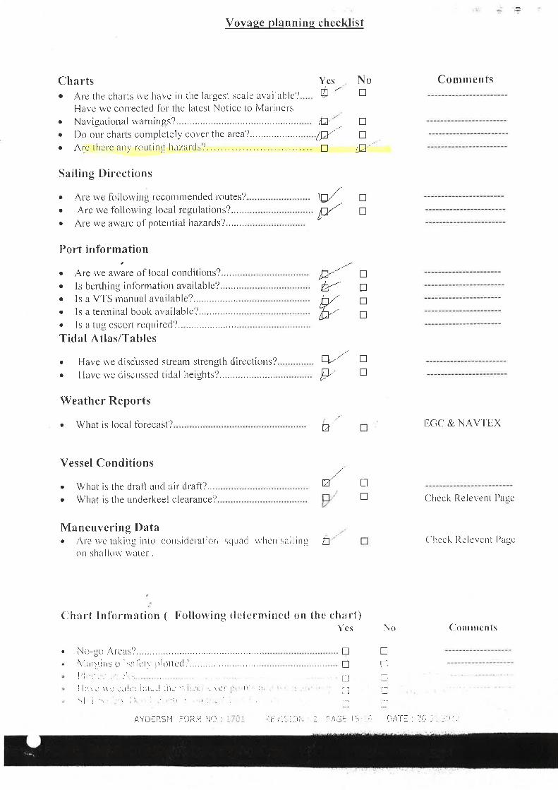
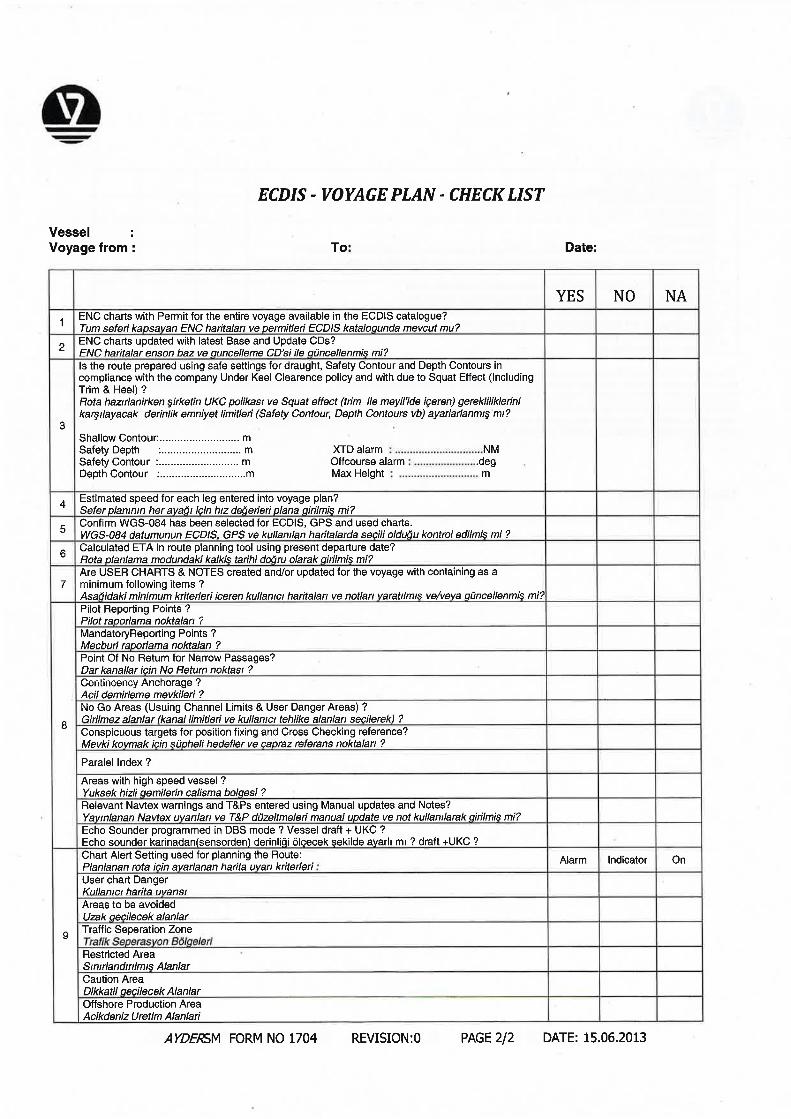
The passage plan checklist, which was included in Ovit’s safety management system(SMS)andwascompletedbythethirdofficer,isatAnnex A. Against the line ‘Are there any routing hazards?’ the ‘no’ box had been ticked. In addition, for the question, ‘Have the team members been made aware of any defective equipment?’ the response was ‘yes’.AvoyageplanningchecklistforuseinECDISfittedships,which was also included in the vessel’s SMS but had not been completed, is at Annex B.
1.7 MARIS 900 ECdIS
1.7.1 Approval and installation
TheMaris900ECDISwascertifiedbyDetNorskeVeritas(DNV) to be compliant with the necessary regulations from the International Maritime Organization’s (IMO) Convention for the Safety of Life at Sea (SOLAS) in November 2009 (Annex C). Foritscertification,thesystemwastestedusingtheInternationalElectrotechnicalCommission (IEC) standard 61174 (2008).
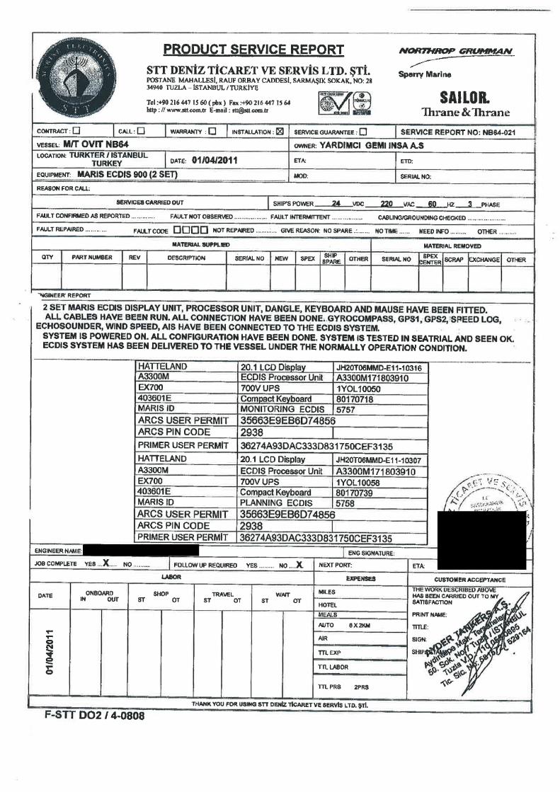
TheMarisType900fittedonboardOvit was supplied and installed by STT Marine ElectronicsinIstanbul.Theinstallationcertificate(Annex d) dated 1 April 2011 stated that ‘all configuration have been done [sic]. System is tested in sea trial and seen OK [sic].’
The system comprised a planning terminal on the starboard side of the bridge by the chart table (Figure 7) and a monitoring terminal on the port side bridge console (Figure 8). Both computers were connected in a local area network and each system was supported by an independent, uninterrupted power supply.
17
Figure 7: ECDIS planning terminal
Figure 8: ECDIS monitoring terminal
System: Maris Type 900
18
The ship’s gyro data, global positioning system (GPS), log speed, echo sounder, windinformationandautomaticidentificationsystem(AIS)wereallconnectedtotheECDIS.
Ovit’sCargoShipSafetyEquipmentCertificate,issuedbytheAmericanBureauofShipping(ABS),confirmedthat‘the ship complied with the requirements of the Convention as regards ship borne navigational equipment…and nautical publications.’ Thiscertificatewasvaliduntil3May2016.
1.7.2 Electronic navigational charts
The Maris 900 uses electronic navigational charts (ENC). An ENC is a ‘vector chart, issued by or on behalf of a Governmental body that complies with the IHO3 ENC product specification that is part of the chart data transfer standard known as S574’. ENC data is divided into ‘cells’ that contain hydrographic data intended for use betweendefinedmaximumandminimumscales.Thefirstdigitofthecell’snumberindicates the intended use and appropriate range scale as shown in Table 3.
Table 3: ENC cell range scales
1.7.3 Contours and depths
The following contour depths (in metres) could be set on the Maris 900 ECDIS:
• Deep contour
• Safety contour
• Shallow contour
• Safety depth
These values were selected on the S57 settings page (Figure 9). The deep and shallow contour values only control colour shading. The safety contour and safety depth settings require values which are appropriate to the local navigational conditions and take into account; the ship’s draught, the effect of squat and, where necessary, height of tide5.
3 International Hydrographic Organization4 AnopenlyavailabledataformatdefinedinIHODocumentS-66Edition1‘Facts about Electronic Charts and
Carriage Requirements’5 The safety contour is a critical feature intended to show the operator a difference between safe and potentially
unsafe water; crossing the safety contour is a mandatory ECDIS alarm. When a safety contour depth is set, if the selected contour is not available, the system defaults to the next deepest contour available. (For example, if the safety contour was set to 15m but the ENC contours available were only every 10m, then the display would show the safety contour at 20m.) The safety depth value is intended to assist the operator by highlighting spot depths less than the chosen setting by the use of a bold font.
19
1.7.4 Guard zone
The Maris 900 ECDIS uses a guard zone ahead of the ship to provide advance warningofdangers.Theextentoftheguardzoneisdefinedbysettingatimeandan angle across the bow (Figure 10)6. The operator is also able to select whether thedangersidentifiedintheguardzonearehighlightedonthedisplay.However,even if the operator selects for the dangers not to be highlighted, an audible alarm shouldstillsoundwhenadangerisidentifiedinsidetheguardzone.
1.7.5 depth alarms
The Maris 900 incorporates two depth alarms:
• The safety contour alarm activates if the guard zone crosses the selected safety contour. This is a mandatory alarm required by the IMO performance standards. The Maris 900 factory default setting value for the safety contour was 30m.
• The grounding alarm activates when the depth at the ship’s position is less than the selected safety depth.
6 The setting of an angle across a ship’s bow generates a cone, the extent of which is determined by speed and the time set. For example, with an angle of 50° and a time of 5 minutes set, the guard zone of a ship at 12kts would extend 25° either side of the bow out to a range of 1nm.
Figure 9: Maris 900 ECDIS ‘S57’ input page
20
1.7.6 Alarm management
When a safety parameter is exceeded, the Maris 900 system activates an audible alarm. It also provides the reason for the alarm in the alarm panel on the display. Once the operator acknowledges the alarm, the audio signal is cancelled. However, the user guide states:
‘The same alarm will not be triggered again but the message will remain displayed for as long as the relevant limitation is exceeded or until the function is purposely switched off. For example after acknowledgement, the message ‘XtD out limits’ will remain displayed for as long as the XTD7 exceeds the XTD limit value defined in the system or until the route is deactivated.’
1.7.7 Route checking
When a passage plan has been completed and is activated for use, the Maris 900 ECDIS automatically defaults to the ‘check-route’ function. This feature checks the intendedroutefornavigationalhazardswithinauser-defineddistancebothsidesofthe track. When a vessel is underway, deviation from a pre-determined route (by exceeding the XTD value) is a mandatory ECDIS alarm.
7 Cross Track Distance
Figure 10: Maris 900 ECDIS guard-zone settings page
21
1.7.8 Over-zoom notification
Referred to as the ‘jail bars’, the Maris 900 ECDIS system contained an over-zoom notificationtoalertanoperatortothefactthatimportantnavigationaldetailmaybemissing from the display because of the scale in use. The jail bars can be seen at Figure 6. In addition, the Maris 900 ECDIS system had an ‘auto-load’ feature which, if selected, loaded the most appropriate scale ENC available.
1.7.9 Logbook and track recording
The Maris 900 user guide states that:
‘During the process of its operation, ECDIS automatically maintains two different electronic logbooks:
• Voyage record
• Twenty four hours logbook
The voyage record stores every two hours the position, course and speed of the ship for half a year. The twenty-four hour logbook records both the navigational events and system events.’
The Maris 900 system also had a user-controlled track recording function which, if enabled,woulddisplayandrecordtheship’spositionatpre-definedintervals.
1.8 ECdIS USE ON BOARd Ovit
1.8.1 Examination
Following the grounding, MAIB examined and analysed Ovit’sECDIS.Thefindingsincluded:
• The audible alarm was not functioning. The audio output communications port hadnotbeenconfigured8. Therefore, when an alarm activated, no signal was sent to the integral speaker in the ECDIS display.
• The route in use was named ‘Rotterdam-Vasto’ and had been selected for navigation on 16 September 2013. It had 47 waypoints and totalled 2749.84nm.
• The ENC cell in use was GB202675. ENC cell GB401892 was available. The ENC auto-load feature was switched off.
8 AnalysisoftheECDISharddriveshowsthatothercomputerconfigurationsettingswerecorrectlysetupatthepoint of installation.
22
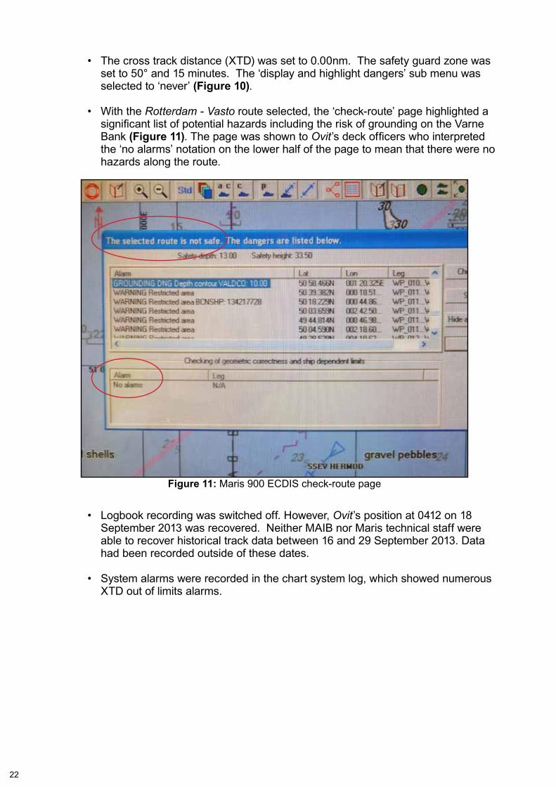
• The cross track distance (XTD) was set to 0.00nm. The safety guard zone was set to 50° and 15 minutes. The ‘display and highlight dangers’ sub menu was selected to ‘never’ (Figure 10).
• With the Rotterdam - Vasto route selected, the ‘check-route’ page highlighted a significantlistofpotentialhazardsincludingtheriskofgroundingontheVarneBank (Figure 11). The page was shown to Ovit’sdeckofficerswhointerpretedthe ‘no alarms’ notation on the lower half of the page to mean that there were no hazards along the route.
• Logbook recording was switched off. However, Ovit’s position at 0412 on 18 September 2013 was recovered. Neither MAIB nor Maris technical staff were able to recover historical track data between 16 and 29 September 2013. Data had been recorded outside of these dates.
• System alarms were recorded in the chart system log, which showed numerous XTD out of limits alarms.
Figure 11: Maris 900 ECDIS check-route page
23
1.8.2 display in use
Figure 6 is a photograph of the ECDIS display on board Ovit, which was taken when the vessel was aground. Information shown includes:
• The XTD in the grounding position was 202 metres (m) to port of the intended track.
• The 30m contour was highlighted as the safety contour.
• Two alarms were active:
◦ ‘XTD out limits’ ◦ ‘Grounding alert’.
1.9 RECONSTRUCTION
1.9.1 Set up and limitations
With the assistance of Warsash Maritime Academy, Ovit’s grounding was reconstructed in a bridge simulator to gain an appreciation of the various factors potentiallyinfluencingtheOOW’ssituationalawareness.Theinputsforthereconstruction included waypoints from Ovit’s passage plan, environmental data corresponding to that at the time of the accident, Ovit’s characteristics and positional data from the vessel’s voyage data recorder (VDR).
Two independent ECDIS (not Maris) were used during the reconstruction. One system was set up to replicate the settings used in Ovit during the grounding, theothersystemwasconfiguredtoshowtheoptimumdisplayavailable. The reconstruction considered both the planning and the monitoring aspects of the grounding.
1.9.2 Findings
Observations made during the reconstruction included:
• Ovit crossed the 30m safety contour at 0251 (Figure 12) and 0417.
• Ovit passed over a charted depth of 13m at 0427 which initiated the ‘grounding alarm’.
• The Varne Light Float was sighted at a range of just over 10nm.
• The lights on the cardinal buoys marking the east and west sides of the Varne Bank were sighted at 5nm.
24
Figu
re 1
2: R
econ
stru
ctio
n sh
owin
g O
vit’s
ear
lier 3
0m c
onto
ur c
ross
ing
25
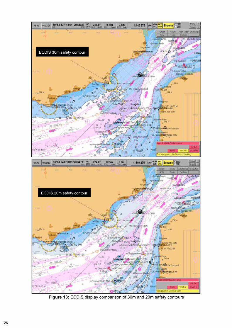
• There was a considerable difference between the ECDIS display with a safety contour set at 20m, and the display with the safety contour set at 30m (Figure 13).
1.10 VESSEL OPERATION ANd MANAGEMENT
1.10.1 General
Ovit was a 6,444 gross tonnage (gt) liquid chemical carrier built in Istanbul in 2011. The vessel was primarily engaged on European and Mediterranean routes and had transited the Dover Strait on 3 occasions in the 3 months before the grounding.
The vessel was owned by Ovit Shipping Ltd, registered in Malta and was one of nine chemical carriers operated by Ayder Tankers Ltd. The company, which was establishedin2006,managedeveryaspectofitsfleetfromitsheadofficeinTuzla,Istanbul. Its Document of Compliance (DoC) had been issued by Bureau Veritas (BV) and was valid until 25 September 2016. Ovit’sSafetyManagementCertificate(SMC) was also issued by BV and was valid until 14 February 2017.
1.10.2 Navigation equipment
In addition to the Maris 900, Ovit’s navigational equipment included:
• Sperry Marine Vision Master 3cm (X Band) radar
• Sperry Marine Vision Master 10cm (S Band) radar
• Sperry Marine R4 GPS navigation receiver
• Rutter NW04 VDR
• Martek Marine ‘Nav-guard’ Bridge Navigational Watch Alarm System (BNWAS)
• Sperry Marine Nav-pilot 4000 autopilot
• Sperry Marine ES5100 echo sounder.
At the time of the grounding, the BNWAS was switched off and no alarm depth had been set on the echo sounder.
1.10.3 Recruitment policy
AyderTankersLtdrecruiteditscrewsthroughitsmanningoffice;manningagencieswere not used. Job applications were scrutinised and then potential recruits were interviewedbeforeacontractwassigned.Newlyemployedseniorofficersspentaminimumof2daysatthecompany’soffices,tobebriefedontheSMSandtheirresponsibility for its implementation on board. Ovit’s master had attended the ship manager’sofficebeforejoiningtheship.
26
ECDIS 30m safety contour
ECDIS 20m safety contour
Figure 13: ECDIS display comparison of 30m and 20m safety contours
27
1.10.4 Safety management system
The implementation of the Safety Management Systems (SMS) on board Ayder Tankers’ vessels was the responsibility of the Designated Person (DP), who was an experienced master and well established within the organisation. The company regularly issued circulars with updated safety information and the DPA conducted frequent visits to ships. The SMS contained detailed guidance and procedures for the safe operation of the ship. In particular:
Master’s responsibility
The SMS set out the responsibilities of masters, which included:
'1.1.1 Master’s responsibility:
• Ensuring that all bridge personnel are fully familiar with the location and operation of all bridge controls and equipment
• Ensuring that the bridge is properly manned for the prevailing conditions
• Ensuring that a berth-to-berth passage plan is prepared and that safe distance from nearest grounding line are maintained'
Passage planning
TheSMSstatedthatthesecondofficerwasdesignatedasthenavigatingofficerand responsible for preparing a berth-to-berth passage plan and presenting it to the master. Key points included:
‘3.2 Principles of passage planning:
The passage plan is to be in three sections:
• Berth to commencement of sea passage (outward pilotage)
• Sea passage
• End of passage to berth (inward pilotage)
3.2.1 The passage plan preparation checklist must be used. An overall assessment of the intended passage must be made by the master, in consultation with the navigating officer and the other deck officers. This will be when all relevant information has been gathered. This appraisal will provide the master and his bridge team with a clear and precise indication of all areas of danger, and identify the areas in which it will be possible to navigate safely taking into account the calculated draught of the ship and planned under keel clearance.’
Use of ECDIS
The SMS provided detailed instructions to ships on which ECDIS was the primary meansofnavigation.Specifically:
28
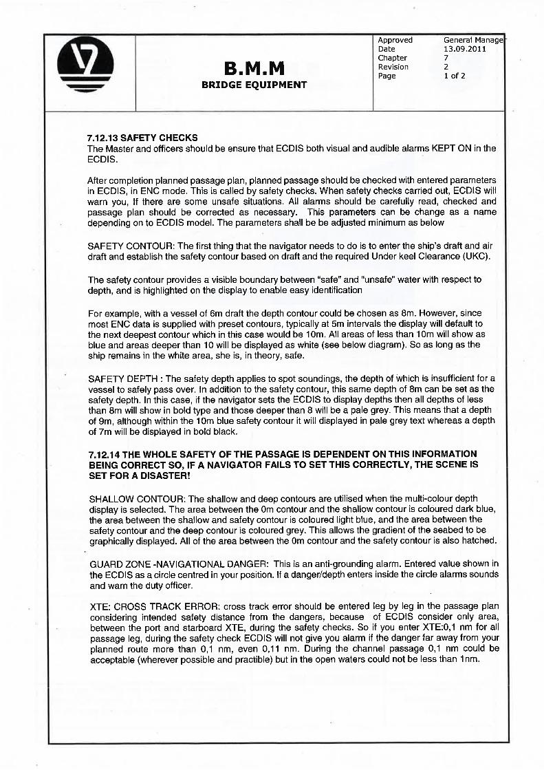
‘7.12.13 safety checks:
• The master and officers should ensure that ECDIS both visual and audible alarms are KEPT ON in the ECDIS. [sic]
• After completion planned passage plan, planned passage should be checked with entered parameters in ECDIS. This is called by safety checks. When safety checks carried out, ECDIS will warn you, if there are some unsafe situation [sic].
SMS Section 7.12.14 provided guidance on the calculation of safety settings including the XTD (Annex E).
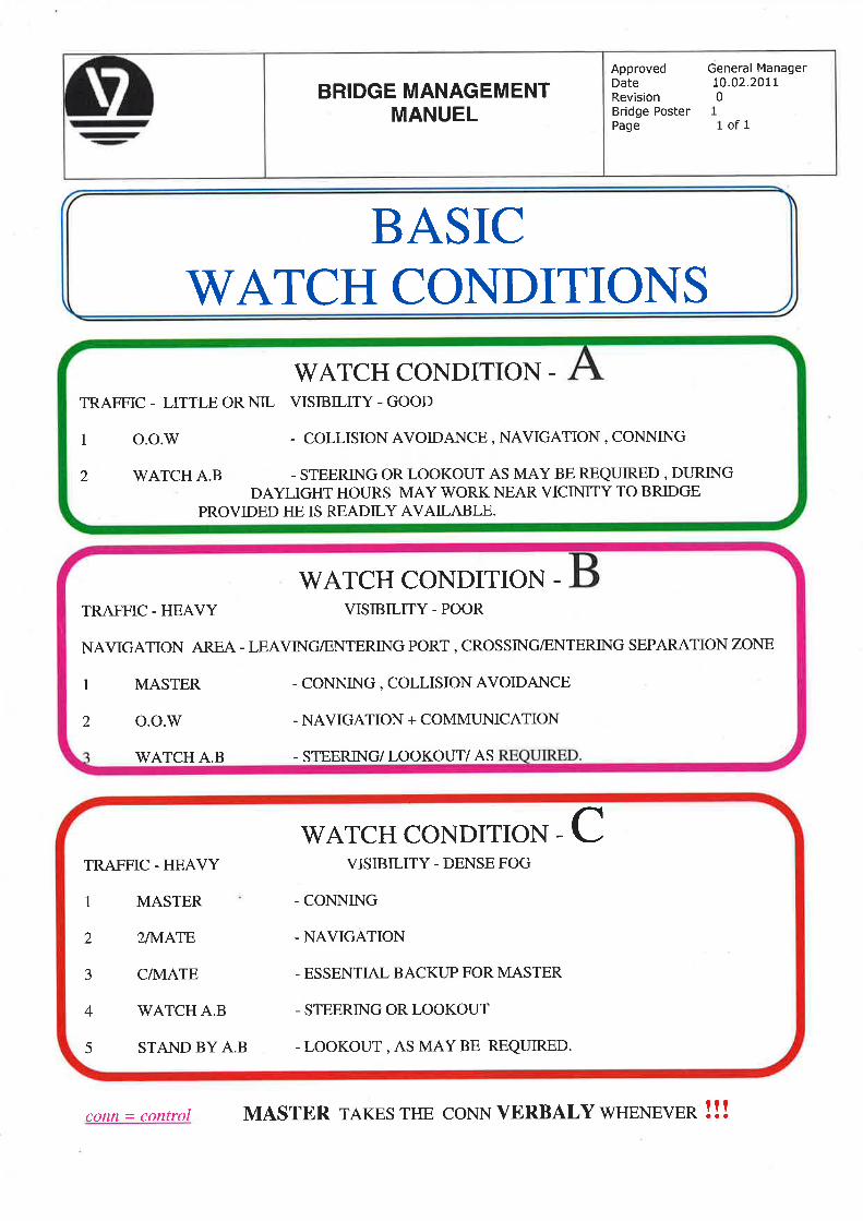
Watch conditions
TheSMSalsoincludeddefinitionsforthreewatchconditions(Annex F) which were based on proximity of danger:
• ConditionA:littletrafficandgoodvisibility
• ConditionB:heavytraffic,poorvisibility,entering/leavingportorcrossing/entering separation zone
• ConditionC:heavytraffic,densefog.
1.10.5 Master’s orders
Ovit’s master had issued a personal set of bridge standing orders to accompany the company’s SMS bridge manual. On 17 September 2013, he had also issued handwritten sea orders which were for ‘From Rotterdam to Brindisi.’ However, neither the master’s bridge nor sea orders included guidance on ECDIS safety settings.
1.10.6 defect reporting
Ayder Tankers Ltd had a well-established procedure for its crews to record and report defects on board. However, no records were found indicating that the absence of an audible alarm in the ECDIS on board Ovit had been reported.
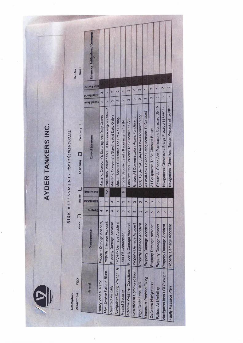
1.10.7 Navigation risk assessment
A risk assessment for navigation (Annex G) was held on board, which included the followingidentifiedhazards:
• ‘High draft/less under keel clearance (UKC) [sic]
• Uncorrect position fixing [sic]
• Faulty passage plan’
The mitigation for ‘Faulty passage plan’ was ‘Navigational Checklists / Bridge Procedures Guide’.
29
1.11 AUdITS, INSPECTIONS ANd SURVEYS
1.11.1 Navigation audits and survey
Ayder Tankers Ltd conducted an internal audit on board Ovit on 27 August 2012. The audit report stated that passage planning was ‘okay’andthattheofficerswere familiar with ECDIS and its functions. A Flag State inspection in Malta on 1 November2012identifiedthattheship’sdeckofficerswere‘not in possession of type-specific ECDIS certificates.’ An annual safety equipment survey conducted by ABS on 16 July 2013 did not identify any problems with the vessel’s navigation equipment.
1.11.2 Ship Inspection Report Programme
TheShipInspectionReportProgramme(SIRE)isasignificantindustryinitiativeintroduced by the Oil Companies’ International Marine Forum (OCIMF) to enable risk-based analyses using data from vessel inspections.
A SIRE inspection was conducted on board Ovit on 8 September 2013. The navigation section of the inspection report contained two observations:
• ‘Admiralty Pilot North Sea (East)(NP55) was out of date
• Port side gyro repeater was not operational’
The report also commented that the passage plan was well prepared, ECDIS trainingcertificateswereheldanddetailedECDISprocedureswereincludedinthecompany bridge manual.
1.12 ECdIS CARRIAGE REqUIREMENTS
1.12.1 International
SOLAS Chapter V, Regulation 19 states:
'2.1.4. All ships…shall have nautical charts and publications to plan and display the ship’s route for the intended voyage and to plot and monitor positions throughout the voyage. An electronic chart display and information system (ECDIS) is also accepted as meeting the chart carriage requirements of this subparagraph. Ships to which paragraph 2.10 applies shall comply with the carriage requirements for ECDIS detailed therein;
2.1.5 back-up arrangements to meet the functional requirements of subparagraph .4, if this function is partly or fully fulfilled by electronic means
2.10 Ships engaged on international voyages shall be fitted with an Electronic Chart Display and Information System (ECDIS) as follows:
.1 passenger ships of 500 gross tonnage and upwards constructed on or after 1 July 2012;
.2 tankers of 3,000 gross tonnage and upwards constructed on or after 1 July 2012;
30
.3 cargo ships, other than tankers, of 10,000 gross tonnage and upwards constructed on or after 1 July 2013;
.4 cargo ships, other than tankers, of 3,000 gross tonnage and upwards but less than 10,000 gross tonnage constructed on or after 1 July 2014;
.5 passenger ships of 500 gross tonnage and upwards constructed before 1 July 2012, not later than the first survey* on or after 1 July 2014;
.6 tankers of 3,000 gross tonnage and upwards constructed before 1 July 2012, not later than the first survey* on or after 1 July 2015;
.7 cargo ships, other than tankers, of 50,000 gross tonnage and upwards constructed before 1 July 2013, not later than the first survey* on or after 1 July 2016;
.8 cargo ships, other than tankers, of 20,000 gross tonnage and upwards but less than 50,000 gross tonnage constructed before 1 July 2013, not later than the first survey* on or after 1 July 2017; and
.9 cargo ships, other than tankers, of 10,000 gross tonnage and upwards but less than 20,000 gross tonnage constructed before 1 July 2013, not later than the first survey* on or after 1 July 2018.'
1.12.2 Flag State
The Malta Transport Authority requirements for the carriage of ECDIS were set out in Transport Malta’s Administration Requirements Document, Section 1, Article 1.20 which stated:
‘Ships fitted with an ECDIS type approved in accordance with relevant international standards, including IMO Resolution A.817(19) as amended, and with adequate back up arrangements are accepted as meeting the chart carriage requirements of SOLAS 74 Chapter V regulation 27 when navigating in waters covered by Electronic Navigation Charts (ENC) officially issued by an authorised Hydrographic Office.
The following arrangements are accepted as fulfilling the back-up requirement:
• A second type-approved ECDIS’
The document did not specify the training standards required for ships’ crews navigating solely using ECDIS.
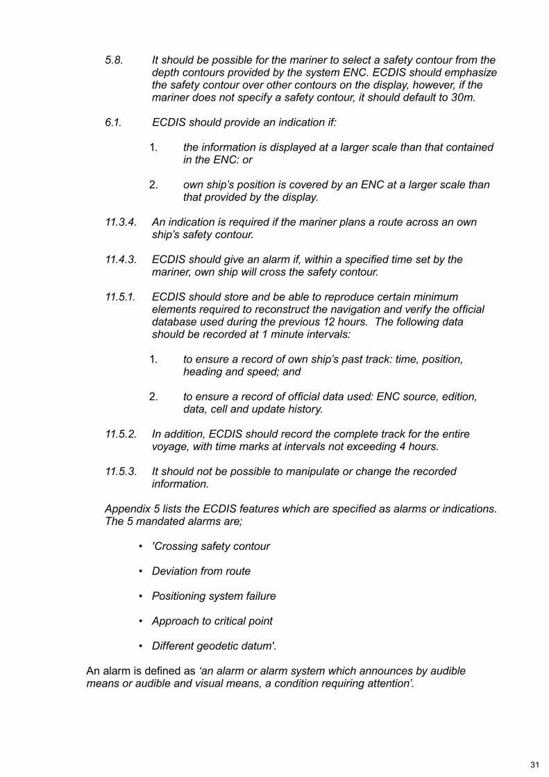
1.13 ECdIS PERFORMANCE STANdARdS
TheperformancespecificationsforECDISaredetailedinIMOResolutionMSC232(82) which was adopted by the Organization on 5 December 2006. The requirement for performance standards includes:
31
5.8. It should be possible for the mariner to select a safety contour from the depth contours provided by the system ENC. ECDIS should emphasize the safety contour over other contours on the display, however, if the mariner does not specify a safety contour, it should default to 30m.
6.1. ECDIS should provide an indication if:
1. the information is displayed at a larger scale than that contained in the ENC: or
2. own ship’s position is covered by an ENC at a larger scale than that provided by the display.
11.3.4. An indication is required if the mariner plans a route across an own ship’s safety contour.
11.4.3. ECDIS should give an alarm if, within a specified time set by the mariner, own ship will cross the safety contour.
11.5.1. ECDIS should store and be able to reproduce certain minimum elements required to reconstruct the navigation and verify the official database used during the previous 12 hours. The following data should be recorded at 1 minute intervals:
1. to ensure a record of own ship’s past track: time, position, heading and speed; and
2. to ensure a record of official data used: ENC source, edition, data, cell and update history.
11.5.2. In addition, ECDIS should record the complete track for the entire voyage, with time marks at intervals not exceeding 4 hours.
11.5.3. It should not be possible to manipulate or change the recorded information.
Appendix 5 lists the ECDIS features which are specified as alarms or indications. The 5 mandated alarms are;
• 'Crossing safety contour
• Deviation from route
• Positioning system failure
• Approach to critical point
• Different geodetic datum'.
Analarmisdefinedas ‘an alarm or alarm system which announces by audible means or audible and visual means, a condition requiring attention’.
32
1.14 OPERATOR STANdARdS
1.14.1 OOW
TheInternationalConventionforStandardsofTrainingandCertificationofWatchkeepers 1995 (STCW) Table A-II/1 sets out the requirement for competence of officersinchargeofanavigationalwatchinshipsof500gtormore.SpecificallyforthoseofficersservingonshipsfittedwithECDIS,theirknowledgeofthecapabilityand limitation of ECDIS operations should include:
• ‘a thorough understanding of ENC data, data accuracy, presentation rules, display options and other chart data formats
• the dangers of over-reliance
• familiarity with the functions of ECDIS required by the performance standards in force’.
Proficiencyinoperation,interpretationandanalysisofinformationobtainedfromECDIS should include:
• ‘safe monitoring and adjustment of information, including own position, chart data displayed and route monitoring
• efficient use of settings to ensure conformance to operational procedures, including alarm parameters for anti-grounding
• situational awareness while using ECDIS including safe water and proximity of hazards, set and drift, chart data and scale selection and suitability of route’.
1.14.2 Senior officers
STCWTableA-II/2specifiestheminimumstandardofcompetencerequiredformasters and chief mates on ships of 500gt or more. It expands the knowledge levels detailed in Table A-II/1 to include, among other things:
• 'Use ECDIS log-book and track history functions for inspection of system functions, alarm settings and user responses
• Use ECIDS playback functionality for passage review, route planning and review of system functions.'
1.15 OPERATOR TRAINING REqUIREMENTS
1.15.1 International Safety Management Code
The International Safety Management Code (ISM Code) provides a standard for the safe management of ships. Guidance in the ISM Code includes:
‘6.2 The company should establish procedures to ensure that new personnel and personnel transferred to new assignments related to safety and protection of the environment are given proper familiarization with their duties.'
33
1.15.2 Generic training
IMO model course 1.27 was issued by the IMO’s STW sub-committee and offered guidance on generic ECDIS training. The model course 1.27 syllabus was intended tomeettherequirementsoftheSTCWCode,specificallytherequirementsoftables A-II/1 and A-II/2. Students completing the course should be equipped with the knowledge, skill and understanding to keep a safe navigational watch using an ECDIS system.
1.15.3 Familiarisation
The IMO published guidance regarding ECDIS familiarisation to member states in STCW.7 Circular Note, dated 22 May 2012. This guidance included:
‘.5 Masters and officers certified under chapter II of the STCW Convention serving on board ships fitted with ECDIS are to be familiarized (in accordance with STCW regulation 1/14) with the ship’s equipment including ECDIS;
.6 ECDIS manufacturers are encouraged to provide resources, such as type-specific materials, which could be provided on a CD or DVD. These resources may form part of the ECDIS familiarization training;
.9 Regulation 1/14, paragraph 1.5 of the STCW Convention, as well as sections 6.3 and 6.5 of the International Safety Management (ISM) Code requires companies to ensure that seafarers are provided with familiarization training. A ship safety management system should include familiarization with the ECDIS equipment fitted including its backup arrangements, sensors and related peripherals. To assist Member Governments, Parties to the STCW Convention, companies and seafarers, a record of such familiarization should be provided;
.10 Administrations should inform their Port State Control officers of the requirements for ECDIS training as detailed in paragraph 9 above. A certificate of competency issued in accordance with the 2010 Manila Amendments would be prima facie evidence of generic ECDIS training; however, a record of the ship specific familiarization of the ECDIS should be provided.’
1.16 VOYAGE PLANNING
STCW Section A-VIII/2, Part 2, states that:
‘Prior to each voyage the master of every ship shall ensure that the intended route from the port of departure to the first port of call is planned using adequate and appropriate charts and other nautical publications as necessary for the intended voyage, containing accurate, complete and up-to-date information regarding those navigational limitations and hazards which are of a permanent or predictable nature and which are relevant to the safe navigation of the ship.’
34
1.17 WATCHkEEPING STANdARdS
STCW Section A-VIII/2, Part 3, states that:
‘9. The master of every ship is bound to ensure that watchkeeping arrangements are adequate for maintaining a safe navigational watch. Under the master’s general direction, the officers of the navigational watch are responsible for navigating the ship safely during their periods of duty, when they will be particularly concerned with avoiding collision and stranding.
14. The lookout must be able to give full attention to the keeping of a proper lookout and no other duties shall be undertaken or assigned which could interfere with that task.
20. Prior to taking over the watch, relieving officers shall satisfy themselves as to the ship’s estimated or true position and confirm its intended track, course and speed, and UMS9 controls as appropriate and shall note any dangers to navigation expected to be encountered during their watch.
36. Officers of the navigational watch shall…bear in mind that the echo sounder is a valuable navigational aid.
42. The officer in charge of the navigational watch shall give watchkeeping personnel instructions and information which will ensure the keeping of a safe watch, including a proper lookout.
48. The officer in charge of the navigational watch shall positively identify all relevant navigational marks.’
1.18 CHANNEL NAVIGATION INFORMATION SERVICE
1.18.1 Purpose
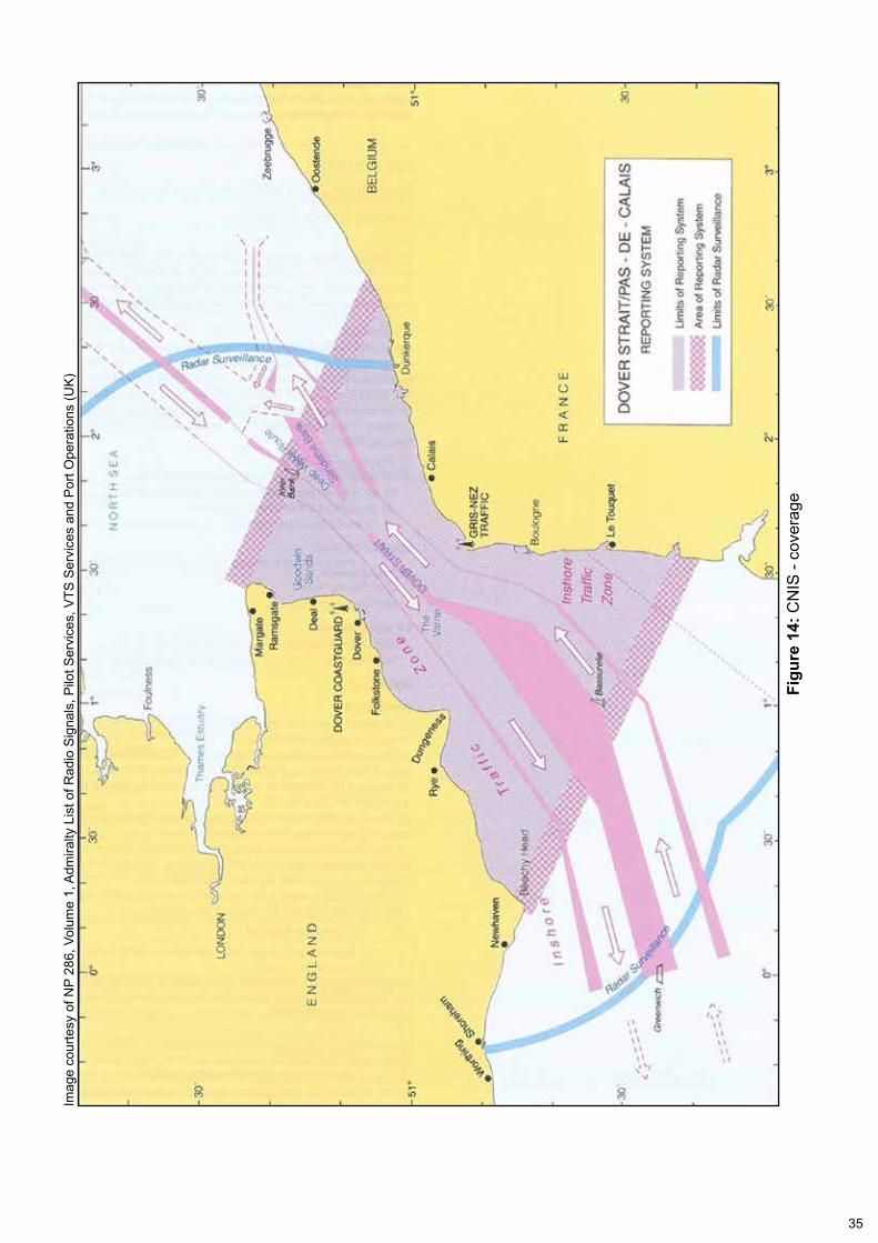
The CNIS was introduced in 1972 and provides a 24-hour radio and radar safety service for shipping within the Dover Strait. By collecting, recording and disseminating maritime information, the CNIS aims to provide the latest safety information to shipping in the CNIS area. CNIS is jointly provided by the UK and French Maritime authorities in Dover and Gris Nez respectively. In the UK, the MCA is responsible for the operation of CNIS, which it delegates to Dover Coastguard. The CNIS area is shown at Figure 14.
9 Unmanned Machinery Space
35
Figu
re 1
4: C
NIS
- co
vera
ge
Imag
e co
urte
sy o
f NP
286,
Vol
ume
1, A
dmira
lty L
ist o
f Rad
io S
igna
ls, P
ilot S
ervi
ces,
VTS
Ser
vice
s an
d P
ort O
pera
tions
(UK
)
36
1.18.2 Vessel traffic services
Merchant Shipping Notice (MSN) 1796, issued by the MCA in April 2006, designated vesseltrafficservice(VTS)stationsintheUKinaccordancewiththeMerchantShipping(VTSReportingRequirements)Regulations2004.Thisnoticedefinedthelevel of service available to shipping operating in designated VTS areas. Annex A of MSN1796designatedtheCNISasan‘informationservice’,whichitdefinedas:
• ‘A service to ensure that essential information becomes available in time for on-board navigational decision making’.
1.18.3 Equipment and manning
The CNIS station within Dover Coastguard contains an array of displays showing integrated radar and AIS information which provide operators with a good situational awareness of shipping in the area. Operators also have access to VHF voice and digital selective calling (DSC) communication systems.
The CNIS operator’s tasks include preparing and transmitting routine broadcasts as well as managing reports from ships entering the area. The CNIS station is continuouslymannedbyasuitablyqualifiedwatchofficer.However,itisacceptableforatraineetooperatetheCNISstationprovidedafullyqualifiedoperatorissupervising.
1.18.4 Varne Bank alerting system
OneofthedutiesofaCNISwatchofficeristomonitortheVarneBankalertingsystem. A warning activates in two stages:
• When a vessel’s radar vector (based on the distance a vessel will travel in 6 minutes) (Figure 5) enters a radar guard zone set around the Varne Bank.
• When the vessel itself enters the guard zone.
When a vessel’s vector crosses the boundary of the guard zone, an audible alarm is activated and the ship’s symbol on the radar display changes colour from black tored,andflashes.Thealertisshownas‘Approaching Varne’ on the operator’s display. The operator then has two options:
1. Acknowledge – this mutes the audible alarm but the radar target continuestoflashred.Ifthisoptionisselected,theaudiblealarmwillreactivate when the ship enters the radar guard zone.
2. Authorise–thismutestheaudiblealarmandtheflashingredshipsymbolturnsblackandstopsflashing.Thealarmsdonotreactivatewhentheship enters the radar guard zone.
Whenthealarmfirstsounds,theoperatorisrequiredtoestablishthevessel’sintentionsand,ifariskofgroundingisidentified,issueawarningviaVHFradio.When the alarm is activated by a vessel which is able to navigate safely across the bank and is permitted to so, the vessel’s movement is ‘authorised’.
37
The procedure to be followed on activation of the Varne Bank alerting system was circulatedtoallwatchofficersbye-mailbytheCNISmanageron29April2013.Itwas not included in Dover Coastguard’s written procedures.
1.18.5 CNIS operator training
InordertoqualifyasaCNISoperator,watchofficerswererequiredtoholdaVTScertificate(V103)andcompletethe‘CNIS Operator Assessment and Endorsement Procedure’. TheV103qualificationisthenationallyrecognisedVTS operators’ training scheme, which is endorsed by the MCA as the National Competent Authority for VTS services in the UK. The syllabus covers all aspects ofVTSoperationsincludingtrafficmanagement,VHFradiowork,communicationco-ordination and dealing with emergency situations.
The ‘CNIS Operator Assessment and Endorsement Procedure’ is also endorsed bytheMCAandisadetailedtrainingschemecoveringthespecificsoftheCNISsystem. Candidates were required to demonstrate a thorough knowledge of the system through supervised watchkeeping and a written exam. However, the syllabusdidnotcontainaspecificrequirementfortrainingontheVarneBankalerting system.
1.18.6 Watch system
To provide 24 hour coverage, Dover Coastguard operates a four watch system. The duty watch is responsible for four key functions: CNIS, Sunk VTS10, the monitoring of VHF channel 16 and search and rescue (SAR). This requires a minimum of four qualifiedoperatorswithineachwatchtobeavailableatalltimes.However,itwaspolicy to have six operators (including trainees) available for day watches11andfivefor night watches12.
The watch on duty overnight on 17/18 September 2013 comprised:
• a watch manager
• awatchofficer
• twotraineewatchofficers(onefromadifferentwatch)
• a watch assistant.
Onlythreequalifiedoperatorswereonwatchbecausetheseniorwatchmanagerandapart-timewatchofficerwerebothonleave.Atthetimeofthegrounding,thewatchmanagerandwatchofficerwerebothabsentfromtheoperationsroomonameal break. The responsibilities of the personnel remaining were:
• SunkVTS-watchassistant(V103qualified)
• CNIS-traineewatchofficer
• VHFchannel16/SAR-traineewatchofficer
10 The North Sea Sunk area VTS is operated by Dover Coastguard11 0800-2000 local time12 2000-0800 local time
38
None of the three remaining operators were nominated by the watch manager to be ‘in charge’ during his absence.
1.18.7 CNIS manpower
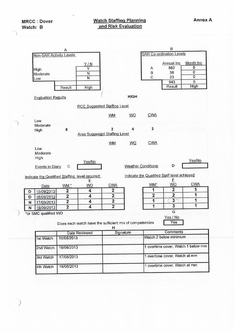
Manpower shortfalls meant the duty watch was frequently unable to meet watch commitments without augmentation by operators from the ‘non-duty’ watches. As a result, it was commonplace for members of staff to work overtime on other watches to ensure the minimum manning levels were maintained. The risk associated withthisdifficultyinsustainingappropriatemanninghadbeenreportedbyDoverCoastguard managers to the MCA headquarters, but its actions were ineffective in easing the manning shortfall.
The Watch Staffing Planning and Risk Evaluation for the period 15-18 September 2013 is at Annex H. This assessment shows that, at the time of the grounding, the watch was at minimum manning. It also shows that the day watch on 15 September 2013wastwowatchofficersbelowtheminimummanninglevel.Theshortageshighlighted in the evaluation were typical of the shortages experienced at other times.
1.19 PREVIOUS ACCIdENTS
1.19.1 Lowlands Maine
On 26 April 2006, the bulk carrier Lowlands Maine ran aground on the Varne Bank. DuringpassagethroughtheDoverStrait,theship’schiefofficermadeanalterationof course to regain track. The new course headed directly for the Varne Bank. Beforethevesselhadregainedtrack,thethirdofficertookoverthebridgewatch.Thethirdofficerfixedtheship’spositionandsawthattheshiphadregainedtrack.However, he did not adjust the ship’s heading back to the base course and the ship continued to head for the Varne Bank until grounding.
1.19.2 Lt Cortesia
On 2 January 2008, the container ship LT Cortesia ran aground on the Varne Bank, causing the buckling of an internal bulkhead. The accident report published by the German Federal Bureau of Maritime Casualty Investigation concluded that the OOW had not properly assessed the shipping situation and that communications with thelookoutwereineffective.Thereportalsoidentifiedthatthecontourandalarmsettings on the ECDIS were inappropriate.
1.19.3 CFL Performer – MAIB report 21/2008
On 12 May 2008, the Netherlands registered dry cargo ship, CFL Performer, ran agroundonHaisboroughSand.Thegroundingoccurredafterthechiefofficeradjusted the passage plan in the ECDIS. The adjusted route, which took the vessel directly over Haisborough Sand, was not checked by the master. The MAIB investigation established that, despite ECDIS being used as a primary meansofnavigation,noneoftheship’sofficershadbeentrainedinitsuse.Arecommendation was made to the MCA to support a proposal that ECDIS competencies were included in the STCW Convention.
39
1.19.4 CSL thames – MAIB report 02/2012
On 9 August 2011, the Malta registered self-discharging bulk carrier, CSL Thames, grounded in the Sound of Mull. The grounding occurred after the OOW had made an alteration of course to avoid another vessel, but had not noticed that the new course would take the ship into shallow water. The audio alarm on the ship’s ECDIS system, which could have alerted the OOW to the danger, was inoperative. In addition, the master and other watchkeepers’ knowledge of the ECDIS system was insufficient.
40
SECTION 2 - ANALYSIS
2.1 AIM
The purpose of the analysis is to determine the contributory causes and circumstances of the accident as a basis for making safety recommendations to prevent similar accidents occurring in the future.
2.2 OVERSIGHT ANd SCRUTINY
It is evident from the planned track over the Varne Bank (Figures 1 and 2) that therouteplannedbythethirdofficerwasunsafeandhadneverbeenproperlychecked.ThethirdofficerhadzoomedinoneachlegoftherouteontheECDISinorder to visually identify navigational hazards. However, this very basic approach was unlikely to identify all the dangers associated with the passage. The ECDIS check-route page (Figure 11) would have been more accurate and reliable. Nonetheless, the danger of passing over the Varne Bank should have still been readily apparent had the visual check been completed diligently.
The requirement to prepare a safe passage plan underpins safe navigation. Therefore,itisimportantthatofficersresponsibleforthistaskaresufficientlyexperienced and competent. In this case, the master’s decision to direct the third officertoplanthepassagewasreasonable.Thesecondofficer’sdeparturefromthevesselwasimminentandthethirdofficerwassoontobepromoted.Thethirdofficerhad also been trained in the use of ECDIS and had used the Maris 900 during his 5 months on board. However, the complexity of the route and the inexperience of the thirdofficerwarrantedahighdegreeofsupervisionandscrutiny.Instead,therewasnone.Itisastonishingthatthesecondofficerdidnotassist,adviseormonitorthethirdofficer,andthatthemasterdidnotchecktheintendedroutehimself.
Althoughthesecondofficerhadbeenexpectingtoleavetheship,noformalhandoverofnavigationofficerresponsibilitieshadtakenplace.Thesecondofficerwas,therefore,stillthenavigatingofficer.Hewasdemotivatedbecausehehadnotbeen able to leave the ship in Hamburg, but this should not have impinged on the secondofficer’sprofessionalresponsibilitytoprovideoversightofthethirdofficerandpassonthebenefitsofhisexperience.Indeed,itisataskthatthemastershould have directed him to undertake.
2.3 BRIdGE WATCHkEEPING PRACTICES
2.3.1 Events leading to the grounding
Whenthechiefofficerarrivedonthebridge,hedidnotchecktherouteaheadto identify potential navigational hazards or the navigational marks likely to be encountered during his watch. Consequently, he was unaware that the ship’s intended track passed over the Varne Bank. He was also ignorant of the cardinal marks marking the danger.
When Ovit grounded,thechiefofficerhadbeenonwatchfor2hours.Duringthistime, he had mainly remained seated in the chair in front of the ECDIS and radar displays (Figure 3). However, his alignment of the scale set on the ECDIS with the
41
range scale on the adjacent radar display resulted in the ECDIS being on a scale of 1:151712, which was totally inappropriate for the area. Consequently, safety critical information was not displayed.
ThechiefofficerdidnotappeartobeconcernedthattheECDISdisplaywasshowing ‘jail bars’ (Figure 6) which he could not avoid seeing. He was using ECDIS solely to monitor the vessel’s position relative to its intended track, nothing more. ThechiefofficerprobablydidnotseeonthedisplaythatOvit crossed the safety contour at 0251 and 0417. Given the ECDIS settings, crossing the safety contour was a routine event which was likely to have been frequently ignored.
Itisevidentthatthechiefofficereitherdidnotlookoutofthebridgewindow,orhe did not try and associate and correlate what he saw ahead of the ship with the information available from his radar, AIS and ECDIS. Therefore, even if the lookout hadreportedhissightingoflightsahead,itisuncertainwhetherthechiefofficerwouldhaverecognisedtheirsignificance.
During the reconstruction (paragraph 1.9) the east and west cardinal marks became visible at a range of 5nm. Consequently, they could potentially have been seen by the OOW and the lookout 25 minutes before Ovit grounded. This was ample time in which to identify the buoys, highlight the error in the passage plan, and take corrective action.
2.3.2 Events following the grounding
At 0434, when Ovit stopped in the water between the cardinal marks delineating the limits of the Varne Bank (Figure 4),thechiefofficer’ssituationalawarenesswas so poor that he did not know that the vessel had grounded. It was only when an engineering alarm sounded at 0437 that he became aware that something was wrong. Even then, it is evident that he thought that the ship was stopped because of amachinerybreakdown.Nonetheless,thatthechiefofficercalledthemasterafterhe moved the azipod control levers to zero pitch, indicates that he appreciated the seriousnessofbeingwithoutpropulsioninatrafficseparationscheme(TSS).
It was probably Dover Coastguard’s call on VHF radio (Table 1) stating that Ovit mightbeontheVarneBankthatpromptedthechiefofficertochangethescaleonthe ECDIS in order to see more information. Only then, at 0453, 19 minutes after Ovit hadstopped,didthechiefofficerrealisethatthetankerhadgrounded.
Althoughthechiefofficerthenagaintelephonedthemaster,thegeneralalarmwas not sounded and no crew muster was undertaken. Furthermore, it was not untilpromptedbytheCNISoperatorat0507thatthechiefofficerinformedDoverCoastguard that Ovit was aground (Table 2). The vagueness and lack of accuracy ofthechiefofficer’sresponsestothesubsequentquestionsaskedbytheCNISoperator were unhelpful, particularly as the operator was trying to establish what had happened and the level of assistance that might be required.
2.4 BRIdGE ORGANISATION
An important element of passage planning is ensuring that the ship is adequately prepared to meet the demands of any navigational situation. In this case, the master was aware that when Ovit sailed from Rotterdam, several hours of pilotage would be followed by a long transit through the TSS, including the Dover Strait.
42
TheDoverStraitisademandingpassagewhichpresentsaseriesofsignificantnavigationalhazardsforshipping,includingdangerousshallowsandahightrafficdensity. However, the area is well surveyed and charted, dangers are marked by navigation aids and it is closely monitored by VTS stations in the UK and France. Nevertheless, it is coastal navigation and requires a high state of alertness and the ability to react quickly to the potential dangers.
The watch conditions detailed in Ovit’s SMS (Annex G) provided guidance on the levels of bridge manning in differing situations. In this case, Ovit was following a trafficlane,visibilitywasgoodandtherewerefewothershipsintheimmediatearea. Therefore, the applicable watch condition to be used arguably rested between ‘watch condition A’ (OOW and lookout) and ‘watch condition B’ (master, OOW and lookout). Namely, the master would probably be required to be on the bridge when approaching and passing key choke points, such as the Varne Bank.
However,althoughthepotentialdangersofheavytrafficandtheproximityofnavigational hazards warranted a cautious approach, they did not trigger any additional precautions on board Ovit. The passage through the Dover Strait was treated in exactly the same way as a passage in open water. Indeed, the master’s decisiontoremaininhiscabinwhencalledbythechiefofficerat0437,indicatesanastounding level of complacency given that his vessel was apparently drifting in the Dover Strait with no propulsion available.
2.5 ECdIS
2.5.1 Use on board Ovit
ECDIS was the primary method of navigation on board Ovit; no paper charts were carried. Therefore, it was vital that the system was set up appropriately and that theofficersoperatingtheequipmentwerefullyfamiliarwithitsfunctions.Thecircumstances of the accident show that the Maris 900 was not used effectively. In particular:
Safety contour
The safety contour setting is intended to offer the OOW a distinct difference between safe and potentially unsafe water; crossing the safety contour initiates an alarm to alert the watchkeeper. Using the formula in Ovit’s SMS,13 (Annex E), the safety contour value should have been set at 13.35m. The ECDIS would then have defaulted to the nearest deeper contour on the chart in use, which was the 20m contour. Instead, the safety contour was set to 30m, which was the manufacturer’s default setting. A comparison of ECDIS displays using 30m and 20m safety contours (Figure 13) shows that use of the 20m setting would have provided a much clearer picture of where there was safe water available.
Route monitoring
A deviation from the planned route is a mandatory ECDIS alarm. However, the XTDalarmisonlyeffectivewhentheplannedrouteissafeinthefirstplaceandan appropriate value for XTD is set. In this case, the XTD value was 0.00nm and therefore the XTD alarms were of no value.
13 (Draft + squat) x 1.5 = (7.9 + 1) x 1.5 = 13.35m
43
ENC management
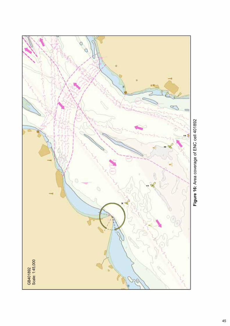
During the Dover Strait passage, the ENC in use was GB202657 which was a ‘general’ chart on a scale of 1:350,000 (Figure 15). In coastal waters, this scale of chart would only be effective for planning purposes. ENC, GB401892 on a scale of 1:45,000 (Figure 16), which was suitable for coastal navigation, was available on board but it was not in use. The ECDIS ‘auto-load’ feature, which would have automatically selected the best scale chart, was switched off.
Although the presence of the jail bars (Figure 6) should have alerted the OOW that somethingwaswrongwiththeECDISdisplay,thechiefofficerdidnotrecognisetheirsignificance.Consequently,hedidnotmanuallyloadthebetterscaleENC.
Audible alarm
The ECDIS audible alarm is a mandated feature and is vital for alerting the operator tonavigationaldangerorsystemfailures.Withoutthecorrectconfigurationofthecommunications port, Ovit’s audible alarm was inoperable. Although the installation report (Annex d) statedthatallconfigurationshadbeencompleted,itispossiblethat the audible alarm had never worked on board. However, it is also possible that theconfigurationofthealarm’scommunicationporthadbeentamperedwithduringOvit’s time in service. Either way, the evidence gathered during this investigation indicatesthatthevessel’sdeckofficershadoperatedtheECDISwithoutanaudiblealarm for a considerable period of time.
2.5.2 The Maris 900 system
In addition to the incorrect operation of the ECDIS by Ovit’sdeckofficers,somefeaturesoftheMaris900ECDISonboardthevesselwereeitherdifficulttouseorappeared not to comply with international standards, notably:
• At the top of the check-route page, it clearly stated that the selected route was unsafe (Figure 11). However, it was unhelpful that the words ‘no alarms’ could be seen in the bottom left of the same page. The ‘no alarms’ information refers to system input data but, as shown by Ovit’s deck officers’understandingofthesystem,itcanbeinadvertentlylinkedwiththenavigational safety data above it.
• Despite its critical importance, the safety contour setting is one of several indistinguishable settings on the same page (Figure 9). The importance of the safety contour setting is not emphasised to the operator.
• The safety contour alarm should have activated shortly before Ovit crossed the 30m contour at 0417. However, the ECDIS display during the grounding (Figure 6) shows that only the XTD and grounding alarms were active. As the safety contour alarm is intended to activate when a vessel is about to cross the designated contour, it is almost certain that it did not function because the ‘display and highlight dangers’ option on the guard zone page was set to ‘never’ (Figure 10). Effectively, this disabled a mandatory alarm.
• The ability to record and then retrieve a vessel’s track history is a mandatory feature listed in the ECDIS performance standards (paragraph 1.13). Other than the vessel’s position at 0412, Ovit’s track history could not be recovered from the system after the grounding.
44
Figu
re 1
5: A
rea
cove
rage
of E
NC
cel
l 202
675
Cell G
B202
675
Com
pila
tion
scal
e: 1
:350
,000
45
Figu
re 1
6: A
rea
cove
rage
of E
NC
cel
l 401
892
GB4
0189
2Sc
ale:
1:4
5,00
0
46
2.6 ECdIS TRAINING ANd FAMILIARISATION
Ovit’smasteranditsdeckofficershadcompletedgenerictrainingontheuseofECDIS.Theyhadalsocompletedtype-specifictrainingontheMaris900systembefore joining Ovit. Nonetheless, it is evident that they were unable to safely and confidentlyoperatetheECDISonboardthevessel.Therefore,whiletheofficers’trainingsatisfiedtherequirementsofSTCWandtheISM,theywereunawareoftheimportanceofcriticalsafetysettingsandthesignificanceofthesystem’salarms.Inshort,thetrainingwhichtheship’sofficershadattendedwasapparentlyeitherineffective,orinsufficient,orboth.
The relatively rapid introduction of ECDIS has led to a situation where large numbers ofdeckofficersarehavingtobetrainedinitsuseinashorttimescale.Inthiscase,itledtoships’officersofvaryingranksandexperiencesbeingtrainedinthesameclassroom. From the outside, this did not appear to have been a problem. However, itclearlypresenteddifficultiesforOvit’s master, who felt unable to ask questions oradmitalackofknowledgebecauseitcouldbeidentifiedasaweakness.Consequently,hegainedlittlefromthetype-specifictrainingandwasunabletousethe Maris 900 when he arrived on board. Therefore he was unable to meet his many responsibilities with regard to SOLAS and STCW.
The requirements for the delivery and content of ECDIS familiarisation has been debated for some time. Currently, it is left to the discretion of Flag States and ship owners to decide. The options available include shore-based courses and computer-based training from a variety of training providers. However, Flag States seemtodifferonthesuitabilityofincludingtrainingonspecificECDISmodelsduringgeneric courses.
Irrespective of the way the requirement for ECDIS familiarisation is met, it is essential that ship owners and managers ensure that it is effective. Given that some deckofficersarefamiliarwithandunderstandmoderntechnologymorethanothers,andthatculturalinfluencesalsoaffectlearning,thiswillnotalwaysbeeasytoachieve.
2.7 ONBOARd LEAdERSHIP
The SMS bridge procedures provided on board Ovit by Ayder Tankers Ltd were comprehensive and included extensive guidance on the conduct of navigation using ECDIS. The master had also been briefed on the SMS by the ship managers during hisvisittoitsofficesbeforehejoinedOvit. However, it is evident that the master and deckofficersdidnotimplementtheshipmanager’spoliciesforsafenavigationandbridge watchkeeping.
The serious shortcomings in the supervision of the passage planning and bridge watchkeeping practices, the lack of awareness of the increased risk when transiting the Dover Strait, and the incorrect or inappropriate use of the ECDIS, have already been discussed (paragraphs 2.3, 2.4, 2.5 and 2.6). There are, however, a number of other departures from the onboard guidance which removed important safety barriers. These included:
• Nopre-sailingbrieftookplaceamongthedeckofficersbeforetheshipsailed.Indeed, it is likely that such briefs were rarely held.
47
• The inoperative ECDIS alarm had not been reported. Instead, the deck officerswerecontentto‘live’withthedefect.
• The BNWAS was switched off and no safety depth setting was selected on the echo sounder.
• The ECDIS –Voyage Plan – Check List (Annex B) was not used.
The on board management of Ovit was dysfunctional. Morale was low; the second officerdidnotwanttoremainonboardandthenewlypromotedchiefofficerhadbeen put under pressure by the delays in crew handover and the unavailability of cigarettesonboard.Moreimportantly,themasterprovidedinsufficientleadershipfora safety culture to be developed and instilled on his bridge.
Aship’smastershouldhavetheconfidencetosetthestandardsforhisbridgeteam,which should include leading by example and identifying and addressing training shortfalls. To achieve this, a master should have the necessary technical knowledge and professional skill. In this case, ECDIS was the primary means of navigation, but Ovit’smasterwasnotconfidentusingit.Therefore,hewasreliantonhisjuniorofficers,whowerealsounabletooperatetheECDISeffectively.
At the time of the vessel’s grounding, the master had been on board Ovit for 3 months. This was ample time for him to better familiarise himself with the ECDIS operation, particularly its check-route function, which would have enabled him to overseetheworkofhisofficers.Bynotmakingtheefforttodothis,themasterseta poor example. Although Ovit’smasterhadbeenqualifiedasamasterfor8yearsand had completed a BRM course 6 months earlier, it is evident that his technical and management skills had not fully developed.
2.8 NAVIGATION AUdIT ANd INSPECTION
2.8.1 Navigation audits
The serious shortcomings with the navigation on board Ovit highlighted in thisinvestigationhadnotbeenidentifiedduringthevessel’srecentauditsandinspections (paragraph 1.11). However, other than the SIRE inspection, the audits and inspections pre-dated the vessel’s crew at the time of grounding, and the SIRE inspectionoccurredwhenthesecondofficerwastheship’snavigator.
Although the SIRE inspection occurred only 10 days before the grounding, the two navigation-related observations reported indicate that the inspection went into some detail. Nevertheless, the inspection did not identify the crew’s lack of competence in usingECDIS,orthesignificantdefectwithitsaudiblealarm.
It is recognised that audits and inspections are a sampling process; it would be impossible to check every facet of a ship’s navigation within a reasonable timescale. However, as ECDIS is replacing paper charts as the primary means of navigation on many vessels, it is imperative that auditors and inspectors are able to identify problems in the way ECDIS are managed, maintained and used. The degree of understanding required of an auditor to check that ENC data in an ECDIS is up to date is clearly more complex than that required to check a written passage plan, and the correction status of paper charts and nautical publications.
48
Many auditors and inspectors do not have a background in navigation, and those that do might not have been trained in ECDIS. Consequently, few will have even a basic understanding of the system, leaving them ill-equipped to assess a core safety-critical function, that of safe navigation. Therefore, there is a strong case for the development and provision of tools that will enable auditors and inspectors to properly check the use and performance of this equipment.
2.8.2 Routine performance testing
EstablishingthattheVDRinashipisperformingcorrectlycanbedifficultduetothe‘black box’ nature of the system. As a result, VDR systems are subject to installation and annual performance checks. This IMO requirement14 has to be conducted by a competentpersonandaimstoconfirmcompliancewithinternationalperformancestandards.
AsECDISisincreasinglywidelyfittedinaccordancewithmandatoryIMOcarriagerequirements,therewouldpotentiallybesignificantbenefitfromatestingregimesimilar to that for VDRs. This would enable Flag State, PSC and other inspectors such as OCIMF to be assured that a ship’s ECDIS system had been subject to thorough and frequent performance testing.
2.9 dOVER COASTGUARd
2.9.1 Varne Bank alerting system
While the responsibility to avoid grounding lies with the ship’s master, the Varne Bank alerting system provides a valuable additional safety barrier against this significanthazardintheDoverStrait.Inthiscase,thealertingsystemdidnotworkas intended.
An audible alarm sounded in the Dover Coastguard operations room at 0411 when Ovit approached the radar guard zone. At the time, the CNIS operator was communicating with another vessel and, instead of calling Ovit on VHF radio to determine the tanker OOW’s intentions and if there was a risk of grounding, the operator cancelled both the audible and visual alarm by selecting ‘authorise’. By selecting ‘authorise’ rather than ‘acknowledge’ the alarms did not reactivate when the vessel entered the guard zone.
Ovit grounded 23 minutes later, but the CNIS operator did not investigate the possibility that the tanker had grounded until 0449 (Table 1). Although it is evident that the operator was distracted at a crucial time, it is also apparent that the operator wasnotqualifiedfortheroleandwasnotsupervised.Inaddition,therewasnospecifictrainingforoperatorsintheuseofthealertingsystemandthealertingprocedure had not been formalised.
2.9.2 Supervision
AstheCNISoperatoratthetimeofthegroundingwasunqualifiedfortherole,itwasinappropriateforthetwofullyqualifiedmembersofthewatchtobeabsentfromtheoperations room at the same time, leaving no one in charge. The presence in the operationsroomofeitherthewatchmanagerorthewatchofficercouldeasilyhavebeen achieved through better management of the watch rota.
14 IMO MSC.1/Circ.1222 dated 11 December 2006
49
Had the CNIS operator been properly supervised when the Varne Bank alarm sounded, it is highly likely that a rapid re-prioritisation and re-allocation of tasks would have been prompted. As Dover Coastguard communicated with Ovit without difficultyafterthegrounding,itisreasonabletoconcludethat,hadaclearverbalwarning been issued by Dover Coastguard on VHF radio at 0411, there would have been a good prospect of attracting the attention of either Ovit’s OOW or lookout in ample time to prevent the grounding.
2.9.3 Manpower
Notwithstanding that better management of the watch rotation could have avoided the trainee operator being left unsupervised, it is of concern that the chronic manpower shortages within Dover Coastguard constantly resulted in watches being under-manned and/or augmented by members of other watches. The Watch Staffing Planning and Risk Evaluation covering the period between 15 and 18 September 2013 (Annex H) shows that the duty watches at Dover Coastguard were below theminimummanninglevelsrequiredtomaintainanefficientserviceinitsareasof responsibility. As this evaluation was typical of other evaluations, the watch managers were clearly placed under considerable and enduring pressure.
50
SECTION 3 - CONCLUSIONS
3.1 SAFETY ISSUES dIRECTLY CONTRIBUTING TO THE ACCIdENT THAT HAVE BEEN AddRESSEd OR RESULTEd IN RECOMMENdATIONS
1. The passage plan, which was prepared by an inexperienced and unsupervised juniorofficer,passeddirectlyovertheVarneBankandwasunsafe.[2.2]
2. The passage plan was not properly checked for navigational hazards using the ECDIS check-route function and it was not checked by the master. [2.2]
3. When taking over the watch, the OOW did not check the ship’s intended track relative to any dangers to navigation that would be encountered on his watch. [2.3.1]
4. The OOW monitored the vessel’s position solely against the intended track. Consequently, his situational awareness was poor. [2.3.1]
5. Although the lights from the cardinal buoys marking the Varne Bank were seen by the lookout, they were not reported. [2.3.1]
6. The passage through the Dover Strait was treated in exactly the same way as a passage in open water. Moreover, the master demonstrated an astounding level of complacency when his vessel was apparently drifting in the Dover Strait without propulsion. [2.4]
7. Thedeckofficerswereunabletosafelynavigateusingthevessel’sECDIS.Theroute was not properly checked, inappropriate depth and cross track error settings were used, and the scale of ENC in use was unsuitable for the area. [2.5.1]
8. The ECDIS audible alarm was inoperative. Although the crew were aware of this defect, it had not been reported. [2.5.1]
9. ECDIStrainingundertakenbytheship’smasteranddeckofficershadnotequippedthem with the level of knowledge necessary to operate the system effectively. [2.6]
10. The SMS bridge procedures provided on board Ovit by Ayder Tankers Ltd were comprehensive and included extensive guidance on the conduct of navigation using ECDIS.However,itisevidentthatthemasteranddeckofficersdidnotimplementthe ship manager’s policies for safe navigation and bridge watchkeeping. [2.7]
11. The on board management of Ovit was dysfunctional and the master provided insufficientleadershipforasafetyculturetobedevelopedandinstilledonhisbridge.[2.7]
12. The serious shortcomings with the navigation on board Ovit highlighted in thisinvestigationhadnotbeenidentifiedduringthevessel’srecentauditsandinspections. There is a strong case to develop and provide tools for auditors and inspectors to check the use and performance of ECDIS. [2.8.1]
13. The Varne Bank alerting system operated by Dover Coastguard did not work as intended. A VHF warning was not broadcast to Ovit because the CNIS operator was distracted.Also,theoperatorwasnotqualifiedfortheroleandwasnotsupervised.Inaddition,therewasnospecifictraininginthealertingsystem,andthealerting
51
procedure had not been formalised. [2.9.1]
14. ItwasinappropriateforthetwofullyqualifiedmembersoftheDoverCoastguardwatch to be absent from the operations room at the same time, leaving the unqualifiedoperatorunsupervised.[2.9.2]
15. It is of concern that chronic manpower shortages within Dover Coastguard resulted in watches constantly being under-manned and/or augmented by members of other watches. [2.9.3]
3.2 SAFETY ISSUES NOT dIRECTLY CONTRIBUTING TO THE ACCIdENT THAT HAVE BEEN AddRESSEd OR RESULTEd IN RECOMMENdATIONS
1. Several of the features of the Maris 900 ECDIS on board Ovitwereeitherdifficulttouse or appeared not to comply with international standards. [2.5.2]
2. AsECDISisincreasinglywidelyfittedinaccordancewithmandatoryIMOcarriagerequirements,therewouldpotentiallybesignificantbenefitfromatestingregimesimilar to that required for VDRs. [2.8.2]
3.3 OTHER SAFETY ISSUES NOT dIRECTLY CONTRIBUTING TO THE ACCIdENT
1. It took the OOW 19 minutes to realise that Ovit was aground and a further 14 minutes to report the accident to Dover Coastguard. The OOW’s vagueness when subsequently answering the coastguard’s questions was unhelpful and potentially could have delayed assistance. [2.3.2]
52
SECTION 4 - ACTIONS TAkEN
Ayder Tankers Ltd has:
• Issued a company safety bulletin highlighting the issues raised by the grounding with the aim of increasing crew knowledge and safety culture.
• Included training on defect reporting system in in-house training.
• Directed all vessels to conduct a master-led risk assessment for navigation in the Dover Strait.
• Agreed a contract with a third party company for provision of navigational audits of ships.
• Taken action to ensure that ECDIS training imparted ashore is effectively implemented on board its vessels.
The Maritime Coastguard Agency/dover Coastguard has, inter alia:
• Included the Varne Bank alerting procedure in its written instructions and embedded the use of the procedure in its operator training and assessment. The procedure has also been updated to limit the authorisation of the Varne Bank alarm to senior watch managers and watch managers only.
• Issued instructions that, where a CNIS operator has not completed a V103/1 VTS Operator course, the trainee operator is to be accompanied by a fully qualifiedoperatorsittingalongsideatalltimes.
• Taken action to ensure that watch rotations over meal breaks are properly managed.
• Included the composition of the Dover Coastguard watches as a standing agenda item at monthly management meetings.
• Made arrangements for adjacent coastguard stations to take over Dover’s SAR responsibilities in extremis to enable Dover Coastguard to focus on its VTS responsibilities (CNIS and Sunk).
• Taken steps to ensure that incursions by vessels into the guard zone around the Varne Bank, which require CNIS operator intervention, are recorded and submitted to the UK Safety of Navigation Committee.
Marine Information Systems AS has:
• Introduced a software upgrade to the Maris ECDIS 900 system to ensure that logbook data recording is always active.
53
SECTION 5 - RECOMMENdATIONS
The Maritime and Coastguard Agency is recommended to:
139/2014 Forward a submission to the IMO Navigation, Communication and Search and Rescue Sub-committee, promoting the concept of carrying out annual performancechecksonallECDISsystemsfittedtoshipsandinuseas the primary means of navigation.
140/2014 Monitor the measures adopted to improve the quality of the VTS services provided by Dover Coastguard to ensure that vessel safety is not compromised,takingintoaccounttheimportanceofsufficientqualified operators being available.
Transport Malta, in co-operation with the Maritime and Coastguard Agency, is recommended to:
141/2014 Propose to the Paris Memorandum of Understanding Committee that a ConcentratedInspectionCampaignbeconductedofECDIS-fitted ships to establish the standards of system knowledge among navigatorsusingalistofpre-definedquestions.
The International Chamber of Shipping (ICS) and the Oil Companies International Marine Forum (OCIMF) are recommended to:
142/2014 In conjunction with ECDIS experts, develop and promulgate a set of focused questions for use by surveyors and auditors when conducting audits and inspectionsonECDISfittedships.
Ayder Tankers Ltd is recommended to:
143/2014 Take steps through audit and assessment to monitor the effectiveness of the ECDISfamiliarisationprovidedtoitsdeckofficers.
Marine Information Systems AS is recommended to:
144/2014 Improve the management of safety critical information in its ECDIS 900 system, focusing on:
• The protection of recorded positional data in accordance with IMO standards.
• Highlighting the importance of safety contour data to the user.
• The activation of an alarm when the safety contour is about to be crossed in accordance with IMO standards.
Safety recommendations shall in no case create a presumption of blame or liability
Annex A
Voyage Planning checklist
Annex B
ECDIS - voyage plan - checklist
Annex C
Maris 900 classification society approval
Annex D
Ovit Maris 900 installation certificate
Annex E
SMS depth and cross track distance setting formulae