28
Climate Change Vulnerability Assessment Makassar Indonesia

Cl imate Change Vulnerability Assessment
MakassarIndonesia

MakassarIndonesia
Climate Change Vulnerability Assessment
Makassar, Indonesia - Climate Change Vulnerability AssessmentCopyright © United Nations Human Settlements Programme (UN-Habitat)First edition 2014
UN-Habitat Regional Office for Asia & the Pacific-FukuokaUnited Nations Human Settlements Programme,ACROS Fukuoka Building, 8th Floor,1-1-1 Tenjin, Chuo-ku, Fukuoka 810-0001, JAPANE-mail: [email protected]
UNDP Indonesia Country OfficeMenaraThamrin 8-9th Floor,Jl. MH ThamrinKav. 3Jakarta 10250, INDONESIAwww.id.undp.org
UNEP Regional Office for Asia and the Pacific (UNEP/ROAP)2nd Floor, Block A, UN Building,Rajdamnern Avenue,Bangkok 10200, THAILANDEmail:[email protected]/roap HS Number: HS/038/14EISBN Number (Series): 978-92-1-132400-6ISBN Number (Volume): 978-92-1-132620-8
DISCLAIMERThe designations employed and the presentation of material in this document do not imply the expression of any opinion whatsoever on the part of the Secretariat of the United Nations concerning the legal status of any country, territory, city or area or of its authorities, or concerning the delimitation of its frontiers or boundaries, or regarding its economic system or degree of development. The analysis conclusions and recommendations of this publication do not necessarily reflect the views of the United Nations Human Settlements Programme, United Nations Development Programme, United Nations Environmental Programme, or its Governing Councils.
Cover photo © Bima Pratama, John Taylor
ACKNOWLEDGEMENTSPrincipal author: John TaylorContributors: Omar Saracho, Ahmad RifaiSatellite imagery analysis: Arlene Ducao, Juhee Bae, Ilias KoenReviewers: Liam Fee, Joyce Lee, Verania Andria, Ashley Palmer, Omar SiddiqueCoordination: Bernhard Barth, Ilija GubicSummarised by: Ian Barnes Editors: Brittany Jordan, Ian BarnesPhotography: Bima Pratama, John Taylor, © UN-Habitat for all photographs Design and Layout: Kenan Mogultay, Deepanjana Chakravarti
01 Introduction 01
1.1 Cities and Climate Change Initiative ............................ 02 1.2 Methodology ............................ 02
02 Overview of the City 03
2.1 Geography ............................ 03 2.2 Ecosystems ............................ 03 2.3 Climate Change Issues ............................ 04 2.4 Urban Economy ............................ 04 2.5 Governance System ............................ 04 2.6 Urban Trends ............................ 04 2.7 Makassar’s City Vision ............................ 05 2.8 The Medium-Term Budget Funding Profile ............................ 05
03 Climate Change Vulnerability Assessment 06
3.1 Methodology and Definitions ............................ 06 3.2 Climate Change Exposure ............................ 06 3.2.1 Climate Trends in Makassar ............................ 06 3.2.2 Climate Hazards in Makassar ............................ 07 3.3 Climate Change Sensitivity ............................ 10 3.3.1 Sensitivity and Physical Urban Systems ............................ 10 3.3.2 Sensitivity and Economic Systems ............................ 11 3.3.3 Sensitivity and Ecosystems ............................ 11 3.3.4 Sensitivity and Urban Poor Housing ............................ 11 3.4 Adaptive Capacity to Climate Change ............................ 13
04 Ecosystem-Based Adaptation Assessment 15
05 Institutional Capacity Assessment 17
06 Analysis and Recommendations 18
07 Conclusion 20
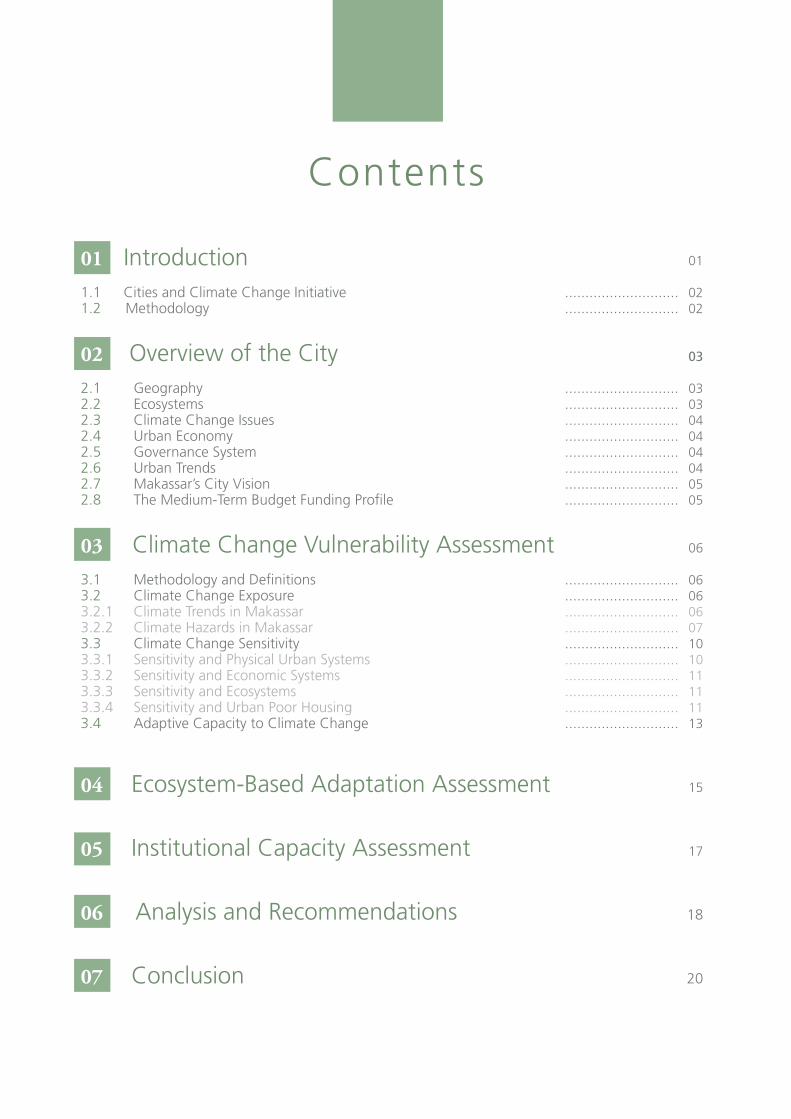
Contents

List of Figures
Figure 1: Location of Makassar on the island of Sulawesi and in relation to the neighboring districts of Takalar, Gowaand Maros …………. 01Figure 2: The mean rainfall and temperature over the long term in Makassar ............... 07Figure 3: Makassar Rainfall Intensity .........…... 07Figure 4: Makassar Average Temperature 1993 – 2012 .....……... 08Figure 5: Exposure rating by district in Makassar ..........….. 09Figure 6: High population growth is occurring in the city’s periphery where the city’s current water supply network is limited. The map demonstrates the need to expand the water supply network to keep up with increasing demand ...........…. 10Figure 7: Sensitivity rating by district in Makassar ..........….. 13Figure 8: Exposure rating by district in Makassar .......……. 16

Makassar, Indonesia - Climate Change Vulnerability Assessment 01
Introduction
01
Climate change is already affecting millions of people worldwide. In urban areas, which are typically charac-terised by significantly higher population density, cli-mate change will exacerbate and compound existing vulnerabilities, especially for the urban poor.
Across Indonesia cities are facing two interlinked challenges, that of rapid population growth and the impacts of climate change. Rapid urbanization offers the benefits of larger economies, increased human resources, and potentially more development oppor-tunities, however, unplanned rapid growth can also strain public services and infrastructure, invite casual-ization of labour and unsafe informal sector employ-ment, causes pollution and overwhelm ecosystems, and leads to traffic congestion. As a result of climate change, we expect that storm frequency and inten-sity will increase, flooding will become serious and droughts will affect food production in rural areas, which has damaging knock-on effects in urban ar-eas. Coastal areas are threatened by inundation from sea-level rise, and other urban challenges. Meanwhile, cities are the main drivers of increased greenhouse gas emissions. This means that cities must be the centre of actions both to mitigate the causes of climate change, and to adapt to their anticipated effects.
Makassar is a coastal city, sitting on the far southwest-ern tip of the island of Sulawesi, in eastern Indonesia. The population has grown from 1.1 million in 2003 to about 1.35 million today, an increase of over 20 per cent in a decade. At the same time, its land area is expanding as reclaimed land extends the city’s coast-line creating opportunities for new commercial devel-opments. On the periphery of the city new housing estates are being developed with rising demand for homes and public services. The city recently built a new international airport and is expanding its port fa-cilities to boost trading capacity and create jobs. Major infrastructure such as roads, hospitals and water sup-ply networks, as well as basic services such as health-care, are becoming vulnerable to the negative effects of climate change.
The vulnerability assessment aims to bring together an understanding of urban growth dynamics with that of climate trends and its impacts in Makassar. The vulner-ability assessment consists of three components: (i) the climate change vulnerability assessment; (ii) the eco-system-based adaptation assessment and (iii) the insti-tutional capacity assessment. It is targeted at national and local government officials, policy makers and key members of organizations and institutions working to improve urban systems and living conditions of poor and vulnerable communities as well as community leaders, NGOs and community based organizations, and anyone interested in taking action to decrease cli-mate vulnerability in the city. It is intended to be used as a planning tool as well as an advocacy document to guide decision-making at the metropolitan, city and community levels about effective responses to climate change impacts. The recommendations can be used to identify priority urban systems, places and popula-tions that are being impacted by climate change and to design appropriate policies and programmes that target specific issues, systems and weaknesses.
Amongst the most vulnerable areas and people of Makassar are
the urban poor who live along the coast. Climate change threatens
their livelihoods and physical safety, and this compounds their exist-
ing social vulnerabilities of lacking access to water and low income.
Cities and Climate Change Initiative02
1.1 1.2Cities and Climate Change Initiative
Methodology
The Cities and Climate Change Initiative was devel-oped by UN-Habitat to promote the mitigation of, and adaptation to, climate change in developing countries. More specifically, the Initiative supports the development of pro-poor innovative approaches to climate change policies and strategies. It builds on UN-Habitat’s rich experience of sustainable urban de-velopment (through the Environmental Planning and Management approach of the Sustainable Cities and Agenda 21 Programmes) as well as on internationally recognised capacity building tools. The Initiative devel-ops, adapts and disseminates methodologies that put city managers and practitioners in a better position to support adaptation to climate change. The Cities and Climate Change Initiative also promotes collaboration by local authorities and their associations in global, regional and national networks, with the triple ratio-nale of: 1) enhancing policy dialogue so that climate change is firmly established on the agenda; 2) sup-porting local authorities’ efforts to bring about these changes; and 3) enhancing awareness, education and capacity-building in support of climate change strat-egies.
The research team gathered information from avail-able government data and maps, through observation field trips, community meetings, and focus group dis-cussions with civil society organizations, community members and government officials. Analyzed data was structured and aligned by the research team among the different components of vulnerability criteria. The information was used to create a vulnerability map at the sub-district level (Kecamatan) in combination with identified urban trends and predominant urban typol-ogies, and three communities were selected to deepen vulnerability analysis. The results of the analysis were then discussed internally between team members, and then presented for verification to government officials and civil society members.
Makassar, Indonesia - Climate Change Vulnerability Assessment 03
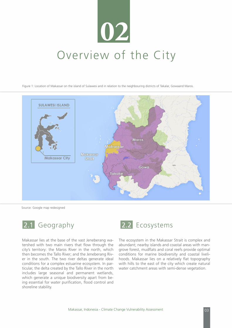
Makassar lies at the base of the vast Jeneberang wa-tershed with two main rivers that flow through the city’s territory: the Maros River in the north, which then becomes the Tallo River; and the Jeneberang Riv-er in the south. The two river deltas generate ideal conditions for a complex estuarine ecosystem. In par-ticular, the delta created by the Tallo River in the north includes large seasonal and permanent wetlands, which generate a unique biodiversity apart from be-ing essential for water purification, flood control and shoreline stability.
The ecosystem in the Makassar Strait is complex and abundant; nearby islands and coastal areas with man-grove forest, mudflats and coral reefs provide optimal conditions for marine biodiversity and coastal liveli-hoods. Makassar lies on a relatively flat topography with hills to the east of the city which create natural water catchment areas with semi-dense vegetation.
Overview of the City
02
Figure 1: Location of Makassar on the island of Sulawesi and in relation to the neighbouring districts of Takalar, Gowaand Maros.
Source: Google map redesigned
2.1 Geography 2.2 Ecosystems
Cities and Climate Change Initiative04
Geographically exposed, the coastal city of Makassar is sensitive to a series of climate change hazards. Ac-cording to climate change models prepared in 2012 by the Australian based Commonwealth Scientific and Industrial Research Organization, rainfall levels in Makassar will remain constant in the coming years but precipitation will be concentrated over a shorter period of time. In other words, the dry season will be prolonged, but average rainfall patterns are expect-ed to remain unchanged. An expected and constant increase in temperatures will simultaneously have an impact on evaporation levels and sea level rise. Tidal floods and storm surges also pose a threat to coastal communities as well as seawater intrusion in coastal aquifers. Flooding is another key concern for the city government regarding climate change impacts. Every year, during January and February there are an increas-ing number of reported inland and coastal floods, ac-cording to the local disaster prevention agency (BPBD). Floods rarely last more than 48 hours, but the increas-ing number of communities that are impacted by floods has constantly exceeded the capacity of BPBD to respond.
Makassar’s role as a gateway city to the rest of east-ern Indonesia for both maritime and aircraft traffic has created a boom for the city as demand increases for commodities. Makassar’s gross domestic product (GDP) has increased from 11,341,848 million Rupiah in 2006 (USD1,104,905,647) to 16,252,451 million Rupiah in 2010 (USD1,583,289,151). During this peri-od the economic growth rate rose from 8.09 per cent in 2006 to 9.83 per cent in 2010. As the city continues to grow it is likely that the economy will diversify fur-ther, adding more commercial and industrial activities and putting more pressure on the environment.
Indonesian cities such as Makassar are governed through a series of local government departments and agencies, supported by a five-year budget plan called the Rencana Pembangunan Jangka Menengah Daerah (RPJMD), or regional medium-term development plan. The RPJMD sets out a vision for the city through the allocation of funds to the different departments, these then have to be approved on an annual basis. Exam-ples of key agencies are public works, responsible for infrastructure projects such as roads, bridges and in-stalling water systems, the municipal water company or Perusahaan Daerah Air Minum (PDAM) responsible for managing water supplies, and Badan Perencana Pembangunan Daerah (BAPPEDA) the regional body for planning and development. Beneath the level of individual departments are the district and local level governments that provide services for residents and act as the first contact that citizens have with gov-ernment officials. Despite the reliance on the local budget for projects and infrastructure improvements, large civil works projects that can create an impact at the city level require national government funds, these are called ministerial projects. Thus there is often a dis-crepancy between what vision can be achieved relying solely upon the city’s budget, and what aspirations can be achieved while accessing additional funding from both national government and private investors.
The following trends are occurring in Makassar as a result of rapid urbanization. Coupled with the risks of climate change they present a growing concern re-garding the city’s sustainability.
1. Urban expansion: Over the last ten years, the pe-riphery region of Makassar, and the border areas of Maros, Gowa and Takalar municipalities have grown much faster than the population of the city centre. Over this period the five outer districts have grown at a rate of 3.01 per cent while the nine districts of the center of the city have a negative growth rate of -0.2 per cent. This indicates that not only are the outer districts outpacing those of the centre, but those of the centre are decreasing in population. Migrants come to the city to seek jobs and many of them
2.3 Climate Change Issues 2.5 Governance System
2.6 Urban Trends
2.4 Urban Economy

Makassar, Indonesia - Climate Change Vulnerability Assessment 05
end up settling on the periphery. Often migrants in these areas go without many services, as public providers and local government struggle to keep up with demand for water, sanitation and electricity. Social services (education and health care facilities) are often also deficient. Peripheral land conversion also limits communities’ capacity to produce food as former farmland is occupied as new urban space.
2. Land reclamation and changing coastlines: Makas-sar is currently undertaking an ambitious plan to create developable lots of land through land rec-lamation. The new coastline will present economic development opportunities and, for investors, the added incentive of flat, empty land. However, it is affecting natural ecosystems, local cultures and economies. New coastal developments threaten these predominantly poor communities by block-ing their access to the sea, altering their livelihoods and potentially transforming their way of life.
3. Water management and supply: The principal water sources for the municipal water company (PDAM) are the two rivers that flow down to the city: the Jeneberang River and the Maros River (that later becomes the Tallo River). After a massive land-slide in 2007 river water from the Jeneberang River became too muddy to use without significant filtra-tion and treatment. The Maros River is cleaner, but the watershed can only provide a limited amount of water and may not be sufficient for the rapidly expanding northern and eastern regions of the city. In addition, the district of Maros has decided to use it themselves rather than continue to provide for Makassar.
The two city visions set forth by the Makassar gov-ernment capture the essence of the city’s imagined future and put forward its strategy for development. The first city vision is of a ‘world city’ or ‘gateway to eastern Indonesia’ which is ambitious and intended to mobilize the aspirations of citizens and generate the interest of potential investors. It is focused on the city’s port and industrial expansion plans, as well as the cre-ation of reclaimed and vacant land along the coast-line. The second vision is a more pragmatic approach to city development and relates to short-term projects. It provides direction to government agencies about how to improve services and keep up with growth.
Makassar’s medium-term development plan (RPJMD) has a five-year development budget that allocates re-sources to government agencies from national govern-ment transfers on an annual basis. The RPJMD is rel-evant to the climate change vulnerability assessment because it is the most reliable means of data on public investments. Given that it is discussed and approved ev-ery five years and guides the direction of investments, it can help produce vulnerability reduction impacts in the short-term. The RPJMD allocates financial resources to local government departments, rather than the type of large development projects in the ‘world city’ vision, which access funding from national-level government institutions and private investors.
2.7 Makassar’s City Vision
2.8 The Medium-Term Budget Funding Profile
Cities and Climate Change Initiative06
According to the Intergovernmental Panel on Climate Change, vulnerability is defined as “the degree to which a system is susceptible to, or unable to cope with, adverse effects of climate change, including cli-mate variability and extremes”. In order to understand Makassar’s vulnerability to climate change it is essen-tial to assess three main components:
1. Exposure: the degree of climate stress upon a particular unit of analysis (i.e. community, sec-tor), and may be characterized by long-term change in climate conditions, or changes in cli-matic variability including the magnitude and fre-quency of extreme events in the urban context.
2. Sensitivity is defined as the degree to which a sys-tem is affected by the bio-physical impact of cli-mate change. It considers the socio-economic con-text of the system being assessed, as well as other non-climate stressors that may affect the city’s vul-nerability, such as its economy, development plans, administrative arrangements and ecosystems.
3. Adaptive capacity: the ability of a system to adjust to climate change (including climate variability and extremes) to moderate potential damages, to take advantage of opportunities, or to cope with the consequence.
The vulnerability assessment identified the climate hazards that Makassar is most exposed to as: sea-level rise, floods, droughts, high winds and erosion, and in-creased in temperatures.
3.2.1 Climate Trends in Makassar
Makassar enjoys a warm and tropical climate with a distinct wet season from November to May and a dry season from June to October and is characterized by high humidity and an average temperature at around 27.8 °c. There is very little temperature variation throughout the year, ranging from 24°c and 32°c min-imum and maximum temperatures. Global meteoro-logical phenomena, such as “el niño” and “la niña” strongly influence climate patterns and impact marine biodiversity. According to the Bureau of Meteorology and Climatology (BMKG), during El Niño years the wet season onset in Makassar is generally delayed by about 10 days and its length is shortened by about 10-30 days. In the meantime, the dry season rainfall is reduced by 51–80 per cent. Historical records over the last fourteen years indicate that flooding and strong winds have damaged the city. From 1999–2013 there were 26 recorded cases of flooding, in which a total 324 houses were damaged and 6,476 people were af-fected.
Climate ChangeVulnerability Assessment
03
3.1 Methodology andDefinitions
3.2 Climate Change Exposure
Makassar, Indonesia - Climate Change Vulnerability Assessment 07
3.2.2 Climate Hazards in Makassar
The predictive and historical information indicate that the most likely climate change hazards that the city will face in the future are: heavy rainfall during a short-ened rainy season, increased temperatures during a prolonged dry season with possible droughts, sea-level rise, and high winds and waves. These climate hazards
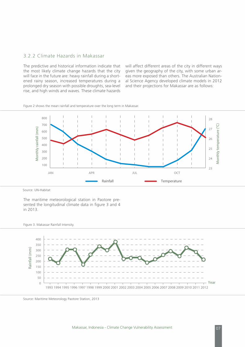
The maritime meteorological station in Paotore pre-sented the longitudinal climate data in figure 3 and 4 in 2013.
Figure 2 shows the mean rainfall and temperature over the long term in Makassar.
Figure 3. Makassar Rainfall Intensity.
will affect different areas of the city in different ways given the geography of the city, with some urban ar-eas more exposed than others. The Australian Nation-al Science Agency developed climate models in 2012 and their projections for Makassar are as follows:
JAN JUL OCTAPR
Rainfall
Mon
thly
rain
fall
(mm
)
Mon
thly
tem
pera
ture
(o C)
Temperature
800
700
600
500
400
300
200
100
28
27
26
25
24
23
400
350
300
250
200
150
100
50
0
Rain
fall
(mm
)
Year
Makassar Rainfall Intensity
1993 1994 1995 1996 1997 1998 1999 2000 2001 2002 2003 2004 2005 2006 2007 2008 2009 2010 2011 2012
Source: UN-Habitat
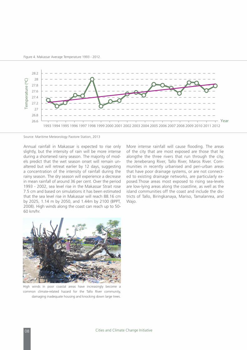
Source: Maritime Meteorology Paotore Station, 2013
Cities and Climate Change Initiative08
Annual rainfall in Makassar is expected to rise only slightly, but the intensity of rain will be more intense during a shortened rainy season. The majority of mod-els predict that the wet season onset will remain un-altered but will retreat earlier by 12 days, suggesting a concentration of the intensity of rainfall during the rainy season. The dry season will experience a decrease in mean rainfall of around 36 per cent. Over the period 1993 - 2002, sea level rise in the Makassar Strait rose 7.5 cm and based on simulations it has been estimated that the sea level rise in Makassar will reach 88.16 cm by 2025, 1.14 m by 2050, and 1.44m by 2100 (BPPT, 2008). High winds along the coast can reach up to 50-60 km/hr.
More intense rainfall will cause flooding. The areas of the city that are most exposed are those that lie alongthe the three rivers that run through the city, the Jeneberang River, Tallo River, Maros River. Com-munities in recently urbanised and peri-urban areas that have poor drainage systems, or are not connect-ed to existing drainage networks, are particularly ex-posed.Those areas most exposed to rising sea-levels are low-lying areas along the coastline, as well as the island communities off the coast and include the dis-tricts of Tallo, Biringkanaya, Mariso, Tamalanrea, and Wajo.
Figure 4. Makassar Average Temperature 1993 - 2012.
28.2
28
27.8
27.6
27.4
27.2
27
26.8
26.6
Tem
pera
ture
(o C)
Year
Makassar Average Temperature 1993 - 2012
1993 1994 1995 1996 1997 1998 1999 2000 2001 2002 2003 2004 2005 2006 2007 2008 2009 2010 2011 2012
Source: Maritime Meteorology Paotore Station, 2013
High winds in poor coastal areas have increasingly become a
common climate-related hazard for the Tallo River community,
damaging inadequate housing and knocking down large trees.
Makassar, Indonesia - Climate Change Vulnerability Assessment 09
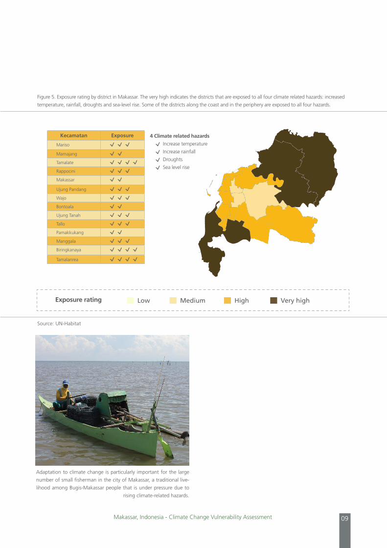
Figure 5. Exposure rating by district in Makassar. The very high indicates the districts that are exposed to all four climate related hazards: increased
temperature, rainfall, droughts and sea-level rise. Some of the districts along the coast and in the periphery are exposed to all four hazards.
Low Medium High Very high
Kecamatan Exposure
Mariso √ √ √
Mamajang √ √
Tamalate √ √ √ √
Rappocini √ √ √
Makassar √ √
Ujung Pandang √ √ √
Wajo √ √ √
Bontoala √ √
Ujung Tanah √ √ √
Tallo √ √ √
Pamakkukang √ √
Manggala √ √ √
Biringkanaya √ √ √ √
Tamalanrea √ √ √ √
4 Climate related hazards
√ Increase temperature
√ Increase rainfall
√ Droughts
√ Sea level rise
Exposure rating
Source: UN-Habitat
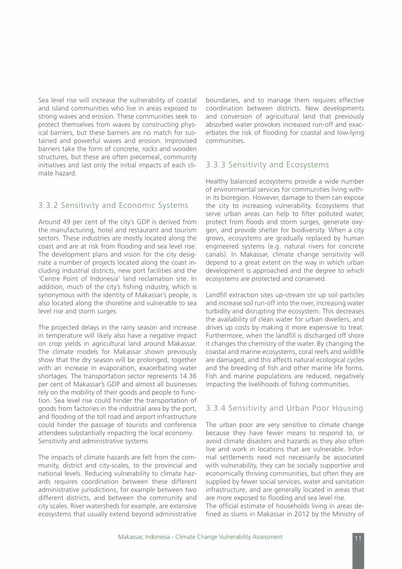
Adaptation to climate change is particularly important for the large
number of small fisherman in the city of Makassar, a traditional live-
lihood among Bugis-Makassar people that is under pressure due to
rising climate-related hazards.
Cities and Climate Change Initiative10
The following sections will summarize the impact of climate hazards identified by the assessment on the city’s systems, as well as describing the factors that make certain systems more sensitive.
3.3.1 Sensitivity and Physical Urban Systems
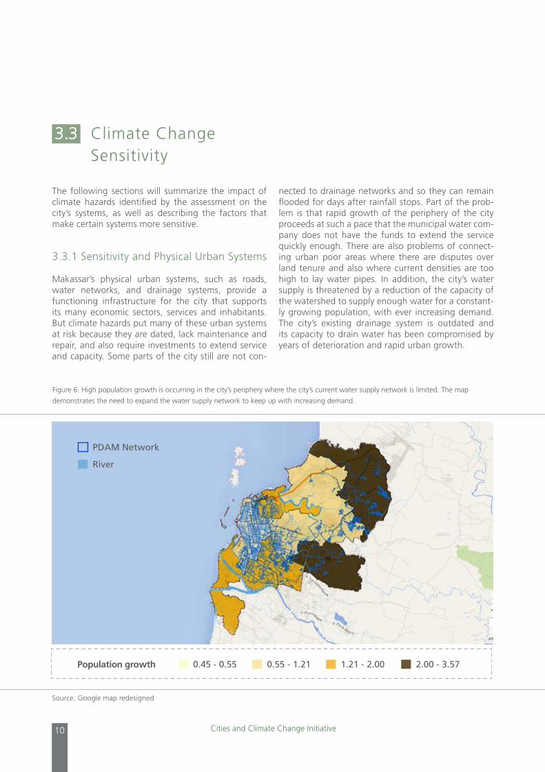
Makassar’s physical urban systems, such as roads, water networks, and drainage systems, provide a functioning infrastructure for the city that supports its many economic sectors, services and inhabitants. But climate hazards put many of these urban systems at risk because they are dated, lack maintenance and repair, and also require investments to extend service and capacity. Some parts of the city still are not con-
nected to drainage networks and so they can remain flooded for days after rainfall stops. Part of the prob-lem is that rapid growth of the periphery of the city proceeds at such a pace that the municipal water com-pany does not have the funds to extend the service quickly enough. There are also problems of connect-ing urban poor areas where there are disputes over land tenure and also where current densities are too high to lay water pipes. In addition, the city’s water supply is threatened by a reduction of the capacity of the watershed to supply enough water for a constant-ly growing population, with ever increasing demand. The city’s existing drainage system is outdated and its capacity to drain water has been compromised by years of deterioration and rapid urban growth.
3.3 Climate ChangeSensitivity
Figure 6. High population growth is occurring in the city’s periphery where the city’s current water supply network is limited. The map
demonstrates the need to expand the water supply network to keep up with increasing demand.
Source: Google map redesigned
0.45 - 0.55
PDAM Network
River
0.55 - 1.21 1.21 - 2.00 2.00 - 3.57Population growth
Makassar, Indonesia - Climate Change Vulnerability Assessment 11
Sea level rise will increase the vulnerability of coastal and island communities who live in areas exposed to strong waves and erosion. These communities seek to protect themselves from waves by constructing phys-ical barriers, but these barriers are no match for sus-tained and powerful waves and erosion. Improvised barriers take the form of concrete, rocks and wooden structures, but these are often piecemeal, community initiatives and last only the initial impacts of each cli-mate hazard.
3.3.2 Sensitivity and Economic Systems
Around 49 per cent of the city’s GDP is derived from the manufacturing, hotel and restaurant and tourism sectors. These industries are mostly located along the coast and are at risk from flooding and sea level rise. The development plans and vision for the city desig-nate a number of projects located along the coast in-cluding industrial districts, new port facilities and the ‘Centre Point of Indonesia’ land reclamation site. In addition, much of the city’s fishing industry, which is synonymous with the identity of Makassar’s people, is also located along the shoreline and vulnerable to sea level rise and storm surges.
The projected delays in the rainy season and increase in temperature will likely also have a negative impact on crop yields in agricultural land around Makassar. The climate models for Makassar shown previously show that the dry season will be prolonged, together with an increase in evaporation, exacerbating water shortages. The transportation sector represents 14.36 per cent of Makassar’s GDP and almost all businesses rely on the mobility of their goods and people to func-tion. Sea level rise could hinder the transportation of goods from factories in the industrial area by the port, and flooding of the toll road and airport infrastructure could hinder the passage of tourists and conference attendees substantially impacting the local economy. Sensitivity and administrative systems
The impacts of climate hazards are felt from the com-munity, district and city-scales, to the provincial and national levels. Reducing vulnerability to climate haz-ards requires coordination between these different administrative jurisdictions, for example between two different districts, and between the community and city scales. River watersheds for example, are extensive ecosystems that usually extend beyond administrative
boundaries, and to manage them requires effective coordination between districts. New developments and conversion of agricultural land that previously absorbed water provokes increased run-off and exac-erbates the risk of flooding for coastal and low-lying communities.
3.3.3 Sensitivity and Ecosystems
Healthy balanced ecosystems provide a wide number of environmental services for communities living with-in its bioregion. However, damage to them can expose the city to increasing vulnerability. Ecosystems that serve urban areas can help to filter polluted water, protect from floods and storm surges, generate oxy-gen, and provide shelter for biodiversity. When a city grows, ecosystems are gradually replaced by human engineered systems (e.g. natural rivers for concrete canals). In Makassar, climate change sensitivity will depend to a great extent on the way in which urban development is approached and the degree to which ecosystems are protected and conserved.
Landfill extraction sites up-stream stir up soil particles and increase soil run-off into the river, increasing water turbidity and disrupting the ecosystem. This decreases the availability of clean water for urban dwellers, and drives up costs by making it more expensive to treat. Furthermore, when the landfill is discharged off shore it changes the chemistry of the water. By changing the coastal and marine ecosystems, coral reefs and wildlife are damaged, and this affects natural ecological cycles and the breeding of fish and other marine life forms. Fish and marine populations are reduced, negatively impacting the livelihoods of fishing communities.
3.3.4 Sensitivity and Urban Poor Housing
The urban poor are very sensitive to climate change because they have fewer means to respond to, or avoid climate disasters and hazards as they also often live and work in locations that are vulnerable. Infor-mal settlements need not necessarily be associated with vulnerability, they can be socially supportive and economically thriving communities, but often they are supplied by fewer social services, water and sanitation infrastructure, and are generally located in areas that are more exposed to flooding and sea level rise. The official estimate of households living in areas de-fined as slums in Makassar in 2012 by the Ministry of
Cities and Climate Change Initiative12
Environment was 58,268. What is significant is that this figure has risen from 13,904 in 2003, an increase of 320 per cent in approximately ten years. The trend is undoubtedly one of growth as the city itself expands and absorbs new migrants seeking employment. Of the total number of households living in slum areas 55,268 live in tidal areas, along the coast or rivers, and this represents 95 per cent of the total number of inhabitants. Many slums are located on public land or private land that is in dispute, but when land prices rise their value makes them a target. The urban poor are sensitive to these changes in land prices and spec-ulation because they often occupy strategic areas near employment centres and markets and in the case of Makassar near the port and city centre.
Sensitivity relates to both the presence of climate haz-ards as well as the socio-economic context of the sys-tem that is being affected. The following six indicators employed to quantify and map sensitivity in Makassar utilize available city-wide data collected from the city government:
1. Areas located along river basins or canals: If a river or canal flows through a district, it will score 1. Those with no rivers or canals score 0.
2. Slum areas: The city government identified the slum areas of the city through their official crite-ria, and if a district has a slum within its boundar-ies, it will score 1.Those without score 0.
3. Poor coastal communities: The presence of poor coastal communities was identified by verifying the official city slum maps through an analysis of aerial photography and field visits. Those districts with poor coastal com-munities will score 1.Those without score 0.
4. Flood areas: Districts that flood regularly were identified using the BPBD department’s flood-ing maps. Districts that have areas that flood regularly score 1. Those that do not score 0.
5. Poverty rate: Poverty data was accessed from the city’s poverty data set (TKPKD) and a per capita poverty rate was established. Dis-tricts with a poverty rate above the average score 1. Those that are below average score 0.
6. Absentee rate for school-aged children: Data about absenteeism was accessed through the city’s education data and used to establish a city average. Districts with an absenteeism rate above the city average score 1.Those that are below av-erage score 0.
The scoring of each indicator was summed up to cre-ate an aggregate sensitivity indicator and can be seen in figure 7.
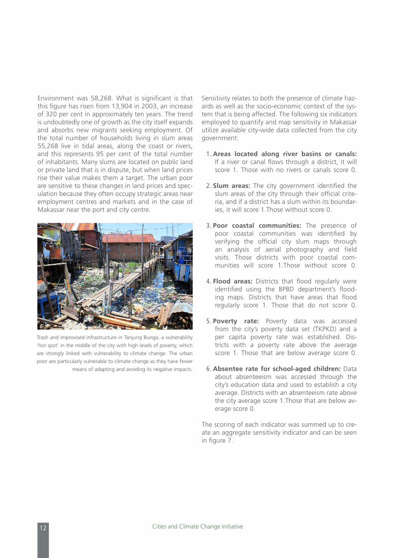
Trash and improvised infrastructure in Tanjung Bunga, a vulnerability
‘hot spot’ in the middle of the city with high levels of poverty, which
are strongly linked with vulnerability to climate change. The urban
poor are particularly vulnerable to climate change as they have fewer
means of adapting and avoiding its negative impacts.

Makassar, Indonesia - Climate Change Vulnerability Assessment 13
Adaptive capacity refers to the ability of a system to adjust to climate change in a way that moderates potential damage, takes advantage of opportunities, or helps cope with the consequences of climate haz-ards. The qualities that contribute to a system’s adap-tive capacity combine both physical and social/insti-tutional elements that support its ability to adapt to climate change. In the context of an urban area such as Makassar, it can refer to the extent of infrastructure and public services, accessibility of information, tech-nological capacity of institutions and communities, levels of wealth, the amount of social capital of a giv-en community, and the capacity of public institutions.
The vulnerability assessment of Makassar’s different forms of adaptive capacity revealed both opportuni-ties and challenges for reducing vulnerability to climate change. Some of the factors that seem to determine future vulnerability reduction are as follows:• Successful government programmes are essential to
ensuring widespread action in reducing climate vul-nerability, but the government often struggles with effective implementation.
• A lack of time invested in community engagement has resulted in lower local ownership levels and lack of sustainability in adaptation initiatives. For example, the Lantebung community reported that the government planted 5,000 mangroves but had minimal community engagement.
3.4 Adaptive Capacity to Climate Change
Figure 7. Sensitivity rating by district in Makassar. Sensitivity was measured by scoring six different indicators that suggest climate change
sensitivity: if the districts have slums areas, areas that flood, have poor coastal settlements, are in a river basin and if they are above the
city’s poverty and school absenteeism averages
Low Medium High Very high
Kecamatan Exposure
Mariso √ √ √ √ √ √
Mamajang √ √ √
Tamalate √ √ √ √ √
Rappocini √ √
Makassar √ √ √
Ujung Pandang √ √ √ √
Wajo √ √ √
Bontoala √ √
Ujung Tanah √ √ √ √ √
Tallo √ √ √ √ √ √
Pamakkukang √ √ √ √
Manggala √ √ √
Biringkanaya √ √ √
Tamalanrea √ √ √ √
6 Climate related sensitivities
√ Areas next to river basin
√ Slum areas
√ Poor coastal settlements
√ Flooded areas
√ % of poverty (above 19%)
√ % of absenteeism (above 24)
Sensitivity rating
Source: UN-Habitat

Cities and Climate Change Initiative14
The assessment also identified the need for great-er support for urban poor communities to overcome barriers. Individual adaptive strategies are common in sensitive households, but efficiency is limited. Urban poor communities may also have lower levels of public services, education and income, all of which lowers their adaptive capacity. By increasing organizational capacity and leveraging the presence and activities of community organizations and leaders, then the poten-tial for successful adaptation policies and programmes can increase.
Government climate change adaptation policies and programmes have largely been concentrated at the national level, and to a lesser degree at the provin-cial level. The government of Indonesia has been developing several national level policies and legal frameworks that specifically address climate change
adaptation. A successful link between the city gov-ernment and these national initiatives can augment the financial and institutional resources available to in-crease adaptive capacity. Collective adaptive strategies are also limited, but benefits generally reach a wider group. Many of the promising examples of adaptive capacity in Makassar are initiatives in which NGOs and civil society organizations partner with community groups and local government. NGOs such as Kupas, IPPM, Map and Oxfam have been of key importance in community engagement and mangrove regen-eration programmes for vulnerable communities in Makassar. Such programmes may focus on supporting communities through building infrastructure, social programmes or capacity building and can be further promoted through partnerships with local govern-ment agencies.
Civil society organizations, such as the NGO IPPM, have worked with
local communities to raise awareness about the importance of man-
groves for both coastal protection to high winds, waves and sea-level
rise, but also to benefit local fishing communities. This mangrove,
along on the coastline of the Lantebung community, is healthy and
provides both for the livelihoods and safety of residents.

Makassar, Indonesia - Climate Change Vulnerability Assessment 15
An ecosystem-based adaptation assessment seeks to understand what environmental services are available from the ecosystems in or around Makassar city? What is their current state? And what environmental ser-vices do they provide? The assessment was conducted by reviewing secondary data, strategic field visits to ecosystems in and around Makassar, focus group dis-cussions with vulnerable communities, semi-informal interviews with academics, civil society organizations and heads of relevant municipal agencies. Satellite imagery and government maps were also consulted while preparing the ecosystems based adaptation as-sessment.
Ecosystems are not bound by political or administrative boundaries, but align to eco-regions and extend far and beyond the city of Makassar. Urban settlements tend to gradually replace ecosystems services for what is perceived as more reliable man-made’s structures (e.g. creeks for concrete canals or mangrove forest for sea walls).The assessment of ecosystem services can be used by government officials, civil society and community based organizations to design informed programmes to tackle climate change impacts in vul-nerable communities by enhancing understanding on available ecosystems in the city and its vital services for vulnerable communities.
Complete ecosystems rarely fit within a city bound-ary; rich environmental relationships usually expand beyond man made political boundaries. Makassar is not the exception as there are three key ecosystems providing environmental services that cross the territo-ry but expand beyond:
• Jeneberang watershed – Expands to the munici-palities of Gowa and Makassar, the Jeneberang riv-er basin provides 80 per cent of the raw water for Makassar, sustains peri-urban agricultural activities and provides timber and other forestry products.
Ecosystem-basedAdaptation Assessment
04
• Tallo River and wetlands - Covers the municipal-ities of Maros and Makassar, complements raw wa-ter availability for the city, provides a wetland that is not only rich in biodiversity, but that acts as a flood-ing buffer zone for the city.
• Islands and the coast – There are 11 shallow is-lands around the coast of Makassar that create a rich marine ecosystem, composed of coral reefs, mudflats, sea grass zones and mangrove forests. The coastal ecosystem provides a source of livelihood for thousands of households in Makassar, protects the shores from erosion and promotes biodiversity. Mul-tiple agencies at different levels are responsible for managing specific parts of surrounding ecosystems.
Environmental services provided by the three above mentioned ecosystems play an essential role in min-imizing sensitivity to climate change impacts for poor and vulnerable communities. The locations of these pockets of poor households are distributed across Makassar, with a higher concentration by the coast and along the Tallo River, near Losari beach and to a lesser degree in peri-urban areas.
4.1 Management of Ecosystems
At the national level the Ministry of Environment is in charge of producing environmental impact assess-ments for new developments, and producing recom-mendations on how to minimize or compensate for damages to environmental services. At the local level a number of agencies from within the city government are sensitive to the importance of ecosystem services. The Marine and Fisheries Department, for example, is aware of ecosystem services, regulates fishing activ-ities, promotes mangrove and fisheries regeneration programmes and creates artificial reefs in areas where coral reefs were bleached or damaged due to climate

Cities and Climate Change Initiative16
change or human activities. The water supply agency PDAM is also concerned about challenges faced by cli-mate change on water quantity and quality, tempera-ture rise represents an increase in evaporation, while upstream landslides have an impact on water turbidity.
4.2 Jeneberang Watershed
The Jeneberang watershed was chosen for the as-sessment focus because of its importance to poor and vulnerable communities and its direct sensitivity to climate change impacts. In the early 1990s, the Japanese Bank for International Cooperation provided a loan to build the Bili-bili dam in the Jeneberang wa-tershed for water provision and to minimize the risk of flooding for downstream communities including the expanding city of Makassar.
The project was initially expected to have a life span of 50 years, but in 2004 a huge landslide from Mount Bawakareng released 1.7 billion cubic metres of rock, earth and debris towards the dam, filling its reservoir with sediment. The landslide filled all 12 of the Sapo dams which the government was building in order to decrease sedimentation. According to some estimates, the mega landslide and following sedimentation have almost filled up the Bili-bili dam, shortening the proj-ect lifespan by about 25 years. The situation posed by sedimentation at the Bili-bili dam is exacerbated by up-stream intense rock and sand extraction that are used for sea reclamation projects in Makassar; a conservative calculation estimated that about 5,000 trucks carrying about 10 tons of material travel every day from Gowa to the Makassar coast. The retro excavators in charge of loading the trucks with material from the rivers are inev-itably increasing the sedimentation in the Bili-bili dam. In addition, there are also extraction activities occurring downstream from the dam, which presumably increase the turbidity of the water in the Jeneberang River.
Figure 8. Exposure rating by district in Makassar. The very high indicates the districts that are exposed to all four climate related hazards: increased
temperature, rainfall, droughts and sea-level rise. Some of the districts along the coast and in the periphery are exposed to all four hazards.
N
Jeneberang watershed
Area 727 KM2
Forest 40%
Rice field 20%
Urban 13%
Other agriculture 27%
Source: Google map redesigned

Makassar, Indonesia - Climate Change Vulnerability Assessment 17
The institutional capacity assessment is an important component of the vulnerability assessment as it pro-vides direction for responses to climate change. The capacity assessment identifies a broad set of capacity building issues for different stakeholder institutions and city organizations to consider in order to better re-spond to climate hazards. It also provides suggestions for cooperation on these issues. The assessment seeks to identify challenges and strengths, and to put for-ward recommendations that build upon new findings as well as existing institutional activities and capacities that are seen as opportunities. In total, ten institutions or organizations were selected and interviewed for the Institutional Capacity Assessment, representing a range of bodies currently dealing with climate haz-ards and the impact of climate change on the city of Makassar from local government agencies to commu-nity groups and NGOs.
Institutional CapacityAssessment
05
A summary of the key lessons learned from the inter-views follows:
• There is a need for greater inter-departmental co-operation at the local government level. Rarely are projects or policies planned or implemented in col-laboration as there is no formal mechanism or in-centive for cooperation.
• The technical and organizational capacity of NGOs, civil society organizations and community groups should be strengthened to enable them to become key actors in efforts to reduce climate vulnerability.
• Institutions should reformulate their organizational vision to focus on reducing vulnerability to climate hazards.
• There are no clear guidelines or regulations con-cerning climate change, which will be necessary to guide action within the city. General reliance upon regulations to guide action itself creates a prob-lematic, reactive mind-set that discourages depart-ments from seeking the causes of problems.
• Communities require support to develop and main-tain climate resilient infrastructure and services that are more robust and systemic, in proportion to the large scale of climate hazards.
At the community-level institutional capacity was assessed through
interviews and discussions with community groups and local NGOs.
Cities and Climate Change Initiative18
The following recommendations are aimed at provid-ing guidance to stakeholders in city government; civil society organizations and NGOs; and local commu-nity groups and residents, to better prepare for the challenges of responding to climate change hazards in Makassar. Policy recommendations to increase climate resilience include:
•Articulate a coherent vision for the city that pro-motes climate change resilience and pro-poor devel-opment. Such a vision can spur better coordination amongst departments, orient city policy measures, and raise awareness amongst citizens.
•Revise existing regulations, planning documentsand project proposals to incorporate necessary mea-sures related to climate change hazards and human vulnerability.
•Undertakealegalandregulatoryreviewofexistingregulations to identify which ones already exist and where new regulations need to be developed or up-dated to implement the city vision.
•Promotegreaterinstitutionalcoordinationamongstgovernment and civil society institutions to strength-en the ecosystem management of Makassar and surrounding areas.
•Buildcapacityandincreasefinancialresourcesinor-der to implement a climate change-focused agenda.
•Designnewpoliciesoradaptexistingpoliciestoen-sure a focus on specific vulnerable groups and plac-es that are identified in the vulnerability assessment.
•Propose specific regulations for the managementof coastal areas (for example to strictly regulate the growth of development and settlements in coastal areas).
•Strengthen law enforcement through capacitybuilding of legal measures, investigation and litiga-tion.
•Ensurethatclimatechangeconsiderationsareinclud-ed in infrastructure and building permit regulations.
Analysis andRecommendations
06
Policies to enhance greater institutional coordination on climate change issues should be led by strong lead-ership such as the Mayor and senior city government officials at BAPPEDA and may include:
•Development of a coordination framework forgreater institutional cooperation. Different depart-ments should work in partnership on planning and implementation of policies and projects, opening lines of communication and appointing focal points, sharing information and collaborating as a team.
•Adherence to this coordination framework by in-stitutions working on climate change related issues should be mandatory in order to design, plan, and implement policies and activities in collaboration with one another.
•Establish amulti-stakeholder climate change resil-ience working group which BAPPEDA will lead. The working group should be supported by mayoral de-cree, and the coordination of actions should occur not only at government level but also at regional, city, district and community levels.
•Promote greater inter-departmental coordination,especially between those working at the commu-nity level, and also between community groups and government, through community-level institutions. Local institutions should be supported and encour-aged to implement projects at the community level.
•Local government should foster coordinationwithnational agencies to enhance adaptation capabili-ties and to advocate for increased allocation of cli-mate-related budgets from the central government.
•Revisionoflocal,regionalandnationallandusereg-ulations in local ecosystems (i.e. Jeneberang water-shed) to control built structure development in key hotspots to strengthen the sustainable provision of key ecosystem services.

Makassar, Indonesia - Climate Change Vulnerability Assessment 19
Policies to increase adaptive capacity include:
•Introduce a capacity buildingprogramme for gov-ernment officials and local parliamentarians in or-der to enhance understanding and raise awareness about: i) budget allocations for climate change-re-lated projects, and ii) creating vulnerability maps at the Kelurahan level, iii) the need to monitor actions, and not merely implement them.
•Build capacity at the community level, in order toplan, propose and implement small-scale projects through community block grant programmes (such as the Musrenbang) that increase adaptive capacity and resilience and raise awareness at the commu-nity level through the dissemination of information about climate change vulnerability and measures that can be taken to increase adaptive capacity.
•Increase the amount of financial resources direct-ed towards climate change-related activities in the 2014-2019 RPJMD.
Policy recommendations to improve ecosystem man-agement include:
•UndertakeacitywideKelurahanvulnerabilitymap-ping initiative to ensure that localized vulnerability is fully mapped and understood.
•Identify areasand support the cultivationofman-groves, in collaboration with NGOs and community groups, to promote their conservation and growth.
•Developmeasurestodiversifyandsupportalterna-tive livelihoods for fisherman communities who are vulnerable to the impacts of climate change.
Policy recommendations for civil society organizations and NGOs include:
•Formulateavisionfortheorganizationfocusedonclimate change.
•Develop institutional and advocacy capacity. Buildupon and expand engagement with community or-ganizations:
Policy recommendations for community groups and residents include:
•Becomemoreinvolvedinmanagingandmaintain-ing community infrastructure.
•Raiseawarenessandbuildorganizationalcapacity.•Engageactivelywithgovernmenttoreducevulner-
ability to climate change.
Cities and Climate Change Initiative20
The Makassar climate change vulnerability assessment shows there is reason for optimism. There is a strong foundation of policies that the city is producing to re-duce vulnerability and there is evidence of promising initiatives taking place at the community level that will enhance climate resilience.
The four main conclusions arising from the Makassar assessment are as follows:
1. Rapid urbanization of the periphery of Makassar and the changing landscape of the coast line threat-en to affect the city’s long-term environmental sus-tainability by damaging the natural ecosystems and putting the water supply system under stress. Short-term measures are necessary to restore the city’s medium- and long-term ecological balance.
2. The rapid urban growth of Makassar will increase vulnerability to climate change hazards if measures are not taken to: a) limit the spread of settlements to areas disconnected from public service networks, b) allocate sufficient resources to areas of rapid pop-ulation growth and critical systems (i.e. the water supply system), c) ensure traditional activities and the sustainable livelihoods of communities displaced by new developments are able to participate in the city’s development opportunities. Sound urban de-velopment can thus be an opportunity to reduce vulnerability, while uncontrolled and haphazard ur-banisation can threaten human safety.
Conclusion
07
3. Climate change hazards present challenges at different scales (the community, city and even the bio-region) and so actions are required to meet these challenges at these different scales. There-fore actions that are directed at reducing vulnera-bility at the city level (such as addressing systemic issues such as water shortages and drainage, and increasing the coordination and technical capacity of city agencies) should be implemented in conjunc-tion with actions targeted at the community scale, at specific vulnerable areas, and for groups. Local communities should be empowered to address their infrastructure needs through local initiatives.
4. The city government can reduce climate change vulnerability by influencing the sensitivity and adap-tive capacity of residents and communities of the city. This is possible through both physical actions (such as improving both natural and man-made sys-tems and building climate proof infrastructure) as well as non-physical actions (such as improving the capacity and administration of public services, sup-porting local community organizations and improv-ing the coordination of institutions).

UN-Habitat’s Cities and Climate Change Initiative promotes enhanced climate change mitigation and adaptation in developing country cities. This document is an initial output of the Cities and Climate Change Ini-tiative activities in Makassar, Indonesia. This abridged report is based on the report titled: “Makassar, Indonesia – Climate Change Vulnerability Assessment”.
Starting with a brief background of the city, this report addresses Makas-sar’s climate change situation from a comprehensive vulnerability perspec-tive that focuses on exposure to climate change hazards, socio-economic sensitivities and the adaptive capacities of the city and its stakeholders. The report puts particular emphasis on the assessment on the role of local ecosystems for climate change adaptation as well as on an institutional assessment. Based on this analysis the report identifies vulnerable people, places and sectors and provides preliminary climate change adaptation options.
HS Number: HS/038/14EISBN Number(Series): 978-92-1-132400-6
ISBN Number (Volume): 978-92-1-132620-8
United Nations Human Settlements Programme P.O. Box 30030, Nairobi 00100, Kenya
E-mail: [email protected]
www.unhabitat.org


