Malaysia’s policies and plans contain emphasis and provisions for holistic and integrated planning and management of natural resource and biodiversity assets as a precursor for environmentally sustainable development. For planners, decision-makers and practitioners to meet these aspirations, resources must be viewed in a broader context. Not only must it go beyond sectors to include all stakeholders in the decision process, but it must also use the best science available to define suitable management actions. The overall purpose of this Guideline is to support this important endeavour.
Transcript
Malaysia’s policies and plans contain emphasis and provisions for holistic and integrated planning and management of natural resource and biodiversity assets as a precursor for environmentally sustainable development.
For planners, decision-makers and practitioners to meet these aspirations, resources must be viewed in a broader context. Not only must it go beyond sectors to include all stakeholders in the decision process, but it must also use the best science available to define suitable management actions.
The overall purpose of this Guideline is to support this important endeavour.
MANAGING BIODIVERSITY IN THE RIPARIAN ZONE i
Tables, Figures and Text Boxes .....................................................................ii
1.1 Who is this Guide for? .......................................................................1 1.2 Purpose of this Guide.........................................................................1 1.3 Using this Guide ................................................................................1
2 The Riparian Zone ......................................................................................2
2.1 What is a riparian zone?.................................................................... .3 2.2 Why is the riparian zone important?..................................................3 2.3 Riparian habitats in Malaysia ............................................................7 2.4 What happened to the riparian zones? ...............................................7
3 Restoring the Riparian Zone......................................................................9
3.1 Overview............................................................................................9 3.2 Key considerations for biodiversity ...................................................9 3.3 Key considerations for water quality improvement.........................14 3.4 Species selection and layout ............................................................15 3.5 Planting and maintenance ................................................................16
4.1 Overview..........................................................................................18 4.2 Establishment of river resources......................................................19
Annex 1: Model riparian zone design..........................................................23
Annex 2: Checklist of native plants suitable for the riparian zone...........24
End notes........................................................................................................36
Table of Contents
ii MANAGING BIODIVERSITY IN THE RIPARIAN ZONE
TABLES, FIGURES AND TEXT
BOXES Table 1. Non-point source pollutants ........................................................................... 6 Table 2. Impacts of human activities on the riparian ecosystem. ................................. 8 Table 3. Functions and effectiveness of plant types ................................................... 14 Table 4. Key legislation and state agencies related to river management .................. 18 Table 5. DID Guidelines for width of river reserves .................................................. 20 Figure 1. Cross section of a riparian zone ................................................................... 2 Figure 2. Effect of riparian vegetation on downstream discharge ............................... 3 Figure 3. Functions of riparian vegetation................................................................... 5 Figure 4. Types of riparian habitats in Malaysia ......................................................... 7 Figure 5. Vertical stratification in a natural forest....................................................... 9 Figure 6. Continuity of canpy cover .......................................................................... 10 Figure 7. Example of a patch-corridor matrix in the riparian zone............................ 11 Figure 8. A river basin............................................................................................... 11 Figure 9. Spacing for different levels of the forest canopy........................................ 15 Figure 10.Proper planting methods ............................................................................ 17 Box 1. Pollination and seed dispersal ........................................................................... 4 Box 2. Kinabatangan - Corridor of Life (a case study) .............................................. 12
Tables, Figures& Text Boxes
MANAGING BIODIVERSITY IN THE RIPARIAN ZONE iii
asl ..........................above sea level cm .........................centimetre DID .......................Department of Irrigation and Drainage ha...........................hectare KCol......................Kinabatangan – Corridor of Life LK.........................Lower Kinabatangan km .........................kilometre m ...........................metre MASMA ...............Urban Stormwater Management Manual for Malaysia N2 ..........................Nitrogen NGO......................Non-governmental Organisation NO2 .......................Nitrite NO3 .......................Nitrate NRE ......................Ministry of Natural Resources and Environment NTFP.....................Non-timber forest product P ............................Phosphorus USDA ...................United States Department of Agriculture USEPA .................United States Environmental Protection Agency
Abbreviations
MANAGING BIODIVERSITY IN THE RIPARIAN ZONE 1
1.1 Who is this Guide for? This Guideline for managing biodiversity in the riparian zone aims to assist all planners and practitioners influencing the landscape of today and tomorrow. In particular, this Guide should be useful for:
• Government agencies at the federal, state and local levels engaged in land use and natural resource planning, administration and assessment.
• Companies and small holder organisations involved in extensive land use systems such as plantations, urban development and sand mining.
• Non-governmental Organisations (NGOs), consultants, educational centres and members of civil society with an interest in biodiversity, environment and sustainable development.
1.2 Purpose of this Guide This Guide aims to provide an overview of what it takes to manage and restore biodiversity in the riparian zone. This guide will assist you in:
• Understanding the importance of riparian zones for biodiversity as well as the well-being of human populations.
• Appreciating the unique types of riparian habitats in Malaysia.
• Recognising the effects of land use change on the ecosystem functions of riparian zones.
• Incorporating key technical, practical and legal considerations required for the restoration of riparian habitats that can function as habitats and corridors for biodiversity and as buffers to protect river water quality.
• Mainstreaming biodiversity into the preparation, review and updating of Policies, Plans and Programmes.
1.3 Using this Guide This Guide is part of a Best Practice Series produced by the Ministry of Natural Resources and Environment (NRE), Malaysia. For a complete understanding of concepts and considerations presented here, readers may consult: A Common Vision on Biodiversity – Reference Document for Planners, Decision-Makers and Practitioners (NRE, 2008), as well as other Guidelines produced in the Best Practice Series.
Other relevant documents which should be referred to are:
• Guidelines for Development of Rivers and River Reserves (DID, 2001)
• Urban Stormwater Manual for Malaysia (MASMA) - Chapters 42 and 43 (DID, 2000)
Further explanation of key concepts is provided in the End Notes. The checklist in Appendix 2 of the Guide provides information on native plants suitable for replanting in riparian habitats.
1 Introduction
Term
The Convention on Biological Diversity defines biodiversity as “the variability among living organisms from all sources including, inter alia, terrestrial, marine and other aquatic ecosystems and the ecological complexes of which they are part; this includes diversity within species, between species and of ecosystems.”
2 MANAGING BIODIVERSITY IN THE RIPARIAN ZONE
Dra
win
g by
Fon
g C
huen
Far
4 2.1 What is a riparian zone? A riparian zone is essentially the land adjacent to streams and rivers; a unique transitional area between aquatic and terrestrial habitats. Plant communities in the riparian zone are called riparian vegetation.
This zone may be taken to consist of four sections, each having different physical conditions, particularly in terms of exposure to water currents, periodical inundation and soil type (Figure 1). The plants found in each section have specific adaptations which enable them to tolerate these physical conditions:
• Lower bank – Constantly subjected to erosive water current. The plants here are able to survive submerged underwater for extended periods of time, with root systems that are able to hold the soil in place.
• Upper bank – Occasionally subjected to erosive water current. The plants here are tolerant to sporadic inundation.
• Terrace face – Only subjected to inundation during high flow events, such as annual flooding. The plants here range from wetland to dryland species.
• Upper terrace – Only subjected to extreme high flow events, such as 1 in 100 year floods. The plants here are mainly dryland species.
Figure 1. Cross section of a riparian zone.
Term
2
The Riparian Zone
Riparian is derived from the Latin word Ripa, which means “river bank”.
MANAGING BIODIVERSITY IN THE RIPARIAN ZONE 3
Dis
char
ge
Dis
char
ge
2.2 Why is the riparian zone important? Although constituting only a small part of the landscape, riparian zones that are intact and functional are important habitats for biodiversity and provide ecosystem services1 which are essential to the well-being of human populations. The main functions of riparian zones are:
Water quality improvement
Non-point sources of pollution, including runoff from agriculture lands and plantations, construction sites and failed septic tanks, introduce a variety of pollutants into the river system. These pollutants, which include sediments, nutrients, organic wastes, chemicals and metals, are difficult to control, measure and monitor (Table 1).
Riparian zones serve as buffers which intercept non-point sources of pollution. In particular, riparian vegetation absorb the heavy metals and nutrients, trap sediments suspended in surface runoff and provide a habitat for micro-organisms that help break down the pollutants. In plantations where fertiliser, pesticides and herbicides are used, the maintenance of a vegetated riparian buffer strip of sufficient width is therefore extremely important to minimise the amount of these pollutants that enter the rivers.
Flood mitigation
Riparian vegetation increases surface and channel roughness, which serves to slow down surface water that enters the river and reduce flow rates within the river. This helps to slightly alleviate the magnitude and intensity of flooding downstream (Figure 2). However, it should be noted riparian vegetation is by no means a viable solution to flood woes – this requires good management of entire river basins, especially the upstream catchments.
Figure 2. Effect of riparian vegetation on downstream discharge.
Riverbank stabilisation
Riparian vegetation protects the riverbanks from erosion or scouring caused by rain, water flow, etc. Erosion caused by removal of riparian vegetation results in sedimentation of the river which increases flood levels, as well as bank failure, which brings about the need for expensive remediation measures such as dikes, levees and flood walls.
(b) Downstream discharge without riparian vegetation
(a) Downstream discharge with riparian vegetation
Terms
An ecosystem is a dynamic complex of plant, animal, and microorganism communities and the nonliving environment, interacting as a functional unit. Humans are an integral part of ecosystems. Ecosystem services are the benefits that people obtain from ecosystems.
Time Time
4 MANAGING BIODIVERSITY IN THE RIPARIAN ZONE Cultural/recreational values
Vegetated riparian zones, especially in urban areas, are important open spaces that may be utilised for recreational and aesthetic purposes such as walking/cycling trails or picnic areas. Numerous studies demonstrate that linear parks not only improve the quality of life in communities, but can increase nearby property values that in turn increase local tax revenues (McMahon, 1994). Rivers also play an important role in many cultures and traditions.
Prime wildlife habitats
Riparian habitats are unique ecosystems where terrestrial and aquatic plant communities meet. The unique micro-climate and proximity to water make riparian zones excellent habitats for many species of animals, especially birds and amphibians. In addition, salt licks, which are an important source of nutrients for ungulates are usually found in the vicinity of rivers and streams.
Natural wildlife corridors
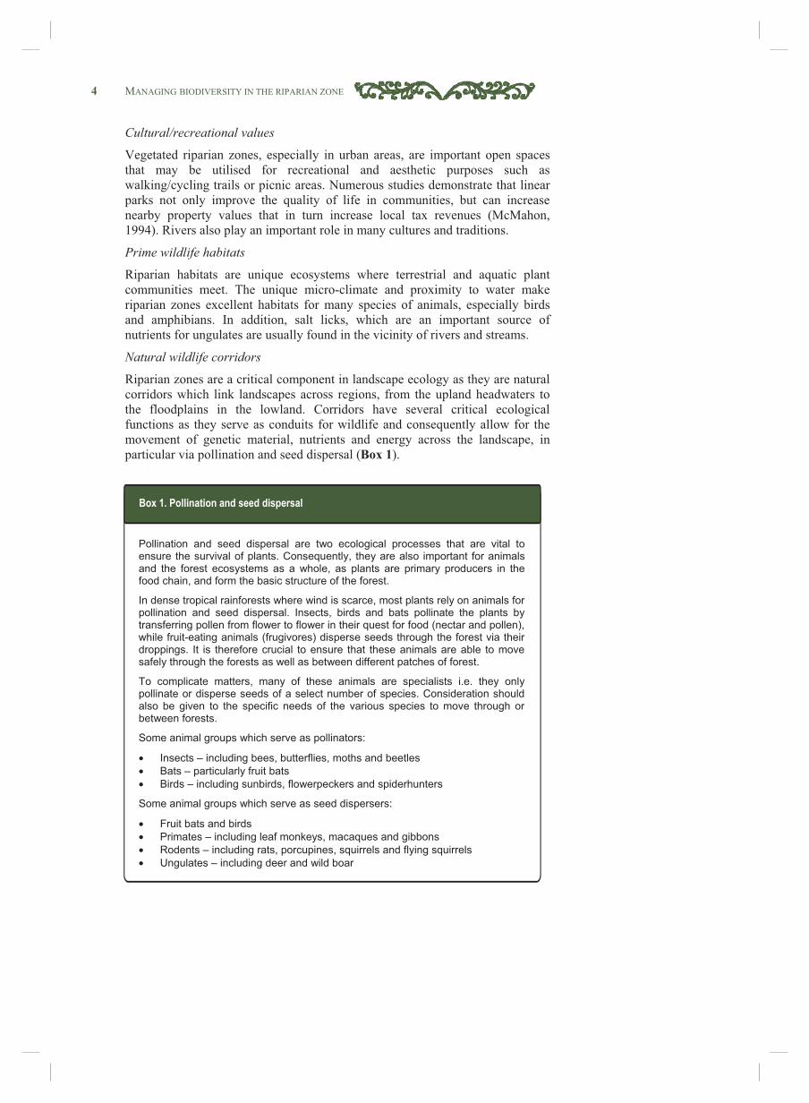
Riparian zones are a critical component in landscape ecology as they are natural corridors which link landscapes across regions, from the upland headwaters to the floodplains in the lowland. Corridors have several critical ecological functions as they serve as conduits for wildlife and consequently allow for the movement of genetic material, nutrients and energy across the landscape, in particular via pollination and seed dispersal (Box 1).
Pollination and seed dispersal are two ecological processes that are vital to ensure the survival of plants. Consequently, they are also important for animals and the forest ecosystems as a whole, as plants are primary producers in the food chain, and form the basic structure of the forest.
In dense tropical rainforests where wind is scarce, most plants rely on animals for pollination and seed dispersal. Insects, birds and bats pollinate the plants by transferring pollen from flower to flower in their quest for food (nectar and pollen), while fruit-eating animals (frugivores) disperse seeds through the forest via their droppings. It is therefore crucial to ensure that these animals are able to move safely through the forests as well as between different patches of forest.
To complicate matters, many of these animals are specialists i.e. they only pollinate or disperse seeds of a select number of species. Consideration should also be given to the specific needs of the various species to move through or between forests.
Some animal groups which serve as pollinators:
• Insects – including bees, butterflies, moths and beetles
• Bats – particularly fruit bats
• Birds – including sunbirds, flowerpeckers and spiderhunters
Some animal groups which serve as seed dispersers:
• Fruit bats and birds
• Primates – including leaf monkeys, macaques and gibbons
• Rodents – including rats, porcupines, squirrels and flying squirrels
• Ungulates – including deer and wild boar
Box 1. Pollination and seed dispersal
MANAGING BIODIVERSITY IN THE RIPARIAN ZONE 5
Dra
win
g by
Teh
Yew
Kia
ng
Maintenance of stream ecology
Riparian vegetation is essential to aquatic organisms. Trees and shrubs provide shade which reduces the water temperature, thus allowing many aquatic species to survive and limit the amount of light in the river which prevents excessive growth of water plants and algae.
Woody debris (known as snags) and leaf litter derived from riparian vegetation are important habitat components of rivers. Snags and leaf litter provide valuable habitats for a number of aquatic and terrestrial species: they are used as nursery areas for larvae and juvenile fish, refuge from predators, shade, feeding and spawning sites and shelter from currents.
Riparian vegetation is a source of food for aquatic animals and plants, providing fruits, insects, leaf litter and organic debris. These food sources are a major component of the diet of many species of fish and aquatic organisms such as turtles.
Figure 3. Functions of riparian vegetation.
Canopy provides shade and protection for animals.
Plants help filter contaminants, stabilize riverbanks and reduce the volume and velocity of water entering the river.
Hollows in logs and branches provide habitat for terrestrial and
aquatic animals.
Birds and bats in the riparian corridor eat insects in adjacent farmland.
Leaves and fruits provide food for terrestrial and aquatic animals.
Without riparian vegetation:
• Lack of habitat means fewer terrestrial animals.
• Lack of food and shelter means fewer aquatic animals.
• Algal growth stimulated by lack of shade and nutrient runoff.
• Increased soil erosion, sedimentation and river bank failure.
• Decreased water quality.
6 MANAGING BIODIVERSITY IN THE RIPARIAN ZONE Table 1. Non-point source pollutants.
Pollutant Sources Effects
Nutrients Although essential elements in aquatic ecosystems, excess amounts can be harmful to aquatic life and reduce water quality of for human use. Nutrients can enter surface waters in subsurface or surface flows; either in dissolved form (as nitrates) or attached to soil particles. Major sources of nutrients are fertilizers, sewage and manure, while industry and atmospheric deposition also contribute significant amounts of nutrients. (Gilliam et al., 1997)
The most significant impact of nutrients on rivers is eutrophication, i.e. the excessive growth of algae and other aquatic plants due to high levels of nutrients. Excessive plant growth depletes the dissolved oxygen in the water, and chokes the water body with large unsightly mats of algae and decaying organic matter. This results in water with an undesirable colour, taste and odour. Eutrophication can affect a stream’s ability to support plant and animal life, interfere with water treatment and diminish its recreational and aesthetic values. Some algae may also form toxins which are directly harmful to aquatic organisms and humans.
Sediment
Sediment refers to soil particles that enter streams, lakes and other bodies of water from eroding or bare land, including plantations, construction and logging areas (especially logging roads), urban areas and eroding stream banks.
Sedimentation of rivers can have a pronounced effect on water quality and stream life. Sediment can clog fish gills, suffocate fish eggs and aquatic insect larvae and cause fish to modify their feeding and reproductive behaviours. Sediment also interferes with recreational activities as it reduces water clarity and fills in water bodies. In addition to mineral soil particles, eroding sediments may transport other substances such as animal wastes, pesticides, metals and other compounds that reduce water quality (Neary et al., 1988).
Pesticides
Pesticides enter streams through surface runoff from plantations, farms, gardens and nurseries, either dissolved in water or attached to sediment particles. They may also be discharged into streams from contaminated groundwater or be deposited into surface waters through atmospheric deposition (McConnell et al., 1995).
Pesticide uptake by human beings is mainly through the consumption of contaminated fish and shellfish, and direct consumption of contaminated water. Certain pesticides accumulate in the fatty tissues of organisms and consequently build up in higher concentrations in top predators further along the food chain, including humans. This is referred to as “biomagnification”. Effects at the organism or ecological level are usually considered to be an early warning indicator of potential human health impacts. However, generalisation is difficult as different categories of pesticides have different types of effects on living organisms, many of which are chronic and not easily detected. Examples include cancers, tumours and lesions, reproductive failure, disruption of hormonal systems and physiological impacts such as physical deformities and egg shell thinning.
Metals
Metals may be released into the aquatic environment through industrial processes, mining operations, urban runoff, transportation activities and application of sewage sludge. Trace metals may also be introduced with agricultural pesticides and fertiliser.
Metals pose a particular threat to aquatic environments because they do not degrade and tend to accumulate in the bottom sediments. Metals may also accumulate in plant and animal tissues. The fate of metals in riparian areas is not well understood.
MANAGING BIODIVERSITY IN THE RIPARIAN ZONE 7
Dra
win
g by
Fon
g C
huen
Far
2.3 Riparian habitats in Malaysia Although no official classification exists, it should be noted that riparian habitats are not homogeneous, but have varying assemblages of plants and animals depending on factors such as elevation, soil and hydrology. Six types of riparian habitats have been distinguished in Malaysia, based on the dominant original riparian vegetation from the highlands to the sea (Corner, 1988) (Figure 4):
• Montane streams – Narrow, shallow fast-flowing streams found in the montane regions. These areas are usually above 1,000m asl and usually fall within forest reserves.
• Saraca streams – Found below montane streams, Saraca streams are rocky, fast-flowing, with waterfalls rapids down the hillsides. Gapis (Saraca spp.) trees are the dominant species, which form “tunnels” over the water.
• Neram rivers – Found downstream from Saraca streams, Neram rivers are distinguished by the abundance of Neram (Dipterocarpus oblongifolius) trees on the river banks.
• Rassau rivers - Freshwater tidal rivers connecting the rocky streams and rivers with the brackish estuaries. Distinguished by the abundance of the screwpine Rassau (Pandanus sp.).
• Nipah rivers – Found upstream of mangroves where the water is calmer with muddy substrate with regular inflow of freshwater and silt. Dominated by the Attap palm (Nypa fructicans).
• Mangrove rivers – Found on the lower stretches of rivers with brackish water, down to the estuaries. Dominated by mangrove species such as Bakay (Rhizophora spp.), Api-api (Avicennia spp.) and Berus (Bruguiera spp.).
In addition, peat swamps and freshwater swamps are two other unique ecosystems that are found along the lower reaches of certain rivers. Both are important ecosystems which have become scarce due to conversion for agriculture use.
Figure 4. Types of riparian habitats in Malaysia.
Mangrove Nipah Rasau Neram Saraca Montane
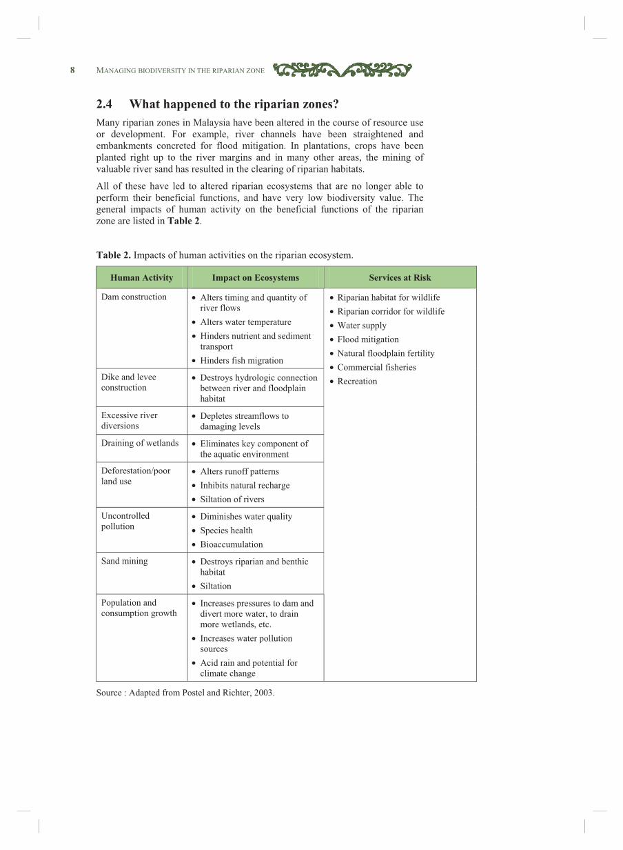
8 MANAGING BIODIVERSITY IN THE RIPARIAN ZONE 2.4 What happened to the riparian zones? Many riparian zones in Malaysia have been altered in the course of resource use or development. For example, river channels have been straightened and embankments concreted for flood mitigation. In plantations, crops have been planted right up to the river margins and in many other areas, the mining of valuable river sand has resulted in the clearing of riparian habitats.
All of these have led to altered riparian ecosystems that are no longer able to perform their beneficial functions, and have very low biodiversity value. The general impacts of human activity on the beneficial functions of the riparian zone are listed in Table 2.
Table 2. Impacts of human activities on the riparian ecosystem.
Human Activity Impact on Ecosystems Services at Risk
Dam construction • Alters timing and quantity of river flows
• Alters water temperature • Hinders nutrient and sediment
transport • Hinders fish migration
Dike and levee construction
• Destroys hydrologic connection between river and floodplain habitat
Excessive river diversions
• Depletes streamflows to damaging levels
Draining of wetlands • Eliminates key component of the aquatic environment
• Diminishes water quality • Species health • Bioaccumulation
Sand mining • Destroys riparian and benthic habitat
• Siltation
Population and consumption growth
• Increases pressures to dam and divert more water, to drain more wetlands, etc.
• Increases water pollution sources
• Acid rain and potential for climate change
• Riparian habitat for wildlife • Riparian corridor for wildlife • Water supply • Flood mitigation • Natural floodplain fertility • Commercial fisheries • Recreation
Source : Adapted from Postel and Richter, 2003.
MANAGING BIODIVERSITY IN THE RIPARIAN ZONE 9
Dra
win
g by
Teh
Yew
Kia
ng
3.1 Overview This section outlines key considerations for the restoration of riparian zones as habitats and/or corridors for biodiversity, buffers to protect river water quality and considerations for tree planting and maintenance.
It is important to have a good understanding of the existing and historical physical and biological conditions of the site, so that rehabilitation methods employed are appropriate to meet the objectives. As such, it should be noted that a number of different site assessments may be required in order to address each key consideration below.
3.2 Key considerations for biodiversity In order to restore the functions of riparian zones as wildlife habitats and corridors, the composition and macro structure (i.e. woody trees) must be returned to a state where the basic requirements for wildlife are met. The restored riparian zones must provide food, offer protection, allow for movement and consequently the opportunity for biological interactions2 to take place. In general, there are seven key considerations for biodiversity:
i) Plant a variety of suitable species
It is best to plant a range of species which can perform a variety of functions. Criteria for species selection include original habitat composition, requirements of targeted animal species, tolerance to physical conditions at the site (particularly the hydrological and soil conditions at various sections of the riparian zone) and other objectives of restoration.
ii) Ensure suitable vertical stratification
Animals occupy different niches in terms of vertical levels, from the ground, up to the under storey and upper canopy layers. Having the right mix of vertical stratification is important as it creates a variety of space in which a range of species may utilise (Figure 5).
Figure 5. Vertical stratification in a natural forest.
3 Restoring the Riparian Zone
10 MANAGING BIODIVERSITY IN THE RIPARIAN ZONE
Drawing by Teh Yew Kiang
iii) Ensure continuity of canopy cover
Suitable spacing and density of trees is important to sustain a diverse range of wildlife. A key consideration for this would be to ensure continuous canopy cover (Figure 6). This is especially important for arboreal species such as orang-utans and gibbons, which seldom go down to the ground. A continuous canopy cover would allow these animals to move along the corridor.
Figure 6. Continuity of canopy cover.
iv) Ensure availability of nesting material
Plants that can be used as nesting material should be retained (if present) or planted so that animals can use the area as breeding or nesting grounds. As different animal species utilise different materials for nesting, care should be taken to ensure a variety of materials such as twigs and leaves are available. Old or dead trees which may provide nesting hollows should not be removed.
v) Retain dead branches, logs and leaf litter
It is important that dead branches and logs on the ground are not removed, as they provide shelter, protection, nesting and breeding grounds for terrestrial and aquatic animals. The natural decomposition of these material, as well as leaf litter by ants and termites, are an important ecological process that contributes to the nutrient cycle.
vi) Ensure sufficient width
The width required for riparian habitats and corridors is generally much greater than that required for water quality (minimum widths for biodiversity are within the region of 100–400m). While the rule of thumb is simply “the wider the better”, two important aspects to consider are the animal species that the habitat and/or corridor is designed for and the impact of edge effects.
Large mammals such as elephants and tigers need to be given a wide berth, if just to minimise the risk human-wildlife conflicts.
“Edge effects” refer to the physical conditions at forest edges (e.g. increased exposure to wind, high temperatures and sunlight) which result in a high rate of tree mortality, degradation and loss of habitat variety, a shift in the species composition and structure of plant communities and consequently an overall loss of flora and fauna species. The perimeter-to-area ratio of the habitat increases when habitat sizes are reduced. This leads to a greater amount of area that suffers from ‘edge effects’.
Key Points
MANAGING BIODIVERSITY IN THE RIPARIAN ZONE 11 vii) Keep landscape connectivity in mind
It is important to consider the bigger picture, as rivers are dynamic systems. Even if only a limited section of the river is focused on in the short term, the activities and conditions upstream are likely to have a significant impact on the site. The layout (width, length and shape) and location of the site should be considered when planning riparian corridors for wildlife.
The patch-corridor matrix concept is useful to consider the structural connectivity between habitats in a landscape (Figure 7). Patches are essentially habitats which are in good condition and are able to support transitory wildlife populations moving between larger habitats (such as forest reserves or national parks). Corridors are strips of suitable habitats which allow for the movement of wildlife between patches.
The most preferable layout is for riparian corridors to be connected to larger patches of terrestrial forest habitats including Forest Reserves and other protected areas. Continuous buffers are more effective at moderating stream temperatures and providing movement corridors for animals. Therefore, the establishment of long continuous riparian habitats should be given higher priority over fragmented strips of greater width.
Figure 7. Example of a patch-corridor matrix in the riparian zone.
Suitable scales for this analysis are at the river basin level or habitat type level i.e. the entire length of the river flowing through a single habitat type (e.g. the entire length of original Saraca stream).
Figure 8. A river basin.
Plantation
Forest
Reserve
Wildlife
Reserve
Plantation
Village
Village
Town
Patch Riparian corridor River
Plantation
Dra
win
g by
: Dyl
an Je
fri O
ng
Term
A “matrix” is a landscape of mixed land use not designated primarily for conservation of natural ecosystems, ecological processes and biodiversity.
12 MANAGING BIODIVERSITY IN THE RIPARIAN ZONE
The project
The lower 100km of the Kinabatangan river in Sabah meanders through low-lying ground to form the Kinabatangan floodplain, which is one of only two places on earth where ten primate species are found together, including the orang-utan, proboscis monkey and the Bornean gibbon. It is also home to over 250 bird, 50 mammal and 20 reptile species as well as 1,056 plant species. Since the 1950s, forests around the Kinabatangan has been converted for various economic activities, including logging activities and agriculture. Oil palm is the dominant commercial crop in the area today.
The Sabah state government declared the Lower Kinabatangan as Sabah’s ‘Gift to the Earth’ in 1999 and in 2005, gazetted 26,000ha as the Kinabatangan Wildlife Sanctuary under the Sabah Wildlife Conservation Enactment 1997. WWF-Malaysia’s Kinabatangan - Corridor of Life (KCol) project aims to establish a balance between the growing demands of private land development, the local community and the need to protect the unique wildlife along the riparian zone. The KCoL vision is as follows:
• A forest corridor along the Kinabatangan, connecting coastal mangrove swamps with the upland forests, where people, wildlife, nature-based tourism and local forest industries thrive and support each other.
• A floodplain that supports a thriving and diverse economy that offers opportunity and choice to local people and businesses.
• Good environmental management of the natural capital on which all partners depends upon.
• A landscape in which agriculture, people and nature conservation is united by their common source of vitality – water.
Working with partners
A key factor contributing to the success of the project is engagement with all stakeholders, from government departments to NGOs, plantation companies and the local communities.
Oil palm plantations, including Asiatic Development, Borneo Samudera, and Pontian United Plantations have agreed to set aside land for reforestation, and some are even starting to venture into ecotourism. Local villagers have set up nurseries which supply saplings to the project, and are engaged in planting and maintenance work. Together with the growth of nature tourism, reforestation of KCol has provided locals with an excellent source of income as well as job and business opportunities.
Phot
o b
y W
illia
n U
nsw
orth
Phot
o b
y W
WF-
Mal
aysi
a
Box 2. Kinabatangan - Corridor of Life (a case study)
MANAGING BIODIVERSITY IN THE RIPARIAN ZONE 13
Forest restoration in KCoL The objective of the forest restoration component of KCoL is to achieve forest connectivity and enhance the quality of wildlife habitats. The long term goal is to establish contiguous forests, from coastal mangroves to the upland forests (encompassing an area of 150,677ha).The component includes nursery development and management, site selection and prioritisation, site preparation and tree planting as well as monitoring and maintenance.
A consultative process was used to prioritise areas for forest restoration. The first of a series of workshops was held in 2008, attended by representatives from Sabah Forestry Department, Sabah Wildlife Department, Universiti Malaya Sabah (UMS), Cardiff University and NGOs. The following criteria were used to identify priority areas, resulting in a prioritisation model (Figure A):
• Re-connect two forest fragments • Restore natural riverine vegetation from the bank of every water course for ecological services • Prevent extinction of orang-utan populations in lower Kinabatangan (by increasing gene flow) • Improve wildlife habitat • Enhance aesthetic value on areas highly visible along touristic routes • Reduce human-wildlife conflict
Tree planting:
Species native to Kinabatangan are planted, particularly those with fruits consumed by wildlife. So far, 17 different species have been planted, with a 5m x 5m spacing between saplings. However, the survival rate of planted saplings has been relatively low thus far, between 10-40%. The main causes of mortality are competition from weeds, inundation by seasonal floodwaters and trampling by elephants. The following actions have been taken to improve survival rates:
• Intensify weeding – monthly weeding in the first year, then once in three months in consecutive years. • Plant taller saplings – only saplings over 1m high are planted to ensure they survive seasonal flooding. • Plant at least three months before annual flooding season. • Avoid planting on known elephant pathways. • Erect temporary fencing around saplings.
Figure: Prioritisation model for forest landscape restoration.
Sour
ce: W
WF-
Mal
aysi
a
Box 2. (cont.)
14 MANAGING BIODIVERSITY IN THE RIPARIAN ZONE
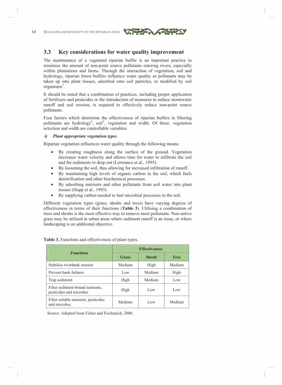
3.3 Key considerations for water quality improvement The maintenance of a vegetated riparian buffer is an important practice to minimise the amount of non-point source pollutants entering rivers, especially within plantations and farms. Through the interaction of vegetation, soil and hydrology, riparian forest buffers influence water quality as pollutants may be taken up into plant tissues, adsorbed onto soil particles, or modified by soil organisms3.
It should be noted that a combination of practices, including proper application of fertilisers and pesticides or the introduction of measures to reduce stormwater runoff and soil erosion, is required to effectively reduce non-point source pollutants.
Four factors which determine the effectiveness of riparian buffers in filtering pollutants are hydrology4, soil5, vegetation and width. Of these, vegetation selection and width are controllable variables:
i) Plant appropriate vegetation types
Riparian vegetation influences water quality through the following means:
• By creating roughness along the surface of the ground. Vegetation decreases water velocity and allows time for water to infiltrate the soil and for sediments to drop out (Lowrance et al., 1995).
• By loosening the soil, thus allowing for increased infiltration of runoff. • By maintaining high levels of organic carbon in the soil, which fuels
denitrification and other biochemical processes. • By adsorbing nutrients and other pollutants from soil water into plant
tissues (Hupp et al., 1993). • By supplying carbon needed to fuel microbial processes in the soil.
Different vegetation types (grass, shrubs and trees) have varying degrees of effectiveness in terms of their functions (Table 3). Utilising a combination of trees and shrubs is the most effective way to remove most pollutants. Non-native grass may be utilised in urban areas where sediment runoff is an issue, or where landscaping is an additional objective.
Table 3. Functions and effectiveness of plant types.
Effectiveness Functions
Grass Shrub Tree
Stabilise riverbank erosion Medium High Medium
Prevent bank failures Low Medium High
Trap sediment High Medium Low
Filter sediment-bound nutrients, pesticides and microbes High Low Low
Filter soluble nutrients, pesticides and microbes Medium Low Medium
Source: Adopted from Fisher and Fischenich, 2000.
MANAGING BIODIVERSITY IN THE RIPARIAN ZONE 15
Dra
win
g by
Fon
g C
huen
Far
ii) Ensure sufficient width
Width is the most important controllable variable for the effectiveness of riparian buffers in filtering pollutants. Topography, hydrology and geology have implications on appropriate buffer widths. In order to be effective, plants must either have access to high water tables or sufficient unsaturated flow. Also, plants will not remove pollutants from water which is moving too rapidly such as on steep slopes or in defined channels.
Decisions on buffer widths are almost always a compromise between environmental goals and social or economic objectives, e.g. the value of water resources versus the value of adjacent land and plantations.
3.4 Species selection and layout Based on the objectives and key considerations, the next question is what to plant (species selection) and where to plant (layout). A model design for the establishment of riparian zones for biodiversity and water quality improvement is given in Appendix 1.
There are two modes of habitat establishment:
• Natural regeneration – allowing nature to take its course with minimal human intervention. This method is suitable for areas where the riparian vegetation is recovering naturally through secondary growth. Such areas may have secondary tree species that provide ready cover, habitat and food source. Enrichment planting and silviculture6 may be required in these areas.
• Replanting – the establishment of a new plant assemblage. This is required in areas that have little or no vegetation. Although more labour intensive and expensive than natural regeneration, it allows for greater control of the plant species composition.
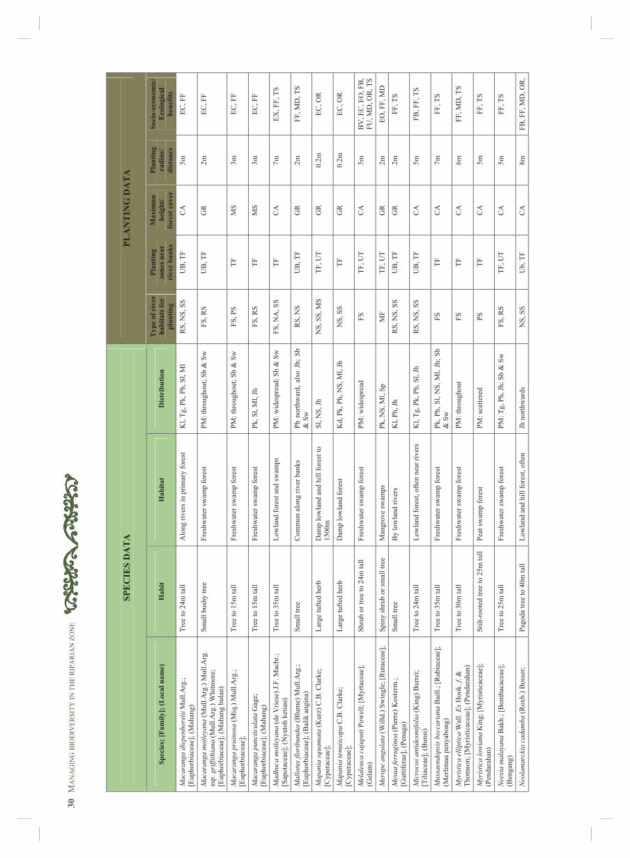
A list of native trees, palms and shrubs suitable for planting in riparian zones is provided in Appendix 2 together with a brief description of each species. This includes natural habitats, distribution, appropriate planting zones, planting radius and socio-economic use7. Some rivers may have endemic species. In such cases, propagation of these species would be extremely important in terms of plant conservation.
In urban areas where the micro-climate is not conducive to the survival of native forest species, hardy coastal species commonly used in urban landscaping may be used. These include Jemeriang Laut (Peltophorum pterocarpum), Bungor (Lagerstroemia speciosa), Jambu Laut (Eugenia grandis), Ketapang (Terminalia catappa), Bintangor Laut (Calophyllum inophyllum) and Mempari (Pongamia pinnata).
To create a mixed stand of diverse tree species that mimics the complexity of a natural forest (Figure 5), traditional agroforestry layouts of rows or contour strips should not be used. Instead, different species should be planted in random order, taking into account the optimal spacing required to ensure continuity of the canopy cover (Figure 9).
Figure 9. Spacing for different levels of the forest canopy.
16 MANAGING BIODIVERSITY IN THE RIPARIAN ZONE 3.5 Planting and maintenance A tree that is properly planted will require less maintenance and have a higher chance of survival. Thus, the following are important considerations:
i) Seedlings and saplings
Seedlings and saplings may be obtained from nurseries specialising in forest species. Alternatively, seeds, seedlings and saplings may be obtained from adjacent riparian areas. This method, which requires more time and resources, may involve seed collection and germination, branch cuttings with root inducement (for fast growing species) or saplings dug out from under the mother tree.
In any case, it is recommended that the seedlings are sown in poly bags in nurseries until they reach sufficient height (at least 1.5m) to minimise the risk of being overgrown by weeds or being eaten by herbivores.
ii) Site preparation
Earthworks which may be required to increase bank or slope stability around the planting site are covered in MASMA (DID, 2000). However, soft engineering methods should be used whenever possible. For example, coir logs made from coconut fibre can help in slope stabilisation and at the same time enhance plant growth and microbial activity.
iii) Planting
Saplings should be hardened for at least two weeks prior to planting in order to acclimatise them to stressful conditions such as minimal watering and increased exposure to sunlight. Weaker saplings should be disposed off before planting.
The diameter of the planting hole should be three times the diameter of the polybag and the height equal to the height of the polybag (Figure 10). Branches and leaves should be pruned and kept to a minimal (25% of actual leaf or branching contents) just before planting to reduce transpiration.
It is often necessary to protect saplings from animals, including birds, tree shrews and rats. Larger trees can tolerate far more leaf damage than newly planted seedlings, provided there is no severe damage to the new leaf bud. Tree guards may be installed, although they are a relatively expensive and labour intensive option. Different materials such as wire mesh and plastic may be used; most are supported by three stakes placed in a triangle around the sapling. However, wind resistant guards do not encourage strong root systems. It is important to remove the guards once the saplings have become well established (about after a year) so that they do not restrict further growth.
iv) Maintenance
Intensive maintenance, including watering, should be carried out within the first three months after planting, or at least until the saplings start to grow new leaves. This is also the time when fertilisers need to be applied. Periodical maintenance, which includes weeding and treatment for insect pests should then be carried out every six months.
The proliferation of woody and non-woody weeds in the tropical climate is the main threat to the survival of saplings. While the best solution is to plant tall saplings, weed control should be carried out periodically, especially in the first few years. Although labour intensive, the best method is by manual weeding. The use of herbicides should be prevented or at least minimised, as the chemicals may pollute the river.
Applying mulch around the saplings suppresses weed growth and at the same time reduces soil compaction and conserves moisture. However, excessive mulching should be avoided as this may deprive roots of oxygen, increase risk of fungal and bacterial infections due to constant moisture around the trunk and
MANAGING BIODIVERSITY IN THE RIPARIAN ZONE 17
Dra
win
g by
Fon
g C
huen
Far
excessive heat from decomposition of the mulch can kill trunk tissue.
Saplings should be periodically inspected for signs of insect infestation or disease. Thinning and pruning may reduce attack in some circumstances, especially if trees are attacked by caterpillars. The presence of natural predators of insects will often effectively control their populations.
Repeated chemical spraying is expensive, polluting and can result in increased populations of some pests. Broad action insecticides that are sprayed repeatedly create a situation in which there is intense selection pressure for resistant individuals. Insects that survive intense spraying will produce offspring that will also survive. Judicious use of chemical insecticides, combined with methods that encourage natural control, will offset the expansion of pesticide-resistant insects.
Deciding which insect control method to use is not straightforward and can require detailed knowledge of the insects’ biology. Accurate identification is very important; similar-looking species may require different control methods.
Figure 10. Proper planting methods.
Prune 75% of leaf biomass to reduce transpiration
Trunk guard Removed after one
year
Backfill planting hole with original soil
Soil undisturbed to provide support and reduce settling
Depth of planting hole should be the same as the height of the rootball
Planting hole should be 3 times wider than the diameter of rootball
Stake driven into soil outside of the rootball
Remove crossed or damaged branches
Leader left un-pruned
18 MANAGING BIODIVERSITY IN THE RIPARIAN ZONE
4.1 Overview The Federal Constitution (9th Schedule, Item 6 of the State List) provides State Authorities in Peninsular Malaysia with absolute ownership of all land within the boundaries of its state. This includes all rivers, streams and watercourses, although rivers shared by more than one state fall under Item 11b of the Federal list. Similar powers are provided to the Sarawak State Authority under the Sarawak Land Code (Cap 81) and the Sabah State Authority under Section 26 (1) of the Land Ordinance Sabah (Cap 68).
Various state and federal agencies are involved in the control and management of rivers, each having specific responsibilities and legislative backing (Table 4). It is therefore important that an integrated and coordinated effort be adopted in the management of rivers and river basins.
Table 4. Key legislation and state agencies related to river management.
State Legislation State Agencies Federal Territory of Kuala Lumpur • Waters Act 1920 (Revised 1989) • DID Federal Territory of KL
Johor • Enactment No. 66 (Johor 1921) • DID Johor Kedah • Kedah Water Resources Enactment 2007 • DID Kedah
Kelantan • Enactment No. 18 of 1935 • DID Kelantan
Melaka • Waters Act 1920 (Revised 1989) • DID Melaka • Melaka River and Coastal
Development Corporation N. Sembilan • Waters Act 1920 (Revised 1989) • DID N. Sembilan
Pahang • Pahang Water Resources Enactment 2007 • DID Pahang Perak • Waters Act 1920 (Revised 1989) • DID Perak
Pulau Pinang • Waters Act 1920 (Revised 1989) • DID P. Pinang Perlis • Enactment No.9 of 1357H (Perlis) • DID Perlis
Sabah • Sabah Water Resources Enactment 1998 • DID Sabah • Sabah Water Resources
Department
Sarawak • Natural Resources and Environment Ordinance
1993 • Sarawak Rivers Ordinance, 1993
• DID Sarawak • Natural Resources and
Environment Board (NREB) • Sarawak Rivers Board
Selangor • Selangor Waters Management Authority Enactment No. 2 of 1999
• DID Selangor • Selangor Water Management
Authority
Terengganu • Enactment No. 2 of 1357H (Terengganu) • DID Terengganu • Terengganu Riverine and Coastal
Agency
4 Legal Framework
MANAGING BIODIVERSITY IN THE RIPARIAN ZONE 19 Some key agencies are:
Department of Irrigation and Drainage (DID)
DID’s role, which includes river basin management, flood management, agriculture drainage and coastal zone management, is provided for through the Ministerial Functions Act 1969 (Revised 2008).
Local authorities
The Local Government Act (1976) provides local authorities in Peninsular Malaysia with various powers. These include:
• Section 69, 70 and 71: Powers to recover expenses incurred in carrying out any work as a result of any person who commits a nuisance or deposits any filth in or upon the bank of any stream, channel, public drain or other watercourses.
• Section 73(a): Powers to make, amend or revoke by-laws to keep public places (including rivers) free from filth.
• Section 101(ee): Power to divert, strengthen, define and canalise the course of any stream, channel or watercourse subject to the consent of the appropriate authorities.
Local Authorities in Sabah and Sarawak are empowered with similar Acts.
The Streets, Drainage and Building Act 1974 (1994) provides Local Authorities in Peninsular Malaysia with further powers pertaining to the management of drains and water courses.
Department of Town and Country Planning
The Department of Town and Country Planning of Peninsular Malaysia is empowered to prepare statutory spatial plans, i.e. Structure Plans and Local Plans under Section 8 of the Town and Country Planning Act 1976. Plans for river reserves, river frontage development and floods levels etc., may be incorporated into the plans.
Forestry Department
The Forestry Department of Peninsular Malaysia, Sabah Forestry and Sarawak Forestry Corporation play a key role in enforcing their respective legislation and subsidiary regulations. The protection of water courses and water resources is an integral part of sustainable forest management. This includes classification and conservation of catchment forests, and ensuring that mitigation measures are implemented to minimise sedimentation from logging activities, especially in the construction of logging roads and skid trails.
4.2 Establishment of river reserves In Peninsular Malaysia, river reserves are normally established through Section 62 of the National Land Code (1965), which gives the State Authority power to reserve state land for any public purpose. In August 2008, the National Water Resources Council agreed that state governments are to gazette river reserves.
The standard practice is for the NRE Minister to designate the Director of the Drainage and Irrigation Department (DID) as the officer having control of the river reserve, in order to enable the DID to manage the reserve. In addition, the Land Acquisition Act 1960 may be used to acquire private land in the river reserves.
20 MANAGING BIODIVERSITY IN THE RIPARIAN ZONE The Guidelines for Rivers and River Reserves produced by DID specify widths of river reserves to a maximum of 50m, based on the width of the river (Table 5). However, it should be noted that the purpose of the guidelines is mainly for bank stabilisation; riparian zones as biodiversity habitats/corridors or water quality improvement require greater widths in general.
Table 5. Guidelines for width of river reserves.
River width (m)
Width of river reserve (m)
>40 50 20 – 40 40 10 – 20 20 5 – 10 10
<5 5 Source: DID, 2001.
In Sabah, the establishment of river reserves is provided for under Section 40 of the Sabah Water Resources Enactment 1998, which states that river reserves “are to be established on land which is within 20 metres of the top of the bank of every river, including its estuary, where the channel is not less than three metres in width”. River reserves may also be established along channels less than three metres wide, upon the recommendation of the Sabah Water Resources Council. The purpose of the establishment of river reserves under Section 40 is for “protecting the volume or flow of water in water bodies and preventing the degradation of the quality of water resources and damage to the aquatic environment in water bodies”.
From a legal and/or management perspective, the width of riparian zones may either be fixed or variable. Fixed-width zones are easier to gazette, enforce and administer, but often fail to provide for many ecological functions. Variable-width zones can be designed to carry out specific functions at various sections, taking into account the site-specific conditions and requirements along the length of the strip.
In addition to the more general river management enactments, other legislation (where available) has also been used to establish river reserves specifically for the purpose of protecting important wildlife habitats in the riparian zone. Examples include:
Protection of firefly habitats
The Selangor state government, through the Selangor Waters Management Authority Enactment 1999 (Government of Selangor Gazette, 2 July 2009). gazetted a river reserve in July 2009 to protect the firefly habitat along the banks of the Selangor river at Kampung Kuantan. The reserve ranges from 150m to 400m from the left and right bank of Sungai Selangor, and 20km to the upstream and 20km downstream from the Kg. Kuantan firefly jetty.
Protection of terrapin habitats
The Kedah state government gazetted two riparian stretches at Bukit Pinang and Sidam Kanan as sanctuaries in 1977, under the Kedah River Terrapin Enactment 1972. In the same year, the Bukit Paloh Terrapin Reserve was gazetted along a riparian stretch in Terengganu, under the state Turtles Enactment 1951 (WWF-Malaysia, 2008).
MANAGING BIODIVERSITY IN THE RIPARIAN ZONE 21
Corner, E.J.H. 1988. Wayside Trees of Malaya. The Malayan Nature Society.
Department of Irrigation and Drainage (DID). 2000. Urban Stormwater Management Manual for Malaysia. Government of Malaysia.
Department of Irrigation and Drainage (DID). 2001. Guidelines for the Development of Rivers and River Reserves. Government of Malaysia.
FAO. 1996. Control of water pollution from agriculture. Edwin D. Ongley. FAO irrigation and drainage paper 55. FAO, Rome.
Fischer, R.A. and J.C. Fischenich. 2000. Design Recommendations for Riparian Corridors and Vegetated Buffer Strips. http://dnr.wi.gov/org/water/wm/dsfm/shore/documents/sr24.pdf
Gilliam, J.W., D.L. Osmond, and R.O. Evans. 1997. Selected agricultural best management practices to control nitrogen in the Neuse River Basin. North Carolina Agricultural Research Service Technical Bulletin 311. Raleigh, N.C. 58 pages.
Government of Malaysia Gazette. National Land Code (No. 56 of 1965).
Government of Selangor Gazette. Selangor Waters Management Authority (No. 2 of 1999).
Government of Selangor Gazette. 2 July 2009. Selangor Waters Management Authority Enactment 1999 Zone of Protection (Declared Area and Restriction) Notification 2009. GN. 2171.
Hupp, C.R., M.D. Woodside, and T.M. Yanosky. 1993. Sediment and trace element trapping in a forested wetland, Chickahominy River. Wetlands 13(2):95-104.
Lowrance, R., L.S. Altier, J.D. Newbold, R.R. Schnabel, P.M. Groffman, J.M. Denver, D.L. Correll, J.W. Gilliam, J.L. Robinson, R.B. Brinsfield, K.W. Staver, W. Lucas, and A.H. Todd. 1995. Water quality functions of riparian forest buffers in Chesapeake Bay watersheds. U.S. Environmental Protection Agency Chesapeake Bay Program. E.P.A. Publication 903-R-95-004 CBP/TRS 134/95.
Lowrance, R., R. Leonard, and J. Sheridan. 1985. Managing riparian ecosystems to control nonpoint pollution. Journal of Soil & Water Conservation 40:87-91.
MacKay, D. 1992. A perspective on the fate of chemicals in soils. Pages 1-11. In: Miller, M.H., J.E.
Malanson, G.P. 1996. Riparian Landscapes. Cambridge University Press.
Managing and Rehabilitating Riparian Vegetation. Land for Wildlife Note No.17
McConnell, L.L., E. Nelson, C.P. Rice, J.A. Harman, J.E. Baker, W.E. Johnson, and S.M. Chernyak. 1995. Pesticides in Chesapeake Bay, atmosphere, and surface waters. Pages 129-132. In: Clean Water, Clean Environment - 21st Century. Volume I: Pesticides. Proceedings of a conference March 5-8, 1995. Kansas City, Mo. American Society of Agricultural Engineers, St. Joseph, Mich.
McMahon, E.T. 1994. National perspective, economic impacts of greenways. Prepared for the Maryland Greenways Commission, Annapolis, MD.
Mitsch, W.J. and J.G. Gosselink. 1993. Wetlands. Van Nostrand Reinhold. New
References
22 MANAGING BIODIVERSITY IN THE RIPARIAN ZONE
York, NY.
Mozaffari, M. and J.T. Sims. 1994. Phosphorus availability and sorption in an Atlantic Coastal Plain watershed dominated by animal-based agriculture. Soil Science 157:97-107.
Neary, D.G., W.T. Swank, and H. Riekerk. 1988. An overview of nonpoint source pollution in the Southern United States. Pages 1-7. In: The Forested Wetlands of the Southern U.S. Proceedings of a symposium July 12-14, 1988. Orlando, Fla. U.S. Department of Agriculture Forest Service Publication GTR-SE-50.
Ng, F.S.P. (ed.), 1978. Tree Flora of Malaya. Vol. 3. Forest Department, Ministry of Primary Industries, Malaysia.
Ng, F.S.P. (ed.), 1989. Tree Flora of Malaya, Vol. 4. Forest Research Institute, Malaysia.
NRE, 2008. A common vision on biodiversity in government and the development process. Reference document for planners, decision-makers & practitioners. Ministry of Natural Resources and Environment - NRE. Putrajaya.
Pionke, H.B., W.J. Gburek, A.N. Sharpley and R.R. Schnabel. 1996. Flow and nutrient export patterns from agricultural hill-land watershed. Water Resources Research, 32, 1795-1804.
Postel, S and B.D. Richter. 2003. River for Life. Managing Water for People and Nature, Island Press.
Ridley, H.N. 1922-1925. The flora of Malay Peninsula. Vol. 1-5. Reeve. London.
Said, I.M. 1990. A list of wetland plant species of Peninsular Malaysia, with particular reference to those having socio-economic value. Asian Wetland Bureau Publication No. 67a.
Soerianegara, I. and R.H.M.J. Lemmens. (ed.), 1994. Plant Resources of South East Asia No. 5(1). Timber trees: Major commercial timbers. Backhuys Publishers, Lieden.
Sosef, M.S.M., L.T. Hong & S. Prawirohatmodjo. (ed.), 1998. Plant Resources of South East Asia No. 5(3). Timber trees: Lesser-known timbers. Backhuys Publishers, Lieden.
U.S. EPA. 1992. Quality Criteria for Water. EPA. Office of Water, Washington, D.C.
Walbridge, M.R. and J.P. Struthers. 1993. Phosphorus retention in non-tidal palustrine forested wetlands of the mid-Atlantic region. Wetlands 13:84-94.
Welsch, D.J. 1991. Riparian forest buffers. United States Department of Agriculture-Forest Service Publication Number NA-PR-07-91. Radnor, Pennsylvannia.
Whitmore, T.C. (ed.), 1972, 1973. Tree Flora of Malaya. Vol 1-2. Forest Department, Ministry of Agriculture and Lands, Malaysia.
Wyatt-Smith, J. and K.M. Kochummen. 1979. Pocket Check List of Timber Trees (3rd. Ed.). Malayan Forest Records No. 17. Forest Department, Peninsular Malaysia. 362 pp.
WWF-Malaysia. 2008. The Master List of Protected Areas in Malaysia – A Tool for National Biodiversity Conservation Management and Planning (Draft Final). A report prepared for the Ministry of Natural Resources and Environment (NRE), Malaysia, with the assistance of Danish International Development Assistance (Danida)
M
AN
AG
ING
BIO
DIV
ERSI
TY IN
TH
E R
IPA
RIA
N Z
ON
E 23
M
odel
rip
aria
n zo
ne d
esig
n Th
e fo
llow
ing
thre
e-tie
red
buff
er sy
stem
has
bee
n ad
apte
d fr
om th
e sy
stem
dev
elop
ed b
y th
e U
SDA
For
est S
ervi
ce (W
elsc
h, 1
991)
, whi
ch is
one
of t
he m
ost w
idel
y us
ed b
uffe
r pl
anni
ng m
odel
s. Th
e m
odel
, whi
ch ta
kes i
nto
acco
unt b
iodi
vers
ity a
nd w
ater
qua
lity
cons
ider
atio
ns, i
ncor
pora
tes a
zon
e sp
ecifi
cally
for i
n-st
ream
aqu
atic
hab
itat p
rote
ctio
n (T
ier 1
), an
d an
opt
iona
l zon
e sp
ecifi
cally
for f
ilter
ing
of se
dim
ents
in su
rfac
e ru
noff
(Tie
r 3).
* N
ote:
Zon
e 3
is re
quir
ed o
nly
if th
ere
is a
hig
h am
ount
of s
edim
enta
tion
from
the
adja
cent
land
use
, e.g
. con
stru
ctio
n si
tes.
Tie
r M
inim
um w
idth
(m
) M
ain
obje
ctiv
es
Veg
etat
ion
Man
agem
ent
Wid
th c
onsi
dera
tions
1 10
1.
Prot
ect i
n-st
ream
aqu
atic
ha
bita
t. 2.
Ban
k st
abili
satio
n.
3. H
abita
t and
cor
ridor
for
terr
estri
al b
iodi
vers
ity.
Tree
s an
d sh
rubs
with
tol
eran
ce t
o pe
riodi
cal i
nund
atio
n.
Shou
ld re
mai
n un
dist
urbe
d;
tree
rem
oval
is n
ot
perm
itted
. Sof
t eng
inee
ring
met
hods
such
as c
oir l
ogs
may
be
used
to st
reng
then
th
e riv
er b
ank.
- W
idth
shou
ld b
e in
crea
sed
if th
e riv
er b
ank
is a
ctiv
ely
erod
ing.
-
Wid
th sh
ould
be
incr
ease
d if
the
area
rece
ivin
g pe
riodi
cal
inun
datio
n is
wid
er th
an 1
0m.
2 10
0 1.
Hab
itat a
nd c
orrid
or fo
r bi
odiv
ersi
ty.
2. U
ptak
e of
nut
rient
s fro
m
grou
ndw
ater
.
Ran
ging
from
tree
s an
d sh
rubs
with
to
lera
nce
to o
ccas
iona
l in
unda
tion
to
dryl
and
spec
ies.
May
in
clud
e sp
ecie
s w
ith e
cono
mic
val
ue in
the
form
of N
on-ti
mbe
r For
est P
rodu
cts
(NTF
P), e
.g. f
ruits
, bar
k, r
oots
that
ca
n be
util
ised
as f
ood
or fi
bre,
etc
.
Har
vest
ing
of N
TFP
with
out t
he u
se o
f hea
vy
mac
hine
ry is
per
mitt
ed.
- W
idth
shou
ld b
e in
crea
sed
if th
e co
rrid
or is
des
igne
d to
cat
er fo
r la
rge
mam
mal
s suc
h as
ele
phan
ts
or ti
gers
.
3*
10
1. Fa
cilit
ate
sedi
men
t filt
erin
g.
2. C
onve
rt su
rfac
e ru
noff
to
unifo
rm, s
hallo
w, s
heet
flow
.
Lala
ng (
impe
rata
cyl
indr
ica)
, gra
ss
or
othe
r sh
rubs
th
at
prov
ide
grou
ndco
ver.
May
be
utili
sed
for
lives
tock
gra
zing
. -
Wid
th sh
ould
be
incr
ease
d if
ther
e is
a h
igh
amou
nt o
f se
dim
ents
or n
itrat
es in
the
surf
ace
runo
ff.
- W
idth
shou
ld b
e in
crea
sed
for
stee
p sl
opes
or d
eep
grou
ndw
ater
flo
w.
Ann
ex 1
24 M
AN
AG
ING
BIO
DIV
ERSI
TY IN
TH
E R
IPA
RIA
N Z
ON
E C
heck
list o
f nat
ive
plan
ts su
itabl
e fo
r pl
antin
g in
the
ripa
rian
zon
e
SP
EC
IES
DA
TA
PL
AN
TIN
G D
ATA
Spec
ies;
[Fam
ily];
(Loc
al n
ame)
H
abit
Hab
itat
Dis
trib
utio
n T
ype
of r
iver
ha
bita
ts fo
r pl
antin
g
Plan
ting
zone
s nea
r ri
ver
bank
s
Max
imun
he
ight
/ fo
rest
cov
er
Plan
ting
radi
us/
dist
ance
Soci
o-ec
onom
ic/
Eco
logi
cal
bene
fits
Acer
laur
inum
Has
sk.;
[Ace
race
ae];
(Med
ang)
Tr
ee to
30m
tall
Peat
swam
p an
d lo
wer
mon
tane
fo
rest
s K
l, Ph
, Sl,
Jh; S
b &
Sw
PS
, MS
TF, U
T C
A
6m
FF, T
S
Acro
stic
hum
aur
eum
L.;
[Pte
ridac
eae]
; (Pi
ai
Raj
a)
Terr
estri
al sh
rub
to 4
m ta
ll M
angr
oves
and
dam
p gr
ound
nea
r th
e se
a PM
: all
coas
ts
MF
UT
GR
0.
8m
FB, F
V, M
D
Acro
stic
hum
spec
iosu
m W
illd.
; [Pt
erid
acea
e];
(Pia
i Raj
a)
Terr
estri
al sh
rub
to 2
m ta
ll Se
awar
d pa
rts o
f man
grov
e sw
amps
PM
: all
coas
ts
MF
UT
GR
0.
4m
FB
Aegi
cera
s cor
nicu
latu
m (L
.) B
lanc
o;
[Myr
sina
ceae
]; (K
acan
g-ka
cang
) Sm
all t
ree
to 5
m ta
ll Ti
dal m
ud a
nd ri
ver e
stua
ries
PM: w
ides
prea
d.
MF
TF
GR
1m
FU
, FV
, PO
Agla
ia ru
bigi
nosa
(Hie
rn) P
anne
ll; [M
elia
ceae
]; (B
ekak
) Tr
ee to
35m
tall
Low
land
fore
st in
clud
ing
peat
sw
amps
Pk
, Sl,
Ml,
Jh
FS, P
S, R
S TF
, UT
CA
7m
FF
, FS,
TS
Agla
ia y
zerm
anni
i Boe
rl. &
Koo
rd.;
[Mel
iace
ae];
R
heop
hytic
tree
to 5
m ta
ll O
n riv
erba
nks
Kl,
Tg, P
k, P
h N
S U
B
GR
1m
EC
, FF
Agla
onem
a ne
bulo
sum
N.E
.Br.;
[Ara
ceae
];
Erec
t her
b 10
-60c
m ta
ll Pe
at a
nd fr
eshw
ater
swam
p fo
rest
, al
so in
the
hills
PM
: wid
espr
ead
FS, P
S, R
S,
NS,
SS
LB, U
B
GR
0.
1m
EC, F
F, O
R
Alst
onia
ang
ustif
olia
Wal
l. ex
A. D
C.;
[A
pocy
nace
ae];
(Pul
ai)
Smal
l tre
e ab
out 1
0m ta
ll Se
ason
al sw
amps
in th
e lo
wla
nds
Pn,
Ph,
Sl,
Ml,
Jh;
Sb &
Sw
FS
, RS
TF
MS
2m
EC, E
X, T
S, W
Q
Alst
onia
pne
umat
opho
ra B
ack.
ex
L.G
. den
B
erge
r; [A
pocy
nace
ae];
(Pul
ai b
ason
g)
Tree
to 4
0m
Low
land
swam
ps o
r hill
fore
st
Pk, P
h, S
l, N
S; S
b &
Sw
FS
, NS,
SS
UT
CA
8m
EC
, EX
, TS
Aral
ia sc
ande
ns (M
err.)
T.D
. Ha;
[Ara
liace
ae];
Sc
ande
nt p
rickl
y sh
rub
Low
land
and
mon
tane
fore
st,
ofte
n ne
ar st
ream
s PK
, Ph,
Sl
NS,
SS,
MS
TF
GR
1m
FF
Aral
idiu
m p
inna
tifiti
dum
(Jun
gh. &
de
Vrie
se)
Miq
.; [A
ralid
iace
ae];
Sh
rub
or sm
all t
ree
to 1
0m
tall
Low
land
and
mon
tane
fore
st,
ofte
n ne
ar st
ream
s PM
: thr
ough
out
NS,
SS,
MS
TF
GR
2m
FF
, MD
, TS
Arch
iden
dron
kun
stle
ri (P
rain
) I.C
. Nie
lsen
; [L
egum
inos
ae];
(Jer
ing)
Sh
rub
or sm
all t
ree
to 1
5m
tall
Ofte
n in
swam
py lo
wla
nd fo
rest
Pk
, Ph,
Jh; S
b &
Sw
FS
, RS
TF
MS
3m
FF, T
S
Ardi
sia
jung
huhn
iana
Miq
. var
. mul
tiflo
ra B
.C.
Ston
e; [M
yrsi
nace
ae];
Sh
rub
or sm
all t
ree
to 1
0m
tall
Low
land
fore
st in
clud
ing
swam
ps
Ph, S
l, Jh
; End
emic
to P
M
FS, R
S, N
S TF
G
R
2m
FF
Aren
ga w
este
rhou
tii G
riff.;
[Pal
mae
]; (K
abon
g)
Feat
her p
alm
to 1
0m o
r m
ore
tall
Gre
gario
us in
hill
side
fore
st
PM: w
ides
prea
d.
SS, M
S TF
M
S 2m
EC
, FB
, FF
Ann
ex 2
M
AN
AG
ING
BIO
DIV
ERSI
TY IN
TH
E R
IPA
RIA
N Z
ON
E 25
SP
EC
IES
DA
TA
PL
AN
TIN
G D
ATA
Spec
ies;
[Fam
ily];
(Loc
al n
ame)
H
abit
Hab
itat
Dis
trib
utio
n T
ype
of r
iver
ha
bita
ts fo
r pl
antin
g
Plan
ting
zone
s nea
r ri
ver
bank
s
Max
imun
he
ight
/ fo
rest
cov
er
Plan
ting
radi
us/
dist
ance
Soci
o-ec
onom
ic/
Eco
logi
cal
bene
fits
Arto
carp
us k
eman
do M
iq.;
[Mor
acea
e]; (
Tera
p)
Tree
to 4
0m ta
ll Lo
wla
nd sw
amp
fore
st
Tg, P
h, S
l, Jh
FS
, RS
UT
CA
8m
EX
, FB
, FF,
TS
Arto
carp
us m
aing
ayi K
ing;
[Mor
acea
e]; (
Tera
p)
Tree
to 3
0m ta
ll Lo
wla
nd sw
amp
fore
st
PM: t
hrou
ghou
t FS
, RS
UT
CA
6m
EX
, FB
, FF,
TS
Avic
enni
a al
ba B
lum
e; [A
vice
nnia
ceae
]; (A
pi-
api h
itam
) Tr
ee to
21m
tall
Mud
dy m
angr
oves
PM
: w
ides
prea
d;
Sb
&
Sw.
MF
LB, U
B
CA
2m
EC
, FF,
WQ
Avic
enni
a of
ficin
alis
L.;
[Avi
cenn
iace
ae];
(Api
-ap
i lud
at)
Tree
to 1
8m ta
ll M
angr
ove,
gen
eral
ly o
n la
ndw
ard
frin
ge
PM: w
ides
prea
d; S
b &
Sw
M
F LB
, UB
M
S 1.
5m
EC, F
F, F
U, W
Q
Barr
ingt
onia
acu
tang
ula
(L.)
Gae
rtn.;
[Lec
ythi
dace
ae];
(Put
at n
asi)
Shru
b or
smal
l tre
e to
13m
ta
ll Lo
wla
nd fo
rest
nea
r riv
ers
Kd,
Tg,
Pk,
Ph,
Jh;
Sb
&
Sw
RS,
NS,
SS
TF
MS
2m
FF, F
V, M
D, T
S,
SF
Barr
ingt
onia
con
oide
a G
riff.;
[Lec
ythi
dace
ae];
(Put
at)
Shru
b or
smal
l tre
e to
4m
ta
ll Ti
dal e
stua
ries
PM:
com
mon
in
the
wes
t co
ast.
MF,
RS
LB, U
B
GR
0.
8m
EC, F
F, W
Q
Beils
chm
iedi
a pa
hang
ensi
s Gam
ble;
[L
aura
ceae
];
Tree
to 1
5m ta
ll
Low
land
fore
st o
ften
near
rive
rs
Kl,
Pk,
Ph;
Ende
mic
to
PM
NS,
SS
TF
MS
3m
MD
, TS
Blum
eode
ndro
n to
kbra
i (B
lum
e) J.
J.Sm
.; [E
upho
rbia
ceae
]; (G
aham
bad
ak)
Tree
to 3
6m ta
ll so
met
imes
stilt
-roo
ted
Low
land
swam
p an
d hi
ll fo
rest
s to
450
m
Tg, P
k, P
h, S
l, N
s, Jh
; Sb
& S
w
FS, P
S, N
A,
SS
TF, U
T C
A
7m
FF, T
S
Brac
kenr
idge
a pa
lust
ris B
arte
ll.; [
Och
nace
ae];
(Lid
ah m
ura)
Tr
ee to
9m
tall
Swam
py lo
wla
nd a
nd m
onta
ne
fore
sts
Kd,
Pk,
Ph,
Sl,
Ml,
Jh; S
b &
Sw
FS
, MS
TF
GR
2m
FF
Brow
nlow
ia a
rgen
tata
Kur
z; [T
iliac
eae]
; (D
ungu
n)
Shru
b or
smal
l tre
e to
18m
ta
ll M
angr
oves
and
tida
l cha
nnel
s PM
: wid
espr
ead;
Sb
& S
w
MF
UB
M
S 1.
5m
EC, T
S
Brug
uier
a pa
rvifl
ora
(Rox
b.) W
ight
& A
rn. e
x G
riff.;
[Rhi
zoph
orac
eae]
; (B
erus
) Tr
ee to
24m
tall
Inne
r sid
e of
man
grov
e fo
rest
s PM
: all
coas
ts; S
b &
Sw
M
F TF
, UT
CA
2m
EC
, FU
, WQ
Buch
anan
ia a
rbor
esce
ns (B
lum
e) B
lum
e;
[Ana
card
iace
ae];
(Ota
k ud
ang)
Tr
ee to
27m
tall
Com
mon
on
river
bank
s PM
: thr
ough
out;
Sb &
Sw
FS
, RS
UB
C
A
5m
DT,
MD
, TS
Cal
amus
blu
mei
Bec
c.; [
Palm
ae];
(Rot
an)
Clu
ster
ing
ratta
n cl
imbi
ng
to 1
5m ta
ll Sw
ampy
or w
et fo
rest
to 8
00m
Pk
, Ph,
Sl,
NS,
Jh
FS, R
S U
B
MS
3m
FB, F
F
Cal
amus
cae
sius
Blu
me;
[Pal
mae
]; (R
otan
) C
lust
erin
g ra
ttan
to 1
00m
lo
ng
Swam
py a
nd w
et lo
wla
nd fo
rest
s Pk
, Ph,
Sl,
NS,
Ml,
Jh
FS, R
S U
B, T
F G
R
2m
FB, F
F, T
S
Cal
amus
eri
nace
us (B
ecc.
) J. D
rans
f.; [P
alm
ae];
(Rot
an)
Rob
ust t
hick
et-f
orm
ing
ratta
n B
ack
man
grov
e Tg
, Pk,
Ph,
Sl,
NS,
Ml,
Jh
MF
TF
GR
2m
FB
, FF
Cam
pnos
perm
a au
ricu
latu
m (B
lum
e) H
ook.
f.;
[Ana
card
iace
ae];
(Ter
enta
ng d
aun
besa
r)
Big
tree
to 3
3m ta
ll Lo
wla
nd sw
amp
and
mon
tane
fo
rest
s to
1600
m
PM: w
ides
prea
d; S
b &
Sw
FS
, RS
TF, U
T C
A
6m
FF, T
S
Cam
pnos
perm
a sq
uam
atum
Rid
l.;
[Ana
card
iace
ae];
(Ter
enta
ng d
aun
keci
l) Tr
ee to
30m
tall
Bot
h sw
ampy
and
dry
low
land
fo
rest
to 1
200m
K
l, Tg
, Ph
, Sl
, Jh
; Sb
&
Sw
FS, R
S, N
S,
SS, M
S TF
, UT
CA
6m
FF
, TS
Car
yota
max
ima
Blu
me;
[Pal
mae
]; (R
abak
So
litar
y fis
htai
l pal
m to
M
onta
ne fo
rest
at 1
000-
1500
m
MR
M
S TF
C
A
6m
EC, F
F
26 M
AN
AG
ING
BIO
DIV
ERSI
TY IN
TH
E R
IPA
RIA
N Z
ON
E
SP
EC
IES
DA
TA
PL
AN
TIN
G D
ATA
Spec
ies;
[Fam
ily];
(Loc
al n
ame)
H
abit
Hab
itat
Dis
trib
utio
n T
ype
of r
iver
ha
bita
ts fo
r pl
antin
g
Plan
ting
zone
s nea
r ri
ver
bank
s
Max
imun
he
ight
/ fo
rest
cov
er
Plan
ting
radi
us/
dist
ance
Soci
o-ec
onom
ic/
Eco
logi
cal
bene
fits
Gun
ung)
30
m ta
ll
Cer
bera
odo
llam
Gae
rtn.;
[Apo
cyna
ceae
]; (P
ong-
pong
) Sm
all t
ree
Man
grov
e an
d m
uddy
coa
sts
PM: w
ides
prea
d; S
b &
Sw
M
F TF
M
S 2m
EC
, FU
, MD
, PO
, VO
Chi
onan
thus
ram
iflor
us R
oxb.
; [O
leac
eae]
; Tr
ee to
17m
tall
Riv
erin
e an
d sw
amp
fore
st
PM: t
hrou
ghou
t; Sb
& S
w
FS, R
S, N
S TF
, UT
MS
3m
FF, T
S
Chi
soch
eton
am
abili
s (M
iq.)
C. D
C.;
[Mel
iace
ae];
Tr
ee to
17m
tall
Peat
swam
p an
d rip
aria
n fo
rest
Sl
, Ph,
Jh
PS, R
S, N
S TF
M
S 3m
FF
, TS
Cle
rode
ndru
m b
revi
floru
m R
idl.;
[V
erbe
nace
ae];
(Pep
angg
il)
Smal
l ant
-inha
bite
d sh
rub
Swam
py lo
wla
nd fo
rest
Pk
, Sl,
Jh; E
ndem
ic to
PM
FS
, RS
TF
GR
1m
FF
, OR
Cor
dia
dich
otom
a G
. For
st.;
[Bor
agin
acea
e];
Tree
to 1
3m ta
ll B
ack
man
grov
e Ps
, Kd,
Pk,
Ph,
Sl,
Ml,
Jh
MF
TF
MS
2.5m
FF
, TS
Cos
tus g
lobo
sus B
lum
e va
r. ri
dley
i (K
. Sch
um.)
Hol
ttum
; [C
osta
ceae
]; (T
epus
) H
erb
to m
ore
than
3m
tall
Dam
p lo
wla
nd fo
rest
s Pk
, Ph,
Sl,
NS,
Jh
NS,
SS
UB
G
R
1m
MD
, OR
Cra
toxy
lum
arb
ores
cens
(Vah
l) B
lum
e va
r. ar
bore
scen
s; [G
uttif
erae
]; (G
eron
ggan
g)
Larg
e tre
e to
42m
tall
Low
land
swam
p fo
rest
and
in th
e hi
lls
Pn, K
l, Tg
, Pk,
Ph,
Sl,
NS,
M
l, Jh
; Sb
& S
w
RS,
NS,
SS
UT
CA
8m
D
T, T
S
Cri
num
asi
atic
um L
.; [A
mar
yllid
acea
e];
Her
b to
2m
tall
Riv
erin
e fo
rest
PM
: wid
espr
ead.
FS
, RS
UB
G
R
0.5m
EC
, FB
, OR
, WQ
Cru
dia
wra
yi P
rain
; [Le
gum
inos
ae];
Tr
ee to
6m
tall
Low
land
swam
p fo
rest
K
d, P
k, Jh
; Sw
FS
, RS
TF
GR
1m
FF
, TS
Cry
ptoc
arya
impr
essa
Miq
.; [L
aura
ceae
]; (M
edan
g)
Tree
to 3
3m ta
ll Lo
wla
nd fo
rest
s and
swam
ps
NS,
Ml,
Jh
FS, R
S, N
S,
SS
TF, U
T C
A
6m
FF, T
S
Cya
thea
gla
bra
(Blu
me)
Cop
el.;
[Cya
thea
ceae
]; (P
aku
gaja
h)
Tree
-fer
n to
4.5
m ta
ll D
amp
fore
st to
170
0m
Ps,
Kd,
KL,
Tg,
Pk,
Ph,
Sl
, NS,
Ml,
Jh
NS,
SS,
MS
UB
, TF
GR
1m
EC
, OR
, WQ
Cya
thea
tric
hode
sma
(Sco
rt.) C
opel
.; [C
yath
eace
ae];
(Pak
u ga
jah)
Tr
ee-f
ern
to 4
.5m
tall
Sw
ampy
low
land
fore
st to
430
m
Pk, P
h, S
l, N
S R
S, N
S, S
S TF
G
R
1m
EC, O
R, W
Q
Cyn
omet
ra ra
mifl
ora
L.; [
Legu
min
osae
]; (K
aton
g la
ut)
Bus
hy-c
row
ned
tree
to
25m
tall
Riv
erba
nks a
nd sw
amps
PM
: wid
espr
ead;
Sb
& S
w
RS,
NS,
SS
TF
CA
5m
EC
, FF
Cyp
erus
iria
L.;
[Cyp
erac
eae]
; H
erb
to a
bout
50c
m ta
ll O
pen
wet
pla
ces t
o 70
0m;
PM: t
hrou
ghou
t. FS
, RS
LB
GR
0.
1m
EC, F
P, W
Q
Dac
ryod
es in
curv
ata
(Eng
l.) H
.J. L
am;
[Bur
sera
ceae
]; (K
edon
dong
) Tr
ee to
30m
tall
Low
land
and
hill
fore
st in
clud
ing
swam
ps
Kl,
Tg, P
k, P
h, S
l, Jh
; Sb
& S
w
NS,
SS
UT
CA
5m
FF
, TS
Dae
mon
orop
s sab
ut B
ecc.
; [Pa
lmae
]; (R
otan
) C
lust
erin
g ra
ttan
to 2
0m o
r m
ore
tall
Fres
hwat
er sw
amp
fore
st to
250
m
Tg, P
k, P
h, N
S, Jh
FS
, RS,
NS,
SS
TF
G
R
1m
FB, F
F, T
S
Dia
lium
indu
m L
. var
. bur
sa (d
e W
it) R
ojo;
[L
egum
inos
ae];
(Ker
anji
paya
) Tr
ee to
35m
tall
Low
land
swam
p fo
rest
PM
: wid
espr
ead;
Sb
& S
w
FS
UT
CA
7m
FF
, TS
Dill
enia
indi
ca L
.; [D
illen
iace
ae];
(Sim
poh)
Tr
ee to
20m
tall
On
stre
am b
anks
; K
l, Tg
, Pk,
Ph,
Sl,
Jh
NS,
SS
UB
M
S 5m
EX
, FF,
TS
Dip
tero
carp
us o
blon
gifo
lius B
lum
e;
Larg
e tre
e B
anks
of f
ast f
low
ing
river
s PM
: eas
t of M
R; S
b &
Sw
N
S U
B
CA
8m
EC
, FF,
TS,
WQ
M
AN
AG
ING
BIO
DIV
ERSI
TY IN
TH
E R
IPA
RIA
N Z
ON
E 27
SP
EC
IES
DA
TA
PL
AN
TIN
G D
ATA
Spec
ies;
[Fam
ily];
(Loc
al n
ame)
H
abit
Hab
itat
Dis
trib
utio
n T
ype
of r
iver
ha
bita
ts fo
r pl
antin
g
Plan
ting
zone
s nea
r ri
ver
bank
s
Max
imun
he
ight
/ fo
rest
cov
er
Plan
ting
radi
us/
dist
ance
Soci
o-ec
onom
ic/
Eco
logi
cal
bene
fits
[Dip
tero
carp
acea
e]; (
Ker
uing
ner
am)
Dol
icha
ndro
ne sp
atha
cea
(L. f
.) K
.Sch
um.;
[Big
noni
acea
e]; (
Tui)
Tree
to 2
4m ta
ll M
angr
oves
and
oth
er m
uddy
ar
eas n
ear t
he se
a PM
: wid
espr
ead;
Sb
& S
w
MF
UT
CA
5m
FB
, MD
, TS
Dra
caen
a ca
ntle
yi B
aker
; [D
raca
enac
eae]
; Sh
rub
to 4
m ta
ll Sw
amps
and
fore
st m
argi
ns
PM: w
ides
prea
d FS
, NS
UB
G
R
1m
EC, O
R
Dra
cont
omel
on d
ao (B
lanc
o) M
err.
& R
olfe
; [A
naca
rdia
ceae
];
Big
but
tress
ed tr
ee to
36m
ta
ll Lo
wla
nd fo
rest
, ofte
n ne
ar ri
vers
K
d, K
l, Tg
, Pn,
Pk,
Ph,
Sl,
NS
NS,
SS
UB
C
A
7m
FF, M
D, T
S
Dry
obal
anop
s obl
ongi
folia
Dye
r ssp
. oc
cide
ntal
is P
.S. A
shto
n; [D
ipte
roca
rpac
eae]
; (K
apur
pay
a)
Big
tree
Sw
ampy
low
land
fore
st
Pk n
orth
war
d; S
w
FS
TF, U
T C
A
8m
FF, T
S
Dua
bang
a gr
andi
flora
(Rox
b. e
x D
C.)
Wal
p.;
[Lyt
hrac
eae]
; Tr
ee to
35m
tall
Low
land
and
hill
s, of
ten
near
riv
er
NS
north
war
d.
NS,
SS
TF, U
T C
A
7m
EC, F
F, T
S
Dye
ra c
ostu
lata
(Miq
.) H
ook.
f.;
[Apo
cyna
ceae
]; (J
elut
ong)
H
uge
lact
ifero
us tr
ee to
m
ore
than
60m
tall
Low
land
swam
p fo
rest
s K
d, K
l, Tg
, Pn,
Pk,
Ph,
Sl,
NS,
Ml,
Jh; S
b &
Sw
FS
, PS
TF
CA
10
m
EX, T
S
Dys
oxyl
um a
ngus
tifol
ium
Kin
g; [M
elia
ceae
];
Rhe
ophy
tic tr
ee to
9m
tall
Ban
ks o
f fas
t-flo
win
g riv
ers
Kl,
Tg,
Ph;
Ende
mic
to
PM
NS,
SS
LB, U
B
GR
2m
FF
, PO
, TS
Elae
ocar
pus g
riffi
thii
(Wig
ht) A
. Gra
y;
[Ela
eoca
rpac
eae]
; (M
edan
g ke
law
ar)
Tree
to 7
m ta
ll Lo
wla
nd fo
rest
nea
r riv
ers a
nd
swam
ps
Kd,
Pk,
Ph,
Sl,
Jh;
Sb &
Sw
FS
, NS,
SS
TF
GR
1.
5m
FF, T
S
Elei
odox
a co
nfer
ta (G
riff.)
Bur
ret;
[Pal
mae
]; (A
sam
pay
a)
Stem
less
thic
ket-f
orm
ing
feat
her p
alm
to 6
m ta
ll W
et p
lace
s in
low
land
fore
st
PM: t
hrou
ghou
t FS
TF
G
R
2m
FB, F
B, F
F, M
D
Etlin
gera
litto
ralis
(J. K
”nig
) Gis
eke;
[Z
ingi
bera
ceae
]; (T
epus
) H
erb
3-6m
tall
Dam
p fo
rest
in th
e lo
wla
nds a
nd
hills
PM
: thr
ough
out
NS,
SS
UB
, TF
GR
0.
5m
FF, O
R, S
F
Etlin
gera
pun
icea
(Rox
b.) R
.M. S
m.;
[Zin
gibe
race
ae];
(Tep
us)
Her
b 2-
4m h
igh
Dam
p fo
rest
in th
e lo
wla
nds a
nd
hills
PM
: thr
ough
out
NS,
SS
UB
, TF
GR
0.
5m
FF, O
R, S
F
Exco
ecar
ia a
gallo
cha
L.; [
Euph
orbi
acea
e];
(But
a-bu
ta)
Smal
l tre
e to
15m
tall
Man
grov
e sw
amps
PM
: all
coas
ts; S
b &
Sw
M
F U
B
MS
2m
EC, M
D, P
O, T
S,
WQ
Fagr
aea
frag
rans
Rox
b.; [
Loga
niac
eae]
; (T
embu
su)
Tree
to 3
0m ta
ll O
pen
swam
py p
lace
s PM
: thr
ough
out
FS
UT
CA
6m
FF
, OR
, TS
Fagr
aea
ridl
eyi K
ing
& G
ambl
e; [L
ogan
iace
ae];
(Tem
busu
) Sc
ande
nt sh
rub
or sm
all
tree
Alo
ng ri
verb
anks
PM
: sca
ttere
d N
S TF
G
R
2m
EC, F
F, O
R
Ficu
s bec
cari
i Kin
g; [M
orac
eae]
; (A
ra T
anah
) Sr
ubby
ear
th-f
ig to
5m
tall
Nea
r roc
ky st
ream
s Tg
to Jh
N
S, S
S LB
G
R
1m
EC, F
F
Ficu
s het
erop
hylla
L. f
.; [M
orac
eae]
; (A
ra)
Srub
to 6
m ta
ll Sa
ndy
river
ban
ks
NS
north
war
d N
S U
B
GR
1m
EC
, FF
Ficu
s isc
hnop
oda
Miq
.; [M
orac
eae]
; (A
ra)
Shru
b to
5m
tall
In a
nd n
ear r
ocky
stre
ams
Cen
tral a
nd N
orth
PM
N
S LB
, UB
G
R
1m
EC, F
F
28 M
AN
AG
ING
BIO
DIV
ERSI
TY IN
TH
E R
IPA
RIA
N Z
ON
E
SP
EC
IES
DA
TA
PL
AN
TIN
G D
ATA
Spec
ies;
[Fam
ily];
(Loc
al n
ame)
H
abit
Hab
itat
Dis
trib
utio
n T
ype
of r
iver
ha
bita
ts fo
r pl
antin
g
Plan
ting
zone
s nea
r ri
ver
bank
s
Max
imun
he
ight
/ fo
rest
cov
er
Plan
ting
radi
us/
dist
ance
Soci
o-ec
onom
ic/
Eco
logi
cal
bene
fits
Ficu
s mic
roca
rpa
L. f.
; [M
orac
eae]
; (Je
jaw
i) La
rge
tree
with
aer
ial r
oots
Sw
ampy
pla
ces
PM: w
ides
prea
d; S
b &
Sw
FS
, RS
UB
, TF
CA
15
m
EC, E
X, F
F, M
D,
OR
Ficu
s olig
odon
Miq
.; [M
orac
eae]
; (A
ra)
Tree
to 1
2m ta
ll B
y lo
wla
nd a
nd m
ount
ain
stre
ams
north
of P
M
NS,
SS,
MS
UB
, TF
MS
2.5m
EC
, FF
Ficu
s pis
ocar
pa B
lum
e; [M
orac
eae]
; (A
ra)
Tree
to 1
8m ta
ll Lo
wla
nd fo
rest
nea
r stre
ams
Pk, P
h, S
l, N
S, M
l R
S, N
S U
B
MS
3.5m
EC
, FF
Ficu
s sem
icor
data
Buc
h.-H
am. e
x Sm
.; [M
orac
eae]
; (A
ra ta
nah)
Ea
rth-f
ig to
12m
tall
Seco
ndar
y fo
rest
ofte
n ne
ar
stre
ams
north
of P
M
RS,
NS
UB
M
S 2.
5m
FF, O
R, P
O
Gar
cini
a op
aca
Kin
g va
r. du
mos
a W
hitm
ore;
[G
uttif
erae
]; (K
andi
s)
Tee
to 1
2m ta
ll Lo
wla
nd fo
rest
and
swam
ps
Pk, P
h, S
l, Jh
; En
dem
ic to
PM
FS
, NR
, SS
TF
MS
2.5m
FF
Gar
deni
a pt
eroc
alyx
Val
eton
; [R
ubia
ceae
];
Smal
l tre
e to
5m
tall
Low
land
swam
p an
d hi
ll fo
rest
Tg
, Ph
RS,
NS,
SS
UB
, TF
GR
1m
EC
, FF,
OR
Glo
bba
vari
abili
s Rid
l. ss
p. v
aria
bilis
; [Z
ingi
bera
ceae
]; (T
epus
) H
erb
to 5
0m ta
ll D
amp
plac
es in
low
land
and
hill
fo
rest
Pk
sou
thw
ard;
End
emic
to
PM
NS,
SS,
MS
LB, U
B
GR
0.
1m
MD
, SF
Glo
chid
ion
pera
kens
e (M
ull.A
rg.)
Airy
Sha
w;
[Eup
horb
iace
ae];
Sh
rub
or sm
all t
ree
to 6
m
tall
Tida
l fre
shw
ater
reac
hes
PM: w
ides
prea
d R
S U
B
GR
1m
EC
, FF
Glu
ta m
alay
ana
(Cor
ner)
Din
g H
ou;
[Ana
card
iace
ae];
(Ren
gas)
Tr
ee to
45m
tall
Low
land
fore
st in
clud
ing
swam
ps
Kd,
Tg,
Pk,
Ph,
Sl,
Jh
FS, N
S, S
S TF
C
A
9m
PO, T
S
Glu
ta p
ubes
cens
(Rid
l.) D
ing
Hou
; [A
naca
rdia
ceae
]; (R
enga
s)
Tree
to 4
0m ta
ll Lo
wla
nd fo
rest
, inc
ludi
ng
swam
ps, t
o 40
0m
Kl,
Tg, P
h, N
S, M
l, Jh
FS
, NS,
SS
TF
CA
8m
PO
, TS
Glu
ta re
ngha
s L.;
[Ana
card
iace
ae];
(Ren
gas)
Tr
ee to
30m
tall
Tida
l fre
shw
ater
reac
hes
Kd,
Kl,
Tg, P
h, Jh
FS
, RS
UB
C
A
6m
EC, P
O, T
S, W
Q
Glu
ta v
elut
ina
Blu
me;
[Ana
card
iace
ae];
(Ren
gas)
La
rge
shru
b or
stilt
-roo
ted
tree
to 2
0m ta
ll B
anks
of t
idal
rive
rs
Kd,
Pk,
Ph,
Sl,
Jh
MF,
RS
LB, U
B
MS
4m
EC, F
V, P
O, T
S
Gon
ysty
lus b
anca
nus (
Miq
.) K
urz;
[T
hym
elae
acea
e]; (
Ram
in m
elaw
is)
Tree
to 2
7m ta
ll Pe
at sw
amp
fore
st
Pk, S
l, Jh
; Sb
& S
w
PS
TF
CA
5.
5m
FF, M
D, T
S
Gui
oa p
leur
opte
ris (
Blu
me)
Rad
lk.;
[Sap
inda
ceae
]; (P
enya
mok
) Tr
ee to
10m
tall
Riv
erin
e fo
rest
PM
: wid
espr
ead;
Sb
& S
w
NS,
SS
UB
G
R
2m
FF, M
D, T
S
Gym
nacr
anth
era
farq
uhar
iana
(Hoo
k. f.
&
Thom
son)
War
b. v
ar. z
ippe
liana
(Miq
.) R
.T.A
. Sc
hout
en; [
Myr
istic
acea
e]; (
Pend
arah
an)
Tree
to 3
0m ta
ll Lo
wla
nd sw
amp
fore
st
Pk, P
h, S
l, Jh
FS
, PS
TF
CA
6m
FF
, TS
Gyn
otro
ches
axi
llari
s Blu
me;
[Rhi
zoph
orac
eae]
; (M
ata
keli)
Tr
ee to
36m
tall
Low
land
swam
ps, t
o m
ount
ains
at
1400
m
PM: t
hrou
ghou
t; Sb
& S
w
FS, N
S, S
S,
MS
TF, U
T C
A
7m
FF, M
D, T
S
Han
guan
a m
alay
ana
(Jac
k) M
err.;
[H
angu
anac
eae]
; (B
akun
g)
Her
b to
2m
tall
Low
land
swam
ps to
mou
ntai
ns a
t 15
00m
PM
: wid
espr
ead
FS, P
S, R
S,
NS,
SS,
MS
LB, U
B, T
F,
UT
GR
0.
4m
EC, F
B, W
Q
Hel
icia
atte
nuat
a (J
ack)
Blu
me;
[Pro
teac
eae]
; (G
olan
g pa
ya)
Shru
b or
smal
l tre
e to
20m
ta
ll Lo
wla
nds a
nd m
ount
ains
nea
r st
ream
s Ps
, Kd,
Kl,
Tg, P
n, P
k, P
h,
Sl, J
h; S
b &
Sw
N
S, S
S, M
S TF
M
S 4m
EX
M
AN
AG
ING
BIO
DIV
ERSI
TY IN
TH
E R
IPA
RIA
N Z
ON
E 29
SP
EC
IES
DA
TA
PL
AN
TIN
G D
ATA
Spec
ies;
[Fam
ily];
(Loc
al n
ame)
H
abit
Hab
itat
Dis
trib
utio
n T
ype
of r
iver
ha
bita
ts fo
r pl
antin
g
Plan
ting
zone
s nea
r ri
ver
bank
s
Max
imun
he
ight
/ fo
rest
cov
er
Plan
ting
radi
us/
dist
ance
Soci
o-ec
onom
ic/
Eco
logi
cal
bene
fits
Hel
icia
robu
sta
(Rox
b.) R
.Br.
ex W
all.;
[P
rote
acea
e]; (
Med
ang
kela
di)
Smal
l tre
e to
10m
tall
Low
land
and
hill
fore
st, m
ostly
ne
ar st
ream
s K
d, K
l, Tg
, Ph,
Sl,
Ml,
Jh;
Sb &
Sw
N
S, S
S U
B, T
F G
R
2m
FV, M
D, P
O, T
S
Her
itier
a lit
tora
lis D
ryan
d.; [
Ster
culia
ceae
]; (D
ungu
n)
Smal
l bus
hy tr
ee to
15m
ta
ll M
angr
ove
swam
ps
PM: a
ll co
asts
; Sb
& S
w
MF
TF
MS
2m
EC, T
S
Hib
iscu
s flo
ccos
us M
ast.;
[Mal
vace
ae];
(Kan
gsar
) Tr
ee to
20m
tall
Low
land
fore
sts,
ofte
n al
ong
river
s M
l nor
thw
ard;
End
emic
to
PM
RS,
NS,
SS
TF, U
T M
S 4m
FB
, FF,
TS
Hib
iscu
s tili
aceu
s L.;
[Mal
vace
ae];
(Bar
u-ba
ru)
Tree
to 1
2m ta
ll Ti
dal f
resh
wat
er re
ache
s PM
: thr
ough
out;
Sb &
Sw
M
R, R
S U
B, T
F M
S 2.
5m
EC, F
B, F
P, F
V,
MD
, OR
, TS
Hom
aliu
m fo
etid
um (R
oxb.
) Ben
th.;
[Fla
cour
tiace
ae];
Tr
ee to
24m
tall
Low
land
fore
st o
ften
near
rive
rs
Pn, K
l, Pk
, Ml.
NS,
SS
UB
, TF
CA
5m
EC
, TS
Hop
ea c
oria
cea
Bur
ck;
[Dip
tero
carp
acea
e];
(Gia
m h
antu
) Ta
ll bu
ttres
sed
tree
Low
land
fore
st, o
ften
near
rive
rs
Kl,
Tg, P
h; S
w
NS,
SS
UB
, TF
CA
7m
EC
, TS
Ilex
mai
ngay
i Hoo
k. f.
; [A
quifo
liace
ae];
Sm
all t
o m
ediu
m-s
ized
tre
e Pe
at sw
amp
fore
st
Sout
h an
d w
est
of P
M;
Ende
mic
PS
TF
M
S 4m
FF
Ints
ia b
ijuga
(Col
ebr.)
Kun
tze;
[Leg
umin
osae
]; (M
erba
u ip
il)
Tree
to 2
5m ta
ll Ti
dal r
each
es o
f riv
ers
PM: t
hrou
ghou
t; Sb
& S
w
MF,
RS
UB
C
A
5m
FF, M
D, T
S
Ixor
a lo
bbii
Kin
g &
Gam
ble
var.
sten
ophy
lla
Cor
ner;
[Rub
iace
ae];
(Jej
arum
) Sh
rub
to 2
m ta
ll R
ocky
stre
am b
anks
in lo
wla
nd
fore
st
PM: w
ides
prea
d.
NS,
SS
UB
G
R
0.4m
FF
, MD
, OR
Jack
iops
is o
rnat
a (W
all.)
Rid
sdal
e;
[Rub
iace
ae];
(Med
ang
gam
but)
Tree
to 3
5m ta
ll Lo
wla
nd sw
amps
or n
ear r
iver
s PM
: wid
espr
ead;
Sb
& S
w
FS, N
S, S
S U
B, T
F C
A
7m
TS
Kai
lars
enia
tent
acul
ata
(Hoo
k. f.
) Tirv
eng.
; [R
ubia
ceae
];
Shru
b to
1.5
m ta
ll R
iver
bank
s PM
: wid
espr
ead
NS,
SS
UB
G
R
0.3m
FF
, OR
Kne
ma
curt
isii
(Kin
g) W
arb.
var
. pal
udos
a J.
Sinc
lair;
[Myr
istic
acea
e]; (
Pend
arah
an)
Tree
to 1
0m ta
ll Fr
eshw
ater
swam
p fo
rest
Pn
, Kl,
Tg, P
k, P
h, S
l, N
S,
Ml,
Jh; S
b &
Sw
FS
TF
G
R
2m
FF, T
S
Lage
rstr
oem
ia sp
ecio
sa (L
.) Pe
rs.;
[Lyt
hrac
eae]
; (B
ungo
r)
Tree
to 1
5m ta
ll O
pen
coun
try n
ear r
iver
s N
S no
rthw
ard;
Sb
& S
w
NS,
SS
UB
, TF
MS
3m
DT,
EC
, EX
, FF,
M
D, O
R, T
S
Lasi
anth
us fi
lifor
mis
Kin
g &
Gam
ble
var.
brac
teat
us K
ing
& G
ambl
e; [R
ubia
ceae
];
Shru
b to
1m
tall
Low
land
and
hill
fore
st, i
nclu
ding
sw
amps
Tg
, Pk
, Ph
, Sl
, N
S;
Ende
mic
to P
M
FS, R
S, N
S,
SS
TF
GR
0.
2m
FF, O
R
Licu
ala
spin
osa
Wur
mb;
[Pal
mae
]; (P
alas
) C
lum
ping
fan
palm
to 6
m
tall
Ope
n co
untry
nea
r riv
ers
PM: t
hrou
ghou
t FS
, RS,
NS
UB
, TF
GR
1m
FB
, FF,
OR
Loph
opet
alum
mul
tiner
vium
Rid
l.;
[Cel
astra
ceae
]; (P
erup
ok)
Tree
to 3
5m ta
ll of
ten
with
sh
ort c
olum
nar
pneu
mat
opho
res
Peat
swam
p fo
rest
Pk
, Ph,
Jh; S
b &
Sw
PS
U
B
CA
7m
EC
, FF,
TS
30 M
AN
AG
ING
BIO
DIV
ERSI
TY IN
TH
E R
IPA
RIA
N Z
ON
E
SP
EC
IES
DA
TA
PL
AN
TIN
G D
ATA
Spec
ies;
[Fam
ily];
(Loc
al n
ame)
H
abit
Hab
itat
Dis
trib
utio
n T
ype
of r
iver
ha
bita
ts fo
r pl
antin
g
Plan
ting
zone
s nea
r ri
ver
bank
s
Max
imun
he
ight
/ fo
rest
cov
er
Plan
ting
radi
us/
dist
ance
Soci
o-ec
onom
ic/
Eco
logi
cal
bene
fits
Mac
aran
ga d
iepe
nhor
stii
Mul
l.Arg
.; [E
upho
rbia
ceae
]; (M
ahan
g)
Tree
to 2
4m ta
ll A
long
rive
rs in
prim
ary
fore
st
Kl,
Tg, P
k, P
h, S
l, M
l R
S, N
S, S
S U
B, T
F C
A
5m
EC, F
F
Mac
aran
ga m
otle
yana
(Mul
l.Arg
.) M
ull.A
rg.
ssp.
gri
ffith
iana
(Mul
l.Arg
.) W
hitm
ore;
[E
upho
rbia
ceae
]; (M
ahan
g bu
lan)
Smal
l bus
hy tr
ee
Fres
hwat
er sw
amp
fore
st
PM: t
hrou
ghou
t; Sb
& S
w
FS, R
S U
B, T
F G
R
2m
EC, F
F
Mac
aran
ga p
ruin
osa
(Miq
.) M
ull.A
rg.;
[Eup
horb
iace
ae];
Tr
ee to
15m
tall
Fres
hwat
er sw
amp
fore
st
PM: t
hrou
ghou
t; Sb
& S
w
FS, P
S TF
M
S 3m
EC
, FF
Mac
aran
ga p
unct
icul
ata
Gag
e;
[Eup
horb
iace
ae];
(Mah
ang)
Tr
ee to
15m
tall
Fres
hwat
er sw
amp
fore
st
Pk, S
l, M
l, Jh
FS
, RS
TF
MS
3m
EC, F
F
Mad
huca
mot
leya
na (d
e V
riese
) J.F
. Mac
br.;
[Sap
otac
eae]
; (N
yato
h ke
tiau)
Tr
ee to
35m
tall
Low
land
fore
st a
nd sw
amps
PM
: wid
espr
ead;
Sb
& S
w
FS, N
A, S
S TF
C
A
7m
EX, F
F, T
S
Mal
lotu
s flo
ribu
ndus
(Blu
me)
Mul
l.Arg
.; [E
upho
rbia
ceae
]; (B
alik
ang
ina)
Sm
all t
ree
Com
mon
alo
ng ri
ver b
anks
Ph
nor
thw
ard,
als
o Jh
; Sb
&
Sw
R
S, N
S U
B, T
F G
R
2m
FF, M
D, T
S
Map
ania
squa
mat
a (K
urz)
C.B
. Cla
rke;
[C
yper
acea
e];
Larg
e tu
fted
herb
D
amp
low
land
and
hill
fore
st to
15
00m
Sl
, NS,
Jh
NS,
SS,
MS
TF, U
T G
R
0.2m
EC
, OR
Map
ania
tenu
isca
pa C
.B. C
lark
e;
[Cyp
erac
eae]
; La
rge
tufte
d he
rb
Dam
p lo
wla
nd fo
rest
K
d, P
k, P
h, N
S, M
l, Jh
N
S, S
S TF
G
R
0.2m
EC
, OR
Mel
aleu
ca c
ajup
uti P
owel
l; [M
yrta
ceae
]; (G
elam
) Sh
rub
or tr
ee to
24m
tall
Fres
hwat
er sw
amp
fore
st
PM: w
ides
prea
d FS
TF
, UT
CA
5m
B
V, E
C, E
O, F
B,
FU, M
D, O
R, T
S
Mer
ope
angu
lata
(Will
d.) S
win
gle;
[Rut
acea
e];
Spin
y sh
rub
or sm
all t
ree
Man
grov
e sw
amps
Pk
, NS,
Ml,
Sp
MF
TF, U
T G
R
2m
EO, F
F, M
D
Mes
ua fe
rrug
inea
(Pie
rre)
Kos
term
.; [G
uttif
erae
]; (P
enag
a)
Smal
l tre
e B
y lo
wla
nd ri
vers
K
l, Ph
, Jh
RS,
NS,
SS
UB
, TF
GR
2m
FF
, TS
Mic
roco
s ant
ides
mifo
lia (K
ing)
Bur
ret;
[Tili
acea
e]; (
Bun
si)
Tree
to 2
4m ta
ll Lo
wla
nd fo
rest
, ofte
n ne
ar ri
vers
K
l, Tg
, Pk,
Ph,
Sl,
Jh
RS,
NS,
SS
UB
, TF
CA
5m
FB
, FF,
TS
Mus
saen
dops
is b
ecca
rian
a B
aill.
; [R
ubia
ceae
]; (M
erlim
au p
enya
bong
) Tr
ee to
35m
tall
Fres
hwat
er sw
amp
fore
st
Pk, P
h, S
l, N
S, M
l, Jh
; Sb
& S
w
FS
TF
CA
7m
FF
, TS
Myr
istic
a el
liptic
a W
all.
Ex H
ook.
f. &
Th
omso
n; [M
yris
ticac
eae]
; (Pe
ndar
ahan
) Tr
ee to
30m
tall
Fres
hwat
er sw
amp
fore
st
PM: t
hrou
ghou
t FS
TF
C
A
6m
FF, M
D, T
S
Myr
istic
a lo
wia
na K
ing;
[Myr
istic
acea
e];
(Pen
dara
han)
St
ilt-r
oote
d tre
e to
25m
tall
Peat
swam
p fo
rest
PM
: sca
ttere
d PS
TF
C
A
5m
FF, T
S
Nee
sia
mal
ayan
a B
akh.
; [B
omba
cace
ae];
(Ben
gang
) Tr
ee to
25m
tall
Fres
hwat
er sw
amp
fore
st
PM: T
g, P
h, Jh
; Sb
& S
w
FS, R
S TF
, UT
CA
5m
FF
, TS
Neo
lam
arck
ia c
adam
ba (R
oxb.
) Bos
ser;
Pago
da tr
ee to
40m
tall
Low
land
and
hill
fore
st, o
ften
Jh n
orth
war
ds
NS,
SS
Ub,
TF
CA
8m
FB
, FF,
MD
, OR
,
M
AN
AG
ING
BIO
DIV
ERSI
TY IN
TH
E R
IPA
RIA
N Z
ON
E 31
SP
EC
IES
DA
TA
PL
AN
TIN
G D
ATA
Spec
ies;
[Fam
ily];
(Loc
al n
ame)
H
abit
Hab
itat
Dis
trib
utio
n T
ype
of r
iver
ha
bita
ts fo
r pl
antin
g
Plan
ting
zone
s nea
r ri
ver
bank
s
Max
imun
he
ight
/ fo
rest
cov
er
Plan
ting
radi
us/
dist
ance
Soci
o-ec
onom
ic/
Eco
logi
cal
bene
fits
[Rub
iace
ae];
ne
ar ri
vers
TS
Neo
nauc
lea
palli
da (R
einw
. ex
Hav
il.) B
akh.
f.
ssp.
mal
acce
nsis
(Gan
d.) R
idsd
ale;
[Rub
iace
ae];
(Men
gkal
)
Shru
b or
smal
l tre
e to
12m
ta
ll Lo
wla
nd to
mon
tane
fore
st, o
ften
near
rive
rs
PM: w
ides
prea
d N
S, S
S, M
S U
B, T
F M
S 2.
5m
EC, F
F
Neo
scor
tech
inia
phi
lippi
nens
is (M
err.)
Wel
zen;
[E
upho
rbia
ceae
]; (B
eki)
Smal
l tre
e Lo
wla
nd a
nd h
ill fo
rest
to 7
00m
, of
ten
in sw
amps
K
d, T
g, S
l, Jh
; Sb
& S
w
FS, R
S, N
S,
SS
UB
, TF
GR
2m
EC
, TS
Nep
heliu
m la
ppac
eum
L. v
ar. p
alle
ns (H
iern
) Le
enh.
; [Sa
pind
acea
e]; (
Ram
buta
n)
Tree
to 2
5m ta
ll Sw
ampy
low
land
fore
st to
400
m
PM: s
catte
red;
Sb
& S
w
FS, R
S, N
S,
SS
TF
CA
5m
D
T, F
F, M
D, T
S,
VO
Nep
heliu
m la
urin
um B
lum
e; [S
apin
dace
ae];
Tr
ee to
20m
tall
Low
land
fore
st, o
ften
near
st
ream
s PM
: wid
espr
ead.
N
S, S
S U
B, T
F M
S 4m
FF
, TS
Nep
heliu
m ra
mbo
utan
-ake
(Lab
ill.)
Leen
h.;
[Sap
inda
ceae
]; (P
ulas
an)
Tree
to 3
5m ta
ll Lo
wla
nd fo
rest
, ofte
n ne
ar ri
vers
Pn
, Kl,
Tg, P
k, P
h, S
l, M
l; Sb
& S
w
NS,
SS
UB
, TF
CA
7m
B
V, F
F, M
D, T
S,
VO
Nor
risi
a m
aior
Sol
er.;
[Log
ania
ceae
]; (S
arap
ak
paya
) Tr
ee to
24m
tall
Low
land
fore
st, o
ften
near
rive
rs
Sl so
uthw
ard;
Sb
& S
w
NS,
SS
UB
, TF
CA
5m
FF
, TS
Nyp
a fr
utic
ans W
urm
b; [P
alm
ae];
(Nip
ah)
Riz
omat
ous r
oset
te fe
athe
r pa
lm to
6m
tall
Gre
gario
us in
tida
l rea
ches
of
estu
arie
s PM
: thr
ough
out
MF
LB, U
B
GR
1m
B
V, E
C, F
B, F
F,
FS, M
D, W
Q
Onc
ospe
rma
tigill
ariu
m (J
ack)
Rid
l.; [P
alm
ae];
(Nib
ong)
20
m-ta
ll sp
iny
feat
her
palm
gro
win
g in
man
y-st
emm
ed c
lum
ps
Bac
k m
angr
ove
PM: t
hrou
ghou
t M
F, R
S U
B, T
F M
S 4m
FF
, FV
, OR
, TS
Pala
quiu
m x
anth
ochy
mum
(de
Vrie
se) P
ierr
e ex
B
urck
; [Sa
pota
ceae
]; (N
yato
h ba
bi)
Tee
to 4
0m ta
ll Lo
wla
nd sw
amp
fore
st
Tg, P
k, P
h, S
l, Jh
FS
, RS
UB
, TF
CA
8m
EX
, FF,
TS
Pand
anus
affi
nis K
urz;
[Pan
dana
ceae
]; (M
engk
uang
) Sr
ub to
5m
tall
Fres
hwat
er o
r bra
ckis
h sw
amps
Tg
, Ph,
Sl,
NS,
Jh
MF,
RS
UB
G
R
1m
EC, F
B, F
F, W
Q
Pand
anus
hel
icop
us K
urz;
[Pan
dana
ceae
]; (R
asau
) Ta
ll er
ect a
quat
ic sh
rub
Fres
hwat
er sw
amps
, usu
ally
st
andi
ng in
wat
er
Sl, P
h, Jh
FS
, RS
LB, U
B
GR
2m
EC
, FB
, FF,
WQ
Pand
anus
mot
leya
nus S
olm
s; [P
anda
nace
ae];
(Men
gkua
ng)
Send
er e
rect
shru
b to
5m
ta
ll N
ear f
ores
t stre
ams o
r in
swam
py
fore
st
PM: s
catte
red
FS, R
S, N
S U
B, T
F G
R
1m
FB, F
F
Pand
anus
yva
nii S
olm
s; [P
anda
nace
ae];
(Men
gkua
ng)
Tall
pric
kly
shru
b 5-
6m
tall
Com
mon
alo
ng w
ater
cou
rses
in
shad
y fo
rest
Pk
, Ph,
Sl,
NS,
Ml,
Jh
NS,
SS
UB
G
R
1m
FB, F
F
Pari
shia
insi
gnis
Hoo
k. f.
; [A
naca
rdia
ceae
];
Ver
y ta
ll tre
e re
achi
ng
60m
Lo
wla
nds t
o 30
0m, i
nclu
ding
sw
amps
K
d, K
l, Pn
, Pk,
Ph,
Ml,
Jh
FS, N
S, S
S TF
, UT
CA
12
m
FF, T
S
Pent
aspa
don
velu
tinus
Hoo
k. f.
; [A
naca
rdia
ceae
]; (P
elon
g)
Big
tree
to 4
8m ta
ll Lo
wla
nd a
nd h
ill fo
rest
, ofte
n by
st
ream
s K
l, Pk
, Ph,
Sl,
NS,
Ml
FS, N
S, S
S U
B, T
F C
A
9.5m
FF
, TS
32 M
AN
AG
ING
BIO
DIV
ERSI
TY IN
TH
E R
IPA
RIA
N Z
ON
E
SP
EC
IES
DA
TA
PL
AN
TIN
G D
ATA
Spec
ies;
[Fam
ily];
(Loc
al n
ame)
H
abit
Hab
itat
Dis
trib
utio
n T
ype
of r
iver
ha
bita
ts fo
r pl
antin
g
Plan
ting
zone
s nea
r ri
ver
bank
s
Max
imun
he
ight
/ fo
rest
cov
er
Plan
ting
radi
us/
dist
ance
Soci
o-ec
onom
ic/
Eco
logi
cal
bene
fits
Phoe
nix
palu
dosa
Rox
b.; [
Palm
ae];
(Kur
ma)
C
lum
ping
feat
her p
alm
to
6m ta
ll In
land
edg
e of
man
grov
e fo
rest
s Ps
, Kd,
Kl,
Tg, P
n, P
k M
F TF
G
R
1m
DT,
FB
, FF,
FV
, O
R
Phol
idoc
arpu
s kin
gian
us (B
ecc.
) Rid
l.;
[Pal
mae
]; (S
erda
ng)
Solit
ary
fan
palm
to 2
5m
tall
Low
land
swam
p fo
rest
PM
: w
ides
prea
d an
d en
dem
ic
FS
TF
CA
5m
FF
, TS
Phol
idoc
arpu
s mac
roca
rpus
Bec
c.; [
Palm
ae];
(Ser
dang
) So
litar
y fa
n pa
lm to
15m
ta
ll Lo
wla
nd sw
amp
fore
st
PM: w
ides
prea
d FS
TF
M
S 3m
FF
, TS
Phra
gmite
s val
lato
ria
(Plu
k. e
x L.
) Vel
dkam
p;
[Gra
min
eae]
; R
eed
to 3
m ta
ll M
argi
ns o
f riv
ers a
nd la
kes
Ps, K
d, P
n, P
k, P
h, S
l, N
S,
Ml,
Jh
FS, R
S LB
, UB
G
R
0.6m
EC
, FB
, FP,
WQ
Phyl
lant
hus p
ulch
er W
all.
Ex M
ull.A
rg.;
[Eup
horb
iace
ae];
Sh
rub
to 6
0cm
tall
Ope
n gr
ound
, ofte
n ne
ar ri
vers
PM
: wid
espr
ead
NS,
SS
LB, U
B
GR
0.
1m
EC,F
F, M
D
Pim
elod
endr
on m
acro
carp
um J.
J.Sm
.; [E
upho
rbia
ceae
]; (P
erah
ikan
) Tr
ee to
18m
tall
Low
land
swam
p fo
rest
Sl
, Ml,
Jh; S
b &
Sw
FS
, RS
TF
MS
3.5m
EX
, FF,
TS
Pipt
ospa
tha
pera
kens
is (E
ngl.)
Eng
l.;
[Ara
ceae
]; (K
elad
i)
Her
b to
50c
m ta
ll O
n ro
cks i
n flo
win
g riv
ers a
nd
stre
ams
PM: w
ides
prea
d N
S, S
S LB
, UB
G
R
0.1m
FF
, OR
, WQ
Plei
ocar
pidi
a en
nean
dra
(Wig
ht) K
. Sch
um.;
[Rub
iace
ae];
Sm
all t
ree
to 1
6m ta
ll Lo
wla
nd fo
rest
incl
udin
g sw
amps
Pn
, Pk
, Ph
, Sl
, M
l, Jh
; En
dem
ic to
PM
FS
, RS,
NS,
SS
TF
M
S 3m
FF
, MD
, TS
Poly
alth
ia g
lauc
a (H
assk
.) F.
Mue
ll.;
[Ann
onac
eae]
; (M
empi
sang
) Tr
ee to
45m
tall
Low
land
swam
p fo
rest
Tg
, Pk
, Ph
, Sl
, Jh
; Sb
&
Sw
FS, R
S TF
C
A
9m
FF, T
S
Poly
alth
ia h
ypol
euca
Hoo
k. f.
& T
hom
son;
[A
nnon
acea
e]; (
Mem
pisa
ng)
Tree
to 3
0m ta
ll Lo
wla
nd a
nd p
eat s
wam
p fo
rest
s Pn
, Kl,
Tg, P
k, P
h, S
l, N
S,
Ml,
Jh; S
b &
Sw
PS
, RS
UB
, TF
CA
6m
FF
, MD
, TS
Pom
etia
pin
nata
J.R
. For
st. &
G. F
orst
.; [S
apin
dace
ae];
(Kas
ai d
aun
besa
r)
Tree
to 4
0m ta
ll D
amp
fore
st in
the
low
land
s and
hi
lls
PM: t
hrou
ghou
t; Sb
& S
w
RS,
NS,
SS
UB
, TF
CA
8m
EC
, FF,
MD
, O
R, T
S
Pong
amia
pin
nata
(L.)
Pier
re v
ar. x
eroc
arpa
(H
assk
.) A
lsto
n; [L
egum
inos
ae];
(Mem
pari)
Sm
all t
ree
to 2
0m ta
ll In
land
, ofte
n al
ong
river
s PM
: all
coas
ts
RS,
NS
TF
MS
4m
FF, M
D, O
R, T
S
Pter
ocar
pus i
ndic
us W
illd.
; [Le
gum
inos
ae];
(Ang
sana
) Tr
ee to
30m
tall
Alo
ng ti
dal r
iver
s Ph
, Jh;
Sb
& S
w
MF,
RS
UB
, TF
CA
6m
D
T, E
X, F
F,
MD
, OR
, TS
Rhiz
opho
ra a
picu
lata
Blu
me;
[Rhi
zoph
orac
eae]
; (B
akau
min
yak)
St
ilt-r
oote
d tre
e to
30m
tall
Man
grov
e fo
rest
PM
: all
coas
ts; S
b &
Sw
M
F LB
, UB
C
A
6m
DT,
EC
, FF,
FU
, TS
Rhiz
opho
ra m
ucro
nata
Lam
.; [R
hizo
phor
acea
e];
(Bak
au k
urap
) St
ilt-r
oote
d tre
e to
30m
tall
Man
grov
e fo
rest
PM
: all
coas
ts; S
b &
Sw
M
F LB
, UB
C
A
6m
EC, F
F, F
U, T
S
Rhyn
chos
pora
cor
ymbo
sa (L
.) B
ritt.;
[C
yper
acea
e];
Her
b to
100
cm ta
ll O
pen
swam
py p
lace
s to
1200
m
PM: t
hrou
ghou
t FS
, RS
LB, U
B
GR
0.
2m
EC, F
B, W
Q
Rypa
rosa
hul
letti
i Kin
g; [F
laco
urtia
ceae
];
Shru
b or
tree
to 2
0m ta
ll Lo
wla
nd sw
amp
fore
st
Tg, P
k, Jh
; Sb
& S
w
FS, R
S TF
M
S 4m
TS
, FF
M
AN
AG
ING
BIO
DIV
ERSI
TY IN
TH
E R
IPA
RIA
N Z
ON
E 33
SP
EC
IES
DA
TA
PL
AN
TIN
G D
ATA
Spec
ies;
[Fam
ily];
(Loc
al n
ame)
H
abit
Hab
itat
Dis
trib
utio
n T
ype
of r
iver
ha
bita
ts fo
r pl
antin
g
Plan
ting
zone
s nea
r ri
ver
bank
s
Max
imun
he
ight
/ fo
rest
cov
er
Plan
ting
radi
us/
dist
ance
Soci
o-ec
onom
ic/
Eco
logi
cal
bene
fits
Sacc
haru
m a
rund
inac
eum
Ret
z.; [
Gra
min
eae]
; (T
ebu)
R
eed
to 4
m ta
ll C
omm
on o
n riv
er b
anks
K
d, T
g, P
n, P
k, P
h R
S, N
S, S
S LB
, UB
G
R
1m
EC, O
R, W
Q
Sacc
iole
pis i
ndic
a (L
.) C
hase
var
. ind
ica;
[G
ram
inea
e];
Her
b to
50c
m ta
ll O
pen
gras
sy a
nd sw
ampy
pla
ces
to 1
700m
Pk
, Ph,
Sl,
NS,
Ml,
Jh
FS, R
S, N
S,
SS, M
S U
B
GR
0.
1m
EC, F
B, F
P, W
Q
Sara
ca c
aulif
lora
Bak
er; [
Legu
min
osae
]; (G
apis
) Tr
ee to
15m
tall
Low
land
and
hill
fore
st, o
ften
river
ine
Ml a
nd P
h no
rthw
ard
SS
LB, U
B
MS
3m
EC, F
F, W
Q
Sara
ca d
eclin
ata
(Jac
k) M
iq.;
[Leg
umin
osae
]; (G
apis
) Tr
ee to
15m
tall
Low
land
and
hill
fore
st, o
ften
river
ine
PM: w
ides
prea
d; S
b &
Sw
SS
LB
, UB
M
S 3m
EC
, FF,
WQ
Sarc
othe
ca la
xa (R
idl.)
Knu
th v
ar. l
axa;
[O
xalid
acea
e];
Shru
b or
tree
to 2
3m ta
ll Sw
amps
and
fore
st m
argi
ns
Ps, K
d, K
l, Tg
, Pk;
En
dem
ic to
PM
FS
, RS,
NS
TF
CA
4.
5m
FF
Schi
zost
achy
um g
raci
le (M
unro
) Hol
ttum
; [G
ram
inea
e]; (
Bul
uh)
Bam
boo
to 4
m ta
ll be
ndin
g ov
er a
t the
top
Fore
st m
argi
ns a
nd ri
ver b
anks
Tg
, Ph,
Sl,
NS,
Ml,
Jh;
Ende
mic
to P
M
NS,
SS
UB
, TF
GR
1m
EC
, FF
Schi
zost
achy
um la
tifol
ium
Gam
ble;
[G
ram
inea
e]; (
Bul
uh)
Bam
boo
to 5
m ta
ll Fo
rest
-riv
er b
ound
arie
s in
the
low
land
s PM
: thr
ough
out
RS,
NS,
SS
UB
, TF
GR
1m
EC
, FF
Schi
zost
achy
um la
tifol
ium
Gam
ble;
[G
ram
inea
e]; (
Bul
uh)
Bam
boo
to 5
m ta
ll Fo
rest
-riv
er b
ound
arie
s in
the
low
land
s PM
: thr
ough
out
RS,
NS,
SS
UB
, TF
GR
1m
EC
, FF
Shor
ea m
acra
ntha
Bra
ndis
; [D
ipte
roca
rpac
eae]
; (M
eran
ti ke
pong
han
tu)
Tree
of m
iddl
e si
ze
Peat
swam
p fo
rest
; Pk
, Ph,
Jh; S
w
PS
TF
MS
3m
TS
Shor
ea p
alem
bani
ca M
iq.;
[Dip
tero
carp
acea
e];
(Mer
anti
teka
wan
g ay
er)
Tree
of m
iddl
e si
ze
Low
land
swam
p fo
rest
Tg
, Pk,
Ph,
Jh; S
b &
Sw
N
S, S
S TF
, UT
MS
3m
TS
Shor
ea u
ligin
osa
Foxw
.; [D
ipte
roca
rpac
eae]
; (M
eran
ti ba
kau)
La
rge
buttr
esse
d tre
e Pe
at sw
amp
fore
st
Pk, S
l; Sw
PS
TF
C
A
8m
TS
Sonn
erat
ia c
aseo
lari
s (L.
) Eng
l.; [L
ythr
acea
e];
(Ber
emba
ng)
Tree
to 1
5m ta
ll M
angr
oves
and
tida
l riv
er b
anks
PM
: com
mon
in th
e w
est
coas
t M
F LB
, UB
M
S 3m
D
T, F
B, F
F, M
D,
TS
Stem
onur
us se
cund
iflor
us B
lum
e; [I
caci
nace
ae];
(Per
epat
buk
it)
Tree
to 1
2m ta
ll Fo
rest
to 1
500m
, mos
tly in
lo
wla
nd sw
amps
Pk
, Ph,
Sl,
Jh; S
b &
Sw
FS
, PS,
MS
TF
MS
2.5m
FF
, MD
, TS
Ster
culia
gilv
a M
iq.;
[Ste
rcul
iace
ae];
(Kal
umpa
ng)
Tree
to 4
0m ta
ll Lo
wla
nd sw
amp
fore
st
Tg, P
k, P
h, M
l, Jh
FS
, RS
TF, U
T C
A
8m
FF, T
S
Syzy
gium
cer
inum
(M.R
. Hen
d.) I
.M. T
urne
r va
r. ce
rinu
m; [
Myr
tace
ae];
(Kel
at)
Tree
to 2
7m ta
ll Lo
wla
nd sw
amp
fore
st
Pn to
Jh
FS, R
S U
B, T
F C
A
5.5m
EC
Syzy
gium
foxw
orth
ianu
m (R
idl.)
Mer
r. &
L.M
. Pe
rry;
[Myr
tace
ae];
(Kel
at)
Smal
l bus
hy tr
ee
Riv
erba
nks
Kl,
Tg, P
k, P
h FS
, RS,
NS
UB
, TF
GR
2m
EC
Syzy
gium
leuc
oxyl
um K
orth
.; [M
yrta
ceae
]; Tr
ee to
15m
tall
Tida
l riv
ers
Pn, T
g, P
k, P
h, Jh
M
F, R
S U
B
MS
3m
FF
34 M
AN
AG
ING
BIO
DIV
ERSI
TY IN
TH
E R
IPA
RIA
N Z
ON
E
SP
EC
IES
DA
TA
PL
AN
TIN
G D
ATA
Spec
ies;
[Fam
ily];
(Loc
al n
ame)
H
abit
Hab
itat
Dis
trib
utio
n T
ype
of r
iver
ha
bita
ts fo
r pl
antin
g
Plan
ting
zone
s nea
r ri
ver
bank
s
Max
imun
he
ight
/ fo
rest
cov
er
Plan
ting
radi
us/
dist
ance
Soci
o-ec
onom
ic/
Eco
logi
cal
bene
fits
(Kel
at)
Syzy
gium
mue
lleri
(Miq
.) M
iq.;
[Myr
tace
ae];
(Kel
at)
Tree
to 2
2m ta
ll Lo
wla
nds,
ofte
n ne
ar st
ream
s Pk
to Jh
R
S, N
S, S
S U
B
CA
4.
5m
EC
Syzy
gium
salic
toid
es (R
idl.)
I.M
. Tur
ner;
[Myr
tace
ae];
(Kel
at)
Rhe
ophy
tic sh
rub
In a
nd n
ear s
tream
s Tg
, Ph;
End
emic
to P
M
NS,
SS
LB, U
B
GR
1m
EC
, WQ
Tare
nna
odor
ata
(Rox
b.) B
.L. R
ob.;
[Rub
iace
ae];
Sh
rub
or sm
all t
ree
to 6
m
tall
Low
land
fore
st in
clud
ing
swam
ps
Pn, P
k, S
l, M
l, Jh
; En
dem
ic to
PM
FS
, RS,
NS,
SS
TF
G
R
1m
OR
Term
inal
ia p
hello
carp
a K
ing;
[Com
bret
acea
e];
Tree
to 3
0m ta
ll Sw
ampy
or a
lluvi
al fo
rest
K
d, K
l, Tg
, Pk,
Ph,
Sl,
NS,
Ml,
Jh
FS, R
S U
B, T
F C
A
6m
MD
Tetr
amer
ista
gla
bra
Miq
.; [T
etra
mer
ista
ceae
]; (P
unah
) Tr
ee to
35m
tall
Low
land
fres
hwat
er a
nd p
eat
swam
p fo
rest
K
d, T
g, P
k, P
h, S
l, M
l, Jh
; Sb
& S
w
FS, P
S TF
C
A
7m
FF, T
S
Tris
tani
opsi
s whi
tean
a (G
riff.)
Pet
er G
. Wils
on
& J.
T. W
ater
h.; [
Myr
tace
ae];
(Pel
awan
) Tr
ee to
24m
tall
Riv
er b
anks
in th
e lo
wla
nds
PM: w
ides
prea
d; S
b &
Sw
R
S, N
S, S
S U
B
CA
5m
TS
Vatic
a lo
bata
Fox
w.;
[Dip
tero
carp
acea
e];
(Res
ak)
Smal
l tre
e Lo
wla
nd fo
rest
nea
r stre
ams
Tg, P
h, Jh
; End
emic
to
PM
RS,
NS,
SS
UB
G
R
2m
TS
Vatic
a ve
nulo
sa B
lum
e; [D
ipte
roca
rpac
eae]
; (R
esak
leto
p)
Smal
l tre
e Lo
wla
nd sw
amp
fore
st
Pk, P
h; S
b &
Sw
FS
, RS
TF
GR
2m
TS
Xylo
carp
us g
rana
tum
J. K
”nig
; [M
elia
ceae
]; (N
yire
h bu
nga)
Tr
ee to
15m
tall
Man
grov
es
PM: a
ll co
asts
; Sb
& S
w
MF
UB
M
S 2m
FU
, TS
Xylo
pia
fusc
a M
aing
ay e
x H
ook.
f. &
Tho
mso
n va
r. fu
sca;
[Ann
onac
eae]
; (Ja
ngka
ng p
aya)
Tr
ee to
30m
tall
Low
land
swam
p fo
rest
K
d, N
S, Jh
; End
emic
to
PM; S
w
FS, P
S, R
S TF
C
A
6m
FF, T
S
Zing
iber
spec
tabi
le G
riff.;
[Zin
gibe
race
ae];
(Tep
us)
Her
b to
abo
ut 2
m ta
ll D
amp
low
land
fore
sts
NS
north
war
d N
S, S
S TF
G
R
0.4m
FF
, MD
, OR
MANAGING BIODIVERSITY IN THE RIPARIAN ZONE 35 Abbreviations: Distribution:
Planting zones near river bank (Refer also to Figure 1):
LB=Lower bank, UB=Upper bank, TF=Terrace face, UT=Upper terrace
Socio-economic/Ecological benefits:
BV=Beverages, DT=Dyes and tannins, EC=Ecology/reafforestation, EO=Essential oils, EX=Exudate/resins, FB=Fibre/thach, FF=Fruits, flowers and seeds (food for wildlife), FU=Fuel/charcoal, FV=Vegetables, MD=Medicinal plants, OR=Ornamental, PO=Poison, SF=Spices/flavours, TS=Timber/structure, VO=Vegetable oils, WQ=Water quality improvement
Sources used to compile species and planting data: Ng, F.S.P. (ed.), 1978. Tree Flora of Malaya, Vol. 3. Forest Department,
Ministry of Primary Industries, Malaysia. 339 pp.
Ng, F.S.P. (ed.), 1989. Tree Flora of Malaya, Vol. 4. Forest Research Institute, Malaysia. 549 pp.
Ridley, H.N., 1922-1925. The flora of Malay Peninsula. Vol. 1-5. Reeve. London.
Said, I.M., 1990. A List of wetland plant species of Peninsular Malaysia, with particular reference to those having socio-economic value. Asian Wetland Bureau Publication No. 67a. 107pp.
Soerianegara, I. & Lemmens, R.H.M.J.. (Editors), 1994. Plant Resources of South East Asia No. 5(1). Timber trees: Major commercial timbers. Backhuys Publishers, Lieden. 610 pp.
Sosef, M.S.M., Hong, L.T. & Prawirohatmodjo, S. (Editors), 1998. Plant Resources of South East Asia No. 5(3). Timber trees: Lesser-known timbers. Backhuys Publishers, Lieden. 859 pp.
Whitmore, T.C. (ed), 1972, 1973. Tree Flora of Malaya. Vol 1-2. Forest Department, Ministry of Agriculture and Lands, Malaysia.
Wyatt-Smith, J. and K.M. Kochummen, 1979. Pocket Check List of Timber Trees (3rd. Ed.). Malayan Forest Records No. 17. Forest Department, Peninsular Malaysia. 362 pp.
36 MANAGING BIODIVERSITY IN THE RIPARIAN ZONE
1 Biodiversity supports ecosystem services which are essentially the multitude of goods and services
critical to human well-being provided by ecosystems. These may be classified into four groups: provisioning services such as food and water; regulating services such as flood, pest and disease control; cultural services such as spiritual and recreational benefits; and supporting services such as nutrient cycling, that maintain the conditions for life on Earth.
Changes in these services affect human well-being through impacts on security, the basic material for a good life, health and social and cultural relations. The Millennium Ecosystem Assessment, completed in 2005 by more than 1,360 scientists working in 95 countries, examined the state of 24 services. The assessment concluded that 15 of the 24 services are in decline, including the provision of fresh water, marine fisheries production and the number and quality of places of spiritual and religious value. The multitude of human drivers of change has significant negative repercussions on the ability of ecosystems to provide these services to all species. Two drivers – accelerated climate change and excessive nutrient loading – are predicted to become more severe in the next 50 years. For more information, go to: www.milleniumassessment.org
Table: Biodiversity and ecosystem services
Biodiversity & ecosystems
Provisioning services Regulating services Cultural services Products obtained from
ecosystems Benefits obtained from regulation of ecosystem
• Climate regulation • Pest regulation • Runoff/flood regulation • Water purification • Pollination • Erosion regulation
• Spiritual & religious • Recreation & ecotourism • Aesthetic & inspirational • Educational • Cultural heritage
Supporting services Services necessary for the production of all other ecosystem services
Soil formation Nutrient cycling Primary production Provision of habitat
Oxygen production
Adapted from: A Common Vision on Biodiversity (NRE, 2008)
2 Biological interactions are essentially the relationships between two species in an ecosystem.
These relationships are categorised based either on the effects or on the mechanism of the interaction. Species may meet once in a generation (e.g. pollination) or live completely within another (e.g., endo-symbiosis). Effects may range from one species eating the other (predation), to both living together with mutual benefit (mutualism). There is also (commensalism) where one of the organisms benefits and the other neither benefits nor is harmed. Competition is the utilisation of limited resources by two or more organisms. The interactions between two species need not be through direct contact. Due to the connected nature of ecosystems, species may affect each other through intermediaries such as shared resources or common enemies.
3 Nitrogen is most commonly transported as dissolved nitrogen (nitrates) through subsurface flows (Pionke et al., 1996). The primary mechanism for nitrate removal by riparian forests is
End Notes
MANAGING BIODIVERSITY IN THE RIPARIAN ZONE 37
denitrification, which is a process whereby nitrogen in the form of nitrate (NO3) is converted by microorganisms to gaseous NO2 and N2 and released into the atmosphere. In order for denitrification to occur, certain soil conditions must be present:
1) a high or perched water table; 2) alternating periods of aerobic and anaerobic conditions; 3) healthy populations of denitrifying bacteria; and 4) sufficient amount of available organic carbon.
Denitrification is most effective in root-zone soil layers where carbon sources are available for the denitrifying bacteria. Numerous researchers have reported that it is the complex interaction between vegetation and below-ground environment that provides the appropriate conditions for denitrification to occur (Lowrance et al., 1995). The majority of denitrification that has been observed in riparian buffers occurred within the first 4.5m of the forested riparian buffer.
Vegetation in riparian buffers also removes nitrogen and phosphorous through uptake. Some of these nutrients are sequestered in woody vegetation, whereas the nutrients absorbed into herbaceous (e.g. leaves) materials are recycled as the vegetative matter dies.
Phosphorus most often enters the stream adsorbed into soil particles and organic materials in surface runoff after storm events (Pionke et al., 1996). Although riparian zones can be important sinks for phosphorus, they are generally less effective in removing phosphorus than sediment or nitrogen.
The primary mechanism for phosphorus removal by riparian buffers is the deposition of phosphorus associated with sediments. In addition to the settling of particulate phosphorus, dissolved phosphorus may also be removed from runoff through adsorption by clay particles, particularly where there are soils containing clays with high levels of aluminum and iron. Some have suggested that because clays tend to accumulate in riparian soils, riparian areas play an important role in the removal of dissolved phosphorus (Walbridge and Struthers, 1993). However, others have found that soils are limited in their capacity to adsorb large loads of phosphorus, and in areas where excessive phosphorus enrichment occur, soils become saturated within a few years (Mozaffari and Sims, 1994).
Unlike nitrogen, phosphorus absorption is reduced in soils with high organic matter (Walbridge and Struthers, 1993). Some phosphorus may be taken up and used by vegetation and soil microbes, but like nitrogen, much of this phosphorus is eventually returned to the soil.
Many factors influence the ability of the riparian buffer to remove sediments from land runoff, including the sediment size and loads, slope, type and density of riparian vegetation, presence or absence of a surface litter layer, soil structure, subsurface drainage patterns, and frequency and force of storm events.
Probably the most important consideration is the maintenance of shallow sheet flow into and across the buffer. Where concentrated flow paths (e.g. rivulets) begin to form or deep sediments begin to accumulate, the buffer can no longer maintain its filtering ability.
Few studies have been done to examine the fate of pesticides in riparian areas. However, where the proper conditions exist, riparian forest buffers have the potential to remove and detoxify pesticides in runoff. Pesticides, like other organic chemicals, are acted upon by various chemical and biological processes in the soil environment. Probably the most important process is the breakdown of organic chemicals by soil microorganisms (MacKay, 1992). Soil microorganisms adapt to the presence pesticides and begin to metabolize it as an energy source. As it is metabolized, the pesticides are broken down to various intermediate compounds, and ultimately carbon dioxide. In addition, most pesticides have a high affinity for clay and organic matter, and may be removed from the soil water as they are bound to soil particles.
Analysis of the woody tissues of trees in the riparian zone reveal that metal compounds are taken up by the trees. Therefore, sediment deposition and uptake by woody vegetation may help mitigate heavy metals in riparian areas (Hupp et al., 1993).
4 Hydrology, i.e. the speed, depth and pathways in which water moves through or over the buffer is the most important factor which determines the effectiveness of riparian buffers. Hydrology in
38 MANAGING BIODIVERSITY IN THE RIPARIAN ZONE
the riparian zone is influenced by local geology, topography, soils and catchment characteristics.
In areas where slope is minimal and surface water flows are slow, shallow and uniform, riparian buffers can be highly effective in slowing the force of stormwater and reducing the amount of sediment, crop debris and other particulate materials that reach streams.
However, riparian buffers are not effective when deep groundwater flow paths cause drainage to bypass (flow below) the riparian zone. For example, in order for nitrate to be removed through denitrification, the ground water must enter a zone where plant roots are or have been active.
Sediment and sediment-associated pollutants, such as some pesticides and phosphorus, move to surface waters almost exclusively through surface runoff. Therefore, when surface runoff becomes concentrated and runs through the buffer in defined channels (usually due to a lack of vegetation), the ability of the buffer to influence surface waters is limited.
5 Soils in riparian zones are highly variable; a combination of local soils weathered in place, deposits of sediments from storm events and the accumulation of organic debris (Lowrance et al., 1985). Soil features which influence water quality include the depth to the water table, soil permeability, texture, chemistry and organic matter content (US EPA, 1993). These features affect the way and the rate at which water flows over and through the riparian area, the extent to which groundwater remains in contact with plant roots and with soil particles and the degree to which soils become anaerobic.
Riparian forests with organic soils have great potential to enhance water quality, by infiltrating a large amount of surface runoff, adsorbing nitrogen and other contaminants and supplying carbon needed to fuel microbial processes. Many of the water quality functions of the riparian area are a result of the activity of soil microorganisms. Soil microorganisms influence water quality in several ways. Like plants, microorganisms take up and convert nutrients to forms which are less biologically available and more readily stored in the soil. Soil microorganisms also utilise and metabolise organic chemicals such as pesticides as energy sources and in the process, transform the chemicals to less toxic compounds. Finally, soil microorganisms are responsible for many chemical reduction reactions that occur in the soil, including denitrification and the reduction of sulphur, iron and other compounds (Mitsch and Gosselink, 1993).
6 Silviculture is the art and science of controlling the establishment, growth, composition, health and quality of forests.
7 Also refer to the Urban Stormwater Management Manual for Malaysia (DID, 2000), which provides a list of recommended plant species, together with the specific functions of each species such as for pollution control and slope stabilisation.