Management prescriptions for Tasmania’s cave fauna Arthur Clarke (Zoology Dept., University of Tasmania) FINAL DOCUMENT Report to Tasmanian RFA Environment and Heritage Technical Committee March,1997
Transcript
Management prescriptions for Tasmania’s cave fauna
Arthur Clarke
(Zoology Dept., University of Tasmania)
FINAL DOCUMENT
Report to Tasmanian RFA Environment and Heritage Technical Committee
This work is copyright. Apart from fair dealing for the purpose of private study, research, criticism or review as permitted under the Copyright Act 1968, no part of this document may be reproduced by any means without the joint written permission from the joint Commonwealth and Tasmania RFA Steering Committee.
The views and opinions expressed in this report are those of the author and do not necessarily reflect those of the Tasmanian and Commonwealth governments.
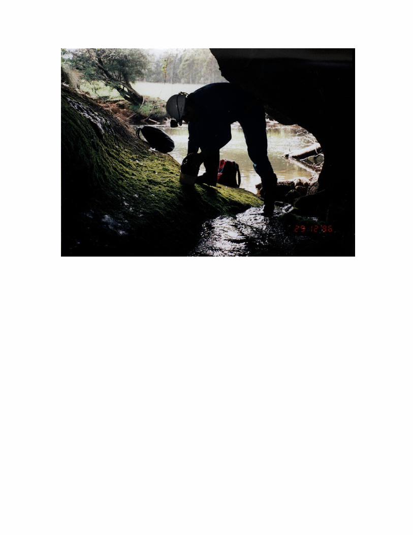
Frontispiece: Looking out the efflux entrance of Swallownest Cave (L-005) in the Loongana karst of northwestern Tasmania - Leven River in background. Winston Ponder from Australian Museum (Sydney) examining cobbles from streamway in search for minute (1-2mm) hydrobiid gastropods - small aquatic snails which live in the streamways of many Tasmanian caves.
FOREWORDUnder the National Forest Policy Statement signed by Tasmania in April 1995, the Tasmanian and Commonwealth governments agreed to a framework and a joint scientific and public consultation process for a comprehensive regional assessment (CRA) of Tasmanian forests leading to negotiation of a Regional Forest Agreement (RFA) for Tasmania. The RFA is an agreement which covers aspects of forest resource allocation, conservation and management and is designed to meet Tasmanian and Commonwealth legislative responsibilities such as the need for appropriate environmental impact assessment.
The CRA information is being gathered in two separate assessment processes:
a social & economic assessment which covers issues such as social impacts, forest resources including wood, mineral and other resources, forest uses such as tourism and apiculture, and industry development options; and
an environment and heritage assessment which covers issues such as cultural heritage, biodiversity, endangered species, old growth, wilderness, national estate and world heritage.
This cave fauna report is one of a series of reports being produced for the biodiversity component of the environment and heritage assessment of the CRA
SECTION 1: THE RFA CAVE FAUNA DATABASE: AN OVERVIEW AND SUMMARY OF RESULTS.................................................................................................................................................
1.1 BACKGROUND AND RECORD SOURCES................................................................................................1.2 AN OUTLINE OF THE CLASSIFICATIONS USED FOR CAVE SPECIES LISTED IN THIS DATABASE...................1.3 DESIGN OF THE DATABASE, RELATED FIELDS AND RELATIONSHIP BETWEEN TABLES.............................1.4 RESULTS OF THE CAVE FAUNA DATABASE: A BRIEF DISCUSSION OF FINDINGS.......................................1.5 AN ANALYSIS OF RESULTS: OBLIGATES AND BIOGEOGRAPHY, SPECIES TYPES AND RICHNESS................1.6 LIMITATIONS OF PRESENT DATA SET..................................................................................................
2.1 AN INTRODUCTION, SOME EXPLANATORY TERMS AND REFERENCE TO POPULATION NUMBERS...............2.2 ECOLOGICAL STATUS AND CLASSIFICATION OF CAVERNICOLES............................................................2.3 CAVE HABITAT ZONES.......................................................................................................................2.4 CAVE COMMUNITIES.........................................................................................................................2.5 CAVE ECOSYSTEMS AND FOOD SOURCES............................................................................................2.6 ASPECTS RELATED TO THE FUNCTIONAL BIOLOGY OF CAVE INVERTEBRATES.......................................2.7 THE SIGNIFICANCE OF TASMANIAN CAVERNICOLES............................................................................2.8 CONSERVATION STATUS AMONGST CAVERNICOLES............................................................................
SECTION 3: THE EVOLUTION OF KARST BIO-SPACE: AN OVERVIEW OF CAVE AND KARST DEVELOPMENT IN FORESTED AREAS OF TASMANIA..................................................
3.1 INTRODUCTION..................................................................................................................................3.2 AN EXPLANATION OF TERMS AND OVERVIEW OF KARST IN TASMANIA.................................................3.3 KARST SOLUTION PROCESSES AND KARSTIFICATION IN TASMANIA......................................................3.4 THE NATURE OF BIO-SPACE: THE MICROHABITATS FOR CAVERNICOLOUS INVERTEBRATES....................
SECTION 4: THE IMPACTS OF SURFACE DISTURBANCE (PARTICULARLY FORESTRY ACTIVITY) WITH PARTICULAR REFERENCE TO CAVE ECOSYSTEMS AND AQUATIC FAUNA.....................................................................................................................................................
4.1 INTRODUCTION..................................................................................................................................4.2 A LITERATURE SUMMARY OF IMPACTS TO AQUATIC FAUNA IN EPIGEAN (SURFACE) STREAMS...............
4.2.2 Intensive timber harvesting and soil disturbance........................................................................4.2.3 Effect of pine plantations...........................................................................................................4.2.4 Impact on fauna by disturbance to riparian zones......................................................................4.2.5 Effects of fire.............................................................................................................................
4.3 LITERATURE SUMMARY OF EFFECTS OF FORESTRY ACTIVITY ON KARST AND CAVE FAUNA...................4.3.1 Limestone quarrying..................................................................................................................4.3.2 Road-making..............................................................................................................................4.3.3 Intensive timber harvesting and soil disturbance........................................................................4.3.4 Impact on cave fauna by introduction of introduced exotic tree species, such as Eucalyptus nitens..................................................................................................................................................4.3.5 Effect of pine plantations...........................................................................................................4.3.6 Impact on cave fauna by disturbance in catchments or riparian zones........................................4.3.7 Effects of fire on karst and cave fauna........................................................................................
4.4 RECENT FIRE IN THE MT. CRIPPS KARST.............................................................................................4.5 RECENT OBSERVATIONS OF IMPACTS FROM FORESTRY ACTIVITY IN TASMANIAN KARST AREAS...........
4.5.1 Exposure of rundkarren..............................................................................................................4.5.2 Turbidity and/or “milkiness” of cave streams during or after rainfall events..............................4.5.3 Decline in cavernicolous species abundance and diversity.........................................................
4.6 PARTICULAR MANAGEMENT CONCERNS RELATING TO THE PRESENCE OF PALAEOKARST DEPOSITS IN SILURO-ORDOVICIAN KARSTS OF TASMANIA............................................................................................
SECTION 5: MANAGEMENT RECOMMENDATIONS - DEFINING PRESCRIPTIVE MEASURES FOR THE PROTECTION OF CAVE FAUNA IN FORESTED AREAS OF TASMANIA..............................................................................................................................................
5.1 INTRODUCTION..................................................................................................................................5.2 CAVE INVERTEBRATE SPECIES PROTECTION.........................................................................................5.3 HABITAT PROTECTION: CAVES, KARST AREAS AND KARST CATCHMENTS..............................................
5.3.1 Habitat protection of caves with known fauna............................................................................5.3.2 Habitat protection of karst areas................................................................................................5.3.3 Habitat protection of land surfaces adjoining karst areas...........................................................5.3.4 Habitat protection of karst catchments.......................................................................................
5.4 AMENDMENTS TO THE TASMANIAN FOREST PRACTICES CODE WITH PARTICULAR REFERENCE TO KARST SURFACES AND KARST CATCHMENTS.............................................................................................
5.4.1 Introduction...............................................................................................................................5.4.2 Recommended amendments to the Forest Practices Code in Tasmania.......................................
5.5 PROTECTION OF CAVE FAUNA BY CHANGES IN LAND TENURE, INCLUDING RESERVATION OF KARST AREAS.....................................................................................................................................................
5.5.1 Introduction...............................................................................................................................5.5.2 Reservation of Crown land to protect cave communities with high conservation significance.....5.5.3 Conservation management of cave communities in private forest..............................................
5.6 REHABILITATION AND HABITAT RESTORATION OR ENHANCED BREEDING PROGRAMMES.......................5.6.1 Rehabilitation or restoration of cave or karst catchments...........................................................5.6.2 Habitat restoration in caves.......................................................................................................5.6.3 Micro-habitat protection as an aid to enhanced breeding...........................................................
5.7 PUBLIC AWARENESS AND EDUCATION ON THE UNIQUENESS AND FRAGILITY OF CAVE ECOSYSTEMS......5.8 RECOMMENDATIONS FOR FURTHER RESEARCH AND STUDY TO ASSIST IN THE CONSERVATION (AND MANAGEMENT) OF CAVE FAUNA IN FORESTED AREAS OF TASMANIA..........................................................
5.8.1 Faunal surveys in unstudied karst areas.....................................................................................5.8.2 More funding or support should be provided to assist taxonomists with identification and description of cave invertebrate species..............................................................................................5.8.3 Determination (or prediction) of species richness.......................................................................5.8.4 Detailed studies of the habitats of rare and threatened species as an adjunct to cave management plans..............................................................................................................................
v
5.8.5 More detailed analysis of RFA database list to accurately assess the conservation status of species prior to inclusion on the list of rare and threatened species....................................................5.8.6 Investigation of karst areas that warrant reservation to provide conservation management of cave communities and rare or threatened cave species (see Section 5.5).............................................5.8.7 Detailed investigation of cave fauna communities in caves of forested karst on private land, or in karsts downstream from privately forested catchments....................................................................5.8.8 Gaining access to additional cave fauna records including specimens not on database, e.g. ANIC (Canberra), TMAG (Hobart) and SAM (Adelaide).....................................................................
APPENDIX 1: PROJECT BRIEF AND WORK PLAN..........................................................................
APPENDIX 2: LIST OF TASMANIAN CAVES WITH OCCURRENCE RECORDS (AS PER RFA DATABASE).............................................................................................................................................
APPENDIX 3: RARE AND THREATENED (AQUATIC AND TERRESTRIAL) CAVE FAUNA SPECIES FROM RFA DATABASE........................................................................................................
GLOSSARY OF TERMS.........................................................................................................................
vii
FIGURES
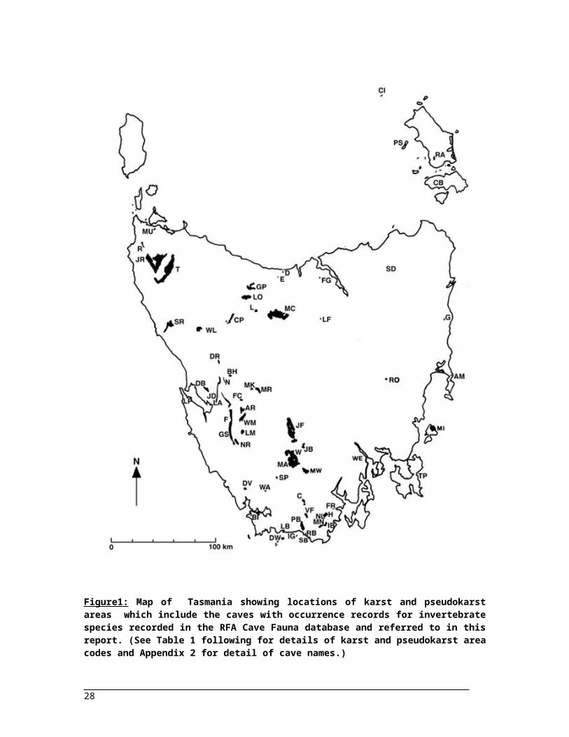
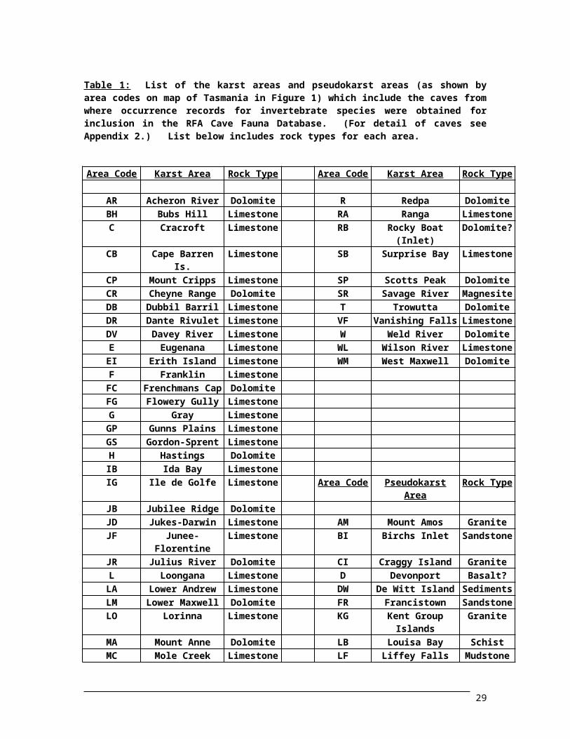
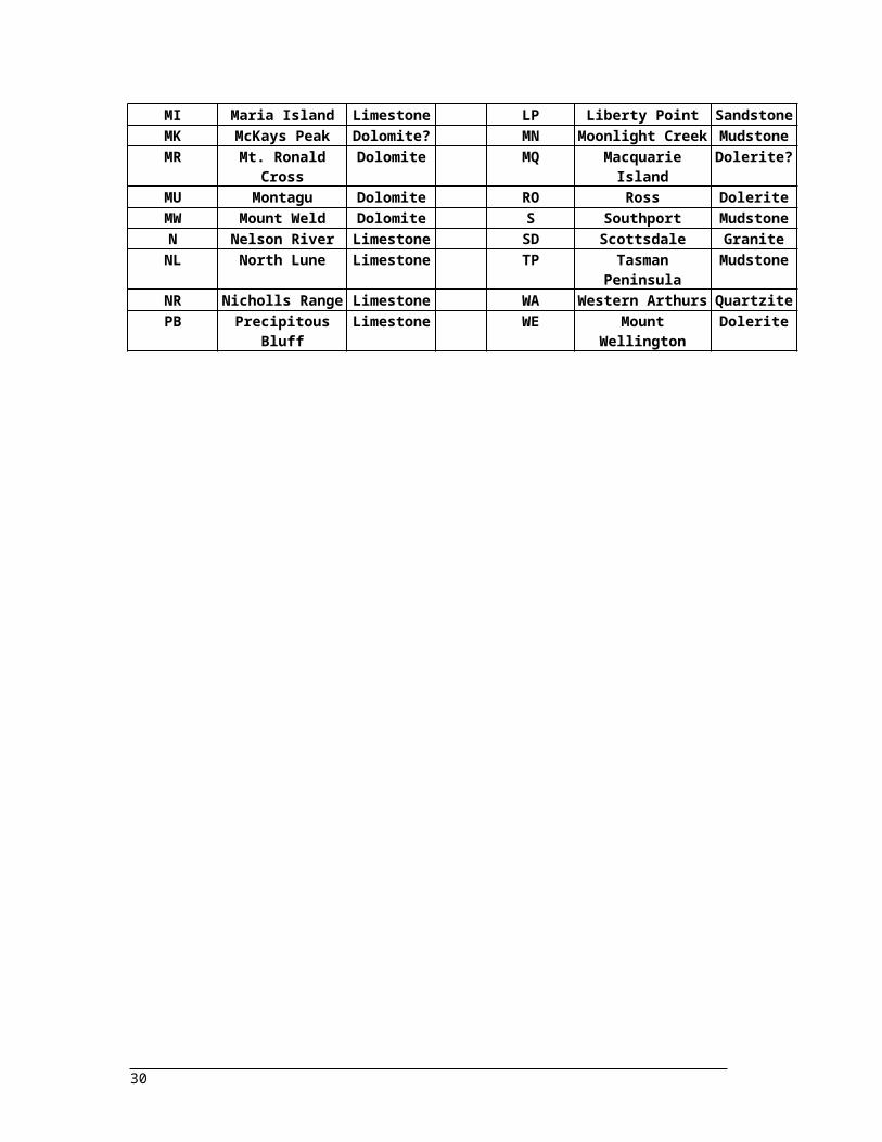
Figure1: Map of Tasmania showing locations of karst and pseudokarst areas which include the caves with occurrence records for invertebrate species recorded in the RFA Cave Fauna database and referred to in this report. (See Table 1 following for details of karst and pseudokarst area codes and Appendix 2 for detail of cave names.).................................................................................................
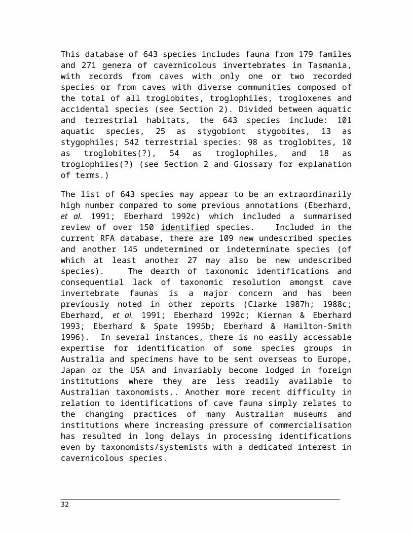
Figure 2: New species of the chthoniid pseudoscorpion: Pseudotyrannochthonius sp. from Tree Root Pot (GP-070) in the Gunns Plains karst area; 3-4mm long. (Note the prey grasping chelate pedipalps.) In database as Pseudotyrannochthonius sp. nov. (no. 5)...........................................................................
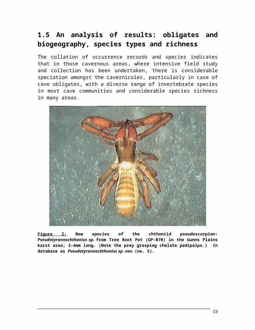
Figure 3: New species (juvenile male) of the tiny (0.5-1mm) blind theriidid spider: Icona, sp. from Emperor Cave (GP-060) in the Gunns Plains karst area.......................................................................
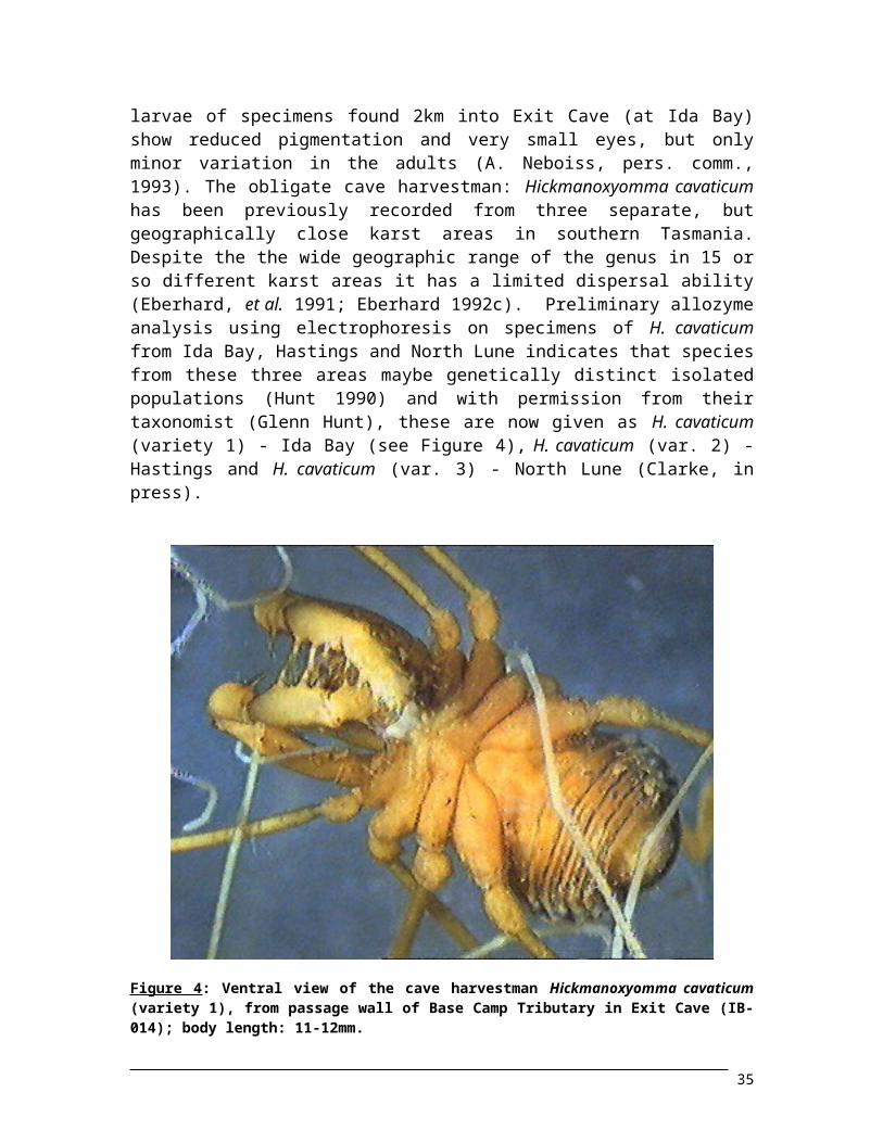
Figure 4: Ventral view of the cave harvestman Hickmanoxyomma cavaticum (variety 1), from passage wall of Base Camp Tributary in Exit Cave (IB-014); body length: 11-12mm......................................
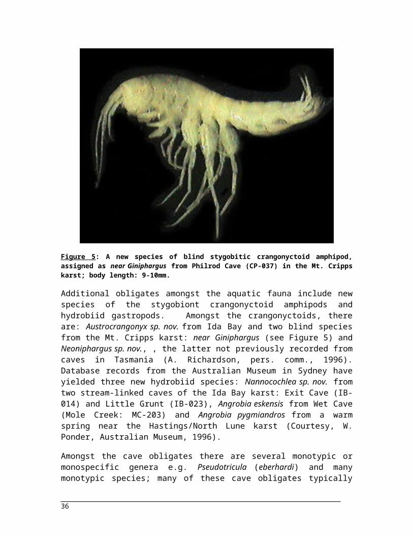
Figure 5: A new species of blind stygobitic crangonyctoid amphipod, assigned as near Giniphargus from Philrod Cave (CP-037) in the Mt. Cripps karst; body length: 9-10mm.................................................
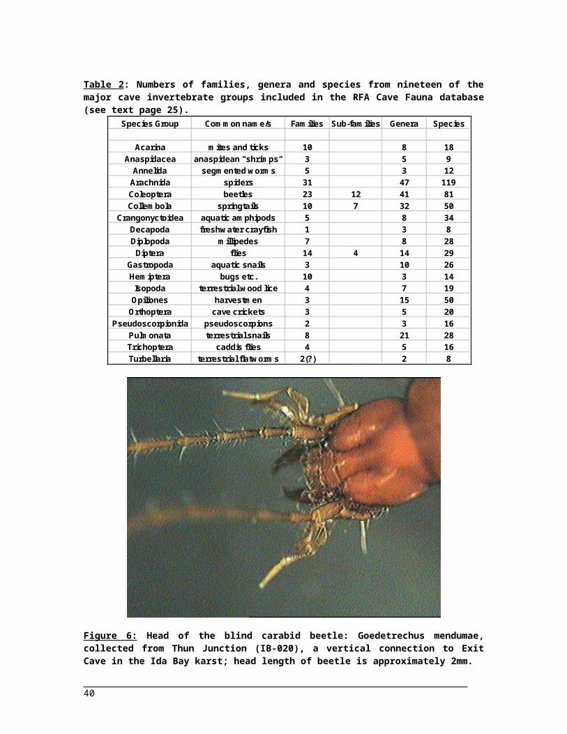
Figure 6: Head of the blind carabid beetle: Goedetrechus mendumae, collected from Thun Junction (IB-020), a vertical connection to Exit Cave in the Ida Bay karst; head length of beetle is approximately 2mm...................................................................................................................................................
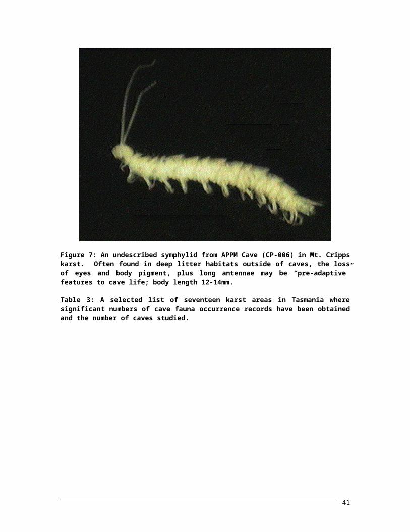
Figure 7: An undescribed symphylid from APPM Cave (CP-006) in Mt. Cripps karst. Often found in deep litter habitats outside of caves, the loss of eyes and body pigment, plus long antennae may be “pre-adaptive” features to cave life; body length 12-14mm.................................................................
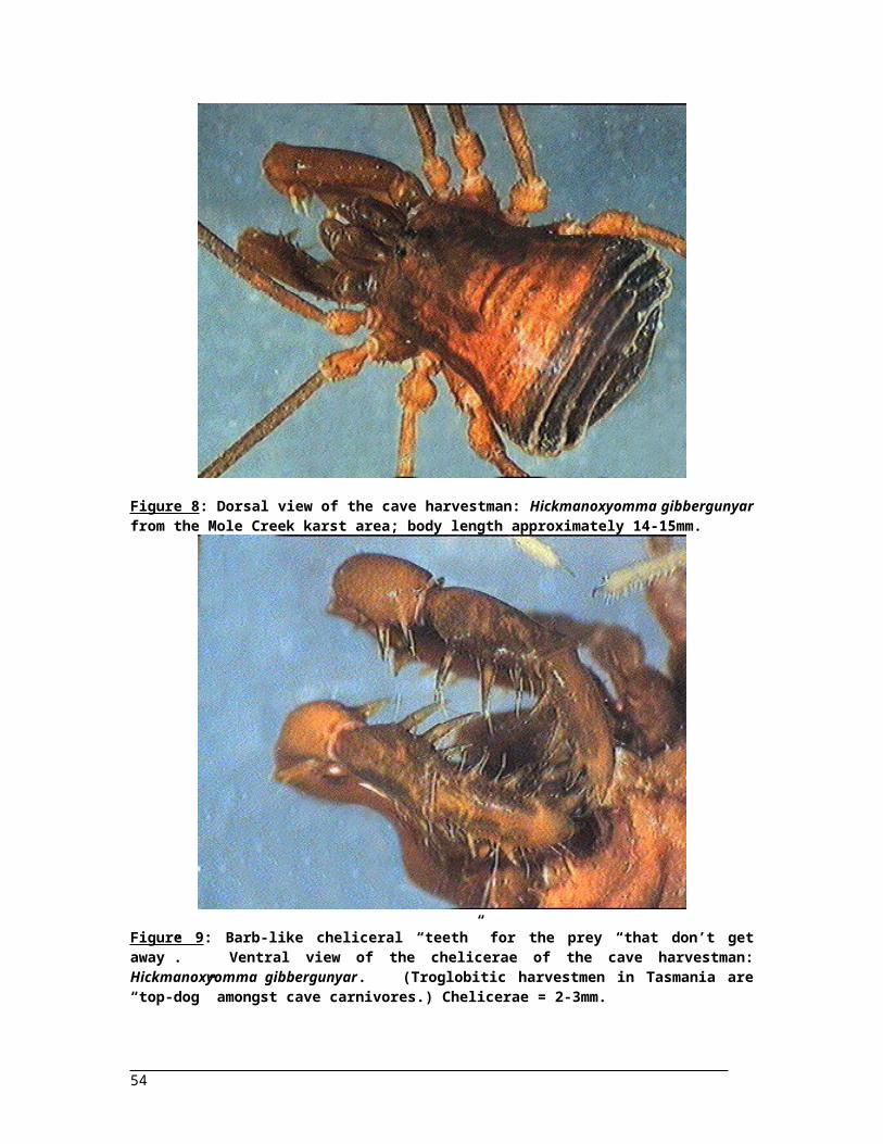
Figure 8: Dorsal view of the cave harvestman: Hickmanoxyomma gibbergunyar from the Mole Creek karst area; body length approximately 14-15mm.................................................................................
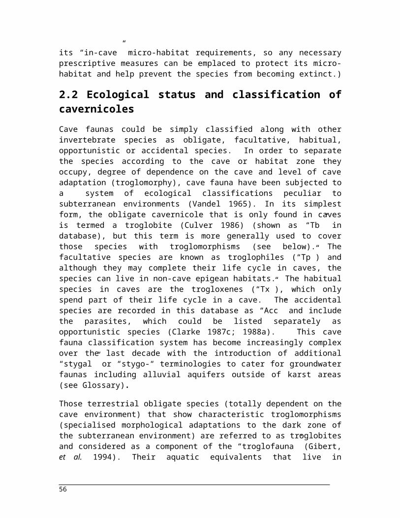
Figure 9: Barb-like cheliceral “teeth” for the prey “that don’t get away”. Ventral view of the chelicerae of the cave harvestman: Hickmanoxyomma gibbergunyar. (Troglobitic harvestmen in Tasmania are “top-dog” amongst cave carnivores.) Chelicerae = 2-3mm..................................................................
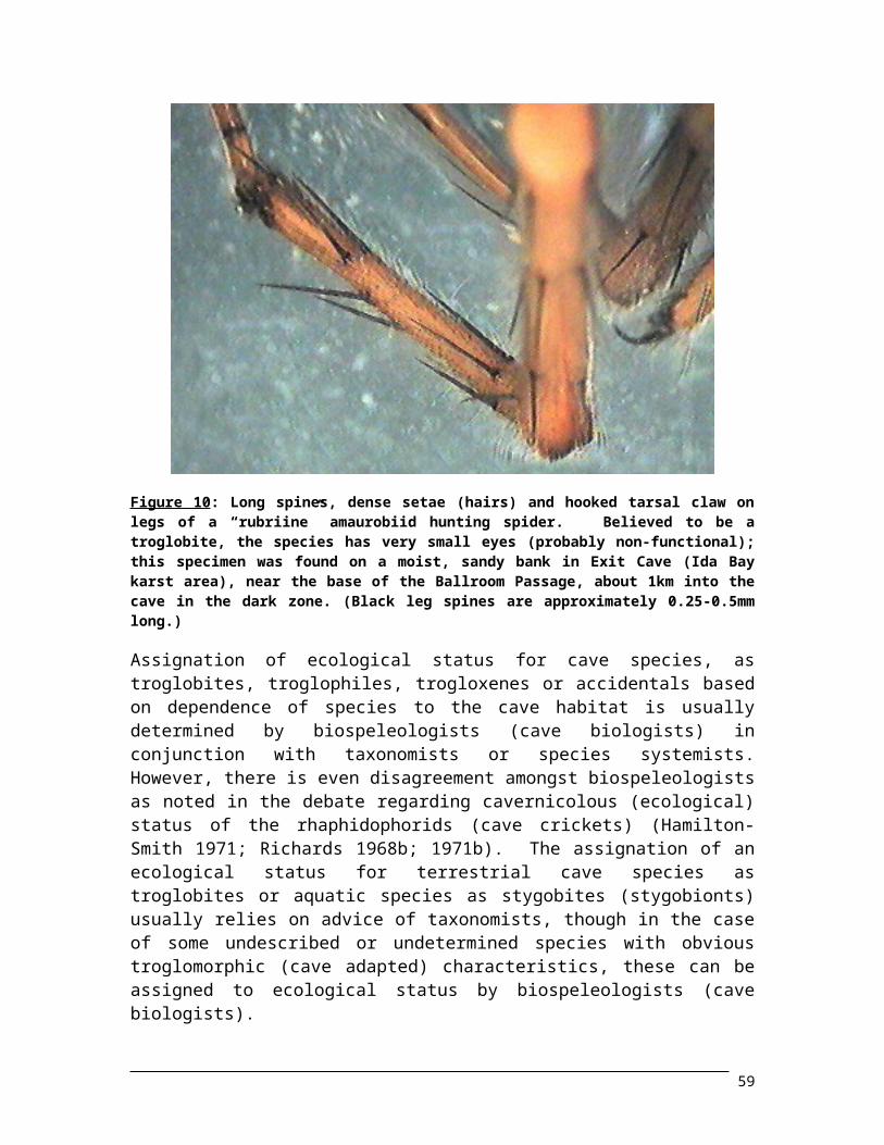
Figure 10: Long spines, dense setae (hairs) and hooked tarsal claw on legs of a “rubriine” amaurobiid hunting spider. Believed to be a troglobite, the species has very small eyes (probably non-functional); this specimen was found on a moist, sandy bank in Exit Cave (Ida Bay karst area), near the base of the Ballroom Passage, about 1km into the cave in the dark zone. (Black leg spines are approximately 0.25-0.5mm long.).......................................................................................................
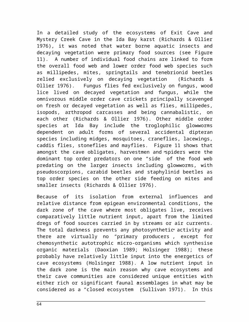
Figure 11: Food web in Exit Cave and Mystery Creek Cave at Ida Bay (based on Figure 11 in Richards and Ollier, 1976)................................................................................................................................
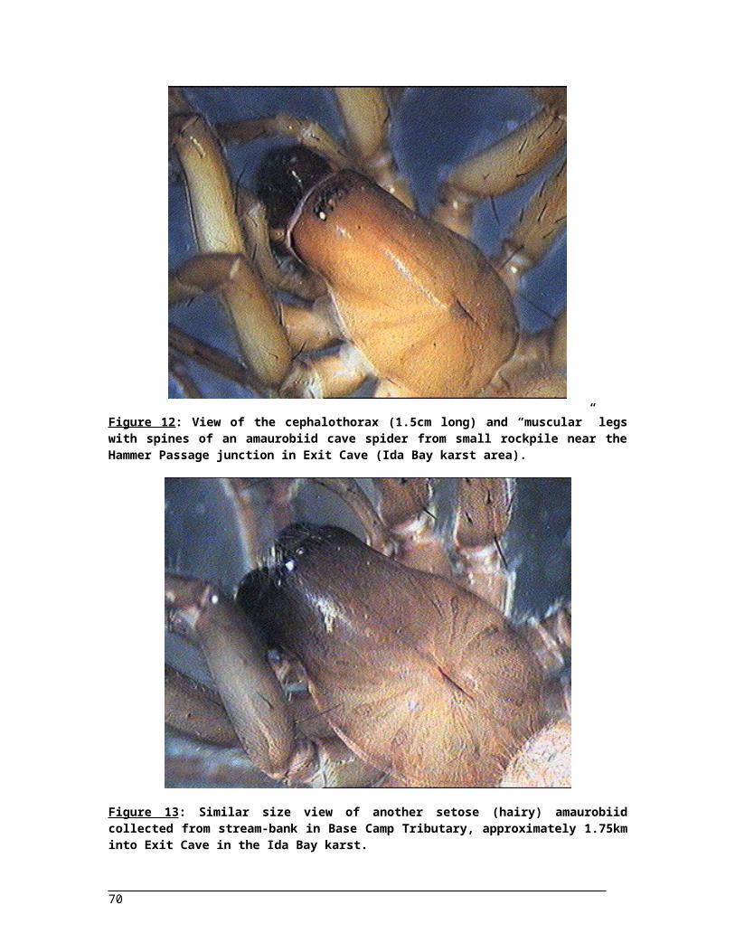
Figure 12: View of the cephalothorax (1.5cm long) and “muscular” legs with spines of an amaurobiid cave spider from small rockpile near the Hammer Passage junction in Exit Cave (Ida Bay karst area)...................................................................................................................................................
Figure 13: Similar size view of another setose (hairy) amaurobiid collected from stream-bank in Base Camp Tributary, approximately 1.75km into Exit Cave in the Ida Bay karst.......................................
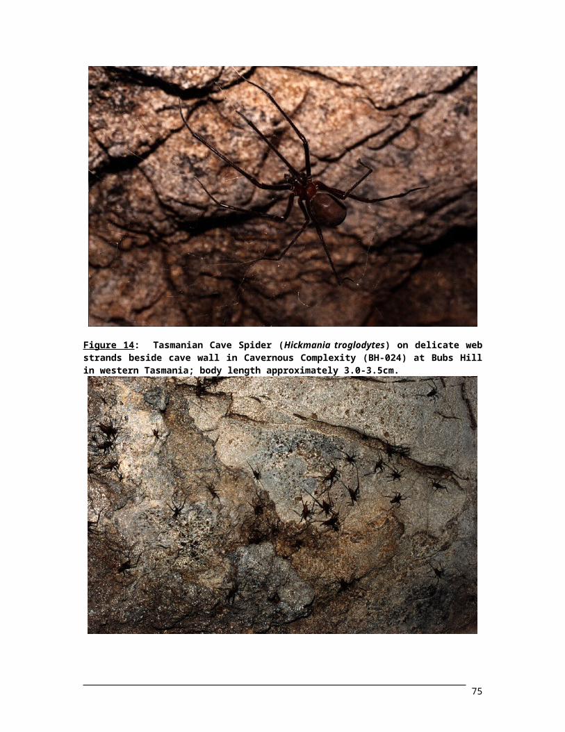
Figure 14: Tasmanian Cave Spider (Hickmania troglodytes) on delicate web strands beside cave wall in Cavernous Complexity (BH-024) at Bubs Hill in western Tasmania; body length approximately 3.0-3.5cm.................................................................................................................................................
Figure 15: Numerous rhaphidophorid cave crickets (Micropathus sp.) on cave wall in 1935 Cave (BH-4) at Bubs Hill in western Tasmania; body length approx. 2.0-2.5cm......................................................
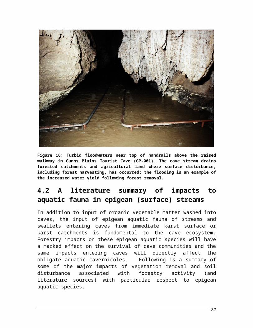
Figure 16: Turbid floodwaters near top of handrails above the raised walkway in Gunns Plains Tourist Cave (GP-001). The cave stream drains forested catchments and agricultural land where surface disturbance, including forest harvesting, has occurred; the flooding is an example of the increased water yield following forest removal...................................................................................................
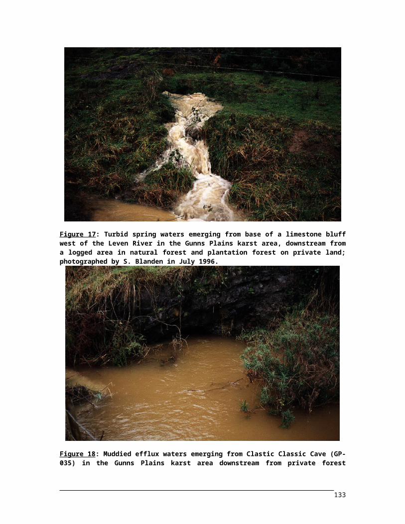
Figure 17: Turbid spring waters emerging from base of a limestone bluff west of the Leven River in the Gunns Plains karst area, downstream from a logged area in natural forest and plantation forest on private land; photographed by S. Blanden in July 1996......................................................................
ix
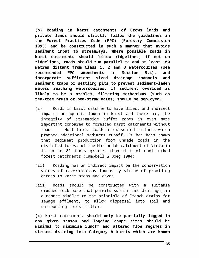
Figure 18: Muddied efflux waters emerging from Clastic Classic Cave (GP-035) in the Gunns Plains karst area downstream from private forest plantations of softwood pine: Pinus radiata and hardwood eucalypt: Eucalyptus nitens; photographed by S. Blanden in July 1996...............................................
xi
TABLES
Table 1: List of the karst areas and pseudokarst areas (as shown by area codes on map of Tasmania in Figure 1) which include the caves from where occurrence records for invertebrate species were obtained for inclusion in the RFA Cave Fauna Database. (For detail of caves see Appendix 2.) List below includes rock types for each area..............................................................................................
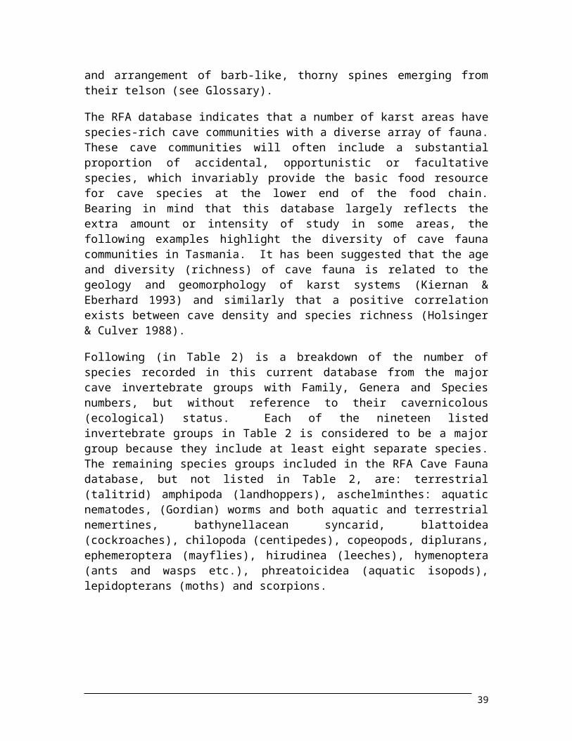
Table 2: Numbers of families, genera and species from nineteen of the major cave invertebrate groups included in the RFA Cave Fauna database (see text page 25)..............................................................
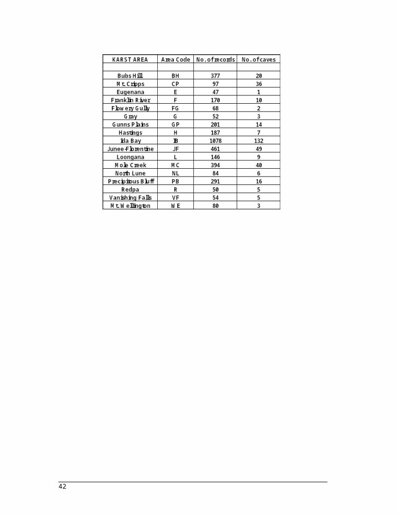
Table 3: A selected list of seventeen karst areas in Tasmania where significant numbers of cave fauna occurrence records have been obtained and the number of caves studied.............................................
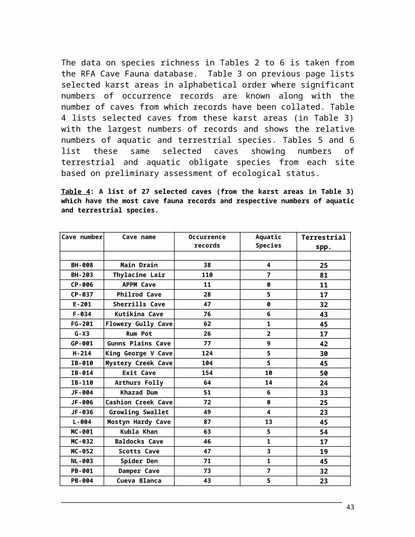
Table 4: A list of 27 selected caves (from the karst areas in Table 3) which have the most cave fauna records and respective numbers of aquatic and terrestrial species........................................................
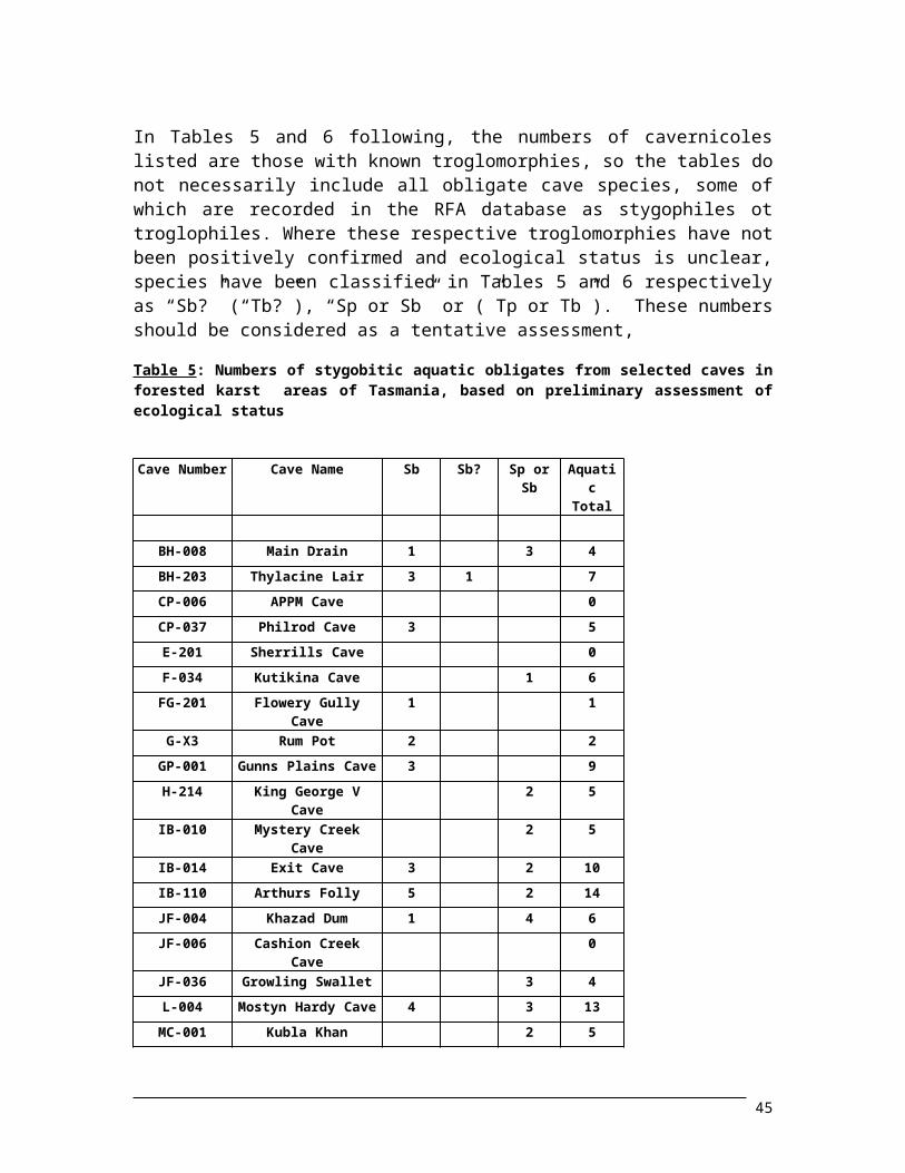
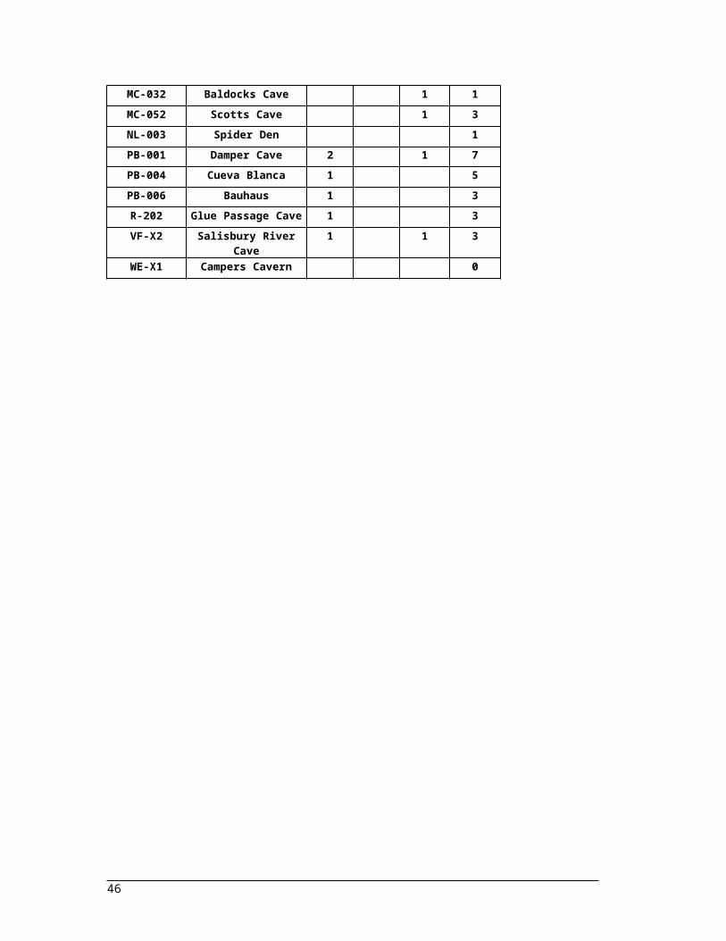
Table 5: Numbers of stygobitic aquatic obligates from selected caves in forested karst areas of Tasmania, based on preliminary assessment of ecological status..........................................................................
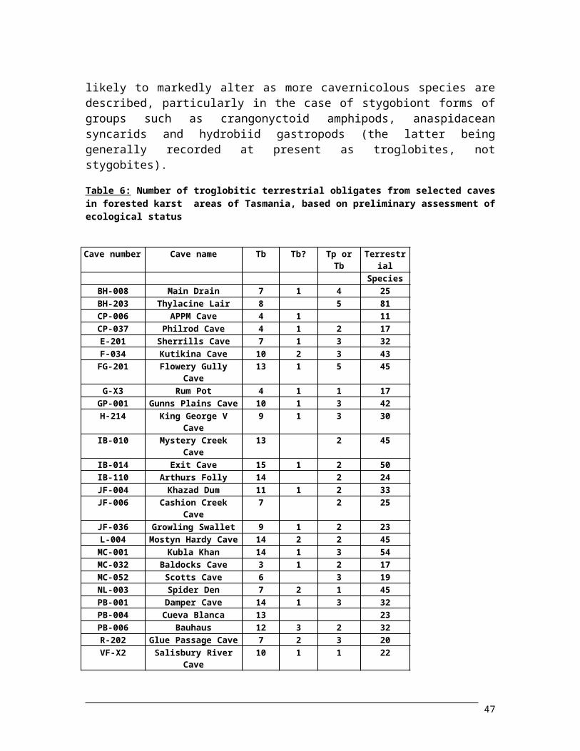
Table 6: Number of troglobitic terrestrial obligates from selected caves in forested karst areas of Tasmania, based on preliminary assessment of ecological status.........................................................
xiii
ACKNOWLEDGMENTSThis RFA Cave Fauna report, with its management prescriptions and the RFA Cave Fauna database which preceded, form part of the Biodiversity Assessment of the joint Commonwealth and State Government Comprehensive Regional Assessment (CRA). This would not have been possible without the support and assistance of many people over the last eight to nine months and I am indebted to all the following persons and a
number of institutions. This project first came to my notice after returning from a brief, albeit 18,600km, journey around Australia in a 4WD (“Forty Caves in Forty Days”), when on the occasion of my half century celebration in early May, both Alastair Richardson and Ian Houshold drew my attention to this, saying “…this job was made for you!”. I am particularly indebted to both these persons for this early notice and their continued assistance, support and encouragement throughout the whole project. Similarly, I am also indebted to my Regional Forest Agreement (RFA) project co-ordinator, Sally Bryant (the boss!) and other members of the CRA (RFA) Environment and Heritage Project Team, plus the whole CRA / RFA / Australian Nature Conservation Agency (ANCA) infrastructure that has forwarded and financed this project and made it possible in so many other ways to be a “happening” and come to fruition. In addition, I particularly thank the other members of my RFA Steering Committee for their input, support and constructive criticism: Alastair Richarson (Tas.Uni.), Kevin Kiernan (Forest Practices Unit), Rob Taylor (Forestry Tasmania) and Geoff Larmour (ANCA).
I am also indebted to the University of Tasmania, in particular the Zoology Department - for providing me with laboratory space, microscope and many other facilities, effectively giving me a “kick-start” into the project. Particular thanks go to my unpaid project supervisor: Alastair Richardson (who promptly answered all my emails), as well as Professor Craig Johnson and acting Department Head: Rob White, plus Roy Swain, Sherrin Bowden and Barry Rumbold for their continued and on-going support and to Zoology Department laboratory staff and technicians: Alan Dumphy, Wayne Kelly, Kate Hamilton, Richard Holmes and Ron Mawbey. I am also extremely grateful for the support and assistance given by Albert Goede, Senior Lecturer in the University of Tasmania’s Department of Geography and Environmental Studies; assistance which included access to all the A. and T. Goede cave fauna collection records (1968-1982) and copies of numerous cave fauna references. In addition, I would also express my thanks to other members of that department: Jamie Kirkpatrick, Peter McQuillan, Jolyon Desmarchelier and Karyl Michaels. Professor Bob Hill from the Faculty of Plant Science in the University of Tasmania kindly provided departmental facilities to produce image scans of colour photographs for the report, including the frontispiece.
Compilation of the RFA Cave Fauna database, on which this report is based, involved an enormous amount of time, many long days and many unpaid hours of work. It could not have been achieved without the assistance of my son (Emerson Clarke), a student in the Department of Computer Science at the University of Tasmania. I am indebted to his
1
time and effort involved with assistance, demonstration and tuition in setting up the structure for the database, re-programming sections of the database and modifying the field characteristics plus the relationships between tables. I am also very grateful for his time and effort with other computer services including the provision and installation of appropriate software for the PC LapTop (loaned by courtesy of Ian Houshold of the Tasmanian Parks and Wildlife Service) which was used by Jason Hamill to assist with data entry. Emerson Clarke has provided valuable assistance with some of the figures including software manipulation of backgrounds in the photo-microscopic digital images to remove dust flecks, bubbles or spurious reflected light spots and has provided additional assistance in formatting the drafts of this report.
The digital images of Tasmanian cavernicoles used in the figures previously mentioned were kindly made available courtesy of Liz Turner and the Tasmanian Museum and Art Gallery (TMAG). The specimens were arranged under microscope in conjunction with the writer and photographed in the Invertebrate Section of TMAG in Hobart. I am also grateful to Stephen Blanden (from Savage River Caving Club) for the loan of the colour photographs depicting the turbid floodwaters in Gunns Plains Tourist Cave and the turbid waters emerging from cave features in other parts of the Gunns Plains karst.
I am also indebted to both Liz Turner and Roger Buttermore for making time and space available for me and granting permission to sort through some 7,000-8,000 registrations cards in the TMAG card index of invertebrate species in search for cave fauna records. Similarly, I would like to thank Trevor Semmens of the Department of Primary Industries and Fisheries (DPIF) Hobart (New Town) laboratories for making time available and helping my assistant (Jason Hamill) search through the DPIF Museum specimen drawers to locate Tasmanian cave fauna specimens.
The actual collation of records for the RFA Cave Fauna database was in itself an enormous task achieved in a very short limited time frame. I owe much to Stefan Eberhard, both for his distinguished work and efforts as a biospeleologist and his earlier publications, numerous unpublished reports (including MSc thesis), plus also permitting access to his Queen Victoria Museum (QVM) museum lodgement records and his so-called “Database from Hell”. The latter contributed some 1,400 records towards the total of almost 4,700 records amassed in this database, (although some of Stefan’s data was also duplicated by museum records). I am also indebted to Elery Hamilton-Smith who gave permission to access his “BS” (“Bio-Speleological”) record cards for specimens lodged at the South Australian Museum; these specimens were collected from Tasmanian caves by Elery and other biologists, including Arthur M. Lea. These “BS” cards also included details of cave numbers, collection dates, collector name/s and published references for some other invertebrate species taken from Tasmanian caves. (I am extremely grateful to Andy Spate from the NSW National Parks and Wildlife Service in Queanbeyan, who sorted these “BS” cards and organised their dispatch and temporary loan to me.) Albert Goede kindly provided me his entire record book of invertebrate fauna collected from Tasmanian caves in the 15 year period: 1968 to 1982. The majority of these specimens were collected by Albert and/or Therese March (formerly Therese Goede). To the numerous other cave biologists or biospeleogists whose data I have
2
obtained through literature sources or museum records, I am also extremely grateful (see Section 1.1).
I am also indebted to the many cavers who voluntarily assisted me with fieldwork and collection of cavernicoles during this project: Stephen Blanden, Stephen (“Joss”) Brooks, Stephen Bunton, Jeff Butt, Jolyon Desmarchelier, Dave Heap, Lesley Gardner, Jason Hamill, Dean Morgan, Kannyappan Ramaswamy, Henry Shannon, Stephen Swabey and Mick Williams. Similarly, I would like to also express my thanks for the in-kind support, assistance and loan of equipment from several speleological bodies: including the former Southern Caving Society, Tasmanian Caverneering Club and the Tasmanian Cave and Karst Research Group, plus the present organisations including Australian Speleological Federation, Mole Creek Caving Club, Northern Caverneers, Savage River Caving Club and Southern Tasmanian Caverneers.
Some of these recently collected specimens were identified at relatively short notice and I would particularly like to thank the following specialists: Kevin Bonham, John Bradbury, Peter Cranston, Val Davies, Mike Gray, Penny Greenslade, Bruce Halliday, Glenn Hunt, Jean Jackson, Darlene Judd, Jerry Lim, Karyl Michaels, Barry Moore, Winston Ponder, Rob Raven, Alastair Richardson, Roy Swain and Liz Turner.
Numerous taxonomists and invertebrate systemists around Australia and overseas have also assisted with this project by virtue of providing me with identifications for cavernicolous species which have been included in the database. I am very much indebted to all the following people: Ian Ball (Memorial University, Halifax, Nova Scotia - aquatic flatworms); Leon Barmuta (University of Tasmania - flies and midges); Kevin Bonham (Hobart- land snails); John Bradbury (Adelaide University - crangonyctoid amphipods); David Briscoe (Macquarie University, NSW - peripatid “velvet” worms); Peter Cranston (ANIC, Canberra - flies); Val Davies (Queensland Museum - amaurobiid spiders); Geoff Dyne (DEST, Canberra - earthworms); Mike Gray (Australian Museum, Sydney - spiders); Alison Green (Launceston - oniscid isopods [slaters]); Penny Greenslade (ANIC, Canberra - springtails); Bruce Halliday (ANIC, Canberra - mites); Mark Harvey (Western Australia Museum - pseudoscorpions); David Hay (Latrobe University, Melbourne - nemerteans); John Hickman (Hobart - harvestmen, spiders and terrestrial flatworms); Glenn Hunt (Aust. Museum, Sydney - mites and harvestmen); John Ireson (Dept. of Primary Industries and Fisheries, New Town - springtails); Jean Jackson (University of Tasmania - aquatic larvae and caddis flies); Darlene Judd (Smithsonian Institue, Washington, D.C. - flies, craneflies, mosquitoes and lacewings); Ron Kershaw (Queen Victoria Museum, Launceston - land snails); Tim Kingston (Queen Vic. Museum, Launceston - aquatic worms); Brenton Knott (Perth, WA - aquatic amphipods and phreatoicid isopods); John Lawrence (ANIC, Canberra - beetles); Jerry Lim (University of Tasmania - hemipteran bugs and aquatic larvae); David McAlpine (ANIC, Canberra - fungus flies); Peter McQuillan (Uni. of Tas.- several insect groups); Bob Mesibov (Queen Vic. Museum, Launceston - centipedes and millipedes); Karyl Michaels (University of Tasmania - beetles); Barry Moore (ANIC, Canberra - carabid beetles); Janet Moore (U.K. - aquatic nemertines); Artus Neboiss (Museum of Victoria - philoptamid caddis flies); Alf Newton (Field Museum of Natural History,
3
Chicago, Illinois - staphylinid beetles); Winston Ponder (Aust. Museum, Sydney - hydrobiid gastropods); Gary Poore (Museum of Victoria - crangonyctoid amphipods); Rob Raven (Queensland Museum - spiders); David Rentz (ANIC, Canberra - grasshoppers and crickets); Aola Richards (University of NSW - cave crickets); Alastair Richardson (Uni. of Tas. - [aquatic] crangonyctoid and [terrestrial] talitrid amphipods); Graeme Smith (Bayer Chemicals, Sydney - silverfish); Roy Swain (Uni.of Tas. - anaspidean syncarids); Bob Taylor (ANIC, Canberra - ants); Liz Turner (Tasmanian Museum and Art Gallery, Hobart - spiders); Janet Waterhouse (Aust. Museum, Sydney - hydrobiid gastropods); M. Williams (ANIC, Canberra - hemipteran aphids); George Wilson (Aust. Museum, Sydney - phreatoicid isopods); and Lee Windsor (James Cook University, Townsville - aquatic flatworms).
In addition to the above, a large number of occurrence records were obtained through various institutions around Australia, either by way of direct access to records or via data licence agreements arranged through the RFA. Firstly, I am very grateful to both Alastair Richardson and Roy Swain from the Zoology Department at the University of Tasmania for giving me access to their respective collations relating to collection records of crangonyctoid amphipods and anaspidean syncarids from caves in Tasmania. I also wish to extend my sincere thanks to Mark Harvey of the Western Australian Museum, Jan Forrest of the South Australian Museum, Ken Walker of the Museum of Victoria, Barry Moore of the Division of Entomology (ANIC) Canberra and Alison Green of Launceston who all provided me with lists of Tasmanian cave specimens in their collections. In order to access museum records for the CRA biodiversity assessment, Forestry Tasmania established data licence agreements with the Australian Museum in Sydney and the Queen Victoria Museum in Launceston. In Sydney, I would particularly like to thank Helen Slarke of the Australian Museum’s “Search and Discover” Section, Jonathan Pritchard of the Australian Museum Business Services and the respective museum section data collection managers: Penny Berents (Marine Invertebrates and other groups); Ian Loch (Malacology); and Max Moulds (Arachnology and Entomology) for arranging the collation and dispatch of either electronic or “hard copy” records. From the Queen Victoria Museum in Launceston, I should like to thank Tim Kingston, Louise McGowan and Tammy Scarborough for all their efforts and dispatch of database records, including the lodgement records pertaining to Stefan Eberhard’s cave fauna collection.
During the course of the database compilation, I was assisted with data entry and allied tasks by Jason Hamill and Jeff Butt, and again I would like to extend my thanks to Sally Bryant and the RFA Environment and Heritage Team for making funding available for Jason and Jeff to do this work. During the first week of Jason’s engagement, when it became clear that in both Forestry Tasmania and Parks & Wildlife, there was no spare available PC computer with Windows 95 and Microsoft Access software, Sally Bryant kindly organised for the upgrading of Ian Houshold’s personal PC LapTop in order to perform this data entry. The database was quite complex with 34 fields over three tables and I am extremely grateful to Jason for the perseverance and diligence he put into the work, (especially for the first fortnight before a mouse was connected), in performing the task with only a trackball function and managing the data entry with the very small LapTop viewing screen. Jason was instrumental in keying in many of the late arrivals of
4
hard copy records received from Australian Museum (Sydney) and Queen Victoria Museum (Launceston) as well as a number of other data entry tasks, including a search for cave fauna specimens in the museum drawers at the Department of Primary Industry and Fisheries New Town laboratories.
Using a home-based computer system, Jeff Butt also assisted with several aspects of data entry to expedite the final collation of the database. Using my “species ID numbers”, Jeff finished off the species categorisation and editing of Stefan Eberhard’s “Database from Hell” to a form consistent with the table design for “Species Taxonomy” in this RFA Cave Fauna database and inserted the General AMG co-ordinates from 1:25,000 map sheets for cave sites in the “Caves” table. In addition, Jeff did a re-check and search of all hard copy records from the Queen Victoria Museum and the Australian Museum and completed data entry of these records and similarly assisted me with cross-checking of cave fauna data records in the University of Tasmania publication by Eberhard, et al. (1991) and the unpublished MSc thesis by Stefan Eberhard (1992). I am extremely grateful to Jeff for all these tasks and also for the production of the map of Tasmanian karst areas with fauna records (in Figure 1) which was based on the map in Matthews (1985).
Finally, I would like to express my thanks to the several persons who assisted me with explanations of various karst (or speleological) and biological terms and/or proof reading/constructive crticism of different sections of this report. Bill Humphreys from Western Australian Museum (Perth) kindly provided me with sources for definitions of cavernicolous stygofauna together with some explanation of terms from the draft chapter of the new book by Wilkins, Culver and Humphreys (in press). Stephen Swabey from the Department of Geography at the Newnham campus of the University of Tasmania reviewed some of the karst landform definitions and assisted in refining some of these, plus provided valuable reference sources to support the new definitions. With permission from the authors, Elery Hamilton-Smith kindly supplied me with a draft copy on conservation of Australian cave fauna written by himself and Stefan Eberhard for insertion as a chapter in the new book by Wilkens, Culver and Humphreys. David Culver from Dept. of Biology, American Unversity, Washington, D. C. (USA) and John Holsinger from Biology Dept., Old Dominican University, Norfolk, Virginia (USA) have both assisted me with further explanations of biospeleological terms and concepts. I am very grateful to the following people who proof read different sections of this report and added constructive criticism: John Holsinger (cave fauna); Albert Goede and Ian Houshold (caves and karst processes) plus Andrew Blakesley and Alastair Richardson (management recommendations).
5
EXECUTIVE SUMMARYMany caves (or karst areas) contain significant populations of invertebrate species which comprise complex and diverse cave communities composed of aquatic and/or terrestrial species. Invertebrate species in Tasmanian cave communities live in a predominantly (and naturally) low level nutrient environment dependent on natural organic input from the surface systems and nutrient recycling within the respective cave ecosystem. Most cave ecosystems are very fragile and easily susceptible to disturbance from both surface impacts or “within” cave visitor impacts. Fundamental to the viablity of these cave communities is the stability of a moisture regime: either a constant supply of “clean” unpolluted stream waters with natural nutrient input and/or percolation (seepage) waters which maintain natural cave air humidity in a stable environment with low evapotranspiration rates.
The cave communities include many obligate (cave restricted) species which have specialised troglomorphic adaptations enabling species to live in total darkness in the stable low nutrient environments. Separated from their surface ancestors, many of these cavernicolous invertebrates in karst areas include phylogenetic or distributionally isolated relicts which have evolved in subterranean environments over a considerable period of time, possibly dating back to a geomorphic era in the subterranean biospace before the development of the caves they now live in. Due to separation of karst areas or contiguous cave (drainage) systems within a karst area, genetic isolation has occurred and speciation of cavernicolous faunas indicates high levels of endemicity. Most of these obligate species can be considered as rare and threatened species with actual categorisation dependent on individual species population dynamics, level of habitat protection and otherwise known or potential habitat threats or disturbances.
The presence or reported occurrence of species from any given cave often reflects the amount of collection or intensity of study in any given cave and therefore record absence need not equate to species absence in any cave. The RFA database on which this report is based includes almost 4,700 occurrence records for 643 cavernicolous invertebrates from 492 caves in 50 (carbonate rock) karst areas and 18 areas of non-carbonate rock. The 643 species include faunas from 179 families and 271 genera and in total comprise 101 aquatic species (38 stygobionts) and 542 terrestrial species (108 troglobites and 72 troglophiles). Due to lack of taxonomic resolution, the species list includes 109 new “undescribed” species and 145 “undetermined” or “indeterminate” species, 27 of which may also be new undescribed species. A total of 170 species are considered as rare or threatened species, but since 102 of these are new (undescribed), undetermined or indeterminate species, only 68 of these species will probably be accorded a conservation status for listing as rare and threatened species.
The following 16 sections of recommendations (and their sub-sections) generally fall into one of seven categories: cave invertebrate species protection, habitat protection (including caves, karst surface environments, adjoining lands and catchments), recommended amendments to the Forest Practices Code of Tasmania, changes in land
6
tenure in some forested karst areas (including recommendations for reservation of some karst areas in Crown land and landcare programmes on private land), habitat restoration and enhanced breeding programmes, mechanisms to increase public awareness of the uniqueness and fragility of cave ecosystems and recommendations for further research and study to assist in broadening the knowledge base of cavernicolous faunas in Tasmania and in particular to promote the conservation and management of cave fauna.
The recommendations made in this report are:
1. Cave invertebrate species protection: (a) Some cave communities should be considered for listing as endangered ecological communities under the auspices of the Commonwealth’s Endangered Species Protection Act 1992. (b) Legislative protection of cave species. The list of rare and threatened species (following IUCN Red Data Book Codes applied at a State Level) should be upgraded under the Threatened Species Protection Act, 1995, to include additional cave invertebrates (including new undescribed and un-named species of known cave dwelling genera). (c) Further cave invertebrates should be included in the “Threatened Fauna Manual for Production Forests in Tasmania”. (d) More funding or support should be provided to assist taxonomists with identification and description of cave invertebrate species. (e) Collection of described cave species should be discouraged by promoting the publication of cave fauna collection records and new species descriptions in speleological journals or elsewhere in the public domain.
2. Habitat protection of caves with known fauna: (a) A register of all known caves with cave fauna should be prepared to assist in planning purposes forest-based activity or other permitted activities in forested karst areas. (b) Specific within-cave micro-habitats and exclusion zones should be defined to protect fauna in some caves of forested karst areas, perhaps by gating or limiting access. All such protective measures should be undertaken in consultation with biospeleologists or relevant local speleological organisations.
3. Habitat protection of karst areas: (a) No forestry activity (roading, quarrying, plantation development or logging) or other surface disturbance (especially ground breaking activity) should be permitted in forests which contain the significantly karstified Siluro-Ordovician limestones and Pre-Cambrian dolomites or magnesites and all areas defined by Kiernan (1995b) as “Category A” karsts. [ This recommendation may only be achievable in the forested karsts of State Forest or unallocated Crown land, or in forested karst areas where Forestry Tasmania can exercise its influence. ] (b) Where forestry operations are being planned on private land in Category A karst areas beyond the control of Forestry Tasmania or other land managers, the senior geomorphologist or other appropriately qualified person from Forestry Tasmania and/or the karst officer from Tasmanian Parks and Wildlife Service should inspect the karst area prior to such activity commencing. Furthermore, such person or persons should be empowered to instruct the relevant land owner/land manager accordingly, if such forestry activity is not recommended, or advise if prescribed management techniques are required. The latter may require a regular monitoring programme. (c) Pollutants such as petroleum products (oils and lubricants), herbicides (or pesticides) and fertilisers should be absolutely
7
avoided on the surface of any Category A karst area in Tasmanian forests. (d) The use of fire is not an acceptable management tool in (forested) karst areas. All fires, whether as cool fires or hot fires during regeneration burns, ground fuel reduction burns or perimeter hazard burns will affect cavernicolous invertebrates which are reliant on natural karst proccess and input of natural organic material from surface systems. Similarly, where possible, accidental bushfires should not be allowed to enter karst areas.
4. Habitat protection of land surfaces adjoining karst areas: (a) In land areas adjoining karsts where there is no accurately mapped boundary to define the karst hydrological limits, a buffer zone extending 1,000 metres beyond the known extent of “Category A” karsts (Kiernan, 1995b) should be established on the downslope side of a known karst area, unless otherwise indicated by the Forest Practices Board’s Senior Geomorphologist, and similarly for a distance of 2,000 metres on the upslope side of a known karst area (Clarke, 1987g; 1989b; 1992) with same proviso. (b) Where logging is proposed in areas adjacent to known areas of carbonate rock or “Category A” karsts, a geological and geomorphic mapping and planning assessment should be undertaken by a karst geomorphologist prior to commencement of logging or plantation coupes.
5. Habitat protection of karst catchments: (a) Karst catchments should be accurately defined and mapped. Forest managers should be advised of the presence and extent of karst catchments in order to minimise the effect of ground-breaking activity associated with roading, timber harvesting or plantation preparation to avoid sediment influx into streams or any other pollutants that will impact on the downstream karst. (b) Roading in karst catchments of Crown lands and private lands should strictly follow the guidelines in the Forest Practices Code (1993) and be constructed in such a manner that avoids sediment input to streamways. Where possible roads in karst catchments should follow ridgelines; if not on ridgelines, roads should run parallel to and at least 100 metres distant from Class 1, 2 and 3 watercourses, and incorporate sufficient sized drainage channels and sediment traps or settling pits to prevent sediment-laden waters reaching watercourses. If sediment overload is likely to be a problem, filtering mechanisms (such as tea-tree brush or pea-straw bales) should be deployed. (c) Karst catchments should only be partially logged in any given season and logging coupe sizes should be minimal to minimise runoff and altered flow regimes in streams draining into “Category A” karsts which are known or likely to contain cave fauna communities. Particular attention in this regard should be given to logging of Pinus radiata plantations, though such plantations are not recommended in karst catchments (see [a] - [vii] in section 5.3.2).
6. Amendments to the Tasmanian Forest Practices Code with particular reference to karst surfaces and karst catchments: (a) Revision or amendment to Forest Practices Code which in effect states that no future logging or timber-harvesting, plantation development or other ground breaking activity will be permitted on “Category A” karsts (Kiernan, 1995a) including State Forest, unallocated Crown lands or private land. (b) Inclusion of karst dolines (or sinkholes) as “Class 4” watercourses. (c) The watercourse classification of the Forest Practices Code (FPC) should be specifically amended for karst catchments to include an additional Class 4 type watercourse draining upstream catchments of 25 to
8
50 hectares, promoting the present FPC Class 4 watercourses (including dolines) to Class 5 watercourses. (d) Recommended streamside reserve widths in karst catchments should be amended: Class 1 watercourses to be 50 metres each side, Class 2 should be 40 metres, Class 3 should be 30 metres and Class 4 (plus a new Class 5) should both be 20 metres. Streamside reserve widths for all watercourses should include an additional factor related to tree height, plus a percentage (10-25%) to allow for “tree jump”, with an additional buffer component to reflect the slope angle. (Therefore if trees beside a Class 3 watercourse are 40m high, the buffer zone should be 44-50m; if trees are only 20m high, buffer zone would remain at 30m.) (e) Trees that are accidentally felled into streamside reserves should not be removed, unless head branches or part of trunk have lodged in the watercourse, in which case they should be fastened by cables, sawn through and winched clear with the main trunk log left in place in streamside reserve. If it can be clearly demonstrated that removal of the fallen tree will not cause significant soil disturbance in the streamside reserve (e.g. on rocky ground), then removal of log may be permitted.(f) Logging machinery on slopes adjacent to riparian zones (streamside reserves) should operate in a manner which pushes logs, bark and slash upslope away from watercourse reserves, by reversing down slopes and working uphill. (g) Inclusion of a specific section or chapter in the Forest Practices Code (FPC) relating to plantation establishment (including land surface preparation and selection of plantation species), plantation management and tree harvesting in karst catchments with particular reference to the downstream effects on aquatic species and cave fauna ecosystems. [ This recommendation assumes that there will be no logging in the Category A karsts in State Forest, unallocated Crown land or on private land, as previously stated in 5.4 (a). ] Particular emphasis should be placed on private plantation forest operations in karst catchments. Special mention needs to be made in regard to the likely effects on cave species due to altered surface ecology, drainage patterns and transpiration rates resulting from planting of introduced exotic species such Pinus radiata or the genetically engineered fast-growing eucalypyt: Eucalyptus nitens. It is important that this advice (including recommended amedments to the FPC) is circulated to the attention of private landowners. Practices related to plantation management, maintenance and harvesting should follow the guidelines in the Forest Practices Code and amendments recommended in this report, including only partial harvesting of coupes in any one season.
7. Protection of cave fauna by changes in land tenure, including reservation of karst areas by reservation of Crown land to protect cave communities with high conservation significance: (a) Cave fauna communities of caves in the “High Sensitivity Zones” in the Junee-Florentine karst of southern Tasmania (Eberhard, 1994; 1996) should be protected by an extension of the Mt. Field National Park boundary. (b) Cave fauna communities in the Mount Cripps karst area in central-northwestern Tasmania, a steep region of polygonal karst mantled by glacial till. This area lies in State Forest (deferred forest ), but the conservation values would be better managed if the area was protected by proclamation of a Reserve.(c) Cave fauna communities in the Mole Creek karst area of northern Tasmania in the deferred forest zone of State Forest and unallocated Crown land covering the catchment to Croesus Cave, the Mayberry-Sassafras divide, the Mole Creek-Lobster Rivulet divide and the Wet Caves catchment could be protected by a Reserve or extension of the recently proclaimed Mole Creek Karst National Park. (d) An extension
9
of the Hastings Caves State Reserve to include cave fauna communities in adjoining State Forest reserves, particularly in the eastern and southern sections of the karst. Reservation could also be achieved by an extension of the Southwest National Park boundary to include the Hastings karst.(e) Cave fauna communities in the North Lune karst would be better managed by reservation. The karst lies in a glaciated area mantled by till deposits, and abuts the Hastings karst in the north and extends in a southerly direction across two northern tributaries of the Lune River: Mesa Creek and Gleichenia Creek. The karst lies in State Forest adjacent to, and east of the present World Heritage Area boundary and could be protected by an extension of the Southwest National Park boundary.
8. Conservation management of cave communities in private forest: (a) Conservation of cave communities occurring in forested karst areas in Permian limestone karst of the Gray and Mount Elephant areas on the east coast of Tasmania (includes some areas in State Forest). (b) Cave fauna communities in Ordovician limestone karsts at Gunns Plains and Loongana in northwestern Tasmania should be recognised and protected as far as possible. Most of these areas are either in privately owned agricultural or forestry land (including additional areas at Mole Creek) or under threat due to unfortunate forest practices that are occurring in their catchments. (c) Smaller areas which support threatened cave species, are often in pseudokarst sites located on private land. Some of these sites are only known by one or two species, sometimes equally rare and threatened as karst area species and the pseudokarst species should be recognised and protected as far as possible. Public awareness and education is probably the only means of protecting these sites, including advice to the landowner.
9. Other recommendations for protection of cave fauna include: (a) rehabilitation or restoration of cave or karst catchments; (b) habitat restoration in caves and micro-habitat protection as an aid to enhanced breeding; (c) increasing public awareness and promoting more education on the uniqueness and fragility of cave ecosystems.
10. Recommendations for further research and study to assist in the conservation (and management) of cave fauna in forested areas of Tasmania include faunal surveys in unstudied karst areas: (a) especially in northwestern and northeastern Tasmania; (b) in land areas adjacent to known karst where the present boundary limits are unclear; (c) in karst areas downstream from catchments where forest activities are presently engaged or under consideration, and (d) undertaking cave fauna studies in areas likely to contain different faunal species assemblages and/or different cave community structures.
11. More funding or support should be provided to assist taxonomists with identification and description of cave invertebrate species: the present lack of taxonomic resolution evidenced by the large number of new (undescribed), undetermined or indeterminate species in the RFA database could be alleviated if funding or support was provided to assist taxonomists.
12. Determination (or prediction) of species richness: prediction of faunal values in Tasmanian caves to assist conservation biologists and forest managers or other land
10
managers to prepare appropriate management plans in “new” areas of forested karst or in karst catchment areas where proposed forestry operations may be planned.
13. Detailed studies of the habitats of rare and threatened species as an adjunct to cave management plans including a detailed study of the currently vulnerable or endangered blind cave beetle Goedetrechus mendumae to ascertain population numbers, habitat requirements and true conservation status as part of the Exit Cave Management Plan. Additional specific studies of other rare and threatened species (including search for species not sighted since 1910 etc.) or similar studies of specific cave communities to determine appropriate management of caves or karst areas in other parts of Tasmania, particularly in the forested karst areas.
14. More detailed analysis of RFA Cave Fauna database list to accurately assess the conservation status of species prior to their inclusion on the list of rare and threatened species. The current RFA Cave Fauna database includes 170 rare and threatened cave species (see Appendix 3), but only 68 of these have been described and named to species level. Further detailed study and analysis of the conservation status of cave species on this RFA database list (see Appendix 3) along with species identifications will enable listing and conservation management of more of these cave species.
15. Investigation of karst areas that warrant reservation to provide conservation management of cave communities and rare or threatened cave species (see Section 5.5) (a) The cave communities and rare or threatened species of the karst areas that warrant reservation or other landcare programmes to protect cave fauna (see Section 5.5) should be further assessed to determine conservation stategies appropriate to the particular karst hydrology or karst bio-space prior to changes in land tenure etc. (b) Those karst areas on Crown land or private land (described in Section 5.5) which are known to have significant cave fauna comuunities and/ or rare and threatened cave dwelling species may warrant further investigation to determine the appropriate strategies for conservation management of caves or cave sites in addition to reservation of land or the introduction landcare programmes or conservation covenants. (c) Detailed investigation of cave fauna communities in caves of forested karst on private land, or in karsts downstream from privately forested catchments. (d) There should be an immediate detailed investigation of cave fauna communities to examine the diversity and abundance of aquatic species in stream caves of forested karst on private land or in karst downstream from privately forested catchments to ascertain population numbers, present conservation status and conservation strategies to protect these species.
16. Gaining access to additional cave fauna records including specimens not on database, e.g. from the Australian National Insect Collection (ANIC) at CSIRO in Canberra, from the Tasmanian Museum and Art Gallery (TMAG) in Hobart and from the South Australian Museum (SAM) in Adelaide. Funding or other support may be required to gain access to further records of Tasmanian cave fauna in the numerous collections that have not been accessed or collated in the present RFA Cave Fauna database.
11
INTRODUCTIONThere are probably more than 4,000 caves in Tasmania and most of these are located in forested areas, particularly in carbonate rock areas, such as limestone or dolomite, but also in non-carbonate areas such as dolerite, granite and sandstone. In Tasmania, there are over 300 areas of carbonate rock, ranging from Pre-Cambrian to Quaternary in geological age. Many of these carbonate rock areas are karstified and/or cavernous and the vast majority of known caves are located in forested karst areas and/or downstream from forested catchments. Due to nature of carbonate rock and karst solution processes, many cavernous karsts form contiguous areas comprised of interconnected networks of fissures, cavities and channels (and caves) that form separate and individual drainage systems, often bearing no relationship to surface topography or surface drainage divides. The sum total of all these subterranean solutional features forms a biospace for cavernicolous invertebrates.
The cavernicolous invertebrates that comprise the cave faunas in this report have been recorded from Tasmanian caves since the 1880s, but more regular cave fauna studies and collections have only occurred in the last 30 years. The early studies were based on occasional collections that coincided with the haphazard discovery and exploration of predominantly horizontal cave systems, mainly in caves of the Ordovician limestones. In the last 10 years more detailed studies have been undertaken in a wider range of Tasmanian karst environments, in different carbonate rock types and in different cave structures including vertical cave systems.
The RFA database which largely forms the basis of this report, represents one of the first collations of its kind in both Tasmania (and Australia) containing the known or accessable occurrence records for all aquatic and terrestrial species collected from Tasmanian caves. (The data was collated on a Microsoft Access database and a full description of methodology is described in Sections: 1.2 and 1.3.) Most of the information was sought by personal contact with curators at state museums and other collectors. Only a small amount of this information was available in electronic form. Much is on card indexes and a substantial amount only exists as label information in vials and hence the cost and time involved in accessing the information in this less-processed form has been respectively higher and longer than expected.
This report aims to provide background information relating to cave fauna, cave development and karst processes, together with the recorded impacts on aquatic and terrestrial fauna in order to support management recommendations for the protection and conservation of cave fauna in forested karst areas of Tasmania (see methodology in Sections: 1.1, 1.2 and 1.3). The objectives of this report (and the database) included: (a) a comprehensive and up-to-date database of Tasmanian cave fauna records; (b) a GIS layer of the above information to assist in forest management planning and conservation or protection of cave fauna species; (c) a ranking of caves (or cave areas) by species (taxon) richness, a cluster analysis and ordination of caves (or cave areas), an areal analysis of these results; and (d) recommended management prescriptions for cave fauna suitable for
12
incorporation into the Forest Practices Code, Threatened Fauna Manual and subsequent use by land managers. Due to time constraints following on from the problems involved in accessing data, the statistical analysis, referred to in (c) above, was not undertaken. However, some of these analyses were achieved by “simple” and “cross-table” queries through the Access database and the results are listed in Tables: 2 to 5. Furthermore, it is understood that personnel associated with the Geographic Information System (GIS) process in the Tasmanian Parks and Wildlife Service maybe undertaking some statistical analysis of the cave fauna data.
13
SECTION 1: The RFA Cave Fauna Database: an overview and summary of results1.1 Background and record sourcesThe current RFA Cave Fauna Database is a collation containing a substantial proportion of the known records for invertebrate species from caves in Tasmania. As an historical record, it is believed to be the first known collation of all invertebrate species recorded from the caves of Tasmania since the early 1880s, and one of few of its kind in Australia. Records relating to invertebrate species collected from mines or other man-made cavities in non-carbonate rock have been deliberately excluded. This collation has been sourced from the recorded observations, collections and species identifications by a number of biospeleologists and invertebrate taxonomists, published records in speleological or biological literature and from organised records (on database, card index or vial labels) from a number of institutions, including museums and universities (see below). Some of the major sources are listed below:
a) scientific journals and publications etc. including: “Zoological Catalogues” of the Australian Biological Resources Study, Occasional Papers of Dept. of Geography & Environmental Studies (University of Tasmania) and the former Dept. of Parks, Wildlife and Heritage, from Papers & Proceedings of the Royal Society of Tasmania, Records of the Australian Museum (Sydney), Records of the Sth. Aust. Museum (Adelaide), Tasmanian Mail, Tasmanian Naturalist, published or unpublished reports by A. Clarke, R. Eberhard or S. Eberhard to Forestry Tasmania and/or the Tasmanian Dept. of Parks, Wildlife and Heritage and their predecessors and published reports and unpublished theses from the Univerity of Tasmania and Tasmanian College of Advanced Education.
b) various Tasmanian or national (Australian) speleological (caving or cave science) magazines, journals, etc.(including reports or articles written by Clarke, Eberhard, Goede, Gray, Hamilton-Smith, Kiernan, Middleton, Skinner and Terauds);
c) collection records of Arthur Clarke;
d) collection records of Stefan Eberhard (including Stefan’s electronic database);
e) collection records of Albert and Therese Goede;
f) card index of “BS” (“Bio-Speleological”) records by Elery Hamilton-Smith;
g) card index of Alastair Richardson (University of Tasmania: Dept. of Zoology);
h) card index at the Tasmanian Museum & Art Gallery (TMAG - Hobart);
14
i) museum records of the Dept. of Primary Industries and Fisheries (New Town, Tasmania);
j) database records of the Australian Museum (Sydney);
k) database records of the Queen Victoria Museum (QVM - Launceston);
l) records from the South Australian Museum (SAM - Adelaide);
m) records from the Western Australian Museum (Perth);
n) records from different sections of the Museum of Victoria (Abbotsford etc.);
o) records from the Australian National Insect Collection (ANIC) at the CSIRO Division of Entomology (Canberra);
p) collection in custody of Roy Swain (University of Tasmania: Dept. of Zoology);
q) private collection and records of Alison Green (Launceston);
r) collection and records of Barry Moore (ANIC, Canberra);
s) personal correspondence from more than 40 taxonomists in Australia and overseas (see Acknowledgments).
In the time frame allowed for compilation of this database, it was impossible to track down all the known occurrence records for Tasmanian caves. It is estimated that there could be well in excess of another 800-1,000 records, including additional card index records at TMAG and QVM and “un-documented” records for phialled (vialed) or pinned specimens that are not on card indexes or databases, e.g. ANIC (Canberra), DPIF (New Town), Queensland Museum, QVM, SAM, TMAG, and at several universities (including University of Adelaide, University of New South Wales, University of Sydney and universities in Western Australia). Following submission of the current RFA database into the Tasmanian Parks and Wildlife GIS, another 300-350 records have come to light, along with subsequent collections from additional caves; these have not been included in the current analysis.
1.2 An outline of the classifications used for cave species listed in this database.The occurrence records included in this database related to invertebrate species collected from caves in Tasmania, most of which are in forested karst areas. Species that are large enough to be seen by the naked eye and can be collected by conventional means in the field are commonly also referred to as macroinvertebrates. Cave dwelling invertebrates are generally known as cavernicoles, even though some species may be accidental to that environment and not totally dependent on the cave habitat. The cavernicolous fauna occupy a range of habitat niches in the cave environment including aquatic and terrestrial
15
sites; in this database each species has been ascribed a number, prefixed by an “A” or “T” for “Aquatic” or “Terrestrial”. For database purposes the only fauna described as aquatic species are those that spend their whole life cycle in water or saturated mediums and therefore does not include those winged adult species with aerial epigean stages, which have aquatic larval or nymphal stages.
For the purposes of this database, the cavernicolous invertebrates have been categorised according to the cave zone they are known from (e.g. dark zone, transition or twilight) and are also assigned with various tags or labels related to their ecological status or dependence on the cave environment and their morphology. Those terrestrial obligate species (totally dependent on the cave environment) that show characteristic morphologies (troglomorphies) supporting total life cycle in the darkened subteranean environment are described as troglobites (“Tb”), and their aquatic equivalents are assigned as stygobites or stygobionts (“Sb”) (see Section 2 and Glossary).
Similarly, subject to advice from taxonomists, augmented with local knowledge of species type and morphology, species presence and abundance plus habitat disturbance, known or perceived threats, species in this database have been ascribed to different categories in terms of Conservation Status as rare, vulnerable or endangered or a combination of part or any of these.
1.3 Design of the database, related fields and relationship between tables For each occurrence record, there is a varying degree of information. Ideally, the basic data for each specimen/s of an occurrence record should at least include species type (and Genus species name), karst area and cave name and/or cave number, date of collection (or observation), name of collector, habitat detail, cave zone, species identifier (and year of identification), place of specimen lodgement (and lodgement or accession number), record source and/or any published reference. In addition, there is further relevant data in relation to the karst area, geology, cave, its location and relevant information regarding surface/catchment land use and habitat threats, plus data pertinent to the species taxonomy.
This database has attempted to encompass most of the above parameters for each occurrence record. Consequently, it is quite a large database (35 fields) and has been compiled using Microsoft Access 7.0 for Windows 95 on an (IBM) PC. The database has been split it into three related tables with “one-to-one” and “one-to-many-relationships” between selected fields of each table (shown in “CAPITALS” below):
Table 2: "Species Taxonomy" - SPECIES ID NUMBER; Species Type; Genus; species; Highest Taxon; Family or Sub-Family; Previous Taxonomy (if any); Ecological Niche; Conservation Status; Species Reference.
Table 3: "Occurrences" - SPECIES ID NUMBER; CAVE NUMBER; Collector; Date (month in Roman numerals); Find Number; Micro-Habitat; Cave Zone; Comment; Record Source; Species Identifier (and date if known); Species Lodgement; Accession Number; Published Reference.
Some brief explanation re the above. Caves are numbered with a one or two letter prefix, representing the name of karst area (Figure 1; Table 1), followed by an individual number, as per guidelines laid down in the ASF handbook (Matthews 1985). For example: IB-10 is Mystery Creek Cave in the Ida Bay karst area, CP-113 is Catacombs Crevice in the Mt. Cripps area and F-3 is Clinnelare Cave (Whitlam Cave) in the Franklin River karst area. For the purposes of this database (in order to have numbers in consecutive running order), all the cave numbers have been given three digits; the above examples are shown in the caves tables as IB-010, CP-113 and F-003 (see Appendix 2).
In some instances, karst area prefixes have been changed or an actual number tag has been placed on a cave that was previously not physically tagged, but simply assigned with an “X’ number (Matthews 1985; Clarke 1987f). In these cases, recording the former “Was” number assists in alleviating confusion between earlier records and the present records. Virtually all of Tasmania is now covered by 1:25,000 map sheets, so the given AMG references for numbered cave entrances relate to these sheets, unless otherwise indicated. (These reference points are confidential and for land management and planning purposes only.) AMG points are given to an accuracy of 500 metres or better, though these reference points often have little relevance since underground cave passages may extend up to 1km or more in either direction from any given entrance or reference point and similarly the actual habitat site for the cave species may be considerably distant from any given AMG reference point.
In relation to Table 2 of the database, the species taxonomy is described as accurately as possible, given the obvious lack of taxonomic resolution and the number of new undescribed or indeterminate species. Many cave species groups have very poor taxonomy or belong to groups undergoing constant taxonomic revision and hence where species have had Genus name or Family name changes, the previous taxonomy is given. Some species groups have not even been classified to Family level. Ecological or cavernicolous status has been assigned to cave species based on their adaptive morphology (if any), the level of dependence to the cave habitat and cave zone where species occur (see Section 2) and similarly a conservation status is accorded based on a number of factors including species endemicity, habitat dependence, population numbers, troglomorphies (cave adaptations) and habitat threats.
The “Occurrences” table is effectively the main table listing the collated records of all invertebrate species known to have been collected or observed in caves of Tasmania and thus has a direct relationship to the previous two tables through the fields: “cave number”
17
and “species ID number”. At the time of submission to the GIS at the Tasmanian Parks and Wildlife Service, this occurrences table included all known records for collected specimens including multiple records for separate specimen lodgements of the same species that may have been collected at the same time, e.g. in the case of Type descriptions when paratypes or allotypes are distributed to different institutions. To avoid confusion with different date formats (e.g. USA system), the month component of DD-MM-YY is shown in lower case Roman numerals, e.g. March is shown as “iii” and November as “xi”. Where known, e.g. for the collections by Clarke, Eberhard and Goede, a Find Number (which usually equates to a “Field Observation” number) is given along with any detail relating to cave micro-habitat, cave zone and other relevant comments including species sex and number of specimens collected. Some records have multiple sources and, where possible, the actual specimen record source is always quoted along with any published reference source (detail of which is included under the field heading of “Published Reference”).
18
Figure1: Map of Tasmania showing locations of karst and pseudokarst areas which include the caves with occurrence records for invertebrate species recorded in the RFA Cave Fauna database and referred to in this report. (See Table 1 following for details of karst and pseudokarst area codes and Appendix 2 for detail of cave names.)
19
Table 1: List of the karst areas and pseudokarst areas (as shown by area codes on map of Tasmania in Figure 1) which include the caves from where occurrence records for invertebrate species were obtained for inclusion in the RFA Cave Fauna Database. (For detail of caves see Appendix 2.) List below includes rock types for each area.
Area Code Karst Area Rock Type Area Code Karst Area Rock Type
AR Acheron River Dolomite R Redpa DolomiteBH Bubs Hill Limestone RA Ranga LimestoneC Cracroft Limestone RB Rocky Boat (Inlet) Dolomite?
CB Cape Barren Is. Limestone SB Surprise Bay LimestoneCP Mount Cripps Limestone SP Scotts Peak DolomiteCR Cheyne Range Dolomite SR Savage River MagnesiteDB Dubbil Barril Limestone T Trowutta DolomiteDR Dante Rivulet Limestone VF Vanishing Falls LimestoneDV Davey River Limestone W Weld River DolomiteE Eugenana Limestone WL Wilson River LimestoneEI Erith Island Limestone WM West Maxwell DolomiteF Franklin Limestone
FC Frenchmans Cap DolomiteFG Flowery Gully LimestoneG Gray Limestone
GP Gunns Plains LimestoneGS Gordon-Sprent LimestoneH Hastings DolomiteIB Ida Bay LimestoneIG Ile de Golfe Limestone Area Code Pseudokarst Area Rock TypeJB Jubilee Ridge DolomiteJD Jukes-Darwin Limestone AM Mount Amos GraniteJF Junee-Florentine Limestone BI Birchs Inlet SandstoneJR Julius River Dolomite CI Craggy Island GraniteL Loongana Limestone D Devonport Basalt?
LA Lower Andrew Limestone DW De Witt Island SedimentsLM Lower Maxwell Dolomite FR Francistown SandstoneLO Lorinna Limestone KG Kent Group
IslandsGranite
MA Mount Anne Dolomite LB Louisa Bay SchistMC Mole Creek Limestone LF Liffey Falls MudstoneMI Maria Island Limestone LP Liberty Point SandstoneMK McKays Peak Dolomite? MN Moonlight Creek MudstoneMR Mt. Ronald Cross Dolomite MQ Macquarie Island Dolerite?MU Montagu Dolomite RO Ross DoleriteMW Mount Weld Dolomite S Southport MudstoneN Nelson River Limestone SD Scottsdale Granite
NL North Lune Limestone TP Tasman Peninsula MudstoneNR Nicholls Range Limestone WA Western Arthurs QuartzitePB Precipitous Bluff Limestone WE Mount Wellington Dolerite
20
1.4 Results of the cave fauna database: a brief discussion of findingsAs submitted to the GIS (Geographic Information System) section of the Tasmanian Parks and Wildlife Service, the current RFA Cave Fauna Database contains almost 4,700 occurrence records for 643 invertebrate species from 492 caves of 68 separate, predominantly-forested karst areas in Tasmania (see Figure 1; Table 1).
Eighteen of these karst areas are more correctly termed as pseudokarst - with caves formed in non-carbonate rock types, e.g. granite, dolerite, sandstone and mudstone. Six of these karst areas are located in off-shore island groups: three in Furneaux Islands, one on Maria Island, one on De Witt Island and one on Macquarie Island. Amongst the true karst areas in regions of carbonate rock, there has been an un-intentional sampling/collection bias for caves in Ordovician Gordon Limestones. The list of caves with faunal records represents a very small fraction of the number of known caves in Tasmania, recently suggested to be in excess of 4,000 (I. Houshold, pers. comm., 1996) and similarly, there are now in excess of 300 recorded (carbonate rock) karst areas in Tasmania (Kiernan 1995b).
These cave fauna records largely reflect the amount of study or intensity of collection in any given cave or karst area and should not be construed to imply the non-presence of cave fauna from known caves that are not listed in the database and/or from the many more unrecorded caves. To some extent cave fauna records in this database represent an historical record based predominantly on the earlier discovery and exploration of horizontal cave systems. It has only been in the last decade or so with the increased use of Single Rope Techniques (SRT) that many more of the vertical caves in Tasmania have been explored, but comparatively few of these have been sampled for cave fauna.
This database of 643 species includes fauna from 179 familes and 271 genera of cavernicolous invertebrates in Tasmania, with records from caves with only one or two recorded species or from caves with diverse communities composed of the total of all troglobites, troglophiles, trogloxenes and accidental species (see Section 2). Divided between aquatic and terrestrial habitats, the 643 species include: 101 aquatic species, 25 as stygobiont stygobites, 13 as stygophiles; 542 terrestrial species: 98 as troglobites, 10 as troglobites(?), 54 as troglophiles, and 18 as troglophiles(?) (see Section 2 and Glossary for explanation of terms.)
The list of 643 species may appear to be an extraordinarily high number compared to some previous annotations (Eberhard, et al. 1991; Eberhard 1992c) which included a summarised review of over 150 identified species. Included in the current RFA database, there are 109 new undescribed species and another 145 undetermined or indeterminate species (of which at least another 27 may also be new undescribed species). The dearth of taxonomic identifications and consequential lack of taxonomic resolution amongst cave invertebrate faunas is a major concern and has been previously noted in other reports (Clarke 1987h; 1988c; Eberhard, et al. 1991; Eberhard 1992c;
21
Kiernan & Eberhard 1993; Eberhard & Spate 1995b; Eberhard & Hamilton-Smith 1996). In several instances, there is no easily accessable expertise for identification of some species groups in Australia and specimens have to be sent overseas to Europe, Japan or the USA and invariably become lodged in foreign institutions where they are less readily available to Australian taxonomists.. Another more recent difficulty in relation to identifications of cave fauna simply relates to the changing practices of many Australian museums and institutions where increasing pressure of commercialisation has resulted in long delays in processing identifications even by taxonomists/systemists with a dedicated interest in cavernicolous species.
1.5 An analysis of results: obligates and biogeography, species types and richnessThe collation of occurrence records and species indicates that in those cavernous areas, where intensive field study and collection has been undertaken, there is considerable speciation amongst the cavernicoles, particularly in case of cave obligates, with a diverse range of invertebrate species in most cave communities and considerable species richness in many areas.
Figure 2: New species of the chthoniid pseudoscorpion: Pseudotyrannochthonius sp. from Tree Root Pot (GP-070) in the Gunns Plains karst area; 3-4mm long. (Note the prey grasping chelate pedipalps.) In database as Pseudotyrannochthonius sp. nov. (no. 5).
22
Figure 3: New species (juvenile male) of the tiny (0.5-1mm) blind theriidid spider: Icona, sp. from Emperor Cave (GP-060) in the Gunns Plains karst area.
As a result of some recent collections and further taxonomic work since Eberhard, (1992c), this RFA database collation includes a number of additional cave species, including several obligate species. Notable amongst these are the zoline carabid beetles: Idacarabus punctipennis from Mt. Ronald Cross, Pterocyrtus cavicola from Franklin River, Nicholls Range and Mt. Anne and an undescribed species: Pterocyrtus sp. nov. from Mt. Cripps, plus the trechine carabids: Tasmanotrechus elongatus from Bubs Hill and Trechistus humicola from Precipitous Bluff (the latter possibly only a habitual species). Amongst the arachnids, there is an undescribed species of the cave harvestman: Hickmanoxyomma sp. nov. from the Mt. Cripps karst; a new pseudoscorpion: Pseudotyrannochthonius sp. nov. (“5”) and undescribed species of the blind theriidid spider Icona sp. nov., both from the Gunns Plains karst area (see Figures 2 and 3); and the synotaxid spider: Tupua ?raveni (nr. cavernicola) from North Lune. In addition there is a possible cave adapted form of the trichopteran (caddis fly): Hydrobiosella tasmanica; larvae of specimens found 2km into Exit Cave (at Ida Bay) show reduced pigmentation and very small eyes, but only minor variation in the adults (A. Neboiss, pers. comm., 1993). The obligate cave harvestman: Hickmanoxyomma cavaticum has been previously recorded from three separate, but geographically close karst areas in southern Tasmania. Despite the the wide geographic range of the genus in 15 or so different karst areas it has a limited dispersal ability (Eberhard, et al. 1991; Eberhard 1992c). Preliminary allozyme analysis using electrophoresis on specimens of H. cavaticum from Ida Bay, Hastings and North Lune indicates that species from these three areas maybe genetically distinct isolated populations (Hunt 1990) and with permission
23
from their taxonomist (Glenn Hunt), these are now given as H. cavaticum (variety 1) - Ida Bay (see Figure 4), H. cavaticum (var. 2) - Hastings and H. cavaticum (var. 3) - North Lune (Clarke, in press).
Figure 4: Ventral view of the cave harvestman Hickmanoxyomma cavaticum (variety 1), from passage wall of Base Camp Tributary in Exit Cave (IB-014); body length: 11-12mm.
24
Figure 5: A new species of blind stygobitic crangonyctoid amphipod, assigned as near Giniphargus from Philrod Cave (CP-037) in the Mt. Cripps karst; body length: 9-10mm.
Additional obligates amongst the aquatic fauna include new species of the stygobiont crangonyctoid amphipods and hydrobiid gastropods. Amongst the crangonyctoids, there are: Austrocrangonyx sp. nov. from Ida Bay and two blind species from the Mt. Cripps karst: near Giniphargus (see Figure 5) and Neoniphargus sp. nov., , the latter not previously recorded from caves in Tasmania (A. Richardson, pers. comm., 1996). Database records from the Australian Museum in Sydney have yielded three new hydrobiid species: Nannocochlea sp. nov. from two stream-linked caves of the Ida Bay karst: Exit Cave (IB-014) and Little Grunt (IB-023), Angrobia eskensis from Wet Cave (Mole Creek: MC-203) and Angrobia pygmiandros from a warm spring near the Hastings/North Lune karst (Courtesy, W. Ponder, Australian Museum, 1996).
Amongst the cave obligates there are several monotypic or monospecific genera e.g. Pseudotricula (eberhardi) and many monotypic species; many of these cave obligates typically belong to genera only recorded from caves and individual species are usually endemic to particular karst areas or individual cave systems within a karst area (Holsinger 1963). Examples of endemic troglobitic species from a single cave include the harvestmen: Hickmanoxyomma goedei from Huon Cave (Scotts Peak: SP-001) and H. cavaticum (variety 2) from Spider Den (North Lune: NL-003); the paronellid springtail: Troglopetini sp. nov. in Arthurs Folly (Ida Bay: IB-110); the blind trechine carabid beetle: Goedetrechus mendumae (Figure 6) from two linked caves: Exit Cave and Thun Junction (Ida Bay: IB-014 and IB-020) and the zoline carabid beetle: Idacarabus
25
punctipennis from Capricorn Cave (Mt. Ronald Cross: MR-204). A troglobitic anapid spider: Chasmocephalon sp. is also recorded from Kubla Khan (Mole Creek: MC-001).
Similarly, the three separate, but parallel hydrological systems which drain the northern limits of the karst at Ida Bay (IB-002, IB-004 and IB-110) are the only caves known to contain the obligate terrestrial isopod: Styloniscus sp. nov. “A”, whereas the apparently troglobitic Styloniscus sp. nov. “B”, has a wide distribution in several other karst areas, including caves of the Exit Cave system that drain the southern parts of the Ida Bay karst. One of the most diverse groups amongst aquatic species found in caves are the hydrobiid (gastropod) molluscs and it seems very likely that most (all?) of the 13 new undescribed taxa which only occur in the Precipitous Bluff caves must have been associated with the caves for a long time (W. Ponder, pers. comm., 1996).
The database indicates that troglobitic forms of the dalodesmid millipede occur in many karst areas of Tasmania along with symphylans (see Figure 7), the latter being a “naturally” troglomorphic species (Eberhard 1992c) also known from deep litter habitats. Cave harvestmen are one of the most diverse species groups in Tasmanian karsts and most obligate species are confined to separate or neighbouring karst areas. These include the troglobitic harvestmen - Lomanella troglodytes from Precipitous Bluff, L. thereseae (Hastings), Hickmanoxyomma gibbergunyar (Mole Creek) - see Figures 8 and 9, H. eberhardi (Mt. Anne), H. clarkei (Cracroft and Precipitous Bluff), H. cristatum (Precipitous Bluff), Nuncioides (Bubs Hill and Junee-Florentine), Mestonia (Precipitous Bluff), Glyptobunus (Gunns Plains) and Notonuncia (Mt.Wellington). The presence of H. clarkei, in neighbouring karst areas of Cracroft and Precipitous Bluff, may imply contiguity of limestone karst between these two areas. Amongst the spider records, there are troglobitic synotaxids: Tupua cavernicola (Mt. Anne) and T. troglodytes (Franklin River, Ida Bay, Junee-Florentine and Precipitous Bluff); a troglobitic theriidid: Icona sp. (from 12-13 areas); and troglobitic micropholcommatids: Olgania (Cracroft, Franklin River, Ida Bay and Weld River) and Textricella (Loongana, Mole Creek and Montagu). Troglobitic hemipteran bugs (Family Enicocephalidae: sp. nov.) are recorded from Mostyn Hardy Cave (Loongana: L-004) and Kelly’s Pot (Mole Creek: MC-207) and troglobitic springtails: (Oncopopduridae: sp. nov.) is recorded from Salisbury River Cave (Vanishing Falls: VF-X2) and Adelphoderia sp. (Sminthuridae) is found in at least seven (7) karst areas.
The database includes records for a number of previously recorded stygobiont species: bathynellacean and anaspidean syncarids, crangonyctoid amphipods, heteriid and phreatoicid isopods, paludicolan flatworms and hydrobiid gastropods (Eberhard, et al. 1991; Eberhard 1992c). The taxonomy of several of these groups is vague and several groups (syncarids, phreatoicids, hydrobiids and amphipods) are currently being revised. There is considerable variation amongst many of these aquatic stygobionts and is particularly exemplified “within” the species presently described as Anaspides tasmaniae. In northern Tasmania, e.g. in the Mole Creek karst, cave species may be 6-8 cm long, usually well pigmented and very similar to epigean species, whereas in southern karsts the species are generally much smaller and there is considerable diversity which may amount to several new species (P. Serov, pers. comm., 1996). In Lake Pluto at
26
Wolf Hole (Hastings: H-X8) there is a “blind” species lacking pigment in its eye stalk ocelli and in other southern karsts it is noted that most cave anaspides are characteristically unpigmented and have a variable number and arrangement of barb-like, thorny spines emerging from their telson (see Glossary).
The RFA database indicates that a number of karst areas have species-rich cave communities with a diverse array of fauna. These cave communities will often include a substantial proportion of accidental, opportunistic or facultative species, which invariably provide the basic food resource for cave species at the lower end of the food chain. Bearing in mind that this database largely reflects the extra amount or intensity of study in some areas, the following examples highlight the diversity of cave fauna communities in Tasmania. It has been suggested that the age and diversity (richness) of cave fauna is related to the geology and geomorphology of karst systems (Kiernan & Eberhard 1993) and similarly that a positive correlation exists between cave density and species richness (Holsinger & Culver 1988).
Following (in Table 2) is a breakdown of the number of species recorded in this current database from the major cave invertebrate groups with Family, Genera and Species numbers, but without reference to their cavernicolous (ecological) status. Each of the nineteen listed invertebrate groups in Table 2 is considered to be a major group because they include at least eight separate species. The remaining species groups included in the RFA Cave Fauna database, but not listed in Table 2, are: terrestrial (talitrid) amphipoda (landhoppers), aschelminthes: aquatic nematodes, (Gordian) worms and both aquatic and terrestrial nemertines, bathynellacean syncarid, blattoidea (cockroaches), chilopoda (centipedes), copeopods, diplurans, ephemeroptera (mayflies), hirudinea (leeches), hymenoptera (ants and wasps etc.), phreatoicidea (aquatic isopods), lepidopterans (moths) and scorpions.
27
Table 2: Numbers of families, genera and species from nineteen of the major cave invertebrate groups included in the RFA Cave Fauna database (see text page 25).
Species Group Common name/s Families Sub-families Genera Species
Figure 6: Head of the blind carabid beetle: Goedetrechus mendumae, collected from Thun Junction (IB-020), a vertical connection to Exit Cave in the Ida Bay karst; head length of beetle is approximately 2mm.
28
Figure 7: An undescribed symphylid from APPM Cave (CP-006) in Mt. Cripps karst. Often found in deep litter habitats outside of caves, the loss of eyes and body pigment, plus long antennae may be “pre-adaptive” features to cave life; body length 12-14mm.
Table 3: A selected list of seventeen karst areas in Tasmania where significant numbers of cave fauna occurrence records have been obtained and the number of caves studied.
29
The data on species richness in Tables 2 to 6 is taken from the RFA Cave Fauna database. Table 3 on previous page lists selected karst areas in alphabetical order where significant numbers of occurrence records are known along with the number of caves from which records have been collated. Table 4 lists selected caves from these karst areas (in Table 3) with the largest numbers of records and shows the relative numbers of aquatic and terrestrial species. Tables 5 and 6 list these same selected caves showing numbers of terrestrial and aquatic obligate species from each site based on preliminary assessment of ecological status.
Table 4: A list of 27 selected caves (from the karst areas in Table 3) which have the most cave fauna records and respective numbers of aquatic and terrestrial species.
Cave number Cave name Occurrence records Aquatic Species Terrestrial spp.
In Tables 5 and 6 following, the numbers of cavernicoles listed are those with known troglomorphies, so the tables do not necessarily include all obligate cave species, some of which are recorded in the RFA database as stygophiles ot troglophiles. Where these respective troglomorphies have not been positively confirmed and ecological status is unclear, species have been classified in Tables 5 and 6 respectively as “Sb?” (“Tb?”), “Sp or Sb” or (”Tp or Tb”). These numbers should be considered as a tentative assessment,
Table 5: Numbers of stygobitic aquatic obligates from selected caves in forested karst areas of Tasmania, based on preliminary assessment of ecological status
likely to markedly alter as more cavernicolous species are described, particularly in the case of stygobiont forms of groups such as crangonyctoid amphipods, anaspidacean syncarids and hydrobiid gastropods (the latter being generally recorded at present as troglobites, not stygobites).
Table 6: Number of troglobitic terrestrial obligates from selected caves in forested karst areas of Tasmania, based on preliminary assessment of ecological status
Cave number Cave name Tb Tb? Tp or Tb TerrestrialSpecies
1.6 Limitations of present data setKnown records for cavernicoles from karst areas in Tasmania are limited to that portion of the karst bio-space (see Section 3) that is accessible, i.e., to caves that are large enough to be humanly enterable. There are numerous small cracks, fissure and voids, sometimes described as micro-caverns (Howarth & Stone 1990) or microcaves (Holland 1994) in the unsaturated vadose region (see Section 3) where terrestrial species live, plus similar cavities and tubes in the saturated (flooded) zone (Ford & Williams 1989) where aquatic species cannot be reached.
The data set is limited to the amount of collecting (and/or intensity of collecting) at any given site; some sites being more accessable, due to location, ease of access (horizontal cave versus vertical cave) or historical factors such as length of time cave has been known and frequency of visitation since initial discovery of the cave. There are potentially large gaps in a number of karst areas where only preliminary study, if any, has been undertaken in selected caves. Kiernan (1995) records over 300 carbonate rock areas in Tasmania and Houshold (pers. comm.1996) states there is likely to be over 4,000 caves in Tasmania. Based on the number of karst areas and caves from which records have been taken, it is estimated that this RFA database only represents selected studies from one-sixth of Tasmania’s karst and less than one-eighth of Tasmania’s caves.
The data have obvious geographic holes: there are very few records if any for karst in northwest Tasmania, e.g. the Savage River magnesite, dolomite and magnesite karsts in the Arthur-Pieman region, limestone at Donaldson River, and virtually no records for the Quaternary, Tertiary or Permian limestones of northeast Tasmania. A number of other significant areas including sections of the Mole Creek karst have only received limited attention, with fauna studies restricted to a few of the better known caves and/or those with known conservation values, where cave management plans have been iniatated. Similarly, in some of the more recently discovered karst areas (e.g. Mount Cripps and North Lune), cave biologists have only briefly studied a few of these sites during sporadic visits on less than half a dozen occasions.
The number of species listed previously directly relates to the number of occurrence records included in this RFA database. It is based on current knowledge of collections and observations and should not be construed to represent the total number of species of any given cave or karst area. Given the opportunity for further study, additional species could be expected from all above mentioned caves or karst areas, along with most of the other caves not yet studied.
Lack of taxon resolution for cave fauna has significantly hindered progress in understanding the full potential or conservation value of these unique invertebrate habitats. An additional number of unidentified or undescribed species have not been included in the database and many more vials of collected specimens still await identification.
33
Some species have not been identified because they are only known from immature or juvenile forms or only from one particular gender, often only female specimens. Species identifications and descriptions for a number of invertebrate taxa frequently require the collection of mature adult specimens, particularly males, and preferably for new species at least one or two specimens of each gender. There is a tendency among aquatic crustaceans, including anaspidacean suncarids, for retention of juvenile characteristics, so species have slower development and mature “earlier” before adult characteristics have formed (R. Swain, pers. comm.1988). Many of the terrestrial species found in caves, e.g. amongst arachnids, are juveniles or, in some cases, adult females only. It is unknown whether this relates to seasonality factors or whether males are more cryptose or secretive. Unless the cave biologist is armed with a powerful hand-lens (magnifying glass) or microscope in the cave (both relatively impractical), it is often difficult to determine the maturity or sex of an individual specimen in a cave.
34
SECTION 2: Caves, cave fauna, cave zones, cave communities and cave ecosystems 2.1 An introduction, some explanatory terms and reference to population numbersDue to regional separation and isolation of cave fauna often with distinct speciations, caves were originally referred to as “islands” by cave biologists (Culver 1970; 1982). The concept has now been expanded to also include larger areas of contiguous karst, and is particularly applicable for terrestrial species and epikarstic aquatic species (D. Culver, pers. comm., 1996) where caves can be described as the individual components of a karst "island" - with interconnectivity betweeen most caves within an "island." (J. Holsinger, pers. comm., 1996). For most aquatic cave species, the underground drainage basin to which they are confined, is analagous to being an island (D. Culver, pers. comm., 1996).
Cave fauna, particularly invertebrate species, are commonly referred to as cavernicoles; these can be simply defined as any animal living in a cave (Eberhard, et al. 1991). Also described as cavernicolous species, these cover a wide range of invertebrate taxa with varying degrees of dependence on the subterranean habitat ranging from those obligate species totally dependent on caves to opportunistic or accidental species that follow streamways into caves, or are washed in/ fall in, or simply carried in by air currents and include those species which enter caves as parasites in the fur or skin of vertebrates or attached to other invertebrates. Animals that can only live in caves and nowhere else are referred to as obligates, i.e., they are “cave-limited”, totally dependent on the cave habitat and obliged to live in that environment. Obligate species are usually confined to the dark or deep cave zone (see below) - a very stable but humid environment with naturally low nutrient input. In this stable environment, there is a reduced seasonal definition of reproductive events, which are usually more related to micro-climate conditions within a particular habitat (Doran 1991). Many cavernicoles are cryptic (or secretive) by nature, by virtue of their preferred micro-habitat (as narrow wall crevices or the interstitial spaces in soil and streamside deposits) or due to their very small size (often <5mm) and may elude even the best of cave-biologist sleuths!
Individual species population numbers in caves are variable. Generally speaking, when obligate species become confined to one cave or a number of inter-connected caves of one contiguous karst or common hydrological system, population numbers are likely to be small (Culver 1986), particularly in the case of terrestrial species. Some cave species are only described from one or two specimens, sometimes only one gender. It is often difficult to locate mature males and/or mature specimens of either gender due to a range of factors including seasonality, moisture levels and food supply and species may be absent altogether or only represented by immature specimens and females, unless both gender are observed during a mating period.
35
Figure 8: Dorsal view of the cave harvestman: Hickmanoxyomma gibbergunyar from the Mole Creek karst area; body length approximately 14-15mm.
Figure 9: Barb-like cheliceral “teeth” for the prey “that don’t get away”. Ventral view of the chelicerae of the cave harvestman: Hickmanoxyomma gibbergunyar. (Troglobitic harvestmen in Tasmania are “top-dog” amongst cave carnivores.) Chelicerae = 2-3mm.
36
Some aquatic species may have relatively large populations with a wide geographic dispersal range due to enhanced mobility in aquatic mediums. However, some aquatic species with abundant populations have low dispersal power as exemplified by the minute hydrobiid gastropods known to often only live in small bodies of water (Eberhard 1992a). Hydrobiids have been recorded from single caves or cave systems in Tasmania (Ponder 1992), and in cave systems at Ida Bay and Precipitous Bluff there are several populations of different species living sympatrically in the same cave stream. In caves where the dominant hyrological regime is seepage or percolation water, rather than throughflow water, aquatic species appear to be less abundant, particularly in populations of obligates such as the troglobitic heterid isopod in IB-110 at Ida Bay.
Terrestrial obligates are often less mobile and may only be known from very small populations in only one cave system (Holsinger 1963). Some of the pseudoscorpion species from caves in the Appalachian mountains of USA are known from less than ten individuals (Culver 1986). In Tasmania, the blind carabid beetle Goedetrechus mendumae (Figure 6) is only known from a small section in the northwestern extremity of Exit Cave in the Ida Bay karst area. When first discovered by cave biologists in early March 1969, G. mendumae was only known from two female specimens found in one small passage section; subsequent collections in late March and May (1969) from the same area yielded two males and two more females. In December 1974, a visiting beetle expert from Japan collected another 6-7 specimens from an adjoining passage and since then the beetle has not been reported (Clarke 1987h; 1991a), although the writer collected a single specimen in late March 1989 from Thun Junction (IB-020), a vertical cave system which connects directly into Exit Cave in the vicinity of the earlier collection sites. (Goedetrechus mendumae should be considered as an endangered species. Further management oriented research should be conducted as soon as possible to ascertain population numbers of G. mendumae, define habitat sites and determine its “in-cave” micro-habitat requirements, so any necessary prescriptive measures can be emplaced to protect its micro-habitat and help prevent the species from becoming extinct.)
2.2 Ecological status and classification of cavernicolesCave faunas could be simply classified along with other invertebrate species as obligate, facultative, habitual, opportunistic or accidental species. In order to separate the species according to the cave or habitat zone they occupy, degree of dependence on the cave and level of cave adaptation (troglomorphy), cave fauna have been subjected to a system of ecological classifications peculiar to subterranean environments (Vandel 1965). In its simplest form, the obligate cavernicole that is only found in caves is termed a troglobite (Culver 1986) (shown as “Tb” in database), but this term is more generally used to cover those species with troglomorphisms (see below). The facultative species are known as troglophiles (“Tp”) and although they may complete their life cycle in caves, the species can live in non-cave epigean habitats. The habitual species in caves are the trogloxenes (“Tx”), which only spend part of their life cycle in a cave. The accidental species are recorded in this database as “Acc” and include the parasites, which could be listed
37
separately as opportunistic species (Clarke 1987c; 1988a). This cave fauna classification system has become increasingly complex over the last decade with the introduction of additional “stygal” or “stygo-“ terminologies to cater for groundwater faunas including alluvial aquifers outside of karst areas (see Glossary).
Those terrestrial obligate species (totally dependent on the cave environment) that show characteristic troglomorphisms (specialised morphological adaptations to the dark zone of the subterranean environment) are referred to as troglobites and considered as a component of the “troglofauna” (Gibert, et al. 1994). Their aquatic equivalents that live in subterranean groundwaters are often described as “stygobionts” (Botosaneanu 1986), a term originally devised to cover all aquatic subterranean organisms with troglomorphic facies that are "restricted" to subterranean groundwater habitats’ i.e., aquatic troglobites and phreatobites. The term has now been expanded to specifically include “stygobites”, as the aquatic equivalent of a troglobite (ascribed in this database as “Sb”), an obligate to hypogean waters (i.e. absent in surface waters); these species usually have specialised troglomorphic features. These stygobites are now grouped together with other stygobionts described now as (facultative) stygophiles (“Sp”) and (habitual) stygoxenes (“Sx”) and form the components of the “sygofauna” (Gibert, et al. 1994), following the subdivision of karst aquifers into three distinct hydrological zones (Culver 1982). The stygophiles are generally considered to be species without adaptations to subterranean life, species that are found in both surface and underground waters; the stygoxenes are essentially surface dwellers that are occasionally or randomly appear in hypogean waters (Gillieson 1996; Marmonier et al., 1993).
Major troglomorphies of troglobitic/ stygobitic species, sometimes described as traits of regressive evolution (Kane & Richardson 1985), include reduced eye size (and loss of visual ability) or loss of eyes (see Figures 3, 5 and 6), reduced body pigmentation (or no pigment; see Figure 7), loss of wings (e.g. carabid beetles), elongation of appendages (Figure 5), extra sensory structures e.g. elongated antennae (Figures 6 and 7), longer and greater density spines or setae (Figure 10), modified olfactory sensory organs (for "sniffing" out prey and mates etc.), sometimes modified chelicerae (the grasping organs used to hold prey foods etc.; see Figure 9) and reduced metabolic rate (Hüppop 1985). To compensate for loss of eyes or reduced “vision”, many troglobitic species have enhanced non-optic sensory structures (Eberhard & Spate 1995). Examples of non-optic sensory structures may include the modified antennae, specialised spines (Figure 10) and modified walking limbs as in the case of the cave harvestmen, whose second pair of legs are longer and used as feelers.
38
Figure 10: Long spines, dense setae (hairs) and hooked tarsal claw on legs of a “rubriine” amaurobiid hunting spider. Believed to be a troglobite, the species has very small eyes (probably non-functional); this specimen was found on a moist, sandy bank in Exit Cave (Ida Bay karst area), near the base of the Ballroom Passage, about 1km into the cave in the dark zone. (Black leg spines are approximately 0.25-0.5mm long.)
Assignation of ecological status for cave species, as troglobites, troglophiles, trogloxenes or accidentals based on dependence of species to the cave habitat is usually determined by biospeleologists (cave biologists) in conjunction with taxonomists or species systemists. However, there is even disagreement amongst biospeleologists as noted in the debate regarding cavernicolous (ecological) status of the rhaphidophorids (cave crickets) (Hamilton-Smith 1971; Richards 1968b; 1971b). The assignation of an ecological status for terrestrial cave species as troglobites or aquatic species as stygobites (stygobionts) usually relies on advice of taxonomists, though in the case of some undescribed or undetermined species with obvious troglomorphic (cave adapted) characteristics, these can be assigned to ecological status by biospeleologists (cave biologists).
Strictly speaking, trogloxenes may also include obligate species; for example, in the case of mammalian vertebrates, some species of bats have an obligate dependence on caves as sites for hibernation and maternity roosts (Culver 1986), as exemplified in many karst areas of mainland Australia. [However, although bats have been recorded from caves in Tasmania (Clarke 1987a), the only species of bats known to Tasmania are tree-dwelling species.]
39
2.3 Cave habitat zones As an adjunct to describing cave habitats for cavernicolous species, caves are usually described by a zonation and “divided” into three or four zones relating to the extent of light penetration, influence of external (or epigean) environmental factors and degree of internal stability. In the accompanying database for Tasmanian caves, three zones are used: twilight, transition or dark zone, or a combination of any two, e.g. twilight/ transition or transition/dark zone. In the outermost reaches of the cave, a fourth zone is sometimes used, referred to as the daylight zone or entrance zone (Eberhard 1992c). There is no defined rule in regard the length or depth and extent of each zone because these are largely dependent on physical characteristics related to geologic, geomorphic or structural configurations and moisture content, particularly in regard to size, shape or depth of entrances, number and proximity of entrances and internal structure (shape and dimensions) of cave passages or chambers. An additional zone (un-related to any of the previous factor influences) has also been recently recognised in sections of caves with high carbon dioxide content and limited airflow. Known as the stagnant air zone, this has been used by Howarth and Stone (1990) as part of an explanation to account for the richness and diversity of troglobitic fauna within the dark zone of Bayliss Cave, one of the Undara lava tubes in far-north Queensland.
The entrance zone represents the interface between surface and subterranean (underground) environments leading internally into the twilight zone where daylight progressively diminishes to zero (Eberhard, et al. 1991; Eberhard 1992c). In the entrance zones and outer twilight zone there tends to be a wide variation or fluctuation of both climatic conditions and food supplies (Holsinger 1988), depending on external factors. In the transitional zone, sometimes referred to as the “variable-temperature zone” (Mohr & Poulson 1966), there is no visible light, but some external factors from the entrance environment may still be apparent. In the dark (deep cave) zone, the environment is effectively insulated from external factors and in theory, conditions remain completely constant (Hüppop 1985; Richards 1962) and is therefore described as the “constant-temperature zone” (Mohr & Poulson 1966). In the characteristically stable dark zone, with a relatively constant temperature that approximates the annual surface mean (Holsinger 1988), the relative humidity is high (often near saturation point) and there is a very low rate of evaporation.
In some Tasmanian caves, particularly large caves carrying substantial streams from mountainous catchments (e.g. Exit Cave and Growling Swallet), conditions in the dark (deep) zone are not always constant. Air temperature and humidity variations which occur in the dark zone of Exit Cave appear to be directly related to stream discharge and water temperature; cooler air temperatures occur when throughflow waters are colder due to snow in the catchment on Moonlight Ridge and the Southern Highlands. There is also a direct relationship between the degree of development of the karst (inter-connectedness) and internal environmental variation. A well developed karst (or a cave with many entrances) is therefore less likely to contain cavernicoles that are well adapted to constant environmental conditions.
40
As would be expected, accidental species and trogloxenes which do not have a great dependence on the cave, are usually found in the outermost daylight or twilight zones, but may extend into the transition zone where many of the troglophiles are often found. There is no hard and fast rule in relation to fauna being in any particular zone, since species move through the cave zones and the whole ecosystem following food and moisture. However, the most common species found in the dark zone are the cave-limited obligates including the troglobites and/or stygobites. The dark zone has also been referred to as the troglic zone (Richards 1962), the true cave zone (Vandel 1965; Howarth & Stone 1990) and the deep cave zone (Eberhard 1992c).
2.4 Cave communitiesCave communities (including both terrestrial & aquatic species) are composed of the sum total of all species that found in caves and include troglobites/ stygobites, troglophiles/ stygophiles, trogloxenes/ stygoxenes, accidentals (and parasites) which are “bound” together by inter-related food chains. Many of those terrestrial species which fall into the categories of trogloxenic or accidental cavernicoles, are species which have an aquatic larval or nymphal stage in the cave streams or other permanent water bodies. Common examples of these in Tasmanian caves include Plecoptera (stone flies), Trichoptera (caddis flies), Ephemeroptera (mayflies), Odonata (dragonflies), Dipteran chironomids (midges), tipulids (crane flies), trichocerids (winter crane flies), culicids (mosquitoes), sciarids (fungus flies), and phorids (hunchback flies).
Each cave community has a restricted and disjunct distribution pattern that is not repeated and often varies between between different cave systems of a single karst region (Eberhard et al. 1991; Eberhard 1992c). Examples of species diversity and variable numbers of aquatic and terrestrial species are given in Section 1.5 and in Tables 3-6. More specific examples detailing the biota of Tasmanian cave communities (and karst areas) have been included in a number of reports (Clarke 1987b; 1987c; 1987h; 1988d; 1989a; 1990b; Eberhard 1987a; 1988b; 1991; 1992c; 1994; 1996; Eberhard, et al. 1991; Goede 1972; Gray & Heap 1996; Houshold & Clarke 1988; Richards & Ollier 1976; Spate, Houshold & Eberhard 1991). Species diversity (richness) includes the total range of species in all cave zones and all micro-habitats (see detail in Section: 5.7). Accidental species and trogloxenes are fundamental to survival of higher order cavernicoles, contributing to the nutrient input of cave ecosystems (see below) and enhancing the diversity and abundance of obligate species.
2.5 Cave ecosystems and food sources Fundamental to the cave ecosystem and its constituent biota is the maintenance of stream flows, water volumes and moisture levels (particularly in the dark zone), together with the input of natural organic food sources. The importance of water balance and stress to cave invertebrates due to water loss has been well documented in numerous scientific studies (Culver 1982; Hüppop 1985; Humphreys & Collis 1990; Doran 1991).
41
Organic matter from epigean sources provides the basic food resource for most cave ecosystems in Tasmania; exceptions could include those caves where fauna rely partly or entirely on the faecal deposits of vertebrate mammals, (including bat guano in mainland Australian caves), or the growth of plants such as fungi in low light regions or dark zones (Eberhard 1988a). Organic matter, which may consist of tree roots, fragments of living green plants, detritus, faecal matter, animal remains (including vertebrate carcasses), other invertebrate organisms including eggs and larvae (Holsinger 1988), most of which is transported underground by streams, swallets, percolation seepage waters, air currents or gravity fall. Due to more or less constant temperatures and the reduced seasonality effect, some aquatic species have prolonged larval stages or larvae present all year round providing a more constant food supply for other higher order organisms. Trichopteran philoptamid larvae have been observed in parts of Exit Cave almost all year round, in a dark zone region almost two kilometres from the nearest known horizontal entrance.
In a detailed study of the ecosystems of Exit Cave and Mystery Creek Cave in the Ida Bay karst (Richards & Ollier 1976), it was noted that water borne aquatic insects and decaying vegetation were primary food sources (see Figure 11). A number of individual food chains are linked to form the overall food web and lower order food web species such as millipedes, mites, springtails and tenebrionid beetles relied exclusively on decaying vegetation (Richards & Ollier 1976). Fungus flies fed exclusively on fungus, wood lice lived on decayed vegetation and fungus, while the omnivorous middle order cave crickets principally scavenged on fresh or decayed vegetation as well as flies, millipedes, isopods, arthropod carcasses and being cannabalistic, on each other (Richards & Ollier 1976). Other middle order species at Ida Bay include the troglophilic glowworms dependent on adult forms of several accidental dipteran species including midges, mosquitoes, craneflies, lacewings, caddis flies, stoneflies and mayflies. Figure 11 shows that amongst the cave obligates, harvestmen and spiders were the dominant top order predators on one “side” of the food web predating on the larger insects including glowworms, with pseudoscorpions, carabid beetles and staphylinid beetles as top order species on the other side feeding on mites and smaller insects (Richards & Ollier 1976).
Because of its isolation from external influences and relative distance from epigean environmental conditions, the dark zone of the cave where most obligates live, receives comparatively little nutrient input, apart from the limited dregs of food sources carried in by streams or air currents. The total darkness prevents any photosynthetic activity and there are virtually no “primary producers”, except for chemosynthetic autotrophic micro-organisms which synthesise organic materials (Daoxian 1989; Holsinger 1988); these probably have relatively little input into the energetics of cave ecosystems (Holsinger 1988). A low nutrient input in the dark zone is the main reason why cave ecosystems and their cave communities are considered unique entities with either rich or significant faunal assemblages in what may be considered as a “closed ecosystem” (Sullivan 1971). In this part of the cave, everything is recycled, so live specimens, dead remains or waste products (including faecal pellets) of one organism become the food source of another organism in the immediate food chain component of the larger food web.
42
For example, during a recent visit to Exit Cave, at Ida Bay in southern Tasmania, four aquatic obligates (all believed to be troglobitic stygobites) were observed in a short (metre long) stream section of Western Passage: anaspidean syncarids, crangonyctoid amphipods, paludicolan flatworms and minute 1mm sized hydrobiid gastropods. This section of feeder passage to the main cave lies in the dark zone approximately two kilometres from the nearest horizontal entrance (IB-014 or IB-120) and well over one kilometre downstream from the nearest vertical entrance (IB-136). Microscopic examination of live specimens of the hydrobiid molluscs collected in natural cave waters in November 1996, indicated that these small organisms yielded a massive amount of minute elongate cigar-shaped/oval-shaped faecal pellets (approximately one-tenth of a millimetre long) which appeared to be being consumed by other micro-organisms, possibly bacteria, and in the cave environment these pellets would undoubtedly be a major food source for the other aquatic troglobites.
This is a filler page only it has been left intentionally blank to be replaced by the food web
*********************************************
Figure 11: Food web in Exit Cave and Mystery Creek Cave at Ida Bay (based on Figure 11 in Richards and Ollier, 1976).
44
TenebrionidaeTenebrionidaeTenebrionidae
SciaridaeSciaridaeSciaridae
FUNGUSFUNGUSFUNGUS
2.6 Aspects related to the functional biology of cave invertebratesSome understanding of the functional biology of cavernicoles is paramount to appreciate the environmental requirements of both aquatic and terrestrial species and protection requirements necessary in order to maintain their unique habitat as a pristine, life sustaining ecosystem. The major environmental requirements for metabolism in cave invertebrates is a clean, pure well oxygenated medium (air or water), high quality unadulterated food and adequate moisture levels to maintain water balance.
Aerobic respiration for invertebrates is dependent on the availability of oxygen for respiring tissue to oxidise organic substances (often carbohydrates) and yield energy. Oxygen is absorbed by diffusion through a range of respiratory surfaces: typically in terrestrial invertebrates these include the membraneous outer skin layer of worms, tubed tracheal systems with spiracles for most insects, lung books and sieve tube tracheae of arachnids and the “lungs” of pulmonate molluscs; aquatic invertebrates usually gain oxygen through evaginated surfaces (gills) or plastrons where hydrophobic hairs provide a non-wettable surface to trap air bubbles (Barnes, et al. 1988). Clay flocculant in suspension will smother aquatic faunas by blocking the “breathing” spiracles or gills as recorded studies on effects to cave fauna have indicated (Lewis 1982; Pride, et al. 1989) and may lead to depletion or drift of macro-invertebrate fauna (Doeg & Milledge 1991). Observations and studies of the respiratory frequency and oxygen consumption amongst obligate aquatic cavernicoles indicate that hypogean waters need to be well oxygenated for species to survive (Culver 1982; Lewis 1982). Observations of crangonyctoid amphipods and freshwater crayfish in cave streams indicate that although there are lower gill tissue oxygen consumption rates and reduced metabolic rates, aquatic obligates in caves are unable to survive in the low oxygen waters that epigean relatives might (Hüppop 1985). In a similar study of metabolic rates among terrestrial cave species, Hüppop (op. cit.) states that in the case of trogloxenes such as cave crickets, there was little difference compared to epigean species, but for obligate arachnids such as harvestmen and spiders, their metabolic rates (and oxygen consumption) were at the lower end of the measured range for epigean species.
In the dark zone of caves where transported nutrient input is low, herbivorous invertebrates require high quality, nutritious plant matter free of foreign substances such as silt particles, charcoal or inorganic compounds. Much of this transported organic matter is partially or completely decomposed by micro-organisms (Culver 1982; Holsinger 1988) or entrance dwelling detritivores (detritus-feeding invertebrates) prior to ingestion by detritus feeding troglobites. Micro-organisms including fungi (Eberhard 1988a) constitute an important component of the food source for cave obligates (Holsinger 1988). Aquatic species are usually either surface feeders, suspension feeders or bottom feeders (Barnes, et al. 1988) relying on “clean” water and unadulterated food particles, free of floating debris or flocculant and settling clay particles (Hynes 1970; Lewis 1982; Michaelis 1984; Hogg & Norris 1991). Apart from parasites, the carnivorous terrestrial obligates in caves are usually searching hunters that “ambush”
45
their prey on hypogean surfaces by means of modified chelicerae (e.g. harvestmen, see Figure 9) or chelate pedipalps (e.g. pseudoscorpion, see Figure 2). In low nutrient ecosystems, cavernicolous species show resistance to starvation (Doran 1991), but conversely, because of their low metabolic rates these cave species cannot tolerate high nutrient inputs (Culver 1982) and hence the problem of nutrient enrichment of cave streams which drain catchments of plantation forests or farmland where fertilisers have been applied.
The entrance zones of caves in Tasmania also usually have high relative humidities, recorded around 86-96% (Richards 1967b) and varied or reduced metabolic rates in cave crickets are more likely to be related to water availability or water loss than other environmental factors (Hüppop 1985). In the stable dark zone of caves, relative humidity is high (Vandel 1965) and hence cavernicolous species are particularly susceptible to dessication due to saturation deficit (a function of humidity and temperature) and are easily stressed by water loss (Doran 1991). Cave species lose water rapidly at lower humidity and even the slightest amount of drying due to water loss can be lethal (Culver 1982). Some moisture loving invertebrate species including cavernicolous fauna have evolved water balance mechanisms to restrict water loss such as thick impermeable integuments, functional tracheal systems and metabolic economy (Doran 1991). In a comparative study between related hypogean and epigean isopods and millipedes, it was demonstrated that epigean terrestrial isopods had a 50% better resistance to water loss than cave species and epigean millipedes had 20 times (2000%) more resistance to water loss than cave millipedes (Humphreys & Collis 1990).
46
Figure 12: View of the cephalothorax (1.5cm long) and “muscular” legs with spines of an amaurobiid cave spider from small rockpile near the Hammer Passage junction in Exit Cave (Ida Bay karst area).
Figure 13: Similar size view of another setose (hairy) amaurobiid collected from stream-bank in Base Camp Tributary, approximately 1.75km into Exit Cave in the Ida Bay karst.
47
The dessicated remains of millipedes are often seen in caves affected by drying and during a recent visit to JF-402 in late November (1996), dozens of dead specimens were seen by the writer. This cave extends downslope from a doline in a recently logged area on karst slopes of the Junee-Florentine valley in southern Tasmania, and loss of protective forest and trees around the entrance may have allowed more rapid ingress of anabatic (warm upslope) or katabatic (cool downslope) winds; JF-402 has also lost its population of glowworms, which were reportedly abundant prior to logging in the area (K. Kiernan, pers. comm. 1996).
In cave ecosystems with low nutrient input, such as those in most Tasmanian caves, system energetics are low and cavernicolous species have a considerably reduced metabolic rate compared to epigean relatives (Hüppop 1985; Humphreys & Collis 1990). Where cave organisms live in food-limited environments, it is suggested that their adaptive characteristics (of so called “regressive evolution”) including reduction in metabolic rate may be considered as the result of selection for energy efficiency (Culver 1982; Kane & Richardson 1985) and/or be directly related to the phylogenetic age of the cave isolated species (Hüppop 1985).
2.7 The significance of Tasmanian cavernicolesMany caves have acted as isolated, but stable refugia for some invertebrate species or groups (Culver 1986; Holsinger 1988; Harvey, et al. 1993) and species in cave communities are often characteristically distinct from epigean forms and may include species or groups surviving long after their epigean (surface) ancestors became extinct or migrated elsewhere due to changes in the surface environment. Some of these species may be older than the caves they live in today and as such represent rare, phylogenetic and distributionally isolated relicts with ancient lineages (Holsinger 1988).
A number of the Tasmanian cave species have ancient lineages and are considered as Gondwanan or Pangean relicts. The troglophilic endemic Tasmanian Cave Spider (Hickmania troglodytes), yet another example of a species in a monospecific genus, is a primitive araneomorph with Gondwanan relatives (Doran 1991). The troglobitic cave carabid beetle Goedetrechus is considered to be a relict genus with Gondwanan distribution and the troglobitic mysmenid spider Trogloneta may be a Pangean relict (Eberhard 1992c). The cave adapted collembolan (springtails) of the families: Sminthuridae, Paronellidae and Oncopoduridae are also considered to be primitive phylogenetic relicts (P. Greenslade, pers. comm. 1996). Additional examples of phylogenetic or distributional relicts in the (aquatic) stygobiont communities (see below) include the bathynellid syncarids (Lake & Coleman 1977), anaspidacean syncarids, phreatoicidean and janirid isopods, crangonyctoid amphipods, hydrobiid gastropods and paludicolan flatworms (Hamilton-Smith & Eberhard, in press 1996). A number of the Tasmanian cave species are described as having disjunct or vicariant distributional patterns, e.g. Goedetrechus and the cave harvestman: Hickmanoxyomma, with separate occurrences of corresponding species in separate karst areas; these species are related to a (now extinct) once widespread surface-dwelling common ancestor (Eberhard, et al. 1991; Eberhard 1992c). Because of their stable environment with constant moist to
48
damp or wet micro-habitats, caves are recognised as one of the few habitats which have the highest levels of invertebrate species endemism (Greenslade 1985; 1987; Williams 1974).
The obligate cave species, including troglobites and stygobites are considered unique especially with regard to their adaptive specialisations, a factor recognised by the 1987 Helsham Inquiry (DASETT 1988). Due to their rarity, endemicity and the significant number of phylogenetic or relict species, the invertebrates of these cave communities represent a very important species group in terms of study and understanding of zoogeographical relationships and evolutionary trends in animal biology. It has been suggested that cave fauna can act as model systems for a variety of geological and biological questions including mineralogy, adaptation, speciation, regressive evolution and species interactions (Culver 1986).
2.8 Conservation status amongst cavernicolesDetermination of the conservation status of known or described cave species may be undertaken by taxonomists based on records of abundance and species endemicity, but generally speaking cave biologists are in a better position to determine this based on the total range of factors: karst area, actual cave structure, micro-habitat, cave zone, known observations of population numbers and species specific factors including troglomorphic features. Most obligate cave species, and all species with distinct (cave adapted) morphologies, can be described as rare and depending on population numbers and habitat disturbance factors, some of these maybe considered as vulnerable or endangered.
Since the taxonomic definition of some of these cave species is still unclear as many cave invertebrates have not been described or precisely identified, the categorisation to IUCN (Rare and Threatened) status in this current RFA database has been based on:
a) advice from taxonomists;
b) known descriptions of species or genera identified or given preliminary ID;
c) knowledge of species specific troglomorphisms (adaptation to hypogean or cave environment as stygobite/troglobite etc).
d) subjective decision-making in relation to the above and other factors such as collection/observation rarity, known or perceived threats to cave environment due to location in relation to surface disturbance (actual, immediate or threatened) etc.
The "rare" listing includes all the troglobites/stygobites, but does not necessarily include all of the endemic species, due in part to lack of taxonomic resolution where species endemicity has not been accurately defined. In a preliminary assessment of the 643 invertebrate species listed in this database, 159 species were considered to be Possibly Rare or Rare, six as Rare or Vulnerable and three as Endangered and two species not reported since 1910 (possibly Extinct): a total of 170. In the limited time of this RFA cave fauna project, it has not been possible to refine this list more accurately, and a
49
further 359 species were not assigned to any “conservation” status. Due to lack of adequate taxonomic resolution amongst the 170 species ascribed as Rare or Threatened (79 undescribed species and 27 indetermined species), 106 of these species will probably not gain any protection status at present. However, the list of rare and threatened cave species can now be increased from 29 to 64, though this may be further amended depending on current land tenure or fauna protection measures in the relevant karst areas and additional identification of disturbance regimes in karst catchments. For example, where species on the current list are found in caves that lie in National Parks, especially those with World Heritage status, these cave species could be considered as no longer threatened; where the cave species occur in unreserved karst areas and/or private land, these species may be considered as threatened. In addition to those 170 above mentioned species, there are another 50 species in database with the assignation as “unknown status”; some of these could be also rare species.
50
Figure 14: Tasmanian Cave Spider (Hickmania troglodytes) on delicate web strands beside cave wall in Cavernous Complexity (BH-024) at Bubs Hill in western Tasmania; body length approximately 3.0-3.5cm.
Figure 15: Numerous rhaphidophorid cave crickets (Micropathus sp.) on cave wall in 1935 Cave (BH-4) at Bubs Hill in western Tasmania; body length approx. 2.0-2.5cm.
51
SECTION 3: The evolution of karst bio-space: an overview of cave and karst development in forested areas of Tasmania3.1 IntroductionThe cave fauna records in the accompanying database have been recorded from 492 caves in 68 karst areas. Eighteen of these karst areas are in non-carbonate rock (e.g. sandstones, granite and dolerite) in landforms produced by geomorphic processes other than solution; these “karst” areas are more precisely described as pseudokarst (Jennings 1985) or parakarst (Kiernan 1988b). The following section will be dealing with the true solutional karst, describing the karst processes that cause the solution of carbonate rock areas and evolution of the inter-connected karst bio-space (including caves) - the subterranean habitat and for aquatic and terrestrial invertebrate species. Some background knowledge of karst processes and the formation of karst bio-space is necessary to provide further insight into fauna dispersal and explanation to support the management prescriptions proposed for protection of invertebrate species in karst areas.
3.2 An explanation of terms and overview of karst in TasmaniaKarst is a geomorphic term relating to the physical structure of carbonate rock terrains which have been modified by water or air moisture. More specifically, karst includes all those surface and subterranean landforms, including caves, that have developed over a long period of time from the solution of carbonate rock e.g. limestone by “natural” waters. Described as as a process of karstification, a number of significant landforms have evolved, many of which play an important role in relation to cave fauna habitats and input of nutrient sources. Amongst the significant surface features, apart from the extensive broad scale karst depressions such as poljes (see Glossary and Gams 1977), there are the smaller closed basin or roughly conical, funnel-shaped depressions, known as dolines, usually formed as a result of solution or collapse of underlying carbonate rock strata. These dolines include sinkholes: sites of sinking water, although large volumes of surface water may also enter the limestone via swallets (see Glossary). Other significant surface karst features include solution-widened joints and fissures or grikes, dry valleys, blind valleys and solution sculptured limestone rock described as “karren”. Where karstification occurs in areas of soil or peat covered limestone, the solution of rock by percolation waters produces smoothly rounded forms such as “Rundkarren”; where exposed to subaerial forces, sharp-edged gutters or grooves develop known as “Rillenkarren” (Jennings 1985). Significantly karstified areas in Tasmania have been classified as “Category A” karsts (Kiernan 1995b) and in forest areas of the Junee-Florentine karst, strongly karstified areas are described as “high sensitivity zones” (Eberhard 1994; 1996).
52
Karstification is often a cyclic process, with phases of active solutional development of karst followed by infilling of karst conduits and voids, reflecting changing global climatic regimes. During warm humid periods, when there is abundant precipitation, fluvial (flowing water) mechanisms are prevalent and karst solution is predominant; during cold dry periods, mass movement and solifluction are the dominant processes and infilling of caves or conduits occur, but glacial meltwater may also have significant local effects on cave evolution. In Tasmanian karsts, at least two or three separate phases of karstification are recognised with phases or periods of cavity solution and conduit development, then subsequent infilling, followed by another phase or period of solution (Clarke 1991c; Osborne 1995). Some early phases of karstification, possibly date back at least 260 million years in areas such as Ida Bay in southern Tasmania (Clarke 1991c; 1995) and up to 350 million years in areas such as Eugenana in northwest Tasmania (Sharples 1994; E. Williams, pers. comm. 1995). The endemic cave fauna of Tasmanian karsts may conceivably be much older than the Pleistocene cycles of erosion and infilling during interglacial and glacial periods (Richards & Ollier 1976) and possibly older than the caves they have lived in during these successive periods of karstification (Holsinger 1988). In the present moist and warm interglacial climate, Tasmanian karsts are in the active phase of solution.
The ancient buried and/or exhumed cave fills of previous phases of karstification are commonly termed as palaeokarst deposits and subsequent to deposition often become the focal point for emplacement of minerals such as sulphides by circulating hydrothermal fluids or brines (Clarke 1993b; 1995; Houshold 1995; Osborne 1995). Palaeokarst should not be confused with relict karst: the ancient fills, bone deposits, speleothems or other old cave forms that result from earlier geomorphic processes within the present phase of karstification. Palaeokarst deposits in caves have been observed by the writer in caves of four Tasmanian karst areas: Gunns Plains: Great Western Cave; Ida Bay: Exit Cave, Loons Cave and EMP Pot; Loongana: Mostyn Hardy Cave; Mole Creek: Genghis Khan and Croesus Cave and deposits have also been recorded in the Cracroft: Wargata Mina (reported by former name as Judds Cavern) (Sharples 1994) and in Junee-Florentine: Growling Swallet (R. Eberhard 1994).
3.3 Karst solution processes and karstification in Tasmania.Karst solution processes are basically either chemical or biochemical whereby slightly acidic percolation waters and throughflow waters dissolve the carbonate mineral component (typically calcium or magnesium carbonate) in limestones and dolomites as the waters pass through the rock strata. Infiltrating waters are described as being “charged” or “aggressive” (Jennings 1985; Ford & Williams 1989): a function of water temperature, acidity, dissolved gases - chiefly carbon dioxide (CO2) and dissolved mineral content. The acidic component in solution waters has three origins: firstly, carbonic acid derived from hydration of atmospheric CO2 (Ford & Williams 1989) plus the CO2 produced by biological proccess in soils (Gillieson 1996; Jennings 1985), secondly, the humic and fulvic acids produced by rotting vegetation in soil and leaf litter (Ford & Williams 1988) and thirdly, the sulphuric acid derived from the weathering of
53
pyritic limestones, interbedded shales and mineralised palaeokarst (Clarke 1993b; 1995; Houshold 1995; James 1991; Jennings 1985; Osborne 1995). Temperature has an important effect because of the greater solubility of gases (such as CO2) in lower temperature waters (Jennings 1985). In the cooler latitudes (and elevated altitudes) of Tasmania, waters dissolve comparatively more carbon dioxide than in warmer climates, so in theory if all else is equal, carbonate solution rates are nominally greater in cooler climates (Goede 1969). However, in warm, humid climates, there is likely to be more luxuriant plant life at greater density and considerably more organic decay in the soil, so consequently considerably more carbon dioxide will be available for solution than in cooler climates. The dissolved mineral content is equally important because some mineral compounds enhance solution, while others inhibit solution of carbonate (Jennings 1985). Apart from geological structural controls such as bedding, folding and jointing, the major factors contributing to karstification relate to the actual calcite solubility of rocks, carbonate mineralogy and level of saturation of solution waters.
In the classic model for karstification of carbonate rocks such as limestones, rainwater is lightly charged with atmospheric carbon dioxide forming a weak solution of carbonic acid. The concentration of carbonic acid is considerably enhanced as water subsequently seeps through soils absorbing additional CO2 derived from the respiration of invertebrates, bacteria and the decay of soil organic matter. Limestones are sometimes covered by thick layers of transported sediments, e.g. glacial tills in the North Lune, Mt. Cripps and Vale of Belvoir karsts (Clarke 1990b; 1990d; Gray & Heap 1996; Salt 1990;) or solifluction deposits such as in the Junee-Florentine karst and on Lune-Sugarloaf in the Ida Bay karst. Generally, however, soil mantles on limestones are thin, clayey residual soils (Gillieson 1996; Jennings 1985; Kiernan 1988a; 1990c) with even thinner mantles where limestone purity is higher (Lewis 1996). Due to the important role played by decaying leaf litter and soil humus content in promoting solution, it is imperative that soils overlying limestone are not disturbed. Most of this organic base material is derived from the forest or other vegetation cover and in instances where karst slopes have been reduced to bare rock surfaces due to soil loss from logging and burning, trees are not likely to grow again until the litter and moss base has become re-established, a process which could take several centuries to occur (Harding & Ford, 1993). In their study of the effects of forest operations in the karst of Vancouver Island (Canada), Harding and Ford (1993) suggested that in the areas where there were now long bare slopes of limestone, the forest may not return until “…the next glaciers have deposited a new layer of till.”
The soils over carbonate rock in karst areas have been likened to being on a sieve (Lewis 1996), because surface waters that drain into the immediate underlying epikarst (see below) can carry soil particles and grits directly into the karst hydrologic system (Lewis 1996). Solutional karst processes may also be impeded by blockages in solution-widened cracks or fissures in the bedrock due to mobilisation of clays and grits from disturbed soil profiles.
Water enters the limestone through miniscule (often microscopic) pores, cracks, joints and bedding planes or into larger crevices such as fissures, solution-widened joints, other zones of rock “weakness” and swallets in what is referred to as the epikarstic region
54
(under soil layers) in the unsaturated vadose zone (Ford & Williams 1988). This latter region is sometimes referred to as the endokarstic, unsaturated, vadose zone (Gillieson 1996). In this zone of free draining percolation or seepage water, a continuing process of solution slowly widens or expands drainage paths over a long period of time. Solution also occurs in the saturated phreatic zone (flooded zone) below the water table and a tubular network of water-filled conduits provides further habitats for aquatic faunas. Drainage waters exit the limestone via predominantly horizontal floodwater channels or conduits and further enlargement of both vertical and horizontal passages occurs through the erosive processes of abrasion and corrasion as gravels or other clastic materials are fluvially transported through the karst system. Some of this transported sediment is deposited in stream channels; the streambank gravels or cobbles and water-filled interstitial spaces provide a further habitat niche for aquatic species in the cave ecosystem.
The mobility of aquatic species is obviously governed by the extent of each localised hydrological regime, which is largely governed by the extent of permeable layers of the limestone. Carbonate rock outcrops often extend each side of a topographic ridgeline or surface divide and hence surface runoff or seepage waters may flow in different directions, not necessarily downslope. The concept of a surface watershed where drainage extends downslope in opposite directions is not applicable in karst areas; water may breach these surface divides draining “backwards” to emerge on the opposite side or surface ridges. Examples of surface divide breaches in forested karst areas of Tasmania include those in Cracroft (Clarke 1987a; Goede 1977b), at Ida Bay in southern Tasmania (Goede 1969), in the Junee-Florentine karsts (R. Eberhard 1994; 1996; Hume 1991) and at Mole Creek in northern Tasmania (Jennings & Sweeting 1959; Kiernan 1990b). It appears likely that a similar breach occurs in the Hastings karst. Following rainfall events, flood waters have been observed in Newdegate Cave, and it is believed that these may be derived from the slopes of Adamsons Peak (I. Houshold, pers. comm. 1996). High turbidity has also been reported in the floodwaters of Newdegate Cave (P. Bradley, pers. comm. 1995; R. Griffiths, pers. comm. 1996) and the flocculent clay may be emanating from logged lower slopes of Adamsons Peak or in the upper reaches of Creekton Rivulet.
3.4 The nature of bio-space: the microhabitats for cavernicolous invertebratesThe long term effect of all solutional processes in carbonate rock is an interconnected network of cracks, pipes, vertical channels, tubes, voids, horizontal conduits and cavities including caves. At any given time, depending on conditions of recharge (water input) and discharge (drainage), this honeycombed network of spaces or spongework may be air-filled, water-filled or alternating in between. This network of spaces can be inhabited throughout by invertebrate (and vertebrate) fauna and along with the interstices in cave sediments and detritus can all be termed the karst bio-space. Aquatic and terrestrial species can move freely and migrate throughout the bio-space following nutrient inputs.
55
A rock unit such as limestone that can store, transmit or yield water is described as an aquifer. The physical characteristics of karstic aquifers including porosity, hydraulic conductivity and storage capacity are dependent on geologic, geomorphic, climatic and biological controls that influence development of the aquifer (Ford & Williams 1988; Gillieson 1996). Limestone is deposited in layers or beds; some layers may be more soluble and more permeable to water than others, causing selective solutional development of cavities or permitting bodies of water to be “perched” one above another. This has important implictions for cavernicolous fauna particularly during periods of recharge, permitting greater mobility of aquatic species, and also “trapping” terrestrial species that may be forced into the unsaturated cavities of the epikarst region till recharge waters subside. During periods of significant recharge, drainage waters from swallets or surface seepage can feed separate hydrological systems and emerge at different effluxes or springs (Ingle-Smith 1974) providing an explanation for the fact that the same aquatic species may be present in adjoining hydrological systems within one karst area.
The predominantly air-filled cavities range in size from fist-sized or smaller voids, sometimes described as microcaverns or microcaves (Howarth & Stone 1990; Holland 1994) to the larger caves and passages that can be entered by humans. Biologists cannot effectively study the faunal component of microcaverns etc. and can only examine those caves that are accessable. It has been estimated that for most karst areas of the world, only 10% of all caves have surface openings or connections enabling underground exploration and biological study (Curl 1958).
56
SECTION 4: The impacts of surface disturbance (particularly forestry activity) with particular reference to cave ecosystems and aquatic fauna4.1 IntroductionForestry activities on Crown land or private land are very similar, except that forest practices on Crown land are generally more controlled due to more rigid adherence to the Forest Practices Code. Activities in forests generally involve vegetation removal or soil disturbance, the latter due largely to use of ground breaking machinery and the destruction of surface litter or mulch by forest practices including fire. Forest practices commonly include road making and snigging tracks; quarrying of stone for road emplacement, fill for low-lying areas or as road gravels; timber harvesting, clearing, windrowing and burning plus the development and maintenance of plantations. Most of these forestry practices will lead to significant impacts on cavernicolous faunas, particularly direct effects on aquatic invertebrates and indirect effects on terrestrial species either in karst areas underneath forest activity or karst downstream from catchments that are being worked.
Aquatic cavernicoles in hypogean (underground) habitats of karst areas will be threatened by the same impacts that affect aquatic species in epigean (surface) habitats. The effects on cave faunas will be more marked because of the limited mobility of some species to avoid impacts (e.g. the minute hydrobiid gastropods) or the narrow habitat range due to restricted hydrological system limits imposed by the individual subterranean karst, together with the naturally low nutrient input levels.
Terrestrial cavernicoles in hypogean habitats of karst areas will be directly and indirectly impacted by effects on aquatic species and alterations to stream hydrology which promote sediment deposition, affect moisture input levels or interfere with natural air current movements. Terrestrial cave faunas will also be directly impacted by disturbances to the epigean karst surface which will modify bio-space humidities due to reduced percolation flow or introduce toxic pollutants (including sedimentation) and similarly modify other natural meteorological conditions related to air volumes and air flow.
The literature summaries on following pages include recorded impacts from locations outside Tasmania, some of which may not necessarily be relevant to Tasmanian forest operations. It should also be noted that some of the listed impacts relate to recorded events in Tasmania that occurred prior to 1987, before the Forest Practices Code (FPC) included specific prescriptions for management of karst areas. However, these pre-1987 impacts have been included in the following literature summaries for two reasons: firstly to provide a complete list of all the impacts due to forestry activity, and secondly, to provide an historical record of published references relating to impacts of forestry on karst and cave fauna.
57
Figure 16: Turbid floodwaters near top of handrails above the raised walkway in Gunns Plains Tourist Cave (GP-001). The cave stream drains forested catchments and agricultural land where surface disturbance, including forest harvesting, has occurred; the flooding is an example of the increased water yield following forest removal.
4.2 A literature summary of impacts to aquatic fauna in epigean (surface) streamsIn addition to input of organic vegetable matter washed into caves, the input of epigean aquatic fauna of streams and swallets entering caves from immediate karst surface or karst catchments is fundamental to the cave ecosystem. Forestry impacts on these epigean aquatic species will have a marked effect on the survival of cave communities and the same impacts entering caves will directly affect the obligate aquatic cavernicoles. Following is a summary of some of the major impacts of vegetation removal and soil disturbance associated with forestry activity (and literature sources) with particular respect to epigean aquatic species.
4.2.1 Road-making
a) Reduction in density, abundance and diversity of macroinvertebrates in downstream locations from sealed roads in forest areas (Barton 1977; Cline, et al. 1982);
b) Tenfold yield of sediment downstream from sealed road in forest area and three-fifths reduction in aquatic fauna (Barton 1977);
58
c) Increased sediment yields into streams derived from unmade roads in forest areas (Michaelis 1984) up to 80 times greater than yield from undisturbed forest without roads (Campbell & Doeg 1984);
d) Increased water yield coming off compacted surfaces such as roads, snigging tracks or log landings (Michaelis 1984).
4.2.2 Intensive timber harvesting and soil disturbance
a) Increased water yield after timber harvesting due to loss of canopy intercept, reduced moisture uptake and loss of evapo-transpiration medium (Campbell & Doeg 1984; NPWS & Forestry Commission NSW 1983);
b) Increased runoff following rainfall events (Michaelis 1984; Richardson 1985);
c) Marked variation in streamflow and increased tendency towards flood-peaks (Campbell & Doeg 1984; Hynes 1970; Michaelis 1984);
d) Elevated levels of suspended sediment in streams during peak flows (Campbell & Doeg 1984; Martin 1996);
e) Rainfall events leading to recurrent turbidity flows which raise bedload sediment (Michaelis 1984; Richardson 1985);
f) Flocculant clays and settling clays derived from surface runoff into streams interfering with the feeding and respiration of aquatic invertebrates (Doeg & Milledge 1991; Hogg & Norris 1991; Hynes 1970; Martin 1996; Michaelis 1984);
g) Marked reduction in distribution, density and diversity of aquatic macro-invertebrates (Cline, et al. 1982; Doeg & Milledge 1991; Martin 1996; Michaelis 1984; Richardson 1985);
h) Macroinvertebrate drift due to suspended sediment load and settling sediment in streams (Barton 1977; Doeg & Milledge 1991);
i) Smothering effect and loss of benthic (bottom dwelling) invertebrate species due to settling sediment in pool sections of streams (Hogg & Norris 1991);
j) Fuel/oil spillage and introduction of other accidental pollutants and consequential deleterious effect on stream faunas (Alley 1972; Campbell & Doeg 1984; Hogg & Norris 1991; Hynes 1970; Michaelis 1984);
k) Increased concentrations of dissolved minerals and inorganic compounds in streams after logging (Hynes 1970; Michaelis 1984);
l) Elevated concentrations of dissolved salts (Campbell & Doeg 1984);
59
m) Downstream effects extending for distances over seven kilometres (Richardson 1985);
n) Long term effects after forest operations lasting for eight years or more (Campbell & Doeg 1984).
4.2.3 Effect of pine plantations
a) Land clearance for plantations yielding all the effects on aquatic faunas previously mentioned in relation to intensive forest harvesting (Campbell & Doeg 1984);
b) Altered nature in surface ecology under pines due to different albeit exotic organic input (including fine needles instead of broad leaves) and similar effect on biota of adjacent streams (Campbell & Doeg 1984; Holmes & Colville 1970);
c) Increased evapotranspiration compared to native forest (NPWS & Forestry Commission NSW 1983) and noticeable reduction in stream flows (Campbell & Doeg 1984);
d) Nutrient enrichment of streams from fertiliser application and leaching of toxic insecticides and pesticides from plantations with deleterious effects on aquatic faunas (Campbell & Doeg 1984; Michaelis 1984);
e) Increased water yield following logging of pines (compared to native forest harvesting) (Clarke 1989b; Grimes, et al. 1995; Harding & Ford 1993; Holmes & Colville 1976; Jennings 1985);
f) Increased sediment yield and silt loss from soil following harvesting of pines (Gunn 1978; Harding & Ford 1993).
4.2.4 Impact on fauna by disturbance to riparian zones
a) Water plants and streamside vegetation acting as intercepts of some stream borne sediment load; disturbance of intercept vegetation in riparian zones effectively increasing stream load and having a deleterious effect on aquatic faunas (Hogg & Norris 1991; P. Greenslade, pers. comm.) [N.B. There is no intercept vegetation on streamsides in caves to hold back suspended sediment.]
b) Removal of streamside (riparian zone) vegetation decreasing the available food supply to aquatic larvae, some adults forms of these species and a number of terrestrial species (Greenslade 1985; 1987; Michaelis 1984);
c) Species species groups depleted due to loss of riparian fauna, including root-sucking hemipteran bugs (Greenslade 1985);
d) Increased water temperature of streams and effect on some aquatic species due to loss of protective shade canopy beside streams (Michaelis 1984);
60
e) Specific effect of riparian disturbance on seasonal breeding or low-breeding aquatic species and some riparian terrestrial species (Greenslade 1985; P. Greenslade pers. comm.).
4.2.5 Effects of fire
a) Depletion of litter layer, mulch and breakdown of soil structure and root mats (Campbell & Doeg 1984; Michaelis 1984);
b) Disruption to nutrient recycling and loss of plant nutrients, particularly potassium and nitrogen (Michaelis 1984);
c) Effect of increasing water yields and reducing water quality (Campbell & Doeg 1984);
d) Increased concentrations of dissolved inorganic compounds in concentrations often toxic to aquatic invertebrates, including following elements: calcium, sodium, aluminium and salts such as sulphates, chlorates and chlorides (Hynes 1970);
e) Release into atmosphere of methyl bromide and methyl chloride from biomass burns and effect on fauna following rainfall events (Mano & Andreae 1994).
4.3 Literature summary of effects of forestry activity on karst and cave faunaThe following references relate to effects and impacts of forest activity on karst and cave fauna, principally in Tasmania, unless otherwise stated. Some of the effects listed include references to impacts on Tasmanian karst that occurred prior to the introduction of the Forest Practices Code, but have been included to provide examples of the total range of effects of forestry practices and to highlight the sensitivity of karst and cave fauna to these impacts.
Apart from those impacts listed in the sub-sections, a major concern relates to the abuse of karst surface dolines and the resulting impacts of such poor land management on cave fauna. The dumping of waste or refuse and filling of dolines with logs, rock and other debris has been common in forested karst areas of many parts of the world, e.g. in karsts of northwestern and southeastern USA (Alley 1972; Holsinger 1966; Stokes, 1996). Despite the introduction of the Forest Practices Code and its relevant sections relating to forested karst in Tasmania, dumping practices and infilling of dolines still remains a problem in some forested karst areas of Tasmania, particularly on private forest lands (Clarke 1989b; Gillieson 1996; Kiernan 1984; 1989a; 1989c; 1990c; Kiernan, et al. 1993). Unnatural infills in dolines have several effects: either reducing the natural inflow for organic nutrients or providing a source of flocculant clays, groundwater contaminants and pollutants which can enter karst aquifers and the subterranean biospace with direct impacts on aquatic faunas. In the Gunns Plains karst area, there are several instances where dolines have been filled in with logs, claysoil, rock and other rubble during land
61
clearing and slope modification prior to development of timber plantations and/or agricultural land (S. Blanden, pers. comm. 1996; K. Burns, pers. comm. 1996).
There are recorded impacts on aquatic cavernicoles as a result of limestone quarrying in the Ida Bay karst area (Clarke 1987h; 1989a; 1989b; 1991b; 1991c; Eberhard 1990a; 1995; Eberhard & Hamilton-Smith 1996; Gillieson 1996; Houshold 1992; 1995). Although these quarries were situated in State Forest or an area surrounded by State Forest it is considered that they were primarily a mining operation, not a forestry operation, though crushed limestone scalpings may have been used on some State Forest roads. (Since 1989, this Ida Bay area has been part of the World Heritage Area, managed by the Tasmanian Parks and Wildlife Service.) However, mining (or quarrying) is obviously still a permitted land use in both unallocated forested Crown Land and allocated State Forest.
4.3.1 Limestone quarrying
(a) Limestone (and dolomite) quarrying has a direct impact on karst generally effecting immediate landform changes (Gunn 1993; Gunn & Gagen 1989) with implications for geoconservation and geodiversity as well as impacting on karst processes and the epikarstic biospace of cave fauna(s);
(b) At least two of the several quarries in the Junee-Florentine karst (the Junee Quarry and Lawrence Rivulet Road Quarry) have had an impact on cave streams and hydrologic regimes (R. Eberhard 1994; 1996);
(c) A limestone quarry in State forest at Loongana, has destroyed at least two caves, one which reportedly had a streamflow swallet entrance and another with significant skeletal (fossil bone) deposits of ancient megafauna (L. Doherty, pers. comm. 1996; N. Kemp, pers. comm. 1987). Operated by North Forests (and their predecessors), this quarry mined limestone reportedly for use in paper pulp manufacture and paper production (L. Doherty, pers. comm. 1996);
(d) A limestone quarry in forest at Bubs Hill, near Victoria Pass, has released substantial portions of clay sediment into stream caves, where the dominant aquatic fauna is now restricted to populations of paludicolan flatworms, e.g. Cura sp. (Clarke 1988e; 1989c; Houshold & Clarke 1988);
(e) The presence of these paludicolan flatworms in cave streams is described as being an indicator of pollution or disturbance to natural cave ecosystems, particularly due to sedimentation (Eberhard 1995) and these flatworm species are one of the very few invertebrates recently recorded in a stream cave in State Forest at Ida Bay downstream from Benders (limestone) Quarry (Eberhard, 1990a; 1995).
4.3.2 Road-making
a) Runoff with sediment load producing influx of sediment into cave streams in Tasmania (Clarke 1988d; 1989a; 1989b; Gillieson 1989; 1996; Houshold & Clarke
62
1988); in north America (J.Lewis 1982; S. Lewis 1996; Pride, et al. 1989; Stokes 1996) and in New Zealand (Simmons & Lohrey, 1985);
b) Sediment input into caves or cave streams as a result of road collapse in Tasmanian karst areas e.g. Bubs Hill, Junee-Florentine, Liena, Mt. Cripps, Mole Creek and Vale of Belvoir (Clarke 1989b; 1991b; 1991c; R. Eberhard 1994; 1996; Gillieson 1996; Houshold & Clarke 1988; Hume 1991; Kiernan 1984; 1988a; 1989a; 1989b; 1990a; 1990b; 1995a; 1995b; Woolhouse 1983);
c) Landslips in areas adjacent to roading across steep slopes in Tasmanian karst (Clarke 1991b; 1991c; Kiernan 1989b; K. Kiernan, pers. comm. 1996) and in North America (Harding & Ford, 1993).
4.3.3 Intensive timber harvesting and soil disturbance
a) General overview of karstic impacts in Tasmania with particular relevance to soil disturbance, stream caves and aquatic values due to snigging and other mechanised forest operations (Clarke 1987f; 1987g; 1989b; 1996d; R. Eberhard 1992; 1994; 1996; S. Eberhard 1991; 1993; 1994; Eberhard & Hamilton-Smith 1996; Gillieson 1996; Houshold & Davey 1987a; Hume 1991; Kiernan 1984; 1988a; 1995a; 1995b; Kiernan, et al. 1993; Goede 1981; Richards & Ollier 1976; Woolhouse 1983);
b) Increased risk of pollution of cave streams and cave ecosystems by spills, leakages and dumping of petroleum fuels, lubricants and other foreign materials (Alley 1972; Houshold & Davey 1987a; Lewis 1982; Pride, et al. 1989; Simmons & Lohrey 1985; Stokes 1996);
c) Reduction in soil carbon dioxide, disruption to karst solution processes and input of excessive organic matter into caves (Alley 1972; Gillieson 1989; 1996) and due to dumping of forest slash and logs in dolines and swallets in Junee-Florentine karst (Kiernan 1995a; 1995b; Kiernan, et al. 1993), in Gunns Plains karst (Richards & Ollier 1976) in caves of the Waitomo district in New Zealand (Gunn 1978) and into vertical entrances of caves in Canadian karsts: on Vancouver Island (Harding & Ford 1993) and in southeastern Alaska (Lewis 1996);
d) Altered hydraulic regime and inflow because of runoff diversion or modification (Gunn 1978; Harding & Ford 1993; Houshold & Davey 1987);
e) Dolines generally becoming swallets following cessation of logging operations (Gillieson 1989; 1996) as shown at Mole Creek (Woolhouse 1983) and in the Junee-Florentine karst (Kiernan, et al. 1993);
f) Increased water yield and runoff after logging (Ford & Williams 1989; Gillieson 1989; Hume 1991; Jennings 1985; Kiernan 1984; 1988a; 1989a; 1989b; 1989c; 1995a; Kiernan, et al. 1993; Simmons & Lohrey 1985) (see Figure 16);
63
g) Sheet erosion of shallow limestone soils on slopes in excess of 10° angle, following clear felling and burning in Junee-Florentine karst (Richards & Ollier 1976; Eberhard 1994; 1996) and in other karst areas of Australia (Gillieson 1989; 1996) and in Canadian karsts on Vancouver Island (Harding & Ford 1993; Stokes 1996) and southeastern Alaska (Lewis 1996);
h) Exposure of normally soil-covered rundkarren pinnacles of surface limestone in Ida Bay and Junee-Florentine karsts due to soil erosion after logging (Houshold & Spate 1990; Richards & Ollier 1976) and in Canadian karst (Harding & Ford 1993);
i) Accelerated sinkhole formation, ground subsidence and flushing of fines from soil due to waterlogging resulting from reduced evapotranspiration after logging (Gillieson 1989), particularly after clear-felling (Kiernan 1989c; 1990c; 1995a);
j) Mobilisation of clays etc. from lower portion of soil proflie and blockages to percolation channels (Duncan & Kiernan 1989; Ford & Williams 1989; Kiernan, et al. 1993);
k) Sediment influx into cave streams and effect on aquatic faunal values in Tasmanian caves (Clarke 1989b; Eberhard & Hamilton-Smith 1996; Gillieson 1989; Houshold 1992; Jennings 1985; Kiernan 1984; 1988a; Kiernan, et al. 1993; Richards & Ollier 1976); in karsts of southeastern USA (Alley 1972; Lewis 1982; Pride, et al. 1989); in limestone karst on Vancouver Island, in Canada (Harding & Ford 1993; Lewis 1996 Stokes 1996); in Waitomo Glowworm Cave on north island of New Zealand (Gunn 1978; Martin 1996; Simmons & Lohrey 1985).
l) Elevated turbidity levels in Tasmanian caves as a result of sediment influx (S. Blanden, pers. comm. 1996; K. Burns, pers. comm. 1996; Clarke 1989a; 1989b; R. Eberhard 1992; 1996; S. Eberhard 1992b; Houshold 1992; Houshold & Spate 1990; Kiernan 1984; 1988a; 1989c; 1990c; 1995a) (see Figures 16, 17 and 18) and elevated turbidity in Waitomo Glowworm Cave in New Zealand (Martin 1996);
m) Specific effect on distribution, density, abundance and diversity of particular species of aquatic cavernicoles due to flocculant and/or settling clays in Tasmanian cave streams (Clarke 1988e; 1989c; Eberhard 1992b; 1995; Houshold & Clarke 1988); in caves of the Missouri karsts of southeastern USA (Lewis 1982; Pride, et al. 1989); and the smothering effect on chironomid larvae in Waitomo Glowworm Cave (adult stage forms provide the main food source for the glowworm population in this cave) (Martin 1996);
n) Requirement of turbulent flow in cave streams to move or flush out bedload sediment in cave streams (Ingle-Smith 1974);
o) Increased aggressivity of seepage waters under logged karst (Gillieson 1989; 1996; Goede 1981; R. Eberhard 1993);
64
p) Increased acidity (decreased pH) due to increased sulphate levels and sulphuric acid in cave waters (Clarke 1993b; 1995; Houshold 1992; 1995; Osborne 1995). (See sub-section 4.6 below.)
4.3.4 Impact on cave fauna by introduction of introduced exotic tree species, such as Eucalyptus nitens
(a) Changed soil ecology and ground fauna, compared to normal ecological regime in native forests (see Section 4.3.5 [a]).
(b) Introduction of exotics such as the genetically engineered, eucalypt: Eucalyptus nitens likely to affect aquatic faunas because of reduced water flow or water levels in the changed hydrological system, resulting from increased water demand of these fast-growing trees and their greater transpiration rate (see also Section 4.3.5 below).
4.3.5 Effect of pine plantations
a) Changed humus type, soil conditions, carbon dioxide availability for dissolution, understorey vegetation and surface ecology, including likely introduction or exotic faunas that may exclude native faunas that are normally form part of cave entrance faunas or food supply that that represents base level for cave ecosystem.
b) Altered flow regimes in karst aquifers and Tasmanian cave streams due to plantation areas of pines particularly Pinus radiata on karst or in catchments, from reduced water levels during growth stage and increased water levels following harvesting of pines or other softwood tree species (Clarke 1989b; L. Doherty, pers. comm.; H. Shannon, pers. comm.); in southeastern South Australia (Grimes, et al. 1995; Holmes & Colville 1970; Jennings 1985); in the Kosciusko National Park of Snowy Mountains in NSW (NPWS & Forestry Commission NSW 1983); in New Zealand karsts (Simmons & Lohrey 1985); and in the British Columbian karsts of western Canada (Ford & Williams 1989; Harding & Ford 1993; Stokes 1996);
c) Pollution of karst aquifers and streams due to nutrient enrichment from fertilisers, the toxic effects of insecticides, herbicides and defoliants and the input of petroleum products or wastes; (applies equally to plantations of native species) (Alley 1972; Clarke 1989b; 1991b; Eberhard 1995; Ford & Williams 1989; Gillieson 1996; Houshold & Davey 1987; Kiernan 1984; 1988a; 1989a; 1995a; Kiernan, et al. 1993; Lewis 1982; Pride, et al. 1989; Richardson 1985; Simmons & Lohrey 1985);
d) Sediment influx into cave streams at Gunns Plains downstream from pine plantations (S. Blanden, pers. comm. 1996) (see Figures 17 and 18) and a stream cave at Loongana (L. Doherty & H. Shannon, pers. comm. 1995) and the consequential effect of turbidity and sedimentation on aquatic cavernicoles as per notation and references in previous section.
65
4.3.6 Impact on cave fauna by disturbance in catchments or riparian zones
a) Increased aggressivity of throughflow waters including re-solution of speleothems in cave waters downstream from catchments (Eberhard 1993; Ford & Williams 1989; Gillieson 1989; 1996; Goede 1981; Houshold 1992);
b) Turbidity and bedload in cave streams such as Emperor Cave (GP-060) immediately downstream from Eucalyptus nitens plantation on private land at Gunns Plains (A. Clarke, pers. observation 1996) and similar effect in Classic Clastic Cave (GP-035) at Gunns Plains (see Figure 18), from plantations in the Westfield Road area and at Florentine Road/Tiger Road junction in Florentine Valley (R. Eberhard 1996) and in streams of other caves at Gunns Plains and Mole Creek (K. Kiernan, pers. comm. 1996);
c) Turbidity in cave streams of karsts adjacent to or adjoining logged areas, following rainfall events, e.g. Newdegate Cave in the Hastings karst, where high turbidity levels have been observed by Parks and Wildlife rangers and staff over the last two years or more since logging of lower slopes of Adamsons Peak and Creekton Rivulet (R. Griffiths & P. Bradley, pers. comm. 1995; I. Houshold, pers. comm. 1996) and in several caves of the Gunns Plains karst (S. Blanden, pers. comm. 1995; 1996) (also see Figure 17 and sub-section 4.4.2);
d) Sediment accumulation in caves following deafforestation in catchment: up to one metre depth in a cave in Junee-Florentine karst of Tasmania, within 12 months following logging (Richards and Ollier 1976; Kiernan, et al. 1993); up to four metres of accumulated sediment on valley floor just upstream of Waitomo Glowworm Cave in New Zealand since the turn of the century (Martin 1996);
e) Loss of riparian vegetation in forested catchments where logging activity is undertaken destroying habitat for larvae and aquatic fauna that would normally be part of organic input into cave ecosystems, e.g. effect on chironomid larvae and other aquatic species in stream feeding Waitomo Glowworm Cave (Martin 1996);
f) Permitting more sunlight penetration into streams due to loss of riparian vegetation, increasing water temperature and reducing available oxygen (Martin 1996);
g) Effect on ecology of cave entrance fauna including glowworms in Waitomo district of New Zealand (Simmons & Lohrey, 1985; Martin 1996) and as a result of timber harvesting in catchment and conversion of forest to pasturelands in private land-holdings in Tasmania, e.g. Flowery Gully, Gunns Plains, Loogana and Mole Creek karsts (K. Kiernan, pers. comm., 1996);
h) Effect on ecology of caves and population numbers of glowworms due to disturbance of mud banks (with chironomid larvae) in riparian zone of streams entering caves (and within cave entrances) in Tasmania (Richards & Ollier 1976; Skinner 1973b) and in New Zealand (Martin 1996; Neale 1985; Simmons & Lohrey 1985);
66
i) Smothering effect on aquatic faunas in cave streams due to significantly reduced levels of dissolved oxygen resulting from increased bacterial activity in sewage contaminated and/or polluted waters from karst catchments (Gillieson 1996; Hamilton-Smith 1970; Kiernan 1988a);
j) Most other effects and impacts as listed with references in Section: 4.2.4.
4.3.7 Effects of fire on karst and cave fauna
a) General effects of fire on karst, based on observations and studies in Australia and overseas (Grimes, et al. 1995; Harding & Ford 1993; Holland 1994; Kiernan 1995a; Kiernan, et al. 1993);
b) Drastic alteration of the acid balance of percolation waters following depletion of humus (by fire) - the main source of carbon dioxide (normally dissolved by seeping percolation waters as carbonic acid for solution of limestone) (Kiernan 1988a);
c) Probable increase in sulphuric acid into karst aquifers (with consequential effect on aquatic fauna) following exposure of sulphide-rich limestones after fires and subsequent erosion, in the particularly susceptable rainforest and mixed forest plant communities (I. Houshold, pers. comm. 1996);
d) Observations of forest fires during “regen-burns” of logging coupes suggest that these are usually short term, intense (hot) fire events with temperatures in excess of 900 C (Holland 1994). Depending on the relative SDI (Soil Dryness Index), relative humidity, air temperature, the understorey vegetation type and amount of fuel load in forest litter, ground fuel reduction burns will also be intense “hot” fires;
e) Limestone calcines at temperatures ranging between 742C and 898C causing spalling and disintegration into grits and insoluble silica fractions which may disrupt karst processes or cause disruption to percolation flow (Holland 1994);
f) Landslips and soil movement on slopes in karst or in karst catchments following fire events in Tasmania (R. Eberhard 1992; 1994; Kiernan 1995a; Kiernan, et al. 1993; Richards & Ollier 1976);
g) Fire burning following logging of karst slopes, causing acceleration of soil loss and leading to exposure of bare carbonate rock surfaces (Harding & Ford 1993; Holland 1994; Kiernan, et al. 1993; Lewis 1996; Richards & Ollier 1976);
h) Sediment influx and charcoal into Loons Cave at Ida Bay following 1967 bushfires (B. Collin, pers. comm. 1974);
i) Fire generated landslip and sediment influx into Welcome Stranger Cave (JF-229) in Junee-Florentine karst of Tasmania (Kiernan 1995a; Kiernan, et al. 1993) and likely effect on cave fauna, particularly aquatic species (K. Kiernan, pers. comm. 1996);
67
j) Report of the two 1995 fires north of Lake Mackintosh in Mt. Cripps karst, including denudation of limestone (Gray & Heap 1996) (see section 4.4 below);
k) Increased concentration of dissolved inorganic compounds into streams and waterways following fire and their toxicity effects on aquatic faunas (Hynes 1970);
l) Release of toxic compounds into atmosphere during fires: atmospheric methyl-bromide is released in quantity during both the burning and smouldering phase of biomass burning and methyl-chloride is released during the smouldering phase (Mano & Andreae 1994) and may even be detectable in speleothems following rainfall events (Desmarchelier, pers. comm. 1996).
4.4 Recent fire in the Mt. Cripps karstThe impact on cave fauna in the Mt. Cripps karst from the fires of January and March 1995 (Gray & Heap 1996) has yet to be fully determined. Approximately 1/6 th of the known karst, including 30 caves (see below), are in the fire damaged (burnt) area, although some swallet entrances and/or cave entrances are in sheltered, unburnt dolines that lie within the wider burn area. In June 1996, the writer collected crangonyctoid amphipods from the riffle zone in the enrance streamway of Dimple Cave (CP-027) where minor amounts of charcoal flecks were noted. However, subsequent inspections in December 1996 and January 1997 revealed a substantial accumulation of charcoal debris and burnt myrtle leaves etc. in the base of many riffle pools and a complete absence of these aquatic amphipods in this same streamway section of Dimple Cave.
The actual cause of the fire was unknown, despite early rumours that it might have been an escaped camp fire from fishermen or campers on the northern shore of Lake Mackintosh. Gray and Heap (1996) state that before the first fire was reported on January 10th 1995, that there was a known electrical storm in the area on January 6 th. However, I have since been assured by Andrew Blakesley of Forestry Tasmania (pers. comm. 1997) that this was a natural fire started by lightning. The fire was reported to be “out” on January 19th (Gray and Heap 1996), but appeared to be revived two months later by warm weather and strong winds in early March.
Most of the Mt. Cripps karst is mantled by a relatively thick covering of colluvial or glacial debris, so erosion and soil loss maybe minimal in gently sloping areas, but there is likely to be a substantial loss of biological activity in soils of the former myrtle forest and rainforest, so in the short term at least, there will be an effect on solution processes in the karst immediately under burnt areas. However, steep areas will be prone to erosion and cliff areas south of Lake Mackintosh near The Sanctuary (CP-050) have already been completely denuded (Gray & Heap 1996) losing vegetation and soil. Dimple Cave (CP-027) is a swallet entrance from a doline under a low bluff of limestone on the northeast edge of the burn area and in June 1996, the writer observed charcoal flecks and burnt plant matter accumulating in the entrance streamway.
For the record, it is worth noting the caves that are situated in the burn area, so future researchers can check the sites to determine the on-going effects or impacts of the burn,
68
particularly in relation to karst processes and cave fauna values. The thirty known caves in the burnt Mt Cripps karst area include: Wetas Lair (CP-012), Kilkenny Pot (CP-013), Dimple Cave (CP-027), Peppered Holes (CP-031), Xmas Special (CP-033), Trifecta Cave (CP-034), Depressing Pot (CP-035), Musk Cave (CP-046), Campsite Conduit (CP-048), The Shelter (CP-049), The Sanctuary (CP-050), The Gallery (CP-053), Tiger Snake Hole (CP-054); Speleopod Hole (CP-055), Yea Passage (CP-056), Black Douglas Hole (CP-078), Contraction Cave (CP-096), Cave of Fire (CP-099), Priceless Pot (CP-100), Doubting Hole (CP-134), Hot Dog Hole (CP-136), The Gash (CP-137), Jumping Jackass Pot (CP-138), Land Slide Hole (CP-139), Euky Pot (CP-140), Shard Pot (CP-141), Mud Slide (CP-143), Trash Can (CP-163), Greenhood Pot (CP-164) and one un-numbered cave: Bushfire Hole (S. Blanden, pers. comm. 1996; 1997; L. Gray pers. comm. 1996; D. Heap, pers. comm. 1996).
4.5 Recent observations of impacts from forestry activity in Tasmanian karst areasFollowing is a summary of recent observations of impacts in forested karst areas where timber harvesting, other forestry activity or surface disturbances have occurred on karst or in karst catchments. Some of these examples have been mentioned in other sections of this report. All listed impacts were recorded by the writer unless otherwise stated.
4.5.1 Exposure of rundkarren
Rundkarren has been observed in several logged karst areas of Tasmania: Gunns Plains, Hastings, Ida Bay, Junee-Florentine, Loongana, Mole Creek and North Lune. Rundkarren is normally developed under the soil profile (see Section 3.2) and is rarely exposed except in areas where soil disturbance has occurred . Exposure of rundkarren may appear in itself to be more of a concern for geoconservation and maintenance of geodiversity, but in fact has immediate implication to possible impact on cavernicolous faunas. The presence of rundkarren implies that surface soil has been lost (due in part to loss of root mats and other soil-binding functions) as a result of ground breaking surface disturbances or fire etc. during forestry operations. Two concerns are raised: firstly, the localised decline of biological activity and lessened seepage of carbonic acid rich percolation waters, and secondly, the soil loss itself - soils and underlying clays must be being mobilised and transported, deposited into swallets or washed into seepage cracks interfering with natural drainage and karst processes (including the bio-space humidity of the unsaturated epikarst).
In the Settlement area of the Florentine Valley karst, several logged areas have been burnt and soil loss is evident, as indicated by the exposure of low limestone ridges following along bedding strike, each ridge containing rounded solution runnels that would normally only develop over a long period of time, under a depth of soil cover (R. Eberhard 1996).
69
4.5.2 Turbidity and/or “milkiness” of cave streams during or after rainfall events
Prominent turbidity in cave streams has been observed in several caves in different karst areas of Tasmania, viz. Flowery Gully, Gunns Plains, Hastings, Junee-Florentine and Loongana, particularly in rainfall periods during the winter months of 1996 and at other times following periods of heavy rainfall. All five of these areas are karst regions that are situated either immediately under actively worked forests, adjacent to present or past areas of deafforestation or downstream from forested karst catchments that have been recently logged or are still being actively worked by surface disturbing forest plantation or logging practices.
In the Flowery Gully karst of the west Tamar area, turbidity is still apparent when the stream is flowing in Flowery Gully Cave (FG-201) after heavy rainfall events, despite the cessation of logging in the catchment several years ago (K. Kiernan, pers. comm. 1996). The catchment to Flowery Gully Cave is in private land which have been recently logged and cleared, mainly for development as agricultural land.
In the Gunns Plains karst area, flooding still frequently occurs in the Gunns Plains Tourist Cave (GP-001) (see Figure 16) bringing fresh sediment into the cave and the turbulent floodwaters are probably raising previously deposited bedload sediment from the cave stream floor. The increased frequency of flooding (peak flow discharges) is one of the known consequences of deafforestation (see Sections 4.2.2 and 4.3.3). Similarly, during a rainfall period in late June 1996, the writer was unable to locate any aquatic cave fauna in the “milky” turbid floodwaters of Emperor Cave (GP-060) which drains a catchment where an Eucalyptus nitens plantation was established about 4-5 years previously. Turbidity in cave streams was also observed during the winter months of 1996 in Weerona Cave (GP-002), Classic Clastic Cave (GP-034), Classic Clastic Pot (GP-035) (S. Blanden, pers. comm. 1996; K. Burns, pers. comm. 1996) (see Figures 17 and 18). During a recent visit to Clastic Classic Cave (GP-034) by the writer in late December 1996, there was evidence of recent deposition of large volumes of clay and mud in the main stream passage; these deposits extended up the sides of the cave walls and formed a “plaster” covering over many of the speleothems. Recent observations by the writer in the streamway of Weerona Cave, during this same late December period, indicated that apart from sparsely scattered hydrobiid gastropods (aquatic snails) clinging to the sides of stream cobbles in the milky waters, there were virtually no other aquatic cave species. All these afore-mentioned caves at Gunns Plains lie under forests or downstream from catchments that include privately owned forest land. Recently established eucalypt plantations lie upstream from GP-001, GP-034, GP-035 and GP-060 and there is also a Pinus radiata plantation in the catchment of GP-034 and GP-035. Turbidity may also become a problem in caves of the forested karst area below Warringa Road in this Gunns Plains karst area; this localised Warringa Road karst area contains at least five known caves including swallets where the rare freshwater crayfish Astacopsis gouldi has been recently observed (S. Blanden, pers. comm. 1996). The karst below Warringa Road and its catchment are reportedly about to be logged and converted to eucalypt plantation (S. Blanden, pers. comm. 1996).
70
Turbidity has been observed in Newdegate Cave (H-X7) - the tourist cave at Hastings - particularly after heavy rainfall events (P. Bradley, pers. comm. 1995; R. Griffiths & I. Houshold, pers. comm. 1996). It seems likely that the source of turbidity in Newdegate Cave emanates from disturbed soils at logging sites in northern catchments under Adamsons Peak and in the headwaters of the Creekton Rivulet which would imply a breach in the surface divide running west from Coal Hill. Recent reports of logging operations in the Creekton Rivulet/Coal Hill area, describe timber harvesting machinery slipping down steep slopes, possibly into dolines or steep-sided dry valleys (R. Griffiths and T. Trueman, pers. comm. 1996).
In the Junee-Florentine karst, milky turbidity was noted by the writer in the streamway of Burning Down The House (JF-402) during mid-November 1996; there was also an absence of aquatic species in the main streamway which drains the logged area above the cave. Turbidity events also appear to be more prevalent in Lawrence Creek Rising in the logged Florentine Valley karst and cave divers report that visibility levels have progressivlely declined with each subsequent visit (R. Eberhard 1996). Turbidity and milkiness have been recently reported in streams of caves in the Coles Creek area of the Junee-Florentine karst (R. Eberhard, pers. comm. 1996; 1997).
Turbidity was also noted in Mostyn Hardy Cave (L-004) in the Loongana karst on several occasions in 1995 and 1996; this cave is downstream from a catchment with pine plantations. There may be other ground breaking activities such as road-making and agriculture in these catchments, but the recent harvesting of pines has been reported as releasing a substantial quantity of sediment into the catchment streams (L. Doherty & H. Shannon, pers. comm. 1995; 1996).
4.5.3 Decline in cavernicolous species abundance and diversity
As previously mentioned above, there was a dearth of aquatic species in the main streamway of Burning Down The House (JF-402) in the Florentine Valley karst when recently visited by the writer in mid-November 1996. During the same visit to JF402, there were an alarming number of desiccated remains of troglobitic millipedes in the dark zone of the cave and only one live specimen was seen. These are moisture-loving cavernicoles with a very low tolerance to moisture loss (Humphreys & Collis 1990). It is suspected that this section of the cave has dried out due to the influx of winds channelling in from the tree-cleared doline entrance or due to fact that the epikarstic seepage channels and cracks in overlying limestone have become blocked by the mobilisation of clays and grits following surface logging. Similarly, in the cave entrance passages there were very few cave species apart from epigean flies. Prior to logging, the cave reportedly had a substantial glowworm population and diverse entrance fauna (K. Kiernan, pers. comm. 1996). However, since much of the surface karst above this cave has been logged and now has active regrowth, the immature eucalypts would naturally require a greater uptake of water from the epikarstic soil cover compared to water requirements of trees in a mature forest, hence compounding the desiccating or drying out effect to the cave below.
71
Similarly, at Flowery Gully Cave (FG-201) where the logged land was converted into paddocks, there was reportedly a large glowworm population prior to logging in the catchment and the once perennial streamway is now reduced to being an intermittent (albeit turbid) stream flow with no aquatic species (K. Kiernan, pers. comm. 1996). As previously mentioned in Section 4.5.2, there appears to be a similar decline in species abundance and diversity in stream caves at Gunns Plains, e.g. Emperor Cave and Weerona Cave, due to the regular introduction of sediment into the streams that drain logged or plantation forest catchments. Interestingly, a hay-bale twine trap-line baited with meat was found by the writer in Gunns Plains Tourist Cave in late December 1996; this had failed to attract any aquatic species including the rare freshwater crayfish: Astacopsis gouldi, that had been known to frequent this stream cave. There also appears to be a possible decline of species in stream caves of the fire burnt Mt. Cripps karst area (see Section 4.4).
Recent investigations by the writer in the logged dolomite karst in the Timbs Creek area, (upstream from Savage River), revealed that many of the caves had dried out, speleothems were no longer actively forming and some a dried “crusty” exterior, plus there were comparatively few cave species; most of the invertebrate fauna in these caves were epigean species living in the cave entrance zones.
4.6 Particular management concerns relating to the presence of palaeokarst deposits in Siluro-Ordovician karsts of TasmaniaThe Siluro-Ordovician karsts of Tasmania are generally all classified as “Category A” karsts (Kiernan 1995b) and in areas where there is reasonable vertical relief, the karsts indicate considerable solutional activity. Karst processes can be accelerated by a number of factors. In the Silurian-Ordovician limestones of Tasmania, solution is likely to be accelerated due the presence of sulphides such as pyrite in limestones and palaeokarst deposits (Clarke 1993b; 1995; Houshold 1995; Osborne 1995). These ancient palaeokarst deposits are commonly exposed at the contacts between limestones-dolomites and overlying post-Ordovician rock strata in Tasmania (Clarke 1995; I. Houshold, pers. comm. 1996) or appear as outcrops where exposures of the fossil karstic erosion surface meet the present land surface (Clarke 1995). Soil disturbance causing exposure of these mineralised deposits can lead to oxidation of sulphides and greater production of sulphuric acid into cave waters endangering populations of aquatic species, e.g. Benders Quarry in the Ida Bay karst.
Oxidation of exposed sulphides can produce abnormally high sulphate levels in groundwaters which have already been recorded in Tasmanian karst (Clarke 1993a; Houshold 1992; 1995). Subsequent combination of sulphate with free hydrogen ions in water leads to the production of sulphuric acid. High levels of sulphate have been recorded in the stream passages of two caves in the Ida Bay karst (Houshold 1992), both could be attributed to sulphuric acid in cave streams. It is likely that sulphuric acid in cave waters has already contributed a significant impact on the populations of some aquatic cave faunas (Houshold 1992). In addition, there is apparent re-solution of
72
speleothems by unnaturally acid cave waters at Mole Creek (R. Eberhard 1993) and the writer has observed palaeokarst deposits (which may contain sulphides) in two caves of the Mole Creek karst, including Croesus Cave (see Section 3.2). The presence of sulphuric acid in seepage and throughflow waters could also account for the comparatively large dimensions of a number of caves in the Ordovician karsts of Tasmania (Clarke 1993b; 1995).
73
SECTION 5: Management recommendations - defining prescriptive measures for the protection of cave fauna in forested areas of TasmaniaThe following recommendations represent an attempt to define the prescriptive measures necessary for on-going management of, and further research into protection requirements of invertebrate cave faunas in forested areas of Tasmania. The recommendations are designed to assist in the protection of cave fauna at both the individual species level, cave community and ecosystem level.
These recommendations for prescriptive measures are designed to be read in conjunction with the database already submitted to the GIS at the Tasmanian Parks and Wildlife Service and the previous (accompanying) sections of this report (including appendix and glossary) where further explanation and justification for some of the prescriptive measures is provided.
5.1 IntroductionStatistical evidence indicates that only 10% of all caves have entrances that open to the surface (Curl 1958). In addition to the enterable caves (from which most cave fauna records emanate), karstified areas of carbonate rock are composed of miniscule cracks, fissures, small voids and cavities (“microcaverns”) which in total provide the living biospace likely to be inhabited by invertebrate species (Howarth & Stone 1990). This report has been based on the study and collection records of invertebrate species from caves that are large enough to be entered by humans, as well as some records for species from some karst discharge springs. Therefore, the database to which this report relates, probably only represents a small proportion of the fauna in the total biospace of any given karst area with potentially many more species to be found, particularly in the small spaces of the epikarstic or groundwater (phreatic) zones which are not accessable. Potentially, there will still be additional species which possibly remain presently unknown to science. In addition, this database and report only represents a small proportion of the Tasmanian cave fauna potential (with records from only one-sixth of all karst areas and one-eighth of known caves).
A relatively conservative broad scale approach has been used in developing these recommendations. The recommendations for prescriptive measures are presented with some degree of reservation because of the shortcomings of this process with time constraints preventing collation of sufficient data and faunal records (if any at all) from a number of significant caves and karst areas and the associated problems related to insufficient taxonomic resolution with many new undescribed or indeterminate species. More definitive prescriptive measures are also dependent on further knowledge related to the conservation status and ecological status of the individual species known to date, along with further habitat knowledge related to the contiguity of particular karsts and
74
their connected or separated hydrologies together with more definition of karst catchment sources and any proposed ground breaking activity in these catchments..
The protection recommendations broadly fit into seven categories:
(a) cave invertebrate species protection;
(b) habitat protection (including karst surface environments and catchments);
(c) recommended amendments to the Forest Practices Code in Tasmania;
(d) changes in land tenure status in some forested karst areas of Tasmania to better assist in the protection of individual species and/or cave communities;
(e) karst catchment, surface karst or subterranean habitat/micro-habitat restoration and enhanced breeding programmes, particularly for rare and threatened species;
(f) increased public awareness of the relative uniqueness and fragility of cave ecosystems;
(g) fiurther study or research into cave ecosystems, cave communities and individual species, cave systems and karst areas to address some of the shortcomings of this present data set and augment our knowledge to assist forest land managers to more adequately address to protection requirements for cave fauna.
Accompanying each of the listed prescriptions or recommendations (highlighted in bold print), there are itemised sections to provide brief explanations and justification for each recommended protective or prescriptive measure. More comprehensive detail, supporting explanation and background information for the recommendations can be found in Sections 2, 3 and 4 of this report.
5.2 Cave invertebrate species protectionIn addition to specific recommendations relating to forested land in karst areas and karst catchments of Tasmania, plus habitat protection and amendments to the Forest Practices Code, there are a number of legislative mechanisms that could be used as prescriptive measures to protect cave fauna.
(a) Some cave communities should be considered for listing as endangered ecological communities under the auspices of the Commonwealth’s Endangered Species Protection Act 1992.
(i) Cave communities (including both terrestrial and aquatic species) are commonly composed of species described in cavernicolous ecological terms as troglobites, troglophiles and trogloxenes, relating to the level of dependency on a cave habitat, level of occupancy and part of the cave that the respective species live in.
75
(ii) Animals that can only live in caves and no where else are referred to as obligates, i.e., they are obliged to live in that environment (cave habitat) and are usually confined to the dark (troglic) or deep (true cave) zone. These species live in a very stable but humid environment with naturally low nutrient input.
(iii) Those obligates which show varying troglomorphisms (morphological adaptation to the dark zone or cave habitat) are referred to as troglobites (though sometimes the aquatic species, particularly pelagic forms, may be referred to as stygobionts). Major adaptations include reduced eyes, or loss of eyes, reduced body pigmentation (or no pigment), elongation of appendages, extra sensory structures (e.g. elongated antennae, longer spines or hairs, walking limbs modified to act as feelers, modified olfactory sensory organs for sniffing out prey and mates etc.) and sometimes modified chelicerae (the grasping organs used to hold prey foods etc.).
(iv) Cave ecosystems and their cave communities are unique entities with rich faunal assemblages in what may be considered as a closed ecosystem (Sullivan 1971). Each cave community has a restricted and disjunct distribution pattern that is not repeated and often varies between between different cave systems of a single karst region (Eberhard et al. 1991; Eberhard 1992).
(v) Caves have been referred to as islands (Culver 1970; 1982) due to the isolation and separation of fauna and to the fact that many caves have acted as stable refugia for many invertebrate species or groups (Harvey, et al. 1993). Many of these species may be older than the caves they live in today and as such represent rare, phylogenetic and distributionally isolated relicts (Holsinger 1988), surviving long after their epigean (surface) ancestors became extinct or migrated elsewhere due to changes in the surface environment. Many species in cave communities are often characteristically distinct from epigean forms.
(vi) Considering the proposed criteria for listing of endangered communities, there is ample evidence to show that loss of taxa has occurred; the geographic distribution of cave communities has decreased; marked alterations to community composition has occured; there has been loss or decline of species which may play a major role in community function and community processes have been altered to the extent that interaction between community components has been impeded (Eberhard & Spate 1995).
(b) Legislative protection of cave species. The list of rare and threatened species (following IUCN Red Data Book Codes applied at a State Level) should be upgraded under the Threatened Species Protection Act 1995, to include additional cave invertebrates (including new undescribed and un-named species of known cave dwelling genera).
(i) Cave fauna include a number of obligate species (which only live in caves). Many of these are defined as troglobites (see [a] - [iii] above). Cavernicolous fauna show high levels of endemicity (Eberhard, et al. 1991; Greenslade 1985;
76
1987) and most obligate species are endemic to individual caves or karst areas. Because of their restricted distribution and unique morphology all cave obligates can be considered as either rare, vulnerable or endangered (depending on population numbers, habitat factors and known or threatened external disturbance threats).
(ii) In 1976, six individual cave fauna species and another 11-12 undefined species of six genera were proclaimed as protected individual species under the National Parks and Wildlife Act 1970 (Skinner 1976). Subsequent discovery and description of new species including species belonging to previously protected genera have not necessarily been accorded the same protection, despite erroneous belief to the contrary from some park managers and academic biologists (Eberhard & Hamilton-Smith 1996).
(iii) Currently there are 29 cave invertebrate species on the Interim List of native invertebrates which are rare or threatened in Tasmania (Invertebrate Advisory Committee 1994). A number of additional species need to be added to the Interim List (see below), including additions in the categories of vulnerable or endangered due to forestry practices in localised areas, particularly on private land at Gunns Plains, Loongana and Mole Creek.
(iv) In the GIS database prepared as part of this project, 643 cave invertebrates have been listed (179 families; 271 genera). Of those, 159 were considered to be Possibly Rare or Rare, six as Rare or Vulnerable and three were considered Endangered. Two species have not been reported since 1910 (possibly Extinct), making a total of 170 rare and threatened species. In the limited time available for this RFA cave fauna project, it has not been possible to refine this list more accurately, and a further 359 species were not assigned any conservation status. Due to lack of formal taxonomic description amongst the 170 species described as Rare or Threatened (79 undescribed species and 27 indetermined species), 106 of these species will probably not gain any conservation (or protection) status at present. However, the list of rare and threatened cave species can now be increased from 29 to 64.
(c) Further cave invertebrates should be included in the “Threatened Fauna Manual for Production Forests in Tasmania”
(i) The present edition of the Threatened Fauna Manual for Production Forests in Tasmania (Jackson & Taylor 1995) only lists seven cave species: two harvestmen, one pseudoscorpion and four beetles. As indicated above, considerably more species can be added to this list. The inclusion of further species will alert forest managers to the range of rare and threatened species in caves and assist them in their planning activities.
(d) More funding or support should be provided to assist taxonomists with identification and description of cave invertebrate species.
77
(i) Because of their rarity, endemicity and the significant number of phylogenetic or relict species, the invertebrates of these cave communities represent a very important species group in terms of study and understanding of zoogeographical relationships and evolutionary trends in animal biology.
(ii) As indicated in Section 5.2 (b) - (iv) above, the lack of taxonomic resolution has been an impediment to affording conservation or protection status to these species. In addition to the previously mentioned 106 undescribed or undetermined species in the rare and threatened categories, a further 57 undescribed species and another 91 undetermined species are listed in this current RFA database.
(iii) The present lack of taxonomic resolution amongst the invertebrate cave fauna can only be compensated for by nominating entire cave communities for protection under the Endangered Species Protection Ac, 1992 (see Section 5.2 (a) above).
(e) Collection of described cave species should be discouraged by promoting the publication of cave fauna collection records and new species descriptions in speleological journals or elsewhere in the public domain.
(i) Many species of cave fauna, especially those that are karst area or cave endemic troglobites, are known from very small populations (Holsinger 1988), e.g. the blind carabid beetle: Goedetrechus mendumae from Exit Cave in southern Tasmania. Over-collection of species such as these could lead to their extinction.
(ii) In Slovenia, over-collecting of the rare aquatic cave vertebrate: the salamander Proteus (the first troglobite ever described) lead to it becoming an endangered species, virtually to the point of extinction; its continued existence is now only guaranteed because of protection in artificial breeding colonies outside of Slovenia (Humphries 1993a).
(iii) Once a new rare species has been described and published in the literature, there should be no reason for the species to be collected again, other than monitoring perhaps once every 10-15 years or longer to verify its continued existence.
(iv) An unknown or unpublished record is little better than an uncollected specimen or species (Jasinska 1993; Humphries 1993a; Terauds 1973). Since the results of many cave collections are only being published in non-speleological or non-biological forums (such as reports to various government bodies), and so are not in the public domain, this will not assist in the conservation or preservation of cave species (Jasinska 1993) and does nothing to discourage further collecting.
78
5.3 Habitat protection: caves, karst areas and karst catchments
5.3.1 Habitat protection of caves with known fauna
(a) A register of all known caves with cave fauna should be prepared to assist in planning purposes forest-based activity or other permitted activities in forested karst areas.
(i) The 1985 Australian Speleological Federation (ASF) Handbook (Matthews 1985) lists all the caves known in Tasmania at that time, including those with fauna records. The database prepared for the current project includes an updated list of 492 Tasmanian caves from which fauna collections have been made (see Appendix 2). The updated list represents a very small fraction of the number of known caves in Tasmania, but it is only in the last 10 years that any attempt has been made to sample all cave types in Tasmania on a systematic basis. Earlier cave records represent an historical record based predominantly on the haphazard discovery and exploration of horizontal cave systems. Cave fauna records simply reflect the intensity of study in any given area and should not be construed to imply the absence of cave fauna from known caves that are not listed or from the many more unrecorded caves.
(ii) Caves listed in this database have been located by six-figure AMG reference co-ordinates from 1:25,000 map sheets taken to the nearest 500 metres or better. These reference points are confidential and for land management and planning purposes only. These AMG reference points often have little relevance since underground cave passages may extend up to 1km or more in either direction from any given entrance or reference point and similarly the location of the cave species may be considerably distant from any given reference point.
(b) Specific within-cave micro-habitats and exclusion zones should be defined to protect fauna in some caves of forested karst areas, perhaps by gating or limiting access. All such protective measures should be undertaken in consultation with biospeleologists or relevant local speleological organisations.
(i) Access to many caves in Tasmania has been enhanced by forest industry activity, e.g. roading in the Florentine Valley. Forest managers, such as Forestry Tasmania, Tasmanian Parks and Wildlife Service and North Forests need to take more responsibility for protection of cave faunas and cave communities in many of these karst areas of Tasmania due to the presence of road access in forests under their jurisdiction.
(ii) Cave fauna and entire cave communities can often be deleteriously affected, albeit inadvertantly, by well meaning visitors or speleologists who trample earthen substrate on cave floors or move through confined waterways.
79
Following assessment by biospeleologists, “no-go” areas within caves can be defined and de-limited by stringline, other marking barriers or gates (Davey 1995; Poulter 1991) in order to protect cave species (see Sections: 5.6.2, 5.6.3, 5.7 and 5.8.4). Measures have already been undertaken toward establishing substrate protection zones in caves within forested areas of Tasmania, e.g. in Kubla Khan and Little Trimmer, both in the Mole Creek karst area (Eberhard & Hamilton-Smith 1996).
5.3.2 Habitat protection of karst areas
(a) No forestry activity (roading, quarrying, plantation development or logging) or other surface disturbance (especially ground breaking activity) should be permitted in forests which contain the significantly karstified Siluro-Ordovician limestones and Pre-Cambrian dolomites or magnesites and all areas defined by Kiernan (1995b) as “Category A” karsts. [ This recommendation may only be achievable in the forested karsts of State Forest or unallocated Crown land, particularly in those forested karst areas where Forestry Tasmania can exercise its influence. ]
(i) Specific management recommendations for the protection of karst features in forested areas of Tasmania suggested by Clarke (1987g) are no longer considered appropriate (see Section: 5.4 [a]), because subsequent knowledge indicates that any ground surface breaking activity in significantly karstified terrains will have a direct impact on the cavernicolous faunas which occupy the biospace regions of the unsaturated or saturated zones of the karst. The emphasis of these earlier management recommendations (Clarke 1987g) was placed on aspects related to geoconservation, geodiversity and maintenance of karst processes, rather than specific management recommendations related to protection and conservation of cave fauna species.
(ii) The Category A karsts of Tasmania are located in regions where carbonate rock has been (and is still being) actively dissolved by naturally acidic groundwaters (derived from rainwater and its overland flow) which seep through surface soil layers percolating into the bedrock below creating solutional paths which remain as water filled components of the karst aquifer or as spaces for natural air flow. Seepage waters contain carbonic acid from the dissolved carbon dioxide of organic matter in humus layers and soil dwelling organisms, from soils which may be merely thin, loose residual earth layers comprising the insoluble components of carbonate rock (unmantled karst) or thicker more consolidated coverings of transported soils (e.g. glacial tills) in covered or mantled karsts (Jennings 1985; Kiernan 1990a; 1990c). The maintenance of a natural organic component of these soils is essential and depends on the maintenance of a healthy natural vegetation cover.
(iii) On entry into a cave roof or cave wall, percolating seepage waters may precipitate some of their dissolved carbonate as speleothems (e.g. stalactites and
80
helictites). The seepage water is largely responsible for maintaining the natural humidity of cave atmosphere and moisture levels of cave walls and cave fills in the stable, deep (dark) zone of caves, which is home to many obligate cave species (including troglobites). These obligate species tend to be easily stressed by water loss (Doran 1991).
(iv) Forest based industries in most karst areas, including roading, quarrying, plantation development and timber harvesting, usually lead to mobilisation of clays, other sediments and grits from the lower portion of soil profiles (Kiernan, et al. 1993). These mobilised sediments either form blockages in the miniscule drainage cracks in the underlying carbonate bedrock (Duncan & Kiernan 1989) preventing on-going solution and drainage or are carried into conduits where flocculant and settling clays (Kiernan, et al. 1993) directly interfere with the feeding and respiration of aquatic invertebrates (Barnes, et al. 1988; Doeg & Milledge 1991; Hogg & Norris 1991; Hynes 1970; Lewis 1982; Martin 1996; Michaelis 1984).
(v) The Siluro-Ordovician limestones and Pre-Cambrian dolomites or magnesites in Tasmania warrant particular management consideration and protection from surface disturbance because of their intense karstification which produces more complex habitats for macroinvertebrates and cave communities. The higher solubility of the limestones and dolomites (due to their high carbonate content) is particularly exemplified in areas of high relief, such as in the Junee-Florentine limestone karst with its deep vertical caves and complex hydrologies (Hume 1991), including those karstified regions described by Eberhard (1994; 1996) as “high sensitivity zones”.
(vi) A further management problem relates to the presence of sulphides in many of these Siluro-Ordovician limestones (Clarke 1993a; 1995; Osborne 1994; Houshold 1995) (See Section 4.6). The exposure and weathering of this mineralised rock can lead to oxidation, producing sulphates and sulphuric acid (James 1991), which is already believed to have contributed to the depletion of cave fauna in Tasmania (Eberhard 1992a; 1992b; Houshold 1992; 1995).
(vii) There is evidence of faunal depletion in caves in Category A karsts in Tasmania that have been affected by logging and other forestry practices (Clarke 1987f; 1987g; 1996d; R. Eberhard 1993; 1994; 1996; Gillieson 1989; 1996; Goede 1981; Kiernan 1995a; Kiernan, et al. 1993; Woolhouse 1983) (see Section 4 of this report).
(viii) Introduced or exotic species, particularly Pinus radiata and Eucalyptus nitens, are considered an inappropriate species to establish on karst terrains due to their higher water demand and increased evapo-transpiration rates (compared to native forest species) which lead to a reduction of moisture levels in caves (referred to as “de-watering”) and conversely, significantly higher runoff leading to flooding in caves following logging of the pines, particularly due to the fact
81
that there is no understorey in pine plantations to absorb runoff (Clarke 1989b; Grimes, et al. 1995; Holmes & Colville 1970; Jennings 1985).
(b) Where forestry operations are being planned on private land in Category A karst areas beyond the control of Forestry Tasmania or other land managers, the senior geomorphologist or other appropriately qualified person from Forestry Tasmania and/or the karst officer from Tasmanian Parks and Wildlife Service should inspect the karst area prior to such activity commencing. Furthermore, such person or persons should be empowered to instruct the relevant land owner/land manager accordingly, if such forestry activity is not recommended, or advise if prescribed management techniques are required. The latter may require a regular monitoring programme.
(i) As described in the recommendations and notes of sub-section 5.3.2 (a), forestry operations are no longer considered to be an appropriate surface activity in Category A karsts on Tasmanian forests. However, on private land where Forestry Tasmania may not be able to exert its direct control, timber harvesting and plantation development may still occur from time to time. It is desirable that Forestry Tasmania will still be able to influence the forestry operations in these areas to minimise the impact on cavernicolous fauna.
(ii) For example, forestry activity is being proposed on private land in the Warringa Road area of Gunns Plains, where there are known caves with rare cave fauna (S. Blanden, pers. comm. 1996). Following proposed logging, the landowner intends to clear the area and establish a forest plantation (S. Blanden, pers. comm. 1996). It is unknown whether Forestry Tasmania or Tasmanian Parks and Wildlife Service have had any input into this proposed operation.
(iii) If forest operations are permitted on private land, a monitoring programme may be required to ensure that planned any logging activity or plantation development is not impacting on aquatic values in cave streams. This might entail the installation of data loggers with turbidity or water chemistry measuring apparatus in known stream caves to monitor the impacts (if any) from forestry operations.
(c) Pollutants such as petroleum products (oils and lubricants), herbicides (or pesticides) and fertilisers should be absolutely avoided on the surface of any Category A karst area in Tasmanian forests.
(i) Petroleum products, herbicides, pesticides and fertilisers are often used in plantation development and sometimes in other forestry activity. (Plantation forests on Category A karst are located on private lands in the Gunns Plains karst area and in the catchment of the Loongana karst area.) When these pollutants are used or applied to land surfaces in karst areas, these materials effectively become accidental contaminants in karst ecosystems with significant impacts on cave faunas.
82
(ii) Petroleum products have a smothering effect on aquatic faunas and herbicides or pesticides act as respiratory irritants or otherwise toxic substances to all cave fauna, particularly aquatic species in cave streams. (Alley 1972; Clarke 1989b; Eberhard 1995; Lewis 1982; Pride, et al. 1989; Richardson 1985).
(iii) Input of fertilisers leads to unnatural nutrient enrichment of an ecosystem with particular impacts on the obligate caves species which have a pre-adaptive lower metabolic rate based on the naturally low nutrient levels (Alley 1972; Eberhard 1995; Holsinger 1988; Hüppop 1985; Pride, et al. 1989).
(iv) Cave fauna depletion in a forested karst area of Tasmania has already been attributed to either one or all of these pollutants (Eberhard 1995; Eberhard and Spate 1996).
(d) The use of fire is not an acceptable management tool in (forested) karst areas (see below). All fires, whether as “cool” fires or “hot” fires during regeneration burns, ground fuel reduction burns or perimeter hazard burns will affect cavernicolous invertebrates which are reliant on natural karst proccess and input of natural organic material from surface systems. Similarly, where possible, accidental bushfires should not be allowed to enter karst areas.
(i) Some areas of Tasmania have had a long history of natural and/or anthropogenic (Aboriginal) burning with varying frequency of burning; most of these areas appear to have been non-karstic or non-cavernous areas. These natural fires have generally been less frequent or periodic compared to planned burns by forest managers. Fire has also been considered as a desired forest management tool to reduce ground surface fuel loads and some understorey vegetation types, particularly in dry sclerophyll forests. Most of the cavernous karst areas in Tasmania are situated in wet sclerophyll, mixed forest and rainforests where fire is usually a less frequent event. The surface of some karst areas in Tasmania have been burnt and the direct effect on cave fauna is unknown, but numerous indirect effects have been recorded (see Sections 4.3.6 and [iv] below). The major concern regarding “artificial” use of fire relates to the frequency or periodicity which fire is used and because of the known effects of fire on karst surfaces and karst processes, fire is not recommended as a management tool in forested karst areas of Tasmania.
(ii) Fire has four major effects on limestone karst and cave faunas:
1) elimination of the litter layer, soil organisms and disintegration of surface limestone;
2) destruction of the root mat and breakdown of soil leading to accelerated sediment movement;
3) the disruption of nutrient cycling, during to loss of potassium and nitrogen compounds in humus/ litter layers;
83
4) introduction of toxic elements into karst aquifers, cave streamways or other conduits and introduction of smoke and fire gases into cave atmospheres.
(iii) Intense hot fires, where temperatures commonly exceed 900C (Holland 1994), are common place during forestry regeneration burns; these will destroy the active organic layer, from which most of the CO2 is produced for dissolution of carbonate rock by percolating seepage. Limestone rock calcines and disintegrates at temperatures between 742C and 898C causing spalling and breakdown into grits including insoluble silica fragments (Holland 1994). Fire can effectively cause the break-up of bed rock and mobilisation of insoluble grits which lodge in the miniscule drainage cracks of the limestone, blocking passages for fauna as well as water.
(iv) Break-up of bedrock combined with the destruction of root mats and breakdown of binding clay amongst soil particles following fire will lead to an acceleration of sediment movement (Holland 1994). Fire often leads to the baking of thin soils (Kiernan 1990c) and detached soil particles are easily caught or trapped in the upper layers of karstified carbonate rock because of the high density of cavities, “microcaves”, cracks and voids (Holland 1994), preventing infiltration of seepage waters. The erosion problem is accentuated on slopes, which presents an added problem in karst because of its steep terrain (Harding & Ford 1993).
(v) Landslips attributed to erosion following fire have been recorded in several areas of Tasmania, including a number of escaped forest burns in the Junee-Florentine valley (Kiernan, et al. 1993; Kiernan 1995a). The base of one of these partially blocks a streamsink draining into Welcome Stranger Cave (JF-229). Debris from this landslip is believed to be the cause of stream turbidity and the recent sedimentation build-up by “progressive deposition” in the cave streambed (Kiernan, et al. 1993) which may have contributed to the depletion of aquatic fauna in this cave (K. Kiernan, pers. comm. 1996).
(vi) Forest fire can have similar effects to forest harvesting on water quantity and water quality and even low intensity control burns will impact on aquatic values (Campbell & Doeg 1984).
(vii) Increased concentrations of dissolved ions are reported from the streams draining the burnt and logged catchments in the Eden forests of southeastern NSW (Michaelis 1984). Fire burns lead to increased concentrations of inorganic compounds of calcium, sodium, alumina, sulphate and chlorine (Hynes 1970) which are likely to be toxic to aquatic invertebrates when carried into karst systems. Methyl-bromide and methyl-chloride are released during biomass burns (Mano & Andreae 1994) and may even be detectable in speleothems if rainfall events occur shortly after biomass burns (Desmarchelier, pers. comm. 1996).
84
5.3.3 Habitat protection of land surfaces adjoining karst areas
(a) In land areas adjoining karsts where there is no accurately mapped boundary to define the karst hydrological limits, a buffer zone extending 1,000 metres beyond the known extent of Category A karsts (Kiernan 1995b) should be established on the downslope side of a known karst area, unless otherwise indicated by the Forest Practices Board’s Senior Geomorphologist, and similarly for a distance of 2,000 metres on the upslope side of a known karst area (Clarke 1987g; 1989b; 1992) with same proviso.
(i) Habitat protection of surface environments adjacent to Category A karsts or known karstified carbonate outcrops is vital to the maintenance of neighbouring karst processes and their cave fauna, because unless the adjoining carbonate rock boundary and its karst hydrology have been accurately defined, the same risk factors apply to forestry operations directly above the karst. (Unless forest managers can justify why logging within a 1,000 metre will have no effect on the karst, there should be no exception to this 1km buffer zone.)
(ii) The concept of a topographic surface divide or surface watershed where drainage extends downslope in opposite directions is often not applicable in karst areas. Water may drain “backwards” to emerge on opposite side of surface ridges. Examples of surface divide breaches in forested karst areas of Tasmania include those at Mole Creek in northern Tasmania (Jennings & Sweeting 1959; Kiernan 1990b) and at Ida Bay in southern Tasmania (Goede 1969).
(b) Where logging is proposed in areas adjacent to known areas of carbonate rock or Category A karsts, a geological and geomorphic mapping and planning assessment should be undertaken by a karst geomorphologist prior to commencement of logging or plantation coupes.
(i) Carbonate rock boundaries (and underlying karst) are often obscured by surficial deposits and transported soils, for example on the glaciated side of a ridge. Evidence suggests that recent logging has occurred in an extension of the Hastings karst in the vicinity of Coal Hill and Chestermans Road in southern Tasmania (see Sections 3.3, 4.3.5 and 4.5.2), in an area which was previously mapped as being beyond the known boundary of (karstified) dolomite. The effect on cave fauna in the Hastings karst is unknown.
5.3.4 Habitat protection of karst catchments
Where logging and other forestry activity are to be carried out in karst catchments, improved forest practices (amendments or additions to Forest Practices Code) should be applied to both State Forest operations and private forestry concerns (see Section 5.4). Particular attention needs to be given to work on slopes above streamways, or in riparian zones, to minimise the risk of stream blockages, landslips and sediment input into streamways that drain into Category A karsts (Kiernan 1995b). The aquatic communities
85
in caves are severely affected by altered water flow regimes, reduced water quality, increased nutrient input and sediment loads of streams that enter their ecosystem (see Section 4 of report) (Eberhard & Hamilton-Smith 1996; Hynes 1970; Richardson 1985).
(a) Karst catchments should be accurately defined and mapped. Forest managers should be advised of the presence and extent of karst catchments in order to minimise the effect of ground-breaking activity associated with roading, timber harvesting or plantation preparation to avoid sediment influx into streams or any other pollutants that will impact on the downstream karst.
(i) Stream sedimentation and turbidity has a major effect on aquatic populations in caves (Eberhard 1992b; 1995; Lewis 1982; Pride, et al. 1989). In a study of the coastal catchment streams in hardwood forests of southern NSW, persistent stream turbidity has been recorded up to seven kilometres downstream over a period of nine months following timber logging in the catchments (Richardson 1985). Turbidity levels gradually decline as suspended sediment is deposited on streambed substrates, but rise again following rainfall events when fresh sediment is introduced and stream turbulence re-suspends sediment (Michaelis 1984; Richardson 1985). Increased yields of stream sediment have been recorded for up to eight years following forest activity in a Victorian catchment (Campbell & Doeg 1984), and the same writers also report on several North American studies which found changes in stream invertebrate fauna attributed to logging activities that had ceased forty years previously.
(ii) There is ample documentation to show that tree-harvesting leads to increased water yields and surface runoff in catchments due to decreased infiltration rates caused by soil compaction by vehicles, loss of precipitation interception by tree canopy, reduced moisture uptake and greatly reduced evapo-transpiration (NPWS & Forestry Commision, NSW 1983). Ground-breaking activity due to bulldozing or use of other heavy machinery (including road-making and snigging tracks), plus the act of falling trees and dragging logs across the forest floor will remove forest litter, exposing or disturbing surface soils. If the combination of increased runoff (at greater velocities) and disturbed or loosened soils leads to a sediment influx into streams and increased flow regime, streams flowing into karsts will severely affect the aquatic macroinvertebrates in the caves.
(iii) Dissolved oxygen in turbulent upland streams of catchments is nearly always in saturation equilibrium with the air (Hynes 1970). However, the decomposition of organic material requires oxygen and the combination of large amounts of logging debris and low flow conditions may produce significant reductions in dissolved oxygen levels (Campbell & Doeg 1984).
86
Figure 17: Turbid spring waters emerging from base of a limestone bluff west of the Leven River in the Gunns Plains karst area, downstream from a logged area in natural forest and plantation forest on private land; photographed by S. Blanden in July 1996.
Figure 18: Muddied efflux waters emerging from Clastic Classic Cave (GP-035) in the Gunns Plains karst area downstream from private forest plantations of softwood pine: Pinus radiata and hardwood eucalypt: Eucalyptus nitens; photographed by S. Blanden in July 1996.
87
(b) Roading in karst catchments of Crown lands and private lands should strictly follow the guidelines in the Forest Practices Code (FPC) (Forestry Commission 1993) and be constructed in such a manner that avoids sediment input to streamways. Where possible roads in karst catchments should follow ridgelines; if not on ridgelines, roads should run parallel to and at least 100 metres distant from Class 1, 2 and 3 watercourses (see recommended FPC amendments in Section 5.4), and incorporate sufficient sized drainage channels and sediment traps or settling pits to prevent sediment-laden waters reaching watercourses. If sediment overload is likely to be a problem, filtering mechanisms (such as tea-tree brush or pea-straw bales) should be deployed.
(i) Roads in karst catchments have direct and indirect impacts on aquatic fauna in karst and therefore, the integrity of streamside buffer zones is even more important compared to forested karst catchments without roads. Most forest roads are unsealed surfaces which promote additional sediment runoff. It has been shown that sediment production from unmade roads in the disturbed forest of the Maroondah catchment of Victoria is up to 80 times greater than that of undisturbed forest catchments (Campbell & Doeg 1984).
(ii) Roading has an indirect impact on the conservation values of cavernicolous faunas by virtue of providing access to karst areas and caves.
(iii) Roads should be constructed with a suitable crushed rock base that permits sub-surface drainage, in a manner similar to the principle of French drains for sewage effluent, to allow dispersal into soil and surrounding forest litter.
(c) Karst catchments should only be partially logged in any given season and logging coupe sizes should be minimal to minimise runoff and altered flow regimes in streams draining into Category A karsts which are known or likely to contain cave fauna communities. Particular attention in this regard should be given to logging of Pinus radiata and Eucalyptus nitens plantations (see Sections: 4.3.4 and 4.3.5), though such plantations are not recommended in karst catchments (see [a] - [vii] in previous section 5.3.2 above).
(i) Increased water yield and surface runoff following logging (or timber harvesting) of native forests has been well documented (Campbell & Doeg 1984; Kiernan 1984; 1988a; 1989; 1995a;) and its effect on distribution, density and diversity of aquatic macroinvertebrates has been recorded (Michaelis 1984; Richardson 1985). Particularly larger water yields have also been recorded after logging of radiata pine, or similar softwood pine plantations (Clarke 1989b; Grimes, et al. 1995; Harding & Ford 1993; Holmes & Colville 1970; Jennings 1985).
(ii) Local residents at Loongana and cavers report that over 20 years or more there has been a marked decline in the glowworm population of Mostyn Hardy Cave (the former Tourist Cave at Loongana). In 1995, I was advised by locals at Loongana that there had been a significant change in streamflow volumes, with
88
decreased flows following the establishment of Pinus radiata plantations in the upper catchment, then increased flows and turbidity following logging disturbances in the middle catchment (L. Doherty & H. Shannon, pers. comm., 1995).
5.4 Amendments to the Tasmanian Forest Practices Code with particular reference to karst surfaces and karst catchments
5.4.1 Introduction
The present Forest Practices Code (Forestry Commission 1993) includes management provisions for forestry activity in karst areas of Tasmania. However, since this Code was written, subsequent studies of cavernicolous faunas (including this report) have revealed that there are significant cave communities in some of the Tasmanian karst areas. The fauna in some of these karst areas includes rare and threatened species with very high conservation significance because of their relevance to biogeographical, zoogeographical, evolutionary and taxonomic studies. In Tasmania, there are over 300 areas of carbonate rock, many of which are karstified, but only a proportion of these are significantly karstified; these are described by Kiernan (1995a) as Category A karsts. Present evidence indicates that these particular Category A karsts also contain significant cave faunas and it is strongly recommended that these areas should not be subjected to logging, plantation development or other ground breaking surface disturbances, either on the karst surface or in the immediate karst catchment.
In order to address the problems related to downstream impacts from karst catchments, a number of recommendations are made relating to the classification and protection of watercourses in order to prevent sediment influx or other accidental contaminants entering the streams or dolines that drain into karst areas. It is also recommended that since dolines are a specific catchment landform for karst areas, these should be included as Class 4 watercourses in the present Forest Practices Code. In order to better address the management concerns relating to plantation forests in karst catchments (or karst areas), it is further recommended that the Forest Practices Code contain a more detailed and specific section highlighting the management requirements for plantation development and plantation maintenance.
5.4.2 Recommended amendments to the Forest Practices Code in Tasmania.
(a) Revision or amendment to Forest Practices Code which in effect states that no future logging or timber-harvesting, plantation development or other ground breaking activity will be permitted on Category A karsts (Kiernan 1995a) including State Forest, unallocated Crown lands or private land.
89
(i) The RFA Cave Fauna database indicates that in all the category A karsts where substantial biological studies have been undertaken, there are significant populations of cave fauna species, at either/or both the individual species level and the cave community level (see Section 1 and Tables 2 to 6). Based on this evidence, it is likely that there will also be significant cave faunas in other unstudied Category A karsts.
(ii) There is ample evidence that forestry activity in karst areas has a detrimental effect on cave faunas (see Sections: 4.3 and 4.5).
(iii) Due to the known presence, or likely presence, of significant cave fauna in Category A karsts, no ground breaking surface disturbance or other associated forestry activity should be permitted in these karst areas.
(b) Inclusion of karst dolines (and sinkholes) as Class 4 watercourses.
(i) Based on the definition for Class 4 watercourses (Forestry Commission 1993) and the footnotes in the Forest Practices Code (1993), dolines (and sinkholes) are effectively “vertical streams”, representing part of the surface catchment and the entry point for surface runoff water into underlying karst “for part or all of the year for most years”. Because water movement tends to be sub-vertical in dolines, the erosion potential is very high compared with surface streams.
(ii) In similarity with Class 4 streams that become small creeks after logging operations ( see following sub-section 5.4 (d) (i) ), dolines (and sinkholes) also tend to become swallets and therefore could easily be equated as Class 4 watercourses. Cavers from northern Tasmania report two dolines in the forested karst at Mole Creek that became swallets after forestry operations: Union Bridge (MC-055) and Prohibition Cave (MC-125) (R. Woolhouse, pers. comm. 1996) in addition to the Sassafras Creek inflow (Kiernan, et al. 1993). In 1970, the doline entrance of Tassy Pot (JF-223) in the Junee-Florentine karst was noted to be taking water and Kiernan (1995a) comments on the fact that there was a “terrifying array of plummeting logs and debris as a result of logging slash having been dumped in the entrance doline.” Elsewhere in the Junee-Florentine, dolines in the JF-228 area and also those around the Nine Road were reported to have become swallets after logging operations concluded (K. Kiernan, pers. comm. 1996)
(c) The watercourse classification of the Forest Practices Code (FPC) should be specifically amended for karst catchments to include an additional Class 4 type watercourse draining upstream catchments of 25 to 50 hectares, promoting the present FPC Class 4 watercourses (including dolines) to Class 5 watercourses.
(i) At present, the Forest Practices Code does not clearly identify or classify watercourses in the upper reaches of any catchment, other than those listed as Class 4 types. This could be alleviated to some extent by adding another watercourse type for streams draining upper catchments of 25-50 hectares to
90
further minimise the likelihood of sediment influx or accidental pollutants entering streams which drain karst catchments and increasing the streamside reserve widths of all watercourse classes in karst catchments (see (d) below).
(d) Recommended streamside reserve widths in karst catchments should be amended: Class 1 watercourses to be 50 metres each side, Class 2 should be 40 metres, Class 3 should be 30 metres and Class 4 (plus a new Class 5) should both be 20 metres. Streamside reserve widths for all watercourses should include an additional factor related to tree height, plus a percentage (10-25%) to allow for “tree jump”, with an extra additional buffer component to reflect the slope angle. ( Therefore if trees beside a Class 3 watercourse are 40m high, the buffer zone should be 44-50m; if trees are only 20m high, buffer zone would remain at 30m. )
(i) The present Forest Practices Code allows for the specification of wider streamside reserves by the Forest Practices Officer for incorporation in Timber Harvesting Plans. Wider buffer zones can be justified because of the paramount importance of ensuring that sedimentation does not enter Category A karsts (Kiernan 1995b). The justification for increasing the reserve width of the present Class 4 reserve buffers (now recommended as Class 5 watercourses in karst catchments) from 10m to 20m lies in the fact that most of these watercourses become substantial creeks following a logging operation.
(ii) The additional percentage factor relating to tree height is merely a common sense factor to help prevent problems arising due to accidental falling of a tree into the streamside reserve and its watercourse; the10-25% addition is to allow for any “catapult” effect as a tree “jumps” off its stump after being felled. This catapult effect is a relatively common phenomenon, which is often more accentuated for larger trees, particularly on slopes, hence the recommendation for a further additional wider riparian buffer zone to compensate for slope angle (see [iii] below).
(iii) Apart from the additional percentage buffer factor for “tree-jump”, the extra additional buffer relates to the greater erosion potential on slopes. On steeper slopes, surface runoff is likely to be more accelerated, possibly also giving rise to turbulent flow. The added velocity could lead to a slope runoff that has greater potential or ability to erode more sediment and combined with the effects of turbulence, a greater ability to pluck up heavier particles and hence carry more sediment into streams (Ingle-Smith 1974).
(iv) The wider riparian buffer zones or streamside reserves will assist to minimise the amount of nutrient enrichment that can reach a stream or watercourse following application of fertilisers in karst catchment plantations. (Ideally, these buffer zones should also be applied to farmland!) Similarly, these wider zones should help to minimise the leaching of toxins derived from herbicides or pesticides and other insolubles, including charcoal that result from fire burns.
91
(e) Trees that are accidentally felled into streamside reserves should not be removed, unless head branches or part of trunk have lodged in the watercourse, in which case they should be fastened by cables, sawn through and winched clear with the main trunk log left in place in streamside reserve. If it can be clearly demonstrated that removal of the fallen tree will not cause significant soil disturbance in the streamside reserve (e.g. on rocky ground), then removal of log may be permitted.
(i) Where trees are accidentally felled into streamside reserves in forests, the dragging of logs by cable or other means will expose and loosen soils. The elongate depression from tree fall and subsequent drag mark will potentially create another Class 4 (or Class 5) channel or watercourse draining the scoured earth into the original watercourse. (The only exception to this maybe in the instances where trees fall into streamside reserves with rocky ground, in which case removal of logs maybe acceptable.)
(ii) Head branches of trees that are left in the streamway will create blockages or impediment to normal streamflow and also potentially accumulate fine sediment which is likely to cause a surge of sediment influx into the watercourse following a rainfall event or subsequent runoff. (In the course of natural events, some forest trees will fall into streams, but this would be expected to be at a lesser frequency compared to the potential number of accidental streamside falls during a logging operation.)
(f) Logging machinery on slopes adjacent to riparian zones (streamside reserves) should operate in a manner which pushes logs, bark and slash upslope away from watercourse reserves, by reversing down slopes and working uphill.
(i) Accumulations of logging slash and other debris adjacent to streamside reserves will potentially act as sediment accumulation zones in streams, increasing the risk of sediment influx to watercourses as surface runoff occurs. Similarly, any accumulation of logging debris that reaches streams will deplete the dissolved oxygen content ( see 5.3.4 (b) - (iii) ).
(g) Inclusion of a specific section or chapter in the Forest Practices Code (FPC) relating to plantation establishment (including land surface preparation and selection of plantation species), plantation management and tree harvesting in karst catchments with particular reference to the downstream effects on aquatic species and cave fauna ecosystems. [ This recommendation assumes that there will be no logging in the Category A karsts in State Forest, unallocated Crown land or on private land, as previously stated in 5.4 (a). ] Particular emphasis should be placed on private plantation forest operations in karst catchments. Special mention needs to be made in regard to the likely effects on cave species due to altered surface ecology, drainage patterns and transpiration rates resulting from planting of introduced exotic species such Pinus radiata or the genetically engineered fast-growing eucalypyt: Eucalyptus nitens. It is important that this advice (including recommended amedments to the FPC) is
92
circulated to the attention of private landowners. Practices related to plantation management, maintenance and harvesting should follow the guidelines in the Forest Practices Code and amendments recommended in this report, including only partial harvesting of coupes in any one season.
(i) The present Forest Practices Code includes scattered references to plantation development, management and maintenance, which would be better consolidated into a single section, with specific reference to plantation forest management practices in karst catchments. Consideration should be given to impacts on aquatic faunas and cave ecosystems (see detail in Sections:
(ii) The problems related to plantations of Pinus radiata and Eucalyptus nitens (from a karst management and biospeleological perspective) are outlined in Sections: 4.3.4 and 4.3.5 in regard to the effects on karst and cave faunas and in Sections: 5.3.2 [a] - [vii] and 5.3.4 [d] - [i] under respective measures for habitat protection of caves and karst areas.
(iii) The concern in regard to plantation establishment by private landowners and its effects on cavernicolous fauna was recently illustrated during a visit to a stream cave in the Gunns Plains karst area of northern Tasmania. An inspection of Emperor Cave (GP-070) was undertaken by myself in the company of other speleologists during a rainfall event in late June 1996, and almost the entire length of the cave stream was moderately to heavily turbid. There was a complete absence of any aquatic fauna and very few terrestrial species near the streamway of GP-070; most of the cave fauna was observed in upper level passages. The immediate surface above the cave is Blackwood (Acacia melanoxylon) forest, but the catchment lies in a recently established plantation, planted out 4-5 years ago with the fast-growing exotic eucalypt (Eucalyptus nitens). Prior to development as a plantation, the entire land surface was apparently bulldozed to a clay-dirt floor, which became a muddied clearing after rain.
(iv) The turbidity of cave streams downstream from logged catchments in the Gunns Plains karst area is also demonstrated elsewhere in this report: Figure 16 shows the turbidity which occurs during flooding in the Gunns Plains Tourist Cave (GP-001) and similarly Figures 17 and 18 indicate the severity of turbibity in karst streams west of the Leven River during the winter months of 1996. During a subsequent visit to the Gunns Plains area in December, 1996, similar evidence of siltation and influx of clay sediment was noted in Weerona Cave (GP-002) where there was also an absence of aquatic species, apart from scattered single specimens of hydrobiid gastropods. The catchment for Weerona Cave is largely in forest, but also includes agricultural land.
(h) A karst geomorphologist from Forest Practices Unit (in Forestry Tasmania) or the Karst Officer (from the Tasmanian Parks and Wildlife Service) should investigate all present and proposed plantation developments which include forested karst or forested karst catchments on private land, especially in the
93
Gunns Plains, Loongana and Mole Creek areas. (These investigations may need to be instigated in conjunction with a representative from Private Forests Tasmania.) These officers should be empowered to permit development of the proposal according to specific guidelines (or make strong recommendations to the landowner opposing the development), direct an appropriate course of remedial action where required, to enforce particular recommendations including establishment of monitoring programmes and adherence to water quality provisions of the Forest Practices Code.
(i) Plantation developments are already impacting on the karsts and cave fauna in several areas at Gunns Plains and Loongana. Some remedial action could include establishment of sediment movement barriers at sites of active erosion (see Section: 5.6.1) and emplacement of filtering bunds around swallets.
(ii) Private landowners should be encouraged to plant native species, rather than the fast-growing introduced species such as Pinus radiata or Eucalyptus nitens which have the effect of altering flow hydrology of surface streams or dewatering karsts due to their higher water demands and more rapid evapo-transpiration rates (see Sections: 5.3.2, 5.3.4, 5.4.2 and 5.5.3).
(iii) The proposed plantation development in forested karst of the Warringa Road area at Gunns Plains should be immediately inspected by a karst geomorphologist prior to logging and establishment of any new plantation forest development.. This karst includes several known swallets and stream caves, which include aquatic species such as the rare and threatened freshwater crayfish: Astacopsis gouldi.
5.5 Protection of cave fauna by changes in land tenure, including reservation of karst areas
5.5.1 Introduction
Many of the caves in Category A karsts (Kiernan 1995b) where biospeleological investigations have been conducted (mainly in Ordovician limestone karsts), include cave fauna communities of generally high conservation significance. Eberhard (1993) lists 14 karst areas where significantly rich and abundant cave communities are threatened by present land use activities; half of these are in karst areas threatened by forestry activity either in private land or Crown land, including State Forest. Threatened cave communities are found in Category A karsts at Gunns Plains, Hastings, Junee-Florentine, Loongana, Mt. Cripps, Mole Creek, North Lune and in several poorly mapped karst areas of northwestern and northeastern Tasmania.
Based on the conservation significance of many karst areas, because of respective cave communities and their level of representation as distinct species communities with different faunal assemblages, some of these unreserved karst areas would be eligible to be assessed for reservation under the terms of the National Parks and Wildlife Act 1970
94
or the Forestry Act 1920. Reservation of unallocated Crown land or State Forest offers a number of advantages over the present system including long term management of conservation values, long term security of tenure, greater potential for effective on-going management and greater potential for adequate funding to manage the area (Dyring 1995). State Reserves (including Forest Reserves) obviously offer the highest level of protection, however, multiple use reserves such as Conservation Areas may be appropriate for areas where bioconservation of cave communities or cave species can be managed along with geoconservation of karst values, providing that the impacts of other land users do not compromise these conservation values.
Some of the forested karst areas in State Forest which include significant cave communities (e.g. the Mt. Cripps karst) are currently being managed in a manner which is both sympathetic and effective in preserving the conservation values of the karst (Dyring 1995) and the cave fauna. However, the present land tenure arrangements in many karst areas including some State Forest, unallocated Crown land and private land, do not offer long term security for the cave fauna of these areas which are subject to the management policies of respective land managers or land users. In addition to changes to land tenure, including reservation of some karst areas, further investigations may be warranted to provide conservation management strategies for particular caves which contain significant cave communities or individual species (see Section 5.8.6).
Category A karsts and their cave communities in some unallocated Crown lands are often unprotected and may be subject to mining and mineral exploration as well as forestry activity. In northwestern Tasmania, there is a vast tract of unallocated Crown land which includes poorly known Category A karst areas in the region between the Arthur and Pieman River systems including a predominantly rainforested area within the so-called “Tarkine” forest. A number of unidentified cave fauna species have been recently discovered in solution caves of the magnesite karst near Main Creek, approximately six kilometres southwest of the Savage River mine; (these species are not currently included in the RFA Cave Fauna database). These caves lie within an unprotected area of magnesite karst in myrtle rainforest which is currently under tenure of a Retention License to Savage Resources Limited. Similarly, there are a number of cave species recorded from Category A dolomite karst in the Timbs Creek area, just upstream from the junction with the Savage River; these species are also unidentifed and may include troglobitic species new to science. The poorly mapped Timbs Creek karst area in myrtle/sassafras rainforest has been selectively logged for minor species, and although once mooted by Andy Halton for inclusion as a Forest Reserve (H. Shannon, pers. comm. 1997), the area is now unprotected and subject to mineral exploration.
Protection of cave fauna on private land may not offer the long term security of Crown land reserves and are probably more dependent on the will or motivation of private landowners, and/or any mechanism for financial compensation to offset loss of productive land. However, a number of conservation strategies could be considered for private land, apart from the obvious purchase by governments which would effect a change in tenure. Dyring (1995) suggests that conservation values in private land could be managed through regional planning schemes, Landcare programmes and conservation
95
covenants. Similarly, agreements could be entered into which might restrict land use activities to ensure that surface karst soils are not disturbed or karst catchment streams are protected by riparian zones or other forest practices, perhaps more enhanced than those included in the Forest Practices Code.
5.5.2 Reservation of Crown land to protect cave communities with high conservation significance
Karst occurs in many forested areas of Crown land in Tasmania; some of these are within State Forest, and some within unallocated Crown land. The RFA Cave Fauna database and subsequent cave fauna studies indicate that there are unprotected cave communities with high conservation significance in the following Category A karsts of Crown land areas in Tasmania: Junee-Florentine, Mt. Cripps, Mole Creek, Hastings, North Lune and in several poorly mapped areas of northwestern Tasmania.
(a) Cave fauna communities of caves in the “High Sensitivity Zones” in the Junee-Florentine karst of southern Tasmania (Eberhard, 1994; 1996) should be protected by an extension of the Mt. Field National Park boundary.
(i) The Mount Field National Park was Tasmania’s first national park, originally proclaimed in 1916 and encompassing a much broader area including many of the limestone caves in the “high sensitivity zone” (Eberhard 1994; 1996). The original park included a larger area around the “Mount Field Caves” (assumed to be Growling Swallet), but in 1946 some 1600 hectares of this land had its “National Park” status revoked and the area was handed over to Australian Newsprint Mills (Kiernan 1995a) to become part of what was known as the ANM Maydena Concession.
(b) Cave fauna communities in the Mount Cripps karst area in central-northwestern Tasmania presently remain unprotected. This area is predominantly a steep region of polygonal karst mantled by glacial till which lies in State Forest (deferred forest), but the conservation values would be better managed if the area was protected by proclamation of a Reserve.
(i) This is one of the most recent areas to be investigated by biospeleologists. Initial studies from approximately one-fifth of the known caves in the Mt. Cripps karst indicates the presence of rich and diverse cave communities, composed of numerous aquatic and terrestrial species.
(ii) The Mt. Cripps karst area has already yielded a large number of endemic species, many of which are cave obligates: stygobites and troglobites (see Section 2 and Glossary for explanation of terms). These obligates include the recent discovery of several new undescribed species, such as the crangonyctoid cave amphipod: near Giniphargus (see Figure 5), the cave harvestman: Hickmanoxyomma sp. and the zolini cave beetle: Pterocyrtus sp.
96
(c) Cave fauna communities in the Mole Creek karst area of northern Tasmania in the deferred forest zone of State Forest and unallocated crown land covering the catchment to Croesus Cave, the Mayberry-Sassafras divide, the Mole Creek-Lobster Rivulet divide and the Wet Caves catchment could be protected by a Reserve or extension of the recently proclaimed Mole Creek Karst National Park.
(i) The Mole Creek karst contains one of the largest diversities of cave fauna of any karst region in the temperate zone of Australia with over 70 species including 15 or more troglobites (Hamilton-Smith & Eberhard, in press 1996).
(ii) A new Park, believed to be the first “Karst” National Park in Australia was proclaimed late in 1996, to provide more adequate protection under a single tenure for some of the known significant caves including the tourist caves at Mole Creek The Karst National Park is presently composed of 12 separate pieces of land, separated by large tracts of privately owned land and State Forest (deferred zone), including un-allocated Crown land. A major portion of this Crown land covers the catchment for the Mole Creek karst and also includes some land immediately adjacent to the the karst.
(iii) Some of these twelve separated pieces of karst which compose the present Karst National Park could be merged or joined with each other along with portions of the intervening land (including unreserved karst, lands adjacent to the karst and the karst catchments), to give the contiguous karst and its presently threatened fauna a more secure and meaningfully protected status under a single tenure or by the creation of further Reserves (Kiernan 1984; 1989a).
(d) An extension of the Hastings Caves State Reserve to include cave fauna communities in adjoining State Forest reserves, particularly in the eastern and southern sections of the karst. Reservation could also be achieved by an extension of the Southwest National Park boundary to include the Hastings karst.
(i) The Hastings karst represents one of the few areas of dolomitic karst in Tasmania where extensive cave fauna study has been undertaken and includes species assemblages found nowhere else in Tasmania. Cave communities in the Hastings karst contain a number of endemic species including the rare sightless anaspidean syncarid from Wolf Hole (H-X8), a cave which is largely outside the Hastings Cave State Reserve.
(ii) The report of floodwaters after rainfall and high turbidity in the tourist cave: Newdegate Cave (H-X7), suggests that the karst extends a considerable distance north and east of the present reserved area, with flocculant clays possibly emanating from the forestry activity on the lower slopes of Adamsons Peak (see Sections: 4.4.2 and 5.3.3 (b).
97
(iii) Further geomorphic study and mapping of the karst is required particularly in the eastern and southern perimeters of the karst to accurately determine the full extent of the Hastings karst area. Additional biospeleological investigations should be undertaken as an adjunct to the geomorphic studies to determine the extent the biogeographic range of the fauna of the Hastings karst prior to any decision to define a boundary extension of the present Caves Reserve or re-position the Southwest National Park boundary.
(e) Cave fauna communities in the North Lune karst would be better managed by reservation. The karst lies in a glaciated area mantled by till deposits, and abuts the Hastings karst in the north and extends in a southerly direction across two northern tributaries of the Lune River: Mesa Creek and Gleichenia Creek. The karst lies in State Forest adjacent to, and east of the present World Heritage Area boundary and could be protected by an extension of the Southwest National Park boundary.
(i) This karst area has only been recently discovered and has received comparatively little study: its limestone boundaries, karst potential and cave fauna have not been accurately defined (Clarke 1990b; 1990d; Sharples 1979). One of the smaller caves with a relatively large cave community of 45 species (including nine troglobites and several new undescribed species) lies within 300-400 metres of a logging operation.
(f) Preliminary investigations of unprotected cave fauna communities in poorly mapped karst areas of unallocated Crown land in northwestern Tasmania including the magnesite karst southwest of Savage River mine, dolomite in the Timbs Creek area and limestone in the Wilson and Huskisson River areas
(i) Category A magnesite karst has been recorded by Kiernan (1995b) in the Main Creek and Bowry Creek areas, southwest of the present Savage River mine. The magnesite deposit is reported to be one of the largest deposits in the world (H. Shannon, pers. comm. 1997) and this may be one of the few if not only magnesite deposit in the world which is karstified (I. Houshold, pers. comm. 1996). A number of unidentified cave fauna species (aquatic and terrestrial) have been recently collected by the writer from Pendant Cave, a major stream cave in the magnesite near Main Creek. This unprotected karst area in myrtle rainforest is currently tenured by a Retention License to Savage Resources Limited.
(ii) Cave fauna has been recently collected from several caves in dolomite karst near Timbs Creek. Although recorded by Kiernan (1995b) as a Category B karst, recent studies have revealed that the area is significantly karstified and warrants being re-classified as a Category A karst. The invertebrate fauna from this unprotected karst in dense myrtle forest includes several new undescribed species, plus a possible troglobitic isopod which may be a new genus and new species. The area has been previously logged for minor forest species, and was being mooted to be set aside to establish a Forest Reserve incorporating the dolomite karst (H. Shannon, pers. comm. 1997).
98
(iii) Cave fauna has been collected from a number of small caves in limestone karsts of both the Wilson River and Huskisson River areas (D. Heap, pers. comm. 1996). Both these unprotected areas, described by Kiernan (1995b) as Category B karsts, are within unallocated Crown land.
5.5.3 Conservation management of cave communities in private forest
(a) Conservation of cave communities occurring in forested karst areas in Permian limestone karst of the Gray and Mount Elephant areas on the east coast of Tasmania (includes some areas in State Forest).
(i) It is possible that parts of the east coast Permian karst that are on private landholdings could be protected by managed forest reserves, regional planning schemes, Landcare proprams and covenants (see Section 5.1). Where land tenure changes cannot be effected, public awareness and education programmes (see Section 5.7) are virtually the only avenue available to assist in protection of the habitat environment for these threatened cave communities.
(b) Cave fauna communities in Ordovician limestone karsts at Gunns Plains and Loongana in northwestern Tasmania should be recognised and protected as far as possible. Most of these areas are either in privately owned agricultural or forestry land (including additional areas at Mole Creek) or under threat due to unfortunate forest practices that are occurring in their catchments.
(i) Some private land areas in the karst of northern Tasmania (including Mole Creek) have been listed on the Register of the National Estate, but this may be of little relevance in terms of providing protection of cave fauna. In instances where cave fauna communities occur in karsts on private land, these may be able to be protected by management through regional planning schemes, Landcare proprams and covenants. Where land tenure changes cannot be effected, public awareness and education programmes (see Section 5.7) are virtually the only avenue available to assist in protection of the habitat environment for these threatened cave communities.
(c) Smaller areas which support threatened cave species, are often in pseudokarst sites located on private land. Some of these sites are only known by one or two species, sometimes equally rare and threatened as karst area species and the pseudokarst species should be recognised and protected as far as possible. Public awareness and education is probably the only means of protecting these sites, including advice to the landowner.
(i) Many of the 18 pseudokarst areas included in the RFA database with this report contain significant species, including locally endemic rare and threatened species. Some of these species are under threat due to their presence in private forest land which maybe earmarked for development or under threat due to land clearing proposals and other ground surface activity.
99
5.6 Rehabilitation and habitat restoration or enhanced breeding programmesSome cave communities and individual cave species have become depleted, endangered or otherwise threatened due to external disturbance regimes which have interfered with the cave ecosystem and habitat niches or by actual degradation of their habitat: either the within cave micro-habitat or the cave and karst catchment. This situation can possibly be ameliorated to some extent by rehabilitation of cave and karst catchments, plus actual habitat restoration in caves or provision of other conservation strategies which may enhance the breeding and/or recovery of endangered species and hence promote recovery of cave communities.
5.6.1 Rehabilitation or restoration of cave or karst catchments
A number of caves and karst areas in Tasmania have been degraded by land surface disturbance in the forests above them or in upstream catchments. Figures 17 and 18 show the turbid floodwaters waters emerging from cave effluxes at Gunns Plains; these caves are situated downstream from forested catchments on private land (see also Figure 16). The streams of these caves contain very few aquatic species and during a recent visit in late December 1996, the writer noted that the terrestrial species component of cave communities in these sites at Gunns Plains appear to be mainly limited to epigean accidental species and trogloxenes. Similar impacts have been reported in sections of the Mole Creek karst as a result of poor management in forested areas on private landholdings (Kiernan 1984; 1989a). In the Ida Bay karst of southern Tasmania, limestone quarrying has impacted on two cave systems which have related hydrological drainage during periods of high recharge: Exit Cave and Bradley-Chesterman Cave (Kiernan 1993).
Gillieson (1996) suggests that the rehabilitation and restoration of caves is best achieved by remedial activites related to the karst surface. Fundamental to the process is the restoration of the normal hydrological system. Amongst the other key elements recommended by Gillieson are control of any active erosion, ensuring there is a stable vegetation cover and getting the soil biology working, then establishing a monitoring programme above ground and below in the cave itself (Gillieson 1996).
Cave communities, species diversity and population densities have been impacted in both Exit Cave and Bradley-Chesterman Cave as a result of flocculent clays mobilised from the disturbed terra rossa surface soils and exposure of palaeokarst deposits (Clarke 1989a; 1989b; 1991b; 1991c; Eberhard 1990a; 1992a; 1992b; 1993; Gillieson 1996; Houshold 1992; Houshold & Spate 1990). The severity of impact is more marked in Bradley-Chesterman Cave where other accidental contaminants including petroleum products have entered the stream system. Following closure of the limestone quarry, a restorative programme has been underway to rehabilitate the quarry site and ensure that all drainage points only permit the input or recharge of flocculant free waters into the karst aquifer (Clarke 1991c; Gillieson 1996; Houshold 1995). This has been achieved by using a number of natural organic filtering devices including fibrous bark of the Brown-
100
topped Stringybark (Eucalyptus obliqua), Leptospermum and Melaleuca tea-tree brush with seed capsules plus hay bales or pea-straw. There has been a marked improvement in the water quality of Eastern Passage of Exit Cave and some improvement in Bradley- Chesterman Cave, though the depth of silt still remains a problem and may take hundreds of years to be flushed out. However, during recent inspections in 1995 and 1996, it was noted that epigean species are beginning to re-colonise Bradley-Chesterman Cave (Clarke in press) and their presence may assist the return of any surviving cave fauna species forced to migrate into biospace beyond the cave space during time of original impact.
Another example of cave fauna protection by restoration of cave and karst catchments is demonstrated by the sustainable landcare management initiatives adopted by the Waitomo Catchment Trust Board to protect Waitomo Glowworm Cave and other stream caves of the Waitomo Catchment in New Zealand (Martin 1996). In 1992, the Waikato Regional Council embarked on a comprehensive conservation policy designed to protect the soil and water resources in the Waitomo River catchment. This included protection schemes for existing native forest, gradual retirement or afforestation of steep slopes, particularly where erosion was already apparent, establishment of temporary sediment dams, pole planting on active eroding slopes to prevent further downward slide of sediment and retirement of riparian stream margins with establishment of suitably wide buffer zones where no ground-breaking surface disturbance occurs (Martin 1996).
Rehabilitation methods such as those described in previous paragraphs may be able to be applied to other forested areas to prevent runoff from unmade roads or snigging tracks entering catchment streams that drain into karst areas or caves. Similarly, these techniques or similar methods could be used to assist all forest land managers including private landowners ensure that exposed or disturbed sediment is not washed into dolines. Forest land managers should be encouraged to strictly follow the Forest Practices Code (and recommended amendments in Section 5.4) in relation to karst catchments and re-vegetate exposed land surfaces to ensure that future forestry or other forest-based activites do not permit sediment influx into streams that drain into karst.
5.6.2 Habitat restoration in caves
Habitat restoration in caves is described by Gillieson (1996) as requiring a long time scale to achieve satisfactory results. Habitat restoration is already occurring in some caves in forested areas of Tasmania where “no-go” areas have been defined by taping off areas in so-called “substrate protection zones” e.g. in caves of the Mole Creek karst: Kubla Khan (MC-001), Little Trimmer (MC-039) (Eberhard & Hamilton-Smith 1996) and in My Cave (MC-141). This course of habitat restoration is only useful if all the cave visitors have good intentions and don’t overstep the line to get their good photo shots! Management plans for caves can assist the process, but once again unless the cave fauna are locked in (or the cave visitors are locked out), the process is reliant on voluntary compliance by the cave visitors (Hamilton-Smith & Eberhard, in press 1996) being prepared to do the right thing. Habitat restoration is also being conducted at Exit Cave in southern Tasmania, following closure and rehabilitation of Benders (limestone)
101
Quarry which was generating sediment input and probably dilute concentrations of sulphuric acid into cave waters (Houshold 1995).
Some cave communities in forested karst areas maybe under threat due to visitor access by cavers (see following Sections: 5.6.3 and 5.7). Since access to many caves in forested areas is assisted by virtue of the roading emplaced by Forestry Tasmania or its predecessor, it may be appropriate that some means for dialogue be established between the Forest Practices Unit, Parks and Wildlife Service and the speleological fraternity to discuss the possible installation of road barriers or gates on cave entrances to limit access to sensitive sites. Similarly, further management plans may need to be addressed by Forestry Tasmania for caves in State Forest or other forested areas.
5.6.3 Micro-habitat protection as an aid to enhanced breeding
Many of the macroinvertebrates in caves, especially the troglobites, are likely to be “low-breeding species” easily affected by environmental change (P. Greenslade, pers. comm.). As described in Sections 3.3, 3.4, 4.1 and 4.3.3, disturbances to karst surface environments such as mechanical ground-breaking activity, vegetation modification and other ecological interference above caves can lead to a drying out of the normally humid bio-space, which may unnaturally stress or desiccate cave invertebrates. Similarly, surface activity in the karst catchment can affect both the water quality of streams and stream ecology which are fundamental to cave ecosystems, particularly to aquatic populations. In caves where typically low-breeding cave invertebrates are only known from small populations or where species numbers are less abundant than would be expected, these individual species may be already vulnerable and at further risk of becoming endangered, possibly to the point of extinction, hence some micro-habitat protection maybe required as an aid to species survival (see Section: 5.8.4).
Breeding enhancement is unlikely to be successful unless the micro-habitats of threatened species are accurately defined and the source of threat is nullified or curtailed altogether. Ideally, these particular micro-habitats within caves should be closed off to access by cave users, unless artificial breeding colonies or underground laboratories are established, such as those in France. [ In Slovenia, over-collecting of the rare aquatic vertebrate: the salamander Proteus (the first troglobite ever described) lead to it becoming an endangered species; its continued existence is now only guaranteed because of protection in artificial breeding colonies outside of Slovenia (Humphries 1993a). ] Underground (cave) laboratories have the ability to ensure species survival because they can environmentally enhance the habitat niche of any rare and threatened species and monitor that immediate environment without the impacts of regular cave visitors to an unprotected site.
In Tasmanian caves, micro-habitat protection is virtually the only means to promote survival of threatened species, providing a more stable environment to enhance breeding and hopefully maintain or increase population numbers. In order to define these particular micro-habitats or the broader habitat range of any endangered species, cave biologists (and possibly cave managers) should carefully study the known or likely
102
habitats for these species and select appropriate within-cave protection zones or “no-go” areas to exclude visitors from this section of the cave. It should be possible to determine or define these protection sites during the course of cave management plans (see Section 5.8.4). In addition to creating zones of “in-cave” isolation or closure of known species micro-habitats with appropriate signage or physical barriers, the best additional assistance is an assurance that the karst surface and catchments will remain undisturbed.
5.7 Public awareness and education on the uniqueness and fragility of cave ecosystemsMany of the issues relating to raising public awareness and educating people about the fragility of cave ecosystems and the need to protect cave fauna have been mentioned in other sections of this report (see Sections: 5.2, 5.4.2, 5.5.3, 5.6.2 and 5.6.3) In addition to revision of the Forest Practices Code and its distribution with the recommended amendments (included in this report) to foresters and other forest managers including private landowners, there are a number of additional avenues tthat will assist in conservation and protection of cave ecosystems and their fauna. These include: increasing the awareness of other karst land users; inclusion of appropriate cave ecology coursework in school or tertiary curricula, or where ever biology is taught; preparation of media articles in newspapers or television, publication of articles in speleological magazines (including records of cave fauna collections) and signage or information leaflets at popularly visited cave entrances.
Cave visitors themselves need to be educated, to be more aware of their subterranean environment and its ecosystem, and encouraged to adopt a cavers’ equivalent of the bushwalkers’ Minimal Impact Bushwalking code: look around you, tread lightly and take nothing but photographs! The majority of speleologists that visit Tasmanian caves would belong to affiliated or member clubs of the national caving body: the Australian Speleological Federation (ASF). This national body already has its own established Code Of Ethics in relation to cave use and most ASF clubs should have access to copies of these for distribution to new members. However, caving is becoming inreasingly popular as an outdoor adventure sport or recreational activity for young people, but unfortunately, many are not involved with caving clubs and do not necessarily know about the ASF cavers’ Code of Ethics or other conservation requirements for caves, cave fauna and cave ecosystems.
Cave visitors can impact on the biological attributes of caves in various ways: by both deliberate or accidental means. In late December 1996, the writer found a deliberately baited “fishing line” in Gunns Plains Tourist Cave; a piece of hay-bale twine tied around a piece of meat had been placed in the cave stream where the large Tasmanian freshwater crayfish: Astacopsis gouldi was known to frequent. Cave visitors have also been known to light fires in caves for warmth, apart from the more inadvertant acts of littering with food scraps, lollie wrappers and leaving behind clothing lint, plus the more deliberate discard of plastic wrappers or food containers, used torch batteries, spent carbide or human wastes.
103
Cave visitors need to be more informed about the environment they are passing through and be aware that the habitat niches for terrestrial or aquatic species in caves are numerous and variable, as well as often being fragile and easily destroyed. It is highly probable that many cave invertebrates have perished as a result of cavers inadvertantly walking on a species or compacting the loose and friable sediment in which the species once lived (Gillieson 1996). Faunal habitats may include the substrate that cavers walk over with boots, the muddy-floored passages they crawl through on their hands and knees, the cave walls they brush against with overalls or the streamways they wade through with gumboots. Even the small impact of a boot-sized imprint on a moist sandy slope or gravelly streambank could be impacting on a habitat that supports a small range of species, possibly impacting on part of a food chain within the wider cave ecosystem. Repetition of foot traffic in certain areas, such as over-use of soft sediment banks or clay-banks as pathways, can lead to collapse of these features or development of erosion gullies, both of which potentially affect cave species habitats. Cave visitors may be requested to walk in cave streams to avoid these unconsolidated or fragile sediment banks and potential erosion gullies; but in fact the stream beds may be equally or more important as habitat niches for aquatic species such as hydrobiid gastropods, anaspidean syncarids, crangonyctoid amphipods or even the aquatic larvae of adult insects.
Apart from some of the visually more obvious micro-habitats such as the exposed surfaces or small pores and cracks in cave walls, cave ceiling and other rock surfaces, there are many other less obvious habitats for invertebrate fauna in caves. The miniscule interstitial spaces between dirt particles, sand grains, gravels, small stones or organic material deposited by floodwaters on cave floor substrate are all potentially habitat niches, along with the larger voids between rock fragments or the boulders in a rock fall chamber. Similarly the water-filled interstitia of bedload sands or gravels or streamside deposits maybe habitat niches for aquatic fauna, e.g. the tiny bathynellacean syncarid from Western Passage in Exit Cave. Undersides of loose cobbles in a streambed may be the habitat for aquatic larvae or feeding site of crangonyctoid amphipods and anaspidean syncarids, while the sides of more firmly wedged or “cemented” cobbles in a streamway or the silty organic substrate of the streambed could be home to the minute 1-2mm long hydrobiid gastropods.
It has been recently suggested that repeated cave visits may have a greater biological impact than the physical effects of sediment compaction and erosion (Gillieson 1996). Although the Tasmanian Parks and Wildlife Service and Forestry Tasmania are introducing cave management plans for frequently visited caves, these plans are often more directed at conserving physical features such as speleothems or sediment deposits, rather than the biological attributes of a cave. Therefore, all Government departments and speleological organisations or other cave management structures, need to include provision for conservation of cave fauna in their management plans (see Section: 5.8.4) as well as being involved in public awareness and education campaigns aimed at the persons who visit caves. If cavers are careful to avoid known or likely faunal habitats and otherwise mindful of their caving activity in this subterranean environment, e.g. remaining on established or marked passage routes in caves, the impacts to cave fauna will be less severe (see Sections: 5.6.3 and 5.8.4).
104
5.8 Recommendations for further research and study to assist in the conservation (and management) of cave fauna in forested areas of Tasmania
5.8.1 Faunal surveys in unstudied karst areas
(a) Further survey and inventory of cave fauna from unstudied forested karst areas, especially in northwestern and northeastern Tasmania and in karst areas downstream from catchments where forest activities are presently engaged or under consideration.
(i) To date there has been a bias in biospelological studies in Tasmania, with the majority of caves sampled being in Ordovician limestones. There are a number of karst areas in Tasmania where there are no records for cave fauna and many areas where there has only been very limited study, for example in several large sections of the Mole Creek karst. It is imperative that studies or inventories be undertaken in other forested areas of karst (including deferred forest zones) and in any karst areas downstream from catchments where logging activity might be considered.
(ii) The database on which this report is based, contains occurrence records for cave fauna from 50 carbonate rock karst areas and 18 pseudokarst (non- carbonate) areas in Tasmania (see Figure 1). In the recently published Atlas of Tasmanian Karst (Kiernan 1995b), there are descriptions for over 300 carbonate rock areas in Tasmania, including many significant Category A areas not covered by this current faunal inventory. Subsequent to the Karst Atlas publication, there have been a number of further significantly karstified areas of dolomite discovered in northwestern Tasmania (C. Sharples, pers. comm. 1996).
(iii) Amongst the significantly karstified and known cavernous areas in Tasmania, classified as Category A areas (Kiernan 1995b), there are a number of karst areas in State Forest, forested areas of unallocated crown land or on private land where no invertebrate fauna studies have been undertaken. Similarly, downstream from many forested catchments, there are many Category A karst areas that have not been investigated. For example, apart from a recent visit to three caves in the Timbs Creek dolomite karst, there has been virtually no cave fauna study in karsts of the Savage River district and in fact there is virtually nothing known biologically about the dolomite karsts in most of northwestern Tasmania. There has only been one brief study of cave fauna in the magnesite karst of northwestern Tasmania during the course of a recent cave survey trip and similarly very little is known from the Permo-Carboniferous karsts of the northeast, for example in the forested Mt. Elephant area. There are additional areas of reportedly significant limestone karst in northwestern Tasmania which also have not been studied (Kiernan 1995b).
105
(b) Undertaking cave fauna studies in areas likely to contain different faunal species assemblages and/or different cave community structures.
(i) It is possible that distinct different faunal assemblages or community structures occur in areas with different rock types, soil types, vegetation cover or climatic regimes. Examples could include the karsts of northeastern Tasmania where summer rainfall is more prevalent or in different rock types such as the dolomites of northwestern Tasmania or in the thick soil covered magnesite karsts, which despite having high carbonate rock content, solution rates are much slower.
(c) Further research into cave fauna from caves in land areas adjacent to or near the perimeter of karst areas where the karst boundaries are unclear or unknown, in conjunction with geomorphic studies to locate karst features and accurately determine the karst boundary limts.
(i) Further study and mapping of the karst is required along with further biospeleological investigations to determine the extent of the Hastings karst and the biogeographic range of its faunal attributes (prior to any decision to define a boundary extension of the present Caves Reserve or re-position the Southwest National Park boundary).
5.8.2 More funding or support should be provided to assist taxonomists with identification and description of cave invertebrate species
(a) The present lack of taxonomic resolution evidenced by the large number of new (undescribed), undetermined or indeterminate species in the RFA database could be alleviated if government funding or support was provided to assist taxonomists.
(i) 170 species in this current RFA database have been given a conservation status as rare or threatened species, but 102 of these are new undescribed or undetermined species and as such probably will not be given status for listing according to IUCN provisions. A further 139 species have not been described to species level.
5.8.3 Determination (or prediction) of species richness
(a) Prediction of faunal values in Tasmanian caves to assist conservation biologists and forest managers or other land managers to prepare appropriate management plans in “new” areas of forested karst or in karst catchment areas where proposed forestry operations may be planned.
(i) It may be possible to devise a model or a method for predicting the faunal values in caves including species richness, endemicity and likely percentage of phylogenetic or relict species, number of obligates or troglobites etc., based on the physical characteristics of caves or karst areas.
106
(ii) A prediction model could incorporate a number of parameters covering physical aspects such as locational geography, geology (rock type, structure and relief), areal extent and/or intensity of karst development and hydrological regimes, cave size and/or structural shape and possibly surface vegetation cover which might also be related to cave biodiversity. These model parameters could be tested against the data that has been already collated for the RFA Cave Fauna database. The model could be used to predict faunal values in other caves or karst areas to develop a biologically-based ranking system..
5.8.4 Detailed studies of the habitats of rare and threatened species as an adjunct to cave management plans
(a) Detailed study of the currently vulnerable or endangered blind cave beetle Goedetrechus mendumae to ascertain population numbers, habitat requirements and true conservation status as part of the Exit Cave Management Plan.
(i) The blind troglobitic cave beetle Goedetrechus mendumae is only known from about 6 or 7 specimens in Exit Cave and has only been sighted once since 1974 (Clarke 1990a; 1991a). A detailed study of its known habitat range and actual micro-habitat (see Section 5.7), plus observation of population numbers will assist in the management plan for Exit Cave to determine whether habitat restoration (see Sections 5.6.2 and 5.6.3) or an enhanced breeding programme (Section 5.6.4) is required to protect this species from extinction.
(b) Specific studies of the habitats for other rare and threatened species (including a search for species not sighted since 1910 etc.) to determine population numbers and accurately assesss conservation status of species.
(i) In the current RFA Cave Fauna database, some 170 species were categorised as rare or threatened species. Many of these species are only known from three or four specimens, or less, sometimes only a single recording of one or two specimens, e.g. the cave beetles found in caves at Ida Bay and Mole Creek by Arthur Lea in 1910 (Lea 1910; 1914). Some cave species are only known or described from one particular gender or from immature (juvenile) life forms.
(ii) Detailed studies should be undertaken in the respective caves or cave habitats to determine the conservation status of individual species and appropriate management for these species (see Section 5.6.2 and 5.6.3).
(c) Similar studies of specific cave communities and their species relationships in caves and cave habitats to determine appropriate management of caves or karst areas to protect rare and threatened species.
(i) In order to determine the appropriate management requirements of some rare and threatened cave species, it may be necessary to study the caves and habitats occupied by the whole (total) cave community (see Section 2.4).
107
(ii) Within any cave ecosystem and its total community of species, there will be an inter-relationship of higher order species in any food web. These higher order species in cave communities are more likely to include the rare and threatened species, which will have varying dependence on lower order species within a particular food chain or nearby habitat niche of the food web or total ecosystem (see Section 2.5 and Figure 11) . In order to protect these rare and threatened species, it may also be necessary to ensure that cave management plans include conservation strategies that also protect the lower order cave community species and their habitats.
5.8.5 More detailed analysis of RFA database list to accurately assess the conservation status of species prior to inclusion on the list of rare and threatened species
(a) The current RFA database includes 170 rare and threatened cave species, but only 68 of these have been described and named to species level. Further detailed study and analysis of the conservation status of cave species on this RFA database list (see Appendix 3) along with species identifications will enable listing and conservation management of more of these cave species.
(i) Conservation status has been accorded to these cave species by cave biologists based on knowledge of the total range of factors: karst area, actual cave structure, micro-habitat, cave zone, known observations of population numbers and species specific factors including troglomorphic features.
(ii) Since the taxonomic definition of some of these cave species is still unclear because many of the cave invertebrates have not been described or precisely identified, the categorisation to IUCN (Rare and Threatened) status in this current RFA Cave Fauna database had to be based on a number of factors. Firstly, where possible, advice from taxonomists; secondly, from known descriptions of species or genera identified or given preliminary indentification; from knowledge of species specific troglomorphisms (adaptation to hypogean or cave environment as stygobite or troglobite etc) and subjective decision-making by biospeleologists (including the writer) in relation to the above and other variables such as collection/observation rarity, known or perceived threats to cave environment due to location in relation to surface disturbance (actual, immediate or threatened) etc.
5.8.6 Investigation of karst areas that warrant reservation to provide conservation management of cave communities and rare or threatened cave species (see Section 5.5)
(a) The cave communities and rare or threatened species of the karst areas that warrant reservation or other landcare programmes to protect cave fauna (see Section 5.5) should be further assessed to determine conservation stategies
108
appropriate to the particular karst hydrology or karst bio-space prior to changes in land tenure etc.
(i) The cave communities of most karst areas are different and the karst area specific conservation strategies that are developed should reflect the habitat requirements of species in relation to the varying or different karst hydrological regimes or different karst (bio-space) development.
(ii) More detailed investigation of these karst areas (in conjunction with geomorphologists) along with further investigation of the cave fauna and habitat requirements should assist in a determination of the level of reservation required for Crown land, e.g. as Conservation Area, Forest Reserve, State Reserve or National Park or the appropriate landcare programme or conservation management required for private land.
(b) Those karst areas on Crown land or private land (described in Section 5.5) which are known to have significant cave fauna comuunities and/ or rare and threatened cave dwelling species may warrant further investigation to determine the appropriate strategies for conservation management of caves or cave sites in addition to reservation of land or the introduction landcare programmes or conservation covenants.
(i) In addition to changes in land tenure or land management of the overall karst area, further investigation of fauna from caves in unprotected karst areas may be necessary to determine the specific conservation strategies or management plans required for particular caves or habitat sites (see Sections: 5.6.3 and 5.7).
5.8.7 Detailed investigation of cave fauna communities in caves of forested karst on private land, or in karsts downstream from privately forested catchments
(a) There should be an immediate detailed investigation of cave fauna communities to examine the diversity and abundance of aquatic species in stream caves of forested karst on private land or in karst downstream from privately forested catchments to ascertain population numbers, present conservation status and conservation strategies to protect these species.
(i) Preliminary indications suggest that the diversity and abundance of aquatic fauna in caves of karst surfaces on privately owned land or the karst catchments have been severely impacted by surface and/or upstream land use activities, such as forestry and agriculture, and many aquatic species may be in decline and possibly already be vulnerable or endangered. An immediate inventory of species presence/absence may assist in remedial action (see Sections: 5.6.2 and 5.6.3) to form conservation strategies to prevent further species decline.
(ii) Investigations in selected caves at Gunns Plains, Loongana and Mole Creek have indicated the presence of fairly diverse cave communities with a
109
relatively rich assemblage of cave species, but an apparent dearth of aquatic species, particularly in stream caves affected by turbidity and sedimentation (see Section 4.5.2, 5.3.2 and 5.3.4 and Figures 16, 17 and 18).
5.8.8 Gaining access to additional cave fauna records including specimens not on database, e.g. ANIC (Canberra), TMAG (Hobart) and SAM (Adelaide)
(a) Funding or other support to gain access to further records of Tasmanian cave fauna in the numerous collections that have not been accessed or collated in the present RFA Cave Fauna database.
(i) During compilation of the present RFA Cave Fauna database (already presented to the GIS at Tasmanian Parks and Wildlife Service), it became evident that there was a considerable amount of Tasmanian cave fauna that was either uncatalogued or not databased. Most of this material is either dry mounted or in phials (vials) at various institutions in Australia and overseas.
(ii) It has been suggested that up to 1,000 uncatalogued specimens (particularly cave insects), could still be lodged with the Australian National Insect Collection (ANIC) at the CSIRO’s Division of Entomology in Canberra. For example, it was recently stated that it would probably take at least one week’s work to sort out and record all the Tasmanian cave rhaphidophorids (cave crickets) that are currently held at ANIC (P. Greenslade, pers. comm. 1996).
(iii) Apart from the Tasmanian cave fauna specimens in private collections around Australia and overseas, there are still uncollated collections at the Department of Primary Industries and (DPIF) in New Town, at the Queen Victoria Museum (QVM) in Launceston, the Tasmanian Museum and Art Gallery (TMAG) in Hobart, the Australian Museum (AUSMUS) in Sydney, the South Australian Museum (SAM) in Adelaide and possibly in the Queensland Museum (QM) in Brisbane. Most if not all this material is uncatalogued, though some specimens may be on card index files. e.g. at TMAG in Hobart.
110
APPENDIX 1: PROJECT BRIEF AND WORK PLAN1. Project Title
Management prescriptions for Tasmania's cave fauna
2. Funded Agency and Principal Investigators
Zoology Dept., University of Tasmania.
Project Officer: Arthur Clarke (A/Prof. Alastair Richardson)
3. Objectives
a) A comprehensive and up-to-date database of Tasmanian cave fauna records.
b) A GIS layer of the above information.
c) A ranking of caves (or cave areas) by species (taxon) richness, a cluster analysis and ordination of caves (or cave areas), an areal analysis of these results.
d) Management prescriptions for cave fauna suitable for incorporation in to the Forest Practices Code, Threatened Fauna Manual.
4. Methods
Preliminary investigations have shown that the amount of information available is considerably more than we originally anticipated. This information is being sought by personal contact with curators at state museums and other collectors. Only a small amount of this information is available in electronic form. Much is on card indexes, and a substantial amount only exists as label information in vials. The cost of accessing this information increases when it is in a less-processed form.
We do not anticipate any substantial fieldwork. Since the information which we are processing is almost entirely backed up by specimens of animals, there is no need to confirm the existence of particular species in particular caves. While the analysis of the data may reveal gaps in the geographical distribution of collections, there is not enough time available to mount collecting expeditions to those areas and have the material identified by experts for inclusion in the current database.
Data will be stored in an Access database (see below) that can be interrogated in various ways. The database will be used to produce a cave x species table of presence-absence data that will be submitted to cluster analysis and ordination using the PATN package (Belbin 1991a), following the analysis strategies suggested by Belbin (1991b). The chief assumption involved in these analyses is that the collections represent the entire fauna in any given cave. This is largely unjustified; due to the rarity of most cave species, absence of a species from a collection cannot be taken to indicate absence from the cave. Also the
111
apparent diversity of the fauna in any cave may only represent the intensity with which it has been collected. Consequently, some caves from which only small collections have been made will have to be eliminated from the analysis.
The database will also be supplied to the RFA team for incorporation as a GIS layer. This should be based on polygons representing each cave area rather than grid references, to ensure the security of some cave locations.
As experienced zoological cavers are contacted for their collecting records, their opinions will be sought on management prescriptions. The literature will be searched for similar prescriptions interstate and overseas. Australian land managers in other states who deal with karst landscapes will be contacted and their management strategies will be examined.
5. Tasklist
a) Compile a current list of occurrences of invertebrate cave fauna from Tasmanian caves, using at least the following sources.
Eberhard et al. (1991)
Eberhard (1992)
Caving literature since the above, plus cross-checking earlier speleological references
Scientific literature since the above, including literature searchfor earlier cave records
Museum collections: Tasmanian Museum & Art Gallery, Queen Victoria Museum, Museum of Victoria, Australian Museum, South Australian Museum, Western Australian Museum, Australian National Insect Collection.
Private collections (A. Clarke, D. Heap, M. Lichon, A. & T. Goede, A. Spate, S. Eberhard. E. Hamilton-Smith, M. Herne, R.J. Cockerill)
b) Enter the above data into a relational database created with Microsoft Access 7.0, and transfer data from the database prepared by Eberhard et al. (1991) into Access, using the following tables and fields.
Occurrences: Record No., Species ID number, Cave No., Collector, DateMicro-habitat, Cave zone, Genus species, Comment, Specimen identifier, Specimen lodgement, Accession number, Published reference.
112
Species Taxonomy: Species ID number, Species type, Highest taxon, Family/Sub-Family, Genus, Species, Ecological status, Conservation status.
c) Transfer data from the Access database to Forestry Tasmania's GIS for production of maps of the caves by species richness, and location of species-rich caves in forested areas.
d) Transfer data from Access database as presence/absence of taxa (highest possible level of identification) to PATN. Analyse the data as described above. Relate cave clusters and/or trends in the ordinations to ecological information (cave size, cave depth, cave hydrology, rock type, altitude). Relate clusters to geographic distribution and historical factors, particularly glaciation.
e) Discuss the trends emerging from these analyses, and management prescriptions, with the Geoconservation Group in the Forest Practices Unit.
f) Review existing management prescriptions for Australian and overseas cave areas, with particular regard to forest practices. Sources to include ACKMA "Living with Limestone" conference proceedings, Hamilton-Smith, Spate, Eberhard, FPU Geoconservation Group.
g) Write report, including specific management prescriptions for caves in forested areas of Tasmania, with reference to the management of karst areas in general.
6. References
Belbin, L. 1991. The Analysis of Pattern in Bio-survey Data. In: Nature Conservation: Cost effective biological surveys and data analysis (C. R. Margules and M. P. Austin, ed.), pp. 191-202. CSIRO, Australia.
Belbin, L. 1991. PATN; Pattern Analysis package. Canberra, Australia, Division of Wildlife and Ecology, CSIRO.
Eberhard, S. M., Richardson, A. M. M. and Swain, R. 1991. The Invertebrate Cave Fauna of Tasmania. A Report to the National Estate Grants Program. Hobart, Zoology Dept., University of Tasmania. 174 pp.
Eberhard, S.M. 1992. Unpublished M.Sc. thesis, University of Tasmania.
113
APPENDIX 2: LIST OF TASMANIAN CAVES WITH OCCURRENCE RECORDS (AS PER RFA
DATABASE)
Cave Number "Was" Number Cave Name Karst Area Rock TypeAM-X1 Small Cave Mount Amos GraniteAR-X1 Was Acheron 1/1 Cave 1-Acheron River Acheron River Pre-Camb. DolomiteAR-X2 Was Acheron 1/2 Cardia Cave Acheron River Pre-Camb. DolomiteBH-001 Western Karst Canyon Bubs Hill Ord. LimestoneBH-002 Fishing Pond Bubs Hill Ord. LimestoneBH-003 WCOC Cave Bubs Hill Ord. LimestoneBH-004 1935 Cave Bubs Hill Ord. LimestoneBH-005 Un-Named Swallet Bubs Hill Ord. LimestoneBH-007 Parasite Pit (Downpipe Connector) Bubs Hill Ord. LimestoneBH-008 Main Drain Bubs Hill Ord. LimestoneBH-009 Number Nine (Hickmania Hideaway) Bubs Hill Ord. LimestoneBH-011 Un-Named Cave Bubs Hill Ord. LimestoneBH-012 Un-Named Swallet Bubs Hill Ord. LimestoneBH-013 Highway Holocaust Bubs Hill Ord. LimestoneBH-014 Nettle Cliff Cave Bubs Hill Ord. LimestoneBH-015 Collapse Cave Bubs Hill Ord. LimestoneBH-016 Bubs Hill Cave Bubs Hill Ord. LimestoneBH-018 Millipede Fissure Bubs Hill Ord. LimestoneBH-019 Daft Horse Cave Bubs Hill Ord. LimestoneBH-022 WHA Cave (Dome Cave) Bubs Hill Ord. LimestoneBH-032 Un-named Cave Bubs Hill Ord. LimestoneBH-202 Minimoria Bubs Hill Ord. LimestoneBH-203 Thylacine Lair Bubs Hill Ord. LimestoneBH-205 Quarry Cave Bubs Hill Ord. LimestoneBH-X1 Tinys Watch Hole Bubs Hill Ord. LimestoneBI-X1 Un-named Cave Birchs Inlet, (Port Davey) Triassic SandstoneC-001 Wargata Mina (Judds Cavern) Cracroft Ord. LimestoneC-002 Matchlight Cavern Cracroft Ord. LimestoneC-004 Un-named Cracroft Ord. LimestoneC-006 Un-named Shaft Cracroft Ord. LimestoneC-007 Skull Cave Cracroft Ord. LimestoneC-008 King Billy Hole Cracroft Ord. LimestoneC-009 Draughting Hole (Attilas Hole) Cracroft Ord. LimestoneC-015 Icebox Cracroft Ord. LimestoneC-017 The Propylaeum (Cleavage Rift) Cracroft Ord. LimestoneC-018 The Bone Bunker Cracroft Ord. LimestoneC-X9 (=CRA90-9) Un-named Cave Cracroft Ord. LimestoneCB-X1 Modder River Cave Cape Barren Is. Pleist. LimestoneCI-X1 Granite Boulder Cave Craggy Island GraniteCP-003 Choir-Room Mt. Cripps Ord. LimestoneCP-004 Narrow Scrape Mt. Cripps Ord. LimestoneCP-006 APPM Cave Mt. Cripps Ord. LimestoneCP-009 Armistice Pot Mt. Cripps Ord. LimestoneCP-011 Snowy Mountain Cave Mt. Cripps Ord. Limestone
114
CP-024 Aerolight Cave Mt. Cripps Ord. LimestoneCP-027 Dimple Cave Mt. Cripps Ord. LimestoneCP-029 Gurgle Tomo Mt. Cripps Ord. LimestoneCP-030 Quasitomo Cave Mt. Cripps Ord. LimestoneCP-033 Xmas Special Mt. Cripps Ord. LimestoneCP-036 Venturi Cave (The Blow Hole) Mt. Cripps Ord. LimestoneCP-037 Philrod Cave Mt Cripps Ord. LimestoneCP-041 Sunlite Hole Cave Mt. Cripps Ord. LimestoneCP-044 Ink Well Mt. Cripps Ord. LimestoneCP-047 Missed Cave Mt. Cripps Ord. LimestoneCP-067 The Gauntlet Mt. Cripps Ord. LimestoneCP-068 Echo Extraordinaire Mt. Cripps Ord. LimestoneCP-069 Dead End Den Mt. Cripps Ord. LimestoneCP-079 The Back Door (2nd Entrance) Mt. Cripps Ord. LimestoneCP-080 Astral Adit Mt. Cripps Ord. LimestoneCP-081 Double Creek Sink I Mt. Cripps Ord. LimestoneCP-084 Erewhon Sink Mt. Cripps Ord. LimestoneCP-085 Shrimpii Cave Mt. Cripps Ord. LimestoneCP-087 Obvious 'Ole Mt. Cripps Ord. LimestoneCP-088 Double Creek Sink II Mt. Cripps Ord. LimestoneCP-089 The Roaring Forties One Mt. Cripps Ord. LimestoneCP-090 The Roaring Forties Two Mt. Cripps Ord. LimestoneCP-092 Three Pit Pot Mt. Cripps Ord. LimestoneCP-096 Contraction Cave Mt. Cripps Ord. LimestoneCP-100 Priceless Pot Mt. Cripps Ord. LimestoneCP-101 Optical 'Ole Mt. Cripps Ord. LimestoneCP-110 Xerxes Cavern Mt. Cripps Ord. LimestoneCP-113 Catacombs Crevice Mt. Cripps Ord. LimestoneCP-142 Forty Two Mt. Cripps Ord. LimestoneCP-X1 = F32 Lost Creek Swallet Mt. Cripps Ord. LimestoneCR-X1 Cave-Cheyne Range Cheyne Range Pre-Camb. DolomiteD-X1 Un-named Spring Devonport UnknownDB-X3 "Cave 3" Dubbil Barril Ord. LimestoneDR-001 (Numbered LS-1) River Cave Dante Rivulet Ord. LimestoneDR-003 (Numbered LS-3) Old-timers Tunnel Cave Dante Rivulet Ord. LimestoneDV-X1 Cave 1 Davey River Ord. LimestoneDV-X2 Cave 2 Davey River Ord. LimestoneDW-X1 Un-named Cave De Witt island Mid-Cambrian
sedimentsDW-X2 Cliff Cave De Witt island Mid-Cambrian sedimentsDW-X3 Site 3 in Dixon &
HousholdUn-named Cave De Witt Island Mid-Cambrian
E-201 Sherrills Cave Eugenana Ord. LimestoneEI-X1 Main Limestone Cave Erith Island (Kent Group) Ord. LimestoneF-003 Clinnelare Cave (Whitlam Cave) Franklin Ord. LimestoneF-008 Un-named Cave Franklin Ord. LimestoneF-027 Pengana Cave Franklin Ord. LimestoneF-034 Kutikina Cave (Fraser Cave) Franklin Ord. LimestoneF-046 Shower Cliff Cavern Franklin Ord. LimestoneF-051 Proina Cave (Lowe Cave) Franklin Ord. LimestoneF-066 Deenareena Cave (Biglandulosum
Cave)Franklin Ord. Limestone
F-074 Gahnia Cave Franklin Ord. LimestoneF-X1 Cave 1 = Gutto Grotto(?) Franklin Ord. LimestoneF-X2 Cave 2 Franklin Ord. LimestoneFC-X1 Un-named Cave Frenchmans Cap Pre-Camb. Dolomite
115
FC-X2 Un-named Cave Frenchmans Cap Pre-Camb. DolomiteFG-201 Flowery Gully Cave Flowery Gully Ord. LimestoneFG-202 Vanishing Cave Flowery Gully Ord. LimestoneFR-X1 Eastern Sandstone Cave Francistown Triassic SandstoneFR-X2 Western Sandstone Arch Francistown Triassic SandstoneG-X1 Bottomless Pit Gray Permian LimestoneG-X2 Elephant Farm Cave Gray Permian LimestoneG-X3 Rum Pot Gray Permian LimestoneG-X4 Shelter Cave Gray Permian LimestoneGP-001 Gunns Plains Tourist Cave Gunns Plains Ord. LimestoneGP-002 Weerona Cave Gunns Plains Ord. LimestoneGP-004 Blooms Cave Gunns Plains Ord. LimestoneGP-010 The Choker Gunns Plains Ord. LimestoneGP-014 Hopscotch Pot Gunns Plains Ord. LimestoneGP-027 Was GP-X2 Great Western Cave Gunns Plains Ord. LimestoneGP-035 Classic Clastic Pot Gunns Plains Ord. LimestoneGP-050 Eureka Pot Gunns Plains Ord. LimestoneGP-053 Was GP-X9 Snail Pot Gunns Plains Ord. LimestoneGP-060 Was GP-X4 Emperor Cave Gunns Plains Ord. LimestoneGP-070 Tree Root Pot Gunns Plains Ord. LimestoneGP-081 Quarriden Gunns Plains Ord. LimestoneGP-X5 Gollum's Hole Gunns Plains Ord. LimestoneGP-X6 Cowshit Hole Gunns Plains Ord. LimestoneGS-004 Rocky Sprent Cave Gordon-Sprent Ord. LimestoneGS-005 Was "GS-X1" in
Un-named Cave (Cave 4) Gordon-Sprent Ord. LimestoneGS-X2 Un-named Cave (Cave 2) Gordon-Sprent Ord. LimestoneGS-X3 Un-named Cave (Cave 3) Gordon-Sprent Ord. LimestoneGS-X5 Un-named Cave Gordon-Sprent Ord. LimestoneH-207 Trafalgar Pot Hastings Pre-Camb. DolomiteH-214 Was H-X6 King George V Cave Hastings Pre-Camb. DolomiteH-X12 The Minerets Hastings Pre-Camb. DolomiteH-X13 Thermal Springs Hastings Pre-Camb. DolomiteH-X4 Waterloo Swallet (Erebus) Hastings Pre-Camb. DolomiteH-X7 Newdegate Cave (Hastings Caves) Hastings Pre-Camb. DolomiteH-X8 Wolf Hole Hastings Pre-Camb. DolomiteIB-001 Revelation Cave Ida Bay Ord. LimestoneIB-002 Loons Cave Ida Bay Ord. LimestoneIB-004 Bradley-Chesterman Cave (efflux) Ida Bay Ord. LimestoneIB-006 Bradley-Chesterman Cave (upstream) Ida Bay Ord. LimestoneIB-007 Log Rift Ida Bay Ord. LimestoneIB-008 Mini Martin Ida Bay Ord. LimestoneIB-010 Mystery Creek Cave (Entrance Cave,
Ida Bay Caves)Ida Bay Ord. Limestone
IB-011 Midnight Hole Ida Bay Ord. LimestoneIB-012 Un-named Cave Ida Bay Ord. LimestoneIB-013 Chockstone Pot Ida Bay Ord. LimestoneIB-014 Exit Cave Ida Bay Ord. LimestoneIB-015 Hobbit Hole Ida Bay Ord. LimestoneIB-016 Un-named Cave Ida Bay Ord. LimestoneIB-018 Western Creek Swallet Ida Bay Ord. LimestoneIB-020 Thun Junction Ida Bay Ord. LimestoneIB-022 Con Cave (Disappointment Pot) Ida Bay Ord. LimestoneIB-023 Little Grunt Ida Bay Ord. Limestone
116
IB-026 Hooks Hole Ida Bay Ord. LimestoneIB-027 Chicken Bone Pot Ida Bay Ord. LimestoneIB-028 Gollums Grovel Ida Bay Ord. LimestoneIB-029 Smelly Cave Ida Bay Ord. LimestoneIB-030 Un-named Cave Ida Bay Ord. LimestoneIB-034 Was IB-1004 Skyhook Pot Ida Bay Ord. LimestoneIB-036 Un-named Cave Ida Bay Ord. LimestoneIB-038 Milkrun Ida Bay Ord. LimestoneIB-039 Skeleton Pot Ida Bay Ord. LimestoneIB-041 Leech Pot Ida Bay Ord. LimestoneIB-043 Rotten Log Hole Ida Bay Ord. LimestoneIB-046 March Fly Pot Ida Bay Ord. LimestoneIB-048 Was IB-X2 Bottleneck Ida Bay Ord. LimestoneIB-049 Shell Hole Ida Bay Ord. LimestoneIB-051 Un-named Cave Ida Bay Ord. LimestoneIB-053 Un-named Cave Ida Bay Ord. LimestoneIB-056 Frog Pot Ida Bay Ord. LimestoneIB-057 Cyclops Pot Ida Bay Ord. LimestoneIB-059 Un-named Cave Ida Bay Ord. LimestoneIB-061 Mini Master Ida Bay Ord. LimestoneIB-062 Un-named Cave Ida Bay Ord. LimestoneIB-063 Shortie Ida Bay Ord. LimestoneIB-064 Marred Pile Ida Bay Ord. LimestoneIB-066 Large Hole Ida Bay Ord. LimestoneIB-067 Un-named Cave Ida Bay Ord. LimestoneIB-068 Fissure Cave Ida Bay Ord. LimestoneIB-069 Un-named Cave Ida Bay Ord. LimestoneIB-070 Weta-Bix Ida Bay Ord. LimestoneIB-071 Un-named Cave Ida Bay Ord. LimestoneIB-072 Ken's Hole Ida Bay Ord. LimestoneIB-074 More Than A Drip Ida Bay Ord. LimestoneIB-075 Ibid Ida Bay Ord. LimestoneIB-076 Contact Cavern Ida Bay Ord. LimestoneIB-077 Conglomerate Cave Ida Bay Ord. LimestoneIB-078 "H" Ida Bay Ord. LimestoneIB-080 Fissure Cave Ida Bay Ord. LimestoneIB-083 Nurklim Ida Bay Ord. LimestoneIB-084 Draughting Ida Bay Ord. LimestoneIB-086 Slip-In Ida Bay Ord. LimestoneIB-087 Drop-In Ida Bay Ord. LimestoneIB-088 Eye Drop Ida Bay Ord. LimestoneIB-089 Lost Lens Doline Ida Bay Ord. LimestoneIB-090 Un-named Cave Ida Bay Ord. LimestoneIB-091 Straw Cave Ida Bay Ord. LimestoneIB-092 Change of Character Ida Bay Ord. LimestoneIB-093 Just A Pot Ida Bay Ord. LimestoneIB-094 Tumbledown Ida Bay Ord. LimestoneIB-096 Root Pot Ida Bay Ord. LimestoneIB-097 Pseudocheirus Ida Bay Ord. LimestoneIB-098 Comet Pot Ida Bay Ord. LimestoneIB-099 Salt and Pepper Ida Bay Ord. LimestoneIB-100 Was IB-X23 Centenary Cave Ida Bay Ord. LimestoneIB-101 Fly Wire Ida Bay Ord. Limestone
117
IB-103 Un-named Cave Ida Bay Ord. LimestoneIB-104 Giotto Pot Ida Bay Ord. LimestoneIB-105 Un-named Cave Ida Bay Ord. LimestoneIB-106 Coralline Cleft Ida Bay Ord. LimestoneIB-107 Was IB-X4 Machete Pot Ida Bay Ord. LimestoneIB-109 Un-named Cave Ida Bay Ord. LimestoneIB-110 Arthurs Folly Ida Bay Ord. LimestoneIB-111 Tram Stop Cave Ida Bay Ord. LimestoneIB-112 Fly Pot Ida Bay Ord. LimestoneIB-117 Cave 23 in SE,
1990Un-named Cave Ida Bay Ord. Limestone
IB-118 Un-named Cave Ida Bay Ord. LimestoneIB-119 Twin Bins Ida Bay Ord. LimestoneIB-120 Valley Entrance Ida Bay Ord. LimestoneIB-122 Mudstone Cavern Ida Bay Ord. LimestoneIB-124 Cave 2 in SE,
1990Un-named Cave Ida Bay Ord. Limestone
IB-125 Cave 17 in SE, 1990
Un-named Cave Ida Bay Ord. LimestoneIB-128 As"IB-130" in SE Dismal Hill Pot Ida Bay Ord. LimestoneIB-129 Was IB-X9 Great Expectation Cave Ida Bay Ord. LimestoneIB-130 Gastropod Grotto Ida Bay Ord. LimestoneIB-131 Old Ditch Road Ida Bay Ord. LimestoneIB-132 Un-named Cave Ida Bay Ord. LimestoneIB-135 Beetlemania Ida Bay Ord. LimestoneIB-144 Gross Cave Ida Bay Ord. LimestoneIB-145 Cliff Cave Ida Bay Ord. LimestoneIB-152 Slug Inn Cave Ida Bay Ord. LimestoneIB-161 Bobs Hole Ida Bay Ord. LimestoneIB-201 Un-named Cave Ida Bay Ord. LimestoneIB-211 Trackcutters Cave Ida Bay Ord. LimestoneIB-X13 Loo Lane Ida Bay Ord. LimestoneIB-X25 "Cave 1" in SE,
1990Un-named Cave Ida Bay Ord. Limestone
IB-X26 "Cave 3" in SE, 1990
Un-named Cave Ida Bay Ord. LimestoneIB-X27 "Cave 4" in SE,
1990Un-named Cave Ida Bay Ord. Limestone
IB-X28 "Cave 5" in SE, 1990
Un-named Cave Ida Bay Ord. LimestoneIB-X29 "Cave 6" in SE,
1990Un-named Cave Ida Bay Ord. Limestone
IB-X30 "Cave 7" in SE, 1990
Un-named Cave Ida Bay Ord. LimestoneIB-X31 "Cave 8" in SE,
1990Un-named Cave Ida Bay Ord. Limestone
IB-X32 "Cave 9" in SE, 1990
Un-named Cave Ida Bay Ord. LimestoneIB-X33 Cave 10 in SE,
1990Un-named Cave Ida Bay Ord. Limestone
IB-X34 Cave 11 in SE, 1990
Un-named Cave Ida Bay Ord. LimestoneIB-X35 Cave 12 in SE,
1990Un-named Cave Ida Bay Ord. Limestone
IB-X36 Cave 13 in SE, 1990
Un-named Cave Ida Bay Ord. LimestoneIB-X37 Cave 14 in SE,
1990Un-named Cave Ida Bay Ord. Limestone
IB-X38 Cave 15 in SE, 1990
Un-named Cave Ida Bay Ord. LimestoneIB-X39 Cave 16 in SE,
1990Un-named Cave Ida Bay Ord. Limestone
IB-X40 Cave 19 in SE, 1990
Un-named Cave Ida Bay Ord. LimestoneIB-X41 Cave 20 in SE,
1990Un-named Cave Ida Bay Ord. Limestone
IB-X42 Cave 21 in SE, 1990
Un-named Cave Ida Bay Ord. LimestoneIB-X43 Cave 22 in SE,
1990Un-named Cave Ida Bay Ord. Limestone
IB-X44 Cave 24 in SE, 1990
Un-named Cave Ida Bay Ord. LimestoneIB-X45 Cave 25 in SE,
1990Un-named Cave Ida Bay Ord. Limestone
IB-X46 Cave 26 in SE, 1990
Un-named Cave Ida Bay Ord. LimestoneIB-X47 Cave 27 in SE,
1990Un-named Cave Ida Bay Ord. Limestone
IB-X48 Cave 28 in SE, 1990
Un-named Cave Ida Bay Ord. Limestone
118
IB-X49 Cave 29 in SE, 1990
Un-named Cave Ida Bay Ord. LimestoneIB-X50 Cave 30 in SE,
1990Un-named Cave Ida Bay Ord. Limestone
IB-X51 Cave 31 in SE, 1990
Un-named Cave Ida Bay Ord. LimestoneIB-X52 Cave 32 in SE,
1990Un-named Cave Ida Bay Ord. Limestone
IB-X53 Cave 33 in SE, 1990
Un-named Cave Ida Bay Ord. LimestoneIB-X54 Cave 34 in SE,
1990Un-named Cave Ida Bay Ord. Limestone
IB-X55 Cave 35 in SE, 1990
Un-named Cave Ida Bay Ord. LimestoneIB-X56 Cave 36 in SE,
1990Un-named Cave Ida Bay Ord. Limestone
IB-X57 Cave 37 in SE, 1990
Un-named Cave Ida Bay Ord. LimestoneIB-X58 Cave 38 in SE,
1990Un-named Cave Ida Bay Ord. Limestone
IB-X59 Cave 39 in SE, 1990
Un-named Cave Ida Bay Ord. LimestoneIB-X60 Cave 40 in SE,
1990Un-named Cave Ida Bay Ord. Limestone
IB-X61 Cave 41 in SE, 1990
Palaeo Delight Ida Bay Ord. LimestoneIB-X62 Cave 18 in SE,
1990Un-named Cave Ida Bay Ord. Limestone
IG-X1 Cave 1- Ile Du Golfe Ile du Golfe Ord. LimestoneIG-X2 Cave 2- Ile Du Golfe Ile du Golfe Ord. LimestoneIG-X4 Cave 4- Ile Du Golfe Ile du Golfe Ord. LimestoneJB-X1 Jubilee Ridge Cave Jubilee Ridge Pre-Camb. DolomiteJD-201 Hamoik 1 Jukes Darwin Ord. LimestoneJD-204 Hamoik 2 Jukes Darwin Ord. LimestoneJF-001 JF One Junee Florentine Ord. LimestoneJF-002 Cauldron Pot Junee-Florentine Ord. LimestoneJF-004 Khazad-Dum Junee-Florentine Ord. LimestoneJF-005 Khazad-Dum Junee Florentine Ord. LimestoneJF-006 Cashion Creek Cave (Westfield Caves) Junee-Florentine Ord. LimestoneJF-007 Frankcombe Cave (Florentine River
JF-362 Settlement Cave Junee-Florentine Ord. LimestoneJF-366 Asteroid Pot Junee-Florentine Ord. LimestoneJF-373 Punishment Pot Junee-Florentine Ord. LimestoneJF-376 Varmint Pot Junee-Florentine Ord. LimestoneJF-387 Porcupine Pot Junee-Florentine Ord. LimestoneJF-391 Gelignite Pot Junee-Florentine Ord. LimestoneJF-392 Warhol Junee-Florentine Ord. LimestoneJF-395 JF395 & swallet (20m uphill) Junee-Florentine Ord. LimestoneJF-402 Was JF-X32 in K
IndexBurning Down The House (Trouble Pot)
Junee-Florentine Ord. LimestoneJF-X49 Was "JF-X2" in
SECheri's Cave Junee-Florentine Ord. Limestone
JF-X50 Was "JF-X3" in SE
Un-named Cave Junee-Florentine Ord. LimestoneJF-X51 Was "JF-X4" in
SEUn-named Cave Junee-Florentine Ord. Limestone
JF-X52 Was "JF-cave" in SE
Un-named Cave Junee-Florentine Ord. LimestoneJF-X53 Was "JF-X6" in
SE (& "JFZ-56"Wherretts Cave Junee-Florentine Ord. Limestone
JF-X54 Un-named Cave Junee-Florentine Ord. LimestoneJF-X55 "TL-32" in
Drysdale, 1992Coles Creek Cave (Follet's Swallet) Junee-Florentine Ord. Limestone
JF-X56 Snail Pot Junee-Florentine Ord. LimestoneJF-X58 Risby Basin Cave (Ray Benders Cave) Junee- Florentine Ord. LimestoneJF-X59 Un-named Cave Junee-Florentine Ord. LimestoneJR-001 Arch Cave (Natural Arch) Julius River Pre-Camb. DolomiteJR-002 Julius River Swallet Julius River Pre-Camb. DolomiteJR-003 Un-named Cave Julius River Pre-Camb. DolomiteJR-005 Julius River Outflow Cave Julius River Pre-Camb. DolomiteKG-X1 Granite Cave Kent Group Islands GraniteKG-X2 Boulder Cave Kent Group Islands GraniteKG-X3 Un-named Boulder Cave Kent Group Islands GraniteKG-X4 Un-named Boulder Cave Kent Group Islands GraniteL-002 Un-named Cave Loongana Ord. LimestoneL-003 Leven Cave Loongana Ord. LimestoneL-004 Mostyn Hardy Cave (Old Tourist Cave) Loongana Ord. LimestoneL-005 Swallownest Cave Loongana Ord. LimestoneL-006 Mostyn Hardy Cave Loongana Ord. LimestoneL-008 Un-named Cave Loongana Ord. LimestoneL-009 Tiger Cave Loongana Ord. LimestoneL-011 Un-named Cave Loongana Ord. LimestoneL-013 Un-named Cave Loongana Ord. LimestoneL-X1 Un-named Cave Loongana Ord. LimestoneLA-X1 Lower Andrew River-Cave 1 Lower Andrew River Ord. LimestoneLA-X2 Lower Andrew River-Cave 2 Lower Andrew River Ord. LimestoneLB-X1 Un-named Cave Louisa Bay (154? in KK,
1988)Pre-Camb. Qtz. Schist
LB-X2 Un-named Fissure Cave Louisa Bay (154? in KK, 1988)
Pre-Camb. Qtz. SchistLF-X1 Un-named Cave Liffey Falls(220 in KK,
1988)Permian mudstone
LM-X1 Cricket Cave Lower Maxwell River Pre-Camb. DolomiteLM-X2 Was "Cave
M8604"Un-named Cave Lower Maxwell River Pre-Camb. Dolomite
LM-X3 Was "Cave M8605"
Un-named Cave Lower Maxwell River Pre-Camb. DolomiteLM-X4 Ballawinne Cave Lower Maxwell River Pre-Camb. DolomiteLM-X5 Shelter Cave Lower Maxwell River Pre-Camb. DolomiteLM-X6 Was "Cave M186" Maxwell River Cave Lower Maxwell River Pre-Camb. DolomiteLM-X7 Gastropod Cave Lower Maxwell River Pre-Camb. DolomiteLO-202 Canned Crawl (also "Cairn Crawl"?) Lorinna Ord. LimestoneLP-X1 Un-named Cave Liberty Point (149? in KK,
1988)Sandstone
MA-001 Was MA-X1in K.I. Col-In-Cavern Mount Anne Pre-Camb. DolomiteMA-004 Was MA-X9 in K.I. Annakananda Mount Anne Pre-Camb. Dolomite
120
MA-010 Deep Thought Mount Anne Pre-Camb. DolomiteMA-014 Un-named Cave Mount Anne Pre-Camb. DolomiteMA-016 Perhaps Cave Mount Anne Pre-Camb. DolomiteMA-018 Un-named Cave Mount Anne Pre-Camb. DolomiteMA-020 Meltwater Pot Mount Anne Pre-Camb. DolomiteMA-X10 Un-named Cave Mount Anne Pre-Camb. DolomiteMA-X11 cave-Mt Anne Mount Anne Pre-Camb. DolomiteMA-X6 Un-named Cave (near Lake Timk) Mount Anne Pre-Camb. DolomiteMC-001 Kubla Khan (Lower Entrance) Mole Creek Ord. LimestoneMC-003 Pyramid Cave System (Top Hole) Mole Creek Ord. LimestoneMC-006 Diamond Cave Mole Creek Ord. LimestoneMC-013 Croesus Cave Mole Creek Ord. LimestoneMC-014 Lynds Cave Mole Creek Ord. LimestoneMC-015 Marakoopa II Cave Mole Creek Ord. LimestoneMC-016 Glowworm Cave Mole Creek Ord. LimestoneMC-017 Cyclops Cave Mole Creek Ord. LimestoneMC-028 Howes Cave Mole Creek Ord. LimestoneMC-029 Kubla Khan (Upper Entrance) Mole Creek Ord. LimestoneMC-032 Baldocks Cave Mole Creek Ord. LimestoneMC-038 Genghis Khan Mole Creek Ord. LimestoneMC-039 Little Trimmer Mole Creek Ord. LimestoneMC-043 Croesus Top Hole Mole Creek Ord. LimestoneMC-044 Honeycomb III Mole Creek Ord. LimestoneMC-046 Cow Cave (Pyramid Link) Mole Creek Ord. LimestoneMC-051 April Fools (Croesus Cave) Mole Creek Ord. LimestoneMC-052 Scotts Cave Mole Creek Ord. LimestoneMC-064 Tailender Cave Mole Creek Ord. LimestoneMC-071 Jawbone Cave Mole Creek Ord. LimestoneMC-075 Mersey Hill Cave Mole Creek Ord. LimestoneMC-084 Honeycomb I Mole Creek Ord. LimestoneMC-096 Sassafras Cave Mole Creek Ord. LimestoneMC-107 Honeycomb II Mole Creek Ord. LimestoneMC-119 King Solomons Cave Mole Creek Ord. LimestoneMC-120 Marakoopa I (Tourist Cave) Mole Creek Ord. LimestoneMC-125 Prohibition Cave Mole Creek Ord. LimestoneMC-127 Devils Drainpipe (Atlantis Cave) Mole Creek Ord. LimestoneMC-144 Wet Cave Mole Creek Ord. LimestoneMC-155 Shish Kebab Mole Creek Ord. LimestoneMC-162 Kutna Hora Mole Creek Ord. LimestoneMC-201 Georgies Hall Mole Creek Ord. LimestoneMC-202 Herberts Pot Mole Creek Ord. LimestoneMC-203 Was MC-X65 in
K.I.Wet Cave (Chudleigh Caves) Mole Creek Ord. Limestone
MC-207 Kellys Pot Mole Creek Ord. LimestoneMC-216 Their Cave Mole Creek Ord. LimestoneMC-228 Un-named Cave Mole Creek Ord. LimestoneMC-230 Was "MC-X1" in
SEBayards Rising Cave Mole Creek Ord. Limestone
MC-X64 Westmoreland Cave Mole Creek Ord. LimestoneMC-X68 Was "MC-cave" in
SEUn-named Cave Mole Creek Ord. Limestone
MI-001 Tearflesh Chasm Maria Island Ord. LimestoneMK-X1 Fissure Caves McKays Peak Pre-Camb. Dolomite?MK-X2 Fissure Cave McKays Peak Pre-Camb. Dolomite?MN-X1 Moonlight Creek Cave Moonlight Creek Permian Mudstone/
Till?MQ-X1 Garden Cave Macquarie Island Dolerite?
121
MR-201 Aquarius Swallet Mt. Ronald Cross Pre-Camb. DolomiteMR-202 Virgo Cave Mt. Ronald Cross Pre-Camb. DolomiteMR-204 Capricorn Cave Mt. Ronald Cross Pre-Camb. DolomiteMR-X1 Scoparia Cave Mt. Ronald Cross Pre-Camb. DolomiteMR-X2 Un-named Cave Mt. Ronald Cross Pre-Camb. DolomiteMU-201 Main Cave Montagu Pre-Camb. DolomiteMU-203 Un-named Cave Montagu Pre-Camb. DolomiteMW-X1 Arrakis Mount Weld Pre-Camb. DolomiteMW-X2 Crystal Palace Mount Weld Pre-Camb. DolomiteN-X1 Nelson River Inflow Cave Nelson River Ord. LimestoneN-X2 Central Cave Nelson River Ord. LimestoneN-X3 Resurgence Cave Nelson River Ord. LimestoneNL-001 Track Cave North Lune Ord. LimestoneNL-002 North Lune Efflux North Lune Ord. LimestoneNL-003 Spider Den North Lune Ord. LimestoneNL-006 Was NL-X1 Mesa Creek Cave North Lune Ord. LimestoneNL-008 Cricket Metropolis North Lune Ord. LimestoneNL-009 Was NL-X5 Top Sink North Lune Ord. LimestoneNR-001 Bill Nielson Cave (Rotuli Cave) Nicholls Range Ord. LimestoneNR-002 Kayak Kavern Nicholls Range Ord. LimestoneNR-X1 Cave 1 in SE,
1987Cave 1-Nicholls Range Nicholls Range Ord. Limestone
SP-X1 Pipeline Cave (Crane Fly Cave) Scotts Peak Pre-Camb. DolomiteSP-X2 Riverside Scotts Peak Pre-Camb. DolomiteSP-X3 Dry Cave Scotts Peak Pre-Camb. DolomiteSP-X4 Un-named Fissure Cave Scotts Peak Pre-Camb. DolomiteSR-X1 Ferncliff Cave Savage River Pre-Camb. DolomiteT-201 Trowutta Arch Trowutta Pre-Camb. DolomiteT-X1 Un-named Cave Trowutta Pre-Camb. DolomiteTP-X1 Un-named sea cave Tasman Peninsula Permian Mudstone?TP-X2 Remarkable Cave Tasman Peninsula Permian Mudstone?VF-X1 The Plughole Vanishing Falls Ord. LimestoneVF-X2 Salisbury River Cave (Rio Negro) Vanishing Falls Ord. LimestoneVF-X3 Predator Pot Vanishing Falls Ord. LimestoneVF-X4 Alley Pot Vanishing Falls Ord. LimestoneVF-X5 Waterfall Spring Cave Vanishing Falls Ord. LimestoneVF-X6 Un-named cave Vanishing Falls Ord. LimestoneW-X10 Keyhole Cavern Weld River Pre-Camb. DolomiteW-X8 Un-named cave Weld River Pre-Camb. DolomiteW-X9 Weld River Arch (& Arch Caves) Weld River Pre-Camb. DolomiteWA-X1 Un-named Fissure Cave Western Arthurs (205 in
KK, 1988)Pre-Camb. Quartzite
WE-X1 Campers Cavern Mt. Wellington DoleriteWE-X2 Dolerite Delight Mt. Wellington DoleriteWE-X3 Lost World Grotto Mt. Wellington DoleriteWL-001 Cascading Corkscrew Wilson River Ord. LimestoneWL-002 The Gondola Wilson River Ord. LimestoneWL-003 Bottleneck Wilson River Ord. LimestoneWM-X1 Cave 1 in SE Un-named Cave West Maxwell-Algonkian Pre-Camb. DolomiteWM-X2 Cave 3 in SE Un-named Cave West Maxwell-Algonkian Pre-Camb. Dolomite
123
APPENDIX 3: RARE AND THREATENED (AQUATIC AND TERRESTRIAL) CAVE FAUNA
SPECIES FROM RFA DATABASE
ID Species Type Genus species Family StatusA-004 Syncarid shrimp Anaspides tasmaniae (cave type) Anaspididae Rare or Vulnerable
T-460 Harvestman sp. or spp. indet. Triaenonychidae Rare
T-470 Spider Physoglenes sp. or spp. indet. Pholcidae Rare
T-471 Spider spp. indet. Stiphidiidae Rare
T-482 Pseudoscorpion Pseudotyrannochthonius
spp. Chthoniidae Rare
T-491 Cave Beetle Idacarabus sp. nov. C Carabidae: Zolinae Rare
127
REFERENCESIncludes cited references from this report (and definition sources) in addition to
record sources for the RFA Cave Fauna database.
Ackroyd, P. (1990) Bug collecting at Ida Bay. Nargun, 23 (2): 15-16.
Alley, T. (1972) Groundwater contamination from sinkhole dumps. Caves and Karst: Research in speleology. May/ June, 1972 - 14 (3): 17-23.
Anon. (1891) The Queen’s Caves, Ida Bay. Tasmanian Mail, May 30, 1891. ( Reprinted in Jnl., Tas. Cave & Karst Res. Group, No. 6: 36-39. )
ABRG [Australian Biological Research Group] (1984) The impacts of timber production and harvesting on native flora and fauna. Commissioned report to Board of Inquiry into the Timber Industry, Victoria. 116pp.
AGPS [Australian Government Publishing Service] (1988) Style Manual for authors, editors and printers. AGPS Press, Canberra. 409pp.
American Geological Institute. (1962) Dictionary of geological terms. Dolphin Books, Garden City, New York. 2nd Edition. 545pp.
Barnes, R.S.K., Calow, P. and Olive, P.J.W. (1988) The Invertebrates: a new synthesis. Blackwell Scientific Publications, Oxford. (1989 Reprint). 582pp.
Barr, C.T. (Jr.) and Holsinger, J. R. (1985) Speciation in cave faunas. Ann. Review Ecol. Syst., 47 (2): 313-337.
Barton, B.A. (1977) Short-term effects of highway construction on the limnology of a small stream in southern Ontario. Freshwater Biology, 7: 99-108.
Bonaparte, R. and Berg, R.R. (1987) The use of geosynthetics to support roadways over sinkhole prone areas. In Beck, B.F. and Wilson, W.L. (Eds.) Karst Hydrogeology: engineering and environmental applications. (Proceedings of the 2nd
Multi-disciplinary Conference on sinkholes and the environmental impacts of karst - Orlando, Florida, U.S.A. - February 1987).
Botosaneanu, L. (ed.), (1986) Stygofauna Mundi. E. J. Brill/Dr. W. Backhuys, Leiden. 740 pp.
Bull, P.A. (1980) The antiquity of caves and dolines in the British Isles. Zeitschrift für Geomorphologie Supplementband, 36: 217-232.
128
Campbell, I.C. and Doeg, T.J. (1984) The impact of timber production and harvesting on aquatic values. Commissioned report to Board of Inquiry into the Timber Industry, Victoria. 127pp.
Chladil, M. (1991) Fire management for nature conservation. Ch. 15 in Kirkpatrick, J.B. (ed.) Tasmanian Native Bush - a management handbook. Tasmanian Environment Centre, Hobart. Pp. 197- 212.
Clarke, A. (1971) Report of first known descent of Tiny’s Watch Hole, Bubs Hill, during Easter, 1971. Speleo Spiel, 57: 3-4.
Clarke, A. (1985) Mountain River - Friday 16/8/1985. Speleo Spiel, 221: 9.
Clarke, A. (1987a) Exciting discoveries in the Cracroft region (April/ May - 1985). Jnl. Tas. Cave & Karst Res. Group, No. 2: (March, 1987): 31-38.
Clarke, A. (1987b) Summary of biological studies from caves in southern Tasmania (based on observations, collections and identifications). Unpubl. report presented to Dept. of Lands, Parks & Wildlife, University of Tasmania (Zoology Dept.), Queen Victoria Museum and Tasmanian Museum & Art Gallery, July 1987. 21pp.
Clarke, A. (1987c) A compararive study of cavernicolous invertebrates in four areas of southern Tasmania karst: Ida Bay, Hastings, Mt. Weld and Precipitous Bluff. Unpubl. paper for private circulation, September, 1987. 14pp.
Clarke, A. (1987d) Submission to Helsham Commission of Inquiry into Southern Forests (Exhibit 65A), 6-10-1987. 12pp., plus appendices & maps (Exhibit 65B).
Clarke, A. (1987e) A brief summary of invertebrate fauna in caves of southern Tasmania. Consultancy report to “Natural Systems Research”, (21-9-1987). 8pp.
Clarke, A. (1987f) The caves of Marble Hill. Southern Caver, 54: (November, 1987): 5-10.
Clarke, A. (1987g) Final submission to Commonwealth (Helsham) Inquiry into Lemonthyme & Southern Forests (Exhibit No. 184B), 29-11-1987. 28pp.
129
Clarke, A. (1987h) A report and commentary on biological studies from caves in southern Tasmania. Supplementary report to Final Submission to Commonwealth (Helsham) Inquiry into Lemonthyme & Southern Forests (Exhibit No. 185), presented 29-11-1987. 21pp.
Clarke, A. (1988a) The biology of caves in southern Tasmania. Jnl. of Tas. Cave & Karst Res. Group, No. 3: 18-29.
Clarke, A. (1988b) Expanding horizons - more karst & cave discoveries in Tasmania. Jnl. of Tas. Cave & Karst Res. Group, No. 3: 40-46.
Clarke, A. (1988c) Commission of Inquiry into Lemonthyme and Southern Forests: karstic impacts. Jnl. of Tas. Cave & Karst Res. Group, No. 3: 58-64.
Clarke, A. (1988d) Fauna from the Bubs Hill Karst, Western Tasmania* Report to Dept. of Lands, Parks & Wildlife, August, 1988. (*Expanded sub-section of a report by Houshold & Clarke, 1988) 31pp.
Clarke, A. (1988e) Cave Fauna from Bubs Hill, Western Tasmania. Unpublished report (October, 1988) to S. Smith for inclusion (?) in “Tas. Invertebrate Research Newsletter No. 2” 2pp.
Clarke, A. (1989a) Invertebrate species from Arthurs Folly (IB-110). From unpublished submission: “Caves north of the South Lune Road and proposed W.H.A. boundary” to Secretary, Lands, Parks & Wildlife (10-4-1989). 7pp.
Clarke, A. (1989b) Some environmental aspects of karst: the sensitivity of karst hydrologies to human impacts. Report submtted to Tasmanian Dept. of Envrionment & Planning, May 1989. 13pp.
Clarke, A. (1989c) Fauna from the caves and karsts of the Bubs Hill area, Western Tasmania. Unpubl. preliminary report to Parks, Wildlife & Heritage. 24pp.
Clarke, A. (1990a) Caves and karst in the Ida Bay region of W.H.A. Unpubl. paper to World Heritage Area Planning Team, 27-2-1990. 8pp.
Clarke, A. (1990b) North Lune - a new limestone karst area in southern Tasmania. Jnl. Tas. Cave & Karst Res. Group, No. 4: 27-37.
Clarke, A. (1990c) “New” cave harvestmen from Tasmania. Jnl. Tas. Cave & Karst Res. Group, No. 4: 51.
Clarke, A. (1990d) Lune River Karst Inventory - Phase 1 (Tas. Karst Atlas Project) - a preliminary report on the karst (& glacial) landforms in the Lune River Valley. Consultancy Report to Forestry Commission of Tasmania. 47pp. plus maps.
130
Clarke, A. (1990e) Idabase, a karst data base for the Ida Bay area. Vol. 3, (Appendix 5) in Houshold, I. and Spate, A. “The Ida Bay Karst Study: geomorphology and hydrology of the Ida Bay karst area”. August, 1990. 67pp.
Clarke, A. (1991a) Limited access cave trip report to Exit Cave (Permit No. 373) - Tasmanian Speleological Federation. Unpubl. report to Parks, Wildlife & Heritage, 14-3-1991. 9pp.
Clarke, A. (1991b) Quarrying, karst research and land tenure at Ida Bay. Australian Caver, 128: 7-11.
Clarke, A. (1991c) Karst research and limestone quarrying in the WHA at Ida Bay, southern Tasmania. Jnl. Tas. Cave & Karst Res. Group, No. 5: 7-19.
Clarke, A. (1992) Recommended minimum protection requirements for caves & karst: for the maintenance of karst processes, karst ecosystems and the subterranean cave biota. (Section in “Benders Quarry: some questions and answers”) 3pp.
Clarke, A. (1993a) The protection of Exit Cave: a dialogue of conservation and management issues. Australian Caver, 134: 10-14 (Published under title of “Exit Cave, past, present and the future”)
Clarke, A. (1993b) Sedimentary ore deposits: a discussion of the variation and changes in Mississippi Valley-type (MVT) lead-zinc and stratiform copper deposits through time. Unpublished paper, University of Tasmania.
Clarke, A. (1995) Searching for palaeokarst at Ida Bay - in southern Tasmania. Speleo Spiel, 287: 4-10.
Clarke, A. (in press) The re-colonisation of fauna in Bradley-Chesterman Cave - an ACKMA conference sequel. In Press to “Aust. Cave & Karst Managment Jnl.”
Clarke, A. (in press) New troglobitic cave fauna species in Tasmania, including apparent species varieties of the southern cave harvestman: Hickmanoxyomma cavaticum. In Preparation to “Southern Caver” (or “Speleo Spiel”).
Clarke, A. (forthcoming) An update of ASF area codes for recorded caves and karst features in Tasmania, including pseudokarst areas in non-carbonate rock. In Preparation to “Australian Caver”.
Cline, L.D., Short, R.A. amd Ward, J.V. (1982) The influence of highway construction on the macroinvertebrate and epilithic algae of a high mountain stream. Hydrobiologia, 96: 149-159.
131
CSIRO Division of Entomology. (1991) Insects of Australia: a textbook for students and research workers. 2nd Edition; 2 volumes. Melbourne University Press, Carlton. Vol. I (542pp.); Vol. II (595pp.).
Culver, D. C. (1970) Analysis of simple cave communities I. Caves as islands. Evolution, 24(2): 463-474.
Culver, D.C. (1982) Cave Life: Evolution and Ecology. Harvard University Press, Massachusetts. 189pp.
Culver, D.C. (1986) Cave Faunas. Ch. 21 in Soule, M.E. (ed.) Conservation Biology: the science of scarcity and diversity. Sinauer Associates Inc., Massachusetts. Pp. 427-443.
Curl, R.L. (1958) A statistical theory of cave entrance evolution. Bull. Nat. Speleo. Soc., 20: 9-22.
Daoxian, Y. (1989) Karst environmental systems. In Gillieson, D.S. and Smith, D.I. (eds.) Resource management in limestone landscapes: international perspectives. Special Publication No. 2, Dept. of Geography and Oceanography, University College, Australian Defence Force Academy, Canberra. Pp. 149-164.
Dartnall, A.J. (1970) Some Tasmanian Chthonid Pseudoscorpions Pap. Proc. Roy. Soc. Tas., Vol. 104: 65-68.
DASETT (Dept. of Arts, Sport, the Environment, Tourism and Territories) (1988)Report of the Commission of Inquiry into the Lemonthyme and Southern Forests. Vol. 1. Aust. Govt. Publishing Service, Canberra. 450pp.
Davey, A. (1995) Some experience in applying the Australian cave management classification scheme. In Spate, A.P., Bell, P and Henderson, K. (eds.) Cave Management in Australasia (Proc. of 7th Australasian Cave Management & Tourism Conference, May 1987. Pp. 41-43.
Dixon, G. and Houshold, I. (1996) Notes on the geology and geomorphology of De Witt Island, southwest Tasmania. Pap. Proc. Roy. Soc. Tas., 130 (1): 67-73.
Doeg, T.J. and Milledge, G.A. (1991) Effects of experimentally increasing concentrations of suspended sediment on macroinvertebrate drift. Aust. Jnl. Mar. Freshwater Res., 1991, 42: 519-526.
Doran, N. (1991) Cave adaptation in the Tasmanian Cave Spider, Hickmania troglodytes. Unpubl. BSc. Honours Thesis, Zoology Dept, Uni. of Tas. 112pp.
132
Drysdale, R. (1992) Karst reconnaissance survey report of the Lower Coles Creek area, Florentine Valley, Tasmania. Unpubl. Report prepared for A.N.M. Forest Management, November 1992.
Duncan, F. and Kiernan, K. (1989) Drought damage in a Tasmanian forest on limestone. Helictite, 27 (2): 83-86.
Dyring, J. (1995) Reservations about Tasmanian karst. In Press for Proc. 11th
ACKMA Conf., Tasmania, 1995.
Eberhard, R. (ed.) (1990) Ida Bay Quarry Special Issue. Speleo Spiel, 263: 1-16
Eberhard, R. (1992) Tasmanian Karst Atlas Project: a report on karst in the Westfield Road area, Florentine Valley. Unpubl. Report to Forest Practices Unit, Forestry Commission of Tasmania.
Eberhard, R. (1993) Water quality change and Large-scale gour erosion in Croesus Cave, Tasmania. Grad. Dip. Env. Studies (Hons.) thesis, University of Tasmania.
Eberhard, R. (1994) Inventory and Management of the Junee River Karst System, Tasmania. (Report to Forestry Tasmania) 125pp.
Eberhard, R. (1996) Inventory and Management of Karst in the Florentine Valley, Tasmania. (Report to Forestry Tasmania) 139pp.
Eberhard, R., Eberhard, S. and Wong, V. (1992) Karst geomorphology and biospeleology at Vanishing Falls, South-West Tasmania. Helictite, 30 (2): 25-32.
Eberhard, R. and Kiernan, K. (1991) Little Trimmer project: instrumented monitoring of the underground environment. In Brooks, S. (ed.) Cave Leeuwin, 1991 - Proc. 18th Biennial Conf. Aust. Speleo Fed., Margaret River, W.A. pp. 66-69.
Eberhard, S.M. (1987a) Survey of cave fauna in Western Tasmania Unpubl. Report to Director of National Parks and Wildlife, March, 1987. 42pp.
Eberhard, S.M. (1987b) Notes on cave fauna. Appendix IX in Greenslade, P. Significance of the invertebrate faunas of the Lemonthyme and Southern Forests. Consultancy report to Helsham Inquiry into Lemonthyme & Southern Forests. (Exhibit No. 112). Pp. 157-168.
Eberhard, S. (1988a). Report on the occurrence of an ascomycete fungus from a cave at Ida Bay. Jnl. of Tas. Cave & J\Karst Res. Gp., 2: 29-30
133
Eberhard, S. (1988b) Survey of cave fauna in Western Tasmania World Heritage Area, Part II. Unpubl. Report to Dept. of Lands, Parks & Wildlife, Hobart, Tasmania. 44pp.
Eberhard, S. (1989) Mount Ronald Cross. Unpubl. report to Parks, Wildlife & Heritage for 1989 WHA Directed Wildlife Research programme.
Eberhard, S.M. (1990a) Ida Bay Karst Study: The cave fauna at Ida Bay in Tasmania and the effect of quarry operations. Unpubl. Report to Dept. of Parks, Wildlife and Heritage, Tasmania, May 1990. 25pp.
Eberhard, S. (1990b) Review of terrestrial isopoda (oniscidea) recorded from Tasmanian caves. Jnl. Tas. Cave & Karst Res. Group, No. 4: 48-49.
Eberhard, S. (1991) Tasmanian Karst Atlas: Loongana. Unpubl. Report to Forestry Commision of Tasmania, 1991. 29pp.
Eberhard, S. (1992a) Investigation of the potential for hydrobiid snails to be used as environmental indicators in cave streams. Preliminary Draft Report, to P.W.H., February, 1992. 18pp.
Eberhard, S. (1992b) The effect of stream sedimentation on population densities of hydrobiid molluscs in caves. Unpubl. Report to Dept. Parks, Wildlife & Heritage, May 1992. 11pp.
Eberhard, S.M. (1992c) The invertebrate cave fauna of Tasmania: ecology and conservation biology. MSc. Thesis, University of Tasmania, August, 1992. 184pp.
Eberhard, S. (1993) The conservation status of rare and threatened cave species in Tasmania. Report to TASPAWS, July 1993. 12pp.
Eberhard, S. (1994) Tasmanian Karst Atlas: Gunns Plains. Unpubl. Report to Forest Practices Unit, Forestry Commision of Tasmania, June 1994. 34pp.
Eberhard, S. (1995) Impact of a limestone quarry on aquatic cave fauna at Ida Bay in Tasmania. In Press for Proc. 11th ACKMA Conf., Tasmania, 1995.
Eberhard, S. and Eberhard, R. (1989) Caves on Tasmania’s east coast: the Gray - Mt. Elephant karst area. Speleo Spiel, 246: 11-15.
Eberhard, S. and Hamilton-Smith, E. (1996) Conservation of cave fauna in Australia. Australasian Cave & Karst Mangt. Assoc. Jnl. 23: 4-14.
Eberhard, S.M., Richardson, A.M.M. and Swain, R. (1991) The invertebrate cave fauna of Tasmania. Zoology Dept., University of Tasmania. 172pp.
134
Eberhard, S. and Spate, A. (1995a) Cave communities. Submission to the Endangered Species Unit, Aust. Nature Conservation Agency, Canberra. 15pp.
Eberhard, S. and Spate, A. (1995b) Cave Invertebrate Survey: toward an atlas of NSW cave fauna. (Report prepared under NSW Heritage Assistance Program NEP 94 765) 112pp.
Ferguson, E.W. (1925) Description of a new species of Mycetophilidae (Diptera) with luminous larvae. Proc. Linnaean Soc. N.S.W., Vol. L: 487-488.
Ford, D.C. and Williams, P.W. (1989) Karst Geomorphology and Hydrology. Unwin Hyman, London. 601pp.
Gams, I. (1977) Towards a terminology of the polje. Proceedings of the 7th
International Congress of Speleology, Sheffield. Pp. 201-202.
Gibert, J., Stanford, J.A., Dole-Olivier, M.J. and Ward, J.V. (1994) Basic attributes of groundwater ecosystems and prospects for research. In: Gibert, J., Danielopol, D.L. and Stanford, J.A.(eds)., Groundwater Ecology. Academic Press, London, pp 7-40.
Gillieson, D. (1973) Maria Island trip report. Speleo Spiel, 78:
Gillieson, D.S. (1996) Caves: processes, development and management. Blackwell Publishers Ltd., Oxford, UK. 324pp.
135
Gillieson, D.S. (1989) Effects of land use on karst areas in Australia. In Gillieson, D.S. and Smith, D.I. (eds.) Resource management in limestone landscapes: international perspectives. Special Publication No. 2, Dept. of Geography and Oceanography, University College, Australian Defence Force Academy, Canberra. Pp. 43-60.
Gillieson, D.S. and Smith, D.I. (eds.) (1989) Resource management in limestone landscapes: international perspectives. Special Publication No. 2, Department of Geography and Oceanography, University College, Australian Defence Force Academy, Canberra. 260pp.
Goede, A. (1966) Kelly Basin (1966). Speleo Spiel, 9: 3
Goede, A. (1967) Tasmanian cave fauna: character and distribution. Helictite, 5(4): 71-86
Goede, A. (1969) Underground stream capture at Ida Bay, Tasmania and the relevance of cold climatic conditions. Aust. Geog. Studies, 7: 41-48.
Goede, A. (1970) New descriptions of Tasmanian cave fauna. Speleo Spiel, July, 1970: 2.
Goede, A. (1971) Bubs Hill and Nelson River - May 28-30. Speleo Spiel, 58: 3-4.
Goede, A. (1972) Distribution of Tasmanian cave fauna. Proc. 8th Nat. Conf., ASF, 1970, Australian Speleological Federation, N.S.W. pp. 88-92.
Goede, A. (1973) Limestone area west of Lake Spicer. Speleo Spiel, 76: 6-7.
Goede, A. (1975) New species discovered in Exit cave. Speleo Spiel, 98: 3.
Goede, A. (1976) Two biological finds at Ida Bay. Speleo Spiel, 109: 3-4.
Goede, A. (1977a) Cave millipedes identified. Speleo Spiel, 126: 2-3.
Goede, A. (1977b) Cracroft expeditions: survey results, scientific observations and speculations. Jnl. Syd. Speleo. Soc. 21 (3): 55-63.
Goede, A. (1981) Variation in hardness of cave drips at two Tasmanian sites. Helictite, 19 (2): 57-67.
Goede, A. (1988) Survey of cave fauna in western Tasmania - a summary of results. Tas. Cave & Karst Res. Group, Jnl. No. 3: 46-48.
136
Goede, A. and Goede, T. (1973a) Tasmanian cave fauna. Part 1: Introduction. Speleo Spiel, 79: 4-5.
Goede, A. and Goede, T. (1973b) Tasmanian cave fauna. Part 2: Springtails (Collembola) Speleo Spiel, 80: 4-6.
Goede, A. and Goede, T. (1974a) Tasmanian cave fauna. Part 3: ticks and mites (acarina). Speleo Spiel, 89: 3-5.
Goede, A. and Goede, T. (1974b) Tasmanian cave fauna. Part 4: Pseudoscorpions Speleo Spiel, 93: 2-4.
Gray, L. and Heap, D. (eds.) (1996) Beyond the Light: the caves and karst of Mount Cripps. Savage River Caving Club, Inc., Burnie, Tasmania. 117pp.
Gray, M.R. (1973) Survey of the spider fauna of Australian caves. Helictite, 11 (3): 47-75.
Green, A.J.A. (1963) A new species of Echinodillo (Isopoda, Oniscoidea, Armadillidae) from Flinders Island, Tasmania. Pap. Proc. Roy. Soc. Tas. 97: 77-80.
Green, A.J.A. (1969) Springtails (Collembola). Supplement to Bulletin of Tasmanian Naturalist, 18: 4. (August 1969)
Green, A.J.A. (1971) Styloniscidae (Isopoda, Oniscoidea) from Tasmania and New Zealand. Pap. Proc. Roy. Soc. Tas. 105: 59-74.
Green, A.J.A. (1974) Oniscoidea (Terrestrial Isopoda) in Williams, W.D. (Ed.) Biogeography and ecology in Tasmania. Dr. W. Junk b.v., Publishers, The Hague. Pp. 229-249.
Green, A.J.A. (1996) Order Isopoda: Sub-order Oniscidea from caves in Tasmania. Unpubl. report written for Arthur Clarke, (11-09-1996).
Greenslade, P. (1985) Conservation priorities in Tasmanian non-marine invertebrates. Unpublished report to National Parks & Wildlife Service, Hobart. 169pp.
Greenslade, P. (1987) Significance of the invertebrate faunas of the Lemonthyme and Southern Forests. Consultancy report to the Commonwealth (Helsham) Inquiry into the Lemonthyme & Southern Forests, Tasmania (Exhibit 112). 177pp.
Grimes, K.G., Hamilton-Smith, E. and Spate, A.P. (1995) South East Karst Province of South Australia. ACKMA report to N.P.W.S. of South Australia. 110pp.
Gunn, J. (1978) Karst hydrology and solution in the Waitomo District, New Zealand. Unpublished PhD thesis, University of Auckland, New Zealand.
137
Gunn, J. (1993) The geomorphological impacts of limestone quarrying. In Williams, P. (ed.) Karst Terrains: Environmental Changes and Human Impact: Catena Supplement, 25: 187-198.
Gunn, J. and Gagen, P. (1989) Limestone quarrying as an agency of landform change. In Gillieson, D.S. and Smith, D.I. (eds.) Resource management in limestone landscapes: international perspectives. Special Publication No. 2, Dept. of Geography and Oceanography, University College, Australian Defence Force Academy, Canberra. Pp.173-182.
Hamilton-Smith, E. (1967) The arthropoda of Australian caves Jnl. Aust. Entomol. Soc., Vol. 6: 103-118. Hamilton-Smith, E. (1970) Biological aspects of cave conservation (Paper read to 6th Biennial; Conf. of ASF, Mirboo North, 1966.) Jnl. Syd. Speleo. Soc., 14 (7): 157-164.
Hamilton-Smith, E. (1971) The classification of cavernicoles. Bull., NSS, 33 (1): 63-68.
Hamilton-Smith, E. (1987) “Karst Features”: the fauna of Australian karst. Australian Ranger Bulletin, 4 (3): 9-10.
Hamilton-Smith, E. and Eberhard, S. (1996) Conservation of cave communities in Australia. “Draft chapter” in Press to Wilkens, Culver and Humphreys (eds.) Subterranean Ecosystems. Elsevier.
Harding, K.A. and Ford, D.C. (1993) Impacts of primary deforestation upon limestone slopes in northern Vancouver Island, British Columbia. Envrionmental Geology: environmental changes in karst areas. 21: 137-143.
Harvey, M.S., Gray, M.R., Hunt, G.S. and Lee, D.C. (1993) The cavernicolous Arachnida and Myriapoda of Cape Range, Western Australia. In Humphreys, W.F. (ed.) The Biogeography of Cape Range, Western Australia. Records of the Western Australian Museum, Supplement No. 45, 1993. Pp. 129-144.
Higgins, E.T. and Petterd, W.F. (1883) The description of a new cave- inhabiting spider, together with notes on mammalian remains from recently discovered caves in the Chudleigh disrict. Pap. Proc. Roy. Soc. Tas., 1883: 191-192.
Hogg, I.D. and Norris, R.H. (1991) Effects of runoff from land clearing and urban development on the distribution and abundance of macroinvertebrates in pool areas of a river. Aust. Jnl. Mar. Freshwater Res., 1991, 42: 507-518
138
Holland, E. (1994) The effects of fire on soluble rock landscapes. Helictite, 32 (1): 3-10.
Holmes, J.W. and Colville, J.S. (1970) Forest hydrology of a karstic region of southern Australia. Jnl. of Hydrology, 10: 59-74.
Holsinger, J.R. (1963) Annotated checklist of the macroscopic troglobites of Virginia with notes on their geographical distribution. Bull., N.S.S., 25 (1), 23rd Jan., 1963.
Holsinger, J.R. (1966) A preliminary study on the effects of organic pollution on Banners Corner Cave, Virginia. International Jnl. Speleo., 2: 75-89.
Holsinger, J.R. (1988) Troglobites: the evolution of cave-dwelling organisms. American Scientist, 76 (2): 146-153.
Holsinger, J.R. and Culver, D.C. (1988) The invertebrate cave fauna of Virginia and a part of Eastern Tennessee: zoogeograhpy and ecology. Brimleyana, 14: 1-164.
Houshold, I. (1992) Geomorphology, water quality and cave sediments in the Eastern Passage of Exit Cave and its tributaries. Report to Parks, Wildlife & Heritage, March, 1992. 18 pp.
Houshold, I. (1995) Rehabilitation of the Lune River limestone quarry. In Press for Proc. 11th ACKMA Conf., Tasmania, 1995.
Houshold, I. and Clarke, A. (1988) Bubs Hill Karst Area: Resource Inventory & Management Recommendations. Unpublished report to Dept. of Lands, Parks & Wildlife, July, 1988.
Houshold, I and Davey, A. (1987a) Karst Landforms of the Lemonthyme and Southern Forests, Tasmania. Consultancy report to the Commonwealth Commission of Inquiry into the Lemonthyme and Southern Forests. (Applied Natural Resource Management, Canberra). 168pp. (Exhibit 122A)
Houshold, I and Davey, A. (1987b) Protection boundaries for key Southern Forest karst areas, Tasmania. Supplementary consultancy report to Commonwealth Commission of Inquiry into the Lemonthyme & Southern Forests. 20pp.
Houshold, I. and Spate, A. (1990) The Ida Bay karst study - geomorphology and hydrology of the Ida Bay karst area. Report to World Heritage Area planning team, Tasmanian Dept. Parks, Wildlife & Heritage. Vol. 1. 63 pp. (& 11pp. appendix)
Howarth, F.G. and Stone, F.D. (1990) Elevated carbon dioxide levels in Bayliss Cave, Australia: Implications for the evolution of obligate cave species. Pacific Science, 44 (3): 207-218.
139
Hume, N.G. (1991) Hydrological and speleological investigation of the Junee-Florentine karst, South West Tasmania. B.A. (Hons.) thesis, University of Tasmania.
Hume, N. and Clarke, A. (eds.) (1989) Tasmanian Caverneering Club: 1988/89 Precipitous Bluff Expedition. Speleo Spiel, 252: 1-14.
Hume, N. and Clarke, A. (eds.) (1989) Tasmanian Caverneering Club: 1988/89 Precipitous Bluff Expedition- Issue #2. Speleo Spiel, 253: 1-13.
Humphreys, W. (1993a) To collect or not to collect? - that is the question. Western Caver, 33: 5-7.
Humphreys, W. (ed.) (1993b) The biogeography of Cape Range, Western Australia. Records of the Western Australian Museum, Supplement No. 45. 248pp.
Humphreys, W.F. and Collis, G. (1990) Water loss and respiration of cave arthropods from Cape Range, Western Australia. Comp. Biochem. Pysiol., 95A (1): 101-107.
Hunt, G.S. (1990) Hickmanoxyomma, a new genus of cavernicolous harvestmen from Tasmania (Opiliones: Triaenonychidae). Rec. Aust. Mus. (1990), 42: 45-68.
Hunt, G.S. (1993) A revision of the genus Lomanella Pocock and its implications for family level classification in the Travunioidea (Arachnida: Opiliones: Triaenonychidae). Rec. Aust. Mus. (1993), 45: 81-119.
Hüppop, K. (1985) The role of metabolism in the evolution of cave animals. NSS Bulletin - Jnl. of Caves & Karst Sudies, 47 (2): 136-146.
Hynes, H.B.N. (1970) The ecology of Running Waters. Liverpool University Press, Liverpool, England. 579pp.
Iliffe, T. (1988) The biospeleological collection of syncarids and other aquatic fauna. Tas. Cave & Karst Res. Group, Jnl. No. 3: 49-51.
Ingle-Smith, D. (1974) Limestone hydrology and its relevance to applied geography. Paper presented at Anglo-Polish Seminar, Torun, Poland, Sept., 1974. 18pp.
Invertebrate Advisory Committee (1994) Interim list of Native Invertebrates which are Rare or Threatened in Tasmania. Parks and Wildlife Service, Hobart. 44pp.
Jackson, P. (1992) The Hastings karst inventory. Unpubl. Report to Forest Practices Unit, Forestry Commission of Tasmania. 6pp.
140
Jackson, J. and Taylor, R. (1995) Threatened Fauna manual for production forests in Tasmania. Forest Practices Board, Forestry Tasmania. 172pp.
James, J. (1991) A discussion of the solution of limestone by sulphuric acid and its importance in Australian caves. In Brooks, S. (ed.) Cave Leeuwin, 1991 - Proc. 18th
Biennial Conf. Aust. Speleo Fed., Margaret River, W.A. pp. 87-93.
Jasinska, E.J. (1993) Reporting of cave life. The Western Caver, 33: 7-8.
Jennings, J.N. and Sweeting, M.M. (1959) Underground breach of a divide. Aust. Jnl. of Science, 21 (8): 261-262.
Kane, T.C. and Richardson, R.C. (1985) Regressive evolution: an historical perspective. NSS Bulletin - Jnl. of Caves & Karst Sudies, 47 (2): 71-77.
Kiernan, K. (1981) The Dante Rivulet karst area, central West Coast Range. Southern Caver, 12 (3): 50-59.
Kiernan, K. (1982) A note on the invertebrate fauna of Biglandulosum (Deenareena), Franklin River valley, Tasmania. Unpubl. Report to National Parks & Wildlife Service, Hobart. 6 pp.
Kiernan, K. (1984) Land use in karst areas - Forestry operations and the Mole Creek Caves. Report to Forestry Commission of Tasmania, National Parks and Wildlife Service of Tasmania and Australian Heritage Commission. 320pp.
Kiernan, K. (1988a) The management of soluble rock landscapes: an Australian perspective. Speleological Research Council Ltd., Sydney, Australia. 61pp.
Kiernan, K. (1988b) Caves and karst areas of Tasmania - a brief summary. Jnl. Syd. Speleo. Soc., 1988, 32 (6): 107-121.
Kiernan, K. (1989a) Karst, caves and management at Mole Creek, Tasmania. Dept. of Parks, Wildlife & Heritage, Occasional Paper, No. 22. 130pp.
Kiernan, K. (1989b) Sinkhole hazards in Tasmania. In Beck, B.F. (ed.) Engineering and environmental impacts of sinkholes and karst. Balkema, Rotterdam. Pp. 123-128.
Kiernan, K. (1989c) Human impacts and management responses in the karsts of Tasmania. In Gillieson, D.S. and Smith, D.I. (eds.) Resource management in limestone landscapes: international perspectives. Special Publication No. 2, Dept. of Geography and Oceanography, University College, Australian Defence Force Academy, Canberra. Pp. 69-92.
141
Kiernan, K. (1990a) Forest Practices: Geomorphology Manual. Forestry Commission, Tasmania - February 1990. 58pp.
Kiernan, K. (1990b) Underground drainage at Mole Creek, Tasmania. Aust. Geog. Studies, 28 (2): 224-239.
Kiernan, K. (1990c) Soil and water degradation in carbonate rock terranes. Aust. Jnl. Soil & Water Conservation, 3 (4): 26-33.
Kiernan, K. (1993) The Exit Cave Quarry: tracing waterflows and resource policy evolution. Helictite, 31 (2): 27-42.
Kiernan, K. (1995a) Karst management in commercial forests. In Spate, A.P., Bell, P and Henderson, K. (eds.) Cave Management in Australasia (Proc. of 7th
Australasian Cave Management & Tourism Conference, May 1987. Pp. 37-40.
Kiernan, K. (1995b) An atlas of Tasmanian karst. Tasmanian Forest Research Council, Inc., Research Report No. 10. Vol. 1 (255 pp.) & Vol. 2 (351 pp.)
Kiernan, K., Eberhard, R. and Campbell, B. (1993) Land management, water quality and sedimentation in sub-surface karst conduits. Helictite, 31 (1): 3-12.
Kiernan, K., Eberhard, R. and Shannon, C.H.C. (1994) Further hydro-geological investigations of the Mill Creek - Kansas Creek area, northern Tasmania. Tasforests, Vol. 6 (September 1994): 7-22.
Kiernan, K. and Eberhard, S. (1993) Karst resources and cave biology. Ch. 3 in Smith, S.J. and Banks, M.R. (eds.) Tasmanian Wilderness - World Heritage Values Published by Roy. Soc. Tas., Hobart. Pp. 28-37.
Knott, B. (1985) Australian aquatic cavernicolous amphipods. Helictite, 23 (2): 51-55.
Knott, B. and Lake, P.S. (1980) Eucrenonaspides oinotheke gen. et sp. n. Psammaspididae) from Tasmania, and a new taxonomic scheme for Anaspidacea (Crustacea, Syncarida) Zoologica Scripta, 9: 25-33.
Lake, P.S. and Coleman, D.J. (1977) On the subterranean syncarids of Tasmania. Helictite, 15 (1): 12-17.
Lawrence, E. (1989) Henderson’s dictionary of biological terms. Longman Scientific & Technical, Harlow, Essex, England. 10th Edition. 637pp.
Lea, A.M. (1910) On some Tasmanian cave-inhabiting beetles. Tasmanian Naturalist, 2: 53-58.
142
Lea, A.M. (1914) On Australian and Tasmanian Coleoptera with descriptions of new species. Part 2. Proc. Roy. Soc. Victoria, 26: 211-217.
Lewis, J.J. (1982) Aquatic ecosystems and management problems in the Mammoth Cave area. In Wilson, R.C. and Lewis, J.J. (eds.) Proceedings of the National Cave Managers Symposium, Carlsbad, New Mexico (1978) and Mammoth Cave, Kentucky (1980). Pygmy Dwarf Press, Oregon.
Lewis, S. (1996) Clearcutting on karst: soil erodes into limestone caves. Watershed Sentinel, 5 (4):
Lichon. M. (1996) Permit to take protected wildlife (No. FA 95344): report and application to continue. 22 July 1996.
Lowry, J.W.J. (1980) Annotated checklist of cavernicoles from Western Australian caves. Appendix 1 in Ecological relationships of Western Australian cavernicoles. Unpubl. MSc thesis, University of New South Wales, Sydney. 163pp.
McQuillan, P.B. (1984) A list of the Type specimens of beetles (Coleoptera) in the collection of the Tasmanian Department of Agriculture. Pap. Proc. Roy. Soc. Tas., 118: 37-45.
Mano, S. and Andreae, M.O. (1994) Emission of methyl-bromide from biomass burning. Science, 263:. 1255-1257.
Marmonier, P., Vervier, P., Gibert, J. and Dole-Olivier, M.J. (1993) Biodiversity in ground waters. Trends in Ecology and Evolution, 8: 392-395.
Martin, G. (1996) Karst management in New Zealand with a focus on Waitomo (Part Two). Aust. Cave & Karst Managt. Assoc. Jnl., 25: 9-12.
Moore, B.P. (1994) New species and new records of Tasmanian cave Carabidae (Coleoptera). Aust. Entomologist, 21 (3): 75-80
National Parks & Wildlife Services of N.S.W. & Forestry Commission of N.S.W. (1983) Harvesting and rehabilitation of Jounama pine plantation, Kosciusko National Park - Environmental Impact Statement. 298pp.
Neale, H. (1985) Management implications of research into Chironomid ecology. Cave Management in Australasia VI - Proc. of 6th Australasian Conf. on cave tourism and management. Waitomo, New Zealand. Pp. 59-76.
Osborne, A. (1995) Evidence for two phases of Late Palaeozoic karstification, cave development and sediment filling in south-eastern Australia. Cave and Karst Science - Trans. Brit. Cave Res. Assocn., 22 (1): 39-44.
Ponder, W.F. (1992) A new genus and species of aquatic cave-living snail from Tasmania (Mollusca: Gastropoda: Hydrobiidae). Pap. Proc. Roy. Soc. Tas., 126: 23-28.
Poulter, N. (1991) Cave rights for troglobites. Proceedings of the 18th Biennnial Conf., Aust. Speleo. Fed., Margaret Riever, W.A. pp. 15-24.
Pride, T.E., Ogden, A.E. and Harvey, M.J. (1989) Biology and water quality of caves receiving urban runoff in Cookville, Tennessess, USA. Proceedings of 10th
International Congress of Speleology, Budapest, August 13-20, 1989.
Richards, A.M. (1962) Cave animals and their environment. Helictite, 1 (1): 3-13.
Richards, A.M. (1964) The Rhaphidophoridae (Orthoptera) of Australia, 1: Tasmania. Pacific Insects, 6 (1): 217-223.
Richards, A.M. (1967a) The Rhaphidophoridae (Orthoptera) of Australia. Part 5. The Rhaphidophoridae of Flinders Island. Proc. Linnean Soc. N.S.W., Vol. 92(2): 151-156.
144
Richards, A.M. (1967b) Notes on the biology of two species of Rhaphidophoridae (Orthoptera) in Tasmania. Proc. Linnean Soc. N.S.W., Vol. 92(3): 273-278.
Richards, A.M. (1968a) The Rhaphidophoridae (Orthoptera) of Australia. Part 6. Two new species from northern Tasmania. Pacific Insects, 10 (1): 167-176.
Richards, A.M. (1968b) The cavernicolous status of some species of Micropathinae (Orthoptera: Rhaphidophoridae). Jnl. Aust. Entomol. Soc., Vol. 7: pp. 87-89.
Richards, A.M. (1970) The Rhaphidophoridae (Orthoptera) of Australia. Part 8. Two new species of Parvotettix Richards. Pacific Insects, 12 (1): 1-8.
Richards, A.M. (1971a) The Rhaphidophoridae (Orthoptera) of Australia: Part 9. The distribution and possible origins of Tasmanian Rhaphidophoridae, with descriptions of two new species. Pacific Insects, 13 (3-4): 575-587.
Richards, A.M. (1971b) The classification of Australian cavernicoles with particular reference to Rhaphidophoridae (Orthoptera). Bull. N.S.S., 33 (4): 135-140.
Richards, A.M. (1974) The Rhaphidophoridae (Orthoptera) of Australia. Part 11. New species from the Bass Strait Islands and Tasmania. Pacific Insects, 16 (2-3): 245-260.
Richards, A.M. and Ollier, C.D. (1976) Investigation and report of the ecological protection of Exit Cave, near Ida Bay in Tasmania. Unpubl. report for National Parks and Wildlife Service - Tasmania, February 1976. 73pp.
Richardson, A., Doran, N., Eberhard, S. and Swain, R. (1995) Bioconservation and Tasmanian cave fauna. In Press for Proc. 11th ACKMA Conf., Tasmania, 1995.
Richardson, B.A. (1985) The impact of forest road construction on the benthic invertebrate and fish fauna of a coastal stream in southern New South Wales. Aust. Soc. Limnol. Bull., 1985, 10: 65-88.
Salt, L. (ed.) (1990) Mt. Cripps area karst investigation. Savage River Caving Club. 134pp.
Sharples, C. (1979) The Ordovician system in the Ida Bay area. Unpubl. BSc. Hons. Thesis, University of Tasmania. 2 volumes.
Sharples, C. (1994) Landforms and geological sites of geoconservation significance in the Huon Forest District. Volume Two: Description. Report to Forestry Commission, Tasmania. 116pp.
145
Simmons, J.H. and Lohrey, A.L. (1985) Waitomo stream catchment control scheme. In Williams, D.R. and Wilde, K.A. (eds.) Cave Management in Australasia V1: Proceedings of the sixth Australasian Conference on cave tourism and management. Waitomo Caves, New Zealand. Pp. 49-58.
Skinner, A.D. (1973a) Maria Island. Speleo Spiel, 81: 5-6.
Skinner, A.D. (1973b) Mass recreation at Ida Bay, the development of Exit Cave. Unpubl. major study (2nd Semester) for Dept. of Env. Design, T.C.A.E., Mt Nelson. October, 1973. 147pp.
Skinner, A. (1976) Protection of Tasmanian cave fauna. ASF Newsletter, 72: 7.
Spate, A. and Australian Museum, Sydney. (1987) Cave and karst words. Australian Ranger Bulletin, 4 (3): 6.
Spate, A., Houshold, I. and Eberhard, S. (1991) Kubla Khan Cave State Reserve (Mole Creek, Tasmania) - Pilot Management Study. Dept. of Parks, Wildlife and Heritage. 64pp.
Stokes, T.R. (1996) Preliminary problem analysis of cave/karst issues related to forestry activities on Vancouver Island. Report completed by Terra Firma Goescience Services, 246 Pine St., Nanaimo, BC, V9R 2B6, Canada - for the Vancouver Forest Region, BC Ministry of Forests. 14 pp.
Sullivan, G.N. (1971) Cave ecosystems and their preservation. Jnl. Syd. Speleo. Soc., 15 (11): 323-325.
Swain, R., Richardson, A.M.M. and Hortle, M. (1982) Revision of the Tasmanian genus of freshwater crayfish Astacopsis Huxley (Decapoda: Parasticidae) Aust. Jnl. Mar. Freshw. Res., 1982, 33, 699-709.
Taylor, R.J. (1991) Fauna conservation in production forests in Tasmania. Forest Practices Unit, Forestry Commission of Tasmania, August 1991. 120 pp.
Terauds, A. (1972) Tasmanian cave fauna: Part 1 - Collecting. Southern Caver, Vol. 4 (2): 1-3.
Terauds, A. (1973) Tasmanian cave fauna: Part 2 - What it consists of. Southern Caver, Vol. 4 (3): 3-11.
Thomas, T.M. (1974) South Wales interstratal karst. Jnl. of British Cave Research Association, 3: 131-152.
146
Turk, F.A. (1967) The non-aranean arachnid orders and myriapods of British caves and mines. (Sub-section of “Hypogean fauna”), in Trans. Cave Res. Group of Great Britain, 9 (3): 142-161.
Vandel, A. (1965) Biospeleology: the biology of cavernicolous animals. Pergamon Press, Oxford, England. 526pp.
Williams, W.D. (1974) Freswater Crustacea, pp. 63-112 in Williams, W.D. (Ed.) Biogeography and ecology in Tasmania. Junk, The Hague, Netherlands. 498pp.
Woolhouse, R. (1983) Effects of forestry on caves of the Mole Creek area. Speleo Spiel, 190: 2-6.
Wong, V. (1992) Vanishing Falls expedition. Speleo Spiel, 275: 1-12.
147
GLOSSARY of TERMS( For terms used in RFA cave fauna database or text of this report )
Abbreviations and conventions
Syn. = synonym (word with same meaning);Cf. = confer (compare) with the following term which is not identical but related to it; n. = noun;adj. = adjective;A word in brackets on the left-hand side (in upper case) is commonly used in conjunction with the following or preceding word without altering the meaning;A word underlined is defined elsewhere in this list.
ABIOTIC: Non-living. E.g. abiotic factors in cave environments would include physical and chemical attributes such as temperature, humidity and acidity (pH).
ACCIDENTAL: (n.) An animal accidentally living in a cave, usually either fallen or washed in, but can include those carried in: i.e., parasites on mammals, other vertebrates or invertebrates. Used for both aquatic and terrestrial species.
ADAPTATION: An inherited structural, functional or behavioural characteristic of an organism which improves its chances for survival and reproduction in a particular microhabitat or environment. (See also troglomorphic adaptations.)
AGGRESSIVE: Referring to water which is still capable of dissolving more limestone, other karst rock, or speleothems.
ANASTOMOSIS: A mesh or network of tubes or half-tubes, often confined to a bedding plane and usually related to the tube conduits formed in the phreatic zone.
ANTENNAE: Pair of “feelers” on heads of crustaceans, insects and other invertebrates that function as sensory organs.
AQUATIC: Pertaining to organisms that live in water.
AQUIFER: A body of rock capable of allowing subterranean water to be stored, transmitted or issue yield as discharge and also capable of absorbing recharge.
ARAGONITE: A less common crystalline form of calcium carbonate belonging to the orthorhombic crystal class, dimorphous with calcite, but denser than calcite.
ARTEFACT: A product of human manufacture or art, e.g. tools of bone, stone flakes, etc., paintings, engravings. In caves, tools are often buried in sediment.
148
ARTHROPODS: The most common group of animals inhabiting caves, including insects, crustaceans, spiders, millipedes, etc. They have jointed limbs and external skeletons.
ASSOCIATION: A relatively stable sub-community of different species living in a characteristic habitat and also characterised by essential uniformity of species composition.
AVEN: An underground vertical shaft leading upward from a cave passage or cave chamber, which often connects with other passages or shafts above and may be the underground entry point for recharge waters from a sinkhole, streamsink or swallet.
BACTERIA: Unicellular microscopic plant organisms, sometimes aggregated in filaments, which can manufacture their own food without sunlight; probably important in caves as decomposers and perhaps as chemosynthetic autotrophs.
BARE KARST: Karst with much exposed bedrock. Syn. unmantled karst.
BATHYPHREATIC: Referring to water moving with some speed through downward looping passages in the phreatic zone.
BED: A depositional layer of sedimentary bedrock or unconsolidated sediment.
BEDDING-GRIKE: A narrow, rectilinear slot in a karst rock outcrop due to solution along a bedding-plane.
BEDDING-PLANE: A surface separating two beds, usually planar.
BENTHIC: Bottom dwelling.
BIOGENIC: Of biological origin. Syn. organic.
BIOGEOGRAPHY: The study of the geographical distribution of animals and plants over the globe. Cf. zoogeography and phytogeography
BIOMASS: The total mass or weight of living matter, usually relates to a given area, habitat or community.
149
BIO-SPACE: The separated or interconnected network of “spaces” as air or water-filled cracks, pipes, vertical channels, tubes, voids or microcaverns, horizontal conduits and larger cavities including caves that are inhabited by invertebrates, including in the interstitial medium and saturated zone.
BIOSPELEOLOGY: The scientific study of plant or animal organisms living in caves; usually applied to studies of cavernicoles.
BIOTA: Sum total of all plants and animals.
BIOTIC: Pertaining to biota.
BLIND VALLEY: A valley that is closed abruptly at its lower end by a cliff or slope facing up the valley. It may have a perennial or intermittent stream which sinks at its lower end or it may be a dry valley.
(BONE) BRECCIA: A fragmented deposit usually composed of angular clasts (and/or bone fragments).
BRANCHWORK: A dendritic system of underground streams or passages wherein branches join successively to form a major stream or passage.
CALCARENITE: A limestone or dolomite rock with a sandy texture, including silica sand fragments and sand-sized coral or shell fragments and possibly other sand sized particles derived from the weathering of older limestones; commonly deposited on or near coastlines by wind and referred to as aeolian calcarenites. (Calcarenites are found in northeast Tasmania and on the Bass Strait islands.)
CALCITE: The commonest calcium carbonate (CaCO3) mineral and the main constituent of limestone, with different crystal forms in the hexagonal-rhombohedral crystal subsystem; dimorphous with aragonite.
CANYON: (1) A deep valley with steep to vertical walls; in karst frequently formed by a river rising on impervious rocks outside the karst area. (2) A deep, elongated cavity cut by running water in the roof or floor of a cave or forming a cave passage.
CARNIVORE: An animal that lives by eating the “flesh” of other animals.
CATCHMENT: The area drained by various sized watercourses including dolines.
150
CAVE: A natural subterranean cavity (or series of cavities) large enough to be humanly enterable, commonly formed by solution of carbonate rock in karst, but may also be formed by wind, fluvial erosion or collapse (see “Pseudokarst”). It may be an air-filled or water-filled cavity. Syn. cavern.
CAVE COMMUNITY: All the cavernicolous animals (and plants) that live together in cave habitats, “bound” together by food chains and other inter-related processes.
CAVE DEPOSIT: An accumulation of material other than speleothems, such as charcoal, fossils, skeletal remains and floodborne debris as well as clay, silt, sand and gravel. (See “Cave Fill”.)
CAVE ECOLOGY: The study of the interaction and relationships between cave organisms and their environment, e.g. energy input from surface, climatic influences, etc. (See also cave ecosystem and cave community.)
CAVE EARTH: Clay, silt, fine sand and/or humus deposited in a cave. Syn. cave fill.
CAVE ECOSYSTEM: The ecological system formed by the interaction of the biotic community with its abiotic environment; in biospleleological terms: the coacting organisms of the cave community with their subterranean bio-space environment.
CAVE FILL: Transported materials such as silt, clay, sand and gravel which cover the bedrock floor or partially or wholly block some part of a cave. (See also “Palaeokarst”)
CAVE SYSTEM: A collection of caves or cavities in a given area which are interconnected by enterable passages or linked hydrologically. Also used as a term for a cave with an extensive complex of chambers and passages.
CAVERNICOLE: An animal which normally lives in caves; includes accidentals, trogloxenes, troglophiles and troglobites and their aquatic equivalents: stygoxenes, stygophiles, and stygobites.
CAVERN: A very large chamber within a cave. Also syn. cave.
CAVERNICOLE: Any animal (invertebrate) found living in a cave for the whole or part of its life cycle.
CAVING: The entering and exploration of caves.
CHAMBER: The largest order of cavity in a cave, with considerable width and length but not necessarily great height.
CHIMNEY: A vertical or nearly vertical opening in a cave, narrow enough to be climbed by chimneying.
151
COLLUVIAL: Transported sediment deposited on a slope.
COLUMN: A speleothem from floor to ceiling, formed by the growth of a stalactite and a stalagmite to join, or by the growth of either to meet bedrock.
CONDUIT: An underground stream course completely filled with water and under hydrostatic pressure or a circular or elliptical passage inferred to have been such a stream course.
CONTIGUOUS KARST: The interconnected air-filled or water-filled solutional or hydrological network of space/s in any area of karstified carbonate rock.
COPROPHAGE: A scavenger which feeds on animal dung, including guano.
CORRASION: The wearing away of bedrock or loose sediment by mechanical action of moving agents, especially water. i.e. corrosion and abrasion
COUPE: An area of forest of variable size, shape and orientation on which timber harvesting takes place, usually followed by forest regeneration activity.
COVERED KARST: Karst where the bedrock is mainly concealed by mulch and litter, soil or surficial deposits. Syn. mantled karst.
CRYPTIC: (adj.) Term used to describe cavernicoles which may be difficult to locate, due to being very small (often <5mm) or secretive by nature or virtue of their preferred habitat, e.g. in narrow wall crevices or the interstitial spaces in soil and streamside deposits.
CRYPTOZOA: The assemblage of small terrestrial animals found living in darkness beneath stones, logs, bark, etc. often in cave entrances and includes species which are potential colonisers of caves.
DARK ZONE: The insulated (inner) stable part of a cave shielded from external factors where conditions remain relatively constant all year round including a relatively constant temperature that approximates the annual surface mean and high humidity (often near saturation point) with a very low rate of evaporation and in Tasmanian caves, this zone is also characterised by low nutrient input. Syn. “troglic” zone; “deep cave” zone.
DECOMPOSERS: Living things, chiefly bacteria and fungi, that live by extracting energy from tissues of dead animals and plants.
DECORATION: Cave features due to secondary mineral precipitation, usually of calcite. Syn. speleothem, sometimes referred to as “formations”.
152
DETRITIVORES: Pertaining to detritus-feeding invertebrates.
DETRITUS: Aggregate of fragments from organic structures, as detached or broken-down tissues; small pieces of dead and decomposing plants and animals.
DISCHARGE: The outflow drainage of aquifer waters.
DISJUNCT (VICARIANT) DISTRIBUTION PATTERN: Relates to the separate occurrences of corresponding species in separate karst areas; these species are related to a (now extinct) once widespread surface-dwelling common ancestor. Cf: Distributional Relict, Phylogenetic.
DISTRIBUTIONAL RELICT: Relates to a species surviving in an area isolated from the main or original distribution area usually as a result of intervention of broad scale environmental events such as glaciation or continental drift, e.g. Gondwanan relict or Pangean relict species.
DOLINE: A closed depression, often basin-shaped or roughly conical, funnel-shaped depressions, usually formed in the karst land surface of carbonate rock area, as a result of solution or collapse of underlying carbonate rock strata. Dolines have a simple but variable form, e.g. cylindrical, conical, bowl or dish-shaped, and may vary in size dimensions from a few metres to many hundreds of metres wide. Dolines also include sinkholes, which are sites of sinking water that drain underground in karst. Dolines may occur as a network of adjoining collapse or sinkhole features in polygonal karst, separated by narrow ridges of limestone; where two or more dolines may coalesce, the larger feature is usually known as a uvala. Dolines may be be mantled by subsequent glacial drift deposits. Where carbonate rock has dissolved or collapsed beneath other rock types, dolines may form in the overlying rock strata: these are commonly termed as interstratal karst depressions and in Tasmania, there are several examples in the Jurassic Dolerite at Mt. Field (adjoining the Junee-Florentine karst) and in the Permian Mudstone above the Hastings and Ida Bay karsts.
DOLOMITE: (1) A mineral consisting of the double carbonate of magnesium and calcium, CaMg(CO3)2. (2) A carbonate rock made chiefly of dolomite mineral.
DRY VALLEY: A valley without a surface stream channel; may be the result of solution or collapse of underlying carbonate rock strata (cf: doline) or have been formed during a previous erosion cycle, when underground conduits where choked or filled with sediment.
EDAPHOBITE: An animal (invertebrate) dwelling in the soil.
ENDOGEAN: Pertaining to the domain immediately beneath the surface, i.e. within the soil or under plant litter.
153
ENTRANCE ZONE: The interface between surface and subterranean (underground) environments leading internally into the twilight zone.
EPIGEAN: Pertaining to the biological domain at the surface or above it, including streams.
EPIPHREATIC: Referring to water moving with some speed in the intermittently or seasonally saturated or floodwater zone on top of the phreatic zone or in the zone liable to be temporarily part of the phreatic zone in flood time.
EPIKARSTIC: Pertaining to the upper/ outer layer of karstified carbonate rock in the unsaturated zone, immediatlely below the soil layer.
EROSION: The wearing away of bedrock or sediment by mechanical and chemical actions of all moving agents such as rivers, wind and glaciers at the surface or in caves.
EVAPOTRANSPIRATION: A process by which water is lost from a catchment or karst surface which includes evaporation of water from wet surfaces as well as transpiration of water from trees and plants.
EXSURGENCE: A spring fed only by percolation water.
FAULT: A fracture separating two parts of a once continuous rock body with relative movement along the fault plane.
FISSURE: An open crack in rock or soil.
FISSURE CAVE: A narrow, verical cave passage, often developed along a joint but not necessarily so. Usually due to solution but sometimes to tension.
FLATTENER: A passage, which, though wide, is so low that movement is only possible in a prone position.
FLOCCULANT: Syn. suspended sediment.
FLUVIAL: Pertaining to processes of flowing water. Cf. lotic.
FOOD CHAIN: A series of plants or animals linked together by their food relationships or a specific nutrient and energy pathway. (See also food web.)
FOOD WEB: An interlocking system of separate food chains in any (cave) community.
FOSSIL: The remains or traces of animals or plants preserved in rocks or sediments.
154
GEOCONSERVATION: The conservation of geodiversity protecting natural values that encompas its ecological and geoheritage values.
GEODIVERSITY: The range or diversity of geologic (bedrock), geomorphic (landform) and soil features, assemblages, systems and processes.
GLACIOFLUVIAL: Pretaining to the fluvial processes of meltwater discharged from a glacier.
GROUNDWATER: Water below the level at which all voids in the rock are completely filled saturated. Syn. phreatic water in saturated zone below water table.
GROTTO: A room in a cave of moderate dimensions but richly decorated.
GUANO: Large accumulations of dung, often partly mineralized, including rock fragments, animal skeletal material and products of reactions between excretions and rock. In caves, derived from bats and to a lesser extent from birds.
GYPSUM: The mineral hydrated calcium sulphate, CaSO4.2H2O.
HABITAT: The immediate surroundings (in the specific bio-space) of plants or animals (cavernicoles), with everything necessary for life of the organism that normally lives there.
HALF-TUBE: A semi-cylindrical, elongate recess in a cave surface, often meandering or anastomosing.
HELICTITE: An irregular, gravity-defying speleothem with eccentric form (usually composed of calcite or aragonite), which at one or more stages of its growth changes its axis from the vertical to give a curving or angular form.
HERBICIDES: Chemicals used to kill plants.
HERBIVORE: An animal that eats plants.
155
HUMIDITY: The amount of water vapour in the air; usually expressed as a ratio of the amount of vapour present in air at a given temperature as compared to the amount of vapour that could be present in air at that temperature. Particularly relevant to the deep zone or dark zone of caves where climatic conditions tend to be constant with very little evaporative moisture loss, but also applicable in the entrance zone or twilight zone of many Tasmanian caves in forested karst areas.
HYPOGEAN: Pertaining to the subterranean domain below the endogean, including the dark zone of caves.
HYPORHEOS: Pertaining to water flowing over streambeds in lotic environments.
INORGANIC: Of non-biological origin.
INSECTICIDES: Chemicals used to kill insects.
INTEGUMENTS: In biological terms usually relates to the covering, investing or coating structure or layer on the outer surface of arthropods, e.g. spiders and beetles.
INTERSTITIAL MEDIUM: Spaces between grains of sand or fine gravel.
INVERTEBRATES: Animals without backbones. Includes the annelids (worms), molluscs (snails) and arthropods found in caves. (See also macroinvertebrates).
KARREN: The minor (small scale) surface forms of karst due to solution of carbonate rock on the immediate surface or under soil layers.
KARST: Terrain with special landforms and drainage characteristics due to greater solubility of certain rocks (notably carbonate rocks such as limestone, dolomite or magnesite) in natural waters. Derived from the geographical name “krs” from part of the karst terrain in Slovenia.
KARSTIC: Pertaining to karst.
KARSTIFICATION: A periodic or cyclic process, where phases of active solutional development of karst are followed by infilling of karst conduits and voids, depending on global climatic regimes.
KARST HYDROGRAPHIC ZONES: The three vertically aligned subterranean divisions of karst into upper unsaturated zone, intermittently saturated epiphreatic (or floodwater) zone and lower saturated (phreatic) zone.
KARST WINDOW: An irregular opening often through a thin rock wall in a cave, usually with a stream flowing through.
156
LARVA(E): The active immature, but self-sustaining and independent stage of invertebrate species, prior to assuming the characteristic features of an adult form.
LIMESTONE: A sedimentary rock consisting mainly of calcium carbonate, (CaC03), derived from the accumulated deposition (and fossilisation) of the calcareous remains of marine or freshwater organisms.
LIQUID MEDIUM: Contains the aquatic cavernicoles.
LOTIC: Pertaining to the aquatic environment of running water.
MACROINVERTEBRATES: Larger invertebrates that are visible to the naked eye.
MAGNESITE: Usually considered as a mineral, but in geomorphic terms as a form of magnesium carbonate rock (cf: dolomite) with varying amounts of magnesium, calcite or iron and may be susceptable to karst solution processes, e.g. the magnesite karst at Savage River in northwestern Tasmania.
MASS MOVEMENT: Dislodgment and downslope transport of soil and bedrock under the influence of gravity.
METABOLIC RATE: The rate at which an organism transforms food into energy and body tissue; most cave animals, particularly the obligates in the dark zone have a reduced metabolic rate.
MICROCAVERNS: Predominantly air-filled cavities ranging in size from “fist” sized voids or smaller, usually referring to those bio-space voids in the epikarstic region of the unsaturated zone and can be considered to include all cavities that are not large enough to be defined as caves. Syn. microcaves.
MICROCLIMATE: The climate (i.e. temperature, humidity, air movements, etc.) of a restricted area or space, e.g. of a cave or on a lesser scale of the space beneath stones in a cave. (See microhabitat).
MICROHABITAT: The individual faunal habitat or niche within a larger (cave) environment; maybe used to encompass broad regions such as the dark zone or smaller defined habitat niches,where environmental conditions differ from those in a surrounding area, e.g. under logs, in wall crevices or in the interstitial medium.
NETWORK: A complex pattern of repeatedly connecting passages in a cave.
NICHE: An organism’s place in the cave ecosystem: where it lives, what it consumes, what consumes it and how it interacts with all biotic and abiotic factors.
NOTHEPHREATIC: Referring to water moving slowly in cavities in the phreatic zone.
157
NYMPH: Pertaining to a juvenile form, particularly related to juvenile insects without wings or with incomplete wings.
OBLIGATE: Pertaining to a species which is unable to live outside the cave environment, often found in the dark zone and may display troglomorphic adaptations.
OMNIVORE: An animal (cavernicole) which habitually eats both plants and animals, e.g. the rhaphidophorid cave crickets.
ORGANIC: Of biological origin. Syn. biogenic.
OUTFLOW CAVE: A cave from which a stream discharge flows or formerly did so, and which cannot be followed upstream to the surface.
PALAEOKARST: "Fossil" karst: cave or karst features remnant from a previous phase or period of karstification, characterised by the presence of ancient (buried) deposits, as lithified cave fills or (bone) breccias.
PARASITE: An organism which at some stage in its life history derives its food from the tissues of another organism; in cave ecosystems, the Acarina (ticks and mites) are commonly found as parasites on other invertebrates or vertebrates.
PARIETAL(ASSOCIATION): Animals found on walls around cave entrances.
PASSAGE: A cavity which is much longer than it is wide or high and may join larger cavities.
PELAGIC: Usually related to free-moving marine organisms within the water column, but also used in this report to differentiate between the benthic and surface living aquatic invertebrates in cave streams.
PERCOLATION WATER: Water moving mainly downwards through pores, cracks and tight fissures in the unsaturated epikarstic zone and vadose zone; may also relate to water draining underground from a swallet or streamsink.
PERMEABILITY: The property of rock or soil permitting water to pass through it. Primary permeability depends on interconnecting pores between the grains of the material. Secondary permeability depends on solutional widening of joints and bedding planes and on other solution cavities in the rock.
PHREATIC ZONE: Zone usually below the water table where voids or tubes in the rock are completely saturated with water. Syn. saturated zone.
PHYLOGENETIC: Pertaining to an ancient lineage with a long history of development for the species. Viz. race history
158
PHREATOBIA: An animal association found in the interstitial medium of water separating grains of sand or fine gravel. Syn. phreatobites.
PIPE: A tubular cavity projecting as much as several metres down from the surface into karst rocks and often filled with earth, sand, gravel, breccia, etc.
POLJE: A large extensive closed depression draining underground, with a flat floor across which there may be an intermittent or perennial stream and which may be liable to flood and become a lake. The floor makes a sharp break with parts of surrounding slopes. The polje may be a regional karst feature which includes other smaller depressions such as dolines or swallets.
POLYGONAL KARST: Karst completely pitted by crowded closed depressions, dolines or sinkholes so that narrow ridge-like divides between them form a crudely polygonal shaped network.
POOL DEPOSIT: (1) Any sediment which accumulated in a pool in a cave. (2) Crystalline deposits precipitated in a cave pool, usually of crystalline shape as well as structure.
POPULATION: Individuals of a species in a given locality which potentially form a single interbreeding group separated by physical barriers from other such populations (e.g. populations of the same species in two quite separate caves).
POROSITY: The property of rock or soil of having small voids between the constituent particles. The voids may not interconnect.
POT (HOLE): A vertical or nearly vertical shaft or chimney open to the surface.
PREDATOR: An animal which captures other animals for its food.
PSEUDOKARST: Terrain with landforms (including caves) which resemble those of karst but are not the product of karst solution processes.
PUPA(E): The inactive stage in the life history of certain insects during which the larva undergoes a gradual reorganisation of its tissues in the process of metamorphosis to becoming an adult.
RECHARGE: The process involving the input or intake (absorption) of water into the zone/s of saturation in karst aquifers; also relates to the quantity of water added to the saturation zone.
REGRESSIVE EVOLUTION: Concept used to describe the adaptive traits or troglomorphies of obligate cavernicoles, particularly those species that only live in the dark zone. Examples of these traits include: reduced eye size, loss of visual ability or
159
loss of eyes; reduced body pigmentation (or no pigment); loss of wings (in insects, such as carabid beetles); elongated appendages including antennae; longer and greater density spines or setae (hairs); and reduced metabolic rate.
(RELATIVE) HUMIDITY: Syn. Humidity
RELICT: See Distributional Relict
RELICT KARST: Old cave forms produced by earlier geomorphic processes within the present phase or period of karstification and open to modification by present day processes such as deposition of speleothems, sediments or skeletal deposits.
RESURGENCE: A spring where a stream, which has a course higher up on the surface, reappears lower down at the surface.
RIFT: A long, narrow, high and straight cave passage controlled by planes of weakness in the rock. Cf. fissure.
RILLENKARREN: Usually solutional karren formed by air currents with airborne moisture forming closely situated often parallel to sub-parallel vertical grooves.
RIMSTONE: A deposit formed by precipitation from water flowing over the rim of a pool.
RIMSTONE DAM: A ridge or rib of rimstone, often curved convexly downstream.
RIMSTONE POOL: A pool held up by a rimstone dam; these may range in size from a few millimetres (microgours) to several metres. Syn. gours.
RIPARIAN ZONE: Pertaining to streambanks and streamsides. The term could possibly be expanded to include the perimeter area around dolines, particularly those which act as swallets.
RISING: Syn. spring.
ROCK PENDANT: A smooth-surfaced rock projection from the roof of a cave due to solution. Usually found in groups. Cf. speleogen.
ROOM: A part of a cave, wider than a passage but not as large as a chamber.
RUNDKARREN: Surface karst solution feature consisting of rounded grooves in e.g. limestone, normally formed under soil or under heavy litter/ moss layers.
SAPROPHAGE: A scavenger feeding on decaying organic material.
SATURATED: (1) Referring to rock with water-filled voids.
160
(2) Referring to water which has dissolved as much limestone or other karst rock as it can under normal conditions.
SATURATED ZONE: The zone below the water table, composed of the shallow phreatic zone, deep phreatic (or bathyphreatic) zone and stagnant phreatic zone. Syn. phreatic zone.
SCALLOPS: Characteristically small shallow, asymmetric hollows produced by flowing water, with current markings that intersect to form points which are directed downstream.
SCATS: Faecal pellets or animal droppings, which may provide an important source of food in caves.
SCAVENGER: An animal that eats dead remains and wastes of other animals and plants (cf. coprophage, necrophage, saprophage).
SEA CAVE: A cave in present-day or emerged sea cliffs, formed by wave attack or solution.
SECTION: A plot of the shape and details of a cave in a particular intersecting plane, called the section plane, which is usually vertical.
SEDIMENT: Material recently deposited by water, ice or wind, or precipitated from water.
SEEPAGE WATER: Syn. percolation water.
SHAFT: A vertical cavity roughly equal in horizontal dimensions but much deeper than broad. Wider than a chimney.
SINKHOLE: A word of American origin used to describe sites of sinking water in a carbonate rock (karst) area; often formed in a doline. Sinkholes also include swallets, and like dolines, can be mantled in by subsequent glacial drift deposits. (In the UK and other parts of Europe, a sinkhole is often referred to as a “swallowhole”.)
SIPHON: A waterfilled passage of inverted U-profile which delivers a flow of water whenever the head of water upstream rises above the top of the inverted U.
SNIGGING TRACK: A track along which logs are dragged by machinery such as bulldozers during timber harvesting or logging operations.
SOLIFLUCTION: Usually relates to the slow movement or flow of saturated soil or rock fragment masses down slopes and may be applied to subaqueous flowage.
161
SOLUTION: In karst study, the change of bedrock from the solid state to the liquid state by combination with water. In physical solution the ions of the rock go directly into solution without transformation. In chemical solution acids take part, especially the weak carbonic acid formed by hydration of carbon dioxide (CO2).
SOLUTION FLUTE: A solution hollow running down the maximum slope of the rock, of uniform fingertip width and depth, with sharp ribs between it and its neighbours.
SOLUTION PAN: A dish-shaped depression on flattish rock; its sides may overhang and carry solution flutes. Its bottom may have a cover of organic remains, silt, clay or rock fragments.
SOLUTION RUNNEL: A solution hollow running down the maximum slope of the rock, larger than a solution flute and increasing in depth and width down its length. Thick ribs between neighbouring runnels may be sharp and carry solution flutes.
SPECIES: A group of (invertebrate) animals that have a high degree of similarity and are actually or potentially interbreeding populations reproductively isolated from other such groups by their biology, not simply by physical barriers. Cf. speciation.
SPELEOGEN: A cave feature formed erosionally or by weathering in cave enlargement such as current marking scallops, rock pendants, canyons or spongework.
SPELEOLOGY: The exploration, description and scientific study of caves, their contents, various related attributes of subterranean environments and related phenomena of karst terrains.
SPELEOTHEM: A cave feature (decoration) formed by the chemical deposition of secondary minerals, most commonly calcite (CaCO3).
SPONGEWORK: A complex of irregular, inter-connecting cavities intricately perforating the rock. The cavities may range from a few centimetres to more than a metre across.
SPRING: A natural flow of water from rock or soil onto the land surface or into a body of surface water. Syn. rising.
SQUEEZE: An opening in a cave only passable with effort because of its small dimensions. Cf. flattener, crawl (way).
STALACTITE: A speleothem hanging or “growing” downwards from a roof or wall, usually of cylindrical or conical form, with a central hollow tube.
STALAGMITE: A speleothem projecting vertically upwards from a cave floor and formed by precipitation from drips, often found directly under a stalactite.
162
STEEPHEAD: A steep-sided valley in karst, generally short, ending abruptly upstream where a stream emerges or formerly did so.
STRAW (STALACTITE): A long, thin-walled tubular stalactite less than about 1cm in diameter that elongates as minerals are deposited at the lower tip by seepage water flows dripping through its hollow interior. May eventually form a stalactite.
STREAMSINK: A point at which a surface stream disappears underground; may be empty into a collapse feature, cave feature such as shaft or be the gradual downward percolation through streambed gravels or boulders. Cf. swallet.
STRIKE: The orientation, relative to north, of beds of rocks, usually defined as the direction of a horizontal line in a bedding plane, especially applicable in rocks inclined from the horizontal. On level ground it is the direction of outcrop of inclined beds.
STYGOBIONT: A term originally coined to describe the aquatic obligates in subterranean groundwaters and cave streams (i.e., the stygofauna), particularly relevant to species with troglomorphies that are restricted to groundwater habitats, i.e., the aquatic troglobites and phreatobia (phreatobites). The term is now expanded to cover the aquatic equivalents of terrestrial cavernicoles in karstic groundwaters: stygobites, stygophiles and stygoxenes and also covers aquatic species in alluvial groundwaters. (See Gibert, et al., 1994 and Marmonier, et al. 1993.)
163
STYGOBITE: An obligate aquatic species of hypogean waters with troglomorphic adaptations, an aquatic equivalent of a (terrestrial) troglobite. Cf. stygobiont. In the expanded definition, stygobites also include the obligatory hypogean forms present in alluvial groundwaters, sometimes found very close to the surface and the phreatobites: stygobites which are restricted to the deep groundwater substrata of alluvial aquifers. (See Gibert, et al. 1994 and Marmonier, et al. 1993.)
STYGOFAUNA: Ecologically descriptive term covering (aquatic) groundwater fauna.
STYGOPHILE: A facultative stygobiont, usually lacking troglomorphies, and considered as the aquatic equivalent of a (terrestrial) troglophile. In the expanded definition relating to porous aquifers, stygophiles are divided into three categories: occasional hyporheos, essentially the larvae of aquatic insects (which require an aerial epigean stage to complete their life cycle); amphibites, whose life cycle requires the use of both surface and groundwater systems; and permanent hyporheos - the diverse assemblage of species present in all life stages in the groundwater or benthic habitats. (See Gibert, et al., 1994.)
STYGOXENE: An habitual stygobiont (aquatic species) which spends only part of its life cycle in cave waters and returns periodically to the epigean domain for food.
SUBTERRANEAN: Pertaining to underground environments (in karst).
SUMP: A point in a cave passage when the water meets the roof.
SUPERSATURATED: Referring to water that has more calcium carbonate or other karst rock mineral in solution than the maximum corresponding to normal conditions.
SURVEY: In caving, the measurement of directions and distances between survey points and of cave details from them, and the plotting of cave plans and sections from these measurements either graphically or after computation of co-ordinates.
SUSPENDED SEDIMENT: Small particles of insoluble organic or inorganic matter suspended in the water column. Syn. flocculant, suspended solid.
SWALLET: Usually related to karst, may be considered as a form of sinkhole, but could refer to a streamsink; (often associated with a cave entrance) and is one of the major entry points for recharge waters that drain underground in carbonate rock areas such as limestone. Swallets may empty directly into open or choked cave features such as shafts or avens, or simply be a zone of gradual downward percolation from the base of a streambed.
TAGGING: Affixing a metal tag bearing a cave number near its entrance, normally by means of rock drill and a small nail or screw.
164
TELSON: The un-paired terminal abdominal segment of Crustacea, e.g. telson of anaspidean syncarids.
TERRA ROSSA: Reddish residual clay soil developed on limestone.
TERRESTRIAL: Pertaining to animals living on “land” surfaces in epigean, endogean or hypogean environments.
THRESHOLD: (1) That part of a cave near the entrance where surface climatic conditions rapidly grade into cave climatic conditions. Not necessarily identical with twilight zone. (2) Slope or cliff facing up a blind or half-blind valley below a present or former streamsink.
THROUGH CAVE: A cave which may be followed from entrance to exit along a stream course or along a passage which formerly carried a stream.
TRANSITION ZONE: Region between the twilight zone and dark zone where no there is no visible light, but some external factors from the entrance environment may still be apparent, e.g. seasonally fluctuating air temperatures.
TRANSPIRATION: Loss of water by plants, usually by evaporation from leaves. Cf. evapotranspiration.
TRAVERTINE: Compact calcium carbonate deposit, often banded, precipitated from spring, river or lake water. Cf. tufa.
TROGLOBITE: An (obligate) cavernicole unable to live outside the cave environment; usually defines an obligate species with troglomorphic adaptations. The term is usually restricted to terrestrial species, but sometimes aquatic obligates maybe referred to as aquatic troglobites.
TROGLODYTE: A human cave dweller.
TROGLOMORPHIC ADAPTATIONS: Adaptations to the cave environment, particularly for species living in the dark zone e.g. lengthening of appendages; loss of pigment; modification of eyes; modified olfactory sensory organs (for "sniffing" out prey and mates etc.); extra sensory structures e.g. elongated legs used as feelers and sometimes modified chelicerae (the grasping organs used to hold prey foods etc.; and reduced metabolic rate are all considered adaptations to the dark zone of caves. Syn. troglomorphies; troglomorphism. Cf. ”regressive evolution”.
TROGLOMORPHIES: Syn. troglomorphic adaptations. (N.B. Troglomorphies do not necessarily equate to level of adaptation to dark zone environment.)
165
TROGLOPHILE: A terrestrial cavernicole which frequently completes its life cycle in caves but is not confined to this habitat.
TROGLOXENE: A terrestrial cavernicole which spends only part of its life cycle in caves and returns periodically to the epigean domain for food.
TUBE: A cave passage of smooth surface, and elliptical or nearly circular in cross-section. Cf. phreatic tube
TUFA: Spongy or vesicular calcium carbonate deposited from spring, river or lake waters. Cf. travertine.
TUNNEL: A nearly horizontal cave open at both ends, fairly straight and uniform in cross-section.
TURBIDITY: Relates to the muddiness, cloudiness or “milkiness” of water and usually reflects the amount of suspended sediment in the water.
TWILIGHT ZONE: The outer part of a cave in which daylight penetrates and gradually diminishes to zero light, where transition zone takes over.
UNSATURATED (VADOSE) ZONE: The component of the karst hydrographic zone including endogean region in soil and the subterranean subcutaneous epikarst and free draining percolation water where voids in the rock are partly filled with air and through which water descends under gravity. Syn. vadose zone.
UVALA: A complex closed depression formed by the coalescence of several lesser or smaller depressions or dolines (including sinkholes) within its rim.
VADOSE FLOW: Water flowing in free-surface streams in caves.
VADOSE SEEPAGE: Syn. percolation water.
VADOSE WATER: Water in the vadose zone.
VADOSE ZONE. Syn. unsaturated zone.
WATER TRACING: Determination of water connection between points of stream disappearance or of soil water seepage and points of reappearance on the surface or underground.
WATER TABLE: The surface between phreatic water which completely fills voids in the rock, and ground air, which partially fills higher voids.
WELL: A deep rounded hole in a cave floor or on the surface in karst.
166
ZONATION: The organisation of the cave habitat into a series of zones relating to the extent of light penetration, influence of external (or epigean) environmental factors and degree of internal stability. Cave zones referred to in this report are the twilight zone, transition zone and dark zone.