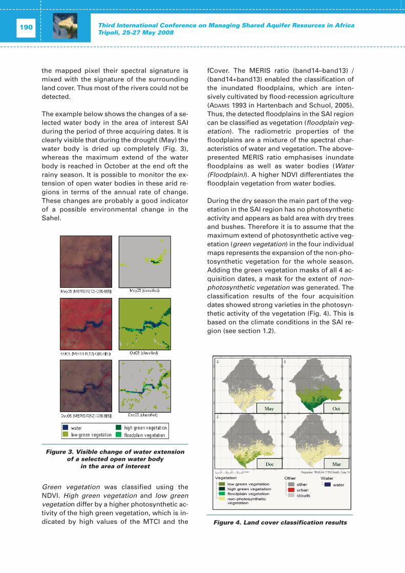
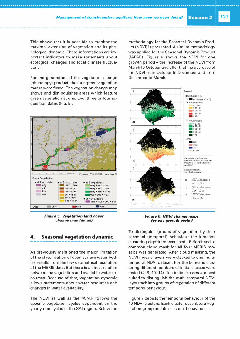
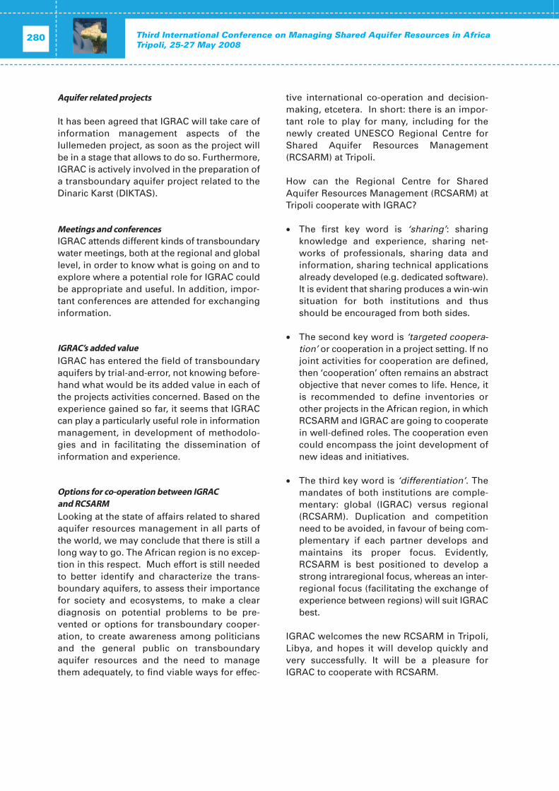
MANAGING SHARED AQUIFER RESOURCES in AFRICA THIRD INTERNATIONAL CONFERENCE Tripoli 25– 27 May 2008 [Proceedings] International Hydrological Programme Division of Water Sciences IHP-VII Series on Groundwater No. 1 United Nations Educational, Scientific and Cultural Organization International Hydrological Programme
Transcript
MANAGING SHARED AQUIFERRESOURCES in AFRICA
THIRD INTERNATIONAL CONFERENCETripoli 25– 27 May 2008
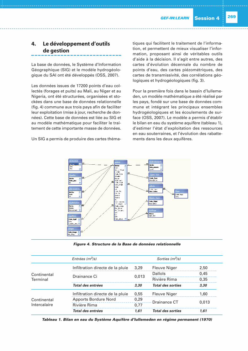
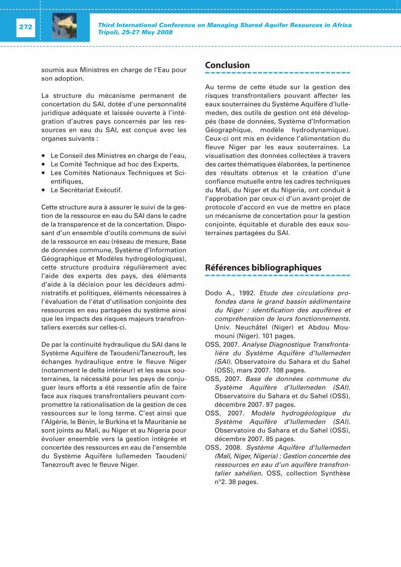
[Proceedings]
International Hydrological ProgrammeDivision of Water Sciences
IHP-VII Series on Groundwater No. 1
United NationsEducational, Scientific and
Cultural OrganizationInternational
Hydrological Programme
The designations employed and the presentation of material throughout the publication do not imply the expression of any opinion whatsoever on the part of UNESCO concerning the legal status of any country, territory, city or area or of its authorities, or the delineation of its frontiers or boundaries.
Published in 2010 by the United NationsEducational, Scientific and Cultural Organization7, place de Fontenoy, 75352 Paris 07 SP
In Tripoli, in 1999 and 2002, the General WaterAuthority of Libya and UNESCO, in cooperationwith the Sahara and Sahel Observatory (OSS),convened two major conferences devoted tothe identification of shared aquifer resources inAfrica. The first marked a milestone in the dis-cussion of the emerging concept of regionalaquifers and was instrumental in launching the UNESCO International Shared AquiferResources Management Initiative (ISARM*).The second Tripoli conference focused morespecifically on the features of those Africanaquifers that are shared between several states.The outcomes of these two conferences notonly provided sound scientific data but also cre-ated networks of experts who, over the lastyears, have continued to work on the issue ofnational sustainable development and thesound management of shared water resources.
For the third time, African and internationalexperts on groundwater resources managementconvened in Tripoli from 25–27 May 2008 on theoccasion of the Third International Conferenceon ‘Managing Shared Aquifer Resources inAfrica’. Hosted by the General Water Authorityof the Libyan Arab Jamahiriya and jointly con-vened by UNESCO’s International HydrologicalProgramme and Sahara and Sahel Observatory(OSS), the Tripoli III Conference was attendedby more than local, regional and international150 experts of different disciplines. The Con-ference was co-sponsored and attended by the
representatives of international, regional andnational organizations and institutions, includ-ing AMCOW, AWF, BGR, BRGM/FFEM, CEN-SAD,FAO, IAEA, IAH, IGRAC, SIWI, and UNECA.
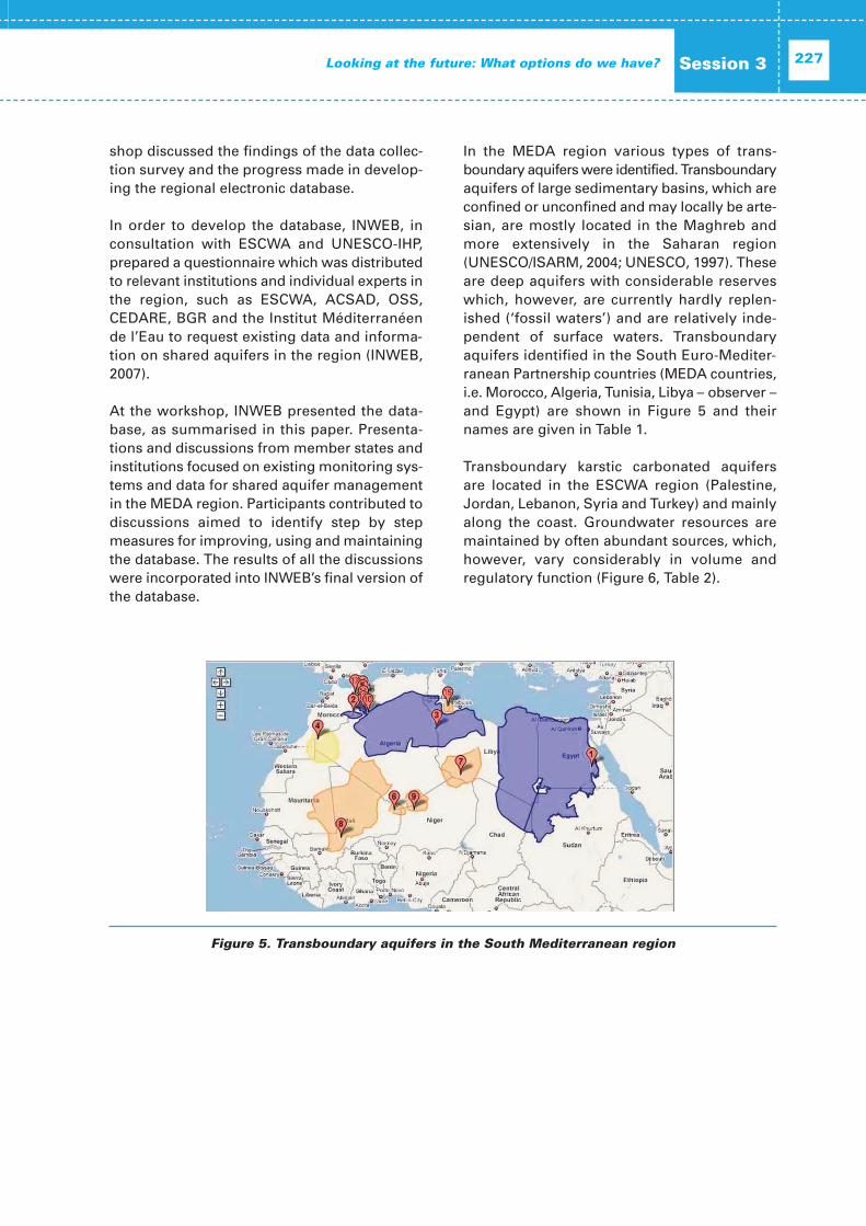
Revealing updates on latest activities anddevelopments in the field of transboundaryaquifer management in Africa, in terms ofhydrogeological as well as socio-economicstudies, legal instruments and managementtechniques, the Tripoli III conference was instru-mental in taking the ISARM initiative in Africaone stage further.
During the Conference the Regional Centre for Shared Aquifer Resources Management(RCSARM), hosted by the Libyan ArabJamahiriya, was officially launched. RCSARMhad been established as a centre under the auspices of UNESCO at the Thirty-fourth General Conference in October 2007. The Centre will have a guiding role in Africa and inthe Arab States for the dissemination of dataand technology and for capacity building andawareness-raising on transboundary aquifersresources studies, with projects on sharedaquifer management and sub-regional capacitybuilding programmes.
The International Conference gave furtherrecognition to the importance of sharedgroundwater resources in Africa, in supportinglivelihoods and thus providing a basis forhuman welfare. Nevertheless, the conferencealso emphasized the lack of data, knowledgeand capacity that is hindering sustainablemanagement of the shared resources in manyplaces. This is reflected in the joint ConferenceStatement prepared by the participants frommore than 20 African States and national,regional and international organizations andassociations.
Furthermore, the outcomes of the conferencewill provide beneficial information for ground-water resources related activities to be organ-ized by international organizations during thenext years.
Foreword
* ISARM is an inter-agency initiative launched by the Intergovernmental Council of the InternationalHydrological Programme of UNESCO at its Four-teenth Session (June 2000) The Council, having recognized that transboundary aquifer systems areimportant sources of fresh water in some regions ofthe world, particularly under arid and semi-arid climatic conditions adopted Resolution No. XIV-12.UNESCO has therefore undertaken the inventory of the main transboundary aquifers in differentregions of the world and published the Atlas ofTrans boundary Aquifers.
J. Alberto Tejada-Guibert Director, a.i.,
UNESCO Division of Water Sciences
PrefaceGroundwater is gaining greater importance bytime in many parts of Africa, particularly in thearid and semi-arid zones of the continent whereit is often the only source of water available.Moreover, groundwater is generally preferredfor domestic uses due to its relative purity andthe absence of contaminants that are foundtypically in surface waters and known to causeseveral serious water borne diseases.
Groundwater occurs in large sandstone andcarbonate aquifers that may extend beyond theboundaries of any single state thus forming‘transboundary or shared’ aquifers. Sustain-able development of such aquifers requires col-lective efforts by concerned institutions in theriparian states to integrate hydrogeologicalstudies, build regional data bases, draw welldefined programmes for monitoring aquiferbehavior and plan for their joint management,which is highly dependent on the state ofknowledge and the degree of cooperationamong riparian states.
Libya’s major groundwater basins are sharedwith all six neighboring countries. This uniquesituation has allowed the country to gain wideexperience in the field and helped create coor-dination bodies such as the Joint Authority forthe Study and Management of the NubianSandstone Aquifer shared by Libya, Egypt,Sudan and Chad; and the Consultation Mecha-nism Unit for the North Sahara Aquifer Systemshared by Libya, Algeria, and Tunisia.
UNESCO played a major role in organizingthree international conferences in Tripoli since1999. The last two conferences – convened inthe years 2002 and 2008 – were dedicated forthe management of shared aquifer resources
in Africa. Both conferences attracted a large number of scientists from nearly all Africanstates and international organizations as wellas key experts from all over the world. Pro-ceedings of these conferences will definitelycontribute to the state of knowledge ongroundwater in Africa and will greatly assist inthe development of common understanding ofwater management issues and help reduce tension between states sharing these aquifers.
In December 2007, Libya and UNESCO signedan agreement for the establishment and oper-ation of a Regional Centre for Shared AquiferResources Management (RCSARM) in Tripoli.The mission of the Centre is to contribute to thestrengthening of the capacity in groundwaterresources management in the region and inparticular on regional shared groundwatermanagement issues, with emphasis on Arabstates and Africa.
Libya has also been recently selected by theAfrican Ministerial Council on Water (AMCOW)to host the African Groundwater Commission.This will add a new dimension to Libya’sresponsibility and that of UNESCO towards theregion and will necessitate making these sci-entific gatherings in Tripoli on African sharedaquifers a regular event.
It is indeed a great honor for the General WaterAuthority of Libya to take part of this inter-national effort aimed at laying the foundationfor a sound and sustainable management ofshared aquifers worldwide. The conferenceand the proceedings would not have been realized without the dedication of the UNESCOteam and all those who participated in theevent.
Omar M. Salem Director,
General Water AuthorityTripoli, Libya
These proceedings were prepared within theframework of the UNESCO-IHP/ISARM Pro-gramme.
The proceedings were compiled by Holger Trei-del, UNESCO Division of Water Sciences, withthe support of Aude Vincent. Marina Rubio pro-vided the editing coordination.
The conference was co-organized with the generous support of the Authorities of theLibyan Arab Jamahiriya and various co-convenors.
- List of authors ..........................................319
Scope and Objectives of theConference
The Third International Conference on Manag-ing Shared Aquifer Resources in Africa washeld in Tripoli, Libya, from 25-27 May 2008, andjointly organized by the General Water Author-ity (GWA) of the Libyan Arab Jamahiriya, theSahara and Sahel Observatory (OSS) andUNESCO’s International Hydrological Pro-gramme (IHP).
The Conference brought together more than150 experts from 20 African countries, inter-national institutions, universities and UNorganizations, revealing the latest activities anddevelopments in the field of transboundaryaquifer management, with a particular focus onAfrica. Besides the latest findings on the hydro-geological characteristics of transboundaryaquifers socio-economic studies, legal instru-ments and management techniques were pre-sented and discussed.
The conference contributed directly to theobjectives of the seventh phase of UNESCO’sInternational Hydrological Programme (IHP-VII)and to the current debate on transboundaryaquifers management. The outcomes and rec-ommendations of the conference were com-piled in the ‘Tripoli III Statement’ and providedvaluable input for some of the related activitiesand events organized by international organi-zations subsequent to the conference.
These included the debates on transboundaryaquifers in Africa that took place at the Stock-holm World Water Week in August 2008, the5th World Water Forum sessions on Trans-boundary Waters in March 2009 in Istanbul andthe UN World Water Day on 22 March 2009, thetheme of which was ‘Transboundary Waters’.
Opening Ceremony
Representatives from the host country, theLibyan Arab Jamahiriya, as well the co-orga-nizers UNESCO-IHP and OSS, welcomed the
participants and provided an overview on thescope and expected outcomes of the confer-ence. This was followed by welcome addressesgiven by representatives of AMCOW,AfDB/AWF, UNECA, UNDP-GEF, FAO and IAEA,stressing the importance of the conference intaking the Internationally Shared AquiferResources Management (ISARM) Initiative inAfrica one stage further. A speech delivered bythe Special Rapporteur of the UN InternationalLaw Commission on the set of draft articles onthe Law of Transboundary Aquifers informedthe participants about this new instrument ofinternational law and its relevance for theAfrican continent.
Session 1: What do we know abouttransboundary aquifers in Africa?
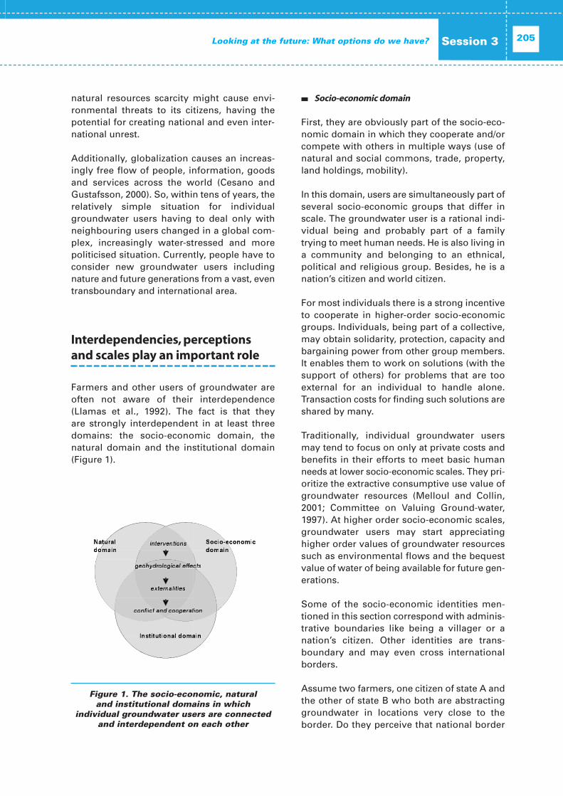
The first session provided an overview aboutthe current state of knowledge on Trans-boundary Aquifer Systems in Africa. ManyAfrican countries are dependant to a greaterextent on the groundwater resources containedin large transboundary aquifer systems. Theseresources often represent the only source ofwater supply for those countries located in thearid zones of the continent.
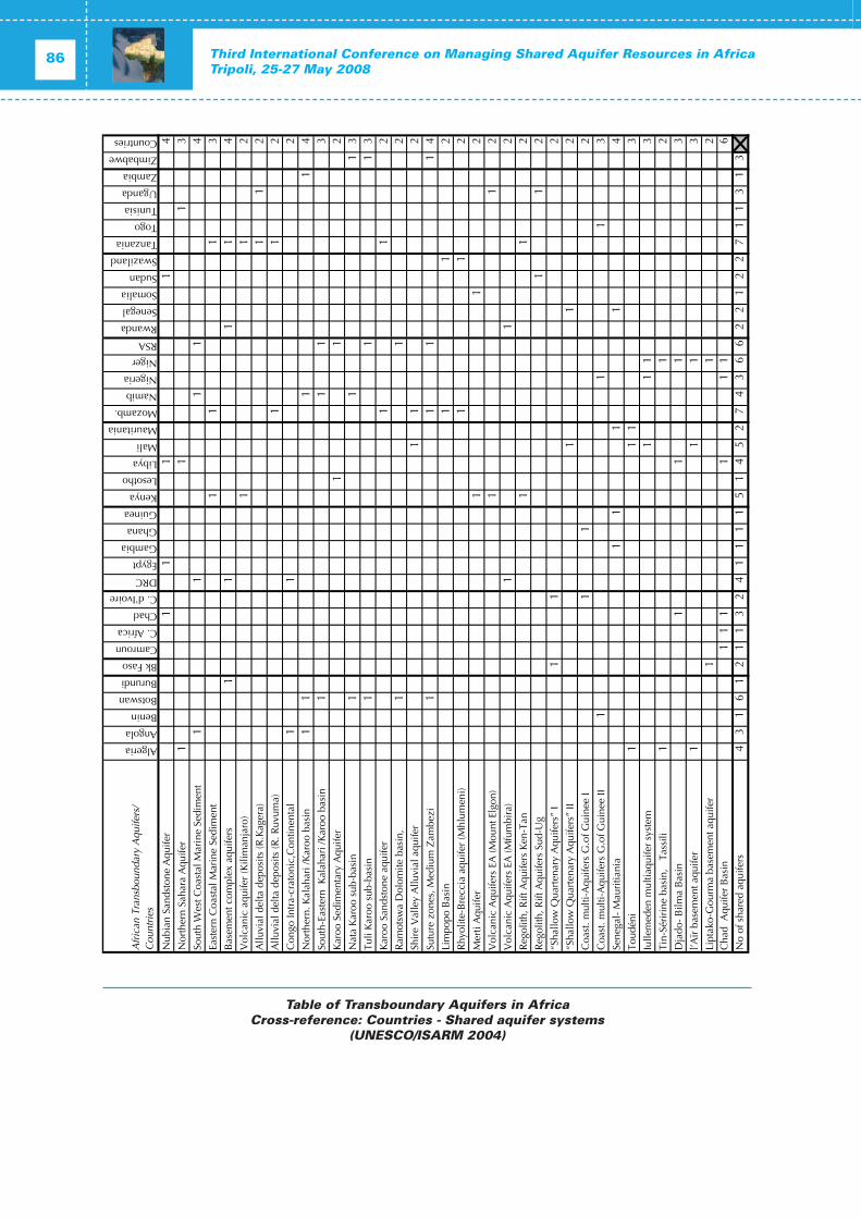
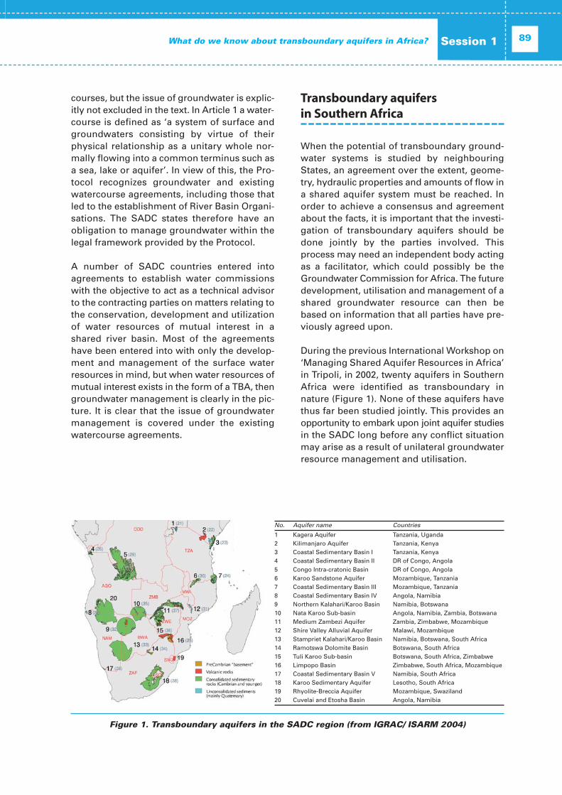
The UNESCO-led Internationally SharedAquifer Resources Management (ISARM) Ini-tiative was instrumental in collecting and col-lating the information that is currently availableabout the 38 Transboundary Aquifers Systemsthat have been identified in Africa to date. Theinventory shows that one aquifer system isoften shared by three or more countries at atime. While water scarcity in most Africancountries implies a serious threat to socio-eco-nomic development, at the same time manyaquifer systems are under-utilized. The limitedfinancial resources and inad equate apprecia-tion of aquifer systems, add to the current lim-itations of the sustainable management oftransboundary groundwater resources inAfrica.
While emphasising the need for sound scien-
Conference Summary Report
tific knowledge on the hydrogeological charac-teristics of the aquifer systems and continuousdata collection and monitoring efforts as abasis for sustainable management practices,the ISARM Initiative and related activities alsopay due attention to socio-economic condi-tions, institutional and legal frameworks andecological requirements. Based on the under-standing that none of these key factors may beleft aside in view of a holistic managementapproach, the different facets of managingshared groundwater resources were discussedduring the session.
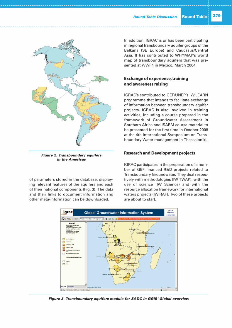
A presentation on the ISARM Americasrevealed achievements and lessons learnt fromthis comprehensive inventory of transboundaryaquifers in North, Central and SouthAmericarounded up the picture of the state of knowl-edge on transboundary aquifers on a globalscale.
Session 2: Management ofTransboundary Aquifers in Africa:‘How have we been doing?
The second session focused on reviewing thestrengths and weaknesses of current trans-boundary aquifer management approachesand explored the underlying causes and exam-ples of the successful application of sustainablemanagement approaches were presented.However, a number of limitations were identi-fied, including lack of coordination and cooper-ation between institutions at national as well asat regional level, insufficient professional andinstitutional capacities, restricted knowledge onhydrogeological characteristics, fragmentedmonitoring of groundwater quantity and qual-ity and lack of adequate funding.
The African Development Bank - African WaterFacility (AWF) focused on the financing aspects of transboundary aquifer management.Regional water security and the importance ofimproved water governance were underlined,pointing towards the lack of available info r -mation in the field of political, socio-economic,environmental and cultural development. Thesupport provided by AWF considers the estab-
lishment of Regional Economic Communities(RECs) and River Basin Organizations (RBOs), inline with the priorities defined by AMCOW. TheFacility supports the development of initiativesand processes on transboundary water coop-eration and the promotion of collaboration andpartnerships including, those with nationalgovernments, communities and NGOs as wellas the private sector and commercial banks.The objective is to incorporate groundwatermanagement into established RBOs and to raise the level of recognition of the need for transboundary aquifer frameworks beyondthe RBO frameworks, especially in North Africa.
A presentation given by the representative ofthe German Federal Institute for Geosciencesand Natural Resources (BGR) focused on initia-tives related to the management and protectionof groundwater resources supported by BGRand the German Federal Ministry for EconomicCooperation and Development (BMZ). Theseincluded seminars organised at StockholmWorld Water Week, policy advice assistancewith a regional focus on Africa and the MiddleEast and in particular supporting the establish-ment of the African Groundwater Commission(AGWC) under the auspices of AMCOW.
The representative of CEN-SAD highlighted theCommunity’s main concerns and areas of inter-vention: food security, water resources mana-gement and desertification, and then elabo-rated on the scope for partnerships and fundingsupport in the sub-region.
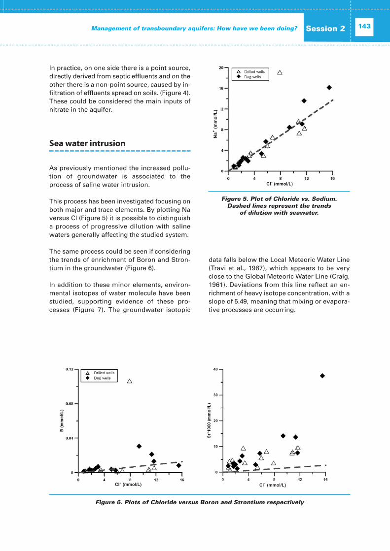
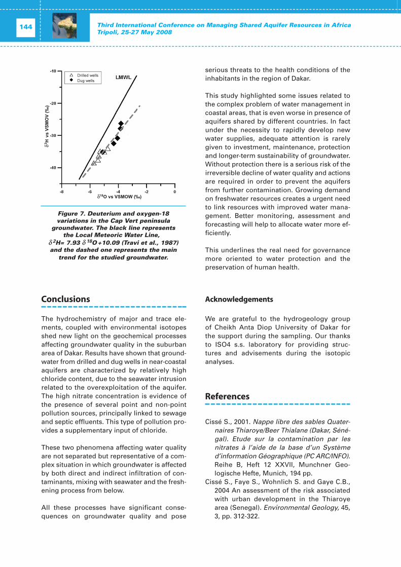
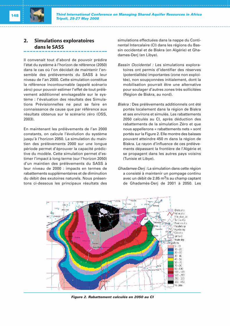
An applied research case on the urban-coastalaquifers at Dakar, Senegal was presented. Thecase study included geochemical and isotopeanalysis and correlations to trace saline intru-sion and anthropogenic groundwater pollution,and proposed the scope for interventions tocontrol water quality in the coastal wells whichare used for urban drinking supplies. The casestudy underlined the risks of saline intrusionfrom over-abstraction and the risk of pollutionfrom inappropriate sanitation and wastewatermanagement.
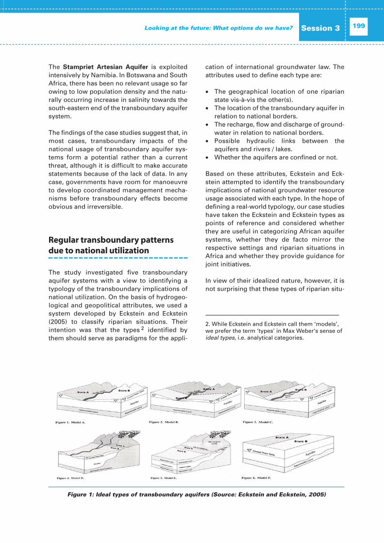
Session 3: Looking into the Future:What options do we have?
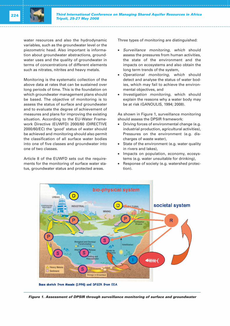
The session focused on evaluating options forthe future of Transboundary Aquifer Mana-gement, taking into consideration Institutionaland Legal Aspects, Governance and PolicyGuidance as well as Economic Aspects andFinancial Instruments. It was generally agreedthat there is an urgent need to move forwardfrom the current situation where proper mana-gement of groundwater resources is an excep-tion rather than common standard. The AfricanGroundwater Commission (AGWC) has beencommissioned by AMCOW to provide strategicsupport throughout this process. The AGWCwill act as a sounding board for strategic adviceon groundwater in Africa; it will operate at theregional economic communities and river/lakebasin organizations; and promote the integra-tion of groundwater in IWRM and national andregional frameworks.
Recent efforts to integrate groundwater intointernational legal instruments were high-lighted, drawing attention to the Berlin Rules(2004) which complement and extend the UN(1997) Convention on Non-navigational Uses ofInternational Waters. Reference was made tothe 5th Report of the United Nations Inter-national Law Commission (ILC) and the draftarticles on the Law of Transboundary Aquifersthat consider the sustainable utilization ofshared groundwater resources, activities thatimpact transboundary aquifer systems, andmade considerable progress on the definitionof key policy terms. However, several keyparameters we found to remain poorly defined.These include the definition of the terms ‘equi-table use’, ‘significant harm’, the definition of‘land-based activities’, the consideration oflonger time scales upon which groundwatersystems operate relative to surface water bod-ies, specific obligations related to dataexchange and prior notification, and the defini-tion of recharge and discharge areas.
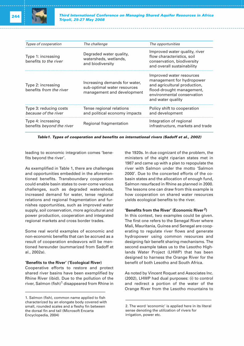
A desk study on Conceptualizing Cooperationfor Africa‘s TBA Systems undertaken by BGRanalysed the nature of impacts, patterns, coop-eration and joint activities associated withTransboundary Aquifer Systems (TBAS) in
Africa. The results of five TBAS were presentedto the audience, revealing highly variablegroundwater abstraction patterns, significantknowledge gaps, uncertainty in resource anduser boundaries, and, uncertainties in causeand effect relationships. In terms of drivers ofcooperation, the study considers the cost ofnon-cooperation, knowledge and third-partysupport as important. It was concluded that (1)awareness, (2) motivation, (3) institutionalframeworks, and (4) an enabling environmentare required to trigger broad involvement intransboundary aquifer management.
A review of three key political paradigms sur-rounding transboundary aquifer management- epistemic community approach, hegemony,and discourse theory – emphasised the impor-tance of politics in transboundary aquifermanagement and suggested that increasingtechnical and institutional capacities may helpreduce inequalities in power between a weakernation and aquifer’s hegemony.
Session 4: GEF – IW:LEARN
This session focused on the Global Environ-ment Facility’s International Waters LearningExchange and Resource Network (GEF –IW:LEARN) and presented several case studies.The Transboundary Diagnostic Analysis (TDA)methodology and possibilities how it could beadopted to groundwater resources were pre-sented and discussed.
In response to a crisis of governance, theIW:LEARN project addresses the challengeswhich are common to GEF-funded projects inthe area of shared water resources: moving thelegal aspects high on the agenda, integratinggroundwater and climate change in trans-boundary surface water projects, and support-ing investment through benefit-sharing, also bysensitizing Finance Ministers. The project’srecent focus on Africa has won the endorse-ment of AMCOW’s. It was recommended thatconjunctive management of surface andgroundwater be pursued, and that the oil andgas industry be engaged in order to benefitfrom their data and resources. The countriessharing the Nubian Sandstone Aquifer System
(NSAS) have made significant progress on datacollection and joint aquifer modelling, and oninstitutional arrangements for permanent coop-eration. Shifting into a higher gear, however,and engaging in further agreements, is com-plicated both by the uneven capacity in the four NSAS countries and by the difficultiesinvolved of canvassing all the stakeholders. Thecountries sharing the North-Western SaharaAquifer System (NWSAS) have made signifi-cant strides in data collection and joint aquifermodelling, and a joint arrangement for perma-nent aquifer-level cooperation has been estab-lished and has begun functioning in 2007. Thecountries sharing the Iullemeden Aquifer Sys-tem (IAS) are set on a similar path, includingjoint data collection and modelling, and aninstitutional arrangement for permanent coop-eration. The sensitization of Ministers of Parli-ment and journalists to water governanceissues, successfully conducted by the GlobalWater Partnership in the Mediterranean region,has provided the inspiration necessary tomount a comparable initiative underway inNorthern Africa, with potential for replicationelsewhere in Africa.
Round Table Discussion: Role of the UNESCO Category 2 RegionalCentre on Shared Aquifer ResourcesManagement in Africa (RCSARM)
The Regional Centre on Transboundary AquiferResources Management in Africa (RCSARM)and the Arab States was launched during theConference. The Centre was established as aCategory 2 Centre under the auspices ofUNESCO and is hosted by the General WaterAuthorities of the Libyan Arab Jamahiriya inTripoli.
The objectives of the Centre are to:
(i) generate and provide scientific and technicalinformation and support exchange of infor-mation on regional shared groundwatermanagement issues, with the emphasis onAfrica and Arab States;
(ii) promote cooperation on multidisciplinary
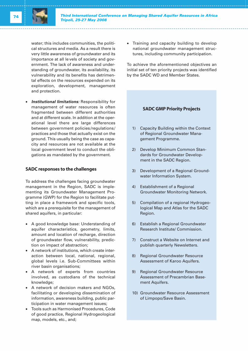
research and compilation of case studies onshared groundwater management in theregion involving international institutionsand networks, especially those under theauspices of UNESCO-IHP and the WorldMeteorological Organization (WMO);
(iii) undertake capacity-building on integratedwater and agriculture management withinthe African region at institutional, profes-sional and educational level includingawareness-raising activities to the generalpublic and to specific targeted audiences;
(iv) seek and respond to invitations for cooper-ation with international institutions and cen-tres and to advance methodology in the fieldof shared groundwater management, sup-port and cooperation with the IHP ISARMProject.
During the round table discussion, the confer-ence participants debated on the role of thenewly established Center for Africa and theArab States and future cooperation opportuni-ties with existing institutions. The importanceof including socio-economic and legal aspectsin the scope of research activities of the Centrewas stressed. The use of existing tools to quan-tify the economic benefits of the appropriatemanagement of shared aquifer resources waspromoted in order to make aware of the cost ofmismanagement. The need for training andcapacity development measures in these fieldswas also highlighted.
Representatives of international organizations,centres and research institutes expressed theirwill to closely cooperate with the newly estab-lished RCSARM Centre.
The participants requested that UNESCO con-tinue its support to African countries in thestudy and management of TransboundaryAquifers and requested that the outcomes andrecommendations of the conference, ‘Tripoli IIIStatement’, be presented for the considerationof decision makers at the Stockholm WorldWater Week in August 2008, the 5th WorldWater Forum 2009 in Istanbul and the UNWorld Water Day on 22 March 2009.
More than 150 participants from more than20 countries and national, regional and inter-national organizations and Associationsattended the International Conference on
Third International Conference on managingshared aquifer resources in Africa
Tripoli, 25-27 May 2008, and formulated the fol-lowing Conference Statement.
We the participants,
Thanking the authorities of the Great SocialistPeople’s Libyan Arab Jamahiriya in arrangingthe series of African ‘Tripoli Meetings’1 whichhave led to better understanding and strength-ened networks, and in hosting the RegionalCentre on Shared Aquifer Resource Mana-gement for Africa,
Considering the challenges of the UN MDG’s,and with concern that they may not be met inAfrica by 2015,
We the participants, addressing the topic ofshared aquifer resources of Africa,
Having recognised the strategic nature ofgroundwater in Africa,
Having reviewed the significant achievements
since ‘Tripoli I 1999’, through the identificationof 38 continent wide, shared aquifer systems,
Responding to the African Union and AMCOWpriorities,
Being aware of the important role of theregional, subregional, and non governmentalorganisations contributions to the implemen -tation of developmental policies, for the sound and sustainable development of ground-water,
Noting that sustainable use of groundwatercould contribute significantly towards achiev-ing water security for poverty alleviation, aswell as mitigation and adaptation to theimpacts of climate change and its variabilityacross the Continent,
Taking note of the need for regulatory instru-ments and appropriate financial mechanismsfor sustainable use which support investmentin infrastructure for shared aquifer mana-gement,
We, the participants,
Welcome the establishment of the AfricanGroundwater Commission by AMCOW,
Welcome the opportunity provided by the FirstAfrican Water Week and World Water Week in
Tripoli III StatementTripoli, 25–27 May 2008
‘Third International Conference
on Managing Shared Aquifer Resources in Africa’
Conference Statement
Stockholm to contribute to the debate on theshared aquifer management in Africa,
Support the Regional UNESCO – Category IICentre, hosted by the General Water Authorityof Libya,
Take note of the text, and the need for action,on the Draft Articles on the Law on the Use ofTransboundary Aquifers prepared by the UNInternational Law Commission,
Considering the above, we have formulated thefollowing ‘Message from Tripoli III’:
We call for further actions that encourage thejoint, sustainable management of aquifersshared by countries in Africa, and,
Call on national governments to facilitatetransboundary aquifer management throughappropriate regulatory and administrativearrangements at domestic level;
Call on bilateral, multilateral financial insti-tutions to reinforce their long term supportto Countries and regional organisations intheir development of groundwater for theirnational economic development, includingproviding the necessary funds for resourceexploration, evaluation and sound data collection to fill in data gaps leading toknowledge based sound management prac-tices;
Call on governments to enhance and pro-vide sustainable integrated shared surfaceand ground water resource management inview of maximising benefits to people andecosystems;
Call for partnerships with industry, espe-cially the mineral development, oil & gassectors, to participate in identification anduse of productive aquifers that could con-tribute to poverty alleviation, human devel-opment and environmental sustainability;
Call upon UNESCO (ISARM-Africa) and GEFInternational Waters to continue and rein-force their programme, and deploy a longterm effort in support of the sustainablemanagement of shared aquifer resources ofAfrica.
We commend this Statement for the attentionof AU, AMCOW and their constituent bodies for consideration and pursuit as appropriate,and,
We address the Tripoli III Statement for theattention of the political process of the5th World Water Forum.
Tripoli, May 2008
OPENING SESSION
Third International Conference on Managing Shared Aquifer Resources in AfricaTripoli, 25-27 May 2008
18
In Name of God the Most Merciful,
Misses and Misters the Representatives of the participating Arab and African coun-tries,
Misses and Misters Guests,
I’m glad to welcome you all and I appreciateyour care to attend the activities of the ThirdInternational Conference on Managing SharedAquifer Resources in Africa, which we are gladto host it in the Great Jamahiriya during theperiod from May 25th to 27th 2008 and I expressour most sincere wishes that this conferencesucceeds.
This Conference is held under certain inter-national circumstances witnessing an increasein aridity and desertification intensity alongwith climatic changes and increase of waterdemand, which makes the aquifer mana-gement an issue that requires more attention.It is also held under circumstances witnessinga water crisis at local and international levels,with an increase in water demand, especiallygroundwater which is the main source of thewater supply in many countries, among them isthe Great Jamahiriya. Considering the impor-tance and sensitivity of the shared aquifers,regarding their management and development,and in line with the policy of the GreatJamahiriya, whom since a long time took theinitiative to set up a continuous consultationmechanism with the countries sharing aquiferswith it, aiming to coordinate the exploitationforms and undertake joint studies to protectsuch aquifers from depletion and contamina-tion. Among these projects is the study ofNubian Sandstone Aquifer System, taking theinitiative to establish the Joint Commission
between Libya, Egypt, Chad and Sudan, whichLibya is honored to host its headquarters sinceits establishment in 1989, also studying theNorth Sahara Aquifer System between theGreat Jamahiriya, Tunisia and Algeria, whichwas crowned by establishing a consultationmechanism and forming a coordination unithosted by the Sahel and Sahara Observatory inits headquarters in neighboring Tunisia.
I’m also glad to praise the continuous cooper-ation with UNESCO in the various fields ofWater, especially the shared ones and todeclare the establishment of the Regional Centre for the Management of the SharedAquifers in Africa and the Arab region, in theGreat Jamahiriya, which I had the honor to signthe agreement of its establishment with theDirector-General of UNESCO in Tripoli on27/12/2007, whose most important targets isthe consolidation of joint studies, capacitybuilding and exchange of information onshared aquifers, and strengthening their mana-gement for a sustainable development.
The water is the control element for sustainabledevelopment, therefore the balance between thedemand on water and the available resources,deserves our attention, for the benefit of thepresent and future generations.
The increasing demand on water is a result ofmany factors, especially the demographicincrease, as the international statistics indicatethat the world population will increase by 50%,from 6.1 billion in the mid 2001 to 9.3 billions by2050, leading to increasing the intensity of thefood crisis.
In addition, the desertification phenomena is aresult of long dry periods and lack of develop-
Opening message
H.E. Dr. A. Al-Mansuri Secretary of General People's Committee for Agriculture, Livestock and Marine Wealth
ment in several regions of the world, startingfrom the African Continent, in addition to themismanagement of natural resources and inparticular the over-exploitation of aquifers.
Therese reasons together formed large pres-sure areas worldwide, especially the Saharacountries in Africa, leading to the emigration ofthousands of people searching for survival andrunning away from the specter of poverty,hunger and death.
Comprehending such dangers and in applica-tion of the United Nations Agreement, Libyaprepared a national work plan to combat deser-tification, which included several strategies andprojects to combat desertification and rehabili-tate affected lands.
Undoubtedly, you realize the extreme signifi-cance which the Alfatah Revolution and itsleader Colonel Muammar Al-Quaddafi, give tothe water issue and the huge investments pro-vided to overcome the water shortage problemand combating desertification. Such effortsincluded the conveyance of potable wateralong thousands of kilometers of large dia -meter pipes, deep from the Sahara desert to thecoastal cities and valleys, in the largest projectof its kind, the Great Man Made River, whichcame to multiply the production, to secure acertain level of food security, to fulfill thepotable water needs of costal towns, that untilrecently witnessed severe shortage, notwith-standing the establishment of many desalin-ization plants and well fields. This huge civilproject will provide a transitory solution to thewater shortage problem in the coastal areas ofthe North Jamahiriya, and as the Leader of therevolution noted, this solution is not final, butrather a final attempt to safeguard life in NorthAfrica, therefore it is necessary to join effortsand intensify research to locate economicallyfeasible alternatives for a sustainable and con-tinuous supply of water.
You might comprehend the urgent need in theArab region and Africa to develop our waterlegislations, which is an extension of our greatcultural heritage that paved the way for thebirth of the most ancient legislations sincethousands of years and which was contempo-rary to the birth and rise of the great civili -zations in the Arab region and Africa.
The distinguished nature of the occurrence anddistribution of surface and groundwaterresources, either quantity or source, and thecontinuous decrease of the per capita share ofit make the issue of sound management ofsuch resources in a sustainable manner inquantity and quality, among the prior interestsof the water institutions, therefore its elemen-tary that the international legislations attract aspecial interest to secure the rights of the countries and regions, and to achieve sustain-able development under water shortage con -ditions.
Water legislation, like other legislations relatedto human life, develops with time to cope withsocial, economic and political growth. In theGreat Jamahiriya we issued the first modernwater law since 1965 which was later replacedwith the law n°3 of 1982, which is among themodern laws dealing with all aspects of regu-lating the exploitation and management ofwater resources, and protecting it from deple-tion and contamination.
In this pleasant occasion, I am glad to expressmy gratitude and acknowledgment to theUNESCO, to the Sahel and Sahara Observatoryand to all International and Regional Organi-zations present in this Conference for theireffective participation in the preparation stages.We also express our gratitude to the local exter-nal preparatory committees for their greateffort to realize this event wishing you a com-fortable stay and a successful conference.
Opening session 19OPENING
Third International Conference on Managing Shared Aquifer Resources in AfricaTripoli, 25-27 May 2008
20
Mesdames et Messieurs,
Distingués invités.
Au moment où s’ouvre cette troisième confé-rence internationale sur les aquifères trans-frontaliers, ici dans cette belle ville de Tripoli, jevoudrais en ma qualité de Président du Comitétechnique consultatif des Experts du Conseildes Ministres Africains de l'eau (AMCOW) et enmon nom propre, remercier le Gouvernementde la République Arabe Jamahiriya Libyenne etson Chef pour l’attention toute particulièrequ’ils accordent aux questions de la gestiondes aquifères transfrontaliers et également aupeuple de Libye pour l’accueil chaleureux dontnous sommes l’objet depuis notre arrivée danscette belle ville de Tripoli.
Je remercie aussi les co-organisateurs de cetteconférence à savoir, l’Observatoire du Sahel etdu Sahara et surtout l’UNESCO pour l’aimableinvitation qu’il a bien voulu nous adresser afinde prendre part à cette importante conférence.
Je remercie aussi le Gouvernement de l’Alle-magne à travers son Ministère Fédéral de laCoopération Economique et du Développement(BMZ) et tous les sponsors des présentesassises.
Je remercie également le personnel de l’Am-bassade de la République du Congo en Libye,pour leur attention et l’intérêt accordé à cetteconférence dont l’impact pour notre pays etpour le continent n’est plus à démonter.
Les Ministres Africains de l'eau, soucieux depromouvoir la coopération régionale, le déve-loppement économique et social, l’éradicationde la pauvreté en Afrique grâce à la gestion des
ressources en eau et la fourniture des servicesliés à l'eau, ont créé en avril 2002, à Abuja auNigéria, le Conseil des Ministres Africains del’Eau (AMCOW) dans l’esprit de la Vision afri-caine de l’eau à l’horizon 2025.
C’est ainsi, que lors de sa sixième session ordi-naire tenue en mai 2007 à Brazzaville au Congo,le Conseil des Ministres a décidé d’institution-naliser la gestion des eaux souterraines enAfrique. En agissant ainsi, il donne l’occasionà toutes les parties prenantes de cette branchedu secteur de l’eau, de mettre en valeur toutesleurs capacités.
En effet, beaucoup de pays africains ont re -cours à de l’eau souterraine pour approvision-ner leurs localités (urbaines et rurales), mais lesinformations et les connaissances dans cedomaine restent encore faibles. Dans mon paysle Congo, la ville de Pointe Noire, deuxièmeville du pays, située sur l’océan atlantique,approvisionne environ 800 000 personnes parjour à partir des forages industriels et foragesdomestiques. L’hydraulique rurale est en grandepartie assurée également par les eaux souter-raines. L’information et les connaissances surles paramètres de ces aquifères restent très faibles, ce qui rend l’exploitation difficile.
Au niveau de la sous-région Afrique centrale,l’harmonisation des politiques en matière desressources en eau est en cours, avec l’appui dela Communauté Economique des États del’Afrique Centrale (CEEAC). La présente Confé-rence vient à point nommé pour nous permet-tre de bénéficier des expériences des autressous-régions et assurer une meilleure intégra-tion régionale.
En décidant de mettre en place une commis-sion africaine sur les eaux souterraines lors de
Opening message
Charles NgangouePrésident du Conseil Des Ministres Africains de l’eau (African Ministers’ Council on Water, AMCOW)
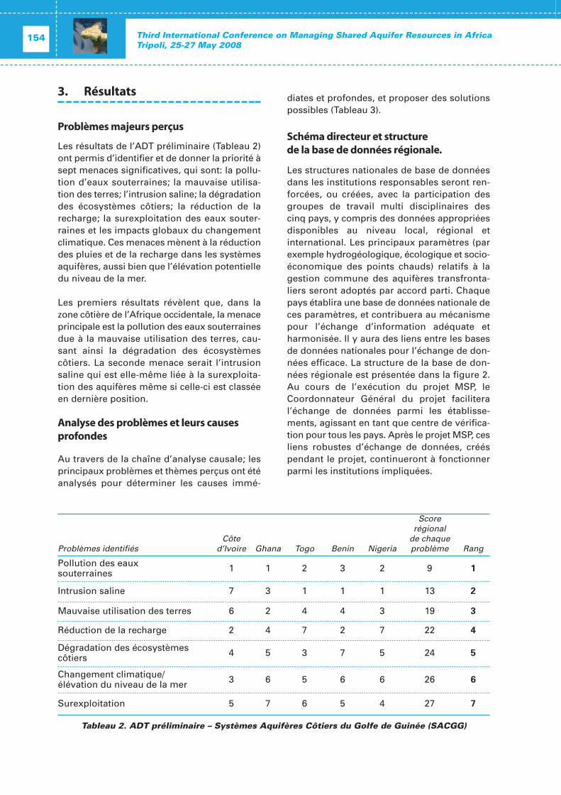
sa réunion de novembre 2007 à Nairobi, leComité Exécutif de l’AMCOW a voulu donner àl’Afrique un instrument de gestion de ses eauxsouterraines de façon durable et aborder laquestion des aquifères transfrontaliers à l’ins-tar des eaux de surface transfrontaliers.
A travers ses activités, la commission africainesur les eaux souterraines doit permettre à l’AMCOW de disposer des outils de prise encompte et de mise en œuvre de ses décisionsen la matière. L’eau étant également un facteurde paix, des conflits seraient évités, la crois-sance économique garantie, l’intégration régionale assurée et ainsi que d’autres actions positives de développement.
Tout cela n’est possible qu’avec l’effort de tous.C’est pour cela que l’AMCOW a engagé etencourage le partenariat stratégique avec lespays et les institutions telles que le NEPAD, laBanque Africaine de Développement, l’UnionEuropéenne, le G8, les Organisations des Na -tions Unies à travers le Groupe eau-Afrique desNations Unies (PNUE, UN-Habitat, UNESCO,UNICEF), les différents Gouvernements et lesAgences de coopération et de Développementà l’instar de la GTZ, l’AFD, DANIDA, le GroupeEau Afrique de l’Initiative eau et assainissementde l’Union européenne ainsi que le ProgrammeEau et l’assainissement (WSP) de la BanqueMondiale.
Ces partenaires stratégiques et bien d’autresque je n’ai pas pu citer, se sont constammentsentis solidaires de l’AMCOW et ont toujoursapporté un appui conséquent à ses activités.
L’agenda africain de l’eau 2008, a permis àl’AMCOW de tenir :
• la Conférence régionale sur l’assainisse-ment et l’hygiène en février 2008 à Etheik-wini en Afrique du Sud ;
• La Première Semaine Africaine de l’eau enmars 2008 à Tunis ;
• et bientôt le Sommet de l’Union Africainesur l’eau et l’assainissement en juillet 2008 àSharm El Sheikh en Égypte.
Tous ces évènements importants pour le sec-teur de l’eau et de l’assainissement en Afriquese sont tenus avec l’appui considérable despartenaires précités. C’est ici une fois de plus,l’occasion de les remercier et de les encouragerà s’engager d’avantage dans la mise en œuvredes décisions, des déclarations et des plansd’actions de ces différents évènements de hautniveau dont nous devons dès à présent capita-liser, valoriser les résultats en vue d’un déve-loppement harmonieux, intégré et durable dusecteur de l’eau et de l’assainissement au pro-fit de l’ensemble des populations africaines.
Je voudrais pour terminer, renouveler ma pro-fonde gratitude à l’endroit de tous ceux qui ontrendu possible, la tenue de cette TroisièmeConférence Internationale sur les aquifèrestransfrontaliers.
Je souhaite par la même occasion plein succèsà ses travaux et vous remercie mesdames etmessieurs de votre aimable attention.
Opening session 21OPENING
Third International Conference on Managing Shared Aquifer Resources in AfricaTripoli, 25-27 May 2008
22
Your Excellency Dr. Mansuri, Secretary of People’s Committee for Agriculture, Livestock and Marine Wealth of the Government of Libyan Arab Jamahiriya;
Mr. Omar Salem, Director of the GeneralWater Authority of the Libyan ArabJamahiriya;
Distinguished Representatives of AMCOW,TAC and Governments;
Distinguished Representatives of UNESCO,IHP, OSS, UN Water Africa, Donors, NGOs and other Stakeholders;
Ladies and Gentlemen.
It is in deeded my pleasure to make this briefstatement on behalf of the African Develop-ment Bank and the African Water Facility onthis International Conference on transboundaryaquifer resources management in Africa. Iwould like to take the opportunity to thank theGovernment of Libya particularly the GeneralWater Authority for organizing this importantConference on transboundary aquifers with theObservatoire du Sahara et du Sahel (OSS) andUNESCO-IHP.
I hope over the coming three days we willdeliberate on the key challenges and issues oftransboundary aquifers and come-up with spe-cific recommendations of concerted actions onthe sustainable use of these unique waterresources of Africa. From this perspective, theConference will provide us with an opportunityfor interaction, networking and design of col-laborative efforts and identify specific actionsthat we can jointly work on in this area.
It is important to note that Africa is endowedwith groundwater resources in shallow anddeep aquifers stored in over 40 transboundaryaquifer systems and that proper managementis of critical importance to ensure the sustain-able use to provide for the lively hood needs ofmillions of our people and contribute to thesocioeconomic development of the continent.
I would like to note that our engagement at theregional level has gained momentum under theleadership of AMCOW and has allowed us toarticulate the African water challenges anddesign concrete strategies and actions toenable us achieve better provision of water andsanitation service and meet the socio-economydemands of our people. I would like to indicatethat in this respect the African Water Vision andFrame Work for Action has indeed provided uswith the appropriate framework to guide theregional efforts of sustainable water resourcesdevelopment in Africa.
The steps taken by AMCOW to consider trans-boundary river basin management to includegroundwater resources management as well as the actions taken to establish an AfricanGroundwater Commission are laudable. Nevertheless, while we now have better under-standing of the water challenges of Africaincluding groundwater, we have yet to translateour visions and strategies into action on theground to make a difference on the lively hoodof millions of African. Indeed this is now thegreatest challenges that require our commit-ment, energy and collective actions.
As Africa’s premier financial institutions, theAfrican Development Bank seeks to helpAfrican countries deal with the threats ofpoverty, growing populations needs for liveli-hood, ensure water security for economic andsocial development, adaptation to climate
Opening message
Tefera Woudeneh Chief Water Operations Officer, African Water Facility, African Development Bank
change impact and associated risks. The keyissue here is the development of the necessarywater infrastructure including storage facilitiesto significantly increase the availability of ade-quate quality and quantity of water to meet thesocio-economic and environmental needs andmanage risks.
In this respect, the Bank’s water and sanitationsector investment has grown five fold since2002, from less than US$ 70 million per annumto over US$ 350 million per year. This isexpected to further increases to reach US$ 600million per year by 2010. The support is tar-geted to contribute to the efforts of sustainablewater security to meet the water supply andsanitation needs, food and energy security andrisk management.
Let me take the opportunity to highlight someof the important initiatives and actions that hasimportant bearing on groundwater resourcesmanagement.
The Bank with other partners and stakeholdershas been supporting the effort of AMCOW toarticulate and promote the African water policychallenges at the regional and internationalforums. The Bank has consistency promotedand advocated for international awareness andsupport to address the key water challenges ofAfrica through the World Water Forum process.The African Water Vision launched at the Second WWF and the discussion on ground-water issues as specific theme on the FourthWorld Forum are significant steps in this direc-tion. I would like to inform you that the Bankhas been requested to lead the Africa’s parti-cipation in the Fifth World Water Forum and I hope that the outcome from this Conferencewill forum part of the regional documentationfor submission at the Forum.
More recently the groundwater resourcesmanagement was one of the main themes ofthe first African Water Week in the frameworkof achieving water Security. This aspect wasconcisely capture in the Ministerial Declarationwhere the Minister called on governments and partners to ‘harness local groundwaterresources to improve livelihoods and managerisks associated with climate change and insti-tutionalize dialogue on groundwater mana-
gement in Africa and implement the Roadmapfor the African Groundwater Commission’.
The Bank is supporting NEPAD and is movingahead with the development of the Medium toLong-term Strategic Framework for the NEPADWater and Sanitation Programme as well as thepreparation of water infrastructure financingunder the Infrastructure Consortium for Africainitiative. The NEPAD Water and Sanitation Pro-gramme is mainly focused on transboundarywater resources management includinggroundwater in transboundary aquifers. In thisrespect support to the North African trans-boundary aquifers systems has been identifiedas an important area of focus.
The implementation of the Rural Water Supplyand Sanitation Initiative is moving forward withprogrammes implantation in 21 countries byend of 2008 which brings coverage to an addi-tional population of about 32 million for watersupply and 29 million people for sanitation withan investment of about US$ 1,024 billion.Groundwater provides significant portions ofthe water resources to meet the basic needs ofrural communities.
The implementation of the African Water Facil-ity has moved forward successfully with theapproval of 34 projects amounting to aboutEuro 30 million. The Facility is planning tomobilize Euro 236 million over the comingyears to provide support in strengtheningwater governance at national and trans-boundary level; investments to meet waterneeds; strengthening the financial base andimproving knowledge and water wisdom. Weare currently closely working with OSS in sup-porting activities related to transboundaryaquifers in North Africa and the IGAD subregion. The effort will continue to expand andin this respect I would like to assure you of ourdesire to closely work with our partners on themanagement of transboundary aquifers inAfrica.
In conclusion, I would like to reiterate that theBank and the African Water Facility will workwith you in moving this important agenda ofthe continent forward. I wish you a successfulmeeting and look forward to actionable out-come over the next three days.
Opening session 23OPENING
Third International Conference on Managing Shared Aquifer Resources in AfricaTripoli, 25-27 May 2008
24
His Excellency, Dr A. Mansuri, Secretary General of Agriculture, Libya,
Dr Omar Salem, General Director of General Water Authority of Libya,
His Excellency, Ambassador Chusei Yamada,
Dr Youba Sokona, Executive Secretary of OSS,
Madame Alice Aureli, UNESCO Representative,
Distinguished representatives of internationaland multilateral institutions,
Eminent experts and participants at this international conference,
Ladies and Gentlemen,
Permit me to join the previous speakers in wel-coming you all, on behalf of the United NationsEconomic Commission for Africa (UNECA) andon behalf of the organizers of the 3rd Inter-national Conference on Managing SharedAquifer Resources in Africa, taking place herein Tripoli, Libya.
I will like to express our profound appreciationto the government of Libya, for hosting theInternational Conference on Managing SharedAquifer Resources in Africa for the third con-secutive time, and for the generous hospitalityextended to all participants at this conference.This to us is a clear indication of the unwaver-ing commitment of the Libyan government tothe improvement of groundwater resourcesmanagement policies in Africa through betterassessment of the groundwater resource situa-
tion, identification of critical problems and theircauses, improving reporting on monitoring ofprogress against set targets, and improvedevaluation of water policy, strategy and actions.Furthermore, since the management of trans-boundary aquifers is premised on the cooper-ation among the riparian countries, it needs beacknowledged the very important contributionof Libya to forging regional cooperation andintegration in Africa through supporting thisinitiative.
Let me also take this opportunity to thank theUnited Nations Educational, Scientific and Cultural Organization (UNESCO), and theObservatoire du Sahara et du Sahel (OSS) forproviding valuable technical and leadershipinput to the organization of this InternationalConference, without which this conferencewould not have been possible. The UN-Water/Africa grouping, secretariat of which ishosted at UNECA, could not have designatedany other better agency to lead other UN agencies in this particular thematic area ofgroundwater management.
We at UNECA view shared aquifer mana-gement from the point of view of their contri-butions to the continent’s socio-economicdevelopment, through groundwater contribu-tions to environmental sustainability andecosystem integrity, provision of water accessto farmers through the use of small-scale watertechnology, and the role of groundwater as areliable source of safe water and sanitation.The importance of this International Confer-ence to the African countries where the povertychallenge, coupled with inadequate populationaccess to water and sanitation is still veryacute, cannot be over-emphasized. In order tomeet the MDG drinking water target in Africa,about 300 million people still need to gain
Opening message
Johnson A. Oguntola
Representative of United Nations Economic Commission for Africa (UNECA), Senior Regional Advisor (IWRM)
access to an improved drinking water source.Groundwater represents a cheap source forattaining this objective.
From irrigation point of view, groundwater con-stitutes the main source of water either in itsoccurrence as independent hydraulic entitieslike is commonly the case in the northern partsof Africa, or as tributary aquifers recharged bysurface water sources. In either of these cases,good management is needed to prevent anar-chy in the use of the resource and to preventexternality on other users in the system.
We are gratified to note that this InternationalConference has been designed to address pertinent issues on Transboundary AquiferManagement, including institutional and legalaspects, governance and policy guidance, econ omic aspects and financial issues. Wehave no doubt that the next three days of dis-cussions on these issues will provide us with abetter management of Transboundary AquiferResources in Africa.
I wish the conference very successful delibera-tions, and thank you for your attention.
Opening session 25OPENING
Third International Conference on Managing Shared Aquifer Resources in AfricaTripoli, 25-27 May 2008
26
Une vision générale sur les eaux souterrainesde l’ensemble du continent africain, les res-sources qu’elles offrent et leurs utilisations,nécessairement panoramique et macrosco-pique, s’attachera surtout aux contrastes essen-tiels et aux comparaisons entre les situationsde chaque pays, illustrées par des images car-tographiques et des chiffres-clés. Elle peut s’or-ganiser en six constats majeurs.
Une géographie des eauxsouterraines très contrastée
La répartition et l’abondance relative des eauxsouterraines sont commandées par la doublediversité géologique et climatique, qui se tra-duit pas deux contrastes majeurs et indépen-dants :
• au plan géologique :Contraste entre bassins sédimentaires etsocle ancien ou formations volcaniques pluslocalisées, qui détermine la variété desconditions hydrogéologiques,
• au plan climatique :Contraste entre zone aride et semi-aride etzone humide, qui détermine l’extrêmevariété des apports météoriques et des évaporations potentielles génératrices del’alimentation et parfois de la décharge desaquifères.
Le croisement de ces deux contrastes géogra-phiques fonde la typologie des ressources eneau souterraine du continent africain, basée àla fois sur le structure des réservoirs aquifèreset la dynamique de leur renouvellement, repré-sentée par exemple par la carte à légende
matricielle illustrant la monographie des eauxsouterraines de l’Afrique publiée par lesNations Unies en 1987.
Les ressources en eau souterraine renouvela-bles les plus abondantes et mobilisables sont à l’évidence situées dans les régions à la fois àaquifère étendu et productif, et en zonehumide.
Cette géographie contrastée détermine aussi ladiversité des demandes en eau qui sollicitentles eaux souterraines, plus particulièrement lesdemandes en eau d’irrigation en zones pauvresen « eau verte », en fonction à la fois des poten-tialités en sols et en eau.
Une typologie hydrogéologiquetrès différenciée
Les conditions hydrogéologiques régionales del’Afrique sont schématisables par quatre typesmajeurs de formations aquifères :
• Bassins sédimentaire multicouches, à nappessouterraines phréatiques ou profondes etcaptive, souvent très étendus (la plupartsont transfrontaliers) dont la compositionstratigraphique peut s’échelonner du Pré-cambrien au Quaternaire, constitués princi-palement de formations détritiques, maisaussi carbonatées Leur puissance atteint,pour la plupart, plusieurs milliers de m et lesvolumes d’eau qu’ils stockent se chiffrent enmilliers de km3 mais ne sont que très par-tiellement mobilisables.
Les caractéristiques des 13 plus importantsde ces grands systèmes aquifères, générale-
Ressources et utilisations des eaux souterraines en Afrique
Jean Margat
Conseiller, BRGM
ment endoréiques en zone aride, sontrésumées dans le Tableau 1.
• Domaines à structure complexe (chaînesplissées) à aquifères peu étendus et discon-tinus, notamment karstiques ou volca -niques, qui bénéficient d’alimentationnotable en zone humide du fait de l’altitudeet sont générateurs des principales sources.Ils sont relativement localisés au Maghreb,en Afrique Australe et dans le sillon vol-canique d’Afrique de l’Est, ainsi que dans lesîles périphériques, volcaniques pour la plu-part, du Cap Vert à Maurice…
• Aquifères alluviaux, de vallées ou deltas, ànappe phréatique ou parfois profonde, plusou moins liés aux grands cours d’eau, trans-frontaliers pour la plupart (Niger, Nil, Séné-gal, Zambèze…).
• Aquifères du socle fissuré et altéré constitu-ant une grande partie du continent, formantdes systèmes localisés souvent discontinuset sans réserve notable.
Quelles sont les ressources en eau souterraine de l’Afrique ?
Deux sortes de ressources en eau souterrainebien distinctes s’offrent en Afrique : des res-sources renouvelables et des ressources nonrenouvelables.
• Les ressources en eau souterraine renouve-lables sont subordonnées aux conditions cli-matiques, donc très différemment distri-buées, et inégalement interdépendantesavec les eaux de surface. Les flux moyensannuels de recharge des aquifères auxquelsces ressources sont assimilées en théoriesont sujets à calcul dans la plupart des paysafricains et ils varient localement à l’ex-trême : de moins d’1 mm /an à plusieurscentaines de mm/an suivant les moyennescalculées par pays, et en sommations parpays de 100 millions à plus de 100 milliardsde m3/an, suivant le climat et l’étendue dupays (voir Tableau 2).Toutefois l’approche par modélisation des
infiltrations à partir de données climatiques(par exemple la cartographie discrète élabo-rée par P. Döll (2003) et reproduite dansWHYMAP) aboutit généralement à des chif-frages plus élevés que l’approche par ana-lyse des débits de base des cours d’eau (cf.la cartographie mondiale du « GroundwaterFlow » élaborée par R.G. Dzhamalov et I.S.Zekster (1999), généralement adoptée parles références nationales de la base AQUAS-TAT de la FAO.
Parvenir à une meilleure convergence desévaluations suivant ces deux approchesserait un thème de recherche opportun.
La plus grande partie de ces apports auxaquifères (et même leur totalité dans lespays enclavés…) équivaut en zone humide àla composant régulière de l’écoulement descours d’eau qui les drainent, donc aux res-sources en eau de surface permanentes.
En zone aride et semi-aride, par contre, leseaux souterraines sont alimentées principa-lement par les infiltrations de cours d’eau, leplus souvent temporaires ou issus de zonehumide (comme le Nil ou le Niger …). Ellessont donc aussi communes avec une partiedes ressources en eau de surface.
Les eaux souterraines et les eaux de surfaceétant largement interdépendantes, les éva-luations des ressources respectives corres-pondantes doivent éviter tout double compte.
De plus la recharge des aquifères ne doit pasêtre identifiée intégralement aux ressourcesen eau souterraine renouvelables et mobili-sables – seules réelles – à évaluer suivantdifférents critères technico-économiques,sociaux et environnementaux, notammentde conservation des eaux de surface per-manentes subordonnées, variées suivant lespays.
• Les ressources en eaux souterraine nonrenouvelables ou « eaux fossiles » sontconstituées par la part jugée extractible – suivant là encore des critères écono-miques et environnementaux (absenced’impact inacceptable) – des réserves desaquifères à renouvellement négligeable,
Opening session 27OPENING
Third International Conference on Managing Shared Aquifer Resources in AfricaTripoli, 25-27 May 2008
28
situés généralement en zone aride ou semi-aride (Sahara, Sahel, Kalahari). Les « exploitations minières » de ces réservesoffrent par définition des ressources nondurables.
Les eaux souterraines prennent une part notable aux ressources en eau de l’Afrique
Globalement 37 % des ressources en eaurenouvelables totales du continent africain sontformés par des eaux souterraines (selon la baseAQUASTAT), mais cette participation est trèsvariée suivant les pays (cf. Tableau 2) : de 5 à88% des ressources intérieures totales, part leplus souvent mineure, mais parfois majeuresurtout en zone aride ou semi-aride (par exem-ple : au Botswana, au Ghana, en Libye, en Mau-ritanie…). Les eaux souterraines forment enmême temps, en zone humide surtout, la partierégulière des eaux de surface : globalement oncalcule que près de 35 % des ressources en eausuperficielle de l’Afrique sont composés par lesapports des écoulements souterrains. Toutefoiscette participation varie de 1 à 85 % suivant lespays. Réciproquement les ressources en eausouterraine exploitables en zone semi-aridesont subordonnées aux eaux de surface et àleur utilisation pour l’irrigation qui engendredes « ressources secondaires » comme enÉgypte dans la vallée et le delta du Nil.
L’importance des eaux souterraines dans lacomposition des ressources renouvelablemobilisables est accrue par leur extension spa-tiale et leur permanence qui favorise leur acces-sibilité par un très grand nombre d’utilisateurset qui augmente leur valeur comme sourced’approvisionnement.
En outre, les eaux souterraines offrent enplusieurs pays d’Afrique septentrionale et aus-trale des ressources en eau non renouvelablesmais considérables, dont l’exploitation minièrepose des problèmes de gestion spécifiques,mais qui sont particulièrement précieuses enzone aride.
Quel est le poids des eauxsouterraines dans lesapprovisionnements en eau de l’Afrique ?
Les prélèvements d’eau souterraine en Afriquesont inégalement inventoriés et chiffrés suivantles pays et les catégories d’exploitants et d’usa-gers (cf. Tableau 2). Cependant les donnéesmanquent surtout dans les pays intertropicauxoù les prélèvements sont présumés très faibles– comme les demandes d’eau en général –, tandis qu’ils sont relativement mieux estimés làoù ils sont plus notables, en zone aride et semi-aride.
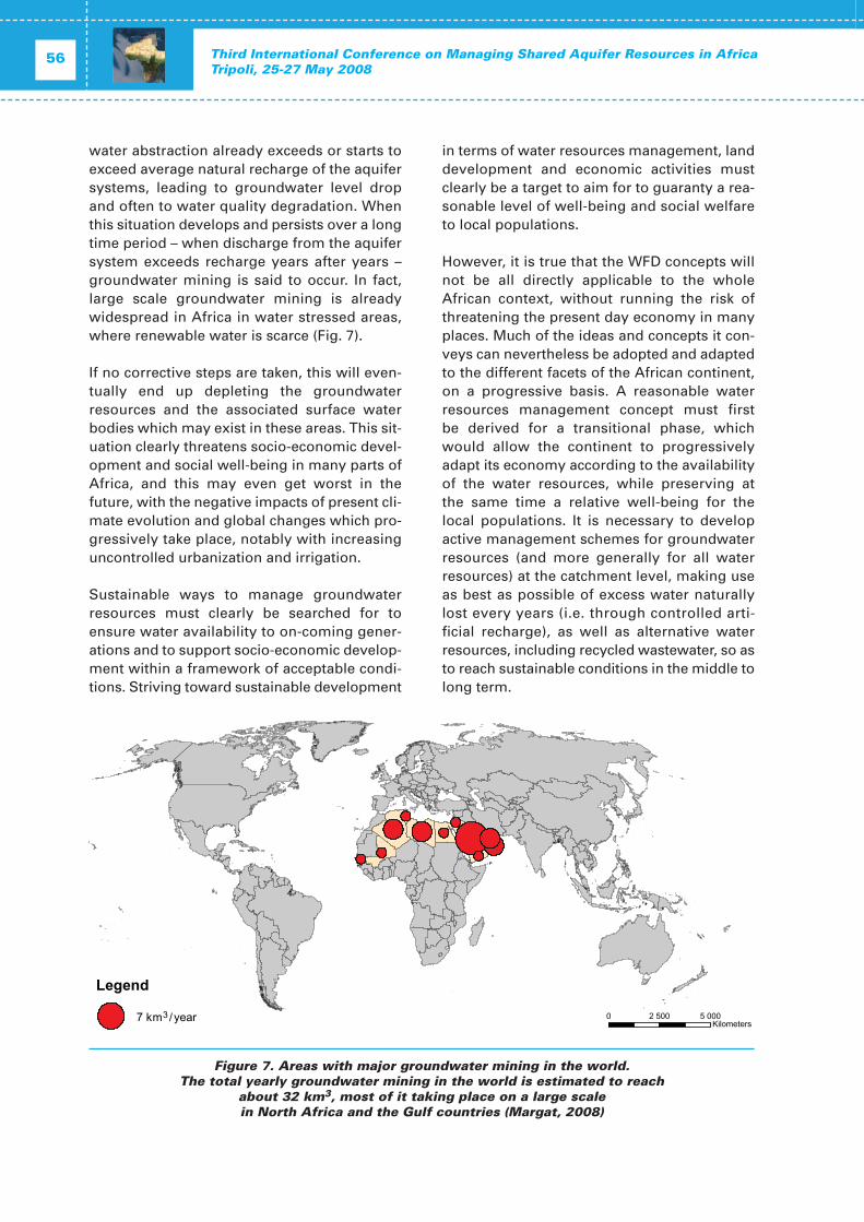
Leur répartition présente est extrêmement inégale : ils ne dépassent 1 km3/an que dans7 pays dont tous ceux d’Afrique septentrionale(Algérie, Égypte, Libye, Maroc, Tunisie),l’Afrique du Sud et sans doute le Nigéria, quicumulent environ 80 % des prélèvementstotaux dans le continent, de l’ordre probable de30 km3/an ce qui représente 14 % des prélève-ments en eau totaux en Afrique, mais ce ratiomoyen très global est peu significatif. Cela necorrespondrait qu’à 4 % des prélèvementsd’eau souterraine mondiaux actuels.
Ces prélèvements d’eau souterraine varientaussi beaucoup par rapport aux populations :de à peine 2 m3/an à 800 m3/an par habitant !(maximum : Libye).
C’est dans les pays en zone aride et semi-arideque les eaux souterraines participent le plusaux approvisionnements en eau : jusqu’à 95%(maximum Libye). Par contre, leur part est engénéral faible en zone humide, encore que nonnégligeable lorsque l’alimentation en eau pota-ble forme la principale demande (exemples :Bénin, Congo, Togo…).
Les eaux souterraines prélevées sont utiliséesprincipalement (75%) par l’irrigation (en zonearide et semi-aride) et en second lieu pour l’ali-mentation en eau potable des collectivitésurbaines et surtout rurales (20 %).
Elles participent aux approvisionnements eneau dans des mesures très variées suivant lespays et les secteurs d’utilisation.
Leur part aux irrigations est maximale et pré-dominante en pays de zone aride et semi-aridepauvres en eau de surface (Libye, Tunisie), maismineure ailleurs.
Leur participation aux alimentations en eaupotable est souvent majeure, notamment pourles populations rurales, et rarement négligea-ble, même en pays à ressources en eau de sur-face abondantes (Afrique intertropicale) pourdes critères de qualité.
Ainsi la géographie de l’utilisation des eauxsouterraines montre en Afrique comme end’autres parties du monde que c’est là où leursressources renouvelables sont les plus raresqu’elles sont paradoxalement le plus exploitéeset utilisées.
Conclusion
Les synthèses continentales, notamment carto-graphiques, sur les eaux souterraines del’Afrique – œuvres collectives panafricainesméritoires en particulier – qui agrègent à la foisdes observations, des interprétations et deshypothèses, sont éclairantes mais ne doiventpas dissimuler que l’état des connaissances surleurs potentialités comme sur leur exploitationest inégalement avancé.
En règle générale, comme dans le reste dumonde, ces connaissance sont d’autant plusavancées là où les eaux souterraines sont leplus exploitées, voire parfois surexploitées, etoù l’on passe du stade de la prospection et dela reconnaissance des productivités locales àl’analyse des systèmes aquifères, à l’évaluationpuis à la gestion des ressources.
Des progrès variés suivant les régions sontencore à accomplir, soit pour préciser et mieuxutiliser les ressources en eau souterraine, soitpour les gérer dans la perspective du dévelop-pement durable et de manière intégrée avec lagestion des eaux de surface.
Opening session 29OPENING
Chiffres-clés sur les eaux souterraines en Afrique
• Ressources en eau souterraine renouve-lables totales moyennes annuelles (écou-lement souterrain) : 1 436 km3/anDont 90 % en zone humide.
• Part commune avec les ressource en eaude surface (« overlap ») = 93 %
• Diversité locale des ressources (rechargedes aquifères) : de moins de 1 000 à plusde 500 000 m3/an par km2.
• Prélèvements actuels d’eau souterraine(année 2000 ou proche) : 27.3 km3/an suivant les statistiques dis-ponibles, environ 30 km3/an estimés autotal, soit 14% des prélèvements en eauxtotaux (215 km3/an selon AQUASTAT2005) dont 7 km3/an extraits de res-sources non renouvelables (essentielle-ment en Algérie, Égypte, Libye, Tunisie).
• Variété de ces prélèvements − répartis par pays : de 10 millions à
7 milliards de m3/an, maximums :Égypte, Libye
− rapportés aux populations : de 1 à 2 m3/an par habitant (Madagascar,Somalie) à 800 m3/an par habitant(Libye).
• Répartition des utilisations d’eau souter-raine : Irrigation (+ élevage) 75%Alimentation en eau potable 20%Industries 5%
• Variété des pressions sur les ressources(ratio prélèvements/ressources renouve-lables naturelles) suivant les pays : de 1 dix-millième (République Démocra-tique du Congo) à plus de 100% (Libye)
Th
ird In
ternatio
nal C
on
ference o
n M
anag
ing
Sh
ared A
qu
ifer Reso
urces in
Africa
Tripo
li, 25
-27
May 2
00
83
0
N° Dénomination PaysSuperficie
(1 000 km2)Structure hydrogéologique
(P : Puissance maximale en m)
Volume d'eau en ré-serve théorique
(1 000 km3)
Flux moyend'alimentation
(km3/an) Références
1
Système aquifère nubien (NAS) :- Système aquifère
des grès de Nubie (NSAS)- Aquifère post-nubien (PNAS)
Tableau 1.Très grands systèmes aquifères de l’Afrique
Op
enin
g sessio
n3
1O
PE
NIN
G
N° Dénomination PaysSuperficie
(1 000 km2)Structure hydrogéologique
(P : Puissance maximale en m)
Volume d'eau en ré-serve théorique
(1 000 km3)
Flux moyend'alimentation
(km3/an) Références
7 Bassin du Lac Tchad
NigerNigériaTchad
CamerounR. centrafricaine
1 917
Multicouche continental intercalaire,
continental terminal et plio - quaternaire
P = 7 000 m
0,6 au Niger (~ 0,4 exploitable
au Tchad)3,6 au Niger
CBLT UNESCO/OSS 2005J. L. Schneider 2001
8Bassin Sudd Umm Ruwaba aquifer
SoudanÉthiopie
365Multicouche
Néogène - QuaternaireP = 3 000 m
0,11 0,34ICID 1983UN 1987
OACT 1993
9 Bassin d'Ogaden - JubaÉthiopieSomalieKenya
~ 1 000Multicouche nappes
libres et captivesP = 12 000 m
~ 10 UN 1987
10 Bassin du Congo
Congo, R. D.CongoAngola
R. centrafricaine Gabon
750
Multicouche Mésozoïque (“Karoo”) à Quaternaire alluvial
P = 3 500 m
~ 100I. Zektser 2004
AAC 1993
11Bassin Cuvelai – Bassin du HautZambèze (Upper Kalahari)
AngolaBotswanaNamibieZambie
Zimbabwe
~ 700
Multicouche Carbonifère Crétacé
(“Karoo”) à Néogène
~ 30 à 60
12Bassin Stampriet-Kalahari (Lower Kalahari)
Afrique du SudBotswanaNamibie
~ 350Multicouche
“Karoo” à Néogène~ 1 à 2
13 Bassin Karoo Afrique du Sud 600Multicouche Cambrien
à Jurassique P = 7 000 m
3 à 5 (Dolomites) 16 à 37AAC 1993
I. Zektser 2004
Tableau 1.Très grands systèmes aquifères de l’Afrique (suite)
Third International Conference on Managing Shared Aquifer Resources in AfricaTripoli, 25-27 May 2008
32
Pays
Resources en eau renouvelables (1)
Prélèvements d’eau souterraine(2)
Proportion dansl’utilisation totale
de l’eau pour
km3/anmm/an
(3)
% dutotal
des res-sourcesen eau
renouve-lables Date km3an
Proportion des res-
sources eneau non
renouvela-bles (%)
Per cap2000 (m3/an)
Propor-tion desprélève-mentstotaux
d’eau (%)
Eau potable(com-
munes)(%)
Afrique du Sud 4.8 4 11 2000 2.84 66 19 13 25
Algérie 1.6 0.7 14 2000 2.6 65 86 61 72 56
Angola 58.0 47 39 2000 0.035 3 10
Bénin 1.8 16 17 2001 0.04 6 31
Botswana 1.7 3 71 2000 0.075 49 70
Burkina Faso 9.5 35 28
Burundi 7.47 268 74
Cameroun 100.0 210 37
Cap Vert 0.12 30 40 1980 0.032 ~75 80
Comores 1.0 448 83
Côte d’Ivoire 37.8 117 49
Djibouti 0.015 0.6 5 2000 0.029 46 100 100 100
Égypte 6.1* 1.3 72 2000 7.04 13 104 8 28 6
Erithrée 0.5 4.2 18
Éthiopie 20.0 18 16
Gabon 62.0 232 38 1985 0.01 8 8 2 2 2
Gambie 0.5 44 17
Ghana 26.3 110 87 2002 0.11 6 11
Guinée 38.0 155 17 1987 0.074 9 10
Guinée équatoriale 10.0 357 38 1985 0.01 8 2 2 2
Guinée-Bissau 14.0 388 88 2000 0.03 25 18
Jamahiriya arabelibyenne
0.5 0.3 83 2000 4.27 87 807 95 88 95
Kenya 3.5 6 17 2002 0.6 20 36 ~ 100 ~ 1
Lesotho 0.5 16 10 2000 0.015 7 28
Libéria 60.0 539 30
(1) Ref. Base AQUASTAT/FAO, Enquéte AQUASTAT2005 et correction s2007.(2) Ref. Base AQUASTAT/FAO, BRGM, IGRAC.(3) Calcul d’après les superficies des pays données dans la base AQUASTAT.* Égypte: Ressources en eau incluant des ressources secondaires d’origine externe = 4,8 km3/an (apports
Tableau 2. Les eaux souterraines en Afrique (suite)
Third International Conference on Managing Shared Aquifer Resources in AfricaTripoli, 25-27 May 2008
34
Références
Appelgren, B (ed.). 2004. ISARM Africa.Managing Shared Aquifers Resources nAfrica. Proceedings of the InternationalWorkshop, Tripoli, Libya, 2-4 juin 2002.IHP-VI, Series on Groundwater N°8.UNESCO, Paris.
BGR/UNESCO. 2008. World-wide Hydrogeo-logical Mapping and Assessment Pro-gramme (WHYMAP) Programme.Groundwater Resources Map of theWorld 1 : 25 000 000 (edition 2008).Dzha-malov R.G. et I.S. Zekster (eds). 1999.World Map of Hydrogeological Condi-tions and Groundwater Flow 1/10M.Compiled by the Water Problems Insti-tute, Russian Academy of Science underUNESCO supervision.
Döll, P. and Flörke, M. 2005. Global-scaleEstimation of Diffuse GroundwaterRecharge. Frankfurt Hydrology Paper 03.
FAO/Frenken, K. (dir). 2005. L’irrigation enAfrique en chiffres (enquête AQUASTAT2005). Rapports sur l’eau, 29. FAO, Rome.79 p + CD-ROM.
Margat, J. 2008. Les eaux souterraines dansle monde. BRGM Éditions/UNESCO-PHI,Paris.
Nations Unies. 1987. Groundwater in North-ern and Western Africa. UN-DTCD Natu-ral Resources Water Series n° 18. NationsUnies, New York.OACT. 1988-1992. Inter-national Hydrogeological Map of Africa 1/
M. OAU/OACT, Alger. Avec noticesexplicatives inédites.
OSS/Margat, J. 1995, 2001. Les ressourcesen eau des pays de l’Observatoire duSahara et du Sahel (OSS). Évaluation, uti-lisation et gestion.
OSS/UNESCO-IHP. 2004. Water Resourcesin the OSS Countries. OSS/UNESCO-IHP,Tunis/Paris. 87 p.
OSS/Margat, J. 1995. Ressources en eaucommunes des pays de la région del’OSS. Bassins fluviaux et aquifères pro-fonds transfrontières. Carte à 1/10000 000 (Ed. OSS).
Seguin J.J., (2005) – Projet Réseau SIG-Afrique.Carte hydrogéologique de l’Afrique à
l’échelle du 1/10 M. BRGM/RP - 54404 - FR.UNESCO. 2001. Regional Aquifer Systems in
Arid Zones. Managing Non RenewableResources. Proceedings of InternationalConference, Tripoli, Libya, 20-24 Nov.1999. IHP-V, Technical Documents inHydrology N° 42. UNESCO, Paris.
Xu, Y. and Usher, B. (eds). 2006. Ground-water Pollution in Africa (Taylor & Fran-cis/ Balkema, London. 353 p.
Zektser I.S and Everett L.G. (eds). 2004.Groundwater resources of the world andtheir use. IHP-VI, Series on groundwaterN° 6. UNESCO, Paris. 346 p.
Site web de IGRAC (UNESCO-WMO/TNOInternational Groundwater ResourcesAssessment Centre, The Netherlands):<http://www.igrac.nl>.
Conscious of the importance for thehumankind of life-supporting groundwaterresources in all regions of the world,
Bearing in mind Article 13, paragraph 1 (a),of the Charter of the United Nations, which pro-vides that the General Assembly shall initiatestudies and make recommendations for thepurpose of encouraging the progressive devel-opment of international law and its codification,
Recalling its resolution 1803(XVII) of 14 December 1962 on Permanent sovereigntyover the natural resources,
Recalling the principles and recommenda-tions adopted by the United Nations Confer-ence on Environment and Development of 1992in the Rio Declaration on Environment andDevelopment and Agenda 21,
Taking into account the need to protectgroundwater resources from, among otherthings, increasing demands for water andagainst its pollution,
Mindful of the particular vulnerability ofaquifers to pollution,
Convinced of the need to ensure the devel-opment, utilization, conservation, managementand protection of groundwater resources in thecontext of the promotion of the optimal andsustainable development of water resources forpresent and future generations,
Affirming the importance of international
cooperation and good neighbourliness in thisfield,
Aware of the special situation and needs ofdeveloping countries,
Recognizing the importance of promotinginternational cooperation,
Recommends as follows:
The law of transboundary aquifers
PART 1 - INTRODUCTION
Article 1ScopeThe present draft articles apply to:(a) utilization of transboundary aquifers and
aquifer systems;(b) other activities that have or are likely to
have an impact upon those aquifers andaquifer systems; and
(c) measures for the protection, preservationand management of those aquifers andaquifer systems.
Article 2 Use of termsFor the purposes of the present draft articles:(a) ‘aquifer’ means a permeable water-bearing
geological formation underlain by a lesspermeable layer and the water contained inthe saturated zone of the formation;
(b) ‘aquifer system’ means a series of two ormore aquifers that are hydraulically con-nected;
(c) ‘transboundary aquifer’ or ‘transboundaryaquifer system’ means respectively, an
Opening session 35OPENING
Codification of the Law on Transboundary Aquifers
Amb. Chusei YamadaSpecial Rapporteur, United Nations International Law Commission (UNILC)
Third International Conference on Managing Shared Aquifer Resources in AfricaTripoli, 25-27 May 2008
36
aquifer or aquifer system, parts of whichare situated in different States;
(d) ‘aquifer State’ means a State in whose ter-ritory any part of a transboundary aquifer oraquifer system is situated;
(d bis) ‘utilization of transboundary aquifersand aquifer systems’ includes withdrawal ofwater, heat and minerals, storage and dis-posal;
(e) ‘recharging aquifer’ means an aquifer thatreceives a non-negligible amount of con-temporary water recharge;
(f) ‘recharge zone’ means the zone which con-tributes water to an aquifer, consisting ofthe catchment area of rainfall water and thearea where such water flows to an aquiferby runoff on the ground and infiltrationthrough soil;
(g) ‘discharge zone’ means the zone wherewater originating from an aquifer flows toits outlets, such as a watercourse, a lake, anoasis, a wetland or an ocean.
PART II - GENERAL PRINCIPLES
Article 3 Sovereignty of aquifer StatesEach aquifer State has sovereignty over theportion of a transboundary aquifer or aquifersystem located within its territory. It shall exer-cise its sovereignty in accordance with thepresent draft articles.
Article 4Equitable and reasonable utilizationAquifer States shall utilize a transboundaryaquifer or aquifer system according to the prin-ciple of equitable and reasonable utilization, asfollows:(a) they shall utilize the transboundary aquifer
or aquifer system in a manner that is con-sistent with the equitable and reasonableaccrual of benefits therefrom to the aquiferStates concerned;
(b) they shall aim at maximizing the long-termbenefits derived from the use of water con-tained therein;
(c) they shall establish individually or jointly anoverall utilization plan, taking into accountpresent and future needs of, and alternativewater sources for, the aquifer States;and
(d) they shall not utilize a recharging trans-boundary aquifer or aquifer system at alevel that would prevent continuance of itseffective functioning.
Article 5Factors relevant to equitable and reasonableutilization1. Utilization of a transboundary aquifer oraquifer system in an equitable and reasonablemanner within the meaning of draft article 4requires taking into account all relevant factors,including:(a) the population dependent on the aquifer or
aquifer system in each aquifer State;(b) the social, economic and other needs,
present and future, of the aquifer Statesconcerned;
(c) the natural characteristics of the aquifer oraquifer system;
(d) the contribution to the formation andrecharge of the aquifer or aquifer system;
(e) the existing and potential utilization of theaquifer or aquifer system;
(f) the effects of the utilization of the aquifer oraquifer system in one aquifer State onother aquifer States concerned;
(g) the availability of alternatives to a parti -cular existing and planned utilization of theaquifer or aquifer system;
(h) the development, protection and conser-vation of the aquifer or aquifer system andthe costs of measures to be taken to thateffect;
(i) the role of the aquifer or aquifer system inthe related ecosystem.
2. The weight to be given to each factor is tobe determined by its importance with regard toa specific transboundary aquifer or aquifer sys-tem in comparison with that of other relevantfactors. In determining what is equitable andreasonable utilization, all relevant factors are to be considered together and a conclusionreached on the basis of all the factors. However,in weighing different utilizations of a trans-boundary aquifer or aquifer system, specialregard shall be given to vital human needs.
Article 6 Obligation not to cause significant harm to otheraquifer States1. Aquifer States shall, in utilizing a trans-boundary aquifer or aquifer system in their ter-
ritories, take all appropriate measures to pre-vent the causing of significant harm to otheraquifer States.2. Aquifer States shall, in undertaking activi-ties other than utilization of a transboundaryaquifer or aquifer system that have, or are likelyto have, an impact on that transboundaryaquifer or aquifer system, take all appropriatemeasures to prevent the causing of significantharm through that aquifer or aquifer system toother aquifer States.3. Where significant harm nevertheless iscaused to another aquifer State, the aquiferStates whose activities cause such harm shalltake, in consultation with the aquifer State, allappropriate measures to eliminate or mitigatesuch harm, having due regard for the provi-sions of draft articles 4 and 5.
Article 7General obligation to cooperate1. Aquifer States shall cooperate on the basisof sovereign equality, territorial integrity, sus-tainable development, mutual benefit and goodfaith in order to attain equitable and reasonableutilization and appropriate protection of theirtransboundary aquifer or aquifer system.2. For the purpose of paragraph 1, aquiferStates should establish joint mechanisms ofcooperation.
Article 8Regular exchange of data and information1. Pursuant to draft article 7, aquifer Statesshall, on a regular basis, exchange readily avail-able data and information on the condition ofthe transboundary aquifer or aquifer system, inparticular of a geological, hydrogeological,hydrological, meteorological and ecologicalnature and related to the hydrochemistry of theaquifer or aquifer system, as well as relatedforecasts.2. Where knowledge about the nature andextent of some transboundary aquifer oraquifer systems is inadequate, aquifer Statesconcerned shall employ their best efforts to col-lect and generate more complete data andinformation updating to such aquifer or aquifersystems, taking into account current practicesand standards. They shall take such action individually or jointly and, where appropriate,together with or through international organ-izations.
3. If an aquifer State is requested by anotheraquifer State to provide data and informationrelating to the aquifer or aquifer systems thatare not readily available, it shall employ its bestefforts to comply with the request. Therequested State may condition its complianceupon payment by the requesting State of thereasonable costs of collecting and, whereappropriate, processing such data or infor-mation.4. Aquifer States shall, where appropriate,employ their best efforts to collect and processdata and information in a manner that facili-tates their utilization by the other aquifer Statesto which such data and information are com-municated.
PART III - PROTECTION, PRESERVATIONAND MANAGEMENT
Article 9Protection and preservation of ecosystemsAquifer States shall take all appropriate measures to protect and preserve ecosystemswithin, or dependent upon, their transboundaryaquifers or aquifer systems, including measures to ensure that the quality and quan-tity of water retained in the aquifer or aquifersystem, as well as that released in its dischargezones, are sufficient to protect and preservesuch ecosystems.
Article 10Recharge and discharge zones1. Aquifer States shall identify recharge anddischarge zones of their transboundary aquiferor aquifer system and, within these zones, shalltake special measures to minimize detrimentalimpacts on the recharge and dischargeprocesses.2. All States in whose territory a recharge ordischarge zone is located, in whole or in part,and which are not aquifer States with regard tothat aquifer or aquifer system, shall cooperatewith the aquifer States to protect the aquifer oraquifer system.
Article 11 Prevention, reduction and control of pollutionAquifer States shall, individually and, where
Opening session 37OPENING
Third International Conference on Managing Shared Aquifer Resources in AfricaTripoli, 25-27 May 2008
38
appropriate, jointly, prevent, reduce and controlpollution of their transboundary aquifer oraquifer system, including through the rechargeprocess that may cause significant harm toother aquifer States. Aquifer States shall take aprecautionary approach in view of uncertaintyabout the nature and extent of transboundaryaquifers or aquifer systems and of their vulner-ability to pollution.
Article 12Monitoring1. Aquifer States shall monitor their trans-boundary aquifer or aquifer system. They shall,wherever possible, carry out these monitoringactivities jointly with other aquifer States con-cerned and, where appropriate, in collaborationwith the competent international organizations.Where, however, monitoring activities are notcarried out jointly, the aquifer States shall ex -change the monitored data among themselves.2. Aquifer States shall use agreed or harmo-nized standards and methodology for monitor-ing their transboundary aquifer or aquifer sys-tem. They should identify key parameters thatthey will monitor based on an agreed concep-tual model of the aquifer or aquifer system.These parameters should include parameterson the condition of the aquifer or aquifer sys-tem as listed in draft article 8, paragraph 1, andalso on the utilization of the aquifer and aquifersystem.
Article 13ManagementAquifer States shall establish and implementplans for the proper management of their trans-boundary aquifer or aquifer system in accor-dance with the provisions of the present draftarticles. They shall, at the request by any of them,enter into consultations concerning the mana-gement of the transboundary aquifer or aquifersystem. A joint management mechanism shallbe established, wherever appropriate.
PART IV - ACTIVITIES AFFECTING OTHER STATES
Article 14Planned activities1. When a State has reasonable grounds forbelieving that a particular planned activity in its
territory may affect a transboundary aquifer oraquifer system and thereby may have a signif-icant adverse effect upon another State, it shall,as far as practicable, assess the possible effectsof such activity.2. Before a State implements or permits theimplementation of planned activities whichmay affect a transboundary aquifer or aquifersystem and thereby may have a significantadverse effect upon another State, it shall pro-vide that State with timely notification thereof.Such notification shall be accompanied byavailable technical data and information,including any environmental impact assess-ment, in order to enable the notified State toevaluate the possible effects of the plannedactivities.3. If the notifying and the notified States dis-agree on the possible effect of the plannedactivities, they shall enter into consultationsand, if necessary, negotiations with a view to arriving at an equitable resolution of the situation. They may utilize an independent fact-finding body to make an impartial assessmentof the effect of the planned activities.
PART V - MISCELLANEOUS PROVISIONS
Article 15Scientific and technical cooperation with developing StatesStates shall, directly or through competentinternational organizations, promote scientific,educational, technical and other cooperationwith developing States for the protection and management of transboundary aquifers or aquifer systems. Such cooperation shallinclude, inter alia:(a) Training of their scientific and technical per-
sonnel;(b) facilitating their participation in relevant
international programmes;(c) Supplying them with necessary equipment
and facilities;(d) Enhancing their capacity to manufacture
such equipment;(e) Providing advice on and developing facili-
ties for research, monitoring, educationaland other programmes;
(f) Providing advice on and developing facili-ties for minimizing the detrimental effects
of major activities affecting transboundaryaquifers or aquifer systems;
(g) Preparing environmental impact assess-ments.
Article 16 Emergency situations1. For the purpose of the present draft article,‘emergency’ means a situation, resulting sud-denly from natural causes or from human con-duct, that poses an imminent threat of causingserious harm to aquifer States or other States.2. Where an emergency affects a trans-boundary aquifer or aquifer system andthereby poses an imminent threat to States, thefollowing shall apply:(a) The State within whose territory the emer-
gency originates shall:(i) without delay and by the most expedi-tious means available, notify other poten-tially affected States and competent inter-national organizations of the emergency;(ii) in cooperation with potentially affectedStates and, where appropriate, competentinternational organizations, immediatelytake all practicable measures necessitatedby the circumstances to prevent, mitigateand eliminate any harmful effect of theemergency;
(b) States shall provide scientific, technical,logistical and other cooperation to otherStates experiencing an emergency. Cooper-ation may include coordination of inter-national emergency actions and communi-cations, making available trained emergencyresponse personnel, emergency responseequipments and supplies, scientific andtechnical expertise and humanitarian assis-tance.
3. Where an emergency poses a threat to vitalhuman needs, aquifer States, notwithstandingdraft articles 4 and 6, may take measures thatare strictly necessary to meet such needs.
Article 17Protection in time of armed conflictTransboundary aquifers or aquifer systems andrelated installations, facilities and other worksshall enjoy the protection accorded by the prin-ciples and rules of international law applicablein international and non-international armedconflicts and shall not be used in violation ofthose principles.
Article 18 Data and information concerning national defenceor securityNothing in the present draft articles obliges aState to provide data or information the confi-dentiality of which is essential to its nationaldefence or security. Nevertheless, that Stateshall cooperate in good faith with other Stateswith a view to providing as much informationas possible under the circumstances.
Article 19Bilateral and regional agreements and arrangementsFor the purpose of managing a particular trans-boundary aquifer or aquifer system, aquiferStates are encouraged to enter into a bilateralor regional agreement or arrangement amongthemselves. Such agreement or arrangementmay be entered into with respect to an entireaquifer or aquifer system or any part thereof ora particular project, programme or utilizationexcept insofar as the agreement or arrange-ment adversely affects, to a significant extent,the utilization, by one or more other aquiferStates of the water in that aquifer or aquifersystem, without their express consent.
Article 20 Relation to other conventions and internationalagreements1. The present draft articles shall not alter therights and obligations of the States partieswhich anse from other conventions and inter-national agreements compatible with the pres-ent draft articles and which do not affect theenjoyment by other States parties of their rightsor the performance of their obligations underthe present draft articles.2. Notwithstanding the provisions of para-graph 1, when the States parties to the presentdraft articles are parties also to the Conventionon the Law of the Non-navigational Uses ofInternational Watercourses, the provisions ofthe latter concerning transboundary aquifers oraquifer systems apply only to the extent thatthey are compatible with those of the presentdraft articles.
Opening session 39OPENING
Third International Conference on Managing Shared Aquifer Resources in AfricaTripoli, 25-27 May 2008
40
Introduction
Any aquifer, large or small, that extendsbeyond the political borders of a country can belabeled as a ‘shared’ or ‘transboundary’ aquifer.In Africa, tens of aquifers are transboundary innature and their development requires jointmanagement by all concerned parties, particu-larly in arid and semi arid regions where theycontribute a high percentage of water fordomestic, agricultural, and industrial activities.
The need for joint management
In several African countries or regions, ground-water is the main available source of water sup-ply. When overexploited or polluted, ground-water aquifers will locally undergo severedepletion and /or deterioration in water quality.The resulting effect may propagate horizontallyto affect greater areas within or beyond thepolitical boundaries of the concerned country.For better understanding of their long termbehaviour, shared aquifers should be alwaysdealt with holistically. Consequently, any reha-bilitation measures should involve all sharingstates.
Case of Libya
Libya shares several aquifer systems withneighboring countries, namely the Gefaraaquifer with Tunisia, the North Sahara aquifersystem with Algeria and Tunisia, and theNubian sandstone aquifer system with Egypt,Sudan and Chad. About 46% of the present
water supply of Libya is extracted from sharedaquifer systems, which in turn form an impor-tant source of water supply in neighboringcountries. To coordinate their efforts in thestudy and management of the shared aquifers,water authorities in the concerned countries ini-tiated formal contacts under bilateral, multilat-eral, regional or international technical cooper-ation agreements, developing later into longterm programmes for joint monitoring andassessment under permanent institutions,namely:
The Joint Commission for the Study and Development of the Nubian Sandstone Aquifer System:
The Commission was established in Tripoli in1989 between Libya and Egypt and joined at alater stage by Sudan and Chad, and was for-mally launched in 1991 to conduct the follow-ing functions:
• Collection, analysis, integration and dis-semination of data and information;
• Planning for the development of waterresources according to agreed exploitationpolicies at national and regional levels;
• Managing the aquifer on sound scientificbases;
• Cooperating in the field of training andcapacity-building;
• Ensuring rational use of the Nubian Sand-stone aquifer water;
• Assessing environmental impact of waterdevelopment;
• Organizing scientific workshops, dissemi-nating aquifer-related information andstrengthening ties with regional and inter-national organizations of common interest.
Transboundary aquifer resources management -
General overview and objectives of the Conference
Omar SalemGeneral Water Authority, Libya
During the last two decades, the Joint Com-mission, in collaboration with InternationalOrganisations, succeeded in realising the fol-lowing projects:
(a) The Nubian Sandstone Aquifer System (NSAS) Study Project
The NSAS Project, launched in 1998, wasfinanced in its first phase by the Inter-national Fund for Agricultural Development(IFAD), with the aim of reviewing previousstudies, establishing a regional data baseand preparing a mathematical model to simulate its future behaviour in response toplanned development schemes. A secondphase of the project covered the socio-economic component and was financed bythe Islamic Development Bank (IDB).
(b) The IAEA/UNDP/GEF Nubian Sandstone AquiferSystem (NSAS) Project
This project is currently under implementa-tion comprising the following components:
- NSAS Diagnostic Analysis,
- NSAS Strategic Action Programme,
- Institutional and Legal Framework.
Future activities
In order to realize the goals of the Joint Com-mission, the common data base has to be acti-vated and updated with gathered informationfrom periodical monitoring campaigns. Specialattention should be given to upgrading existinglegislation to safeguard against potential harmemanating from pollution and overexploitation.
The Coordination Unit for the North Sahara Aquifer System
Cooperation between Libya, Tunisia and Alge-ria in managing shared aquifers goes back tothe seventies of last century taking the form ofperiodical meetings of bilateral and tripartitecommittees dedicated to the debate and
exchange of information on the state of sharedaquifers. Major accomplishments in this field issummarised as follows:
(a) The North Sahara Aquifer System Project - Phase I
The project, known as SASS (SystemeAquifere du Sahara Septentrional) started inJuly 1999 and was initially financed by IFAD.The project, in its first phase, defined thetechnical parameters of the basin and built aGIS controlled data base. A mathematicalmodel to simulate aquifer response to theproposed development schemes was devel-oped to be also used as a future mana-gement tool for the basin. At the end of thefirst phase, and with assistance of FAO, anagreement to establish a consultation mech-anism was approved in 2002 and is currentlyunder implementation. A Coordination Unit,hosted by the Sahara and Sahel Obsrvatory(OSS) in Tunisia and financially supportedby member countries was recently formedto carry out the following functions:
- Manage the tools developed under theSASS project (hydrogeologic data baseand simulation model);
- Develop and follow-up a reference obser-vation network;
- Process, analyze and validate data relatingto the knowledge of the resource;
- Develop databases on socio-economicactivities in the region, in relation to wateruses;
- Develop and publish indicators on theresource and its uses in the three countries;
- Promote and facilitate the conduct of jointor coordinated studies and research byexperts from the three countries;
- Formulate and implement training pro-grammes;
- Update the SASS model on a regularbasis;
- Devise and formulate proposals relatingto the evolution and functioning of theconsultation mechanism, and to its opera-tionalization during phase 2.
Opening session 41OPENING
Third International Conference on Managing Shared Aquifer Resources in AfricaTripoli, 25-27 May 2008
42
(b) The North Sahara Aquifer System Project -Phase II
Under phase II, complementary studies cov-ering related hydrogeological componentswere conducted, namely:
- The Libyan – Tunisian Gefara Aquifer,
- The Algerian and Tunisian Shotts,
- The Western Erg in Algeria.
A socio – economic study was also completedunder this phase.
Further actionAlthough political support for the joint insti-tutions was initially secured, additionalefforts are needed for strengthening theirtechnical role in integrating policies ofgroundwater resources management in theregion. These efforts will be primarily cen-tered on:
- Financial support,
- Well defined programmes of activities,
- Active data bases,
- Periodical updating of the models to copewith changes in the pattern and magni-tude of water extraction,
- Harmonization of legislation and policiesfor the development and protection ofshared aquifers.
The Regional Centre for Shared Aquifer Resources Management (RCSARM)
In recognition of the importance of a soundmanagement of shared aquifers, Libya hasrequested the International Hydrological Pro-gramme (IHP) Council to establish a regionalcentre under the auspices of UNESCO devotedfor the case of shared aquifers in Africa, aimingat focusing on African water resources, provid-ing training facilities to African experts, organ-izing seminars and meetings to facilitate thesharing of knowledge among African countries.During its Fifteeenth session in June 2002, theIntergovernmental Council of (IHP) adoptedresolution XV-10 welcoming the establishmentof the Centre and requesting UNESCO’s assis-
tance in preparing the necessary documenta-tion to be submitted to UNESCO’s governingbodies.
The centre is expected to play an important rolein Africa and in the Arab states for the dissem-ination of data and technology and for capacitybuilding and awareness raising on trans-boundary aquifer resources studies, with proj-ects on shared aquifer management and sub-regional capacity building programmes.
Objectives of the CentreThe objectives of the Centre were defined asfollows:
- generate and provide scientific and tech-nical information and support exchange ofinformation on regional shared ground-water management issues, with theemphasis on Africa and the Arab States
- promote cooperation on multidisciplinaryresearch and compilation of case studieson shared groundwater management inthe region involving international institu-tions and networks, especially thoseunder the UNESCO/IHP and WMO aus-pices
- undertake capacity building on integratedwater and agriculture management withinthe African region at institutional, profes-sional and educational level includingawareness raising activities to the generalpublic and to specific targeted audiences;
- seek and respond to invitations for coop-eration with international institutions andcentres and to advance methodology inthe field of shared groundwater mana-gement, support and cooperation with theIHP ISARM Project.
Regional and international impact of the Centre
- Coverage: geographically the Centre willcarry out regional research projects ongroundwater resources. He Centre isready to welcome involvement from allcountries of the region sharing concernson groundwater resources issues and will-ing to contribute to and benefit from theCentre.
- Potential impacts: currently, a regionalcentre on transboudary aquifer systemsdevoted to the assessment of the status ofgroundwater resources at local andregional level does not exist. The Centre isthus expected to contribute to enhancetechnical and scientific cooperation andknowledge transfer in related topics atboth regional and international levels. Thepotential impact of the Centre on scientificand technical cooperation at interregionallevel is thus significant.
- Technical cooperation: technical cooper -ation with other established or proposedinstitutes and centres being part ofUNESCO or placed under its auspices,including the Category 2 Centre of WaterResources in Cairo, the UNESCO-IHE insti-tute for Water Education in Delft, the Category 2 centre on Water Law inDundee, the Category 2 ICHARM Centre in Japan, among others. Other relevantinternational and regional agencies andscientific NGO’s can be linked to the Centre through UNESCO. Furthermore,the Centre has the intention to obtain the auspices of WMO. In particular, closecooperation is foreseen with the Cate-gory 2 Centre on Groundwater ResourcesAssess ment and Information Systems(IGRAC) to be established in the Nether-lands. Cooperation with other UnitedNations entities, including FAO and UNU,is envisaged.
The UNESCO General Conference authorizedthe Director-General to sign an agreement withthe Libyan Arab Jamahiriya to establish theCentre and in 27/12/2007, the agreement wassigned in Tripoli between the Director-Generalof UNESCO and the Secretary of Agriculture ofLibya. The ratification of the agreement wasissued in 17/2/2008 by the General People’sCommittee (GPC) of Libya.
The Centre is now officially established and thecoming period will be totally dedicated for thenomination of administrators, securing a work-ing budget, and preparing work plans. The cur-rent Conference is expected to assist in theefforts already taken in this direction.
The Third International Conferenceon Managing Shared AquiferResources in Africa (Tripoli III)
Based on the success of the previous inter-national conferences, Tripoli III is the result ofseveral meetings and discussions between theGeneral Water Authority of Libya (GWA),UNESCO and OSS. To secure good preparationfor a successful event with wide participationfrom African and international experts, the dateof the Conference was postponed few times.
Apart from providing a suitable atmosphere forAfrican and international experts to debateissues related to shared aquifers in the region,the Conference also comes as an implementa-tion of the Sirte Declaration of the extraordinaryAfrican Union Summit on Agriculture andWater which calls, among other points, for:
- Strengthening centers of excellence and/or networks and their establishment forcrops, animals, forestry, fisheries, waterand environmental management
- Encouraging bilateral agreements onshared water management
The Conference will also provide a valuableinput to the seventh phase of UNESCO-IHP andother important international gatherings wheretransboundary water constitutes part of theiragenda, such as the Stockholm Water Week,the 5th World Water Forum (WWF), the Inter-national Conference on Water for Agricultureand Energy in Africa to be held in Sirte (Libya)in December 2008, and the UN World Waterday. The Conference is a platform to highlightand discuss the activities of the UNESCO –ISARM initiative in Africa with emphasis onexpanding the existing network of experts andmaking proposals for new sub- regional activi-ties.
In addition, the Conference, throughout itstechnical sessions, will review experiences onexisting scientific knowledge, leading to theestablishment of a plan of action for sharedaquifer systems resources management inAfrica and provide inputs and debate on themission of the RCSARM.
Opening session 43OPENING
Third International Conference on Managing Shared Aquifer Resources in AfricaTripoli, 25-27 May 2008
44
The way forward
Although a great deal has been accomplishedin the field of groundwater management inAfrica, there is still an urgent need for morecooperation among states with regard to jointmanagement of shared aquifers. Among theforeseen measures on the short and mediumterm are:
• Making the International Conference onManaging Shared Aquifer Resources in
Africa a regular event that convenes everythree or four years in Tripoli. For each event,a specific topic focusing on one of the vari-ous aspects of shared groundwater mana-gement can be selected.
• Strengthening joint authorities and perma-nent coordination committees to implementjoint management of shared aquifers
• Supporting the RCSARM in carrying out itsplans.
Je voudrais tout d’abord rendre un vibranthommage à nos hôtes de la Grande Jamahiriyaarabe libyenne, et, plus particulièrement à l’Autorité Générale de l’Eau sous l’impulsiondécisive du grand Leader Mouammar Kadhafipour le travail accompli dans le domaine desaquifères transfrontaliers depuis déjà plusieursannées.
Je pense aussi qu’il faut saluer les efforts de lacommunauté internationale, qui année aprèsannée se bat pour accroître la prise de consciencede l’importance de l’eau et de sa gestion dansun contexte de changement global.
L’Afrique compte environ 80 bassins fluviaux etlacustres transfrontaliers et d’une quarantained’aquifères transfrontaliers. Plus que partoutailleurs, les ressources en eau partagées de cessystèmes hydrauliques sont au cœur du déve-loppement de l’Afrique.
L’objet de la présente conférence porte sur lagestion des aquifères partagés du continentafricain ; et la présente session se fixe pourobjectif de faire le point de l’état des connais-sances des aquifères transfrontaliers. C’estdonc une opportunité que nous devons saisirpour connaître et apprécier les résultats des tra-vaux réalisés, évaluer les connaissances quenous avons de ces ressources en eau, maisaussi et surtout pour mesurer l’ampleur du tra-vail qui reste à faire en vue de parvenir à unegestion intégrée et inclusive de ces ressources.
Je crois que l’on saisit ainsi la pleine justifica-tion de la tenue à Tripoli de cette troisième édi-tion de la conférence sur la gestion des aqui-fères transfrontaliers en Afrique.
C’est pourquoi, vous me permettrez en guised’introduction aux travaux de cette premièresession de vous entretenir sur l’importance des aquifères transfrontaliers en Afrique enposant la question suivante : l’état de nosconnaissances sur les aquifères transfrontaliersd’Afrique est-il en adéquation avec l’impor-tance de ces ressources en eau pour le déve-loppement et la lutte contre la pauvreté ?
En Afrique les eaux souterraines sont extrême-ment importantes pour le bien être individuel etle développement social et économique. Bienqu’elles comptent pour seulement 15 % des res-sources en eau renouvelables, plus de 75 % dela population africaine utilisent les eaux sou-terraines comme principale source d’approvi-sionnement pour l’alimentation en eau potableet les autres besoins domestiques. Une partiesignificative de l’agriculture en Afrique dépendde la disponibilité de l’eau souterraine. Lesbesoins en eau du secteur industriel en dépen-dent aussi largement. Cette importance est par-ticulièrement évidente dans de nombreusesrégions africaines à climat hyperaride, aride etsemi-aride comme c’est le cas dans les paysd’Afrique du Nord tels que la Libye, la Tunisieet certaines parties de l’Algérie et du Maroc. Il en est également de même dans les paysd’Afrique australe tels que le Botswana, laNamibie et le Zimbabwe.
L’exemple de la Libye montre à quel point cepays est très bien placé pour connaître l’impor-tance des ressources en eau souterraines. Ellea saisi très tôt l’enjeu de leur gestion concertéelorsqu’elles sont partagées. En effet, en conju-guant des années d’efforts scientifiques et tech-niques, la Libye, l’Algérie et la Tunisie, viennentde formaliser la mise en place d’un mécanisme
Opening session 45OPENING
Importance des aquifères transfrontaliers en Afrique
Youba Sokona Observatoire du Sahara et du Sahel
Third International Conference on Managing Shared Aquifer Resources in AfricaTripoli, 25-27 May 2008
46
de concertation tripartite pour faciliter la ges-tion concertée des ressources en eau du Sys-tème Aquifère du Sahara Septentrional qu’ilspartagent.
La Libye s’est, par ailleurs, investie dans destravaux d’envergure sur le système aquifèredes grés de Nubie, avec l’Égypte, le Tchad et leSoudan. A ma connaissance, la Libye est en faitle seul État africain à avoir mené des actions siavancées sur deux systèmes aquifères parta-gés.
On ne le dira jamais assez, les aquifères trans-frontaliers constituent à la fois des ressourcesen eau essentielles et stratégiques en Afrique.
• Essentielles et stratégiques par le volume d’eauqu’ils représentent. Le Système Aquifère duSahara Septentrional stocke 30 000 km3
d’eau, celui des grès de Nubie 120 000 km3,celui du Système Aquifère d’Iullemeden5 000 km3. A titre de comparaison, le débitannuel du Nil est de 90 km3 et le stock d’eaudu Système Aquifère du Sahara Septentrio-nal correspond ainsi à 300 années d’écoule-ment du Nil ;
• Essentielles et stratégiques en raison deleurs fonctions hydrologique et écologiquede maintien des écosystèmes, et de leur rôle contributif au développement socio-économique ;
• Essentielles et stratégiques enfin pour sou-tenir les stratégies d’adaptation aux impactsnégatifs des changements et/ou variabilitésclimatiques sur les ressources en eau dansde nombreuses régions africaines. Lorsqueces aquifères sont liés à des systèmes d’eaude surface, comme en Afrique Australe ouen Afrique de l’Ouest par exemple, leur rôletampon d’atténuation des extrêmes leurconfère une fonction majeure pour réduireles impacts des changements climatiques :stocker l’eau des inondations plus fré-quentes, et soutenir les débits des fleuvesen période de sécheresse plus prolongée.
Les travaux entrepris à ce jour ont permisd’identifier une quarantaine d’aquifères trans-frontaliers en Afrique. Mais parmi eux, combienont bénéficié d’études et de travaux spécifiques
sur l’ensemble de leur système ? Plus généra-lement, les travaux sur les eaux souterrainesfont cruellement défaut, contrairement auxfleuves ; on connaît donc encore très mal lamajorité d’entre elles.
Dans la région du circum-Sahara, des travauxconséquents ont été menés sur deux prin-cipaux systèmes aquifères transfrontaliers.Depuis 1994, dans le cadre de son programmesur les grands aquifères transfrontaliers du cir-cum-Sahara, l’OSS s’est beaucoup investi auxcôtés des pays dans une dynamique partagéed’amélioration de la connaissance pour aboutirà une gestion intégrée et inclusive des res-sources en eau de ces aquifères.
Sur le Système Aquifère du Sahara Septentrio-nal, la Libye, l’Algérie et la Tunisie disposentdésormais d’une connaissance plus précise surles limites du système, l’estimation des res-sources en eau et de leur exploitation, desoutils communs de gestion et d’un cadre deconcertation. Ces résultats appréciables dans laconnaissance ont nécessité dix années de tra-vail, des investissements conséquents, unegrande expertise et une volonté politiquerenouvelée de la part des pays concernés.
Concernant le Système Aquifère d’Iullemeden(SAI), partagé par le Niger, le Mali et le Nigeria,un travail similaire est entrepris depuis 2004.Les outils communs de gestion, le modèlehydrogéologique, la caractérisation de larecharge, l’évaluation des risques transfronta-liers ont montré deux résultats majeurs : i) lesprélèvements estimés sur le système excédentdésormais sa recharge, ii) le SAI est un contri-buteur net au débit du Niger (à hauteur de 80 %de sa recharge annuelle), et est aussi connectéhydrauliquement au Système Aquifère deTaoudéni-Tanezrouft. Dans son rôle de facilita-teur, l’OSS propose désormais de poursuivrecette dynamique et de l’étendre au SystèmeAquifère de Taoudéni-Tanezrouft, à travers unprogramme d’étude hydrogéologique du sys-tème global Iullemeden-Taoudéni-Fleuve Niger,qui rassemblera cinq autres pays en plus destrois pays qui se partagent le SAI.
Au-delà de ces avancées certes modestes maisnotables dans la connaissance des aquifèrestransfrontaliers d’Afrique, d’autres travaux ont
lancé les bases du développement d’uneconscience de bassin, au sein de la SADC enAfrique Australe, sur le système côtier desaquifères d’Afrique de l’Ouest, et dans les paysde l’IGAD, où l’OSS entame un projet d’évalua-tion des ressources en eau partagées, dans laperspective d’amener les pays à travaillerensemble sur les aquifères transfrontaliers. Onest cependant loin de couvrir les 40 aquifèresrecensés en Afrique.
Au-delà des études et travaux scientifiques sur l’amélioration de la connaissance, il estessentiel et fondamental d’aboutir à des résul-tats concrets, utiles dans les pays, et béné-fiques aux populations. Pour y parvenir il estprimordial de disposer de réseaux de mesuresou d’observations et d’institutions à mêmed’accompagner et d’amener les pays à une coo-pération transfrontalière à travers une approcheintégrée et inclusive vers l’intégration régionale.
En 2003, l’AMCOW (la Conférence des minis-tres africains en charge de l’eau) a, fait leconstat de la dégradation du peu de réseaux demesures et la décadence des institutions encharge de ces réseaux. C’est pourquoi, au coursde sa sixième session ordinaire en 2007, elle adécidé la création de la Commission africainedes eaux souterraines.
L’expérience de l’OSS montre que la connais-sance limitée ou insuffisante et la mauvaisegestion de l’eau souterraine sont la norme plu-tôt que l’exception. La raison est bien simple ;son rôle peu visible dans le paysage et sanature cachée font qu’elle est particulièrementvulnérable aux impacts des phénomènes natu-rels et des activités anthropiques. Ces impactspeuvent restés cachés pendant plusieursannées et quand on les découvre, il est parfoisdifficile et onéreux de les atténuer. Améliorer laconnaissance et mieux gérer les ressources eneaux partagées des aquifères transfrontaliersexigent une prise de conscience des partiesconcernées et l’intégration de la gestion deseaux souterraines dans les stratégies natio-nales et régionales de développement.
A la lumière des acquis et de l’expérience del’OSS, permettez-moi de partager avec vousquatre actions clé qui me paraissent détermi-
nantes dans la gestion durable des ressourcesen eau des aquifères transfrontaliers :
• accroître la prise de conscience de l’impor-tance des eaux souterraines et de leur carac-tère stratégique dans un contexte de chan-gement global marqué par la croissancedémographique et les changements clima-tiques ;
• poursuivre et accélérer la connaissance dela dynamique des ressources, de leur poten-tiel, des usages, et une vision pour leur uti-lisation partagée, rationnelle et durable eninvestissant sur le long terme ;
• créer les capacités appropriées sur les plansscientifique et technique mais également etsurtout sur le plan de la gouvernance et faci-liter la collaboration entre la communautéscientifique africaine, les institutions afri-caines et internationales, le secteur privé etla société civile ;
• renouveler la volonté politique et renforcerla coopération entre les pays pour une ges-tion inclusive et intégrée dans un esprit deresponsabilité partagée.
Avant de terminer mon propos, permettez-moienfin d’aborder la question du partenariat.Nous sommes nombreux dans cette salle, nousvenons d’horizons divers, d’institutions diffé-rentes, chacun avec sa culture, ses façons defaire, ses compétences. Chacun d’entre nous ala volonté de contribuer à l’amélioration de lagestion des aquifères transfrontaliers d’Afrique,pour le bénéfice des africains. Chacun peutapporter sa pierre à l’édifice. Mais si l’on sou-haite mobiliser nos énergies efficacement, sansperte de charge ; nous devons travailler encohérence, et utiliser au maximum toutes lessynergies possibles entre les pays, leurs admi-nistrations, du niveau national au niveau local,les institutions scientifiques et techniques,sous-régionales et continentales, les parte-naires du développement, qu’ils soient finan-ciers, scientifiques et techniques, politiques, ...,mais aussi les ONG, et le secteur privé. Il s’agîtaujourd’hui de monter des programmes ambi-tieux, en bâtissant des partenariats durablessur chacun des aquifères transfrontaliersd’Afrique.
Opening session 47OPENING
Third International Conference on Managing Shared Aquifer Resources in AfricaTripoli, 25-27 May 2008
48
Pour conclure, je souhaiterais proposer deuxidées innovantes :
• Premièrement, il s’agit de soutenir et d’ac-compagner les efforts de AMCOW à traversune identification des institutions nationaleset régionales africaines qui ont un potentielpour adresser les préoccupations et les défisdes eaux souterraines, et de leur confier desmandats spécifiques en fonction de leursavantages comparatifs ;
• Deuxièmement, il existe des opportunitéspour collecter les données et informations.Qui dispose aujourd’hui de données géolo-giques précises sur le continent africain : je
pense que les acteurs de l’exploration pétro-lière et minière en sont le plus pourvus. Jepropose que, lors de la conclusion d’unaccord de prospection, soit mentionnée unedemande explicite des États aux opérateursconcessionnaires, celle de mener des étudessur les eaux souterraines et de fournir lesdonnées ainsi que leur droit de propriétéaux États.
Mes amis, chers collègues, nous n’avons pas le choix. Avançons ensemble, en cohérence,soyons innovants, soyons concrets, bâtissonsdes programmes africains intégrés, et partici-pons ainsi à l’intégration régionale du continentafricain.
Opening session 49OPENING
The road to Tripoli III:
what was discovered on the way, and where to next?
Shammy PuriIAH Chair of the TARM Commission and Co-coordinator of the ISARM Programme
The Third Conference in 2008, to be held I Tripoli, on the subject of Africa’s shared-transboundary aquifers management is a celebration of the many achievementssince the first such conference held in 2000. Since then, significant developmentshave taken place not only in Africa, but also in other parts of the World, where theISARM Programme has been active. This presentation will trace the background tothe initial scientific conceptualisation of the issue, highlight that it was at thesequential Tripoli Meetings that an international group Experts first gave supportto the consideration of regional aquifer systems in a holistic manner, many ofwhich transcend international boundaries and then also developed the first conti-nent wide inventory for Africa. Concurrently, the scientific developments in theAmericas, the Balkans, Easter Mediterranean region, and in Asia have given asound foundation to the understanding of the science and to the gaps in policy,both at the national level and at the international level. The latter has resulted inthe development of Draft Articles on the Use of Transboundary aquifers, which maywell become an important international legal instrument in the near future. Thepresentation will also give a perspective on the ‘way ahead’, especially in the con-text of the new Regional Centre on Shared Aquifers Resources in Africa. The estab-lishment of such a centre with support from international organisations will meetthe future needs of young scientists from Africa, in addressing their shared visions,and will fill the capacity gaps that currently are a constraint to bringing the scienceinto policy.
Abstract
Third International Conference on Managing Shared Aquifer Resources in AfricaTripoli, 25-27 May 2008
50
1. Introduction
Eight to ten million km3 of groundwater aresupposed to constitute about 98 to 99% of theworld’s soft water stocks (in comparison all sur-face water systems together represent less than1%), of which only a small part (a few percent-age of renewable water) can practically beused. Today human withdraw from the earth’ssub-surface 200 times more water than petro-leum. Most of the groundwater abstraction isused for agriculture, human needs (to covermore than 50% of the needs) and industry.Groundwater plays a major role in the worldwater economy and contributes for a large partin the food security. Almost all countries use
groundwater; for some of them, including inAfrica, this is the basic, and sometimes the onlywater resource.
However, although globally plentiful, ground-water availability and water needs do notalways coincide in many parts of the world.Moreover, uncontrolled and important stresseson groundwater exist in many places, both interms of quantity and quality. Quantitativestresses on groundwater, such as overpump-ing, often induce long-term non-equilibriumconditions, with groundwater level decline anddepletion of the resource as a result (Fig. 1).Land subsidence and damages to built surfacestructures may also occur. Qualitative stresses,
Management of Transboundary Aquifer Systems:
a worldwide challenge, a need for
increased concertation and political support
Didier Pennequin Water Division, Bureau de Recherches Géologiques et Minières (BRGM), France
Figure 1. Overpumping – a very common quantitative stress applied on aquifer systems – often leads to water level decline and depletion of the groundwater resource. This occurs in many places in the world as here in Jaipur, India (Antea, 2004)
such as infiltration of pollutants, lead to waterresources degradation and to the generation ofall sorts of contamination and pollution prob-lems, often jeopardizing water supplies forhuman consumption. Uncontrolled exploitationcan have similar effects, as shown in many nat-urally occurring arsenic prone areas.
These stresses and their negative conse-quences in the long run may severely affectsocio-economic activities, as groundwater isone of the bases for socio-economic develop-ment: mis-management of the groundwaterresources very often lead in the long term tothe degradation of the human condition, to theclosing down of many industries, to a progres-sive abandonment of the agricultural space …and to high economic and environmental coststo future generations. Today, climate changeand even more so global change (including climate change, migration of populations,increased economic development, etc.) willoften tend to make these problems worse.
To cope with this situation and this trend, it ismandatory to enhance sustainable develop-ment, management and protection of the waterresources (to simplify, we will use the term‘sustainable water resources management’ torepresent this concept for the rest of thispaper). This is needed to fulfil present-dayneeds and to preserve the socio-economicactivities in many areas, but even more so, toensure the availability of the resources and thewell being for future generations. SustainableWater resource management requires consid-ering together all significant physical and envi-ronmental parameters, including both surfaceand groundwater whenever it is needed, butalso all socio-economical factors. In the case ofseveral countries, cultural and political aspectsmust often be added to this list.
Sustainable water resources management istherefore not an easy concept to apply in thefield when the water resources lie entirelywithin one country, or within one socio-economico-political entity. However, it is evenmore difficult in the cases when waterresources spread over two or more adjacentcountries, or when they cross political bound-aries and become transboundary or sharedwater resources. This is particularly true for
groundwater systems which are not readily vis-ible to the populations. In these cases, the chal-lenge is even greater, but not insurmountable.
2. The European approach to sustainable groundwater management
Sustainable water resources management – groundwater included – is the core idea of theEuropean Water Framework Directive (WFD)which recommends management of the waterresources at the catchment scale, including inthe cases of transboundary water resourceswhich are numerous in Europe.
Sustainable water resources management asdefined by the WFD implies that managing waterresources, including groundwater resources, mustbe done in a way that all equitable and perti-nent uses of water may be satisfied for presentand future generations, within the limits of thewater resources’ potential. This means that wemust make sure that the water resources arepassed on to the next gener ations with a ‘goodwater status’ condition, both in terms of quan-tity and quality. In fact, the WFD considers that‘water is not a commercial product like anyother but, rather, a heritage which must be pro-tected, defended and treated as such’.
In Europe with the WFD, sustainable aquifersystem management (to focus now on ground-water, but the same is true for surface water)requires a global multi-parameters vision: anintegrate catchment - level like approach mustbe used, taking into consideration (1) the fullwater cycle (including surface water andgroundwater) over the full extent of the aquifersystem, and (2) all the pertinent aspects andparameters of the system, including the physi-cal properties of the resource, the environmen-tal setting, the general social framework andbehaviour and the economic activity. In addi-tion, one of the founding principles is thatwater must pay for itself. Informing the generalpublic and involving stakeholders are alsomandatory to comply with the sustainabilityconcept, as water resources management isconsidered to be everybody’s business.
Opening session 51OPENING
Third International Conference on Managing Shared Aquifer Resources in AfricaTripoli, 25-27 May 2008
52
Sustainable aquifer system management istherefore a concept which calls for a multidis-ciplinary approach at the right scale, trans-parency, and which strives for autonomy, bothfor the present and for the future. In addition,it must be closely associated to land develop-ment and to the economic activity.
More concretely, implementing sustainablegroundwater resources management in theEuropean view requires that at least eight basicconditions are met:
• A good knowledge of the groundwater sys-tems at the catchment scale (from both aquantitative and qualitative standpoint),their functioning mode and interactions withsurface and meteoric waters to computerecharge and discharge rates, the possibleevolutions under global change (includingclimate change or climate variation),
• A thorough understanding of the socio-economic context, the direct and indirectpressures it exerts on the groundwater sys-tems, notably in terms of pumping and pol-lutant loads discharged into the environ-ment, and more generally, its interactionswith the groundwater systems and thetrends foreseen for the future,
• Clear objectives set at the catchment scale(what do we want to do? Where do we wantto go?), and the technical solutions availableto meet them (How can we do it?),
• A strong political will/support with adequatefinancial means to reach the objectives,
• Proper laws and regulations to set up thenecessary legal framework for operationalprocesses,
• Proper institutional structures with adequatemeans to implement and support the nec-essary actions toward sustainable aquifersystem management (ex: through action/management plans or programmes ofmeasures),
• Stakeholder involvement (for a necessaryappropriation and support to the generalgroundwater management process)
• Transparency and communication towardthe general public (sustainable groundwatermanagement is everybody’s business) …although care and screening is neededaccording to the context and the target
aimed at, to avoid either confusion or paral-ysis of the process.
3. Sustainable or reasonable groundwater management in Africa
Groundwater is plentiful in many areas ofAfrica. In fact, many of the very large aquifersystems lie in Africa (Fig. 2) : the Nubian sand-stone (No. 1), the SASS (North-Western SaharaAquifer System – No.2), the Murzuk aquifersystem (No.3), the Taoudeni-Tanezrouft system(No.4), the Senegalo-Mauritanian Basin (No.5),the Iullemeden-Irhazer (No. 6), the Lake ChadBasin (No. 7), the Sudd Basin (Um RuwabaAquifer – No. 8), the Ogaden-Juba Aquifer(No.9), the Congo Basin aquifer system(No.10), the Upper and Lower Kalahari Basin(No.11 and No.12) and the Karoo Basin (No.13)extend over large portions of Africa.
Yet, many of them lie in arid or sub-arid areas,characterized by extreme dry conditions andwater stressed situations (Fig. 3). Indeed, theaverage yearly natural recharge in many partsof Africa, mainly in northern, eastern andsouthern Africa, remains very low. In theseareas, the large aquifer systems were formedmillions of years ago when the African platewas under more favourable latitude and cli-matic conditions, and therefore are the result ofpast precipitation events. Today they have littlerenewable water and often the foreseen cli-matic trends tend to suggest further degrada-tion of this situation.
On the contrary, in other parts of the continent,as in equatorial Africa and in southern portionsof western Africa, humid climates prevail,enhancing the replenishment of the aquifer sys-tems, and triggering periodic floods and highwater events.
Nearly all large aquifer systems extend overtwo or more countries, and are transboundaryor shared water resources (Fig. 4). In manyareas, interactions with large river systemshave been demonstrated or are strongly sus-pected to occur.
Opening session 53OPENING
1
2533
4
9
7
19
2
36
26
22
21
10
3
14
18
6
11
8
5
13
20
31
27
37
15
24
28
23
17
12
34
29
35
3032
16
0 5 0002 500Kilometres
Figure 2. The very large aquifer systems in the world: many of them lie in Africa (see text above for more details) (Margat, 2008)
Figure 3. Global scale estimation of diffuse groundwater recharge (Döll et al., 2005)
Third International Conference on Managing Shared Aquifer Resources in AfricaTripoli, 25-27 May 2008
54
Most African countries rely heavily on ground-water to satisfy human needs and socio-economic activities. The more intensive usesare for agriculture and drinking water, and to alesser extent, for mining and industrial activity.Some countries in Africa, in semi-arid and aridregions, are sometimes heavily dependent ongroundwater as it is their only water resource:
this is the case for example of Libya and Algeria (Fig. 5).
After WWII economic development has led tolarge increases in groundwater abstraction inmany regions of the world (Fig. 6). Africa hasstarted to follow this trend too, and so in manyplaces in Africa today, average annual ground-
1. Nubian Sandstone Aquifer System (Egypt,Libya, Sudan, Chad)
Figure 4. Main transboundary aquifer systems in Africa (BRGM, 2008 and UNESCO, 2004)
Opening session 55OPENING
0 5 0002 500Kilometres
Legend
0 - 25%
26 - 50%
51 - 75%
76 - 100%
No data
Figure 5. Part of groundwater abstraction in total freshwater abstraction (Margat, 2008)
United States
India
China
PakistanIran
MexicoSaudi Arabia
JapanRussia
France
India
Bangladesh
Pakistan
China
Mexico
0
50
100
150
200
250
India
China
Pakistan
Iran
Mexico
Saudi Arabia
Japan
United States
Russia
France
National sources :continous line
Estimations from T. Shah, IWMI, 2004:not continous line
Abstraction (km3 / year)
1970 1980 1990 2000 201019601950
Figure 6. Evolution of groundwater abstraction in the second half of the 20th century (Margat, 2008)
Third International Conference on Managing Shared Aquifer Resources in AfricaTripoli, 25-27 May 2008
56
water abstraction already exceeds or starts toexceed average natural recharge of the aquifersystems, leading to groundwater level dropand often to water quality degradation. Whenthis situation develops and persists over a longtime period – when discharge from the aquifersystem exceeds recharge years after years –groundwater mining is said to occur. In fact,large scale groundwater mining is alreadywidespread in Africa in water stressed areas,where renewable water is scarce (Fig. 7).
If no corrective steps are taken, this will even-tually end up depleting the groundwaterresources and the associated surface waterbodies which may exist in these areas. This sit-uation clearly threatens socio-economic devel-opment and social well-being in many parts ofAfrica, and this may even get worst in thefuture, with the negative impacts of present cli-mate evolution and global changes which pro-gressively take place, notably with increasinguncontrolled urbanization and irrigation.
Sustainable ways to manage groundwaterresources must clearly be searched for toensure water availability to on-coming gener -ations and to support socio-economic develop-ment within a framework of acceptable condi-tions. Striving toward sustainable development
in terms of water resources management, landdevelopment and economic acti vities mustclearly be a target to aim for to guaranty a rea-sonable level of well-being and social welfareto local populations.
However, it is true that the WFD concepts willnot be all directly applicable to the wholeAfrican context, without running the risk ofthreatening the present day economy in manyplaces. Much of the ideas and concepts it con-veys can nevertheless be adopted and adaptedto the different facets of the African continent,on a progressive basis. A reasonable waterresources management concept must first be derived for a transitional phase, whichwould allow the continent to progressivelyadapt its economy according to the availabilityof the water resources, while preserving at the same time a relative well-being for the local popu lations. It is necessary to developactive management schemes for groundwaterresources (and more generally for all waterresources) at the catchment level, making useas best as possible of excess water naturallylost every years (i.e. through controlled arti-ficial recharge), as well as alternative waterresources, including recycled wastewater, so asto reach sustainable conditions in the middle tolong term.
0 5 0002 500Kilometers
Legend
7 km3/year
Figure 7. Areas with major groundwater mining in the world. The total yearly groundwater mining in the world is estimated to reach
about 32 km3, most of it taking place on a large scale in North Africa and the Gulf countries (Margat, 2008)
4. Managing transboundary groundwater systems
Transboundary groundwater systems presentthe same characteristics as do the intra-nationalgroundwater systems. The sustainable mana-gement concept should be applied as well, or atleast, aimed at, and the scale of work should beidentical: the catchment level. The differencehowever is that political boundaries run at theirsurface, which adds up a new dimension towater resources management.
Indeed, the countries, states or political entitieswhich share groundwater systems most oftenhave different political vision on using andmanaging water resources, often due to con-flicting interests, different laws and regulationsregarding water resources management andwater resources protection, and different insti-tutional organisation in charge of implement-ing the actual management of the waterresources. Furthermore, these water resourcesare shared among different stakeholders andusers from each side of the borders, and con-flicting interests may arise or already prevail at their level too, for example in the frameworkof an upstream – downstream relationship,whereby excess water may be used upstreamin the recharge area, on one side of the border,leaving insufficient water downstream in thedischarge area, on the other side of the border.The same kind of conflict may also arise arounda quality degradation problem downstreamwhich would be due to upstream mis-mana-gement of pollutants.
Clearly, transboundary groundwater resourcesmanagement brings about a strong politicaldimension which is added to the normal com-plexity of the problem, and from which willdepend the quality of the management plansthat may be established to manage the entirewater resources and the procedures andactions that may eventually result and beimplemented in the field.
In such cases, the decision instances and thesupervising bodies for the implementation ofwater management procedures in the fieldshould be empowered at a supra-national level,for example, as institutions or mechanismsconstituted by representative of all legitimate
parties being concerned by the resource, andenthrusted with the power to act according toneeds. At the same time, the national tools mustbe adapted whenever needed and additionalefforts must be deployed in the concertationprocesses, thereby calling for more stakehold-ers’ involvement, more transparency and morecommunication on all sides of the borders.
More specifically and to summarize, the keyingredients for successful transboundarygroundwater resources management – andmore generally transboundary water resourcesmanagement –, in addition to those alreadymentioned above for sustainable resourcesmanagement, notably include:
• The agreement on common cross-bordervisions and on common supra-nationalobjectives for the groundwater systems atthe catchment scale,
• Strong cross-border political involvement,and adequate incentives and financialmeans for field implementation of themanagement plans for sustainable waterresources management,
• The harmonisation or adaptation of thenational legislations on all sides of the bor-ders (at least with respect to the trans-boundary groundwater resources con-cerned) to avoid diverging or blockingprocesses,
• A proper catchment level supra-nationalinstitutional structure or mechanismempowered to enforce and supervise thegroundwater management processes (i.e;basin commission, …),
• Common cross-boundary communicationstrategies (top-down and bottom-up),explaining as needed the benefits of com-mon management of the water resources,and answering all pertinent questions thatmay arise,
• Constructive dialogues between stakehold-ers showing win-to-win processes andappropriation by all of the stakes involvedand of the notion of common benefits,
• Common dialogues, field actions and tech-nical procedures involving technicians, engi-neers and scientists on all sides of the borders (ie.; to monitor the water resource,to exchange data, to build and use commonwater resource management tools such as
Opening session 57OPENING
Third International Conference on Managing Shared Aquifer Resources in AfricaTripoli, 25-27 May 2008
58
data bases, GIS, decision support systems (DST), mathematical models, …, to developindicators for management purposes, etc.).
5. Conclusion
Sustainable water resources management is aworldwide challenge, and it should be amandatory target fixed for all water resources,and even more so for groundwater resources,as they often support the surface water sys-tems and are one of the pillars for social wel-fare and economic growth. This becomes evenmore crucial today with the global changes andthe long-term climatic variations.
This challenge is even greater when politicalboundaries cross over the groundwaterresources, when they are shared by two ormore countries, as the political dimension thenbecomes greatly amplified.
Transboundary aquifers and their overlyingcontexts must be thoroughly assessed andunderstood: indeed, their characteristics, theway they function, their potential, their weak-nesses and the relationship that exist betweenthe water resources and the socio-economiccontext they support, must be known in orderfor the decision makers to take sound decisionsregarding their management. Building efficientmanagement models and decision supporttools often will help to first understand thewater resources behaviours, and next to man-age them properly based on sound informationand reliable data.
However, this is still not enough: there is alsoa need for a strong political involvement andsupport to collaborate toward common trans-boundary objectives, based on shared visionson the water resources. Adequate institutionalstructures or mechanisms duly empowered toorganize, supervise and perpetuate the mana-gement efforts on all sides of the borders arealso needed, and so are the necessary laws andregulations to set up the framework.
Transboundary aquifer systems are not intrin-sically different then any other aquifer systems;simply their management requires a stronger
political support and additional concertationmechanisms among the all parties, as conflict-ing interest may be numerous and more exac-erbated than in normal conditions. Efforts todeploy are greater, and in some highly conflict-ing cases it may be needed to envisage findingways to show that benefits for all are greater ifcollaboration takes place and if the waterresources is managed properly, in a sustainablemanner on all sides of the borders. A globalmulti-criteria cost-benefit type of analysis mayused to that purpose.
Today, more and more attention is paid totransboundary water resources managementas demonstrated by the evolution of the legis-lation (WFD), through initiatives taken by manyactors (UNESCO-IHP, RIOB/INBO, BRGM, BGR,etc…) and by the increasing number of projectsfocusing on transboundary aspects of waterresources management, funded by differentfunding agencies (Europe, GEF, FFEM, …).
References
ANTEA, 2004. Artificial Groundwater Rechargeand Waste Water Reuse for Jaipur City. FinalReport written in collaboration with BRGM.
BRGM, 2008 and UNESCO, 2004. Map elabo-rated using the BRGM hydrogeologic mapfrom the Sigafrique project (projet deRéseau Africain d’Information Géoscien-tifique pour le Developpement Durable) andthe results from the UNESCO project Managing Shared Aquifer Resources inAfrica, UNESCO-IHP/ISARM 2004, Series onGroundwater No.8.
Döll, P. and Flörke, M., 2005. Global scale esti-mation of diffuse groundwater recharge.Frankfurt Hydrology Paper 03. Institute ofPhysical Geography, Frankfurt University.
Margat, J. 2008. Les eaux souterraines dans lemonde, UNESCO-IHP / BRGM Éditions, Paris.
Pennequin, D. et Machard de Grammont, H.,2006. Application of the WFD concept atthe frontiers of Europe for transboundaryresources management; illusion or reality ?.Proceedings of the International Symposiumof IAH on Aquifers Systems Management,30 May-1st June 2006, Dijon, France.
Opening session 59OPENING
New Dimensions in Studying Shared Aquifers in Africa
(Seismic Approach, Induced Hydrological Changes on Shared Aquifers)
Samir Anwar Al-Gamal Observatoire du Sahara et du Sahel (OSS) Advisor in Water Resources
The interaction between volcanism, tectonic activities, and uplifting also resultedin aquifer compartmentalization, discontinuous groundwater flow, lower ground-water storage and complex groundwater flow pattern. High salinity, high fluoride,above average content of trace elements in groundwater observed in the EastAfrican rift is the result of volcanism and climate.
In attempts to optimize the future development of a transboundary basin, certaintypes of approaches, should be sought preferentially, both by institutions deal-ing with transboundary water resources and by national water authorities them-selves.
A consideration of the case studies and other transboundary water resources hasshown that several factors with potential contributions to the optimal future devel-opment of transboundary basins are of frequent importance, but have receivedinsufficient attention from most researchers of which seismic events inducinghydrological changes has not received sufficient attention although many parts ofAfrican continent are located at the intersection of two seismically active tectonicbelts. Moreover, the proper management of transboundary aquifers in Africashould consider all factors in hand in an attempt to promote a ‘basin awareness’by working to increase and exchange knowledge on these units (geological, hydrogeological and geophysical as well as improvement of models, etc.), creation ofeffective joint structures in the face of still poorly mastered resource management.
Now researchers have established a more subtle effect of shaking of aquifer mate-rials by seismic waves-it increases the permeability of rock to groundwater andother fluids.
Seismic events inducing hydrological changes is a new dimension that shouldbe sought preferentially in studying shared aquifers in Africa and though it rep-resents a modest step, it can help in the improvement of water management struc-ture and in the development of new techniques.
Hydrologic changes occur in response to large earthquakes, and various mecha-nisms have been postulated to explain them. These included: (1) large drop ofwater table in the mountainous area; (2) rapid increase of discharge along activefaults; and (3) change of chemistry of discharged water. Researchers have con-cluded that earthquakes offer a unique way to observe how hydrological systemsbehave, from small watersheds to transboundary aquifers which represent vastaquifers or aquifers of large areal extent.
Abstract
Third International Conference on Managing Shared Aquifer Resources in AfricaTripoli, 25-27 May 2008
60
1. Introduction
A convincing explanation of earthquake-induced hydrological and geochemical changesis that they are caused by changes in ground-water pressure due to the earthquake-inducedchanges in crystal volumetric strain (Wakita,1975; Roeloffs, 1988; Kawabe, 1991; Muir-Woodand King, 1993).
1.1 Seismic waves and Groundwater level
Seismic waves shake aquifer materials andhence increase the permeability of rock togroundwater and other fluids An earthquakeemits its power in three waves of energy. Com-pressional or primary, or P-waves are felt as asudden jolt. Shear or secondary or S-wavesarrive a few seconds later and are felt as a moresustained side-to-side shaking. Surface wavesradiate outwards from the epicenter. The pointon the surface directly above the hypocenter(Fig. 1) and arrive after the main P and S-waves.
Seismic waves have two main types of effectson groundwater levels: oscillations, and ‘per-manent’ offsets. Muddy or turbid water at longdistances from the epicenter are most likely anaftereffect of oscillations. Seismic waves causeexpansion and contraction of the aquifertapped by the well, in turn causing oscillatorypore pressure changes (Cooper et al., 1965). Ifthe aquifer has high enough transmissivity,
then these pressure changes cause flow intoand out of the well. This implies that the porepressure changes in the aquifer are about thesame size as the water level fluctuations in thewell. Offset produces permanent expansionand contraction of the surrounding rocks(Roeloffs, 1998). The offsets can be ‘instanta-neous’ (to the resolution of the water level sam-pling interval), or they can begin abruptly andtake days to weeks to reach their maximum (orminimum) values.
Seismic waves at distant locations are tran-sient, yet they can trigger seismicity that per-sists for days (or longer) or larger events thatare delayed (Roeloffs et al., 1999). It is knownthat increasing fluid pressure can trigger earth-quakes (lab and induced seismicity studies),and the seismic-wave-induced fluid pressureoffsets are effects that last much longer thanthe duration of the seismic wave train. It alsoappears that triggered seismicity preferentiallyoccurs in hydrothermal areas, and that in theseareas fluid pressure rises are more likely to beincreases. The exact mechanism linking thefluid pressure changes and triggered earth-quakes isn’t yet pinned down, but the circum-stantial evidence for a connection is rathercompelling.
Ultimately, the most obvious manifestation ofan earthquake is the shaking from seismicwaves that knocks down buildings and rattlespeople. Now researchers have established amore subtle effect of this shaking – it increasesthe permeability of rock to groundwater andother fluids (Stephens, 2006).
1.3 Seismic activities and groundwater
Hydrologic changes associated with earth-quakes be can be expressed as an inducedchange in both quality and quantity of ground-water. The interaction between volcanism, tec-tonic activities, and uplifting also resulted inaquifer compartmentalization, discontinuousgroundwater flow, lower groundwater storageand complex groundwater flow pattern. Highsalinity, high fluoride, above average content oftrace elements in groundwater observed in theEast African rift is the result of volcanism andclimate.
Fig. 1. Compressional and shear wavesimpacted on aquifer’s materials
(Roeloffs, 1998)
1.3.1 Changes in groundwater level
Four types of post-seismic responses may bedistinguished (Wang, 2002). In type 1, thegroundwater level declined exponentially withtime following a co seismic rise. This was themost common response in the study area(Chelungpu earthquake, Simoes et al., 2007,Chelungpu, Taiwan, 1999) and occurred inunconsolidated sediments on the ChoshuiRiver fan. In type 2, the groundwater level roseexponentially with time following a co seismicfall as exemplified by Landers earthquake (Fig.8). In type 3, the groundwater level continuedto decline with time following a co seismic fall.This also occurred in the deformed and frac-tured sedimentary rocks near the ruptured faultas exemplified by Northridge earthquake.Finally, in type 4, the groundwater level, fol-lowing a co seismic rise, stayed at the samelevel or even rose with time before it eventuallydeclined as exemplified by Hector Mine earth-quake (Earth and Planetary Sciences 333 (2001)(Fig. 2).
The Cooperative Agreement with the U.S.Department of Energy, the Harry Reid Centrefor Environmental Studies at the University ofNevada – Las Vegas (HRC), conducts groundwater level measurements at selected bore-holes near Yucca Mountain, and collects quar-terly data from a network of 24 wells currentlycomprising the monitoring network. Most ofthese wells lie on the eastern flanks and along
crest of Yucca Mountain within Areas 25 and 29of the Nevada Test Site. The plot of continu-ously monitored groundwater level changesdue to the earthquake of Yucca Mountain isshown as Fig. 3, while the quarterly groundwater level changes is shown as Fig. 4.
Groundwater Research Group, Osaka City,Island of Awajishima, which is situated veryclose to the epicentre of Kobe earthquake,Japan which occurred in January 17 1995, hasreported repeatedly dramatic decrease ofgroundwater level in the Kobe Earthquake. Ithas been reported by Sato et al., 1995; Ground-water Research Group, that groundwater levelstarted to drop soon after the Earthquake(Fig. 5). The water table in the central part of theIsland before the Earthquake was close to thetopographic surface and dropped to more than70 m within 90 days after the Earthquake (GRG,1996; Kumai, personal communication).
1.3.2 Rapid increase of discharge along active faults
The second earthquake -induced hydrologicalchange has included change of relative dis-charge as a function of time exemplified byFig. 5, data after Sato and Takahashi (1996).Sato and Takahashi reported the volumetricchange of discharge at six locations betweenMay 1995 and June 1996 (Fig. 5). The overalldischarge in June 1996 was 43% of that in May1995 (Fig. 5). Although they did not measurethe entire volume of discharge over the island,their locations are all situated at the major dis-charge points and also cover the studied area;thus, it can be assumed that the ratio of theirmeasurements represents the ratio of thewhole volume of discharge. Oshima et al.(1996) measured stream flow of four locations,located about 250 m from the coast, whosecatchment areas extend about 500–600 m alongthe coast. They measured an overall dischargeof 1.75 m³/min 290 days after the earthquake.This value is about 1.3–1.6 times larger than thesteady state value (integrated over a 500–600 mdistance) obtained from the model which isdescribed later, in the case where one-third ofthe annual rainfall is assumed to be therecharge rate. The increase of discharge also issignificant compared with the annual fluctua-tions. Sato and Takahashi (1995) reported that
Third International Conference on Managing Shared Aquifer Resources in AfricaTripoli, 25-27 May 2008
62
the water level of one of the ponds, which islocated where Oshima et al. (1996) measureddischarge, increased very rapidly just after theearthquake even though no water existed there
before the earthquake. Considering that thedam was artificially broken within a day afterthe Earthquake to prevent it from overflowing,the increase of discharge must have been sig-nificantly larger than the annual fluctuations.
1.3.3 Change of chemistry of discharged water Earthquakes have imposed drastic changes inthe chemistry of groundwater as a post seismicchange in groundwater quality. In AwajishimaIsland, the change in chemical compositionwas observed after the earthquake of August1994 (Hake and Nishimura, 1994), the earth-quake of January-February 1995 (Sato et al.,1995), earthquake of March 1995 (Takamura,Kono, 1996) and the earthquake of October1996 in a well of 1,205 m depth. The chemicalcomposition of discharged water resulted in anincrease in bicarbonate after the earthquake(Fig. 6). The change of chemical compositioncan be explained either by the mixing of dis-charged water at steady state and the deeper
Fig. 5. Change of relative discharge (normal-ized by that in May 1995) as a function oftime. Small dots and dotted lines indicate
each measurement and large dots and a lineindicate the overall change between May1995 and June 1996. Data after Sato and
Takahashi (1996).
Fig. 3. Plot of continuously monitored groundwater level changes showing effects of earthquake Yucca Mountain (Sato et al., 1995)
Fig. 4. Plot of quarterly groundwater level changes (Sato et al., 1995)
water represented by the 1,205 m well; or bythe discharge of water that had been side-tracked into dead-end pores and/or slow path-ways through relatively less permeable rocksdue to the possible earthquake-induced micro-fracturing, or some other reasons. A remark-able change in the concentration of radon in thegroundwater was observed after the 1995 Kobeearthquake (Fig. 7).
2. Shared aquifers in Africa
A consideration of the case studies and other transboundary water resources (11 case studies representing the shared groundwater
resources within the zone of action of OSS (39 for all African continent) (Fig. 8 and Fig. 9respectively) has shown that several factorswith potential contributions to the optimalfuture development of transboundary basinsare of frequent importance, but have receivedinsufficient attention from most riparians (andat least some funding agencies) to date. Seis-mic events induced-hydrological changes havereceived insufficient attention. Joint watermanagement is a desirable objective in trans-boundary basins. However, the precise formthat this should take varies considerably,according to a number of factors which arebasin-specific of which seismic events have notyet been considered within the framework ofproper management. This issue is closely tiedto the securitization-desecuritization scenario,which tends to prescribe the form of interfacepreferred by the basin States.
The tectonic settings of Africa
The tectonic and geological history of Africacan be summarized and shown as Fig. 10 whichillustrates the most important tectonic featuresas described below.
Cameroon Rift: The Cameroon Rift is an extre -mely long and straight rift valley dating tothe Cenozoic Era (65-0 million years ago). Itsformation resulted in substantial volcanicactivity in west and central Africa.
Opening session 63OPENING
Fig. 6. Change in groundwater chemistry due to earthquakes
Fig. 7. Radon emissions before and after the 1995 Kobe earthquake
Third International Conference on Managing Shared Aquifer Resources in AfricaTripoli, 25-27 May 2008
64
Fig. 8. Shared aquifers within the zone of action of OSS
Fig. 9. Shared aquifers in Africa
Opening session 65OPENING
West African Mobile Belt: The West AfricanMobile Belt is a Cenozoic relict area wherematerials eroded from the Afro-Arabian Cratonwere deposited at the western continentalmargin (Fig. 10). Much of this area was lateruplifted by continental displacement.
Cape Mobile Belt: The Cape Mobile Belt is aCenozoic relict area where materials erodedfrom the Afro-Arabian Craton were depo -sited at the southern continental margin.Much of this area was later uplifted by con-tinental displacement.
Tethyan Mobile Belt: The Tethyan Mobile Beltactually extends from this area, acrossnorthern India, through the Himalaya Mountain Range, and finally terminates inthe vicinity of Indonesia.
Red Sea Rift: The Red Sea Rift began during theMiocene Epoch (about 25 million years ago)
and continues today. Its formation is relatedto the formation of the Aden Rift. The tworifts have now effectively separated Africafrom Arabia, although the two were oncepart of the same landmass, the Afro-Arabiancraton.
Aden Rift: The Aden Rift began during theMiocene Epoch (about 25 million years ago)and continues today. Its formation is relatedto the formation of the Red Sea Rift.
East and West Great Rift Valleys: The East andWest Great Rift Valleys of East Africa offersome of the richest beds of fossils datingfrom the Miocene and younger to be foundin the world. With the exception of the SouthAfrican cave deposits, all of the most impor-tant type fossils for Australopithecus andearly Homo have been found within the Riftzone. The rifts were caused by severe warp-ing and uplifting of the craton (as much as
Fig. 10. Tectonic map of Africa
Tethyan Mobile Belt
West African Mobile Belt
Cameroon Rift
Cape Mobile Rift
Aden Rift
East and West Great Rift Valleys
Red Sea Rift
Third International Conference on Managing Shared Aquifer Resources in AfricaTripoli, 25-27 May 2008
66
2,000 meters). The uplifting caused expan-sion of the crust and the resultant collapseof the arch crests along normal faults.
Ground acceleration in Africa
Ground acceleration is a measure of how hardthe earth shakes in a given geographic area. AShakeMap (ground acceleration map, Fig. 11) isa representation of ground shaking producedby an earthquake. The information it presentsis different from the earthquake magnitude andepicenter that are released after an earthquakebecause
ShakeMap focuses on the ground shaking produced by the earthquake, rather than theparameters describing the earthquake source.So, while an earthquake has one magnitudeand one epicenter, it produces a range of
ground shaking levels at sites throughout the region depending on distance from theearthquake, the rock and soil conditions atsites, and variations in the propagation of seis-mic waves from the earthquake due to com-plexities in the structure of the Earth’s crust(Wald et al., 2005).
Conclusions
Researchers have concluded that earthquakesoffer a unique way to observe how hydro logicalsystems behave, from small watersheds totransboundary aquifers which represent vastaquifers or aquifers of large areal extent.
Seismic events inducing hydrological changesis a new dimension that should be sought pref-
Fig. 11. Ground acceleration map of Africa
Peak ground acceleration (m2/s) with 10% probability of exceedance in 50 years
erentially in studying shared aquifers in Africa.This would improve the joint water mana-gement which is a desirable objective in trans-boundary basins. However, the precise formthat this should take varies considerably,according to a number of factors which arebasin-specific.
Hydrologic changes occur in response to largeearthquakes, have included: (1) large drop ofwater table in the mountainous area; (2) rapidincrease of discharge along active faults; and(3) change of chemistry of discharged water.
Many discharging waters appeared and severalwell water levels were lowered. This can beexplained by permeability enhancementcaused by the strong ground motion.
A convincing explanation of earthquake-inducedhydrological and geochemical changes is thatthey are caused by changes in groundwaterpressure due to the earthquake-inducedchanges in crustal volumetric strain.
References
Cooper, H. H. Jr, J. D. Bredehoeft, I.S. Papado-pulos, R. R. Bennett,1965. The responseof well-aquifer systems to seismic waves,J. Geophys. Res., 70, 3915-3926, 1965.
C. R. Acad. Sci. Paris, 2001. Sciences de la Terreet des planètes/Earth and PlanetarySciences, 333, 545–555. Elsevier SAS.
Hake, Y., Nishimura, R., 1994. Visit to valuablewater springs (27). Valuable watersprings in Awaji Island. Journal ofGroundwater Hydrology, 36, 487–492.
Muir-Wood, R. and G.C.P. King, 1993. Hydro-logical signatures of earthquake strain, J.Geophys. Res., 98, 22035-22068, 1993.
M.Takahashi and Y.Sano, 1995. Ground-water
radon anomaly before the Kobe earth-quake in Japan, Science, 269, 60-61, 1995
Oshima, H., Tokunaga, T., Miyajima, K., Tanaka,K., Ishibashi, H., 1996. Groundwater fluc-tuations caused by the earthquake. Jour-nal of the Japan Society of EngineeringGeology 37, 351–358.
Roeloffs, E.A., 1988. Hydrologic precursors toearthquakes: A review, Pure Appl. Geo-phys., 126, 177-209, 1988.
Roeloffs, E., M. Sneed, D.L. Galloway, M.L.Sorey, C.D. Farrar, J.F. Howle,2002., J. Hughes, Water Level Changes Inducedby Local and Distant Earthquakes at LongValley Caldera, California, submitted toBull. Volc. Geotherm. Res, 2002.
Sato, Tsutomu, Norio Matsumoto, MakotoTakahashi, and Eikichi Tsukuda, 1995.Ground water changes related to the1995 Kobe earthquake Eos, Trans., Amer.Geophys. U., 76, p.3 78.
Stephens,T., 2006. Increased flow of ground-water after earthquakes suggests oilextraction applications, UC SANTA CRUZTim Stephens (831), 459-2495.
Wang, C.Y., Li, C.L. and Yen, H.Y., 2002. Map-ping the northern portion of theChelungpu fault, Taiwan by shallowreflection seismics, Geophys. Res. Lett.,29, doi:10.1029/2001GL014496.
Wakita, H, 1974. Water wells as possible indi-cators of tectonic strain, Science, 189,553-555.
Wald, David J., B. C. Worden, V. Quitoriano andK. L. Pankow, 2005. ShakeMap Manual:Users Guide, Technical Manual, and Soft-ware Guide. USGS Techniques and Meth-ods 12–A1, 128 pp.
Ya-Ju Hsu, Paul Segall, Shui-Beih Yu, Long-Chen Kuo and Charles A. Williams, 2007.Temporal and spatial variations of post-seismic deformation following the 1999Chi-Chi, Taiwan earthquake. Geophys. J.Int. 169, 367–379.
Opening session 67OPENING
Third International Conference on Managing Shared Aquifer Resources in AfricaTripoli, 25-27 May 2008
68
Impact of climate change on transboundary aquifers
and adaptation measures
Richard Taylor1 and Alice Aureli21 Department of Geography, University College London
2 UNESCO Division of Water Sciences
Intensification of the global hydrological system brought about by climate changeis predicted to accentuate current inequities in the distribution of precipitation.Over the next century, sub-tropical regions in Africa (Sudo-Sahelian Africa, south-ern Africa) as well as the ‘Horn of Africa’ are expected to experience a reductionin precipitation and fewer rainfall events whereas the humid tropics are predictedto feature an increase in precipitation involving fewer but more intense rainfallevents. Considerable uncertainty exists regarding the impacts of these hydrologi-cal changes on groundwater resources due, in part, to more variable rechargeregimes and increased groundwater withdrawals. The latter are expected to resultfrom increased domestic demand due to population growth and increased irriga-tion as a result of reduced soil moisture and prolonged dry periods in semi-aridregions as well as increased evaporation under warmer air temperatures in aridregions. In humid regions, more frequent heavy rainfall events may increase therisk of groundwater contamination by pathogenic microorganisms throughenhanced flushing of inadequately contained faecal wastes. For coastal aquifers,sea-level rise decreases the depth of the freshwater-seawater interface yet thereis substantial uncertainty in the magnitude of sea-level rise over the 21st century.Its impacts on groundwater availability will depend, furthermore, upon not onlythe height of the water table above sea level but also employed abstractionregimes. All of these uncertainties in the impacts of climate change on ground-water resources combined with intrinsic limitations in our knowledge of the extentand properties (storage, flow) of aquifers pose immense challenges to equitablesharing of transboundary groundwater.
The impacts of climate change on the management of transboundary aquifers haveyet to receive formal consideration in international fora on climate change (e.g.IPCC) and transboundary aquifers (e.g. ISARM). In Africa and around the globe,equitable sharing of groundwater from transboundary aquifers will require quan-titative groundwater management strategies that consider the dynamic and tran-sient nature of groundwater availability and demand as a result of climate change.How each region addresses this challenge remains an open, but critical, question.UNESCO-IHP’s global programme, GRAPHIC (Groundwater Resources Assessmentunder the Pressures of Humanity and Climate Change), promotes sustainablemanagement of groundwater in the face of climate change and linked humanimpacts through information exchanges and technical guidance by regional net-works of experts who coordinate thematic working groups around representativecase studies. Working under the umbrella of AMCOW, a similar model might
Abstract
Opening session 69OPENING
usefully be considered for a coordinated African initiative on the management oftransboundary aquifers under conditions of climate change. Supported by gov-ernments from countries primarily responsible for climate change, the initiativecould be implemented through the newly established African Groundwater Com-mission and feature regional working groups that also engage in inter-regional dia-logue around shared management challenges and uncertainties (e.g. aquifer envi-ronments, development scenarios). Case studies could be drawn from existinginitiatives (GRAPHIC, ISARM) and the upcoming Groundwater & Climate in Africaconference in Kampala (June 2008). Such a strategic, continent-wide platformcould strengthen institutional capacities and facilitate cooperation and theexchange of information. This model would, furthermore, encourage efficient, sus-tainable support from African water ministries and the donor community as wellas the development of clear and complementary strategies to mitigate and adaptto the impacts of development and climate change.
Third International Conference on Managing Shared Aquifer Resources in AfricaTripoli, 25-27 May 2008
70
Background
The Southern African Development Commu-nity (SADC) is a regional grouping of 15 sover-eign states: Angola, Democratic Republic of theCongo, Botswana, Lesotho, Malawi, Mauritius,Mozambique, Namibia, Seychelles, SouthAfrica, Swaziland, Tanzania, Zambia and Zim-babwe. SADC’s population is estimated at 240million people and expected to double in 25years; this will add additional stresses to under-managed water recourses and major water andenvironment crisis will occur if decisive actionsare not taken towards sustainable and inte-grated water resources management.
SADC’s water resources are vital for sustain-able economic and social development of the
region. In addition to meeting the basic needsof water supplies for domestic and industrialrequirements, sanitation and waste mana-gement for about 240 million people, as well assustaining a rich diversity of natural ecosys-tems, the region’s water resources are criticalfor increasing food security through bettermanagement of rain-fed and irrigated agricul-ture, aquaculture, and livestock production; andimproving access and availability of cheapenergy through hydropower. Despite theimportance of water for development in theregion, at present there is little focus on a strat-egy for the development and management ofthe region’s water resources, and in particularthe management of transboundary water-course systems (SADC Regional Water Policy,2005).
Challenges to transboundary aquifer management
in the SADC region
Philip Beetlestone and Phera RamoeliSADC, Water Division, Gaborone, Botswana
The Southern African Development Community (SADC) within its Regional Strate-gic Action Plan on Integrated Water Resources Development and Management(1998) developed and adopted a regional Groundwater Management Programme(GMP, 1999) to focus on the exchange of information, research and training, mon-itoring, mapping, characterisation and management of transboundary ground-water resources. The overall objective of the GMP is to promote the sustainabledevelopment of groundwater resources at a regional level, incorporating research,assessment, exploitation and protection, particularly related to drought mana-gement and to integrate groundwater issues in the joint management of Inter-national River Basins. The GMP consists of 10 priority Projects within a frameworkof regional co-operation and development. Since 2002, SADC has begun to imple-ment projects within the GMP. This article follows up on a previous presentationat the Internationally Shared Aquifer Resources Management (ISARM) 2002 Work-shop in Tripoli and highlights the progress and challenges to transboundaryaquifer management in SADC during the execution of its GMP.
Abstract
The SADC region is characterised by very aridconditions in the south-centre and south westof the continent, and is subjected to high cli-matic variability increasing the vulnerability tofloods and droughts. Average annual rainfallvaries from 4,000 mm in the Northern part ofthe region to less than 50 mm and high evapo-ration. Rainfall patterns are characterised byseasonal distribution and high variability,resulting in high vulnerability to floods anddroughts. The water resource is unevenly dis-tributed in time and space amongst surface andgroundwater.
There are 15 major shared rivers and a mini-mum of 20 major transboundary aquifer sys-tems covered by the 12 continental MemberStates. The critical importance of water toregional integration and economic develop-ment was recognised by the Member Statesand thus the SADC Water Sector was estab-lished in August 1996; currently renamed as theSADC Water Division (SADC WD) as is part ofthe Infrastructure and Services Directoratebased in Gaborone Botswana. The vision of theWater Division is ‘to attain the sustainable, inte-grated planning, development, utilisation andmanagement of water resources that contributeto the attainment of SADC’s overall objectivesof an integrated regional economy on the basisof balance, equity and mutual benefit for allmember States’.
SADC water instruments
To address the issue of water and the trans-boundary nature of water in the region, theSADC built a framework to address regionalmanagement of water in a comprehensivemanner. To achieve this several water legal andnon legal water instruments were created andare summarized below.
The SADC Protocol on Shared Watercourses
(adopted 1995, revised 2000) was framed to setthe rules for the joint management of regionalwater resources. The overall objective of thisProtocol is to foster closer cooperation for judi-cious, sustainable and co-ordinated mana-gement, protection and utilisation of shared
watercourses and advance the SADC agenda ofregional integration and poverty alleviation, awatercourse meaning a system of surface andgroundwater consisting a unitary whole flow-ing into a common terminus. The Protocol isthe SADC legal instrument under which bilat-eral and multilateral agreements betweenWatercourse States may be developed; and fos-ters the development of cooperation at theRiver Basin Level and promotes the concept ofIntegrated Water Resources Management(IWRM).
To further implementation of the Protocol theSADC Regional Water Policy (2005) was devel-oped and provides the framework for sustain-able, integrated and coordinated development,utilization, protection and control of nationaland transboundary water resources regionally.In addition it provides the context and intent forwater resources management, representing theaspirations and interests of Member States.
A Regional Water Strategy (2006) was finallydeveloped as the framework for implementa-tion of the Policy and Protocol, indicatingactions, responsibilities and timeframes. How-ever actions towards realization of the Protocolhad been outlined in the Regional Strategic
Action Plan on Integrated Water Resources
Development and Management (RSAP, 2005)
which is currently in its second phase, 2005-2010. The RSAP includes seven areas of inter-vention identified as key issues for the Region:Legal and regulatory framework; Institutionalstrengthening; Linkages with sustainable devel-opment policies; Data collection, managementand dissemination; Awareness building, edu-cation and training; Stakeholder participation;and Infrastructure Development. Thirty-one pri-ority water resources interventions, pro-grammes or projects were identified to com-prise the Plan. One of these is the Regional
Groundwater Management Programme (GMP,
2005) as groundwater is viewed as critical tothe development of the region. The overallintent of the GMP is to create an enabling envi-ronment for the joint management of sharedaquifers by putting in place a framework andspecific tools to enable effective resourcemanagement.
To facilitate the Protocol a river basin approach
Opening session 71OPENING
Third International Conference on Managing Shared Aquifer Resources in AfricaTripoli, 25-27 May 2008
72
was adopted by the Member States in the plan-ning, development and management of water-courses, particularly in shared watercourses.Currently five River Basin Organizations are inexistence; it is through these organizations and others like them that it is envisaged that the intent of the regional water policy will beimplemented and result in the Integrated Water Resources Management of all freshwaterresources, including aquifers is realized. Thisapproach will consider the integrated use ofsurface and ground water resources, the reuseof water, proper pollution management and theprovision of environmental requirements.
Groundwater in SADC
Groundwater development in SADC is influ-enced by the general stress on water resourcesresulting from the high spatial and temporalvariability of the resource and precipitation,increasing water demand, economical devel-opment and urbanisation, all of which impacton the quantity and quality of available ground-water. Over arching this is the objective ofSADC to meet the Millennium DevelopmentGoal drinking-water and sanitation target whichwill place additional stresses on the resourcesand the growing concern on protection of a pre-cious and fragile ecosystems in the Region.
The importance of groundwater resources
Groundwater resources in SADC play a majorrole in urban and rural water supplies and thusmust be protected and developed in the bestsustainable manner. In some areas ground-water is the only reliable source of water result-ing in 60 percent of SADC’s population and70 percent of rural population using ground-water as their primary water source. As a resultgroundwater is likely to be the key resource toimprove the water supply coverage and qualityin many rural areas and, to a lesser extent, inurban areas. In addition it has proved time andtime again to be a reliable source of water tomitigate the effects of drought.
In the Region’s shared river basins complex
relations between surface and groundwaterexist and are not fully understood; the relationsresult in aquifers contributing to the river baseflow. Groundwater use in such aquifers may have adverse impacts across internationalboundaries on downstream river flows and transboundary aquifers if inadequately managed and over exploited; aquifer develop-ment and management should therefore beaddressed in the context of international riverbasin management. A challenge for SADC isthat major transboundary aquifers are in gen-eral not coincident with the transboundary riverbasins.
It is realized in the SADC Secretariat that some aspects of exploration, development and management in selected aquifers should beaddressed at the Regional level because itwould create synergies between countries andoptimise scarce human and financial resources.There are mutual benefits to be gained from an improved joint consideration and protectionof groundwater, through the exchange of information, harmonisation, shared research,development and management activities. Theincreasing demands and resulting pressure ontransboundary water resources create a needfor a better joint understanding and adequateshared management; in turn leading to thepotential mitigation and prevention in trans-boundary water and water related conflicts.
The strategic planning of SADC’s groundwaterresources has to take into account the inter-national scope of the resource to meet existingand future water demands and thus the mana-gement of shared aquifers should be addressedat both the national and regional level.
Challenges facing groundwatermanagement in SADC
Despite the efforts undertaken by the SADCSecretariat, the Member States, and nationalgroundwater managers to strengthen inter-national cooperation on common issues, theRegion is facing a number of challenges. Inorder to convert good will and good principlesinto the practical management and develop-ment of groundwater on the ground and resultin the joint management of shared aquifers, the
challenges identified in SADC have to be over-come; the more critical are outlined below (notnecessarily in order of priority or applicable toall SADC Member States):
• Lack of information and data: surface water resources are generally well charac-terized in the region, however there is adearth of basic information for groundwaterresources. The government structures over-seeing groundwater development face noncompliance of groundwater guidelines andthe submittal of hydrogeological data fromentities participating in its development(drillers, NGOs…); and data, mapping andprojects conducted are lost or no longeravailable within the government entity.Monitoring networks and data are limited asdata collection is not consistent or continuedonce the initial development has occurred.
• Limited capacity: Trained technical person-nel in groundwater are not readily availablein adequate numbers in all Member States.Most have minimal trained individuals atprofessional and technical level or remainseverely under resourced. This is exacer-bated by a continual migration of qualifiedstaff out of the region and/or out of the pub-lic sector into more lucrative private sector,this is exacerbated by low remuneration.
• Legal and regulatory limitations: Laws inmost member countries have been drawnup with regulation of surface water sourcesin mind, thus groundwater is generally notprominently featured in legislation.
• Policy harmonization: Policies betweenmember states regarding groundwater arenot always in agreement; thus there is aneed for the harmonization of water strate-gies and policies between riparian states tofacilitate the management of groundwater ata transboundary level for the sustainableeconomic development the Region.
• Poor consideration given to groundwater
resources: In many areas, groundwater isnot considered because it has not been usedin the past, or at present its use is limited,the drilling industry is not developed, orgroundwater potential is believed to be
poor. This results in neglecting the potentialof groundwater as a viable alternative tosurface water and thus its management andprotection are marginalized.
• Poor reliance on groundwater resources
from water developers and planners:
Groundwater resource evaluation and pre-diction of aquifer behaviour are generallynot known with a sufficient accuracy andamounts of water that can be reliablyabstracted in the future being too vague;thus water planners are not consideringgroundwater as a long term water supplyoption, even if it is economically attractive.In addition poor consideration and lessimportance is placed on groundwater duringwater resources planning, IWRM and budg-eting. Generally SADC Countries well endowed with surface water usually have a lowerconsideration of groundwater resources thanarid countries, who rely mainly on ground-water for their water supply.
• Implementation mechanisms: River BasinOrganisations and other organizationstasked with the management of trans-boundary water resources have a key role toplay in addressing the identification of trans-boundary aquifers, developing processesand creating the institutional setting forshared aquifer management; however theaforementioned activities are limited or intheir infancy.
• Poor appreciation of shared aquifers: Thereis little understanding of the transboundarynature of aquifers amongst managers andcommunities dependent on the aquifers.The international impact of groundwaterabstraction /degradation has been in thepast neglected against a focus on nationalwater resources planning, because therewas no evidence of potential competitionacross the border. However, increasedstresses on Regional water resources willrequire shared aquifer management as acomponent of long term planning.
• Awareness of groundwater: As ground-water is unseen and difficult to quantify incomparison to surface water the generalfocus and interest has been towards surface
Opening session 73OPENING
Third International Conference on Managing Shared Aquifer Resources in AfricaTripoli, 25-27 May 2008
74
water; this includes communities, the politi-cal structures and media. As a result there isvery little awareness of groundwater and itsimportance at all le vels of society and gov-ernment. The lack of awareness and under-standing of groundwater, its availability, itsvulnerability and its benefits has detrimen-tal effects on the resources expended on itsexploration, development, managementand protection.
• Institutional limitations: Responsibility formanagement of water resources is oftenfragmented between different authoritiesand at different scale. In addition at the oper-ational level there are large differencesbetween government policies/regulations/practices and those that actually exist on theground. This usually being the case as capa -city and resources are not available at thelocal government level to conduct the obli-gations as mandated by the government.
SADC responses to the challenges
To address the challenges facing groundwatermanagement in the Region, SADC is imple-menting its Groundwater Management Pro-gramme (GWP) for the Region to facilitate put-ting in place a framework and specific tools,which are a prerequisite for the management ofshared aquifers, in particular:
• A good knowledge base: Understanding ofaquifer characteristics, geometry, limits,amount and location of recharge, directionof groundwater flow, vulnerability, predic-tion on impact of abstraction;
• A network of institutions, which create inter-action between local, national, regional,global levels i.e. Sub-Committees withinriver basin organisations;
• A network of experts from countriesinvolved, as custodians of the technicalknowledge;
• A network of decision makers and NGOs,facilitating or developing dissemination ofinformation, awareness building, public par-ticipation in water management issues;
• Tools such as Harmonised Procedures, Codeof good practice, Regional Hydrogeologicalmap, models, etc., and;
• Training and capacity building to developnational groundwater management struc-tures, including community participation.
To achieve the aforementioned objectives aninitial set of ten priority projects was identifiedby the SADC WD and Member States.
SADC GMP Priority Projects
1) Capacity Building within the Contextof Regional Groundwater Mana-gement Programme.
2) Develop Minimum Common Stan-dards for Groundwater Develop-ment in the SADC Region.
3) Development of a Regional Ground-water Information System.
4) Establishment of a RegionalGroundwater Monitoring Network.
5) Compilation of a regional Hydrogeo-logical Map and Atlas for the SADCRegion.
6) Establish a Regional GroundwaterResearch Institute/ Commission.
7) Construct a Website on Internet andpublish quarterly Newsletters.
8) Regional Groundwater ResourceAssessment of Karoo Aquifers.
9) Regional Groundwater ResourceAssessment of Precambrian Base-ment Aquifers.
Since the development of the GWP in 1998 theSADC WD has made a concerted effort toaddress the challenges facing regional ground-water management. This has been accom-plished not only by the implementation ofsome of the GWP projects but by the incorpo-ration of groundwater throughout its otherwater resources activities. The activities can beclassified as Direct Groundwater Activities,Institutional Strengthening, River Basin Organ-izations, Groundwater Awareness and OtherActivities; each of these will be discussed inmore detail below.
Direct groundwater activities
Regional Situational Analysis (Completed 2001)
The objectives of the analysis were toreview and assess the procedures adoptedin SADC Member States for the develop-ment, protection and management ofgroundwater resources for various pur-poses, review the institutional and legalframework and the funding structure for theimplementation of groundwater develop-ment and management programmes inMember States. In addition identify the needfor, and define a common nomenclature andreferences facilitating, the exchange of infor-mation and the development of activities atregional scale, such as a common number-ing system and geographic references forwells, definition, limits and codification ofaquifers, legends for hydrogeological maps.
Minimum Common Standards for Groundwater Development in the SADC Region’ (Completed 2001)
The Document ‘A Code of Good Practice and Guidelines for Groundwater Develop-ment in the SADC Region’ includes 11 sec-tions on: Groundwater Project Implementa-tion, Reconnaissance, Borehole Sighting,Drilling, Borehole Construction and Devel-opment, Groundwater Sampling, Pumping
Tests, Production Pumping, Borehole Equip-ping, Hand Dug Wells and Springs, andReporting. This document initiates harmon-isation and improvement of practices andserves as guideline.
The development of a regional hydrogeo-logical map is ongoing (completion 2010).
Pilot Testing of groundwater and drought management plans in communities of the Limpopo Basin is ongoing (completion 2010).
Mapping of groundwater dependant ecosystems in SADC is ongoing (com pletion 2010).
Drought vulnerability mapping is ongoing (completion 2010).
Groundwater valuation on representative activities is ongoing (completion 2010).
Pilot testing of transboundary aquifer monitoring is ongoing(completion 2010).
Institutional strengthening
River Basin Organizations
To move towards the management of trans-boundary Watercourses the SADC MembersStates are in the process of the creation andestablishment of several River Basin Organ-izations: Limpopo River Basin Commission(LIMCOM), Orange-Senqu River Basin Com-mission (ORASECOM), Okavango RiverBasin Commission (OKACOM), the RovumaBasin Committee, Zambezi River BasinCommission (ZAMCOM). It is envisaged bythe Protocol that the RBOs will also facilitatethe management of transboundary aquifersdefined in the Protocol as Watercourse. Cre-ation of RBO’s for the remaining trans-boundary river basins will continue into thefuture.
Regional Groundwater Centre of Excellence
Based on the issues and challenges facingthe SADC region, the GMP identified the
Opening session 75OPENING
Third International Conference on Managing Shared Aquifer Resources in AfricaTripoli, 25-27 May 2008
76
need for an institution to raise the under-standing of groundwater managementthrough knowledge management, capacitybuilding, coordination, information dissem-ination and awareness raising, financing,action-oriented research, and promotion ofbest practices. The institution is being estab-lished as the SADC Groundwater Mana-gement Institute (GMI) and will addressissues of concern and become a centre ofexcellence in groundwater in the SADCregion and internationally. This institution’sintended vision is to ‘ensure the equitableand sustainable use and protection ofgroundwater, as well as being a centre ofexcellence in the areas of groundwaterdrought management and management ofgroundwater dependant ecosystems in theregion’. The GMI is scheduled to be opera-tional by the first quarter of 2010.
Groundwater awareness
One of the largest challenges is the awarenessof groundwater and the importance of itsmanagement. Awareness of the potential ofgroundwater as a sustainable water resourcesand its fragility is limited at all levels, from com-munities using groundwater as their primarywater source, to water managers, parliamen-tarians and policy makers among others. Inorder to meet all the challenges the profile ofgroundwater needs to be raised in all the afore-mentioned eyes. To accomplish this the SADCWater Division has developed a specific waterresources awareness strategy incorporatinggroundwater which is currently being imple-mented. In addition a specific focused ground-water awareness campaign targeting theregion’s decision makers is also being imple-mented and is intended to be carried on by theGMI. A strategy of the groundwater awarenesscampaign is to raise the profile of groundwateramong water managers, policy makers, parlia-mentarians, RBOs and the media through:
Production and dissemination of ground-water awareness informational materials using multimedia channels (website, banners, flyers, posters etc);
Development of a journalist network to write
in-depth news features on topical groundwater issues in the region;
Strategic engagements aimed at sensitizing policy makers, parliamentarians, RBOs on theimportance of incorporating groundwater in integrated water resources management plans;
Facilitating television and radio interviews on groundwater issues of concern for the SADC region.
The continuation of awareness will remain apriority of GMI once it is established.
Other activities
In fulfilling the plan to provide specific tools,which are a prerequisite for the management oftransboundary aquifers, SADC is making sig-nificant progress. The tools will be made avail-able to Member States and RBOs to facilitatethe management process. The tools include:
Development of a groundwater knowledge information meta database;
Development of Decision Support Guidelinesfor:• Community Groundwater Management• Groundwater and Drought Management• Mapping and Methodologies for identifying• Groundwater Dependant Ecosystems• Groundwater and Drought Vulnerability• Groundwater valuation.
The WaterNet, a capacity building initiative, has been created and active over the last years focusing on building the regional institutional and human capacity in IWRM through training, education, research and outreach by harnessing the complementary strengths of member institutions in the region and elsewhere.
The Water Research Fund for Southern Africa (WARFSA) has been active over the last years in the implementation of multi-disciplinary research projects in IWRM in the region aimed at ensuring sustainable devel-opment of water resources.
The way forward
Since 2002 the processes and achievementsattained in region by SADC such as the SADCProtocol on Shared Water Courses, the SADCWater Policy, the SADC Water Strategy and theSADC Groundwater Management Programmecurrently ongoing provide a framework forMember States to manage water resources in amore holistic manner.
Within this framework, individual MemberStates’ and River Basin Organizations’ ground-water management performance continues tobe hampered by the many challenges men-tioned earlier slowing overall progress towardsmore sustainable use and management ofgroundwater resources. The challenges com-bined have major region-wide impacts whichimpede progress towards social and economicdevelopment and harmonization in SADC.
Even with the progress made by SADC and itsMember States on moving towards more effec-tive groundwater management, a greater con-sideration of groundwater is still required, inorder to put into practice the concept of Inte-grated Water Resources Management at riverbasin and regional level. A move towardsenforcement of agreed procedures, guidelinesand standards needs to be further enhanced todevelop joint management of shared aquifers,along with the harmonisation of concepts con-cerning the sustainable use of groundwater,encompassing technical, legal, regulatory,social and financial aspects.
In summary, the SADC Water Division in col-laboration with the Member States, stakehold-ers and RBOs need to continue to develop
programmes, guidelines and projects that willbridge the policy, knowledge, awareness andcapacity gaps between Member States andwork towards reducing the disparities and‘Level the Playing Field’.
References
Groundwater Consulting Bee Pee (Pty) Ltd forSADC Infrastructure and Services - WaterDivision, 2001. Development of a Code ofGood Practice for Groundwater Develop-ment in the SADC Region - Report No.1 Situation Analysis Report.
Molapo P., Puyoo S. SADC Water Sector Coor-dinating Unit, 2002. Transboundary AquiferManagement in the context of IntegratedWater Resources Management in the SADCregion.
SADC Infrastructure and Services - Water Divi-sion, 2000. SADC Protocol on Shared WaterCourses.
SADC Infrastructure and Services - Water Divi-sion, 2005. Regional Strategic Action Plan onIntegrated Water Resources Developmentand Management - Annotated Strategic Plan2005 – 2010.
SADC Infrastructure and Services - Water Divi-sion, 2005. SADC Water Policy.
SADC Infrastructure and Services - Water Divi-sion, 2006. SADC Water Strategy.
Wellfield Consulting Services Pty Ltd for SADCInfrastructure and Services - Water Division,2003. SADC Regional Situation Analysis
The World Bank, 2005. Project Appraisal Docu-ment – for a Groundwater and DroughtManagement in SADC Project.
Opening session 77OPENING
SESSION 1What do we know
about transboundary aquifers in Africa?
Third International Conference on Managing Shared Aquifer Resources in AfricaTripoli, 25-27 May 2008
80
Introduction
African partnerships
In the last decade only transboundary aquifermanagement in Africa has emerged as a prior-ity and becoming increasingly recognized byregional and sub-regional institutions, nationalgovernments and development partners withinternational and regional inter-governmentalorganizations, investment banks and donorcountries. The water-policy development andtechnical partnership process initiated inWWF2, 2000 with the African Water Vision, andwith water as the top item at WSSD, Johan-nesburg 2002, resulted in the MDGs, and theestablishment of the African sustainable devel-opment and partnership, NEPAD and the Council of African Water Ministers, AMCOW.Transboundary groundwater management is acentral area that is responding to the programmeareas of NEPAD, and has been adopted as aneffective strategy for climatic change adapta-tion and mitigation. The intended message andreport on the progress in the African regionallevel from the present meeting to the FifthWorld Water Forum in Istanbul, 2009 is likely tohave an impact to enhance transboundaryaquifer management.
ISARM-Africa
The regional approach supports consistencyand unity in addressing the priority issue oftransboundary aquifer management built onthe involvement of the African countries andorganizations. A regional consensus in definedpolicy and institutional structures, with a solidassessment and inventory of the transbound-ary aquifers has also been imperative for mobi-lization and administration of financial and
technical resources from countries and donorsfor implementation of the management anddevelopment of Africa’s transboundary aquifersunder AWF established in 2004. In this process,the ISARM-Africa programme will provide thetechnical basis, in policy and institutional devel-opment and assessment of aquifer resourceswith aquifer inventories and assessments ofsocio-economic and environmental aspects inAfrica, drawing upon with the other parallelregional ISARM programmes.
Transboundary aquifers and sharing countries
The transboundary configuration of the aquifersin Africa is unique and justifies special consid-eration. There are more than 50 identifiedmajor transboundary aquifers located in orrelated to close to all (48) African continentalcountries and supporting a majority of Africa’spopulation (900 million) that depend ondrought secure groundwater supplies, fordrinking water and agriculture. The individualtransboundary aquifers are frequently sharedby more than two and up 4 to 6 countries, and several countries share up to as many as 5-7 transboundary aquifer systems with neighbouring countries (see Table, in Annex,UNESCO 2004). The regional initiative supportsthe distribution of the institutional responsi -bilities, fosters inclusive country participationand cooperation and brings development andenvironmental gains with cost-effectiveness,reduced repetitions and a focused commonapproach on common global and region-wideissues, including sustainable development and alleviation of poverty, water and food inse-curity, climatic change and land degradation.With socio-economic development and growthcatching up in the region, groundwater and the
Main achievements in the management
of transboundary aquifers in Africa
and relevance for national policy
Bo Appelgren UNESCO Senior Consultant
land and ecological linkages are being recog-nized and strengthened in a consistent way,integrated with surface water systems for con-junctive management and use, and benefitingfrom sustainable funding and technologyaccess1.
Africa is moving ahead towards implemen -tation of transboundary groundwater mana -gement, in terms of country level participationand development and adoption of instrumentsand coordination mechanisms on sharedgroundwater resources. Substantial coopera-tion on data exchange, policy and institutionaldevelopment and joint management of risk/uncertainty and contingencies is emerging in the transboundary North Western Sahara,Nubian Sandstone and Iullemeden Aquifers.Multilateral cooperative aquifer mechanismsare being established and African governmentsare involving the national water, land and envi-ronmental sectorsand strengthening domesticpolicy and capacity for implementation andsustainable use at local level. The ISARM ini-tiative originated and became visible in theTripoli I and II Conferences and the presentTripoli III provides the opportunity to reviewthe achievements to consider the imperativesfor continued focused and consistent action inthe region.
Groundwater involves a wide range of optionsand aspirations for management intervention.With the unique social role of water and in par-ticular groundwater as a ‘primary’ naturalresource that, depending on its availability andsuitability, together with land produces the‘secondary’ resources that are crucial for socialstability and economic development of thecommunity (Caponera, Nanni, 2007), a first con-sideration is to focus on essential objectives2
that directly respond to immediate social andeconomic imperatives especially at the domes-tic and local level (Box 1).
There is the scope for alternative interventions,to enhance and improve the scientific andsocial knowledge base, governance and insti-tutional capacity, introduce updated technologyand mobilize funding resources and support
What do we know about transboundary aquifers in Africa? 81Session 1
1. Re: GEF-UNDP MSP project ‘Regional Dialogueand Twinning in Africa’ (related to The PetersbergProcess, Africa Transboundary Basin Roundtable).
2. Implementation of transboundary aquifer mana-gement is ultimately referred to the States, and it will be important to harmonize approaches andbuild on the domestic groundwater managementpractices and administrative capacities of theStates.
The essential objective, in transboundary andmulti-jurisdictional groundwater mana-gement is to introduce change from unman-aged use of groundwater, as an invisible andunknown common and open-access resourcesusceptible to overexploitation, pollution andother abuses, into a managed, commonproperty resource. This involves that: (a) communities and groups within estab-
lished domains of use - for transboundaryground waters the national jurisdictionswithin nation-state borders – to jointlydevelop and undertake managementresponsibilities, including regulation andincentives, in accordance with,
(b) the relationships between the domains ofuse and the ground waters, and groundwater movements as defined, and agreedupon and depending on joint institutionalcapacity for equity, to recognize and meetthe needs of the parties, adapt to growingand changing water demands, acknowl-edge established trends and responsesand share common information on bestpractices for aquifer management andprotection. The responsibilities includeattention to the increasing influence fromexternal factors with international tradeagreements and external investments.The consequent capacity requirementsare focused on information and aware-ness, cooperation and joint planning andsharing of information, technology andother cooperative arrangements. In thissense joint regional and global ground-water mapping and exchange of databetween aquifer-sharing countries, suchas the global WHYMAP and IGRAC initia-tives, and specific sub-regional surveys,such as the sub-regional assessmentsunder ISARM-Africa, with support ofAfrican organizations, with CEDARE andOSS represent immediately significantachievements. (after: Jarvis 2005)
Box 1
Third International Conference on Managing Shared Aquifer Resources in AfricaTripoli, 25-27 May 2008
82
sustainable development for economic growth,health and poverty alleviation. As ideas, con-cepts and methodologies for transboundarygroundwater management emerge fromnational governments, research centers anduniversities and the private sector in Africa, andother regions, there is the opportunity to struc-ture a regional multidisciplinary research, sci-ence and education sector to accommodate,document, assess and disseminate new devel-opments and capacity in transboundary aquifermanagement.
Summary of main achievements in transboundary aquifermanagement
The main achievements and series of actions inmanagement of transboundary aquifers inAfrica originated in Tripoli I, 1999 (UNESCO/IHP,2001) and Tripoli II 2002 when ISARM-Africaformally launched in (UNESCO/IHP, 2004) and coincide with the issues in the presentTripoli III workshop, to: assess current progresson, (1) what is known about transboundaryaquifers in Africa, (2) management of trans-boundary aquifers, (3) look into the future andthe management options, and (4) review prior-ities and options for the mission the RegionalCenter on Shared Aquifer Resources Mana-gement in Africa, and the formulation of a Planof Action for Shared Aquifer Resources Mana-gement in Africa for participation and partner-ships between the African organizations andcountries and international organizations and donors.
Tripoli I and Tripoli II recognized that the trans-boundary ground waters is an under-utilizedresource in Africa; with the need to explore theresource, with improved management as thepriority, to progress socio-economic develop-ment, human development and alleviation ofpoverty in Africa. The meetings recommendedcontinued inventories of African shared aquifersfollowing the guidance of the ISARM frame-work and the preparation of policy guidelinesfor sound and sustainable development ofshared aquifers. The presented transboundaryaquifers cases gave a basis for a first African
aquifer inventory, from the country perspec-tives and demonstrated the strength of aninclusive and country demand-driven process.The African countries sharing transboundaryaquifers were encouraged to implement jointmanagement through the strengthening oftheir institutions and supportive legal frame-works, building capacities and drawing on theexisting experience at regional and nationallevels, raising awareness, and encouraginginvestments. The Tripoli II recommendationsemphasized the importance of policy supportunder regional mechanisms and processes andwere submitted to the attention of the AfricanMinisters through the NEPAD and AMCOWprocesses.
The achievements in transboundary ground-water management in Africa in the last 5-10 years range from aquifer inventories andsurveys, several case studies and projects andresulting adopted aquifer cooperative andmechanisms. The period coincided with inter-national groundwater law initiatives, notablythe codification of the Law of TransboundaryAquifers under UN-ILC. Progress at nationallevel of national groundwater managementpolicies with governance and administrativearrangements for transboundary groundwatermanagement implementation remains variableand is still evolving. With transboundarygroundwater emerging as a priority, there is awide support in international dialogues andresearch initiatives by donor institutions andAfrican and external research centers and uni-versities. The substantial achievements includethe following outcomes:
• ISARM-Africa: Preliminary inventory of maintransboundary aquifer systems based oncountry reports, technical papers presentedin Tripoli II, 2002 (UNESCO, 2004)
• ISARM-Africa, Monographs: Groundwaterresources and transboundary aquifer mana-gement in North Africa and the Sahel(UNESCO, OSS, 2006),
• Initiation of additional sub-regional ISARMprogrammes in Southern Africa – SADC andWest Africa.
• Capacity building in transboundary aquifermanagement in the MEDA countries: The project, including Algeria, Egypt, Libya,Morocco and Tunisia in North Africa,
supported the analysis of existing legalinstruments, elaboration of a policy anddraft vision for the MEDA and the ISARM-MED/INWEB electronic data base on trans-boundary ground waters in the Mediter-ranean region,
• Global groundwater resources compilationand mapping under the WHYMAP,
• Regional and transboundary aquifer basingroundwater database managed by IGRAC,and individual aquifer platforms on theIGRAC web-site.
• Transboundary GEF-supported aquifer projects in the Iullemeden, North-WesternSahara and Nubian Sandstone aquifer sys-tems, the Limpopo Basin, and the Mediter-ranean Coastal aquifers – under the MED/MAP Mediterranean LME project (Algeria,Egypt, Libya, Morocco, Tunisia), with pipe -line aquifer projects: Coastal aquifers in theGulf of Guinea, (Benin, Ghana, Côte d’Ivoire,Nigeria, Togo); and Lake Chad Aquifer sys-tem.
• Established transboundary groundwaterinstruments and mechanisms: - Joint Authority for Nubian Sandstone
Aquifer ( Egypt, Libya, Chad, Sudan)- Coordination Mechanism for the North-
Western Sahara Aquifer (Algeria, Libya,Tunisia)
- Coordination mechanism, in final draft,and Transboundary Diagnostic Analysisfor the Iullemeden aquifer (Mali, Niger,Nigeria)
• African expert consultation on transbound-ary aquifer management in arid zones inNorth Africa and the Middle East, related tothe UN-ILC project on the Law of Trans-boundary Aquifers under the ISARM initia-tive.
• Earth observation technology applicationsin transboundary aquifer management inAfrica: North-Western Sahara, and Iulle-meden Aquifer systems under Africa/TIGERprogramme; GEO-AQUIFER project (Algeria,Libya, Tunisia); and Mediterranean coastalaquifers project.
• International dialogues on transboundaryaquifer management in Africa including theStockholm Initiative for Promoting Trans-boundary Cooperation on Groundwater forAfrica, Africa Transboundary Basin Round-table.
Transboundary aquifermanagement in Africa; options and way forward
The regional ISARM framework supports aphased approach, successively expanded fromaquifer assessment inventories and hydrogeo-logical data collection to socio-economic andwater use, environmental and developmentaspects, with strategic planning and action forsustainable with policy, legal and institutionalissues and mechanisms for transboundarygroundwater governance. The hydrologic rela-tionships and interactions between surface and ground water integration and conjunctivemanagement and use within regional riverbasins and river basin organizations are cur-rently being reviewed by OSS in the Sahara/Sahel sections with the focus on the interac-tions between the Iullemeden aquifer and Nigerriver. The identification of sustainable financingmechanisms, and access to appropriate low-cost technology, represent, as indicated earliercritical steps for the implementation sustain-able transboundary aquifer management.
Scope and targets for action
The above achievements, and with a prelimi-nary aquifer inventory and regional consensusand mobilization of the African countries in the sub-regions, under the first phase there isthe scope to continue with the succeedingphases of ISARM-Africa. The following are proposed requirements and steps to followtowards the implementation of transboundaryaquifer management in Africa:
1. Elaboration and definition of a RegionalVision for the sustainable management ofthe transboundary aquifer systems in Africa,with a vision statement3 and a defined and
What do we know about transboundary aquifers in Africa? 83Session 1
3. e.g. ‘An African region where shared aquifers arejointly managed to satisfy local/national/regionalwater requirements to attain sustainable develop-ment, without harming neighboring countries.’
Third International Conference on Managing Shared Aquifer Resources in AfricaTripoli, 25-27 May 2008
84
adopted road from vision to policy, consis-tent with the AMCOW mission statement4.
2. Second Phase of ISARM-Africa: institutionaland legal issues;- diagnostic analysis of domestic ground-
water institutional and legal frameworksin African countries. (Box 2)
- groundwater management in transbound-ary context, with national-transboundarylinkages;
3. Third Phase III of ISARM – Africa; Review ofthe socio-economic and developmentaspects in the areas of the transboundaryaquifers, with development policies, strate-gies, urban and rural groundwater use anddischarges e.g. water supplies and sanita-tion, agriculture, tourism and ecologicalwater use.
Conclusion
The present review at the regional, sub-regional, domestic and local level in Africa hasidentified the following main achievements intransboundary aquifer management:
• Regional policy-level water- and develop-ment partnerships and -policy mechanismsin Africa with NEPAD, AMCOW and the AWF,
• Enhanced inventories and improved scien-tific knowledge base of the transboundaryaquifer resources,
• The successful African progress in the senseof adopted and draft basin groundwateragreements, and sub-regional protocols andwater sectors with provisions on ground-water,
4. ‘The Mission of AMCOW, 2002 is to provide poli tical leadership, policy direction and advocacyin the provision, use and management of water resources for sustainable social and econ omic
development and maintenance of African eco-systems and strengthen intergovernmental cooperation to address the water and sanitation issues in Africa.’
National groundwater law evolves withdomestic policies and priorities, linked tonational social and economic considerationsin the social and economic sectors, internaldispute issues and institutional capacity con-cerns, while international groundwater lawremains static and lags behind as an unseenresource, with few disputes, a close ground-water/land relationship, and with action takenat national and local level. Internationalgroundwater law is often also biased towardssurface water, and existing treaties pay scantattention to groundwater and provisions ongroundwater are not always adequate.
Current evolutions in national groundwaterlaw include: shift from private to stategroundwater ownership and to regulation,with former owners turned into users; aug-mented control and power of the administra-tion: and provisions challenged before thecourts on constitutional grounds.
National groundwater law includes:
• Provisions common to surface water andgroundwater: permit systems; protectionagainst pollution (wastewater dischargelicenses, etc.); economic instruments(water charges, incentives); and sanctionsfor non-compliance, and
• Groundwater-specific provisions: licens-ing of drillers; inventory of wells; meteringof wells; duty of user to report; land sur-face zoning for water quantity and quality;protection of drinking water sources; EIA;and artificial recharge of aquifers.
• International aquifer institutions are few inthe world that includes Geneva AquiferCommission and three aquifer institutionsin Africa: Joint Authority for NubianSandstone Aquifer; NWSAS coordinationmechanism, and Iullemeden Aquifer FinalDraft Consultation Mechanism (fromNanni 2005).
Box 2
Legal aspects of transboundary and domestic groundwater management
• Individual multilateral aquifer system projects,
• Initiation of coastal aquifer management inthe rapidly developing and urbanizedAfrican coastal zones, integrated under mainmarine systems including the North AfricanMediterranean coast and the Gulf of Guinea,
• Assessments of risk and uncertainties withthe socio-economic aspects and considera-tions in transboundary aquifer mana-gement,
• Participation of African experts in technicalconsultations on an international law ontransboundary groundwater management.
The review also emphasized the national policyfor local implementation of transboundaryaquifer management with the importance ofdomestic policies and administrative capacityon groundwater management, consistent andsupportive of international agreements andimperatives.
The conclusion is that the activities underISARM-Africa framework, initiated in the earlierTripoli conferences facilitated a progresstowards implementation and that there is asolid basis that need to be extended to all sub-regions, to proceed on the subsequent phasesto review 1) policy, legal and institutionalaspects for transboundary groundwater gover-nance for harmonization and inclusiveness withwell focused mechanisms at national level, and2) socio-economic and development and wateruses aspects and drivers related to trans-boundary groundwater, especially in the provi-sion of secure water supplies and sanitation.
It is observed that in the perspective of this planISARM-Africa, with the policy support of the
regional development partnerships, can beexpected to enhance the cooperation for activeregional mobilization on transboundary aquifermanagement including synergies and gains incost-effectiveness.
Selected References
Caponera, Nanni, 2007. Principles of Water Lawand Administration ; 2nd revised edition,Taylor & Francis, London 2007
FAO 1980, Water law in selected African coun-tries, FAO Legal Series Rome, 1980
Jarvis et al. 2005. Ground Water 43, no. 5: 764–770 Vol. 43, No. 5.
Nanni M. 2005, Legal Aspects of GroundwaterManagement: An Overview; Experts Con-sultation Transboundary aquifers, Hydroge-ology and International Law: UNESCO,Paris, 7-9 March 2005.
UNESCO 2001, International Conference onRegional Aquifer Systems in Arid Zones –Managing non-renewable resources,UNESCO - GWA of the Libyan ArabJamahiriya, Tripoli, Libya, 20–24 November1999, IHP-V |Technical Documents in Hydro -logy No. 42, UNESCO, Paris, 2001.
UNESCO 2004, ISARM-AFRICA ManagingShared Aquifer Resources in Africa, IHP-VISeries on Groundwater no 8, UNESCO 2004
UNESCO/OSS 2006, in collaboration with M. J.Margat, Ressources en eau et gestion desaquifères transfrontaliers de l’Afrique duNord et du Sahel, IHP-IV Series on Ground-water No. 11, UNESCO 2006.
Annex (next page): Table of Transboundary Aquifers in Africa:Cross-reference: Countries - Shared aquifer systems (UNESCO/ISARM 2004)
What do we know about transboundary aquifers in Africa? 85Session 1
Third International Conference on Managing Shared Aquifer Resources in AfricaTripoli, 25-27 May 2008
86
Afr
ican
Tra
nsbo
unda
ry A
quife
rs/
Cou
ntri
es
Algeria
Angola
Benin
Botswan
Burundi
Bk Faso
Camroun
C. Africa
Chad
C. d'Ivoire
DRC
Egypt
Gambia
Ghana
Guinea
Kenya
Lesotho
Libya
Mali
Mauritania
Mozamb.
Namib
Nigeria
Niger
RSA
Rwanda
Senegal
Somalia
Sudan
Swaziland
Tanzania
Togo
Tunisia
Uganda
Zambia
Zimbabwe
Countries
Nub
ian
Sand
ston
e A
quife
r 1
11
14
Nor
ther
n Sa
hara
Aqu
ifer
11
13
Sout
h W
est C
oast
al M
arin
e Se
dim
ent
11
11
4Ea
ster
n C
oast
al M
arin
e Se
dim
ent
11
13
Bas
emen
t com
plex
aqu
ifers
11
11
4V
olca
nic
aqui
fer
(Kili
man
jaro
)1
12
Allu
vial
del
ta d
epos
its (R
.Kag
era)
11
2A
lluvi
al d
elta
dep
osits
(R. R
uvum
a)1
12
Con
go In
tra-
crat
onic
,Con
tinen
tal
11
2N
orth
ern.
Kal
ahar
i /K
aroo
bas
in1
11
14
Sout
h-Ea
ster
n K
alah
ari /
Kar
oo b
asin
11
13
Kar
oo S
edim
enta
ry A
quife
r1
12
Nat
a K
aroo
sub
-bas
in
11
13
Tuli
Kar
oo s
ub-b
asin
1
11
3K
aroo
San
dsto
ne a
quife
r1
12
Ram
otsw
a D
olom
ite b
asin
, 1
12
Shir
e V
alle
y A
lluvi
al a
quife
r1
12
Sutu
re z
ones
, Med
ium
Zam
bezi
1
11
14
Lim
popo
Bas
in
11
2R
hyol
ite-B
recc
ia a
quife
r (M
hlum
eni)
11
2M
erti
Aqu
ifer
11
2V
olca
nic
Aqu
ifers
EA
(Mou
nt E
lgon
) 1
12
Vol
cani
c A
quife
rs E
A (M
fum
bira
)1
12
Reg
olith
, Rift
Aqu
ifers
Ken
-Tan
11
2R
egol
ith, R
ift A
quife
rs S
ud-U
g1
12
“Sha
llow
Qua
rten
ary
Aqu
ifers
” I
11
2“S
hallo
w Q
uart
enar
y A
quife
rs”
II1
12
Coa
st. m
ulti-
Aqu
ifers
G.o
f Gui
nee
I1
12
Coa
st. m
ulti-
Aqu
ifers
G.o
f Gui
nee
II
11
13
Sene
gal-
Mau
ritia
nia
11
11
4To
udén
i1
11
3Iu
llem
eden
mul
tiaqu
ifer
syst
em
11
13
Tin-
Séri
rine
bas
in,
Tas
sili
11
2D
jado
- B
ilma
Bas
in1
11
3l’A
ïr b
asem
ent a
quife
r 1
11
3Li
ptak
o-G
ourm
a ba
sem
ent a
quife
r1
12
Cha
d A
quife
r B
asin
11
11
11
6N
o of
sha
red
aqui
fers
43
16
12
11
32
41
11
15
14
52
74
36
62
21
22
71
13
13
Table of Transboundary Aquifers in AfricaCross-reference: Countries - Shared aquifer systems
(UNESCO/ISARM 2004)
What do we know about transboundary aquifers in Africa? 87Session 1
Transboundary groundwater management
in the River Basin Organisations of SADC
Greg Christelis1, Piet Heyns1, Jürgen Kirchner1,
Alexandros Makarigakis2, Yongxin Xu31 Ministry of Agriculture, Water and Forestry, Republic of Namibia
2 UNESCO Office Windhoek3 UNESCO Chair in Hydrogeology, University of the Western Cape, South Africa
Possible unsustainable exploitation or pollution of shared groundwaterresources by more than one country make it extremely important to take pre-emptive, appropriate measures to avoid possible future conflicts. This can beachieved when the respective countries cooperate by jointly locating andinvestigating groundwater environments that are of a transboundary nature.Measures can be agreed upon to manage the aquifer on a joint basis toobtain the maximum benefits for each of the countries without jeopardizingthe integrity of the aquifer to the detriment of future beneficial use by any oneof those involved.
Within the Southern African Development Community (SADC) the extent towhich the principles for the management of surface water resources can beapplied or adjusted to suit transboundary groundwater resource manage-ment have received some attention, but much more needs to be done. Theexistence of transboundary aquifers (TBAs) and/or aquifer systems in theSADC region has not been investigated comprehensively. Without priorknowledge about the extent and properties of the transboundary aquifers itis difficult to put the necessary appropriate management structures in placeand to plan for the development of the region.
An ISARM SADC initiative, organized by UNESCO, to give more attention tothe management of (TBAs), commenced in March 2007 and it was realizedthat the number of (TBAs) thus far identified are not exhaustive and manynew TBAs were identified. This initiative was followed up by a meeting bet-ween Botswana, Namibia and South Africa in July 2007 where it was deci-ded to commence with the first combined investigation of the Stampriet Kala-hari / Karoo Basin TBA underlying the Kalahari in Southeast Namibia andrunning through into Botswana and South Africa. The main objective is togather sufficient information of this TBA in order to address related legal,social, economic and ecological aspects in the area. Climatic variability ampli-fies the need for sound management of TBAs, especially in the aforemen-tioned location which is predicted to receive reduced rainfall as a functionof climate change.
In order to best manage the aquifer, its extent and properties must be fullyunderstood. Only then can the best management strategy be designed andthe needs of the three countries in this Karoo Basin area be optimally addres-sed. The wider purpose of the study is to serve as a model to propose pos-sible ways of implementing better transboundary aquifer managementwithin the SADC.
Abstract
Third International Conference on Managing Shared Aquifer Resources in AfricaTripoli, 25-27 May 2008
88
Introduction
Although groundwater in Southern Africa islikely to be the least expensive water resourceto improve the water supply coverage in manyareas, there is a perception that groundwater isof a localized nature and is often viewed as aless important, but nevertheless inexhaustibleresource that could be exploited without dueconsideration of its sustainability. However thedevelopment of groundwater requires a moreresponsible approach and should rather becarefully managed to utilise its sustainablepotential, to protect its quality and to guard itagainst over-exploitation in order to maximizethe benefits that can be obtained for all stake-holders in society and nature.
The management of transboundary waters,including those located in shared aquiferswithin the SADC, is subject to a regional proto-col that has been based on the principles ofinternational water law, and a significant num-ber of bilateral and multilateral agreements thatestablished international river basin organisa-tions to manage transboundary water withregard to sustainable development, utilisation,protection and other relevant issues. In thiscontext the term ‘transboundary aquifer’means an aquifer that extends across theboundary between two or more countries.
Besides the understanding of the hydrogeolog-ical characteristics, the study of these aquiferswill provide the required information to estab-lish the most appropriate management struc-tures needed in order to deal with the political,legal, socioeconomic, institutional and envi-ronmental issues that are important for thecountries sharing the groundwater resource.
The development of transboundary aquifermanagement should rather be an integratedinitiative that is harmonised with existingregional instruments of international water law,existing transboundary water managementinstitutions and coordinated with other pro-grammes already initiated in the SADC.
The management of transboundary aquiferscan contribute not only to sustainable develop-ment, but also to continued peace and stabilitywithin the SADC region. The results of inter-
governmental negotiations concerning themanagement of transboundary aquifers arealso of political importance and politiciansshould be made aware of the situation in orderto mobilize their support for transboundarygroundwater management initiatives as anessential component that can contribute topeaceful coexistence.
The existing regional legal environment andinstitutional responsibilities could be mobilizedto achieve transboundary groundwater mana-gement within the SADC and the UNESCOdrive that resulted in an ISARM SADC initiativethat commenced in March 2007 in order to -facilitate the process of identification andinvestigation of TBAs as well as subsequent follow-up meetings will be discussed. During a subsequent meeting it was decided to com-mence with the first combined investigation of the Southeast Kalahari/Karoo Basin TBA.This study should lead to a better Integrated Water Resources Management approach forthe Orange-Senqu River Basin Commission(ORASECOM).
Regional legal and institutionalframework
Key objectives in the SADC treaty for all mem-ber states are regional integration, poverty alle-viation, food security and industrial develop-ment. The basic natural resource to achievethese objectives, including the eight Millen-nium Development Goals adopted by theUnited Nations (UN) in 2000, is to make betteruse of groundwater sources. The main reasonfor this is that water supply schemes that utilizegroundwater can be extended to serve manymore small communities in the rural areas inthe SADC and could most probably be devel-oped at much less cost than sophisticated,large-scale and capital intensive piped watersupply infrastructure.
The Protocol on Shared Watercourse Systemsin the SADC, that was revised to bring it in linewith the United Nations Convention on theNon-Navigational Uses of International Water-courses, refers to shared (surface) water-
What do we know about transboundary aquifers in Africa? 89Session 1
courses, but the issue of groundwater is explic-itly not excluded in the text. In Article 1 a water-course is defined as ‘a system of surface andgroundwaters consisting by virtue of theirphysical relationship as a unitary whole nor-mally flowing into a common terminus such asa sea, lake or aquifer’. In view of this, the Pro-tocol recognizes groundwater and existingwatercourse agreements, including those thatled to the establishment of River Basin Organi-sations. The SADC states therefore have anobligation to manage groundwater within thelegal framework provided by the Protocol.
A number of SADC countries entered intoagreements to establish water commissionswith the objective to act as a technical advisorto the contracting parties on matters relating tothe conservation, development and utilizationof water resources of mutual interest in ashared river basin. Most of the agreementshave been entered into with only the develop-ment and management of the surface waterresources in mind, but when water resources ofmutual interest exists in the form of a TBA, thengroundwater management is clearly in the pic-ture. It is clear that the issue of groundwatermanagement is covered under the existingwatercourse agreements.
Transboundary aquifers in Southern Africa
When the potential of transboundary ground-water systems is studied by neighbouringStates, an agreement over the extent, geome-try, hydraulic properties and amounts of flow ina shared aquifer system must be reached. Inorder to achieve a consensus and agreementabout the facts, it is important that the investi-gation of transboundary aquifers should bedone jointly by the parties involved. Thisprocess may need an independent body actingas a facilitator, which could possibly be theGroundwater Commission for Africa. The futuredevelopment, utilisation and management of ashared groundwater resource can then bebased on information that all parties have pre-viously agreed upon.
During the previous International Workshop on‘Managing Shared Aquifer Resources in Africa’in Tripoli, in 2002, twenty aquifers in SouthernAfrica were identified as transboundary innature (Figure 1). None of these aquifers havethus far been studied jointly. This provides anopportunity to embark upon joint aquifer studiesin the SADC long before any conflict situationmay arise as a result of unilateral groundwaterresource management and utilisation.
Figure 1. Transboundary aquifers in the SADC region (from IGRAC/ ISARM 2004)
No. Aquifer name Countries
1 Kagera Aquifer Tanzania, Uganda2 Kilimanjaro Aquifer Tanzania, Kenya3 Coastal Sedimentary Basin I Tanzania, Kenya4 Coastal Sedimentary Basin II DR of Congo, Angola5 Congo Intra-cratonic Basin DR of Congo, Angola6 Karoo Sandstone Aquifer Mozambique, Tanzania7 Coastal Sedimentary Basin III Mozambique, Tanzania8 Coastal Sedimentary Basin IV Angola, Namibia9 Northern Kalahari/Karoo Basin Namibia, Botswana10 Nata Karoo Sub-basin Angola, Namibia, Zambia, Botswana11 Medium Zambezi Aquifer Zambia, Zimbabwe, Mozambique12 Shire Valley Alluvial Aquifer Malawi, Mozambique13 Stampriet Kalahari/Karoo Basin Namibia, Botswana, South Africa14 Ramotswa Dolomite Basin Botswana, South Africa15 Tuli Karoo Sub-basin Botswana, South Africa, Zimbabwe16 Limpopo Basin Zimbabwe, South Africa, Mozambique17 Coastal Sedimentary Basin V Namibia, South Africa18 Karoo Sedimentary Aquifer Lesotho, South Africa19 Rhyolite-Breccia Aquifer Mozambique, Swaziland20 Cuvelai and Etosha Basin Angola, Namibia
Third International Conference on Managing Shared Aquifer Resources in AfricaTripoli, 25-27 May 2008
90
The main purpose of comprehensive joint stud-ies of transboundary aquifers can be sum-marised as follows:
• To identify the existence, extent and geom-etry of the aquifer,
• To investigate the hydrogeological charac-teristics of the aquifer,
• To understand the interaction between sur-face water and groundwater,
• To determine the mechanism and amount ofgroundwater recharge,
• To identify the hydrochemical processesoccurring in the aquifer system under natu-ral conditions and after development,
• To identify the vulnerability of the aquifersystem and assess the risks emanating fromexisting pollution hazards,
• To determine the exploitation potential andoptimal amount of abstraction for a sustain-able management of the resource and
• To advise the respective countries about theutilisation and management of the aquifer.
The ISARM SADC Initiative
An ISARM SADC initiative commenced inMarch 2007, in order to facilitate the process ofidentification and investigation of TBAs. Theinitiative intended in delivering the following:
• Providing a coordination mechanism,
• Establishment of a network (short term),
• Provide a TBA Inventory / Baseline condi-tions (medium term).
During the meeting in March it was realizedthat the number of aquifers identified in Figure1 is not exhaustive and more TBAs were iden-tified. The overall objective is to gather infor-mation in order to address legal, social and
ecological aspects in the SADC region via anumber of projects that will be jointly imple-mented by the States that share the same trans-boundary aquifer systems.
A meeting between Botswana, Namibia andSouth Africa in July 2007 followed the initialmeeting within the framework of the ISARM ini-tiative. An assessment of current informationand resources (both human and financial) waslooked into as well as the identification of gapsin order to be able to draw a clear picture of theTBAs. It was decided to commence with thefirst combined investigation of the StamprietKalahari / Karoo Basin TBA under the auspicesof the ORASECOM. A proposal was drafted atthe meeting to request the ORASECOM to:
• establish a Groundwater Technical Commit-tee to assist the Commission in ensuringthat groundwater issues are adequatelyaddressed in conjunction with surface waterissues,
• specifically include groundwater in the pro-posed Molopo-Nossob Basin study (the rel-evant sub-basin of the Orange River basin)which is a GEF funded study that wasalready in the Transboundary DiagnosticAssessment phase when the request wasmade.
This proposal was favourably received andapproved by the ORASECOM.
SADC case study: The Stampriet Kalahari/ KarooBasin
The southern part of the Kalahari lies in theLower Orange River Basin and the so-called‘Stampriet Artesian Basin’ in Namibia is part ofa shared aquifer group that straddles the bor-der between Botswana, Namibia and SouthAfrica (aquifer No. 13 in Figure 1). The qualityof the water in the aquifers decreases in theflow direction towards south-westernBotswana and the north-western Cape in SouthAfrica. Water is often brackish to saline in thisarea, known in Namibia as the salt block, and
this was probably due to leakage and evapora-tion through time.
This system was investigated in detail byPacific Consultants International and theNamibian Department of Water Affairs andForestry. The project was largely funded by theJapanese Government through the JapaneseInternational Cooperation Agency (JICA). Thereare two confined regional artesian aquifers inthe Karoo sediments, overlain by the Kalaharisediments that often contain an unconfinedaquifer system. The study confirmed thatextensive faulting resulted in a complex natureof this aquifer system. Recharge into the sys-tem in the north-western part of the basin isfrom structures such as faults, linked to sink-holes that serve as the main conduits forrecharging the artesian sandstones. Therecharge mechanism in the Botswana / Namibiaboundary area is still unknown.
Recommendations were made to improve themanagement of the aquifers in terms of sustainable utilization, and on the rehabilitationof inadequately designed boreholes that inter-sect the artesian aquifers and cause losses due to leakage from the artesian aquifers intothe upper Kalahari sediments. Further work, tobetter understand and quantify the degree oflosses due to leakage from the artesianaquifers, has been proposed.
In Namibia this aquifer system is the mainsource of water supply for agricultural devel-opment as well as for the five urban centreswithin the region. In Botswana this area issparsely populated although water is requiredfor stock watering, game, and smaller villagesthat are in need of increased water supply, andfurther development is envisaged. Further-more, mining companies are involved in explo-ration activities within the area. Within SouthAfrica the water needs from this system ismainly required in a large game reserve and forstock watering on the commercial farms. Thesystem needs to be jointly studied byBotswana, Namibia and South Africa. It is alsoenvisaged that this study can be used as amodel for similar studies in the rest of theSADC.
With the assistance of UNESCO a four-day fol-low-up meeting was held in Namibia within the
project area during April 2008, and wasattended by the three basin states and otherstakeholders. The purpose was to consolidatethe knowledge of the Stampriet Kalahari/KarooBasin in the three countries sharing the aquifer;to identify knowledge gaps; to define a common investigation program; and proposemeasures to commonly manage the aquifer. ATechnical Task Team was formed to representthe three countries at the relevant ORASECOMmeetings and to serve as a mechanism to drive the project. It was decided at the meetingto demarcate and jointly look at two areaswithin the Basin, one in the south neighbouringNamibia and South Africa, and another area to the north neighbouring Namibia andBotswana.
The delegates of all three countries were muchin favour of cooperating in this project. A studyproposal is being formulated that addresses theknowledge gaps and the investigation needs asexperienced by the three participating coun-tries. Apart from data exchange the project willprobably concentrate on recharge assessment;water quality issues; harmonising legal andtechnical regulations regarding drilling andwater use; and establishment of a commonmonitoring network. Investigations into naturalleakage and identification and repair of leakingboreholes are the more challenging issues thatneed to be addressed.
This joint project will establish the informationnecessary for Transboundary groundwatersecurity that could lead to amongst other benefits, to promote the development of aTransboundary Game Park between the threecountries. An exchange of groundwater dataand information will furthermore promote bet-ter long-term management to the benefit of allthree countries.
The way forward
The initiative with the Stampriet Kalahari / KarooBasin TBA should serve as a pilot approach forother TBA areas considered within the SADC.Climatic variability amplifies the need for sound management of TBAs, especially in the
What do we know about transboundary aquifers in Africa? 91Session 1
Third International Conference on Managing Shared Aquifer Resources in AfricaTripoli, 25-27 May 2008
92
aforementioned location which is predicted toreceive reduced rainfall because of climatechange.
In the way forward international financial insti-tutions should be made aware of the importantrole of groundwater to facilitate sustainableregional development of Southern Africa. Jointstudies on transboundary aquifers within thework of the existing river basin institutionsmust be encouraged and this will lead to bet-ter integrated water resources management. Itis clear that external international support forthese activities will enhance the outcome to thebenefit of the local population, socio-economicdevelopment and conflict resolution
The concept of an International GroundwaterResources Assessment Centre (IGRAC), an initiative of UNESCO and WMO, launched inFebruary 1999, has resulted in a WEB-baseddatabase system for transboundary aquifers,including those in Southern Africa, to providein short time, easily manageable storage facili-ties for existing information from groundwaterstudies and for future transboundary aquiferstudies. The interactive meta-information database on organizations, people and docu-ments containing data supplied by individual countries, as well as a digital project workspaceset up and facilitated by IGRAC will allow forimproved communication between all partici-pating SADC countries.
Conclusions
Groundwater already does, and will increas-ingly have to play a crucial role in the fulfil-ment of the African Water Vision towardspoverty alleviation, socio-economic develop-ment, regional cooperation and environmentalprotection. In contrast to its strategic role,groundwater has remained a relatively poorlyunderstood and managed resource. This hasbecome a clear threat to sustainable waterservice delivery and meeting the MillenniumDevelopment Goals on water.
In terms of existing international and regional
water law in the SADC, all parties sharing trans-boundary surface water or groundwaterresources have an obligation to ensure closecooperation with the objective to achieve thejudicious, sustainable and coordinated mana-gement, utilization and protection of theresource.
Southern Africa is a region where many sover-eign states have committed themselves to par-ticipate constructively in activities related to themanagement of shared watercourse systems.The best way to initiate the joint studies onTBAs is to integrate this issue within the workof the existing river basin institutions that havebeen established by the respective Basin Statesto advise the Governments on the inves ti-gation, development, utilisation and mana-gement of shared water resources. This willalso lead to a better integrated water resourcesmanagement approach for the River BasinOrganisations when addressing currentgroundwater utilisation issues in the SADC.This information, based on the evaluation of groundwater-related data, should beexchanged and combined in a joint mana-gement strategy.
The management of transboundary aquifers issubject to bilateral and multilateral agreementson water abstraction, prevention of pollutionand any other relevant issues. A proper hydro-geological characterization of a specific aquifersystem combined with an understanding of thelegal, socioeconomic, institutional and envi-ronmental issues of the countries sharing thegroundwater resource is crucial in this context.Substantial political, socio-economic, technicaland ecological benefits can be obtained by allparties participating in the joint management oftransboundary aquifers.
It is therefore of paramount importance that the required labour force and funding is pro-vided by the respective countries to study the Stampriet Kalahari /Karoo Basin TBA. Such acommitment will certainly enhance the oppor-tunity to solicit international donor support that can complement local technical expertiseand assist in securing management strategiesthat will enhance joint cooperation for the benefit of the people within the three BasinStates. The wider purpose of the study is to
propose possible ways of implementing bettertransboundary aquifer management within therest of the SADC.
A challenge for Africa concerning Transbound-ary Groundwater is to overcome and managethe conflict of interests due to its unseen andpoorly understood nature, and to prevent theunwillingness to cooperation on resource shar-ing. These problems are exacerbated throughthe well-known human challenges of equity,justice, power and governance regarding anyfinite natural resource and particularly pressingfor groundwater because of its hidden nature.Appropriate governance structures in place to help achieve the objectives of equity and sustainability of Transboundary groundwaterwill promote joint cooperation between thecountries.
References
Heyns P., 2006. Exposing TransboundaryAquifers: A Resource for Cooperation in
Southern Africa, Stockholm World WaterWeek, Sweden.
Christelis G., Heyns P., Kirchner J., MakarigakisA., and Margane A., 2007. TransboundaryGroundwater Management in the RiverBasin Organisations of SADC with SpecialReference to the Namibian case, StockholmWorld Water Week, Sweden.
UNESCO, 2004. ISARM Africa - ManagingShared Aquifer Resources in Africa, Pro-ceedings of the 2002 Int. Workshop, Tripoli,Libya. Appelgren B. (editor). IHP-VI, Serieson Groundwater No. 8. UNESCO, Paris.
Molapo P. and Puyoo S., 2004. TransboundaryAquifer Management in the Context of Inte-grated Water Resources Management in theSouthern African Development Community(SADC region). In: ISARM Africa - ManagingShared Aquifer Resources in Africa, Pro-ceedings of the 2002 Int. Workshop, Tripoli,Libya. Appelgren B. (editor). IHP-VI, Serieson Groundwater No. 8, pp. 31-38. UNESCO,Paris.
Vasak C., 2005. Groundwater Resources andTransboundary Aquifers of Southern Africa(Second Draft). International GroundwaterResources Assessment Centre (IGRAC),Netherlands.
What do we know about transboundary aquifers in Africa? 93Session 1
Third International Conference on Managing Shared Aquifer Resources in AfricaTripoli, 25-27 May 2008
94
L’année 2007 a été très riche au niveau de laprise de conscience sur le changement clima-tique. La publication du 4e rapport d’évaluationdu Groupe Intergouvernemental d’Experts surl’Evolution du Climat (GIEC), couronnée par leprix Nobel de la Paix, a permis de fournir à lacommunauté scientifique et aux décideurs unétat des connaissances très large sur le change-ment climatique, et ses impacts. Cependant, denombreux efforts restent à fournir pour amé -liorer notre compréhension de ces phéno -mènes complexes, en particulier en Afrique,ainsi qu’au niveau des eaux souterraines. Eneffet, il existe dans ce champs d’étude un pointcommun notable entre l’Afrique et les eauxsouterraines: l’Afrique est le continent dont onconnaît le moins le climat actuel et ses futuresévolutions, et les eaux souterraines sont la
composante du cycle hydrologique dont onconnaît le moins les relations avec les change-ments climatiques (IPCC, 2007).
Quelques éléments sur lechangement climatique en Afrique :impact et adaptation
La plupart des projections climatiques sur lecontinent africain proviennent de modèlesglobaux océan-atmosphère, dont la résolutionest trop faible. Contrairement aux autres ré -gions, il existe encore trop peu de modélisa-tions climatiques au niveau régional Africain(Sarr, 2008). Il ressort néanmoins de la figure 1
Les aquifères transfrontaliers du circum-Sahara
et les changements climatiques :
améliorer la compréhension des enjeux
C. Baubion et A. MamouObservatoire du Sahara et du Sahel
Fig. 1. Evolution des températures et des précipitations selon le scénario moyen d’émission A1Bentre la période 1980-1999 et 2080-2099 (moyenne de 21 modèles climatiques) AR4 GIEC, 2007
qu’on observera globalement des précipita-tions plus faibles en Afrique du Nord et enAfrique Australe, et des précipitations accruesen Afrique de l’Est. Cette représentationmoyennée de 21 modèles climatiques cache enfait de grandes disparités entre les modèles,notamment dans le cas de l’Afrique de l’Ouestoù certains prévoient une augmentation etd’autre une diminution des précipitations,selon l’évolution du front inter tropical qui com-mande la saison des pluies au Sahel (Nicholsonet Grist, 2003). Toutefois il ressort aussi de ces études climatiques qu’à l’avenir le climatAfricain serait marqué par une augmentationde sa variabilité, avec plus d’événementsextrêmes comme les sécheresses et les inon-dations.
Un autre type d’impact du changement clima-tique est aussi à prendre en compte lorsquel’on s’intéresse aux eaux souterraines afri -caines, il s’agit de l’augmentation du niveau dela mer. Sur le XXe siècle, cette augmentation aatteint en moyenne 17 cm, avec une ré par titiontrès variable selon les régions du monde. LeGIEC prévoit qu’au cours du XXIe siècle, cetteaugmentation devrait s’accélérer sous l’effet de la dilatation thermique des océans et desfontes de glace pour atteindre 18 à 59 cm. Maisde nom breux océanographes estiment cettefourchette trop optimiste, l’accélération de lafonte de Glaces du Groenland et des pôles leurparaissant sous-estimée (Rahmstorf, 2007). Leszones côtières et deltaï ques d’Afrique, trèsfortement peuplées comme le delta du Nil oucelui du fleuve Niger sont tout particulièrementmenacées.
Dans les faits, le continent Africain est le plusvulnérable aux effets du changement et de la variabilité climatique. Se conjuguant avecd’autres facteurs de pression, l’impact deschangements climatiques sur la sécurité ali-mentaire, la santé, les milieux côtiers, l’envi-ronnement et les ressources en eau aura enAfrique des conséquences d’autant plus désas-treuses que le continent dispose de faiblescapacités d’adaptation. Et les ressources eneau, particulièrement vulnérables aux effetsdes changements climatiques, constituent unélément essentiel pour développer des straté-gies d’adaptation. Les pratiques traditionnellesd’adaptation à la variabilité climatiques – tels
que les systèmes d’irrigation traditionnelle desFoggaras1 - ne seront peut-être pas suffisantes.Au-delà des ressources en eau de surface, dontle stockage et le transfert via de grandes et coû-teuses infrastructures tels que les barragesn’apparaissent pas comme une solution pourl’adaptation en Afrique – sans parler de leursimpacts sociaux et environnementaux –, quelrôle peuvent donc jouer les ressources en eauxsouterraines dans ce contexte ?
Changement climatique et eaux souterraines
Avant d’explorer spécifiquement le cas desaquifères transfrontaliers circum-sahariens, ilest nécessaire de préciser les multiples rela-tions, impacts directs et indirects entre les eauxsouterraines de façon générale et les change-ments climatiques en Afrique.
L’impact le plus direct du changement clima-tique sur les eaux souterraines concerne larecharge des aquifères (IPCC, 2007). L’accrois -sement de la variabilité des précipitations, leurdiminution, leur augmentation, ainsi que lechangement de leur répartition spatiale et tem-porelle affecteront directement la recharge desaquifères. C’est aussi l’augmentation desphénomènes climatiques extrêmes, et en parti-culier des inondations, qui pourra participer àinfluencer la recharge. A contrario, la rechargesera réduite en général par l’augmentation del’évapotranspiration liée à celle des tempéra-tures. Et en outre, l’évolution probable de lavégétation dans les zones de recharge per-turbera les processus d’infiltration des eauxdans le système sol-plante et donc à nouveaula recharge des nappes.
What do we know about transboundary aquifers in Africa? 95Session 1
1. Systèmes traditionnels de captage gravitaire des eaux souterraines en zone de piémont ; on en trouve beaucoup en Algérie, où ils servent pour l’irrigation des palmeraies dans le bassin duSahara Occidental. La modélisation menée parl’Observatoire du Sahara et du Sahel a démontréles risques de tarissement de leurs sources.
Third International Conference on Managing Shared Aquifer Resources in AfricaTripoli, 25-27 May 2008
96
D’autre part, l’impact du changement clima-tique sur les débits des fleuves et rivières ou leniveau des lacs modifiera aussi la piézométriedes aquifères à travers le lien entre les eaux desurface et les eaux souterraines. Lorsque lesconnexions et les échanges hydrauliques entreles systèmes de surface et souterrains sont pro-ductifs et la recharge faible, les évolutions duniveau des fleuves et rivières peuvent influ-encer par ailleurs bien plus la piézométrie desaquifères que les variations de la recharge(Allen et al., 2003).
De façon plus indirecte, mais pas forcémentmoindre, le changement climatique affecterales aquifères à travers la demande en eau quisera amenée à s’accroître significativement, etconcernera tout autant les aquifères que leseaux de surface. Certes l’augmentation de lademande ne sera pas liée uniquement au chan -gement climatique, qui est à mettre en regardde l’augmentation démographique, entre autre.Néanmoins, l’augmentation des températuresrenforcera les besoins en eau des plantes dansles zones irriguées et donc les prélèvementssur les eaux souterraines. L’accroissement de lavariabilité climatique, qui entraînera une varia -bilité plus forte de la disponibilité des res -sources en eau de surface renforcera en par ti-culier la pression sur les eaux souterraines.Toujours en ce qui concerne la demande, enaccentuant les migrations « forcées» desruraux vers les grandes villes, les changementsclimatiques contribuent à renforcer concomita-mment la demande urbaine en eau, et donc lesprélèvements dans les aquifères qui four-nissent l’eau potable de la majorité des villesd’Afrique (OSS, 2008).
En ce qui concerne la qualité des eaux souter-raines, le risque d’augmentation du niveau desmers pourra avoir un impact sur l’intrusion deseaux salées des mers au sein des aquifèrescôtiers, surtout si elle se conjugue avec uneaug mentation des prélèvements et les rabatte-ments piézométriques que celle-ci entraînerait.Et l’accroissement de l’évapotranspiration dansles régions arides et semi-arides augmenterales risques de salinisation des sols puis desnappes phréatiques. C’est aussi l’infiltration deseaux stagnantes suite aux inondations accrues,qui pourront affecter la qualité des eaux souter-raines.
Ces multiples relations entre eaux souterraineset changements climatiques montrent ainsiclairement que les aquifères seront affectés parles changements climatiques en Afrique etdans le monde.
Les aquifères transfrontaliers du circum-Sahara : une ressourcepeu affectée par les changementsclimatiques ?
Les impacts directs du changement climatiquesur les aquifères transfrontaliers du circum-Sahara (Fig. 2) seront globalement limités : cesaqui fères sont pour l’essentiel de grands sys-tèmes fossiles, offrant pour l’essentiel des eauxnon-renouvelables, leur recharge étant extrê -me ment faible comparée à leurs réserves, quisont, elles, très importantes (OSS-UNESCO, 2006).A titre d’exemple, les réserves en eau du SystèmeAquifère du Sahara Septentrional (Algérie,Tunisie, Libye) sont estimées à 30 000 km3,pour une recharge de 1 km3/an, et celles du SystèmeAquifère d’Iullemeden (Mali, Niger, Ni geria) à5 000 km3 pour une recharge de 0,15 km3/an.En comparaison, le débit annuel du Nil àAssouan est de l’ordre de 90 km3 par an.
Les principaux impacts directs du changementclimatique sur les aquifères transfrontaliers ducircum-Sahara seront donc de deux ordres :
• les impacts liés à l’augmentation du niveaudes mers sur les aquifères côtiers (Djeffaratuniso-libyenne, Système Aquifère du Séné-galo-Mauritanien) et les risques de salinisa-tion afférents (Fig. 3). Cependant, les étudesmenées par l’OSS sur la Djeffara (OSS, 2006)ont montré que ce sont des rabattements del’ordre de 30 m à 60 m des aqui fères qui ontfavorisé l’intrusion des eaux de mer dans lesystème, et que les prélèvements qui ensont responsables sont ame nés à s’accroîtreencore dans le futur. Quant à l’augmentationdu niveau de la mer, avec environ 50 cm d’ici100 ans, la remontée du front salé 2 (Fig. 3)
2. Selon le principe de Ghyben-Herzberg (de Marsily, 2002)
atteindrait environ 20 m sur la frangecôtière. Cet effet restera ainsi probablementmoindre que celui du à l’augmentation desprélèvements, et surtout très localisé.
• les impacts sur les systèmes hydriques desurface, tels que les perturbations des débitsdes fleuves et du niveau d’eau des lacs, dansle cas où les aquifères sont liés à ces eauxde surface (Système Aquifère d’Iullemedenavec le fleuve Niger, Système Aquifère du
Lac Tchad). Par exemple, les travaux menéssur l’IullemedenI ont montré que ce systèmeétait un contributeur net au débit du Niger àhauteur de 150 millions de m3/an (OSS,2008). Mais dans ces cas précis, au vu des divergences entre les résultats desmodèles climatiques dans la frange sahélo-soudanaise – certains prévoient une aug-mentation des précipitations, d’autres unediminution (IPCC, 2007) –, il est encore diffi-cile de prévoir quels seront ces impacts.
What do we know about transboundary aquifers in Africa? 97Session 1
Fig. 3. Biseau salé dû à l’infiltration des eaux de mers dans les aquifères côtiers
TAOUDENITANEZROUFT
SAI
SASS
GRES DE NUBIE
LAC TCHAD
DJEFFARA
MAGHNIA
ER RACHIDIA-BECHAR
TINDOUF
SENEGALO-MAURITANIEN
OUGADEN
En cours d'étudeEtude projetée
Etude achevéeEtude non entamée
LacsLimites de bassinsRivières
MURZUK
0° 0°
20° 20
40° 40
10°
10°
10°
10°
30°
30°
50°
50°
500 0 500 Kilometres
Fig. 2. Les aquifères transfrontaliers du circum-Sahara
Third International Conference on Managing Shared Aquifer Resources in AfricaTripoli, 25-27 May 2008
98
Quoiqu’il en soit, une augmentation de lavariabilité climatique et de l’occurrence desphénomènes extrêmes comme les séche-resses et les inondations est fort probable,ce qui aurait un impact important sur leseaux de surface, ainsi que sur les eaux sou-terraines qui y sont liées. Toutefois lesnappes pourront aussi jouer un rôle tamponencore plus important qu’aujourd’hui, sou-tenant les débits des fleuves en période desécheresse et se rechargeant de façon plusimportante lors des inondations.
Enfin, en ce qui concerne les grands aquifèresdu Nord du Sahara (Système Aquifère duSahara Septentrional, Grés de Nubie, Bassin duMurzuk), caractérisés à la fois par une faiblerecharge et un lien très limité avec les eaux desurface, ceux-ci seront peu affectés directementpar le changement climatique.
Conclusion
C’est donc principalement à travers l’augmen-tation de la demande en eau, impact indirect duchangement climatique, que les aquifèrestransfrontaliers du circum-Sahara seront forte-ment sollicités. Il apparaît ainsi, que cesressources en eau, souterraines, transfrontal-ières sont des ressources stratégiques pourl’adaptation aux changements climatiques. Lestock d’eau qu’elles conservent devra être pro-tégé et géré de façon rationnelle et concertéeentre les pays qui les partagent afin de lesutiliser au mieux ainsi que leurs caractéris-tiques uniques pour s’adapter au changement climatique : ressource disponible à toute sai-son, soutien des étiages … A cet effet, il con-vient d’accé lérer fortement l’amélioration desconnaissances dont on dispose sur cesressources encore trop faiblement étudiées. Demême, il est nécessaire de conduire desrecherches précises sur le changement clima-tique et son impact sur les ressources en eau,de façon à informer les stratégies d’adaptationau changement climatique et de préciser le rôle
que peuvent jouer ces aquifères transfronta -liers dans de telles stratégies. Cependant, pom-per l’eau des aquifères profonds coûte cher enénergie, il ne s’agirait pas ainsi d’augmenter lafacture de CO2 de la planète…
Bibliographie
Allen, D.M., D.C. Mackie and M. Wei, 2003,Groundwater and climate change: a sen-sitivity analysis for the Grand Forksaquifer, southern British Columbia,Canada. Hydrogeol. J., 12, 270-290.
De Marsily, G., 2002, Cours d’hydrogéologie,Université Pierre et Marie Curie.
Inter Governmental Panel on Climate Change,2007, 4th assessment report, Freshwaterresources and their management, Work-ing Group 2, Chapter 3.
Inter Governmental Panel on Climate Change,2007, 4th assessment report, Africa,Working Group 2, Chapter 9.
Nicholson, S.E. and J.P. Grist, 2003, The sea-sonal evolution of the atmospheric circu-lation over West Africa and EquatorialLake, J. Climate 16.
OSS-UNESCO, 2006, Ressources en eau et gestion des aquifères transfrontaliersd’Afrique du Nord et du Sahel.ISARM-Africa. IHP-IV, Series on Groundwater No.11. UNESCO, Paris.
OSS, 2006, Etude hydrogéologique du systèmeaquifère de a Djeffara Tuniso-libyenne.
OSS, 2008, Système Aquifère d’Iullemeden,Gestion concertée des ressources en eaupartagées d’un aquifère transfrontalierSahélien.
OSS, 2008, Migrations forcées et défis environ-nementaux, Table ronde de l’AssembléeGénérale de l’OSS, Tripoli.
Rahmstorf, S., 2007, The IPCC sea level num-ber, <www.realclimate.org>.
Sarr, A., 2008, Climate change in Africa fromIPCC AR4 report, IPCC AR4 Outreachevent, Marrakech, 2008.
What do we know about transboundary aquifers in Africa? 99Session 1
Groundwater resources evaluation
of Agades Province, Niger (Iglalen-Tegeden-Igorar)
Salem M. Rashrash1, Nabila A. Altwibi21 Alfateh University, Department of Geological Engineering, Tripoli, Libya
2 African Projects Authority, Tripoli, Libya
The purpose of this study is to evaluate the groundwater resources of Iullemme-den basin in Niger which extends over more than 1,000 km from North to Southand over 800 km East -West. This hydrogeological basin is one of the most impor-tant basins in Central Africa shared by many countries. The Republic of Niger isone of the under development African countries, and suffering from droughts andchanging in the weather in the last decade.
The study area is located within Agades Region in the western central part of theRepublic of Niger. The study area covers three locations, Iglalen, Tegedenadrarand Igorar sites which are targeted by the pilot agriculture project conducted byLibyan government to help the Niger people. This study is based on hydrogeo-logical and geological data gathered from 13 exploration and production wells inthe three mentioned locations.
The results of the study showed that there is a continuous aquifer extending underall the study area of good quality water. The transmissivity values ranges from1.04 x 10-3 to 6.0 x 10⁻³ m2/s, based on pumping test data analyses.
A preliminary hydrogeological model has been constructed for this area using thehydrogeological parameters and water requirement needed to irrigate the pilotproject in the three sites. The model results show that the aquifer can produce thewater requirement with a maximum predicted drawdown after 50 years of 63 min Iglalen , 48 m in Tegedenadrar and 24 m in Igorar site.
Abstract
Third International Conference on Managing Shared Aquifer Resources in AfricaTripoli, 25-27 May 2008
100
A comparative study of groundwater chemistry
and dynamics within the shared aquifer of the Lake Chad
Basin (Kadzell and Bornu regions, Niger and Nigeria)
Rim Zairi1, Jean-Luc Seidel1, Guillaume Favreau1, Aws Alouini2, Ibrahim Baba Goni3, Christian Leduc4
1 UMR HydroSciences, CNRS-IRD-Université Montpellier II, Montpellier, France2 Département du Génie Rural, Eaux et Forêts, INAT, Tunis, Tunisie
3 Department of Geology, University of Maiduguri, Nigeria4 UMR G-EAU, CEMAGREF-CIRAD-ENGREF-IRD, Montpellier, France
The large (500,000 km2) unconfined Quaternary aquifer of the Lake Chad Basin isshared by four countries in central Africa (Cameroon, Chad, Niger and Nigeria).For most of the 25 millions inhabitants of this semiarid basin, groundwater rep-resents the only perennial fresh water resource available. Numerous studies havebeen achieved since the 1960s, mostly dedicated to the characterization of theaquifer storage at large scales. At a finer scale, processes of groundwater rechargeand mechanisms of salinization remain poorly known. However, a good knowl-edge of these processes is required to simulate the water resources variation andthe impact of the rapid environmental changes (land clearing, global warming) ontheir dynamics.
The Bornu (Nigeria) and Kadzell (Niger) plains are separated by the KomaduguYobe (KY) River, which flows northeast to the Lake Chad (Fig. 1). They both havein their centers a large natural piezometric depression, up to 40 m deep (PNUD/CBLT, 1970). The proposed explanation is an upward flux in their center by evap-otranspiration whereas the Lake and the KY River maintain high hydraulic poten-tials by infiltration along the edges; lateral fluxes toward the centers are very lim-ited due to the low horizontal permeability.
The main goal of our study was first to test this hypothesis, using environmentaltracers (stable isotopes, trace elements and major ions), and second to estimate,by numerical modelling and radio-isotopes, a possible time scale evaluation forgroundwater response to an abrupt change in environmental conditions. Piezo-metric data were obtained from various published reports and additional meas-urements performed from 2004 to 2006. Groundwater samples were obtained inlarge diameter wells or boreholes, for the same period, in collaboration with localauthorities.
Carbon-14 (12 analyses) and tritium (10 analyses) data confirm that the center ofboth depressions correspond to a minimum renewal rate. Tritium contents showvalues below the detection threshold (< 1.0 TU) except near the Lake and the KY
Abstract
What do we know about transboundary aquifers in Africa? 101Session 1
River where higher contents are observed. Carbon-14 data are also consistentlylower in the center with a minimum observed in the Bornu depression (17 pmC).Although water - rock interactions are likely to occur within the aquifer (as shownby Sr isotopic values), C-14 data interpreted in terms of “groundwater age” pointout the Holocene period for recharge of oldest groundwater. This result is con-sistent with lower values of 18O/D-H2O in the center of the plains, a consequenceof groundwater recharge under a cooler and/or more humid climate.
Major ions (including Cl) and trace elements (Li, Br, B and Sr) data were used tofurther constrain recharge processes. The influence of River and Lake water ongroundwater chemistry is obvious along the KY floodplain on both sides of theriver, and near the Lake shore; within a few kilometers, mixing with older ground-water occurs, characterized by higher chloride contents and lower Li/Cl ratios.
Environmental tracers are therefore useful to track flowpath and assess first esti-mates of time scales to be taken into account for groundwater modelling.
For water resources management issues, the following conclusions should behighlighted:
(1) a symmetrical pattern of recharge and discharge processes occurs on both sides of the Niger and Nigerian border (KY River)
(2) Shared surface waters (from both Lake Chad and KY River) contribute significantly to groundwater recharge
(3) Although similar processes appear in Niger and Nigeria, differences exist in hydrodynamics (water table depth) and geochemical parameters (C-14 content, electrical conductivity and major ions concentration)
These conclusions confirm that sharing experience is of mutual benefit for longterm management of water resources in the Lake Chad Basin. For scientific objec-tives, comparing two symmetric aquifers helps in deciphering local characteris-tics from general patterns.
Fig.1. Location of the study area
Third International Conference on Managing Shared Aquifer Resources in AfricaTripoli, 25-27 May 2008
102
Transboundary aquifer management
and climate change programmes:
the experiences of the Nile Basin Programme
Callist TindimugayaMinistry of Water and Environment, Uganda
Groundwater plays a significant role in surface water systems but this role has notbeen adequately considered in most transboundary river basin management ini-tiatives, including the Nile Basin. Groundwater maintains baseflow to streams andwater levels in many wetlands, which are critical for providing refuge to fauna andmaintaining biodiversity. Information about the role of groundwater, in particu-lar its contribution to water balances in lakes, rivers, and wetlands is very crucialfor instituting water resource management strategies. Recent studies in the NileBasin show that many swamps may in fact be fed by groundwater and that insome sections of the basin around Lake Victoria, there are significant interactionbetween transboundary surface water and groundwater resources. Furthermore,groundwater levels in monitoring wells constructed in an alluvial aquifer and sur-face water levels in Lake Victoria respond in a similar manner to climate variabil-ity and change. The above findings call for management of groundwaterresources as part of transboundary river basin management whether the aquifersare transboundary or not.
Abstract
What do we know about transboundary aquifers in Africa? 103Session 1
The state of understanding on groundwater flow
and solute transport between Ethio-Djibouti
and Ethio-Kenyan boundaries along the East African Rift
Seifu KebedeDepartment of Earth Sciences, Addis Ababa University
Uplifting, volcanism and concurrent rifting in the Eastern Africa resulted in a com-plex topographic, climatic and hydrologic setting. The topography is character-sied by narrow depression bounded by highlands in both sides. This topographicsetup in turn control the monsoon moisture re-distribution once the moisture orig-inating from Indian or Atlantic Ocean reaches the region. As the result the rift flooris characterized by arid to semi arid climate and the plateau by relatively humidclimate.
The interaction between volcanism, tectonic activities, and uplifting also resultedin aquifer compartmentalization, discontinuous groundwater flow, lower ground-water storage and complex groundwater flow pattern. High salinity, high fluoride,above average content of trace elements in groundwaters observed in the EastAfrican rift is the result of volcanism and climate.
Because of scarcity and seasonality in the availability of fresh surface waterresources groundwater is the principal source of groundwater in the region. Theavailability and quality of groundwater in the rift floor however depends ongroundwater flow connection between the highlands bordering the rift whererecharge takes place and the rift floor aquifers. Tectonic configuration along theplateau rift transects in the region is the principal control on groundwater flowcontinuity between the plateaus and the rift. In the rift floor the groundwater flowlines are parallel to the axis of the rift favoring transboundry groundwater flowbetween Ethiopia and Kenya and Ethiopia and Djibouti. New evidences show thatregional groundwater flow cross the Ethio Kenyan border following the MagadoFault belt confined in the Bulbul Basalts although such evidence of transboundrygroundwater flow is not clearly documented along the Ethio Djibouti border.
Regardless of the transboundry nature of aquifers in the Ethio Kenyan and EthioDjibouti borders or elsewhere between the political boundaries between countriesof East Africa cut by the rift, the volume of groundwater shared by the countriesis low. This is because of the discontinuous nature of groundwater flow paths, lowstorage capacity of volcanic aquifers and emergence of groundwater resourceswithin the rift floor prior to reaching the shared political boundaries. Regardlessof the relatively limited volume of transboundry groundwater flow the East Africancountries form a complex ecological niche. The ecology of the rift floor in this
Abstract
Third International Conference on Managing Shared Aquifer Resources in AfricaTripoli, 25-27 May 2008
104
countries (Djibouti, Ethiopia, Kenya, Tanzania and Uganda) is highly groundwaterdependent. For example the major part of the water budget of the East African Riftlakes is groundwater dependent (reference). Groundwater is the major pathwayfor solute and nutrient path ways in the wetlands and lakes of the rift valley. Forexample fresh eutrophic lakes with no surface water flows are the result of soluteloss to groundwater. Despite the minimal volume of groundwater shared by thecountries sharing the rift valley, the rift valley of these countries share one thingin common. That is their rift ecosystem dependent on groundwater resources.Groundwater exploitation in one country may have an impact on ecosystem of thecountry near by calling for a common vision for ecosystem based groundwatermanagement in the rifts.
In addition to the aquifers the countries share and the similarity and interde-pendence of ecosystems of the rift floors, the countries crossed by the rift sharecommon methodological challenges in understanding and managing theirgroundwater resources. These is because volcanic aquifers are complex by natureand physical groundwater modeling has limitations, geochemical methodologiesis investigating the resources is also challenged. Therefore there is a need in thesecountries to share their understanding of groundwater flow and best practices andmethodologies in exploiting and managing the resources judiciously.
By reviewing the methodological challenges the East African Countries face inmanaging their groundwater resources, this work presents one cases study ongroundwater flow investigation along the Ethio-Kenyan boundary and one casestudy on groundwater flow between the Ethiopian Highlands and Djibouti. Thiswork also presents cases studies on the role of groundwater in rift ecosystem. Thiswork emphasizes the need of common management of groundwater resourcesdespite the relatively minimum volume of groundwater flow along the politicalboundaries of the East African countries.
An integrated hydrological, geochemical and hydrogeological investigation inBorena lowlands of Ethiopia bordering the Ethio-Kenyan boundary demonstratethat the two countries share groundwater emerging from the highlands of Borenaand flowing through the extensive Ririba fault zone running NS between Kenyaand Ethiopia. The groundwater flow is confined in the Bulbul basalt of high tran-sitivity and good groundwater quality (TDS <1500 mg/L). In the Ethiopian Djiboutitransect the major groundwater originating from the Ethiopian highlands in theBlue Nile plateau is recycled mainly in alluvial grabens bordering the rift. Geo-chemical and isotope hydrological evidence show the major portion of ground-water circulating in the rift floor bordering Djibouti and Ethiopia originate fromrecharge taking place in the Awash flood plain.
What do we know about transboundary aquifers in Africa? 105Session 1
Delineation of the shared Groundwater Bodies in Egypt
using the European WFD Approach -
A step toward formulating the African WFD
Taher M. HassanResearch Institute for Groundwater, Egypt
Since 1998 many National and International Institutions promoted intensive stud-ies in regard to Shared Aquifer (SA) characterization.
As pioneer organization UNESCO lunched ISARM project, which improved theexisting scientific knowledge, provided a comprehensive assessment of SA, andformulated common principals for SA resources management. Based on the sig-nificant global inventory; UNESCO introduced about forty SA systems In Africaamong them eleven located in Nile Basin Riparian Countries, for it joint and sus-tainable management is essential to maintain human and environmental needs.
This encouraged the GEF IW program to propose and lunch four Medium Sizedproject in North and North East Africa at the last five years to develop frameworkfor the sustainable management and use of the SA includes Illemeden, North-western Sahara, Nubian and River Nile Aquifer Systems through the formulationof a Transboundary Diagnostic Analysis (TDA) followed by a Strategic Action Pro-gram (SAP) to ensure inter regional comparability. These projects will expand andconsolidate the technical and scientific knowledge of the shared aquifer systems.
Looking for the European experience in the field of the SA management we foundthat EU established Water Framework Directive (WFD 2000/60/EC) includes a com-prehensive regulatory framework for the protection of groundwater, which followsthe same stepwise approach as for surface waters namely characterization phase,monitoring programs, design programs of measures in the context of the Trans-boundary river basin management planning and compliances to good statusobjectives by the end of 2015. All EU member state has to harmonize their nationallegislation, groundwater units and standard with that described in the WFD guid-ance documents. First step of the WFD implementation is localizing and outlin-ing of the water bodies in the country and their initial characterization. Thegroundwater body is the management unit under the WFD that is necessary forthe subdivision of large geographical areas of aquifer in order for them to be effec-tively managed.
In this paper the author introduce the Egyptian experience in delineation of twentynine groundwater bodies in a horizontal and in vertical manner based on theEgyptian hydrogeological mapping program; established since 1988 and accord-ing the EU guidance documents. Following those criteria a distinction betweensingle porous groundwater bodies and groups’ groundwater bodies as well as
Abstract
Third International Conference on Managing Shared Aquifer Resources in AfricaTripoli, 25-27 May 2008
106
shallow groundwater bodies and deep groundwater bodies has been made. Thefollowing delimitation criteria as size, geological and hydrogeological homo-geneity, groundwater chemistry, the existing national monitoring network, uti-lization, economic importance and risk potential have to be taken in to account.With respect to the different geological strata one must distinguish betweenporous, fractured and carbonate karstic types of aquifer.
Delineation of such detailed and homogenous groundwater bodies will precisethe technical and scientific knowledge of the shared aquifer systems in Africa.
1. Introduction and regional description
The coastal region of West Africa has under-gone tremendous development over the years.The economy of the area depends largely onthe availability of adequate and good qualitywater for the various economic activities.Therefore, an understanding of the geochemi-cal evolution of groundwater will provide an in-sight into the interaction of water with theenvironment and contributes to better resourcemanagement.
The primary objective of this study was to as-sess the quality of groundwater and the majorhydrogeochemical processes controlling thewater composition in Benin, Nigeria and Sene-gal based primarily on available and publisheddata.
The study areas are situated along the westcoast of Africa (Fig. 1). Geographically, they arelocated approximately between latitudes 5°00and 15°00 N and longitudes 15°00 W and15°00 E. The physical setting of the study areais summarized in Table 1.
What do we know about transboundary aquifers in Africa? 107Session 1
The hydrogeochemical characteristics
of coastal aquifers in the West Coast of Africa: A review
Aniekan Edet Department of Geology, University of Calabar, Nigeria
The coastal aquifer of West Africa straddle several countries including Cameroon,Nigeria, Benin, Togo, Ghana, Côted’Ivoire and Senegal. The present study wastherefore designed to use available hydrochemical data to assess the regionalgroundwater quality and determine the processes controlling groundwater chemistry of the coastal aquifer in Nigeria, Benin and Senegal. The data showedthat of the 139 data considered, about 10%, 85% and 55% of total dissolved solids(TDS), chloride and nitrate respectively, was higher than the World Health Organ-isation (WHO) maximum admissible values of 1,000 mg/l (TDS), 250 mg/l (Cl) and10 mg/l (THC). This suggests contamination of the groundwater by natural andanthropogenic sources. Specifically, seawater encroachment is a major problemin Nigeria and Senegal, while anthropogenic pollution constitutes a problem inBenin and Senegal. Gypsum and carbonate dissolution also contributes to thegroundwater chemistry in Senegal. In Nigeria, oil and gas activities contributes tohydrocarbon pollution. On the basis of cross plots and cumulative probabilitycurves for Cl (seawater intrusion) and NO3 (human activities), the groundwater isgrouped into four classes. The first is freshwater groundwater, while the secondand third are those groundwater affected by seawater and anthropogenic sources.The fourth type is those affected by both seawater and anthropogenic sourcesrespectively. The study recommends that for the management of transboundaryaquifers, it is essential that the processes controlling groundwater chemistryshould be identified.
Abstract
Third International Conference on Managing Shared Aquifer Resources in AfricaTripoli, 25-27 May 2008
108
2. Data acquisition
The data for the present study were obtainedfrom the work of Boukari et al. (1996) for Beninand Faye et al (2003) for Senegal. The data forNigeria is presently being prepared for publi-cation (Edet, in prep).
In all cases Temperature, conductivity, pH anddissolved oxygen were measured in situ. Thelaboratory analyses were performed using standard equipment (Flame photometer, Atomic
Absorption Spectrophotometer and ion chroma tography).
3. Results and Analysis
A statistical summary of the data for the threecountries are presented in Table 2. The Tablealso includes the WHO (1993) limits for drink-ing and domestic purposes and the percent ofeach parameter higher than the WHO limits.
Benin data: after Boukari et al., 1996; Senegal data: after Faye et al., 2003.
Third International Conference on Managing Shared Aquifer Resources in AfricaTripoli, 25-27 May 2008
110
4. Discussion
Data for Benin showed that 50% and 80% for Kand NO3 were higher than the WHO (1993)maximum value of 12 and 10 mg/l respectivelyfor drinking water purposes. The data fromNigeria showed that most of the parametersconsidered except for NO3 were higher than theWHO (1993) maximum admissible values(Table 1). For Senegal, the EC, TDS, Ca, Na, K,SO4, Cl and NO3 were higher than the WHO values by certain level of percentages. Thehighest of 65.6% was obtained for NO3.
4.1 Hydrogeochemical facies and processes
Six types of hydrogeochemical facies identifiedin the study area and are presented in Table 3.The table also includes the different processes
controlling the groundwater chemistry in thedifferent countries.
Besides the above processes, groundwatersaffected by wastewater and sewages fromhuman activities including pit latrines and sep-tic tanks are generally high in nitrate as shownin the present data (Table 1).
4.2 Classification
The water samples were classified into fourgroups based on the concentrations of Cl- andNO3
-, which represents the influences of sea-water and human activities (Kim et al., 2004). Inthis classification, the regional threshold valueswere obtained from the inflection point of theS-shaped cumulative frequency distributionplots based on the method of Sinclair (1976).For this work, the threshold values obtained are88 mg/l for chloride and 70 mg/l for nitrate. Fourwater types have been identified on the basisof this classification (Table 4).
Facies Countries Process
Na–Cl Benin, Nigeria, Senegal Seawater Intrusion
Na–HCO3 Benin, Nigeria, Senegal Ion exchange
Ca–HCO3 Benin, Senegal Carbonate dissolution
Ca–Cl Benin, Nigeria, Senegal Ion exchange
Ca–SO4 Senegal Gypsum dissolution
Mg–Cl Nigeria Ion exchange/Seawater Intrusion
Table 3. Hydrochemical facies and processes controlling water chemistry in Benin, Nigeria and Senegal
Table 4. Classification of groundwater in the study area based on a threshold value of 88 mg/l (Cl) and 70 mg/l (NO3) in Benin, Nigeria and Senegal
The development of hydrocarbon reserves overthe years has contributed significantly in the in-crease in the activities oil and gas related in-dustries in the Niger Delta Region of southernNigeria. These activities have lead to an in-crease in the demand of potable water whosemain source in the area is groundwater. Thegroundwater resources provide more than 85% of the water used in the area and its con-tamination through oil spillage, leakage frompipelines and storage facilities, natural and anthropogenic sea water contamination is one of the major problems facing the region.The contaminated groundwater may not onlyreduce the available water for use but also posea threat to the human health.
Figure 2 shows a plot of mean concentrationsof chloride and total hydrocarbon content ingroundwater. Group A: Groundwater sampleswere collected near petroleum processing facilities located inland thus the groundwaterhas no problem with seawater but affected by hydrocarbon; Group B: The groundwater samples were collected near petroleum pro-cessing facility located along the coast. Thewater were affected by seawater and hydro-carbon; Group C: The groundwater sampleswere not collected near petroleum processingfacility and far away from the coast. The waterhas no problem with seawater and hydro-carbon; Group D: The groundwater sampleswere not collected near petroleum processingfacility but near the coastline. The water has noproblem with hydrocarbon but affected by sea-water intrusion.
5. Conclusions
1. The quality of groundwaters in parts westcoast of Africa have been evaluated usingthe WHO limits for drinking and domesticpurposes.
2. The groundwaters in the studied areas arepredominantly as follows:
Benin: Na+-HCO3
-, Na+-Cl-, Ca2+-HCO3-
and Ca2+-Cl-.Nigeria:
Na+-Cl-, Mg2+-Cl-, Ca2+-Cl-
and Na+-HCO3-
Senegal: Na+-Cl-, Ca2+-HCO3
-, Ca2+-Cl-, Na+-HCO3-
and Ca2+-SO42-.
3. The main geochemical processes whichcontribute to groundwater chemistry:
• rainwater originated freshwater (Benin,Nigeria, Senegal) very dilute Na+-HCO3
-
dominated),• seawater (tidal flushing) related water
(Nigeria, Senegal) (Na+-Cl- dominated), • human waste-related contaminated
water (Benin, Senegal) (NO3- dominated),
• cation exchange in Benin, Nigeria andSenegal (resulting in relative loss ofCa2+),
• calcite dissolution (Senegal) (Ca2+-HCO3-
dominated),• gypsum dissolution (Senegal) (Ca2+-
SO42- dominated),
• hydrocarbon contamination in Nigeria(High THC).
4. For management of transboundary aquifers,the source of pollution should be identified.
References
Boukari M., Gaye, C.B., Faye, A. and Faye S.,1996. The impact of urban development oncoastal aquifers near Cotonou. Benin, JourAfrican Earth Sciences 22 (4): 403-408.
Faye S., Faye S.C., Ndoye S. and Faye A, 2003.
What do we know about transboundary aquifers in Africa? 111Session 1
0,1
1
10
100
A B C D
Cl-
an
d T
HC
mg
/l
Location
#REF!
Cl-
THC
Figure 2. Plot showing mean concentrationsof chloride (Cl–) and total hydrocarbon
content (THC) in groundwater for differentscenarios in the coastal parts of Nigeria
Third International Conference on Managing Shared Aquifer Resources in AfricaTripoli, 25-27 May 2008
112
Hydrochemistry of the Saloum (Senegal)superficial coastal aquifer. EnvironmentalGeology, 44:127-136.
Kim, K., Rajmohan, N., Kim, H.J., Hwang, G.S.,Cho and M.J., 2004. Assessment of ground-water chemistry in a coastal region (Kunsan,Korea) having a complex contaminantsources: a stoicometric approach. Environ-mental Geology, 46, 763-774.
Sinclair, A. J., 1976. Application of ProbabilityGraphs in Mineral Exploration. Associationof Exploration Geochemists, Rexdale, Ont. p 95.
World Health Organisation (WHO), 1993. Guide-lines for drinking water quality, Vol. 1, Rec-ommendations. Geneva, Switzerland.
1. Introduction
Tunisia and Libya are considered among countries which suffer from limited surfacewater resources because most parts of thesecountries are either semi-arid or arid. Con-sequently, groundwater constitutes the mainwater resource in southern Tunisia and Libya.The North West aquifer system (NWSAS) is onethe most important aquifers in the world. Itextends over much of Algeria (700,000 km2),Libya (250,000 km2) and Tunisia (80,000 km2).In 2000, the NWSAS supplied an estimated
volume of 2.2 billion m3 fresh water for domes-tic water supply, agriculture and other indus-trial purposes. Groundwater withdrawal fromthe NWSAS increased from about 14 m3/s in1950 to 82 m3/s in 2000, resulting in decrease inthe natural water flows (OSS, 2003). TheNWSAS is constituted of three importantaquifers: The continental Intercalaire overlainby the Complexe Terminal and the Djeffaraaquifer which covers the coastal lowlandsstraddling Tunisia and Libya over an area of34,000 km2. The presented study is focused onDjeffara aquifer system which suffers from
What do we know about transboundary aquifers in Africa? 113Session 1
Assessment of renewal rate in the shared Djeffara
coastal aquifer by isotopic investigation
K. Zouari1, M. Megribi2, N. Chkir1, R. Trabelsi1, B. Ben Baccar3 and P. Aggarwal41 Laboratory of Radio-Analysis and Environment of the National School of Engineers of Sfax - Tunisia
2 General Water Authority, Tripoli, Libyan Arab Jamahiriya3 Direction Générale des Ressources en Eau, Ministère de l’Agriculture et des Ressources en Eaux, Tunisa
4 Hydrology Section, International Agency of Atomic Energy, Vienna, Austria
Groundwater recharge assessment in arid and semi-arid areas is difficult due tothe low amount and variability of recharge. A multitracer approach investigationbased on a linear mixing model for oxygen-18 and a ‘well-mixed’ reservoir modelfor C-14 activities allows direct investigation of relatively long-term renewal ratesof an aquifer. The recharge process of the three layered Djeffara system, wasinvestigated using isotopic approach. This study investigates the whole basin ofthe Djeffara from the Gabès in Tunisia to Jebel Nefouza in Libya. Over this basin,recharge is highly heterogeneous with different origins, from rainfall to fossilwater through interconnection between underlying Continental Intercalaireaquifer mainly through geological features (faults) but as well as by vertical leak-age. Recent recharge mainly occurs in the Libyan basin through water-bearing for-mations outcrops. Heterogeneity of the recharge is reflected through the widevariation of oxygen-18 content of the groundwater. The carbon-14 activities rangefalls between 0 and 100 pmc showing pre and post-aerial thermonuclear testrecharge. A well-mixed reservoir model has been applied to estimate renewalrates taking in account recent and fossil contribution to input water signature. Thismodel gives relatively low renewal rates for the area. Using carbon-14, meanannual rates of groundwater renewal range from 0.004 to 2.5 ‰ but with relativelysignificant differences for each layer of the Djeffara system indicating differentrecharge mechanisms.
heavy anthropogenic stress. Djeffara plain islocated in the most populous and intensivelyagricultural region of Libya and in southeasternTunisia. In order to supply the ever increasingwater demand, the Djeffara aquifer system iswitnessing intense exploitation which causesan excessive depletion of the fresh ground-water resources. The situation is being exacer-bated by the lack of adequate recharge toreplenish the water withdraw from the variousaquifers of the Djeffara.
A number of major hydrological studies andproject have been carried out on this aquifersystem. The regional organisation, the Saharanand Sahel Observatory (OSS), is involved in theoverall monitoring of the aquifer system and iscurrently responsible for implementing theUNEP/GEF North-western Sahara Project. How-ever, the calibration of the model elaborated forDjeffara aquifer system is constrained by majoruncertainties in the model input parameterssuch as recharge rate, evaporative water loss,presence and amount of leakage betweenaquifers, etc. Isotopic investigations carried outunder the IAEA TC project RAF8/035 attempt toprovide an assessment of such parametersbased on stable (deuterium, oxygen 18, car-bon 13) and radioactive (tritium, carbon 14)
tracers. The aim of this paper is to quantify therenewal rate of the Djeffara aquifer systemusing isotopic tools.
2. Hydrogeological setting
The Djeffara plain is limited by the Skhiraregion, in the north, El-Hamma faults, andDahar mountains in the west and southwest,and by Jebel Nefousa in Libya in the south. It issubmitted to arid climate conditions with rain-fall mainly decreasing from 150 to less than20 mm·yr–1. Humidity and temperature dependon the climate regime, but generally the meanannual temperature is higher than 20°C in themajor part of the region. Daytime temperaturemay reach 40-50°C in the desert (Dubief, 1959,Edmunds et al., 1997).
The Djeffara plain is underlied by a multilay-ered aquifer system characterized by a lithos-tratigraphic and structural complexity. It iscomposed by a succession of marine and con-tinental sedimentary deposits whose lithologyand thickness varies from the north to thesouth. Lithologically, it represents the lateral
Third International Conference on Managing Shared Aquifer Resources in AfricaTripoli, 25-27 May 2008
114
TUNISIA
ALGERIALIBYA
Mediterranean Sea
Djeffara Plain
ZARZIS
REMADA
ZUWARAHTRIPOLI
MEDENINE
TATAOUINE
El Azizia
Ras Jedir
JERBA
Tiji
Gabes
SkhiraN
S
EW
El Hamma
DA
HA
R M
OU
NTA
INS
Jebel NEFOUSA
0 100 KmLimit of study area
Sabkhas
Mediterranean Sea
Figure 1. Location map of the Djeffara plain
continuation of the Continental Terminal (CT) orin other places the Continental Intercalaire (CI).Although the Djeffara appears to be a continu-ation of the CT, the two systems are hydrogeo-logically independent (recharge mechanism,groundwater flow, recharge sources, chem-istry). The basin is strongly affected by tectonicdeformations and faults in different directions,which induce a distinct lateral compartmental-isation. El Hamma fault is one of the prominentfeatures that bound the Djeffara aquifer fromthe north-west. The water bearing formationsin the area are classified in five aquifers: Conti-nental sands of Mio- Pliocene and Quaternary,Miocene maritime sands, Senonian limestone,Triassic sands and Dolomites, and limestoneand dolomites of Upper Jurassic (Fig. 2). These
aquifers are hydraulically connected throughthe existing faults. They are structured accord-ing to three main layer separated by aquitards(Fig. 3) and have been used as a structure of the numerical groundwater flow model (Besbeset al., 2005). The three aquifers, from top to bottom, are as follows:
• The Upper Aquifer (UA), which includes, inLibya, the thick and productive Mio-Plio-Quaternary formations of the Tripoli-Sabrata-Swani-Ben Ghashir-Qarabolli region.On the central region, the Upper Aquifershows Quaternary plating, generally ofreduced thickness. On the south the UA islied to the Al Azizah limestone formationand the Bir al Ghanam gypsum formation
What do we know about transboundary aquifers in Africa? 115Session 1
Legend :
Quaternary
Miocene
Senonian
Turonian
Cenomanien
Albo-Aptian
Neocomien
Jurassic
Trias
0
500
1000
1500
ah
diB l
e tel
me
Z Dra
a O
udre
f
Oud
ref 1
9
Gha
nnou
ch 4 gi rZ ni
A2 al uo
mT ni
A4 anatt e
K Zer
kine
1bi
s
1- eni r uoG
1- ar arG uo
B Gar
gabi
a
hcuoahC. di
S Ben
Gar
dane
-1
272/
76
49/7
6
A1/
38
282/
81
222/
76
222/
76
48/7
9
DW
-5
NWTUNISIA LIBYA
Figure 2. Coastal hydrogeological cross section in Djeffara plain (in Besbes et al., 2005).
Aquifère supérieur(Upper aquifer)
Aquifère moyen (Middle aquifer)
Aquifère du Trias(Triassic aquifer)
Figure 3. General structure of the Djeffara hydrogeological conceptual model – hydrogeological cross section from inland to the Sea (in Besbes et al., 2005).
Third International Conference on Managing Shared Aquifer Resources in AfricaTripoli, 25-27 May 2008
116
outcrops. At the Jebel Nefousa foothill, butonly in the SW direction, the UA is inhydraulic continuity with the Mesozoic Kiklaformation (CT) outcrops, constituted by con-tinental sands. In Tunisia, the UA groups theknown shallow aquifers of the region,namely: Gabes, Djerba, Zarzis, Ben Gardane,El Hamma. In the SW area, the UA joins theoutcrops of the Continental Intercalaire ofthe eastern Dahar. Where the UA constitutesthe main resource within Tripoli region, andwhere it is exploited by relatively deep wells,in Tunisia the UA is exclusively developedby means of shallow wells.
• The Deep Coastal Aquifer (Middle Aquifer, MA),which groups a number of permeable for-mations which can be referred to asMiocene sands (Lower Miocene aquifer,Zarzis Vindobonian sands), constantly pres-ent through the whole coastal region, andwhich represent the main formations of this aquifer. The MA also groups the Mio-Pliocene formations of North Gabes, theSenonian limestones of South Gabes andthe Upper Triassic gres of Abu Shaybawithin the middle-oriental Djeffara.
• The Triassic Aquifer (TA), located within theTriassic permeable formations, basically thedolomitic formations of Al Aziziyah in cen-tral Djeffara, the sand-type formations ofRas Hamia in Libya and Kirchau in Tunisia,which are present everywhere but absent inthe north of Tebaga Mountain (Gabesregion).
The three layers of Djeffara aquifer systemshow a general SW-NE flow, from the DaharMountains and El Hamma faults towards theMediterranean Sea, in accordance with theplain structure.
Under the RAF/8/035 project, a total of about400 water samples were collected from theDjeffara aquifer levels (Fig. 4).
Groundwater were analysed for chemical andisotopic compositions. Measurement of pH,Conductivity, TDS and alkalinity were made inthe field. Major elements were determined inthe local laboratories using standard protocols.Oxygen 18, deuterium, carbon 13, carbon 14,and tritium, were measured using standardprocedures thanks to IAEA support.
Figure 4. Spatial distribution of sampled points for Djeffara aquifer system
3. Isotope hydrology of the Djeffara aquifer system
Isotope investigations aim to identify insighthydraulic connections between the threeaquifer levels, to define recharge origin andmechanisms of each layer, and then to evaluatethe contribution of modern and old ground-water to the Djeffara plain resources. Stableisotope values of groundwater sampled fromdifferent levels of Djeffara system in Tunisian
and Libyan basin show a great scatter fromhighly depleted values to enriched ones (Fig. 5).
Groundwater sampled from boreholes locatednear El-Hamma and Chenchou faults in Tunisiashow highly depleted δ18O and δD compo -sition close to the mean CI groundwater signa-ture (δ18O = –8,4‰ SMOW) and low C-14 acti-vities (Fig. 6). This observation confirms thatthe CI aquifer is discharging in the Djeffaraplain through the fault of El Hamma and
What do we know about transboundary aquifers in Africa? 117Session 1
Figure 5. δ 2H vs δ18O diagram for different levels in the Djeffara plain system from Tunisian and Libyan basins
Figure 6. δ18O vs C-14 (pcm) diagram for different levels in the Djeffara plain system from Tunisian and Libyan basins
Third International Conference on Managing Shared Aquifer Resources in AfricaTripoli, 25-27 May 2008
118
Chenchou indicating the presence of hydraulicconnection. Downstream of flow direction,from El Hamma fault Eastward to the Mediter-ranean Sea, the δ18O and δD values becomemore enriched highlighting increasing contri-bution of modern recharge.
Mixing rates between different recharge origin
Given that the oxygen 18 is a conservative tracer,a preliminary assessment of mixture ratiosbetween different water origins has been carriedout by mass balance equation given the iso-topic signature of end-members (Equation 1):
[Eq. 1]
The deepest and the most confined part of theContinental Intercalaire aquifer is characterizedby highly depleted δ18O values between –8.0and –9.5 ‰. (Guendouz 1985, Edmunds et al.,2003). In Tunisia, the main origin of fossil waterin the Djeffara aquifer is the discharge of the CI aquifer through the El Hamma-Chenchoufaults, up to Medenine fault, through the frac-ture network of the Turonian and Senonian car-bonatic formations. Therefore, the oxygen-18fingerprint of the fossil water for tunisian basinof the Djeffara system is taken equal to the δ18O value of the CI aquifer in the same area,equal to δ18O = –8.5‰ SMOW. For the Libyanbasin of the Djeffara system, the signature ofthe fossil water has been considered equal to δ18O= –9.3‰ SMOW which is the most depletedvalue observed in this area.
The recent water, that means actual rainfall, has isotopic signature of δ18O =–4‰ SMOW(WISER-IAEA database) in Tunisia basin as wellas in Libyan one.
The first remark highlighted by the calculationof the contribution of recent water is its large variation ranging between 0% and 98%(Table 1). Lowest contribution of recent water toDjeffara recharge are calculated for the Triassicaquifer in Tunisian Dahar region and for theMiddle Aquifer nearest the ElHamma faultwhere water show high depleted δ18O values,while highest recent water contribution areobserved in the mio-plio-quaternary shallowaquifers.
The contribution of recent water to the rechargeof the Upper and the Middle Aquifers of theDjeffara system is more important in Libyanbasin. This can be explained by the dischargeof the Continental Intercalaire aquifer throughthe El Hamma fault in the northern part of theTunisian Djeffara basin. In fact, most of ground-water with depleted oxygen-18 values islocated in this area near this geological featurewhere the fossil water contribution can reachmore than 95% of the recharge. The contri -bution of fossil water to the Upper Aquiferdecreases toward the south indicating thatrecent recharge of the upper aquifer is mainlyoccurring in the Libyan basin where the recentwater contribution is more than 68% with amean of 79% of the recharge. However, nodirect relationship has been found with watertable depth probably because this process isalso influenced by local lithology and geologi-cal conditions. The Middle Aquifer is also morerecharged in Libyan part of the system wherethe average of modern waters is rangingaround 65%, this level sampled in Tunisian partis more influenced by old groundwater.
Stable isotopes trend to indicate that modernrecharge of the Triassic Aquifer of the Djeffarasystem is of the same range in Tunisia andLibya (around 50%) and take place mainly
Table 1. Recent water contribution (%) to Djeffara aquifer recharge by mass balance equation
through the formation outcrops along the Oriental side of the Dahar Mountain.
Preliminary results suggest that the mainrecharge area of the whole system is located inthe Libyan part of the basin as previouslyshown by piezometric mapping (SASS projectin OSS, 2003).
4. Modelling of carbon-14 activities and estimation of renewal rates
Annual renewal rates of groundwater intounconfined aquifer can be estimated fromradiotracers such us carbon-14 activities takinginto account both (i) the annual input of theradio-tracers and (ii) the radioactive decay.These components represent the two parame-ters of the models. The model of a well-mixedreservoir (Le Gal La Salle et al., 2001, Leduc etal., 1996) assumes that a complete mixing ofgroundwater issued from successive rechargeevents occurs within the aquifer, which is sup-posed to be at steady state, i.e. water lossequals water input.
As the CO2 is well homogenised in each hemi-sphere (Fontes, 1983), variations of atmos-pheric carbon-14 activity measured in thenorthern hemisphere can be used in the studyarea. Before 1905, the carbon-14 activity showslittle variation (Stuiver et al., 1991) and theatmospheric activity is assumed to have beenconstant at 100 pmc. Between 1905 and 1950,the consumption of fossil fuel generated aslight decrease in the radiocarbon atmosphericactivity from 99.5 to 97.5 (Suess, 1971). Themain changes in the carbon-14 activity are dueto the aerial thermonuclear tests between 1953and 1963 when the radioactivity of the atmos-phere rose dramatically, up to around 200 pmcin 1963 in the northern hemisphere (Levin et al.,1992). Since 1980, the mean annual radiocar-bon activity of the atmosphere has beenassumed to have decreased exponentially(Levin et al., 1995).
For the model of a well-mixed reservoir withannual time steps, the radiocarbon activity ofgroundwater is calculated from the radioactive
decay of carbon-14 in solution and the annualinput of carbon-14 as follows (Equation 2):
[Eq. 2]
where:
R: annual renewal rate; AGW: C-14 activity ofgroundwater; Ain: C-14 activity of input water;λ: radioactive constant (1.21 ×10⁻⁴ a−1) and i : time by year between 1905 and samplingdate. Equation 2 allows calculating the renewalrate of the last period ranging between 1905and the sampling date.
In Djeffara aquifer, the input water is a mixturebetween rainfall (recent water) and leakagefrom Continental Intercalaire aquifer (fossilwater) as calculated according to equation 1.This process has taken place during such a longtime that the reservoir can be considered aswell-mixed. However, the use of this modelover a long period of time might be limited bythe assumption of steady state. Variations inthe initial conditions assumed for the modelcan include changes in the atmospheric car-bon-14 activity before 1905, variations in therenewal rate itself or in the volume of the reser-voir. The estimated renewal rate remains reli-able as a high limit.
Samples showing a higher carbon-14 activitycompared to the predicted value of input watercould have been contaminated with modernatmospheric CO2 in open wells, leading to anincrease of the carbon-14 activity. Most of thesesamples have highly depleted δ18O (‰ SMOW)value indicating that they should have no C-14activities or at least very low values. A firstapproach based on the comparison of C-14activities and δ18O (‰ SMOW) values allows usto disregard non-representative samples.
Renewal rate estimated using the model of awell-mixed reservoir (Table 2) from the carbon-14 data varies by more than one order of mag-nitude from 0.004 to 2.5‰.
The renewal rate indicates a large spatial varia-tion according to local geological features.Higher renewal values are observed for theUpper aquifer level with an annual mean rate of0.335‰ (Table 2). For this level, the renewal ratein the Tunisian basin is ensured by fossil
What do we know about transboundary aquifers in Africa? 119Session 1
Third International Conference on Managing Shared Aquifer Resources in AfricaTripoli, 25-27 May 2008
120
groundwater with a contribution of 40% reach-ing a local maximum of 60% near the Elhammafault as well as by local rainfall.
Renewal rates calculated for the Middle Aquifervary between 0.000 and 0.075‰ and remainlower than for the Upper one, indicating thatrecharge processes are slower in the Tunisianbasin as well as in the Libyan one. The rechargeof this level in the Tunisian basin is mainlyensured by fossil water with a contribution of65% reaching locally 100% near the Elhammafault while in the Libyan basin, the fossil watercontribution to recharge average around 35%with a maximum local maximum of 75% inAouled Mahmoud area.
The Triassic Aquifer shows more significantrenewal rates ranging between 0 and 2.27‰mainly due to local rainfall recharge throughoutcrops along the Dahar mountains. However,due to the weak amount of these local rainfalls,renewal rates remain lesser than those ensuredby fossil water.
A frequencies analysis had been carried out inorder to identify some homogeneous watertypes according to renewal rates. These watertypes plot on C-14 activities vs δ18O (‰ SMOW)diagrams along different mixing lines betweenthe two-end-members used for the calculationsof the mixing ratios. This approach has beenapplied for the Djeffara system and allowed todistinguish between three types of water(Fig. 7) that can be linked to three rechargemechanisms.
The first water type is characterized by a verylow renewal rates ranging between 0.000 and0.0292‰ with a mean value of 0.0132‰, mixing
processes on which appreciatively 57% is com-ing from modern water, have more effect onoxygen-18 values than on carbon-14 activitiesthat remain very low.
The water type has more significant renewalrates, ranging between 0.032 and 0.13‰ with amean value of 0.078‰, the recharge is balancedbetween modern water (52%) and fossil water(48%).
The third water type has relatively higherrenewal rates ranging between 0.136 and2.46‰ with a mean of 0.52‰, the contributionof modern waters to this renewal process isalso about 61%.
5. General conclusions
The oxygen-18 signature of the groundwateremphasises the heterogeneity of the rechargeprocesses that is also shown by the highly vari-able carbon-14 activity in the unconfinedaquifer. The recent recharge is highly variableaccording to local lithology features, a spatialinvestigation shows that this recent recharge ismore important in the Libyan basin of the Djef-fara aquifer along outcrops of different forma-tions.
The model of a well-mixed reservoir has beenapplied to C-14 activities for each aquifer of theDjeffara system in order to estimate renewalrate of groundwater. The C-14 activities of inputwater were weighted according to recent/fossil
Table 2. Renewal rate (‰) of Djeffara aquifer system by well-mixed reservoir model
ratio as calculated by oxygen-18 values. Pre-dicted C-14 activities are in good agreementwith measured data of the groundwater in thestudied aquifer. The multi-tracers approachappears to be necessary to identify ground-water with carbon-14 data that are not repre-sentative of residence time.
The renewal rate of the Upper Aquifer of theDjefarra system is the higher one but remainsof weak range, probably because it is directlyrelated to recent water input, i.e. rainfall rates,in an area submitted to arid climate conditionswith low rainfall averages. The Middle Aquiferand the Lower Aquifer of the Djeffara systemhas renewal rates of similar range.
However, renewal rates over the entire Djeffarabasin show very high variability, ranging from0.004 to 2.5‰.
Further investigations of stable isotopes and ofrenewal rates according to different parameterssuch as temperature could help to refinerecharge mechanisms as well as mixingprocesses between different water origins.
6. References
Besbes M., Bouhlila R., Pallas P., Pizzi G., AyoubA., Babasy M., El Barouni S., Horriche F.,2005, Survey of Water Resources in the Djef-fara Aquifer System Part II Constructionand calibration of the groundwater flow andTDS transport model – Report of Observa-toire du Sahel et du Sahara
Dubief, J., 1959, Le climat du Sahara. Mém.Hors-série. Inst. Rech. Sah. Tome 1. Alger,312 pages
Edmunds, W.M., Shand, P., Guendouz, A.,Moulla, A.S., Mamou, A., Zouari, K., 1997,Recharge characteristics and groundwaterquality of the Grand Erg Oriental basin, Finalreport. EC (Avicenne) Contract CT93AVI0015,BGS Technical Report WD/97/46R, Hydroge-ology series
Edmunds, W.M., Guendouz, A., Mamou, A.,Moulla, A.S., Shand, P., & Zouari, K., 2003,Groundwater evolution in the ContinentalIntercalaire aquifer of southern Algeria andTunisia: trace element and isotopic indica-
What do we know about transboundary aquifers in Africa? 121Session 1
Rmean=0,013‰r2 = 0,454
Rmean=0,078‰r2 = 0,8134
Rmean=0,517‰r2 = 0,7594
0
10
20
30
40
50
60
70
80
90
100
-10 -9 -8 -7 -6 -5 -4 -3
18O (‰ SMOW)
carb
on-1
4 ac
tivity
(pcm
)
Upper Aquifer
Middle Aquifer
Triassic Aquifer
High renewal rate: 0,136-2,464‰
Medium renewal rate: 0,032-0,130‰
Low renewal rate: 0-0,0292‰
Fig. 7. C-14 Activities vs δ18O (‰ SMOW) according to renewal rates
Third International Conference on Managing Shared Aquifer Resources in AfricaTripoli, 25-27 May 2008
Fontes, J.-Ch., 1983, Dating of groundwater. In:Guidebook on Nuclear Techniques inHydrologyTechnical Reports Series No. 91,IAEA, Vienna pp. 285–317
Guendouz, A., 1985, Contribution a l’étude géo-chimique et isotopique des nappes pro-fondes du Sahara Nord-Est septentrional,Algérie. Thèse doctorat 3éme cycle. Univ.Paris-Sud, Orsay, 243 p.
Leduc, C., Taupin, J.-D. and Le Gal La Salle, C.,1996, Estimation de la recharge de la nappephréatique du Continental Terminal(Niamey, Niger) à partir des teneurs en tri-tium. C. R. Acad. Sci. Paris 323, pp. 599–605.
Le Gal La Salle, C., Marlin C., Leduc C., TaupinJ. D., Massault M., Favreau G., 2001,Renewal rate estimation of groundwaterbased on radioactive tracers (3H, 14C) in anunconfined aquifer in a semi-arid area,Iullemeden Basin, Niger. Journal of Hydrol-ogy Volume 254, Issues 1-4, 10 December2001, Pages 145-156.
Levin, I., Bösinger, R., Bonani, G., Francey, R.J.,Kromer, B., Münnich, K.O., Stuter, M., Triv-ett, N.B.A. and Wölfli, W., 1992, Radiocarbonin atmospheric carbon dioxide distributionand trends. In: Taylor, R.E., Long, A. and Kra,R.S., Editors, 1992. Radiocarbon After TwoDecades, pp. 503–518 Springer, Berlin.
Levin, I., Graul, R. and Trivett, N.B.A., 1995,Long term observations of atmospheric CO2and carbon isotopes at continental sites inGermany. Tellus 47B, pp. 23–34.
OSS (2003): Système Aquifère du Sahara Sep-tentrional. Volume 4 : Modèle Mathéma-tique. Projet SASS ; Rapport interne.Annexes. 229 p.
Stuiver, M., Braziunas, T.F., Becker, B. andKromer, B., 1991, Climatic, solar oceanic andgeomagnetic influences on the late-glacialand Holocene atmospheric 14C/12C change.Quat. Res. 35, pp.1–24
Suess, H., 1971, Climatic changes and theatmospheric radiocarbon. Palaeogeogr.Paleoclimatol. Plaeoecol. 10, pp. 199–202.
1. Introduction
La plaine côtière de la Djeffara s’étend en Tuni-sie (Mamou, 1990), et en Libye (Macdonald,1994), sur une superficie de près de 40 000 km².Cette région est d’une importance capitale pourla Libye dont plus de la moitié de la populationy est active, de même qu’elle abrite dans sapartie tunisienne, près du dixième de la popu-lation du pays et des activités économiquesnévralgiques comme le tourisme, les industrieschimiques de Gabès et l’agriculture. Le systèmeaquifère de la Djeffara qui s’étend sous cette plaine, a connu une intense évolution liéeau développement démographique et écono-mique de la région. L’étude hydrogéologiquede ce système aquifère, menée en collabora-tion étroite entre l’Observatoire du Sahara et duSahel (OSS) et les deux pays concernés (Libyeet Tunisie) a pour but d’affiner et de préciser sesliaisons d’alimentation avec le Système Aqui-fère Saharien à travers l’exutoire tunisien et le Djebel Nafusa en Libye, les risques d’intru-sion saline de l’eau de mer et les éventuelséchanges d’influence à travers la frontière, à lalumière des options de planification des eauxdu système.
L’évaluation des différents apports à l’alimen-tation du système aquifère de la Djeffara estd’autant plus nécessaire que les prélèvementssont l’objet d’une croissance impressionnanteet affichent des signes de surexploitation mani-feste (importantes baisses piézométriques,tarissement de l’artésianisme et des sources,intrusion d’eau de mer le long de la côte
libyenne). Les deux pays sont ainsi fortementintéressés par le bilan en eau de ce systèmeaquifère et par l’ampleur de l’influence quepeut exercer l’exploitation dans l’un des deuxpays sur l’autre.
L’intrusion saline de l’eau de mer est déjà unfait constaté dans les alentours de Tripoli etconstitue un danger majeur dont le développe-ment est intimement lié à l’intensification del’exploitation de ce système aquifère.
A travers l’intérêt que suscite une bonneconnaissance du fonctionnement hydrodyna-mique et chimique du système aquifères de laDjeffara, la quantification des différents termesde son bilan en eau et les perspectives demieux orienter la planification de l’exploitationvers la minimisation des risques en vue d’as-surer la durabilité de la ressource en eau et sesdifférents usages, Cette étude est un cas typi-quement instructif sur l’approche adoptée parl’OSS. Cette approche a permis, en plus desrésultats scientifiques obtenus, la mise en placed’un mécanisme permettant aux partenairesconcernés par l’exploitation des ressources eneau transfrontalières de s’échanger l’informa-tion et d’harmoniser les visions quant à l’éva-luation de l’état de la ressource en eau et à laplanification de son exploitation future. Cemécanisme est initié par le développementd’ou tils performants, permettant de mieux maî-triser l’information hétérogène disponible dansles deux pays, comme la cartographie numé ri-sée, la base de données commune et le sys -tème d’information géographique (Abdous, 2004).Cette approche trouve dans la modélisation du
What do we know about transboundary aquifers in Africa? 123Session 1
Étude du système aquifère de la Djeffara tuniso-libyenne
Ahmed Mamou et Mohamedou Ould Baba SyObservatoire du Sahara et du Sahel
1. L’étude du système aquifère de la Djeffaratuniso-libyenne a été menée (2003–2006) dans le cadre de l’étude SASS, par l’Observatoire du Sahara et du Sahel (OSS) et les experts des deuxpays (Libye et Tunisie).
Ont été associés à cette étude, les spécialistes suivants:
- Libye (General Water Authority): A. As Suni, A. Ayoubi, S. El Baruni, S. Kadri et M. Toumi;
- Tunisie (Direction Générale des Ressources enEau): B. Ben Baccar, Y. Ben Salah, F. Horriche, B. Labidi et H. Yahyaoui;
- OSS: B. Abdous, M.O. Baba Sy, M. Besbes, R. Bouhlila, A. Mamou, P. Pallas et G. Pizzi.
Third International Conference on Managing Shared Aquifer Resources in AfricaTripoli, 25-27 May 2008
124
système aquifère l’outil de base qui complètel’analyse des données disponibles, la quantifi-cation des termes du bilan en eau du systèmeaquifère et la réalisation de simulations prévi-sionnelles donnant les tendances du compor-tement du système aquifères vis-à-vis de l’in-tensification de l’exploitation.
Cette manière de faire, tout en apportant unevaleur ajoutée à l’information disponible et enaméliorant la connaissance scientifique, per-met aux experts des deux pays de s’approprierl’information et les outils ainsi développés,ainsi que de mieux contribuer à la prise de déci-sion. Le cadre de coopération et de concerta-tion ainsi instauré, permet aux différents res-ponsables techniques dans les deux pays,d’être impliqués dans la gestion de cette res-source et les décisions qui la concernent.
2. Caractérisation du système aquifère de la Djeffara
2.1 Caractérisation structurale
L’analyse de l’ensemble des informations géo-logiques de la Djeffara a été menée à l’aided’une carte numérisée permettant d’harmoni-ser la nomenclature géologique de part et d’au-tre de la frontière et de mettre en évidence lacontinuité des couches (El Sunni and al., 2004 ;Mamou, 2005). Elle a été complétée par l’ana-lyse des données des sondages miniers, pétro-liers et hydrauliques en vue de mieux éluciderla structure souterraine du système aquifère(Mamou, 1987). Ainsi les données de plus de450 forages, ont été analysées pour en tirer descorrélations hydrogéologiques, des cartes dutoit et du mur de chaque formation et unschéma structural d’ensemble, assez simplifiépour représenter les différentes couches dusystème aquifère. L’ensemble de cette ana lysestructurale a permis d’y définir trois aqui fèresmajeurs : a) L’aquifère supérieur (nappe phréa-tique), très bien développé dans le secteur deTri poli et constant sur toute la région, ren-fermant des eaux de qualité médiocre dans les zones frontalières ; b) L’aquifère inférieur(nappe du Trias) contenu dans les couches tria-siques perméables, salées dans la région de
Tataouine et Médenine ; c) L’aquifère intermé-diaire (nappe côtière) qui regroupe un certainnombre de formations perméables autour dessables Miocènes, constants dans toute larégion côtière et qui constituent la véritable cléde voûte de ce deuxième aquifère (Figure 1).
2.2 Caractérisation hydrogéologique
Le système aquifère de la Djeffara correspondà une cuvette synclinale dont la tectonique alargement contribué à l’établissement des liaisons entre ses différents niveaux aquifères.Ce système aquifère connaît des zones derecharge sur les bordures continentale de laplaine (Kallel, 2004; Baruni and al., 2004), ainsique des communications souterraines latéralesavec les aquifères du bassin saharien. Demême que son fonctionnement hydrodyna-mique se manifeste par plusieurs exutoiresnaturels constitués par des sources et deszones d’évaporations (sebkhas). Sa piézométrielargement commandée par son alimentation etsa configuration structurale, montre un écoule-ment souterrain vers la Méditerranée, avec trèspeu d’écoulement à travers la frontière entreles deux pays. Le suivi de sa piézométrie, deson exploitation et de la composition chimiquede ses eaux sur plus de 50 ans, a permis de dis-poser d’une information exhaustive pour lecalage du modèle hydrodynamique et la vérifi-cation de sa représentativité durant cettepériode (Besbes, et al., 2004). La modélisationhydrochimique a été entreprise en vue de bienquantifier les risques associés à cet aspect(Besbes et al., 2005).
Le système aquifère de la Djeffara contient uneressource en eau dont l’exploitation a connuune intense évolution au cours des trente der-nières années. La construction du Modèle« Djeffara tuniso-libyenne » répond d’abord àun objectif d’ordre scientifique: proposer unevision homogène et coordonnée d’un même etunique système ; elle répond ensuite à desobjectifs d’ordre pratique et opérationnel : défi-nir des politiques d’exploitation des ressourcesen eau ; en prédire les impacts sur le court et lelong terme ; préciser et aider à gérer les risqueset évaluer leurs conséquences.
En matière de risques, la Djeffara se distingue
What do we know about transboundary aquifers in Africa? 125Session 1
Fig. 1. Djeffara tuniso-libyenne: distribution des trois systèmes aquifères
Third International Conference on Managing Shared Aquifer Resources in AfricaTripoli, 25-27 May 2008
126
d’ores et déjà par un niveau d’alerte prononcé :en 40 ans, les prélèvements y sont passés de200 Millions m3/an (en 1960) à près de 1 Mil-liard m3/an (en 2000). Il en est résulté d’impor-tants rabattements (parfois supérieurs à 50 m)dans les zones côtières où se trouve concentréel’exploitation, et notamment dans la région deTripoli où de dangereuses intrusions salinesont été constatées. Le modèle devait reconsti-tuer cette modification du régime des écoule-ments et de la salinité des eaux, et aider àrechercher les moyens de minimiser cette nui-sance.
La lame d’eau moyenne précipitée sur la régionde 177 mm/an et le volume précipité sur le do-maine de la Djeffara s’établit à 8,5 x 10⁹ m3/ansoit un flux équivalent à 270 m3/s. La rechargedes aquifères des grands systèmes sahariensest un aspect qui nécessite l’approfondis -sement des observations in situ. Les approchesutilisées à ce jour, dans le domaine saharien,traduisent l’empirisme du terrain et l’estima-tion par calcul (Babasy, 2005). En admettant des coefficients d’infiltration directe de 2 à 3%, l’apport par recharge directe aux affleure-ments perméables utiles serait de l’ordre de 200 Mm3/an. L’Infiltration des crues d’Ouedss’établirait à près de 90 Mm3/an, soit 50% desruissellements totaux en première analyse.Quant aux autres sources de recharge (retoursd’eau d’irrigation et fuites des réseaux), ellesont été négligées dans la présente étude.
Par ailleurs, l’apport estimé du ContinentalIntercalaire Saharien représente le triple dudébit initial des sources de la Djeffara etpresque autant que l’exploitation totale actuellede la nappe intermédiaire en Tunisie. C’est direl’importance que revêt l’impact de sa connais-sance et de son évolution dans le temps surcelle de toute la nappe de la Djeffara. Concer-nant les apports de la Hamada El Hamra, il n’enexiste pas d’estimation fondée sur des obser-vations.
Malgré les nombreuses inconnues qui subsis-tent encore sur la définition des trois systèmesaquifères de la Djeffara, et notamment sur leurstructure, leurs conditions de gisement, leurcontact et leurs échanges avec la mer, leur ali-mentation souterraine (par les zones saha-riennes) et de surface (infiltration des eaux de
pluie et des eaux de ruissellement), une repré-sentation acceptable de la configuration piézo-métrique initiale a été obtenue après calage:dans toutes les zones où des données piézo-métriques initiales étaient disponibles et fiables, les écarts de calage ont été inférieurs à10 m. Les zones pour lesquelles le calage sem-ble imparfait correspondent à des zones péri-phériques où la piézométrie est mal connue.Par ailleurs, une restitution satisfaisante par lemodèle de l’évolution des rabattements mesu-rés ainsi que de celle du débit des sources, per-met d’apprécier la qualité du calage du modèleen régime transitoire en référence à unepériode importante allant de 1950 à 2000,période au cours de laquelle le système Djef-fara a subi de profondes mutations en raisond’un accroissement considérable des débitsprélevés.
2.3 Modélisation hydrodynamique et hydrochimique de la Djeffara
L’objectif de la modélisation des transferts desel dans la Djeffara était de préciser le rôle etl’impact de chacune des sources de sels,actuelles ou potentielles, sur la répartition spa-tio-temporelle de la salinité des eaux sur ledomaine d’étude, en fonction des apports,naturels ou induits, et du régime des prélève-ments opérés. La méthodologie se fonde surles équations de transport convectif, diffusif etdispersif de solutés dans le système en termede concentration globale de sels. L’outil numé-rique utilisé [MODFLOW-MT3D-PMWIN5],résout cette équation dans un système multi-couche.
Le modèle du système aquifère de la Djeffaracalé en régime «Permanent » puis en « Transi-toire » (OSS, 2006) permet d’anticiper, de façonsatisfaisante, le comportement des différentesnappes de la Djeffara en termes de rabatte-ments. Toutefois, on peut raisonnablementpenser que la fiabilité du modèle pourra êtresensiblement améliorée lorsqu’il sera possibled’entreprendre, sur l’ensemble du système aqui-fère, notamment en Libye mais également en Tunisie sur la nappe supérieure, une étudeplus précise de la répartition des débits de prélèvements effectués et de leur évolution his-torique.
Il y a lieu de noter l’importance de l’infiltration,soit près de 330 Mm3/an, dans le bilan de laDjeffara et de pressentir désormais l’impor-tance que l’on doit accorder à l’étude de larecharge naturelle dans la région ainsi du restequ’à l’estimation de l’ensemble des apports en provenance du Sahara, de l’ordre de 260 Mm3/an (en 1950, passant à 200 Mm3/an enl’an 2000), et qui sont tous appelés, aussi bienpour ce qui est de l’exutoire tunisien du CI quede l’exutoire libyen de la nappe du Trias, à évo-luer en défaveur de la Djeffara. Enfin, le poste« entrée d’eau de mer » prend en 2000, uneimportance considérable dans la région de Tri-poli, de l’ordre de 34 Mm3/an, et représente unrisque majeur, d’ores et déjà exprimé en termesde détérioration de la qualité de l’eau, et que lemodèle de Transport de solutés avait précisé-ment pour objet de mieux évaluer, notammenten termes prospectifs de durabilité d’exploita-tion de la Ressource.
Le transport de sel a été représenté en régimespermanent et transitoire : a) La modélisation durégime permanent de transport s’effectue à lasuite du régime hydrodynamique permanent etcorrespond à la même époque (T). Elle permetun premier calage des paramètres de transport:dispersivités et porosités ; b) Le régime transi-toire de transport est calculé à partir de cettedate T et concerne toute la période à simuler. Lerégime hydrodynamique correspondant est celuiobtenu par calage du modèle d’écoulement.
Les analyses d’eau disponibles dans la base dedonnées « Djeffara » sont relatives aux élé-ments majeurs et au résidu sec ou à la conduc-tivité électrique. Dans cette étude seule laconcentration globale est retenue, identifiée aurésidu sec.
Le modèle hydrodynamique conditionne com-plètement les échanges d’eau de différentessalinités entre les trois couches aquifères ainsiqu’avec leur environnement. Ainsi, les apportsdu trias à la nappe miocène apparaissent déter-minants et doivent expliquer en grande partieles salinités élevées dans la région de Jerba-Zarzis et relativement faibles dans la partielibyenne. En Libye, c’est l’intrusion marine quidevrait pouvoir expliquer en totalité la salinisa-tion de la frange côtière de l’aquifère supérieurde la région de Tripoli.
Le calage en régime transitoire se fonde sur lesétats de référence datés 1972 et 2000 dans lazone de Tripoli, seul secteur où l’on ait observédes variations significatives dans la période his-torique.
2.4 Simulations prévisionnelles
Les simulations prévisionnelles à long termeavaient pour objectifs de prédire les impacts del’exploitation actuelle et future des aquifères dela Djeffara, en termes de rabattements supplé-mentaires des niveaux et de modifications de laqualité des eaux qui pourraient en résulter. Cessimulations ont été réalisées sur la base desscénarios de développement prévus par cha-cun des pays (Besbes et al., 2006).
En Libye, la demande de l’irrigation est indexéesur la croissance démographique et inclut la fourniture par la Grande Rivière. Quant à lademande en eau potable, elle est directementproportionnelle à la croissance démogra-phique. Ces estimations, effectuées par laGWA, ont servi à définir les simulationslibyennes.
En Tunisie, les simulations ont pour objectifd’étudier des hypothèses fortes d’exploitationde la nappe du Continental intercalaire saha-rien, situé en amont, particulièrement auniveau de l’exutoire tunisien du Chott Fedjej,ainsi que la réaction de la nappe phréatique àl’appel d’eau de mer. Une simulation combi-nant les hypothèses dans les deux pays, tentede tester la réponse des nappes de la Djeffaraaux prélèvements maxima envisagés par cha-cun des deux pays.
4. Conclusions et recommandations
Outre les résultats des différentes simulationsprévisionnelles réalisées, qui vont sans doutepouvoir d’ores et déjà confirmer, ou infléchir,en tous cas guider, les programmes et les poli-tiques de l’eau élaborés dans la région, lemodèle construit aura permis de mettre l’ac-cent sur les insuffisances et de mesurer le poids
What do we know about transboundary aquifers in Africa? 127Session 1
Third International Conference on Managing Shared Aquifer Resources in AfricaTripoli, 25-27 May 2008
128
des incertitudes qui pèsent désormais sur laconnaissance des diverses composantes dusystème aquifère et sur son exploitation, quel’on peut rappeler, ou aborder, comme suit pargrandes familles de paramètres :
a) la Recharge directe, ou part renouvelable des ressources
Elle se compose de deux éléments, tous deuxn’ayant malheureusement pas fait d’observa-tions suivies et pertinentes :
• l’infiltration directe des précipitations, quenous avons, dû faute d’évaluations précises,considérer comme une fraction constante dela pluie, calée par essais successifs enrégime permanent;
• la recharge par les crues d’oueds, typique-ment représentative des différences d’expé-riences, de références et de conception quiexistent sur un certain nombre de questionsimportantes de part et d’autre de la fron-tière : référence en Tunisie aux expérimen-tations réalisées à Kairouan qui estiment à30% la part des crues infiltrées, et référenceà un certain nombre de travaux en Libye quiestiment cette part à 80%. La présente étuden’a pas pu trancher, et nous avons dû nouscontenter d’un arbitrage médian avec unencore hypothétique 50%.
b) la relation avec les grands aquifères sahariens
Outre ces apports de surface, trois grandessources d’apports souterrains, en provenancedu Sahara, conditionnent par ailleurs l’hydro-dynamique et l’hydrochimie des nappes de laDjeffara: l’apport du Continental Intercalaire parl’exutoire tunisien, l’apport du Trias (salé) dubassin du grand erg oriental, l’apport du Trias(à eau douce) du bassin de la Hamada elHamra. Ces apports souterrains représententprès de la moitié des apports totaux au système(près de 50% en Tunisie, 40% en Libye) et pour-tant leur connaissance est encore trèsembryonnaire.
d) l’extension sous marine et les conditions limites en mer
Si les relations avec le domaine marin ont puêtre approchées en Libye avec une certaine
fidélité, précisément (et malheureusement)parce que l’invasion marine y constitue d’oreset déjà un fait d’observation, il n’en est encorerien en Tunisie où (il faut s’en réjouir) l’intrusionmarine n’est pas encore à l’ordre du jour, ce quirend là notre modèle et ses prédictions certesencore très hypothétiques : l’extension en merde la nappe miocène et la condition limite sous marine sont ici quasiment arbitraires ce qui devrait tempérer l’optimisme des résultats et limiter la portée des résultats de simulationsprévisionnelles sur le long terme.
e) les paramètres du modèle hydrodynamiqueNous avons construit le modèle d’un système à la structure extrêmement complexe, avec un nombre dérisoire de mesures in situ des paramètres hydrodynamiques : assez peu de valeurs de transmissivités, pratiquement pasde mesures de coefficients d’emmagasinementen nappe libre (l’un des paramètres les plusdéterminants du modèle), aucune valeur desperméabilités verticales. C’est dire l’effort demesure et d’expérimentation qui devra êtreconsenti dorénavant pour une plus grande fia-bilité du modèle.
f) les paramètres du modèle de transport
Le modèle construit, qui donne une vision d’en-semble des transferts de sels dans le système,est certainement perfectible. Il constitue néan-moins un outil de gestion et de tests de scéna-rii d’exploitation valable. Il pourra égalementconstituer un point de départ pour des étudesplus ciblées où l’acquisition de l’information,essentiellement sur la géométrie des réservoirset sur leurs paramètres physiques devraitconcentrer l’essentiel des moyens à déployer.
g) l’estimation des prélèvements souterrains
En l’absence d’inventaires des débits extraitspériodiquement contrôlés par des mesures surles ouvrages d’exploitation, notamment enLibye où l’on observe les plus fortes concen-trations de forages (5 000 forages est une estimation souvent évoquée), une méthoded’évaluation des pompages fondée sur l’obser-vation des rabattements (pour laquelle la GWAa mis en place un réseau remarquable), a étédéveloppée pour la présente étude. Ce type devalidations croisées (débits→rabattements
pour l’estimation des prélèvements, puis rabat-tement→débits pour le calage du modèle) n’estévidemment pas sans risques : toute spécula-tion n’est valable que par la confrontation avecla vérité-terrain. Autrement dit, les inventairesclassiques avec estimation sur le terrain desdébits extraits demeurent incontournables et laDjeffara ne peut échapper à cette règle.
Périodiquement depuis 1970, des modèles ma -thématiques hydrogéologiques intéressant laDjeffara tunisienne ou libyenne, ont confrontéles besoins toujours plus exigeants des utilisa-teurs et les estimations toujours plus alarmistesfournies par les hydrogéologues. A chaque fois,un compromis a été trouvé, accordant aux uti-lisateurs des quantités supplémentaires encontre partie de niveaux qui s’approfondissentet d’une intrusion marine qui progresse (enLibye) ou qui menace (en Tunisie), et laissantaux générations futures d’hydrogéologues lesoin d’apporter des précisions sur l’alimen -tation des nappes et sur les apports souterrainsau système : exutoire tunisien, Hamada elHamra. Le modèle réalisé ici n’échappe pas à larègle, mais il aboutit cependant à une prise deconscience généralisée de l’insuffisance struc-turelle des ressources conventionnelles en facedes besoins croissants et de la nécessité d’en-visager dès maintenant, la mise en œuvre desolutions alternatives pour satisfaire les besoins en eau. Par ailleurs et en terme deconnaissance du système aquifère, le présentmodèle « bénéficie » en quelque sorte d’un étatd’exploitation du système qui se situe à unniveau exceptionnellement avancé et de don-nées d’observations en grand nombre, autanten termes quantitatifs de la ressource qu’entermes de qualité des eaux. Ces éléments ontconcouru à l’élaboration d’un outil de simula-tion de la ressource, en quantité et en qualité,certes encore perfectible, mais relativementprécis, représentatif, et à jour des connais-sances actuelles.
Références bibliographiques
Abdous B., 2005. Base de données de la Djef-fara – Manuel d’utilisation (Juin 2005). OSS,Tunis, 57 p.
Babasy M., 2005. Recharge et paléorecharge dusystème aquifère du Sahara septentrional.Thèse de Doctorat en Géologie. Faculté desSciences de Tunis, Janv. 2005, 277 p.
Baruni S.S., R.H. Futaisi, M.A. El Gadi et M.A. El Mejerbi, 2004. Hydrology of theLibyan Jeffara Plain. OSS-Tunis, March2004.
Besbes M., Ph. Pallas et A. Mamou, 2004. Rap-port de la phase I – Elaboration du modèleconceptuel. OSS-Tunis, Novembre 2004, 67 p.
Besbes M., R. Bouhlila, Ph. Pallas, G. Pizzi, A. Ayubi, M. Babasy, S. Baruni et F. Horriche,2005. Rapport de la partie II : Construction etcalage des modèles d’écoulement et detransport. OSS-Tunis, Juin 2005, 110 p.
Besbes M., G. Pizzi et Ph. Pallas, 2006. Rapportde la partie III : Simulations prévisionnelles.OSS-Tunis, Avril 2006, 50 p.
El Sunni A.T., S.S. Baruni, R.H. Futaisi, A.B. Doma et M.T. Gharyane, 2004. Geologyof the Libyan Jeffara Plain. OSS-Tunis, Feb. 2004, 62 p.
Kallel M.R., 2004. Hydrologie de la DjeffaraTunisienne. OSS-Tunis, Novembre 2004, 60 p.
Mamou, 1990. Caractéristiques et évaluationdes ressources en eau du Sud tunisien.Thèse doct. es sc. Univ.Paris Sud, Juin 1990,405 p.
Mamou, A. 1987. Le Crétacé inférieur sous laDjeffara. DGRE-Tunis, 45 p.
Mamou, A. 2005. Étude de la géologie de laDjeffara tunisienne (Novembre 2005). OSS-Mott MacDonald, 1994. General Plan for theUtilisation of the Great Man Made RiverWaters, phase II. Main report, plates,Annexe A and B. (GWA). Tunis, 35 p.
OSS, 2006. Étude hydrogéologique de la Djef-fara tuniso-libyenne. OSS-Tunis, Novembre2006, 210 p.
What do we know about transboundary aquifers in Africa? 129Session 1
Third International Conference on Managing Shared Aquifer Resources in AfricaTripoli, 25-27 May 2008
130
Groundwater losses by evaporation
in the Nubian Sandstone and the Paleozoic aquifers
in Libya and Egypt: Earth observation,
field experiments and numerical modelling
M. Menenti1 and W.G.M. Bastiaanssen 2
1 Institute for Mediterranean Agriculture and Forest Systems (ISAFOM), Naples, Italy2 Waterwatch, Wageningen, The Netherlands
This study summarizes results of two investigations (Menenti, 1984; Menenti et al., 1989) on the groundwater losses by evaporation in the Sahara. Both studies relied on a combination of field experiments, satellite observations andnumerical modelling. Occurrence of groundwater at the surface or at shallowdepths is widespread in the deserts of North Africa. These areas are fed by themajor aquifers in this region, where the water bearing formations store mainlyfossil groundwater. These aquifers release water through these discharge areas(playas) at a quasi-steady rate and the yearly evaporation adds up to a very con-siderable water resource that is being lost at present, irrespective of whateverstrategy has been adopted about groundwater exploitation.
Specifically, two aquifer systems were studied:
a) The Paleozoic (Cambro-Ordovician) and Mesozoic (Cretaceous) aquifers in theFezzan region in Libya; where groundwater development in the Al Jufrah andWadi Ash Shati areas is significant and where playas in the Wadi Ash Shatidepression.are extensive. This aquifer system is undergoing natural depletionsince the Makalian pluvial 11000 years ago.
b) The Nubian sandstone aquifer in the Western Desert of Egypt where ground-water resources are very significant and development of agriculture in theoases of the Western Desert has been pursued by the Government of Egyptsince the 70s.
The two studies reviewed here relied on the evaluation of the land surface energybalance to estimate the amount of evaporation. This approach entails determinghow much radiant energy is absorbed at the land surface and how much is beingdissipated by heating the soil and the air. By imposing closure of the land surfaceenergy balance, the rate of energy consumed by the liquid to vapour phase tran-sition (latent heat) is determined. The latent heat is equivalent to the mass of waterevaporated.
The land surface energy balance in the playas of Fezzan was studied by fieldexperiments in 1978 and 1979, and in the Western Desert from 1986 through 1988.Concurrent airborne and satellite data collected by multi-spectral imagingradiometers were acquired to determine the land surface albedo and surface temperature. Parameterizations of radiative and convective flux densities were
Abstract
developed (SEBAL, Bastiaanssen, 1995) and used to estimate the latent heat fluxdensity, i.e. the rate of evaporation, as a function of land surface albedo and tem-perature.
The airborne and satellite radiometric data allowed to extend the findings of thefield experiments to the entire area where groundwater evaporation occurs andthe total yearly amount of groundwater evaporation was obtained for both theWadi Ash Shati depression and the playas in the Western Desert of Egypt.
The total yearly evaporation lost from the aquifers West Libya was estimated at8.5 x108 m3 yr-1 and at 2.4 x10⁹ m3 yr-1 for the Nubian Sandstone Aquifer Systemin the Western Desert of Egypt.
In both cases the consistency of these results with groundwater flow in theseaquifers was evaluated using numerical models. In the case of the Western Desertof Egypt, the model study showed that the SEBAL estimations of evaporation wereconsistent with the calculated groundwater flow of 2.1 x10⁹ m3 yr-1 (FEMSATmodel) and 2.3 x 10 9 m3yr-1 (TRIWACO model) using observed pressure headsand large values for the saturated hydraulic conductivity of the water bearing formations, Ksat. Such large, but still consistent with aquifer properties, values,ranging from 300 to 600 cm d-1, could be physically explained by the low water viscosity at temperatures of 60°C to 70°C which prevails in deep aquifers (> 4,000 m).
In conclusion, these studies point out the very significant amount of fossil ground-water that is being lost at a near constant rate, because of a hydrological processthat can only be slowed down by attaining lower hydraulic head through ground-water exploitation.
What do we know about transboundary aquifers in Africa? 131Session 1
SESSION 2Management
of transboundary aquifers: How have we been doing?
Third International Conference on Managing Shared Aquifer Resources in AfricaTripoli, 25-27 May 2008
134
Introduction
La Communauté des États Sahélo-Sahariens(CEN-SAD) a été créée par traité en date du4 février 1998 et regroupe, depuis juin 2007,vingt cinq (25) pays membres répartis enAfrique du Nord, de l’Ouest et en Afrique Cen-trale et de l’Est. Elle couvre une superficie deplus 13,4 millions de km2, soit environ 45% decelle de l’Afrique. En 2006, sa population a étéestimée à 436 millions d’habitants, représen-tant environ 48 % de la population africaine.Elle est donc, la plus importante communautééconomique régionale en Afrique en termes dePIB, de marché de consommateurs et de nom-bre de pays concernés.
La Communauté vise essentiellement l’établis-sement d’une union économique à travers lamise en place d’un plan de développementcomplémentaire intégrant les domaines agri-cole, industriel, énergétique, social et culturel.
Les économies de la majorité des pays de l’es-pace CEN-SAD sont essentiellement agricoles,une agriculture de subsistance majoritairementà caractère pluvial qui contribue à environ 20 à40 % du Produit national brut (PNB) et constitue70 à 80 % des opportunités d’emploi avec destaux d’investissement limités. Cette agriculturede subsistance à caractère extensive et à usaged’intrants très limité conduit à l’exploitationquasi exclusive des ressources naturelles denature fragile du fait de l’équilibre écologiquetrès précaire de ces milieux. La pression démo-graphique, marquée par un accroissement depopulations situé entre 2 et 3 % dans la grandemajorité des pays de la zone, dépassant même3 % dans certains d’entre eux, alliée à une urba-nisation mal contrôlée exacerbe la pression sur
les ressources naturelles qui s’en trouventencore plus fragilisées. La question de l’eau s’yimpose de plus en plus comme un véritabledéfi en ce début du XXIe siècle. Sa raréfactionet/ou la non-maîtrise de sa gestion constituentune contrainte majeure pour le développementde la zone qui est parmi les plus vulnérablesaux sécheresses alors que d’autres régions ducontinent bénéficient de ressources en eauabondantes, peu exploitées et insuffisammentmises en valeur (OSS, 2006).
Dans un tel contexte, la création d’une unionéconomique forte repose en grande partie surle développement du secteur rural et la gestionefficace des ressources naturelles et particuliè-rement sur le développement et la valorisationdes ressources en eau souterraine et de surfacenotamment partagées pour en faire le cimentde l’intégration régionale. Ceci implique unchangement dans les paradigmes de dévelop-pement en complétant les approches baséessur les contraintes par des approches baséessur les dynamiques. Ainsi l’approche de ges-tion des ressources en eau devra davantages’appuyer sur sa disponibilité en terme quanti-tatif et qualitatif.
Aussi, une stratégie efficace de développementdu secteur rural et de gestion des ressourcesnaturelles devra tenir compte des germes d’in-novation et de changement à l’œuvre dans lessociétés et les valoriser tout en capitalisant lesconnaissances, les savoirs et savoir-faire dansle cadre de programmes majeurs partagés.
La stratégie de développement rural et de ges-tion des ressources naturelles de la CEN-SAD a été pensée dans ce sens et prend en compteles engagements des pays dans les différents
La stratégie de développement rural
et de gestion des ressources naturelles :
un cadre de gestion durable des ressources en eau
dans une perspective d'intégration économique
Wafa Essahli et Gilbert Zongo Secrétariat Général
de la Communauté des États Sahélo-Sahariens (CEN-SAD)
forums internationaux, régionaux et sous-régionaux et les acquis de leurs programmesd’action et des différents instruments mis enplace pour l’atteinte des objectifs de dévelop-pement durable et de développement du Mil-lénaire. Elle comporte quatre orientationsmajeures :
• promouvoir une agriculture durable, diver-sifiée et régionalement intégrée en perspec-tive d’une sécurité alimentaire et de la luttecontre la pauvreté ;
• promouvoir la gestion intégrée des ressourcesen eau pour une gestion durable des res -sources naturelles ;
• consolider les actions de lutte contre ladésertification ;
• développer un partenariat de financement et de coopération Sud-Sud impliquant véri-tablement les principaux bénéficiaires envue de promouvoir des actions pertinentesd’aide au développement à partir desbesoins réels et prioritaires de l’espace.
La présente communication traite des ini -tiatives engagées par le Secrétariat Généralpour promouvoir la gestion durable des res-sources en eau notamment partagées en lienavec l’axe 2 de sa stratégie dans une perspec-tive d’intégration régionale.
Le paysage institutionnel en matière de gestion des ressources en eau
La dynamique de concertation entre acteursautour de la gestion des ressources en eau est effective dans l’espace CEN-SAD et a connuune formalisation institutionnelle dès lesannées 60. De nos jours et selon la nature de laressource, l’échelle de concertation et les fina-lités, on distingue plusieurs cadres de planifi-cation, de suivi et de promotion du développe-ment des ressources en eau.
Les Organismes de Bassins (ABN, CBLT, OMVS,OMVG, Initiative du bassin du Nil, Autorité duBassin de la Volta) expriment la volonté affir-mée des pays membres à mieux cerner lesenjeux liés au développement des ressources
en eau du bassin et à améliorer l’efficacité dessolutions mises en œuvre1. Ces organismessont régis par des accords et/ou conventionsjuridiques et comprennent, pour leur fonction-nement, un organe exécutif et des instances dedécision et de pilotage (Conseil des Ministres etSommet des Chefs d’État et de Gouvernement).En plus des actions de prévention des conflits,ces organismes ont la vocation de promouvoirle développement des ressources par l’amélio-ration de sa disponibilité et son niveau de valo-risation dans les secteurs hydroagricole ethydroélectrique. Les difficultés de fonctionne-ment que connaissent certains de ces orga-nismes ne faiblissent en rien l’intérêt assidu despays participants, définitivement convaincus del’importance de telles structures de coopéra-tion. Tel est le cas par exemple de l’Organisa-tion de Mise en Valeur du Fleuve Sénégal(OMVS) qui réunit le Mali, le Sénégal et la Mau-ritanie et exerce des missions diverses maisdont la seule gestion des barrages de Diama etde Manantali suffirait à justifier l’existence2.
Le principe de gestion concertée des res -sources en eaux qui est à l’origine de la créa-tion des organismes de bassin est applicableaux autres systèmes hydrologiques suscepti-bles d’une telle gestion partagée. Il en est ainsipour les aquifères souterrains dont le potentielse chiffre, dans l’espace CEN-SAD, à quelquesmilliards de mètre cube et qui constituent,notamment pour la partie Nord de l’espaceCEN-SAD, une ressource essentielle pour ledéveloppement des régions arides et semi-arides. Etant transfrontaliers dans l’ensemble,la coopération entre les pays concernés devrapermettre de renforcer la connaissance sur cetype de ressource et de définir le mode d’ex-ploitation et les bases juridiques y relatives.Cette coopération est déjà initiée dans le cadredu programme Eau de l’OSS pour le SystèmeAquifère du Sahara Septentrional (SASS) quese partagent la Libye, l’Algérie et la Tunisie et leSystème Iullemenden partagé par le Mali, leNiger et le Nigeria. Une autre initiative coor-donnée par le CEDARE est en cours sur le Sys-tème Aquifère des Grès de Nubie impliquant laLibye, l’Egypte, le Soudan et le Tchad.
Management of transboundary aquifers: How have we been doing? 135Session 2
1. OSS, 2006.2. FAO, 2007.
Third International Conference on Managing Shared Aquifer Resources in AfricaTripoli, 25-27 May 2008
136
Au cours de la dernière décennie, l’idée d’unegestion intégrée des ressources en eau s’estimposée face à l’augmentation des besoins parrapport à la faible disponibilité et à la pollutiongrandissante de ces ressources qu’elles soientsuperficielles ou souterraines, aux conflitsd’usage à l’intérieur des pays et entre payspartageant un même bassin3. Cette idée s’im-pose avec plus d’acuité face à la question lanci-nante de la démocratisation de l’accès à l’eaupotable dont près de 100 millions (25 à 30%population totale) de personnes dans l’espaceCEN-SAD sont actuellement privées. Face à cescontraintes et dans la dynamique interna-tionale, plusieurs initiatives ont été engagéesdans l’espace CEN-SAD, coordonnées par desCommunautés économiques régionales4, despartenariats bi- ou multilatéraux5 ou des con-seils ministériels6 et visent notamment à :
• assurer une gestion responsabilisée, parta-gée et décentralisée des ressources en eau ;
• faciliter les transferts de technologie ; • mettre en place les outils de gestion institu-
tionnelle et financière en vue d’un suivi inté-gré des ressources en eau ;
• faciliter le partage d’expériences et la dissé-mination d’information, avec la mise enplace d’un système intégré de documenta-tion sur l’eau.
Par ailleurs, les différences substantielles dupoint de vue des potentialités en ressources eneau, du degré de mobilisation de ces res-sources et du paysage institutionnel de sa ges-tion entre les deux principaux sous-ensemblesconstituant l’espace CEN-SAD (le Nord et leSud du Sahara) portent en elles les germesd’un développement complémentaire et har-monieux que la création de conditions propicesd’échanges et de planification de la ressourcepermettra de valoriser efficacement dans uneperspective d’intégration régionale dont lesorientations seront à définir après une analysedétaillée de l’état des ressources, des besoinset des capacités (infrastructures hydrauliques,
transfert de l’eau physique et virtuel, transferttechnologiques…).
Enfin, il convient de souligner la richesse del’espace en structures de développement scien-tifique (UNESCO, CILSS, OSS, CEDARE,SEMIDE), d’intégration régionale (UEMOA,CEDEAO, CEEAC, COMESA, UMA, IGAD) et deconseil ministériel (AMCOW) dont les expé-riences, multiples et variées, sont très riches etméritent d’être valorisées pour une plus grandesynergie des actions.
Les défis de l’amélioration de la connaissance sur les ressourcesen eau dans l’espace CEN-SAD
Des ressources faiblement valorisées
L’espace CEN-SAD est caractérisé par des res-sources en eaux renouvelables (souterraine et de surface) inégalement réparties entre leNord et le Sud du Sahara. Elles sont estimées à1 554 milliards de m3 soit 29% des ressourcestotales du continent africain 7 et demeurentdans l’ensemble sous exploitées (7 %). Les pré-lèvements sont largement dominés par le sec-teur agricole (86%) dont les superficies aména-gées et irriguées ne représentent cependantque 2 % environ des terres arables de la région.La partie subsaharienne de l’espace comptemoins de 28 grands barrages par unité de sur-face de 100 000 km2, contre 4,3 à l’échelle del’Afrique, 240 en Chine et 130 en Inde ce qui,entre autres, explique la « faible » valorisationdes ressources. Les prélèvements des res-sources pour les prochaines décennies vonts’accroître du fait de la croissance de la popu-lation et le changement de ses modes de vie,une planification efficace permettant d’opérerdes choix de développement des ressources eneau impliquant l’ensemble des acteurs estindispensable. De même, qu’il conviendrad’améliorer les capacités de stockage de la res-source afin d’améliorer sa disponibilité, la
durée de son utilisation et son exploitation pourdes besoins très variés (agriculture, électricité,élevage, besoins domestiques).
Une interdépendance des pays de larégion vis-à-vis des ressources en eau
Les principaux cours d’eau (Nil, Niger, Sénégal,Gambie…) prennent tous leur source dans desrégions bien arrosées avant de traverser leszones sahéliennes où les déficits pluviomé-triques sont chroniques depuis le début desannées 70. Cette complexité hydro climatiquedes bassins montre l’interdépendance des paysde la zone qui exploitent ces ressources en eau.
Les eaux souterraines revêtent elles aussi uneconfiguration régionale importante : le systèmeaquifère de grès de Nubie est partagé par l’Egypte, le Soudan, la Libye et le Tchad, celuidu Sahara Septentrional par l’Algérie, la Tuni-sie et la Libye. Il en est de même des autresaquifères de la zone.
Cette situation pose la problématique de ges-tion des ressources en eau de l’espace entermes régionaux qui implique la nécessitéd’une concertation entre les pays concernés envue de leur valorisation au profit des intérêtscommuns et notamment d’intégration écono-mique.
Des données variées mais faiblementharmonisées
Les informations sur les ressources en eau sontdisponibles essentiellement à l’échelle despays et des bassins fluviaux. Les analyses dedéveloppement sont contraignantes des faibleséchelles d’intervention et les approches et lesoutils de suivi des ressources demeurent variésen fonction du statut de l’acteur considéré (Etat,Organisme de Bassin, Organisme de dévelop-pement scientifique). Dans l’optique de promo-tion d’une vision intégrée et harmonisée desressources en eau dans l’espace CEN-SAD, ilest judicieux de partager les méthodes de col-lecte des informations en vue de disposer d’in-dicateurs consensuels et adaptés aux besoinsd’une gestion pertinente de la ressource.
Aussi, la promotion intégrée des ressources eneau à l’échelle régionale exige t-elle une ana-lyse élargie des différents types de ressourcesautant selon leurs usages qu’au regard des dif-férents besoins en vue d’en dégager et de valo-riser les opportunités de complémentarité et detransfert physique et virtuel de l’eau à l’échellede l’espace CEN-SAD. A partir des situationsdéjà établies et des initiatives de développe-ment entreprises par les différents acteurs(CERs, Organismes intergouvernementaux dedéveloppement et pays membres) de l’espace,il s’agira d’intégrer l’ensemble des orientationset de les adapter à un contexte de développe-ment aussi large que celui de la Communauté.
La monographie des ressources en eau de l’espace CEN-SAD
Au regard de l’ensemble de ces contraintes etpour relever les défis d’une véritable gestiondes ressources en eau dans une perspectived’intégration régionale, la première action del’axe eau de la stratégie de développementrural et de gestion des ressources naturelles dela CEN-SAD est consacrée à l’élaboration d’unemonographie des ressources en eau de l’es-pace dans l’objectif de :
• établir et analyser de manière exhaustive lasituation des connaissances sur les res-sources en eau ;
• identifier des orientations de développe-ment et des programmes à vocation d’inté-gration régionale ;
• définir les bases de renforcement de laconcertation entre les acteurs sur la problé-matique de gestion des ressources en eautransfrontalières de l’espace.
Au terme du projet, les résultats suivants sontattendus :
• les bases de connaissances sur les res-sources en eau sont analysées et valoriséesdans un système d’information partagé parl’ensemble des acteurs de l’espace (CERs etOrganismes de bassin) ;
• des orientations de développement et des
Management of transboundary aquifers: How have we been doing? 137Session 2
Third International Conference on Managing Shared Aquifer Resources in AfricaTripoli, 25-27 May 2008
138
programmes à vocation d’intégration régio-nale sont identifiés. La mise en œuvre de cesprogrammes transfrontaliers contribuera à améliorer le niveau de valorisation desressources notamment dans la partie subsaharienne de l’espace estimé à moinsde 2%. Le secteur agricole qui reste à la têtedes prélèvements sera ainsi développé poursatisfaire les besoins alimentaires au niveaulocal et procurer du revenu par l’écoulementdes productions vers les zones à faible capa-cité hydrique de production agricole. Par ail-leurs, la valorisation des ressources en eauà travers les aménagements hydroélec-triques contribuera à améliorer le cadre devie des populations et les conditions de pro-motion industrielle avec la disponibilité etl’accessibilité de l’énergie électrique.
• les bases d’une concertation entre lesacteurs pour le suivi et le développementdes ressources en eau sont définies. Du faitde la grande variété des acteurs impliquésdans le suivi des ressources dans l’espace, ilest impératif de partager et d’harmoniser lesméthodes et les outils afin d’aboutir à desindicateurs partagés et mieux élaborés.Aussi certains dispositifs de suivi au niveaunational notamment seront-ils renforcés envue d’équilibrer leur contribution à l’ensem-ble du système de suivi des ressources.
Conclusion
La CEN-SAD entend renforcer, à travers la miseen œuvre de ce projet, la concertation avec l’en-semble des acteurs régionaux (CERs et Orga-nismes de Bassin) en leur offrant un espaced’échanges et de concertation et une opportu-nité de mise en commun de leurs données,
informations et outils pour se forger une visionharmonisée et partagée de la gestion intégréedes ressources en eau notamment transfronta-lières à l’échelle de l’espace. Cette concertationpermettra en outre d’assurer la continuité géo-graphique de l’espace couvert par le projet quireprésentera ainsi près de la moitié du Conti-nent africain.
D’ores et déjà plusieurs partenaires ontexprimé leur soutien et leur adhésion au projetdont les CERs (UMA, UEMOA, CEDEAO…),l’UNESCO, la Facilité Africaine de l’Eau et lamobilisation des acteurs et des ressourcesdevra se poursuivent en vue de permettre sonlancement après l’adoption du projet par lesInstances de la Communauté en juin 2008 pro-chain à Cotonou au Bénin.
Bibliographie
Burton, J. 2001. La gestion intégrée des res-sources en eau par bassin- Manuel de For-mation. IEPF.
CEN-SAD, 2007 : Stratégie de développementrural et de gestion des ressources naturelles, 30 p.
FAO, 2007. Politique de l’eau, actions collec-tives et solidaires. Rome, version du 18décembre 2007.
CEDEAO-CSAO/OCDE, 2006. Atlas de l’Intégra-tion Régionale en Afrique de l’Ouest.
OSS, 2006. Mise en place d’une institution deconcertation et d’aide à la décision pour unemeilleure gestion des ressources en eau del’espace CEN-SAD. Tunis.
OSS/UNESCO, 2000. Les ressources en eau despays de l’Observatoire du Sahara et duSahel : évaluation, utilisation et gestion,87 p.
Introduction
Groundwater in the region of Dakar is signi -ficantly threatened by the side effects of popu-lation growth.
As the area accounts for 23% of the total popu lation of Senegal and only 0.3% of thesurface area (Ministère de l’économie et des
finances, 2004), the resulting situation is the
unregulated development of informal settle-ments in suburban and rural areas, puttingeven more pressure on already insufficient sanitation infrastructures (Deme et al., 2006),and increase in water requirements. Moreoveras many other coastal African cities (Showers,2002) Dakar’s water supply depends upongroundwater for its daily function, and popu-lation use pit latrines and dump waste re-sources already threatened by seawaterintrusion.
Management of transboundary aquifers: How have we been doing? 139Session 2
Water Geochemistry for the management
of urban-coastal aquifers: the case of Dakar (Senegal)
V. Re1, S. Cissé Faye2, E. Sacchi 3, G.M. Zuppi11 Department of Environmental Sciences, Cà Foscari University, Venezia, Italy
2 Department of Geology, Cheikh Anta Diop University, Dakar, Senegal3 Department of Earth Sciences, University of Pavia and CNR-IGG, Section of Pavia, Italy
This paper presents results achieved within the AQUIFER project and from apply-ing a remote sensing approach for regional scale water and vegetation monitor-ing in the Sahel. This area is characterized by important interaction between cli-mate variability and socio-economic key factors like agriculture and waterresources. The present study is focussing on surface water and vegetation mon-itoring over the Iullemeden Aquifer System. The groundwater of the IullemedenAquifer System (IAS) is composed by two major aquifers: the cretaceous Conti-nental Intercalaire and the tertiary and quaternary Continental Terminal. ThisAquifer system is affected by progressive over-extraction, water quality degrada-tion human induced pollution, associated with soil degradation, and the impactsof variability and climatic change. The specific vegetation and the open surfacewater bodies in these arid regions are good indicators for environmental change.In many parts of the Sahel there are no continuous ground truth measurementsavailable to allow statements about the extension of vegetation and open waterbodies. Earth Observation data may provide the only approach to detect andanalyse long-term changes and it allows to monitor the negative impacts ofhuman activities and climatic change of the available water resources in this area.This study demonstrates the performance and suitability of ENVISAT MERIS andASAR-WS data for this purpose. Land cover classification maps of four differentpoints in time within one growth period were generated using a rule based (objectoriented) classification approach. Additionally, the changes between the four dif-ferent dates as well as the seasonal vegetation dynamics were analysed.
Third International Conference on Managing Shared Aquifer Resources in AfricaTripoli, 25-27 May 2008
140
The lack of use and diffusion of sewagedrainage infrastructures can be considered asone of the main sources of groundwater pollu-tion in this area. These considerations are notlimited to Dakar and its outskirts but can be ap-plied to all cities and villages in the peninsula,as in many others in the whole Senegalo-Mau-ritanian basin (Cissé et al., 2004).
In addition to this social situation, 90% of thelocal industries are located in the region (in-cluding agribusiness, textile and fertilizers pro-duction), and these are recognized to be,together with agricultural practices, other im-portant drivers of the severe nitrates load in theaquifer (Tandia et al., 1999).
Therefore in this area, both point and non-pointsources of chemical contamination contributeto groundwater quality decline. For this reasonthe apportioning of the relative loads ingroundwater, with a focus on anthropogenic in-puts of nitrogen and occurrence of saline waterintrusion is required.
In order to perform sound management prac-tices a profound knowledge of the mainprocesses of contamination is required. For thisreason the main objective of this study is toidentify the origin of groundwater pollution in order to provide a basis for supporting deci-sion making processes. Beside its relevance at regional level, this study has to be seen as a general example of a geochemical based ap-proach for long-term groundwater mana-gement in coastal transboundary aquifers.
The case study
The region of Dakar is located in the mid-west-ern section of Senegal and it extends as apeninsula 50 km in the W-E direction (Figure 1).In the N-S direction, the area has a maximumwidth of 15 km, decreasing at the Cambérèneisthmus to a narrow strip of 4.5 km (Hebrardand Elouard, 1976).
The peninsula of Cap-Vert is constituted by arocky headland linked to the continent by the
isthmus of Thiaroye and it extends up to thecliff of Thiès, which represents its eastern limit.
The region belongs to the Senegalo-Mauritan-ian sedimentary basin and its main morpho-logical features are an uplift of the sedimentarydeposits related to the Dakar Quaternary volcanism and the eastern depression locatedin the Thiaroye suburban area. Two aquiferssystems are present in the peninsula: the in-frabasaltic semi-confined aquifer in the horst ofDakar and the unconfined aquifers of Thiaroyeto the East (Cissé, 2001) which supplies 7% ofDakar’s drinking water.
Methods
In order to discriminate between different sourcesof contamination in the region of Dakar, ground -water has been sampled in 13 drilled wells and 13 hand dug wells spread across the quaternaryaquifer. Water sampling was conducted, betweenMarch and April 2006, in an area of approxi-mately 300 km2 in the Cap Vert Peninsula, fromDakar Yoff to Kayar (Figure 1).
The development of effective managementstrategies to preserve water quality, and reme-diation plans for sites with ascertained con-tamination, requires identification of thepollutants sources and understanding of the ef-fective processes affecting local nitrate con-centrations.
Literature accounts for a wide ensemble ofmethodologies which allow monitoring, de-scribing and understanding hydrologicprocesses in small catchments. The use of iso-topic tracers has been recognized to be themost useful in terms of providing new insightsinto hydrologic processes (Kendall and McDonnell, 1992). In particular the basis for theidentification of NO3
- is the use of natural abun-dance of δ15N. The δ18O composition of nitrateadds some more information on the origin ofNO3
-, and it allows distinguishing between syn-thetic and natural fertilizers (Clark and Fritz,1998). The analysis of nitrogen isotope patternpermits to identify the occurrence of contami-nation by septic effluents apart from agricul-
tural sources and to verify the expected corre-lation between groundwater pollution and an-thropogenic land use.
On the other hand the hydrochemistry of minorelements, namely boron (B), strontium (Sr), to-gether with the environmental stable isotopes(δ18O and δ2H) and the major-ion chemistry hasbeen used to restrict the sources and theprocesses of salinization in the Quaternarysand aquifer.
Results and discussion
In situ measurements of pH varied between 4and 9 and the electrical conductivity rangedfrom 190 to 4,200 μScm-1, in both drilled andhand dug wells. Concentration values of major-elements found in the groundwater of the Cap-Vert peninsula permitted the classification ofwaters as sodium-chloride. Mineralizationprocesses are relevant and concern areaswhere farming and rural or urban life can affectthe groundwater quality. The data indicate highcation content and low alkalinity values, to-gether with an increase in dissolved nitrate andchloride.
The abundance of major ions, especially of ni-trates, chlorides and sulphates suggest an ele-vated alteration of physical-chemical propertiesin fresh water resources, and thus an increasedrisk for public health.
On the basis of the anionic distribution (Fig-ure 2) it is possible to recognize two maintrends whose combined action is controllingthe composition of this groundwater: on onehand a progressive enrichment in Chloride, as-sociated with a very low nitrate concentrations,and on the other hand a significant enrichmentin nitrate affecting both drilled and dug wells.
These two trends could be assumed as the majorcontrols of groundwater chemistry: sea waterintrusion, mainly due to overexploitation of the
Management of transboundary aquifers: How have we been doing? 141Session 2
Figure 1. The region of Dakar and localization of the wells in the studied area
Figure 2. Distribution of Chloride vs. Nitrate.Distribution of Nitrate vs Chloride contents.
The black line indicates the main trend of mixing with seawater.
Starting from this process a progressiveenrichment in the load of pollutants
is showed by the dashed lines.
Third International Conference on Managing Shared Aquifer Resources in AfricaTripoli, 25-27 May 2008
142
aquifer, and anthropogenic pollution, especiallydue to the inputs of manure and septic efflu-ents. All these processes are in synoptic action,therefore limiting the detection of representa-tive end members for each phenomenon.
Groundwater pollution
Intensive human activity in this area has re-sulted in pollutant loads, often exceeding drink-ing water standards. In particular, the contentof nitrate is very high, and, for 50% of wells, theconcentrations were exceeding the WHO regu-latory limit of 50 mgL-1. Several studies (Fanand Steinberg, 1996; Feast et al., 1998) havepointed out how an excess of nitrate in drink-able water can lead to occurrence of seriousdisease, especially concerning children (i.e.methemoglobinemia and gastric cancer). Forthis reason, in order to build up the correct pol-icy for groundwater management, the identifi-cation of the different sources of nitrogenpollution is required.
Considering the isotopic composition of thewells in the region of Dakar, (Figure 3) most ofsamples lay within the ranges consistent with
an origin from animal wastes, manure and sep-tic system effluents (10-15‰), as expected ifconsidering the position and the social situa-tion of the region of Dakar. In fact in rural areasand in over inhabited region, the main impacton groundwater is represented by the com-bined action of fertilizers and septic effluents.The second registered trend involves threewells and is compatible with the signature ofsoil organic matter (δ15N - NO3 + 4-+ 9‰).
15N vs N2 air (‰)
18O
vs
SM
OW
(‰
)
nitrification
denitrification
Figure 4. Isotopic composition of Nitrates for the Cap Vert peninsula groundwater (after Kendal and McDonnell, 1998).
Grey and black circles represent drilled and dug wells respectively, their radius being proportional to the nitrate content
(see scale in the left hand corner).
15N vs N2 air (‰)
NO
3- (m
g/L
)
Drilled wellsDug wells
Figure 3. Dissolved nitrate content vs. δ 15N
In practice, on one side there is a point source,directly derived from septic effluents and on theother there is a non-point source, caused by in-filtration of effluents spread on soils. (Figure 4).These could be considered the main inputs ofnitrate in the aquifer.
Sea water intrusion
As previously mentioned the increased pollu-tion of groundwater is associated to theprocess of saline water intrusion.
This process has been investigated focusing onboth major and trace elements. By plotting Naversus Cl (Figure 5) it is possible to distinguisha process of progressive dilution with salinewaters generally affecting the studied system.
The same process could be seen if consideringthe trends of enrichment of Boron and Stron-tium in the groundwater (Figure 6).
In addition to these minor elements, environ-mental isotopes of water molecule have beenstudied, supporting evidence of these pro -cesses (Figure 7). The groundwater isotopic
data falls below the Local Meteoric Water Line(Travi et al., 1987), which appears to be veryclose to the Global Meteoric Water Line (Craig,1961). Deviations from this line reflect an en-richment of heavy isotope concentration, with aslope of 5.49, meaning that mixing or evapora-tive processes are occurring.
Management of transboundary aquifers: How have we been doing? 143Session 2
Cl- (mmol/L) Cl- (mmol/L)
Drilled wellsDug wells
Cl- (mmol/L) Cl- (mmol/L)
Figure 6. Plots of Chloride versus Boron and Strontium respectively
Drilled wellsDug wells
Na
+ (
mm
ol/L
)
Cl- (mmol/L)
Figure 5. Plot of Chloride vs. Sodium. Dashed lines represent the trends
of dilution with seawater.
Third International Conference on Managing Shared Aquifer Resources in AfricaTripoli, 25-27 May 2008
144
Conclusions
The hydrochemistry of major and trace ele-ments, coupled with environmental isotopesshed new light on the geochemical processesaffecting groundwater quality in the suburbanarea of Dakar. Results have shown that ground-water from drilled and dug wells in near-coastalaquifers are characterized by relatively highchloride content, due to the seawater intrusionrelated to the overexploitation of the aquifer.The high nitrate concentration is evidence ofthe presence of several point and non-pointpollution sources, principally linked to sewageand septic effluents. This type of pollution pro-vides a supplementary input of chloride.
These two phenomena affecting water qualityare not separated but representative of a com-plex situation in which groundwater is affectedby both direct and indirect infiltration of con-taminants, mixing with seawater and the fresh-ening process from below.
All these processes have significant conse-quences on groundwater quality and pose
serious threats to the health conditions of theinhabitants in the region of Dakar.
This study highlighted some issues related tothe complex problem of water management incoastal areas, that is even worse in presence ofaquifers shared by different countries. In factunder the necessity to rapidly develop newwater supplies, adequate attention is rarelygiven to investment, maintenance, protectionand longer-term sustainability of groundwater.Without protection there is a serious risk of theirreversible decline of water quality and actionsare required in order to prevent the aquifersfrom further contamination. Growing demandon freshwater resources creates a urgent needto link resources with improved water mana-gement. Better monitoring, assessment andforecasting will help to allocate water more ef-ficiently.
This underlines the real need for governancemore oriented to water protection and thepreservation of human health.
Acknowledgements
We are grateful to the hydrogeology group of Cheikh Anta Diop University of Dakar for the support during the sampling. Our thanks to ISO4 s.s. laboratory for providing struc-tures and advisements during the isotopicanalyses.
References
Cissé S., 2001. Nappe libre des sables Quater-naires Thiaroye/Beer Thialane (Dakar, Séné-gal). Etude sur la contamination par lesnitrates à l’aide de la base d’un Systèmed’information Géographique (PC ARC/INFO).Reihe B, Heft 12 XXVII, Munchner Geo-logische Hefte, Munich, 194 pp.
Cissé S., Faye S., Wohnlich S. and Gaye C.B.,2004 An assessment of the risk associatedwith urban development in the Thiaroyearea (Senegal). Environmental Geology, 45,3, pp. 312-322.
Drilled wellsDug wells
18O vs VSMOW (‰)
2H
vs
VS
MO
V (
‰)
Figure 7. Deuterium and oxygen-18 variations in the Cap Vert peninsula
groundwater. The black line represents the Local Meteoric Water Line,
δ 2H= 7.93 δ 18O+10.09 (Travi et al., 1987) and the dashed one represents the main
trend for the studied groundwater.
Clark I. and Fritz P., 1997. Environmental Iso-topes in Hydrogeology. Lewis Publishers,New York, 328 pp.
Craig H., 1961. Isotopic variations in meteoricwaters. Science, 133, pp. 1702-1703.
Deme I., Tandia A.A., Faye A., Malou R., Dia I.,Diallo M. S., Sarr M., 2006. Management ofnitrate pollution of groundwater in Africancities: The case of Dakar, Senegal. In: Y. Xuand B.H. Usher, Editors, Groundwater Pollu-tion in Africa, Taylor & Francis, pp. 181-192.
Fan A.M. and Steinberg V.E., 1996. Health Impli-cations of Nitrate and Nitrite in DrinkingWater: An Update on MethemoglobinemiaOccurrence and Reproductive and Develop-mental Toxicity. Regulatory Toxicology andPharmacology, Volume 23, Issue 1, pp. 35-43.
Feast N.A., Hiscock K.M., Dennis P.F., AndrewJ.N., 1998. Nitrogen isotope hydrochemistryand denitrification within the Chalk aquifersystem of north Norfolk, UK. Journal ofHydrology, Volume 211, Issues 1-4, pp. 233-252.
Hebrard L. and Elouard P., 1976. Note explica-
tive de la carte géologique de la presqu’îledu Cap-Vert. Laboratoire de Géologie, Uni-versité Cheikh Anta Diop de Dakar Facultéde Science.
Showers K.B., 2002. Water Scarcity and UrbanAfrica: An Overview of Urban-Rural WaterLinkages. World Development, 30(4), 621-648.
Tandia A.A., Gaye C.B. and Faye A., 1998. Ori-gin, process and migration of nitrate com-pounds in the aquifers of Dakar region,Senegal. Pub. IAEA-tecdoc-1046, pp. 67-80.
Tandia A.A., Diop E.S. and Gaye C.B., 1999. Pol-lution par les nitrates des nappes phréa-tiques sous environnement semi-urbain nonassaini: exemple de la nappe de Yeumbeul,Sénégal. Journal of African Earth Sciences,Vol. 29, No. 4, pp. 809-822.
Travi Y., Gac J. Y., Fontes J. C. and Fritz B., 1987.Reconnaissance chimique et isotopique deseaux de pluie au Sénégal. Géodynamique,n°spécial, Paris, 1987, 2(1), pp. 43-53.
Management of transboundary aquifers: How have we been doing? 145Session 2
Third International Conference on Managing Shared Aquifer Resources in AfricaTripoli, 25-27 May 2008
146
Introduction
Le développement des modèles hydro géo lo -giques a conduit à des avancées significativesdans la gestion des ressources en eau. Leurutilisation pour appréhender le fonctionnementhydraulique des systèmes aquifères est en pleinessor et devient indispensable, notammentdans la perspective d’une réflexion sur le déve-loppement durable et l’application des prin-cipes de la Gestion Intégrée des Ressources enEau (GIRE, IWRM en anglais).
L’expérience de l’Observatoire du Sahara et duSahel (OSS) dans ce domaine, acquis dans le cadre des projets menés sur les aquifèrestransfrontaliers du Système Aquifère du SaharaSeptentrional (SASS) (partagé par l’Algérie, laLibye et la Tunisie) et du Système Aquifèred’Iullemeden (SAI) (partagé par le Mali, le Nigeret le Nigeria) (voir la Figure 2 de la contributionde Baubion et Mamou dans cette même publi-cation), a permis de dynamiser l’utilisation del’outil de modélisation pour la gestion ratio -nnelle et concertée des ressources en eau sou -terraines transfrontalières partagées. En effet,cette modélisation, en tant que démarche sci-entifique, contribue à concevoir l’entité hydro -géo logique dans son ensemble et à traduire le comportement du système aquifère dans ses limites naturelles avec une meilleure appré-ciation des risques et impacts qui menacent la ressource. L’approche adoptée se décline en trois étapes principales : Conceptualisation,Calage et Réalisation des simulations explo -ratoires.
1. Actualisation des connaissances des systèmes aquifères
La modélisation réalisée dans le cadre de cesdeux projets avait essentiellement pour objec-tif l’actualisation des connaissances et la miseen place d’un programme de gestion ration -nelle, concertée entre les pays. Cette activités’est révélée d’une importance première car audelà de la réalisation des objectifs initialementfixés, notamment la quantification de la res -source exploitable, elle a permis d’identifier desaspects qui n’avaient pas été considérés ini-tialement, de comprendre les imperfections desmodèles conceptuels et de vérifier les hypo -thèses formulées. En effet, en plus de la bonnerestitution des mesures, dans les limites desordres de grandeurs acceptables, les modèlesont permis de simuler le comportement dessystèmes aquifères du SAI et du SASS.
1.1 Géométrie et réserves des aquifères
Des coupes stratigraphiques ont été élaboréespour la précision de la géométrie des aquifèreset la définition des modèles conceptuels (OSS,2003 et 2007). La Figure 1 ci-dessous montreune coupe Ouest-Est à travers le système aqui -fère d’Iullemeden. Elle illustre la morphologieen cuvette du SAI. Les formations du Crétacésupérieur disparaissent vers l’Est du bassin oùle Ci est en affleurement. Les données récentesapportent plus de précision sur l’épaisseur duCi dans cette partie Ouest du bassin, le forageCombretom traversant le Ci dans toute sonépaisseur. Les formations du Cénomanien et duTuro nien, absentes vers le Sud, font leur appa -rition vers le Nord, à partir du tracé de cettecoupe.
Apport de la modélisation dans la gestion concertée
des aquifères transfrontaliers : cas du SASS et du SAI
Mohamedou Ould Baba Sy Observatoire du Sahara et du Sahel
Les investigations menées ont permis uneassez bonne connaissance de la géométrie desces aquifères et ont rendu possible le calcul desréserves emmagasinées dans ces formationsgéologiques (Tableau 1). La lecture de cetableau montre que la durée de renouvellementdes ressources en eau de ces aquifères est del’ordre de dizaines de milliers d’années. Leurstaux de renouvellement est très faible, et illus-tre ainsi leur caractère fossile (Margat, 1992) ounon renouvelable.
1.2 Résultats des modèles du SASS et du SAI
Des résultats édifiants sont donnés par les mo-dèles du SASS et du SAI qui, en réalisant leurs
objectifs, ont conduit à actualiser la connais-sance de ces aquifères. Un des résultats lesplus importants est le calcul des bilans en eaudes systèmes aquifères au terme du calage enrégime d’équilibre. Ainsi les ressources en eaudu SASS ont été évaluées à environ 30 m3/s(OSS, 2003). Quant au SAI, les relations étroitesentre les aquifères et leurs principaux exutoiresnaturels ont pu être définies et les dé bits quan-tifiés. Le modèle établit la ressource globale duSAI à environ 5 m3/s, soit 150 millions de m3/an,dont 82% soutiennent les écoulements du fleuveNiger. Les hypothèses formulées sur l’exploita-tion des nappes du SAI ont permis d’aboutir àdes résultats pertinents, notamment les baissesrelativement fortes des niveaux des nappesdans certaines localités, notamment près de lafrontière Nigéro-nigériane (OSS, 2007).
Management of transboundary aquifers: How have we been doing? 147Session 2
Figure 1. Coupe W-E à travers le SAI
Tableau 1. Réserves des aquifères du SAI et du SASS
RéservoirAquifère
Volume d’eau moyen
(109 m3)S
Flux moyen (109 m3)
Q
Durée de renouvellement
(années)S / Q
Taux de renouvellement
Q / S
SAI
Continental intercalaire(OSS, 2007)
3 891 0,05 77 820 1,28 x 10⁻⁵
Continental terminal(OSS, 2007)
1 057 0,103 10 262 9,74 x 10⁻⁵
SASS
Continental intercalaire(Babasy, 2005)
20 000 0,296 70 000 1,48 x 10⁻⁵
Complexe terminal(Babasy, 2005)
11 000 0,573 20 000 5,20 x 10⁻⁵
Third International Conference on Managing Shared Aquifer Resources in AfricaTripoli, 25-27 May 2008
148
2. Simulations exploratoires dans le SASS
Il convenait tout d’abord de pouvoir pré direl’état du système à l’horizon de réfé rence (2050)dans le cas où l’on décidait de main tenir l’en-semble des prélèvements du SASS à leurniveau de l’an 2000. Cette simulation constituela référence incontournable (appelé scénariozéro) pour pouvoir estimer l’effet de tout prélè-vement additionnel envisageable sur le sys-tème : l’évaluation des résultats des Simula-tions Prévisionnelles ne peut se faire enconnaissance de cause que par réfé rence auxrésultats obtenus sur le scénario zéro (OSS,2003).
En maintenant les prélèvements de l’an 2000constants, on calcule l’évolution du systèmejusqu’à l’horizon 2050. La simulation du main-tien des prélèvements 2000 sur une longuepériode permet d’éprouver la capacité prédic-tive du modèle. Cette simulation permet d’es-timer l’impact à long terme (sur l’horizon 2050)d’un maintien des prélèvements du SASS àleur niveau de 2000 : impacts en termes derabattements supplémentaires et de diminutiondu débit des exutoires naturels. Nous présen-tons ci-dessous les principaux résultats des
simulations effectuées dans la nappe du Conti-nental Intercalaire (CI) dans les régions du Bas-sin occidental et de Biskra (en Algérie) et Gha-dames-Derj (en Libye).
Bassin Occidental : Les simulations explora-toires ont permis d’identifier des réserves(potentialités) importantes (zone non exploi-tée), non soupçonnées initialement, dont lamobilisation pourrait être une alternativepour soulager d’autres zones très sollicitées(Région de Biskra, au nord).
Biskra : Des prélèvements additionnels ont étéportés localement dans la région de Biskraet ses environs et simulés. Les rabattements2050 calculés au CI, après déduction desrabattements de la simulation Zéro et quenous appellerons « rabattements nets » sontportés sur la Figure 2. Elle montre des baissespouvant atteindre 450 m dans la région deBiskra. Le rayon d’influence de ces prélève-ments dépassant la frontière de l’Algérie etse propagent dans les autres pays voisins(Tunisie et Libye).
Ghadames-Derj : La simulation dans cette régiona consisté à maintenir un pompage continuavec un débit de 2.85 m3/s au champ captantde Ghadamès-Derj de 2001 à 2050. Les
Figure 2. Rabattement calculés en 2050 au CI
rabat tements nets (impact spécifique auchamp de Ghadamès, déduction faite deseffets du maintien des prélèvements 2000)sont présentés sur la Figure 3. Les baissesadditionnelles calculées peuvent atteindre130 m. Dans cette zone située près du pointtriple des trois pays, l’influence des prélève-ments additionnels est vite ressentie auniveau des deux autres pays voisins (Algé-rie, Tunisie).
Conclusion
Les interactions entre interrogations, informa-tions et modèles ont conduit à une meilleureconnaissance, caractérisation, compréhensionet quantification des phénomènes modélisés.Ces modèles ont aussi permis de faire des pré-dictions pour les pays concernés et serventainsi d’outils d’aide à la décision.
En définitive, l’activité de modélisation entre-prise dans le cadre des projets de l’OSS (SASSet SAI) met en place un cadre de concertationentre les différents acteurs (entre les pays ; etentre l’OSS et les pays). Elle permet aux admi-nistrations nationales responsables des res-
sources en eau de s’approprier d’un outil degestion et de suivi de l’utilisation de la res-source. En ce sens, elle intègre le contexte de laGIRE, traitant les problèmes sur une échelleintersectorielle.
Bibliographie
Baba Sy M., 2005. Recharge et paléorechargedu système aquifère du Sahara septentrio -nal. Thèse de Doctorat en Géologie. Facultédes Sciences de Tunis, Janv. 2005, 277 p.
OSS, 2003. Système Aquifère du Sahara Sep -ten trional. Volume 4 : Modèle Mathématique.Projet SASS ; Rapport interne. Annexes.Tunis, Tunisie. 229 p.
OSS, 2007. Modèle mathématique du SystèmeAquifère d’Iullemeden. Projet SAI ; Rapportinterne. Annexes. Tunis, Tunisie. 85 p.
Management of transboundary aquifers: How have we been doing? 149Session 2
Figure 3. Rabattements calculés en 2050 au CI
Third International Conference on Managing Shared Aquifer Resources in AfricaTripoli, 25-27 May 2008
150
Gestion conjointe des systèmes aquifère côtier partagé
du Golfe de Guinée : point des activités et perspectives
dans la mise en œuvre du projet MSP/FEM
P. Jourda1, M. Boukari 2, B. Banoeng-Yakubo3,
C.N. Ajandu 4, K. Gnandi5 et E. Naah 6
1University of Cocody, 2Université Nationale du Benin, 3University of Lagon Accra, 4 Federal Ministry of Water Resources,Abuja, 5 Université de Lomé, 6UNESCO Nairobi Office
En Afrique de l’Ouest, pendant la dernière décennie les aquifères des bassinssédimentaires côtiers ont été détériorés, en raison de la faible gestion glo-bale des eaux souterraines. Pour faire face à ces menaces, l’UNESCO a ini-tié un projet intitulé : Gestion conjointe du système aquifère côtier du Golfede Guinée. L’objectif de cet article est de faire le point sur les étapes dans lamise en place du projet. Dans le cadre de l’exécution du PDF A, une AnalyseDiagnostique Transfrontalière (ADT) préliminaire a d’abord été menée etensuite, à travers des actions concertées, le projet a été finalisé et soumisau financement du FEM dans un format PIF (Project Identification Form).L’ADT préliminaire a révélé que la principale menace est la pollution des eauxsouterraines due à la mauvaise utilisation des terres causant ainsi la dégra-dation de l'écosystème côtier. La chaîne d’analyse causale de ces menacesa permis d’identifier les causes profondes dont l’une est le manque de ges-tion concertée de ces aquifères partagés. C’est pour créer les conditions dela gestion conjointe de ces aquifères côtiers transfrontaliers que l’ossaturedu projet formée de cinq composantes, l’accent a été mis sur les moyens degestion concertée dans deux composantes. Ainsi, une des composantes estaxée sur l’établissement d’un cadre légal de coopération et des mécanismesinstitutionnels pour une gestion conjointe, une protection et utilisation effi-cientes des ces aquifères partagés. L’autre composante, porte sur la mise enplace d’une Base de Données Régionales et d’un Système d’Echange d’In-formations (BDR&SEI) du Système Aquifère Côtier du Golfe de Guinée(SACGG). La structure de la base de données régionale devant permettre degérer ces aquifères de manière conjointe a donc été définie. Le projet vientd’être approuvé par le FEM et son coût total s’élève à 2 065 000 $ US. Laprochaine activité va consister à présenter le projet dans un format beaucoupplus détaillé afin de permettre le décaissement des fonds par le FEM.
Aquifères côtiers, Golfe de Guinée, Analyse Diagnostique Transfrontalière,Base de Données Régionales et Système d’Echange d’Informations, Pollutiondes eaux souterraines
Mots clés
Résumé
Introduction
En Afrique occidentale, au cours de la dernièredécennie plusieurs aquifères côtiers, lagunes etmangroves ont été détruits, en raison de l’ab-sence d’une gestion globale des ressources eneau (Owolabi and Obot, 1998 ; Boukari et al.,1996, Jourda et al., 2006). Les risques identifiésincluent l’intrusion saline qui pourrait détruireles aquifères côtiers et leurs ressources d’eaupotable (Sama, 1989; Tijani and al., 1996 ; Nielsand Banoeng-yakubo, 2001). Pour faire face àces menaces, le projet : « Gestion conjointe desaquifères côtiers du Golfe de Guinée » a été ini-tié par l’UNESCO/PHI et soumis au financementdu Fonds de l’Environnement Mondial (FEM).
Les risques régionaux (conflits entre pays voi-sins dus à la mauvaise gouvernance des aqui-fères partagés) et les avantages liés à l’actionpréventive commune seraient identifiés et trai-tés dans le dit projet au travers des processusde l’Analyse Diagnostique Transfrontalière(Anonyme, 2002) et du Programme d’ActionStratégique (PAS) au niveau sous-régional etnational. Selon les recommandations du FEM,le but de conduire une Analyse DiagnostiqueTransfrontalière (ADT) est de mesurer l’impor-tance relative des sources et des causes, immé-diates et profondes, des problèmes sur les eauxtransfrontalières, et pour identifier des actionspréventives et réparatrices potentielles. L’ADTfournit la base pour le développement desPlans d’Action Nationaux (PAN), du PAS dans lesecteur des eaux internationales du FEM et dela base de données régionale pour une gestionrationnelle des aquifères côtiers comme outilde prévention des conflits.
En effet, la gestion commune des aquifèrestransfrontaliers, l’information hydrogéologiqueet écologique harmonisée, adéquate, appro-priée et valide sera cruciale dans l’établisse-ment d’une base de données cohérente. Il estdonc impératif que la collecte de donnéeshydrogéologiques centralisées existantes etnouvelles soit accompagnée du développe-ment d’outils puissants et robustes de l’infor-mation comme une base de données régionaledevant servir de système d’information. Cepen-dant, la construction d’une base de donnéespour un seul pays n’est pas une tâche facile àplus forte raison la construction d’une base de
données régionale impliquant cinq pays de lasous région (Côte d’Ivoire, Ghana, Bénin, Togoet Nigeria). Cette phase de mise en placerequiert plusieurs étapes notamment l’identifi-cation des problèmes, des données et desmécanismes de fonctionnement, et de la struc-ture de cette base de données. C’est le pointdes activités et les perspectives dans la miseen œuvre du projet que se propose de traitercet article.
1. Contexte géologique et hydrogéologique
La portée de l’ADT couvre les cinq pays duGolfe de Guinée à savoir : Bénin, Côte d’Ivoire,Ghana, Nigeria et Togo. Le Golfe de Guinéecomporte deux bassins sédimentaires côtiers(Tastet, 1979) (Figure 1) dont l’un (le Bassin deTano) s’étend depuis la ville de Fresco à l’Ouest(Côte d’Ivoire) jusqu’à Axim (Ghana) et l’autre(le Bassin de Kéta), part de la ville de Kéta(Ghana), Togo, Bénin, jusqu’à la ville de Calabarà l’Est (Nigeria).
L’histoire géologique de ces deux bassins estliée à l’ouverture de l’Océan Atlantique. Lebassin sédimentaire de Tano est le prolonge-ment du bassin sédimentaire de Kéta (Mes-traud, 1970 in Tastet, 1972). La naturelithologique des sédiments est formée desables, sables argileux et de calcaires. L’âge desformations va du Crétacé au Quaternaire.
Ces deux bassins sédimentaires renfermentdeux principaux systèmes aquifères partagés(Jourda, 2004). Ces systèmes aquifères com-portent globalement quatre aquifères princi-paux (Tableau 1):
• les aquifères confinées du Crétacé moyen àsupérieur (Albien jusqu’au Maastrichien)formés d’horizons de sables et de calcaires ;
• les aquifères confinés de l’Eo-Paléocèneconstitués de calcaires;
• l’aquifère libre du Mio-pliocène (ContinentalTerminal) formé de sables et graviers.L’équivalent au Nigeria de l’aquifère du
Management of transboundary aquifers: How have we been doing? 151Session 2
Third International Conference on Managing Shared Aquifer Resources in AfricaTripoli, 25-27 May 2008
152
Figure 1. Cadre géologique des bassins sédimentaires côtiers du Golfe de Guinée
COTED’IVOIRE
GHANA
TOGO BENIN NIGERIABassin
de TanoBassin de Kéta
QUATERNAIREHolocènePléistocène FORMA-
TION DU
BÉNINTERTIAIRE
NéogènePliocèneMiocène
PaléogèneOligocèneEocènePaléocène
CRETACE
Sénonien(Crétacé sup.)
MaastrichtienCampanien ? ?
(Les bassins de Tano et de Kéta
ne sont pas contigus)
SantonienConiacien
(Crétacémoyen)
TuronienCénomanienAlbienAptien
SOCLE PRECAMBRIEN
Tableau 1. Systèmes Aquifères Côtiers du Golfe de Guinée (SACGG)
Lacune de sédimentationSocle précambrien
Aquifère
AquicludeLimite inférieure incertaine
?
Continental Terminal est l’aquifère de sablesde la plaine côtière (Formation de Bénin)dont l’épaisseur peut atteindre 800 m (Ibe etal., 1998) ;
• L’aquifère libre des cordons sableux de dunedu littoral (importance limitée).
Pour des raisons économiques, le ContinentalTerminal (CT), avec une épaisseur variable etun niveau statique allant de 45 à 150 m, estactuellement l’aquifère le plus utilisé dans lazone côtière. L’aquifère artésien calcaire par-tiellement fossile (Crétacé supérieur) d’une pro-fondeur variant de 200 à 800 m représente lesgrandes réserves d’eau communes qui sontd’une importance stratégique régionale poursatisfaire les demandes en eau croissante etfournir des sources d’approvisionnementsalternatives afin de protéger les aquifères peuprofonds menacés par la surexploitation dansla bande côtière (Boukari et al., 1996 ; Sama,1989).
2. Méthode
Le développement de la structure de la base dedonnées régionale a été réalisé selon deux pro-cessus essentiels.
Le premier processus a d’abord consisté àmener une ADT suivant deux étapes. Au coursde la première étape, les informations prélimi-naires ont été recueillies ainsi que les donnéescollectées et celle-ci peut être résumée en troispoints:
• mission de reconnaissance menée en août2004 par le consultant de l’UNESCO dansles 5 pays sous-régionaux (Bénin, Côted’Ivoire, Ghana, Nigeria, Togo) dans le cadrede la préparation d’un document d’ébauche« PDF A » sur les aquifères côtiers trans-frontaliers partagés du Golfe de Guinée;
• rapports des ateliers nationaux tenus enaoût 2005 dans les cinq pays (Bénin, Côted’Ivoire, Ghana, Nigeria, Togo) pour la préparation du document du projet régional
(MSP) dans le cadre de l’exécution du « PDF A »;
• cinq pays participants ont identifié septmenaces significatives au cours de la réu-nion régionale du groupe de travail tenue àParis en janvier 2006 dans le cadre de l’exé-cution de « PDF A ». Chaque pays a classéles menaces par ordre d’importance. Lamenace la plus importante a eu la cote 1 etla moins importante la cote 7. A la fin, lescotes obtenues par chaque menace par payssont additionnées. La menace qui a la cotela plus faible est la plus importante et inver-sement.
La seconde étape a consisté à exécuter lachaîne d’analyse causale. Les problèmes et lesthèmes principaux perçus ont été analyséspour déterminer les causes primaires, secon-daires et profondes de ces problèmes outhèmes. L’identification des causes profondesest importante parce que celles-ci tendent àêtre des contributeurs plus systémiques et plusfondamentaux à la dégradation environne-mentale. Les interventions et les actions diri-gées contre les causes profondes tendent à êtreplus durables et plus efficaces que les inter-ventions dirigées contre les causes primairesou secondaires.
L’ADT préliminaire permet de clarifier les liensentre les causes profondes et les problèmesperçus pour encourager des interventions plusdurables à ce niveau. L’information détaillée surl’état des systèmes aquifères du Golfe de Gui-née, les problèmes et les questions majeurs,leurs causes et leurs impacts rassemblés ontété examinés et alors synthétisés dans lestables analytiques.
A la suite de cette ADT, des réunions de concer-tations ont eu lieu entre les différents déléguésdes cinq pays et les partenaires au développe-ment afin de réfléchir sur le schéma directeur etla structure de la base de données régionale.
Enfin le projet a été rédigé sous un format syn-thétique (Format PIF) pour être soumis à l’ap-probation du FEM.
Management of transboundary aquifers: How have we been doing? 153Session 2
Third International Conference on Managing Shared Aquifer Resources in AfricaTripoli, 25-27 May 2008
154
3. Résultats
Problèmes majeurs perçus
Les résultats de l’ADT préliminaire (Tableau 2)ont permis d’identifier et de donner la priorité àsept menaces significatives, qui sont: la pollu-tion d’eaux souterraines; la mauvaise utilisa-tion des terres; l’intrusion saline; la dégradationdes écosystèmes côtiers; la réduction de larecharge; la surexploitation des eaux souter-raines et les impacts globaux du changementclimatique. Ces menaces mènent à la réductiondes pluies et de la recharge dans les systèmesaquifères, aussi bien que l’élévation potentielledu niveau de la mer.
Les premiers résultats révèlent que, dans lazone côtière de l’Afrique occidentale, la menaceprincipale est la pollution des eaux souterrainesdue à la mauvaise utilisation des terres, cau-sant ainsi la dégradation des écosystèmescôtiers. La seconde menace serait l’intrusionsaline qui est elle-même liée à la surexploita-tion des aquifères même si celle-ci est classéeen dernière position.
Analyse des problèmes et leurs causesprofondes
Au travers de la chaîne d’analyse causale; lesprincipaux problèmes et thèmes perçus ont étéanalysés pour déterminer les causes immé-
diates et profondes, et proposer des solutionspossibles (Tableau 3).
Schéma directeur et structure de la base de données régionale.
Les structures nationales de base de donnéesdans les institutions responsables seront ren-forcées, ou créées, avec la participation desgroupes de travail multi disciplinaires des cinq pays, y compris des données appropriées disponibles au niveau local, régional et international. Les principaux paramètres (par exemple hydrogéologique, écologique et socio-économique des points chauds) relatifs à lagestion commune des aquifères transfronta-liers seront adoptés par accord parti. Chaquepays établira une base de données nationale deces paramètres, et contribuera au mécanismepour l’échange d’information adéquate et harmonisée. Il y aura des liens entre les basesde données nationales pour l’échange de don-nées efficace. La structure de la base de don-nées régionale est présentée dans la figure 2.Au cours de l’exécution du projet MSP, le Coordonnateur Général du projet faciliteral’échange de données parmi les établisse-ments, agissant en tant que centre de vérifica-tion pour tous les pays. Après le projet MSP, cesliens robustes d’échange de données, crééspendant le projet, continueront à fonctionnerparmi les institutions impliquées.
Tableau 2. ADT préliminaire – Systèmes Aquifères Côtiers du Golfe de Guinée (SACGG)
Problèmes identifiésCôte
d’Ivoire Ghana Togo Benin Nigeria
Score régional
de chaqueproblème Rang
Pollution des eaux souterraines 1 1 2 3 2 9 1
Intrusion saline 7 3 1 1 1 13 2
Mauvaise utilisation des terres 6 2 4 4 3 19 3
Réduction de la recharge 2 4 7 2 7 22 4
Dégradation des écosystèmescôtiers 4 5 3 7 5 24 5
Changement climatique/ élévation du niveau de la mer 3 6 5 6 6 26 6
Surexploitation 5 7 6 5 4 27 7
Man
agem
ent o
f transb
ou
nd
ary aqu
ifers: Ho
w h
ave we b
een d
oin
g?
15
5S
ession
2Tableau 3. haîne d’analyse causale des problèmes perçus (Causal chain analysis of perceived problems)
Problème perçu EffetCause
immédiate
Cause
profonde
Solution
possible
Potentiel
bénéfice
Transfrontalier
1. Pollution des eaux souterraines
• Pollution des eaux souterrainesdue au mercure (Hg),arsenic (As),phosphate dans les eaux de surface,croissance desmaladies liées à l’eau
• Coût élevé destraitements,eutrophisation des eaux de surface
• Coût élevé del’utilisation de l’eau,populationsexposées auxmaladies liées àl’eau.
• Absence depolitique de suivi, Absence de protection de régulation
• Absence de cadreinstitutionnel
• Absence devolonté politique
• Elever la conscience des leaders, harmoniser leslois sur l’eau etl’environnement.
• Adopter, appliquer etimposer les dispositions,développer un cadre légalrégional
• Définir des périmètres deprotection autour desforages et puits, protéger les zones de recharge,promouvoir les traitementsdes eaux usées et saréutilisation.
• Réaliser des cartes devulnérabilité à la pollutiondes aquifères côtiers dugolfe de Guinée
• Amélioration du cadre légal et institutionnel
• Mise en placed’une structuresous régionale de gestionconjointe desaquifères,renforcement du cadre légal decoopération
• Gestion durabledes ressources en eau partagée
• Réduction desconflitstransfrontaliersentre pays voisins
Th
ird In
ternatio
nal C
on
ference o
n M
anag
ing
Sh
ared A
qu
ifer Reso
urces in
Africa
Tripo
li, 25
-27
May 2
00
81
56
Tableau 3. (Suite)
Problème
perçuEffet Cause immédiate Cause profonde Solution possible
Potentiel bénéfice
Transfrontalier
2. Mauvaise utilisation des terres
• Croissance de lavulnérabilité des aquifères,salinisation due à lapercolation de l’eau de mer,
• Dégradation/ détériorationdes zones humides(mangroves), pollution desressources en eau due auxdéchets des fermes, érosioncôtière.
• Réduction de la rechargedes nappes
• Dégradation de l’eau et deshabitats côtiers marins
• Exode rural, fortecroissance de lapopulation,activités minières,fosses septiques,urbanisation rapide
• Exploitation etextraction à cielouvert desmatériaux deconstruction
• Déforestation
• Absence de pland’utilisation desterres
• Immigrationhumaineincontrôlée
• Destruction dutissu familial
• Élevage itinérantdu bétail
• Mettre en place despolitiques et desplans d’occupationdes terres
• Contrôler lesmigrations depopulations
• Mettre en place unepolitique sociale quireconstitue lastructure familiale
• Détermination de modèle et de planification d'utilisation de la terre, évaluation d'effeturbain de développement etimpact sur la recharge et lapollution des aquifères.
• Une meilleure protection desressources naturelles baséessur des incitations,amélioration de la qualité et la disponibilité de l'eau.
• Amélioration de la qualité dela vie des habitants et del'écosystème des SACGG
3. Intrusionsaline
• Intensification de lasalinisation des eauxsouterraines et abandondes champs captants
• Développement denouveaux champs captantsadditionnels
• Les maladies dues à laconsommation de l'eausalée, détérioration dessystèmes de distribution de l'eau.
• Manque de solutions de rechangeéconomiques durables
• Agriculture non planifiée
• Manque deplanification del’utilisation des terres
• Créer les bassins d’orage facilitant ainsi la recharge artificielledes aquifères
• Déterminer et protégerles zones de rechargede aquifères
• Installer une politiqued'urbanisation prévue en tenant compte deszones de recharge desaquifères
• Soutenir le reboisementdes forêts détruites
• Augmenter ladisponibilité del'eau réduisant dece fait les conflitsentre les paysvoisins
Th
ird In
ternatio
nal C
on
ference o
n M
anag
ing
Sh
ared A
qu
ifer Reso
urces in
Africa
Tripo
li, 25
-27
May 2
00
81
58
Tableau 3. (Suite)
Problème
perçuEffet Cause immédiate Cause profonde Solution possible
Potentiel bénéfice
Transfrontalier
6. ChangementClimatiqueglobal
• Baisse des précipitations, • Baisse des écoulements
de surface, déclin dans larecharge d'eauxsouterraines,
• Assèchement des zonesinondables des zoneshumides
• La pénurie accrue de l'eau,sécheresse accrue,diminution des ressourcesen eau
• Élévation du niveau de lamer
• Déforestation,émission de gazà effets de serre
• Croissanceindustrielle
• Manque desolutions de rechangeéconomiquesdurables
• Agricultureextensive
• Protéger les forêts
• Réduire lesémanations des gaz àeffets de serre dansl’atmosphère
• Utiliser des énergiesmoins polluantes
• Une meilleure protectiondes ressources naturellesbasées sur les incitationsreçues
7. Surexploi -tation deseauxsouterraines
• La baisse des niveauxpiézométriques des eauxsouterraines
• Intrusion d'eau salée, • Assèchement des zones
humides• Baisse de productivité des
ouvrages• Baisse de la quantité de
ressources en eaudisponibles
• Affaissement des terrains• Destruction des habitats
• Croissanceélevée despopulations,
• Besoin desatisfaire lademande en eaudomestique etagricole de plusen plus grande
• Manque de cadreinstitutionnel etcoopératif
• Faiblegouvernance desressources en eau.
• Flux migratoireincontrôlé
• Installez un réseau desurveillance,
• Installez une base dedonnées et unrenforcement du système del'information du •SACGG,
• Installer unmécanismeinstitutionnel degestion intégrée desressources en eausouterraine
• Réduction de perturbationdans les sens d'écoulementdes eaux souterraines,
• Prévention de conflits entreles pays voisins
• Établissement d’une basede données commune pourla gestion durable dusystème des aquifèrescôtiers du Golfe de Guinée(SACGG)
Principales composantes et budgetcorrespondant
Les principales composantes et les budgetscorrespondants sont les suivants :
1. Préparer un accord sur une Analyse Diag-nostique Transfrontalière (ADT). 510 600 $US(FEM : 196 600 $US)
2. Établir une base de données nationales régionalement harmonisées pour l’échangeet le partage de données hydrogéo-logiques conformes. 527 300 $US (FEM : 377 300 $US)
3. Préparer un Programme d’Actions Straté-giques (PAS) du SACGG pour faire face auxmenaces majeures. 389 600 $US (FEM : 239 600 $US)
4. Etablir un mécanisme pour la coopérationdans l’utilisation, la protection et la gestiondu SACGG partagé. 350000 $US (FAO : 300 000$US)
6. Suivi et évaluation du projet. 90 000 $US(FEM: 70 000 $US)
Conclusion et perspectives
En conclusion nous pouvons retenir, au stadeactuel de la mise en œuvre du projet, les élé-ments suivants :
• ADT préliminaire a permis d’identifier lesmenaces majeures sur le SACGG;
• Cadre de la BDR et SEI est connu;
• Lettres d’endossement du projet par lespays sont disponibles;
• Lettres de co-financement du projet par lespays sont disponibles;
• Projet sous format PIF est approuvé par leFEM mais est en attente de la lettre de co-financement de la FAO pour amorcer lesétapes suivantes;
• Le Bureau Régional pour l’Afrique de la FAOà Accra (Ghana) a fait une évaluation posi-tive des requêtes au niveau régional et
Management of transboundary aquifers: How have we been doing? 159Session 2
Côte d’Ivoire Nigeria
Ghana Togo Bénin
SACGG: Système d’Echange d’Informations et de Données
Base de Données Nationale et SEI
Echange entre Base Données et SEI
Base de Données Régionale et SEI
Figure 2. Base de Données (BD) et Système d’Echange d’Informations (SEI) du système aquifère côtier du Golfe de Guinée
Third International Conference on Managing Shared Aquifer Resources in AfricaTripoli, 25-27 May 2008
160
transmis le dossier à sa division des opéra-tions depuis le 6 mai 2008. Le dossier est encours de traitement au siège de la FAO àRome et nous sommes dans l’attente d’uneréponse pour le co-financement du pro-jet (en cours);
• Rédiger un projet plus détaillé afin d’obtenirle décaissement des fonds (en cours);
• Lancement du projet (2e semestre 2008).
Remerciements
Les auteurs remercient l’UNEP et l’UNESCO-PHI pour le support financier à la réalisation decette étude.
Références bibliographiques
Anonyme, 2002. Volta River Basin PreliminaryTransboundary Diagnostic Analysis. Finalreport, 137 p.
Owolabi, A. et Obot, A.U., 1998. Quality ofgroundwater in the Coastal Plain SandsAquifer of the Akwa Ibom State, Nigeria.Journal of African Earth Sciences, Vol. 27,No. 2, 259-275.
Boukari M.; Gaye; C. B; Faye, A. et Faye, S.,1996. The impact of urban development oncoastal aquifers near Cotonou, Benin. Journal of African Earth Sciences, Vol. 22. No. 4, 403-408.
Ibe, K.M. et Njemanze, G.N., 1998. The impactof urbanisation and protection of waterresources, Oweri, Nigeria. Journal of Envi-ronmental Hydrology. Vol. 6, paper 9.http:/www.hydroweb.com.
Jourda, J. P.; Kouame, K. J.; Saley, M.B., Koua-dio, B.H., Oga, Y.S. et Deh S., 2006. Conta -mination of the Abidjan Aquifer by sewage:An assessment of extent and strategies forprotection. In : Groundwater Pollution inAfrica (edited by Yongxin, X. and Brent, U.),p. 291-300. Taylor & Francis/Balkema,Great-Britain.
Jourda, P., 2004. Gestion conjointe des res-sources en eau des aquifères partagescôtiers de l’Afrique de l’ouest. Rapport de finde mission, 65p. UNESCO, Nairobi, Kenya.
Niels O. J. et Banoeng-yakubo B. K., 2001. Environmental isotopes (18 O, 2 H, and87 Sr / 86Sr) as a tool in groundwater inves-tigations in the Keta Basin, Ghana. Hydro-logy Journal 9, 190-201.
Tijani, M. N., Loehnert, E. P. et Uma, K. 0., 1996.Origin of saline groundwaters in the Ogojaarea, Lower Benue Trough, Nigeria. Journalof African Earth Sciences. Vol. 23, No.2, 237-252.
Sama, D.,1989. Synthèse des connaissanceshydrogéologiques sur les aquifères du bas-sin sédimentaire côtier du Togo : secteuroccidental (Alimentation en eau potable dela ville de Lomé). Mémoire de DESS 77 p.Université d’Orléans, France.
Tastet, J.P., 1972. Environnements sédimen-taires et structuraux quaternaires du littoraldu Golfe de Guinée (Côte d’Ivoire, Togo,Bénin). Thèse 181p. Université de Bor-deaux 1, France.
Management of transboundary aquifers: How have we been doing? 161Session 2
Metadata catalogues as a base
of the Shared Water Information Systems
for shared water resources management
Paul HaenerInternational Office for Water (IOWater), France
Whatever for groundwater as for surface water, the access to update and completeinformation concerning the status and the evolution of the water resources andits uses is a major stake as regards transboundary or local water policy: whetherit concern regulatory actions, planning, risk management or informing the public,the administrators of the water resource need to regularly avail themselves of reli-able, up-dated and pertinent information.
Thus, it is yet established that the sound governance of water issues supposes theorganization of efficient information systems in order to meet the expectationsof the deciders and other main information users.
In opposition to centralized information systems where information is concentratein a unique point, the distributed and shared water information systems presentvarious interests:
- Integration of the various levels: Whereas public action concerns, in the high-est degree, the national territory, and sometimes that of local authorities, waterissues are global and concern, in most cases, a simultaneous combination ofvarious levels of action: local, basin, regional, national, international, etc
- Integration of the various data producers in relation with the various topic todeal with for a real Integrated water resource management
- Possibility to let and to manage the data at the most appropriate level, as closeas possible of data producer, in order to involve and to have a better participa-tion of the various actors, and to always have access to the last updated versionmade available
Once organized the principles of partnership between the various institutions andactors to be involved, one of the fist step for the establishment of these sharedwater information systems is to identify the main information expected by thefinal users and then, on base of this need analysis, to identify and analyze the qual-ity of the data and information already existing at the level of the various institu-tions.
Metadata catalogues are particularly useful at this stage. Indeed, these highlycapable tools enable each partner to do the following via Internet:
- Input and then consult metadata from a variety of existing information sourcesdepending on access rights set by each metadata producer ;
Abstract
Third International Conference on Managing Shared Aquifer Resources in AfricaTripoli, 25-27 May 2008
162
- Identify data available locally, nationally and internationally, based on geo-graphical criteria or using key words;
- Download data depending on access rights set by data producers.
More other they allow to promote, to share and to regularly update via Internet,the results of the various inventory of existing available water related data sourceregularly realized by the water related projects.
Water related metadata catalogue were tested with success during the ‘Feasi bilitystudy on the development of a regional water observation mechanism in theMediterranean’.
This metadata catalogue is presently under development at Mediterranean levelwithin a EWMIS project aiming to prepare, in coordination with the EEA, a‘Mediterranean information mechanism on water’ which is compatible with the‘Water Information System for Europe’ - WISE. The metadata collection processwill be open to any organization providing water related data.
On the other hand, the International Office for Water is also presently supportingthe “Convention on the Protection and Use of Transboundary Watercourses andInternational Lakes of the UNECE“ in the establishment of a metadata database(other appellation of a metadata catalogue) for the EECCA countries, this in coor-dination with the Euro-med catalogues previously mentioned.
Couldn’t we envisage studying the interest of such tools to support trans-boundary African water resource management?
Management of transboundary aquifers: How have we been doing?
Gestion intégrée des ressources en eau dans les bassins
Comportement du champ captant d’Idini pour l’alimenta-
tion en eau potable de la ville de Nouakchott, Mauritanie
Bassirou Diagana et Samba ThieyeDirection de l'Hydraulique, Mauritanie
La maîtrise et la sauvegarde des ressources en eau passent obligatoirement parune gestion coordonnée et intégrée. En effet, la plupart des grandes villes del’Afrique sont tributaires soit des eaux des bassins hydrologiques soit de cellesdes eaux souterraines partagées.
La présente communication est relative aux ressources en eau partagée entre laMauritanie et le Sénégal et en particulier le comportement des ressources en eauobservé dans l’aquifère du Continental Terminal exploité au champ captant d’Idini.
En Mauritanie la plupart des grandes villes sont tributaires des eaux souterrainespour l’ensemble de leurs besoins en eau. L’étude et le suivi de ces ressources sontun facteur essentiel et déterminant pour s’assurer de leur développement futur.
L’aquifère le plus sollicité est celui du Continental Terminal et entièrement loca-lisé dans le bassin sénégalo-mauritanien localement appelé bassin du Trarza dunom de la région administrative la plus occupée par celui-ci.
A l’implantation de la capitale Nouakchott, en 1958 l’état des connaissances de cetaquifère ne permettait pas d’envisager une exploitation intensive pour assurer lesbesoins en eau essentiels. C’est ainsi qu’il a été décidé dans un premier tempsd’assurer ces besoins par une usine de dessalement d’eau de mer.
Au début des années 1970, sur la base d’études plus approfondies, la possibilitéd’alimenter Nouakchott à partir des eaux souterraines est évidente, et grâce à lacoopération chinoise débute par 18 forages, implantés dans le petit campementdu nom d’Idini situé à 55 km à l’est de la jeune capitale. Une nouvelle ère pour l’exploitation des eaux souterraines à une échelle jamais connue au paravent enMauritanie a commencé.
Depuis lors, la ville ne cesse de grandir non seulement par la croissance démo-graphique normale et le développement du tissu industriel, mais surtout parl’exode massif consécutif aux graves sécheresses successives qu’a connu toutel’Afrique soudano-sahélienne dans les années 1970 et 1980.
De 18 forages à l’origine à 36 forages actuellement, pour une production respec-tive de 25 000 m3 à 60 000 m3 par jour, l’exploitation de l’aquifère ne doit plus êtrel’affaire des seuls producteurs, mais surtout des spécialistes des ressources eneau et plus particulièrement des hydrogéologues.
C’est ainsi que le réseau piézométrique initial est repris depuis 1999, puis suivi de
Résumé
163Session 2
Third International Conference on Managing Shared Aquifer Resources in AfricaTripoli, 25-27 May 2008
164
1. Introduction
L’approvisionnement en eau des populationsdevrait être une préoccupation essentielle detous les Etats en tout temps et d’une façon per-manente, et non pour une période circonstan-ciée comme nous le vivons actuellement dansde nombreux pays.
Cette action qui n’est pas une fin en soit consti-tue effectivement un des handicaps majeursque vivent les populations de la ville de Nouak-chott, notamment pendant les périodes degrandes chaleurs au cours desquelles l’eau dis-tribuée ne couvre pas leurs besoins.
Cette situation est-elle liée à l’insuffisance de laproduction nécessaire (débit d’exploitationmaximal des forages ou capacité limitée de la(des) conduite (s) à faire transiter les besoinsnécessaires de la population par insuffisancede la ressource, ou par incapacité de program-mation et de mobilisation, ou est-elle liée aux
réserves elles-mêmes de l’aquifère du Conti-nental Terminal, exploité par un champ captantsitué à 55- 65 km à l’est de la capitale et dont lenombre de forages est passé de 18 à 36 entre1976 et 2007.
Compte tenu de la situation géographique de l’aquifère exploité (front salé à l’ouest, lefleuve au sud, le biseau sec à l’est et le nordindéterminé à l’époque) le choix étant porté sur la solution la moins onéreuse (exploitationdes eaux souterraines) les différents scéna-rios d’exploitation avaient été étudiés parmodèle mathématique en 1978 élaboré par leBURGEAP.
De son côté à partir de 1992 le BRGM, tout ense référant sur les travaux antérieurs, en plusdes nouvelles données collectées sur 15 ans,propose une étude similaire. Mais contraire-ment au BURGEAP les deux sites autres quecelui d’Idini sont dans la même zone d’exten-sion que celui d’Idini.
manière régulière à partir de 2001, afin de mieux appréhender le comportementde l’aquifère en vue des dispositions techniques efficaces à prendre en tempsopportun pour assurer l’alimentation en eau de la capitale de façon permanente.
Au delà des forages destinés à l’alimentation de la ville de Nouakchott, des cen-taines d’autres forages et puits privés ou collectifs exploitent le même aquifèresur l’ensemble du bassin.
Après quelques années de collecte de données et au regard du rôle des grandsouvrages hydrauliques construits sur le fleuve Sénégal (le barrage de Manantalien amont et celui de Diama en aval), qui est la principale source probable de réa-limentation des aquifères du bassin, nous voudrions présenter dans cet article,et sur la base des données, des rapports et des hypothèses des études antérieures,les premières conclusions sur le comportement de l’aquifère du Continental Ter-minal du bassin du Trarza, et plus particulièrement du champ captant de Idini :
- quantité et qualité de la ressource en eau ;- échange eau de surface – eau souterraine;- bilan de la ressource ;- scénarios de gestion intégrée.
Third International Conference on Managing Shared Aquifer Resources in AfricaTripoli, 25-27 May 2008
166
3. Présentation du champ captant
Le champ captant alimentant la ville de Nouak-chott est implanté dans la petite localité de Idinisituée à une soixantaine de kilomètres de laville. Le choix de ce site est imposé par la proxi-mité du front salé, de façon à pouvoir approvi-
sionner la Capitale sans risque d’intrusion pré-maturée des eaux salées.
Ce champ se situe dans la partie la plus occi-dentale de l’aquifère à eau douce du CT du bassin du Trarza du nom de la région admi-nistrative, lui-même appartement au Bassin sénégalo-mauritanien (Fig. 2).
Figure 2. Carte hydrogéologique simplifiée du bassin sénégalo-mauritanien
Ce bassin s’étend également au nord au Saharaoccidental et au sud jusqu’en Guinée Bissau. Ilest compris entre les affleurements du socleprécambrien de la chaîne des Mauritanides àl’est et l’océan Atlantique à l’ouest. En forme dedemi-cercle, il est ouvert sur l’océan Atlantiquesur plus 1 400 km et couvrirait une superficie de500 000 km2.
4. Historique du champ captant d’Idini
Le site d’Idini a été évoqué pour la premièrefois en 1954 par la Compagnie Générale deGéophysique (CGG). En 1964, une campagnede sondages électriques effectués par la CGG,ainsi qu’une série d’ouvrages forés, équipéspour la plupart en piézomètres, ont permis depréciser la géométrie de l’aquifère du Conti-nental Terminal et de démontrer son hétérogé-néité verticale. La répartition des zones salées aété détectée grâce à la campagne de sondagesélectriques.
L’étude réalisée par le BRGM en 1967 a établiun premier bilan des réserves mobilisables àpartir du champ captant d’Idini et cette mêmeannée, un troisième forage d’exploitation a per-mis d’augmenter la capacité de production dela station de captage d’Idini.
En 1968, une usine de dessalement de l’eau demer a été mise en fonctionnement pour contri-buer à l’alimentation de Nouakchott grâce àune capacité de 2 000 m3 par jour.
A la suite d’une croissance exceptionnelle de lapopulation de Nouakchott dans les années1970, les besoins en eau pour l’an 2000 ont étéestimés à 100 000 m3 par jour ; ces estimationsont montré la nécessité d’effectuer de nou-veaux aménagements et l’usine est abandon-née en 1974.
En 1973, une station de captage, comportant18 ou vrages et 11 piézomètres, a été réaliséepar la Mission Chinoise de Coopération. La pro-duction était alors fixée à environ 12 500 m3 parjour, bien en dessous de la capacité théoriqueévaluée à 24 000 m3 par jour.
Consécutivement à cette étude, six foragesd’exploitation ont été réalisés en 1991 au Sud-est du champ de captage, permettant de fairepasser la production de 23 000 m3 à 30 000 m3
par jour.
En 1996, la réalisation de deux forages et deuxpiézomètres sur le site de Ténadi (Est du champcaptant d’Idini) a permis d’améliorer la connais-sance des sables et grès du Continental Termi-nal. La modélisation mathématique a été actua-lisée puis utilisée pour affiner les stratégies etaménagements à choisir.
En 1997, pour répondre à l’accroissement de lademande et faire passer la productivité à prèsde 40000 m3 par jour, quatre nouveaux foragesd’exploitation ont été réalisés et implantés dansla cinquième vallée, à l’Est du champ captantd’Idini.
Actuellement, le champ captant compte 36 fo -rages d’exploitations avec une production jour-nalière de 60 000 m3/jour.
Cet historique montre que des solutions pro -visoires ont été adoptées pour suivre graduel-lement l’augmentation de la demande, sanspour autant qu’une véritable stratégie n’ait étéappliquée pour maîtriser la ressource, le risquede pollution saline et pour adapter en consé-quence les capacités d’exhaure.
Le système aquifère
Le système aquifère du bassin est multicoucheavec des formations s’étendant du Sénonien auquaternaire et sont essentiellement détritiquesavec des liaisons intercommunicantes verti-cales et horizontales conférant quelques diffi-cultés d’individualisation des principalesmasses d’eau.
Il y a lieu de rappeler que c’est l’aquifère sub-phréatique qui est exploité du fait de laqualité saumâtre de l’aquifère phréatique et de la salinité élevée de la nappe profonde.Séparé de l’un et de l’autre par une couche argileuse d’épaisseur irrégulière et capricieuse,la nappe exploitée est surtout soumise auxphénomènes de drainance de la nappe phréa-tique.
Management of transboundary aquifers: How have we been doing? 167Session 2
Third International Conference on Managing Shared Aquifer Resources in AfricaTripoli, 25-27 May 2008
168
Le bassin au sens stricto du Trarza constitueune importante réserve d’eau douce, présen-tant deux à trois aquifères au moins au droitd’Idini contenus dans des formations sabloargileuses du CT. Avec sa forme en creux, rac-cordée au niveau de la mer, il s’abaisse régu-lièrement vers l’est, de sorte que le niveau sesitue à Idini à moins 12 m sous le niveau de lamer, ce qui pourrait accentuer les risques d’in-trusion saline (Fig. 3).
5. Études antérieures (Données de base et hypothèses)
De nombreuses études ont été réalisées par lesbureaux d’étude. Parmi elles, deux retiennentnotre attention, l’une réalisée par le BURGEAPet l’autre par le groupement BRGM-SAFEGEdans le cadre de la recherche de solutions défi-nitives à la problématique de l’alimentation eneau de la ville de Nouakchott.
Elles avaient émis différentes hypothèses, cer-taines sur la base de modèles mathématiquesde l’aquifère du Continental Terminal en vue dedéterminer sa capacité à pouvoir alimenter laville en eau à moyen et à long termes.
Pour chacune de ces études, des différents pré-lèvements quantitatifs avec les incidences res-pectives sur le niveau piézométrique et la qua-lité chimique des eaux avaient été estiméségalement sur diverses périodes pour la vali-dation de leurs hypothèses.
5.1 BURGEAP
Suite aux études effectuées, notamment cellesmenées par la CGG au cours les années 1950qui avaient délimité l’extension ouest de l’aqui-fère à eau douce dans la zone Idini-Hassi ElBaghra et les différents sondages mécaniquesqui ont suivi, le premier champ captant (18forages et 8 piézomètres) est constitué et misen production grâce à la coopération chinoiseen 1973.
Figure 3. Coupe schématique du bassin sédimentaire côtier
Les besoins de la ville augmentant (par rapportune idée très largement répandue sur la pro-gression du front salé de l’ordre des dizaines demètres par an vers le continent d’une part, et ledoute sur la capacité de productivité du Conti-nental Terminal de la nappe du Trarza à pouvoircontinuer à alimenter la ville d’autre part), une étude hydrogéologique (suivi de modèlemathématique de type physique conçu à partirdes équations différentielles), parmi différentessolutions, est entreprise en 1977 par le bureaud’étude BURGEAP en vue d’assurer uneapproche définitive à long terme l’AEP de lacapitale.
5.1.1 Solutions envisageables Les différentes solutions envisagées et étudiéesétaient les suivantes (Fig. 4).
• Prélèvement dans la nappe du Trarza à Idini,avec ou sans déminéralisation,
• Prélèvement dans la nappe du Trarza d’unepartie et l’autre à Ténadi,
• Prélèvement dans l’Aftout-es-Esahéli à ElGoychichit,
• Prélèvement dans le fleuve Sénégal à KeurMassène,
• Prélèvement dans le fleuve Sénégal à Podor• Prélèvement en mer et dessalement à proxi-
mité de Nouakchott.
A l’issue de l’étude technique d’une part etsocio-économique d’autre part comparative de ces solutions, celle relative à l’exploitationcombinée des eaux souterraines du champ
captant d’Idini et de celui de Ténadi situé à unequarantaine de km du site précédent, s’estrévélée la solution la plus sûre (maîtrise tech-nique, qualité et quantité de l’eau) et la moinsonéreuse au prix de m3 d’eau vendu auxcitoyens.
5.1.2 Hypothèses sur la productionCes scénarios d’exploitation sont élaborés surla base de l’étude de l’évolution de tous lesbesoins en eau (domestiques, industriels etagricoles).
En effet, au regard des contraintes majeuressurvenues au cours de années 70 et 80 liéesessentiellement aux périodes successives desécheresse qu’à connues les régions soudanosahéliennes, Nouakchott, nouvelle ville en pleinessor de développement en ces temps est sujetd’un exode sans précédent. Ainsi l’eau produitequi devait être destinée presque uniquementaux besoins domestiques devait satisfaire éga-lement les besoins industriels et une partie del’agriculture notamment maraîchers. Cesbesoins représentent plus de 20 % des besoinstotaux.
C’est pour satisfaire ces besoins de plus en plusprécaires que, le BURGEAP en 1979, a émis leshypothèses de production en m3/jour présen-téée sur le tableau 1.
Le tableau 2 présente comment ces produc-tions sont réparties sur les champs captants deIdini et de Ténadi.
Management of transboundary aquifers: How have we been doing? 169Session 2
Tableau 1. Hypothèses de production en m3/ jour émises par le BURGEAP en 1979
Année 1980 à 1992 1996 1998 2000 à 2010
Production(m3/jour)
Idini 20 000 à 61 000 32 000 28 000 20 000
Ténadi 17 000 40 000 64 000 80 000
Tableau 2. Répartition des production estimées sur les champs captants de Idini et de Ténadi
Third International Conference on Managing Shared Aquifer Resources in AfricaTripoli, 25-27 May 2008
170
Figure 4. Schéma des six solutions envisageables pour l’alimentation en eau de Nouakchott
5.1.3 Hypothèses sur les fluctuations
Les hypothèses de l’un ou l’autre présent uneévidence certaine sur le comportement de lanappe notamment au niveau de la pressionhydraulique que la qualité d’eau en égard de laproximité du front salé.
C’est pourquoi l’étude du comportement de la pression hydraulique de la nappe sub-phréatique sollicité étant charge n’a pas fait de commentaire spécifique. L’étude s’est beaucoup plus intéressée aux changementspouvant intervenir beaucoup plus sur la qualité chimique de l’eau.
Néanmoins la simulation au débit maximale àIdini (25 000m3/jour) sur une période 50 ans(2001) conduirait une baisse de 9 m du niveaude l’eau avec une salinité augmentant jusqu’à2 g/l alors que le seuil de potabilité est 1,5 g/l.Quant à la simulation de 100 000 m3/jour, lasalinisation serait de 3,6 g/ l .
5.2 BRGM
5.2.1 Proposition de sites de production
Idini : 25 forages jusqu’en 19915 à partir de 1996 (en arrêtant les foragesles plus proches de front salé).
Zone 1 : 16 forages (jusqu’en 1996) à 35 (en 2005)ou 17 (en 1996) à 41 (en 2005).
Zone 2 : 13 forages (en 2006) à 23 (en 2010) ou 19 (en 2006) et 31 (en 2010).
5.2.2 Hypothèses de productionLa plus récente étude est réalisée par le BRGM
en 1990 qui s’est appuyée sur les résultats de l’ensemble des études antérieures sur labase d’une nouvelle simulation mathématique.Cette simulation sur modèle numérique déve-loppé pour la période 1991-2010 prévoyait pour les scénarios une production respectivede 30 000 m3/jour jusqu’en 1995 et 74 800 ou84 300 m3/j jusqu’en 2010 (tableau 3).
Pour ce faire, en vue de minimiser l’avancée du front salé, le BRGM propose en plus de l’actuel champ captant de Idini, contrairementau BURGEAP qui envisage un deuxième champà une quarantaine de km plus loin, l’exploita-tion de deux autres champs captant dans lamême zone (fig. 6) que celle de Idini à unedizaine de 10 km avec un programme de réali-sation de nouveaux forages suivant un pland’exploitation déterminé.
5.2.3 Fluctuations envisageables
Pour le BRGM ces dispositions se traduisentpar des fluctuations du niveau piézométriquesimulé également comme suit :
Idini : une baisse de 2 m de 1992 à 1995pour revenir à 1 m en 1996 cela a cause de la diminution des prélève-ments sur ce site par cause de la miseen production des zones 1 et 2.
Zone 1 : une baisse de 0,5 m jusqu’en 1995puis de 3 à 5 m de 1996 à 2005 et uneremontée de 0,5 m à 1 m ou 1 à 2 mà la mise en exploitation du la zone 2.
Zone 2 : une baisse de 3 à 4,5 m respective-ment pour les productions de 74 800et 84 300 m.
Management of transboundary aquifers: How have we been doing? 171Session 2
Année 1991 à 1995 1996 à 2005 2005 à 2010Soit un total
en 2010
Production(m3/jour)
Idini 23 000 à 30 000 18 100 18 100
Zone 118 800 à 41 500 19.700 à 48.900
29.400 74 800
Zone 214.800 à 27.30022.600 à 36.800
84 300
Tableau 3. Simulation sur modèle numérique développé pour la période 1991-2010, base pour le avec des études antérieures, pour uneétudedes paroductions par le BRGM en 1990
Third International Conference on Managing Shared Aquifer Resources in AfricaTripoli, 25-27 May 2008
172
6. Suivi de la ressource sur le terrain
6.1 Évolution des productions réelles
Le champ captant d’Idini qui assure l’alimenta-tion en eau de la ville de Nouakchott a bien évolué depuis sa mise en production (fig. 7 ettableau 4). De 18 forages en 1978, il comprend
actuellement 36 forages d’exploitation (soit uneaugmentation de 100%) répartis dans 5 valléesinter dunaires.
6.2 Evolution des niveauxpiézomètriques
La régularité du suivi a été effective depuis1999 seulement. Néanmoins, il peut être
Figure 6. Délimitation des trois champs captants et des mailles de prélèvement
dégagé un enseignement sur la réponse del’aquifère exploité par rapport aux prélève-ments. Sur la trentaine de piézomètres consti-tuant le réseau d’observations du champ cap-tant, les mesures effectuées au cours de cesannées sont reportées sur le tableau compara-tif ci-dessous (Tableau 5).
Il ressort de l’analyse des différents niveauxobservés une faible variation à la baisse. Lesplus importantes (6 à 1,3 m) étant situées aucentre du champ. L’influence des prélèvementsest presque nulle (0,01 m) aux piézomètressitués à une dizaine de km du cœur du champcaptant. Sur l’emble des points d’observation la
Management of transboundary aquifers: How have we been doing? 173Session 2
Tableau 4. Evolution des productions réelles du champ captant d’Idini
Third International Conference on Managing Shared Aquifer Resources in AfricaTripoli, 25-27 May 2008
174
baisse est actuellement de l’ordre de1,25 mdepuis 1964.
Facteurs déterminants
Ni les modèles, ni le suivi direct de terrain n’onttenu compte de facteurs pouvant influencerconsidérablement l’appréciation des données.En effet le comportement de l’aquifère, faceaux prélèvements plus importants qu’il subit,aurait pris en compte dans toute sa dimensionle phénomène de dégouttement de la nappe
phréatique et surtout l’influence du fleuveSénégal, seule source de réalimentation pro-bable des aquifères de la zone d’étude.
Les piézomètres suivis sont surtout influencéspar les prélèvements et non par la recharge. Entenant compte des relations entre les aquifèreset les eaux de surfaces au cours des différentespériodes de l’années, on aurait saisi toute l’im-portance que joue actuellement le fleuve Séné-gal dans la réalimentation des aquifères adja-cents directement ou indirectement.
Tableau 5. Evolution du niveau piézométrique suivant les productions
Sur l’ensemble des piézomètres suivis, les don-nées de quatre piézomètres sont présentéesdans la figure 8 :
- G9 situé au cœur du champ présente unrabattement assez important de l’ordre de 6 m depuis 1972 ;
- G02 et SE05 situés aux environs de 3 km respectivement au sud-ouest et à l’est duchamp captant présentent des graphes iden-tiques avec des rabattements de 3,03 et3,5 m ;
- G07 situé à 10 km au nord ouest n’est passoumis à l’influence des prélèvements duchamp captant.
6.3 Évolution de la qualité chimique(minéralisation)
Les mesures de conductivité électrique conver-ties en minéralisation de l’eau des forages deproduction relevées de l’origine à 2007 sontrassemblées dans le tableau 6. Les valeursobservées ne varient pas de manière significa-tive au cours de cette courte période, mais indi-quent que la teneur en sel change de manièreimportante entre les différents forages et sui-vant leur position par rapport aux différenteszones du champ captant.
Par ailleurs, on constate que la minéralisationde l’eau atteint 1 600 mg/l au forage F11 et
dépasse donc le seuil de potabilité de 1g/l fixépar l’OMS. Pour les forages F5, F6, F8 et F14situés au Nord-Ouest du champ captant, ceseuil est approché mais non dépassé.
Afin de mieux appréhender l’influence des pré-lèvements du champ captant sur la nappe, lesdonnées de minéralisation de six forages répar-tis sur les 5 vallées, ont été présentées sur lafigure 9.
Dans l’ensemble, les variations de minéralisa-tion enregistrées sont en moyenne de l’ordre0,2 g/l. Cependant il faut signaler l’augmenta-tion significative de la minéralisation pour lesforages situés au nord -ouest du champ captant1,3 g/l au F11, 0,6 g/l au F14 et 0,4 g/l aux F13et F9.
7. Analyse comparative des hypothèses par rapport aux données réelles de terrain
Si les modèles ne reflètent que la qualité desdonnées sur lesquels ils sont bâtis, il y a lieu dereconnaître ici leur faiblesse, non pas que leurconception dans l’établissement des hypo-thèses sur l’évolution du comportement del’aquifère du CT du Trarza soit défaillante, maisplutôt par l’insuffisance de la prise en compte
Management of transboundary aquifers: How have we been doing? 175Session 2
de tous les facteurs pouvant contribuer à s’ap-procher des réalités.
A quelques exceptions près, aucune des hypothèses émises n’est identique aux don-nées réelles collectées au cours des suivis deterrain.
Au stade actuel, si les hypothèses étaient sui-vies au sens strict, les équipements seraient au-delà des réalisations actuelles. Toute fois, il nefaut cependant pas lier l’incapacité à satisfaireles besoins de la ville uniquement au non suivides recommandations issues des études réali-sées par les bureaux d’études.
L’analyse comparative des hypothèses d’unepart aux résultats de terrain d’autre part(tableau 7), nous conforte dans le bon compor-tement de l’aquifère du CT du basin sénégalomauritanien. Ce bon comportement, sans met-tre en doute les résultats des modèles est àmettre au compte des possibilités d’une réali-mentation à partir du fleuve Sénégal.
En effet depuis la mise en eau des barrages de Diama (hydro-électrique) et de Manantali(contre la remontée de la mer) le fleuve est
maintenu à un niveau constant au cours detoute l’année de sorte que le gradient soit favo-rable au seul sens unique d’écoulement, dufleuve vers les aquifères.
9. Conclusion et recommandations
Contrairement à une idée très largement répan-due, la nappe du Trarza plus particulièrementle CT du champ captant de Idini, se comportetrès bien face aux prélèvements de plus en plusconsidérables dont il est l’objet. Après près de35 ans d’exploitation, il est observé seulement6 m au maximum de rabattement au cœur duchamp captant alors qu’il est pratiquement nul(0,01 m) à sa périphérie. Ceci s’explique sansrisque de se tromper par l’existence d’unesource d’alimentation.
Au regard de la configuration géographique dubassin, les seules sources sûres sont la mer etle fleuve Sénégal. La qualité de l’eau étant elleaussi presque constante l’avancée du front saléjusqu’à la prise en compte d’étude spécifiquesur son comportement est à priori considérée
Management of transboundary aquifers: How have we been doing? 177Session 2
F1
0
100
200
300
400
500
1970
1986
1989
1990
1991
1992
1993
1994
1995
2000
2001
2002
2003
2004
2005
2006
2007
F27
0
50
100
150
200
250
1970
1986
1989
1990
1991
1992
1993
1994
1995
2000
2001
2002
2003
2004
2005
2006
2007
F12
0
100
200
300
400
500
600
1970
1986
1989
1990
1991
1992
1993
1994
1995
2000
2001
2002
2003
2004
2005
2006
2007
F18
050
100150200250300350
1970
1986
1989
1990
1991
1992
1993
1994
1995
2000
2001
2002
2003
2004
2005
2006
2007
0
100
200
300
400
500
1970
1986
1989
1990
1991
1992
1993
1994
1995
2000
2001
2002
2003
2004
2005
2006
2007
F10
050
100150200250300350400
1970
1986
1989
1990
1991
1992
1993
1994
1995
2000
2001
2002
2003
2004
2005
2006
2007
Figure 9. Données de minéralisation de six forages répartis sur les 5 vallées
Third International Conference on Managing Shared Aquifer Resources in AfricaTripoli, 25-27 May 2008
178
comme presque stationnaire par rapport auxvolumes des prélèvements actuels.
Les travaux de suivi du champ captant d’Idini
et la synthèse hydrogéologique de la région
qui ont été réalisés depuis 1999 à 2007, ont
permis d’améliorer la connaissance de la res-
source en eau dans cette zone. La nappe du
Trarza, actuellement exploitée pour l’alimenta-
tion en eau de la ville de Nouakchott et dresser
le comportement de la nappe par rapport aux
prélèvements.
Les résultats de suivi indiqués par les simula-tions mathématiques étaient très pessimistes.Malgré les augmentations des volumes préle-vés, les rabattements envisagés par lesmodèles sont très loin d’être atteints.
Ces résultats encourageant montrent que lesmodèles n’ont pas pris en compte tous les fac-teurs du système aquifères. C’est le cas parexemple de la possibilité de réalimentation dela nappe :
- Quel rôle joue le fleuve Sénégal ? - Existe-t-il une recharge à partir de la bordure
orientale de la nappe ? - Existe-t-il des échanges verticaux entre les
différents aquifères ?
Ces questions ont un début de réponse par ledépouillement et l’analyse des données de cestrente dernières années. Toute fois à la lumièrede l’évolution des méthodes et techniques derecherche et d’analyse, il est nécessaire d’en-treprendre ou de poursuivre les études néces-saires à la réalisation des actions suivantes :
• Utilisation des techniques d’analyses isoto-piques pour étudier la relation eaux de sur-face / eaux souterraines ;
• Extension du suivi piézomètrique aux envi-rons immédiats du fleuve Sénégal ;
• Réaliser des couples de piézomètres sur lesaquifères phréatique et sub-phréatique afind’étudier leur relation.
Tableau 7. Analyse comparative des hypothèses d’une part aux résultats de terrain
Hypothèse BURGEAP
Hypothèse BRGM
Suivi réel de la ressource
Echéances de production 1979 à 2010 1992 à 2020 2007
Sites Idini et Ténadi (40 km) plus à l’est
Idini (3 Zones juxtaposées) Idini
Nombre de forages
- Id : 25 en 1991 et 35 en 2005
- Z1 : 16f en 96
- Z2 : 13 f en 06 et 23 en 2010
36 forages
Production annuelle
20 000 à Idini
80 000 à Ténadi
14 800 à 27 300
22 600 à 36 80018.870
Variation moyenne du NS 9m 12 à 15 m sous le NS 6 à 1,3m
(0,01)
Variation de la qualité chimique 2 g/l 0,2 g/l
9. Bibliographie
BRGM, 1992. Faisabilité de l’alimentation eneau potable de Nouakchott.
BURGEAP, 1978. Alimentation en eau de la villede Nouakchott.
CNRE, 2004 à 2007. Comptes rendus de mission
de suivi du réseau piézomètrique du champcaptant d’Idini.
Diagana, B. ,1997. Synthèse des connaissanceshydrogéologiques des bassins au sud duSahara. OSS.
Diagana, B. et Thieye S., 2004. Questionnairesur le bassin sénégalo mauritanien. UNESCO-ISARM.
Management of transboundary aquifers: How have we been doing? 179Session 2
Third International Conference on Managing Shared Aquifer Resources in AfricaTripoli, 25-27 May 2008
180
Introduction
En raison de sa position géographique, sadiversité biologique, son système aquifère
complexe, son potentiel en eaux souterrainestransfrontalières, sa diversité culturelle, sonimportance socio-économique, sa vulnérabilitéà la pollution anthropique et sa sensibilité à lavariabilité climatique, la gestion intégrée des
Gestion des eaux souterraines dans une région
sous contraintes naturelles et anthropiques sévères :
le bassin du lac Tchad
Benjamin Ngounou Ngatcha1, Benoît Laignel2,
Jacques Mudry3 et Pierre Genthon41 Université de Ngaoundéré, Cameroun, 2 Université de Rouen, France,
3 Université de Franche-Comté, France, 4Université de Montpellier 2, France
Groundwater resources of the Lake Chad basin play a major role in the water eco-nomy of Cameroon, Chad, Niger and Nigeria. Over the past 40 years, climatevariability has led to strong pressure on water resource: the water supply situa-tion is therefore fragile in several Lake Chad basin countries. The region suffersfrom irregular and insufficient rainfall, poor soils and high temperatures (45°C).Because of the large variations of yearly rainfall values, the groundwater and sur-face water level varies consistently across the years. The growing population isputting increased pressure on groundwater resources.
The purpose of this paper is to draw together experience of application of ground-water resources management in semi-arid region in order to provide guidanceand examples of good practice in a sustainable manner without sacrificing thepossible prosperity of future generation. The main objectives for managinggroundwater resources are as follow: reducing pollution; preventing and settingconflicts of use; promoting joint management of aquifer water resources sharedamong several territorial entities; integrating the management of groundwaterand surface water on the basis of proper recognition of the links between aquifersystems and hydrographic basin; exchanges of experience and particularly rele-vant and targeted cooperation throughout the sub region.
Lake Chad Basin, groundwater resource management, transboundary aquifers,climate variability, anthropic constraint.
Keywords
Abstract
ressources en eau dans le bassin du Lac Tchadest un enjeu majeur pour les Etats riverains àtravers la Commission du Bassin du Lac Tchad(CBLT). Le concept de gestion intégrée par bas-sin versant s’est imposé comme un modèle car,les ressources en eau doivent être géréescomme un patrimoine précieux, et leurs usagesorganisés pour permettre la satisfaction opti-male de l’ensemble des besoins, éviter les gaspillages, empêcher des dégradations irré-versibles et assurer les recyclages.
Ce travail fait le point sur les politiques en placeet sur les problèmes rencontrés ainsi que surles mesures concrètes d’adaptation à l’échelledu bassin du Lac Tchad pour aider à améliorerla gestion des ressources en eau face auxcontraintes naturelles et anthropiques sévères.
1. Présentation du bassin du Lac Tchad
Le bassin du lac Tchad est un bassin ferméd’environ 2335000 km ² (fig. 1). Les zones semi-arides et arides y représentent une grande
partie depuis le 10° jusqu’à la frontière avec laLibye et l’Algérie. Le régime des précipitationsest caractérisé par d’importantes irrégularitésinterannuelles. Les principaux cours d’eau per-manents sont le Chari et le Logone qui repré-sentent plus de 80 % des apports au lac Tchad.Les sédiments comblant la cuvette tchadiennesont formés essentiellement de sables et degraviers dont la granulométrie est extrême-ment variable ; la structure d’ensemble estcomplexe et on note la présence d’argile, d’argile-sableux et de sable argileux. Les for-mations sédimentaires sont le siège d’impor-tants aquifères à nappes libres superficielles età nappes profondes semi-captives ou captives(fig. 2). Ces aquifères qui sont exploitées depuisdes décennies jouent un rôle capital pour l’alimentation en eau potable des populationsriveraines et pour le développement socio-économique de la sous région.
2. Impacts de la variabilité climatique et de la pression anthropique sur les ressources en eau
Au contraire d’autres zones d’Afrique sub-saharienne, la variabilité spatio-temporelle desprécipitations dans le bassin du Lac Tchad a étépeu étudiée jusqu’à présent, alors que sonimpact sur les ressources en eau de cetteimmense région est très important. Le bassindu Lac Tchad a subi une diminution significa-tive des précipitations annuelles de plus de
Management of transboundary aquifers: How have we been doing? 181Session 2
Third International Conference on Managing Shared Aquifer Resources in AfricaTripoli, 25-27 May 2008
182
20%, voire 30%, au cours de la décennie 1960quelque soit le niveau pluviométrique consi-déré entre les latitudes 11 et 16°N (Niel et al.,2005), la diminution des superficies des zoneshumides ainsi que des écoulements de surfacede l’ordre de 30 à 60%. La baisse continue desprécipitations observées dans ces régions acréé dans des zones jusque la considéréescomme humides, des conditions caractéris-tiques de milieux désertiques. La recharge desnappes étant tributaires des eaux de surface,cette diminution s’est traduite par la baisse duniveau des nappes superficielles (fluctuation de1 à 3 m), la diminution très sensible de larecharge des aquifères profonds et la réductiondes réserves d’eau souterraines (NgounouNgatcha et al., 2005).
L’agriculture et l’élevage occupent plus desdeux tiers des populations actives et sont lesprincipaux secteurs utilisateurs de l’eau, sur-tout pour l’irrigation. Le dédoublement de lapopulation à l’horizon 2050 (27 millions à50 millions) va provoquer une intensification dela pression sur les ressources en eau. Les amé-nagements et l’utilisation de la ressource eneau dans le bassin du Lac Tchad représententdes facteurs de perturbation de l’infiltrationdes eaux vers les nappes (colmatages sédi-mentaires, augmentation globale de l’évapo-transpiration (2 200 mm/a) du fait des fortestempératures (40 à 50°C)).
3. Contraintes majeures pour la gestion des ressources en eau dans le bassin du Lac Tchad
Pour envisager la gestion des aquifères au-delà desfrontières des Etats, de nombreux problèmesqui illustrent la complexité du bassin du LacTchad demeurent et méritent d’être clarifiés.
De l’identification des aquifères
Il n’y a pas une gestion possible des aquifèressans une connaissance géologique et géomé-trique parfaite du réservoir. Malgré les recom-mandations du projet PICG/UNESCO n° 127, lesaquifères du Quaternaire et du Continental ter-minal sont encore mal corrélés dans le bassindu lac Tchad (Ngounou Ngatcha et al., 2006). Laconnaissance des caractéristiques hydrogéolo-giques du bassin doit encore être précisée etactualisée.
De la controverse autour de l’origine desnappes déprimées du bassin du Lac Tchad
Les mesures les plus anciennes (UNESCO,1969) ont permis une ébauche de carte piézo-métrique représentant un état quasi-naturel du
Figure 3. Carte piézométrique montrant des nappes déprimées dans le bassin du Lac Tchad (d’après UNESCO, 1969)
système aquifère du Quaternaire (fig. 3). Cettecarte met en évidence des zones déprimées dela nappe dans la plaine du Kadzell (Niger), dansla plaine des Yaérés (Cameroun) et dans leChari Barguimi au Tchad. Au Cameroun, unereprésentation bicouche de la nappe des allu-vions du Quaternaire (fig. 4) a permis à Ngou-nou Ngatcha et al. (2007) de mettre en cause les dépressions piézométriques du Grand Yaéréjadis considérées comme liées à la faible perméabilité des aquifères et à la reprise éva-poratoire prépondérante (Djoret, 2000 ; Gaul-tier, 2004).
Des sources de recharge principales des nappes
Les sources de la recharge des nappes sontproblématiques et l’on ne dispose d’aucunequantification précise. L’importance des eauxsouterraines comme source principale d’ali-mentation en eau potable est plus générale-ment affirmée que quantifiée. Il faut définir lesressources en eau exploitables du bassin afinde répondre à la question ci-après : jusqu’àquand et à quel rythme peut-on continuer d’ex-
ploiter intensivement les aquifères dans lesconditions actuelles sans s’exposer à de gravesdifficultés ? Les données sur les prélèvementssont mal connues et il faudrait des effortsconsidérables pour avoir des données fiablessur les prélèvements humaines, agricoles etindustriels. On est encore réduit à faire des éva-luations parfois à 100 % près.
De la vulnérabilité des nappes à la pollution
De nombreux cas de pollution ont été recensésdans le bassin du lac Tchad. La question del’origine des nitrates dans les eaux souterrainesreste encore à préciser à l’échelle du bassin(Ngounou Ngatcha et al., 2000). Les concentra-tions sont variables dans l’espace et dans letemps. Les pollutions par les micropolluantsorganiques et minéraux restent relativementponctuelles. L’utilisation durable des eaux sou-terraines doit permettre non seulement que lapérennité de l’eau ne soit pas menacée, maisaussi que les environnements naturels quidépendent de cette ressource, tels que la végé-tation riveraine, les écosystèmes aquatiques et
Management of transboundary aquifers: How have we been doing? 183Session 2
Figure 4. Aquifère du Quaternaire dans la plaine des Yaérés au Cameroun (d’après Ngounou Ngatcha, 1993)
Third International Conference on Managing Shared Aquifer Resources in AfricaTripoli, 25-27 May 2008
184
les milieux humides, soient protégés. L’agricul-ture étant la source essentielle de subsistancepour l’essentiel de la population, il faut mettrel’accent sur l’importance de la mise en valeurdes moyens d’irrigations dans tout programmede développement économique du Bassin duLac Tchad.
Des réseaux de suivi quantitatif et qualitatif des eaux souterraines
Les réseaux de connaissance des eaux souter-raines sont rudimentaires et ne permettent pasde mieux caractériser les aquifères. Il ne peuty avoir de bilans ni de gestion prévisionnelle,sans réseaux permanents représentatifs de sui-vis quantitatifs et qualitatifs des eaux souter-raines. Il faut de longues séries d’observationpour apprécier l’évolution des ressources eneau et également des stations de référence sta-bles pour établir les normes et les caractéris-tiques des régimes.
Des aspects socio-économiques
La mobilisation des usagers est un complé-ment nécessaire pour accomplir les objectifs dela durabilité, et rassembler le support auxbesoins des programmes socio-économiques.Il faut favoriser une plus grande implication desusagers et des acteurs locaux dans la gestionde leur ressource, dans la mesure où c’est euxqui déterminent la qualité globale du milieu etqui sont le plus fortement concernés par sonmaintien.
Des contraintes liées à la variabilitéclimatiques
Il existe peu de travaux sur l’impact des chan-gements climatiques sur les ressources en eauaux horizons 2025 à 2050. Si les conséquencesdes futures modifications de la recharge deseaux souterraines, résultant des changementssocio-économiques et climatiques, devaientêtre vérifiées, les hydrogéologues devraienttravailler de plus en plus avec des chercheursd’autres disciplines ; par exemple des socio-économistes, des modélisateurs de l’agricul-ture, des spécialistes du sol, pour améliorer
la compréhension de la société, en ce quiconcerne les liens essentiels entre le besoin dedonnées et l’avancement et l’application desapproches scientifiques pour une gestion effi-cace de l’eau.
De la modélisation
Les modèles développés jusqu’à présent onttoujours considérés les eaux souterraines et leseaux de surface indépendamment. Lesmodèles de simulation intégrant les eaux sou-terraines et les eaux de surfaces permettrontd’apprécier les possibilités de croissance desprélèvements dans le bassin et leur degré d’in-terdépendance. Il faut aussi prendre en compteles différents éléments des écosystèmes desbassins hydrographiques dans la mise enœuvre des plans de gestion avec un objectif deprévision des ressources (sous différents scé-narii) à des horizons à moyen et long terme.
Conclusion et recommandations
Nonobstant son aspect qualitatif, cette étudemontre que beaucoup reste à faire et ouvre lesperspectives sur des études détaillées.
Recommandations vers les Etats
• Renforcer la coopération et les échangesd’informations et de données.
• Mobiliser les moyens financiers et humainspour la mise en œuvre effective des plansnationaux d’adaptation aux changementsclimatiques.
• Doter les institutions universitaires et derecherche de moyens techniques et finan-ciers pour le développement de larecherche.
• Renforcer les capacités des services natio-naux producteurs de données.
• Renforcer et intensifier les formations sur lagestion des aquifères transfrontaliers.
Recommandation vers la CBLT
• Etablissement d’un réseau de mesuresmoderne sur les ressources en eau. En effet,La recharge, l’écoulement et l’influence desprélèvements ne peuvent être bien appré-ciés sans de bons réseaux piézométriques.
• L’utilisation d’un cadre économique pourétablir des règles de prise de décision pourla gestion des ressources en eau.
• Le renforcement des mesures juridiques etréglementaires pour préserver la qualité del’eau et de l’environnement.
• Rendre opérationnel le comité scientifiqueconsultatif.
• Promouvoir en partenariat avec les Institu-tions universitaires et de recherches, larecherche sur le suivi et la gestion des aqui-fères transfrontaliers.
Recommandation vers l’UNESCO/PHI
• Favoriser des rencontres scientifiques car,l’avenir des projets régionaux africains estconditionné par le renforcement des rela-tions scientifiques entre les pays et les cher-cheurs de la région.
• Aider à la mise en place dans la sous régionde groupes de travail ou d’experts s’ap-puyant sur des études méthodologiquesappropriées.
• Aider la promotion d’une recherche scienti-fique sous régionale s’appuyant sur la miseen commun des compétences hydrogéolo-giques nationales et internationales.
Références bibliographiques
Djoret, D. 2000. Etude de la recharge de lanappe du Chari Barguimi (Tchad) par lesméthodes chimiques et isotopiques. Thèse
Doctorat, Université d’Avignon et des paysde Vaucluse, Avignon, France.
Gaultier, G. 2004. Recharge et paléorecharged’une nappe libre en milieu Sahélien (Nigeroriental) : approche géochimique et hydro-dynamique. Thèse de Doctorat, UniversitéParis-Sud, Orsay, France, 179 p. + annexes.
Ngounou Ngatcha, B., 1993. Hydrogéologied’aquifères complexes en zone semi-aride.Les aquifères du Grand Yaéré (Nord Came-roun), Thèse Doctorat, Université de Greno-ble 1, France, 352 p.
Ngounou Ngatcha, B.; Njitchoua, R.; EkodeckG.E.; Naah E.; Mudry, J. et Sarrot-Reynauld, J., 2000. Pollution par les nitratesdes eaux souterraines de la partie septen-trionale du Cameroun. Actes ColloqueESRA’ 2000, Poitiers, 13 au 15 septembre2000.
Ngounou Ngatcha, B.; Mudry, J.; Sigha Nkamd-jou, L.; Njitchoua, R. et Naah, E. 2005. Cli-mate variability and impacts on alluvialaquifer in a semiarid climate, the Logone-Chari plain (South of Lake Chad). In Regio-nal impacts of climate change – Impactassessment and decision making. IAHSPublication, 295: 94–100.
Ngounou Ngatcha, B.; Mudry, J. et Leduc C.,2006. A propos des aquifères du Continentalterminal dans le bassin du lac Tchad. 21stColloquium on African Geology, Geosciencefor Poverty Relief, Maputo, Mozambique, 3–5 juillet 2006, Abstract book, p. 374.
Ngounou Ngatcha, B.; Mudry, J.; Ara nyo -ssy, J.F.; Naah, E. et Sarrot-Reynauld, J.,2007. Apport de la géologie, de l’hydrogéo-logie et des isotopes de l’environnement à laconnaissance des «nappes en creux» duGrand Yaéré (Nord Cameroun). Journal ofWater Science/ Revue des Sciences de l’eau,vol. 20(1) : 29-43.
Niel, H.; Leduc, C. et Dieulin C., 2005. Caracté-risation de la variabilité spatiale et tempo-relle des précipitations annuelles sur le bassindu Lac Tchad au cours du 20ème siècle.Hydrological Sciences/Journal-des Scienceshydrolo giques, 50(2) : 223-243.
UNESCO.1969. Synthèse hydrologique du bas-sin du lac Tchad. Projet UNESCO/Fonds spé-cial, 1966-1969, Rapport technique présen-tant les principaux résultats des opérations,217 p.
Management of transboundary aquifers: How have we been doing? 185Session 2
1. Introduction
The Sahel is the transition zone between Sahara desert and an area where in the pres-ence of rainfall agriculture is possible. This areais characterized by important interaction be-tween climate variability and socio-economickey factors like agriculture and water resources.The transboundary area of interest SAI (Sys-tème d’Aquifères d’Iullemeden) is affected by progressive over-extraction, water qualitydegradation, human induced pollution, associ-ated with soil degradation, and the impacts of
variability and climatic change. Studies in thisregion identified desertification and land degra-dation as a possible cause for the persistentdrought in the Sahel.
Because of that there is a need for an effectiveintegrated water management to determine thelong term affect and implement correctivemeasures. The specific vegetation and the opensurface water bodies in these arid regions aregood indicators of environmental change. Longtime land cover analysis allows monitoring thenegative results from over-extraction of the
Third International Conference on Managing Shared Aquifer Resources in AfricaTripoli, 25-27 May 2008
186
Analysis of ASAR WSand MERIS FR data
for large scale water and vegetation monitoring
in the Iullemeden aquifer, West African Sahel zone
R. Leiterer1, J. Reiche1, C. Thiel1, C. Schmullius1 and A.K. Dodo21 Friedrich-Schiller-University Jena, Institute of Geography, Germany
2 Observatoire du Sahara et du Sahel
This paper presents results achieved within the AQUIFER project and from apply-ing a remote sensing approach for regional scale water and vegetation monitor-ing in the Sahel. This area is characterized by important interaction between cli-mate variability and socio-economic key factors like agriculture and waterresources. The present study is focussing on surface water and vegetation mon-itoring over the Iullemeden Aquifer System. The groundwater of the IullemedenAquifer System (IAS) is composed by two major aquifers: the cretaceous Conti-nental Intercalaire and the tertiary and quaternary Continental Terminal. ThisAquifer system is affected by progressive over-extraction, water quality degrada-tion human induced pollution, associated with soil degradation, and the impactsof variability and climatic change. The specific vegetation and the open surfacewater bodies in these arid regions are good indicators for environmental change.In many parts of the Sahel there are no continuous ground truth measurementsavailable to allow statements about the extension of vegetation and open waterbodies. Earth Observation data may provide the only approach to detect andanalyse long-term changes and it allows to monitor the negative impacts ofhuman activities and climatic change of the available water resources in this area.This study demonstrates the performance and suitability of ENVISAT MERIS andASAR-WS data for this purpose. Land cover classification maps of four differentpoints in time within one growth period were generated using a rule based (objectoriented) classification approach. Additionally, the changes between the four dif-ferent dates as well as the seasonal vegetation dynamics were analysed.
available water resources as well as the vege-tation decrease by human interventions. As re-mote sensing data two instruments from theENVISAT satellite – MERIS and ASAR – areused. Therefore, this research shall demon-strate the performance and suitability of a syn-ergetic usage of radar data and optical data forlong-term and large scale vegetation monitor-ing.
Project background
The results have been achieved within the ESA financed AQUIFER project, which aims tosupport national authorities and internationalinstitutions with earth observation based tech-nology to better manage internationally sharedwater resources as well as to strengthen over-all and integrated water management practicesand to build up a local capacity for service pro-vision of EO-based information products insupport of aquifer management. This Aquiferproject is embedded in the TIGER initiative,which is focusing on the use of space technol-ogy for water resource management in Africa,establishing a long-term relationship betweenuser communities and Earth Observation andproviding concrete actions to match the Reso-lutions
In many parts of the Sahel there are no contin-uous ground truth measurements to allowstatements about the extension of vegetationand open water bodies. Earth Observation datamay provide the only way to detect and analyselong-term changes.
1.2 Test site characteristic
The transboundary area of interest SAI (Fig. 1)covers approximately 525.000 km2, includingparts of Niger, Nigeria, and Mali. It is locatedwithin (1°00’–10°00’) E and (10°00’–19°00’) N(GAF AG 2006) and comprises parts of thenorthern and southern Sahel (Wezel et al.1999).
The climate in the SAI basin is characterised bythe annual cycle of rainfall. A short rainy sea-son with high precipitation from June to Sep-tember is followed by a long drought fromOctober to the middle of May. Water resources
from dams or groundwater are used in thedrought for irrigation, but individual water bodies may dry out completely and large areasare only cultivated during the rainy season. Inthe rainy season the number of rainy days andthe amount of annual rainfall decrease from thesouth to the north. The floodplains of the mainrivers are mostly inundated during this season.The vegetation adapts to the annual cycle ofrainfall with a slight temporal delay. The phys-iognomy of the vegetation zones changes fromcontracted vegetation in the Sahara to tree,shrub or grass savannas in the Sahel. Duringthe long drought a huge part of the vegetationwithers. These bald trees and bushes show nophotosynthetic activity until the next rainfall.The sparse tree density as well as the intensivepasturing results in an increased soil and veg-etation erosion in the whole region (Wezel et al.1999).
2. Data sets and processing
The SAR data was acquired in Wide SwathMode (VV). This data product includes slantrange to ground range corrections and covers acontinuous area along the imaging swath. TheMERIS data was delivered as full resolution(FR) data. MERIS L1b products providegeocoded Top-Of-the-Atmosphere (TOA) radi-ances with a pixel spacing of 260 m at nadir. A
Management of transboundary aquifers: How have we been doing? 187Session 2
Figure 1. Area of interest SAI (MERIS data: Oct05 - R[11]-G[7]-B[5])
Third International Conference on Managing Shared Aquifer Resources in AfricaTripoli, 25-27 May 2008
188
swath width of 1150 km allows the coverage ofthe entire earth surface within an interval of3 days. As reference data, a Landsat-7 mosaicfrom 2000 and NigeriaSat-1 scene from 2006were available for a part of the AOI.
First of all, the EO-data were pre-processed onthe base of commonly used techniques.GAMMA Remote Sensing Software was usedfor the data extraction, the radiometric calibra-tion (including speckle filtering) and the repro-jection of the SAR data. To reduce the speckleeffect for an adequate estimate of 0, the Frostfilter was applied. The performance of specklereduction has been evaluated based on the Fil-ter Index, the Speckle Noise Index and theEquivalent Number of Looks. The Edge Keep-ing Index was used to verify the texture andedge preservation (ZHIYONG et al. 2004). Due tothe limited availability of SAR scenes, the typi-cal seasonal dependency of the vegetationcover and the differences between the sub-swaths, the application of a multi-temporal fil-tering has not been satisfactory. For thegeocoding information, the SRTM 90 m eleva-tion data of the Consortium for Spatial Infor-mation (CGIAR-CSI), processed to fill datavoids, was used. Due to the sensitivity of thebackscattering coefficient to the terrain, thetopographic normalisation process proposedby STUSSI et al. 1995 was applied. For a full cov-erage of the area of interest the scenes werecombined to create a consistent mosaic acrossthe region. After the processing of the individ-ual SAR scenes one problem remained: It wasimpossible to completely adjust the backscat-ter intensity of the individual subswaths.
The BEAM Software was used for the data extraction, the orthorectification and the repro-jection of the MERIS data. To enable a compar-ison and to mosaic the different images, it wasnecessary to convert the TOA radiance valuesinto surface reflectance (SR). In order to correctfor atmospheric influences, the SimplifiedMethod for Atmospheric Corrections (SMAC)has been used (RHAMAN AND DEDIEU 1994). Theorthorectification was applied by using theGETASSE30 elevation data as a source for therequired geocoded information. Additionally,the MERIS Level 2 biophysical vegetation vari-ables (fAPAR, fCover) were generated by theMERIS TOA-VEG Processor (BARET et al. 2006).
The product layers have been co-located withthe corresponding orthorectified MERIS image.Similar to the ASAR data, the scenes were com-bined to create a consistent mosaic across theregion.
2.1 Analysis of ASAR time series
The SAR data were well investigated with re-gard to their potential for land cover classifica-tion based on different commonly usedmethods.
Generally, open surface water is consideredeasy to detect on radar images. This point ofview seems to be an oversimplification, since itis known that C-band is very sensitive forroughness on water surfaces due to windy con-ditions. Typically water bodies appear in SARimages as areas with a low backscattering, thusa simple threshold could be used for a suc-cessful extraction. Small waves on the watersurface result in higher backscatter intensity(De Chiara et al. 2006) and hinder the distinc-tion between water and the remaining areas.Multi-temporal analysis of all available ASARmosaics as well as the additional use of texturefeatures did not improve the distinction. Fur-thermore, the detection of water bodies usingthe ASAR data was limited by the low geomet-ric resolution, which also prevented the detec-tion of the mostly narrow rivers.
The specific SAR technique offers a usefulmethod to detect urban areas. The geometriccharacteristics of buildings causes dihedralscattering, leading to very high backscatteringand enabling the classification of urban areasusing the ASAR backscatter information. De-tection of urban areas with MERIS data in theSAI region is not practicable because thehouses are primarily built of natural materials.This limits the separation between urban areasand the surrounding land cover by radiometricfeatures.
The multi-temporal mean image of the avail-able ASAR mosaics (May05, Sep05 and Dec05)allowed the extraction of an urban mask withan overall accuracy of 86% (Fig. 2).
2.2 Analysis of MERIS time series
Vegetation indices provide an excellent basisfor the recording of vegetation dynamics andtheir phenology as well as for the distinctionbetween vegetation and non-vegetation. Due tothe inclusion of absorption characteristics ofthe vegetation, which are related to the sea-sonal and annual variations in the photosyn-thetic activity, vegetation indices are verysuitable for the detection of seasonal vegeta-tion dynamics. For all MERIS mosaics the in-dices NDVI, SAVI (Soil Adjusted VegetationIndex) and the MTCI (MERIS Terrestrial Chloro-phyll Index) were calculated (Eq. 1, 2).
[Eq. 1]
[Eq. 2]
The NDVI was calculated from the MERISbands 13 (865 nm) and 7 (665 nm). Because ofthe low vegetation density in the SAI region,the value 1 was used as soil-brightness depen-dent correction factor L for the calculation ofthe SAVI. Compared to the NDVI, the SAVI high-lights the vegetation areas more properly. TheMTCI is sensitive to a wide range of chlorophyllcontents and provides a good distinction be-tween different photosynthetic activities (Dashand Curran 2005).
Besides the introduced vegetation indices, thebiophysical vegetation variables fAPAR andfCover were generated. The TOA-VEG Proces-sor derives fAPAR and fCover directly from the MERIS L1b data (see section 2). The fAPAR value (Fraction of Absorbed Photo-synthetically Active Radiation) refers only to the green parts of the canopy (leaf chloro-phyll content > 15μg.cm-2) and varies from 0(low) to 1 (high). fAPAR is comparable with thealready existing MERIS Level 2 fAPAR productMERIS Global Vegetation Index (MGVI). fCoveris the fraction of green vegetation covering aunit area of horizontal soil. It only considersgreen vegetation (leaf chlorophyll content > 15 μg.cm-2) and varies from 0 (bare soil) to 1(full cover) (Baret et al., 2006).
3. Land cover classification
For the land cover classification of the four ac-quisition dates, different classification ap-proaches have been tested. Supervised (MLC),unsupervised (k-means clustering) and rulebased (object oriented) classifications using theMERIS bands and the ASAR back-scatter inten-sity as well as several indices (see section 2.2) have been considered. The com-parison and analysis of the several classifica-tions results pointed out that the rule based(object oriented) approach is suited best for theland cover and land cover change classification.
During the progress of the classification hierar-chy the basic classes water, green vegetationand other were subdivided into water, clouds,urban, low green vegetation, high green vege-tation, floodplain vegetation and other. Urbanareas were defined by means of the extractedASAR urban mask (see section 2.1). For thegeneration of the cloud mask the high reflec-tion of clouds and haze in the MERIS band 1and the MERIS cloud ratio (band11/band10)have been used (Preusker et al. 2006). Openwater bodies (flowing and standing water) arecharacterised by very low reflection in the nearinfrared and particularly by very low values inthe NDVI. The major limitation of the waterbody mask results from the low geometricalresolution of the MERIS data (260 m). Hence in
Management of transboundary aquifers: How have we been doing? 189Session 2
Figure 2. Extraction of the ASAR urban mask
Third International Conference on Managing Shared Aquifer Resources in AfricaTripoli, 25-27 May 2008
190
the mapped pixel their spectral signature ismixed with the signature of the surroundingland cover. Thus most of the rivers could not bedetected.
The example below shows the changes of a se-lected water body in the area of interest SAIduring the period of three acquiring dates. It isclearly visible that during the drought (May) thewater body is dried up completely (Fig. 3),whereas the maximum extend of the waterbody is reached in October at the end oft therainy season. It is possible to monitor the ex-tension of open water bodies in these arid re-gions in terms of the annual rate of change.These changes are probably a good indicatorof a possible environmental change in theSahel.
Green vegetation was classified using theNDVI. High green vegetation and low greenvegetation differ by a higher photosynthetic ac-tivity of the high green vegetation, which is in-dicated by high values of the MTCI and the
fCover. The MERIS ratio (band14–band13) /(band14+band13) enabled the classification ofthe inundated floodplains, which are inten-sively cultivated by flood-recession agriculture(ADAMS 1993 in Hartenbach and Schuol, 2005).Thus, the detected floodplains in the SAI regioncan be classified as vegetation (floodplain veg-etation). The radiometric properties of thefloodplains are a mixture of the spectral char-acteristics of water and vegetation. The above-presented MERIS ratio emphasises inundatefloodplains as well as water bodies (Water(Floodplain)). A higher NDVI differentiates thefloodplain vegetation from water bodies.
During the dry season the main part of the veg-etation in the SAI region has no photosyntheticactivity and appears as bald area with dry treesand bushes. Therefore it is to assume that themaximum extend of photosynthetic active veg-etation (green vegetation) in the four individualmaps represents the expansion of the non-pho-tosynthetic vegetation for the whole season.Adding the green vegetation masks of all 4 ac-quisition dates, a mask for the extent of non-photosynthetic vegetation was generated. Theclassification results of the four acquisitiondates showed strong varieties in the photosyn-thetic activity of the vegetation (Fig. 4). This isbased on the climate conditions in the SAI re-gion (see section 1.2).
Figure 3. Visible change of water extensionof a selected open water body
in the area of interest
Figure 4. Land cover classification results
This shows that it is possible to monitor themaximal extension of vegetation and its phe-nological dynamic. These informations are im-portant indicators to make statements aboutecological changes and local climate fluctua-tions.
For the generation of the vegetation change(phenology) product, the four green vegetationmasks were fused. The vegetation change mapshows and distinguishes areas which featuregreen vegetation at one, two, three or four ac-quisition dates (Fig. 5).
4. Seasonal vegetation dynamic
As previously mentioned the major limitationof the classification of open surface water bod-ies results from the low geometrical resolutionof the MERIS data. But there is a direct relationbetween the vegetation and available water re-sources. Because of that, vegetation dynamicallows statements about water resources andchanges in water availability.
The NDVI as well as the fAPAR follows the specific vegetation cycles dependent on theyearly rain cycles in the SAI region. Below the
methodology for the Seasonal Dynamic Prod-uct (NDVI) is presented. A similar methodologywas applied for the Seasonal Dynamic Product(fAPAR). Figure 6 shows the NDVI for onegrowth period – the increase of the NDVI fromMarch to October and after that the decrease ofthe NDVI from October to December and fromDecember to March.
To distinguish groups of vegetation by theirseasonal (temporal) behaviour the k-meansclustering algorithm was used. Beforehand, acommon cloud mask for all four MERIS mo-saics was generated. After cloud masking, theNDVI mosaic layers were stacked to one multi-temporal NDVI dataset. For the k-means clus-tering different numbers of initial classes weretested (4, 8, 10, 14). Ten initial classes are bestsuited to distinguish the multi-temporal NDVIlayerstack into groups of vegetation of differenttemporal behaviour.
Figure 7 depicts the temporal behaviour of the10 NDVI clusters. Each cluster describes a veg-etation group and its seasonal behaviour.
Management of transboundary aquifers: How have we been doing? 191Session 2
Figure 5. Vegetation land cover change map (detail)
Figure 6. NDVI change maps for one growth period
Third International Conference on Managing Shared Aquifer Resources in AfricaTripoli, 25-27 May 2008
192
To label the different classes, thresholds weredefined basing on visual interpretation of theimage data and a statistical analysis of the clus-ters. Because of the strong radiometric effect ofbare soil, the threshold for photosynthetic ac-tivity was defined with an NDVI> 0. High pho-tosynthetic activity was defined with an NDVIthreshold > 0.15.
5. Conclusions
This study demonstrated the performance andsuitability of ENVISAT MERIS and ASAR datafor the purpose of monitoring long-termchanges regarding to land cover. It was shownthat large scale land cover monitoring usingASAR and MERIS data provides an appropriatetool to observe water and vegetation extensionin the course of a year.
In the case of long time series, these infor -ma-tions are important indicators to make reliablestatements about ecological changes or localclimate fluctuations. For instance, it could offerhelp for the decision making for an improvedwater management in the Sahel and a basis forthe estimation of water resources used for irri-gation.
Alternatively, it allows monitoring the effects ofSahelian drought, overgrazing and the local im-pact of climate change and help the govern-ment take a look at past trends in terms ofdeforestation, reclaimed land and new settle-ment areas to determine the long term affectand implement corrective measures.
For this purpose, the GlobCover project offers a very interesting free available facility. Glob-Cover provides bimonthly pre-processedMERIS mosaics for 2005, which are a gooddata-base for large scale coverage with a hightemporal resolution. Considering that in the future similar products are available, you havean outstanding tool to monitor the whole Sahel zone and to analyse the land coverchange in terms of climate change and thehuman impact.
References
Baret F., K. Pavageau, D. Beal, M. Weiss, B. Ber -thelot and P. Regner (2006) : Algorithm Theo-retical Basis Document for MERIS Top of theAtmosphere Land Products (TOA_VEG). Ver-sion 3.
DASH, J. and P. J. CURRAN (2004): Evaluation andapplications of the MERIS Terrestrial Chloro-phyll Index (MTCI). Geoscience and RemoteSensing Symposium, 2004. IGARSS apos 04.Proceedings. 2004. IEEE International Volume1, 20–24 Sept, 2004.
De Chiara, G., V. Bovolin, P. Villani and M. Migli-accio (2006): Remote Sensing Technique toEstimate the Water Surface of ArtificialReservoirs: Problems and Potential Solu-tions. IEEE GOLD Remote Sensing Confer-ence 2006.
GAF AG (2006): Aquifer. Technical Specificationand Service Cases Description Draft, Issue 1.1b.
Hartenbach, A. and J. Schuol (2005): BakoloriDam and Bakolori Irrigation Project–SokotoRiver, Nigeria. Case study.
Preusker, R., Huenerbein, A. and J. Fischer(2006): Cloud detection with MERIS usingoxygen absorption measurements. Geophys-ical Research Abstracts, Vol. 8, EuropeanGeosciences Union 2006.
Rhaman, H. and G. Dedieu (1994): SMAC: asimplified method for the atmospheric cor-rection of satellite measurements in the solarspectrum. – Int. J. Remote Sensing, Vol. 15, 1, pp. 123–143.
Stussi, N., A. Beaudoi, T. Castel and P. Gigord(1995): Radiometric correction of multi-configuration spaceborne SAR data over
Figure 7. Temporal behaviour of NDVI in SAI
hilly terrain. Proceedings of InternationalSymposium on Retrieval of Bio- and Geo-physical Parameters from SAR Data for LandApplications, 10–13. October, Toulouse,France, pp. 469–478.
Wezel, A. Bohlinger, B. and R. Böcker (1999):Atlas of natural and agronomic resources of
Niger and Benin. Vegetation zones in Nigerand Benin – present and past zonation.
Zhiyong, W., Z. Jixian and W. Tongxiao (2004):The contrast research of the methods ofrestraining the speckle noise of SAR images.XXth ISPRS Congress, 12–23. July, Istanbul,Turkey.
Management of transboundary aquifers: How have we been doing? 193Session 2
Third International Conference on Managing Shared Aquifer Resources in AfricaTripoli, 25-27 May 2008
194
Transboundary aquifers management/
modelling as management tool
Mohammed El-Fleet
In regions, where groundwater is the principal source of fresh water, the problem of over-abstraction can lead to particular problems – where levels inunconfined aquifers effectively fall, loss of formation pressure in confinedaquifers, changing boundary conditions and the potential intrusion of saline waterinto the aquifer resulting in abstracted water being contaminated by salt water.
In order to develop and understand the impact of strategies for the sustainableexploitation of available water resources in transboundary aquifers, a means ofpredicting the response of the aquifer to the different demands placed on it isneeded. The most obvious approach is to develop a computer based simulationtool which attempt to encapsulate the fundamental equations which govern theflow of water in the aquifer.
This paper presents a case study that uses modelling techniques to forecastunconfined aquifer’s response to planned abstraction operations.
Abstract
SESSION 3Looking at the future:
What options do we have?
Third International Conference on Managing Shared Aquifer Resources in AfricaTripoli, 25-27 May 2008
196
Trends and developments in the legal and institutional
dimension of shared groundwater management
Stefano BurchiDevelopment Law Service, Legal Office, Food and Agriculture Organization of the United Nations (FAO)
Transboundary (shared) groundwater has been emancipated from trans-boundary surface water in the treatment it has received by the internationalcommunity of sovereign States and by legal specialists. Where relevant,State practice has, as evidenced by treaties, agreements and non-bindingpronouncements, increasingly zeroed in on the specifics of transboundarygroundwater resources development and protection, and has laid down the rules of behaviour for States in their management of this increasingly crit-ical resource. Transboundary groundwater-specific international customaryrules are also emerging, largely as a result of the on-going work of the UNInternational Law Commission. This paper will illustrate relevant State prac-tice while indicating emerging international custom in the matter, and there-after tease out emerging trends and the issues ahead.
Abstract
Background
In 2007 the German Ministry for EconomicCooperation and Development (BMZ) commis-sioned a study on transboundary groundwaterin Africa,1 recognizing its potential for support-ing the African countries’ social and economicdevelopment. The role of groundwater inAfrica’s development is above all a strategicone. While only 5% of Africa’s cultivated land iscurrently under irrigation (about 9 millionhectares), the potential for expanding the irri-gated area in sub-Saharan Africa is estimatedat about 45 million hectares (Ouagadougou Callfor Action 2007: 1). Sharply rising food pricesand growing populations add emphasis to theimportance of increasing irrigated agriculture.In addition, the vision of overcoming poverty,which resulted in the UN Millennium Develop-ment Goals (MDGs), is a greater challenge thanever in Africa. Water is directly or indirectlyrelated to all of the MDGs, from MDG 1 (halvingthe number of people living on less than a dol-lar a day by 2015) to MDG 7 (halving the num-ber of people without access to safe drinkingwater and sanitation by 2015) (GTZ 2005: 21). Itis believed that these challenges can be metonly if groundwater is utilized. Furthermore, itis assumed that precipitation patterns will beaffected in the African continent as a result of
climate-induced changes causing impacts on water-dependent economic and social activities: while East Africa is expected toreceive more rainfall, North and southern Africais likely to suffer from reduced rainfall(Kundzewicz 2007). There is, however, a highprobability that rainfall will be concentrated onfewer but heavier incidences of precipitation,thus worsening the conditions for rain-fed agri-culture (Taylor and Aureli 2008, this volume).Even though groundwater recharge will also beaffected, groundwater is less susceptible tochanges in rainfall than surface water flows andcan therefore help to bridge longer periods ofdrought if surface water and groundwater areused conjunctively.
Apart from these interrelated factors, policy-makers are beginning to realize that, in general,groundwater has economic advantages oversurface water: it can be exploited at relativelylow cost as there is usually no need for high-intensity investments in large-scale infrastruc-ture – such as dams – with its adverse socialand environmental effects. This makes ground-water an ideal water source for rural Africa.
The growing importance of groundwater callsfor the coordination of the utilization of sharedaquifer resources. Africa is endowed with about40 transboundary aquifer systems (WHYMAP2006), many of them containing huge amountsof water. Mechanisms for coordinated activitieshave recently been set up, especially in NorthAfrica. However, the large majority of Africantransboundary aquifer systems is used andmanaged unilaterally, without due considera-tion being given to the current and potentialtransboundary implications of national usage.
Looking at the future: What options do we have? 197Session 3
Facing the challenge of launching joint initiatives
to manage Africa’s transboundary aquifer systems
Waltina Scheumann1 and Mathias Polak21 Deutsches Institut für Entwicklungspolitik, 2Consultant
1. Unless otherwise stated, this paper is based on the publication: Scheumann, W. and E. Herrfahrdt-Pähle (eds.), 2008, Conceptualizingcooperation on Africa's transboundary ground-water resources, Deutsches Institut für Entwick-lungspolitik, Studies 32, Bonn (www.die-gdi.de).
Third International Conference on Managing Shared Aquifer Resources in AfricaTripoli, 25-27 May 2008
198
Study outline
Based on the trends and assumptions outlinedabove, the study was designed to address fourquestions:
1. Does national usage have transboundaryimpacts?
2. If so, do these impacts show regular pat-terns?
3. What factors contribute to and drive coop-eration between riparian states adjoiningtransboundary aquifer systems?
4. How can international donors help to initiatejoint activities?
To answer these questions, five transboundaryaquifer systems were analysed. They were cho-sen to reflect a broad range of hydrogeological,geopolitical and institutional situations:
• North-West Sahara Aquifer System(NWSAS, shared by Algeria, Libya andTunisia)
• Nubian Sandstone Aquifer System (NSAS,shared by Egypt, Libya and Sudan)
• Lake Chad Basin Aquifer System (LCBAS,shared by the Central African Republic,Chad, Cameroon, Niger and Nigeria)
• Kilimanjaro Mountain Aquifer (KMA, sharedby Kenya and Tanzania)
• Stampriet Artesian Aquifer (SAA, shared byBotswana, Namibia and South Africa).
The study is based on a review of the literatureand on interviews with experts from the vari-ous countries and the German developmentcooperation community.
Transboundary impacts of national utilization
The North African transboundary aquifer sys-tems (i.e. NWSAS and NSAS) contain hugeamounts of water. Owing to the low precipita-tion rates in North Africa, they receive almostno recharge and are therefore designated non-renewable resources. Nevertheless, they areused intensively for agriculture and domesticwater supply. The North-West Sahara Aquifer
System is exploited most intensively in Algeria,followed by Tunisia and Libya. The result is adecline in groundwater levels in all three coun-tries and a drying up of outlets in the SouthTunisian oasis. These impacts of national usageare, however, still contained within nationalborders. Transboundary impacts have not beenevident so far, although they are very likely toemerge if the planned well-field projects areimplemented in the riparian countries.
The Nubian Sandstone Aquifer System is usedmost intensively in Libya and Egypt. Declininggroundwater levels in both states result fromnational exploitation, but so far no trans-boundary impacts have been identified. BothNorth African systems are among the world’slargest bodies of groundwater and are capableof providing the countries sharing them withreliable water supplies for many years to come.However, being non-renewable, they are finiteresources and must be used with the utmostcaution (Polak et al. 2007: 3).
The Lake Chad Basin Aquifer System in theSahel is also a huge body of groundwater,which is hydrologically linked to Lake Chad. Itis used intensively in Chad and Northern Nige-ria, providing water for settlements and irriga-tion. This intensive use has led to declininggroundwater tables in both countries. Trans-boundary impacts on flood plains and the baseflow of rivers in neighbouring countries arevery likely. The fact that no transboundaryimpacts have been observed so far is probablydue to poor monitoring rather than their non-occurrence.
The Kilimanjaro Mountain Aquifer is relativelysmall and not yet used intensively in any of theriparian states, where surface water is still theprimary resource. However, changes in landuse are having a major impact on the rechargeand discharge of the aquifer. It is rechargedalmost completely in a forest belt located onMount Kilimanjaro in Tanzanian territory.Owing to deforestation, recharge has fallensharply in recent years. In the same period sur-face runoff has increased. This situation isaffecting the inflow into groundwater-depen-dent lakes downstream, which are either inKenyan territory or shared, and so threateningvaluable ecosystems.
The Stampriet Artesian Aquifer is exploitedintensively by Namibia. In Botswana and SouthAfrica, there has been no relevant usage so farowing to low population density and the natu-rally occurring increase in salinity towards thesouth-eastern end of the transboundary aquifersystem.
The findings of the case studies suggest that, inmost cases, transboundary impacts of thenational usage of transboundary aquifer sys-tems form a potential rather than a currentthreat, although it is difficult to make accuratestatements because of the lack of data. In anycase, governments have room for manoeuvreto develop coordinated management mecha-nisms before transboundary effects becomeobvious and irreversible.
Regular transboundary patternsdue to national utilization
The study investigated five transboundaryaquifer systems with a view to identifying atypology of the transboundary implications ofnational utilization. On the basis of hydrogeo-logical and geopolitical attributes, we used asystem developed by Eckstein and Eckstein(2005) to classify riparian situations. Theirintention was that the types 2 identified bythem should serve as paradigms for the appli-
cation of international groundwater law. Theattributes used to define each type are:
• The geographical location of one riparianstate vis-à-vis the other(s).
• The location of the transboundary aquifer inrelation to national borders.
• The recharge, flow and discharge of ground-water in relation to national borders.
• Possible hydraulic links between theaquifers and rivers / lakes.
• Whether the aquifers are confined or not.
Based on these attributes, Eckstein and Eck-stein attempted to identify the transboundaryimplications of national groundwater resourceusage associated with each type. In the hope ofdefining a real-world typology, our case studieshave taken the Eckstein and Eckstein types aspoints of reference and considered whetherthey are useful in categorizing African aquifersystems, whether they de facto mirror therespective settings and riparian situations inAfrica and whether they provide guidance forjoint initiatives.
In view of their idealized nature, however, it isnot surprising that these types of riparian situ-
Looking at the future: What options do we have? 199Session 3
Figure 1: Ideal types of transboundary aquifers (Source: Eckstein and Eckstein, 2005)
2. While Eckstein and Eckstein call them ‘models’,we prefer the term ‘types’ in Max Weber's sense ofideal types, i.e. analytical categories.
Third International Conference on Managing Shared Aquifer Resources in AfricaTripoli, 25-27 May 2008
200
ations do not reflect real-world situations anddo not form a comprehensive model for con-ceptualizing transboundary implications. Nev-ertheless, it should be emphasized that, as a‘mind map’, the six Eckstein and Eckstein typeshave proved useful in a preliminary assess-ment of situations.
The five case studies demonstrate the impossi-bility of arriving at a classification of ripariansituations because the hydrogeology of theaquifers is far too complex: firstly, in all but onecase study, the transboundary aquifer systemsconcerned have more than two riparian states.While this does not contradict the assumptionsof Eckstein and Eckstein, it makes the task oftracing the causes of transboundary problemsand compensating for them more difficult.
Secondly, and more importantly, in somecases, more than one of the Eckstein and Eckstein types is applicable. For example, if atrans boundary aquifer is composed of differentwater-bearing strata, the role of each riparianstate may change depending on the part of theaquifer from which it draws its groundwater.While the LCBAS is described by types B, C, D,E and F, the deep and non-renewable trans-boundary aquifer systems in North-Africa (i.e. NWSAS and NSAS) are best described bytype F; the KMA is of types B and C and theSAA of types B and E.
Thirdly, accurate boundary demarcation anddelineation are of critical importance for deter-mining which countries are riparian states andwhich make use of groundwater or influencerecharge. The case studies show that much isstill unknown in this regard. Even when ripar-ian countries can be clearly identified, uncer-tainties exist as to their location in relation tothe entire aquifer system and the latter’s inter-action with surface water bodies. Clearly, thereis a need for in-depth and on-site studies.
Cooperation-driving factors ?
Countries have begun cooperating on trans-boundary aquifer systems for various reasons.Advanced institutional forms exist in the case
of the two North African aquifers. These mech-anisms result from long-term technical cooper-ation among the riparian states, which in turnstarted with the gathering of knowledge atnational level. On the basis of this scientific andtechnical knowledge, decision-makers enteredinto transboundary dialogue, which led to theestablishment of joint NSAS and NWSAS insti-tutions and even to the conclusion of a legalagreement on joint research and managementactivities in the case of the NWSAS.
The recently launched hydrogeological inves-tigations on the SAA, which are being under-taken jointly by Botswana, Namibia and SouthAfrica, follow the same line. Based on politicalcommitment, sound scientific capacities anddonor support enable these countries to gain and share knowledge on their commonresources.
The costs of non-cooperation (CNC) (Feitelson2003) have become obvious in a few cases, andpotential impacts are perceived as threats tonational development endeavours. CNC includesuch direct costs as those associated withincreased pumping if water tables fall, treat-ment costs if water becomes saline or polluted,and the loss of benefits which might have beenrealized had the nation states concerned coop-erated with each other. This is the case with theKMA, where reduced inflows into groundwater-dependent lakes have led to the inclusion ofgroundwater in the Greater Pangani cross-bor-der dialogue, which was initially confined tosurface water, and to the implementation of anIntegrated Water Resources Managementapproach in the riparian countries.
Donor support for the implementation of Inte-grated Water Resources Management atnational and transnational level can be seen asa third important factor. The continent-widetendency of river / lake basin organizations toextend their mandate on groundwater is oneresult of this support. This is the case, forinstance, at Lake Chad, where the Lake ChadBasin Commission officially became responsi-ble for the LCBAS and evolved into a focal pointfor discussions and information exchangeamong riparian states.
The analysis of factors that drive riparian coop-
eration on transboundary aquifer systemsreveals the influence donors have on thelaunching of such initiatives. Donors can assistadministrations in developing knowledge onthe resource and designing and implementinggroundwater management effectively. Knowl-edge about natural resources – and their socio-economic relevance – can help to convincedecision-makers to engage in transboundarydialogue. Figure 2 outlines a model path ofcooperation that shows how intensified usageand closer transboundary cooperation shouldevolve together. In reality, there is a danger of transboundary activities lagging behindbecause the costs of non-cooperation are nottransparent and are emerging slowly. Given theslow reactions of groundwater systems and thelong-term recharge frames, this may result inhigh costs for riparian states in the long run.Utilizing and managing transboundary aquifersystems therefore require a precautionaryapproach, including coordinated riparian actioneven when transboundary impacts are not yetvisible. Donors can play a crucial role in com-municating this message to decision-makers.
Recommendations to national decision-makers and international donors
A high degree of factual uncertainty is currentlyhindering the development of rules and specificregulations for transboundary aquifer mana-gement, but should be no excuse for abstainingfrom joint activities. The present dearth of infor-mation requires that joint investigation projectsbe carried out and that scientific cooperation beintensified. Efforts should be undertaken inclose cooperation with researchers andresearch organizations in the various ripariancountries in order to facilitate the translation ofscientific evidence and results into national andregional water management processes. Thismay help decision-makers to apply a process-oriented approach in which management isbased on the best available data and assess-ment tools.
Donors can support capacity-building forgroundwater management at the level of
regional river / lake basin organizations andnational water administrations. Support canalso be provided for training and twinning pro-jects, and for long-term capacity-building pro-grammes. Priority should be given to capacity-building in African countries with relativelylittle expertise in groundwater managementcompared to their riparian neighbours. Devel-opment cooperation should aim at eliminatingthese differences in information, skills, knowl-edge, etc. among the riparian countries andthus removing one of the barriers to jointendeavours.
Since cross-boundary cooperation and institu-tions evolve over time, as experience and con-fidence develop, support must be tailored tothe respective stages of cooperation when var-ious functions and the goals pursued undergochange (Feitelson and Haddad 1998: 229–230).Organizations that already exist may be pro-moted to enable them to coordinate activitiesand so arrive at an improved knowledge baseto guide decision-making.
Our analysis shows the following issues to becrucial. Some of them are focused on thenational level because transboundary cooper -ation begins with sound management practicesof national institutions.
Establish a sound knowledge base
Reliable information on hydrogeological attrib-utes and processes and on the socio-economicrelevance of the various transboundary aquifersystems is key to the launching of trans-boundary dialogues. At present, the socio-eco-nomic values derived from transboundaryaquifer systems are often neglected, especiallywhen they relate to groups in society that areoverlooked in national policies (e.g. ethnicminorities).
Build scientific, technical and institutionalcapacities for national management
The capacity to handle knowledge and toinclude it in policy processes at national level isa precondition for the establishment of trans-boundary management. National scientific
Looking at the future: What options do we have? 201Session 3
Third International Conference on Managing Shared Aquifer Resources in AfricaTripoli, 25-27 May 2008
202
investigations, data bases and water adminis-trations should be helped to establish soundinstitutions capable of taking informed deci-sions.
Integrate groundwater into relevant policies
This involves, for instance, land-use planning toprotect and improve catchment functions,waste water management and better agricul-tural practices aimed at reducing sources ofpollution.
Bibliography
Eckstein, Y. and G. E. Eckstein 2005. Trans-boundary aquifers: Conceptual models fordevelopment of international law, in:Ground Water 43 (5), 679–90.
Feitelson, E. (2003). When and how shouldshared aquifers be managed? in: WaterInternational 28 (2), 145–53.
Feitelson, E. / M. Haddad, 1998. A stepwiseopen-ended approach to the identification ofjoint management structures for sharedaquifers, in: Water International 23 (4), 227–37.
Gesellschaft fuer Technische Zusammenarbeit,GTZ, 2005. Umwelt, Infrastruktur und die
Millenniumsentwicklungsziele (MDG). Beitragder deutschen Technischen Zusammenarbeit.URL:http://www.gtz.de/de/dokumente/mdg-umwelt-und.infrastruktur.pdf, accessed 02 June 2008.
Kundzewicz, Z. 2007. Climate-related waterphenomena: which regions are mostaffected? Presentation at the conference ‘EZtrifft Wissenschaft: Anpassung an den Klimawandel’, 23 May, Eschborn, (online):URL:http://www.gtz.de/de/dokumente/en-w a t e r - c l i m a t e - c h a n g e - w a t e r -phenomena.pdf, downloaded 02 June 2008.
Ouagadougou Call for Action 2007, 28 March:URL:http://www.icid.org/ouagadougou.pdf,accessed 02 June 2008.
Polak, M., R. Klingbeil and W. Struckmeier2007.Strategies for the Sustainable Mana-gement of Non-renewable GroundwaterResources. Federal Institute for Geosciencesand Natural Resources (BGR), Hannover.
Scheumann, W. and E. Herrfahrdt-Pähle (eds.)2008. Conceptualizing cooperation on Africa’stransboundary groundwater resources.Deutsches Institut für Entwicklungspolitik,Studies 32, Bonn.
Taylor, R. and Aureli, A. 2008. Impacts of cli-mate change on transboundary aquifers andadaptation measures.
World-wide Hydrogeological Mapping andAssessment Programme (WHYMAP) 2006.Groundwater Resources of the World – Trans-boundary Aquifer Systems 1:50 000 000(special edition for the 4th World WaterForum, Mexico City, March 2006).
Looking at the future: What options do we have? 203Session 3
Transboundary aquifer management is about people
Frank van Weert and Jac van der GunInternational Groundwater Resources Assessment Centre (IGRAC)
Groundwater is an extremely important natural resource. It serves vital andeconomic interests of a large part of the world’s population and it plays animportant role in sustaining nature and the environment. Groundwater tendsto be dynamically interconnected over large distances, through the pores orfissures of aquifers. As a effect, a person abstracting groundwater from a well– or having any other local interaction with the aquifer – in principle modifiesgroundwater conditions for his neighbours and even for people living atmore remote locations within the aquifer’s sphere of influence. In economicterms, the impact caused is called an externality – one of the grounds forgroundwater resources management interventions. Transboundary aquifersare likely to produce externalities across international or other administrativeboundaries. Managing groundwater resources of such aquifers is difficult,even more difficult than groundwater resources management within one single jurisdiction.
First of all, groundwater users have been confronted over the last decadeswith a gradually more complex world. New voiceless groundwater usershave been identified: ecosystems and future generations. Globalisation andincreasing pressures on the groundwater systems resulted in the need fortaking an increasingly wider geographical context into consideration.
Secondly, one has to be aware that interdependencies, perceptions andscales play an important role in water resources management. Recognizingthe interdependencies in the socio-economic domain, the natural domain andthe institutional domain helps developing correct perceptions of what isgoing on and choosing an appropriate scale and effective measures foraction.
Finally, how to trigger real transboundary aquifer management action? Fourfactors seem crucial: awareness, motivation, institutional framework andoperational means. Evidently, people start being involved only after theyhave become aware of the presence of one or more relevant transboundaryaquifers. Motivation for action will depend on the results of a transboundaryaquifer diagnostic analysis. Further steps require some kind of organisationwith a mandate and access to legal or regulatory instruments. To make all these steps possible, an appropriate budget is indispensible, as well aspolitical and public support.
Abstract
Third International Conference on Managing Shared Aquifer Resources in AfricaTripoli, 25-27 May 2008
204
Introduction
Water is an essential resource for people world-wide for meeting their basic needs and as anagricultural and industrial production factor.Based on AQUASTAT data analysis (FAO) theagriculture sector is the largest groundwaterconsumer in Africa (uses about 70% of all with-drawn water).
Groundwater is ubiquitous in many areas inhuge volumes and provides a reliable, ondemand and on-the-spot clean resource.Improved technology and subsidized pumpsand energy provide relatively easy and cheapaccess to many, even relatively poor farmers(Llamas et al., 2007).
In Africa, the proportional share of ground-water withdrawals on the total withdrawnwater (based on 18 country AQUASTAT data) isabout 30%. Large differences exist between thegroup of North African countries (Sahara andSahel area) - without substantial surface water-and Sub-Saharan countries. In Libya, 99% ofall withdrawn water is groundwater and prac-tically the whole population is directly depend-ent on it.
The use of groundwater has brought manybenefits to people in rural areas (subsistence,improved health and livelihood development,increased crop yields and consequent higherincomes).
In economic terms, groundwater users thatabstract from a shared groundwater resourcemay be subject to externalities. An externalityis present when an (economic) activity has sideeffects on a third party, which do not enter thecost-benefits consideration of the decision-maker (Görlach and Interwies, 2003). Due to thediffusive character of the aquifer a farmerpumping groundwater is causing a water tabledecline that is not restricted to his own land(Llamas et al., 1992). He may also affect neigh-bouring farmer’s capacity to pump ground-water. Poor farmers without enough financialreserves to deepen their wells may be left with-out water and may have to abandon their landand livelihood (Villholth, 2006).
The externalities are a strong reason for peopleto cooperate and manage the shared ground-water resources. With current technology andagricultural production intensity, externalitiescaused by intensive groundwater use can eas-ily cross administrative boundaries like stateborders.
This paper discusses transboundary aquifermanagement and tries to see problems andsolutions from the individual groundwateruser’s perspective in an increasingly complexworld. The papers looks conceptually into howindividual groundwater users are interrelated inmultiple domains in an increasingly complexworld. In the last section, we suggest whatshould be done to make transboundary aquifermanagement become people’s business.
An increasingly more complexworld for groundwater users
Global population has increased the total waterdemand in absolute terms. Moreover, percapita global water use grew nine-fold in thepast 100 years due to increased higher eco-nomic standards and improved technology(Eckstein and Eckstein, 2005). As a result, manygroundwater systems in the world are underconsiderable stress, resulting in permanentchanges in state and regime.
The last three or four decades of the previousMillennium brought new global macro-per-spectives on natural resources systems thatinfluenced how we manage our aquifers. First,people started realizing the importance ofecosystems and the life-supporting servicesthey provide (Acreman, 2001; Falkenmark andFolke, 2002). The functioning of some theseecosystems is depends strongly on ground-water and hence ‘nature’ entered the arena asa new voiceless groundwater user. Secondly,the possibility that depletion of naturalresources and deterioration of eco-sytemsmight be irreversible (Falkenmark and Folke,2002) brought the notion of sustainability.Along came another voiceless groundwateruser in the area: future generations. Thirdly,nations and governments started realizing that
natural resources scarcity might cause envi-ronmental threats to its citizens, having thepotential for creating national and even inter-national unrest.
Additionally, globalization causes an increas-ingly free flow of people, information, goodsand services across the world (Cesano andGustafsson, 2000). So, within tens of years, therelatively simple situation for individualgroundwater users having to deal only withneighbouring users changed in a global com-plex, increasingly water-stressed and morepoliticised situation. Currently, people have toconsider new groundwater users includingnature and future generations from a vast, eventransboundary and international area.
Interdependencies, perceptionsand scales play an important role
Farmers and other users of groundwater areoften not aware of their interdependence (Llamas et al., 1992). The fact is that they are strongly interdependent in at least threedomains: the socio-economic domain, the natural domain and the institutional domain(Figure 1).
Socio-economic domain
First, they are obviously part of the socio-eco-nomic domain in which they cooperate and/orcompete with others in multiple ways (use ofnatural and social commons, trade, property,land holdings, mobility).
In this domain, users are simultaneously part ofseveral socio-economic groups that differ inscale. The groundwater user is a rational indi-vidual being and probably part of a family trying to meet human needs. He is also living ina community and belonging to an ethnical,political and religious group. Besides, he is anation’s citizen and world citizen.
For most individuals there is a strong incentiveto cooperate in higher-order socio-economicgroups. Individuals, being part of a collective,may obtain solidarity, protection, capacity andbargaining power from other group members.It enables them to work on solutions (with thesupport of others) for problems that are tooexternal for an individual to handle alone.Transaction costs for finding such solutions areshared by many.
Traditionally, individual groundwater usersmay tend to focus on only at private costs andbenefits in their efforts to meet basic humanneeds at lower socio-economic scales. They pri-oritize the extractive consumptive use value ofgroundwater resources (Melloul and Collin,2001; Committee on Valuing Ground-water,1997). At higher order socio-economic scales,groundwater users may start appreciatinghigher order values of groundwater resourcessuch as environmental flows and the bequestvalue of water of being available for future gen-erations.
Some of the socio-economic identities men-tioned in this section correspond with adminis-trative boundaries like being a villager or anation’s citizen. Other identities are trans-boundary and may even cross internationalborders.
Assume two farmers, one citizen of state A andthe other of state B who both are abstractinggroundwater in locations very close to the border. Do they perceive that national border
Looking at the future: What options do we have? 205Session 3
slu aruun
ttoaN
iamoodnoittinevverrvetteni
o eicoS -e cimonoceniamod
e
o taa
l
e
no
g e
iamoo
g
d
anoitutitsnI amod
ffffefefefffffffffeoh lacigolorroddryydhooeeeggg
seittiilanrrnettexe
o arraepoooocdnatttcilfflnoc
c
n
n
cc
n
c
iamod
s
ia
tts
oitti
Figure 1. The socio-economic, natural and institutional domains in which
individual groundwater users are connectedand interdependent on each other
Third International Conference on Managing Shared Aquifer Resources in AfricaTripoli, 25-27 May 2008
206
between their countries as a boundary, limitingcooperation and incurring competition andconflict instead? Alternatively, do they some-how feel related since they are part of a socio-economic identity present in both locations (forexample living in the same watershed, or justby the simple fact that they are both farmers)?
Within the socio-economic domain, these different perceptions of the boundary may have large effects on- how problems and solu-tion in transboundary aquifer management arelooked at.
Natural domain
Aquifers show continuity and are oftenhydraulically connected to other aquifers andor other water systems. These characteristicscause that an intervention in a water system ata certain location will cause a geohydrologicaleffect in other locations. Examples of suchinterventions are groundwater abstractions andthe introduction of pollutants. Effects are alter-ations in groundwater pressures, groundwatertables, flow directions and velocities and waterquality.
Groundwater systems are hydraulically diffu-sive and chemical reactive. Hence, the intensityof the geohydrological effect decreases withdistance from the intervention location due toall kind of diffusion and reaction processes.Drawdown curves are a typical example of thisprinciple. Groundwater contamination plumesoften illustrate this principle as well: one gen-erally observes highest and most toxic con-centrations near the spillage or applicationlocation. Dilution, adsorption and natural atten-uation decrease the pollutant’s concentration inthe groundwater along its pathway.
At the scale of an individual groundwater user,the extent and intensity of the geohydrologicaleffects of his interventions are often relativelysmall. In general, drawdown cones have radiiof influence in the order of tens of meters toseveral kilometres. Typical contaminationplumes have lengths ranging from meters tohundreds of meters. Groundwater abstractionabstracted for irrigation is often periodic indaily and seasonal terms and hence cones
appear and disappear in time scales from daysto months.
A different and less reversible effect, however,is the modification of the regional hydrogeo-logical regime resulting from many abstrac-tions and or sources of contaminations combined. This may lead to widespread disap-pearance of springs, baseflows and water-related ecosystems; wells becoming dry; landsubsidence; permanently lower groundwaterlevels and even exhaustion of the groundwaterresources.
Geohydrological effects become externalitieswhen a human party at one location is able toalter the lateral groundwater flow and anotherparty is affected by it without compensation forthe extra costs incurred (Swallow et al., 2001).Whether geohydrological effects are reallyexperienced as externalities is dependent onwho is living in the geohydrologically affectedarea, in what direct either indirect way they aredependent on the groundwater resources andhow they value those resources (Figure 2).
Various authors (Custodio, 2002; Llamas et al.,1992; Llamas Madurga et al., 2007) have exten-sively described possible externalities from(intensive) groundwater use. The externalitiesmay affect groundwater users directly or indi-rectly and at various socio-economic scales.Groundwater table decline increase privatepumping costs. Farmers may be left withoutwater if they do not have financial resources to
State B State A
1) intervention in A
2a) geohydrological effect in state A
2b) geohydrological effect
in state B
3a) externality in A?3b) externality in B?
Figure 2. The transboundary relationsbetween interventions in the natural
domain, geo-hydrological effects and externalities
deepen their wells or if the aquifer runs dryphysically. How does a community cope withfamilies that loose their livelihood since theyare dependent on that water? Groundwatertable decline may furthermore decrease base-flow to streams affecting their environmentalfunctions or navigability. It may decrease envi-ronmental flows jeopardizing the quality ofecosystem services where a large part ofhuman population is depending on. It may putlimits on groundwater use in particular sectorssince often less fresh groundwater with unac-ceptable mineral content is eventually beingpumped.
Institutional domain:
It is the institutional domain where ground-water interests of all groundwater users(including the voiceless) meet. North (1993)defines institutions as human constructs thatstructure human interaction. They are made upof formal constraints (rules, laws, constitu-tions), informal constraints (norms of behav-iour, conventions, and self imposed codes ofconduct), and their enforcement characteristics.
Besides above-mentioned constraints, the insti-tutional domain normally consists of govern-mental, civil society and market organisations.Such organisations are responsible for definingthe constraints, monitoring the people’s behav-iour and effects in the natural domain, prevent-ing and checking non-compliance and settlingof disputes (Ostrom, 1990).
Some institutional groundwater managementmeasures simply forbid certain interventions(pumping limits and land use and no-pumpingzoning). Other institutional measures try toinfluence the water using behaviour of peopleand compensate experienced externalities(Görlach, and Interwies, 2003). Examples of thelatter measures are pump subsidies, taxes, pric-ing of extracted water, tradable groundwaterrights and groundwater markets.
With respect to transboundary aquifer mana-gement, the following observations can bemade:
The diversity of possible institutional arrange-ments throughout the world is enormous due
to large differences in the socio-economic andnatural settings. A farmer in State A may be invery different institutional setting than a farmerin state B (Ostrom, 2005).
Within each state, individual groundwaterusers like farmers are often subject to differentinstitutional rules and standards simultane-ously, so-called legal pluralism (Bruns andMeinzen-Dick, 2005).
Increasingly, the principle of subsidiarity ispracticed. This means that institutionalarrangements are made such that they corre-spond to the scale of geohydrological effects inthe natural domain and externalities in thesocio-economic domain. Problems areattempted to be solved at the lowest scale pos-sible. If problems are too complex for a lowerinstitutional scale, it will be solved at a higherinstitutional scale with where rules and organ-isations have a more extended range, validity,jurisdiction and mandate. When internationallaws, agreements and international organisa-tions are non-existent, to whom can statesaddress when they perceive transboundarygroundwater problems as national scale prob-lems? We try to answer this in the next section.
Often small-scale groundwater users like farm-ers do participate actively in the lower-scaleinstitutions like watershed organisations andwater users associations. People’s participationin groundwater management often decreasesat higher institutional levels and becomes rep-resentative at best. However, sometimes usersform such a large part of the electorate, as inIndia, that water management becomes politi-cal, (Llamas et al., 2007).
In most developing (and developed) countries,the state is missing sufficient capacity to regis-ter and monitor the large number of ground-water users. Instead, the national institutionalscale of groundwater management is an aggre-gate of more local groundwater choices andactions, the so-called colossal disorganisation(Mukherji and Shah, 2005).
The question is at what scale, institutionalarrangements should be made in case of inter-national transboundary. Is it an issue ofnational security and hence does it need formal
Looking at the future: What options do we have? 207Session 3
Third International Conference on Managing Shared Aquifer Resources in AfricaTripoli, 25-27 May 2008
208
arrangements (treaties, supra-national institu-tions and international law) at the nationalscale? Or are geohydrological effects causedand externalities perceived at much smallerscales, for example only caused by a group offarmers in one state and felt by a group of farm-ers in another state. In the latter case, institu-tional arrangements at lower scales betweenboth states seem to be more favourable.
Maybe the solution for transboundary mana-gement is in what Mukherji and Shah (2005)name groundwater governance: a de-centrali-sation and plurisation of groundwater mana-gement into a number of levels that stretch hor-izontally (state, civil society and market) andvertically (from local self-government to supra-regional river basin or aquifer managementorganisations).
How does transboundary aquifer management become people’s business?
Managing aquifer resources across inter-national boundaries is not an activity sponta-neously developed by people. As has beenpointed out before, it requires people to look atgroundwater from a societal point of viewrather than from their individual perspectiveand they should understand and be able to han-dle the inherent complexities, interdependen-cies and scale issues. Even if these conditionsare fulfilled, several other factors are crucial forany action to take place. Four important onesare briefly addressed below: awareness, moti-vation, institutional framework and operationalmeans.
Awareness
Groundwater is an invisible resource and forany person or institution it takes time and effortto discover where and how groundwater ispresent in his/her region. Local and nationalinstitutions in charge of geological and/orhydrological surveys or water managementmay play an active role in raising public aware-ness on the presence, properties and role ofarea-specific groundwater systems. Especially
since the late 1990s, the awareness that manyaquifers are crossing international boundarieshas raised interest in the subject of trans-boundary aquifer resources management(ISARM, 2001; Puri and Aureli, 2005). Inter-national and regional organizations since thenhave forged cooperation between countries ontransboundary aquifers, usually starting withinventories of transboundary aquifers, such asin Europe (Almássy and Buzás, 1999); in theCaucasus, Central Asia and South-East Europe(UNECE, 2007); and in the Western Hemisphere(UNESCO-OEA-ISARM, 2007).
Motivation: what interests are at stake?
The mere fact that an aquifer system crosses aninternational boundary (or another boundary ofadministrative mandate) does not necessarilyimply the need for transboundary aquifermanagement. In some settings there may be nodanger for any significant transboundaryeffects, or the effects do not translate into exter-nalities. While elsewhere considerable cross-boundary impacts are expected. Therefore,after identifying and assessing a transboundaryaquifer, a diagnostic analysis has to take placeto find out what possible transboundary geo-hydrological effects may be produced, whichexternalities are caused and to judge whetherthey are worth the effort of developing andimplementing transboundary aquifer mana-gement action.
The Ruhr Graben aquifer system, sharedbetween Germany and The Netherlands, mayserve as an example. This aquifer system is adownfaulted zone within the large unconsoli-dated multi-layer Tertiary-Quaternary aquifersystem that covers most of The Netherlandsand extends eastwards into Germany (figure 3).Europe’s largest lignite deposits are located inthe German part of the Ruhr Graben. Afterexploitation of the shallower deposits duringthe nineteenth century, open-pit mining of deeplignite deposits was initiated during the 1950sand is continuing until today. Since originalgroundwater tables are shallow and thedeposits rather deep (until 450 m below sur-face), large quantities of groundwater have tobe pumped to excavate the overburden anddrain the pits in order to enable the ligniteexploitation by huge machinery. For all lignite
pits combined, at present some 540 millioncubic metres of groundwater is pumped annu-ally and discharged into river Meuse; at sometime in past decades the pumping rate waseven 1.2 billion cubic metres per year (Jansen,2007).
Groundwater simulation studies carried outshow that drainage for lignite mining causesimportant changes in the groundwater flowregimes. In particular they show strong ground-water piezometric level declines in the deeperparts of the multi-layer aquifer system. This isconfirmed by a steady decline of the piezomet-ric level by 50 cm/year observed in a 530 mdeep monitoring well in The Netherlands. Shal-low monitoring wells so far show only minorimpacts (Stuurman and Vermeulen, 1998).These observed and predicted geohydrologicaleffects of lignite mining pit drainage across theinternational boundary is a convenient point of
departure for both national parties to make uptheir minds.
The crucial question to be answered: Is theresufficient motivation and justification in thiscase to put transboundary issues on theagenda, with the objective of discussing con-flicts of interest, coordinating water mana-gement across the international boundary andsettling cross-boundary disputes?
Institutions: are frameworks for coordination,regulation and enforcement in place?
Any attempt to address and discuss trans-boundary aquifer issues is unlikely to be suc-cessful unless a clear institutional arrangementis defined to deal with the subject. As discussedin the institutional domain section, varioustypes of arrangements are possible, e.g. for-malized meetings between the mandated water
Looking at the future: What options do we have? 209Session 3
Figure 3. Cross-section showing schematically the relation between lignite pits in Germany and the transboundary
German-Dutch aquifer system (Stuurman and Vermeulen, 1998).
Third International Conference on Managing Shared Aquifer Resources in AfricaTripoli, 25-27 May 2008
210
resources management agencies from acrossthe border, an international commission - suchas the USA-Mexican International Boundaryand Water Commission (IBWC, 2008) - or aninternational project - such as the Guaraní proj-ect (Guaraní, 2008a).
The institutions involved should have access torelevant information of the participating coun-tries and a certain mandate to speak and act onbehalf of these countries.
It is up to these institutional bodies to developcriteria, rules and measures for transboundarymanagement of their shared aquifer systemsand to find adequate forms of negotiating solu-tions. However, the United Nations Inter-national Law Commission, in close cooperationwith UNESCO, is developing an Interna tionalConvention (or Law) on TransboundaryGroundwater, proposing principles to beadopted by countries that have ratified it (Inter-national Law Commission, 2008). In case-spe-cific cases, a treaty between countries is theinstrument to formalize the agreements made.
Although national mandates are required toagree on international matters, this does notmean that transboundary aquifer managementis necessarily the domain of national actors. Onthe contrary, in practice there may be a strongpreference for local stakeholder participation inthe development and implementation of meas-ures.
The Guarani Project, e.g., aims to “provideinformation about groundwater, the GuaraniAquifer and the Project to the greatest numberof people in the region – including minority cul-tures and groups– to promote their greater par-ticipation and involvement in the project. Par-ticipation of interested actors, specially in theformulation of the Strategic Action Plans, in theexecution of the pilot projects in the “criticalareas” (Hot Spots) and in the evaluation andmonitoring of the project, will improve the like-lihood of its sustainability.” (Guaraní, 2008b).
In this respect, the complex and multiple socio-economic identities of all participants, their var-ious interdependencies and their perceptionson transboundary effects and externalitiesmust be taken into account. In order to create
full commitment and interaction, awarenessraising, knowledge development and access toinformation should be targeted to all partici-pating stakeholders ranging from the verygrass-root level to the highest national and/orinternational level.
Enabling: are adequate means available?
Transboundary aquifer management requiresvery significant efforts. Consequently, a suffi-ciently large and diverse team of qualified per-sons should be enabled to spend their time oncollecting and analyzing information, on devel-oping ideas, on interacting with stakeholders,on establishing management plans, on prepar-ing regulations or a treaty, on issuing and mon-itoring measures, and on any other activityneeded to make transboundary aquifer mana-gement operational. This requires an adequatebudget. In the case of the Guaraní project abudget of USD 53.5 million was made availablefor the period March 2003 – March 2007, half ofwhich granted by GEF. For many trans-boundary systems in the world, however, muchsmaller budgets may be sufficient, because theGuaraní aquifer system is exceptionally largeand not very well explored yet.
It goes without saying that political and publicsupport are essential as well for makingprogress in transboundary aquifer mana-gement.
Conclusions
Based on this literature review study and onexperiences with the cases described in thispaper we come to these concluding remarks.
Although the term “transboundary aquifermanagement” raises associations with highlevels of aggregation such as “aquifers” and“nation-to-nation”, one should not forget thatit basically is about people. It attempts toensure that objectives and preferences ofpeople regarding groundwater are satisfied asclosely as possible.
The context of transboundary aquifer mana-
gement is very complex. It is important to rec-ognize that people are interdependent in multi-ple ways in the natural domain (e.g. thegroundwater resources) but also in the socio-economic and institutional domains. Further-more, perceptions on transboundary watermay vary according to the scale level and fromone stakeholder to another. Awareness raisingon these interdependencies and perceptions isa necessary first step.
Collecting, analyzing and especially symmetri-cally sharing of data, information and knowl-edge from the socio-economic, natural, andinstitutional domains are of paramount impor-tance in all subsequent steps of transboundaryaquifer management evolvement.
In order to come to operational transboundaryaquifer management in a certain area, favourableconditions have to be created. Firstly, thisincludes building and disseminating informa-tion on the transboundary aquifers concerned.Secondly, a transboundary aquifer diagnosticanalysis should help deciding whether or notthere is sufficient motivation for developingtransboundary aquifer management plans.What are the geohydrological effects ofgroundwater interventions and in what extentand magnitude do these effects cross borders?Who is going to be affected at what socio-economic scales and has a motivation to participate actively in transboundary aquifermanagement?
A third requirement is an adequate institutionalframework. Institutional arrangements shouldbe such that they cover and include all relevantprocesses in the natural domain and allgroundwater users and other stakeholders inthe socio-economic domain. The arrangementsshould be tailored to the area-specific settingsin the socio-economic, natural and institutionaland also political domains. The Interna tionalConvention on Transboundary Groundwaterwill provide principles on which more specificarrangement can be based.
Finally, an enabling environment with sufficientpolitical support and funding for the demand-ing transboundary aquifer management activi-ties is certainly needed for successful coopera-tion and management.
References
Acreman, M., 2001. Ethical aspects of water andecosystems, Water Policy, 3, 257-265.
Almássy, E., and Z Buzás, 1999. Inventory oftransboundary groundwaters. UN Econ -omic Commission for Europe.
Bruns B.R. and R. Meinzen-Dick, 2005. Frame-works for Water Rights: An overview ofInstitutional options, chapter in WaterRights Reform, Lessons for InstitutionalDesign, eds Bruns, B.R., Ringler C. and R. Meinzen-Dick.
Cesano, D. and J.E. Gustafsson, 2000. Impact ofglobalization on water resources, A sourceof technical, social and environmental chal-lenges for the next decade, Water Policy, 2,213-227.
Committee on Valuing Groundwater, Water Science and Technology Board, Commis-sion on Geosciences, Environment andResources, National Research Council,1997, Valuing Groundwater, economic con-cepts and approaches, National AcademyPress, United States of America.
Custodio, E., 2002. Aquifer overexploitation:what does it mean?, Hydrogeology Journal,10, 254–277.
Eckstein, Y., and G.E. Eckstein, 2005. Trans-boundary Aquifers: Conceptual Models forDevelopment of International Law, GroundWater, 43(5), 679–690.
FAO, AQUASTAT, 2008. online global informa-tion system on water and agriculture, Landand Water Development Division, http://www.fao.org/nr/water/aquastat/data/query/index.html, referenced at 10-03-2008.
Falkenmark, M. and C. Folke, 2002. The ethicsof socio-ecohydrological catchment mana-gement: towards hydrosolidarity, Hydrol-ogy and Earth System Sciences, 6(1), 1–9.
Görlach, B. and E. Interwies, 2003. Econ omicAssessment of Groundwater Protection :Asurvey of the Literature, Berlin, Ecologic.
Green Cross International, 2000. National Sov-ereignty and International Watercourses.
Guaraní Project, 2008a. Internet Portal, homepage, http://www.sg-guarani.org/index,ref-erenced in March 2008.
Guaraní Project, 2008b. Internet Portal, Projectsummary,http://www.sg-guarani.org/index/site/
Looking at the future: What options do we have? 211Session 3
Jansen, D., 2007. Braunkohle im Rheinland (Lignite in Rheinland). BedRohstoff Braun -kohle Conference, Berlin, March 2007.
Llamas R, Back W, Margat J,1992. Groundwateruse: equilibrium between social benefitsand potential environmental costs, AppliedHydrology, 2, 3-14.
Llamas-Madurga, M.R., Santos, P.M. and A. dela Hera, 2007. Hydropolitics and Hydroeco-nomics of Shared Groundwater Resources:Experience in Arid and Semiarid Regions,Paper presented in the Conference of theNATO Advanced Study Institute ‘Overex-ploitation and Contamination of SharedGroundwater, Resources’, Bulgaria, October2006, published in the NATO Securitythrough Sciences Series-C EnvironmentalSecurity.
Melloul, A.J. and M. L.Collin, 2001. A Hierarchyof Groundwater Management, Land-use, and Social Needs Integrated for Sus-tainable Resource Development, Environ-ment, Development and Sustainability, 3, 45–59.
Mukherji, A. and T, Shah, 2005. Groundwatersocio-ecology and governance: a review
of institutions and policies in selected countries, Hydrogeology Journal, 13, 328–345.
North, D, 1993. Economic Performance throughTime, Nobel Prize lecture, The SverigesRiksbank Prize in Economic Sciences inMemory of Alfred Nobel 1993.
Ostrom, E., 1990. Governing the Commons:The Evolution of Institutions for CollectiveAction, Cambridge University Press.
Ostrom, E., 2005. Understanding InstitutionalDiversity, Princeton University Press.
Puri, S. and A. Aureli, 2005. TransboundaryAquifers: a Global Program to Assess, Eval-uate and Develop Policy, Ground Water,43(5), 679–690.
Stuurman R. and P. Vermeulen, 1998. Trans-boundary groundwater flow in the Centraland Ruhr Graben. Internal note TNONetherlands Institute of Applied Geoscience(Spraakwater), in Dutch.
Swallow, B.M., Garrity, D.P. and M. van Noord-wijk, 2001. The effects of scales, flows andfilters on property rights and collectiveaction in watershed management, WaterPolicy, 3, 457-474.
UN Economic Commission for Europe(UNECE), 2007. Our waters: joining handsacross borders. First assessment of trans-boundary rivers, lakes and groundwaters.United Nations, New York and Geneva.
UNESCO-OEA-ISARM, 2007. Sistemas Acuí -feros Transfronterizos en las Américas. PHI-VI/ Serie ISARM Américas No 1.
Villholth, K.G., 2006. Groundwater assessmentand management: implications and oppor-tunities of globalization, Hydrogeology Jour-nal,14, 330–339.
Third International Conference on Managing Shared Aquifer Resources in AfricaTripoli, 25-27 May 2008
Looking at the future: What options do we have? 213Session 3
Main achievements in the management
of transboundary aquifers in Africa
and relevance for national policy
Anders JägerskogStockholm International Water Institute (SIWI)
The aim of this paper is to analyse the inherently political nature of trans-boundary water management specifically focusing on transboundary aquifermanagement. While transboundary waters, at least to some extent, has beentreated as a natural scientific issue it is argued that it is imperative to includean account of the political context in which decisions guiding the water mana-gement of a transboundary basin are taken. Some of the main conclusionsdrawn in the paper are;
- First, water is linked to other political concerns. This is evidenced in the dis-cussions on sanctioned discourses where concerns relating to history,national heritage etc. to a larger or lesser extent influence the water policydecisions.
- Secondly, transboundary aquifers (as well as transboundary surfacewaters) seem to be a source of co-operation and that relates in part to theregime/institutional characteristics that evolve over time in different basins.However, to achieve improved co-operation with increased trust among theriparians donors and other actors need to keep in mind that a key aspectis that the evolvement of co-operation is a process which takes time andpatience.
- Thirdly, the co-operation that takes place shall be viewed through a hydro-hegemony perspective which helps understand the underlying powerstructures and the fact that what may seem like genuine co-operation israther a ‘coercive’ function.
Conflict, Co-operation, Hydro-Hegemony, Sanctioned Discourse and WaterRegimes
Abstract
Keywords
Third International Conference on Managing Shared Aquifer Resources in AfricaTripoli, 25-27 May 2008
214
Legal framework for sharing transboundary
groundwater resources in regions of Africa
Tushar Kanti SahaNational University of Lesotho
Water scarcity and its plentitude in spatial distribution by the hand of naturecreated a paradox for the living conditions of the people around the world.Yet water as a source and resource for sustaining life on earth is such a peren-nial problem that can hardly be addressed in simple manner because somesolutions are not visible on the site while sighting a solution does not nec-essarily make the problem slighter. Complicated legal issues cropping up sur-rounding the groundwater reserve and sharing it on fair, equitable and sus-tainable basis have far reaching implications for the administration ofenvironmental and human rights law. As demand for water increases, watershortages are becoming more common in some areas of the world. In placeswith water scarcity, such as in a desert, it made sense in the past to havesmall bodies of governance with strict rules for the inhabitants. Freedom, itappears, is greater where water is most available. Human rights are there-fore protected and enjoyed more meaningfully by the people with access towater. Dispute involving sharing water resources are politically sensitive andrarely is it resolved by legal mechanism although legal procedure is oftenresorted to under the prevailing legal framework. Dispute involving sharingsurface water is a visible matter whereas groundwater resource can be con-texualised only in the backdrop of scientific principles based on proven dataand analytical research output.
More than 2 billion people rely on aquifer for their drinking water supply, irri-gation needs and drawing livelihood from ecosystem. Use of groundwaterfor Irrigation need covers 40% in India and 70% in Libya and Algeria. Whileexcessive exploitation can make water table to go down, contamination canbe a bad dream for it is not only expensive to clean up but in some casesremediation may not be possible at all. The key to resolve the world’s watercrisis may lay hidden underground. Thus, nearly half the world’s populationalready depends on groundwater that is pumped from the pore spaces ofrock formations, known as aquifers, which lie hidden below the Earth’s sur-face. These formations can span thousands of kilometres and contain enoughwater to satisfy all of humanity’s demands for many decades provided arational mechanism is devised.
Abstract
Looking at the future: What options do we have? 215Session 3
Groundwater resources are increasingly being viewed with great possibilityin playing a key role in poverty eradication or alleviation as well as sustain-able growth in Africa. Groundwater is the most reliable and affordable sourceof potable water and most efficient source for irrigation. The ongoing inven-tory of aquifers indicates that 60 transboundary aquifers are shared by riparian states many of them are located in arid and water short region.About 24 transboundary river basin in Africa, institutional mechanisms arein place (www.bgr.bund.de./EN/Themen/ Wasser). Several hundred metresdeep with some of the purest water in the world to grasp the dimensions ofthe Nubian Sandstone Aquifer, for example, which lies under the desert sandof Libya, Egypt, Chad and Sudan is a boon waiting to be harvested. UnderEnglish common law, water beneath the ground is absolute property of thelandowner without regards to its effects on the neighbouring land owners(Bradford v. Pickles ). This is known as Riparian rights inherent with the rightof ownership of overlying land. A shift in favour of more logical legal rulesemerged with enlightenment on the lateral contiguity of aquifers and devel-opment of the principles of prior rights known as Appropriative rights (firstcome, first served). Groundwater also can be appropriated and diverted out-side of groundwater basins by cities, water districts, and other users whoselands do not overlie a ground water basin. In international law context, aState may within its own territory, make use of groundwater as long as itcauses no appreciable harm to another State. However, long term overpumping of ground water that exceeds natural or artificial replenishment haslong been a concern. Over abstraction or over drafting a ground water sup-ply is costly and may result in increased pumping, deepening or drilling newwells, poorer water quality; and reduced aquifer capacity.
Ground water lacks the natural self-cleansing abilities of streams and rivers.Under the aquifer’s anaerobic conditions, the environment is relatively bac-teriafree and the temperature fairly constant. The lack of turbulence in slowlymoving ground water allows the transport of pollutants through the systemas a «plume» rather than dispersing and diluting contaminants. With theintroduction of new chemical compounds into the environment and majoradvances in detection technology, traces of unfiltered chemicals are discov-ered in wells worldwide. When ground water is pumped from a coastalaquifer faster than it can be replenished from surface sources, seawaterintrudes and contaminates the aquifer.
In African context a laissez faire approach to the problem of groundwaterabstraction rights is unlikely to serve the general purpose and common inter-est of the people living in the same region as they share commonalty andcontiguity of ground water resources. Shared aquifers are a major bone ofcontention in arid regions of North Africa and the middle-east. The issue ofWest Bank groundwater between Israel and the Palestinians is one of thethorny eruptions remaining for settlement. The nature of aridity or semi-arid-ity characterises the climate and hydrology of the region, hence undisturbedaccess to water is essential for continued survival. Added to the problem,
Third International Conference on Managing Shared Aquifer Resources in AfricaTripoli, 25-27 May 2008
216
political tensions among the concerned riparians aggravate the water dis-putes.
Groundwater is of high social, economic, environmental and strategic impor-tance. It represents about 97% of the freshwater resources available on earth,excluding the water locked in the polar ice. Aquifers, among them numeroustransboundary ones, are coming under growing pressure from over-abstrac-tion and pollution, which seriously threaten their sustainability. Up to nowinternational law has paid very little attention to groundwater issues than tosurface water. Slowly but surely, however, a body of rules dealing with thisvital resource is emerging that indicates a trend towards more comprehen-sive international regulation. Knowledge is percolating through many lay-ers of scientific discussion since the inception of Darcy’s law (Darcy’s law isa generalised relationship for flow in porous media. It shows the volumetricflow rate is a function of the flow area, elevation, fluid pressure and propor-tionality constant).
There is an urgent need to make use of the ushering knowledge paradigmto demystify the value of groundwater and its relationship to surface water.Moreover, there is a need to inject hydro-geologic concepts and under-standing into legal and political discourse and to embark on the developmentof sound, science-based laws and policies. The present study will explore andanalyse some appropriate models for development of clear, logical, andappropriate norms of State conduct by highlighting two issues relating to thequestion of excessive abstraction either up-gradient or down-gradient acrossthe international frontier which can diminish the groundwater resources inthe neighbouring country and inadequacy of protection measures in an up-gradient country which can lead to contamination of valuable groundwaterresources in down-gradient country pointing to the integration of moderntechnology into a legal strategy within a workable model framework.
Looking at the future: What options do we have? 217Session 3
At its 14th session (2000) the Intergovernmen-tal Council of UNESCO’s International Hydro-logical Program adopted Resolution XIV-12launching the International Shared AquiferResources Management (ISARM) project topromote studies on transboundary aquifers,and improve their scientific knowledge. On thelong term, the project aims at developing atoolkit for a management approach of trans-boundary aquifers
The ISARM initiative has identified five focusareas for the proper study and management oftransboundary aquifers: Scientific-hydrogeo-logical, legal and institutional, environmental,and socio-economic aspects1. Within theframework of its legal focus are, the ISARMproject has contributed to the recent develop-ment of international law in the field of trans-boundary aquifers. In the Americas, the projectis already a step ahead, and has accomplisheda second phase devoted to the legal aspects oftrasnboundary aquifers. These recent develop-ments could of examples and models forISARM in Africa.
I. Legal development at the global level
In 2002, the UN International Law Commission(UNILC) in charge of the codification and pro-gressive development of international law
included the topic of Shared Natural Resourcesto its program, dividing it into three sub-topics:transboundary groundwaters, oil and gas. TheSpecial Rapporteur decided to adopt a step bystep approach and began with ‘transboundarygroundwaters’. Upon the request of the SpecialRapporteur, within the framework of its ISARMproject, UNESCO-IHP has, since 2003 set agroup of experts on hydrogeology and ground-water resources, who has provided scientificand technical advice to the Special Rapporteurand the UNILC on issues. Under the coordina-tion of UNESCO-IHP, the experts group invited,coordinated and supported the contributions ofinternational experts, as well as international,regional and national institutions. A series ofmeetings and briefings to provide guidance onthe science of hydrogeology were held in Paris,Tokyo, and Geneva at the UNILC Headquartersand in New York at the 6th Committee of theUN General Assembly.
In the frame of its assistance to the Special Rapporteur and to the UN ILC, UNESCO-IHPorganised regional meetings for different partsof the world bringing together hydrogeologistsand lawyers. The meetings concerned: the Arab world, the Americas and Europe. Theiraim was to hear the regional view on trans-boundary aquifers and to benefit from theexperts experience in the field. All related documents and meetings report are availableon <http://www.isarm.net/publications/147>.
Finally in 2008, the Special Rapporteur submit-ted his last report in which he presented thedraft articles and their commentaries in arevised version, after consideration of the com-ments received from Governments. The draftarticles are intended to offer States a frame-work for their agreements on transboundaryaquifers. They are divided into four parts: Intro-duction, General principles, Protection, preser-
Further developments of ISARM in Africa:
the legal and institutional focus area.
Example from the Americas
Raya M. StephanUNESCO-IHP Consultant
1. Puri S., Appelgren B., Arnold G., Aureli A.,Burchi S., Burke J., Margat J., Pallas P. Inter-nationally Shared (Transboundary) AquiferResources Management, Their Significanceand Sustainable Management. A frameworkdocument, IHP-VI, Paris, France, November2001.
Third International Conference on Managing Shared Aquifer Resources in AfricaTripoli, 25-27 May 2008
218
vation and management, Miscellaneous provi-sions. The draft articles apply to the use ofaquifers and transboundary aquifers, to otheractivities that have or are likely to have animpact upon those aquifers and aquifer sys-tems; and to the measures for the protection,preservation and management of thoseaquifers and aquifer systems. The second arti-cle defines the word aquifer, aquifer system,recharge zone and discharge zone. The part onGeneral Principles include the principles ofinternational water law the equitable and rea-sonable use, and the obligation not to causesignificant harm, both adapted to the case oftransboundary aquifers; as well as the generalobligation of international law, the obligation tocooperate with its practical implication the reg-ular exchange of data. In its third part, the draftarticles include more technical provisions suchas the protection and preservation of ecosys-tems, or related to recharge and dischargezones, to the prevention, reduction and controlof pollution, to monitoring and to mana-gement, encouraging States to establish jointmechanisms. Finally the last part includes interalia an article encouraging the scientific andtechnical cooperation with developing States,directly or through the competent internationalorganizations. UNESCO-IHP supports andencourages such cooperation on trans-boundary aquifers in various regions of theword through its ISARM project.
The ILC adopted the draft articles at secondreading, and according to its Statute deferredthem to the UN General Assembly with the fol-lowing recommendation:
1. a. To adopt a resolution taking note of thedraft articles on the law of transboundaryaquifers and to annex these articles to theresolution;
b. To recommend to States concerned tomake appropriate bilateral or regionalarrangements for the proper managementof their transboundary aquifers on the basisof the principles enunciated in these articles;
2. To consider, at a later stage, the elaborationof a convention on the basis of the draft arti-cles.
At the 63rd session (2008) of the 6th Committeeof the General Assembly (Legal), more thanforty States commented the achievement of the ILC on the law of transboundary aquifers,expressed their satisfaction and their support of the two steps approach recommended by the ILC. On this basis, a draft resolution was prepared for submission to the GA. On 11 December 2008, the UN GA adopted Reso-lution A/RES/63/124 on the law of trans-boundary aquifers2. The Resolution includes inits annex the draft articles prepared by the UNILC. It commends the articles to the attention ofGovernments, and ‘encourages the States con-cerned to make appropriate bilateral or regionalarrangements for the proper management oftheir transboundary aquifers, taking intoaccount the provisions of these draft articles.’ Italso acknowledges ‘the valuable scientific andtechnical assistance rendered to the Inter-national Law Commission’ by UNESCO-IHP.
II. Regional legal assessment:example of ISARM Americas
The ISARM project is being implementedthrough regional initiatives.
In the Americas, UNESCO and OAS jointlylaunched the program at the IAH-ALHSUD Con-gress in 2002 at Mar del Plata, Argentina.
The Programme is coordinated by a team ofexperts from OAS and UNESCO-IHP and isimplemented at a country level by NationalFocal Points designated both by the IHPNational Committees and the IWRN (IntegratedWater Resources National) Focal Points of OAS.
One the most important initial steps of the pro-gramme in the Americas was the formation ofa network of National Coordinators, represent-
2. The text of the Resolution is available at<http://www.isarm.net/dynamics/modules/SFIL0100/view.php?fil_Id=227>
ing currently 25 countries. These coordinatorsattend the annual workshops organized byISARM Americas, ensure adequate responsesfrom their countries to the questionnairesagreed upon, collaborate – usually supportedby national colleagues– in the interpretation ofthe information and may participate in anyother activity under the ISARM Americas pro-gramme.
Following the methodology identified by theISARM project, in the Americas the Programmehas gone through three main region-wide activities, corresponding to three phases.
In the first phase, a preliminary inventory oftransboundary aquifers of the Americas, includ-ing collection of data regarding their hydro -geological characteristics and the actual use oftheir groundwate. In this phase, 68 trans-boundary aquifers (Figure 1) were identified. Allthe results of this phase were published in the first volume Preliminary Assessment: Trans-boundary Aquifer Systems in the Americas3.
At the second ISARM Americas workshop (ElPaso 2004), the National coordinators andcountry members unanimously agreed that thelegal aspect of transboundary aquifers, at inter-national and national level, was one of the mostimportant issues to be developed by the pro-gramme in the future, and recommended moreactivities and information exchange on thisregard. They stressed that the legal and institu-tional gaps are the major concerns identified atthe regional level. At the third workshop (SaoPaulo 2005), it was decided that the next activ-ities of the programme will be mainly focusedon the identification of the legal and institu-tional aspects related to transboundaryaquifers in the American countries. It wasdecided that an ad hoc questionnaire, would beprepared and circulated during to the NationalCoordinators.
The prepared questionnaire required the fol-lowing information:
• Domestic legislation on water resources ingeneral, and on groundwaters resources inparticular;
• The domestic institutions in charge of water;• Transboundary cooperation on surface and
groundwater, including joint mechanisms.
Twenty-two countries participated and sentback their questionnaires with the requestedanswers. The contents of the second volume ofthe ISARM Americas was discussed andadopted at the fourth workshop in San Sal-vador (2006). A template by country was desig-nated for presentation of the answers of thequestionnaire. The following content for thepublication was decided4:
International Law applicable to transboundary aquifer systems: a fast and promising evolution;
Legal and institutional framework of the countries of the Americas relevant to transboundary aquifer systems;
Analysis of the national legislations and international agreements on groundwaters in the Americas.
Conclusions and recommendations
After achieving its second phase, the programhad entered into a third phase devoted to theinventory and analysis of socio-economicaspects of the region’s transboundary aquifersand their joint management. The publication isunder final revisions.
The ISARM Americas progam has succeeded increating a dynamic and a great spirit of coop-eration among the national coordinators of theparticipating countries.
Looking at the future: What options do we have? 219Session 3
3. Available in Spanish at <http://www.isarm.net/publications/303>
4. The full text of the publication is available at<http://www.isarm.net/dynamics/modules/SFIL0100/view.php?fil_Id=226>
Figure 1. Transboundary aquifer system of the Americas
What evolution for Africa
Transboundary waters agreements inAfrica
On the African continent legal and institutionaldevelopment on transboundary aquifers hasalready occurred even if in a limited way. Twoof the few existing agreements over trans-boundary aquifers are related to African trans-boundary aquifer systems. These are:
• the agreement on the ‘Constitution of theJoint Authority for the study and the devel-opment of he Nubian Sandstone AquiferWaters’, signed in 1992 between Egypt andLibya (Sudan and Tchad joined at a laterstage);
• the Ministerial Declaration for the consulta-tion mechanism on the North WesternSahara Aquifer System.
In a third case, the Iullemeden Aquifer System,the countries (Mali, Niger and Nigeria) agreedto establish a consultation mechanism amongthemselves. In June 209, in a meeting held atBamako (Mali), the three countries agreed on aroad map, a Protocol for the consultation mech-anism and a Declaration. However the issue ispending, waiting for the formal approval andsignature of these texts by the countries.
Other numerous agreements concerning sur-face water bodies include provisions for therelated groundwaters, such as :
• Revised Protocol on Shared Watercourses inthe Southern African Development Commu-nity (2000)
• Convention on the Sustainable Develop-ment of Lake Tanganyka, 12 June 2003,(Burundi, Congo, Tanzania, Zambia)
• The Protocol for Sustainable Developmentof Lake Victoria basin, 29 November 2003,(Kenya, Tanzania, Uganda)
• Convention and Statutes relating to thedevelopment of the Chad basin, 22 May1964 (Cameroon, Chad, Niger, Nigeria)
• Agreement concerning the equitable shar-ing in the development, conservation anduse of the common water resources, 18 July1990 (Nigeria, Niger).
The development of ISARM in Africa
The ISARM initiative was launched in Africa atthe international workshop ‘Managing sharedaquifer resources in Africa’, (Tripoli Libya, June2002), where the participants recommended,inter alia the inventory and the assessment ofshared aquifer resources in Africa5.
The initiative is being conducted at sub-regional levels. It has already started in West-ern Africa, where a first regional workshop wasorganized in Cotonou (Benin) in 2007. Policyand legislative aspects of groundwaters andtransboundary aquifer systems were includedin the questionnaire which was circulated to theparticipating experts.
However for the moment, the project decidedto concentrate as a first phase on the prepara-tion of an atlas of transboundary aquifer sys-tems.
The initiative is also being developed in theSADC region. UNESCO commenced the acti vityin March 2007 in Pretoria (RSA). The initiativeintends to
• Establish a network of groundwater experts,• Provide a Mechanism for Coordination ,• Provide an inventory of transboundary
aquifers.
Soon after this first meeting, a second one washeld including three countries: Botswana,Namibia and South Africa with the objectivesof:
• Initiating the efforts of strengtheningGroundwater in River Basin Organisations;
• Identifying the first pilot project: the Stam-priet Kalahari / Karoo Basin transboundaryaquifer system;
• Developing a concept proposal to be sub-mitted to ORASECOM (Orange-Senqu Com-mission).
Looking at the future: What options do we have? 221Session 3
5. The proceedings of the workshop are availableat: http://unesdoc.unesco.org/images/0013/001385/138581m.pdf
Third International Conference on Managing Shared Aquifer Resources in AfricaTripoli, 25-27 May 2008
222
At a third meeting held in 2008, a first projectproposal was prepared : to identify knowledgegaps; to define a common investigation pro-gram; and propose measures to commonlymanage the aquifer. In May 2009, it wasdecided to widen the scope of the project withthe inclusion of the Ramotswa Dolomitic Trans-boundary Aquifer, shared between Botswanaand South Africa.
A first meeting of ISARM in the IGAD region is
organized in February 2010 with a special focuson the governance of groundwater.
The legal and institutional phase of ISARM has created the awareness of the importance ofa legal and institutional framework in buildingcooperation and joint management of a trans-boundary aquifer system. The project has also allowed developing multidisciplinarity bybuilding cooperation among lawyers and water scientists and technicians.
Looking at the future: What options do we have? 223Session 3
Introduction
The development and validation of ground-water management plans for sustainable utili-sation and protection of shared groundwaterresources should be based on reliable informa-
tion and data (UNECE, 2000). Basic data are thephysical, geological and hydrogeological char-acteristics of the aquifer such as the extent ofthe aquifer, its three-dimensional structure, thevalue of parameters like porosity, permeabilityand transmissivity, the amount of aquifergroundwater resources, the renewable ground-
Developing common web-based databases
for monitoring of shared aquifers:
application in the Mediterranean region
Jacques Ganoulis
UNESCO Chair and International Network of Water/Environment Centres for the Balkans (INWEB):Aristotle University of Thessaloniki
For joint monitoring and management of transboundary groundwater aquifers itis important to harmonise neighbouring countries’ databases and information sys-tems of in order to more effectively share monitoring data and other related rele-vant information. Such cooperative databases should make available to all part-ners quantitative monitoring data and other useful information, such as aquiferlocation and properties, monitoring stations, remote sensing information, hydro-geological and other specialised maps. The databases should be easily accessibleby all stakeholders, facilitate the updating of information and have minimal main-tenance and operational costs.
In this paper, a WEB–based database system, which was developed by theUNESCO Chair and Network INWEB (International Network of Water/EnvironmentCentres for the Balkans) in cooperation with the UNESCO International Hydro-logical Programme (IHP), the Economic and Social Commission of Western Asia(ESCWA), and the Economic Commission of Africa (ECA) is described. The data-base covers major transboundary aquifers in the area of Euro-Mediterranean Part-nership countries (Morocco, Algeria, Tunisia, Libya –observer, Egypt, Palestine,Jordan, Lebanon, Syria and Turkey), known collectively as the MEDA region.Shared aquifers are the most precious source of water in these regions, whereas much as 80% of groundwater resources are shared between two or more countries.
Third International Conference on Managing Shared Aquifer Resources in AfricaTripoli, 25-27 May 2008
224
water resources and also the hydrodynamicvariables, such as the groundwater level or thepiezometric head. Also important is informa-tion about groundwater abstractions, ground-water uses and the quality of groundwater interms of concentrations of different elementssuch as nitrates, nitrites and heavy metals.
Monitoring is the systematic collection of theabove data at rates that can be sustained overlong periods of time. This is the foundation onwhich groundwater management plans shouldbe based. The objective of monitoring is toassess the status of surface and groundwaterand to evaluate the degree of achievement ofmeasures and plans for improving the existingsituation. According to the EU-Water Frame-work Directive (EUWFD) 2000/60 (DIRECTIVE2000/60/EC) the ‘good’ status of water shouldbe achieved and monitoring should also permitthe classification of all surface water bodiesinto one of five classes and groundwater intoone of two classes.
Article 8 of the EUWFD sets out the require-ments for the monitoring of surface water sta-tus, groundwater status and protected areas.
Three types of monitoring are distinguished:
• Surveillance monitoring, which shouldassess the pressures from human activities,the state of the environment and theimpacts on ecosystems and also obtain thelong term trends of the system,
• Operational monitoring, which shoulddetect and analyse the status of water bod-ies, which may fail to achieve the environ-mental objectives, and
• Investigation monitoring, which shouldexplain the reasons why a water body maybe at risk (GANOULIS, 1994; 2008).
As shown in Figure 1, surveillance monitoringshould assess the DPSIR framework: • Driving forces of environmental change (e.g.
industrial production, agricultural activities),Pressures on the environment (e.g. dis-charges of waste water),
• State of the environment (e.g. water qualityin rivers and lakes),
• Impacts on population, economy, ecosys-tems (e.g. water unsuitable for drinking),
• Response of society (e.g. watershed protec-tion).
Figure 1. Assessment of DPSIR through surveillance monitoring of surface and groundwater
For groundwater, including shared aquifers, awater level monitoring network is required,which should provide a reliable assessment ofthe quantitative status of all groundwater bod-ies or groups of bodies, including an assess-ment of the available groundwater resource.Furthermore for groundwater aquifers infor-mation on its chemical status, as well as sur-veillance and operational monitoring arerequired (DIRECTIVE 2006/118/EC).
As shown in Figure 2, in an aquifer shared bytwo countries, two different monitoring sys-tems may be developed comprising of stationsX and Y on either side of the border respec-tively. The main question is how to more effec-tively share the data and related information,when different institutions with different equip-ment operate on either side of the border. Ofcourse the best solution is to set up commongroundwater monitoring networks having thesame design, standards and quality control. Iffor various historical and political reasons thisprocedure is not feasible, it is much more real-istic to harmonise on a regional basis thealready existing databases which the differentcountries have developed for data storage andprocessing (Figure 3). This means, for example,that in order to assess trends in groundwaterquality and assess strategic policies for ground-water management, the analysis of data andthe definition of trends should be comparableon both sides of the border of a shared aquifer.
The main purpose of this paper is to describehow a harmonised database was developed,which put together existing reliable data and
information on shared aquifers in the MEDAregion (Figure 4) and how results are madeavailable and accessible for use by all memberstates. The database consists mainly of meta-data and is WEB based and accessible throughthe Internet. Google technology is used as abackground to indicate the location of theshared aquifers and provide some basic char-acteristics of the surrounding area (cities, landuses, etc).
Basic hydro-geological characteristics and alsoinformation on groundwater use and assess-ment of the current situation are provided. Theinteractive map allows the web user to take atour in the region, zoom into selected aquiferlocations and access basic information onhydrology, hydrogeology, water uses and policy, which can be used for a general under-standing of the situation of any particularaquifer or aquifer system. Such information isuseful to decision makers, water professionals,educators, students and all interested citizensand also for developing shared monitoring systems.
A web-based database for the MEDA region
ESCWA completed an interregional projectentitled ‘Capacity building for sustainable utilisation, management and protection ofinternationally shared groundwater in the
Looking at the future: What options do we have? 225Session 3
Figure 3. Harmonising databases from monitoring systems in a shared aquifer
Third International Conference on Managing Shared Aquifer Resources in AfricaTripoli, 25-27 May 2008
226
Mediterranean region.’ This project aimed tostrengthen the capacity of water managementinstitutions in the MEDA region to implementsustainable forms of utilisation, managementand protection of internationally shared groundwater resources.
The project developed appropriate mana-gement and capacity building tools, whichwere grouped in three work packages (WPs) asfollows:
WP1: Comparative analysis of existinginstruments for shared groundwatermanagement.
WP2: Evaluation and adaptation of existingwater visions/forecasts to sharedaquifers and development of databaseon shared aquifers in the Mediter-ranean region.
WP3: Case studies in support of the estab-lishment of joint arrangements for themanagement of internationally sharedaquifers in the Mediterranean region.
The shared aquifers database in the regionreported here comes within the framework ofWP2, activity 2.2.
From November 26th to 27th 2007, theUNESCO Chair and Network INWEB organiseda workshop in Thessaloniki, Greece, entitled:‘Shared Aquifer Database in the MEDA Region:
contents, use and maintenance’. This was thefourth1 workshop implemented within thescope of the project. It addressed part of thesecond objective of the project ‘Transfer andexchange of know-how on various sharedaquifer management issues and the mana-gement of data on shared aquifers’. The work-
Figure 4. Geographical location of the MEDA region
1. The first workshop was on ‘Existing Instrumentsfor Shared Groundwater Management’, the secondon ‘Policy Framework for Supporting the Establish-ment of Regional Mechanism’ and the third on ‘Evaluating and Adapting Existing Water Visions/Forecasts’.
shop discussed the findings of the data collec-tion survey and the progress made in develop-ing the regional electronic database.
In order to develop the database, INWEB, inconsultation with ESCWA and UNESCO-IHP,prepared a questionnaire which was distributedto relevant institutions and individual experts inthe region, such as ESCWA, ACSAD, OSS,CEDARE, BGR and the Institut Méditerranéende l’Eau to request existing data and informa-tion on shared aquifers in the region (INWEB,2007).
At the workshop, INWEB presented the data-base, as summarised in this paper. Presenta-tions and discussions from member states andinstitutions focused on existing monitoring sys-tems and data for shared aquifer managementin the MEDA region. Participants contributed todiscussions aimed to identify step by stepmeasures for improving, using and maintainingthe database. The results of all the discussionswere incorporated into INWEB’s final version ofthe database.
In the MEDA region various types of trans-boundary aquifers were identified. Transboundaryaquifers of large sedimentary basins, which areconfined or unconfined and may locally be arte-sian, are mostly located in the Maghreb andmore extensively in the Saharan region(UNESCO/ISARM, 2004; UNESCO, 1997). Theseare deep aquifers with considerable reserveswhich, however, are currently hardly replen-ished (‘fossil waters’) and are relatively inde-pendent of surface waters. Transboundaryaquifers identified in the South Euro-Mediter-ranean Partnership countries (MEDA countries,i.e. Morocco, Algeria, Tunisia, Libya – observer –and Egypt) are shown in Figure 5 and theirnames are given in Table 1.
Transboundary karstic carbonated aquifers are located in the ESCWA region (Palestine,Jordan, Lebanon, Syria and Turkey) and mainlyalong the coast. Groundwater resources aremaintained by often abundant sources, which,however, vary considerably in volume and regulatory function (Figure 6, Table 2).
Looking at the future: What options do we have? 227Session 3
Figure 5. Transboundary aquifers in the South Mediterranean region
Third International Conference on Managing Shared Aquifer Resources in AfricaTripoli, 25-27 May 2008
11 Ain Beni Mathar Algeria, Morocco Karst, limestone
12 Chott Tigri-Lahouita Algeria, Morocco Limestone and sandstone
13 Triffa Algeria, Morocco Porous, quartenary
14 Jbel El Hamra Algeria, Morocco Karstic
15 Djaffar Djeffara Libya-Tunisia N/A
Table 1. Names of shared aquifers in the South Mediterranean region and countries involved
The Internet-based ‘Google’ mapdatabase
The interactive database is located on the web-site of the UNESCO Chair and Network INWEB(www.inweb.gr) and can be accessed from themenu item ‘Water Database’ (Figure 7).
Third International Conference on Managing Shared Aquifer Resources in AfricaTripoli, 25-27 May 2008
230
Basic hydrogeological characteristics and alsoinformation on groundwater use and assess-ment of the current situation are provided online in summary and in descriptive form. Thesemeta-data and additional information onshared aquifers in the MEDA region are avail-able and accessible for use by all memberstates and other interested stakeholders.
The interactive map allows the web user fromany country involved to take a virtual tour inGoogle Earth of all shared aquifers in theregion and zoom into selected aquifer locations(Figure 8). By looking at satellite pictures ofGoogle Earth the local situation (e.g. the loca-tion of a river, Figure 8) and the land use (forexample agricultural activities and the locationof a city in the aquifer’s area, Figure 8) can beseen. Furthermore, by accessing basic infor-mation on hydrology, hydrogeology, water
uses and policy, a general understanding of thesituation of any particular aquifer or aquifersystem can be developed.
Aquifers database
INWEB’s aquifer database contains data oninternationally shared aquifers in the MEDAregion. The dataset is the same as that pre-sented in the Interactive Map, but in a differentformat. Three filters shown in dropdownmenus can be selected individually or com-bined with a logical AND with the other activefilters. The three filters are:
• Aquifer name• Country name• Aquifer type
Figure 7. Location of the interactive water database in UNESCO/ INWEB’s internet site, www.inweb.gr
For example by selecting Jordan from theCountry Name drop down menu, a list of allaquifers shared by Jordan and one or moreother countries is automatically produced. Ifthis selection is combined with a second filtere.g. Aquifer Type – Karstic, a list showing onlythe karstic aquifers shared by Jordan and oneor more other countries is automatically pro-duced. If the Aquifer Name is selected from thedrop down menu, this selection can be com-bined with a selection from the Country Namedrop down menu to produce a list showingonly the data relevant to that particular Aquifer
and Country.
Conclusions
The importance of shared groundwater resourcesin the Mediterranean region becomes mostapparent when plans to combat water scarcityand to adapt to climate change are needed and
when there is increased pressure for economicdevelopment and water related activities oneither side of the border (Margat, 2004;Mediterranean Groundwater Report, 2007).
Establishing groundwater quantity and qualitymonitoring systems is the foundation for devel-oping a common vision on groundwater mana-gement and set up strategies for groundwaterprotection. Monitoring of water quality, waterlevels and water extraction in a shared aquiferare required to assess the availability andexploitability of groundwater resources. Whencommon monitoring systems are not feasiblefor various reasons regarding the institutionalorganisation of the countries involved, the har-monization of the data bases and data process-ing is essential for a cooperative utilisation ofgroundwater resources.
In this paper a Web-based cooperative data-base is described for the main transboundaryaquifers located in the MEDA region. This is afirst step towards enhancing cooperation andhelping regional partnerships and networks
Looking at the future: What options do we have? 231Session 3
Figure 8. View of the Macva’s Aquifer region (Serbia-Bosnia and Herzegovina) in Google Earth
involving decision makers, different scientificdisciplines, and stakeholders to develop effec-tive action plans for sustainable groundwatermanagement of shared aquifer resources.
References
Ganoulis, J., 1994; 2008. Risk Analysis of WaterPollution: Probabilities and Fuzzy Sets.Wiley-VCH, Weinheim, Oxford, NY. 306 pp.(Second Edition, 2008-in print).
European Commission, 2000. Directive 2000/60/EC of the European Parliament and of theCouncil of 23 October 2000 establishing aframework for community action in the fieldof water policy. Off. J. Eur. Communities.L 327, 22.12.2000.
European Commission, 2006. Directive 2006/118/EC of the European Parliament and ofthe Council of 12 December 2006 on the pro-tection of groundwater against pollution anddeterioration.
INWEB, 2007. Inventories of TransboundaryGroundwater Aquifers, UNESCO Chair andNetwork INWEB, Thessaloniki, Greece.<http://www.inweb.gr>.
Margat, J., 2004. Blue Plan. L’eau des Méditer-ranéens: situation et perspectives. UNEPMAP Technical Report Studies, 158, Athens.<http://www.unepmap.org>
Mediterranean Groundwater Report, 2007.Joint Mediterranean EUWI/WFD process,Mediterranean Groundwater Working Group.<http://www.semide.net/topics/groundwa-ter/>.
UNECE, 2000. Guidelines on Monitoring andAssessment of Transboundary Ground-waters. Lelystad, UNECE Task Force on Monitoring and Assessment, under theConvention on the Protection and Use ofTransboundary Watercourses and Inter-national Lakes (Helsinki 1992).
UNESCO, 1997. Proceedings of the InternationalConference on ‘Regional Aquifer Systems in Arid Zones: Managing non-renewableResources’, Tripoli, Libya, 20–24 November1999. UNESCO Paris, Technical Documentsin Hydrology No. 42.
UNESCO/ISARM, 2004. Managing Shared Aqui-fer Resources in Africa. Bo Appelgren (Ed.)Paris, UNESCO, IHP-VI, Series in Ground-water No. 8.
Third International Conference on Managing Shared Aquifer Resources in AfricaTripoli, 25-27 May 2008
Water resources in South America have anirregular distribution: important rivers in con-trast with great arid regions where water is alsonecessary to guarantee the human life. Unfor-tunately, declining water levels in unconfinedaquifers, loss of formation pressure in confinedaquifers, deterioration or pollution of the waterbodies are some signs of the impact of theintensive or negligent use of these resources.
Although for surface water bodies there is agreat experience on treaties and other legal
agreements providing rules of good gover-nance among the riparian countries, there is nosuch experience for groundwater resources(Puri et al., 2001). Consequently, the great chal-lenge for all South American countries is toselect the appropriate models of institutionalorganization to develope, manage and protectthese transboundary water bodies. This goalcould only be achieved with an appropriate andintegrated knowledge of the entire aquifer sys-tem. But, independently of the different inst i-tutional models, it must be taken into accountthe real water resources richness in all the con-tinent and the effective need of agreement andcooperation among the countries.
Looking at the future: What options do we have? 233Session 3
Transboundary Aquifers in Argentina (South America),
cooperation for protection and governance
Ofelia C. Tujchneider1,2, Marta del C. Paris1,
Marcela A. Pérez1 and Mónica P. D´Elia11 Facultad de Ingeniería y Ciencias Hídricas, Universidad Nacional del Litoral
2 Consejo Nacional de Investigaciones Científicas y Técnicas, Argentina
South America is a continent of the Americas with a wide variety of waterresources. This continent has very important superficial basins – most of themshared by several countries – and also large transboundary aquifers. In the past,the attention was directed to study and understand the superficial basins whereasfewer efforts were devoted to groundwater resources. At the beginning of the1980s some studies suggested the possibility of the presence of the GuaraniAquifer System in Argentina that was corroborated at the middle of the 1990s.Then, from 2002 to 2006, as a result of the UNESCO/OAS Programme ISARMAmericas, six others transboundary aquifers were preliminary defined. The prin-cipal aspects of these transboundary aquifers, their importance for water supplyand for the sustainability of the related ecosystems are presented in this contri-bution.
Third International Conference on Managing Shared Aquifer Resources in AfricaTripoli, 25-27 May 2008
234
By the ISARM Programme, an international network for transboundary aquifer resourcemanagement, supported by UNESCO´s IHP, inco-operation with IAH, FAO, OAS, UNESCWA/OSS, seven transboundary aquifers were pre-liminary identified in Argentina. Most of themwere recognized in agreement with the scien-tists of the sharing countries. While a betterdefinition of the geometry and behaviour ofsome of these transboundary groundwater sys-tems is reached, their principal features are pre-sented here.
Argentine transboundarygroundwater systems –Methodological framework
The identification of transboundary aquifer sys-tems requires a multidisciplinary approach andthe generation, processing and analysis of the-matic data and information, such as geology,hydrogeology, geological structure, hydro-geochemisty, hydrodynamics, hydraulic para-meters, climatic information, biodiversity, legaland socio-economical aspects, and so on. All
of these factors should be interpreted andaccepted by the sharing countries to agree on the geometry, boundaries and characteris-tics of the shared aquifer. The appropriatemethodological procedures and framework for this activity was offered by the UNESCO/OAS ISARM America Programme. The Pro-gramme is a local initiative launched byUNESCO/International Hydrological Pro-gramme (UNESCO-PHI) with the Organizationof American States (OAS), during the Inter-national Hydrogeo logists Association (IAH) and Latin American Association of Ground-water for Development (ALHSUD) at the Mardel Plata Congress (Argentina, 2002). The mainobjectives of this Programme are: 1) reachingbetter scientific, environmental, legal and insti-tutional knowledge on transboundary ground-water; 2) collecting information to create theAmericas Transboundary Aquifers Inventory; 3) selecting prioritary study cases to implementpilot projects.
‘The key features of transboundary aquifersinclude a natural subsurface path of ground-water flow, intersected by an internationalboundary, such that water transfers from oneside of the boundary to the other (Figure 1).
������������ �����������
����������� �
������������������������������������ ��
���������������������
��������������������������� ��
Figure 1. Schematic illustration of a transboundary aquifer (Puri et al., 2001)
‘The recognition of transboundary aquifersshould lead to mutual international acceptanceof an effective and equitable management ofshared resources. In contrast to surface water,groundwater resource boundaries are oftenvery poorly known and so many transboundaryaquifers remain only partly recognised. Never-theless, it is essential to view the entire aquifersystem, including all aquifers that are hydrauli-cally interconnected, directly by lateral or indi-rectly through vertical contact or through
fractures and low permeability formations’(Puri et al., 2001).
In the Argentine inventory, two important transboundary aquifer systems had been iden-tified previously of the launching of ISARMAmerica: the Guaraní Aquifer System (SAG)(Montaño et al., 1998; Silva Busso, 1999) andthe Yrendá Toba Tarijeño Aquifer System(SAYTT), Figure 2. The other five aquifer sys-tems are the result of the Programme men-tioned above (Figure 3).
Looking at the future: What options do we have? 235Session 3
Figure 2. Transboundary Aquifer Systems in Argentina
Third International Conference on Managing Shared Aquifer Resources in AfricaTripoli, 25-27 May 2008
236
Up to now, the joint data collection carried outis an evidence of the acceptance of the partici-pating countries to exchange available infor-mation on the shared groundwater resource inorder to develop a reliable conceptual model,design legal frameworks, and establish guid-ance on joint management and responsibilityof these resources.
The answers gave by the different scientists orinstitutions consulted in this preliminary inven-tory are summarized below.
Figure 3. Transboundary Aquifer Systems in Argentina
Guaraní Aquifer System (SAG)
The SAG is one of the most important freshgroundwater reservoirs due to its estimatedareal extent (1,200,000 km2) and volume(40,000 km3). It is shared by four South Americancountries: Argentina, Brazil, Paraguay andUruguay, which use this resource for very dif-ferent purposes at varying exploitation levels(Figure 2). This mega-aquifer is situated in aeo-lian and fluvial sandstones of continental origindeposited in Triassic and Jurassic times. Thesesandstones are generally covered by basalt formations from the Cretaceous, which providedifferent degrees of confinement. Therefore,the aquifer system is both confined and uncon-fined. The pattern of these sandy sedimentsdepends on: the Paraná Sedimentary Basinboundaries, the structural configuration of thegeologic basin and the basaltic deposits thatcover the sandstones. The thickness of theaquifer system ranges from a few meters up to800 m. Its depth varies throughout and canreach up to 1,800 m. Other distinctive charac-teristics are: artesian pressures and high yields,good quality groundwater (average salinity of300 mg/l) and temperature ranges from 38ºC to60oC by geothermal gradient. The unconfinedzones are characterized by water of a calcium-bicarbonate composition whilst the confinedones produce water with a sodium-bicarbonatecomposition. On the southern border of thegeological basin the water is of sodium-chloride composition with high salinity, reachingPermian formations (Tujchneider et al., 2007).
Yrenda Toba Tarijeño AquiferSystem (SAYTT)
This aquifer system is shared by Argentina,Bolivia and Paraguay. It is considered that the surface area of this system covers 250,000 – 300,000 km 2. This fact has to be cor-roborated with the agreement of the threecountries involved in order to establish the realextension of the aquifer system in their ownterritory (Figure 2). In Bolivia it is associatedwith the sediments underlying the alluvial fansof the large river systems of the ChaqueñaPlain. In Paraguay it is included into the great
region called Paraguayan Chaco; and inArgentina, underlies the North-West portion ofthe country. Due to the great geologic hetero-geneity of the silts containing the water-bearing formation and the high space variabil-ity of the groundwater quality, which rangesfrom saline-brackish to fresh water, only500,000 people would be favored by its use.Studies carried out in the sharing countries atdifferent scales could explain some aspects ofthe regional geology and hydrogeology of theaquifer system. By means of isotopic hydro -logy, it could be also possible to identify relevant aspects about the groundwater chem-ical characteristics but only in a small region ofthe system. The collection, compilation andevaluation of the available information is considered to be a key issue for establishing, ina cooperative way, the reservoir geometry andits hydraulic behaviour. This scientific-hydro-geological approach helps for the equitablemanagement of this shared resource.
Litoral Cretácico Aquifer System
This groundwater resource is shared byArgentina and Uruguay and is located underly-ing approximately the Uruguay River Basin.The region has humid climate with a 1,200 mmaverage annual precipitation and very impor-tant ecological systems. In this region morethan 500,000 inhabitants are supplied by thisaquifer. It is mainly used for irrigation, industryand cattle raising. The aquifer system has anestimated volume of 40,000 km2. The water isstored in a sedimentary sequence (sandstones)which its total depth is of 150 m. The principalrecharge area is located in Uruguay. The waterelectric conductivity ranges from 400 to 1,400 mmhos/cm. This aquifer system is ofgreat importance because it is situated under aregion of a growing economic development. Itis clearly important for both countries toaddress their efforts in promoting a unified andconsistent knowledge of the aquifer system asthe basis for its proper management and pro-tection (Figure 2).
Looking at the future: What options do we have? 237Session 3
Third International Conference on Managing Shared Aquifer Resources in AfricaTripoli, 25-27 May 2008
238
Salto Salto Chico Aquifer System
It is located along the boundary betweenArgentina and Uruguay, and it has an area of40,000 km2. It is also underlying the UruguayRiver Basin, but it is above the Guaraní andLitoral Cretácico Aquifer Systems (Figure 3). Itis situated in fluvial deposits from the Tertiary,with medium to coarse grain size. Most of theaquifer is confined but in some zones it is semiconfined. The sandstone outcrops located east-wards constitute the recharge area. Regionaltransmissivity is estimated in 1,200 m2/day andthe hydraulic conductivity is of about 43 m/day.Groundwater is of very good quality (low salin-ity) with a sodium bicarbonate composition.The thickness of this aquifer can exceed 60 m.In Argentina, this aquifer system is supplying200 Mm3/year. This abstraction is mainly usedfor irrigation purposes. Moreover, this aquiferhas a great regional impact because the econ -omic development (rice crops) and the humansupply depend on it. It is also recognized as avaluable and reliable fresh groundwaterresource especially under the implied threat ofthe deterioration of its quality and quantity dueto human activities.
Serra Geral Aquifer System
The Serra Geral Aquifer System occupies allthe high lands, in the border area amongArgentina, Brazil, Paraguay and Uruguay (Fig-ure 3). In Brazil, its areal extent is 412,000 km2,50,000 km2 in Argentina, 45,000 km2 inUruguay and 30,000 km2 in Paraguay. Theaquifer system is fractured, nonconfined tosemiconfined. In Brazil this aquifer is inten-sively exploited. The depth of the deep wellsreaching this aquifer varies between 80 to100 m. The pumping rate is very variableranges from 10 to 100 m3/h. This is due to thefractured characteristics of the system. Thewater stored is of sodium-bicarbonate compo-sition. In Uruguay this aquifer nowadays sup-plies an important population which uses it fordrinking water. This system contributes to theLa Plata River Basin with important amount ofwater that maintains the base flow of the sur-face water courses. In all the countries
involved, there is a lack of information, particu-larly about the recharge process for controllingthe exploitation. It is inferred a probablehydraulic connection with the Guaraní AquiferSystem in its bordering area.
Puneños Aquifer System
The Puneños transboundary aquifer system islocated in the Puna, a region located in theNorth-East of Argentina with the highest aver-age elevation in this country and in the south-west Bolivian highlands surrounded by highplateaus and Andean cliffs. There is also aseries of arid valleys and blocky structuresmountains oriented from north to south. Itsaverage height is 3,800 meters above sea level,with high volcanic peaks and extensive saltfields. (Filí and Tujchneider, 1990). The climateis cool and semi-arid to arid, with a total annualrainfall lower than 200 mm. The aquifer systemhas an estimated area of 17,000 km2 (Figure 3).
In these environment the Quaternary alluviumsediments filling the inter range tectonic gravesgenerally have the porosity and hydraulic con-ductivity required to form aquifers. Therecharge possibilities are restricted by both theHolocene fine sediments covering the bottomof the depressions and the insufficient rainfall.In spite of this, important deposits of barelymineralized ground waters have been localized,with phreatic to leaky aquifer behaviour, andprobably related with superficial basins.
The groundwater quality is good to very good,and it has an incipient exploitation. Located inone of the most arid areas of the world, theaquifer is of great regional importance assource of drinking water and for the dependentecosystem. However it is subject in terms of theaffectation because of the mining works. Thisis one of the main activities in the region. Atpresent, the native local population uses thegroundwater for drinking water and stock watersupplies.
Cóndor Aquifer System
This aquifer system is located at 62° South and69° West, on the Strait of Magallanes whichentirely separate Argentina mainland from theIsla Grande of Tierra del Fuego. Up to now, it isconsidered the southernmost aquifer in theworld (Figure 3). It is situated in an area of coolextreme climatic conditions, with little popu-lation but with an important oil companiesactivity. Nowadays, these companies use thegroundwater for secondary recovery. InArgentina, the perimeter of this aquifer systemis approximately 318 km and its area 5,490 km2.It is composed by a complex sequence of fluvio-glacial and glacial deposits from thePleistocene and Holocene underlying sand andgravel sediments. It was possible to identify anupper phreatic aquifer and below it, a semi-confined one, which is recharged by the first.The aquifer system presents a fresh water-saltywater interface sensitive to the volumeexploited. The aquifer system is of regionalimportance not only because it supports the oilactivity, but rather also the local communitieswhich use it for water livestock and human con-sumption.
Final considerations
According with the different climatic character-istics of country and the shortage of surfacewater resources, groundwater and particularlytransboundary aquifer systems, acquire strate-gic interest in the socio-economical develop-ment for Argentina. Nevertheless the lack ofcontrol in their exploitation and land use con-trol could produce the eventual deterioration oftheir quality or/and quantity.
So, the great and main challenge for all theSouth American countries will be the selectionof appropriate models of institutional organ-ization to manage and protected the trans-boundary water resources. Independently ofthe diversity of the possible institutional mod-els, it must take into account the real richnessof fresh water and the need of agreement andcooperation between countries.
This involves a the great responsibility for theenvironmental sustainability and an equitableand efficient manage that must be solved onthe basis of system (natural and social) knowl-edge, the develop of legal instruments, capac-ity building strategies, control and protectpolicies to avoid conflicts, strengthen the insti-tutions, raise awareness, improve the watergovernability, reduce poverty and achieve theMillennium Goals.
Acknowledgements
Authors wish to declare their acknowledge-ments to ISARM/UNESCO/OAS Programmeand the distinguished colleagues Dr. Mario Her -nández, Dr. Adrian Silva Busso, Dr. GuillermoBaudino, Lic. Nilda Gonzalez, Dr. Eduardo Díaz,Dr. Alfredo Tineo for their cooperation in defin-ing the Argentinian transboundary Aquifer sys-tems, sharing information and knowledge. Alsoto the ISARM Américas focal points of Bolivia,Brazil, Chile, Paraguay and Uruguay. Theauthors greatly appreciate the cooperation ofIng. Verónica Musacchio.
References
Fili, M. and Tujchneider O. 1990. Geohydro -logical aspects of the Holocene in Argentina.Quaternary of South America and AntarcticPeninsula. Volume 7, 261:272. Ed: A.A. Bal -kema.Rotterdam. 1990. ISSN 0168- 6305.
Nelson da Franca, N.; Puri, S.; Aureli A.; Miletto M.; Donoso, M.C.; Tujchneider, O.and Rivera A. Eds. 2007. ISARM Américas.Sistemas Acuíferos Transfronterizos de lasAméricas. Evaluación preliminar. UNESCO,Montevideo/Washington D.C.,188 pp.
Montaño, J.; Tujchneider, O.; Auge, M.; Fili, M.;Perez, M.; Paris, M.; D’Elía, M.; Nagy, M.;Collazo, P. and Decoud, P. 1998. AcuíferosRegionales en América Latina: Sistema Acuí -fero Guaraní. Capítulo Argentino-Uruguayo.Centro Internacional de Investigaciones parael Desarrollo de Canadá (CIID)-Centro de
Looking at the future: What options do we have? 239Session 3
Third International Conference on Managing Shared Aquifer Resources in AfricaTripoli, 25-27 May 2008
240
Publicaciones de la Universidad Nacionaldel Litoral, Santa Fe, Argentina. 216 pp.
Silva Busso, A. 1999. Contribución al conoci-miento de la geología e hidrogeología del
Sistema Acuífero Termal de la Cuenca Cha-coparanense Oriental Argentina. PhD Uni-versidad de Buenos Aires, Argentina. (inSpanish).
Tujchneider, O.; Pérez, M.; Paris, M.; D´Elía M.2007. The Guaraní Aquifer System: state-of-the-art in Argentina. Aquifer System Mana-gement: Darcy´s Legacy in a World ofImpending Water Shortage, Laurence Cheryand Ghislain de Marsily. ISBN 978-0-415-44355-5.
Looking at the future: What options do we have? 241Session 3
Benefit Sharing Framework in Transboundary
River Basins: The Case of the Nile
Tesfaye Tafesse College of Development Studies, Addis Ababa University
Evidence of global water crisis is widespread. Currently, one-third of the world’s 6 billionpeople have no access to sanitation and one billion are without access to clean water. The UNbelieves that over the next two decades the average supply of water per person worldwide willdrop by a third. 60 percent of the African continent is covered by transboundary river basins,and about one-third of its population (300 million people) is experiencing increasing waterscarcity. It is projected that by 2025 half of African countries will experience water stress andthe sharing of shared water resources will play a significant role in inter-state relations amidsta combination of burgeoning population and recurrent drought/famine in some parts of thecontinent.
Benefits in use of transboundary rivers such as the Nile are multiple and interacting. Thesebenefits include political cohesion, economic cooperation, environmental and natural resourceprotection and development, and social and cultural relations. It is high time for transboundaryprojects to identify the economic and social benefits that can be accrued from shared waterresources and build principles and mechanisms by which benefits can be shared amongst theriparian states. The aim of the study is to highlight the concept of benefit sharing in trans-boundary river basins with special emphasis on the Nile.
The findings of the study indicated that benefit sharing in transboundary river basins shoulddovetail macro economics with micro livelihoods impact to identify potential benefits andcosts. For transboundary rivers such as the Nile, attempts should be made to identify thetypologies of benefits, aspects of benefit sharing, scenarios of benefit sharing, and the opti-mization/maximization of benefits. With the better management of ecosystems cooperationcan provide‘benefits to the river’; with cooperative management of shared rivers benefits canbe accrued ‘from the river’ (e.g. increased food production and power); with easing of tensionsbetween riparian states costs ‘because of the river’ could be reduced; and with cooperationbetween riparian states leading to economic integration comes ‘benefits beyond the river’. Interms of aspects of benefit sharing, issues related to benefit sharing for whom, by whom andbecause of whom need to be addressed. Similarly, scenarios of benefit sharing should be con-sidered as phases or time perspectives by anchoring short-term works of strengthening thehitherto existing riparian links, medium-term tracking and improvement of in-country andtransborder institutional arrangements for resource use and cooperation and long-term effortson investment in basin-wide joint development and programs.
There is huge number of benefits in the Nile Basin that are potentially realizable. For instance,the implementation of watershed management in the Ethiopian highlands may lessen silta-tion and flooding in downstream Sudan and Egypt. By the same token, there could be eco-nomic benefits of electricity generation in DRC to the neighboring co-basin states of Rwanda,Burundi and Uganda. There are also benefits that are less tangible, which take a political direc-tion. A good example for this could be the ease of travel between co-basin countries that canfacilitate economic activities and social networking.
The challenge is not so much in identifying benefits but rather to put them in a realistic frame-work as funded and agreed upon by governments on a multilateral basis. Once this is done,the next important step would be to treatise the agreement so that it becomes part of the treaty.Efforts should hence be made to come up with the Nile Basin Benefit Sharing Treaty ratherthan restricting ourselves to the Nile Basin Waters Agreement.
Abstract
Third International Conference on Managing Shared Aquifer Resources in AfricaTripoli, 25-27 May 2008
242
Project context
Evidence of global water crisis is widespread.Currently, one-third of the world’s 6 billionpeople have no access to sanitation and onebillion are without access to clean water. TheUN believes that over the next two decades theaverage supply of water per person worldwidewill drop by a third. Although 60 percent of theAfrican continent is covered by transboundaryriver basins, about one-third of its population(300 million people) is experiencing increasingwater scarcity. It is projected that by 2025 halfof African countries will experience waterstress and the sharing of water will play a sig-nificant role in inter-state relations amidst acombination of burgeoning population andrecurrent drought/famine in some parts of thecontinent (Tesfaye, 2001).
The Nile is the longest river in the world thattraverses 10 states. The basin encompasses3.35 km2 area, i.e. 10 percent the continent’slandmass, and is inhabited by 40 percent ofAfrica’s population. The Nile Basin is home to160 million people in ten riparian states,namely Burundi, Democratic Republic of Congo(DRC), Egypt, Eritrea, Ethiopia, Kenya, Rwanda,Sudan, Tanzania and Uganda, of which four are‘water scarce’ (refer to Figure 1). The Nile BasinInitiative (hereafter NBI) was established in1999 in Dar es Salaam, Tanzania with majorobjectives of addressing the region’s brewingwater conflict, reducing poverty and promotingeconomic integration (ibid). The NBI is com-posed of two complementary programs,namely the all-basin Shared Vision Program(hereafter SVP) and the sub-basin SubsidiaryAction Programs (hereafter SAP). Both the SVPand SAP have come up with dozens of projects,which include, among others, efficient wateruse for agriculture, environment, irrigation and drainage, watershed management, Joint Multi purpose Projects (JMPs), power transmis-sion and flood preparedness and early warn-ing. Some, if not all of the projects, have gonethrough feasibility stages and are awaitingfunds for their implementation.
Benefits in use of transboundary rivers such asthe Nile are multiple and interacting. Thesebenefits include political cohesion, economiccooperation, environmental and natural resource
protection and development, and social andcultural relations. It is high time for the afore-mentioned projects to identify the econ omicand social benefits that can be accrued fromthem and build principles and mechanisms by which benefits can be shared amongst theriparian states. Unless these multi-faceted benefits are identified sooner than later, con-flicts of interest could rage and frustrationsamongst the people inhabiting the basin couldsurface.
The aim of this study will hence be to highlightthe concept of benefit sharing in general termsas well as in the context of the Nile Basin. By so doing, the envisaged research attemptsto discuss issues related to the typologies of benefit sharing, its directions, valuations,optimization/ maximization, distributions, costsand scenarios in transboundary aquifers.
Objectives
The objective of this paper will be to developanalytical frameworks, mechanisms and prin -ciples of benefit sharing in general terms as well as in the context of the Nile Basin(Fig. 1). Attempts will be made to convergemacro-economics with micro livelihoodsimpact to identify potential benefits and costs.The identification of the typologies of benefits,aspects of benefit sharing, scenarios of benefitsharing, concepts related to optimization /max-imization of benefits and possible researchableareas will be explicated.
Typologies of benefits
As stated by Sadoff and Grey (2002a), with bet-ter management of the ecosystems cooper -ation can provide ‘benefits to the river’; withcooperative management of shared rivers benefits can be accrued ‘from the river’ (e.g.increased food production and power); witheasing of tensions between riparian statescosts ‘because of the river’ could be reduced;and with cooperation between riparian states
Looking at the future: What options do we have? 243Session 3
Figure1. The Nile Drainge Basin
Third International Conference on Managing Shared Aquifer Resources in AfricaTripoli, 25-27 May 2008
244
leading to economic integration comes ‘bene-fits beyond the river’.
As exemplified in Table 1, there are challengesand opportunities embedded in the aforemen-tioned benefits. Transboundary cooperationcould enable basin states to over-come variouschallenges, such as degraded watersheds,increased demand for water, tense regionalrelations and regional fragmentation and fur-nishes opportunities, such as improved watersupply, soil conservation, more agricultural andpower production, cooperation and integratedregional markets and cross border trades.
Some real world examples of economic andnon-economic benefits that can be accrued as aresult of cooperation endeavors will be men-tioned hereunder (summarized from Sadoff etal., 2002a).
‘Benefits to the River’ (‘Ecological River)
Cooperative efforts to restore and protectshared river basins have been exemplified byRhine River (ibid). Due to the pollution of theriver, Salmon (fish)1 disappeared from Rhine in
the 1920s. In due cognizant of the problem, theministers of the eight riparian states met in1987 and came up with a plan to repopulate theriver with Salmon under the motto ‘Salmon2000’. Due to the concerted efforts of the co-basin states and the allocation of enough fund,Salmon resurfaced in Rhine as planned in 2000.The lessons one can draw from this example ishow cooperation on shared water resourcesyields ecological benefits to the river.
‘Benefits from the River’ (Economic River 2)
In this context, two examples could be given.The first one refers to the Senegal River whereMali, Mauritania, Guinea and Senegal are coop-erating to regulate river flows and generatehydropower using common resources anddesigning fair benefit sharing mechanisms. Thesecond example takes us to the Lesotho High-lands Water Project (LHWP) that has beendesigned to harness the Orange River for thebenefit of both Lesotho and South Africa.
As noted by Vincent Roquet and Associates Inc.(2002), LHWP had dual purposes: (i) to controland redirect a portion of the water of theOrange River from the Lesotho mountains to
2. The word ‘economic’ is applied here in its literalsense denoting the utilization of rivers forirrigation, power etc.
1. Salmon (fish), common name applied to fishcharacterized by an elongate body covered withsmall, rounded scales and a fleshy fin between the dorsal fin and tail (Microsoft EncartaEncyclopedia, 2004)
Types of cooperation The challenge The opportunities
Type 1: increasing benefits to the river
Degraded water quality, watersheds, wetlands, and biodiversity
Improved water quality, riverflow characteristics, soilconservation, biodiversity and overall sustainability
Type 2: increasing benefits from the river
Increasing demands for water, sub-optimal water resources management and development
Improved water resourcesmanagement for hydropowerand agricultural production,flood-drought management,environmental conservation and water quality
Type 3: reducing costsbecause of the river
Tense regional relations and political economy impacts
Policy shift to cooperation and development
Type 4: increasing benefits beyond the river Regional fragmentation
Integration of regionalinfrastructure, markets and trade
Table1. Types of cooperation and benefits on international rivers (Sadoff et al., 2002)
the Vaal River basin through a series of damsand canals for utilization in the GuatengProvince of South Africa, (ii) to take advantageof the head differential between the highlandsand lowlands of Lesotho to generate hydro -power in Lesotho to meet its own needs.
In order to attain both the purposes at hand, thetwo parties have agreed to share the cost ofconstruction in rough proportion to the shareof their anticipated benefits. According to theagreements reached between the two coun-tries, South Africa has agreed to pay Lesothoroyalties for water transferred for 50 years (itcurrently accounts for 5% of Lesotho’s GDP)and the latter will receive all the hydropowergenerated by the project. Both parties haveconsidered the water and power deals as equi-table allocations of benefits (Sadoff et al.,2002a).
‘Because of the River’ (Political River)
The costs incurred due to the presence ofshared water resources have remained higherin rivers flowing through arid and semi-aridenvironments, such as the Jordan, Nile andEuphrates. Tensions and disputes, which havelong remained the norms than exceptions, inthese river basins inhibited regional integrationand facilitated fragmentation. As noted by Sad-off et al (2002a: 398) with reference to theabove-stated rivers, ‘little flows between thebasin countries except the river itself – no labor,power, transport or trade’.
‘Benefits beyond the River’ (Catalytic River)
It envisages other flows than the river itself,such as improved communication and trade(ibid). The same authors (2002a: 399) statedthat ‘cooperation on shared river managementcan enable and catalyze benefits ‘beyond theriver’, more directly through forward linkagesin the economy and less directly throughdiminished tensions and improved relation-ships’. A good example for such a benefit is theMekong Basin. During years of conflicts in theregion, Laos always provided hydropower toThailand. Similarly, Thailand has always pur-chased gas from Myanmar and Malaysia andhydropower from Laos and China. In effect, theriparian transactions brought about mutualdependency.
Aspects of benefit sharing
In line with the above-stated typologies of ben-efits, one can assert that the most importantaspects of benefit sharing that need to beaddressed include benefit sharing forwhom, by whom and because of whom.We need to identify the stakeholders who areinvolved in benefit sharing, i.e. whether it isgovernment to government or people to peopleor civil society to civil society. In other words,benefit sharing should be looked at differentlevels and need not be restricted at the macrolevel alone. We need to go beyond large infra-structure projects such as, the generation ofstreams of electricity or the prevention ofwatershed degradation. The grass root benefitsthat trickle to the rural poor be it in terms ofrural electrification or small-scale irrigationneed to be identified.
In order to trace the direction of benefits, weneed to pose questions, such as where do benefits go and whether they go to the peopleor the private sector. This will lead us to the fun-damental question of valuing benefits by whichwe need to weigh, for instance, watershed/flood protection benefits versus increments inhigh value cash crops because of irrigationbenefits. Once this is done, the next task will beto monetize (value) benefits and share them bybuilding mechanisms.
One also needs to take into consideration thedifferent aspects of benefit sharing includingdirect vs. indirect, tangible vs. immeasurable,planned vs. spillover and domestic vs. trans-boundary.
The questions come again: What are the mech-anisms of benefit sharing? What is the timescale involved? What is the likelihood of bene-fits being realized in terms of planning in timescales? Ten, fifteen twenty years or what? Whatare the challenges of the existing politicaleconomies in the basin? Who are the real powers behind the choice of benefits? Theremust be a minimal level of benefit sharing in adescending order that will take us into a realeconomic integration on the basis of sharedresources, i.e. ‘benefits beyond the river’. Itmay be easy to talk about power transmissionbetween Ethiopia and the Sudan, which
Looking at the future: What options do we have? 245Session 3
Third International Conference on Managing Shared Aquifer Resources in AfricaTripoli, 25-27 May 2008
246
deservedly is the sharing of benefit in its ownright. Though we can use it as a starting point,we need to go one step further. What if, forinstance, the benefits to Ethiopia, where powerwill be generated, take a long time to translateinto growth? How do we account for the timelag? We need to bring in lessons fromattempted regional integrations in Africa andelsewhere where there had been problems oftranslating political agreements into economicbenefits. The integration attempts failed simplybecause there was a major lag between politi-cal and economic benefit frameworks that inturn yielded frustrations among people.
Benefit sharing does not only mean the gener-ation of benefits. It should also look at the dis-tribution of benefits and the distribution ofcosts. Costs have to be part of the benefit-shar-ing framework with a built-in benefit-cost shar-ing mechanism.
Scenarios of benefit sharing
Prior to any construction of big dams, say inEthiopia or DRC, we need to come up withshort, medium and long-term scenarios. Sce-narios could be considered as phases or timeperspectives of benefit sharing. Short-termworks of strengthening the already establishedlinks and benefits through different initiativesand continuous rational dialogue among co-basin states could be considered as short-termscenarios. A medium-term scenario could betracking and improving in-country institutionalarrangements for resource use and coopera-tion, and benefit and cost sharing mechanisms.In the long term, one can think of effortsneeded to bring about investments in jointdevelopment projects and programs.
The low/short scenario may dwell on the bene-fits that have already been achieved in thebasin. These include, among others, thealready established NBI (‘benefits to the river’),the dialogue that is taking place between co-basin states and the building up of confidencein the development of stakeholder involve-ment. The medium scenario could, for instance,be changes in the regulation of reservoirs,
which would maximize hydropower potential,develop irrigation, and facilitate trade benefitsamongst the riparian states. Long-term impactscould be funding joint projects such as, large-scale irrigation, watershed conservation, biodi-versity conservation and the like.
There are also medium-term long impacts andlong-term high impacts. The former include aset of benefits related to access to markets fordifferent goods, development of joint flood pro-tection measures and joint water management,while the latter the development of integratedriver basin management system combiningpower transmission with dams and irrigation,so called high impact multi-purpose projects. Agood example for the latter would be the envis-aged/planned multi-purpose project on theBlue Nile River at Kara Dobi site in Ethiopia.
Although, in principle, cooperation is a searchfor win-win solutions, still optimization or max-imization of benefits needs to be quantified intime, place and in terms of the maximum valuethat can be generated. Different types of inter-vention in different countries jointly or unilat-erally may have multiple benefits and costsdifferentiated by space/place and time. Opti-mization of benefits among basin countriesneeds also to be considered in the context ofdynamic economic, social and political rela-tions in the basin. Trade relations, experienceof joint programs, similarity in major policydirection, tradition of cultural and social rela-tions and history are among factors that wouldinfluence the venture of benefit sharing andcooperative arrangement.
An important task that deserves close attentionis identifying the focus of the benefit sharingand ensuring ways of supporting the economicand social development of the people in thebasin without losing sight of conserving water resource for long term use, controllingwatershed degradation, minimizing any politi-cal upheavals among the basin states, and facil-itation of trade. Of course, every measure torealize each component would have effects onother components of the basin network.
In reality, political economy won’t allow eachbasin state to have an optimal benefit. Forinstance, more environmental benefits may
bring about less economic benefits and viceversa. The former may have long-term eco-nomic benefits but may not generate short-term gains with watershed program’s benefits,for instance, requiring 20 to 30 years of realiza-tion times. We can hence seek to optimize butneed to agree on the nature of the frameworkof optimization. In order to sort out such bene-fits, we need to draw lessons from the LesothoHighlands Conservation Project where therehave been lots of debates about benefit sharing frameworks. As has been discussed in the previous section, the project broughtabout water for South Africa, power and royalties for Lesotho but miseries for peoplewho used to live in the inundated areas. Examples for the latter include externalitiessuch as, displacement, resettlement and envi-ronmental changes. Despite the completion ofthe Lesotho Project, there are still quite a lot of controversies on the actual impact, with theresettlement issue being one among many.
Benefit sharing in the context of the Nile Basin
Due to the prevalence of centuries of hydropo-litical stalemates in the Nile, costs ‘because ofthe river’ have remained high in the basin. Thevarious attempts that were made to forge coop-eration and bring ‘benefits to the river’ amongstthe co-basin states via Hydromet, Undugu andTECCONILE did not bring the desired fruit.Now, more than ever before and after theestablishment of NBI, the Nile riparian statesare making efforts to reap ‘benefits from theriver’ by designing projects under the umbrellaof SVP and SAP. One has to wait and seewhether these ‘benefits from the river’ will berealized or not. Assuming that the SVP and SAPprojects will see the day’s light soon (imple-mentation), one can contemplate about ‘bene-fits beyond the river’, including the diminishingof tensions, regional integration, cross bordertrade and food security. It is high time for all theNile Basin projects to include the benefit shar-ing variable in the equation.
There is huge number of benefits in the Nile Basin that are potentially realizable. First andforemost, we need to have information on theactual economic framework already in place inthe basin. These may include the volume oftrade that is passing through a set of basincountries such as, between Burundi and DRCor Ethiopia and Egypt, the nature of thosetrades, the type of economic as well as socialrelations. We need to undertake scoping stud-ies, come up with a typology of benefits andthe schematic nature of relations that alreadyexist amongst the basin states by gatheringdata on the volume of trade, labor migrationetc. amongst the co-basin states. Once thesedata are available, it will become easier to con-struct a matrix of relations amongst the basinstates. This will give us not only the shape ofbenefits that already exist but will also help usin identifying benefits that will be built fromscratch.
So, in the Nile Basin we can have lots of poten-tial benefits that need to be realized in thefuture. For instance, the implementation ofwatershed management in the Ethiopian high-lands may lessen siltation and flooding indownstream Sudan. By the same token, therecould be economic benefits of electricity gen-eration in DRC to the neighboring co-basinstates of Rwanda, Burundi and Uganda. Theseagain throw up some questions: Where do thebenefits go? Do they go to the governments,urban centers or is it part of the rural electrifi-cation program serving the masses of thepopulation. There are also benefits that are lesstangible, which take a political direction. Agood example for this could be the ease oftravel between co-basin countries that can facil-itate economic activities and social networking.
The challenge is not so much in identifyingbenefits but rather to put them in a realisticframework as funded and agreed upon by gov-ernments on a bilateral basis. Once this is done,the next important step would be to treatise theagreement so that it becomes part of the treaty.Efforts should hence be made to come up withthe Nile Basin Benefit sharing Treaty ratherthan restricting ourselves to the Nile BasinWaters Agreement.
Looking at the future: What options do we have? 247Session 3
Third International Conference on Managing Shared Aquifer Resources in AfricaTripoli, 25-27 May 2008
248
Key research questions
Some of the issues that need to be addressedin the context of benefit sharing in trans-boundary aquifers, including the Nile, includethe following:
• What could be the benefits to, from andbecause of the Nile River?
• How do we identify and prioritize differentbenefit streams?
• How can we create an enabling environmentto realize benefits?
• What are the requirements to achieve ben-efit sharing? Is it by making treaty or byusing scientific knowledge or a combinationof both?
• What is the gap between reality (activitiescarried out by way of trade, economic coop-eration etc.) and what has been envisaged?
• Assuming there are sets of environmentalbenefits, how are they likely to be achieved?
• What is the political economy of benefitsharing in the Nile Basin? How did it work inthe past?
• How do we prepare compensation modali-ties and mechanisms when economic lossesare involved?
• How do we value different benefits? What isthe suitable system to value different bene-fits?
• How do we monetize environmental bene-fits, i.e. environmental valuation? How dowe develop the frameworks for environ-mental valuation?
• What is the cost aspect of benefit sharing?Can we share costs the same way as we dofor benefits?
• What is the role of external or third partiesin brokering benefit sharing? What rolecould they play in optimizing benefit sharingand in supporting benefit-sharing frame-works?
Summary and conclusions
The concept note tried to outline the benefitsthat can be accrued from cooperation onshared water resources in the framework of‘benefits to, from and beyond the river’ as wellas in the context of reduction of costs ‘because
of the river’. Real world examples have beendrawn from Rhine, Senegal, Orange, Jordan,Euphrates and the Nile rivers to illustrate theaforementioned typologies of benefits.
The stance of the Nile Basin has also been scru-tinized contextually. Historical evidences sug-gest that the centuries of hydropoliticalstalemates in the basin spiraled the costsincurred ‘because of the river’. There is now ahope that the on-going NBI and its multifariousprojects could help in bringing some ‘benefitsto and from the river’ when they will be trans-lated on the ground. Similarly, the diminishingtensions that have come as a result of cooper-ation through the NBI may enable the basinstates to forge regional integration by lookingat benefits ‘beyond the river’. In sum, the real-ization of the aforementioned projects couldreduce poverty, enhance food security andimprove the livelihood of the population inhab-iting the basin. The potential benefits that areembedded in the Nile in terms of flood and siltreduction, hydropower generation and povertyreduction need to be smoked out. After thesetasks are accomplished, the next steps to betaken include identification of stakeholders whohave a stake in benefit sharing, indication of thedirection of benefits, building benefit sharingmechanisms, fixing time scales and sorting outscenarios of benefit sharing. Attempts shouldalso be made to come up with benefit sharingmodel.
References
Fischer, C., 2005. Review of International Expe-rience with Benefit Sharing Instruments. AReport for the World Bank, Southeast AsiaDivision.
Kitissou, M., 2004. Hydropolitics and Geo-politics: Transforming Conflict and Reshap-ing Cooperation in Africa, Africa Notes, November/December 2004.
Pottinger, L., 2004. Can the Nile States Damtheir way to Cooperation, InternationalRivers Network (unpublished).
Radis, A.M., 2006. The Role of Resource Shar-ing Initiatives in Peace Building. The Case ofPeace Parks. Unpublished BA thesis.
Sadoff, W.C and Grey, D.,2002a. Beyond theriver: the benefits of cooperation on inter-national rivers, Water Policy, 4, pp. 389-403.
Sadoff, W.C. et al., 2002b. Africa’s InternationalRivers: an Economic Appraisal. The WorldBank, Washington, D.C.
Sadoff, W.C. and Grey, D., 2003. Cooperation onInternational Rivers: a continuum for Secur-ing and Sharing Benefits’ (unpublished).
Tafesse, T., 2001. The Nile Question: Hydro-politics, Legal Wrangling, Modus Vivendiand Perspectives. Lit Verlag, Muenster/Ham-burg.
The World Bank Group, 2002. Benefit Sharingfrom Dam Projects, Phase I, Desk StudyFinal Report.
Transboundary Management Guidance Com-mittee, 2002. Development of a SharingAllocation Proposal for TransboundaryResources of Cod, Haddock and Yellowtailon Georges Bank. Fisheries ManagementRegional Report, Canada.
Vincent Roquet and Associates Inc., 2002. Ben-efit Sharing from Dam Projects – Phase IDesk study (Final Report). Prepared for theWorld Bank.
Looking at the future: What options do we have? 249Session 3
Third International Conference on Managing Shared Aquifer Resources in AfricaTripoli, 25-27 May 2008
250
Groundwater issues of Libya
and surrounding countries
Avdhesh K. Tyagi1 and Abdelfatah Ali21School of Civil and Environmental Engineering, Oklahoma State University
2 Abdelfatah Ali, Fulbright Scholar,Oklahoma State University
This paper concentrates on the groundwater issues of Libya and surrounding countries.Libya covers a large surface area of more than 1.5 million square kilometers. Libya sharesit’s borders with Egypt and Sudan in the east, Chad and Niger in the south, and Algeria andTunisia in the west. In the north, it has more than 2,000 kilometer border on the Mediter-ranean Sea. These surrounding six countries share different groundwater basins withLibya.
The most important of these aquifers is the Nubian Sandstone Aquifer extending underLibya, Egypt, and Chad, whereas the Sahara basins share water resources with Tunisia andAlgeria. In the north, Libya has over pumped groundwater, resulting in salt water intrusioninto the groundwater aquifer. An optimized control of pumping is needed to retard the inva-sion of the fresh-salt water interface.
The Ogallala aquifer underlies the states of Nebraska, Kansas, Oklahoma, Texas, Colorado,and New Mexico like Libya and the surrounding countries. Modeling studies are performedby the U.S. Geological Survey, Oklahoma State University and other universities in the sixstates. In addition, the United States has many states such as New York, Florida, Alabama,Texas and California that are affected by the saltwater intrusion problem. There are simi-larities in the U.S. problems and those in Libya for aquifer management.
This paper is on concepts of groundwater modeling and optimization of groundwaterpumping using operations research techniques. In order to grow crops, the water qualityis equally important. Sometimes total dissolved solids between 1,000 to 3,000 milligramsper liter are found in aquifer, limiting its usage only for specific crops. Softwares will besuggested for use for groundwater flow and water quality modeling using constraints ofpumping and water quality.
Abstract
SESSION 4GEF-IW:LEARN
Introduction
The GEF currently supports about a dozenAfrican freshwater basin projects representinginvestments in the range of US$90 million. TheAfrica Governance Process project is testingregional dialogue and twinning for adaptivelearning in transboundary water resourcesmanagement and aims to assist African basinsin effecting policy reforms to improve watergovernance and transition to needed invest-ments. Through this project GEF is supportingthe adoption and national ownership of trans-boundary water partnerships, the shift to ‘sys-tems-thinking’ approaches by integratinggroundwater, lake systems and climate changeconsiderations in shared basin planning andmanagement, the strengthening of investmentplanning processes, as well as the exchange ofexperiences from African basins and GEF proj-ects and partners – including this conferenceand the outcomes achieved this week here inTripoli - that can inform global policy dialoguessuch as the World Water Forum (WWF) in 2009.At the broader development level, GEF IW proj-ects are expected to contribute to the achieve-ment of MDGs and of the Johannesburg Plan ofImplementation in relation to Integrated WaterResource Management (IWRM) and reform inthe water sector. In particular, the Africa Gover-nance Process project will help ensure that suc-cessful experiences in benefit sharing are repli-cated, that legal reforms support investmentsand that intersectoral coordination supportspoverty reduction efforts in sectors underpin -ned by the use of water resources. In order tosupport systematic reforms in transboundarywater management and governance, the Ger-man government in cooperation with GEF,
UNDP, and the World Bank support a process ofexperience sharing and dialogue (known as thePetersberg Process) and hosted a roundtabledialogue for African Transboundary basins nearBonn in late September, 2007. This high levelRoundtable identified priorities determined bya wide range of African stakeholders includingpublic institutions, regional transboundarybasin organizations, civil society representa-tives and donors. The Africa GovernanceProcess project and the experiences of the GEFinternational waters portfolio in Africa are inte-gral parts of this process and will ensure therecommendations and priorities identified bythe Petersberg Roundtable contribute to meet-ings such as this one and are taken a step further to inform the WWF in 2009. The UnitedNations University International Network onWater, Environment and Health is working withAfrican Rift Lake basin commissions and NorthAmerican Great Lakes commissions to jointlydevelop and test the use lake basin mana-gement indicators and to test twinning of greatlakes systems. The project also aims to ensurethat the water resources concerns of Africancountries are broadly informed by science, thatpolicy reform is supported by tested benefit-sharing methodology and enacted through theengagement of regional organizations of par-liamentarians in integrated water governance –including surface and groundwater as well asfreshwater and marine linkages – and that theeffectiveness of regional groundwater, lake andRiver Basin Organizations are enhanced.UNESCO-IHP is coordinating the mainstream-ing of groundwater and climate considerationsinto transboundary water resources mana-gement (TWRM) under the umbrella of theGEF/UNDP Africa Governance Process projectfrom 2007 through 2010.
Testing regional dialogue and twinning processes
in Africa for adaptive learning
in transboundary water resources governance
Janot Mendler de SuarezDeputy Director, GEF-IWLEARN and Project Coordinator, GEF/UNDP IW Africa Governance Process project
252 Third International Conference on Managing Shared Aquifer Resources in AfricaTripoli, 25-27 May 2008
Session 4 253GEF-IW:LEARN
Rationale
It is estimated that transboundary water sys-tems cover 61% of Africa’s landmass, that 77%of the African population lives in their basinsand that they represent 93% of the availablesurface water in Africa. The distribution ofwater resources in the African continent is characterized on the one hand by great vari-ability from the dry North to the South andfrom the Sahel in the West to the arid Hornregion and on the other hand by tremendousinterconnection through the 60 transboundaryriver basins covering over 63% of the conti-nent’s land area, some 700 lakes (15 of whichare transboundary), and by vast and largelyundeveloped transboundary groundwateraquifer systems. This is reflected in the extentof the GEF response through its extensiveinvestment in African IW river, lake and ground-water (including coastal aquifers) – as well asland degradation, biodiversity and adaptation –projects.
Objectives
To increase African leaders and stakeholders’‘Knowledge and political will for balancing sus-tainable uses of water resources at the trans-boundary and regional basin systems scales byinstitutionalizing systems-thinking and adap-tive management feedback mechanisms, 3mutually instructive objectives support the con-tinent-wide GEF and other donor-funded trans-boundary water cooperation initiatives:1. To facilitate implementation of partnerships,
exchanges of experience, and learning onpolicy, legal and institutional reform fortransboundary waters management throughincreased knowledge and capacity of deci-sion-makers, legislators and public opinion-makers;
2. To enhance regional and national knowl-edge and capacity for the management andplanning of shared water resource systemsthrough the integration of groundwaterdimensions, climate impacts and develop-ment of science and policy linkages for riverbasin and lake system management;
3. To strengthen investment planning pro cessesin shared water resources management andinfrastructure by sharing lessons on tran -sition from donor support to self-sustainingregional water institutions and providing abasis for assessing optimal investments insupport of benefit sharing discourse.
Outcomes expected
The principles of engagement for all partnersin the Africa Governance Process are: a) Ensur-ing that all activities benefit African countries,basins and organizations; b) Building on exist-ing projects and initiatives, when they bring an added value to GEF projects and to thewater governance process in Africa; c) Broad-ening the stakeholder base beyond the usualtechnicians, scientists and water experts – andto specifically include parliamentarians andmedia.
The project supports activities contributing to:• Enhancing understanding and capacity of
regional and national decision-makers, leg-islators and the media to influence gover-nance and reform shared water resourceplanning and management;
• Informing deliberations at WWF 2009 withAfrican TWRM experiences;
• Regional learning mechanisms institutional-ized among African RBOs;
• Building capacity of key actors and institu-tions to mainstream groundwater consider-ations and climate change impacts in waterresource management strategies and poli-cies;
• Articulating African perspectives and priori-ties on (i) groundwater and climate change,(ii) Lakes management and governance and(iii) adding value to collaboration (and alsobrought to discussions at WWF);
• Agreed framework for collaboration ongreat lakes systems through enhanced sci-ence and policy linkages;
• Testing methodology for assessing benefitsharing options for investment;
• Catalyzing investment commitments atwater system levels;
• Transferring lessons on transition from
donor support to self-sustaining regionalwater institutions.
With the backing of the international commu-nity the project strives through partnershipamong GEF IW projects, AMCOW, AMCEN,NEPAD, Parliamentary organizations of theregional African communities, civil societyorganizations, media and scientists, to gener-ate three key results:a. Better understanding among national legis-
lators and decision-makers of trans-boundary water issues and experiences -and that African experience will informdeliberations of the WWF in 2009;
b. ‘Water system’ approaches and climatechange considerations are better reflected inwater resource planning and management
c. Effectiveness of transboundary waterresources management institutions areenhanced through strengthened investmentplanning and financing.
Conclusion
The African nexus is clear: Growing pressureon water resources from population and eco-nomic growth and climate change is driving theneed to engage stakeholders at multiple levelsand across sectors in integrated, eco-system-based approaches as a foundation of sustain-able development. This means confronting anincreasingly urgent need to improve coopera-tion both within and between transboundarybasin systems at a sub-regional and indeedcontinental scale to balance competing uses ofwater resources and share experiences.
On the issue of water scarcity, the 2006 HumanDevelopment Report concluded that it was aconsequence of poor management and gover-
nance rather than one of absolute scarcity ofthe resource. The delivery of tangible benefitsfor African populations and the conservation ofkey ecosystems functions and services arethreatened by (i) poor governance structuresand the lack of translation of transboundaryagreements into national legislation; (ii) theo-retical understanding of benefit sharing whichis not easily valued in terms of developmentimpacts and (iii) the prospective of future climate change impacts which tend to reversethe tendency from cooperation to the protec-tion of individual, national interests. As notedalready by AMCOW and underscored in thePetersberg Africa Roundtable, while capacityremains weak in African water governanceinstitutions at all levels, the institutional archi-tecture is largely in place, the Africa WaterVision provides a framework for priorityactions, networking among African practition-ers and policy-makers within and among trans-boundary basins is a proven means to sharesuccessful experience and learn from mistakes,benefit-sharing approaches can increase thebenefits to all stakeholders within trans-boundary surface and groundwater systemsand the role of groundwater and aquifers isexpected to be developed as one of the keys tosuccessful adaptation to the impacts of popu-lation pressure in the context of climate changein arid regions and in particular in Africa. Theneed for considerable information exchangeand communication is crucial to forging newways to manage Africa’s shared freshwaterresources as a network of hydrologically andsocio-economically interconnected and trans-boundary hydrographic systems and to imple-ment ecosystembased governance as a means to guide investment, infrastructure and devel-opment planning from the regional to commu-nity scales necessary to meet Africa’s develop-ment needs both in the context of climatechange and without compromising future generations.
254 Third International Conference on Managing Shared Aquifer Resources in AfricaTripoli, 25-27 May 2008
GEF-IW:LEARN 255Session 4
Groundwater priorities in Africa –
Five years of GEF experience
Andrea MerlaUNESCO Consultant
The arid and semi-arid regions of Africa have been since the early 2000’s the focusof the groundwater portfolio of the Global Environment Facility, an independentfinancial organization that provides grants to developing countries for projectsthat benefit the global environment and promote sustainable livelihoods in localcommunities. The portfolio developed rapidly thanks to the scientific guidanceprovided by the ISARM program of UNESCO IHP, and to a partnership with UNEP,UNDP and the World Bank, the three core agencies of the GEF. It now embraceswide regions of Saharan and Sub-Saharan Africa addressing some of the world’slargest transboundary aquifers: the Nubian, the NW Sahara, the Iullemendenamong them. This first phase of GEF action was built upon UNESCO’s pioneer-ing work in the identification of transboundary aquifers systems, that has raisedthe awareness of states and of the local scientific communities on the sharednature of these fundamental resources. As we move towards a renewed and hope-fully expanded effort of the GEF – UNESCO alliance on groundwater, it is theappropriate time to draw some general considerations from the experience gainedduring these first challenging years.
Among its many unique features, Africa is dominated by hydrogeologicalprocesses that develop almost exclusively at a large “continental” geographic andgeologic scale. Meteoric water recharge occurs in huge amounts but largely lim-ited to few “water towers” from where slowly, through geologic time, water infil-trates vast horizontally extended layered aquifers formed by permeable rocks inlarge sedimentary basins, little disturbed by tectonic movements. Because of this“continental” dimension, all these resources are of transboundary nature, andtheir sustainable use requires a regional, if not continental approach. The under-standing of the key features of all major African groundwater resources, which isindispensable for their proper management, requires a regional appreciation ofthe hydro-geologic processes and a “large scale” vision. Likewise, their mana-gement schemes will necessarily have to move beyond narrow local or nationalcontexts to reflect and take into account the regional and often transboundarynature of the processes involved. Possibly more than anywhere else, trans-boundary cooperation on groundwater issues is essential in Africa, to be achievedthrough various forms and mechanisms, moving from exchanges to consultationto joint management - from the regional level, like the Regional Centre for theManagement of Shared Ground-water Resources recently established in Libya, tothe transboundary aquifer level, like the mechanisms functioning for the NWSahara Aquifer or the Nubian.
In Northern Africa, deep-seated groundwater resources are being actively andsometimes aggressively exploited. This tremendous development came about as
Abstract
Third International Conference on Managing Shared Aquifer Resources in AfricaTripoli, 25-27 May 2008
256
a consequence of oil exploration, likewise similar situations in the Arabian Penin-sula. Water mining from these largely “fossil” reservoirs poses both technical andsustainability issues, which need to be addressed in order to preserve to the extentpossible the strategic importance of this vital resource. The experience beinggained in the exploitation and management of these deep transboundary systemsshould be shared and progressively applied to the many deep but renewablegroundwater systems that characterize the African sedimentary basins.
African groundwater resources sustain some of the world’s largest and most valu-able transboundary freshwater ecosystems, which traditionally provide liveli-hoods for populations in the hundred of thousands. This role is not always fullyrecognized. It is now more and more evident that groundwater, with its fluctua-tions in time and space, is critical for the existence of Saharan oasis and humidzones, for the survival during extended droughts of the inner deltas of the Nigeror the Okavango, for the functioning of the Sudd swamps, and of many more wet-lands and lakes of the continent. Lake Chad is a groundwater outcrop, its watersfluctuating, and even disappearing altogether, but never changing in salinity. Thisglobal patrimony of huge economic and biodiversity value is now at risk, not leastbecause the fundamental importance of groundwater is not well understood.Excessive groundwater abstractions, lack of appreciation and disregard of surfacewater – groundwater interactions, and contamination are among the anthro-pogenic causes. Conjunctive surface and groundwater management is the onlysustainable answer.
The imperative of climate change adaptation is presently at center stage world-wide. In Africa there is a growing sense of urgency, as land degradation pro-gresses unstopped and enhanced by climatic fluctuations and extreme events.Groundwater, less dependent on climate, with a slow response to fluctuations,and almost ubiquitous, needs to play a strategic role in the climate adaptationarena. In many cases, it may make the difference. These key functions of ground-water have to be preserved, and enhanced through the use of new, innovativemethods of recharge and exploitation, the full technical and economic assessmentof deeper aquifers, the expansion of the resource base through the application ofmodern exploration technologies to new less endowed regions, and the recogni-tion of its renewable and climate independent energy potential.
Introduction
The Nubian Sandstone Aquifer System (NSAS)is the world’s largest ‘fossil’ water aquifer sys-tem. Lying beneath the four African countriesof Chad, Egypt, Libyan Arab Jamahariya (Libya),and Sudan, it covers some two million sq km.
Groundwater has been identified as the biggestfuture source of water to meet growingdemands and development goals in each coun-try. But can the NSAS meet such demand?Over-abstraction has already started, at timesleading to desertification. Other major humanpressures include agricultural irrigation and cli-mate change.
GEF-IW:LEARN 257Session 4
Nubian Sand Stone Aquifer System
from Science to Practices: Causal Chain Analysis
Ahmed R. Allam1, Ahmed R. Khater2, Lotfi Madi and Abdula Kair1 IAEA (GEF)
2 Research Institute for Groundwater. National Water Research Center, Egypt3General Water Authority, Libyan Arab Jamahiriya
4 Ministry of Irrigation & Water Resources, Sudan
For many years, many international organizations have been working with NSAScountries through national and regional projects to try and understand the com-plexities of the aquifer. Causal chain analysis might be the powerful tool that helpsin such matter. The methodology requires some analysis of the flow of cause andeffect for the underlying problems, threats and risks of the transboundary aquifer.Through the exercise the potential problems and threats that the Nubian Sand-ston Aquifer System NSAS is facing and/or could face in the future will be deter-mined. Properly identifying the various problems (55 problem), in different cate-gories, that the NSAS and the project face was achieved with the help of the someprofessional from the NSAS countries.
The analysis for setting a causal structure is reviewed which was carried out withthe help of an ‘interpretive structural model’ (ISM) software. In this software allideas/problems will be recorded, classified and an iterative set of questions, usinga Boolean logic, on the context relation will be presented for answering. This wasthrown the results for building the causal chain analysis and a corresponding chartand diagram
A main problem, which can be easily identified as a root cause for some environ-mental transboundary issues in the NSAS is the Financial and Budget Limitationsin the region and in the area of work (Water resources Management). Financiallimitations affect directly five other identified factors: it limits the amount and qual-ity of human resources in hydrology ; it limits the availability of a properly func-tioning and integral central database for the Nubian Aquifer; it prevents from con-structing wells and boreholes in some regions; it affects the institutional capacityin the countries; and, it might have repercussion on the water consumption habitsamong the population by not allowing to have better communication to the gen-eral population on better care for the water.
Abstract
Third International Conference on Managing Shared Aquifer Resources in AfricaTripoli, 25-27 May 2008
258
For many years, many international organ -izations have been working with NSAS countries through national and regional pro -jects to try and understand the complexities ofthe aquifer. However, there remains a gap inunderstanding how the NSAS works. Improv-ing the information base is thus the key firststep. Causal chain analysis might be the pow-erful tool that helps in such matter.
For the causal chain analysis, a Group DecisionSupport System approach for Interactive Mana-gement (IM) will be applied. This an approachcharacterized by being adapted for a group ofpeople who collaborate to support integratedsystems thinking for complex decision making,in this case in finding root causes and prob-lems. This way, the analysis will enable collab-oration. Some benefits from this are:
• Facilitating collaboration from various stake-holders,
• Promoting effective organizational learning,• Having an asynchronous collaboration and
elaboration of the analysis.
The methodology requires some analysis of the flow of cause and effect for the underlyingproblems, threats and risks of the trans-boundary aquifer. Previous studies and assess-ments of the NSAS have been done. There are,however, many gaps in information and furtherrecognition of root causes and problems is nec-essary for the successful accomplishment ofgood management of the regional aquifer. Thecausal chain analysis will lead to a better under-standing of transboundary issues, problemsand root causes within the NSAS and will helpidentify potential solutions. Through the exer-cise the potential problems and threats that theNSAS is facing and/or could face in the futurewill be determined. Participation by the coun-tries’ counterparts is essential.
The objective of this exercise is to develop acausal chain analysis, in line but in an innova-tive way, through common collaboration andparticipation that is to take place first by onlineparticipation in an asynchronous way in whichparticipants from the four coutries effectivelycontribute.
Methodology
Interactive Management (IM) is to be usedalong with a Group Decision Support Systemapproach. The purpose of the methodology tobe used will be the diagnosis and definition ofthe problem situation, allowing for structuringcausal chains. The ten basic steps of themethodology are as follows:
I. A Triggering Question will be distributed;II. Participants generate and identify ideas
based on the Triggering Question; eachidea is identified with one of the types ofclusters given (clusters have been identi-fied as depending on the nature of theproblems, whether they are economic,social, technical, etc.);
III. The ideas will be arranged and clarified toavoid duplicate ideas;
IV. The ideas are identified and clarified into acontextual relation;
V. The ideas are classified depending on theircontextual relations and categorizedaccordingly;
VI. The arranged ideas are presented to theparticipants for further clarification in casea modification is necessary;
VII. The final ideas’ arrangement are submittedto the participants for voting in order ofimportance;
VIII. Participants vote, with a ‘yes’ or ‘no’answer, on the contextual relation of theideas; this will establish relations betweenpair of ideas giving an overall structure tothem ;
IX. The structure of ideas (a causal chain dia-gram) is to be displayed to the participants;
X. Discussion on the resulting structureshould follow. The structure is to be modi-fied if necessary.
Guidance's followed during Problems genera-tion
1. Concentrate in the aspects of the Situationwhich are NOT DESIRABLES (avoid pos-ing/establishing solutions);
2. Include ONLY ONE IDEA in each sentence(divide complex ideas in 2 or more sen-tences);
3. Try catching ONLY THE ESSENCE of the idea(leave details for later).
Detonators for generating problems (ideas):
Guide to develop the problem scheme:
Methodology in practice
Triggering question: What are the risks, threatsand problems that the NSAS is facing or couldface in the future?
Idea/problem identification and classification:
Based on the consultations with experts fromthe four countries, a series of transboundaryproblems were identified and highlighted.Table (1) is presenting the problems as indi-cated. Some ideas, such as Agricultural activityincrease, were included; the reason behindincluding these has been to show the impactthat growing populations, agriculture andindustrial activity, among other problems, putpressure on the groundwater resources, addingto the need to sustainable manage the NubianAquifer System.
Structuring – cause and effect: Under a prob-lem situation structure, the results from thebrainstorming of ideas on problems, risks andthreats that the NSAS and the management of
the NSAS face, a structuring analysis exercisehas been conducted. For structuring the ideas,each idea is compared to one another in pairs,forming a matrix of relations based on the con-text relation indicated above: questioningwhether one idea worsens another.
Using this approach will lead to a properlyarrangement of problems and to an adequateconstruction of a flowchart presenting the prob-lems, the problems’ symptoms and the rootcauses.
Table 1 presents suggested ideas.
The matrix formed by this approach will haverows and columns representing each of theideas, the interaction between each idea/prob-lem will be represented by a ‘1’ if there is a pos-itive answer to the contextual relation and itwill be represented by a ‘0’ if there is a nega-tive contextual relation. Whether a contextualrelation is positive or negative depends on thepositive (‘yes’) or negative (‘no’) answer to thecontext relation posed (‘A aggravates [makesworse] significantly to B?).
The analysis for setting a causal structure iscarried out with the help of an ‘interpretivestructural model’ (ISM) software. In this soft-ware all ideas/problems will be recorded, clas-sified and an iterative set of questions, using aBoolean logic, on the context relation will bepresented for answering. This will throw theresults for building the causal chain analysisand a corresponding chart and diagram.
Results and discussion
After selecting the ideas, they were classifiedinto different categories, depending on theaspect that the problem may represent. In thegraph, each idea is colour-coded as indicated in the legend. Some ideas have two colours, as they might imply that is a problem whichcrosses the border between two categories, i.e.‘No central database (Problem 11)’ has coloursgrey and turquoise, since it represents a prob-lem on the institutions, but that also involvestechnical aspects and the management of rele-
27 Lack of knowledge on lakes around the NSAS[deleted- is within the scope of 26] 55 Regulatory instruments nor properly in place
28Lack of wells and boreholes in some areas
Table 1. Suggested Ideas
The results given by pairing the problems haveprovided an extensive chart which shows theflow of causes and effects. It provides aninsight into probable causes to various prob-lems the NSAS and it sustainable managementface. But given the complexity of the problemsthis is not a ‘one right answer’ issue. This chartpresents the results given by the exercise,which is influenced by the ideas/problemsgiven and by the knowledge and views of theparticipants in the project. It recognizes thatthere is no single solution but that a set of iden-tified problems, are actually symptoms and/orcauses of other problems, and that by tacklingthose, other problems can be mitigated andhopefully, eventually solved. The original chartfrom the exercise has been fine-tuned by theIMT in order to reflect better the relationshipsbetween factors taking into account the currentknowledge in hydrology, of the NSAS and theregion itself.
The causal chain is complicated, complex. Thisis natural given the intricacies of the naturalenvironment and of social sciences. Its compli-cation and complexity requires the help ofexperts for diagnosis; there is no single rightanswer, path or flow, but rather several patternsand flows and directions. Facts are taken intoaccount, but gaps remain. Its complicationrequires in-depth analysis of the flows. How-ever it is also a complex flow.
A general analysis will be done providing anoverall explanation of the different causes andeffects in the model. It will also be noted whichof these problems identified are being directlytackled by the water resources official officers,which ones are within reach of their responsi-bilities/involvement and which are outside oftheir control.
The chart shows two different patterns: on theleft part there is a causal chain in which envi-ronmental (green) factors predominate, and onthe right, a causal chain with predominantlytechnical/operational/managerial (grey) andpolitical/legal/institutional (turquoise) factorsappears. On both causal chains there are socio-economic (yellow) factors. And there are ‘redarrows’, indicating the formation of cycles, notonly within each causal chain, but also goingfrom one causal chain to another. Most of the
connections shown between both causal chainsgo from the right-side chain to the left-sidechain, which shows that ultimately, issues andproblems on the political, legal, institutional,technical, operation and managerial side, affectthe environmental issues at hand. The causalchains can be looked at and analyzed either ina top-bottom or in a bottom-top manner. Eachfactor involved and its immediate interactions(immediate causes-and-effects) with other fac-tors will be explained in the next paragraphs.Names may be stated different but they will beidentified by the Idea Number in parenthesisand by being written in Bold fonts; starting bythe right-side causal chain:
A main problem, which can be easily identifiedas a root cause for some environmental trans-boundary issues in the NSAS given its place inthe chart, is the Financial and Budget Limita-tions (33) in the region and in the area of work(Water resources Management). Financial limi-tations affect directly five other identified fac-tors: it limits the amount and quality of humanresources in hydrology (44); it limits the avail-ability of a properly functioning and integralcentral database (11) for the Nubian Aquifer; itprevents from constructing wells and bore-holes (28) in some regions; it affects the insti-tutional capacity (12) in the countries; and, itmight have repercussion on the water con-sumption habits among the population (49) bynot allowing to have better communication tothe general population on better care for thewater.
With budget limitations the lack of a properlyworking central database (11) results, which itthen causes to have a lack of data (10) on theNSAS. The lack of data (10) affects directly theinformation available by making informationgaps (32), and it also affects the institutionalcapacity (12) in the region (without accurateand complete data, the institutions cannotproperly take action that is substantiated byresearch).
The scarce or not properly trained humanresources in hydrology (44) affects negativelythe design and location of wells (38); the laterwill then have a negative effect on the con-struction of wells and boreholes (28), on theconsumption of water by the population (49),
GEF-IW:LEARN 261Session 4
Third International Conference on Managing Shared Aquifer Resources in AfricaTripoli, 25-27 May 2008
262
given that inadequate designs can lead to leaks,excessive use of water, or other technical prob-lems, and also on the physical infrastructure(54) in the countries. A lack of capable humanresources in hydrology (44) also affects theinstitutional capacity (54) regarding the mana-gement of the water resources in each country.
Any resulting lack of institutional capacity (12)– from the factors stated above–, will furtheraggravate the lack of wells and boreholes (28)problem. And in addition to this, it can lead toinability of the institutions to carry out sam-pling (19) campaigns.
At this stage of the causal chain, two problemshave arisen: that regarding wells and boreholes(28) and that on sampling difficulties (19). Bothof these problems further exacerbate the insuf-ficient monitoring (13) in various parts of theNubian. Monitoring in the chart involves theobservations for precipitation, chemicals, soilinformation and other relevant aspects of waterquality. Not having sufficient monitoring (13)leads to information gaps (32), which, as men-tioned before are also formed by the lack ofproper data (10).
Information gaps (32) create knowledge gaps insurface-water and groundwater relationships(26). This knowledge includes the recharge,evaporation and discharge rates, informationon lakes and oasis around the NSAS and allother scientific knowledge directly related tothe hydrogeology of the NSAS. Having thesescientific knowledge gaps (26) leads to havingand inappropriate or a not properly workinginformation management system (41), which inturn results in a deficient of a decision-makingsupport system (39). If that is the case, deci-sions regarding the proper management of theNSAS are not properly based on the scientificknowledge and information available. This lackof a proper decision-support system (39) maylead to a degree of joint management ineffec-tiveness (35). Without the proper informationmanagement system (39) and the joint mana-gement effectiveness (35), information dissem-ination (42) could be hampered causing directlytwo things: to have inadequate well designsand locations (38) [which creates as cycle, asthis leads to lack of wells, leading to poor mon-itoring and so on], and, it leads to poor sharing
of information among the four countries (43).Without the sharing of information (43), and thetrust that comes with it, there cannot be com-mon regulations within the countries (45). With-out common regulations (45), the regulatoryinstruments may not be properly in place (55)and vice versa, which creates a vicious cycle,and both factors affect the functioning of thecommon institutions in place (46), such as theJoint Authority for the Nubian Aquifer.
Insufficient or inadequate legislation (34) ineach country affects the possibility of havingcoming regulations (45) as well as well as thedecision-making support system (39). If wehave common institutions (46) not functioningto the best they could, the common strategy forwater resource management (47) of the NSASmay fail or lack. Without effective commoninstitutions (46) the NSAS is vulnerable to pol-lution (37) as countries may not see for thewhole NSAS, but only for local care. Without afour-country strategy for water resource mana-gement (47) of the NSAS and without the prop-erly functioning of the common institutions(46), the infrastructure (54) for managing theNubian Aquifer will be meagre. As mentionedabove, infrastructure factors not only reflect thebuildings, equipment and hardware, but alsothe soft skills and capacity. In terms of the hard-ware, poor infrastructure (54) affects having acentral database (11) for information on theNSAS [another cycle-creating problem].
Finally on the right-side of the diagram, at thetop of the problems from a mainly institutional,political and managerial side, is the problem ofuncontrolled water use and exploitation (40)which is direct result of the poor infrastructure(54) and of the inadequate water consumptionhabits (49) among the population.
The top problem on the right-side flow-path,uncontrolled water use and exploitation (40)connects to the left-side diagram through theeffect it has in increasing over-abstraction (1).
Turning the attention onto the left-side flow-path, we have population increase (14) as a rootcause of the overall flow. With larger popula-tions (14), it is probable that a larger number,though not necessarily a larger share, of thepopulation may have inadequate water con-
sumption habits (49) leading to more wateruse. As populations increase (14) in the region,the industrial activity (15) and agricultural activ-ity (16) rise, to try to fulfil their respectiveneeds. Also, more groundwater abstractionrises as water is needed for human consump-tion [directly related to populations increase(14)] and for the industrial and agriculturalactivities (15 and 16), which may be causingover-abstraction (1).
Over-abstraction (1), increases in industrialactivity (15) and in agricultural activity (16), alllead to more waste discharge (50), which maybe not properly done. Waste discharge (50),industry (15) and agriculture (16) are also medi-ums for generating more pollution (7). Over-abstraction (1) also increases the problem ofStalinization (6) and causes a drop in the waterlevel (2) in the Nubian Aquifer. The later alsodisturbs the water balance (4), which in turnenhances the Stalinization (6) problem.
Three already identified factors, namely pollu-tion (7), Salinization (6) and disturbed waterbalance (4), negatively affect and deterioratethe water quality (3) of the Nubian Aquifer. Withthe deterioration of the water quality (3) comesa damage to the ecosystem (5) in the region,consequently causing and affecting climatechange (9) and loss of biodiversity (8). Climatechange (9) may be the origin for extremeweather events (36) and also disturbs the rain-fall profile (17), i.e. causing more rain in someareas while at the same time increasingdroughts in others. With a disturbed rainfallprofile (17) comes further loss of biodiversity(8), both of which may increase droughts (18)in the already arid region of the Nubian.Droughts (18) cause further uncontrolled wateruse and exploitation (40) of the Nubian as theonly reliable/permanent (though not renew-able) source of water. With more frequent andmore intense droughts (18) come lowerrecharge rates (21) and extreme weather events(36); consequently, these two resulting factorsfurther make the region vulnerable to pollution(37). The pollution vulnerability (37) will finallymake it more difficult to have a proper wastedischarge (50) techniques and methods so asto have a minimal negative impact on the envi-ronment [causing yet again, another cycle inthe causal chain].
Summary and conclusion
Causal chain is not a simple snapshot of causeand effect problems. It is rather a complex anddynamic picture of the overall causal chain.Though not perfect it has been aimed at show-ing the main environmental, managerial andinstitutional problems facing the NSAS and thevarious interrelations and interconnectionsbetween different factors, recognizing thatsome are direct and other indirect.
In consultation with some professionalsfrom the Nubian countries, Group DecisionSupport System approaches for InteractiveManagement (IM) were applied. This is anapproach characterized by being adapted for agroup of people who collaborate to supportintegrated systems thinking for complex deci-sion making, in this case in finding root causesand problems. This way, the analysis willenable collaboration. Properly identifying thevarious problems (55 problem), in different cat-egories, that the NSAS and the project face wasachieved with the help of the working group.
Under a problem situation structure, theresults from the brainstorming of ideas onproblems, risks and threats that the NSAS andthe management of the NSAS face, a structur-ing analysis exercise has been conducted. Forstructuring the ideas, each idea is compared toone another in pairs, forming a matrix of rela-tions based on the context relation indicatedabove: questioning whether one idea worsensanother.
The analysis for setting a causal structure isreviewed which was carried out with the helpof an ‘interpretive structural model’ (ISM) soft-ware. In this software all ideas/problems will berecorded, classified and an iterative set of ques-tions, using a Boolean logic, on the contextrelation will be presented for answering. Thiswas thrown the results for building the causalchain analysis and a corresponding chart anddiagram.
After selecting the ideas, they were classi-fied into different categories, depending on theaspect that the problem may represent. In thegraph, each idea is color-coded as indicated inthe legend. Some ideas have two colors, as
GEF-IW:LEARN 263Session 4
Third International Conference on Managing Shared Aquifer Resources in AfricaTripoli, 25-27 May 2008
264
they might imply that is a problem whichcrosses the border between two categories, i.e.‘No central database’ has color grey andturquoise, since it represents a problem on theinstitutions, but that also involves technicalaspects and the management of relevant infor-mation for further understanding the NSAS.The Categories to choose from to classify theideas and their respective colors for the chartwere:
A main problem, which can be easily identi-fied as a root cause for some environmentaltransboundary issues in the NSAS given itsplace in the chart, is the Financial and BudgetLimi-tations in the region and in the area ofwork (Water resources Management). Financiallimitations affect directly five other identified factors: it limits the amount and quality ofhuman resources in hydrology; it limits the
availability of a properly functioning and integral central database for the NubianAquifer; it prevents from constructing wells andboreholes in some regions; it affects the insti-tutional capacity in the countries; and, it mighthave repercussion on the water consumptionhabits among the population by not allowing tohave better communication to the generalpopulation on better care for the water.
References
Sen, A., 2002. How does culture matter?Unpublished, manuscript available athttp://www.cultureandpublication.org/con-ference/book.htm.
Sterner, T., 2000. Policy Instruments for Envi-
ronmental and Natural Resource Mana-gement. Resources for the Future. Washing-ton D.C.
UNEP 1999 GIWA, Project Identification. Williamson, E.O., 2000. The new institutional
economics: Tacking stock, looking ahead. J. Econ. Literature 38, p. 596.
Williamson, E.O., 2000. The new institutionaleconomics: Tacking stock, looking ahead. J. Econ. Literature 38, pp. 595-613.
Wolf, A., 2002. The importance of regionalcooperation on water management for con-fidence building: Lessons learned. Paperpresented at the 10th OSCE EconomicForum on Cooperation for the Sustainableuse and Protection of Quality of Water in theContext of the OSCE. Czech Republic.
World Bank, 2003. World Development Report2003. Washington D.C.
Third International Conference on Managing Shared Aquifer Resources in AfricaTripoli, 25-27 May 2008
266
La gestion concertée des ressources en eau partagées
du Système Aquifère saharo-sahélien d’Iullemeden
(Afrique de l’Ouest)
Abdel Kader Dodo, Dr. Mohamedou Ould Baba Sy et Ahmed MamouObservatoire du Sahara et du Sahel
Au cours des trois dernières décennies, le Système Aquifère d’Iullemeden (SAI)a fait l’objet, dans chacun des trois principaux pays concernés (Mali, Niger et Nige-ria), de nombreuses études pour identifier, caractériser et exploiter les formationsaquifères qui le composent à savoir : le Continental intercalaire crétacé (Ci) sur-monté par le Continental Terminal tertiaire et quaternaire (CT). Dans sa partie occi-dentale, le SAI est drainé par le fleuve Niger.
Les ressources en eau du SAI sont exposées à un environnement vulnérable etcontraignant. Elles sont soumises à une pression démographique et un accrois-sement des prélèvements non contrôlés ayant engendré une amorce de la surex-ploitation à partir de 1995.
Par ailleurs, ces ressources en eau certes considérables, sont peu renouvelables(1 %PCM en 14C au centre et au Sud dans le Ci) mais reçoivent toutefois des eauxrécentes dans les zones de recharge (96 %PCM en 14C dans l’extrême Nord oùl’aquifère est à nappe libre).
Les études réalisées entre 2004 et 2008 avec la pleine participation des cadrestechniques des pays dans le cadre du projet « gestion des risques hydrogéolo-giques dans le Système Aquifère d’Iullemeden (SAI) », ont entre autres porté surla construction d’une base de données, l’élaboration d’un Système d’InformationGéographique (SIG) et d’un modèle hydrogéologique pour, notamment, simulerle comportement hydrodynamique du système aquifère et évaluer son bilan eneau. C’est ainsi que des échanges hydrauliques ont été mis en évidence entre lesaquifères et le fleuve Niger qui reçoit en moyenne annuelle près de 125 millionsde m3 à partir des eaux souterraines.
Les résultats et produits obtenus ont servi à analyser et à diagnostiquer troisrisques majeurs transfrontaliers qui menacent ces eaux souterraines partagées àtravers la démarche Analyse Diagnostique Transfrontalière/Programme d’ActionStratégique (ADT/PAS) préconisée par le Fond pour l’Environnement Mondial(FEM) pour les Eaux Internationales adaptée au Système Aquifère d’Iullemeden.L’ADT a contribué à l’élaboration d’un protocole d’accord pour la création et lamise en place du mécanisme de concertation pour une gestion concertée de laressource du SAI a été élaboré.
Aquifères partagés, Continental intercalaire, Continental Terminal, outils de ges-tion, risques transfrontaliers, mécanisme de concertation, gestion concertée,régions arides et semi-arides, Afrique de l’Ouest.
Résumé
Mots clés
1. Introduction
Le Système Aquifère d’Iullemeden (SAI) estsitué dans la zone aride et semi-aride del’Afrique de l’Ouest (fig. 1). Il s’étend entre leslatitudes 10°30 et 19°40 Nord et les longitudes0°50 et 9°20 Est et couvre une superficie de plusde 500 000 km2. Le SAI qui se prolonge auNigéria sous le nom de bassin Sokoto Basin ausud, et en Algérie et au Mali sous l’appellationdu « bassin du Tamesna », est traversé sur envi-ron 700 km dans sa partie sud-ouest par lefleuve Niger (le troisième fleuve d’Afrique parson envergure de 4 200 km) et certains de sesaffluents dont le Goulbi de Maradi (ou rivièreRima).
2. Cadre géologique et hydrogéologique
Le Continental intercalaire (Ci) regroupe icitoutes les formations sédimentaires gréseusesdu Crétacé inférieur d’origine continentale. LeContinental Terminal (CT) est l’ensemble desformations sédimentaires gréso-argileusesoligo-pliocènes et quaternaires. Ces deux for-mations constituent des réservoirs aquifèresséparés par des formations semi-perméablesmarno-calcaires, argileuses et schisteuses d’âgeCrétacé supérieur, Paléocène et Eocène à tra-vers lesquelles ces aquifères communiquent(fig. 2). Le Ci est libre dans sa bordure et captifau centre.
GEF-IW:LEARN 267Session 4
Figure 1. Limite du Système Aquifère d’Iullemeden (SAI)
Third International Conference on Managing Shared Aquifer Resources in AfricaTripoli, 25-27 May 2008
268
3. Problématique des eaux souterraines partagées
Les ressources en eau du SAI sont exposées àun environnement vulnérable et contraignant :1) baisse de la pluviométrie de l’ordre de 20%à 30% depuis 1968-70 ; 2) ensablement duréseau hydrographique et installation des cor-dons dunaires notamment dans les aires derecharge. Par ailleurs, ces ressources en eausont peu renouvelables et majoritairementanciennes (1% PCM au centre et au Sud del’aquifère) avec toutefois des eaux récentesdans les zones de recharge ; en effet, les eauxdu Ci ont révélé des teneurs en 14C de 96 %PCM dans le Nord où l’aquifère est à nappelibre (Dodo, 1992).
Ces ressources en eau sont soumises à :
1. la pression démographique (de l’ordre de 6 millions d’habitants en 1970, et 15 millionsen 2000, la population projetée atteindrait 30 millions d’habitants en 2025) ;
2. un accroissement sensible des prélève-ments : les trois pays réalisent des ouvragesde captage et exploitent les ressources eneau communes du système aquifère sansconcertation. Ainsi, sous la pression crois-sante de la demande en eau, les prélève-ments en eau à partir des nappes du Ci et duCT se sont intensifiés de façon conséquentedepuis plus de 40 années passant de 50 mil-lions de m3 en 1970 à 180 millions m3 en2004 (fig. 3) ;
3. la pollution d’origines diverses et la dégra-dation de leur qualité notamment par la pré-sence de la Fluor- Apatite Ca5(PO4)3 (OH, F,Cl) dans le Ci. L’Apatite s’associe souvent àdes composés organiques disséminés. Ellese retrouve également dans les rochesriches en Calcium (les carbonatites, les cal-caires métamorphiques) et les roches mag-matiques alcalines (granites, syénites, peg-matites et laves équivalentes, les filonshydrothermaux).
Figure 2. Coupe Ouest-Est à travers le SAI
Figure 3. Prélèvements de volumes d’eaucroissants par pays (histogrammes) dépas-sant à partir de 1995 la recharge moyenne
(ligne rouge)
4. Le développement d’outils de gestion
La base de données, le Système d’InformationGéographique (SIG) et le modèle hydrogéolo-gique du SAI ont été développés (OSS, 2007).
Les données issues de 17200 points d’eau col-lectés (forages et puits) au Mali, au Niger et auNigeria, ont été structurées, organisées et sto -ckées dans une base de données relationnelle(fig. 4) commune aux trois pays afin de faciliterleur exploitation (mise à jour, recherche de don-nées). Cette base de données est liée au SIG etau modèle mathématique pour faciliter le trai-tement de cette importante masse de données.
Un SIG a permis de produire des cartes théma-
tiques qui facilitent le traitement de l’informa-tion, et permettent de mieux visualiser l’infor-mation, proposant ainsi de véritables outilsd’aide à la décision. Il s’agit entre autres, descartes d’évolution décennale du nombre depoints d’eau, des cartes piézométriques, descartes de transmissivité, des corrélations géo-logiques et hydrogéologiques (fig. 3).
Pour la première fois dans le bassin d’Iulleme-den, un modèle mathématique a été réalisé parles pays, fondé sur une base de données com-mune et intégrant les principaux ensembleshydrogéologiques et les écoulements de sur-face (OSS, 2007). Le modèle a permis d’établirle bilan en eau du système aquifère (tableau 1),d’estimer l’état d’exploitation des ressourcesen eau souterraines, et l’évolution des rabatte-ments dans les deux aquifères.
GEF-IW:LEARN 269Session 4
Tableau 1. Bilan en eau du Système Aquifère d’Iullemeden en régime permanent (1970)
Infiltration directe de la pluie 3,29 Fleuve Niger 2,50
Drainance Ci 0,013Dallols 0,45Rivière Rima 0,35
Total des entrées 3,30 Total des sorties 3,30
Infiltration directe de la pluie 0,55 Fleuve Niger 1,60Apports Bordure Nord 0,29
Drainance CT 0,013Rivière Rima 0,77Total des entrées 1,61 Total des sorties 1,61
Continental Terminal
Continental Intercalaire
Entrées (m3/s) Sorties (m3/s)
Figure 4. Structure de la Base de données relationnelle
Third International Conference on Managing Shared Aquifer Resources in AfricaTripoli, 25-27 May 2008
270
De ces résultats, il en découle que la principalesource d’alimentation des aquifères provient del’infiltration directe des eaux de pluies estiméeà 3.8 m3/s soit 78 % de la ressource globale dusystème estimée à environ 5 m3/s soit 150 mil-lions de m3/an. Par ailleurs, les prélèvementsqui étaient insignifiants au début des années1970 ont progressivement augmenté ; ils sontestimés à plus de 180 millions de m3 actuelle-ment. D’après cette estimation, ils dépasse-raient dès 1995 la recharge moyenne évaluéeà environ 150 millions de m3/an (fig. 3).
Le modèle a permis également de simuler lecomportement du système sur la période 1970-2004, puis la période 2004-2025 sur la base del’hypothèse nommée «hypothèse zéro». Cettehypothèse consiste à maintenir constants lesprélèvements de 2004 et simuler leur impactsur la ressource à l’horizon 2025.
5. Analyse Diagnostique Transfrontalière
Les risques transfrontaliers susceptibles d’af-fecter les eaux souterraines du Ci et du Conti-nental Terminal ont été analysés à travers ladémarche ADT/PAS (Analyse DiagnostiqueTransfrontalière/Programme d’Action Straté-gique) du Fonds pour l’Environnement Mondial(FEM) pour les Eaux Internationales adapté auxeaux souterraines transfrontalières du SystèmeAquifère d’Iullemeden (OSS, 2008).
L’Analyse Diagnostique Transfrontalière (ADT)a été menée par les Comités Nationaux deCoordination et de Suivi des activités du projet(CNCS) et les consultations nationales, sur labase des données et informations existantes etdisponibles. Le CNCS mis en place dans chacundes pays est pluridisciplinaire ; il regroupe lesinstitutions étatiques (Ministères de l’Hydrau-lique, de l’Environnement, de l’Agriculture, del’Elevage, des Affaires Etrangères sur lesaspects juridiques transfrontaliers, les Agencesde l’eau), et les Organisations Non Gouverne-mentales concernées par la question de l’Eau.
Les risques transfrontaliers pouvant être consi-dérés comme des préoccupations majeures
communes aux trois pays, analysés par lesCNCS, les consultants nationaux et sur la basedes investigations menées par l’équipe del’OSS, sont de trois types :• la diminution de la ressource en eau : elle
est due aux effets conjugués des prélève-ments progressifs et de la réduction de larecharge des aquifères à cause entre autresde la diminution de la pluviosité ;
• la dégradation de la qualité de l’eau : elles’identifie à la pollution des nappes à causedes rejets d’eaux usées ne répondant pasaux normes de qualité, et à l’appel d’eauxsouterraines anormalement minéralisées(teneurs en fluorures supérieures 6 mg/l)engendrant certains maladies hydriquestelles les fluoroses osseuses et dentaires ;
• les impacts de la variabilité et /ou change-ments climatiques : cette préoccupationmajeure, a la particularité d’être à la fois lacause et la conséquence de certaines situa-tions. Le risque climatique proprement dit semanifeste par son caractère aléatoire à causede l’occurrence des extrêmes climatiques(sécheresses, inondations) au cours desannées et décennies à venir. Les modèlesglobaux climatiques sont davantage déve-loppés pour les eaux de surface (notammentla pluie) que les eaux souterraines. Ce typede risque se caractérise notamment par 1) laréduction des précipitations ; 2) l’ensable-ment du réseau hydrographique du fleuveNiger réduisant ses échanges avec le Ci et leCT et favorisant des inondations de plus enplus fréquentes, 3) l’installation des cordonsdunaires dans les aires de recharge et sur lecouvert végétal réduisant l’infiltration deseaux de pluie.
Une analyse de la chaîne des causes a été éla-borée (tableau 2) pour examiner ces troisrisques. La chaîne des causes se compose detrois types de causes :• les causes immédiates, tangibles, considé-
rées souvent comme les causes techniquesdirectes du problème ;
• les causes fondamentales regroupant lesutilisations et les pratiques sur les res-sources fondamentales, les causes socialeset économiques y afférentes ; et
• les causes profondes souvent liées aux as-pects fondamentaux de la macroéco -nomie, de la démographie, des modèles de
consommation, aux valeurs environnemen-tales, à l’accès à l’information et aux pro-cessus démocratiques, à la gouvernance.
6. Mécanisme de concertation entre les trois pays
Face à ces risques majeurs transfrontaliers quimenacent leurs ressources communes, les troispays (Mali, Niger et Nigeria), convaincus que
les efforts d’un seul pays ne sauraient réduire ni maîtriser les conséquences de ces risques,ont reconnus le besoin de se doter d’un cadrejuridique de concertation pour une gestionconjointe, équitable et durable des eaux sou-terraines transfrontalières, et pour alerter lesutilisateurs et les décideurs de nouveauxrisques transfrontaliers. Un Avant-projet deprotocole d’accord portant création du méca-nisme de concertation pour la gestion du Système Aquifère d’Iullemeden (SAI), a étéapprouvé par les cadres techniques des pays et
GEF-IW:LEARN 271Session 4
Tableau 2. Aperçu de l’Analyse de la chaîne causale des risques transfrontaliers dans le SAI
Causes immédiates
Risques transfrontaliers
Causes fondamentales
Causes profondes
• Réduction de la recharge (Réduction de la pluie, desécoulementshydrographiques,ensablement des aires de recharge, réductiondes échanges entrefleuve Niger et eauxsouterraines)
• Sécheresses fréquentes
• Réduction de la ressourceen eau
• Accroissement de la demande eneau (croissance dela population,activitésanthropiques)
• Intensification desprélèvements
• Insuffisance deconcertation entre les pays
• Faiblesse dansl’application des lois et règlements
• Insuffisance d’une« Conscience debassin » et de laGouvernance des eaux partagées
• Minéralisation desaquifères (présence de Fluorures, Sulfures,etc…)
• Impacts de laVariabilité etChangementsclimatiques
• Déforestation(production bois de chauffe)
• Utilisationinadéquate desterres
• Migration despopulations deszones désertiquesvers les zoneshumides
• Faiblesensibilisation à l’échelle nationaleet sous-régionale
• Faible engagementfinancier des payspour les solutionsdurables
• Faible prise encompte des résultatsissus des études etrecherches
Third International Conference on Managing Shared Aquifer Resources in AfricaTripoli, 25-27 May 2008
272
soumis aux Ministres en charge de l’Eau pourson adoption.
La structure du mécanisme permanent deconcertation du SAI, dotée d’une personnalitéjuridique adéquate et laissée ouverte à l’inté-gration d’autres pays concernés par les res-sources en eau du SAI, est conçue avec lesorganes suivants :
• Le Conseil des Ministres en charge de l’eau,• Le Comité Technique ad hoc des Experts,• Les Comités Nationaux Techniques et Sci-
entifiques,• Le Secrétariat Exécutif.
Cette structure aura à assurer le suivi de la ges-tion de la ressource en eau du SAI dans le cadrede la transparence et de la concertation. Dispo-sant d’un ensemble d’outils communs de suivide la ressource en eau (réseau de mesure, Basede données commune, Système d’InformationGéographique et Modèles hydrogéologiques),cette structure produira régulièrement avecl’aide des experts des pays, des élémentsd’aide à la décision pour les décideurs admi-nistratifs et politiques, éléments nécessaires àl’évaluation de l’état d’utilisation conjointe desressources en eau partagées du système ainsique les impacts des risques majeurs transfron-taliers exercés sur celles-ci.
De par la continuité hydraulique du SAI dans leSystème Aquifère de Taoudeni/Tanezrouft, leséchanges hydraulique entre le fleuve Niger(notamment le delta intérieur) et les eaux sou-terraines, la nécessité pour les pays de conju-guer leurs efforts a été ressentie afin de faireface aux risques transfrontaliers peuvant com-promettre la rationalisation de la gestion de cesressources sur le long terme. C’est ainsi quel’Algérie, le Bénin, le Burkina et la Mauritanie sesont joints au Mali, au Niger et au Nigeria pourévoluer ensemble vers la gestion intégrée etconcertée des ressources en eau de l’ensembledu Système Aquifère Iullemeden Taoudeni/Tanezrouft avec le fleuve Niger.
Conclusion
Au terme de cette étude sur la gestion desrisques transfrontaliers pouvant affecter leseaux souterraines du Système Aquifère d’Iulle-meden, des outils de gestion ont été dévelop-pés (base de données, Système d’InformationGéographique, modèle hydrodynamique).Ceux-ci ont mis en évidence l’alimentation dufleuve Niger par les eaux souterraines. Lavisualisation des données collectées à traversdes cartes thématiques élaborées, la pertinencedes résultats obtenus et la création d’uneconfiance mutuelle entre les cadres techniquesdu Mali, du Niger et du Nigeria, ont conduit àl’approbation par ceux-ci d’un avant-projet deprotocole d’accord en vue de mettre en placeun mécanisme de concertation pour la gestionconjointe, équitable et durable des eaux sou-terraines partagées du SAI.
Références bibliographiques
Dodo A., 1992. Etude des circulations pro-fondes dans le grand bassin sédimentairedu Niger : identification des aquifères etcompréhension de leurs fonctionnements.Univ. Neuchâtel (Niger) et Abdou Mou-mouni (Niger). 101 pages.
OSS, 2007. Analyse Diagnostique Transfronta-lière du Système Aquifère d’Iullemeden(SAI). Observatoire du Sahara et du Sahel(OSS), mars 2007. 108 pages.
OSS, 2007. Base de données commune du Système Aquifère d’Iullemeden (SAI).Observatoire du Sahara et du Sahel (OSS),décembre 2007. 97 pages.
OSS, 2007. Modèle hydrogéologique du Système Aquifère d’Iullemeden (SAI).Observatoire du Sahara et du Sahel (OSS),décembre 2007. 85 pages.
OSS, 2008. Système Aquifère d’Iullemeden(Mali, Niger, Nigeria) : Gestion concertée desressources en eau d’un aquifère transfron-talier sahélien. OSS, collection Synthèsen°2. 38 pages.
ROUND TABLE
The International GroundwaterResources Assessment Centre
The International Groundwater Resources Cen-tre (IGRAC) is a joint initiative of the UnitedNations Educational, Scientific and CulturalOrganization (UNESCO) and the World Meteor-ological Organization (WMO). Generous finan-cial support from the Netherlands Governmentenabled IGRAC to initiate its activities early2003 and to develop them until today andbeyond. The centre is hosted by Deltares/Netherlands Organization for Applied Science(TNO) at the premises of TNO Built Environ-ment and Geosciences, Princetonlaan 8,Utrecht, The Netherlands.
Under the general objective of contributing toadequate development and management of theworld’s groundwater resources – in conjunctionwith surface water resources – the basic tasksadopted by IGRAC are the following:
• Enhancing world-wide knowledge ongroundwater, by promoting groundwater-related information and experiences to beshared and by making this informationwidely available through centralised infor-mation storage/ retrieval services and tar-geted dissemination.
• Contributing to the acquisition of more andbetter groundwater data, by means ofguidelines and protocols for groundwaterassessment and monitoring.
• Participating in international projects aimingto support adequate development andmanagement of the world’s groundwaterresources.
These formulated tasks are the basis forIGRAC’s programme of activities, developed inclose consultation with the centre’s main stake-holders (see Table 1).
Internationally Shared Aquifers
Political boundaries usually do not take intoaccount the physical boundaries of ground-water systems or aquifers. As a consequence,the vast majority of countries in the worldshares aquifers with their neighbours. Suchaquifers are called transboundary aquifers orinternationally shared aquifers. Political, socio-economical, cultural and other differencesbetween the countries – as well as national sovereignty and possible conflicting interests –make it much more difficult to assess and man-age internationally shared aquifers thandomestic ones. Insufficient knowledge of trans-boundary aquifers (or parts of such aquifers)and a lack of coordinated management canlead to undesired changes in groundwaterflows, levels, stored volumes and concen -trations of dissolved substances. These changes,in turn, may lead to water scarcity, health prob-lems, economic losses, degradation of ecosys-tems and environmental problems. Therefore,appropriate inventory and assessment of trans-boundary aquifers are required to reveal oppor-tunities or potential problems that need to be addressed by neighbouring countries inrelation to shared aquifer resources. If the diagnostic analysis shows that there is reallysomething at stake, then steps should be takento coordinate groundwater resources mana-gement across the international boundary, in order to prevent or mitigate groundwater
Third International Conference on Managing Shared Aquifer Resources in AfricaTripoli, 25-27 May 2008
276
IGRAC and its activities related to Shared Aquifer Resources
Jac van der GunInternational Groundwater Resources Assessment Centre (IGRAC)
problems and to improve the overall benefitfrom groundwater.
Attention for transboundary groundwater hasdeveloped much later than for transboundarysurface waters. The awareness of change, inparticular of steadily stronger pressures ongroundwater systems in terms of increasingabstractions and pollution hazards, has moti-vated governments, institutions and otherstakeholders first to make efforts for effectivegroundwater resources management at thelocal and national levels. But gradually it hasbecome evident that coordination of ground-water management across administrativeboundaries deserves attention as well, in themany cases where aquifers are crossing suchboundaries of jurisdiction. As a result, inter-national and regional organisations have devel-oped over the last decade many initiativesrelated to transboundary aquifer resourcesmanagement (TARM) or Internationally SharedAquifer Resources Management (ISARM), incooperation with country representatives of theregions concerned (see www.isarm.net).
Global awareness of the importance of interna-tionally shared aquifer resources management
has enormously increased since the launch ofthe worldwide ISARM Initiative at the 14th Ses-sion of the Intergovernmental Council ofUNESCO-IHP in 2002. The worldwide ISARM(Internationally Shared Aquifer ResourcesManagement) Initiative is an UNESCO ledmulti-agency effort aimed at improving theunderstanding of scientific, socio-economic,legal, institutional and environmental issuesrelated to the management of transboundaryaquifers. The initiative is sponsored by UNESCO’sInternational Hydrological Programme (UNESCO-IHP) and operates through a joint effort of anumber of organizations, including the Inter-national Association of Hydrogeologists (IAH),the UN Food and Agriculture Organisation(FAO), the UN Economic Commission forEurope (UNECE), the Organisation of AmericanStates (OAS), the International Network ofWater-Environment Centres for the Balkans(INWEB), the Sahara and Sahel Observatory(OSS), the UN Economic and Social Commis-sion for West Asia (UNESCWA), the Universityof Dundee (The Department of Law), the Organ-isation for Security and Cooperation in Europe(OSCE), and others. ISARM is also linked withFrom Potential Conflict to Co-operation Poten-tial (PCCP) ––another UNESCO initiative – that
Round Table Discussion 277Round Table
Main categories of activities Modules/Components/projects Remarks
A. Developing a Global GroundwaterInformation System (GGIS)
Global OverviewDetailed thematic or regional informationMeta-Information Discussion forumCollaborative environment
All products and services are availablethrough IGRAC’s webportal www.igrac.nl.
B. Contribution to world-wideenhancement of groundwaterdata acquisitionand monitoring
Inventories of guidelines, groundwater monitoringpractices and data processingDevelopment of new guidelines for groundwater data acquisition
Contributions to WHO-UNESCO Manual on WaterResources Assessment
Development of a Global Groundwater Monitoring Network Not yet operational.
C. Participation in international projects and programmes
WHYMAP, WWAP/WWDR, GRAPHICS, ClimateChange, GEF International Waters projects, various Trans-boundary Aquifer projects, National GroundwaterMeta-Information Systems (NAMIS), etc.
Results included in project reports, maps, databases, etc.
Table 1. Outline of IGRAC’s programme of activities (2003-2008)
addresses the challenge of water sharing pri-marily from the point of decision makers anddevelopers of conflict prevention tools. In parallel, UN’s International Law Commission(UN-ILC) has completed – in co-operation withUNESCO-IHP and associated institutions – draftarticles on the Law on Transboundary Aquifersand submitted these in 2007 to governmentofficials for comments. Other important globalactors in the field of transboundary aquifers arethe UN Environmental Programme (UNEP), theGlobal Environmental Facility (GEF) and theInternational Groundwater Resources Assess-ment Centre (IGRAC). A latest institutionaleffort to boost transboun dary aquifer resourcesmanagement is the agreement by the end of2007 for creating the UNESCO Regional Centrefor Shared Aquifer Resources Management forAfrica (RCSARM) in Tripoli, Libya.
IGRAC’s activities on Internationally Shared Aquifers
A significant part of IGRAC’s main activities is related to the subject ‘Shared AquiferResources’ or ‘Transboundary Aquifers’. Theyrange from general support to ISARM andUNESCO to very specific technical activities in a number of projects. A brief review follows.
General support to ISARM and UNESCO
First of all, IGRAC has assumed responsibilityfor developing ISARM’s web portal and keepingit up-to-date.
This site is intended to be a global key-refer-ence for anyone interested in internationallyshared groundwater resources and their mana-gement. The site does not only provide generalinformation on the ISARM initiative, the ongoing ISARM programme and related keypersons. It also contains regional portals(Americas, SE Europe and Africa are opera-tional), it provides downloads of important doc-uments and it facilitates co-operation on trans-boundary aquifers by means of a web basedcollaborative environment. (see http://www.isarm.net).
Furthermore, IGRAC is member of the ISARMCore Group and participates in UNESCO’sworking group in support of developing Draft Articles of the Law on TransboundaryAquifers.
Regional or global transboundarymapping analysis and informationmanagement
IGRAC is an active player in a number ofregional transboundary aquifer groups. Suchgroups usually start with an inventory of trans-boundary aquifers in their region, followed bythe collection of physical, institutional andsocio-economic information on each of theidentified aquifers. This information is aperquisite for adequate diagnostic analysis andgives guidance as to the priorities and sensibleoptions for transboundary aquifer mana-gement.
IGRAC has been contributing actively to ISARMof the Americas, in particular by mapping eachof the 68 identified transboundary aquifers(Fig. 2) for the recently published Atlas ofTransboundary Aquifers in the Americas.
For the SADC region (Southern Africa) IGRACdeveloped an information system allowingtransboundary aquifers to be included in the internet based Global Overview of GGIS(see above). The information system allowsuser defined maps to be generated on the basis
Figure 1. Home page of the ISARM portal (2008)
278 Third International Conference on Managing Shared Aquifer Resources in AfricaTripoli, 25-27 May 2008
of parameters stored in the database, display-ing relevant features of the aquifers and each of their national components (Fig. 3). The dataand their links to document information andother meta-information can be downloaded.
In addition, IGRAC is or has been participatingin regional transboundary aquifer groups of theBalkans (SE Europe) and Caucasus/CentralAsia. It has contributed to WHYMAP’s worldmap of transboundary aquifers that was pre-sented at WWF4 in Mexico, March 2004.
Exchange of experience, training and awareness raising
IGRAC’s contributed to GEF/UNEP’s IW:LEARNprogramme that intends to facilitate exchangeof information between transboundary aquiferprojects. IGRAC is also involved in trainingactivities, including a course prepared in theframework of Groundwater Assessment inSouthern Africa and ISARM course material tobe presented for the first time in October 2008at the 4th International Symposium on Trans -boundary Water management in Thessaloniki.
Research and Development projects
IGRAC participates in the preparation of a num-ber of GEF financed R&D projects related toTransboundary Groundwater. They deal respec-tively with methodologies (IW TWAP), with theuse of science (IW Science) and with theresource allocation framework for internationalwaters projects (IW RAF). Two of these projectsare about to start.
Figure 2. Transboundary aquifers in the Americas
Figure 3. Transboundary aquifers module for SADC in GGIS’ Global overview
Round Table 279Round Table Discussion
Third International Conference on Managing Shared Aquifer Resources in AfricaTripoli, 25-27 May 2008
280
Aquifer related projects
It has been agreed that IGRAC will take care ofinformation management aspects of theIullemeden project, as soon as the project willbe in a stage that allows to do so. Furthermore,IGRAC is actively involved in the preparation ofa transboundary aquifer project related to theDinaric Karst (DIKTAS).
Meetings and conferencesIGRAC attends different kinds of transboundarywater meetings, both at the regional and globallevel, in order to know what is going on and toexplore where a potential role for IGRAC couldbe appropriate and useful. In addition, impor-tant conferences are attended for exchanginginformation.
IGRAC’s added valueIGRAC has entered the field of transboundaryaquifers by trial-and-error, not knowing before-hand what would be its added value in each ofthe projects activities concerned. Based on theexperience gained so far, it seems that IGRACcan play a particularly useful role in informationmanagement, in development of methodolo-gies and in facilitating the dissemination ofinformation and experience.
Options for co-operation between IGRAC and RCSARMLooking at the state of affairs related to sharedaquifer resources management in all parts ofthe world, we may conclude that there is still along way to go. The African region is no excep-tion in this respect. Much effort is still neededto better identify and characterize the trans-boundary aquifers, to assess their importancefor society and ecosystems, to make a cleardiagnosis on potential problems to be pre-vented or options for transboundary cooper -ation, to create awareness among politiciansand the general public on transboundaryaquifer resources and the need to managethem adequately, to find viable ways for effec-
tive international co-operation and decision-making, etcetera. In short: there is an impor-tant role to play for many, including for thenewly created UNESCO Regional Centre forShared Aquifer Resources Management(RCSARM) at Tripoli.
How can the Regional Centre for SharedAquifer Resources Management (RCSARM) atTripoli cooperate with IGRAC?
• The first key word is ‘sharing’: sharingknowledge and experience, sharing net-works of professionals, sharing data andinformation, sharing technical applicationsalready developed (e.g. dedicated software).It is evident that sharing produces a win-winsituation for both institutions and thusshould be encouraged from both sides.
• The second key word is ‘targeted coopera-tion’ or cooperation in a project setting. If nojoint activities for cooperation are defined,then ‘cooperation’ often remains an abstractobjective that never comes to life. Hence, itis recommended to define inventories orother projects in the African region, in whichRCSARM and IGRAC are going to cooperatein well-defined roles. The cooperation evencould encompass the joint development ofnew ideas and initiatives.
• The third key word is ‘differentiation’. Themandates of both institutions are comple-mentary: global (IGRAC) versus regional(RCSARM). Duplication and competitionneed to be avoided, in favour of being com-plementary if each partner develops andmaintains its proper focus. Evidently,RCSARM is best positioned to develop astrong intraregional focus, whereas an inter-regional focus (facilitating the exchange ofexperience between regions) will suit IGRACbest.
IGRAC welcomes the new RCSARM in Tripoli,Libya, and hopes it will develop quickly andvery successfully. It will be a pleasure forIGRAC to cooperate with RCSARM.
Introduction
The past decades have seen an increasedexploitation and reliance on groundwaterresources which have allowed many people tosecure their livelihoods and for regions todevelop agricultural production and/or theirindustries. In some countries, groundwater isthe predominant source of water. Althoughgroundwater resources are abundant on aglobal scale, it is, like all other freshwaterresources, not homogenously distributedaround the world. Some regions have largeaquifers covering an extensive area (they areoften transboundary); others have no or verylittle groundwater. In many instances, ground-water resources are being overexploited, withwithdrawal rates exceeding recharge rates andare polluted by anthropogenic activities such asindustrial wastes, urban wastewater, land usechanges, agricultural pesticides and fertilisers.In as much that the increased use of ground-water contributes to the achievement of theMillennium Development Goals (MDGs) in par-ticular MDG 7: ‘Ensuring environmental sus-tainability’, and Target 10: ‘to cut in half, by2015, the proportion of people without sustain-able access to safe drinking water and basicsanitation’, these resources should be man-aged in a sustainable way to support theachievement of the MDGs.
Unsustainable groundwater exploitation andthe vulnerability of the resource itself to otheranthropogenic activities either have direct con-sequences on populations (e.g. polluted drink-ing water, land subsidence in mega-cities), orrepresent a ‘creeping’ threat that will materi-alise in the long run (e.g. mining of fossilwater). In some regions, the consequences of
unsustainable groundwater use have an impacton human livelihoods, human health, foodsecurity and environmental security, four of theseven pillars of the definition of Human Secu-rity as given by UNDP (1994). These impactsare either direct or indirect and can compro-mise the services that can be provided by vari-ous ecosystems to communities (MillenniumEcosystem Assessment, 2005). Superimposedon this, climate change, by affecting the hydro-logic cycle (changes in precipitation andgroundwater recharge patterns and its conse-quences on the biosphere), could exacerbatethe situation in the future for given locations.Groundwater management is particularlyimportant in dryland areas of the world due tothe high proportion of dryland dwellers whoare dependent on groundwater sources fortheir drinking water and irrigation needs (Mil-lennium Ecosystem Assessment, 2005).
The links between groundwater degradationand human security need to be addressed in acomprehensive manner and it is for this reasonthat the International Hydrological Programmeof UNESCO (UNESCO-IHP) and the UnitedNations University (UNU) have launched a pro-gramme named ‘Quo Vadis Aquifer?’ (QVA) totackle this issue through research, capacitydevelopment and networking activities as wellas through the provision of decision-makingtools for policy-makers.
Aims of ‘Quo Vadis Aquifer?’
The ‘Quo Vadis Aquifer?’ programme proposesto address, through research and capacity
Round Table Discussion 281Round Table
Quo Vadis Aquifer? A joint programme addressing
the links between groundwater and human security
Fabrice Renaud1, José Luis Martin-Bordes2 and Brigitte Schuster31 United Nations University, Institute for Environment and Human Security
2 Consultant, UNESCO, International Hydrological Programme3 United Nations University, International Network on Water, Environment and Health
Third International Conference on Managing Shared Aquifer Resources in AfricaTripoli, 25-27 May 2008
282
development projects and activities, the threatson human security posed by groundwaterresources degradation. It was initiated in Jan-uary 2006 by a group of scientists and expertsfrom various relevant fields, who identified theneed for such a programme and made recom-mendations as to its research and capacitydevelopment objectives (Renaud et al., 2006).The various activities under the programmewill:
• Advance the scientific knowledge on meth-ods to capture the relationships between dif-ferent types of pressures placed on theaquifers and the vulnerability of communi-ties that rely on this resource, and this in awide range of environments;
• Provide, through research results and effec-tive communication, policy-relevant infor-mation to local and national policy-makersthat would enable them to take actions toalleviate the pressures on the resourcesand/or reduce the vulnerability of the com-munities concerned;
• Through institutional and individual capac-ity development, provide the means for tar-get countries to effectively address the issueat hand.
Examples of specific outcomes of QVA are (i) toincrease our knowledge on the interrelation-ship between groundwater and human vulner-ability – which will serve as a proxy descriptionof human (in)security; (ii) through vulnerabilityassessments and in partnership with nationaland local partners in selected case study areas,identify solutions to reduce groundwater-related vulnerabilities of communities; and (iii)to provide solutions to the cases of trans-boundary issues related to groundwater andcommunity vulnerability. ‘Quo Vadis Aquifer?’is an umbrella programme developed andmanaged jointly by UNESCO-IHP and theUnited Nations University – Institute on Envi-ronment and Human Security (UNU-EHS) thatis composed of a series of interlinked projectsaddressing the objectives mentioned above.The programme is open-ended in terms of itsduration, but the individual projects and activi-ties have fixed-term time spans and addressspecific issues. The problematique to be
addressed requires inputs from a large array ofdisciplines spanning the fields of groundwatermodelling to social sciences. Therefore, theprojects are developed and implementedthrough the vast network of partners of bothinstitutions.
The GWAHS-CS Project
Within the QVA programme, it was importantto initiate as rapidly as possible field-basedassessments where the links between ground-water degradation and human security couldbe studied, i.e. understanding the reciprocalimpacts that dictate how the resource is usedand/or how the availability and quality of theresource allows for sustainable living condi-tions for the communities concerned. The firstproject developed under the QVA programmeis GWAHS-CS (Groundwater and Human Secu-rity – Case Studies) which started in January2008 and will be implemented through 2009(Renaud et al., 2008). It is a joint initiative ofUNU-EHS (with expertise in vulnerabilityassessment), UNESCO-IHP (with expertise ingroundwater science) and the United NationsUniversity – International Network on Water,Environment and Health (UNU-INWEH) (withexpertise on water resource management). Themain goal of GWAHS-CS is to study the rela-tionship between human well-being andgroundwater in developing countries. One spe-cific component of the research will consist ofvulnerability assessments of communities whorely on groundwater for their every day subsis-tence. Vulnerability concepts are briefly dis-cussed below and a description of the project isalso provided.
Vulnerability concepts
Capturing comprehensively Human Security isa complex task. One way to assess HumanSecurity in the context of hazard impacts is todetermine the vulnerability of communities tothese hazards. Although this reduces the scopeof the assessment, the task remains a chal-lenging one as (i) there are no clear definitionsof vulnerability (Thywissen, 2006), and (ii) to becomprehensive, vulnerability assessmentneeds to account for many inter-related factors.
One definition among others which could beconsidered within the framework of QVA is that‘vulnerability is the intrinsic and dynamic fea-ture of an element at risk that determines theexpected damage or harms resulting from agiven hazardous event and is often evenaffected by the harmful event itself’ (Thywis-sen, 2006,). This definition applies equally wellfor rapid onset hazards (e.g. floods, tsunamis)and ‘creeping processes’ (e.g. land degrada-tion, groundwater degradation).
In addition to conceptual issues, a systemneeds to be defined. The GWAHS-CS projectdeals with interactions between a biophysicalsystem (groundwater aquifers) and a social sys-tem (household, community, region; but alsovarious economic sectors that depend ongroundwater resources for their livelihoods).The problem is therefore best addressed not bylooking at the systems separately but by look-ing at the interactions of the systems and theway they are linked: a coupled Socio-EcologicalSystem (SES) should therefore be considered.An SES is defined as a system that includessocietal (human) and ecological (biophysical)subsystems in mutual interaction (Gallopín,2006) and thus the concept reflects the idea thathuman actions and ecological structures areclosely linked and dependent on each other,thus sharp separation of social and natural sys-tems is arbitrary (Berkes et al., 2003). ForGWAHS-CS, this SES can be described as thegroundwater resource (aquifer, but also overly-ing soil and vegetation which will in part dictaterecharge rates, quality of recharge water, etc.)and the people who rely on these resources(economic sectors, social groups). This SES haslinks to outside elements and factors which caninfluence the linkages and feedback loopswithin the coupled system.
In parallel to the vulnerability concepts thereexists another body of research that has inves-tigated the resilience of SES. The concept wasoriginally introduced by Holling (1973) withinthe ecological literature as a way to understandnonlinear dynamics. Carpenter et al. (2001)define resilience as: the amount of disturbancea system can absorb and still remain within thesame state or domain of attraction; the degreeto which the system is capable of self-organi-zation; and the degree to which the system can
build and increase the capacity for learning andadaptation. The concepts of resilience and vul-nerability are often used jointly although care-ful definitions need to be given to each.
Part and parcel of the GWAHS-CS project willbe to conduct research to adapt existing con-ceptual frameworks for vulnerability. For exam-ple, one framework is the Vulnerability Assess-ment Framework of UNU-EHS (Birkmann, 2006;Figure 1). Within this framework, vulnerabilityof communities to natural and man-made haz-ards is approached from a multi-dimensionalperspective whereby it encompasses environ-mental, social and economic spheres (sustain-able development concept) and incorporatesfeatures such as susceptibility, exposure, andcoping capacities. The framework positions vul-nerability within a feedback-loop system and bythis underlines that for assessing vulnerabilityit is necessary to also take into account copingcapacities and potential intervention tools. Asstated above, it links vulnerability assessmentswith the concept of sustainable developmentby focussing not only on economic damagepotentials (economic sphere), but also on thesocial and environmental dimension of vulner-ability. It stresses the importance to be proac-tive in order to reduce vulnerability before ahazard (including creeping processes) affectsany of these spheres. Resilience will also beconsidered as a component of vulnerability,particularly from the perspective of the identifi-cation of tipping points (whereby a systemshifts from one configuration to another) withinenvironmental and the social components(Renaud et al., submitted).
Brief project description
The main focus of GWAHS-CS is to apply vul-nerability assessment methods in order todetermine the vulnerability of coupled socio-ecological systems (defined above). Two broadobjectives are to (1) address the threats tohuman security and well-being currently posedby water scarcity and water quality degrada-tion, and (2) strengthen the role of groundwatermanagement and protection in alleviating suchthreats. Specific activities include:
Round Table Discussion 283Round Table
• The adaptation of existing vulnerabilityassessment frameworks;
• The development of socio-environmentalindicators of vulnerability; and
• Vulnerability assessments in the four casestudy areas.
In the project, groundwater degradation is con-sidered as a direct hazard to the communitiesbut also as an element of vulnerability whencommunities face other hazards. Throughoutthe project an emphasis is placed on engagingrelevant government institutions to fosterbroad uptake of the approach as a decision-making and planning tool. The project is under-pinned by an active South-South network ofscientists that allows cross-fertilisationbetween case studies with diverse geographic,climatic, social, cultural and economic settings.To characterise the vulnerability (and resilience)of selected communities facing various types ofgroundwater degradation processes, four casestudy areas in Egypt, Iran and Vietnam wereselected for the project.
The study area in Egypt is at Wadi El Natrounlocated approximately 90 km south of Alexan-dria and 110 km northwest of Cairo in the West-ern Desert. The case study is implemented bythe University of Alexandria. Infiltrating waterfrom the Nile River is the main recharge sourcefor the four existing aquifers. Water supply fordomestic, agricultural and industrial purposesis mainly extracted from a Pliocene aquifer. Inthe last decade the economic development(linked to growing agricultural activities andpopulation growth), lack of waste water treat-ment and sanitation systems led to the overex-ploitation and contamination of the aquifers.The unsustainable over pumping has causedsalinisation, the depletion of groundwater lev-els and a reduction of groundwater quality.
The study area in the I.R. of Iran is implementedby the Fars Research Center for Agriculture andNatural Resources and is situated 200 kmsoutheast of Shiraz in the Gareh-Bygone Plainin a semi-arid climate. Floodwater from theBisheh Zard River Basin is used for artificialrecharge of the alluvial aquifers in the rainyseason. Economic development, as well as cli-mate change, has caused groundwater degra-
284 Third International Conference on Managing Shared Aquifer Resources in AfricaTripoli, 25-27 May 2008
dation and bigger artificial recharged zones arerequired in the future to satisfy the growingwater demand. In addition, the large usage offertilizers and the related high nitrate concen-trations in the floodwater reduces water qualityand threatens human health.
The two study areas in Vietnam are bothlocated in the South of the country in a tropicalclimate. The first test site is implemented by theMekong Delta Research and Development Insti-tute, Can Tho University and is located in theMekong Delta in the Tra Vinh Province. Ground-water of the coastal aquifer system is mainlyused in the dry season from November to Aprilfor both domestic consumption and agricul-tural purposes. Economic development andintensive agriculture, especially shrimp pro-duction and processing as well as increasinglivestock farming has caused saline intrusionand reduced water quality through contamina-tion by fertilizers.
The second test site is implemented by the Divi-sion of Hydrogeology and Engineering Geol-ogy for the South of Viet Nam and is located inthe sand dune area of the Binh Thuan Provincewhich suffers from groundwater degradationand water scarcity problems. Deforestation, thefast development of tourism and shrimp pro-duction, has caused the upconing of salinewater from deeper fossil resources. Further-more the local mining of titan has resulted inarsenic and iron pollution threatening thehealth of local communities that use the wateras drinking water. A UNESCO-Italian project inthe region aims at augmenting groundwaterresources by artificial recharge to supply freshwater to the local communities.
Research steps within the project will be as follows: a desktop analysis will improve theunderstanding of the hydrogeological settingsat various scales in the case study areas. Thiswill be followed by an assessment of thethreats to groundwater quality and availability,including the possible effects of climate change.The project will further clarify the role ofgroundwater as an ecosystem service both forecosystem maintenance and also with respectto community reliance on the resource. Anotherresearch component will focus on social andeconomic assessments in order to determine:
• Degree of dependence of local populationson groundwater;
• Vulnerability of various economic sectorsand various social groups;
• Existing management strategies;
• Policies related to groundwater mana-gement.
Research will finally concentrate on trying to characterise tipping points of the SES bylooking at thresholds within sub-systems andthreshold of the entire socio-ecological system.
GWAHS-CS will contribute to fill a scientific gapon the theme of groundwater degradation in itsrelationship to human security, required toguide the development of effective copingstrategies. It will also address how sustainablemanagement of groundwater (including artificial recharge) can reduce vulnerability and increase resilience of communities andimprove their well-being. The project will alsocontribute, through specific training on vulner-ability assessments, to capacity development inthe target countries. Synthesised findings andrecommendations emerging from the casestudy sites will be presented to policy-makersat national and international level.
Conclusions
Given the increasing importance of ground-water resources for the livelihood of many peoplearound the world (be it as a direct source ofpotable water or as a source of water for indus-try and agriculture and for the sustainability ofecosystems) and the subsequent increasedpressure on the resource (be it overexploitationor pollution), UNU and UNESCO-IHP decided tocollaborate on a programme aiming at address-ing the links between groundwater degradationand human security. Therefore, the ‘Quo VadisAquifer?’ Programme was initiated and is now operational. The first project under thisumbrella programme, GWAHS-CS, is nowbeing implemented and other project propos-als are being considered. GWAHS-CS will focus
Third International Conference on Managing Shared Aquifer Resources in AfricaTripoli, 25-27 May 2008
286
on research, networking and policy activities toreduce the vulnerability of local populations togroundwater degradation.
References
Berkes, F.; Colding, J. and Folke, C. (eds). 2003.Navigating social-ecological systems: build-ing resilience for complexity and change.Cambridge University Press, Cambridge.
Birkmann, J. (ed.) 2006. Measuring Vulnerabil-ity to Natural Hazards, Towards Disaster Resilient Societies. UNU-Press, Tokyo, NewYork.
Carpenter, S.R.; Walker, B.H.; Anderies, J.M.,and Abel, N. 2001. From metaphor to meas-urement: resilience of what to what? Ecosys-tem, 4 : 765 –781.
Gallopín, G.C. 2006. Linkages between vulner-ability, resilience, and adaptive capacity.Global Environmental Change 16 :293–303.
Holling, C.S. 1973. Resilience and stability ofecological systems. Annu Rev Ecol and Syst,4:1–23.
Millennium Ecosystem Assessment, 2005.Ecosystems and Human Well-being: Deser-
tification Synthesis. World Resources Insti-tute, Washington, DC.
Renaud, F.G.; Birkmann, J.; Damm, M. and Gallopín, G.C. Submitted Manuscript. Importance and difficulties in thresholdcharacterisation of coupled social-ecologicalsystems exposed to external shocks. Natu-ral Hazards (submitted in May 2008).
Renaud, F.; Martin-Bordes, J.-L. and Schuster, B.2008. Groundwater and Human Security –Case Studies (GWAHS-CS) Results from theKick-Off Workshop. UNU-EHS WorkingPaper No.4, United Nations University – Institute for Environment and Human Secu-rity (UNU-EHS), Bonn.
Renaud, F.; Shamir, U. and Forkutsa, O. 2006.Quo Vadis Aquifer? UNU-EHS WorkingPaper No. 2, United Nations University – Institute for Environment and Human Secu-rity (UNU-EHS), Bonn.
Thywissen, K. 2006. Components of risk. Acomparative glossary. Source 2, PublicationSeries of the United Nations University – Institute for Environment and Human Secu-rity (UNU-EHS), Bonn.
UNDP. 1994. Human Development Report. Newdimensions of human security. UNDP, NewYork.
POSTER SESSION
Third International Conference on Managing Shared Aquifer Resources in AfricaTripoli, 25-27 May 2008
288
Introduction
An adequate supply of water often depends onthe building of dams, reservoirs and aqueducts.The ability to store and distribute water for lateruse during periods of high precipitation is crucial for regions that are semi arid and arid.Subsurface water available for development isnormally referred to as ground water. Ground-water results predominantly from precipitationthat has reached the zone of saturation on theearth through infiltration and percolation.Groundwater is developed for use throughwells, springs or dugout ponds. The Geologic
formation of an area determines its ground -water occurrences, it is largely found in sedi-mentary rocks; because of their high solubility,combined with their great abundance in theearth crust, sedimentary rocks forms a majorportion of soluble constituents of ground water.
Heavy metals have been classified as ‘geogeniccontaminants’ which include elements such asCadmium (Cd), Lead (Pb) and Mercury (Hg).Elevated levels of these and other potential pol-lutants have been recorded in many areas ofthe world including Canada, USA, India, Chinaand Bangladesh to name a few examples (Bow-man et al., 2003). The primary concern of sci-
Levels of Cadmium, Chromium and Lead detected
in a groundwater source in Zaria, Northern Nigeria
S.J. Oniye, A.M. Chia*, D.A. Adebote, S.P. Bako and I.G. Ojo * Department of Biological Sciences, Ahmadu Bello University, Zaria, Nigeria
The primary concern of scientists, managers and policy makers all over the worldis not only on the depletion of ground water but also contamination. This con-tamination is caused by leaking of underground storage facilities; inferior designand construction of industrial waste ponds; and seepage from the deep well injec-tion of hazardous wastes into underground geologic formations; and runoff car-rying residues from food products, motor vehicles, road construction and build-ings. A total of seventeen wells in seven settlements around Zaria, NorthernNigeria were investigated for nominal levels of Cadmium (Cd), Chromium (Cr) andLead (Pb) using Atomic Absorption Spectrophotometer (AAS). Chromium wasrecorded to have the highest mean concentration of 0.4881+0.1657mg/L, whileCadmium had the least concentration of 0.0021+0.0005mg/L. The concentrationof Chromium and Cadmium was observed to be above acceptable levels for TotalDaily Intake (TDI) while that of Lead were within acceptable TDI levels. It is estab-lished world over that an average of 25% of usable ground water is contaminatedand in some areas as much as 75%. This is a cause for great concern as man andanimals stand the risk of heavy metal poisoning. There is therefore the need toeffectively manage and conserve ground water.
Ground water, wells, Cadmium, Chromium, Lead, Zaria, Nigeria.
Abstract
Keywords
entists, managers and policy makers all overthe world is not only on the depletion of groundwater but also contamination. This contamina-tion is caused by leaking of underground stor-age facilities; inferior design and constructionof industrial waste ponds; and seepage fromthe deep well injection of hazardous wastesinto underground geologic formations; andrunoff carrying residues from food products,motor vehicles, road construction and build-ings (Zimmerman, 2008). Any type of develop-ment, including roadway construction, canaffect groundwater in a number of ways. Thegroundwater elevation can be temporarily orpermanently altered due to dewatering efforts.Furthermore, the impervious surface willincrease therefore decreasing the groundwaterrecharge in the immediate area of the highwayand road activities, though such changes arenot expected to change the amount of rechargeoccurring in the entire project area.
Due to the inadequate supply of water in Nigeria, people in rural and urban areas resortto sinking of wells as an alternative to watersupply from other sources. Human practicesexpose these aquifers to organic and inorganicpollutants. The pollution of these Aquifers thenplaces people in Zaria at the risk of Heavy metalpoisoning. The present study was aimed atinvestigating the current level of selectedHeavy metals in wells in Zaria, Northern Nigeria.
Materials and methods
Study Area and sampling: One liter samples ofwater were collected in plastic bottles from rep-resentative wells in the various selected settle-ments in Zaria (11o3’N and 7o42’E) NorthernNigeria. These settlements comprised SabonGari, Chikaji, Samaru, Wusasa, Hanwa, Bomoand Dogarawa. 100cm3 of each water samplewas pretreated by addition of 5ml concentratedNitric acid and shaken vigorously. The mixturewas allowed to boil, cool. It was then filteredand transferred into plastic bottles.
Elemental Analysis of Samples: Cathode raytube for each element to be analyzed was
placed inside the Atomic Absorption Spec-trophotometer (AAS) while distilled water wasused as a blank. The concentration of elementsin each sample was obtained directly by insert-ing the siphoning capillary tube of the AtomicAbsorption Spectrophotometer into the watersamples, which helps in drawing the atoms ofthe elements into flame produced by the AASfrom Acetylene gas and air. As the atoms of theelements are fed into flame, there is atomiza-tion which causes their release. The concentra-tion of each element is then read directly froman automated computer system unit attachedto the AAS.
Physicochemical Analysis of Samples: The pHof the well water samples were determined bya Hanna pH 210-microprocessor pH meter. Elec-trical Conductivity of the well water sampleswere determined by a Hanna EC 214 Conduc-tivity meter. A mercury thermometer was usedto determine temperature of water samples.Measuring tape was used to measure theheight of the well mouth, circumference anddepth of wells. Other parameters determinedwere the distance of the wells from the nearestbuilding and frequency of use.
Data Treatment: Data obtained from the studywas subjected to Analysis of Variance (ANOVA)to test for significant difference betweenobserved means. Correlation coefficient wasused to test for possible relationship betweenobserved parameters.
Results
The concentration of Cadmium, Chromium andLead determined from the wells showed thatChromium had the highest mean concentrationof 0.4881 + 0.1657 mg/L in Chikaji, while the leastconcentration of 0.1566 +0.0889 mg/L wasrecorded in Dogarawa. Of all three heavy metalsstudied Cadmium had the least concentrationwith the lowest value of 0.0021 + 0.0005 mg/Lobserved in Hanwa while the highest concen-tration was recorded in Sabon Gari. The highestconcentration of Lead was recorded in Doga -rawa (0.1817 + 0.0211 mg/L) and least concen-tration was in Hanwa (0.0394 + 0.0318 mg/L).
Poster Session 289Posters
Third International Conference on Managing Shared Aquifer Resources in AfricaTripoli, 25-27 May 2008
290
The level of Chromium and Cadmium exceededthe recommended 0.05mg/L and 0.01mg/L con-centration for drinking water guideline limitrespectively. Contrary to the observations forChromium and Cadmium, the concentration ofLead concentration was below the 0.5mg/L limits for Total Daily Intake (TDI) (WHO, 1998;USEPA, 2002). The present study has indicatedover 75% of the wells studied in Zaria are pol-luted. This holds true for the nominal concen-trations of Chromium in the well watersamples. For Cadmium, the present study hasindicated that about 18% of the total wells studied are polluted.
Discussion
The pathways of these heavy metals into wellsin Zaria appear to be enigmatic. Plausiblesources of contamination by Chromium couldbe attributed to soap and detergent used forwashing at home, disposal of industrial waste,particularly from the metal plating, tanning andtextile industries. Possible sources of Cadmiumcould be the result of disposal of waste fromphotographic metal plating or pesticide manu-facturing industries and corrosion by acidicwater of galvanized pipes. Finally, the chiefsources of Lead contamination may be attrib-uted to the proximity of the wells to the nearestvehicular road with high traffic densities,degree or urbanization of the selected settle-ments, topography, climatic conditions, dis-
posal of waster and other materials containinglead, for example, batteries.
The current high values of Cadmium andChromium in wells in Zaria is cause for alarmas it already established that these elementsexhibit acute and chronic harmful effects toman and animals. For example Cadmium canstay for life in the kidney, the liver and bloodvessels.
The earliest sign of subtle Cadmium toxicity is elevation of blood pressure. When it accu-mulates beyond the subtle poisoning stage, the kidney and liver are damaged and bloodpressure falls. Although in the present studyspeciation of the Trace elements was not inves-tigated, literature is available that implicatesChromium (VI) compounds and Chromium (III)compounds as being carcinogenic. Chromium(III) compounds are less damaging to the healthdue to their limited absorption by the body(<1%) (Sterner, 1999). On the other hand,Chromium (VI) are active poisons, on contactwith the skin, they trigger dermatitis, allergies,and irritations. Taking Chromium (VI) com-pounds orally can lead to stomach and intes-tinal infections, liver and kidney damage. Thismeans that the nominal concentration ofChromium in these wells being above recom-mended level for TDI may pose a serious threatto the health of people in Zaria. This is becausedepending on the speciation of the metal itcould lead to chronic or acute poisoning(Sterner, 1999; Ruttenber and Kimbrough,1995).
Notes+ = covered; - = not covered; Freq = Frequently used; Aban = Abandoned, Occ = occasionally used, Govt = Government, Com = Community
Third International Conference on Managing Shared Aquifer Resources in AfricaTripoli, 25-27 May 2008
292
The present study has indicated that over 75%of the wells studied in Zaria are polluted. This isespecially true for the nominal levels ofChromium in the well water samples. For Cadmium, the present study has indicated thatabout 18% of the total wells studied are pol-luted. The high percentage of polluted wells inZaria therefore calls for immediate actions tobe taken to halt the rate of pollution. Hencegovernment and private organizations areencouraged to provide clean and portable tapor borehole water for people in Zaria area. Theinhabitants of the studied settlements shouldbe educated on effective handy techniques fortreatment of water before drinking or evenavoiding that source of water completely. Fur-ther studies are encouraged to be carried out todetermine the concentration of heavy metals inthe blood of consumers of water from thesewells to establish possible association betweenthe levels of heavy metals in well water withblood samples and occurrence of ailments.
References
Bowman, C. A., Bobrowsky P. T., and Selinus, O.(2003). Medical geology: new relevance inearth sciences. Articles 26 (4): 270-278.
La fluctuation climatique qu’a connue le Came-roun à partir des années 70 jusqu’à nos jours,additionnée à l’explosion démographique(environ 2,5%/an), l’urbanisation, le développe-ment touristique et le progrès social ont aug-menté les besoins en eau. Les grandes
agglomérations du Cameroun à l’exemple de laville de Yaoundé font face de nos jours à denombreux problèmes liés aux ressources eneau. La proportion des citadins raccordés auxréseaux d’adduction d’eau de la Société Natio-nale des Eaux du Cameroun (SNEC) atteintrarement 32 %. Les autres populations s’ap-provisionnent dans les sources et les puits dont
Poster Session 293Posters
Évaluation des ressources en eau
dans la région de Yaoundé (centre-Cameroun) :
influence des fluctuations climatiques sur leur évolution
Dorice Kuitcha1, Gaston Lienou 3, Véronique Kamgang Kabeyene Beyala2, Luc Sigha Nkamjou1 and Georges Emmanuel Ekodeck3
1 Institut de Recherches Géologiques et Minières / Centre de Recherches Hydrologiques, ,Yaoundé, Cameroun2 Université de Yaoundé I, Ecole Normale Supérieur, Yaoundé, Cameroun
3 Université de Yaoundé I, Faculté de Sciences, Laboratoire de Géologie de l’Ingénieur et d’Altérologie, Yaoundé, Cameroun
.
Cette étude vise à la caractérisation (quantitative et qualitative) des ressources eneau dans la ville de Yaoundé, afin d’apprécier l’impact de la variabilité climatique.Au niveau hydro climatique, les résultats des études montrent que les précipita-tions ont été dans l’ensemble moyennes (1 547,2 mm). L’analyse des indices desprécipitations permet de constater que la chronique 1927 à 2007 est marquée parune alternance des périodes excédentaires et déficitaires, sans aucun cyclerégulier. Les périodes déficitaires, assez fréquentes, ont néanmoins entraîné une baisse significative des écoulements sur certains bassins versants. Le com-portement de la nappe suit celui de la pluviométrie (vidange en saison sèche etrecharge en saison de pluie). Du point de vue bactériologique et physico-chimique, les résultats témoignent d'une dégradation significative des ressourcesen eau: concentrations en coliformes totaux et fécaux, en streptocoques fécaux, en aérobies sulfo réducteur comprise entre 10 et 500 000/100 ml d’eau ; matièreen suspension (MES) comprise entre 5 et 107mg/l ; conductivité comprise entre73 et 603 μS/cm ; Demande Biologique en oxygène (DBO5) comprise entre 16 et48 mg/l et Demande chimique en Oxygène (DCO) comprise entre 43 et 81 mg/l. Lefacteur prépondérant qui contrôle la qualité des ressources en eau dans la vilede Yaoundé, reste l’anthropisation sous ses différentes formes (occupation chao-tique des sols, rejets solides domestiques et industriels mal contrôlés, mauvaisassainissement, etc. Ceci se traduit par les pollutions diverses observées sur lespoints d’eaux (puits, sources et cours d’eau) étudiés.
Yaoundé, ressources en eau, changement climatique, pollution, assainissement.
Résumé
Mots clés
Third International Conference on Managing Shared Aquifer Resources in AfricaTripoli, 25-27 May 2008
294
la qualité est douteuse au vu des nombreusesmaladies d’origine hydriques (choléra, typhoïde,diarrhée, etc) dont cette population est le plussouvent victime.
Par ailleurs, ces environnements sont malconnus tant du point de vue de leur géométrie,de leur potentialité que de leur qualité.
Ainsi, une gestion efficace actuelle et future desressources en eau souterraine de la région deYaoundé doit passer par une meilleure connais-sance d’une part de la dynamique de ces res-sources (actuelle et future dans le contexte duchangement climatique) et d’autre part de l’in-teraction entre les usages, le milieu et ces res-sources. Il est donc nécessaire de faire uneévaluation (quantitative et qualitative) minu-tieuse du potentiel hydrique en eau de cette
région dans le but de proposer aux dirigeantsun schéma de gestion et d’exploitation durable.
2. Cadre de l’étude, matériels et méthodes
La zone urbanisée de Yaoundé couvre unesuperficie d’environ 256 km2 et est limitée parles 3° et 5° parallèles de latitude Nord et les 11°et 12° méridiens de longitude Est. Le climat estde type équatorial à quatre saisons qui s’alter-nent dans l’année : une grande saison sèche(Décembre-Février), une petite saison de pluie(Mars-Juin), une petite saison sèche (Juillet-Août) et une grande saison de pluie (septembre-Novembre) (Suchel, 1972). La pluie moyenne
Figure 1. Localisation de Yaoundé. a : le Cameroun dans l’Afrique; b: la région de Yaoundé ; C : le sous-bassin du Mfoundi Nord
annuelle est de 1600 mm, pour une tempéra-ture moyenne de 23°C. La ville de Yaoundé estdrainée par un ensemble de rivières pérennes(Mfoundi, Mefou et Mfoulou). Le substratumgéologique est formé d’embréchites (gneissmassif riche en quartz). Il est couvert par lesalluvions argilo sableuses dans les thalwegs etdes sols latéritiques sur les flancs des collines.Nos investigations se sont déroulées dans lesecteur nord de la ville de Yaoundé (Figure 1)et ont concerné trois sous bassins versants desuperficie comprise entre 6 et 7 km2. Ces sousbassins ont été choisis en fonction de leur den-sité de peuplement et des taux de connectiondes populations au réseau d’eau potable.
L’évaluation des ressources en eau comporteun volet quantitatif basé sur l’estimation desdébits des rivières et des sources, de la pluvio-métrie ainsi que de la capacité des nappes. Levolet qualitatif est basé sur la mesure des para-mètres physico-chimiques et bactériologiques.Les échantillons sont prélevés en fonction dessaisons climatiques et sont réalisés dans lessources, les puits et les cours d’eau. Les para-mètres bactériologiques recherchés concer-nent : les coliformes totaux et termotolérentsou fécaux, les streptocoques fécaux et les anaé-robies sulfitoréducteurs, Salmonella, Shigella,Vibrio cholerae, Enterobacter et citrobacter etpseudomonas. Quant aux paramètres physico-chimiques on procède à la détermination dupH, de la conductivité, des solides totaux dis-sous, des matières en suspensions, de la tem-pérature, de la demande biologique enoxygène (DBO5) et de la demande chimique enoxygène (DCO).
Les études des fluctuations climatiques àYaoundé sont axées essentiellement sur l’ana-lyse des paramètres suivants : des hauteurs depluies mensuelles, des hauteurs de pluiesannuelles et le comportement du niveau piézo-métrique en fonction de la pluviosité. On pro-cède par l’analyse des indices qui mesurent unécart par rapport à une moyenne établie surune longue période pour caractériser les fluc-tuations des différentes variables.
Résultats et discussion
3. 1 Variabilite hydroclimatique dans la ville de Yaoundé
3. 1. 1 Variabilite des précipitations
Les données de la station météorologique deYaoundé sur la période 1927-2007 sont utiliséespour analyser la variabilité temporelle despluies. La figure 2 présente la répartition despluies annuelles en quatre saisons. La compa-raison des pluies mensuelles de l’année d’ob-servation aux moyennes mensuelles à cettestation de références indiquent des modi fica-tions qui tendent à corroborer les résultats déjà obtenus sur les variations des pluies mensuelles dans la zone équatoriales (Sighom-nou, 2004 ; Liénou et al., 2005). Les pluies mensuelles du milieu de l’année (avril à sep-tembre) sont globalement plus élevées en 2006et 2007.
Poster Session 295Posters
0
50
100
150
200
250
300
350
jan fév
mar
s
avr
mai
juin juil
août
sept
oct
nov
déc
Mois
Plu
ie (m
m)
Pluie moyenne 1927-2005Pluie moyenne 2006-2007
Figure 2. Répartition mensuelle des pluies annuelles à la station météorologique de Yaoundé
Third International Conference on Managing Shared Aquifer Resources in AfricaTripoli, 25-27 May 2008
296
Les totaux de pluie moyenne interannuelle dela période 1927 à 2007 sont de 1 564 ± 238 mm,ce qui correspond à un cœfficient de variationégal à 15%. Quant aux valeurs extrêmes, la plusfaible pluie observée dans la région durantcette même période, 1 051,1 mm a été enregis-trée en 1942 tandis que la plus élevée (2 142 mm) a été observée en 1966.
La figure 3 ci-dessous présente l’évolution desindices de la pluviosité annuelle par rapport à lamoyenne interannuelle de la période 1927-2007. De ce graphique, on constate que lespériodes humides s’alternent avec les périodessèches. Si l’on se réfère à l’évolution de la plu-viosité dans la région de Yaoundé, on se rendcompte que la pluie a diminué au fil du temps,elle est passée en moyenne de 1 692 mm dansla décennie 1960/1970 à pratiquement 1414 mmdans la décennie 1990/2000. On peut dontconclure que la sécheresse s’est signalée àYaoundé depuis la décennie 1970 en dépit dequelques années humides observées. Ces
résultats confirment la baisse généralisée desprécipitations observée en Afrique intertropi-cale en général et au Cameroun en particulier etcorrobore avec les travaux de Sighomnou,2004 ; Malou, 2002 ; Servat et al., 2002 et Mahéet al., 2003. Cette baisse se caractérise par unediminution du cumul des pluies annuelles par-ticulièrement marquée au cours de la décennie1990.
3. 1. 2 Relation pluie - niveau piézométrique
La figure 4 ci dessous présente la variation sai-sonnière du niveau de la nappe en fonction desprécipitations dans un puits de la ville deYaoundé.
Cette figure montre que l’évolution des niveauxpiézométriques suit celle de la pluviométrie etceci nous permet d’émettre l’hypothèse selonlaquelle les ouvrages s’alimentent presque dela même façon au cours de l’année puisque lemaximum se trouve en période de grande sai-
0
50100
150200
250300
350400
janv-
07
févr
-07
mar
s-07
avr-0
7
mai-
07
juin-
07
juil-0
7
août
-07
sept
-07
oct-0
7
nov-
07
déc-
07
Mois
Pluie
(mm)
719,05
719,1
719,15
719,2
719,25
719,3
719,35
719,4
Nive
au pi
ézom
étriqu
e (m)
Pluie (mm)
Niveau piézométrique (m)
Figure 4. Relation pluie niveau piézométrique dans le puits P3 de la ville de Yaounde
-3
-2
-1
0
1
2
3
1927
1932
1937
1942
1947
1952
1957
1962
1967
1972
1977
1982
1987
1992
1997
2002
2007
Année
Indice
Figure 3. Évolution des indices de la pluviosité annuelle sur la période 1927-2007 à Yaoundé.
son des pluies (octobre). On peut déduire sousréserve des preuves nouvelles que les eauxsouterraines de Yaoundé sont alimentées parles eaux de pluies à travers les fissures et lesfractures par infiltration.
De nombreux travaux ont montré l’existenced’une modification climatique abrupte situéevers 1970, signalée par une diminution despluies dans toute l’Afrique centrale. Dans cetterégion, les débits de la plupart des cours d’eauont diminué de manière significative au coursdes trente dernières années (Aka et al., 1996).Cette diminution s’expliquerait en partie par laforte baisse du niveau des nappes et de leurcontribution aux écoulements de base (Mahé etal., 2000). Ceci est d’autant plus vrai pour lescours d’eaux dont une part significative del’écoulement provient des aquifères. Quant les pluies diminuent, les apports de nappesdeviennent de plus en plus faibles et les écoulements sont essentiellement constituésdu ruissellement de surface. Les apports denappes de versants temporaires ne deviennentimportants qu’en milieu de saison de pluie,mais ils tarissent très vite. Leur extension selimite le plus souvent aux berges proches.
3.2 Qualité de l’eau dans la ville de Yaoundé
3.2.1 Caractérisations bacteriologiques
Les analyses bactériologiques sont réaliséesdans les eaux des puits, des sources et desrivières. Les résultats ont permis d’identifiertrois groupes de bactéries bioindicatrices (coli-formes totaux, coliformes fécaux et strepto-coques fécaux) et ceci à des proportionsvariables. Dans les puits, les coliformes totauxvarient de 10 000 à 100 000 ; les coliformesfécaux de 500 à 10 000 et les streptocoquesfécaux de 0 à 20 000 UFC /100 ml d’eau. Onnote l’absence des anaérobies sulfo réducteursdans tous les puits analysés. La recherche desbactéries pathogènes opportunismes à révéléla présence de Escherichia coli ; Citrobacter,Pseudomonas sp ; Levinea et de l’Enterobacterdans tous les puits.
Dans les sources, les bioindicateurs de pollu-tion retrouvés concernent les coliformes totauxet les coliformes fécaux. Par contre on note
l’absence des streptocoques fécaux dans toutesces sources. Leurs abondances varient de 100 à 1 000 UFC / 100ml d’eau (coliformes totaux)et de 10 à 50 UFC /100 ml d’eau (coliformesfécaux). L’identification des germes a signalé laprésence de quelques bactéries pathogènes(Pseudomonas sp ; Enterobacter et Klebsiellapneumoniae) dans toutes les sources analy-sées.
Dans les cours d’eau, en dehors des germes bio indicateurs de pollution retrouvés, on aégalement identifié des germes anaérobies sulfito réducteurs. En effet, les coliformestotaux varient de 100 000 à 500 000 UFC/100 ml d’eau; les coliformes fécaux de 5 000 à20 000 UFC/100 ml d’eau, les streptocoquesfécaux de 10 000 à 100 000 UFC /100 ml d’eauet les germes anaérobies sulfito réducteurs de 0 à 5 000 UFC/100 ml d’eau. Les analysesont également signalées la présence des pathogènes suivants dans les cours d’eaux:Escherichia coli ; Pneumoniae, Citrobacter,Pseudo monas sp ; Proteus vulgaris et de l’En-terobacter.
On constate dans l’ensemble que les eaux derivières contiennent plus de germes bioindica-teurs de pollution que les eaux de puits et desources et ceci se confirment par la quantité degermes retrouvés. Sur l’ensemble d’échan-tillons analysés, on note la prédominance dePseudomonas sp, et surtout des coloniesmuqueuses de Klebsiella pneumoniae et Ente-robacter.
De nombreuses études ont démontré la pollu-tion des ressources en eau par les fèces enmilieu urbain dans de nombreux pays en développement en général et au Cameroun en particulier (Ford, 1994 ; Baba-Moussa etal.,1995 ; Bemmo et al., 1998a ; Bemmo et al.,1998b ; Wethé, 1999. L’impact des eaux uséeset des rejets domestiques est perceptible sur laqualité des eaux des sources, puits et coursd’eau de la ville de Yaoundé. La plupart de ceseaux ont un niveau de pollution supérieur auxdirectives de l’Organisation mondiale de lasanté (OMS), car les normes de l’OrganisationMondiale de la Santé (OMS) et de l’Union Européenne (UE) fixent à 0 sur 100 ml d’eau laquantité de bactéries dans une eau potable.D’après nos résultats, tous les points d’eau
Poster Session 297Posters
Third International Conference on Managing Shared Aquifer Resources in AfricaTripoli, 25-27 May 2008
298
analysés sont impropres à la consommationhumaine.
3.3.2 Caractéristiques physico-chimiques des points d’eau
Les eaux des puits sont acides (pH comprisentre 4,9 et 5,6) et bien oxygénées (62,5 % et79,9 %). Ces puits passent de très faiblementminéralisés (P3 : 73,8 μS/cm) à minéralisationimportante (P2 : 603 μS /cm) suivant le site. La température moyenne varie de 23,9 °C à24,8 °C. Elles sont voisines de la températureambiante (25°C). Les Matières en Suspensions(MES) vont de 17,3 à 39,1mg.l-1, Les solidestotaux dissous (TDS) de 34,5 à 368 mg/l et laturbidité de 1 à 25 FAU.
Tout comme dans les puits, les eaux de sourcessont acides (pH compris entre 4,7 et 4,8). Lesvaleurs de la température enregistrées sesituent entre 24,3 (S3) et 25,2 °C (S2). Ellessubissent de très faibles variations d’unesource à l’autre. Ces sources passent de trèsfaiblement minéralisées (S3 : 72,5 μS/cm) àminéralisation moyenne (S2 : 295 μS/cm). Letaux de saturation en oxygène est comprisentre 70 et 89 %. La température est proche dela température ambiante (24,3 et 25,2 °C). Ledébit des sources varie de 0,3 à 0,8 l/s. LesMatières en Suspensions (MES) vont de 4,7, à14,8mg.l-1. Les solides totaux dissous (TDS) de41,5 à13,7 mg /l et la turbidité entre 4 et 5 FAU.
Dans les cours d’eau, les valeurs des paramè-tres physico-chimiques sont plus élevées quedans les sources et les puits. Le pH est comprisentre 6,5 et 7,05, celui-ci est très proche de laneutralité. Les conductivités vont de 215,5 à 427 mS/cm. Ces eaux sont moins saturées enoxygène (25,5 à 66 %). Les Matières en Sus-pensions (MES) vont de (33,4 à 107,2 mg.l-1),les Solides Totaux Dissous (TDS) de 101 à 198 mg/l, La Demande Biologique en Oxygène(DBO5) comprise entre 16 et 48 mg/l, DemandeChimique en Oxygène (DCO) entre 43 et 81 mg/l et la turbidité est comprise entre 39 et89 FAU.
En effet, la nature acide des eaux de puits etdes sources épouse visiblement celle des solsde la région de Yaoundé qui sont connus pour
avoir généralement des pH nettement acides(Yongeu-Fouateu, 1986). Le pH d’une eau sou-terraine, bien que sensible à diverses fluctua-tions n’est pas très différent de celui du sol quil’encaisse (Faillat, 1990). Ces faibles valeurs dupH se rapprochent assez de celle observée dansles eaux des puits des régions forestières deCôte d’Ivoire ainsi que de celle enregistrée dansles eaux de sources de la région granito gneis-sique de Finlande (Faillat et Rambaud, 1991 ;Chippaux et al., 2002).
La fluctuation spatiale du degré de minéralisa-tion des eaux pourrait être due à la variationspatiale de la solubilité des minéraux du sol etpeut-être aussi à l’impact local des apportsd’origine superficielle résultant des activitéshumaines, tant agricole que domestique, (Closeet al., 1989), du type de végétation recouvrantle sol ainsi que de la nature pétrographique desroches.
Conclusions
Ces travaux ont permis de suivre la pluviomé-trie de Yaoundé et de constater que les pluiesdurant la période 2006 et 2007 ont été dans lamoyenne de celles obtenues de 1927 à 2007.Ces résultats confirment la baisse généraliséedes précipitations et des écoulements observésau Cameroun en générale et à Yaoundé en par-ticulier depuis trois décennies. Ces étudestémoignent également une dégradation conti-nue et permanente des points d’eau.
L’impact des eaux usées et des déchets domes-tiques est perceptible sur la qualité des eauxdes sources, puits et cours d’eau de Yaoundé.En effet, suivant que les points d’eau sont plusou moins protégés par rapport aux sourcespotentielles de pollution, la qualité des eaux estplus ou moins bonne.
La mise en place de périmètres de protection,avec l’éloignement des latrines et l’interdictionou la limitation des nouvelles constructions àproximité immédiate, constitue une premièrecatégorie de mesures.
Remerciements
Nous adressons nos remerciements à la Fon-dation Internationale pour la Sciences (FIS)pour leur soutient à travers une bourse accor-dée pour la réalisation de ce travail. Nos vifsremerciements également à l’Agence Norvé-gienne pour le Développement pour l’accord dela bourse START/NORAD.
Références bibliographiques
Aka A., Kouame B., Paturel J., Servat E., LubèsH., Masson J.M. 1996. Analyse statistique del’évolution des écoulements en Côted’Ivoire. Mélanges à la mémoire de JeanRodier. Publication AISH, n° 238, 167-177.
Baba-Moussa A., Maystre L. Y., Schertenleib R.1995. Etude de la pollution bactériologiquede la nappe phréatique à partir d’une latrineen Afrique subtropicale. La Tribune de l’Eau[Trib. Eau ], Vol. 48, no 578, p. 43-58.
Bemmo N., Njine T., Nola M. et Ngamga G.1998a. Techniques utilisées au niveau desquartiers périurbains de Yaoundé (Came-roun) pour l’évacuation des eaux usées etexcréta humains. Proposition de systèmesappropriés. Rapport final. Action derecherche N°4, programme “Alimentationen eau potable dans les quartiers périur-bains et les petits centres”, 126 p.
Bemmo N., Njine T., Nola M. et NgamgaG.1998b. Impact des différents dispositifsd’évacuation des eaux de vidange, des eauxusées, des excrétas humains et des déchetssolides sur les ressources en eau, la santé etl’environnement : cas des quartiers densesà habitats spontanés et des zones périur-baines de Yaoundé-Cameroun. Propositionde systèmes appropriés tenant compte descontraintes locales. Rapport de recherche.160 p.
Chippaux J P., Houssier S., Gross P., Bouvier C.,et Brissaud F. 2002. Etude de la pollution del’eau souterraine de la ville de Niamey,Niger. Bull Soc Pathol/ Exot. 94, 2. 119-123.
Close M.E.,Hodgson L.R. et Tod Gre. 1989. Fieldevaluation of fluorescent whitenint agentsand sodium tripolyphosphate as indicatorsof septic tank contamination in domestic
wells. New Zeal. J. Marine Fresh Res., 23,p. 563-568.
Fallat J.P. 1990.Origine des nitrates dans lesnappes des fissures de la zone tropicaleshumide. Exemple de la Côte d’Ivoire. J.Hydrol.113, p. 231-264
Fallat J.P. et Rambaud A. 1991. Deforestationand leaching od nitrogen as nitrate intounderground water in intertropical zone: theexample of Côte d’Ivoire. Environ. Geol. Sci.,17, p. 133-140.
Ford L.A. 1994. Detection of aeromonas salmo-nica from water using of filtration method.Aquaculture. 122, p.1-7.
Liénou G., Mahe G., Paturel J.E., Servat E.,Lubes-Niel E., Sighomnou D., Ekodeck G.Eet Dezetter A. 2005. Changement desrégimes hydrologiques des rivières du sud-Cameroun : impact de la variabilité clima-tique en zone équatoriale. IAHS Publ. N° 296, p.158-168
Mahé G., Leduc C., Amani A., Paturel J.E.,Girard S., Servat E. et Dezetter A. 2003. Aug-mentation récente du ruissellement de sur-face en région soudano-sahélienne etimpact sur les ressources en eau. In: Hydro-logy of the Mediterranean and SemiaridRegions (Proceedings of an internationalsymposium help at Montpellier, April 2003).IAHS Publ. N° 278, p. 213-222.
Malou R., Honoré D. et Kandia Yaye K. 2002. Lavariabilité spatio-temporelle des précipita-tions au Sénégal depuis un siècle. Procee-dings 4eme Conf Inter FRIEND, Cape Town,Sud Afrique. IAHS publ. N° 274. p. 499-506.
Mwaguni, S.M. 2002. Public health problem inMombassa District. A case study on sewagemanagement. MSc thesis. University of Nai-robi. 86 p.
Servat E., Paturel E. et Ouedraogo M. 2002.Conséquence de la sécheresse observéedepuis le début des années 1970 en Afriquede l’Ouest et centrale : normes météorolo-giques et hydrologiques. Proceedings 4emeConf Inter FRIEND, Cape Town, Sud-Afrique,IAHS publ. n° 274. p149-155.
Sighomnou D. 2004. Analyse et redéfinition desrégimes climatiques et hydrologiques auCameroun : Perspective d’évolution des res-sources en eau. Thèse Doct d’Etat, Univ.Yaoundé I. 298 p.
Suchel. 1972. La répartition et les régimes plu-viométriques au Cameroun. Travaux et
Poster Session 299Posters
Third International Conference on Managing Shared Aquifer Resources in AfricaTripoli, 25-27 May 2008
300
document de géographie tropicale n° 5.CEGET-CNRS, Bordeaux, 283 p.
Yongeu-Fouateu R. 1986. Contribution à l’étudepétrographique de l’altération et de faciès decuirassement férrugineux des gneiss mig-matitiques de la région de Yaoundé. Th.Doct, Univ. de Yaoundé.
Wethe J., Radoux M. et Tanawa E. 2003. Assai-nissement des eaux usées et risques socio-sanitaires et environnementaux en zoned’habitats planifiés de Yaoundé (Cameroun).VertigO - la revue électronique en sciencesde l’environnement. Vol. 4, n°1, 12 p.
Poster Session 301Posters
Isotopic composition of groundwater
and palaeoclimatic condition of
North Western Sahara Aquifer System (NWSAS), Africa
North Western Sahara Aquifer System (NWSAS) is a transboundary multilayeredaquifer system shared by Algeria, Tunisia, Morocco and Libya.The NWSAS multi-layered aquifer system encompasses two major water bearing formations; theupper Cretaceous (Cenomanian) argillaceous sandstones referred to as ‘Conti-nental Intercalaire’ and the Mio-Pliocene continental sandy facies known as ‘Com-plex Terminal». Both aquifers constitute the major groundwater resources in theforgoing countries.
Palaeoclimatic condition were assessed from the isotopic composition of ground-water samples taken from the foregoing water bearing formations using stable iso-topes of O-18 ,H-2 , and radioactive isotopes of H-3 and C-14 .
Dated groundwater related to the two aquifers have preserved a record of palaeo-climatic change through their isotopic signature and solutions of meteoric originwhich maybe directly or indirectly influenced by climatic change.
The highly depleted value of stable isotopes ; O-18 as -10.9 ‰ and H-2 as -80.7‰reflects the greater proportion of palaeowaters, while the comparatively enricheddelta values of O-18 as-4.8‰ and H-2 as ≤ -45‰ indicate a considerable fraction ofmodern water recharging both aquifer members.
This low heavy isotope content cannot be explained as a consequence of theamount and/or temperature effect. It is proposed that the low δ values of recon-structed rainfall are due to condensation at high altitude of convective showersgenerated along squall lines.
The hypotheses offered herein include evaporative cooling in the unsaturated zoneand rapid infiltration of cold surface waters through the most conductive major soilpores.
Abstract
Third International Conference on Managing Shared Aquifer Resources in AfricaTripoli, 25-27 May 2008
302
Risque de pollution des ressources en eau souterraine
dans la zone côtière congolaise : cas de Pointe-Noire
Albert Pandi1 et Guy Dieudonné Moukandi21 Expert Principal, Commission Internationale du bassin Congo-Oubangui-Sangha (CICOS), Kinshasa (RDC)2 Chargé de cours à École Nationale Supérieure Polytchnique, Université Marien Ngouabi, Brazzaville(RDC)°
La région de Pointe-Noire est représentative des systèmes sédimentaires côtiers,qui est une agglomération densément peuplée où les problèmes de réduction dela quantité et de forte minéralisation des eaux souterraines sont identifiés. Cesressources en eau souterraine sont sollicitées pour les besoins en eau potable, d’in-dustrie et de sylviculture de façon exponentielle et incontrôlée depuis l'apparitionmassive des forages profonds (années 1997). Actuellement des entreprises et par-ticuliers exploitent directement les nappes de l’aquifère de Pointe-Noire et lesdébits prélevés dépassent 88 848 m3.j-1 La deuxième ville de la République duCongo (600 000 habitants) est en train de connaître un très fort taux d’accroisse-ment de sa population. Cette croissance fulgurante est accompagnée d’undéveloppement urbain extensif qui a pour conséquence la consommation incon-trôlée de l’espace. La croissance de cette agglomération se développe sous l’im-pulsion des activités pétrolière et portuaire. Elle constitue le poumon économiquede la République du Congo où sont concentrées presque la quasi-totalité desindustries (secteur bois, secteur mines : Potasse et Magnésium, hydrocarbures,boisson et eau minéral). Elle est aussi une région sylvicole où se développent desmilliers des hectares de plantations d’eucalyptus. Aux activités industriellesdéveloppées chaque année, aggravent ainsi les problèmes d’alimentation en eaupotable et en énergie, s’ajoute la pollution de l’air, des sols et des eaux par les rejetsdomestiques et industriels (hydrocarbures, effluents divers et autres) et par l’utili-sation des sols (forêts d’eucalyptus). Le manque de suivi du réseau piézométriqueet l’inexistence d’un modèle hydrogéologique fonctionnel de cet aquifère limite lespossibilités de prévision du comportement des nappes, les exposants ainsi à unrisque réel d’invasion par les eaux saumâtres.
De ce fait, on note une forte minéralisation dans la nappe profonde due à la baissedrastique du niveau de la nappe à quelques mètres (voire dizaine de mètre) derabattement au cours de cette dernière décennie. La minéralisation des eaux, dansla zone de Pointe-Noire, est due à l’arrivée d'eau saumâtre. Celle-ci a été identi-fiée grâce aux campagnes de sonde de résistivité (Safege, 1990). Toutefois, uneconcentration en nitrates égale à 50 mg/ l a été notée dans les eaux de puits domes-tiques issues de la nappe superficielle à Pointe Noire (Pandi et Mapangui 2002).
A l'échelle du bassin, l’évolution quantitative et qualitative des ressources en eaudemeure une question entière à laquelle il faut impérativement apporter uneréponse afin d'aider les organismes en charge de la gestion des ressources eneaux. Pour ce faire, une modélisation hydrogéologique 3D du système multicouchedoit être conduite à l'aide des modèles appropriés. Mais préalablement la question
Résumé
Poster Session 303Posters
du bilan hydrologique et plus précisément, la quantification du terme « infiltration »doit être regardé avec attention.
Le bassin sédimentaire de Pointe-Noire présente un système hydrogéologique àaquifère à multi couches qui sont comprise entre 10 et 400 m de profondeur àPointe-Noire et 70 et 150 m à Pointe Indienne. Ces couches aquifères sont séparéespar intercalations des matériaux très composites (calcaire marneux, grès con-solidés, argile…) de la série argilo gréseuses rougeâtre du gréso-dolomitique. Lescouches les plus exploitées sont la nappe phréatique et la nappe profonde n°1. Lapremière est exploitée de façon artisanale par des puits traditionnels et la secondeindustrielle par des forages profonds. Ce système d’aquifère s’alimente directe-ment dans les plateaux de Hinda où existent les plantations d’eucalyptus, avec uneréputation de la forte consommation en eau du sol. Les plantations d’eucalyptuspourraient entraîner la baisse d’alimentation de cet aquifère.
L’agglomération de Pointe-Noire compte plus de 77 forages repartis comme suit :23 forages pour la SNDE (Société Nationale des Distribution d’Eau), avec pour débitd’exploitation 2 477 m3.h -1 soit 59 448 m3.h -1 et 54 forages privés (44 foragesd’eau des grands consommateurs et 7 forages de petits consommateurs) pour un débit de 29 400 m3.h -1; soit au total la consommation dans l’agglomération de Pointe-Noire est de 88 848 m3.h -1 ; débit largement supérieur à l’usage prévi-sionnel. Le seuil donné par les études de Iwaco (1994) et de Safege (1990) est de40 000 m3.h -1. Dépasser ce seuil il y aurait risque d’intrusion saline.
Si l’on ne peut pas optimiser le réservoir de cet aquifère, on s’attend à une catas-trophe naturelle. D’ailleurs il est surprenant que rien ne soit signalé jusqu’à présent,ce n’est pas un miracle, mais tout simplement il se passe un problème dedrainance très élevée qui alimente cette couche. Mais là n’est pas la solution, l’in-trusion saline dans cet aquifère est signalée par les écoulements vertical et hori-zontal.
Le développement de l’exploitation minière et pétrolière pause déjà le problèmed’approvisionnement en eau potable car la demande est accrue ; mais cetteexploitation demande un pompage de 400 m3.h -1 par exemple pour l’exploitationde Magnésium. Si cela peut se faire dans cette zone, on assistera à une catastro-phe naturelle qui se traduirait par une forte augmentation de la minéralisation quiles rendra ainsi impropres à la consommation ; on pourra même assister àl’assèchement des nappes. Le coût d’installation et d’exploitation des équipementsde désalinisation des eaux rendrait hors de portée l’accès à l’eau potable auxusagers. Il est donc nécessaire de prévenir cette éventualité en engageant dès àprésent une réflexion en vue de définir une stratégie de gestion rationnelle desressources en eau de l’agglomération de Pointe-Noire. L’urgence de cette réflex-ion se justifie également par la nécessité de prendre en compte l’influence des vari-ations climatiques sur l’équilibre hydrodynamique de l’interface eau douce/eau salée.
Il est urgent de réactualiser les données piézométriques existantes. Ceci nécessiteun suivi régulier de la nappe de Pointe-Noire et donc de réhabiliter le réseau pié-zométrique de la ville. Le suivi régulier de la piézométrie fournira des donnéesfiables pour le contrôle et la gestion des ressources en eau souterraine.
Third International Conference on Managing Shared Aquifer Resources in AfricaTripoli, 25-27 May 2008
304
Groundwater flow system definition and its potential
in transboundary and climate change issues
J.J. Carrillo-Rivera1, A. Cardona 2 and L. Padilla Sanchez21 Institute of Geography, Universidad Nacional Autónoma de México, CU, Coyoacán, 04510, DF, México
2 Earth Sciences, Universidad Autónoma de San Luís Potosí, 78290, SLP, México°
.The original focus of interest in early hydrogeological studies was the aquifer unit,as it is the physical media that stores and permits the transfer of groundwater fromthe recharge zone to the discharge zone, making groundwater available to bore-holes for water extraction. Recently, the aquifer concept has been well comple-mented by flow system theory, where groundwater may be present in local, inter-mediate and regional flow systems. This implies that groundwater may travel fromone aquifer unit to another aquifer unit (or more) located above or below the for-mer. Understanding the geochemical behaviour of groundwater in its geologicalenvironment allows prevailing flow systems and existing natural or inducedgroundwater connection (between aquifer units) in any region to be proposed.
There is increasing evidence that climate is becoming more variable. However,there are still large uncertainties as to whether this may be attributable to globalwarming. Increasing climate variability may lead to an intensification of the com-ponents of the hydrological cycle. For some regions increases in magnitude andfrequency of extreme events are already being observed. In addition there is a pos-sibility that future extremes will be projected to be even more severe than thoseexperienced to date. Climate change, as well as increases in climate variability, willincrease the vulnerability of certain regions and communities to changes in hydro-logical responses. Foresighted management practices will be needed to help copewith, and adapt to, these changes. Climate variability and change have been iden-tified as key drivers of ecosystem health, and the growth and spreading of water-related diseases; however, even without climate change, most developing countries will be confronted with serious water problems by the middle of the 21stcentury.
It has been recognized that adaptation to climate change requires different actions:i) science-based knowledge, ii) resilient development policies, iii) appropriate insti-tutions and regulatory mechanisms, iv) adequate economic resources and instru-ments, v) international collective action, among others. With regard to the firstaction, groundwater flow systems and their chemical definition are paramount inthe development of a sustainable groundwater extraction management strategy,which should be part of an integral water administration framework aimed at min-imizing negative environmental impacts. Such impacts are expected to increasedue to predicted future climatic conditions indicating an annual average precipi-tation decrease in most of the Mediterranean, northern Africa, northern Sahara,among others, an effect that is coupled with an increase in environmental tem-perature. The continuous expected increase in population and productive activitiesin those arid and semi-arid regions exercises an additional pressure on existing
Abstract
Poster Session 305Posters
groundwater flow systems. When these regions are fractioned by administrativeand political decisions, the definition of groundwater flow system becomes a sig-nificant issue.
In a local groundwater fl ow system water takes months or years to travel betweenrecharge and discharge zones, and a reduction in precipitation would reducerecharge and diminish stored water, therefore making local flows more vulnerableto climate change. Thus, there is a need to defi ne local flows and to identify andenhance actions to protect them from contamination and from the danger of inefficient extraction that might be both uneconomical as well an environmentalhazard.
In contrast to local flows, intermediate and regional flow systems might travel fromone region, or country, into another, with their recharge processes usually takingplace in a zone located far away from the discharge zone (naturally or by meansof boreholes), and in addition to climate change issues, they need to be evaluatedby means of an integrated approach to propose transboundary groundwater mana-gement. A definition of fl ow systems may be reached either through significantamounts of subsurface hydraulic-related data, which is usually scarce in develop-ing countries, or from an integrated analysis of direct and indirect evidence thatincludes chemical, geological, soil, vegetation, isotopic, and hydraulic ground watercharacterization.
The flow system definition may prove to be a valuable tool to define groundwatervulnerability to climate change at either village or city scale, as well as at a stateor country level. They may assist in defi ning a suitable strategy to protect watersources associated with local flows, and the wise management of the flow systemswith the lowest response to vulnerability to climate change (intermediate andregional flows) which are, however, central to transboundary groundwater issues.
Third International Conference on Managing Shared Aquifer Resources in AfricaTripoli, 25-27 May 2008
306
Remote Sensing applications for the exploration
of the Ntane Sandstone Transboundary Aquifer
in Eastern Botswana and Zimbabwe
Max KarenEarth Science Systems, Botswana
.
Botswana is a semi arid country in Southern Africa, which is heavily reliant ongroundwater. In the past 30 years major groundwater reservoirs have been iden-tifi ed within the Ntane Sandstone. The result of the exploration projects has led tothe sandstone becoming a key component in the national water supply network.
The Ntane sandstone has been investigated all over Botswana, this has created alot of data about the aquifer. In the North East of the country the Maitengwegroundwater exploration programme identifi ed a major groundwater reservoirthat has since been developed into a wellfi eld that now supplies 150,000 peoplein North East Botswana.
The Maitengwe project established important data about the aquifer includingways of targeting permeable zones, age diff erence of the water and variations inwater quality. This data, which included remote sensing and both aerial and groundgeophysics can be calibrated against the actual drilling results. The ability to useremote sensing and geophysics calibrated against real borehole data enables thisaquifer to be assessed more effi ciently in other areas of Botswana and other SADCcountries, this is particularly true of the Maitengwe area; this is because the Ntanesandstone in the Maintengwe area is in direct hydraulic continuity with the sameaquifer in Zimbabwe where it is called the Forest sandstone, or more locally theNyamandhlovu aquifer, it is therefore a transboundary aquifer. The Maitengwe areais part of the Nata Karoo sub basin which is close to the Tuli Karoo Sub basin, bothareas are similar, therefore the possibility exists that data and knowledge can alsobe transferred and used to evaluate the aquifer in both basins. The main objectiveof this paper is to highlight ways in which the aquifer can be evaluated in othercountries based on decades of work in Botswana. In particular its aim is to try tohighlight cost eff ective exploration techniques that are based on proven methods.The focus of the paper is the use of Landsat imagery in conjunction with aero-magnetic data, which will be used to highlight how structural controls on theaquifer can be identifi ed before costly drilling programmes are started
Development of digital water well licensing system
using new technologies for governance
in El Kharga Oases - New Valley, Egypt
Taher M. Hassan and Nahed E. El Arabi Research Institute for Groundwater, National Water Research Centre, Egypt
.
In arid environments there are many groundwater bodies suffering of local ground-water overexploitation, groundwater lowering and quality deterioration due to theuncontrolled drilling of the production wells and poor well fields design.
The West Nile Delta groundwater body in North Egypt surviving of these problems, where the overall groundwater extraction surpass twice the ground-water potential, groundwater level lowered between 0.01 to 24 meter and the TDSincreased, in the other hand 78% of the region territory still available ground waterpotential and there are no sever groundwater deterioration problems.
Also at El Kharga Oases groundwater body located in the New Valley governoratethe groundwater is the sole available water resources and it extracted from theunrenewable Nubian Sandstone Aquifer System, where the overall abstraction isslightly exceed the groundwater potential but only at 10% of the region territory;the groundwater units are overexploited by nine times the estimated groundwaterpotential, as the result of the poor well field design and inequitable well spread-ing crosswise the oases.
In this paper the author introduce a new digital licensing system put together manyspecific interactive static and dynamic layers using modern technologies of Geographical Information System (GIS), Global Positioning System (GPS) andnumerical Groundwater Modeling System (GMS).
Initially to build the system we prepared five basic static layers, which reflect thegeneral characteristics of the groundwater body. Topographic map or the digitalelevation model, geographical map includes streams, surface water bodies andlocal administration units, boundary of the existing hydrogeological units, welllocation map and the generated GMS grid lie on top of the other layers using GIStechniques.
Then the Groundwater Body locally divided to even areas matching with the modelgrid named Groundwater Units that divided to similar smaller Elements, whichinclude a certain number of the groundwater model Cells to link the basic mapswith the GMS.
We used the well data and the groundwater information assembled and organizedin the National Groundwater Information Center, which linked to the GIS and the
Abstract
Third International Conference on Managing Shared Aquifer Resources in AfricaTripoli, 25-27 May 2008
308
GMS to produce series of aquifer interpretation (dynamic) layers and maps withdifferent scales for the Groundwater Body till the smallest Element or Cell. Thesedynamic maps include Groundwater level map, distribution of TDS, thicknessesand extension of the different aquifers and abstraction distribution map.
In order to develop this interactive information system to fit the licensing processeswe developed a macro program for data base software to take in the considerationthe National Groundwater Legal Framework criteria and limitation and someimportant socio economic factors. Also we updated the GMS periodically with ana-lytical sub routine and the recent well data to produce detailed dynamic specificreports or/and maps for certain groundwater area (cell, Element, Unit, Body). Thisspecific report shows the total and the available groundwater potential at this area,the characteristics of the nearest wells; includes the water level, discharge, waterquality and optimum well design and also give major criteria and measures forrequested well licensing or technical advice to move the requested well to appro-priate place.
This Licensing System operated electronically by sending the well coordinates inUTM projection Via E mail or SMS to the Groundwater Information Center locatedat the Research Institute for Groundwater to get the specific report for well licenseissue or renewal
This licensing system is interactive realize the participation of all groundwaterstockholders, investors, farmers, technicians, engineers, researchers, decision mak-ers and politicians in the groundwater development and management process. Itcharacterized by publicity and transparency and considered an efficient system forgroundwater protection and a good step toward governance of the groundwatermanagement in the arid and semi arid region for sustainable development.
Poster Session 309Posters
Les prémisses d’une vision communautaire
de la gestion des cours d’eau internationaux
Naoual Bennaçar
.
L’eau source de conflits entre États a toujours été foyer de discorde. Il est intéres-sant de rappeler que 145 traités portant sur des cours d’eau internationaux sont envigueur1. Serait-ce le début d’une sagesse se profilant au travers d’un difficileapprentissage du partage de l’eau ? Une prise de conscience nécessaire pourqu’une révolution des mentalités et du droit international transforme l’approchedestructrice que les hommes semblent faire prévaloir ?
La conscience qu’un partage pacifique de l’eau peut être une source précieuse decoopération entre les peuples éviterait bien des conflits latents ou à venir dans lesrapports entre les différentes communautés. Car l’exploitation des nappes phréa-tiques et le contrôle des rivières peuvent provoquer des tensions et des conflitsentre pays voisins et riverains. L’analyse des ressources hydriques dépasse le cadrenational, et la problématique commence à recevoir l’attention nécessaire dans lesystème du droit international.
Une culture de l’eau dans les organisations internationales a vu le jour. Face auxréactions unilatéralistes de certains États dans l’appropriation de cours d’eau inter-nationaux se construisent difficilement des théories de partage. Toutefois les obsta-cles à une approche prenant en compte la ressource dans sa globalité, semble peuà peu s’imposer (chapitre I). Une évolution paraît se dessiner pour enfin appréhen-der l’apprentissage difficile qu’est celui du partage de l’eau et reconnaître en l’eaunon plus une ressource qui divise, mais une ressource naturelle qui, en étantpartagée, peut aider à rapprocher des peuples et les États au-delà de leurs diver-gences (chapitre II).
En effet, la croissance démographique, les besoins différenciés mais en augmen-tation continue des pays industrialisés comme des pays en voie de développe-ment, les aléas climatiques, qu’il s’agisse de sécheresses récurrentes, de pénurieschroniques ou d’inondations dévastatrices, exacerbent le caractère vital de l’eau,qui devient un enjeu économique majeur – et donc un enjeu de politique nationaleou internationale générateur de situations conflictuelles entre États.
Ces situations conflictuelles demeurent jusqu’à présent largement dominées parles rapports de force, qu’il s’agisse du Proche ou Moyen-Orient (Euphrate, Nil,Jourdain) ou d’autres parties du monde (Rio Grande, Gange, etc.). En dépit detimides avancées dans les concepts de partage des eaux, l’évolution prometteusevers une approche intégrée constatée ces derniers décennies ne dispense toute-fois pas d’accélérer ce processus, si l’on attend du droit international de l’eau un
Résumé
Third International Conference on Managing Shared Aquifer Resources in AfricaTripoli, 25-27 May 2008
310
appui décisif dans la résolution des conflits d’usage. Une harmonie entre les Étatssur le partage des eaux est nécessaire pour permettre enfin d’envisager l’eau entant que Bien commun de l’humanité.
Chapitre I. Les obstacles à une vision communautaire de gestion de l’eauChapitre II. L’eau : Bien commun de l’humanité
1. Wolf et Amner, cité par « The World Water Vision » in Proposition pour contribuer à la mise en œuvre de structures efficaces concernant la gestion des eaux partagées. Sur les145 traités existant, 124 sont bilatéraux et 21 sont multilatéraux, 52 font suite à des litigesentre deux États, ou encore d’un désaccord entre deux États liés et un troisième (15), alorsque 22 traités ne font mention d’aucun désaccord et que 47 ne le précisent pas. De nom-breux traités ont été signés grâce à des compensations en espèce (46), en terrain (6) ou autresans lien avec l’eau (10) et 83 se réfèrent uniquement à l’eau. En ce qui concerne leurs objec-tifs, 57 traités se rapportent à l’hydroélectricité, 53 à l’alimentation en eau, 9 aux usagesindustriels ou à la navigation, 6 à la pollution et 13 aux inondations. Enfin, 78 d’entre euxont prévu des clauses pour les mesurer et 67 n’en ont pas. Beaucoup de ces traités, qui ont20 à 50 ans, n’avaient que des objectifs limités, notamment résoudre une crise, et ne met-taient pas en place un organe permanent de concertation (ou ceux prévus n’ont pas fonc-tionné), (http://www.oieau.fr/forum2/resume_academie.htm).
_ _ BGR Federal Institute for Geosciencesand Natural Resources (Germany)
Institut Fédéral pour la géoscienceet les ressources naturelles
_ _ BMZFederal Ministry for EconomicCooperation and Development(Germany)
Ministère de la Coopération et du Développement (Allemagne)
_ _ DANIDA Danish International DevelopmentAgency
Agence de Coopération et deDéveloppement (Danemark)
_ _ GTZ _ Agence de Coopération et deDéveloppement (Allemagne)
_ AEP _ _ Alimentation en Eau Potable
_ AFD _ _ Agence de Coopération et deDéveloppement, France
_ CEEAC _ _ Communauté Economique desEtats de l’Afrique Centrale
BRGM French Geological Survey and Bureau of Mines
Bureau des Recherches Géolo-giques et Minières (France)
_ CGG _ _ Compagnie Générale deGéophysique
_ Ci _ _ Continental intercalaire
_ CT _ _ Continental/Complexe Terminal
CILSS Permanent Inter State Committeefor Drought Control in the Sahel
Comité permanent Inter-Etats de Lutte Contre le Sécheresse dans le Sahel
_ DBO _ _ Demande Biologique en Oxygène
_ DCO _ _ Demande Chimique en Oxygène
_ FFEM _ _ Fond Français pourl’Environnement Mondial
_ MES _ _ Matières en Suspension
_ OACT _ _ Organisation Africaine deCartographie et de Télédetection
_ OMVG _ Gambia River Basin DevelopmentOrganisation
Organisation pour la Mise en Valeurdu Fleuve Gambie
_ OMVS _ _ Organisation pour la Mise en Valeurdu fleuve Sénégal
_ PAN _ _ Plan d’Action National
_ PNB _ _ Produit National Brut
SAFEGE _French Limited Company for theStudy of Management and Busi-ness
Société Anonyme Française d’Etude de Gestion et d’ Entreprises(filiale de Suez Environnement)
SEMIDE _Euro-Mediterranean Regional Pro-gram for Local Water Management
Système Euro-Méditerranéen d’Information sur les Savoire-FaireDans le Domaine de l’Eau
SNEC _ _Société Nationale des Eaux du Cameroun
TDS _ _ Solides totaux dissous
UMA _ _ Union du Maghreb Arabe
312 Third International Conference on Managing Shared Aquifer Resources in AfricaTripoli, 25-27 May 2008
English French English French
AAS _ Atomic Adsorption Spectrophotometer _
ACSAD _ Arab Centre for the Studies of Arid Zonesand Drylands _
AEGOS _ A Georesource International System for Africa _
AfDB orADB _ African Development Bank _
ALHSUD _ Latin American Association ofGroundwater for Development _
AMCEN _ African Ministerial Conference on theEnvironment _
AMCOW _ African Ministers’ Council on Water _
ANBO RAOB African Network of Basin Organizations _
AOI _ Arab Organization for Industrialization _
ASAR-WS _ Advanced Synthetic Aperture Radar(satellite data from ENVISAT) _
AUC _ African Union Commission _
AWF _ African Water Facility _
CASGG SACGG Coastal Aquifer System of the Gulf of Guinea
Système Aquifère Côtier du Golfe deGuinée
CD _ Convention to Combat Desertification _
CEDARE _ Centre for Environmental and Developmentfor the Arab Region and Europe _
CEN-SAD CEN-SAD Community of Sahel-Saharan States,Tripoli
Communauté des Etats Sahelo-sahariens
CNC _ Costs of Non-Cooperation _
COMESA _ Common Market for Eastern and Southern Africa _
DIKTAS _ Dinaric Karst _
DPSIR _
Driving forces of environmental changes,Pressures on the environment, State of theenvironment, Impacts on population,economy, ecosystems, Response of society(monitoring framework)
_
DRC _ Democratic Republic of Congo _
DTCD _ Department of Technical Cooperation forDevelopment (United Nations) _
EA _ Enabling Activity (GEF) _
EC _ Electrical Conductivity _
ECA _ Economic Commissions of Africa _
ECOWAS CEDEAO
Economic Commission of West African States (Benin, Burkina Faso, CapeVerde, Côte d’Ivoire, Gambia, Ghana,Guinea, Guinea Bissau, Liberia, Mali, Niger,Nigeria, Senegal, Sierra Leone, and Togo)
Communauté économique des Etats del’Afrique de l’ouest
EIA _ Environmental Impact Assessment _
Acronyms and abbreviations (cont’d)
Appendices 313Appendix1: Acronyms and abbreviations
English French English French
ENVISAT _ Environmental Satellite (Earth-observingsatellite built by ESA) _
EO _ Earth Observation (from the space) _
ESA _ European Spatial Agency _
ESCWA _Economic and Social Commission ofWestern Asia (Palestine, Jordania, Liban, Syria and Turkey)
Anders JägerskogProject Director, Stockholm International Water Institute (SIWI)
Drottninggatan 33, 111 51 Stockholm, Sweden
Tushar Kanti SahaNational University of Lesotho
Raya M. StephanUNESCO-IHP Consultant
Jacques GanoulisUNESCO Chair and Network INWEB: International Network of Water/Environment Centres for the Balkans
Department of Civil Engineering, Aristotle University of Thessaloniki54124 Thessaloniki, GreeceEmail: [email protected]
Ofelia C. Tujchneider 1,2, Marta del C. Paris1,Marcela A. Pérez1 and Mónica P. D´Elia1
1 Facultad de Ingeniería y Ciencias HídricasUniversidad Nacional del LitoralCiudad Universitaria CC 217 (3000) Santa Fe, ArgentinaTel/Fax: 54-342-4575 245/233 (int 150)Email: [email protected] /[email protected]
2 Consejo Nacional de Investigaciones Científicas y Técnicas, Argentina
Tesfaye Tafesse Associate Professor of Geography and Development Studies,Addis Ababa University
College of Development StudiesP.O. Box 1176, Addis Ababa, EthiopiaPhone: ++251-11-1239721 (off.); Fax No.: ++251-11-1239729
Avdhesh K. Tyagi1 and Abdelfatah Ali 2
1 Avdhesh K. Tyagi, Director2 Abdelfatah Ali, Fulbright Scholar,
Oklahoma Infrastructure Consortium, School of Civil and Environmental EngineeringOklahoma State University, Stillwater,Oklahoma 74078
Session 4
Janot Mendler de SuarezDeputy Director, GEF-IWLEARN and Project Coordinator, GEF/UNDP IW Africa Governance Process project
Andrea MerlaUNESCO Consultant
Ahmed R. Allam1, Ahmed R. Khater, Lotfi Madi and Abdula Kair1 IAEA (GEF)
Abdel Kader Dodo, Mohamedou Ould Baba Sy and Ahmed MamouObservatoire du Sahara et du Sahel