Mankato/North Mankato Area Planning Organization Belgrade Avenue Corridor Study Final Report July 2017 Submitted by: Bolton & Menk, Inc. 1960 Premier Drive Mankato, MN 56001 P: 507‐625‐4171 F: 507‐625‐4177
Transcript
Mankato/North Mankato Area Planning Organization
Belgrade Avenue Corridor Study Final Report July 2017
Submitted by:Bolton & Menk, Inc. 1960 Premier Drive Mankato, MN 56001 P: 507‐625‐4171 F: 507‐625‐4177
Prepared by: Bolton & Menk, Inc. Table of Contents Belgrade Avenue Corridor Study ǀ T42.111862 Page i
Table of Contents I. Executive summary ............................................................................................................. 1
II. Introduction ........................................................................................................................ 4
III. Study Partners ..................................................................................................................... 6
IV. Public Involvement ............................................................................................................. 6
V. Coordination with the Belgrade Avenue Master Plan ........................................................ 8
VI. Existing Conditions .............................................................................................................. 9
A. Previous Studies Overview .................................................................................... 9
B. Demographics And Trends ................................................................................... 11
C. Transportation System Characteristics ................................................................ 12
D. Study Area Characteristics ................................................................................... 12
VII. Study Goals ....................................................................................................................... 15
VIII. Future Traffic .................................................................................................................... 16
IX. Issues Identification & Evaluation of Alternatives ............................................................ 18
A. Focus Area 1: Lee Boulevard Intersection ........................................................... 18
B. Focus Area 2: Nicollet Avenue to Lake Street ...................................................... 19
C. Focus Area 3: Intersection between Lake Street and Range Street .................... 21
D. Focus Area 4: 200 Block (Range Street to TH 169 Southbound Ramp) ............... 22
E. Focus Area 5: TH 169 Southbound Ramp Intersection ........................................ 27
X. Recommendations and Implementation Sequence ......................................................... 29
A. Focus Area 1: Lee Boulevard Intersection ........................................................... 29
B. Focus Area 2: Nicollet Avenue to Lake Street ...................................................... 30
C. Focus Area 3: Intersection between Lake Street and Range Street .................... 31
D. Focus Area 4: 200 Block (Range Street to TH 169 Southbound Ramp) ............... 32
E. Focus Area 5: TH 169 Southbound Ramp Intersection ........................................ 34
XI. Next Steps ......................................................................................................................... 35
Prepared by: Bolton & Menk, Inc. Table of Contents Belgrade Avenue Corridor Study ǀ T42.111862 Page ii
Figures Figure 1. Study Area ......................................................................................................................... 5
Figure 2. Public Involvement ........................................................................................................... 6
Prepared by: Bolton & Menk, Inc. Executive summary Belgrade Avenue Corridor Study ǀ T42.111862 Page 1
I. EXECUTIVE SUMMARY
Introduction
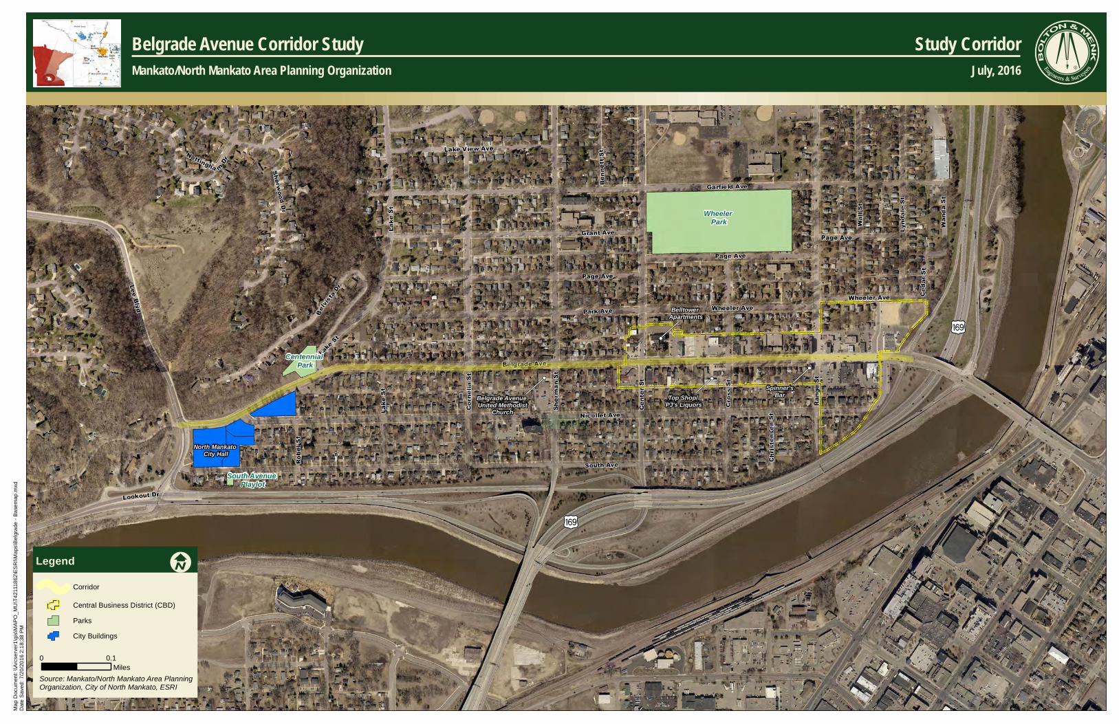
The Mankato/North Mankato Area Planning Organization (MAPO) and the City of North Mankato, in partnership with the Minnesota Department of Transportation (MnDOT), completed this study to identify a long-term vision for multimodal improvements on Belgrade Avenue in North Mankato. The study extent includes Belgrade Avenue from Lee Boulevard on the west to the Veteran’s Memorial Bridge on the east (Figure 1). Unless otherwise present in the study, report figures are included in Appendix A.
The Belgrade Avenue corridor has served the City of North Mankato as the central corridor of the downtown business district since before the City was incorporated in 1899. It provides the gateway to the City from US Trunk Highway (TH) 169 and the City of Mankato to the east.
The City has demonstrated a commitment to enhancing the quality of downtown through planning efforts and public outreach. The most recent effort, the Belgrade Avenue Master Plan, ran concurrently with this effort.
Study Partners
The Belgrade Avenue Corridor Study was a joint effort between
The City of North Mankato
MAPO
MnDOT
Study Objectives
The study defines a comprehensive vision for Belgrade Avenue to continue momentum in the corridor fostering continued growth and mobility needs over the next 25 years. The corridor study process included the following elements:
Understand the needs and opportunities in the corridor
Develop and evaluate potential transportation improvement alternatives
Gather public and business input on corridor needs and improvement alternatives
Develop an implementation plan that prioritizes projects for completion over time
Coordination with the Belgrade Avenue Master Plan
The City of North Mankato initiated the Belgrade Avenue Master Plan in 2015 to achieve a framework for investment in the Central Business District and a shared vision for its future by the City, citizens and property owners in the area. Many consistent themes related to transportation needs emerged from the public and stakeholders during the plan’s initial phases. As a result, the City of North Mankato requested MAPO fund a study of Belgrade Avenue to identify transportation issues and potential improvement solutions that could be considered and woven into the Belgrade Avenue Master Plan process.
Issues Identification
Improvement alternatives were identified and evaluated based on the existing conditions analysis and issues and needs identified through public, agency and stakeholder involvement. The following describes alternatives studied for the Belgrade Avenue corridor.
Prepared by: Bolton & Menk, Inc. Executive summary Belgrade Avenue Corridor Study ǀ T42.111862 Page 2
A. Focus Area 1: Lee Boulevard Intersection
The primary issue in this focus area is the delay on Belgrade Avenue for westbound traffic entering Lee Boulevard southbound. Under existing (2016) conditions, the westbound approach to Lee Boulevard exhibits traffic delay below acceptable standards during both the AM and PM peak hour periods.
B. Focus Area 2: Nicollet Avenue to Lake Street
The primary issue in this segment is a gap in the bicycle network between Nicollet Avenue and Lake Street along Belgrade Avenue. Both Nicollet Avenue and Lake Street have sharrows indicating their service as on-street bike routes in the community. Generally, there are no bicycle fa cilities planned along Belgrade Avenue due to the parallel route along Nicollet Avenue, however, completing this gap is necessary to create a more complete network.
C. Focus Area 3: Intersections between Lake Street and Range Street
The primary issue in this segment is a crash issue at Sherman Street. Two of the six crashes that occurred at this intersection between 2010 and 2014 involved pedestrians. The Sherman Street intersection exhibited serious injury crashes outside of the normal range for this intersection type. This is concerning as Sherman Street is designated and signed as a bicycle route and serves pedestrians by providing access to Spring Lake Park north of Belgrade Avenue.
D. Focus Area 4: 200 Block (Range Street to the TH 169 Southbound Ramp)
Issues in this segment include:
Back-ups on Belgrade Avenue at Range Street – Traffic currently back-ups at the Range Street/Belgrade Avenue intersection during the PM peak hour.
Traffic speeds in the 200 Block – The speed of traffic is a concern within the 200 Block of Belgrade Avenue. Citizens and business owners have expressed that vehicles travel too fast within this area causing issues for pedestrian movements from the north to the south side of the street.
Safe Pedestrian Crossings in the 200 Block – There is a demand for pedestrian crossings at the Range Street intersection with Belgrade Avenue as well as mid-block in the 200 Block for patrons parking in public lots north of Belgrade Avenue and visiting businesses on the south side.
Several property access locations closely spaced – Multiple access points exist within close proximity in the 200 Block of Belgrade Avenue. This is particularly true along the north side of the roadway where six accesses are located within roughly 500 feet. These access locations can be problematic for vehicles and pedestrians.
Perceived Parking shortage – The Downtown Planning Study (2012) quantified available public and private parking facilities within the downtown area and found a parking shortage is perceived, but actual supply is generally sufficient for existing uses at most times. However, the location of facilities and proximity to businesses may contribute to perceptions that the area is underserved.
E. Focus Area 5: TH 169 Southbound Ramp Intersection
There are no traffic operational issues at this location today or projected into the future. However, this intersection provides the gateway to downtown North Mankato and is the primary location where speeds into the 200 Block are perceived as excessive.
Prepared by: Bolton & Menk, Inc. Executive summary Belgrade Avenue Corridor Study ǀ T42.111862 Page 3
Recommendations and Implementation Plan
Some of the improvements identified in this study are directly related to existing and/or safety issues on Belgrade Avenue. Others are related to an opportunity to enhance Belgrade Avenue for both motorized and non-motorized uses consistent with the Belgrade Avenue Master Plan. Study recommendations are organized into an implementation sequence for the City’s consideration. This will allow the City to take incremental steps over time, ultimately working towards a corridor that operates safely and efficiently and compliments their downtown vision.
Next Steps
Additional design, studies and public input will be needed for each of the recommended improvement options to move forward. The purpose of the Belgrade Avenue Corridor Study was to develop a long-term plan for improvements to Belgrade Avenue that are consistent with the goals and objectives of both the City’s Comprehensive Plan and the Belgrade Avenue Master Plan. The concepts developed as part of this study are high-level and will need additional refinement through preliminary and final design. Environmental review and permitting will also be required with exact requirements based on the scope of the project and the funding source.
The improvement options identified within this study and the projects prioritized as part of the implementation plan will help the City of North Mankato continue to maintain a functioning yet safe minor arterial roadway that supports their downtown vision.
The City should work to further plan, obtain funding, design, and implement the recommended improvement projects. All partners have an active role in implementing these improvements. All competitive funding sources should be considered. Agencies should also update or amend their comprehensive and transportation plans to include these findings to better leverage funding sources.
Prepared by: Bolton & Menk, Inc. Introduction Belgrade Avenue Corridor Study ǀ T42.111862 Page 4
II. INTRODUCTION
The Mankato/North Mankato Area Planning Organization (MAPO) and the City of North Mankato, in partnership with the Minnesota Department of Transportation (MnDOT), completed this study to identify a long-term vision for multimodal improvements on Belgrade Avenue in North Mankato. The study extent includes Belgrade Avenue from Lee Boulevard on the west to the Veterean’s Memorial Bridge on the east (Figure 1). Unless otherwise present in the study, report figures are included in Appendix A.
The Belgrade Avenue corridor has served the City of North Mankato as the central corridor of the downtown business district since before the City was incorporated in 1899. It provides the gateway to the City from US Trunk Highway (TH) 169 and the City of Mankato to the east. The corridor contains a variety of business types serving as the commercial core of the City with various residential densities mixed in.
The City has demonstrated a commitment to enhancing the quality of downtown through planning efforts and public outreach. Previous plans include the North Mankato Comprehensive Plan (2015) with a dedicated chapter for downtown redevelopment as well as the Downtown Planning Study (2012) aimed at guiding future development and shaping the character of the downtown.
Another planning effort that ran concurrently with this effort was the Belgrade Avenue Master Plan which serves to achieve a framework for investment in the Central Business District and a shared vision of the future of the Central Business District by the City, citizens and property owners in the downtown area. The City’s planning process for the Belgrade Avenue Master Plan began prior to the Belgrade Avenue Corridor Study and was a catalyst in the MAPO’s decision to fund the study. The City and MAPO saw the opportunity to build on the momentum of the Master Plan effort, utilizing the same steering committee and combining public information meetings.
Consistent themes for the corridor within previous plans are to improve pedestrian facilities and streetscape appearance, reduce the speed of traffic in the 200 Block, enhance pedestrian safety, identify and address parking deficiencies, and encourage and promote renovation and rehabilitation of the existing buildings.
Due to the demonstrated commitment from the City to improve this area, the Belgrade Avenue Corridor Study was identified as a priority in the MAPO 2045 Long Range Transportation Plan. The City of North Mankato agreed that the timing was right to pursue this study which was funded through the MAPO.
The study defines a comprehensive vision for Belgrade Avenue to continue momentum in the corridor fostering continued growth and mobility needs over the next 25 years. The corridor study process included the following elements:
Understand the needs and opportunities in the corridor
Develop and evaluate potential transportation improvement alternatives
Gather public and business input on corridor needs and improvement alternatives
Develop an implementation plan that prioritizes projects for completion over time
)y
)y
Belltower Apartments
Belgrade Avenue United Methodist
Church
North Mankato City Hall
Spinner'sBarTop Shop/
PJ's Liquors
Wheeler Park
Centennial Park
South Avenue Playlot
Ma
p D
ocu
men
t: \\
Arc
serv
er1
\gis
\MA
PO
_M
U\T
421
118
62\E
SR
I\Ma
ps\B
elgr
ade
- B
ase
map
.mxd
Dat
e S
aved
: 7/
20
/20
16
2:1
8:38
PM
LegendCorridor
Central Business District (CBD)
Parks
City Buildings
0 0.1Miles
I
Serv ice Laye r Cr edit s: Belgrade Avenue Corridor StudyMankato/North Mankato Area Planning Organization
Study CorridorJuly, 2016
CLIENTLOGO
Source: Mankato/North Mankato Area Planning Organization, City of North Mankato, ESRI
Prepared by: Bolton & Menk, Inc. Study Partners Belgrade Avenue Corridor Study ǀ T42.111862 Page 6
III. STUDY PARTNERS
The Belgrade Avenue Corridor Study was a joint effort between:
The City of North Mankato
MAPO
MnDOT
These agencies served as a Project Management Team (PMT) and met monthly throughout the study process to review and discuss study progress and technical deliverables.
IV. PUBLIC INVOLVEMENT
Public involvement was an integral part of the Belgrade Avenue Corridor Study. Input from business owners, property owners, interested citizens, elected officials and other corridor users was critical to understand issues and needs and to vet improvement concepts and priorities. Figure 2 outlines the different groups, outreach activities, and their interaction and roles in the overall study’s decision-making process.
Figure 2. Public Involvement
Prepared by: Bolton & Menk, Inc. Public Involvement Belgrade Avenue Corridor Study ǀ T42.111862 Page 7
The following methods were used to promote public involvement during the study:
Public Informational Open House Meetings – A public open house meeting was held on January 26, 2017 to communicate to the public study goals and solicit input on improvement alternatives for identified for consideration. This meeting was repeated on January 28, 2017 to allow those unable to attend the first round an opportunity to offer their input. These meetings combined the Belgrade Avenue Corridor Study as well as the Belgrade Avenue Master Plan efforts, soliciting feedback on both. A summary of these meetings is included in Appendix B.
Property/Business Owner Meetings – Project Staff met with five businesses on a one-on-one basis early in the issues identification process of the study. Businesses included:
o Brunton Architects
o Nakato
o Dino’s
o Expressway Gas Station/CENEX
o Frandsen Bank & Trust
Property/Business Owner meeting summaries are included in Appendix C.
Buiness On Belgrade (BOB) Group Meetings – Two meetings were held with the Business on Belgrade (BoB) Group on February 28th and March 2nd of 2017. The meetings were held to solicit feedback from the BoB group as business owner turnout was low at the January open house meetings. Eleven members total from the group attended the February/March meetings. BoB Group meeting summaries can be seen in Appendix D.
Agency and Elected Official Updates - Meetings were held with agencies and elected officials to review the range of alternatives generated from this study. These included a North Mankato City Council meeting and meetings with MnDOT District 7 representatives.
MAPO Updates – Project staff provided an update to the MAPO Policy Board in February and May 2017 and the MAPO Technical Advisory Committee (TAC) in July 2016 and another in January 2017.
Steering Committee Meetings – A Steering Committee consisting of 18 interested citizens, stakeholders, and business representatives met three times throughout the study process. This group provided review of study initiatives and input on the generation of study materials throughout the study process. They also assisted with public and property/business representative meetings. Steering Committee meeting summaries can be seen in Appendix E.
Study Communications – Bolton & Menk, Inc. hosted a project website for the Belgrade Avenue Corridor Study throughout the entire process. Study documents, concept alternatives and public involvement notices were posted on the website at key study milestones. Newsletters were prepared for each public information meeting and sent to stakeholders along Belgrade Avneue and a press release was also included in the Mankato Free Press Newspaper as notice to the community. A public comment web application was also hosted on the project website as well as the City’s site to solicit public feedback as well. The results of the public comment web application can be seen in Appendix F.
Prepared by: Bolton & Menk, Inc. Coordination with the Belgrade Avenue Master Plan Belgrade Avenue Corridor Study ǀ T42.111862 Page 8
V. COORDINATION WITH THE BELGRADE AVENUE MASTER PLAN
The City of North Mankato initiated the Belgrade Avenue Master Plan in 2015 to achieve a framework for investment in the Central Business District and a shared vision for its future by the City, citizens and property owners in the area. Although the City’s planning process for the Belgrade Avenue Master Plan began prior to the Belgrade Avenue Corridor Study, many consistent themes related to transportation needs emerged from the public and stakeholders during the plan’s initial phases. Many of these themes had also been identified in previous planning studies in the
downtown area. As a result, the City of North Mankato requested MAPO fund a study of Belgrade Avenue to identify transportation issues and potential improvement solutions that could be considered and woven into the Belgrade Avenue Master Plan process.
The merging of these two planning efforts officially began in September 2016 when the Beglrade Avenue Corridor Study held the first Steering Committee meeting. The Steering Committee used for the corridor study was the same committee used for the master plan. In addition, the public open houses and business owner meetings held later in the corridor study also brought in content and recommendations of the Master Plan.
The vision for the Belgrade Avenue Master Plan was developed by terms used to describe an ideal future Central Business District by participants in the public process and is as follows:
The North Mankato Central Business District is a growing and safe district characterized by cohesive architectural design, pedestrian friendly streetscapes, and new destinations all contributing to a beautiful, thriving, and inviting area and serving as the core for community convention.
The Master Plan is guided by goals directly from the community’s Comprehensive Plan. Goal 2 from Chapter 9 – Downtown Redevelopment shows a desire to “Create a safe and inviting pedestrian realm” in the Central Business District. Consistent themes for the Belgrade Avenue corridor derived from public and stakeholder input during the Master Plan and recent planning efforts were to improve pedestrian facilities and streetscape appearance, reduce the speed of traffic in the 200 Block, enhance pedestrian safety, identify and address parking deficiencies, and encourage and promote renovation and rehabilitation of the existing buildings.
The Belgrade Avenue Master Plan identifies a plan for 5, 10, and 20-year improvement implementation. Key transportation implementation initiatives identified in the Master Plan include the employment of traffic calming strategies, and streetscaping and pedestrian improvements to create a more inviting destination for public gathering.
The Belgrade Avenue Master Plan is meant to work in unison with the Belgrade Avenue Corridor Study to achieve a framework to implement this future vision. These efforts should be consulted together to inform decision-making for the future of the Central Business District.
Themes consistent among stakeholders and citizens in past Central Business District planning efforts:
Improve pedestrian facilities and streetscape appearance
Reduce the speed of traffic in the 200 Block
Enhance pedestrian safety
Identify and address parking deficiencies
Encourage and promote renovation and rehabilitation of existing buildings
Prepared by: Bolton & Menk, Inc. Existing Conditions Belgrade Avenue Corridor Study ǀ T42.111862 Page 9
VI. EXISTING CONDITIONS
This section documents existing conditions on Belgrade Avenue as it relates to land use, previous studies, traffic operations, safety, access, pedestrian/bicycle accommodations and environmental resources. This information serves as the framework to develop improvement options for Belgrade Avenue.
A. Previous Studies Overview
Several short and long-range documents have been completed which provide planning direction for future transportation system needs within and near the Belgrade Avenue corridor. The key points in each study relevant to Belgrade Avenue are summarized below by plan title.
Mankato/North Mankato Area Planning Organization (MAPO) 2045 Long-Range Transportation Plan (LRTP) (2015)
Belgrade Avenue is a minor arterial roadway under the MAPO’s existing functional classification system
Forecasted 2045 Congested Roadway Segments:
o Lee Boulevard - Lor Ray Drive to Belgrade Avenue; LOS F1; 1.27 V/C ratio
o Belgrade Avenue - Lee Boulevard to Range Street; LOS E; .96 V/C ratio
Future projects:
o Restripe Belgrade Avenue from Center Street to Range Street as a 3-lane facility (2021-2025 timeframe)
o Reconstruct Lee Boulevard from Lookout Drive to Belgrade Avenue as a 3-lane (2021-2025 timeframe)
o Reconstruct Belgrade as 2-lane from Lee Boulevard to Range Street (2031-2045 timeframe)
o Reconstruct Belgrade as 4-lane from Range Street to TH 169 (2031-2045 timeframe)
o Expand Lee Boulevard to a 4-lane roadway from Lor Ray Drive to Belgrade Avenue (illustrative project)
o Need for an Intersection Control Evaluation on Lee Boulevard at Belgrade Avenue (2021-2025 timeframe)
City of North Mankato Complete Streets Plan & Policy (2016)
Proposed on-street bicycle accommodations chart which includes Lee Boulevard from Lookout Drive to Hoover Drive and Range Street from Nicollet Avenue to McKinley Street
North Mankato Comprehensive Plan (2015)
Highlights the Central Business District as a development style common among other older downtowns with features such as being pedestrian oriented, on-street parking, and the preferred location for prominent community events
Central Business District is the community focal point and plans for its continued momentum by:
o Creating an attractive gateway to downtown off TH 169 through streetscape 1 Level of Service (LOS) is defined on page 13 of this document and is a measure of intersection delay.
Prepared by: Bolton & Menk, Inc. Existing Conditions Belgrade Avenue Corridor Study ǀ T42.111862 Page 10
improvements and design standards
o Implement land use standards that emphasize walkability (i.e., rear parking at businesses, wider sidewalks with no obstructions, unique streetscape methods)
o References the Downtown Planning Study (2011) which found a “perceived shortage of parking” yet the supply is generally sufficient for the existing uses during the day
Roadway design should consider the user friendliness of alternative modes of transportation while preserving on-street parking where feasible
The City of North Mankato Parks Master Plan (2015)
Identifies Centennial Park, a 1 Acre Commemorative Park located at 840 Belgrade Avenue with a decorative water fountain and benches
City of North Mankato Downtown Planning Study (2012)
Rates vehicular circulation as “generally good” but during peak traffic hours (7:45 – 8:15 AM and 4:45 – 5:15 PM), negotiating a turn at mid-block is difficult and parallel parking on Belgrade is problematic
Recommends additional pedestrian access and circulation to promote pedestrian traffic to businesses across the street from each other in the 200 block
Identified the following parking/traffic/pedestrian concerns from a July 26, 2011 public meeting:
o More parking near businesses
o Wheel stops to keep parked cars off of sidewalks
o Manage traffic coming over the bridge and vehicles leaving businesses
o Better public transportation service
o Parking is a priority for future development efforts in the downtown
Implies that the parking issue is a perceived inconvenience due to a lack of visibility of existing parking stalls on the 200 block of Belgrade Avenue and on Nicollet Avenue
Recommends providing signage for patron and public parking and possibly asking the city to provide a single page flyer for businesses to distribute to show downtown parking options
Recommends creating gathering spaces/opens spaces/green spaces/pathways that include amenities such as bike racks outdoor seating/benches and routes that tie into nearby parks and trails
Recommends improving connectivity to Belgrade Avenue over Veterans’ Memorial Bridge and beyond to Wheeler Park, City Hall, Taylor Library and Centennial Park
Downtown Focus Group (2010)
Recommends a more attractive entrance to the downtown off Veterans’ Memorial Bridge
Recommends pedestrian, bicycle, family friendly and handicap accessible pathways
Recommends lighting improvements on Belgrade Avenue
Recommends slowing vehicular traffic coming over the bridge onto Belgrade Avenue
Prepared by: Bolton & Menk, Inc. Existing Conditions Belgrade Avenue Corridor Study ǀ T42.111862 Page 11
Recommends reconfiguring the four-lane stretch of Belgrade to help increase pedestrian traffic
Recommends adding signage indicating the location of parking
Belgrade Avenue Master Plan (2017)
Identifies future redevelopment efforts at key intersections in the Central Business District along Belgrade Avenue to include two to three story multi-use buildings
A steering committee of 27 members was assembled in early 2016 to assist with guiding planning efforts
Plan adoption is anticipated in December 2016
B. Demographics And Trends
Located in south central Minnesota, the Mankato/North Mankato metropolitan planning area is 75 miles south of Minneapolis-St. Paul at the junction of US Trunk Highway (TH) 14 and TH 169. The area has experienced widespread growth across the metropolitan area and serves southern Minnesota as a hub for health care, education, retail, agriculture, and industry. The area is comprised of Mankato, North Mankato, Eagle Lake and Skyline; Blue Earth and Nicollet counties; and Belgrade, Lime, South Bend, LeRay and Mankato townships.
Population
The Mankato/North Mankato area has seen rapid growth. In 2010, the metropolitan statistical area (MSA) population was 96,740 with an urbanized population of 58,265. The 2010 population estimate represents a 12.9% change from the year 2000 for the MSA. Table 1 illustrates historic population figures referenced from the Mankato/North Mankato Metropolitan Planning Organization’s (MAPO) 2045 Long Range Transportation Plan.
Age
The population’s age distribution (Table 2) is important as it effects transportation usage. Within the period from 2000 to 2010, 18-34 year olds as well as those of retirement age saw the highest increases in populations indicating increased commuters and dial-a-ride transit users. Retirees exhibited the greatest increase in population while 18-20 year olds represented the largest demographic group. With a large 18-20 year old group, the area may see a higher demand for pedestrian and bicycle amenities.
Employment
Most household trips include travel to and from places of employment. Mankato and North Mankato are the major employment centers for the region with a labor shed spanning 16 counties. There is a net inflow of primary jobs in the MAPO market area
1980
CENSUS
1990
CENSUS
2000
CENSUS
% CHANGE
1990‐2000
2010
CENSUS
% CHANGE
2000‐2010
2015
ESTIMATE
North Mankato 9,145 10,164 11,798 16.1% 13,394 13.5% 13,529
MSA 79,243 82,120 85,712 4.4% 96,740 12.9% 99,134
Table 1. 1980 – 2010 Historic Population (Source: US Census Bureau; Minnesota State Demographer (Mankato Area Housing
Study Update, 2013; MAPO 2045 Long Range Transportation Plan.)
Table 2. Population by Age (Source: US Census Bureau; MAPO 2040 Long Range Transportation
Plan)
AGE 2000 2010 CHANGE
0‐9 9,869 11,466 1,597
10‐17 9,447 8,298 (1,149)
18‐20 17,249 19,606 2,357
25‐34 10,460 13,342 2,882
35‐44 11,879 10,009 (1,870)
45‐54 10,640 12,129 1,489
55‐64 6,161 10,411 4,250
65‐74 4,785 5,627 842
75‐84 3,649 3,867 218
85+ 1,573 1,985 412
Total 85,712 96,740 11,028
MSA
Prepared by: Bolton & Menk, Inc. Existing Conditions Belgrade Avenue Corridor Study ǀ T42.111862 Page 12
meaning there are more jobs in the market than people living in the market area. Almost 72 percent of labor force living in the market area also work there.
C. Transportation System Characteristics
Functional Classification
The functional classification system is used to create a roadway network that efficiently collects and distributes traffic from neighborhoods to the state highway system. A successful system coordinates and manages mobility, roadway design, and route alignment as well as seeks to match current and future access and land use with the adjacent roadway’s purpose, speeds, and spacing. Functional classifications are comprised of principal arterials, minor arterials, major and minor collectors, and local roadways.
Belgrade Avenue serves is a minor arterial roadway spanning from Veterans’ Memorial Bridge and the TH 169 Interchange to Lee Boulevard. It serves a diverse mix of personal vehicle, freight, transit, bicycle, and pedestrian traffic. It also bisects North Mankato’s downtown Central Business District. From a regional perspective, mobility on Belgrade Avenue is important, as it provides connections to other minor arterial roadways such as Lee , Range Street and the Veterans Memorial Bridge which provide access to other portions of North Mankato and across the river into Mankato.
Existing Number of Lanes
Belgrade Avenue is a two lane undivided roadway from Lee Boulevard to Range Street with westbound right turn lanes at Lee Boulevard and Center Street; four lane undivided roadway from Range Street to Nicollet Avenue; and a four lane divided roadway from Nicollet Avenue to the TH 169 interchange ramps. The intersections of Belgrade Avenue at the TH 169 interchange ramps are signalized. The intersections of Belgrade at Range Street and Center Street are all way stop controlled. Belgrade Avenue at Sherman Street and Belgrade Avenue at Lake Street are side street stop controlled with Belgrade Avenue having the right of way. The intersection of Belgrade Ave at Lee Boulevard is side street stop controlled with Lee Boulevard having the right of way.
Parking Accommodations
Belgrade Avenue permits on-street parking within the Central Business District and westward towards Lee Boulevard. In addition, on-street parking is permitted on adjacent streets and off-street public, private, and private-shared parking is permitted at select businesses along Belgrade Avenue. A parking assessment reveals a total of 273 public parking spaces, 286 private parking spaces, and 211 private-shared parking spaces in the Central Business District of the study area (200 – 500 Block of Belgrade). The parking assessment took into account on-street parking resources along side streets intersecting Belgrade Avenue extending north and south to the next street. On Belgrade Avenue in the Central Business District, 34 public parking spaces are on the north side of the roadway and 58 spaces are on the south side. More information can be seen in the Parking Assessment map in the appendix.
D. Study Area Characteristics
This section contains existing conditions of Belgrade Avenue related to land use, traffic operations, crash history, roadway access, transit, and pedestrian and bicycle connections.
Several Figures are appended to this document relating to the existing characteristics described within the study area in the text below. Refer to Appendix A for the following existing conditions graphics:
Figure A.1 - Land Use
Figure A.2 - Traffic Operations
Prepared by: Bolton & Menk, Inc. Existing Conditions Belgrade Avenue Corridor Study ǀ T42.111862 Page 13
Figure A.3 - Crash History
Figure A.4 - Access Inventory
Figure A.5 - Existing Pedestrian and Bicycle Accommodations
Figure A.6 - Transit
Figure A.7 - Parking Assessment
A detailed Existing Traffic Conditions Technical Memorandum is attached in Appendix G which documents the traffic data collection, methodology and additional details on existing conditions analysis summarized in the sections below.
Land Use
Land uses along the study corridor consist of general commercial, high density residential, and low density residential within the Central Business District. Beyond the Central Business District, uses consist of predominately low density residential and institutional centers. Open spaces/parks are located north of the study corridor west of Lake Street. The eastern terminus of the study corridor is the TH 169 interchange and the western terminus is Lee Boulevard. Intersections where potential redevelopment may occur according to the Belgrade Avenue Master Plan are indicated. Major traffic generators along Belgrade Avenue include Cenex gas station, Frandsen, US Postal Office, multiple dining establishments, Belgrade Avenue United Methodist Church, Taylor Library and the City of North Mankato City Hall and Police Annex.
Traffic Operations
Approximately 21,500 vehicles per day currently use the Veterans Memorial Bridge. Approximately 9,800 vehicles per day continue onto Belgrade Avenue between the TH 169 west off ramp intersection and Range Street. There are 7,200 vehicles per day from Center Street to Sherman Street, and 6,700 vehicles from Cornelia Street to Lee Boulevard.
The average intersection control delay is a volume weighted average of delay experienced by all motorists entering the intersection on all intersection approaches. Intersections and each intersection approach are given a ranking from Level of Service (LOS) A through LOS F. LOS A indicates the best traffic operation, with vehicles experiencing minimal delays. LOS A through D is generally perceived to be acceptable to drivers. LOS E indicates that an intersection is operating at, or very near, its capacity and that drivers experience considerable delays. LOS F indicates an intersection where demand exceeds capacity and drivers experience substantial delays.
Table 3 shows all of the intersections along the study corridor are operating at generally acceptable levels of service. However, the individual movement of westbound to southbound at the Lee Boulevard intersection is operating at a LOS E/D during the AM and PM peak hours, respectively. Queues, or back-ups for the westbound left at the Range Street intersection with Belgrade Avenue, were observed extending beyond the American Legion driveway and the Frandsen Bank driveway during the PM peak hour periods. A copy of the Existing Traffic Conditions Technical Memorandum is included in Appendix G.
Prepared by: Bolton & Menk, Inc. Existing Conditions Belgrade Avenue Corridor Study ǀ T42.111862 Page 14
A crash review was completed using the Minnesota Crash Mapping Analysis Tool (MnCMAT) which identified 42 crashes on Belgrade Avenue between Lee Boulevard and the west TH 169 interchange ramp within a five-year period from 2010 to 2014. MnDOT uses a comparison of the crash rate and the critical rate when determining whether or not safety issues exist at an intersection. The crash rate is the number of crashes per million entering vehicles (MEV). The critical rate is a statistical comparison based on similar intersections statewide. An observed crash rate greater than the critical rate indicates that the intersection operates outside of the expected, normal range. The critical index reports the magnitude of this difference and a critical index of less than one shows that the intersection is operating within the normal range.
Most intersections in this segment exhibit crash counts within a normal range during the five-year period. The Sherman Street intersection exhibited serious injury crashes outside of the normal range for this intersection type. Six crashes occurred in this location within the 5-year period, two of these involved a pedestrian.
Access Inventory
There are 55 access points in this segment including six primary accesses (6 per mile), seven secondary accesses (7 per mile), and 42 private accesses (40 per mile). Both primary and secondary access counts fall below MAPO’s recommendations for 9 to 19 accesses per mile along minor arterial roadways.
Pedestrian and Bicycle Accommodations
Sidewalks are present along both sides of the study corridor from Lee Boulevard to the TH 169 interchange. There are no bicycle facilities along Belgrade Avenue, however, two on-road bike routes intersect Belgrade Ave at Sherman Street. and Center Street. An on-road bike route exists on Lake St. from its intersection with Belgrade Ave. north to the recent trail addition on TH 14. In addition, an on-road bike route extends along Nicollet Avenue from its western intersection with Belgrade Avenue to its eastern intersection with Belgrade Avenue.
DirectionAverage
Queue (ft)
Max
Queue (ft)
****AM 4 A 14 B NBL WBT 44 109
PM 5 A 16 B NBL WBT 99 190
AM 11 B 21 C SBL WBL 72 129
PM 11 B 25 C SBL WBL 123 225
AM 7 A 9 A EBT EBL/T 45 71
PM 8 A 10 B WBL/EBT WBL 83 145
AM 7 A 9 A WBT EBL/T 41 74
PM 8 A 10 A WBT WBT 54 86
AM 3 A 8 A SBT SBL/T/R 38 62
PM 3 A 9 A SBL SBL/T/R 35 60
AM 2 A 6 A SBL SBL/R 23 43
PM 2 A 8 A SBL EBL/T 17 50
AM 4 A 40 E WBL SBL 38 93
PM 4 A 25 D WBL SBL 45 97
*Delay in seconds per vehicle
**Maximum delay and LOS on any approach and/or movement
****Max Queue refers to the 95% Queue (Passenger car stored length = 25 ft, Heavy vehicle stored length = 45 ft)
***Limiting Movement is the highest delay approach.
Maximum
Delay‐
LOS**
Limiting
Movement
***
Max Approach Queue
Lee Blvd at Belgrade Ave Side-Street Stop Controlled
Center St at Belgrade Ave All-Way Stop Controlled
Range St at Belgrade Ave All-Way Stop Controlled
SB TH 169 Ramp at Belgrade Ave Signalized Intersection
Traffic Control ScenarioPeak
Hour
Intersection
Delay*‐ LOS
Sherman St at Belgrade Ave Side-Street Stop Controlled
Lake St at Belgrade Ave Side-Street Stop Controlled
NB TH 169 Ramp at Belgrade Ave Signalized Intersection
Prepared by: Bolton & Menk, Inc. Study Goals Belgrade Avenue Corridor Study ǀ T42.111862 Page 15
and continues east to join the Rex Macbeth River Trail.
There are a few high demand pedestrian crossing locations along Belgrade Avenue. The Wall Street intersection allows pedestrians’ access from public parking lots access to Circle Inn, Dino’s Pizzeria, and Like-Nu Cleaners. The Range Street intersection accommodates a high volume of pedestrians accessing the American Legion, Frandsen Bank, NaKato Bar & Grill, and Spinners Bar. The Center Street intersection provides an on-street bike path encouraging bicycle access across Belgrade Avenue to BellTower Apartments, Wheels Unlimited, and Benderz Bar and Grill. The Sherman Street intersection provides an on-street bike path encouraging bicycle access across Belgrade Avenue to Belgrade Avenue United Methodists Church. Pedestrian crossings exist at both intersections as well.
Transit Routes
Two routes of the Mankato Area Transit System pass through the study corridor. Bus stops are located at the intersections of Belgrade Avenue with Nicollet Avenue, Sherman Street, Center Street, Range Street.
Environmental Considerations - Social, Economic, and Environmental (SEE) Concerns
A high-level environmental screening using publicly available GIS datasets was conducted to identify any potential environmental resources within the study area as future roadway improvements were considered. No fatal flaws to roadway improvements were identified within the study area as part of this preliminary screening. Additional formal environmental documentation may be necessary as individual roadway improvement projects are pursued in the future. The environmental screening conducted as part of this study is included in Appendix H.
VII. STUDY GOALS
Based on the existing conditions findings and public, business and stakeholder input on issues and needs, goals were developed to guide the Belgrade Avenue Corridor Study. Study partners used the following goals to identify and evaluate transportation improvement alternatives along Belgrade Avenue:
Provide an appropriate balance between vehicle mobility and access
Safely accommodate all users (vehicles, transit, pedestrians, bicycles, heavy trucks)
Support an inviting and safe pedestrian environment both along and across Belgrade Avenue
Support bicycle connections across Belgrade Avenue to designated parallel bike routes and regional trails
Support future land use and redevelopment plans
Provide infrastructure improvements compatible with preferred design guidelines
Enhance community character and the downtown environment
Prepared by: Bolton & Menk, Inc. Future Traffic Belgrade Avenue Corridor Study ǀ T42.111862 Page 16
VIII. FUTURE TRAFFIC
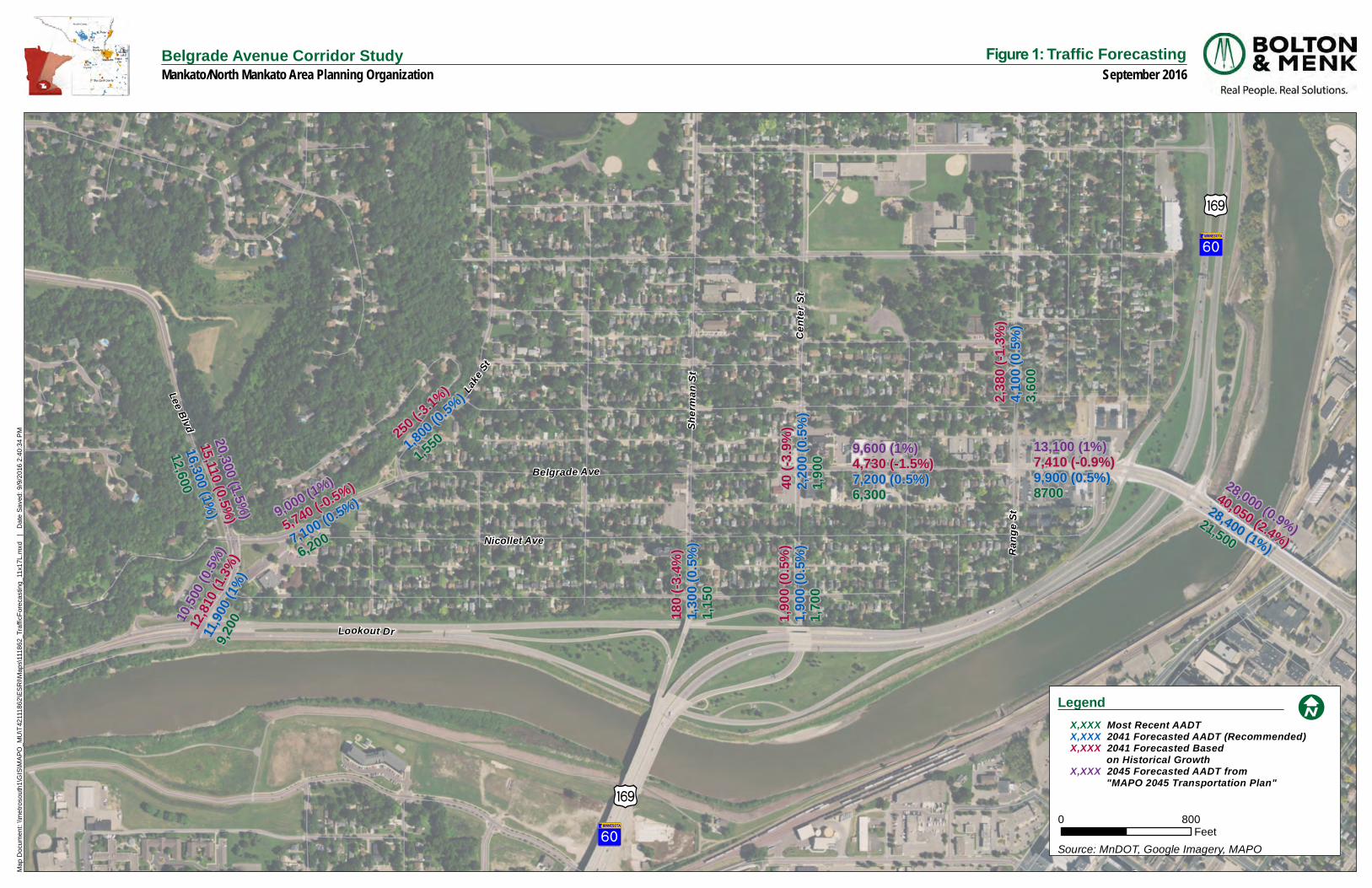
Future traffic volumes for 2041 (25-year forecast) were developed using historical data and the Mankato/North Mankato Area Planning Organization (MAPO) 2045 Long Range Transportation Plan while recognizing population growth trends in the area. The historical growth rates (1997-2013) along Belgrade Avenue were found to be negative based on historical data. The MAPO 2045 Long Range Transportation Plan identified future growth rates between 0.9% and 1% on Belgrade Avenue.
Taking all sources into account a 0.5% growth rate was used along Belgrade Avenue between Lee Boulevard and the TH 169 South Ramp. This 0.5% growth rate accounts for some growth on Belgrade Avenue over the next 25 years but also recognizes Belgrade Avenue is a completely developed corridor and is not anticipated to experience a large increase in future traffic. The study partners felt this modest growth rate was appropriate considering the corridor’s historical trend. The Future Conditions Traffic Analysis Memorandum is included in Appendix I. A map illustrating the 2041 forecasted traffic volumes for Belgrade Avenue is included in Figure 3.
Future Operations Analysis
A level of service (LOS) analysis of the peak hours was completed using the forecasted turning movement counts in SimTraffic. Table 4 shows the results of the 2041 no-build traffic analysis.
Overall intersection delay is acceptable with LOS A or B at all of the intersections during both peak hours.
The westbound Belgrade Avenue to southbound Lee Boulevard movement is anticipated to operate at LOS F by 2041 if no changes are made to this intersection. This is a safety concern as traffic making this move is likely to get frustrated and take a chance on an inadequate gap to make their move. This often results in crashes.
The average queue for the westbound left and thru movement at the Range Street/Belgrade Avenue intersection is anticipated to increase to 100 feet during the PM peak hour. Today, this queue blocks the American Legion driveway and Frandsen Bank driveway and by 2041 is anticipated to extend even further to block the western Cenex driveway. This is a safety concern for vehicles trying to navigate in and out of these driveways during these peak periods.
DirectionAverage
Queue (ft)
Max
Queue (ft)
NB TH 169 Exit Ramp & Belgrade Ave AM 5 A 15 B NBL WBT 75 200
Signalized Intersection PM 7 A 20 C NBL WBT 100 500
SB TH 169 Exit Ramp & Belgrade Ave AM 14 B 24 C SBL WBL 125 250
Signalized Intersection PM 16 B 30 C SBL WBT 75 350
Range St & Belgrade Ave AM 7 A 9 A EBT SBL/T/R 50 125
Stop Controlled PM 9 A 12 B WBL WBL/T 100 225
Center St & Belgrade Ave AM 8 A 9 A WBT EBL/T 75 125Stop Controlled PM 9 A 11 B WBT WBT 75 150
Sherman St & Belgrade Ave AM 3 A 10 B SBT SBL/T/R 50 100Stop Controlled PM 3 A 10 B SBT SBL/T/R 50 100
Belgrade Ave & Lake St AM 2 A 6 A SBL SBL/R 50 75Stop Controlled PM 2 A 8 A SBL EBL/T 25 75
Lee Blvd & Belgrade Ave AM 9 A 245 F WBL SBT/R 25 275Stop Controlled PM 7 A 86 F WBL SBL 75 200
*Delay in seconds per vehicle
**Maximum delay and LOS on any approach and/or movement
***Limiting Movement is the highest delay movement.
Max Approach QueueLimiting
Movement
***
Maximum
Delay‐LOS**
Intersection
Delay*
Peak
HourIntersection
Table 4. 2041 Existing Geometry (No Build) Traffic Operations Analysis
Cherry St
S Riverfro
ntDr
)y
)y
?ÜA@
?ÜA@
Belgrade AveLa
ke St
Cent
er S
t
Rang
e St
Nicollet Ave
Sher
man S
t
Lookout Dr
Lee Blvd
40 (-3
.9%)
2,200
(0.5%
)1,9
00
180 (
-3.4%
)1,3
00 (0
.5%)
1,150
250 (-3
.1%)
1,800 (0
.5%)
1,550
1,900
(0.5%
)1,9
00 (0
.5%)
1,700
2,380
(-1.3%
)4,1
00 (0
.5%)
3,600
13,100 (1%)7,410 (-0.9%)9,900 (0.5%)8700
9,600 (1%)4,730 (-1.5%)7,200 (0.5%)6,300
9,000 (1%)
5,740 (-0.5%)
7,100 (0.5%)
6,200
10,500
(0.5%
)12,
810 (1
.3%)
11,90
0 (1%
)9,2
00
28,000 (0.9%)40,050 (2.4%)
28,400 (1%)21,500
20,300 (1.5%)
15,110 (0.5%)
16,300 (1%)
12,600
Ma
p D
ocu
me
nt:
\\m
etr
oso
uth
1\G
IS\M
AP
O_
MU
\T42
111
86
2\E
SR
I\M
ap
s\11
18
62
_Tra
fficF
ore
cast
ing
_11
x17
L.m
xd
|
Da
te S
ave
d:
9/9
/20
16 2
:40
:34
PM
Belgrade Avenue Corridor StudyMankato/North Mankato Area Planning Organization
Figure 1: Traffic ForecastingSeptember 2016
Legend
0 800Feet
Source: MnDOT, Google Imagery, MAPO
!I X,XXX Most Recent AADT X,XXX 2041 Forecasted AADT (Recommended) X,XXX 2041 Forecasted Based
on Historical Growth X,XXX 2045 Forecasted AADT from
"MAPO 2045 Transportation Plan"
Prepared by: Bolton & Menk, Inc. Issues Identification & Evaluation of Alternatives Belgrade Avenue Corridor Study ǀ T42.111862 Page 18
IX. ISSUES IDENTIFICATION & EVALUATION OF ALTERNATIVES
Improvement alternatives were identified and evaluated based on the existing conditions analysis and issues and needs identified through public, agency and stakeholder involvement. The following describes alternatives studied for the Belgrade Avenue corridor, organized into five focus areas based on their location along the corridor. The improvement options discussed here can be seen on the MAPO website (www.mnmapo.org). Also, a discussion of the traffic analysis completed for each alternative is included in the Future Conditions Traffic Analysis Memorandum in Appendix I.
A. Focus Area 1: Lee Boulevard Intersection
The primary issue in this focus area is the delay on Belgrade Avenue for westbound traffic entering Lee Boulevard southbound. Under existing (2016) conditions, the westbound approach to Lee Boulevard exhibits traffic delay during both the AM and PM peak hour periods operating with LOS E during the AM and LOS D during the PM.
Public and stakeholder input during the corridor study process supported the issue. The westbound to southbound delay at this intersection is anticipated to worsen to LOS F for both peak periods by 2041 as traffic volumes on Lee Boulevard increase and without any improvements to the intersection traffic control.
An intersection control evaluation was conducted at this intersection to determine the most appropriate traffic control to address the delay issues and future traffic needs. The evaluation found traffic signal warrants were not met for existing or 2041 traffic. All way stop warrants were met which indicates a roundabout could be a traffic control option. An all way stop itself is not recommended since it would increase delay on the Lee Boulveard approaches to the intersection. The overall intersection operations at this location are adequate in the LOS A/B range. Any improvements identified should not worsen the overall intersection operations.
Based on the results of the traffic control evaluation, a roundabout was considered at this location (Figure 4). The traffic analysis found a single-lane roundabout would adequately serve both existing and 2041 traffic volumes. A roundabout at Lee Boulevard and Belgrade Avenue would alleviate delays for the problematic westbound to southbound movement at this intersection.
Public and stakeholder input on the idea of a roundabout at this location was mixed. The majority of the concerns expressed were related to the grades of the intersection and how to safely navigate the roundabout from southbound Lee Boulevard to eastbound Belgrade Avenue during winter conditions. A detailed analysis of the intersection profiles was not conducted as part of the corridor planning study. However, the consultant traffic and design engineers did take a preliminary review of contours through this area and felt the roundabout was a feasible intersection control option in this location for future consideration. Additional
Figure 4. Lee Boulevard/Belgrade Avenue Roundabout Concept.
Prepared by: Bolton & Menk, Inc. Issues Identification & Evaluation of Alternatives Belgrade Avenue Corridor Study ǀ T42.111862 Page 19
detailed design of the roundabout grades, placement, approach angles and geometric design and pedestrian crossing locations/connections will be required in the future if the City of North Mankato pursues implementation of this project.
A roundabout at Lee Boulevard and Belgrade Avenue is estimated to cost approximately $1.5 million.
B. Focus Area 2: Nicollet Avenue to Lake Street
The primary issue in this segment is a gap in the bicycle network between Nicollet Avenue and Lake Street along Belgrade Avenue. Both Nicollet Avenue and Lake Street have sharrows indicating their service as on-street bike routes in the community. However, both roads terminate at Belgrade Avenue as do the bicycle facilities they host. This leaves a nearly 700-foot gap in the bicycle network along Belgrade Avenue. Generally, there are no bicycle facilities planned along Belgrade Avenue due to the parallel route along Nicollet Avenue, however, completing this gap is necessary to create a more complete network.
Three alternatives were developed to provide a connection to complete this network. Each considers a crossing on Belgrade Avenue at a different location to take advantage of existing features. These options are described below.
Option 1: Trail Addition from Lee Boulevard to Lake Street with Crossing at Nicollet Avenue.
Option 1 requires expansion of the existing sidewalk along Belgrade Avenue extending from Lee Boulevard to Lake Street. This would result in a 10-foot wide multi-use trail that would accommodate a bicycle connection to both the trail on Lee Boulevard and facilities on Lake Street. The crossing at Nicollet Avenue would utilize a crosswalk that currently exists at this location. The westbound lane on Belgrade Avenue would decrease in width from 24-feet currently to 17-feet to accommodate the proposed trail. This shift into the existing street section of Belgrade Avenue for the trail is due to the topography of the land adjacent to the existing trail. It would be difficult and costly to expand the current sidewalk to the north. The decrease in width on Belgrade Avenue would have little effect on the functionality of westbound Belgrade Avenue traffic movements. It would require removing parking in this section; however, it has been observed that this parking is rarely used. Figure 5 illustrates this scenario. Option 1 is estimated to cost approximately $160,000.
Figure 5. Multi‐Use Path from Lee Boulevard to Lake Street.
Prepared by: Bolton & Menk, Inc. Issues Identification & Evaluation of Alternatives Belgrade Avenue Corridor Study ǀ T42.111862 Page 20
Option 2: Multi-Use Path from Lake Street to Mid-Block Crossing at the North Mankato Water Plant.
Option 2 (Figure 6) calls for a small segment (210-feet) of multi-use trail from Lake Street to a new, mid-block crossing at the North Mankato Water Plant that would take advantage of an existing walking path along the eastern side of that building. This would require the widening of that path segment adjacent to the building and moving the existing crosswalk from Nicollet Avenue to a mid-block location. The feasibility of widening the existing path shown in Figure 7 & 8 should be studied further to determine if adequate room exists for this connection. The improvement is estimated to cost approximately $50,000. The disadvantage of this option is it does not provide a bicycle connection to the Lee Boulevard trail as Option 1 accomplishes.
Option 3: On-Street Bike Lane from Lake Street To Mid-Block Crossing at the North Mankato Water Plant.
Option 3 (Figure 9) is the least invasive and lowest cost option which entails an on-street bicycle lane from Lake Street to a new mid-block crossing at the North Mankato Water Plant. This would require striping and marking a bike lane at a very low cost as an option without widening sidewalks into trails. Construction costs would be isolated to the trail expansion next to the water plant.
Figure 6. Multi‐use path with Mid‐Block Crossing
Figure 7. View of the Water Plant Path from Nicollet Avenue
Figure 8. Existing Path Location (Source: Google Maps)
Prepared by: Bolton & Menk, Inc. Issues Identification & Evaluation of Alternatives Belgrade Avenue Corridor Study ǀ T42.111862 Page 21
C. Focus Area 3: Intersection between Lake Street and Range Street
The primary issue in this segment is a crash issue at Sherman Street. Two of the six crashes that occurred at this intersection between 2010 and 2014 involved pedestrians. The Sherman Street intersection exhibited serious injury crashes outside of the normal range for this intersection type. This is concerning as Sherman Street is designated and signed as a bicycle route and serves bicycles and pedestrians by providing access to Spring Lake Park north of Belgrade Avenue.
Other pedestrian crossing demand locations along Belgrade Avenue between Lake Street and Range Street include:
Center Street access to area schools and parks – Center Street is also designated and signed as a bicycle route that intersects Belgrade Avenue. This route provides access to the Monroe/Bridges School location as well as Wheeler Park to the north thus having potential for many to cross Belgrade Avenue on foot or bicycle.
Cross Street access to area schools and parks – While not a designated bicycle route, Cross Street provides similar direct access to the area schools and Wheeler Park to the north of Belgrade Avenue.
Figure 10. Intersection Bump‐Outs between Lake Street and Range Street
Figure 9. On‐Street Bike‐Lane
Prepared by: Bolton & Menk, Inc. Issues Identification & Evaluation of Alternatives Belgrade Avenue Corridor Study ǀ T42.111862 Page 22
In order to address pedestrian crossing demands and improve safety, intersection bump-outs were proposed at four locations along the Belgrade Avenue corridor between Lake Street and Range Street. Bump-outs provide a traffic calming effect by narrowing the roadway. They also shorten the crossing distance for pedestrians by 9-14 feet and make pedestrians more visible as they attempt to cross the street. Figure 10 illustrates bump-outs at the intersections of Cornelia Street, Sherman Street, Center Street and Cross Street along Belgrade Avenue. The estimated cost of the bump-outs in these locations is approximately $40,000 per intersection.
D. Focus Area 4: 200 Block (Range Street to TH 169 Southbound Ramp)
Issues in this segment include:
Back-ups on Belgrade Avenue at Range Street – Traffic currently back-ups at the Range Street/Belgrade Avenue intersection during the PM peak hour. This back-up is not problematic from a delay standpoint but is a safety concern as it extends past the American Legion and Frandsen Bank driveways. This back-up is projected to worsen by 2041 and also extend past the western Cenex driveway. This is a safety concern for traffic trying to enter and exist these driveways.
Traffic speeds in the 200 Block – The speed of traffic is a concern within the 200 Block of Belgrade Avenue. Citizens and business owners have expressed that vehicles travel too fast within this area causing issues for pedestrian movements from the north to the south side of the street. A dynamic speed sign is located at the eastern entrance to Belgrade Avenue to make drivers aware of their speed and aid in slowing them down. The concern continues to exist despite this sign.
Safe Pedestrian Crossings in the 200 Block – There is a demand for pedestrian crossings at the Range Street intersection with Belgrade Avenue as well as mid-block in the 200 Block for patrons parking in public lots north of Belgrade Avenue and visiting businesses on the south side. Public input in the Master Plan, Corridor Study and previous planning studies have expressed a desire for a mid-block crossing on the 200 Block of Belgrade Avenue. The City has also explored options for this in the past. Due to current conditions, a mid-block, marked crossing is not recommended as it would be difficult for vehicles to see a pedestrian trying to cross from the south side of Belgrade Avenue between parked cars.
Several property access locations closely spaced – Multiple access points exist within close proximity in the 200 Block of Belgrade Avenue. This is particularly true along the north side of the roadway where six accesses are located within roughly 500 feet. These access locations can be problematic for vehicles and pedestrians. For instance, vehicles have been observed making a left turn from southbound Range Street to eastbound Belgrade Avenue, and then immediately turning again into a parking lot at the corner of Belgrade Avenue/Range Street. The proximity of the parking lot access to the intersection is problematic and results in vehicles blocking the Belgrade Avenue/Range Street intersection waiting to turn into the parking lot. The Circle Inn driveway onto Belgrade Avenue is also problematic as it is difficult to see eastbound pedestrians and vechicular traffic from this access point due to the building location directly adjacent to the sidewalk. Both of these driveways (Circle Inn and the city parking lot next to the American Legion) have access off of adjacent side streets.
Perceived Parking shortage – On-street parking is located on the south side of Belgrade Avenue. Sixteen on-street stalls exist today. Off-street public parking is isolated to the 200 Block of Belgrade Avenue. The Downtown Planning Study (2012) quantified available public and private parking facilities within the downtown area and found a parking shortage is perceived, but actual supply is generally sufficient for existing uses at most times. However, the location of facilities and proximity to
Prepared by: Bolton & Menk, Inc. Issues Identification & Evaluation of Alternatives Belgrade Avenue Corridor Study ǀ T42.111862 Page 23
businesses may contribute to perceptions that the area is underserved.
Several alternatives were developed for the 200 Block to assist with an improved vehicle and pedestrian traffic environment and to support the Belgrade Avenue Master Plan recommendations. Improvement options analyzed included options to improve pedestrian crossings with the existing four-lane section, an option to improve the pedestian environment, calm traffic and provid additional streetscape opportunities by reducing the number of lanes on Belgrade Avenue, and intersection control options at Range Street and the TH 169 southbound ramp intersection. Improvement options for this area are described below.
Option 1: Four-Lane Option
The four-lane option (Figure 11) maintains most of what is there today exhibiting minimal change. This option calls for two driveway closures on the north side of Belgrade Avenue to improve traffic flow and safety. Both of these properties have access to an adjacent side street and could reconfigure their parking lot striping to accommodate this change. This four-lane option includes a mid-block pedestrian crossing from the Circle Inn to the vacant lot on the south of Belgrade Avenue. Sidewalk bump-outs are proposed at Range Street and the new mid-block crossing location to shorten the pedestrian crossing distance and make pedestrians more visible to drivers. The bump-outs would require the loss of 3-4 on-street parking stalls on the south side of Belgrade Avenue. The bump-outs are necessary to provide a mid-block pedestrian crossing in this location. It is not recommended to add a mid-block crossing without the bump-out as it would be very difficult to see a pedestrian trying to cross from the south between parked cars.
A mid-block crossing in this four-lane option could be paired with an overhead rectangular rapid flashing beacon as seen in Figure 12 to enhance the crossing location. The vehicle yield rate for an rectangular rapid flashing beacon is 88% as opposed to 7% for a
Figure 11. 200 Block 4‐Lane Option
Figure 12. Overhead Rectangular Rapid Flashing Beacon (Source: Google Maps)
Prepared by: Bolton & Menk, Inc. Issues Identification & Evaluation of Alternatives Belgrade Avenue Corridor Study ǀ T42.111862 Page 24
crosswalk alone. A major consideration for the City of North Mankato will be whether or not an overhead rectangular rapid flashing beacon system fits within the context of their downtown as it would change the look and quaint feel of the surrounding land uses.
A ground mounted rectangular rapid flashing beacon is not recommended with a four-lane option as it difficult to see the ground mounted flashers on the side of the road with two lanes of traffic in each direction.
The estimated cost of the 4-lane improvements are approximately $25,000 for both bump-outs and $50,000 - $75,000 for an overhead rectangular rapid flashing beacon system.
Option 2: Three-Lane Option
Both existing traffic volumes (8,700 vehicles per day) and forecasted 2041 traffic volumes (9,900 vehilces per day) can be accommodated adequately by a 3-lane roadway through the 200 Block area. Three-lane roadway are able to efficiently accommodate upwards of 15,000 – 20,000+ vehicles per day.
A 3-lane roadway section was considered in the 200 Block area as an option to address concerns related to traffic speeds, pedestrian crossing safety and provide opportunities for additional streetscape space. These were consistent themes identified in previous downtown planning studies and concurrent Belgrade Avenue Master Plan.
Several variations of a three-lane option were considered. All options included one lane in each direction with a center turn lane. All options carried forward the proposed driveway closures shown in the four-lane option. The differences between the options included traffic control options at Range Street and TH 169 southbound ramp, and access to Wall Street and Nicollet Avenue.
Range Street Traffic Control Options:
There are two different traffic control options for the Range Street intersection. One option is a mini-roundabout (Figure 13) that would alleviate back-ups that occur at the westbound intersection approach and would move traffic efficiently through the intersection under both today and 2041 conditions. The roundabout option improves pedestrian crossings by shortening the crossing distance with fewer lanes at the intersection. Many concerns about the mini-roundabout were expressed during the public and business outreach phase of the corridor study. These concerns included disbelief that a mini-roundabout would operate efficiently and concern that it would increase speeds and decrease pedestrian safety and the intersection as a result.
Figure 13. 200 Block 3‐Lane Option with Mini‐Roundabout, Mid‐Block Crossing, and Dedicated Left Turn at Nicollet Avenue
X X
Prepared by: Bolton & Menk, Inc. Issues Identification & Evaluation of Alternatives Belgrade Avenue Corridor Study ǀ T42.111862 Page 25
The other Range Street traffic control option considered with a 3-lane option is to maintain the existing four-way stop scenario (Figure 14). The 3-lane section on Belgrade Avenue would need to widen to include a dedicated right-turn lane to northbound Range Street as exists today, for this option to operate efficiently. The advantage of this option is it maintains a status quo to what the public is comfortable with. The disadvantage is the back-ups that exist on westbound Belgrade Avenue at this interesction will not be addressed. The majority of the public and business owners seemed to accept this trade-off as it is contained within a peak hour and not an all day occurrence.
Wall Street/Nicollet Avenue Access Options:
Three options were considered for access to Wall Street and Nicollet Avenue with the three-lane option. The reason for the variations was related to a desire to consider a dedicated left-turn lane to Nicollet Avenue. This movement is prohibited today but was identified by several businesses in the 200 Block as a way to improve traffic detours through the area during events on Belgrade Avenue.
The first option provides a dedicated left turn to Nicollet Avenue. This can work with a 3-lane configuration since space is available due to the lane reconfiguration. The left-turn lane is on the short-end of a desired turn lane length. Since this movement is prohibted today, it was difficult for the traffic study to know how many vehilces would want to make this movement. Therefore, a sensitivity analysis was completed in order to determine if there were adequate gaps for a westbound left from Belgrade Avenue onto Nicollet Avenue. It is anticipated that this movement could operate adequately based on the sensitivity analysis performed. The Future Conditions Traffic Memorandum in Appendix I documents the sensitivy analysis and when this movement could become problematic. Additional future study is recommended if this is an option the City wishes to implement. This option can be seen in Figure 15.
Another option is to prevent left turning traffic through this section altogether by extending the existing median to the proposed mid-block crossing at the Circle Inn. This would provide pedestrian refuge for those crossing mid-block providing the safest pedestrian environment of the options. However, the disadvantage of this option is the restrictions in turning movements at both Wall Street and Nicollet Avenue. This is likely not viable as there are several heavy trucks entering and exiting Wall Street to get to businesses such as the Cenex/Expressway Gas Station. Trucks would not be able to access the TH 169 Interchange with the restriction of lefts onto Belgrade Avenue at this location. It is unlikely that this option would be implemented. This option can be seen in Figure 16.
The third and final option is to extend the existing median through the Nicollet Avenue intersection to ensure lefts to Nicollet Avenue are not possible at all, stopping the existing
Figure 15. Dedicated left turn to Nicollet Avenue
Figure 14. 3‐Lane Option with All‐Way Stop at Range Street
X
Prepared by: Bolton & Menk, Inc. Issues Identification & Evaluation of Alternatives Belgrade Avenue Corridor Study ǀ T42.111862 Page 26
trend of vehicles taking illegal lefts onto Nicollet Avenue. The downside to this option is that it prevents any possibility of allowing left turns onto Nicollet Avenue during events. This option can be see in Figure 17.
Mid-Block Crossing:
A mid-block crossing in this three-lane option could be paired with a ground mounted rectangular rapid flashing beacon as seen in Figure 18 to enhance the crossing location. As with the overhead rectangular rapid flashing beacon, the vehicle yield rate for the ground-mounted beacon in this circumstance is 88% as opposed to 7% for a crosswalk alone. Again, the major consideration for the City of North Mankato will be whether or not a ground-mounted rectangular rapid flashing beacon system fits within the context of their downtown as it would also affect its character.
There was a lot of support for a mid-block crossing during the public, business and steering committee outreach during the corridor study.
Streetscape:
Streetscape is an important facet of an area such as the downtown. When asked of the importance of streetscape amenities, 81% of citizens and stakeholders responding suggested that it is important to provide additional streetscape amenities in the downtown (Figure 19).
The implementation of a three-lane option provides perhaps most space for improvements to the streetscape. Wider sidewalks allow for an increased pedestrian amenity zone to accommodate landscaping, decorative pavement, seating, wayfinding signage, artwork, outdoor space for businesses, etc. The lane reduction, decorative pavement, and bumpout for the mid-block crossing could all work together to provide traffic calming in the 200 Block (Figure 20). These streetscape elements could be paired with any of the 3-lane options described above.
Figure 19. Support for Additional Streetscape Amenities
Prepared by: Bolton & Menk, Inc. Issues Identification & Evaluation of Alternatives Belgrade Avenue Corridor Study ǀ T42.111862 Page 27
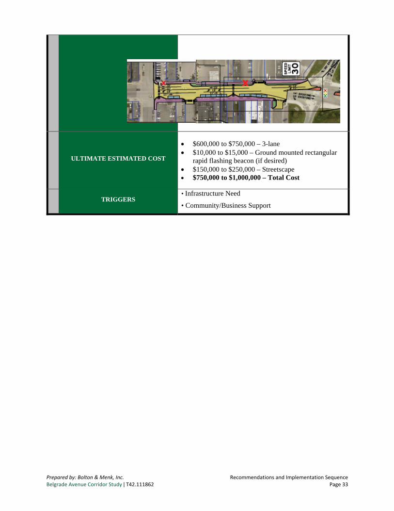
The estimated cost of the 3-lane options are approximately $750,000 - $1,000,000. This includes the 3-lane configuration, ground mounted rectangular rapid flashing beacon, and streetscape enhancements.
During the corridor study’s outreach process, there was public and business support for the elements of a 3-lane option. This was shown in the support for wider sidewalks, improved pedestrian crossings and additional space for streetscape enhancements. Some business owners were concerned about change and the impact of construction on their business operations. The Steering Committee expressed support for a future 3-lane option as it is the option that most closely aligns with the vision of the Central Business District.
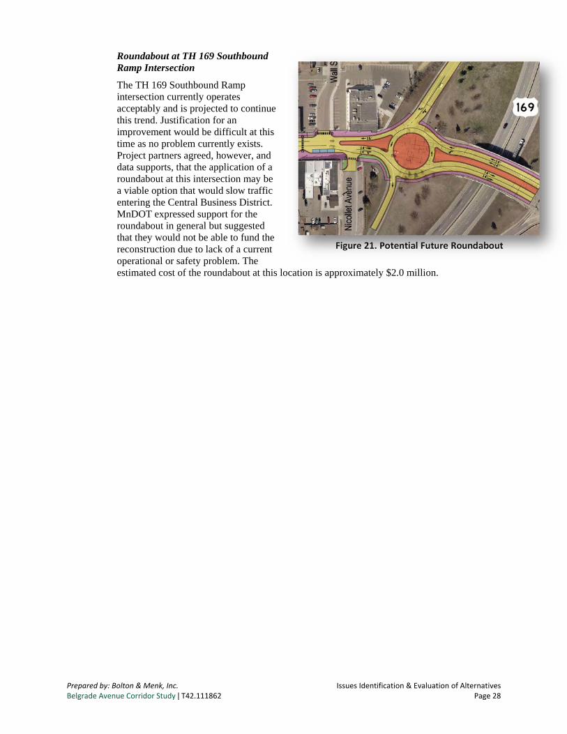
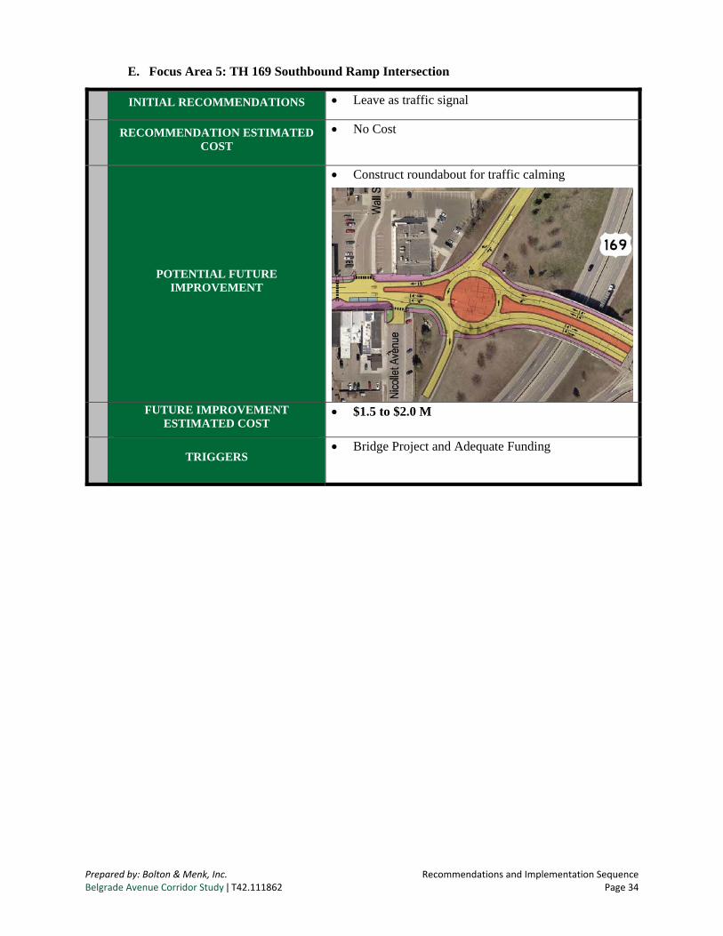
E. Focus Area 5: TH 169 Southbound Ramp Intersection
There are no traffic operational issues at this location today or projected into the future. However, this intersection provides the gateway to downtown North Mankato and is the primary location where speeds into the 200 Block are perceived as excessive. Figure 21 shows a roundabout option that was considered at this location as a measure to calm traffic transition from the Veteran’s Memorial Bridge to downtown.
Prepared by: Bolton & Menk, Inc. Issues Identification & Evaluation of Alternatives Belgrade Avenue Corridor Study ǀ T42.111862 Page 28
Roundabout at TH 169 Southbound Ramp Intersection
The TH 169 Southbound Ramp intersection currently operates acceptably and is projected to continue this trend. Justification for an improvement would be difficult at this time as no problem currently exists. Project partners agreed, however, and data supports, that the application of a roundabout at this intersection may be a viable option that would slow traffic entering the Central Business District. MnDOT expressed support for the roundabout in general but suggested that they would not be able to fund the reconstruction due to lack of a current operational or safety problem. The estimated cost of the roundabout at this location is approximately $2.0 million.
Figure 21. Potential Future Roundabout
Prepared by: Bolton & Menk, Inc. Recommendations and Implementation Sequence Belgrade Avenue Corridor Study ǀ T42.111862 Page 29
X. RECOMMENDATIONS AND IMPLEMENTATION SEQUENCE
Some of the improvements identified in this study are directly related to existing and/or safety issues on Belgrade Avenue. Others are related to an opportunity to enhance Belgrade Avenue for both motorized and non-motorized uses consistent with the Belgrade Avenue Master Plan. The following recommendations are organized into an implementation sequence for the City’s consideration. This will allow the City to take incremental steps over time, ultimately working towards a corridor that operates safely and efficiently and compliments their downtown vision.
A. Focus Area 1: Lee Boulevard Intersection
INITIAL RECOMMENDATION
Continue to monitor intersection operations and safety conditions
RECOMMENDATION ESTIMATED COST
No Cost
ULTIMATE RECOMMENDATION
Construct a roundabout
ULTIMATE RECOMMENDATION ESTIMATED COST
$1.5 Millon
TRIGGERS
Increased crashes/Safety Concern
Delay worsens
Prepared by: Bolton & Menk, Inc. Recommendations and Implementation Sequence Belgrade Avenue Corridor Study ǀ T42.111862 Page 30
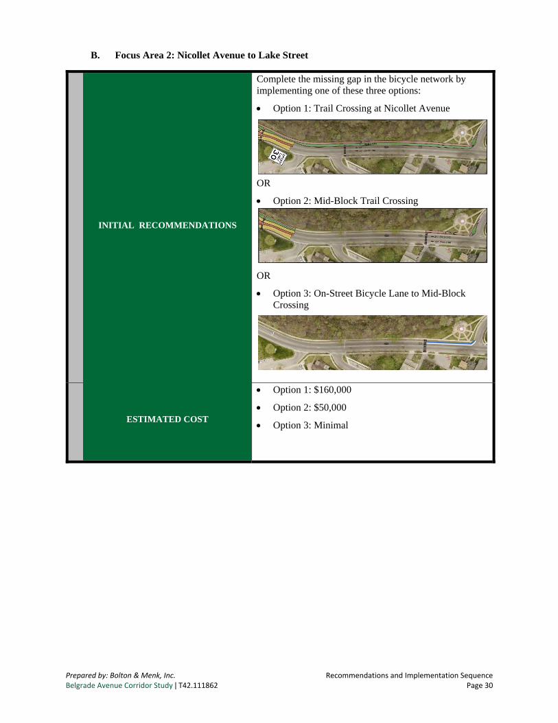
B. Focus Area 2: Nicollet Avenue to Lake Street
INITIAL RECOMMENDATIONS
Complete the missing gap in the bicycle network by implementing one of these three options:
Option 1: Trail Crossing at Nicollet Avenue
OR
Option 2: Mid-Block Trail Crossing
OR
Option 3: On-Street Bicycle Lane to Mid-Block Crossing
ESTIMATED COST
Option 1: $160,000
Option 2: $50,000
Option 3: Minimal
Prepared by: Bolton & Menk, Inc. Recommendations and Implementation Sequence Belgrade Avenue Corridor Study ǀ T42.111862 Page 31
C. Focus Area 3: Intersection between Lake Street and Range Street
INITIAL RECOMMENDATIONS
Test a bump-out with temporary materials such as paint or striping and traffic cones. Seek public feedback on improvement after the trial period
Continue to monitor intersection safety for pedestrian and bicycles
INITIAL ESTIMATED COST $900 per test bump-out
ULTIMATE RECOMMENDATION
If test is successful, install bump-outs on Belgrade Avenue between Lake Street and Range Street in the locations identified below. These locations are noted in order of priority if the City chooses to install bump-outs incrementally rather than all at one time.
Sherman Street – Highest priority location as pedestrian crashes are documented at this location with severity rates higher than average
Center Street – Provides access to School/Wheeler Park
Cross Street – Provides access to Wheeler Park
Cornelia Street – If bump-outs are installed at the locations above, Cornelia Street should also be considered for corridor consistency
ULTIMATE RECOMMENDATION ESTIMATED COST
$40,000 per intersection
TRIGGERS
Support for bump-outs following a trial period, OR
Continued and/or increased pedestrian crossing safety concerns
Prepared by: Bolton & Menk, Inc. Recommendations and Implementation Sequence Belgrade Avenue Corridor Study ǀ T42.111862 Page 32
D. Focus Area 4: 200 Block (Range Street to TH 169 Southbound Ramp)
INITIAL RECOMMENDATION
Allow left turns onto Nicollet Avenue during events
Test bump-outs with temporary materials to determine community/business support
If community/business support exists after testing bump-outs, implement a 4-lane improvement as shown below. This improvement includes the closure of two driveways, construction of a mid-block crossing with bump-out and Range Street crossing with bump-out
INITIAL ESTIMATED COST
$2,000 for bump-out test
$25,000 for permanent installation of both bump-outs
When pavement conditions dictate the need for a more extensive reconstruction project in the 200 Block, re-evaluate whether or not the 4-lane improvements identified above have adequately addressed the community and business needs of the downtown and vision of the Belgrade Avenue Master Plan.
If additional traffic calming measures, pedestrian environment improvements and streetscape space is desired, implement a 3-lane configuration with an all-way stop at Range Street, left turn at Nicollet Avenue, and streetscape improvements. This option is strongly supported by the Steering Committee as it most closely alignes with the future vision of the Centeral Business District as outlined in the Belgrade Master Plan.
Prepared by: Bolton & Menk, Inc. Recommendations and Implementation Sequence Belgrade Avenue Corridor Study ǀ T42.111862 Page 33
ULTIMATE ESTIMATED COST
$600,000 to $750,000 – 3-lane $10,000 to $15,000 – Ground mounted rectangular
rapid flashing beacon (if desired) $150,000 to $250,000 – Streetscape $750,000 to $1,000,000 – Total Cost
TRIGGERS • Infrastructure Need
• Community/Business Support
Prepared by: Bolton & Menk, Inc. Recommendations and Implementation Sequence Belgrade Avenue Corridor Study ǀ T42.111862 Page 34
E. Focus Area 5: TH 169 Southbound Ramp Intersection
INITIAL RECOMMENDATIONS Leave as traffic signal
RECOMMENDATION ESTIMATED COST
No Cost
POTENTIAL FUTURE IMPROVEMENT
Construct roundabout for traffic calming
FUTURE IMPROVEMENT ESTIMATED COST
$1.5 to $2.0 M
TRIGGERS
Bridge Project and Adequate Funding
Prepared by: Bolton & Menk, Inc. Next Steps Belgrade Avenue Corridor Study ǀ T42.111862 Page 35
XI. NEXT STEPS
The recommendations and implementation section of this report outline an implementation sequence for the City’s consideration. The intent of the implementation sequence is to allow the City of North Mankato to incrementally test and implement projects over time. This will allow gradual change to occur while testing community/business support along the way, ultimately working towards the city’s downtown vision. It also allows flexibility in timing major improvements with future infrastructure needs to ensure financial responsibility.
Additional design, studies and public input will be needed for each of the recommended improvement options to move forward. The purpose of the Belgrade Avenue Corridor Study was to develop a plan for improvements to Belgrade Avenue that are consistent with the goals and objectives of both the City’s Comprehensive Plan and the Belgrade Avenue Master Plan. The concepts developed as part of this study are high-level and will need additional refinement through preliminary and final design. Environmental review and permitting will also be required with exact requirements based on the scope of the project and the funding source.
The improvement options identified within this study and sequenced in the implementation plan will help the City of North Mankato continue to maintain a functioning yet safe minor arterial roadway supporting the City’s downtown vision.
Study partners must continue to work together to further plan, obtain funding, design, and implement the recommended improvement projects. All partners have an active role in implementing these improvements. All competitive funding sources should be considered. Agencies should also update their comprehensive and transportation plans to include these findings to better leverage funding sources.