98
Manningham Municipal Fire Management Plan

Manningham Municipal Fire Management Plan
Manningham Municipal Fire Management Plan 2
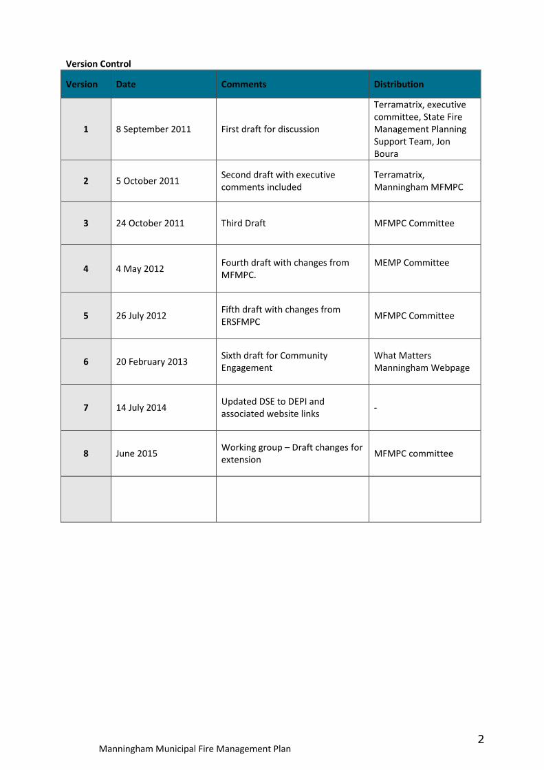
Version Control
Version Date Comments Distribution
1 8 September 2011 First draft for discussion
Terramatrix, executive
committee, State Fire
Management Planning
Support Team, Jon
Boura
2 5 October 2011 Second draft with executive
comments included
Terramatrix,
Manningham MFMPC
3 24 October 2011 Third Draft MFMPC Committee
4 4 May 2012 Fourth draft with changes from
MFMPC.
MEMP Committee
5 26 July 2012 Fifth draft with changes from
ERSFMPC MFMPC Committee
6 20 February 2013 Sixth draft for Community
Engagement
What Matters
Manningham Webpage
7 14 July 2014 Updated DSE to DEPI and
associated website links -
8 June 2015 Working group – Draft changes for
extension MFMPC committee
Manningham Municipal Fire Management Plan 3
Acknowledgements
The Municipal Fire Management Planning Committee acknowledges and thanks all those that assisted in the
development of this plan throughout the consultation process and those who supplied agency specific
information for this publication.
Photos supplied by MFB, Manningham City Council, and ParksVic.
Designed and printed by Courtney – www.courtneycolour.com.au

Manningham Municipal Fire Management Plan 4
Authorisation This Municipal Fire Management Plan was adopted as the first iteration of the Manningham Municipal Fire Management Plan, in partnership with the agencies listed below. Include new authorisation sheet Jamie Hansen Chair MFMPC & CFA Operations Officer District 13 Tony McCoy MFB Commander Community Resilience Helen Napier Municipal Emergency Management Coordinator Gavin Tyler Municipal Fire Prevention Officer Mike Cusack Ranger in Charge Parks Victoria Meg Downie Chair Manningham MEMPC
Manningham Municipal Fire Management Plan 5
Acronyms
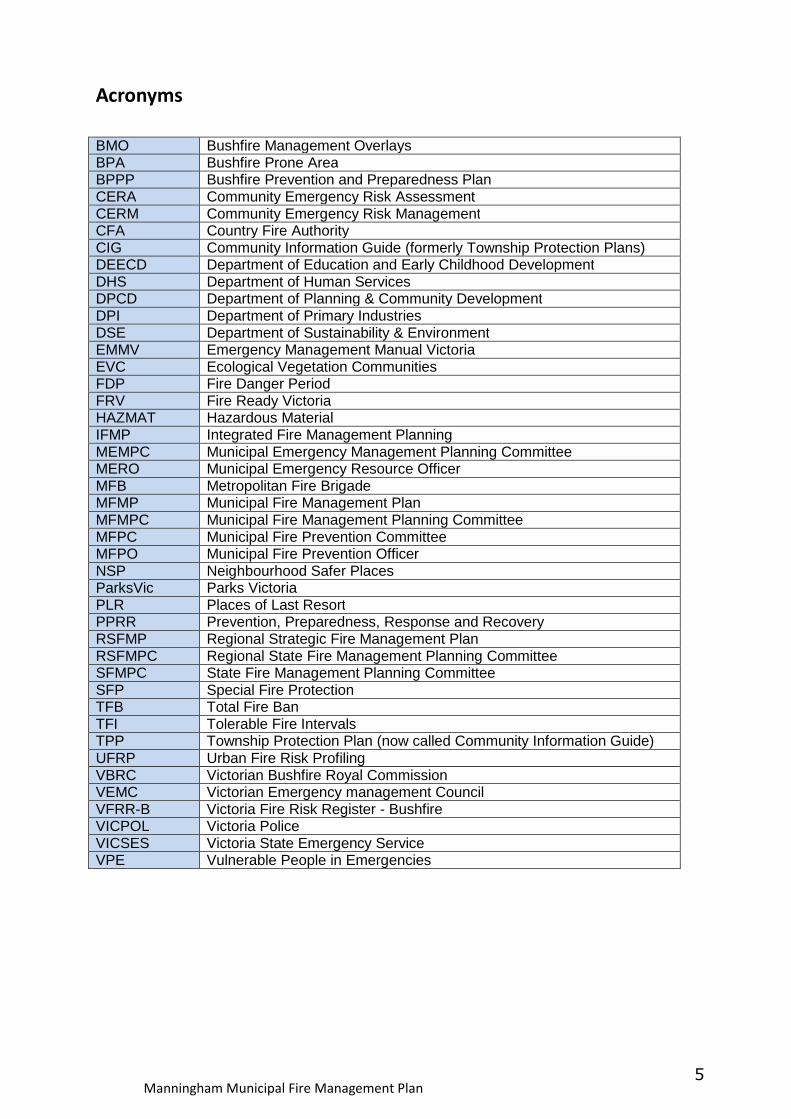
BMO Bushfire Management Overlays BPA Bushfire Prone Area BPPP Bushfire Prevention and Preparedness Plan CERA Community Emergency Risk Assessment CERM Community Emergency Risk Management CFA Country Fire Authority CIG Community Information Guide (formerly Township Protection Plans) DEECD Department of Education and Early Childhood Development DHS Department of Human Services DPCD Department of Planning & Community Development DPI Department of Primary Industries DSE Department of Sustainability & Environment EMMV Emergency Management Manual Victoria EVC Ecological Vegetation Communities FDP Fire Danger Period FRV Fire Ready Victoria HAZMAT Hazardous Material IFMP Integrated Fire Management Planning MEMPC Municipal Emergency Management Planning Committee MERO Municipal Emergency Resource Officer MFB Metropolitan Fire Brigade MFMP Municipal Fire Management Plan MFMPC Municipal Fire Management Planning Committee MFPC Municipal Fire Prevention Committee MFPO Municipal Fire Prevention Officer NSP Neighbourhood Safer Places ParksVic Parks Victoria PLR Places of Last Resort PPRR Prevention, Preparedness, Response and Recovery RSFMP Regional Strategic Fire Management Plan RSFMPC Regional State Fire Management Planning Committee SFMPC State Fire Management Planning Committee SFP Special Fire Protection TFB Total Fire Ban TFI Tolerable Fire Intervals TPP Township Protection Plan (now called Community Information Guide) UFRP Urban Fire Risk Profiling VBRC Victorian Bushfire Royal Commission VEMC Victorian Emergency management Council VFRR-B Victoria Fire Risk Register - Bushfire VICPOL Victoria Police VICSES Victoria State Emergency Service VPE Vulnerable People in Emergencies
Manningham Municipal Fire Management Plan 6
Contents (page numbers to be updated) Acronyms .............................................................................................................................. 5
Contents .............................................................................................................................. 6
1 Introduction .................................................................................................................. 8
1.1 Context .................................................................................................................................... 8
1.2 Core membership of the Manningham Municipal Fire Management Planning Committee .. 9
1.3 Authority for the plan and planning process ......................................................................... 10
1.4 Plan endorsement, adoption and audit................................................................................. 10
1.5 Period of the plan .................................................................................................................. 10
1.6 Plan review ............................................................................................................................ 11
1.7 Summary of the plan preparation process ............................................................................ 11
2 Engagement and communications ................................................................................ 12
2.1 Community engagement ....................................................................................................... 12
2.2 Communications .................................................................................................................... 13
2.3 Submissions ........................................................................................................................... 13
2.4 Stakeholder analysis .............................................................................................................. 13
2.5 Communication and engagement principles ........................................................................ 14
2.6 Stakeholder communications objectives .............................................................................. 14
3 Summary of the Environmental Scan ............................................................................ 16
3.1 Location ................................................................................................................................. 16
3.2 Natural environment ............................................................................................................. 17
3.3 Demographics ........................................................................................................................ 18
3.4 Fire management implications .............................................................................................. 20
3.5 Specific risk locations ............................................................................................................. 27
3.6 Future fire management implications ................................................................................... 27
3.7 History of fire ......................................................................................................................... 28
4 Municipal fire management objectives ......................................................................... 30
4.1 Manningham MFMPC objectives: ......................................................................................... 30
4.2 Purpose .................................................................................................................................. 30
4.3 Aligning with the Eastern Metropolitan Regional Strategic Fire Management objectives ... 30
4.4 Broader purpose of the Manningham Municipal Fire Management Plan ............................ 31
4.5 Strategic directions ................................................................................................................ 32
4.6 Links to other business planning and programs .................................................................... 32
5 Fire risk management strategies................................................................................... 33
5.1 Risk identification .................................................................................................................. 33
5.2 Precincts ................................................................................................................................ 35
5.3 Risk assessment ..................................................................................................................... 39
5.4 Victorian Fire Risk Register – Bushfire (VFRR-B) .................................................................... 41
5.5 Community Information Guides (formerly Township Protection Plans TPPs) ...................... 42
5.6 Neighbourhood Safer Places ................................................................................................. 43
5.7 Community Fire Refuges ....................................................................................................... 43
5.8 Hazardous trees ..................................................................................................................... 43
5.9 Council Incentives.................................................................................................................40
6 Plan reporting and review ............................................................................................ 44
6.1 Plan endorsement and adoption ........................................................................................... 44
6.2 Plan audit and review ............................................................................................................ 45
6.3 Reporting on plan outcomes ................................................................................................. 45
Appendices 46
A.1 Victorian Fire Risk Register – Bushfire (VFRR-B) ..................................................................... 46
A.2 Structure Fire Risk Management Register .............................................................................. 54
A.3 Hazardous Materials Risk Management Register ............................................................ 65
Manningham Municipal Fire Management Plan 7
B.1 Multi Agency Action Plan ...................................................................................................... 67
B.2 VFRR Treatment Plan
C. 1 Hazardous trees ..................................................................................................................... 68
C. 2 Community Information Guides (formerly Township Protection Plans) ............................... 73
C. 3 Neighbourhood Safer Places (NSP) ........................................................................................ 73
C.4 Community Fire Refuges ......................................................................................................... 73
D.1 Community engagement work plan ....................................................................................... 74
D.2 Stakeholder Matrix ................................................................................................................. 86
D.3 List key stakeholders - based on the IAP2 spectrum in the Community Consultation and
Engagement Policy (2010) ............................................................................................................ 88
E. Maps .......................................................................................................................................... 92
Bibliography 93
Manningham Municipal Fire Management Plan 8
1 Introduction South-east Australia is one of the most fire prone areas in the world. Compounding factors such as recent drought, climate change and increasing population living in high risk areas put our communities at risk of being exposed to bushfire. The Black Saturday bushfires of February 2009 remain a constant reminder of why we should plan for unplanned fire events in the landscape. Whilst careful attention needs to be given to the management of bushfire risk in Victoria, many lives are lost every year as a result of structure fires and other fire related incidents in our community. As such, this plan considers all fire hazards in the urban and rural environments. Approaches to fire management need to be based on robust risk assessment processes. This plan includes an analysis of fire related risk and identification of relevant treatments for increased safety. It places emphasis on integrated sustainable management solutions across differing land tenures and land uses. Effective and efficient fire management is built on past learning, continuous improvement and requires the commitment of all stakeholders with responsibilities for land and fire management and the welfare of all members of the community, particularly those vulnerable to the impacts of fire. As such Victoria’s fire agencies play a significant role in supporting communities to build self-reliance and resilience. The best results in fire management can be achieved through the empowerment of communities to make appropriate decisions in planning for and responding to the threat of fire in the landscape and in their homes and businesses.
1.1 Context This Manningham Municipal Fire Management Plan (MFMP) will replace the current Municipal Fire Prevention Plan (MFPP) as new fire planning arrangements are introduced across the State of Victoria. The Manningham MFMP is a sub plan of the Manningham Municipal Emergency Management Plan (MEMP). It is a significant part of the Victorian Government’s Integrated Fire Management Planning (IFMP) process. IFMP aims to achieve a consistent and effective means for fire management planning within Victoria through a commitment to cooperation, including information sharing and the building of collective knowledge. IFMP operates at the State, regional, municipal and local (in some areas) levels. Each level has different objectives, these are as follows. State The State Fire Management Strategy 2009 provides the guidance for a combined and organised effort in lowering the risk of fire through cooperative principles in the State of Victoria. Region The Eastern Metropolitan Regional Strategic Fire Management Plan (RSFMP) provides the risk management requirements and quantifies the need for planning at municipal level involving an all agency approach, while embracing the broader community and stakeholders. Municipal
Manningham Municipal Fire Management Plan 9
Municipal Fire Management Plans (MFMP) provide a consistent approach to fire management planning within the municipal area through commitment to cooperation, including sharing and building of collective knowledge and experience at the municipal level. This is done through the Municipal Fire Management Planning Committee (MFMPC) who work collaboratively to achieve the following planning outcomes:
• The implementation of common planning models and methodologies; • Allocation of resources and accountabilities; • Participation in common decision making through the committee process; • Collaborative delivery of fire management activities; and • Cooperative engagement.
The Manningham MFMP is a sub plan of the Manningham MEMP, is risk based and has been developed using principles outlined in the IFMP Framework (2010) and IFMP Guidelines (2010), and the Guidelines for Municipal Fire Management Planning, Part 6A: Emergency Management Manual Victoria (2011). Critical to the success of IFMP is the ongoing building and maintaining of relationships across government, the private sector and the broader community. Participation, support and cooperative decision making by all these sectors working in collaboration to develop fire strategies, programs and plans for all types of fire risk, and meeting the needs of local communities are essential for effective implementation of IFMP. The Manningham MFMP is an integrated plan combining plans from the Manningham City Council, the Department of Sustainability and Environment (DSE), Parks Victoria (ParksVic) Country Fire Authority (CFA), Metropolitan Fire Brigade (MFB) VicRoads and other key stakeholders.
1.2 Core membership of the Manningham Municipal Fire Management Planning Committee
The Municipal Fire Management Planning Committee (MFMPC), appointed by the Municipal Emergency Management Planning Committee (MEMPC), has representation from the following organisations:
• Manningham City Council • MFB • CFA • PARKS VIC/DSE
Advisory agencies may also attend to give their expert advice. These agencies may include:
• Victoria Police • VicRoads • DHS • Melbourne water • SPAusnet
The MFMPC has the following role:
• Identifying and prioritising the risks and vulnerabilities across the municipal area;
• Reducing the likelihood and consequence of fire hazards within local communities;
• Management of local priorities relating to protection of communities and assets;
Manningham Municipal Fire Management Plan 10
• Development and implementation of works programs for the management of fires, including hazard removal and fuel management;
• Community engagement activities; • Identification of reliable water supplies; • Encouragement of increased responsibility by the community; • Consideration of planning across municipal boundaries; and • Elevation of matters to the regional fire management planning committee.
All agencies and organisations with responsibilities under the MFMP have provided written confirmation of their capability and commitment to meet their obligations as specified and agreed in the plan. The ‘all agencies’ aspect of Victoria’s emergency management arrangements recognises however that all agencies; not just those MFMPC members have a role in fire management and protecting the community from fire risk.
1.3 Authority for the plan and planning process Authority for this plan is derived from the Emergency Management Act 1986 (S21(5)). In the country area of Victoria, a MFMP prepared and endorsed in compliance with the guidelines contained within Part 6A of the Emergency Management Manual Victoria (EMMV), will be deemed to fulfil section 55A of the Country Fire Authority (CFA) Act 1958. The Council’s fire prevention responsibilities derive from the Country Fire Authority Act, 1958 and Metropolitan Fire Brigades (MFB) Act, 1958 and are to take all practical steps (including burning) to prevent the occurrence of fires on, and minimise the danger of spread of fires on and from land under its control or management (CFA Act, s.43; MFB Act, s.5 (1) (a)). The MFMPC has replaced the Municipal Fire Prevention Committee (MFPC) which is constituted under s.54 of the CFA Act to undertake a range of functions including advising Council on the existence and management of hazards and making recommendations in the preparation of the Municipal Fire Prevention Plan (MFPP) (CFA Act, s.55). This plan is consistent with Action 1.1.7 of the Manningham Council Plan 2009-2013 and fulfils all legislative fire prevention requirements.
1.4 Plan endorsement, adoption and audit This MFMP has been completed to the satisfaction of the committee. The MFMPC and MEMPC have endorsed this MFMP. After the MFMP was endorsed by the MFMPC and the MEMPC, it was be sent to the Regional Strategic Fire Management Planning Committee (RSFMPC) for comment. Following community engagement due to commence in early 2013 this MFMP will be recommended to Manningham City Council for adoption. This MFMP adopted by council will be deemed to meet the requirements of a municipal fire prevention plan pursuant to s55A(1) of the CFA Act, provided that it contains the provisions as set out in s55(A)2.The MFMP will be audited in accordance to s.55B of the CFA Act 1958, triennially, by the CFA’s Fire Prevention Improvement Officer.
1.5 Period of the plan The Manningham MFMP has a three year planning cycle. It will be reviewed on a 12 monthly basis after the final adoption of the plan by Manningham MEMP.
Manningham Municipal Fire Management Plan 11
1.6 Plan review The plan is reviewed and updated annually by the MFMPC to ensure it meets community needs and expectations. This review takes into account works completed, environmental changes and any additional risks. Any significant changes to the plan should be approved by MFMPC members and articulated through the MEMPC and Council. This MFMP will be reviewed and amended as per the actions listed in the Multi Agency Action Plan Appendix B;
• Annually in association with the MEMP; • Changes to the Victorian Fire Risk Register (VFRR) and the Urban Fire Risk
Profiling (UFRP) tool data will be updated in the plan; • The MFMPC will review the implementation of the treatments applied to
VFRR and UFRP tool identified risks by each agency (as appropriate); • Requirement for additional or alternative treatments to mitigate identified risks
will be assessed; • Following significant incidents if required; • As directed by the State or Regional Fire Management Planning Committees
(SFMPC or RSFMPC’s); and • As required by legislation.
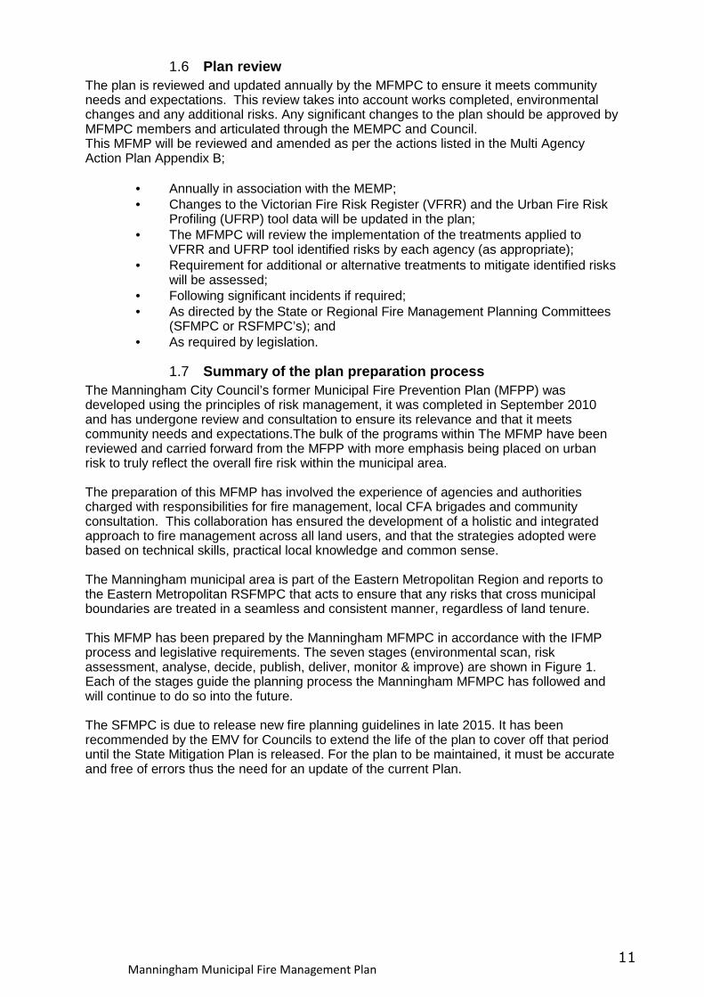
1.7 Summary of the plan preparation process The Manningham City Council’s former Municipal Fire Prevention Plan (MFPP) was developed using the principles of risk management, it was completed in September 2010 and has undergone review and consultation to ensure its relevance and that it meets community needs and expectations.The bulk of the programs within The MFMP have been reviewed and carried forward from the MFPP with more emphasis being placed on urban risk to truly reflect the overall fire risk within the municipal area. The preparation of this MFMP has involved the experience of agencies and authorities charged with responsibilities for fire management, local CFA brigades and community consultation. This collaboration has ensured the development of a holistic and integrated approach to fire management across all land users, and that the strategies adopted were based on technical skills, practical local knowledge and common sense. The Manningham municipal area is part of the Eastern Metropolitan Region and reports to the Eastern Metropolitan RSFMPC that acts to ensure that any risks that cross municipal boundaries are treated in a seamless and consistent manner, regardless of land tenure. This MFMP has been prepared by the Manningham MFMPC in accordance with the IFMP process and legislative requirements. The seven stages (environmental scan, risk assessment, analyse, decide, publish, deliver, monitor & improve) are shown in Figure 1. Each of the stages guide the planning process the Manningham MFMPC has followed and will continue to do so into the future. The SFMPC is due to release new fire planning guidelines in late 2015. It has been recommended by the EMV for Councils to extend the life of the plan to cover off that period until the State Mitigation Plan is released. For the plan to be maintained, it must be accurate and free of errors thus the need for an update of the current Plan.
Manningham Municipal Fire Management Plan 12
Figure 1 – Integrated Fire Management Planning (IFMP) Process
2 Engagement and communications The MFMPC is responsible for developing the Stakeholder and Community Engagement Plan, is committed to consulting with stakeholders and the community to develop and further inform fire management planning. Valuing local knowledge and recognising the unique contribution communities can make to the fire planning process has guided the consultation program. Effective community engagement and education is essential if the vision for the future of fire management in Victoria is to be achieved. This will occur through:
• active participation of community, the fire management sector and government, collaboratively working and planning together to reduce the destructive impact of fire on communities and the environment;
• communities that have greater resilience to the effects of fire; • greater understanding of the fire sector within the community; and • healthy, natural, social, built and economic environments.
The key principles guiding this communications and engagement strategy are transparency, openness and collaboration. The opportunity to align fire planning consultation by key organisations including CFA, MFB, Manningham City Council, VICPOL, ParksVic, and DSE is a key objective of this process.
2.1 Community engagement Community engagement is a high priority for all levels of government. Undertaking, effective community engagement is critical to assisting agencies and communities to better plan, prepare, respond and recover from bushfires.
Manningham Municipal Fire Management Plan 13
A six-week community consultation program will commence in February 2013 (appendix D1). Key elements being considered for this program include:
• community information sessions held in conjunction with Fire Ready Victoria (FRV) meetings targeting high risk communities in Manningham;
• workshops with Community Fire Guard Groups; • inclusion of a cover letter with the distribution of the Community Information
Guide; • briefings with CFA brigade and volunteer members; and • an online engagement program.
2.2 Communications An extensive communications plan will support the consultation program and raise awareness among the general community about the role of the fire management planning in our community. Key communications activities will include:
• media campaign and advertising of consultation program; • direct mail to high-risk communities; • distribution of flyers and posters through community networks; • promotion through Manningham City Council, MFB, CFA, and ParksVic
community networks; and • direct invitation to key stakeholders.
2.3 Submissions The community is invited to submit feedback in response to the MFMP. At the conclusion of consultation period the relevant agency together with the MFMPC will review, assess and respond to community submissions and update this MFMP accordingly.
2.4 Stakeholder analysis The production of the first iteration of Manningham’s MFMP was put together by the MFMPC made up of representatives from Manningham City Council, CFA, MFB and ParksVic. As a sub-plan to Manningham’s MEMP the MFMP was then put before the MEMPC for comment. This committee has broader representation including SES, DHS, DEECD and VICPOL. An initial stakeholder analysis was carried out to identify relevant stakeholders and their level of participation in the MFMP planning process. These stakeholders were divided into three groups depending on their involvement in fire planning within Manningham;
• Primary – permanent MFMPC members; • Secondary – MEMPC members; and • Tertiary – other agencies, organisations or community groups that could have
valuable input towards to the MFMPC Stakeholder engagement and participation is an essential element of fire management planning. Stakeholders are required to participate for a range of reasons, including (but not limited to):
• Legislative responsibilities in relation to fire management; • Leadership;
Manningham Municipal Fire Management Plan 14
• Provision of hazard expertise and technical advice; • Subject to hazard impact – directly and/or indirectly; • Land tenure and management arrangements; • Expressed expectations; and • Influence and/or support mitigation.
The stakeholders involved in fire management planning in the Manningham municipal area are listed in the Stakeholder matrix in Appendix D.2 (Manningham MFMP Stakeholder and Community Engagement Plan). The level of participation in IFMP at the municipal level is dependent upon the number and criticality of assets and level of responsibility they have in fire management. This stakeholder analysis informed the development of the Stakeholder and Community Engagement Plan; which will develop a shared understanding of how communications will occur, when communications will occur and why communications will occur. This will increase efficiencies, reduce duplications and provide consistent messaging through the implementation of IFMP in the Manningham municipal area.
2.5 Communication and engagement principles The Manningham MFMPC Stakeholder and Engagement Matrix (Appendix D.2) contained within the Stakeholder and Community Engagement Plan outlines the level of participation and information they will receive during the plan development, review and reporting phases of the planning and implementation process. This analysis is based upon the principles of International Association for Public Participation 2 (IAP2). Inform Provide appropriate detailed and accurate information to assist stakeholders develop a shared understanding of the complexity of issues, alternatives and possible solutions. Consult Utilise stakeholder expertise and diversity to obtain input into analysis, alternatives and develop key decisions. Involve Work directly with the suite of key stakeholders throughout the various processes to ensure key issues and intent are understood and considered. Collaborate Partner with key stakeholders in each aspect of decision-making. This includes the development of alternatives, the identification of contributions and priority actions with a clear understanding of the responsibilities of each stakeholder. Empower Foster and promote transparent and accountable processes that allow each stakeholder organisation to empower themselves through key actions and the implementation of responsibilities. Appendix D.3 uses these principles and presents the methods that will be used in stakeholder and community engagement.
2.6 Stakeholder communications objectives The achievement of fire management objectives and the success of fire management outcomes will be dependent on effective communications in all planning and implementation phases. A communications plan for the MFMPC will be developed in future iterations of this MFMP. The objectives of this communications plan will be to:
Manningham Municipal Fire Management Plan 15
• Build a collaborative approach to IFMP; • Identify internal communication flows within organisations; • Ensure that communication across agencies is effective in developing a
shared understanding of the issues and key responsibilities and that all agencies deliver a consistent message to the community and their stakeholders;
• Build resilient relationships and sound networks between key stakeholders; • Consult with communities so that local knowledge is captured in the planning
process that this communication plan supports; • Foster better communication and planning between the agencies and local
communities; and • Achieve greater consistency from all levels of government on key policy
issues.
3 Summary of the Environmental Scan
3.1 Location The City of Manningham is located about 12 kilometres east of central Melbourne and covers an area of approximately 114 square kilometres (Map 1). The Manningham municipal area begins at the junction of the Yarra River and Koonung Creek in the west, which forms a natural boundary to the area, with the Yarra River to the north and the Koonung Creek to the south. The municipal area is divided by the Mullum Mullum Creek and the Urban Growth Boundary into two distinct topographic areas. Land to the west of the Mullum Mullum Creek is highly urbanised, while land to the east is primarily semi-rural in character with vegetation contained in both public and private land and along riparian corridors. Residential development is largely focused in areas west of the Mullum Mullum Creek and includes the suburbs of Bulleen, Templestowe, Doncaster, Doncaster East, Donvale and Lower Templestowe. Residential areas located to the east of the creek are comprised of Warrandyte, Park Orchards and Wonga Park. The Manningham MFMPC recognises this diverse mix of environments and Manningham is often referred to as the municipality that encapsulates a “balance of city and country”.
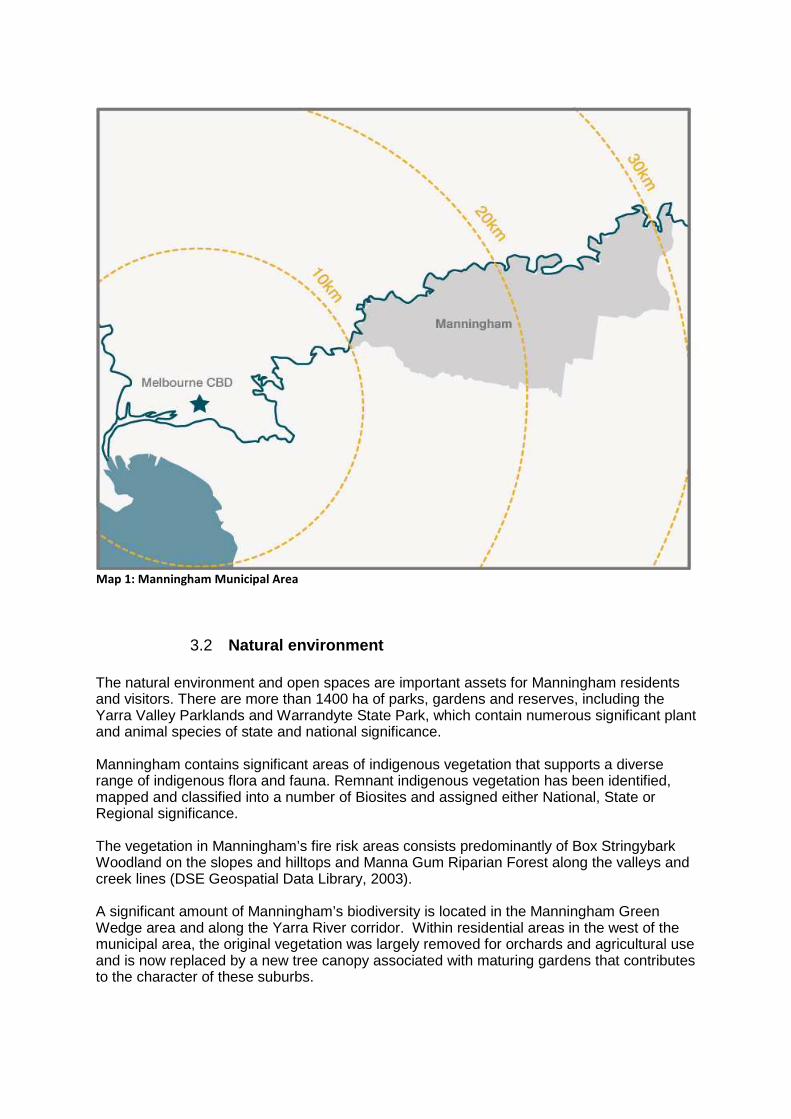
Map 1: Manningham Municipal Area
3.2 Natural environment The natural environment and open spaces are important assets for Manningham residents and visitors. There are more than 1400 ha of parks, gardens and reserves, including the Yarra Valley Parklands and Warrandyte State Park, which contain numerous significant plant and animal species of state and national significance. Manningham contains significant areas of indigenous vegetation that supports a diverse range of indigenous flora and fauna. Remnant indigenous vegetation has been identified, mapped and classified into a number of Biosites and assigned either National, State or Regional significance. The vegetation in Manningham’s fire risk areas consists predominantly of Box Stringybark Woodland on the slopes and hilltops and Manna Gum Riparian Forest along the valleys and creek lines (DSE Geospatial Data Library, 2003). A significant amount of Manningham’s biodiversity is located in the Manningham Green Wedge area and along the Yarra River corridor. Within residential areas in the west of the municipal area, the original vegetation was largely removed for orchards and agricultural use and is now replaced by a new tree canopy associated with maturing gardens that contributes to the character of these suburbs.
Predominant areas of bushfire planning interest cover most of the eastern half of Manningham’s geographic area in the semi-rural Manningham Green Wedge landscape. The eastern section of the municipal area has significantly more vegetation than the west, which is highly urbanised. There are several clusters of small residential lots located in identified high risk bushfire areas. Due to the semi-rural dispersed lot pattern throughout the municipal area much of the eastern half of Manningham is susceptible to bushfires. Furthermore, areas at most bushfire risk are affected by vegetation, environmental and landscape-based overlays which seek to protect vegetation. There are also a number of single access roads and egress constraints, particularly at two bridge crossings of the Yarra River and through streets in the Warrandyte and Wonga Park areas.
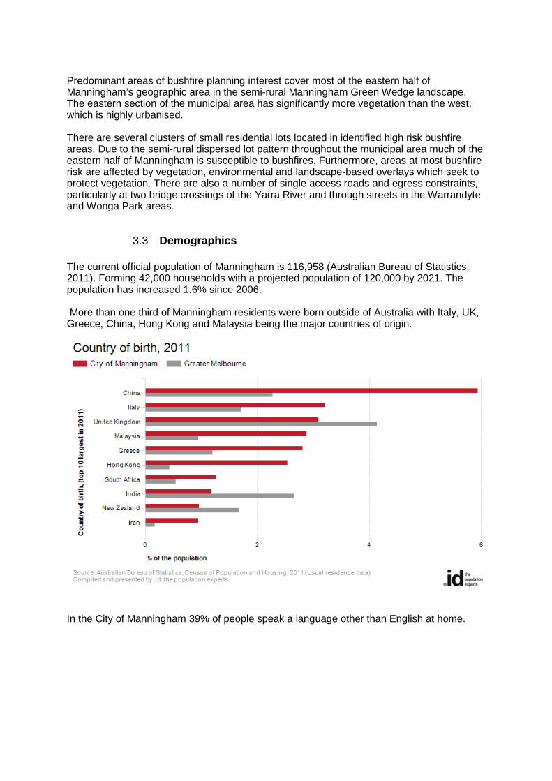
3.3 Demographics The current official population of Manningham is 116,958 (Australian Bureau of Statistics, 2011). Forming 42,000 households with a projected population of 120,000 by 2021. The population has increased 1.6% since 2006. More than one third of Manningham residents were born outside of Australia with Italy, UK, Greece, China, Hong Kong and Malaysia being the major countries of origin.
In the City of Manningham 39% of people speak a language other than English at home.
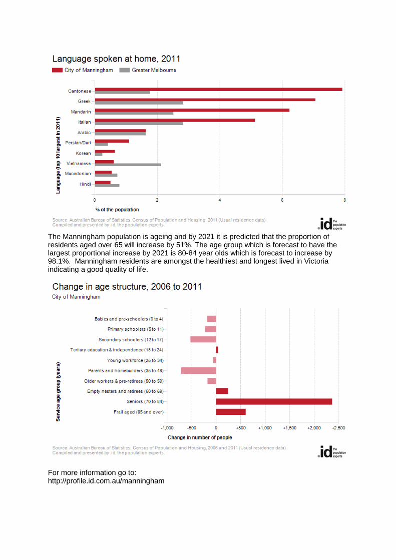
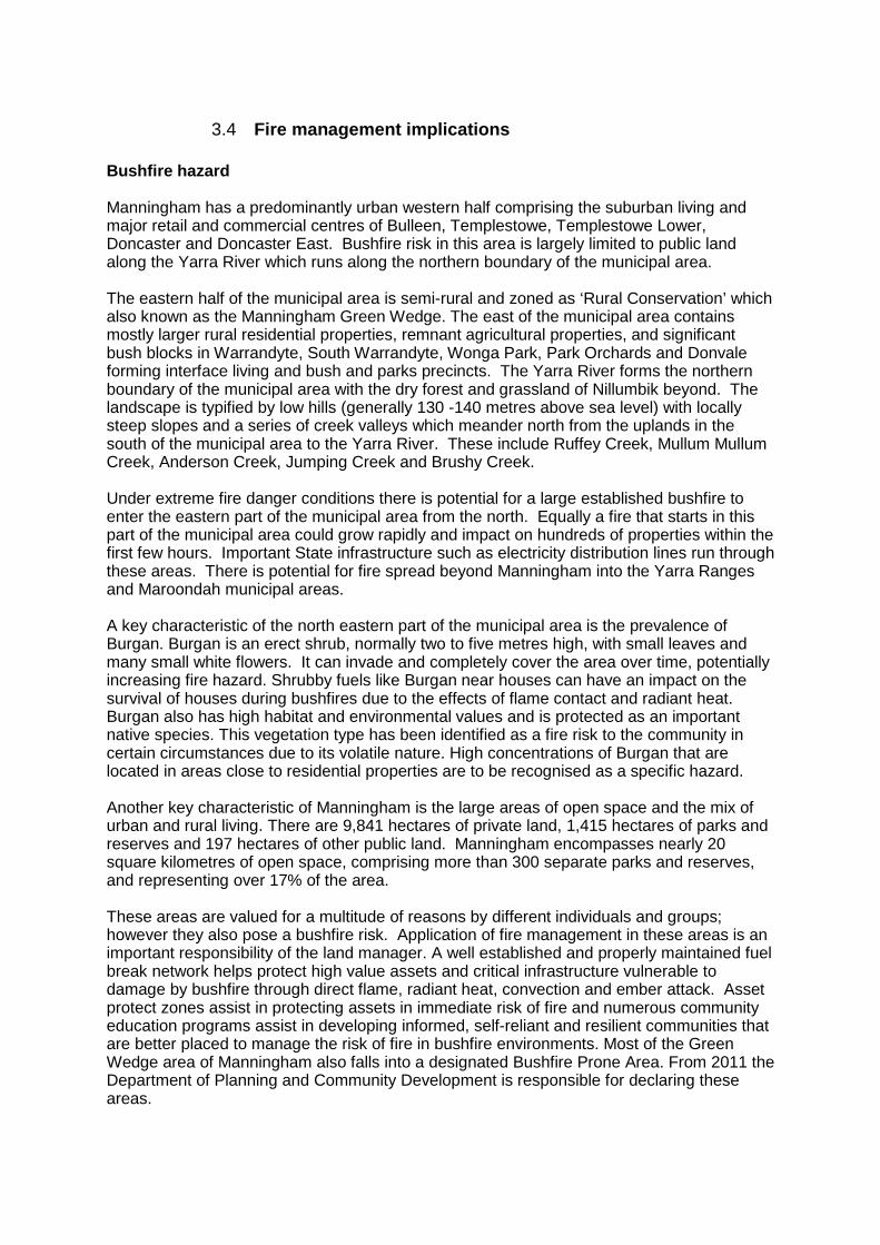
The Manningham population is ageing and by 2021 it is predicted that the proportion of residents aged over 65 will increase by 51%. The age group which is forecast to have the largest proportional increase by 2021 is 80-84 year olds which is forecast to increase by 98.1%. Manningham residents are amongst the healthiest and longest lived in Victoria indicating a good quality of life.
For more information go to: http://profile.id.com.au/manningham
3.4 Fire management implications Bushfire hazard Manningham has a predominantly urban western half comprising the suburban living and major retail and commercial centres of Bulleen, Templestowe, Templestowe Lower, Doncaster and Doncaster East. Bushfire risk in this area is largely limited to public land along the Yarra River which runs along the northern boundary of the municipal area. The eastern half of the municipal area is semi-rural and zoned as ‘Rural Conservation’ which also known as the Manningham Green Wedge. The east of the municipal area contains mostly larger rural residential properties, remnant agricultural properties, and significant bush blocks in Warrandyte, South Warrandyte, Wonga Park, Park Orchards and Donvale forming interface living and bush and parks precincts. The Yarra River forms the northern boundary of the municipal area with the dry forest and grassland of Nillumbik beyond. The landscape is typified by low hills (generally 130 -140 metres above sea level) with locally steep slopes and a series of creek valleys which meander north from the uplands in the south of the municipal area to the Yarra River. These include Ruffey Creek, Mullum Mullum Creek, Anderson Creek, Jumping Creek and Brushy Creek. Under extreme fire danger conditions there is potential for a large established bushfire to enter the eastern part of the municipal area from the north. Equally a fire that starts in this part of the municipal area could grow rapidly and impact on hundreds of properties within the first few hours. Important State infrastructure such as electricity distribution lines run through these areas. There is potential for fire spread beyond Manningham into the Yarra Ranges and Maroondah municipal areas. A key characteristic of the north eastern part of the municipal area is the prevalence of Burgan. Burgan is an erect shrub, normally two to five metres high, with small leaves and many small white flowers. It can invade and completely cover the area over time, potentially increasing fire hazard. Shrubby fuels like Burgan near houses can have an impact on the survival of houses during bushfires due to the effects of flame contact and radiant heat. Burgan also has high habitat and environmental values and is protected as an important native species. This vegetation type has been identified as a fire risk to the community in certain circumstances due to its volatile nature. High concentrations of Burgan that are located in areas close to residential properties are to be recognised as a specific hazard. Another key characteristic of Manningham is the large areas of open space and the mix of urban and rural living. There are 9,841 hectares of private land, 1,415 hectares of parks and reserves and 197 hectares of other public land. Manningham encompasses nearly 20 square kilometres of open space, comprising more than 300 separate parks and reserves, and representing over 17% of the area. These areas are valued for a multitude of reasons by different individuals and groups; however they also pose a bushfire risk. Application of fire management in these areas is an important responsibility of the land manager. A well established and properly maintained fuel break network helps protect high value assets and critical infrastructure vulnerable to damage by bushfire through direct flame, radiant heat, convection and ember attack. Asset protect zones assist in protecting assets in immediate risk of fire and numerous community education programs assist in developing informed, self-reliant and resilient communities that are better placed to manage the risk of fire in bushfire environments. Most of the Green Wedge area of Manningham also falls into a designated Bushfire Prone Area. From 2011 the Department of Planning and Community Development is responsible for declaring these areas.
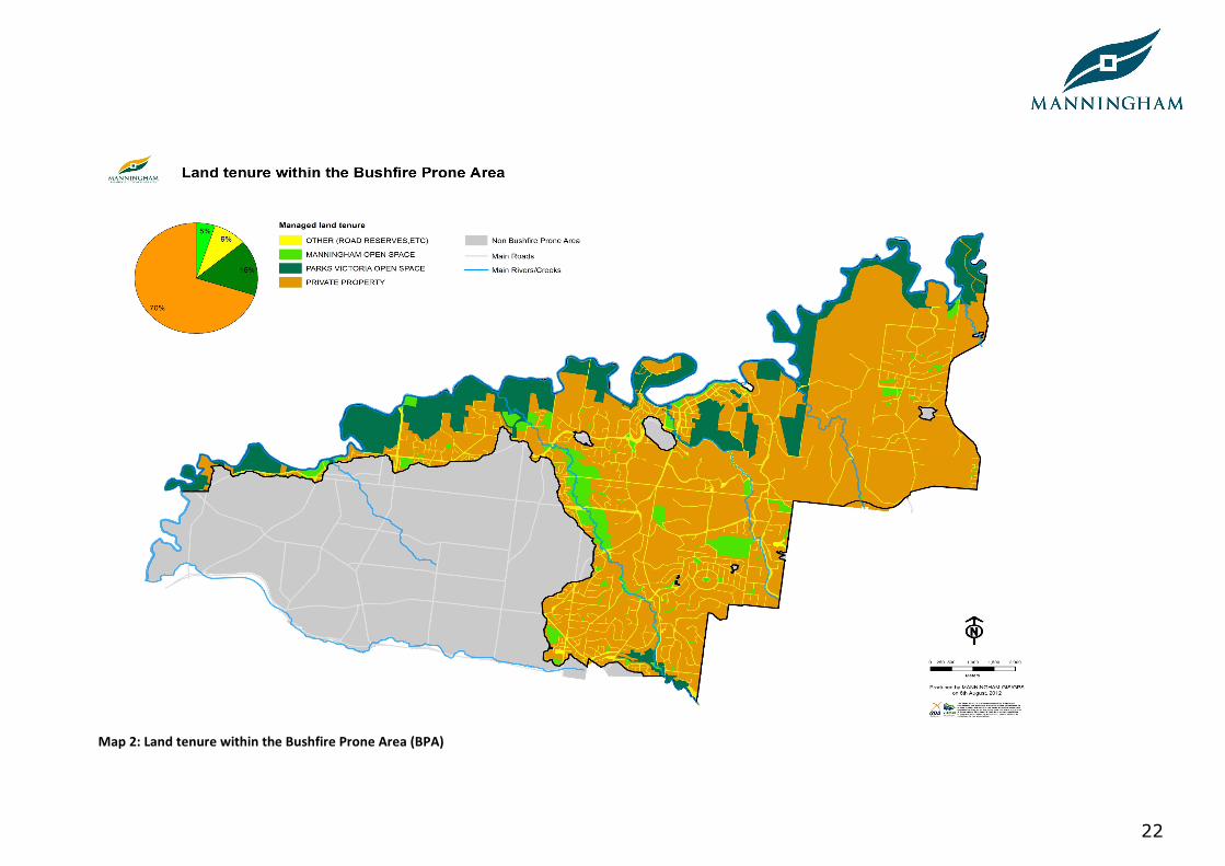
Due to the extent of heavily treed landscapes and dispersed rural communities found across the eastern parts of Manningham, there is a large and scattered population living in heavily vegetated semi-rural environments. Many of these areas are covered by vegetation, environmental and landscape-based planning overlays, which seek to protect native vegetation. Within these non-urban areas of the municipality, there are a number of streets with restricted access and egress. This is due to the pattern of existing roads (both minor unsealed access roads and major arterial roads), being predominantly single carriageways that follow the topography and landscape, in combination with extensive roadside vegetation. There are also broader community access concerns in Warrandyte, relating to the ability of primary road networks to accommodate the evacuation of an area’s population during a fire event.These same concerns may result in emergency fire fighting vehicles and police being unable to respond in certain areas and under certain conditions. Land tenure shown in Map 2 illustrates that over 70% of land within the Manningham BPA is privately held constraining the ability of agencies to directly manage vegetation in certain areas. It is therefore the role of agencies to influence property owners to undertake fire planning on their properties through initiatives like the CFA’s Home Bushfire Advice Service and Community Fireguard and joint education campaigns before and during every fire season.
22
Map 2: Land tenure within the Bushfire Prone Area (BPA)
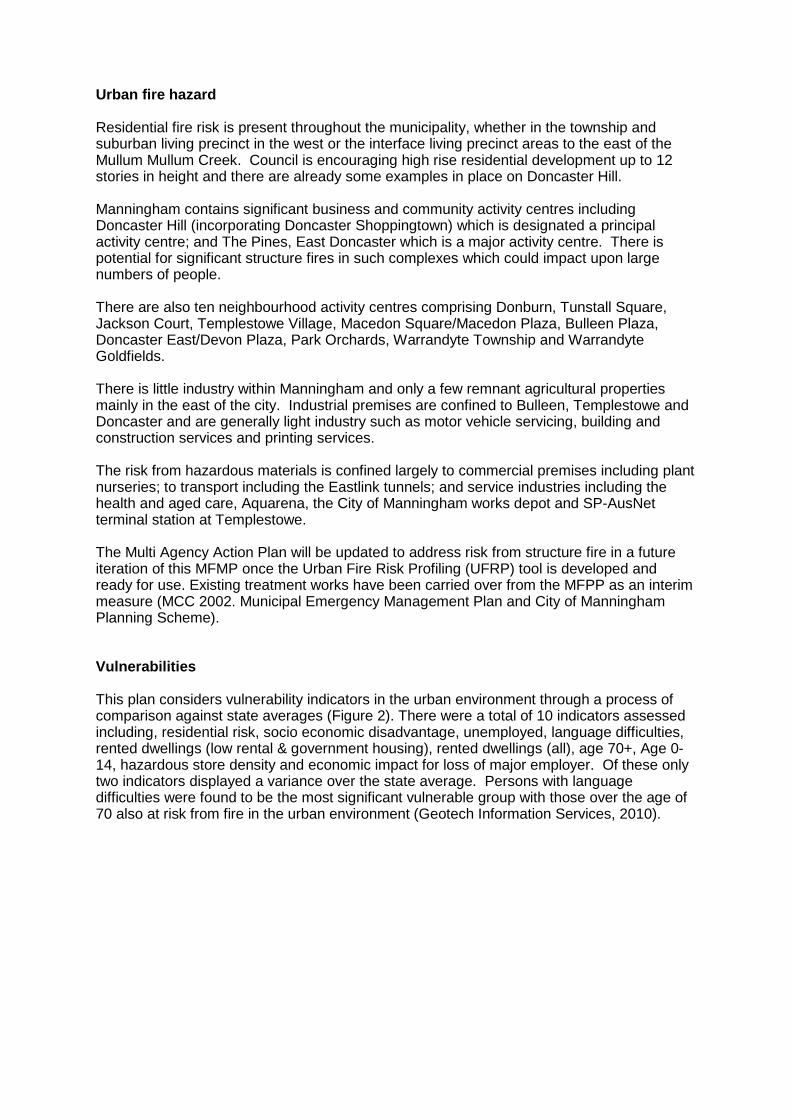
Urban fire hazard Residential fire risk is present throughout the municipality, whether in the township and suburban living precinct in the west or the interface living precinct areas to the east of the Mullum Mullum Creek. Council is encouraging high rise residential development up to 12 stories in height and there are already some examples in place on Doncaster Hill. Manningham contains significant business and community activity centres including Doncaster Hill (incorporating Doncaster Shoppingtown) which is designated a principal activity centre; and The Pines, East Doncaster which is a major activity centre. There is potential for significant structure fires in such complexes which could impact upon large numbers of people. There are also ten neighbourhood activity centres comprising Donburn, Tunstall Square, Jackson Court, Templestowe Village, Macedon Square/Macedon Plaza, Bulleen Plaza, Doncaster East/Devon Plaza, Park Orchards, Warrandyte Township and Warrandyte Goldfields. There is little industry within Manningham and only a few remnant agricultural properties mainly in the east of the city. Industrial premises are confined to Bulleen, Templestowe and Doncaster and are generally light industry such as motor vehicle servicing, building and construction services and printing services. The risk from hazardous materials is confined largely to commercial premises including plant nurseries; to transport including the Eastlink tunnels; and service industries including the health and aged care, Aquarena, the City of Manningham works depot and SP-AusNet terminal station at Templestowe. The Multi Agency Action Plan will be updated to address risk from structure fire in a future iteration of this MFMP once the Urban Fire Risk Profiling (UFRP) tool is developed and ready for use. Existing treatment works have been carried over from the MFPP as an interim measure (MCC 2002. Municipal Emergency Management Plan and City of Manningham Planning Scheme). Vulnerabilities This plan considers vulnerability indicators in the urban environment through a process of comparison against state averages (Figure 2). There were a total of 10 indicators assessed including, residential risk, socio economic disadvantage, unemployed, language difficulties, rented dwellings (low rental & government housing), rented dwellings (all), age 70+, Age 0-14, hazardous store density and economic impact for loss of major employer. Of these only two indicators displayed a variance over the state average. Persons with language difficulties were found to be the most significant vulnerable group with those over the age of 70 also at risk from fire in the urban environment (Geotech Information Services, 2010).
24
Figure 2 - IFMP Risk Overview – Urban Fire Vulnerability Indicators
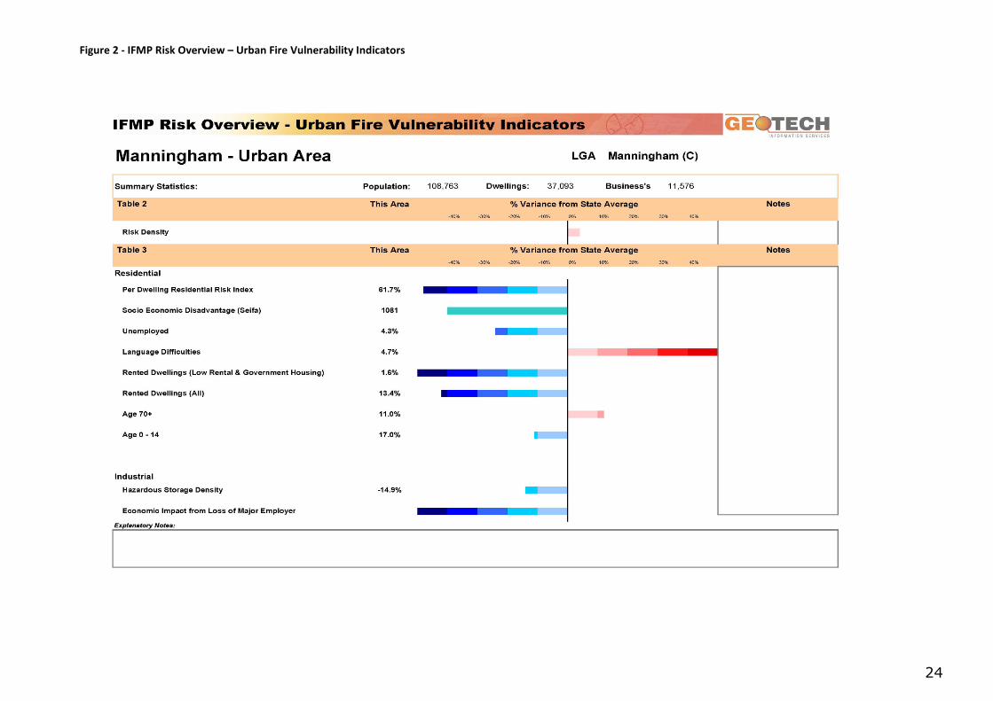
Implications for the Vulnerable People in Emergenci es Program In regard to bushfire, the 2009 Victorian Bushfires Royal Commission recommended that MEMPs contain information relating to vulnerable people. The Manningham MEMP contains information about community organisations already working with vulnerable individuals at the local level and a register of facilities where vulnerable people are likely to be situated – for example aged care facilities, hospitals, schools and child care centres. Victoria Police is the lead agency responsible for facilitating evacuations of vulnerable persons. 5,021 people or 4.5% of the population in the City of Manningham report needing help in their day-to-day lives due to disability. Need for assistance with core activities
City of Manningham 2011 2006 Change
Assistance needed by age group (years)
Number % of total age group
Greater Melbourne Number
% of total age group
Greater Melbourne
2006 to 2011
0 to 4 46 0.9 1.0 38 0.7 0.8 +8 5 to 9 145 2.4 2.5 90 1.4 2.0 +55
10 to 19 218 1.5 2.0 175 1.2 1.5 +43 20 to 59 846 1.5 2.0 734 1.3 1.8 +112 60 to 64 225 3.2 6.1 236 3.3 5.6 -11 65 to 69 300 4.7 7.8 241 3.9 6.9 +59 70 to 74 441 8.0 11.6 346 7.7 10.7 +95 75 to 79 677 16.6 18.7 529 15.5 16.9 +148 80 to 84 822 28.0 28.9 633 28.1 27.9 +189
85 and over 1,301 50.9 48.4 911 46.4 46.9 +390
Total persons needing assistance
5,021 4.5 4.5 3,933 3.6 4.0 +1,088
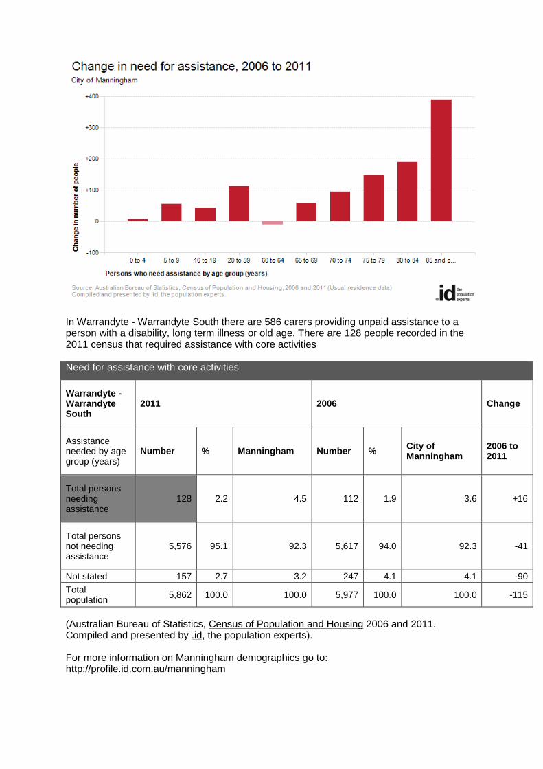
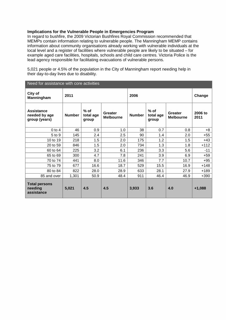
In Warrandyte - Warrandyte South there are 586 carers providing unpaid assistance to a person with a disability, long term illness or old age. There are 128 people recorded in the 2011 census that required assistance with core activities Need for assistance with core activities
Warrandyte - Warrandyte South
2011 2006 Change
Assistance needed by age group (years)
Number % Manningham Number % City of Manningham
2006 to 2011
Total persons needing assistance
128 2.2 4.5 112 1.9 3.6 +16
Total persons not needing assistance
5,576 95.1 92.3 5,617 94.0 92.3 -41
Not stated 157 2.7 3.2 247 4.1 4.1 -90
Total population 5,862 100.0 100.0 5,977 100.0 100.0 -115
(Australian Bureau of Statistics, Census of Population and Housing 2006 and 2011. Compiled and presented by .id, the population experts). For more information on Manningham demographics go to: http://profile.id.com.au/manningham
3.5 Specific risk locations The Manningham municipal area contains a number of specific assets at risk from fire in both the urban and bushfire risk environments. These independent assets are listed separately from grouped assets covered by precincts, urban risk environments and vulnerabilities.
Assets at risk from bushfire have been identified through the Manningham MFMPC and are listed in the Victorian Fire Risk Register (VFFR). The VFRR is a program that assesses risk systematically through the identification of assets at risk from bushfire. The VFRR identifies in particular, human settlement, transmission lines, schools, retirement villages, terminal stations, holiday parks, scout camps and community halls that are all deemed to be at risk from bushfire (Appendix A.1) The Urban Fire Risk Profiling (UFRP) tool also provides a list of specific assets that are exposed to the risk of fire in urban environments across the Manningham municipal area. Detailed lists are contained in the UFRP, Manningham area and surrounds shown in Appendix A.2 (Geotech Information Services 2010). A modified list that considers likelihood and consequence is included in Section 5.3 Fire Risk Management Strategies. Further work will be carried regarding specific assets in the urban environment in future iterations of the MFMP.
3.6 Future fire management implications Doncaster Hill Covering 58 hectares centred on the intersection of Doncaster Road and Williamsons/Tram Road in Doncaster, Doncaster Hill is set to be the civic heart of Manningham. The Doncaster Hill Strategy is a 20-year strategy adopted by Manningham City Council in February 2002. It is the City Council’s response to increased demand for more appropriate, sustainable and diverse housing options that accommodate the municipal area's changing demographic and social needs. Doncaster Hill is envisaged to be a mixed-use sustainable urban village with a strong sense of place and a community-focused lifestyle. Through this strategy Council aims to alleviate concerns over urban growth spreading further into poorly serviced and more sensitive urban and non-urban areas, whilst capitalising on the accessibility, servicing and extraordinary views of the location. The strategy plans to attract 4,000 new residential apartments and five million extra visitors a year. Manningham Green Wedge
Manningham’s eastern areas are covered by vegetation, environmental and landscape-based overlays, which seek to protect native vegetation. The Manningham Green Wedge is one of 12 such zones in Victoria. These are areas of environmental significance where efforts are made to protect and enhance agricultural, environmental, historic, landscape or recreational values, or resources such as minerals or stone. A map of the Green Wedge is in Appendix E.
The Manningham Green Wedge includes parts of the non-urban suburbs of Warrandyte, Warrandyte South, Donvale, Templestowe and Park Orchards, and all of Wonga Park. To date, they have been protected from further subdivision by planning controls, in order to retain the rural character. Most of the Green Wedge area of Manningham also falls into a designated Bushfire Prone Area or Bushfire Management Overlay.
Bushfire Prone Areas (BPA)s and Bushfire Managemen t Overlay (BMO)s
Manningham residents can go online to find out if their property is within a designated Bushfire Prone Area. Go to: www.land.vic.gov.au
Bushfire Prone Areas (BPA) is a state wide building control. Specific bushfire construction standards apply in designated bushfire prone areas in Victoria. These bushfire construction requirements are aimed at improving bushfire protection for residential buildings.
Bushfire Management Overlay (BMO) is a state wide planning and building control. Areas in the BMO are areas that have the highest fire risk and are likely to be particularly exposed to the impact of bushfire. The suitability of new development (including subdivision) in these areas must be fully considered before it proceeds.
More information on the BMO planning scheme maps can be found online at: www.dpcd.vic.gov.au/planningschemes
3.7 History of fire
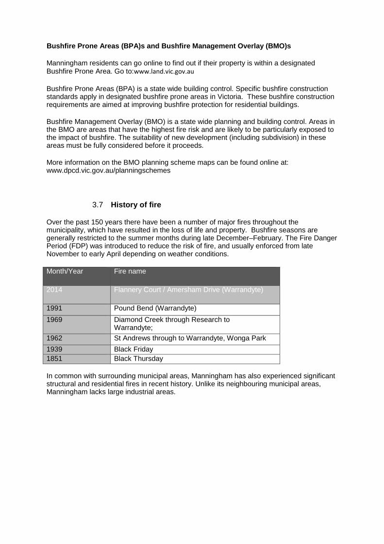
Over the past 150 years there have been a number of major fires throughout the municipality, which have resulted in the loss of life and property. Bushfire seasons are generally restricted to the summer months during late December–February. The Fire Danger Period (FDP) was introduced to reduce the risk of fire, and usually enforced from late November to early April depending on weather conditions.
Month/Year
Fire name
2014 Flannery Court / Amersham Drive (Warrandyte)
1991 Pound Bend (Warrandyte)
1969 Diamond Creek through Research to Warrandyte;
1962 St Andrews through to Warrandyte, Wonga Park
1939 Black Friday 1851 Black Thursday In common with surrounding municipal areas, Manningham has also experienced significant structural and residential fires in recent history. Unlike its neighbouring municipal areas, Manningham lacks large industrial areas.
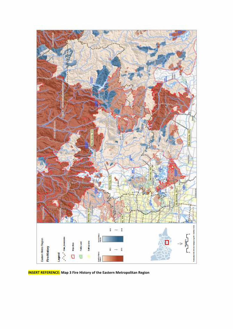
INSERT REFERENCE: Map 3 Fire History of the Eastern Metropolitan Region
4 Municipal fire management objectives Manningham MFMPC chose to adopt some of the visions and values set out in Manningham City Council’s 2009 Council Plan as their fire management objectives. Whilst linking into the overall visions and values of the Manningham City Council, they are also reflective of the key stakeholder agencies values and objectives for fire management.
4.1 Manningham MFMPC objectives: To effectively manage and reduce the risk of fire, with a view to protecting life and property and with due regard to the natural environment; and To align and integrate existing fire management planning and practices across agencies and the community.
4.2 Purpose The purpose of this MFMP is to benefit the people of Manningham by coordinating the planning and implementation of measures necessary to minimise the occurrence of unplanned bushfires, urban fires and incidents and mitigate their impact on the community. Specific fire management objectives for the Manningham municipal area are:
• To reduce the occurrence of unplanned fires and incidents; • To minimise the severity and impact of any fires and incidents on life, property
and the environment in Manningham; • To increase the preparedness and resilience of the community to fire and
incidents; and • To facilitate community recovery from any serious events, and to integrate fire
management with broader emergency management planning in the City of Manningham.
This MFMP focuses on the prevention and community preparedness aspects of the above objectives. Response and recovery arrangements are found in the MEMP and agency operational plans. The MFMPC is a subcommittee of the MEMPC, with overlapping membership of the committees and the two plans reference each other as appropriate.
4.3 Aligning with the Eastern Metropolitan Regional Str ategic Fire Management objectives
Each RSMPC across the state has responsibilities for setting regional objectives. This MFMP aligns with the Eastern Metropolitan RSFMP.
The Eastern Metropolitan RSFMPC endorses the State vision:
Fire management in the Eastern Metropolitan Region that delivers:
• Active participation of community, the sector and government working together in fire management planning to reduce the destructive impact of fire on communities and the environment.
• Communities that are resilient to the effects of fire;

• Greater understanding of the fire sector within the community; and • Healthy natural, social, built and economic environments.
(IFMP State Fire Management Strategy 2009 p. 11)
The Eastern Metropolitan RSFMPC Mission is the RSFM PC’s statement of intent: ‘Agencies of the Eastern Metropolitan region working together with communities to reduce the impact of unplanned fire.’
The Eastern Metropolitan regional strategic fire management objectives were developed in line with the State fire management key themes; planning together; collaborative implementation; building knowledge; building capability; and using fire (State Fire Management Strategy, 2009, pp. 13-15). The Eastern Metropolitan RSFMPC will work towards realising the vision and achieving their mission through the following seven key themes;
1. Committee becomes the driver (lead body) for fire management planning across the region.
2. Building and using knowledge. 3. Working with the community to manage fire. 4. Delivering cross tenure outcomes that address fire risk at a landscape and
regional level. 5. Effective communications and marketing. 6. Continuous improvement. 7. Identifying and treating significant natural, social, built and economic
environments at risk. These key themes provided direction for the Eastern Metropolitan’s RSFMPs key themes and the objectives that specify how a particular area of concern will be addressed. The corresponding action or set of actions for each objective states how the objective is going to be achieved. This information is presented in the Eastern Metropolitan’s RSFMP Action Plan (http://www.ifmp.vic.gov.au/images/plans/eastmetro/Eastern-Metro-Fire_Management-Plan-2011.pdf).
4.4 Broader purpose of the Manningham Municipal Fire Management Plan
The primary aim of the fire management plan is to create greater community awareness and communicate fire management information more effectively. Ultimately, the Manningham MFMPC will share responsibility for implementing the strategies contained within the plan and create a safer municipal area through undertaking the following tasks:
• Ensure that plans and actions are in place (that responsible authorities are advised of actions which the committee deem necessary) for minimising the risk of an outbreak of fire or for suppressing any fire that may occur within the area (Section 55 of the CFA Act 1958);
• Develop programs that are relevant to the community; • Measure fire safety outputs to assess the reduction in community vulnerability
to fire; • Engage community groups and businesses in ongoing dialogue about fire
mitigation solutions including fire prevention activities; and
• Liaise with other agencies and committees to ensure integration and consistency of purpose.
4.5 Strategic directions The strategic direction of the Manningham MFMP aligns with the State Fire Management Strategy (2009) which articulates the vision of future fire management in Victoria as fire management that delivers:
• Active participation of community, the industry and government, working together in fire;
• Fire management planning to reduce the destructive impact of fire on communities and the environment;
• Communities that are resilient to the effects of fire; • Greater understanding of the fire industry within the community, healthy
natural, social, built and economic environments. Also considered in the ongoing development of the fire management plan are the following broad strategy documents: “Living with fire”- Victoria's Bushfire Strategy http://www.justice.vic.gov.au “Bushfire Safety Policy Framework”, (Fire Services Commissioner) http://www.firecommissioner.vic.gov.au “Making Victoria Fire Ready”, (Implementing Governments response to 2009 VBRC) http://www.cfa.vic.gov.au “National Strategy for Disaster Resilience”, Council of Australian Governments http://www.coag.gov.au
4.6 Links to other business planning and programs Important linkages are:
• The State Fire Management Strategy (2009) • Eastern Metropolitan Regional Strategic Fire Management Plan (2011) • Manningham City Council MEMP • Manningham City Council, Bushfire Prevention & Preparedness Plan (BPPP). • DSE Fire Protection Plan • DSE Fire Operation Plan • United Energy Bushfire Mitigation Strategy • SP Ausnet Bushfire Mitigation Strategy • Vic Roads – Roadside Fire management strategy • Neighbouring municipalities fire management plans • VFRR • UFRP tool • Hazard Tree/Electric Line Clearance Program
Other linkages occur through alignment to organisational business planning cycles, agreed data sharing protocols and common risk assessment methodologies.
5 Fire risk management strategies Manningham MFMPC have developed and implemented this plan to reduce the number and the severity of fires within the municipal area with the aim of creating a safer community. **ADD reference to Phoenix modelling and new munici pal report**
5.1 Risk identification This plan assesses risk in accordance with the methodology described in AS/NZS ISO 31000:2009. The MEMPC and MFMPCs have utilised tools based on ISO 31000: 2009 to inform this plan. These tools include: Community Emergency Risk Assessment (CERA) This is a method of managing Municipal wide risks. This process has identified Bushfire, structural fire and hazardous material release as being significant risks in Manningham. Further information can be found at: http://www.ses.vic.gov.au/
Victoria SES is currently reviewing and improving this process which in future will be known as Community Emergency Risk Assessment (CERA). Members of the Manningham MEMPC are involved in the development of this tool. Road Bushfire Risk Assessment Guidelines (DSE, 2009) The purpose of this guideline is to:
Confirm road bushfire management objectives; Outline processes for assessing risk in regards to each objective; Determine the priority for bushfire mitigation works on particular roads; and Provide guidance on selecting appropriate risk treatments.
Further information can be found at: http://www.dse.vic.gov.au/__data/assets/pdf_file/0010/135946/VicRoads-Bushfire-Risk-Assessment-Guideline.pdf Roadside Vegetation Management for Bushfire Risk Mi tigation Purposes (DSE, Feb 2012) The purpose of this guideline is to assist VicRoads and local councils to determine if works involving the removal of native vegetation for bushfire mitigation are exempt from planning scheme requirements under clause 58.02 of the Victoria Planning Provisions (Roadside Works for Bushfire Purposes). The guideline is also designed to assist road mangers to work through a risk assessment process as required by the new exemption. Further information can be found on the Department of Sustainability and Environment website at http://www.dse.vic.gov.au/ Code of Practice for Bushfire Management on Public Land (DSE, Jun 2012) The Code of Practice for Bushfire Management on Public Land establishes the framework for bushfire management (including planned burning and bushfire response) on Victoria's public land. Victorian Fire Risk Register The VFRR is a systematic process that utilises the expertise and local knowledge of a range of organisations and stakeholders in identifying locations and assets at risk from bush or grass fires, then assessing the level of risk and assigning a range of treatments to manage/mitigate the risk. Stakeholders include representatives from Manningham City Council, CFA, MFB, ParksVic, DSE, VICPOL, Melbourne Water and others. Under the VFRR process, assets are grouped into several broad categories—Human Settlement, Economic, Environmental and Cultural Heritage and include residential and
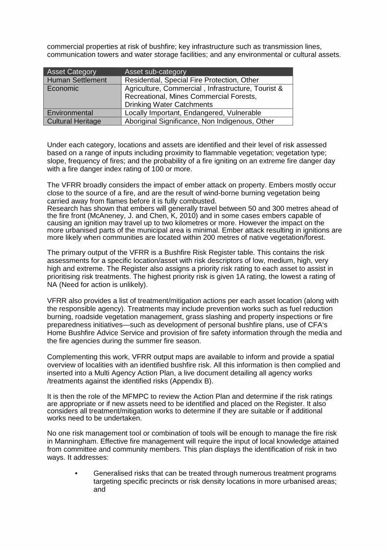
commercial properties at risk of bushfire; key infrastructure such as transmission lines, communication towers and water storage facilities; and any environmental or cultural assets. Asset Category Asset sub-category Human Settlement Residential, Special Fire Protection, Other Economic Agriculture, Commercial , Infrastructure, Tourist &
Recreational, Mines Commercial Forests, Drinking Water Catchments
Environmental Locally Important, Endangered, Vulnerable Cultural Heritage Aboriginal Significance, Non Indigenous, Other Under each category, locations and assets are identified and their level of risk assessed based on a range of inputs including proximity to flammable vegetation; vegetation type; slope, frequency of fires; and the probability of a fire igniting on an extreme fire danger day with a fire danger index rating of 100 or more. The VFRR broadly considers the impact of ember attack on property. Embers mostly occur close to the source of a fire, and are the result of wind-borne burning vegetation being carried away from flames before it is fully combusted. Research has shown that embers will generally travel between 50 and 300 metres ahead of the fire front (McAneney, J. and Chen, K, 2010) and in some cases embers capable of causing an ignition may travel up to two kilometres or more. However the impact on the more urbanised parts of the municipal area is minimal. Ember attack resulting in ignitions are more likely when communities are located within 200 metres of native vegetation/forest. The primary output of the VFRR is a Bushfire Risk Register table. This contains the risk assessments for a specific location/asset with risk descriptors of low, medium, high, very high and extreme. The Register also assigns a priority risk rating to each asset to assist in prioritising risk treatments. The highest priority risk is given 1A rating, the lowest a rating of NA (Need for action is unlikely). VFRR also provides a list of treatment/mitigation actions per each asset location (along with the responsible agency). Treatments may include prevention works such as fuel reduction burning, roadside vegetation management, grass slashing and property inspections or fire preparedness initiatives—such as development of personal bushfire plans, use of CFA‘s Home Bushfire Advice Service and provision of fire safety information through the media and the fire agencies during the summer fire season. Complementing this work, VFRR output maps are available to inform and provide a spatial overview of localities with an identified bushfire risk. All this information is then complied and inserted into a Multi Agency Action Plan, a live document detailing all agency works /treatments against the identified risks (Appendix B). It is then the role of the MFMPC to review the Action Plan and determine if the risk ratings are appropriate or if new assets need to be identified and placed on the Register. It also considers all treatment/mitigation works to determine if they are suitable or if additional works need to be undertaken. No one risk management tool or combination of tools will be enough to manage the fire risk in Manningham. Effective fire management will require the input of local knowledge attained from committee and community members. This plan displays the identification of risk in two ways. It addresses:
• Generalised risks that can be treated through numerous treatment programs targeting specific precincts or risk density locations in more urbanised areas; and
• A range of site-specific locations with treatments to reduce specific risks within the municipal area.
As Manningham is a municipal area that has both urban and rural environments it is important to consider all fire risks across the area. As such this plan uses precincts and the VFRR for bushfire risk assessment; and the UFRP tool for the assessment of urban risk and vulnerabilities. Both of these risk assessment products:
• are generally consistent with the principles of ISO 31000; • identify risk environments relevant to either the Urban or Rural environment; • identify high risk locations through the differentiation of risk groupings or
densities; and • identify site specific locations requiring analysis and treatment application.
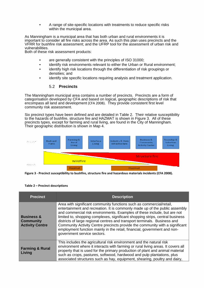
5.2 Precincts The Manningham municipal area contains a number of precincts. Precincts are a form of categorisation developed by CFA and based on logical, geographic descriptions of risk that encompass all land and development (CFA 2008). They provide consistent first level community risk assessment. Six precinct types have been defined and are detailed in Table 2. Their relative susceptibility to the hazards of bushfire, structure fire and HAZMAT is shown in Figure 3. All of these precincts types, except for farming and rural living, are found in the City of Manningham. Their geographic distribution is shown in Map 4.
Figure 3 - Precinct susceptibility to bushfire, structure fire and hazardous materials incidents (CFA 2008).
Table 2 – Precinct descriptions
Precinct Description
Business & Community Activity Centre
Area with significant community functions such as commercial/retail, entertainment and recreation. It is commonly made up of the public assembly and commercial risk environments. Examples of these include, but are not limited to, shopping complexes, significant shopping strips, central business districts of large regional centres and transport terminals. Business and Community Activity Centre precincts provide the community with a significant employment function mainly in the retail, financial, government and non-government service sectors.
Farming & Rural Living
This includes the agricultural risk environment and the natural risk environment where it interacts with farming or rural living areas. It covers all property that is used for the primary production of plant and animal material such as crops, pastures, softwood, hardwood and pulp plantations, plus associated structures such as hay, equipment, shearing, poultry and dairy,
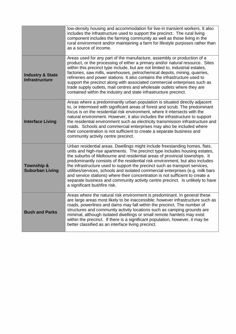
low-density housing and accommodation for live-in transient workers. It also includes the infrastructure used to support the precinct. The rural living component includes the farming community as well as those living in the rural environment and/or maintaining a farm for lifestyle purposes rather than as a source of income.
Industry & State Infrastructure
Areas used for any part of the manufacture, assembly or production of a product, or the processing of either a primary and/or natural resource. Sites within this precinct type include, but are not limited to, industrial estates, factories, saw mills, warehouses, petrochemical depots, mining, quarries, refineries and power stations. It also contains the infrastructure used to support the precinct along with associated commercial enterprises such as trade supply outlets, mail centres and wholesale outlets where they are contained within the industry and state infrastructure precinct.
Interface Living
Areas where a predominantly urban population is situated directly adjacent to, or intermixed with significant areas of forest and scrub. The predominant focus is on the residential risk environment, where it intersects with the natural environment. However, it also includes the infrastructure to support the residential environment such as electricity transmission infrastructure and roads. Schools and commercial enterprises may also be included where their concentration is not sufficient to create a separate business and community activity centre precinct.
Township & Suburban Living
Urban residential areas. Dwellings might include freestanding homes, flats, units and high-rise apartments. The precinct type includes housing estates, the suburbs of Melbourne and residential areas of provincial townships. It predominantly consists of the residential risk environment, but also includes the infrastructure used to support the precinct such as transport services, utilities/services, schools and isolated commercial enterprises (e.g. milk bars and service stations) where their concentration is not sufficient to create a separate business and community activity centre precinct. Is unlikely to have a significant bushfire risk.
Bush and Parks
Areas where the natural risk environment is predominant. In general these are large areas most likely to be inaccessible; however infrastructure such as roads, powerlines and dams may fall within the precinct. The number of structures and community activity locations such as camping grounds are minimal, although isolated dwellings or small remote hamlets may exist within the precinct. If there is a significant population, however, it may be better classified as an interface living precinct.
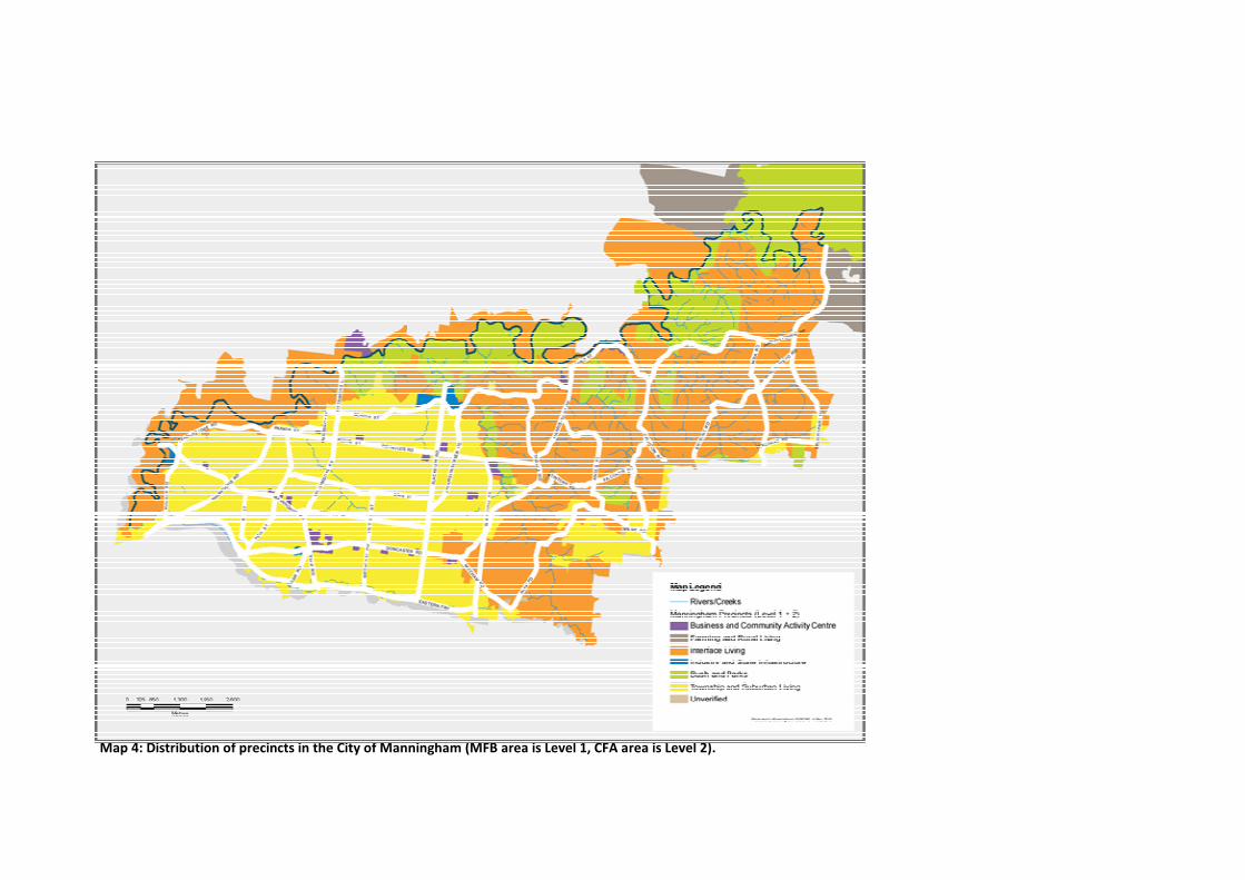
Map 4: Distribution of precincts in the City of Manningham (MFB area is Level 1, CFA area is Level 2).
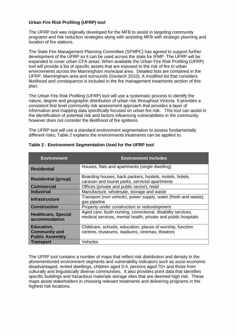
Urban Fire Risk Profiling (UFRP) tool
The UFRP tool was originally developed for the MFB to assist in targeting community programs and risk reduction strategies along with assisting MFB with strategic planning and location of fire stations.
The State Fire Management Planning Committee (SFMPC) has agreed to support further development of the UFRP so it can be used across the state for IFMP. The UFRP will be expanded to cover urban CFA areas. When available the Urban Fire Risk Profiling (UFRP) tool will provide a list of specific assets that are exposed to the risk of fire in urban environments across the Manningham municipal area. Detailed lists are contained in the UFRP, Manningham area and surrounds (Geotech 2010). A modified list that considers likelihood and consequence is included in the fire management treatments section of this plan. The Urban Fire Risk Profiling (UFRP) tool will use a systematic process to identify the nature, degree and geographic distribution of urban risk throughout Victoria. It provides a consistent first level community risk assessment approach that provides a layer of information and mapping data specifically focused on urban fire risk. This tool can assist in the identification of potential risk and factors influencing vulnerabilities in the community however does not consider the likelihood of fire ignitions. The UFRP tool will use a standard environment segmentation to assess fundamentally different risks; Table 2 explains the environments treatments can be applied to. Table 2 - Environment Segmentation Used for the UFR P tool
Environment Environment Includes
Residential Houses, flats and apartments (single dwelling)
Residential (group) Boarding houses, back packers, hostels, motels, hotels, caravan and tourist parks, serviced apartments
Commercial Offices (private and public sector), retail Industrial Manufacture, wholesale, storage and waste
Infrastructure Transport (non vehicle), power supply, water (fresh and waste), gas pipeline
Construction Property under construction or redevelopment
Healthcare, Special accommodation
Aged care, bush nursing, correctional, disability services, medical services, mental health, private and public hospitals
Education, Community and Public Assembly
Childcare, schools, education, places of worship, function centres, museums, stadiums, cinemas, theatres
Transport Vehicles The UFRP tool contains a number of maps that reflect risk distribution and density in the aforementioned environment segments and vulnerability indicators such as socio-economic disadvantaged, rented dwellings, children aged 0-4, persons aged 70+ and those from culturally and linguistically diverse communities. It also provides point data that identifies specific buildings and hazardous materials storage sites that are deemed high risk. These maps assist stakeholders in choosing relevant treatments and delivering programs in the highest risk locations.
5.3 Risk assessment This MFMP identifies fire, including structural and non-structural, as a risk and rates it extreme across the municipal area as a whole. The Manningham MEMP identifies dangerous goods/hazardous materials as a risk and rates it Moderate across the municipal area as a whole. This risk assessment (Table 3) focuses the assessment on each of the precinct types rather than on the municipal area as a whole. The risk posed by structure fire, hazardous materials incidents and bushfire to the safety of Manningham was assessed in terms of likelihood and consequence for each of the precincts. This provides a fire risk profile for the municipal area. Qualitative risk analysis was conducted using the likelihood-consequence matrix contained in the Emergency Risk Management - Applications Guide (EMA 2000) produced by Emergency Management Australia, which is based upon ISO 31000:2009 Risk Management – Principals and guidelines. All risks rated as moderate or above are explicitly addressed by strategies in this MFMP. This high-level risk assessment is complemented by a number of risk assessment tools that quantify and map the distribution of particular risks or hazards across the municipal area and which are used in more detailed targeting of individual treatment programs. These include the VFRR that details the risk from bushfire across the municipal area and the UFRP tool.
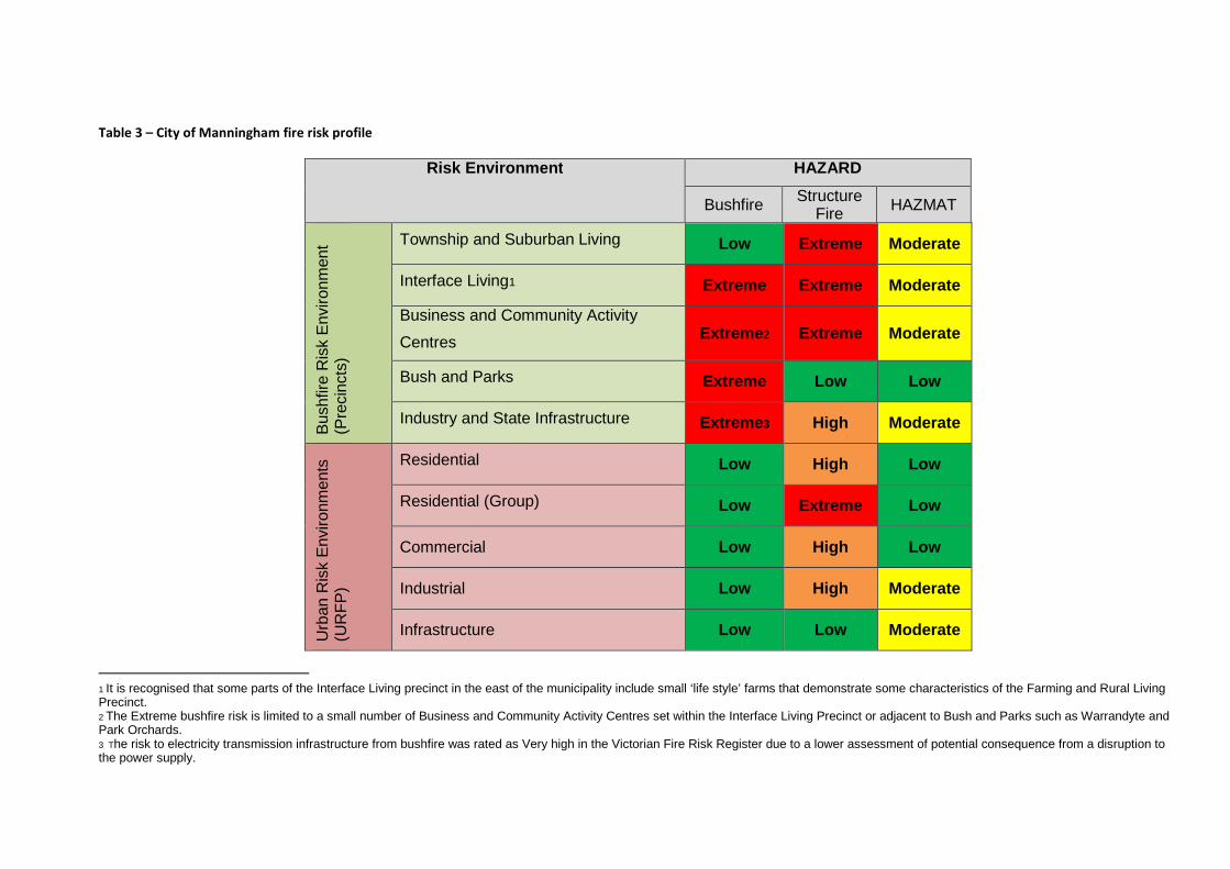
Table 3 – City of Manningham fire risk profile
Risk Environment HAZARD
Bushfire Structure Fire HAZMAT
Bus
hfire
Ris
k E
nviro
nmen
t (P
reci
ncts
)
Township and Suburban Living Low Extreme Moderate
Interface Living1 Extreme Extreme Moderate
Business and Community Activity
Centres Extreme2 Extreme Moderate
Bush and Parks Extreme Low Low
Industry and State Infrastructure Extreme3 High Moderate
Urb
an R
isk
Env
ironm
ents
(U
RF
P)
Residential Low High Low
Residential (Group) Low Extreme Low
Commercial Low High Low
Industrial Low High Moderate
Infrastructure Low Low Moderate
1 It is recognised that some parts of the Interface Living precinct in the east of the municipality include small ‘life style’ farms that demonstrate some characteristics of the Farming and Rural Living Precinct. 2 The Extreme bushfire risk is limited to a small number of Business and Community Activity Centres set within the Interface Living Precinct or adjacent to Bush and Parks such as Warrandyte and Park Orchards. 3 The risk to electricity transmission infrastructure from bushfire was rated as Very high in the Victorian Fire Risk Register due to a lower assessment of potential consequence from a disruption to the power supply.
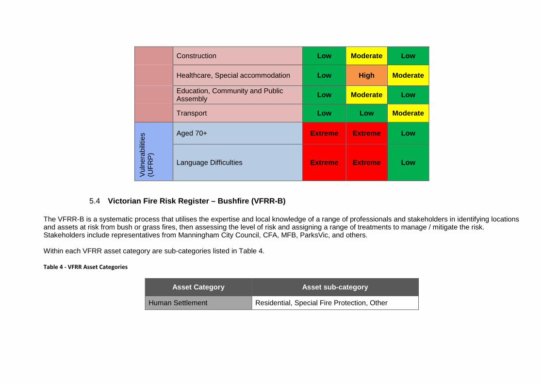
Construction Low Moderate Low
Healthcare, Special accommodation Low High Moderate
Education, Community and Public Assembly Low Moderate Low
Transport Low Low Moderate
Vul
nera
bilit
ies
(UF
RP
)
Aged 70+ Extreme Extreme Low
Language Difficulties Extreme Extreme Low
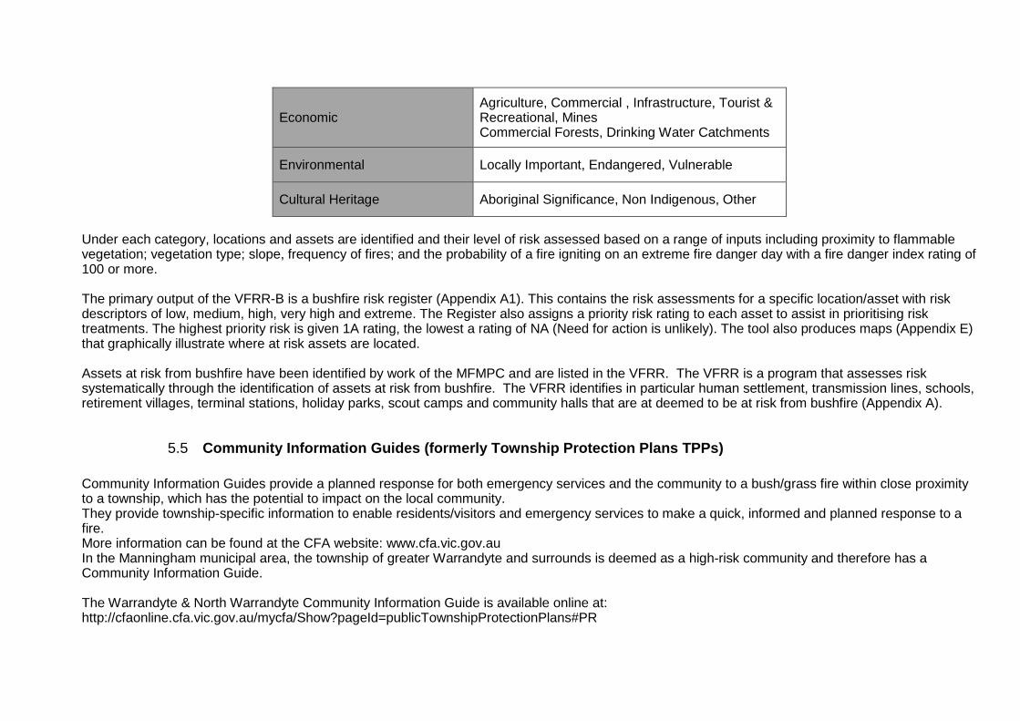
5.4 Victorian Fire Risk Register – Bushfire (VFRR-B) The VFRR-B is a systematic process that utilises the expertise and local knowledge of a range of professionals and stakeholders in identifying locations and assets at risk from bush or grass fires, then assessing the level of risk and assigning a range of treatments to manage / mitigate the risk. Stakeholders include representatives from Manningham City Council, CFA, MFB, ParksVic, and others. Within each VFRR asset category are sub-categories listed in Table 4. Table 4 - VFRR Asset Categories
Asset Category Asset sub-category
Human Settlement Residential, Special Fire Protection, Other
Economic Agriculture, Commercial , Infrastructure, Tourist & Recreational, Mines Commercial Forests, Drinking Water Catchments
Environmental Locally Important, Endangered, Vulnerable
Cultural Heritage Aboriginal Significance, Non Indigenous, Other
Under each category, locations and assets are identified and their level of risk assessed based on a range of inputs including proximity to flammable vegetation; vegetation type; slope, frequency of fires; and the probability of a fire igniting on an extreme fire danger day with a fire danger index rating of 100 or more. The primary output of the VFRR-B is a bushfire risk register (Appendix A1). This contains the risk assessments for a specific location/asset with risk descriptors of low, medium, high, very high and extreme. The Register also assigns a priority risk rating to each asset to assist in prioritising risk treatments. The highest priority risk is given 1A rating, the lowest a rating of NA (Need for action is unlikely). The tool also produces maps (Appendix E) that graphically illustrate where at risk assets are located. Assets at risk from bushfire have been identified by work of the MFMPC and are listed in the VFRR. The VFRR is a program that assesses risk systematically through the identification of assets at risk from bushfire. The VFRR identifies in particular human settlement, transmission lines, schools, retirement villages, terminal stations, holiday parks, scout camps and community halls that are at deemed to be at risk from bushfire (Appendix A).
5.5 Community Information Guides (formerly Township Pro tection Plans TPPs) Community Information Guides provide a planned response for both emergency services and the community to a bush/grass fire within close proximity to a township, which has the potential to impact on the local community. They provide township-specific information to enable residents/visitors and emergency services to make a quick, informed and planned response to a fire. More information can be found at the CFA website: www.cfa.vic.gov.au In the Manningham municipal area, the township of greater Warrandyte and surrounds is deemed as a high-risk community and therefore has a Community Information Guide. The Warrandyte & North Warrandyte Community Information Guide is available online at: http://cfaonline.cfa.vic.gov.au/mycfa/Show?pageId=publicTownshipProtectionPlans#PR
Further CIG’s are being developed for Wonga Park and South Warrandyte as part of the ongoing municipal fire management planning process.
5.6 Neighbourhood Safer Places Neighbourhood Safer Places- Places of last Resort (NSP – PLR) are an area or premises that may, as a last resort, provide some sanctuary from the life threatening effects of a bushfire (i.e. direct flame contact or radiant heat). Specific locations for NSP have been identified for the Manningham municipal area. This information is in Appendix C3.
For more information on NSP visit; www.cfa.vic.gov.au
5.7 Community Fire Refuges
A community fire refuge is a designated building open to the public that can provide short term shelter from the immediate life-threatening effects of a bushfire event. There are strict standards for the design and construction of community fire refuges, which have been incorporated into the Victorian Building Regulations.
Community Fire Refuge information is attached in Appendix C4.
5.8 Hazardous trees
The Electricity Safety Act 1998 (Victoria) (ES Act) Section 86 provides that a municipal council must specify:
a) procedures and criteria for the identification of trees that are likely to fall onto, or come into contact with, an electric line (hazard trees); and
b) procedures for the notification of responsible persons of trees that are hazard trees in relation to electric lines for which they are responsible. The Hazardous Tree Plan is detailed in Appendix C.1.
This document outlines the management of municipal street trees within designated areas of both low and high bushfire risk.
5.9 Manningham Council Incentives
Manningham City Council provides the following incentives to assist property owners and residents in reducing the risk of bushfire to their property:
a) Permit to burn – Council now issues permits to burn on properties greater than 2500 square metres that expire after 3 years. Allows property owners and residents to burn at all times of the year provided the fire danger period is not in place and provided that the fire danger rating is low/moderate or high.
b) Green Waste Vouchers – properties located in the bushfire prone area are entitled to four green waste vouchers which entitle the bearer to free green waste disposal. These vouchers are valid in the period to the lead up of the fire danger period.
c) Bundled Green Waste – Council now allows residents to swap their two hard waste on call pick ups for bundled garden waste collection.
d) Garden Waste Bins – extra bins available from Council at approx $170 per year.
6 Plan reporting and review
6.1 Plan endorsement and adoption The MFMPC shall draft a MFMP and seek endorsement, by signature, of the draft plan from the committee and, where appropriate, non-committee members with responsibilities and accountabilities under the plan. Following this process, the MFMPC will recommend the MFMP to the MEMPC for endorsement. Once endorsed by the MEMPC, the plan will be sent to the Eastern Metropolitan RSFMPC for comment, prior to recommendation to the Manningham City Council for adoption. The MFMP as adopted by Council, will be deemed to meet the requirement for a municipal fire prevention plan under s. 55A(1) of the Country Fire Authority Act, provided that it contains the provisions as set out in s. 55(A)2. For other councils, audit arrangements will be determined prior to the initial audit of the MFMP.
6.2 Plan audit and review The plan has a three year lifespan based on current audit requirements contained within Section 55B of the CFA Act. It is acknowledged that the audit process and planning cycles may change as the IFMP framework and planning processes evolve.
6.3 Reporting on plan outcomes
Ongoing monitoring and annual review is essential to ensure that the MFMP remains relevant and up to date. The Multi Agency Action Plan will be a standing agenda item at MFMPC meetings and will be reported on biannually by agencies to the MFMPC as ongoing treatment works are completed. The half yearly reports will then be presented to the Eastern Metropolitan RSFMPC. This MFMP will be reviewed and amended:
• Following significant incidents, if required; • with changes in local demographics and local risk; • as directed by the State or Regional Fire Management Planning Committees; and • as required by legislation.
Appendices
A.1 Victorian Fire Risk Register – Bushfire (VFRR-B ) CFA (2014) Victorian Fire Risk Register, Manningham City Council. (need to include appendix of what treatments mean)
Asset name Asset Location VFRR Map Ref. VFRR Risk VFRR Priority
Human Settlement - Residential
Gold Memorial Warrandyte 43011 Extreme 1B
Pound Bend Warrandyte 43012 Extreme 1B
Minter CRT Warrandyte 43017 Extreme 1B
Stane Brae Wonga Park 43019 Extreme 1B
Scotchmans Hill/Webb Street Warrandyte 4351762
Extreme 1B
Clifford Drive Wonga Park 4351764 Extreme 1B
Brysons/Yarra Road Wonga Park Proposed
Whipstick Gully Warrandyte 4351763 Very High 2A
Mullum Mullum Linear Donvale 4351765 High 3A
Currawong Donvale 43013 Very High 2A
Haslams Track/ Hillcrest Road Warrandyte South 43041 Very High 2A
100 Acres Park Orchards 43014 High 3A
The Domain Templestowe 43015 High 3A
Mullum Mullum South Donvale 43016 High 3A
Brushy Park and Holloway RD Wonga Park 43028 Medium 4
Alexander RD Warrandyte 43048 Medium 4
Candlebark Park Templestowe 43049 Medium 4
Human Settlement - Special Fire Protection
Clifford Park Scout Camp 7 Clifford DR, Wonga Park 43001 Extreme 1B
Melbourne Christian Fellowship 70 Holloway RD, Wonga Park 43004 Extreme 1B
Yarra River Bank Warrandyte 43020 Extreme 1B
Lower Homestead RD - Yarra River Wonga Park 43023 Extreme 1B
Discovery Holiday Park - Crystal Brook 182 Warrandyte RD, East Doncaster 43031 Extreme 1B
Yarra Brae Horse Trails Yarra Brae 43039 Extreme 1B
Jumping Creek Reserve Warrandyte State Park 43046 Extreme 1B
Time Out Childcare Centre 100 Deep Creek RD, Doncaster East 43053 Extreme 1B
Whitefriars College 156 Park RD, Donvale 43008 Very High 2A
Wonga Park Cricket and Tennis Club Launders AVE, Wonga Park 43025 Very High 2A
The Village Centre Shops Wonga Park 43026 Very High?? 2A (needs reassessment
Yarra Street Shops Warrandyte Proposed
Goldfields Plaza Warrandyte Proposed
Wonga Park Community Hall Old Yarra RD, Wonga Park 43027 Very High 2A
Warranvale Retirement Home 314 Reynolds RD, Donvale 43032 Very High 2A
Donvale Christian College 155 Tindals RD, Donvale 43033 Very High 2A
Andersons Creek Primary School Drysdale RD, Warrandyte 43036 Very High 2A
Warrandyte Primary School Forbes ST, Warrandyte 43037 Very High 2A On Luck Chinese Retiremement Village Tinsdale Rd, Warrandyte 43042 Very High 2A Warrandyte Child Care Centre and Preschool 2 Masonic AVE, Warrandyte 43044 Very High 2A
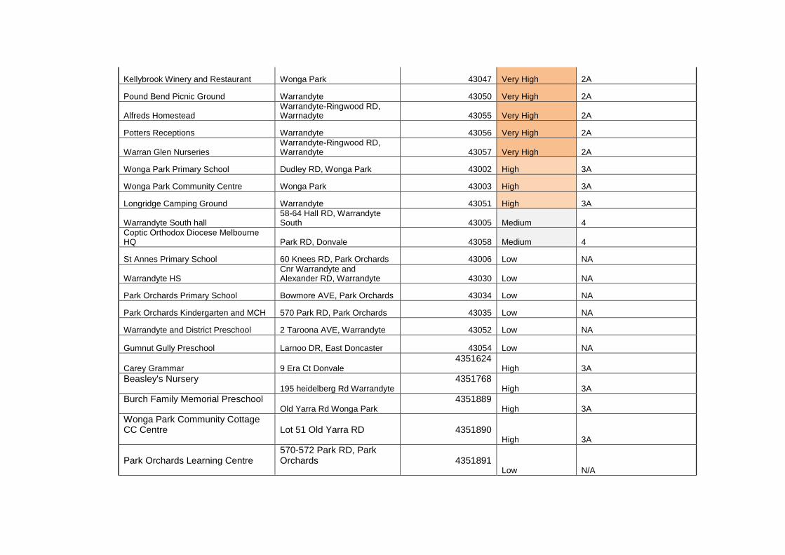
Kellybrook Winery and Restaurant Wonga Park 43047 Very High 2A
Pound Bend Picnic Ground Warrandyte 43050 Very High 2A
Alfreds Homestead Warrandyte-Ringwood RD, Warrnadyte 43055 Very High 2A
Potters Receptions Warrandyte 43056 Very High 2A
Warran Glen Nurseries Warrandyte-Ringwood RD, Warrandyte 43057 Very High 2A
Wonga Park Primary School Dudley RD, Wonga Park 43002 High 3A
Wonga Park Community Centre Wonga Park 43003 High 3A
Longridge Camping Ground Warrandyte 43051 High 3A
Warrandyte South hall 58-64 Hall RD, Warrandyte South 43005 Medium 4
Coptic Orthodox Diocese Melbourne HQ Park RD, Donvale 43058 Medium 4
St Annes Primary School 60 Knees RD, Park Orchards 43006 Low NA
Warrandyte HS Cnr Warrandyte and Alexander RD, Warrandyte 43030 Low NA
Park Orchards Primary School Bowmore AVE, Park Orchards 43034 Low NA
Park Orchards Kindergarten and MCH 570 Park RD, Park Orchards 43035 Low NA
Warrandyte and District Preschool 2 Taroona AVE, Warrandyte 43052 Low NA
Gumnut Gully Preschool Larnoo DR, East Doncaster 43054 Low NA
Carey Grammar 9 Era Ct Donvale 4351624
High 3A Beasley's Nursery 195 heidelberg Rd Warrandyte
4351768 High 3A
Burch Family Memorial Preschool Old Yarra Rd Wonga Park
4351889 High 3A
Wonga Park Community Cottage CC Centre
Lot 51 Old Yarra RD
4351890 High 3A
Park Orchards Learning Centre
570-572 Park RD, Park Orchards
4351891 Low N/A
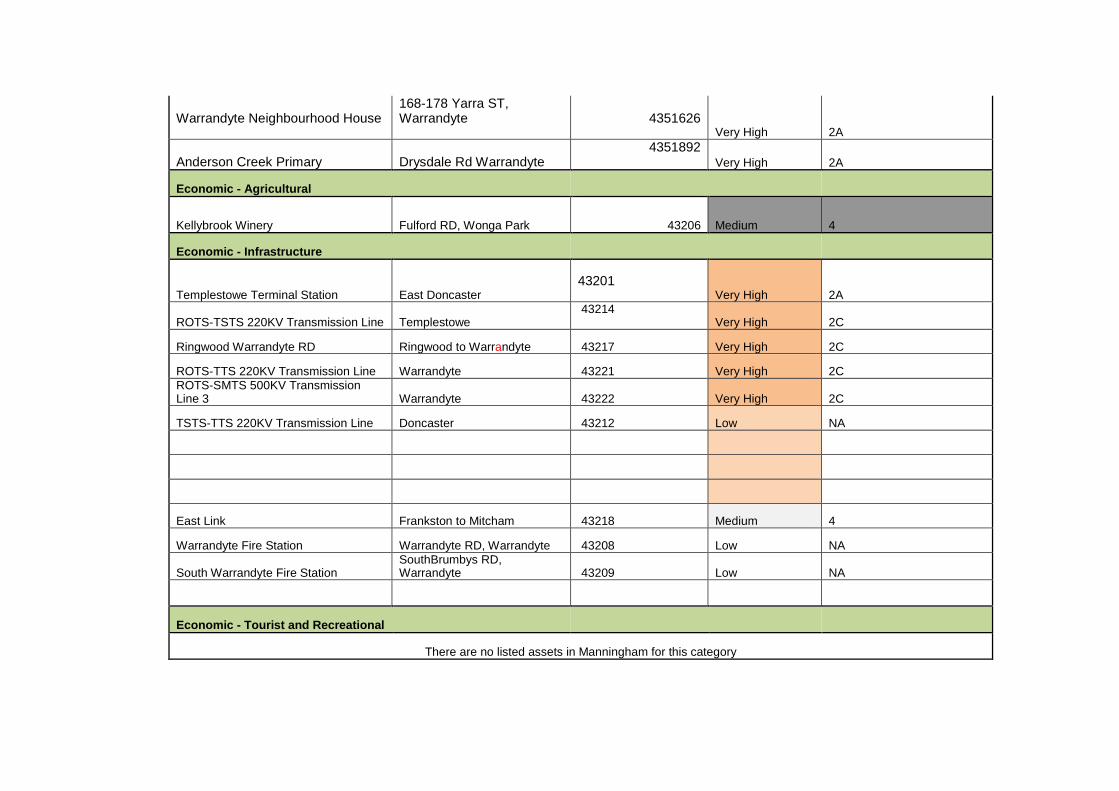
Warrandyte Neighbourhood House
168-178 Yarra ST, Warrandyte
4351626 Very High 2A
Anderson Creek Primary Drysdale Rd Warrandyte 4351892
Very High 2A
Economic - Agricultural
Kellybrook Winery Fulford RD, Wonga Park 43206 Medium 4
Economic - Infrastructure
Templestowe Terminal Station East Doncaster
43201 Very High 2A
ROTS-TSTS 220KV Transmission Line Templestowe 43214 Very High 2C
Ringwood Warrandyte RD Ringwood to Warrandyte 43217 Very High 2C
ROTS-TTS 220KV Transmission Line Warrandyte 43221 Very High 2C ROTS-SMTS 500KV Transmission Line 3 Warrandyte 43222 Very High 2C
TSTS-TTS 220KV Transmission Line Doncaster 43212 Low NA
East Link Frankston to Mitcham 43218 Medium 4
Warrandyte Fire Station Warrandyte RD, Warrandyte 43208 Low NA
South Warrandyte Fire Station SouthBrumbys RD, Warrandyte 43209 Low NA
Economic - Tourist and Recreational
There are no listed assets in Manningham for this category
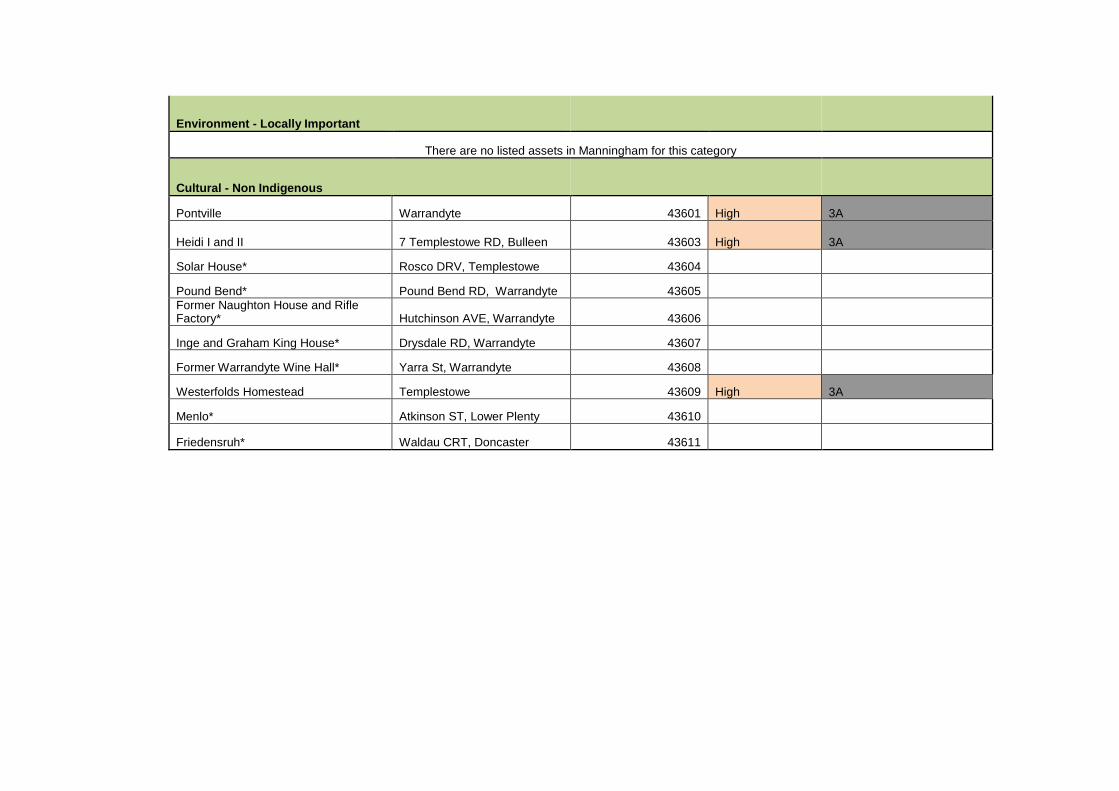
Environment - Locally Important
There are no listed assets in Manningham for this category
Cultural - Non Indigenous
Pontville Warrandyte 43601 High 3A
Heidi I and II 7 Templestowe RD, Bulleen 43603 High 3A
Solar House* Rosco DRV, Templestowe 43604
Pound Bend* Pound Bend RD, Warrandyte 43605 Former Naughton House and Rifle Factory* Hutchinson AVE, Warrandyte 43606
Inge and Graham King House* Drysdale RD, Warrandyte 43607
Former Warrandyte Wine Hall* Yarra St, Warrandyte 43608
Westerfolds Homestead Templestowe 43609 High 3A
Menlo* Atkinson ST, Lower Plenty 43610
Friedensruh* Waldau CRT, Doncaster 43611
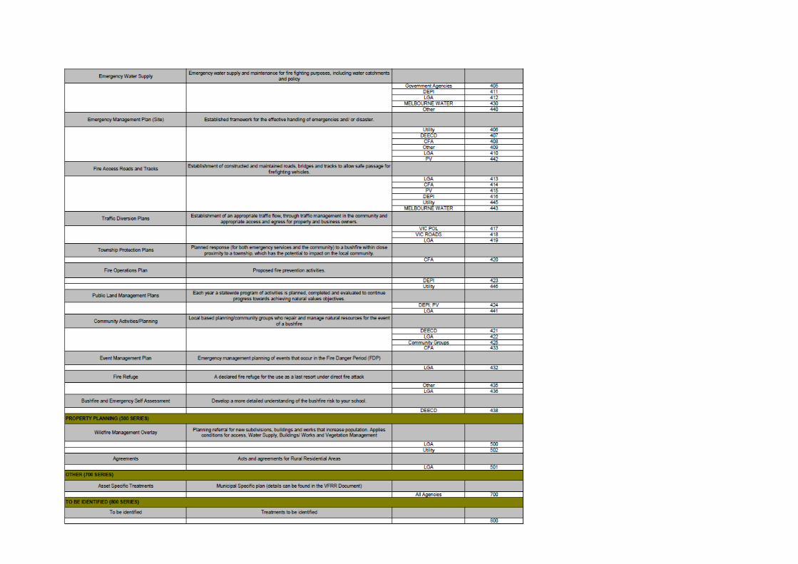
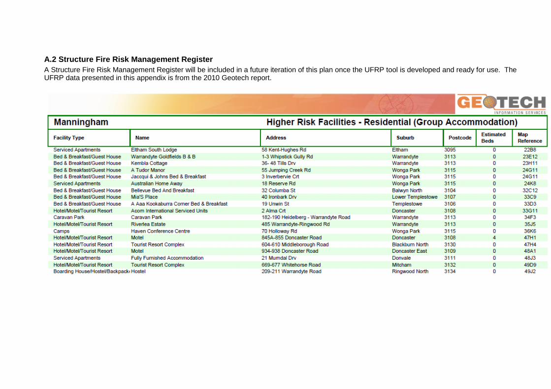
A.2 Structure Fire Risk Management Register A Structure Fire Risk Management Register will be included in a future iteration of this plan once the UFRP tool is developed and ready for use. The UFRP data presented in this appendix is from the 2010 Geotech report.
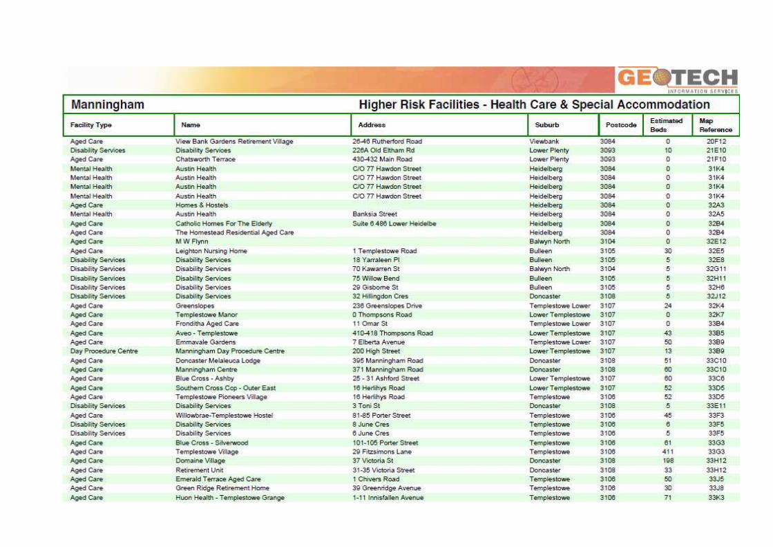
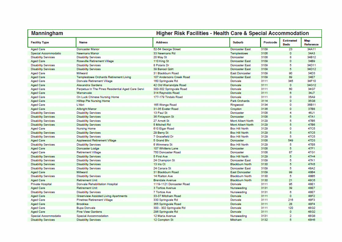
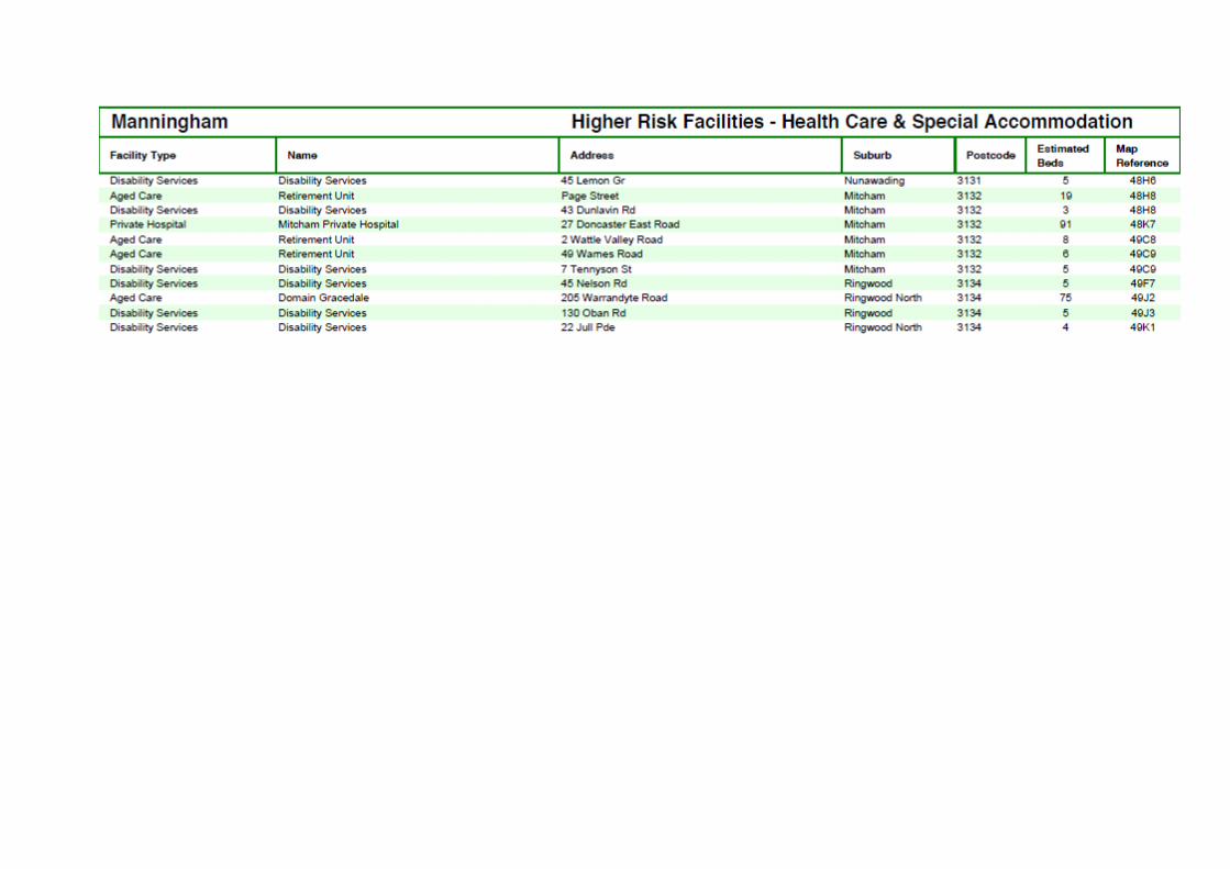
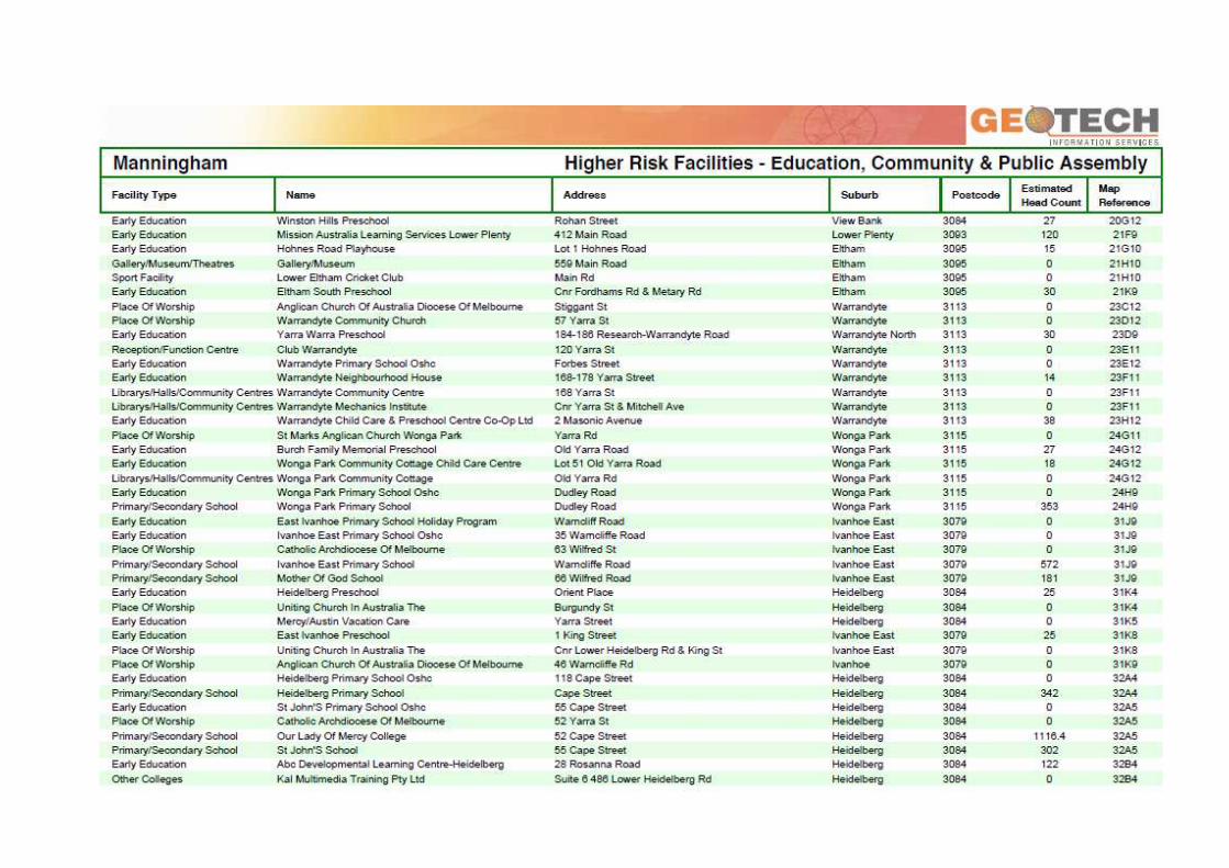
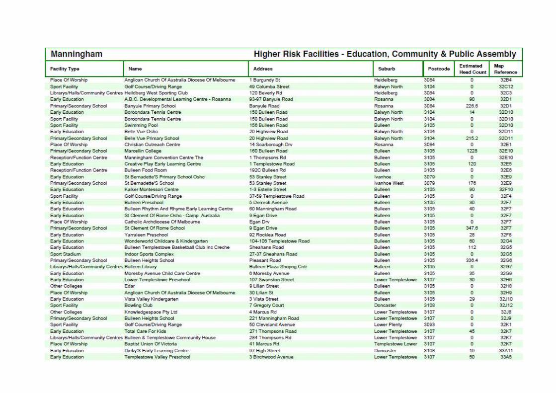
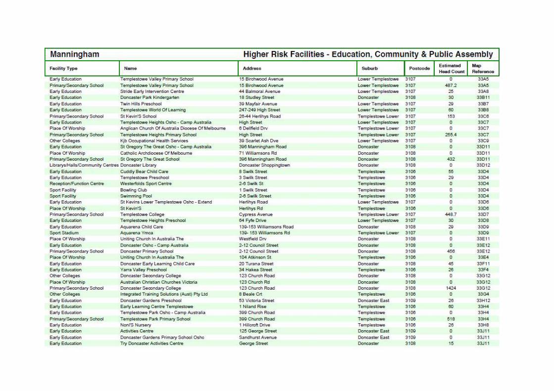
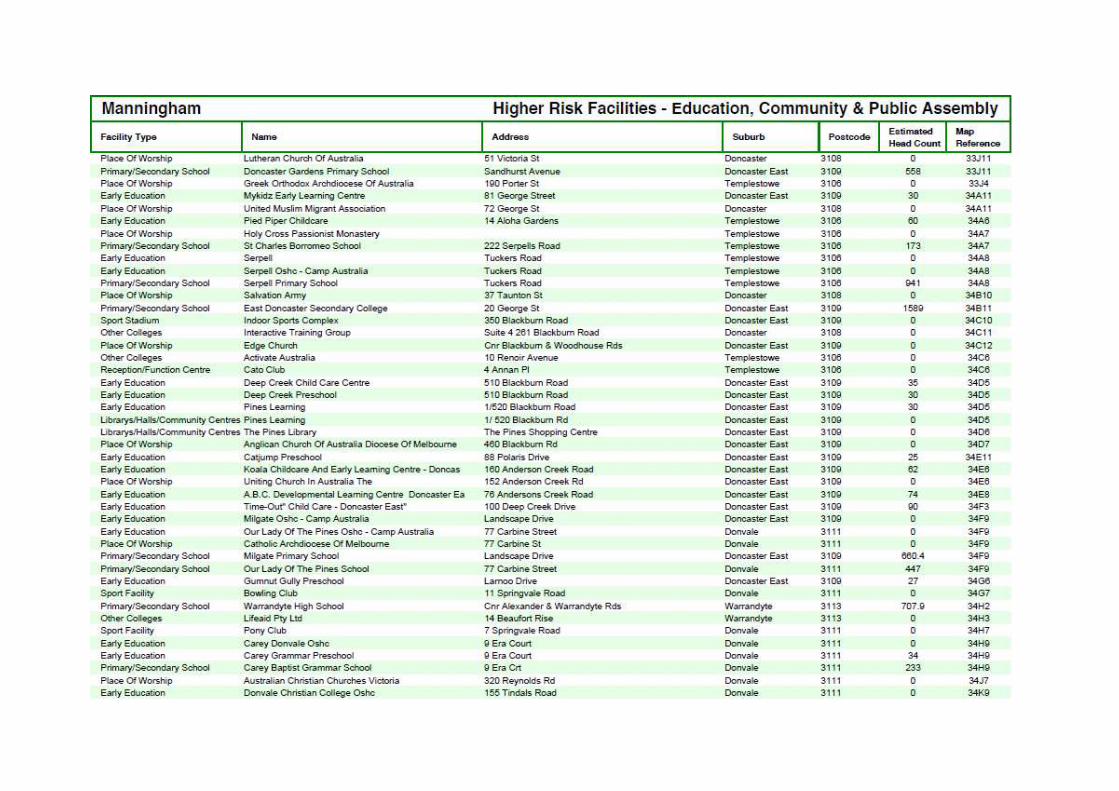
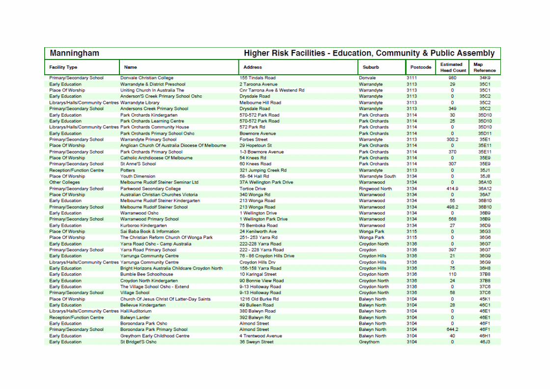
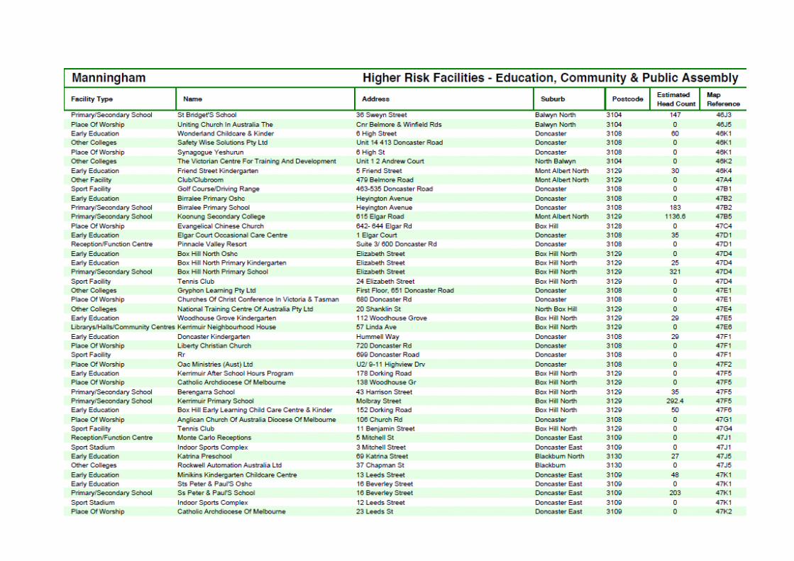
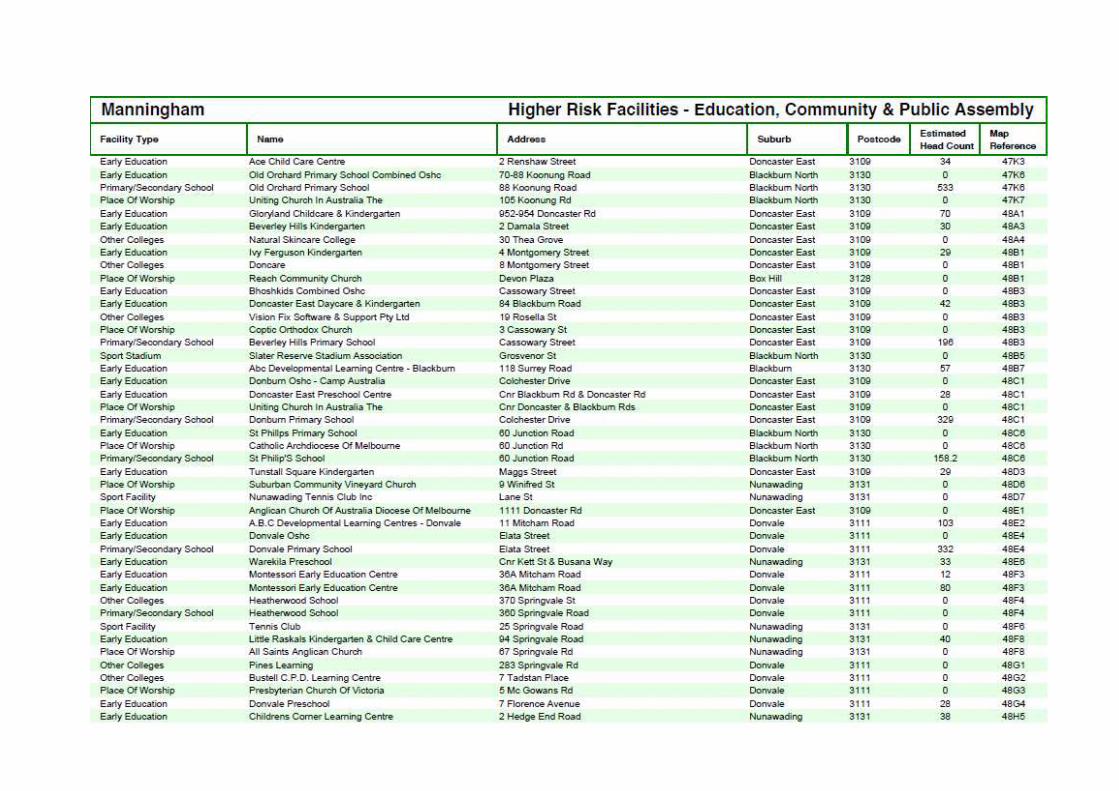
A.3 Hazardous Materials Risk Management Register A Hazardous Materials Risk Management Register will be included in a future iteration of this plan with the development of the UFRP tool.
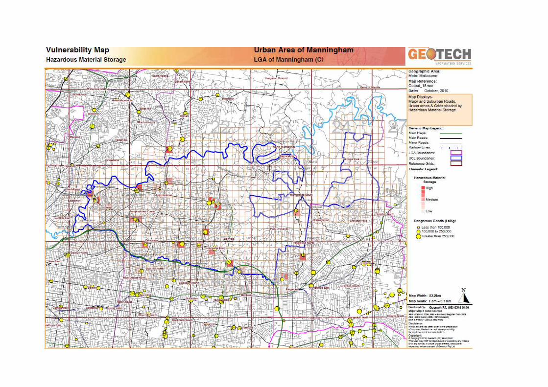
B.1 Multi Agency Action Plan
The Manningham MFMPC is currently reporting on a Multi-Agency Action Plan that addresses the fire management objectives of this plan. Existing treatment works have been carried over from the MFPP as an interim measure. New treatments have been added while treatments that are no longer applicable have been removed by the committee.
Actions are to be devised to work towards preparing for, preventing, responding to and recovering from unplanned fires. Each action, where possible is required to be specific, measurable, achievable, relevant and time-framed. The action plan outlines each action stating;
Who is responsible for carrying out and reporting on the action; When the action is going to happen; and Provides a measure that can be used to determine that the action is complete or partially completed. Provides information for six monthly reporting
Reporting on Action Plan progress will involve checking and recording action outcomes against the pre-stated measures.
The Action Plan will include treatments that are municipal wide as well as specific to address assets listed in the VFRR. Municipal wide treatments are activities which reduce the overall bushfire risk within the MFMP area. They are applied across the area irrespective of asset and/or location. The relevant actions are applied across all tenures with each agency responsible for the lands under their care. These treatments are undertaken on an ongoing basis as part of normal business and are not linked to specific assets in the VFRR. Rather they are applied across all or part of Manningham as designated by legislation or agency policy (e.g. Fire Danger Periods, Total Fire Ban’s). In addition, assets listed under specific environments at risk including Human Settlement, Natural Environment, Economic, Infrastructure, and Social listed in the VFRR will also have actions devised by the MFMPC to treat these risks.
Structure and hazardous materials fire risk will be addressed in future iterations of this MFMP and Action Plan once the Urban Fire Risk Profiling (UFRP) tool is developed and ready for use.
** Refer to TRIM D15/42319***
B.2 VFRR – Reporting Plan Reporting will occur on all treatments allocated to assets listed in the VFRR-B.
**Refer to TRIM D15/22453 – VFRR spreadsheet for reporting**
C. 1 Hazardous trees
PROCEDURE FOR IDENTIFICATION AND NOTIFICATION OF HAZARD TREES
The Electricity Safety Act 1998 (Victoria) (ES Act) Section 86 provides that a municipal council must
specify, within its Municipal Fire Management Plan:
a. procedures and criteria for the identification of trees that are likely to fall onto, or come into contact with, an electric line (hazard trees ); and
b. procedures for the notification of responsible persons of trees that are hazard trees in relation to electric lines for which they are responsible.
Under the ES Act, the person responsible for maintaining vegetation and clearance space around
power lines is referred to as the 'responsible person'.
What is a hazard tree?
According to the ES Act, a hazard tree is a tree which ‘is likely to fall onto, or come into contact with, an electric line’.
The Electricity Safety (Electric Line Clearance) Regulations 2010 further provide that a responsible person may cut or remove such a tree ‘provided that the tree has been assessed by a suitably qualified arborist; and that assessment confirms the likelihood of contact with an electric line having regard to foreseeable local conditions.’
Due to legal requirements which require a clearance space be maintained around an electric line,
hazard trees are usually located outside the regulated clearance space. Despite being outside the
clearance space, the tree may still have the potential to contact the line due to its size or because of
a structural fault or weakness which renders part, or all, of the tree likely to contact or fall onto the
line.
Who is responsible for a hazard tree?
Under the ES Act, the person responsible for maintaining vegetation and clearance space around
power lines is referred to as the ‘responsible person’. This includes responsibility for keeping the
whole or any part of a tree clear of the line.
Under the ES Act, responsibility is allocated between distribution businesses and other owners of
electricity infrastructure, land owners and occupiers, public land managers such as municipal
councils, Department of Sustainability and Environment and VicRoads.
Municipal councils are responsible for trees on public land within their municipalities, for which they
are the land manager, where these are also within a Declared Area for the purposes of the ES Act.
Primary responsibility for vegetation clearance and management within the municipality, for areas
which are not within a Declared Area, will usually fall to the relevant electricity distribution
company.
Responsible Persons within Manningham City Council
There are a number of organisations that have responsibility for electric line clearance in the City of
Manningham, including:
• United Energy
• Ausnet Services
• VicRoads
• Manningham City Council
Other relevant information
Responsible persons, other than private persons, must have an electric line clearance management
plan in place for areas for which they have responsibility (refer Electricity Safety (Electric Line
Clearance) Regulations 2010).
PROCEDURES AND CRITERIA FOR IDENTIFYING HAZARD TREES
In the course of everyday duties, potentially hazardous trees may come to the attention of staff or
volunteer members of the entities with representation on the Municipal Fire Management Planning
Committee (MFMPC), staff of the distribution business(es) or other persons, including members of
the public.
There are a range of factors which may indicate that a tree is a hazard tree. That is, a tree which is
likely to fall onto, or come into contact with, an electric line. Some of these factors will be obvious
when looking at the tree but many may only be apparent when the tree is assessed by a person with
specific expertise and training, such as an arborist.
The following criteria may be used to assist in identifying a hazard tree:
• The size of the tree suggests that it is likely to come into contact with the electric line, for
example because it appears to be encroaching or growing into the line clearance space.
• There is an excessive lean on the tree, or branches hanging off the tree and the tree is in
proximity to an electric (power) line.
• The size or appearance of the tree suggests it could come into contact with the line including
under foreseeable local conditions.
If a potentially hazardous tree is identified, the notification procedure outlined below should be
followed. Where a responsible person becomes aware of a potentially hazardous tree for which they
have responsibility, they must follow their own applicable internal procedure and the notification
procedure described below does not apply.
PROCEDURES AND CRITERIA FOR NOTIFYING HAZARD TREES
To ensure that information regarding potentially hazardous trees is captured in an efficient manner
and, as appropriate, referred to the responsible person for action, the following procedure for the
notification of hazardous trees should be followed:
� Hazardous tree reports outside the declared area for Council responsibility should be reported to the relevant Distribution Company.
� Where any person becomes aware of, or receives a report of, a potentially hazardous tree within the municipality, this should be referred to the relevant Distribution Company.
� Reports of potentially hazardous trees must be provided to the relevant Distribution Company for action as soon as practicable. Reports must include, as far as
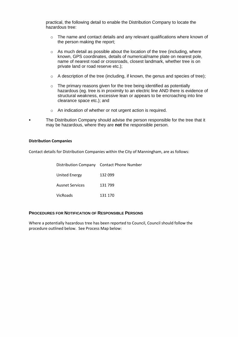
practical, the following detail to enable the Distribution Company to locate the hazardous tree:
o The name and contact details and any relevant qualifications where known of the person making the report;
o As much detail as possible about the location of the tree (including, where known, GPS coordinates, details of numerical/name plate on nearest pole, name of nearest road or crossroads, closest landmark, whether tree is on private land or road reserve etc.);
o A description of the tree (including, if known, the genus and species of tree);
o The primary reasons given for the tree being identified as potentially hazardous (eg. tree is in proximity to an electric line AND there is evidence of structural weakness, excessive lean or appears to be encroaching into line clearance space etc.); and
o An indication of whether or not urgent action is required.
� The Distribution Company should advise the person responsible for the tree that it may be hazardous, where they are not the responsible person.
Distribution Companies
Contact details for Distribution Companies within the City of Manningham, are as follows:
Distribution Company Contact Phone Number
United Energy 132 099
Ausnet Services 131 799
VicRoads 131 170
PROCEDURES FOR NOTIFICATION OF RESPONSIBLE PERSONS
Where a potentially hazardous tree has been reported to Council, Council should follow the
procedure outlined below. See Process Map below:
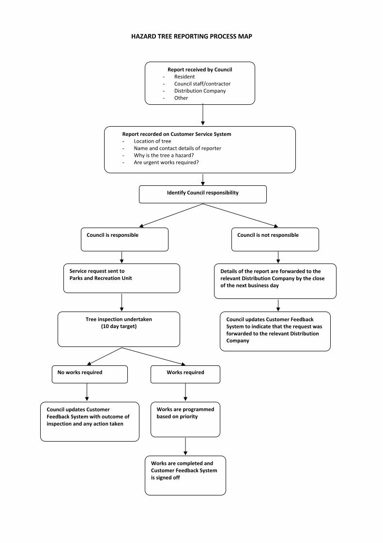
HAZARD TREE REPORTING PROCESS MAP
Report received by Council
- Resident
- Council staff/contractor
- Distribution Company
- Other
Report recorded on Customer Service System
- Location of tree
- Name and contact details of reporter
- Why is the tree a hazard?
- Are urgent works required?
Identify Council responsibility
Council is not responsible
Council is responsible
Service request sent to
Parks and Recreation Unit
Tree inspection undertaken
(10 day target)
No works required Works required
Council updates Customer
Feedback System with outcome of
inspection and any action taken
Works are programmed
based on priority
Works are completed and
Customer Feedback System
is signed off
Details of the report are forwarded to the
relevant Distribution Company by the close
of the next business day
Council updates Customer Feedback
System to indicate that the request was
forwarded to the relevant Distribution
Company
Reporting
All responsible persons should put in place mutually agreed arrangements for the manner in which it
passes on reports of potentially hazardous trees to responsible persons.
In situations where Manningham City Council is notified of a hazardous tree for which they are the
responsible person, then Council is not required forward the notification to the relevant Distribution
Company.
Reporting Timelines
Reports to the relevant distribution company/responsible person should be made as soon as
practicable.
In circumstances where:
� the potentially hazardous tree is located within a high bushfire risk area (as per Section 80 of the ES Act) and the potentially hazardous tree is reported during the fire danger period declared under the Country Fire Authority Act 1958 (Victoria); or
� the report indicates that there is an imminent danger that the tree will contact or fall onto lines as a result of minor environmental changes;
The potentially hazardous tree must be referred to the relevant responsible person for action as
soon as possible, and by the close of the next business day.
Register
Manningham City Council, as a responsible person, will maintain a register of notifications received
for hazard trees for which they are the responsible person through its Customer Service System.
C. 2 Community Information Guides (formerly Townshi p Protection Plans) http://cfaonline.cfa.vic.gov.au/mycfa/Show?pageId=publicTownshipProtectionPlans#PR
C. 3 Neighbourhood Safer Places (NSP) Manningham Municipal Area’s NSP are as follows:
1. Warrandyte Senior Citizens Centre 2-28 Taroona Avenue, Warrandyte 2. Domeney Reserve Sporting Pavilion 24-52 Knees Road, Park Orchards 3. Wonga Park Primary School Cnr Dudley Road and Lantana Drive, Wonga Park 4. Warrandyte Sports Pavilion 2-28 Taroona Avenue, Warrandyte
For more information on NSP's visit, www.cfa.vic.gov.au
C.4 Community Fire Refuges Manningham City Council does not have any identified Fire Refuges.
D.1 Community engagement work plan
Contents
1. Introduction
1.1 About the MFMP
1.2 Why is community engagement important to fire management planning?
1.3 Associated documents
2. Strategic framework for Manningham
3. Community engagement landscape &opportunities for agency collaboration
4. WHY: Aims &objectives
4.1 Aims &objectives
4.2 Negotiable and non-negotiable
5. WHAT: Positioning and key messages
5.1 Project statement
5.2 Key questions
5.3 Key messages
6. WHO& HOW: Engagement & communications
7. Risk management
7.1 Identification and analysis
7.2 Risk assessment
7.3 Media research
8. Project management
8.1 Roles and responsibility
1. Introduction
The purpose of this document is to outline the communications and engagement activities to be
implemented to support the development of the Manningham Municipal Fire Management Plan
(MFMP).
An overarching Regional Stakeholder and Community Engagement Strategy guides these strategic
imperatives outlined in this implementation plan.
The key principles guiding the communications and engagement strategy are transparency, openness
and collaboration.
Community engagement for fire management planning is intended to:
� promote acceptance, understanding and joint problem solving; � raise knowledge and skills of fire management through participation; � produce plans that support community and organisational expectations; and � incorporate community and organisational needs into the development of plans.
1.1 About the MFMP
The MFMP represents a true collaborative approach between agencies responsible for fire planning
and management across the municipality.
1.2 Why is community engagement important to fire management planning?
Community engagement is a high priority for all levels of Government. Undertaking effective
stakeholder and community engagement is critical to assisting agencies and communities to plan,
prepare, respond and recover from bushfires.
1.3 Associated documents
This plan is to be read in conjunction with the Manningham MFMP.

2. Strategic framework for Manningham The Integrated Fire Management (IFMP) process has adopted the International Association of Public
Participation (IAP2) Framework to guide its engagement activities.
For the purposes of the [insert municipality] communications and engagement program, the level at
which it must focus is on the INFORM and CONSULT level. Agencies are responsible for activities
featured in INVOLVE, COLLABORATE and EMPOWER levels.
Inform Consult Involve/Collaborate
Who General community
Residents and business owners in high risk
bushfire prone areas:
Warrandyte
South Warrandyte
Park Orchards
Wonga Park
Donvale
Doncaster East
Templestowe East
MCC staff residing in the bushfire prone
areas.(Everyone email/E bulletin/Mfocus)
Individuals with special interest in fire
management
Media (press release)
Special interest:
Manningham Community Directory:
Park Orchards Rate Payers Assoc.
Warrandyte Assoc. (Be Ready Warrandyte
Committee)
Agricultural – Orchards, Wineries
Multicultural
Tourism and regional development(EEP
Lucinda, Hannah)
Members of Parliament (Noel)
Environmental, Landcare Groups and Friends
of groups (EEP)
Senior citizen groups
Rotary, Probus and Apex Groups
Manningham City Council
Councillors (SBS briefing)
Municipal Emergency Management Planning
Committee (Standing agenda item)
Council Business Units:
Committees of management
Customer service
CFA Brigades:
Warrandyte
South Warrandyte
Wonga Park
Community groups:
Warrandyte Community
Association (Be Ready
Warrandyte Committee)
Community Fireguard
Groups
Engagement
objectives
To ensure fire
planning engagement
process assists in
educating and
informing the
community about risk
of bushfire.
To seek and ensure local knowledge is
captured and considered for inclusion in fire
planning management.
To gain input and shape
MFMP and approach to
community engagement.
Commitment to
stakeholders
We will provide you
with opportunities to
be involved in the
We will keep you informed, listen to and
acknowledge concerns and aspirations and
provide feedback on how public input
We will work with you to
ensure that your concerns
and aspirations are directly
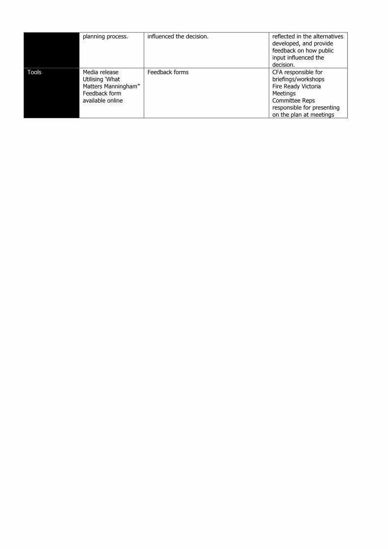
planning process.
influenced the decision.
reflected in the alternatives
developed, and provide
feedback on how public
input influenced the
decision.
Tools Media release
Utilising ‘What
Matters Manningham”
Feedback form
available online
Feedback forms
CFA responsible for
briefings/workshops
Fire Ready Victoria
Meetings
Committee Reps
responsible for presenting
on the plan at meetings
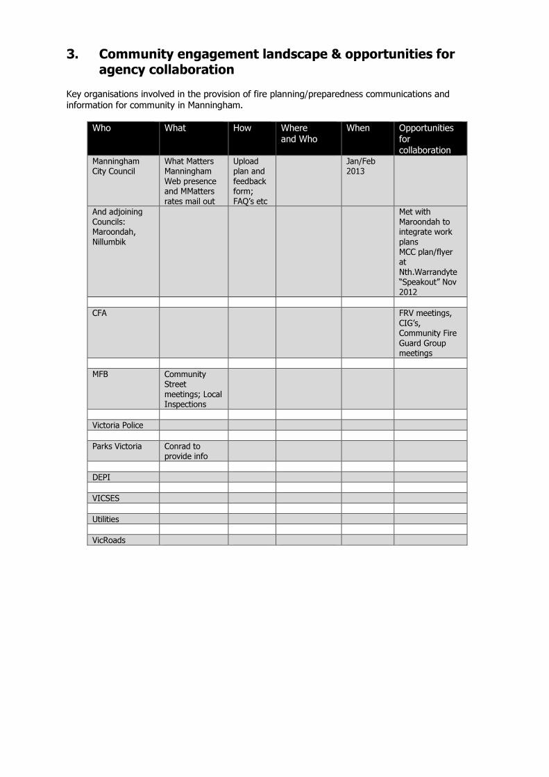
3. Community engagement landscape & opportunities for agency collaboration
Key organisations involved in the provision of fire planning/preparedness communications and
information for community in Manningham.
Who What How Where
and Who
When Opportunities
for
collaboration Manningham
City Council
What Matters
Manningham
Web presence
and MMatters
rates mail out
Upload
plan and
feedback
form;
FAQ’s etc
Jan/Feb
2013
And adjoining
Councils:
Maroondah,
Nillumbik
Met with
Maroondah to
integrate work
plans
MCC plan/flyer
at
Nth.Warrandyte
“Speakout” Nov
2012
CFA FRV meetings,
CIG’s,
Community Fire
Guard Group
meetings
MFB Community
Street
meetings; Local
Inspections
Victoria Police
Parks Victoria Conrad to
provide info
DEPI
VICSES
Utilities
VicRoads
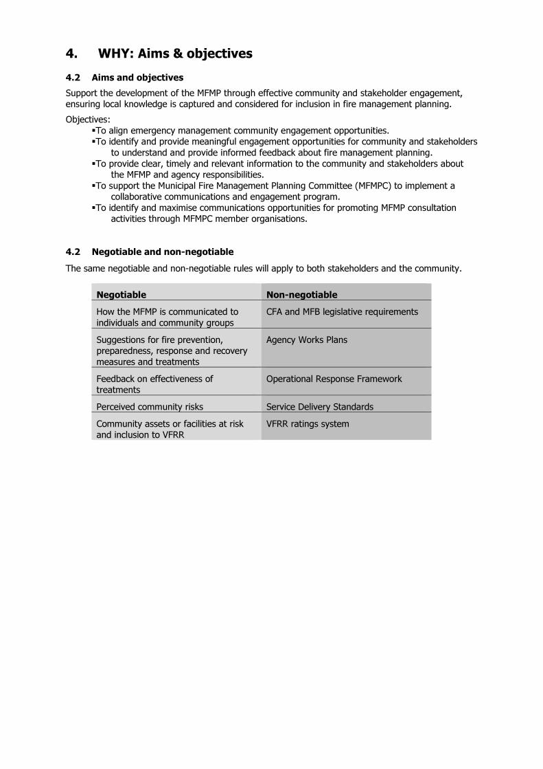
4. WHY: Aims & objectives
4.2 Aims and objectives
Support the development of the MFMP through effective community and stakeholder engagement,
ensuring local knowledge is captured and considered for inclusion in fire management planning.
Objectives:
� To align emergency management community engagement opportunities. � To identify and provide meaningful engagement opportunities for community and stakeholders
to understand and provide informed feedback about fire management planning.
� To provide clear, timely and relevant information to the community and stakeholders about the MFMP and agency responsibilities.
� To support the Municipal Fire Management Planning Committee (MFMPC) to implement a collaborative communications and engagement program.
� To identify and maximise communications opportunities for promoting MFMP consultation activities through MFMPC member organisations.
4.2 Negotiable and non-negotiable
The same negotiable and non-negotiable rules will apply to both stakeholders and the community.
Negotiable Non-negotiable
How the MFMP is communicated to
individuals and community groups
CFA and MFB legislative requirements
Suggestions for fire prevention,
preparedness, response and recovery
measures and treatments
Agency Works Plans
Feedback on effectiveness of
treatments
Operational Response Framework
Perceived community risks Service Delivery Standards
Community assets or facilities at risk
and inclusion to VFRR
VFRR ratings system
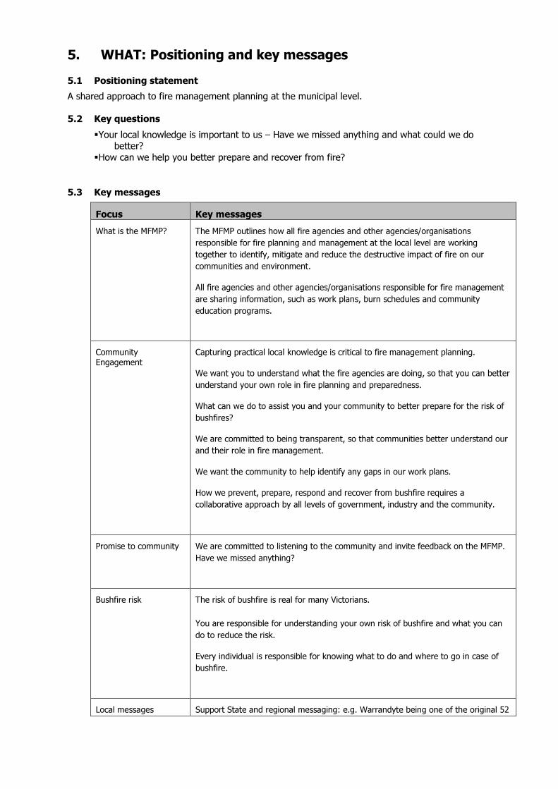
5. WHAT: Positioning and key messages 5.1 Positioning statement
A shared approach to fire management planning at the municipal level.
5.2 Key questions
� Your local knowledge is important to us – Have we missed anything and what could we do better?
� How can we help you better prepare and recover from fire?
5.3 Key messages
Focus Key messages
What is the MFMP? The MFMP outlines how all fire agencies and other agencies/organisations
responsible for fire planning and management at the local level are working
together to identify, mitigate and reduce the destructive impact of fire on our
communities and environment.
All fire agencies and other agencies/organisations responsible for fire management
are sharing information, such as work plans, burn schedules and community
education programs.
Community
Engagement
Capturing practical local knowledge is critical to fire management planning.
We want you to understand what the fire agencies are doing, so that you can better
understand your own role in fire planning and preparedness.
What can we do to assist you and your community to better prepare for the risk of
bushfires?
We are committed to being transparent, so that communities better understand our
and their role in fire management.
We want the community to help identify any gaps in our work plans.
How we prevent, prepare, respond and recover from bushfire requires a
collaborative approach by all levels of government, industry and the community.
Promise to community We are committed to listening to the community and invite feedback on the MFMP.
Have we missed anything?
Bushfire risk The risk of bushfire is real for many Victorians.
You are responsible for understanding your own risk of bushfire and what you can
do to reduce the risk.
Every individual is responsible for knowing what to do and where to go in case of
bushfire.
Local messages Support State and regional messaging: e.g. Warrandyte being one of the original 52
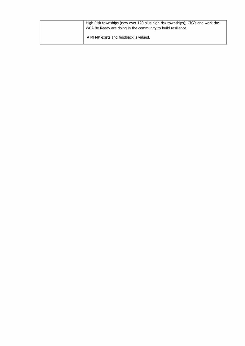
High Risk townships (now over 120 plus high risk townships); CIG’s and work the
WCA Be Ready are doing in the community to build resilience.
A MFMP exists and feedback is valued.
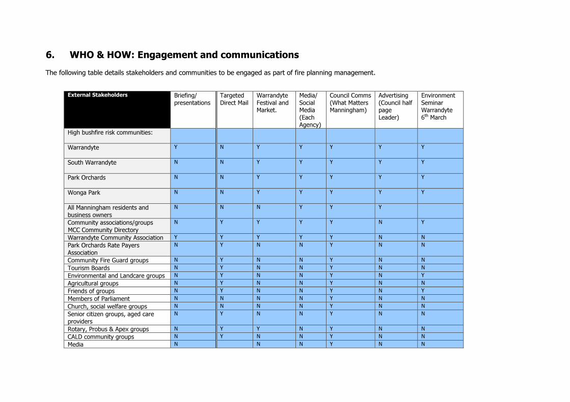
6. WHO & HOW: Engagement and communications
The following table details stakeholders and communities to be engaged as part of fire planning management.
External Stakeholders Briefing/
presentations
Targeted
Direct Mail
Warrandyte
Festival and
Market.
Media/
Social
Media
(Each
Agency)
Council Comms
(What Matters
Manningham)
Advertising
(Council half
page
Leader)
Environment
Seminar
Warrandyte
6th March
High bushfire risk communities:
Warrandyte
Y N Y Y Y Y Y
South Warrandyte
N N Y Y Y Y Y
Park Orchards
N N Y Y Y Y Y
Wonga Park
N N Y Y Y Y Y
All Manningham residents and
business owners
N N N Y Y Y
Community associations/groups
MCC Community Directory
N Y Y Y Y N Y
Warrandyte Community Association Y Y Y Y Y N N Park Orchards Rate Payers
Association
N Y N N Y N N
Community Fire Guard groups N Y N N Y N N Tourism Boards N Y N N Y N N Environmental and Landcare groups N Y N N Y N Y
Agricultural groups N Y N N Y N N
Friends of groups N Y N N Y N Y
Members of Parliament N N N N Y N N Church, social welfare groups N N N N Y N N Senior citizen groups, aged care
providers
N Y N N Y N N
Rotary, Probus & Apex groups N Y Y N Y N N CALD community groups N Y N N Y N N Media N N N Y N N

Councillors Y Y N N Y N N
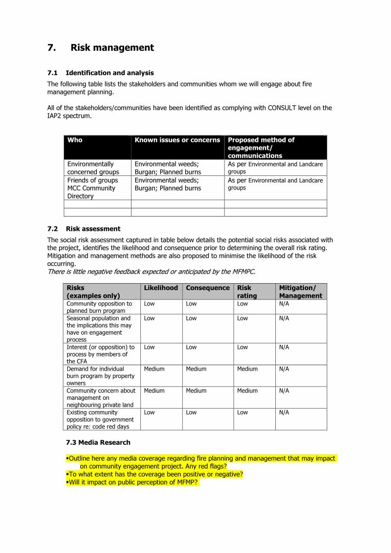
7. Risk management
7.1 Identification and analysis
The following table lists the stakeholders and communities whom we will engage about fire
management planning.
All of the stakeholders/communities have been identified as complying with CONSULT level on the
IAP2 spectrum.
Who Known issues or concerns Proposed method of
engagement/
communications
Environmentally
concerned groups
Environmental weeds;
Burgan; Planned burns
As per Environmental and Landcare
groups
Friends of groups
MCC Community
Directory
Environmental weeds;
Burgan; Planned burns
As per Environmental and Landcare
groups
7.2 Risk assessment
The social risk assessment captured in table below details the potential social risks associated with
the project, identifies the likelihood and consequence prior to determining the overall risk rating.
Mitigation and management methods are also proposed to minimise the likelihood of the risk
occurring.
There is little negative feedback expected or anticipated by the MFMPC.
Risks
(examples only)
Likelihood Consequence Risk
rating
Mitigation/
Management Community opposition to
planned burn program
Low Low Low N/A
Seasonal population and
the implications this may
have on engagement
process
Low Low Low N/A
Interest (or opposition) to
process by members of
the CFA
Low Low Low N/A
Demand for individual
burn program by property
owners
Medium Medium Medium N/A
Community concern about
management on
neighbouring private land
Medium Medium Medium N/A
Existing community
opposition to government
policy re: code red days
Low Low Low N/A
7.3 Media Research
� Outline here any media coverage regarding fire planning and management that may impact on community engagement project. Any red flags?
� To what extent has the coverage been positive or negative? � Will it impact on public perception of MFMP?
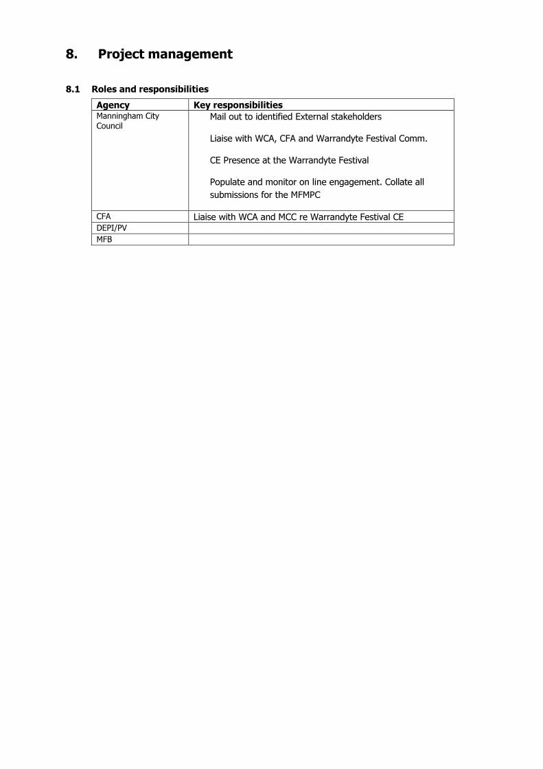
8. Project management
8.1 Roles and responsibilities
Agency Key responsibilities Manningham City
Council Mail out to identified External stakeholders
Liaise with WCA, CFA and Warrandyte Festival Comm.
CE Presence at the Warrandyte Festival
Populate and monitor on line engagement. Collate all
submissions for the MFMPC
CFA Liaise with WCA and MCC re Warrandyte Festival CE DEPI/PV MFB
D.2 Stakeholder Matrix
Influence categories: H= High: Key stakeholders who have direct interest and investment in the project M= Moderate: stakeholders who have a general interest in the project L= Low: parties who may be interested in the project (but not stakeholder)
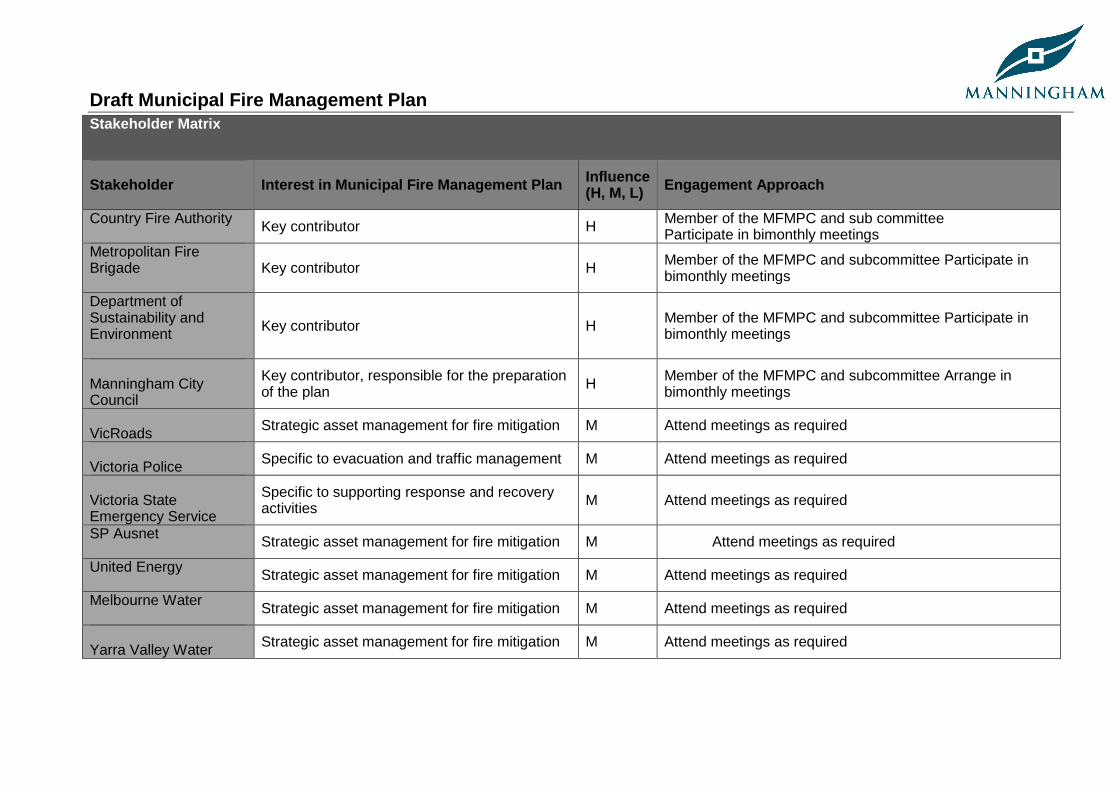
Draft Municipal Fire Management Plan
Stakeholder Matrix
Stakeholder
Interest in Municipal Fire Management Plan Influence (H, M, L) Engagement Approach
Country Fire Authority Key contributor H Member of the MFMPC and sub committee
Participate in bimonthly meetings Metropolitan Fire Brigade
Key contributor H Member of the MFMPC and subcommittee Participate in bimonthly meetings
Department of Sustainability and Environment
Key contributor H Member of the MFMPC and subcommittee Participate in bimonthly meetings
Manningham City Council
Key contributor, responsible for the preparation of the plan H Member of the MFMPC and subcommittee Arrange in
bimonthly meetings
VicRoads Strategic asset management for fire mitigation M Attend meetings as required
Victoria Police Specific to evacuation and traffic management M Attend meetings as required
Victoria State Emergency Service
Specific to supporting response and recovery activities M Attend meetings as required
SP Ausnet Strategic asset management for fire mitigation M Attend meetings as required
United Energy Strategic asset management for fire mitigation M Attend meetings as required
Melbourne Water Strategic asset management for fire mitigation M Attend meetings as required
Yarra Valley Water Strategic asset management for fire mitigation M Attend meetings as required
Draft Municipal Fire Management Plan
D.3 List key stakeholders - based on the IAP2 spect rum in the Community Consultation and Engagement Po licy (2010) Name of stakeholder groups
Level of engagement Engagement method/channel Key messages
Primary agencies CFA MFB DSE MCC
Consult Involve Collaborate
Stakeholder workshops, briefings, meetings
Developing the plan, responsible for the delivery of the communications and consultation plan
Secondary agencies Vic Roads Victoria SES Victoria Police SP AusNet United Energy Yarra Valley Water Melbourne Water
Inform Involve Empower
Stakeholder workshops, briefings, meetings as required Direct letters requesting input when required
Plan is being drafted, MFMPC is seeking input Input requested through MFMPC Draft complete MFMPC is seeking comment
Environment groups (community) Wonga Park Jumping Creek Catchment Land Care group Friends of the Warrandyte State Park Scout Groups
Inform
Direct mail letters Draft to be placed on website and available at Council offices for viewing Advertising that draft is available for comment
Plan is currently being drafted, background, objective of the plan, where interest should be directed Plan been drafted, comments are requested. Methods for accessing information
Municipal Emergency Management Planning Committee
MFMP is a sub component of the committees Municipal Emergency Management Plan H MFMPC provides meeting minutes to MEMPC and is
represented at the MFMPC
Draft Municipal Fire Management Plan
Plan available at fire consultation days such as DSE FOP and CFA Fire Ready Victoria sessions Community discussion forums run if there is enough interest
Draft Municipal Fire Management Plan
List key stakeholders - based on the IAP2 spectrum in the Community Consultation and Engagement Policy (2010) Name of stakeholder Groups
Level of engagement
Engagement method/channel Key messages
Resident groups Wonga Park Residents Association Rate payers association
Inform
Direct mail letters Draft to be placed on website and available at Council offices for viewing Advertising that draft is available for comment Plan available at fire consultation days such as DSE’s FOP’s and CFA’s Fire Ready Victoria program Community discussion forums run if there is enough interest
Plan is currently being drafted, background, objective of the plan, where interest should be directed. Plan has been drafted, comments are requested. Methods for accessing information.
Business groups Warrandyte Businesses Association Warrandyte Community Association Manningham Business Network
Inform
Direct mail letters Draft to be placed on website and available at Council Offices for viewing Advertising that draft is available for comment Plan available at fire consultation days such as DSE’s FOP’s and CFA’s Fire Ready Victoria sessions Community discussion forums run if there is enough interest
Plan is currently being drafted, objective of the plan, where interest should be directed. Plan has been drafted, comments are requested. Methods for accessing information.
Media Manningham Leader Manningham Matters Warrandyte Diary
Inform
Direct mail letters Draft to be placed on website and available at Council Offices for viewing Advertising that draft is available for comment Plan available at fire consultation days such as DSE’s FOP’s and CFA’s Fire Ready Victoria sessions
Plan is currently being drafted, background, objective of the plan, where interest should be directed. Plan been drafted, comments are requested. Methods for accessing information.
Draft Municipal Fire Management Plan
Local MPs Ryan Smith Kevin Andrews Danielle Green
Inform
Direct mail letters Draft to be provided for comment
Plan is currently being drafted, background, objective of the plan, where interest should be directed for constituents. Plan has been drafted, comments were requested. Methods for accessing information.
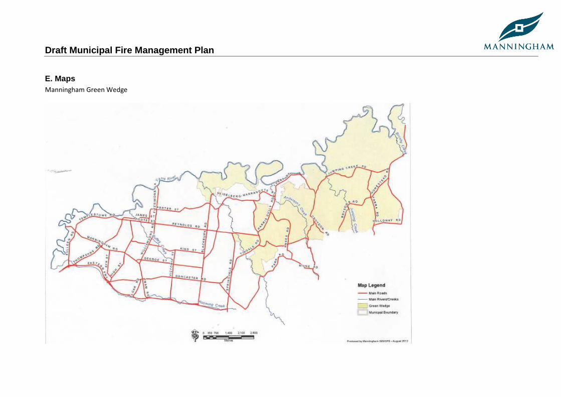
Draft Municipal Fire Management Plan
E. Maps Manningham Green Wedge
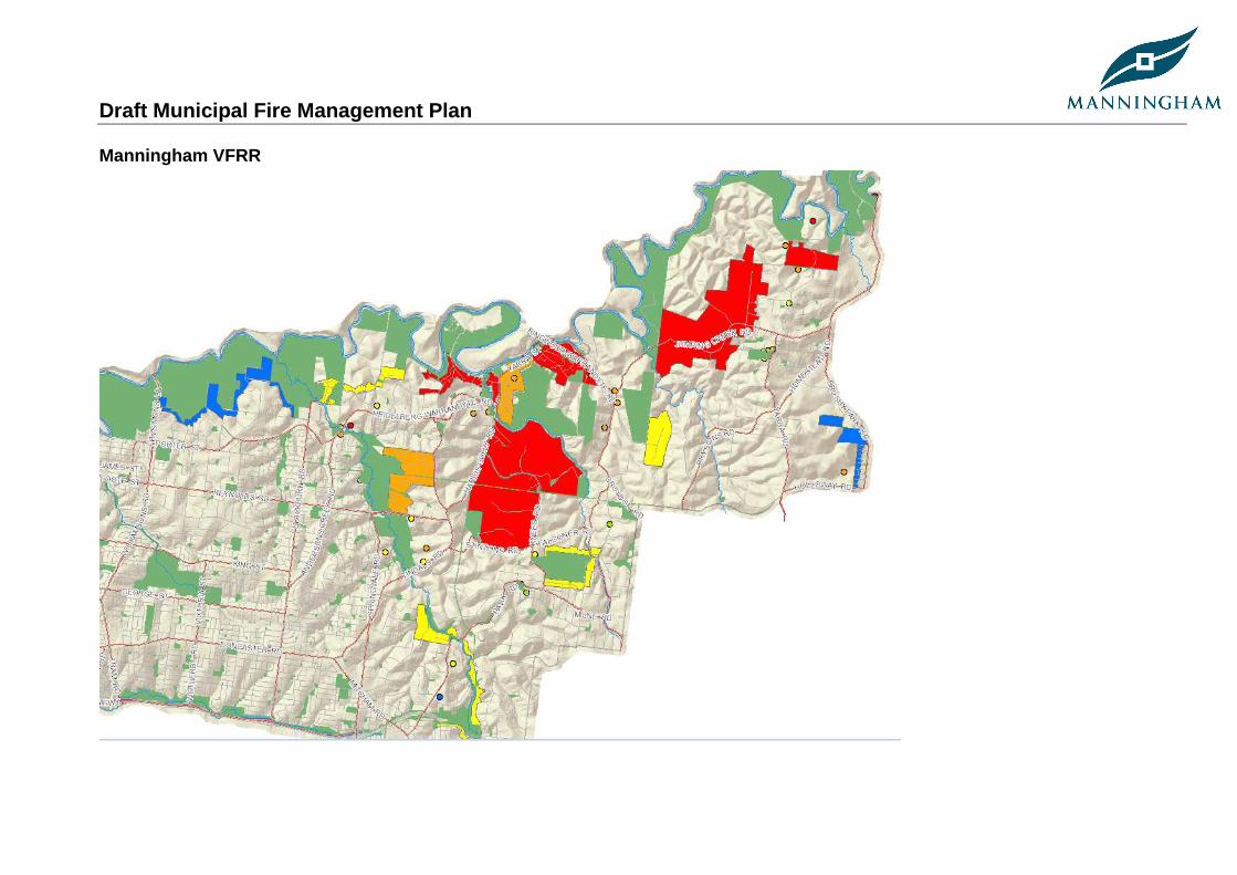
Draft Municipal Fire Management Plan
Manningham VFRR
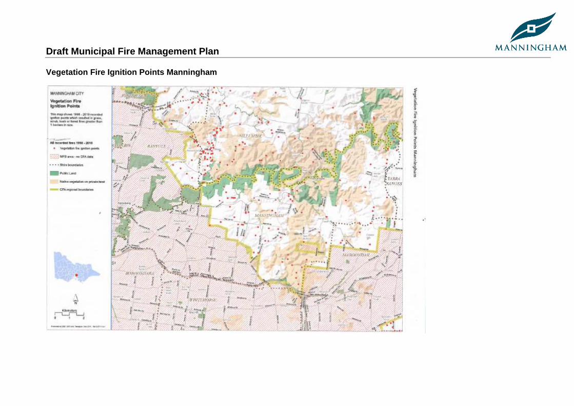
Draft Municipal Fire Management Plan
Vegetation Fire Ignition Points Manningham
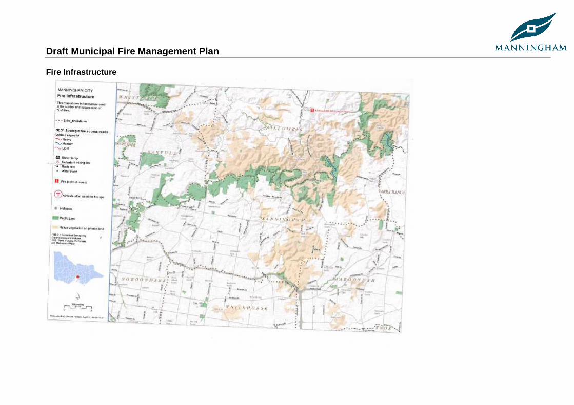
Draft Municipal Fire Management Plan
Fire Infrastructure
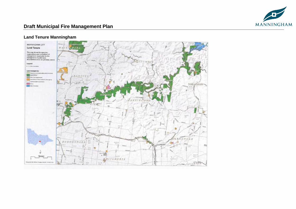
Draft Municipal Fire Management Plan
Land Tenure Manningham
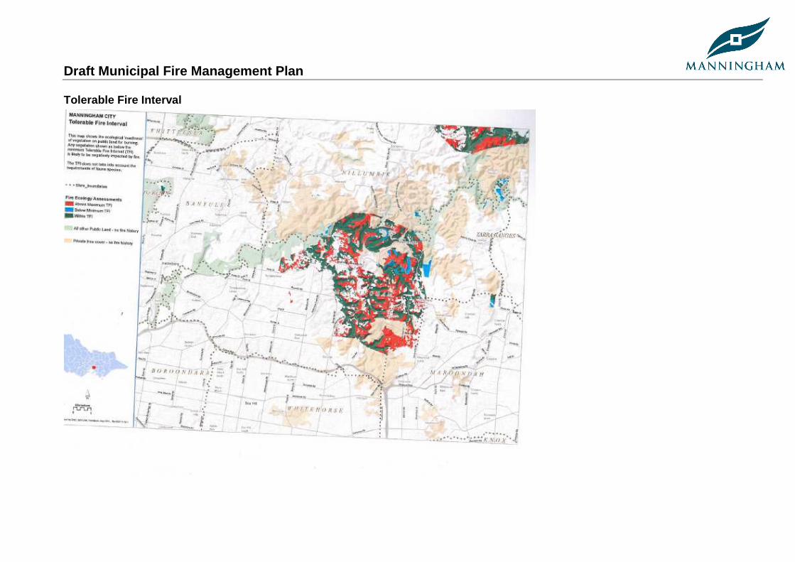
Draft Municipal Fire Management Plan
Tolerable Fire Interval
Draft Municipal Fire Management Plan
Bibliography
AFAC. (2010, December). Bushfire glossary. Retrieved November 22, 2011, from Australasian Fire and Emergency Services Authorities Council web site: http://knowledgeweb.afac.com.au/data/bushfire_glossary
Australian Bureau of Statistics, Census of Population and Housing 2006 and 2011. Compiled and presented by .id, the population experts. CFA (2008).Precincts: an Approach to Integrated Service Delivery. CFA, Melbourne. CFA Act 1958, www.cfa.vic.gov.au DSE Geospatial Data Library, 2003 DSE. (2012, February). Retrieved October 09, 2012, from DSE website: http://www.dse.vic.gov.au/__data/assets/pdf_file/0007/135943/Roadside-
Vegetation-Management-for-bushfire-risk-mitigation-purposes.pdf DSE. (2012, June). Fire and Emergencies. Retrieved October 09, 2012, from DSE website: http://www.dse.vic.gov.au/fire-and-other-
emergencies/publications-and-research/code-of-practice-for-bushfire-management-on-public-land DSE. (2009, April). Managing native roadside vegetation. Retrieved October 04, 2012, from DSE website:
http://www.dse.vic.gov.au/__data/assets/pdf_file/0007/102310/Managing_native_vegetation_on_roadsides.pdf Eastern Meropolitan Regional Strategic Fire Management Plan 2011, www.ifmp.vic.gov.au EMA (2000).Emergency Risk Management: Applications Guide. Emergency Management Australia, Canberra. Geotech Information Services (2010) Urban Fire Risk Profile, Manningham Urban Area & surrounds. IAP2. (2011). Resources. Retrieved November 23, 2011, from International association for public participation:
http://www.iap2.org.au/resources/list/asset_id/36/cid/1/parent/0/t/resources/title/IAP2%20Spectrum IFMP guidelines. (2010, September). Integrated fire management planning guidelines. Victoria, Australia: Authorised by the State Fire Management
Planning Committee.
Draft Municipal Fire Management Plan
Manningham Council Plan 2009-2013 MCC (2002).Municipal Emergency Management Plan and City of Manningham Planning Scheme. Metropolitan Fire Brigades (MFB) Act, 1958 McAneney, J. and Chen, K. (2010) Bushfire Penetration into Urban Areas in Australia: A Spatial Analysis, Bushfire CRC Report for the Victorian
Bushfires Royal Commission. National Strategy for Disaster Resilience, 2009, www.coag.gov.au/.../2011-02-13/docs/national_strategy_disaster_resilience.pdf SFMPC. (2009, September). State Fire Management Strategy 2009. (www.ifmp.vic.gov.au, Ed.) State of Victoria. Standards Australia (2009).ISO 31000:2009 Risk management – Principles and guidelines. Standards Australia, Sydney. State of Victoria. (2011, January). Emergency Management Manual Victoria. Emergency Management Manual Victoria,
www.oesc.vic.gov.au/emergencymanual State of Victoria. Emergency Management Act 1986, www.oesc.vic.gov.au Terramatrix (2009).City of Manningham Bushfire Prevention and Preparedness Plans for Bushland Reserves: Context and Methodology. Terramatrix,
Beechworth VFRR. (2011, November 11). Victorian Fire Risk Register Reference Guide. Retrieved November 22, 2011, from VFRR web site:
http://vfrr.fileburst.com/VFRR/VFRR_Supporting_Documentation/
Draft Municipal Fire Management Plan
Disclaimer This publication maybe of assistance to you. However the State of Victoria and its employees do not guarantee that the publication is without flaw of any kind, or is wholly appropriate for your particular purposes. It therefore disclaims all liability for any error, loss or other consequence which may arise from you relying on any information in this publication.
For more information go to: www.ifmp.vic.gov.au


