78
MANUAL FOR COMMUNITY-BASED FLOOD MANAGEMENT NEPAL

MANUAL FORCOMMUNITY-BASED
FLOOD MANAGEMENT
NEPAL


Table of Contents
List of Acronyms 230
Executive Summary 231
1 Introduction 236
2 Classification of Floods and Flood Prone Areas 241
3 Pre-Flood Preparedness 244
4 During Flood Responses 255
5 Post-Flood Rehabilitation and Maintenance 256
6 Managing Information for Future References 258
Annexures 260
MANUAL FOR COMMUNITY-BASEDFLOOD MANAGEMENT IN NEPAL
Asia Pacific J. Env. Dev., 11(1&2), 2004, pp. 227-304

List of Acronyms
ADB/N : Agricultural Development Bank of NepalCBOs : Community Based OrganizationCFMC : Community Flood Management CommitteeDADO : District Agriculture Development OfficeDDC : District Development CommitteeDHM : Department of Hydrology and MeteorologyDNCRC : District Natural Calamity Relief CommitteeDOR : Department of RoadsDWIDP : Department of Water Induced Disaster PreventionDWRC : District Water Resources CommitteeGLOF : Glacier Lake Outburst FloodINGO : International Non-Governmental OrganizationJICA : Japan International Cooperation AgencyNGO : Non-Governmental OrganizationsNRCS : Nepal Red Cross SocietyRCC : Reinforced Cement ConcreteRUAA Roorkee University Alumni AssociationSIREN Society of Irrigation EngineersUNDP : United Nations Development ProgrammeVDC : Village Development Committee

EXECUTIVE SUMMARY
Floods in Nepal
Unstable steep slopes, weak and fragile geological formation of young mountainsalong with heavy monsoon rainfall make Nepal one of the most hazardous areasin the world. Because of its topographical variation and geological characteristicstogether with torrential rain during the monsoon season, the country frequentlysuffers from different kinds of water induced disasters like soil erosion, landslide,debris flow, floods etc. These phenomena cause loss of lives and property andpose severe hazards to physical infrastructures resulting in the disruption of thesocial and economic development of the country.
The Project
This project is a part of the Global Water Partnership’s (GWP) Associated Programon Flood Management (APFM) and is sponsored and funded by the WorldMeteorological Organization (WMO). The broad objective of the project is to findout ways and means for strengthening the self-help capacity of communities forimproved flood management under the IWRM framework. The overall goal is tocontribute to the process of sustainable development and improve the quality oflife by reducing flood vulnerability with a focus on non-structural measures. As apart of AFPM’s activities in facilitating the development of regional activities, theproject’s study area included Bangladesh, India and Nepal under a common andcollaborative research design. The project comprises two phases. Phase I of thestudy was completed in early 2003 which aimed to prepare a country paper toaccess flood management activities and practices in the countries with the focuson community involvement in such activities. The outcome of the Phase I studywas presented in the Third World Water Forum held in March 2003 in Kyoto,Japan.
In Nepal, two study areas were selected for carrying out the study. The first is thearea in Saptari District in Eastern Development Region affected by the KhandoRiver and the second is the area in Rautahat District in Central DevelopmentRegion affected by the Bagmati and Lalbakeya rivers. The selected location areshown in Figure 1.

Figure 1 : Project Area—Rautahat and Saptari Districts, Nepal.
232 ASIA PACIFIC JOURNAL ON ENVIRONMENT AND DEVELOPMENT

Phase II StudyThe present phase II of the study project aims to gather additional knowledgeabout the flood affected communities and undertake appropriate activities tostrengthen self-help capacity of communities for improved integrated floodmanagement. The following activities are envisaged:
• Strengthen people’s ability to understand flood warning messages anduse them in combination with their own assessments through traditionalmethods.
• Undertake programme to enhance awareness, preparedness, and copingstrategies of flood affected people.
• Provide assistance for improving the flood responses by the local people.• Prepare a manual using guidelines provided by the national flood response
strategies that are available in each country and knowledge generatedthrough local surveys and consultations.
• Identify specific non-structural measures beyond the ability of the localcommunity, which have to be provided by the government and NGOs /CBOs in each location to help reduce flood vulnerability.
• Facilitate confidence building and dialogue amongst individualprofessionals, and institutions dealing with the issues involved in floodmanagement.
• Identify effective modalities of managing floods through effective regionalco-operation as well as specific activities to accelerate such co-operation.
Two physical outputs are expected out of this study, the first is the manual oncommunity approach to flood management and the second is establishmentof some organized communities aware of improved integrated floodmanagement and ready to make use of the manual.
Study TeamJalsrot Vikas Sanstha (JVS) has been entrusted with the task of carrying out thepilot study in Nepal. Mr. Som Nath Paudel, Executive Director of JVS is theCoordinator of the study. The study team consists of the following:
Mr. Shiv Kumar Sharma Team Leader/ River Engineer
Mr. Danda Pani Jaishy River Engineer
Mr. Ram Chandra Dangal River Engineer
Mr. Rajendra Pandit Sociologist
Mr. Roshan Subedi Sociologist
Further, two social organizers Mr. Rajesh Kumar Jha and Mr. Birendra Dev wereinvolved on part time basis in Rautahat and Saptari project areas respectively.
MANUAL: NEPAL 233

Activities AccomplishedUnder Phase II of the study, the Nepalese team has completed the followingactivities:
• Field visit and interaction with the people in July 2003.• Preparation of a sample constitution for the Community Flood Management
Committee (CFMC) and distribution to the key persons in thecommunities.
• Preparation of Manual on Community Approach to Flood Management.• Presentation of the manual to professional groups, focused community
of the study area and stakeholders at district level of the study area.• Identification of further works to disseminate the manual.
This report marks the end of Phase II study.
Lessons Learned from the FieldDetails of the findings of the field visits in the study areas and interactions withthe affected communities are presented in Annex I and Annex II for Saptari andRautahat respectively. Many common observations have been made, which areas follows:
• People temporarily shift to high lands, public places, schools,embankments, etc during floods.
• The communities have no collective pre-coping mechanism. All theactivities are done on individual basis.
• Proper coordination is lacking among the agencies involved. The externalsupport provided to the affected communities is inadequate andinequitable.
• Due to heavy sediment load in the river, the bed level is rising every yearcausing more threat of flooding in the future.
• There is no permanent flood management committee in the communities.However, they form an ad-hoc committee when river training works withsupport from the government agencies are to be constructed.
• Strong confidence for self-help is demonstrated by the communities, butscarcity of funds remains a major constraint
The following observations in the two study areas were not common:
a) Saptari District Study Area• There is no flood warning system and people predict flood by watching
the clouds and the rain.
234 ASIA PACIFIC JOURNAL ON ENVIRONMENT AND DEVELOPMENT

• Some of the households in Tilathi community have individual pre-copingpractices such as storing food, keeping plastic sheets and tents etc. Butthere is no such practice in the community of Launiya.
• Proper engineering design of river training works being undertaken islacking.
b) Rautahat District Study Area• The communities in Brahmapuri and Banjaraha entrust the elders for
flood forecast who listen to the weather report from radio broadcasts andwatch flood events for the purpose.
• Although the Government is about to complete embankments to stopwater spilling over the banks of Bagmati and Lalbakeya, the threat offlood damage will remain the same.
• Growing urbanization and network of roads and infrastructure areincreasing the drainage congestion and the depth and duration ofinundation are also on the increase.
• The Red Cross has made some efforts to mobilize the youths of BanjarahaVDC amd train them in disaster management techniques.
The ManualThe manual has been divided in to 6 sections. Section 1 provides the generalperspective of the study. Section 2 deals with classification of floods and flood-prone areas. This is expected to form a uniform base in the use of this manual.Section 3 has systematically listed a range of various activities a communitymay have to undertake as pre-flood preparedness that would prepare the communityto face the flood. Section 4 categorically lists the activities the community has tocarry out in the event of flood. Similarly, Section 5 deals with post-flood rehabilitationand maintenance. Section 6 elaborates on different activities to manage informationfor future reference and maintain transparency of the work performed by thecommunity organization.
Further WorksThe contents of the manual have been disseminated to the professionals in variousforums, to the communities taken as focused groups for the study and the districtlevel stakeholders of the study area. The manual, probably being a new endeavorin itself, was successful in gathering a lot of enthusiasm and appreciation fromthe stakeholders but there was almost no comment procedures enlisted in themanual. However, the dissemination provided a clear roadmap for further worksto be undertaken, which are as follows:
MANUAL: NEPAL 235

An external catalytic agent is necessary to facilitate the community to organize,make its constitution and carry out works as illustrated in the manual for at leasttwo or three years of monsoon. This will ensure the sustainability of the communityorganization. The lessons out of this process will be helpful in replicating the workin other concerned areas. The catalytic agent, which will need financial resourcefor itself, would also help channel external financial support to carry out variousactivities mentioned in the manual.
Many suggested incorporating simple but illustrative methods on how to do variousthings which can be done by the community by themselves with little assistancefrom outside. These methods can include a variety of activities such as how toconstruct spurs, how to construct in embankment, how to construct revetment,how to carry out plantation, how to make flood proof houses, how to chooselocation for taking refuge during flood, how to make tubewells free fromcontamination during flood, how to make water portable and so on.
The suggestions mentioned are very well-founded and should be included in futureworks.
1 INTRODUCTION
1.1 Floods in NepalUnstable steep slopes, weak and fragile geological formation of young mountainsalong with heavy monsoon rainfall make Nepal one of the most hazardous areasin the world. Because of its topographical variation and geological characteristicstogether with torrential rain during the monsoon season, the country frequentlysuffers from different kinds of water induced disasters like soil erosion, landslide,debris flow, floods etc. These phenomena cause loss of lives and property andpose severe hazards to physical infrastructures resulting in the disruption of thesocial and economic development of the country.
About eighty percent of the total land area of Nepal is hilly and many villages aresituated on or adjacent to unstable hill slopes. As a result, frequent landslidesand floods with debris flow occur. Unplanned settlements and physicalconstructions without due consideration to the natural hazards considerablyaggravate the mountain hazards. On the other hand landslides add enormoussediment load to streams and rivers causing floods and debris flow downstream.Every year, such disasters cause loss of human lives and immense damages toagricultural land, crops, human settlements and other physical property.Low lying areas, like the Terai, inner Terai and valleys are inundated and fields arefilled with sediments every year due to floods during the monsoon season. In July1993, Nepal experienced a devastating flood in the Terai region, which took the
236 ASIA PACIFIC JOURNAL ON ENVIRONMENT AND DEVELOPMENT

lives of 1,336 people and left 487,534 people homeless. In 1999, floods andlandslides killed 113 while 47 people were reported missing and 97 seriouslyinjured; 8,844 families were affected, 3,507 houses and cattle sheds were destroyedand 17,732 hectares of land and agricultural crops were ruined. According to thegovernment estimate, the disaster caused a total loss of NRs 3.6 million. In Julyand August 2002, Nepal experienced numerous floods and landslides in the easternand central regions, which took the lives of 451 people and affected about 55,000families.Effective management of the rivers of Nepal which cause landslide and soil erosionin the hills, widespread bank erosion and flooding of arable land in the Terai andwashing away of houses, bridges, roads etc. is not an easy task. However, effortshave been made by the government in the field of river training and landslidecontrol with its limited means and resources and with the help of various donoragencies. The task being highly complicated and resource demanding can onlybe accomplished with an integrated development approach and active participationof the community.
1.2 The ProjectThis project is a part of the Global Water Partnership’s (GWP) Associated Programon Flood Management (APFM) and is sponsored and funded by the WorldMeteorological Organisation (WMO). The broad objective of the project is to findout ways and means for strengthening the self-help capacity of communities forimproved flood management under the IWRM framework. The overall goal is tocontribute to the process of sustainable development and improve the quality oflife by reducing flood vulnerability with a focus on non-structural measures butkeeping unavoidable structural means in view. As a part of AFPM’s activities infacilitating the development of regional activities, the project’s study area includedBangladesh, India and Nepal under a common and collaborative research design.Jalsrot Vikas Sanstha (JVS) has been entrusted with the task of carrying out thepilot study in Nepal. The project is designed to carry out its study in two phases.
Phase I StudyThis phase of the study was carried out in late 2002 and early 2003. The objectiveof this phase was to prepare a country report with the following specific objectives:
• Identify sources of information on floods among the flood-pronecommunities and assess their levels of flood preparedness;
• Ascertain the community’s level and magnitude of perception of flood asa risk;
• Understand flood management activities and practices at the communitylevel;
MANUAL: NEPAL 237

• Determine the needs and expectations of the communities vis-à-vis floodmitigation and loss minimization;
• Highlight the community level coping strategies at present, and theircapacity to enhance their options for response in flood vulnerabilityreduction.
In Nepal, two study areas were selected for carrying out the study. The first is thearea in Saptari District in Eastern Development Region affected by the KhandoRiver and the second is the area in Rautahat District in Central DevelopmentRegion affected by the Bagmati and Lalbakeya rivers.The outcome of the Phase I study was presented in the Third World Water Forumheld in March 2003 in Kyoto, Japan which has made the following generalizationsabout the salient traits of community approaches to flood management in GBMregion:
• The status of flood forecasting and warning as well as informationdissemination is inadequate.
• The communities depend to a great extent on traditional knowledge andexperience for flood preparedness, supplemented by radio broadcasts.
• Assistance provided by agencies from outside the local community isoften inadequate and inequitable. Self-help and assistance from neighborsand relatives are generally more forthcoming.
• Floods that destroy lives, crops, cattle and other assets are perceived asa hazard, and the people are conscious of the real need to adopt measuresfor vulnerability reduction.
• Among various coping strategies/practices (like evacuation, flood proofing,storage of food and livestock), community participation and mobilizationare important, although extra-community assistance in relief and recoveryis required.
• The communities expect such measures from the government and NGOsas the implementation of certain structural flood protection works,equitable and transparent (corruption free) distribution of post-flood reliefmaterials, loans and grants, and support for the rapid restoration of thelocal infrastructure.
• The communities demonstrate strong confidence and potentials for self-help in flood management at the local level, though fund scarcity remainsa serious constraint impeding their success.
Phase II StudyThe present phase II of the study project aims to gather additional knowledgeabout the flood affected communities and undertake appropriate activities tostrengthen self-help capacity of communities for improved integrated flood
238 ASIA PACIFIC JOURNAL ON ENVIRONMENT AND DEVELOPMENT
management. The following pertinent activities are envisaged:• Strengthen people’s ability to understand flood warning messages and
use them in combination with their own assessments through traditionalmethods.
• Undertake programme to enhance awareness, preparedness, and copingstrategies of flood affected people.
• Provide assistance to improve the flood responses undertaken by thelocal people.
• Prepare a manual using guidelines provided by the national flood responsestrategies that are available in each country and knowledge generatedthrough local surveys and consultations.
• Identify specific non-structural measures, beyond the ability of the localcommunity to address, which have to be provided by the government andNGOs/CBOs in each location to help reduce flood vulnerability.
• Facilitate confidence building and dialogue amongst professionals,individuals and institutions dealing with the issues involved in floodmanagement.
• Identify effective modalities of managing floods through effective regionalco-operation as well as specific activities to accelerate such co-operation.
Two physical outputs are expected out of this study—the first is a manual oncommunity approach to flood management and the second is establishmentof some organized communities aware of improved integrated floodmanagement and ready to make use of the manual.
1.3 Approach and MethodologyThis report is the outcome of the Phase II study. This study has been carried outadopting the following approach and methodology.
• A study team was formed comprising a coordinator, a team leader, twoengineers and two sociologists. The team discussed the scope of thestudy and worked out the general framework of the report to be produced.The team further discussed the issues that are needed to be addressedon the community approach of flood management, especially in thecontext of Nepal. Based on the report of Phase I study, other informationand reports available on the web and in various agencies within Nepal,the team prepared a list of questions that would be utilized to get therelevant communities’ perception on flood management and their existingsocial and physical systems and the way they respond to the floods.The team identified the subjects to be incorporated in the manual andprepared the table of contents of the manual.
MANUAL: NEPAL 239

• The team prepared a sample constitution for the Community FloodManagement Committee (CFMC) in Nepali.
• The study team visited the study area in July 2003. There was flood inboth the locations and the team had a good opportunity to observe it.Interactions were carried out with the flood victims, villagers, officialsfrom local government agencies and relief workers from NGOs and INGOs.The interaction was focused on getting greater insight into the flood andrelated management issues in the area together with getting feedbackfor the essential elements to be incorporated in the manual.
• The team distributed the sample constitution for CFMC to the key personsin the communities to get the feedback.
• Field reports were written after the field visits which are presented inAnnex I and II of this report.
• Manual on Community Approach to Flood Management has beenprepared. While preparing the manual, local cultural and social setting,economic conditions and existing rules and regulations are duly takeninto consideration. Section 2 onwards of this report is the manual.
• The study team presented the draft manual to a group of engineers in atalk program organized jointly by Society of Irrigation Engineers (SIREN),Nepal and Roorkee University Alumni Association (RUAA), Nepal Sectionand feedback was received. There were about 50 persons participating inthe program.
• The coordinator and the team leader of the study presented a paper onthe study to the “National Seminar on Water Induced DisasterManagement” conducted jointly by the Department of Water InducedDisaster Prevention and JICA on 11-13 March 2004.
• Similarly, the paper was also presented to the seminar on “DisasterManagement in Nepal” conducted by Nepal Engineers’ Association on11-12 April 2004 and feedback from the professionals was obtained.
• The manual, originally written in English, was translated into the Nepalilanguage. The team visited Saptari study area from 28 February to 6March 2004 and Rautahat study area from 23 February to 1 March 2004.The purpose of this visit was to disseminate the draft manual in Nepali tothe community and stakeholders. Interaction programs at two levels,one at the community and the other at district level stakeholders, wereconducted. The response of the community and the stakeholders wasvery encouraging as indicated by their overwhelming presence andparticipation in the programs. Major points of discussions were notedand are presented in this report as Annex VI. Video records of theseinteractions have also been prepared and kept on record for furtherreference.
240 ASIA PACIFIC JOURNAL ON ENVIRONMENT AND DEVELOPMENT

1.4 The Study AreaThis report including the manual has been prepared on the basis of feedback frominteractions with the communities residing in two flood-prone areas located inSaptari and Rauthahat districts of Nepal. These areas are the same ones chosenin the first phase of the study (Refer Annex I and II).
In order to get more focused insight on flood related issues outlined by the scopeof Phase II, two communities in each of the study areas were chosen for detailedinteraction. These are the most vulnerable and affected communities and aremost likely to get organized to adopt community approach to flood management.In Saptari District, one is from Tilathi and the other from Launiya VDC. Similarly inRautahat District, one community is from Brahmapuri and the other is fromBanjaraha VDC.
2 CLASSIFICATION OF FLOODS AND FLOOD PRONE AREAS2.1 Types of FloodsFlash Floods: These are events with very little time lapse between the start ofthe flood and peak discharge. They are often associated with short intervals betweenstorm occurrences and arrival of the flood wave. Floods of this type are particularlydangerous because of the suddenness and speed with which they occur. Flashfloods are more common with isolated and localized intense rainfall originatingfrom thunderstorms. Debris torrents are generally created in the hills from suchflash floods. Rivers originating from the Siwalik range of Nepal are characterizedby a sharp rise followed by a rapid recession often causing high flow velocitiesand damaging crops and properties.
Monsoon Floods: Monsoon is a rainfall phenomenon typical to this region whichis characterized by intense rain during four months of June to Septemberaccounting for about 80 percent of the annual rainfall. This widespread and intensemonsoonal rain causes flood and associated damages. Not all the inundation ofland or damage to physical property, however, are from this hydrologicalphenomenon alone. Often other factors operate either to exacerbate an alreadyoccurring flood problem or to create entirely a separate flood problem. Thesefactors are associated most often with the promotion of hydraulic surcharge inwater levels. They include the presence of natural or manmade obstructions inthe flood path such as bridge piers, floating debris, weirs, barrages andembankments constricting the flow path.
Monsoon floods from the major rivers generally rise slowly in the southern Teraiplains and the period of rise and fall may extend up to 12 to 24 hours or more.Inundation of large areas due to floods overflowing the river banks causes extensivedamage. The flood water erodes the banks causing permanent damage to theadjacent agricultural land.
MANUAL: NEPAL 241

Local Floods: High localized rainfall of long duration in the monsoon seasonoften generates water volume in excess of local drainage capacity causing localizedflood. The drainage congestion resulting from man made infrastructures such asroads, embankments and bridges often exacerbate the situation. This type offlood is common in the southern Terai part, inner Terai and in the valleys.Glacier Lake Outburst Flood: Glacier lakes are common in the NorthernHimalayan part of the country. The Mahalali River Basin within the territory ofNepal consists of 16 lakes, the Karnali River Basin consists of 907 lakes, theGandaki River Basin consists of 338 lakes and the Koshi River Basin contains1054 lakes. Altogether 2315 glacial lakes are identified in Nepal. Areas like theUpper Barun, Lower Barun, Chamlangtsho, Tsho Rolpa, Sabou, Dudh Kunda,Majang, Inja, Thulagi have potentially dangerous glacier lakes. These lakes containhuge volumes of water and remain in an unstable condition. As a result, they mayburst at any time and a natural catastrophe may cause great loss of life andphysical property. About 14 such glacier lake outburst floods (GLOF) have alreadybeen experienced from 1935 to 1991 in Nepal.
2.2 Classification of Floods and Flood Prone AreasNepal experiences major floods during the monsoon season (July to September)caused by incessant heavy rainfall. High monsoon precipitation almost in all thecatchments within a short span of time resulting in large runoff from differentcatchments and consequent high water levels in the rivers, causes widespreadinundation and river bank cutting in the Terai plains, and landslides and siltation inthe hilly area. Accordingly, the flood prone areas of Nepal can be classified as:
i) Erosion Prone Areasii) Sedimentation Prone Areasiii) Inundation Prone Areas
2.2.1 Erosion Prone AreaA considerable area of land is flooded during the monsoon causing heavy damageto cultivated land, houses, roads and other physical properties due to bank erosionand river toe cutting. The top soil suitable for fertile agriculture is washed awayand the land is converted into sandy river beds. The land is lost almost forever asreclaiming it requires a lot of time and effort which is often beyond the capacity ofthe land holders. This type of area lies mostly along the banks of the river.Managing the flood in such an area is mostly limited to adopting structuralmeasures to protect the banks from erosion and maintaining the infrastructure.
2.2.2 Sedimentation Prone AreaAlmost all the rivers originating from the hills and mountains of Nepal enter into
242 ASIA PACIFIC JOURNAL ON ENVIRONMENT AND DEVELOPMENT

the Terai plain in the south. Most of the rivers have gradient high enough to carrywith them sediment bed load in the hill region. As the gradient becomes flatter inthe Terai, they deposit their bed load causing a considerable rise in the bed level.The bed rise triggers change of course and widening of the river every year. Thisphenomenon is more severe in case of the rivers originating from the Churiyarange, which carry considerable flood discharge during monsoon and are almostdry during other months of the year. Every year, sedimentation occurs on largeareas of cultivated land converting them into sandy areas. The top agricultural soilis washed away in some cases and replaced by coarse sediment and in someother cases sediment is deposited on top of the agricultural soil.Similarly, floods overflowing the banks of the rivers deposit coarse sand in theadjoining land damaging standing crops and converting the land to infertile landmass. Reclaiming this land requires removal of the deposit which is costly andtime consuming.Growing crops immediately after flood recession is normally not possible in suchan area.Managing the flood in such an area is mostly limited to adopting structuralmeasures to stop the flood entering into the area and maintaining the infrastructure.
2.2.3 Inundation Prone AreaWhen flood water level exceeds the natural bank level of river, floodwater spillsover the banks. Sedimentation occurs in the immediate vicinity of the river bankswhich is called sedimentation prone area. After sedimentation prone area, floodwater continues spreading over the adjacent areas and submerges agriculturalland, villages and towns on its way. The flood water carries only fine sedimentswhich gets deposited over the area as the flood advances. This deposit containscrop nutrients and thus helps increase the crop yield.Drainage congestion due to settlements and man made infrastructure, such asroad and embankments, change the pattern, depth and duration of drainage ofthe inundating water. Growing crops immediately after flood recession is possiblein such an area.There are lots of possibilities and scope of flood management by the communityin this area.Inundation area can further be classified:
According to frequency of floodOccurrence of flood every year;Once in five years;Once in ten years;Once in 25 years.
MANUAL: NEPAL 243

According to depth of flooding ( For the convenience of the local people the depth of inundation is kept in multipleof 1 foot= 30cm)
Severe: Having depth of more than 60 cmModerate: Having depth between 60 to 30 cmNormal: Having flood depth less than 30 cm
According to duration of standing floodwaterSevere: Floodwater standing more than 30 hrsModerate: Water standing between 12 hours to 30hoursNormal: Water standing for less than 12 hours
Depending upon the type and extent of information available and the copingmethods with which a community feels easier, any one of the classifications canbe adopted for risk assessment.
3 PRE-FLOOD PREPAREDNESSIn areas where occurrence of flood is a regular phenomenon, preparedness isconsidered as one of the main activities to save life and property of the people.Preparedness includes three Ps—plans, preparations and provisions made inadvance for carrying out activities when the area is being hit by the flood. Theprimary objective is to allow the passage of flood with minimum damage to livesand properties of the community.We should always keep in our mind that the flood water is beneficial also. Itbrings humus sediment and deposits on the farm land. It makes the soil rich infertilizers and nutrients and crop production after the flood is high. Unless theflood causes damages to properties and loss of lives, it will be beneficial to allowthe flood water to come. Thus, preparing for the flood rather than driving it away inmany instances will be better for rural farm areas.
3.1 Why Community OrganizationIn a country like Nepal where mostly poor people live in the flood affected area,vulnerability to flood is high because of inadequate knowledge in the field of floodmanagement. Most of the activities during the flood are carried out on an individualbasis which constraints the scope of minimizing loss of lives and damage toproperties. If these activities are carried in an organized manner involving thecommunity at large, risk and vulnerability due to flood can be minimized to asubstantial level.It is quite recently in Nepal that the role of communities in flood related activitieshas been recognized. The river training works that the government and local bodies
244 ASIA PACIFIC JOURNAL ON ENVIRONMENT AND DEVELOPMENT

carry out are often form users’ groups involving the beneficiaries. The users’ groupsare involved only during construction. But organized communities for nonstructuralmeasures are almost nonexistent although some efforts are now being madesuch as this by NGOs.The need of organized effort is clearly felt during the time of flood. It is observedthat most of the coping practices are done on individual basis. People preparethemselves for flood to the best of their individual capacities. Therefore the well-to-do families in the community are better prepared for the flood than the poorones who are poorly prepared and often face various difficulties in getting outsideassistance. Furthermore, it is difficult to arrive individually at a collective decisionfor the solution of the flood related problems. If a coping strategy on communalbasis is adopted, the coping mechanism will be more effective and efficient.
In general, outside assistance reaches the community only in the late post-floodsituation and that too is not sufficient, and proper distribution of relief supplies isalways in question in the affected community. It is therefore the community itselfthat has to prepare itself and act till such time as outside help reaches it. It isagain at this time, during the flood and immediately after, that the loss of lives anddamages to properties reach the maximum and the community’s action cansignificantly reduce the damages. Institutions are often criticized for partiality andfor not reaching out to the needful community. The community can help in identifyingthe needy and facilitate the institutions reaching them.
Having described all the benefits of community involvement in flood management;how to involve community in it? It must have a representing organization. Thisorganization will speak for the community. We already have experience of havingsuch organizations in irrigation, drinking water, forest and many other developmentactivities. If we are affected by the flood, then we are in need of one moreorganization. We can give different names to the organization. We have suggestedthe name “Community Flood Management Committee”, in short CFMC. Nepal’sWater Resources Act allows registration of such a committee and once registeredattains legal status.
Now we can summarize the benefits of having CFMC as follows:• Better preparation for facing the flood event,• Immediate response during flood,• Better coordinated effort to fight flood,• Ease in bringing external support,• Making community’s voice heard,• Channelise government support,• Establishment of legal body and registration.
MANUAL: NEPAL 245

3.2 Formation of CFMCCommunity institutions are important to plan, implement and monitor differentactivities relating to flood disaster and minimize the impacts of flood on thecommunity. Community development will start with the Community Mobilizationcomponent, to strengthen the organizational bases for local flood mitigationinitiatives. Unlike the past practices in which people are hastily organized primarilyfor the construction of physical facilities, more focus should be placed onawareness-raising and capacity building of the communities themselves.Prior to the formation of the CFMC, required information such as importance ofcommunity institutions, role and responsibilities of CFMC, formation process andinvolvement of the community, women, affected groups etc. should be disseminatedto the concerned VDC and its representatives, local leaders, teachers and thecommunity.It is necessary to organize settlementwise meetings and dialogue withcommunities regarding the formation of the Committee.
Who will do all these things? Some catalyst organization is needed at this point.Depending upon specific situation, there can be a number of institution initiatingthis process. NGOs, the concerned VDC, Red Cross etc. can play this role.Furthermore, there are some Government organizations working in disastermanagement such as the local division of DWIDP, local office of the Chief DistrictOfficer, Local Police office, Local Military office which can initiate this process.The elite should seek the possibility of involving themselves in one or more ofthese organizations.
Again depending upon the specific situation of the affected community, there canbe a number of ways of forming the CFMC. Interaction with the communitiesduring the field study phase of preparing this manual has indicated two suchoptions as follows:
a. Village Development Committee (VDC) should establish CFMCrepresenting the affected communities, women and ethnic groups withthe chairmanship of local Ward chairman of the affected area.
b. Affected communities should establish CFMC with the chairmanship oflocal elected community leader and with the representation of VDC andWard representatives including women, ethnic groups, teachers, localleaders etc.
Initially, an Ad-hoc Committee of 5 to 7 members should be formed before theformation of the main committee. The AC will be involved in discussions andinteractions among the affected communities, local leaders, teachers, womenand different ethnic groups. For such discussions, the AC should seek the help ofthe catalytic organization. The main objective of this committee will be to makedraft constitution of the committee and facilitate the formation of CFMC.
246 ASIA PACIFIC JOURNAL ON ENVIRONMENT AND DEVELOPMENT

Once the draft constitution is prepared, the AC should call for a mass meeting fordiscussing on the draft. The draft constitution should be amended to reflect thesuggestions received in the mass meeting.The CFMC should have 9 to 13 members elected from the general assemblyaccording to the constitution of the community. This CFMC will include women,ethnic groups, local leaders, teachers etc. There should be an advisory committeeof which concerning district level government organizations, concerned membersof VDCs, school teachers, local health workers, agriculture extension workers,local NGOs and CBOs will be the members.According to the specific needs of the community CFMC should also form varioussub-committees. Some of the possible sub-committees are as follows:
a) Forecasting and Warning Sub-Committeeb) Rescue, Evacuation and Search Sub-Committeec) Relief Materials Distribution Sub-Committeed) Rehabilitation and Reconstruction Sub-Committeee) Health and Hygiene Sub-Committee
The CFMC with draft constitution will apply for registration to the office of theChief District Officer. The format for application and the format of draft constitutionand the list of necessary papers are provided in Annex –III.
3.3 Information Dissemination and TrainingOnce the CFMC is in place, it should focus on raising awareness and increasingthe capacity of the community to be prepared for the flood through training. CFMCshould discuss the need of such training with the help of the Advisory Committee.There can be several types of training that the community may need. Followingare the sample list of such training:
Training for preparednessa) Developing flood warning and forecasting systemb) Construction method of flood proof housingc) Flood resistant crops and their cultivationd) Office management and record keeping for CFMC and Sub-committeese) Bioengineering methods of river training
Training for flood response activitiesa) Evacuation, rescue, search methods such as boating, swimmingb) Management and distribution of relief materialsc) Maintaining health and hygiene during flood situationd) Food storage and handling during flood
MANUAL: NEPAL 247

Training on post flood rehabilitation andreconstruction activitiesTraining on income generation activities such as nursery establishment, apiculture,gabion wire netting, local handicrafts, sewing/cutting and weaving training forwomen, candle manufacture at local level, Dhaki: District DOSCI is the mainconcerned agency.Information dissemination is the most powerful tool for public awareness.Information makes people aware about the potential danger from the flood and thetraining makes the community prepared to cope with incoming flood hazards.CFMC should inform the people of its activities, make them aware of the likelyflood situation and possible measures. Information dissemination to the communitycan be done in several ways some of which are given below:
• Regular talk program in the community• Distribution of pamphlets, posters and other materials• Raising awareness through mass media (radio bulletins, television,
newspapers etc.) in local languages• Preparation of documentary films; slides for public shows• Inclusion of Flood Management Manual in secondary school syllabus• Poetry, debate and essay competition in the schools on flood• District level, regional level workshops and national level conference (every
year) involving community organizationsThe CFMC should make a list of possible institutions that can provide assistancein training and information dissemination. The committee should seek the help ofsuch institutions. The list of possible institutions should be listed in Annex IV.CFMC should note that such training is required at different times and for differentgroups of persons.
3.4 Assessment of Flood HazardsIn a community the vulnerability to flood may be different at different locations.The type of damage for those living along the river bank is different from thoseaway from it. Similarly different types of houses in the same area may havedifferent degrees of vulnerability according to the mode of construction. CFMCshould first prepare a map identifying the area in accordance with the type of floodprone area. On the map, features like public land, public utilities, high land, roadsetc. should be delineated. If possible, the map should also delineate areas havingdifferent depths of water or duration of standing water.While preparing the map, CFMC should interact with the people and also seekhelp of organizations working in disaster management. The local office of DWIDPand many NGOs and social organizations can also provide technical support forpreparing such maps.
248 ASIA PACIFIC JOURNAL ON ENVIRONMENT AND DEVELOPMENT

Preparation of this map would facilitate assessing where the flood is likely toaffect the most and accordingly prepare plans to minimize the damages. Themap prepared so far would provide list of houses that are likely to be submergedduring flood event and the area of crop that is likely to be affected. If at all preparingthe map is not possible, the CFMC can prepare a list with its own experiences ofprevious flood events and interaction with the people.With the list of houses prepared, CFMC should now try to categorize these housesin terms of their vulnerability to the flood. Use of following nomenclature isrecommended.
Type and condition of housesI. On the basis of construction:Ia. Permanent type (R.C.C. type)Ib. Temporary type hovels (local material based, generally single storied)
II. On the basis of stories:IIa. Single storied (all temporary huts made with local material)IIb. Multi-storied
III. On the basis of location:IIIa. Nearby riverbank.IIIb. Depressed area (constructed on lowland in comparison with average
peripheral topography)On the basis of this categorization, the rescue plans can be prepared asillustrated in the following section.
3.5 Making Provisions for Emergency ReliefOccurrence of flood is common every year, which may affect partly or fully thelocal inhabitants of the community. Hence, some of the necessary relief materialsshould be collected and stockpiled for the emergency period. The CFMC shouldidentify need of such relief material and quantify them. A variety of relief materialsmay be required as shown below:
• Provision of safe drinking water—installation of tube well or other pipewater arrangement
• Materials for making temporary latrines• First Aid medicines especially for water borne diseases; treatment with
like paracetamol, Jevanjal. Chlorine tablets, Oral re-hydration powder etc.• Fast food items like satoo, beaten rice, noodles, bread, biscuits, beans
etc.
MANUAL: NEPAL 249

• Cooking utensils, stoves etc.• Provision of energy for lighting and cooking—lantern, torches, dry wood,
LPG gas cylinders• Provisions of clothes, blankets, tents, plastic sheets etc.
It should also be borne in mind that not all the members of the community wouldneed assistance from the resources of the CFMC. Therefore, interaction with thepeople is needed to identify those who can make their own arrangement andthose who cannot do so and provisions should be made considering the needs ofthose who cannot make their own arrangement.For those who can make their own arrangement, CFMC should provide adequatetraining, especially to the women, on how to keep such provisions.
3.6 Making Temporary RefugeThere may be houses in the community which are liable to flooding or damageduring flood. Temporary refuge may be necessary for the households and cattleresiding in such houses. Classification of houses and the list prepared describedin previous section will help identify such house and households that need temporaryrefuge. It should also be borne in mind that many households needing evacuationtake refuge in the neighboring houses which are suitable for such purpose.Considering the needy people together with those individuals who can providerefuge to their neighbors, the size of temporary refuge can be determined.Once the size of temporary refuge is determined, one or several locations suitablefor such refuge should be selected. Ideally such location should be on higherelevations well above the flood levels and should be easily accessible to theevacuating people. Public land and utilities are usually suitable for such purpose.CFMC should explore the possibility of making use of land occupied by publicschools, health post, VDC buildings, temples, churches, Hatia, community forest,embankments of river/canals, roads, private buildings which could provide temporaryrefuge. If some of the locations selected are lying in the low land area, CFMCshould consider raising the land. On the other hand, if some construction is in theoffing, CFMC should ensure that the public buildings to be constructed are suitablefor taking refuge during flood. CFMC, with wide public consensus, can alsoestablish housing norms that require new houses to be built on safe locations.Once the temporary refuge is located, CFMC should make arrangement for providingemergency relief to these locations. The relief materials can be stored in suchrefuges.
3.7 Making Provisions for Flood FightingOften during the flood, various measures such as filling the breaches of theembankment, deflecting flow from one to other direction, isolating water wells,
250 ASIA PACIFIC JOURNAL ON ENVIRONMENT AND DEVELOPMENT

provision stores, health centers and other structures from being flooded maybecome essential. Adequate provision of required materials for such activitiesshould be made and stored at convenient places.Based primarily on the experience of the previous flood, CMFC should first assessthe need of such materials. CFMC should procure such material from its ownresource or from external support or both. A wide range of such materials shouldbe considered. Sand bags, stones, gabion wires, bamboo poles, straw and bush,plastic sheets, nylon ropes, earth cutting tools, grass cutting tools, nails, hammer,lighting equipment, raincoats are some common material for such provisions.Consideration should also be given to sell off the perishable items in time andreplenish them before monsoon.
3.8 Generating Financial ResourcesThere can be several ways to generate the resource internally from within thecommunity. Some of the possible ones are:
• The community can own forest and grass belt and sell products• Nursery products in case the community runs nurseries• Group savings, donations etc.• VDC can give a part of the money it receives as royalties from the use of
natural resources in the area• Local industries can provide support• Charity shows to raise money
Most of the time when a flood event has to be faced, resources available from thecommunity alone are not sufficient and therefore CFMC should seek support fromexternal institutions. Quite often, it is the capacity of CFMC that convinces suchinstitutions for support. At this point, it is essential that CFMC make convincingand clear proposal for the support requested. CFMC should make a trust fund tocollect the money available. The money should be deposited in a bank accountwhich should be operated by two members of the committee.CFMC should make an inventory of GOs, NGOs, CBOs and other socialorganizations from which support can be requested with their full address and thecontact persons. CFMC should then communicate with these agencies with itsproposal. A support from a single organization may not be effective and may needsupplementary support and therefore an individual organization may shy off fromsupporting CFMC proposal. In such a situation, organizing meeting of a numberof organizations is very effective in drawing various supports from them for executingthe proposal. CFMC should take lead in organizing such meeting.
3.9 Adjusting Land UsesFlood is destructive in nature. But the flood in inundation prone area deposit fertile
MANUAL: NEPAL 251

loam rich in plant nutrients. Yields of paddy and other crops increase in suchsoils. Suitable adjustments to the crops can minimize the risk of crop damage.Adopting suitable crop resistant to water logging for the duration of the flood, andalso suitable crop on sedimentation zone after flood can reduce damage due toflood. CFMC should play leading role in adopting various techniques for makingbest use of the opportunities available. For this, CFMC can seek support fromvarious external agencies for information and training. Another approach could beexchange of experiences through visit of other flood prone areas.To minimize loss to properties, houses and settlements should be located inhigher places. The houses should be elevated well above the flood level. TheCFMC should advise the community people to adopt such an approach.
3.10 Forecasting and WarningForecasting of flood and accordingly issuing warning to the people in the communitycan save many lives and properties. In many countries, the government issuesflood warning and the people respond accordingly. However, Nepal does not havesuch warning system in place. The time between the rainfall and the occurrenceof flood in an area is often very short. Having an effective warning system isdifficult and needs a lot of resources which Nepal has not been able to afford sofar. Therefore, it is important that individual communities should develop their ownwarning system based on available information and resources available. Followingare some of the examples of local methods of flood forecasting.
• Radio and TV broadcasts in Nepal provide weather data such as rainfalland temperature at several places in the country usually at the end ofeach of the news bulletins. TV broadcasts from India received in Nepalalso broadcast weather information with satellite images. All theseinformation may be very useful in forecasting floods. Therefore, duringmonsoon season, we should listen to or watch these news broadcastsregularly.
• Assigning some persons to observe hydrological events in the catchmentand water levels. Observing clouds in the upper catchments, changes inthe water flow, e.g., rising levels of water surface, river water mixed withmud, leaves floating on the water, increasing number of fishes in the rivermay provide enough clue for issuing flood warning.
• Unusual sound/smell of rivers (e.g., rumbling sounds coming from theriver, muddy smell of the stream) may also be read as nature’s warming.
• Continued rainfall in the surrounding areas or in the upper catchments ofthe stream, monitoring such rainfall through public radio transmissionoften provide clues for likely flood event. (In the case of Rauthahat, theelite of the community come to know about Monsoon reports from Radioand TV during rainy season. They have experienced that when rainfall at
252 ASIA PACIFIC JOURNAL ON ENVIRONMENT AND DEVELOPMENT

Kathmandu exceeds 60 mm in rainy season. it is as good as a clue forflood warming.
Flood Forecasting and Warning sub-committee of CFMC should be vigilant 24hours during the four months of monsoon season. The sub-committee shouldkeep record of indicators observed, the corresponding warning issued and theactual effect that took place. On the basis of such exercise following some eventsand continued refinement of the forecasting and warning methods, a sound workablesystem can be eventually established.Warning follows forecasting. According to the degree of severity of the flood forecastwarning should be in terns of different levels applicable to different parts of thehabitat of the community. Each level of warning should again be tied up to someaction that a resident in a particular area should take. The likely actions are—stay alert, keep your belongings, valuables and relief at higher elevations, preparefor evacuation, evacuate and go to safe refuge.
CFMC should make proper arrangement to disseminate the forecast andcorresponding warning to the people. The whole area can be divided into convenientsectors of which one or two members of the Flood forecasting and Warning sub-committee can be assigned for disseminating information. There can be a numberof mediums adopted for issuing the warning as follows:
• By showing flags (raising flags of different colors—yellow to indicatereadiness to face floods, red to indicate flood is coming, people mayevacuate, green to indicate that danger is over) on bamboo poles orhanging flags over tall public buildings at open space which can be seenfrom all sides of the village)
• From people to people by word of mouth• By playing drums and announcement• By using loud speaker• By using local FM radio if available
By the time warning is issued, CFMC should also communicate the situation tothe concerned agencies outside the community for possible help and rescueoperation. CFMC should also respond to the warning by keeping all its sub-committee members alert and within reach to receive instruction and take action.
3.11 Preparing Evacuation PlanIn areas where standing water depth due to flood is high and it may cause damageto the houses, and houses are likely to be washed away by flood current or byerosion, the area should be evacuated timely to minimize loss of lives and valuableproperties. CFMC should prepare evacuation plan after discussion with the people.The evacuation activities should be in conformity with the level of warning issued.
MANUAL: NEPAL 253

The Evacuation and Rescue sub-committee should assist the people to take asafe escape route and go for the temporary refuge. The whole area can be dividedinto convenient sectors; one or two member of the sub-committee should takeresponsibility of each sector. There should be information such as who is going totake refuge in neighbor’s house, who is going to the temporary refuge, whichtemporary refuge is allocated for which area. Such information should be readilyavailable to the members of Evacuation and Rescue sub-committee. Thisinformation should be disseminated to all the people in the community byorganizing mass meetings before the onset of the monsoon.The CFMC should delineate the escape route. The CFMS should also identifyminor works needed to make the routes safer and execute the works in cooperationwith the community and external support. The escape route can be a road or aflooded drainage channel.The evacuation plan should include provision of appropriate equipment and toolsneeded for evacuation. According to specific situation, this may include boats,ropes, empty drums for floating, rubber tubes, stretchers etc. CFMC shouldassess the need of such provisions. The CFMC can also make it mandatory foreach individual household to keep some of the provisions. The remaining provisionsshould be maintained by CFMC at locations easily accessible to the Evacuationand Rescue sub-committee members.The members of the Evacuation and Rescue sub-committee should be providedwith basic training of evacuation and rescue operation and emergency medicalcare.
3.12 Ensuring Communication LinksDuring the flood, there is no electricity supply and telephone lines are disrupted.The communication systems often fail which disconnects the community fromthe outside world. Maintaining fool proof communication link to the outside worldis essential to inform their situation and call for necessary rescue and relief support.There can be various options that may be utilized:The local Police have wireless communication. CFMC should ensure that theequipment are available during flood emergency for their use and they have enoughof energy (battery, fuel for running generator) to run the equipment at least for 3 or4 days.There can be local PCO office. CFMC should make sure that the office is locatedat higher elevation and has enough of power to run the equipment.The Community can procure a mobile phone set for use only during the flood.CFMC should prepare some residents in the area to carry messages out of thearea. Basic training on swimming and operating boats may be needed for suchpeople. Depending upon the reliability of each of the options, the CFMC shouldmaintain at least two systems for communication.
254 ASIA PACIFIC JOURNAL ON ENVIRONMENT AND DEVELOPMENT

3.13 River Training WorksRiver training works should be done for various purposes such as protecting landand settlement adjacent to the river bank against erosion, diverting the flood wateraway from the bank, checking the river from spilling flood water into the village.Several types of river training are in use. Revetments are provided to protect thebank from erosion. Material like loose stones, bricks, stones filled in gabions,sand filled in bags are used for such works. Similarly small spurs, usually calledstuds, are provided to keep the flood water away from the bank. Long spurs areprovided to direct the course of the river to a direction away from the bank. Loosestones, stones filled in gabion box, bricks, sand bags, bamboo piles, bamboomats are used to make the spurs. Similarly embankments are constructed alongthe river bank to raise the level and stop the water spilling the bank and enteringthe villages. The embankments are made of earth. These are sometimes protectedwith revetments and spurs also.The community, may need to do various river training works mentioned above. InNepal, there are various division or sub-division offices of the Department of WaterInduced Disaster Prevention, which provide technical support for such works. Thecommunity through CFMC should ask for such support from the respective officesin their area. These offices often provide material support such as gabion boxes,nylon boxes, sand bags etc for river training. The CFMC should check and ask forsuch support from these offices. It should then mobilize the community to do restof the work such as collecting stones, filling them in the gabion, earthworks etc.There are many other organizations that may provide technical as well as financialsupport to carry out these works. CFMC should be well informed of thesepossibilities and should make every effort to seek such support. But we shouldalways keep in our mind that SELF-HELP IS THE BEST HELP.
4 DURING FLOOD RESPONSESThis section deals with the situation when the flood has actually arrived and thecommunity has started responding to the situation. It is in fact testing thepreparedness of the community. At this time CFMC members and all other sub-committees should remain active in their respective areas.
4.1 Role of CFMC During FloodCFMC and the sub-committee have the following role in this situation:
• CFMC should monitor activities of all its subcommittees.• CFMC should maintain communication link to the outside world and inform
on regular basis about the flood situation in the area. It should also callfor necessary help for rescue and relief operation to be conducted.
• The Rescue, Evacuation and Search Sub-committee should carry out its
MANUAL: NEPAL 255

operation in such a way that nobody is left unattended. Priority should begiven to any call for rescue. For evacuation priority should be given to thedisabled, old persons, women and children. The sub-committee shouldremain vigilant for a call for search of a mission person and actimmediately.
• The Health and Hygiene Subcommittee should monitor health conditionsof the people in the community. The first priority should be given to potabledrinking water. The sub-committee should avail of means and chemicalsto purify the water. The sub-committee should also monitor the sanitationsituation. It should also monitor incidence of water related deceases andprovide available medical treatment to the patients.
• The Relief Material Distribution Subcommittee should start distributingrelief material to the people in need. A brief meeting with the CFMC canbe held to finalize mode of distributing such materials depending uponthe availability of materials and situation obtaining.
• CFMC should coordinate rescue and relief operation with external assistinginstitutions.
• Rehabilitation and Reconstruction Subcommittee should concentrate onflood fighting activities with the help of the people and the material athand.
• CFMC should monitor the effectiveness of the preparedness plan andkeep record of important activities conducted on day to day basis.
• CFMC should also keep record of expenditure and use of material on dayto day basis.
• CFMC should assist security institutions in maintaining law and order inthe area.
5 POST-FLOOD REHABILITATION AND MAINTENANCE
5.1 Prioritizing Rehabilitation ActivitiesWhen flood starts receding, the immediate need is to bring normalcy in thecommunity as early as possible through rehabilitation and maintenance of thedamaged infrastructures. Life of the people at this stage is still disrupted and theyseek help from their own community and from outside. At present rehabilitationoperation in Nepal is spread over a large number of sectoral line agencies andinstitutions and that too is available late after the occurrence of flood. The governmentline agencies such as DWIDP, Department of Roads, Nepal Electricity Authority,Nepal Telecommunication Authority do the rehabilitation of the damagedinfrastructure under their respective jurisdictions. Hence a coordinated approachto delivering necessary help is essential.
256 ASIA PACIFIC JOURNAL ON ENVIRONMENT AND DEVELOPMENT

The CFMC with the help of proper supporting agencies should focus its activitiesin order of the following priority.
• Restoration of health care and maintenance of hygiene and sanitation• Helping people in need of food• Restoration of communication and coordinating external support• Prepare restoration plan• Start immediate repair and maintenance that the community can do by
itself• Seek and coordinate external help for restoration of houses and
infrastructuresFurthermore, rehabilitation and maintenance activities should be carried out inthree stages- Stage I Immediate, Stage II Intermediate and Stage III after Normalcy.CFMC should identify the activities to be executed in each of these phases.
5.2 Immediate Rehabilitation ActivitiesThe immediate relief activities that are needed in the community in this stage areas follows:
• Supply of potable water and monitoring of its availability• Monitoring hygiene and sanitation situation and maintenance.• Mobilizing health personnel for the needy people, children, pregnant
women and the elderly• Ensuring availability of basic food items in the market at reasonable prices• Informing relief agencies of their need and establishing communication
with them• Fair distribution of the relief materials• Helping establish law and order• Mobilizing people to clear the drainages for fast drain out of flood water
5.3 Intermediate Rehabilitation ActivitiesWhen flood recedes and normalcy starts returning, then the CFMC should focuson the following activities:
• Assess damage caused by the flood through sub-committee. Form-2(Annex-V)
• Prepare immediate restoration plan and identify who is doing what(persons, committee and external agencies)
• Start executing immediate restoration plan
MANUAL: NEPAL 257

• Seek external help by communicating with related agencies• Coordinate external restoration activities• Facilitate people in getting reconstruction materials such as wood, roofing
material etc.• Educate people in reviving the damaged crops and facilitate them in getting
seeds, fertilizers and external support• Facilitate needy people in getting work for their day to day maintenance;
activities such as food for work can be brought to the area where poorersection of the community can work to earn
• Facilitate reconstruction by ensuring that the rebuilt constructions,houses, bridges are now safe against the next flood
5.4 Rehabilitation Activities when Normalcy ReturnsThe following activities should be done during this stage:
• Review the effectiveness of the preparedness measures and decide whatthe deficiencies are and what improvements are necessary in thepreparedness for the next flood
• A restoration plan should be prepared as per the revisions made above• Facilitate starting income generating activities for the poor• Facilitate growing new crops according to the situation and needs• Start those activities which can be done by the communities and seek
help from external agencies which cannot be done by the community• Coordinate the work being done by different helping agencies• Conduct next cycle of activities of preparedness
6 MANAGING INFORMATION FOR FUTURE REFERENCES
6.1 Keeping an Account of the EventsFlood relief activities of the past, in most cases are criticized for mismanagement.Relief institutions come to help people only after occurrence of flood and damageto the community. This situation can be better managed if information collectedfrom different sources are communicated to different helping institutions in time.Structural measures are still in vogue to control flood in many communities. Manypeople of a community mostly demand for structural measures, which they think,are the best method of flood control. The structural measures are oftenunsustainable due to their inherent technical deficiencies. Non-structuralmeasures of flood management described in the previous section, thoughsustainable, require much effort on educating people and proper management.
258 ASIA PACIFIC JOURNAL ON ENVIRONMENT AND DEVELOPMENT

CFMC in coordination with different institutions should collect required informationon preparedness, forecasting and warning, crop management, before, during andafter the floods. The information on the damages caused by each flood is veryimportant for reviewing preparedness plan.CFMC should keep record of all the flood events and the associated damagescaused, together with the activities conducted by the CFMC in response to theflood. The records should be in writing. It will be a good practice to send a copy ofthese records to the local office of DWIDP for safe-keeping.
6.2 Mapping Resources and Services Available at Local LevelMapping of resources and services available at local level is necessary to copewith the disasters of flood. Mapping of resources such as cultivable land, forest,grazing land, and villages etc. should be made by CFMC with the help of differentorganizations. Similarly services available in a community such as schools, healthposts, public/private ponds, nurseries etc. should be mapped and a detailedinventory of such services should be made. This resource and service map isinstrumental to assess the risk and vulnerability involved in a community as wellas for the mitigation planning.The flood risk maps prepared should be updated annually after the end of eachmonsoon season. The list of organizations available locally for support and theiraddress should be updated periodically.
6.3 Maintaining TransparencyCFMC should maintain transparency at all levels of its activities. CFMC shouldmaintain records of all the expenditure incurred in any operation on daily basis. Itshould maintain the record of the use of material in stock. It should also maintainthe records of money, relief material received from external agencies and theiruses and expenditure. At the end of the monsoon season each year, CFMCshould call a general meeting and make public all these records for comments.CFMC should also make public its activities periodically. Maintaining transparencywould increase public acceptance of CFMC.
MANUAL: NEPAL 259

Annex-I
FIELD REPORTON
FLOOD MANAGEMENT IN SAPTARI, NEPAL
1 IntroductionThe study was conducted by a group consisting of an engineer and a sociologistin the flood affected area of Launiya and Tilathi Village DevelopmentCommittes(VDC) of the Saptari District to asses the ways and means forstrengthening the self-help capacity of communities for improved flood managementunder the Integrated Water Resources Management framework. These VDCs arefrequently affected by the flood from the Khando River during the monsoon period.The severity of flood is high in the Launiya and Tilathi VDCs. Other villages in thevicinity such as Bishahariya, Sakarpura and Malhaniya are also affected by theflood but to a lesser extent.The community in the flood affected area consists of downtrodden people whohave been affected by the flood several times a year and the vulnerability isincreasing every year as the existing embankments are not maintained and theriverbed level is rising every year. This village is a proof in itself that structuralmeasures alone cannot save a community from floods. Hence, non-structuralmeasures will have a long-term positive effect in these communities to cope withthe inevitable floods.
1.1 Location of the study areaConsidering severity of the flood, Launiya and Tilathi villages have been selectedas the study area. The study area lies in the Saptari District of Eastern DevelopmentRegion. There are 114 VDCs and one municipality in Saptari district. Rajbirajmunicipality is its headquarters. The two villages, Launiya and Tilathi, are locatedin southern part of the district with the gross area of about 700 and 550 ha of land,respectively. Both the locations are about 10 km away from the districtheadquarters. Bus service is available in Tilathi whereas Launiya is about 2 kmaway from the nearest roadhead, Birpur. The study area has been shown inFigure 2.
260 ASIA PACIFIC JOURNAL ON ENVIRONMENT AND DEVELOPMENT

Figure 2: Focused Study Locations in Saptari District
1.2 Geographical characteristics of flood plain1.2.1 Land and ClimateThe land of the study areas is fertile cultivated Terai plains with clayey loams tosandy loam types of soil.The study area has a sub-tropical climate with hot temperature in summer. Theaverage minimum and maximum temperatures recorded are 19.6°C and 31.1°Crespectively. Annual precipitation is about 1200-1300 mm.
1.2.2 Streams & RiversMajor rivers in Saptari are Koshi, Khadag, Khando, Mahuli and Sundari. Koshi islocated in eastern part of the district and is providing irrigation to the district. Abarrage has been constructed across Koshi river. The river training worksconstructed along the river both upstream and downstream of the barrage provideprotection to the area although some damages occur during high floods.South Saptari is regarded as flood prone area due to a number of flashy riversflowing through the area. Most of the rivers are seasonal and originate from Siwalik(Churiya hills). They carry large quantity of sediment from the steep hills anddeposit it on the flat fertile land. Increased deforestation and encroachment of theforest land in the hills have increased erosion further aggravating this situation.
MANUAL: NEPAL 261

According to the District Soil Conservation Office, about seventy VDCs are affectedmoderately by flood and about 20 VDCs are highly affected. The study area lieson the banks of Khando River.
Khando RiverThe upper catchment of the Khando river falls in the Siwalik Hills and the lower inthe Terai Plain. It meets Koshi river in India. The river is seasonal and is almostdry throughout the year except in the months of the rainy season. The catchmentin the Siwalik hills is sparsely vegetated. The geological condition is fragile withloose pebbles and cobbles contributing to the high bed load. The catchment areaof Khando is about 165 km2 of which around 30% falls in the Siwalik range. Theelevation varies from 65 m at the study area to 300 m at the Siwalik Hills. Maximumflood discharge is about 250 m3/s (100 years return period). The rising of bed dueto sediment deposition has caused widening of river channel and overflow into theadjacent land. Its width within the study area varies from 25 to 200 m. The riverhas changed its course over the years.
1.3 Demographic and socio- economic characteristics1.3.1 PopulationAccording to the national census 2001, population and the number of householdsof the study areas are provided in Table I-1.
Table I-1: Population and Household Numbers of PRA Locations
District Location Population Total HHsSaptari Tilathi 3,079 709
Launiya 2,960 630
Total 6,039 1,339
1.3.2 Caste & EthnicityThe study area is dominated by the terai caste/ethnic groups such as Yadhav,Tharu, Khatbe, Dhanuk, Shah, Telli, Rajpoot, Kayastha, Dom, Chamar, Newar,Brahmn / Chhetri (hill), Haluwai, Mushar etc.
1.3.3 Economy & Land use PatternAgriculture is the mainstay of the economy in the study area. About 79 percentpeople of the area depend on agriculture for their livelihood and the remaining onservice, trading and others (Source: District Agriculture Office). The main crops
262 ASIA PACIFIC JOURNAL ON ENVIRONMENT AND DEVELOPMENT

cultivated are paddy followed by wheat and potato. The predominant form ofproduction is subsistence agriculture. Family is the basic unit of production. Theaverage land holding size in Saptari district is 1.3 ha. Food production in the areais just enough to feed the area.
2. Floods, its types and intensity in the area2.1 History of floodThe riverbank of the study area is prone to erosion every year. It is learnt from fieldinquiries and observation that the river has been eroding its banks at a rate of 0.5m/annum on average. The floods of 1998 and 2002 have caused severe inundation.The community provided the following records of damage by the floods:1983: Damaged land and houses in various VDCs including Sakarpura, Tilathi
and Bisariya. Khando River changed its course. People of both Tilathi andSakarapura VDC are in dispute over the route of Khando.
1993: About 100 ha of paddy land inundated, about 100 households shifted fortwo months and took refuge in the school and on the bank of fishponds. Alarge number of cattle in this area perished in the flood.
2000: Paddy crops were damaged in Tilathi and Bisariya and 20 to 30 housesinundated.
2001: Embankment (gabion boxes) constructed by DOI were damaged and onehouse was destroyed, 10 ha of paddy crop inundated.
2002: At Launiya about 25 ha of land silted up, 40 ha of transplanted paddy weresubmerged and hence replanted, two ponds completely and two partlydamaged, 26 huts swept away, 60 houses partially damaged, 100 housesinundated, and Koshi canal No. 6 and its minors silted up and banksdamaged in many places.At Bisariya 25 houses inundated where water level rose to above 3 feetand 10 ha of crops silted up on the left bank of Khando.At Tilathi 100 households shifted and took refuge in school compound forseven days; 100 ha inundated and three ponds destroyed.
2003: Ward nos. 1, 2, 3, 4, 5 and 7 of Launiya were severely affected by theflood, whereas other wards 6, 8 and 9 were also moderately affected. Theriver washed away the right embankment at ward no. 4 of Launiya. 26houses were washed away, 100 houses were partially damaged and 3fishponds were completely filled with sand. Similarly, about 30 ha of paddyland was filled with sediment. Straw of paddy stored to feed the cattle(from about 150 ha) was washed away and around 400 trees of Mangoand Sisham were uprooted and taken away by the flood.At Tilathi VDC, the floods washed about 15-20 huts away and about 150houses were partially damaged by inundating water 3-4 feet deep. It was
MANUAL: NEPAL 263

observed that about 200 ha of paddy land was inundated. According to thecommunity, the flood caused severe damage in ward nos.5, 3 and 7 ofTilathi. It was also observed that most of the local roads were damaged.
2.2 Types of floodThe main type of flood that causes damage in the study area is flash flood in theKhando River. This river carries a considerable discharge during monsoon andflooding occurs in the Launiya, Tilathi, Sakarpura and Malhaniya VDCs. The floodwater carries sediment from the hills and deposits it in the lower reach. The riverremains almost dry during other months.
2.3 Intensity of floodThe country slope of Launiya VDC is comparatively higher than that of TilathiVDC. The overflowing floodwater enters first to the area in Launiya VDC and theeffect of inundation remains only for about 3 to 4 hours. The high velocity of floodcauses damage to standing crops and physical property. As the water reachesTilathi VDC, it remains there for up to 7 days causing difficulty for the people intheir daily work and to the cattle. The depth of floodwater in some residentialareas of Tilathi VDC observed by the study team during their field visit was up to3 to 4 feet, whereas the depth in other paddy fields was up to 4 to 6 feet.
2.4 Causes of flood problems in the areaAccording to the local people, flooding used to occur in Launiya, Tilathi andBishahariya VDCs in the past but of a small magnitude. The floodwater fromKhando river used to spill from its low banks and disperse in a larger area causingless damage in the community. However, the situation has changed now due toconstruction works which are not done in a planned manner. Embankments havebeen constructed recently on both banks in a bid to contain flood from overflowingand reclaim the eroded land. The embankments have not allowed enough waterwayfor the flood. At one location the river has been narrowed down to 40m only. Theresult is frequent breaching of the embankment with increased damages. One ofsuch sections was breached during the monsoon of 2003 before the study teamreached the field. The study team observed emergency reconstruction of thissection during the field visit. The reconstruction was done with the help of DistrictAdministration Office (DAO) and Department of Water Induced Disaster Prevention(DWIDP). The rebuilt section was only about 1.5m wide and about 3m high.Gabion boxes filled with sand bags were piled up in a vertical section and bamboopiling was done on both sides (see photograph). This section was again washedaway by the flood (see photograph) on 29th July 2003. Flood water entered fromthis location to the Launiya and Tilathi VDCs causing widespread damage inthese two VDCs.
264 ASIA PACIFIC JOURNAL ON ENVIRONMENT AND DEVELOPMENT

Another characteristic of Khando River is that it carries heavy amount of sedimentwhich is deposited in the riverbed causing the riverbed to rise. There is anapproximately 2 to 3 meter rise of river bed relative to the adjoining village groundlevel. This has further increased the vulnerability to flood. As the waterway is notenough for the flood, breach of embankment occurs every year and in a differentlocation. Hence, flooding has become a regular phenomenon for the people ofthese VDCs.
3 Description of current flood event of 2003Flood occurred four times in the Launiya and Tilathi VDCs in the monsoon of2003 till the day of field visit—on 29th June, 7th July 7, 13th July 13 and 29th July. Ofthese, the flood of 29th July was a devastating one. On the night of 29th June atabout 1:00 am, the right bank embankment of Khando River breached and theflood water entered into the villages. The study team was in the field on 29th Julyand got an opportunity to observe the effect of flood closely.According to the community, ward nos. 1, 2, 3, 4, 5 and 7 were severely affectedby the flood, whereas other wards 6, 8 and 9 were moderately affected. The floodwater washed away 26 houses of Launiya VDC, 100 houses were partiallydamaged and 3 fishponds were completely filled with sand. Similarly, about 30 haof paddy land was silted up. Paddy straw stored to feed the cattle (from about 150ha) was washed away and around 400 trees of Mango and Sisham were uprootedand taken away by the flood. People set their cattle free and ran to the schoolarea and other highland areas of the village with their children. "Many peoplewould have lost their lives had not Mr. Ram Lakhan Mandal and Kris Mandal ofLauniya VDC warned the villagers about the possible breach of the embankment"said Mr. Muneswor Mandal a resident of Launiya VDC. Many people took shelterin the Umeswor Rastriya Primary School, which is situated in the relatively higherarea of the village. Many people also stayed overnight on the high banks of KoshiBranch canal which runs from east to west in the Launiya VDC. Many peoplealso stayed on the top of the embankment of the Khando River. People were seencollecting their leftover belongings the next morning.Many people were seen eating beaten rice and moori (puffed rice) which they hadtaken with them while taking refuge on high land. Their houses were inundatedwith water and their kitchens were wet and would take days to get dried up.People took drinking water from the tubewells of high areas that were not damagedby the flood. Many tubewells were under flood water making them unsuitable foruse in fetching drinking water.Children, women and the old people seemed to be the most affected groups. Thefloodwater was flowing with high current along the village roads; it was very difficultfor these groups to make their way to the safe places through the current. Childrenwere excited to go out in the water and it was hard for the elders to guard them.Cattle were kept in the school premises but there was very little fodder for them.
MANUAL: NEPAL 265
Similarly, the flood entered into the Tilathi VDC and brought havoc there. Thefloods washed about 15-20 small huts away and about 150 houses were partiallydamaged by rising water level up to 3-4 feet. It was observed that about 200 ha ofpaddy land was inundated. It was also observed that most of the local roads weredamaged and under water. The people were facing problems commuting. Peoplewhose huts were damaged took shelter in the premises of Rastriya Primary Schooland nearby neighboring houses. Seven families took shelter for 2-3 days in theschool compound. Some cattle were also kept inside the classrooms and lockedfrom outside as the owner had gone out for work. Most of the children were not ina position to go to school after schools opened, because village roads weredamaged by the flood said Dayananda Mishra lecturer of M.B. Campus, Saptari.The flood created psychological discomfort and fear for the residents of affectedareas. During the flood, people felt unsafe and discomfort while shifting from oneplace to another. They also faced difficulty to manage foodstuffs daily. It wasobserved that the well-off households of Tilathi migrated due to the fear of recurrenceof flood. According to the community, about 100 households were already shiftedto Kathmandu, Biratnagar, Rajbiraj, Janakpur etc.
4 Existing coping practicesThe team collected information segregated into 3 situational aspects—beforeflood, during flood, and after flood.
4.1 Pre- flood situationIt was informed that there are no collective coping practices in the community.The severity of flood was observed by the community only after the constructionof embankments and its breach. There was no preplanned coping mechanism inboth Tilathi and Launiya. However, in Tilathi most of the community memberswere aware of the frequency of flood and mentally prepared in coping with it on anindividual basis. It was revealed that most of the households in Tilathi have thepractice of keeping plastic sheets and few have tents for temporary shifting.Similarly, some of the people managed to keep their food stocks in the elevatedlocations. But in Launiya, there was no such preparation for it. Most of thehouseholds of Launiya community have adopted wait and see strategy. Some ofthe families sent their female members and children to their maternal home dueto fear of flood.
4.2 During flood situationThe community people of both Launiya and Tilathi were fully aware that flood hasdevastating after effects and could hamper the whole community at any time.During flood, most of the households are compelled to manage individually asand when needed. If the flood happens to come during the night, people set their
266 ASIA PACIFIC JOURNAL ON ENVIRONMENT AND DEVELOPMENT

cattle free and run with their children to a safer place. The cattle are then collectednext day in the morning. The community as per their own traditional judgmentmove away to seek safe places like schools, roads, and other embankmentswhen the water level rises above risk level. Similarly, the families whose housesare completely damaged or destroyed take shelter in schools and neighboringhouses. Those who have tents and plastic sheets also move towards safer places.Livestock are also kept on the uplands. Those households who have permanentbuildings stayed in the first floor and kept their cattle in the upland areas.According to the community in Tilathi, the flood water remains for about 7 dayswhereas in Launiya it lasts for about 3 to 4 hours.
4.3 Post- flood situationMost of the people found it difficult to arrange things like clothing, shelter andfood. Similarly, when the water level starts to subside, occurrence of waterborneepidemics like diarrhea, cholera, dysentery, pneumonia etc is high. Similar isthe case with the livestock. Help from outside world often comes after the floodcauses damage to the community, and which, most of the time is insufficient andreach late. Some of the community leaders provide assistance to the affectedfamilies.During the flood event of 2003 in Launiya and Tilathi, there was no immediaterescue operation from the government side in the flood-affected areas. Chief DistrictOfficer and District Police Officers visited the area only after 10 days after theoccurrence of flood. In Launiya VDC, a relief package containing one tent, oneplastic sheet, one school bag, note books and pencils for the children and a cashamount of Rs 1,100 for each of the 26 affected families were distributed by theDistrict Administration office from the fund from District Natural Disaster ReliefCommittee (DNDRC). According to the community, only those, whose houseswere totally damaged, were provided relief package. However, no relief packagewas available to those whose houses were partially damaged. No food itemswere given in this package.Similarly, relief packages were distributed to the affected families of Tialathi.According to the community, about 102 people received the package. Many peopleof the area criticized this relief operation as they felt that there was inequitabledistribution of the fund and that the needy people did not get the relief packagewhile some people of the same family got the package repeatedly.The district administration gave priority to reconstruct the damaged embankmentin Launiya. The Chief District Officer had given word to the flood affected people tosupply about 500 gabion boxes and 35,000 plastic bags. The bamboos for thepiling work were to be supplied by the villagers. Till the end of the field visit, a totalof 4,200 plastic bags and 102 gabion boxes were made available.
MANUAL: NEPAL 267

5 Risk assessmentThe risk due to flood is on the rise due to rising riverbed level every year. At thesame time the embankments and spurs constructed are not maintained regularlyand are prone to damages. Narrowing down of the Khando River in Launiya VDChas posed yet another risk in the community. Because of this narrowing down ofriver, breach of embankment occurs every year. The location of breach beingunknown to the community it poses great uncertainty to the whole community ofLauniya and Tilathi.
6 Institutional Involvement and assistance offeredDifferent agencies such as DAO, DNDRC, DDC, NRCS, DWIDP, JICA etc areinvolved in flood rehabilitation activities. Although there are many agencies workingin the field, coordination among them and joint planning are lacking. All of themwork on ad-hoc basis.District Natural Disaster Relief Committees (DNDRC) have been formed underthe chairmanship of Chief District Officer, including police, army as well asdevelopment oriented line agencies related to irrigation, river training, agriculture,forest, housing and town development, banks and social organizations working inthe area. Similarly, Japan International Cooperation Agency (JICA), was also foundinvolved in the river training works. It was reported by the community that reliefprovided per head is usually not sufficient and DNDRC is ineffective and inefficienttoo.Coordination and cooperation seem lacking among the concerned agencies andsometimes duplication of relief fund is also reported. The data available regardingthe flood-affected areas are varied.
7 Potentialities for community approach to flood managementAs per the discussion, the communities in Launiya and Tilathi were foundcommitted to make efforts from their side to adopt required preventive measuresregarding flood management in an organized way through the participatoryapproach. However, the communities are in favor of structural measures ratherthan the non-structural ones. Some non-structural measures along with thestructural ones preferred by the communities are as follows:
• Identification of flood shelter and relief camps• Awareness creation on flood fighting through training, drills and campaign.• Establishment of forecasting and warning system regarding the impending
flood• Arrangements of first aid and necessary medicines of mainly waterborne
diseases and provision of fast foods like beaten rice• Formation of Community Flood Management Committee (CFMC)
268 ASIA PACIFIC JOURNAL ON ENVIRONMENT AND DEVELOPMENT
• Immunization provision for both humans and animals• Spray of insecticides after flood to save from epidemic waterborne diseases
like diarrhea, dysentery, cholera, typhoid, pneumonia, etc.• Coordinate the works being done by the different helping agencies• Arrangement of training to local teachers, VDC and NGO personnel• Introduce community flood management course in school education
Some participants of Tilathi in Saptari opined that Khando river course should bemade straight and the old course through the Sakarapura should be reactivated.It was learnt from the community that both Tilathi and Sakarapura communitieshave serious dispute over the route of Khando River. They have disputed over theright of way issue due to regular changes of the river course.
8 Approach and methodologyThe study team consisting of an engineer and a sociologist visited the field duringthe flooding time and observed the current situation through the transect walkalong the Khando river in Saptari district. During the visit, discussions were heldwith the various communities. Information regarding the floods in the study areaswas gathered. The study team conducted Focus Group Discussion (FGD),community meetings, observations and PRAs in the flood affected area ofBishahariya, Launiya and Tilathi Village Development Committees (VDCs). Somekey informants were also interviewed while collecting the additional informationabout the flood and its effect on the community. Similarly, the study team visitedoffices of the District Development Committee (DDC), Local Development Officerand Chief District Officer (CDO) in Saptari district. Discussions were held withthese offices on the flood-affected community and on activities carried out by thevarious agencies on flood mitigation, relief and rehabilitation.In order to orient the community to form organized groups for flood managementactivities, a model constitution of the committee was distributed and read in thecommunity gathering.
9 Study findingsThe major findings of the study are as follows.
• There is no flood warning system and people use traditional practices ofwatching clouds and rain.
• People temporarily shift to high lands, public places, schools,embankments, etc during floods.
• The communities have no collective pre-coping mechanism. All theactivities are done on individual basis.
• Some of the households in Tilathi community have individual pre-coping
MANUAL: NEPAL 269

practices such as storing foods, keeping plastic sheets and tents etc.But there is no such practice in the community of Launiya.
• Proper coordination is lacking among the agencies involved. The externalsupport provided to the affected communities is inadequate andinequitable.
• Due to heavy sediment load in the river, the bed level is rising every yearcausing more threat of flooding in the future.
• Proper engineering design of river training works is lacking.• There is no permanent flood management committee in the communities.
However, they form an ad-hoc committee when river training works withsupport from the government agencies are undertaken.
• Strong confidence in self-help is demonstrated by the communities, butscarcity of fund remains a major constraint.
Photographs
Reconstructed embankment made of bamboo pile, sand bags in gabion boxes
270 ASIA PACIFIC JOURNAL ON ENVIRONMENT AND DEVELOPMENT
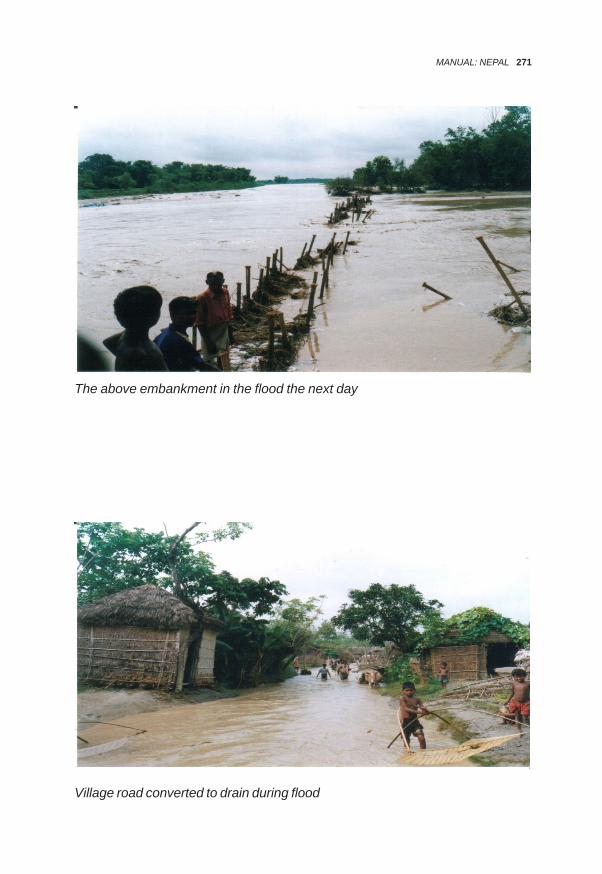
The above embankment in the flood the next day
Village road converted to drain during flood
MANUAL: NEPAL 271

The main road to India from the village under flood
Fish pond silted up by sediment deposition
272 ASIA PACIFIC JOURNAL ON ENVIRONMENT AND DEVELOPMENT

School on high ground, where people take refuge during flood
MANUAL: NEPAL 273

Annex-IIFIELD REPORT
ONFLOOD MANAGEMENT IN RAUTAHAT, NEPAL
1. Introduction1.1 Location of the study areaThe study area lies on the southern part of Rautahat district, Narayani Zone, thecentral development region of Nepal. It is geographically located at 26045’N to26046’30”N and 85015’E to 85020’E. The study area comprise of two locations inthe vicinity of Gaur Municipality, the district headquarters. To the east of Gaur liesthe first location which is ward nos. 6,7 and 9 of Brahmapuri Village DevelopmentCommittee (VDC). The second location lies in ward nos. 1 to 9 of BanjarahaVDC.
Gaur is connected with east-west highway by a 42 km long Chandranigapur-Gaurroad. Daily bus services from the Gaur and air service from Simara are availablefrom Kathmandu. The road distance of Gaur from Kathmandu is 334 km. Thelocation of the Study area is presented in Figure 3.
Figure 3: Focused Study Location in Rautahat
274 ASIA PACIFIC JOURNAL ON ENVIRONMENT AND DEVELOPMENT

1.2 Geographical characteristics of flood plain1.2.1 Climate
The study area has a sub tropical climate with hot temperature in summer. Theaverage minimum and maximum temperatures recorded are 19.6°C and 31.1°Crespectively. Annual precipitation is about 1200-1300 mm.
1.2.2 Land Use
The elevation of the study area varies from 73 to 76 m above average mean sealevel (amsl) and is topographically in the Terai plain. The soil is comprises ofclayey loams to sandy loams. Total covered area for study is about 6,600 hawhich include two selected locations. About 20% of the land is occupied bysettlements, roads and drainage whereas remaining 80% has been used foragriculture.
1.2.3 River and Streams
Major rivers flowing within Rautahat district include Bagmati, Lalbakaiya, Chandiand Jhanjh. Among these Bagmati and Lalbakeya are the rivers directly affectingthe study area due to flood.
a) Bagmati RiverThe Bagmati River rises in the Shivpuri range at about 16 km north-east ofKathmandu at an elevation of 2,800 m. Bagmati river has the total catchment of7,000 sq km in Nepal at the border with India. Its discharge of 100 years returnperiod has been estimated to be 10,500 cumecs.
The first 150 km of the river drains hilly and forested area from which it enters flatTerai land. The river is generally braided in Nepal Terai up to Nepal-India borderand is of meandering type downstream. The river drops sediments in its stretchpassing through the study area. It occasionally shifts its course; causes bankerosion and spills its banks inundating areas in Nepal and India.
HMG is constructing embankments along the bank. The work started a decadeago and will be completed in next three years.
b) Lalbakeya RiverThe Lalbakeya River originates at an elevation of 1,512 m in the Churia ranges.The river is a major tributary of Bagmati River. Its first 80 km length lies in Nepaland the remaining 29 km in India when it finally joins Bagmati. The catchmentarea of the river within Nepal is 896 sq km. The maximum discharge of 100 yearsreturn period is estimated to be 500 cumecs.
MANUAL: NEPAL 275

Churia range, being geologically fragile, adds large volumes of sediment into theriver system. The sediment is carried out downstream and deposited in the relativelyflatter area when it passes through the study area. The river becomes wide andoften changes its course damaging the adjacent agricultural land. It also spills itsbank causing inundation.
Recently, HMG has constructed embankment along the banks of the river
1.3 Demographic and socio- economic characteristics1.3.1. PopulationThe study area has a total population of 29,397 comprising of 15,481 males and13,916 females., Average household size is 5.3. The latest census report of 2001has recorded the total number of households as 4,922.
1.3.2 Caste /EthnicityThe study area is dominated by Terai ethnic group like Yadhav, Musalman, Tharu,and Rajput. Similarly, some occupational caste like, Kurmi, Baniya, Musahar,Teli, Dhobi, Mali and untouchables remain as minority. Braman, Chhetri, Rai,Newar as hill ethnic groups also figure in the ethnic composition.
1.3.3 EconomyAgriculture is the mainstay of the economy in the study area. According to theDistrict Agriculture Office, 79 percent of the people depend on agriculture for theirlivelihood and the remaining on service, trading and others. The main crops cultivatedare paddy followed by sugarcane or mustard, wheat and potato. The predominantform of production till today is subsistence agriculture. Family is the basic unit ofproduction. Female and child labor along with adult male labor is used for thepurpose. There is hardly any surplus since the size of the landholding is verysmall. However, wealthy farmers are switching from domestic to commercialfarming. The average landholding size in Rautahat district is 1.06 ha.
2 Floods, its types and intensity in the area2.1 History of floodDuring PRA and FGD people were asked about the floods they remember. Thefollowing are the main flood events that they instantly recalled:
Year Depth of Water1954 60 cm1975 60 cm1993 180 cm2002 150 cm2003 150 cm
276 ASIA PACIFIC JOURNAL ON ENVIRONMENT AND DEVELOPMENT

Depth of inundation has increased over the years. Excessive inundation occurredin the last two consecutive years. Drainage congestion due to development activitiessuch as roads and embankments in and around the area have contributed to theincreasing depth of inundation. The flooding situation occurs normally about thricea year and flood water recedes in about 24 to 30 hours.
2.2 Types of floodsThe type of flood causing damages to the Brahmapuri area is monsoonal flood ofBagmati River. The flood erodes the bank permanently washing away theagricultural land and making people landless. At high floods the water spills overthe bank and the village gets inundated.Similarly, Banjaraha village is affected by the floods from Lalbakeya River. Thetype of flood in this river is flash flood. During floods, the water spills over the bankand inundates the village. Embankments and roads constructed recently in andround the area obstruct drainage path and the water remains stagnant in the areacausing much inconvenience to the people and damaging houses and standingcrops.
2.3 Intensity of floodFlooding occurs almost once every year in the area although the extent of damagesmay depending on the severity of the flood. The floods of Bagmati and Lalbakeyarivers spill over their banks from several points within and from some pointsupstream of the area. The spilled water spreads over the area causing widespreadinundation. The depth of inundation reported in some part is as high as 1.8 m insome years. The stagnated water remains in the area for about 30 hours inresidential areas which are relatively higher land and for about seven days in lowlying agricultural land. Embankments and roads constructed recently in andround the area obstruct drainage path. The time of stagnation is becoming longeras the construction activities are on the rise.
2.4 Causes of floodThe area has high water table and is composed of loamy soil having slow infiltrationrate. The rainfall occurring locally in the area cannot infiltrate into the ground andso creates large surface runoff. The area being flat and drains being congested,the runoff water cannot get out of the area quickly and thus starts spreading.Growing urbanization associated with construction of houses and roads furtheradd congestion to the drainage system. The flood plains are being encroached bysettlements and river training works are done without considering the drainage
MANUAL: NEPAL 277

requirement. These activities have reduced the floodway considerably over years.The result is longer duration of inundation over wider area of coverage as the timepasses. The construction of embankments is being taken up by the governmentto the check spillage from these rivers. As the construction is not yet complete,inundation from the spills will continue for some years. Once the construction ofembankment is completed, the area will be within the embankments on all sides.In this case, the drainage of the local storm water will continue to remain a problemand the whole area will remain under threat of flood due to embankment breaches.The relevance of non-structural measures involving the community will be greatereven if the area is protected with embankments.The Churia range is geologically younger and fragile. The degrading forest in therange has increased erosion and consequent increase in the sediment in theriver. The sediment is carried by the rivers and is deposited in the stretch wherethe study area lies. The result is bed rise and instability of the river system. Therivers are observed to be changing their courses eroding banks.
3 Damages caused by recent floodsThe 1993 Bagmati flood was the most devastating flood in the recent decades.The extent of damage due to this flood was over a wide area beyond the studyarea. The most affected ones were Rautahat and the adjoining Sarlahi districts.The flood damaged a barrage built upstream of the study area and causedwidespread damage to the canal system serving some 20,000 ha. The rehabilitationworks amounting to about Nrs. 300 million were done over three years to restorethe irrigation system. In and around the study area the flood washed awaythousands of hectares (ha.) of cultivable land, 100 persons died and many familiesbecame homeless. In Rautahat district, it is estimated that around 895 ha paddyland was covered with sand, 935 ha paddy land was eroded and 25,650 ha standingcrops, 1982 ha seasonal vegetables and 47 ha fish farms were partially damagedby the flood.The flood of 2002 is considered as the second heavy flood after 1993. Around1,250 ha of standing crops, 142 ha of seasonal vegetables and 10 ha of fish farmswere damaged and around 87 cattle were swept away by this flood (Source:DADO Rautahat). In the flood event about 62 families were displaced, 631 housesfully damaged, 4,450 families moderately affected, 4 persons were injured and 3died (Source: PRA 2002). Similarly, in the municipality area, 78 households werefully damaged, 815 families affected and 1 person died from the flood (Source:Red Cross Rautahat). It is to be noted that these recorded damages are notmutually exclusive.
In July 2003, the study team also observed occurrence of a flood in the areaduring their field visit. The depth of inundation was observed to be about 90 cmand extent of damage to settlement, houses and crops were visible.
278 ASIA PACIFIC JOURNAL ON ENVIRONMENT AND DEVELOPMENT

4 Existing coping practices4.1 Pre- flood situationMany people in the community store some of their food grain on the first floor ofthose having multistory and permanent building. Some have built small temporarysheds in elevated places from which they can watch the crops against birdswhich is also used for taking refuge during flood. Some people have made woodenbenches on which they stay above water while the inundation goes on beneaththe benches. Some people have made provision of plastic for use during flood.Many people keep provision of dried and precooked food for about two days. Thisincludes beaten rice and noodles. The plinths of permanent houses are kept highabove the ground. Most of the affluent people in the flood-prone areas arrange forthe temporary migration of their children, pregnant woman, old and sick people totheir relatives’ houses in the flood-free areas. The community has no organizedinstitution for flood fighting and the above-mentioned flood-response-strategy ispracticed on individual basis, not in the collective form.
4.2 During flood situationPeople in the two locations of the study area seem to have their own system offlood warning being practiced over years. In Brahmapuri area, where flood isexpected from Bagmati River, some of the experienced people in the communitynever miss a radio-report on weather to know the monsoon-conditions atKathmandu. They also keep watching the sky over Churiya Range to assesswhether it is raining heavily or not. If the rainfall in Kathmandu is more than 60 mmany day, they remain alert and get ready to evacuate in order to shift to safeplaces. They have experienced that 12 hours time is taken by the rainwater totraverse the distance from Kathmandu to their localities; flooding begins in Rauthatin about 12 hours, and in about 18 hours, the flood inundates their residentialareas. In general, the flood warning is disseminated through person to personcommunication.In case of Banjaraha, a rain gauge station is established at Nijgadh which isabout 30 km north and upstream of the area with the effort of Red Cross. In caseof heavy rain in Nijgadh area, the person reading the rain gauge conveys themessage through telephone to the Red Cross Office at Gaur. The Red CrossOffice at Gaur in turn transfers the message to Banjaraha VDC preferably bytelephone. If the telephone is out of order, it uses other means such as usingwireless network of Police or sending some one on a bicycle carrying the message.When water level starts rising in the residential area they start to shift their livestockto uplands like embankments and higher roads. This is based primarily on previousexperience and direction of the elders. Thereafter, the people shift themselvesand also help the neighbors. They take refuge in neighboring permanent houses,public houses and places on high lands. During a flood situation, there is no
MANUAL: NEPAL 279

practice for flood coping in organized ways; there is no mechanism either. Insome particular cases the people seem to help their neighbors in the rescueoperation during flood situation.
4.3 Post- flood situationGenerally, there is no practice to involve the community collectively for relief andreconstruction. Some comparatively richer people help the poor ones, whosehouses are damaged partially or fully, provide the scanty locally available resources,like bamboos, etc., to rehabilitate them.Flood victims usually approach concerned institutions to ask for relief materiallike tents, clothes, utensils, medicine, etc.At the district level, District Natural Disaster Relief Committee (DNDRC) hasbeen formed under the chairmanship of Chief District Officer. Other institutionsinvolved in the relief activities are DADO, DDC, DWIDP, Red Cross, Police andMilitary. There are some NGOs and INGOs also that have provided relief in thearea. Coordination of the relief operation among these agencies and joint planningis lacking. Many of them seem to work on ad-hoc basis and independent of eachother.
5 Institutional involvement and assistance offeredThe DNDRC held preparatory meetings just before the start of monsoon, speciallyfocused on flood fighting in the flood prone area. Concerned line agencies, Police,Military, NGOs and INGOs take part in the meeting. This meeting usually takesstock of the disaster situation in the previous years and draws tentative actionplan for the forthcoming monsoon flood. The provisions made by various agenciesare minimal at the district level.Emergency flood fighting through structural measures in the case of riverbankcutting/erosion and embankment breaches goes on under the DWIDP districtbased office. Emergency fund is allocated to the central organization DWIDP.The DWIDP releases emergency fund as and when the need arises, on the basisof the damage report submitted by their district based office. During the site visit,the study team observed an emergency work continuing on the right bank protectionof the Bagmati river near Bramapuri VDC and left bank protection of the Lalbakaiyariver near Tikulia.District agricultural development office (DADO) has no approved yearly programfor flood management related activities. However, it usually distributes mini kit ofsome vegetables and crops when the need arises.Municipality allocates Rupees 30 to 35 thousand budgets in its yearly program toprovide the flood relief packages especially within its boundary.The Red Cross has provided support for the flood warning system in BanjarahaVDC. It has also conducted an awareness education to manage disasters in the
280 ASIA PACIFIC JOURNAL ON ENVIRONMENT AND DEVELOPMENT

area. It also distributes relief packages for the flood victims and provides themtraining for income generation.Local Police and Military generally respond to the rescue and relief workimmediately after flood occurrence.There are some NGOs and INGOs reportedly involved mainly in relief activitiesand a few in rehabilitation activities.However, coordination and cooperation seems weak among the services agencies.Red Cross distributes relief packages for the flood victims as per the availability ofthe resources with them in the post flood situation. Moreover, other outsiders alsosometimes help the victims with relief packages after the flood occurrences.
6 Risk AssessmentThe risk data were obtained through the report prepared by the Red Cross forBanjaraha VDC, by DDC for Bramapuri VDC.
• Life and household riskLocation Households PopulationBanjaraha 310 2,369Bramhapuri 312 1,262
• Crop Risk–-monsoon paddy:Location Area (ha)Banjaraha 270Bramhapuri 270
7 Potentialities for community approach to flood managementThe communities in Brahmapuri and Banjaraha are found committed to makeefforts from their side to adopt required preventive measures regarding the floodmanagement in organized way through the participatory approach. Some non-structural measures along with the structural ones preferred by the communitiesare as follows:
• Identification of flood shelter and relief camps• Awareness creation on flood fighting through training, drills and campaign• Establishment of forecasting and warning system regarding the impending
flood• Arrangements of first aid and necessary medicines for mainly waterborne
diseases and provision of fast foods like beaten rice• Formation of Community Flood Management Committee (CFMC)
MANUAL: NEPAL 281

• Immunization provision for both humans and animals• Spray of insecticides after flood to protect the community from epidemic
waterborne diseases like diarrhea, dysentery, cholera, typhoid, pneumonia,etc.
• Coordinate the works being done by the different helping agencies• Arrangement of training to local teachers, VDC and NGO personnel• Introduce community flood management course in school education
8 Adopted study methodologyThe study team consisting of an engineer and a sociologist visited the field duringthe flooding time and observed the current situation through the transect walkalong the Bagmati and Lalbakeya rivers. During the visit, discussions were heldwith the various communities. Information regarding the floods in the study areaswas gathered. The study team conducted Focussed Group Discussion (FGD),community meetings, observations and PRAs in the flood affected area ofBrahmapur and Banjaraha. Some key informants were also interviewed whilecollecting the additional information about the flood and its effect on the community.Similarly, the study team visited offices of the District Development Committee(DDC), Local Development Officer, Chief District Officer (CDO), and Local Officeof the Department of Water Induced Disaster Prevention, Gaur Municipality, WaterSupply and Sanitation Division, Red Cross, District Agriculture Development Officein Rautahat district. Discussions were held with these offices on the flood-affectedcommunity and on activities carried out by the various agencies on flood mitigation,relief and rehabilitation.In order to orient the community to form organized groups for flood managementactivities, a model constitution of the committee was distributed and read in thecommunity gathering.
9 Field study findings• The communities in Brahmapur and Banjaraha are practicing their own
system of flood forecasting and warning.• People temporarily shift to neighboring permanent houses, high lands,
public places, schools, embankments, etc during floods.• The communities have no collective pre-coping mechanism. All the
activities are done on individual basis.• Many people keep provisions of food and shelter for use during flood.• Proper coordination is lacking among the agencies involved. The external
support provided to the affected communities is inadequate andinequitable.
282 ASIA PACIFIC JOURNAL ON ENVIRONMENT AND DEVELOPMENT

• Rivers are unstable causing threat of flooding in the future.• Although government is about to complete embankment to stop water
spilling the banks of Bagmati and Lalbakeya, the threat of flood damagewill remain the same.
• Increasing urbanization and increased network of roads and infrastructureare increasing the drainage congestion and the depth and duration ofinundation are also on the increase.
• The Red Cross has made some efforts to mobilize the youths of BanjaharaVDC on organized basis in disaster management and has provided themtraining.
• There is no permanent flood management committee in the communities.However, they seem to be eager to form such committee if external supportis made available.
• Strong confidence in self-help is demonstrated by the communities, butscarcity of fund remains a major constraint
Photographs
MANUAL: NEPAL 283

284 ASIA PACIFIC JOURNAL ON ENVIRONMENT AND DEVELOPMENT
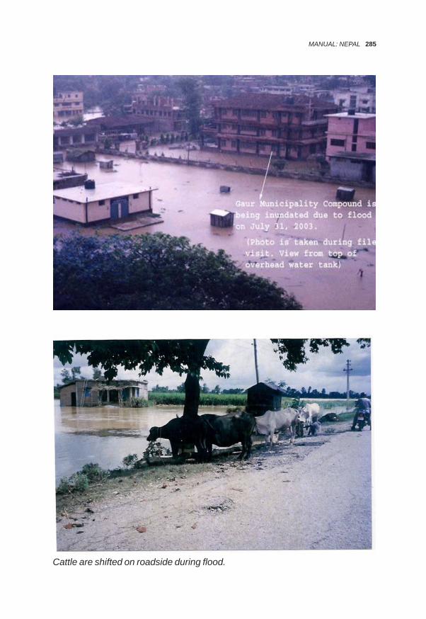
Cattle are shifted on roadside during flood.
MANUAL: NEPAL 285
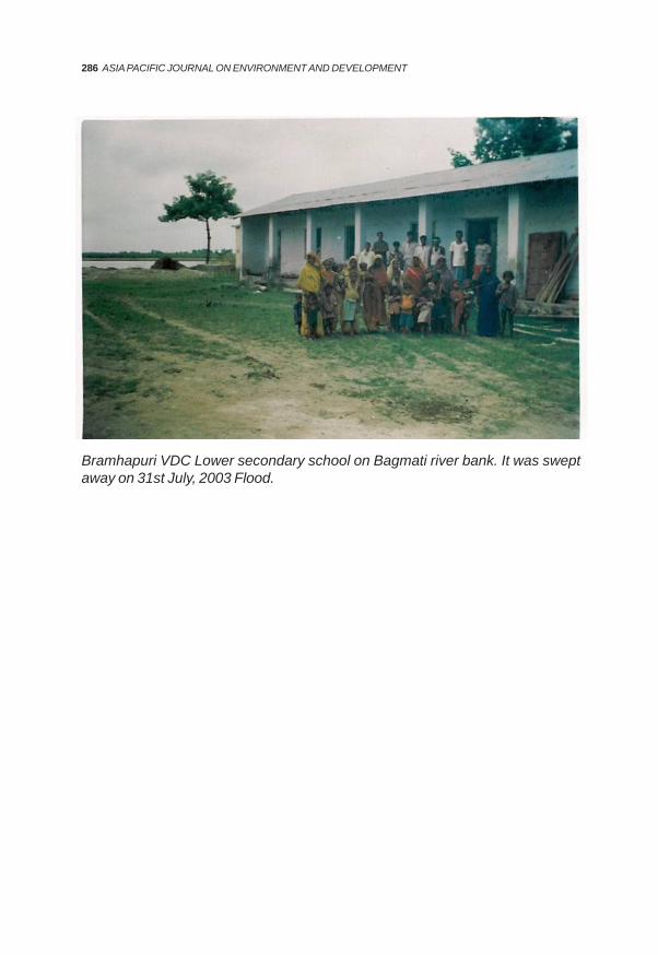
Bramhapuri VDC Lower secondary school on Bagmati river bank. It was sweptaway on 31st July, 2003 Flood.
286 ASIA PACIFIC JOURNAL ON ENVIRONMENT AND DEVELOPMENT

Annex IIIEnglish translation from the Nepali language (of model Constitution)
Constitution of (.........) River Community FloodManagement Committee 2004
Preface:Originating from the Siwalik/Mahabharat hills in the ..............zone, ............ District,Constituency number .............. and ................. VDC; having confluence in the ..............river and flowing through .......... VDCs; the river ............... is causing heavy loss tohuman lives and property, causing damage to crops and cutting hundreds of hectaresof land. As proper management of this river has not been undertaken by any governmentor non-government organizations to cope with problems caused by this river, theConstitution of Community Flood Management Committee-2004 is framed to train theriver properly, to involve the local people in the overall management and floodmanagement of the river and to minimize the damages caused by the river.
Article - 1Brief Name and Commencement:
a) The name of this committee will be .............. and in brief ............b) The constitution of this committee will be effective from the date of approval of
the related office.c) Address and office of the committee: The office of ......... VDC will be used as
the office of this committee.d) There will be a consultation committee to provide necessary consultation
and suggestions to the committee.
Article – 2Definitions:Unless the context otherwise requires, in this constitution:-
a) ‘River’ means .......... River originating from the Siwalik/Mahabharat hills in the...... Zone, .......... District, Constituency number .......... and .............. VDC; havingconfluence in the .............. river and flowing through ............. VDCs from Northto South.
b) ‘Management’ means activities undertaken before, during and after theoccurrence of flood, to protect loss of lives and property in the communityfrom the fury of flooding every year.
c) ‘Control’ means any activities undertaken to protect erosion, flooding andcutting of agricultural land and settlement, deforestation etc. through rivertraining.
d) ‘Coordination’ means mediation between this community and anygovernmental, non-governmental, national, international organization,persons, groups, communities etc. and providing training to the communityin flood management.
MANUAL: NEPAL 287
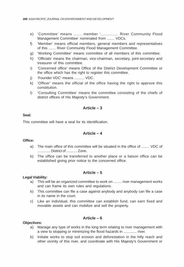
e) ‘Committee’ means ....... member ‘............... River Community FloodManagement Committee’ nominated from ....... VDCs.
f) ‘Member’ means official members, general members and representativesof this ....... River Community Flood Management Committee.
g) ‘Working Committee’ means committee of all members of this committee.h) ‘Officials’ means the chairman, vice-chairman, secretary, joint-secretary and
treasurer of this committee.i) ‘Concerned office’ means Office of the District Development Committee or
the office which has the right to register this committee.j) ‘Founder VDC’ means .......... VDC.k) ‘Officer’ means the official of the office having the right to approve this
constitution.l) ‘Consulting Committee’ means the committee consisting of the chiefs of
district offices of His Majesty’s Government.
Article – 3Seal:
This committee will have a seal for its identification.
Article – 4Office:
a) The main office of this committee will be situated in the office of ........ VDC of............. District of ........... Zone.
b) The office can be transferred to another place or a liaison office can beestablished giving prior notice to the concerned office.
Article – 5Legal Viability:
a) This will be an organized committee to work on ........ river management worksand can frame its own rules and regulations.
b) This committee can file a case against anybody and anybody can file a casein its name in the court.
c) Like an individual, this committee can establish fund, can earn fixed andmovable assets and can mobilize and sell the property.
Article – 6Objectives:
a) Manage any type of works in the long term relating to river management witha view to stopping or minimizing the flood hazards in ............. river.
b) Initiate works to stop soil erosion and deforestation in the hilly reach andother vicinity of this river, and coordinate with His Majesty’s Government or
288 ASIA PACIFIC JOURNAL ON ENVIRONMENT AND DEVELOPMENT

concerned organization to manage the uncontrolled and unmanagedtransportation of the river aggregates in the river.
c) Manage tributaries of this river and other branches of this river.d) Manage different resources like education, health, forestation, different income
generating activities in the vicinity of this river.e) Help reduce hazards from river by raising awareness among the people and
remove the problem of deforestation.f) Manage flood in the ....... river by coordinating with different governmental,
non-governmental, national, international organizations and institutions andif necessary reach an agreement with them.
Article – 7Scope of Work:The committee will implement the following works in the ............. committee.
a) Flood management before, during and after the occurrence of flood.b) Watershed conservation.c) Construction of embankments.d) People’s awareness programme for forest conservation.e) Afforestation – (Green Belt).f) Alternative agricultural income generating program.
Article – 8Membership:A qualified Nepalese citizen will be the member of working committee to manage floodof ................... river of VDC1. Types of membership:
a. Working committee member.b. Representative member appointed by the committee when necessary to fulfill
the allocated work.c. The committee may award honorary membership to any national or foreign
citizen and to the organizations providing special assistance as per itsobjectives.
2. Working committee can nominate experienced and skilled persons as additionalmembers from ............ VDC as per its requirements.
Article – 9Qualifications and Charges for Membership:a. Qualifications of the member:
i) Nepalese citizens who have attained 16 years of ageii) Free from any criminal charges
MANUAL: NEPAL 289

iii) Not mentally retardediv) Resident of .......... VDC But this clause will not be applicable in case of
representative membersb. Membership charge – As per the decision made by quorum of committee
Article – 10Expiry of Membership:The membership will be considered expired in the following cases:
a) If resigned through a written noticeb) If the member is deadc) In case of absence in three consecutive meetings without reason or prior
notice, membership could be cancelledd) If proved to be indulging in activities against the interest of the committee for
personal benefit
Article – 11Formation of Working Committee:
a) A 13 member executive committee will be formed comprising of flood affectedand elected persons of .............. VDC
b) Executive committee will choose the chairman, vice-chairman and thetreasurer from among its members.
c) The tenure of the executive committee will be of 5 years.
Article – 12Work, Duties and Authority of Officials:1) Chairman
a) Call the meeting of the executive committeeb) Take initiative for necessary agreementsc) Control and look after all types of works relating to flood managementd) Implement the decisions made by the committeee) Assume the chairmanship of the committee and give deciding vote in the
meeting2) Vice-Chairman
a) Help in the work of chairmanb) Perform all types of work done by the chairman in his/her absence except
important agreements to be concluded by the committee3) Secretary
a) Keep records of meetings passed by the committeeb) Make agenda of meetings for their approval
290 ASIA PACIFIC JOURNAL ON ENVIRONMENT AND DEVELOPMENT

c) Coordinate with other organizations, institutions, or persons and chairman ofthe committee and work accordingly
4) Joint Secretarya) Do all the works of secretary in his/her absence except in respect of important
decisions5) Treasurer
a) Keep record of financial transactionsb) Keeping up-to-date record of income and expenditure of the committeec) Give and take necessary directions in controlling the financial activities
Article – 13Consultant Committee:
1) There will be a consultant committee to give necessary suggestion to thiscommittee
2) The chiefs of the following district level offices of HMG will be the members ofthis consultant committee:
Chairman of District Development CommitteeChief District OfficerDistrict Agriculture Development OfficerLocal Development OfficerDistrict Forest Office, ChiefDistrict Soil Conservation Office, ChiefDivision/Sub-Division Irrigation Office, ChiefChairman of Nepal Red Cross Society, District CommitteeHon’ble Member, House of Representatives, Constituency No....Hon’ble Member, House of Representatives, Constituency No....
Article – 14Financial Arrangements:
a) The committee, to execute its work, can raise a fund and make rules tooperate such a fund.
b) The following types of amounts will be deposited in the fund:i) Fund available from the founder VDCii) Fund received from HMG, non-governmental organizations,
individuals, groups, community or any other sourcesiii) Fixed or movable assets of the committee or amount received
from itc) The working committee will make rules to operate the bank account of the fund.
MANUAL: NEPAL 291

Article – 15Audit:
a) The accounts of the committee will be audited every year by the auditorrecognized by HMG.
b) Every year the committee will submit the report of the audit to the concernedauthority on the basis of report from the treasurer of the committee.
Article – 16Provision of Election:
a) The working committee will make necessary provisions and rules to conductelection of the committee.
b) The committee will give notice of such provision to the founder VDCs.
Article - 17No Confidence Motion:
a) A written complaint from a member of the committee specifying that anymember or official is working against the interest and objective of thecommittee with proof and ratified by two-thirds majority of the committee willbe sufficient for the dismissal of a member or official of the committee. Thenotice of such dismissal should be given to the concerned official and VDC.
Article - 18Right to Frame Rules and Guidelines:
This committee will have the right to make rules remaining within the limits of thisconstitution, Institutions Registration Act-2034 and prevailing laws of Nepal to fulfill theobjectives of the committee.
Article - 19Amendment to the Constitution:
a) With the application of a member of the committee for the benefit of thecommittee and remaining within the preamble of the committee, theconstitution can be amended or extra article can be added with the ratificationof two-thirds majority of the committee.
b) The amended constitution should be approved by the concerned official.
Article - 20Dismissal of the Committee:
The committee will be automatically dismissed with the decision from the votes of allthe voters of the working committees of all the .........VDCs that the committee is no
292 ASIA PACIFIC JOURNAL ON ENVIRONMENT AND DEVELOPMENT

longer necessary. The notice of such dismissal should be given to the concernedofficial.
Article - 21Explanation and Special Provision:
The explanation of this constitution will be done by the committee. Special provision ifrequired will be made on the basis of majority of the committee.
Article - 22Repeal and Retention:
Articles of this constitution of.................River Community Management Committee willbe automatically cancelled to the extent of contradiction if they contradict the prevailinglaws of Nepal.
MANUAL: NEPAL 293

Directory of Contacts
Name of Office Address Office Contact Contact Person
Phone Fax Name Phone Phone(Office) (Home)
** Please write down the names of organizations/persons that may be useful for you in the area.
Annex- IV
LIST OF RELEVANT ORGANISATIONS/PERSONS
294 ASIA PACIFIC JOURNAL ON ENVIRONMENT AND DEVELOPMENT

Form 1Risk Assessment Form
District:………………VDC:……………....…Ward No:…………….
S.No Name Number of Family Total Cattle Food Crops Type Depthof House- Members Grain of ofhold Old Women Child- Young Big Small House WaterChief ren
Form 2Damage Assessment Form
District:……………………VDC: ……………………..Ward No …………………., Village…………………….
S.No. Name of Person Type of damage Value Rs Remarks Houses Crops Cattle Land Other
Annex-V
RISK AND DAMAGE ASSESSMENT FORMS
MANUAL: NEPAL 295

Annex-VI
INTERACTION PROGRAMON
COMMUNITY FLOOD MANAGEMENT APPROACHES IN NEPAL
PART A: SAPTARI1 IntroductionA team consisting of an engineer, a sociologist and an association organizervisited the Launiya and Tilathi VDCs of Saptari District from February 28 to March6, 2004. These are the flood-affected areas of Khando River. The main objective ofthis visit was to introduce the draft manual 'Community Approach to FloodManagement in Nepal' to the community people and different stakeholders in thedistrict. The manual was introduced by organizing interaction programs in thecommunity and among the stakeholders. First interaction program was conductedin the Launiya VDC on March 2, 2004 and the second was conducted in TilathiVDC on March 4, 2004. Similar interaction program with the stakeholders wasconducted in Rajbiraj, the district headquarters of Saptari district on March 5,2004.
2 Interaction with the Community2.1 Interaction at LauniyaThe program was organized in the Launiya VDC where more than 150 peopleparticipated. The program was initiated with the welcome speech and by givingintroduction of the program by Danda Pani Jaishy( River Engineer). Mr. HariNarayan Mandal of Launiya VDC welcomed the study team and praised the workof the team by delivering opening remarks on behalf of the community. Mr. DandaPani Jaishy and Mr. Roshan Subedi(Sociologist) presented the contents of themanual to the audience. After the presentation of the manual the floor was openedfor discussion where many useful suggestions and comments were made by theparticipants which are as follows:
Mr. Khagendra Mandal, Launiya VDC• Most of the villagers are illiterate and poor and do not have proper understanding
of the flood situation which causes much damage to the life and property ofthe people.
• It is very difficult to implement a community approach in such a place withoutproper help from outside.
• Many governmental and non-governmental organizations came to this place
296 ASIA PACIFIC JOURNAL ON ENVIRONMENT AND DEVELOPMENT

in the past, for survey/research work and never returned to the place again tohelp the downtrodden people. So he doubts about the future programs of thisgroup too.
• Proper coordination with line agencies is required to deliver required service.• The Government does not allocate sufficient budget for the embankment
construction of Khando River.• Concerned line agencies should be prepared at least for the three months of
the rainy season to help the flood affected people.• There is not sufficient waterway within the two embankments. Proper waterway
should be maintained by giving proper compensation to the landowners andacquiring the required land for the embankments.
Mr Shiv Saran Mandal, Launiya• The presentation is excellent and the efforts made to organize the flood affected
community are praiseworthy.• We have a history of fighting with the flood and will continue to fight it.• Structural measures are the proper methods to control flood in this community
Pradeep Kumar Mandal, Ex Vice Chairman Launiya VDC• Our ancestors fought the flood of Khando themselves but now we are receiving
some help from different government and non-government organizations.• We are participating voluntarily in the flood fighting and other activities during
the flood.• There are 11 VDCs which are affected by the Khando River, Launiya being the
most affected among all.• Problem of flood in other VDCs originates from Launiya. Hence, flood control
activities should be concentrated mostly in this VDC
Hari Narayan Mandal, Launiya VDC• All the past river training activities done by different NGOs/INGOs and
government agencies are not based on any technical grounds, hence theflood situation is worsening every year. Most of the construction works weredone without proper survey and design work.
• The situation is not improving although different agencies are investing a largesum of money to control the Khando River.
• Technical soundness of the work is more important than plainly delivering theservice for cheap popularity and vested interest.
• The proposed community approach will become successful only if externalsupport to the community is continued for certain years thus making it selfsustainable.
MANUAL: NEPAL 297

2.2 Interaction Program at TilathiSimilarly, interaction program was organized in the Tilathi VDC too, where morethan 20 people participated. After the presentation of the manual, the floor wasopened for discussion. Suggestions and comments made by the participants areas follows:
Pradeep Narayan Jha, Tilathi VDC• There should be a contact office within the reach of community to make
regular contact for flood management before, during and after the flood.• Criteria for membership of a sub-committee should be clear.
Amir Jha, Ex. Vice–Chairman,Tilathi VDC• Financial resource should be made available for flood management activities.• Relief package distribution is not a solution. However, this is a very common
practice during flood.• Proper design and construction of river training activities are required to solve
the flood related problems.• Relief packages should be distributed fairly to needy people.• Although most of the study focuses on Terai areas, construction works have
been done in uphill Chure area. Information regarding the construction islacking.
Dev Narayan Yadav, Ex-Area Member of DDC,Tilathai VDC• All the VDCs within the Constituency no 2 are equally affected by Khando
khola. So, the community based program should be conducted in all theaffected areas to minimize the problems.
Dayananda Mishra, Lecturer, Vindeshor Multiple Campus, Saptari• Real situation should be analyzed and flood management should be carried
out with the involvement of the community.• Community Flood Management concept would be effective in flood affected
areas as these are the people to respond first during the flood.
3 Interaction Program with StakeholdersAfter the community level interactions, stakeholders' interaction was conductedat Rajbiraj on Friday, 5th March, 2004. Representatives from different line agenciesof the government, NGOs, Red Cross Society, journalists of different national andlocal newspapers and representatives from the two communities took part in theinteraction. Mr. Roshan Subedi welcomed the participants and Mr. Danda Pani
298 ASIA PACIFIC JOURNAL ON ENVIRONMENT AND DEVELOPMENT

Jaishy shed light on the objectives of the program. Mr. Bhup Nath Sharma, LocalDevelopment Officer, presented the inaugural speech. Mr. Sharma gave valuablesuggestions such as inclusion of the chairman of Nepal Red Cross Society of theconcerned district in the consultation committee. He expressed his doubt on thecontinuity of community based flood management program without firm governmentsupport. He further stressed that a coordinated effort will certainly help minimizeflood hazards of the community if not completely eliminate such hazards.
Mr.Danda Pani Jaishy and Roshan Subedi presented the objectives of the programand contents of the manual to the participants. After the presentation of the manualthe floor was opened for discussion. Major suggestions and comments receivedduring the interaction are as follows:
Dr Nareswor Prasad Singh , NRCS-Saptari, Lions Club Saptari• The Draft Manual entirely focuses on the non-structural measures such as
training, awareness campaign, preparedness activities etc. Hence, it issuggested to include structural preventive measures as well to minimize theflood problems.
• More coordination is needed among the concerned agencies.
Dhruva Dev, Chairman, NGO Federation, Saptari• Available fund should be used judiciously and NGOs would be useful partners
for community flood management programs.After the presentation, the participants were divided into three groups and eachgroup presented their own findings to the plenary. The groups were divided asfollow:
Group I – Pre-flood PreparationsGroup II- During Flood ResponsesGroup III- After Flood Actions
Mr. Amir Jha, Ex-Vice-Chairman of Tilathi VDC presented the outcome of Group-I to the plenary session. He was assisted by Mr. Bhusan Rai, Social DevelopmentOfficer of DDC, Saptari. The main suggestions presented by this group are asfollows:
• There is urgent need of preparatory works before the onset of monsoon tominimize the loss of life and property of the community as described in themanual.
• A coordination committee of different flood management committees withinthe flood affected zone of a river is necessary to coordinate the necessaryactivities with different line agencies.
• The chairman of Nepal Red Cross Society, District Committee should alsobe included in the consultation committee of the committee as mentioned inthe constitution(Annex-III)
MANUAL: NEPAL 299

• Certain spelling mistakes and language of some sentences in the manualsshould be corrected.
Ms. Sunita Mishra, Vice-President of Women Development and Child CareFoundation, Saptari, presented on behalf of group-II. This group focused on whatshould be the responses of the community during the period of flood. The mainoutcomes of the group are as follows:• Activities mentioned in section-4 of the manual are good enough to minimize
loss of life and property by the flood• Rescue operations, which are carried out on community basis, are
comparatively better than those carried on individual basis.• Aged people, women, children, disabled and sick people should get priority
during evacuation and rescue operations.• Pregnant women and pregnant animals should get due care during the flood.• Care should be taken to control any outbreak of epidemics from drinking
contaminated water.• Care should be taken to save cash and other valuables.• Food, medicines and shelter materials should be distributed to the needy
Mr. Dhirendra Prasad Shah, local correspondent of the National Daily 'TheHimalayan Times' presented the outcome of the discussion on behalf of group III.The group identified the following activities for the post flood situation:
• Keeping record of the damage caused by the flood• Manage provision of drinking water, shelter, food and health care to those
affected by the flood• Manage systematic shelters against the random settlement after the flood• Minor repair and maintenance work from the local material available• Public awareness program to save the people from the fury of flood• Take initiatives for a permanent flood control work• Take an account of the works done in the preparation stages• Start income generation programs with the help of concerned line agenciesAt the end of the interaction, the participants were asked to mention the positiveand negative parts of this interaction. The response was as follows:
Positive• Non-structural measures are equally important to minimize the flood hazards.• The manual is comprehensive and is helpful to minimize flood hazards if
practiced by the community properly.
300 ASIA PACIFIC JOURNAL ON ENVIRONMENT AND DEVELOPMENT

• Individual efforts are not sufficient to manage a flood. Hence, a coordinatedeffort is necessary.
• Such gatherings from time to time bring together different groups in one platform,which is helpful to know the sufferings of the flood affected people.
• Flood hazards can be minimized with proper preparedness before flood.• Transparency in the work is the key to success for any community
organization.• This interaction meeting worked as an eye opener to the participants.
Negative• Such meetings which are conducted in the headquarters, generally fail to
fulfill the immediate requirements of the rural people. Hence, they should beconducted in the affected area itself to gain support of the people.
• There is no guarantee of continuation of this program in the future.• The actions mentioned in the manual should be implemented with necessary
physical and financial support which the study team is requested to facilitate.
PART B: RAUTAHAT1. IntroductionA team of an Engineer, a Sociologist, Social Organizer and a support staff visitedboth the flood-affected locations i.e. Bramapuri VDC which is affected by Bagmatiriver and Banjaraha VDC affected by Lalbakaiya river of Rautahat district fromFebruary 23 to March 1, 2004. The main objective of this visit was to disseminatethe manual prepared to the community of those VDCs and various district levelstakeholders and collect suggestions and comments so as to refine the manualfurther and identify further course of action to be taken. The district level interactionprogram of stakeholders was conducted on February 27, 2004, whereas thecommunity level interaction was organized on February 28, 2004.
2 Interaction with the CommunityThe community level interaction program could not be conducted at the studysite due to security problem. Upon the suggestion of the security personnel aswell as community people the venue of interaction program was set within themunicipality area at Tikuliya High School in Gaur municipality. People from boththe locations gathered at the school for interaction. In spite of some inconvenience,more than 50 people of different strata participated. The program was initiated bydelivering the welcome speech and introduction of the details of the interactionprogram by Ram Chandra Dangal (River Engineer) on behalf of JVS. Similarly, Mr.Narayan Das the then vice-chairman of Bramapuri VDC and Mr. Tej Narayan
MANUAL: NEPAL 301
Singh the then vice chairman of Banjahara VDC welcomed the participants aswell as the study team on the behalf of their respective communities. After thewelcome addresses Socioligst Mr. Rajendra Kumar Pandit and River EngineerMr. Ram Chandra Dangal presented the content of the draft manual to theparticipants. Then, the floor was opened for in depth discussion. The followingsection depicts the outcome of the discussions.
Mr. Tej Narayan Singh – the then Vice Chairman Banjahara VDC• It is praiseworthy to develop a flood management manual; however the manual
has discussed only non-structural measures, which is not the immediatesolution of the recurring flood in the area.
• If the interaction was conducted jointly with other stakeholders, cooperationand coordination issues raised in the manual could be discussed in detail.This would have cleared the role and responsibility of the concerned agenciestoo.
• The manual is silent on indicating the responsible agency to implement thismanual.
Mr. Narayan Das-the then Vice Chairman Bramapuri VDC• The community is mainly suffering from riverbank cutting. Hence, the immediate
need of the community is protection through embankment construction. Themanual is silent on structural measures; therefore, structural as well as non-structural measures should go side by side.
• The concept of the community management committee is very good; however,external support is extremely needed to make such a committee sustainablein the long run.
• The manual has discussed and attached the sample constitution of thecommunity flood management committee; however, it is not clear who wouldfacilitate registration of such a committee.
• Various training programs and income generation activities are proposed inthe community in the manual, but it is not clear who will initiate theseendeavors.
• The preparedness plan is very ambitious regarding fuel and food storage,because, majority of the community people are suffering from day to dayneeds. Therefore, there must be an external support available for suchprovisions.
• The manual has mentioned that the aged people, women, disabled and sickpeople should be given priority during evacuation.
• There are delays in the construction of river training works on Bagmati Riverwhich will protect Bramapuri VDC from flood, hence it is suggested that theworks should be completed as soon as possible.
302 ASIA PACIFIC JOURNAL ON ENVIRONMENT AND DEVELOPMENT

• The constructed Lalbakeya embankment has no provision of drainages andtherefore it takes more time for the inundating water to drain properly causinga lot of inconvenience to the people in Banjaraha VDC after flood.
• In the manual, it is mentioned that there should be permanent public buildingsin the community for immediate evacuation of the flood-affected people. Butin fact the existing public buildings like school, health post, VDC are alsolocated in flood areas. Hence, those facilities are not so useful for emergencyevacuation.
3. Interaction with the StakeholdersStakeholders interaction program was organized on Friday, 27th February 2004.District natural disaster committee members, representatives from variousgovernment line agencies, NGOs and Nepal Red-Cross Society, teachers, districtlevel social activists, political leaders, civic society and journalists of differentnational and local newspapers participated in the program. At the beginning of theprogram, the draft manual was distributed to each of the participants. SociologistMr Rajendra Kumar Pandit welcomed the participants on behalf of the organizer.The session was chaired by Chief District Officer of Rautahat District. In hisinaugural speech, he shed light on the need and significance of community floodmanagement manual. Then, the draft manual was presented by Mr. Ram ChandraDangal (River Engineer) and Mr. Rajendra Kumar Pandit (Sociologist). Immediatelyafter the formal session was closed, the floor was opened for comments andobservations of the participants.
Chief District Officer - Mr Mohan Pd. Acharya• The contents of the draft manual should be highly appreciated and the manual
will be helpful to the flood affected community. This study is very good andcovers all aspects of community flood management.
• The manual could not explore the causes of the flood in the particular case ofRautahat. Addressing these causes may be helpful in reducing the adverseeffect of the flood. This should also be incorporated in the manual.
• The provision of community flood management committee is good and anyone of the two procedures for its formation suggested in the manual may beadopted as per the specific local condition.
• It is suggested that DWIDP should take the lead role in making use of thismanual with coordination and cooperation from the concerned communities.
Teacher- Mr. Bijaya Keshore Jha• Minimization of flood intensity is not incorporated in the manual.• An afforestion program should be launched along the riverbank on both sides
as well as in the catchment area.
MANUAL: NEPAL 303

Mr. Sita Ram Mudvari• The manual is very good; however, it is silent on implementation aspects.
Hence, the manual should be tested practically in the field by actions followingthe manual.
• Minimization of flood intensity is not incorporated in the manual.• The sand in the riverbed should be removed each year to protect settlements
from the floods.
Genaral suggestions made by various participants• More fruitful comments could have been made if the manual was distributed
15 days ahead.• The community should take care of the local existing embankment and river
training works which should be mentioned in the manual.• Actions suggested in the manual should be implemented on pilot basis and
the manual should be improved based on such implementation process.• The manual has spoken about transparency; however, it is not specific on
how transparency can be implemented.• The Government should be persuaded to adopt laws and regulations appropriate
for flood prone areas such as building byelaws and norms for construction ofroads and multipurpose public areas for shelters, for which it may be necessaryto have greater public debate.
304 ASIA PACIFIC JOURNAL ON ENVIRONMENT AND DEVELOPMENT


